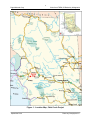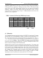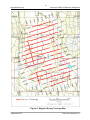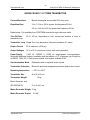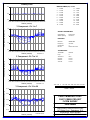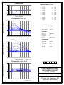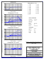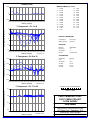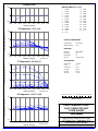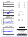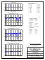
1
PAGET Minerals Corporation
BC Geological Survey
Assessment Report
32031
2010 Assessment Report
Geophysical Survey on the
Chist Creek Property
Skeena Mining Division
103I/08
UTM Zone 09 NAD83
543500E 6022900N
540 21’ North Latitude
1280 20’ West Longitude
For
Paget Minerals Corporation
By
Jim Young
February 2011
PAGET Minerals Corporation
Table of Contents
1
Introduction .................................................................................. 1
2
Property Location and Access ........................................................ 1
3
Physiography, Climate and Vegetation........................................... 1
4
Claim Status .................................................................................. 1
5
Exploration History........................................................................ 5
6
TDEM and Magnetic Survey Specifications and Results................... 5
7
Summary and Recommendations................................................... 6
8
References .................................................................................... 7
i
PAGET Minerals Corporation
List of Figures
Figure 1: General Location Map...............................................................3
Figure 2: Claim Map................................................................................4
List of Appendices
Appendix A: Geophysical Report
Appendix B: Statement of Qualifications
Appendix C: Statement of Expenditures
ii
PAGET Minerals Corporation
1 Introduction
The Chist Creek Property, in the Central Coast region southeast of Terrace, B.C., hosts a
large alteration zone believed to represent a Late Paleozoic volcanogenic massive sulfide
system. This report describes the results of a ground EM and magnetometer survey
conducted on the property between September 13-26, 2010. The survey was carried out
by Discovery International Geophysics Ltd. of Surrey, B.C. and Hague, Saskatchewan.
2 Property Location and Access
The Chist Creek Property is located 24 kilometers southeast of Terrace, B.C. in NTS
103I/08, latitude 54°21’N, longitude 108°20'W (Figure 1). Logging roads extend up
Williams Creek to within a few kilometers of the property to the north and extend to the
base of the south facing slopes of the property near Chist Creek. Otherwise access is
convenient by helicopter from the Terrace airport or heli-base in Thornhill.
3 Physiography, Climate and Vegetation
Elevations range from 800 meters in the south along Chist Creek, to 1464 meters in the
west-central part of the property. Much of the area is above treeline in the alpine, where
topography is moderate and vegetation is limited to heather and sparse patches of stunted
softwoods. The south facing northern slope of the Chist Creek drainage is steep and
densely forested. Streams that drain the southern slope are variably incised into the
mountainside, in places forming steep sided slot canyons. Lower reaches of the property
have experienced clear cutting, and the logging cuts have not been replanted. The area
has a mild, wet coastal climate but with significant snowfall in the November – March
period. Rapid snow accumulations in excess of over 1 meter in a day have been recorded
in the area.
4 Claim Status
The Chist Creek Property consists of five contiguous claims which total 1545.4 hectares,
as indicated on Figure 2. They are owned 100% by Paget Minerals Corporation (BCE ID
number 213190) of 1160-1040 W. Georgia St., Vancouver, BC. The claims are currently
valid until November 30, 2013.
1
PAGET Minerals Corporation
Table 1: Claim Status
Tenure
Number
549673
Claim Name
RICHEST MAN IN
BABYLON
555399
CHIST 4
692863
SNAKE 1
831964
CHIST 4
831966
CHIST 5
Owner
213190
(100%)
213190
(100%)
213190
(100%)
213190
(100%)
213190
(100%)
Good To
Date
Status
2013/nov/30
GOOD
263.8192
2013/nov/30
GOOD
188.4861
2013/nov/30
GOOD
169.5441
2013/nov/30
GOOD
452.3285
2013/nov/30
GOOD
471.2603
1545.4382
Good to Dates reflect new dates upon acceptance of work described in this report
2
Area (ha)
300000
400000
500000
600000
700000
800000
900000
6400000
6200000
6300000
6000000
!
Smithers
Terrace
!
Prince Rupert
_CHIST CREEK
Prince George
5800000
5700000
Legend
5600000
_
CHIST CREEK
Coastline
5600000
5700000
5800000
5900000
!
5900000
!
6100000
Stewart
6100000
!
6000000
6200000
6300000
6400000
6500000
6600000
.
6600000
200000
6500000
100000
100000
200000
300000
100
400000
Kilometers
50
0
500000
600000
5500000
Figure 1 Project Location
Chist Creek Project
Paget Mineral Corp.
100
700000
800000
900000
5400000
5500000
Highways
539000
540000
541000
542000
543000
544000
545000
546000
547000
548000
549000
6031000
538000
6031000
537000
6030000
6029000
6028000
6027000
6026000
6025000
6024000
6024000
6025000
6026000
6027000
6028000
6029000
6030000
.
6023000
6023000
692863
6022000
6022000
549673
831964
6021000
6021000
555399
6020000
6019000
6018000
Rivers
Figure 2 Claim Map
Chist Creek Project
Paget Mineral Corp.
537000
538000
539000
540000
6016000
Logging Roads
Lake
541000
542000
543000
544000
1,600
800
545000
546000
0
547000
6017000
6017000
Highways
6015000
Chist Creek Tenures
6016000
Legend
1,600 Meters
548000
549000
6015000
6018000
6019000
6020000
831966
PAGET Minerals Corporation
5 Exploration History
Limited exploration work has been done in the vicinity of the Chist Creek Property. In
1984 and 1985 Ryan Exploration Co. produced geological maps of much of the Chist
Creek property, they also conducted a rock, silt and soil sampling program. This work is
documented in two assessment reports available on the B.C. Ministry of Mines ARIS
website (http://www.em.gov.bc.ca/cf/aris/). This work defined the stratigraphy of the
area, and identified a broad zone of alteration in foliated volcanic rock, which hosted CuPb-Zn-Ag-Au mineralization. The property was staked by Paget Resources Corp. in 2007
and a two day mapping and rock sampling program verified alteration and mineralization
consistent with environments that host Kuroko-type volcanogenic massive sulfides
deposits. Work in 2010 by Paget Minerals Corp. focused on identifying new zones of
mineralization and targets for diamond drilling. The Chist Creek property also lies
within an area that has recently been the subject of a government mapping program
(Nelson et al. 2008), a B.Sc. honours thesis McKeown (2008), and a Geoscience BC
research project (Pignotta, 2010).
Table 2: Historical exploration work in the Chist Creek Property area.
Report #
Year Work
Done
12717
1984
14076
1985
29595
2007
6 TDEM
and
Company
Ryan
Exploration
Co.
Ryan
Exploration
Co.
Paget
Resources
Corp.
Magnetic
Work Done
Geological mapping, rock, soil
sediment sampling (316 samples
and
Geological mapping (1:5,000)
Geological mapping and rock sampling
(12 samples)
Survey
Specifications
and
Results
A TDEM (Time Domain Electromagnetic) and magnetic geophysical survey was
conducted over the Chist Creek Property from September 13-26 in order to assess the
5
PAGET Minerals Corporation
potential for subsurface massive sulfides. During the survey 7.0 km of fixed-loop TDEM
data were collected on 8 profile lines at a 200 metre spacing using two different
transmitter loops. A total of 14.4 km of magnetic data were collected over the same area
at 100 m line spacing. Two test lines of IP were also run in the southern part of the grid.
The survey logistical details and equipment specifications are presented in Appendix A,
"Geophysical Report on Fixed-Loop TDEM, IP/Resistivity and Magnetic Surveys, Chist
Creek Project", by Kuttai and Woods. A location map of the TDEM survey and loop
layout is presented as Figure 2 of Appendix A. EM profiles for each line are presented in
sub-appendix C of Appendix A, while an interpretation map of the TDEM survey is
presented as sub-appendix F. A location map of the magnetic survey is presented as
Figure 4 of Appendix A, while a the gridded and contoured magnetic data is presented as
a shaded map in sub-appendix E.
7 Summary and Recommendations
The 2010 TDEM survey was designed to test the potential of the property for buried
conductive massive sulfide bodies. This possibility is ruled out by the lack of late-time
anomalies (Appendix A, Section 7.1). Although a number of linear anomalies were
detected, these are interpreted as due to electrolytic conduction in a structure, not massive
sulfides (unless sphalerite is the dominant sulfide). Although the TDEM responses do not
do not require sulphide conduction, they also do not preclude some contribution from
sulphides.
The magnetic survey indicates an overall magnetic gradient from a high in the northwest
corner of the survey area to a low in the southeast, with several smaller amplitude mag
highs scattered through the area. These may be due in part to magnetite-jasper alteration,
which has been noted in places within the survey area.
It is recommended that an IP survey be conducted over the survey area to better map the
distribution of disseminated and stringer sulfides as well as possible sulfide altered
volcanic units or structures..
6
PAGET Minerals Corporation
8 References
Bradford, J. (2008): Rock Geochemistry and Geological Mapping on the Chist Creek
Property Skeena Mining Division (103I/08); BC Ministry of Energy, Mines and
Petroleum Resources, Assessment Report 29 595, 25p.
Gareau, S.A., Freidman, R.M., Woodsworth, G.J., Chide F., (1997): U-Pb ages from the
northeastern quadrant of Terrace map area, west-central British Columbia; in Current
Research, Geological Survey of Canada, Paper 1997 – A/B, p. 31-40
Hooper, D.G., (1984): Geological Report on the Gazelle claim, record number 4229; BC
Ministry of Energy, Mines and Petroleum Resources, Assessment Report 12 717, 41p.
Hooper, D.G., (1985): Geological Report on the Gazelle claim; BC Ministry of Energy,
Mines and Petroleum Resources, Assessment Report 14 076, 25p.
McKeown, M., Nelson, J.L., Friedman, R. (2008); Newly discovered volcanic-hosted
massive sulphide potential within Paleozoic colcanic rocks of the Stikine assemblage,
Terrace area, northwestern British Columbia; in Geological Fieldwork 2007, BC Ministry
of Energy, Mines and Petroleum Resources, Paper 2008-1, p. 103-116
Nelson, J.L., Kyba, J., McKeown, M., Angen, J. (2008a): Geology of the Chist Creek
map area (NTS 103I/08); BC Ministry of Energy, Mines and Petroleum Resources, Open
File 2007-4, 1:70 000 scale
Nelson, J.L., Kyba, J., McKeown, M., Angen, J. (2008b): Terrace Regional Mapping
Project Year 3: contributions to stratigraphic, structural and exploration concepts,
Zymotes River to Kitimat River, (NTS 103I/08); in Geological Fieldwork 2007,BC
Ministry of Energy, Mines and Petroleum Resources, Paperr 2008-1, p. 159-174
Pignotta, G.S., Mahoney, J.B., Hardel, B.G., Meyers, J.L., (2010): Volcanic Facies,
Deformation and Economic Mineralization in Paleozoic Strata of the Terrace-Kitimat
Area, British Columbia (NTS 103I); in Geoscience BC Summary of Activities 2009,
Geoscience BC, Report 2010-1, p. 105-114
7
PAGET Minerals Corporation
Appendix A
Geophysical Report on Fixed-Loop TDEM, IP/Resistivity and Magnetic Surveys,
Chist Creek Project
Johnathan Kuttai
Dennis Woods
8
GEOPHYSICAL REPORT
ON FIXED-LOOP TDEM, IP/RESISTIVITY
AND MAGNETIC SURVEYS
CHIST CREEK PROJECT
NORTHERN BRITISH COLUMBIA
Chist Creek Grid: 54° 21’ N, 128º 20’ W
For
PAGET MINERALS CORP.
1160-1040 West Georgia Street
Vancouver, British Columbia
V6E 4H1 Canada
By
Johnathan Kuttai, B.Sc.
Geophysicist
and
Dennis Woods, Ph.D., P.Eng.
Chief Geophysicist
DATE OF WORK: Sept 13, 2010 to Sept 28, 2010
DATE OF REPORT: 02 February 2011
DISCOVERY INT’L GEOPHYSICS INC.
147 Robin Crescent
Saskatoon, SK, Canada S7L 6M3
tel: +1 306 249 4422
fax: +1 306 249 4421
web: www.discogeo.com
e-mail: [email protected]
i
Paget Minerals Corp.
Chist Creek TDEM, IP/Resistivity & Magnetics
TABLE OF CONTENTS
SUMMARY ............................................................................................................... 1
1
INTRODUCTION...................................................................................................... 2
2
PROPERTY LOCATION, ACCESS AND PHYSIOGRAPHY................................... 2
3
SURVEY METHODOLOGY ..................................................................................... 4
3.1
ELECTROMAGNETICS ............................................................................................ 4
3.2
EMIT SMARTEM TRANSIENT EM ......................................................................... 6
3.3
RESISTIVITY......................................................................................................... 6
3.4
INDUCED POLARIZATION ....................................................................................... 7
3.5
MAGNETICS ......................................................................................................... 8
4
SURVEY PROCEDURES ...................................................................................... 10
4.1
SURVEY GRID PREPARATION .............................................................................. 10
4.2
FIXED-LOOP TRANSIENT EM............................................................................... 10
4.3
IP/RESISTIVITY .................................................................................................. 12
4.4
MAGNETICS ....................................................................................................... 14
5
DATA PROCESSING AND PRESENTATION....................................................... 17
5.1
TRANSIENT EM.................................................................................................. 17
5.2
IP/RESISTIVITY .................................................................................................. 18
5.3
MAGNETICS ....................................................................................................... 20
6
INTERPRETATION ROCEDURES ........................................................................ 20
6.1
TRANSIENT EM.................................................................................................. 20
6.2
IP/RESISTIVITY .................................................................................................. 22
6.3
MAGNETICS ....................................................................................................... 22
7
DISCUSSION OF RESULTS ................................................................................. 23
7.1
SURFACE TDEM ............................................................................................... 23
7.2
IP/RESISTIVITY .................................................................................................. 24
7.3
MAGNETICS ....................................................................................................... 24
September 2010
Discovery Geophysics Inc.
ii
Paget Minerals Corp.
Chist Creek TDEM, IP/Resistivity & Magnetics
8
CONCLUSION AND RECOMMENDATIONS ........................................................ 25
9
REFERENCES....................................................................................................... 28
10 CERTIFICATE OF QUALIFICATIONS: ................................................................. 29
List of Figures
Figure 1: Location Map, Chist Creek Project.................................................................. 3
Figure 2: Fixed-Loop TDEM Survey Coverage Map..................................................... 11
Figure 3: IP/Resistivity Survey Coverage Map ............................................................. 13
Figure 4: Magnetic Survey Coverage Map ................................................................... 16
List of Tables
Table 1: Fixed-Loop TEM Survey Coverage Table ..................................................... 12
Table 2: IP/Resistivity Survey Coverage Table ........................................................... 14
Table 3: Magnetic Survey Coverage Table ................................................................. 15
APPENDICES
APPENDIX A – Instrument Specifications
APPENDIX B – Survey Production Notes
APPENDIX C – Transient EM Profiles
APPENDIX D – IP/Resistivity Pseudo and Inversion Sections
APPENDIX E – Magnetic Map
APPENDIX F – TDEM Interpretation Map
APPENDIX G – Digital Data on Compact Disc
September 2010
Discovery Geophysics Inc.
1
Paget Minerals Corp.
Chist Creek TDEM, IP/Resistivity & Magnetics
SUMMARY
During the period of September 13th to September 28th 2010, Discovery International
Geophysics Inc. carried out fixed-loop TDEM, IP/resistivity, and magnetic surveys for
Paget Minerals Corp. on the Chist Creek project. The Chist Creek property is located
west-central British Columbia, approximately 25 km south-east of the city Terrace.
During the survey, 7.0 km of fixed-loop TDEM data were collected on 8 profile lines at
200 m line spacing using two different transmitter loops. A total of 14.4 km magnetic data
were collected over the same grid at 100 m line spacing. In addition, 1.4 km of
IP/Resistivity data were collected on two selected lines as a test. All TDEM profile lines
were surveyed using single turn 600m by 500m (approximately) transmitter loops. The
IP/resistivity survey employed parameters a = 25m, n = 1 to 6. The magnetic survey data
were collected at 12.5 m station spacing over the entire grid, except for occasion gaps
due to steep terrain.
No late-time responses were obtained with the TDEM survey, indicating that no strong
conductors exist on the survey grid which could be due to massive sulphides. However,
weak, early- to mid-time anomalies were recorded, which are likely due to ionic
conduction within shear or fault structures. Although no high-conductivity massive
sulphide conductors were detected, the TDEM results do not preclude the possibility of
non-conductive massive sulphides (i.e. with dominant sphalerite mineralization), or
disseminated sulphide mineralized zones.
The IP/resistivity inversion results confirm that the dominate TDEM conductors on line
4200N at 2550E and 2750E are shallow low resistivity zones with no chargeability. This
confirms that the dominant TDEM conductor on the east side of the survey grid is caused
by electrolytic conduction within a major geologic structure, and hence is lower priority for
further exploration.
Weaker TDEM anomalies at about 2200E and 2350E are also observed in IP/resistivity
inversion section on line 4200N as shallow low resistivity zones, but are very irregular
and not particularly intense. However, there is chargeability expression in the same area,
so these TDEM conductors are more likely to be at least partially related to sulphides.
The irregularity and only moderately low resistivity indicate that the sulphides do not form
into a cohesive zone, but rather are more disseminated or sporadic. The anomalous
zones are quite compact and shallow, except for the zone at about 2175E on line 4200N
which is the best target discovered for follow-up drill testing due to the size and intensity
of this high chargeability zone. The second best target is the weaker chargeability
anomaly at 2300E on line 4200N because it has an underlying low resistivity zone.
September 2010
Discovery Geophysics Inc.
2
Paget Minerals Corp.
1
Chist Creek TDEM, IP/Resistivity & Magnetics
INTRODUCTION
During the period of September 13th to September 28th 2010, Discovery International
Geophysics Inc. carried out fixed-loop TDEM, IP/resistivity, and magnetic surveys, for
Paget Minerals Corp. The survey was carried out on the Chist Creek property, which is
located west-central of the British Columbian province, approximately 25 km south-east
of the city of Terrace.
During the survey, 7.0 km of fixed-loop TDEM data were collected on 8 profile lines using
two loops. A total of 1.4 km of IP/resistivity a = 25, n = 1 to 6 data were collected over 2
profiles were multiple TDEM anomalies were found. After the completion of the TDEM
survey a total of 14.4 km of magnetics with 12.5 m station spacing data were collected
over the entire grid of 17 profile lines, except for occasion impassable gaps in the
coverage due to steep terrain. All profile lines were surveyed using single-turn 600m by
500m transmitter loops. Station spacing for the TDEM survey was nominally 100m, but
increased to 200m in areas of only background response, and reduced to 75m or 50m to
detail anomalies. The surveys were carried out by crew chief, Kevin Mouldey and Adam
Starnyski. At the completion of the fixed-loop TDEM survey, Anthony Robertson, John
Kuttai, and Dave Budgell drove out from Saskatoon to aid in the IP/resistivity survey.
Instrumentation consisted of a Geonics EM-57/67 transmitter, an EMIT (ElectroMagnetic
Imaging Technology) SMARTem V receiver along with SMARTem transmitter controller,
a Geonics 3D-3 induction coil, two GDD TXII-3600 IP/resistivity transmitters, an Iris
ELREC Pro IP/resistivity receiver, and two GEM Systems GSM-19 magnetometers.
Detailed technical information on the equipment used to conduct the TDEM surveys can
be found in Appendix A: Instrument Specifications.
2
PROPERTY LOCATION, ACCESS AND PHYSIOGRAPHY
The survey on the Chist Creek property is centred at 54° 21’ N latitude and 128º 20’ W
longitude (UTM: 543,200E, 6,023,100N, Zone9, NAD83), on NTS map sheet 103 I/7.
The survey area is located in the west-central area of British Columbia, approximately 25
kilometres southeast of the city of Terrace (Figure 1). The property was accessed via
helicopter from Terrace airport, about 5 km south of Terrace. Accommodations and other
amenities for the survey crew were obtained in Terrace.
All equipment and crew were moved daily via helicopter from Terrace airport to the
survey grid and return. Once at the grids, the majority of the surveys were carried out on
foot, with occasional helicopter support following morning drop off or immediately prior to
pickup, to help move equipment and crew about the grid.
September 2010
Discovery Geophysics Inc.
3
Paget Minerals Corp.
Chist Creek TDEM, IP/Resistivity & Magnetics
Figure 1: Location Map, Chist Creek Project
September 2010
Discovery Geophysics Inc.
4
Paget Minerals Corp.
Chist Creek TDEM, IP/Resistivity & Magnetics
The Chist Creek survey area is located above tree-line at 1300m to 1500m elevation, on
a mountain ridge. The survey area is largely devoid of trees and bush except for
occasional patches of sub-alpine scrub in isolated pockets: e.g. in ravines and on more
sheltered slopes. Although essentially on a mountain-top plateau, the local terrain is very
rough in areas – in fact, impassable in some places without climbing aids, and certainly
too risky for surveying with heavy and expensive geophysical equipment. The west end
of line 4500E, and along a sharp slope break at about 2500E to 2600E on lines 4300N to
5000N, are examples of areas that had to be skipped.
The ground slopes away abruptly to the south, northeast and northwest of the survey
area into dense sub-alpine scrub. The heavy bush and steep slopes in these areas
limited all surveying. Geophysical surveys could be attempted on these steep slopes, but
it would require well cut lines, and would be very slow and expensive to complete.
Surveying down the mountainsides was clearly beyond the scope of these initial ground
geophysical surveys on the property. More open forest, more amenable to geophysical
surveying, would be encountered at lower elevations, particularly to the south.
The plateau ridge extends to the north, southeast and west of the survey grid, and
additional geophysical surveys could be carried out a few hundred metres in any of these
directions, although not over any known zones of mineralization, and also, at farther
distance, beyond the property boundaries, especially to the west. However, the
extension of the ridge to the west was utilized for placement of the TDEM transmitter
loops and the IP/resistivity “infinite” current electrode.
3
SURVEY METHODOLOGY
3.1
Electromagnetics
All electromagnetic (EM) techniques operate under the principle of electromagnetic
induction. An EM field is created by passing a time-varying current through a coil or loop
of wire (sometimes a long grounded wire is used). The “primary” EM field from the
transmitter induces electric currents to flow in the earth, particularly in more conductive
earth materials such as a massive sulphide ore body. These induced “eddy” currents, in
turn, produce a “secondary” EM field which sums with the primary field in space and time.
The resultant EM field is sensed by induction of currents in a receiver coil or loop of wire,
or by high-sensitivity magnetometers (e.g. SQUID, fluxgate, alkali vapour). The greater
the conductivity and/or size of the conductive body in the earth, the greater will be the
secondary EM field sensed by the receiver coil or magnetometer.
September 2010
Discovery Geophysics Inc.
5
Paget Minerals Corp.
Chist Creek TDEM, IP/Resistivity & Magnetics
There are two modes of operation of EM transmitters and receivers: frequency-domain
and time-domain or transient EM. In frequency-domain systems, such as a horizontal
loop EM instrument, the transmitter currents vary by a regular, alternating waveform at a
specific frequency or set of frequencies. The secondary response from the earth has the
same waveform as the primary inducing field except for a difference in amplitude and an
inherent phase shift between the secondary field and the primary field. Characteristics of
the conductive earth can be derived from the amplitude and phase shift of the secondary
field, particularly at different frequencies. In particular, the spatial variation of the
response, as the receiver and transmitter are moved over the surface, can be used to
deduce the spatial position, form and size of electrical conductors in the earth.
Time-domain EM systems employ a primary EM field which is discontinuous in time so
that the secondary field is measured after the primary field terminates. A rapid
termination of the primary field or an EM “transient” will cause induction in the conductive
earth similar to a more regularly varying EM field. The advantage of this technique is that
the secondary field is measured while the primary field is off. Hence, measurements can
be made with greater sensitivity and variations due to the spatiality of the primary field
(e.g. topographic effects) can be avoided. In transient EM, the amplitude of the
secondary EM field decays with time after the primary field shuts off, and characteristics
of this decay can be used to deduce characteristics of the conductive body in the earth.
In particular, conductivity-thickness product, or conductance, can be determined from the
rate of decay of the response, although the size of the conductor and/or the size of the
transmitter loop must also be factored into the conductance calculation (Woods, 1975;
Woods et al., 1980; Lamontagne, et al., 1980; Gallagher, et al., 1985).
Transient EM systems can be operated in a wide variety of configurations of transmitter
and receiver because of their inherent freedom from geometric restrictions. The most
popular modes are “moving-loop” where a relatively small transmitter loop (often 100 m
or less in size) is moved over the surface (or above the surface as with airborne surveys)
and measurements are made with a receiver either within the loop (centre moving-loop or
“in-loop”), or at some fixed distance from the Tx loop (offset moving-loop or “Slingram”).
“Fixed-loop” is where a larger transmitter loop (usually greater than 100 m across) is laid
out on the surface and measurements are made along profile lines (or down drill holes)
outside or inside the Tx loop. In the large fixed-loop mode, measurements are normally
made of both the vertical and the horizontal components of the secondary response.
September 2010
Discovery Geophysics Inc.
6
Paget Minerals Corp.
3.2
Chist Creek TDEM, IP/Resistivity & Magnetics
EMIT SMARTem Transient EM
The EMIT Smartem receiver is a full waveform transient EM receiver that samples and
records the entire TEM transmitted signal: on-time and off-time of all stacks. It can
sample at up to 100 kHz sample rate (i.e. 10 µsec per sample). The secondary EM field
resulting from the presence of a conductor is recorded using induction coil or SQUID
sensors in a pre-selected number of windows on the decay curve during the reading, by
stacking successive pulses and averaging within the windows. Depending on the
receiver settings and the transmitter base frequency, the individual window times can
range from 10 µsec to 4.0 sec after primary field shut-off, which are equivalent to a
spectrum of frequencies from approximately 50 kHz to 0.125 Hz.
The EMIT Smartem receiver can be used with any transient EM transmitter because it
operates with a separate controller that synchronizes the receiver to the transmitter
pulses. The controller operates the transmitter by setting the repetition rate of the
transient pulses. The transmitter circuitry generates the transient pulses and hence sets
the characteristics of the pulses (e.g. rise time and form, shut-off rate and linearity, etc.),
but the Smartem controller controls the repetition rate of the pulses and synchronization
to the receiver via stable oscillating quartz crystals. The controller can operate at a wide
range of frequencies from 0.0025 Hz to 12,500 Hz, but usually for TEM surveys it is in the
range from 1 Hz to 1,000 Hz. The Smartem controller can operate with any TEM
transmitter, but for the present surveys it was used with a Geonics EM-57/67 transmitter.
Additional detailed technical information on the EMIT Smartem transient EM system can
be found in Appendix A: Instrument Specifications.
3.3
Resistivity
The resistivity method is conceptually one of the most straight-forward of all geophysical
procedures. Electrical current is applied to the earth, either on surface or in boreholes,
using two grounded electrodes, a powerful electrical generator and wire cables. At some
location within the generated current field, the electrical potential (i.e. voltage) is
measured between two other grounded electrodes using a sensitive voltmeter. Knowing
the positions of all electrodes and the intensity of current driven into the ground, it is
possible to calculate the apparent resistivity of the earth from the measured potential.
The apparent resistivity is the effective resistivity of a uniform earth which would give rise
to the same measured potential.
There are a wide variety of arrangements of electrodes (i.e. arrays) for different
exploration purposes. To determine how apparent resistivity varies with depth, a
spreading type of array is used, in which the distance between electrodes is increased in
September 2010
Discovery Geophysics Inc.
7
Paget Minerals Corp.
Chist Creek TDEM, IP/Resistivity & Magnetics
some orderly fashion and measurements are repeated. To determine how apparent
resistivity varies with position, and hence map the spatial apparent resistivity variation,
the electrode separation remains fixed and the array is moved with repeated
measurements. Some arrays can operate in both modes simultaneously, thus forming
two- or three-dimensional views of the earth.
The Wenner array is a spreading type array in which all electrodes are equally spaced
along a line with the current electrodes outside the potential electrodes.
The
Schlumberger array has all electrodes along a line with the current electrodes outside the
potential electrodes, but the potential electrode separation is fixed while the current
electrodes are symmetrically separated. In the dipole-dipole array, the current electrode
separation is set to the same separation as the potential electrodes, and the dipoles are
moved apart.
The dipole-dipole array is also used in a moving mode, but since all four electrodes must
be moved with each station, other less cumbersome arrays have been developed. The
gradient array is similar to the Schlumberger array except that the current electrodes are
fixed at some large separation and the potential electrode pair is moved about the region
between them. The pole-pole array is essentially half a Wenner array: one of the current
electrodes and one of the potential electrodes are at "infinity" (i.e. fixed at a very large
distance from the survey area so that their relative location has no effect on the
measurements), while the other potential and current electrodes are moved about. The
pole-dipole array is similar to the dipole-dipole array except that one of the current
electrodes is at infinity.
3.4
Induced Polarization
The induced polarization (IP) geophysical method utilizes the over-voltage phenomena of
electrical reactance between metals or metallic minerals (e.g. most sulphides, graphite,
and some oxides) and an electrolyte (i.e. ionic groundwater), referred to as "electrode
polarization". Electrical current generated in the earth by applying a high voltage to a pair
of grounded electrodes, will cause electro-chemical reactions on the surfaces of metallic
mineral grains in contact with groundwater. The net effect is a build-up of charges on the
mineral grains (i.e. overvoltage), which can be observed by rapidly terminating the
current and then measuring the slow over-voltage decay with an integrating voltmeter
connected to a pair of measurement electrodes. This is referred to as "time-domain" IP
and the integrated voltage measurement is called "chargeability".
IP overvoltage can also be observed by noting its effect on an alternating current
generated in the earth. At low frequency (less than 0.1 cps), the ratio of measured
September 2010
Discovery Geophysics Inc.
8
Paget Minerals Corp.
Chist Creek TDEM, IP/Resistivity & Magnetics
voltage to current will be approximately the same as that obtained by DC resistivity. At
higher frequencies (greater than 1.0 cps) the measured voltage will be slightly lower due
to the opposing effect of overvoltage. This is referred to as the "frequency effect" and the
methodology is called "frequency-domain" IP.
In addition to the over-voltage phenomena of metallic mineral grains, some other
minerals (most notably clay minerals) can exhibit a weaker induced polarization response
referred to as "membrane polarization". This is due to a displacement of the
concentration of positive ions in the electrolyte next to mineral grains with net negative
surface charge. The effect is much smaller than electrode polarization but can be
significant in certain situations such as argillic alteration zones.
The arrangements of electrodes for induced polarization surveys are primarily the moving
and combined moving-spreading type arrays. The most commonly used arrays are the
dipole-dipole, pole-dipole, pole-pole and gradient. Each has specific advantages and
disadvantages. The dipole-dipole array has good spatial resolution, good depth
information and produces symmetric anomalies; however it has poor penetration depth,
low current density, low voltage measurement and is relatively slow and expensive. The
pole-dipole array has good spatial resolution and depth information, along with higher
current density and voltage measurement, and better penetration depth; but it produces
non-symmetric anomalies that are more difficult to interpret. Survey rates and costs are
marginally better than the dipole-dipole array.
The pole-pole array has good current density, high voltage measurement and very good
penetration depth; however the spatial and depth resolution is poor. The gradient array
has good current density, very good spatial resolution and good penetration depth; but it
has poor depth information and low voltages (except for large voltage dipoles which have
lower resolution). Greater survey rates and lower costs can be obtained with both the
pole-pole and gradient arrays.
3.5
Magnetics
The primary objective of magnetic surveying in mineral exploration is the identification
and characterization of spatial changes in the earth’s magnetic field. The spatial
variations or anomalies of interest are those that span from a few metres to several
thousands of metres. They are typically caused by anomalous variation in the distribution
of magnetic minerals in the earth or by buried iron objects or cultural features. The
anomalies caused by geologic sources are primarily related to the presence of the most
common magnetic mineral: magnetite and related minerals, (titanomagnetite, maghemite,
ulvospinel, etc.), which can be collectively referred to as magnetite - a heavy, hard and
September 2010
Discovery Geophysics Inc.
9
Paget Minerals Corp.
Chist Creek TDEM, IP/Resistivity & Magnetics
resistant mineral. The common rust-coloured forms of iron oxide (e.g. hematite, limonite,
etc.) are orders of magnitude less magnetic and are rarely the cause of magnetic
anomalies. Other magnetic minerals that occur to a lesser extent are pyrrhotite
(important in some sulphide deposits), and ilmenite (important in some placer deposits).
Most rocks contain magnetite from very small fractions of a percent up to several percent,
and even several tens of percent in the case of magnetite iron ore deposits. It is the
distribution of magnetite, and certain characteristics of its magnetic properties, that form
the basis of the magnetic method. Buried iron objects and cultural features are also
detected during magnetic surveying due to magnetic materials common to most manmade structures (i.e. steel), or due to magnetic fields associated with electrical current in
power lines, transformers or other radiating sources.
Anomalies of the earth’s magnetic field are caused by two different kinds of magnetism:
remnant and induced magnetization. Remnant or permanent magnetization (the former
ascribed to rocks, the latter to metals) can be the predominant magnetization (relative to
the induced magnetization) in certain rock types. Remnant magnetization is related to
the thermal, chemical or mechanical properties and formational history of a rock, and is
independent of the field in which it is measured. Diabase dykes, iron formations,
kimberlitic pipes and other geological formations with high concentrations of magnetite
often have high values of remnant magnetization.
Induced magnetization refers to the magnetism acquired by a rock by virtue of its
presence in an external magnetizing field: i.e. the earth’s field. The intensity of
magnetization is directly proportional to the strength of the ambient field and to the ability
of the material to acquire a magnetic field - a property called magnetic susceptibility. The
direction of the induced magnetism in a rock is the same as that of the earth’s ambient
field. The local variation in magnetic field strength observed by a magnetic survey is due
to variation in the susceptibility of the underlying rock, which is mostly due, in turn, to
variation in the concentration and habit of magnetic minerals - primarily magnetite.
Typically, mafic and ultramafic igneous rocks have higher susceptibilities than felsic
igneous rocks, which have higher susceptibilities than sedimentary rocks.
September 2010
Discovery Geophysics Inc.
10
Paget Minerals Corp.
4
SURVEY PROCEDURES
4.1
Survey Grid Preparation
Chist Creek TDEM, IP/Resistivity & Magnetics
New lines were flagged with orange and blue winter flagging and labelled with the line
and station at 25 metre intervals. When installing the lines, a compass was used to
maintain the correct bearing and adjacent lines were monitored where visible in an
attempt to keep the lines from closing together or drifting apart. Handheld GPS readings
were recorded at each station, where possible, to facilitate accurate plotting of the grid on
a topographical map. Although this method of survey grid preparation is fast and
inexpensive and produces a reasonably precise grid map, a proper cut and chained grid
should be considered in areas of future drilling to insure that the geophysical anomalies
are accurately located for drill testing.
4.2
Fixed-Loop Transient EM
The fixed-loop TEM survey was carried out on the Chist Creek grid over 8 separate
profile lines. This survey used two single-turn, 10-gauge transmitter loops measuring
approximately 600m by 500m (see Figure 2). The transmitter loops were positioned at
the west ends of the survey lines, as this was the only practical location due to the local
terrain. However, it was still difficult and time-consuming to place the loops into position.
The originally planned locations had to be modified on the ground due to steep slopes
and impassable sub-alpine scrub. In one instance, along baseline 2000E between
4400N and 4600N, the helicopter was used to lay the loop wire into position over an
especially steep slope. The end of the wire was attached to the hook under the belly of
the helicopter, and then flown slowly along the line while a crewmember held the winder
in place and made sure that the wire didn’t tangle while playing off the spool.
A Geonics EM-57/67 transmitter, located on the common side of the transmitter loops at
about 2000E on line 4600N, was used for the TEM surveys. An EMIT SMARTem V
digital receiver was also employed along with Geonics 3D-3 simultaneous induction coils.
Induction coils are better suited to detecting weaker conductors at relatively high
frequency and in the early gates of the secondary decay.
For all surveys, the transmitter and the receiver were synchronized at a set repetition
frequency using crystal clocks. One the first day, the survey was carried out on line
4600N and part of line 4400N at a frequency of 10Hz, which permits the recording of 25
standard SMARTem gates from 0.1 ms to 18 ms. Since no late-time response was
obtained, it was decided to continue the survey using 30 Hz frequency and 20 gates from
0.1 ms - 6.1 ms.
September 2010
Discovery Geophysics Inc.
11
Paget Minerals Corp.
Chist Creek TDEM, IP/Resistivity & Magnetics
Figure 2: Fixed-Loop TDEM Survey Coverage Map
September 2010
Discovery Geophysics Inc.
12
Paget Minerals Corp.
Chist Creek TDEM, IP/Resistivity & Magnetics
Transmitter currents were 24 A for Loop 1 and 20 A for Loop 2, with a turn-off times of
0.38 ms and 0.40 ms, respectively. Readings were taken at 75m to 100m intervals along
survey lines, and at 50m intervals when passing over loop edges and anomalous
responses. Details of the surface TDEM surveys are listed below in Table 1 and the
survey lines and Tx loops are shown in Figure 2. Additional details can be found in the
production notes in Appendix B.
TABLE 1: Induction Coil Fixed-Loop TEM Survey Coverage
Loop
2
2
2
2
1
1
1
1
Line
4000N
4200N
4400N
4600N
4800N
5000N
5200N
5400N
Station
2250E
1750E
1800E
2050E
1750E
1800E
1950E
2100E
to
-
Station
2800E
2750E
2900E
2800E
2750E
2750E
2800E
2900E
Total
4.3
Total (m)
550
1000
1100
750
1000
950
850
800
7.0 km
IP/Resistivity
The IP/resistivity survey was carried out using an Iris ELREC Pro time-domain IP receiver
and two GDD TxII 3.6 kW transmitters, in series, to achieve a total output power of 7.2
kW. A pole-dipole electrode array was employed with survey parameters of a = 25m, n =
1 to 6. The receiver array and current electrode were advanced 25m for every reading of
n = 1, 2, 3, 4, 5, 6 dipoles. The Iris ELREC Pro receiver records both induced
polarization and resistivity data simultaneously. At least two readings were taken at each
station to ensure the integrity of the IP/resistivity data.
Stainless steel rods were used as potential and current electrodes. The receiver was
placed in the middle of a spread of six stainless steel electrodes, which were connected
to the receiver through individual potential wires. The moving current electrodes and the
fixed “infinite” electrode at UTM 541,746N, 6,022,736E, were connected to the transmitter
with 16-gauge wire, suspended above the ground to avoid animal chews, wherever
possible. Transmitter currents ranged from a low of 0.2 amps to a high of 1.2 amps,
depending on local soil conditions, but mostly varied from 0.4 to 0.6 amps.
September 2010
Discovery Geophysics Inc.
13
Paget Minerals Corp.
Chist Creek TDEM, IP/Resistivity & Magnetics
Figure 3: IP/Resistivity Survey Coverage Map
September 2010
Discovery Geophysics Inc.
14
Paget Minerals Corp.
Chist Creek TDEM, IP/Resistivity & Magnetics
The receiver simultaneously records the primary, secondary and SP voltages from the
potential dipoles. A value of apparent resistivity (in ohm-m) and apparent chargeability
(in mV/V) is calculated using these voltages, the recorded current and the relative
locations of all electrodes. The integrated chargeability is calculated by summing the
secondary voltages in 20 time windows from an initial delay of 40 milliseconds (ms) out to
1.84 sec. The transmitter and receiver were operated on 8-second period: i.e. 2s on
(+'ve), 2s off, 2s on (-'ve), 2s off, etc. Specific information on the Iris ELREC Pro receiver
and the GDD TxII 3600 kW transmitter can be found in Appendix A: Instrument
Specifications.
A total of 1.4 km of IP/resistivity survey coverage was completed on two lines during 2 ½
days of surveying with a crew of 4 men. Details of the IP/resistivity survey coverage are
listed in Table 2, and the survey line locations are shown in Figure 3. Additional details
can be found in the production notes in Appendix B.
Table 2: IP/Resistivity Survey Coverage Table
Line
4200N
4600N
4.4
Station
1900E
1900E
to
-
Station
2900E
2300E
Total (m)
1000
400
Total
1.4 km
Magnetics
The magnetic survey was carried using a GEM Systems Overhauser magnetometer
model GSM-19. A second GSM-19 was set up behind the hotel where the crew was
staying in Terrace, and used as a base station magnetometer to record magnetic diurnal
variations and make diurnal corrections.
The GEM Systems GSM-19 instrument contains several microprocessors and associated
digital circuitry for measuring, processing and storing magnetic data. The instrument
digitally records magnetic intensity readings from a proton precession sensor connected
to the receiver console, along with the time from an internal clock. Internal clocks in the
GSM-19 mobile unit and GSM-19 base station magnetometer are synchronized at the
start of each day's survey to the nearest second. In base station mode, the GSM-19 can
store up to 10,000 sets of readings, which is more than 24 hours of unattended recording
at 5 second sample interval. Through linear interpolation, diurnal corrections are
automatically applied to data from the mobile field instruments during data transfer.
September 2010
Discovery Geophysics Inc.
15
Paget Minerals Corp.
Chist Creek TDEM, IP/Resistivity & Magnetics
To insure consistently high quality magnetic data, the operators made every effort to
remove all magnetic materials from their persons. However, certain magnetic items
could not be removed, including steel shanks in work boots, clips and zippers on jackets,
etc. Therefore, in an effort to increase the repeatability of the survey data, tests were
carried out at the beginning of each survey day to determine how much of an effect these
items have on the recorded magnetic field strength. Successive readings were taken at
one location without moving and the repeatability was found to be typically of order 1 to 2
nT, which is therefore the error of the final data.
Magnetic data were collected at 12.5m station spacing on all lines. Line spacing was 100
metres between lines 4000N to 5500N. A total of 14.4 km of total field magnetic data
were collected on 17 lines. Details of the survey coverage are listed below in Table 3
and the survey line locations are shown in Figure 4. Additional details can be found in
the production notes in Appendix B.
Table 3: Magnetics Survey Coverage Table
Line
4000N
4100N
4200N
4300N
4400N
4500N
4600N
4700N
4800N
4900N
5000N
5100N
5200N
5300N
5400N
5500N
BL2000E
Station
2250E
2250E
1975E
1750E
1850E
2200E
1750E
1750E
1750E
1750E
1850E
1900E
1950E
2000E
2100E
2200E
4100N
to
-
Station
2800E
2825E
2900E
2825E
2900E
2900E
2800E
2750E
2750E
2700E
2650E
2675E
2800E
2725E
2875E
2700E
5200N
Total
September 2010
Total (m)
550
575
925
1075
1050
700
1050
1000
1000
950
800
775
850
725
775
500
1100
14.4 km
Discovery Geophysics Inc.
16
Paget Minerals Corp.
Chist Creek TDEM, IP/Resistivity & Magnetics
Figure 4: Magnetic Survey Coverage Map
September 2010
Discovery Geophysics Inc.
17
Paget Minerals Corp.
Chist Creek TDEM, IP/Resistivity & Magnetics
5
DATA PROCESSING AND PRESENTATION
5.1
Transient EM
At the conclusion of each survey day, the TEM data were copied from the SMARTem
receiver to another computer using a USB memory stick. The full TEM waveform is
recorded at a high sample rate for each individual stack, therefore extremely large data
files are produced each day. Full waveform recording permits post-survey processing
such as stacking and windowing of the secondary TEM data. For example, post-survey
processing of full waveform data may include a selective stacking procedure to help
eliminate noise, or extracting the secondary response for an entirely different set of gate
times than used during the original survey, or to obtain on-time or primary field data. This
post-survey processing is carried out using an EMIT program called Agent99.
Agent99 is also used to QC the readings at each station by examining the secondary
decay plots for each component. Readings with decays that are not smoothly varying
with time (e.g. due to sensor movements and vibrations caused by wind) or lie
significantly outside the range of the majority of decays at that station (i.e. outliers caused
by localized spherics) are deleted from the stack. The final edited data are then
2
converted from recorded units of µV/A to nV/Am by dividing by the effective area of the
coil. The data are then written to a final TEM data file for each line surveyed.
The TEM data files are imported into another EMIT program called Maxwell, which is
used to plot and model all types of EM data. Maxwell automatically reads header
information from the TEM data files upon import, thus reducing human input, time and
errors. Profiles for each line and each component are created at an appropriate scale,
limited by the page size. Single-page plots were created for each component on each
line; consequently, three plots are created per line. Each plot, depending on the
frequency used, displays data from 20 or 25 gates (SMARTem standard gate times) for
each individual component, divided into three early-, mid- and late-time panels, plus a top
panel showing the primary field strength. Each panel displays 5 to 9 time-gates as linear
2
amplitude profiles of the secondary data plotted in nV/Am .
All pertinent survey specifications are displayed on the profile plots, including window
gate times (in ms), transmitter loop size, transmitted current, turn-off ramp time,
transmitter-to-receiver offset, etc. for each line. The gate times are referenced from the
end of the turn-off ramp to the center of the particular window. The gate times are also
listed in the header information of every TEM data file. The profile plots are shown in
Appendix C.
September 2010
Discovery Geophysics Inc.
18
Paget Minerals Corp.
5.2
Chist Creek TDEM, IP/Resistivity & Magnetics
IP/Resistivity
The ELREC Pro automatically records the following information for each channel with
each reading: line number, current electrode station, potential dipole station, selfpotential (Sp) in millivolts (mV), primary voltage (Vp) in mV, chargeability (M) in millivolts
per volt (mV/V), chargeability stacking error or deviation, the current keyed in by the
operator in milliamps (mA), number of stacks, and 20 secondary voltages normalized by
the primary voltage in millivolts per volt (mV/V). The 20 normalized secondary voltages
are the average values in 20 user-specified, time-delay gates as specified in Appendix A.
Semi-logarithmic gates were used with 2 second timing (0.125 Hz repetition frequency).
Successive primary, secondary and spontaneous potential readings are averaged during
the stacking process. The receiver operator determines the number of stacks based on
the quality of the data as exemplified by the consistency of individual readings and the
indicated stacking error. Depending on the telluric noise and the amplitude of the
receiver voltages (which depends on the apparent resistivity of the ground and the
amount of current generated by the transmitter), typical stack counts are usually between
4 and 8. Usually, two or more successive readings are taken at each station to ensure
the integrity of the data.
The data from each of the 6 dipoles are automatically stored with all associated header
information with every reading. The positions of all electrodes for any given dipole at any
reading location can be derived from this header information. The data are concatenated
into a single data file as the survey progresses. New data files are started each day and
for each individual line, and are transferred to a portable computer at the end of every
survey day.
The first step of the data processing procedure is to reformat the instrument “.bin” files
into column text ".dat" files. Apparent resistivities in ohm-m are then calculated from the
primary voltage, the current, and the electrode locations using standard formulation. The
total integrated chargeability is calculated by summing each normalized secondary
voltage, times its gate width, and then dividing this total by the total sample interval.
More robust processing can be carried out post-survey to reduce noise and improve the
reliability of the data, by evaluating how well the 20-window secondary voltages fit a
standard Cole-Cole model decay curve (Johnson, 1984).
Final processed data are written to plot data files together with their corresponding
measurement location defined as the midpoint between the current and potential
electrodes, and a pseudo-depth defined as half the distance between the current and
potential electrodes. The pseudo-depth values are used to form standard Hallof
September 2010
Discovery Geophysics Inc.
19
Paget Minerals Corp.
Chist Creek TDEM, IP/Resistivity & Magnetics
pseudo-sections of the data (Hallof, 1957) at 1:2,500 scale, as shown in Appendix D.
Scales will not be exact because of page formatting constraints. All pseudo-sections are
plotted with the same colour scheme so that line-to-line comparisons can be easily made.
The pseudo-sections display both apparent resistivity and apparent chargeability data.
Hallof pseudo-sections cannot be considered true geometric sections of the IP/resistivity
response of the earth along the survey line since the data are derived by measurement in
a "half-space" rather than in a two-dimensional section (i.e. the data can be affected by
anomalous zones to the side as well as at depth). In addition, Hallof pseudo-section data
displays are complicated by the geometry of the electrode array. For instance, when
either the current or potential dipoles are in proximity to an anomalous conductive or
chargeable zone near surface, anomalous readings will result. When plotted in a Hallof
pseudo-section, the anomalous readings appear to extend to depth on 45º slopes,
forming the characteristic "pant-leg" type anomaly.
Pseudo-section geometric distortions can be overcome, and a truer section of the earth
can be formed, by inverting the IP/resistivity data using formulation developed by
Oldenburg and Li (1994). This formulation divides the two-dimensional earth into a
rectilinear mesh of infinite horizontal prisms, each having an assigned resistivity and
chargeability. The mesh is fine enough to adequately represent the topography and
geologic section beneath the survey line, but can be no better than the resolution set by
the dipole size and station interval. The mesh also extends beyond the survey line and to
greater than the penetration depth in order to completely model the anomalous response.
In the inversion routine, the resistivities and chargeabilities of the individual mesh prisms
are varied in a systematic way to find a better fit between the theoretically calculated
response from the model and the actual measured response: i.e. the measured primary
and secondary voltages. The mesh values can assume any value during this fitting
procedure, except that the algorithm forces a smoothly varying distribution in preference
to an irregular model, even though an irregular model may produce a more exact fit to the
measured voltages. The procedure is iterative: it terminates (i.e. finds the best fitting
model) once the misfit is below some predefined level.
The result is a geometrically and topographically "true" cross section that better
represents the distribution of resistivities and chargeabilities beneath the survey line. But
it may not be the actual distribution. Its accuracy is dependent of the density of
measured data (the more data, the higher the resolution), and three-dimensional effects
can produce spurious results. The results of the inversion are shown in Appendix D as
individual resistivity and chargeability inversion sections for each line at 1:2,500 scale.
September 2010
Discovery Geophysics Inc.
20
Paget Minerals Corp.
5.3
Chist Creek TDEM, IP/Resistivity & Magnetics
Magnetics
Magnetic data processing begins with reformatting of the data-dump files from each day's
survey into standard XYZ data format (i.e. line #, station #, data...). Diurnal corrections
are made automatically during the dumping procedure by combining each day’s base
station data with the data from the mobile field instruments. The exact time of each
reading on the mobile instrument is correlated with an interpolated base station reading,
and then added or subtracted from a common base station datum. The diurnal corrected
magnetic data from each day are then concatenated into a single survey data file along
with the UTM X and Y coordinates of each line/station location.
The total magnetic intensity (TMI) data are gridded, contoured and plotted, along with
stacked profiles, on a GPS corrected survey grid and topographic base map at 1:5,000
scale in Appendix E. TMI profiles are plotted along each survey line with a base value of
56,000 nT and an amplitude scale of 1000 nT/cm at 1:5,000 map scale. The magnetic
data were gridded using a trend-biased, minimum curvature, gridding routine by defining
a rectangular, 12.5 x 25 m grid cell size with the long dimension rotated to the average
trend direction of 330º azimuth. This appears to be the dominant alignment of the linear
magnetic anomalies in the survey area, and is presumably the orientation of the regional
structural trend. Trend biasing produces a much cleaner looking magnetic map because
magnetic highs and lows connect more smoothly from one line to the next. The gridded
total magnetic intensity map is useful for making regional tectonic and stratigraphic
interpretations in the survey area. It can also be used to interpret cross-cutting magnetic
breaks and structures (i.e. possible faults),
6
INTERPRETATION ROCEDURES
6.1
Transient EM
The discussion of the transient EM survey results is primarily a qualitative analysis of the
profile plots based on past experience and aided by scale model studies (Woods, 1975)
and primary field vector plots (Macnae, 1980). Quantitative interpretations are made
using nomograms (Woods, et al., 1980; Gallagher, et al., 1985) and the results of these
interpretations are transferred to an interpretation map as shown in Appendix F.
Numerical computer modeling (e.g. Dyck, et al., 1980; West, et al., 1984; Duncan et al.,
1998) is also utilized to interpret the data, or to confirm interpretations. Threedimensional modeling routines (e.g. Walker and West, 1991), which allow the
investigation of multiple conductors and the effects of conductive host rocks, are also
useful in complex situations. Precise interpretations are often quite difficult due to
September 2010
Discovery Geophysics Inc.
21
Paget Minerals Corp.
Chist Creek TDEM, IP/Resistivity & Magnetics
complex combinations of the background half-space response - i.e. the "smoke ring"
effect (Nabighian, 1979) - and multiple conductor responses. In addition, an anomalous
response from a large fixed transmitter loop is commonly due to a combination of electromagnetic induction and ohmic current channelling, with the latter possibly dominating.
The position and depth of the conductors are determined from the shape of the
anomalous response after visual removal of the background half-space response and
separation of multiple anomalous responses on the same line. For large fixed-loop TEM
surveys, the top of a conductor is located directly below the in-line horizontal component
amplitude maximum and the vertical component inflection maximum; and the depth to the
top of the conductor is calculated from the peak-to-peak separation of the vertical
component side lobes.
For centre moving-loop surveys, the top of a conductor is located directly below the
vertical component amplitude maximum; although in the case of a planar, near-vertical
conductor close to surface, there may be a sharp negative spike directly over the
conductor due to null-coupling. For Slingram moving-loop surveys, the top of a conductor
is located directly beneath a vertical component amplitude minimum between two sidelobe maximums. The depth to the top of the conductor can be estimated from the width
of the moving-loop TEM anomaly.
The dip of the conductor is estimated from the asymmetry of the in-line horizontal
component profile and the relative sizes of the vertical component side lobes from a
fixed-loop survey. For a moving-loop survey, the dip of the conductor is determined by
the asymmetry of the vertical component profile. Also, the peak amplitude of a movingloop anomaly tends to migrate in the down-dip direction with later channel, because the
late-channel response originates at greater depth due to migration of the induced
currents toward the centre of a conductor with time.
The conductivity-thickness product (i.e. conductance) is determined from the rate of
decay of the transient EM secondary response versus gate time regardless of survey
mode or transmitter loop and receiver coil configuration. However, the size of the
conductor and/or the size of the transmitter loop must be factored into the conductance
calculation (Woods, 1975; Woods, et al., 1980; Lamontagne, et al., 1980; Gallagher, et
al., 1985). A tabulation of channel times for the SMARTem receiver is listed in Appendix
A (Instrument Specifications).
Large background responses, closely spaced multiple conductors, and broad anomalies
from deep conductors often make interpretations difficult and imprecise. Generally the
deeper the conductive source, the lower will be its spatial resolution.
September 2010
Discovery Geophysics Inc.
22
Paget Minerals Corp.
6.2
Chist Creek TDEM, IP/Resistivity & Magnetics
IP/Resistivity
Resistivity and chargeability are bulk or whole-rock properties: they depend on physical
properties that are common to the entire rock mass over the sample volume, which is a
function of the resolution limit of the electrode array. Hence, a small zone of highly
conductive or chargeable material may not produce as large an anomalous response as
a more subtle variation in the average concentration of conductive or chargeable
minerals in the entire rock mass. However, if the electrode array is small enough, the
smaller anomalous zones will be detectable, but only at shallow depth since small
electrode arrays do not have as great a penetrate depth as large arrays.
Variations in resistivity are due to variations in the content and habit of the major rockforming minerals, especially the porosity and permeability of the rock, since resistivity is
primarily affected by the amount and conductivity (a direct function of the amount of
dissolved salts) of interstitial groundwater. Hence, highly porous formations such as
overburden, or rock types with high concentrations of conductive mineralogy such as
graphitic argillites tend to have anomalously low resistivity, whereas massive rock types
with little conductive mineral content and low porosity (e.g. granitic intrusives), have
anomalously high resistivity. Alteration has a pronounced effect on resistivity: clay
alteration tends to reduce overall resistivity while quartz replacement will increase
resistivity in confined regions.
Chargeability is a function of the minor constituents of the rock mass: e.g. sulphide
mineralization, graphite content, and to a lesser extent, magnetite and other oxides, and
clay mineralogy. The habit of these minerals is critically important to the amplitude of the
chargeability expression. Since chargeability is a surface area phenomenon, smaller
grain size and more anhedral texture (e.g. finely disseminated, clastic sedimentary
graphite or pyrite) will produce greater chargeability than coarse grained mineralogy such
as primary or secondary replacement sulphides.
6.3
Magnetics
Areas of anomalous magnetic intensity, displaying both positive and negative anomalies
relative to the ambient field strength, are composed of geologic formations with above
average magnetite content (e.g. mafic intrusives, iron formations, etc.). Strong negative
anomalies may be caused by reversely polarized or rotated magnetic formations with
strong remnant magnetization. Alternatively, large negative anomalies can be associated
with positive anomalies due to the dipolar characteristics of anomalous magnetic fields.
Narrow, high-amplitude anomalies are due to magnetic features very close to surface broad magnetic anomalies indicate deeper burial or more uniform magnetization. Areas
September 2010
Discovery Geophysics Inc.
23
Paget Minerals Corp.
Chist Creek TDEM, IP/Resistivity & Magnetics
of lower magnetic intensity than the ambient field, characterized by broad, low-amplitude,
negative total intensity anomalies, could be related to hydrothermal alteration of
magnetite to hematite. Geologic contacts or possible faulting can be inferred from the
magnetic colour image along pronounced linear gradients and other discontinuities.
7
DISCUSSION OF RESULTS
7.1
Surface TDEM
No late-time anomalies were detected by the fixed-loop TDEM survey, which indicates
that no massive sulphide conductors exist on the surveyed portion of the Chist Creek
property. This, however, does not rule out the possibility of a massive sulphide zone with
dominant sphalerite mineralization, since sphalerite is not typically a conductive sulphide.
It also does not rule out the possibility of a more disseminated or veinlet style of sulphide
mineralization occurring on the survey grid.
A variety of weaker anomalies were detected by the fixed-loop TDEM survey. These
early- to mid-time anomalies have been interpreted on the map shown in Appendix F as
caused by weak conductors with conductivity-thickness products in the range of 1 to 10
Siemens. The most pronounced anomaly is due a long, continuous conductor along the
east side of the survey grid at approximately 2750E. This conductor is likely due to
electrolytic conduction in a geological structure or shear zone. It is clearly a major
structure with considerable strike length and obvious topographic correlation. Whether or
not this structure has associated sulphide mineralization cannot be determined from the
TDEM survey results. The conductor appears to get stronger and more pronounced to
the north.
Other similar conductors have been interpreted at approximately 2200N, 2350E and from
2500E to 2650E on lines 4000N to 4800N. These all appear to be shorter strike length
and mostly weaker conductors than the dominant anomaly at 2750E. They could also be
caused by fault or shear structures, with or without sulphide mineralization: i.e. the
TDEM responses do not require sulphide conduction, but they also do not preclude some
contribution from sulphides. These conductors, once plotted on a map, also appear to
have partial topographic expression.
The conductor that extends from 2650E on line 4600N to 2550E on line 4000N appears
to become stronger and more dominant toward the south, while the structure at 2750E to
2800E on these lines gets weaker and less dominant. Perhaps this trend would continue
to the south if the fixed-loop TDEM survey were extended down the mountainside south
September 2010
Discovery Geophysics Inc.
24
Paget Minerals Corp.
Chist Creek TDEM, IP/Resistivity & Magnetics
of the present grid. This north-south trending conductor at 2550E could be the start of
another major structure extending to the south.
7.2
IP/Resistivity
The conductors on line 4200N at 2550E and 2750E, from the TDEM survey, appear as
shallow, low resistivity zones with no associated chargeability in the IP/resistivity survey
results. This confirms that the conductivity within these zones is due to electrolytic
conduction in fault or shear structures. The weaker TDEM conductors at 2200E and
2350E do not appear as particularly intense or pronounced low resistivity zones from the
IP/resistivity results, but have high chargeability expression which indicates that there are
sulphides associated with these weak TDEM conductors. However, the irregularity and
only moderately low resistivity at these locations indicates that the sulphides do not form
into cohesive zones, but rather are more disseminated and sporadic.
The anomalous zone at about 2150E to 2200E has significantly greater chargeability than
the zone at 2350E, even though TDEM conductor at this location has lower conductivitythickness. This demonstrates that the TDEM conductivity is controlled primarily by
electrolytic conduction in geologic structures rather than sulphide mineralization, and that
IP/resistivity appears to be a better tool for detecting these anomalous zones. A similar
zone of low resistivity and very high chargeability is noted on line 4600N at 2150E.
The inversion results display additional strong chargeability anomalies with moderately
low resistivity expression on lines 4200N and 4600N at about 2000E to 2050E. No
TDEM anomalous responses were noted in this area, however, it is close to the
transmitter loop edge, and hence anomalous TDEM responses are difficult to distinguish.
Also, the TDEM survey on line 4600N ended at 2050E.
7.3
Magnetics
Magnetic data indicate generally low magnetic field strength to the southeast and high
magnetic intensity to the northwest. This overall variation is probably related to a change
from volcanic rocks over most of the survey area to a granitic intrusion in the northwest.
Another granitic intrusion has been mapped in the northeast corner of the survey grid,
however this area has low magnetic intensity, so it must be a different phase of intrusion
from the granite in the northwest.
Within the volcanic terrane, there may be two possible formations based on the base
level of the total magnetic intensity. A low magnetic formation along the east side of the
grid and a somewhat higher (about 400nT) formation in the south-central portion of the
September 2010
Discovery Geophysics Inc.
25
Paget Minerals Corp.
Chist Creek TDEM, IP/Resistivity & Magnetics
grid and extending northwest to the granite in the northwest. This may be related to
different volcanic lithologies or different extrusive phases.
Also within the lower magnetic intensity volcanic terrane, are multiple, narrow, highintensity magnetic anomalies with TMI of more than 1000 nT above base levels. These
anomalies appear to trend north-northwest at about 320º to 340º azimuth. There are
many of these anomalies and they seem to appear randomly and sporadically throughout
the volcanic terrane. There are a wide variety of possible explanations for these irregular
looking magnetic anomalies. Possibilities are small intrusive dykes, or isolated zones of
secondary alteration, etc.
8
CONCLUSION AND RECOMMENDATIONS
The TDEM fixed-loop TDEM, IP/resistivity, and magnetic surveys by Discovery
International Geophysics successfully delineated a variety of anomalous zones on the
Chist Creek property for Paget Minerals Corp., which may be related to economic
mineralization. Although no massive sulphide zones were detected (other than the
remote possibility of massive sphalerite), the data collected over the 8 TDEM, 2
IP/resistivity, and 17 magnetic profiles, indentified various structural conductors and
zones of possible disseminated and veinlet sulphide mineralization.
The relatively weak TDEM anomalies detected at approximately 2350E on lines 4200N
and 4400N are close to known mineralization and geochemical highs. In fact, this
conductor is nearly coincident with a mapped iron exhalative/replacement horizon
(jasper/chert+magnetite), and high Cu, Zn and Au values are found immediately to the
north and south along this horizon. The high chargeability and underlying low resistivity
at 4300E on line 4200N suggests that this TDEM anomaly is caused, in part, by sulphide
mineralization as well as electrolytic conduction along the structure. This weak
conductor, and particularly the chargeability high displayed in the inversion section on
line 4200N at 4300E (75m depth), is a priority target for follow-up drill testing.
Additional, very high chargeability exists farther west in an area where mafic to
intermediate volcanics to the west are in contact with mainly felsic rocks to the east.
Sulphides have been mapped in the volcanic rocks near this contact, and although there
are few geochemical highs in this area, the high chargeability zones at 2025E and 2175E
on line 4200N (50m depth) and at 2050E and 2150E on line 4600N (25 m depth), are
also high priority targets. The high chargeability zone at about 2150E to 2200E also has
a coincident weak TDEM conductor on lines 4200N and 4400N, however the primary drill
target should be the centre of the high chargeability zone displayed on the inversion
September 2010
Discovery Geophysics Inc.
26
Paget Minerals Corp.
Chist Creek TDEM, IP/Resistivity & Magnetics
sections in Appendix D, rather than the weak TDEM conductor.
These anomalous chargeability zones tend to display a dominant easterly dip. The
anomalous zones are quite compact and shallow, except for the zone at about 2175E on
line 4200N which is the best target discovered for follow-up drill testing. The second best
target is the weaker chargeability anomaly at 2300E on line 4200N because it has an
underlying low resistivity zone. Drill holes should be laid out to intersect directly through
the centre of the high chargeability anomalies on the inversion sections.
There is no significant mapped mineralization, sulphides or geochemical highs in the
vicinity of the dominant TDEM anomaly along the eastern side of the survey grid, and no
chargeability was detected at the east end of the IP/resistivity survey on line 4200N. This
conductor is therefore interpreted as a being caused by electrolytic conduction within a
geologic structure of considerable strike length and obvious topographic correlation. No
drilling is recommended on this conductor, however additional geochemical exploration
for anomalous gold values could be carried out along the axis of the structure.
The other weak TDEM conductors, that have been interpreted on lines 4000N to 4800N
at about 2500E to 2650E, are shorter strike length and mostly weaker than the dominant
anomaly. They are also likely caused by electrolytic conduction within fault or shear
structures, with little or no sulphide mineralization. There are a few isolated geochemical
highs close to these weak conductors, at about 2600E near lines 4400N and 4500N, but
they do not warrant follow up drill testing without additional indications of sulphide
mineralization being present (e.g. from an IP\resistivity survey).
A linear trend of geochemical anomalies is located south of the Chist Creek survey grid
and south of the present geophysical surveys. If the grid was extended south down the
mountainside, these geochemical anomalies would be located at about 3500N to 3700N
and 2400E to 2500E. The geochemical anomalies appear to be directly along strike from
the TDEM conductor located at 2550E to 2650E from line 4000N to line 4400N.
Additional TDEM surveys to the south of the present grid, on this southern facing
mountainside, appear to be warranted.
However, IP/resistivity seems to be the more useful technique for geophysical exploration
on the Chist Creek property, because there is a stronger correlation between high
chargeability and known sulphide mineralization. Consequently, it is recommended that
the entire Chist Creek grid area be surveyed with IP/resistivity, using the same survey
array that was used for the present surveys: a = 25m, n = 1 to 6. This survey should
extend south down the south-facing mountainside on well cut and chained grid lines.
September 2010
Discovery Geophysics Inc.
27
Paget Minerals Corp.
Chist Creek TDEM, IP/Resistivity & Magnetics
Respectfully submitted,
Johnathan C. Kuttai, B.Sc.
Geophysicist
Dennis Woods, Ph.D., P.Eng
Chief Geophysicist
September 2010
Discovery Geophysics Inc.
28
Paget Minerals Corp.
9
Chist Creek TDEM, IP/Resistivity & Magnetics
REFERENCES
Duncan A., Amann B., O'Keeffe K., Williams P., Tully T., Wellington A., Turner G.:
Examples from a new EM and electrical methods receiver system, Exploration
Geophysics 29, pp.347–354, 1998.
Dyck, A.V., Bloore, M., and Valles, M.A.: User manual for programs PLATE and
SPHERE; Research in Applied Geophysics, 23, University of Toronto, 1980.
Gallagher, P.R., Ward, S.H. and Hohmann, G.W.: A model study of a thin plate in free
space for the EM37 transient electromagnetic system, Geophysics, vol.50, no.6, pp.10021019, 1985.
Hallof, P.G.: On the Interpretation of Resistivity and Induced Polarization Results,
unpublished. Ph.D. thesis, Mass. Inst. Tech., 1957.
Johnson, I.M.:
Spectral induced-polarization parameters as determined through
time-domain measurements, Geophysics, vol.49, no.11, pp.1993-2003, 1984.
Lamontagne, Y.L., Lodha, G.S., Macnae, J.C. and West, G.F.: UTEM Wideband TimeDomain EM Project 1976-8, Research in Applied Geophysics #11, Geophysics
Laboratory, Department of Physics, University of Toronto, 1980.
Nabighian, M.N.: Quasi-static transient response of a conducting half-space - an
approximate representation, Geophysics, vol.44, no.7, pp.1700-1705, 1979.
Oldenburg, D.W. and Li, Y.: Inversion of induced polarization data, Geophysics, vol.59,
no.9, pp.1327-1341, 1994.
Walker, P.W. and West, G.F.: A robust integral equation solution for electromagnetic
scattering by a thin plate in a conductive media; Geophysics, vol.56, no.4, pp.1140-1152,
1991.
West, G.F., Macnae, J.C. and Lamontagne, Y.L.: A time-domain EM system measuring
the step response of the ground, Geophysics, vol.49, no.7, pp.1010-1026, 1984.
Woods, D.V.: A scale model study of the Crone Borehole pulse electromagnetic (PEM)
system; unpublished M.Sc. thesis, Queen's University, Kingston, Ontario, 1975.
Woods, D.V. and Crone, J.D.: Scale model study of a borehole pulse electromagnetic
system; C.I.M. Bulletin, vol.73, no.817, pp.96-104, 1980.
Woods, D.V., Rainsford, D.R.B. and Fitzpatrick M.M.:
Analogue modeling and
quantitative interpretation of borehole PEM measurements (abstract only); EOS
Transactions of the American Geophysical Union, vol.61, no.17, pp.412-415, 1980.
September 2010
Discovery Geophysics Inc.
29
Paget Minerals Corp.
10
Chist Creek TDEM, IP/Resistivity & Magnetics
CERTIFICATE OF QUALIFICATIONS:
Johnathan C. Kuttai
I, Johnathan C. Kuttai of the municipality of Saskatoon, in the province of Saskatchewan,
hereby certify as follows:
1.
I am a Geophysicist with Discovery International Geophysics office at 147 Robin
Crescent Saskatoon, Saskatchewan, S7L 6M3.
2.
I hold the following university degree: Bachelor of Science, Geophysics, University
of Saskatchewan, 2010.
3.
I am a registered Geoscientist-in-training with The Association of Professional
Engineers and Geoscientists of the Province of Saskatchewan.
4.
I have no direct interest in Paget Minerals Corp. or the above described properties
and projects that are the subject of this report, nor do I intend to have any direct
interest.
Dated at Surrey, in the Province of British Columbia, this 1st day of February, 2011.
Johnathan C. Kuttai, B.Sc.
Geophysicist
September 2010
Discovery Geophysics Inc.
30
Paget Minerals Corp.
Chist Creek TDEM, IP/Resistivity & Magnetics
Dennis V. Woods
I, Dennis V. Woods of the municipality of Surrey, in the province of British Columbia,
hereby certify as follows:
1.
I am a Consulting Geophysicist with an office at 14342 Greencrest Drive, Surrey,
B.C., V4P 1M1.
2.
I hold the following university degrees: Bachelor of Science, Applied Geology,
Queen's University, 1973; Master of Science, Applied Geophysics, Queen's
University, 1975; Doctor of Philosophy, Geophysics, Australian National
University, 1979.
3.
I am a registered professional engineer with The Association of Professional
Engineers and Geoscientists of the Province of British Columbia (registration
number 15,745).
4.
I am an active member of the Society of Exploration Geophysicists, the Canadian
Society of Exploration Geophysicists and the Australian Society of Exploration
Geophysicists.
5.
I have practised my profession as a field geologist (1971-1975), a research
geoscientist (1974-1986), and a geophysical consultant (1979 to the present).
6.
I have no direct interest in Paget Minerals Corp. or the above described properties
and projects that are the subject of this report, nor do I intend to have any direct
interest.
Dated at Surrey, in the Province of British Columbia, this 1st day of February, 2011.
Dennis V. Woods, Ph.D., P.Eng.
Consulting Geophysicist
September 2010
Discovery Geophysics Inc.
31
Paget Minerals Corp.
Chist Creek TDEM, IP/Resistivity & Magnetics
APPENDIX A
Instrument Specifications
September 2010
Discovery Geophysics Inc.
32
Paget Minerals Corp.
Chist Creek TDEM, IP/Resistivity & Magnetics
GEONICS EM 57 / 67 TDEM TRANSMITTER
Current Waveform
Bipolar rectangular current with 50% duty cycle.
Repetition Rate
3 Hz, 7.5 Hz or 30 Hz (power line frequency 60 Hz)
2.5 Hz, 6.25 Hz or 25 Hz (power line frequency 50 Hz)
Rates below 1 Hz available from PROTDEM receiver through reference cable.
Turn-Off Time
transmitter loop.
20 to 150 μs, depending on size, current and number of turns in
Transmitter Loop Single Turn: Any dimension; minimum resistance 0.7 ohms
Output Current
25 A maximum; (50 A pp)
Output Voltages
18 V to 60 V continuous control, with motor generator,
Power Supply
1,800 W, 100/220 V, 50/60 Hz single-phase motor-generator.
Optionally additional output is available with the addition of 12 V batteries (up to eight) or
an EM-67, 100V DC, 2.5 kW power module, total output available 4 kW.
Synchronization Mode
Reference cable or optional quartz crystal.
Transmitter Protection
Electronic and electromagnetic protection against short circuit.
Operating temperature
~ -35°C to +50°C
Transmitter Size
43 x 25 x 25 cm.
Transmitter Weight
15 kg.
Motor Generator size
(EZ 5000XK1C)
51 x 43 x 41 cm.
Motor Generator Weight 31 kg.
Motor Generator Output
September 2010
5.0 kW
Discovery Geophysics Inc.
33
Paget Minerals Corp.
Chist Creek TDEM, IP/Resistivity & Magnetics
ElectroMagnetic Imaging Technology (EMIT)
SMARTem V Advanced Geophysical Receiver System
Front-End Electronics
• 8 Channels
• Programmable bandwidth 8 pole linear phase, low-pass, anti-alias filter
• Internal gain programmable 1-800
• Channels not used are powered down
• Self-calibrating
• Measurement of sensor resistance
• 10 Ohm input impedance
PC Functionality
• Intel Celeron 500MHz CPU and 128Mb RAM
• QWERTY membrane keypad
• VGA LCD screen 640x480 pixels
• Internal 40Gb Hard Disc
• Printer, USB and serial ports
• External keyboard and video ports
Environment/Power
• Rugged aluminum case
• Dimensions: 18” x 13” x 6” (457mm x 330mm x 152mm)
• Weight: approx 12 kg (depending on battery configuration)
• Operating temperature: -20°C to 50°C
• Internal nickel metal hydride battery pack with built-in intelligent charger
• Auxiliary power from external 12-24V battery
• Sealed against dust/moisture
Timing/Synchronization
• Transmitter frequencies from 0.001Hz to 10,000Hz
• Continuous sampling rate up to 1000kHz, interleaved sampling at up to 1 MHz
• Oven controlled 10 MHz crystal oscillators in receiver and transmitter controller
• Independent supply of power to oscillator with computer off
Software
• Rapid automatic gain setting
• User-selectable sampling rate/bandwidth
• Digital storage oscilloscope and spectrum analyzer functions
• User-setting of data acquisition parameters, including signal processing functions
to improve signal-to-noise ratio
• Automated communication with 3-component borehole EM probe systems
• Display of survey results in profile or station formats
• Routines to reprocess and analyze data
September 2010
Discovery Geophysics Inc.
34
Paget Minerals Corp.
Chist Creek TDEM, IP/Resistivity & Magnetics
• Transform to B field from dB/dt
• Mimic any other receivers’ functionality
• Specialized functions written on request
Supplementary Info
• Rapid acquisition, analysis and display of TDEM, IP, resistivity, CSAMT and other
geophysics data
• Eight programmable channels including amplifier, 8 pole linear phase low-pass
filter
and 16 bit A/D converter
• Time or Frequency domain processing
• Very low noise data acquisition
• SMART digital signal processing – superior rejection of power line, sferic, VLF
and
telluric interference
• Sample up to 1 MHz
• Fully compatible with integrated graphic spectrum analyzer and oscilloscope
functionality
• Windows 98 operating system
• Compatible with Zonge, Geonics, Iris and other transmitter systems
• Crystal-synchronized or direct transmitter trigger capabilities
• Automated and manual crystal synchronization function
• Automated functions for acquisition of 3-component borehole TDEM data from
Geonics
BH43-3D probe
• Low power consumption, long-life internal nickel metal hydride batteries
• Power saving features
• Internal calibration of each channel and automated measurement of sensor
resistance if
required
• Optionally record stacked and/or raw time series
• Large hard disc for storage of several days of raw time series data
September 2010
Discovery Geophysics Inc.
35
Paget Minerals Corp.
Chist Creek TDEM, IP/Resistivity & Magnetics
Standard Smartem Gates
Gate
Start
Centre
End
Maximum
Frequency
Custom Protem Gates
Gate
Start
Centre
End
1
0.087
0.100
0.112
1
0.0800
0.0882
0.0963
2
0.109
0.124
0.140
2
0.0963
0.1069
0.1175
3
0.135
0.154
0.173
3
0.1175
0.1313
0.1450
4
0.167
0.191
0.215
1000 Hz
4
0.1450
0.1619
0.1788
5
0.208
0.238
0.267
5
0.1788
0.2007
0.2225
6
0.258
0.295
0.332
625 Hz
6
0.2225
0.2507
0.2788
7
0.320
0.366
0.412
7
0.2788
0.3144
0.3500
8
0.398
0.455
0.511
8
0.3500
0.3957
0.4413
9
0.494
0.564
0.635
9
0.4413
0.4994
0.5575
10
0.613
0.701
0.788
10
0.5575
0.6313
0.7050
11
0.761
0.870
0.978
11
0.7050
0.7994
0.8938
12
0.945
1.080
1.215
12
0.8938
1.0139
1.1340
13
1.173
1.340
1.508
150 Hz
13
1.1340
1.2870
1.4400
14
1.456
1.664
1.872
14
1.4400
1.6355
1.8310
15
1.808
2.066
2.324
90 Hz
15
1.8310
2.0805
2.3300
16
2.244
2.565
2.885
16
2.3300
2.6480
2.9660
17
2.786
3.184
3.582
17
2.9660
3.3725
3.7790
18
3.459
3.953
4.447
18
3.7790
4.2970
4.8150
19
4.294
4.908
5.521
19
4.8150
5.4755
6.1360
20
5.331
6.093
6.854
20
6.1360
6.9583
7.7806
21
6.618
7.564
8.509
21
7.7806
8.8071
9.8336
22
8.217
9.391
10.564
23
10.201
11.658
13.115
24
12.664
14.473
16.282
25
15.722
17.968
20.214
26
19.519
22.307
25.095
27
24.232
27.694
28
30.083
29
30
277 Hz
30 Hz
Maximum
Frequency
90 Hz
30 Hz
22
9.8336
11.118
12.402
23
12.402
14.012
15.621
15 Hz
24
15.621
17.641
19.661
10 Hz
10 Hz
25
19.661
22.200
24.738
26
24.738
27.930
31.122
31.155
7.5 Hz
27
31.122
35.140
39.157
6 Hz
34.381
38.678
6 Hz
28
39.157
44.217
49.276
5 Hz
37.348
42.683
48.018
5 Hz
29
49.276
55.651
62.025
3.75 Hz
46.366
52.990
59.614
3.75 Hz
30
62.025
70.058
78.092
3 Hz
31
57.562
65.786
74.009
3 Hz
32
71.462
81.671
91.880
2.5 Hz
33
88.719
101.393
114.067
2 Hz
34
110.142
125.876
141.611
1.5 Hz
35
136.738
156.272
175.806
36
169.757
194.008
218.259
1 Hz
37
210.749
240.856
270.963
0.8333 Hz
38
261.640
299.017
336.394
0.625 Hz
39
324.819
371.222
417.625
0.5 Hz
40
403.255
460.863
518.471
15 Hz
41
500.631
572.149
643.668
42
621.520
710.309
799.098
43
771.602
881.831
992.060
0.25 Hz
44
957.924
1094.771
1231.617
0.2083 Hz
45
1189.239
1359.130
1529.021
0.1667 Hz
46
1476.410
1687.326
1898.241
0.125 Hz
47
1832.926
2094.773
2356.619
0.3333 Hz
48
2275.531
2600.607
2925.682
0.0833 Hz
49
50
2825.014
3507.184
3228.588
4008.210
3632.161
4509.236
0.04 Hz
September 2010
7.5 Hz
Discovery Geophysics Inc.
36
Paget Minerals Corp.
Chist Creek TDEM, IP/Resistivity & Magnetics
ELREC PRO RECEIVER
Specifications
a.
b.
c.
d.
10 CHANNELS / IP RECEIVER FOR MINERAL EXPLORATION
10 simultaneous dipoles
20 programmable chargeability windows
High accuracy and sensitivity
ELREC Pro: this new receiver is a new compact and low consumption unit designed for
high productivity Resistivity and Induced Polarization measurements. It features some
high capabilities allowing it to work in any field conditions.
Reception dipoles: the ten dipoles of the ELREC Pro offer a high productivity in the field
for dipole-dipole, gradient or extended poly-pole arrays.
Programmable windows: beside classical arithmetic and logarithmic modes, ELREC
Pro also offers a Cole-Cole mode and a twenty fully programmable windows for a higher
flexibility in the definition of the IP decay curve.
IP display: chargeability values and IP decay curves can be displayed in real time thanks
to the large graphic LCD screen. Before data acquisition, the ELREC Pro can be used as
a one channel graphic display, for monitoring the noise level and checking the primary
voltage waveform, through a continuous display process.
Internal memory: the memory can store up to 21 000 readings, each reading including
the full set of parameters characterizing the measurements. The data are stored in flash
memories not requiring any lithium battery for safeguard.
Switching capability: thanks to extension Switch Pro box(es) connected to the ELREC
Pro unit, the 10 reception electrodes can be automatically switched to increase the
productivity in-the-field.
FIELD LAY-OUT OF AN ELREC PRO UNIT
The ELREC Pro unit has to be used with an external transmitter, such as a VIP
transmitter. The automatic synchronization (and re-synchronization at each new pulse)
with the transmission signal, through a waveform recognition process, gives a high
reliability of the measurement.
Before starting the measurement, a grounding resistance measuring process is
automatically run ; this allows to check that all the electrodes are properly connected to
the receiver.
September 2010
Discovery Geophysics Inc.
37
Paget Minerals Corp.
Chist Creek TDEM, IP/Resistivity & Magnetics
Extension Switch Pro box(es), with specific cables, can be connected to the ELREC Pro
unit for an automatic switching of the reception electrodes according to preset sequence
of measurements ; these sequences have to be created and uploaded to the unit from
the ELECTRE II software. The use of such boxes allows to save time in case of the user
needs to measure more than 10 levels of investigation or in case of large 2D or 3D
acquisition.
DATA MANAGING
PROSYS software allows to download data from the unit. From this software, one has
the opportunity to visualize graphically the apparent resistivity and the chargeability
sections together with the IP decay curve of each data point. Then, one can process the
data (filter, insert topography, merge data files…) before exporting them to a txt file or to
interpretation software: RES2DINV or RESIX software for pseudo-section inversion to
true resistivity (and IP) 2D section. RES3DINV software, for inversion to true resistivity
(and IP) 3D data.
FEATURES
TECHNICAL SPECIFICATIONS
1. Input voltage:
2. Max. for channel 1: 15 V
3. Max. for the sum from channel 2 to channel 10: 15 V
4. Protection: up to 800V
5. Voltage measurement:
6. Accuracy: 0.2 % typical
7. Resolution: 1 µV
8. Chargeability measurement:
9. Accuracy: 0.6 % typical
10. Induced Polarization (chargeability) measured over to 20 automatic or user defined
windows
11. Input impedance: 100 MW
12. Signal waveform: Time domain (ON+,OFF,ON-, OFF) with a pulse duration of 500 ms - 1
s - 2 s - 4 s -8 s
13. Automatic synchronization and re-synchronization process on primary voltage signals
14. Computation of apparent resistivity, average chargeability and standard deviation
September 2010
Discovery Geophysics Inc.
38
Paget Minerals Corp.
Chist Creek TDEM, IP/Resistivity & Magnetics
15. Noise reduction: automatic stacking number in relation with a given standard deviation
value
16. SP compensation through automatic linear drift correction
17. 50 to 60Hz power line rejection
18. Battery test
GENERAL SPECIFICATIONS.
1. Data flash memory: more than 21 000 readings
2. Serial link RS-232 for data download
3.
Power supply: internal rechargeable 12V, 7.2 Ah battery ; optional external 12V standard
car battery can be also used
4. Weather proof
5. Shock resistant fiber-glass case
6. Operating temperature: -20 °C to +70 °C
7. Dimensions: 31 x 21 x 21 cm Weight: 6 kg
ARITHETIC
0.5 sec
Delay
1
2
3
4
5
6
7
8
9
10
11
12
13
14
15
16
17
18
19
20
60
40
40
40
Total
180
September 2010
SEMI-LOGARITMIC
1
sec
120
40
40
40
40
40
40
40
40
40
40
40
40
40
40
40
40
40
40
40
40
2
sec
240
80
80
80
80
80
80
80
80
80
80
80
80
80
80
80
80
80
80
80
80
920
1840
0.5 sec
40
40
80
160
320
1
sec
40
20
20
20
20
20
20
20
20
40
40
40
40
40
40
80
80
80
80
80
80
2
sec
40
40
40
40
40
40
40
40
80
80
80
80
80
80
80
160
160
160
160
160
160
920
1840
COLE-COLE
0.5 sec
160
80
180
420
USER DEFINED
1
sec
20
10
20
20
20
20
20
30
30
30
40
40
40
50
50
50
60
60
70
80
90
2
sec
20
20
30
30
30
40
40
50
60
70
80
90
100
110
120
130
140
150
160
180
200
850
1850
20
10
10
10
10
10
10
10
10
10
10
10
20
20
20
20
20
30
40
50
60
1
sec
20
10
10
10
10
10
10
20
20
20
20
30
30
40
50
60
70
90
110
130
150
2
sec
20
20
20
20
20
20
30
30
40
40
50
60
70
80
100
120
140
180
220
260
300
410
920
1840
0.5 sec
Discovery Geophysics Inc.
39
Paget Minerals Corp.
Chist Creek TDEM, IP/Resistivity & Magnetics
GDD TxII-3600 kW Induced Polarization Transmitter
The 3600 watts induced polarization (I.P.) transmitter works from a standard 220 V
source and is well adapted to rocky environments where a high output voltage of up to
2400 V is needed. Moreover, in highly conductive overburden, at 150 V, the highly
efficient TxII-3600 watts transmitter is able to send a current of up to 10 amperes. By
using this I.P. transmitter, you obtain fast and high-quality I.P. readings even in the most
difficult conditions. Its high power, up to 10 amperes, combined with a Honda generator
makes it particularly suitable for pole-dipole Induced Polarization surveys.
Features:
• Protection
• Output
• Power
against short circuits even at zero (0) ohms
voltage range: 150 V to 2400 V / 14 steps
source: 220 V, 50/60 Hz
• Operates
from a standard 220 V generator
Specifications:
General
Size
3600
TxII- 21 x 34 x 50 cm
Weight
3600
TxII- approx. 35 kg
Operating
temperature
-40°C to 65°C
Electrical
September 2010
Discovery Geophysics Inc.
40
Paget Minerals Corp.
Chist Creek TDEM, IP/Resistivity & Magnetics
Used for time-domain 2 sec. ON
2 sec. OFF
IP
Time Base
1-2-4-8 sec.
Output current range
0.005 to 10 A
Output voltage range
150 to 2400 V
Power
3600
Source
TxII- Recommended motor/generator set: Standard 220 V,
50/60 Hz Honda generator Suggested Models:
EM3500XK1C, 3500 W, 62 kg or EM5000XK1C, 5000
W, 77 kg
Controls
ON/OFF
Power
Output voltage 150 V, 180 V, 350 V, 420 V, 500 V, 600 V, 700 V, 840 V,
1000 V, 1200 V, 1400 V, 1680 V, 2000 V, 2400 V
range switch
Displays
Output
LCD
current reads to ±0,001 A
Very
weather
September 2010
cold standard LCD heater on readout
Discovery Geophysics Inc.
41
Paget Minerals Corp.
Protection
Chist Creek TDEM, IP/Resistivity & Magnetics
Total protection against short circuits even at zero (0) ohms
Indicator lamps - High voltage ON-OFF
- Output overcurrent
(in case of
- Generator over or undervoltage
overload)
- Overheating
- Logic failure
- Open loop protection
September 2010
Discovery Geophysics Inc.
42
Paget Minerals Corp.
Chist Creek TDEM, IP/Resistivity & Magnetics
GEM SYSTEMS INC
GSM-19 OVERHAUSER MAGNETOMETER
I. INSTRUMENT SPECIFICATIONS
MAGNETOMETER / GRADIOMETER
Resolution:
0.01nT (gamma), magnetic field and gradient.
Accuracy:
0.2nT over operating range.
Range:
20,000 to 120,000nT.
Gradient Tolerance:
Over 10, 000nT/m
Operating Interval:
3 seconds minimum, faster optional. Readings initiated from keyboard,
external trigger, or carriage return via RS-232C.
Input / Output:
6 pin weatherproof connector, RS-232C, and (optional) analog output.
Power Requirements:
12V, 200mA peak (during polarization), 30mA standby. 300mA peak in
gradiometer mode.
Power Source:
Internal 12V, 2.6Ah sealed lead-acid battery standard, others optional.
An External 12V power source can also be used.
Battery Charger:
Input: 110 VAC, 60Hz. Optional 110 / 220 VAC, 50 / 60Hz.
Output: dual level charging.
Operating Ranges:
Temperature: - 40oC to +60oC.
Battery Voltage: 10.0V minimum to 15V maximum.
Humidity: up to 90% relative, non condensing.
Storage Temperature:
-50oC to +65oC.
Display:
operation
LCD: 240 X 64 pixels, OR 8 X 30 characters.
below -20oC.
Dimensions:
Console: 223 x 69 x 240mm.
Built in heater for
Sensor Staff: 4 x 450mm sections.
Sensor: 170 x 71mm dia.
Weight: console 2.1kg, Staff 0.9kg, Sensors 1.1kg each.
September 2010
Discovery Geophysics Inc.
43
Paget Minerals Corp.
Chist Creek TDEM, IP/Resistivity & Magnetics
VLF
Frequency Range:
15 - 30.0 kHz plus 57.9 kHz (Alaskan station)
Parameters Measured: Vertical in-phase and out-of-phase components as percentage of total
field.
2 relative components of horizontal field. Absolute amplitude of total
field.
Resolution:
0.1%.
Number of Stations:
Up to 3 at a time.
Storage:
Automatic with: time, coordinates, magnetic field / gradient, slope, EM
field,
frequency, in- and out-of-phase vertical, and both horizontal
components for
each selected station.
Terrain Slope Range:
0o - 90o (entered manually).
Sensor Dimensions:
140 x 150 x 90 mm. (5.5 x 6 x 3 inches).
Sensor Weight:
1.0 kg (2.2 lb).
September 2010
Discovery Geophysics Inc.
44
Paget Minerals Corp.
Chist Creek TDEM, IP/Resistivity & Magnetics
APPENDIX B
Survey Production Notes
September 2010
Discovery Geophysics Inc.
45
Paget Minerals Corp.
Chist Creek TDEM, IP/Resistivity & Magnetics
Discovery Int’l Geophysics Inc. - Production Notes
Paget Minerals - Chist Creek Project - TDEM, Magnetic and IP/Resistivity Surveys
September 13 to 28, 2010
Crew: Anthony Robertson (crew chief), Kevin Mouldey (crew chief), John Kuttai
(geophysicist), Adam Starnyski, Dave Budgell.
(Submitted by Kevin Mouldey)
Mon, Sep 13, 2010, Chist Creek - Kevin and Adam drove one truck and all TDEM
equipment from Houston to Terrace BC. Arrived in the afternoon, checked into motel,
and made contact with the helicopter pilot Craig Roy at Lakelseair, about the job.
Weather looks good for the next week. Mobilization-demobilization
Tue, Sep 14, 2010, Chist Creek - Kevin and Adam got to heli-port by 7:30, and started
loading up a sling load. We had a few delays due to the pilot dealing with paperwork and
trying to spread the weight for the least amount of trips possible. We arrived at the grid
around 8:30 with an internal load after about a 12 minute ride to the grid. The sling came
in about a half hour later and the pilot shut down so we could get all the wire situated for
drops around the loop. Kevin went and did some wire drops and finished by 9:30 and
helicopter returned to Terrace. We then got to laying loop 2 out. Due to the tough
terrain, the loop took the majority of the day. We got stumped at line 4450N and BL
(2000E) because of a 100 to 150 meter drop off to get to L4600N where we dropped the
Tx and really there was just no way around it. Kevin tried walking up to the edge, tying
the wire on a rock with a bunch of slack and threw it down (unsuccessfully the first two
times) finally Kevin got it about half way down by that time it was 6:00pm and we had
already made the pilot shut down for half an hour so we figured we had better leave it for
the morning. TDEM Survey Day
Wed, Sep 15, 2010, Chist Creek - Kevin and Adam arrived at the grid at about 8:30 and
had the helicopter lay out the last few hundred meters by tying the end of the wire onto
his long line and having the pilot pulling it up and over the cliff. We started surveying on
L4600N and surveyed from 2050E to 2800E for 750m and were unable to take readings
at 2850E and 2900E due to steep terrain. So we proceeded to move over to 4400N and
surveyed from 2900E to 2250E. These lines were really rough so production was pretty
slow. Getting up to 2500E from 2600E was a chore; we tried scrambling up the hill but
no luck. So we had to walk around about 600m to get the top from a less steep
embankment. Had to skip 2550E though as it was on the side of the hill. We finished the
day off at 2250E on L4400N and walked back to Tx as it was 6:00pm already. Total
surveying: 1.4 km. TDEM Survey Day
Thu, Sep 16, 2010, Chist Creek - Kevin and Adam arrived at the grid at 8:30 and had
the pilot shut down for 15 minutes so we could fire up the transmitter and gas up the
generators. We then got dropped off at the top of the hill and proceeded to survey
L4400N from 2200E to 1800E. We moved over to L4200N and surveyed from 1750E to
September 2010
Discovery Geophysics Inc.
46
Paget Minerals Corp.
Chist Creek TDEM, IP/Resistivity & Magnetics
2900E. We then moved on to L4000N and surveyed west from 2800E to 2250E.
Stations 2850E and 2900E could not be surveyed because of cliffs, also we had to cut
short at 2250E due to a ravine and tough terrain at the west end of L4000N. Helicopter
came for a pick up at 5:30pm. Total surveying: 2.2km. TDEM Survey Day
Fri, Sep 17, 2010, Chist Creek - We got out to the grid at about 8:15 and started
wrapping up loop 2, we told the pilot to come back in 3 hours for wire pick up and drop off
for loop 3, he ended up shutting down for 15 minutes when he came back. We set up
loop 3 and were finished around 5:00pm. The pilot was already on his way out, so no
surveying was done. TDEM Survey Day
Sat, Sep 18, 2010, Chist Creek – Squared up the north end of loop 1 by repositioning
the loop wire, and the started off at L4800N and worked our way to the east end,
surveying from 1750E to 2800E and proceeded to walk over to L5000N. Surveyed
L5000N from 1800E to 2750E. Finished surveying at 5:00pm and walked back to the Tx
to shut down and wait for a pickup. Total surveying: 2.0km. TDEM Survey Day
Sun, Sep 19, 2010, Chist Creek - Kevin and Adam surveyed L5200N and L5400N,
completing the induction coil survey. We were unable to survey 2850E and 2900E on
L5200N due to steep terrain. Weather started turning for the worse and had to call the
helicopter in for a pickup at 4:00pm. Total surveying: 1.75km. TDEM Survey Day
Mon, Sep 20, 2010, Chist Creek - We got out to the field by 8:30, and packed an internal
load for the pilot to take back to the heli base. Wrap loop 1 and were finished that by
12:30. We got the magnetic gear ready and proceeded to survey L4600N and the east
end of L4500N, 44N, 43N, and 42N, and were ready for a pickup up by 4:00. Total
surveying: 2.1km. Anthony, John and Dave departed Saskatoon with all of the
IP/resistivity gear at around 12:00pm and drove to Hinton AB, arriving around 8:00pm.
TDEM Survey 1/2 Day and Magnetic Survey 1/2 Day
Tue, Sep 21, 2010, Chist Creek - Kevin and Adam arrived at the grid at 8:15 and got
dropped off on L5400N and proceeded with the magnetic survey all day on lines 5500N
to 4800N. Helicopter pickup was 5:30pm. Total surveying: 5.6km. Anthony, John and
Dave departed Hinton, AB around 8:30am and arrived in Terrace around 6:00pm where
they met up with Kevin and Adam. Magnetic Survey Day
Wed, Sep 22, 2010, Chist Creek - Departed Terrace around 7:30am. Two crew
members installed a current infinite in a pond west of the grid at 541,746 N 6,022,736 E
and laid wire to where the transmitter and generator was dropped off by the helicopter at
about 2000E on L4600N. Other crew set up the a=25m, n=1 to 6 PLDP array on
L4200N. Four crew members surveyed L4200N from 2000E to 2750E. The crew
experienced delays due to fairly dense bush and a poorly picked Tx location causing
communication problems. Adam carried out 3.6km of magnetic surveying on lines 4700N
September 2010
Discovery Geophysics Inc.
47
Paget Minerals Corp.
Chist Creek TDEM, IP/Resistivity & Magnetics
to 4300N and BL2000E. Arrived back in Terrace around 6:30pm. IP/Resistivity Survey
Day (3 extra crew members) and Magnetic Survey Day
Thu, Sep 23, 2010, Chist Creek - Departed Terrace around 7:30am. The Tx site was
moved to a more ideal location so as to fix the communication problems. Surveyed
L4200N from 2750E to 2900E and then closed the array off to n=3. Wrapped back up to
2000E and then re-setup the array and collected data from 1925E to 1975E. The array
was wrapped again and then the current feed was wrapped back to the Tx and then laid
over to L4600N. Still had most of the day left and good weather so setup on L4600N at
1900E and surveyed up to 2300E. The crew experienced delays due to finding
acceptable ground contacts in a shale slide. Adam completed 2.3km magnetic survey on
lines 4300N to 4000N and BL2000E. Arrived back in Terrace around 6:45pm.
IP/Resistivity Survey Day (3 extra crew members) and Magnetic Survey Day
Fri, Sep 24, 2010, Chist Creek - Departed Terrace around 8:00am. The survey array on
L4600N was closed off and then all wire on the grid was wrapped up. The majority of the
gear was moved off the grid however, due to increasingly poor weather, the last sling
load could not be made and all of the transmitter equipment was left behind. Arrived
back in Terrace around 1:00pm. Anthony, John, Kevin and Dave departed Terrace
around 5:00pm and arrived in Smithers around 7:30pm. Adam remained in Terrace to
receive the transmitter equipment whenever the weather cleared up. IP/Resistivity
Survey Day (3 extra crew members)
Sat, Sep 25, 2010, Chist Creek - Unable to fly due to bad weather to collect Tx gear.
Standby Day
Sun, Sep 26, 2010, Chist Creek - Unable to fly due to bad weather to collect Tx gear.
Standby Day
Mon, Sep 27, 2010, Chist Creek - Unable to fly due to bad weather to collect Tx gear.
Standby Day
Tue, Sep 28, 2010, Chist Creek - The pilot made a trip for the sling load in a small
window of opportunity and was able to retrieve it at 1:00pm. The Tx was flooded with
water after sitting out in the rain for 3 days and was damaged. Adam packed the rest of
the remaining gear and drove to Fraser Lake arriving at 7:00pm. Standby Day
September 2010
Discovery Geophysics Inc.
48
Paget Minerals Corp.
Chist Creek TDEM, IP/Resistivity & Magnetics
APPENDIX C
Transient EM Profiles
September 2010
Discovery Geophysics Inc.
Primary Field
WINDOW TIMES (ms): Centre
200
0
-200
2250 2300 2350 2400 2450 2500 2550 2600 2650 2700 2750 2800
Station (metres)
1
2
3
4
5
6
7
8
9
10
11
12
13
14
15
16
17
18
19
20
: 0.0995
: 0.1245
: 0.1540
: 0.1910
: 0.2375
: 0.2950
: 0.3660
: 0.4545
: 0.5645
: 0.7005
: 0.8695
: 1.080
: 1.341
: 1.664
: 2.066
: 2.565
: 3.184
: 3.953
: 4.908
: 6.093
Z Component - Ch 1 to 7
EM Response (nV/Am2)
40
SURVEY PARAMETERS
Configuration
Station Spacing
20
RECEIVER
Receiver
Frequency
Component
Rx Coil
0
-20
2250 2300 2350 2400 2450 2500 2550 2600 2650 2700 2750 2800
Station (metres)
: SMARTEM
: 30.1205
:Z
: Geonic 3D-3
TRANSMITTER
Transmitter
Loop
Tx Current
On Time
Off Time
Turn Off
Channels 1-7
Z Component - Ch 7 to 14
8
EM Response (nV/Am2)
: Fixed Loop
: 50-75 m
: Geonics
:2
: 20 A
: 8.3 ms
: 8.3 ms
: 0.4 ms
6
4
2
0
2250 2300 2350 2400 2450 2500 2550 2600 2650 2700 2750 2800
Station (metres)
Channels 7-14
-100 -50
0
50
100 150 200 250 300 350 400
Z Component - Ch 15 to 20
Scale 1:6700
EM Response (nV/Am2)
0.4
0.2
PAGET MINERALS CORP.
CHIST CREEK PROJECT
FLTEM SURVEY
0.0
-0.2
2250 2300 2350 2400 2450 2500 2550 2600 2650 2700 2750 2800
Station (metres)
Channels 15-20
Line 4000N
Line 4000N
DISCOVERY GEOPHYSICS INC
147 Robin Cres., Saskatoon, S.K.
Surveyed By: Kevin Mouldey
Survey Date: Sept 2010
Primary Field
WINDOW TIMES (ms): Centre
200
0
-200
2250 2300 2350 2400 2450 2500 2550 2600 2650 2700 2750 2800
Station (metres)
1
2
3
4
5
6
7
8
9
10
11
12
13
14
15
16
17
18
19
20
: 0.0995
: 0.1245
: 0.1540
: 0.1910
: 0.2375
: 0.2950
: 0.3660
: 0.4545
: 0.5645
: 0.7005
: 0.8695
: 1.080
: 1.341
: 1.664
: 2.066
: 2.565
: 3.184
: 3.953
: 4.908
: 6.093
X Component - Ch 1 to 7
EM Response (nV/Am2)
40
SURVEY PARAMETERS
30
Configuration
Station Spacing
20
RECEIVER
10
Receiver
Frequency
Component
Rx Coil
0
2250 2300 2350 2400 2450 2500 2550 2600 2650 2700 2750 2800
Station (metres)
: SMARTEM
: 30.1205
:X
: Geonic 3D-3
TRANSMITTER
Transmitter
Loop
Tx Current
On Time
Off Time
Turn Off
Channels 1-7
X Component - Ch 7 to 14
8
EM Response (nV/Am2)
: Fixed Loop
: 50-75 m
: Geonics
:2
: 20 A
: 8.3 ms
: 8.3 ms
: 0.4 ms
6
4
2
0
2250 2300 2350 2400 2450 2500 2550 2600 2650 2700 2750 2800
Station (metres)
Channels 7-14
-100 -50
0
50
100 150 200 250 300 350 400
X Component - Ch 15 to 20
Scale 1:6700
EM Response (nV/Am2)
0.2
PAGET MINERALS CORP.
CHIST CREEK PROJECT
FLTEM SURVEY
0.0
-0.2
2250 2300 2350 2400 2450 2500 2550 2600 2650 2700 2750 2800
Station (metres)
Channels 15-20
Line 4000N
Line 4000N
DISCOVERY GEOPHYSICS INC
147 Robin Cres., Saskatoon, S.K.
Surveyed By: Kevin Mouldey
Survey Date: Sept 2010
Primary Field
WINDOW TIMES (ms): Centre
200
0
-200
2250 2300 2350 2400 2450 2500 2550 2600 2650 2700 2750 2800
Station (metres)
1
2
3
4
5
6
7
8
9
10
11
12
13
14
15
16
17
18
19
20
: 0.0995
: 0.1245
: 0.1540
: 0.1910
: 0.2375
: 0.2950
: 0.3660
: 0.4545
: 0.5645
: 0.7005
: 0.8695
: 1.080
: 1.341
: 1.664
: 2.066
: 2.565
: 3.184
: 3.953
: 4.908
: 6.093
Y Component - Ch 1 to 7
EM Response (nV/Am2)
10
SURVEY PARAMETERS
5
Configuration
Station Spacing
0
RECEIVER
-5
Receiver
Frequency
Component
Rx Coil
-10
2250 2300 2350 2400 2450 2500 2550 2600 2650 2700 2750 2800
Station (metres)
: SMARTEM
: 30.1205
:Y
: Geonic 3D-3
TRANSMITTER
Transmitter
Loop
Tx Current
On Time
Off Time
Turn Off
Channels 1-7
Y Component - Ch 7 to 14
1
EM Response (nV/Am2)
: Fixed Loop
: 50-75 m
: Geonics
:2
: 20 A
: 8.3 ms
: 8.3 ms
: 0.4 ms
0
-1
-2
2250 2300 2350 2400 2450 2500 2550 2600 2650 2700 2750 2800
Station (metres)
Channels 7-14
-100 -50
0
50
100 150 200 250 300 350 400
Y Component - Ch 15 to 20
Scale 1:6700
EM Response (nV/Am2)
0.1
0.0
PAGET MINERALS CORP.
CHIST CREEK PROJECT
FLTEM SURVEY
-0.1
-0.2
2250 2300 2350 2400 2450 2500 2550 2600 2650 2700 2750 2800
Station (metres)
Channels 15-20
Line 4000N
Line 4000N
DISCOVERY GEOPHYSICS INC
147 Robin Cres., Saskatoon, S.K.
Surveyed By: Kevin Mouldey
Survey Date: Sept 2010
Primary Field
WINDOW TIMES (ms): Centre
0.2
0.0
-0.2
1700 1800 1900 2000 2100 2200 2300 2400 2500 2600 2700 2800 2900
Station (metres)
1
2
3
4
5
6
7
8
9
10
11
12
13
14
15
16
17
18
19
20
: 0.0995
: 0.1245
: 0.1540
: 0.1910
: 0.2375
: 0.2950
: 0.3660
: 0.4545
: 0.5645
: 0.7005
: 0.8695
: 1.080
: 1.341
: 1.664
: 2.066
: 2.565
: 3.184
: 3.953
: 4.908
: 6.093
Z Component - Ch 1 to 7
EM Response (nV/Am2)
60
SURVEY PARAMETERS
40
Configuration
Station Spacing
20
RECEIVER
0
Receiver
Frequency
Component
Rx Coil
-20
1700 1800 1900 2000 2100 2200 2300 2400 2500 2600 2700 2800 2900
Station (metres)
Channels 1-7
Z Component - Ch 7 to 14
EM Response (nV/Am2)
10
: Fixed Loop
: 50-100 m
: SMARTEM
: 30.1205
:Z
: Geonic 3D-3 Coil
TRANSMITTER
Transmitter
Loop
Tx Current
On Time
Off Time
Turn Off
: Geonics
:2
: 20 A
: 8.3 ms
: 8.3 ms
: 0.4 ms
5
0
-5
1700 1800 1900 2000 2100 2200 2300 2400 2500 2600 2700 2800 2900
Station (metres)
Channels 7-14
-200 -100
0
100 200 300 400 500 600 700 800
Z Component - Ch 15 to 20
Scale 1:14618
EM Response (nV/Am2)
0.4
0.2
PAGET MINERALS CORP.
CHIST CREEK PROJECT
FLTEM SURVEY
0.0
-0.2
1700 1800 1900 2000 2100 2200 2300 2400 2500 2600 2700 2800 2900
Station (metres)
Channels 15-20
Line 4200N
Line 4200N
DISCOVERY GEOPHYSICS INC
147 Robin Cres., Saskatoon, S.K.
Surveyed By: Kevin Mouldey
Survey Date: Sept 2010
Primary Field
WINDOW TIMES (ms): Centre
0.2
0.0
-0.2
1700 1800 1900 2000 2100 2200 2300 2400 2500 2600 2700 2800 2900
Station (metres)
1
2
3
4
5
6
7
8
9
10
11
12
13
14
15
16
17
18
19
20
: 0.0995
: 0.1245
: 0.1540
: 0.1910
: 0.2375
: 0.2950
: 0.3660
: 0.4545
: 0.5645
: 0.7005
: 0.8695
: 1.080
: 1.341
: 1.664
: 2.066
: 2.565
: 3.184
: 3.953
: 4.908
: 6.093
X Component - Ch 1 to 7
EM Response (nV/Am2)
40
SURVEY PARAMETERS
Configuration
Station Spacing
20
RECEIVER
Receiver
Frequency
Component
Rx Coil
0
-20
1700 1800 1900 2000 2100 2200 2300 2400 2500 2600 2700 2800 2900
Station (metres)
Channels 1-7
X Component - Ch 7 to 14
7.5
EM Response (nV/Am2)
: Fixed Loop
: 50-100 m
: SMARTEM
: 30.1205
:X
: Geonic 3D-3 Coil
TRANSMITTER
Transmitter
Loop
Tx Current
On Time
Off Time
Turn Off
: Geonics
:2
: 20 A
: 8.3 ms
: 8.3 ms
: 0.4 ms
5.0
2.5
0.0
-2.5
1700 1800 1900 2000 2100 2200 2300 2400 2500 2600 2700 2800 2900
Station (metres)
Channels 7-14
-200 -100
0
100 200 300 400 500 600 700 800
X Component - Ch 15 to 20
Scale 1:14618
EM Response (nV/Am2)
0.2
PAGET MINERALS CORP.
CHIST CREEK PROJECT
FLTEM SURVEY
0.0
-0.2
1700 1800 1900 2000 2100 2200 2300 2400 2500 2600 2700 2800 2900
Station (metres)
Channels 15-20
Line 4200N
Line 4200N
DISCOVERY GEOPHYSICS INC
147 Robin Cres., Saskatoon, S.K.
Surveyed By: Kevin Mouldey
Survey Date: Sept 2010
Primary Field
WINDOW TIMES (ms): Centre
0.2
0.0
-0.2
1700 1800 1900 2000 2100 2200 2300 2400 2500 2600 2700 2800 2900
Station (metres)
1
2
3
4
5
6
7
8
9
10
11
12
13
14
15
16
17
18
19
20
: 0.0995
: 0.1245
: 0.1540
: 0.1910
: 0.2375
: 0.2950
: 0.3660
: 0.4545
: 0.5645
: 0.7005
: 0.8695
: 1.080
: 1.341
: 1.664
: 2.066
: 2.565
: 3.184
: 3.953
: 4.908
: 6.093
Y Component - Ch 1 to 7
EM Response (nV/Am2)
10
SURVEY PARAMETERS
Configuration
Station Spacing
0
RECEIVER
Receiver
Frequency
Component
Rx Coil
-10
-20
1700 1800 1900 2000 2100 2200 2300 2400 2500 2600 2700 2800 2900
Station (metres)
Channels 1-7
Y Component - Ch 7 to 14
2
EM Response (nV/Am2)
: Fixed Loop
: 50-100 m
: SMARTEM
: 30.1205
:Y
: Geonic 3D-3 Coil
TRANSMITTER
Transmitter
Loop
Tx Current
On Time
Off Time
Turn Off
: Geonics
:2
: 20 A
: 8.3 ms
: 8.3 ms
: 0.4 ms
1
0
-1
-2
1700 1800 1900 2000 2100 2200 2300 2400 2500 2600 2700 2800 2900
Station (metres)
Channels 7-14
-200 -100
0
100 200 300 400 500 600 700 800
Y Component - Ch 15 to 20
Scale 1:14618
EM Response (nV/Am2)
0.10
0.05
PAGET MINERALS CORP.
CHIST CREEK PROJECT
FLTEM SURVEY
0.00
-0.05
-0.10
1700 1800 1900 2000 2100 2200 2300 2400 2500 2600 2700 2800 2900
Station (metres)
Channels 15-20
Line 4200N
Line 4200N
DISCOVERY GEOPHYSICS INC
147 Robin Cres., Saskatoon, S.K.
Surveyed By: Kevin Mouldey
Survey Date: Sept 2010
Primary Field
WINDOW TIMES (ms): Centre
500
0
-500
1800 1900 2000 2100 2200 2300 2400 2500 2600 2700 2800 2900
Station (metres)
Z Component - Ch 1 to 8
EM Response (nV/Am2)
100
50
14
15
16
17
18
19
20
21
22
23
24
25
: 0.0995
: 0.1245
: 0.1540
: 0.1910
: 0.2375
: 0.2950
: 0.3660
: 0.4545
: 0.5645
: 0.7005
: 0.8695
: 1.080
: 1.341
: 1.664
: 2.066
: 2.564
: 3.184
: 3.953
: 4.908
: 6.093
: 7.564
: 9.390
: 11.66
: 14.47
: 17.97
SURVEY PARAMETERS
Configuration
Station Spacing
: Fixed Loop
: 50-100 m
0
RECEIVER
-50
1800 1900 2000 2100 2200 2300 2400 2500 2600 2700 2800 2900
Station (metres)
Receiver
Frequency
Component
Rx Coil
: SMARTEM
: 10
:Z
: Geonics 3D-3
Channels 1-8
Z Component - Ch 9 to 16
4
EM Response (nV/Am2)
1
2
3
4
5
6
7
8
9
10
11
12
13
TRANSMITTER
Transmitter
Loop
Tx Current
On Time
Off Time
Turn Off
2
: Geonics
:2
: 20 A
: 25 ms
: 25 ms
: 0.4 ms
0
-2
1800 1900 2000 2100 2200 2300 2400 2500 2600 2700 2800 2900
Station (metres)
Channels 9-16
Z Component - Ch 17 to 25
-200-140-80-20 40 100160220280340400
EM Response (nV/Am2)
0.2
Scale 1:14000
PAGET MINERALS CORP.
CHIST CREEK PROJECT
FLTEM SURVEY
0.0
-0.2
1800 1900 2000 2100 2200 2300 2400 2500 2600 2700 2800 2900
Station (metres)
Channels 17-25
Line 4400N
Line 4400N
DISCOVERY GEOPHYSICS INC
147 Robin Cres., Saskatoon, S.K.
Surveyed By: Kevin Mouldey
Survey Date: Sept 2010
Primary Field
WINDOW TIMES (ms): Centre
500
0
-500
1800 1900 2000 2100 2200 2300 2400 2500 2600 2700 2800 2900
Station (metres)
X Component - Ch 1 to 8
EM Response (nV/Am2)
60
1
2
3
4
5
6
7
8
9
10
11
12
13
: 1.664
: 2.066
: 2.564
: 3.184
: 3.953
: 4.908
: 6.093
: 7.564
: 9.390
: 11.66
: 14.47
: 17.97
40
SURVEY PARAMETERS
20
Configuration
Station Spacing
: Fixed Loop
: 50-100 m
RECEIVER
0
Receiver
Frequency
Component
Rx Coil
-20
1800 1900 2000 2100 2200 2300 2400 2500 2600 2700 2800 2900
Station (metres)
: SMARTEM
: 10
:X
: Geonics 3D-3
Channels 1-8
TRANSMITTER
X Component - Ch 9 to 16
4
EM Response (nV/Am2)
14
15
16
17
18
19
20
21
22
23
24
25
: 0.0995
: 0.1245
: 0.1540
: 0.1910
: 0.2375
: 0.2950
: 0.3660
: 0.4545
: 0.5645
: 0.7005
: 0.8695
: 1.080
: 1.341
Transmitter
Loop
Tx Current
On Time
Off Time
Turn Off
2
: Geonics
:2
: 20 A
: 25 ms
: 25 ms
: 0.4 ms
0
-2
1800 1900 2000 2100 2200 2300 2400 2500 2600 2700 2800 2900
Station (metres)
Channels 9-16
-200 -100
0
100 200 300 400 500 600 700 800
X Component - Ch 17 to 25
Scale 1:13400
EM Response (nV/Am2)
0.2
PAGET MINERALS CORP.
CHIST CREEK PROJECT
FLTEM SURVEY
0.0
-0.2
1800 1900 2000 2100 2200 2300 2400 2500 2600 2700 2800 2900
Station (metres)
Channels 17-25
Line 4400N
Line 4400N
DISCOVERY GEOPHYSICS INC
147 Robin Cres., Saskatoon, S.K.
Surveyed By: Kevin Mouldey
Survey Date: Sept 2010
Primary Field
WINDOW TIMES (ms): Centre
500
0
-500
1800 1900 2000 2100 2200 2300 2400 2500 2600 2700 2800 2900
Station (metres)
Y Component - Ch 1 to 8
EM Response (nV/Am2)
5
14
15
16
17
18
19
20
21
22
23
24
25
: 0.0995
: 0.1245
: 0.1540
: 0.1910
: 0.2375
: 0.2950
: 0.3660
: 0.4545
: 0.5645
: 0.7005
: 0.8695
: 1.080
: 1.341
: 1.664
: 2.066
: 2.564
: 3.184
: 3.953
: 4.908
: 6.093
: 7.564
: 9.390
: 11.66
: 14.47
: 17.97
0
SURVEY PARAMETERS
-5
Configuration
Station Spacing
: Fixed Loop
: 50-100 m
RECEIVER
-10
-15
1800 1900 2000 2100 2200 2300 2400 2500 2600 2700 2800 2900
Station (metres)
Receiver
Frequency
Component
Rx Coil
: SMARTEM
: 10
:Y
: Geonics 3D-3
Channels 1-8
Y Component - Ch 9 to 16
0.50
EM Response (nV/Am2)
1
2
3
4
5
6
7
8
9
10
11
12
13
TRANSMITTER
Transmitter
Loop
Tx Current
On Time
Off Time
Turn Off
0.25
: Geonics
:2
: 20 A
: 25 ms
: 25 ms
: 0.4 ms
0.00
-0.25
-0.50
1800 1900 2000 2100 2200 2300 2400 2500 2600 2700 2800 2900
Station (metres)
Channels 9-16
Y Component - Ch 17 to 25
-200-140-80 -20 40 100160220280340400
EM Response (nV/Am2)
0.1
Scale 1:13500
0.0
PAGET MINERALS CORP.
CHIST CREEK PROJECT
FLTEM SURVEY
-0.1
-0.2
1800 1900 2000 2100 2200 2300 2400 2500 2600 2700 2800 2900
Station (metres)
Channels 17-25
Line 4400N
Line 4400N
DISCOVERY GEOPHYSICS INC
147 Robin Cres., Saskatoon, S.K.
Surveyed By: Kevin Mouldey
Survey Date: Sept 2010
Primary Field
WINDOW TIMES (ms): Centre
500
0
-500
2000
2100
2200
2300
2400
2500
2600
2700
2800
Station (metres)
Z Component - Ch 1 to 8
EM Response (nV/Am2)
100
50
14
15
16
17
18
19
20
21
22
23
24
25
: 0.0995
: 0.1245
: 0.1540
: 0.1910
: 0.2375
: 0.2950
: 0.3660
: 0.4545
: 0.5645
: 0.7005
: 0.8695
: 1.080
: 1.341
: 1.664
: 2.066
: 2.564
: 3.184
: 3.953
: 4.908
: 6.093
: 7.564
: 9.390
: 11.66
: 14.47
: 17.97
SURVEY PARAMETERS
Configuration
Station Spacing
: Fixed Loop
: 50 m
0
RECEIVER
-50
2000
2100
2200
2300
2400
2500
2600
Station (metres)
2700
2800
Receiver
Frequency
Component
Rx Coil
: SMARTEM
: 10
:Z
: Geonics 3D-3
Channels 1-8
TRANSMITTER
Z Component - Ch 9 to 16
3
EM Response (nV/Am2)
1
2
3
4
5
6
7
8
9
10
11
12
13
Transmitter
Loop
Tx Current
On Time
Off Time
Turn Off
2
: Geonics
:2
: 20 A
: 25 ms
: 25 ms
: 0.4 ms
1
0
2000
2100
2200
2300
2400
2500
Station (metres)
2600
2700
2800
Channels 9-16
Z Component - Ch 17 to 25
-200 -140 -80 -20 40 100 160 220 280 340 400
EM Response (nV/Am2)
0.2
Scale 1:9745
PAGET MINERALS CORP.
CHIST CREEK PROJECT
FLTEM SURVEY
0.0
-0.2
2000
Line 4600N
Line 4600N
DISCOVERY GEOPHYSICS INC
147 Robin Cres., Saskatoon, S.K.
2100
2200
2300
2400
2500
Station (metres)
2600
2700
2800
Channels 17-25
Surveyed By: Kevin Mouldey
Survey Date: Sept 2010
Primary Field
WINDOW TIMES (ms): Centre
500
0
-500
2000
2100
2200
2300
2400
2500
2600
2700
2800
Station (metres)
X Component - Ch 1 to 8
EM Response (nV/Am2)
60
14
15
16
17
18
19
20
21
22
23
24
25
: 0.0995
: 0.1245
: 0.1540
: 0.1910
: 0.2375
: 0.2950
: 0.3660
: 0.4545
: 0.5645
: 0.7005
: 0.8695
: 1.080
: 1.341
: 1.664
: 2.066
: 2.564
: 3.184
: 3.953
: 4.908
: 6.093
: 7.564
: 9.390
: 11.66
: 14.47
: 17.97
40
SURVEY PARAMETERS
20
Configuration
Station Spacing
: Fixed Loop
: 50 m
RECEIVER
0
-20
2000
2100
2200
2300
2400
2500
2600
Station (metres)
2700
2800
Receiver
Frequency
Component
Rx Coil
: SMARTEM
: 10
:X
: Geonics 3D-3
Channels 1-8
TRANSMITTER
X Component - Ch 9 to 16
4
EM Response (nV/Am2)
1
2
3
4
5
6
7
8
9
10
11
12
13
Transmitter
Loop
Tx Current
On Time
Off Time
Turn Off
2
: Geonics
:2
: 20 A
: 25 ms
: 25 ms
: 0.4 ms
0
-2
2000
2100
2200
2300
2400
2500
Station (metres)
2600
2700
2800
Channels 9-16
X Component - Ch 17 to 25
-200 -140 -80 -20 40 100 160 220 280 340 400
EM Response (nV/Am2)
0.2
Scale 1:9745
PAGET MINERALS CORP.
CHIST CREEK PROJECT
FLTEM SURVEY
0.0
-0.2
2000
Line 4600N
Line 4600N
DISCOVERY GEOPHYSICS INC
147 Robin Cres., Saskatoon, S.K.
2100
2200
2300
2400
2500
Station (metres)
2600
2700
2800
Channels 17-25
Surveyed By: Kevin Mouldey
Survey Date: Sept 2010
Primary Field
WINDOW TIMES (ms): Centre
500
0
-500
2000
2100
2200
2300
2400
2500
2600
2700
2800
Station (metres)
Y Component - Ch 1 to 8
EM Response (nV/Am2)
10
14
15
16
17
18
19
20
21
22
23
24
25
: 0.0995
: 0.1245
: 0.1540
: 0.1910
: 0.2375
: 0.2950
: 0.3660
: 0.4545
: 0.5645
: 0.7005
: 0.8695
: 1.080
: 1.341
: 1.664
: 2.066
: 2.564
: 3.184
: 3.953
: 4.908
: 6.093
: 7.564
: 9.390
: 11.66
: 14.47
: 17.97
5
SURVEY PARAMETERS
0
Configuration
Station Spacing
: Fixed Loop
: 50 m
RECEIVER
-5
-10
2000
2100
2200
2300
2400
2500
2600
Station (metres)
2700
2800
Receiver
Frequency
Component
Rx Coil
: SMARTEM
: 10
:Y
: Geonics 3D-3
Channels 1-8
TRANSMITTER
Y Component - Ch 9 to 16
0.6
EM Response (nV/Am2)
1
2
3
4
5
6
7
8
9
10
11
12
13
Transmitter
Loop
Tx Current
On Time
Off Time
Turn Off
0.4
: Geonics
:2
: 20 A
: 25 ms
: 25 ms
: 0.4 ms
0.2
0.0
-0.2
2000
2100
2200
2300
2400
2500
Station (metres)
2600
2700
2800
Channels 9-16
Y Component - Ch 17 to 25
-200 -140 -80 -20 40 100 160 220 280 340 400
EM Response (nV/Am2)
0.2
Scale 1:9818
PAGET MINERALS CORP.
CHIST CREEK PROJECT
FLTEM SURVEY
0.0
-0.2
2000
Line 4600N
Line 4600N
DISCOVERY GEOPHYSICS INC
147 Robin Cres., Saskatoon, S.K.
2100
2200
2300
2400
2500
Station (metres)
2600
2700
2800
Channels 17-25
Surveyed By: Kevin Mouldey
Survey Date: Sept 2010
Primary Field
WINDOW TIMES (ms): Centre
500
0
-500
1700 1800 1900 2000 2100 2200 2300 2400 2500 2600 2700 2800
Station (metres)
1
2
3
4
5
6
7
8
9
10
11
12
13
14
15
16
17
18
19
20
: 0.0995
: 0.1245
: 0.1540
: 0.1910
: 0.2375
: 0.2950
: 0.3660
: 0.4545
: 0.5645
: 0.7005
: 0.8695
: 1.080
: 1.341
: 1.664
: 2.066
: 2.565
: 3.184
: 3.953
: 4.908
: 6.093
Z Component - Ch 1 to 7
EM Response (nV/Am2)
40
20
SURVEY PARAMETERS
Configuration
Station Spacing
0
RECEIVER
-20
1700 1800 1900 2000 2100 2200 2300 2400 2500 2600 2700 2800
Station (metres)
Receiver
Frequency
Component
Rx Coil
: SMARTEM
: 30.1205
:Z
: Geonics 3D-3
Channels 1-7
Z Component - Ch 7 to 14
6
EM Response (nV/Am2)
: Fixed Loop
: 50-100 m
TRANSMITTER
Transmitter
Loop
Tx Current
On Time
Off Time
Turn Off
4
: Geonics
:1
: 20 A
: 8.3 ms
: 8.3 ms
: 0.38 ms
2
0
-2
1700 1800 1900 2000 2100 2200 2300 2400 2500 2600 2700 2800
Station (metres)
Channels 7-14
Z Component - Ch 15 to 20
-200 -120 -40 40 120 200 280 360 440 520 600
EM Response (nV/Am2)
0.2
Scale 1:13500
PAGET MINERALS CORP.
CHIST CREEK PROJECT
FLTEM SURVEY
0.0
-0.2
1700 1800 1900 2000 2100 2200 2300 2400 2500 2600 2700 2800
Station (metres)
Channels 15-20
Line 4800N
Line 4800N
DISCOVERY GEOPHYSICS INC
147 Robin Cres., Saskatoon, S.K.
Surveyed By: Kevin Mouldey
Survey Date: Sept 2010
Primary Field
WINDOW TIMES (ms): Centre
500
0
-500
1700 1800 1900 2000 2100 2200 2300 2400 2500 2600 2700 2800
Station (metres)
1
2
3
4
5
6
7
8
9
10
11
12
13
14
15
16
17
18
19
20
: 0.0995
: 0.1245
: 0.1540
: 0.1910
: 0.2375
: 0.2950
: 0.3660
: 0.4545
: 0.5645
: 0.7005
: 0.8695
: 1.080
: 1.341
: 1.664
: 2.066
: 2.565
: 3.184
: 3.953
: 4.908
: 6.093
X Component - Ch 1 to 7
EM Response (nV/Am2)
30
20
SURVEY PARAMETERS
10
Configuration
Station Spacing
RECEIVER
0
-10
1700 1800 1900 2000 2100 2200 2300 2400 2500 2600 2700 2800
Station (metres)
Receiver
Frequency
Component
Rx Coil
: SMARTEM
: 30.1205
:X
: Geonics 3D-3
Channels 1-7
X Component - Ch 7 to 14
6
EM Response (nV/Am2)
: Fixed Loop
: 50-100 m
TRANSMITTER
Transmitter
Loop
Tx Current
On Time
Off Time
Turn Off
4
: Geonics
:1
: 20 A
: 8.3 ms
: 8.3 ms
: 0.38 ms
2
0
-2
1700 1800 1900 2000 2100 2200 2300 2400 2500 2600 2700 2800
Station (metres)
Channels 7-14
X Component - Ch 15 to 20
-200-140-80 -20 40 100160220280340400
EM Response (nV/Am2)
0.4
Scale 1:13500
0.2
PAGET MINERALS CORP.
CHIST CREEK PROJECT
FLTEM SURVEY
0.0
-0.2
1700 1800 1900 2000 2100 2200 2300 2400 2500 2600 2700 2800
Station (metres)
Channels 15-20
Line 4800N
Line 4800N
DISCOVERY GEOPHYSICS INC
147 Robin Cres., Saskatoon, S.K.
Surveyed By: Kevin Mouldey
Survey Date: Sept 2010
Primary Field
WINDOW TIMES (ms): Centre
500
0
-500
1700 1800 1900 2000 2100 2200 2300 2400 2500 2600 2700 2800
Station (metres)
1
2
3
4
5
6
7
8
9
10
11
12
13
14
15
16
17
18
19
20
: 0.0995
: 0.1245
: 0.1540
: 0.1910
: 0.2375
: 0.2950
: 0.3660
: 0.4545
: 0.5645
: 0.7005
: 0.8695
: 1.080
: 1.341
: 1.664
: 2.066
: 2.565
: 3.184
: 3.953
: 4.908
: 6.093
Y Component - Ch 1 to 7
EM Response (nV/Am2)
0
-2
SURVEY PARAMETERS
-4
Configuration
Station Spacing
-6
RECEIVER
-8
1700 1800 1900 2000 2100 2200 2300 2400 2500 2600 2700 2800
Station (metres)
: SMARTEM
: 30.1205
:Y
: Geonics 3D-3
Channels 1-7
Y Component - Ch 7 to 14
0.5
EM Response (nV/Am2)
Receiver
Frequency
Component
Rx Coil
: Fixed Loop
: 50-100 m
TRANSMITTER
Transmitter
Loop
Tx Current
On Time
Off Time
Turn Off
0.0
: Geonics
:1
: 20 A
: 8.3 ms
: 8.3 ms
: 0.38 ms
-0.5
-1.0
-1.5
1700 1800 1900 2000 2100 2200 2300 2400 2500 2600 2700 2800
Station (metres)
Channels 7-14
Y Component - Ch 15 to 20
-200-140-80 -20 40 100160220280340400
EM Response (nV/Am2)
0.10
Scale 1:13500
0.05
PAGET MINERALS CORP.
CHIST CREEK PROJECT
FLTEM SURVEY
0.00
-0.05
-0.10
1700 1800 1900 2000 2100 2200 2300 2400 2500 2600 2700 2800
Station (metres)
Channels 15-20
Line 4800N
Line 4800N
DISCOVERY GEOPHYSICS INC
147 Robin Cres., Saskatoon, S.K.
Surveyed By: Kevin Mouldey
Survey Date: Sept 2010
Primary Field
WINDOW TIMES (ms): Centre
500
0
-500
1800 1900 2000 2100 2200 2300 2400 2500 2600 2700 2800
Station (metres)
1
2
3
4
5
6
7
8
9
10
11
12
13
14
15
16
17
18
19
20
: 0.0995
: 0.1245
: 0.1540
: 0.1910
: 0.2375
: 0.2950
: 0.3660
: 0.4545
: 0.5645
: 0.7005
: 0.8695
: 1.080
: 1.341
: 1.664
: 2.066
: 2.565
: 3.184
: 3.953
: 4.908
: 6.093
Z Component - Ch 1 to 7
EM Response (nV/Am2)
40
20
SURVEY PARAMETERS
0
Configuration
Station Spacing
RECEIVER
-20
-40
1800 1900 2000 2100 2200 2300 2400 2500 2600 2700 2800
Station (metres)
Receiver
Frequency
Component
Rx Coil
: SMARTEM
: 30.1205
:Z
: Geonics 3D-3
Channels 1-7
Z Component - Ch 7 to 14
6
EM Response (nV/Am2)
: Fixed Loop
: 50-100 m
TRANSMITTER
Transmitter
Loop
Tx Current
On Time
Off Time
Turn Off
4
: Geonics
:1
: 20.0-24.5 A
: 8.3 ms
: 8.3 ms
: 0.38 ms
2
0
-2
1800 1900 2000 2100 2200 2300 2400 2500 2600 2700 2800
Station (metres)
Channels 7-14
Z Component - Ch 15 to 20
-200 -120 -40
40 120 200 280 360 440 520 600
EM Response (nV/Am2)
0.2
Scale 1:12273
PAGET MINERALS CORP.
CHIST CREEK PROJECT
FLTEM SURVEY
0.0
-0.2
1800 1900 2000 2100 2200 2300 2400 2500 2600 2700 2800
Station (metres)
Channels 15-20
Line 5000N
Line 5000N
DISCOVERY GEOPHYSICS INC
147 Robin Cres., Saskatoon, S.K.
Surveyed By: Kevin Mouldey
Survey Date: Sept 2010
Primary Field
WINDOW TIMES (ms): Centre
500
0
-500
1800 1900 2000 2100 2200 2300 2400 2500 2600 2700 2800
Station (metres)
1
2
3
4
5
6
7
8
9
10
11
12
13
14
15
16
17
18
19
20
: 0.0995
: 0.1245
: 0.1540
: 0.1910
: 0.2375
: 0.2950
: 0.3660
: 0.4545
: 0.5645
: 0.7005
: 0.8695
: 1.080
: 1.341
: 1.664
: 2.066
: 2.565
: 3.184
: 3.953
: 4.908
: 6.093
X Component - Ch 1 to 7
EM Response (nV/Am2)
40
20
SURVEY PARAMETERS
Configuration
Station Spacing
0
RECEIVER
-20
1800 1900 2000 2100 2200 2300 2400 2500 2600 2700 2800
Station (metres)
Receiver
Frequency
Component
Rx Coil
: SMARTEM
: 30.1205
:X
: Geonics 3D-3
Channels 1-7
X Component - Ch 7 to 14
7.5
EM Response (nV/Am2)
: Fixed Loop
: 50-100 m
TRANSMITTER
Transmitter
Loop
Tx Current
On Time
Off Time
Turn Off
5.0
: Geonics
:1
: 20.0-24.5 A
: 8.3 ms
: 8.3 ms
: 0.38 ms
2.5
0.0
-2.5
1800 1900 2000 2100 2200 2300 2400 2500 2600 2700 2800
Station (metres)
Channels 7-14
X Component - Ch 15 to 20
-200-140-80 -20 40 100160220280340400
EM Response (nV/Am2)
0.2
Scale 1:12273
PAGET MINERALS CORP.
CHIST CREEK PROJECT
FLTEM SURVEY
0.0
-0.2
1800 1900 2000 2100 2200 2300 2400 2500 2600 2700 2800
Station (metres)
Channels 15-20
Line 5000N
Line 5000N
DISCOVERY GEOPHYSICS INC
147 Robin Cres., Saskatoon, S.K.
Surveyed By: Kevin Mouldey
Survey Date: Sept 2010
Primary Field
WINDOW TIMES (ms): Centre
500
0
-500
1800 1900 2000 2100 2200 2300 2400 2500 2600 2700 2800
Station (metres)
1
2
3
4
5
6
7
8
9
10
11
12
13
14
15
16
17
18
19
20
: 0.0995
: 0.1245
: 0.1540
: 0.1910
: 0.2375
: 0.2950
: 0.3660
: 0.4545
: 0.5645
: 0.7005
: 0.8695
: 1.080
: 1.341
: 1.664
: 2.066
: 2.565
: 3.184
: 3.953
: 4.908
: 6.093
Y Component - Ch 1 to 7
EM Response (nV/Am2)
2
0
SURVEY PARAMETERS
-2
Configuration
Station Spacing
-4
RECEIVER
-6
1800 1900 2000 2100 2200 2300 2400 2500 2600 2700 2800
Station (metres)
: SMARTEM
: 30.1205
:Y
: Geonics 3D-3
Channels 1-7
Y Component - Ch 7 to 14
0.5
EM Response (nV/Am2)
Receiver
Frequency
Component
Rx Coil
: Fixed Loop
: 50-100 m
TRANSMITTER
Transmitter
Loop
Tx Current
On Time
Off Time
Turn Off
0.0
: Geonics
:1
: 20.0-24.5 A
: 8.3 ms
: 8.3 ms
: 0.38 ms
-0.5
-1.0
1800 1900 2000 2100 2200 2300 2400 2500 2600 2700 2800
Station (metres)
Channels 7-14
Y Component - Ch 15 to 20
-200-140-80 -20 40 100160220280340400
EM Response (nV/Am2)
0.2
Scale 1:12273
0.1
PAGET MINERALS CORP.
CHIST CREEK PROJECT
FLTEM SURVEY
0.0
-0.1
1800 1900 2000 2100 2200 2300 2400 2500 2600 2700 2800
Station (metres)
Channels 15-20
Line 5000N
Line 5000N
DISCOVERY GEOPHYSICS INC
147 Robin Cres., Saskatoon, S.K.
Surveyed By: Kevin Mouldey
Survey Date: Sept 2010
Primary Field
WINDOW TIMES (ms): Centre
500
0
-500
1900 2000 2100 2200 2300
2400 2500
2600 2700
2800
Station (metres)
1
2
3
4
5
6
7
8
9
10
11
12
13
14
15
16
17
18
19
20
: 0.0995
: 0.1245
: 0.1540
: 0.1910
: 0.2375
: 0.2950
: 0.3660
: 0.4545
: 0.5645
: 0.7005
: 0.8695
: 1.080
: 1.341
: 1.664
: 2.066
: 2.565
: 3.184
: 3.953
: 4.908
: 6.093
Z Component - Ch 1 to 7
EM Response (nV/Am2)
40
20
SURVEY PARAMETERS
Configuration
Station Spacing
0
RECEIVER
-20
1900 2000 2100 2200 2300
2400 2500
Station (metres)
2600 2700
2800
Receiver
Frequency
Component
Rx Coil
: SMARTEM
: 30.1205
:Z
: Geonics 3D-3
Channels 1-7
TRANSMITTER
Z Component - Ch 7 to 14
6
EM Response (nV/Am2)
: Fixed Loop
: 50 m
Transmitter
Loop
Tx Current
On Time
Off Time
Turn Off
4
: Geonics
:1
: 24.5 A
: 8.3 ms
: 8.3 ms
: 0.38 ms
2
0
-2
1900 2000 2100 2200 2300
2400 2500
Station (metres)
2600 2700
2800
Channels 7-14
Z Component - Ch 15 to 20
-200 -120 -40
40
120 200 280 360 440 520 600
EM Response (nV/Am2)
0.2
Scale 1:11045
PAGET MINERALS CORP.
CHIST CREEK PROJECT
FLTEM SURVEY
0.0
-0.2
1900 2000 2100 2200 2300
Line 5200N
Line 5200N
DISCOVERY GEOPHYSICS INC
147 Robin Cres., Saskatoon, S.K.
2400 2500
Station (metres)
2600 2700
2800
Channels 15-20
Surveyed By: Kevin Mouldey
Survey Date: Sept 2010
Primary Field
WINDOW TIMES (ms): Centre
500
0
-500
1900 2000 2100 2200 2300
2400 2500
2600 2700
2800
Station (metres)
1
2
3
4
5
6
7
8
9
10
11
12
13
14
15
16
17
18
19
20
: 0.0995
: 0.1245
: 0.1540
: 0.1910
: 0.2375
: 0.2950
: 0.3660
: 0.4545
: 0.5645
: 0.7005
: 0.8695
: 1.080
: 1.341
: 1.664
: 2.066
: 2.565
: 3.184
: 3.953
: 4.908
: 6.093
X Component - Ch 1 to 7
EM Response (nV/Am2)
60
40
SURVEY PARAMETERS
20
Configuration
Station Spacing
RECEIVER
0
-20
1900 2000 2100 2200 2300
2400 2500
Station (metres)
2600 2700
2800
Receiver
Frequency
Component
Rx Coil
: SMARTEM
: 30.1205
:X
: Geonics 3D-3
Channels 1-7
TRANSMITTER
X Component - Ch 7 to 14
6
EM Response (nV/Am2)
: Fixed Loop
: 50 m
Transmitter
Loop
Tx Current
On Time
Off Time
Turn Off
4
: Geonics
:1
: 24.5 A
: 8.3 ms
: 8.3 ms
: 0.38 ms
2
0
-2
1900 2000 2100 2200 2300
2400 2500
Station (metres)
2600 2700
2800
Channels 7-14
X Component - Ch 15 to 20
-200-140 -80 -20 40 100 160 220 280 340 400
EM Response (nV/Am2)
0.2
Scale 1:11045
PAGET MINERALS CORP.
CHIST CREEK PROJECT
FLTEM SURVEY
0.0
-0.2
1900 2000 2100 2200 2300
Line 5200N
Line 5200N
DISCOVERY GEOPHYSICS INC
147 Robin Cres., Saskatoon, S.K.
2400 2500
Station (metres)
2600 2700
2800
Channels 15-20
Surveyed By: Kevin Mouldey
Survey Date: Sept 2010
Primary Field
WINDOW TIMES (ms): Centre
500
0
-500
1900 2000 2100 2200 2300
2400 2500
2600 2700
2800
Station (metres)
1
2
3
4
5
6
7
8
9
10
11
12
13
14
15
16
17
18
19
20
: 0.0995
: 0.1245
: 0.1540
: 0.1910
: 0.2375
: 0.2950
: 0.3660
: 0.4545
: 0.5645
: 0.7005
: 0.8695
: 1.080
: 1.341
: 1.664
: 2.066
: 2.565
: 3.184
: 3.953
: 4.908
: 6.093
Y Component - Ch 1 to 7
EM Response (nV/Am2)
5
0
SURVEY PARAMETERS
Configuration
Station Spacing
-5
RECEIVER
-10
1900 2000 2100 2200 2300
2400 2500
Station (metres)
2600 2700
2800
Receiver
Frequency
Component
Rx Coil
: SMARTEM
: 30.1205
:Y
: Geonics 3D-3
Channels 1-7
TRANSMITTER
Y Component - Ch 7 to 14
0.5
EM Response (nV/Am2)
: Fixed Loop
: 50 m
Transmitter
Loop
Tx Current
On Time
Off Time
Turn Off
0.0
: Geonics
:1
: 24.5 A
: 8.3 ms
: 8.3 ms
: 0.38 ms
-0.5
-1.0
1900 2000 2100 2200 2300
2400 2500
Station (metres)
2600 2700
2800
Channels 7-14
Y Component - Ch 15 to 20
-200-140 -80 -20 40 100 160 220 280 340 400
EM Response (nV/Am2)
0.10
Scale 1:11045
0.05
PAGET MINERALS CORP.
CHIST CREEK PROJECT
FLTEM SURVEY
0.00
Line 5200N
Line 5200N
DISCOVERY GEOPHYSICS INC
147 Robin Cres., Saskatoon, S.K.
-0.05
-0.10
1900 2000 2100 2200 2300
2400 2500
Station (metres)
2600 2700
2800
Channels 15-20
Surveyed By: Kevin Mouldey
Survey Date: Sept 2010
Primary Field
WINDOW TIMES (ms): Centre
100
0
-100
2100
2200
2300
2400
2500
2600
2700
2800
2900
Station (metres)
1
2
3
4
5
6
7
8
9
10
11
12
13
14
15
16
17
18
19
20
: 0.0995
: 0.1245
: 0.1540
: 0.1910
: 0.2375
: 0.2950
: 0.3660
: 0.4545
: 0.5645
: 0.7005
: 0.8695
: 1.080
: 1.341
: 1.664
: 2.066
: 2.565
: 3.184
: 3.953
: 4.908
: 6.093
Z Component - Ch 1 to 7
EM Response (nV/Am2)
40
20
SURVEY PARAMETERS
Configuration
Station Spacing
0
RECEIVER
-20
2100
2200
2300
2400
2500
2600
2700
Station (metres)
2800
2900
Receiver
Frequency
Component
Rx Coil
: SMARTEM
: 30.1205
:Z
: Geonics 3D-3
Channels 1-7
TRANSMITTER
Z Component - Ch 7 to 14
6
EM Response (nV/Am2)
: Fixed Loop
: 50 m
Transmitter
Loop
Tx Current
On Time
Off Time
Turn Off
4
: Geonics
:1
: 24.5 A
: 8.3 ms
: 8.3 ms
: 0.38 ms
2
0
-2
2100
2200
2300
2400
2500
2600
Station (metres)
2700
2800
2900
Channels 7-14
Z Component - Ch 15 to 20
-200 -140 -80 -20 40 100 160 220 280 340 400
EM Response (nV/Am2)
0.2
Scale 1:9818
PAGET MINERALS CORP.
CHIST CREEK PROJECT
FLTEM SURVEY
0.0
-0.2
2100
Line 5400N
Line 5400N
DISCOVERY GEOPHYSICS INC
147 Robin Cres., Saskatoon, S.K.
2200
2300
2400
2500
2600
Station (metres)
2700
2800
2900
Channels 15-20
Surveyed By: Kevin Mouldey
Survey Date: Sept 2010
Primary Field
WINDOW TIMES (ms): Centre
100
0
-100
2100
2200
2300
2400
2500
2600
2700
2800
2900
Station (metres)
1
2
3
4
5
6
7
8
9
10
11
12
13
14
15
16
17
18
19
20
: 0.0995
: 0.1245
: 0.1540
: 0.1910
: 0.2375
: 0.2950
: 0.3660
: 0.4545
: 0.5645
: 0.7005
: 0.8695
: 1.080
: 1.341
: 1.664
: 2.066
: 2.565
: 3.184
: 3.953
: 4.908
: 6.093
X Component - Ch 1 to 7
EM Response (nV/Am2)
30
20
SURVEY PARAMETERS
Configuration
Station Spacing
10
RECEIVER
0
2100
2200
2300
2400
2500
2600
2700
Station (metres)
2800
2900
Receiver
Frequency
Component
Rx Coil
: SMARTEM
: 30.1205
:X
: Geonics 3D-3
Channels 1-7
TRANSMITTER
X Component - Ch 7 to 14
6
EM Response (nV/Am2)
: Fixed Loop
: 50 m
Transmitter
Loop
Tx Current
On Time
Off Time
Turn Off
4
: Geonics
:1
: 24.5 A
: 8.3 ms
: 8.3 ms
: 0.38 ms
2
0
-2
2100
2200
2300
2400
2500
2600
Station (metres)
2700
2800
2900
Channels 7-14
X Component - Ch 15 to 20
-200 -140 -80 -20 40 100 160 220 280 340 400
EM Response (nV/Am2)
0.4
Scale 1:9818
0.2
PAGET MINERALS CORP.
CHIST CREEK PROJECT
FLTEM SURVEY
0.0
-0.2
2100
Line 5400N
Line 5400N
DISCOVERY GEOPHYSICS INC
147 Robin Cres., Saskatoon, S.K.
2200
2300
2400
2500
2600
Station (metres)
2700
2800
2900
Channels 15-20
Surveyed By: Kevin Mouldey
Survey Date: Sept 2010
Primary Field
WINDOW TIMES (ms): Centre
10
5
0
-5
2100
2200
2300
2400
2500
2600
2700
2800
2900
Station (metres)
1
2
3
4
5
6
7
8
9
10
11
12
13
14
15
16
17
18
19
20
: 0.0995
: 0.1245
: 0.1540
: 0.1910
: 0.2375
: 0.2950
: 0.3660
: 0.4545
: 0.5645
: 0.7005
: 0.8695
: 1.080
: 1.341
: 1.664
: 2.066
: 2.565
: 3.184
: 3.953
: 4.908
: 6.093
Y Component - Ch 1 to 7
EM Response (nV/Am2)
10
5
SURVEY PARAMETERS
Configuration
Station Spacing
0
RECEIVER
-5
2100
2200
2300
2400
2500
2600
2700
Station (metres)
2800
2900
Receiver
Frequency
Component
Rx Coil
: SMARTEM
: 30.1205
:Y
: Geonics 3D-3
Channels 1-7
TRANSMITTER
Y Component - Ch 7 to 14
1.0
EM Response (nV/Am2)
: Fixed Loop
: 50 m
Transmitter
Loop
Tx Current
On Time
Off Time
Turn Off
0.5
: Geonics
:1
: 24.5 A
: 8.3 ms
: 8.3 ms
: 0.38 ms
0.0
-0.5
-1.0
2100
2200
2300
2400
2500
2600
Station (metres)
2700
2800
2900
Channels 7-14
Y Component - Ch 15 to 20
-200 -140 -80 -20 40 100 160 220 280 340 400
EM Response (nV/Am2)
0.2
Scale 1:9818
PAGET MINERALS CORP.
CHIST CREEK PROJECT
FLTEM SURVEY
0.0
-0.2
2100
Line 5400N
Line 5400N
DISCOVERY GEOPHYSICS INC
147 Robin Cres., Saskatoon, S.K.
2200
2300
2400
2500
2600
Station (metres)
2700
2800
2900
Channels 15-20
Surveyed By: Kevin Mouldey
Survey Date: Sept 2010
49
Paget Minerals Corp.
Chist Creek TDEM, IP/Resistivity & Magnetics
APPENDIX D
IP/Resistivity Pseudo and Inversion Sections
September 2010
Discovery Geophysics Inc.
INDUCED POLARIZATION SURVEY
INVERTED RESISTIVITY (ohm-metres)
1950E
cCC
:
2000E
" " "
"
:
2050E
: ' "
"
'
2100E
" " "
"
2150E
" " ~
"
'
2200E
" :
2250E
2300E
2350E
2400E
2450E
.
.&&
.
.
.
T
t
2500E
.
.
.
.
2550E
.
.
.
.
2600E
.
.
RES
POLE-DIPOLE ARRAY
.
TRANSMITTER:
Two Parallel GDD TXll-3600
2s +on, 2s off, 2s -on, 2s off
Current: 0 . 2 to 1 . 2 Amps
INVERTED CHARGEABILITY (mV/V)
2250E
2300E
2350E
2400E
2450E
2500E
RECEIVER:
Iris ELREC Pro
20 windows - 40 ms delay
40,40,40,40,40,40,80,80,
80,80,80,80,80,160,160,
160,160,160,160,160 ms
Scale 1 : 2 , 5 0 0
50
0
50
100
(metres)
PAGET MINERAL CORP
CHlST CREEK PROJECT
20 1 0 GRID
Terrace, BC
Line 4200N
DISCOVERY GEOPHYSICS INC.
Surveyed By: Anthony Robertson
Survey Date: Sept 201 0
150
50
Paget Minerals Corp.
Chist Creek TDEM, IP/Resistivity & Magnetics
APPENDIX E
Magnetic Map
September 2010
Discovery Geophysics Inc.
51
Paget Minerals Corp.
Chist Creek TDEM, IP/Resistivity & Magnetics
APPENDIX F
TDEM Interpretation Map
September 2010
Discovery Geophysics Inc.
52
Paget Minerals Corp.
Chist Creek TDEM, IP/Resistivity & Magnetics
APPENDIX G
Digital Data on Compact Disc
September 2010
Discovery Geophysics Inc.
PAGET Minerals Corporation
Appendix C
Statement of Expenditures
Mobilization
$3500
TDEM
$20800
Magnetics
$3500
Standby
$3000
Report
$2000
Subtotal
$32800
HST
$3936
Total
$36736
Helicopter
$24795
Submitted
$55104
Useable
$18368
11