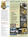
1
Topcon IS Series imaging/scanning/robotic system IS-1" accuracy IS-3" accuracy The New Image of Surveying Some products define an era. Others create a new one. The new Topcon IS scanning, robotic, reflectorless imaging station is that product. Its only limit is your imagination. Topcon’s IS combines the best of two worlds, advanced imaging and high-accuracy surveying, incorporating real-time field imagery with spatial data. The IS’s powerful functionality is controlled using Topcon’s exclusive ImageMaster software that produces “photography with dimension”, a revolutionary and cost effective alternative to laser scanning. Reality captured for results unimaginable. TOTAL STATIONS Imaging Station Series Features: * IntelligentScan automatically recognizes significant features in the images. Its 20 pps scan rate is ideal for most applications, and its 2000m precision reflectorless range is tops in its class. * ImageDrive lets you visually operate from the controller and easily switch from imaging to prism tracking. * First with Independent Control to allow complete control from your computer, WiFi-equipped FC-2200, and other compatible devices. * Integrated dual-camera array with wide-area and 30x scope view so you can zoom in on the detail you need. specifications A Robot at Heart… The IS doesn’t forsake its robotic roots. The IS has all the features of our GPT-9000A robotic total station and more. Our 9000A series robotic system features sophisticated technology unique to Topcon– our one-touch quick lock feature that set the standard in robotic target acquisition has taken another step forward, with the sleek new RC-3 system. All 9000A series robotic systems offer reflectorless measurement superior to any other instrument available – capable of precision measurements at a mind-boggling 2000 meters! Packed with a wide variety of advanced technologies, the Topcon GPT-9000A series robotic total station demonstrates why Topcon continues to be the world’s leader in precision survey instrumentation: * Innovative, completely cable-free system design * Superior X-TRAC™ Quick-Lock tracking technology * Full-color, graphical Windows Mobile instrument & field controller interface * The most advanced, longest range, and most powerful reflectorless technology available * Integrated interference free 2.4 GHz SpSp robotic data communications Reflectorless Accessories: 60487 BT-65Q Lithium-Ion battery pack 60241 BC-30B 110V charger 60243 F-25 USB cable Tracking Turning speed 85 degrees /sec Tracking speed 15 degrees /sec Tracking range 26 to 3,280 feet, 8 to 1000 meters Tracking accuracy 2 " Telescope Length 165 Millimeters Objective Lens Diameter 45mm(EDM:50mm) Magnification 30x Image Erect Field of View 1° 30’ Resolve Power 3.0" Min. Focus Distance 1.3 meters Measurement Range 1 Prism 9840 ft, 3000 meters Non Prism 6500 ft, 2000 meters Measuring Accuracy Prism Mode ±(2mm+2ppmxD*) m.s.e. fine Non Prism Mode ±(5mm) m.s.e. fine (>25m), Long range ±(10mm+10ppm) fine Minimum reading 1mm(0.005ft.)/0.2mm(0.001ft.) fine Measurement time 1.2 sec.(Initial 3.0 sec.) fine Angle Measurement Method Absolute Detection 2 sides horizontal, 2 side vertical Minimum reading 0.5"/1" arc sec, 0.1/0.5 mgon Accuracy 1" to 5" (see models) Diameter of Circle 71 Millimeters Computer Unit Operating system Windows CE-NET 4.2 Processor Intel PXA255 400 Mhz RAM 64MB Display 320x240 (QVGA) graphic LCD TFT color touch screen Card system Compact flash Imaging Cameras (2) 1.3mp Image Speed 1 to 10 fps Scanning Max 20 points/second Power Source BT-65Q Lithium-Ion Capacity 5000 mAh approximate battery life 4.5 hours including distance measurement Battery Charger ID BC-30B Recharging time 5.0 Hours LASERS • SURVEY • GPS • MACHINE CONTROL MACHINERY CO., INC. 24 Cedar Street • So. Bound Brook, NJ 08880-1352 Phone: 800-453-7726 Fax: 732-805-0022 QS Series The QS Series Quick Station TOTAL STATIONS reflectorless/wireless robotic system QS 1" QS 3" QS 5" Jobsite demands are constantly changing. Adopting and utilizing the very best technology innovations for your business enables you to increase your productivity and profitability like never before. Robotic instrument technology and the significant performance advantages it can offer have changed the way topography and layout tasks are completed worldwide. Through Topcon's leadership and experience in optical instrumentation that spans more than 70 years, we have the know-how to design and build the very best robotics systems available. Topcon is now on its 8th generation of robotic instrument technology. With a modern, cable-free design, the QS Series offers the most advanced robotic technology available. The QS Series Robotic System features sophisticated technology unique to Topcon. Our one-touch Quick Lock feature that set the standard in robotic target acquisition has taken another step forward with X-TRAC 8, a superior technology solution for strong tracking and quick re-acquisition in challenging environments. Available in 1, 3, and 5 second angle accuracies, you can select the instrument that best fits your requirements. All QS Series Robotic Systems offer reflectorless measurement superior to any other instrument available - capable of precision measurements at a mind-boggling 6,500 ft. (2,000m)! Topcon's new QS Series Robotic Systems: Superior Technology - Superior Design - Superior Performance and Value only from Topcon, the World Leader in Precision Measurement Technology. Reflectorless RC-4 The new dual-laser system features: * Wide-area aiming for faster QuickLock * Integrated 2.4GHz radio simplifies communication with all Topcon field controllers * Extended radio range * Multi-channel support Accessories: 60487 BT-65Q Lithium-Ion battery pack 60241 BC-30B 110V charger 60243 F-25 USB cable specifications ANGLE MEASUREMENT Method Absolute Reading Horizontal 2 sides Vertical 2 sides Minimum Reading QS1 0.5”/1” (0.1/0.5mgon) QS3 1” / 5” (0.2/1mgon) QS5 1” / 5” (0.2/1mgon) Accuracy QS1 1” (0.3mgon) QS3 3” (1mgon) QS5 5” (1.5mgon) Tilt Correction Dual Axis Compensating Range ±6’ DISTANCE MEASUREMENT 1 prism 9,840’ (3,000m) 3 prism 13,120’ (4,000m) 9 prism 16,400’ (5,000m) Non-Prism Mode 4.9’ - 820’ (1.5m - 250m) Non-Prism Long Mode 16.4’ - 6,500’ (5.0m - 2,000m) MEASUREMENT ACCURACY Prism Mode Fine 0.2mm / 1mm ±(2mm+2ppmxD) m.s.e. Coarse 1mm ±(7mm+2ppmxD) m.s.e. Coarse 10mm ±(10mm+2ppmxD) m.s.e. Non-Prism Mode Fine 0.2mm / 1mm ±(5mm) m.s.e. Coarse 1mm / 10mm ±(10mm) m.s.e. Non-Prism Long Mode Fine 1mm ±(10mm+10ppmxD) m.s.e. Coarse 5mm ±(20mm+10ppmxD) m.s.e. Coarse 10mm ±(100mm) m.s.e. USER INTERFACE OS Microsoft Windows® CE.NET 4.2 Processor Intel PXA255 400MHz Screen Full Color Touch-screen LASERS • SURVEY • GPS • MACHINE CONTROL MACHINERY CO., INC. 24 Cedar Street • So. Bound Brook, NJ 08880-1352 Phone: 800-453-7726 Fax: 732-805-0022 GPT-7500 Series TOTAL STATIONS reflectorless/Windows CE GPT-7501 GPT-7503 GPT-7505 As the world leader in precise positioning solutions, Topcon has a tradition of bringing innovative technology to the jobsite. The GPT-7500 series total stations continue this tradition by providing advanced reflectorless technology in addition to a convenient built-in Windows CE.NET operating system and large, full color graphic display with touch screen! Advanced Long Range Prismless Measurement Capability - The GPT-7500 series gives you up to 2000m reflectorless range, the longest in its class! Measure up to 3000m with a prism. The unique dual optical EDM design takes pulse laser reflectorless measurement to a higher level. Even at long distances, it maintains focused beam accuracy and allows you to measure only the target you select. Windows CE technology on the GPT-7500 total station provides a bright graphic display, touch screen display, more functionality, better support for standard accessories like Bluetooth® wireless technology, and more available software. It provides the ideal user interface for an integrated, on-board solution for the GPT-7500 total stations. GPT-7500 Series Features: • Advanced Lithium-ion Battery • Removable Compact Flash Data card • Powerful TopSurv on-board Software Reflectorless Accessories: 60487 BT-65Q Lithium-Ion battery pack 60241 BC-30B 110V charger 60243 F-25 USB cable specifications Telescope Length 150 Millimeters Objective Lens Diameter 45mm(EDM:50mm) Magnification 30x Image Erect Field of View 1° 30’ Resolve Power 2.5" Min. Focus Distance 1.3 meters Measurement Range 1 Prism 9900 ft, 3000 meters 3 Prism 4000 meters Non Prism 6500 ft, 2000 meters Measuring Accuracy Prism Mode ±(2mm+2ppmxD*) m.s.e. fine Non Prism Mode ±(5mm) m.s.e. fine(3-25m), ±(2mm+2ppmxD*) m.s.e. (>25m) Minimum reading 1mm(0.005ft.)/0.2mm(0.001ft.) fine Measurement time 3.0 sec./1.2 sec.(Initial 4.0 sec.) fine Angle Measurement Method Absolute Detection 2 sides horizontal, 2 side vertical Minimum reading 0.5"/1" arc sec, 0.1/0.5 mgon Accuracy 1" to 5" (see models) Diameter of Circle 71 Millimeters Tilt Correction Type Dual Axis Compensating Range ±4’ Correction Unit 1" arc sec, 0.1 mgon Computer Unit Operating system Windows CE-NET 4.2 Processor 177 Mhz Hitachi SH7750R RAM 64MB Display 320x240 (QVGA) graphic LCD TFT color touch screen Card system Compact flash Interface RS-232 (6 pin), USB type B for ActiveSync Environmental Circular level sensitivity 10’ /2mm Plate level sensitivity 30" /2mm Optical Plummet 3x Magnification Dimensions (HxWxL) 13.5 (H) x 9.6 (W) x 8.6 (L) inches Instrument Weight (with battery) 13.6 pounds, 6.2 kg Dust/Water Protection IP54 rating Operating Temperature -20° to +50° C, -4° to +122° F Power Source BT-65Q Lithium-Ion Capacity 5000 mAh approximate battery life 7.5 hours including distance measurement, 10 hours Angle measurement only Battery Charger ID BC-30B Recharging time 4.0 Hours LASERS• SURVEY• GPS• MACHINE CONTROL MACHINERY CO., INC. 24 Cedar Street • So. Bound Brook, NJ 08880-1352 Phone: 800-453-7726 Fax: 732-805-0022 GTS-750 Series TOTAL STATIONS Windows CE on-board GTS-751 GTS-753 GTS-755 At Topcon efficiency and productivity are our priority. By adopting the latest Windows®CE technology, Topcon brings the advantages of the GUI (Graphical User Interface) to a Total Station. Whether you are an experienced user or just a beginner, the graphical interface and intuitive design will allow you to get up and running in no time. Windows CE technology provides a bright graphic display, more functionality, better support for standard accessories and much more software available. In addition, it is easier to convert software written for other hardware. Our robust 32-bit multitasking environment allows application developers to get the best out of our modern microprocessor design. Windows®CE contains innovative functionality such as vibrant graphics and touch screen capabilities that make the user interface ideal for an integrated, on-board solution. The GTS750 series once again demonstrates Topcon’s market leadership, and we will continue to ride the wave of technology while older text-based systems are left behind. GTS-750 Series Features: • Built-in Windows®CE.NET operating system • Large, full color graphic display touch screen • Advanced Lithium-Ion Battery • Removable Compact Flash Data card • Powerful TopSurv on-board Software Accessories: 60487 BT-65Q Lithium-Ion battery pack 60241 BC-30B 110V charger 60243 F-25 USB cable specifications Telescope Length 150 Millimeters Objective Lens Diameter 45mm(EDM:50mm) Magnification 30x Image Erect Field of View 1° 30’ Resolve Power 2.5" Min. Focus Distance 1.3 meters Measurement Range 1 Prism 9900 ft, 3000 meters 3 Prism 4000 meters 9 Prism 5000 meters Measuring Accuracy Prism Mode ±(2mm+2ppmxD*) m.s.e. fine Minimum reading 1mm(0.005ft.)/0.2mm(0.001ft.) fine Measurement time 2.8 sec./1.2 sec.(Initial 4.0 sec.) fine Angle Measurement Method Absolute Detection 2 sides horizontal, 2 side vertical Minimum reading 0.5"/1" arc sec, 0.1/0.5 mgon Accuracy 1" to 5" (see models) Diameter of Circle 71 Millimeters Tilt Correction Type Dual Axis Compensating Range ±4’ Correction Unit 1" arc sec, 0.1 mgon Computer Unit Operating system Windows CE-NET 4.2 Processor 177 Mhz Hitachi SH7750R RAM 64MB Display 320x240 (QVGA) graphic LCD TFT color touch screen Card system Compact flash Interface RS-232 (6 pin), USB type B for ActiveSync Environmental Circular level sensitivity 10’ /2mm Plate level sensitivity 30" /2mm Optical Plummet 3x Magnification Dimensions (HxWxL) 13.5 (H) x 9.6 (W) x 8.6 (L) inches Instrument Weight (with battery) 13.6 pounds, 6.2 kg Dust/Water Protection IP54 rating Operating Temperature -20° to +50° C, -4° to +122° F Power Source BT-65Q Lithium-Ion Capacity 5000 mAh approximate battery life 7.5 hours including distance measurement, 10 hours Angle measurement only Battery Charger ID BC-30B Recharging time 4.0 Hours Operating temperature 0° to +40° Celsius, 32° to 104° Fahrenheit LASERS• SURVEY• GPS• MACHINE CONTROL MACHINERY CO., INC. 24 Cedar Street • So. Bound Brook, NJ 08880-1352 Phone: 800-453-7726 Fax: 732-805-0022 GPT-7000i Series TOTAL STATIONS reflectorless/Windows CE/digital camera GPT-7001i GPT-7002i GPT-7003i GPT-7005i Capture reality – don’t just measure it! With its integrated digital camera technology, the Topcon GPT7000i imaging total station makes your field data come alive. Captured job site photos are incorporated into your measurement data, or use the onboard imaging technology to superimpose design points or stakeout points. By adding optional digital imaging software you can combine multiple job site photos and create 3D models and point clouds! Never miss a required shot again! The GPT-7000i series gives you up to 250m reflectorless range, the longest in its class! Measure up to 3000m with a prism. The unique dual optical EDM design takes pulse laser reflectorless measurement to a higher level. Even at long distances, it maintains focused beam accuracy and allows you to measure only the target you select. Topcon's GPT-7000i is a World's First imaging total station. It contains an integrated camera that allows you to visually map measurements to job site photographs. With additional software you can create 3D point clouds and stereoscopic images. For high performance surveying, get Topcon. GPT-7000i Series Features: • Dual-view integrated CCD camera: wide and finder view • Windows CE.NET 4.2 operating system • Extra-large QVGA LCD TFT color display • Pinpoint reflectorless measuring up to 250m Reflectorless CAPTURE REALITY Accessories: 60244 BT-61Q Lithium-Ion battery pack 60241 BC-30B 110V charger 60243 F-25 USB cable specifications Telescope Length 150 Millimeters Objective Lens Diameter 45mm(EDM:50mm) Magnification 30x Image Erect Field of View 1° 30’ Resolve Power 2.8" Min. Focus Distance 2.0 meters Camera Number of effective pixels 640 x 480 (VGA) Digital zoom magnifications 0.25, 0.5, 1.0, 2.0 Minimum focusing distance 2m Angle of View 1° telescopic or 30° wide-angle Measurement Range 1 Prism 9900 ft, 3000 meters Non Prism 820 ft, 250 meters Measuring Accuracy Prism Mode ±(2mm+2ppmxD*) m.s.e. fine Non Prism Mode ±(5mm) m.s.e. fine(3-25m), ±(2mm+2ppmxD*) m.s.e. (>25m) Minimum reading 1mm(0.005ft.)/0.2mm(0.001ft.) fine Measurement time 3.0 sec./1.2 sec.(Initial 4.0 sec.) fine Angle Measurement Method Absolute Detection 2 sides horizontal, 2 side vertical Minimum reading 0.5"/1" arc sec, 0.1/0.5 mgon Accuracy 1" to 5" (see models) Diameter of Circle 71 Millimeters Tilt Correction Type Dual Axis Compensating Range ±4’ Correction Unit 1" arc sec, 0.1 mgon Computer Unit Operating system Windows CE-NET 4.2 Processor 177 Mhz Hitachi SH7750R RAM 64MB Display 320x240 (QVGA) graphic LCD TFT color touch screen Card system Compact flash Interface RS-232 (6 pin), USB type B for ActiveSync Environmental Circular level sensitivity 10’ /2mm Plate level sensitivity 30" /2mm Optical Plummet 3x Magnification Dimensions (HxWxL) 13.5 (H) x 9.6 (W) x 8.6 (L) inches Instrument Weight (with battery) 13.6 pounds, 6.2 kg Dust/Water Protection IP54 rating Operating Temperature -20° to +50° C, -4° to +122° F Power Source BT-61Q Lithium-Ion Capacity 4400 mAh Battery Charger ID BC-30B Recharging time 4.0 Hours LASERS• SURVEY• GPS• MACHINE CONTROL MACHINERY CO., INC. 24 Cedar Street • So. Bound Brook, NJ 08880-1352 Phone: 800-453-7726 Fax: 732-805-0022 Reflectorless GPT-7001i GPT-7002i GPT-7003i GPT-7005i Capture reality – don’t just measure it! With its integrated digital camera technology, the Topcon GPT-7000i imaging total station makes your field data come alive. Captured job site photos are incorporated into your measurement data, or use the onboard imaging technology to superimpose design points or stakeout points. By adding optional digital imaging software you can combine multiple job site photos and create 3D models and point clouds! Never miss a required shot again! The GPT-7000i series gives you up to 250m reflectorless range, the longest in its class! Measure up to 3000m with a prism. The unique dual optical EDM design takes pulse laser reflectorless measurement to a higher level. Even at long distances, it maintains focused beam accuracy and allows you to measure only the target you select. GPT-7000i Series Features: • Dual-view integrated CCD camera: wide and finder view • Windows CE.NET 4.2 operating system • Extra-large QVGA LCD TFT color display • Pinpoint reflectorless measuring up to 250M Specifications Telescope Length 150 Millimeters Magnification 30x Camera Number of effective pixels 640 x 480 (VGA) Digital zoom magnifications 0.25, 0.5, 1.0, 2.0 Minimum focusing distance 2m Measurement Range 1 Prism 9900 ft, 3000 meters Non Prism 820 ft, 250 meters Measuring Accuracy Prism Mode ±(2mm+2ppmxD*) m.s.e. fine Non Prism Mode ±(5mm) m.s.e. fine(3-25m), (2mm+2ppmxD*) m.s.e. (>25m) Angle Measurement Accuracy 1" to 5" (see models) Computer Unit Operating system Windows CE-NET 4.2 Display 320x240 (QVGA) graphic LCD TFT color touch screen Card system Compact flash Interface RS-232 (6 pin), USB type B for ActiveSync Environmental Optical Plummet 3x Magnification Dimensions 13.5 (H) x 9.6 (W) x 8.6 (L) inches Instrument Weight (with battery) 13.6 pounds GPT-7000i Series Windows CE/digital camera TOPO Survey Measurement Topcon's GPT-7000i is a World's First imaging total station. It contains an integrated camera that allows you to visually map measurements to job site photographs. With additional software you can create 3D point clouds and stereoscopic images. For high performance surveying, get Topcon. Data Map Settings Close Offsets Images US Mode NP Meas L1 L2 L3 P1 108 Applications for Imaging • Archaeology • Construction - As built Surveys - Volume calculations - Dimension Control - Monitoring • Accident Investigation • Crime Scene Mapping • Disaster Management • Heritage Surveys • Land Survey Mapping • Asset Management • Quarrying • Hazardous area surveying • Industrial Measurement TOPO Survey Measurement Data Map Settings Close Offsets Images US Mode NP Meas L1 L2 L3 108 P1 CAPTURE REALITY Phone: 800-453-7726 MACHINERY CO., INC. 24 Cedar Street • So. Bound Brook NJ 08880-1352 LASERS• SURVEY• GPS• MACHINE CONTROL GPT-3100W Series reflectorless/bluetooth wireless TOTAL STATIONS Topcon was the first to bring a completely wireless total station to the surveying industry. Now, with the GPT-3100W series reflectorless total stations, Topcon gives you the convenience of wireless technology on the total stations with the longest reflectorless range in their class. The GPT-3100W series provides the highest measuring precision available due to its dual-optical design, so you get incredible results every time, in all situations. GPT-3100W Series Features: • Dual-Optical Design—Reflectorless measuring requires a finely focused beam for pinpoint accuracy. Prisms need a wider pattern to prevent off-center measuring degradation. Topcon’s dual-optical system gives you both for the maximum measuring accuracy all the time. • Precise Pulse-Laser Reflectorless—Topcon’s pulselaser “ time-of-flight” system eliminates measuring errors caused by the overlapping signals used in phase measuring systems. Accurately measuring corners or through objects such as a chainlink fence is always fast and reliable. • Longest Reflectorless Range—Up to 350m, the longest reflectorless range in its class! Measures up to 3000m with a prism. The dualoptical design allows you the extended range using a class 1 laser— safe for all conditions—making it ideal for use in hightraffic and other heavily populated areas. Reflectorless GPT-3102W GPT-3103W GPT-3105W GPT-3107W GPT-3002LW GPT-3003LW GPT-3005LW LW = long range reflectorless up to 1200M ! specifications Telescope Length 150 Millimeters Objective Lens Diameter 45mm(EDM:50mm) Magnification 30x Image Erect Field of View 1° 30’ Resolve Power 2.8" Min. Focus Distance 1.3 meters Measurement Range 1 Prism 9900 ft, 3000 meters Mini Prism 4920 ft, 1500 meters Non Prism W - 1150 ft, 350 meters LW - 3900 ft, 1200 meters Measuring Accuracy Prism Mode ±(3mm+2ppmxD*) m.s.e. fine Non Prism Mode ±(3mm+2ppm @ 25m or more) m.s.e. fine Minimum reading 1mm(0.005ft.)/0.2mm(0.001ft.) fine Measurement time 1.2 sec.(Initial 3.0 sec.) fine Angle Measurement Method Absolute Detection 2 sides horizontal, 2 side vertical Minimum reading 1"/5" arc sec, 0.2/1 mgon Accuracy 2" to 7" (see models) Diameter of Circle 71 Millimeters Tilt Correction Type Dual Axis Compensating Range ±3’ Correction Unit 1" arc sec, 0.1 mgon Computer Unit Interface RS-232C(6 pin) Serial, Bluetooth wireless Environmental Circular level sensitivity 10’ /2mm Plate level sensitivity 30" /2mm Optical Plummet 3x Magnification Laser Plummet LD (Visible Laser) light source, 633nm Dimensions (HxWxL) 13.2 (H) x 7.2 (W) x 6.9 (L) inches Instrument Weight (with battery) 11.4 pounds, 5.2 kg Dust/Water Protection IP66 rating Operating Temperature -20° to +50° C, -4° to +122° F Power Source BT-52QA Output Voltage DC7.2 Volts Capacity 2700 mAh approximate battery life 4.2 hours including distance measurement, 45 hours Angle measurement only Battery Charger ID BC-27BR Recharging time 1.8 Hours Operating temperature 0° to +40° Celsius, 32° to 104° Fahrenheit Accessories: 51730 BT-52QA NiMH battery pack 60347 BC-27BR 110V charger 60381 FC-100 128mb BT with TopSurv TS LASERS • SURVEY • GPS • MACHINE CONTROL MACHINERY CO., INC. 24 Cedar Street • So. Bound Brook, NJ 08880-1352 Phone: 800-453-7726 Fax: 732-805-0022 GTS-230W Series bluetooth wireless GTS-233W GTS-235W GTS-236W GTS-239W TOTAL STATIONS Topcon's GTS-230W Series are the World's First electronic total stations to feature wireless operation! Each model in this versatile lineup can handle all surveying and construction total station needs at a remarkably low price. Four levels of angular accuracy are available to suit any application. And the rugged, waterproof/dustproof design, (IP-66), will stand up to the harshest construction site environment. GTS-230W Series Features: • World's first wireless total station (no cable from instrument to data collector) • Large, easy-to-read screen • Expanded keyboard Like Topcon's GTS-220 Series, the GTS230W Series is loaded with standard features including a long life 10 hour NiMH battery, a "Point Guide Feature" to allow fast alignment in staking tasks, and a laser plummet to help make setup fast and easy. Even wireless operation is standard with the GTS-230W Series, so you don't have to worry about messy cables slowing you down! specifications Telescope Length 150 Millimeters Objective Lens Diameter 45mm(EDM:50mm) Magnification 30x Image Erect Field of View 1° 30’ Resolve Power 2.5 " Min. Focus Distance 1.3 meters Measurement Range 1 Prism 9900 ft, 3000 meters 3 Prism 4000 meters 9 Prism 5000 meters Measuring Accuracy Prism Mode ±(2mm+2ppmxD*) m.s.e. fine Minimum reading 1mm(0.005ft.)/0.2mm(0.001ft.) fine Measurement time 2.8 sec/ 1.2 sec.(Initial 4.0 sec.) fine Angle Measurement Method Absolute Detection 2 sides horizontal, 1 side vertical Minimum reading 1"/5" arc sec, 0.2/1 mgon Accuracy 3" to 9" (see models) Diameter of Circle 71 Millimeters Tilt Correction Type Dual Axis Compensating Range ±3’ Correction Unit 1" arc sec, 0.1 mgon Computer Unit Interface RS-232C(6 pin) Serial, Bluetooth wireless Environmental Circular level sensitivity 10’ /2mm Plate level sensitivity 30" /2mm Optical Plummet 3x Magnification Laser Plummet LD (Visible Laser) light source, 633nm Dimensions (HxWxL) 13.2 (H) x 7.2 (W) x 6.9 (L) inches Instrument Weight (with battery) 10.8 pounds, 5.2 kg Dust/Water Protection IP66 rating Operating Temperature -20° to +50° C, -4° to +122° F Power Source BT-52QA Output Voltage DC7.2 Volts Capacity 2700 mAh approximate battery life 10 hours including distance measurement, 45 hours Angle measurement only Battery Charger ID BC-27BR Recharging time 1.8 Hours Operating temperature 0° to +40° Celsius, 32° to 104° Fahrenheit Accessories: 51730 BT-52QA NiMH battery pack 60347 BC-27BR 110V charger 60381 FC-100 128mb BT with TopSurv TS LASERS• SURVEY• GPS• MACHINE CONTROL MACHINERY CO., INC. 24 Cedar Street • So. Bound Brook, NJ 08880-1352 Phone: 800-453-7726 Fax: 732-805-0022 GTS-100 Series entry level total station GTS-102N GTS-105N TOTAL STATIONS The new Topcon GTS-100N series total station combines the traditional Topcon rugged field-ready quality and accuracy with economical, compact design that is perfect for everyday measuring and positioning applications such as topo and construction layout. GTS-100N features: * Economical, value priced measuring solution * Rugged, durable, water resistant design * Two accuracies to choose from 2” & 5” * Expanded, Full numeric keypad * On board programs & 24,000 point data storage * Ideal as a construction stakeout total station * Perfect when combined with FC field controller and software The entry-level value choice is the GTS-100N. Built with legendary Topcon precision and durability, the GTS-100N provides the construction professional with a dedicated lay-out solution. Use the onboard software to layout points in the field, confident that with Topcon, you’ll be right on target. Or use any of Topcon’s field controllers running one of our range of software packages tailored to the tasks you want to perform. specifications Accessories: 60537 BT-61 battery pack 60538 BC-G1B 110V charger Telescope Length 150 Millimeters Objective Lens Diameter 45mm (EDM:50mm) Magnification 30x Image Erect Field of View 1° 30 Resolve Power 3 " Min. Focus Distance 1.3 meters Measurement Range 1 Prism 6500 ft, 2000 meters 3 Prism 8800 ft, 2700 meters Measuring Accuracy Prism Mode ±(2mm + 2ppm x D)m.s.e. fine, N/A Measurement time 1mm: 1.2sec. (Initial 4sec.) Angle Measurement Method Absolute Reading Detection 2 horizontal, 1 vertical Minimum reading 1/5 " Tilt Correction Type Single Axis Method Liquid surface reflective profile sensor Compensating Range ±3' Correction Unit 1 arc sec Computer Unit Display 2 screen, dot matrix graphic LCD display Power approximate battery life 9 including distance measurement, 40 Angle measurement only LASERS• SURVEY• GPS• MACHINE CONTROL MACHINERY CO., INC. 24 Cedar Street • So. Bound Brook, NJ 08880-1352 Phone: 732-560-3200 Fax: 732-805-0022 CTS-3000 Series contractors reflectorless CTS-3005 CTS-3007 TOTAL STATIONS The CTS-3000 series features onboard software that simplifies staking. An extended keyboard enables easy operation and data input. The system software can also be operated with a hand-held data collector, like Topcon's FC-100. Reflectorless measurement capabilities up to 250m (820 ft.) and a prism type range of 3,000m (9842 ft.) to a single standard size prism provide the range needed to cover most job sites. CTS-3000 Features: • CTS - Contractors Total Station • Layout and offset measurement made easy • Reflectorless measurement to 250m • Easy on-board software • Class 1, eye-safe laser • TopField on-board software The pinpoint reflectorless measurement function will increase the productivity and flexibility of your measurements. Use a prism or not, it’s up to you. Utilize the CTS series to help you keep control on the job site. Replace lost or disturbed stakes, or use it to make spot measurements for elevations. Reflectorless specifications Telescope Length 150 Millimeters Objective Lens Diameter 45mm(EDM:50mm) Magnification 30X Image Erect Field of View 1° 30’ Resolve Power 2.8 " Measurement Range 1 Prism 9900 ft, 3000 meters Mini Prism 6.6 - 4,920 ft, 2 - 1,500 meters Pin Pole Prism 6.6 - 8,200 ft, 2 - 2,500 meters Non-Prism Mode 5 - 820 ft, 1.5 - 250 meters Measuring Accuracy Prism Mode ±(3mm+2ppmxD)m.s.e. fine, ±(10mm+2ppmxD)m.s.e. coarse Non-Prism Mode ±(10mm) m.s.e. fine(3-25m), ±(3mm+2ppm) m.s.e. fine(25m or more) Minimum reading 0.2mm(0.001ft.) / 1mm(0.005ft) fine, 1mm(0.005ft) 10mm(0.02ft.) coarse,10mm(0.02ft.) tracking Measurement time 1mm:1.2 sec.(Initial 3.0 sec.)/0.2mm:3.0 sec (Initial 4.0 sec.) Angle Measurement Method Absolute Detection 2 sides horizontal, 2 sides vertical Minimum reading 1"/5" arc sec, 0.2/1 mgon Accuracy 5 or 7 second (see models) Diameter of Circle 71 Millimeters Tilt Correction Type Single or Dual Axis Compensating Range ± 3’ Environmental Circular level sensitivity 10’ /2mm Plate level sensitivity 30" /2mm Optical Plummet 3x Magnification Laser Plummet LD (Visible Laser) light source, 633nm Laser Pointer LD (Visible Laser) light source, 690nm Dimensions (HxWxL) 13.2 x 7.2 x 6.9 inches Instrument Weight (with battery) 11.4 pounds, 5.2 kg Dust/Water Protection IP66 rating Operating Temperature -20° to +50° C, -4° to +122° F Power Source NiMH Battery BT-52Q Output Voltage DC7.2 Volts Capacity 2700 mAh approximate battery life 4.2 hours including distance measurement, 45 hours Angle only Battery Charger ID BC-27 Recharging time 1.8 Hours Operating temperature +10° to +40° C, +50° to +104° F Accessories: 51730 BT-52QA NiMH battery pack 60347 BC-27BR 110V charger 51224 Serial data cable 60438 FC-100 128mb with TopSurv Contractors LASERS• SURVEY• GPS• MACHINE CONTROL MACHINERY CO., INC. 24 Cedar Street • So. Bound Brook, NJ 08880-1352 Phone: 800-453-7726 Fax: 732-805-0022 prisms, tribrachs, tripods, poles SURVEY ACCESSORIES prisms 632010M CST 632010M - Single tilt prism with target (metal yoke) CST 651500 - Mini prism pack complete (metal housing) TOP 51920K - Single prism complete 2 1/2" TOP 51803 - Prism only 2 1/2" TOP 51910 - Single prism holder for 51803 TOP 51828 - Site pole for 51910 651500M Prism / Instrument Bags CST 612541 - Small nylon soft padded prism bag CST 612540 - Medium nylon soft padded prism bag CST 612546 - Total station soft nylon padded case (front load) CST PRISM BAGS tribrachs/adapters 612525 614500 CST 614500 - Tribrach with optical plummet CST 612525 - Rotating tribrach adapter with lock CST 612521 - Rotating tribrach adapter friction type SE 2152-03 - Tribrach with optical plummet SE 2070-00 - Rotating tribrach adapter with lock SE 2020-00 - Rotating tribrach adapter friction type TOP 55501 - Tribrach with optical plummet TOP 55502 - Tribrach without optical plummet TOP 51861 - Tribrach adapter S2 without optical plummet TOP 51851 - Tribrach adapter 2 with optical plummet 51861 55501 ALQR20 tripods CST ALC20 - Aluminum light weight tripod (QR) CST ALQR20 - Aluminum heavy duty tripod (QR) CST 60WDF20 - Wood/fiberglass tripod (QR) CST FGHD20 - All fiberglass heavy duty tripod (QR) SE 5302-10 - Wood/fiberglass tripod (QR) SE 5203-10 - All fiberglass heavy duty tripod (twist and QR) prism poles / bi-pods 674715TMA 60WDF20 CST 674708TMA - Maxi-Lite 8' prism pole (knob lock) CST 674712TMA - Maxi-Lite 12' prism pole (knob lock) CST 674715TMA - Maxi-Lite 15' prism pole (knob lock) CST 674508TMA - standard 8' prism pole (quick loc) CST 674512TMA - standard 12' prism pole (quick loc) CST 674515TMA - standard 15' prism pole (quick loc) SE 5129-54 - Carbon Fiber 8' robotic pole (knob lock) CST 674204 - 4' Non Graduated prism pole (quick release) CST 674260X - CST Thumb release bi-pod SE 5217-04 - SECO Thumb release bi-pod QUICK-LOC KNOB-LOCK 5217-04 674708TMA LASERS• SURVEY• GPS• MACHINE CONTROL MACHINERY CO., INC. 24 Cedar Street • So. Bound Brook, NJ 08880-1352 Phone: 800-453-7726 Fax: 732-805-0022 TDS Nomad Nomad 800B Nomad 800L DATA COLLECTORS rugged, compact, powerful The new TDS Nomad packs even more functionality into the most powerful and fullfeatured rugged handheld computer available. Start with an 806 MHz processor, a long-life battery and integrated wireless capabilities like GPS, 802.11g, and Bluetooth. Then select an optional Nomad configuration that includes an integrated laser bar code scanner and color digital camera. The Nomad also features a high-resolution, sunlight-visible VGA display that shows graphics and maps in crisp detail. And it's fully rugged and just as tough as our other handhelds which means the Nomad offers a lower Total Cost of Ownership (TCO) than consumer-grade handhelds. Standard Features • Windows Mobile 6.0 (Classic Edition) • 806MHz XScale Processor • 64 MB high-speed SDRAM • 512 MB or 1GB nonvolatile Flash storage • Sunlight-readable color TFT display • Touchscreen • Rugged waterproof design • Integrated speaker and microphone • 15 hours of continuous room-temperature operation • Optional integrated Bluetooth and 802.11g wireless High performance Every Nomad comes with an 806 MHz Marvell PXA320 XScale processor, 128 MB RAM and a hot-swappable rechargeable lithium-ion battery pack to keep going strong all day. Recharging time is significantly reduced with the use of lithium-ion batteries. Ultra rugged Like all TDS rugged handhelds, the Nomad meets the rigorous MIL-STD-810F military standard for drops, vibration, humidity, altitude and extreme temperatures. It also comes with an IP67 rating. Windows Mobile The Nomad also includes the latest Windows Mobile 6 software, so it runs all the applications you use most, including a wide range of thirdparty software for industry-specific applications. Wireless The Nomad has built-in Bluetooth and optional 802.11g wireless communication capabilities. possible. Available with TDS Survey Pro 4.2 Survey STD Survey Pro Survey Pro + Robotics Survey Pro + GPS Survey Pro MAX specifications Physical Size 6.92" (17.6 cm) x 3.92" (10.0 cm) x 1.96" (5.0 cm) Weight 21 ounces (596 g) including rechargeable PowerBoot Environment Operating Temperature -22 to 140° F (-30 to 60° C)¹ Storage Temperature -40 to 158° F (-40 to 70° C)¹ Temperature shock MIL-STD-810F, Method 503.4 Humidity MIL-STD-810F, Method 507.4 Water IP67, sealed against accidental immersion (1m for 30 minutes) MIL-STD-810F, Method 512.4, Procedure I Drop MIL-STD-810F, Method 516.5, Procedure IV 26 drops from 4 ft (1.22 m) onto plywood over concrete 6 additional drops at -22° F (-30° C) 6 additional drops at 140° F (60° C) Sand and Dust IP67, MIL-STD-810F, Method 510.4, Procedure I Vibration MIL-STD-810F, Method 514.5, Procedures I (Figures 17) & II Altitude MIL-STD-810F, Method 500.4, Procedures I, II and III 15,000 ft at 73° F (23° C) Electrical Processor Marvell PXA320 XScale @ 806 MHz Memory 128 MB high-speed SDRAM ~ 22 MB reserved Storage Onboard nonvolatile NAND flash 512 MB (Nomad 800B) 1 GB (Nomad 800L) Expansion 1x Type II Compact Flash, 1x SDIO slot Display 480 x 640 pixel (VGA) color TFT with LED back light Batteries 5200 mAh LiIon rechargeable pack Input/Output Ports Standard 9-pin male D-shell RS-232 serial and USB ports LASERS• SURVEY• GPS• MACHINE CONTROL MACHINERY CO., INC. 24 Cedar Street • So. Bound Brook, NJ 08880-1352 Phone: 800-453-7726 Fax: 732-805-0022 TDS Recon Recon 200X Recon 400X Recon NX DATA COLLECTORS rugged, compact, powerful Taking you further—at the office and in the field. The next-generation TDS Recon X-Series rugged handheld computer delivers maximum performance and reliability in a lightweight, extremely rugged design that's easy to carry. Featuring optional embedded Bluetooth and 802.11g wireless, the waterproof Recon weighs just 17 ounces, meets military specifications for drops, vibration, and both high and low temperature operation, and runs Windows Mobile 5.0. The Recon works wherever and whenever you need it. Standard Features • Windows Mobile 5.0 (Premium Edition) • 200 MHz or 400MHz Intel PXA255 XScale Processor • 64 MB high-speed SDRAM • 128 MB or 256 MB nonvolatile Flash storage • Sunlight-readable color TFT display • Touchscreen • Rugged waterproof design • Integrated speaker and microphone • 15 hours of continuous room-temperature operation • Optional integrated Bluetooth and 802.11g wireless High performance The Recon features the high-performance 200 MHz or 400 MHz XScale processor, a color display with front light, 64 MB of RAM and 128 or 256 MB of nonvolatile Flash storage to protect data from resets or power loss. Ultra rugged The Recon can handle the toughest field conditions. It meets MIL-STD-810F standards for drops, vibration and temperature extremes, and it has an IP67 rating—meaning it's impervious to dust and water immersion. Windows Mobile The Recon runs Windows Mobile 5.0, so you'll have the applications you use most-including a calendar, e-mail, and Mobile versions of Word, Excel and even PowerPoint. Long battery life The Recon's rechargeable NiMH PowerBoot module provides 3,800 mAh of power, enough to give you at least 15 hours of continuous typical use—more than a full day's work. The optional AA PowerBoot Module uses two AA batteries (alkaline or lithium) to keep your Recon running for up to 16 hours. It's perfect as a backup or in areas where recharging isn't possible. Available with TDS Survey Pro 4.2 Survey STD Survey Pro Survey Pro + Robotics Survey Pro + GPS Survey Pro MAX Recon for land surveyors Survey Pro on the Recon is now even more affordable. Running Survey Pro 4.x software, the new Recon NX gives HP 48 users an option to update their data collector at a very comfortable price. specifications Physical Size 6.50" (16.5 cm) x 3.75" (9.5 cm) x 1.75" (4.5 cm) Weight 17 ounces (490 g) including rechargeable PowerBoot Environment Operating Temperature -22 to 140° F (-30 to 60° C)¹ Storage Temperature -40 to 158° F (-40 to 70° C)¹ Temperature shock MIL-STD-810F, Method 503.4 Humidity MIL-STD-810F, Method 507.4 Water IP67, sealed against accidental immersion (1m for 30 minutes) MIL-STD-810F, Method 512.4, Procedure I Drop MIL-STD-810F, Method 516.5, Procedure IV 26 drops from 4 ft (1.22 m) onto plywood over concrete 6 additional drops at -22° F (-30° C) 6 additional drops at 140° F (60° C) Sand and Dust IP67, MIL-STD-810F, Method 510.4, Procedure I Vibration MIL-STD-810F, Method 514.5, Procedures I (Figures 17) & II Altitude MIL-STD-810F, Method 500.4, Procedures I, II and III 15,000 ft at 73° F (23° C) Electrical Processor Intel PXA255 XScale CPU @ 200 MHz (Recon 200X, NX) @ 400 MHz (Recon 400X) Memory 64 MB high-speed SDRAM ~ 22 MB reserved Storage Onboard nonvolatile NAND flash 128 MB (Recon 200X) 256 MB (Recon 400X) Expansion 1x Type I and 1x Type II Compact Flash slots Display 240 x 320 pixel (¼ VGA) color TFT with LED front light Batteries 3800 mAh NiMH rechargeable pack Input/Output Ports Standard 9-pin male D-shell RS-232 serial and USB ports LASERS• SURVEY• GPS• MACHINE CONTROL MACHINERY CO., INC. 24 Cedar Street • So. Bound Brook, NJ 08880-1352 Phone: 800-453-7726 Fax: 732-805-0022 TDS Ranger Ranger 300X Ranger 500X Ranger NX DATA COLLECTORS rugged, durable, powerful Smart, tough and loaded with additional features Featuring Windows Mobile 5.0, the next-generation TDS Ranger possesses features that field professionals depend on, like fieldready ruggedness, 30-hour battery and an easy to use keypad and touchscreen. The Ranger grows more versatile as technology evolves, integrating more and more capabilities designed to improve your work life. The Ranger gives you the option of integrated Bluetooth and 802.11 wireless, so you can connect to your field equipment without bulky cables. The CompactFlash (CF) slots allow you to add GPS, GPRS, digital cameras, bar-code scanners and other CF devices. The Secure Digital (SD) slot lets you increase data storage to handle larger jobs and is SDIO-enabled. Standard Features • Microsoft Windows MobileTM 5.0 • 53 tactile keys with separate navigation, alpha and numeric keypads, plus 8+1 directional pad • Touchscreen • Battery life of 30 hours under normal operating conditions • Complete recharge in 4.5 hours (80% in 2 hours) • Battery charge status LED indicator • Notification LED • Rugged polycarbonate shell • Integrated speaker and microphone Go Wireless You have the option of integrated Bluetooth and 802.11g wireless. The Ranger now comes in two models, the 300X and the 500X, to give you the choice of adding the options you want. Windows Mobile 5 The Ranger's operating system is Microsoft Windows Mobile 5.0. Run the Mobile version of all your favorite programs including PowerPoint and Outlook. Take advantage of the ability to run thousands of software programs designed for this OS. PowerBoot Module A lithium-ion battery pack keeps your Ranger going strong day after day. With normal use, the Ranger's PowerBoot Module provides 30 hours of power. Recharging time is significantly reduced with the use of lithium-ion batteries—4.5 hours for full recharge and two hours for 80% recharge. Ranger NX Model The Ranger NX gives you another choice in data collectors. By removing the option of expansion slots and providing 128 MB of on-board Flash storage, the Ranger NX becomes an extremely affordable rugged device. Available with TDS Survey Pro 4.2 Survey STD Survey Pro Survey Pro + Robotics Survey Pro + GPS Survey Pro MAX Ranger for land surveyors Survey Pro on the Ranger is now even more affordable. Running Survey Pro 4.x software, the new Ranger NX gives HP 48 users an option to update their data collector at a very comfortable price. specifications Models Overview 500X • 300X • NX PROCESSOR/SPEED: 520 MHz • 312 MHz • 312 MHz MEMORY: 128 MB • 64 MB • 64 MB DATA STORAGE: (On-board Flash) 512 MB • 256 MB • 128 MB WIRELESS: Integrated Bluetooth Standard • Optional • N/A Integrated 802.11g Optional • Optional • N/A Physical Size 10.5" (26.6 cm) x 5.2" (13.1 cm) x 1.9" (4.8 cm) Weight 952 g (2.1 lb), including battery Environment Operating Temperature -22 to to 140° F (-30 to 60 C)¹ Storage Temperature -40 to 158° F (-40 to 70 C)¹ Humidity MIL-STD-810F, Method 507.4 Water IP67, sealed against accidental immersion (1 m for 30 min.) Drop MIL-STD-810F, Method 516.5, Procedure IV 48" onto concrete, 26 drops at room temperature (all faces, edges, corners, one drop each) Dust IP67, MIL-STD-810F, Method 510.3, Procedures I & II Vibration MIL-STD-810F, Method 514.5, Procedure I, Figs. 5 & 17 Altitude MIL-STD-810F, Method 500.4, Procedures I, II & III 15,000 ft at 73 ° F Input/Output Ports 9-pin serial port—RS232 (115 Kbps), USB client, DC power port Electrical Processor Intel PXA 270 XScale CPU Expansion (not available on NX model) 1x Type I and 1x Type II CompactFlash 1x Secure Digital (SD) memory card slot Display 320 x 240 pixel (1/4 VGA) color TFT with LED backlight Power Li-Ion rechargeable pack, 6600 mAh Batteries 6600 mAh Lithium Ion rechargeable pack LASERS• SURVEY• GPS• MACHINE CONTROL MACHINERY CO., INC. 24 Cedar Street • So. Bound Brook, NJ 08880-1352 Phone: 800-453-7726 Fax: 732-805-0022 TDS Recon/Ranger accessories DATA COLLECTORS compact flash cards Holux GR-271 GPS * WAAS enabled * Internal antenna * SiRF Star III chip * ROHS compliant * Without WAAS/EGNOS: 5-10 meter accuracy * With WAAS/EGNOS: < 2.2 meter accuracy, horizontal 95% of time <5 m, vertical 95% of time * This product is only compatible in the right-hand CF slot. LifeView FlyCAM-CF Camera * 1.3 megapixel resolution * Still and video capture compact flash caps Socket Bluetooth * Short range wireless communication * NOTE: Not for use in units with built-in Bluetooth. Extended CF-Cap Recon Compatibility: * GPS cards * Other oversized CF cards power PowerBoot Module Recon * Up to 15 hours battery life * 3800 mAh NiMH battery * Rechargeable AA PowerBoot Module * Takes 2 AA batteries * Lithium or alkaline * No need to recharge Vehicle Charging Cable Recon * 12V cable * Recharge while driving Power Supply Recon * North American and International models PowerBoot Module Ranger * Up to 30 hours battery life * 6600 mAh Li-Ion battery * Rechargeable Extended/Optical CF-Cap Ranger Compatibility: * GPS cards * Socket 5P Scan card for bar codes * Other oversized CF cards cases Vehicle Charging Cable Ranger * 12V cable * Recharge while driving Standard Carry Case Recon * Extended size * Long-lasting nylon * Belt loop AC Charger Ranger * Multiple-standard power supply * International plug adapters miscellaneous Stylus pens (set of two) Lanyard * Stylus pen convenient when needed * Velcro safety release Tripod Hook * Easy to install * Works with major tripod brands * Comes in a kit Standard Carry Case Recon * Standard size * Long-lasting nylon * Belt loop Screen Protectors * Easy to install * standard style, pack of ten * long-life, clear or anti-glare, pack of two Hand Strap * Elastic * Prevent accidental drops Standard Carry Case Ranger * Standard size * Long-lasting nylon * Belt loop Extended Carry Case Ranger * Extended size * Long-lasting nylon * Belt loop cables Pole Brackets (no picture) * RECON 200/400/NX * RANGER 300/500 * RANGER 200 Instrument interface cables for: Topcon • Nikon • Leica • Trimble • Sokkia Instrument download cables 9 pin Serial • USB LASERS• SURVEY• GPS• MACHINE CONTROL MACHINERY CO., INC. 24 Cedar Street • So. Bound Brook, NJ 08880-1352 Phone: 800-453-7726 Fax: 732-805-0022 TDS Survey Pro DATA COLLECTORS TDS Survey Pro 4.3 Survey STD Survey Pro Survey Pro + Robotics Survey Pro + GPS Survey Pro MAX data collection software The #1 choice since 1995—productive, reliable, comprehensive TDS Survey Pro surveying software has been the #1 choice of surveyors since 1995¹. That's because Survey Pro gives you a complete set of capabilities for all your survey projects—and it's fast, reliable and easy to use, so you can work more productively in the field. And Survey Pro is always getting better. Based on feedback from surveyors like you, we regularly add enhancements and new features to Survey Pro that will help you work more productively in the field. And we always welcome your comments and suggestions so we can continue to update Survey Pro to support all the latest instruments and make your workflow faster and easier. • BNP Media, "Surveying and Mapping Industry Study," 1995-2006. Includes TDS software sold by dealers and TDS partner companies. Today's Survey Pro is better than ever, with features and function enhancements that make your workflow faster and easier. At the same time, TDS continues to update Survey Pro and they actively seek your feedback so they can keep making Survey Pro even better for you. SURVEY PRO + = PROFIT Survey Pro on TDS data collectors The best way to run Survey Pro is on a TDS handheld data collector. That's because we developed both the TDS Recon and Ranger rugged handheld computers to work with Survey Pro. The Recon and Ranger run Survey Pro functions and routines quickly, making it easy to use all the software's capabilities. Survey Standard Survey Standard is complete data collection software for surveyors. You can get a complete COGO suite including triangle solutions, map check and predetermined area, as well as traverse, sideshot and staking routines. And you can easily upgrade Survey Standard to any other Survey Pro level. Survey Pro Survey Pro adds several advanced features to Survey Standard. Survey Pro provides intuitive and powerful slope staking and road layout routines. You can also view DTM files, stake using the DTM surface and collect feature/attribute data, helping you save time in the field and in the office. Survey Pro Robotics The Survey Pro Robotics data collection package includes the functionality of Survey Pro and reliably controls your robotic total station with an easy-to-use interface that features intuitive, useful search tools, active maps, automatic repetition and a fine-turning routine that lets you make even precise turns remotely. Survey Pro GPS The Survey Pro GPS data collection package contains most Survey Pro functions, and adds the ability to collect data from RTK GPS receivers, as well as the ability to configure and store static GPS data. TDS GPS software reduces training and simplifies setups, and the Start Survey Wizard takes you through a streamlined GPS setup procedure. Survey Pro Max Survey Pro Max is the ultimate field software. It integrates Survey Pro Robotics and Survey Pro GPS functions, enabling you to use the same job files with both GPS receivers and total stations. LASERS• SURVEY• GPS• MACHINE CONTROL MACHINERY CO., INC. 24 Cedar Street • So. Bound Brook, NJ 08880-1352 Phone: 800-453-7726 Fax: 732-805-0022 FC-25 Rugged and Compact Topcon FC-25/25A features a pocket-sized, lightweight body with exceptional ruggedness. Conforming to the MIL standard and the IP65 dust/water protection, these field controllers are able to survive severe worksite conditions. DATA COLLECTORS pocket sized power FC-25 screenIntegrated Sensors Embedded 20 channel GPS chipset provides positional information by point positioning or by DGPS using SBAS corrections. The FC-25A incorporates a 3MP auto focus camera, electronic compass and an altimeter for GIS data collection applications. Easy, Intuitive Operation Windows Mobile® 6.5 operating system and a 3.5" sunlight readable touch screen display provide quick, easy, and intuitive operation. Field-exchangeable Battery Rechargeable Li-ion battery can be removed and replaced at the worksites. Battery charger is available as an optional accessory. specifications COMPUTER CPU 533MHz OS Microsoft Windows Mobile® 6.5 Features Memery 256MB SDRAM, 2GB Flash Memory * Windows Mobile® 6.5 * Embedded 20 Channel GPS Receiver * WLAN/Bluetooth® Wireless * 533MHz CPU / 256MB SDRAM * Field-exchangeable Li-ion Battery * Rugged and Lightweight (11.3 oz.) * IP65 Dust/Water Protection * FC-25A also with Built-in Camera, Compass, and Altimeter Display 3.5" Sunlight Readable TFT color LCD 640x480 VGA with Touch Screen Keypad 4 keys (including power key) and 1 directional key Interface Wireless LAN 802.11 b/g Bluetooth® Ver.2.0 Class 2USB Type Mini-B (Host 1.1/Client 2.0, to be switched by software)SD/SDHC Card Slot (Up to 16GB SDHC) INTEGRATED SENSOR GPS Type SiRFstarIII Chipset, GPS L1 (C/A), 20 Channels Horizontal Accuracy (RMS)*1 DGPS*2: 1m to 3m (3.3’ to 9.9’), Point Positioning: 5m (16.4’) Built-in Camera (FC-25A) 3 Megapixels, Auto Focus Camera Other Sensor (FC-25A) Electronic Compass, Altimeter ENVIRONMENTAL Available with TopSurv 8 modules: : Contractors STD Pro Pro + Robotics Pro + GPS Complete GIS Dust/Water Protection IP65 (IEC 60529:2001) Operating Temperature -22° F to +140° F (-30° C to +60° C) Temperature Shock MIL STD-810G, Method 503.5, Procedure-I-C; -30?C~71?C Humidity Up to 95%, non-condensing MIL-STD-810G Drop 5’ (1.52m), Vibration, Humidity PHYSICAL Dimensions H 5.75” x W 3.23” x D 1.30” (H 146 x W 82 x D 33mm) Weight with Battery 11.3 oz (320g) Battery Removable Li-ion Rechargeable Battery, 3.7V, 2400mAh Operating Time 7.5 hours with Bluetooth® connection Recharging Time 3.5 hours LASERS • SURVEY • GPS • MACHINE CONTROL MACHINERY CO., INC. 24 Cedar Street • So. Bound Brook, NJ 08880-1352 Phone: 800-453-7726 Fax: 732-805-0022 FC-120 DATA COLLECTORS rugged, compact, powerful If you are looking for a compact controller that provides big-time results, look no further than Topcon's FC-120. The FC-120 field controller incorporates the graphical Windows® CE operating system on a crisp, bright, color touch screen display that makes your field data come alive. This powerful operating system, combined with the versatility of dual removable media for data storage and transfer; the easyaccess, long-life "camcorder" style rechargeable battery; and the compact design that small on size, but not in performance, makes the FC-120 is the perfect field controller for any job. specifications Standard Features • Built-in Bluetooth® wireless technology • Ultra-bright, TFT, color touch screen display • Windows® CE.NET 5.0 operating system • Compact, Rugged design • Easy access Compact Flash and SD Media card slots deliver memory expansion and connectivity options • 520MHz XScale processor • Removable, Long-lasting Li-Ion batteries • 64MB SDRAM, 128/256MB ROM Available with Topcon TopSurv modules: : Contractors STD Pro Pro + Robotics Pro + GPS Complete GIS Internal Microprocessor Intel PXA270 Xscale Processor Speed 520 MHz Operating System Windows CE.NET 5.0 Memory 0.512 Eboot MB, 64 SDRAM MB, 128/256 (built in CF card) Physical Type of data collector Handheld Controller Dimensions 182 x 103 x 59 mm Weight 600 (with batteries) grams External Display QVGA (Portrait) 3.5 inch color TFT Transreflective type, 240 x 320 pixel dimensions Backlight LED Backlight keyboard ESC, Alt, Enter, Windows, Desktop, and Power Key, Cursor key keys, 10 total keys Touch Screen Resistive/Passive touch screen External Power with run charge Audio integrated sealed speaker (mono), sealed microphone Interface Serial RS-232C Serial (D-sub 9) USB Type B mini Ver1.1 IrDA no Ethernet no Built-in BT yes SD yes (memory) Compact Flash 1 x Type I/_ (Memory and I/O Card) Environmental Operating Temperature -20 to +50 degrees Celsius Storage Temperature -30 to +60 degrees Celsius Water 66 IP Drop Dropping this instrument from a height of 1 meter does not affect its functions EMC EN55022, EN55024 ESD EN61000 Mandatory FCC Class B, CE, CSA Power Batteries Li-ion rechargeable system 2200mAH / 7.4V Operating Time 20-45 Hours Charge Time with fast charger 3 Hours Other Accessories Battery (BT-62Q), AC-DC converter (AD-9), Interface cable (F-25), Handstrap, Soft case, Stylus pen, Display protection sheet_5, manual LASERS • SURVEY • GPS • MACHINE CONTROL MACHINERY CO., INC. 24 Cedar Street • So. Bound Brook, NJ 08880-1352 Phone: 800-453-7726 Fax: 732-805-0022 FC-250 DATA COLLECTORS rugged, state-of-the-art The FC-250 field controller incorporates Windows Mobile® 6.5 operating system on a crisp, bright, color touch screen display that makes your field data come alive. This powerful operating system, combined with the versatility of dual removable media for data storage and transfer; the easy-access, long-life rechargeable battery; and the compact design that is small on size, but not in performance, makes the FC-250 the perfect field controller for any job. The FC-250 has built-in Bluetooth® wireless technology and WiFi. Both the Bluetooth and WiFi components are hardwired inside the device leaving the CF card slot open and available for other CF devices. specifications Microprocessor Marvel PXA320 Processor Speed 806MHz Operating System Microsoft Windows Mobile 6.5 Memory DDR SDRAM 256MB Flash Memory 1GB (NAND) * 806MHz Processor * Windows Mobile 6.5 operating system * RS-1 Radio capable * Compact, ruggedized design * Easy access Compact Flash and SD Media card slots deliver memory expansion and connectivity options * Built-in Bluetooth® wireless technology and WiFi * Removable Li-ion batteries * Ultra-bright, TFT, color touch screen display * Wireless connectivity available for Topcon GPS+ and W-series total stations * Cable-free operation * Ruggedized, shock absorbing environmentally sealed housing * Separately sealed battery makes swapping a snap * Shock Resistance, 1 meter drop resistant Available with TopSurv 8 modules: : Contractors STD Pro Pro + Robotics Pro + GPS Complete GIS Interface Serial: D-sub 9 pin USB: (2 ports) USB rev 1.1 (Type Mini-B and Type A) Card Slot: SD (Memory and I/O) Compact Flash (Memory and I/O) Bluetooth Capable Yes Wireless LAN Yes (802.11b/g) LCD Display 640 x 480 VGA (portrait) Color Sunlight Readable 3.7 inch color TFT transparent type Backlight Backlight (LED) Touchscreen Resistive touch screen/passive Keyboard 7 key w/smart keyboard External Power Yes Audio Sealed Speaker (mono) Sealed Microphone Yes (mono) Environmental IP-66 Operating Temperature -4° F to +122° F (-20° C to +50° C) Dimensions 7.72 in. x 4.21 in. x 2.40 in. (196 x 107 x 61mm) Weight 1.5 lbs (0.7kg ) Batteries Removable Li-ion batteries Internal rechargeable backup battery Operation (main battery) No less than 10 hours without communications No less than 8 hours with Bluetooth No less than 6 hours with WLAN LASERS • SURVEY • GPS • MACHINE CONTROL MACHINERY CO., INC. 24 Cedar Street • So. Bound Brook, NJ 08880-1352 Phone: 800-453-7726 Fax: 732-805-0022 FC-2500 DATA COLLECTORS rugged, powerful, full size The world’s most advanced field controller is also the world’s toughest. Topcon’s FC-2500 is fully loaded to unleash your productivity. Its rock-solid design takes drops, dirt, even drowning, without fear of data loss. FC-2500 Add-on robotic radio design The FC-2500 has an add-on connection on the back of the unit to control a spread spectrum radio for robotics communication. Use this connector and an RS-1 to have a cablefree radio connection to the Topcon robotic instruments. Additional packs may be possible in the future. Alphanumeric Keyboard Finally a 55 key alphanumeric keyboard unit that can control the Robotic systems. We know that land surveyors in the US market prefer an alphanumeric keyboard data collector. This FC-2500 can handle the robotic radio as an expansion slot radio. USB Flash Drive Use the USB mini port as both a Host and Client. This On-The-Go (OTG) functionality allows for expanded memory and easy file transfer through USB flash drives or ActiveSync connection. This design also provides rugged protection. The FC-2500 can not be compromised by opening a card door or flap. The entire unit is sealed and submersible. Removable, hot swappable battery packs With two NiMH batteries loaded standard with 2500mAh each, battery performance can be as high as 50 hours. But with all the functionality of this device turned on and on full power drain, you can still count on 12-14 hours. The typical power drain from a Bluetooth connection to a GPS receiver will run for 24 hours. Don’t ever worry about overcharging, the FC-2500 has internal temperature monitors to prevent any unexpected high temperature issues. Waterproof and rugged The FC-2500 is rated at IP-67, which means it can be accidentally submersed in water. The unit also has a 3 foot drop proof rating. 5.17 MP Camera Capture Reality in yet an additional device from Topcon. Topcon understands that a picture is worth more than a thousand words. This highly advanced camera can be used to associate photos with stored TopSurv points as Photo Notes. For every topo shot, as photo note can be stored. specifications Standard Features * 624MHz XScale processor * 5.17 megapixel camera and bar code reader * 256Mb RAM, 2Gb ROM (4X the competition) * Built-in wireless Bluetooth® and WiFi connectivity * Windows CE.NET 5.0 operating system * Add-on robotic radio design * 55 key alphanumeric keyboard * 8 way directional arrow and enter key * Easy access USB flash drive * Accessible, rechargeable and hot swappable batteries Available with Topcon TopSurv7 modules: : Contractors STD Pro Pro + Robotics Pro + GPS Complete GIS Internal Microprocessor Xscale PXA 270 Processor Speed 624 MHz Operating System Windows CE.NET 5.0 Memory 256 SDRAM MB, 2 GB internal flash (built in CF card) Physical Type of data collector Handheld Controller Dimensions 10.85 in. x 5.34 in. x 2.19 in. Weight 2.36 lbs. (with rechargeable battery pack) External Display 3.5 in. TFT Color LCD, 240 x 320 pixel dimensions Backlight LED Backlight keyboard Alpha numeric, ten key, Power key, cursor key, etc keys, 53 total keys Touch Screen Resistive/Passive touch screen External Power with run charge Audio Beep Tones Interface Serial RS-232C Serial (D-sub 9) RS-232C Serial (6 pin for total-station) USB Type B mini Ver1.1 WiFi 802.11 b/g Built-in BT yes Built-in Camera 5.17 megapixel processed Environmental Operating Temperature -20 to +50 degrees Celsius Storage Temperature -20 to +70 degrees Celsius Water 67 IP Drop Designed to protect falling on the hard surface from 1.0m above the ground. EMC EN55022, EN55024 ESD EN61000 Mandatory FCC Class B, CE, CSA Power Batteries NiMH rechargeable system 2500mAh Operating Time 42 Hours LASERS • SURVEY • GPS • MACHINE CONTROL MACHINERY CO., INC. 24 Cedar Street • So. Bound Brook, NJ 08880-1352 Phone: 800-453-7726 Fax: 732-805-0022 TopSurv 8 Field controller software with a superior graphical user interface and fast performance DATA COLLECTORS field collection software Available with Topcon TopSurv modules: Contractors STD Pro Pro + Robotics Pro + GPS mmGPS Complete Of the many features in the new TopSURV 8, the large graphical user interface (GUI) is one of the best. With the big icons you can point and touch with your finger, instead using a stylus. Portrait and landscape devices supported. Survey with speed and convenience. hardware platform Operating System : 32 bit, Windows CE OS, 3 Version Graphics : 320 x 240 min resolution w / H in pixels, 640 x 480 alt resolution w / h in pixels RAM : 64 min Mb Disk Space : 64 min free in Mb, flash (internal) type Features # Faster # 60% smaller file size # Icon-based GUI # Intuitive, easy operation # Advanced import/export # More COGO # Advanced collection routines See everything clearer. Create, edit, upload, and download faster using advanced data management techniques. How many instruments do you use on the jobsite? To simplify your work, Topcon stores configuration files for each instrument. Switching from a GRS-1 to a QS is a snap — there’s no wasted time configuring baud rates and connection settings. Just do it once and store it. Compatibility problems? We know there are several programs that require specific file formats, so we’ve given TopSURV 8 numerous file formatting export options. Modules TopSURV Standard – Powerful, easy-to-use package that meets your surveying needs including data collection, a multitude of stakeout options, advanced COGO, data conversions, and more. NEW! Contractor- Simplified functionality for common layout tasks and point collection. Roading – Create & edit cross section templates, horizontal and vertical alignments, road & slope stakeout, and more. Robotic – Take control of your Topcon robotic instrument, with complete support for all of the advanced features of our full robotic line-up! Includes automated surface scanning integrated with digital imaging. Pictures are 'rubber sheeted' over measurements for 3D viewing and analysis in Topcon Tools. stakeout made simple GPS – RTK setup and control is quick and easy with our Auto-Base and Auto-Rover routines. Allows complete integration of GPS and conventional surveying data! Unleash the full power and capability of your Topcon GPS+ system! LASERS • SURVEY • GPS • MACHINE CONTROL MACHINERY CO., INC. 24 Cedar Street • So. Bound Brook, NJ 08880-1352 Phone: 800-453-7726 Fax: 732-805-0022 Topcon Tools DATA COLLECTORS pc processing software Topcon's Topcon Tools software provides a powerful post-processing solution, network analysis and adjustment with an intuitive operator interface that's easy to learn and use. Version 6.04 further expands the already diverse modular functionality with a new 'Imaging' module to support our newest line of optical imaging products. Impressive data automation routines take much of the hassle out of GPS processing and get you the right answer fast! Features Include: GPS processing Import Data From Files: • RINEX / Compact RINEX data, • NGS Data sheets, • ASCII control files, • Roads and X-Section Templates Data, • DXF, DWG, Land XML, SHP Post Processing • Processing static, stop and go, kinematic Topcon GPS+ and RINEX/ Compact RINEX data • Engine mode selection • Precise ephemerides using for processing both GPS and GLONASS satellites observations • Possibility to split and merge occupations • Disable Satellite(s) from processing Adjustments • Least Squares free or constrained adjustment of separate or mixed TS, GPS and DL observations • Separate adjustments for plane coordinates and for heights performed after network analysis by the Adjustment module • Reports on adjusted points, fixed/weighted points, used and rejected observations, errors of unit weight (UWE) and UWE bounds Localization and Coordinate Systems: • Separate Horizontal and Vertical localization • Localization Algorithm computing conversion parameters from WGS84 to a local system using one or more pairs of Control Points • Extensive projections support • Wide range Geoid support • NEW! GIS High Accuracy module GIS Professional bundles the GIS module with High Accuracy module • Imaging Module • Easy-to-use graphical interface • Topcon GPS+ data processing with direct import from Topcon receivers using Topcon Link • Expanded features on Design Module include DTM edits, Advanced layer control, and more • Advanced Processing module enhanced • Additional background image support (Mr.SID…) • Expanded import and export for Autodesk Graphical Windows® based screens provide a map and CAD view of your project along with sortable tables of observation and vector information. With user defined reports and customizable job configurations, Topcon Tools can process and report data for specific projects and users. Powerful data checking and editing is at your fingertips! Adjustments Design module: • Creating a digital terrain model and graphical view of this model in the CAD and 3D View • Creating roads, TopSURV and other software roads support • X-section templates import from different formats Image Module: • Scan sessions support • Stereopairs import and viewing • Positioning points on the stereopairs Import/Export Imaging Export Data to Devices • Coordinates data files to a Total Station • Any files from Topcon Tools to a TPS Controller LASERS• SURVEY• GPS• MACHINE CONTROL MACHINERY CO., INC. 24 Cedar Street • So. Bound Brook, NJ 08880-1352 Phone: 800-453-7726 Fax: 732-805-0022 Survey Master OFFICE SOFTWARE pc survey software Complete Desktop Survey Software Solution With SurveyMaster, a user has all he needs to complete a field project whether it is a simple mortgage survey with a one page print out of the boundary and house, or a complicated multi-surface construction jobsite with roads, utilities, machine control and buildings. From Field to Finish, SurveyMaster can handle that critical data flow efficiently. Straight Forward Licensing SurveyMaster runs on the actual USB key. So when a user needs to move to a different PC or perhaps go out into the field, he simply takes his USB key with him. He can run SurveyMaster on as many PCs as he likes without having to run time consuming installations on each PC. Just simply plug in the USB Key. Control your survey data with SurveyMaster - whether in a deeded boundary survey or a construction site. SurveyMaster was designed by surveyors for surveyors and stands alone in ease of use and seamless integration with Topcon field equipment. * Complete Desktop Survey Solution * Field to Finish Topcon Solution * Synchronization with TopSURV 7 * Program is transportable – USB Key * Finished Plat Printing * Land Survey Functions * Contouring and Surface File Editing * Volume analysis * Standalone performance Specifications Hardware Platform type 32 bit, Windows 2000/XP/Vista OS RAM 512 min Mb Processor speed 500 MHz or higher Connectivity USB2 Port Designed by experience SurveyMaster was designed by surveyors that have the software experience needed to understand what is needed to manage site and surveying data efficiently. We provide the user with all the legal, annotation, adjustment, and drafting tools they need in one Topcon product. Standalone performance and freedom SurveyMaster is standalone CAD-based software that Topcon controls all aspects of. We interface with all of our field equipment and allow you a simple import and export path to other specific software if needed. There are no costly subscriptions or painful annual license agreements. LASERS • SURVEY • GPS • MACHINE CONTROL MACHINERY CO., INC. 24 Cedar Street • So. Bound Brook, NJ 08880-1352 Phone: 800-453-7726 Fax: 732-805-0022 GMS-2 GPS RECEIVERS hand-held gps/gis mapping system Introducing the next generation of compact satellite positioning receivers. Setting the new standard for handheld GPS systems, the GMS-2 combines more functionality into one device than ever conceived of before now! Track GPS and Glonass satellites, take digital photos and collect field data from a total station...the GMS-2 can do it all. FEATURES: • DUAL CONSTELLATION SATELLITE TRACKING • INTEGRATED DIGITAL CAMERA • CUSTOMIZED FIELD SOFTWARE • ULTRA-SHARP COLOR TFT TOUCH SCREEN • WIRELESS DATA COMMUNICATION (BLUETOOTH) • BUILT-IN ELECTRONIC COMPASS • EXTERNAL ANTENNA PORT • DUAL USE - GPS RECEIVER OR FIELD CONTROLLER • LIION RECHRGEABLE BATTERY PACK • SD MEMORY SLOT • USB AND SERIAL PORTS available with TopSurv Includes: • GMS-2 receiver • LiIon battery pack and charger • USB download cable • Soft carrying case • Manual and stylus pens • Topcon Tools GIS module (optional) specifications One person, cable free operation for fast dependable results in the field. The GMS-2 is powerful enough to tackle all types of job requirements. Number of channels 50 GPS+Glonass DGPS accuracy 50cm HRMS L1 static function H- 3mm V- 4mm WAAS/EGNOS Yes CORS beacon Yes with BR-1 Internal memory Flash 256MB - 128SDRAM Processor 520MHz intel Operating system Windows CE 5.0 Onboard software TopSurv or TopPAD Office software Topcon Tools (GIS) Display Color QVGA touchscreen Input/Output Bluetooth, USB, Serial Battery life 7 hours in GPS mode Battery type LiIon battery rechargeable Weight 0.7kg Environmental IP66, 1 meter drop LASERS• SURVEY• GPS• MACHINE CONTROL MACHINERY CO., INC. 24 Cedar Street • So. Bound Brook, NJ 08880-1352 Phone: 800-453-7726 Fax: 732-805-0022 GMS-110 GPS RECEIVERS GIS mapping system The new Topcon GMS-110 system was designed to provide a compact, rugged GIS Mapping system that incorporates all of the primary position correction services – Beacon, WAAS, EGNOS, and OmniSTAR®VBS. Utilizing Topcon's integrated system design and Bluetooth® wireless technology, the GMS-110 brings the versatility of a backpack GIS solution without the mess of a bunch of external cables and components. GMS-110 Features: • Sub-meter accuracy with real-time differential correction from OmniSTAR®-VBS and Navigation Beacons • OmniSTAR® satellite differential correction provides wide area coverage • Coastal navigation beacons provide free differential correction over most of North America and Europe • WAAS and EGNOS ready The GMS-110 receiver system also provides your choice of field data controller. Now users can choose between ESRI's ArcPad field solution for the advanced GIS maintenance professional, and Topcon's TopSURV-GIS for the surveyor-friendly GIS data acquisition system. Both software systems are available on Topcon's rugged FC-100 Windows CE® color touchscreen field computer. advanced technology precision GPS+. FC-100 data controller GMS 110 MAP RT w/MGA5: • Assy, Map Rt Boxed • Assy,map Rt • Cable Rec To Serial Db9 • Cable Power Receiver To Sae • Cable,power/charger • Power Supply W/48" Safeco Conn • Gps L1 • Sw, Omnistar Operating Option • Rtcm Input (Rover Gps L1) • Waas Option • Registration, Omnistar Form • Kit, Mg-a5 W/cables And Adapter • Assy,mg-a5 Antenna • Adapter, Mga Hard Anodized • Cable Gps Antenna 3 Meter • Backpack,gis Reflective W/pole • Cable Rec To Serial Db9 • Data Recording Capacity 4mb • Kit, Topcon Tools Gis Sw + Usb • Manual, Topsurv Map-rt Qrg • Manual, Gms-110 Operator's specifications Tracking Signal GPS L1 C/A Carrier Channel 40 Cold Tracking <60 seconds Warm Tracking <10 seconds Reacquisition <1 seconds Physical Enclosure aluminum construction Dimensions 157 x 48 x 170 mm Weight 1.3 kg Color Topcon Grey Environmental Operating Temperature -30 to +60 degrees Celsius Storage Temperature -40 to +70 degrees Celsius Humidity 95 % Power Internal Battery Li-ion, 4000 mAh, 7.4V x 2 batteries Operating Time 15-22 Hours External Power 1 port(s) Input Voltage 6 to28 V DC, 2 minimum charge Power Consumption 3.4 Watts Battery Charger AC Adaptor Charging Time 8-10 Hours Key and LED Key 3: on/off, data logging, reset LED 5: Satellite, data, battery, omnistar/beacon, bluetooth Memory Internal Memory Compact flash card Capacity 512 max, 32 standard MB Logging Time 158 Hours Connectors External Power Port 1 port(s), 5 pin ODU External Antenna Connector TNC connector Serial Port 1 port(s), 7 pin ODU LASERS• SURVEY• GPS• MACHINE CONTROL MACHINERY CO., INC. 24 Cedar Street • So. Bound Brook, NJ 08880-1352 Phone: 800-453-7726 Fax: 732-805-0022 GRS-1 GPS RECEIVERS handheld RTK GNSS network receiver Topcon, the company that brought you the first integrated GPS receiver now brings you the first fully integrated handheld GNSS receiver and field controller! Small & Lightweight Design— ideal network rover Scalable & Expandable— handheld or on-the-pole Multifunction— survey/map/navigate/communicate World’s First all-in-one, handheld, dual frequency GNSS Receiver and Field Controller * Smallest, lightest RTK rover receiver * 1cm RTK accuracy * Dual-frequency, 72 channel GPS + GLONASS receiver * Fastest receiver—100Hz * Integrated cell phone (GSM, CDMA) * 806MHz XScale Processor * Bright, touch screen display * Integrated camera & compass * Windows Mobile 6.1 Operating System * Built-in Bluetooth wireless technology and Wireless LAN connectivity Topcon’s new GRS-1 (Geodetic Rover System) is the world’s first fully integrated dual constellation network enabled RTK rover system. It is an all-in-one handheld GNSS receiver and field controller featuring high-speed processor, increased memory, built-in camera and digital compass. Also integrated are an SD memory card slot, optional internal GSM or CDMA modem, and wireless connectivity via Wireless LAN and Bluetooth® wireless technology. The GRS-1 achieves three primary and evolutionary goals for a GNSS receiver: small size, minimal weight, and affordability. It provides DGPS capability via an internal L1 antenna, perfect for the GIS and navigation space. Instantly move to centimeter RTK accurate dual frequency / dual constellation GNSS by simply adding a carbonfiber pole with Topcon’s PGA-1 external antenna then connect to your local GNSS network via the internal modem. As an added benefit, the GRS-1 can also be used as a static post processed receiver system. LASERS• SURVEY• GPS• MACHINE CONTROL MACHINERY CO., INC. 24 Cedar Street • So. Bound Brook, NJ 08880-1352 Phone: 800-453-7726 Fax: 732-805-0022 HiPer Lite Plus GPS RECEIVERS dual frequency static and RTK GPS system Shut out cable hassles and run up your productivity with the Topcon HiPer® Lite +! Only Topcon lets you ad the entire GLONASS satellite network, providing you with stronger solutions that can keep you working when others can't. Exclusive Advanced Multipath Reduction (AMR) and Co-op Tracking™ help you acquire sat-lock faster and maintain it longer in difficult working conditions. And because the HiPer Lite + is 100% cable-free, set-up is faster and there's no box full of cables to maintain – just precision GPS+ positioning at work for you! HiPer Lite + Features: • Super-fast and easy base station setup • Cable-free rover with Bluetooth technology • Integrated spread spectrum radio up to 2.5km • No FCC licensing requirements • 40-channel dual-frequency GPS plus GLONASS • Exclusive AMR and Co-op Tracking™ technology The secret to HiPer® Lite is the advanced internal radio technology, developed by Topcon specifically for our GPS receivers, that allows us to create an integrated system that doesn't require the typical mess of cables. The advanced design incorporates a high performance 915 MHz Spread Spectrum radio that provides superior interference-free communication up to 2.5km on the job site. Combined with the center-mount antenna design, the HiPer Lite is a robust short range positioning system.HiPer® Lite+ is not only free from cable hassles, it's also Lite on your wallet as well. Starting at a price well below a typical RTK GPS+ system, the Topcon HiPer Lite+ removes price barriers to provide affordable Standard Package Includes: • HiPer Lite+ Receiver (0Mb) • 1 Hz Update Rate • Co-op Tracking • NMEA 0183 output • User Defined Outputs • MINTER Interface • 2x RS232 Serial Ports • 1x External Power Port • Power and Data Cables specifications Tracking Signal Signal GPS/GLONASS L1/L2 C/A and P Code & Carrier WAAS/EGNOS Channel 40 Cold Tracking <60 seconds Warm Tracking <10 seconds Reacquisition <1 seconds Accuracy Static 3mm +.5ppm horizontal, 5mm +.5ppm vertical RTK/Kinematic 10mm + 1ppm horizontal, 15mm + 1ppm vertical Physical Enclosure Aluminum extrusion, waterproof construction Dimensions 159 x 172 x 88 mm Weight 1.65 kg Color Topcon Grey/Yellow Environmental Operating Temperature -30 to +60 degrees Celsius Storage Temperature -22 to +140 degrees Celsius Humidity unknown 95% Power Internal Battery Li-ion, 4000 mAh, 7.4V x 2 batteries Operating Time 14+ (10 TX) Hours External Power 1 port(s) Input Voltage 6 to28 V DC, 2 minimum charge Power Consumption 4.2 Watts Battery Charger AC Adaptor Communication Bluetooth 1.1 comp. USB 1.1 Version Serial Port A/D port, 460800,230400,115200(Default),57600, 38400,19200,9600,4800,2400,1200,600, 300 Baudrate, RTS/CTS Flow Control, 7, 8(Default) Length, 1 (Default), 2 Stop bit, None (Default), odd, even Parity Key and LED Key 3: on/off, Function, Reset LED 2x 3-color status indicator LEDs Memory Internal Memory compact flash card Capacity up to 128 MB Logging Time 53 Hours LASERS• SURVEY• GPS• MACHINE CONTROL MACHINERY CO., INC. 24 Cedar Street • So. Bound Brook, NJ 08880-1352 Phone: 800-453-7726 Fax: 732-805-0022 HiPer II dual frequency static and RTK GPS system HiPer II – The Next Generation Dual Frequency GNSS Receiver GPS RECEIVERS Topcon raises the industry standard once again by presenting the next-generation of the world’s most popular receiver system –the HiPer II. Smaller, lighter, faster, more affordable: the HiPer II receiver is designed on these clear-cut concepts. This state-of-the-art receiver not only offers further enhanced agility, but also increases receiver performance and user-friendliness as well as the fully customizable structure providing our customers with the maximum flexibility to choose the system options they require. Internal GSM/CDMA Modem for Network RTK Designed as a perfect network RTK rover, the HiPer II gives you the option of an internal GSM or CDMA cellular modem. With its completely integrated design, the HiPer II eliminates the hassles of external modems and cables, all in a lightweight, rugged design. Voice Messages for Receiver Status Multi-lingual, clear-tone voice messages notify the users of critical receiver information and status such as satellite signal interruption, radio interference, low battery, low memory and more. This feature improves your efficiency by providing information without having to look at the LED display or controller screen. Long-Life Li-ion Battery Topcon's HiPer II comes standard with a modern design long-life Lithium Ion battery that is located safely behind a sealed battery cover. Data Storage with SD or SDHC Cards A large volume of static observation data from long term survey projects, long sessions and displacement monitoring can be stored onto the popular SD cards or SDHC cards with 4GB or larger capacity. Features: * Smaller. Lighter. Faster. More Affordable. * Integrated GPS+GLONASS RTK & Static Receiver * Rugged, Lightweight, Magnesium Alloy Construction * Cable-free Bluetooth® Wireless Operation * Optional integrated SS or Digital UHF Radio * Optional integrated GSM or CDMA Modem specifications TRACKING CAPABILITIES Number of Channels 72 Universal Channels Tracked Signals GPS L1 CA, L1/L2 P-code, L2C, GLONASS L1/L2 CA, L1/L2 Pcode, SBAS WAAS, EGNOS, MSAS POSITIONING ACCURACY Static L1+L2 H: 3mm + 0.5ppm V: 5mm + 0.5ppm L1 only H: 3mm + 0.8ppm V: 4mm + 1ppm Fast Static L1+L2 H: 3mm + 0.5ppm V: 5mm + 0.5ppm Kinematic L1+L2 H: 10mm + 1ppm V: 15mm + 1ppm RTK L1+L2 H: 10mm + 1ppm V: 15mm + 1ppm DGPS <0.5m USER INTERFACE Operation Single-button operation for power, receiver reset Display Panel 22 LED status indicators DATA MANAGEMENT Memory Multi-lingual voice messages for receiver status information Data Format RTCM SC104 2.1/2.2/2.3/3.0/3.1, CMR, CMR+, NMEA Update/Output Rate 1Hz, 5Hz, 10Hz, 20Hz options Communication Port RS-232C (4,800 to 115,200bps) WIRELESS COMMUNICATION Bluetooth® Modem V2.1 + EDR, Class 1, 115,200bps UHF Radio Internal, receiver (RX) and transmitter (TX), 410 to 470MHz Spread Spectrum Radio Internal, receiver (RX) and transmitter (TX), 915MHz GSM/CDMA Modem Internal ENVIRONMENTAL Dust/Water Protection IP67 (IEC 60529:2001) at closing all connector caps Protected against temporary immersion up to 1m (3.3ft.) depth Shock 2m (6.56ft.) pole drop Operating Temperature HiPer II receiver -40 to +149° F (-40 to +65° C) Radio/GSM modems -4 to +131° F (-20 to +55° C) Storage Temperature -49 to +158° F (-45 to +70° C) Humidity 100%, condensing PHYSICAL Enclosure Magnesium alloy housing Size 7.24” Diameter x 3.74“ Height (184mm Diameter x 95mm Height) Weight HiPer II receiver 2.43 lb. (1.1kg) BDC58 6.9 oz. (195g) Radio/GSM modems 4.1 to 8.2 oz. (115 to 230g), depending on modem specifications POWER SUPPLY Standard Battery BDC58 Detachable, Li-ion rechargeable battery, 7.2V, 4.3Ah Operating Time at 68° F (20° C) >7.5 hours in static mode w/Bluetooth® Charger CDC68 Recharging time Approx. 4 hours at 77° F (25° C) Input voltage 100 to 240V AC (50/60Hz)5 External Power Input Voltage 6.7 to 18V DC * Bright, easy-to-read LED Panel * Voice Messages for Receiver Status * SD/SDHC Memory Card Slot * Removable Li-ion Battery LASERS • SURVEY • GPS • MACHINE CONTROL MACHINERY CO., INC. 24 Cedar Street • So. Bound Brook, NJ 08880-1352 Phone: 800-453-7726 Fax: 732-805-0022 GR-3 Topcon's GR-3 with its wide array of advanced design features is truly a revolutionary receiver– two steps ahead of any other receiver technology available! advanced technology precision GPS+. GPS RECEIVERS G3 triple constellation GPS receiver Topcon’s GR-3 receiver, the next generation of system design and tracking technology, is now available with a completely new digital UHF radio system utilizing DSP technology. This technological advancement delivers far greater reliability and performance than older analog UHF technology of the past and sets new standards for performance, accuracy and innovative design. GPS receiver design has taken a quantum leap forward with the new GR-3. It starts with 72 “universal” channels that support all current and planned satellite positioning signals. Then there’s the micro-tuned, precision antenna capable of receiving all G3 positioning signals with Topcon’s patented center-mount radio antenna for superior signal tracking and interference reduction. The GR-3 receiver incorporates a unique dual communication system, featuring both cellular and radio technology. Offering a 915 MgHz Spread Spectrum internal Tx/Rx* or Digital UHF radio, the GR-3 can serve roles as either an RTK base or rover system. And by utilizing the optional internal GSM/GPRS modem communication system via the easily accessible cellular SIM card slot, a user can extend their range far beyond radio capability or utilize both receivers as rover systems off a fixed base station or a network system. It is the World’s First G3 (GPS, Glonass, Galileo) capable GNSS receiver, and a clear indication of Topcon’s technology leadership in the satellite positioning industry! GR-3 Features: • Digital UHF or Spread Spectrum radio • Advanced Rugged System Design • Optional Internal GSM/GPRS Cellular Communication • 72 Universal Tracking Channels • Bluetooth Wireless Technology • G3 Satellite Tracking (GPS, Glonass, Galileo) GR-3 Base and Rover Kit: • 2 GR-3 915 • 4 Rechargeable Batteries • 2 Alkaline Battery Packs • 2 Smart Battery Chargers • Fixed Height Tripod • 2m Grade Pole • Dual Unit Carry Case Standard: • Full GPS L1, L2, C/A code, P code and L2C code signal tracking • RTK 5Hz position and raw observation output • Advanced Multipath Reduction • Co-Op Tracking • Cinderella Functionality • All data and comm. ports active Optional Upgrades: • GPS L5 Tracking • GLONASS L1, L2 Tracking • GALILEO Tracking • Add GSM Modem • VRS Enabled • RTK 10Hz • RTK 20Hz specifications Tracking Signal GPS/GLONASS L1/L2/L5 C/A and P Code & Carrier, Gallileo E 1/2/5a and L1, WAAS/EGNOS Channel 72 Cold Tracking <30 seconds Warm Tracking <5 seconds Reacquisition <1 seconds Accuracy Static 3mm +.5ppm horizontal, 5mm + .5ppm vertical RTK/Kinematic 10mm + 1 ppm horizontal, 15mm + 1 ppm vertical Physical Enclosure Magnesium I-beam Housing, Waterproof construction Dimensions W: 158 x D: 158 x H: 234.5 mm Weight 1.78 kg Color Topcon Grey/Yellow Environmental Operating Temperature -20 to +50 degrees Celsius Storage Temperature -20 to +35 with batteries Waterproof IP66 Drop 2 m Power Internal Battery 2 Li-Ion, 3900mAh, 7.2V Operating Time 14 Hours External Power 1 port(s) Battery Charger Dual Li-Ion "Smart" charger with optional Alkaline battery pack. Charger doubles as external power source Communication Bluetooth Bluetooth standard 1.2 USB 1.1 Version Key and LED Key Two keys, Power ON/Off and Function Start/stop data logging, switch to extended information mode LED 6, one for receiver status, data recording indication, TX/Rx, Bluetooth status and 2 for indication of each battery charge level Memory Internal Memory Environmentally protected, removable SD™ media card slot Capacity 1024 MB Connectors External Power Port 1 port(s), DC Jack Type A ODU External Antenna Connector reverse tnc/bnc modem connector SD Card Slot 1 slot, Memory I/O Serial Port 1 port(s), RS232 ODU LASERS• SURVEY• GPS• MACHINE CONTROL MACHINERY CO., INC. 24 Cedar Street • So. Bound Brook, NJ 08880-1352 Phone: 800-453-7726 Fax: 732-805-0022 Phone: 732-560-3200 Fax: 732-805-0022 MACHINERY CO., INC. LASERS• SURVEY• GPS• MACHINE CONTROL GR-3 G3 ENABLED GNSS RECEIVER WITH ADVANCED GPS+ TECHNOLOGY INCLUDES: • 2 GR-3 RECEIVERS • CHARGING CRADLES/DATA CABLES • HARD SHELL CASE • HD FIXED HEIGHT TRIPOD OPTIONAL ACCESSORIES: • FC-100/200/2000 CONTROLLER WITH TOPSURV GPS+ • TOPCON TOOLS POST PROCESSING SOFTWARE The GR-3 is the next generation RTK GPS system from Topcon. This exciting new system incorporates G3 tracking technology to track all three satellite positioning systems as well as new design features not found in any other system. FEATURES: • G3 TRACKING 72 UNIVERSAL CHANNELS • TRACKS GPS, GLONASS, GALILEO • HOT SWAPPABLE LiION BATTERIES • COMPLETELY CABLE FREE DESIGN • WIRELESS DATA COMMUNICATION (BLUETOOTH) • 915MbHz SPREAD SPECTRUM RADIO • DURABLE MAGNESIUM HOUSING • I-BEAM CONSTRUCTION FOR ADDED STRENGTH • ENVIRONMENTALLY SEALED PORTS • SD MEMORY CARD COMPATIBLE • QUICK SNAP POLE MOUNTING SYSTEM Combine the GR-3 with a Topcon FC- series controller with Bluetooth wireless, and perform RTK topo or stakeout surveys cable free. For static control surveys add Topcon Tools post-processing software for high accuracy traverse and network surveys. Built to withstand a 2 meter drop the GR-3 receivers will hold up to the toughest job sites. Perform RTK or static surveys with speed and accuracy. Specifications: Tracking # of Channels 72 universal channels GPS L1,L2 &L5 carrier Glonass L1,L2&L5 carrier Galileo E2-L1-E1,E5,E6 WAAS Yes Accuracy RTK H-10mm V-15mm Post Processed H-3mm V-5mm Communication Radio type 915MHz spread spectrum Base radio output 1.0 watt max Cellular SIM card GSM/GPRS Wireless Bluetooth 1.1 Environmental Enclosure Magnesium I-beam Operating temp. -20 to 50 C Env. specification IP66 water/dust Shock rating 2 meter pole drop 24 Cedar Street • So. Bound Brook, NJ 08880-1352 Topcon GPS & Robotic Rentals Cleary Machinery has the latest Topcon Robotic and RTK GPS Survey Systems available for rental. Rates: GPT-9000A Package day - $250.00 week - $750.00 month - $2500.00 Rates: GR-3 Package day - $300.00 week - $1000.00 month - $3500.00 FEATURES: GPT-9000A SERIES REFLECTORLESS/ROBOTIC WIRELESS • RADIO AND OPTICAL TOTAL STATION PACKAGE COMMUNICATION INCLUDES: • GPT-9000 TS WITH BUILT-IN RADIO • RC-3 COMMUNICATION KIT • FC-200 DATA COLLECTOR WITH RS-1 RADIO KIT AND TOPSURV SOFTWARE • CARBON FIBER POLE WITH 6 PRISM • FAST AND DEPENDABLE TRACKING • 2000 METER REFLECTORLESS RANGE • WIRELESS DATA COMMUNICATION (BLUETOOTH) • SPREAD SPECTRUM RADIO GR-3 RTK GPS/GLONASS RECEVERS FEATURES: PERFORM STATIC SURVEYS, TOPO INCLUDES: AND STAKEOUT IN RTK MODE. • TRACKING (GPS/GLONASS/GALILEO) COMPLETELY WIRELESS • 72 CHANNELS OPERATION WITH BLUETOOTH • BLUETOOTH TECHNOLOGY COMMUNICATION. WORKS WITH TOPCON AND TDS DATA • RUGGED SYSTEM DESIGN COLLECTORS WITH BLUETOOTH • HOT SWAPPABLE BATTERIES OPTION. • WIRELESS OPERATION MACHINERY CO., INC. LASERS• SURVEY• GPS• MACHINE CONTROL 24 Cedar Street • So. Bound Brook, NJ 08880-1352 DT-200 Series DT-205 DT-205L DT-207 DT-207L DT-209 DT-209L DIGITAL THEODOLITE digital theodolite The DT-200 series integrates the same high-quality advanced absolute circle reading technology found in Topcon's high-performance total station products for more accurate field calculations; and they continue to deliver the highest quality optics and electronics you expect to find in Topcon theodolites. DT-200 Series features: * Long Battery Life * Waterproof and Dustproof Digital Theodolites * 633nm diode laser that can (L series) * be seen up to 50 meters away (L series) Available in three affordable models delivering 5", 7", or 9" angle accuracy, there is a DT-200 theodolite perfect for any job. Like the DT-100 series, the DT-200 sereies weathers any wet or dust conditions in the field, allowing for a more productive day during inclement weather. All models are also compact and lightweight for easy portability; and their simple operation provides precise measurement in a functional, hassle-free package. specifications Telescope Length 149 mm Objective lens 45 mm Magnification 30x power Field of view 1° 30’ Resolving power 2.5 power Minimum focus 90 cm Stadia ratio 100 Stadia constant 0 Sighting collimator Double Electronic Angle Measurement Method Absolute Reading Detecting 2 horizontal sides, 1 vertical sides Minimum reading 1"/5" arc seconds, 0.2mgon/1mgon mgon Accuracy 5 arc seconds, 71mm Diameter Circle Display sides 2 - LCD 7 segments Data Output Serial signal connector RS-232C Compensator Tilt sensor Vertical Compensating range ±3 ft Optical Plummet Telescope Magnification 3x power Field of view 3° degrees Level Sensitivity Plate level 40° /2mm Circular level 10° /2mm Water Protection Standard IP66 rating Power Supply Battery 4AA batteries Operating time Theodolite only 140 Hours Environmental Operating Temp -20 to +50 degrees C LASERS• SURVEY• GPS• MACHINE CONTROL MACHINERY CO., INC. 24 Cedar Street • So. Bound Brook, NJ 08880-1352 Phone: 800-453-7726 Fax: 732-805-0022 AT-B and DL Series automatic and digital levels AUTO LEVELS AT-B2 Utilizing a finely tuned magnetic damping system, AT-B series automatic levels quickly level and stabilize the line of sight. These precision instruments ensure reliable leveling even when working near heavy equipment or busy highways where fine vibrations could be present. The automatic levels feature IPX6 protection against powerful water jets from all directions and are fully resistant to driving rain and splashing water. Horizontal angles can be directly read in 1° or 1gon units. Free rotation feature allows you to read any angle from zero. The circle is covered for protection against dirt and scratch. The readout window is located below the eyepiece for quick reading. AT-B2 AT-B3 DL-502 AT-B4 DL-503 DL-502 / 503 – Electronic Digital Level World's First "Wave-and-Read" Technology Topcon DL-500 series digital levels maximize work efficiency and minimize human error, providing consistent measurement precision and speed, regardless of operator skill. ncorporating cutting-edge RandomBidirectional (RAB) coding technology, an optimized digital processing algorithm, the DL-500 provides exceptional measurement accuracy, stability and speed, under a variety of environmental conditions. Even when the staff surface is partially shaded, or in dim lighting conditions as low as 20 lux, a single button triggers measurement and the DL-500 instantly provides reliable results. The world's first "Wave-and-Read" technology provides an additional survey style option that allows a rod operator to wave the staff forward and back, instead of keeping the staff plumb. This simpler method is faster, easier, minimizes the fatigue and is just as accurate. Pre-installed measurement programs assist various leveling tasks and accompanied calculations. Internal memory stores field data, and can be directly transferred to your computer via serial cable, eliminating human error. AT-B Series Features: * Durable, Dependable, High Value Auto Levels * 3 Models - 32x, 28x, and 24x Magnifications * Rapid, Accurate, and Stable Automatic Compensation * Ultra-Short 20cm (7.9 in.) Focusing * All-Weather Dependability * Clampless, Endless Fine Horizontal Adjustments DL-503 LASERS • SURVEY • GPS • MACHINE CONTROL MACHINERY CO., INC. 24 Cedar Street • So. Bound Brook, NJ 08880-1352 Phone: 800-453-7726 Fax: 732-805-0022 Motorola XTN series TWO WAY RADIOS dependable, durable communication All XTN Radios come with antenna, Ni-MH rechargeable battery, belt clip, wall charger, warranty card and user manual. Meet the next generation in two-way radios, featuring state-of-the-art technology from the company that’s been the leader in two-way radio technology for over 70 years. If getting your job done means communicating with others at your job site, the Motorola XTN Series Professional two-way radios can help you work smarter and faster. Rugged - the XTN series is not just weatherproof, shockproof and drop-proof, but designed to meet MilSpec810, and IP54 standards. Battery Life - the XTN NiMH rechargeable battery lasts up to 15 hours, so it can handle extended shifts without recharging. The XTN can also accommodate AA batteries. Audio Quality - the XTN series offers better audio quality than what we had in the Spirit M-Series, thanks to newly designed chip and optimized acoustic cabinet that provides clearer audio at higher volumes. The XTN Series single channel model • Available in 1W and 2W models • VHF and UHF frequencies • MilSpec810 IP54 • RSSI signal strength • 121 total privacy codes • LCD display • Battery guage • Cloning capabilities • Manager lockout Features: Ultra compact size (5.0 x 2.5 x 1.38”) 9.9 ounces Audio accessory jack 27 VHF frequencies 56 UHF frequencies 38 PL codes - 83 DPL codes Range up to 2 miles in open areas Range up to 20 floors (250,000sq.ft.) 1 year replacement warranty XTN SERIES MODELS: XV1100 - 1 watt 1 channel VHF XV2100 - 2 watt 1 channel VHF XU1100 - 1 watt 1 channel UHF XU2100 - 2 watt 1 channel UHF ACCESSORIES: NTN8971BR NiMh battery pack NNTN4077 AC wall charger 53875 Drop-in quick charger 53862 Remote speaker microphone 53865 Headset with microphone 53866 Earpiece with microphone MR7000-200 Leather carrying case MR7000-CAO Nylon carrying case LASERS• SURVEY• GPS• MACHINE CONTROL MACHINERY CO., INC. 24 Cedar Street • So. Bound Brook, NJ 08880-1352 Phone: 800-453-7726 Fax: 732-805-0022 Chicago Steel Tape MAGNETIC LOCATORS dependable, durable metal detectors Improved water resistance and mechanical life are provided by our new direct contact switching with the PC board. Enjoy enhanced functioning, reliability, and maintenance for all CST locators. Our Magna-Trak® magnetic locators include a multitude of convenience features you won’t find anywhere else; features like an LCD visual display and/or audio tone, a lightweight, easy-grip design, and water resistant cases. Magna-Trak® locators also feature easy battery access and outstanding battery life, and they’re backed by a 5-year warranty! Plus, our patented* electronic balancing procedure allows balancing to be done quickly and efficiently and all of our manufacturing is done right here at CST to ensure quality control. Magna-Trak® 200 Series All the features needed in a magnetic locator, ergonomically designed for complete one-handed operation. Large LCD Display * Digital readout and bar graph allow you to locate visually * Used with audio tone allows for pinpoint accuracy, even in congested search areas * Segmented battery level indicator means no power loss surprises * Indicator cautions when detecting a power line Erase Function (MT202 Only) * Lets you block out interference from a magnetic disturbance (such as a nearby fence) Membrane Switch * Lets you adjust volume and sensitivity with the same hand that holds the locator * No mechanical controls – membrane is sealed from dust and moisture Magnetic Speaker * Enhanced to produce a richer tone for easier locating. Engineered Body * Lightweight (only 3 lbs.) * Water-resistant housing permits use in the rain * Ergonomic handle with textured grip Magna-Trak® 100 The Original! The Magna-Trak 100’s LCD indicator offers a digital bar graph display, in addition to a standard audio tone, to precisely identify the target object, especially in noisy, congested areas. An additional feature is a visual reminder when batteries are low. The lightweight Magna-Trak 100 features simple, waterproof bottom, push-button membrane pad operation with an ergonomic design. The Magna-Trak 100 offers easy battery access and outstanding battery life, and is backed by a five-year warranty. Magna-Trak® 101 The Value-Priced Standard! Our low-cost Magna-Trak 101 magnetic locator provides excellent field performance at a budget price! It features quickaction, control knob operation to adjust sensitivity and volume. The Magna-Trak 101 magnetic locator is a streamlined version of the Magna-Trak 100. Features all the same components as the Magna-Trak 100, minus the LCD meter display and membrane switch. The operation of this locator is dependent upon only two rotary control knobs: sensitivity and volume. Magna-Trak® 102 Feature-Packed for Versatility! The Magna-Trak 102 magnetic locator provides the same basic performance features as the Magna-Trak 100. However, with the addition of our push-button “erase” feature, greater flexibility is achieved and performance is enhanced. When a magnetic disturbance, such as a metal fence, is confronted, simply press the “erase” button and the disturbance is erased for continued searching without interference. No need to reduce the sensitivity; the Magna-Trak 102 always returns to perfect magnetic balance when the “erase” button is pressed. The Magna-Trak 102 locator also includes a power line indicator feature. The LCD panel visually indicates that a power line is present. CAUTION: This feature is an aid only and is not intended for locating buried power lines. LASERS• SURVEY• GPS• MACHINE CONTROL MACHINERY CO., INC. 24 Cedar Street • So. Bound Brook, NJ 08880-1352 Phone: 800-453-7726 Fax: 732-805-0022 Schonstedt MAGNETIC LOCATORS dependable, durable metal detectors Schonstedt Magnetic Locators • Unmatched sensitivity allows you to find what you're looking for quickly, without the risk of passing over your target. • Our locators last 100% to 250% longer than others, making your investment a solid one. • 85% of the Surveyor market can’t be wrong. All Locators Feature: * Seven Year Warranty * Enhanced target definition * Unsurpassed detection range * Piezoelectric speaker * Clear, sharp, detection signal pinpoints the target * Five individual sensitivity settings * No response to aluminum, brass, or copper * Ease of operation reduces search time * With experience, user can distinguish between small pieces of scrap iron and actual targets * Modular construction * High performance components * Weather protected controls * Rugged lightweight case * Patented HeliFlux® sensors GA-52Cx Specifications Input Power - Two alkaline 9-volt batteries Battery Life - 40 hours (intermittent usage) Output - Approximately 40 Hz audio tone on speaker. Tone frequency increases or decreases with gradient-field intensity. Weight - Approximately 2.5lb. (1.13 kg.) Operating Temp - -13° to 140° F (-25° to 60° C) Overall Length - 42.3 in. (107.4 cm) Waterproof Length - 34.5 in. (87.6 cm) Nominal Sensor Spacing - 20 in. (50.8 cm) Construction - Modular, all solid state GA-72Cd Specifications Input Power - Two alkaline 9-volt batteries Battery Life - 40 hours (intermittent usage) Output - Approximately 40 Hz audio tone on speaker. Tone frequency increases or decreases with gradient-field intensity. Weight - Approximately 2.5lb. (1.13 kg.) Operating Temp - -13o to 140oF (-25o to 60oC) Overall Length - 42.3 in. (107.4 cm) Waterproof Length - 34.5 in. (87.6 cm) Nominal Sensor Spacing - 20 in. (50.8 cm) Construction - Modular, all solid state GA-92XTi Specifications Output - Audio Signal increases in frequency with gradient-field intensity. Idle frequesncy = 10 Hz Visual - Expanding bar graphs indicate polarity (+ or -) and relative strength (GA-92XTd model only) Battery Life - 24 Hours (intermittent usage) Input Power - One lithium 9-volt battery Battery Check - 4-segment LCD BATT indicator Weight - Approximately 2.4 lb. (1.1 kg) Operating Temp - -13o to 140oF (-25o to 60oC) Overall Length - 26 in. (~66 cm) (when extended) 15.5 in (~39 cm) (when collapsed) Waterproof Length - 11.5 in. (~29 cm) (when extended) Nominal Sensor Spacing - 9.5 in. (~24 cm) Construction - 30% glass-filled, high impact ABS, .2 in (~5 mm) wall thickness LASERS• SURVEY• GPS• MACHINE CONTROL MACHINERY CO., INC. 24 Cedar Street • So. Bound Brook, NJ 08880-1352 Phone: 800-453-7726 Fax: 732-805-0022 Survey Supplies FIELD SUPPLIES We stock a complete line of Surveying accessories and Field Supplies. Stop by and pick up you supplies from our South Bound Brook location, or we can ship your orders via UPS usually within 24 hours. Measuring Tapes Steel Fiberglass Power Tapes Folding Rulers Plumb Bobs Gammon Reels Flagging Tape Stake Flags Marking Paint Keil and Markers Mag Nails Field and Level Books Level Rods Fiberglass Lenker Oak Stakes, Hubs and Lath Rebar Hand Tools Machette Hammers Bush Axe Manhole Hook Safety Equipment Vests Cones Hard Hats Warning Signs LASERS• SURVEY• GPS• MACHINE CONTROL MACHINERY CO., INC. 24 Cedar Street • So. Bound Brook, NJ 08880-1352 Phone: 800-453-7726 Fax: 732-805-0022