1
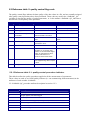
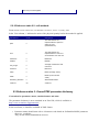
OceanSITES User’s Manual
NetCDF Conventions and Reference Tables
Version 1.1
June 30th, 2008
Table of contents
1.OVERVIEW
4
1.1.About OceanSITES
4
1.2.About this document
4
1.3.OceanSITES data management structure and data access
4
2.OCEANSITES DATA FORMAT
4
3.DATA FILE DIMENSIONS
6
3.1.Global attributes
7
3.2.Variables
3.2.1.Coordinate variables
3.2.2.Coordinate quality control variables
3.2.3.Data variables
11
11
13
14
4.OCEANSITES METADATA FORMAT
17
5.REFERENCE TABLES
17
5.1.Reference tables 1: data type and data code
5.1.1.Data type
5.1.2.Data code
17
17
17
5.2.Reference table 2: quality control flag scale
5.2.1.Reference table 2.1: quality control procedure indicator
5.2.2.Reference table 2.2: cell methods
18
18
19
5.3.Reference table 3: OceanSITES parameter dictionary
19
5.4.Reference table 4: Data Assembly Center Codes
22
5.5.Reference table 5: data mode
5.6.Reference table 6: OceanSITES sites catalog
22
23
6.GDAC ORGANIZATION
24
6.1.File naming convention
6.1.1.Data file naming convention
6.1.2.Metadata file naming convention
24
24
25
6.2.Index file for data files
25
History
Version
Date
Comment
0.1
20/03/2003
TC: creation of the document
0.3
20/02/2004
TC: updates on locations, mooring name, data state indicator,
parameters table, epic codes, history information
0.3.2
26/05/2004
N.G.: make more flexible, add dataset (metadata) file
0.4
01/06/2004
TC: separate data set description and data file, merge with
Steve Hankins's straw man
0.6
28/06/2004
TC: updates from Nan Galbraith, Steve Hankins, Jonathan
Gregory, Brian Eaton
0.7
23/05/2005
Maureen Edwards: NOCS data centre, new GF3 parameters
0.7
24/05/2005
Roy Lowry: physical parameters from BODC Data Markup
Vocabulary
1.0
18/02/2006
TC: updates following OceanSITES data management meeting
2006, Hawai’i
§2.1: LEVEL dimension replaces DEPTH to accomadate depth
or pressure
§2.2: QC_MANUAL field created
§2.2: CONVENTION field removed
§2.2: PLATFORM_CODE added
§2.2: SITE_CODE added
§2.2: WMO_PLATFORM_CODE added
§2.3: DEPTH renamed DEPH to comply to GF3
§2.3: DATA_MODE set at measurement level
§3: metadata file description transferred to "OceanSITES
metadata proposal" until approval
§5: file naming convention updated
1.0
19/02/2006
NG: data codes in chapter 4.1.2
1.0
28/04/2006
PF & NG: data mode optional
1.0
28/04/2006
TC & JG: §2.2 global attributes
1.1
April-MayJune 2008
NG, MM,TC, ML: general revision based on OceanSITES 2008
meeting
Epic codes removed
Use ISO8601 for string dates
Remove general attributes
Update global attribute section for CF-1.1 compatibility
New dimensions for DEPTH, LATITUDE, LONGITUDE
Add an uncertainty attribute
New presentation of the document
1.Overview
1.1.About OceanSITES
The OceanSITES program is the global network of open-ocean sustained timeseries sites, called ocean
reference stations, being implemented by an international partnership of researchers. OceanSITES provides
fixed-point timeseries of various physical, biogeochemical, and atmospheric variables at different locations
around the globe, from the atmosphere and sea surface to the seafloor. The program’s objective is to build
and maintain a multidisciplinary global network for a broad range of research and operational applications
including climate, carbon, and ecosystem variability and forecasting and ocean state validation.
All OceanSITES data are publicly available. More information about the project is available at
http://www.oceansites.org.
1.2.About this document
The main purpose of this document is to specify the format of the files that are used to distribute
OceanSITES data, and to document the standards used therein. This includes naming conventions, or
taxomony, as well as metadata content.
1.3.OceanSITES data management structure and data access
The data flow within OceanSITES is carried out through three organisational units:
The Principal Investigator (PI), typically a scientist at a research institution, maintains the observing
platform and the sensors that deliver the data. He or she is responsible for providing the data and all
auxiliary information to a Data Assembly Center (DAC). The DAC assembles OceanSITES-compliant
files from this information and delivers these to one of two Global Data Assembly Centers (GDAC),
where they are made publicly available. The user can access the data at either GDAC, cf. section "GDAC
organization".
2.OceanSITES data format
OceanSITES uses the NetCDF (network Common Data Form) system, a set of software libraries and
machine-independent data formats. Our implementation of NetCDF is based on the community-supported
Climate and Forecast (CF) specification, which supplies a standard vocabulary and some metadata
conventions.
OceanSITES has several more restrictions than the CF standard. These are intended to make it easier to
share in-situ data, to make it simpler for the GDACs to aggregate data from multiple sites, and to ensure
that the data can be created and understood by the basic NetCDF utilities.
•
•
OceanSITES includes standard terms for the short name of both coordinate and data variables
(measurements) .
File names are created using a standard, described in section 6.2.
•
Coordinate variables, which describe the dimensions of a data set, are limited to a single set of
longitude, latitude, depth and time (X,Y,Z, and T) dimensions in any single file. If data from a
reference station cannot all be put on to a single set of axes, then separate files are created for these
data.
An OceanSITES data file contains measurements such as temperature and salinity, continuously performed
at different levels on a platform (e.g. mooring), as well as meteorological or other parameters recorded at
the site, derived variables associated with the site, and complete location, time, and provenance
information.
The requirements are drawn almost exclusively from the NetCDF Style Guide:
•
Units are compliant with CF/COARDS/Udunits ;
•
The time parameter is encoded as recommended by COARDS and CF.
•
Parameters are given standard names from the CF table
•
Where time is specified as an attribute, the ISO8601 standard is used.
For more information on CF, COARDS, NetCDF, Udunits, and ISO8601 see:
•
NetCDF: http://www.unidata.ucar.edu/software/netcdf/docs/BestPractices.html
•
Udunits: http://www.unidata.ucar.edu/software/udunits/
•
CF: http://cf-pcmdi.llnl.gov/
•
COARDS: http://www.ferret.noaa.gov/noaa_coop/coop_cdf_profile.html
•
ISO8601: http://en.wikipedia.org/wiki/ISO_8601
3.Data file dimensions
NetCDF dimensions provide information on the size of the data variables. OceanSITES allows a single
parameter for each of the data dimensions, i.e. time, depth, latitude and longitude. Requirements are
described further in the section on coordinate variables. Standard names for OceanSITES dimensions
should be in upper case.
Name
Example
Comment
TIME
TIME=unlimited Number of time steps.
Example: for a mooring with one value per day and a
mission length of one year, TIME contains 365 time
steps.
DEPTH
DEPTH=5
Number of depth levels.
Example: for a mooring with measurements at 0.25,
10, 50, 100 and 200 meters, DEPTH=5.
LATITUDE
LATITUDE=1
Dimension of the LATITUDE coordinate variable.
Examples: for a mooring without positioning system,
LATITUDE=1. For a mooring with a GPS receiver,
use LATITUDE of the same dimension as TIME and
provide the actual location.
LONGITUDE
LONGITUDE=1 Dimension of the LONGITUDE coordinate variable.
Examples: for a mooring without positioning system,
LONGITUDE=1. For a mooring with a GPS receiver,
use LONGITUDE of the same dimension as TIME
and provide the actual location.
POSITION
POSITION=1
Dimension of the POSITION_QC variable.
3.1.Global attributes
The global attribute section of a NetCDF file contains metadata that descibes the contents of the file
overall, and allows for data discovery. All fields should be human-readable, and should be of character
type, not numeric, even if the information content is a number. OceanSITES recommends that all of these
attributes be used and contain meaningful information unless there are technical reasons rendering this
impossible. However, files that do not at least contain the attributes listed as "mandatory" will not be
considered OceanSITES-compliant. In OceanSITES, global attribute names are in lower-case letters.
Global attributes can be thought of as conveying five kinds of information:
•
What: what are the data in this dataset;
•
Where: the spatial coverage of the data;
•
When: the temporal coverage of the data;
•
Who: who produced the data;
•
How: how were the data produced and made available.
The global attributes specification follows the recommendations of Unidata NetCDF Attribute Convention
for Dataset Discovery, at http://www.unidata.ucar.edu/software/netcdfjava/formats/DataDiscoveryAttConvention.html
Name
Example
Definition
data_type
data_type="OceanSITES
time-series data"
This field contains the type of data contained in the file.
The list of acceptable data types is in reference table 1.
Example: "OceanSITES time-series data".
This attribute is mandatory.
format_version
format_version="1.1"
OceanSITES format version
Example: "1.1".
This attribute is mandatory.
platform_code
platform_code="CIS -1"
Platform unique code within OceanSITES project.
Example:
"CIS-1" mooring on CIS site (Central Irminger Sea).
This attribute is mandatory.
date_update
date_update="2006 -0411T08:35:00Z"
File update or creation date (UTC). See note on time format
below.
This attribute is mandatory.
institution
institution="National
Oceanographic Centre"
Specifies institution where the original data was produced.
site_code
site_code="CIS"
Name of the site within OceanSITES project.
Example: "CIS" for Central Irminger Sea.
The site codes are listed in reference table 6.
wmo_platform_c
ode
wmo_platform_code="48409 WMO (World Meteorological Organization) identifier.
"
This platform number is unique within the OceanSITES project.
Example: "48409" for CIS-1 mooring.
source
source="Mooring
observation"
WHAT
The method of production of the original data. For OceanSITES
data, use one of the following:
"Shipborne observation", "Mooring observation"
history
history=
"2005-04-11T08:35:00Z
data collected, A. Meyer.\n
2005-04-12T10:11:00Z
OceanSITES file with postrecovery data compiled and
sent to DAC, A. Meyer."
Provides an audit trail for modifications to the original data. It
should contain a separate line for each modification, with each
line beginning with a timestamp, and including user name,
modification name, and modification arguments. The time stamp
should follow the format outlined in the note on time formats
below.
data_mode
data_mode="R"
Indicates if the file contains real -time, post-recovery, or delayedmode data.
The list of valid data modes is in reference table 5.
quality_control_i
ndicator
quality_control="6"
Level of quality control applied to data.
The values are listed in reference table 2.1.
quality_index
quality_index="A"
A code value valid for the whole dataset:
0 unknown quality
A excellent (no known problems, regular quality checking)
B probably good (occasional problems, validation phase)
C extremely suspect, frequent problems
references
references="http://
www.oceansites.org,
http://www.noc.soton.ac.uk/
animate/index.php"
Published or web-based references that describe the data or
methods used to produce it. Include a reference to OceanSITES
and a project-specific reference if appropriate.
comment
comment="…"
Miscellaneous information about the data or methods used to
produce it. Any free-format text is appropriate.
conventions
conventions="OceanSITES
Manual 1.1, CF-1.1"
Name of the conventions followed by the dataset.
netcdf_version
netcdf_version="3.5"
Netcdf version used for the data set
title
summary
title="CIS Mooring Data"
summary="Oceanographic
mooring data from CIS
observatory in the Central
Irminger Sea, North Atlantic,
in 2005. Measured
properties: temperature and
salinity at ten depth levels."
Free-format text describing the dataset. The display of these two
attributes together should allow data discovery for a human
reader.
"title": title of the dataset. Use the file name if in doubt.
"summary": a longer description of the dataset. A paragraph of
up to 100 words is appropriate.
naming_authority naming_authority="OceanSI The "id" and "naming_authority" attributes are intended to
id
TES"
provide a globally unique identification for each dataset. For
id="OS_CIS-1_200502_TS" OceanSITES data, use:
naming_authority="OceanSITES" and
id=file name (without .nc suffix), which is designed to be unique.
cdm_data_type
cdm_data_type="Station"
The "cdm_data_type" attribute gives the Unidata CDM (common
data model) data type used by THREDDS. E.g. "Point",
"Trajectory", "Station", "Radial", "Grid", "Swath".
Use "Station" for OceanSITES mooring data. More:
http://www.unidata.ucar.edu/projects/THREDDS/CDM/CDM TDS.htm
area
area="North Atlantic Ocean"
Geographical coverage. Try to compose of the following:
North/Tropical/South Atlantic/Pacific/Indian Ocean, Southern
Ocean, Arctic Ocean.
For specific sea area, use the International Hydrographic
Bureau sea areas available at :
http://vocab.ndg.nerc.ac.uk/client/vocabServer.jsp.
geospatial_lat_m
in
geospatial_lat_min="59.8"
The southernmost latitude, a value between -90 and 90
degrees.
WHERE
geospatial_lat_m
ax
geospatial_lat _max ="59.8"
The northernmost latitude, a value between -90 and 90 degrees.
geospatial_lon_
min
geospatial_lon_min="-41.2"
The westernmost longitude, a value between -180 and 180
degrees.
geospatial_lon_
max
geospatial_lon_max="-41.2"
The easternmost longitude, a value between -180 and 180
degrees.
geospatial_vertic
al_min
geospatial_vertical_min="10 Minimum depth for measurements
.0"
geospatial_vertic
al_max
geospatial_vertical_max="2
000"
Maximum depth for measurements
WHEN
time_coverage_s
tart
time_coverage_start="2006- Start date of the data in UTC. See note on time format below.
03-01T00:00:00Z"
time_coverage_e
nd
time_coverage_end="200603-05T23:59:29Z"
Final date of the data in UTC. See note on time format below.
WHO
institution_refere
nces
institution_references="http:/ References to data provider institution, the place to find all
/www.nocs.uk"
information on the dataset (web-based, i.e. give URLs).
contact
contact="[email protected]"
Contact person’s e-mail.
author
author="John Smith"
Name of the person responsible for the creation of the dataset.
data_assembly_
center
data_assembly_center="EU
ROSITES"
Data Assembly Center (DAC) in charge of this data file.
The data_assembly_center are listed in reference table 4.
pi_name
pi_name="Alice Juarez"
Name of the principal investigator in charge of the platform.
distribution_state
ment
distribution_statement="Foll
ows CLIVAR (Climate
Varibility and Predictability)
standards, cf.
http://www.clivar.org/data/da
ta_policy.php. Data
available free of charge.
User assumes all risk for
use of data. User must
display citation in any
publication or product using
data. User must contact PI
prior to any commercial use
of data."
Statement describing data distribution policy. OceanSITES has
adopted the CLIVAR data policy, which explicitly calls for free
and unrestricted data exchange. Details at:
http://www.clivar.org/data/data_policy.php
citation
citation="These data were
The citation to be used in publications using the dataset.
collected and made freely
available by the
OceanSITES project and the
national programs that
contribute to it."
update_interval
update_interval="daily"
Update interval for the file, one of the following:
"hourly", "daily", "yearly", "void".
Use "void" for delayed-mode or archive data that do not need
continuous updating.
qc_manual
qc_manual="OceanSITES
User's Manual v1.1"
This field contains the name of the manual that describes the
quality control procedure. As of now, there is no separate QC
manual, so the user's manual is the appropriate reference.
HOW
Note on time formats
Whenever time information is given in the global attributes, it ought to be a string of the format:
"YYYY-MM-DDThh:mm:ssZ" (i.e. year - month - day T hour : minute : second Z)
If higher resolution than seconds is needed, any number of decimal digits (".s") for the seconds is
acceptable:
"YYYY-MM-DDThh:mm:ss.sZ"
In any case, the time must be in UTC. A capital "T" separates the date and the hour information. The string
must end with a capital "Z", an old indication of UTC. These formats are two (of many) described by
ISO8601.
Examples:
•
2005-10-24T08:00:00Z
•
2008-01-01T22:50:02.031Z
3.2.Variables
NetCDF variables include data measured by instruments, parameters derived from the primary
measurements, and coordinate variables, which may be nominal values, such as values for depth for
instruments that do not directly record depth. The variable names are written in CAPITALIZED letters.
Each variable has a specific set of attributes, some of which are mandatory.
3.2.1.Coordinate variables
The coordinate variables orient the data in time and space. For this purpose, they have an "axis" attribute
defining that they point in X, Y, Z, and T dimensions. The DEPTH variable may be positive in either
upward or downward direction, which is defined in its "positive" attribute. All attributes in this section
except the "comment" are mandatory, however "QC_indicator" may be omitted for any parameter if there is
a separate QC variable for that parameter.
Optionally, the Z axis may be represented as pressure, if, for example pressure is recorded directly by an
instrument and the calculation of depth from pressure would cause a loss of information. Depth is strongly
preferred, since it allows data to be used more directly; data with different coordinate variables must be
recorded in separate files.
Type, Name, Dimension, Attributes
Comment
Double TIME(TIME);
TIME:long_name = "time";
TIME:standard_name = "time";
TIME:units = "days since 1950-0101T00:00:00Z";
TIME:_FillValue = 999999.0;
TIME:valid_min = 0.0;
TIME:valid_max = 90000.0;
TIME:QC_indicator = <X>;
TIME:QC_procedure = <Y>;
TIME:uncertainty = <Z>;
TIME:comment = "Optional comment..."
TIME:axis = "T";
Date and time (UTC) of the measurement in days since midnight,
1950-01-01.
Float LATITUDE(LATITUDE);
LATITUDE:long_name = "Latitude of each
location";
LATITUDE:standard_name = "latitude";
LATITUDE:units = "degrees_north";
LATITUDE:_FillValue = 99999.0;
LATITUDE:valid_min = -90.0;
LATITUDE:valid_max = 90.0;
LATITUDE:QC_indicator = <X>;
LATITUDE:QC_procedure= <Y>;
LATITUDE:uncertainty = <Z>;
LATITUDE:comment = "Optional
comment..."
LATITUDE:axis="Y";
Latitude of the measurements.
Units: degrees north; southern latitudes are negative.
Float LONGITUDE(LONGITUDE);
LONGITUDE:long_name = "Longitude of
each location";
LONGITUDE:standard_name = "longitude";
LONGITUDE:units = "degrees_east";
LONGITUDE:_FillValue = 99999.0;
LONGITUDE:valid_min = -180.0;
LONGITUDE:valid_max = 180.0;
LONGITUDE:QC_indicator = <X>;
LONGITUDE:QC_procedure = <Y>;
LONGITUDE:uncertainty = <Z>;
LONGITUDE:comment = "Optional
comment..."
LONGITUDE:axis="X";
Longitude of the measurements.
Unit: degrees east; western latitudes are negative.
Float DEPTH(DEPTH);
DEPTH:long_name = "Depth of each
measurement";
DEPTH:standard_name = "depth";
DEPTH:units = "meters";
DEPTH:positive = "down";
DEPTH:_FillValue = -99999.0;
DEPTH:valid_min = 0.0;
DEPTH:valid_max = 12000.0;
DEPTH:QC_indicator = <X>;
DEPTH:QC_procedure = <Y>;
DEPTH:uncertainty = <Z>;
DEPTH:comment = "Optional comment..."
DEPTH:axis="Z";
Depth of each measurement.
Example:
Noon, Jan 2, 1950 is stored as 1.5.
July 25, 2001, 19:14:00 is stored as 18833.8013889885.
<X>: Replaces TIME_QC if constant. Cf. note on quality control in
data variable section, value from reference table 2.
<Y>: Cf. note on quality control in data variable section, value
from reference table 2.1.
<Z>: Choose appropriate value.
Example: 44.4991 for 44° 29’ 56.76’’ N
<X>: Replaces LATITUDE_QC if constant. Cf. note on quality
control in data variable section, value from reference table 2.
<Y>: Cf. note on quality control in data variable section, value
from reference table 2.1.
<Z>: Choose appropriate value.
Example: 16.7222 for 16° 43’ 19.92’’ E
<X>: Replaces LONGITUDE_QC if constant. Cf. note on quality
control in data variable section, value from reference table 2.
<Y>: Cf. note on quality control in data variable section, value
from reference table 2.1.
<Z>: Choose appropriate value.
Example: 513 for a measurement 513 meters below sea surface.
Z axes may be positive="up" (atmospheric) or positive="down"
(oceanic).
<X>: Replaces DEPTH_QC if constant. Cf. note on quality control
in data variable section, value from reference table 2.
<Y>: Cf. note on quality control in data variable section, value
from reference table 2.1.
<Z>: Choose appropriate value.
3.2.2.Coordinate quality control variables
The coordinate variables have the same quality control variables as the data variables. If the quality control
values are constant, the information is given in attributes of the coordinate variables. For details, see
<PARAM>_QC in the section on data variables, and the note on quality control therein.
Type, Name, Dimension, Attributes
Comment
Byte TIME_QC(TIME);
Quality flag for each TIME value.
Byte POSITION_QC(POSITION);
Quality flag for each LATITUDE and LONGITUDE value.
Byte DEPTH_QC(DEPTH);
Quality flag for each DEPTH value.
3.2.3.Data variables
Data variables contain the actual measurements and indicators about their quality, uncertainty, and mode
through which they were obtained. There are different options as to how the indicators are specified, whether
in attributes or separate variables, which are outlined in the notes below the table. The variable names are
standardized in reference table 3; replace <PARAM> with any of the names indicated there. Mandatory
attributes are marked as such, however, OceanSITES requests that all other attributes be used and contain
meaningful information unless technical reasons make this impossible.
Type, Name, Dimension, Attributes
Comment
Float <PARAM>(TIME, DEPTH);
Contains data values.
<PARAM>:long_name = "Y";
<PARAM> names are defined in reference table 3.
<PARAM>:standard_name = "<X>";
Examples:
<PARAM>:units = "<Y>";
TEMP, PSAL, DOXY.
<PARAM>:_FillValue = <Y>;
<PARAM>:QC_indicator = <X>;
These 3 attributes are mandatory : standard_name, units and
<PARAM>:QC_procedure = <X>;
_FillValue.
<PARAM>:valid_min = <Y>;
The others attributes are highly recommended if available.
<PARAM>:valid_max = <Y>;
<PARAM>:comment = "<Y>";
<X> : standardized attributes listed in reference tables
<PARAM>:sensor_depth = <Y>;
<Y> : attributes whose value is set by the PI (Principal Investigator)
<PARAM>:ancillary_variables = "<Y>" ;
<PARAM>:uncertainty = <Y>;
long_name: type char
<PARAM>:accuracy = <Y>;
standard_name: type char, see reference. table 3
<PARAM>:precision = <Y>;
units: type char, see reference table 3
<PARAM>:resolution = <Y>;
_FillValue : type float, see reference table 3
<PARAM>: cell_methods = "<Y>";
QC_indicator: type byte, see reference table 2 and note on quality
<PARAM>:DM_indicator = "<Y>"
control below
QC_procedure type byte, see reference table 2.1 and note on quality
control below
valid_min: type float. Minimum value for valid data
valid_max: type float. Maximum value for valid data
comment. type char. Any free-format text with comments as
appropriate.
sensor_depth. type float. Nominal sensor depth(s) in meters, counting
positive as per DEPTH:positive.
ancillary_variables. type char. Other variables associated with
<PARAM>, e.g. <PARAM>_QC. List as space-separated string.
Example: TEMP:ancillary_variables="TEMP_QC TEMP_DM
TEMP_UNCERTAINTY"
uncertainty: type float. Overall measurement uncertainty, if constant.
Cf. note on uncertainty below.
accuracy: type float. Nominal sensor accuracy. Cf. note on uncertainty
below.
precision: type float. Nominal sensor precision. Cf. note on uncertainty
below.
resolution: type float. Nominal resolution of this data parameter.
cell_methods: type char. Specifies cell method as per CF convention.
Example: TEMP:cell_methods="TIME: point DEPTH: point LATITUDE:
point LONGITUDE: point" Values are listed in table 2.2
DM_indicator: Type char. Data mode, if constant, as per reference
table 5. Cf. note on data modes below.
Byte <PARAM>_QC(TIME, DEPTH);
<PARAM>_QC:long_name = "quality
flag";
<PARAM>_QC:conventions =
"OceanSITES reference table 2";
<PARAM>_QC:_FillValue = -128;
<PARAM>_QC:valid_min = 0;
<PARAM>_QC:valid_max= 9;
<PARAM>_QC:flag_values = 0, 1, 2, 3,
4, 5, 7, 8, 9;
<PARAM>_QC:flag_meanings =
"no_qc_performed good_data
probably_good_data
bad_data_that_are_potentially_correcta
ble bad_data value_changed not_used
nominal_value interpolated_value
missing_value"
Contains quality flags for values of associated <PARAM>. Flag scale is
specified in reference table 2, and is included in the flag_meanings
attribute.
Char <PARAM>_DM(TIME, DEPTH);
<PARAM>_DM:long_name = "method
of data processing ";
<PARAM>_DM:conventions = "
OceanSITES reference table 5";
<PARAM>_DM:flag_values = "R" , "P",
"D", "M";
<PARAM>_DM:flag_meanings = "realtime post-recovery delayed-mode
mixed";
<PARAM>_DM:_FillValue = " ";
Data mode. Indicates if the data point is real-time, delayed-, or postrecovery mode. It is included when the dataset mixes modes for a single
variable.
See note on data modes below, and reference table 5.
Float
<PARAM>_UNCERTAINTY(TIME,
DEPTH):
<PARAM>_UNCERTAINTY:long_name
= "uncertainty"
<PARAM>_UNCERTAINTY:_FillValue=
<Y>
<PARAM>:units = "<Y>";
Overall uncertainty of the data given in <PARAM>.
long_name: type char. fixed value
conventions. type char. Required; fixed value
_FillValue . type byte. Required; fixed value
valid_min. type byte. Required; fixed value
valid_max: type byte. Required; fixed value
flag_values: type byte. Required; fixed value
flag_meanings: type char. Required; fixed value
long_name: type char. Required; fixed value:
conventions: type char. Required; fixed value:
flag_values: type char. Required; fixed value:
flag_meanings: type char. Required; fixed value:
_FillValue : type char. Required; fixed value
Cf. note on uncertainty below.
long_name: type char. Required; fixed value
_FillValue : type float. Required.
units: type char. Required. Must be the same as <PARAM>:units.
Note on quality control (QC)
The quality of the data in a variable <PARAM> is described by the attribute <PARAM>:QC_procedure,
and one of the following: the attribute <PARAM>:QC_indicator or the variable <PARAM_QC>.
<PARAM>:QC_procedure is mandatory and contains values from reference table 2.1, which describe what
kind of quality control procedure has been applied.
It is mandatory to define one of <PARAM>:QC_indicator or <PARAM_QC>, both of which would contain
values describing the data quality as per reference table 2. If the quality is the same for all <PARAM>, use
<PARAM>:QC_ind icator. Else, use <PARAM_QC>.
Note on uncertainty
If the overall measurement uncertainty for a variable <PARAM> is reasonably well-known, it must be
provided in the attribute <PARAM>:uncertainty if it is constant, or in a variable of its own,
<PARAM>_UN CERTAINTY, if it is not constant. If uncertainty is given in either way, the attribute
<PARAM>:accuracy is optional.
If it is impossible to estimate the overall measurement uncertainty, it is required to define at least the
attribute <PARAM>:accuracy with the nominal sensor accuracy.
The attributes <PARAM>:precision and <PARAM>:resolution are optional; they contain the sensor
precision and resolution if defined.
Note on data modes (DM)
Data mode may be represented as a global attribute "data_mode" if all data is a single mode, or as an
attribute to a variable <PARAM>:DM_indicator if all data for <PARAM> is in a single mode. If a
parameter contains a mixture of modes, these attributes should be set to "M" and the actual data modes
should be represented by an extra variable, <PARAM>_DM. The values for the data modes are explained
in reference table 5.
Example for sea temperature measurements and associated quality flags
Float TEMP(TIME, LEVEL);
TEMP:long_name = "sea water temperature in-situ ITS-90 scale";
TEMP:standard_name = "sea_water_temperature";
TEMP:units = "degree_Celsius";
TEMP:_FillValue = 99999.f;
TEMP:QC_indicator = 1;
TEMP:valid_min = -2.0f;
TEMP:valid_max = 40.f;
TEMP:comment = "";
TEMP:ancillary_variables = "TEMP_QC" ;
TEMP:resolution = 0.001f;
TEMP:uncertainty = 0.01f;
TEMP:error = 0.02f;
TEMP:cell_methods="TIME: point DEPTH: point LATITUDE: point
LONGITUDE: point";TEMP:DM_indicator="P";
Byte TEMP_QC(TIME, LEVEL);
TEMP_QC:long_name = "quality flag";
TEMP_QC:conventions = "OceanSITES reference table 2";
TEMP_QC:flag_values = 0, 1, 2, 3, 4, 5, 7, 8, 9;
TEMP_QC:flag_meanings = "no_qc_performed good_data probably_good_data
bad_data_that_are_potentially_correctable bad_data value_changed not_used nominal_value
interpolated_value missing_value"
TEMP_QC:_FillValue = 0;
4.OceanSITES metadata format
The OceanSITES data management team is developing a metadata format, probably using a SensorML
implementation of XML, to allow metadata to be stored external to the NetCDF files.
5.Reference tables
5.1.Reference tables 1: data type and data code
5.1.1.Data type
The data_type global attribute should have one of the following valid values:
Data type
OceanSITES metadata
OceanSITES profile data
OceanSITES time-series data
OceanSITES trajectory data
5.1.2.Data code
Data codes are used for file naming convention in chapter 6.1.1 and describe what kind of measurements
the file contains.
They consist of the following letters:
Data Code
Meaning
C
Conductivity (electric conductivity of sea water)
M
Meteorological parameters (e.g. wind, air pressure, radiative fluxes, air temperature)
O
Oxygen concentration (in sea water)
S
Salinity (of sea water)
T
Temperature (of sea water)
V
Velocity (of sea water)
5.2.Reference table 2: quality control flag scale
The quality control flags indicate the data quality of the data values in a file, and are normally assigned
after quality control procedures have been performed. These codes are used in the <PARAM>_QC
variables to describe the quality of each measurement, or in the attribute <PARAM>:QC_indicator to
describe the overall quality of the parameter.
Code
Meaning
Real -time comment
Post-recovery mode comment
0
No QC was performed
-
-
1
Good data
All real-time QC tests passed.
All post-recovery tests passed.
2
Probably good data
-
-
3
Bad data that are potentially
correctable
These data are not to be used
without scientific correction.
Possible re-calibration needed.
4
Bad data
Data have failed one or more
tests.
Data have failed one or more
tests.
5
Value changed
Data may be recovered after
transmission error.
-
6
Not used
-
-
7
Nominal value
Data were not observed but
reported; i.e. an anchor drop
position or an instrument target
depth, as opposed to a GPS
position time series or a
pressure sensor time series.
-
8
Interpolated value
Missing data may be interpolated from neighbouring data in space
or time.
9
Missing value
-
-
5.2.1.Reference table 2.1: quality control procedure indicator
This table describes the quality procedures applied to all the measurement of a parameter.
These values are used as an overall quality indicator (i.e. one summarizing all measurements) in the
attributes of each variable <PARAM>.
Cf. <PARAM>:QC_procedure attribute description in section 3.2.3.
Code
Meaning
0
No QC performed
1
Ranges applied, bad data flagged
2
Data interpolated
3
Sensor malfunctioning (data possibly useful)
4
Data missing
5
Data manually reviewed
6
Data verified against model or other contextual information
7
Other QC process applied
5.2.2.Reference table 2.2: cell methods
From NetCDF Climate and Forecast (CF) Metadata Conventions, Version 1.2, 4 May, 2008
In the Units column, u indicates the units of the physical quantity before the method is applied.
Cell Method
Units
Description
point
u
The data values are
representative of points in
space or time
(instantaneous).
sum
u
The data values are
representative of a sum or
accumulation over the cell.
maximum
u
Maximum
median
u
Median
mid_range
u
Average of maximum and
minimum
minimum
u
Minimum
mean
u
Mean (average value)
mode
u
Mode (most common
value)
standard_deviation
u
Standard deviation
variance
u2
Variance
5.3.Reference table 3: OceanSITES parameter dictionary
Convention for parameter names, standard names and units
The parameter dictionary is now contained in an Excel file, which is available at
http://www.oceansites.org/parameters/...
In the near future, it should be available in XML format.
•
Parameter names should start with a 4 characters code based on SeaDataNet-BODC parameter
discovery vocabulary.
They are not strictly standardized, however.
When necessary, a parameter name has a suffix that designates secondary parameters 1 . The suffix
starts with the character "_".
•
The NetCDF "standard_name" attribute contains the standardized parameter name from CF
conventions.
•
The NetCDF "units" attribute are compliant with Udunits as implemented in the CF/COARDS
standards.
As the parameter names are not strictly standardized, one should use the standard_name attribute to query a
particular measurement from differe nt data files.
Example
On a mooring, sea temperature measured by a series of Microcat CTD is reported as TEMP, with a standard
name of SEA_WATER_TEMPERATURE.
Secondary temperature measurement performed by an oxygen sensor is reported as DOXY_TEMP with a
standard name of temperature_of_sensor_for_oxygen_in_sea_water.
For both measurements, the unit attribute is "degree_Celsius".
References
The OceanSITES standard names are taken from the CF standard names, available at:
•
http://cf-pcmdi.llnl.gov/documents/cf-standard-names/
The parameter names are based on SeaDataNet-BODC parameter discovery vocabulary available at:
•
http://seadatanet.maris2.nl/v_bodc_vocab/welcome.aspx
Select P021, " BODC Parameter Discovery Vocabulary"
The units are compliant with Udunits, as implemented by the CF standard; definitions are available at:
•
http://www.unidata.ucar.edu/software/udunits
The valid parameter names, standard names, long_names and units are available at:
1
•
http://www.ifremer.fr/co/etc/oceansites/oceansites-user- manual-parameters.pdf
•
http://www.ifremer.fr/co/etc/oceansites/oceansites-user- manual- units.pdf
The following list an extract of the OceanSITES parameter dictionary for parameter name and standard
name.
Parameter
Standard name
AIRT
air_temperature
ATMP
air_pressure
ATMS
air_pressure_at_sea_level
CDIR
direction_of_sea_water_velocity was sea_water_direction
CNDC
sea_water_electrical_conductivity
CSPD
sea_water_speed
DEPH
depth
DEWT
dew_point_temperature
DOX2
moles_of_oxygen_per_unit_mass_in_sea_water was dissolved_oxygen
DOXY
mass_concentration_of_oxygen_in_sea_water was dissolved_oxygen
DOXY_TEM
P
temperature_of_sensor_for_oxygen_in_sea_water
DRYT
dry_bulb_temperature
DYNHT
dynamic_height
EWCT
eastward_sea_water_velocity
FLU2
fluorescence
HCSP
sea_water_speed
HEAT
heat_content
ISO17
isotherm_depth
LW
surface_downwelling_longwave_flux_in_air
NSCT
northward_sea_water_velocity
OPBS
optical_backscattering_coefficient
PCO2
surface_partial_pressure_of_carbon_dioxide_in_air was CO2_partial_pressure_in_dry/wet_gas
PRES
sea_water_pressure
PSAL
sea_water_salinity
RAIN
rainfall_rate
RAIT
thickness_of_rainfall_amount
RELH
relative_humidity
SDFA
surface_downwelling_shortwave_flux_in_air
SRAD
isotropic_shortwave_radiance_in_air
SW
surface_downwelling_shortwave_flux_in_air
TEMP
sea_water_temperature
TIME
time
UCUR
eastward_sea_water_velocity
UWND
eastward_wind
VAVH
sea_surface_wave_significant_height
VAVT
sea_surface_wave_zero_upcrossing_period
VCUR
northward_sea_water_velocity
VDEN
sea_surface_wave_variance_spectral_density
VDIR
sea_surface_wave_from_direction
VWND
northward_wind
WDIR
wind_to_direction
WSPD
wind_speed
WSPD
wind_speed
5.4.Reference table 4: Data Assembly Center Codes
Data Assembly Centers and institutions
EUROSITES
EuroSites EU project
JAMSTEC
Jamstec, Japan
MEDS
MEDS, Canada
NDBC
National Data Buoy Center, USA
NOCS
National Oceanography Centre, Southampton
PMEL
PMEL, USA
SIO
SIO, Scripps, USA
WHOI
Woods Hole Oceanographic Institution, USA
5.5.Reference table 5: data mode
The values for the variables "<PARAM>_DM", the global attribute "data_mode", and variable attributes
"<PARAM>:DM_indicator" are defined as follows:
Value Meaning
"R"
Real-time data. Data coming from the (typically remote) platform through a communication
channel without physical access to the instruments, disassembly or recovery of the platform.
Example: for a mooring with a radio communication, this would be data obtained through the
radio.
"P"
Post-recovery data. Data obtained after the instruments or the platform have been recovered or
serviced. Example: for instruments on a mooring, this would be data downloaded directly from
the instruments after the mooring has been recovered on a ship.
"D"
Delayed-mode data. Data published after all calibrations and quality control procedures have
been applied. This is the final status of the data.
"M"
Mixed. This value is only allowed in the global attribute "data_mode" or in attributes to variables
in the form "<PARAM>:DM_indicator". It indicates that the file contains data in more than one of
the above states. In this case, the variable(s) <PARAM>_DM specify which data is in which data
mode.
5.6.Reference table 6: OceanSITES sites catalog
The OceanSITES sites catalog is available at http://www.oceansites.org/parameters /..
The following list is an extract from the catalog.
OceanSITES moorings catalogue based on data files available
from GDAC
site code
platform code
WMO
code
DAC
contact
CIS
CIS-1
44478
EuroSites
NOCS
CIS
CIS-2
44478
EuroSites
NOCS
ESTOC
ESTOC-1
13471
EuroSites
NOCS
PAP
PAP-1
62442
EuroSites
NOCS
PAP
PAP-2
62442
EuroSites
NOCS
BTM
BTM
-
NDBC ?
UCSB
KEO
KEO32N145E
28401
PMEL
Cronin
MOVE
V404
41173
NDBC ?
SIO
MOVE
V405
-
NDBC ?
SIO
MOVE
V406
41174
NDBC ?
SIO
NTAS
NTAS
-
NDBC ?
Woods
Hole
STRATUS
STRATUS
-
NDBC ?
Woods
Hole
TAO
0n110w
32323
PMEL
McPhaden
TAO
0n140w
51311
PMEL
McPhaden
TAO
0n165e
52321
PMEL
McPhaden
TAO
0n170w
51010
PMEL
McPhaden
PIRATA
0n23w
15004
PMEL
McPhaden
RAMA
0n80.5e
23001
PMEL
McPhaden
PIRATA
10s10w
15001
PMEL
McPhaden
PIRATA
15n38w
13008
PMEL
McPhaden
6.GDAC organization
There are two GDACs (global data assembly centers) for redundancy, which are the users' access points for
OceanSITES data. One GDAC is located in France (Coriolis, http://www.coriolis.eu.org), the other one in
the USA (NDBC, National Data Buoy Center, http://www.ndbc.noaa.gov). The GDACs handle
OceanSITES data, metadata, and index files on ftp servers. The servers at both GDACs are synchronized at
least daily to provide the same OceanSITES data.
The user can access the data at either GDAC's ftp site:
•
ftp://ftp.ifremer.fr/ifremer/oceansites
•
ftp://data.ndbc.noaa.gov/data/oceansites
From these root directories of the GDACs downward, the organization of the directories and files is:
•
site/platform/OS_XXX_YYY_ZZZ<_PARTX>.nc
•
site: OceanSites site code
•
platform: platform code
The site and platform codes are available in the "O ceanSITES catalogue" document at either GDAC's root
directory:
•
oceansites_catalogue.xml
6.1.File naming convention
The OceanSITES file names use the following naming conventions:
6.1.1.Data file naming convention
OS_XXX_YYY_ZZZ<_PARTX>.nc
•
OS: OceanSITES prefix
•
XXX: platform code from the OceanSITES catalogue
•
YYY: configuration code
•
ZZZ: list of "data codes" from reference table 1
The data code is a list of the primary parameters measured. The data code will not list secondary
parameters.
•
<_PARTX>: when an OceanSites data file size becomes excessive (eg: > 100Mb), it can be split in
smaller parts: PART1, PART2, … PARTN
Example:
•
OS_CIS-1_200502_TS.nc
This file contains temperature and salinity data from the CIS-1 mooring, from the Animate project, for the
deployment performed in February 2005. Giving the deployment date (here: 200502) as the configuration
code (YYY) is the recommended method if multiple site occupations exist, and if this makes identification
unique.
6.1.2.Metadata file naming convention
OS_XXX_YYY_META.xml
•
OS: OceanSITES prefix
•
XXX: platform code
•
YYY: configuration code
These metadata are for the corresponding data file(s) OS_XXX_YYY_ZZZ<_PARTX>.nc.
Example:
•
OS_CIS-1_200502_META.xml
This file contains the metadata of CIS-1 mooring, for the deployment performed in February 2005.
6.2.Index file for data files
To allow for data discovery without downloading the data files themselves, an index file is created at the
GDAC level, which lists all available data files and the location and time ranges of their data contents:
•
The data index file is located at the root directory of the GDAC.
•
The index file contains the list and a description of all data files available on the GDAC.
•
There is a header section, lines of which start with # characters.
•
The information sections are comma-separated values.
•
Each line contains the following information:
•
FILE: the file name, beginning from the GDAC root directory
•
DATE_UPDATE: the update date of the file, YYYY-MM-DDTHH:MI:SSZ
•
START_DATE: first date for observations, YYYY-MM-DDTHH:MI:SSZ
•
END_DATE: last date for observations, YYYY-MM-DDTHH:MI:SSZ
•
•
SOUTHERN_MOST_LATITUDE
•
NORTHERN_MOST_LATITUDE
•
WESTERN_MOST_LONGITUDE
•
EASTERN_MOST_LONGITUDE
•
UPDATE_INTERVAL: M monthly, D daily, Y yearly, V void
•
SIZE: the size of the file in megabytes
The fill value is empty (eg. : ,,).
GDAC data files index: oceansites_files_index.txt
# OceanSites FTP GLOBAL INDEX
# ftp://ftp.ifremer.fr/ifremer/oceansites
# Contact: http://www.oceansites.org
# Index update date YYYY-MM-DDTHH:MI:SSZ: 2008 -03-30T18:37:46Z
#
#FILE,DATE_UPDATE,START_DATE,END_DATE,
SOUTHERN_MOST_LATITUDE,NORTHERN_MOST_LATITUDE,WESTERN_MOST_LONGITUDE,EASTER
N_MOST_LONGITUDE,UPDATE_INTERVAL,SIZE
TAO/0n170w/OS_0n170w_SW_LW_2m.nc,2008-04-12T08:05:00Z,2007-03-17T18:07:00Z,2008-0412T08:05:00Z,0,0,-170,-170,M,16.7