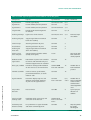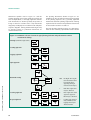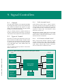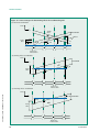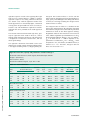
1
AUSTROADS
AUSTROADS
PART
PART
GUIDE TO TRAFFIC ENGINEERING PRACTICE SERIES
GUIDE TO TRAFFIC ENGINEERING PRACTICE SERIES
Traffic Signals
AP-G11.7/03
ISBN 0 85588 622 6
HB 191:2003
PART 7 – TRAFFIC SIGNALS
GUIDE TO TRAFFIC ENGINEERING PRACTICE SERIES
Accessed by AR -M- VICROADS on 02 Jun 2005
AUSTROADS
THIRD EDITION
Guide to Traffic Engineering Practice
Traffic Signals
Accessed by AR -M- VICROADS on 02 Jun 2005
THIRD EDITION
Guide to Traffic Engineering Practice: Part 7 – Traffic Signals
First Published 1987
Revised Edition 1993
Reprinted 1997
3rd Edition 2003
Copyright © Austroads Inc.
This work is copyright. Apart from any use as permitted under the Copyright Act 1968,
no part may be reproduced by any process without the prior written permission of Austroads.
National Library of Australia
Cataloguing-in-Publication data:
Guide to Traffic Engineering Practice: Part 7 – Traffic Signals
ISBN 0 85588 622 6
Austroads Publication No. AP-G11.7/03 (formerly NAS 54.9)
Technical writer and editor
Rahmi Akçelik (Akçelik and Associates Pty Ltd)
Austroads project manager
Martin Chelini (VicRoads)
Accessed by AR -M- VICROADS on 02 Jun 2005
Project coordinator
Michael Tziotis (ARRB Transport Research Ltd)
Technical contributors (in alphabetical order by first name)
Bill Sissons (New Zealand)
Bob Mudford (Roads and Traffic Authority New South Wales)
Branko Stazic (Transport South Australia)
Colin Foot (Transport South Australia)
David Jones (Brisbane City Council)
David Nash (VicRoads)
David Stewart (Queensland Department of Main Roads)
Gary Veith (VicRoads)
Geoff Horni (Department of Infrastrtucture, Planning and Environment, Northern Territory)
Geoff Lake (Roads and Traffic Authority New South Wales)
John Buckland (Transport South Australia)
Jon Douglas (Queensland Department of Main Roads)
Ken Grattan (Department of Infrastrtucture, Planning and Environment, Northern Territory)
Martin Chelini (VicRoads)
Michael Day (Department of Urban Services, Australian Capital Territory)
Peter Freeman (Department of Infrastructure, Environment and Resources, Tasmania)
Peter Lowrie (Roads and Traffic Authority New South Wales)
Ross Thomson (New Zealand)
Published by Austroads Incorporated
Level 9, Robell House
287 Elizabeth Street
Sydney NSW 2000 Australia
Phone: +61 2 9264 7088
Fax: +61 2 9264 1657
Email: [email protected]
www.austroads.com.au
Reproduction of extracts from this publication may be made subject to due acknowledgement of the source.
Austroads believes this publication to be correct at the time of printing and does not accept responsibility for any consequences arising
from the use of information herein. Readers should rely on their own skill and judgement to apply information to particular issues.
Guide to Traffic Engineering Practice
Traffic Signals
Accessed by AR -M- VICROADS on 02 Jun 2005
THIRD EDITION
Austroads Profile
Austroads is the association of Australian and New Zealand road transport and traffic authorities whose purpose is
to contribute to the achievement of improved Australian and New Zealand transport related outcomes by:
• developing and promoting best practice for the safe and effective management and use of the road system
• providing professional support and advice to member organisations and national and international bodies
• acting as a common vehicle for national and international action
• fulfilling the role of the Australian Transport Council’s Road Modal Group
• undertaking performance assessment and development of Australian and New Zealand standards
• developing and managing the National Strategic Research Program for roads and their use.
Within this ambit, Austroads aims to provide strategic direction for the integrated development, management and
operation of the Australian and New Zealand road system — through the promotion of national uniformity and
harmony, elimination of unnecessary duplication, and the identification and application of world best practice.
Austroads Membership
Austroads membership comprises the six State and two Territory road transport and traffic authorities and the
Commonwealth Department of Transport and Regional Services in Australia, the Australian Local Government
Association and Transit New Zealand. It is governed by a council consisting of the chief executive officer (or an alternative
senior executive officer) of each of its eleven member organisations:
• Roads and Traffic Authority New South Wales
• Roads Corporation Victoria
• Department of Main Roads Queensland
• Main Roads Western Australia
• Transport South Australia
• Department of Infrastructure, Energy and Resources Tasmania
• Department of Infrastructure, Planning and Environment Northern Territory
• Department of Urban Services Australian Capital Territory
• Commonwealth Department of Transport and Regional Services
• Australian Local Government Association
• Transit New Zealand
Accessed by AR -M- VICROADS on 02 Jun 2005
The success of Austroads is derived from the synergies of interest and participation of member organisations and
others in the road industry.
Handbook Endorsement
In December 1993 Austroads and Standards Australia signed a Memorandum of Understanding regarding the
development of Standards and related documents primarily for the development and management of the Australian
road system. Standards Australia's support for this handbook reflects the cooperative arrangement between the
two organisations to ensure there is a coordinated approach in this area.
In August 1995 Austroads, Transit New Zealand and Standards New Zealand signed an agreement regarding the
development of Standards and related documents for endorsement of the appropriate Austroads publications as
SNZ handbooks. Standards New Zealand and Transit New Zealand's support for this handbook reflects the cooperative
arrangement with Austroads to ensure that there is a coordinated approach in this area.
Handbook No. HB 191:2003
Foreword
Austroads works towards uniformity of practice in
respect of design, construction and user aspects of roads
and bridges and with this purpose in view, publishes
guides and general procedures.
Traffic Engineering Practice, first published in 1965, is
a practical guide to traffic engineering for highway and
transport engineers in Road Authorities, Local Government and engineering consultants, and as a reference
for engineering students.
The guide consists of 15 parts as shown below:
Part 1
Traffic Flow
2
Roadway Capacity
3
Traffic Studies
4
Treatment of Road Crashes
5
Intersections at Grade
6
Roundabouts
7
Traffic Signals
8
Traffic Control Devices
9
Arterial Road Traffic Management
10 Local Area Traffic Management
11 Parking
12 Roadway Lighting
Accessed by AR -M- VICROADS on 02 Jun 2005
13 Pedestrians
14 Bicycles
15 Motorcycle Safety
The information contained in the various parts is
intended to be used as a guide to good practice.
Discretion and judgement should be exercised in the
light of many factors which may influence the choice
of traffic engineering treatment in any given situation.
These guidelines make reference where relevant to
current Australian Standards and are intended to supplement and otherwise assist in their interpretation and
application.
This is the third edition of Part 7 – Traffic Signals. Part
7 focuses on technical aspects of designing safe and
efficient traffic signal installations. This edition is a major
revision of the 1993 publication, and incorporates the
latest practice throughout Australia. It has been prepared after extensive consultation with Australian State,
Territory and New Zealand authorities. It is hoped that it
will give readers a better insight into the Australian and
New Zealand practice and be helpful in developing
improved control practices for the benefit of road users.
This document presents detailed information and provides guidelines on collection of design data, geometric
elements, signal system and components, signal face
layouts and display sequences, signal phasing, location
of signal equipment, traffic detection, signal controllers,
pavement markings, signs, electrical design, coordination of traffic signals, installation checks and maintenance, and special applications including advance
warning signals, emergency vehicle facilities, public
transport priority, bicycle facilities, roundabout metering
signals, ramp-metering signals, special intersection
treatments, overhead lane-control signals, single-lane
operation and portable signals, left turn on red, and
metering signals at sign-controlled intersections.
Appendices provide detailed discussions on human
factors and vehicular traffic characteristics relevant to
traffic signal control, provide guidelines for determining
signal timings, and give a complete worked example. A
glossary of terms is included at the start of the document.
Austroads would like to acknowledge the contributions of Ted Barton, Ross Blinco, Frank Hulscher
and Cliff Arndt in previous editions of this guide.
Accessed by AR -M- VICROADS on 02 Jun 2005
Contents
Glossary of Terms . . . . . . . . . . . . . . . . . . . . . . . . . . . . . . . . . . . . . . . . . . . . . . . . . . . . . . . . . . . . . . . .
1.
Introduction . . . . . . . . . . . . . . . . . . . . . . . . . . . . . . . . . . . . . . . . . . . . . . . . . . . . . . . . . . . . . .
1
1.1
1.2
1.3
1.4
1.5
General . . . . . . . . . . . . . . . . . . . . . . . . . . . . . . . . . . . . . . . . . . . . . . . . . . . . . . . . . . . . .
Scope . . . . . . . . . . . . . . . . . . . . . . . . . . . . . . . . . . . . . . . . . . . . . . . . . . . . . . . . . . . . . .
Statutory Provisions . . . . . . . . . . . . . . . . . . . . . . . . . . . . . . . . . . . . . . . . . . . . . . . . . . .
Associated Standards and Manuals . . . . . . . . . . . . . . . . . . . . . . . . . . . . . . . . . . . . . . . .
Guidelines . . . . . . . . . . . . . . . . . . . . . . . . . . . . . . . . . . . . . . . . . . . . . . . . . . . . . . . . . .
1.5.1
Signalised Intersection Warrants . . . . . . . . . . . . . . . . . . . . . . . . . . . . . . . . . .
1.5.2
Midblock Signalised Crossing Warrants . . . . . . . . . . . . . . . . . . . . . . . . . . . . .
1.5.3
Warrants for Pedestrian Signals at Signalised Intersections . . . . . . . . . . . . . .
Environment . . . . . . . . . . . . . . . . . . . . . . . . . . . . . . . . . . . . . . . . . . . . . . . . . . . . . . . . .
Design Process . . . . . . . . . . . . . . . . . . . . . . . . . . . . . . . . . . . . . . . . . . . . . . . . . . . . . . .
Construction . . . . . . . . . . . . . . . . . . . . . . . . . . . . . . . . . . . . . . . . . . . . . . . . . . . . . . . . .
Operation . . . . . . . . . . . . . . . . . . . . . . . . . . . . . . . . . . . . . . . . . . . . . . . . . . . . . . . . . . .
Maintenance . . . . . . . . . . . . . . . . . . . . . . . . . . . . . . . . . . . . . . . . . . . . . . . . . . . . . . . . .
Education and Enforcement . . . . . . . . . . . . . . . . . . . . . . . . . . . . . . . . . . . . . . . . . . . . .
Definitions . . . . . . . . . . . . . . . . . . . . . . . . . . . . . . . . . . . . . . . . . . . . . . . . . . . . . . . . . .
1
1
1
1
2
2
2
3
4
4
4
4
6
6
6
Design Data . . . . . . . . . . . . . . . . . . . . . . . . . . . . . . . . . . . . . . . . . . . . . . . . . . . . . . . . . . . . . .
7
2.1
2.2
2.3
2.4
2.5
Introduction . . . . . . . . . . . . . . . . . . . . . . . . . . . . . . . . . . . . . . . . . . . . . . . . . . . . . . . . .
Physical Layout of Intersections . . . . . . . . . . . . . . . . . . . . . . . . . . . . . . . . . . . . . . . . . .
Traffic Data . . . . . . . . . . . . . . . . . . . . . . . . . . . . . . . . . . . . . . . . . . . . . . . . . . . . . . . . . .
Crash Data . . . . . . . . . . . . . . . . . . . . . . . . . . . . . . . . . . . . . . . . . . . . . . . . . . . . . . . . . .
Future Developments . . . . . . . . . . . . . . . . . . . . . . . . . . . . . . . . . . . . . . . . . . . . . . . . . .
7
7
7
8
8
Geometric Elements . . . . . . . . . . . . . . . . . . . . . . . . . . . . . . . . . . . . . . . . . . . . . . . . . . . . . . .
9
1.6
1.7
1.8
1.9
1.10
1.11
1.12
2.
Accessed by AR -M- VICROADS on 02 Jun 2005
3.
xv
3.1
3.2
3.3
3.4
3.5
3.6
3.7
General . . . . . . . . . . . . . . . . . . . . . . . . . . . . . . . . . . . . . . . . . . . . . . . . . . . . . . . . . . . . .
Traffic Lanes . . . . . . . . . . . . . . . . . . . . . . . . . . . . . . . . . . . . . . . . . . . . . . . . . . . . . . . . .
3.2.1
Lane Arrangements . . . . . . . . . . . . . . . . . . . . . . . . . . . . . . . . . . . . . . . . . . .
3.2.2
Right-Turn Lanes . . . . . . . . . . . . . . . . . . . . . . . . . . . . . . . . . . . . . . . . . . . . .
3.2.3
Left-Turn Lanes . . . . . . . . . . . . . . . . . . . . . . . . . . . . . . . . . . . . . . . . . . . . . . .
Corner Kerb Radius . . . . . . . . . . . . . . . . . . . . . . . . . . . . . . . . . . . . . . . . . . . . . . . . . . . .
Median Islands . . . . . . . . . . . . . . . . . . . . . . . . . . . . . . . . . . . . . . . . . . . . . . . . . . . . . . .
3.4.1
Divided Roads . . . . . . . . . . . . . . . . . . . . . . . . . . . . . . . . . . . . . . . . . . . . . . .
3.4.2
Undivided Roads with Small Median Islands at the Intersection . . . . . . . . . .
Painted Medians and Islands . . . . . . . . . . . . . . . . . . . . . . . . . . . . . . . . . . . . . . . . . . . . .
Kerbside Allocations . . . . . . . . . . . . . . . . . . . . . . . . . . . . . . . . . . . . . . . . . . . . . . . . . . .
3.6.1
Parking . . . . . . . . . . . . . . . . . . . . . . . . . . . . . . . . . . . . . . . . . . . . . . . . . . . . .
3.6.2
Bus Zones . . . . . . . . . . . . . . . . . . . . . . . . . . . . . . . . . . . . . . . . . . . . . . . . . . .
Service Roads . . . . . . . . . . . . . . . . . . . . . . . . . . . . . . . . . . . . . . . . . . . . . . . . . . . . . . . .
9
9
9
9
10
11
11
11
11
11
12
12
12
12
TRAFFIC SIGNALS
4.
Signal System and Components . . . . . . . . . . . . . . . . . . . . . . . . . . . . . . . . . . . . . . . . . . . .
13
4.1
System . . . . . . . . . . . . . . . . . . . . . . . . . . . . . . . . . . . . . . . . . . . . . . . . . . . . . . . . . . . . .
4.1.1
Purpose . . . . . . . . . . . . . . . . . . . . . . . . . . . . . . . . . . . . . . . . . . . . . . . . . . . .
4.1.2
System Process . . . . . . . . . . . . . . . . . . . . . . . . . . . . . . . . . . . . . . . . . . . . . . .
Components . . . . . . . . . . . . . . . . . . . . . . . . . . . . . . . . . . . . . . . . . . . . . . . . . . . . . . . . .
4.2.1
Signal Lanterns . . . . . . . . . . . . . . . . . . . . . . . . . . . . . . . . . . . . . . . . . . . . . . .
4.2.2
Associated Equipment . . . . . . . . . . . . . . . . . . . . . . . . . . . . . . . . . . . . . . . . . .
4.2.3
Lantern Supports . . . . . . . . . . . . . . . . . . . . . . . . . . . . . . . . . . . . . . . . . . . . .
4.2.4
Power Reticulation . . . . . . . . . . . . . . . . . . . . . . . . . . . . . . . . . . . . . . . . . . . .
4.2.5
Signal Controller . . . . . . . . . . . . . . . . . . . . . . . . . . . . . . . . . . . . . . . . . . . . . .
4.2.6
Traffic Detection . . . . . . . . . . . . . . . . . . . . . . . . . . . . . . . . . . . . . . . . . . . . . .
4.2.7
Roadway Components . . . . . . . . . . . . . . . . . . . . . . . . . . . . . . . . . . . . . . . . .
Component Selection . . . . . . . . . . . . . . . . . . . . . . . . . . . . . . . . . . . . . . . . . . . . . . . . . .
13
13
13
13
13
17
17
17
17
17
18
18
Signal Face Layouts and Display Sequences . . . . . . . . . . . . . . . . . . . . . . . . . . . . . . . . . .
19
5.1
19
19
19
19
19
19
19
20
21
21
21
22
22
23
23
23
23
24
24
24
25
25
26
29
29
29
30
30
34
34
34
34
34
4.2
4.3
5.
5.2
5.3
5.4
Accessed by AR -M- VICROADS on 02 Jun 2005
5.5
5.6
5.7
5.8
viii
Introduction . . . . . . . . . . . . . . . . . . . . . . . . . . . . . . . . . . . . . . . . . . . . . . . . . . . . . . . . .
5.1.1
Method of Controlling Traffic . . . . . . . . . . . . . . . . . . . . . . . . . . . . . . . . . . . .
5.1.2
Definitions . . . . . . . . . . . . . . . . . . . . . . . . . . . . . . . . . . . . . . . . . . . . . . . . . .
Signal Face Elements . . . . . . . . . . . . . . . . . . . . . . . . . . . . . . . . . . . . . . . . . . . . . . . . . . .
5.2.1
Signal Aspects . . . . . . . . . . . . . . . . . . . . . . . . . . . . . . . . . . . . . . . . . . . . . . . .
5.2.2
Colour of Aspects . . . . . . . . . . . . . . . . . . . . . . . . . . . . . . . . . . . . . . . . . . . . .
5.2.3
Size of Aspects . . . . . . . . . . . . . . . . . . . . . . . . . . . . . . . . . . . . . . . . . . . . . . .
5.2.4
Types of Aspects . . . . . . . . . . . . . . . . . . . . . . . . . . . . . . . . . . . . . . . . . . . . . .
5.2.5
Target Boards . . . . . . . . . . . . . . . . . . . . . . . . . . . . . . . . . . . . . . . . . . . . . . . .
Vehicle Signal Face Layouts . . . . . . . . . . . . . . . . . . . . . . . . . . . . . . . . . . . . . . . . . . . . . .
5.3.1
Basic Signal Face Layouts . . . . . . . . . . . . . . . . . . . . . . . . . . . . . . . . . . . . . . .
5.3.2
Multi-Column Signal Face Layouts . . . . . . . . . . . . . . . . . . . . . . . . . . . . . . . .
5.3.3
Four-Aspect Single-Column Signal Face Layouts . . . . . . . . . . . . . . . . . . . . . .
5.3.4
Two-Aspect Signal Face Layouts . . . . . . . . . . . . . . . . . . . . . . . . . . . . . . . . . .
Face Layouts with Right-Turn Arrow Aspects . . . . . . . . . . . . . . . . . . . . . . . . . . . . . . . .
5.4.1
Six-Aspect Signal Face Layouts with Right-Turn Arrow Aspects . . . . . . . . . . .
5.4.2
Five-Aspect Signal Face Layouts with Right-Turn Arrow Aspects . . . . . . . . . .
5.4.3
Four-Aspect Signal Face Layouts with Right-Turn Arrow Aspects . . . . . . . . .
Face Layouts with Left-Turn Arrow Aspects . . . . . . . . . . . . . . . . . . . . . . . . . . . . . . . . .
5.5.1
Six-Aspect Signal Face Layouts with Left-Turn Arrow Aspects . . . . . . . . . . . .
5.5.2
Five-Aspect Signal Face Layouts with Left-Turn Arrow Aspects . . . . . . . . . . .
5.5.3
Four-Aspect Signal Face Layouts with Left-Turn Arrow Aspects . . . . . . . . . .
Permissible and Non-Permissible Signal Face Layouts . . . . . . . . . . . . . . . . . . . . . . . . . .
Sequence of Vehicle Signal Displays . . . . . . . . . . . . . . . . . . . . . . . . . . . . . . . . . . . . . . .
5.7.1
Basic Sequence . . . . . . . . . . . . . . . . . . . . . . . . . . . . . . . . . . . . . . . . . . . . . . .
5.7.2
Sequences with Arrow Aspects . . . . . . . . . . . . . . . . . . . . . . . . . . . . . . . . . . .
5.7.3
Right-Turn Sequences . . . . . . . . . . . . . . . . . . . . . . . . . . . . . . . . . . . . . . . . . .
5.7.4
Left-Turn Sequences . . . . . . . . . . . . . . . . . . . . . . . . . . . . . . . . . . . . . . . . . . .
5.7.5
Sequences for Two-Aspect Columns . . . . . . . . . . . . . . . . . . . . . . . . . . . . . . .
Pedestrian Signals . . . . . . . . . . . . . . . . . . . . . . . . . . . . . . . . . . . . . . . . . . . . . . . . . . . . .
5.8.1
Signal Face Layout . . . . . . . . . . . . . . . . . . . . . . . . . . . . . . . . . . . . . . . . . . . .
5.8.2
Basic Sequence . . . . . . . . . . . . . . . . . . . . . . . . . . . . . . . . . . . . . . . . . . . . . . .
5.8.3
Procedure without Pedestrian Displays . . . . . . . . . . . . . . . . . . . . . . . . . . . . .
AUSTROADS
CONTENTS
5.9
Bicycle Signals . . . . . . . . . . . . . . . . . . . . . . . . . . . . . . . . . . . . . . . . . . . . . . . . . . . . . . . .
5.9.1
Signal Face Layout . . . . . . . . . . . . . . . . . . . . . . . . . . . . . . . . . . . . . . . . . . . .
5.9.2
Basic Sequence . . . . . . . . . . . . . . . . . . . . . . . . . . . . . . . . . . . . . . . . . . . . . . .
5.9.3
Procedure without Bicycle Displays . . . . . . . . . . . . . . . . . . . . . . . . . . . . . . . .
Special Vehicle Signals . . . . . . . . . . . . . . . . . . . . . . . . . . . . . . . . . . . . . . . . . . . . . . . . . .
5.10.1
Signal Face Layout . . . . . . . . . . . . . . . . . . . . . . . . . . . . . . . . . . . . . . . . . . . .
5.10.2
Special Vehicle Sequence . . . . . . . . . . . . . . . . . . . . . . . . . . . . . . . . . . . . . . .
Signal Start-Up and Failure Displays . . . . . . . . . . . . . . . . . . . . . . . . . . . . . . . . . . . . . . .
5.11.1
Signal Display on Failure . . . . . . . . . . . . . . . . . . . . . . . . . . . . . . . . . . . . . . . .
5.11.2
Signal Display on Start Up . . . . . . . . . . . . . . . . . . . . . . . . . . . . . . . . . . . . . .
34
34
34
34
34
34
34
35
35
35
Signal Phasing . . . . . . . . . . . . . . . . . . . . . . . . . . . . . . . . . . . . . . . . . . . . . . . . . . . . . . . . . . . .
36
6.1
Introduction and Scope . . . . . . . . . . . . . . . . . . . . . . . . . . . . . . . . . . . . . . . . . . . . . . . . .
36
6.2
General Requirements for Signal Phasing . . . . . . . . . . . . . . . . . . . . . . . . . . . . . . . . . . .
6.2.1
Fundamental Rules . . . . . . . . . . . . . . . . . . . . . . . . . . . . . . . . . . . . . . . . . . . .
6.2.2
Evaluation of Phasing Design . . . . . . . . . . . . . . . . . . . . . . . . . . . . . . . . . . . .
6.2.3
Crash Risk Factors . . . . . . . . . . . . . . . . . . . . . . . . . . . . . . . . . . . . . . . . . . . . .
Phasing Design . . . . . . . . . . . . . . . . . . . . . . . . . . . . . . . . . . . . . . . . . . . . . . . . . . . . . . .
6.3.1
Through Phasing with Filter Right Turns . . . . . . . . . . . . . . . . . . . . . . . . . . . .
6.3.2
Leading Right Turn Phasing . . . . . . . . . . . . . . . . . . . . . . . . . . . . . . . . . . . . .
6.3.3
Lagging Right Turn Phasing . . . . . . . . . . . . . . . . . . . . . . . . . . . . . . . . . . . . .
6.3.4
Split-Approach Phasing . . . . . . . . . . . . . . . . . . . . . . . . . . . . . . . . . . . . . . . . .
6.3.5
Diamond Overlap Phasing . . . . . . . . . . . . . . . . . . . . . . . . . . . . . . . . . . . . . .
6.3.6
Lead-Lag Right Turn Phasing . . . . . . . . . . . . . . . . . . . . . . . . . . . . . . . . . . . .
6.3.7
Repeat Right Turn Phasing . . . . . . . . . . . . . . . . . . . . . . . . . . . . . . . . . . . . . .
Left-Turn Movements . . . . . . . . . . . . . . . . . . . . . . . . . . . . . . . . . . . . . . . . . . . . . . . . . .
Pedestrian Movements . . . . . . . . . . . . . . . . . . . . . . . . . . . . . . . . . . . . . . . . . . . . . . . . .
6.5.1
General . . . . . . . . . . . . . . . . . . . . . . . . . . . . . . . . . . . . . . . . . . . . . . . . . . . . .
6.5.2
Pedestrian Movements at Intersections . . . . . . . . . . . . . . . . . . . . . . . . . . . . .
6.5.3
Midblock Signalised Crossings . . . . . . . . . . . . . . . . . . . . . . . . . . . . . . . . . . .
36
36
37
37
37
41
42
42
43
43
44
44
44
47
47
47
48
Location of Signal Equipment . . . . . . . . . . . . . . . . . . . . . . . . . . . . . . . . . . . . . . . . . . . . . .
49
49
49
51
52
52
53
53
53
54
54
54
57
57
57
57
58
59
59
59
5.10
5.11
6.
6.3
6.4
6.5
7.
Accessed by AR -M- VICROADS on 02 Jun 2005
7.1
7.2
7.3
7.4
7.5
7.6
7.7
AUSTROADS
Introduction . . . . . . . . . . . . . . . . . . . . . . . . . . . . . . . . . . . . . . . . . . . . . . . . . . . . . . . . .
Designation of Signal Faces . . . . . . . . . . . . . . . . . . . . . . . . . . . . . . . . . . . . . . . . . . . . . .
Signal Face Functions . . . . . . . . . . . . . . . . . . . . . . . . . . . . . . . . . . . . . . . . . . . . . . . . . .
Signal Face Site Requirements . . . . . . . . . . . . . . . . . . . . . . . . . . . . . . . . . . . . . . . . . . . .
7.4.1
Recommended Minimum Number of Signal Faces . . . . . . . . . . . . . . . . . . . .
7.4.2
Dual Primary Signal Faces . . . . . . . . . . . . . . . . . . . . . . . . . . . . . . . . . . . . . . .
7.4.3
Overhead Signal Faces . . . . . . . . . . . . . . . . . . . . . . . . . . . . . . . . . . . . . . . . .
7.4.4
Pedestrian Signal Faces . . . . . . . . . . . . . . . . . . . . . . . . . . . . . . . . . . . . . . . . .
Positioning of Signal Equipment . . . . . . . . . . . . . . . . . . . . . . . . . . . . . . . . . . . . . . . . . .
7.5.1
Lateral Post Positions . . . . . . . . . . . . . . . . . . . . . . . . . . . . . . . . . . . . . . . . . .
7.5.2
Longitudinal Post Positions . . . . . . . . . . . . . . . . . . . . . . . . . . . . . . . . . . . . . .
7.5.3
Collision Risk Reduction . . . . . . . . . . . . . . . . . . . . . . . . . . . . . . . . . . . . . . . .
7.5.4
Lantern Mounting Heights . . . . . . . . . . . . . . . . . . . . . . . . . . . . . . . . . . . . . .
7.5.5
Clearances from Power Lines . . . . . . . . . . . . . . . . . . . . . . . . . . . . . . . . . . . .
7.5.6
Lantern Aiming . . . . . . . . . . . . . . . . . . . . . . . . . . . . . . . . . . . . . . . . . . . . . . .
7.5.7
Modification for Unusual Geometry and Other Physical Considerations . . . .
7.5.8
Other Street Furniture . . . . . . . . . . . . . . . . . . . . . . . . . . . . . . . . . . . . . . . . . .
Visors . . . . . . . . . . . . . . . . . . . . . . . . . . . . . . . . . . . . . . . . . . . . . . . . . . . . . . . . . . . . . .
Louvres . . . . . . . . . . . . . . . . . . . . . . . . . . . . . . . . . . . . . . . . . . . . . . . . . . . . . . . . . . . . .
ix
TRAFFIC SIGNALS
8.
Traffic Detection . . . . . . . . . . . . . . . . . . . . . . . . . . . . . . . . . . . . . . . . . . . . . . . . . . . . . . . . . .
60
8.1
Introduction . . . . . . . . . . . . . . . . . . . . . . . . . . . . . . . . . . . . . . . . . . . . . . . . . . . . . . . . .
8.1.1
Traffic Detection During a Signal Cycle . . . . . . . . . . . . . . . . . . . . . . . . . . . . .
8.1.2
Vehicle Detection Modes . . . . . . . . . . . . . . . . . . . . . . . . . . . . . . . . . . . . . . .
Types of Traffic . . . . . . . . . . . . . . . . . . . . . . . . . . . . . . . . . . . . . . . . . . . . . . . . . . . . . . .
Vehicle Detection . . . . . . . . . . . . . . . . . . . . . . . . . . . . . . . . . . . . . . . . . . . . . . . . . . . . .
8.3.1
Detector Types . . . . . . . . . . . . . . . . . . . . . . . . . . . . . . . . . . . . . . . . . . . . . . .
8.3.2
Detection System Functions . . . . . . . . . . . . . . . . . . . . . . . . . . . . . . . . . . . . .
8.3.3
Loop Shape and Size . . . . . . . . . . . . . . . . . . . . . . . . . . . . . . . . . . . . . . . . . . .
8.3.4
Location of Detectors . . . . . . . . . . . . . . . . . . . . . . . . . . . . . . . . . . . . . . . . . .
8.3.5
Operational Characteristics of Loop Detectors . . . . . . . . . . . . . . . . . . . . . . .
Pedestrian Traffic Demands . . . . . . . . . . . . . . . . . . . . . . . . . . . . . . . . . . . . . . . . . . . . . .
8.4.1
Pedestrian Detection . . . . . . . . . . . . . . . . . . . . . . . . . . . . . . . . . . . . . . . . . . .
8.4.2
Automatic Introduction of Pedestrian Movements . . . . . . . . . . . . . . . . . . . .
8.4.3
Push Button Location . . . . . . . . . . . . . . . . . . . . . . . . . . . . . . . . . . . . . . . . . .
Special Traffic Detection . . . . . . . . . . . . . . . . . . . . . . . . . . . . . . . . . . . . . . . . . . . . . . . .
8.5.1
Buses . . . . . . . . . . . . . . . . . . . . . . . . . . . . . . . . . . . . . . . . . . . . . . . . . . . . . .
8.5.2
Trams . . . . . . . . . . . . . . . . . . . . . . . . . . . . . . . . . . . . . . . . . . . . . . . . . . . . . .
8.5.3
Bicycles . . . . . . . . . . . . . . . . . . . . . . . . . . . . . . . . . . . . . . . . . . . . . . . . . . . . .
8.5.4
Emergency Vehicles . . . . . . . . . . . . . . . . . . . . . . . . . . . . . . . . . . . . . . . . . . .
8.5.5
Emergency Service Demand . . . . . . . . . . . . . . . . . . . . . . . . . . . . . . . . . . . . .
8.5.6
Railway Traffic . . . . . . . . . . . . . . . . . . . . . . . . . . . . . . . . . . . . . . . . . . . . . . .
60
60
60
61
62
62
62
62
64
66
66
66
66
66
67
67
67
67
68
68
68
Signal Controllers . . . . . . . . . . . . . . . . . . . . . . . . . . . . . . . . . . . . . . . . . . . . . . . . . . . . . . . . .
69
9.1
9.2
General . . . . . . . . . . . . . . . . . . . . . . . . . . . . . . . . . . . . . . . . . . . . . . . . . . . . . . . . . . . . .
Types of Control . . . . . . . . . . . . . . . . . . . . . . . . . . . . . . . . . . . . . . . . . . . . . . . . . . . . . .
9.2.1
Traffic-Actuated Control . . . . . . . . . . . . . . . . . . . . . . . . . . . . . . . . . . . . . . . .
9.2.2
SCATS Master Isolated Control . . . . . . . . . . . . . . . . . . . . . . . . . . . . . . . . . . .
9.2.3
Semi-Actuated Control . . . . . . . . . . . . . . . . . . . . . . . . . . . . . . . . . . . . . . . . .
9.2.4
Fixed-Time Control . . . . . . . . . . . . . . . . . . . . . . . . . . . . . . . . . . . . . . . . . . . .
Selection of Appropriate Control . . . . . . . . . . . . . . . . . . . . . . . . . . . . . . . . . . . . . . . . . .
9.3.1
Facilities . . . . . . . . . . . . . . . . . . . . . . . . . . . . . . . . . . . . . . . . . . . . . . . . . . . .
9.3.2
Controller Capacity . . . . . . . . . . . . . . . . . . . . . . . . . . . . . . . . . . . . . . . . . . . .
9.3.3
Controller Operation and Maintenance . . . . . . . . . . . . . . . . . . . . . . . . . . . .
Controller Programming . . . . . . . . . . . . . . . . . . . . . . . . . . . . . . . . . . . . . . . . . . . . . . . .
Preventing Hazardous Displays . . . . . . . . . . . . . . . . . . . . . . . . . . . . . . . . . . . . . . . . . . .
69
69
69
69
70
70
70
70
71
71
71
71
Pavement Markings . . . . . . . . . . . . . . . . . . . . . . . . . . . . . . . . . . . . . . . . . . . . . . . . . . . . . . .
73
10.1
10.2
73
73
73
73
73
73
73
74
74
74
74
8.2
8.3
8.4
8.5
9.
Accessed by AR -M- VICROADS on 02 Jun 2005
9.3
9.4
9.5
10.
10.3
10.4
10.5
10.6
x
General . . . . . . . . . . . . . . . . . . . . . . . . . . . . . . . . . . . . . . . . . . . . . . . . . . . . . . . . . . . . .
Longitudinal Lines . . . . . . . . . . . . . . . . . . . . . . . . . . . . . . . . . . . . . . . . . . . . . . . . . . . . .
10.2.1
Dividing Lines . . . . . . . . . . . . . . . . . . . . . . . . . . . . . . . . . . . . . . . . . . . . . . . .
10.2.2
Lane Lines . . . . . . . . . . . . . . . . . . . . . . . . . . . . . . . . . . . . . . . . . . . . . . . . . .
10.2.3
Turn Lines . . . . . . . . . . . . . . . . . . . . . . . . . . . . . . . . . . . . . . . . . . . . . . . . . . .
Transverse Lines . . . . . . . . . . . . . . . . . . . . . . . . . . . . . . . . . . . . . . . . . . . . . . . . . . . . . .
10.3.1
Stop Lines . . . . . . . . . . . . . . . . . . . . . . . . . . . . . . . . . . . . . . . . . . . . . . . . . . .
10.3.2
Pedestrian Crosswalk Lines . . . . . . . . . . . . . . . . . . . . . . . . . . . . . . . . . . . . . .
Painted Medians and Islands . . . . . . . . . . . . . . . . . . . . . . . . . . . . . . . . . . . . . . . . . . . . .
Pavement Messages and Symbols . . . . . . . . . . . . . . . . . . . . . . . . . . . . . . . . . . . . . . . . .
Raised Pavement Markers . . . . . . . . . . . . . . . . . . . . . . . . . . . . . . . . . . . . . . . . . . . . . . .
AUSTROADS
CONTENTS
11.
Signs
...................................................................
75
Introduction . . . . . . . . . . . . . . . . . . . . . . . . . . . . . . . . . . . . . . . . . . . . . . . . . . . . . . . . .
General Requirements . . . . . . . . . . . . . . . . . . . . . . . . . . . . . . . . . . . . . . . . . . . . . . . . . .
11.2.1
Erection . . . . . . . . . . . . . . . . . . . . . . . . . . . . . . . . . . . . . . . . . . . . . . . . . . . .
11.2.2
Periodic Signs . . . . . . . . . . . . . . . . . . . . . . . . . . . . . . . . . . . . . . . . . . . . . . . .
11.2.3
Illuminated Signs . . . . . . . . . . . . . . . . . . . . . . . . . . . . . . . . . . . . . . . . . . . . .
Signs at Signal Installations . . . . . . . . . . . . . . . . . . . . . . . . . . . . . . . . . . . . . . . . . . . . . .
11.3.1
Parking Signs . . . . . . . . . . . . . . . . . . . . . . . . . . . . . . . . . . . . . . . . . . . . . . . .
11.3.2
STOP HERE ON RED SIGNAL/ARROW Signs . . . . . . . . . . . . . . . . . . . . . . . .
11.3.3
GIVE WAY TO PEDESTRIANS Sign . . . . . . . . . . . . . . . . . . . . . . . . . . . . . . . .
11.3.4
Pedestrian Scramble-Crossing Sign . . . . . . . . . . . . . . . . . . . . . . . . . . . . . . . .
11.3.5
Signs to Control Turning Movements . . . . . . . . . . . . . . . . . . . . . . . . . . . . . .
11.3.6
U-TURN PERMITTED Sign . . . . . . . . . . . . . . . . . . . . . . . . . . . . . . . . . . . . . .
11.3.7
TURN LEFT AT ANY TIME WITH CARE Sign . . . . . . . . . . . . . . . . . . . . . . . . .
11.3.8
LEFT TURN ON RED PERMITTED AFTER STOPPING Sign . . . . . . . . . . . . . .
11.3.9
Hook Turn Only Sign . . . . . . . . . . . . . . . . . . . . . . . . . . . . . . . . . . . . . . . . . .
11.3.10 Traffic Signal STOP Sign . . . . . . . . . . . . . . . . . . . . . . . . . . . . . . . . . . . . . . . .
11.3.11 Warning Signs . . . . . . . . . . . . . . . . . . . . . . . . . . . . . . . . . . . . . . . . . . . . . . .
11.3.12 NOT IN USE Sign . . . . . . . . . . . . . . . . . . . . . . . . . . . . . . . . . . . . . . . . . . . . .
11.3.13 Fault Reporting Sign . . . . . . . . . . . . . . . . . . . . . . . . . . . . . . . . . . . . . . . . . . .
11.3.14 Other Signs . . . . . . . . . . . . . . . . . . . . . . . . . . . . . . . . . . . . . . . . . . . . . . . . .
75
75
75
75
75
75
75
75
76
76
77
78
78
79
79
79
80
80
80
80
Electrical Design . . . . . . . . . . . . . . . . . . . . . . . . . . . . . . . . . . . . . . . . . . . . . . . . . . . . . . . . . .
81
12.1
12.2
12.3
12.4
12.5
12.6
General . . . . . . . . . . . . . . . . . . . . . . . . . . . . . . . . . . . . . . . . . . . . . . . . . . . . . . . . . . . . .
Installation . . . . . . . . . . . . . . . . . . . . . . . . . . . . . . . . . . . . . . . . . . . . . . . . . . . . . . . . . .
Cables . . . . . . . . . . . . . . . . . . . . . . . . . . . . . . . . . . . . . . . . . . . . . . . . . . . . . . . . . . . . . .
Vehicle Loop Detector Cables . . . . . . . . . . . . . . . . . . . . . . . . . . . . . . . . . . . . . . . . . . . .
Data Link Cables . . . . . . . . . . . . . . . . . . . . . . . . . . . . . . . . . . . . . . . . . . . . . . . . . . . . . .
Cable Connection Design . . . . . . . . . . . . . . . . . . . . . . . . . . . . . . . . . . . . . . . . . . . . . . .
81
81
81
82
82
82
Coordination of Traffic Signals . . . . . . . . . . . . . . . . . . . . . . . . . . . . . . . . . . . . . . . . . . . . .
83
13.1
13.2
83
83
83
85
86
86
86
87
87
88
88
88
88
88
89
90
11.1
11.2
11.3
12.
Accessed by AR -M- VICROADS on 02 Jun 2005
13.
13.3
13.4
13.5
13.6
13.7
13.8
AUSTROADS
Introduction . . . . . . . . . . . . . . . . . . . . . . . . . . . . . . . . . . . . . . . . . . . . . . . . . . . . . . . . .
Principles of Coordination . . . . . . . . . . . . . . . . . . . . . . . . . . . . . . . . . . . . . . . . . . . . . . .
13.2.1
Fundamentals of Signal Coordination . . . . . . . . . . . . . . . . . . . . . . . . . . . . . .
13.2.2
Offset Strategies . . . . . . . . . . . . . . . . . . . . . . . . . . . . . . . . . . . . . . . . . . . . . .
The Case for Coordination . . . . . . . . . . . . . . . . . . . . . . . . . . . . . . . . . . . . . . . . . . . . . .
Types of Coordination . . . . . . . . . . . . . . . . . . . . . . . . . . . . . . . . . . . . . . . . . . . . . . . . . .
13.4.1
Local Interlinking . . . . . . . . . . . . . . . . . . . . . . . . . . . . . . . . . . . . . . . . . . . . .
13.4.2
Synchronous Linking . . . . . . . . . . . . . . . . . . . . . . . . . . . . . . . . . . . . . . . . . . .
13.4.3
Wide Area Control Systems . . . . . . . . . . . . . . . . . . . . . . . . . . . . . . . . . . . . .
Coordination Methods . . . . . . . . . . . . . . . . . . . . . . . . . . . . . . . . . . . . . . . . . . . . . . . . .
13.5.1
Fixed-Time Plan Selection System . . . . . . . . . . . . . . . . . . . . . . . . . . . . . . . . .
13.5.2
Traffic-Responsive Plan Selection System . . . . . . . . . . . . . . . . . . . . . . . . . . .
13.5.3
Fully-Adaptive System . . . . . . . . . . . . . . . . . . . . . . . . . . . . . . . . . . . . . . . . .
Design Factors . . . . . . . . . . . . . . . . . . . . . . . . . . . . . . . . . . . . . . . . . . . . . . . . . . . . . . .
Coordination Requirements Affecting the Design of Signalised Intersections . . . . . . . . .
Coordination Timing Criteria . . . . . . . . . . . . . . . . . . . . . . . . . . . . . . . . . . . . . . . . . . . . .
xi
TRAFFIC SIGNALS
14.
Installation Checks and Maintenance . . . . . . . . . . . . . . . . . . . . . . . . . . . . . . . . . . . . . . . .
91
14.1
Precommissioning Checks . . . . . . . . . . . . . . . . . . . . . . . . . . . . . . . . . . . . . . . . . . . . . . .
14.1.1
General . . . . . . . . . . . . . . . . . . . . . . . . . . . . . . . . . . . . . . . . . . . . . . . . . . . . .
14.1.2
Check List . . . . . . . . . . . . . . . . . . . . . . . . . . . . . . . . . . . . . . . . . . . . . . . . . . .
Monitoring and Evaluation of Operation . . . . . . . . . . . . . . . . . . . . . . . . . . . . . . . . . . . .
14.2.1
General . . . . . . . . . . . . . . . . . . . . . . . . . . . . . . . . . . . . . . . . . . . . . . . . . . . . .
14.2.2
Check List . . . . . . . . . . . . . . . . . . . . . . . . . . . . . . . . . . . . . . . . . . . . . . . . . . .
Maintenance . . . . . . . . . . . . . . . . . . . . . . . . . . . . . . . . . . . . . . . . . . . . . . . . . . . . . . . . .
14.3.1
Maintenance Management . . . . . . . . . . . . . . . . . . . . . . . . . . . . . . . . . . . . . .
14.3.2
Maintenance Records . . . . . . . . . . . . . . . . . . . . . . . . . . . . . . . . . . . . . . . . . .
14.3.3
Preventative Maintenance . . . . . . . . . . . . . . . . . . . . . . . . . . . . . . . . . . . . . .
14.3.4
Breakdown Maintenance . . . . . . . . . . . . . . . . . . . . . . . . . . . . . . . . . . . . . . .
14.3.5
Lamp Replacements . . . . . . . . . . . . . . . . . . . . . . . . . . . . . . . . . . . . . . . . . . .
14.3.6
Accident Damage . . . . . . . . . . . . . . . . . . . . . . . . . . . . . . . . . . . . . . . . . . . . .
14.3.7
Cleaning and Painting . . . . . . . . . . . . . . . . . . . . . . . . . . . . . . . . . . . . . . . . . .
14.3.8
Spare Parts . . . . . . . . . . . . . . . . . . . . . . . . . . . . . . . . . . . . . . . . . . . . . . . . . .
14.3.9
Replacement Scheduling . . . . . . . . . . . . . . . . . . . . . . . . . . . . . . . . . . . . . . . .
91
91
91
92
92
92
92
92
93
93
93
93
93
94
94
94
Special Applications and Facilities . . . . . . . . . . . . . . . . . . . . . . . . . . . . . . . . . . . . . . . . . .
95
14.2
14.3
15.
15.1
15.2
15.3
15.4
15.5
Accessed by AR -M- VICROADS on 02 Jun 2005
15.6
15.7
15.8
15.9
15.10
15.11
15.12
15.13
xii
Introduction . . . . . . . . . . . . . . . . . . . . . . . . . . . . . . . . . . . . . . . . . . . . . . . . . . . . . . . . .
Advance Warning Signals . . . . . . . . . . . . . . . . . . . . . . . . . . . . . . . . . . . . . . . . . . . . . . .
Railway Level Crossings . . . . . . . . . . . . . . . . . . . . . . . . . . . . . . . . . . . . . . . . . . . . . . . .
15.3.1
Proximity to Level Crossing . . . . . . . . . . . . . . . . . . . . . . . . . . . . . . . . . . . . . .
15.3.2
Linking Requirements . . . . . . . . . . . . . . . . . . . . . . . . . . . . . . . . . . . . . . . . . .
15.3.3
Railway - Road Crossing within the Intersection . . . . . . . . . . . . . . . . . . . . . .
15.3.4
Conflicting Railway and Road Signals . . . . . . . . . . . . . . . . . . . . . . . . . . . . . . . .
Emergency Vehicle Facilities . . . . . . . . . . . . . . . . . . . . . . . . . . . . . . . . . . . . . . . . . . . . .
15.4.1
Facilities Close to a Signalised Intersection . . . . . . . . . . . . . . . . . . . . . . . . . .
15.4.2
Signals for Midblock Access Points . . . . . . . . . . . . . . . . . . . . . . . . . . . . . . . .
Public Transport Priority . . . . . . . . . . . . . . . . . . . . . . . . . . . . . . . . . . . . . . . . . . . . . . . .
15.5.1
Bus Priority . . . . . . . . . . . . . . . . . . . . . . . . . . . . . . . . . . . . . . . . . . . . . . . . . .
15.5.2
Tram Priority . . . . . . . . . . . . . . . . . . . . . . . . . . . . . . . . . . . . . . . . . . . . . . . . .
15.5.3
Operation . . . . . . . . . . . . . . . . . . . . . . . . . . . . . . . . . . . . . . . . . . . . . . . . . . .
Bicycle Facilities . . . . . . . . . . . . . . . . . . . . . . . . . . . . . . . . . . . . . . . . . . . . . . . . . . . . . . .
Roundabout Metering Signals . . . . . . . . . . . . . . . . . . . . . . . . . . . . . . . . . . . . . . . . . . . .
Ramp-Metering Signals . . . . . . . . . . . . . . . . . . . . . . . . . . . . . . . . . . . . . . . . . . . . . . . . .
Special Intersection Treatments . . . . . . . . . . . . . . . . . . . . . . . . . . . . . . . . . . . . . . . . . . .
15.9.1
Seagull T-Intersections . . . . . . . . . . . . . . . . . . . . . . . . . . . . . . . . . . . . . . . . .
15.9.2
Paired Intersections . . . . . . . . . . . . . . . . . . . . . . . . . . . . . . . . . . . . . . . . . . . .
15.9.3
Intersections With More Than Four Legs . . . . . . . . . . . . . . . . . . . . . . . . . . . .
Overhead Lane-Control Signals . . . . . . . . . . . . . . . . . . . . . . . . . . . . . . . . . . . . . . . . . .
Single-Lane Operation and Portable Signals . . . . . . . . . . . . . . . . . . . . . . . . . . . . . . . . .
15.11.1 Single-Lane Operation . . . . . . . . . . . . . . . . . . . . . . . . . . . . . . . . . . . . . . . . .
15.11.2 Portable Signals . . . . . . . . . . . . . . . . . . . . . . . . . . . . . . . . . . . . . . . . . . . . . .
Left Turn On Red . . . . . . . . . . . . . . . . . . . . . . . . . . . . . . . . . . . . . . . . . . . . . . . . . . . . .
Metering Signals at Sign-Controlled Intersections . . . . . . . . . . . . . . . . . . . . . . . . . . . . .
95
95
96
96
96
96
97
97
97
98
98
98
98
98
99
99
101
102
102
103
104
105
105
105
106
106
106
AUSTROADS
CONTENTS
Appendix A Human Factors . . . . . . . . . . . . . . . . . . . . . . . . . . . . . . . . . . . . . . . . . . . . . . . . . . . . . . .
A.1
A.2
A.3
General . . . . . . . . . . . . . . . . . . . . . . . . . . . . . . . . . . . . . . . . . . . . . . . . . . . . . . . . . . . . .
Human Behaviour . . . . . . . . . . . . . . . . . . . . . . . . . . . . . . . . . . . . . . . . . . . . . . . . . . . . .
Vision . . . . . . . . . . . . . . . . . . . . . . . . . . . . . . . . . . . . . . . . . . . . . . . . . . . . . . . . . . . . . .
A.3.1
Visual Sensitivity . . . . . . . . . . . . . . . . . . . . . . . . . . . . . . . . . . . . . . . . . . . . . .
A.3.2
Visual Acuity . . . . . . . . . . . . . . . . . . . . . . . . . . . . . . . . . . . . . . . . . . . . . . . . .
A.3.3
Colour Perception . . . . . . . . . . . . . . . . . . . . . . . . . . . . . . . . . . . . . . . . . . . . .
A.3.4
Photometric Requirements of Signals . . . . . . . . . . . . . . . . . . . . . . . . . . . . . .
107
108
109
109
110
110
111
Appendix B Vehicular Traffic Factors . . . . . . . . . . . . . . . . . . . . . . . . . . . . . . . . . . . . . . . . . . . . . . .
112
B.1
B.2
General . . . . . . . . . . . . . . . . . . . . . . . . . . . . . . . . . . . . . . . . . . . . . . . . . . . . . . . . . . . . .
Vehicle Deceleration and Acceleration Characteristics . . . . . . . . . . . . . . . . . . . . . . . . . .
B.2.1
Deceleration Characteristics . . . . . . . . . . . . . . . . . . . . . . . . . . . . . . . . . . . . .
B.2.2
Acceleration Characteristics . . . . . . . . . . . . . . . . . . . . . . . . . . . . . . . . . . . . .
Basic Properties of Vehicular Traffic . . . . . . . . . . . . . . . . . . . . . . . . . . . . . . . . . . . . . . . .
B.3.1
General . . . . . . . . . . . . . . . . . . . . . . . . . . . . . . . . . . . . . . . . . . . . . . . . . . . . .
B.3.2
Basic Parameters . . . . . . . . . . . . . . . . . . . . . . . . . . . . . . . . . . . . . . . . . . . . . .
B.3.3
Flow Rate, Density and Occupancy Ratios . . . . . . . . . . . . . . . . . . . . . . . . . .
B.3.4
Basic Relationships at Traffic Signals . . . . . . . . . . . . . . . . . . . . . . . . . . . . . . .
112
112
112
113
114
114
114
115
116
Appendix C Signal Timings . . . . . . . . . . . . . . . . . . . . . . . . . . . . . . . . . . . . . . . . . . . . . . . . . . . . . . .
121
B.3
C.1
C.2
C.3
C.4
Accessed by AR -M- VICROADS on 02 Jun 2005
107
C.5
C.6
AUSTROADS
Introduction . . . . . . . . . . . . . . . . . . . . . . . . . . . . . . . . . . . . . . . . . . . . . . . . . . . . . . . . .
Signal Timing Methods . . . . . . . . . . . . . . . . . . . . . . . . . . . . . . . . . . . . . . . . . . . . . . . . .
C.2.1
Green Times and Cycle Time . . . . . . . . . . . . . . . . . . . . . . . . . . . . . . . . . . . . .
C.2.2
Maximum Tolerable Delay . . . . . . . . . . . . . . . . . . . . . . . . . . . . . . . . . . . . . .
Actuated Controller Operation . . . . . . . . . . . . . . . . . . . . . . . . . . . . . . . . . . . . . . . . . . .
C.3.1
Vehicle Phase Intervals . . . . . . . . . . . . . . . . . . . . . . . . . . . . . . . . . . . . . . . . .
C.3.2
Pedestrian Intervals . . . . . . . . . . . . . . . . . . . . . . . . . . . . . . . . . . . . . . . . . . . .
C.3.3
Actuated Controller Settings . . . . . . . . . . . . . . . . . . . . . . . . . . . . . . . . . . . . .
Vehicle Settings . . . . . . . . . . . . . . . . . . . . . . . . . . . . . . . . . . . . . . . . . . . . . . . . . . . . . . .
C.4.1
Late Start Setting . . . . . . . . . . . . . . . . . . . . . . . . . . . . . . . . . . . . . . . . . . . . .
C.4.2
Minimum Green Setting . . . . . . . . . . . . . . . . . . . . . . . . . . . . . . . . . . . . . . . .
C.4.3
Maximum Extension Green Setting . . . . . . . . . . . . . . . . . . . . . . . . . . . . . . . .
C.4.4
Gap Setting . . . . . . . . . . . . . . . . . . . . . . . . . . . . . . . . . . . . . . . . . . . . . . . . .
C.4.5
Early Cut-Off Green and Early Cut-Off Yellow Settings . . . . . . . . . . . . . . . . .
C.4.6
Vehicle Clearance Settings . . . . . . . . . . . . . . . . . . . . . . . . . . . . . . . . . . . . . .
C.4.7
Other Vehicle Settings . . . . . . . . . . . . . . . . . . . . . . . . . . . . . . . . . . . . . . . . .
Pedestrian Settings . . . . . . . . . . . . . . . . . . . . . . . . . . . . . . . . . . . . . . . . . . . . . . . . . . . .
C.5.1
Pedestrian Walk Time . . . . . . . . . . . . . . . . . . . . . . . . . . . . . . . . . . . . . . . . . .
C.5.2
Pedestrian Clearance Time . . . . . . . . . . . . . . . . . . . . . . . . . . . . . . . . . . . . . .
C.5.3
Pedestrian Delay Setting . . . . . . . . . . . . . . . . . . . . . . . . . . . . . . . . . . . . . . . .
Bicycle Settings . . . . . . . . . . . . . . . . . . . . . . . . . . . . . . . . . . . . . . . . . . . . . . . . . . . . . . .
121
121
121
123
123
123
125
127
127
127
128
128
129
129
130
132
133
133
134
134
135
xiii
TRAFFIC SIGNALS
Appendix D Worked Example . . . . . . . . . . . . . . . . . . . . . . . . . . . . . . . . . . . . . . . . . . . . . . . . . . . . .
D.1
D.2
136
Introduction . . . . . . . . . . . . . . . . . . . . . . . . . . . . . . . . . . . . . . . . . . . . . . . . . . . . . . . . .
Input and Output Requirements . . . . . . . . . . . . . . . . . . . . . . . . . . . . . . . . . . . . . . . . . .
D.2.1
Input Data . . . . . . . . . . . . . . . . . . . . . . . . . . . . . . . . . . . . . . . . . . . . . . . . . .
D.2.2
Output Information . . . . . . . . . . . . . . . . . . . . . . . . . . . . . . . . . . . . . . . . . . .
Existing Geometry and Phasing . . . . . . . . . . . . . . . . . . . . . . . . . . . . . . . . . . . . . . . . . .
D.3.1
Description and Input Data for Design 1 . . . . . . . . . . . . . . . . . . . . . . . . . . . .
D.3.2
Analysis Results for Design 1 . . . . . . . . . . . . . . . . . . . . . . . . . . . . . . . . . . . .
Proposed Geometry and Phasing . . . . . . . . . . . . . . . . . . . . . . . . . . . . . . . . . . . . . . . . .
D.4.1
Description and Input Data for Design 2 . . . . . . . . . . . . . . . . . . . . . . . . . . . .
D.4.2
Analysis Results for Design 2 . . . . . . . . . . . . . . . . . . . . . . . . . . . . . . . . . . . .
Implementation of Proposed Design . . . . . . . . . . . . . . . . . . . . . . . . . . . . . . . . . . . . . .
D.5.1
Provision of Signal Hardware and Location . . . . . . . . . . . . . . . . . . . . . . . . . .
D.5.2
Cable Connection Design . . . . . . . . . . . . . . . . . . . . . . . . . . . . . . . . . . . . . . .
D.5.3
Selection of Controller Settings . . . . . . . . . . . . . . . . . . . . . . . . . . . . . . . . . . .
136
136
136
137
138
138
140
141
141
143
147
147
149
149
References . . . . . . . . . . . . . . . . . . . . . . . . . . . . . . . . . . . . . . . . . . . . . . . . . . . . . . . . . . . . . . . . . . . . . .
153
Information Retrieval . . . . . . . . . . . . . . . . . . . . . . . . . . . . . . . . . . . . . . . . . . . . . . . . . . . . . . . . . . . . .
158
D.3
D.4
Accessed by AR -M- VICROADS on 02 Jun 2005
D.5
xiv
AUSTROADS
Glossary of Terms
Meanings given here may differ from Australian
Standards AS 1348.1 and 1348.2 (1986). Other sources
are the Australian Road Rules (NRTC 1999), US Highway Capacity Manual (TRB 2000) and various research
reports (Akçelik 1981; Akçelik, Besley and Roper 1999).
Arrow-Controlled Turn
A left-turn or right-turn movement at a signalised
intersection that is made with a green arrow display,
and therefore is unopposed. Also see Unopposed Turn,
Full Control, Partial Control.
Acceleration Lane
A paved auxiliary lane, including tapered areas, allowing
vehicles to accelerate when entering the through-traffic
lane of the roadway.
Arrow Mask
A mask placed over a vehicle aspect so that an arrow
shape will be displayed when the aspect is illuminated.
Also see Symbolic Mask.
Active Warning Device
A device which changes state to display a warning of
a hazard.
Arterial Demand
A feature of traffic signal controllers whereby a permanent demand is placed for a particular phase or signal
group. Also see Recall Feature.
Actuated Control - see Traffic-Actuated Control
Actuation
The electrical action produced by a vehicle (on a vehicle
detector) or pedestrian (on a push button switch) to
enable the controller to recognise its presence.
Adaptive Engineering - see Controller Programming
Advance Warning Signals
An active warning device consisting of a warning sign
with Alternating Flashing Yellow displays to warn
approaching drivers of their imminent arrival at traffic
signal installation.
Accessed by AR -M- VICROADS on 02 Jun 2005
Algorithm - see Controller Algorithm
All-Red Interval
A period of time for the clearance of conflicting movements within the controlled area, during which only
red aspects are illuminated for conflicting movements.
Approach
That section of road, consisting of one or more lanes,
used by vehicles approaching an intersection or midblock site.
Arterial Road
A road that predominantly carries through traffic from
one region to another, forming principal avenues of
travel for traffic movements.
Aspect
A single optical system (circular, arrow, or symbolic)
on a signal face capable of being illuminated at a given
time. Red, yellow, green and white aspects are used
for vehicle movements. Also see Pedestrian Aspects,
Bicycle Aspect, Special Vehicle Aspects, Lantern.
Availability
A measure of the probability in signal maintenance that
the equipment will be available for use, determined as
MTBF/(MTBF + MTTR) where MTBF = Mean Time
Between Failures and MTTR = Mean Time To Repair.
Background Intensity
The luminous intensity of the signal background.
Area Traffic Control System - see Wide Area
Control System
Bandwidth
The amount of green time common to all signals
along the route in a coordinated system (Green Band).
This can be determined as the time between the first
and the last vehicle, travelling at the design speed,
which can pass through a coordinated system of signals
receiving a green signal on arrival at each stop line.
Arrow Aspect
A masked vehicle aspect that displays an arrow shape
when illuminated.
Bicycle Aspect
A masked aspect that displays a bicycle symbol when
the aspect is illuminated. Also see Bicycle Signal Face.
Approach Speed - see Speed
TRAFFIC SIGNALS
Bicycle Signal Face
A signal face for the control of bicycle movements
that consists of two bicycle aspects (red, green) or three
bicycle aspects (red, yellow, green). Also see Bicycle
Aspect.
Cableless Linking
A mode of signal coordination in which linking is
achieved by reference to an accurate clock in each signal
controller. The clocks are initially set to exactly the same
time and maintained in synchronism by reference to
the mains supply frequency. The clock initiates the operation of a certain plan at a certain time of day and day of
week, according to a predetermined schedule.
Cable Linking - see Local Interlinking
Capacity
The maximum sustainable flow rate at which vehicles
or persons reasonably can be expected to traverse
a point or uniform segment of a lane or roadway during
a specified time period under given roadway, geometric,
traffic, environmental, and control conditions; usually
expressed as vehicles per hour, passenger cars per hour,
or persons per hour.
Channelisation
A system of controlling traffic by the introduction of a
traffic island or median, or markings on a carriageway
to direct traffic into predetermined paths, usually at
an intersection or junction.
Clearance Time
Time given to allow a terminating movement of vehicles
or pedestrians to vacate the controlled area, before
the beginning of the next movement of traffic. Also
see Pedestrian Clearance Period.
Accessed by AR -M- VICROADS on 02 Jun 2005
Column (of Aspects)
A combination of signal aspects arranged in a, vertical
assembly.
Conflicting Movements
The vehicle or pedestrian traffic streams at an intersection, whose paths cross or merge when moving
simultaneously.
Controlled Area
That portion of a carriageway or intersection, the entry
into which is controlled by traffic signals.
Controller
The equipment (including the housing) that switches
power to signal lanterns and controls the duration and
sequence of signal displays.
xvi
Controller Algorithm
Programmed logic sequence internal to the controller,
which transforms operator input and traffic demands
into traffic control signal sequences.
Controller Personality
A unique program that configures the controller to
the specific operational design of the intersection or
midblock device it is controlling, including specifications
of which signal groups run in each phase, the sequence
of phases, detector functions, detector alarm conditions
and default time settings.
Controller Programming
The task of configuring a controller to the specific
requirements of a particular site. Also called Adaptive
Engineering.
Controller Settings
User-defined control parameters within a traffic controller that determine signal timings (together with
current traffic demands in the case of traffic-actuated
controller).
Coordination
The operation of a traffic signal system where the
control of individual installations is interrelated by means
of a Wide Area Control System, Local Interlinking or
Cableless Linking.
Cowl - see Visor
Critical Intersection
The intersection in a coordinated signal system that
operates with the highest overall degree of saturation
during a given period.
Critical Lane
The lane in a lane group or approach that has the
highest degree of saturation and places the highest
demand on green time.
Critical Movements
The set of movements that determine the capacity
and timing requirements of a signalised intersection.
Crosswalk Lines
Continuous or broken lines marked transversely across
the road to define the limits of a signalised crossing.
Also see Marked Foot Crossing, Signalised Crossing.
Cycle
A complete sequence of signal phases.
AUSTROADS
GLOSSARY
Cycle Length (Cycle Time)
Time required for one complete sequence of signal
displays (sum of phase green and intergreen times).
For a given movement, cycle time is the sum of the
durations of red, yellow and green signal displays, or
sum of Effective Green and Red Times.
Degree of Saturation
The ratio of arrival (demand) flow rate to capacity
during a given flow period.
Delay
The additional travel time experienced by a vehicle or
pedestrian with reference to a base travel time (e.g. the
free flow travel time).
Demand
The registration of the presence of vehicle or pedestrian
traffic waiting for the right of way.
Demand Flow (Demand Volume)
The number of vehicles or pedestrians arriving during
a given period as measured at the back of queue (as
distinct from departure flows measured in front of the
queue). Also see Flow Rate, Traffic Count, Traffic Volume.
Density
The number of vehicles per unit distance along the
road as measured at an instant in time.
Design Life
The number of years into the future while the intersection operates satisfactorily considering increases in
traffic demand volumes.
Accessed by AR -M- VICROADS on 02 Jun 2005
Detector
A device by which vehicle or pedestrian traffic registers
its presence. The most common detectors are the
inductive loop detectors for vehicles and the pushbutton detectors for pedestrians. Other detector types
include microwave/radar, infrared, sonic, video image
processing, magnetic and pressure detectors.
Detector Loop
One or more loops of wire embedded in the road
surface and connected to the controller, energised by a
low voltage current. The inductance of the circuit
changes when a vehicle passes over the loop, which is
detected by a unit in the controller.
Diamond Overlap Phasing
Phasing that allows right turns from opposing directions
to operate either simultaneously, or independently with
the through movement on the same approach, depending on demand for the right turns and conflicting
through movements.
AUSTROADS
Display
A signal aspect that is illuminated.
Display Sequence
The order in which traffic signal displays occur.
Also see Phase Sequence.
Divided Road
A road with a median that separates the opposing
directions of travel.
Dividing Line
A road marking formed by a line, or two parallel lines,
whether broken or continuous, designed to indicate
the parts of the road to be used by vehicles travelling
in opposite directions.
Dividing Strip
An area or structure that divides a road lengthways, but
does not include a nature strip, bicycle path, footpath
or shared path.
Downstream
In the direction of the movement of traffic.
Dual Primary Signal Face
The signal face mounted on a post either on the
median at or near the right of the stop line, or if there
is no median or median is too narrow, to the right and
near the projection of the stop line. Also see Primary
Signal Face.
Dual Secondary Signal Face
The signal face mounted on a post on the downstream
side to the right of that approach, in addition to the
secondary signal face located on the median.
Early Cut-Off
The phase interval used at the end of a phase for
allowing the termination of some signal groups earlier
than others.
Effective Green and Red Times
The movement green and red times for capacity and
performance analysis purposes, which are determined
by adjusting the displayed green and red times for
Start Loss and End Gain effects. Also see Green Time,
Red Time.
Eighty-fifth Percentile Speed - see Speed
End Gain
Duration of the interval between the end of displayed
green period and the end of effective green period for
a movement. This is used in signal timing and performance analysis to allow for additional departures after the
end of green period. Early Cut-Off time can be treated
as an end gain for the movement that is terminated at
the end of the Early Cut-Off interval. Also see Start Loss.
xvii
TRAFFIC SIGNALS
Exclusive Pedestrian Phase
The phase at an intersection during which all pedestrian
displays are green and all vehicle displays are red, allowing all pedestrian movements to operate simultaneously
while all vehicle movements are stopped. Also see
Scramble-Crossing Phase.
Exclusive Lane
A lane (or length of lane) allocated for use only by a
particular movement or a type of vehicle, e.g. left-turn
lane, through lane, right-turn lane, bus lane. Also see
Shared Lane.
Extension Period
The interval of variable length during the green period
that begins after a demand for another phase is registered following the minimum green interval, and extends according to vehicle detector actuations subject
to a maximum green extension setting in the controller.
Face - see Signal Face
Filter Turn
A turning movement that must give way to and find
safe gaps in conflicting (opposing) vehicle or pedestrian
traffic before proceeding, e.g. filter right-turn, slip-lane
left turn, left turn on red. Also called Opposed Turn.
Finishing-Offset Coordination
Coordination of the end times of green periods using a
signal offset that equals the average uninterrupted
travel time in the travel direction so as to minimise
delay along the route. Also see Offset.
Fixed-Time Control
A signal control method that allows for only a fixed
sequence and fixed duration of displays.
Accessed by AR -M- VICROADS on 02 Jun 2005
Fixed-Time Plan Selection
A signal coordination method that uses predetermined
signal timing plans introduced according to a weekly
schedule or timetable.
Flexilink
The cableless linking mode of operation in the SCATS
control system, used to maintain a level of signal
coordination in the event of failure of the regional
computer or parts of the communication system.
Flow Rate
Number of vehicles or pedestrians per unit time passing
(arriving or departing) a given reference point. Also see
Demand Flow (Demand Volume), Traffic Count, Traffic
Volume.
Flow Ratio
The ratio of arrival (demand) flow rate to saturation flow
rate during a given flow period.
Full Control
Control of a turning movement using three-aspect (red,
yellow, green) turn arrows on a six-aspect signal face,
where the green arrow indicates that the vehicle can
turn unopposed (with no opposing vehicle or pedestrian
traffic) and the red arrow indicates that the vehicle is not
permitted to turn (filter turns not permitted).
Fully-Actuated Control - see Traffic-Actuated Control
Fully-Adaptive Control
A signal coordination method that generates appropriate
signal timing plans on-line in a continuously variable
fashion using extensive data provided by vehicle
detectors.
Gap Setting
A controller setting equivalent to a predetermined
space time measured between successive vehicles at
the given (approach) speed, detection zone length
and vehicle length values. Also see Space Time.
Give-Way Line
A broken line (double continuous lines in New
Zealand, known as limit line) marked across all or part
of a road, behind which vehicles should slow down and
give way to opposing traffic. Also see Stop Line.
Green Band - see Bandwidth
Green Time
Duration of the green display for a phase or a movement. Also see Effective Green and Red Times.
Guide Sign
A sign which is erected to inform and advise road users
of directions, distances, destinations, routes and location
of services for road users, and points of interest.
Headway
The time between passage of the front ends of two
successive vehicles (corresponds to Spacing). Not to
be confused with the Headway Setting in a signal
controller.
Headway Setting
A controller setting equivalent to a predetermined space
time measured between successive vehicles at the given
(saturation, or queue discharge) speed, detection zone
length and vehicle length values. Also see Space Time.
Intensity - see Luminous Intensity
xviii
AUSTROADS
GLOSSARY
Intersection
A place at which two or more roads meet or cross.
Intergreen Time
Duration of the clearance part of the phase corresponding to the period between the phase change
point (the end of running intervals) and the beginning
of the green display for the next phase (end of phase).
Normally, it comprises Yellow Time and All-Red Time.
The Early Cut-off Green interval that follows the phase
change point is also considered to be part of the
Intergreen Time.
Irradiation
Blurring of the edges of a bright object viewed adjacent
to a dark background.
Junction - see Intersection
Lagging Right Turn
An arrow-controlled right-turn movement that is
started and terminated in the phase that immediately
follows the phase in which the opposing through
movement runs.
Lane
A portion of the carriageway allocated for the use of a
single line of vehicles.
Lane-Control Signal
A signal face mounted above a lane in an overhead lane
control scheme, which is used to control the direction
of vehicle flow in the lane during a particular time.
Accessed by AR -M- VICROADS on 02 Jun 2005
Lane Group
A set of lanes allocated to a particular movement in
exclusive lanes, or to several movements with common
shared lanes.
Lantern
A signal assembly of optical components (one or more
aspects), together with the means of connecting them
to power supply and facilities for mounting the complete assembly. Also see Aspect.
Late Start
The phase interval used at the start of a phase for
delaying the start of some movements.
Leading Right Turn
An arrow-controlled right-turn movement that is
started and terminated in the phase that immediately
precedes the phase in which the opposing through
movement runs.
AUSTROADS
Lead-Lag Right Turn Phasing
A phase sequence that commences with a fully-controlled leading right turn from one approach, followed
by a through phase, and terminates with a lagging
right turn from the opposing approach.
Level of Service
An index of the operational performance of traffic on
a given traffic lane, carriageway, road or intersection,
based on service measures such as speed, travel time,
delay and degree of saturation during a given flow
period.
Limit Line - see Give-Way Line, Stop Line
Linking - see Coordination
Local Interlinking
A signal coordination system comprising a small number
of closely-spaced signals, interconnected by a cable,
usually with one of the signal controllers assuming the
role of master. Also see Master Controller.
Louvres
An assembly of mechanical baffles mounted within the
visor to reduce sun phantom (horizontal louvres) or to
restrict the angular coverage of a signal (vertical louvres).
Luminance
Luminance at a point of a surface and in a given
direction is the luminous intensity per unit projected
area of a light emitting or reflecting surface.
Luminous Intensity
Luminous intensity in a given direction is the luminous
flux emitted by a light source in an infinitesimal cone
containing the given direction divided by the solid
angle of that cone.
Marked Foot Crossing
A transverse strip of carriageway marked for the use
of pedestrians crossing the road (mid block or at an
intersection) controlled by vehicular and pedestrian
signals. The term Signalised Crossing used in this document includes Marked Foot Crossing.
Masterlink
The fully-adaptive mode of operation of the SCATS
control system.
Median
A dividing strip that separates vehicles travelling in
opposite directions.
xix
TRAFFIC SIGNALS
Master Controller
A traffic signal controller controlling a system of secondary controllers.
Movement
A stream of vehicles that enters from the same approach and departs from the same exit (i.e. with the
same origin and destination).
MTBF
Mean time between failures (a signal maintenance
term).
MTTR
Mean time to repair (a signal maintenance term).
Negotiation Speed - see Speed
Ninety-fifth Percentile Queue Length
Queue length expected to be exceeded in 5 per cent
of signal cycles only, used for designing adequate queue
storage length.
Occupancy Time
The time that starts when the front of a vehicle enters
the detection zone and finishes when the back of the
vehicle exits the detection zone. Thus, it is the duration
of the period when the detection zone is occupied by
a vehicle.
Off-Peak Period
The periods that have low demand volumes of traffic
during the day. Also see Peak Period.
Offset
The difference between the start or end times of green
periods at adjacent (upstream and downstream) signals.
Opposed Turn - see Filter Turn
Accessed by AR -M- VICROADS on 02 Jun 2005
Opposing Movement
1. A movement that conflicts with, and has priority
over, another (opposed) movement.
2. A movement which approaches from the opposite
direction as another on the same road regardless
of destination.
Outreach (of Mast Arm)
The horizontal distance from the centre line of the
vertical member to the centre line of the overhead
lantern assembly.
Overhang (of Mast Arm)
The horizontal distance from the kerb alignment to
the centre line of the overhead lantern assembly.
Overlap Movement
A movement that runs in consecutive phases without
stopping during the associated intergreen period(s).
Also see Overlapping Signal Group.
Overlapping Signal Group
A signal group that displays green in consecutive
phases and during the associated phase transition(s).
Also see Overlap Movement.
Painted Island
An area of a road, surrounded by a line or lines
(whether broken or continuous), on which there are
stripes marked on the road surface in white or another
colour contrasting with the colour of the road.
Parallel Pedestrian Movement
A signalised pedestrian movement that runs at the
same time as the parallel vehicle movement(s) that
are controlled by circular green displays.
Partial Control
Control of a turning movement by a green arrow
display in one phase (as an unopposed movement) and
by a green circle display in another phase (as a filter,
or opposed movement).
Passage Detector
A detector which produces a short output (pulse) of
relatively constant duration, independent of the mass
or type of a moving vehicle within the detection zone.
Peak Period
The period that has the highest demand volume of
traffic during the day (peak hour, peak half hour, etc).
Also see Off-Peak Period.
Pedestrian-Actuated Control - see Traffic-Actuated
Control
Pedestrian Aspects
Signal aspects for pedestrians, consisting of the Walk
aspect (a green walking human figure) and the Don’t
Walk aspect (red standing human figure). Also see
Pedestrian Signal Face.
Pedestrian Clearance Period
The Flashing Don't Walk period that immediately
follows the termination of pedestrian Walk display to
enable pedestrians, who have just stepped off the
kerb at the commencement of this period, to complete
their crossing to the nearest kerb or refuge. Pedestrian
Clearance Time is the duration of the Pedestrian
Clearance Period.
Overhead Signal Face
The signal face mounted above the roadway.
xx
AUSTROADS
GLOSSARY
Pedestrian Crossing
A transverse strip of carriageway marked for the use
of pedestrians crossing the road (mid block or at
intersections) at a place with a pedestrian crossing sign,
and with or without alternating flashing twin yellow
lights. Also called Zebra Crossing where indicated by
parallel white stripes on the road surface.
Pedestrian Green Time
The duration of the green Walk display.
Pedestrian Indicator
An indicator mounted on the pedestrian push-button
assembly that is illuminated to acknowledge when a
demand has been recorded.
Pedestrian Push-Button Assembly
Device to enable pedestrians to register a demand for
right of way. It includes the pedestrian indicator. Push
button devices are also used for bicycles and emergency
vehicles.
Pedestrian Refuge
A place, usually in a carriageway, set aside for exclusive
use of pedestrians.
Pedestrian Signal Face
A two-aspect signal face for the control of pedestrian
movements that consists of green Walk and red Don't
Walk aspects. Also see Pedestrian Aspects.
Accessed by AR -M- VICROADS on 02 Jun 2005
Perception and Reaction Time
The time between the commencement of a stimulus,
e.g. change in signal condition, and the taking of
appropriate action, e.g. application of vehicle brakes.
Phase
That part of a signal cycle during which one or more
movements receive right of way subject to resolution
of any vehicle or pedestrian conflicts by priority rules.
A phase is identified by at least one movement gaining
right of way at the start of it and at least one movement
losing right of way at the end of it.
Phase Sequence
The order of phases in a signal cycle. Also see Display
Sequence, Signal Phasing.
Phase Split
Duration of each phase (Green Time and Intergreen
Time) within a signal cycle. It is normally expressed as
a percentage of cycle length.
Phasing - see Signal Phasing
Platoon
A group of vehicles or pedestrians travelling together
because of signal control, geometric conditions or other
factors.
Post
Vertical tubular support for traffic signal lanterns and
associated signs.
Presence Detector
A detector that produces a continuous output while a
moving or stationary vehicle is present within the
detection zone.
Primary Signal Face
The signal face mounted on a post at or near the left
of the stop line of the approach. Also see Dual Primary
Signal Face, Secondary Signal Face, Tertiary Signal Face.
Priority Rule
A traffic regulation which assigns priority to one stream
of traffic. Also see Conflicting Movements, Filter Turn,
Opposing Movement.
Priority Traffic
That traffic which is allocated priority service at an
intersection by the operation of signals. It may include
emergency vehicles or public transport vehicles. Not to
be confused with the term Priority Road (Major Road)
for unsignalised intersections (a road on which traffic
has right of way over all entering or crossing traffic).
Progression
Progression is a time-relationship, between adjacent
traffic signals, which allows vehicle platoons to be given
a green signal as they pass through the sequence of
intersections.
Queue
A line of vehicles or pedestrians waiting to proceed
through an intersection. Slowly moving vehicles or
pedestrians joining the back of the queue are usually
considered part of the queue. The internal queue
dynamics can involve starts and stops. A faster-moving
line of vehicles is often referred to as a moving queue
or a platoon.
Reaction Time - see Perception and Reaction Time
Recall Feature
A feature of traffic signal controllers whereby a demand
is placed for a particular phase when no other demands
are present and all approach timers have expired. Also
see Arterial Demand.
Plan - see Timing Plan
AUSTROADS
xxi
TRAFFIC SIGNALS
Red Arrow Drop Out
A form of partial control that uses three-aspect (red,
yellow, green) right-turn arrows on a six-aspect signal
face and extinguishes the red arrow for the adjacent
green circle display to permit filter turns after a few
seconds in the through phase.
Red Time
Duration of the red signal display for a phase or a
movement. Also see Effective Green and Red Times.
Shared Lane
A lane allocated for use by two or more movements,
e.g. shared through and right-turn lane. Also see
Exclusive Lane.
Sight Distance
The distance over which a road user needs to have
unobstructed sight to respond to a visual cue, or to safely
avoid a conflict.
Repeat Right Turn Phasing
Phasing that introduces the arrow-controlled right
turn twice in the same cycle.
Signal - see Traffic Signal
Reversible Lanes - see Tidal Flow Scheme
Signal Aspect - see Aspect
Right-Turn Trap
A situation where a driver executing a filter right-turn
manoeuvre at the start of yellow interval thinks that
the signals change to yellow for the opposing traffic
at the same time, and therefore proceeds and runs
into an opposing through vehicle for which the signal
display would still be green. Also known as "lagging
right turn problem" or "yellow trap". Also see Lagging
Right Turn.
Signal Controller - see Controller
Road Marking
A word, figure, symbol, mark, line, raised marker or stud,
or something else, on the surface of a road to direct or
warn traffic, but does not include a Painted Island.
SCATS
A well-known fully-adaptive wide area control system
developed in Australia and used in many cities around
the world (Sydney Coordinated Adaptive Traffic System).
SCATS DS
Degree of saturation in the SCATS adaptive control
method.
Accessed by AR -M- VICROADS on 02 Jun 2005
Sequence - see Display Sequence
SCATS Master Isolated Control
The SCATS adaptive control method for a single
(isolated) signalised intersection.
Scramble-Crossing Phase
An Exclusive Pedestrian Phase at an intersection where
pedestrians are allowed to cross in any direction
including diagonally within the limits of the crosswalk
lines. Also see Exclusive Pedestrian Phase.
Secondary Signal Face
The signal face mounted on a post on the downstream
side to the right of the approach. Also see Primary
Signal Face, Tertiary Signal Face.
Semi-Actuated Control - see Traffic-Actuated Control
xxii
Sign - see Traffic Sign
Signal Coordination - see Coordination
Signal Cycle - see Cycle
Signal Display - see Display
Signal Face
A set of signal aspects in a common assembly,
generally in one or two columns placed together with
a target board to improve signal visibility, facing traffic
from one direction.
Signal Group
A signal group is a set of lanterns with common
electrical switching such that the aspects illuminated
in each lantern are always identical.
Signal Group Overlap - see Overlapping Signal Group
Signal Intensity
The luminous intensity of the signal aspects. Also see
Luminance and Luminous Intensity.
Signal Lantern - see Lantern
Signal Linking - see Coordination
Signal Offset - see Offset
Signal Phase - see Phase
Signal Phasing
Sequential arrangement of separately controlled groups
of vehicle and pedestrian movements within a signal
cycle to allow all vehicle and pedestrian movements
to proceed.
Signal Range (Visual Range)
The distance over which the signal is intended to be
clearly visible to approaching traffic.
Signal Sequence - see Display Sequence
AUSTROADS
GLOSSARY
Signal Timing
The process of determining durations of successive
intervals of green, yellow and red displays, actuated
signal control settings, as well as offsets for coordinated
signals.
Signalised Crossing
An area of the road used by pedestrians when crossing
the road with the guidance of pedestrian signals at a
midblock or intersection location, and can be used by
cyclists if bicycle signals are provided.
Simultaneous-Offset Coordination
Signal coordination where green periods in the travel
direction start at the same time (zero offset). This is
useful when the back of queue at the downstream
intersection interrupts progression at closely spaced
intersections. Also see Offset.
Slip Lane
A left-turn lane separated from an adjacent lane by a
triangular island.
Space Length (Gap Distance)
The following distance between two successive vehicles
as measured between the rear end of one vehicle and
the front end of the next vehicle in the same traffic
lane (spacing less vehicle length).
Space Occupancy Ratio
The proportion of a road section (distance) occupied
by vehicles at an instant in time.
Space Time
The time between the detection of two consecutive
vehicles when the presence detection zone is not
occupied. It is equivalent to gap time less the time
taken to travel the effective detection zone length.
Accessed by AR -M- VICROADS on 02 Jun 2005
Spacing
The distance between the front ends of two successive
vehicles in the same traffic lane.
Special Vehicle Aspects
Signal aspects for special vehicles (bus, tram, emergency
vehicle) consisting of red, yellow and white B, T and E
symbols. Also see Special Vehicle Signal Face.
Special Vehicle Signal Face
A single-column signal face for the control of special
vehicle (bus, tram, emergency vehicle) movements.
Also see Special Vehicle Aspects.
Speed
Distance travelled per unit time. In a time - distance
diagram, the slope of the trace of a vehicle is its speed.
Approach Speed is the uninterrupted (midblock) cruise
AUSTROADS
speed of vehicles before being affected by traffic signals.
This can be represented by the speed limit. Negotiation
Speed is the safe speed of a vehicle moving through the
controlled area of the intersection. For turning vehicles,
this can be determined as a function of the negotiation
radius. Eighty-fifth Percentile Speed is the speed at or
below which 85 per cent of the traffic travels.
Split-Approach Phasing
The signal phasing arrangement that allocates separate
phases to opposing approaches, allowing the through
and all turning movements from each approach to
operate simultaneously.
Staged Signalised Crossing
A system by which a long signalised crossing is divided
or “staged” into several time-separated sections, each
being a separate group controlled by individual signals.
Start Loss
Duration of the interval between the start of displayed
green period and the start of effective green period
for a movement. This is used in signal timing and performance analysis to allow for queue discharge time losses
at the start of green period due to vehicles accelerating
to saturation speed, or due to giving way to opposing
vehicle or pedestrian movements. Late Start time can
be treated as a start loss for the movement that starts
after the Late Start interval. Also see End Gain.
Starting Display - see Starting Signal
Starting-Offset Coordination
Coordination of the start times of green periods using
a signal offset that equals the average uninterrupted
travel time in the travel direction so as to minimise
stops along the route. Also see Offset.
Starting Signal
A signal which is located so that the drivers who have
stopped at the stop line can see the signal display.
Stop Line
A single continuous line (double continuous lines in
New Zealand, known as limit line) marked across all
or part of a road, behind which vehicles should stand
when required to stop by traffic light signals or regulatory
signs. Also see Give-Way Line.
Stopping Display - see Stopping Signal
Stopping Signal
A signal which is used to enable the approaching
driver to make a decision either to stop safely in front
of the stop line or proceed into the intersection.
xxiii
TRAFFIC SIGNALS
Stopping Sight Distance
The sight distance which is necessary to enable a
driver to stop safely in response to a red signal.
Sun Phantom
The internal reflection of light from external sources
(especially the sun) onto the lens of a signal lantern
which makes it appear to be internally illuminated.
Symbolic Mask
A mask used to create a symbol (e.g. arrow, pedestrian
or bicycle) or letter (e.g. B or T) to dedicate the aspect
to a particular vehicle movement (e.g. turning traffic)
or a special vehicle movement (e.g. bus, tram). Also see
Arrow Mask.
Synchronous Linking - see Cableless Linking
T-Intersection
An intersection where two roads meet (whether or
not at right angles) and one of the roads ends.
Target Board
The panel attached to a signal face to improve its
visibility by reducing background luminance.
Tertiary Signal Face
The signal face mounted on a post on the downstream
side to the left of the approach. Also see Primary Signal
Face, Secondary Signal Face.
Through Phasing
Phasing that allows through and left-turn movements
and filter right turns from opposing approaches to
operate in the same phase using the three-aspect
circular (red, yellow, green) signal faces.
Accessed by AR -M- VICROADS on 02 Jun 2005
Tidal Flow Scheme
A traffic management method for increasing capacity
under conditions of high traffic demand and marked
directional split by means of reversible lanes or
carriageways.
Timing Plan
A plan that defines the cycle time, green splits and
offsets for each intersection in a coordinated signal
system.
Traffic
Movement of vehicles and pedestrians (people and
goods) along a route.
Traffic-Actuated Control
A control method that allows a variable sequence and
variable duration of signal displays depending on
vehicle and pedestrian traffic demands. All vehicle
movements (phases) are actuated in Fully-Actuated
Control in contrast with Semi-Actuated Control where
only minor vehicle movements (e.g. side road traffic)
are actuated.
Traffic Composition
The proportions (usually expressed as a percentage)
of the different vehicle classes and turning vehicles
within the total traffic flow.
Traffic Control Device
Any traffic sign, road marking, traffic signal, or other
device, placed or erected under public authority for the
purpose of regulating, directing, warning or guiding
traffic.
Traffic Count
The process of determining the number of vehicles or
pedestrians passing a given point or points during a
specified period of time. Also see Demand Flow
(Demand Volume), Flow Rate, Traffic Volume.
Traffic Demand - see Demand
Traffic Flow - see Traffic Volume
Traffic Island
A structure on a road to direct traffic, but does not
include a Road Marking or Painted Island.
Time - Distance Diagram
A graphical representation of the movement of a
vehicle or traffic stream in terms of its time and distance
coordinates, e.g. used to show signal coordination along
a route or for showing vehicles queuing at traffic signals.
Traffic-Responsive Plan Selection
A signal coordination method that introduces predetermined plans by means of algorithms that respond
to changing traffic conditions using data collected
from detectors.
Time Occupancy Ratio
The proportion of time in a given period when the
passage or occupancy detector at a point along the
road is occupied by vehicles.
Traffic Sign
A board, plate, screen, or another device, whether or
not illuminated, displaying words, figures, symbols or
anything else to regulate, direct or warn road users,
and includes a children crossing flag, a hand-held stop
sign, a parking control sign and a variable illuminated
message sign, but does not include traffic signals.
xxiv
AUSTROADS
GLOSSARY
Traffic Signal
A signal that controls vehicle and pedestrian traffic at
an intersection or on a road by means of red, yellow,
green or white light displays, and includes circular and
arrow signals, pedestrian signals, bicycle crossing signals,
B (bus) and T (tram) signals, overhead lane control
signals, and twin red or yellow signals.
Traffic Volume
The number of vehicles or pedestrians passing a given
point on a lane or carriageway during a specified
period of time. Also see Demand Flow (Demand
Volume), Flow Rate, Traffic Count.
Trailing Right Turn - see Lagging Right Turn
Transponder
A device fitted to a bus, tram or emergency vehicle that
allows the signal controller to selectively identify the
presence of that vehicle in a stream of mixed traffic.
Undivided Road
A road without a median. Also see Divided Road.
Unopposed Turn
A left-turn or right-turn movement at a signalised
intersection that is made with no opposing or conflicting
vehicular or pedestrian flow allowed.
Upstream
In the direction opposite to the movement of traffic.
Vehicle Passage Time
The time between the passage of the front and back
ends of a vehicle from a given point along the road.
Visor
An attachment to the face of a signal aspect to
minimise the sun-phantom effect and/or to reduce
the possibility of a signal being seen by traffic for
which it is not intended. Also called Cowl.
Volume of Traffic - see Traffic Volume
Walk Time
Duration of the Walk display (steady green person)
for pedestrians.
Wide Area Control System
A signal coordination system comprising one or more
centrally or regionally located computers controlling
relatively large numbers of signals, with all signals
connected to the traffic control computers, usually by
leased data lines or, in some cases, by dedicated cable
systems.
Yellow Time
Duration of the yellow display for a phase or a
movement.
Yellow Trap - see Right-Turn Trap
Zebra Crossing - see Pedestrian Crossing
Accessed by AR -M- VICROADS on 02 Jun 2005
Urban Traffic Control System - see Wide Area Control
System
Vehicle-Actuated Control - see Traffic-Actuated Control
AUSTROADS
xxv
Accessed by AR -M- VICROADS on 02 Jun 2005
1. Introduction
1.1
General
It is not practicable to standardise the design of intersections or the signal installations that control them.
However, to ensure uniformity it is important to standardise design procedures and the operating characteristics of traffic signals.
This guide deals mainly with the design of traffic signals.
Traffic signal design can vary from simple two-phase to
very complex phasing control. Signal phasing mainly
depends on safe operation, the volume and direction of
traffic flows, and intersection geometry. Coordination
can also affect signal phasing. To ensure safe operation
the signals, roadway, signs and pavement markings
should provide consistent operating characteristics and
be adequately maintained.
The design, installation, operation and maintenance
details given in this guide needs to be tempered by the
requirements, practices and regulations of individual
jurisdictions.
The guide presents general guidelines for design of
signals, and good engineering judgement is required
for effective design to resolve issues that may arise in
specific situations.
Accessed by AR -M- VICROADS on 02 Jun 2005
1.2
Scope
It is emphasised that this is not a standards document.
The hierarchy of documents in relation to the use of
this document is:
(i) Australian and New Zealand Standards,
(ii) Guide to Traffic Engineering Practice series, and
(iii) Local in-house standards and manuals.
Any reference to right-turn and left-turn movements
in this document is based on driving on the left-hand
side of the road as applicable in Australia and New
Zealand. Any specification or recommendation related
to these movements should be applied to driving on
the right-hand side of the road by interchanging the
terms left-turn and right-turn.
1.3
Statutory Provisions
The installation of and compliance with traffic control
devices are the subject of legislation in each Australian
State or Territory, and in New Zealand. Before construction of any signal installation, compliance with the
relevant statutes and regulations must be assured.
1.4
Associated Standards
and Manuals
Basic information necessary to promote uniformity in
the design of traffic signal installations is provided in
this guide. Design practice, signal equipment used, and
the signs and pavement markings that are uniquely
associated with traffic signals are discussed.
This guide is complementary to AS 1742 Manual of
Uniform Traffic Control Devices and other associated
Australian Standards dealing with components of
signal systems (see Table 4.1 in Section 4). The guide
should be used in conjunction with those standards
(Standards Australia 1975-2000).
The guide can generally be applied in situations where
the speed limit is 80 km/h or less. When installed in
locations where the speed limit is above 80 km/h,
measures should be taken to ensure safe operation.
Austroads has issued a number of publications relevant
to signalised intersections. In particular, various parts
of the Guide to Traffic Engineering Practice (GTEP)
(Austroads 1988 - 1999) are companions to this guide.
Although the guide may be applied to situations with
higher traffic speeds, allowance should be made for the
fact that driver judgement and response are more
critical, and the possibility of unsafe operation is increased, in such situations.
Examples of local guidelines are:
(a) Traffic Signal Practice - Design. Roads and Traffic
Authority of New South Wales (RTA NSW 1992).
TRAFFIC SIGNALS
(b) Traffic Engineering Manual Volume 1 - Traffic
Management. VicRoads (VicRoads 1997a).
(c) Road Planning and Design Manual. Queensland
Department of Main Roads (QMR 2000).
(d) Manual of Traffic Signs and Markings, Parts I and II.
Transit New Zealand and Land Transport Safety
Authority (1997, 1998).
1.5
Guidelines
The following general guidelines can be used to
determine whether installation of traffic signals is justified
at an intersection subject to following considerations:
(a) Where alternative or additional criteria exist in
local guidelines, they should be applied.
(b) All other relevant factors should be taken into
account and proper engineering judgement
should be exercised.
(c) The warrants alone should not be used to justify
an installation. If a site satisfies warrants, this does
not necessarily mean that signals are the best
solution. Alternative treatments such as the use of a
roundabout should be considered to determine the
optimum solution in terms of traffic performance
measures, levels of service, and benefit-cost ratios.
The reader should refer to other parts of the Guide to
Traffic Engineering Practice series for information on
other intersection types (roundabouts, sign-controlled
intersections, interchanges).
1.5.1
Signalised Intersection Warrants
Accessed by AR -M- VICROADS on 02 Jun 2005
The terms major road and minor road are used below
to indicate roads carrying the larger and smaller traffic
demand volumes.
As a guide, installation of signals may be considered at
an intersection if one of the following warrants is met.
(a) Traffic demand volumes: For each of four onehour periods of an average day, the major road
flow exceeds 600 veh/h in both directions, and
the highest volume approach on the minor road
exceeds 200 veh/h. OR
(b) Continuous traffic: For each of four one-hour
periods of an average day, the major road flow
exceeds 900 veh/h in both directions, and the
highest volume approach on the minor road
exceeds 100 veh/h, and the speed of traffic on
2
the major road or limited sight distance from the
minor road causes undue delay or hazard to the
minor road vehicles, and there is no other nearby
installation easily accessible to the minor road
vehicles. OR
(c) Pedestrian safety: For each of four one-hour
periods of an average day, the major road flow
exceeds 600 veh/h in both directions (or where
there is a central pedestrian refuge at least 1.2 m
wide, the major road flow exceeds 1000 veh/h in
both directions), and the pedestrian flow crossing
the major road exceeds 150 ped/h. For high-speed
major road conditions where the 85th percentile
speed on the major road exceeds 75 km/h, the
above major road traffic flow criteria are reduced
to 450 veh/h without refuge and 750 veh/h with
refuge. OR
(d) Crashes: The intersection has been the site of
an average of three or more reported casualty
crashes per year over a three-year period where
the crashes could have been prevented by traffic
signals, and the traffic flows are at least 80 per
cent of the volume warrants given in (a) and (b).
Signals should only be installed if simpler devices
will not effectively reduce the accident rate. OR
(e) Combined factors: In exceptional cases, signals
occasionally may be justified where no single
guideline is satisfied but where two or more of
the warrants given in (a), (b) and (c) are satisfied
to the extent of 80 per cent or more of the stated
criteria.
1.5.2
Midblock Signalised
Crossing Warrants
The need for a midblock signalised crossing depends
on the probability of pedestrians being able to find
suitable gaps in vehicular traffic stream. This probability
is decreased with the increased speed, and increased
volume and density of vehicles. Other factors to
consider include platooning of vehicle flows from
upstream signals, number of traffic lanes to cross,
pedestrian desire lines, impact of future development,
as well as proportion of children, elderly or handicapped
pedestrians.
Justification for the provision of a midblock signalised
crossing should be based on the potential pedestrian
flows rather than the existing flows, considering that
this facility may attract additional pedestrians to the site.
AUSTROADS
INTRODUCTION
Provision of a midblock signalised crossing should be
avoided within 130 m of a signalised intersection.
The following guidelines for midblock signalised
crossings differ from those given in Austroads GTEP
Part 13 (Pedestrians) and AS 1742 Part 10.
As a guide, a mid-block signalised crossing may be
considered if one of the following warrants is met.
(a) For each of four one-hour periods of an average
day, the pedestrian flow crossing the road exceeds
250 ped/h, and the vehicular flow exceeds
600 veh/h in both directions, or where there
is a central pedestrian refuge at least 1.2 m wide,
the major road flow exceeds 1000 veh/h in both
directions. OR
(iv) The site meets the warrants for a pedestrian
(Zebra) crossing, but a signalised crossing
would improve traffic flow by enabling it to
be coordinated with another site, or sites.
In accordance with AS 1742 Part 10 and where regulations permit, “Pelican crossings” (Section 6.5.3) may
be provided if:
(a) a pedestrian-actuated mid-block signalised
crossing is justified (using the above guidelines),
(b) For each of eight one-hour periods of an average
day, the pedestrian flow crossing the road exceeds
175 ped/h, and the vehicular flow exceeds
600 veh/h in both directions, or where there is
a central pedestrian refuge at least 1.2 m wide,
the major road flow exceeds 1000 veh/h in both
directions, and there is no other pedestrian (Zebra)
crossing or signalised crossing within a reasonable
distance. OR
1.5.3
(c) Where the crossing is used predominantly by
children, and for each of two one-hour periods
of an average day, the pedestrian flow exceeds
50 ped/h, and the vehicular flow exceeds
600 veh/h in both directions. OR
The following guidelines for pedestrian signals at
signalised intersections differ from those given in
Austroads GTEP Part 13 (Pedestrians) and AS 1742
Part 10.
(d) Where at least 50 per cent of pedestrians using
the crossing are elderly or handicapped persons,
and for each of two one-hour periods of an
average day, the pedestrian flow exceeds
50 ped/h, and the vehicular flow exceeds
600 veh/h in both directions. OR
Accessed by AR -M- VICROADS on 02 Jun 2005
(iii) The flow warrant for a pedestrian (Zebra)
crossing is realised (see AS 1742 Part 10 and
Austroads GTEP Part 13, Appendix B) but its
provision could cause a hazard to pedestrians
because of the width of the carriageway,
insufficient sight distance to the crossing or
the speed or number of vehicles. OR
(e) A midblock signalised crossing may also be
considered in special situations if one of the
following warrants is met:
(i) The location has been the site of two or more
pedestrian casualties over a three-year period
where these could have been prevented by
a midblock signalised crossing. OR
(ii) There is a large seasonal variation in the
vehicular traffic flow (such as at a holiday
resort) and it can be shown to meet the
general criteria during the busy season,
even if during the rest of the year, the
general criteria are not met. OR
AUSTROADS
(b) the site would benefit from reduced vehicle
delays, and
(c) the site is an area where the 85th percentile
speeds are 80 km/h or less.
Warrants for Pedestrian Signals
at Signalised Intersections
As a guide, pedestrian signals may be considered at a
signalised intersection if one of the following warrants
is met.
(a) Where the pedestrian movement crosses the
major road, for each of two one-hour periods
of an average day, the pedestrian flow exceeds
30 ped/h. OR
(b) Where the pedestrian movement crosses the
minor road, for each of two one-hour periods
of an average day, the pedestrian flow exceeds
60 ped/h. OR
(c) A midblock signalised crossing is warranted
within 130 m. OR
(d) Where the pedestrian flow criterion is not met but
one or more of the following conditions apply:
(i) A number of young children will use the
crossing. OR
3
TRAFFIC SIGNALS
(ii) Elderly or handicapped pedestrians will use
the crossing. OR
(iii) There will be a hazard to pedestrians due to
the width of the carriageway (greater than
six lanes or 25 m). OR
(iv) There will be a hazard to pedestrians due
to the high speed or number of vehicles.
1.6
Environment
This guide is applicable to most Australian environments.
Engineering judgement should be exercised to confirm
its relevance where local conditions occur which may
obstruct a driver's vision (snow, fog, pollution), affect a
vehicle's performance (ice, sand, steep grades), or affect
the interaction between drivers, vehicles, pedestrians
and traffic signals.
Figure 1.1 illustrates the interaction between the signal
system and various external factors including:
Appendices A and B provide the theoretical background material for users of this guide. Appendix C
discusses general aspects of signal timing methods,
describes actuated signal controller operation, and
presents guidelines for determining appropriate values
of controller settings.
Appendix D illustrates some aspects of the design
process for a sample intersection.
1.8
Construction
Construction methods employed depend on local
resources and practices and are not addressed in
this guide.
It is important to maintain safe traffic operations during
signal installation and reconstruction. Thus suitable
staging of works should be considered. The control
arrangements at the intersection where the signals are
being installed or at adjacent intersections may require
special attention during the construction period.
(a) road user requirements,
(b) expectations of travel conditions,
1.9
(c) public transport policies,
Signal installations should be checked periodically to
ensure that the signal operation accommodates any
changes in traffic or environment that may have
occurred (e.g. increased or decreased demand volumes).
(d) vehicle and pedestrian movements, and
(e) accident rates.
1.7
Design Process
In general, feedback from road users may be sufficient
to ensure that the phasing and signal timings are
appropriate. Feedback from electrical maintenance staff
and other traffic professionals should be encouraged to
ensure that the signals continue to operate as efficiently
as possible.
Accessed by AR -M- VICROADS on 02 Jun 2005
Subsequent chapters of this guide examine the individual tasks of signalised intersection design. The design
process is the orderly combination of these tasks into a
rational and effective design sequence as shown in
Table 1.1.
Operation
4
AUSTROADS
INTRODUCTION
Figure 1.1 Traffic signal external factors
General community
Expectation of
travel conditions
(route selection
information)
Transportation
requirements
• Public policies
• Reports
• Suggestions
• Information
• Regulations
• Restrictions
Non road-based
transport
Traffic
authorities
Measures of
signal system
performance
Trip generation
Road user
requirements
• Design
• Settings
Road
Driver
Vehicle
characteristics
Signal system
Vehicle and
pedestrian
signal displays
Road users
Accessed by AR -M- VICROADS on 02 Jun 2005
Environmental
variables
Observance
levels
•
•
•
•
•
Weather
Enforcement levels
Time of day
Road conditions
User characteristics
• Traffic movements
• Accident rates
AUSTROADS
5
TRAFFIC SIGNALS
Table 1.1 Signalised intersection design process
Design Tasks
Section
(i)
Collect design data.
2
(ii)
Determine the geometric requirements.
3
(iii)
Determine signal phasing and time settings:
This involves determining capacities and traffic performance
characteristics for a number of possible phasing schemes and
geometric layouts.
6, App B, C
(iv)
Determine signal face layouts.
5
(v)
Select signal hardware, determining location of signal displays,
and appropriate use of pavement markings and signs.
4, 7, 10, 11
(vi)
Determine detector locations and prepare controller program.
8, 9
(vii)
Prepare the electrical design.
12
(viii)
Determine the need for signal coordination, and accordingly,
prepare coordination plans.
13
(ix)
Prepare operational documentation necessary for the installation,
commissioning and operation of the signals.
14
1.10 Maintenance
1.11 Education and Enforcement
Maintenance of traffic signal equipment is essential
for effective operation. Integral components of an
effective maintenance system are:
It is essential that road users understand the meaning
of signal displays. When unfamiliar displays are first
used in a locality, the need for public education should
be considered.
(a) speedy and accurate fault reporting,
(b) fast response time to reported faults,
(c) preventative maintenance, and
Regulations concerning traffic signal operations should
be enforced to ensure correct responses from the public
and to deter unsafe practices.
(d) lamp changing.
1.12 Definitions
Accessed by AR -M- VICROADS on 02 Jun 2005
Terms used in this guide are those commonly used
and accepted in engineering practice. Specialist terms
are defined in the Glossary of Terms given at the start
of this document (also see AS 1348).
6
AUSTROADS
2. Design Data
2.1
Introduction
Design data are used to assess the adequacy of geometric layouts, the location of signal equipment, the
signal phasing and time settings. These data should be
accurate and up-to-date. Data can be divided into
four main categories:
(a) physical layout,
(b) traffic data,
(j) location of trees and their probable size when
fully grown,
(k) type and location of surrounding development
(residential, suburban shopping, industrial, central
business district, railway stations, schools, etc),
(c) crash data, and
(l) access to properties (queuing vehicles may block
access and detector position may be affected),
(d) planning information concerning future
developments.
(m) location and size of drainage pits and pipes,
Where data are estimated or predicted, the effect of
data accuracy levels on the design should also be
considered.
(n) the position of telecommunication, sewer, gas,
water and any other underground services
(these locations should be verified with the
relevant authorities).
2.2
The following information should be noted for use
in the design:
Physical Layout
of Intersections
The following features of the site should be shown on
a base plan where relevant:
(a) relevant property boundaries and building lines,
(b) type and location of kerbs and channels,
(c) layout and condition of pavements, medians, etc,
on all approach and exit roads,
Accessed by AR -M- VICROADS on 02 Jun 2005
(i) position of any overhead obstructions (horizontal
and vertical clearances, to verandahs, signs,
power lines, shop awnings, etc should be shown),
(d) approach grades,
(e) parking restrictions or facilities, bus bays, taxi zones,
(f) location of all poles and aerial cables
(note whether high voltage, low voltage
or telecommunication lines),
(g) position, type and size of existing road signs,
and any other roadside furniture,
(h) location and nature of existing street lighting,
(i) work proposed by other authorities,
(ii) constraints on locations of:
–
controller and power supply,
–
posts,
–
intersection signalised crossings and
pedestrian (Zebra) crossings,
–
cable ducts,
–
junction pits (for ducting),
(iii) any special traffic which uses the intersection
(e.g. over-dimensional vehicles, special
pedestrian needs), and
(iv) strategic location within the road network.
2.3
Traffic Data
Traffic demand volumes are essential for the design of
traffic signal installations. The design should place
emphasis on serving transport needs of people and
goods rather than vehicles only.
TRAFFIC SIGNALS
Traffic signals should operate efficiently over a wide
variety of traffic conditions. While designs are based
on peak traffic conditions, efficient operations at peak
and lower volumes are provided by the use of adaptive
control. It is usually necessary to provide for a number
of peak traffic conditions, e.g. am and pm commuter,
retail, recreation, and special event peaks.
Local policies and consideration of demand flow
patterns determine the selection of the duration of
design period (60-minute, 30-minute or 15-minute
peak) for the purpose of capacity and performance
analysis.
See Austroads GTEP Part 3 (Traffic Studies), and
Section 8 of ARR 123 (Akçelik 1981).
Motor Vehicles
Traffic volumes for the relevant peak periods are
expressed in hourly flow rates. These should also include
information about traffic composition in terms of turning
movements and heavy vehicles. For definitions of
different vehicle classes, see Section 5.5 of ARR 123
(Akçelik 1981) and Section 9 of Austroads GTEP Part 2
(Roadway Capacity).
Counts should identify the pedestrian volumes crossing
each vehicle approach and the proportion of children,
aged or other pedestrians with special needs included
in these volumes. These are required to enable specific
features to be designed where necessary.
Bicycle volumes should also be counted both along
and across each vehicle approach to identify the need
for special features in the design.
2.4
Crash Data
Crash data should be obtained to identify hazard
problems with the existing geometry, or special
problems for which traffic signals should cater. Crash
data for this purpose are best shown as collision
diagrams and it is usual to show data for at least three
years. See Austroads GTEP Part 4 (Road Crashes).
2.5
Future Developments
During the design of traffic signal installations, it is
desirable to consider potential changes to traffic demand
patterns resulting from changes to land use and future
traffic growth in the area of the intersection.
A design life analysis should be carried out to
investigate the amount of traffic that can be accommodated by the intersection in future years. This will
determine the adequacy of the geometric layout and
phasing. It will also identify future needs for additional
road space and more complex phasing (including
associated lanterns and detection). The design should
take account of these changes particularly with regard
to ducting arrangements.
Accessed by AR -M- VICROADS on 02 Jun 2005
These data are normally obtained from manual counts
of at least two-hour duration for each peak period.
Usually 15-minute summation intervals are used so
the peak flow rates can be identified. Traffic counts
may vary by day of the week, or because of weather,
school or public holidays or other abnormal conditions.
The designer should consider the circumstances of the
count and adjust or recount if necessary before
determining the volumes for the design.
Pedestrians and Bicycles
8
AUSTROADS
3. Geometric Elements
3.1
General
This section deals with aspects of intersection geometry
that are specific to signalised intersections. For a more
detailed treatment of intersection geometry refer to
Austroads GTEP Part 5 (Intersections at Grade).
Accessed by AR -M- VICROADS on 02 Jun 2005
When designing traffic signals for installation at an
existing intersection, it is important to identify and
rectify deficiencies in the geometric layout (see the
worked example in Appendix D). Detailed geometric
characteristics of the intersection as discussed in this
section need to be considered when improving an
existing intersection, and designing of a new signalised
intersection.
3.2
Traffic Lanes
3.2.1
Lane Arrangements
The number of lanes, and thus the capacity of each
approach, is determined by the total available width
(and the scope for widening) of the approach and the
traffic volume on that approach. To increase the capacity
of an intersection, it is necessary to provide additional
capacity on the critical approach or approaches. An
approach is critical if its capacity is limiting the capacity
of the intersection with a given flow pattern. Different
approaches can be critical with different flow patterns
(i.e. different times of day). Increasing the capacity of
any critical approach may also increase the capacity of
other critical approaches as additional green time can
be given to the other approaches.
Increasing the number of lanes in order to increase
capacity can be achieved by either reducing the width
of existing lanes, or by widening the approach and
departure carriageways to introduce short lanes on
the approach and departure sides (turn pockets and
flares), and providing appropriate tapers to allow proper
usage of lanes. Recommended lane widths are given
in Austroads GTEP Part 5.
The capacity gained from lanes with limited queue
storage space (approach short lanes) can be limited
especially when long cycle times are used (Akçelik
1981). Similarly, gains from downstream short lanes
can be limited due to underutilisation of the lane on
the approach side.
Through lanes across an intersection should be aligned
to achieve a clear definition of vehicle paths. When it
is desired to store vehicles in separate turning lanes
adjacent to through traffic lanes, it is important to
ensure that adequate storage length is provided. Where
adequate storage length cannot be provided, the signal
phasing and time settings may be modified. The design
of appropriate storage length is based on a selected
percentile queue length, e.g. 95th percentile value
(queue length exceeded in 5 per cent of signal cycles).
An important aspect of the design of intersection geometry is the decision about the use of exclusive lanes
allocated for use by one movement, and shared lanes
allocated for use by several movements, e.g. shared
through and right-turn lane. This should aim to achieve
balanced lane use by existing demand volumes.
3.2.2
Right-Turn Lanes
Where through and right-turn vehicles share a lane,
the following may occur:
(a) hazardous situations created by a stationary
right-turn vehicle in the lane (due to restricted
sight distance),
(b) blocking a through lane (reducing capacity,
increasing delays and queue lengths), and
(c) an inefficient use of any right-turn traffic phase.
Therefore, exclusive right-turn lanes should be provided
where practical. If the right-turn volume is low, a turn
ban (prohibition of the right-turn movement) may be
considered.
TRAFFIC SIGNALS
The use of a shared through and right-turn lane adjacent
to an exclusive right-turn lane may be considered where
right-turn traffic demand volumes are large. Implications of this in terms of signal phasing should be
considered carefully (see Section 6).
There should be sufficient clearance distance between
swept paths for opposing right-turn movements that
occur simultaneously.
Where there is insufficient width to allow opposing
right-turn movements to occur simultaneously, these
turns should be separated in the signal phasing
(Section 6), or banning one or more right-turn movements may be considered.
3.2.3
Left-Turn Lanes
The use of exclusive left-turn lanes should be considered
where left-turn traffic demand volumes are large.
Slip lanes may be provided for left-turn movements.
These lanes may be controlled by signals or by giveway rule. The TURN LEFT AT ANY TIME WITH CARE
(Section 11.3.7) or GIVE WAY signs may be used at
slip lanes not controlled by traffic signals. A high-entry
angle exclusive slip lane subject to give-way control is
shown in Figure 3.1 (East approach).
Safety of pedestrians crossing in front of slip lanes is an
important issue that should be addressed carefully in
the design of signalised intersections (Section 6.5.2(d)).
Where regulations permit, two-aspect (red, yellow)
signal arrangements can be used to stop traffic at a
signalised crossing on a left-turn slip lane, particularly
if the slip lane is more than one-lane wide (see Section
5.3.4).
Left-turn islands for slip lanes should be designed to
accommodate signal equipment, the storage of
pedestrians and the ends of any necessary stop line
and signalised crossing or pedestrian (Zebra) crossing.
Accessed by AR -M- VICROADS on 02 Jun 2005
Figure 3.1 Painted five-lane treatment on all approaches and high-entry angle exclusive slip lane
on East approach
10
AUSTROADS
GEOMETRIC ELEMENTS
3.3
Corner Kerb Radius
Corner kerb radii and traffic islands should be designed
to cater for the movement of design heavy vehicles.
Turning path templates are available to assist with the
design of corner kerb radius and traffic islands. See
Design Vehicles and Turning Paths (Austroads 1995)
and Austroads GTEP Part 5.
When applying turning path templates, it should be
remembered that, under Australian Road Rules, vehicles
7.5 m or longer (including any load or projection)
legally can use up to two marked lanes to safely turn
left or right. The two marked lanes must be nearest to
the far left of the road for left turns, or nearest to the
dividing line or median for right turns.
It is preferable to keep corner kerb radii to a minimum.
The use of larger corner kerb radii can result in the
following problems:
(a) greater vehicle turning speeds which can become
a problem for pedestrians crossing the road at
the intersection;
(b) increased clearance times and delays if stop lines
are located further from the intersection;
(c) longer signalised crossings or deviations from
their direct route if the crossing is shortened
by moving it further from the intersection; and
(d) possible difficulties in achieving optimum lantern
positioning and aiming.
3.4
Median Islands
3.4.1
Divided Roads
Accessed by AR -M- VICROADS on 02 Jun 2005
The following are the more important practices that
should be observed when designing median islands at
signalised intersections:
(a) a minimum clearance from face of kerb to the
signal equipment (usually the edge of the target
board) of 0.5 m is desirable to avoid both damage
to the equipment and vehicles; additional clearance
may be needed to allow for road camber,
(c) if an exclusive right-turn lane is provided, the
residual width of median should satisfy (a) and (b),
(d) the use of wide medians reduces capacity because
of increased clearance times, and it may create
the problem of interlocking the opposing rightturn vehicles,
(e) the ends of median islands should be set back
0.6 m behind the prolongation of the kerb lines
unless a signalised crossing is provided, and
(f) when a signalised crossing is provided, the median
should be terminated at the crossing unless a gap
in the median as wide as the crossing is provided
and the median continued for at least 2 m beyond
the crossing.
3.4.2
Undivided Roads with Small
Median Islands at the Intersection
The practices listed in Section 3.4.1 for divided roads
also apply to sites with minor channelisation. The
median islands should be at least 10 m long to ensure
adequate conspicuity. If a signal post is provided the
median should be at least 1.2 m wide for singlecolumn lanterns (wider for two-column lanterns).
3.5
Painted Medians
and Islands
Painted medians or islands may be used where there
is not sufficient carriageway width to construct a kerbed
median or island, or where it is desirable to permit
vehicles to cross the median. Painted medians may be
used with painted five-lane intersection treatments in
urban areas as shown in Figure 3.1. For this treatment,
lane widths on a four-lane undivided road are reduced
in the vicinity of the intersection to permit the creation
of a separate sheltered right-turn lane. Viability of this
treatment depends on being able to achieve acceptable lane widths. See Austroads GTEP Part 5.
Traffic signal posts should not be placed in the painted
areas, and they should always be located behind raised
kerbing (see Section 10.4).
(b) where pedestrians are likely to accumulate on
medians, the width should be a minimum of
1.5 - 2 m (see AS 1742),
AUSTROADS
11
TRAFFIC SIGNALS
3.6
Kerbside Allocations
3.6.1
Parking
Appropriate management of parking on approach and
exit roads is needed for efficient intersection operation.
Results of inappropriate management are:
3.6.2
Bus Zones
The effect of bus bays or zones close to the intersection
is similar to that of short-term parking. Bus stops on the
approach to intersections cause detection difficulties
when designing bus priority schemes.
(a) a reduction in the number of effective approach
lanes,
Bus stops on the departure side of the intersection can
cause following vehicles to queue into the intersection
unless a fully indented bus bay is provided.
(b) a reduction in the number of effective departure
lanes,
3.7
(c) misleading detector actuations,
Generally, service roads should not be carried through
signalised intersections for the following reasons:
(d) obstruction of signal displays and other control
devices,
(e) reduced sight distances for vehicle or pedestrian
traffic, and
(f) decreased capacity and increased delays and
queue lengths.
(a) reduction in safety, due to the higher number
of conflict points, the larger intersection conflict
area, and the difficulty for right-turning motorist
to select appropriately sized gaps in opposing
traffic on two carriageways during the given
signal phase, and
(b) reduction in intersection capacity because of
increased pedestrian and vehicle clearance times.
Thus, where service roads are provided, problems can be
minimised by terminating the service road or by carrying
it around the corner as a left-turn movement only.
Accessed by AR -M- VICROADS on 02 Jun 2005
Where statutory restrictions are not adequate, parking
prohibitions and restrictions are necessary to reduce
these difficulties. Analysis of how additional parking
restrictions and prohibitions can improve the intersection performance can be performed using computer
programs for intersection analysis.
Service Roads
12
AUSTROADS
4. Signal System and Components
4.1
System
4.1.1
Purpose
Signal control is provided to:
(a) reduce traffic conflicts and delays,
(b) share time between conflicting movements,
(c) reduce crashes.
4.1.2
System Process
As seen in Figure 4.1, which illustrates the signal system
process, demands for traffic movements are identified
through vehicle detectors, pedestrian push buttons,
and where relevant, externally supplied data from a
master control computer. The signal system transforms
traffic demands, in a manner determined by the controller algorithms and operational settings, into a
sequence of signal displays. Also see Figure 1.1 in
Section 1 for the interaction between a traffic signal
system and various external factors.
4.2
Components
The major components of the signal system are listed
in Table 4.1 together with the purpose of each component, Australian Standards and other sources for
technical specifications, and reference to sections of
this guide where the subject is discussed in detail.
Figure 4.2 shows various signal components.
4.2.1
Signal Lanterns
Signal lantern is an assembly comprising one or more
signal aspects, together with the means of connecting
them to power supply and facilities for mounting the
complete assembly (AS 1742, 2144). Signal aspect is
a single optical system on a signal face capable of being
illuminated at a given time. See Section 5.
Vehicular Lanterns
These lanterns convey the control signals to vehicular
traffic. They include 200 mm diameter red, yellow,
green and white aspects, as well as 300 mm aspects
(see Section 5.2.3). Each aspect may have arrow masks,
or other qualifying symbols.
Pedestrian Lanterns
Accessed by AR -M- VICROADS on 02 Jun 2005
These lanterns are provided for the control of pedestrians. Red and green symbol aspects are used.
TRAFFIC SIGNALS
Figure 4.1 The traffic signal system
Master control
(where area
control applies)
Traffic
engineers
Movement demands
Monitoring data
Loop feeds
Signal controller
Pedestrian demand
System design
Detector
actuations
Instruction data
Controller settings
Detector
sensor
units
Movement timing
Circuit switching logic
Pedestrian
pushbutton
Loop
sensor
Vehicle traffic
Signal
displays
Pedestrian demand
indicators
Switched lamp circuits
Accessed by AR -M- VICROADS on 02 Jun 2005
V ehicle trajectories
Switched lamp circuits
Monitoring and
failsafe switching
Pedestrian
pushbutton
indicator
Vehicle
lanterns
Pedestrian
traffic
Pedestrian
lanterns
14
AUSTROADS
SIGNAL SYSTEM AND COMPONENTS
Accessed by AR -M- VICROADS on 02 Jun 2005
Table 4.1 Traffic signal components (section numbers refer to this guide)
Component
Purpose
Specifications
Section Comments
Signal lanterns
Provide signal display
AS 2144, AS 1742
5, A
Signal visors
Restrict visibility and sun phantom
AS 2144
7, A
Signal louvres
Restrict visibility and sun phantom
AS 2144 and local*
7, A
Target boards
Provide good visual background
for lanterns
AS 2144
5, 7, A
Traffic signal lamps
Light source for the lanterns
AS 2144, AS 4113
4, A
Traffic signal posts
Support signal lanterns mounted
beside the roadway
AS 2339
7
Lantern straps
Attach signal lantern to posts
AS 2339
7
Post brackets
Attach signal lantern to posts
AS 2339
7
Traffic signal
mast arms
Support signal lanterns mounted
above the roadway
AS 2979
7
Joint use mast
arms and posts
Support lanterns and other utilities
(usually street lights)
Local*
Multicore traffic
signal cables
Reticulation of power from controller
to lanterns and demands from post
mounted equipment to the controller
AS 2276
Part 1
Ducts, pits, conduits
Provide for underground installation
of cable and access for maintenance
AS/NZS 3000
12
Parts 1&2 and local*
Terminal assemblies
Connect lanterns, push buttons,
post mounted detectors, etc to the
multicore cable
AS 2339
12
Signal controller
Determine display sequence and
durations and provide switching
of power to the signal lanterns
AS 2578
Part 1 and local*
5, 6,
8&9
Variation due to
level of complexity
at intersections
and alternative
control algorithms
used
Loop vehicle
detectors
Detect vehicles
AS 2703
8
Special purpose
detectors are
available
Loop feed cable
and loop cable
Installation of the sensor loop and
connection to the detector
AS/NZS 2276
Part 2 & AS 2276
Part 3
8
Pedestrian pushbutton assembly
For pedestrians to register demands
and obtain acknowledgement
AS 2353
8
* Local traffic administration specifications
AUSTROADS
Domestic lamps
not suitable
Agreement with
local authorities
usually required
12
Variation due to
local installation
practices
May also provide
for visually
handicapped
continued over page...
15
TRAFFIC SIGNALS
Table 4.1 Traffic signal components (section numbers refer to this guide) continued...
Component
Purpose
Specifications
Section Comments
Pedestrian sensors
Detect pedestrians waiting to cross
the road, or pedestrians who are on
the crossing
Local*
8
Traffic signs
Regulate, inform and guide traffic
AS 1742
11
Roadway
components
Serve normal road engineering
purposes
Austroads
Guides and local*
Finial cap
Prevent inadvertent contact with live
terminals and to protect the terminal
assembly and associated wiring from
the weather
AS 2339
12
Arrow and
other masks
Permit the display of special arrow
symbols that control specific turn
movements
AS 2144
5, A
* Local traffic administration specifications
Figure 4.2 Traffic signal components
Outreach
Target
board
Threeaspect
lantern
Junction
box
Finial cap
Lantern
mounting
strap
Upper mounting
bracket
Visors
Split shell
mounting bracket
Overhead
lantern
Clearance 5.4 m minimum
Overhang
Pedestrian
lantern
Accessed by AR -M- VICROADS on 02 Jun 2005
Pedestrian
push button
Traffic signal post
16
Traffic signal mast arm
Joint use traffic
signal and street pole
Combination traffic signal
mast arm and street light
AUSTROADS
SIGNAL SYSTEM AND COMPONENTS
4.2.2
Associated Equipment
Equipment associated with the lanterns include
(AS 2144):
Lamps
Lamps of special manufacture are required for signal
lanterns. They are designed to be compatible with the
optical system of the lantern, to produce the specified
light output and to obtain the best possible life characteristics to minimise lamp replacement (see Section 14).
Visors
Visors are generally used to:
(a) minimise sun phantom effects, and
(b) reduce the possibility of a signal being seen
by traffic for which it is not intended.
Power Reticulation
The supply of power throughout the signal installation is
made via traffic signal cable, which is laid underground
in ducting. Changes of direction in the ducting are made
at junction pits. Junction boxes and terminal assemblies
provide for the connection of the cable to the signal
equipment (see AS 2276, Part 1).
The signal cable provides 240 volt (nominal) 50 Hz
power to the signal lanterns and circuits for pedestrian
push buttons and other traffic demands. This is a low
voltage installation and must be installed to requirements of the local electricity authority and AS 3000,
Part 1.
4.2.5
Signal Controller
Louvres
The traffic signal controller regulates the sequence
and duration of signal displays (see AS 2578, Part 1).
The main features of this equipment include:
Louvres may be used to:
(a) power switches for the signal lanterns,
(a) minimise sun phantom effects when oriented
horizontally, and
(b) failsafe systems to prevent conflicting signal
displays,
(b) reduce the possibility of a signal being seen
by traffic for which it is not intended.
(c) vehicle detector systems,
As louvres constrict light distribution, their use should
be restricted to essential locations.
Target Boards
Target boards surround the signal lantern in order to
improve the visibility of displays. Black target boards
provide the best conspicuity.
Symbolic Masks
Accessed by AR -M- VICROADS on 02 Jun 2005
4.2.4
A mask can be used to create an arrow symbol or letter
(e.g. B or T) to dedicate the aspect to a particular vehicle
movement (e.g. turning traffic) or a special vehicle
movement (e.g. bus, tram).
4.2.3
Lantern Supports
Posts, poles, brackets and straps are used to support the
signal lanterns at the required height (AS 2339).
Lanterns may also be fixed to existing power reticulation
poles and street lighting poles to reduce the number of
poles at a particular site. Typical examples are illustrated
in Figure 4.2 (also see Section 7.5.8).
AUSTROADS
(d) provision for inputs from pedestrian push buttons
or any other device,
(e) a logic unit to control the sequence and timing of
movements or phases, including minimum greens
and safe clearance periods between conflicting
movements,
(f) facilities for traffic personnel to monitor and alter
its operation, and
(g) facilities to allow data communications between
the controller and a master control computer.
4.2.6
Traffic Detection
The most common form of vehicle detector for most
traffic control applications is the inductive loop
(AS 2703). Several turns of wire are placed in a slot
cut in the road pavement (AS 2276, Parts 2 and 3).
The wire is connected via a feed cable to a detector
sensor unit mounted in the controller cabinet or on a
signal post. Presence or movement of a vehicle (as a
large mass of metal) over a loop reduces the loop
inductance and causes a detector output. This output
is the closure of a relay contact or the equivalent
operation of a semiconductor.
17
TRAFFIC SIGNALS
Alternative forms of detection such as microwave,
infrared or video may be used where appropriate.
Pedestrian demands are usually recorded when a
pedestrian presses a push button (AS 2353) mounted
on the side of the signal post (see Section 8 for details).
Other pedestrian sensors such as overhead infrared or
microwave sensors, and pressure pads in the footpath
may also be used.
Detection of bicycles and light motorcycles is more
difficult, but may be achieved by attention to the design
of the loop (see Section 8.3).
Roadway Components
These include islands, medians, pavement markings and
signs (AS 1742). Such components are not unique to
traffic signal installations but they are an integral part of
the installation, and affect its design and performance.
4.3
Component Selection
The selection of the components to be used for a signal
installation will be determined by the signal design.
Consideration should also be given to factors such as
availability of components, maintenance requirements,
stock holdings, price, whole of life cost, and standardisation of installation. Some modifications of design
may be required in order to achieve overall economic
efficiency for the supply, installation and maintenance
of the system.
Accessed by AR -M- VICROADS on 02 Jun 2005
Priority vehicles may also be detected if special detector
systems are used.
4.2.7
18
AUSTROADS
5. Signal Face Layouts
and Display Sequences
5.1
Introduction
This section covers the design of signal face layouts and
sequence of signal displays for different situations. The
advice is comprehensive and interrelated. Particular
advice should not be considered in isolation, nor should
variations be introduced without careful evaluation.
This section does not cover those special applications
and facilities described in Section 15.
5.1.1
Method of Controlling Traffic
Traffic signals control approaching vehicles by displaying
red, yellow or green signals, and pedestrians crossing
the road by displaying red or green signals. Traffic
signals can also control special vehicles such as trams,
buses, and emergency vehicles using white symbolic
displays.
As with all traffic control devices, it is important that the
design of traffic signals follows defined conventions to
ensure that a driver is not confronted with a display,
or a sequence of displays, which is confusing. Hesitancy,
potential for misinterpretation and accidents, and
unnecessary delays are reduced by design uniformity.
Basic design criteria aim to:
(a) give a logical and unambiguous presentation,
Accessed by AR -M- VICROADS on 02 Jun 2005
(b) ensure uniformity of format,
(c) promote displays that are simple and easy
to comprehend,
(d) prevent unsafe or conflicting displays,
Signal aspect is a single optical system on a signal face
capable of being illuminated at a given time.
Signal display is an aspect that is illuminated.
Signal face refers to a set of signal aspects in a common
assembly, generally in one or two columns placed
together with a target board to improve signal visibility,
facing traffic from one direction.
Signal lantern refers to an assembly of optical components (one or more aspects), together with the means
of connecting them to power supply and facilities for
mounting the complete assembly.
5.2
Signal Face Elements
5.2.1
Signal Aspects
Signal faces are made up of a number of signal
aspects generally in one or two columns. Their nature is
described in AS 1742, Part 14, and design and recommended size of signal aspects, including shapes of
symbols, are given in AS 2144.
5.2.2
Colour of Aspects
Vehicle aspects shall be red, yellow or green.
Pedestrian aspects shall be red or green.
Bicycle aspects for two-aspect lanterns shall be red or
green, and for three-aspect lanterns shall be red, yellow
or green.
(e) prevent unsafe sequence of displays, and
Special vehicle aspects for trams, buses or emergency
vehicles shall be red, yellow or white.
(f) ensure appropriate number of lanterns
with a view to minimising the cost.
5.2.3
5.1.2
The following considerations apply in relation to the
size of signal aspects:
Definitions
The following definitions are important in understanding the presentation in this and other sections of
this guide.
Size of Aspects
(a) 200 mm nominal diameter general-purpose
aspects are suitable for most urban applications,
TRAFFIC SIGNALS
5.2.4
(b) all aspects in the one signal face must be of the
same size,
Types of Aspects
Signal aspects currently in use are illustrated in
Figure 5.1. Some aspects shown are not permitted in
some jurisdictions.
(c) for pedestrian aspects, 200 mm nominal
diameter aspects shall be used.
(d) extended-range aspects with a 300 mm nominal
diameter are more expensive to provide and to
operate, and therefore their use should be limited
to the following situations:
(i) in overhead signal faces mounted on mast
arms or gantries,
Circular Aspects
Circular aspects (disks) are used as a first preference.
They are the easiest to comprehend and have the
greatest visual range.
Circular aspects control all traffic approaching or waiting
at the stop line associated with those aspects if they are
the only aspects in the signal face. At an intersection, a
circular green display permits left-turning and rightturning traffic to filter (accept gaps in a pedestrian
movement or oncoming traffic) unless prohibited by
other controls.
(ii) where circular displays must provide a
greater advance warning than the normal
150 m from the signal stop line, or where
the 85th percentile approach speed exceeds
70 km/h, and
(iii) where an arrow signal display must provide
greater advance warning than the normal
80 m from the signal stop line, or where
the 85th percentile speed of turning traffic
exceeds 40 km/h.
Arrow Aspects
Arrow aspects are used to control particular movements
at traffic signal installations including U-turn movements as seen in Figure 5.1. Arrow aspect orientations
to be used are shown in Figure 5.2.
Figure 5.1 Signal aspects currently in use (Note: U-turn and E aspects are not permitted in some jurisdictions)
Accessed by AR -M- VICROADS on 02 Jun 2005
Circular
Pedestrian
DON'T WALK
(red only)
Buses
20
U-turn
Arrow
Trams
Pedestrian
WALK
(green only)
Emergency
vehicle
Bicycle
AUSTROADS
SIGNAL FACE LAYOUTS AND DISPLAY SEQUENCES
Figure 5.2 Arrow aspect orientations
°-6
30
Left turn 90°
0°
Left turn
30° 60
°
Straight through
Right turn 90°
Directional arrow displays supplement or cancel the
intent of any circular displays with which they are
associated. Because the mask obscures the greater
part of the lens, the visual range is reduced. For this
reason, straight through arrows (used to control the
faster movements) should preferably not be used in
red or yellow aspects and they should only be used in
green aspects when absolutely necessary.
The white T or B, and in some jurisdictions, E aspect is
used to indicate that trams, buses or emergency vehicles
may proceed.
Where all traffic on an approach must turn left (and/or
right), and there is no conflict with a pedestrian or
other traffic movement, extra guidance may be given
by replacing green circular aspects with arrows.
Pedestrian aspects must not be combined with vehicle
aspects in the same signal face. Circular and arrow
aspects may be combined as detailed later in this
section. Circular or arrow aspects can also be combined
with special vehicle aspects.
Downward pointing arrow aspects should not be used
with intersection control signals, their use is confined
to overhead control signals.
Pedestrian Aspects
The Don't Walk aspect is a red standing human figure,
and the Walk aspect is a green walking human figure
as seen in Figure 5.1.
Bicycle Aspects
Accessed by AR -M- VICROADS on 02 Jun 2005
Right turn
Where regulations permit, bicycle aspects can be used
in a similar way to pedestrian aspects to control cyclists
crossing the road, or in a similar way to vehicle aspects
to control on-road bicyclists at an intersection. The
symbol for bicycle aspects is shown in Figure 5.1.
Two aspects, red and green, are used for road crossings.
Three aspects, red, yellow and green, are used at road
intersections with exclusive bicycle lanes, or at intersections of a road and exclusive bicycle path.
Special Vehicle Aspects
Special vehicle aspects are used to control bus, tram
and emergency vehicle movements at traffic signals as
regulations permit. The symbols for special vehicle
aspects are given in Figure 5.1.
AUSTROADS
White arrows are also used occasionally to indicate
that drivers of special vehicles may proceed in the
direction of the arrow.
Combination of Aspects
5.2.5
Target Boards
High ambient or background lighting may decrease
conspicuity of the displays. The use of target boards
should be considered (see Figure 4.2 in Section 4).
Multi-column signal faces should be provided with a
common target board.
Target boards are not used with pedestrian lanterns.
5.3
Vehicle Signal Face Layouts
This section discusses general requirements for vehicle
signal face layouts. Sections 5.4 and 5.5 discuss signal
face layouts with right-turn and left-turn arrow aspects.
The sequence of vehicle signal displays is discussed in
Section 5.7.
5.3.1
Basic Signal Face Layouts
Aspects are arranged in columns with the red aspect
upper-most, the yellow aspect central and the green
aspect at the bottom. The basic three-aspect signal
face consists of red, yellow and green circular aspects
in a single column as shown in Figure 5.3.
21
TRAFFIC SIGNALS
This is the normal minimum permissible signal face
layout and should be used as a first preference. In
special traffic situations, two-aspect signal faces may
be used as discussed in Section 5.3.4. Single-aspect
signals are not permissible (except for overhead lane
control signals as discussed in Section 15.10).
Figure 5.3 Basic three-aspect signal face layout
(f) no column contains more than three aspects;
(g) only one aspect of each colour is permitted
in each column;
(h) at one time not more than one aspect is
illuminated in each column.
The use of three columns in a display is not recommended as they are difficult to comprehend and are
not catered for in standard mountings. Therefore, where
possible, they should be split into separate two-column
displays mounted on different posts or mast arms.
Multi-column display sequences are discussed in
Section 5.7.2.
Figure 5.4 Six-aspect multi-column signal
face layouts
5.3.2
Multi-Column Signal Face Layouts
Multi-column signal faces can contain four, five, or six
aspects. Generally, these face layouts have an arrow
aspect column adjacent to the basic three-aspect
column (Section 5.3.1). Six-aspect face layouts, as
shown in Figure 5.4, are used to control left-turn or
right-turn movements independently of the through
movement on the same approach.
Multi-column signal faces shall comply with the
following:
(a) aspects of the same shape and orientation are
located in the same column;
Accessed by AR -M- VICROADS on 02 Jun 2005
(b) left-turn arrow aspects are located to the left of
the circular aspects, and right-turn arrow aspects
are located to the right of the circular aspects;
(c) columns containing only a yellow aspect are not
permitted;
5.3.3
Four-Aspect Single-Column
Signal Face Layouts
A single column of four aspects can be used consisting
of red and yellow circular aspects and two green aspects
(circular and arrow, or two arrows) as shown in Figure
5.5. This is not permitted for overhead mounted signals.
Four-aspect columns should not be used in multicolumn displays.
Figure 5.5 Four-aspect single-column signal
face layouts
(d) columns containing only red and green aspects
are not permitted;
AND except in the case of a four-aspect singlecolumn display as detailed in Section 5.3.3:
(e) aspects of the same colour are located on the
same horizontal level;
22
AUSTROADS
SIGNAL FACE LAYOUTS AND DISPLAY SEQUENCES
5.3.4
Two-Aspect Signal Face Layouts
Where regulations permit, two-aspect signal face
layouts (Figure 5.6) are used in the following circumstances (also see ramp-metering signals in Section 15.8,
and metering signals at sign-controlled intersections
in Section 15.13):
(a) Roundabout metering signals (see Section 15.7),
or at signalised crossings near a roundabout entry,
comprising red and yellow circular aspects (Figure
5.6a). In this case, a green circle is not used in
order to avoid conflict with the requirement to
give way at the roundabout.
5.4
Face Layouts with RightTurn Arrow Aspects
5.4.1
Six-Aspect Signal Face Layouts
with Right-Turn Arrow Aspects
A six-aspect signal face layout with red, yellow and
green arrow aspects can be used to independently
control right-turn movements (see Figure 5.4).
The green right-turn arrow should be displayed only
when no conflicting traffic movements (vehicle or
pedestrian) are permitted.
(b) To stop traffic at a signalised crossing on a leftturn slip lane where traffic may continue to filter
after the pedestrian phase has finished, comprising
red and yellow circular or arrow aspects (Figure
5.6b). In this case, green circle or green arrow
is not used in order to avoid conflict with the
requirement to give way to other traffic at the
slip lane give-way line.
The yellow right-turn arrow is always displayed following the green arrow display.
(c) Yellow and green arrow aspects on the far-right
side of a divided road (dual secondary signal as
shown in Figure 7.1b in Section 7) to reassure
right-turn traffic in a wide intersection that they
may proceed (Figure 5.6c).
5.4.2
(d) "Split tertiary" signals comprising yellow and
green arrows, which are used where the road
that left turners are turning into has a median
or island (Figure 5.6d). Refer to Section 7.4.1(b).
Figure 5.6 Two-aspect signal face layouts
(a) Roundabout metering,
or signalised crossing
near a roundabout entry
(b)Slip lane with
signalised crossing
The red right-turn arrow should be displayed following the yellow arrow display when the right-turn movement or a conflicting movement (vehicle or pedestrian) must be protected. Vehicle movements include
special vehicles such as tram, bus, or train.
Five-Aspect Signal Face Layouts
with Right-Turn Arrow Aspects
Right-Turn Yellow and Green Arrow Aspects
A five-aspect signal face layout with yellow and green
arrow aspects as shown in Figure 5.7 may be used in
lieu of a six-aspect face layout when:
(a) the right-turn movement may filter at all times
when the circular aspect is green (hence no need
for red arrow), and
(b) there is no conflicting pedestrian movement or
special movement which requires protection from
the right-turning vehicle (see Section 6.3).
Accessed by AR -M- VICROADS on 02 Jun 2005
Right-Turn Yellow and Red Arrow Aspects
(c) Dual secondary
signals for wide
intersections
AUSTROADS
(d)Split tertiary
signals for wide
intersections
A five-aspect signal layout with yellow and red arrow
aspects as shown in Figure 5.8 is rarely needed (and is
not permitted in some jurisdictions). It may be used to
terminate a right-turn filter movement during the
circular green display to avoid blockage of the intersection during a nearby tram, bus or train movement.
23
TRAFFIC SIGNALS
Figure 5.7 Five-aspect signal face layout
with yellow and green right-turn
arrow aspects
Figure 5.9 Four-aspect signal face layouts
with single right-turn green
arrow aspect
or
Figure 5.8 Five-aspect signal face layout
withred and yellow right-turn
arrow aspects
5.4.3
Four-Aspect Signal Face Layouts
with Right-Turn Arrow Aspects
Single Right-Turn Green Arrow Aspect
A four-aspect signal layout with single green arrow
aspect (Figure 5.9) may be used only when the rightturn green arrow display is always terminated simultaneously with the circular green display, i.e. when the
circular yellow display is introduced.
Accessed by AR -M- VICROADS on 02 Jun 2005
Single Right-Turn Red Arrow Aspect
A four-aspect signal layout with single red arrow
aspect (Figure 5.10) may be used only when its use
is restricted to the sequence discussed in Section 5.7.3
(Figure 5.22).
This signal face layout is used infrequently. It may be
used to delay a filter right-turn movement for the
protection of pedestrians or special vehicles.
24
Figure 5.10 Four-aspect signal face layout
with single right-turn red
arrow aspect
5.5
Face Layouts with Left-Turn
Arrow Aspects
5.5.1
Six-Aspect Signal Face Layouts
with Left-Turn Arrow Aspects
A six-aspect signal face layout with red, yellow and
green arrow aspects can be used to independently
control left-turn movements (see Figure 5.4).
The green left-turn arrow should be displayed only
when no conflicting traffic movements (vehicle or
pedestrian) are permitted.
The red left-turn arrow should be displayed following
the yellow arrow display when the left-turn movement
or a conflicting movement (vehicle or pedestrian)
must be protected. Vehicle movements include special
vehicles such as tram, bus, or train.
The column of left-turn aspects should be blacked out
when the left-turn movement may filter through a
parallel walk or other traffic movement, i.e. when the
circular green only is displayed.
AUSTROADS
SIGNAL FACE LAYOUTS AND DISPLAY SEQUENCES
5.5.2
Five-Aspect Signal Face Layouts
with Left-Turn Arrow Aspects
5.5.3
Four-Aspect Signal Face Layouts
with Left-Turn Arrow Aspects
Left-Turn Yellow and Green Arrow Aspects
Single Left-Turn Green Arrow Aspect
When it is not required to protect conflicting movements during the display of the circular green, the red
left-turn arrow aspect may be omitted from the sixaspect face layout, forming the five-aspect signal face
layout shown in Figure 5.11. The left-turn green
arrow should be displayed only when no conflicting
traffic movements are permitted.
A four-aspect signal layout with single green arrow
aspect (Figure 5.13) may be used only when the leftturn green arrow display is always terminated simultaneously with the circular green display, i.e. when the
circular yellow display is introduced.
Left-Turn Yellow and Red Arrow Aspects
The yellow and red arrow aspects alone (Figure 5.12)
should be provided when the left-turn movement
may be stopped during the circular green display but
the requirements for a left-turn green arrow in Section
5.5.1 are not met. This occurs infrequently but may be
required to stop left-turn traffic for trains or trams.
For left-turn traffic, a green period must be assured
when the circular green aspect is displayed alone.
Figure 5.11 Five-aspect signal face layout
with yellow and green left-turn
arrow aspects
Single Left-Turn Red Arrow Aspect
A four-aspect signal layout with single red arrow
aspect (Figure 5.14) may be used only when its use is
restricted to the sequence discussed in Section 5.7.4
(Figure 5.25).
This display is used infrequently. It may be used to
delay a filter left-turn movement for the protection of
pedestrians or special vehicles, in which case the red
arrow should be switched off at the earliest practicable
time, e.g. at the end of the Walk period.
Figure 5.13 Four-aspect signal face layout
with single left-turn green arrow
aspect
Accessed by AR -M- VICROADS on 02 Jun 2005
or
Figure 5.12 Five-aspect signal face layout
with red and yellow left-turn
arrow aspects
AUSTROADS
Figure 5.14 Four-aspect signal face layout
with single left-turn red arrow
aspect
25
TRAFFIC SIGNALS
5.6
Permissible and
Non-Permissible
Signal Face Layouts
Figure 5.15 summarises permissible three- to six-aspect
signal face layouts for normal vehicles including the
more common layouts discussed in Sections 5.3 to 5.5.
Refer to Figure 5.6 for permissible two-aspect signal
face layouts. Single-aspect face layouts are not permissible except in rare circumstances.
Figure 5.16 contains examples of signal face layouts
that are acceptable but should be avoided if possible.
Figure 5.17 shows signal face layouts that are not
permissible.
Figure 5.15 Permissible signal face layouts
Three-aspect signal face layouts
Four-aspect signal face layouts
Five-aspect signal face layouts
Accessed by AR -M- VICROADS on 02 Jun 2005
Six-aspect signal face layouts
26
AUSTROADS
SIGNAL FACE LAYOUTS AND DISPLAY SEQUENCES
Figure 5.16 Signal face layouts that are permissible but should be avoided if possible
Five-aspect signal face layouts
Six-aspect signal face layouts
Accessed by AR -M- VICROADS on 02 Jun 2005
Seven-aspect signal face layouts
Eight-aspect signal face layouts
Nine-aspect signal face layouts
AUSTROADS
27
TRAFFIC SIGNALS
Accessed by AR -M- VICROADS on 02 Jun 2005
Figure 5.17 Examples of non-permissible signal face layouts
28
AUSTROADS
SIGNAL FACE LAYOUTS AND DISPLAY SEQUENCES
5.7
5.7.1
Sequence of Vehicle
Signal Displays
Basic Sequence
The basic sequence of vehicle displays within a signal
face shall be Green to Yellow to Red to Green as
shown in Figure 5.18. It applies to three-aspect circular,
arrow or symbolic arrangements, and four-aspect
arrangements with a green arrow where both greens
shall terminate at the same time (see Figure 5.15).
The exceptions are:
(a) midblock Pelican crossings (see Section 6.5.3)
where the sequence for vehicle movements shall
be Green to Yellow to Red to Flashing Yellow
to Green.
(b) multi-column arrangements without a three-aspect
symbolic column, or a single symbolic aspect
where the sequence may include an Off condition.
Figure 5.18 Basic display sequence for threeaspect signals
(b) The alternative permitted sequences for arrows
of six-aspect signal faces are:
(i) Green to Yellow to Red to Off to Red to
Green;
(ii) Green to Yellow to Red to Flashing Yellow
to Yellow to Red to Green;
(iii) Green to Yellow to Red to Flashing Yellow
to Off to Red to Green;
(iv) Green to Yellow to Red to Off to Green.
(c) The permitted sequences for arrows in fiveaspect signal faces are:
(i)
Green and Yellow arrows: Green to Yellow
to Off to Green;
(ii) Red and Yellow arrows: Red to Off to
Yellow to Red;
(iii) Red and Yellow arrows: Red to Flashing
Yellow to Off to Red;
(iv) Red and Yellow arrows: Red to Flashing
Yellow to Yellow to Red.
(d) Any green display shall always be followed by
a yellow display applicable to that movement,
although not necessarily in the same column,
of duration sufficient for termination of that
movement.
(e) A red display must be preceded by its associated
yellow display where present, or a circular yellow
display.
5.7.2
Sequences with Arrow Aspects
Accessed by AR -M- VICROADS on 02 Jun 2005
In sequences with arrow aspects (usually in multicolumn displays), the requirements of the basic
sequence of displays (discussed in Section 5.7.1) are
extended as follows:
(a) Where it is desirable to allow for filter movements
to take place, the Off condition of a column of
arrow aspects may be used (Flashing Yellow
may also be used - see Section 6.3).
AUSTROADS
The alternatives for use of the Flashing Yellow enables
termination of the phase by either a yellow disc or
a yellow arrow as considered appropriate for the
application.
Figure 5.19 gives examples of fully-controlled rightturn display sequences for six-aspect arrangements.
As a general principle, only one colour change is
desirable at a time, and a red or green display change
during a yellow circle or yellow arrow display is not
desirable, except with diamond overlap phasing where
these conditions can occur due to the independent
operation of circle and arrow displays.
29
TRAFFIC SIGNALS
5.7.3
Right-Turn Sequences
In addition to the examples of right-turn display
sequences for six-aspect arrangements shown in
Figure 5.19, examples of display sequences to initiate
and terminate arrow-controlled right-turn movements
are illustrated in Figures 5.20 and 5.21, respectively.
Figure 5.22 shows a special display sequence using a
four-aspect arrangement with a single right-turn red
arrow aspect as discussed in Section 5.4.3. This figure
shows initiation and termination of a filter right-turn
movement.
5.7.4
Left-Turn Sequences
Display sequences to initiate and terminate arrowcontrolled left-turn movements are illustrated in Figures
5.23 and 5.24, respectively.
Figure 5.25 shows a special display sequence using a
four-aspect arrangement with a single left-turn red
arrow aspect as discussed in Section 5.5.3. This figure
shows initiation and termination of a filter left-turn
movement.
Figure 5.19 Examples of fully-controlled right-turn display sequences for six-aspect arrangements
Right-turn arrow displays change simultaneously with circular displays: right-turn and through
movement initiated and terminated at the same time
Right-turn arrow and circular displays change at different times: terminating the right-turn
movement and initiating the through movement
Accessed by AR -M- VICROADS on 02 Jun 2005
Right-turn arrow and circular displays change at different times: terminating the through movement
and initiating the right-turn movement
30
AUSTROADS
SIGNAL FACE LAYOUTS AND DISPLAY SEQUENCES
Figure 5.20 Examples of display sequences
to initiate an arrow-controlled
right-turn movement
Figure 5.21 Examples of display sequences
to terminate an arrow-controlled
right-turn movement
During red circular display
During red circular display
During green circular display
During green circular display
Simultaneously with green circular display
Simultaneously with green circular display
Accessed by AR -M- VICROADS on 02 Jun 2005
Displays where provided
Displays where provided
AUSTROADS
31
TRAFFIC SIGNALS
Figure 5.22 Display sequences for four-aspect arrangement with single red right-turn arrow aspect
for the protection of pedestrians or special vehicles
With pedestrian or special vehicle demand
Without pedestrian or special vehicle demand
Figure 5.23 Examples of display sequences to initiate an arrow-controlled left-turn movement
Accessed by AR -M- VICROADS on 02 Jun 2005
During red circular display
Simultaneously with green circular display
During green circular display
Displays where provided
32
AUSTROADS
SIGNAL FACE LAYOUTS AND DISPLAY SEQUENCES
Figure 5.24 Examples of display sequences to terminate an arrow-controlled left-turn movement
Simultaneously with green circular display
During red circular display
During green circular display
Displays where provided
Figure 5.25 Display sequences for four-aspect arrangement with single red left-turn arrow aspect
for the protection of pedestrians or special vehicles
With pedestrian or special vehicle demand
*
* Conflicting pedestrian movement
Accessed by AR -M- VICROADS on 02 Jun 2005
Without pedestrian or special vehicle demand
*
* No conflicting pedestrian or right-turning vehicle movement
AUSTROADS
33
TRAFFIC SIGNALS
5.7.5
Sequences for Two-Aspect Columns
The sequence requirements for two-aspect vehicle
signals (where used as regulations permit) are as follows:
(a) at ramp-metering signals: Green to Red to Green,
(b) at roundabout metering signals: Off to Yellow
to Red to Off,
(c) at far right secondary signals: Off to Green
to Yellow to Off,
(d) at left-turn slip lanes with signalised crossings:
Off to Yellow to Red to Off.
For pedestrian and bicycle signalised crossings,
see Sections 5.8 and 5.9.
5.8
Pedestrian Signals
5.8.1
Signal Face Layout
A pedestrian signal face layout consists of a red pedestrian aspect mounted above a green pedestrian aspect
(Figure 5.1). Pedestrian aspects must never be incorporated with vehicle aspects in a common signal face.
5.8.2
Signal Face Layout
Where permitted by legislation, a bicycle signal face
layout consists of a red bicycle aspect mounted above
a green bicycle aspect (Figure 5.1). These two-aspect
bicycle lanterns must never be incorporated with vehicle
aspects in a common signal face.
Three-aspect bicycle signals (red, yellow and green
bicycle aspects) can also be used to separately control
bicycle movements.
5.9.2
Basic Sequence
The basic sequence for bicycle displays with two-aspect
arrangement is Steady Red to Green to Flashing Red
to Steady Red. The sequence for bicycle displays with
three-aspect arrangement is Green to Yellow to Red
to Green.
5.9.3
Procedure without
Bicycle Displays
When bicycle signals are not provided at signalised
intersections, bicycles on the roadway are controlled
by the vehicle displays.
The basic sequence for pedestrian displays is Steady
Red to Green to Flashing Red to Steady Red.
5.10 Special Vehicle Signals
In some jurisdictions, the red pedestrian signal is extinguished until the pedestrian demand is registered. In
this case, the sequence for pedestrian displays is Off
to Steady Red (on pedestrian demand) to Green to
Flashing Red to Steady Red (for a short period, e.g.
2 seconds) to Off.
5.10.1 Signal Face Layout
5.8.3
Accessed by AR -M- VICROADS on 02 Jun 2005
Basic Sequence
5.9.1
Procedure without
Pedestrian Displays
When pedestrian signal aspects are not provided or
are not operating at an intersection, pedestrians may
be controlled by the circular vehicle displays (subject
to legislation).
5.9
Bicycle Signals
Signal face layout and sequence requirement for
bicycle signals are discussed in this section. For further
information on bicycle signals, see Section 15.6 and
Appendix C.6.
34
Where permitted by legislation, a special vehicle signal
face layout consists of a single column of red and
yellow aspects and a white special vehicle aspect
(B for Buses, T for Trams, or E for Emergency vehicles)
that provides control of special vehicle movements
(Figure 5.1).
In some cases, it may be necessary for special-purpose
aspects to be mounted and aimed separately from
vehicle or pedestrian displays.
Single-aspect white aspects are also used to control
special vehicle movements.
5.10.2 Special Vehicle Sequence
The sequence for special vehicle displays is Red to
White to Yellow to Red. Where white special vehicle
lanterns are displayed as single aspect units, the
sequence is Off to White to Off.
AUSTROADS
SIGNAL FACE LAYOUTS AND DISPLAY SEQUENCES
A single white aspect does not fully control a special
vehicle movement, i.e. its absence does not compel a
special vehicle to stop.
5.11 Signal Start-up and
Failure Displays
5.11.1 Signal Display on Failure
When the intersection cannot be controlled with the
normal vehicle displays due to equipment malfunction
or maintenance activities, the display recommended is
flashing yellow displays at a rate of 1 Hertz with equal
On and Off times.
5.11.2 Signal Display on Start Up
When initiating operation of a signal-controlled
intersection the following sequence of displays is
recommended:
(a) display Flashing Yellow on all approaches
for a minimum of ten seconds,
(b) display Steady Red on all approaches
for three seconds minimum,
(c) display Green aspects to the first (usually
preselected) movements to proceed,
(d) introduce a cyclic display of all phases
and movements,
(e) proceed with normal operation.
Accessed by AR -M- VICROADS on 02 Jun 2005
Flashing yellow displays are safer than blacked out
displays. Blanks, Davies and Hulscher (1976) have
measured the public acceptability of the incidence of
various types of signal display faults. Davies, Hulscher
and Syme (1978) showed that the public regard
blacked-out signals as being unacceptably hazardous,
and that under fault conditions the signals should
revert to flashing yellow. Therefore flashing yellow
should not be used as a regular, routine mode of
operating intersection signals, for example under light
traffic conditions. A survey of accident data (Middleton
1969) has confirmed that even under light traffic conditions it is advantageous to retain normal operation
of signals.
AUSTROADS
35
6. Signal Phasing
6.1
Introduction and Scope
Signal phase is a state of the signals during which one
or more movements receive right of way subject to
resolution of any vehicle or pedestrian conflicts by
priority rules. A phase is identified by at least one
movement gaining right of way at the start of it and at
least one movement losing right of way at the end of it.
Signal phasing covers the arrangements of separately
controlled traffic movements at a signalised intersection
into sequential and concurrent (overlapping) traffic
streams to form a complete sequence of phases. This
sequence of phases is called a cycle.
Two methods exist for the implementation of phasing
arrangements in signal controllers:
(a) Phase control whereby the signal timing parameters (intergreen time, minimum green time,
etc.) are specified for phases. Phase control tries
to minimise the number of phases in order to
decrease the intersection lost time.
Accessed by AR -M- VICROADS on 02 Jun 2005
(b) Group control whereby the signal timing parameters are specified for movements. Group
control tries to maximise the amount of overlap
movements so as to minimise the total time for
all critical movements to operate, regardless of
the number of phases. This control method
permits more flexible and efficient operation,
and suits more complicated phasing systems.
These two control methods do not necessarily represent the operation of any particular type or make of
controller. The controllers used in Australia employ
features of both phase and group control methods.
6.2
General Requirements
for Signal Phasing
This section discusses fundamental aspects of signal
phasing. All of the guidelines or rules apply irrespective
of the number or sequence of phases. Sections 6.3 to
6.5 present detailed discussions on phasing design.
Permissible and recommended signal display combinations and sequences are described in Section 5.
Detailed discussion of sequences with arrow aspects
including various examples is presented in Section 5.7.
6.2.1
Fundamental Rules
Signal phasing provides the mechanism by which the
basic safety and efficiency requirements of vehicle and
pedestrian movements at a signalised intersection are
met. Thus, the objectives of signal phasing design are:
(a) safety: reduce crashes by managing and
minimising conflicts among movements with
particular consideration given to conflicts
with an accident history, and
(b) efficiency: minimise delay, queue length or
number of stops, or a combination of these
operational performance measures, or maximise
throughput (Akçelik 1981).
The above objectives often conflict, and appropriate
compromises need to be found. In minimising delay,
queue length and number of stops, the average values
of these measures for all movements at the intersection as well as the individual movement values
should be considered.
Driver understanding and acceptance of the system,
and uniformity at the intersections in an area (consistency) are important considerations in signal phasing
design.
SIGNAL PHASING
The choice of phasing system depends on the following
factors:
(a) layout: the number of lanes available for each
movement on the approach and departure of
each intersecting road,
(b) alignment: the horizontal and vertical alignment
in regard to the angle roads intersect and sight
distance available to allow safe filtering of rightturn movements,
(c) traffic flows: the amount of traffic including
proportion of heavy vehicles in each through
or turning movement,
(d) signal coordination: progression considerations
for an intersection within a coordinated signal
system,
(e) pedestrians: which pedestrian movements need
to be controlled and how they will be catered
for in the phasing system, and
(f) special vehicles: whether or not buses, trams,
bicycles need to be separately controlled, and
how they will be catered for in the phasing system.
The design of a phasing system cannot be separated
from the design of lane arrangements. The allocation
of lanes to various movements from each approach
road must therefore be considered carefully in designing
phasing systems.
Accessed by AR -M- VICROADS on 02 Jun 2005
Phasing design should also consider safety implications
of intersection signal operation during low demand
periods when normal phase sequencing may not occur
due to phase skipping.
Certain timing constraints are imposed on signal
operation for reasons of safety and maximum tolerable
delay. Signal controller settings subject to constraints
for safety reasons include minimum green time, minimum pedestrian walk time, minimum red arrow display
time, pedestrian clearance time, and intergreen time.
This subject is discussed in detail in Appendix C.
AUSTROADS
6.2.2
Evaluation of Phasing Design
Alternative signal phasing designs can be developed
for a given intersection in accordance with the criteria
given in Section 6.2.1.
The relative effectiveness of alternative phasing designs
can be evaluated using computer software packages
that offer analytical or simulation techniques for estimating operational performance measures.
Section 14 describes how the chosen phasing can be
checked in operation.
6.2.3
Crash Risk Factors
Safety evaluation is a prime consideration in selecting
a phasing design. The following factors are expected
to contribute to significant increases in risk of crashes
involving turning movements that filter through
opposing vehicle and pedestrian movements:
(a) The sight distance from the turning vehicle to
conflicting vehicles or pedestrians is inadequate.
(b) There is more than one lane of turning traffic.
(c) Parallel pedestrian movements are exposed to:
(i) high volumes of turning traffic,
(ii) high turning traffic speeds resulting from
the turn geometry, or
(d) The 85th percentile speed of the opposing traffic
is greater than 70 km/h and the right-turning
traffic has to turn across three or more lanes of
oncoming traffic.
(e) Lagging right turn with opposing filter turn
(this conflict must be avoided as discussed
in Section 6.3.3).
6.3
Phasing Design
Figure 6.1 presents definitions of basic elements of
phasing that are applicable to four-way or three-way
intersections (cross intersections or T-junctions) and
can be adopted to intersections with more than four
approaches. Each phasing element is discussed in detail
in Sections 6.3.1 to 6.3.7.
37
TRAFFIC SIGNALS
Movement symbols used in Figure 6.1 and the
phasing diagrams given in this guide do not have any
lane use implications, i.e. through, right-turn and leftturn movements are shown separately irrespective of
being in shared or exclusive lanes. Any movements
stopped by red displays are not shown in the full phase
sequence diagrams. Turning movements that give way
to opposing vehicle or pedestrian movements are
shown in broken lines.
The phasing alternatives shown in Figure 6.1 are
named by the type of right-turn movement operating
in the phasing sequence since, generally, right-turn
movements determine phasing requirements. Phasing
requirements for left-turn and pedestrian movements
are discussed in Sections 6.4 and 6.5.
The basic phasing elements in Figure 6.1 show movements on one road only, say East-West road. Left-turn
Figure 6.1 Definitions of basic elements of signal phasing (left-turn and pedestrian movements
not shown for clarity)
Through (with filter right turns)
Leading right turn
1
Lagging right turn
2
NRT
Split-approach
Accessed by AR -M- VICROADS on 02 Jun 2005
Diamond overlap
1
Lead-lag right turn
3
Repeat right turn
2
NRT
38
NRT
No Right Turn (rightturn movement must
be banned where
opposing through
movement overlaps).
1
Both filter right turns
may be allowed.
2
Filter right turns from
approach opposite
NRT may be allowed.
3
Leading turn must be
fully controlled, and
lagging turn may be
allowed to filter.
AUSTROADS
SIGNAL PHASING
and pedestrian movements are not shown for reason
of clarity. The leading, lagging and repeat right-turn
phasing options are shown in terms of the right-turn
movement from the West approach, but they are
equally applicable to a right-turn movement from the
East approach. Similarly, the split-approach and the
lead-lag phasing options can be in reverse order, i.e.
East approach first.
The phasing elements shown in Figure 6.1 can be
used to build a total phasing arrangement for the
whole intersection (a complete signal cycle). The
simplest signal phasing at an intersection involves two
through phases with filter right turns and parallel
pedestrian movements as illustrated in Figure 6.2.
By allocating right of way to each road alternately, the
two-phase system eliminates all crossing conflicts
between through traffic movements. However, it leaves
four turning conflicts between right-turn and through
vehicles, four merge conflicts between right-turn and
left-turn vehicles, and eight turning vehicle -pedestrian
conflicts as shown in Figure 6.3. Some of these
turning conflicts can be avoided by using the phasing
alternatives given in Figure 6.1, or introducing rightturn bans. Section 11 covers the type of signs that can
be used to ban right-turn movements, either full time
or part time.
Figures 6.4 and 6.5 show two complete phasing
arrangements for a cross intersection, consisting of
leading (Figure 6.4) or lagging (Figure 6.5) right turn
phasing on one road and a through phase with filter
right turns on the other road. Thus, the signal cycle
consists of three phases in these cases.
Accessed by AR -M- VICROADS on 02 Jun 2005
With lagging right turn phasing, a "right-turn trap"
situation can occur as discussed in Section 6.3.3. This
can also occur with other phasing arrangements due
to phase skipping. Various measures to avoid rightturn trap are discussed in Section 6.3.3.
With all phasing options shown in Figure 6.1, except
the split-approach phasing, provision of an exclusive
right-turn lane is recommended in order to:
(a) reduce the exposure to the rear-end conflict
between through and right-turn vehicles,
(b) avoid lane blockage by vehicles waiting for
gaps or stopped by a red display, and
AUSTROADS
(c) isolate detection of right-turn vehicles (to prevent
through vehicles unnecessarily calling the turn
phase for leading right turn phasing).
A right-turn bay is a practical solution for providing an
exclusive right-turn lane. The length of the right-turn
bay should be determined during the evaluation
process (Section 6.2.2). An exclusive right-turn lane is
essential for operation of diamond overlap phasing,
and is recommended in the case of fully-controlled
right turns.
Where a right turn is banned part time using a
switchable electronic sign, the switching of the sign
should be coordinated with the signal displays in order
to obtain a safe transition. If the right-turn movement
is arrow controlled, the sign should preferably switch
on at the same time as the arrows change from a
yellow display to a red display or red arrow drop-out.
The phasing alternatives shown in Figure 6.1 can be
achieved through the following types of right-turn
control at traffic signals:
(a) Filter Only: No right-turn arrows, i.e. three
circular aspects (red, yellow, green) only.
Green circle alone indicates that right-turning
drivers can “filter” through gaps in the opposing
vehicle and pedestrian traffic. Normally, rightturning vehicles give way to through and leftturning vehicles from the opposing direction.
However, right-turning vehicles have priority
over left-turning vehicles using a slip lane.
(b) Full Control: Three-aspect (red, yellow, green)
right-turn arrows on a six-aspect signal face.
The green arrow indicates that the vehicle can
turn unopposed (with no opposing vehicle or
pedestrian traffic), and the red arrow indicates
that the vehicle is not permitted to turn. Filter
right turns are not permitted at any time during
the cycle.
(c) Partial Control
(i) Two-aspect (green, yellow) right-turn
arrows on a five-aspect signal face:
The green arrow indicates that the vehicle
can turn unopposed. A green circle without
the green arrow permits the vehicle to filter.
39
TRAFFIC SIGNALS
Figure 6.2 Two-phase system with filter right turns and parallel pedestrian movements
Phase A
Phase B
Figure 6.3 Conflict points in the two-phase system shown in Figure 6.2
Figure 6.4 Three-phase system consisting of leading right turn phasing on the East-West road
and a through phase with filter right turns on the North-South road
Phase B
Phase C
Accessed by AR -M- VICROADS on 02 Jun 2005
Phase A
40
AUSTROADS
SIGNAL PHASING
Figure 6.5 Three-phase system consisting of lagging right turn phasing on the East-West road
and a through phase with filter right turns on the North-South road
Phase A
Phase B
Phase C
NRT
(ii) Red Arrow Drop Out: Three-aspect (red,
yellow, green) right-turn arrows on a sixaspect signal face are provided but the
red arrow extinguishes (drops out) and the
adjacent green circle display permits filter turns
after a few seconds in the through phase.
(iii) Flashing Yellow Arrow: As an alternative
to blanking the arrow displays, a flashing
yellow arrow may be displayed after the red
arrow where regulations permit. This display
indicates that a right turn may be made but
the driver must give way to other vehicles
and pedestrians that also have a signal to
proceed.
(d) Part-Time Full Control
Full Control operates during certain hours of the
day, and Filter Only or Partial Control operates
during other times of the day.
Accessed by AR -M- VICROADS on 02 Jun 2005
6.3.1
Through Phasing with
Filter Right Turns
This phasing arrangement (see Figures 6.1 and 6.2)
allows the through and left- turn movements and filter
right turns from opposing approaches to operate in
the same phase using three-aspect circular (red, yellow,
green) signal faces (see Figure 5.3 in Section 5).
AUSTROADS
A filter right-turn movement must give way to and
find safe gaps in conflicting vehicle or pedestrian traffic
before proceeding. A phasing alternative that uses a
green right-turn arrow would be considered if:
(a) evaluation of the phasing indicates that the
intersection performance is improved by
providing a separate right-turn phase
(Section 6.2.2), or
(b) the filter right turn is considered unsafe due to
crash risk factors (Section 6.2.3).
If a suitable phasing alternative that can cater for the
right-turn movements in an efficient and safe manner
cannot be found, consideration would be given to
banning the right turns.
If only one right turn can be banned and the other
right turn cannot filter efficiently, a lagging right turn
sequence may be an option (see Section 6.3.3).
If neither right turn can be banned, a leading right turn
sequence may be an option if one of the right turns
can filter safely and efficiently and the other cannot
filter efficiently (see Section 6.3.2).
If both right turns cannot filter efficiently, then a
diamond overlap sequence may be an option (see
Section 6.3.5).
If both right turns are required but the diamond turn
is not practical, a split-approach sequence may be an
option (see Section 6.3.4).
41
TRAFFIC SIGNALS
6.3.2
Leading Right Turn Phasing
Lagging Right Turn Phasing
A leading right turn sequence is where a right-turn
phase precedes the phase in which the opposing
through movement runs (see Figures 6.1 and 6.4). In
Figure 6.4, the leading right-turn movement from the
West approach runs in Phase A, and the opposing
through movement from the East approach runs in
Phase B.
A lagging (trailing) right turn sequence is where a rightturn phase follows the phase in which the opposing
through movement runs (see Figures 6.1 and 6.5). In
Figure 6.5, the lagging right-turn movement from the
West approach runs in Phase B, and the opposing
through movement from the East approach runs in
Phase A.
A leading right turn phase is controlled by three-aspect
right-turn arrows (red, yellow, green) in a six-aspect
signal face, or by two-aspect right-turn arrows (yellow,
green) in a five-aspect signal face (see Figures 5.4 and
5.7 in Section 5).
A lagging right turn phase is controlled by three-aspect
right-turn arrows (red, yellow, green) in a six-aspect
signal face, or by two-aspect right-turn arrows (yellow,
green) in a five-aspect signal face (see Figures 5.4 and
5.7 in Section 5).
This phasing is a suitable option where an arrowcontrolled right turn has a filter right turn from the
opposing direction (the right-turn movement from the
East approach in Figure 6.4), which cannot be banned
and is able to filter safely and efficiently.
This phase sequence can be used where a two-phase
system (Figure 6.2) has safety or efficiency problems
with filter right turn operation.
Where it is safe to do so, the arrow-controlled right
turn can be allowed to filter through the opposing
through movement during the following phase (the
right-turn movement from the West approach in
Phase B in Figure 6.4). If filtering causes safety problems,
this right turn must be stopped, using a red arrow
display, when the opposing through movement is
operating (full control).
Where the leading right-turn movement is allowed to
filter during the following phase in the case of sixaspect signal face, the arrow-controlled turn must be
terminated and held on a red arrow display at the
beginning of the green circular display (at the start
of Phase B in Figure 6.4). The red arrow is then extinguished for the remainder of the green circular display
(red arrow drop out).
Accessed by AR -M- VICROADS on 02 Jun 2005
6.3.3
This phasing system becomes inefficient for shared
lanes when a through vehicle calls the right-turn phase
and there are no right-turn vehicles during that phase.
The provision of an exclusive right-turn lane (turn-bay
or full-length lane) is recommended.
42
In the case of cross roads, the lagging right turn phasing
is a suitable option only where the right-turn from the
direction opposing the lagging right turn (right turn
movement from the East approach in Figure 6.5) can
be banned or other measures can be taken to ensure
the safety of this movement. This is because the
filtering right-turn vehicles would face a yellow circle
display while the oncoming through traffic (from the
West approach in Figure 6.5) faces a green circle display
during the phase transition (from Phase A to Phase B in
Figure 6.5). This situation also applies to T-intersections
with filter U-turns.
In this case, a driver who wants to turn right by filtering
at the end of the first phase from the direction opposing
the lagging right-turn movement (right turns from the
East approach filtering at the end of Phase A in Figure
6.5) will see the signal display changing to yellow. The
driver may think that the signals change to yellow for
the opposing traffic (from the West approach in Figure
6.5) at the same time, and therefore proceed and run
into an opposing through vehicle for which the signal
display would still be green ("right-turn trap").
If the right-turn movement from the direction opposing
the lagging right turn cannot be banned, this conflict
situation must be avoided by:
AUSTROADS
SIGNAL PHASING
(a) using a leading right turn sequence (Section 6.3.2)
rather than a lagging right turn sequence, and
ensuring that the transition from the through
phase to the right-turn phase is avoided when
the intervening phases are skipped (not demanded),
e.g. in Figure 6.4, transition from Phase B to
Phase A when Phase C is not demanded, or
(b) forcing the overlapping through movement
(from the West approach in Figure 6.5) to stop
and then start up again (though this is not an
efficient method), or
(c) using another phasing such as split-approach
phasing (Section 6.3.4), or diamond overlap
phasing (Sections 6.3.5), or lead-lag right turn
phasing (Sections 6.3.6).
A similar conflict for filtering right-turn vehicles can
occur in any phase sequence where one through
movement receives yellow signal display before the
opposite through movement (early cut-off). For
example, this may happen at paired intersections (see
Section 15) where through movements are terminated
at different times in order to clear traffic from internal
approaches.
Where it is safe to do so, the arrow-controlled right
turn is generally allowed to filter through the opposing
through movement during the preceding phase (the
right-turn movement from the West approach in Phase
A in Figure 6.5). If filtering causes safety problems,
this right turn must be stopped, using a red arrow
display, when the opposing through movement is
operating (full control).
Accessed by AR -M- VICROADS on 02 Jun 2005
6.3.4
Split-Approach Phasing
Split-approach phasing allocates separate phases to
opposing approaches at four-way intersections (see
Figure 6.1). The through and turning movements from
each approach operate simultaneously, and right-turn
movements are unopposed under this phasing.
Split-approach phasing is controlled by four-aspect
signal faces, i.e. three circular aspects (red, yellow,
green) and a green arrow aspect (see Figure 5.9 in
Section 5).
AUSTROADS
Split-approach phasing may also be appropriate where:
(a) side streets at an intersection are slightly offset
so right turns cannot make a diamond turn, or
sight distance makes opposing filter right-turn
movements unsafe;
(b) turn proportions vary significantly during the day
requiring flexible shared lane arrangements; or
(c) a particularly heavy right-turn movement is
opposed by a very light movement, in which
case the right-turn vehicles may fail to give
way to opposing through vehicles.
Other phasing options should be evaluated against
split-approach phasing before adopting it since it may
result in inefficient site operation. However, safety is a
prime consideration in the evaluation.
6.3.5
Diamond Overlap Phasing
Diamond overlap phasing allows right turns from
opposing directions to operate either simultaneously,
or independently with the through movement on the
same approach, depending on demand for the right
turns and conflicting through traffic on the road
controlled by the diamond overlap phasing in each
signal cycle (see Figure 6.1).
Diamond overlap phasing is controlled by threeaspect right-turn arrows (red, yellow, green) in a sixaspect signal face, or by two-aspect right-turn arrows
(yellow, green) in a five-aspect signal face (see Figures
5.4 and 5.7 in Section 5).
The diamond overlap phasing is used where opposing
right-turn flows are too large for efficient filter operation
alone at four-way intersections, or there are safety
reasons that preclude right-turn filtering being allowed.
The right turns can operate as optional filter turns where
safety permits. Filter turns are introduced after both
right-turn movements are stopped and both through
movements are started (red arrow drop out).
The diamond overlap phasing shown in Figure 6.1
provides leading right turns in both directions, thus
avoiding phase transitions that cause lagging right-turn
conflict where filter turns are used (Section 6.3.3).
43
TRAFFIC SIGNALS
6.3.6
Lead-Lag Right Turn Phasing
Lead-lag right turn phasing combines the leading and
lagging right turn arrangements, i.e. a right-turn phase
precedes the phase in which both through movements run followed by a right-turn phase for the
right-turn movement from the opposing approach
(see Figure 6.1). In this phasing,
(i) the leading right turn must be fully controlled
using three-aspect right-turn arrows (red, yellow,
green) in a six-aspect signal face, and
(ii) the lagging right turn can be either fully
controlled using three-aspect right-turn arrows
(red, yellow, green) in a six-aspect signal face,
or partially controlled using either three-aspect
right-turn arrows with red arrow drop out or
two-aspect right-turn arrows (yellow, green)
in a five-aspect signal face.
This phasing is useful for signal coordination purposes
since it provides more predictable operation than the
diamond overlap phasing.
Where it is safe to do so, the lagging right-turn movement may be allowed to filter through the opposing
through movement during the preceding through
phase (red arrow drop out). If filtering causes safety
problems, this right turn must be stopped, using a red
arrow display, when the opposing through movement
is operating (full control).
The leading right-turn movement should not be
allowed to filter during the following through phase
(i.e. should be fully controlled) in order to avoid the
lagging right-turn conflict discussed in Section 6.3.3.
Accessed by AR -M- VICROADS on 02 Jun 2005
6.3.7
Repeat Right Turn Phasing
Repeat right turn phasing introduces the arrowcontrolled right turn twice in the same cycle (see Figure
6.1). Effectively, this provides a combined leading and
lagging right-turn arrangement for a selected right
turn movement, unlike the lead-lag right turn phasing
(Section 6.3.6) that applies to the right turns from
opposing directions.
(ii) partially controlled using either three-aspect
right-turn arrows (red, yellow, green) with red
arrow drop out or two-aspect right-turn arrows
(yellow, green) in a five-aspect signal face.
Where it is safe to do so, the right-turn movement
subject to the repeat turn arrangement may be allowed
to filter during the through phase (partial control). If
filtering causes safety problems, this right turn must be
stopped, using a red arrow display (full control).
The right-turn movement from the opposing direction
should not be allowed to filter during the through
phase in order to avoid the lagging right-turn conflict
discussed in Section 6.3.3.
This phasing can be used for either full-time or parttime operation. Its use will depend on the degree to
which right-turn traffic flow fluctuates at a site.
Repeat right turn phasing increases short lane capacities
by using two short green intervals (applicable to rightturn bays). It is also useful where there is insufficient
storage on the immediate departure (downstream) side
where traffic may be forced to stop intermittently. In
this case, this phasing operates as a metering device.
The use of a repeat right turn phase introduces an
additional intergreen period that may impact the
efficiency of the intersection if the right turn is a critical
movement.
6.4
Left-Turn Movements
Left-turn movements do not control phasing selection.
They can run in one or more phases depending on
phasing requirements for other movements.
When controlled by circular signals alone, left-turning
traffic will filter through gaps in the parallel pedestrian
traffic during the green and intergreen periods. Red
left-turn arrows may be used where this practice is
considered unsafe due to an unacceptable accident
history, or where the following conditions contribute
to an increased risk of accident:
(a) the volume of left-turn traffic is high, or
The right turn associated with the repeat phasing can be
(b) the speed of left-turn traffic is high due to the
turn geometry, or
(i) either fully controlled using three-aspect rightturn arrows (red, yellow, green) in a six-aspect
signal face, or
(c) the visibility of pedestrians by turning vehicles
is inadequate.
44
AUSTROADS
SIGNAL PHASING
Figure 6.6 Examples of complementary left and right arrow-controlled turns
An example of the use of left-turn red arrow is holding
the left-turn movement on red during pedestrian Walk
and/or Clearance intervals. The red left-turn arrow can
also be used to provide priority for special vehicle movements (e.g. train or tram level crossings).
Figures 5.12 and 5.14 in Section 5 show examples of
four-aspect and five-aspect signal faces with a red
left-turn arrow.
Accessed by AR -M- VICROADS on 02 Jun 2005
Green left-turn arrows may be used when there is no
conflict with other vehicle or pedestrian movements.
Complementary left and right arrow-controlled turns
as shown in Figure 6.6 is the most common example
of this. See Figures 5.11 and 5.13 in Section 5 for
examples of four-aspect and five-aspect signal faces
with a green left-turn arrow.
Figure 6.7 shows the use of complementary left and
right arrow-controlled turns at a T-intersection where
five-aspect signal face layouts are used. This example
is used to demonstrate some issues regarding the use
of green left-turn arrows.
In this example, there is no provision for pedestrians
crossing the Eastern leg of the intersection. Left-turn
green arrow from the East in Phase A and from the
South in Phase B are not displayed because these arrows
would be in conflict with the pedestrian movements.
A left-turn green arrow should never be displayed in
the same phase as a filter right turn from the opposing
approach operates. This is the other reason for not
AUSTROADS
displaying the left-turn green arrow from the East
approach during Phase A.
The introduction of the green left-turn arrow is delayed
by a few seconds at the start of Phase B in order to
minimise the chances of conflicts between left-turning
vehicles from the East and filter right-turning vehicles
from the West clearing the intersection during the
intergreen period between Phases A and B.
In some jurisdictions, a flashing yellow arrow is used
to protect pedestrian movements (see Section 6.5.2).
In Figure 6.7, this applies to left turn from the East
approach in Phase A, and to left turn from the South
approach in Phase B.
Some jurisdictions allow left turn on red as a delay
reduction measure subject to various criteria being met
(see Section 15.12). This arrangement permits vehicles
to turn left through a red circle display after first
stopping at the stop line, provided it is safe to do so.
When unsignalised slip lanes are provided for left-turn
movements, vehicles can turn during all phases subject
to giving way to conflicting vehicle movements, as well
as pedestrians crossing the slip lane. For example, in
Figure 3.1 in Section 3.2.3, left-turn movements using
the slip lane on the East approach give way to through
traffic from the North approach and the right-turn
traffic from the West approach.
45
TRAFFIC SIGNALS
Figure 6.7 T-intersection phasing to demonstrate use of complementary left and right arrow-controlled turns
Phase A
N
Phase B
N
Accessed by AR -M- VICROADS on 02 Jun 2005
Phase C
N
46
AUSTROADS
SIGNAL PHASING
6.5
Pedestrian Movements
6.5.1
General
(a) Control of pedestrian movements is achieved
through:
(i) a Walk period indicated by a steady green
person display that permits pedestrians to
commence their crossing;
(ii) a Clearance period consisting of a red flashing
standing person display that permits
pedestrians to complete their crossing but
prohibits pedestrians starting to cross; and
(iii) a Don't Walk period consisting of a steady
red standing person display that prohibits
crossing.
Pedestrian aspects are shown in Figure 5.1 in
Section 5. In some jurisdictions, the steady red
Don't Walk display is extinguished after a short
period until the pedestrian demand is registered
(see Section 5.8.2).
(b) The flashing rate for the Clearance period should be
approximately 1 Hz with an on-off ratio of 60:40.
6.5.2
Pedestrian Movements
at Intersections
Accessed by AR -M- VICROADS on 02 Jun 2005
(a) Under normal conditions the introduction of a
green pedestrian display would be subject to a
pedestrian demand, but where pedestrian movements are consistent and heavy, automatic introduction of the relevant green pedestrian display
may be considered.
(b) Normally, pedestrian movements (Walk displays)
are introduced with the parallel vehicle movements.
If the number of pedestrian - vehicle conflicts is
high or the speed of approaching vehicles is high,
red arrow or flashing yellow arrow displays may
be required to protect pedestrians. If this creates
phase transitions that are too complicated, or
additional phases are needed to fully service the
vehicle movements, an exclusive pedestrian phase
AUSTROADS
may be considered. During an exclusive pedestrian
phase, all Walk displays (and associated clearances)
are shown simultaneously while all vehicle movements are stopped by red signals. In a scramblecrossing phase, pedestrians are allowed to walk
in any direction including diagonally across the
intersection within the limits of the crosswalk
lines. However, exclusive pedestrian phases should
be avoided as they normally create longer delays
to vehicles and pedestrians, compared with parallel
pedestrian - vehicle phasing arrangements.
(c) Reintroduction or late introduction of a pedestrian
movement (Walk display) may be used subject
to sufficient time remaining in the phase to
provide adequate Walk and Clearance times.
Where reintroduction or late introduction is used,
it is recommended that consideration be given to
terminating conflicting vehicle turning movements.
(d) Slip Lanes: Pedestrian movements across a slip
lane (channelised left-turn carriageway) should
be signalised where warranted by pedestrian
volumes or when pedestrians require additional
protection due to special conditions (vehicle
speed, sight distance, pedestrian disabilities).
Generally, signals should be provided on a slip
lane consisting of two or more lanes. In some
jurisdictions, two-aspect (red, yellow) signals are
used for slip lanes with one or more lanes. In this
case, the left-turn movement is subject to normal
give way conditions just downstream of these
signals (see Sections 3.2.3 and 5.3.4). Figure 7.6
in Section 7 shows a signalised crossing on a
two-lane slip lane.
(e) "Staged" Crossing: Staged signalised crossings
can be considered where median widths provide
adequate storage for the pedestrian traffic and
large Walk plus Clearance time values cause the
intersection performance to deteriorate seriously.
The staged crossings should be offset to make
it clear to the pedestrians that the crossings are
separately controlled, and to reduce the chance
of pedestrians on one side of the road reacting
to a Walk display on the far side of the road.
47
TRAFFIC SIGNALS
6.5.3
Midblock Signalised Crossings
At a midblock signalised crossing, all vehicles must face a
red display during the pedestrian Walk and Clearance
periods, i.e. while the pedestrian signals display green
and flashing red signal.
Figures 7.9(b) and 7.9(c) in Section 7 show midblock
two-stage signalised crossings with an offset.
Pedestrian sensors may be used to detect pedestrians
waiting to cross the road as well as pedestrians who
are on the crossing so as to provide variable length
clearance interval for pedestrians, e.g. Puffin crossings
(see Section 8.4.1).
Accessed by AR -M- VICROADS on 02 Jun 2005
An exception to this is the Pelican crossing which
permits vehicles to proceed, giving way to pedestrians
by displaying a flashing yellow signal to the vehicles,
during the pedestrian Clearance 2 interval (see Sections
1.5.2, 5.7.1 and C.3.2). This helps to reduce delay to
vehicle traffic.
In the case of controlling pedestrians crossing two
carriageways separately ("staged" crossing), median
widths should provide adequate storage for pedestrians,
and the crossings should be offset for the same reasons
given in Section 6.5.2(e).
48
AUSTROADS
7. Location of Signal Equipment
7.1
Introduction
Signal face layouts are discussed in detail in Section 5.
This section discusses location of signal equipment
within the area of the intersection, including location
of pedestrian signal faces. Signal faces should be located
in accordance with specification in AS 1742 Part 14
(Standards Australia 1996). Location of pedestrian
push-button assemblies is discussed in Section 8.4.3.
7.2
Designation of Signal Faces
The designation of signal faces in relation to their
locations for a given approach road are given below and
shown in Figures 7.1 and 7.2 for:
The secondary signal face for any approach is that signal
face mounted on a post on the downstream side to
the right of that approach.
Tertiary Signal Face
The tertiary signal face for any approach is that signal
face mounted on a post on the downstream side to the
left of that approach.
Dual Primary Signal Face
The dual primary signal face for any approach is that
signal face mounted on a post either:
(i) an undivided road approach at a cross-road
intersection,
(a) if there is no median or median is too narrow, to
the right and near the projection of the stop line
as shown in Figure 7.1(a), or
(ii) a divided road approach at a cross-road
intersection,
(b) on the median at or near the right of the stop
line on that approach as shown in Figure 7.1(b).
(iii) a terminating road at a T-intersection, and
(iv) an approach road at a midblock signalised
crossing.
Various symbols used in figures given in this section to
describe signal faces are explained in Figure 7.3. Refer
to AS 1100 Part 401 and local standards for additional
symbols.
Primary Signal Face
Accessed by AR -M- VICROADS on 02 Jun 2005
Secondary Signal Face
The primary signal face for any approach is that signal
face mounted on a post at or near the left of the stop
line on that approach.
Dual Secondary Signal Face
The dual secondary signal face for any approach is that
signal face mounted on a post on the downstream side
to the right of that approach, in addition to the secondary signal face located on the median (Figure 7.1(b)).
Overhead Signal Face
Signal faces mounted on a mast arm (see AS 2979)
above the roadway are similarly designated as Overhead Primary, Overhead Secondary and Overhead
Tertiary Signal faces.
TRAFFIC SIGNALS
Figure 7.1 Signal face designations for four-way intersections
(a) Undivided road approach at a cross-road intersection
Tertiary
Secondary
Overhead tertiary
Overhead secondary
Dual primary
Primary
Overhead primary
Approach
(b) Divided road approach at a cross-road intersection
Tertiary
Accessed by AR -M- VICROADS on 02 Jun 2005
Overhead tertiary
Secondary
Dual (far-right) secondary
Overhead secondary
Dual primary
Primary
Overhead primary
Approach
50
AUSTROADS
LOCATION OF SIGNAL EQUIPTMENT
Figure 7.2 Signal face designations for T-intersections and midblock signalised crossings
(a) Terminating road at a T-intersection
Tertiary
Secondary
Primary
Dual primary
Alternative position if no
median or median is too
Dual primary narrow
Overhead primary
Approach
(b) Midblock signalised crossing
Primary
Approach
Tertiary
Pedestrian
Secondary
7.3
Signal Face Functions
Accessed by AR -M- VICROADS on 02 Jun 2005
A design must provide for the following signal face
functions for each approach as relevant.
(a) Warning Display: To alert the approaching drivers
to the presence of traffic signal control.
(b) Stopping Display: To inform approaching drivers
sufficiently in advance of the stop line that they
are required to stop.
AUSTROADS
(c) Starting Display: To inform drivers stopped at
the stop line when they may proceed.
(d) Manoeuvring Display: To inform drivers about to
enter the intersection, or within the intersection,
of any priority or restriction allocated to them.
Each signal face can provide more than one function as
detailed in Table 7.1. A signal face does not adequately
provide the function if two or more lanes of traffic
separate approaching vehicles and the signal face.
51
TRAFFIC SIGNALS
Figure 7.3 Symbols used to describe signal faces
(refer to AS 1100 Part 401 and local
standards for additional symbols)
Three-aspect circular
Three-aspect circular with
"closed visor" (optional)
Three-aspect left arrow
Three-aspect right arrow
Two-aspect pedestrian
Pedestrian push button
7.4
Signal Face Site
Requirements
7.4.1
Recommended Minimum
Number of Signal Faces
(a) The minimum number of signal faces for a given
approach is three, with the exception of special
applications and facilities (see Section 15). An
approach with a primary, a secondary and a tertiary
signal face satisfactorily provides for all essential
signal face functions while still providing a limited
degree of safety in case of individual lamp failure.
(b) The minimum number of signal faces for each
left-turn movement is two. They should be located
in the primary and tertiary locations. Where the
road left-turning vehicles are turning into has a
median or island, the tertiary signal face may be
located on that median or island if a suitable post
is provided ("split tertiary" arrangement). Signal
faces for a channelised left-turn carriageway are
covered in Section 7.5.2.2.
(c) The minimum number of signal faces for each
right-turn movement is two. They should be
located as follows:
(i) on a divided road with medians of sufficient
width, in the dual primary and secondary
locations,
(ii) otherwise, preferably in the overhead primary
and secondary locations, or
(iii) as a last choice, in the primary and
secondary locations.
Table 7.1 Signal face functions
Location of
Signal Face
Accessed by AR -M- VICROADS on 02 Jun 2005
Primary
Main Functions Performed
Warning Stopping Starting Manoeuvring
Yes
Yes
No
No
Secondary
‡
‡
Yes
Yes
Tertiary
‡
‡
Yes
Yes
Yes
Yes
No
No
Overhead Primary Yes
Yes
No
No
Overhead Secondary ‡
‡
Yes
‡
Overhead Tertiary
‡
Yes
‡
Dual Primary
‡
‡ These functions may also be provided depending on site
geometry, topography and other conditions.
Furthermore, if both the secondary and overhead
secondary are provided, right-turn aspects should
be placed on both.
On a divided road where there are two or more
lanes turning right, consideration should be given
to installing a right-turn signal face in the dual
(far-right) secondary location.
(d) At intersections where geometry, physical features,
approach widths or other factors restrict the
functions provided by only three signal faces,
additional signal faces may be necessary, for
example at multiple leg intersections or where the
controlled area is exceptionally large or complex.
Excessive numbers of signal faces add to the
visual clutter at the intersection and add to
intersection operating costs. The provision of
additional signal faces that are not warranted
may become confusing.
52
AUSTROADS
LOCATION OF SIGNAL EQUIPTMENT
7.4.2
Dual Primary Signal Faces
A dual primary signal face is normally provided when
there is a median island of sufficient width, and:
(a) there are two or more approach lanes and/or
(b) there are right-turn arrow aspects.
7.4.3
Overhead Signal Faces
7.4.3.1 Overhead Signal Warrants
(a) Overhead signal faces are expensive to install
and to maintain. Their use should be minimised.
They are required in the following situations:
(i) where the stopping sight distance to the
post-mounted signal face is inadequate,
e.g. because of vertical or horizontal
alignment, awnings, poles, trees or similar
sight obstructions, and
(ii) where the roadway is too wide for kerbmounted signal faces to fall within the
driver's line of sight.
(b) Overhead signals may be omitted if it is likely
that they could appear to apply to an adjacent
upstream signalised intersection.
7.4.3.2 Overhead Signal Location
(a) The primary signal face location is preferred for
overhead signal faces (see Table 7.1) because it
provides:
(i) The greatest sight distance from the stop
line, and
Accessed by AR -M- VICROADS on 02 Jun 2005
(ii) Warning and stopping functions when
dual primary signal faces are warranted
but cannot be provided.
(b) Provided adequate sight distance is available,
an overhead secondary signal face may be used
instead of an overhead primary signal face where
additional starting and/or manoeuvring functions
are required, e.g. if secondary median signal faces
are not available or for additional right-turn arrow
aspects when dual primary signal faces are not
available.
Where two overhead signal faces are required for
each approach, primary and secondary signal faces
for opposite approaches are often mounted on
the same mast arm to reduce costs.
AUSTROADS
(c) Provided adequate sight distance is available, an
overhead tertiary signal face may be used instead
of an overhead primary signal face when additional
starting or manoeuvring functions are required,
e.g. for additional signal faces incorporating leftturn arrows.
(d) Provided signal face functional requirements are
met (see Section 7.3), economy in the use of mast
arms can be achieved by mounting more than one
signal face on a mast arm, e.g. on cross-road intersections, a primary signal face for one approach
and a tertiary signal face for the approach from
the right.
(e) Unless obstructions such as power lines are present,
the mast arm outreach selected should ideally
locate the signal face above the second lane
from the kerb.
Where obstructions are present and inadequate sight
distance is the main reason for providing an overhead
signal face, the signal face should be located:
(i) as near as possible to the ideal location, and
(ii) so that necessary safety clearance from the
obstruction are maintained.
7.4.4
Pedestrian Signal Faces
The following requirements apply for signalised crossings at intersections and midblock locations. Also see
Section 7.5.2.4 on midblock signalised crossings.
(a) A pedestrian signal face must be provided at each
end of a signalised crossing. It should be located
within 1 metre of the projection of the crosswalk
lines and aimed at the opposite end of the crossing
(see Figures 7.2(b), 7.4(a), 7.6, 7.8, 7.9).
(b) If the crossing width exceeds 10 m, two
pedestrian signal faces should be provided at
each end of the crossing (see Figure 7.4(b)).
(c) If the crossing distance exceeds 25 m,
supplementary pedestrian signal faces should be
installed on a median island where practicable.
(d) The pedestrian signal face should be located, and
if necessary screened, to ensure that it is obvious
which crossing is controlled by the signal face.
(e) Where a crossing is staged as two separate
movements, each stage must be signalised as a
separate crossing with due regard to (d) above.
53
TRAFFIC SIGNALS
Figure 7.4 Pedestrian signal faces: pedestrian
arrow orientations shown in (a)
and (b) indicate options available
generally
(a) Intersection Signalised Crossing (in this
example, arrow legends point horizontally
on the push buttons)
< 25 m
7.5
Positioning of
Signal Equipment
The conspicuity of traffic signals is influenced by a
combination of factors such as signal colour, intensity,
size, background luminance and exposure time, as well
as the location of the signal in the driver's visual field.
Figure 7.5(a) illustrates driver lantern visibility templates
for use on signal layout design plans to determine if
lanterns are located sufficiently close to the driver's line
of sight. Figure 7.5(b) illustrates a typical application of
a visibility template.
< 10 m
The number of signal posts should be minimised for
safety and aesthetic reasons, e.g. pedestrian and vehicle
signals can be mounted on a common post; or vehicle
signals for different approaches can be mounted on a
common post.
(b) Wide Midblock Signalised Crossing (in this
example, arrow legends point upwards on
the push buttons)
The recommended positions for signal posts and mast
arms are detailed below. It is important that these
positions satisfy the requirements of the Commonwealth
Disability Discrimination Act 1992 and AS/NZS 1428.
Mast arms are rigid structures and they should only be
located where the probability of impact by vehicles is
low (AS 2979).
< 25 m
> 10 m
7.5.1
Lateral Post Positions
Kerbside posts and mast arms should be positioned
nominally 1 metre from the kerb face, but not closer
than 0.6 m.
Median posts should be located centrally in the median,
or on wide medians, the post should not be located
more than 2 m from the relevant kerb face.
7.5.2
Longitudinal Post Positions
Accessed by AR -M- VICROADS on 02 Jun 2005
7.5.2.1 Cross-Road Intersections (Figure 7.1)
(i) Primary Signal Faces: Posts for primary and dual
primary signal faces should be placed between
the projection of the adjacent stop line and up to
a distance of 3 metres downstream. They should
not be placed upstream of the adjacent stop line
(except as provided for in Section 7.5.7 (d)) or on
the departure side of a signalised crossing. Posts
should be placed not less than 1.2 m from an
island nose.
54
AUSTROADS
LOCATION OF SIGNAL EQUIPTMENT
(ii) Secondary Signal Faces: Secondary signal faces
are usually placed on the primary post (or dual
primary post if there is a median) of the opposite
approach.
(iii) Tertiary Signal Faces: Posts for tertiary signal
faces are preferably placed on the projection of
the building alignment, or at the tangent point
of the curve where large radius curves are used,
or a minimum of 2 m from the corner and 1 m
from adjacent edges of the triangular island
formed by a separate left-turn lane.
7.5.2.2 Separate Controlled Lanes
Within an Intersection
(i) Primary Signal Faces: Posts for primary and dual
primary signal faces are located as described in
Section 7.5.2.1(i) except that one of these posts
should be located at least 6 m beyond the stop
line to provide a starting signal (Figure 7.6).
Figure 7.6 Signal face location for channelised
left-turn control
Figure 7.5 Signal face visibility templates
(a) Visibility templates
130m
270m
120m
260m
110m
250m
Stop line
100m
240m Stop line
21
280m
12
140m
Driver position
at stopping
distance
0m
<60km/h
(200 mm lanterns)
0m
>60km/h
(300 mm lanterns)
(b) Typical application of visibility template
for stopping sight distance of 100 m
Figure 7.7 Signal face location for channelised
right-turn treatment (seagull)
>6m
Accessed by AR -M- VICROADS on 02 Jun 2005
140m
Lantern not visible
130m
120m
Lanterns
visible
110m
100m
p line
Sto
Vehicle at
sight distance
AUSTROADS
55
TRAFFIC SIGNALS
(ii) Secondary and Tertiary Signal Faces: Posts for
these signal faces are located as shown in Figure
7.6 to provide starting and/or manoeuvring
functions. The provision of both secondary and
tertiary signal faces may not always be required.
Where there is a separate departure lane and
secondary and tertiary signal faces are provided,
the posts should be placed either side of the
separate departure lane to reduce the likelihood
of driver error and incorrect manoeuvres (see
Figure 7.7).
7.5.2.3 T-Intersections
(i) Primary Signal Faces: Posts for primary signal
faces are located as described in Section 7.5.2.1(i).
common post located on the projection of the
departure side crosswalk line.
(iv) Overhead Signal Faces: If overhead signal faces are
provided, the tertiary signal faces may be omitted.
Figures 7.9(b) and (c) show examples of dual carriageway signalised crossings. In the case of a narrow
median, the secondary posts are located closer to the
stop line in order to provide more space for pedestrians
to wait and move in the median area.
Figure 7.8 T-intersection signal location
(a) Without Signalised Crossings
(ii) Secondary Signal Faces: Posts for secondary signal
faces at the head of the T are located as described
in Section 7.5.2.1(ii) but posts for secondary signal
faces for the stem of the T are located to the right
of the projection of the centre line but closer to
the line of sight of the approaching motorist
(Figures 7.2(a) and 7.8(a)).
The preferred location of the signalised crossing is
to the left of the stem as shown in Figure 7.8(b).
Figure 7.8(c) shows the relocation of posts for
secondary and tertiary signal faces to allow a
common post to be used with a pedestrian
signal face.
(b) With Signalised Crossing on the Left
(iii) Tertiary Signal Faces: Posts for tertiary signal
faces are located generally as described in
Section 7.5.2.1(iii) except that some adjustment
is normally made to allow the common post
to be shared with the secondary signal face
for the stem of the T.
Accessed by AR -M- VICROADS on 02 Jun 2005
7.5.2.4 Midblock Signalised Crossings
(Figures 7.2(b) and 7.9)
(i) Primary Signal Faces: Posts for these signal faces
are located as described in Section 7.5.2.1(i).
(c) With Signalised Crossing on the Right
(ii) Secondary Signal Faces: For undivided carriageways, these signal faces are mounted with the
primary signal face of the opposite approach
on a common post. For divided carriageways,
secondary signal faces are mounted with the
pedestrian signal face on a common post located
on the projection of the crosswalk line.
(iii) Tertiary Signal Faces: For both divided and
undivided carriageways, these signal faces are
mounted with the pedestrian signal face on a
56
AUSTROADS
LOCATION OF SIGNAL EQUIPTMENT
Figure 7.9 Midblock signalised crossings
(a) One-stage Signalised Crossing
Accidents involving traffic signal equipment contribute
substantially to maintenance costs and signal outages.
Although traffic signal posts and controllers yield under
impact, their location on the outside of curves or near
exit or entry points should be avoided if possible.
For unyielding traffic signal mast arms or sign gantry
posts, improvements to pavement skid resistance or
location well back from the kerb may be necessary.
7.5.4
Lantern Mounting Heights
The mounting height is measured from pavement level
to the top of the lantern body.
(b) Two-stage Signalised Crossing with Left-hand
Offset: Wide-median
(a) Where possible all mounting heights should be
4.1 m. Where the lantern is required to be visible
within 20 m (e.g. some starting or manoeuvring
lanterns), the mounting height may be reduced
to 3.2 m. Where reductions in mounting height
are necessary to clear obstructions such as awnings,
a minimum clearance to the target board of
2 metres must be maintained.
(b) For pedestrian lanterns the mounting height
should be 3 m.
(c) Overhead lanterns should be mounted so that
a clearance of 5.4 m to 5.8 m between the road
surface and the bottom of the target boards is
maintained.
(c) Two-stage Signalised Crossing with Left-hand
Offset: Narrow-median
Excessive clearance may result in the lantern being
located too far above the driver's line of sight.
(d) Clearance from the ground to any lantern target
board shall be not less than 2 m.
Accessed by AR -M- VICROADS on 02 Jun 2005
7.5.5
Clearances from Power Lines
Minimum clearances from overhead power lines to
any signal equipment are specified by the electricity
authorities. The required clearances vary depending on
line voltage, line insulation and local electricity authority practices, therefore the local electricity authority
should be consulted if equipment is to be located near
power lines.
7.5.3
Collision Risk Reduction
Studies by Fox, Good and Joubert (1979) show that
poles at the intersection of major roads have the highest
risk of accident involvement.
AUSTROADS
7.5.6
Lantern Aiming
(a) The visual range of each lantern is determined
by its position, photometric performance and its
orientation. Table 7.2 shows the coverage provided
by a lantern for various aiming distances.
57
TRAFFIC SIGNALS
(b) Table 7.3 lists the recommended aiming distances
from the stop line towards the centre of the
approach lanes for stopping and for warning
functions.
(c) Starting signals should be aimed at a point
3 metres from the stop line at the centre of
the approach.
(d) Manoeuvring signals should be aimed at the
centre of the stop line.
(e) A lantern should not be required to be seen
from closer than 8 m.
Table 7.2 Visual coverage of lanterns
Visual Coverage
Aiming Distance Ground Mounted Overhead
(metres from lantern)
(metres from lantern)
40
10 - 70
60
25 - 95
80
40 - 120
50 - 110
100
55 - 145
65 - 140
120
75 - 170
130
90 - 170
140
105 - 195
150
125 - 225
Table 7.3 Recommended aiming distances
Accessed by AR -M- VICROADS on 02 Jun 2005
Approach
Speed (km/h)
58
Stopping
Warning
(metres from stop line)
40
40
80
50
60
100
60
80
130
70
100
150
80
120
170
7.5.7
Modification for Unusual
Geometry and Other
Physical Considerations
Alternative positions and/or additional lanterns may
be provided where fixed obstructions such as poles,
trees, awnings, underground services and background
interference including illuminated advertising signs, or
the intersection approach geometry are such that
standard positions and numbers of lanterns are not
adequate to carry out the required functions. These
are illustrated in the following examples:
(a) Where the warning or stopping function of
primary (or dual primary) lanterns is adversely
affected on left-hand curve approaches, an
additional lantern should be provided on the
right-hand side of the road.
(b) Where it is not practicable to screen a lantern
effectively from traffic for which the signal
display is not intended (see Section 4.2.2),
that lantern should be relocated or omitted.
(c) Where it is necessary to prevent a lantern from
being seen by traffic at an upstream stop line,
tilting of the lantern or other measures to limit
the field of view can provide effective solutions.
Some agencies tilt only the green face display as
the confusion normally only occurs when green
is displayed.
(d) Where a railway line is in close proximity to a
signal installation, lantern screening and aiming
arrangements must ensure that signals do not
constitute a source of confusion to train drivers
(see Section 15.3.4).
(e) Where a low bridge over an approach roadway
obstructs visibility of the lanterns, an advance
warning sign may be used (see Figure 15.1).
When the bridge is adjacent to the intersection,
an additional primary signal may be placed in
advance of the bridge, not more than 10 m
from the stop line.
AUSTROADS
LOCATION OF SIGNAL EQUIPTMENT
7.5.8
Other Street Furniture
To reduce street furniture clutter, suitably located
existing utility poles may be used for the mounting of
lanterns, provided that agreement to do so can be
obtained from the utility authority. A minimum 1 m
clearance should be provided from lanterns to other
separate street furniture items.
Where possible, streetlights and lanterns should be
located on one common post or structure under a "joint
use" arrangement with the local electricity authority.
The use of common posts for mounting guide signs and
signal hardware is encouraged (see Section 11.2.1).
7.6
Visors
Visors are used to modify the angular visual coverage
of the lantern (e.g. to hide the lantern from the view
of drivers on other approaches) and/or to shield the
lantern optical system from incident light that may
produce sun-phantom illumination (see Figure 4.2 in
Section 4).
(a) Table 7.4 details the angle at which the signal
is totally cut off from view for various visors.
Accessed by AR -M- VICROADS on 02 Jun 2005
(b) Cutaway visors are used to provide additional
visibility on the cutaway side and standard cut
off on the other side.
(a) Louvres should not be used in association
with symbolic aspects.
(b) Horizontal louvres are used to:
(i) minimise sun-phantom illuminations
where visors have proved ineffective,
(ii) restrict the signal display coverage
along the approach.
(c) Vertical louvres are used to:
(i) produce the required signal display where
the cut off provided by visors is inadequate
(typically at skewed intersections),
(ii) restrict the visibility of the signal display
to a certain lane or lanes of the approach,
(iii) shield the lantern from the view of train
drivers or other persons in the vicinity of
an intersection when it is desired that such
persons should not be able to see the lantern.
Table 7.4 Cut off angles for visors
Lantern
Size
(mm)
Visor Type
as per
AS 2144
Angle for
Total Cut Off
Length
of Signal
(mm)
Indication
200
Open Type A
200
No restriction
(c) Where no restriction of angular coverage is
required an open visor should be used to shield
the lantern from incident light.
200
Closed Type B
200
90º
200
Closed Type B
300
67º
(d) Closed visors are normally used on secondary
and tertiary lanterns. The shorter closed visor
should be used unless additional angular cut
off is essential. The longer visors are also more
difficult to protect from damage.
200
Cutaway Type C
300
Open side see
7.6(b) 32º on
Closed side
300
Open Type A
300
No restriction
300
Closed Type B
300
90º
300
Closed Type B
400
74º
300
Cutaway Type C
400
Open side see
7.6(b) 37º on
Closed side
7.7
Louvres
Louvres are used when visors are unable to provide the
necessary visual cut off. Their use should be minimised because louvres reduce the efficiency of the
optical system and they produce reflected images that
are visible under low ambient lighting.
AUSTROADS
59
8. Traffic Detection
8.1
Introduction
An important aspect of traffic-responsive signal control
systems is the detection of vehicle and pedestrian traffic
demands in order to determine the signal displays
required, their initiation and duration. For this purpose,
detectors are used to register the presence and/or
passage of vehicles and pedestrians.
Detectors can be grouped broadly as vehicle detectors,
push-button (pedestrian) detectors and special detectors. Many types of detector exist including inductive
loop, push button, microwave/radar, infrared, sonic,
video image processing, magnetic and pressure. The
most common detectors are the inductive loop detectors for vehicles and the push-button detectors for
pedestrians. For general information on detectors,
refer to FHWA (1996).
8.1.1
Traffic Detection
During a Signal Cycle
Traffic can be detected at any time during the signal
cycle. In this respect, there are two considerations:
Accessed by AR -M- VICROADS on 02 Jun 2005
(a) Initial detection: Arriving traffic (vehicle or
pedestrian) faced by a red signal registers an
initial demand (via a detection system) that it
requires a green signal.
(b) Subsequent detection: Vehicle traffic approaching
on a green signal registers (via the same detection
system) that it requires the green signal to continue
even though the initial detection may have been
made by another traffic movement in the same
phase.
The type and location of detection systems used
determines the parameters of the initial and subsequent
detections, and as a consequence the design and operation of traffic responsive signal control are determined.
8.1.2
Vehicle Detection Modes
The sensor units for vehicle loop detectors have a switch
to allow the detector to be operated in one of two
modes.
(a) Presence mode: In this mode, the sensor unit
produces a continuous output whenever a vehicle
is in detection zone. The duration of the output
(occupancy time) depends on the length and
speed of the vehicle. Both moving and stationary
vehicles can be detected in the presence mode.
(b) Passage mode: In this mode, the sensor unit
produces a brief pulse when a vehicle enters
the detection zone, thus detecting only moving
vehicles regardless of their length or speed.
Passage detection does not provide further
pulses if stationary (or very slow moving)
traffic occupies the detection zone.
Figure 8.1 shows basic traffic parameters relevant to
measurements by a vehicle loop detector system in
presence detection mode. These include spacing
(distance), headway (time), occupancy time, space (or
gap) time and distance, vehicle length, as well as the
fundamental traffic parameters speed, flow rate and
density, which are not shown in the figure. The definition of spacing and headway parameters with reference to the front ends of the leading and following
vehicles is adopted in Figure 8.1. Relationships among
basic traffic parameters are summarised in Appendix B.
More detailed discussion on this subject can be found
in Akçelik, Besley and Roper (1999).
TRAFFIC DETECTION
Figure 8.1 Basic traffic parameters relevant to measurements by a vehicle loop detector system in
presence detection mode
spacing (Lh)
space (gap)
length
(L s)
Vehicle positions at time t LB
vehicle
length
(Lv )
B
A
Vehicle positions at time t LA
LOOP
B
A
effective detection
zone length (Lp )
LOOP
DETECTOR
SENSOR
electrical
output
headway (h)
occupancy
time (t o)
PRESENCE
DETECTION
space time (ts )
A
B
time
t LA
t LB
Accessed by AR -M- VICROADS on 02 Jun 2005
Leading (front) end
of vehicle A enters
the detection zone
Passage detection can only allow a measure of headway
time. The only additional information it can provide is
the flow rate. Presence detection can provide more
information, enabling more characteristics of the vehicle
stream to be calculated. For example, besides indicating continuing presence of a vehicle, it allows determination of occupancy and space times, as well as
parameters such as the SCATS DS (degree of saturation) (Lowrie 1982, 1990, 1996, 2001). Therefore,
presence detection is the preferred type of detection
for traffic manage-ment.
AUSTROADS
detector
output
8.2
Leading (front) end
of vehicle B enters
the detection zone
Types of Traffic
Systems are required to detect the following types
of traffic:
(a) vehicles generally,
(b) pedestrians,
(c) special vehicles, i.e. buses, trams, bicycles,
emergency vehicles (fire engines, ambulances)
and trains.
Detection methods used for these types of traffic
are discussed in the following sections.
61
TRAFFIC SIGNALS
8.3
Vehicle Detection
8.3.1
Detector Types
To satisfy the normal requirements of intersection
control, detectors must have a clearly defined detection
zone so that interference from adjacent lanes is low.
Detectors that emit a broad beam of energy (e.g. microwave and infrared detectors) fail to satisfy this criterion.
Currently, the best type of detector that meets the
detection requirements discussed in Section 8.1.2 is
the inductive loop detector. Although there are other
types of detectors that satisfy these requirements, they
are generally operationally or economically inferior in
normal situations, and are not considered further.
Inductive loop detector systems vary mainly in the
specification of detector location and size.
Abnormal situations or temporary detection requirements during road works or situations of road surface
instability may be satisfied by use of microwave
detector units.
Video image processing has found increased use overseas in recent years.
8.3.2
Detection System Functions
Vehicle detectors provide the following functions on
a lane-by-lane or approach basis.
Accessed by AR -M- VICROADS on 02 Jun 2005
8.3.2.1 Demands for a Phase
Detectors initiate a demand for a phase, i.e. "call" a
phase. This is usually done for vehicles waiting against
a red signal. The demand can be a "locking call" in
which case the call is only cancelled when the requested
phase runs. The location of detectors for locking calls
requires that only vehicles serviced by the demand
phase be detected. Presence or passage detection mode
can be used.
The demand can be a non-locking call, in which case
the call is cancelled when the detector input is removed.
Non-locking calls are used for approaches or lanes
where the vehicle may leave the approach before the
called phase occurs, for example:
(i) a right-turn phase is no longer needed when
right-turn vehicles filter before the turn phase
is displayed, or
62
(ii) a side-street phase is no longer required if the
waiting vehicle turns left when a left-turn green
arrow display occurs in the preceding phase
(e.g. a three-phase T-intersection case with
overlap left-turn and right-turn movements), or
(iii) where left turn on red is permitted.
Non-locking calls can be achieved by presence detection
only. The detector loops must be located so that the
vehicle waiting for the called phase is detected.
8.3.2.2 Conditional Demands
In some situations, a conditional demand is required
to detect stopped or slow-moving traffic (see Section
8.3.4.3). A call is not registered until the detector is
occupied for a minimum set time ("presence time").
The call may be locking or non-locking. Presence
detection mode is required for conditional demands,
and the length and location of the sensor loops is
critical for this purpose.
8.3.2.3 Green Extension
Detectors are used to extend green displays when
there is a continuous stream of approaching vehicles.
The most common way of extending the green period
is to compare vehicle space times with a preset "gap
setting" (see Appendix C).
8.3.2.4 Strategic Functions
For traffic signals operating under wide area control
systems (see Section 13.4.3), some detectors have a
dual role:
(i) Tactical: to determine the demand and/or
duration of phases in the same way as isolated
traffic signals, and
(ii) Strategic: to provide information in order to
enable computation of cycle length, phase
splits and signal offsets for system control.
8.3.3
Loop Shape and Size
Loop size, which determines the detection zone,
is dependent on two factors:
(i) Longitudinal Response: This is determined by
the detection zone required along the roadway.
The length depends upon the detection function
required, and normally varies between 1 metre
and 12 metres.
AUSTROADS
TRAFFIC DETECTION
(ii) Transverse Response: This is determined by the
transverse width of the detection zone required
across the roadway. The width depends upon the
dimension of the target vehicles to be detected
and the width of the traffic lanes. The accuracy
of target vehicle detection, in relation to the
detection function required, also affects the
loop width chosen.
Figure 8.2 shows different loop shapes, namely (a) rectangular, (b) symmetripole, (c) quadrupole, (d) slanted
and (e) double diamond. Figure 8.2 (a) shows various
applications of the rectangular loop, including its use
in a single lane and across several lanes, as well as a
loop swung at an angle of approximately 20 degrees to
the direction of vehicular travel, which has been found
to be effective in detecting cyclists (this application can
also be used for symmetripole and quadrupole loops).
Hulscher and Sims (1974) examined the relative merits
of the various configurations with respect to sensitivity,
noise immunity, interference and similar performance
parameters. The most common loop shape in use is
symmetripole but some jurisdictions use a rectangular
loop shape.
From electromagnetic considerations, the optimum loop
size for presence detectors are the vehicle dimensions.
However, as vehicles vary in size a compromise is
necessary. To adequately detect small vehicles, a loop
size of ten square metres is considered a practical
maximum.
The sensitivity of detection within and between lanes
is also determined by the shape and size of the loop.
Length of the detection zone is not necessarily the
same as the loop length due to fringing field effects
(as affected by the sensitivity settings of the detector).
The efficiency of the detection system is maximised
by providing one loop per lane. The dimensions and
placement of loops affect performance and are
discussed in the following sections.
Figure 8.2 Typical loop shapes
Accessed by AR -M- VICROADS on 02 Jun 2005
(a) Rectangular
(b) Symmetripole
(c) Quadrupole
(d) Slanted
(e) Double diamond
direction
of travel
AUSTROADS
63
TRAFFIC SIGNALS
8.3.4
Location of Detectors
The location of the loop affects the functions that the
detector is able to perform. The types of vehicle loop
detectors used for traffic signal control include:
(i) stop-line detection,
(ii) advance detection, and
Detectors are not normally required in uncontrolled
left-turn slip lanes for signal control purposes but may
be installed to allow traffic to be counted.
Figure 8.3 Configuration and layout
for stop-line loop
(a) Layout of 4.5 m and 11 m loops
(iii) queue detection.
2.0
The 11 m detector may be used at locations where a
shared or exclusive right-turn lane permits filtering and
a right-turn phase is also provided (see Figure 8.3). In
practice, the 11 m detector is split into two 4.5 m
sections (designated approach and departure loops)
that act together in some conditions and separately in
others. Longitudinal position of 11.0 m detector may
vary depending upon intersection geometry.
64
Call & extend
Call & extend
2.0 4.5
2.0
A rectangular d1
type loop can
also be used
d3
d2
D
Dividing
line
Lane
line
(b) Configuration of loop
2 wires
Figure 8.3 shows location and layout of 4.5 m and 11 m
loops, and loop configuration. The lateral dimension of
the loop should be derived from Table 8.1 (Dean,
Macdonald and Morris 1981) for each situation as
indicated in Figure 8.3.
d4
2 wires
Accessed by AR -M- VICROADS on 02 Jun 2005
Stop-line loops require greater sensitivity as slowmoving or stopped vehicles must be detected. The
location of the loop in relation to the stop line must
ensure that the normal stopping position of the first
vehicle is in the detection zone.
d4
1.5
4 wires
A detection system that employs stop-line presence
detection on a lane-by-lane basis is the most common
method used in Australia. This has been a result of the
development of the SCATS wide-area traffic control
system (Sims 1979; Sims and Dobinson 1979; Lowrie
1982, 1990, 1996, 2001).
2.0
4 wires
8.3.4.1 Stop-Line Loop Detection
4.5
11.0
4.5
(c) in Queensland, loop lengths in the range 1.2 to
3.0 m have been used, and the current practice
is 2 m loops at setback distances of 35-45 m for
major roads and 6 m for minor roads.
Call only
Stop line
Kerb line
(b) the detector loop length used for stop-line
detection is generally 4.0 m or 4.5 m, however
recent research indicates that shorter loop length
could be appropriate, especially for right-turn
lanes (Akçelik, Besley and Roper 1999);
2 wires
(a) the setback distance for stop-line detectors is
generally 1.5 m but ranges from 0.3 m to 2.5 m;
D
= lane width
d1, d2 = distances from loop
wires to lane edge
d3
= D - d1- d2
d4
= 0.5 d3
2 wires
Based on a study of traffic signal control practice in
Australia (Akçelik 1995a) as well as more recent
experience:
The two loop sections
are wired in series and
connected to one sensor
AUSTROADS
TRAFFIC DETECTION
Table 8.1 Lateral dimensions of symmetripole
loops
Spacing from Each Outer Wire of Loop to Lane Edge*
Lane Width
(m)
General
(m)
When Adjoining
Median Strip Kerb Side
(m)
(m)
2.5 - 3.0
0.74
0.55
0.83
3.0 - 3.5
0.73
0.54
0.82
3.5 - 4.0
0.72
0.53
0.81
4.0 - 4.5
0.71
0.52
0.80
4.5 - 5.0
0.70
0.51
0.79
5.0 - 5.5
0.69
0.50
0.78
* d1 and d2 in Figure 8.3.
advance loops are able to terminate phases earlier,
since assessment of gaps can be made several seconds
before it can be detected at the stop line. The following
considerations also apply to advance detector loops:
(i) they are not as effective as stop-line detectors in
identifying turning movements if placed upstream
of exclusive turning lanes,
(ii) demands lodged are processed on the assumption
that vehicles do not change lanes or turn off
before reaching the stop line,
(iii) vehicles entering the roadway between the
detector loop and the stop line are not detected,
or vehicles leaving the roadway between the
detector loop and the stop line are detected
unnecessarily.
8.3.4.3 Queue Detection
8.3.4.2 Advance Detection
In Australia, detectors located in advance of the stop
line for the purpose of detecting moving vehicles are
usually used on safety grounds, i.e. used at sites where
approach speed is high and particularly when there is a
large proportion of heavy vehicles. For this purpose,
they should be located to suit the stopping distance
required for the 85th percentile approach speed,
where possible.
Advance detector loops are used in addition to the
normal stop-line detectors. They can be set in presence
or passage mode.
Advance detector loops are also used without stopline detectors as shown in Figure 8.4.
Figure 8.4 Advance loop
Presence detectors, in conjunction with a presence
timer, may be used to detect queues of excessive
length. A "presence time" is set, e.g. 5 seconds, and
when the loop is occupied for longer than this set time, a
demand is registered.
Applications of queue detection include:
(a) registering a demand for a right-turn phase
by determining if the queue is too long to filter
adequately (see Figure 8.5);
(b) detecting critical storage conditions that require
the cessation or introduction of certain phases,
for example:
(i) traffic blocking the middle of a major
intersection,
(ii) queues on freeway off-ramps that are likely
to overflow onto the freeway,
Accessed by AR -M- VICROADS on 02 Jun 2005
(iii) queues on or near a railway level crossing;
Figure 8.5 Use of queue loop for demanding
a right-turn phase
Distance from stop line
Generally, advance detector loops are located at a
distance from the stop line that corresponds to the
actuated signal gap setting. Under free-flow conditions,
AUSTROADS
65
TRAFFIC SIGNALS
(c) use of roundabout metering signals to create gaps
for roundabout legs with excessive queuing
(see Figure 15.3 in Section 15.7) where the
main approach contributing to the circulating
stream causing the queuing problem ("metered
approach") is stopped by a red signal when the
queue reaches the advance queue loop on the
"controlling approach" (Akçelik, Chung and
Besley 1998); and
(d) use of part-time metering signals at sign-controlled
intersections to create gaps in major road traffic
to reduce excessive delays experienced by vehicles
on the sign-controlled approach by stopping the
major road traffic using a queue detector on the
sign-controlled approach (Section 15.13).
8.3.5
Operational Characteristics
of Loop Detectors
Accessed by AR -M- VICROADS on 02 Jun 2005
In previous sections, only the principal characteristics of
presence and passage detection have been discussed.
For satisfactory performance, other operational parameters of loop detectors may need to be considered.
These include sensitivity, paralysis time, response delay
and other factors that are beyond the scope of this
guide. Further details concerning operational requirements can be found in Hulscher and Sims (1974).
8.4
Pedestrian Traffic Demands
8.4.1
Pedestrian Detection
Push-button detectors are the most common detectors
for pedestrians. To register a demand, a pedestrian must
actuate the appropriate pedestrian push button. When
the button has been pressed an illuminated panel
(pedestrian indicator), when present, may be used to
indicate to the pedestrian that the demand has been
recorded by the controller. The illuminated panel
switches off when the demand is satisfied.
Audio-tactile push buttons should be used where
needed by visually-impaired or elderly pedestrians
(Hulscher 1976).
Additional detectors in the footpath or overhead
(usually infrared or microwave) may be used to detect
the presence of pedestrians on the crossing and to
modify the duration of the Walk or Clearance (Flashing
Don't Walk) intervals, e.g. Puffin crossings.
8.4.2
Automatic Introduction of
Pedestrian Movements
Figure 8.3 illustrates the recommended loop layout
and configuration for stop-line detectors. The derivation
of the loop configuration (symmetripole) is given in
Dean, et al (1981). The transverse spacing between the
outer loop conductors and the lane boundary must be
chosen to minimise:
In addition to push-button detection, controllers may
also be set to register a fixed demand for any pedestrian
movement so that the movement runs each cycle.
This should only be considered where the pedestrian
volumes are high and the cycle time is long enough to
accommodate all phases with pedestrian movements.
Automatic introduction may be invoked by time of
day, or on the condition that the coordinated signal
cycle time exceeds a certain value.
(a) unwanted detection of vehicles in the adjacent
lane (overcounting); and
8.4.3
(b) the number of undetected vehicles, especially
two-wheeled traffic which do not travel through
the loop's detection zone (undercounting).
The optimum transverse spacing is achieved when
overcounting errors are equal to undercounting errors.
Similarly, the gap between the two sections comprising
each 4.5 m loop must be kept to a minimum to give
good longitudinal response for all classes of vehicle.
However, the smaller this gap is made, the more overall
sensitivity is reduced. A spacing of 0.5 m (as shown in
Figure 8.3a) is a good compromise figure.
66
Push Button Location
(a) General: Pedestrian push buttons are normally
mounted on traffic signal posts or mast arms.
The push buttons shall be located at each end
of the signalised crossing and at each pedestrian
refuge. Consideration should be given to provision
of a push button on any median island signal post.
Typical locations of push buttons are illustrated
in Figure 8.6. They should be located so as to
be clearly visible to approaching pedestrians
and should not be obstructed by other road
or footpath furniture.
(b) Height: The push button should be mounted
at a height of 1m ± 0.1 m from the ground.
AUSTROADS
TRAFFIC DETECTION
(c) Orientation: Where provided, pedestrian
push buttons shall be orientated as follows
(see Figure 8.6):
(i) Orientated at the kerbside so that it is either
perpendicular to the signalised crossing and
facing away from the crossing, or parallel to
the crossing and facing towards pedestrians
about to use the crossing. Orientation
according to one or other of these options
should be consistent throughout the region.
(ii) In narrow medians, one push button may
be mounted on the median post with its
face parallel to the signalised crossing.
(d) Arrow Legends: An arrow legend should be
included on the face of the push-button assembly.
This is used to give guidance to people with visual
disabilities. The arrow should point towards the
associated crosswalk lines as shown in Figure 8.6.
(i) Where the face of the push button is at right
angles to the direction of the associated crosswalk lines, the arrow legend should point up
to indicate a straight ahead walk direction.
(ii) Where the face of the push button is parallel
to the crosswalk lines, the arrow legend should
be horizontal pointing in the direction of the
associated signalised crossing.
Accessed by AR -M- VICROADS on 02 Jun 2005
(iii) Where one push button is mounted in a
narrow median, the arrow legend should have
a horizontal double-headed arrow. The face
of the push button should be parallel to the
crosswalk lines.
(e) Distance from Signalised Crossing: The push
button should be located not more than 1 m
outside the projection of the signalised crossing
nor more than 2 m back from the kerbline at the
signalised crossing.
(f) Push Button Posts: A special push button post
should be installed if no traffic signal post can
be located in a suitable position.
(g) Audio-Tactile Buttons: These shall not be closer
than 2 m from one another (AS 1742 Part 14).
For this reason, two push buttons on one pole
is not suitable for audio-tactile push buttons.
AUSTROADS
8.5
Special Traffic Detection
Special detection methods are used for particular types
of traffic including buses and trams (see Section 15.5.3),
bicycles, emergency vehicles and railway traffic.
8.5.1
Buses
Normal loop detectors may be used for bus detection
where "Bus Only" lanes are provided. Where buses
share lanes with other traffic, one technique used
involves an "on-bus transponder/transmitter" which is
a device fitted to the bus. This identifies the presence
of a bus to a roadway sensor. In some applications, a
bus is detected only when such device is actuated by
the driver.
Other techniques may be used which utilise:
(a) combinations of detectors which either identify
the bus by its length or its height above the road
surface; or
(b) classification detectors which identify the bus
by special loop detectors.
8.5.2
Trams
Three methods of tram detection are currently in use:
(a) Loops: Trams in a dedicated lane may be detected
by inductive loops placed between the rails. They
may produce passage or presence actuations.
(b) Transponder/Transmitter Systems: In a mixed
traffic lane, inductive loops do not uniquely
identify trams. Transponder or transmitter
systems as described in Section 8.5.1 for
buses can be used.
(c) Skates: Skates are overhead contacts in the
energy supply lines to the tram. As the tram
pickup passes, a momentary isolated contact
closure is transmitted to the controller. These
perform a locked call function only.
8.5.3
Bicycles
When separate bicycle lanes are provided and bicycle
detection is required, loop detectors with very sensitive
loop arrangements spanning the whole width of the
bicycle lane are necessary. An evaluation of inductive
loops for bicycle detection has been reported by
Leschinski (1994).
67
TRAFFIC SIGNALS
Where bicycle traffic shares lanes with other vehicles,
it is not possible to ensure detection of bicycles due to
their narrow width. In this case, push buttons may be
provided in special positions to assist bicycle riders to
lodge a demand.
Figure 8.6 Push button location and orientation
1
1
a special priority traffic phase is introduced and maintained until the demand is removed.
8.5.5
Emergency Service Demand
Emergency service demands are normally recorded by
push buttons. Typical applications involve signals in
close proximity to fire stations and ambulance depots.
The emergency service may require a green movement
of fixed duration within a fixed time of the demand
being made, or they may be prepared to wait for the
required movement and move off when indicated by
the control equipment.
8.5.6
Railway Traffic
Where railway level crossing signals are coordinated
with road traffic signals, the usual sequence of operations is as follows (see Section 15.3):
(i) traffic queued across the line is cleared,
(ii) vehicles crossing the railway line are stopped, and
2
(iii) if the intersection signals have not reached a
safe display by the time railway signals begin
to operate, then the intersection signals are
switched to flashing yellow.
The precise method of operation required should be
obtained from the local rail authority.
2
2
Common inputs from the level crossing control equipment are:
1
(a) Call - activated when the train reaches a point
approximately 35 seconds upstream of the crossing,
Accessed by AR -M- VICROADS on 02 Jun 2005
1
1
Arrow legends point upwards on these push buttons
2
Arrow legends point horizontally on these
push buttons
8.5.4
Emergency Vehicles
Emergency vehicles can be selectively detected through
a transponder/transmitter fitted to the vehicle. The
appropriate authority provides the necessary advance
warning of the approach of the vehicle and special
arrangements are made to ensure their prompt passage.
When emergency vehicle demands are recorded by a
controller, existing displays are terminated safely and
68
(b) Release/Force - goes off when the train activates
the level crossing and on when the booms are
nearly vertical,
(c) Pre-Release - indicates when the train is clear
of the crossing and the booms start to rise,
(d) Booms Horizontal - indicates that the booms
are horizontal, and
(e) Cable Monitor - permanently on to indicate
that the cable is intact.
The time between the Call and Force inputs (35
seconds) is based on whether the train is a stopping or
an express train, and the approach speed of the train. It
allows for the termination of all pedestrian and vehicle
movements in the running signal phase, transition to a
track clearance phase, and then starting a phase that
does not conflict with the train movement(s), before
the railway level crossing signals start operating.
AUSTROADS
9. Signal Controllers
9.1
General
9.2.1
The traffic signal controller is the equipment (including
the housing) that switches power to the signal lanterns
and controls the duration and sequence of signal
displays. This equipment is placed in a ground-mounted
housing or a post-mounted housing.
Figure 9.1 illustrates how the controller interfaces to
the other components of the signal system. The physical
characteristics of the controller are specified in AS 2578.
9.2
Types of Control
Operation of a traffic signal controller depends on the
type of control used. Different types of signal control
for isolated (non-coordinated) intersection operation
are discussed in this section. For further discussion,
refer to RTA NSW (1991, 1992), FHWA (1996), and
Akçelik (1995b).
Traffic-Actuated Control
Traffic-actuated control allows a variable sequence
and variable duration of signal displays depending on
traffic demands. This type of control is also referred to
as "fully actuated" since all movements (phases) are
actuated in contrast with "semi-actuated" control
described in Section 9.2.3.
Although fully-actuated control has been the most
common type of control traditionally, the use of "SCATS
Master Isolated" control described in Section 9.2.2 has
found increased use in Australia.
9.2.2
SCATS Master Isolated Control
Where an intersection controller is linked to a SCATS
regional computer (Lowrie 1982, 1990, 1996, 2001),
it may be run under normal fully-actuated control or
SCATS Master Isolated (SMI) control as alternative
forms of isolated (non-coordinated) control.
Types of coordinated signal operation are discussed in
detail in Section 13.4.
Accessed by AR -M- VICROADS on 02 Jun 2005
Figure 9.1 Typical interfacing requirements for traffic signal controllers
Inputs
Outputs
Vehicle
detectors
Signal lanterns
(vehicle and
pedestrian)
Pedestrian
pushbutton
switches
Pedestrian
demand
indicators
External
coordination
facilities
Special inputs,
tram, train,
emergency
services
(eg firebrigade,
ambulance)
TRAFFIC SIGNAL
CONTROLLER
Serial
communication
facility
External
monitoring
facilities
Special outputs,
tram, train,
emergency
services
(eg firebrigade,
ambulance)
TRAFFIC SIGNALS
SMI control works in the same way as fully-actuated
control except that maximum green times are determined by the regional computer (subject to a maximum cycle time using SCATS green split algorithms)
on a cycle-by-cycle basis according to varying demand
conditions. As a result of this, SMI control offers advantages over traditional fully-actuated control (Akçelik,
Besley and Chung 1998).
9.2.3
Semi-Actuated Control
In this type of control, usually only minor movements
(e.g. side road traffic) are actuated. Non-actuated phase
(usually major movement) receives minimum green
duration, but green period is extended indefinitely
until an actuated phase demand is received. Midblock
signalised crossings with pedestrian actuation only,
i.e. where the vehicle movements are not actuated,
are of this type.
9.2.4
Fixed-Time Control
Fixed-time control provides only a fixed sequence and
duration of signal displays. This is rarely used in Australia,
because of its inefficiency and lack of flexibility.
Coordinated signal control has some elements of fixedtime operation, e.g. using a specified cycle time for all intersections in a common coordination area (Section 13).
9.3
Selection of
Appropriate Control
The selection of signal control appropriate for a particular site is based upon the following criteria:
(a) facilities,
(b) capacity,
Accessed by AR -M- VICROADS on 02 Jun 2005
(c) operation and maintenance, and
(d) cost and availability.
9.3.1
Facilities
The various control facilities available in the signal controller determine the nature, duration and sequence
of signal displays.
As the number of control facilities required increases,
the controller logic becomes more complex.
70
9.3.1.1 Sequence Selection Facilities
(a) Fixed sequence: This provides for a fixed duration
of signal display to be allocated to each approach
cyclically. The sequence never changes, and this
is the minimum sequence facility available.
(b) Skipped sequence (traffic actuated): This sequence
provides for automatically altering the duration
of signal displays in accordance with the measured
traffic demands. Phases or groups are designated
to run in a predetermined sequence. Phases can
be skipped if there is no demand for them when
it is their turn in the sequence.
(c) Variable sequence: This provides for phases to
be run as soon as possible in the sequence subject
to a priority of movements and termination of
conflicting groups. Rather than use predetermined
data, this system uses the most recently measured
traffic data, fed into the system via traffic detectors.
This sequence facility is available in the most
recent microprocessor-based signal controllers.
(d) Priority sequence: This provides for the abrupt
insertion of a phase into the sequence, e.g. in
response to a train, tram or bus demand.
(e) Forced sequence: This provides for a sequence of
phases to be determined by a master controller
and/or external logic. This facility is required in
most coordinated and other master controlled
systems.
9.3.1.2 Display Duration Facilities
(a) Fixed duration: The duration of the display is fixed.
(b) Traffic actuated: The duration of the display
is determined by the actuations of the vehicle
detectors and pedestrian push-button detectors
associated with that phase. This facility is available
in most controllers in various degrees of complexity.
(c) Traffic responsive: The duration of the display
is determined by the traffic demands on all
approaches of the intersection. This facility is not
yet commercially available in isolated controllers.
(d) Master controlled: The duration of the display is
determined by signals/commands from a master
computer or other coordination devices.
AUSTROADS
SIGNAL CONTROLLERS
9.3.1.3 Coordination and
Communication Facilities
These facilities are determined by the coordination
requirements and/or area traffic control system such
as SCATS (Lowrie 1982, 1990, 1996, 2001) within
which the intersection must operate. Some possible
facilities are:
(a) time of day linking (synchronous or cableless
linking),
(b) linking by dedicated cable,
(c) serial communication (telephone cable, radio).
These facilities are discussed in detail in Section 13.
9.3.2
Controller Capacity
The controller capacity required is determined by the
number of signal groups which must be switched, and
the number of detector and push button input circuits.
These requirements can be determined from the intersection geometry and the phasing design. Spare capacity may be required for future expansion of the
intersection phasing.
9.3.3
Controller Operation
and Maintenance
Accessed by AR -M- VICROADS on 02 Jun 2005
When selecting a traffic signal controller, consideration
should be given to the operation and maintenance
requirements of each type. The staff required for these
purposes, must be familiar with controller type. For new
controller types or controllers installed in remote areas,
consideration needs to be given to the ability of staff to
operate and maintain the controllers. Arrangements
may need to be made for training, operations support
and spare parts for maintenance.
9.4
Controller Programming
The task of configuring a controller to the specific
requirements of a particular site is known as adaptive
engineering. Each controller has a unique program
called a "personality" which configures the controller to
the specific operational design of the intersection or
midblock device it is controlling. Traffic signal controllers
can also be used to control overhead lane signals, rampmetering signals, metered roundabouts and similar
devices.
Where two devices are very closely spaced, there can
be advantages in using one controller for both devices,
provided the controller has sufficient signal groups.
AUSTROADS
This reduces installation and recurrent costs, and guarantees traffic progression (offsets) between the two
devices, but increases the complexity of the personality.
The personality specifies which signal groups run in each
phase, the sequence of phases, detector functions,
detector alarm conditions and default time settings.
Signal groups can be controlled conditionally within a
phase, e.g. in a diamond overlap phase (see Section
6.3) or completely independently of the phasing, e.g.
slip lane vehicle and pedestrian groups. Where there
are unusual operations, such as a railway interlink, the
personality logic can be quite complicated.
9.5
Preventing Hazardous
Displays
Hazardous displays arise from failures in the mechanisms that switch power to the signal lanterns. These
hazards can be minimised by interlocked switching
and/or conflict monitoring.
The general principle is that if a signal group is showing
green when it should not, then conflicting signal groups
are forced to red.
Interlocked switching is used with relay switching of
lamp circuits. Switching a green to one signal group
will open the circuit to conflicting green signal groups
and close the circuit to the red of these signal groups.
One method of interlocking signal groups is effected
by connecting relay contacts in series to create a
"chain" from the lamp active supply to the green feeds
of the signal groups. When a signal group is switched
to green, the green feed to signal groups lower down
the chain is open circuited (green interlocking). The
groups which are higher in the chain must ensure the
red is displayed for groups which are lower in the
chain (red interlock). Signal groups which are designed
to have an Off display should be in the lowest positions
in the chain. They do not require a red interlock as this
would override the off display.
Conflict monitoring is mandatory where solid state
lamp switching is used. The circuits to the signal group
colours should be monitored as closely as possible to
the controller output terminals. The state of each circuit
is compared with a table of conflicting signal groups
specified in the personality so that unsafe displays are
avoided.
A detailed study of the techniques used is beyond the
scope of this guide. Figure 9.2 indicates the acceptable,
undesirable and unsafe lantern displays. The adaptive
engineering required is equipment dependent.
71
TRAFFIC SIGNALS
Walk & Don't Walk
No Walk & No Don't Walk
Don't Walk
Walk
Green & Yellow & Red
Yellow & Red
Green & Yellow
Green & Red
Off
Red
Yellow
Green
Figure 9.2 Safety of signal displays
Green
Yellow
Red
Off
Green & Red
Green & Yellow
Yellow & Red
Green & Yellow & Red
Acceptable display
Undesirable display
Unsafe display
Accessed by AR -M- VICROADS on 02 Jun 2005
Acceptable display
where
(1) shown during intergreen or for intervals not exceeding 4 seconds
(2) multiple relay failures occur
(3) the Of f signal group has the majority of its displays on the
same post(s) as the signal group which displays the colour Red
72
AUSTROADS
10. Pavement Markings
10.1 General
10.2.3 Turn Lines
This section provides information on pavement markings used at signalised intersections. It contains additional and supplementary data to that contained in
AS 1742 Part 2 and AS 1742 Part 14, and Austroads
GTEP Part 5 (Intersections at Grade). In New Zealand,
reference should be made to the Manual of Traffic
Signs and Markings, Part II (Transit New Zealand and
Land Transport Safety Authority 1997).
Turn lines are used to provide guidance for two or more
traffic streams turning in the same direction. Turn lines
are not used for single turning movements unless in
their absence, opposing right turns would be in danger
of colliding, or the turning path to the departure is not
obvious under all conditions.
Pavement markings at traffic signal installations are
subject to constant wear by turning and braking traffic,
and they are often obscured by general traffic. Therefore, they must be properly maintained for effective
and safe operation of signals.
10.2 Longitudinal Lines
10.2.1 Dividing Lines
Accessed by AR -M- VICROADS on 02 Jun 2005
Unbroken dividing lines are marked on the roadway
to separate opposing traffic movements on the
approaches to signalised intersections and midblock
signalised crossings on undivided roads.
An unbroken dividing line may be a single unbroken
line or a parallel pair of unbroken lines. Both types of
dividing lines prevent overtaking. A single unbroken
line may be crossed to enter or leave the road, but a
parallel pair of unbroken lines may not be crossed to
enter or leave the road unless a local jurisdiction road
rule permits.
Normally dividing lines should be provided for a
minimum of 30 m in approach to the stop line (see
Section 10.3.1). This length may be extended if road
conditions on an intersection approach require it.
10.2.2 Lane Lines
On the immediate approaches to traffic signals, the
use of lane lines is essential where the approach width
will accommodate two or more traffic streams. Lane lines
are generally broken lines but must be unbroken where
lane changing is to be prohibited on the approach.
Where opposing right-turn movements operate in the
same phase, care must be taken with positioning turn
lines so that sufficient swept width is provided for each
vehicle and a sufficient gap is left between opposing
turning traffic. The use of Austroads turning path
templates can assist with positioning and determining
the radii of turn lines (Austroads 1995). It is suggested
that a gap of 1.2 to 2.0 m is provided between the
overhang lines of the Austroads templates. At major
urban intersections with double right-turn lanes from
opposite directions, it is necessary to select the design
vehicles for the turns, e.g. car and semi-trailer from
both directions.
Turn lines should not be carried through pedestrian
crosswalks.
10.3 Transverse Lines
10.3.1 Stop Lines
Stop lines indicate to drivers the point behind which
vehicles must stop when required, e.g. during the red
interval. Where approach speeds are 80 km/h or above,
lines 600 mm wide are preferred, elsewhere lines
300 mm wide may be used.
To minimise the controlled area, stop lines should
generally be located as follows:
(a) Intersections with signalised crossings: 1.2 m to
2.0 m desirable (0.6 m minimum) in advance of
and parallel with the crossing. This distance is
increased where bicycle head-start storage areas
are provided (see GTEP Part 14).
TRAFFIC SIGNALS
(b) Urban intersections without signalised crossings:
generally at or just in advance of the primary signal
post, and not less than 1 m from the kerbline
projection in the intersecting street except as
provided for in (c). Additional clearance from
the kerbline may be required for occasional
pedestrian movement.
(c) Rural Intersections or intersections without
kerbing on high-speed approaches: 3 m to 5 m
clear from the nearest point of conflict with cross
traffic and upstream of the primary traffic signals.
(d) Midblock Signalised Crossings: nominal 6 m in
advance of crossing, but not less than 10 m in
advance of secondary signal.
10.3.2 Pedestrian Crosswalk Lines
The signalised crossing should be at least 2 m wide and
delineated by two parallel lines.
This width should be increased when there are heavy
pedestrian volumes. The line nearest the centre of the
intersection should be not less than 0.6 m (desirably
1.0 m) clear of the cross street kerbline projection. For
scramble crossings (Section 11.3.4), the lines nearest
the centre of the intersection are removed, and in
some jurisdictions, diagonal lines connecting opposite
corners of the controlled area are used.
Signalised crossings should generally follow the shortest
route across the carriageway, or be angled at no more
than 20 degrees to the pedestrian's shortest route.
Accessed by AR -M- VICROADS on 02 Jun 2005
Pedestrian (Zebra) crossings defined by parallel white
stripes on the road surface and two "Walking Legs"
signs (Section 11.3.14) are not used within the controlled area of signalised intersections. However, some jurisdictions use Zebra crossings at unsignalised slip lanes
at signalised intersections.
10.4 Painted Medians
and Islands
Painted areas (see Section 3.5) may be line-marked to
prevent or permit vehicles to cross the area:
(a) A single broken outline will permit vehicles to
cross the median or island to overtake vehicles,
enter an abutting property, or enter the road
from an abutting property.
74
(b) A single unbroken outline will prevent overtaking,
but enable a vehicle to cross the median or island
to enter a turn bay, enter an abutting property,
or enter the road from an abutting property.
(c) Double unbroken outlines will prevent overtaking,
turning to access an abutting property, entering
the road from an abutting property, or crossing
the painted area to enter a turn bay.
Traffic signal posts must not be placed in the painted
areas, and should always be located behind raised
kerbing.
10.5 Pavement Messages
and Symbols
The use of pavement messages and symbols should be
minimised in advance of signalised intersections. They
may be hazardous if placed in the path of braking
traffic. Where advance warning of signals is required,
signs should be used in lieu of pavement messages
(see Section 11.3.11).
The KEEP CLEAR marking may be used at minor unsignalised intersections and access roads where entering
or exiting traffic may be impeded by queues from a
nearby signalised intersection.
Pavement arrows in a lane are provided to indicate the
direction in which a driver is legally obliged to travel
through the intersection from that lane. They should
only be used where necessary so that skidding problems for motorcycles are minimised. They should not
be used to indicate a turn where the turn is restricted
during certain hours of the day.
10.6 Raised Pavement Markers
These devices may be used to augment painted lines
at traffic signals where it is considered necessary to
improve night or wet weather visibility, or to indicate
paths that would otherwise be confusing.
Reflective markers are often used on intersection
approaches whereas non-reflective markers may be
used to delineate lanes which change direction through
the intersection, e.g. curves and misalignment between
approach and departure lanes.
AUSTROADS
11. Signs
11.1 Introduction
This section refers to traffic signs that are associated
with traffic signal installations.
Unless otherwise specified in this section, all signs
should be designed and located in accordance with AS
1742. Refer to AS 1742 Part 1 for a general index of
signs, and Section 2 of AS 1742 Part 2 for treatment at
intersections. Sign numbers given in this section refer
to those based on these standards. In New Zealand,
reference should be made to the Manual of Traffic Signs
and Markings, Part I (Transit New Zealand and Land
Transport Safety Authority 1998).
11.2 General Requirements
11.2.1 Erection
At signalised intersections signs must not be located
where they obscure signal displays or limit the sight
distance to conflicting or merging traffic. Sight distance
is important in the event of signal failure.
Accessed by AR -M- VICROADS on 02 Jun 2005
To reduce the number of posts at a signalised intersection, it may be possible to mount small signs on
signal posts provided the posts are suitably located
and the signs do not interfere with signal operation or
maintenance.
11.2.2 Periodic Signs
It is often necessary to prohibit certain movements or
classes of vehicles in order to maximise intersection
throughput in peak traffic demand periods. At signalised
intersections, this may be achieved by:
(a) The use of Regulatory Signs together with
supplementary plates showing the times of
operation (see Figure 11.5 in Section 11.3.5).
This type of prohibition applies regardless of traffic
variations, e.g. 4.00 pm - 6.00 pm, Mon - Fri.
(b) The use of switchable signs that are displayed only
when the restriction applies. The display may be
achieved by internal illumination (Section 11.2.3)
or by mechanical rotation or shutters.
The restriction can be imposed as required in
association with an area traffic control plan and
in combination with a suitable signal display.
The installation and maintenance costs are
higher than fixed signs. Operational safety
in the breakdown mode should be ensured.
11.2.3 Illuminated Signs
Internally illuminated, fibre optic and LED signs are
used at signalised intersections. This sign can be an
illuminated white legend, e.g. NO RIGHT TURN on a
black background, or a symbolic sign, e.g. a symbolic
no right turn sign (see Section 11.3.5).
Illuminated signs may apply continuously or at certain
limited times during the day. They may flash continuously or for that part of the signal cycle when
emphasis is required.
11.3 Signs at Signal Installations
11.3.1 Parking Signs
Signs controlling or prohibiting parking or stopping
are used extensively in the vicinity of signalised intersections in order to improve intersection capacity and
to reinforce statutory no stopping requirements associated with traffic signals (see R5 series signs in AS 1742
Parts 1 and 11). See Section 3.6.1 on parking control.
11.3.2 STOP HERE ON RED SIGNAL/
ARROW Signs
The STOP HERE ON RED SIGNAL and STOP HERE
ON RED ARROW signs (R6-6 and R6-14 shown in
Figure 11.1) are not intended for routine use at
signalised intersections. Uses to which it may be put
are generally limited to the following:
TRAFFIC SIGNALS
(a) To define a stopping point which is different from
the location of the primary signal, and where the
stopping point cannot be adequately defined by
a stop line.
(b) In situations where traffic turning with a green
signal is required to stop at a red signal in the
cross street (e.g. internal approaches of staggered
T-intersections) or within a wide median opening
where right-turn traffic filtering through an
opposing stream is not safe.
(c) As a reinforcement in situations where signals
might be unexpected such as at temporary
signals (Section 15.11).
Figure 11.1 STOP HERE ON RED SIGNAL
(R6-6) and STOP HERE ON
RED ARROW (R6-14) signs
entered. In this situation, turning vehicle drivers
may assume there is no crossing and may
become unaware of pedestrians.
The sign should only be used in the above circumstances. Indiscriminate use would reduce the effectiveness of the sign and the traffic regulation that requires
drivers to give way to pedestrians crossing the road
drivers are entering.
Generally, this sign is erected on the same traffic signal
posts as the signal faces which control the movement.
Internally illuminated or fibre optic GIVE WAY TO
PEDESTRIANS signs that are activated by pedestrian
demand may be used for greater conspicuity.
Figure 11.2 GIVE WAY TO PEDESTRIANS
(R2-10) sign
11.3.3 GIVE WAY TO PEDESTRIANS Sign
Accessed by AR -M- VICROADS on 02 Jun 2005
The GIVE WAY TO PEDESTRIANS sign (R2-10 shown
in Figure 11.2) is used at signalised intersections under
following circumstances:
(a) Turning vehicles are observed not to give way to
pedestrians using a signalised crossing. This may
occur with filter right-turn movements through a
parallel pedestrian movement where the signalised
crossing distance is long. In this case, the rightturn movement may become established before
a pedestrian enters the conflict zone, particularly
from the same side of the road that the right turn
commences.
(b) Turning traffic experiences an unexpected
conflict with a signalised pedestrian movement.
This can occur where the signalised crossing is
located a short distance down the street being
76
11.3.4 Pedestrian Scramble-Crossing Sign
The PEDESTRIANS MAY CROSS DIAGONALLY (or
pedestrian scramble-crossing) sign allows pedestrians
to cross the road diagonally at signalised intersections
where an exclusive pedestrian phase is used (sign R35 shown in Figure 11.3).
During the scramble-crossing phase, all pedestrian
movements including diagonal movements operate
simultaneously within the marked limits of crossing
(see Section 10.3.2). Scramble-crossing phases must
operate full time. They should be installed only where
there is demonstrated need for pedestrians to cross
diagonally and there are delay reductions to vehicles
and pedestrians.
AUSTROADS
SIGNS
Figure 11.3 Pedestrian scramble-crossing
(R3-5) signs
Figure 11.4 Signs to control turning movements
at signalised intersections
Turn Ban signs
11.3.5 Signs to Control Turning
Movements
R2-6L
R2-6R
Signs to control turning movements consist of Turn Ban
signs and Must Turn signs (Figure 11.4). These signs
must always be consistent with signal arrow displays
and/or pavement arrow markings.
Generally, these signs are erected on the same traffic
signal posts as the signal faces which control the
movement.
11.3.5.1 Turn Ban Signs
NO LEFT TURN (sign R2-6L), NO RIGHT TURN (sign
R2-6R), and NO TURNS (sign R2-7) signs are used for
banning turning movements.
R2-7
Must Turn signs
Turn bans can be full-time or part-time (limiting its
operation to certain times of day). For part-time turn
ban, no turn signs R2-6L and R2-6R are used with a
Time of Operation supplementary plate (R9-1) showing
the times the turn is banned as shown in Figure 11.5
(also see Section 11.2.2).
Accessed by AR -M- VICROADS on 02 Jun 2005
NO LEFT TURN or NO RIGHT TURN may be controlled
by internally illuminated signs as an alternative to R2-6L
and R2-6R signs (see Section 11.2.3).
Special vehicles may be excepted from the turn ban if
necessary. Further supplementary plates for buses
(R9-2), bicycles (R9-3), or authorized vehicles (R9-4)
can be used for this purpose (Figure 11.6).
R2-L
R2-R
11.3.5.2 Must Turn Signs
LEFT LANE MUST TURN LEFT (sign R2-9L), RIGHT
LANE MUST TURN RIGHT (sign R2-9R) are used where
a midblock through lane becomes an exclusive turn
lane at the intersection.
This lane arrangement practice should be discouraged
and avoided if possible as it can lead to lane change
accidents.
AUSTROADS
77
TRAFFIC SIGNALS
Figure 11.5 Supplementary time of operation
plates for part-time turn bans (R9-1)
(a) geometry is sufficient to allow the U-turn to be
made in one manoeuvre by vehicles of the type
likely to U-turn;
(b) there are no more than two opposing through
lanes of traffic;
(c) there is adequate visibility of approaching vehicles;
(d) there would be no danger to pedestrians; and
(e) there is no left-turn green arrow control in road
to the right.
Where a fully controlled right-turn phase is provided
(b) and (c) above may not apply.
Figure 11.6 Supplementary plates excepting
special vehicles from turn bans
Supplementary plates such as LIGHT VEHICLES ONLY
can be used with the U-TURN PERMITTED sign in order
to advise of site restrictions such as limited turning radii.
Figure 11.7 U-TURN PERMITTED (R2-15) sign
R9-2
R9-3
Accessed by AR -M- VICROADS on 02 Jun 2005
11.3.7 TURN LEFT AT ANY TIME
WITH CARE Sign
R9-4
11.3.6 U-TURN PERMITTED Sign
U-turns at signalised intersections are prohibited in
most Australian jurisdictions by legislation. Where it is
considered desirable and safe to relax this general rule,
the U-TURN PERMITTED sign is used (sign R2-15
shown in Figure 11.7). As a general rule the sign should
only be used on intersection approaches with medians
and preferably with right-turn auxiliary lanes. U-turns
should only be permitted where:
78
The TURN LEFT AT ANY TIME WITH CARE sign should
only be used at an intersection controlled by traffic
signals where a slip lane is provided for left-turn movements not controlled by the signals and where the slip
lane falls clearly within the boundary of the intersection
(sign R2-16 shown in Figure 11.8). This sign shall be
located in such a position that it clearly applies to the
slip lane.
In some jurisdictions, a GIVE WAY (R1-2) sign is used
instead of the TURN LEFT AT ANY TIME WITH CARE
sign.
AUSTROADS
SIGNS
Figure 11.8 TURN LEFT AT ANY TIME WITH
CARE (R2-16) sign for slip lanes
TURN
LEFT
AT ANY TIME
WITH CARE
11.3.9 Hook Turn Only Sign
The RIGHT TURN FROM LEFT ONLY sign (Figure
11.10) is used at an intersection controlled by traffic
signals where right-turning drivers are required to make
a Hook Turn. This manoeuvre consists of entering the
intersection from the far left side of the approach road,
moving forward while keeping to the left of the intersection and clear of any signalised crossing, waiting in
that position until the traffic lights on the road to the
right change to green, and then turning into that road.
This sign shall be located in such a position that it is
clearly seen by drivers approaching the intersection
(e.g. overhead location).
Figure 11.10 Hook Turn Only sign
11.3.8 LEFT TURN ON RED PERMITTED
AFTER STOPPING Sign
The LEFT TURN ON RED PERMITTED AFTER STOPPING sign is used to allow vehicles on any approach
where this sign is displayed, to turn left through a red
circle display after first stopping at the stop line, provided it is safe to do so (sign R2-20 shown in Figure
11.9). See Section 15.12 for detailed discussion on
Left Turn On Red.
This sign is mounted below the primary signal face. A
supplementary sign should also be mounted below
the tertiary signal face if drivers have difficulty seeing
the sign at the primary signal position when stopped at
the stop line.
Figure 11.9 LEFT TURN ON RED PERMITTED
AFTER STOPPING (R2-20) sign
Accessed by AR -M- VICROADS on 02 Jun 2005
LEFT
TURN
ON RED
PERMITTED
AFTER
STOPPING
AUSTROADS
11.3.10 Traffic Signal STOP Sign
The Traffic Signal STOP sign (Figure 11.11) is used to
indicate that a driver approaching a signalised intersection, where traffic signals are blacked out or flashing,
should stop and give way to traffic as if the sign were
a stop sign at an intersection without traffic signals.
This sign is erected on the traffic signal post carrying
the primary signal faces.
Figure 11.11 Traffic Signal STOP sign
STOP
79
TRAFFIC SIGNALS
11.3.11 Warning Signs
(a) identification of the maintenance authority,
The symbolic Signals Ahead sign (sign W3-3 shown
in Figure 15.1 in Section 15.2) is required where:
(b) a 24 hour telephone number to report faults, and
(i) the sight distance to the signal stop line or to the
back of the stationary queue at the signals is less
than the stopping sight distance (e.g. 115 m for
a speed of 80 km/h), or
(ii) the signals are located in an unexpected position
(e.g. temporary signals in a rural area), or
(iii) high approach speeds may lead to frequent infringement of the signals or to accidents (especially
when coupled with large downhill grade).
This sign is usually used at the first set of signals encountered when approaching from a rural speed zone
of 80 km/h or more. In some instances, duplication of
the sign on the opposite side of the road may be
warranted.
A PREPARE TO STOP supplementary plate (sign W8-27
shown in Figure 15.1 in Section 15.2) should also be
considered in order to reinforce the Signals Ahead
sign. Under circumstances where this is considered to
be inadequate, flashing yellow signals should be used
to attract special attention to these signs. AS 1742
Part 2 gives stopping sight distance values for various
design speeds.
(c) an identification code number for the installation
if required.
11.3.14 Other Signs
Other signs used at signalised intersections include
FORM 1 LANE (G9-15), FORM 2 LANES (G9-16), NO
HOOK TURN BY BICYCLES (R2-22), and Symbolic
Walking Legs sign for pedestrian (Zebra) crossings on
slip lanes (R3-1).
Figure 11.12 NOT IN USE temporary sign
NOT
IN
USE
11.3.12 NOT IN USE Sign
Accessed by AR -M- VICROADS on 02 Jun 2005
When a traffic signal installation is not illuminated, the
temporary NOT IN USE sign (Figure 11.12) may be used
to obscure at least two signal faces on each vehicular
approach, usually prior to the commissioning of a new
set of signals. Overhead displays are not normally
obscured.
The sign has black letters (minimum size 160 mm) on a
yellow non-reflective background which may comprise
either a rectangular plate shaped so as to obscure the
signal display, or a "boot" made of canvas or similar
material which fits over the complete signal display.
11.3.13 Fault Reporting Sign
The fault reporting sign is used to inform pedestrians
and motorists of the reporting procedure for signal
faults (Figure 11.13). The use of this sign is recommended to encourage the public to report faults. The
sign or signs should be mounted on the signal controller
to be visible to passing traffic. It should show the following information in black letters at least 15 mm high:
80
Figure 11.13 Example of fault reporting sign
R T A
TO REPORT FAULTY SIGNAL
OPERATION PLEASE PHONE
9211-3000
AUSTROADS
12. Electrical Design
12.1 General
Electrical design is required for power and lighting circuits for the interconnection of signal components
including controllers, lanterns, detectors and push
buttons. Cabling and wiring involved may provide one
or more of the following:
(e) duct and access pit sizes to facilitate installation
of cable.
(a) 240V 50 Hz circuits for lamps and post-mounted
detectors,
12.3 Cables
(b) extra low voltage 50 Hz circuits for pedestrian
push button demand indicators,
Cables manufactured to the requirements of AS 2276
are used.
(c) circuits for vehicle detector outputs,
For reasons of aesthetics and operational benefits,
cables are installed underground. Multicore cables have
core insulation based on a four-colour system as follows:
(d) digital data links associated with coordinated
signal systems where dedicated cables or those
leased from telecommunication authorities may
be used.
Accessed by AR -M- VICROADS on 02 Jun 2005
(d) jointing of cables, at terminal strips located on
the top of signal posts, and in either junction
boxes attached to, or within the cavity of joint
use columns and mast arms,
(a) Earth core: Green/Yellow
(b) Neutral core: Black
The design function will need to provide details of
duct sizes and access pits. Cable connection charts are
required to identify each core of each cable, its function,
connection details and cable routing. Such a chart is
an essential document for installation and subsequent
maintenance.
(c) ELV return: Grey
Adaptive engineering is required to enable the operation and maintenance of isolated or coordinated
signal systems (see Section 9.4).
It should be noted that the conductor sizes of multicore cables are defined by AS 2276 Part 1. For long
cable lengths or high electrical loading conditions,
calculations of voltage drop and current carrying capacity may indicate that larger conductors are required.
The number of circuits required will determine the
number of cores required in each cable. Provision must
be made for:
12.2 Installation
All cable systems shall be installed to the requirements
of the local electricity authority and the requirements
of AS/NZS 3000. This provides safety for both electrical
workers and the general public. In this regard specific
attention must be given to:
(a) adequate buried depth of cable,
(b) earthing of signal hardware and equipment
for electrical safety,
(c) adequate separation/isolation/insulation
of 240V and other cabling,
(d) Other numbered cores: White
Installation techniques will depend on local practice
and policies. The "common bus" system or the radial
routing system are two techniques used.
(i) one active cable core for each colour of each
signal group;
(ii) one cable core for each pedestrian push button
demand circuit; and
(iii) a number of spare cores (Spare cores allow for
modifications to the signal control mode without
recabling. In the event of core damage, it may
allow repair to be carried out without the need
to replace the cable).
TRAFFIC SIGNALS
12.4 Vehicle Loop
Detector Cables
For vehicle loop detector sensors either post-mounted
or located in the controller housing, the feed to the
loops should be by screened feeder cable manufactured
to the requirements of AS/NZS 2276 Part 2.
The sensor to loop distance should be minimised since
long lengths of feeder cable may have adverse effects
on detector sensor operation. The loop cable should be
manufactured to the requirements of AS 2276 Part 3.
12.5 Data Link Cables
The cable connection design determines the size, length
and routing of cables. The circuits connecting lanterns,
push buttons and wait indicators to the controller may
be optimised, to produce the most economic solution.
The number of cores in the multicore cable is chosen
to provide sufficient circuits for each colour of each
signal group, push button, and pedestrian wait indicator.
The cores are connected from the post-mounted terminal block, on each post to the controller terminals.
The cable connection chart documents the cable
connection design. Details of the connection of individual cable cores to the appropriate terminals in the
controller and on each terminal block at each post are
shown. A typical example is illustrated in Appendix C.
Accessed by AR -M- VICROADS on 02 Jun 2005
Data link cables are either leased from telecommunication authorities or manufactured and installed to
their requirements. The desired data transfer rate determines the cable types that are required. Aspects of
Section 12.2 are also pertinent.
12.6 Cable Connection Design
82
AUSTROADS
13. Coordination of Traffic Signals
13.1 Introduction
Coordination of traffic signals is implemented to
improve the level of service of a road or a network of
roads where the spacing of signals is such that isolated
operation causes frequent stopping and unnecessary
delays to platoons of vehicles formed at upstream
signals. Signal coordination also helps to prevent queues
forming at a downstream intersection extending back
and reducing the capacity of an upstream intersection,
particularly where there is limited queue storage space
between intersections (Akçelik 1981; Lowrie 1996).
Signal coordination is accomplished essentially by:
(a) operating all signals in the area on the same
system cycle time, and
(b) maintaining a time (offset) relationship between
start or end times of green displays at adjacent
(upstream and downstream) signals according
to the speed of vehicle platoons so as to obtain
a progression of green periods along the road.
Accessed by AR -M- VICROADS on 02 Jun 2005
An exception to the use of common system cycle time
is double cycling (see Section 13.2.1).
The design objective in determining a signal coordination plan (the system cycle time, durations of green
displays, and offsets) is to optimise a selected performance measure, e.g. minimise delay or the number of
stops or a combination of delay and stops. The performance measure can be applied for the area as a
whole, or for selected routes in the area (e.g. major
arterial roads).
Signal coordination is an important tool in the achievement of other traffic management and environmental
objectives, such as improving the level of service of
major arterial roads to reduce the pressure on residential
streets and central business district (CBD) areas, and
reducing fuel consumption and pollutant emissions.
In addition to improving the level of service of preferred
routes, coordination may be utilised to discourage the
use of certain routes by providing bad progression (also
reducing green times at intersections along the route)
to make those routes unattractive.
The benefits of traffic signal coordination were reported
in Australian studies by Bastable (1980), Luk, Sims and
Lowrie (1983), and Negus and Moore (1984). Further
references and a summary of benefits of signal coordination can be found in Lowrie (1996). These benefits
include:
(a) reduction in travel time and delay,
(b) reduction in the number of stops,
(c) improved capacity of closely-spaced signalised
intersections,
(d) reduction in intersection accidents,
(e) reduction of noise levels, air pollution and energy
(fuel) consumption,
(f) achievement of other area or corridor traffic
management goals,
(g) benefits from the increased capacity of the road
network which helps to avoid expensive roadwidening projects.
13.2 Principles of Coordination
13.2.1 Fundamentals of Signal
Coordination
There are three fundamental control parameters
in preparing a signal coordination plan:
(a) a common system cycle time (one half of the
cycle time in the case of double cycling),
(b) green splits, and
(c) offsets.
A system cycle time can be selected by first determining
an appropriate cycle time for each intersection in the
area, e.g. using the practical cycle time method (see
Appendix C). Then, the intersection with the largest
cycle time can be designated as the critical intersection,
and its cycle time can be used as the common system
cycle time.
TRAFFIC SIGNALS
Figure 13.1 Basic strategies for determining offsets for coordinated signals
(a) Idealised coordination
Time
Distance
Cycle
time
Traffic
flow
Bandwidth
O4 >0
Red
time
Green
time
O3 >0
O2 >0
O1=0
1
Offset
2
3
4
Reference
intersection
(b) Starting offset coordination
Time
Bandwidth
Distance
O4>0
Cycle
time
O2<0
O1<0
1
O3=0
2
3
4
Reference
intersection
(c) Finishing offset coordination
Accessed by AR -M- VICROADS on 02 Jun 2005
Time
O4>0 Bandwidth
Distance
O2<0
O1<0
O3=0
Cycle
time
1
2
3
4
Reference
intersection
84
AUSTROADS
COORDINATION OF TRAFFIC SIGNALS
Some minor intersections in the area can be operated
with a cycle time of half the system cycle time (double
cycling) when it is found that this can reduce delay to
side-road traffic and pedestrians significantly without
unduly increasing the number of stops on the main
road.
In addition to the three fundamental parameters discussed above, alternative signal phase sequences should
be considered to achieve improved signal coordination
(Lowrie 1996).
Alternatively, the coordination areas can be re-arranged
to achieve a better grouping of the intersections with
similar cycle times as far as the network geometry
permits. For an overall benefit to be derived from signal
coordination, the benefit from progressions must exceed
the disbenefit from the operation of some intersections
at a higher than required cycle time. Wherever possible,
measures should be taken to decrease the cycle time
requirement of the critical intersection so as to improve
the performance of traffic not only at the critical intersection but also in the control area as a whole.
There are four basic offset strategies for coordination
along a route. These are:
Since all intersections in the area are to operate with
the common system cycle time, the green splits for
each intersection are calculated using this cycle time
(except in the case of double cycling).
Accessed by AR -M- VICROADS on 02 Jun 2005
An offset is the difference between the beginning (or
end) times of the green periods at the given intersection
and a selected "reference intersection", i.e. it is the time
difference between phase introductions (or terminations).
Accordingly, offsets can take positive or negative
values. For example, in Figure 13.1 (a), Intersection 1 is
the reference intersection (offset, O1 = 0), and Intersections 2, 3 and 4 have positive offset values (O2, O3,
O4 > 0). In Figures 13.1 (b) and (c), Intersection 3 is the
reference intersection (offset, O3 = 0), Intersection 4
has a positive offset value (O4 > 0) and Intersections 1
and 2 have negative offset values (O1, O2 < 0). The
reference intersection is used for offset calculation only,
and is not necessarily the critical intersection.
The offset is determined by the distance between
signals, the progression speed along the section of road
between signals, the sources and flow rates of vehicle
platoons entering from the upstream intersection, flows
entering and exiting midblock, platoon dispersion characteristics, and the queue of vehicles waiting at the
downstream signal.
Ideally, offsets should minimise the need for a platoon
to vary its progression speed and should maximise the
number of vehicles arriving at the downstream signal
during the green period considering all vehicle movements. However, offsets are usually selected to obtain
good progression for major movements. Basic strategies
for determining offsets are discussed in Section 13.2.2.
AUSTROADS
13.2.2 Offset Strategies
(i) coordination of the starting offsets, i.e. the
beginning of green periods at all signals,
(ii) coordination of the finishing offsets, i.e. the
end of green periods,
(iii) simultaneous offsets, i.e. the green periods
start at the same time, and
(iv) maximum bandwidth, i.e. maximise the amount
of green time available to a platoon along a route.
Figure 13.1(a) shows a time - distance diagram for an
idealised situation where the green times on the arterial
approaches of all intersections are equal and good
progression is provided in both directions. Unequal
green times and different spacings between intersections make it difficult to achieve coordination in both
directions of a route or on all directions in a network.
Figures 13.1(b) and 13.1(c) illustrate the starting offset
and finishing offset strategies for one-way progressions, respectively. In these cases, the value of offset
equals the average travel time based on the design
(progression) speed.
The aim of a starting offset strategy is to provide
minimum stops. The lead vehicles are presented with
green signals before they reach each intersection in
order to achieve smooth progression. There may be,
however, a penalty for vehicles towards the rear of
the platoon. At those intersections where less green
time is available to the through phase, all vehicles may
not have cleared the intersection before the phase is
terminated. Consequently the trailing vehicles will be
stopped forming residual queues. These vehicles must
then wait until the next cycle and experience delays,
and may also interfere with the progression of the
platoon from the next cycle.
By coordinating finishing offsets, minimum delay can
be achieved since few vehicles travelling on the
arterial route will be caught within the system. The
disadvantage of this technique is that vehicles may
encounter queues or red signals at those intersections
where green time is limited. Although the delay before
85
TRAFFIC SIGNALS
the through phase can be introduced may be short,
the smoothness of the progression is disrupted. At some
intersections, this may cause all vehicles to stop and the
back of queue to extend back towards the upstream
intersection.
A compromise between the starting and finishing offset
strategies is often possible (e.g. synchronisation of the
mid-points of green periods as discussed in Akçelik
1981), but as a general rule, it is more acceptable to
coordinate starting offsets.
The simultaneous offset strategy is useful when intersections are closely spaced, and residual queues at the
downstream intersection can cause blocking of the
upstream intersection (Rouphail and Akçelik 1992).
The bandwidth is the amount of green time common to
all signals along the route. As shown in Figures 13.1 (a)
to (c), the bandwidth can be determined as the maximum time interval which can be drawn on a time distance diagram between two parallel lines, with a
slope corresponding to the design progression speed,
enclosing the green periods of all the signals in the
system. Though simplistic, the bandwidth gives an
indication of the ability of the signals to pass a platoon
of vehicles through the system without stopping.
Accessed by AR -M- VICROADS on 02 Jun 2005
It is necessary to construct different signal coordination
plans in order to cater for differing traffic flow (demand)
patterns, i.e. am peak, pm peak and off-peak. Each
plan consists of the system cycle time, green splits and
offsets (Section 13.2.1). The plans are selected either
by time of day or by using a traffic-responsive method,
or calculated on-line by adaptive control algorithms
(Section 13.5).
The basic offset strategies discussed above do not
involve modelling of queues that are likely to exist at
downstream signals as a result of the trailing end of
the main road platoon being stopped in the previous
signal cycle and vehicles turning from the side roads
of the upstream intersection. These queues interfere
with the progression of platoons. Furthermore, the
calculation of signal coordination plans that yield optimum progressions is not an easy task especially for
closed-loop network formations, i.e. two-way progressions on an arterial road and grid networks. For this
reason, various computer methods have been developed for determining optimum signal offset plans.
Signal timing plans should be verified by on-site observations, and fine-tuned accordingly. See Section 13.8
for further discussion.
86
13.3 The Case for Coordination
An isolated intersection is one in which vehicle arrivals
at each approach are not significantly affected by other
intersections. This situation can be managed by traffic
actuated controllers with a high degree of efficiency.
The presence of an upstream signalised intersection or
midblock signalised crossing alters the arrival pattern
from random to platooned flow. This enables improved
traffic flow to be achieved if the green display is
arranged to coincide with the arrival of the platoon.
The closer the traffic control signals are spaced, the
more platooned (less random) the arrival patterns
become, and the greater the opportunities are for improved efficiency afforded by coordination. Generally,
benefits result from coordination when traffic signals
are provided at successive intersections spaced less
than one kilometre apart. At spacings of less than 500
metres, the reductions in delays and stops usually
exceed 20 per cent (Bastable 1980). Most studies of
installed coordination systems, both fixed-time and
adaptive, have shown the systems to be highly cost
effective.
13.4 Types of Coordination
There are numerous options available for signal coordination. These options fall into three basic categories
in terms of hardware architecture (Lowrie 1996, 2001):
(i) local interlinking (cable),
(ii) synchronous (cableless) linking, and
(iii) wide area control systems.
These are discussed in Sections 13.4.1 to 13.4.3.
13.4.1 Local Interlinking
These systems comprise a small number of closelyspaced signals, interconnected by a cable which allows
the operation of one signal to affect the operation of
the others. In such systems, usually one of the signal
controllers assumes the role of master and may contain a
number of timing plans to suit traffic conditions at
different times.
An intersection signal controller with a nearby midblock
signalised crossing controller can be coordinated via
local interlinking. In this case, the intersection controller
imposes restraint periods on the pedestrian signal controller during which the introduction of the pedestrian
phase is inhibited.
AUSTROADS
COORDINATION OF TRAFFIC SIGNALS
A variety of local interlinking systems have been used
in the past. They have now been replaced by wide
area control systems (Section 13.4.3).
synchronise the signal controller clock. The Dial-in
Dial-out system can also be used to modify linking
data as well as monitor on site operation.
13.4.2 Synchronous Linking
Synchronous linking is the fall-back mode of operation
in some wide area control systems for use when the
central control computer fails.
The synchronous (or cableless) linking system can be
applied to a large system of signals without relying on
a central computer (e.g. the SCATS Flexilink mode of
operation as discussed in Section 13.5.3). Coordination
of signals is achieved by reference to an accurate clock
in each signal controller. These clocks are initially set to
exactly the same time and maintained in synchronism
by reference to the mains supply frequency.
Each controller contains one or more signal timing
plans and a weekly schedule for the introduction of
the plans according to the time of day and day of the
week. The timing plans include the cycle time and
green splits to be used and, because the clocks are
synchronised, the cycle position of each controller can
be synchronised. This allows offsets to be specified and
maintained. Synchronous linking uses a fixed cycle time
but allows local vehicle actuation of minor phases
within the constraints of the timing plan.
Although they provide a low-cost solution, cableless
linking systems pose serious problems in maintaining
the clocks in synchronism, even in cities with reliable
mains power. However, synchronisation of the signal
controller clocks can be maintained using a "Dial-in
Dial-out" system. This system can be programmed to
call each site in a linking system at regular intervals to
13.4.3 Wide Area Control Systems
Wide area control systems, usually known as area traffic
control (ATC) or urban traffic control (UTC) systems,
involve one or more centrally or regionally located computers controlling relatively large numbers of signals.
These systems provide for centralised monitoring and
control, and often include a traffic control centre
which is staffed for significant periods of the day to
monitor operations and assist with relief of congested
traffic conditions which result from traffic incidents and
signal equipment malfunctions.
All signals in centrally controlled systems are connected
to the traffic control computers, usually by leased data
lines or, in some cases, by dedicated cable systems.
In Australia and New Zealand, SCATS (Sims 1979;
Sims and Dobinson 1979; Lowrie 1982, 1990, 1996,
2001; Charles 2001) is widely deployed except in
Queensland where the STREAMS and BLISS systems
are in use. The SCATS system is also used in many
cities around the world. Typical system architecture
used in the PC-based SCATS 6 system is shown in
Figure 13.2. For detailed description of the SCATS
system, refer to Lowrie (1996).
Accessed by AR -M- VICROADS on 02 Jun 2005
Figure 13.2 SCATS 6 PC-based wide area control system architecture
Local controllers
(up to 250 local controllers
per region)
Regional computers
(up to 64 regions)
LAN/WAN
Control
room
functions
AUSTROADS
Central
management
ITS
services
Central
workstations
Remote
workstations
87
TRAFFIC SIGNALS
13.5 Coordination Methods
Traffic control systems to implement signal coordination
can be categorised as follows according to the operating
method (control philosophy) employed:
(i) fixed-time plan selection system,
(ii) traffic-responsive plan selection system, and
(iii) fully-adaptive system.
These are discussed in Sections 13.5.1 to 13.5.3.
13.5.1 Fixed-Time Plan Selection System
In fixed-time control systems, predetermined signal
timing plans are introduced according to a weekly
schedule or timetable. Each plan defines the cycle time,
green splits and offsets to be used for the duration of
the plan. Depending on the complexity and variation
of traffic demand patterns, between three and ten plans
are usually provided, typically for the morning and
evening peak periods, business hours, late night traffic
and weekends. Signal timing plans are calculated offline using manual or computerised methods.
Fixed-time control does not rely on data from vehicle
detectors although some variants include a degree of
local traffic actuation that requires the use of detectors.
Accessed by AR -M- VICROADS on 02 Jun 2005
Fixed-time systems offer the advantage of relative
simplicity of both equipment and control philosophy.
On the other hand, they are unable to cope with
unpredicted traffic conditions. Furthermore, as traffic
conditions change in time, signal plans become inappropriate (aged). This requires collection and processing
of large amounts of data for updating of signal timing
plans. Deferral of the development of new timing plans
or introduction of ad hoc changes to the plans and
timetables result in sub-optimal traffic performance.
13.5.2 Traffic-Responsive Plan
Selection System
This system selects predetermined signal timing plans
using algorithms that respond to changing traffic
conditions based on data collected from detectors.
The simplest form of traffic responsive operation is
based on pattern matching. In this method, plan introduction times are modified or selected by comparison
of measured traffic parameters (usually flow and/or
occupancy) with predetermined levels of these parameters. Typically, these parameters are derived from
88
data measured on a limited number of detectors located
so as to capture predominant characteristics of known
traffic conditions.
This mode of operation offers flexibility in plan introduction times, but suffers from most of the problems
of fixed-time system and cannot allow for unpredicted
demand patterns in a satisfactory way.
13.5.3 Fully-Adaptive System
Fully traffic-responsive control employs a large number
of vehicle detectors, usually at every controlled signal.
Two such systems that have been widely accepted are
SCOOT (Hunt, et al 1981) and SCATS (e.g. Lowrie
1996, 2001).
The adaptive mode of operation of SCATS is known
as Masterlink. SCATS also provides for a fall-back
cableless linking mode known as Flexilink, which is
used to maintain a level of signal coordination in the
event of failure of the regional computer or parts of
the communication system (Section 13.4.2).
A fully-adaptive system generates appropriate signal
timing plans on-line in a continuously variable fashion
using the extensive traffic flow and density data
provided by vehicle detectors. As a result, signal timing
plans can suit a wide variety of traffic conditions,
responding to wide variations in demand pattern and
changes in network capacity caused by incidents and
other factors such as road works.
Fully-adaptive control systems require expertise to set
up and review if optimal performance is to be maintained. The flexibility of the system is dependent on a
large number of detectors. The cost of installing and
maintaining these detectors is high compared to lower
performing fixed-time systems.
13.6 Design Factors
While detailed aspects of the design process are quite
specific to the control system chosen, the following
factors are taken into account in designing signal
coordination systems.
(a) Traffic Management Policies
The strategies for the routes and networks to
be coordinated should be determined, including
public transport considerations (see Sections
13.1 and 15.5).
AUSTROADS
COORDINATION OF TRAFFIC SIGNALS
(b) Roadway Factors
Information is required on the capacities of roads
both at and between intersections. This enables
an assessment of the manner in which traffic
platoons will behave. The effective capacity of
the coordinated system is determined by the
capacities of critical intersections that must be
identified. In addition, data on the geometry of
the intersections in the network, including the
location of existing and planned intersections
and signalised crossings, and the distances
between the stop lines are required.
(c) Geometric Factors
Examination of intersection and roadway geometry
may indicate the need for changes to improve the
flow of traffic. Examples of geometric improvements include the provision of exclusive rightturn lanes, left-turn slip lanes, and line-marking
alterations to minimise lane changing caused by
the lack of lane continuity along a road.
(d) Traffic Factors
A complete inventory of traffic movements along
a route to be coordinated is required. This enables
progression charts (time-distance diagrams) and
signal timing plans to be prepared. Each individual
intersection must be assessed first, after which
appropriate combinations of intersections may be
assessed on a coordinated basis using a common
cycle time.
(e) Traffic Equipment
Accessed by AR -M- VICROADS on 02 Jun 2005
An inventory of existing equipment is necessary
to identify constraints imposed by this equipment
and to determine required changes.
13.7 Coordination Requirements
Affecting the Design of
Signalised Intersections
When undertaking the design of a set of traffic signals, it
is important to consider the effects that coordination
will have on the design. The major effects relate to the
following factors.
(b) Detector Placement and Function
In many cases, the detection system required, will
be specified by the type of master control system
to be installed. Detector placement and function
options include, individual lane detectors, approach
detectors, stop-line detectors, advance detectors
or queue detectors (see Section 8).
(c) Cycle and Phase Timing
Determination of a common system cycle time and
phase green times is discussed in Section 13.2.1.
(d) Phasing Design
The phasing design of signals needs to consider
the coordination requirements (see Section 6).
For example, it may be necessary to vary the
phase sequence to achieve two-way coordination,
and this may not be apparent until the system
progression strategy has been determined.
Some isolated signal features such as conditional
pedestrian movements can irregularly interrupt
associated traffic movements and impair progression or capacity. These features should be removed
by redesign of the intersection phasing.
(e) Side Road and Pedestrian Delay
At intersections in a coordinated system, there
could be an increase in delays to vehicles entering
from side roads and pedestrians crossing the
main route compared with operation on an
isolated traffic-actuated basis due to a longer
cycle time imposed by the critical intersection
in the system. Therefore, careful consideration
must be given to this factor to ensure minimisation
of this adverse effect, e.g. through sub-area
optimisation in order to reduce the cycle time.
(f) Public Transport
The needs of public transport should be
considered in the overall design. Benefits to
public transport may be achieved by either
introducing a passive bias to the signal settings,
or by actively responding to the presence of
a public transport vehicle to adjust the signal
operation. It may also be possible to relocate
bus or tram stops at certain critical points.
(a) Traffic Signal Controller Selection
A traffic signal coordination scheme will require
the use of controllers that are compatible with
the type of coordination adopted.
AUSTROADS
89
TRAFFIC SIGNALS
13.8 Coordination
Timing Criteria
times may lead to the blockage of upstream signal stop
lines (queue spill back), and the resulting loss in the
network capacity leads to increased delays and stops.
As discussed in Section 13.1, the principal objective of
coordination timing is to optimise a selected performance measure. Usually, delay, number of stops or a
combination of delay and stops is used as the performance measure. It is generally recognised that the
following factors favour minimising stops:
Signal coordination plans can be prepared manually
using time - distance diagrams, or an off-line optimisation software, e.g. TRANSYT (Li 1988; U.S. Department of Transportation 1988; Vincent, Mitchell and
Robertson 1980) and SCATES (RTA NSW 1991a).
Preparation of signal coordination plans are also
relevant to fully-adaptive control systems, e.g. offset
plans for the Masterlink mode and timing plans for the
synchronous linking fall-back mode in SCATS.
(a) crash risk - this is greatest at the change of
signal phases, and is reduced if fewer vehicles
are stopped;
(b) fuel consumption, exhaust pollution and operating
cost - these are increased by stop-start driving
cycles, therefore reduced if fewer vehicles are
stopped;
(c) driver expectation - drivers relate coordination
more to the number of stops than to overall delay.
Minimising the number of stops, fuel consumption,
emissions or operating cost does not yield the same
signal timing plans as the minimum delay criterion due
to the different offset and cycle time requirements.
However, as shown in Figure 13.3, such longer cycle
times do not involve a significant delay penalty.
Operating cost
Delay
Minimum
delay
Minimum
cost
Cycle time
Accessed by AR -M- VICROADS on 02 Jun 2005
On the other hand, long cycle times result in longer
delays to side-road traffic and pedestrians, and result
in longer queue lengths. In areas such as CBD networks
where queue storage spaces are limited, long cycle
Figure 13.3 Typical relationship between traffic
performance and cycle length for
coordinated signals
90
AUSTROADS
14. Installation Checks
and Maintenance
14.1 Precommissioning Checks
14.1.1 General
Prior to commissioning, it is necessary to check the
installation to ensure that it is in accordance with the
design and that all equipment is correctly installed and
operating.
14.1.2 Check List
The following checks should be carried out:
(a) ensure that an insulation check in accordance
with AS/NZS 3000 has been completed prior to
switching on the controller and detectors; generally
the relevant electricity supply authority will not
provide connection to mains supply unless their
special requirements and those of AS/NZS 3000
have been met;
(b) ensure that the controller has been tested in the
workshop for compliance with the controller
programming procedures (Section 9.4) and
phasing requirements of the design;
Accessed by AR -M- VICROADS on 02 Jun 2005
(c) check vehicle detectors for correct operation
(presence or passage), and ensure that the loop
detection zone does not encroach on other lane
streams;
(d) check pedestrian push-button assemblies to
verify the operation of pedestrian indicators,
orientation of the arrows, the audio tactile
operation including sound levels, and the
connection of the audio tactile functions to
the correct Walk displays;
(e) energise the controller (but with lamps circuits off)
and check the operation in response to demands
from vehicle, bus, tram and pedestrian detectors;
where special detectors (e.g. for fire stations and
trains) are provided these should be similarly
checked; and detector presence times should
be checked;
(f) momentarily energise each lamp circuit to ensure
that the intersection has been wired correctly,
i.e. that signal faces not associated with the
circuit being energised are not energised;
(g) check that the signal faces for each approach
are in accordance with the design plan;
(h) check signal faces for correct aiming and
coverage by visual inspection from each
approach lane (see Section 7.5);
(i) check signal visors and louvres to ensure that sun
phantoms are acceptably low and that signal cut
off in relation to conflicting movements has been
achieved (see Sections 7.6 and 7.7);
(j) check that the flashing yellow mode and start-up
sequence operate correctly;
(k) with lamp switching circuits energised, check
the operation of the signal groups by cycling
the controller through all of its phases; this is a
further check that the controller programming
applied to the site is correct;
(l) check that the site communicates to the central
computer if applicable;
(m) check that any necessary changes to the design
are recorded and that information specific to the
site is documented; complete documentation is
essential to facilitate maintenance;
(n) check that the lane configuration and pavement
markings are in accordance with the design plan
(Sections 3 and 10);
(o) check that the required signs have been installed
and redundant signs removed (Section 11);
(p) have the kerbside controls been installed?
(q) check that the fault reporting sign has been
installed on the signal controller (Section 11.3.13).
TRAFFIC SIGNALS
14.2 Monitoring and
Evaluation of Operation
(f) are signal phasings and timings (Section 6 and
Appendix C) adequate to ensure that
14.2.1 General
(i)
Following implementation and fine-tuning of signals,
monitoring and evaluation of the operation will verify
(or otherwise) the adequacy of assumptions made in the
design. Inadequate kerbside parking controls or unforeseen variations in traffic (demand) flow, are examples
of problems that may be identified.
(ii) traffic is not held unnecessarily at a red
signal when adequate gaps exist in a
running movement?
When a signalised intersection is commissioned, users
may experiment with alternative routes during the finetuning period. Thus, the timing of the monitoring and
evaluation process needs careful consideration. The process may need to be repeated a number of times.
While the design may be based on selected peak traffic
flows (see Section 2.3), monitoring and evaluation
should also consider conditions during off-peak periods,
public or school holidays, and unusual traffic flow
periods.
The monitoring and evaluation process essentially
repeats the design process using the data collected after
the commissioning to verify the adequacy of the design
in terms of safety and efficiency. If deficiencies are
evident it may be possible to implement changes to
improve performance, e.g. fine-tuning of signal timings,
phase sequencing, restrictions on movements, and
extension of kerbside controls.
In some cases, deficiencies can only be corrected by a
complete redesign of the channelisation associated with
the signal installation, particularly when the design has
been constrained. The decision to implement a redesign
involves a complex process of engineering assessment.
Accessed by AR -M- VICROADS on 02 Jun 2005
(e) is equipment (controller) operating as designed?
the yellow times in relation to vehicle stopping
characteristics, and times provided between
phases to clear traffic from the controlled
area are satisfactory?
(iii) delays to vehicles and pedestrians on each
approach are at satisfactory levels ?
(iv) the numbers of vehicles left in a queue at
the termination of the green period and the
number of vehicles stopped more than once
in each queue are at satisfactory levels?
(v) the occurrence of queue overflows from
turning lanes blocking other movements
is minimised?
(vi) if coordination exists, good progressions
are obtained as planned (Section 13)?
(g) does platooning by upstream signals or interference from downstream signals indicate
a need for coordination (Section 13)?
(h) are vehicle detector loops appropriately located
to detect traffic as intended in both the passage
and presence mode, and is waiting traffic standing
in the position anticipated in the design (Section 8)?
(i) are unusual vehicles being missed by detectors,
and are they in sufficient numbers to justify
special detection techniques?
14.2.2 Check List
14.3 Maintenance
The following checks should be made when monitoring
and evaluating the operation of a site:
Traffic signal installations require maintenance to ensure
satisfactory operation in terms of capacity and safety.
(a) are the signs and road markings appropriate
to the phasing as designed?
(b) are the kerbside controls adequate for the
required capacity of the site?
Regular checks should be made to ascertain whether
signal settings are still appropriate for the prevailing
traffic conditions (Appendix C). This aspect is sometimes overlooked during routine maintenance and only
examined when a major problem becomes evident.
(c) are traffic flows actually as predicted or
assumed?
14.3.1 Maintenance Management
(d) is traffic avoiding the signalised site and creating
congestion elsewhere?
92
Signal maintenance management aims to minimise
costs while maximising the availability and life of the
installation.
AUSTROADS
INSTALLATION CHECKS AND MAINTENANCE
The level of maintenance required should be considered
during design. For example, lamp burn outs can reduce
the number of displays below the minimum considered
necessary for safe control. If at the design stage some
additional displays were provided, the time taken to
respond to advice of a lamp burn out would be less
critical.
14.3.2 Maintenance Records
To adequately schedule maintenance it is necessary to
estimate the Mean Time Between Failure (MTBF) and
Mean Time To Repair (MTTR) for various signal components. If this information is sufficiently detailed it
may also be useful in identifying those components
that may reduce the reliability of the signal system.
Maintenance records also provide a basis for the review
of specifications and guidance in the appraisal of equipment tendered for purchase. A good maintenance
record should include the following data:
(a) Fault advice:
14.3.3 Preventative Maintenance
Preventative maintenance involves the provision of
service before failure occurs. Periodic maintenance is
scheduled so that equipment operates between routine
servicing with an estimated probability of breakdown.
These techniques (reliability engineering) and preventative maintenance scheduling are beyond the scope
of this guide.
14.3.4 Breakdown Maintenance
Despite efforts to maximise equipment availability,
random breakdowns will occur and must be repaired.
Notification of failures can be expected from Police,
other agencies or from the public, and while the details
are often insufficient, response to such advice must be
seen to occur within a reasonable time if future advice
is to be encouraged.
Hulscher (1974, 1977) provided a useful guide to priority that should be assigned to various traffic signal
faults and guides to suitable response times.
(i) date and time,
(ii) source,
(iii) location, and
(iv) apparent nature.
(b) Service report:
(i) date and time of arrival and departure,
(ii) location,
(iii) travel involved,
(iv) personnel identification,
(v) action taken to clear fault,
14.3.5 Lamp Replacements
Lamp failures can occur at any time although the probability of failure increases as the lamp approaches its
rated life.
Unless adequate display redundancy is provided in the
design, random failures will need to be repaired as breakdown maintenance rather than by routine servicing.
The application of reliability engineering techniques and
those of Hulscher (1974) will allow the determination of
suitable bulk/group re-lamping intervals to minimise
the number of random failures that must be attended
to, and to maintain an adequate signal luminance.
Accessed by AR -M- VICROADS on 02 Jun 2005
(vi) details of further work required, and
(vii) materials used including description and serial
numbers of operational spares installed and
removed.
(c) Shop service records:
(i) date and time, returned for service, service
actually started, service completed,
(ii) description and serial numbers of units,
(iii) repair-hours involved, and
(iv) materials used in repair.
AUSTROADS
14.3.6 Accident Damage
A high priority should be given to actions in response to
reports of accident damage. Minor damage may cause
significant operational problems, e.g. when conflicting
displays are given to traffic. Damaged equipment
should be checked as soon as possible to ensure that
it is electrically safe. Thus attempts should be made to
respond promptly to these reports. It may be necessary
to temporarily switch the signals to flashing yellow, or
off. The installation should be returned to service as
soon as possible.
93
TRAFFIC SIGNALS
14.3.7 Cleaning and Painting
14.3.9 Replacement Scheduling
Signal hardware should be kept clean and where
necessary painted, by routine maintenance. Cleaning
of lanterns is important in maintaining light output
although the required frequency is related to the
environment.
While maintenance activities aim to keep equipment
operational, the rate of failure of components generally
tends to increase as the equipment ages. After a period,
some specialised components may be either withdrawn from manufacture or manufactured in reduced
quantities. These then become harder to acquire and
more expensive with the net result that maintenance
costs rise.
14.3.8 Spare Parts
Advances in technology also render older equipment
increasingly unsuitable for the operational demands
made upon it. This together with rising maintenance
costs eventually makes replacement with new equipment necessary. Reliability engineering techniques can
assist in identifying the economic life of equipment and
when replacement should be scheduled.
Accessed by AR -M- VICROADS on 02 Jun 2005
Maintenance planning must consider the availability
of spare parts. Stocks of expendable items such as lamps
will differ from those such as controllers that are
recyclable, operational spares. Items which are unique
to the industry or which have long delivery times should
be stocked in sufficient quantity. However having
regard to average failure and repair rates, a 10 per cent
spares holding is generally satisfactory.
94
AUSTROADS
15. Special Applications and Facilities
15.1 Introduction
This section presents information on functional and
operational aspects of special traffic signal applications
and facilities. For further information, refer to AS 1742
Parts 2 and 14.
15.2 Advance Warning Signals
Advance warning signals are an active warning device
consisting of a warning sign with Alternating Flashing
Yellow lights. Alternative formats for advance warning
signals are shown in Figure 15.1.
The advance warning device is cabled to the traffic
controller and timed as a separate signal group. The
yellow lights should flash alternately, one being Off
while the other is On, at a frequency of 1 Hz.
There are two main purposes for the use of an active
advance warning device (rather than a passive device):
(a) Arterial roads with a high proportion of heavy or
long combination vehicles, where there is a high
risk of frequent infringement of signals and a
high risk of rear-end and cross accidents due to
the inability to stop in time for the red display,
e.g. due to high approach speeds or significant
Figure 15.1 Alternative formats for advance warning signals (Note: the two alternatives shown on the
right-hand side of the diagram are not permitted in New Zealand, where MOTSAM sign
PW-64 should be used)
Alternate flashing
yellow lights
Accessed by AR -M- VICROADS on 02 Jun 2005
W3-3 sign
PREPARE
TO STOP
W8-27 sign
PREPARE
TO
STOP
PREPARE
TO STOP
TRAFFIC SIGNALS
downhill grade: the warning device should be
located approximately at the stopping sight
distance from the stop line of the intersection,
on the approach side of the intersection (see
AS 1742 Part 14).
The flashing yellow lights are started a fixed
time in advance of the yellow interval when the
main through traffic phase is terminating at the
intersection, using the early cut-off period timer
(Appendix C.4.5). The flashing lights may be
terminated at the start of the red display for the
main through traffic phase. In some jurisdictions,
the flashing lights are terminated at the start of
the green display.
(b) A traffic signal installation that is obscured from
the view of approaching traffic such that there is
a high risk of collision with the rear end of traffic
queued at the signals: the warning device should
be located at not less than the stopping distance
in advance of the probable end of the queue.
Accessed by AR -M- VICROADS on 02 Jun 2005
The yellow lights will need to flash beyond the
start of the green display when the sight distance
to the back of the queue for the through movement is a problem. The back of the queue will
not begin to move until some seconds after the
green signal is displayed. This time can be calculated
as the 95th percentile queue value (in vehicles)
times the queue departure response time. Akçelik,
Besley and Roper (1999) reported a typical queue
departure response time of 1.15 s observed at
intersections in Melbourne and Sydney.
The assembly is generally erected on the left of the
approach. However, if it cannot be seen in this position
due to restricted sight distance caused by horizontal
left-hand curvature, the assembly should be erected
on the right of the approach. The assembly may also be
mounted overhead if the sight distance to a sidemounted sign is restricted by vertical road curvature.
extend across the rail tracks, special provision should
be made to force the road signals to a phase that will
clear the queue before the arrival of the train.
The signal requirements should be determined in
consultation with the appropriate railway authority.
Use of "yellow box" pavement markings and fixed or
variable message signs such as KEEP TRACKS CLEAR
may be effective in preventing vehicles queuing over
rail crossings.
Some examples and guidelines for good practice have
been documented by ITE Technical Committee TENC4M-35 (ITE 1997). Guidelines for the operational
requirements of traffic signal controllers linked with
railway level crossing controls are given in a VicRoads
(1997b) document titled "Linking Traffic Signals to
Railway Level Crossings".
15.3.2 Linking Requirements
If linking with the railway level crossing is justified,
track switches should be provided by the railway
authority to enable the special queue-clearing sequence
to be initiated before the flashing red signals commence
to operate.
The road signal sequence should be arranged so that
after the queue-clearing phase has terminated, no
phases or turning movements can be introduced for
traffic needing to cross the rail tracks until the train
has cleared. The railway track switches should provide
an indication when the train has cleared the level
crossing. In the case of a rail crossing provided with
manually operated gates, no special provision is
generally required. When the level crossing opens to
road traffic, the normal phase sequence is restored and
some compensation can be given to the waiting traffic.
Provision of additional storage may be necessary for
vehicles that cannot be released while the railway
crossing is closed.
Refer to Appendix B.2.1 for a discussion of vehicle
braking characteristics and stopping distance.
Common inputs from the railway level crossing control
system are given in Section 8.5.6.
15.3 Railway Level Crossings
15.3.3 Railway - Road Crossings
within the Intersection
15.3.1 Proximity to Level Crossing
If a road signal installation is located in close proximity
to a railway level crossing such that there is a probability
that a vehicle queue generated by the road signals will
96
It may be possible to include the railway - road crossing
within the conflict area. In this situation the train
movement will need to be treated as a priority phase.
The flashing red railway display should be provided as
part of the control.
AUSTROADS
SPECIAL APPLICATIONS AND FACILITIES
15.3.4 Conflicting Railway
and Road Signals
Special precautions may need to be taken to shield
any green roadway display from traffic approaching or
stopped by a flashing red railway display. Similarly,
roadway displays should be shielded from the view of
train drivers.
15.4 Emergency Vehicle Facilities
15.4.1 Facilities Close to a
Signalised Intersection
When a fire or ambulance station is close to a signalised
intersection, special precautions shall be taken to ensure
that stationary vehicles do not block emergency service
vehicles that are trying to exit in an emergency. The
measures for this purpose include:
(a) relocating the stop line further from the
intersection, and
(b) adding a special emergency service phase to the
intersection signals.
Relocating the stop line could be appropriate where
the exit from the emergency service facility is at the
intersection. If the resulting position of the stop line is
unnatural from the motorist's point of view, extra
facilities such as a wider 600 mm stop line and the STOP
HERE ON RED SIGNAL sign (Section 11.3.2) may be
necessary. It may also be appropriate to provide signs
and pavement markings to warn motorists not to
queue across the driveway (Section 10.5).
When the exit from the emergency service facility is
too far from the intersection and relocation of the stop
line would require a longer intergreen period, flashing or
non-flashing signals may be used (Section 15.4.2).
These are operated from the emergency service facility
to allow safe exit of the emergency service vehicles.
A special emergency service phase may be provided
at the intersection if it is warranted on the basis of:
(i) conflict between emergency service vehicles
and other traffic;
(ii) possibility of queued vehicles blocking the exit
from the emergency service facility; or
(iii) delays to emergency service vehicles if the
emergency service phase is not provided.
The special emergency service phase should clear any
queued vehicles within the path of the emergency
vehicle to allow it unimpeded travel in any direction
through the intersection.
Figure 15.2 Signals for midblock access points to or from emergency service facilities
(a) Typical signal location
Emergency
vehicle
entry
Accessed by AR -M- VICROADS on 02 Jun 2005
2m
10 m
6m
(b) Signal face: flashing signals
AUSTROADS
97
TRAFFIC SIGNALS
15.4.2 Signals for Midblock Access Points
Signals for midblock access points from emergency
service facilities shall comprise signal faces provided in
accordance with Figure 15.2(a) in one of the following
forms:
(a) Non-flashing signals: If provided as a two-aspect
signal face, the display sequence shall be Off to
Yellow to Red to Off. If provided as a three-aspect
signal face, the display sequence shall be Off to
Green to Yellow to Red to Off. Some jurisdictions
use the sequence Off to Green to Yellow to Red
to Green to Off. The STOP HERE ON RED SIGNAL
sign (Section 11.3.2) shall be provided on the
primary signal post if no stop line is marked.
(b) Flashing signals: The signal face containing
flashing signals shall comprise a single steady
yellow signal surmounted by twin alternate
flashing red signals in the configuration shown
in Figure 15.2 (b). The display sequence shall be
Off to Yellow to Flashing Red to Off. Signs shall
be displayed at or near the signals indicating to
road users that they must stop when the lights
are flashing.
Signals shall be visible to all pedestrians and other road
users on the approaches. Activation of the signals is
initiated manually within the emergency service facility
and automatically displays the yellow signal for 4 to 6 s
followed by the red or flashing red signal, which then
continues to operate until switched off.
Accessed by AR -M- VICROADS on 02 Jun 2005
15.5 Public Transport Priority
Special public transport priority treatments at signalised
intersections, such as special signal phases for buses
and trams, are used as a travel demand management
measure to encourage the use of public transport.
Signal aspects and display sequences for buses and trams
are described in Sections 5.2 and 5.10. Sections 8.5.1
and 8.5.2 discuss detection of buses and trams.
15.5.1 Bus Priority
A three-aspect column is used to control a bus phase.
A bus lane must be designated a bus only lane for at
least 100 m on the approach to the stop line. This is
necessary to legally deny vehicles other than a public
bus access to that length of lane. Otherwise, a vehicle
could block the bus movement when a white B is
displayed. Other vehicles can legally enter a bus lane
98
up to 100 m before turning or leaving the road. Signs
and pavement markings can be used to designate a
length of bus only lane. The lane adjacent to the bus
only lane must be marked with left turn and through
arrows if it is a shared lane, or left-turn arrows only if it
is an exclusive left-turn lane. This is essential to legally
allow other vehicles to turn left across the bus only lane.
A single white B aspect must be in at least a fouraspect signal face. It is used to provide a priority start at
the beginning of the phase in which other vehicles
moving in the same direction as the buses operate. A
single white B aspect is needed only when the buses
and vehicles in the adjacent lane merge on the
departure. A priority start is not necessary if the bus lane
continues on the departure. Conflicting movements
between buses and other vehicles must be denied or
non-existent. The only exception is a merge conflict
on the departure.
It is important to remember that any vehicle classified
as a public bus may use a bus or bus only lane. The lane
will not be used exclusively by buses on a registered
route at all times. For example, if a registered bus route
continued left at a signalised intersection, buses on
that route would only turn left. However, other public
buses in the bus only lane could proceed straight ahead
or turn right when a white B is displayed. This must be
considered before using B aspects to control buses.
15.5.2 Tram Priority
Tram priority is controlled differently to bus priority.
Unlike buses, tram direction is controlled by tracks
either located in the centre lanes of a shared roadway
or clear of the trafficked lanes in a centrally located
tram reserve.
A three-aspect column is used to control tram movements in their own right of way to eliminate conflicts
between trams and other vehicles and to provide tram
only phases.
A single-aspect white T and five-aspect signal faces as
shown in Figure 5.1 and Section 5.4.2 are used to
provide tram priority for trams on shared roadways.
The five-aspect signal face is used in conjunction with
a tram-actuated leading right-turn phase to clear
queued vehicles between the tram and the stop line.
The single-aspect white T is used with tram only phases,
where trams are on a unique route. Where trams use
alternative routes, white arrows are used to indicate
the turning direction.
AUSTROADS
SPECIAL APPLICATIONS AND FACILITIES
15.5.3 Operation
Public transport priority at traffic signals can be
categorised as passive and active priority measures
(ITE Australian Section 1985, Taylor 1996). Passive
priority measures include reduced cycle time, green
time allocation and basic phasing design with bias to
favour bus and tram movements, repetition of bus and
tram movement phases in one signal cycle, and signal
coordination with special consideration for bus and
tram movements.
Active public transport priority techniques at traffic
signals include:
(a) phase extension, i.e. holding the green display
to allow the bus or tram to clear the intersection;
(b) phase early start, i.e. early display of the green
signal when a bus or tram facing a red signal is
detected;
(c) provision of special tram phases at complex
intersections with multiple phases;
(d) phase suppression, i.e. skipping a non-tram
phase in some limited circumstances in order
to service a tram or bus phase more quickly.
Accessed by AR -M- VICROADS on 02 Jun 2005
A technique called flexible window stretching that
combines phase extension and early start methods has
been used for tram priority within the SCATS control
system (ITE Australian Section 1985, McGinley 1983).
This technique has the ability to provide priority at any
point in the signal cycle and transfer time between
phase extension and early start phases. However, at sites
with significant pedestrian activity associated with the
side-road phase, the amount of time that can be taken
away from the side-road phase is significantly reduced.
A single frequency transponder system has been used
for tram detection in the Melbourne tram priority
system. The system allows a positive coupling between
the transponder and in-ground detector loops to
selectively detect trams in a mixed traffic stream.
Bus Only Lanes are used as an effective measure of
public transport priority. A white B signal aspect display
permits a bus to move in any direction from the stop
line of a bus only lane. The movement must be made
with safety and in accordance with any regulatory
requirements. Detailed information on the use of bus
lanterns at signalised intersections can be found in
RTA NSW (1998).
A Queue Relocation method has also been used for
bus priority. This method limits the queue length at
the downstream intersection. The bus priority system
at the upstream intersection allows buses to advance
AUSTROADS
to the end of the queue at the downstream intersection
before other traffic leave the upstream intersection. The
buses are then in position to take advantage of the
green period at the downstream location.
15.6 Bicycle Facilities
Detailed information on bicycle facilities in general
can be found in Austroads (1999) GTEP Part 14
(Bicycles), AS 1742 Part 9, and in Veith (1996).
Usually, bicycle facilities are combined with pedestrian
facilities at signalised intersections and midblock signalised crossings. Signal aspects and sequences for bicycle
and pedestrian signals are described in Sections 5.2, 5.8
and 5.9. Signal face site requirements and positioning
of signal equipment for pedestrian signals are discussed in Sections 7.4.4 and 7.5.2.4. Detection of
cyclists is discussed in Section 8.5.3.
Bicycles may be controlled by two-aspect red and green
bicycle signal faces, or three-aspect red, yellow, and
green bicycle signal faces (Section 5.9.1). The type of
bicycle path (exclusive, shared, etc) is a factor in the
selection of two-aspect or three-aspect signal faces.
It is recommended that, at intersections, a stop line for
bicycles is placed 2 m downstream of the normal stop
line so that left-turning motor vehicle drivers, in
particular bus and truck drivers, will be aware of bicycles
waiting for a green signal. If vehicles cannot turn left,
there is no need for this treatment.
A bicycle rider is required to dismount when crossing
a road from a footpath, bicycle path, shared path or
separated path whether traffic signals are installed or
not. However, where bicycle lanterns are installed, a
bicycle rider facing a bicycle signal may negotiate the
intersection or midblock location without dismounting.
15.7 Roundabout
Metering Signals
Roundabout metering signals may be used where
excessive queuing and delays are observed on one or
more legs of a roundabout due to heavy circulating
flow rates, especially in the case of heavily directional
origin-destination movements. In this case, a dominant
approach stream constitutes the major proportion of
traffic in the circulating stream that causes a significant
reduction in the capacity of the approach that has to
give way to that circulating stream (Akçelik, Chung and
Besley 1998). These signals are usually employed on a
part-time basis since they may be required only when
heavy demand conditions occur during peak periods.
99
TRAFFIC SIGNALS
Two-aspect yellow and red signals are used for roundabout metering as shown in Figure 5.6(a), Section
5.3.4. The sequence of aspect display is Off to Yellow
to Red to Off. When metering is not required neither
aspect is displayed.
Figure 15.3 shows the use of metering signals at a
roundabout. The signalised approach is referred to as
the “metered approach”, and the approach with the
queue detector as the “controlling approach”.
When the queue on the controlling approach extends
back to the queue detector (Section 8.3.4.3), the signals
on the metered approach operate so as to create a
gap in the circulating flow. This helps the controlling
approach traffic to enter the roundabout. When the
red display is terminated on the metered approach,
the roundabout reverts to normal operation.
The introduction and duration of the red signal on the
metered approach is determined by the controlling
approach traffic. The duration of the blank signal is
determined according to a minimum blank time require-
ment, or extended by the metered approach traffic if
detectors are used on that approach.
A minimum of two signal faces, one primary and one
tertiary, shall be installed. A regulatory sign STOP
HERE ON RED SIGNAL (Section 11.3.2) shall be fixed
to any signal post erected adjacent to the stop line, as
drivers do not expect to stop at the advance stop line
location. Stop lines shall be located not less than 3 m in
advance of the approach holding line but preferably,
should be positioned approximately 20 m from the
holding line. Queue detector setback distance on the
controlling approach is usually in the range 50 m to 120 m.
Various site-specific methods may also be used to
meter traffic, e.g. using an existing upstream midblock
signalised crossing on the metered approach.
In some cases, it may be necessary to supplement the
traffic signals with explanatory fixed or variable message
signposting. Where sight restrictions exist, advance
warning signals should be considered (Section 15.2).
Accessed by AR -M- VICROADS on 02 Jun 2005
Figure 15.3 Roundabout metering signals
Stop line
setback
Detector
setback
Metered
approach
Controlling
approach
100
AUSTROADS
SPECIAL APPLICATIONS AND FACILITIES
15.8 Ramp-Metering Signals
Ramp-metering systems control the flow of traffic
entering a freeway via access ramps in order to prevent
the breakdown of flow on the freeway and hence
preserve its ultimate capacity, and minimise delay and
travel time (Lowrie 1996a). Ramp metering may also
be applied to similar situations on ramps leading onto
roads other than freeways. Metering signals may be
used on a part-time basis.
Two-aspect red and green signals are used for ramp
metering. The sequence of aspect display is Green to
Red to Green. When metering is not required neither
aspect shall be displayed.
A typical ramp-metering signal layout for a one lane
entry ramp is illustrated in Figure 15.4. The signals are
driven by a ramp-metering controller that permits one
vehicle to enter the freeway each time the green signal is
displayed. In the case of ramps where traffic queues in
two lanes at the metering signal, a “dual release”
system displays green signals to each queue alternately.
A minimum of two signal faces, one primary and one
tertiary, shall be provided. The distance from the
associated stop line to the entrance ramp nose shall
be sufficient to allow a vehicle stopped at the signals
to accelerate to freeway speed before merging with
the freeway stream. Adequate provision for queuing
at the signals should also be made, including provision
for possible queuing back beyond the ramp.
If a sign is used to indicate that the entry to the ramp
is restricted, it may take one of the following forms:
(a) A variable message sign with legend FREEWAY
ENTRY RESTRICTED.
(b) A fixed FREEWAY ENTRY RESTRICTED sign with
times of operation below the legend.
(c) A fixed FREEWAY ENTRY RESTRICTED WHEN
FLASHING sign in an assembly with flashing
yellow lights, e.g. as shown in Figure 15.4.
Freeways that operate at or near capacity for significant
periods of the day are suitable for the deployment of
ramp-metering systems. For motorist acceptance and
compliance, the system must operate efficiently and
not appear to unnecessarily delay ramp traffic.
Many ramp-metering systems are operated in conjunction
with freeway control systems. In this case, ramp-metering
controllers are connected to a central computer that
processes data from detectors on the freeway and
ramps, and computes appropriate ramp flow rates.
Figure 15.4 Freeway ramp-metering signals
Freeway traffic
Accessed by AR -M- VICROADS on 02 Jun 2005
Freeway
on-ramp
Optional sign
AUSTROADS
101
TRAFFIC SIGNALS
15.9 Special Intersection
Treatments
15.9.1 Seagull T-Intersections
The purpose of a "seagull" treatment of a signalised
T-intersection is to avoid stopping through vehicles on
the major road, approaching from the left of the
T-junction stem as seen in Figure 15.5 (a). This through
movement is not signal controlled and operates continuously as seen in Figure 15.5 (b). However, this movement could be signalised in order to make provision
for pedestrians crossing. When there is pedestrian
demand, the through movement would be stopped
when the side road movement operates, e.g. in Phase
C in Figure 15.5 (b).
Generally, traffic signals should be installed on seagull
intersections only where right-turn vehicles from the
stem of the T-intersection do not have to merge with
through traffic on the departure and weave across
through traffic to turn left just beyond the signals.
Any merging by these right-turn vehicles can result in
rear-end collisions.
If traffic has to merge on the departure, the safest option
is for through traffic in the left-most lane to merge to
its right. This means providing right-turn vehicles from
the stem of the T-junction with their own lane or
lanes on the departure as shown in Figure 15.5(a).
A capacity and performance evaluation should be
carried out to determine if the seagull operation is
more efficient than other intersection design options.
This should account for lane underutilisation on the
major approach road from the left of the T-intersection
that is likely to be caused by this treatment.
Figure 15.5 "Seagull" T-intersection geometry and signal phasing
Accessed by AR -M- VICROADS on 02 Jun 2005
(a) Intersection geometry
(b) Signal phasing
Phase A
102
Phase B
Phase C
AUSTROADS
SPECIAL APPLICATIONS AND FACILITIES
15.9.2 Paired Intersections
Paired intersection is a term used for two closely-spaced
intersections with limited queuing space between the
two intersections (internal approaches). Typical examples
are staggered T-intersections and freeway diamond
interchanges as seen in Figures 15.6(a) and (b). Intersections with a wide median have similar characteristics.
Paired intersections are regulated either by a single
traffic signal controller using built-in offset arrangements achieved through special phasing arrangements,
or by two separate signal controllers that are linked
under a signal coordination system.
With paired intersections, care should be taken to avoid
the potential "see through" problem, i.e. downstream
green signals being seen by motorists stopped at the
upstream stop line (see Section 7.5.7).
Severe unequal lane utilisation may be observed due
to heavy origin-destination flows in paired intersection
systems, e.g. "dog-leg" movements at staggered
T-intersections. This should be taken into account in
designing geometry and signal phasing for paired
intersections.
Management of queuing in internal approaches of a
paired intersection system is important to avoid blockage of upstream signals by through and turning vehicles
queued in internal approach lanes. Early cut-off and
early start phasing arrangements, simultaneous offsets
(Section 13.2.2) and shorter signal cycle times are
useful methods for this purpose (see Appendix C).
It is important to ensure that adequate queue storage
spaces are provided for vehicles turning right from
internal approaches to the freeway on-ramps.
Figure 15.6 Examples of staggered T-intersection and freeway diamond interchange
(a) Staggered T-intersection
Accessed by AR -M- VICROADS on 02 Jun 2005
(b) Freeway diamond interchange
AUSTROADS
103
TRAFFIC SIGNALS
15.9.3 Intersections With More
Than Four Legs
At intersections with more than four legs, potentially,
there are more than four origin-destination movements
from each approach road. The design of lane arrangements (Section 3) and signal phasings (Section 6) for
such intersections is a significantly more complex task.
Where allowed, U-turn movements will also need to be
considered in the design. Refer to AS 1742 Part 14,
Section 6.2.3. Generally, these complex intersections
would be treated on a site-specific basis.
An example of a five-way intersection geometry and
phasing arrangements is shown in Figure 15.7.
The complexity of signal design for such intersections
depends on the number of conflicting vehicle movements. The main aim is to minimise the number of
phases as much as possible by eliminating some of the
conflicting movements. This may mean banning some
movements by using regulatory signs, introducing oneway approach and one-way exit conditions, or introducing partial or total road closure. Where movements
are banned alternative routes should be available and
may need to be signposted as such. In Figure 15.7, the
East leg is a one-way approach, and the right-turn movement from the West leg to the South leg is banned.
Pavement markings should reflect the physical direction
of travel as appropriate as shown in Figure 15.7.
This consideration also applies to three-way and fourway intersections where legs intersect at other than
90-degree angles, e.g. Y-junctions.
Signalised crossings may require special attention,
depending on the vehicle movements permitted in
the same phase, to ensure that there are no safety
problems. The inclusion of signal-controlled bus, bicycle,
or tram lanes can further complicate the signal phasing
for this type of intersection. Where possible these
special vehicles should be controlled by normal vehicular displays.
For intersections where legs intersect at other than
90-degree angles, care needs to be taken to avoid the
potential see through problem by ensuring that the
green signals on one leg are not seen by drivers on an
adjacent leg.
Figure 15.7 Example of an intersection with more than four legs
Accessed by AR -M- VICROADS on 02 Jun 2005
(a) Intersection geometry
(b) Signal phasing
Phase A
104
Phase B
Phase C
Phase D
AUSTROADS
SPECIAL APPLICATIONS AND FACILITIES
15.10 Overhead LaneControl Signals
Overhead lane-control signals may be used to control
a reversible flow lane as part of a peak period tidal
flow scheme, or to control lane usage at a toll station
or a similar facility.
Overhead lane-control signals are single-aspect white
arrow or red cross as shown in Figure 15.8. The white
downward pointing arrow permits travel in that lane,
the red cross prohibits travel in that lane. White arrows
are used to ensure that no confusion exists with traffic
signal control displays.
Where a lane-control signal aspect display is not
required to change since the traffic is always allowed to
use the lane in the same direction, it may be replaced by
a fixed sign, subject to various conditions including:
(a) The lane arrow shall be a downward pointing
white arrow on a black background or black
arrow on a white background.
(b) The lane cross shall be red on a white
background.
(c) The minimum signboard size shall be
600 x 600 mm.
(d) On each set of signals across a roadway, signals
over lanes immediately to the left or right of
reversible lanes shall be signal aspects and not
sign alternatives.
Accessed by AR -M- VICROADS on 02 Jun 2005
(e) Sign alternatives shall be as conspicuous as the
signal displays. White portion of the sign shall
comprise retroreflective material, and external
illumination shall be considered for this purpose.
Figure 15.8 Signal face layouts with white arrow
and red cross aspects for overhead
lane control
15.11 Single-Lane Operation
and Portable Signals
15.11.1 Single-Lane Operation
Single-lane roadway operation by means of traffic
signals may be applied:
(a) as a permanent arrangement at a single-lane
bridge or other roadway constriction that is too
narrow for two-way traffic (e.g. repair works
that will continue for a long period of time), and
where the combination of the length of singlelane section, traffic volume and inter-visibility
between approaches does not permit the safe
use of GIVE WAY or STOP sign control or
uncontrolled operation; or
(b) as a temporary arrangement using portable
traffic signals or temporary fixed traffic signals at
roadworks or bridgeworks where the conditions
in (a) above apply.
For permanent and temporary fixed traffic signals,
signal faces comprise a single column with three circle
aspects. A primary signal face must be installed on each
approach. Both secondary and tertiary signal faces are
recommended for each approach in case of lamp failure.
The minimum requirement is two signal faces for each
approach. The secondary and tertiary signal faces are
installed 6 to 10 m beyond the primary signal face. A
regulatory sign STOP HERE ON RED SIGNAL (Section
11.3.2) is erected adjacent to the stop line. For portable
signals, see Section 15.11.2.
The general treatment for single-lane operation is to use
two phases where one phase controls each direction
of traffic. This requires very long intergreen times to
allow one movement to clear the conflict area before
the other movement can be started. This causes long
delays that could lead to driver frustration. This cannot
be avoided in heavy traffic situations, but delays can
be reduced in low traffic situations by adding an allred phase. The controller will normally wait in the all-red
phase until one of the other two phases is demanded.
That phase can then be introduced immediately with
minimum delay to the motorist. The phase is extended
and terminated as usual.
Where guard fence is used on the single-lane bridge
approaches, it should be extended, if necessary to
protect the traffic signal posts and controller.
AUSTROADS
105
TRAFFIC SIGNALS
15.11.2 Portable Signals
Portable traffic signals are intended primarily for shortterm application of single-lane operation. If conditions
are to continue unchanged for longer than two or three
months, consideration should be given to the installation
of temporary fixed, rather than portable, traffic signals
(see Section 15.11.1). Decision regarding this can be
made on safety and economic grounds.
Portable traffic signals comprise a single column with
three circle aspects, and are usually trailer mounted or
in tripod format. One signal face is required to control
each direction of travel. This is located at (or 6 m
downstream of) the stop line or stopping position on
each approach. A regulatory sign STOP HERE ON RED
SIGNAL (Section 11.3.2) is also erected adjacent to
the stop line.
Requirements for the design, construction and performance of portable traffic signal systems are specified
in AS 4191. Location and operation of portable traffic
signals is described in AS 1742 Part 3.
15.12 Left Turn On Red
A LEFT TURN ON RED PERMITTED AFTER STOPPING
(LTOR) sign (Figure 11.9) allows vehicles on the
signed signalised intersection approach to turn left
when facing a red circle display, subject to having first
stopped at the stop line on that approach, then
proceeding only if it is safe to do so. Location of the
LTOR sign is discussed in Section 11.3.8.
Accessed by AR -M- VICROADS on 02 Jun 2005
LTOR may be used as a delay reduction measure,
subject to any jurisdictional regulations and the criteria
described in the Australian Standard AS 1742 Part 14
to ensure the safety of pedestrians, cyclists and motorists.
LTOR may be considered for use where the left-turn
movement is controlled by circular aspects only.
In addition to the conditions for use specified in
AS 1742 Part 14 , LTOR is not permitted on any approach
where the LTOR movement would conflict with a bus
or tram movement proceeding on a white display.
The loop detectors in the left lane, where LTOR is used
will need to be presence timed to zero to ensure that a
106
vehicle having turned from the lane during the red
period does not unnecessarily initiate a phase change.
Slip lanes should not be provided with LTOR signs as
other road rules apply to this situation.
15.13 Metering Signals at SignControlled Intersections
The use of metering signals at intersections controlled
by give-way or stop signs is an unusual application,
and can only be applied where local traffic regulations
permit. The system is similar in operation to roundabout
metering signals (Section 15.7). However, it is only
recommended for local urban collector roads where
the posted speed limit is 60 km/h or below.
The objective of the system is to reduce excessive
delays experienced by sign-controlled movements that
have difficulty in finding adequate gaps in priority traffic
streams. As an alternative to full signalisation, the
metering signals are employed on a part-time basis at
sites where they are required only during peak demand
periods.
This arrangement consists of two-aspect yellow and
red signals (see Figure 5.6(a) in Section 5.3.4) for
metering the major road traffic, and a queue detector
(Section 8.3.4.3) to detect vehicles waiting on the signcontrolled approach. The sequence of aspect display is
Off to Yellow to Red to Off.
When metering is not required, metering signals facing
the major road traffic are in Off state (blank display).
When the queue detector on the approach subject to
sign control detects vehicles waiting, the metering
signals display Yellow and then Red. When the Red
display is terminated on the major road, the intersection
reverts to normal operation. In one jurisdiction, twoaspect yellow and green displays were used on the signcontrolled approach. In this case, the display sequence
was Off to Green to Yellow to Off.
A regulatory sign STOP HERE ON RED SIGNAL
(Section 11.3.2) is used at the major road stop line as
in the case of roundabout metering signals.
AUSTROADS
Appendix A Human Factors
A.1
General
This appendix discusses aspects of human characteristics relevant to traffic signal control. Road users,
including drivers, pedestrians and cyclists, are engaged
in a variety of tasks in the road environment, and have
unique elements and characteristics in relation to traffic
control purposes. Knowledge of human capabilities
and behavioural characteristics is a vital input to the
successful development of all aspects of traffic
engineering and control (Ogden 1996).
Similarly, some critical characteristics of vehicles using
road facilities need to be considered in the design of
road and traffic control elements (Gardner 1996).
Vehicular traffic factors are discussed in Appendix B.
Detailed treatment of pedestrian and bicycle traffic
characteristics can be found in the Highway Capacity
Manual, Chapters 11, 18 and 19 (TRB 2000), ITE
(1998), and Austroads GTEP Part 13 (Pedestrians)
and Part 14 (Bicycles). Transit (bus, tram, light rail)
concepts and analysis methods can be found in the
Highway Capacity Manual, Chapters 14 and 27 (TRB
2000). Detailed information on human and vehicle
factors can also be found in Lay (1985).
A simplified block diagram that shows the basic elements
involved in the traffic control process is given in Figure
A.1. The interfaces between the human elements and
the external world are the senses, and the most significant sense is vision, which is of particular interest.
Information transfer from the traffic control system to
the road user is aided if the traffic signals, signs and
pavement markings match the human visual characteristics of the majority of the population. This involves
visual acuity, sensitivity to light, and colour discrimination, as well as the time-related effects of perception
and reaction.
On the other hand, successful application of traffic
signal control depends on the extent to which it
matches the traffic requirements. At low levels of traffic,
conflict between different road users moving at speed
increases accident risk, whereas under congested conditions such conflict generates delays and builds up
frustration.
Delay and the number of stops experienced by
vehicles and pedestrians may not always be reduced
by installation of traffic signals, but the efficient use of
signals may generally cause delays and the number of
stops to be redistributed. Similarly, the number of accidents may not decrease significantly after installation
of signals, but the type of accidents will be different,
and in general, accident severity will be reduced.
Accessed by AR -M- VICROADS on 02 Jun 2005
Figure A.1 Basic elements interacting in the traffic situation
User
Control system
Traffic
Detection
Control
Signals
Signs &
markings
Visual
characteristics
Human
behavioural
characteristics
Pedestrian
characteristics
Driver
characteristics
Vehicles
characteristics
Environment
Road
conditions
TRAFFIC SIGNALS
A.2
traffic lights without any complicating factors has been
found to be in the range 1 to 2 seconds.
Human Behaviour
The complexity of human behaviour makes it impossible
to deal adequately with this vital subject apart from
describing a few basic concepts, within the scope of
this guide.
Important aspects of human performance relevant to
traffic control are information processing and decisionmaking, visual characteristics and information needs
(Ogden 1996). Various aspects of information processing and decision-making are discussed in this
section, and visual characteristics are discussed in
Section A.3. Refer to Ogden (1996) for a discussion of
key needs of road users in relation to traffic control,
namely conspicuity, legibility, comprehensibility and
credibility.
Considerable evidence shows that humans can deal
with only a limited amount of information at a time,
and that they require a measurable length of time to
respond to events in their environment. The length of
time required to respond to an event depends, amongst
other things, on the number of other activities or
events being attended to, the probability of the event
occurring, how far ahead the event can be predicted,
whether a subsequent important event is anticipated,
the number of possible alternative responses and the
complexity of the response required (Welford 1969).
Measurements of actual response times to changes in
The human system deals with stress situations in a
complex way. A conceptual model of the human
decision-making process is shown in Figure A.2. At
point A, the task is well within the ability of the driver,
but the demand for mental stimulation inherent in the
human system forces him to adjust the overall task to
point B by adding self-paced tasks (such as listening
to the radio or having a discussion with a passenger).
With an increase in the externally-paced task demand,
the driver must first reduce the self-paced task. A
further increase in the externally-paced task demand
brings the driver's performance to point C. This may not
be recognised by the driver who thinks his performance
is at D.
This over-estimation of his own decision-making ability
is a potentially dangerous human characteristic. If the
presentation rate increased to E, it may only be the
driver's skill in shedding redundant information or
good fortune that may avert disaster. A more detailed
and informative treatise on this subject is given by
Cumming (1964).
Hebb (1955) postulated a relationship to explain how
changes in performance result from changes in arousal,
as shown in Figure A.3. Arousal describes the general
state of interaction between influences such as noise,
e
an
c
fo
rm
ct
pe
r
fe
D
C
Error or information
missed or shed
E
Actual performance
Pe
r
Accessed by AR -M- VICROADS on 02 Jun 2005
Rate of output (decision rate)
Figure A.2 Conceptual model of the human decision-making process
B
A
Information processed
Presentation rate (task demand)
108
AUSTROADS
APPENDIX A HUMAN FACTORS
sleeplessness, intoxication, incentive, and time-of-day.
A rise in arousal yields a rise in performance only up to a
certain optimal level, but any increase in arousal beyond
this optimal level will produce a drop in performance.
Such limitations in road user performance should be
taken into account in the design of traffic signals. The
safe and efficient movement of vehicles and pedestrians
can be assisted by requiring road users to make simple
decisions, one at a time, with adequate time between
decisions, and with sufficient advance warning. This is
helped by measures such as:
(a) providing the minimum number of signal faces
for safe traffic control,
(b) ensuring consistency and uniformity of signal
installation and operation,
(c) ensuring sight to potential traffic conflicts is not
obstructed, e.g. for a filter right turn, or a left
turn from a slip lane,
(d) ensuring signs and pavement markings are
adequate for special provisions, e.g. turn bans,
left turn on red, exclusive pedestrian phase,
(e) providing adequate advance warning of traffic
signals, lane discipline, or manoeuvring where
required, and
(f) minimising competing information in the
immediate vicinity of traffic signals.
Accessed by AR -M- VICROADS on 02 Jun 2005
Performance
Figure A.3 Postulated relationship between
performance and arousal
(after Hebb 1955)
Optimal level
Increasing
alertness,
positive
emotion
Increasing
emotional
disturbance,
anxiety
point of waking
deep sleep
Arousal
AUSTROADS
For safety reasons pedestrian movements must be carefully analysed when designing traffic signals. Pedestrians
will ignore the protection offered by pedestrian signals if
they are faced with what they consider is an unreasonable delay, or a badly located signalised crossing.
Determination of pedestrian Walk and Clearance times
for pedestrian signals is discussed in Appendix C.
A.3
Vision
The detection of a signal is dependent on intensity,
colour, luminous contrast with the background, position
of the signal in the visual field of the observer and its
exposure time.
Three visual attributes are of major importance in the
context of drivers' ability to perceive and respond to
traffic signals. These are:
(a) visual sensitivity,
(b) visual acuity, and
(c) colour perception.
The same attributes apply to pedestrians who are also
required to obey traffic signals, but pedestrian response
characteristics are not as critical because of their slower
movements.
Some pedestrians have visual handicaps and therefore
audio-tactile push buttons and tactile ground surface
indicators must be provided to cater for their needs.
A.3.1
Visual Sensitivity
Visual sensitivity refers to the ability of the eye to
respond to luminance differences in different parts of
the scene and is intimately connected with contrast. The
threshold for detection of contrast rises with increasing
age. Compared with young, visually fit persons, it is
18 per cent higher at age 42 years, and 80 per cent
higher at age 64 years. Older drivers therefore require a
higher target light intensity to arouse the same response as in young drivers (Cole and Brown 1968).
In the absence of other distracting or confusing light
sources, detection of signal displays is performed on
the basis of contrast. When a signal is seen against a
background of high brightness, such as the clear sky,
higher signal light intensity is necessary to maintain a
high probability of detection and a short reaction time.
The effect of the luminance of the background can be
reduced by the provision of a black target board
behind the signal (Cole and Brown 1966; Fisher and
109
TRAFFIC SIGNALS
Cole 1974). It should be noted that, in the measuring
of contrast, there is direct (inverse) relationship between
the signal intensity and the amount of background
screening provided by a target board of a given size
under given conditions of background luminance.
Contrast can also be reduced by sun phantom that
raises the level of reflected light from un-energised
signal aspects making detection of the energised signal
difficult.
Because signals cannot normally be placed on the
direct line of sight of an approaching driver, an allowance has to be made for the reduced visibility of signals
located eccentrically to the line of sight.
As shown by Fisher and Cole (1974), the research into
effects of background luminance, visibility range, eccentricity of signals to direct line of sight, sun phantom
and related factors can be applied to develop a signal
intensity specification based on a high probability of
detection and minimum reaction time.
A.3.2
Visual Acuity
Visual acuity describes the ability of the eye to distinguish fine detail (ability to see clearly). Poor visual acuity
resulting from congenital or age-related eye defects can
usually be corrected by supplementary refraction, i.e.
spectacles. However, mild refractive error is not a serious
handicap in every day life and is relatively common.
Accessed by AR -M- VICROADS on 02 Jun 2005
Poor visual acuity is significant in the reading of signs,
for example a person with poor acuity may need to
stand at half the reading distance of a person with
normal visual acuity to read a sign legend equally well.
Shape-coded light signals such as arrows and human
figure outlines are more tolerant to the effects of blur
(Smith and Weir 1975).
Because of the effects of irradiation, especially under
conditions of low ambient light levels, the signal
luminance of shape-coded signals must be controlled
more carefully than the circular signal and the resultant
reduced intensity of such signals severely restricts the
visibility range as compared to the circular signal.
A.3.3
Colour Perception
Since the primary information of the signal is transmitted as changes in colour, the recognition of colour
is an important consideration. Two areas of particular
significance in relation to traffic signal displays are
colour vision defect and the effects of glare.
110
About 8 per cent of males and approximately 0.4 per
cent of females have some defect in discriminating
colours involving the red and green receptor system.
A summary of the main types of colour vision defects
in relation to traffic signals is given by Fisher and Cole
(1974). In order to make allowance for the incidence
of colour vision defects in the signal displays, colour is
specified within close limits and at maximum spectral
separation. This provides the optimum degree of colour
discrimination for people who confuse the red and
green colours. Position-coding of signals also assists. In a
vertically-oriented system, the red signal is therefore
only displayed on the top and the green signal on the
bottom (see Section 5). In a horizontally-oriented
system (e.g. for lane control), the red signal is always on
the right and the green signal on the left of the lantern.
It is important to communicate the correct coloured
image to the eye, and when glare is present this
communication may not happen. Glare results when the
light intensity or luminance levels of the signal become
so high that the eye is overloaded. A light source that
produces this sensory overload communicates false
information and reduces the overall effectiveness of the
system. Dimming of signals may therefore be necessary
under conditions of low ambient light.
The eye is sensitive to only a narrow band of wavelengths. However, colour perception cannot be described only in terms of wavelength, and in practice
three inexact terms are used to describe colour:
(a) hue, which is related to wavelength,
(b) saturation, which refers to the purity of the
colour, i.e. how much white is in the mixture, and
(c) brightness, which describes whether a colour is
vivid or dim.
This "three-dimensional" concept of colour was developed by the Commission Internationale de l'Eclairage
(CIE) into a quantitative system of colour coordinates
which takes due account of the colour response of the
human eye. This quantitative system is based on the
normalised quantities X, Y and Z which are interrelated by the equation X + Y + Z = 1. The CIE chromaticity diagram uses coordinates X and Y only, and forms
the basis of all modern colour specifications (Blevin
1972). The CIE chromaticity diagram can be found in
AS 2144 and AS/NZS 2633.
The colour boundaries for red, green and yellow signals
apply to a four-colour system, the fourth colour being
white. As stated previously, it is important to maintain
AUSTROADS
APPENDIX A HUMAN FACTORS
the maximum separation between colours to allow for
colour vision defect. At the same time, the boundaries
of the red and green signals should be chosen away
from the extremities of the visible spectrum where the
sensitivity of the eye is reduced, and much higher
signal intensities would be required to satisfy the
criteria outlined in Section A.3.1. Colour and signal
intensity are significantly interconnected and in practice
red signals are chosen as close as possible to the "yellow
boundary" of the chromaticity diagram, while green
signals are selected as close as possible to the "white
boundary" for maximum light output.
A.3.4 Photometric Requirements of Signals
Fisher and Cole (1974) gave a summary of this development. Hulscher (1975) extended Fisher's work to signals
for a viewing range up to 240 m. The photometric
specification for both types of signal is now incorporated
in AS 2144.
Accessed by AR -M- VICROADS on 02 Jun 2005
The photometric requirements of signals cover not
only the intensity distribution of the coloured light and
the colour boundaries, but also the amount of sun
phantom and size of target boards.
Cole and Brown (1968) determined the actual intensity
for rapid perception of a red signal. The standard has
been set by the criterion of 200 cd of red light at a
distance of 100 m. This distance is equivalent to a
stopping distance from a speed of 80 km/h under dry
conditions, or 65 km/h under wet conditions. Fisher
(1971) developed a specification for the intensity
distribution of the signal having regard to eccentric
viewing angles met in practical situations. Fisher also
deduced that the relative intensities of the three colours
should be in the ratios 1:1.33:3 for red, green and
yellow signals respectively. He recommended that the
amount of sun phantom from the yellow aspect
should be limited to 8.3 per cent of the on-axis signal
intensity of the energised red and green aspects.
AUSTROADS
111
Appendix B Vehicular Traffic Factors
B.1
General
As in the case of human factors discussed in Appendix
A, a sound knowledge of characteristics of vehicles
using traffic control facilities and a good understanding
of relevant vehicular traffic factors are essential to
successful implementation of traffic control measures.
Important vehicle characteristics relevant to traffic
control include vehicle dimensions and manoeuvrability
(including overall size, length, width, height, mass
and power to weight ratio), braking (deceleration),
acceleration, visibility (related to sight distance) and
cornering. In this respect, it is important to recognise
different characteristics of different vehicle types such
as cars, vans, buses, bicycles, motorcycles, trucks, rigid
vehicles, semi-trailers, and so on (TRB 2000, Chapters
2 and 8). In order to simplify vehicular traffic analysis,
different vehicle types are often classified into light
vehicle and heavy vehicle categories. Consideration
of the effect of different ages of vehicles in the general
vehicle population is also important in relation to
critical vehicle characteristics.
Accessed by AR -M- VICROADS on 02 Jun 2005
Vehicle braking characteristics are discussed in Section
B.2. Refer to Gardner (1996), Homburger, et al (2001),
Lay (1985) and Pline (1999) for more detailed information. Basic characteristics of vehicular traffic relevant
to traffic signal control are discussed in Section B.3.
B.2
B.2.1
Vehicle Deceleration and
Acceleration Characteristics
Deceleration Characteristics
It is necessary to consider vehicle deceleration characteristics in terms of braking capabilities, e.g. for the
purpose of determining yellow time, and deceleration
characteristics for normal operational analysis, e.g.
for geometric delay or operating cost calculations.
In terms of braking performance, the vehicle stopping
distance, which is one of the most important con-
siderations in traffic signal design, consists of the
distance travelled during reaction time, and the distance
travelled during braking. It may be expressed as:
2
Ds = Dr + Db =
tr vi
vi
+
3.6
254(f+G)
(B.2.1)
where
Ds = stopping distance (m),
Dr = reaction distance (m),
Db = braking distance (m),
tr
= reaction time (s),
vi
= initial speed before braking (km/h),
f
= longitudinal coefficient of friction
(assumed constant throughout
braking), and
G
= approach grade (per cent grade
divided by 100; negative value for
downhill grade and positive value for
uphill grade, e.g. - 0.05 for 5 per cent
downhill grade).
While a general-purpose reaction time of tr = 2.5 s is
recommended in the literature, possibly appropriate for
unalert drivers in general driving conditions (Gardner
1996; Lay 1985), a reaction time of tr = 1.0 or 1.5 s is
used in Appendix C (Section C.4.6.1) for determining
the yellow time at signals. Using tr = 1.5 s, the vehicle
stopping distance can be determined from:
2
D s = 0.42 v i +
vi
254(f+G)
(B.2.2)
The above expressions assume a constant deceleration
rate, ad (in m/s2) from an initial speed vi (km/h) to
zero final speed, and calculate the braking distance
from Db = 0.5 (vi2 / 12.96) / ad, where ad = g (f + G)
for braking on a road with frictional coefficient f and
grade G (g is the gravitational acceleration rate,
g = 9.8 m/s2). The braking time (tb in seconds) for
constant acceleration rate can be determined from
tb = 7.2 Db / vi = (vi / 3.6) / ad where vi is in km/h and
ad is in m/s2.
APPENDIX B VEHICULAR TRAFFIC FACTORS
The road grade (G) is seen to add to (or subtract from)
the value of the friction coefficient f. For braking on a
level road (G = 0), ad = g f. Thus, the friction coefficient
represents the maximum available deceleration
expressed in units of the gravitational acceleration rate.
For example, the deceleration rate of ad = 3.0 m/s2
used in Appendix C (Section C.4.6.1) for determining
yellow time implies a friction coefficient of f = 0.31 on
a level road (G = 0). In this case, using Equation (B.2.2)
for an initial speed of vi = 60 km/h, a braking distance
of Db = 46 m (braking time, tb = 5.6 s), and a total
stopping distance of Ds = 71 m are found.
While Equations (B.2.1) and (B.2.2) are based on a
constant acceleration model, Akçelik and Biggs (1987)
described a polynomial model that better represents
the S-shaped speed-time profiles of vehicles in
acceleration or deceleration. However, they found that
percentage errors in deceleration distances predicted by
the constant deceleration model compare reasonably
well with prediction errors from the polynomial as
well as linear and sinusoidal models.
Note that the friction coefficient varies due to many
factors such as types and conditions of tyres and road
surface. Clean, wet, hard surface pavements, and tyres
in reasonable condition are assumed in determining
the value of friction coefficient for traffic control and
design purposes (Gardner 1996). Austroads (2000)
Guide to the Selection of Pavement Surfacings gives
information on the skid resistance and surface texture
levels at which investigation might be considered to
determine whether remedial treatment is required.
Accessed by AR -M- VICROADS on 02 Jun 2005
A marked reduction in the friction coefficient occurs
with wet pavements (Oliver 1979), a situation that is
not always realised by drivers since the friction characteristics of a pavement surface are not apparent from
its appearance, particularly where polishing of the
aggregate has occurred.
Data given in Glauz and Harwood (1999) indicates
that appropriate friction coefficients for cars on wet
surfaces are in the range 0.28 to 0.40, corresponding
to deceleration rates in the range 2.7 to 3.9 m/s2.
Glauz and Harwood (1999) suggest that deceleration
rates up to 3.0 m/s2 are comfortable for passenger car
occupants, and suggests this value for determining
yellow time at signals (see Appendix C, Section
C.4.6.1).
AUSTROADS
In terms of deceleration characteristics for normal
operational analysis, maximum deceleration rates of
1.7 m/s2 for cars, 1.5 m/s2 for light trucks and 1.2 m/s2
for heavy trucks were observed during deceleration
manoeuvres at signalised intersections, roundabouts
and priority intersections in urban areas in New Zealand
(Dibley and Reid 1990).
The deceleration model for normal operating conditions
for light vehicles at intersections described in Akçelik
& Associates (2001a) indicates an average deceleration
rate of 1.8 m/s2 and a corresponding maximum
deceleration rate of 3.1 m/s2 for stopping from an initial
speed of 60 km/h. For a heavy vehicle with a power
to weight ratio of 12, the model indicates an average
deceleration rate of 1.3 m/s2 and a corresponding
maximum deceleration rate of 2.2 m/s2 for stopping
from an initial speed of 60 km/h. Based on these values,
average deceleration rates are seen to be approximately
60 per cent of the maximum deceleration rates.
B.2.2
Acceleration Characteristics
Acceleration rates observed under normal operating
conditions are also smaller than maximum acceleration
rates that represent acceleration capabilities of
vehicles (the latter is relevant to, for example, design
of acceleration lanes at interchanges). Jarvis (1982)
observed maximum acceleration rates in the range
1.1 to 3.9 m/s2, and the corresponding average
acceleration rates were in the range 0.8 to 1.2 m/s2.
Glauz and Harwood (1999) give maximum acceleration
rates in the range 1.7 to 2.8 m/s2 for cars and 0.2 to
0.9 m/s2 for trucks, and states that normal acceleration
rates are less than 65 per cent of the maximum
acceleration rates for cars. Akçelik and Biggs (1987)
reported that the observed values of the ratio of
average acceleration to maximum acceleration in each
acceleration manoeuvre were in the range 0.24 to 0.67
(Akçelik, Biggs and Lay 1983).
The acceleration model for normal operating conditions
for light vehicles at intersections given in Akçelik &
Associates (2001a) indicates an average acceleration
rate of 1.5 m/s2 and a corresponding maximum
acceleration rate of 2.7 m/s2 for acceleration from
stopped position to a final speed of 60 km/h. For a
heavy vehicle with a power to weight ratio of 12, the
model indicates an average acceleration rate of 0.8 m/s2
and a corresponding maximum acceleration rate of
1.4 m/s2 for acceleration from stopped position to a
final speed of 60 km/h.
113
TRAFFIC SIGNALS
B.3
Basic Properties of
Vehicular Traffic
B.3.1
General
Various traffic characteristics are used to describe
collective behaviour of vehicles in traffic, hence referred
to as traffic flow parameters. Knowledge of relationships among traffic flow parameters is useful for
traffic signal control purposes as discussed in Section
8.1 in relation to traffic detection.
Vehicle passage time is the time between the passage
of the front and back ends of a vehicle from a given
point along the road. Gap time is the time between the
passage of the rear end of one vehicle and the front
end of the next vehicle, measured at a given point along
the road, and is equivalent to headway time less
vehicle passage time.
(i) distance-based traffic flow parameters: spacing
(Lh), space (gap) length (Ls), vehicle length (Lv);
Occupancy time starts when the front of a vehicle
enters the detection zone and finishes when the back
of the vehicle exits the detection zone. Thus, it is the
duration of the period when the detection zone is
occupied by a vehicle. Space time is the time between
the detection of two consecutive vehicles when the
presence detection zone is not occupied. It is
equivalent to gap time less the time taken to travel
the effective detection zone length.
(ii) time-based traffic flow parameters: headway (h),
vehicle passage time (tv), gap time (tg), occupancy
time (to), space time (ts); and
Speed is the distance travelled per unit time. In a time
- distance diagram, the slope of the trace of a vehicle
is its speed as seen in Figure B.1.
(iii) other traffic flow parameters derived from the
time-based and distance-based parameters: speed
(v), flow rate (q), density (k), time occupancy
ratio (Ot), and space occupancy ratio (Os).
The relationships among the basic parameters described
above and shown in Figure B.1 are summarised below
(time-based parameters are in seconds, distance based
parameters are in metres, and speed is in m/s):
The basic parameters describing traffic flow characteristics can be summarised as follows:
Average values of the above parameters are considered
when representing aggregate characteristics of traffic
streams. The parameters are explained in Sections B.3.2
and B.3.3. For further information, refer to Akçelik,
Besley and Roper (1999) and Akçelik, Roper and Besley
(1999).
B.3.2
Basic Parameters
Accessed by AR -M- VICROADS on 02 Jun 2005
This section discusses all parameters listed in Section
B.3.1 except flow rate, density and occupancy ratios,
which are discussed in Section B.3.3.
Figure B.1 gives a simple diagram that summarises the
relationships among basic traffic parameters. See Figure
8.1 in Section 8 for a diagram showing parameters
relevant to the measurement of traffic parameters by
presence detection.
Spacing is the distance between the front ends of two
successive vehicles in the same traffic lane. Space (gap)
length is the following distance between two successive
vehicles as measured between the rear end of one
vehicle and the front end of the next vehicle in the
same traffic lane (spacing less vehicle length).
Headway is the time corresponding to spacing, i.e.
time between passage of the front (leading) ends of
two successive vehicles (h = t2 - t1 in Figure B.1).
114
Lh = Lv + Ls = h v / 3.6
(B.3.1)
Ls = Lh – Lv = tg v / 3.6
(B.3.2)
h
= 3.6 Lh / v = to + ts = tv + tg
(B.3.3)
tv
= 3.6 Lv / v
(B.3.4)
to
= 3.6 (Lp + Lv)/v = tv + 3.6Lp/v (B.3.5)
tg
= h – tv = 3.6 Ls / v
(B.3.6)
ts
= h – to = 3.6 (Ls – Lp) / v
(B.3.7)
v
= 3.6 Lh / h = 3.6 Ls / tg
(B.3.8)
where
Lh = spacing (m),
Ls = space (gap) length (m),
Lv = vehicle length (m),
Lp = effective detection zone length (m),
h
= headway (seconds),
tv
= vehicle passage time (seconds),
tg
= gap time (seconds),
to
= occupancy time (seconds),
ts
= space time (seconds), and
v
= vehicle speed (km/h).
AUSTROADS
APPENDIX B VEHICULAR TRAFFIC FACTORS
Figure B.1 Diagram showing the relationships among basic traffic parameters
Distance
Lv
v
Lp
Lh
Ls
Lp+ Lv
Ls - Lp
to= (Lp+ Lv )/ v
ts = (Ls- Lp) /v
Lp/v
tv= Lv/v
tg
h
t1
Accessed by AR -M- VICROADS on 02 Jun 2005
Where the traffic stream is represented as a mixture
of light and heavy vehicles, the average vehicle length
representing the actual traffic composition can be
calculated according to the proportions of these two
classes of vehicles in the traffic stream. For example,
using average vehicle lengths of 4.4 m and 9.0 m for
light and heavy vehicles, respectively, the average
vehicle length with 10 per cent heavy vehicles is
approximately 4.9 m.
For general analysis purposes, the effective detection
zone length may be considered to be equal to the
physical loop length. The typical loop length used in
Australia is 4.0 m or 4.5 m.
AUSTROADS
t2
B.3.3
Flow Rate, Density and
Occupancy Ratios
Flow rate is the number of vehicles per unit time
passing (arriving or departing) a given reference point
along the road. With queuing at interrupted traffic
facilities, demand flow rate can be measured as the
arrival flow rate at the back of the queue. Density is
the number of vehicles per unit distance along the
road as measured at an instant in time.
Time occupancy ratio is the proportion of time in an
analysis period when the passage or presence detector
at a point along the road is occupied by vehicles. Space
occupancy ratio is the proportion of a road section
(distance) occupied by vehicles at an instant in time.
115
TRAFFIC SIGNALS
The relationships among flow rate (veh/h), density
(veh/km) and occupancy ratios (percentage values)
are summarised below:
q
= 3600 / h = 1000 v / Lh
k
= 1000 / Lh = q / v
(B.3.10)
q
= vk
(B.3.11)
(B.3.9)
Ot = 100 to / h = 100 (Lv + Lp) / Lh (B.3.12a)
for presence detection and
subject to Ot ≤ 100 %
Ot = 100 tv / h = 100 Lv / Lh
for passage detection
(B.3.12b)
Os = 100 Lv / Lh = Lv k / 10
(B.3.13)
where
q
= flow rate (veh/h),
k
= density (veh/km),
Ot = time occupancy ratio (per cent),
Os = space occupancy ratio (per cent),
v
= speed (km/h),
h
= headway (s),
Lh = spacing (m),
Lv = vehicle length (m),
Lp = effective detection zone length (m),
to
= occupancy time (seconds), and
tv
= vehicle passage time (seconds).
In traffic theory, Equation (B.3.11) is known as the
fundamental traffic flow relationship.
Accessed by AR -M- VICROADS on 02 Jun 2005
From Equations (B.3.12b) and (B.3.13), it is seen that
space occupancy and time occupancy ratios are equivalent with passage detection, Os = Ot.
B.3.4
Basic Relationships
at Traffic Signals
The basic relationships given in Sections B.3.2 and B.3.3
are applicable to queue discharge and uninterrupted
flow conditions at traffic signals.
Drivers maintain what they feel is a safe distance
when following other vehicles. The minimum spacing
(or gap length) values can be observed between
vehicles in a queue at signals. The average spacing
between vehicles in a queue is called jam spacing (Lhj).
116
This equals the average vehicle length (Lv) plus the
average jam gap length (Lsj) measured from the back
of the leading vehicle to the front of the following
vehicle in the queue:
Lhj = Lsj + Lv
(B.3.14)
The density that corresponds to the jam spacing is
called the jam density (i.e. the number of vehicles per
unit distance in a stationary queue) in veh/km:
kj
= 1000 / Lhj
(B.3.15)
As vehicles speed up from a stationary queue, the gap
length between vehicles increases gradually, and
therefore the spacing increases as a function of speed.
After an initial acceleration period, vehicles departing
from a queue at traffic signals cross the stop line with
approximately constant headways. This is the minimum
(saturation) headway (hn), which corresponds to a
maximum flow rate known as saturation flow rate
(qn = s = 3600 /hn). Other corresponding parameters
include the saturation speed (vn), spacing at saturation
flow (Lhn), occupancy time at saturation flow (ton),
and so on.
Under uninterrupted flow conditions (as applicable
after queue has been cleared at signals), vehicle spacings
and headways increase, and the flow rate and density
decreases, as the speed increases towards the free flow
speed (vf).
The maximum flow rate at traffic signals can be
obtained during fully saturated green periods. Capacity
is the maximum hourly flow rate that can be achieved
with allowance for the green time available. Other
important parameters used in the timing and performance analysis of signalised intersections include degree
of saturation which is the ratio of arrival (demand)
flow rate to capacity, and flow ratio, i.e. the ratio of
arrival (demand) flow rate to saturation flow rate. These
parameters can be determined from:
Q = sg/c
(B.3.16)
x
= q / Q = q c / (s g)
(B.3.17)
y
= q/s
(B.3.18)
where Q is capacity (veh/h), s is the saturation flow rate,
g is the effective green time (s), c is the cycle time (s),
and q is the arrival (demand) flow rate (veh/h).
Traffic flow conditions with demand flow rates below
and above capacity are referred to as undersaturated
and oversaturated conditions, respectively.
AUSTROADS
APPENDIX B VEHICULAR TRAFFIC FACTORS
Akçelik, Besley and Roper (1999) described analytical
models for queue discharge and uninterrupted flow
conditions at traffic signals. The models were calibrated
using data collected at eighteen signalised intersections
in Sydney and Melbourne. Table B.1 summarises the
average parameter values for through and right-turn
traffic lanes at these intersections (for light vehicles
only). The parameters for right-turn lanes are for
arrow-controlled movements. For data presented in
Table B.1, average vehicle length was Lv = 4.4 m, and
the effective detection zone length was Lp = 4.5 m.
Figures B.2 to B.4 show various relationships among
the basic parameters, based on the use of data given
in Table B.1 for through traffic lanes.
As seen in Figure B.2, each vehicle spacing measurement corresponds to a unique speed value. On the
other hand, Figure B.3 shows that, under all except
saturation flow conditions (vn = 42 km/h, hn = 1.75 s),
each headway measurement corresponds to two speed
values. These represent two contrasting traffic flow
conditions, i.e. free-flowing conditions with high speeds
vs forced flow (congested) conditions with low speeds.
For example, a 3.0 s headway represents both 1200
veh/h at 67 km/h and 1200 veh/h at 11 km/h. This
severely restricts the application of passage detectors
for traffic control.
In contrast with the headway measurement, each
occupancy time or space time measurement by
presence detection may correspond to a unique speed
value as seen in Figure B.4. However, it is seen that
occupancy times increase sharply and the space time
becomes zero when speed drops to very low values.
Zero space time (continuous occupancy) is a result of
the bridging effect that occurs at low speeds when the
front end of the following vehicle enters the detection
zone before the rear end of the leading vehicle exits.
Table B.1 Basic traffic parameters observed at eighteen signalised intersections in Sydney and Melbourne
Through
Traffic Lanes
Right-Turn
Traffic Lanes
2057
2033
Free-flow speed, vf (km/h)
69
65
Jam spacing, Lhj (m)
7.0
6.4
Jam gap length, Lsj (m)
2.6
2.0
Jam density, kj (veh/km)
144
157
Headway, hn (s)
1.75
1.77
Speed, vn (km/h)
42
25
Spacing, Lhn (m)
20.4
12.0
Gap length, Lsn (m)
16.0
7.6
Density, kn (veh/km)
49
83
Occupancy time, ton (s)
0.76
1.31
Space time, tsn (s)
0.99
0.46
Time occupancy ratio, Otn (%)
44
74
Space occupancy ratio, Otn (%)
22
37
Saturation (or maximum) flow rate, s or qn (veh/h)
Accessed by AR -M- VICROADS on 02 Jun 2005
Parameters for queue discharge at saturation (maximum) flow
AUSTROADS
117
TRAFFIC SIGNALS
Figure B.2 Spacing and gap length as a function of speed using average parameter values for
through traffic lanes surveyed in Melbourne and Sydney (vehicle length = 4.4 m)
Spacing, L h and
Gap length, L s (m/veh)
50
40
30
Spacing
Gap length
Lhn = 20.4
20
Lsn = 16.0
10
Lhj = 7.0
vn = 42.1
Lsj = 2.6
vf = 69.0
0
0
10
20
30
40
50
Speed, v (km/h)
60
70
80
Figure B.3 Headway time as a function of speed using average parameter values for through
traffic lanes surveyed in Melbourne and Sydney
80
70
vf= 69.0
Accessed by AR -M- VICROADS on 02 Jun 2005
Speed, v (km/h)
60
50
vn = 42.1
40
30
20
10
hn = 1.75
0
0.0
1.0
2.0
3.0
4.0
Headway time, h (s )
118
AUSTROADS
APPENDIX B VEHICULAR TRAFFIC FACTORS
Figure B.4 Occupancy and space times as a function of speed using average parameter values
for through traffic lanes surveyed in Melbourne and Sydney (vehicle length = 4.4 m,
effective detection zone length = 4.5 m)
Average Thru (All sites)
Occupancy time, to and
Space time, t s (s)
4.0
3.0
Occupancy time
Space time
2.0
tsn = 0.99
ton= 0.76
1.0
vn = 42.1
vf =69.0
0.0
0
10
20
30
40
50
60
70
Speed, v (km/ h)
As seen in Figure B.5, the uniqueness of space time,
and the speed below which it becomes zero depends
critically on the effective detection zone length (Lp).
For low values of Lp, each space time measurement
corresponds to two values of speed, and this is not
useful for traffic control for the same reasons as stated
for the passage detector. For large values of Lp, each
space time measurement provides a unique value of
speed; but if Lp is excessive, the lower range of speed is
restricted because of zero space time values at relatively
high speeds.
Accessed by AR -M- VICROADS on 02 Jun 2005
A discussion of optimum detection zone length based
on data collected in Sydney and Melbourne (summarised
in Table B.1) can be found in Akçelik, Besley and
Roper (1999). The optimum length for a detector loop
is one that is as short as possible but not so short as to
result in a double valued space-time relationship. To
determine the optimum loop length, a limiting (low)
speed value (vo) that gives zero space time needs to
be chosen. The limiting speed needs to be selected
conservatively since, if it is too low, the loop length may
be too short under adverse driving conditions (e.g. wet
weather or darkness). This is because the gap lengths
may increase and speeds decrease under adverse conditions, resulting in a sharp increase in space time at
low speeds, and therefore leading to a double valued
speed – space time relationship.
AUSTROADS
119
TRAFFIC SIGNALS
Figure B.5 The relationship between space time and speed as a function of the detection zone length
using average parameter values for through traffic lanes surveyed in Melbourne and Sydney
It was found that the optimum detection zone length
is strongly related to jam gap length (Lsj). Using a
limiting speed value of vo = 10 km/h, the following
expression can be used to determine the optimum
loop length as a simple method:
Lp = 1.9 e0.33 Lsj
(B.3.19)
Accessed by AR -M- VICROADS on 02 Jun 2005
Jam gap length characteristics vary for individual sites,
and therefore should be measured wherever possible.
Since it is easier to measure the jam spacing, the jam
gap length can be calculated with the help of
Equation (B.3.14) assuming an average vehicle length.
Using the average jam gap length values given in
Table B.1, this expression gives optimum loop length
values of 4.5 m for through traffic lanes and 3.7 m for
right-turn lanes. While these are consistent with the
stop-line presence detector loop lengths used in
Australia, analyses of individual sites indicated that
optimum loop lengths in the range 4.0 to 4.8 m for
through traffic lanes and 3.0 to 3.8 m for right-turn
traffic lanes. Using a limiting speed value of vo = 5 km/h,
shorter optimum loop length values are determined.
120
On this basis, the optimum loop lengths were in the
range 3.0 to 3.8 m for through traffic lanes and 2.2 to
3.1 m for right-turn traffic lanes.
The saturation space time (tsn) is useful for determining
appropriate gap settings for actuated signal control
(see Appendix C, Section C.4.4), and for obtaining
information about green time utilisation. Average
values of tsn = 1.0 s for through traffic lanes and 0.5 s
for right-turn traffic lanes are given in Table B.1. An
average space time during a signal cycle that exceeds
the saturation space time indicates that the green
time is not fully saturated. This principle is used in
SCATS to determine the degree of saturation (DS) for
each cycle by comparing the total space time measured
in each cycle with the space time at maximum flow
(MF) (Lowrie 1982, 1990, 1996, 2001).
An important advantage of the space time parameter
for traffic control purposes is that, unlike the headway
and occupancy time parameters, it is independent of the
vehicle length. Assuming that the gap length is not
affected by vehicle type to a great extent, the above
considerations are valid irrespective of the vehicle type.
AUSTROADS
Appendix C Signal Timings
C.1
Introduction
Allocation of appropriate green times to competing
traffic movements at a signalised intersection requires
considerations of safety, adequate capacity, efficient
traffic operation (minimum delay, queue length and
stops) for the intersection as a whole, as well as equity
in levels of service provided for different movements
(major road vs minor road, and vehicles vs pedestrians),
and priority to public transport vehicles.
This appendix discusses general aspects of signal timing
methods (Section C.2), describes actuated signal controller operation (Section C.3), and presents guidelines
for determining appropriate values of controller settings
(Sections C.4 to C.6).
Certain timing constraints are imposed on signal operation for safety reasons. Safety requirements constrain
the minimum green time, minimum red arrow display
time, minimum pedestrian walk and clearance times,
and intergreen time. Maximum tolerable delay needs
to be considered due to its implications on safe operation of signals (Section C.2.2).
Accessed by AR -M- VICROADS on 02 Jun 2005
Table C.1 presents a summary of signal controller
settings, their purposes and recommended values.
C.2
Signal Timing Methods
C.2.1
Green Times and Cycle Time
Signal timing methods are used to determine appropriate
green times and cycle time. Although most modern
signals operate in actuated control mode, historically,
signal timing calculation methods for fixed-time signals
have been applied to actuated signals as well, mainly
to determine the maximum green time (Webster and
Cobbe 1966, Miller 1968, Akçelik 1981). Such methods
calculate an "optimum" or "practical" cycle time, and
then calculate green times on the basis of equal degrees
of saturation or specified practical degrees of saturation,
i.e. maximum acceptable (target) demand flow to
capacity ratios.
Signal timing methods that estimate green times directly
using actuated controller parameters, and then calculate
the resulting cycle time, have been developed more
recently (Akçelik 1995a,b,c; TRB 2000).
TRAFFIC SIGNALS
Accessed by AR -M- VICROADS on 02 Jun 2005
Table C.1 Summary of signal controller settings
Setting
Purpose
Range
Maximum Cycle Time
Limit the total cycle time to reduce delays
and queue lengths where applicable.
100 -120 seconds (simple two-phase),
150 - 180 seconds (complex phasing).
Late Start
Allow the introduction of some signal
groups to be delayed for a preset time.
0 - 6 seconds.
Basic Minimum Green
Ensure that the green signal is displayed
for a safe minimum time.
4 - 10 seconds.
Increment
(for advance detectors)
Add a small amount of time to the Basic
Minimum Green Setting to provide extra
green time for vehicles stored between the
detector and the stop line.
0.5 - 2.0 seconds.
Maximum Variable
Initial Green
(for advance detectors)
Limit the initial green period determined
by increments.
Depends on the distance of advance
detectors from stop line
(see Section C.4.2.2).
Maximum Extension Green
(or Maximum Green)
Control the maximum extension green time
(after minimum green intervals) available
to each phase or signal group.
Choose for optimum traffic
performance under different traffic
conditions; avoid unduly long cycle
times (see Table C.2).
Gap
Set the maximum allowable time period
between successive detector actuations before
the movement terminates ("gaps out").
1.0 - 4.0 seconds.
Early Cut-Off Green
Allow the termination of some signal
groups earlier than others.
0 - 10 seconds.
Yellow Time
To provide sufficient warning of the
termination of the phase.
See Section C.4.6.1.
All-Red Time
Provide a safe clearance for vehicles that
cross the stop line towards the end of the
yellow interval.
See Section C.4.6.2 and Table C.2.
Presence
Set the period for which a detector must
be occupied before a demand is recorded.
0 - 5 seconds.
Headway (Space)
Set the desirable space time between
successive detector actuations for efficient
traffic flow.
0.3 - 1.5 seconds.
Waste
Set the value of the sum of the excess of the
actual space time over the space time setting
at which the phase is terminated.
4 - 12 seconds.
Minimum Red Arrow Time To allow appropriate red arrow display time
considering driver reaction/perception
characteristics.
2 - 5 seconds.
Pedestrian Walk Time
Set the duration of the green Walk display.
See Section C.5.1 and Table C.2.
Pedestrian Clearance Time
Set the duration of the Flashing
Don't Walk display.
See Section C.5.2 and Table C.2.
Pedestrian Delay
Provide a delay between the push button
actuation and the placement of the
pedestrian demand.
0 - 10 seconds.
122
AUSTROADS
APPENDIX C SIGNAL TIMINGS
SCATS Master Isolated Control (Section 9.2.2) is
basically an actuated control method, but differs from
the traditional actuated controller operation in determining appropriate green times on a cycle-by-cycle
basis (Akçelik, Besley and Chung 1998). The traditional
vehicle-actuated control uses Maximum Green Settings,
i.e. maximum cycle time is not a setting. SCATS Master
Isolated Control determines green times using the equal
degree of saturation principle subject to a specified
maximum cycle time. These green times act effectively
as maximum green times, and the actual green times
differ from these values when the phase changes occur
by "gapping out" (Section C.4.4).
Determination of appropriate cycle time and green times
for coordinated signals is discussed in Section 13.2.1.
C.2.2
Maximum Tolerable Delay
Drivers and pedestrians will tolerate only limited delay
at traffic signals, particularly if a red display appears to
be maintained needlessly. Because of the inherent
bounds of human patience, drivers and pedestrians
may disobey red displays if delays are abnormally long.
Therefore, an upper time limit must be set to green
time for any movement to ensure that motorists are not
kept waiting for an "excessive" period against a red
signal (see Section C.4.3). The waiting time for traffic
facing a red display depends on:
(a) traffic flows on the subject approach as well as
flows on other approaches
(b) green time (actuated controller) settings
Accessed by AR -M- VICROADS on 02 Jun 2005
(c) requirements of signal coordination on a
conflicting phase.
The "excessive" time is related to the level of traffic
activity at the intersection. The behaviour of drivers is
also related to feelings of perceived equity. In other
words, drivers can be held against a red display in a
minor side street for relatively long periods compared
to the waiting time tolerated by drivers on a busy
arterial road.
Subjective observations suggest that maximum waiting
times (against a red display) range from 20 seconds
under light traffic conditions to 120 seconds under
heavy traffic conditions. These values relate to the
maximum delay experienced by an individual vehicle
(or pedestrian). Average delay estimated by analytical
methods is for all vehicles (or pedestrians) delayed
AUSTROADS
and undelayed, and therefore, is shorter than maximum
delay. For example, the worst level of service has been
defined on the basis of average delay being above 70
to 80 seconds (TRB 2000, RTA NSW 1993).
Increased green time for a movement results in
increased red times for competing movements, which
will then require longer green times. This leads to
increased cycle time. Maximum green settings should
be selected to avoid very long cycle times in order to
ensure acceptable levels of service. The recommended
maximum cycle time for a two-phase intersection is
100 to 120 seconds (subject to signal coordination
considerations) and is 150 to 180 seconds for sites with
complex phasing systems and high traffic demands.
C.3
Actuated Controller
Operation
This section presents a description of how actuated
signal controllers work. Although the discussion is
relevant to actuated controllers generally, some specific
aspects of controller operation are valid for the
Australian controllers only (RTA 1991, Akçelik 1995b).
At vehicle-actuated signals, the green times, and
hence the cycle time, are determined according to the
vehicle demands registered by detectors (Section 8).
This may be on the basis of phase control or group
(movement) control (see Section 6.1). Phase sequence
may be fixed or variable. A phase can be skipped when
there is no demand for it. A phase (or signal group)
consists of various intervals as discussed in Sections
C.3.1 and C.3.2.
C.3.1
Vehicle Phase Intervals
The vehicle phase (signal group) intervals are shown
in Figure C.1. This does not include the early cut-off
interval, which is discussed in Section C.4.5.
The running part of the phase corresponds to the period
when the green signal is displayed. It is the period
between the phase start and the phase change points.
The clearance part of the phase corresponds to the
period when the yellow and all-red signals are displayed.
It is the period between the phase change point (the
end of running intervals) and the beginning of the green
display for the next phase (end of phase). Green time is
the duration of running intervals, and the intergreen
time is the duration of Yellow Time and All-Red Time.
123
TRAFFIC SIGNALS
Figure C.1 Definition of phase (signal group) intervals for vehicle traffic
Phase change
point
Start of
Phase
Running Intervals
(Green)
Minimum Green
Red Time
Basic * Variable
Late Minimum
Initial
Start Green
Green
End of
Phase
Clearance Intervals
(Intergreen)
Demand for
another phase
registered
Rest
Red Time
Extension
Green
Yel low
All-Red
* For advance detection only
Different signal indications can be displayed to different
movements using the phase during the late start and
early cut-off green intervals. The late start interval is
used to delay the introduction of green signal to some
movements in the phase. The durations of these
intervals are determined by the Late Start and Early CutOff Green Settings (Sections C.4.1 and C.4.5).
Accessed by AR -M- VICROADS on 02 Jun 2005
The two minimum green intervals used for safety
reasons are the basic minimum green interval and
variable initial green interval (Section C.4.2). With
stop-line detectors, a Basic Minimum Green Setting
determines the minimum green time allocated to a
movement (Section C.4.2.1). The variable initial green
interval is used with advanced detectors to provide
additional minimum green time to discharge a queue
of vehicles stored between the stop line and detectors
during the red period. The duration of this interval
varies in response to the number of actuations of the
advance detectors and is determined according to the
values of the Vehicle Increment and Maximum Initial
Green Settings (Section C.4.2.2).
The controller cannot enter the extension green interval
until a demand for another phase is registered. The rest
interval is an untimed interval after the minimum green
time expires, during which the controller rests until a
demand for another phase is registered as shown in
Figure C.1. The rest interval is skipped if a demand is
registered for other phases before the end of the minimum green time.
The extension green interval is of variable length,
and under isolated operation, its duration is determined by extension settings, namely the Gap Setting
124
(Section C.4.4), Headway and Waste Settings (Section
C.4.7.2), and Maximum Extension Green Setting
(Section C.4.3). In the case of parallel vehicle and
pedestrian movements at intersections, the pedestrian
Walk and Clearance 1 intervals can hold the extension
green interval (Sections C.3.2 and C.5).
The Gap, Headway and Waste Settings are used as
"space" (non-occupancy) time values as measured by
presence detection (see Appendix B.3.2). For example,
where the Gap Setting is 3.0 seconds and the detector
occupancy time at a given speed is 0.7 seconds, and
the "headway" equivalent of this setting is 3.7 seconds.
The gap timing logic operates from the start of the
green period to enable a green termination at the end
of the minimum green period or the rest interval. It
operates for the whole of the running part of the phase
including the rest interval. The gap timer is loaded with
the Gap Setting when a detector actuation occurs. With
presence detection, the gap timer starts decrementing
(from the initial value of the Gap Setting) when detector
actuation ceases.
If the gap timer reaches zero before the next detector
actuation, the timer is said to have timed out (or
"gapped out"). When this occurs during the extension
green interval, the green period is terminated (subject
to parallel pedestrian movement timing constraints).
This point during the phase is called the phase change
time. This type of extension green termination will be
called a gap change. The phase change process starts
with the yellow signal display unless there is an early
cut-off green interval in which case the early cut-off
yellow interval starts (Section C.4.5).
AUSTROADS
APPENDIX C SIGNAL TIMINGS
The current Australian control method employs
Headway and Waste Settings as additional extension
settings. The headway-waste control method aims to
terminate the extension green interval before gap change
if the headways are too small for a gap change but too
large for efficient traffic operation. The efficiency is
measured by difference of measured space times from
the Headway Setting. The difference is called a waste
increment.
The maximum change occurs when a gap change or
waste change has not occurred during the extension
green interval and the total green extension time equals
the maximum extension green setting.
A waste timer operates throughout the running part
of the phase, but its operation is ignored until the start
of the extension green interval (i.e. until the end of the
minimum green period or until a demand for another
phase is received, whichever comes later). At the start
of the extension green interval, and at each detector
actuation after that, the headway timer is loaded with
the Headway Setting. When the detector actuation
ceases (i.e. at the end of the occupancy time), the
headway timer starts decrementing. If the headway
timer reaches zero before another actuation occurs, the
timer is said to have timed out. The headway timer may
time out many times during a phase.
(iii) a waste change, or
The value of the waste timer at the start of the extension green interval equals the waste setting. Whenever
the headway timer is timed out, the waste timer starts
decrementing until a new detector actuation occurs.
The amount of decrement equals the waste increment. When the waste timer reaches zero, the waste
timer is said to have timed out. When this occurs before
a gap change, the phase will be terminated. This is
referred to as a waste change.
Accessed by AR -M- VICROADS on 02 Jun 2005
In addition to a gap change or waste change, the phase
can be terminated by a minimum change, or a maximum change.
The minimum change occurs when the phase ends at
the end of the minimum green period when a demand
for another phase has been received and the gap timer
has timed out before the end of the minimum green
period.
AUSTROADS
In summary, subject to demand for another phase, the
green period can be terminated by one of four methods:
(i) a minimum change,
(ii) a gap change,
(iv) a maximum change.
C.3.2
Pedestrian Intervals
At a signalised intersection, pedestrian movements can
run concurrently with parallel vehicle movements, or run
in an exclusive pedestrian phase. At midblock signalised
crossings, vehicle and pedestrian movements run in
alternate phases (see Section 6.5.3).
Normally, pedestrian movements (phases) are introduced by push-button detection. For parallel crossings at
intersections, pedestrian demand needs to be received
before the relevant phase starts. Pedestrian movements
(phases) can also be introduced automatically in areas
where heavy pedestrian movements exist.
The pedestrian movement (phase) intervals, as well as
their relationship with parallel vehicle movement
intervals (applicable in the case of parallel vehicle and
pedestrian movements at signalised intersections), are
shown in Figure C.2. Pedestrian and vehicle phase
intervals at a midblock Pelican crossing are shown in
Figure C.3 (see Section 6.5.3).
Pedestrian displays are Walk, Flashing Don't Walk and
Steady Don't Walk. The Flashing Don't Walk display
corresponds to Clearance Intervals 1 and 2. The
Clearance 2 interval overlaps with part of the vehicle
clearance interval.
The Pedestrian Delay interval shown in Figure C.2 provides a delay between the push button actuation and
the placement of the pedestrian demand (Section C.5.3).
125
TRAFFIC SIGNALS
Figure C.2 Definition of pedestrian movement (phase) intervals and relationship with parallel vehicle
movement intervals where applicable
Start of
pedestrian
movement
Pedestrian movement
End of
pedestrian
movement
Start of
pedestrian
clearance
Pedestrian Placement of
push-button pedestrian
operation
demand
Total clearance time
Pedestrian
Delay
Clearance 1
Steady Don't
Walk (Red)
Steady Don't
Walk (Red)
Flashing Don't
Walk (Red)
Walk (Green)
Phase change
point
Start of
Phase
Vehicle Movement *
Clearance 2
Vehicle Green
(Running Intervals)
* Applicable for parallel
End of
Phase
Vehicle Intergreen
(Clearance Intervals)
vehicle - pedestrian
movements at intersections
Vehicle
Yellow
Vehicle
All-Red
Figure C.3 Pedestrian and vehicle phase intervals at a Pelican crossing
Pedestrian Phase
Start of
Pedestrian
Phase
Steady Don't Walk (Red)
Pedestrian
Phase
Change
Walk (Green)
End of
Pedestrian
Phase
Flashing Don't Walk (Red)
Clearance 1
Steady Don't Walk (Red)
Clearance 2
Total Clearance Time
All-Red"
Pedestrian Intergreen
Vehicle Phase
Start of
Vehicle
Phase
Accessed by AR -M- VICROADS on 02 Jun 2005
End of
Vehicle
Vehicle
Phase
Phase
Change Vehicle
Intergreen
Green
Yellow
Flashing Yellow
All-Red
Green
Red
126
AUSTROADS
APPENDIX C SIGNAL TIMINGS
For parallel crossings at signalised intersections, and
subject to demand for another phase, a phase will start
terminating at the end of the:
Table C.2 Typical signal controller settings used
with 4 - 4.5 m stop-line detectors in
Australian practice (values in seconds)
(i) pedestrian Clearance 1 interval if the vehicle
running intervals expire before, or concurrently
with it,
Vehicle Settings
ArrowThrough
Controlled
(and Left-Turn) Right-Turn Pedestrian
Movements Movements Settings
(ii) the vehicle running intervals if the pedestrian
Clearance 1 interval expires before them.
For midblock signalised crossings and exclusive pedestrian phases at intersections, the pedestrian phase will
start terminating at the end of the Clearance 1 interval
regardless of a demand for another phase.
The minimum phase green time due to a pedestrian
movement is determined as the sum of minimum Walk
Time and Clearance 1 interval time. This will govern the
minimum phase time when parallel pedestrian and
vehicle movements operate concurrently and the minimum phase green time due to a pedestrian movement
equals or exceeds the duration of vehicular running
intervals for the phase.
Methods to determine pedestrian Walk Time and
Clearance Time settings are described in Section C.5.
Late Start
2-5
0-6
Minimum Green
5 - 10
5-6
Maximum
Extension Green
10 - 85
5 - 25
Gap
2.5 - 4.0
2.0 - 3.0
Headway
0.3 - 1.5
0.6 - 1.2
Waste
4 - 11
2-8
Early CutOff Green
0-8
0
Yellow Time
3.0 - 5.0
3.0 - 6.0
All-Red Time
1.0 - 3.0
1.0 - 3.0
0-3
0-5
Presence Time
C.3.3
Actuated Controller Settings
Accessed by AR -M- VICROADS on 02 Jun 2005
Selecting appropriate values of controller settings for
efficient operation of actuated signals for a given phasing system is not an easy task. The location, number
and other characteristics of detectors affect the choice
of actuated signal settings also.
For the purpose of determining the values of actuated
controller settings, it is necessary to identify the proportion of flow in the critical lane. Critical lane is the
lane that places the highest demand on green time in a
given phase or signal group considering all movements
in the phase or group. In terms of capacity analysis,
this is the lane with the largest degree of saturation
(demand flow rate to capacity ratio). Where capacities
of all lanes are equal and all lanes are utilised equally,
this is the lane with the highest demand flow rate. A
simple manual method to determine the proportion
of flow in the critical lane is given in Akçelik (1995b,
Appendix B).
The methods recommended for determining actuated
signal controller settings are described in Sections C.4
to C.6.
Walk Time
5 - 16
Clearance Time
6 -20
C.4
Vehicle Settings
Actuated controller settings for vehicle movements are
described in the following sections which are presented
in the order they appear in Figure C.1.
C.4.1
Late Start Setting
The purpose of the Late Start Setting is to allow the
introduction of some signal groups to be delayed at the
start of a phase for a preset time.
Examples of the use of this setting are:
(a) To delay start of left turns: 3 to 6 seconds
depending on intersection geometry.
(b) To delay the start of a filtering right turn
immediately following its control by a
right-turn green arrow display: 5 seconds.
Typical signal controller settings used in Australian
practice are given in Table C.2 (Akçelik 1995a,b).
AUSTROADS
127
TRAFFIC SIGNALS
C.4.2
Minimum Green Setting
The minimum duration of the green signal ("minimum
green time") is determined considering the dynamic
characteristics of the vehicles in the traffic stream.
A starting delay is experienced when a signal changes
from red to green. This delay includes allowance for
the alertness of drivers (perception and reaction time),
preparation of the vehicle (selecting gear, releasing
hand-brake) and acceleration to the desired or possible
speed (see Appendices A and B).
There is also a safety element involved in determining
the minimum green time, since drivers expect the signal
to remain green for a "reasonable" time, and a green
interval which is unduly short leads to erratic behaviour
and rear-end collisions.
Motor cycles and passenger cars have greater acceleration capabilities than trucks and, in the interests of
safety, minimum green time should be related to the
slowest vehicle likely to use the intersection within
95 per cent probability (5th percentile speed).
Minimum green time comprises the Basic Minimum
Green Setting (Section C.4.2.1) plus a variable time
determined by the Increment and Maximum Variable
Initial Green Settings (Section C.4.2.2).
The Basic Minimum Green Setting is the minimum
time a green aspect can be displayed when stop-line
detectors are used. When using only advance detectors,
the minimum green time is increased above this value
in order to allow for vehicles stored between the stop
line and advance detector location. The Increment
and Maximum Variable Initial Green settings are used
for this purpose. For stop-line detectors, the Maximum
Variable Initial Green setting is zero.
Accessed by AR -M- VICROADS on 02 Jun 2005
A method for determining the Maximum Variable Initial
Green and Increment Settings is given in Akçelik
(1995b, Appendix B).
C.4.2.1 Basic Minimum Green Setting
With stop-line detectors, the minimum green time is
equal to the Basic Minimum Green Setting. A longer
minimum green display is required when advance
detectors only are used as explained in Section C.4.2.2.
A minimum green time is needed to ensure that the
green signal (circle or arrow) is displayed for a safe
minimum time, i.e. not less than 5 seconds. This is to
provide enough time for a stationary vehicle at the stop
line to begin moving and enter the intersection. At a
128
particular site, there may be a need to increase the
minimum green time to allow for heavy vehicles, a
steep upgrade, pedestrians, or clearing of turning traffic.
Typical Minimum Green Settings used in practice with
stop-line detectors are shown in Table C.2.
C.4.2.2 Increment and Maximum
Variable Initial Green
The Increment and Maximum Variable Initial Green
Settings are applicable when only advance detectors
are used.
Each vehicle arriving against a red signal adds a small
amount of time (equal to the Increment Setting) to
the minimum green time. This provides sufficient green
time to enable those vehicles stored between the
detector and the stop line to clear the intersection.
Typical Increment Settings are in the range 0.5 to 2.0
seconds depending on the number of approach lanes
and the location of the advance detectors. Careful site
observation is required under a range of conditions,
especially where lane utilisation varies. It is recommended to allow for an increase for upgrade and a
decrease for downgrade at the rate of 0.1 second for
each per cent of road grade.
The Maximum Variable Initial Green Setting limits the
additional minimum green time (Variable Initial Green
time) determined by increments. The value of this
setting depends on the distance of advance detectors
from stop line. For example, if the distance is 50 m, then
for an average spacing of 7 m per vehicle, 7 vehicles will
store between the detectors and the stop line in each
lane. Using a start loss of 2 seconds for the first vehicle at
the start of the green period, and assuming that a car
leaves the queue every two seconds, the required
setting is 2 + 7 x 2 = 16 seconds. If the Basic Minimum
Green Setting is 6 seconds, then the required Maximum
Variable Initial Green setting is 16 - 6 = 10 seconds.
Again careful site observation is required to ensure
that there is sufficient Variable Initial Green time so that
vehicles queued beyond the detectors can move over
them and thus extend the phase.
C.4.3
Maximum Extension Green Setting
The Maximum Extension Green Setting is used to
control the maximum green time available to each
phase or signal group when conflicting demands exist
and when operating in the isolated mode (see Section
13.3). This setting determines the duration of the
extension green interval (see Figure C.1).
AUSTROADS
APPENDIX C SIGNAL TIMINGS
Maximum green time is the sum of minimum green
time (Section C.4.2) and the Maximum Extension Green
Setting. In some controllers, a Maximum Green Setting
equivalent to the maximum green time is used.
As seen in Table C.2, typical Maximum Extension Green
Settings used in practice are 10 to 85 seconds for
through movement phases and 5 to 25 seconds for
arrow-controlled right-turn phases.
The maximum green times should be determined with
the objectives of ensuring equitable distribution of
green time amongst competing signal groups (movements) and achieving optimum traffic performance
(e.g. minimum delay, stops or queue length), considering
different traffic demand periods. This is a key parameter
for optimising the performance of actuated traffic signals.
When determining maximum green times, a balance
needs to be achieved between:
(i) erring on the long side considering that the Gap
Setting should reduce the green time if necessary,
and
(ii) large maximum green time values for individual
phases (or signal groups) can add up to unduly
long cycle times resulting in intolerable delay
(see Section C.2.2.).
The optimum values of maximum green times produced
by an appropriate software package could be used as
a guide to determining the Maximum Extension Green
Settings with the above criteria in mind (Maximum
Extension Green Setting = maximum green time minimum green time).
The following formula provides a simple manual method
for determining the Maximum Extension Green Setting
(Akçelik 1995b, Appendix B):
Accessed by AR -M- VICROADS on 02 Jun 2005
Gemax = [y Rmax / (xp - y)] - Gmin
(C.4.1)
where
Gemax = maximum Extension Green Setting (s),
Gmin
= minimum green time (= Basic
Minimum Green Setting with
stop-line detectors) (s),
y
= flow ratio (demand flow rate/
saturation flow rate) for the
critical lane,
Rmax
= maximum red time that is acceptable
to drivers (e.g. 60 seconds), and
xp
= practical degree of saturation
(maximum value acceptable at high
demand conditions), e.g. xp = 0.95.
AUSTROADS
C.4.4
Gap Setting
The Gap Setting is used to set the maximum allowable
time between successive detector actuations before the
movement terminates due to large gaps between
vehicles. If the Gap Setting is too short, the phase may
terminate before a platoon of vehicles is passed, and
if it is too long, the phase will extend unduly.
Microprocessor-based controllers provide for at least 2
and up to 8 gap timers so that different approach characteristics such as grade and turning radius, can be
catered for.
The Gap Setting is determined as a space time value
measured between consecutive vehicles by the detector,
i.e. as the time when the detector is not occupied.
Table C.2 indicates that typical Gap Settings used in
Australian practice are in the range 2.5 to 4.0 seconds
for through (and left-turn) movements, and 2.0 to
3.0 seconds for arrow-controlled right-turn movements.
A method to determine gap settings is discussed in
Akçelik, Besley and Roper (1999, Section 14.2).
The "Headway Setting" and "Waste Setting" that are
used in association with the Gap Setting are discussed
in Section C.4.7.2. Analytical and simulation studies
indicated that these settings do not influence the green
duration as much as the Maximum Extension Green
and Gap Settings (e.g. Akçelik 1995b).
C.4.5
Early Cut-Off Green and
Early Cut-Off Yellow Settings
The early cut-off green interval allows the termination
of some signal groups earlier than others. This arrangement is shown in Figure C.4. For example, at paired
intersections, the upstream signals may be terminated
earlier than the downstream signals in order to minimise
queuing on internal approaches (see Section 15.9.2).
The Early Cut-Off Green Setting depends on intersection geometry, but normally should not be less than
3 seconds.
The early cut-off yellow interval is an auxiliary phase
interval used to provide a yellow display for any signal
groups that are terminated at the beginning of the
early cut-off green interval.
The early cut-off green interval follows the phase change
point, and is considered to be part of the clearance
interval (intergreen time).
129
TRAFFIC SIGNALS
Figure C.4 Early cut-off green and Early cut-off yellow (upstream and downstream movements
refer to an example of paired intersection)
Phase
change
point
Start of
Phase
Running intervals
Downstream
movement
Green
Minimum
Green
Upstream
movement
Rest
Extension
Green
Green
C.4.6 Vehicle Clearance Settings
Intergreen period as a vehicle change and clearance
interval involves two intervals:
(a) a yellow interval to warn approaching drivers
that the phase is terminating, and
(b) an all-red interval to enable vehicles within the
intersection to clear the controlled area.
There is a large number of publications on determining
appropriate values of Yellow Time and All-Red Time
(e.g. Hulscher 1980, 1984; ITE 1994). It is recommended that the Yellow Time be set as detailed in
Section C.4.6.1 and the All-Red Time be set as detailed
in C.4.6.2.
Accessed by AR -M- VICROADS on 02 Jun 2005
C.4.6.1 Yellow Time
The purpose of the yellow interval is to provide
sufficient warning of the termination of the phase. A
driver must stop for a yellow display provided it can
be done safely.
Table C.2 indicates that typical Yellow Times used in
practice are in the range 3.0 to 6.0 seconds.
130
Clearance intervals
(Intergreen)
End of
Phase
Early
Cut-Off
Green
Early
Cut-Off
Yellow
Yellow
All-Red
Red
Traffic regulations prohibit the entry of vehicles into a
controlled area when a red signal is displayed. The
yellow signal is used to allow for the fact that a traffic
stream cannot be stopped abruptly at the end of the
green interval. The stopping performance of drivers is
related to reaction time, braking characteristics of the
vehicle, distance from the stop line, road gradient,
approach speed, discomfort tolerance and behaviour
of following traffic. Since accident risk is highest during
the transition from green to one movement (phase) to
green to another movement (phase), the timing of this
change interval is very important.
The braking capability of modern vehicles is high, and
in practice the discomfort incurred by rapid deceleration is the main constraint in controlled stops. Another
important consideration is the perceived danger of a
rear-end collision with a following vehicle (particularly
a heavy vehicle), which may not be prepared for the
sudden deceleration. These considerations are so
important to many drivers that their first inclination is
to attempt to cross the intersection during the yellow
period.
AUSTROADS
APPENDIX C SIGNAL TIMINGS
Table C.3 Yellow Time values (seconds) determined using ad = 3.0 m/s2
vD = 50 km/h
Grade
tr = 1.0 s
tr = 1.5 s
vD = 60 km/h
tr = 1.0 s
vD = 70 km/h
tr = 1.0 s
tr = 1.5 s
vD = 80 km/h
tr = 1.0 s
tr = 1.5 s
-0.08
4.5
5.0
5.0
5.5
5.5
6.0
6.0
6.5
-0.05
4.0
4.5
4.5
5.0
5.0
5.5
5.5
6.0
-0.02
3.5
4.0
4.0
4.5
4.5
5.0
5.0
5.5
0.00
3.5
4.0
4.0
4.5
4.5
5.0
5.0
5.5
0.02
3.0
3.5
3.5
4.0
4.0
4.5
4.5
5.0
0.05
3.0
3.5
3.5
4.0
4.0
4.5
4.5
5.0
0.08
3.0
3.5
3.5
4.0
3.5
4.0
4.0
4.5
The yellow interval should only be long enough to
enable traffic to comply with regulatory requirements.
If the yellow interval is too short, vehicles within a
certain distance from the stop line will be unable (or
unwilling) to stop before the red signal appears, and if
the yellow time is too long, motorists will tend to
abuse the signal. As Gazis, Herman and Maradudin
(1960) have shown, an inappropriate choice of yellow
time can place an approaching driver, at the onset of
the yellow signal, in the predicament of being too
close to the intersection to stop safely and comfortably,
and yet be too far from it to clear the conflict area or
even reach the stop-line before the red signal appears.
This phenomenon is related to approach speed and is
generally analysed in terms of the "dilemma zone".
Accessed by AR -M- VICROADS on 02 Jun 2005
tr = 1.5 s
The yellow time should be just sufficient to enable a
driver approaching at the design speed who is unable
to stop in advance at the stop line to cross the stop
line before the red signal appears. In other words, the
duration of the yellow signal is dictated by the needs
of the driver who requires the maximum deceleration
acceptable to the majority of the population (say 85
per cent). This criterion ensures that drivers travelling
at or below the speed limit will not be caught in the
"dilemma zone" and that the yellow interval is no
longer than necessary. Thus, the yellow time should
be equal to the sum of the driver's reaction time and the
time to reach the stop line at the design speed, vD.
AUSTROADS
This can be mathematically expressed as:
ty
= tr + 0.5 (vD / 3.6) /(ad + 9.8 G) (C.4.2)
subject to ty ≥ 3.0
ty
= Yellow Time (s),
tr
= reaction time (s),
where
vD = design speed (km/h),
ad = the deceleration acceptable to the
majority of drivers (m/s2), and
G
= approach grade (per cent grade
divided by 100; negative value for
downhill grade and positive value for
uphill grade, e.g. - 0.05 for 5 per cent
downhill grade).
The Yellow Time values calculated as a function of
the approach grade using ad = 3.0 m/s2, tr =1.0 and
1.5 seconds in Equation (C.4.2) for the design speeds
of vD = 50, 60, 70 and 80 km/h, rounded to the
nearest 0.5 seconds are given in Table C.3.
C.4.6.2 All-Red Time
An all-red interval is used between the end of the yellow
interval of a phase or signal group and the commencement of the green on the next phase or signal group.
The purpose of the all-red interval is to provide a safe
clearance for vehicles that cross the stop line towards
the end of the yellow interval since they may be in
danger of collision with vehicles or pedestrians released
in the following phase or signal group.
131
TRAFFIC SIGNALS
While there may be isolated instances when longer AllRed Times are justified to meet unusual traffic situations,
additional All-Red Time must not be provided to clear
any vehicles waiting to make a right-hand turn. Excessive All-Red Times are likely to give rise to "running the
red" behaviour, particularly if yellow times are too short.
As seen in Table C.2, typical All-Red Times used in
practice are in the range 1.0 to 3.0 seconds.
The timing of an all-red interval should take account
of the speed of vehicles crossing the stop line at the
end of the yellow interval, the distance to the furthest
potential point of conflict with vehicle and pedestrian
traffic of the next phase, the length of the clearing
vehicle and the time for starting traffic to reach the
furthest point of potential conflict with vehicles or
pedestrians. A detailed method to take these factors
into account was described by Hulscher (1980). The
following simplified method is recommended for
determining the All-Red Time:
tar = 3.6 Lc / vD
subject to tar ≥ 1.0
Special All-Red setting for a phase is used for phase
transitions that require significantly longer or shorter
all-red values (e.g. due to phase skipping) compared
with the all-red setting for normal phase transition.
C.4.7
Other Vehicle Settings
C.4.7.1 Presence Setting
(C.4.3)
This is used to set the time for which a detector must
be occupied before a demand is recorded, or to prevent
a demand being recorded unnecessarily.
where
tar = All-Red Time (s),
Typical values of the Presence Setting used in practice
are in the range 0 to 5 seconds. Examples of the use of
this setting are:
Lc = clearance distance between the stop
line and furthest point of potential
conflict with vehicles or pedestrians
of the next phase (m), and
(a) shared lane detector for lagging right turn
phasing: 2 to 5 seconds.
vD = design speed (km/h).
(b) left-turn detector on overlapped movement:
3 seconds.
The All-Red Time values calculated as a function of
speed for various clearance distances are shown in
Figure C.5.
(c) left turn on red lane detector: zero.
Figure C.5 All-Red Time as a function of speed (vD) and clearance distance (Lc)
Accessed by AR -M- VICROADS on 02 Jun 2005
All-red time, t ar (s)
4.0
L c = 40 m
3.0
L c = 30 m
2.0
L c = 20 m
L c = 15 m
1.0
0.0
40
50
60
70
80
Design speed, vD (km/h)
132
AUSTROADS
APPENDIX C SIGNAL TIMINGS
C.4.7.2 Headway and Waste Settings
C.5
The purpose of "Headway" (Space Time) Setting is to
set the desirable space time between successive detector
actuations for efficient traffic flow. It is used in association with the Waste Setting.
Actuated controller settings for pedestrian movements
are described in the following sections (see Figures
C.2 and C.3).
In general traffic engineering usage, the term "headway" means the time between passage of the front
ends of two successive vehicles at an observation point,
e.g. at the leading edge of the detector. As such, the
term "Headway Setting" is a misnomer as it is a "space
time" value (see Appendix B.3.2).
C.5.1
As seen in Table C.2, typical "Headway" Settings used
in practice are 0.3 to 1.5 seconds for through movements and 0.6 to 1.2 seconds for arrow-controlled
right-turn movements. The "Headway" setting can
be related to the SCATS parameter "Space Time at
Maximum Flow". The values of this parameter were
found to be 0.85 to 1.02 seconds for through movements and around 0.61 to 0.74 seconds for arrowcontrolled right-turn movements (Akçelik, Besley and
Roper 1999).
The waste is the sum of the excess of the actual space
time over the "Headway" Setting. The Waste Setting
is used to set the value of this sum at which the phase
is terminated (Section C.3.1). However, research has
indicated that, with efficient Gap Settings as discussed
in Section C.4.4, the phase (or signal group) is more
likely to "gap out" before a phase change due to the
Waste Setting.
Accessed by AR -M- VICROADS on 02 Jun 2005
Where employed, the Waste Setting may be determined
as 10-20 per cent of maximum green time (minimum
green time plus Maximum Extension Green Setting)
subject to a minimum value of 4 seconds and a maximum value of about 12 seconds.
Table C.2 indicates that typical Waste Settings used in
practice are 4 to 11 seconds for through movements
and 2 to 8 seconds for arrow-controlled right-turn
movements.
C.4.7.3 Minimum Red Arrow Time
The minimum duration of a red arrow signal display is
governed principally by driver reaction/perception
characteristics. It is recommended that, as a safety
constraint, a minimum value of 3 seconds be used.
AUSTROADS
Pedestrian Settings
Pedestrian Walk Time
The purpose of the Walk Time Setting is to give
pedestrians sufficient time to begin their crossing. This
setting determines the duration of the green Walk
display. Its value depends on the amount and type of
pedestrians using the crossing. Table C.2 indicates
that typical Pedestrian Walk Times used in practice are
in the range 5 to 16 seconds.
Pedestrian Walk Times can be determined as follows:
(a) Use a minimum value of 5 seconds. However,
where the signalised crossing is on a very narrow
carriageway (such as a slip lane), a minimum of
4 seconds is permissible.
(b) Add 2 seconds for each additional rank of
pedestrians waiting (optional).
(c) Allow more time for:
(i) schools,
(ii) railway stations,
(iii) elderly, children, and people with disabilities,
and
(iv) crossing of wide roads in one movement
(i.e. beyond medians).
When crossing a wide road with median in one movement, the Walk Time may be calculated from:
tpw = Lpw / vpw
subject to tpw ≥ 5
(C.5.1)
where
tpw = pedestrian Walk Time (s),
Lpw = pedestrian walking distance (m),
determined as the larger of the "first
carriageway width plus median width"
measured in each direction, and
vpw = pedestrian walking speed (m/s).
When Walk Time is determined using Equation (C.5.1),
the calculation of clearance distance is based on the
larger of the two carriageway widths, i.e. excluding
the median width, as discussed in Section C.5.2.
133
TRAFFIC SIGNALS
For pedestrian walking speed in Equation (C.5.1), use
the clearance speed, vpw = vpc (see Section C.5.2).
Where pedestrian demands are high (such as may occur
in shopping areas), signal timings for the intersection
may be biased to favour pedestrians. The pedestrian
Walk Time can be increased in line with the green
display for the parallel vehicle movements.
C.5.2
Pedestrian Clearance Time
The purpose of the Pedestrian Clearance Time is to
allow pedestrians, who have stepped off the kerb at the
commencement of the pedestrian clearance interval,
to complete their crossing with safety. It comprises
Clearance 1 and Clearance 2 Intervals as seen in
Figures C.2 and C.3.
The pedestrian clearance interval is implemented
using Flashing Don't Walk display. However, during the
intergreen interval terminating the phase, the Flashing
Don't Walk or Steady Don't Walk displays can be used
as part of the clearance period (except, in some
jurisdictions, only the Steady Don’t Walk may be displayed when filter right turns are allowed with parallel
pedestrian movements).
If a median exists, its width is included in the clearance
distance when crossing both carriageways in one movement, i.e. the pedestrian clearance distance includes
both carriageway widths as well as the median width.
However, if the Walk Time is calculated using
Equation (C.5.1) for the case when crossing a wide road
with median in one movement, the clearance distance
in Equation (C.5.2) should be based on the larger of
the two carriageway widths (i.e. excluding the median
width).
Where a median is wide enough to store pedestrians,
a staged signalised crossing can be used (see Section
6.5). In this case, the crossings are treated separately,
and the width of appropriate carriageway is used as
the clearance distance for each crossing.
Where an exclusive pedestrian phase is provided at an
intersection, the shortest distance between diagonally
opposite corner kerb radii for the longest crossing is
used as the clearance distance.
As seen in Table C.2, typical Pedestrian Clearance Times
used in practice are in the range 6 to 20 seconds. The
Pedestrian Clearance Time should be determined as
follows.
The pedestrian walking speed for determining total
clearance time is usually 1.2 m/s. A clearance speed
of vpc = 1.0 m/s may be appropriate for sites with
higher populations of slower pedestrians.
(i) Calculate the total clearance time (in seconds)
from:
Figure C.6 shows the distribution of walking speeds at
mid-block signalised crossings in Melbourne (Akçelik &
Associates 2001b). This indicates that the recommended
clearance speeds of 1.0 and 1.2 m/s correspond to 5th
and 15th percentile speeds, respectively, i.e. approximately 5 per cent of pedestrians were observed to cross
with speeds below 1.0 m/s, and 15 per cent of pedestrians were observed to cross with speeds below 1.2 m/s.
tpc = Lpc / vpc
subject to tpc ≥ 5
(C.5.2)
where
tpc = total pedestrian clearance time (s),
Lpc = pedestrian clearance distance (m), and
Accessed by AR -M- VICROADS on 02 Jun 2005
The pedestrian clearance distance in Equation (C.5.2)
is based on the length of the marked crossing between
kerb lines. Where the sides of the crossing are of
unequal length, the length of the longest side is used.
vpc = pedestrian walking speed (m/s).
(ii) Determine the durations of the Clearance 1 and
Clearance 2 intervals (tc1 and tc2) from:
tc2 = I
(C.5.3)
tc1 = tpc - I
where
I
= intergreen time (s) (see Section C.4.6), and
tpc = total clearance time (s) from Equation
(C.5.2).
134
C.5.3
Pedestrian Delay Setting
The Pedestrian Delay Setting is used to provide a delay
between the push button actuation and the placement
of the pedestrian demand (see Figure C.2). This helps
to form pedestrian platoons and thus avoid unnecessary
introduction of the pedestrian movements.
Where used, typical Pedestrian Delay Setting is 5 to
10 seconds, applicable to both midblock pedestrian
controllers and intersection controller with completely
independent pedestrian feature.
AUSTROADS
APPENDIX C SIGNAL TIMINGS
Percentage crossing below given speed
Figure C.6 Walking speeds of pedestrians observed at three mid-block signalised crossings in Melbourne
100
90
80
70
60
50
40
30
20
15th per c enti le
10
5th per centile
0
0.0 0.2 0.4 0.6 0.8 1.0 1.2 1.4 1.6 1.8 2.0 2.2 2.4
Walking speed (m/s)
C.6
Bicycle Settings
Two-aspect bicycle signal faces used at midblock signalised crossings or intersection signalised crossings are
connected to the same signal group in the controller
that drives the two-aspect pedestrian signal faces. In
this case, the pedestrian "Walk" and "Clearance"
times apply to the bicycles as well.
Three-aspect bicycle signal faces can also be used at
signalised intersections. In this case:
Accessed by AR -M- VICROADS on 02 Jun 2005
(a) For bicycle movements parallel with a main road
and crossing narrow minor roads, the bicycle
signal faces are connected to the adjacent vehicle
signal group, and introduced with the green
display for vehicles and terminated with the
vehicle movement.
(b) For bicycle movements across a main road, and
for those parallel with a main road and crossing
wide minor roads, the bicycle signal faces are
driven by a separate signal group with green,
yellow and red times that reflect a bicycle speed
of 20 km/h.
AUSTROADS
The following measures can be adopted in order to
allow for slower speeds of cyclists compared with
vehicle speeds (see Austroads (1999) Traffic Engineering
Guide Part 14, Section 5.4.3):
(i) Adjusting the Yellow Time for the bicycle movement to warn cyclists to stop before other traffic
in the same phase, i.e. increase the intergreen
time only for the cyclists (effectively providing
an early cut-off). Since this reduces the bicycle
green time, it should be ensured that the combined
green plus intergreen time is sufficient for a cyclist
accelerating from rest at the stop line to clear the
controlled area.
(ii) Allowing the cyclists to move off before the vehicle
traffic (late start). This is appropriate where the
bicycle lane does not continue through the intersection and bicycles have to merge with other traffic.
135
Appendix D Worked Example
D.1
Introduction
This appendix presents a worked example to illustrate
various aspects of signalised intersection timing, performance analysis and implementation procedures for a
signalised intersection design. A four-way intersection
controlled by actuated signals is considered. Under
current conditions (Design 1), a two-phase system is
used, which is inadequate due to filter right-turn
movements against heavy opposing through flows.
As a result, improvements to the intersection geometry
and signal phasing are considered (Design 2).
Signal timing and performance analyses presented in
this section were carried out using the aaSIDRA software package (Akçelik & Associates 2001a). The aim
is to ensure that the model replicates the observed
conditions for current Design 1, and then to see that
the proposed Design 2 provides satisfactory operating
performance. The analyses assume actuated signal
operation, and signal coordination applies to some
movements.
Accessed by AR -M- VICROADS on 02 Jun 2005
Section D.2 contains listings of the input data and
output information required for timing and performance
analyses of signalised intersections. Sections D.3 and
D.4 describe input data and analysis results for Designs 1
and 2, respectively.
Decisions regarding improvements to intersection
design and operational conditions should be made considering a wide range of operating conditions. Therefore, intersection timing and performance analyses
should ideally be carried out for several typical flow
periods, including am and pm peak periods, business
hours, medium off-peak and light off-peak periods.
For the purpose of this worked example, conditions
during one peak period only will be considered.
D.2
Input and Output
Requirements
D.2.1
Input Data
The first step in timing and performance analyses of a
signalised intersection is preparation of input data using
an intersection layout plan, and signal phasing, design
volumes and other information on traffic characteristics
at the intersection. The following is a summary of the
input data for timing and performance analyses of
signalised intersections.
(a) Geometric Data
(i) Intersection configuration
(cross intersection, T-intersection, etc).
(ii) For each intersection leg:
• two-way, one-way approach or
one-way exit,
• signalised crossings and type
(one-stage or two-stage),
• banned movements,
• number of approach and exit lanes
(at the stop line),
• median width at the stop line if a median
strip exists,
• approach grade (negative for downhill,
positive for uphill),
• upstream and downstream short lanes,
any turn bans,
• bus only or tram only lanes,
• details of parking restrictions, bus stops,
tram stops, emergency access.
APPENDIX D WORKED EXAMPLE
(iii) For each approach lane:
• lane type including slip lane, continuous
lane, short lane due to turn slot or parking,
• lane discipline (left-turn, through,
right-turn, exclusive or shared),
• lane width,
• lane (storage) length,
• free (non-blocking) queue values for
shared lanes,
(vi) Signal coordination data (percentage arriving
during green or arrival types describing
progression quality).
(d) Movement Operational Data
• basic saturation flow,
(i) Approach and exit speeds, approach
distances, jam spacings.
• number of parking manoeuvres and buses
stopping (affecting saturation flow).
(ii) Negotiation radius, speed and distance
for movements through the intersection.
(b) Volume Data
(i) Demand volume counts (or estimates)
in vehicles per 15 minutes, 30 minutes or
60 minutes, in origin-destination format
describing left-turn, through and rightturn movements, as well as any diagonal
movements or U-turns.
(ii) Heavy vehicle data for each movement.
(iii) The method of counting heavy vehicles (HVs):
percentage HVs, separate light and heavy
vehicles, or HVs included in the total count.
(iv) Pedestrian volume counts.
(v) Peak flow factors for peaking effects,
and flow scales for design life analyses.
(c) Signal Control Data
(i) Actuated or fixed-time analysis.
Accessed by AR -M- VICROADS on 02 Jun 2005
(v) Phase green times and cycle time if data
observed in the field or reported by SCATS
or other control system are available (for
testing current traffic conditions under
current signal timings).
(ii) Signal phase sequences to be tested (one
or more), showing vehicle (opposed and
unopposed) and pedestrian movements
which operate in each phase.
(iii) Timing data including intergreen times,
start loss and end gain times, minimum
and maximum green times, pedestrian
Walk and Clearance times.
(iv) Movements for green split priority (for
allocation of any excess green times in
long cycles).
AUSTROADS
(iii) Opposing movement specifications and
gap-acceptance parameters for opposed
turns (filter right-turn and slip lane left-turn
movements).
(iv) Practical (target) degrees of saturation for
signal timing and spare capacity calculations.
Software packages provide default values for most input
data items, representing commonly occurring conditions.
These default values can be used where data are not
available.
D.2.2
Output Information
Various output statistics for timing and performance
analyses of signalised intersections are presented at
different aggregation levels, i.e. per movement (vehicle
and pedestrian), per lane, per lane group or approach,
and for the intersection as a whole. Average, total or
maximum values are used as applicable (e.g. average
delay, total operating cost, and maximum degree of
saturation).
Detailed information about output statistics and analytical models used for predicting them can be found in
the aaSIDRA User Guide (Akçelik & Associates 2001a).
Output data requirements include the following.
(a) Input Data Listing and Processed Input Data.
The listing of input data helps the analyst to
check the input data including the default values
used. Processed data includes arrival (demand)
flow rates that are determined by adjustments
to user-specified volumes to take account of the
volume counting period, peak flow factors and
flow scales.
137
TRAFFIC SIGNALS
Figure D.1 Current intersection layout (Design 1)
24.5
7% down
Clearway
Road
N
4.5 3.4 3.2 3.4
Shopping
centre
No Stopping Zone
50 m
ELP
Side
3% up
3.2
3.2
Signalised
crossings
3.2
3.2
12.8
Street
12.8
Parking
ELP
ESP
Level
50 m
No Stopping Zone
Clearway
3.4 3.2 3.4 4.5
Shops
Main
5% down
24.5
(b) Signal Timings
(i) Cycle time, displayed green times for phases
and effective green times for movements.
For actuated signals, the phase green times
(therefore the cycle time) are estimated
average values.
Accessed by AR -M- VICROADS on 02 Jun 2005
(ii) Critical movement analysis results.
(iii) Cycle time or maximum green time
optimisation results.
(c) Capacity
(i) Saturation flow estimates, including
indications of any lane underutilisation
and shared lanes that operate effectively
as exclusive lanes (de facto exclusive lanes).
(ii) Capacity and degree of saturation.
(iii) Practical spare capacity.
(d) Performance
(i) Delay, queue length (average and
percentile), stop rate, etc.
138
(ii) Level of service.
(iii) Average speed including the effect of delay.
(iv) Operating cost, fuel consumption and
pollutant emissions (carbon dioxide,
carbon monoxide, etc)
D.3
Existing Geometry
and Phasing
D.3.1
Description and Input
Data for Design 1
The current intersection layout (Design 1) is shown in
Figure D.1. The North-South road (Main Road) has
3-lane approaches with median and clearway conditions,
whereas the East-West road (Side Street) has 2-lane
approaches without median and with parking allowed
up to 50 m to the stop line. All approaches have shared
left-turn and right-turn lanes, and all lanes have normal
stop lines (no slip lanes or continuous lanes).
AUSTROADS
APPENDIX D WORKED EXAMPLE
Signalised crossings exist in front of all intersection legs
except South. Other details such as lane widths, grades,
kerb-to-kerb road widths, electric supply pole (ESP),
electric light pole (ELP) and so on are shown in Figure D.1.
Figure D.2 Signal phasing for Design 1
Phase A
Phase B
The existing intersection is two-phase operation with
filter right turns as shown in Figure D.2. Peak hour traffic
volumes for each approach and pedestrian volumes for
each crossing are shown in Figure D.3.
The filter right-turn movements from both North and
South approaches encounter heavy opposing flows, and
the right-turn movement from North has high volume.
The site has a crash history of 8 right-angle collisions
and 2 “right-turn with opposing-through” collisions, and
the number of crashes has been increasing in recent
years. This trend is in line with increased right-turn volume from the North resulting from the expansion of the
shopping centre.
traffic flows, as evident by very long delays experienced
by right-turning vehicles from North approach in particular. The current conditions (Design 1) will be analysed
with this problem in mind, and then improvements to the
intersection layout and signal phasing will be sought
in order to improve the intersection safety and efficiency
substantially (Design 2) as discussed in Section 6.
The two-phase arrangement can no longer cater for
right-turn volumes against heavy opposing through
Road
Figure D.3 Traffic volumes
N
220 1200 77
(10) (125) (8)
200
30
52 (5)
220 (15)
65 (7)
50
Street
7 5 910 60
(6) (85) (5)
Main
Accessed by AR -M- VICROADS on 02 Jun 2005
Side
70 (8)
265 (20)
55 (4)
Light vehicle (and Heavy vehicle) volumes are shown for each vehicle movement.
Pedestrian volumes are shown for West, North and East legs.
Vehicle and pedestrian demand volumes (veh/h and ped/h) shown are derived from 30-minute peak count.
AUSTROADS
139
TRAFFIC SIGNALS
Various input data for Design 1 analysis are determined
as follows:
(a) The volumes in Figure D.3 are peak 30-minute
values though given as hourly flow rates (i.e. twice
the values of 30-min volume counts). Therefore,
the Peak Flow Period for performance calculations
is specified as 30 minutes, and the Peak Flow
Factor is specified as 1.00.
(b) There are no measured saturation flows available,
and hence they will be estimated by the program.
The site is in a suburban shopping environment.
Basic saturation flows of 1950 and 1800 through
car units per hour are considered to be appropriate
for the North-South and East-West roads,
respectively.
(c) The intersection is in a 60 km/h speed limit zone.
All approach and exit speeds are therefore specified
as 60 km/h. All approach distances are specified
as 500 m.
Accessed by AR -M- VICROADS on 02 Jun 2005
(d) All intergreen times are 6 seconds. They are
determined using the method described in
Appendix C, Section C.4.6 (I = ty+ tar where
ty = yellow time, and tar = all-red time). Yellow
times are calculated using Equation C.4.2
(Appendix C) with vD = 60 km/h, tr = 1.5 s,
ad = 3.0 m/s2 and the grades shown in Figure
D.1. The resulting yellow times are ty = 4.8 s
for South, 5.1 s for North, 4.3 s for East and
4.0 s for West approach. Intersection widths
used for all-red time calculations are 13 m for
North-South movements and 25 m for EastWest movements, and the corresponding allred times from Equation C.4.3 are tar = 0.9
and 1.8 s, respectively. Thus, the use of I = 6.0 s
is adequate for all approach movements.
(e) The minimum green times are 8 s for Phases A
and B (see Table C.2), subject to pedestrian
minimum time requirements discussed in point
(g) below. Normal start loss values are 3 seconds.
Left-turning and right-turning vehicles that conflict
with pedestrian movements are assumed to
experience a further 8 seconds delay. Therefore,
the start loss values for turning vehicles will be
11 seconds. This will impact left-turn traffic
performance significantly (for South, North and
West approaches), but will have less effect on
right-turn traffic (not used for West approach)
140
since start losses due to opposing traffic queue
clearance intervals are likely to be longer than
11 seconds.
(f) The pedestrian “Walk” period is selected as
6 seconds for all movements. The pedestrian
clearance times are determined by aaSIDRA
using Equation C.5.2 (Appendix C) with
pedestrian clearance speed of 1.2 m/s (default).
Clearance distances of 14 m for North-South
movements and 26 m for East-West movements
(including both carriageways and the median
width as applicable) are used.
Minimum time requirements for pedestrians are
determined as the sum of Walk and Clearance 1
time (see Figure C.2). Clearance 1 time is determined as the total clearance time less Clearance
2 time (overlap with the intergreen time). The
aaSIDRA default value of 2 s Clearance 2 time
is used. The resulting "pedestrian minimum
green" times (Walk plus Clearance 1) are 16 s
for North-South movements and 26 s for EastWest movements.
The aaSIDRA method for actuated signals may
use a smaller "average" minimum pedestrian
time requirement so as to allow for signal cycles
with no pedestrian demand. This is likely to come
into effect with low pedestrian volumes on the
crossings in front of the East and West approaches.
(g) Default values of actuated signal settings
(maximum green and gap settings) will be
used. Effective detection zone length is 4.5 m
for all lanes. Due to the phasing arrangement
without any arrow-controlled right-turns in
Design 1, maximum green setting = 50 s and gap
setting = 2.5 s will be used for all movements.
(h) Actuated coordinated signals are assumed.
Arrival types of 5 ("Highly favourable" progression
quality) for the through movement on the North
approach, and 4 ("Favourable" progression
quality) for the through movement on the
South approach are specified.
D.3.2
Analysis Results for Design 1
With the default actuated signal settings, an average
cycle time of 102 s is estimated with green times of
50 s for Phase A (maximum), and 40 s for Phase B.
Highly oversaturated conditions, and therefore very
AUSTROADS
APPENDIX D WORKED EXAMPLE
long delays (level of service F) are predicted for the filter
right-turn movement from North as seen in Figures D.4
and D.5. All other movements appear to operate
satisfactorily, with the exception of right turn from
South (level of service E).
From Figure D.5, the right-turn lanes on North and
South approaches are seen to be operating as de facto
exclusive lanes (right turns only) due to long delays
experienced in these lanes. This indicates inefficient
use of the road space available.
D.4
Proposed Geometry
and Phasing
D.4.1
Description and Input
Data for Design 2
The proposed intersection layout (Design 2) is shown
in Figure D.6. It is similar to that of Design 1, with the
exception of the following changes made to the
North approach:
Optimisation of cycle time (as coordinated actuated
signals) indicates that the performance of right-turn
movements can be improved significantly at an optimum cycle time of 84 s (green times of 46 s for Phase A,
and 26 s for Phase B). However, the right-turn movement from the North approach is still highly oversaturated (average delay = 322.4 s). Furthermore, the
coordination requirements may not allow the use of a
shorter cycle time.
(a) An exclusive right-turn lane 2.8 m wide and
80 m long (short lane) is provided.
These results confirm the need for improvements to
the intersection layout and signal phasing to cater for
the right-turn movement from the North approach in
particular.
The proposed signal phasing system is shown in Figure
D.7. Because the exclusive right-turn lane added to
the North approach will be arrow controlled, a leading
(b) The median strip is reduced from 4.5 m to
1.7 m wide.
(c) A left-turn slip lane 3.0 m wide and 70 m long
(short lane) is provided.
(d) The pedestrian crossing between the footpath
and the traffic island is not signalised.
Accessed by AR -M- VICROADS on 02 Jun 2005
Figure D.4 Average delay and level of service estimates for Design 1
(based on default actuated signal settings)
AUSTROADS
141
TRAFFIC SIGNALS
intergreen time between Phases C and A. On the
other hand, the through movement from North has a
single green period although it runs during both Phases
C and A (it is not stopped during the intergreen time
between Phases C and A).
right turn sequence is used as the opposing filter right
turn has been retained (Phase C added). A lagging
right-turn sequence has safety problems in this case
(see Section 6.3.3). Had the right-turn volume from
South approach been considerably higher, a diamond
overlap phase design would have been assessed (see
Section 6.3.5). This would have required an exclusive
right-turn lane to be provided on the South approach
as well.
The intergreen time for Phase C is calculated on the
basis of the conflict between the right-turn movement
from North clearing the intersection and the pedestrian
movement in front of the West approach starting.
Negotiation radius for this movement is measured as
15 m, and the negotiation speed and distance are calculated as 22 km/h and 24 m. Using tr = 1.5 s, ad = 3.0 m/s2,
vD = 22 km/h and G = - 0.07 in Equation C.4.2,
yellow time is calculated as ty = 4.1 s. Using LC = 24 m
in Equation C.4.3, all-red time (for 60 km/h zone) is
found as tar = 1.7 s. Therefore, intergreen time for
Phase C is selected as I = 6 s.
The left-turn movement from North (slip lane) gives
way to right turns from South in Phase A, and to
through traffic from West in Phase B. This movement
is designated as undetected, and therefore, will not
affect signal timings.
The right-turn movement from North receives two
distinct green periods, namely unopposed during Phase
C and opposed during Phase A, stopping during the
Figure D.5 Lane flow, capacity and performance results for Design 1
Austroads Guide TEP Part 7 (Traffic Signals) Worked Example TEP7D1
Design 1 (Two-Phase)
Intersection ID: TEP7A
Actuated Coordinated Signals, Cycle Time = 102
Table S.7 - Lane Performance
Lane
No.
Effective Red
Arv Flow
& Green Times (sec)
(veh
R1
G1
R2
G2
/h)
Cap
(veh
/h)
Deg.
Satn x
Aver.
Delay
(sec)
Eff.
Stop
Rate
Queue
95% Back
(vehs)
(m)
Shrt
Lane
(m)
South: Main Road South
1 LT
54
48
0
0
524
857
0.612
20.2
0.62
18.4
136
2T
52
50
0
0
552
902
0.612
16.5
0.54
17.9
132
3R
86
16
0
0
65
86
0.759
59.9
0.80
4.3
30
Accessed by AR -M- VICROADS on 02 Jun 2005
East: Side Street East
1 LT
62
40
0
0
153
301
0.507
27.5
0.66
6.2
46
2 TR
73
29
0
0
211
416
0.507
37.2
0.75
10.7
77
50
North: Main Road North
1 LT
54
48
0
0
691
861
0.802
13.5
0.62
23.1
172
2T
52
50
0
0
719
897
0.802
8.8
0.51
21.0
156
3R
75
27
0
0
230
142
1.624
630.0
2.32
49.2
330
West: Side Street West
1 LT
68
34
0
0
151
275
0.547
32.8
0.70
6.8
50
2 TR
69
33
0
0
271
496
0.547
34.1
0.75
13.2
95
142
50
AUSTROADS
APPENDIX D WORKED EXAMPLE
Figure D.6 Proposed intersection layout (Design 2)
N
80 2.83.4 3.23.4 3.0
No Stopping Zone
70
50
Side
3% up
Shopping
centre
ELP
Parking
12.8
7% down
Clearway
Road
24.5
3.2
3.2
1.7
3.2
3.2
Level
Street
12.8
ELP
ESP
50
No Stopping Zone
3.4 3.2 3.4 4.5
5% down
Main
Clearway
Shop s
24.5
Minimum green times for Phases A and B are 8 s as in
Design 1, and minimum green time for Phase C is
chosen as 6 s (see Table C.2). Minimum pedestrian
time requirements are not changed as a result of the
changes to intersection geometry.
Accessed by AR -M- VICROADS on 02 Jun 2005
The additional start loss of 8 s is removed from the leftturn movement from North. It is retained for the rightturn movement from North in Phase A, but there is no
additional start loss for this movement in Phase C.
For Phase C (arrow-controlled right-turn), maximum
green setting = 20 s and gap setting = 2.0 s will be
applicable (default values). Signal coordination data
are unchanged.
D.4.2
Analysis Results for Design 2
With the default actuated signal settings, an average
cycle time of 138 s is estimated with green times of
20 s for Phase C, and 50 s each for Phases A and B.
This is the maximum cycle time that results from all
critical movements requiring maximum green times.
The intersection performance under this set of timings
is not quite satisfactory as seen in Figure D.8. Although
satisfactory performance is observed for the right-turn
AUSTROADS
movement from North, all pedestrian movements and
the right-turn movement from East are seen to experience long delays (level of service E).
A sensitivity analysis indicates that shorter maximum
green settings for all movements produce better results.
The results with the optimum maximum green settings
of 23 s for through and left-turn movements and 9 s
for the arrow-controlled right-turn movement (45 per
cent of default values) is shown in Figure D.9. These
settings give an average cycle time of 75 s with green
times of 23 s for Phase A (maximum), 25 s for Phase B
(minimum due to the pedestrian movement) and 9 s
for Phase C.
Cycle-time optimisation for coordinated signal operation purposes (using reduced maximum green settings)
indicates that the intersection could operate satisfactorily at a low cycle time of 80 s as seen in Figure
D.10. The green times with this cycle time were 28 s for
Phase A, 25 s for Phase B and 9 s for Phase C.
The variable cycle time results indicate that the capacity
is maximum at a cycle time of 85 seconds, and significant decreases in capacity are observed with increased
cycle times. The loss of capacity with increased cycle
times for this example is due to the existence of filter
143
TRAFFIC SIGNALS
Figure D.7 Signal phasing for Design 2 (left-turn vehicles from North approach give way to opposing
through and right-turn movements in Phases A and B)
Phase A
Phase B
turns, lane blockages (by left turns waiting for pedestrians, and filter right turns waiting for gaps) and
short lanes.
Given the above results, a cycle time of 90 s is selected
for coordinated signal operation (on the basis that this
is the critical intersection in the signal coordination
area). Maximum green settings of 35 s for through and
left-turn movements and 14 s for the arrow-controlled
right-turn movement (70 per cent of default values)
are selected as reasonably large values.
The resulting green times are 12 s for Phase C, and 30 s
each for Phases A and B. The performance results under
these timings are shown in Figure D.11. The largest
Phase C
degree of saturation is 0.760, average delay is 21.2 s
for all vehicles and 37.4 s for all pedestrians.
If this intersection is not the critical intersection in the
signal coordination area, a longer cycle time may be
imposed by the critical intersection. Considering this,
the intersection performance with a cycle time of 120 s
and the default maximum green settings is tested.
The resulting green times are 48 s for Phase A, 44 s for
Phase B and 10 s for Phase C. This indicates generally
satisfactory operation (largest degree of saturation
= 0.900, average delay for all vehicles = 24.9 s) although
average delay for all pedestrians was significantly higher
(52.3 s).
Accessed by AR -M- VICROADS on 02 Jun 2005
Figure D.8 Average delay and level of service estimates for Design 2 (with default maximum green settings)
144
AUSTROADS
APPENDIX D WORKED EXAMPLE
Figure D.9 Average delay and level of service estimates for Design 2 (with reduced maximum green settings)
Finally, a flow scale analysis for design life purposes is
carried out using the reduced maximum green settings
(70 per cent of default values). In this analysis, all
demand flows are increased from current levels by
applying an increasing flow scale factor. Average green
times and cycle time are recalculated under each
demand flow scenario. As seen in Figure D.12, these
results indicate that the intersection could carry 16 per
cent more traffic before it reaches the point when the
spare capacity is zero, i.e. the intersection degree of
saturation equals the practical (target) degree of
saturation of 0.90. With a uniform traffic growth of
2 per cent per year, this would mean that the intersection would be operating at practical capacity after
8 years.
Based on the above analysis results, it may be concluded
that Design 2 provides a satisfactory solution to the
problems experienced with Design 1.
Figure D.10 Average delay vs cycle time for Design 2 (with reduced maximum green settings)
30
Accessed by AR -M- VICROADS on 02 Jun 2005
Average delay (s)
28
26
24
22
20
18
16
14
60
AUSTROADS
70
80
90
10 0
Cy cl e time (s)
110
120
13 0
145
TRAFFIC SIGNALS
Figure D.11 Lane flow, capacity and performance results for Design 2 for a selected cycle time of 90 s
Austroads Guide TEP Part 7 (Traffic Signals) Worked Example TEP7D2
Design 2 (Three-Phase Option)
Intersection ID: TEP7B
Actuated Coordinated Signals, Cycle Time = 90
Table S.7 - Lane Performance
Lane
No.
Effective Red
Arv Flow
& Green Times (sec)
(veh
R1
G1
R2
G2
/h)
Cap
(veh
/h)
Deg.
Satn x
Aver.
Delay
(sec)
Eff.
Stop
Rate
Queue
95% Back
(vehs)
(m)
Shrt
Lane
(m)
South: Main Road South
1 LT
63
27
0
0
417
548
0.760
33.9
0.80
18.3
135
2T
60
30
0
0
467
614
0.760
29.1
0.77
19.5
144
3 TR
61
29
0
0
257
339
0.760
33.4
0.79
11.9
86
East: Side Street East
1 LT
60
30
0
0
176
307
0.575
29.0
0.70
7.1*
52
2 TR
70
20
0
0
188
326
0.575
38.8
0.78
9.1
66
50
North: Main Road North
1L
6
48
16
20
85
943
0.090
10.5
0.67
0.9
7
70
2T
42
48
0
0
443
987
0.449
3.4
0.17
4.5
33
3T
42
48
0
0
439
976
0.449
3.4
0.17
4.4
33
4T
42
48
0
0
443
987
0.449
3.4
0.17
4.5
33
5R
42
12
27
9
230
340
0.676
28.9
0.83
7.1
47
80
7.8*
58
50
West: Side Street West
1 LT
65
25
0
0
178
282
0.630
34.1
0.74
2 TR
67
23
0
0
244
388
0.630
36.3
0.79
11.6
83
Figure D.12 Percentage spare capacity vs flow scale for Design 2 (with reduced maximum green settings)
20
Accessed by AR -M- VICROADS on 02 Jun 2005
Practical spare capacity (%)
15
10
5
0
-5
-10
-15
-20
10 0
146
10 4
108
112
11 6 120 124
Flowscale (%)
12 8
13 2
136
140
AUSTROADS
APPENDIX D WORKED EXAMPLE
D.5
D.5.1
Implementation of
Proposed Design
(a) Signal Faces
Since the movements on the East, South and West
approaches do not include any arrow-controlled
turning movements, the basic three-aspect signal
display is used. However, as the signal faces for
the North approach are required to provide for
a leading right-turn phase, a six-aspect multicolumn signal face is used. This consists of a
column of three-aspect (green, yellow and red)
right-turn arrows in addition to the basic threeaspect signals (see Figure 5.4). This operation
could also be implemented using a five-aspect
two-column signal face with green and yellow
right-turn arrows only (see Figure 5.7). In the
case of three-aspect right-turn arrows, red-arrow
drop out method is used to achieve filter right
turns in Phase A as allowed by the adjacent green
circle displays (see Section 6.3).
Provision of Signal Hardware
and Location
Following the signal timing and performance analyses
in the previous sections, the intersection geometry
and phasing design can be finalised, and the necessary
signal hardware such as signal faces, posts, mast arms,
controller, detector etc, as well as the line markings and
signposting, may be included on the base plan of
Design 2. For detailed information, see Section 7 for the
use and location of this equipment, Section 8 for the
basic logic and installation of detector,. Section 10 for
various types of pavement marking, and Section 11 for
signposting.
Figure D.13 shows the line marking, signal face locations and provision of some accessories. The following
discussions are based on this figure.
Figure D.13 Signal face locations for Design 2
N
2.8 3.4 3.2 3.4 3.0
C
C/A
3
2
1.5
0.6
B
3.0
0.6
Accessed by AR -M- VICROADS on 02 Jun 2005
C
B
1
3.6
3.0
3.2
C/A
9
A
3.4 3.2 3.4 4.5
3.2
C/A
B
10
AUSTROADS
C/A
B
7
C/A
Controller
A
B
0.6
A
ESP
6
3.0 B
A
A
A
3.2
5
4
B
B
3.2
C/A
ESP
8
Signal post numbers
147
TRAFFIC SIGNALS
(c) Size of Signal Aspects
(b) Number of Signal Faces
(i) East and West approaches: Three signal faces
(primary, secondary and tertiary) are provided.
The green circle is displayed during Phase B.
Only 200 mm aspects are used as recommended
in Section 5.2.3, since there are no grounds for
providing 300 mm signals.
(ii) North approach: Four signal faces (primary,
dual primary, secondary, and tertiary) are
provided. The primary and tertiary signal
faces are three-aspect circles. The dual
primary and secondary signal faces are
six-aspect with three-aspect circles and
three-aspect arrows. As the medians are
of sufficient width, these signal faces are
on posts located in the medians. The green
arrow is displayed in Phase C only. The green
circle is displayed in both A and C phases and
the C/A intergreen.
(d) Use of Mast Arm
The use of mast arm or overhead signal faces
is not warranted at this site. For the South and
North approaches, the dual primary signal face
can be accommodated on the median islands as
its width is greater than the 1.5 m recommended
for dual column aspects of 200 mm size.
(e) Target Boards
All vehicle signal faces are provided with a target
board, appropriate to the signals being used.
(f) Visors and Louvres
(iii) South approach: Four signal faces (primary,
dual primary, secondary, and tertiary) are
provided. As the medians are of sufficient
width, these signal faces are on posts located
in the medians. All signal faces are threeaspect circles. The green circle is displayed
in Phase A only.
Closed visors are to be provided on all secondary
and tertiary signal faces except the three-aspect
right-arrow signal faces (see Section 7.6). The
use of louvres is not warranted in this case.
(g) Location of Controller Housing and Signal Posts
The controller should be located in an unexposed
position in close proximity to the intersection
and available power supply. In Figure D.13,
this is located on the South-West corner.
(iv) Pedestrian signals: Only one pedestrian
signal face is required at each end of the
signalised crossing as the crossing width and
distance criteria are satisfied (see Section
7.4.4). Note that the East-West crossing
distance is close to the limit value of 25 m.
Pedestrian signal faces display green Walk
signal during the appropriate phases C/A,
A or B (see Figures D.7 and D.13).
The posts are numbered sequentially (1 to 10)
in a clockwise manner for the identification used
in the cable connection diagram. Note that the
number of posts has been minimised by accommodating the various signals where practicable on a
common post.
Post
number
Cable 9
10
Det
A
Det
B
Det
C/A
Fe
ed
er
ca
ble
Feeder cable
le
cab
r
e
ed
Fe
9
Cable 8
8
Cable 7
7
Cable 6
6
Cable 5
5
Cable 10
Accessed by AR -M- VICROADS on 02 Jun 2005
Figure D.14 A typical cable layout diagram for Design 2
Controller
Cable 1
1
Cable 2
2
Cable 3
3
Cable 4
4
Post
number
An optional cable can be added between Posts 4 and 5. This cable is available to restore the service
quickly in the event of a breakage elsewhere in the loop.
148
AUSTROADS
APPENDIX D WORKED EXAMPLE
D.5.2
In view of the above considerations, the first circuit caters
for Posts 1 to 4, the second circuit caters for Posts 5 to 10.
Cable Connection Design
The cable layout for the intersection is prepared next,
according to the general requirements indicated in
Section 12. The layout, which uses the open-loop
system, is shown in Figure D.14. Two parallel circuits
are set up to connect all signal faces and pedestrian
push buttons to the controller.
D.5.3
Selection of Controller Settings
The results of the signal timing analysis for Design 2
(Section D.4) can be used in conjunction with the
method described in Appendix C to determine initial
controller settings.
A closed-loop system may be achieved by adding a
cable between Posts 4 and 5. This helps to restore the
service quickly in the event of a breakage elsewhere in
the loop. However, this cable would not normally be
terminated at Post 5 as it would affect the lamp
monitoring.
D.5.3.1 Controller Operation Sheets
Controller Operation Sheets are used to record operational specifications and all related information including
controller type, signal group allocation, detector map
(layout and numbering), detector functions, phasing
diagram, approach timing details, controller time settings
including pedestrian time settings, signal coordination
details, and special functions.
The vehicle detectors are connected to the controller
separately via screened feeder cables. The cable size is
chosen to provide sufficient cores to cater for signal
requirements with adequate spares.
Utilising the Controller Operation Sheets, a personality
to adapt a controller to the intersection is prepared by
use of a generation program specific to the brand and
model of controller being used. These programs require
considerable experience and expertise to implement effectively. The manufacturer or a professional with expertise in
the particular controller being used should be consulted.
The circuits are arranged to achieve the most economic
solution in terms of cable size and length, and the associated costs of ducting under the prevailing site conditions
and existing services. Adequate spares in cores must
be provided in each cable for possible future expansion.
The cable size is chosen to provide sufficient cores to
cater for signal requirements with adequate spares.
Figure D.15 Location of detectors for Design 2
24.5
N
2.8 3.4 3.2 3.4 3.0
'C - A1' detector
'C - A2' detectors
1.4 2.0 1.8 1.9
'C/A' pedestrian
'A' pedestrian
ESP
3.2 3.2
'B' pedestrian
1.7.1.8
12.8
1.8 1 .7
3.2 3.2
Accessed by AR -M- VICROADS on 02 Jun 2005
'B1' detectors
12.8
ESP
'A' detectors
'B2'detectors
Clearway
1.9 1.8 2.0
3.4 3.23.44.5
24.5
AUSTROADS
149
TRAFFIC SIGNALS
D.5.3.2 Detectors and Approach Timers
(b) The approach timers are allocated as follows:
Detectors and approach timers must be decided before
the controller settings are determined. These are
detailed below.
Phase A, approach timer 1: A detectors
(a) All detectors are 4.5 m presence detectors
located at the stop line in each lane, except
for the C phase right-turn detector, which is
an 11.0 m detector because both an arrowcontrolled turn and a filter turn are provided
(see Figure D.15, also Figure 8.3 in Section 8).
Individual detector loops are labelled for
identification purposes. Method of labelling
varies from jurisdiction to jurisdiction and
may reflect detector operational functions.
Phase B, approach timer 2: B2 detectors
Phase A, approach timer 2: C-A2 detectors
Phase B, approach timer 1: B1 detectors
Phase C, approach timer 1: C-A1 detector
(approach section)
Phase C, approach timer 2: C-A2 detectors.
(c) Pedestrian features will be as follows:
Pedestrian feature number 1: C/A pedestrian
Pedestrian feature number 2: A pedestrian
Pedestrian feature number 3: B pedestrian.
Figure D.16 Phase and pedestrian time settings recorded in a typical Timing Card for Design 2
Controller Time Settings
Phase Time Settings
Accessed by AR -M- VICROADS on 02 Jun 2005
Time
Setting
No.
Description
1
RED/YELLOW
2
LATE START
3
MINIMUM GREEN
4
INCREMENT
5
MAXIMUM INITIAL GREEN
6
MAXIMUM EXTENSION GREEN
7
EARLY CUT OFF (ECO)
8
YELLOW
9
ALL RED
10
SPECIAL ALL RED
11
GAP 1
12
GAP 2
13
GAP 3
14
GAP 4
15
HEADWAY 1
16
HEADWAY 2
17
HEADWAY 3
18
HEADWAY 4
19
WASTE 1
20
WASTE 2
21
WASTE 3
22
WASTE 4
SPECIAL ALL RED SEQUENCES
PROHIBITED SEQUENCES
150
Limit
5
20
20
5
40
90
20
7
15
15
10
10
10
10
5
5
5
5
50
50
50
50
A
(1)
B
(2)
C
(3)
5
8
27
5.0
1.0
2.5
2.5
0.7
0.7
4.0
4.0
-
8
27
4.0
2.0
2.5
2.5
0.7
0.7
4.0
4.0
A-C
6
8
4.0
2.0
2.0
2.5
0.6
0.6
2.0
2.0
-
Phase
D
E
(4)
(5)
F
(6)
G
(7)
AUSTROADS
APPENDIX D WORKED EXAMPLE
Figure D.16 Phase and pedestrian time settings recorded in a typical Timing Card for Design 2 (continued)
Controller Time Settings continued
Pedestrian Time Settings
Time
Setting
No.
Description
Limit
1
DELAY
2
P1
(1)
P2
(2)
P3
(3)
20
-
-
-
WALK
40
6
6
6
3
CLEARANCE 1
40
10
10
20
4
CLEARANCE 2
10
2
2
2
AUTO SWITCH
OFF
OFF
OFF
PEDESTRIAN PHASES
C/A
A
B
D.5.3.3 Timing Card
A Timing Card is used to record controller settings. Part
of a typical Timing Card completed for Design 2 is
shown in Figure D.16. Values given in this figure are
based on those used in the aaSIDRA analysis for
Design 2 where applicable. Dashes (-) have been used
for those time settings that are not applicable. These
should not be confused with zeros that, if used,
would produce zero time settings.
The entries in the Timing Card shown in Figure D.16
are discussed below. The following paragraph numbers
match the Time Setting Numbers in the Timing Card
(and in the controller).
PHASE TIME SETTINGS
Accessed by AR -M- VICROADS on 02 Jun 2005
1. RED/YELLOW
Not used (this controller feature is found in old
sites only; practice has been discontinued and is
not in accordance with current standards as seen
in Section 5.7).
2. LATE START
The Phase A late start interval is used to hold
the Phase C right-turn red arrows at the start
of Phase A in order to protect the pedestrian
movement in front of the West approach.
3. MINIMUM GREEN
Minimum green is Gmin = 8 s for Phases A and B,
and 6 s for Phase C.
AUSTROADS
Pedestrian
P4
P5
P6
(4)
(5)
(6)
P7
(7)
P8
(8)
4. INCREMENT
This is not applicable since there are no passage
detectors.
5. MAXIMUM INITIAL GREEN
This is not applicable since there are no passage
detectors (see Section C.4.2.2).
6. MAXIMUM EXTENSION GREEN
These are calculated as the maximum green
settings (reduced values) used in the aaSIDRA
analysis less the minimum green time, Gemax =
Gmax - Gmin. Therefore, Gemax = 35 - 8 s = 27 s
for Phases A and B, and Gemax = 14 - 6 = 8 s for
Phase C are recorded in the Timing Card.
It is important to note that maximum green
extension settings should be selected on the
basis of analyses carried out for different flow
periods (see Section D.1) to satisfy requirements
of different demand patterns and different
demand flow levels in those periods.
7. ECO (Early Cut Off) Green
Not applicable since there are no staged
terminations of movements.
8. YELLOW
The values shown are based on the calculations
given in Section D.3.1 (d).
9. ALL RED
The values shown are based on the calculations
given in Section D.3.1 (d).
151
TRAFFIC SIGNALS
10. SPECIAL ALL RED
There are no special all red features.
11. GAP 1
This is the first gap setting for each phase. In
Figure D.15, these are A, B1 and C-A1 detectors.
The gap setting is es = 2.5 s for A and B1
detectors, and es = 2.0 s for C-A1 detector.
12. GAP 2
This is the second gap setting for each phase.
In Figure D.15, these are B2 and C-A2 detectors.
The gap setting is es = 2.5 s for these detectors.
13, 14. GAP 3 and GAP 4
These are not applicable since there are only two
approach timers per phase (see Figure D.15).
15-22
HEADWAY and WASTE
Similar to the GAP time settings, HEADWAY and WASTE
time settings are required for the first and second
approach timers only.
Headway settings are 0.7 s for A, B1, B2 and C-A2
detectors, and 0.6 s for C-A1 detector (right-turn
movement).
Waste settings are usually determined as 10 per cent
of maximum green values, implying 3.5 s for Phases A
and B, and 1.4 s for Phase C. However, these are less
than the minimum values (see Appendix C, Table C.2).
Therefore, waste settings are 4.0 s for A, B1, B2 and
C-A2 detectors, and 2.0 s for C-A1 detector.
SPECIAL ALL RED SEQUENCES
This is not applicable.
Accessed by AR -M- VICROADS on 02 Jun 2005
PROHIBITED SEQUENCES
Transition from Phase A to Phase C (due to skipping of
Phase B) is prohibited so that both approaches of Main
Road display yellow signals simultaneously to avoid a
possible filter right-turn conflict problem for the South
approach of Main Road (see Section 6.3.3).
152
PEDESTRIAN TIME SETTINGS
1. DELAY
Pedestrian delay setting is not used.
2. WALK
Walk time is 6 seconds for each pedestrian
movement.
3. CLEARANCE 1
Clearance 1 time (see Figure C.2) is 10 s for P1
and P2, and 20 s for P3. These are based on the
use of clearance distances of 14 m for P1 and P2,
and 26 m for P3 (see Section D.3.1).
4. CLEARANCE 2
Clearance 2 time is 2 s for all pedestrian movements
(2 s overlap with yellow time of the terminating
intergreen, i.e. with Phase A intergreen for P1
and P2, with Phase B intergreen for P3.
AUTO SWITCH
This is not applicable since actuated pedestrian movements are used (this is used for introducing the pedestrian feature automatically with the associated phase).
PEDESTRIAN PHASES
This indicates the phase(s) associated with each pedestrian movement.
Other Time Settings
Further time settings not shown in Figure D.16 are
recorded on the Timing Card. These include special
movement time settings, presence time settings, signal
coordination features, and so on.
In this example, there are no special movements, and
the only presence-timed detector is the 11 C-A1
detector (11 m long), where a presence time of 2 s is
appropriate.
A-phase operates as the "recall" phase to facilitate signal
coordination along North-South approach.
AUSTROADS
References
AKÇELIK, R. (1981). Traffic Signals: Capacity and
Timing Analysis. Research Report ARR No. 123
(6th reprint: 1995). ARRB Transport Research Ltd,
Vermont South, Australia.
AKÇELIK, R. (1995a). Australian vehicle-actuated
control practice: survey results. Road and Transport
Research 4 (3), pp 63-70.
AKÇELIK, R. (1995b). Signal Timing Analysis for
Vehicle-Actuated Control. Working Paper WD TE
95/007. ARRB Transport Research Ltd, Vermont South,
Australia.
AKÇELIK, R. (1995c). Signal Timing Calculation
Methods for Vehicle-Actuated and Fixed-Time
Signals. Working Paper WD TO 95/020. ARRB
Transport Research Ltd, Vermont South, Australia.
AKÇELIK, R., ROPER, R. and BESLEY, M. (1999).
Fundamental Relationships for Freeway Traffic
Flows. Research Report ARR 341. ARRB Transport
Research Ltd, Vermont South, Australia.
AUSTROADS (1988 - 1999). Guide to Traffic
Engineering Practice (GTEP). Association of
Australian State Road and Transport Authorities,
Sydney, Australia.
Part 2
Roadway Capacity. 1988.
Part 3
Traffic Studies. 1988.
AKÇELIK & ASSOCIATES (2001a). aaSIDRA User
Guide. Akçelik and Associates Pty Ltd, Melbourne,
Australia.
Part 4
Road Crashes. 1988.
Part 5
Intersections at Grade. 1988.
Part 6
Roundabouts. 1993.
AKÇELIK & ASSOCIATES (2001b). An Investigation
of Pedestrian Movement Characteristics at Mid-Block
Signalised Crossings. Technical Report. Akçelik and
Associates Pty Ltd, Melbourne, Australia.
Part 8
Traffic Control Devices. 1988.
AKÇELIK, R., BESLEY M. and CHUNG, E. (1998).
An evaluation of SCATS Master Isolated control.
Proc. ARRB Transport Research 19th Conference
(Transport 98) (CD), pp 1-24. ARRB Transport
Research Ltd, Vermont South, Australia.
Accessed by AR -M- VICROADS on 02 Jun 2005
AKÇELIK, R., CHUNG, E. and BESLEY, M. (1998).
Roundabouts: Capacity and Performance Analysis.
Research Report ARR No. 321. ARRB Transport
Research Ltd, Vermont South, Australia (Revised
edition 1999).
AKÇELIK, R., BESLEY M. and ROPER, R. (1999).
Fundamental Relationships for Traffic Flows at
Signalised Intersections. Research Report ARR 340.
ARRB Transport Research Ltd, Vermont South, Australia.
AKÇELIK, R. and BIGGS, D.C. (1987).
Acceleration profile models for vehicles in road traffic.
Transportation Science, 21(1), pp 36-54.
AKÇELIK, R., BIGGS, D.C. and LAY, M.G. (1983).
Modelling Acceleration Profiles. Internal Report AIR
390-3. ARRB Transport Research Ltd, Vermont South,
Australia.
Part 13 Pedestrians. 1995.
Part 14 Bicycles. 1999.
Part 15 Motorcycles. 1999.
AUSTROADS (1995). Design Vehicles and Turning
Paths. Association of Australian State Road and
Transport Authorities, Sydney, Australia.
AUSTROADS (2000). Guide to the Selection of
Pavement Surfacings. Association of Australian State
Road and Transport Authorities, Sydney, Australia,
pp 12-17.
BASTABLE, A.J. (1980). The economic and social
impact of dynamic signal co-ordination in Sydney.
Proc. ARRB 10th Conf. 10 (4), pp 245-251. ARRB
Transport Research Ltd, Vermont South, Australia.
BLANKS, H.S., DAVIES, L.W. and HULSCHER, F.R.
(1976). Failsafe requirements of road traffic signal
equipment. Proc. ARRB 8th Conf. 8 (5), pp 27-35.
ARRB Transport Research Ltd, Vermont South,
Australia.
TRAFFIC SIGNALS
BLEVIN, W.R. (1972). Colour Specification.
IES Convention.
CHARLES, P. (2001). Time for a change. Traffic
Technology International, June/July issue, pp 68-71.
COLE, B.L. and BROWN, B. (1966). A preliminary
examination of the optimal performance of road traffic
signal lights. Australian Road Research 2 (8), pp 24-32.
COLE, B.L. and BROWN, B. (1968). Specification
of road traffic light intensity. Human Factors 10 (3),
pp 245-254.
CUMMING, R.W. (1964). The analysis of skills in
driving. Australian Road Research 1 (9), pp 4-14.
DAVIES, L.W., HULSCHER, F.R. and SYME, J.W.
(1978). Failsafe requirements of road traffic signal
equipment II. Proc. ARRB 9th Conf. 9(5), pp 69-78.
ARRB Transport Research Ltd, Vermont South, Australia.
DEAN, K.G., MACDONALD, D.E. and MORRIS, D.J.
(1981). Vehicle Detector Loop Configurations (Phase
2). Report No R81-3. AWA Research Laboratory.
DIBLEY, T. and REID, J. (1990). Acceleration /
Deceleration Profiles at Urban Intersections. Report
for Transit New Zealand. Australasian Traffic Survey
Pty Ltd, Melbourne.
FISHER, A.J. (1971). A Photometric Specification for
Vehicular Traffic Signal Lanterns. Report (3 parts).
University of New South Wales, Sydney, Australia.
FISHER, A.J. and COLE, B.L. (1974). The photometric
requirements of vehicular traffic signal lanterns. Proc.
ARRB 7th Conf. 7(5), pp 246-264. ARRB Transport
Research Ltd, Vermont South, Australia.
Accessed by AR -M- VICROADS on 02 Jun 2005
FHWA (1996). Traffic Control Systems Handbook.
Federal Highway Administration Report No.
FHWA-SA-95-032. Washington, D.C., U.S.A.
FOX, J.C., GOOD, M.C. and JOUBERT, P.N. (1979).
Collisions with Utility Poles. Summary Report.
Department of Transport, Office of Road Safety,
Canberra.
GARDNER, R. (1996). Vehicle characteristics. In:
Traffic Engineering and Management (Eds: K.W.
Ogden and S.Y. Taylor), Institute of Transport Studies,
Department of Civil Engineering, Monash University,
Melbourne, Australia (Reprinted: 1999), pp 3-20.
GAZIS, D., HERMAN, R. and MARADUDIN, A.
(1960). The problem of the amber signal light in
traffic flow. Operations Research 8(1), pp 112-132.
154
GLAUZ, W.D. and HARWOOD, D.W. (1999).
Vehicles. In: Traffic Engineering Handbook (Ed:
J.L. Pline), Prentice Hall, Eaglewood Cliffs, New
Jersey, U.S.A. Fifth Edition, pp 50-77.
HEBB, D.O. (1955). Drivers and the conceptual
nervous system. Psychological Review Vol 62,
pp 243-254.
HOMBURGER, W.S., HALL, J.W., REILLY, W.R.
and SULLIVAN, E.C. (2001). Fundamentals of
Traffic Engineering. Course Notes UCB-ITS-CN-01-1.
Institute of Transportation Studies, University of
California, Berkeley, U.S.A. 15th Edition.
HULSCHER, F.R. (1974). Practical Implementation of
performance objectives for traffic light signals, Proc.
ARRB 7th Conf. 7(5), pp 226 - 245. ARRB Transport
Research Ltd, Vermont South, Australia.
HULSCHER, F.R. (1975). Photometric requirements
for long-range road traffic light signals. Australian
Road Research 5 (7), pp 44-51.
HULSCHER, F.R. (1976). Traffic signal facilities for
blind pedestrians. Proc. ARRB 8th Conf. Session 25,
pp 13-26. ARRB Transport Research Ltd, Vermont
South, Australia.
HULSCHER, F.R. (1977). Reliability aspects of
road traffic control signals. Traffic Engineering
and Control 18 (3), pp 98 - 102.
HULSCHER, F.R. (1980). Determination of intergreen
time at phase changes. In: Driver Observance of Traffic
Light Signals (Hulscher, F.R., et al), Appendix E. Report
to Traffic Authority of New South Wales, Sydney.
HULSCHER, F.R. (1984). The problem of stopping drivers
after termination of the green signal at traffic lights.
Traffic Engineering and Control 25(3), pp 110-116.
HULSCHER, F.R. and SIMS, A.G. (1974).
Use of vehicle detectors for traffic control. Traffic
Engineering and Control 15 (19), pp 866-869.
HUNT, P.B., ROBERTSON, D.I., BRETHERTON,
R.D. and WINTON R.I. (1981). SCOOT - A Traffic
Responsive Method of Coordinating Signals.
Laboratory Report LR 1014. Transport and Road
Research Laboratory, Crowthorne, Berkshire, U.K.
ITE (1994). Determining Vehicle Signal Change and
Clearance Intervals. An Informational Report of the
Institute of Transportation Engineers. Prepared by the
ITE Technical Council Task Force 4TF-1, Washington,
D.C., U.S.A.
AUSTROADS
REFERENCES
ITE (1997). Preemption of Traffic Signals at or
near Railroad Grade Crossings with Active Warning
Devices. A Recommended Practice of the Institute of
Transportation Engineers. Prepared by the ITE Traffic
Engineering Council Committee TENC-4M-35,
Washington, D.C., U.S.A.
ITE (1998). Design and Safety of Pedestrian
Facilities. A Recommended Practice of the Institute
of Transportation Engineers. Prepared by Traffic
Engineering Council Committee TENC-5A-5,
Washington, D.C., U.S.A.
LUK, J., SIMS, A.G. and LOWRIE, P. (1983). Parramatta
Experiment - Evaluating Four Methods of Area Traffic
Control. Research Report ARR No. ARR 132. ARRB
Transport Research Ltd, Vermont South, Australia.
McGINLEY, F.J. (1983). Active tram priority in coordinated signal systems. Australian Road Research
13 (3), pp 173-184.
ITE Australian Section (1985). Management
and Operation of Traffic Signals in Melbourne,
Australia. Prepared by the ITE Australian Section
Committee on Traffic Signals, Melbourne, Australia.
MIDDLETON, I.J. (1969). Study of Accidents at
Intersections. Civil Engineering Thesis, University
of Melbourne.
JARVIS, J.R. (1982). In-service vehicle performance.
In: Traffic Energy and Emissions, Joint Society of
Automotive Engineers Australasia and ARRB 2nd
Conference, Melbourne, Australia.
MILLER, A.J. (1968). Australian Road Capacity
Guide. Bulletin No. 4. Australian Road Research
Board Vermont South, Australia (reprinted as
Research Report ARR 79, 1978; superseded by
Research Report ARR 123).
LAY, M.G. (1985). Source Book for Australian Roads
(3rd Edition). ARRB Transport Research Ltd, Vermont
South, Australia.
LESCHINSKI, R.E. (1994). Evaluation of inductive
loops for bicycle detection. Proc. ARRB Transport
Research 17th Conf. 17 (5), pp 119-131. ARRB
Transport Research Ltd, Vermont South, Australia.
LI, M. (1988). Modeling oversaturated conditions in
TRANSYT-7F Release 8. McTrans Newsletter, Volume
13 (Summer 1998), Transportation Research Center,
University of Florida, Gainesville, Florida, U.S.A.
LOWRIE, P. (1982). The Sydney Coordinated
Adaptive Traffic System - principles, methodology,
algorithms. Proc. International Conference on Road
Traffic Signalling. Institution of Electrical Engineers,
London, pp 67-70.
Accessed by AR -M- VICROADS on 02 Jun 2005
LOWRIE, P. (2001). SCATS - The history of its
development. Paper presented at the 8th World
Congress on Intelligent Transport Systems, Sydney,
Australia. Paper No. ITS00738, Session No. 147 (CD).
LOWRIE, P. (1990). SCATS - A Traffic Responsive
Method of Controlling Urban Traffic. Roads and
Traffic Authority of New South Wales, Sydney.
LOWRIE, P. (1996). Signal linking and area control.
In: Traffic Engineering and Management (Eds: K.W.
Ogden and S.Y. Taylor), Institute of Transport Studies,
Department of Civil Engineering, Monash University,
Melbourne, Australia (Reprinted: 1999), pp 461 - 480.
LOWRIE, P. (1996a). Freeway Ramp Metering
Systems. Paper presented at the ITE Inaugural
Regional Conference - Transport and Liveable
Cities, Melbourne, Australia.
AUSTROADS
NEGUS, B.J. and MOORE, S.E. (1984). Benefits of
SCRAM - the Maroondah Highway survey. Proc.
ARRB 12th Conf. 12 (4), pp 1-16. ARRB Transport
Research Ltd, Vermont South, Australia.
NRTC (1999). Australian Road Rules. National Road
Transport Commission. Printed and distributed by the
NSW Government Information Service, Sydney, New
South Wales, Australia.
OGDEN, K.W. (1996). Human factors in traffic
engineering. In: Traffic Engineering and Management
(Eds: K.W. Ogden and S.Y. Taylor), Institute of
Transport Studies, Department of Civil Engineering,
Monash University, Melbourne, Australia (Reprinted:
1999), pp 3-20.
OLIVER, J.W.H. (1979). Skid Resistance Reduction in
Wet Weather Due to Hydroplaning of Vehicle Tyres,
Pavement Surface Drainage Symposium, Sydney,
May 1979, ARRB Transport Research Ltd, Vermont
South Australia.
PLINE, J.L. (Ed) (1999). Traffic Engineering Handbook.
Prentice Hall, Eaglewood Cliffs, New Jersey, U.S.A.
Fifth Edition.
QMR (2000). Road Planning and Design Manual.
Queensland Department of Main Roads, Brisbane.
ROUPHAIL, N.M. and AKÇELIK, R. (1992). A
preliminary model of queue interaction at signalised
paired intersections. Proc. ARRB 16th Conf. 16 (5),
pp 325-345. ARRB Transport Research Ltd, Vermont
South, Australia.
155
TRAFFIC SIGNALS
RTA NSW (1991). Traffic Signal Operation.
Document No. RTA-TC-106. Roads and Traffic
Authority of New South Wales, Sydney, Australia.
RTA NSW (1991a). SCATES User Manual. Roads
and Traffic Authority of New South Wales, Sydney,
Australia.
RTA NSW (1992). Traffic Signal Practice - Design.
Roads and Traffic Authority of New South Wales,
Sydney, Australia.
RTA NSW (1992a). Portable Traffic Signals - Guide
To Use. Roads and Traffic Authority of New South
Wales, Sydney, Australia.
RTA NSW (1993). Guide to Traffic Generating
Developments. Roads and Traffic Authority of
New South Wales, Sydney, Australia.
RTA NSW (1998). Bus Lanterns at Signalised
Intersections. Technical Direction 98/4 (77M1776).
Roads and Traffic Authority of New South Wales,
Sydney, Australia.
AS 1580 (1992-2000) Paints and Related Materials
AS 1742 (1990-2000) Manual of Uniform Traffic
Control Devices
AS 1743 (1992-1995) Road Signs
AS 1744 (1975)
Forms of Letters and
Numerals for Road Signs
AS 1798 (1992)
Lighting Poles and Bracket
Arms
AS 1906 (1981-1997) Retroreflective Materials and
Devices for Road Traffic
Control Purposes
AS 2009 (1991)
Glass Beads for RoadMarking Materials
AS/NZS 2053
(1995-1997)
Conduits and Fittings for
Electrical Installations
AS 2144 (1995)
Traffic Signal Lanterns
AS/NZS 2276
(1992-1998)
Cables for Traffic Signal
Installations
AS 2339 (1997)
Traffic Signal Posts and
Attachments
AS 2353 (1999)
Pedestrian Push-Button
Assemblies
SMITH, G. and WEIR, R. (1975). Visibility Studies
of Symbols Used for Traffic and Pedestrian Control
Lanterns. Research Report ARR No. 38. ARRB
Transport Research Ltd, Vermont South, Australia.
AS 2578 (1983)
Traffic Signal Controllers
AS/NZS 2633 (1996)
Guide to the Specification of
Colours
STANDARDS AUSTRALIA (1996). Manual of
Uniform Traffic Control Devices - Part 14: Traffic
Signals. AS 1742.14. Standards Australia, Sydney.
AS 2700 (1996)
Colour Standards for General
Purposes
AS 2702 (1984)
Acoustics - Methods for the
Measurement of Road Traffic
Noise
AS 2703 (1987)
Vehicle Loop Detector
Sensors
AS 2898 (1992)
Radar Speed Detection
SIMS, A.G. (1979). The Sydney Co-ordinated Adaptive
Traffic System. Proceedings of the Engineering
Foundation Conference on Research Directions in
Computer Control of Urban Traffic System, ASCE,
New York, pp 12-27.
SIMS, A.G. and DOBINSON, K.W. (1979). SCAT The Sydney coordinated adaptive traffic system,
philosophy and benefits. Proceedings of the
International Symposium on Traffic Control Systems,
Vol. 2B, pp 19-42. Univ. of California, Berkeley.
Accessed by AR -M- VICROADS on 02 Jun 2005
AS/NZS 1428.4 (1992) Design for Access and
Mobility - Tactile ground
surface indicators for the
orientation of people with
vision impairment
STANDARDS AUSTRALIA (175–2000. Sydney.
(For online search: http://www.standards.com.au/).
AS 1100.401 (1984)
Technical drawing Engineering Survey
and Engineering Survey
Design Drawing
AS 1158 (1986-1999) Road Lighting
AS 1348 (1986-1992) Road and Traffic Engineering
- Glossary of Terms
156
AUSTROADS
REFERENCES
AS 2979 (1998)
Traffic Signal Mast Arms
AS/NZS 3000 (2000)
Electrical Installations
(Wiring Rules)
AS 4113 (1993)
Traffic Signal Lamps
AS 4191 (1994)
Portable Traffic Signal
Systems
TAYLOR, M.A.P. (1996). Planning and Design for
On-Road Public Transport. In: Traffic Engineering
and Management (Eds: K.W. Ogden and S.Y. Taylor),
Institute of Transport Studies, Department of Civil
Engineering, Monash University, Melbourne,
Australia (Reprinted: 1999), pp 335-355.
TRANSIT NEW ZEALAND AND LAND TRANSPORT
SAFETY AUTHORITY (1998). Manual of Traffic Signs
and Markings, Part I: Traffic Signs. Wellington, New
Zealand.
TRANSIT NEW ZEALAND AND LAND TRANSPORT
SAFETY AUTHORITY (1997). Manual of Traffic Signs
and Markings, Part II: Markings. Wellington, New
Zealand.
VEITH, G.J. (1996). Roads for Cyclists.
In: Traffic Engineering and Management (Eds: K.W.
Ogden and S.Y. Taylor), Institute of Transport Studies,
Department of Civil Engineering, Monash University,
Melbourne, Australia (Reprinted: 1999), pp 313-333.
VICROADS (1997a). Traffic Management. Traffic
Engineering Manual Volume 1. VicRoads, Melbourne.
VICROADS (1997b). Linking Traffic Signals to
Railway Level Crossings. Unpublished Document.
VicRoads, Melbourne.
VINCENT, R.A., MITCHELL, A.I. and ROBERTSON,
D.I. (1980). User Guide to TRANSYT version 8.
Transport and Road Research Laboratory,
Report LR 888, Crowthorne.
WEBSTER, F.V. and COBBE, B.M. (1966). Traffic
Signals. Road Research Technical Paper No 56.
HMSO, London.
WELFORD, A.T. (1969). Fundamentals of Skill.
London, Methuen.
Accessed by AR -M- VICROADS on 02 Jun 2005
TRB (2000). Highway Capacity Manual.
Transportation Research Board, National Research
Council, Washington, D.C., U.S.A.
U.S. DEPARTMENT OF TRANSPORTATION (1988).
TRANSYT-7F Users Guide. Transportation Research
Center, University of Florida, Gainesville, Florida,
U.S.A.
AUSTROADS
157
Information Retrieval
Austroads (2003). Guide to Traffic Engineering Practice Part 7 – Traffic Signals. Sydney. A4, 184 pp, AP-G11.7.
Keywords:
Bicycle, Cycle (traffic signals), Delay, Design, Design speed, Detection, Dividing line, Driver behaviour, Fixed time
(signals), Gap acceptance, Junction (intersection), Interchange, Lantern, Layout, Level of service, Linked signals,
Parking, Pavement marking, Pedestrian, Pedestrian crossing, Performance, Public transport, Queue, Road
marking, Road user, Roundabout, Safety, Sight distance, Signalisation, Signalised crossing, Traffic control, Traffic
flow, Traffic lane, Traffic island, Traffic management, Traffic sign, Traffic signal, Vehicle actuated, Vehicle spacing
Abstract:
The Austroads Guide to Traffic Engineering Practice provides a comprehensive coverage of traffic surveys,
analysis, layout, design, traffic management, and road safety standards and practices in Australia. To date, 15
parts of the guide have been published.
Part 7 - Traffic Signals (2003) is a major revision of the 1993 publication. It incorporates the latest practice in
the safe and efficient design of traffic signal installations.
Accessed by AR -M- VICROADS on 02 Jun 2005
Part 7 presents detailed information and provides guidelines on collection of design data, geometric elements,
signal system and components, signal face layouts and display sequences, signal phasing, location of signal
equipment, traffic detection, signal controllers, pavement markings, signs, electrical design, coordination of
traffic signals, installation checks and maintenance, and special applications including advance warning
signals, emergency vehicle facilities, public transport priority, bicycle facilities, roundabout metering signals,
ramp-metering signals, special intersection treatments, overhead lane-control signals, single-lane operation
and portable signals, left turn on red, and metering signals at sign-controlled intersections. Appendices
provide detailed discussions on human factors and vehicular traffic characteristics relevant to traffic signal
control, provides guidelines for determining signal timings, and give a complete worked example. A glossary
of terms is included.
158
AUSTROADS
AUSTROADS
AUSTROADS
PART
PART
GUIDE TO TRAFFIC ENGINEERING PRACTICE SERIES
GUIDE TO TRAFFIC ENGINEERING PRACTICE SERIES
Traffic Signals
AP-G11.7/03
ISBN 0 85588 622 6
HB 191:2003
PART 7 – TRAFFIC SIGNALS
GUIDE TO TRAFFIC ENGINEERING PRACTICE SERIES
Accessed by AR -M- VICROADS on 02 Jun 2005
AUSTROADS
THIRD EDITION