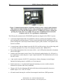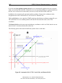
1
GSM-19 v7.0 Instruction Manual Manual Release 7.4 March 2008 GEM Systems, Inc. Advanced Magnetometers 135 Spy Court, Markham, ON Canada L3R 5H6 Phone +1-905-752-2202 Fax: +1-905-752-2205 Email: [email protected] Web: http://www.gemsys.ca TABLE OF CONTENTS 1. INTRODUCTION AND TUTORIAL ........................................................................................................................ 4 1.1 USING WALKING MODE WITH GPS .......................................................................................................................... 6 1.1.1 Getting Started ........................................................................................................................................ 6 1.1.2 Setting the Positioning System................................................................................................................. 6 1.1.3 Changing Time, Filename and Cycling................................................................................................... 8 1.1.4 Setting the Tuning, AC Filter and Display Mode .................................................................................... 8 1.1.5 Working with the GPS Functionality....................................................................................................... 9 1.1.6 Starting a Reading, Surveying and Stopping Recording ....................................................................... 11 1.1.7 Dumping Data to a Personal Computer................................................................................................ 12 1.1.8 Considerations for Using RS-232 Waypoint Uploading ....................................................................... 12 2. THEORETICAL DESCRIPTION............................................................................................................................ 15 3. EARTH’S MAGNETIC FIELD................................................................................................................................ 16 4. INSTRUMENT DESCRIPTION .............................................................................................................................. 17 4.1 STANDARD SYSTEM COMPONENTS ............................................................................................................. 17 4.2 ASSEMBLING THE INSTRUMENT................................................................................................................... 19 4.2.1 General Assembly Instructions.............................................................................................................. 20 4.2.2 Using the Charger ................................................................................................................................. 20 4.2.3 Using the 6-Pin Connector.................................................................................................................... 21 4.3 DESCRIPTION OF CONNECTORS .................................................................................................................... 22 4.3.1 Pinout of a 6-Pin Female Connector..................................................................................................... 23 4.3.2 Pinout of a 4-Pin Female Connector..................................................................................................... 23 4.3.3 Pinout on BNC Female Connector (Fast or Walking modes):.............................................................. 23 4.3.4 External Trigger Options ...................................................................................................................... 24 5. OPERATING INSTRUCTIONS .............................................................................................................................. 25 5.1 KEYBOARD DESCRIPTION .............................................................................................................................. 25 5.1.1 Power On............................................................................................................................................... 25 5.1.2 Power Off .............................................................................................................................................. 25 5.2 MAIN MENU ........................................................................................................................................................ 25 5.3 SURVEY MENU................................................................................................................................................... 27 5.3.1 Setting the Survey Mode ........................................................................................................................ 28 5.3.2 Setting the Positioning System............................................................................................................... 29 5.3.3 Understanding the Line / Station Positioning System ........................................................................... 34 5.3.4 Understanding the X / Y Positioning System ......................................................................................... 35 5.3.5 Setting the Time ..................................................................................................................................... 36 5.3.6 Setting the File Name ............................................................................................................................ 37 5.3.7 Setting the Cycle Time ........................................................................................................................... 38 5.3.8 Tuning the Magnetometer...................................................................................................................... 39 5.3.9 Using the AC-Filter ............................................................................................................................... 41 5.3.10 Setting the Display Mode..................................................................................................................... 42 5.3.11 Entering Text ....................................................................................................................................... 46 5.3.12 Changing the Magnetometer ID Number ............................................................................................ 46 5.4 WORKING WITH MOBILE MODE (ALL MODELS)........................................................................................ 47 5.4.1 Performing a Reading ........................................................................................................................... 47 5.4.2 Repeating a Reading ............................................................................................................................. 50 5.4.3 Monitoring the Noise............................................................................................................................. 50 5.4.4 Using the End of Line (EOL) Function ................................................................................................. 51 5.4.5 Evaluating Signal Quality ..................................................................................................................... 54 5.5 WORKING WITH GRADIOMETER MODE (19G & 19GW)............................................................................. 55 5.5.1 Performing a Reading ........................................................................................................................... 55 5.5.2 Specifying Gradiometer Sensor Spacing ............................................................................................... 56 5.5.3 Selecting the Display Mode ................................................................................................................... 57 5.5.4 Selecting Magnetometer Channels ........................................................................................................ 58 5.6 WORKING WITH WALKING MODES (19W, 19WG & 19GFW)..................................................................... 59 5.6.1 Performing a Reading ........................................................................................................................... 60 5.7 WORKING WITH BASE STATION MODE (ALL MODELS) ........................................................................... 62 5.7.1 Performing a Reading ........................................................................................................................... 62 5.7.2 Stopping a Base Station Reading .......................................................................................................... 64 5.8 SYNCHRONIZING ROVER AND BASE STATION UNITS (ALL MODELS) ................................................. 64 5.8.1 Setting the Time on the First Magnetometer ......................................................................................... 64 5.8.2 Transferring the Time............................................................................................................................ 65 5.9 APPLYING DIURNAL CORRECTIONS ............................................................................................................ 66 5.9.1 Mag-to-Mag Diurnal Correction .......................................................................................................... 67 5.9.2 File-to-File Diurnal Correction (GEMLinkW Utility)........................................................................... 69 6. DATA ORGANIZATION AND TRANSFER ......................................................................................................... 70 6.1 FILES AND DIRECTORIES................................................................................................................................. 70 6.2 DATA TRANSFER ............................................................................................................................................... 71 6.2.1 Setting the RS-232 format...................................................................................................................... 71 6.2.2 Transferring the Data............................................................................................................................ 73 7. RECALLING DATA ................................................................................................................................................. 76 7.1 SELECTING A FILE TO REVIEW ...................................................................................................................... 76 7.2 DATA RECALL IN TEXT MODE ....................................................................................................................... 77 7.3 DATA RECALL IN GRAPH MODE .................................................................................................................... 79 8. ERASING MEMORY................................................................................................................................................ 83 8.1 STARTING THE ERASING PROCESS ............................................................................................................... 83 9. TESTING YOUR SYSTEM ...................................................................................................................................... 85 9.1 STARTING THE TESTING PROCESS (ROM EXAMPLE) .............................................................................................. 85 10. UPGRADING INTERNAL SOFTWARE (FIRMWARE)................................................................................... 86 10.1 USING THE GEMLINKW UPGRADE UTILITY ............................................................................................. 86 10.2 ACCESSING THE UPGRADE MODE .............................................................................................................. 86 11. STORING YOUR MAGNETOMETER (IMPORTANT!) .................................................................................. 88 12. CHARGING THE BATTERY (IMPORTANT!) .................................................................................................. 88 13. MAINTAINING YOUR SYSTEM (IMPORTANT!) ........................................................................................... 89 14. WARRANTY (IMPORTANT!) .............................................................................................................................. 89 APPENDIX A: GLOBAL MAGNETIC MAPS .......................................................................................................... 90 A.1 UNDERSTANDING THE DIFFERENT SENSOR ORIENTATIONS ............................................................... 90 A.1.1 Overhauser Sensor................................................................................................................................ 90 A.1.2 Standard Proton Sensor........................................................................................................................ 90 APPENDIX B: RAW DATA FILES TRANSMITTED BY RS-232-C...................................................................... 93 B.1 MOBILE MODE................................................................................................................................................... 93 B.2 BASE MODE........................................................................................................................................................ 93 B.3 VLF OPTION........................................................................................................................................................ 94 B.4 WALKING MAG OPTION .................................................................................................................................. 95 B.5 GRADIOMETER OPTION .................................................................................................................................. 96 APPENDIX C: VLF SURVEY OPTION..................................................................................................................... 97 C1. ACCESSING THE VLF FUNCTIONALITY....................................................................................................... 97 C2. SELECTING VLF STATIONS............................................................................................................................. 98 C3. STARTING A READING .................................................................................................................................. 101 C4. SIGN CONVENTIONS FOR IN-PHASE (IP) AND OUT-OF-PHASE (OP) .................................................... 103 APPENDIX D: GPS (GLOBAL POSITIONING SYSTEM) OPTION .................................................................. 104 D.1 SETTING UP THE GPS ..................................................................................................................................... 104 D2. SYNCHRONIZING GPS TIME ......................................................................................................................... 106 D3. DISPLAYING CURRENT GPS INFORMATION ............................................................................................ 107 D4. SETTING UP NAVIGATION OPTIONS .......................................................................................................... 108 D.4.1 Automatic Grid Setup (Line-to-Line Navigation) ............................................................................... 108 D.4.2 Programmable Waypoints (Point-to-Point Navigation)..................................................................... 112 D.4.3 RS-232 Waypoint Transfer (Point-to-Point Navigation) .................................................................... 115 D.5 SURVEYING WITH GPS NAVIGATION ........................................................................................................ 117 D.6 DGPS POST PROCESSING .............................................................................................................................. 121 D.7 CDGPS/OMNISTAR GPS OPTION .................................................................................................................. 124 APPENDIX E: GSM-19 V7 DIDD MAGNETOMETER ......................................................................................... 137 APPENDIX F: GSM-19T PROTON PRECESSION SYSTEM............................................................................... 138 F.1 MAGNETIC FIELD MEASUREMENT PROCESS........................................................................................... 138 APPENDIX H: GSM-19 MAG / GRAD SPECIFICATIONS.................................................................................. 139 APPENDIX I: PROGRAMMABLE BASE OPTION............................................................................................... 140 I.1 SETTING UP THE PROGRAMMABLE BASE STATION OPTION ................................................................ 140 I.2 USING THE IMMEDIATE SCHEDULING FEATURE..................................................................................... 142 I.3 USING THE DAILY SCHEDULING FEATURE ............................................................................................... 142 I.4 USING THE FLEXIBLE SCHEDULING FEATURE......................................................................................... 144 I.5 TRANSFERRING SCHEDULES FROM YOUR PC TO YOUR GSM-19 ......................................................... 147 APPENDIX J: VERSION 7.0 ADDITIONS .............................................................................................................. 148 J1. DATA VALUES ...................................................................................................................................................... 148 J2. PROGRAMMABLE OUTPUT..................................................................................................................................... 148 4 GSM19 Series Magnetometers - Version 7 1. INTRODUCTION AND TUTORIAL The GSM-19 is a portable high-sensitivity Overhauser effect* magnetometer/gradiometer designed for hand-held, towed or base station use. Applications include geophysical, geotechnical, or archaeological exploration, long term magnetic field monitoring at Magnetic Observatories, volcanological and seismic research, etc. Figure 1: Sensor and GPS antenna. Use a full section staff (56cm) between sensor and antenna to avoid magnetic interference. GEM System, Inc. Advanced Magnetometers For more technical information, visit www.gemsys.ca! 5 GSM19 Series Magnetometers - Version 7 The GSM-19 is a secondary standard for measurement of the Earth’s magnetic field with 0.01 nT resolution, and 0.2 nT absolute accuracy over its full temperature range. Some of the system features include: • Microprocessor control with large memory storage capabilities (up to 32 Mbytes). • Synchronization of and held and base station units with automatic corrections for diurnal variations of magnetic field. • Access to results in serial form (RS-232-C interface) for collection by data acquisition systems, terminals or computers. • On-line Real Time Transmission (RTT) and post-operation transfers. • Gradiometer mode with strict control of measuring intervals and concurrent measurement of two magnetic fields. The result is a high quality reading, independent of diurnal variations of magnetic field. • Option VLF sensor for combined magnetometer/gradiometer-VLF measurement. The GSM-19 Series of magnetometers includes several models, each with different features and options. In addition, each mode and option can be used in different ways resulting in a variety of combinations. The purpose of this manual is to introduce the most important modes, features and options. After understanding these, it is easier to see how they combine with the others. If your system has a feature that is not described here, please contact us. As well, we welcome suggestions about ways in which we can enhance this manual based on your experiences. *Overhauser Effect (An exclusive feature of GEM Systems Magnetometers) In contrast to a standard proton magnetometer sensor that uses a proton-rich liquid, an Overhauser Effect sensor has a free radical added. This free radical ensures the presence of free, unbound electrons that couple with protons, producing a two-spin system. A strong RF magnetic field is used to disturb the electron-proton coupling. By saturating free electron resonance lines, the polarization of protons in the sensor liquid is greatly increased. The Overhauser effect offers a more powerful method of proton polarization than standard DC polarization (i.e. stronger signals are achieved from smaller sensors, and with less power.) GEM Systems, Inc. Advanced Magnetometers For more technical information, visit www.gemsys.ca 6 GSM19 Series Magnetometers - Version 7 1.1 USING WALKING MODE WITH GPS Welcome to the v7.0 Tutorial for GEM magnetometers (and gradiometers) using Walking Mode with GPS. This guide provides you with the basic information required to get started. You may also want to supplement your review of this tutorial by referring to the rest of the manual. 1.1.1 Getting Started Gettting started is easy; simply requiring turning on the magnetometer and then accessing the main Survey menu. 1. Start by turning the mag on (B-power button). You are in the Main menu. 2. Select A-Survey. You are now in the Survey menu. 3. Press C-Change to set the survey mode. You may see, for example, that A-mobile (discontinuous survey), B-base, and C-walk (nearly continuous survey) modes are available to you. 4. Select the survey mode option (C-walk). This resets the file number as well. Note that re-setting the survey mode is the only way to create a new file. You must do this after each survey so that you can continue with following lines or survey blocks (i.e. depending on the way you run your surveys). 1.1.2 Setting the Positioning System GEM’s GPS functionality is based on waypoints and includes three waypoint options: • Automatic Grid Setup. Specify the endpoints for the start and end of the first survey line and the system automatically creates 500 survey lines parallel to the defined line. • Programmable Waypoints. Define waypoints on the keyboard. This can be challenging to do except for the shortest of files. Generally not recommended. • RS-232 Waypoints Transfer. Define a waypoint file on your PC and upload it using the RS-232 capabilities on the magnetometer / gradiometer. You can use this functionality with one of four positioning options: • UTM. Universal Transverse Mercator. • Lat / Long. Latitude and Longitude (i.e. Easting and Northing) • Local Grid. Reformatted grid with local coordinates for easier manipulation of survey positions (i.e. you can set your local grid so you do not have to use large numbers such as those generated in UTM coordinates). GEM Systems, Inc. Advanced Magnetometers For more technical information, visit www.gemsys.ca 7 • GSM19 Series Magnetometers - Version 7 Rotated Grid. Grid rotated through a specific angle as defined by the first two waypoints on the starting line. If you turn GPS off, you only have standard X-Y and LINE / STATION formats available to you. The X-Y system uses a Cartesian coordinate system whereas LINE / STATION uses line and station numbers that are both annotated with directional information (ex. N, S, E, W and more). Both systems are valid; the X-Y system may be somewhat easier to deal with as numbers do not require later manipulation; LINE-STATION positions are annotated as described above and may require that you remove the annotations later in the post-processing stage (which requires more work). This section describes how to use the Automatic Grid waypoint option with the UTM positioning option. 5. Select the position option. You have four options available, including UTM, Lat / Long, Local Grid and Rotated Grid. 6. Select C-change. The system displays the select positioning system screen. Use C-change to toggle to the positioning option that you want to use. In this case, select UTM. 7. Press F-ok. The system displays the select picket marking screen. This is the screen enables you to annotate UTM values in the magnetometer’s output file at designated locations. What happens with Walking mode is that you can mark pickets at designated stations (i.e. UTM values are added to the file when you press F during the survey). For example, if you are walking along the grid and reach a picket that you want to identify with specific UTM locations, you would then press F at the picket location. These values are added to the file. 8. If you want to change the marking system, press C. The system shows the next possible option. For now, choose the XY option and press F-ok when finished. The system displays the X-Y detailed positioning screen. 9. Start by setting the position. Here, we use x=0, y=0 as the start of our grid; you can use any values that are appropriate for your project. 10. The increment value controls the data acquisiton locations along the line. If your plan for the survey grid is to run vertical lines at 1m spacings, move the cursor to the increment values, select C-clear and then E-enter until increments are set to set x=0, y=1. When finished, select E-Enter. Alternately, iIf your plan is to run horizontal lines, set x=1, y=0, for instance, for the increment. 11. The EOL increment controls the line spacing. For example, if you are using vertical lines and lines spaced at 2m, set x=2, y=0. Or, if you are using horizontal lines spaced at 3m, set x=0, y=3. GEM Systems, Inc. Advanced Magnetometers For more technical information, visit www.gemsys.ca 8 GSM19 Series Magnetometers - Version 7 12. Press F-ok. The system returns you to the Survey menu. 1.1.3 Changing Time, Filename and Cycling The time parameter controls the clock settings, and therefore, the time stamps that are placed in the final output file. It is also required for performing base station corrections. Filename controls the designated name of the file and is generally some specific value that is appropriate for the project at hand (ex. 05survey.m or other value). The cycling controls the rate at which the magnetometer (or gradiometer) samples. 13. In the Survey menu, move the cursor to the time item and select it using C-change. Select Cchange and enter a new time in wyymmddhhmmss format. For a description of this format, see the corresponding information in the User Guide. 14. Move the cursor to the file item and select it using C-change. Type a new filename and use the E-enter key to save the name. Note that the first two letters and the extension cannot be altered; these are reserved for system defaults. 15. Move the cursor to the cycling item and select it using C-change. The system toggles the cycling settings as shown on the display. For walking mode, you should see settings such as, “0.5 sec, 1.0 sec, 2.0 sec, etc.” 1.1.4 Setting the Tuning, AC Filter and Display Mode With an advanced magnetometer, there will be some sort of “tune initialize” function that is responsible for finding the precession signal (ex. similar to a radio station), and a second “autotune” function that tracks the precession signal as it changes in amplitude. With GEM, there are 4 possible states of the two controls, as follows: Tune initialize Y Autotune Y Y N N Y Use When Average magnetic field value at the survey location is not known or alternately, as a default for maximizing signal-to-noise ratios. Magnetometer is running automatically (ex. as a base station) and there is some magnetic noise in the vicinity, for example, from vehicles nearby. The magnetometer may lose its signal when these extreme noise events occur; however, it will recover gracefully as it will use the “tune initialize” value for readings that follow. For fastest readings; reading time is minimized as the system will not scan over the entire frequency range (i.e. disabled). In addition, it is recommended for areas with very high gradients; the magnetometer may saturate at these points but will recover gracefully once the magnetometer passes by anomalous zones. Another possible use is with a base station where the unit is stationary and the base unit does not have to handle large GEM Systems, Inc. Advanced Magnetometers For more technical information, visit www.gemsys.ca 9 GSM19 Series Magnetometers - Version 7 N N deviations in values such as would be encountered in a moving survey. For use with a base station (i.e. where the unit is stationary and not affected by large survey-related jumps in the magnetic field). AC Filtering controls whether 50 Hz or 60 Hz filters are added for suppression of noise from powerlines. The final value discussed in this section is the Display Mode which is used to control the appearance of the data onscreen while the survey is being performed. 16. Move the cursor to the tuning menu item and select C-change. The system displays the tune initialize screen. Set the value to yes by pressing the C-change button. 17. Then press F-ok to exit. The system displays the autotune screen. Set the value to yes by pressing the C-change button. The system returns to the Survey menu. 18. Move the cursor to the AC filter item and select C-change. The system changes between three values: no, 50 Hz and 60 Hz. Select the one that you want to use. 19. Move the cursor to the display mode item and select C-change. The system shows the display-mode screen and the current setting (either text or graph). If you: • Select text and F-ok, the system automatically returns you to the Survey menu after your selection. • Select graph and F-ok, the system adds a second value: field nT. This means that the field value will also be displayed. You can use the C-change button to select from other labeling options such as coordinates, field nT & coordinates or no text. When you press F-ok again, the system displays the clear graph screen. For continuous plotting of values, leave this value set to no. When you press F-ok again, the system displays the vertical scale screen. Use the C and D keys, and the A- and B+ keys to change the base line position and the vertical scale of the graph, respectively. 1.1.5 Working with the GPS Functionality The GPS functionality is accessed with the Main survey screen and specifically, the F-GPS control. Once you have turned the GPS functionality on, you will see a GPS screen with the following four values: • A-initialize. Manual initializing of GPS. Normally GPS is initialized when you start the survey; however, if you experience a situation in which the GPS is not responding, you may want to try to manually initialize the GPS. GEM Systems, Inc. Advanced Magnetometers For more technical information, visit www.gemsys.ca 10 GSM19 Series Magnetometers - Version 7 • B-navigation. This is the main access point for the waypoint options – Automatic, Programmable and RS-232, as well as lane guidance for controlling the width of acceptable deviation (i.e. wander) from the grid lines. • C-synch-to-UTC. Manual synchronization of GPS. Normally GPS is synchronized when you start the survey; however, this functionality is intended for synchronization of nonGPS magnetometers and gradiometers. The way you use this is to first synchronize the rover (assuming this is the GPS unit) and then connect the rover to the base magnetometer and synchronize the times using standard synchronization cables and functionality. • D-test. This is a very useful display menu that shows you what the GPS system is seeing when you have it turned on. Parameters include Lat / Long, UTM, number of satellites, strength in decibels and other values. 20. From the Survey menu, press F-GPS. The system displays the GPS screen. 21. Press C-change to set the GPS to Yes. Press F-ok. The system displays the Navigation menu. You can choose to initialize values, or more commonly, to set the Navigation options. 22. Select B-navigation. The system displays the lane guidance and grid setup screen. You have the option of changing the setting from no to yes as required. Generally, you want to have lane guidance active, so use C-change to set the value to yes, and then press F-ok. The system displays the grid setup screen. 23. In this example, choose the A-automatic grid setup option. This creates a grid of 500 parallel lines (as defined by the starting and ending waypoints of the starting line). The system displays the lane width screen. 24. Use the C-change control to set the lane width (i.e. tolerance value for navigating along the lines) to the appropriate value, say, 25m. 25. Press F-ok. The system displays the start point screen. Enter the starting Easting and Northing of the first waypoint (i.e. for the line you want to use as your starting line). 26. After you enter your first two points, you will see local grid origin (x and y) values. You can choose to set these to local values so that the eastings and northings map to a local grid you are using. In this case, we will assume the default values (i.e. 0) and continue. 27. After you enter the local grid (y) value, the system displays the end point screen. Similarly to the starting point screen, complete all values as required and press F-ok. The system displays the line screen. 28. The line screen offers the opportunity to add a unique line number for each line of the survey. This will be recorded in the output file along with a “/line” notation – a standard GEM Systems, Inc. Advanced Magnetometers For more technical information, visit www.gemsys.ca 11 GSM19 Series Magnetometers - Version 7 notation used by software programs, such as Encom, Geosoft and Intrepid. This was a key upgrade in version 7 (i.e. to enable seamless data transfer from GEM output ASCII files to destination programs). 29. Select C-change and enter a value, say 10, for this parameter. The system displays the line spacing item. You can use this control to define how far apart you would like your lines defined. 30. Press F-ok. The system displays a “please wait” message while it generates the grid. This can take up to a minute to generate so please be patient! When finished, the system displays the lane width screen. This is the first step in a process of verifying that the lines created are consistent with the values you want. 31. Press F-ok in the lane width screen. The system displays the waypoint review screen with the first waypoint identifier (1). Press F-ok again. The system displays the second waypoint identifier (2). Press F-ok again. The system displays the waypoint 0001 screen. 32. Use the waypoint screen to confirm that the easting and northing values are the ones you intended to use. At this point, you can either continue to check values or press E-end to exit from this screen and return to the GPS screen. You are now ready to survey. 1.1.6 Starting a Reading, Surveying and Stopping Recording In this section, we quickly review the steps involved in actually acquiring data in walking mode. We start with the basic steps and then move to more advanced concepts such as positioning systems and how to use the X-Y positioning system. 33. From the Survey menu, press A-start. The system displays a “please wait” message while it initializes the GPS. The system then displays the start survey screen. This screen has controls for advancing the waypoint (currently you see distances to your second waypoint). 34. We recommend that you use the A- control to decrement the waypoint from 2 to 1. You can then use the navigation arrow and distance fields on the screen to navigate to waypoint 1 where you will start your survey. 35. When you arrive at waypoint 1, use the B+ control to increment the waypoint to waypoint 2. Then press F-start survey. The system synchronizes to UTC time. Note: This can take up to fifteen minutes when you are first using the magnetometer in a new part of the world. Please be patient. If there is no action within this period, you can try to re-initialize using the re-initialize function as described in the Working with GPS Functionality section of this tutorial. 36. On proper initialization, the system displays the stop / walk screen after you press F-start survey. Select C-walk. The system displays the line / picket / display screen. GEM Systems, Inc. Advanced Magnetometers For more technical information, visit www.gemsys.ca 12 GSM19 Series Magnetometers - Version 7 Note: The system is actively recording measurements actively at this time so you must be walking. 37. When finished your line, press A. This stops data acquisition. 38. Now, use the navigation functionality to move from waypoint 2 to waypoint 3. When you have arrived at waypoint 3, use the B+ control to increment the waypoint to waypoint 4 which is your next destination. Press F-start survey and continue taking measurements as described here. 39. When finished all lines, press 1 and C keys at the same time. The system returns you to the main menu and closes your file so that it is protected. 1.1.7 Dumping Data to a Personal Computer When dumping data, it is essential that your transmission settings are the same on the magnetometer / gradiometer as on the Personal Computer. You can check and change baud rates, etc. by selecting C-info from the Main screen followed by B-RS232. 40. Initiate dumping by selecting the 1-Send command from the Main Menu. The system displays the file screen. 41. Use C-change-number to change the identifier of the file you want to dump; if you need to see which files are in the mag, use the C-info / C-file-review function first. When finished, press F-ok. The system displays the select SEND format screen. 42. Select from D-default or F-Custom. Values you can use include X, Y, time, nT, nT/m, corrected nT (cor-nT), signal quality (SQ), elevation (new for version 7), satellites (sat), picket-x and picket-y. Custom allows you to arrange these in any order you would like; default provides a preset listing of values in GEM format. 43. When ready to send data, press A-send. The system downloads the data. 44. Options A and E give you the choice to select A-all or F-field values only. Select the data you want to send. The system automatically displays an “ending now 1C-stop”message when finished. 1.1.8 Considerations for Using RS-232 Waypoint Uploading If you want to use the magnetometer’s guidance features, one way to do so is to load a series of waypoints from a Personal Computer. Please note that you installed a demonstration version of GEMLinkW 3.0 software for downloading, diurnal corrections and other functions. With this version, there is a limitation in terms of transferring waypoints to magnetometers (i.e. the system does not support a second decimal place ... centimetre positions). GEM Systems, Inc. Advanced Magnetometers For more technical information, visit www.gemsys.ca 13 GSM19 Series Magnetometers - Version 7 The solution for this issue is to copy the executable file, GEMLinkW.exe, directly from the CD to the folder that contains the installed GEMLinkW software. This file is typically stored in C:\Program Files\GEMLinkW 3.0\ . To load waypoints: 1. Create an ASCII file with two columns of Easting and Northing data (only UTM format supported) that includes 2 decimal places (but NO decimal point). The following shows such a file. The last two digits are centimetres. If your original file is in metres, for example, you will have to add two zeros at the end of each number to transfer the file correctly. 62891912 485690556 62898934 485692178 62899600 485689000 62892700 485687200 Note: When creating files for waypoints transfer, it is important to make sure that there are no empty headers or strings (characters) at the beginning or end of the file, or extra spaces at the end of strings within the file. 2. Set the communication parameters on the console (C-info / RS-232 menu) and then on the magnetometer. They must be exactly the same for the upload to work. Note that you may have to set your Personal Computer’s communication port to 3, 4 or 5 depending on your system’s configuration. 3. Open GEMLinkW and select the Tools | RS-232 Transfer | Transfer GPS waypoints | PC to console option. The system displays the Waypoints Transfer Utility screen. 4. Select the Open file button and then locate your waypoint file. Press Ok. The system displays a message similar to the following, “The current active serial port is COM5. Make sure the RS232 port of the mag is connected to it.” GEM Systems, Inc. Advanced Magnetometers For more technical information, visit www.gemsys.ca 14 GSM19 Series Magnetometers - Version 7 5. Press the Next button and follow the instructions on the screen for setting up the magnetometer to receive waypoints. 6. Then press Next. The system transfers the data and displays a message when transfer is complete. GEM Systems, Inc. Advanced Magnetometers For more technical information, visit www.gemsys.ca 15 GSM19 Series Magnetometers - Version 7 2. THEORETICAL DESCRIPTION The magnetic field measuring process consists of the following steps: a) Polarization. A strong RF current is passed through the sensor creating polarization of a proton rich fluid in the sensor. In the case of the GSM-19 fast sampling family, polarization can be concurrent with other intervals of measurement. Keeping the RF on all the time increases the maximum datasampling rate to 5 Hz. b) Deflection. A short pulse deflects the proton magnetization into the plane of precession. c) Pause. The pause allows the electrical transients to die off, leaving a slowly decaying proton precession signal above the noise level. d) Counting. The proton precession frequency is measured and converted into magnetic field units. e) Storage. The results are stored in memory together with date, time, and coordinates of measurement. In base station mode, only the time and total field are stored. GEM Systems, Inc. Advanced Magnetometers For more technical information, visit www.gemsys.ca 16 GSM19 Series Magnetometers - Version 7 3. EARTH’S MAGNETIC FIELD The nominal distribution of the Earth’s magnetic field is shown in Figure A1 in Appendix A and the separation of equatorial and polar regions is shown in Figure A2. In polar regions the inclination of the magnetic field vector is approximately vertical, whereas in equatorial regions it is horizontal. In general, the sensor axis must be approximately at right angles to the magnetic field to obtain the best signal. For this purpose, the sensor must be kept oriented in a magnetic East-West direction in equatorial regions. NOTE: Omnidirectional sensors (i.e. do not need to be oriented) can be purchased as an option from GEM Systems. Initially, the tuning of the instrument should agree with the nominal or expected value of the magnetic field for the particular region (see Figure A1 in Appendix A). You can set this tuning automatically or use the tune initialize feature provided for this purpose. After each reading the instrument tunes itself automatically. If large changes in magnetic field are encountered between successive readings, you see a warning and you may have to repeat the reading to obtain an accurate result. Local ferromagnetic objects (such as screws, pocketknives, wristwatches, tools etc.) may impair the quality of measurement or, in drastic cases, obscure the proton precession signal by creating excessive gradients. NOTE: For best results, you should keep ferromagnetic objects away from the sensor. In normal applications, the magnetometer console does not produce appreciable effects on measurements provided that the sensor is installed on the staff and kept at least at arm’s length from the operator and the console. GEM Systems, Inc. Advanced Magnetometers For more technical information, visit www.gemsys.ca 17 GSM19 Series Magnetometers - Version 7 4. INSTRUMENT DESCRIPTION Before starting, you should be aware of some general terminology that applies to GEM’s magnetometers and gradiometers. ROVER and BASE station modes are terms that describe the operating characteristics of instruments whereas SLOW and FAST reading rates describe the cycling characteristics of instruments. Specifically, • ROVER mode refers to instruments that physically move throughout the survey. GEM delivers instruments that operate in mobile (i.e. magnetometer), gradiometer, walking magnetometer and walking gradiometer modes. • BASE station mode describes stationary units used for diurnal correction. • SLOW cycling rates describe instruments that cycle from 3 seconds to 1 hour. • FAST reading rates describe instruments that cycle from 0.5 seconds to 1 hour (i.e. include all SLOW reading rates). By default, all GSM-19 series magnetometers / gradiometers have a mobile and base station mode, and cycle at a slow reading rate. However, if you purchase additional options such as walking mode or walking gradiometer rover mode, your instrument is automatically upgraded to a fast cycling rate. Please keep this terminology in mind when reading the next two sections and other parts of the manual that describe the various operating modes and options. 4.1 STANDARD SYSTEM COMPONENTS The following images show the standard components that are shipped with a GSM-19 system. Figure 2. GSM-19 Case with Sectional Staff rods. Assemble these rods if you are planning to conduct a “Mobile” survey (i.e. one with discrete stations as opposed to a “walking” or continuous survey). GEM Systems, Inc. Advanced Magnetometers For more technical information, visit www.gemsys.ca 18 GSM19 Series Magnetometers - Version 7 Figure 3: Standard magnetometer components include a sensor, console, radio frequency cable, download cable, shoulder harness, sensor mounting rod, and RS-232 cable. Also included here are a GPS and GPS support rod. For a complete list of parts, consult your packing slip. It may show, for example, that you have an additional sensor and radio frequency cable (i.e. for a gradiometer configuration). The following list summarizes the STANDARD parts that are shipped with a GSM-19 system: • 1 sensor for magnetometer and 2 for gradiometer. Sensors are dual-coils designed to reduce noise and improve gradient tolerance. Coils are electrostatically shielded and contain a special proton rich liquid in a sealed Pyrex bottle Radio Frequency (RF) resonator. The liquid does not need to be refilled. • 1 coaxial sensor cable per channel, typically RG-58/U and 206 cm long. (Up to 100m long cable is available optionally. Over 20m, we recommend a triaxial cable - Belden 9222). • Fast reading magnetometers have two sensor cables – one for RF polarization and a microphone cable for the signal. • Console with all electronic circuits. It has 16 key keyboard, graphic display (64 x 240 pixel, or 8 x 30 characters), sensor and power / input / output connectors. The keyboard also serves as an ON-OFF switch. • 6-pin console connector for RS-232, external power, battery charging or external trigger. Optional dual analog output is available on a 3-pin connector. • Sealed connectors (i.e. keyboard and front panel mounting screws are sealed so that the instrument can operate under rainy conditions). • Charger with 2 levels of charging (full and trickle) that switch automatically from one to another. Input is 110 - 250V, 50 / 60 Hz. • All-metal console housing for excellent electromagnetic interference (EMI) protection. GEM Systems, Inc. Advanced Magnetometers For more technical information, visit www.gemsys.ca 19 • GSM19 Series Magnetometers - Version 7 Aluminum staff with 4 strong tubing sections (plastic staff optional). This construction allows for a selection of sensor elevations above ground during surveys. For best precision the full staff length should be used. Recommended sensor separation in gradiometer mode is one staff section (56cm), although two or more sections are sometimes used for maximum sensitivity. 4.2 ASSEMBLING THE INSTRUMENT The GSM-19 is very simple to assemble. The following picture shows the sensors in Gradiometer or Walkgrad configuration mounted on a back pack Figure 4: Gradiometer and Backpack Assembly GEM Systems, Inc. Advanced Magnetometers For more technical information, visit www.gemsys.ca 20 GSM19 Series Magnetometers - Version 7 4.2.1 General Assembly Instructions When assembling the instrument, start by: 1. Installing the sensor on top of the 4th section of the staff, far from any metallic or magnetic object. 2. Plug the sensor cable(s) into the side of the console. 3. Check the magnetometer power. Typically, power is supplied via a 12 volt built-in rechargeable battery. 4. If you are using an external power supply (250mA or 3W of power), connect it to pins E (-) and F (+) of the 6-pin connector at the bottom end of the console. Pins B and C are used for RS232C communications. Pin A is reserved for external trigger. A spliced 6 pin (to RS-232C and external battery) cable is optionally supplied with the instrument. Pin D is reserved for charging the internal battery. 5. If you are using fast sensors (optional), make sure that there are two short cables (sub cables) with 2 BNC connectors. Connect first the extension cables and then connect both cables to the GSM-19 console-BNC and 4 pin connector. The lower set of connectors on the unit's display and in this manual is referred to as [lower], while the upper set is referred to as [upper]. 6. If you are using slow sensors (optional), make sure that you have one short cable with a BNC connector. First connect the extension cable and then connect 4 pin connector to the GSM-19 console. Again, the lower 4-pin connector on the display is referred to as the [lower] and upper 4 pin connector is referred to as [upper]. 7. If you are using the VLF unit (optional), connect the VLF cable (plastic connector) to VLF sensor and the metal shell connector to the mag. 8. If you are using the backpack accessory (optional), install the sensors in the unit for hands free operation. Refer to picture on the previous page for a general overview of the backpack assembly. 9. If you are using the GPS sensor (optional), refer to Figure 1 to see how the unit is configured. Make sure that you connect the antenna cable to the BNC connector marked with a yellow tag on the right hand side of the console. 4.2.2 Using the Charger The charger supplied with the magnetometer is of wide input voltage range 100 - 250 VAC 50/60 Hz. The “fast charging” indicator of the battery charger will light when battery charging is in progress, and charging should be allowed to proceed until the indicator goes off. GEM Systems, Inc. Advanced Magnetometers For more technical information, visit www.gemsys.ca 21 GSM19 Series Magnetometers - Version 7 4.2.3 Using the 6-Pin Connector The 6-pin connector can be used for different purposes: • To connect the charger. • For time synchronization and for diurnal correction - use 6-pin to 6-pin cable connected from console to console. • For RS-323 data transfer, either in Real time Transmission or after the survey. • For external triggering. • For upgrading internal software. • For any combinations of the above with proper cable (contact GEM systems for available options). Figure 5. Operator with console, sensor and GPS. GEM Systems, Inc. Advanced Magnetometers For more technical information, visit www.gemsys.ca 22 GSM19 Series Magnetometers - Version 7 4.3 DESCRIPTION OF CONNECTORS SNSR RS232 PWR Sensor Channel that receives the proton precession signal RS-232 Communication port and input for power UPR SNSR Upper sensor channel that receives the proton precession signal. LWR SNSR Lower sensor channel that receives the proton precession signal. RS232 PWR RS-232 Communication port and input for power GSM-19 MAGNETOMETER GSM-19G GRADIOMETER UPR PLRZ Upper polarization. Sends RF signal, polarizes the upper sensor. SNSR Sensor channel that receives the proton precession signal UPR SNSR Upper sensor channel that receives the proton precession signal. PLRZ Polarization, sends RF signal, polarizes the sensor. LWR SNSR Lower sensor channel that receives the proton precession signal. LWR PLRZ RS232 PWR RS-232 Communication port and input for power. GSM-19W “WALKING” MAG RS232 PWR Lower polarization. Sends RF signal, polarizes the lower sensor. RS-232 Communication port and input for power. GSM-19GW “WALKING” GRAD GEM Systems, Inc. Advanced Magnetometers For more technical information, visit www.gemsys.ca 23 GSM19 Series Magnetometers - Version 7 4.3.1 Pinout of a 6-Pin Female Connector A - external trigger. B - RS-232-C to mag. C - RS-232-C from mag. D - (+) of 12V lead acid battery charger. E - Ground, (common). F – external battery + 11V to 15V. NOTES: External power applied to pin F does not charge the internal battery. Voltage in excess of 15 volts in pin F may trigger an internal protection and blow the internal fuse. Fuses cannot be reset and must be replaced. 4.3.2 Pinout of a 4-Pin Female Connector A - signal input. B - Ground. C - not used. D - not used. 4.3.3 Pinout on BNC Female Connector (Fast or Walking modes): Center pin - RF output. Body - Ground. GEM Systems, Inc. Advanced Magnetometers For more technical information, visit www.gemsys.ca 24 GSM19 Series Magnetometers - Version 7 4.3.4 External Trigger Options Those survey modes that require your intervention to take a reading, such as Mobile, slow Gradiometer or slow modes combined with VLF, could also be triggered by external control pulses sent to the 6-pin connector. Auto-cycling modes, such as Base, Walk Mag or Walk Grad do not respond to external trigger commands. External trigger can be accomplished in three different ways: 1. Using external relay or switch between pins A - E: • Keep A-E open for most of the time. • Shorting A - E for 10ms - 50ms is recognized as a trigger. 2. Using external voltage on pin A with E as ground: • Keep A at 5V to 12V most of the time. • Voltage falling to 0V for 10ms - 50ms is recognized as a trigger. 3. Using RS-232 to GSM-19 at pin B and pin E as signal GND: • A Carriage return byte is recognized as a trigger command. NOTE: Real Time Transmission must be enabled for this trigger mode to operate properly. For those external trigger modes involving pin A as an input, you can check the status of pin A from the unit's screen. From main menu, press D-test and then E-ext-trigger. The screen shows Pin A floating for the high-level conditions, and Pin A GNDed for the ground (GND) level. NOTE: Pin A is actually never floating. It is tied to +5v by internal pull-up resistors. GEM Systems, Inc. Advanced Magnetometers For more technical information, visit www.gemsys.ca 25 GSM19 Series Magnetometers - Version 7 5. OPERATING INSTRUCTIONS This section is intended to give you a basic overview of the keyboard, menus and processes required to set up and operate the magnetometer in the field. 5.1 KEYBOARD DESCRIPTION The keyboard consists of 16 alphanumerical keys. The function of the keys is described below: 5.1.1 Power On 1. Press the button labeled “B” on the console to turn the GSM-19 on. 2. If during power up, you hold the power button B for about 2 seconds, the following screen is displayed: SCREEN 1 Gem Systems GSM-19GW 9001054 52 West Beaver Creek Road #14 Richmond Hill, Ontario L4B 1L9 Canada tel 905-764-8008 fax 764-2949 www.gemsys.on.ca [email protected] bytes v7.0 10 IX 2000 4194304 Screen 1 displays the company address, telephone, fax, e-mail and website. The bottom line displays the software version/date and the total storage capacity of the unit in bytes. You can access the same information screen by pressing C-info and then 3-info from the main menu screen. Once the power button is released, the unit proceeds to the Main Menu. Options and their functions are explained later in section 5.2. 5.1.2 Power Off To switch the unit off, press the O and F keys simultaneously at any time, in any menu. 5.2 MAIN MENU To position the magnetometer in the Main Menu, press the 1 and C keys simultaneously – at any time. All of the valid options and their functions are displayed on the screen in the form of a letter / digit followed by a dash and then a brief description of its function. GEM Systems, Inc. Advanced Magnetometers For more technical information, visit www.gemsys.ca 26 GSM19 Series Magnetometers - Version 7 The 13.2V on the bottom right corner of the screen shows the battery voltage. SCREEN 2 A-survey B-diurn.cor F-GPS C-info OF-off D-test E-time-synch 1-send 15 II 00 TU 01:04:15 45-erase 2-enter text 13.2V From the Main Menu, you can press the following to go to the menus shown on the right: A Survey Menu (see section 5.3) B Diurnal correction (see section 5.9) C Info Menu (see section 5.4.5) D Test (see section 9) E Time Synchronization (see section 5.8) 1 Data Transfer (see section 6.2) F GPS option (see Appendix D) 45 Data Erasing (see section 8) 2 Text Mode (see section 5.3.10) GEM Systems, Inc. Advanced Magnetometers For more technical information, visit www.gemsys.ca 27 GSM19 Series Magnetometers - Version 7 5.3 SURVEY MENU The Survey Menu is the main menu you use for acquiring data. To access the Survey Menu, make sure you are in the Main Menu and press A. The active option on the survey menu is the one highlighted with reverse video. Pressing B moves the highlighted marker backward, and F moves it forward. Once the desired option is highlighted, press C-change to change its settings. SCREEN 3 survey mode position time file cycle time tuning AC filter display mode text ID connect sensor now 029127 readings left mobile A-start C-change ← BF → In the Survey Menu, you can press the following to initiate the actions shown on the right: F move forward or B move backwards through the parameters C change settings of the highlighted parameter A start the survey at any time GEM Systems, Inc. Advanced Magnetometers For more technical information, visit www.gemsys.ca 28 GSM19 Series Magnetometers - Version 7 5.3.1 Setting the Survey Mode In the Survey Menu, highlight survey mode and press C-change. The survey modes that are applicable for the unit are displayed. NOTE: The available survey modes of your unit may differ from the ones shown here depending on its model, its software, and its hardware. SCREEN 4 A – mobile B – base C – grad D – walkmag E – walkgrad and select: A mobile B base (station) C grad D walkmag E walkgrad After a survey mode has been selected, the settings that apply to that mode is displayed. For example, if the mobile survey mode is selected, you see: SCREEN 5 survey mode position time file cycle time tuning AC filter display mode text ID connect sensor now 029123 readings left mobile A-start C-change ← BF → GEM Systems, Inc. Advanced Magnetometers For more technical information, visit www.gemsys.ca 29 GSM19 Series Magnetometers - Version 7 If the base survey mode is selected, you see: SCREEN 6 survey mode datum time file cycle time tuning AC filter display mode text ID connect sensor now 089123 readings left base A-start C-change ← BF → CAUTION: Before taking a reading, check to make sure all cables and sensor(s) are connected. This maximizes the lifespan of your system and protects internal RF circuits from water damage, overheating, etc. The active survey mode and the number of readings that could be taken in that mode until the memory is full are also indicated on the screen. NOTE: The mobile menu does not have a setting for the DATUM, and the base does not have a setting for POSITION. 5.3.2 Setting the Positioning System From the Survey Menu scroll with B or F to highlight position. SCREEN 7 survey mode position time file cycle time tuning AC filter display mode text ID 00100N 0000125E A-start ← C-change BF → When position is highlighted, the unit displays the current position settings. To select the positioning system or make changes to the coordinate numbers, press C-change. GEM Systems, Inc. Advanced Magnetometers For more technical information, visit www.gemsys.ca 30 GSM19 Series Magnetometers - Version 7 The selection of the positioning system can be made only once per file and only before the first reading of the file is taken. Positioning systems cannot be combined. Once a reading is taken, the current system remains for the rest of the file. By default, the system used in the last file is the active one. If you need to change it, do so now before taking any readings. The Selection for X / Y coordinates looks like: SCREEN 8 select positioning system XY each: -9999999 to +9999999 or -9999999.99 to +9999999.99 F-ok C-change or for the Line / Station grid system SCREEN 9 select positioning system LINE 0 to 99999 STATION 0 to 9999999 or 0.00 to 99999.99 each with NN NE E SE S SW S NW F-ok C-change C-change toggles between the above two screens. Press F-ok to select one. NOTE: If your unit is equipped with built-in GPS and GPS is active, you have more options for the positioning system. See Appendix D for more details. GEM Systems, Inc. Advanced Magnetometers For more technical information, visit www.gemsys.ca 31 GSM19 Series Magnetometers - Version 7 If you select X/Y system, the next screen is: SCREEN 10 x= 0 position y= 0 x= 0 y= 0 increment x= 0 y= 0 EOL increment E-next C-clear D-backsp. F-ok • Position • Increment Increase in each direction that is added to present position after each reading. • EOL Current coordinates. These are the X/Y coordinates of the first reading. End Of Line increment (i.e. added to the present X and Y if you press EOL -see section 5.4.4) A list of available commands is shown on the bottom line: E moves cursor to next number. C erases the number at cursor position. D cursor jumps to the end of the number - if you just want to modify last digit. F leaves this screen. If you press C-clear or D-backsp, the bottom line changes to display new commands: SCREEN 11 x= 0 position y= 0 x= 0 increment x= 10 EOL increment 0-9 A-dp B- + y= 0 y= 0 D-backsp. E-enter GEM Systems, Inc. Advanced Magnetometers For more technical information, visit www.gemsys.ca 32 GSM19 Series Magnetometers - Version 7 0-9 digits can be entered. A-dp places decimal point, after that only 2 more digits are allowed. B-+ toggles sign. D-backsp backspace. Erases last digit (or decimal point) entered. E-enter press if number is correct. If you selected Line-Station positioning system, two screens are displayed: one for the Line and the other for the Station settings. SCREEN 12 LINE 00100 N change A-number B-coordinates F-OK EOL INCREMENT +00100 change C-sign D-number LINE INCREMENT +00000 change E-sign 0-number A changes line number. B changes line cardinals. (N,NE,E,SE,S,SW,W,NW) C changes EOL increment sign. D changes EOL increment. E changes line increment sign. 0 changes line increment. NOTE: The EOL increment only affects the Line number (see section 5.4.4). GEM Systems, Inc. Advanced Magnetometers For more technical information, visit www.gemsys.ca 33 GSM19 Series Magnetometers - Version 7 SCREEN 13 STATION 012345.50 E change A-number B-coordinates STATION INCREMENT +00012.25 change C-sign D-number F-OK A changes station number. B changes station cardinals. (N,NE,E,SE,S,SW,W,NW) C changes station increment sign. D changes station increment. When you press A - number, D - number or 0 - number the following screen is displayed: SCREEN 14 E - enter C - clear Here you can enter the required number, using 0-9 digits and A as a decimal point. Then use Cclear to make corrections or E-enter to store. When you press B-coordinates, the following screen is displayed: SCREEN 15 enter NESW Use the blue letters on the keyboard to select the desired cardinal point. GEM Systems, Inc. Advanced Magnetometers For more technical information, visit www.gemsys.ca 34 GSM19 Series Magnetometers - Version 7 NOTES: For a standard survey do not use LINE INCREMENT (set it to 0). You can use LINE INCREMENT if you are surveying a base line or tie-line. Otherwise you would be walking diagonally on your grid. If you are planning to use station interpolation for walk files (see section 6.2.3), keep in mind the number of readings and the distance between pickets by managing the cycling time and the station increment. If you have too many readings and small station increments, some interpolated stations have repeated values. 5.3.3 Understanding the Line / Station Positioning System N W station 600.00W station 587.50W station 587.50E station 600.00E If you walk East from station 600.00W you must use -12.50 station increment. E If you walk West from station 600.00E you must use -12.50 station increment. S In both cases, when you pass through station 0.00, the GSM-19 automatically changes E to W or W to E and the sign of the station increment. The station increment is used in a mathematically correct way and is related to the direction in which you are walking. As per the above diagram the same applies to N or S stations. GEM Systems, Inc. Advanced Magnetometers For more technical information, visit www.gemsys.ca 35 GSM19 Series Magnetometers - Version 7 5.3.4 Understanding the X / Y Positioning System N ↑ x=-600.00 W +y x=-587.50 x=587.50 If you walk East from x=-600.00 (or any other point), you must use +12.50 x increment and 0 y increment. x=600.00 E If you walk West from x=600.00 (or any other point), you must use -12.50 x increment and 0 y increment. ↓ -y S For clarity, in the above diagram x-axis is aligned EW, and y-axis NS but they could also represent any other grid. The x increment is used in a mathematically correct way and also indicates the direction in which you are walking. Similar rules apply for walking in y direction. • Walking north or east requires a positive increment regardless of where you stand. • Walking south or west requires a negative increment. The x increment must be zero if you walk along y lines. NOTE: All the numbers shown above are just examples, the range of numbers which can be used are: GEM Systems, Inc. Advanced Magnetometers For more technical information, visit www.gemsys.ca 36 GSM19 Series Magnetometers - Version 7 Line 0 to 99999 Station 0 to 9999999 or 0.00 to 99999.99 xy -9999999 to +9999999 or -9999999.99 to +9999999.99 The same limits apply for the increments, but selections must be done in such a way that after the increments are added the numbers are still within range. 5.3.5 Setting the Time In the Survey Menu, press F to highlight time SCREEN 16 survey mode position time file cycle time tuning AC filter display mode text ID 13 V 96MO15:05:04.0 this time has been set by keyboard A-start C-change BF ← time running → The line that has “this time has been set by keyboard” can also have other values as follows: • has been set by GPS. • has been set by default. • has been set by cable synch. • has been set by remote. To change the time, press C-change and the following screen is displayed: SCREEN 17 wyymmddhhmmss c-clear GEM Systems, Inc. Advanced Magnetometers For more technical information, visit www.gemsys.ca 37 GSM19 Series Magnetometers - Version 7 Now enter the date and time. In case of a typing error, press C. • w - weekday, 1 - Monday, 7 - Sunday • yy - year • mm - month • dd - day • hh - hours in 24h system • mm - minutes • ss - seconds When all of the digits are entered the unit displays the following screen: SCREEN 18 F-start-clock Press F when you intend to start the time. NOTE: Units equipped with GPS overwrite this time with UTC when GPS is enabled. 5.3.6 Setting the File Name In the Survey Menu, press F to highlight file SCREEN 19 survey mode position time file cycle time tuning AC filter display mode text ID 01survey.m A-start C-change ← BF → GEM Systems, Inc. Advanced Magnetometers For more technical information, visit www.gemsys.ca 38 C GSM19 Series Magnetometers - Version 7 change enables you to change the 6 letter file name - but only before the first reading of the file. • Use the red letters on the keyboard to name the file. If the required letter is second or third, press the corresponding button twice or three times. Use the: F button after each letter to move the cursor to the next position and B button as a backspace. You can store up to 50 files in the mag. File names have a format similar to 01survey.m, where you can only change the 6 letters between the first number and the period (i.e. the file extension is fixed). The prefix numbering (ex. 01 to 50) and the file extension are automatically assigned. The file extensions are .m for mobile and .b for base (see section 6.1 for more file extensions). 5.3.7 Setting the Cycle Time In the Survey Menu, press F to highlight cycle time. SCREEN 20 survey mode position time file tuning AC filter cycle time display mode text ID 0004.0 sec cycle time A-start C- D+ ← BF → C - and D + enable you to decrement or increment the Cycle time There are four groups of survey modes with different limits in cycle time: 1. 2. 3. 4. Cycle Time 3.0 sec. - 10.0 sec. 3.0 sec. - 3600.0 sec. 0.5 sec. 2.0 sec. 0.2 sec. 2.0 sec. Survey Mode Mobile gradiometer, mobile + vlf, gradiometer vlf. Base Station. Walk modes. Fast & marine modes. The cycling time for each of these groups is saved and after changing the survey mode the last used cycle time is restored in each of the survey modes. GEM Systems, Inc. Advanced Magnetometers For more technical information, visit www.gemsys.ca 39 GSM19 Series Magnetometers - Version 7 The definition of cycle time is different for different survey modes: • In mobile, gradiometer, mobile + vlf or gradiometer + vlf modes, the GSM-19 does not cycle automatically. You must press a button to take each reading. The cycle time in these modes represents the maximum waiting time to match the seconds and fraction of seconds to those of a base station unit cycling at the same rate. This ensures that there is a reading on the base station taken precisely at the same time, and that interpolation of the base unit readings is not required during diurnal corrections (see section 5.9). When the unit is set to immediate start, lines 6 & 7 of the LCD show immediate start (correction with interpolation). This means that once in survey mode, pressing any button starts a reading immediately. Because there is no waiting time, the time stamps of the readings of the mobile unit may not match the time stamps of the readings of the base station. During diurnal correction the base readings are linearly interpolated to the time of the mobile unit. • Base, walk, fast and marine modes are auto cycling modes. The cycle time is the time between consecutive readings. For more precise diurnal correction, press D+ or C- to select the same cycle rate as the base unit. NOTE: To perform diurnal corrections, the time of the mobile and the base MUST also be synchronized. See Time Synchronization in section 5.8. 5.3.8 Tuning the Magnetometer In the Survey Menu, press F to highlight tuning. SCREEN 21 survey mode position cycle time tuning display mode text ID initialize N A-start time file AC filter auto-tune Y056 C-change ← BF → GEM Systems, Inc. Advanced Magnetometers For more technical information, visit www.gemsys.ca 40 GSM19 Series Magnetometers - Version 7 C-change lets you change all three parameters as follows: 1. Tuning initialize. 2. Auto tune. 3. Tuning number in μT. If you press C-change, you see the following: SCREEN 22 tune initialize yes F-ok C-change C - change toggles between yes and no • If you select tune initialize yes, the unit automatically scans through its range for the initial tuning setting. This scan is performed only once and before a reading is taken (when entering the survey mode from this screen). Once tuning is initialized, the value of the tuning parameter depends on the auto-tune setting. NOTE The automatic scanning process may fail in noisy or high magnetic gradient areas. In these cases you may use manual tuning by setting tune initialize to NO. • If you select tune initialize no, you must manually set the field range in screen 24. To store your selection and access the next tuning parameter, press F-ok. SCREEN 23 auto-tune yes F-ok C-change C-change toggles between yes and no. GEM Systems, Inc. Advanced Magnetometers For more technical information, visit www.gemsys.ca 41 GSM19 Series Magnetometers - Version 7 • auto-tune yes allows the unit to follow changes in the magnetic field with jumps of a maximum of +-2.5 μT per reading in the survey area. • auto-tune no permanently holds tuning at the initial value. If tune initialize was set to YES, the tuning value obtained during the automatic scan is set for the survey. If tune initialize is set to NO, the unit retains the tuning value displayed on the next screen To store your selection press F-ok. If you selected tune initialize no at screen 22, the following screen is displayed. SCREEN 24 57 tuning 19-131 microT F-ok C-change-number Enter the first two digits of expected magnetic field (first 3 if above 100 kgamma) for initial tuning. 5.3.9 Using the AC-Filter In the Survey Menu, press F to highlight AC filter. SCREEN 25 survey mode position time cycle time tuning AC filter display mode text ID file 60Hz A-start C-change ← BF → C-change toggles between 60Hz, 50Hz and No. If you select No, the reading is defined as the longest measurement possible, however, the other two settings are recommended because of possible AC interference. GEM Systems, Inc. Advanced Magnetometers For more technical information, visit www.gemsys.ca 42 GSM19 Series Magnetometers - Version 7 NOTE: It must be mentioned here that the AC filter is not a DSP (digital signal processor) implemented in software or a hardware filter. It simply shortens the measuring time to match a specific numbers of 1/60 or 1/50 seconds periods to minimize the interference of power lines. GEM Systems magnetometers output real measured values with no extra filtering, averaging, or signal manipulation of any kind. State-of-the-art measuring algorithms and system design -- from the sensors to the electronics ensure the quality of the results. In the few cases when averaging of the readings is required, you have full control over the process. 5.3.10 Setting the Display Mode In the Survey Menu, press F to highlight Display Mode. SCREEN 26 survey mode position time file cycle time tuning AC filter display mode text ID graph A-start C-change ← BF → C-change toggles between the text or graph selections. If you select text, all of the graphs are disabled and the following screen is displayed: SCREEN 27 text display-mode F-ok C-change GEM Systems, Inc. Advanced Magnetometers For more technical information, visit www.gemsys.ca 43 GSM19 Series Magnetometers - Version 7 If graph is selected, the following is displayed. SCREEN 28 graph no text display-mode F-ok C-change C-change toggles line 2 between no text; field n;, coordinates; andfield nT & coordinates. no text only a graph of the magnetic field is displayed during survey with no other text. field nT the graph along with the magnetic field readout in big digits in upper left display corner is displayed. Coordinates line and station (or X/Y) is displayed in small characters in top right corner. field nT & and coordinates both field and coordinates numbers are shown. NOTE: Gradiometer modes have more options in this screen to accommodate the selection of gradient graph or readouts. GEM Systems, Inc. Advanced Magnetometers For more technical information, visit www.gemsys.ca 44 GSM19 Series Magnetometers - Version 7 Press F after you have made your selection. The following screen is displayed. SCREEN 29 yes clear graph F-ok C-change C - toggles between yes and no. Once programmed, this feature is always active at the start of a survey until you disable it. It can only be changed in this screen at the end of the set up menus. This feature has no effect on the display when you go from the survey menu back to the survey. Yes Always starts the survey with an empty screen. The graph starts from the left side, and the offset is set to 00. No Displays the last graph from memory and starts adding the new readings at the end of it. After you have made your selection, press F. The following screen is displayed. SCREEN 30 D↑ C↓ vertical scale 160nT A- B+ F Use A- or B+ to select the vertical scale and D or C to adjust the vertical offset by one dot of the LCD (keep pressed for fast, continuous action). Only a short, rounded indication of the vertical scale appears on the 1st line of the screen. The actual values are the ones shown in the following table. The vertical units are nT (i.e. full scale from top to bottom of the screen). The horizontal range is always 240 dots and each dot represents a reading. GEM Systems, Inc. Advanced Magnetometers For more technical information, visit www.gemsys.ca 45 GSM19 Series Magnetometers - Version 7 Real Range LCD Short Form 0.64nT 0.64nT 1.28nT 1.28nT 2.56nT 2.56nT 5.12nT 5nT 10.24nT 10nT 20.48nT 20nT 40.96nT 40nT 81.92nT 80nT 163.84nT 160nT 327.68nT 300nT 655.36nT 650nT 1310.72nT 1300nT 2621.44nT 2600nT 5242.88nT 5000nT Table 1: Vertical Graph Display Ranges GEM Systems, Inc. Advanced Magnetometers For more technical information, visit www.gemsys.ca 46 GSM19 Series Magnetometers - Version 7 5.3.11 Entering Text In the Survey Menu, press F to highlight Text. SCREEN 31 survey mode cycle time display mode A-start position time file tuning AC filter text ID C change ← BF → C-change allows an entry of a text with comments or observations pertinent to the survey. More text or comments can be added later as the survey progresses (see section 5.4.1). Each file may have its own text (including base mode). You can recover the text later using SEND (dumping data) in a separate file or you can access it chronologically with the data. 5.3.12 Changing the Magnetometer ID Number In the Survey Menu, press F to highlight ID. SCREEN 32 survey mode position time file cycle time tuning AC filter display mode text ID 123456789 A-start C- change ← BF → C-change allows a change of ID number of this unit –value is shown in the headers of the files when using SEND. A maximum of 9 digits is allowed. This setting has no effect on the readings or the survey mode itself. It could be used to identify the operator or any other additional information pertinent to the current file or unit. GEM Systems, Inc. Advanced Magnetometers For more technical information, visit www.gemsys.ca 47 GSM19 Series Magnetometers - Version 7 5.4 WORKING WITH MOBILE MODE (ALL MODELS) As described in the instrument description section in Chapter 4, GEM’s ROVER modes include mobile, gradiometer, walking and walking gradiometer. This section describes the mobile mode that (along with the BASE STATION mode) is a standard feature of all GSM-19 series units. 5.4.1 Performing a Reading Mobile mode is a standard mode and is always included in every GSM-19 configuration. CAUTION: Before taking a reading, check to make sure all cables and sensor(s) are connected. This maximizes the lifespan of your system and protects internal RF circuits from water damage, overheating, etc. With MOBILE survey mode selected, press A-start from anywhere in the Survey Menu. SCREEN 33 survey mode position time file cycle time tuning AC filter display mode text ID connect sensor now 029127 readings left mobile A-start C-change ← BF → • If tune initialize is selected (see section 5.3.7), the unit displays Please wait while scanning through its range for the initial tuning value. • If text is selected in Display Mode (see section 5.3.9) the following screen is displayed: SCREEN 34 A - menu 1 - repeat (same position) other keys - read L 100 N S 200 E To take a reading, press any other key (with the exception of A which returns you to the menu). GEM Systems, Inc. Advanced Magnetometers For more technical information, visit www.gemsys.ca 48 • GSM19 Series Magnetometers - Version 7 If you need to repeat a reading, press 1. This repeats the reading for the current Line and Station (or X/Y) without position increments (see section 5.4.2). NOTE: Readings are stored in memory as they are taken with no further user intervention. After the reading is performed, the following screen is displayed: SCREEN 35 56,789.34 nT 12.34 nT 99 A - menu 1 - repeat (same position) other keys - read L 100 N S 200 E where the: • first number (56,789.34 ) is Total Magnetic field in nT • second (12.34 ) is the difference with the previous reading also in nT • third (99) is the signal quality (see 5.4.8) • last line is displaying line and station numbers (or X/Y coordinates) If graph is selected in Display Mode the screen corresponds to your choice of: • graph only ( no text ) • graph and field nT • graph, field and coordinates • (see 5.3.9 Setting the Display Mode) GEM Systems, Inc. Advanced Magnetometers For more technical information, visit www.gemsys.ca 49 GSM19 Series Magnetometers - Version 7 To Stop Reading or Exit the Reading Menu, press A. The following screen is displayed: SCREEN 36 A-position B-enter text 4-graph vertical scale C-tune 5-display-mode E-EOL F-ok 0-noise 1-info The following menu gives you access to some of the parameters in the set up menus. • A-position - Will take you to the position coordinates setup screen. NOTE that from this menu you can only change the coordinates but you cannot change the system (see section 5.3.2). • B-enter text - Allows you to type messages or comments which can later be recovered with SEND. • 4-graph - Is active only if graph mode is selected. It allows to change the graph's scale and offset (see section 5.3.8) • C-tune - Leads you to the tuning setup screens (see section 5.3.6). NOTE that the tune initialize process is not repeated when returning to survey (even when set to YES). • 5-display-mode - Guides you through the selection of Display Mode (see section 5.3.8). • E-EOL - Performs End Of Line function - line number is incremented, direction is reversed (see section 5.4.4). • F-ok - Takes you back to survey. • 0-noise - Will display noise from sensor - value of 100 or less is normal (see section 5.4.3). • 1-info - Is very useful in providing information about last reading like s/n (signal/noise ratio) and measurement time in ms. It also shows the number of readings which can be taken before the memory is full (see section 5.4.5). GEM Systems, Inc. Advanced Magnetometers For more technical information, visit www.gemsys.ca 50 GSM19 Series Magnetometers - Version 7 5.4.2 Repeating a Reading To repeat a reading, make sure that you are in the Reading Menu and press 1- repeat. The following screen is displayed. SCREEN 37 56,789.34 nT 12.34 nT 99 A - menu 1 - repeat (same position) other keys - read L 100 N S 200 The new reading has the coordinates of the current position (either Line and Station numbers or X/Y coordinates). You can take as many repeated readings as needed (i.e. without incrementing the position) by pressing 1- repeat (same position). ALL repeat readings are automatically stored with the same coordinates and the actual time of the reading. When you dump or transfer the file using SEND, all the readings and the repeats are sent with their correct time stamp and coordinates. NOTE: On units equipped with GPS, it is not possible to take repeat readings when GPS is active. The coordinates are taken from the GPS module each time a reading is taken. 5.4.3 Monitoring the Noise From the Reading Menu, press A-menu. The following screen is displayed. SCREEN 38 A-position B-enter text 4-graph vertical scale C-tune 5-display-mode E-EOL F-OK 0-noise 1-info GEM Systems, Inc. Advanced Magnetometers For more technical information, visit www.gemsys.ca 51 GSM19 Series Magnetometers - Version 7 Then press 0- noise SCREEN 39 lower 99 F-ok • lower indicates this is the noise level of the lower channel. The noise level is useful, for example, to evaluate the effect of nearby power lines on a survey. The level is internally set to 100 and any value over this indicates a high noise level. If high noise levels are encountered, you may want to adjust the survey grid location or perform the survey while anticipating that some individual readings may be noisier than desired. • Alternatively, gradiometer units that are equipped with two channels, may display upper if the upper channel is the active one, or both upper and lower when in gradiometer mode. In any case, if there is no external electromagnetic disturbance the number displayed is 100 or less. To return to reading mode press F twice. 5.4.4 Using the End of Line (EOL) Function From the Reading Menu, press A-menu. The following screen is displayed. SCREEN 40 A-position B-enter text 4-graph vertical scale C-tune 5-display-mode E-EOL F-OK 0-noise 1-info press E-EOL EOL is a very useful feature. One button, (E), is all that is required to continue a survey with minimum user intervention. GEM Systems, Inc. Advanced Magnetometers For more technical information, visit www.gemsys.ca 52 GSM19 Series Magnetometers - Version 7 The way the EOL operates depends on the positioning system in use. a) EOL with Line / Station system • Line Coordinate: The Line Number is incremented by the current Line Increment. • Station Coordinate: The Station Number remains the same but the Station Increment reverses sign. With this simple process the operator is ready to walk to the next line of the grid and start taking the readings moving in the opposite direction he or she walked the previous one. However, if the next line starts at a different station number, you may press A- or B+ to change the current station number backward or forward by the pre-set station increment. SCREEN 41 A- B + F-ok L00100N S0000225E b) EOL with X / Y coordinates • X and Y coordinates both increment by their respective EOL increment • X and Y increments both reverse sign If you need to make further adjustments, you may press A- or B+ to change the current X and Y coordinates backward or forward by their respective increments. NOTE: To walk along X lines set Y increment and X EOL increment both to zero. To walk along Y lines set X increment and Y EOL increment both to zero. GEM Systems, Inc. Advanced Magnetometers For more technical information, visit www.gemsys.ca 53 GSM19 Series Magnetometers - Version 7 5.4.5 Displaying System Information From the Reading Menu, press A-menu. The following screen is displayed. SCREEN 42 A-position B-enter text 4-graph vertical scale C-tune 5-display-mode E-EOL F-OK 0-noise 1-info Then press 1-info. The following screen is displayed. SCREEN 43 up 2840zc 1200ms 2600 1600 lo 2780zc 1200ms 2500 1600 F This screen is providing the following information: • Up - Upper channel (if installed) • Lo - Lower channel • 2840zc - # of zero crossings taken (used for measurement calculation) • 1200ms - Signal measurement time in milliseconds • 2600 & 1600 - First and last signal measurement amplitudes ( S/N ) GEM Systems, Inc. Advanced Magnetometers For more technical information, visit www.gemsys.ca 54 GSM19 Series Magnetometers - Version 7 5.4.5 Evaluating Signal Quality Each mode, which includes the magnetic field measurement, has a signal quality indicator that is displayed in text. It is stored in memory, and it can be recovered using the SEND or File Review functions. It is a number presented in the form xy, where x and y are between 0 and 9. • X is associated with measurement time and is a sort of gradient indicator. • 9 means max measurement time was accomplished. • 0 means measurement was too short. 0 5 6 7 8 9 <600 ms <300 ms <115 ms <700 ms <350 ms <130 ms <800 ms <400 ms <145 ms <900 ms <450 ms <158 ms >=900ms 0.2s <200 <300 <400 <500 ms ms ms ms <100 <150 <200 <250 ms ms ms ms <35ms <40ms <60ms <75ms <90ms 0.1s <34ms <54ms <58ms 62ms <66ms >=1s 0.5s 1 2 3 4 <100 ms <50ms 38ms <42ms <46ms <50ms >=450ms >=158ms >=66ms Table 2: Definition of X The numbers in the table represent the measurement time. The value of X is obtained differently depending on the cycling rate and the accomplished measuring time. • Y represents the area under signal amplitude coincident with the time of measurement. • 9 means optimal conditions. • 0 means unacceptable reading. • x=0 causes y=0 but not vice versa. GEM Systems, Inc. Advanced Magnetometers For more technical information, visit www.gemsys.ca 55 GSM19 Series Magnetometers - Version 7 5.5 WORKING WITH GRADIOMETER MODE (19G & 19GW) The gradiometer option is available in GSM-19G and GSM-19WG (Walking Gradiometer) units, and therefore this section refers only to these units. Both units enable you to measure the magnetic field gradient between two sensors. These systems measure and store the gradient between the sensors in nT/m as well as the magnetic field reading in nT obtained by the lower sensor. The difference is that the Walking Gradiometer records data continuously for linear interpolation and referencing of ground positions following the survey. 5.5.1 Performing a Reading After the initial start-up procedures (refer to section 5.3), select the Survey mode from the Survey Menu as follows: SCREEN 44 survey mode position time cycle time tuning AC filter display mode text ID connect sensor now 029876 readings left mobile A-start C-change ← file BF → Press C-change. The following screen is displayed. SCREEN 45 A - mobile B - base C - grad GEM Systems, Inc. Advanced Magnetometers For more technical information, visit www.gemsys.ca 56 GSM19 Series Magnetometers - Version 7 Select C-grad. The following screen is displayed. This screen enables you to define settings for the gradiometer mode. SCREEN 46 survey mode position time file cycle time tuning AC filter display mode text ID sensors connect sensors now 029127 readings left grad ← BF A-start C-change → 5.5.2 Specifying Gradiometer Sensor Spacing Press F to highlight sensors. The following screen is displayed. SCREEN 47 survey mode position time cycle time tuning AC filter display mode text ID sensors file 56 cm apart A-start C - change ← BF → NOTE: This screen is available only with the gradiometer models. C-change allows you to set the distance between sensors. The change is allowed only once per file before the first reading is taken. Grad displayed is in nT/m and is obtained as Gradient (nT/m) = FIELD lower channel (nT) - FIELD upper channel (nT) Distance between sensors (m) If just the difference of the two fields is required, enter 100cm as the distance between the sensors. GEM Systems, Inc. Advanced Magnetometers For more technical information, visit www.gemsys.ca 57 GSM19 Series Magnetometers - Version 7 5.5.3 Selecting the Display Mode Press F to highlight display mode. The following screen is displayed. SCREEN 48 survey mode position cycle time tuning display mode text time file AC filter ID sensors graph A-start C-change ← BF → Use C-change to switch to the text or graph modes. In graph mode, you can plot either the Total field (from the lower sensor) or the Gradient. SCREEN 49 graph field display mode F - ok C - change C - change toggles between field and grad. Press F-ok to select one. The following screen is displayed. SCREEN 50 graph field no text display mode F - ok C - change GEM Systems, Inc. Advanced Magnetometers For more technical information, visit www.gemsys.ca 58 GSM19 Series Magnetometers - Version 7 Use C-change to select the text labels you want to add to the graph. The options are: • no text • field nT • coordinates • field nT and coordinates • grad nT/m • grad nT/m and coordinates 5.5.4 Selecting Magnetometer Channels Normally when a GSM-19G gradiometer is used in a single channel mode (i.e. for magnetic readings only), the lower sensor is used to take the readings but it is also possible to use the upper channel for this purpose. To change the channel, access the Main Menu and press C-info. The following screen is displayed. SCREEN 51 F - time B - RS232 D - dir C - review 1 - erase - file A - remote 0 - datum 2 - buzzer E-channel 3-info Press E – channel. The following screen is displayed. SCREEN 52 lower F - ok C - change C-change toggles between lower and upper (channel). Press F-ok to store your selection. GEM Systems, Inc. Advanced Magnetometers For more technical information, visit www.gemsys.ca 59 GSM19 Series Magnetometers - Version 7 NOTE: This is NOT a permanent selection. Even when the upper channel is selected for single channel modes, the unit defaults to the lower channel after a grad mode is used. 5.6 WORKING WITH WALKING MODES (19W, 19WG & 19GFW) GEM’s unique “Walking” Magnetometer/Gradiometer enables acquisition of nearly continuous data on survey lines. Thanks to the Overhauser effect enhancement exclusive of GEM Systems, sampling rates that could otherwise be obtained only with optically pumped systems, can be achieved with excellent results. Similar to an airborne survey in principle, data is recorded at discrete time intervals (normally up to 2 and optionally up to 5 readings per second) as the instrument travels along the line. At each survey picket the operator presses the designated key. The “Walking Mag” records the coordinates of the picket and automatically assigns linearly interpolated coordinates to all intervening readings (see section 6.2.3). NOTE: When a Walking Mag or Grad is used with GPS coordinates, the system does not perform interpolation at pickets; instead it uses the actual GPS position at each designated time (as specified through the survey cycle time). GEM Systems, Inc. Advanced Magnetometers For more technical information, visit www.gemsys.ca 60 GSM19 Series Magnetometers - Version 7 5.6.1 Performing a Reading After the initial start-up procedures (refer to section 5.3), select the survey mode from the Survey Menu as follows: SCREEN 53 survey mode position time file cycle time tuning AC filter display mode text ID connect sensor now 029127 readings left mobile ← BF A-start C-change → Press C-change. The following screen is displayed. SCREEN 54 A - mobile B - base C - grad D - walkmag E - walkgrad In this screen you have the choice of selecting the Survey Mode D - for walkmag mode (available on GSM-19W units) E - for walkgrad mode (available on GSM-19GW units) Both walkmag and walkgrad are auto-cycling modes. The unit takes readings at the pre-set rate without your intervention and as he/she walks along the lines. To set the rate, highlight cycle time from the survey menu and use C- or B+ to increase or decrease the current setting. The available rates are: 0.5sec. (2 readings/second or 2Hz) 1.0sec. (1 reading/second or 1Hz) 2.0 sec. (1 reading/2seconds or 0.5 Hz) GEM Systems, Inc. Advanced Magnetometers For more technical information, visit www.gemsys.ca 61 GSM19 Series Magnetometers - Version 7 NOTE: Some units, normally the models GSM-19F fastmag or GSM-19GFW fastgrad, are equipped with 0.2 sec (5Hz). Press A-start when ready to start the survey. After tune initialize (if enabled) the following screen is displayed. SCREEN 55 A-stop C-walk To start reading, press C-walk. The magnetometer starts cycling at the pre-set rate. If in graph mode, the last graph in the memory may or may not be displayed here depending on how the clear graph setting has been programmed (see section 5.3.8). In any case, press C-walk again to start reading. As you walk the lines, press F at the designated pickets to insert position labels between the data lines of the file. NOTES: • Keep the F key pressed for a few seconds to be sure the picket has been marked. A black rectangle shows at the bottom of the screen to indicate the command was accepted. The beeper sounds briefly if it is enabled. • If GPS is enabled this command is not available. Each reading is stored with its coordinates. GEM Systems, Inc. Advanced Magnetometers For more technical information, visit www.gemsys.ca 62 GSM19 Series Magnetometers - Version 7 To stop taking readings, press A and hold it until the display is blank. When A is released the following screen is displayed. SCREEN 56 A - position B - enter text 4 - graph vertical scale C - tune 5 - display mode E - EOL F - ok 0 - noise 1 - info Please look for the descriptions of these options in section 5.4.1 GSM-19GW units combine the functionality of the GRADIOMETER with the WALKMAG to provide the WALKGRAD mode. The operation of the unit in this survey mode is similar to what is has been described in this section. A new parameter, sensors, is shown in the survey menu and it is used to set the distance between the sensors. For details, refer to section 5.5.2 on “Setting the Gradiometer Sensor Spacing”. 5.7 WORKING WITH BASE STATION MODE (ALL MODELS) The base station mode is a standard mode in all GSM-19 units. This section provides general information about accessing the base station functionality. You should also be aware of the unique programmable base station option that was added in Version 6. This capability enables scheduling in three ways. Details are provided in Appendix I. 5.7.1 Performing a Reading From the Main Menu press A-survey to access the Survey Menu and then, with survey mode highlighted, press C-change. The following screen is displayed. SCREEN 61 A - mobile B - base C - grad D - walkmag E - walkgrad GEM Systems, Inc. Advanced Magnetometers For more technical information, visit www.gemsys.ca 63 GSM19 Series Magnetometers - Version 7 NOTE: Your modes may differ depending on your model, its software, and its hardware. Press B to select Base Station. The unit returns to Survey Menu. The following screen is displayed. SCREEN 62 survey mode datum time file cycle time tuning AC filter display mode text ID connect sensor now 089123 readings left base A-start C-change ← BF → Press F to highlight datum and then C-change to change its value. The following screen is displayed. SCREEN 63 56000.00 datum F - ok C - change number The number that appears on the screen is the one that was set by the last user. You can change it by pressing C and set the desired number. NOTE: The Datum represents the offset or shift imposed to the Diurnal Corrected (see next section 5.9). It has no influence on the readings or the survey itself. It is only used with the SEND command when dumping or transferring files that have been subject to Diurnal Correction. Its value is normally the expected magnetic field of the area and it could be set after the survey or before dumping the data. Moreover, a file could be transferred several times, each time with a different datum to obtain different offsets on the corrected data. GEM Systems, Inc. Advanced Magnetometers For more technical information, visit www.gemsys.ca 64 GSM19 Series Magnetometers - Version 7 After setting display mode, cycling rate and the other parameters as it has been explained before for the mobile mode (see sections 5.3.3 to 5.3.9), press A-start to start the base file. 5.7.2 Stopping a Base Station Reading The only way of stopping a Base survey is by pressing 1 C to force the return to main menu. If the base is re-started, a new file is created. NOTE: Optionally, v7.0 GEM Systems magnetometers may be equipped with a Programmable Base Station feature. The programmable base allows you to enter and store up to 30 base station survey programs or schedules that determine the date and time to start and stop the base. The schedules can be entered using the keypad or transferred from a file on a PC using GEMLinkW. 5.8 SYNCHRONIZING ROVER AND BASE STATION UNITS (ALL MODELS) If you intend to use two or more GSM-19s (for example, a Rover unit such as a GSM-19 in mobile, gradiometer, walking or walking gradiometer mode and a Base Station unit) in the survey to later perform diurnal correction, you must synchronize their times. 5.8.1 Setting the Time on the First Magnetometer First, you have to set the right time on one of the mags. (Refer to 5.3.3 Setting Time) and then transfer it to the other units using the synchronization cable and the procedure described below. IMPORTANT NOTES: Units equipped with built-in GPS overwrites the local time with UTC when GPS is active. • If ALL units are equipped with GPS they all automatically synchronize to UTC and the GPS timing controls their cycling. This is the optimum synchronization and in this case there is no need to transfer the time from one unit to another. • If only ONE unit is equipped with GPS, you should synchronize that unit to UTC (see Appendix D) and then use the synchronization cable to transfer the UTC time to the other. • Also note that in this case, the cycling of one unit is synchronized to GPS time every reading taken. The other unit runs on its internal timer with no further GPS synchronization. Therefore, there may be a time discrepancy between the two units. This time discrepancy only becomes significant after very long surveys or in the case of unattended base stations without GPS. GEM Systems, Inc. Advanced Magnetometers For more technical information, visit www.gemsys.ca 65 GSM19 Series Magnetometers - Version 7 • If none of the units is equipped with GPS, set the time manually in one of them and use the synch cable to transfer the time to the other. In this case, both units run on their respective internal timers. 5.8.2 Transferring the Time To transfer the time, from the Main Menu press E-time-synch on EACH unit. The following screen is displayed. SCREEN 57 connect cable & press C Connect the 6-pin to 6-pin cable between the two units. NOTE: The same cable is used for diurnal correction. This is why sometimes it is called Reduction Cable and sometimes Synch cable. Please contact GEM Systems if you need to order one. Press C. The following screen is displayed. SCREEN 58 A-source B-destination enter destination first GEM Systems, Inc. Advanced Magnetometers For more technical information, visit www.gemsys.ca 66 GSM19 Series Magnetometers - Version 7 First press B-destination on the unit with the incorrect time, and then press A-source on the unit with the correct time. After the synchronization, the destination unit displays screen 59, while the source unit displays screen 60. SCREEN 59 04 II 95sa12:02:21.3 SCREEN 60 04 II 95sa12:02:21.3 C or 1C C or 1C synch done =+-1ms You is able to check the time by pressing the C button on both mags simultaneously. This "freezes" the time on the display for an easier comparison but the internal timer continues running. Press 1 C to return to main menu. After the aforementioned steps, time synchronization can be inspected again at any time and on both mags. To do so from the Main Menu press C-info and then press F-time. Press and hold the F key simultaneously on both units to freeze the time display. 5.9 APPLYING DIURNAL CORRECTIONS Diurnal corrected data is obtained by combining the readings of a Mobile unit with the readings of a Base Station unit. The diurnal correction is obtained from the following equation corrected field = mobile field - base field + datum The Datum is just a positive shift of the corrected data. It is normally set to the average or expected magnetic field of the area, but it could also be set to any other positive value or to zero Since the Base is a stationary unit, its changes of the magnetic field are only caused by diurnal variations. The readings of the Mobile unit however, are influenced by the diurnal and also by the local variations of the field encountered during the survey (anomalies). The Diurnal Correction removes the diurnal variations from the Mobile data so the anomalies can be better appreciated. The reference or criteria to combine the Mobile and Base readings is the time stamp of the readings. • If the time of the readings of the mobile unit exactly match the time of the readings of the Base unit, the Diurnal Correction is performed directly according to the equation above. • If the times do not match, the magnetic field from the Base unit is obtained by linearly interpolating the field of the two Base readings that are closest in time to the Mobile reading. The best way of obtaining diurnal corrected data is by using a Base Station and a Mobile unit. GEM Systems, Inc. Advanced Magnetometers For more technical information, visit www.gemsys.ca 67 GSM19 Series Magnetometers - Version 7 An alternative method involves using only one unit and a special type of readings called Tie Point Reading. The Tie Point method is not as effective since it implies interpolating readings with a large time interval and it is very seldom used. It was a standard feature on previous models but has not been implemented in our version 6 magnetometers. If you are interested in using Tie Point Corrections with a version 5 or earlier magnetometer, please refer to our web site that has a technical note on this subject. When using two units, the Diurnal Correction can be performed unit to unit by sharing the contents of their memory, or File-to-File after dumping the files to a PC and using GEMLinkW's Diurnal correction Utility. 5.9.1 Mag-to-Mag Diurnal Correction When performing Diurnal Correction by connecting two units, the Base readings are transferred to the Mobile file and stored in it. This permanently modifies the original Mobile file and memory. NOTE: Because the flash memory chips cannot be overwritten, DO NOT perform a second diurnal correction on a file that has been already corrected or the file may be corrupted. After a Mobile file has been merged with a Base file, the corrected data is available for file review either in text or graph mode (see section VII) or data transfer (see section 6.2.2). The actual correction is not performed during the transfer but while dumping or reviewing a Mobile file that has been merged with the base readings. This allows you to perform many corrections or files review, all with different values of Datum if needed. To change the Datum before dumping or reviewing the file press C-info from the Main menu and then 0-datum. NOTE: You require a reduction cable (6-pin to 6-pin cable) to connect the two units. NOTE: The same cable is used for time synchronization. This is why sometimes it is called Reduction Cable and sometimes Synch cable. Please contact GEM Systems if you need to order one. GEM Systems, Inc. Advanced Magnetometers For more technical information, visit www.gemsys.ca 68 GSM19 Series Magnetometers - Version 7 IF YOU HAVE VERSION 6 AND VERSION 5 UNITS 1. Turn both units on. 2. Connect reduction cable. 3. Make sure the base unit is in its main menu. 4. From main menu press B-diurn.cor on the mobile/grad/walk/walkgrad unit. If there is more than one file in memory, select the relevant one and press F-ok. If the mobile is the version 6 unit it displays SCREEN 64 connect cable and set base mag to main menu F 5. Press F 6. The software automatically searches the base for the file with the correct date and time and transfers its data. 7. Press 1C to return to the main menu. Version 5 and version 6 magnetometers are fully compatible for unit to unit diurnal correction whether they are used as Base or Mobile. Older units however, may not be fully compatible with the version 6 magnetometers but you can always perform file-to-file correction using GEMLinkW. NOTE: When units older than version 5 are in use, it is advised to use File-to-File correction. This is because (in the event of incompatible file formats) the original mobile file may be damaged when combined with the base file. GEM Systems, Inc. Advanced Magnetometers For more technical information, visit www.gemsys.ca 69 GSM19 Series Magnetometers - Version 7 5.9.2 File-to-File Diurnal Correction (GEMLinkW Utility) If you have GEMLinkW installed in your computer, you may use its Diurnal Correction Utility to combine the Base and Mobile files after you saved them on a disk. Please refer to the help files provided with GEMLinkW for more information. NOTE: GEMLinkW is normally shipped with the new units in a CD-ROM. It is also available from GEM Systems Web Site at www.gemsys.on.ca from the support pages. The latest version of GEMLinkW is 3.0. It includes more and better tools than the previous versions. A summary of the latest upgrades can be found at: www.gemsys.ca/Quantum/Technology/GEMLinkW%20Updates%20Profile%20Plotting.htm GEM Systems, Inc. Advanced Magnetometers For more technical information, visit www.gemsys.ca 70 GSM19 Series Magnetometers - Version 7 6. DATA ORGANIZATION AND TRANSFER A new file is created automatically in the following cases: 1. You select a new survey mode and take at least one reading. 2. The current file runs into a new day (midnight crossing) 3. You stop and re-start a base unit. 6.1 FILES AND DIRECTORIES You can store up to 50 files in the mag. File names have a format similar to 01survey.m, where you can only change the 6 letters between the first number and the period. The unit automatically assigns Numbers 01 to 50, and the file extension. File extensions include the following: .m .b .g .fmh .fma .fgh .fga .vX .mvX .gv X .wm .wg .wmv .wgv mobile base gradiometer fast mag hip chain fast mag auto cycle fast grad hip chain fast grad auto cycle vlf only . mobile+vlf. gradiometer+vlf. walkmag walkgrad walkmag+vlf walkgrad+vlf X represents the number of VLF stations used (1 to 3) X represents the number of VLF stations used (1 to 3) X represents the number of VLF stations used (1 to 3) The GSM-19 has a directory function you can use to show all the files in the mag. • To access this function, press C-info in the Main Menu and then press D-dir. The file names are displayed on the left, and the number of readings in this file on the right. • Press F quickly to view the next files. • If you press and hold F, you see the file number followed by the date and the time of the first reading of the file. GEM Systems, Inc. Advanced Magnetometers For more technical information, visit www.gemsys.ca 71 GSM19 Series Magnetometers - Version 7 6.2 DATA TRANSFER Data transfer is enabled via RS-232 downloading from the magnetometer to computer. This section describes how to access this functionality and set download parameters such as baud rates. 6.2.1 Setting the RS-232 format Before transferring data, you have to set the RS-232 format. Once set, the RS-232 format is saved in the memory. From the Main Menu, press C-info SCREEN 65 F-time B-RS232 D-dir C-review A-remote 0-datum E-channel 2-buzzer 3-info Press B-RS-232 to access the RS-232 setting for the SEND (data dump) function SCREEN 66 RS-232 115200 bps [send] 8 data bits 1 stop bit no parity F-ok C-change • Press F-ok if selection is correct • Press C-change if you need to change the transfer rate GEM Systems, Inc. Advanced Magnetometers For more technical information, visit www.gemsys.ca 72 GSM19 Series Magnetometers - Version 7 SCREEN 67 50 110 300 600 1200 24000 48000 9600 14400 19200 28800 38400 57600 152000 ← A-select BF → Scroll backward with B or forward with F and highlight the desired transmission rate (keep pressed for a continuous scroll). Press A-select to save your option. The unit returns to screen 66. Pressing F-ok leads you to the selection of RS-232 parameters for Real-time Transmission (RTT). When RTT is enabled, the unit outputs the readings (tagged with their time stamp) to the RS-232 6 pin connector in real time as they are taken. SCREEN 68 real time RS-232 yes F-ok transmission C-change C-change toggles between yes and no. • If you do not intend to use the RTT function, select no and press F-ok to return to the Info Menu. Then press 1C to return to main menu. • Otherwise select yes and press F-ok . The RTT setting screen is displayed. GEM Systems, Inc. Advanced Magnetometers For more technical information, visit www.gemsys.ca 73 GSM19 Series Magnetometers - Version 7 SCREEN 69 19200 28800 38400 57600 A-select ← 115200 BF → Press A-select to save your option. If finished press F-ok to return to the Info Menu, and then press 1C to return to main menu. IMPORTANT NOTES: The data bits, stop bits and parity are not programmable for either SEND or RTT but the default values are displayed for your reference. You MUST set the receiving device to these parameters 8 data bits 1 stop bit no parity The slowest transmission rate for RTT is 19200 bps If RTT is not enabled, the external triggering of the unit by the RS-232 line may not work properly or at all since the transmission rate is not initialized (see end of section 4.3) 6.2.2 Transferring the Data For proper data transfer, you MUST match the RS-232 settings of the magnetometer and those of the receiving device (PC, data logger, etc). Remember that you can program the transmission rate for SEND and RTT on the unit. However, the data bits, stop bits and parity are not programmable for either SEND or RTT, but the default values are displayed on the setting screens for your reference. GEM Systems, Inc. Advanced Magnetometers For more technical information, visit www.gemsys.ca 74 GSM19 Series Magnetometers - Version 7 NOTES You MUST set the receiving device to these parameters 8 data bits 1 stop bit no parity You will need an RS-232 cable (6-pin to 9-pinD cable). Please contact GEM Systems to order one. To start the transfer: 1. Connect the 9-pinD connector to an available serial port on the receiving device, and the 6pin connector to the unit. 2. Then, from the Main Menu press 1-Send to dump or transfer the data. The system displays Screen 70. 2 SCREEN 70 file F-ok C-change-number • If there is only a single file in the memory, the system automatically shows screen 71. • If there is more that one file in the memory, you are prompted to select the file you want to transfer. If the file number shown in the screen (ex. 2 above) is not the file you want to transfer, select C-change-number. The system displays a file entry screen. Enter the file number and then select E-Enter. The system then returns to Screen 70 where you now select F-ok. The system displays Screen 71. SCREEN 71 Select SEND format D-Default F-Custom Screen 71 is new functionality developed for Version 7. This screen allows you to either select a default file format or your own format. See Appendix H for a description of data values for each format. GEM Systems, Inc. Advanced Magnetometers For more technical information, visit www.gemsys.ca 75 GSM19 Series Magnetometers - Version 7 When you select D-Default, the system automatically starts sending data. When you select FCustom, the system displays Screen 72. SCREEN 72 SEND format is: X Y elevation nT nT/m sq cor-nT sat time picket-x picket-y * A-send C-Change 1. To alter the order of data values, position the cursor on the field that you want to change and press C. The system scrolls through a series of values. 2. Choose the one that you want and either move to the next field or select A-send to start transmitting the data. GEM Systems, Inc. Advanced Magnetometers For more technical information, visit www.gemsys.ca 76 GSM19 Series Magnetometers - Version 7 7. RECALLING DATA The GSM-19 series of magnetometers / gradiometers enables you to recall or review data in text mode and graphical mode. This system describes these processes. 7.1 SELECTING A FILE TO REVIEW From the Main Menu, press C-info. The system displays the following screen: SCREEN 73 F-time B-RS232 D-dir C-file-review A-remote 0-datum E-channel 2-buzzer 3-info Press C- file-review SCREEN 74 11 file F-ok C-change-number Select the file you want to review (by pressing C-change and entering the file number) and press Fok. The system displays the following screen: SCREEN 75 text display-mode F-ok C-change C-change toggles between text and graph. GEM Systems, Inc. Advanced Magnetometers For more technical information, visit www.gemsys.ca 77 GSM19 Series Magnetometers - Version 7 In either case the next screen after pressing F-ok you are prompted to set the review increment. SCREEN 76 1 incr F-ok C-change The increment is used in different way depending on the mode: a) in text mode, the value represents the number (1 to 999) of readings to jump while scrolling through the data. b) in graph mode, the value is the number (1 to 180 ) of ½ screens (120 dots) to increment The next step depends on the survey and display mode you are reviewing: • text mode (Section 7.2) or • graph mode (Section 7.3) 7.2 DATA RECALL IN TEXT MODE To recall data in text mode, start from Screen 75 above. Then set the increment using the screen below: 1 SCREEN 77 incr F-ok C-change GEM Systems, Inc. Advanced Magnetometers For more technical information, visit www.gemsys.ca 78 GSM19 Series Magnetometers - Version 7 Press F after your selection. The following screen is displayed. SCREEN 78 056789.34 11:22:33.4 27 IX 96 000000.0 00100N 0000125E A- B+ C 99 • On line 1: the value to the left is the uncorrected field and the value to the right is the corrected field • On line 2: time of the reading [hh:mm:ss.s] • On line 3: date of the reading [day, month, year] • On line 4: left - Line # and Station # A- displays an older reading (current – increment) B+ displays a newer reading (current + increment) C displays the change of increment screens 99 represents the signal quality factor Base files are reviewed in a similar way but the corrected field and the position labels are not displayed: SCREEN 79 056789.34 27 IX 96 11:22:33.4 B+ C 99 GEM Systems, Inc. Advanced Magnetometers For more technical information, visit www.gemsys.ca 79 GSM19 Series Magnetometers - Version 7 NOTE: Depending on the survey mode, some files (like mobile and slow grad) are reviewed from the last reading to the first. Some others (like base and walk modes) are reviewed from the first to the last. 7.3 DATA RECALL IN GRAPH MODE After selecting graph mode, you are prompted to set the increment (or the scroll jump) to use while reviewing along the graph. Allowed increment values are 1 to 180. An increment of 1 represents 120 points of the graph (equals half a screen). For example, with an increment of 1, the left half of the graph becomes the right half, and new data is plotted on the left side. You is displaying half of the data already viewed on the right side of the screen. With an increment of 2, the last point at the left of the graph becomes the first point at the right and a full new screen is plotted. To recall data in text mode, start from Screen 75 above. Toggle to graph mode and then set the increment using the screen below: 1 SCREEN 80 incr F-ok C-change Press C-change to set the increment and F-ok when ready On survey modes other than base, you are prompted to select the value to graph. Depending on the mode the options may be: • uncorrected field • corrected field (data available only after Mag-to-Mag diurnal correction) • grad (for grad or walkgrad modes) (normally lower channel) GEM Systems, Inc. Advanced Magnetometers For more technical information, visit www.gemsys.ca 80 GSM19 Series Magnetometers - Version 7 SCREEN 81 uncorrected field F - ok C - change C-change toggles between the options. When you are finished making your selection, press F. The following screen is displayed. 000100N 000575E SCREEN 82 .............................. uncorrected field 00100N 0000125E A- B+ C The upper right corner shows the coordinates of the right most readings. The bottom left corner shows the coordinates of the left most readings. A- scrolls the graph backward B+ scrolls the graph forward C displays the following graph setting screen To change the graph’s settings, press C. The following screen is displayed: SCREEN 83 D ↑ vertical scale 20 nT .............................. C ↓ A- B+ F GEM Systems, Inc. Advanced Magnetometers For more technical information, visit www.gemsys.ca 81 GSM19 Series Magnetometers - Version 7 Here you have the following options: A- reduces the vertical scale B+ increases the vertical scale C moves the graph down (keep pressed for continuous action) D moves the graph up (keep pressed for continuous action) F returns you to graph review When reviewing base files: The upper left corner shows the time (hhmmss) of the left most reading The upper right corner shows the time of the rightmost reading A- scrolls the graph backward B+ scrolls the graph forward Although base readings are always uncorrected, the label 'uncorrected field' may be shown. SCREEN 84 123456 125634 ..................................... uncorrected field A- B+ C Press C to change the graph's settings SCREEN 85 D ↑ vertical scale 20 nT ........................ C ↓ A- B+ F Here you have the following options: GEM Systems, Inc. Advanced Magnetometers For more technical information, visit www.gemsys.ca 82 GSM19 Series Magnetometers - Version 7 A- reduces the vertical scale B+ increases the vertical scale C moves the graph down D moves the graph up F returns you to the graph review screen GEM Systems, Inc. Advanced Magnetometers For more technical information, visit www.gemsys.ca 83 GSM19 Series Magnetometers - Version 7 8. ERASING MEMORY GSM-19 version 6 magnetometers are equipped with flash memory chips. Flash memory cannot be partially erased. The technology requires that the memory chips must be erased all at once. For this reason, it is not possible to remove single files from the memory. To erase one file you must erase them all. When flash memory is erased, all the information is overwritten with "blanks". Once erased, the data CANNOT be recovered. IMPORTANT NOTE: Use this function only if you want to clear the entire memory, since all of the files is erased. As a security feature, to prevent accidental data loss, you must press two buttons simultaneously to access the erase menu and to later confirm whether to erase the memory or not. 8.1 STARTING THE ERASING PROCESS From the Main Menu, press 4 and 5 simultaneously. SCREEN 86 erase data ? er - erase n - NO • If you choose to NOT ERASE, press n-NO (button 6). The system returns to the main menu. • To erase data, simultaneously press the e and r (3 and 7) buttons. The unit displays the percentage of memory erased as the process progresses. GEM Systems, Inc. Advanced Magnetometers For more technical information, visit www.gemsys.ca 84 GSM19 Series Magnetometers - Version 7 SCREEN 87 please wait 010% of memory erased Press F when 100% of the memory has been cleared NOTE: Units with 32MB of memory take several minutes to erase all memory. GEM Systems, Inc. Advanced Magnetometers For more technical information, visit www.gemsys.ca 85 GSM19 Series Magnetometers - Version 7 9. TESTING YOUR SYSTEM The test function checks various parameters. Definitions and actions are as follows: • A-memory is a test of the RAM. Afterward, press F to return to the test menu. • B-keys lets you test each key on the keyboard. Afterward, press 1C to return to main menu. • C-display tests all dots on the LCD by drawing different patterns. Press F to advance and inspect the drawing to detect LCD problems. Afterward, the unit returns to the test menu. • D-rom is a test of the ROM (i.e. where the firmware resides). During this test the checksum of the existing data in the ROM is compared to the checksum stored in EPROM. • F-buzzer sounds the internal buzzer intermittently provided it is enabled. Press F to return to test menu. 9.1 STARTING THE TESTING PROCESS (ROM EXAMPLE) From the Main Menu, press D – test. The system displays the following screen: SCREEN 88 A - memory B - keys C - display D - rom E-ext-trigger F-buzzer v7.0 9 IV 2002 Press D – rom. The system performs the test and displays a screen similar to the following: SCREEN 89 00B8C6E1 = 00B8C6E1 F The numbers on both sides of the equal sign should be the same. The number on the left side is the checksum stored in the EPROM, and the number on the right side is the calculated checksum. The checksum shown here is just an example. Each unit has its own checksum number. GEM Systems, Inc. Advanced Magnetometers For more technical information, visit www.gemsys.ca 86 GSM19 Series Magnetometers - Version 7 10. UPGRADING INTERNAL SOFTWARE (FIRMWARE) One of the new features in v7.0 is the ability to upgrade your magnetometer's internal software (i.e. firmware) from a PC using the 6-pin connector for the RS-232 port and the file transfer cables. 10.1 USING THE GEMLINKW UPGRADE UTILITY The Upgrade utility of GEMLinkW provides all the functionality required to upload the new software to the unit and guides you to the process with step by step instructions. For your reference, the screens below illustrate the messages that the unit displays during the software upgrade process. NOTES: To avoid hardware/software incompatibility, the source software files are released as required and normally named as the serial number of the unit with extension '.bin'. If you need to upgrade or want to check whether new functionality is available for your system through upgrades, please contact GEM Systems at [email protected] and include “Upgrade” in the title of your message. For upgrades, we provide a file containing the source code and GEMLinkW (or other upgrade package provided by GEM Systems). 10.2 ACCESSING THE UPGRADE MODE To access the upgrade mode, the unit must be in the test menu. When the transmission begins, the unit displays the following: SCREEN 90 software upgrade in progress please do not touch keyboard receiving 524288 bytes Later, more messages is added to this screen as a progress report but the process is automatic and once started it does not require user's intervention. GEM Systems, Inc. Advanced Magnetometers For more technical information, visit www.gemsys.ca 87 GSM19 Series Magnetometers - Version 7 SCREEN 91 software upgrade in progress please do not touch keyboard 524288 bytes received 07183A4A SCREEN 92 software upgrade in progress please do not touch keyboard 524288 bytes received 07183A4A erasing flash SCREEN 93 software upgrade in progress please do not touch keyboard 524288 bytes received 07183A4A flash erased, verified SCREEN 94 software upgrade in progress please do not touch keyboard 524288 bytes received 07183A4A flash erased, verified reprogramming flash SCREEN 95 524288 bytes received 07183A4A flash erased, verified flash reprogrammed press 1C to reboot Press 1C to reboot with the new software and go to the main menu. GEM Systems, Inc. Advanced Magnetometers For more technical information, visit www.gemsys.ca 88 GSM19 Series Magnetometers - Version 7 11. STORING YOUR MAGNETOMETER (IMPORTANT!) The unit goes to shelf-off mode automatically after 24 hours of being turned off (0F command). To minimize power consumption from the battery when the unit is not in service, the shelf-off function switches OFF the main power and also powers down the internal oscillator that normally maintains time. Date and Time have to be programmed again the next time you use the unit. NOTE that date and time can only be maintained within 24 hours after the unit is switched off. If the unit is stored for very long time in addition to the automatic shelf-off function, the internal battery should be periodically recharged (see below). 12. CHARGING THE BATTERY (IMPORTANT!) The internal battery is 12V lead acid 2.0 Ah battery. To maximize its lifespan, you MUST maintain it in the following manner: • Do not allow the battery to fully discharge since this may cause internal leakage or shorts. • Even if an external battery is used, charge the internal battery frequently. • Always keep it charged (charger is automatic so overcharging is not possible). Additionally, the shelf-off function is triggered automatically after 24 hours of having the unit switched off by pressing OF. • If the unit is used daily, always charge it overnight. If the unit is left “on” for a long period of time and the battery voltage drops to 8.5V, it automatically switches off. 24 hours later the automatic shelf-off is triggered. NOTE: Batteries are NOT included in the normal warranty provided by GEM as their lifespan is determined by the way in which they are normally maintained. GEM Systems, Inc. Advanced Magnetometers For more technical information, visit www.gemsys.ca 89 GSM19 Series Magnetometers - Version 7 13. MAINTAINING YOUR SYSTEM (IMPORTANT!) Except for exchanging sensors or sensor cables, the instrument is generally not field-serviceable. Numerous self-test possibilities and warnings make the diagnostics reasonably easy though. The sensor should be kept clean and free of ferromagnetic particles, dust, etc. The liquid of the Overhauser sensors is sealed in a pyrex bottle. Refilling is neither possible nor needed. 14. WARRANTY (IMPORTANT!) ALL GEM Systems magnetometers excluding batteries are guaranteed for replacement of defective parts and correction of defective labor for two years from shipping date. Shipping costs are not covered. IMPORTANT NOTE: Any unauthorized opening of the sensor or console without written consent of GEM Systems, Inc. will void the warranty. GEM Systems, Inc. Advanced Magnetometers For more technical information, visit www.gemsys.ca 90 GSM19 Series Magnetometers - Version 7 APPENDIX A: GLOBAL MAGNETIC MAPS Official International Geophysical Reference Field (IGRF) maps of the total magnetic field and its inclination are shown in Figures A1 and A2. Refer to map A1 to estimate the total magnetic field of your survey area. On map A2, areas with inclination more than +/- 450 are considered “ polar” areas, while those with less than +- 450 inclination are “equatorial” areas -- although some parts of “equatorial” areas lay far away from geographic equator (i.e. almost all of South America and most of Africa). A.1 UNDERSTANDING THE DIFFERENT SENSOR ORIENTATIONS A.1.1 Overhauser Sensor In equatorial regions, the magnetic field direction should be considered horizontal and pointing north to south. Here, the GSM-19 (Overhauser) sensor axis must be oriented horizontally in an east-west direction. In regions north of the +45o line, or south of the -45o line, the sensor may be oriented in any horizontal direction. NOTE: Omnidirectional sensors are available for carefree operation. Please ask your GEM representative for more information. A.1.2 Standard Proton Sensor GSM-19T (standard proton magnetometer) sensor is constructed differently. It has an “orientation line” engraved at its side. In polar regions this line must be vertical and in equatorial regions it is to be horizontal. Alternatively the orientation line can be kept vertical and the sensor in principally North-South orientation for the whole Earth. GEM Systems, Inc. Advanced Magnetometers For more technical information, visit www.gemsys.ca 91 GSM19 Series Magnetometers - Version 7 Figure A1: Magnetic Field Intensity GEM Systems, Inc. Advanced Magnetometers For more technical information, visit www.gemsys.ca 92 GSM19 Series Magnetometers - Version 7 Figure A2: Magnetic Field Inclination GEM Systems, Inc. Advanced Magnetometers For more technical information, visit www.gemsys.ca 93 GSM19 Series Magnetometers - Version 7 APPENDIX B: RAW DATA FILES TRANSMITTED BY RS-232-C Data is sent via the unit’s serial link to a printer or a host computer in a standard ASCII format. The data comes as a stream of unlabelled numbers that varies with the survey mode that was employed. Slow modes have a more extensive header, including column identifiers. Each case is described below. B.1 MOBILE MODE Data taken in mobile mode is sent through the Rs-232 port as follows: time 122136.0 122142.0 line 00000N 00000N station 0000100E 0000125E field (nT) 57034.56 57034.67 corrected field (nT) 56977.87 56977.84 99 99 Column 1:Time, as hhmmss.s(12h 21m 36.0s in row 1) Column 2: Line number and direction Column 3: Station number and direction Column 4: Raw (unreduced data (nT) Column 5: Reduced magnetic field data (nT) Column 6: Signal Quality B.2 BASE MODE Base station data transmission is similar to that of mobile data, except for the exclusion of line and station numbers. The transmission appears as follows: time 125010.0 125020.0 field/nT 57756.28 57756.12 99 99 Column 1: Time, as hhmmss.s Column 2: Unreduced magnetic field data (nT) Column 3: Signal Quality GEM Systems, Inc. Advanced Magnetometers For more technical information, visit www.gemsys.ca 94 GSM19 Series Magnetometers - Version 7 B.3 VLF OPTION If you select A-all from the Send Menu (i.e. to transfer all VLF data), the format is as follows: 141645.0 0000N 0000100E 57137.66 57001.37 000N 21.4 006.0 000.9 071 -026 005.6 24.0 -013.4 001.1 -000 090 012.1 23.4 -027.7 -003.1 -004 066 000.5 141645.0 Time, as hhmmss.s 0000N Line number and direction 0000100E Station number and direction 57137.66 Uncorrected magnetic field (nT) 57001.37 Corrected magnetic field (nT) 000N Slope (degrees) 21.4 First VLF station frequency 006.0 ip - vertical in phase component (%) 000.9 op - vertical out of phase component (%) 071 x - horizontal amplitude -026 y - horizontal amplitude 005.6 VLF total field strength (pT) 24.0 Second VLF station frequency -013.4 ip (%) 001.1 op (%) -000 x amplitude 090 y amplitude 012.1 VLF total field strength (pT) The next six numbers represent the same values for the third VLF station. GEM Systems, Inc. Advanced Magnetometers For more technical information, visit www.gemsys.ca 95 GSM19 Series Magnetometers - Version 7 It is also possible to send only the magnetic field readings without any VLF readings. Enabling the F-field option in the send menu does this. The resulting data appears as follows. time 141545.0 141606.0 line 00000N 00000N station 0000100E 0000125E field (nT) 57138.04 57137.88 corrected field (nT) 57001.42 57001.33 Column 1: Time as hhmmss.s Column 2: Line number and direction Column 3: Station number and direction Column 4: Uncorrected magnetic field (nT) Column 5: Reduced magnetic field (nT) B.4 WALKING MAG OPTION Data obtained with the Walking unit option can be sent in a variety of formats. If you select A-a11 from the Send Menu, the format is as follows: 0000N 101302.0 101308.0 000100E 057070.42 057069.93 057015.16 057014.57 Row 1: Line number/direction and station number/direction Row 2, Column 1: Time, as hhmmss.s Row 2, Column 2: Uncorrected magnetic field (nT) Row 2, Column 3: Reduced magnetic field (nT) NOTE: The text in row 1 only appears chronologically when a position label for a picket was stored. GEM Systems, Inc. Advanced Magnetometers For more technical information, visit www.gemsys.ca 96 GSM19 Series Magnetometers - Version 7 If you select D-station-interpolation, station numbers are linearly interpolated as follows: 0075N 0075N 0075N 001937.0E 001937.3E 001937.5E 060326.34 060326.72 060326.92 Column 1: Line number and direction Column 2: Interpolated Station number and direction Column 3: Uncorrected magnetic field (nT) NOTES: The station number always has an extra digit added to the end for the interpolation. If you are planning to use station interpolation for walk files, keep in mind the number of readings and the distance between pickets by managing the cycling time and the station increment. If you have too many readings and small station increments, some interpolated stations have repeated values. B.5 GRADIOMETER OPTION Data obtained with the gradiometer option is sent as follows. time 111403.0 111421.0 line 00600N 00600N station 0000100E 0000125E field nT grad nT/m 57241.40 -001.24 57241.37 -001.27 Column 1: Time, as hhmmss.s Column 2: Line number and direction Column 3: Station number and direction Column 4: Unreduced magnetic field Column 5: Magnetic field gradient (nT/m) and sign Column 6: Reduced magnetic field (nT) GEM Systems, Inc. Advanced Magnetometers For more technical information, visit www.gemsys.ca corrected field nT 057228.30 057228.28 97 GSM19 Series Magnetometers - Version 7 APPENDIX C: VLF SURVEY OPTION The VLF option to the GSM-19 Series is available on its own or in conjunction any model of magnetometer or gradiometer. When installed in conjunction with magnetometer modes, the VLF mode can be used alone or combined with mag modes. GENERAL NOTES: Base Station modes cannot be combined with VLF. When combined with walk modes, the VLF reading is not taken while walking. Instead, when F is pressed to mark a station label, the unit interrupts the cycling, take the VLF reading, and then prompts you to reassume the magnetometer cycle. The walkVLF option is yet to be implemented in version 6 mags. OPERATION NOTE*** The following instructions are regarding the VLF option only . It is assumed that the operator knows how to operate the GSM-19 magnetometer. If not, please refer to GSM-19 Manual for more detailed operation description. C1. ACCESSING THE VLF FUNCTIONALITY Press B - to turn power on and display the Main Menu Press A - Survey to access the Survey Menu Press C - to change the Survey Mode Depending on the available survey modes, a screen similar to the following one is displayed: SCREEN C1 A-mobile B-base D-vlf E-mobile+vlf Press D or E, or the command to the VLF survey mode you want to use. GEM Systems, Inc. Advanced Magnetometers For more technical information, visit www.gemsys.ca 98 GSM19 Series Magnetometers - Version 7 C2. SELECTING VLF STATIONS The VLF unit may be tuned to up to 3 VLF stations simultaneously and store the readings from each during the survey. On the next screen, enter how many VLF stations you want to use SCREEN C2 # of VLF stations? Enter 1, 2 or 3. The stations used in the last survey (if any) is displayed SCREEN C3 17.1 19.6 24.0 F-ok C-change-number Press F-ok to accept or C-change-number select different stations. To select different stations, scrolling with B and F highlight the frequency in kHz from the list of the available VLF stations and press A-select-station to save your option SCREEN C4 15.1 16.0 16.4 17.1 17.4 18.6 19.0 19.6 21.4 22.3 23.4 24.0 24.8 28.5 A-select station ← BF → Repeat the process until the frequency for all the stations have been entered. GEM Systems, Inc. Advanced Magnetometers For more technical information, visit www.gemsys.ca 99 GSM19 Series Magnetometers - Version 7 The next table shows the VLF stations available in the GSM-19. Location Designation Frequency (kHz) Bordeaux, France FUO 15.1 Rugby, UK GBR 16.0 Hegeland, Norway JXN 16.4 Moscow, Russia UMS 17.1 Yosamai, Japan NDT 17.4 portable transmitter 18.6 Criggeon, UK 19.0 Oxford, UK GBZ 19.6 Annapolis, USA NSS 21.4 NW Cape, Australia NWC 22.3 Lualualei, Hawaii NPM 23.4 Cutler, USA NAA 24.0 Seattle, USA NLK 24.8 Aguada, Puerto Rico NAU 28.5 Power (kW) 500 750 350 1000 500 550 400 1000 600 1000 125 100 The US NAVY shuts down its VLF station for maintenance purposes according to the following schedule. Please note that this schedule is provided as complementary information and GEM Systems has no control over any changes that may have been implemented. US NAVY VLF STATIONS MAINTENANCE SCHEDULE NDT (17.4KHz) 2300 TO 0900 UT FIRST THURSDAY-FRIDAY OF MONTH 2300 TO 0700 UT ALL OTHER THURSDAY-FRIDAY NAA (24.0KHz 1200 TO 2000 UT / TESTING 2000 TO 2200 EACH MONDAY. IF HOLIDAY FALLS ON MONDAY, TESTING WILL BE PERFORMED ON PRECEDING FRIDAY. NSS (21.4KHz) 1200 TO 2000 UT / TESTING 2000 TO 2200 UT EACH TUESDAY. NWC (22.3KHz) 0000 TO 0800 UT EACH MONDAY. NPM (23.4KHz) 1800 TO 0400 UT LAST WEDNESDAY-THURSDAY OF MONTH 1800 TO 0200 UT ALL OTHER WEDNESDAY-THURSDAY NLK (24.8KHz) 1600 TO 2400 UT EACH THURSDAY DURING DAYLIGHT SAVING TIME, 1500 TO 2300 UT EACH THURSDAY Once the frequency for all the stations has been entered, the selected values are displayed. GEM Systems, Inc. Advanced Magnetometers For more technical information, visit www.gemsys.ca 100 GSM19 Series Magnetometers - Version 7 Press F-ok to continue or C-change number again to make more changes. On the next screen you can enter the terrain slope and its direction which is stored with the VLF data. SCREEN C5 0000N slope/elevation 0-8191 B-change-NESW F-ok C-change-number If you are satisfied with your selection, press F-ok. This leads you to the Survey Menu corresponding to the current survey mode. SCREEN C6 survey mode position time file cycle time tuning AC filter text ID connect sensor now 018127 readings left mobile + vlf A-start C-change ← BF → From the survey menu you can adjust the parameters in the usual way. Common parameters, such as position, file name or time, apply to both, the magnetic and the VLF surveys. NOTE: VLF readings are taken after the magnetic readings. Remember that when combined with walk modes, the VLF readings are not taken while walking. Instead, when F is pressed to mark a station label, the unit interrupts the cycling, takes the VLF reading, and then prompts you to reassume the cycle GEM Systems, Inc. Advanced Magnetometers For more technical information, visit www.gemsys.ca 101 GSM19 Series Magnetometers - Version 7 C3. STARTING A READING Press A-start to start the survey. The VLF readings are presented as on the following screen SCREEN C7 24.0 kHz i-022.1% o+014.2% p 053 005.6 pT v 024 A-menu 1-repeat (same position) L00100N S00112.50E Each Station will have 6 Values displayed: Frequency in kHz. b: Field strength in pT i: In-phase component as a percentage of the field strength o: Out-of-phase component as a percentage of the field strength p: Horizontal component - coil axis parallel to the operator’s direction, arbitrary scale v: Horizontal component - coil axis at the right angle to the operator’s direction, arbitrary scale The last line displays the position coordinates in the form of the current positioning system. When conducting the survey with the VLF option on the GSM-19, the quality of the incoming signal can be effectively determined by the field strength shown in the upper right corner of the screen. This value is directly proportional to the strength of the incoming signal. A field strength reading above 5pT yields excellent quality results. Below this level, the readings still give useful results, although of lesser quality. A field strength reading of less than 0.5pT indicates a VLF signal so weak, the results are not useable. To conduct a useful survey of an area, you should tune into a station with the highest possible total electromagnetic field reading. To determine the field strength of the stations you can use the Scan option. The Scan option gives you a general view of the available VLF spectrum. The entire VLF range is scanned and all stations of sufficient strength are displayed along with their signal strength in pT (or mgamma). GEM Systems, Inc. Advanced Magnetometers For more technical information, visit www.gemsys.ca 102 GSM19 Series Magnetometers - Version 7 To access the Scan option from the Reading Menu, press A-menu SCREEN C8 A-position B-enter text C-tune D-delete E-EOL f-OK 0-noise 1-info 3-vlf Press 3-vlf and then C-scan on the following screen. SCREEN C9 B-slope C-scan D-enter - vlf - stations F-ok Other options are: B- to manually enter a terrain slope to be stored with vlf data. C- to scan all VLF stations and display field strength for each. D- to change frequencies of VLF stations. F- exits to survey mode. GEM Systems, Inc. Advanced Magnetometers For more technical information, visit www.gemsys.ca 103 GSM19 Series Magnetometers - Version 7 The VLF Survey Mode also has a correction for the tilt level of the VLF sensor for up to 10o from the horizontal plane. When the VLF sensor is tilted more than 10o, the computation process stops and the following message appears on the display (until the tile is corrected): SCREEN C10 24.0 kHz Tilt ? 14 15 ← V A-menu 1-repeat (same position) L 00100N S 00112.50 E 14 deviation of the sensor from the vertical in the X direction in degrees 15 deviation in the Y direction ←, →, Λ, V show the direction the sensor should be rotated to correct the tilt C4. SIGN CONVENTIONS FOR IN-PHASE (IP) AND OUT-OF-PHASE (OP) Measured components are vertical in- and out-of-phase relative to the total horizontal field. Rising magnetic field in the direction the operator is facing is considered positive, while decreasing magnetic field is considered negative. 1. If station has coordinates N NE E SE and the station increment is positive, signs for IP and op are not changed. 2. If station has coordinates N NE E SE and station increment is negative signs for IP and op are inverted. 3. If station has coordinates S SW W NW and the station increment is positive, signs for IP and op are inverted. 4. If station has coordinates S SW W NW and the station increment is negative, signs for IP and op are not changed. GEM Systems, Inc. Advanced Magnetometers For more technical information, visit www.gemsys.ca 104 GSM19 Series Magnetometers - Version 7 APPENDIX D: GPS (GLOBAL POSITIONING SYSTEM) OPTION At GEM, we address our customer requests for GPS and its higher resolution derivative, Differential GPS (DGPS) through both built-in and external GPS options. Built-in GPS offers many advantages because it minimizes weight and removes bulky components that can be damaged through normal survey procedures. IMPORTANT NOTES: The GPS antenna must be connected to the BNC connector MARKED WITH YELLOW located on the RIGHT HAND SIDE of the console. Do NOT connect the GPS antenna into the BNC connector for the sensor RF on the left-hand side. The antenna will be damaged beyond repair. The GPS antenna MUST be mounted a minimum of one full section staff (56cm) apart from the sensors to avoid magnetic interference. D.1 SETTING UP THE GPS To access the GPS menu, press F-GPS from the Main Menu SCREEN D1 A-survey B-diurn.cor F-GPS no 15 II 00 TU 00:56:56 C-info OF-off D-test E-time-synch 1-send 45-erase 2-enter text 13.2V Press C-change to toggle GPS on or off SCREEN D2 GPS yes 0 bytes A-send-raw-data F-ok C-change GEM Systems, Inc. Advanced Magnetometers For more technical information, visit www.gemsys.ca 105 GSM19 Series Magnetometers - Version 7 NOTE A-send-raw-data and the number of bytes is only visible on mags equipped with DGPS post-processing option. Press F-ok after making your choice. • If GPS no is selected, the software automatically returns to the Main Menu. • If GPS yes is selected, the unit displays the GPS menu. SCREEN D3 GPS menu A-initialize-GPS C-synch-to-UTC E-post-processing no B-navigation D-test F NOTE E-post-processing is only visible on units equipped with DGPS post-processing option. B-navigation is only visible on units equipped with lane guidance and waypoints navigation options Select A-initialize-GPS to initialize the GPS module and start GPS lock. SCREEN D4 please wait for pps The message “please wait for pps” , where pps represents Pulse Per Second, is displayed until GPS lock occurs. Then the display returns to the GPS menu. GEM Systems, Inc. Advanced Magnetometers For more technical information, visit www.gemsys.ca 106 GSM19 Series Magnetometers - Version 7 NOTES: The message “please wait for pps” may not be visible with some GPS boards (i.e. AllSTAR with WAAS). Instead, you will notice that there may be a because the magnetometer will wait for a minimum of 3 satellites before synchronizing time. The time to achieve GPS lock may vary due to sky visibility, weather conditions, and it is also affected by the satellite parameters stored in the GPS module during the previous surveys. Turning off the GPS in Canada and back on in Europe increases the time to lock since new satellites must be tracked. The PPS signal is generated when enough satellites are "in view" to produce a good GPS solution. The GPS initialize command has been added to the GPS menu only for convenience. Before starting (or re-starting) a survey with the GPS enabled, the GPS module is automatically initialized. The survey does not proceed until achieving lock condition. Normally, there is no need to manually initialize the GPS. D2. SYNCHRONIZING GPS TIME Select C-synch-to-UTC to manually synchronize the internal timer to UTC (Universal Time Coordinate) or GMT (Greenwich Meridian Time). After detecting PPS, the unit shows: SCREEN D5 Synchronizing to UTC Coordinated Universal Time Now the internal clock is synchronized to GPS UTC time NOTE: The synchronize to UTC command has been added to the GPS menu only for convenience. Before starting (or re-starting) a survey with the GPS enabled, the unit automatically synchronizes to UTC. The survey does not proceed until achieving lock condition and synchronizing the time. With GPS enabled, the internal timer is always overwritten. It is not possible to run a GPS survey with other than UTC. GEM Systems, Inc. Advanced Magnetometers For more technical information, visit www.gemsys.ca 107 GSM19 Series Magnetometers - Version 7 Normally, there is no need to manually synchronize the time, unless you need to transfer UTC to other units. D3. DISPLAYING CURRENT GPS INFORMATION Select D-test to display current GPS information as described below SCREEN D6 094 00007 UTC 122 0000174 24 04 02 21:37:38 0629231 4857210 00008 -00008 00008 00000 0001 0002 0000031 0000152 5 FFFFF5CA F1FFFFFE 0.00% 043.8566413 -0.793920040 08 NOTE: If post-processing was enabled in the GPS menu, the unit begins storing DGPS binary data when entering this test menu. Line 1 094 represents the length of the GPS data in bytes. It is obtained by comparing the PPS and internal TCXO. A value of 7 is normal. Line 2 Displays date and time in UTC Line 3 0629231 4857210 0000174 represent UTM Easting, Northing and altitude in meters Line 4 00008 -00008 are the position coordinates in the Local Grid. Line 5 00008 00000 are the position coordinates in the Rotated Grid. 0001 0002 are the current starting and ending waypoints Line 6 0000031 are intermediate calculation numbers and 0000152 is the distance (in meters) along the current line (wp1 - wp2 direction in this example) from current location to the ending waypoint (wp2 in this example) Line 7 displays the addresses of the memory locations used to store DGPS binary data and the percentage of memory used to that purpose. Line 8 043.8566413 -079.3920040 are Latitude and Longitude in decimal degrees. 08 is the number of satellites in view. GEM Systems, Inc. Advanced Magnetometers For more technical information, visit www.gemsys.ca 108 GSM19 Series Magnetometers - Version 7 D4. SETTING UP NAVIGATION OPTIONS Select B-setup to access the GPS aided navigation menu. SCREEN D7 Lane guidance & grid setup no F-ok C-change Press C-change to enable or disable this option. This option enables you to enter up to 1000 waypoints in one of 3 ways (automatically, from keyboard, or from computer and uploading). SCREEN D8 A-automatic-grid-setup B-programmable-waypoints C-RS-232-waypoints-transfer The characteristics of these navigation modes are explained in the sections that follow. D.4.1 Automatic Grid Setup (Line-to-Line Navigation) With the A-automatic-grid-setup option, you can generate a rectangular grid with parallel lines separated by a specified increment (for example, 100m). You must define the START and END points (in UTM only) for the first line and the line increment. If you enter a positive value for the increment, the lines are added in a counter-clockwise direction. In the diagram that follows, a negative value has been used to increment lines below the initial line. The system generates a grid with 500 lines (i.e. 1000 waypoints). With waypoints, you can: a) use as many of the waypoints as required b) skip waypoints, for example, where obstacles are in the way c) stop the survey and re-start at another waypoint. GEM Systems, Inc. Advanced Magnetometers For more technical information, visit www.gemsys.ca 109 GSM19 Series Magnetometers - Version 7 If you have the lane guidance option selected, you are automatically guided to the next waypoint when you reach the end of the line. Alternately, you can stop taking readings at a particular point on the line, move to the next line and resume your survey at any desired location on the line. In addition to the automatic grid generation and lane guidance features, the coordinates in this navigation mode can be referenced to a Local Grid or to a Rotated Grid. The Local Grid takes as its origin the START point but with arbitrary coordinates assigned by you. The orientation of its axes remains parallel to NS and WE directions the same as the UTM coordinates. The Rotated Grid uses the same origin and arbitrary coordinates as the Local Grid, but the axes are rotated so the Y-axis takes the direction of the line. The following picture shows how the different systems relate to each other. Figure D 1 Automatic Grid (UTM, Local Grid, and Rotated Grid) GEM Systems, Inc. Advanced Magnetometers For more technical information, visit www.gemsys.ca 110 GSM19 Series Magnetometers - Version 7 Using the Rotated Grid allows you to have an arbitrary origin that you define, and the coordinates always in reference to axes parallel to the grid. In short, your grid determines the map and not the NS direction. The Local Grid is a scaled down, local version of the UTM system, and it is based on your own arbitrary origin. It allows you to use smaller numbers or at least relevant to your origin or your grid. To set the automatic grid first define the width of the lane SCREEN D9 lane width +-05m F-ok C-change The available lane widths are 2, 5, 10, 20, 25, 50 units. Press C-change to toggle between these values and F-ok to accept. To define the grid, enter all the parameters sequentially as they are requested using F-ok to accept or C-change to change, the digit keys 0 to 9 for the numbers, A for the decimal point and D as backspace for corrections. SCREEN D10 0629229 UTM Easting start point 4857218 UTM Northing start point 00000 x local grid origin 00000 y local grid origin F-ok C-change GEM Systems, Inc. Advanced Magnetometers For more technical information, visit www.gemsys.ca 111 GSM19 Series Magnetometers - Version 7 SCREEN D11 0629629 UTM Easting end point 4857618 UTM Northing end point F-ok C-change SCREEN D12 00000 line 100 line spacing F-ok C-change The line number would have to be set to the same value of the Y coordinate of the origin in order to conform to your grid origin setting. This number will default even if you change it. You must choose an appropriate line spacing and enter it. After the last value is entered the unit returns to the GPS menu. To proceed with the survey, press F. The unit returns to the main menu. Set the survey mode, cycling rate, and the other survey parameters in the usual way. NOTE that the options for the positioning system are not the same as the previous Line and Station or XY. Options that were added in v7.0 include: • UTM • Latitude Longitude • Local Grid • Rotated Grid The data is stored with UTC time as the time stamp and the position in the units of the selected system. GEM Systems, Inc. Advanced Magnetometers For more technical information, visit www.gemsys.ca 112 GSM19 Series Magnetometers - Version 7 D.4.2 Programmable Waypoints (Point-to-Point Navigation) By selecting B-programmable-waypoints the survey can be planned almost Point-by-Point. Up to 1000 survey waypoints can be stored in memory and the unit guides you to each one of those points. While walking from waypoint to waypoint, the lane guidance feature keeps you within a lane of pre-defined width using arrows (< - or - >) to indicate left or right. When within the lane, the display shows horizontal bars (- -). In addition, the distance (in meters) to the next waypoint is displayed. In contrast to the automatic grid, Programmable Waypoints is a Point-to-Point navigation mode. NOTES: The coordinate of the waypoints can ONLY be entered in UTM The points are retrieved from memory in ascending numeric order. If the survey starts at WP1, you are guided to WP2. Then from WP2 to WP3 and so on. When the indication of the distance to the waypoint is zero meters and the arrows are not displayed, you reached destination. At this point, you should exit the reading mode using A-menu, and then use the command E-next-point. The next point command is used and works as the EOL command. It basically switches the destination point as the origin point, and retrieves the next consecutive waypoint from memory. The next figure shows these concepts: GEM Systems, Inc. Advanced Magnetometers For more technical information, visit www.gemsys.ca 113 GSM19 Series Magnetometers - Version 7 Figure D 2 Waypoint Navigation New Navigation Feature In August / September of 2002, the navigation display was enhanced through the addition of a large directional arrow on the face of the LCD unit. This feature is designed to assist you in staying precisely on track during your survey. To see how this new feature looks and works, turn on your unit and access the navigation option. GEM Systems, Inc. Advanced Magnetometers For more technical information, visit www.gemsys.ca 114 GSM19 Series Magnetometers - Version 7 The first step to program the waypoints is defining the width of the lane SCREEN D13 lane width +-05m F-ok C-change The available lane widths are 2, 5, 10, 20, 25, 50 meters. Press C-change to toggle between these values and F-ok to accept. To define the grid, enter all the parameters sequentially as they are requested using F-ok to accept or C-change to change, the digit keys 0 to 9 for the numbers, A for the decimal point and D as backspace for corrections. SCREEN D14 00001 start waypoint F-ok C-change SCREEN D15 00001 start waypoint 00002 end waypoint F-ok C-change GEM Systems, Inc. Advanced Magnetometers For more technical information, visit www.gemsys.ca 115 GSM19 Series Magnetometers - Version 7 SCREEN D16 0629229 UTM Easting waypoint 0001 F-ok SCREEN D17 C-change 0629229 UTM Easting 4857547 UTM Northing waypoint 0001 F-ok C-change E-end The process is the same for waypoint 2 and the rest. When the Northing for the last waypoint you want to program is entered you may press E-end to return to the GPS menu. D.4.3 RS-232 Waypoint Transfer (Point-to-Point Navigation) This is not a navigation mode. It is actually a tool to program the waypoints. If the survey involves several waypoints, programming them one by one using the unit's keypad may become quite a task. Instead, you may use the RS-232 port to transfer the waypoint from a file on your PC. NOTE: To transfer the waypoints you MUST have GEMLinkW 2.4 or newer installed on your PC and use the Transfer GPS waypoint utility. GEMLinkW is freely available from GEM Systems web site. The text files may be created using GEMlinkW in editing mode, or with any other word processor capable of saving as plain ASCII text. Spreadsheet programs such as Microsoft Excel can also be used provided the files are saved as text (space, comma, TAB , or colon separated) and not as worksheets or workbooks. GEM Systems, Inc. Advanced Magnetometers For more technical information, visit www.gemsys.ca 116 GSM19 Series Magnetometers - Version 7 The files must have two columns; one for each UTM coordinate of the waypoints. GEMLinkW expects SPACE as the default delimiter between fields (or columns) but a different one can also be selected. The magnetometer consoles can store up to 1000 waypoints. Therefore, the files should have 1000 (or less) lines or rows. However, if the file is larger only the first 1000 lines is transferred. A CR (carriage return) or CRLF (carriage return/Line feed) determines the end of each line. Lines terminated only with LF cannot be used since they are treated as a single line. A general description of the file format follows: Easting WPoint1 Easting WPoint2 Easting WPoint3 | | | | Easting WPoint1000 Separator Separator Separator | | Separator Northing WPoint1 CRLF Northing WPoint2 CRLF Northing WPoint3 CRLF | | Northing WPoint1000 CRLF NOTE: The coordinates of the waypoints may be entered as UTM The following is an example of valid UTM coordinates to program WP1 to WP5 with SPACE as field delimiter between columns. WP6 to WP1000 have their UTM coordinates set to zero 629260 4857196 629268 4857195 629271 4857194 629361 4857193 629262 4857192 After creating the text file on the PC, open GEMLinkW, access the Transfer GPS waypoint utility, and just follow the step-by-step instructions provided. GEM Systems, Inc. Advanced Magnetometers For more technical information, visit www.gemsys.ca 117 GSM19 Series Magnetometers - Version 7 NOTE: It is advised to use GEMLinkW version 2.4 or higher (as of this release of the manual, the current version is 3.0). The instructions here correspond to the 2.4 software release. If any of the steps don't match the options or screens available from your unit, it is either because your unit does not support the waypoint feature or you have an older software version. Please contact GEM Systems for assistance. D.5 SURVEYING WITH GPS NAVIGATION IMPORTANT NOTES: The GPS antenna must be connected to the BNC connector MARKED WITH YELLOW located on the RIGHT HAND SIDE of the console. Do NOT connect the GPS antenna into the BNC connector for the sensor RF on the left-hand side. The antenna will be damaged beyond repair. The GPS antenna MUST be mounted a minimum of one full section staff (56cm) apart from the sensors to avoid magnetic interference. Make sure GPS is enabled (GPS yes) When the GPS is enabled, the positioning system is selected as usual but the options are different. Press A for survey and using the F control to toggle the cursor right to Position, press C to change. The following sequence is an example: From the Main Menu, press A-survey. The following screen is displayed: SCREEN D18 A-survey B-diurn.cor C-info OF-off D-test E-time-synch 1-send F-GPS yes 15 II 00 TU 00:56:56 45-erase 2-enter text 13.2V The unit checks for GPS lock GEM Systems, Inc. Advanced Magnetometers For more technical information, visit www.gemsys.ca 118 GSM19 Series Magnetometers - Version 7 SCREEN D19 please wait for pps Select survey mode SCREEN D20 A-mobile B-Base C-grad D-walkmag E-walkgrad To select the position system, highlight position scrolling the cursor with B or F. The current position is displayed in the selected system. SCREEN D21 survey mode position time file cycle time tuning AC filter display mode text ID 0000268 0001 0002 629229 4857218 07 - > A-start ← C-change BF → Where 0000268 - is the distance (in meters) along the current line (wp1 - wp2 direction in this example) from current location to the ending waypoint (wp2 in this example) 0001 0002 - are the current waypoints. 629229 4857218 are the current coordinates GEM Systems, Inc. Advanced Magnetometers For more technical information, visit www.gemsys.ca 119 GSM19 Series Magnetometers - Version 7 07 - is the number of satellites in view -> are the lane guidance indicators If GPS lock is lost while in the survey menu the screen displays SCREEN D22 survey mode position time file cycle time tuning AC filter display mode text ID 0000268 0001 0002 no GPS A-start ← C-change BF → Press C-change to change the positioning system SCREEN D23 survey mode position time file cycle time tuning AC filter display mode text ID 0000268 0001 0002 629229 4857218 A-start ← SCREEN D24 C-change BF → select position system rotated grid F-ok C-change The options are Local Grid, Rotated Grid, UTM or Lat-Long. GEM Systems, Inc. Advanced Magnetometers For more technical information, visit www.gemsys.ca 120 GSM19 Series Magnetometers - Version 7 NOTE: When using programmable waypoints, the Local and Rotated Grid options may not be displayed. If they are displayed however, remember that the waypoints are entered in UTM and therefore, Local or Rotated systems are not coherent with the planned route. Other survey parameters may be adjusted as normal. When ready, press A-start to start the survey and take magnetic readings. The unit will: 1. Check GPS lock and initialize GPS if necessary. 2. Synchronize internal clock to UTC time (time is overwritten) 3. Perform tune-initialize for magnetic readings (if tune initialize is enabled) 4. Display the reading menu. The GPS information is displayed along with the magnetic data. For example, in the Mobile mode, you see: SCREEN D25 48101.65nT 0.01 99 A - menu other keys – read 12.2 0000268 0001 0002 629229 4857218 07 - > Where 0000268- is the distance (in meters) along the current line (wp1 - wp2 direction in this example) from current location to the ending waypoint (wp2 in this example) 0001 0002- are the current waypoints. 629229 4857218 are the current coordinates 07 - is the number of satellites in view -> are the lane guidance indicators GEM Systems, Inc. Advanced Magnetometers For more technical information, visit www.gemsys.ca 121 GSM19 Series Magnetometers - Version 7 NOTE: When GPS is enabled it is not possible to take repeat readings. Each reading is taken with its UTC time and its coordinates. If GPS lock is lost during the survey the unit displays: SCREEN D26 48101.65nT A - menu 0.01 99 other keys – read 12.2 0000268 0001 0002 No GPS NOTES: Automatic Grid Setup (line to line navigation) does not display distance to the destination point. Other survey modes display the navigation data in a similar fashion. D.6 DGPS POST PROCESSING Units equipped with GPS and post-processing option, are capable of storing the binary GPS information required for the purpose. When the magnetometer is in reading mode, the required messages from the GPS module are stored in binary format at the end of the memory block NOTES: Since the DGPS information is stored at the end of the memory block, it is recommended to erase the entire memory before a survey involving DGPS storing to delete any data from previous surveys. Two DGPS files are required to perform GPS post-processing. One from a base GPS station (which could also be the mag base station) and another from the mobile unit. To enable or disable post-processing, from the GPS menu press E-postprocessing and conduct the survey in the usual manner. GEM Systems, Inc. Advanced Magnetometers For more technical information, visit www.gemsys.ca 122 GSM19 Series Magnetometers - Version 7 SCREEN D27 GPS menu A-initialize-GPS C-synch-to-UTC E-post-processing no B-navigation D-test F At the beginning of each survey (or when re-starting a survey from the main menu), a warning is momentarily displayed if post-processing is disabled. If you DO want to store DGPS data, press 1C and enable post-processing from the GPS menu. Otherwise, continue with the current settings when the warning message disappears. SCREEN D28 ! GPS WARNING ! storing for post-processing disabled After the survey the DGPS binary data can be transferred to a PC using A-send-raw-data SCREEN D29 GPS yes 8544455 bytes A-send-raw-data F-ok C-change GEM Systems, Inc. Advanced Magnetometers For more technical information, visit www.gemsys.ca 123 GSM19 Series Magnetometers - Version 7 SCREEN D30 A-PC-transfer B-binary-transfer 8544455 bytes 1. B-binary-transfer sends the DGPS data in hexadecimal format and NOT in the normal ASCII. The receiving device, whether a PC or data logger, must be capable of receiving and capturing binary data. While this worked well with 2 or 3 MB files, the Windows environment proved to be unreliable for larger files. DGPS binary files may be much larger than 2 or 3 MB and in those cases, part of the data was lost during the transfer even at low transmission rates. The PC transfer method is highly advised. 2. PC-transfer. GEMLinkW's Receive DGPS Binary Utility has been designed to safely transfer the DGPS binary data from the memory of GEM Systems' magnetometers equipped with onboard GPS and with post-processing option, to a file on the PC. Once initiated, the process automatically checks for data integrity. Checksums of the transmitted and received data and size of the files in bytes are available from the unit and the PC to confirm proper data transfer. Step by step instructions are provided with the utility. NOTE: For this method GEMLinkW 2.4 or higher is required. D.7 CDGPS/OMNISTAR GPS OPTION 1. Introduction This document provides basic information operator needs to know to setup and begin to use GSM19 magnetometer equipped with OEMV NovAtel GPS. CDGPS option available for GSM-19 magnetometers based on OEMV compact low power single frequency L1 GPS, with integrated L-band (Omni STAR/CDGPS) card. OEMV GPS requires to be initialized on power-up each time. 2. Enabling GPS On power-up from main menu press F-GPS button and then enable GPS operation by pressing Cchange button, if it is disabled. Once message ‘GPS yes’ is on the screen - GPS is powered-up. To verify GPS hardware version, firmware version please press buttons ‘5’’6’ simultaneously. GEM Systems, Inc. Advanced Magnetometers For more technical information, visit www.gemsys.ca 124 GSM19 Series Magnetometers - Version 7 In different modes of operation GPS OEMV module communicates with magnetometer on two different baud rates 115200 and 9600. After GPS powered-up magnetometer attempts to establish communication with GPS on both baud rates and screen will show toggling of baud rates on the screen. Once communication link works, GPS will be switched to 115200 baud rate and it will be ready to be initialized. After GPS was powered-up it normally takes 10-12seconds before GPS will respond. GEM Systems, Inc. Advanced Magnetometers For more technical information, visit www.gemsys.ca 125 GSM19 Series Magnetometers - Version 7 3. GPS Menu Screen #1 GEM Systems, Inc. Advanced Magnetometers For more technical information, visit www.gemsys.ca 126 GSM19 Series Magnetometers - Version 7 4. Initialization of GPS Once GPS menu is on the screen then press ‘A – Initialize’. Screen #2 Sub-menu that consist of four modes of operation and software reset command will come up on the screen. A-Auto, C-CDGPS, F-SBAS, O-OmniSTAR, refer to screen #2 Depending on selection made by operator GPS will either select most appropriate mode of operation automatically, operate as CDGPS, SBAS or as OmniSTAR receiver. Experience shows that normally when A-Auto selected, GPS turns to SBAS mode of operation over CDGPS even L-band signal available. As a result precision of position solution is less then possible in Canada. Reception of differential corrections from OmniStar requires subscription. In case user would try to synchronize to UTC without initialization than message shown on fig will appear on the screen. GEM Systems, Inc. Advanced Magnetometers For more technical information, visit www.gemsys.ca 127 GSM19 Series Magnetometers - Version 7 3.1 CDGPS initialization If CDGPS mode of operation will be selected then one of four possible Canadian locations must be selected. Screen #3 A-East B-East- Central C-West- Central D-West Depending on area selection one of four available L-band satellites will be used. Once location selected, then CDGPS will show the status of frequency carriers accordingly to specific satellite. Screen #4 1557897000Hz Measured frequency of L-band signal GEM Systems, Inc. Advanced Magnetometers For more technical information, visit www.gemsys.ca 128 GSM19 Series Magnetometers - Version 7 46.53dB 28.8s 0082 Carrier to noise density ratio Number of seconds of continuous tracking Tracking status. Digit 8 stands for Phase Locked. Last digit (in this example 2) stands for 2-tracking, 0-serching, 1-pull-in. After pressing F console will automatically go to GPS Menu. * 3.2 SBAS initialization If SBAS initialization option is selected then no other settings are required and console will automatically go to GPS menu. 3.3 OmniSTAR initialization If OmniSTAR initialization option selected, then operator will be offered to choose one of eight available geographical areas. Screen #5 Those areas are: Eastern US Central US Western US North Central and South America Asia and Pacific Islands Africa Europe, Africa and Mid East Australia and Far East To scroll forward between areas press ‘B’, to scroll backward press ‘A’, to select chosen area press ‘F’. GEM Systems, Inc. Advanced Magnetometers For more technical information, visit www.gemsys.ca 129 GSM19 Series Magnetometers - Version 7 Screen #6 First line of screen will show serial number of GPS receiver needed to activate OmniSTAR subscription. Second line will show how many hours left till subscription expires. This data being received from satellite and in case GPS is not activated, then it shows 0000 hours. Third line shows name of satellite that oversees selected geographical region and its frequency. Forth line shows actual measured frequency of beam received by antenna and carrier to noise density ratio. Fifth line is empty and reserved for future use. Sixth line shows number of seconds receiver is being locked on carrier. Change between carriers within same geographical region or change of geographical zone will reset counter to 0, as well as repeated initialization routine or power-down will do the same. Seventh line represents Signal Tracking Status. 82 stands for phase locked and signal is being tracked. For more detailed explanation please refer to Table 1: Table 1: L-band Signal Tracking Status (Courtesy of NovAtel) GEM Systems, Inc. Advanced Magnetometers For more technical information, visit www.gemsys.ca 130 GSM19 Series Magnetometers - Version 7 Eight line represents OmniSTAR VBS Status Word. Screenshot #6 of magnetometer screen above shows that subscription expired. For more detailed explanation please refer to Table 2: Table 2: OmniSTAR VBS Status Word (Courtesy of NovAtel) Press F button to get to GPS menu. 4. L-band info To verify current status of L-band based services as OmniSTAR or CDGPS from GPS menu press ‘0-Lband info’ . One of above shown screens #4 or #6 will come up, depending on how GPS was initialized to work either with OmniSTAR or with CDGPS. In case if SBAS mode was selected then attempt to receive L-band info will show message on the screen #7. GEM Systems, Inc. Advanced Magnetometers For more technical information, visit www.gemsys.ca 131 GSM19 Series Magnetometers - Version 7 Screen #7 This is due to the fact that SBAS it is L1-band based augmentation system and in such configuration L-band receiver is disabled. In the case if GPS initialized to receive L-band signal then screens #4 or #6 will come up for CDGPS or OmniSTAR respectively. Lock time parameter will reflect length uninterrupted tracking of satellite signal. 5. L-1 satellite info Press 1 to verify status of L1-satellites-info. Screen #8 On this screen 14 satellites visible and in use will be shown by names-numbers along with elevation, azimuth and carrier to noise density ratio. Satellites which show 00dB, being excluded from computation of position. Press ‘F’ to return to GPS menu. GEM Systems, Inc. Advanced Magnetometers For more technical information, visit www.gemsys.ca 132 GSM19 Series Magnetometers - Version 7 6. E-test E-Test option of GPS menu allows seeing actual positioning solution provided by GPS regardless of how GPS initialized. Screen #9 First line of screen #9 is empty. Second line consists of status ‘S’-no differential, ‘C’-CDGPS, ‘W’-SBAS and ‘O’-OmniSTAR solution, date and time. (If GPS initialized for OmniSTAR without subscription, letter ‘O’ will be visible on the screen but positioning provided will not be up to specified). Third line UTM zone, UTM coordinates and elevation in meters above sea level. Fourth line Local Grid Coordinates Fifth line Rotated Grid Coordinates Six line shows standard deviation of Easting, Northing and Height in meters. Seventh line shows selected datum. Bottom line has Latitude and Longitude along with number of satellites being tracked at the moment. Pressed ‘F’ button will lead to GPS menu. 7. Change of Datum. Factory default geodetic datum for OEMV-1 is WGS84. Operator can select from 86 available Datum’s. Table 3: List of available Datum’s. (Courtesy of NovAtel) 1 2 3 4 5 6 7 8 ADIND ARC50 ARC60 AGD66 AGD84 BUKIT ASTRO CHATM See #65 ARC1950(SW&SE Africa See #66 Australian Geodetic Datum 1966 Australian Geodetic Datum 1984 Bukit Rimpah (Indonesia) Camp Area Astro (Antarctica) Chatham 1971(New Zealand) GEM Systems, Inc. Advanced Magnetometers For more technical information, visit www.gemsys.ca 133 9 10 11 12 13 14 15 16 17 18 19 20 21 22 23 24 25 26 27 28 29 30 31 32 33 34 35 36 37 38 39 40 41 42 43 44 45 46 47 48 49 50 51 52 53 54 55 56 57 58 59 60 GSM19 Series Magnetometers - Version 7 CARTH CAPE DJAKA EGYPT ED50 ED79 GUNSG GEO49 GRB36 GUAM HAWAII KAUAI MAUI OAHU HERAT HJORS HONGK HUTZU INDIA IRE65 KERTA KANDA LIBER LUZON MINDA MERCH NAHR NAD83 CANADA ALASKA NAD27 CARIBB MEXICO CAMER MINNA OMAN PUERTO QORNO ROME CHUA SAM56 SAM69 CAMPO SACOR YACAR TANAN TIMBA TOKYO TRIST VITI WAK60 WGS72 Carthage(Tunisia) CAPE (South Africa) Djakarta (Indonesia) Old Egyptian European 1950 European 1979 G.Segara (Kalimantan-Indonesia) Geodetic Datum 1949 (New Zealand) Do not use!!! See #76 Guam 1963 Do not use!!! See #77 or #81 Do not use!!! See #78 or #82 Do not use!!! See #79 or #83 Do not use!!! See #80 or #84 Herat North (Afghanistan) Hjorsey 1955 (Iceland) Hong Kong 1963 See #68 Do not use!!! See #69 or #70 Do not use!!! See #71 Kertau 1948 (West Malaysia &Singapore Kandawala (Sri Lanka) Liberia 1964 Do not use!!! See #72 See #73 Merchich (Morocco) See #74 N. American 1983( Includes Areas 37-42) N. American Canada 1927 N. American Alaska 1927 N. American Conus 1927 See #75 N. American Mexico N. American Central America Nigeria (Minna) Oman Puerto Rica and Virgin Islands Qornoq (South Greenland) Rome 1940 Sardinia Island South American Chua Astro (Paraguay) South American (Provisional 1956) South American 1969 S. American Campo Inchauspe (Argentina) South American Corrego Alegre (Brazil) South American Yacare (Uruguay) Tananarive Observatory 1925 (Madagascar) See #85 See #86 Tristan Astro 1968 (Tristan du Cunha) Viti Levu 1916 Fiji Islands See #67 World Geodetic System 1972 GEM Systems, Inc. Advanced Magnetometers For more technical information, visit www.gemsys.ca 134 61 62 63 64 65 66 67 68 69 70 71 72 73 74 75 76 77 78 79 80 81 82 83 84 85 86 GSM19 Series Magnetometers - Version 7 WGS84 ZANDE USER CSRS ADIM ARSM ENW HTN INDB INDI IRL LUZA LUZB NAHC NASP OGBM OHAA OHAB OHAC OHAD OHIA OHIB OHIC OHID TIL TOYM World Geodetic System 1984 Zanderidj (Surinam) User defined Datum Canadian Spatial Ref. System epoch 2005 Adindan (Ethiopia, Mali, Senegal, Sudan) ARC 1960 Wake-Eniwetok (Marshall Islands) Hu-Tzu_Shan (Taiwan) Indian (Bangladesh) Indian (India, Nepal) Ireland 1965 Luzon (Philipines excluding Mindanoa Is.) Mindanoa Island Nahrwan (Saudi Arabia) N. American Caribean Great Britain 1936 (Ordinance Survey) Hawaiian Hawaii Hawaiian Kauai Hawaiian Maui Hawaiian Oahu Hawaiian Hawaii Hawaiian Kauai Hawaiian Maui Hawaiian Oahu Timbalai (Brunei and East Malaysia) 1948 Tokyo ( Japan, Korea and Okinawa ) In order to set desired Datum press button ‘D-datum’ from GPS menu. Screen #10 Press ‘C- change’ and that type-in desired Datum name from list available from Table 3. It will appear in small letters. Once desired Datum set its necessary to verify acceptance of datum by checking of E-test screen #9. If datum typed properly and accepted then desired datum would appear in capital letters on seventh line of screen #9. GEM Systems, Inc. Advanced Magnetometers For more technical information, visit www.gemsys.ca 135 GSM19 Series Magnetometers - Version 7 8. List of reference documents. In case there are some GPS related technical insight questions, please refer to NovAtel originated set of documents. It includes technical specification, options available e.t.c. 1. 2. 3. 4. OEMV family user manual OM-20000093 HW Rev2.pdf OEMV family firmware reference manual OM-20000094.pdf Quick Start guide GM-14915062.pdf Quick reference guide GM-14915061.pdf GEM Systems, Inc. Advanced Magnetometers For more technical information, visit www.gemsys.ca 136 GSM19 Series Magnetometers - Version 7 APPENDIX E: GSM-19 V7 dIdD MAGNETOMETER dIdD is a vector magnetometer, offering a completely integrated design for continuous monitoring of the Inclination and Declination, and total field intensity of the Earth's magnetic field. This system employs a mutually orthogonal coil setup that -- through a simple measurement methodology -- offers superior stability in comparison with fluxgate magnetometer instruments used for similar applications. Please refer to the dIdD Instruction Manual. This is separately supplied with the dIdD system. GEM Systems, Inc. Advanced Magnetometers For more technical information, visit www.gemsys.ca 137 GSM19 Series Magnetometers - Version 7 APPENDIX F: GSM-19T PROTON PRECESSION SYSTEM The GSM-19T is a portable standard (without Overhauser enhancement) proton magnetometer/gradiometer designed for hand-held or base station use for geophysical, geotechnical or archaeological exploration, long term magnetic field monitoring at Magnetic Observatories, volcanological and seismic research, etc. The GSM-19T is a secondary for measurement of the Earth’s magnetic field, having 0.2nT resolution, and 1nT absolute accuracy over its full temperature range. The GSM-19T is a microprocessor based instruments with storing capabilities. Large memory storage is available (up to 2Mbytes for version 5 and up to 32Mbytes for version 6 units). Synchronized operation between hand held and base station units is possible, and the corrections for diurnal variations of magnetic field are done automatically. The results of measurements are made available in serial form (RS-232-C interface) for collection by data acquisition systems, terminals or computers. Both on-line and post-operation transfer are possible. The measurement of two magnetic fields for determination of gradient is done concurrently with strict control of measuring intervals. The result is a high quality gradient reading, independent of diurnal variations of magnetic field. Optionally the addition of a VLF sensor for combined magnetometer/gradiometer-VLF measurement is available. F.1 MAGNETIC FIELD MEASUREMENT PROCESS The magnetic field measuring process consist of the following steps: • Polarization: A strong DC (opposed to the RF polarization used on Overhauser enhanced units) current is passed through the sensor creating polarization of a proton-rich fluid in the sensor • Pause: The pause allows the electrical transient to die off, leaving a slowly decaying proton precession signal above the noise level. • Counting: The proton precession frequency is measured and converted into magnetic field units. • Storage: The result are stored in memory together with date, time and coordinates of measurements. In base station mode, only the time and total field are stored. Both series, GSM-19 and GSM-19T are used and operated in the same fashion. The main difference between these models is the addition of an electron-rich fluid in the sensor and additional circuits to achieve the Overhauser affect in the GSM-19 system. * See Appendix A of this User's Manual for proton sensor orientation requirements. GEM Systems, Inc. Advanced Magnetometers For more technical information, visit www.gemsys.ca 138 GSM19 Series Magnetometers - Version 7 APPENDIX H: GSM-19 MAG / GRAD SPECIFICATIONS Resolution: Accuracy: Range: Gradient Tolerance: Operating Interval: 0.01nT (gamma), magnetic field and gradient. +/- 0.1nT over operating range. 15,000 to 120,000nT. Over 10, 000nT/m 3 seconds minimum, faster optional. Readings initiated from keyboard, external trigger, or carriage return via RS-232C. Input / Output: 6 pin weatherproof connector, RS-232C, and (optional) analog output. Power Requirements: 12V, 200mA peak (during polarization), 30mA standby. 300mA peak in gradiometer mode. Power Source: Internal 12V, 2.6Ah sealed lead-acid battery standard, others optional. An External 12V power source can also be used. Battery Charger: Input: 110 VAC, 60Hz. Optional 110 / 220 VAC, 50 / 60Hz. Output: dual level charging. Operating Ranges: Temperature: - 40oC to +50oC. Battery Voltage: 10.0V minimum to 15V maximum. Humidity: up to 90% relative, non condensing. Storage Temperature: -50oC to +50oC. Display: LCD: 240 X 64 pixels, OR 8 X 30 characters. Built in heater for operation below -20oC. Dimensions: Console: 223 x 69 x 240mm. Sensor Staff: 4 x 450mm sections. Sensor: 170 x 71mm dia. Weight: console 2.1kg, Staff 0.9kg, Sensors 1.1kg each. VLF Frequency Range: 15 - 30.0 kHz Parameters Measured: Vertical in-phase and out-of-phase components as percentage of total field. 2 relative components of horizontal field. Absolute amplitude of total field. Resolution: 0.1%. Number of Stations: Up to 3 at a time. Storage: Automatic with: time, coordinates, magnetic field / gradient, slope, EM field, frequency, in- and out-of-phase vertical, and both horizontal components for each selected station. Terrain Slope Range: 0o - 90o (entered manually). Sensor Dimensions: 140 x 150 x 90 mm. (5.5 x 6 x 3 inches). Sensor Weight: 1.0 kg (2.2 lb.). GEM Systems, Inc. Advanced Magnetometers For more technical information, visit www.gemsys.ca 139 GSM19 Series Magnetometers - Version 7 APPENDIX I: PROGRAMMABLE BASE OPTION The programmable base feature allows full control over the base surveys. It is particularly useful for remote or unattended base stations. By programming or scheduling the base, you can determine when the surveys begin and end hours, days or years in advance. This result in a more efficient use of batteries or other available power sources, and also avoids storing in memory hours or days-worth of unwanted data. Because a new file is created every time a base survey starts, each schedule has its own file. I.1 SETTING UP THE PROGRAMMABLE BASE STATION OPTION From the Main Menu, press A-survey to access the Survey Menu and then, with survey mode highlighted, press C-change. NOTE: If GPS synchronization is required make sure the GPS is enabled. SCREEN G1 A - mobile B - base C - grad D - walkmag E - walkgrad NOTE: The available survey modes of your unit may differ from the ones shown here depending on its model, its software, and its hardware. Press B to select Base Station. The unit returns to Survey Menu with the following screen: SCREEN G2 survey mode datum time file cycle time tuning AC filter display mode text ID connect sensor now 089123 readings left base A-start C-change ← BF → GEM Systems, Inc. Advanced Magnetometers For more technical information, visit www.gemsys.ca 140 GSM19 Series Magnetometers - Version 7 1. From the survey menu, select cycling rate, tuning, time and other parameters in the normal way. 2. Connect the sensor(s) and, if required, the GPS antenna. 3. Press A-start to proceed. NOTE: If tune initialize is set to YES, it is activated at this point. Make sure the sensors are connected to the unit. Otherwise, tune initialization fails and this affects all the scheduled base surveys. Programmable bases can be operated in three different modes: • Immediate • Daily • Programmable The screen for the base mode used in the last survey is displayed. Press E-new-mode to change the base mode SCREEN G3 base start A-immediate B-daily C-programmable D-RS-232 GEM Systems, Inc. Advanced Magnetometers For more technical information, visit www.gemsys.ca 141 GSM19 Series Magnetometers - Version 7 I.2 USING THE IMMEDIATE SCHEDULING FEATURE The Immediate scheduling feature lets you start the base station instantly following the initial setup. Select A-immediate. The following screen is displayed. SCREEN G4 base will start immediately A-start E-new-mode The immediate mode is the normal manual base mode. Pressing A-start starts the survey and you must press 1C to stop it. I.3 USING THE DAILY SCHEDULING FEATURE The Daily Base scheduling feature lets you run the base station every day by starting and stopping at designated times. SCREEN G5 base start A-immediate B-daily C-programmable D-RS-232 Select B-daily SCREEN G6 base will run every day from 07:00 to 19:00 A-start C-change E-new-mode GEM Systems, Inc. Advanced Magnetometers For more technical information, visit www.gemsys.ca 142 GSM19 Series Magnetometers - Version 7 NOTES: The start and stop times used in the last survey is displayed. If in the last survey the unit was used in the programmable mode, the start and stop times displayed is those of the first program in memory. Press C-change to enter different start and stop times SCREEN G7 base will run every day from to Enter the time as hh:mm in 24 hrs format. If an invalid number for hours or minutes is entered the unit displays SCREEN G8 .base will run every day from 66:00 to 19:00 illegal entry F Pressing F returns both times to 00:00. To enter the correct time, start the process again. When the last digit has been entered the unit returns to screen G6 and displaying the new program. Press A-start to start the base. GEM Systems, Inc. Advanced Magnetometers For more technical information, visit www.gemsys.ca 143 GSM19 Series Magnetometers - Version 7 If the start time has already passed, the unit starts immediately. Otherwise it displays: SCREEN G9 050916 waiting for program 07:00 to 19:00 • Where 050916 is the current time in hhmmss. • When the start time is reached, the survey begins. NOTE: The start time indicates the beginning of the survey and NOT the time of the first reading. Depending on the selected cycling rate the time of the first reading of the file is delayed. Furthermore, to preserve the battery the GPS module is turned off while waiting for a program start. If GPS is enabled, the unit turns on GPS and waits for GPS lock and UTC synchronization. This imposes a further delay on the time required for the first reading. At the stop time, the unit stops cycling, turns off GPS if enabled, closes the current file and waits for the start time the next day. The daily survey loop can only be stopped by pressing 1C either while taking readings or while waiting for the start time. I.4 USING THE FLEXIBLE SCHEDULING FEATURE The flexible scheduling feature lets you store up to 30 schedules each with date and time for the start and the date and time to stop the surveys. SCREEN G10 .base start A-immediate B-daily C-programmable D-RS-232 Select C-programmable. A screen similar to the following is displayed. GEM Systems, Inc. Advanced Magnetometers For more technical information, visit www.gemsys.ca 144 GSM19 Series Magnetometers - Version 7 SCREEN G11 ----start-------stop---p# yymmdd hh:mm yymmdd hh:mm 01 020503 07:00 020504 23:00 02 000000 00:00 000000 00:00 03 000000 00:00 000000 00:00 04 000000 00:00 000000 00:00 05 000000 00:00 000000 00:00 A-start C-change E-new-mode NOTES: The schedules used in the previous programmed surveys is displayed. If the last survey the unit was used in daily base mode, the hours and minutes of the first program is those of the daily program, but the dates is the last ones stored in memory. Press C-change to enter different schedules. SCREEN G12 ----start-------stop---p# yymmdd hh:mm yymmdd hh:mm 020504 23:00 01 020503 07:00 02 000000 00:00 000000 00:00 03 000000 00:00 000000 00:00 04 000000 00:00 000000 00:00 05 000000 00:00 000000 00:00 C-change A-move D-delete <BF> E A solid black square indicates the first program. B scrolls through the programs backward F scrolls forward D-delete deletes the program marked with the black square and moves the programs below it up one step in the list. A-move places a copy of the marked program at the current program number and moves marked program on step down. NOTE that this overwrites program number 30. GEM Systems, Inc. Advanced Magnetometers For more technical information, visit www.gemsys.ca the 145 GSM19 Series Magnetometers - Version 7 C-change deletes the marked program and allows the input of a new one. Illegal entries for date and time is rejected and the process must be re-started. E (for Enter) stores the changes. Once all the programs have been entered, press A-start to begin the survey. The unit searches through the programs until it finds the first to run. If the start time of the program has already passed, the unit starts immediately. Otherwise, it displays: SCREEN G13 050916 waiting for program 01 020503 07:00 020504 23:00 Where 050916 is the current time in hhmmss. 020503 07:00 are start date and time of the program 020504 23:00 are stop date and time of the program When the start time is reached, the survey begins. NOTE: The start time indicates the beginning of the survey and NOT the time of the first reading. Depending on the selected cycling rate the time of the first reading of the file is delayed. Furthermore, to preserve the battery the GPS module is turned off while waiting for a program start. If GPS is enabled, the unit turns on GPS and waits for GPS lock and UTC synchronization. This further delays the time required for the first reading. At the stop time, the unit stops cycling, turns off GPS if enabled and closes the current file. If another valid program is stored, the unit waits for its start time. When all the programs are completed, the unit displays a "press 1C" message. GEM Systems, Inc. Advanced Magnetometers For more technical information, visit www.gemsys.ca 146 GSM19 Series Magnetometers - Version 7 I.5 TRANSFERRING SCHEDULES FROM YOUR PC TO YOUR GSM-19 By selecting D-RS-232 the base schedules can be transferred to the unit from a PC file. This is not a different base survey mode. It is actually a tool to enter the base schedules. If you need to enter several base programs, it may be easier to type them into a text file on a PC and then transfer the file to the unit using the RS-232 port. NOTE: To transfer the base schedules you MUST have GEMLinkW 2.4 or newer installed on your PC and use the programmable Base utility. GEMLinkW is freely available from GEM Systems web site. The text files may be created using GEMlinkW in editing mode, or with any other word processor capable of saving as plain ASCII text. Spreadsheet programs such as Microsoft Excel can also be used provided the files are saved as text (space, comma, TAB , or colon separated) and not as worksheets or workbooks. The magnetometer consoles can store up to 30 programs or schedules. Therefore, the files should have 30 (or less) lines or rows. However, if the file is larger only the first 30 lines is transferred. The end of each line is determined by a CR (carriage return) or CRLF (carriage return / line feed). Lines terminated only with LF cannot be used since they are treated as a single line. A general, condensed description of the file format may be written as follows: Start date and time Stop date and time YYMMDDhhmm prog 1 Separator YYMMDDhhmm prog 1 CRLF YYMMDDhhmm prog 2 Separator YYMMDDhhmm prog 2 CRLF | | | | | | | | YYMMDDhhmm prog 30 Separator YYMMDDhhmm prog 30 CRLF For example if you are using SPACE as field separator, and want to automatically start the base on May 20 2002 at 11:30 AM and stop it on May 25 2002 at midnight, you should enter the line as: 0205201130 0205252359 (file is 1min short) or 0205201130 0205260000 After creating the text file on the PC, just follow the step-by-step instructions provided by GEMLinkW's Programmable Base utility. GEM Systems, Inc. Advanced Magnetometers For more technical information, visit www.gemsys.ca 147 GSM19 Series Magnetometers - Version 7 APPENDIX J: VERSION 7.0 ADDITIONS Version 7 changes provide additional data values (including “line” information for compatibility with Geosoft , Encom and other similar earth science software packages) and output flexibility. This section should be read in combination with Section 6.2.2 which describes data transfer. J1. DATA VALUES New data values available for the first time include line numbers (preceding data blocks), elevation, satellites (number of), picket-x and picket-y. Following is a definition of each new value: • Line numbers – standard numbers (ex. line 100) that can be added to the front of data records. This enables both easier direct import into software packages and easier manual manipulation of files as it is easier to detect where different blocks of data start and end. • Elevation – elevation (height above sea level) values derived from GPS. • Satellites – number of satellites visible (for GPS or DGPS corrections) for each reading. This value can give a measure of survey positioning quality. • Picket-x – an “X” positioning value that is assigned to a specific reading location. This value can be used for geo-referencing maps to specific pickets or in re-establishing positions on the ground for drilling or other follow up. • Picket-y – a “Y” positioning value that is assigned to a specific reading location. This value can be used for geo-referencing maps to specific pickets or in re-establishing positions on the ground for drilling or other follow up. J2. PROGRAMMABLE OUTPUT Now when you use the Send function (1-Send in the Main menu) to transfer data from the magnetometer console to a computer, you see two options – Default and Custom. Default values change according to the survey mode (ex. Base, Mobile, Grade, Walkmag, Walkgrad). For example, if you are working with a Walkgrad with GPS, selecting Default sends values in the following order: • • • • • • X (UTM, Lat/Long, X, Line) Y (UTM, Lat/Long, Y, Station) Elevation (m) Mag in nT Grad in nT/m Signal Quality (sq) GEM Systems, Inc. Advanced Magnetometers For more technical information, visit www.gemsys.ca 148 • • • • • GSM19 Series Magnetometers - Version 7 Corrected Mag (cor-nT) Satellite (sat) Time (time) Picket-x (picket-x) Picket-y (picket-y) Selecting Custom provides you with the option of changing the Default order to any ordering of values you would like as well of duplication of values, if required for any reason. GEM Systems, Inc. Advanced Magnetometers For more technical information, visit www.gemsys.ca