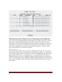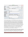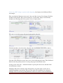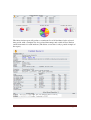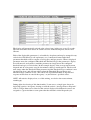
1
Open Information Systems for Emergency Services
TicketsCAD
V2.20a 11_06_11 User’s Configuration and Operating Manual
Alan Jump, N5ILN
11/10/2011
OpenISESTicketsCAD
This page intentionally left blank
OpenISESTicketsCAD
Page 1
OpenISESTicketsCAD Open-source Computer Aided Dispatch
v2.20a Release 11_06_11
TicketsCAD Configuration and
Operating Manual
Alan Jump, N5ILN
Contents
Introduction ......................................................................................................................... 6
Target audience ............................................................................................................... 6
About this manual ........................................................................................................... 6
Testbed system specifications ..................................................................................... 7
A note on call information shown in this manual ....................................................... 7
Software License ............................................................................................................. 7
Installation........................................................................................................................... 8
Obtaining and installing Tickets ..................................................................................... 8
Installing “by hand” or on non-Windows systems ..................................................... 8
Windows installer........................................................................................................ 8
Support ............................................................................................................................ 9
Software updates ............................................................................................................. 9
Making Tickets visible from the Web ............................................................................ 9
Browser requirements and limitations ............................................................................ 9
Configuration .................................................................................................................... 11
Getting started ............................................................................................................... 11
Edit settings ................................................................................................................... 14
API keys ........................................................................................................................ 17
Google Maps API Key .............................................................................................. 17
White-pages API key ................................................................................................. 18
Default map ................................................................................................................... 18
Regions ......................................................................................................................... 19
Facility and Unit types andStatus types ........................................................................ 20
Incident types ................................................................................................................ 23
Signals ........................................................................................................................... 25
OpenISESTicketsCAD
Page 2
Adding users ................................................................................................................. 26
Adding Facilities ........................................................................................................... 28
Adding Units ................................................................................................................. 31
Insurance information ................................................................................................... 34
Operations ......................................................................................................................... 36
Situation display............................................................................................................ 36
Creating call records ..................................................................................................... 37
Dispatching Units.......................................................................................................... 40
Call progression status .................................................................................................. 42
Adding Units to a call ................................................................................................... 44
Removing units from a call ........................................................................................... 44
Unit status information ................................................................................................. 44
Closing a call................................................................................................................. 47
Incident list display sequencing .................................................................................... 49
Removing units from the system .................................................................................. 49
Mobile/Unit use of Tickets ............................................................................................... 52
Additional functions.......................................................................................................... 56
Standard Operating Procedures screen ......................................................................... 56
Chat ............................................................................................................................... 56
Log ................................................................................................................................ 56
Full screen ..................................................................................................................... 57
Links ............................................................................................................................. 57
Manual .......................................................................................................................... 57
Reports .............................................................................................................................. 58
Printing reports.............................................................................................................. 60
Advanced Configuration ................................................................................................... 62
Configuration options ................................................................................................... 62
abbreviate affected, abbreviate description .............................................................. 62
allow custom tags...................................................................................................... 62
allow notify................................................................................................................ 62
aprs fi key .................................................................................................................. 62
auto poll .................................................................................................................... 62
auto route .................................................................................................................. 62
call board .................................................................................................................. 63
OpenISESTicketsCAD
Page 3
chat time .................................................................................................................... 63
closed interval ........................................................................................................... 63
date format ................................................................................................................ 63
deflat, deflng ............................................................................................................. 63
def zoom, def zoom fixed ........................................................................................... 63
disp stat ..................................................................................................................... 63
email from ................................................................................................................. 63
email reply to ............................................................................................................ 63
frameborder and framesize ....................................................................................... 63
func keys .................................................................................................................... 63
group or dispatch ...................................................................................................... 63
gtrack URL ................................................................................................................ 64
guest add ticket ......................................................................................................... 64
host ............................................................................................................................ 64
instam key.................................................................................................................. 64
kml files ..................................................................................................................... 64
linkcapt, link url ........................................................................................................ 64
logo ........................................................................................................................... 64
maptype ..................................................................................................................... 64
map caption............................................................................................................... 64
military time .............................................................................................................. 64
msg text fields............................................................................................................ 64
pie charts ................................................................................................................... 65
quick .......................................................................................................................... 65
restrict user add, restrict user tickets ....................................................................... 65
reverse geo ................................................................................................................ 65
serial number app ..................................................................................................... 65
situ refresh ................................................................................................................ 65
smtp account ............................................................................................................. 66
sounds ....................................................................................................................... 66
terrain ....................................................................................................................... 66
tickets per page ......................................................................................................... 66
ticket table width ....................................................................................................... 66
UTM .......................................................................................................................... 66
OpenISESTicketsCAD
Page 4
validate email ............................................................................................................ 66
wp key........................................................................................................................ 66
Regions and map markup options ................................................................................. 66
Other map markup options........................................................................................ 68
Other configuration options .......................................................................................... 69
Delete closed tickets .................................................................................................. 69
Dump DB to screen ................................................................................................... 69
Set colors ................................................................................................................... 69
Reset database .......................................................................................................... 69
Optimize database..................................................................................................... 69
Test functions ............................................................................................................ 70
All-Tickets Notify and Add/Edit Notifies ................................................................... 70
Places ........................................................................................................................ 70
Add Tickets Module................................................................................................... 71
Constituents............................................................................................................... 71
Unit and Asset Tracking ................................................................................................... 72
APRS............................................................................................................................. 72
Google Latitude ............................................................................................................ 73
InstaMapper .................................................................................................................. 74
LocateA ......................................................................................................................... 75
OpenGTS ...................................................................................................................... 76
Internal tracking capability with GPSGate ................................................................... 76
Statistics ........................................................................................................................ 77
Messaging ......................................................................................................................... 79
Wrapping up...................................................................................................................... 89
Manual revision history .................................................................................................... 90
Acknowledgements ........................................................................................................... 92
OpenISESTicketsCAD
Page 5
Introduction
TicketsCAD (Tickets) is a Web-based, free, open-source Computer Aided Dispatch
(CAD) software package. It is a cross-platform system, designed to be deployed on any
computer capable of delivering Web content using the “*AMP” stack (Apache, MySQL,
PHP). Tickets has been tested and deployed on computers running Windows XP SP2 or
later, along with various distributions of GNU/Linux. It is designed for ease of
deployment and use by organizations with limited budgets for information technology
(IT) support. Tickets has been placed into production environments by fire districts,
police agencies, and amateur radio organizations in support of special events and
emergency-communications functions, and can be used with minimal modification by
courier services and point-to-point transportation organizations. It can be used by a
singledispatcher, or multiple operators simultaneously, and supports multi-departmental
operation through the use of Region assignments.
Tickets incorporates mapping facilities provided through Google Maps, which allows
those facilities to be used free of charge so long as the product in which they are used is
made available to the general public at no charge. Because of this, Tickets ships with a
Guest account, which allows visitors to view (but not change) system screens and
records. NOTE:If an agency wishes to remove the Guest account, they will need to
acquire a Google Maps Premium API key to remain compliant with Google’s
licensing.The Premium API key is NOT free. See the Configuration section for more
information on the Google Maps API key required for operation.
Along with mapping functions, Tickets also incorporates multiple means of tracking field
units, all of which are free for the deploying jurisdiction. Individual field units may be
tracked using different systems, and positions displayed on the Situation map, with
configurable display update rates.
Tickets may be used in either Internet-connected or “stand-alone” modes; without a
functioning Internet connection, however, none of the mapping functionality will be
available. Operating in a “stand-alone” mode will not restrict operation on a LAN, so
long as there is a valid TCP/IP connection between users’ computers and the server on
which Tickets is running.
Target audience
Tickets is intended for use by small jurisdictions or agencies with limited budgets, and
was specifically designed for emergency-services use. It may also be particularly suited
for use by larger jurisdictions as a fallback CAD system. It is highly customizable for use
by other services as well. Deployment possibilities are limited only by the planning
capabilities of the agency desiring to place the system into service.
About this manual
This manual, like the software it is meant to support, is a work in progress. Revisions will
be released on an irregular basis, but every effort will be made to include information
pertaining to the most current release of Tickets, and if errors are discovered in the
manual, interim releases will correct those errors. Tickets is completely backwardsOpenISESTicketsCAD
Page 6
compatible, i.e. all functionality that existed in previous versions exists in current
versions, although means of accessing certain functions may differ slightly, and screens
may appear slightly different as new functions are added. I will typically include example
screen shots from the most current release to illustrate given functions or settings, but in
the event those images are substantially different from previous manual releases, I will
also bring those differences to the reader’s attention.
Because of the software’s inherent flexibility in modes of deployment and use, it is
highly unlikely that this manual can address every possible question or issue that may
arise. I will, several times in this manual, refer users whose questions or problems aren’t
answered here to the Open Source CAD forum on Google Groups, which can be found at
https://groups.google.com/forum/?hl=en#!forum/open-source-cad, or to the TicketsCAD
Web page at http://www.ticketscad.org.
Testbed system specifications
Screen shots and images are derived from my test deployment, which was installed on a
Toshiba Satellite L305 laptop with an Intel Celeron 900 processor operating at 2GHz and
2GB of memory, running Windows Vista Home Basic. Typical system CPU load postinstall increased approximately 2%, and memory use increased by 11MB combined
between the Apache Web server and MySQL database services (both at idle). Hard drive
space requirements are yet to be evaluated; however, a full installation occupies less than
100MB. NOTE:These figures are estimates only, based on a very low-load installation
and limited data input. I welcome information from users regarding their own memory
and hard-drive needs and consumption in actual production environments.
A note on call information shown in this manual
Example images and screen shots contained in this manual were produced using call
information derived completely from my own imagination and entered on my test system.
Because of US laws concerning patient privacy, I cannot use live or historical data from
EMScalls. Mapped locations do exist as a matter of course.
Software License
Tickets is licensed under the GNU General Public License (GPL). This software license
allows users to use, modify or re-package the software without limits, as long as any
modifications or re-packaging are also provided free of charge. Licensing the software in
this manner allows for local modifications and improvements, which can then be placed
back “into the loop” for other users to make use of. For full information on the GPL,
please see the Free Software Foundation’s Web site at http://www.fsf.org.
OpenISESTicketsCAD
Page 7
Installation
Obtaining and installing Tickets
System requirements
In an emergency-communications application, any computer capable of running
Windows XP or later can be used as a server for Tickets. However, for a full-time
production environment, I recommend a server-class computer with as much memory as
it is capable of managing, an uninterruptible power supply, and a robust, high-availability
network connection. For additional data protection, I also recommend a means of
producing data backups on a regular, scheduled basis. These requirements should be
discussed with your local IT wizard, and budget constraints balanced against mission
capabilities. Tickets will run very happily on a “surplused” desktop system under most
flavors of Linux, but if you anticipate more than eight users making simultaneous access
for calltaking, dispatching, and so forth, elimination of data-throughput bottlenecks will
greatly improve the usability of the system. My own recommendation is for no less than
4GB of RAM and at least 500GB of hard drive space for routine operation under Linux,
and double each under Windows 7 (due to the inherent memory requirements of an
operating system that runs primarily in a graphic environment).
Installing “by hand” or on non-Windows systems
Tickets can be installed on any system capable of serving Web pages using the common
combination of the Apache web server, MySQL relational database, and PHP scripting
software. Because there are multiple ways to install this software combination on servers,
and each target servermay be running a different operating system, the actual installation
procedure for each falls outside the scope of this manual, and therefore will not be
described. Instead, refer to the Web tutorials on setting up a Web server for hosting
Tickets, which can be found at
http://sourceforge.net/apps/mediawiki/openises/index.php?title=Web_Server_Tutorials.
The tutorials found there will clearly describe deployment of the software stack on
Ubuntu Linux and Windows computers. Once you have completed the appropriate
sequence, move to the “How To Install Tickets” tutorial at
http://sourceforge.net/apps/mediawiki/openises/index.php?title=Tickets_Tutorials.That
tutorial will guide you through the necessary steps of creating the database Tickets will
store its information in, then initializing that database using the install.php script included
in the Tickets .zip file.NOTE: a future revision to this manual may include expanded
installation instructions.
Windows installer
As an alternative, if you plan to deploy Tickets on a Windows computer, you can
visithttp://www.ticketscad.org, obtain the most recent Windows installer for the Tickets
system, and proceed with that installation. (Thanks to Kevin Bednar, K2KMB for
developing the installer package, as well as deploying and maintaining the demonstration
system at http://www.ticketscad.org.) On Windows Vista or Windows 7 installations, you
OpenISESTicketsCAD
Page 8
may get a warning that Windows Firewall has blocked Internet access by the software. If
you receive that warning, click the “Unblock” button. Otherwise, Tickets will not be
accessible from the Web, mapping functions will not work, and Tickets will only operate
on the computer on which it was installed. See “Making Tickets visible from the Web”
below.
Support
If at any time you have an issue with installing Tickets, you can consult – or, better yet,
join – the Open Source CAD forum dedicated to Tickets. The forum is at
http://groups.google.com/forum/#!topic/open-source-cad. The TicketsCAD.org site also
has Live Help available during business hours (in the United States). That forum is also
where users can learn of new software or documentation releases, contribute ideas for
further development, or provide bug reports.
Software updates
Updates to the Tickets software are typically installed by extracting the released .zip file
into the base directory or folder where the Tickets files were placed during the initial
installation (normally /www, /www/tickets, /htdocs, or /htdocs/tickets, depending on how
Tickets was installed), allowing the extraction process to overwrite existing files. If any
change to this procedure is required, it will be noted as part of the update release.NOTE:
The install.php script is dangerous to leave unsecured after installation is complete, as it
can redirect or even destroy your data. I strongly recommend renaming or moving this
script after installation is complete to prevent users from running it.)
Users who installed Tickets via the Tickets to Go package may not be able to update their
installation in this manner. Development work continues on semi-automated software
update systems. Watch the open-source-cad forum or the TicketsCAD.org Web page for
more information.
Making Tickets visible from the Web
As with any CAD deployment, or any other mission-critical software installation which
may be accessed by users via the Internet, system security should be taken into
consideration. Your server should be running behind a firewall, either one installed on
that server or a gateway computer for your agency. However, in order to make your
Tickets deployment usable from other computers, either on an internal network or via the
Internet, you will need to open ports 80 and 443. For additional security, you may wish to
change the ports used for accessing Tickets. You may also need to set up port forwarding
or network address translation (NAT) and/or edit the .htaccess file in the root Web
document directoryor folder in order for your deployment to be usable in a networked
environment. These tasks are beyond the scope of this manual, since they will likely be
different for every agency’s installation. Consult your Internet Service Provider or your
local IT guru for the necessary steps.
Browser requirements and limitations
Tickets has been tested using four of the most commonly-available Web browsers:
Internet Explorer 9.0, Firefox 7.0, Google Chrome 14.0, and Apple Safari 5.0. You will
OpenISESTicketsCAD
Page 9
need to set your browser to allow popups from your Tickets installation’s URL in order
for all functions to work.
At the time of this writing, the following browser limitations are known:
•
•
•
Google Chrome will sometimes not play sound files.
Mouseover help functions (e.g. in New Call incident-type selection) do not work
in Apple Safari browsers.
Internet Explorer will not play sound files.
OpenISESTicketsCAD
Page 10
Configuration
Designing a CAD deployment should never be considered a trivial task. Even a cursory
glance through this manual section is enough to show the amount of thought and planning
required in order to most efficiently apply the flexibility built into Tickets (or any other
CAD system, for that matter). While it is possible to install and deploy Tickets in a very
short time, producing a logical and usable workflow should always be a high priority for
anyone who will administer and operate the installation. The task of deployment design is
beyond the scope of this manual. I highly recommend reading all the way through this
manual before beginning any configuration you intend to place into a production
environment. By doing so you will learn what configuration options are available, and
therefore can plan to maximize those options in a manner that best suits your needs.
There won’t be a single “right” way to configure each of the described options of Tickets,
because each installation will be for a different purpose, in a different area, and with a
different focus. Still, the procedure outlined below will give you a good framework for
setting up the various options available. I’m going to outline a comparatively simple
configuration for use in a fire/EMS environment, and the options I’ve chosen are based
on my own personal experience with what managers in my area want recorded and
reported. Your setup will probably look very little like the examples provided. NOTE:
some of the example screens are NOT what one will see on a “fresh” install, since I’m
obtaining them from my testbed system, which has had some configuration options
changed.
Getting started
First, login as admin. All configuration will be accomplished using that account,
including defining a “default” map area, defining facilities, defining incident types, and
adding and positioning units.
Note the Day and Night colors option. Different users will prefer different color palettes
depending on whether the environment they are viewing screens in is well-lit or not. The
default color palettes have been selected based on typical ambient lighting for each
condition. These palettes can be changed by the Super-Administrator from the Config
screen (see Advanced Configuration), and operators may switch between Day and Night
palettes as desired while logged in.
OpenISESTicketsCAD
Page 11
Now click the Configbutton…it’s on the top row. No matter what screen you are
viewing, that top row will remain unchanged.
That will take you to the Config screen, where you’ll be spending quite a bit of time
working through the options in this document.
The very next thing you should do is change the default admin password. Consider it a
matter of basic security. You’ll be entering a great deal of data in the coming sections,
and some of it might be considered privileged or confidential in nature. Never expose
more of your system than you need to.
OpenISESTicketsCAD
Page 12
Passwords are case-sensitive. Don’t forget the new password. Without it, you won’t be
able to make any changes to the configuration, which is what this is all about, right? Also
make sure the Level setting for this user is set at Super. If you don’t, you’ll completely
lock yourself out of the configuration options, and the only way back in will be to
completely re-install Tickets, or at the very least, re-initialize the database. Double-check
the changes you made, then click the Submit button to save them.
You may also wish to change the user ID of the Admin account, and as a matter of
system security, I highly recommend it, although for your own peace of mind you may
wish to first define a separate user who will have Super privileges, then delete the default
Admin account. Follow your local policies.
You will add more users to the system through the Add User link on the Config screen.
That will come later.
After changing the password and returning to the Config screen, click on the Admin user
again. That will open the Edit User screen. From there, click the option-expand button
(the plus sign) and make sure that user is granted access to any Regions configured. This
must be done even if you don’t plan on building any additional Regions (see the
Advanced Configuration section for information on utilizing Region settings). If you
don’t, you will be able to create Incidents, but will not be able to do anything else with
them, including assigning resources (Units, etc.) to those Incidents, and if an Incident
doesn’t have a default Region (called Group on some screens), it will not be shown on
ANY User’s screens, effectively becoming a “phantom” Incident record. (It will,
however, appear on Reports.)
OpenISESTicketsCAD
Page 13
This has to be done for any and all Users created, either now or later.
Edit settings
Now we’ll look at some low
low-level
level options that can, and should, be customized for your
particular installation. Click the Edit Settings link to bring up the options page.
The described items should be changed
changed from the default. Note that all the settings have
mouse-over
over help available, so if you aren’t sure of what a given setting change will do,
you can hover your mouse pointer over it and get a brief description. For
or any changes
you make here to take effect,
fect, you will need to sign out and back into Tickets.
First, change the “def area code”,
code “def city” and “def state” fields appropriately for your
jurisdiction and deployment. For special-event
special event use, they can either be changed at the
beginning of the event or simply left blank, since it is presumed that all the tickets
generated will be from the location of the event. Filling in these fields will auto-fill the
corresponding fields when a new call is generated (see the “Creating tickets” section).
section)
The values can be overridden at the time of creating the new call.
The “delta mins” option deserves some attention. The PHP back-end
back end software for Tickets
is shipped with the time functions set for UTC,
UTC, since for hosted deployments it is
presumed that the server’ss clock is set for UTC.
UTC The time on the menu bar, however, will
OpenISESTicketsCAD
Page 14
match the clock on the user’s computer.
computer.To set your server to generate timestamps in local
time, set “delta mins” for an appropriate offset. For example, if you are in the Central
time zone in the United States, and you observe Daylight Savings time, the delta mins
should be 300.
NOTE:For a locally-deployed
deployed server, it
i may be necessary to edit php.ini to force the
software to properly timestamp your tickets and display the correct time. If so, don’t
forget to stop and restart the Apache web server software to effect the change. See the
“Web Server Tutorials” for more information
infor
on controlling Apache. If you are running
on a remotely-hosted
hosted server and can’t get the timestamps to agree with the local time, you
may have to enlist the assistance of the
t hosting company’s Help Desk.
You can tell quickly if you have the option set correctly if you open a ne
new ticket and the
timestamp is right. You won’t have to save the ticket; just open the New Call screen and
look at the timestamp near the bottom. Don’t forget that if you changed “delta mins”,
you’ll first have to sign out and back into Tickets.
It’s nott necessary to do more than look at the time stamp on the ticket (see screen image
below); once you’ve checked that, you can go back to the Config screen and continue.
OpenISESTicketsCAD
Page 15
An important option to set is the “internet” option. If your system is set up on a server
that has a permanent and reliable connection to the Internet, set this at 1. If it will be run
on a system that won’t be connected to the Internet, set it at 2. If you aren’t sure, or if
your connection isn’t reliable, set it at 3. If the Internet is NOT available and you have
the option set at 2 or 3, Tickets will still function, but you will not have a map display,
routing or unit tracking functions, or white-pages lookup or geocoding. Setting the
option to 3 will cause the system to periodically test for an Internet connection, and use it
if it exists. However, the system will test for a connection with every page load or screen
change, so it will respond much slower to user inputs. Option 3 is a good “set and forget”
selection, but only if the loss of performance won’t be an issue. I recommend using
option 3 only in very rare instances.
Set the locale option for the area your installation will be operating: in the United States,
0; in the United Kingdom, 1; other areas, 2.
This will configure the date formatting and map coordinates displays appropriately.
If you desire, set the login banner option to a descriptive title for your installation.
OpenISESTicketsCAD
Page 16
Change the default map height and width values as needed to alter the map dimensions to
fit your display. The default values will often work well, but it won’t be perfect for
everyone. This is a system-wide setting, so consider the screen sizes of any machine
connecting to your deployment and adjust accordingly. A 480x480 view, for example,
works very well on my 15” laptop screen (with a 16x9 aspect ratio, which is common for
newer systems). Experiment as needed to determine the best map size and adjust the
entries accordingly.
If a user account set up at the Operator level is allowed to edit existing ticket information,
change the “oper can edit” option to 1. If the option is set to 0 (the default), the operator
can still add Notes to a ticket, but cannot edit base information in an existing ticket, such
as call location or incident type, and cannot add Actions or Patients to a call record. Set
this according to your organization’s policy. Keep in mind that any changes made to an
existing ticket will generate a log entry, so allowing an Operator to edit existing tickets
won’t damage the audit trail.
Everything else can be left at default values for now. We’ll go into more detail on the rest
of the options in the Advanced Configuration section.
API keys
Pay attention here.This is one of the little fiddly bits that can cause a headache or two, so
read this section closely, and at least twice.
Tickets ships with two default API keys provided: one for Google Maps, and one for
white-pages reverse lookups. These API keys are configured for the URL of
http://localhost. If you’re going to be using Tickets as an integrated package on a single
computer, or you won’t be using the mapping functions (as in a non-Internet-connected
installation) and no or limited reverse lookups, you won’t have to do anything with these,
and you can just move along to the next section. If not, read on.
Google Maps API Key
If you will be using Ticketsin a multi-user setup, or on a hosted server, AND you want to
use the mapping functions, you’ll have to get your own Google Maps API key. Go to
http://code.google.com/apis/maps/signup.html and complete the signup form.
Once you’ve received it, copy the string into the Gmaps API Key field on the Edit
Settings screen, save the change, then log off and back onto Tickets. CAUTION: If you
don’t get your own key, or if you usethe default key included with the Tickets installation
OpenISESTicketsCAD
Page 17
multi-user environment,, computers trying to
package, and then try to run Tickets in a mult
access the Tickets host will receive a notice informing you that you’ll need a different
API key, and after that, they’ll see a “browser compatibility error” message and refuse to
load pages.
It’s best to use your organization’s primary Web URL (such as myagency.org)
myagency.org to produce
the key. Any URL including such a domain will allow the mapping functions to operate
normally. If you obtain a key for your organization’s Web site, but try to access the
server using a numeric
ic IP, you’ll get the same error and failure. (Some
(Some users have had
success generating an API key using a numeric IP and then accessing the deployment
using that numeric IP, but it didn’t work for me.)
me In most, but not all, cases, the API key
ke
can be obtained
d at no cost, as long as you deploy Tickets with the Guest account intact
and usable by the general public. Y
You
ou (or your local IT guru and/or legal eagle) will want
to review the license agreement for the API key
keys offered,, and plan accordingly.
accordingly.NOTE:
the lack
ck of a separate Google Maps API key will NOT preclude use of Tickets by
multiple operators on an internal network. It will only prevent use of the mapping
functions. NOTE: Ass of October 1, 2011, Google has announced that the API key is
deprecated for JavaScript
Script applications, which is what Tickets is based on. However, I was
not able to access map functions on my test system without a valid API key.
White-pages API key
Like the Google Maps API key, Tickets ships with a “default” API key for generating
white-pages
pages lookups from provided telephone numbers (performing lookups will be
discussed in the “Creating tickets” section). For testing or for low-call-volume
low
volume
installations that don’t make use of white
white-pages
pages lookups, this will typically suffice.
However, the service provider, http://www.whitepages.com, places a limit on lookup
frequency,, and as Tickets deployments increase, use of the default key will soon be met
with “volume exceeded” errors from the provider. (As of this
this writing, their limit is two
lookups per second for a given API key.)
key.) To avoid this error, obtain your own API key.
Visit http://developer.whitepages.com/page and follow the instructions there, then copy
the newly-generated API key to the “wp key” field in “Edit settings”.
NOTE: API keys for APRS.fi and InstaMapper may be desired for unit or asset tracking,
but Tickets does not ship with default API keys for tthose
hose functions. See the “Unit and
Asset Tracking” section of this manual for a discussion of those API keys.
Default map
If your installation will have full-time
full time access to the Internet, and you plan on using the
mapping functions, the next thing you wil
willl probably want to do is establish a default map.
Click the Set Default Map link. You should see a nation-sized
nation sized map. Enter the city and
state you want to center the map on, and click the Lookup button…it’s the one with the
glasses. The map should now be centered
centered on your selected city. You can also slew the
map using the mouse if you prefer,
prefer, by clicking and dragging as desired
desired. Zoom in with the
map slider, or with the mouse wheel if you have one, until you can see the entire
jurisdiction you’re setting up.
OpenISESTicketsCAD
Page 18
Don’t forget to set the Zoom level on the map to show the area you want to default to. It
might be tricky to keep the map area zoomed in enough to get the detail level you want,
but out enough to show the coverage area you need. Trade off as needed to provide a
workable start point. The map is dynamic on all screens, so it can be moved or zoomed as
needed at any time, but every time you switch screens, it’ll return to this default.
NOTE: if your default map does not have any units positioned on it, but you have units
defined and positioned elsewhere off-map, setting Dynamic Zoom will cause the map to
shift to, and zoom in on, the closest defined unit. If this behavior is not acceptable, select
a different option. The zoom options are also a system-wide setting. My own preference
is to set the Dynamic Zoom option to “Situation Fixed”.
Regions
Beginning in release 2.20 10_31, Tickets has the capability of defining separate Regions.
As shipped, Tickets has four region types pre-defined: a General region, meant as a
“catch-all” or for those who aren’t planning in implementing Regional operation; Fire;
EMS; and Security. These Region types can be assigned to individual Regions in a
deployment’s coverage area, and using the map markup facilities, can be defined
graphically. Further, individual Users can be limited to operating within certain Regions,
which permits them to see only those resources and incidents attached to those Regions.
One application of Region assignments should be obvious: assigning dispatchers to
separate Regions by emergency-response discipline, but allowing Supervisors to view all
Regions at once, or selectively turn off display of certain Regions, to allow for better
situational awareness.
Take note here: if a User is assigned to a certain Region, they will NOT be able to create,
or act on, an Incident for any other Region. However, all Incidents created, by default, are
displayed in the General region. Remember when you created a new User? This is where
OpenISESTicketsCAD
Page 19
it becomes very important to ensure that new User has a Region assigned. I’ll go more
into Region configurations in the Advanced Configuration section.
Facility and Unit types andStatus types
Now we’re getting into the heart of the configuration. The next things you should be
thinking about is how you want to define your unit types, facility types, and whether you
want to stay with the default unit status options or change them to suit your particular
deployment. For example, an EMS installation will need to define Facility types for
hospitals, and may wish to add clinics, fire stations, or post locations. For a RACES or
ARES operation, you may wish to define Facility types for shelters, canteens, search-andrescue staging areas, and so forth. Be as creative as your particular deployment requires.
Each Facility type can also have its own status which will be displayed on the Situation
screen or on the map. We’ll go into that in the Operations chapter.
The examples below show the beginnings of a special-event deployment of Tickets
intended for emergency medical support.
OpenISESTicketsCAD
Page 20
Enter a name and description for each facility type, and select an icon color from the
presented options, and click Submit. The above shows two facility types already defined.
When you have all your facility types entered, click the Finished button to go back to the
Config screen. Notice we aren’t defining actual Facilities yet, only the kinds of Facilities
needed for this deployment. A Super or Admin user can add Facility types as needed.
Only a Super user can remove Facility types.
Next, consider whether you wish to define status types for facilities. It may be useful if,
for example, you have several hospitals in the area, and those hospitals request
transporting agencies divert to other hospitals due to patient census. Those diversion
requests can be reflected in Facility Status indications, which are defined by clicking the
Facility Status link on the Config screen.
OpenISESTicketsCAD
Page 21
Again, enter a name and description for each status, change the displayed status color if
desired using HTML hexadecimal color codes, and click Next to save, then Finish to
return to the Config screen. (When entering color codes, don’t forget to add the hash
mark (#) at the beginning of the hexadecimal string. Otherwise, you’ll get black text on a
white background.) The status value and descriptions are all freeform, as are the
groupings, so like other type and status definitions, you can be as comprehensive as your
situation requires. The above example shows typical hospital-status options for a
particular area.
Now that you have facilities, it’s time to add Unit types to the system. Again, you aren’t
defining actual units at this point; that’s done from the Unit screen. Think about what
kinds of units you will need to represent on your Situation screen and map. A fire-alarm
deployment will need to track multiple types of apparatus, such as attack engines,
ladders, or rescue trucks, which will all need to be defined. An EMS deployment may
need to track only one or two unit types (“ambulance” and “supervisor”, for example), or
may track ALS and BLS ambulances separately, along with medic cars. A special event
may also wish to define types for communications units, route checkpoints, and so forth.
Click the Unit Types link, then the Add new Unit Types entry button, and fill in the
information and select an icon color for each type. Click Continue, then when all your
unit types are defined, click the Finish button.
OpenISESTicketsCAD
Page 22
Unit Status Types can be defined the same as Facility Status types. The default install
supplies three status types: available, in service, or unavailable. Add or change status
types to suit your particular deployment. Notice that when adding status types, you have
the option of defining whether that status will inhibit a unit in that status from being
dispatched to an incident. That inhibit function can be further controlled by “enforced” or
“not enforced” options; the “not enforced” option will show an alert dialog if a unit in
that status is dispatched, but will still allow the dispatch, while the “enforced” option
won’t allow that unit to be selected for dispatch.
Incident types
Now the part that will likely take the longest: defining Incident types. For a fire-alarm
deployment, you may have comparatively few incident types to define, e.g. structure fire,
car fire, motor-vehicle collision, stuck elevator, and so forth. EMS and law-enforcement
deployments will likely have considerably more. As an example of this, I defined 32
different incident types for my test EMS installation. (The incident types I created were
based on the State of New Jersey Emergency Medical Dispatch guide cards, which I used
due to ready availability online.) The display will normally show 20 entries per page, as
shown below.
OpenISESTicketsCAD
Page 23
Defining incidents is as straightforward as defining facility types or unit types, but there
will be more information to enter. Here’s where Tickets provides some operator
assistance…you can enter short incident codes as the incident type, then enter a more
descriptive term as the actual incident name, and when entering an actual ticket, hovering
the mouse pointer over a given code in the drop-down list for incident types will show a
small popup text box with the full name you defined.
When entering incident type information, you also can enter protocol information to suit
your particular deployment. Using my example EMS deployment, since each incident has
a default “priority” defined, I use that section to provide dispatch guidance information
for upgrading that priority level. A fire-department deployment might use that section for
dispatch guidance in what additional resources to send to a given incident type, e.g. a
OpenISESTicketsCAD
Page 24
motor-vehicle collision gets an engine company and a rescue, a structure fire gets two
engine companies, a ladder and an ambulance, and so forth. Again, defining your incident
types has the potential to be the most time-consuming setup task for you, but is also the
section which will provide the most meaning when examining the reports Tickets can
produce for analysis by emergency managers.
If you decide to remove some of your Facility or Unit types or statuses, and there are
records in the database that use those types or statuses, you won’t be allowed to remove
them. This is intentional, as it maintains what database gurus call ‘referential integrity’. If
it becomes absolutely necessary to do so, you will need to remove any stored tickets that
contain those types or statuses, by using the Config option “Delete Closed Tickets”,
available only to the Super-Administrator account.
Signals
Signals are a means of quick-entering text that you may commonly use or repetitively
enter into a call. They are configured just as Facility or Unit types. NOTE: when you
click the Signals link from the Config screen, the maintenance screen that appears will
refer to the Codes table, as shown in the following example. However, all entries in this
table will appear on the New Call screen in the Signal drop-down selector, as well as
other screens related to a given incident, including the Close dialog. In the example setup,
I have designed the Signals list as a quick-fill list of possible call dispositions for an EMS
deployment.
OpenISESTicketsCAD
Page 25
Adding users
We’re nearly finished with basic configuration. I’m going to presume you do NOT want
your dispatchers to have full and unfettered access to the configuration of the system. So
set up separate accounts for them. As a matter of basic system security, I’m going to
strongly recommend the Admin account, which has Super-administrator permissions by
default, NOT be used for day-to-day operation, because there is always the potential for
making a mistake that could severely damage the database…and, as a result, all the
information you just spent all that time entering into the system. So…
Define a user name and set an initial password, and tell the new user to change it at their
first opportunity! In most instances, your other dispatchers can be set at the Operator
level. If you have users that will be logging into the system from field units, define them
OpenISESTicketsCAD
Page 26
at the Unit level. (This will require the specific unit to already be defined on the Unit
screen.)
Enter as much or as little additional personal information on each user as your policies
require. Specific permission and access levels:
•
•
•
•
Units only see their ticket info on the Situation screen, but can look at (but not
edit) other screens as well. Units can also update their own statuses, enter Action
and Patient notes, and trigger dispatch actions for additional units on their tickets.
Units can also access the Call Board bar and change their call progression status,
with a shorter list of call progression status change functions on the Mobile
screen. We’ll discuss the Mobile screen in more detail in the Operations chapter.
Members may view all information screens, just like the guest account.Unlike the
guest account, their logins are monitored and logged. Members can also receive
emails from the system (if email is enabled). This option may be useful for
organization or agency members that do not have direct dispatch responsibilities,
but may have a need for monitoring activities, such as emergency managers.
Operators can enter and close tickets, change unit statuses and Facility statuses,
and can add Facility types and status types, but cannot add or remove units.
Depending on the option set in the Edit Settings screen, they may also be allowed
to edit basic ticket information.
Admins have full access to the system except for low-level configuration options
and database maintenance functions. I suggest you use this level for duty
supervisors. If your system includes units that are activated and deactivated
periodically through the course of a day, the supervisor can add or remove those
units as required. Note that if a given unit also has a Unit user account on the
OpenISESTicketsCAD
Page 27
•
•
•
system, that account will remain in place even if the unit is removed from the
system.
Super-Administrator users have full run of the system, including the ability to
delete closed tickets from the database, or even complete re-initialization of the
database, which deletes ALL data. Istrongly recommend that only one SuperAdministrator account exist, it has a strong password, and it is not used for routine
operation.
Individual users may be restricted to viewing and dispatching specific asset
groups (called Regions in the software) by clicking the plus sign beside the Group
legend and checking or unchecking the Region options required. This will be
discussed further in the Advanced Configuration chapter. As stated before, make
sure each User created is assigned to at least one group.
Statistics users are special constructs used specifically for monitoring system
statistics (see the Statistics section of the Advanced Configuration chapter for full
information on this).
At this point, you have completed basic configuration, including defining Facility types
and statuses, Unit types and statuses, and additional users of your deployment. It’s time
to step back and breathe for a bit. The next steps in configuration get into the meat of the
system, by defining actual facilities and units. Once that’s done, we’ll put the system to
work by going through an entire dispatch cycle or two. For those using an Internetconnected installation, I’ll also look at the basics of unit tracking and routing.
For much of the followingsections, I won’t be including map images, unless they’re
needed to demonstrate a function or feature. I’m doing this for two reasons: first, it makes
the data-entry fields larger on the screen, and therefore more readable on the page;
second, not everyone will be setting up Tickets to use the mapping functions. I will make
an effort to point out where the screens will look and act differently in each case. As
always, I urge you to thoroughly test your installation prior to putting it into a production
environment, and that includes experimenting with the map features, if they’ll be used, to
learn their behavior.
Adding Facilities
Facilities can be defined by users with Operator, Admin or Super-Administrator
permissions. (Unlike Units, Facilities can only be removed by the Super-Administrator.)
Sign into the system with an appropriate account, then click the Fac’s button on the top
row.
The below example shows part of my test system’s Facility list.
OpenISESTicketsCAD
Page 28
Clicking the “Add a Facility” button will bring up a new screen with a number of fields
for entering Facility data. We’ll just look at the required fields for now.
As is the convention with most other screens in Tickets, fields marked with a red asterisk
are required for input; all others are optional. Note also that the City and State fieldsare
pre-populated (see the Edit Settings chapter). This can be overridden as needed.
Below is a Facility being added to thedatabase.
OpenISESTicketsCAD
Page 29
The Description field is free-form, but should contain pertinent information for that
facility. If you were defining a fire station, it might contain the names or designators of
any apparatus housed there (although at least one user has added that information to the
Capability field).
Note the Icon field. For users employing the map functions of Tickets, this is the
identifier that will appear on the map “flag”, and is also the behavior you will see when
defining Units. The system will always use the last three letters in that field for the flag.
The Handle field will auto-populate from the Name field unless a separate entry is made.
Entering an email address in any of the Email fields will allow a dispatcher to send
emails (if enabled in the system) to that facility, using that email address. This may be
useful, for example, in notifying hospitals of patients being transported. The email may
point to a SMS address if desired.
To properly position the flag on the map, either click on the desired position to set the
coordinates, or if the facility has a street address, input that in the appropriate fields and
click the Lookup button (the button with the glasses).
For previous users of Tickets, note that the Region and Boundary selectors are new
options in version 2.20. These will be discussed in detail in the Advanced Configuration
chapter.Ensure that the new Facility is assigned to at least one Region; otherwise, it will
not display on any maps. Boundary selection is optional, but may prove useful especially
in a disaster-management scenario. If, for example, a Facility Catchment boundary is
defined and associated with a particular facility, such as a shelter, the operator could tell
at the time of Incident creation which shelter should be used. Again, this is a matter of
careful design consideration on the part of the deploying agency, but is limited only by
the imagination of the person designing the boundaries and regions.
OpenISESTicketsCAD
Page 30
Once everything has been set, including the default facility status, click the Next button at
the bottom of the screen. Doing so saves the facility in the system and returns you to the
Fac’s screen.
Adding Units
Finally, we need to add some units to the system that can be dispatched to calls. Units can
be added only by Admin or Super operators. Click the Units button at the top of the
screen.
Below is a sample list of units for my test system. We’ll add another unit to that list.
Again, you’ll be presented with a page of available options, with the required settings
marked with a red asterisk.
OpenISESTicketsCAD
Page 31
The Type option will show a drop-down selection of the Unit types you defined earlier,
as the Status option will show the Status types.
The unit shown above is a mobile unit,so I assigned a default location for mapping
purposes by entering the location and clicking the Lookup button (the glasses). That
populated the Lat/Lng and USNG fields automatically. An alternate option would be to
click the map to assign a default location, which will populate the Lat/Lng and USNG
fields, then entering the location without clicking Lookup.
If the “Multiple” option is checked, a unit will show Available on the Situation screen
even if already dispatched, which will allow that unit to be dispatched on more than one
call simultaneously. This may be useful, for example, in dispatching an Animal Control
unit or laboratory courier that might be expected to handle several tasks, or make
multiple pick-ups or deliveries in turn, before returning to their home facility.
As with Facilities, ensure the newly-created Unit is assigned to at least one Region.
Otherwise, it will not be assignable and will not appear on any lists or screens.
Time for a short discussion regarding the mapping and tracking functions available in
Tickets.Seven options are available for mobile unit tracking: APRS (for amateur-radio
stations so equipped), InstaMapper, Google Latitude, LocateA, Gtrack, OpenGTS, and
the GPSGate internal tracking system. Setting mobile units up with any of these systems
is beyond the scope of this document. However, Tickets makes tracking using any of
these options a very simple matter of entering the necessary call sign (for APRS), badge
ID (for Google Latitude) or license key (for others) in the Callsign/License-key field and
selecting the appropriate tracking method from the drop-down. Doing so will also enable
the automatic unit dispatch routing function, if the Directions box is checked.Each of the
position-reporting/tracking systems incorporated into Tickets may be tested from the
Config screen by clicking the appropriate link and entering the needed license key, badge
OpenISESTicketsCAD
Page 32
or callsign as appropriate. (Gtrack is now defunct, and mentioned here and in the Unit
and Asset Tracking section only for backwards compatibility.)OpenGTS is a full opensource tracking system, and is designed for use with a large number of devices. For full
information on OpenGTS, see the project Web site at http://www.opengts.org. Tickets
also has internal tracking capability using the GPSGate system, which is intended for coinstallation on the same server. I’ll go into more detail on that in the Advanced
Configuration section.
If the unit you just added is going to be capable of accessing Tickets from the field, create
a separate Unit account for them.
Set the Level at “Unit”, and select the unit identifier from the Unit dropdown list. Note
that only accounts of Operator or higher may have a Unit selection assigned to them;
attempting to assign a Unit to a lower access level will produce an error.
Note the “Contact via” field. Entering a valid email will allow Tickets to send emails,
dispatch information or configured notifications to that email address, if your system is
configured to send emails. The entered email address can be a SMS gateway, which will
allow Tickets to send SMS messages to the designated unit. Tickets recognizes certain
SMS gateways and will automatically break generated emails to remain below the typical
160-character limit per message.
We’ll go into the functions available to Unit accounts a bit later. Right now, be aware that
a Unit that accesses Tickets from the field can update their status, add Notes and Actions
to the ticket on which they’re dispatched (and only on tickets on which they’re
dispatched), and can access specific functions on the Call Board function bar, particularly
their call-progression status. Doing so can greatly reduce your operator’s workload, and
provide your field units with dispatch information they can quickly refer to, including the
mapping functions. On the other hand, if your system is not connected to the Internet, you
cannot make direct use of these functions.
OpenISESTicketsCAD
Page 33
WARNING: Tickets can NOT always predict the correct route of travel between
a unit location and an incident. Roads may be closed due to special events,
construction, or natural or man-made catastrophes. In the case of some
deployments or incidents, there may not even be roads that can be seen or mapped
using Tickets. With mapping functions enabled, Tickets can provide decisionsupport guidance for closest-unit dispatch based on straight-line
distances.However, actual unit selection for dispatch must be the responsibility of
the dispatching operator, and route selection must be the responsibility of the
responding unit, in accordance with jurisdictional policies and best practices.
Tickets and its developers, and the developers and vendors of mapping,
position-reporting, and routing functionalityimplemented in Tickets, assume no
liability regarding the accuracy or timeliness of position-reporting or routing
guidance.
Insurance information
New in release 2.13c 6_30 is the ability to select specific insurance carriers for Patients
when entering Patient data.This function is intended for use by organizations that bill
insurance companies for services, such as ambulance services. A separate Config link is
provided to add the necessary information for selection on a drop-down on the Add
Patient pop-up.
Clicking this link will open a new page allowing the configuration of specific insurance
carriers. Note that only the carrier can be preconfigured in this manner. An agency may
choose to enter a patient’s account information in an individual call record, but the level
of security built into Tickets is not sufficient to safeguard that information to the
standards required by the Health Insurance Portability and Accountability Act. (See the
screenshots below.)
OpenISESTicketsCAD
Page 34
OpenISESTicketsCAD
Page 35
Operations
Finally. All our units are set up and in place, we have facilities defined and their statuses
set, incident types are created and ready. We can create tickets and dispatch units to them.
I advise that you read through this section carefully and closely, and at least twice. It’s
long, so take your time, and take notes.
Again, I’d advise you to only give your operators the access they absolutely must have in
order to do the job. Too much access can damage the system; too little and they can’t do
what they need to. In most cases, Operator access is going to be enough for routine use.
Situation display
Here is an example Situation screen from my test system. For those who have read ahead
to the Advanced Configuration section on Regions and Boundaries, note that while this
Situation screen is from a previous software version, the default General region will
which display all units and regions in the system, which would be an equivalent mode of
operation.
Active incidents are displayed first in order of severity, then in recency of activity, with
older timestamps lower in the list. Closed incidents (depicted as struck through) always
display below active incidents. Responders are listed in order of most recent activity
OpenISESTicketsCAD
Page 36
timestamps. Facilities are listed alphabetically by facility type, then alphabetically by
facility name. Individual descriptor windows may be collapsed as needed.
A strikethrough on the timestamp next to each Responder or Facility indicates no updates
or changes in status in the last three hours.
Notice the numbers between the Addr field and the timestamp on the individual incident
line of the Incidents section. They indicate how many Patient records, Action
A
records,
and dispatched Units
nits are associated with that incident. The Unit digit will blink if no
units are assigned to a call. The Patient digit will not be shown if there is no Patient
record associated with the incident.
If you have Units with tracking set up and enabled, you will see the indicator “Source
time” at the bottom of the Responder list. This is an update time indicator for Units that
have tracking enabled. The “as of” ttime will be highlighted for tracked units to indicate
when the last
st position update was received by the tracking data source.
Note the “Show/Hide” panel below the m
map.
ap. This allows individual users to filter
displayed Facilities and Units. The displayed units will be further filtered by the groups
or regions a user is assigned to (see the Advanced Configuration chapter). Units assigned
to groups or regions not allocat
allocated
ed to the individual user will not display.
Selections made on the Show/Hide panel are not persistent between logins; users must re
reselect their preferred display options each time they log into Tickets.
Creating call records
Click the New button on the top of the screen to open the New Call page. A blank
example appears below. Most of the fields are self-explanatory,
self explanatory, but there are some points
that need to be addressed, and I’ll focus on those in turn.
OpenISESTicketsCAD
Page 37
Location is a physical address or specific, identifiable site such as an intersection. If
you’re using the mapping features, you can enter a street address and click Lookup, and
the software will search the Internet for the best available match and mark that as the
dispatch location. This also works for known intersections, e.g. “Route 50 & Highway
97”. If the address you enter sends the mapped incident location away from the actual
location of the incident, the address or location isn’t in Google’s geocode database. To
properly locate the incident on your map, you may need to Cancel the new ticket, then
restart the process, but instead of entering the location or address first, click on the actual
incident location on the map to set the coordinates in the geocoding fields (the Incident
Lat/Lng fields will populate from your mouse click), then enter the location as usual.
Without either an entry in the Location field, or a recorded Incident Lat/Lng either by
geocoding lookup or mouse click, the ticket won’t save and you’ll get an error
message.NOTE: the text entered in the Address field will be transmitted exactly as
entered on notification pages/emails/SMS texts, including case.
It may also be possible to obtain and auto-fill the incident location through a white-pages
reverse lookup on the caller’s telephone number; enter the caller’s telephone number with
area code and click the Lookup button next to the Phone field. However, this should not
be relied upon, because lookups will fail on cell phone callers, callers using VoIP
telephone services (such as Vonage), or callers with newer phone service where the
OpenISESTicketsCAD
Page 38
address information has not yet been updated in the available “free” reverse-lookup
databases. The caller may also not be reporting an incident at their location, as might be
the case with a relayed call received via a motorist-assist program such as OnStar™. In
any case, follow your jurisdiction’s policies and best practices.
If you aren’t using a system that’s connected to the Internet, the Lookup functions will be
disabled, and the Incident Lat/Lng fields won’t appear on the page.
Protocol information, if any, will appear based on the selection made in the Nature dropdown, which is actually the name of the incident type you defined in Incident Types.
Priority will automatically fill with the default priority level you defined for that incident
type. It can be changed as needed for the particular call being entered.
Synopsis is a brief description of the incident. Make it something you’d transmit by radio
to the responding units. Remember that this will be the description permanently recorded
in the call record. (See the sidebar “A word on call records” that appears later in this
manual.)
The Signal drop-down selector enters predefined text into the applicable field. Note that
there are two Signal drop-downs, one just under the Synopsis field and one under the
Disposition field. However, there is only one table from which Signal predefined texts
can be selected, and those texts will appear on both drop-downs. Operators should verify
they are using the proper drop-down when making use of this function.
Incident Name is automatically populated based on selections that can be made and
altered by the Super-Administrator, using the Incident Numbers option on the Config
screen.
These options can be selected according to the needs of your organization. Again, I’d
recommend testing various options to see which suits your agency’s requirements prior to
putting the system into full operation.NOTE: if “Append Incident nature” is selected, and
the Incident record is then edited to change the nature of the incident in the drop-down
selector, the new incident nature will be appended to the existing incident number, and
will NOT overwrite the previous incident nature.
OpenISESTicketsCAD
Page 39
If the call is at a facility you previously defined, select that facility in the upper Facility
drop-down. If there is a specific destination or delivery facility intended, select that in the
lower Facility drop-down. If this is a scheduled or planned response, such as (in the case
of EMS) an interfacility transfer, click the Scheduled Date radio button and enter the date
and time in the fields that appear.
If your system is connected to the Internet, the Incident Lat/Lng fields should now be
populated…if they aren’t, either try looking up the address of the incident again using the
Lookup button, or clicking on the incident location on the map.NOTE: clicking the
incident location on the map will override the geolocation generated by the address
lookup, which may be necessary if a lookup failed to produce the correct location.
Below is a sample New Call screen with appropriate fields for that call completed.
When all fields are filled correctly, click Next.
Dispatching Units
OpenISESTicketsCAD
Page 40
You’ll next be presented with a screen allowing you to select responding units. This gets
a little more complicated, so follow along closely here. If one operator is performing both
calltaking and dispatch functions, you can ignore the next couple of sentences. If the
operator entering the ticket information is NOT the dispatcher (e.g. different operating
positions for a calltaker and a dispatcher), that operator should click the Situation button
on the top menu bar to return them to the Situation screen.The operator performing
dispatch duties will then also click the Situation button at the top of the screen (it will
turn red when the new ticket is completed and available for dispatch, and depending on
the browser, an audio alarm will sound) to bring the Current Situation screen up to date,
and then click the ticket itself to bring up the Dispatch screen.
Either way, the unit or units to respond on the call will now be selected. In my case, I’m
using the mapping system, so I’ll show that as well.
Notice that a recommended route has been generated based on the locations I’ve defined
for my units, and a straight-line distance between each unit and the incident is shown.
Selecting a different unit will produce a recommended route for that unit, if one can be
generated. If you aren’t using the mapping system, these functions won’t be
OpenISESTicketsCAD
Page 41
shown.Clicking the “Mail Direcs” button will send a Google Maps turn-by-turn route to
the dispatched unit, starting at the unit’s current location and ending at the incident, if
that unit has an email address defined and email is enabled in the system. The button will
still appear if the system is not connected to the Internet, or if email is not enabled, but it
will be inactive.
The selector buttons on the map can be moved as needed by clicking and dragging the
“Drag Me” legend. This may be helpful if the buttons are hiding a needed part of the
map. If your system isn’t connected to the Internet, the selector buttons will appear on the
upper-right side of the page, and still can be dragged as needed to allow the full screen to
be read.
I’ve selected the first unit in the list as my responding unit. All that’s left to do here is
click the DISPATCH UNITS button (currently shown in the map area). I’ll get a
confirmation popup window. Clicking “Okay” brings up a screen that allows me to either
return to the Situation screen or go back to the Dispatch Units screen to add additional
units to the ticket. All units assigned to the call will be listed.
Now click Finished, which will return you to the Situation screen and, on an Internetconnected system where an email address is defined for the dispatched unit(s), the call
information will also be automatically transmitted to the email addresses specified. The
operator will have the option of editing dispatch emails prior to sending, via a separate
pop-up window (see the Advanced Configuration section for information on predefining
email contents). Whether an email is generated or not, the selected units are now assigned
to the incident, and clicking the Finished button will return you to the Situation screen.
Call progression status
At the top of the screen, click the Board button. This will open up a new mini-window,
which is the Call Board function bar.(The bar can be configured as either a floating
window, or as a fixed frame in the main display, by changing the “call board” option on
the Edit Settings screen.)
OpenISESTicketsCAD
Page 42
Reading across the panel, you’ll first see the incident number. I have my test system set
to append the incident name to the number as a mnemonic for the operator. Next is the
synopsis that was entered on the New Call screen, the location, and then the responding
units. Each unit assigned to the call will appear on a separate line, followed by a series of
check boxes and a status drop-down. The check boxes have the following meanings:
1.
2.
3.
4.
5.
6.
D – dispatched
R – responding
O – on scene
FE – facility enroute
FA – facility arrived
Clear – clear of the incident
To record the specific time of each change of status, click the appropriate status box to
check it, then click theApply All button on the right side of the Call Board bar to update
the status. If multiple units are assigned to a call, several status changes can be recorded
at once simply by checking as many boxes as are needed at a time and clicking Apply
All.NOTE: Call-progression status is different than unit-availability status. Follow your
agency’s policies and best practices in recording all status changes.
Parts of the Dispatch section of the bar need a bit of explanation. The R/D radio button
allows the operators to either reset dispatch times (in case of operator or timing error) or
delete the entire dispatch. Note that deleting the dispatch does NOT remove or close the
ticket. It may be necessary to delete a dispatch in the event of a unit with inappropriate
capabilities being assigned to a call, or that unit being needed to respond to a higherpriority call, or a unit becomes available that is closer than the unit originally dispatched.
Local policies will dictate how and when that function should be employed.
Also, clicking the timestamp in the Dispatch section will expand the entire Call Board
window, as shown below.
OpenISESTicketsCAD
Page 43
This allows the operator to add comments to the dispatch, select additional units to add to
the call, enter mileage information for billing purposes, or change timestamps on status
changes. This function should be used rarely, as it can adversely affect the call record.
Test thoroughly before using!
Adding Units to a call
It may become necessary to expand the dispatch of a call to additional units. For
example, a unit may request additional resources under a mutual-aid agreement, or a lawenforcement unit may request to be added to an incident to back up a primary responding
unit. There are several ways to add units to an existing call. From the Situation screen,
clicking the call or any unit displayed on the current map (if mapping is enabled) will pop
up a window containing basic information, and include a Dispatch link. Clicking that link
will take the operator to the Dispatch screen, from which additional units can be selected
for dispatch. If the operator clicks a unit not displayed on a map (or if mapping is
disabled), a screen showing the unit information will be displayed, along with a “To
Dispatch” button. Clicking that button will display a list of active incidents. Click the
incident the unit is to be dispatched on to add them to that incident. NOTE: it will be
necessary to close and re-open the Call Board bar to show the call-progression check
boxes for units added to an existing call.
Removing units from a call
The Clear check box on the Call Board can be used to remove individual dispatched units
from a call. Checking that box and clicking the Apply All button will remove the
specified unit from the call, but will not close the call. That option allows, for example, a
fire alarm call with multiple units responding to have certain units cancel from the call, or
be returned to service after responding, without affecting the status of other responding
units. (Some fire department jurisdictions refer to this as “reducing the call”.) If the Clear
check box is checked for the only unit assigned to a call and Apply All is clicked, that
unit will still be shown as no longer assigned to the call, but the call will remain open.
The dispatcher will then need to either return to the Situation screen, click the incident,
and dispatch another unit, or click on the correct unit and then click the “To Dispatch”
button or Dispatch link on the map popup (as appropriate).
Unit status information
Looking back at the Situation screen after changes are made on the Call Board, users with
mapping enabled will see small icons next to dispatched units that indicate their call
progression status. This is NOT the same as the Status shown just to the left of that
indicator. Each will need to be updated separately. There will also be a number to the
right of the call-progression status symbol; that number shows how many minutes the
unit has been in that call-progression status. This number will NOT automatically update;
OpenISESTicketsCAD
Page 44
click the Situation button at the top of the screen, or refresh the screen with the
appropriate browser control, to see the current status time.
At thiss point, I’m going to move back and forth a bit between screens on systems that
have mapping
ing enabled, and systems that don’t, since the displays will be different, and
each mode of operation requires more explanation.
If you DO have mapping enabled:
Clicking the incident line next to the dispatched unit will open a popup on the map that
presents
nts you with certain options.
If I click the “To Facility” link, Tickets will show me the closest facilities, the distance to
each, and offer to generate routing. Clicking the “Dispatch” link allows me to add
additional units to the call, e.g. a rescue tr
truck
uck if extrication was involved. Clicking the
“Edit” link opens a window that allows changes to be made to the unit definition (not
available at Operator or lower status). Clicking “View” will simply show all involved
timestamps for the call.
Clicking the incident line itself will again provide a popup in the Map window, but with
different options. These are more likely to be of regular use.
OpenISESTicketsCAD
Page 45
Again, clicking Dispatch will allow additional resources to be added to the incident.
Clicking Details produces a status report on the call. Edit opens a window much like the
New Calls window, which allows changing basic call information (not available if you
set the “oper can edit” option to 0 and the current user’s access is set to Operator). Close
Incident opens a dialog which allows the operator to close out the incident and release
dispatched units. Popup produces a separate window with a status report and map of the
incident. Add Note allows appending dispatch-related notes to the incident record. Add
Patient opens a data-entry screen allowing entry of a patient name and other identifying
information, facility information, signal (optional depending on definition) and free-form
description.
Action is another free-form data entry screen that allows the operator to make notes
regarding call progression, and provides check boxes to select individual units to which
that action pertains.
OpenISESTicketsCAD
Page 46
Closing a call
To close the call, return to the Situation screen, click the incident, and then select the
Close Incident link. That opens a smaller data entry window for noting disposition
information.
Add any information required – note that there MUST be information entered in the
Disposition window – and click Next. That will close the call, and release anyand all
units assigned to the call.
One last look at the Situation screen and we see that the call is closed:
The closed call is now shown “struck through”. Closed calls are shown on the Incident
list for a period of time that can be set in the Config screen, under Edit settings. A colored
icon with a numeric flag will also appear on the screen allowing the specific locations of
closed incidents to be seen at a glance. In the case of multiple incidents at the same
location, only the most recent or highest-priority incident will be visible.
OpenISESTicketsCAD
Page 47
If you are NOT using a system with mapping, the displays look different. Here’s
an example.
First, note that the Situation screen won’t show any hint of a map. In exchange, Facilities
default to being shown. They can be shown on a system with a map as well, but they
default to not showing unless the operator elects to display them.
The same screen with a new call entered and awaiting dispatch:
Click the incident, select the unit to dispatch, and click DISPATCH UNITS as before.
Note that on the Situation screen, there are no icons indicating unit status. The Call Board
then becomes the primary means of seeing call progression and unit status.
Closing a call is the same…click the incident to open up the edit screen, and then click
Close Incident as before.
Changing either unit or facility status will generate a log entry in the system, just as
changing anything in an incident. This provides audit-trail capabilities for emergency
managers. We’ll cover the reporting functions in the next section of the documentation.
OpenISESTicketsCAD
Page 48
Incident list display sequencing
On the Situation screen, the newest incidents will always appear at the top of the list.
Closed incidents (struck through) will be listed in descending order of severity or priority,
not by incident times. If the mapping system is enabled, incident marker flags will
automatically renumber to coincide with the incident list on the Situation screen.
Removing units from the system
Some services, such as larger EMS or law enforcement operations, rotate units through
the course of a day, and may have more units in service during some parts of a day than
others. It may also become necessary to replace units due to vehicle retirement or
replacement, if units are designated by vehicle numbers. To reflect that in Tickets, an
operator with permissions of Admin or higher can add or remove units from the system.
Adding units has already been discussed. To completely remove a unit from the system,
click the Units button at the top of the screen.
Next, click the unit you wish to remove from service. That will bring up an edit screen
for the unit. If mapping is enabled, you’ll first receive a pop-up on the map; click the Edit
link on the pop-up.
If the unit designators don’t change often (e.g. they are assigned to specific vehicles), a
better option would be for a user with Admin rights to create all the units and set their
initial status to “unavailable” (or create an Off Duty status). Since unit displays for
Situation or Dispatch screens can be filtered by status, a dispatching operator can elect
not to display units with that status, which also restricts them from being dispatched on a
call. Again, this is an operational decision that should be made according to your
jurisdiction’s policies and best practices. Remember that users of Operator level or higher
can add units, but only users of Admin level or higher can remove them.
OpenISESTicketsCAD
Page 49
Check the Remove Unit box at the bottom of the screen and click Next. You’ll get a
confirmation popup. Click OK to remove the unit, or Cancel to keep it. NOTE: if you try
to remove a unit currently assigned to a call, the Remove Unit checkbox will be grayed
out and you’ll see a notation next to it reminding you that it’s assigned.
OpenISESTicketsCAD
Page 50
This page intentionally left blank
OpenISESTicketsCAD
Page 51
Mobile/Unit use of Tickets
Tickets has mobile functionality included in its base deployment. A defined Unit that has
also a Unit account set up and associated with it gains additional functions which can
alleviate some dispatcher workload. We’ll review the options here. Remember, to see any
of these additional functions, the user must be accessing Tickets under a Unit account,
AND that account must be associated with a defined Unit.
When a Unit logs in to Tickets, they’ll automatically be shown the Mobile screen, as
shown below.NOTE: while non-Unit users will see the far-right button with the label
“Mobile”, Units will see their unit name on that button.
When notified of a call, the unit can click on the large button (the one that shows their
unit identifier) to access the call information and various system functions:
OpenISESTicketsCAD
Page 52
This screen shows all call information, including log data. By clicking the Map button,
the unit can bring up a map of the area, which can then be scrolled or zoomed to show the
actual call location (RU indicates Responding Unit, the blue pin is the incident location):
The unit can then click the Responding and On-Scene buttons on the right side of the
screen to update the call-progression status as appropriate. Either the unit or the
dispatching operator can also change the unit’s status drop-down as required. Note that
the unit can ONLY change the status shown in the drop-down when on a dispatched
ticket.
By clicking the “All Calls” button at the lower right, a unit may view (but not edit) all
currently open tickets, and see log entries and unit statuses by clicking the radio button at
the top:
OpenISESTicketsCAD
Page 53
A word on call records
We live in a litigious society.
Anyone may file a lawsuit at any
time, against anyone else, for any
reason. American television
channels air large numbers of
advertisements from attorneys
who specialize in personal injury
claims, medical malpractice
claims, and the like. For this
reason, keeping accurate records
is extremely important in the
emergency services, even for
volunteer organizations. Tickets
timestamps each change to a call
ticket as it occurs, including the
login identifier of who made each
change, along with the final octet
of the IP address of their
computer. The software also
precludes changes to call records
except by users with sufficient
access permissions, and even then
will log any change made to a
ticket. This preserves a verified
audit trail for each and every call
record generated by the software
and its users.
In the United States, call records
are viewed as legal documents.
They should be treated as such.
Do not enter any information into
a call record that you would not
want printed in a newspaper or
heard on the evening news. Even
with HIPAA restrictions, all call
information stored in Tickets can
be used as evidence.
Consult a practicing attorney in
your area should you have any
questions or concerns regarding
how call information stored in or
generated by Tickets could be
used in court.
Clicking the same button will reset the screen to showing only the
unit’s currently-dispatched call.CAUTION: attempting to access
functions on the left side of the screen, other than the Map function,
will cause a “server time-out” page to be displayed in the pop-up
window.Preventing access to functions that may alter call
information for other units preserves the audit trail of each ticket
and preventing unauthorized or accidental changes to tickets.
Observe the lower center portion of the screen shot above; every log
entry shows what unit or operator made a particular change to a
ticket.
By using the buttons on the left side of the screen, the unit may add
Actions, Patient info, Notes, send Notify emails or E-mail other
entities (if email capability is available in the Tickets deployment),
or access more Dispatch functions, including requesting additional
units to be dispatched. The dispatching operator can override the
Dispatch functions used by the unit as required.
In the case of the Tickets installation being used as a dispatch
system for EMS, updating unit status for patient transport is a bit
more involved, but still possible from the unit. Before the unit will
be able to update its call-progression status from the Mobile screen,
other than selecting Responding or On Scene, a destination Facility
must be entered into the call. Since the call cannot normally be
edited by a Unit, the jurisdiction will have to decide whether to
assign a user of sufficient permissions (Operator, if “oper can edit”
is set to 1 in Configuration, or higher), or if assigning a Facility to a
OpenISESTicketsCAD
Page 54
call will be a mandatory radio call to the duty dispatcher, who will then update the call
accordingly. Either way, once the receiving Facility is selected, the Mobile unit will have
two additional buttons on the right side of the screen: Facility Enroute and Facility
Arrive. These buttons may then be used by the Unit to update their call-progression
status without further radio traffic.
In the instance of multiple units being dispatched on the same ticket, any unit may select
a Clear status as required. This will remove them from the dispatch and generate a log
entry accordingly. (CAUTION: Callscannot be closed by a Unit or from the Mobile
screen, unless the associated User has Operator or higher permissions.) This function
would commonly be used in a multiple-tier EMS dispatch operation, or in a fire-service
operation, where each responding unit would update its own status, but only a Chief or
other fire officer is authorized to direct the call be closed.If the last assigned Unit clicks
the Clear button on the Mobile screen, they will be removed from the call, but the call
will remain open.Again, a user with Operator or higher permissions will need to close the
call.
OpenISESTicketsCAD
Page 55
Additional functions
Standard Operating Procedures screen
Tickets has a separate screen accessible from the top menu, which is intended for use by
jurisdictions as a quick-access function to display a file containing Standard Operating
Procedures. At the time of this writing, all that is needed is for the desired file to appear
as the first PDF-format file, alphabetically, in the emd_cards subdirectory (or folder) of
the installation. The specific contents of this file is left to the discretion of the jurisdiction
deploying Tickets into a production environment.
Chat
Tickets contains a built-in “chat” client intended for use between users of the same
installation who may be in physically different locations. Clicking the Chat button on the
top menu bar will open a separate window which functions as the Chat screen.
To open a chat with an operator, select that operator from the Invite drop-down, then
click the Send Invite button that appears. The receiving operator’s Chat button will
change color to red and plays a sound defined in the Edit Settings screen. With the Chat
window open, a text conversation can be conducted as with any chat client. Clicking the
Close button will close the Chat window.
NOTE: The Chat function is NOT a private chat between participating users.Any loggedin user with the Chat window open will see any and all messages sent. Do not use the
Chat function to pass sensitive or confidential information.
Log
Clicking this button on the top menu will open a data-entry window allowing a free-form
log entry to be generated. This may be useful for events which are not associated with a
given unit, facility or incident, but which should be recorded as part of the deployment’s
records, such as a road closure, weather event, and so on. Changes in dispatch operators
do not need to be logged using this function, unless local policy directs otherwise.
OpenISESTicketsCAD
Page 56
Full screen
Clicking this button will open a new floating windowshowing a full-screen
screen map (if
mapping
ng functions are enabled) with flags and markers derived from the Situation screen
data.
As with the Situation screen, individual selections are available to show or hide specific
severities of Incidents, Unit types by status, or Facilities by type. To close any of the
option boxes, click the red X in the upper
upper-right
right corner of the option box. To redisplay the
option box, move the mouse pointer over the applicable option box type as shown on the
far right of the screen. To close the map window, click the Close link near the lower right
corner.
Links
Clicking this button displays up to three Internet links defined in the Edit Settings screen.
Clicking one of those links will open the associated page on a separate browser tab.
Manual
Clicking this link will open the first (alphabetically) available PDF-format
PDF format file contained
in the /manual directory of the Tickets installation. It is intended for deploying agencies
to allow for this manual to be accessed and referenced from an operating installation;
however, the agency may substitute any other PDF-format file desired..
OpenISESTicketsCAD
Page 57
Reports
Tickets has five pre-defined report types available. I’ll review each in turn. In order to
produce printed copies of these reports, the user must have access to a printer, either
physically connected to the computer they are using to access the Tickets deployment or
available on the network. Reports can be filtered to show individual units or incidents as
needed. There are also aggregate reports available by day, month or year. Filters can be
applied to any available reporting period.NOTE: the gold arrows shown in the screen
shots are scroll arrows for report pages that exceed the screen display area. They appear
on all Reports screens that exceed the height of the display.
The Units daily report shows each unit with timestamps for each configured duty status.
The Dispatch daily report shows each incident with timestamps for each change of callprogression status.
The Incident Summary report will be of interest to emergency managers. It displays a list
of incidents for the selected time frame and a series of pie charts which break down
incidents by severity (or priority), type, and location. Locations are determined by
municipalities as entered in the City field of the New Call screen, and municipalities or
jurisdictions not listed in the Google database can be defined using the Places option on
the Config screen.
OpenISESTicketsCAD
Page 58
The After-Action report will produce a continuous list of all incidents for the selected
time period, with a complete list of associated timestamps and a table of Note, Patient
and Action entries for each incident. (The below screen shot is only a partial example of
the report.)
OpenISESTicketsCAD
Page 59
The Incident Management report provides a “snapshot” summary of activity over the
selected time frame, including duration of each recorded call from time of dispatch to
time of call closure.
Note that in this example there are no average times for High severity incidents. The two
High-severity
severity incidents in the log at the time this report was generated are still open. The
TBD entries in the “Closed” column are an alert to the reader that those incidents have
not been closed.
The Incident Management report will normally truncate the Address field at 15
characters. This is a feature intended to retain readability of the report on smaller screens.
Users with wide-screen
screen displays may desire to display the entire Address field, which
will also allow for copying and pasting, and printing, the entire field. To do so, check the
“full width” box, as shown below
.
When displaying
ying an Incident Management report, clicking an individual incident in that
report will bring up a pop--up window displaying the entire incident.
Printing reports
Tickets currently does not have a discrete Print function incorporated; it is therefore
dependent
ent on the functionality of the browser being used. However, most modern
browsers have fairly sophisticated printing capabilities. In testing for this manual, I found
the printing functions in Firefox more than adequate for producing hard-copy
hard
reports;
other browsers,, such as Internet Explorer and Google Chrome, will have similar
capabilities.
OpenISESTicketsCAD
Page 60
In most cases, all that will be needed to produce a quality hardcopy of a generated report
will be to generate the report you wish to print, then click and drag over the text in order
to highlight it, and press CTRL+P to access the browser’s Print functions. When the
dialog box pops up, click the radio button to Print Selected
Selected Text, and then the OK button.
Highlighting text in this manner and pressing CTRL+C will Copy
Copy that text to your
system’s Clipboard, from where it can be pasted using CTRL+V into your preferred
spreadsheet or word processor application. Tickets outputs text in tab-delimited
tab delimited format.
Text formatting is maintained in this operation. An example with selected
elected text is below.
(The scroll arrow will NOT copy onto the clipboard.)
OpenISESTicketsCAD
Page 61
Advanced Configuration
Tickets has several additional configuration functions and options, many of which won’t
need to be changed for successful deployment and use. Some options, however, may
enhance the functionality of Tickets for a given deployment. I’ll go through the
remainder of the settings first, then discuss how to set up and use the additional mapping
functions including tracking and routing. Finally, I’ll touch on some options for
integration into a larger-scale operation.
Configuration options
We’ve already made some changes to the “Edit settings” page on the Config screen. The
rest of the settings, in their default state, provide a stable Tickets deployment. Still, some
agencies may wish to make some changes to those settings to suit their particular needs.
I’ll go over all the settings that haven’t been mentioned yet, and re-examine a handful
that were talked about before, but need expansion.
Note that these options have mouse-over help available (for compatible browsers).
abbreviate affected, abbreviate description
These settings limit the associated field lengths on Call Board, Situation, Full Screen and
Report screens to the specified length. An entry of 0 allows the entire field to be
displayed. Both settings default to 30 characters.
allow custom tags
This setting allows the use of HTML tags in field entries. The default is 0 (off).
allow notify
This allows setup and transmission of notification emails using the selected specifiers.
We’ll go into setting up notifications later in the manual. The default is 1 (on). For this
setting to have any effect, email must be enabled and functioning.
aprs fi key
Tickets v2.13a changed sourcing for APRS tracking from OpenAPRS to APRS.fi. To use
APRS tracking, obtain a valid API key from APRS.fi and enter it in this field.
auto poll
This specifies how frequently, in minutes, the Instamapper and APRS servers are polled
for position updates. Both require valid API keys from the associated servers. The default
is 0 (no polling).
auto route
The default is 1 (on), which allows Tickets to create routing from a unit’s defined or
reported position to an incident location. If mapping is not available, this setting will have
no effect.
OpenISESTicketsCAD
Page 62
call board
There are three possible settings: 0 (no call board display at all), 1 (the default, creates a
floating Call Board window), or 2 (displays the Call Board in a fixed frame).
chat time
This setting tells Tickets how long, in hours, to preserve Chat history for all users.
closed interval
This is how long, in hours, Tickets will continue to display closed (struck-through) calls
on the Situation screen. Leaving this field empty will allow closed calls to be displayed
for 24 hours.
date format
This specifies how dates and times are to be displayed. The format is the same as how the
PHP back-end processor handles dates and times. It should only be changed by users
familiar with those formats.
deflat, deflng
These are generated by setting the default map and should be left alone.
def zoom, def zoom fixed
These are generated by setting the default map and should be left alone.
disp stat
This controls the order of the call-progression status indicators. It is a slash-separated list.
In most cases it should be left alone.
email from
Set this to the “From” email address Tickets will use when sending emails.
email reply to
Set this to the “Reply to” email address Tickets will use when sending emails. This field
is optional and does not need to point to a valid email address. A common setting would
be [email protected]: this MUST be the same as the email-from field
in the “smtp account” string (see below).
frameborder and framesize
These settings are display controls. Frameborder allows a border of the set number of
pixels in width to be drawn between the top control panel and the main Tickets screen.
Framesize controls how big the top control panel will be, in pixels.
func keys
These are three user-defined function keys which can be set to open specific URLs. One
defaults to the Open ISES home page. For these to have any use, the Tickets deployment
needs to be connected to the Internet.
group or dispatch
These two settings control how Units will be displayed according to their individual
status settings. I recommend leaving this at the default setting (1).
OpenISESTicketsCAD
Page 63
gtrack URL
This sets the URL for the Gtrack server that can be used for unit tracking. NOTE: Gtrack
is no longer supported.
guest add ticket
If changed from the default (0) to 1, guest accounts can create tickets. For system
security reasons, I strongly advise not enabling this feature unless there is a significant
operational need to do so.
host
This simply displays the URL of the host system for Tickets. It can be set however the
deploying agency desires and will be shown on the top frame of all pages.
instam key
Enter your InstaMapper API key in this field to enable unit tracking using the
InstaMapper system. Tracking will be discussed later in the manual.
kml files
This defaults to 1 (on) and allows the use of KML files in displaying generated maps.
Google transmits its maps in KML format, so this should not be changed.
linkcapt, link url
Set these to a desired external link which will be displayed on the Situation page.
logo
If you have a graphic file you wish to display on the top frame of all pages, enter the
filename of that graphic in this field. I recommend using a small graphic, no larger than
100x100 pixels, in .png format.
maptype
There are four options which control the type of map that will be displayed (if mapping is
enabled): 1 for Standard, 2 for Terrain, 3 for Satellite, and 4 for a Hybrid of satellite and
standard maps. Standard maps render fastest, but other map types may be more useful in
using Tickets, for example, in search and rescue deployments.
map caption
This is typically defined when you set your default map.
military time
This defaults to 1 (24-hour clock). Change to 0 for a 12-hour clock format with am/pm.
msg text fields
These fields define the data sent by Tickets to define default email contents for dispatch
and notification emails. Msg_text_1 defines notification contents, msg_text_2 defines
mini-menu emails, and msg_text_3 defines dispatch emails. Contents are set as a
sequence of alphabetic characters as follows:
A – subject
B – incident
OpenISESTicketsCAD
Page 64
C – priority or severity
D – nature
E – written
F – updated
G – reported by
H – phone number of reporting party
I – status
J – address or location of incident
K – description
L – disposition
M – start/end times
N – map coordinates
O – Actions
P - Patients
Q – host
R – 911 contacted
Setting msg_text_3 as C J D H, thus, would produce an email containing the call priority,
nature, address, and phone number.
pie charts
This controls the size, in pixels, of the pie charts generated by the Incident Summary
report
quick
Changing this from the default 0 (off) to 1 (on) will bypass certain user notification steps
and allow for somewhat faster operation by users. This is a system-wide option.
restrict user add, restrict user tickets
These fields limit the user to adding calls as themselves only, and showing generated
calls only. These fields should not be changed from the default 0.
reverse geo
This allows the system to use reverse geocoding when setting a call location. The default
is 0 (off).
serial number app
This setting controls whether, and where, the sequential call number will be added to the
name of the given call. Set to 0 to inhibit adding the number, 1 to prepend it, 2 to append.
situ refresh
This controls how often, in seconds, the Situation screen is refreshed. The default (0) sets
the screen to not automatically refresh. Minimum is 15 seconds. Note that available
network bandwidth and server capability will affect refreshing. I recommend no less than
30 seconds between refreshes. The top-row Situation button will still change color when
information affecting the Situation screen has changed.
OpenISESTicketsCAD
Page 65
smtp account
This string, if configured, will enable the sending of email from Tickets. It is a slashdelimited string, with the following format:
• Server/port/ssl/login/password/email-from
• Server is the SMTP server address. Port is the required port to access that server.
• ssl is optional, required only if an encrypted login to the email server is required.
• login and password are the necessary login items for the server. Caution: the
password is stored in PLAIN TEXT. (You DO have a strong password for your
Super-Admin account, right?)
• email-from is a “From” setting. This field must be the same as the “email reply
to” field above. Gmail account users will need to include this field in the string;
other public email providers may as well. As of Tickets version 2.13a 4_09,
consider it a required field; if your email server doesn’t need it, it’ll ignore it.
sounds
These two fields specify a given sound file to be played (on compatible browsers) on an
alert condition. Use the Alarm Audio Test function to play the default sounds included
with Tickets. Note that browser selection will affect which sound is played, and not all
browsers support sound.
terrain
This setting allows the Terrain map option to be offered to users. Terrain maps are image
files transmitted from Google, which are then overlaid by Tickets with the positions of
your defined Units and Facilities and any active or recently-closed Incidents. Depending
on your Internet connection (required for this option to function), this may slow your
system’s response.
tickets per page
This sets how many lines of incidents will be displayed. The default is 0 (no limit).
ticket table width
Set this to the maximum width the Ticket field will use. It defaults to 640.
UTM
Change this from the default 0 (off) to 1 (on) to display UTM coordinates in addition to
lat/long coordinates.
validate email
This option performs simple email validation checks when sending notifications. It
defaults to 1 (on).
wp key
This is the API key for white-pages lookups. It should not be altered unless your
jurisdiction elects to obtain a WP key (see the Configuration section).
Regions and map markup options
As of version 2.20 10_31_11, Tickets includes functionality to define individual regions
(also called groups) for operational separation of asset classes. In the default
OpenISESTicketsCAD
Page 66
configuration, four Region types are identified: EMS, Security, Fire, and General.
Additional Region types may be defined by the super-user as required. Once Region
types have been defined, individual Regions may be created using those Region types,
much as individual Facilities were created after defining the associated Facility type. A
sample Region definition screen appears below. Note that I defined the Region earlier,
and have simply opened the Update screen, which is identical in all but the screen title.
Individual fields are self-explanatory. Only the first three fields MUST be completed.
At the time of this writing, the Def State and Def Zoom fields are non-functional and
reserved for future expansion, so completing those fields is optional. Def Latitude and
Def Longitude are also reserved for future expansion, but were populated as part of the
developers’ alpha-testing cycle.
Once Regions have been defined, they may be selected for use by individual users, either
as a default limitation assigned by the super-administrator account when the individual
user account was created or by a selector that will appear on screen when the user logs in.
Units and Facilities may also be assigned to specific Regions. Doing so automatically
limits display and dispatch of Units to users who have access to the associated Region.
For example, a user who is assigned specifically to the Fire region will only see units and
facilities that have been associated with the Fire region. The General group may be used
as a “catch-all” mode to allow emergency managers to maintain situational awareness of
the entire deployed system, and in deployments where no other Regions have been
defined, it is the default mode of operation. However, it is possible to configure units and
facilities to NOT display on the General region. Individual deploying agencies and
OpenISESTicketsCAD
Page 67
jurisdictions will need to determine what assets should be associated with given defined
Regions and configure the system accordingly.
Other map markup options
As configured by the installation routine, Tickets has five user-definable options for map
markup: region boundaries, banners, facility catchments, ring fences and exclusion zones.
Each of these functions will be outlined in turn.
Region boundaries
The deploying agency may define specific region boundaries for display on the user map.
The meaning of individual boundaries can be defined locally. Region boundaries may be
created using either polygons (for irregularly-shaped borders such as city limits or
ground-unit dispatch zones) or circles (for radius-defined limits, such as air operations).
Polygon boundaries are created by clicking the Map Markup link from the Config screen,
then clicking the Polygon button on the “Add New…” line.
Drawing the polygon border is a simple matter of moving and/or zooming the map to the
desired area, then clicking on individual locations on the map to place successive points
denoting the border positions. The software will automatically close the polygon by
creating a border line between the first and last points placed, so it is only necessary to
place those two points in close proximity. Fills will be completed automatically by the
system. NOTE:A Region boundary, like all other boundaries I will describe in this
section, will NOT automatically preclude a Unit from being assigned to an Incident
located outside a given boundary; it is intended as an operator aid only. Ringfences and
exclusion zones WILL produce an alert message should a tracked asset cross them, but
untracked units sent across a ringfence or into an exclusion zone will NOT. Consider
such boundaries carefully, and in accordance with best practices or agency policies.
Banners
Banners are simple text titles for given maps or map areas. They are overlaid on the
selected map area to denote specific information.
OpenISESTicketsCAD
Page 68
Ring fences and exclusion zones
A defined ring fence will, on being crossed by a tracked Unit, display and log an alert
message. It is most typically used for delineating jurisdiction boundaries. An exclusion
zone works in much the same way, but is intended to outline a specific area into which no
unit should be dispatched, e.g. a hazardous-materials incident evacuation zone.
Facility catchments
A facility catchment area may be defined for operator decision support, and as with other
boundaries, may be either polygons or finite-radius circles. A catchment area would most
often be used to determine the correct facility to act or respond regarding a given
Incident; for example, which shelter an evacuee should be taken to, or which fire station
might be responsible for coverage of a particular location.
Other configuration options
Several other options are available on the Config screen, although some will not be
available to users other than the Super-Administrator. I’ll examine the more important
(and potentially damaging) options.
Delete closed tickets
This option, as the name implies, deletes all closed incidents from the database. It is only
available to the Super-Administrator. Once deleted, incident records can NOT be
recovered.
Dump DB to screen
This is a debugging tool available only to the Super-Administrator. In case of significant
operating issues, the Super can dump the contents of the database and save it as a file
which can then be sent to the development team for analysis.
Set colors
These two options, one for Day and one for Night, allow changes to the respective color
palettes. These are system-wide changes, and are therefore only available to the SuperAdministrator.NOTE: switching between Day and Night palettes may be done at will by
the logged-in user. Day and Night palette selection is not persistent between logins.
Reset database
This option is extremely dangerousand is therefore only available to the SuperAdministrator. Selecting this option and following the given prompts will completely
reset the Tickets database to a fresh-install state, erasing ALL stored incident, Unit,
Facility, Status, Incident and Signal data.
Optimize database
This option will examine the database for integrity and optimize accordingly. I
recommend making use of this function yearly, after deleting large numbers of old,
closed incidents. It is available only to the Super-Administrator account.
OpenISESTicketsCAD
Page 69
Test functions
These links allow the associated functions to be tested prior to making changes to the
“Edit settings” screen. Select the desired function to test and enter the needed
information.
All-Tickets Notify and Add/Edit Notifies
These options control when certain users are automatically notified by email whenever an
incident is opened or changed in Tickets. To set up an automatic notification, click the
All-Tickets Notify link to open the data entry box. Add the required email address to
where the notification will be sent. The Execute field is optional, and when filled with the
appropriate field codes (see “msg text fields” above) will override the msg_text_1 field
from the Edit Settings screen. Additional optional notifications can be sent if actions or
patients are changed for a call, or if the call itself is altered. Finally, select whether the
user will be notified of any new call entered, or only calls of highest severity (priority). A
typical use of this function would be to send automatic notifications to field supervisors
in the event of a high-priority call. A particular user may request additional, or different,
information than would normally be sent, which is when the Execute field comes into
play.
Notifications can also be set up on individual incidents. Click the incident you want to set
up notification on, then click the Edit button, and just above the data-entry fields, click
the Notify link. As many notifications as necessary can be set up by repeating these steps.
NOTE: some email providers may restrict how often similar emails can be sent from an
individual account; check your provider’s documentation for specific limits.
Modifying previously-created notifications is done through the Add/Edit Notifies option.
This allows the email address to be changed, the Execute field to be altered, what trigger
conditions cause notifications to be sent, or deletion of the automatic notification from
the system.
Creating or altering automatic notifications is restricted to Super-Administrator accounts.
Places
Tickets v2.13a and later has the ability to define Places. Some jurisdictions may have
small towns or hamlets that do not have a post office or other defining geopolitical
designation which would cause it to appear in Google’s geocoding database, but are
commonly known to local residents and may therefore be used as a location reference
when reporting an incident. The Places function allows a user of either Administrator or
Super-Administrator to define such locations by entering the Place name, then clicking
on the location on the map to associate that Place with a coordinate set. A Lookup
function is provided to ensure the Place being defined is in fact not in Google’s database
(which is surprisingly complete in some areas). Once a new Place has been entered, the
Place name can be used when entering a call location on the New Call screen.
OpenISESTicketsCAD
Page 70
Add Tickets Module
This function allows deploying agencies to add expansion modules to their Tickets
system without having to copy or edit individual files. New expansion modules will be
announced as they are released.
Constituents
Editing this table will allow the system super-administrator to change the names of fields
used on several screens. This may be useful to maintain similarity of terminology within
a deploying agency, or to assist in data collection and tracking. Note that altering a field
name may require a local update to this manual to reflect the change in meaning for that
field.
OpenISESTicketsCAD
Page 71
Unit and Asset Tracking
One of the most useful functions of any computer-aided dispatch system is the ability to
quickly identify the locations of assets and units. This improves the situational awareness
of users, managers and other interested parties.Tickets includes the capability to use
seven different GPS tracking options: APRS, Google Latitude, InstaMapper, LocateA,
Gtrack, OpenGTS, and GPSGate. (NOTE: as of this writing, Gtrack is apparently
defunct; therefore, I will only mention it in passing. Replacement options are being
examined.) Each tracking system has its own advantages and disadvantages, which I will
describe below. Before I go any farther, I will advise you that except for APRS and
GPSGate, the tracking systems integrated into Tickets rely heavily on the unit being
equipped with an appropriate smartphone; the tracking method will depend more on
which smartphone is available than an agency’s preference. There is an exception to this:
LocateA. I’ll go into that exception when I discuss that system, below.
A caution regarding tracking services is in order. Each of these systems depends on the
proper function of a GPS receiver, either as a standalone device or integrated into a
smartphone. Consequently, positioning and tracking services are also subject to the same
limitations as any other GPS receiver, including signal disruption by electrical noise,
meteorological phenomena, terrain, or other factors. Using a smartphone’s integrated
GPS will also reduce that smartphone’s battery life, so the use of an appropriate external
power source while tracking services are in use is highly recommended. Finally, use of a
smartphone-based tracking service will require that tracking service’s “app” to be
running (in the case of iPhone users, the app must be in the foreground, except for
Google Latitude, which allows for background position reporting), and making or
receiving calls or using other apps will interrupt the tracking service’s app, and as a
result, the device’s location won’t update in Tickets.
A further caution regarding switching tracking on and off: if a unit was being tracked by
one of the systems described, but tracking is then turned off by selecting None in the
Tracking drop-down selector on the Edit Unit page, Tickets will NOT reset the unit’s
position to the default location entered on the Edit Unit page unless the user clicks the
Lookup button.
Finally, remember that the Situation map does NOT update automatically. Users will
have to refresh the screen using the appropriate browser control or by clicking the
Situation button when it turns light blue in order to view the most current map and
position update times for tracked Units.
APRS
Developed by Bob Bruninga, WB4APR, the Automatic(or Amateur, depending on who
you ask) Packet Reporting System was designed to function with amateur-radio
equipment. For detailed information regarding the history and technical aspects of APRS,
visit http://www.tapr.org/aprs_information.html.
OpenISESTicketsCAD
Page 72
CAUTION: APRS transmitting equipment is only usable by licensed amateur radio
operators.
Tickets uses data from http://aprs.fi to produce APRS positions and tracks. Configuration
to use APRS data is relatively simple. Sign up for an account at http://aprs.fi,
http://aprs.fi then look
on the My Account page for your API key and copy that into the “aprs fi key” field on
the “Edit Settings” page and save the change.
Once the API key is installed, Tickets will be capable of tracking any APRS unit. To
enable it for a specific unit, select APRS from the Tracking drop
drop-down
down selector, then
enter the callsign (and SSID, if there is one) in the Callsign field.
Google Latitude
Google Latitude is a smartphone app, part of the Google Mobile suite. A list of supported
phones can be found at
http://www.google.com/support/mobile/bin/answer.py?answer=136640
google.com/support/mobile/bin/answer.py?answer=136640 The app is free
google.com/support/mobile/bin/answer.py?answer=136640.
to download and install on supported phones,
phones, and signup is automatic for anyone with an
account for any Google service, including Gmail.
Gmail. Users have control over whether
Latitude is able to track them at a given time, and whether it will locate them by best
available location or by city center only.
To enable unit tracking in Tickets for units using Latitude, you will need their public
location badge ID. This is a numeric string which will
will be displayed to users when they
open the Apps tab on their Latitude page, and is shown in a small block of HTML code
marked “Google Public Location Badge”.
OpenISESTicketsCAD
Page 73
The badge ID can be added to an existing unit or entered when creating a new unit. Select
“Latitude”
atitude” as the Tracking method, then copy that numeric string (and ONLY the
numeric string…and be careful, there may be a leading hyphen beginning that string, and
you’ll need to keep the hyphen too) to the Badge ID field.
InstaMapper
InstaMapper, like Google
ogle Latitude, works with certain smartphones. See the list at
http://www.instamapper.com/phones.html Users sign up for an account, set up an
http://www.instamapper.com/phones.html.
authorized device and obtain a license key, then install the app on their phone and enter
that license key in the app.
An advantage of InstaMapper is that the device being tracked can be configured to
transmit only at certain intervals,
intervals, and positions being transmitted can be determined to
certain precision levels by using either GPS or cell-tower
cell tower triangulations, with a precision
range from 2000 feet down to 600 feet (for triangulation) or 60 feet (by GPS). An
alternate option is to set the accuracy to “Any”, which allows the software to determine
the best accuracy level available and transmit position fixes accordingly. The app can
also be set to retain a certain number of positions in buffer memory for track updating.
My test iPhone installation
stallation has good battery life with settings of “Send at most every 150
seconds”, buffer size of 10 positions, and accuracy by GPS to 600 feet. (I’d still plug my
phone into a car adapter for extended use.) Units can also be selected between Imperial,
metric,
tric, or nautical distance measures. See the InstaMapper Web page for more
information regarding device and app setup.
Enabling InstaMapper tracking is the same as other methods mentioned so far,
far except that
a separate API key must be obtained as follows: after obtaining the device license key, go
to the Devices page, and click the “configure API access link”. Then, in the “current
devices” area of that page, click the “enable API access” link next to the already
alreadyconfigured device. That will produce two APII key numbers, one for the device itself
(which you may safely ignore), and the master API key for your account. Copy the
OpenISESTicketsCAD
Page 74
master API key number into the “instam key” field on the Edit Settings screen of the
Config page in Tickets to enable tracking of your configured InstaMapper devices.
To track an individual unit, select
s
InstaMapper from the drop-down
down selector on the Edit
Unit (or New Unit) page, then enter the 13-digit
13 digit license key in the field provided.
Below is an example screen from the InstaMapper web site showing the various key code
fields.
NOTE: Coordination with phone owners will be necessary, as API keys are not
interoperable; a phone owner who obtains their own license key will not be trackable
using your master API key. This is intentional on the part of InstaMapper, as it ensures a
measure of privacy among account holders.
LocateA
LocateA is another
nother smartphone
smartphone-dependent
dependent tracking system, whose home page is at
http://locatea.net.. This system relies on Java-enabled
Java enabled smartphones and PDAs and
Windows-based
based smartphones;
smartphones; as of this writing there is no app for the iPhone or its
relatives.. The exception is that LocateA can also interface with dedicated tracking
devices, and with laptop PCs equipped with GPS receivers and LocateA’s software.
Again, obtain the required key code by signing up for an account with that service and
installing the requisite app on the device to be tracked
tracked,, and enable tracking by selecting
LocateA from the drop-down
down selector and entering the key code. Review the information
at LocateA’s Web site for complete information, including capabilities for dedicated
dedicateddevice tracking or laptop use. NOTE:I have not tested LocateA myself, due to lack of
available
ble compatible hardware for testing.
OpenISESTicketsCAD
Page 75
OpenGTS
OpenGTS is a free, open-source
source GPS tracking system. It is designed to work with a large
number of GPS-enabled
enabled devices, including some commercial asset
asset-tracking
tracking equipment.
At the time of this writing, I do not hhave
ave the requisite equipment on hand to test
OpenGTS tracking, so I will refer interested readers to the project’s home Web page at
http://www.opengts.org for information regarding compatible equipment, deployment
and operation.
Internal tracking capability with GPSGate
Tickets has the capability to track assets internally using the GPSGate facility. This
system relies on a stand-alone
alone GPS connected to a ccomputer
omputer running Windows XP or
later. (See the GPSGate site at http://www.gpsgate.com for more information, including a
list of compatible GPS devices.) The development team has examined this functionality
with the assistance
tance of agencies and individuals who volunteered time and equipment for
testing; what follows are the recommended procedures for configuring and utilizing
GPSgate as a tracking system.
The first step is to select or create a Unit which will be tracked using
using the internal system,
and select “Internal” as its tracking type.
In the text box to the right of the tracking selection drop-down,
drop down, enter a unique identifier
string (this can be any alphanumeric string, so long as it is unique to your installat
installation).
This string will be used when configuring the client device for that Unit.
A unit with the internal tracking function enabled will display on the Situation screen as a
Mobile type TT.
The internal tracking system requires the FransonGPSGate application. Full instructions
for installation and use of that client are available on the GPSGate Web page at
http://www.gpsgate.com. Note that the only configuration required from within Tickets is
to set the tracking method for a given unit to “Internal” and to set the unit identifier string
(see above). Most configuration can be accomplished automatically from within the
Setup Wizard. However, there are certain options which must be set manually. If you’ve
already run the Setup Wizard once to associate your GPS device to the software, click the
Advanced Configuration button. Then, from the Settings screen, click on the “Output”
tab, select the “add gpsgate.com (send)” option and click “Add”. On the next screen, in
OpenISESTicketsCAD
Page 76
the Server address field, enter the root domain address of your server, e.g.
“yourdomain.com”. NOTE: do not prepend “www” or “http:” to that address. Click the
“More Options” button, then in the “GPSGate server address, enter the full path to the
tracker.php script for your Tickets installation, e.g myserver.com/tickets/tracker.php. In
the “Protocol” dropdown, select HTTP; this will populate the Port field with 80, which is
proper for Tickets to function. Click the “OK” button to close that popup, then “Next”. In
the Username box, enter the unit identifier string you set up in Tickets for that unit. The
Password box can be filled with anything; Tickets will ignore that string, but GPSGate
requires that it be populated. Next, click the “Advanced” button and set your preferred
position update frequency (the default is 15 seconds). At this point, if you click the
“Test” button, you should get a confirmation message reading “Data Received and
Inserted Into Database”. You can then click the “Finish” button to complete the
configuration.
Statistics
Tickets now has a near-real-time statistical tracking mode available for emergency
managers. This mode allows an at-a-glance view of up to eight user-selectable
parameters. This function is designated as a separate User, and is intended to be run from
an independent workstation, either at a supervisory location or displayed via a projection
system. To that end, a new “statistics” User type has been created. The ONLY function
available to a Statistics user is to display the configured statistics information.
Each Statistics user can have access to one, some, or all Regions. There is no limit set on
how many Statistics users can be configured on a single Tickets installation. However, a
Statistics user MUST be assigned to at least one Region or Group in order to produce a
display of the statistical data.
On the very first login of a Statistics user, the display configuration page will be
displayed, from which all desired fields and their contents are configured. The
configuration page may be selected at any time for adjustment of parameters or test
conditions. See the screenshot below.
OpenISESTicketsCAD
Page 77
The display will automatically refresh at the selected rate, in this case every 15 seconds.
The auto-refresh has been tested on current versions of Internet Explorer, Firefox and
Chrome.
Each of the displayable parameters is selectable by dropdown and may be arranged in any
order desired. Each field is self-explanatory as to content and format. Individual
parameter thresholds will be a matter of local policy and best practice. When a displayed
parameter meets the configured Threshold and Threshold Type, that parameter’s display
box will turn red, and remain so until the parameter no longer meets the configured
threshold and type (a Critical alert). In the example display, if the average time between
dispatch and on-scene status exceeds four minutes, that box would turn red. The box will
turn orange when the Threshold Warn parameter and the Threshold Type condition is met
(an Advisory alert), and will turn yellow when the Threshold Flag parameter and
Threshold Type condition is met. This allows for rapid identification of dispatch and
response metrics that are outside the agency’s or jurisdiction’s specified values.
NOTE: All statistics displayed are, as of this writing, resolved to the nearest minute,
rounding up.
During alpha-level testing of this functionality, I came across a single item of note for
deploying agencies. An agency electing to track the statistic “Average Time to Dispatch”
will see a larger-than-correct value for that statistic displayed if additional resources are
assigned to a given incident at some point after that incident’s initial dispatch cycle.
OpenISESTicketsCAD
Page 78
Messaging
General
Tickets CAD now includes two way email and SMS via an SMS Gateway (currently
SMS Responder – www.sms-responder.com). Setup needs to be done carefully and for
SMS Responder you should first request an Organisation Code, API PIN, the server
addresses for server 1 and 2 and also the reply to numbers for server 1 and 2.
Incoming and outgoing messages are stored in the Tickets database (and can be archived
if required) and are flagged with the appropriate Ticket or Responder ID.
Messages are shown in 4 places, the “Messages” screen, the Tickets “View” screen, the
Responder “View” screen and also the after action report. Please note that for emails this
requires the Ticket number to be in the subject line of the email (this is automatically
entered). As long as this is left in the subject line for replies then Tickets will be able to
interpret this and store the incoming message appropriately.
POP3 email uses the Xpertmailer library http://www.xpertmailer.com/ .
Messaging Setup
Setup of messaging is done in 4 areas and needs to be done in the following order.
1. In Config / edit settings, change the entry in “use_messaging” from 0 (default) to
either “1” for email only, “2” for SMS only or “3” for Email and SMS.
Please note that the email settings here are purely for incoming email receipt from a
POP3 email account. Outgoing email is still set as before either using inbuilt php
sendmail or SMTP mail by inputting the SMTP mail string in the appropriate place in
Config / edit settings. Note that you also need to configure a replyto address and a from
address in Config / edit settings.
2. In Config you will, once you have done the setting in (1) see a new config group
called Messaging. In this group you will see the following options:
a. Messaging Settings
b. Message Archiving
c. Get All Messages
d. Edit Standard Messages
e. Message Text Replacement
f. Edit Auto Status Text
OpenISESTicketsCAD
Page 79
Messaging Settings
Many of the settings are set as a default value however you will need to fill out the
following fields depending on your configuration setting for “use_messaging”.
If “use_messaging” is set to 1 or 3:
Email server:
Email userid:
Email password:
Email svr simple:
your pop3 server address, for instance pop3.live.com
your pop3 account name, either a name or your email address
depending on the mail provider
Your pop3 account password
For most public email providers this should be set to 0, for some
private mail servers do not use secure connections and should be
set to 1 – this only validates with userid and password and no SSL
/ TLS
Email port:
defaults to 995 but other normal settings would be 110 or 587.
Other settings should be left as default unless there are problems. Note that Xpertmailer
does not support TLS so the “email addon” should be left as “notls”.
If “use_messaging” is set to 2 or 3:
The SMS Responder basic settings (server, mode and reply to numbers) are set as default
and should be left as they are unless advised otherwise by SMS Responder.
Smsg orgcode:
As provided by SMS Responder
OpenISESTicketsCAD
Page 80
Smsg apipin:
Smsg server inuse:
Smsg force sec:
As provided by SMS Responder
Leave as 1.
leave as 0 unless there are problems in use where the primary
server is not functioning well (responding slow maybe. Tickets
automatically switches between the primary and secondary servers
when there are major failures but there may be cases where the
primary is reported as working but causes operational issues.
Automatic Status updates
Settings “use autostat”, start tag and end tag are associated with automatic responder
status updates. This is where responders can text back standard text between the
delimiters set in start tag and end tag and their status is set automatically depending on
the configured text / status pairings in the “auto status text” settings. “use autostat”
should be set to 1 if you wish to use this feature and the start tags and end tags should be
set to whatever works operationally however * is generally a good setting. Where a
number of responders uses cellphones such as iPhones or some Motorola phones, “*” can
be time consuming to enter requiring a number of keystrokes, in this case it may be better
to use a different character.
Auto Status Text
Click on “Edit Auto Status Text” and you will see the screen below:
Each configured responder (unit) status value is listed on the left with a text box to9 the
right of it. For each status that you want to be able to set automatically based on an
incoming SMS message, type in the Text that you want to trigger this in the box or select
from one of the pre-configured 10 and 1 codes using the select control on the right of the
OpenISESTicketsCAD
Page 81
table. When you have set all the ones you want (status values that you don’t want to be
set or checked should have “Not Set” in the text box) click “Submit”.
Standard Messages
You can pre-configure standard messages that can be used in outgoing SMS or email
messages and are selected by a select control on the various messaging forms.
Click on “Edit Standard Messages” and you will see the following screen:
Click “Add new Std msgs entry” to add a new standard message, hover under “Id” for an
existing message to edit, view or delete a current message.
In Standard Messages you can also put “Smart / Replacement” text strings which are used
by Tickets to insert dynamic elements such as Ticket Number, Ticket Summary etc.
These replaceable entries should be a text string delimited by | (the pipe character).
Therefore in the above you can see in the existing message |TKT|. In the next section you
will see what this entry does and what text is inserted in place of |TKT|.
OpenISESTicketsCAD
Page 82
Message Text Replacement
Click on “Message Text Replacement” and you will see the following screen:
Hover under ID on an existing entry and select the
icon to edit or click “Add new
replacetext
eplacetext entry”. You will see the following screen:
In_text:
Out_text:
Add ticket:
Add user:
This is the text that should be inserted in the standard message
between the | characters.
This is the Text that will be used to replace the tag – in this case it
would be “Ticket” although it could easily be “Ticket Number” or
“Blah Blah Blah”.
Yes or no, adds the Ticket number straight after the text in “out
text”.
Adds the
the current logged in user name after the ticket number if it is
set as yes or after the “out text”.
OpenISESTicketsCAD
Page 83
Add user unit:
Add time:
Add date:
App summary:
Adds the current logged in user unit (if applicable) after User, or
Ticket or Out text depending on what is set to show.
Adds the current time after user unit or user or ticket or out text
Adds the date after the time, user unit, user, ticket or out text
Adds a Ticket summary after the Standard message.
By using “Replacement text” you can add text shortcodes to standard messages which
will make that standard message variable to fully reflect the ticket that the message is
being sent about.
Message Archiving
This allows messages stored in the inbox to be archived to a .csv file stored on the server
which can also be downloaded for local storage. Archived messages within files on the
server can still be read, forwarded and replied to.
Get all Messages
During standard operation, incoming SMS messages are only retrieved for associated
outgoing messages that have been sent in the last 24 hours. This is to avoid too much
server load and associated performance impact for Tickets. If you need to retrieve all
messages this can be done as a single request by clicking this link.
Using Messaging
Messages are sent as normal however there are a number of new options added to the
sending of messages.
Contact Units
On the situation screen, when you click an incident in the side bar or click an incident
marker on the map you get a popup info window over the map. There is now an added
link on this info window to “Contact Units”.
Clicking the “Contact Units” link, opens a Messaging window with all configured units,
subject and message boxes, a select menu to allow you to use one of the standard
messages and radio buttons to select whether to use email or SMS Responder. The screen
looks like the one following:
OpenISESTicketsCAD
Page 84
Note that units are listed in distance from the incident order to enable messages to be
targeted at those nearest to the incident.
There is a link at the top of the window to “Check All” which allows you with one click
to select all units to send a message to.
There are two “select” controls underneath the message text box, one to add a standard
“signal” (Q or 10 codes) and one to add a standard message which could be along the
lines of “Please advise availability for job in “XXXX”, reply [#] followed by your
availability.
Note the “[#]” in the message. This is a special code for SMS Responder – it assigns a
unique message id to an outgoing message and if Units reply including the generated
number in the SMS message then incoming messages will also be picked up by Tickets
CAD and associated with the correct outgoing message / Incident.
NOTE: If the “[#]” is not put into outgoing SMS Responder messages, you will not
get any replies!
After selecting the units to send the message to, selecting any “Signal” and/or standard
message, type anything additional into the message text box and then select either the
“Use email” or “Use SMS Responder” radio buttons and then click “Next”. Tickets CAD
will then endeavor to send the message and if successful will show the following screen:
OpenISESTicketsCAD
Page 85
Note, the number after Messages sent should correspond to the number of recipients of
the message.
Once the message is sent it will appear in the Messages Window accessed by clicking
“Msgs” on the top menu bar. The screen will look as follows:
Notice that the date in the date column can be different colors. Tickets and SMS
Responder check the delivery status of a message. Green shows delivered to all
recipients, blue is partially delivered and red denotes delivery failure to all recipients.
The outgoing message will appear in the “Sent items” folder, not the inbox thus
following normal email standards. Replies to messages will appear in the inbox as will
incoming emails. You can in any of the folders click on the entry under “Tkt” to see a
ticket summary in a popup (this is for messages that are associated with a particular
Incident, clicking anywhere else in the line will open up the message window for that
particular message. Opening the message window will also mark the message read in
your message list (but not in other logged on users as they won’t have read it). At the top
of the message in the message window you will see which users have read the message.
From the message screen you can chose to just read, reply or forward the message. When
forwarding the message you can either manually type in an email address (or if it was an
SMS message the SMS Gateway ID or an email address) or you can select an email
address from already stored email addresses on the system (either in contacts, units or
OpenISESTicketsCAD
Page 86
other users). For reply or forward, fill out the text (the originating message is
automatically kept in the message) and click “send”.
Messages are also shown in the Incident / Ticket view screen appearing under the map
and showing only those messages that have been sent or received for the particular
incident.
Like this, messages are also shown on the unit view screen appearing again under the
map and this time showing only those messages that have been sent or received to or for
that unit.
Messages can be viewed, forwarded and replied to in the same way when clicked from
one of these screens as can be done from the main messages window. The major
difference with these screens is that incoming and outgoing messages are shown together
rather than separated into incoming and outgoing.
OpenISESTicketsCAD
Page 87
This page intentionally left blank
OpenISESTicketsCAD
Page 88
Wrapping up
You now have a fully-functional CAD system, can activate units and define facilities, can
create incident tickets and assign units to them, and can move units through the incident
progression from assignment to incident close.Properly-equipped mobile units that you
have defined and granted system access to can also update their call status and enter
additional information into the system as required.Key users can be notified of creation of
or changes to calls.Finally, you are able to track appropriately-equipped units on the map
(if mapping is enabled) using multiple means of GPS location.
If you have any questions that weren’t focused on in this manual, or problems you
couldn’t find an answer to, feel free to sign into the Open Source CAD forum on Google
Groups. Visit http://groups.google.com/group/open-source-cad. Live help and/or chat is
also available at http://www.opentickets.org.
OpenISESTicketsCAD
Page 89
Manual revision history
•
•
•
•
•
•
•
•
•
•
•
•
•
•
•
•
•
•
24 March 2011: initial publication with Configuration
30 March 2011: Updated and expanded Configuration, added screen shots
4 April 2011: further expansion of Configuration, addition of Operations, added
Table of Contents, added descriptions of ancillary functions, description of known
browser limitations
18 April 2011: updated material to reflect current software version, added
description of remaining low-level Configuration functions, added section on
Tracking features
19 April 2011: correction of strikethrough times on Facilities and Units,
clarification on Situation update timing if any unit is being tracked, addition of
Situation screen “Source time” flag explanation
20 April 2011: clarification on email setup, description of Notification function,
addition of Places function, clarification of browser requirements and limitations
21 April 2011: expanded Notification subsection to describe configuring
notifications on individual incidents
23 April 2011: expanded Reports descriptions, included basic technique for
printing reports or copying report contents into office-suite applications
24 April 2011: documentation of new requested feature: full width option to allow
for display of full Address field on Incident Management report
25 April 2011: “oper can edit” configuration option: must be 1 to allow Operatorlevel users to add Action or Patient entries on incidents
11 May 2011: new software release update; updated several screen graphics to
reflect latest release screens, additional information added regarding setting up
tracking using InstaMapper, note that clicking an incident in Incident
Management report will open a pop-up displaying full incident details, description
of call-progression status time indicator on Situation screen, reformat headings
and subheadings, add short description of “Show/Hide” panel on Situation
display, note that a notification email address can be a SMS account, minor
readability cleanups
12 May 2011: revision of Mobile screen description to include function of, and
required sequence to enable, Facility Enroute and Facility Arrive buttons
19 May 2011: minor cleanup and corrections of typographical errors; correction
that Google Latitude can operate in the background on iPhones
21 May 2011: IE 9.0 will not play sound files (reports “Not supported” when
testing)
24 May 2011: add subsection on white-pages lookup API key, change “Add
Tickets Module” function description
25 May 2011: add blank pages for proper double-sided page printing sequence
(chapters currently start on even-numbered pages)
30 May 2011: software maintenance release: new top-menu-bar link available for
User Manual online access from local installation
2 June 2011: expansion and clarification of Google and White Pages API key
requirements
OpenISESTicketsCAD
Page 90
•
•
•
•
5 June 2011: corrected dispatch sequence to indicate that on a multi-operator
system the audio alarm sounds when a new incident has been entered
15 June 2011: updated certain screen shots for current release version
8 July 2011: software update release: Situation screen now refreshes
automatically, addition of Insurance data fields for Patient info, Patient number on
Situation screen now clickable, updated latest browser versions tested
10 November 2011: significant software update release: addition of Regions, two
new unit tracking options, Statistics user; replacement of some outdated graphics,
rewriting of some material for additional clarity
OpenISESTicketsCAD
Page 91
Acknowledgements
Tickets is designed to operate using the following software:
•
•
•
•
Apache Web server (http://www.apache.org)
MySQL relational database (http://www.mysql.org)
PHP Hypertext Preprocessor scripting software (http://www.php.net)
Google Maps (http://maps.google.com) and associated APIs
Tracking functionality includes or is made possible through:
•
•
•
•
•
•
•
APRS (http://www.aprs.org)
APRS.fi (http://www.aprs.fi)
Google Latitude (http://www.google.com/latitude)
InstaMapper (http://www.instamapper.com)
LocateA (http://locatea.net)
OpenGTS (http://www.opengts.org)
GPSGate (http://www.gpsgate.com)
The development team:
•
•
•
•
Andy Harvey (developer)
Arnie Shore (developer)
Kevin Bednar (Windows installer maintainer, TicketsCAD.org Web site)
Alan Jump (technical writer/documentation maintainer)
OpenISESTicketsCAD
Page 92