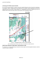
1
A-CR-CCP-704/PF-001
ROYAL CANADIAN ARMY CADETS
GOLD STAR
INSTRUCTIONAL GUIDE
SECTION 1
EO M422.01 – REVIEW SILVER STAR NAVIGATION
Total Time:
60 min
PREPARATION
PRE-LESSON INSTRUCTIONS
Resources needed for the delivery of this lesson are listed in the lesson specification located in A-CR-CCP-704/
PG-001, Gold Star Qualification Standard and Plan, Chapter 4. Specific uses for said resources are identified
throughout the instructional guide within the TP for which they are required.
Review the lesson content and become familiar with the material prior to delivering the lesson.
Learning stations are a form of group work, where the cadets learn by sorting through the information presented.
When setting up learning stations, ensure there is enough room for each cadet to be comfortable and adequate
space for writing down information. When the cadets arrive at a learning station, all required information shall
already be available. These stations should be placed close enough together to minimize time for movement
and far enough apart to avoid interruptions from other groups. For this lesson, set up three learning stations
for reviewing navigation.
Instructors assigned to a learning station shall review their station's questions and locate and record their
answers on the sheet provided prior to the cadets' arrival.
Photocopy the Silver Star Navigation Review worksheet located at Attachment A for each cadet.
Make three copies of the Silver Star Navigation Review Worksheet Answer Key located at Attachment B for
each learning station instructor. Determine answers for Stations 2 and 3.
Photocopy the Learning Station Information Sheets located at Attachments C, D, and E for each learning station
instructor.
Review Attachment A and complete a preliminary run-through of the provided questions for each station.
Review the activities, ensuring they are best suited to the training area, size of the group, staff and training
aids available.
Prepare all resources necessary for the selected activities.
Assistant instructors are required at each learning station.
PRE-LESSON ASSIGNMENT
Nil.
M422.01-1
A-CR-CCP-704/PF-001
APPROACH
A practical activity was chosen for this lesson as it is an interactive way for the cadet to develop navigation skills
and knowledge in a safe and controlled environment. This activity contributes to the development of navigational
skills and knowledge in a fun and challenging setting.
INTRODUCTION
REVIEW
Nil.
OBJECTIVES
By the end of this lesson the cadet shall have reviewed Silver Star navigation.
IMPORTANCE
It is important for cadets to review Silver Star navigation as it is the foundation for global positioning system
(GPS) training. Silver Star navigation introduces cadets to the fundamentals of using a GPS receiver. Cadets
should take every opportunity to practice and refine these skills.
M422.01-2
A-CR-CCP-704/PF-001
Teaching Point 1
Conduct a Silver Star navigation review activity using
learning stations.
Time: 50 min
Method: Practical Activity
ACTIVITY
OBJECTIVE
The objective of this activity is to have the cadet review Silver Star navigation.
RESOURCES
Three GPS receivers,
Two topographical maps of the local area,
Nine pencils,
One pencil eraser,
Three copies of the Silver Star Navigation Review Worksheet Answer Key located at Attachment B,
Three copies of the Learning Station Information Sheets located at Attachments C–E,
One copy of the Silver Star Navigation Review Worksheet located at Attachment A for each cadet, and
Paper.
ACTIVITY LAYOUT
Set up three learning stations as follows:
Station 1:
one GPS receiver,
three pencils,
one copy of the Silver Star Navigation Review Worksheet Answer Key, and
one copy of the Learning Station 1 Information Sheet;
Station 2:
one GPS receiver,
one topographical map of the local area,
three pencils,
one copy of the Silver Star Navigation Review Worksheet Answer Key,
one copy of the Learning Station 2 Information Sheet; and
M422.01-3
A-CR-CCP-704/PF-001
Station 3:
one GPS receiver,
one topographical map of the local area,
three pencils,
one pencil eraser,
one copy of the Silver Star Navigation Review Worksheet Answer Key, and
one copy of the Learning Station 3 Information Sheet.
ACTIVITY INSTRUCTIONS
1.
Explain to the cadets they will be taking part in a round robin activity with stations. At each station they
will be presented with the questions found on their worksheets. Inform the cadets that the activity is to
be completed individually.
2.
Divide the cadets into three groups, and place each group at one of the learning stations.
3.
Provide each cadet a copy of the Silver Star Navigation Review Worksheet located at Attachment A to
complete as they rotate through the stations.
4.
Assign an assistant instructor to each learning station. Give each assistant instructor a copy of:
a.
the Silver Star Navigation Review Worksheet Answer Key; and
b.
the Learning Station Information Sheet to assist the cadets in completing their worksheets if
required.
5.
Have the assistant instructor at each station explain the worksheet and what to do.
6.
Allow the cadet(s) approximately fifteen minutes to complete the station.
7.
Have the cadets explain their answers individually to the instructors.
8.
The instructor will confirm the answers are correct by referring to the Silver Star Navigation Worksheet
(as required) and correct any errors.
9.
Allow one minute for the cadets to move between stations.
10.
Have the cadets complete each station, following Steps 5–8.
11.
Debrief the cadets at the end of the activity. Discuss any areas of concern and answer any questions.
Station 1: Components of the GPS. At this station, the cadet shall complete the following on the worksheet
for Station 1:
1.
identify and briefly explain the components of the GPS, to include:
satellites,
ground stations, and
receivers;
M422.01-4
A-CR-CCP-704/PF-001
2.
identify the features of a GPS receiver, to include the following components:
antenna,
screen,
battery compartment, and
buttons; and
3.
independently navigate through the GPS receiver and locate one of the following:
satellite status,
menu,
position,
compass navigation,
map, and
map screen.
Station 2: Set a map datum on a GPS receiver. At this station, the cadet shall complete the following on
the worksheet for Station 2:
1.
complete the process for confirming correct coordinate system by:
identifying military grid reference system (MGRS) grid system on a topographical map;
locating the grid zone designator; and
confirming the 100 000-m square identifier;
2.
locate the map datum from a topographical map; and
3.
set the map datum on a GPS receiver.
Station 3: Identify location using a GPS receiver. At this station, the cadet shall complete the following on
the worksheet for Station 3:
1.
confirm that the correct coordinate system is set on the GPS receiver;
2.
locate the geographical position screen in the GPS receiver;
3.
read the grid reference (GR); and
4.
plot the eight-figure GR on the topographical map.
SAFETY
Nil.
CONFIRMATION OF TEACHING POINT 1
The cadets’ participation in the activity will serve as the confirmation of this TP.
M422.01-5
A-CR-CCP-704/PF-001
END OF LESSON CONFIRMATION
The cadets’ participation in the learning stations will serve as the confirmation of this lesson.
CONCLUSION
HOMEWORK / READING / PRACTICE
Nil.
METHOD OF EVALUATION
Nil.
CLOSING STATEMENT
Concepts of Silver Star navigation should be understood before more challenging skills can be introduced at the
Gold Star level. Throughout expeditions, there will be requirements to navigate routes. Take every opportunity to
practice, whether it is plotting position on a map from a GPS grid reference or helping a junior cadet understand
how a GPS receiver works.
INSTRUCTOR NOTES / REMARKS
The navigation activity will consist of three learning stations. The cadets will rotate through the stations every
15 minutes. There will be 5 minutes provided at the end of the lesson to answer questions or provide additional
instruction on areas where cadets experienced difficulty.
This EO shall be conducted during the bivouac field training exercise.
Assistant instructors are required for this lesson, at each learning station.
Topographical maps have not been provided, so the cadet can use local area topographical maps.
REFERENCES
A2-036 A-CR-CCP-121/PT-001 Director Cadets 3. (2003). Royal Canadian Army Cadet reference book.
Ottawa, ON: Department of National Defence.
C2-142 ISBN 0-7645-6933-3 McNamara, J. (2004). GPS for dummies. Hoboken, NJ: Wiley Publishing, Inc.
C2-143 ISBN 1-58923-145-7 Featherstone, S. (2004). Outdoor guide to using your GPS. Chanhassen, MN:
Creative Publishing International, Inc.
C2-144 ISBN 0-07-223171-8 Broida, R. (2004). How to do everything with your GPS. Emerville, CA: McGrawHill.
M422.01-6
A-CR-CCP-704/PF-001
Attachment A to EO M422.01
Instructional Guide
SILVER STAR NAVIGATION REVIEW WORKSHEET
Cadet's Name: ___________________________________
Note: Use the back of the worksheet or an attached piece of paper(s) for additional notes / calculations if
required.
Station 1: Components of the GPS
Select the correct statement
1.
Describe how satellites, ground
stations, and receivers work.
2.
Select the correct statement.
Identify the error(s) in
the incorrect statements.
Identify the components
of a GPS receiver.
3.
The minimum number of satellites that are required to cover the
entire Earth is 18.
The ground control segment of the GPS is comprised of seven
ground stations that track the satellites, monitor their condition and
make any necessary adjustments to keep the system accurate.
GPS receivers make up the user segment. It is the GPS receiver,
whether it is in an airplane, a truck, a boat or in a hiker's hand,
that detects the radio signals from the satellite ground stations and
calculates the receiver's position.
Components of a GPS receiver
1.
2.
3.
4.
Buttons on a GPS receiver
Identify and briefly explain
the functions of 5 buttons
on the GPS receiver.
1.
2.
3.
4.
5.
Navigate through the GPS
receiver and locate the
selected screen screens
determined by the instructor.
Screens identified
1.
List the screens identified.
M422.01A-1
A-CR-CCP-704/PF-001
Attachment A to EO M422.01
Instructional Guide
Station 2: Set a map datum on a GPS receiver
Given a topographical map
Process for confirming correct MGRS
of the local area and a
1.
GPS receiver, complete
2.
the process for confirming
correct Military Grid Reference 3.
System (MGRS) coordinates.
Map Datum
Locate the map datum
from a topographical map.
Set Datum
Set the map datum
on a GPS receiver.
M422.01A-2
A-CR-CCP-704/PF-001
Attachment A to EO M422.01
Instructional Guide
Confirm that the correct
coordinate system is set
on the GPS receiver.
Station 3: Identify location using a GPS receiver
Confirm correct coordinate system
What coordinate
system is used?
Locate geographical position screen in a GPS receiver
Locate geographical position
screen in a GPS receiver.
Record the GR
Read the GR from the GPS.
Plot GR
Plot the GR on the
topographical map.
M422.01A-3
A-CR-CCP-704/PF-001
Attachment A to EO M422.01
Instructional Guide
THIS PAGE INTENTIONALLY LEFT BLANK
M422.01A-4
A-CR-CCP-704/PF-001
Attachment B to EO M422.01
Instructional Guide
SILVER STAR NAVIGATION REVIEW WORKSHEET ANSWER KEY
Note: Learning stations require preparation of answers. Learning station information sheets have been provided
with a detailed description on how each question should be answered.
Station 1: Components of the GPS
Select the correct statement
1.
The minimum number of satellites that are required to cover
the entire Earth is 18.
Describe how satellites, ground
stations, and receivers work.
2.
The ground control segment of the GPS is comprised of FIVE
ground stations that track the satellites, monitor their condition and
Select the correct statement.
make any necessary adjustments to keep the system accurate.
Identify the error(s) in
3.
GPS receivers make up the user segment. It is the GPS receiver,
the incorrect statements.
whether it is in an airplane, a truck, a boat or in a hiker's hand, that
detects the radio signals from the SATELLITES and calculates the
receiver's position.
Components of a GPS receiver
1.
Antenna
Identify the components
2.
Screen
of a GPS receiver.
3.
Battery Compartment
4.
Buttons
Buttons on a GPS receiver
1.
On / Off
6.
Menu
Identify and briefly explain the
2.
Backlight
7.
NAV
function of 5 buttons on the
3.
Enter
8.
Mark
GPS receiver.
4.
Escape
9.
Arrow Joystick
5.
Zoom in
Navigate through the GPS
Screens identified
receiver and locate the
1.
Satellite screen
4.
Compass navigation
selected screen screens
2.
Menu
5.
Map
determined by the instructor.
3.
Position
6.
Map screen
List the screens identified.
M422.01B-1
A-CR-CCP-704/PF-001
Attachment B to EO M422.01
Instructional Guide
Station 2: Set a map datum on a GPS receiver
Process for confirming correct MGRS coordinate system
The learning station instructor shall reference the local topographical map
and complete the following questions prior to the cadets' arrival:
Given a topographical map
of the local area and a
GPS receiver, complete the
process for confirming correct
MGRS coordinate system.
Locate the map datum
from a topographical map.
Set the map datum
on a GPS receiver.
1.
Identify MGRS grid system on a topographical map.
Answer:_________________
2.
Locate the grid zone designator.
Answer:_________________
3.
Confirm the 100 000-m square identifier.
Answer:_________________
Map Datum
The learning station instructor shall refer to the local topographical map
and find the correct datum.
MAP Datum: ________________________________
Set Datum
Consult the GPS Receiver User Manual and Learning Station
2 Information Sheet for the detailed instructions on how to set the datum
on a GPS receiver.
Datum to be set:_______________________________
M422.01B-2
A-CR-CCP-704/PF-001
Attachment B to EO M422.01
Instructional Guide
Confirm that the correct
coordinate system is set
on the GPS receiver.
Station 3: Identify location using a GPS receiver
Confirm correct coordinate system
What coordinate
system is used?
Locate geographical position
screen in a GPS receiver.
Confirm that the cadet follows the process and ensures the correct
coordinate system is set.
MGRS coordinate system should be used.
Locate geographical position screen in a GPS receiver
Record the GR
Read the GR from the GPS.
Plot GR
Plot the GR on the
topographical map.
M422.01B-3
A-CR-CCP-704/PF-001
Attachment B to EO M422.01
Instructional Guide
THIS PAGE INTENTIONALLY LEFT BLANK
M422.01B-4
A-CR-CCP-704/PF-001
Attachment C to EO M422.01
Instructional Guide
LEARNING STATION 1 INFORMATION SHEET
HOW THE GPS WORKS
The system is divided into three parts or segments: space, ground control and users. The space segment
consists of 24 satellites that orbit 20 200 km above the Earth and send radio signals toward Earth. The radio
signals broadcast the position of each satellite in the sky with an electronic code.
Each satellite performs a relatively simple primary task: it transmits a timing signal using its built-in atomic clock.
When a device on the ground receives that signal, it can determine its distance from the satellite.
That single measurement alone does not accomplish much, but when a GPS receiver collects timing signals
from three different satellites, the receiver can determine two precise coordinates: latitude and longitude. With
four satellite signals, the GPS receiver is able to determine altitude as well.
A GPS receiver can also determine speed and heading.
COMPONENTS OF THE GPS
Satellites
The GPS and its satellites have the following characteristics:
The minimum number of satellites that are required to cover the entire Earth is 18, however the number
of satellites in orbit fluctuates between 24 and 29 satellites due to spares and upgrading.
Satellites orbit in a semi-synchronous orbit (orbits are coordinated, but not identical).
Each satellite completes an orbit every 12 hours.
Satellites orbit the Earth at 20 200 km (12 552 miles) (airplanes routinely fly at 11–13 km [37 000–
43 000 feet], the shuttle orbits at 370 km [230 miles]).
Each satellite has three key pieces of hardware:
Computer. Controls its flight and order functions.
Atomic clock. Keeps accurate time within three nanoseconds (approximately three-billionths of
a second).
Radio transmitter. Sends signals to Earth.
Ground stations
The ground control segment of the GPS is comprised of five ground stations that track the satellites, monitor
their condition and make any necessary adjustments to keep the system accurate. The entire system functions
and is monitored by the US Department of Defence. Information from the stations are sent to a master control
station—the Consolidated Space Operations Centre (CSOC) at Schriever Air Force Base in Colorado where
the data is processed and adjustments are made. The five ground stations are in Hawaii, Colorado, Diego
Garcia, Ascension Island and Kwajalein.
M422.01C-1
A-CR-CCP-704/PF-001
Attachment C to EO M422.01
Instructional Guide
Receivers
GPS receivers make up the user segment. It is the GPS receiver, whether it is in an airplane, a truck, a boat or
in a hiker's hand, that detects the radio signals from the satellites and calculates the receiver's position.
When a receiver is turned on, it interprets the radio signals and extracts the satellite location information. The
GPS signal broadcasts information that tells the receiver the location of each satellite in the system. The receiver
then interprets the radio signal to determine the exact time. This is required to calculate position.
The orbits of the GPS satellites ensure that there will be a minimum of four satellites covering any spot on the
globe at all times. The receiver uses the signal from one satellite to continuously monitor and be synchronized
with the time maintained by the other satellites. The receiver collects the signals from the other satellites
and calculates the difference between them. This calculation positions the receiver from each satellite and
triangulates its location. Based on a four-satellite fix, the receiver will identify location giving the user latitude,
longitude and altitude (altitude is only possible with a four-satellite fix).
COMPONENTS OF A GPS RECEIVER
Antenna. Allows the GPS receiver to receive satellite signals.
Screen. Displays information.
Battery compartment. Stores the receiver power supply.
The buttons in the following list are found on the Magellan eXplorist 200 GPS receiver.
Other makes and models of GPS receivers may have different function buttons. Consult the
user manual for GPS receiver button functions.
BUTTONS
On / Off. Turns the receiver on and off.
Backlight. Turns the display backlight on and off and changes intensity.
Enter. Accesses highlighted menu items or highlighted screen menu options.
Escape. Cancels data inputs. Closes the accessed function and goes back to the previous screen and moves
backward through the navigation screens.
Zoom in. On the map screen zooms in on the map displayed. The map display can be zoomed in to 35 m
(100 feet). Also moves through the list of waypoints when using an alphabetical search.
Zoom out. On the map screen zooms out on the map displayed. The map display can be zoomed out to
2736 km (1700 miles). Also moves through the list of waypoints when using an alphabetical search.
Menu. Displays a menu with available options. Options may be selected by using the arrow joystick to highlight
the option and pressing "enter" to access it.
NAV. Moves through the navigation screens (Map screen, Compass screen, Position screen, Satellite screen).
Mark. Saves present position as a waypoint. Waypoints are saved and stored in "My Points of Interest".
GOTO. Creates a one-leg route from the present position to a destination selected from the POI database or
by using the cursor on the background map and pressing GOTO on a point.
M422.01C-2
A-CR-CCP-704/PF-001
Attachment C to EO M422.01
Instructional Guide
Arrow joystick. Moves the cursor on the map screen. It also moves the highlighted bar to select menu options
and data-entry fields.
Figure C-1 Explorist 200 GPS Receiver
Note. From Magellan eXplorist 200 Reference Manual (p. 1), 2004,
by Thales Navigation, Inc. Copyright 2004 by Thales Nav, Inc.
SATELLITE STATUS
The satellite status screen displays the acquisition of satellites (satellite signal strength and satellite geometry)
and the progress of the collection of satellite data. The receiver is constantly monitoring satellites. The display
on the satellite status screen graphically depicts the activity.
As new satellites come into view, a new bar appears in the graph. Bars that were solid minutes ago disappear
as satellites pass over the horizon. If a satellite is being monitored but not used, the bar will appear hollow.
On Wide Area Augmentation System (WAAS) enabled GPS receivers, the WAAS satellite signal strength is
indicated on its own bar on the graph. On this screen it is common for GPS receivers to display the following
information:
satellite signal strengths,
battery strength, and
estimated position error (EPE).
M422.01C-3
A-CR-CCP-704/PF-001
Attachment C to EO M422.01
Instructional Guide
Figure C-2 Satellite Status Screen
Note. From Outdoor Guide to Using Your GPS (p. 45), by S. Featherstone,
2004, Chanhassen, MN: Creative Publishing International, Inc.
MENU
This screen is used for customizing the GPS receiver. All data fields can be changed to give a person the
information they require including waypoints, routes, time and speed, etc. On this screen it is common for GPS
receivers to display the following information:
customization options for the GPS receiver,
waypoints and routes, and
map datum.
Figure C-3 Menu Screen
Note. From Outdoor Guide to Using Your GPS (p. 54), by S. Featherstone,
2004, Chanhassen, MN: Creative Publishing International, Inc.
POSITION
The position screen is used for confirming coordinates, datum, time, date, and the EPE. This screen is used
infrequently, for brief periods, mostly in planning and after marking a waypoint. Graphics, like a compass rose,
are not displayed. This screen is not ideally laid out for user-friendly navigation.
M422.01C-4
A-CR-CCP-704/PF-001
Attachment C to EO M422.01
Instructional Guide
After acquiring enough satellites to begin navigating, many GPS receivers automatically go to the position
screen or the map screen. In addition to the information mentioned above, an operator may find current speed,
heading and a trip odometer. On some GPS receivers, the information displayed can be changed.
Figure C-4 Position Screen
Note. From Outdoor Guide to Using Your GPS (p. 46), by S. Featherstone,
2004, Chanhassen, MN: Creative Publishing International, Inc.
COMPASS NAVIGATION
This screen shows the direction of travel (track) as it relates to the direction of the destination (bearing). It
will show the distance from the destination and time to the destination. This screen is used frequently when
navigating from point to point and for navigating around obstacles.
The digital compass graphic should not be confused with a real compass. Although
they look the same, it can give a very different reading because without movement GPS
receivers cannot display direction. Read the owner's manual and determine if the compass
is an electronic compass capable of identifying a compass heading while the operator is
standing still.
M422.01C-5
A-CR-CCP-704/PF-001
Attachment C to EO M422.01
Instructional Guide
Figure C-5 Compass Navigation Screen
Note. From Outdoor Guide to Using Your GPS (p. 47), by S. Featherstone,
2004, Chanhassen, MN: Creative Publishing international, Inc.
MAP
This screen identifies position. A GPS without a built-in map will identify where a person is in relation to another
waypoint. A GPS receiver with a built-in map will identify where a person is in relation to landmarks, such as
roads, cities and bodies of water. A GPS receiver with downloadable maps will identify where a person is in
relation to city streets and topographical features.
The advantage of this screen is its ability to identify the current position by looking at the features on a map
rather than just the coordinates. Depending on the zoom level—which is shown at the bottom of the screen—
these features may be roads or cities or entire continents.
The map screen allows an operator to pinpoint where they are and create a waypoint on the map by moving the
cursor over a feature and pressing ENTER or MARK, making route building easier. The map screen can also
serve as an address book. By moving the cursor over a certain waypoint and pressing ENTER, information is
displayed, such as phone numbers, addresses, and navigation information.
M422.01C-6
A-CR-CCP-704/PF-001
Attachment C to EO M422.01
Instructional Guide
Figure C-6 Map Screen
Note. From Outdoor Guide to Using Your GPS (p. 50), by S. Featherstone,
2004, Chanhassen, MN: Creative Publishing International, Inc.
M422.01C-7
A-CR-CCP-704/PF-001
Attachment C to EO M422.01
Instructional Guide
THIS PAGE INTENTIONALLY LEFT BLANK
M422.01C-8
A-CR-CCP-704/PF-001
Attachment D to EO M422.01
Instructional Guide
LEARNING STATION 2 INFORMATION SHEET
PROCESS FOR CONFIRMING CORRECT MGRS COORDINATES
MGRS coordinates allow a GPS receiver to work in conjunction with a topographical map. To confirm the MGRS
coordinates correspond with the topographical map the user will have to:
1.
Identify the MGRS grid system on the topographical map.
2.
Locate the grid zone designator.
3.
Confirm the 100 000-m square identifier.
Identifying MGRS Grid System on a Topographical Map
Locating the MGRS grid system on topographical maps provides the navigator with another method to confirm
the GPS receiver is reporting coordinates that correspond with the map being used. If the coordinates are
different, the navigator will know that the GPS receiver is set to another datum and will have to be adjusted
to provide the correct coordinates.
Locating the Grid Zone Designator
The location of the grid zone designator is found in the marginal information. The zone for the example in
Figure D-1, is 18 T.
Figure D-1 Grid Zone Designator
Note. Created by Director Cadets 3, 2008, Ottawa, ON: Department of National Defence.
Confirming the 100 000-m Square Identifier
The 100 000-m square identifier is located in the same marginal information area as the grid zone designator.
The example in Figure D-1 states that the map is adjacent to the 100 000-m square identifications UE and
UD. Additionally when the 100 000-m square identifier on a topographical map joins an adjacent grid zone, the
identifier will be noted on the map in the 00 00 grid square. This is illustrated in Figure D-2.
M422.01D-1
A-CR-CCP-704/PF-001
Attachment D to EO M422.01
Instructional Guide
Figure D-2 Topographical Map 100 000-m Square Identifier
Note. Created by Director Cadets 3, 2008, Ottawa, ON: Department of National Defence.
IDENTIFYING THE MAP DATUM FROM A TOPOGRAPHICAL MAP
The map datum of a topographical map is located in the lower right side of the marginal information, under the
conversion scale for elevations.
M422.01D-2
A-CR-CCP-704/PF-001
Attachment D to EO M422.01
Instructional Guide
Figure D-3 Map Datum
Note. Created by Director Cadets 3, 2008, Ottawa, ON: Department of National Defence.
SETTING A DATUM ON A GPS
To set a datum on a GPS:
1.
Identify the map datum of the topographical map being used as the reference.
2.
With the GPS, go to the set-up menu, then NAVIGATION, then SYSTEM or UNITS.
3.
Highlight the map datum's box.
4.
Scroll through the list of datums and find the map datum being used.
5.
Set the correct datum.
To set the datum of the eXplorist 200 GPS receiver:
1.
Power up the receiver.
2.
Press the ENTER button.
3.
Press MENU button.
4.
Highlight the preferences and press ENTER.
5.
Highlight the map units and press ENTER.
6.
Highlight the map datum and press ENTER.
7.
Highlight the correct datum and press ENTER.
M422.01D-3
A-CR-CCP-704/PF-001
Attachment D to EO M422.01
Instructional Guide
THIS PAGE INTENTIONALLY LEFT BLANK
M422.01D-4
A-CR-CCP-704/PF-001
Attachment E to EO M422.01
Instructional Guide
LEARNING STATION 3 INFORMATION SHEET
IDENTIFYING MGRS GRID SYSTEM ON A GPS RECEIVER
Ensure that the GPS receiver coordinate system is set to Military Grid Reference System
(MGRS).
GPS receivers will identify the UTM coordinates when reading location, to include:
grid zone designator,
100 000-m square identifier, and
GR.
GPS receivers, depending on the make and model, are capable of selecting an MGRS
accuracy of four-, six-, eight-, and ten-figure GRs. If the GPS receiver being used for this TP
is enabled with this capability, it is suggested that it be set to a six-figure GR.
Figure E-1 GPS Receiver Coordinates
Note. Created by Director Cadets 3, 2008, Ottawa, ON: Department of National Defence.
M422.01E-1
A-CR-CCP-704/PF-001
Attachment E to EO M422.01
Instructional Guide
The coordinates displayed on the GPS receivers in Figure E-1 are set to MGRS. Each GPS receiver is set with
a different datum for the same location.
GPS Receiver Datum set to NAD-27
The coordinates are identified as:
GPS Receiver Datum set to NAD-83
The coordinates are identified as:
grid zone designator—18 T,
grid zone designator—18 T,
100 000-m square identifier—TD, and
100 000-m square identifier—TP, and
10-figure GR as—96785 86748
10-figure GR as—96830 86973
Note the difference between the coordinates of the same location using a different datum.
PROCESS FOR CONFIRMING CORRECT MGRS COORDINATES
MGRS coordinates allow a GPS receiver to work in conjunction with a topographical map. To confirm the MGRS
coordinates correspond with the topographical map the user will have to:
1.
identify the MGRS grid system on the topographical map;
2.
locate the grid zone designator; and
3.
confirm the 100 000-m square identifier.
Identifying the MGRS Grid System on a Topographical Map
Locating the MGRS on topographical maps provides the navigator with another method to confirm the GPS
receiver is reporting coordinates that correspond with the map being used. If the coordinates are different, the
navigator will know that the GPS receiver is set to another datum and will have to be adjusted to provide the
correct coordinates.
Locating the Grid Zone Designator
The location of the grid zone designator is found in the marginal information. The zone for the example in
Figure E-1, is 18 T.
M422.01E-2
A-CR-CCP-704/PF-001
Attachment E to EO M422.01
Instructional Guide
Figure E-2 Grid Zone Designator
Note. Created by Director Cadets 3, 2008, Ottawa, ON: Department of National Defence.
Confirming the 100 000-m Square Identifier
The 100 000-m square identifier is located in the same marginal information area as the grid zone designator.
The example in Figure E-2 states that the map is adjacent to the 100 000-m square identifications UE and UD.
Additionally, when the 100 000-m square identifier on a topographical map joins an adjacent grid zone, the
identifier will be noted on the map in the 00 00 grid square. This is illustrated in Figure E-3.
M422.01E-3
A-CR-CCP-704/PF-001
Attachment E to EO M422.01
Instructional Guide
Figure E-3 Topographical Map 100 000-m Square Identifier
Note. Created by Director Cadets 3, 2008, Ottawa, ON: Department of National Defence.
Position. The position screen is used for confirming coordinates, datum, time, date, and the EPE. This screen
is used infrequently, for brief periods, mostly in planning and after marking a waypoint. No easy-to-understand
graphics, like a compass rose, are displayed.
After acquiring enough satellites to begin navigating, many GPS receivers automatically go to the position
screen or the map screen. In addition to the information mentioned above, an operator may find current speed,
heading and a trip odometer. On some GPS receivers the information displayed can be changed.
M422.01E-4
A-CR-CCP-704/PF-001
Attachment E to EO M422.01
Instructional Guide
Figure E-4 Position Screen
Note. From Outdoor Guide to Using Your GPS (p. 46), by S. Featherstone,
2004, Chanhassen, MN: Creative Publishing International, Inc.
EXTRACTING A 6-FIGURE GR FROM A 10-FIGURE GR
A 10-figure grid reference given from a GPS receiver has 10 digits and is accurate to 1 m. To extract the 6-figure
GR from the 10-figure GR one must understand how the figures work.
GRID REFERENCE WRITTEN FIGURES
Definition
Easting
Northing
A 10-figure GR accurate to
96779 86744
1 m is written as
An 8-figure GR accurate to
9677 8674
10 m is written as
A 6-figure GR accurate
967 867
to 100 m of the same
coordinates is written as
A 4-figure GR accurate
to 1 000 m of the same
96 86
coordinates is written as
As illustrated in the above chart, the 10-figure GR has two sets of numbers. The first five digits are eastings
and the second five digits are the northing coordinates. When taking a GR from a GPS receiver, it is important
to identify the 10 digits and extract the first three numbers from the easting portion and the first three numbers
from the northing portion (eg, 96779 86744). The 6-figure grid reference can then be plotted on a map as GR
967 867.
M422.01E-5
A-CR-CCP-704/PF-001
Attachment E to EO M422.01
Instructional Guide
THIS PAGE INTENTIONALLY LEFT BLANK
M422.01E-6
A-CR-CCP-704/PF-001
ROYAL CANADIAN ARMY CADETS
GOLD STAR
INSTRUCTIONAL GUIDE
SECTION 2
EO M422.02 – SET A MULTI-LEG ROUTE USING A GLOBAL POSITIONING SYSTEM (GPS) RECEIVER
Total Time:
120 min
PREPARATION
PRE-LESSON INSTRUCTIONS
Resources needed for the delivery of this lesson are listed in the lesson specification located in A-CR-CCP-704/
PG-001, Gold Star Qualification Standard and Plan, Chapter 4. Specific uses for said resources are identified
throughout the instructional guide within the TP for which they are required.
Review the lesson content and become familiar with the material prior to delivering the lesson.
All information in this lesson is based on the Magellan eXplorist 200 GPS. If a different GPS receiver is being
used, consult the owner's manual to ensure the proper terminology and processes are used for this lesson.
Ensure GPS receivers are set up and initialized prior to the start of the lesson.
Create and input five points of interest (POIs) into each GPS receiver. Personalize these POIs so that they can
be easily identified by the cadets during the lesson (eg, Gold 1, Gold 2, Gold 3).
Identify four POIs for the cadets to create in the GPS receiver in TP 2 and then link together to form a multi-leg
route in TP 4. The POIs chosen must be able to be linked into a route.
Clear all track logs from the GPS receivers.
Create an active track in the GPS receivers of no longer than 100 m. Have the active track begin and end at
the same location where the lesson will be taught. Once the active track has been established, stop it. Before
TP 7 begins, resume the active track log on each of the GPS receivers.
PRE-LESSON ASSIGNMENT
Nil.
APPROACH
An interactive lecture was chosen for TPs 1 and 3 to introduce the cadet to the features available on a GPS
receiver.
A demonstration and performance was chosen for TPs 2, 4, 5 and 7 as it allows the instructor to explain and
demonstrate how to create POIs and routes while providing the cadet the opportunity to practice these skills
under supervision.
A demonstration was chosen for TP 6 as it allows the instructor to demonstrate the process of working a GPS
receiver providing the cadet with the knowledge on how these skills can be applied in the future.
M422.02-1
A-CR-CCP-704/PF-001
INTRODUCTION
REVIEW
The review for this lesson is from EO M422.01 (Review Silver Star Navigation).
QUESTIONS:
Q1.
What are the components of a GPS receiver?
Q2.
What are the five screens on a GPS receiver?
Q3.
What does the arrow joystick on the GPS receiver do?
ANTICIPATED ANSWERS:
A1.
The components of a GPS receiver are:
antenna,
screen,
battery compartment, and
buttons.
A2.
The five screens on a GPS receiver are:
satellite screen,
menu screen,
position screen,
compass navigation screen, and
map screen.
A3.
The arrow joystick moves the cursor on the map screen and moves the highlighted bar to select menu
options and data-entry fields.
OBJECTIVES
By the end of this lesson the cadet shall have set a multi-leg route using a GPS receiver.
IMPORTANCE
It is important for cadets to be able to set a multi-leg route on a GPS receiver because it allows the cadet to
move from point to point without having to input new POIs for each leg, thereby saving time and minimizing
the possibility of mistakes.
M422.02-2
A-CR-CCP-704/PF-001
Teaching Point 1
Identify the two types of POIs.
Time: 5 min
Method: Interactive Lecture
The purpose of this TP is to introduce the cadets to the two types of POIs that can be used
to set a multi-leg route in a GPS receiver.
Depending on the GPS receiver being used, POIs may also be referred to as waypoints or
landmarks.
Show cadets each type of POI in the GPS receiver.
The most important function of a GPS receiver is its ability to store POIs because they allow the user to return
to a variety of points at a later time. A POI can be anything from a previous campsite to the place where the
bus is waiting to pick up the group. POIs can be set prior to leaving or anytime along a route.
An easy way to think about a POI is to think about it as a location on a map marked by a
pushpin.
There are two types of POIs:
Marked. A GPS receiver automatically displays the current coordinates of the user's position. Saving this
position into the GPS receiver's memory establishes a new POI.
Stored. A POI can also be established even if it is not the user's current position. This stored POI is manually
entered coordinates, from the map page of the GPS receiver, or taken from the list of POIs that come preloaded into the GPS receiver's memory.
GPS receivers can only store a fixed number of POIs—some limit the user to 250, while
others can hold 1 000.
CONFIRMATION OF TEACHING POINT 1
QUESTIONS:
Q1.
What is a POI?
Q2.
When can POIs be set on a GPS receiver?
Q3.
What is the difference between a marked and a stored POI?
ANTICIPATED ANSWERS:
A1.
A POI can be anything from the previous campsite to the place where the bus is waiting to pick the
group up.
A2.
POIs can be set prior to leaving or anytime along a route.
A3.
A marked POI saves the user's current location, while a stored POI is a manually entered GR, from
the map page of the GPS receiver, or taken from the list of POIs that come pre-loaded into the GPS
receiver's memory.
M422.02-3
A-CR-CCP-704/PF-001
Teaching Point 2
Explain, demonstrate and have the cadets identify and
create POIs.
Time: 20 min
Method: Demonstration and Performance
For this skill TP it is recommended that instruction take the following format:
1.
Identify the components of a POI.
2.
Explain and demonstrate each mark while the cadets observe.
3.
Explain and demonstrate each step required to complete each mark. Monitor the
cadets as they practice each step.
4.
Monitor the cadets' performance as they practice each mark.
Note: Assistant instructors may be used to monitor the cadets' performance.
Inform the cadets that once they receive their GPS receiver they will only pick it up when
told to do so, follow along with the instructions and only press the buttons they are directed
to press.
Distribute the GPS receivers to the class. Depending on the number of GPS receivers
available and the number of cadets in the class, some cadets may have to pair up.
IDENTIFY A POI
The following information can be saved in the GPS receiver when a POI is marked in order to distinguish one
POI from another:
Location. Indicates the coordinates of the POI, using the coordinate system set on the GPS receiver.
Name. POIs can receive a name of the user's choice or be automatically assigned a number from the GPS
receiver. Many GPS receivers limit the number of characters that can be used to name the POI, so come
creativity is usually required. Many users develop a list of common abbreviations to use when naming POIs
such as CS for campsite, BS for best site, WS for water source, etc.
Date and time. Automatically recorded and saved when a POI is created.
Icon / symbol. Some GPS receivers allow the user to assign an icon / symbol to the newly created POI. This
icon / symbol appears on the map page when the area around the POI is displayed. This is an optional feature
and is not required—a default icon / symbol appears when one is not selected by the user.
CREATE POIs
Always confirm that the GPS receiver is set to the correct coordinate system and map
datum prior to creating POIs.
There are four different ways that POIs can be created and saved into the memory of the GPS receiver. They
are created using:
a quick mark,
a personalized mark,
M422.02-4
A-CR-CCP-704/PF-001
a coordinate mark, and / or
a map cursor mark.
Quick Mark
The steps to execute a quick mark are as follows:
1.
press MARK; and
2.
press ENTER.
A quick mark uses the mark position defaults and therefore is not personalized by the user. To distinguish the
POI from other POIs it is automatically assigned a number. Numbers are assigned in chronological order and
no two POIs have the same number. For example, the first marked POI would be saved as POI001.
Personalized Mark
A personalized mark is inputted in the same way as a quick mark. Once the coordinates have been entered it
is then personalized to enable easy identification, by entering:
1.
name, and
2.
icon / symbol.
The steps to create a POI using a personalized mark are as follows:
1.
press MARK;
2.
personalize the POI by:
a.
moving the arrow joystick to highlight the name field;
b.
pressing ENTER;
c.
moving the arrow joystick to select the character desired, pressing ENTER after each character
is selected;
d.
moving the arrow joystick to OK, once all characters have been selected;
e.
pressing ENTER;
f.
moving the arrow joystick to highlight the icon / symbol field;
g.
pressing ENTER;
h.
moving the arrow joystick to the desired icon / symbol; and
i.
pressing ENTER to select the icon / symbol;
3.
move the arrow joystick to highlight the save field; and
4.
press ENTER.
Coordinate Mark
A coordinate mark is entered when coordinates from a topographical map are being used or if the user has
been given a set of coordinates that they want to make into a POI.
M422.02-5
A-CR-CCP-704/PF-001
The steps to create a POI using a coordinate mark are as follows:
It is important to make sure that the GPS receiver has been set to the same coordinate
system as the coordinates that are going to be entered.
1.
press MARK;
2.
move the arrow joystick to highlight the location field;
3.
press ENTER;
4.
use the arrow joystick to adjust the characters in the first line (grid zone designation and 100 000-m
square identification) of the location field;
5.
press ENTER to move to the second line of the location field;
6.
use the arrow joystick to adjust the characters in the second line (grid reference) of the location field;
Moving the arrow joystick in an up / down motion will increase / decrease the value at the
cursor point.
Moving the arrow joystick in a left / right motion will move the cursor point to the left / right.
7.
press ENTER;
8.
personalize the POI, if desired (as detailed in Personalize a Mark, Step 2);
9.
move the arrow joystick to the save field; and
10.
press ENTER.
Have the cadets input the four POIs identified prior to the lesson using a coordinate mark
into the GPS receiver. If the initial POI is the current location, it shall be entered using a
personalized mark.
Map Cursor Mark
A map cursor mark allows the user to mark a position, other than the current position, by moving the cursor
around the map to a specific place to create a POI.
The steps to create a POI using a map cursor mark are as follows:
1.
go to the map screen page of the GPS receiver;
2.
move the arrow joystick to put the GPS receiver into cursor mode;
3.
move the arrow joystick until it is over the location of the desired POI;
4.
press MARK;
5.
personalize the POI, if desired (as detailed in Personalize a Mark, Step 2);
6.
move the arrow joystick to the save field;
M422.02-6
A-CR-CCP-704/PF-001
7.
press ENTER; and
8.
press ESC to exit the cursor mode.
CONFIRMATION OF TEACHING POINT 2
The cadets marking of POIs using the quick mark, personalized mark, coordinate mark, and map cursor mark
will serve as the confirmation of this TP.
Teaching Point 3
Discuss types of routes.
Time: 5 min
Method: Interactive Lecture
The purpose of this TP is to introduce the cadets to the different types of routes that can be
developed on a GPS receiver. Ensure that the cadets understand the difference between
the three routes discussed.
Routes are the least understood and one of the most important functions of a GPS receiver. Understanding
how to use routes makes navigating using a GPS receiver much more enjoyable.
Route. A route is a series of POIs strung together to make an electronic path that also represents the trail the
user intends to follow.
Leg. The segment between each set of POIs is called a leg.
A single route can be made up of a number of different legs.
There are three different types of routes that can be developed on a GPS receiver.
GOTO route. A GOTO route is the simplest and most common type of route. A GOTO route is a one-leg
route with a starting point (present location) and a destination (selected POI). This type of route is useful when
travelling to a specific manually-entered or stored POI. GOTO routes can only be used once.
Multi-leg route. A multi-leg route is a number of GOTO routes combined together. For example, if a GOTO
route is from point A to point B then a multi-leg route would go from point A to point B to point C to point D and
so on. Multi-leg routes can be saved into the memory of the GPS receiver and used repeatedly.
Backtrack route. As an individual walks with their GPS receiver, it records their tracks by automatically saving
coordinates. A backtrack route uses these tracks to create a multi-leg route, in reverse order, enabling the user
to navigate back to the start location following the same exact path. A backtrack route can be saved into the
memory of the GPS receiver and used repeatedly.
M422.02-7
A-CR-CCP-704/PF-001
CONFIRMATION OF TEACHING POINT 3
QUESTIONS:
Q1.
What is the difference between a route and a leg?
Q2.
What is a multi-leg route?
Q3.
How are the POIs of a backtrack route saved into the GPS receiver?
ANTICIPATED ANSWERS:
A1.
A route is a series of POIs strung together to make an electronic path that also represents the trail the
user intends to follow and a leg is the segment between each set of POIs.
A2.
A multi-leg route is a number of GOTO routes combined together.
A3.
The POIs of a backtrack route are saved into the GPS receiver automatically as tracks while the
individual walks.
Teaching Point 4
Explain, demonstrate and have the cadets create a GOTO
route.
Time: 15 min
Method: Demonstration and Performance
For this skill TP it is recommended that instruction take the following format:
1.
Explain and demonstrate creating a GOTO route while the cadets observe.
2.
Explain and demonstrate each step required to create a GOTO route. Monitor the
cadets as they practice each step.
3.
Monitor the cadets' performance as they practice creating a GOTO route and walking
to the destination POI.
Note: Assistant instructors may be used to monitor the cadets' performance.
Always confirm that the GPS receiver is set to the correct coordinate system and map
datum prior to creating a GOTO route.
A GOTO route is the most commonly route used on a GPS receiver. A GOTO route has the following features:
It is a straight line from the user's present location to a selected POI.
It can not be saved.
It is erased when the GPS receiver is turned off.
It is created using stored POIs.
M422.02-8
A-CR-CCP-704/PF-001
All POIs that have been saved or that were pre-loaded into the GPS receiver can be
accessed using the POI database. POIs can be searched by nearest to present location or
alphabetically. The POI database is accessed by:
1.
pressing MENU;
2.
using the arrow joystick to highlight POINTS OF INTEREST;
3.
pressing ENTER;
4.
using the arrow joystick in an up / down motion to highlight MY POINTS OF
INTEREST;
5.
using the arrow joystick in a left / right motion to select NEAREST or
ALPHABETICALLY;
6.
pressing ENTER; and
7.
using the arrow joystick to highlight the desired POI.
The steps to create a GOTO route are as follows:
1.
press GOTO;
2.
use the POI database to select (highlight) the POI that will be the destination; and
3.
press ENTER.
If there is already an existing GOTO route set, the GPS receiver will ask the user to confirm
the creation of the new GOTO route. Pressing ENTER will erase the previous route to
create the new route.
Once ENTER has been pressed, the last viewed navigation screen will be displayed, updated with information
relating to the GOTO route that was just created. On the map screen, a line will be drawn from the current
POI to the destination POI—this represents the GOTO route. The compass screen will change to display the
name of the destination POI.
A GOTO route can also be created from a map cursor mark. Cadets will not be required to
complete this skill.
The steps to create a GOTO route from a map cursor mark are as follows:
1.
while viewing the map screen, use the arrow joystick to turn on the cursor mode;
2.
continue using the arrow joystick to move the cursor to a point on the map that
represents the desired destination;
3.
press GOTO;
4.
highlight YES to create a new GOTO route;
5.
press ENTER;
6.
highlight YES to create GOTO route to the current cursor position; and
7.
press ENTER.
M422.02-9
A-CR-CCP-704/PF-001
Once any route has been set, a GPS receiver indicates the following information:
distance to the destination POI,
bearing to the destination POI,
how long it will take to reach the destination,
if the user is on / off course, and
how to get back on course, if off course.
The GPS receiver only indicates distance and bearing when the user is moving forward.
GOTO routes can also be created using the map cursor.
When navigating to a POI the GPS receiver indicates arrival at the destination POI.
Depending on the GPS receiver being used, this may be a beep, a vibration or a flash on
the screen.
CONFIRMATION OF TEACHING POINT 4
The cadets' creation of a GOTO route will serve as the confirmation of this TP.
Teaching Point 5
Explain, demonstrate and have the cadets create and
activate / deactivate a multi-leg route.
Time: 30 min
Method: Demonstration and Performance
For this skill TP it is recommended that instruction take the following format:
1.
Explain and demonstrate creating a multi-leg route while the cadets observe.
2.
Explain and demonstrate each step required to create a multi-leg route. Monitor the
cadets as they practice each step.
3.
Explain and demonstrate activating / deactivating a multi-leg route will the cadets
observe.
4.
Explain and demonstrate each step required to activate / deactivate a multi-leg route.
Monitor the cadets as they practice each step.
5.
Monitor the cadets' performance as they practice creating a multi-leg route, activating
a multi-leg route, navigating using a multi-leg route and deactivating a multi-leg route.
For the practical portion of this TP, cadets will create a multi-leg route with three legs using
stored POIs.
Note: Assistant instructors may be used to monitor the cadets' performance.
M422.02-10
A-CR-CCP-704/PF-001
MULTI-LEG ROUTE
Always confirm that the GPS receiver is set to the correct coordinate system and map
datum prior to a multi-leg route.
Multi-leg routes can be used to navigate to a final destination using multiple legs. A route with multiple legs
allows the user to incorporate rest stops, terrain features (eg, travelling around a lake), contingency plans,
emergency evacuations, etc.
A multi-leg route has the following features:
It can be saved in the memory of the GPS receiver (the number of routes which can be saved is dependent
on the GPS receiver being used).
It remains active, even after the GPS receiver has been turned off.
It can be edited, reversed, deleted, or viewed on the map.
It allows for leg destination points to be switched when the route is active (eg, instead of going to the
lake, the user many choose to go directly to the campsite and skip the lake).
Create a Multi-Leg Route
The steps to create a multi-leg route are as follows:
1.
press MENU;
2.
use the arrow joystick to highlight ROUTES;
3.
press ENTER;
4.
use the arrow joystick to highlight NEW;
5.
press ENTER;
6.
ensure ADD POI is highlighted and press ENTER;
7.
use the POI database to add POIs by highlighting the desired POI and pressing ENTER after each one;
8.
use the arrow joystick to highlight SAVE ROUTE once all the desired POIs have been entered;
9.
press ENTER;
10.
use the arrow joystick and the ENTER button to input a route name;
11.
highlight OK; and
12.
press ENTER.
Activate / Deactivate a Multi-Leg Route
Once a multi-leg route has been created, it is saved in the memory of the GPS receiver. While a GOTO route
is automatically activated, a multi-leg route must be activated manually by the user. An active route is the route
that the user is presently navigating on. A route remains the active route until it is deactivated or a new route
is activated.
M422.02-11
A-CR-CCP-704/PF-001
The steps to activate / deactivate a route are as follows:
1.
press MENU;
2.
use the arrow joystick to highlight ROUTES;
3.
press ENTER;
4.
use the arrow joystick to highlight the name of the route that is to be activated / deactivated;
5.
press MENU;
6.
highlight ACTIVATE ROUTE or DEACTIVATE ROUTE; and
7.
press ENTER.
As with a GOTO route, once a multi-leg route has been activated / deactivated the GPS receiver returns to the
last viewed navigation screen with the route chosen activated or deactivated.
When navigating using an activated multi-leg route, the GPS receiver indicates when
approaching the end of each leg. Once the POI at the end of a leg has been reached, the
GPS receiver automatically recalculates to the next leg, until the route is complete.
CONFIRMATION OF TEACHING POINT 5
The cadets' creation of a multi-leg route will serve as the confirmation of this TP.
Teaching Point 6
Demonstrate how to modify a multi-leg route.
Time: 15 min
Method: Demonstration
The purpose of this TP is to demonstrate to cadets the different ways to modify an
established multi-leg route. Demonstrate each skill, ensuring that the cadets can see the
GPS receiver. If an assistant instructor is available, divide the cadets into two groups and
have the assistant instructor demonstrate to one group.
MODIFY A MULTI-LEG ROUTE
Once a multi-leg route has been created, there may be a requirement to modify some aspects of the route.
There are four ways to modify a multi-leg route:
change the destination leg of an active route;
edit a saved route;
reverse the route; and
delete a route.
Change the Destination Leg of an Active Route
When created, a multi-leg route will has many different legs incorporated into it—with each leg having its own
destination. In some instances, the user may want to skip a leg and move directly to the next leg. The GPS
M422.02-12
A-CR-CCP-704/PF-001
receiver allows the user to change the destination leg and then recalculates the navigation instructions based
on the new destination.
Use the following multi-leg route which begins at the campground as an example:
the first leg takes the user from the campground to the bridge;
the second leg takes the user from the bridge to the lake; and
the third leg takes the user from the lake to the park where lunch will be served.
The route would be campground > bridge > lake > park.
The user could decide to skip the lake and go directly to the park, by changing the
destination leg from the lake to the park.
The destination leg of a route can only be changed if the route is active.
The steps to change the destination leg of an active route are as follows:
1.
press MENU;
2.
use the arrow joystick to highlight ROUTES;
3.
press ENTER;
4.
use the arrow joystick to highlight the active route;
5.
press MENU;
6.
highlight SELECT LEG;
7.
press ENTER;
8.
use the arrow joystick to highlight the new destination POI from the route list (in the example it would
be 'park');
The current active leg in the route list will be bolded.
9.
press ENTER;
10.
use the arrow joystick to highlight YES and confirm the action;
11.
press ENTER; and
12.
press NAV to return to the last viewed navigation screen.
The multi-leg route recalculates and the user is able to navigate to the new destination.
M422.02-13
A-CR-CCP-704/PF-001
Edit a Saved Route
A saved multi-leg route can be edited by:
adding a leg;
inserting a new leg;
deleting a leg; or
replacing a leg.
The steps to edit a saved multi-leg route are as follows:
1.
press ENTER;
2.
use the arrow joystick to highlight ROUTES;
3.
press ENTER;
4.
use the arrow joystick to highlight the name of the route that is to be edited;
5.
press ENTER;
6.
choose any of the following:
a.
add a leg:
(1)
use the arrow joystick to highlight ADD POI;
(2)
press ENTER;
(3)
search the POI database for the new POI; and
(4)
highlight the desired POI and press ENTER;
The new POI is added to the end of the route.
b.
c.
insert a new leg:
(1)
use the arrow joystick to highlight the POI that the new leg will be inserted in front of;
(2)
press MENU;
(3)
highlight INSERT POI;
(4)
press ENTER;
(5)
search the POI database for the new POI; and
(6)
highlight the desired POI and press ENTER;
delete a leg:
(1)
use the arrow joystick to highlight the POI that is to be deleted;
(2)
press MENU;
M422.02-14
A-CR-CCP-704/PF-001
d.
(3)
highlight DELETE POI; and
(4)
press ENTER;
replace a leg:
(1)
use the arrow joystick to highlight the POI that is to be replaced;
(2)
press MENU;
(3)
highlight REPLACE POI;
(4)
press ENTER;
(5)
search the POI database for the new POI; and
(6)
highlight the desired POI and press ENTER;
7.
use the arrow joystick to highlight SAVE ROUTE once the route has been edited;
8.
press ENTER;
9.
highlight OK;
10.
press ENTER.
Reverse a Route
Reversing a route takes a previously saved route and recreates it in the reverse order.
Using the previous multi-leg route example, the reverse route would be park > lake > bridge
> campground.
The steps to reverse a route are as follows:
1.
press MENU;
2.
use the arrow joystick to highlight ROUTES;
3.
press ENTER;
4.
use the arrow joystick to highlight the name of the route that is to be reversed;
5.
press MENU;
6.
highlight REVERSE ROUTE; and
7.
press ENTER.
Delete a Route
The number of routes that can be saved in the GPS receiver's memory depends on the GPS receiver being
used. Once the memory is full, routes have to be deleted to add new routes.
The steps to delete a route are as follows:
1.
press MENU;
2.
use the arrow joystick to highlight ROUTES;
M422.02-15
A-CR-CCP-704/PF-001
3.
press ENTER;
4.
use the arrow joystick to highlight the name of the route to be deleted;
5.
highlight DELETE ROUTE;
6.
press ENTER;
7.
highlight YES to confirm the deletion; and
8.
press ENTER.
CONFIRMATION OF TEACHING POINT 6
QUESTIONS:
Q1.
What are the four ways to modify a multi-leg route?
Q2.
Changing the destination leg of a route allows the user to do what?
Q3.
What should the user do if the GPS receiver's memory is full and they can not add a new multi-leg route?
ANTICIPATED ANSWERS:
A1.
The four ways to modify a multi-leg route are:
change the destination leg of an active route;
edit a saved route;
reverse the route; and
delete a route.
A2.
Changing the destination leg of a route allows the user to skip a leg(s) of an active route.
A3.
If the GPS receiver's memory is full the user has to delete a route.
Teaching Point 7
Explain, demonstrate and have the cadets create and
deactivate a backtrack route.
Time: 20 min
Method: Demonstration and Performance
For this skill TP it is recommended that instruction take the following format:
1.
Explain and demonstrate creating a backtrack route from a track log while the cadets
observe.
2.
Explain and demonstrate each step required to create a backtrack route from a track
log. Monitor the cadets as they practice each step.
3.
Monitor the cadets' performance as they practice creating a backtrack route from a
track log and walk on that route.
Ensure that the track log is resumed on the cadets GPS receivers.
Note: Assistant instructors may be used to monitor the cadets' performance.
M422.02-16
A-CR-CCP-704/PF-001
Tracks. The coordinates of the user's current position. They are automatically created and
saved into the memory of the GPS receiver when it is turned on and the tracks feature is
enabled.
Track log. A series of tracks strung together. Tracks automatically become a track log that,
if the user chooses, can be saved for use later. A track log can also be made into:
a multi-leg route, and / or
a backtrack route.
Track logs are not recorded when the GPS receiver is turned off or if it loses satellite
reception.
Ensure that the cadets understand that the track log function can be turned on and turned
off, that track logs can be saved and tracks can be cleared. They will not be required to
complete these skills.
To enable the track log:
1.
press MENU;
2.
use the arrow joystick highlight TRACK LOG;
3.
press ENTER;
4.
use the arrow joystick to highlight ACTIVE TRACK;
5.
press MENU;
6.
highlight NEW TRACK; and
7.
press ENTER.
To stop / resume a track log:
1.
press MENU;
2.
use the arrow joystick to highlight TRACK LOG;
3.
press MENU with the ACTIVE TRACK highlighted;
4.
highlight STOP LOGGING / RESUME LOGGING; and
5.
press ENTER.
To save a track log:
1.
press MENU;
2.
use the arrow joystick highlight TRACK LOG;
3.
press ENTER;
4.
use the arrow joystick to highlight ACTIVE TRACK;
5.
press MENU;
M422.02-17
A-CR-CCP-704/PF-001
6.
highlight SAVE;
7.
press ENTER;
8.
use the arrow joystick and the ENTER button to assign the track a name;
9.
use the arrow joystick to highlight OK; and
10.
press ENTER.
To clear the active track:
1.
press MENU;
2.
use the arrow joystick to highlight TRACK LOG;
3.
press ENTER;
4.
use the arrow joystick to highlight ACTIVE TRACK;
5.
press MENU;
6.
highlight clear TRACK;
7.
press ENTER.
BACKTRACK ROUTE
A backtrack route uses track logs to create a route that returns the user to their start point following the exact
path that was taken.
The steps to creating a backtrack route are as follows:
1.
press MENU;
2.
use the arrow joystick to highlight TRACK LOG;
3.
press ENTER;
4.
use the arrow joystick to highlight ACTIVE TRACK;
5.
press MENU;
6.
highlight BACKTRACK;
7.
press ENTER; and
8.
press ENTER.
Once a backtrack route has been activated, the GPS receiver no longer records track
information.
The steps to deactivating a backtrack route are as follows:
1.
press MENU;
2.
highlight TRACK LOG;
3.
press MENU;
M422.02-18
A-CR-CCP-704/PF-001
4.
highlight ACTIVE TRACK;
5.
press MENU;
6.
highlight DEACTIVATE;
7.
press ENTER; and
8.
press ENTER.
CONFIRMATION OF TEACHING POINT 7
The cadets' creation of a backtrack route will serve as the confirmation of this TP.
END OF LESSON CONFIRMATION
The cadets' creation of a GOTO route, a multi-leg route and a backtrack route will serve as the confirmation
of this lesson.
CONCLUSION
HOMEWORK / READING / PRACTICE
Nil.
METHOD OF EVALUATION
This lesson is assessed IAW A-CR-CCP-704/PG-001, Gold Star Qualification Standard and Plan, Chapter 3,
Annex B, 422 PC.
CLOSING STATEMENT
Being able to set a multi-leg route is one of the most important skills to master when using a GPS receiver.
The establishment of a route ensures efficient and accurate travel from POI to POI, making the experience
more enjoyable for all.
INSTRUCTOR NOTES / REMARKS
GPS receiver instructions are based on the Magellan eXplorist 200. For instruction on use with other GPS
receiver models, refer to the user's manual.
This EO shall be conducted during the allocated bivouac field training exercise.
REFERENCES
C1-178 Thales Navigation Inc. (2004). Magellan eXplorist 200 GPS user manual. San Dimas, CA: Thales
Navigation Inc.
M422.02-19
A-CR-CCP-704/PF-001
THIS PAGE INTENTIONALLY LEFT BLANK
M422.02-20
A-CR-CCP-704/PF-001
ROYAL CANADIAN ARMY CADETS
GOLD STAR
INSTRUCTIONAL GUIDE
SECTION 3
EO M422.03 – FOLLOW A MULTI-LEG ROUTE USING
A GLOBAL POSITIONING SYSTEM (GPS) RECEIVER
Total Time:
90 min
PREPARATION
PRE-LESSON INSTRUCTIONS
Resources needed for the delivery of this lesson are listed in the lesson specification located in A-CR-CCP-704/
PG-001, Gold Star Qualification Standard and Plan, Chapter 4. Specific uses for said resources are identified
throughout the instructional guide within the TP for which they are required.
Review the lesson content and become familiar with the material prior to delivering the lesson.
Photocopy Attachment A (Input a Multi-Leg Route in the Magellan eXplorist 200 GPS Receiver) for each cadet.
Design a 4-km route with a minimum of 12 legs.
Assistant instructors are required for this lesson.
PRE-LESSON ASSIGNMENT
Nil.
APPROACH
A practical activity was chosen for this lesson as it is an interactive way to allow cadets to experience following
a multi-leg route using a GPS receiver in a safe and controlled environment.
INTRODUCTION
REVIEW
The review for this lesson is from EO M422.02 (Set a Multi-Leg Route Using a Global Positioning System [GPS]
Receiver).
QUESTIONS:
Q1.
Describe the differences between the two types of points of interest (POIs).
Q2.
What are the steps to create a personalized mark?
Q3.
What is a GOTO route?
M422.03-1
A-CR-CCP-704/PF-001
ANTICIPATED ANSWERS:
A1.
A marked POI saves the user's current location, while a stored POI can be a manually entered GR. It
can be marked from the map page of the GPS receiver, or it can taken from the list of POIs that come
pre-loaded into the GPS receiver's memory.
A2.
To create a personalized mark:
A3.
1.
press MARK;
2.
personalize the POI by:
(a)
moving the arrow joystick to highlight the name field;
(b)
pressing ENTER;
(c)
moving the arrow joystick to select the character desired, pressing ENTER after each
character is selected;
(d)
moving the arrow joystick to OK once all characters have been selected;
(e)
pressing ENTER;
(f)
moving the arrow joystick to highlight the icon / symbol field;
(g)
pressing ENTER;
(h)
moving the arrow joystick to the desired icon / symbol; and
(i)
pressing ENTER to select the icon / symbol;
3.
move the arrow joystick to highlight the save field; and
4.
press ENTER.
A GOTO route is the simplest and most common type of route. A GOTO route is a one-leg route with
a starting point (present location) and a destination (selected POI). This type of route is useful when
travelling to a specific manually entered or stored POI. GOTO routes can only be used once.
OBJECTIVES
By the end of this lesson the cadet shall have followed a multi-leg route using a GPS receiver.
IMPORTANCE
It is important for cadets to know how to follow a multi-leg route using a GPS receiver as each leg represents
a checkpoint during an expedition. Breaking the expedition into legs allows for planning in rest points, meal
locations, sleep locations and ensures that cadets feel a sense of success as the expedition progresses. Multileg routes also reaffirm the group is on the correct course, limiting the chances of becoming lost.
M422.03-2
A-CR-CCP-704/PF-001
Teaching Point 1
Have the cadets, in groups of four, practice following a
multi-leg route using a GPS receiver.
Time: 80 min
Method: Practical Activity
BACKGROUND KNOWLEDGE
PROCESS FOR
COORDINATES
CONFIRMING
CORRECT
MILITARY
GRID
REFERENCE
SYSTEM
(MGRS)
MGRS coordinates allow a GPS receiver to work in conjunction with a topographical map. To confirm the MGRS
coordinates correspond with the topographical map, the user will have to:
1.
Identify the MGRS grid system on the topographical map.
2.
Locate the grid zone designator.
3.
Confirm the 100 000-m square identifier.
Identifying MGRS Grid System on a Topographical Map
Locating the MGRS grid system on topographical maps provides the cadet with another method to confirm the
GPS receiver is reporting coordinates that correspond with the map being used. If the coordinates are different,
the navigator will know that the GPS receiver is set to another datum and will have to be adjusted to provide
the correct coordinates.
Locating the Grid Zone Designator
The location of the grid zone designator is found in the marginal information. The zone for the example in
Figure 1 is 18 T.
Figure 1 Grid Zone Designator
Note. Created by Director Cadets 3, 2008, Ottawa, ON: Department of National Defence.
M422.03-3
A-CR-CCP-704/PF-001
Confirming the 100 000-m Square Identifier
The 100 000-m square identifier is located in the same marginal information area as the grid zone designator.
The example in Figure 1 states that the map is adjacent to the 100 000-m square identifications UE and UD.
Additionally when the 100 000-m square identifier on a topographical map joins an adjacent grid zone, the
identifier will be noted on the map in the 00 00 grid square. This is illustrated in Figure 2.
Figure 2 Topographical Map 100 000-m Square Identifier
Note. Created by Director Cadets 3, 2008, Ottawa, ON: Department of National Defence.
IDENTIFYING THE MAP DATUM FROM A TOPOGRAPHICAL MAP
The map datum of a topographical map is located in the lower right side of the marginal information, under the
conversion scale for elevations.
M422.03-4
A-CR-CCP-704/PF-001
Figure 3 Map Datum
Note. Created by Director Cadets 3, 2008, Ottawa, ON: Department of National Defence.
SETTING A DATUM ON A GPS
To set a datum on a GPS:
1.
Identify the map datum of the topographical map being used as the reference.
2.
With the GPS, go to the set-up menu, then "navigation", then "system" or "units".
3.
Highlight the map datum's box.
4.
Scroll through the list of datums and find the map datum being used.
5.
Set the correct datum.
To set the datum of the eXplorist 200 GPS receiver:
1.
Power up the receiver.
2.
Press the ENTER button.
3.
Press MENU button.
4.
Highlight the preferences and press ENTER.
5.
Highlight the map units and press ENTER.
6.
Highlight the map datum and press ENTER.
7.
Highlight the correct datum and press ENTER.
IDENTIFYING MGRS GRID SYSTEM ON A GPS RECEIVER
Ensure that the GPS receiver coordinate system is set to Military Grid Reference System
(MGRS).
M422.03-5
A-CR-CCP-704/PF-001
GPS receivers will identify the Universe Transverse Mercator (UTM) coordinates when reading location, to
include:
grid zone designator,
100 000-m square identifier, and
GR.
GPS receivers, depending on the make and model, are capable of selecting an MGRS
accuracy of four-, six-, eight-, and ten-figure GRs. If the GPS receiver being used for this TP
is enabled with this capability, it is suggested that it be set to a six-figure GR.
Figure 4 GPS Receiver Coordinates
Note. Created by Director Cadets 3, 2008, Ottawa, ON: Department of National Defence.
The coordinates displayed on the GPS receivers in Figure 4 are set to MGRS. Each GPS receiver is set with
a different datum for the same location.
GPS Receiver Datum Set to NAD-27
The coordinates are identified as:
GPS Receiver Datum Set to NAD-83
The coordinates are identified as:
grid zone designator—18 T,
grid zone designator—18 T,
100 000-m square identifier—TD, and
100 000-m square identifier—TP, and
10-figure GR as—96785 86748
10-figure GR as—96830 86973
M422.03-6
A-CR-CCP-704/PF-001
Note the difference between the coordinates of the same location using a different datum.
Position. The position screen is used for confirming coordinates, datum, time, date, and the estimated position
error (EPE). This screen is used infrequently, for brief periods, mostly in planning and after marking a waypoint.
No easy-to-understand graphics, like a compass rose, are displayed.
After acquiring enough satellites to begin navigating, many GPS receivers automatically go to the position
screen or the map screen. In addition to the information mentioned above, an operator may find current speed,
heading and a trip odometer. On some GPS receivers the information displayed can be changed.
Figure 5 Position Screen
Note. From Outdoor Guide to Using Your GPS (p. 46), by S. Featherstone,
2004, Chanhassen, MN: Creative Publishing International, Inc.
EXTRACTING A 6-FIGURE GR FROM A 10-FIGURE GR
A 10-figure grid reference given from a GPS receiver has 10 digits and is accurate to 1 m. To extract the 6figure GR from the 10-figure GR one must understand how the figures work.
GRID REFERENCE WRITTEN FIGURES
Definition
A 10-figure GR accurate to
1 m is written as
An 8-figure GR accurate to
10 m is written as
A 6-figure GR accurate
to 100 m of the same
coordinates is written as
A 4-figure GR accurate
to 1 000 m of the same
coordinates is written as
Easting
Northing
96779 86744
9677 8674
967 867
96 86
As illustrated in the above chart, the 10-figure GR has two sets of numbers. The first five digits are eastings
and the second five digits are the northing coordinates. When taking a GR from a GPS, receiver it is important
M422.03-7
A-CR-CCP-704/PF-001
to identify the 10 digits and extract the first three numbers from the easting portion and the first three numbers
from the northing portion (eg, 96779 86744). The 6-figure grid reference can then be plotted on a map as GR
967 867.
CREATING A PERSONALIZED MARK
The steps to create a personalized mark are as follows:
1.
press MARK;
2.
personalize the POI by:
a.
moving the arrow joystick to highlight the name field;
b.
pressing ENTER;
c.
moving the arrow joystick to select the character desired, pressing ENTER after each character
is selected;
d.
moving the arrow joystick to OK, once all characters have been selected;
e.
pressing ENTER;
f.
moving the arrow joystick to highlight the icon / symbol field;
g.
pressing ENTER;
h.
moving the arrow joystick to the desired icon / symbol; and
i.
pressing ENTER to select the icon / symbol;
3.
move the arrow joystick to highlight the save field; and
4.
press ENTER.
CREATING A COORDINATE MARK
The steps to create a coordinate mark are as follows:
It is important to make sure that the GPS receiver has been set to the same coordinate
system as the coordinates that are going to be entered.
1.
press MARK;
2.
move the arrow joystick to highlight the location field;
3.
press ENTER;
4.
use the arrow joystick to adjust the characters in the first line (grid zone designation and 100 000-m
square identification) of the location field;
5.
press ENTER to move to the second line of the location field;
6.
use the arrow joystick to adjust the characters in the second line (grid reference) of the location field;
Moving the arrow joystick in an up / down motion will increase / decrease the value at the
cursor point.
Moving the arrow joystick in a left / right motion will move the cursor point to the left / right.
M422.03-8
A-CR-CCP-704/PF-001
7.
press ENTER;
8.
personalize the POI, if desired (as detailed personalize a mark, Step 2);
9.
move the arrow joystick to the save field; and
10.
press ENTER.
CREATING A MULTI-LEG ROUTE
The steps to create a multi-leg route are as follows:
1.
press MENU;
2.
use the arrow joystick to highlight ROUTES;
3.
press ENTER;
4.
use the arrow joystick to highlight NEW;
5.
press ENTER;
6.
ensure 'add POI' is highlighted and press ENTER;
7.
use the POI database to add POIs by highlighting the desired POI and pressing ENTER after each one;
8.
use the arrow joystick to highlight SAVE ROUTE once all the desired POIs have been entered;
9.
press ENTER;
10.
use the arrow joystick and the ENTER button to input a route name;
11.
highlight OK; and
12.
press ENTER.
ACTIVATING A MULTI-LEG ROUTE
The steps to activate a multi-leg route are as follows:
1.
press MENU;
2.
use the arrow joystick to highlight ROUTES;
3.
press ENTER;
4.
use the arrow joystick to highlight the name of the route that is to be activated;
5.
press MENU;
6.
highlight ACTIVATE ROUTE; and
7.
press ENTER.
M422.03-9
A-CR-CCP-704/PF-001
ACTIVITY
Time: 80 min
OBJECTIVE
The objective of this activity is to have the cadets, in a group of no more than four, follow a multi-leg route
using a GPS receiver.
RESOURCES
GPS receiver (one per group),
Start point,
Three POIs (per group),
Compass (one per group),
Topographical map of the local area (one per group),
Whistle (one per cadet),
First aid kit (one),
Hand-held radio (one per group), and
Input a Multi-leg Route in the Magellan eXplorist 200 GPS Receiver handout located at Attachment A
(one per cadet).
ACTIVITY LAYOUT
Break the route into three legs (POIs) for each group.
ACTIVITY INSTRUCTIONS
1.
Brief the cadets prior to the start of the activity, to include an explanation of:
a.
the objectives and importance of the activity;
b.
the coordinates they will require to input their routes, including start and end points and the POIs;
and
c.
any safety guidelines that must be followed while performing the activity.
2.
Divide cadets into groups of no more than four.
3.
Provide one GPS receiver, topographical map of the local area, compass and hand-held radio to each
group.
4.
Provide a whistle and a copy of the Input a Multi Leg Route in the Magellan eXplorist 200 GPS Receiver
handout to each cadet.
5.
Have each group determine who will navigate each leg.
6.
Assign each cadet within each group their POI coordinates.
M422.03-10
A-CR-CCP-704/PF-001
7.
Have the cadets, in navigating order, input their provided coordinates using a GPS receiver by:
a.
confirming that the GPS receiver is set to the correct coordinate system;
b.
confirming that the correct map datum is set;
c.
marking the start point, using a personalized mark by;
d.
(1)
pressing MARK;
(2)
personalizing the POI by:
(a)
moving the arrow joystick to highlight the name field;
(b)
pressing ENTER;
(c)
moving the arrow joystick to select the character desired, pressing ENTER after each
character is selected;
(d)
moving the arrow joystick to OK once all characters have been selected;
(e)
pressing ENTER;
(f)
moving the arrow joystick to highlight the icon / symbol field;
(g)
pressing ENTER;
(h)
moving the arrow joystick to the desired icon / symbol; and
(i)
pressing ENTER to select the icon / symbol;
(3)
moving the arrow joystick to highlight the save field; and
(4)
pressing ENTER;
establishing three POIs using coordinate marks by:
(1)
pressing MARK;
(2)
moving the arrow joystick to highlight the location field;
(3)
pressing ENTER;
(4)
using the arrow joystick to adjust the characters in the first line (grid zone designation and
100 000-m square identification), as required;
(5)
pressing ENTER to move to the second line of the location field;
(6)
using the arrow joystick to adjust the characters in the second line (gird reference) of the
location field;
(7)
pressing ENTER;
(8)
personalizing the POI, if desired;
(9)
moving the arrow joystick to the save field;
(10) pressing ENTER; and
(11) repeating the process for the remaining POIs; and
M422.03-11
A-CR-CCP-704/PF-001
e.
creating a multi-leg route by:
(1)
pressing MENU;
(2)
using the arrow joystick to highlight ROUTES;
(3)
pressing ENTER;
(4)
using the arrow joystick to highlight NEW;
(5)
pressing ENTER;
(6)
ensuring ADD POI is highlighted and pressing ENTER;
(7)
using the POI database to add POIs by highlighting the desired POI and pressing ENTER
after each one;
(8)
using the arrow joystick to highlight SAVE ROUTE once all the desired POIs have been
entered;
(9)
pressing ENTER;
(10) using the arrow joystick and the ENTER button to input a route name;
(11) highlighting OK; and
(12) pressing ENTER.
8.
Have the cadets, in navigating order:
a.
b.
9.
activate the route by:
(1)
pressing MENU;
(2)
using the arrow joystick to highlight ROUTES;
(3)
pressing ENTER;
(4)
using the arrow joystick to highlight the name of the route that is to be activated;
(5)
pressing MENU;
(6)
highlighting ACTIVATE ROUTE; and
(7)
pressing ENTER; and
navigate to each POI along the set route using the GPS receiver (within a 10-m radius).
Debrief the cadets by asking:
a.
how they felt about the activity;
b.
what part of the activity they found difficult;
c.
what they felt they accomplished; and
d.
what they would try to improve if given the chance to complete the activity again.
M422.03-12
A-CR-CCP-704/PF-001
SAFETY
Cadets will be navigating legs on their own. Additional instructors will be required to monitor the activity by
positioning themselves in random locations along the route.
Provide cadets with a safety bearing to travel on in the case of GPS receiver fails or in the event of becoming lost.
END OF LESSON CONFIRMATION
The cadets' participation in the GPS navigation activity will serve as the confirmation of this lesson.
CONCLUSION
REVIEW
Nil.
HOMEWORK / READING / PRACTICE
Nil.
METHOD OF EVALUATION
This lesson is assessed IAW A-CR-CCP-704/PG-001, Gold Star Qualification Standard and Plan, Chapter 3,
Annex B, 422 PC.
CLOSING STATEMENT
The ability to identify route legs and input those legs into a GPS allows one to divide up the route when
navigating. Dividing the expedition route into legs allows the leader to prepare for rest stops, meal breaks
and particular points to use as overnight rest points. A leg also provides the group with minor points of
accomplishments and promotes individual and team morale.
INSTRUCTOR NOTES / REMARKS
This EO shall be conducted during the allocated bivouac field training exercise.
Additional instructors will be required to supervise the cadets while participating in the activity. Assistant
instructors shall be randomly placed along the route to assist cadets.
The type of GPS receiver may vary. If the Magellan eXplorist 200 is not being used to refer the owner's manual
for instructions and proper methods of use.
REFERENCES
C1-178 Thales Navigation Inc. (2004). Magellen eXplorist 200 GPS user manual. San Dimas, CA: Thales
Navigation Inc.
M422.03-13
A-CR-CCP-704/PF-001
THIS PAGE INTENTIONALLY LEFT BLANK
M422.03-14
A-CR-CCP-704/PF-001
Attachment A to EO M422.03
Instructional Guide
Input a Multi-Leg Route in the Magellan eXplorist 200 GPS Receiver
To input a multi-leg route in a GPS receiver:
1.
Confirm that the GPS receiver is set to the correct coordinate system.
2.
Confirm that the correct map datum is set.
3.
Mark the start point, using a personalized mark by:
4.
a.
pressing MARK;
b.
personalizing the POI by:
(1)
moving the arrow joystick to highlight the name field;
(2)
pressing ENTER;
(3)
moving the arrow joystick to select the character desired, pressing ENTER after each
character is selected;
(4)
moving the arrow joystick to OK once all characters have been selected;
(5)
pressing ENTER;
(6)
moving the arrow joystick to highlight the icon / symbol field;
(7)
pressing ENTER;
(8)
moving the arrow joystick to the desired icon / symbol; and
(9)
pressing ENTER to select the icon / symbol;
c.
moving the arrow joystick to highlight the save field; and
d.
pressing ENTER.
Establish three POIs using coordinate marks by:
a.
pressing MARK;
b.
moving the arrow joystick to highlight the location field;
c.
pressing ENTER;
d.
using the arrow joystick to adjust the characters in the first line (grid zone designation and
100 000-m square identification), as required;
e.
pressing ENTER to move to the second line of the location field;
f.
using the arrow joystick to adjust the characters in the second line (gird reference) of the location
field;
g.
pressing ENTER;
h.
personalizing the POI, if desired;
i.
moving the arrow joystick to the save field;
M422.03A-1
A-CR-CCP-704/PF-001
Attachment A to EO M422.03
Instructional Guide
5.
6.
j.
pressing ENTER; and
k.
repeating the process for the remaining POIs.
Create a multi-leg route by:
a.
pressing MENU;
b.
using the arrow joystick to highlight ROUTES;
c.
pressing ENTER;
d.
using the arrow joystick to highlight NEW;
e.
pressing ENTER;
f.
ensuring ADD POI is highlighted and pressing ENTER;
g.
using the POI database to add POIs by highlighting the desired POI and pressing ENTER after
each one;
h.
using the arrow joystick to highlight SAVE ROUTE once all the desired POIs have been entered;
i.
pressing ENTER;
j.
using the arrow joystick and the ENTER button to input a route name;
k.
highlighting OK; and
l.
pressing ENTER.
Activate the route by:
a.
pressing MENU;
b.
using the arrow joystick to highlight ROUTES;
c.
pressing ENTER;
d.
using the arrow joystick to highlight the name of the route that is to be activated;
e.
pressing MENU;
f.
highlighting ACTIVATE ROUTE; and
g.
pressing ENTER.
M422.03A-2
A-CR-CCP-704/PF-001
ROYAL CANADIAN ARMY CADETS
GOLD STAR
INSTRUCTIONAL GUIDE
SECTION 4
EO C422.01 – LOCATE A GEOCACHE
Total Time:
30 min
PREPARATION
PRE-LESSON INSTRUCTIONS
Resources needed for the delivery of this lesson are listed in the lesson specification located in A-CR-CCP-704/
PG-001, Gold Star Qualification Standard and Plan, Chapter 4. Specific uses for said resources are identified
throughout the instructional guide within the TP for which they are required.
Review the lesson content and become familiar with the material prior to delivering the lesson.
Create four geocaches for cadets to locate. Record information about each geocache on the Geocache
Information Form located at Attachment A and photocopy one for each group. This form will be provided to the
cadets to assist them with locating geocaches.
For each geocache, place a number of small treasures and a geocache register inside a watertight storage
vessel. Label each vessel and place it in the appropriate location.
The activity is developed using four geocaches. Each cadet shall have the opportunity to practice locating a
geocache. Depending on the number of cadets, more geocaches may be required.
PRE-LESSON ASSIGNMENT
Nil.
APPROACH
An interactive lecture was chosen for TP 1 to introduce the cadets to geocaching.
A practical activity was chosen for TP 2 as it is an interactive way for the cadets to locate a geocache and
increase their Global Positioning System (GPS) receiver navigation skills in a safe, controlled environment.
This activity contributes to the development of navigation skills and knowledge in a fun and challenging setting.
INTRODUCTION
REVIEW
Nil.
OBJECTIVES
By the end of this lesson the cadet shall have located a geocache.
C422.01-1
A-CR-CCP-704/PF-001
IMPORTANCE
Geocaching is an activity where an individual locates points and objects through given coordinates using a GPS
and provided clues. This activity develops GPS receiver skills, and benefits the cadet by practicing moving from
points of origin to intended destinations using a GPS receiver.
C422.01-2
A-CR-CCP-704/PF-001
Teaching Point 1
Describe the sport of geocaching.
Time: 5 min
Method: Interactive Lecture
GEOCACHING
The word geocaching is pronounced GEE-oh-cash-ing and comes from two separate words; geo, for geology
and cache, which means a hidden store of goods or valuables. Geocaching is a worldwide activity where one
person establishes a cache and posts its location for others to find. Participants load the coordinates of the
cache into their GPS receiver, and then use it to find the cache.
The most common website for information about geocaching is www.geocaching.com. This
website allows participants to locate geocaches or to report the location of new geocaches.
ORIGIN
Geocaching originated in May 2000 when the United States government turned off GPS selective availability
(selective availability purposely degrades the accuracy of the GPS signal). At that point, civilian GPS receivers,
that were formerly accurate to 90-m (300 feet), became accurate to 3–9 m (10–30 feet). This level of accuracy
offered some new creative possibilities.
When accuracy was increased, the recreational user developed a hide-and-seek type game with a high-tech
twist and treasure. An individual would find a location in some out-of-the way place, record its coordinates and
leave a stash behind for another gamer to locate.
EQUIPMENT REQUIRED
A GPS receiver and cache coordinates are all that is required to geocache. Geocache coordinates define the
location of a geocache. They can be found through friends and on the Internet. The following items will provide
a geocacher with a more enjoyable experience:
Spare batteries. Geocaching depends on the use of a GPS receiver; the GPS receiver is powered by batteries.
In the event a GPS receivers' batteries expire while in use, it is imperative that the geocacher have replacement
batteries.
Map and compass. In the event the GPS receiver fails or the batteries go dead, the map and compass will
serve as a backup tool for navigation. A map will also provide the navigator with a detailed view of the landscape.
Not all GPS receivers provide enough detail to effectively understand contours and terrain.
Pen or pencil and paper. Used for taking notes about the route and to leave notes in the cache.
An item to leave in the cache. Most caches have treasures left for individuals to find. The best items are
unique, out-of-the-ordinary items (eg, foreign coins, fossils, exotic matchbooks, or anything that is attractive to
a collector). Once an individual has located a cache they take a treasure and replace it with one of their own.
Appropriate clothes and footwear. Geocaching can have the navigator crossing various types of terrain in
many different conditions. A geocacher should wear clothing suitable to stay warm and dry for the environmental
conditions of the day and the terrain to be covered.
Food and water. Some caches take all day to find; it is important to be prepared with enough food and water
to successfully complete the search.
C422.01-3
A-CR-CCP-704/PF-001
Trekking pole or walking stick. If the terrain is rough, a good walking stick or set of trekking poles can make
travelling up and down hills and negotiating uneven surfaces easier.
Flashlight. Can be used in order to see into cracks and crevices where a cache might be hidden. It also
becomes useful if forced to travel in low light conditions.
Cellphone. In case contact with emergency services is required.
CONFIRMATION OF TEACHING POINT 1
QUESTIONS:
Q1.
What is geocaching?
Q2.
When did geocaching originate?
Q3.
What equipment is required to geocache?
ANTICIPATED ANSWERS:
A1.
Geocaching is a worldwide activity where one person establishes a cache and posts its location for
others to find. Participants load the coordinates of the cache into their GPS receiver, and then use it
to find the cache.
A2.
Geocaching originated in May 2000.
A3.
A GPS receiver and geocache coordinates are all that is required to geocache.
Teaching Point 2
Have the cadets, in groups of three, locate a geocache.
Time: 20 min
Method: Practical Activity
ACTIVITY
OBJECTIVE
The objective of this activity is to have the cadets, in groups of three, locate a geocache.
RESOURCES
GPS receiver (one per group),
Compass (one per group),
Geocache coordinates,
Topographical map of the local area (one per group), and
Geocache treasures (eg, pencils, markers, erasers, shoe polish, instructions to properly tie parade boots).
ACTIVITY LAYOUT
Set up a round robin geocache hunt.
C422.01-4
A-CR-CCP-704/PF-001
ACTIVITY INSTRUCTIONS
1.
Divide the cadets into groups of three and provide each group with a GPS receiver.
2.
Give each group the geocache coordinates.
3.
Have each group choose a treasure item to place inside the geocache.
4.
Have each group participate in a free-for-all (select geocaches of their own choice) style search by:
a.
receiving all completed geocache information forms;
b.
setting up the GPS receiver by:
c.
(1)
confirming that the correct coordinate system is set; and
(2)
confirming the correct map datum is set;
creating a point of interest (POI) from a coordinate mark by:
(1)
pressing MARK;
(2)
moving the arrow joystick to highlight the location field;
(3)
pressing ENTER;
(4)
using the arrow joystick to adjust the characters in the first line (grid zone designation and
100 000-m square identification) of the location field;
(5)
pressing ENTER to move to the second line of the location field;
(6)
using the arrow joystick to adjust the characters in the second line (grid reference) of the
location field;
(7)
pressing ENTER;
(8)
personalizing the POI, if desired;
(9)
moving the arrow joystick to the save field; and
(10) pressing ENTER;
d.
e.
5.
navigating to the geocache by:
(1)
selecting a GOTO route;
(2)
choosing the geocache POI;
(3)
navigating to the area;
(4)
searching the area of the POI for the geocache; and
(5)
locating the geocache; and
swapping a treasure and obtaining the next geocache information form.
Have each group repeat Steps 4 b–e until they have located all four geocaches.
C422.01-5
A-CR-CCP-704/PF-001
6.
Conduct a debriefing by asking the cadets:
a.
how they felt about the activity;
b.
how they felt they worked together;
c.
what portion of the activity challenged them the most;
d.
how their teammates assisted them when they were challenged; and
e.
if there are any specific examples of when their team experienced difficulty.
SAFETY
The possibility exists for cadets to become lost or disoriented while searching for a geocache. Establish
boundaries, a stop time and a safety bearing before cadets participate in the activity.
CONFIRMATION OF TEACHING POINT 2
The cadets' participation in the geocache activity will serve as the confirmation of this TP.
END OF LESSON CONFIRMATION
The cadets' participation in the geocache activity will serve as the confirmation of this lesson.
CONCLUSION
HOMEWORK / READING / PRACTICE
Nil.
METHOD OF EVALUATION
Nil.
CLOSING STATEMENT
Participating in geocaching will develop a better working knowledge of how to use and navigate with a GPS
receiver. The skills used in geocaching directly relate to expedition training and navigating with a GPS receiver.
INSTRUCTOR NOTES / REMARKS
The instructor is to create sample geocaches, select a location in the vicinity of the class, place the geocaches
and mark the coordinates prior to conducting this lesson.
REFERENCES
C1-178 Thales Navigation Inc. (2004). Magellan eXplorist 200 GPS user manual. San Dimas, CA: Thales
Navigation Inc.
C2-142 ISBN 0-7645-6933-3 McNamara, J. (2004). GPS for dummies. Hoboken, NJ: Wiley Publishing, Inc.
C422.01-6
A-CR-CCP-704/PF-001
Attachment A to EO M422.01
Instructional Guide
GEOCACHE INFORMATION FORM
C422.01A-1
A-CR-CCP-704/PF-001
Attachment A to EO M422.01
Instructional Guide
THIS PAGE INTENTIONALLY LEFT BLANK
C422.01A-2
A-CR-CCP-704/PF-001
ROYAL CANADIAN ARMY CADETS
GOLD STAR
INSTRUCTIONAL GUIDE
SECTION 5
EO C422.02 – CREATE A GEOCACHE
Total Time:
30 min
PREPARATION
PRE-LESSON INSTRUCTIONS
Resources needed for the delivery of this lesson are listed in the lesson specification located in A-CR-CCP-704/
PG-001, Gold Star Qualification Standard and Plan, Chapter 4. Specific uses for said resources are identified
throughout the instructional guide within the TP for which they are required.
Review the lesson content and become familiar with the material prior to delivering the lesson.
Photocopy the Stash a Cache Record and Report Form located at Attachment A for each cadet.
Visit www.geocaching.com and print the information sheet of a geocache in the local area for use in TP 3.
PRE-LESSON ASSIGNMENT
Nil.
APPROACH
An interactive lecture was chosen for this lesson to introduce the cadet to creating a geocache.
INTRODUCTION
REVIEW
The review for this lesson is from EO C422.01 (Locate a Geocache).
QUESTIONS:
Q1.
What is geocaching?
Q2.
When did geocaching originate?
Q3.
What equipment is required to geocache?
C422.02-1
A-CR-CCP-704/PF-001
ANTICIPATED ANSWERS:
A1.
Geocaching is a worldwide activity where one person establishes a cache and posts its location for
others to find. Participants load the coordinates of the cache into their GPS receiver, and then use it
to find the cache.
A2.
Geocaching originated in May 2000.
A3.
A GPS receiver and geocache coordinates are all that is required to geocache.
OBJECTIVES
By the end of this lesson the cadet shall be able to create a geocache.
IMPORTANCE
It is important for cadets to create a geocache. Cadets who participate in expeditions may come across unique
places that they would consider a location many people would enjoy visiting. Being able to establish a geocache
will allow others to seek out and find their unique location.
C422.02-2
A-CR-CCP-704/PF-001
Teaching Point 1
Identify factors to consider when selecting a container to
store a geocache.
Time: 5 min
Method: Interactive Lecture
CHARACTERISTICS OF A GEOCACHE STORAGE CONTAINER
Creating a geocache requires careful planning. The geocache contains items that will have to be stored inside
the container and must be able to withstand environmental conditions.
Durability
The type of container used to store a geocache should be based on the location. Considerations should include
human traffic and environmental conditions, such as:
deep cold,
freezing,
rapid thawing,
rain, and
extreme heat.
The contents of a geocache have to be protected from the environment in a waterproof
container. Items can be placed inside a plastic bag within a container that is not waterproof
but this is not recommended.
Size
Location can determine the size of a geocache. Urban geocaches are usually smaller, allowing the creator to
hide them from the general passerby. Larger geocaches are generally placed in rural or wilderness locations.
There is no set size of a geocache, but the standard that has been established reflects the following:
Micro. Tiny in size; roughly the size of a matchbox or 35-mm film canister.
Figure 1 Micro Key Chain Cache
Note. From "Shop Groundspeak," by Groundspeak, 2008, Micro-Cache Capsule. Copyright 2000–2008 by Groundspeak,
Inc. Retrieved March 18, 2009, from http://shop.groundspeak.com/productDetail.cfm?CategoryID=13&ProductID=47
C422.02-3
A-CR-CCP-704/PF-001
Small. Large enough to hold a small logbook; similar to the size of a small butter container (250–500 mL) or
slightly larger.
Figure 2 Small Cache Stone
Note. From "Shop Groundspeak," by Groundspeak, 2008, Small Cache Stone. Copyright 2000–2008 by Groundspeak,
Inc Retrieved March 18, 2009, from http://shop.groundspeak.com/productDetail.cfm?CategoryID=13&ProductID=24
Regular. Plastic storage containers and ammo boxes (30–50 cal) are considered regular size. They are able
to store most items, large or small, and contain a large log book.
Figure 3 Pelican Cache Container–Medium
Note. From "Shop Groundspeak," by Groundspeak, 2008, Pelican Cache Container–
Medium. Copyright 2000–2008 by Groundspeak, Inc. Retrieved March 18, 2009, from
http://shop.groundspeak.com/productDetail.cfm?CategoryID=13&ProductID=131
Large. This container is the size of a 19-L (5-gallon) bucket or fuel can.
C422.02-4
A-CR-CCP-704/PF-001
Colour
Containers can be any colour, but since the point of geocaching is to locate a hidden treasure, it is common
to have the geocache coloured to blend in with the surrounding environment. Depending on the terrain and
vegetation, olive and black are good colours for camouflage.
Figure 4 Geocache Container
Note. From "BB," by BBC, 2005, Photo Galleries. Retrieved March 17, 2009, from http://
www.bbc.co.uk/wiltshire/content/image_galleries/wiltshire_05_year_in_pixs_gallery.shtml?6
CONTENTS OF A GEOCACHE
Visitor Register
Every geocache contains a visitor register or log. It allows people to record their success in finding the cache
and leave a comment for others. The size of the cache will affect the size of the register. The register may
be a small scroll or a large notebook. Some cache hiders paste their logo or some other graphic on the cover
of the visitor register.
C422.02-5
A-CR-CCP-704/PF-001
When creating a geocache, seek approval from the unit commanding officer to place the
corps crest or logo on the register. If one is not available, seek approval to use the Royal
Canadian Army Cadets Corps (RCACC) Crest or the Canadian Cadet Movement (CCM)
logo (as illustrated in Figures 5 and 6).
Figure 5 Sample Corps Crest
Note. Created by 2562 Queen Elizabeth Royal Canadian Army Cadet
Corps. Retrieved March 17, 2009, from http://2562army.zapto.org
Figure 6 Royal Canadian Army Cadets Crest
Note. Created by Director Cadets 3, 2009, Ottawa, ON: Department of National Defence.
C422.02-6
A-CR-CCP-704/PF-001
Figure 7 Cadets Canada
Note. Created by Director Cadets 3, 2009, Ottawa, ON: Department of National Defence.
Pen or Pencil
Allows other geocachers to write in the register about their discovery and share their experience with others.
Pencils are the best option to place in the geocache as ink will freeze in the cold.
Trinkets or Treasures
These act as a reward for the visiting person. These items should be unique and interesting. They can include
pins, medals, coins, pictures, etc. Geocaching is a family sport so put a mix of things that appeal to both young
and old participants. There should be no need to continuously replace the trinkets, as geocachers should trade
with the contents that have been initially placed in the cache. There is no specific requirement to fill the container
with trinkets, but most caches have between 6–12 small items.
Resealable Plastic Bag
The container used should be waterproof but there is always the possibility the container may get damaged or
left open. Store items that will be affected by moisture (eg, register, pen and treasures) inside the resealable
bag.
If extra space is available inside the geocache container, include a few extra resealable
bags in case the ones being used become damaged.
Identifying Information
The cache should have some information that identifies it as a geocache. There are two types of identifying
information that can be found at a geocache:
Geocache information sheet. Describes what geocaching is and provides instructions to the finder (as
illustrated in Figure 8). The geocaching.com website has this sheet available in a number of different languages.
Laminating this sheet is a good idea. Be sure to record the geocache's name and its coordinates.
C422.02-7
A-CR-CCP-704/PF-001
Figure 8 Geocache Information Sheet
Note. Created by Director Cadets 3, 2009, Ottawa, ON: Department of National Defence.
Official geocache label. Identifies the container as a geocache. It provides the name of the geocache, contact
name and contact information, (as illustrated in Figure 9). It is not required to place this information on the
container, but it helps reduce the chances of someone thinking it may be dangerous. It should be placed on
the outside of the container, and be visible and waterproof.
C422.02-8
A-CR-CCP-704/PF-001
Geocaches registered with www.geocaching.com shall have an official geocaching label
affixed to it. Contact information and the website with information pertaining to the geocache
must be listed.
Figure 9 Official Geocache Label
Note. Created by Director Cadets 3, 2009, Ottawa, ON: Department of National Defence.
CONFIRMATION OF TEACHING POINT 1
QUESTIONS:
Q1.
What factors should be considered when selecting a geocache container?
Q2.
The size of a geocache container sets a limit on what?
Q3.
What are some of the items that can be place in a geocache?
ANTICIPATED ANSWERS:
A1.
The durability, size and colour are the factors that should be considered when selecting a geocache
container.
A2.
The size of a geocache container limits the amount of items and treasures that can be placed in the
container.
A3.
Items that can be placed in a geocache are:
visitor register,
pen or pencil,
trinkets or treasures,
resealable plastic bag, and
identifying information.
C422.02-9
A-CR-CCP-704/PF-001
Teaching Point 2
Describe geocache locations.
Time: 10 min
Method: Interactive Lecture
GEOCACHE LOCATIONS
A geocache location should offer a unique challenge or experience for the finder. What some might consider an
easy cache might present exciting challenges for others. Guidelines exist when determining where geocaches
should / should not be located.
The location of a cache defines its success and popularity; location is like marketing—make
it appeal to people.
Locations a Geocache Should Be Placed
In the vicinity of a unique feature. Locating a place that has a unique feature will be interesting and attractive
to geocachers.
In a location where there is incredible scenery or a gorgeous view. Geocachers enjoy visiting places that
have a great view. Not every geocacher is going to look for a difficult challenge; searching for a scenic site with
little difficulty will be just as rewarding to some.
In a location that provides a significant challenge. Geocaches that are challenging to find or difficult to get
to are popular.
Locations a Geocache Should Not Be Placed
Underground. Covering a geocache with some leaves or branches is okay but burying a geocache is not
acceptable. Geocaches are not to be dug up as if they were pirate booty.
Environmentally sensitive areas. Archaeological sites, historic sites and fragile environments are areas that
have been deemed out of bounds and should not be disturbed.
National parks or designated wilderness areas. These areas are protected from human traffic. Placing a
geocache here is not acceptable in the geocaching community.
Within 46 m (150 feet) of railroad tracks. For safety reasons, geocaches are not to be placed near railroads.
Anywhere that might cause concerns about possible terrorist activities. Since the terrorist attacks in the
United States of America (USA), people have become wary of strange objects, containers, and cases. When
selecting a site for a geocache, give consideration to what others, who are not playing the game, may think if
they come across the cache. Try to avoid placing caches near, on or under public structures. These may include,
but are not limited to highway bridges, dams, government buildings, elementary and secondary schools, and
airports.
Within 160 m (one tenth of a mile) of another geocache. Placing a geocache in close proximity of another
could become confusing over time. Research the location online to determine there is no other geocaches
close by. This is geocaching etiquette.
C422.02-10
A-CR-CCP-704/PF-001
CONFIRMATION OF TEACHING POINT 2
QUESTIONS:
Q1.
What makes a geocache attractive for others to visit?
Q2.
Where should geocaches not be placed?
Q3.
Why should geocaches not be placed near government buildings or public structures?
ANTICIPATED ANSWERS:
A1.
Geocachers like to find caches in locations that have some unique features or incredible scenery and
that are challenging to navigate.
A2.
Geocaches should not be placed:
underground,
in environmentally sensitive areas,
in national parks or designated wilderness areas,
within 46 m (150 feet) of railroad tracks,
anywhere that might cause concerns about possible terrorist activities, and
within 160 m (one-tenth of a mile) of another geocache.
A3.
People who do not understand the game may mistake a geocache for something dangerous.
Teaching Point 3
Identify how to submit a geocache to a website.
Time: 10 min
Method: Interactive Lecture
ACCESSING GEOCACHE WEBSITES
Search the Internet to locate websites that post geocaches. There is no cost associated with most geocache
websites. Websites have rules and guidelines to follow when submitting a geocache.
The website www.geocaching.com is one of the most popular geocaching websites.
REGISTERING THE GEOCACHE BY SUBMITTING THE GEOCACHE INFORMATION
Distribute the Stash a Cache Record & Report Form located at Attachment A to each cadet.
This is the information a website requires to post a geocache.
Show the cadets the information sheet of the geocache in the local area printed from
www.geocaching.com
C422.02-11
A-CR-CCP-704/PF-001
Log on to a website and begin the process for submitting a cache. The site should guide cadets through the
process with an online form about the geocache. The contents of the form will vary from site to site; however,
the information below is some of the common information that would be submitted when posting a geocache.
Geocache type. There are many types of geocaches, including traditional (a single container), multi-cache
(clues to one or more other caches in a single cache point), virtual (a location that does not have a container),
and letterbox (clues are listed instead of coordinates). When submitting information, the type of geocache will
have to be identified.
Geocache size. Can be from a micro size (35-mm film canister) to a large size (19-L bucket). Reference the
website form and select the size of the geocache.
Nickname. The name of the geocache.
Date placed. Commonly written as mm/dd/yyyy.
Coordinates. The standard system used is latitude and longitude.
When inputting latitude and longitude coordinates and switching to Military Grid Reference
System (MGRS), the original coordinates will automatically change.
Location. Lists the province and country.
Difficulty rating. Typically based on a scale from one to five: one being easy and five being hard. The scale
is often developed by the host website; when filling out this information, consult their rating system.
Terrain rating. Typically based on a scale from one to five: one being easy and five being hard. The scale is
often developed by the host website; when filling out this information, consult their rating system.
Short description. Provides the geocacher with location information, such as terrain, general difficulty levels,
and altitudes.
Long description. Provides details about the geocache, including contents and what the container looks like.
Trackable items. These items are placed as treasures. The requirement of the finder is to report online back
to the creator of the geocache, and comment that they have located their trackable treasure and will follow
up when they place the item in another geocache. The item will continue to get tracked as it is passed from
geocache to geocache.
MAINTAINING THE GEOCACHE
Servicing a Geocache
Once a geocache has been established it becomes the responsibility of the creator to maintain the cache. This
means visiting the cache periodically to verify that it is still there and in the same condition. The cache may
need to be resupplied with little trinkets and treasures. If the site seems like it is being disturbed or damaged,
consider moving the geocache or removing the geocache entirely. If one determines they no longer want to
manage the geocache, it must be entirely removed from the location and the website.
Overseeing Posted Blogs
The geocache created will hopefully be visited by many people. By registering the geocache online, the
website(s) will allow visitors to submit a blog (small note) on the geocache visited. It is the responsibility of the
geocache creator to ensure the blogs posted are legitimate and to determine if the entry is a true or false report.
C422.02-12
A-CR-CCP-704/PF-001
CONFIRMATION OF TEACHING POINT 3
QUESTIONS:
Q1.
What website is the most popular website for geocaching?
Q2.
What does the scale of terrain difficulty explain?
Q3.
Who is responsible to maintain a geocache?
ANTICIPATED ANSWERS:
A1.
The most popular website for geocaching is www.geocaching.com
A2.
The scale of terrain difficulty describes the rating system used to determine how difficult the terrain is
when traveling to the geocache; one being easy and five being hard.
A3.
The creator of the geocache is responsible to maintain it.
END OF LESSON CONFIRMATION
QUESTIONS:
Q1.
What website is the most popular website for geocaching?
Q2.
What kinds of items are located inside a geocache?
Q3.
In what type of coordinates would a geocache usually be recorded?
ANTICIPATED ANSWERS:
A1.
The most popular website for geocaching is www.geocaching.com
A2.
The items placed in a geocache should be unique and interesting. They can include pins, medals, coins,
and pictures.
A3.
The coordinates would usually be recorded in latitude and longitude.
CONCLUSION
HOMEWORK / READING / PRACTICE
Nil.
METHOD OF EVALUATION
Nil.
CLOSING STATEMENT
GPS technology is a very accurate way to navigate from point to point. Geocashing is one of the fastest ways
to get real-world experience with a GPS receiver. This sport is a fun and challenging activity that combines
modern technologies with outdoor navigation skills.
C422.02-13
A-CR-CCP-704/PF-001
INSTRUCTOR NOTES / REMARKS
Print a list of local geocaches from a website (eg, www.geocaching.com) illustrating the information from an
established geocache.
EO C422.01 (Locate a Geocache) shall be completed prior to conducting this lesson.
Time has not been allocated during this lesson for the cadets to create a geocache. A geocaching activity has
been developed as an option in EO C422.06 (Practice Navigation as a Member of a Small Group). Corps are
strongly encouraged to use these complementary periods to create and locate geocaches.
REFERENCES
C2-142 ISBN 0-7645-6933-3 McNamara, J. (2004). GPS for dummies. Hoboken, NJ: Wiley Publishing, Inc.
C422.02-14
A-CR-CCP-704/PF-001
Attachment A to EO C422.02
Instructional Guide
Stash a Cache
Record and Report Form
C422.02A-1
A-CR-CCP-704/PF-001
Attachment A to EO C422.02
Instructional Guide
THIS PAGE INTENTIONALLY LEFT BLANK
C422.02A-2
A-CR-CCP-704/PF-001
ROYAL CANADIAN ARMY CADETS
GOLD STAR
INSTRUCTIONAL GUIDE
SECTION 6
EO C422.03 – DISCUSS MAP SOFTWARE
Total Time:
30 min
PREPARATION
PRE-LESSON INSTRUCTIONS
Resources needed for the delivery of this lesson are listed in the lesson specification located in A-CR-CCP-704/
PG-001, Gold Star Qualification Standard and Plan, Chapter 4. Specific uses for said resources are identified
throughout the instructional guide within the TP for which they are required.
Review the lesson content and become familiar with the material prior to delivering the lesson.
If available, provide an example using a global positioning system (GPS) receiver that is capable of connecting
with a computer complete with the manufacturer's software.
If the resources are available, connect to the Internet and access Google Earth. Provide a simulation on how
to upload information from a GPS receiver to Google Earth.
PRE-LESSON ASSIGNMENT
Nil.
APPROACH
An interactive lecture was chosen for this lesson to introduce the cadet to map software for GPS receivers.
INTRODUCTION
REVIEW
Nil.
OBJECTIVES
By the end of this lesson the cadet shall have discussed map software.
IMPORTANCE
It is important for cadets to know that map software is available and GPS receiver units are capable of
networking with a computer and web-based software. The combination of map software and GPS receivers
has the ability to enhance planning and tracking capabilities. Cadets can plan their route on a computer, review
their route with more detail, print usable maps and download prepared routes with waypoints and points of
interest (POIs). The ability to perform these functions may allow the cadet to plan and design the navigation
component of a day hike or expedition with meticulous scrutiny.
C422.03-1
A-CR-CCP-704/PF-001
Teaching Point 1
Describe GPS manufacturer software features.
Time: 15 min
Method: Interactive Lecture
SOFTWARE FEATURES
GPS receiver manufacturers have developed a number of software products that allow the user to access the
GPS receiver's map on a computer. The ability to work with the map on a computer allows the cadet to plan
and prepare routes and study the terrain along the route.
Every GPS receiver's make and model is typically sold with a different base map (preloaded map that comes
with the purchase of a GPS receiver). These maps can be added to commercially available maps / software to
upload a different map. This allows new and improvised benefits like increased detail, different styles of maps
(eg, topographical, nautical) or updated maps.
Different manufacturers' GPS receivers are similar, but have specific differences that
separate one from the other.
The following points identify a GPS receiver's software functions when connected to a computer. Most GPS
receivers have these common features:
Setting POIs. Software packages have POIs such as restaurants, stations and geographic features shown
on the maps that may be viewed with a computer or GPS receiver. These POIs can be set while using the
computer and later downloaded to the receiver for use while travelling along the planned route.
Printing maps on a personal computer. The maps from a GPS receiver with the manufacturer's computer
software allow the user to view and print maps, measure distances, and plan trips. The ability to print the map
provides a hard copy of the planned route, reducing the requirement to purchase additional maps of the area.
Uploading maps, waypoints, routes and tracks to GPS receivers. One purpose of mapping programs is to
upload maps to the GPS receiver. The maps appear in colour and are the same on the computer and the GPS
receiver screen, although the GPS receiver displays smaller portions of the map compared to the computer
screen. Once a map is uploaded to the computer, waypoints, routes, and tracks can be uploaded from the
computer to a GPS receiver. The user can plot several waypoint locations on the computer map and then
transfer them to the GPS receiver.
Downloading GPS receiver data to a personal computer. With GPS mapping software, information that has
been recorded with the GPS receiver, such as waypoints, routes, and tracks, can be downloaded. This data
can then be viewed as an overlay on the maps displayed on the computer or stored on the computer's hard
drive for future reference.
CONFIRMATION OF TEACHING POINT 1
QUESTIONS:
Q1.
What common software features are available for computers and GPS receivers?
Q2.
What is the benefit of having the ability to print a map from the computer GPS receiver software?
Q3.
What information can be downloaded from a GPS receiver to a computer?
C422.03-2
A-CR-CCP-704/PF-001
ANTICIPATED ANSWERS:
A1.
The common software features available for computers and GPS receivers are options that allow the
users to:
set POIs;
print maps on a computer;
upload maps, waypoints, routes and tracks to GPS receivers; and
download GPS receiver data to a personal computer.
A2.
The ability to print the map gives the user a hard copy of the planned route, reducing the requirement
to purchase additional maps of the area.
A3.
The information that has been recorded with the GPS receiver, such as waypoints, routes, and tracks,
can be downloaded. This data can then be viewed as an overlay on the maps displayed on the computer
or stored on the computer's hard drive for future reference.
Teaching Point 2
Describe web-based resources.
Time: 10 min
Method: Interactive Lecture
WEB-BASED RESOURCES
During this TP explain to the cadets how GPS receivers are now being used for many
different purposes other than navigation. Allow the cadets to comment and express their
experiences and ideas to help develop and support the information presented.
GPS receivers are used for more than just navigation. Entrepreneurs have developed many ways to use a GPS
receiver to help with tracking, locating, measuring, and positioning. These applications are available through
the Internet.
The Internet provides the GPS receiver user with many sites where they can access and upload their treks.
Google Earth is a program provided free by Google (www.google.com) that allows the GPS receiver user to
link with the program and upload their trekking history, including start and finish locations, waypoints and POIs.
This program then maps out the trek and displays it on a overlay of the map provided by the program. The
program is also capable of providing real-time tracking.
Information that is uploaded is surrendered to the website and the data then becomes
available for anyone to view and use.
This is just one example of a web-based resource that is available to GPS receiver users. Other web-based
resources can be used for:
pet and animal tracking,
personal safety locators and trackers,
theft deterrence devices for automotive vehicles,
cell phone tracking,
C422.03-3
A-CR-CCP-704/PF-001
child monitoring and communications, and
athletic training tracking.
CONFIRMATION OF TEACHING POINT 2
QUESTIONS:
Q1.
What other websites exist for GPS users?
Q2.
What can a GPS receiver user do when they access the program Google Earth?
Q3.
What other web-based resources exist for GPS receiver users?
ANTICIPATED ANSWERS:
A1.
The answers provided will be based on the cadets' experience with web-based resources.
A2.
A GPS receiver user can upload their trekking history, including start and finish location, waypoints and
POIs. Google Earth maps out the trek and displays it on a overlay of the map provided by the program.
The site is also capable of providing real time tracking.
A3.
The other web-based resources can be used for:
pet and animal tracking,
personal safety locators and trackers,
theft deterrence devices for automotive vehicles,
cell phone tracking,
child monitoring and communications, and
athletic training tracking.
END OF LESSON CONFIRMATION
QUESTIONS:
Q1.
What are three software features of GPS receiver manufacturer software for computers?
Q2.
What is the main purpose of mapping programs on a computer?
Q3.
What website can be used to interface with a GPS receiver and provide an overlay of a persons trek?
ANTICIPATED ANSWERS:
A1.
Three features of GPS receiver manufacturer software for computers can include any of the following:
set POIs,
print maps on a computer,
upload maps, waypoints, routes and tracks to GPS receivers, and
download GPS receiver data to a computer.
C422.03-4
A-CR-CCP-704/PF-001
A2.
The main purpose of mapping programs on a computer is to upload maps to the GPS receiver.
A3.
Google Earth can interface with a GPS receiver.
CONCLUSION
HOMEWORK / READING / PRACTICE
Nil.
METHOD OF EVALUATION
Nil.
CLOSING STATEMENT
GPS receivers have many capabilities. Cadets are able to access the Internet and link the GPS receiver with
the computer, uploading information from the GPS receiver to obtain a visual representation and description of
the areas travelled. This information can be shared with other cadets who wish to retrace a route that someone
has already travelled.
INSTRUCTOR NOTES / REMARKS
Nil.
REFERENCES
C2-142 ISBN 0-7645-6933-3 McNamara, J. (2004). GPS for dummies. Hoboken, NJ: Wiley Publishing, Inc.
C422.03-5
A-CR-CCP-704/PF-001
THIS PAGE INTENTIONALLY LEFT BLANK
C422.03-6
A-CR-CCP-704/PF-001
ROYAL CANADIAN ARMY CADETS
GOLD STAR
INSTRUCTIONAL GUIDE
SECTION 7
EO C422.04 – MEASURE A GRID BEARING WITH A PROTRACTOR
Total Time:
90 min
PREPARATION
PRE-LESSON INSTRUCTIONS
Resources needed for the delivery of this lesson are listed in the lesson specification located in A-CR-CCP-704/
PG-001, Gold Star Qualification Standard and Plan, Chapter 4. Specific uses for said resources are identified
throughout the instructional guide within the TP for which they are required.
Review the lesson content and become familiar with the material prior to delivering the lesson.
Photocopy the Steps to Measure a Grid Bearing With a Protractor handout located at Attachment A for each
cadet.
Photocopy the Steps to Converting Bearings located at Attachment B for each cadet.
Prepare the topographical map of the area being used. A minimum of four sets of six-figure grid references
(GRs) for the start and finish points.
Identify a minimum of four grid bearings and four magnetic bearings to convert.
For the activity in TP 3, select a location, such as a sports field or park, where cadets can march on a bearing for
at least 100 paces. From the start point, take a bearing that will allow cadets to march no less than 100 paces
in a straight line with the magnetic declination of the compass set at zero, 10° mils west and 10° mils east,
safely and within visibility of the start point.
Assistant instructors may be required for this lesson.
PRE-LESSON ASSIGNMENT
Nil.
APPROACH
An interactive lecture was chosen for TP 1 to introduce the cadet to the features of a protractor.
A demonstration and performance was chosen for TPs 2 and 3 as it allows the instructor to explain and
demonstrate the skill of measuring grid bearings with a protractor and converting bearings while providing an
opportunity for the cadet to practice the skill under supervision.
A practical activity was chosen for TP 4 as it is an interactive way to allow cadets to experience following a
magnetic bearing in a safe and controlled environment.
C422.04-1
A-CR-CCP-704/PF-001
INTRODUCTION
REVIEW
Nil.
OBJECTIVES
By the end of this lesson the cadet shall have measured a grid bearing with a protractor.
IMPORTANCE
It is important for cadets to know how to measure a grid bearing with a protractor as it is much more accurate
than the compass when measuring grid bearings and it provides the cadet an opportunity to enhance their map
and compass skills by using another useful navigation tool.
C422.04-2
A-CR-CCP-704/PF-001
Teaching Point 1
Describe the features of a protractor.
Time: 10 min
Method: Interactive Lecture
This TP is to describe the features of the protractor to the cadets. Distribute a protractor
to every cadet so they can clearly see each feature and point to each feature as it is
described.
Refer to Figure 1 to aid in locating and describing the features of the protractor.
FEATURES OF A PROTRACTOR
The protractor is made of flexible plastic. Its features include:
1.
1 : 50 000 scale romer,
2.
1 : 25 000 scale romer,
3.
a hole in each romer for plotting GRs,
4.
conversion scale for converting between mils and degrees,
5.
graduations in mils (outside edge),
6.
graduations in degrees (outside edge),
7.
1 : 50 000 scale for measuring distance,
8.
1 : 25 000 scale for measuring distance,
9.
centre lines (vertical and horizontal),
10.
a centre hole, and
11.
conversion scales for converting units of distance.
The outside of the protractor indicates both degrees and mils.
C422.04-3
A-CR-CCP-704/PF-001
Figure 1 Protractor
Note. Created by Director Cadets 3, 2009, Ottawa, ON: Department of National Defence.
CONFIRMATION OF TEACHING POINT 1
QUESTIONS:
Q1.
What is the protractor made of?
Q2.
How many romers are there on the protractor and where are they located?
Q3.
What do the graduations around the outside edge of the protractor show?
ANTICIPATED ANSWERS:
A1.
The protractor is made of flexible plastic.
A2.
There are two romers: 1 : 25 000 and 1 : 50 000 scale, located at the top left and right hand corners.
A3.
The graduations are in mils and degrees.
C422.04-4
A-CR-CCP-704/PF-001
Teaching Point 2
Explain, demonstrate and have the cadets measure a grid
bearing with a protractor.
Time: 20 min
Method: Demonstration and Performance
For this skill TP, it is recommended that instruction take the following format:
1.
Explain and demonstrate the complete skill of how to measure a grid bearing with a
protractor while cadets observe, to include:
a.
plotting the six-figure GR start and finish points;
b.
placing the protractor on the map;
c.
aligning the protractor parallel to the eastings; and
d.
reading the grid bearing at the point where the plotting ray crosses the edge of
the protractor.
2.
Explain and demonstrate each step required to measure a grid bearing with a
protractor.
3.
Have each cadet practice each step.
4.
Have each cadet perform the complete skill.
Distribute a copy of the Steps to Measure a Grid Bearing with a Protractor handout located
at Attachment A for each cadet, as a reference.
MEASURE A GRID BEARING WITH A PROTRACTOR
The steps to measuring a grid bearing with a protractor are:
Step 1. Plot the six-figure GR start and finish points by:
sharpening the pencil that is being used, as this will allow for a more accurate plotting of a bearing;
The line of the plotting ray that is created must be accurate and thin. If the plotting ray is
slightly off or thick, it can cause the bearing reading to be off, which can cause the final
location to be missed by the navigator.
identifying, using a romer to create a precise dot, the start GR and marking it as Point A on the map;
identifying, using a romer to create a precise dot, the finish GR and marking it as Point B on the map;
drawing a straight line, using the edge of the protractor, starting from Point A and continuing to Point B
(This line is called the plotting ray); and
extending the plotting ray past Point A and B and mark the line with an arrow to indicate the direction of
travel. This will make it easier to read the bearing.
The plotting and reading of grid bearings on a map can be done by using either a protractor
or a compass; however, the protractor is a more accurate measure.
C422.04-5
A-CR-CCP-704/PF-001
Figure 2 Step 1 to Measuring a Grid Bearing With a Protractor
Note. Created by Director Cadets 3, 2009, Ottawa, ON: Department of National Defence.
Step 2. Place the protractor on the map by:
ensuring the centre hole is on the plotting ray and the centre line is over an easting line on the map;
orienting zero mils to the top of the map (north); and
ensuring the mils scale is placed east or west of the grid lines, as required.
If the bearing to be plotted is estimated to be between 0 and 3 200 mils, the protractor must
be placed so that the mils scale is to the east of the easting line.
If the bearing to be plotted is estimated to be between 3 200 mils and 6 400 mils, the
protractor must be placed so that the mils scale is to the west of the easting line.
C422.04-6
A-CR-CCP-704/PF-001
Figure 3 Step 2 to Measuring a Grid Bearing With a Protractor
Note. Created by Director Cadets 3, 2009, Ottawa, ON: Department of National Defence.
Step 3. Align the protractor parallel to the eastings by:
sliding the centre hole along the plotting ray; and
matching the vertical line on the protractor with an easting line.
C422.04-7
A-CR-CCP-704/PF-001
Figure 4 Step 3 to Measuring a Grid Bearing With a Protractor
Note. Created by Director Cadets 3, 2009, Ottawa, ON: Department of National Defence.
Step 4. Read the grid bearing at the point where the plotting ray crosses through the mils graduations on the
side of the protractor by:
finding and reading the grid bearing off the protractor on the mils scale;
determining which bearing is the correct one; and
recording the bearing.
By referring to basic knowledge of cardinal points and their mils equivalents, a close
estimate of the bearing can be determined prior to plotting and reading the grid bearing.
CONFIRMATION OF TEACHING POINT 2
The cadets’ measuring a grid bearing with a protractor will serve as the confirmation of this TP.
Teaching Point 3
Conduct an activity where the cadets will demonstrate the
effects of magnetic declination adjustment.
Time: 30 min
Method: Practical Activity
The magnetic declination correctly set on a compass will help to identify the bearing from one’s current location
to a prominent object, which will save hours when in the wilderness.
C422.04-8
A-CR-CCP-704/PF-001
The term magnetic declination is correctly used to identify the difference between true north
(axis of the earth) and magnetic north (compass). Because the army rarely uses true north
for land navigation, it is common to refer to the difference between grid north (map) and
magnetic north (compass), the grid magnetic angle, as magnetic declination.
Magnetic declination is the difference between grid north (map) and magnetic north (compass). It is caused by
the different locations of the north of the eastings and the magnetic north pole.
Declination changes due to the constantly shifting magnetic pole. Although this change is ongoing, the variation
is minor, therefore only the annual change (change over the course of one calendar year) is calculated.
Where it is necessary to convert from degrees to mils or vice versa when following a
bearing, the following conversion factors may be useful.
1° = 17.8 mils;
1' = 0.3 mils;
1 mil = 3.4'
Figure 5 Following a Magnetic Bearing Description
Note. Created by Director Cadets 3, 2009, Ottawa, ON: Department of National Defence.
ACTIVITY
Time: 25 min
OBJECTIVE
The objective of this activity is to have the cadets demonstrate the effects of magnetic declination by following
three different magnetic bearings to determine the importance of calculating the correct magnetic declination
on a compass.
RESOURCES
Topographical map (one per cadet),
Compass (one per cadet),
C422.04-9
A-CR-CCP-704/PF-001
Marker, with flag (one per cadet),
A predetermined distance, and
Predetermined magnetic declinations.
ACTIVITY LAYOUT
Nil.
ACTIVITY INSTRUCTIONS
1.
Conduct a safety briefing.
2.
Select three cadets to march on the bearings.
3.
Issue each cadet the required resources.
4.
Have one cadet follow a bearing for 100 paces with the magnetic declination on the compass set to zero.
5.
Have a cadet follow a bearing for 100 paces with the magnetic declination on the compass set to
10 degrees east.
6.
Have a cadet follow a bearing for 100 paces with the magnetic declination on the compass set to
10 degrees west.
7.
Once the three cadets have marched 100 paces, have them stop and mark the spot with a flagged marker
that is visible from a distance and return to the start point.
8.
From the start point, have the cadets observe the three points and note the difference. Also inform them
that if the cadets were to keep walking, the further they are from the start point, the further apart they
would become.
This activity demonstrates that an incorrect magnetic declination set on a compass can
affect the final destination when following a bearing.
9.
Conduct a debriefing.
SAFETY
Cadets shall be briefed on boundaries.
CONFIRMATION OF TEACHING POINT 3
The cadets’ participation in demonstrating the effects of magnetic declination when following a magnetic bearing
will serve as the confirmation of this TP.
C422.04-10
A-CR-CCP-704/PF-001
Teaching Point 4
Explain, demonstrate and have the cadets convert bearings.
Time: 20 min
Method: Demonstration and Performance
For this skill TP it is recommended that instruction take the following format:
1.
Explain and demonstrate the complete skill of how to measure a grid bearing with a
protractor while cadets observe, to include:
a.
identifying the grid or magnetic bearing;
b.
converting the bearing; and
c.
listing the magnetic or grid bearing.
2.
Explain and demonstrate each step required to convert bearings.
3.
Have each cadet practice each step.
4.
Have each cadet practice the complete skill.
Distribute a copy of the Steps to Converting Bearings handout located at Attachment B for
each cadet, as a reference.
Refer to A-CR-CCP-703/PF-001, Silver Star Instructional Guides, EO M322.02 (Calculate
Magnetic Declination), if further information is required.
Use the pre-determined grid bearings and magnetic bearings when converting.
CONVERT BEARINGS
Bearings taken on a map are grid bearings and bearings taken using a compass to an object on the ground are
magnetic bearings. Given the fixed point of reference for these two types of bearings, north, is not the same for
grid bearings (map north located at the top of the eastings) and magnetic bearings (magnetic north), there is a
requirement to convert the bearings when switching from using a map to using a compass. Some compasses
will do this automatically when the magnetic declination is set on the compass. When using compasses without
the magnetic declination set or a protractor the bearing will have to be manually converted.
Map users will identify the declination in the marginal information through a declination diagram depicting the
true, grid, and magnetic bearing of any line within the area of the map sheet.
The steps to converting a grid bearing to a magnetic bearing are:
1.
Calculate the current magnetic declination.
2.
Adjust for the magnetic bearing by either adding or subtracting the appropriate angle, which is called the
grid magnetic angle (GMA), to / from the grid bearing.
C422.04-11
A-CR-CCP-704/PF-001
When converting grid bearings to magnetic bearings, the following mathematical formulas
are used:
When the GMA is west of Grid North, add the magnetic declination to the grid
bearing (west is best).
When the GMA is east of Grid North, subtract the magnetic declination from the grid
bearing (east is least).
Grid magnetic angle is the horizontal angular difference between grid north and magnetic
north. This is the number that is applied when converting from magnetic to grid bearings.
Figure 6 Three Norths
Note. From Maps, Field Sketching, Compasses and the Global Positioning System
(p. 51), by Canadian Forces, 2006, Ottawa, ON: Department of National Defence.
C422.04-12
A-CR-CCP-704/PF-001
3.
List the magnetic bearing.
Figure 7 Examples of Converting Grid Bearings to Magnetic Bearings Diagram
Note. From Land Environmental Training, by Director Cadets 6 (Personnel,
Policy and Training), 2009, Ottawa, ON: Department of National Defence.
The steps to converting a magnetic bearing to a grid bearing are:
1.
Calculate the current magnetic declination.
2.
Adjust for the magnetic bearing by either adding or subtracting the GMA from the magnetic bearing.
C422.04-13
A-CR-CCP-704/PF-001
When converting magnetic bearings to grid bearings, the following mathematical formulas
are:
When the GMA is west of Grid North, subtract the magnetic declination from the
magnetic bearing (west is least).
When the GMA is east of Grid North, add the magnetic declination to the magnetic
bearing (east is best).
3.
List the grid bearing.
Figure 8 Examples of Converting Magnetic Bearings to Grid Bearings Diagram
Note. From Land Environmental Training, by Director Cadets 6 (Personnel,
Policy and Training), 2009, Ottawa, ON: Department of National Defence.
Figures 7 and 8 show the relative positions and values of the angles from the information
supplied.
It is important to place the bearings in their correct positions relative to each other in accordance with the
map information supplied. Once a correct and relative diagram has been made, with the values inserted, the
conversion of bearings is straightforward.
Another useful tool is to create a table, Magnetic–Declination–Grid, then add or subtract in
the direction referred to by the declination.
Example 1, with all the required information.
Magnetic
Declination
Grid
1725 mils
W 125 mils
1600 mils
For West declination, going west, the mathematical formula for finding the magnetic
bearing: 1600 mils + 125 mils = 1725 mils.
C422.04-14
A-CR-CCP-704/PF-001
Example 2, the grid bearing is missing.
Magnetic
Declination
Grid
3200 mils
W 250 mils
?
If ? + 250 mils = 3200 mils, then 3200 mils - 250 mils = 2950 mils. The answer is
2950 mils.
Example 3, the magnetic bearing is missing.
Magnetic
Declination
Grid
?
W 300 mils
6050 mils
If ? - 300 mils = 6050 mils, then 6050 mils + 300 mils = 6350 mils. The answer is
6350 mils.
All bearings are measured clockwise from their north point. The magnetic bearing will be
greater than the corresponding grid bearing by the amount of the GMA.
CONFIRMATION OF TEACHING POINT 4
The cadets’ performance of converting bearings will serve as the confirmation of this TP.
END OF LESSON CONFIRMATION
The cadets’ measuring of a grid bearing with a protractor will serve as the confirmation of this lesson.
CONCLUSION
HOMEWORK / READING / PRACTICE
Nil.
METHOD OF EVALUATION
Nil.
CLOSING STATEMENT
Knowing how to measure a grid bearing with a protractor enhances map and compass skills and allows cadets
to plot bearings by using another useful tool, while navigating confidently during field training exercises.
INSTRUCTOR NOTES / REMARKS
Topographical maps can be requested through RCSU.
REFERENCES
A2-041 B-GL-382-005/PT-001 Directorate of Army Doctrine 8. (2006). Maps, field sketching, compasses and
the global positioning system. Ottawa, ON: Department of National Defence.
C2-041 ISBN 0-07-136110-3 Seidman, D., & Cleveland, P. (1995). The essential wilderness navigator.
Camden, ME: Ragged Mountain Press.
C422.04-15
A-CR-CCP-704/PF-001
THIS PAGE INTENTIONALLY LEFT BLANK
C422.04-16
A-CR-CCP-704/PF-001
Attachment A to C422.04
Instructional Guide
Steps to Measure a Grid Bearing With a Protractor
The steps to measuring a grid bearing with a protractor are:
Step 1. Plot the six-figure GR start and finish points by:
1.
sharpening the pencil that is being used, as this will allow for a more accurate plotting of a bearing;
2.
identifying, using a romer to create a precise dot, the start GR and marking it as Point A on the map;
3.
identifying, using a romer to create a precise dot, the finish GR and marking it as Point B on the map;
4.
drawing a straight line, using the edge of the protractor, starting from Point A and continuing to Point B
(This line is called the plotting ray); and
5.
extending the plotting ray past Point A and B and mark the line with an arrow to indicate the direction of
travel. This will make it easier to read the bearing.
Step 2. Place the protractor on the map by:
1.
ensuring the centre hole is on the plotting ray and the centre line is over an easting line on the map;
2.
orienting zero mils to the top of the map (north); and
3.
ensuring the mils scale is placed east or west of the grid lines, as required.
Step 3. Align the protractor parallel to the eastings by:
1.
sliding the centre hole along the plotting ray; and
2.
matching the vertical line on the protractor with an easting line.
Step 4. Read the grid bearing at the point where the plotting ray crosses through the mils graduations on the
side of the protractor by:
1.
finding and reading the grid bearing off the protractor on the mils scale;
2.
determining which bearing is the correct one; and
3.
recording the bearing.
C422.04A-1
A-CR-CCP-704/PF-001
Attachment A to C422.04
Instructional Guide
THIS PAGE INTENTIONALLY LEFT BLANK
C422.04A-2
A-CR-CCP-704/PF-001
Attachment B to C422.04
Instructional Guide
Steps to Converting Bearings
The steps to converting a grid bearing to a magnetic bearing are:
1.
Calculate magnetic declination.
2.
Adjust for the magnetic bearing by either adding or subtracting the appropriate angle, which is called the
grid magnetic angle (GMA), to / from the grid bearing.
When converting grid bearings to magnetic bearings, the following mathematical formulas
are:
When the GMA is west of Grid North, add it to the grid bearing (west is best).
When the GMA is east of Grid North, subtract it from the grid bearing (east is least).
3.
List the magnetic bearing.
The steps to converting a magnetic bearing to a grid bearing are:
1.
Calculate magnetic declination.
2.
Adjust for the magnetic bearing by either adding or subtracting the GMA from the magnetic bearing.
When converting magnetic bearings to grid bearings, the following mathematical formulas
are:
When the GMA is west of Grid North, subtract it from the magnetic bearing (west is
least).
When the GMA is east of Grid North, add it to the magnetic bearing (east is best).
3.
List the grid bearing.
The Magnetic–Declination–Grid table. Add or subtract in the direction referred to by the declination.
Magnetic
Declination
Grid
1725 mils
W 125 mils
1600 mils
For West declination, going west, the mathematical formula for finding the magnetic bearing: 1600 mils +
125 mils = 1725 mils.
C422.04B-1
A-CR-CCP-704/PF-001
Attachment B to C422.04
Instructional Guide
THIS PAGE INTENTIONALLY LEFT BLANK
C422.04B-2
A-CR-CCP-704/PF-001
ROYAL CANADIAN ARMY CADETS
GOLD STAR
INSTRUCTIONAL GUIDE
SECTION 8
EO C422.05 – DETERMINE LOCATION USING RESECTION
Total Time:
60 min
PREPARATION
PRE-LESSON INSTRUCTIONS
Resources needed for the delivery of this lesson are listed in the lesson specification located in A-CR-CCP-704/
PG-001, Gold Star Qualification Standard and Plan, Chapter 4. Specific uses for said resources are identified
throughout the instructional guide within the TP for which they are required.
Review the lesson content and become familiar with the material prior to delivering the lesson.
Photocopy the Steps to Determine Location Using Resection handout located at Attachment A for each cadet.
Select a location where three prominent objects are easily identifiable and can be seen both on the map and
on the ground. Ensure compasses and topographical maps of the local area are available.
PRE-LESSON ASSIGNMENT
Nil.
APPROACH
A demonstration and performance was chosen for this lesson as it allows the instructor to explain and
demonstrate the skill of determining location using resection while providing an opportunity for the cadet to
practice the skill under supervision.
INTRODUCTION
REVIEW
Nil.
OBJECTIVES
By the end of this lesson the cadet shall be expected to determine their location using resection, within +/- 500 m.
IMPORTANCE
It is important for cadets to know how to determine their location using resection as it provides the cadet an
opportunity to enhance their map and compass skills. If a cadet is required to find their location and / or report
their location, they will be able to do so quickly and effectively.
C422.05-1
A-CR-CCP-704/PF-001
Teaching Point 1
Explain, demonstrate and have the cadets determine their
location using resection.
Time: 50 min
Method: Demonstration and Performance
This TP demonstrates to the cadet how to determine location using resection. For this skill
TP, it is recommended that instruction take the following format:
1.
Explain and demonstrate the complete skill of determining location using resection
while cadets observe, to include:
a.
calculating the current declination of the topographical map;
b.
setting the current declination on the compass;
c.
locating three prominent objects;
d.
identifying the location of the three prominent objects on the topographical map;
e.
marking the three prominent objects on the topographical map;
f.
determining the magnetic bearing to each prominent object using a compass;
g.
determining the back bearing for each prominent object;
h.
plotting each back bearing on the topographical map; and
i.
determining location based on the intersection of the lines or the centre of the
triangle created.
2.
Explain and demonstrate each step required to determine location using resection.
3.
Have the cadets practice each step.
4.
Have the cadets practice the complete skill.
Provide guidance to the cadets as they learn how to determine location using resection.
Distribute a copy of the Steps to Determine Location Using Resection Information Sheet
located at Attachment A for each cadet, as a reference.
Refer to B-GL-382-005/PT-001, Maps, Field Sketching, Compasses and the Global
Positioning System, for further information on determining location using resection.
DETERMINE LOCATION USING RESECTION
In the absence of local details and contours on a map, location can be determined from distant objects such
as hilltops, corners of woods, other natural features, or buildings. When determining location using resection,
it is better to select three points so that a triangle is formed and the location will be inside the triangle.
C422.05-2
A-CR-CCP-704/PF-001
The steps to determining location using resection are:
1.
Calculate the current declination of the topographical map.
2.
Set the current declination on the compass.
3.
Locate three prominent objects that can be seen from the current location. The three surrounding points
should form a triangle.
Ensure that the three prominent objects are readily identifiable objects that can be seen
both on the map and on the ground.
4.
Identify the location of the three prominent objects on the topographical map.
5.
Mark the three prominent objects on the topographical map.
6.
Determine the magnetic bearing to each prominent object using a compass.
7.
Determine the back bearing for each prominent object.
8.
Plot each back bearing on the topographical map by:
a.
placing the compass on the topographical map, without disturbing the dial setting, so that one side
of the base plate intersects the symbol of the object and the compass is pointing in the direction
of travel;
b.
keeping an edge of the compass base on the symbol of the object, lining up the meridian lines on
the compass with the easting lines on the map by rotating the compass and ensuring that the edge
of the compass is always in contact with the prominent object;
Keep the compass meridian lines that are on the bottom of the dial parallel to the eastings
on the map, so the orienting arrow points up or north on the map.
9.
c.
drawing a line along the edge of the compass that intersects and extending the line from the symbol
of the object, in the direction of the back bearing; and
d.
repeating Steps a–c for the second and third prominent objects.
The lines should meet in a small triangle. Determine the location from the centre of the triangle created.
C422.05-3
A-CR-CCP-704/PF-001
Figure 1 Three-Point Resection
Note. From Royal Canadian Army Cadet Reference Book (p. 5-56), by
Director Cadets 3, 2003, Ottawa, ON: Department of National Defence.
CONFIRMATION OF TEACHING POINT 1
QUESTIONS:
Q1.
In the absence of local detail and contours on a map, what type of objects can be used when determining
location using resection?
Q2.
When determining location using resection, what are the first two steps that must be completed?
Q3.
After completing the resection, what shape has been created and how do you determine your location?
ANTICIPATED ANSWERS:
A1.
Answers may vary. Some examples may include hilltops, corners of woods, other natural features, or
buildings.
A2.
The first two steps are:
A3.
1.
Calculate the current declination of the topographical map.
2.
Set the current declination on the compass.
The lines should meet in a small triangle. Location is then determined from the centre of the triangle
created.
END OF LESSON CONFIRMATION
The cadets’ determining their location using resection will serve as the confirmation of this lesson.
C422.05-4
A-CR-CCP-704/PF-001
CONCLUSION
HOMEWORK / READING / PRACTICE
Nil.
METHOD OF EVALUATION
Nil.
CLOSING STATEMENT
Knowing how to quickly and effectively complete a resection will enhance map and compass skills and will
allow location to be determined, while navigating during field training exercises.
INSTRUCTOR NOTES / REMARKS
Nil.
REFERENCES
A2-041 B-GL-382-005/PT-001 Directorate of Army Doctrine 8. (2006). Maps, field sketching, compasses and
the global positioning system. Ottawa, ON: Department of National Defence.
C422.05-5
A-CR-CCP-704/PF-001
THIS PAGE INTENTIONALLY LEFT BLANK
C422.05-6
A-CR-CCP-704/PF-001
Attachment A to C422.05
Instructional Guide
Steps to Determine Location Using Resection
The steps to determining location using resection are:
1.
Calculate the current declination of the topographical map.
2.
Set the current declination on the compass.
3.
Locate three prominent objects. The three surrounding points form a triangle.
4.
Identify the location of the three prominent objects on the topographical map.
5.
Mark the three prominent objects on the topographical map.
6.
Determine the magnetic bearing to each prominent object using a compass.
7.
Determine the back bearing for each prominent object.
8.
Plot each back bearing on the topographical map by:
9.
a.
placing the compass on the topographical map, without disturbing the dial setting so that one side
of the base plate intersects the symbol of the object and the compass is pointing in the direction
of travel;
b.
keeping an edge of the compass base on the symbol of the object, lining up the meridian lines on
the compass with the easting lines on the map by rotating the compass and ensuring that the edge
of the compass is always in contact with the prominent object;
c.
drawing a line along the edge of the compass that intersects and extending the line from the symbol
of the object, in the direction of the back bearing; and
d.
repeating Steps a–c for the second and third prominent objects.
The lines should meet in a small triangle. Determine location based on the centre of the triangle created.
C422.05A-1
A-CR-CCP-704/PF-001
Attachment A to C422.05
Instructional Guide
Figure A-1 Three-Point Resection
Note. From Royal Canadian Army Cadet Reference Book (p. 5-56), by
Director Cadets 3, 2003, Ottawa, ON: Department of National Defence.
C422.05A-2
A-CR-CCP-704/PF-001
ROYAL CANADIAN ARMY CADETS
GOLD STAR
INSTRUCTIONAL GUIDE
SECTION 9
EO C422.06 – PRACTICE NAVIGATION AS A MEMBER OF A SMALL GROUP
Total Time:
270 min
PREPARATION
PRE-LESSON INSTRUCTIONS
Resources needed for the delivery of this lesson are listed in the lesson specification located in A-CR-CCP-704/
PG-001, Gold Star Qualification Standard and Plan, Chapter 4. Specific uses for said resources are identified
throughout the instructional guide within the TP for which they are required.
Review the lesson content and become familiar with the material prior to delivering the lesson.
Review the five activity descriptions in TP 1. Select one activity to conduct in the allocated time of 80 minutes.
Select a different activity for each session conducted.
Confirm the availability of local resources required for the activity selected and prepare the topographical map of
the area and the routes being used, to include grid references (GR) and bearings, prior to delivering this lesson.
PRE-LESSON ASSIGNMENT
Nil.
APPROACH
A practical activity was chosen for this lesson as it is an interactive way to allow cadets to experience navigation
by setting and following a route using a Global Positioning System (GPS) receiver, in a safe and controlled
environment. This activity contributes to physical fitness and to the development of navigation skills and
knowledge in a fun and challenging setting.
INTRODUCTION
REVIEW
Nil.
OBJECTIVES
By the end of this lesson the cadet shall have practiced navigation as a member of a small group, using a
GPS receiver.
IMPORTANCE
It is important for cadets to practice navigation skills using a map, a compass and a GPS receiver. Participation
in these activities contributes to the development of navigation skills and knowledge in a fun and challenging
setting. Cadets will rely on this skill set throughout navigation and expedition training.
C422.06-1
A-CR-CCP-704/PF-001
Teaching Point 1
Have the cadets participate in a navigation activity.
Time: 80 min
Method: Practical Activity
SUPERVISE NAVIGATION
Green / Red Star cadets will be given a map and a compass to conduct a predetermined navigation activity.
Green / Red Star cadets will be given directions by a staff member, and the resources required to complete the
chosen activity. Gold Star cadets will supervise and assist the Green / Red Star cadets while they participate in
a chosen navigation activity. Gold Star cadets will be provided with a GPS receiver to aid in confirming answers,
as required.
NAVIGATION BRAIN TEASER
Using a map, a compass and a GPS receiver, Gold Star cadets will navigate to predetermined points on the
map. The course will consist of a minimum of four legs, approximately 500–1 000 m in length. Following the
clues provided, when each group arrives at the checkpoint, they will record the GR on the GPS receiver (to
ensure they were at each checkpoint) and are given clues (magnetic bearing, GR or distance) directing them
to another checkpoint. The clues should make the cadets think about and use their navigation skills to find the
next checkpoint. The group that locates the most checkpoints and has the fastest time is the winning group.
Input the provided coordinates using a GPS receiver by:
1.
confirming that the GPS receiver is set to the correct coordinate system;
2.
confirming that the correct map datum is set;
3.
marking the start point, using a personalized mark;
4.
establishing three Points of Interest (POIs) using a coordinate mark by:
a.
pressing MARK;
b.
moving the arrow joystick to highlight the location field;
c.
pressing ENTER;
d.
using the arrow joystick to adjust the characters in the first line (grid zone designation and 100 000m square identification) of the location field;
e.
pressing ENTER to move to the second line of the location field;
f.
using the arrow joystick to adjust the characters in the second line (grid reference) of the location
field; pressing ENTER;
g.
personalizing the POI, if desired (as detailed in Personalize a Mark, Step 2);
h.
moving the arrow joystick to the save field; and
i.
pressing ENTER;
5.
navigating to the main menu screen;
6.
scrolling to SELECT A ROUTE;
7.
selecting CREATE A NEW ROUTE;
C422.06-2
A-CR-CCP-704/PF-001
8.
adding the POIs;
9.
saving the route; and
10.
naming the route.
CONSTRUCT A NAVIGATION COURSE
Gold Star cadets will set up a map and compass navigation activity for the Green or Red Star cadets. The
navigation activity must allow the cadets an opportunity to practice and review previous navigation lessons
and skills.
Gold Star cadets must consider the following guidelines when planning a navigation activity:
The overall safety of all navigators. Establish clear boundaries for the exercise and give all navigators a
safety bearing. A safety bearing will lead them to a safe area like a road or other distinct feature.
The skill level of the navigators and what skills need to practiced in the navigation activity.
The type of navigation activity and the resources required for the navigation activity.
A full reconnaissance of the area should be carried out when planning, ensuring the navigation activity
has a start, no more than 10 control points and a finish.
The first and last controls should be relatively easy to find, as this improves a navigator's confidence and
keeps the flow of the course going smoothly.
Control points must be in a safe location and visible from at least 10 m (33 feet) away.
Have different routes in and out of a control, as this keeps navigators from finding a control by watching
someone else come out of it.
Set a time limit for the activity to be planned and conducted.
Position water, first aid and supervisors at key controls in the course. For controls without attending
supervisors, establish a method (orienteering punch, sign-up list, etc.) for proving or establishing that a
navigator has passed through the control.
Log the departure and arrival times of navigators so it is known who is still out on the course.
Brief navigators on safety, rules and safety bearings prior to sending them out on a course. Debrief the
navigators after the activity to discover what they learned and how successful the course was.
CATCH A CACHE
Gold Star cadets will be given a map, a compass, a GPS receiver, trinkets and any other information required to
navigate to as many geocaches, as they can find in the predetermined time limit. Groups of cadets will seek out
the geocaches and upon finding one, fill out the logbook, remove one trinket and replace it with another trinket.
Participate in a geocache search by:
1.
receiving all required geocache information for geocaches in the area;
2.
setting up the GPS receiver by:
a.
confirming that the correct coordinate system is set; and
b.
confirming the correct map datum is set;
C422.06-3
A-CR-CCP-704/PF-001
3.
4.
creating a POI from a coordinate mark by:
a.
pressing MARK;
b.
moving the arrow joystick to highlight the location field;
c.
pressing ENTER;
d.
using the arrow joystick to adjust the characters in the first line (grid zone designation and 100 000m square identification) of the location field;
e.
pressing ENTER to move to the second line of the location field;
f.
using the arrow joystick to adjust the characters in the second line (grid reference) of the location
field;
g.
pressing ENTER;
h.
personalizing the POI, if desired (as detailed in Personalize a Mark, Step 2);
i.
moving the arrow joystick to the save field; and
j.
pressing ENTER;
navigating to the geocache by:
a.
selecting a GOTO route;
b.
choosing the geocache POI;
c.
navigating to the area;
d.
searching the area of the POI for the geocache; and
e.
locating the geocache; and
5.
swapping a treasure; and
6.
reflecting on the experience as a group.
CREATE OR MAINTAIN A CACHE
Use the Stash a Cache form located at Attachment A of C422.02 (Create a Geocache),
when creating each geocache.
Gold Star cadets will either create and setup geocache container(s) by hiding them in the surrounding area and
marking their coordinates or maintain an existing geocache. Gold Star cadets will be given a map, a compass
and a GPS receiver, trinkets and any other information required to create or maintain the geocaches. If time
permits, allow other cadets to seek out the geocaches and upon finding one, fill out the logbook, remove one
trinket and replace it with another trinket.
Identify the geocache coordinates by:
1.
setting the desired coordinate system;
2.
setting the correct datum;
C422.06-4
A-CR-CCP-704/PF-001
3.
recording the coordinates at the location; and
4.
describing the geocache's physical location.
Depending on terrain selected and complexity of the navigation instructions, a navigation
trail can be as easy or as challenging as you wish to make it.
ACTIVITY
Time: 80 min
OBJECTIVE
The objective of the Supervise Navigation activity is to have the Gold Star cadets supervise and assist the
Green / Red Star cadets while they participate in a navigation activity.
RESOURCES
GPS receiver (one per cadet),
Whistle (one per cadet), and
Any other resources required to complete the activity.
ACTIVITY LAYOUT
Nil.
ACTIVITY INSTRUCTIONS
1.
Conduct a safety briefing, to include an explanation of:
a.
actions to be taken if a cadet becomes lost;
b.
time limits for the activity;
c.
boundaries;
d.
rules and safety procedures for the activity; and
e.
a narrative of the specific activity being conducted.
2.
Divide the Gold Star cadets into groups by the number of Green / Red Star cadet groups.
3.
Issue each Gold Star group a GPS receiver.
4.
Refer to and follow the Green / Red Star cadets' navigation activity instructions for the chosen activity by
confirming answers, as required, with a GPS receiver.
5.
Have the Gold Star cadets supervise and assist Green / Red Star cadets as they conduct a navigation
activity.
C422.06-5
A-CR-CCP-704/PF-001
6.
Conduct a debriefing where the cadets may be asked:
a.
how they felt about the activity;
b.
what they felt they accomplished;
c.
what they would try to improve on if given the opportunity to complete the activity again; and
d.
what they learned about using a GPS with a map.
If available, use an assistant instructor at each checkpoint to answer questions and to
prevent groups from following each other or sharing answers.
SAFETY
Cadets shall be briefed on boundaries which must take into account any dangerous obstacles or crossings. If
radios are available, each group should be given a radio.
ACTIVITY
Time: 80 min
OBJECTIVE
The objective of the Navigation Brain Teaser activity is to have the cadets, as members of a small group, find
as many checkpoints as possible.
RESOURCES
GPS receiver (one per group),
Topographical map (one per group),
Compass (one per group),
Whistle (one per cadet),
Paper, and
A predetermined navigation route with checkpoints.
ACTIVITY LAYOUT
Clearly mark the start and finish lines.
Position a clue(s) at each checkpoint to direct the groups to the next checkpoint.
C422.06-6
A-CR-CCP-704/PF-001
ACTIVITY INSTRUCTIONS
The clues should not be too easy or too hard for the cadets to find each checkpoint. Stagger
the clues to prevent groups from following each other or sharing answers.
Examples of this may include:
having groups enter or leave checkpoints at different directions; and
having the order of checkpoints different for each group.
1.
Conduct a safety briefing, to include an explanation of:
a.
actions to be taken if a cadet becomes lost;
b.
time limits for the activity;
c.
boundaries;
d.
rules and safety procedures for the activity; and
e.
a narrative of the specific activity being conducted.
2.
Divide the cadets into groups by the number of GPS receivers available.
3.
Issue each group a map, a compass, and a GPS receiver.
4.
Give the clue for the first checkpoint to the cadet leading the group.
5.
Have the cadet leading the group input their provided coordinates and follow them along a route.
6.
Start groups at two-minute intervals and record start times.
7.
On a piece of paper, have cadets record clues in the order they complete the checkpoints.
8.
Have cadets alternate turns leading the group at least once.
9.
Collect sheets and record the finish time for each group.
10.
Announce the group that locates the most checkpoints and has the fastest time as the winning group.
11.
Conduct a debriefing where the cadets may be asked:
a.
how they felt about the activity;
b.
what they felt they accomplished;
c.
what they would try to improve on if given the opportunity to complete the activity again; and
d.
what they learned about using a GPS with a map.
If available, use an assistant instructor at each checkpoint to give cadets the next clue and
answer questions.
C422.06-7
A-CR-CCP-704/PF-001
SAFETY
Cadets shall be briefed on boundaries which must take into account any dangerous obstacles or crossings. If
radios are available each group should be given a radio.
ACTIVITY
Time: 80 min
OBJECTIVE
The objective of the Construct a Course activity is to have the cadets set up a map and compass navigation
activity.
RESOURCES
GPS receiver (one per group),
Topographical map (one per group),
Compass (one per group),
Whistle (one per cadet),
Any other resources required to complete the activity.
ACTIVITY LAYOUT
Nil.
ACTIVITY INSTRUCTIONS
1.
Conduct a safety briefing, to include an explanation of:
a.
actions to be taken if a cadet becomes lost;
b.
time limits for the activity;
c.
boundaries;
d.
rules and safety procedures for the activity; and
e.
a narrative of the specific activity being conducted.
2.
Have the cadets set up the navigation activity that allows an opportunity to practice and review previous
navigation lessons and skills.
3.
Conduct the navigation activity, ensuring the guidelines when planning a navigation activity are followed.
4.
Conduct a debriefing where the cadets may be asked:
a.
how they felt about the activity;
b.
what they felt they accomplished;
c.
what they would try to improve on if given the opportunity to complete the activity again; and
d.
what they learned about using a GPS with a map.
C422.06-8
A-CR-CCP-704/PF-001
SAFETY
Cadets shall be briefed on boundaries which must take into account any dangerous obstacles or crossings. If
radios are available each group should be given a radio.
ACTIVITY
Time: 80 min
OBJECTIVE
The objective of the Catch a Cache activity is to have the cadets, as members of a small group, locate
geocaches.
RESOURCES
GPS receiver (one per group),
Geocache coordinates,
Topographical map of the local area (one per group),
Whistle (one per cadet),
Paper, and
Geocache treasures (eg, pencils, stickers, trinkets).
ACTIVITY LAYOUT
Identify existing geocaches or create complete geocache containers, hide them in the surrounding area
and mark their coordinates.
Establish a finish time, which may include a point score penalty system for late arrivals.
Establish a finish location.
ACTIVITY INSTRUCTIONS
To keep things interesting, the difficulty of finding the landmarks should vary.
1.
Conduct a safety briefing, to include an explanation of:
a.
actions to be taken if a cadet becomes lost;
b.
time limits for the activity;
c.
boundaries;
d.
rules and safety procedures for the activity; and
e.
a narrative of the specific activity being conducted.
C422.06-9
A-CR-CCP-704/PF-001
2.
Divide the cadets into groups by the number of GPS receivers available.
3.
Issue each group the resources required to conduct the activity.
4.
Give each group all required geocache information.
5.
Have the cadet leading the group input their provided coordinates and navigate to the geocache.
6.
Groups may start at the same time or at intervals, depending on the number of groups.
7.
On a piece of paper, have cadets record the GR coordinates of each geocache as they find it.
8.
Have the cadets alternate leading the group and using the GPS to identify the geocaches.
9.
Have the cadets place a trinket in each geocache and record the information in the logbook.
10.
Conduct a debriefing where the cadets may be asked:
a.
how they felt about the activity;
b.
what they felt they accomplished;
c.
what they would try to improve on if given the opportunity to complete the activity again; and
d.
what they learned about using a GPS with a map.
SAFETY
Cadets shall be briefed on boundaries which must take into account any dangerous obstacles or crossings. If
radios are available each group should be given a radio.
ACTIVITY
Time: 80 min
OBJECTIVE
The objective of the Create a Cache activity is to have the cadets create and set up a geocache(s) or maintain
an existing geocache(s).
RESOURCES
GPS receiver (one per group),
Compass (one per group),
Topographical map of the local area (one per group),
Whistle (one per cadet),
Paper, and
Geocache treasures (eg, pencils, stickers, trinkets).
ACTIVITY LAYOUT
Create complete or maintain existing geocache containers.
Establish a start and finish location.
C422.06-10
A-CR-CCP-704/PF-001
ACTIVITY INSTRUCTIONS
1.
Conduct a safety briefing, to include an explanation of:
a.
actions to be taken if a cadet becomes lost;
b.
time limits for the activity;
c.
boundaries;
d.
rules and safety procedures for the activity; and
e.
a narrative of the specific activity being conducted.
2.
Divide the cadets into groups by the number of GPS receivers and compasses available.
3.
Issue each group the resources required to conduct the activity.
4.
Have the cadets determine a location for each geocache.
5.
Have the cadets record the coordinates of each geocache in their GPS receiver.
6.
On a piece of paper, have cadets record the GR coordinates and details of each geocache.
7.
Have cadets alternate using the GPS receiver to create or maintain the geocaches, as required.
8.
Conduct a debriefing where the cadets may be asked:
a.
how they felt about the activity;
b.
what they felt they accomplished;
c.
what they would try to improve on if given the opportunity to complete the activity again; and
d.
what they learned about using a GPS with a map.
SAFETY
Cadets shall be briefed on boundaries which must take into account any dangerous obstacles or crossings. If
radios are available each group should be given a radio.
CONFIRMATION OF TEACHING POINT 1
The cadets' participation in the navigation activity will serve as the confirmation of this TP.
END OF LESSON CONFIRMATION
The cadets' participation in the navigation activity will serve as the confirmation of this lesson.
CONCLUSION
HOMEWORK / READING / PRACTICE
Nil.
METHOD OF EVALUATION
Nil.
C422.06-11
A-CR-CCP-704/PF-001
CLOSING STATEMENT
Navigating using a GPS receiver or a map and compass are skills that can also be used in situations outside the
Cadet Program. True proficiency in these skills used during these activities can only be achieved by practicing.
These activities allow the cadets the opportunity to develop their navigation skills and knowledge in a fun and
challenging setting.
INSTRUCTOR NOTES / REMARKS
If a different GPS receiver is being used for the navigation exercise, refer to the user manual for that receiver.
This EO may be conducted in conjunction with Green and Red Star map and compass practice (eg, EO C122.01
[Practice Navigation as a Member of a Small Group] and EO C222.01 [Practice Navigation Using a Map and
Compass]). When the Green and Red Star cadets practice using a map and compass, the Gold Star cadets
use the GPS receiver.
This complementary activity can be carried out as nine periods during a supported day or over three sessions
of three periods each, to a maximum of nine periods.
If cadets are assigned as team leaders, they will be debriefed on their performance as part of PO 403 (Act
as a Team Leader)
Assistant instructors are required for this lesson.
REFERENCES
A2-036 A-CR-CCP-121/PT-001 Director Cadets 3 (2003). Royal Canadian Army cadet reference book. Ottawa,
ON: Department of National Defence.
A2-041 B-GL-382-005/PT-001 Directorate of Army Doctrine 8. (2006). Maps, field sketching, compasses and
the global positioning system. Ottawa, ON: Department of National Defence.
C1-178 Thales Navigation Inc. (2004). Magellan eXplorist 200 GPS user manual. San Dimas, CA: Thales
Navigation Inc.
C2-142 ISBN 0-7645-6933-3 McNamara, J. (2004). GPS for dummies. Hoboken, NJ: Wiley Publishing, Inc.
C422.06-12