1
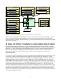
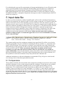
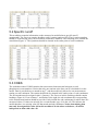
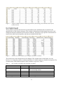
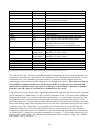
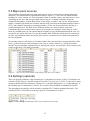
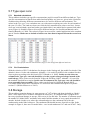
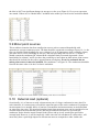
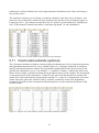
The FyrisNP model Version 3.2 – A tool for catchment-scale modelling of source apportioned gross and net transport of nitrogen and phosphorus in rivers A user´s manual Institutionen för vatten och miljö, SLU Box 7050, 750 07 Uppsala Rapport 2012:8 The FyrisNP model Version 3.2 – A tool for catchment-scale modelling of source apportioned gross and net transport of nitrogen and phosphorus in rivers A user´s manual Elin Widén-Nilsson, Klas Hansson, Mats Wallin, Faruk Djodjic & Caroline Orback Institutionen för vatten och miljö, SLU Box 7050, 750 07 Uppsala Rapport 2012:8 Institutionen för vatten och miljö, SLU Box 7050 750 07 Uppsala Tel. 018 – 67 31 10 http://www.slu.se/vatten-miljo, www.slu.se/vattennav Contents 1 MODEL HISTORY ................................................................................................................................................ 7 2 VERSION HISTORY ............................................................................................................................................. 7 2.1 2.2 2.3 VERSION 3.0 .......................................................................................................................................................... 7 VERSION 3.1 .......................................................................................................................................................... 8 VERSION 3.2 .......................................................................................................................................................... 8 3 MODEL DESCRIPTION ....................................................................................................................................... 9 4 USE OF OTHER MODELS TO CALCULATE INPUT DATA ....................................................................... 10 5 INPUT DATA FILE .............................................................................................................................................. 11 5.1 TEMPERATURE .................................................................................................................................................... 11 5.2 SPECIFIC RUNOFF ................................................................................................................................................ 12 5.3 COBS ................................................................................................................................................................. 12 5.4 CATCHMENT ....................................................................................................................................................... 13 5.5 MAJOR POINT SOURCES ....................................................................................................................................... 15 5.6 SETTINGS (OPTIONAL) ......................................................................................................................................... 15 5.7 TYPE SPEC CONC ................................................................................................................................................. 16 5.7.1 Standard calculations ............................................................................................................................... 16 5.7.2 .PLC5 calculations.................................................................................................................................... 16 5.8 STORAGE ............................................................................................................................................................. 16 5.9 MINOR POINT SOURCES ....................................................................................................................................... 17 5.10 EXTERNAL LOAD (OPTIONAL) ......................................................................................................................... 17 5.11 CONSTRUCTED WETLANDS (OPTIONAL) .......................................................................................................... 18 5.12 COMMENTS (OPTIONAL) ................................................................................................................................. 19 6 OUTPUT DATA .................................................................................................................................................... 19 6.1 6.2 6.3 7 RESULTS.XML ..................................................................................................................................................... 19 MONTECARLO.OUT .............................................................................................................................................. 19 RESULTS.OUT, RESULTS_AVERAGES.OUT ........................................................................................................... 19 INTRODUCTION TO THE VARIOUS WINDOWS OF THE MODEL ........................................................ 20 7.1 THE PROJECT MANAGER ...................................................................................................................................... 20 7.2 WORKSPACE PANEL ............................................................................................................................................ 20 7.3 PROJECTS PANEL ................................................................................................................................................. 21 7.4 THE GENERAL TAB .............................................................................................................................................. 21 7.5 THE DATA TAB .................................................................................................................................................... 22 7.6 THE Q-DATA TAB ................................................................................................................................................ 23 7.7 THE CALIBRATION TAB ....................................................................................................................................... 24 7.7.1 Settings ...................................................................................................................................................... 24 7.7.2 Results and plots in the calibration tab .................................................................................................... 26 7.7.3 Distributed parameter values.................................................................................................................... 28 7.8 THE SCENARIO TAB ............................................................................................................................................. 29 7.9 THE RESULT TAB ................................................................................................................................................. 29 7.10 INTERNAL LOAD ............................................................................................................................................. 29 7.11 SOURCES ........................................................................................................................................................ 30 7.12 APPORTIONMENT............................................................................................................................................ 31 7.13 CATCH CONTR ................................................................................................................................................ 31 7.14 OUT BUTTON .................................................................................................................................................. 32 7.15 THE CATCHMENT LISTBOX ............................................................................................................................. 32 7.16 OTHER FEATURES ........................................................................................................................................... 32 8 SPECIAL FEATURES ......................................................................................................................................... 32 8.1 8.2 8.3 REMOVAL OF EMPTY ROWS IN THE INPUT DATA TABLES...................................................................................... 32 COLUMN MODE SWITCH ...................................................................................................................................... 32 CATCHMENT OVERVIEW GRAPH .......................................................................................................................... 32 8.4 9 HOW TO START USING THE FYRISNP MODEL ........................................................................................ 34 9.1 9.2 9.3 9.4 9.5 9.6 10 FIGURE OPTIONS .................................................................................................................................................. 33 SYSTEM REQUIREMENTS ..................................................................................................................................... 34 INSTALLING THE PROGRAM ON YOUR COMPUTER ................................................................................................ 34 IMPORT DATA ...................................................................................................................................................... 34 STATISTICS USED FOR CALIBRATION ................................................................................................................... 35 CALIBRATION AND PARAMETER SENSITIVITY/UNCERTAINTY .............................................................................. 35 SCENARIOS .......................................................................................................................................................... 36 REFERENCES ...................................................................................................................................................... 36 1 Model history The dynamic Fyris model was originally developed by Hans Kvarnäs at the Dept. of Aquatic Sceince and Assessment at SLU 1 for calculating source apportioned nitrogen and phosphorus transport in the River Fyris catchment in central Sweden (Kvarnäs 1996). After this first application the model has been further developed in applications for the Lake Vättern catchment (Kvarnäs 1997), the Lake Storsjön catchment (Johansson & Kvarnäs 1998), catchments of coastal areas in Lake Vänern (Wallin et al. 2000) and the River Göta catchment (Sonesten et al. 2004). During 2005-2006 the platform for the Fyris model was changed from LabView (http://www.ni.com/labview) to Visual Studio and .Net Framework (http://msdn.microsoft.com/netframework). This user manual describes the new version of the model released in spring 2012. 2 Version history 2.1 Version 3.0 A number of changes and additions have been introduced since version 2 of the Fyris Model. Some examples are listed here: 1. The model can be used with weekly resolution in time in addition to the standard one month resolution. 2. It should no longer be necessary to provide input data using decimal point. The conversion from national to U.S. settings should be taken care of by the model. The reason why U.S. settings are used in the model is that the automatic conversion only works for this setting. 3. Column names changed in the Catchment data table such that units are included. 4. In the Minor Point Sources Excel worksheet, the user must specify a value for all subcatchments, even if there is no source (if so, set equal to 0). 5. Due to some changes in the internal model data tables, when loading older projects, the user should expect to see messages about changing the old project file. The model performs these changes automatically. However, if the original Excel file did not contain Minor Point Sources information for all sub-catchments, the user must change the input file manually and then start a new project. 6. The model can now simulate constructed wetlands. 1 former Department of Environmental Assessment 7 7. The model can also make use of a feature called External Load, meaning that in cases where only the lower part of a river system is of interest, the upper part can be added as external mass flows if the proper measurements exist. This is similar to a Major Point Source, except that both water mass flow rate as well as nutrient mass flow rate is added to the designated sub-catchment. 8. The Q-data tab now also provides values of specific runoff, flow rate, and hydraulic load for every sub-catchment. 9. An automatic calibration algorithm has been added. 10. It is possible to decide which measurement stations to include in the calibrations. 11. It is possible to choose between two different ways of computing the model efficiency, as well as a statistical measure involving the combined results for linear correlation, the model efficiency, and the variance. In addition to these changes, many minor alterations have been undertaken. 2.2 Version 3.1 The model changed name from Fyris to FyrisNP. The major change from version 3.0 is that a new graphics library is used in FyrisNP. The library, ZedGraph (http://zedgraph.org/wiki/), is licensed under the GNU Lesser General Public License, meaning that it can be included in FyrisNP for public use. For more information, consult the Zedgraph webpage at http://zedgraph.org/wiki/index.php?title=LGPL_License. Zedgraph offers some new functionality, including the ability to copy, save or print what you see in the graph. In addition, it is possible to zoom and pan the graph or display individual point values by hovering over a specific data point. The other important addition is a new plot of tree type that enables the user to view the structure of the catchment, i.e. the sub-catchments and the connections between them. This is a great help to make sure data was supplied and imported as intended. It is also a very effective technique to present data that is related to geography. 2.3 Version 3.2 Three major changes have been made to FyrisNP. • The first is the possibility of stepwise calibration, with different parameter values in different sub-catchments. When implementing the stepwise calibration several changes were made to the calibration tab. The plot was lift out to a separate window, while the calibration settings were moved from their separate window into the calibration tab. • The second is the possibility of calculating type specific concentrations for sub-catchments based on the nitrogen deposition (clearcuts in southern Sweden, according to Löfgren & Westling [2002]) or on altitude (forest, clearcuts and mires in northern Sweden, according to Löfgren & Brandt [2005]), analog to the PLC5 calcualtions (Brandt et al. 2008) • The third change is that retention is calculated also at negative temperatures. Important minor changes: 1. Added the possibility to set the working directory, i.e. the folder where the simulation files are to be stored. 2. Added program version to the program name such that old installations of FyrisNP will not be overwritten when the new program is installed. 3. Automatic average calculation of total averages for each sub-catchment, as well as averages for each month (Jan, Feb, etc.) and year. Additionally a lot of meta-data about the calculations added to Results.out and Results_averages.out. 8 4. In the catchment overview a possibility to plot the location of the nutrient measurement stations and the parameter values c0 and kvs have been included. Additionally the land-use areas are now shown in percentages of the sub-catchment areas, and a 0-100 scale can be chosen. 5. A possibility to already in the input file write comments about the input data which are seen in the general tab of the model. 6. Model efficiencies are now calculated for transports as well (but these values are not saved) 7. Increased the number of possible Monte Carlo simulations to 10000. 8. Bug fixes, e.g. a. Solved several bugs in the constructed wetlands module. b. Solved bugs occurring when calculating on a shorter timeperiod than the input data and the shorter timeperiod was implemented more consequent in the different calculations. c. Deletion of the currently open project is now blocked (user have to open another project first – there is no option to close the open project). d. New projects can be opened after another within the same FyrisNP session. (Previously FyrisNP had to be closed down before opening a second new project.) One additional major change is the possibility to do Monte Carlo runs also with the type specific concentrations, but this option is currently hidden in the standard versions of the program. 3 Model description The dynamic FyrisNP model calculates source apportioned gross and net transport of nitrogen and phosphorus in rivers and lakes. The main scope of the model is to assess the effects of different nutrient reduction measures on the catchment scale. The time step for the model is in the majority of applications one month and the spatial resolution is on the sub-catchment level. Retention, i.e. losses of nutrients in rivers and lakes through sedimentation, up-take by plants and denitrification, is calculated as a function of water temperature, nutrients concentrations, water flow, lake surface area and stream surface area. The model is calibrated against time series of measured nitrogen or phosphorus concentrations by adjusting two parameters. 9 Stream data and model lake data Type specific concentrations Observed N and P conc. Stream length and width Root zone leaching from arable and pasture land Temperature Lake area and volume Runoff Initial lake concentration Timeseries data Runof from forested land, clearcuts and wetlands Point source discharges Sub-catchment land use Forested land Model results (monthly data) Sub-catchment calculations Retention Clear cuts Net and gross transport Mire/wetlands Source apportionment Arable land Pasture land Athmospheric deposition Lakes Urban areas Figure 1. The general structure of inputs and outputs to the FyrisNP model. Data used for calibrating and running the model can be divided into time dependent data, e.g. timeseries on observed nitrogen and phosphorus concentration, water temperature, runoff and point source discharges, and time independent data, e.g. land-use information, lake area and stream length and width (see Figure 1). 4 Use of other models to calculate input data In Swedish applications with FyrisNP a major part of the input data is derived from the Swedish Pollution Load Compilation (PLC) reporting to HELCOM. The fifth PLC (PLC5) is the latest report (Brandt et al. 2008). Depending of the modelling scale PLC-data are usually complemented with local and regional data with higher spatial and temporal resolution. Some of the PLC-data are derived using different models. These models as well as some complementary models are summarised below For several years SLU researchers have been developing robust calculation models that can be used to estimate leaching of both nitrogen and phosphorus from Swedish arable land and to see how leaching is affected by various measures. The NLeCCS (Nutrient Leaching Coefficient Calculation System) modelling system comprises the SOILNDB and ICECREAMDB models. The dynamic SOILNDB model (Johnsson 2002) is used for calculating type-specific concentration of nitrogen in leaching from agricultural land. For calculating the type-specific concentration of phosphorus in run off from agricultural land the dynamic ICECREAMDB model (Larsson et al. 2007) is used. The NLeCCS modelling system generate the type-specific concentrations for a given nutrient (N or P) as an annual average concentration normalized for climatic conditions during a longer time period and typical for a combination of crop and soil types (for phosphorus also for P-content in the soil and slope). More details about the calculations of type specific concentrations in runoff from arable land is described in Johnsson (2008). 10 For calculating the type-specific concentration of nitrogen and phosphorus in run off from forested areas a regression model is used (Löfgren & Westling 2002). Several options are available for calculating runoff and water discharge. Examples are the HYPE model (Lindström 2010), the HBV model (Bergström 1995), the Q model (Kvarnäs 2000) or FyrisQ, the windows version of WASMOD (Xu 2002). Atmospheric deposition of nitrogen on water is calculated by the MATCH model (www.smhi.se). 5 Input data file In order to perform simulations with the FyrisNP model, an Excel-file containing all input data is required. Any name may bee chosen for the Excel file as long as it has the .xls extension. Input files made in Excel 2007 or Excel 2010 should be saved as in Excel 97-2003 file format to get the .xls extension and to be able to open it in FyrisNP.The Excel data file contains between eight and twelve different worksheets depending on what features are used (Figure 2). The inclusion of the External load, Constructed wetlands, Settings and Comments worksheets is optional, but the Storage worksheet must always be supplied (it can be empty if no storage is considered). The order of the worksheets in the workbook is of no importance, however, the names and content of each worksheet must obey the guidelines in this manual. Make sure the name of the worksheet is spelled according to Figure 2, and that the upper/lower case is correct! Remember to include N or P in the file name. Figure 2. The worksheets required in the Excel workbook Optional worksheets are “External load“,“Constructed wetlands”, “Settings“ and “Comments“. The contents and layout of the worksheets included in the input Excel file will be covered in the following paragraphs. First, the worksheets containing the driving variables, i.e. temperature and runoff, will be described. The temperature worksheet is governing the setup of the internal data tables and arrays of the program; in other words, the program will set up everything to fit the time period specified in this file. Make sure that the temperature worksheet and the runoff worksheet cover the same time period, and that values are specified for every month (or week)! Additionally, observed concentrations, major point sources, and external load must match this time period and resolution. The model requires input data time series to start in January. It is later possible to restrict the calculation to any time-period in the Calibration tab Additional worksheets are allowed, although not recommended. They will give a critical model error message, but are thereafter ignored by the model. 5.1 Temperature This worksheet includes data on measured water temperature (monthly mean) from a station in the modelled catchment or from a nearby station outside the catchment. If such data are not available, data on measured air temperature (monthly mean) is an acceptable approximation of water temperatures. The columns from left in the temperature worksheet are: Year; Month (1-12); Number of days per month (28-31) and Temperature (˚C) (Figure 2). These data are used for all sub-catchments in the model and you have to fill in a row for each time step of the model. This means that if the model includes data for 5 years (60 months) you have to fill in 60 rows. The model requires input data time series to start in January. Make sure to include a header row since data is imported from the second row down. 11 Figure 2. A snapshot from a typical Temperature worksheet. 5.2 Specific runoff This worksheet contains information on the measured or modelled area-specific runoff (mm/month). The first row contains headings, and Q-station numbers (ID). The Q-station numbers should be in increasing order, but need not be consecutive numbers. The following rows contain the actual data (Figure 3). The Q-stations should be situated in the outlet point of a sub-catchment. Figure 3. The Specific runoff worksheet. 5.3 COBS The worksheet named COBS contains data on measured nutrient (total nitrogen or total phosphorous) concentrations. Notice that only one nutrient at the time can be calculated for in the model. Data is provided once a month in mg l-1, and the model only allows for one measurement station per sub-catchment. The station should also be situated in the outlet point of a sub-catchment. The first month must be assigned value 1 (January). The first row in this worksheet should contain headings (Figure 4). From column C, and further to the right, the sub-catchment ID corresponding to the measurement station should be provided. Only include the sub-catchments for which there are measured values. If values are missing for a certain month, type -99 in the cell. This informs the model that there is a missing value for that month and sub-catchment. Notice that missing data may only be assigned the value -99 in this worksheet! In the other worksheets, -99 will be interpreted as data with value -99. 12 Figure 4. A typical COBS worksheet containing measured (and missing) concentration values of the studied nutrient. 5.4 Catchment This worksheet contains characteristics on the different sub-catchments that is needed for the quantification of the nutrient transport. This includes information on hydrological network of subcatchments and sub-catchment specific data on land-use, deposition, type-specific concentration in runoff from arable land and pasture and data on included model lakes. Figure 5. The first rows and columns of an example Catchment worksheet. The position for each column must not be changed. The variable name in the header row can, however, be changed (possible to include translation of variable and more detailed description). The variable names, units and description of the variables are given in Table 1. Table 1. The variables included in the Catchment worksheet. Variable name Catchment ID Station ID Unit - Downstream ID Area Lake Area Stream Length km2 km2 m Description Sub-catchment ID-number The ID-number of the nearest downstream flow measuring station. Downstream sub-catchment Total area of sub-catchment Lake area Stream length 13 Stream Area Mountain Forest Clearcuts km2 km2 km2 km2 Mire Arable Pasture Open land Settlements Urban cArable cPasture Altitude km2 km2 km2 km2 km2 km2 mg/l mg/l m Lake Model Dep Lake kg/month/km2 kg/week/km2 kg/month/km2 kg/week/km2 km2 m m3·106 mg/l Dep Clearcut Model Lake Name* Model Lake Area Model Lake Depth* Model Lake Volume Initial Lake Concentration Stream area Mountain area (above tree line) Forested area Clear cuts (not older than 5 years in S Sweden and 10 years in N Sweden) Mire/Wetland Arable land Pasture Other open land Settlements** Urban areas** Type specific concentration from arable land Type specific concentration from pasture Altitude above sea level. Used to identify Northern Sweden in the PLC5 type calculations. Set to 0 for Southern Sweden. 1 = Yes, 0 = No Nitrogen deposition on lakes (zero for P), monthly or weekly values Nitrogen deposition on clearcuts (zero for P), monthly or weekly values Model lake area Model lake mean depth Model lake volume Initial concentration for model lakes * Parameter currently not in use in the model. ** Settlements and urban areas do have the same type specific concentration (see 5.7). The outflow ID in the Catchment worksheet contains information on how the sub-catchments are connected to each other. If, for instance, sub-catchment 1360 is immediately downstream of subcatchment 1348, 1360 should be typed into column C (Downstream ID column) on the row containing the sub-catchment 1348 information (see example in Figure 5). The outlet area for the whole model catchment should have the downstream ID -1. At present, the catchment ID must be in a form that can be converted to an integer, i.e. preferably it should be a number from the start. ID’s such as 1234-5678 or Catchment1 do not work! Large lakes with water turnover time significantly higher than the time step of the model (1 month) may be included as “Model lakes” in the Catchment worksheet (Tab. 1). For these lakes additional information is needed (area, volume and initial concentration). A yearly mean concentration from the beginning of the calibration period can be used as initial concentration. The purpose of the initial concentration is for the model to find a stable modelled concentration as quickly as possible. Please note that the initial lake concentration is used even if the calculations are specified to start at a later time step. The “Model lakes” are assumed to be situated close to the outlet of the subcatchment and, hence, receive the total load from sources after retention in the sub-catchment. Furthermore, there can only be one “Model lake” per sub-catchment. Information on water storage in “Model lakes” is inserted in a separate worksheet (see section 5.7). Please note that even if you do not use the “Model lakes” the columns concerning model lakes cannot be empty. The “Model Lake Name” can e.g. be set to “-“. 14 5.5 Major point sources This worksheet contains data from large point sources such as wastewater treatment plants and industries. The data should be organized according to Figure 6, i.e. the first row should contain headings for every column. It is of no importance what is actually written, just make sure to write something on line one, and start providing data on row two. Column A should contain the catchment ID-numbers, column B the name of the facility, column C the year for which the data applies, column D the month for which the nutrient load is measured/calculated (numbered from 1 to 12), and column E the load per month (kg month-1). There can be more than one facility in a certain catchment area. The data for the different facilities are inserted below each other. Catchments that have no major point sources do not need to be included. If only data on yearly loads are available and you can assume that the loading is evenly distributed through the year you may divide the yearly load with 12 to get the monthly load. While the model lakes are assumed to be at the sub-catchment outlet, the major point sources are assumed to be situated far upstream in the sub-catchment. No missing values are allowed so for months with no data you must insert an approximation of the load, e.g. the load for the same month previous year or a mean value for e.g. the previous three months. If your simulated catchment has no major point sources, you must put a fictive major point source in this sheet, with load 0 kg/month. Figure 6. The first rows and columns of the Major point sources-worksheet. 5.6 Settings (optional) This is an optioal worksheet if the standard type of calculations is chosen. If PLC5 calculations are selected cell B2 (Figure 7) should contain the text PLC5 (or plc5, plc 5 or PLC 5) and cell A2 must contain information of the substance (Nitrogen, N, n, nitrogen, Phosphorus, P p or phosphorus). If the standard type of calculations is chosen, one can also write Standard (or standard) in cell B2. The phosphorus calculations will be similar for both the PLC5 and the standard alternative. The selection of PLC5 will affect how the type specific concentration is written. Figure 7. The Settings worksheet for PLC5 type calculations of nitrogen. 15 5.7 Type spec conc 5.7.1 Standard calculations This worksheet includes type-specific concentrations (mg/l) in runoff from different land use. Typespecific concentrations in runoff from arable land and pasture are, however, given in the Catchment worksheet thus allowing different concentrations to be used for different sub-catchments. The values in the Type spec conc worksheet can vary with season requiring one value for each month of the year (12 rows). The land use classes are from the left: mountain areas (above tree line), forests, clear cuts, mire/wetlands, open land (other open land which is not arable land or pasture) and urban areas (Figure 8). Suitable values to be used for different land use for Swedish catchments can be found in Brandt et al. 2008. The values in Figure 8were used for a model application in the southern part of Sweden. Make sure to include a header row since data is imported from the second row down. Figure 8. 5.7.2 Type specific nutrient concentrations (mg/l) in the runoff from different land uses. .PLC5 calculations With the selection of PLC5 calculations for nitrogen in the Settings tab, the model first checks if the altitude is above 0 in the sub-catchments. Altitudes = 0 is used in FyrisNP for the southern Sweden forest regions according to the division in PLC5 (Brandt et al. 2008). In this case the clear cut column in the Type spec conc tab should be set to the organic nitrogen leakage instead of the total leakage. These values can be found in Löfgren & Westling (2002). Altitudes > 0 is used for the northern Swedish forest region. In this case all columns in the Type spec conc tab should be set to a monthly factor around 1. These values can be found in Löfgren & Brandt (2005). For further details about these calculations it is referred to the technical description of FyrisNP version 3.2 (Widén-Nilsson et al. 2012). 5.8 Storage This worksheet contains changes in water storage (m3·106) in lakes and dams included as “Model lakes” in the model (see Catchment worksheet in section 4.1). If a modelled lake is judged not to have any significant changes in storage, fill in zeros (0) for this lake. The number of columns equals the number of “Model lakes” and dams in the model and the number of rows equals the number of months. Include a header row, where the column headers are the catchment IDs of the subcatchment the model lake belongs to. The catchment IDs should increase from left to right. In the example in Figure 9, there are two model lakes – one in sub-catchment 1367 and one in 1407. Only 16 the lake in 1407 has significant changes in storage over the year (Figure 9). Every row represents one month. If there are no “Model lakes” included in the model you can leave the worksheet blank. Figure 9. The Storage worksheet. 5.9 Minor point sources This worksheet contains data from small point sources such as scattered households with autonomous sewage treatment system. The data should be organized according to Figure 10, i.e. the first row should contain headings for every column. It is of no importance what is actually written, just make sure to write something on line one, and start providing data on row two. Column A should contain the catchment ID, column B the calculated load per month (kg month-1) from households. In column C and D you have the possibility to insert data on other minor point sources that should be included in the source apportionment calculations. Even if a catchment has no minor point sources it must be included, like catchment 7 in Figure 10. The catchments should be listed in the same order as in the Catchment worksheet. Figure 10. The first rows and columns of the Minor point sources worksheet. 5.10 External load (optional) Occasionally, it is of interest to study a downstream part of a larger catchment in more detail. In such situations, it is unnecessary to model the upstream parts of the entire catchment if continuous measurements (on a monthly basis) of nutrient concentration and measurements or modelled data on water flow rate exist. The measured nutrient input from upstream areas can be considered as an external load on the downstream system, and may be added as an input to a specified subcatchment. Notice that the actual external load will not end up in any results plot specified as external load. However, it will be implicitly visible since the sub-catchment it is directed to, will most likely have a quite high impact on downstream areas as compared to other similar sub- 17 catchments. It will not influence the source apportionment calculations since it does not belong to any specific source. The worksheet contains year in column A, month in column B, water flow rate in column C, and mass flow rate of nutrients in column D. Pay attention to the first line of the worksheet (Figure 11). Looking at cell C1, Qe4 denotes external flow rate (m3 month-1) to sub-catchment 4. Similarly for cell C4, Me4 denotes external mass inflow of nutrients (kg month-1) to sub-catchment 4. Figure 11. The first rows and columns of the External load worksheet. 5.11 Constructed wetlands (optional) The Constructed wetlands worksheet contains technical information as well as data on the geometry and degradation characteristics for every wetland (Figure 12). Looking at column B, it contains a logical switch that determines whether the constructed wetland shall be taken into account for the specific sub-catchment or not (0 = not included, 1 = included). Column C contains the surface area in km2 of the wetland. Column D contains the mean depth in meters of the wetland. The mean depth is currently not used in the calculations. Column E is the Qfraction that decides how much of the stream flow is diverted from the stream into the wetland, i.e. a value of 0.3 indicate that 30% of the stream water flow passes the wetland. Finally, column F contains the value of the degradation constant k. For details on the conceptual model and equations, see the technical description of the FyrisNP Model. Figure 12. The first rows and columns of the Constructed wetlands worksheet. 18 5.12 Comments (optional) This is an optional worksheet, giving the user the possibility to add information about the data constituting the input data file. It will be seen in the Comments box in the General tab of the model. The comments are written on row 1-8 in column B in the worksheet (Figure 13). Figure 13. The Comments worksheet. 6 Output data The program produces two major output files: montecarlo.out, and results.xml. montecarlo.out contains information regarding the Monte Carlo simulation of the project, provided such a simulation has been performed, while results.xml contain all other results. Optionally, by clicking the write file button in the Results tab, it can also write the files results.out and results_averages.out. 6.1 Results.xml The content of this file can be viewed in the graphical user interface of the FyrisNP model (see chapter 6 of this manual), but may also be opened in external programs for data analysis. It is however recommended that the user instead export data using the write file button in the Results tab window to obtain two semi-colon separated text file named Results.out and Results_averages.out. These file can be opened in Excel and contains the information included in the Result tab described in section 6.3 6.2 montecarlo.out This file contains the parameter values and model efficiencies, as well as the correlation coefficients, for all Monte Carlo simulations performed within the project (table 2). Table 2. The content and organization of data in the montecarlo.out ASCII file. Column 1 c0 2 cT (= 20 °C) 3 kvs 4 E 5 R empirical calibration parameter for temperature dependency upper limit in °C for temperature dependency empirical calibration parameter for hydraulic dependency model efficiency according to Nash & Sutcliffe (1970) the linear correlation coefficient A more detailed description of the parameters in the montecarlo.out file is given in the technical description of FyrisNP version 3.2 (Widén-Nilsson et al. 2012). 6.3 Results.out, Results_averages.out The results files contain time series with the following columns: Catchment ID, Year, Month, Retention, Mass flow rate, Concentration, Station ID, Lake model, Q, Area, Mountain, Forest, 19 Clearcut, Mire, Farmland, Pasture, Open Land, Built, Urban, Major point sources, Households, Minor 1, Minor 2, Lake deposition. The retention is the retention occurring in the corresponding sub-catchment, acting on both the load from the sub-catchment itself, as well as on the contribution from upstream sub-catchments. The mass flow rate is the outflow in kg of nitrogen or phosphorous from the sub-catchment. The concentration is the corresponding sub-catchment outflow concentration in mg/l. The mass flow rate divided by the water flow Q gives the concentration. The sum of the columns from Mountain, Forest and onwards give the gross load from the sub-catchment. 7 Introduction to the various windows of the model 7.1 The project manager The project manager is where you organize the work you carry out using the FyrisNP model. The project manager comprises three parts, working directory, the workspace panel and the projects panel (Figure 14). The project manager is open by clicking on Menu > Projectmanager in the main program window. The default working directory is in the program file folder of FyrisNP, but it can be changed to e.g. My Documents. The workspace is essentially a directory on your computer (found under the FyrisNP model directory) that contains a number of projects. A possible way of organizing your work is to give the workspace the same name as the catchment and nutrient (N or P) you currently study, and then store all simulations related to that catchment as projects in that workspace. If you click any workspace in the list, the projects belonging to it will show up to the right. Figure 14. The project manager window. 7.2 Workspace panel The “New” button allows the user to create a new workspace, and the delete button allows the user to delete a workspace – but ONLY if it is empty. Thus, the user must delete all projects within the 20 workspace first and then delete the workspace itself. The rationale behind this procedure is to reduce the risk of undesired deletions of work projects. 7.3 Projects panel – The New button creates a new project by prompting the user to import an Excel file. The user should browse to the desired Excel file and open it. The data in the Excel file will now be imported if the contents fulfil the requirements on it. – The Delete button is used to delete a project. Only one project at a time can be deleted. – The Copy button is used to copy an entire project to a new project for which the user will be prompted to provide a name. All settings and results of the old project will be copied to the new one, except the text written in the comments box of the General tab. – The Open button opens the selected project. The same action will be taken by double-clicking a project in the list. The project file name may not contain any point characters, “.”. Several instances of FyrisNP can be open, allowing the user to work simultaneously with multiple simulations. 7.4 The General tab The general tab provides the user with some significant numbers concerning the project at hand (Figure 15). These numbers can be used for a quick check that data was loaded properly. You can also store comments about your project in the large textbox. The first lines of information contained herein will be visible in the project manager. 21 Figure 15. The “General tab” is the first thing the user sees of the actual model. It contains general information of the projects such as number of sub-catchments and time steps (months or weeks), number of measurement stations for water discharge (Q-stations) and nutrient concentration (cstations) and number of lake models included. If information is given in the Comments or Settings tab it will also be shown here. 7.5 The Data tab Under the data tab one can find data tables corresponding to the worksheets of the input data Excel file (Figure 16) by clicking the corresponding button on the left. These data tables are useful for checking that the import of data worked well. As of version 3.1 of FyrisNP, the data can also be visualised in a tree plot by pressing the “Catchment view” button in the upper right corner. 22 Figure 16. The “Data tab” is useful for browsing the input data tables making sure that all information was imported correctly. Buttons for Constructed wetlands and External load only show up if such worksheets are present in the input file. 7.6 The Q-data tab The data under the Q-data tab shows the Q-stations data, storage in model lakes, and for all subcatchments: area specific runoff, flow rate, and hydraulic load (Figure 17). Figure 17. The Q-data tab contains data regarding runoff, storage, specific runoff, flow rate and hydraulic load. 23 7.7 The Calibration tab The basic idea of this tab window (Figure 18) is to provide means of calibrating your model, and evaluate how sensitive the chosen goodness-of-fit value is to changes in parameter values (see section 9.5). Manual calibrations, automatic calibrations and Monte Carlo simulations may be used to find out the optimum set of parameter values. The user can specify calibration specific settings (Table 3). Performing an ordinary simulation with FyrisNP is quite straight-forward. Select manual calibration, enter calibration settings, select parameter values for c0 and kvs, and push the “Run” button. Parameter c0 is allowed to vary between 0 and 1, and parameter kvs from 0 and up. However, kvs values above 30 are considered quite rare. The simulated results are presented in graphs as time-series for the catchments having nutrient measurement stations (Figure 20). The influence of parameters c0 and kvs can be analysed by means of Monte Carlo simulations where parameter values are generated randomly according to user specified uniform distributions. The results can be visualised through scatter plots (Figure 22). The scatter plots reveal if any parameter is redundant, and will also give information about what parameter values will give the best fit to the measured data. The parameter values (c0 and kvs) giving the best fit to measured data generated with Monte Carlo simulations are then typically used to run the model in manual calibration mode. Figure 18. The calibration tab. 7.7.1 Settings The calibration settings include specification of the time period you want to simulate. The FyrisNP model does not use date information of any sort, thus months are simply numbered from one and up. In addition to time period, the user can specify which observation stations (IncludeObs) to include in the calibration. I.e., the statistics will only be based on the checked stations in this list. 24 Table 3. The calibration settings in FyrisNP explained for the three modes of calibration. .The manual calibration settings are the c0 and kvs values. The Monte Carlo settings include number of Monte Carlo simulations to perform. Currently, the maximum number is limited to 10 000. When carrying out a Monte Carlo simulation, the parameters are randomly selected from an interval. Only uniform distributions are used in FyrisNP. In the example to the left, the parameter values are thus randomly selected 300 times from the specified intervals, 0 to 0.6 for c0, and 5 to 30 for kvs. Parameter c0 may vary between 0 and 1, and parameter kvs from 0 upwards. The settings for automatic calibration contain two criteria for judging when the calibration process should be terminated. The first is simply the maximum allowed number of iterations, the second is a condition related to the method used. The given number is associated with the difference in model efficiency between the worst and best simulations of the current simplex. Put in other words, for the specific example, it would be very surprising if an unknown parameter combination exists, that would result in a model efficiency exceeding the best known simulation with more than 0.01. In general, the model efficiency surface is quite smooth. The algorithm searches within the limits specified by the user. The automatic calibration makes use of the Simplex algorithm (Sorooshian & Gupta 1995) to find the parameter combination giving the best model efficiency within the user specified parameter interval. This automatic calibration algorithm seems very efficient and reliable for the simple model structure in FyrisNP, having only two calibration parameters. 25 7.7.2 Results and plots in the calibration tab Efficiency and r value for both concentrations and transports are shown after a manual calculation (Figure 19). When opening an old project, the efficiency and r value of the concentration calculations can be seen, but transport efficiency and r value needs to be recalculated. Figure 19 Efficiency values of concentrations and transports from a manual simulation. Results of a manual simulation can be plotted as time series of concentrations or transports in each sub-catchment with measurements (Figure 20). The simulated concentrations or transports can also be plotted versus the corresponding measured values (Figure 21). Model efficiency and r values for different c0 and kvs values of the Monte Carlo simulations are plotted when clicking the Plot button when Monte Carlo is selected (Figure 22). Figure 20. The plot shows a manual time series simulation of nitrogen concentration in catchment 3. 26 Figure 21. The plot shows a simulated nitrogen transports versus measured nitrogen transports in a catchment. Figure 22. The plot shows an example Monte Carlo simulation consisting of 1000 individual simulations. Every single simulation is plotted as a dot where the model efficiency is a function of the value of the calibration parameter kvs. The Calibration tab includes in addition to the calibration options discussed above, radio buttons for selection of statistic approach (see paragraph 9.4 for more information), textboxes displaying 27 parameter values and statistical measures, and buttons for running the model and plotting simulations and data. Figure 23 The resulting view after a Monte Carlo simulation have been performed. The arrow shows the copying of the best Monte Carlo or automatic parameter values to the settings for a manual simulation. Tip: pushing the “Best MC/Best Automatic” button will copy the parameter values to the corresponding textboxes used in manual simulations (Figure 23). You must always end with a manual calibration run in order to see the results. 7.7.3 Distributed parameter values FyrisNP has a possibility to use different parameter values for different subcatchments. This gives the possibility to do a step-wise calibration of c0 and kvs, starting in the headwaters and continuing downstream. This function is only recommended for advanced users. To activate this feature, unclick the “Uniform” checkbox. More columns will then be seen in the in the tabular area (here referred to as the data grid view) of the calibration tab. Clicking IncludeSub means that that sub-catchments, including its all upstream sub-catchments, will be included in the calculation. IncludeObs is similar to the calculation with uniform parameter values, i.e. it tells if the concentration measurements of that sub-catchment will be used in the model performance statistics or not. If OwnValues is checked, the parameter values of that sub-catchment will be fixed to the ones listed in the table and will not be varied in a Monte Carlo or automatic calibration. 28 7.8 The Scenario tab This tab is currently not in use. In order to run different scenarios you have to make the changes in the input file and upload it as a new project. Then run the model using the original calibration settings and without any data on measured nutrient concentrations. 7.9 The Result tab Figure 24 The “Result tab” provides the means to display, copy and export output data as well as program procedures to e.g. perform source apportionment. The Result tab lets you look at the entire results file in itself, sorted according to sub-catchment. In addition, it provides the user with the possibility to automatically perform various computations by pressing the buttons “Internal load”, “Sources”, “Apportionment”, “Catch contr” (Figure 24). These buttons are explained in the following sections. 7.10 Internal load Pressing this button presents in the tabular area (here referred to as the data grid view) of the Results tab the internal gross load (before retention) in each sub-catchment, and the net contribution (after retention) of each sub-catchment to the sub-catchment itself summed over the entire simulation period. The results can be viewed in the plot window (Figure 25). Please note that while the gross contribution can be summed for all sub-catchments, it is not allowed to sum the net contribution as it will give a too high value. To get the net contribution of each sub-catchment to the downstream sub-catchment, see the column “Contribution at outlet” of the downmost sub-catchment in the “Catch contr“ button. 29 Figure 25. The bar chart presents the nutrient contribution per sub-catchment, before (gross) and after (net) retention within the same sub-catchment. 7.11 Sources After the computation, the data grid view will contain the gross contribution (before retention) of the different sources in each sub-catchment summed over the entire simulation period. The results can be viewed in the plot window (Figure 26). Figure 26. The bar chart presents the source composition for every sub-catchment. 30 7.12 Apportionment Clicking this button will start the computation of the source apportionment of the total upstream net load (after retention) calculated for the outlet of the sub-catchment that is chosen by inserting its catchment ID in the textbox labelled Out in the left margin of the Result tab (Figure 24). I.e. it is possible to make an upstream source apportionment for every sub-catchment outlet in the system if wanted. The upper row of the presented data contains the actual net load in kilograms per month that each source contributed with at the chosen outlet point. The lower row comprises the corresponding fractions of the load. The results can be viewed in the plot window (Figure 27). Figure 27. The source apportionment presented graphically by means of a pie chart. 7.13 Catch contr Clicking this button will start the calculation of the nutrient mass contribution in kilograms per month from each sub-catchment to the chosen outlet. As mentioned in paragraph 7.12, the outlet catchment is selected by inserting its ID number in the textbox labelled Out (Figure 24). The column labelled “Contribution at source” contains values that are identical to the values presented as gross contribution when pressing the internal load button. The column labelled “Contribution at outlet” contains the load from this sub-catchment at the chosen outlet point, i.e. after retention in every downstream sub-catchment on the way to the outlet. The column “Mean retention coefficient” contains the mean retention ratio in each sub-catchment. The column “Delivered fraction” contains the ratio of the “Contribution at outlet” to the “Contribution at source”. Please note that the “Mean retention coefficient” and the “Contribution at source” are calculated for the sub-catchment itself, while the “Delivered fraction” and the “Contribution ad outlet” varies depending on which subcatchment is used in the Out textbox. Please note that the order of the sub-catchments in the results from ”Catch contr” button is different from the order of the input data. The data can be viewed in the catchment overview graph (Figure 28) provided that the results table contains the appropriate data. 31 7.14 Out button By clicking the Out button the outlet sub-catchment will automatically be inserted in the textbox labelled Out (Figure 24). 7.15 The Catchment listbox Clicking any of the catchment ID numbers in this listbox will present the part of the complete results file relating to the chosen ID. 7.16 Other features Other features of the Result tab are: Tip: copy the present contents of the data table to the clipboard by clicking the Copy button. save the entire results file (consisting of all catchment ID data tables) to a semi-colon separated text file called results.out by clicking the Write file button. A second file, results_averages.out, with averages for each year and subcatchment, each month and subcatchment as well as a total average for each subcatchemt is also written. These two files do also contain meta-data about the simulation, such as input data file name, parameter settings and calibration results. 8 Special features 8.1 Removal of empty rows in the input data tables If the program imported more rows from the Excel worksheet than are filled with data, you can double-click on a row header in any data table shown under the data tab to remove all rows where the first cell is empty. The model will not run if there is more than one empty row after the last data filled row. 8.2 Column mode switch Under the data tab, you can change column mode by clicking the salmon coloured little square in the bottom right corner. 8.3 Catchment overview graph The catchment overview graph depicts the catchment structure, i.e. linking sub-catchments, and thus showing the water flow directions. The sub-catchments are visualised as boxes, corresponding to the model concept of the FyrisNP model. It can be used at anytime by pressing the “Catchment overview” button in the upper right corner of the program window. The boxes can be coloured, where the colours represent a user selected variable of interest (Figure 28). The catchment overview graph enables immediate identification of sub-catchments which for some reason deviate from the rest, and is thus a useful tool in the process of understanding the system and identifying key processes. Three types of data can be visualised in the catchment overview, namely input data, calibration data and output data. The input data contains, apart from areas, information about the usage of the lake module and the deposition on lakes and clearcuts. The calibration data contains the position of the observed chemical data and the calibration parameter values. The output data contains the four columns from “Catch contr”. 32 The colormaps are either defined over the range from minimum to maximum value of the data shown or, by clicking the 0-100 check-box, over the range from 0 to 100. The latter is mainly useful the for percentage values of the areas. Figure 28. The catchment overview graph, showing delivered fractions of nitrogen to the catchment outlet. 8.4 Figure options It is possible to zoom in any of the plots from the Calibration tab, Results tab or Catchment overview plot by marking the area to focus on with the mouse. Right-clicking will give several options to change the scale of the figure back (Figure 29). Right-clicking will also give the possibility to copy the figure to the clipboard and to highlight point value (Figure 29). If Show Point Values is clicked, point values will show up when moving the mouse over the figure. 33 Figure 29. Available options when right-clicking in a figure. 9 How to start using the FyrisNP model 9.1 System requirements In order for the FyrisNP Model to run properly on your computer, it is required that you have Windows XP, Vista or 7 including .NET framework installed. The .NET-framework should be provided with Windows Service Pack 2 for Windows XP, but can otherwise be installed separately from Windows homepage. Furthermore, Office 2003, 2007 or 2010 is required since the input data is imported using an Excel workbook. 9.2 Installing the program on your computer A standard set up program comprising two files (setup.exe and Setup Fyris Model.msi) is provided for installation of the FyrisNP model on your computer. The program will check your computer to make sure that the .NET-framework is previously installed, and will encourage you to download it if it is missing. During the installation you have the possibility to decide in what folder you want the program installed, and the set up program will create a desktop shortcut as well as a start menu shortcut. If your computer is connected to a network, it is likely that administrator rights are needed for the installation. From version 3.2.0.6 the program will be installed to a folder named with the version number. It is thus it is possible to have several program versions installed. Installation of new program versions will not overwrite the older program versions. The FyrisNP icon in the Windows Start menu points to the most recent program version. 9.3 Import data The first thing do to when you want to start working with the FyrisNP model is to import the data needed to run the model. The requirements on the input data have been mentioned in chapter 4 of this document. A short walkthrough is provided here: Open the project manager using the Menu. If needed, create a new workspace which will contain your projects by clicking the new button in the workspace panel. Create a new project by clicking the new button in the projects panel. A dialog will emerge and show Excel files in the directory last used on your computer. Browse to the Excel file you want to use as data source, and open it. 34 Even if no error messages appeared during the opening of the Excel file, it might be a good idea to look through the imported data to make sure it was imported as expected. This can be done by browsing the data tables in the data grid view under the Data and Q-data tabs respectively. If there is more than one empty line beneath your imported data, remove it (paragraph 8.1). If you get error messages when importing the input data file check that: all time series data (nutrient conc., runoff, temp., point source discharges) cover the same time period, that the sub-catchment network is correct (downstream ID:s in the Catchment worksheet) and that the excel file contains no equations or functions in the imported cells. 9.4 Statistics used for calibration In order to evaluate the fit of simulated to measured values, two statistical measures are used in the FyrisNP Model: the model efficiency, Eff, and the linear correlation coefficient, r. Eff = 1 implies that the measured and modelled series are identical, and E = 0 indicates that the simulation is no better than a straight line representing the average value of the observations. The FyrisNP Model supports two modes of statistical measures calculation: 1. One series: E and r are calculated based on all selected pairs of observed and simulated concentrations; i.e. all value-pairs are lumped before calculation of E and r. This is the default setting. This calculation gives usually high values of E since the comparison is made against a mean value of the observed values that is far from the individual observation points. 2. Multiple series: E and r are calculated separately for each selected sub-catchment and then the arithmetic average is taken. 9.5 Calibration and parameter sensitivity/uncertainty Good modelling practice requires the user to calibrate the model such that the computed output compares well to the measured data. This is done by means of adjusting the model parameters, c0 and kvs. The model provides the user with three different methods for calibration and/or evaluation of sensitivity to individual parameter values. It is possible to choose which sub-catchments to include or exclude in the calibration procedure. The time period can also be specified. 1. The manual calibration allows the user to manually change both parameter values (c0 and kvs), after which the model performs one simulation over the selected time period, using data from the selected measurement stations to calculate the model efficiency and the linear correlation coefficient. The user can inspect the simulation by looking at time-series graphs, or graphs of simulated versus observed concentrations for the selected sub-catchments. The manual calibration is useful for getting acquainted with the model behaviour, and provides graphical means of performing a more subjective eye-pleasing calibration which is occasionally preferred. 2. In the Monte Carlo simulation, the user specifies a uniform distribution of values for both parameters, and the number of individual simulations to carry out. As was the case for the manual calibration, the simulation covers the selected time period, and the selected instream concentrations are used to calculate model efficiency and the correlation coefficient. The outcome may be analyzed graphically in the model by means of scatter plots. 35 3. The automatic calibration option uses the Simplex algorithm (Sorooshian & Gupta 1995) to find the optimal parameter values within user specified parameter intervals. The optimal parameter values are considered to be the ones that provide the highest E value for the chosen calibration set up. The result is presented by means of parameter values, plus E and r values calculated in accordance with the selected statistical mode as presented in the previous paragraph. When you feel confident with the results, it is time to start with scenario modelling as described below. 9.6 Scenarios The scenarios need to be created by the user by means of altering the input data, and then reimporting the data to the model to see the changes in output. Remember to keep the same parameter values as was found during the calibration process. 10 References Brandt, M., Ejhed, H. & L. Rapp 2008. Näringsbelastningen på Östersjön och Västerhavet 2006. Sveriges underlag till HELCOM:s femte Pollution Load Compilation. – Naturvårdsverket, Rapport 5815, 2008 (Nutrient loads to the Swedish marine environment in 2006. Sweden’s Report for HELCOM’s Fifth Pollution Load Compilation. Swedish EPA Report 5815). Johansson, J-Å. & H. Kvarnäs, 1998. Modellering av näringsämnen i Storsjön och dess tillrinningsområde. Länsstyrelsen i Gävleborgs län. Rapport 19998:13. ISSN 0204-5954. (Modelling nutrients in Lake Storsjön and its catchment. – County Administration of Gävleborg. Report 1998:13). Johnsson, H., Larsson, M.H., Mårtensson, K. and M. Hoffmann 2002. SOILNDB: a decision support tool for assessing nitrogen leaching losses from arable land. Pages 505-517. – Environmental Modelling & Software 17:505-517. Johnsson, H., Larsson, M., Lindsjö, A., Mårtensson, K., Persson, K. and G. Torstensson, 2008. Läckage av näringsämnen från svensk åkermark. Beräkningar av normalläckage av kväve och fosfor för 1995 och 2005. – Naturvårdsverket, Rapport 5823. (Leaching of nutrients from Swedish arable land. Estimates of normal leaching of nitrogen and phosphorus for 1995 and 2005. – Swedish EPA Report 5823). Kvarnäs, H. 1996. Modellering av näringsämnen I Fyrisåns avrinningsområde. Källfördelning och retention. – Rapport från Fyrisåns vattenförbund 1996, 31 sid. (Modelling nutrient transport in the Fyris River catchment. Source apportionment and retention. – Report from River Fyris Water Conservation Board, Uppsala, Sweden). Kvarnäs, H. 1997. Modellering av näringsämnen i Vätterns tillrinningsområde. Källfördelning och retention. – Vättervårdsförbunder, rapport nr 46. ISSN 1102-3791. (Modelling nutrient transport in the catchment of Lake Vättern. Source apportionment and retention. – Lake Vättern Society for Water Conservation, Report no 46). Kvarnäs, H. 2000. The Q model. A Simple Conceptual Model for Runoff Simulation in Catchment Areas. Dept. of Environmental Assessment, SLU, Report 2000:15. Larsson, M.H., Persson, K., Ulén, B., Lindsjö, A. and N.J. Jarvis, 2007. A dual porosity model to quantify phosphorus- losses from macroporous soils. – Ecological Modelling 205, 123-134. Lindström, G., Pers, C.P., Rosberg, R., Strömqvist, J., Arheimer, B., 2010. Development and test of the HYPE (Hydrological Predictions for the Environment) model – A water quality model for different spatial scales. Hydrology Research 41.3-4, 295-319 Löfgren, S. & M. Brandt, 2005. Kväve och fosfor i skogsmark, fjäll och myr i norra Sverige. – Rapportserie SMED och SMED&SLU Nr 14 2005. ISSN: 1652-4179. (Nitrogen and phosphorus in forests, mountains and mires in northern Sweden. – Report series SMED and SMED&SLU 14 2005.) 36 Löfgren, S. & O. Westling, 2002. Modell för att beräkna kväveförluster från växande skog och hyggen i Sydsverige. – Institutionen för miljöanalys, SLU, rapport 2002:1. (Model for estimating nitrogen losses from growing forests and clear-felled areas in southern Sweden. – Dept. of Environmental Assessment, SLU, Report 2002:1. 23 pp). Nash, J. E. and J. V. Sutcliffe , 1970. River flow forecasting through conceptual models part I – A discussion of principle. – Journal of Hydrology, 10 (3), 282–290. Sonesten, L., Wallin, M. & H. Kvarnäs, 2004. Kväve och fosfor till Vänern och Västerhavet. Transporter, retention och åtgärdsscenariern inom Göta älvs avrinningsområde. – Länsstyrelsen i Västra Götalands län, rapport nr 2004:33.ISSN 1403-168X. (Nitrogen and phosphorus loading on Lake Vänern and Västerhavet Sea. Transport, retention and nutrient reduction measures within the River Göta catchment. – County Administration of Västra Götaland, report no 2004:33.ISSN 1403-168X). Sorooshian, S., and V.K. Gupta, 1995. Model calibration. – In V.P. Singh (ed.) Computer models of watershed hydrology, chapter 2. Wallin, M., Östlund, M. & H. Kvarnäs, 2000. Näringsbelastning på Vänerns vikar inom Karlstad kommun. Källfördelning, retention, mål och årgärder. – Institutionen för miljöanalys, SLU, rapport 2000:6. ISSN 1403-977X. (Nutrient loading in coastal areas of Lake Vänern within Karlstad Township. Source apportionment, retention, environmental objectives and measures. – Swedish University of Agricultural Sciences (SLU), Dept. of Environmental Assessment. Report 2000:6, ISSN 1403-977X, 113 p). Widén-Nilsson, Hansson, K, Wallin, M & G. Lindgren 2008. The Fyris model Version 3.2. Technical description. – Swedish University of Agricultural Sciences, Dept. of Environmental Assessment, Report 2012: 9, ISSN 1403-977X. Xu, C-Y, 2002. WASMOD - The Water And Snow balance MODelling system, Chapter 17 of the Book "Mathematical Models of Small Watershed Hydrology and Applications", Edited by V P Singh and D K Frevert. Water Resources Publications, LLC, Chelsea, Michigan, USA. 37