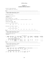
1
City of Sacramento
User’s Manual for
Sacramento Stormwater
Management Model (SSWMM96)
January 1996
City of Sacramento
Stormwater Management Model
(SSWMM96)
User's Manual
January 1996
By:
Montgomery Watson
777 Campus Commons Road
Suite 250
Sacramento, CA 95825
TABLE OF CONTENTS
PAGE
SECTION 1 BACKGROUND ............................................................................................................1-1
1.1 History of SSWMM96 ...................................................................................................................1-1
1.1.1 RUNOFF Block ...............................................................................................................1-1
1.1.2 EXTRAN Block...............................................................................................................1-2
SECTION 2 RUNOFF BLOCK ..........................................................................................................2-1
2.1 Introduction ....................................................................................................................................2-1
2.2 Subcatchment Parameters...............................................................................................................2-2
2.2.1 Drainage Area ..................................................................................................................2-2
2.2.2 Subcatchment Width ........................................................................................................2-2
2.2.3 Slope ................................................................................................................................2-3
2.2.4 Imperviousness.................................................................................................................2-3
2.2.5 Roughness Coefficient (Manning's n) ..............................................................................2-4
2.2.6 Depression Storage ..........................................................................................................2-5
2.2.7 Infiltration Coefficients ....................................................................................................2-6
2.3 Conveyance Parameters..................................................................................................................2-7
2.3.1 Conveyance Elements ......................................................................................................2-7
2.3.2 Special Flow Routing Elements .......................................................................................2-8
2.3.3 Manning's n ......................................................................................................................2-8
2.4 Precipitation ...................................................................................................................................2-8
2.5 Input Data Preparation....................................................................................................................2-9
2.5.1 Default Values..................................................................................................................2-9
2.5.2 Overland Flow Input Data Template................................................................................2-9
2.5.2.1 Title Section.....................................................................................................2-11
2.5.2.2 System Parameters Section ..............................................................................2-11
2.5.2.3 Rainfall Parameters Section.............................................................................2-11
2.5.2.4 Subcatchment Data Section .............................................................................2-12
2.5.3 Routing Input Data Template.........................................................................................2-14
2.5.3.2 System Parameters Section ..............................................................................2-14
2.5.3.3 Subcatchment-Conveyance Element Relationships Section ............................2-14
2.5.3.3 Conveyance Element Data Section ..................................................................2-16
2.6 Output Description .......................................................................................................................2-18
2.6.1 RUNOFF Subcatchment Simulation Output ..................................................................2-18
2.6.2 RUNOFF Conveyance Routing Output..........................................................................2-19
2.7 Debugging And Stabilization Hints ..............................................................................................2-26
2.7.1 Important Limitations.....................................................................................................2-26
2.7.2 Calibration......................................................................................................................2-27
2.7.3 Warnings and Error Messages........................................................................................2-28
2.7.3.1 Subcatchment Warnings and Error Messages..................................................2-28
2.7.3.2 Conveyance Element Routing Warnings and Error Messages.........................2-28
2.8 Runoff Graphs ..............................................................................................................................2-29
SECTION 3 EXTRAN BLOCK..........................................................................................................3-1
3.1 Introduction ....................................................................................................................................3-1
3.2 Conveyance Elements.....................................................................................................................3-3
3.2.1 Conduits ...........................................................................................................................3-3
3.2.2 Overflow Sections............................................................................................................3-3
3.3 Junction Elements...........................................................................................................................3-3
3.3.1 Storage Junctions .............................................................................................................3-4
3.3.2 Orifices.............................................................................................................................3-4
3.3.3 Weirs................................................................................................................................3-4
i
Table of Contents
PAGE
3.3.4 Pumps...............................................................................................................................3-4
3.3.5 Free Outfalls.....................................................................................................................3-5
3.3.6 Flap (Tide) Gates .............................................................................................................3-5
3.4 Input Data Preparation....................................................................................................................3-6
3.4.1 Default Values..................................................................................................................3-6
3.4.2 Input Data Template.........................................................................................................3-6
3.4.2.1 Title Section.......................................................................................................3-6
3.4.2.2 System Parameters Section ................................................................................3-6
3.4.2.3 Conveyance Elements Section .........................................................................3-11
3.4.2.4 Junction Elements Data Section.......................................................................3-13
3.4.2.5 Storage Junction Data Section .........................................................................3-14
3.4.2.6 Orifice Data Section ........................................................................................3-15
3.4.2.7 Weir Data Section............................................................................................3-16
3.4.2.8 Pump Data Section ..........................................................................................3-16
3.4.2.9 Free Outfall Data Section ................................................................................3-18
3.4.2.10 Outfall with Flap Gate Section ......................................................................3-19
3.4.2.11 Tide or Stage Boundary Data Section............................................................3-19
3.4.2.12 Initial Flows, Velocities, and Heads Data Section.........................................3-20
3.4.2.13 User-Defined Inflow Hydrograph Section .....................................................3-21
3.5 Output Description .......................................................................................................................3-22
3.5.1 Definition of Output Variables.......................................................................................3-22
3.6 Debugging and Stabilization Hints ...............................................................................................3-30
3.6.1 Important Limitations.....................................................................................................3-30
3.6.2 Calibration......................................................................................................................3-31
3.6.3 Fatal Error Messages......................................................................................................3-32
3.6.3 Termination of Execution Error Message ......................................................................3-37
3.6.4 Warning Messages .........................................................................................................3-38
3.7 EXTRAN Graphs .........................................................................................................................3-39
SECTION 4 HEC1 HYDROGRAPHS ...............................................................................................4-1
4.1 Introduction ....................................................................................................................................4-1
4.2 Input Data Preparation....................................................................................................................4-2
4.3 Example..........................................................................................................................................4-2
APPENDIX A RUNOFF EXAMPLE PROBLEM ............................................................................A-1
APPENDIX B EXTRAN EXAMPLE PROBLEM ............................................................................A-2
ii
LIST OF TABLES
TABLE
NO.
2-1
2-2
2-3
2-4
2-5
2-6
2-7
2-8
2-9
3-1
3-2
3-3
4-1
TITLE
PAGE
Land Uses and Percent Imperviousness.........................................................................................2-4
Subcatchment Overland Flow Roughness Coefficients .................................................................2-5
Typical Depression Storage for Various Land Covers ..................................................................2-5
Recommended Infiltration Coefficients.........................................................................................2-7
RUNOFF Subcatchment Simulation Input Template ..................................................................2-10
RUNOFF Conveyance Routing Input Template..........................................................................2-15
RUNOFF Subcatchment Simulation Output File ........................................................................2-20
RUNOFF Conveyance Routing Output File................................................................................2-23
Hydrograph Plotting Example .....................................................................................................2-30
EXTRAN Input Template .............................................................................................................3-7
Sample Extran Output .................................................................................................................3-23
Hydrograph Plotting Example .....................................................................................................3-39
HEC-1 Postprocessor Example .....................................................................................................4-2
A-1 Sump 43 RUNOFF Input..............................................................................................................A-2
A-1 Sump 43 RUNOFF Output ...........................................................................................................A-4
B-1 Sump 43 EXTRAN Input Data.....................................................................................................B-2
B-2 Sump 43 EXTRAN Output Data ..................................................................................................B-6
LIST OF FIGURES
FIGURE
NO.
1-1
1-2
2-1
2-2
2-3
2-4
2-5
3-1
3-2
3-3
3-4
3-5
3-6
3-7
a
TITLE
PAGEa
SWMM91 Hydrograph Simulation Schematic..............................................................................1-1
Conceptual Relationship of RUNOFF and EXTRAN ...................................................................1-1
Idealized Subcatchment Gutter Arrangement Showing Subcatchment Width...............................2-2
Calculating Basin Width for Irregular Shaped Subcatchments......................................................2-3
Conveyance Element Configurations ............................................................................................2-7
Special Flow Routing Conveyance Elements ................................................................................2-8
Trapezoidal Approximations for Streets........................................................................................2-8
Operation of EXTRAN Block .......................................................................................................3-1
Definition of Terms for Pipe Junction ...........................................................................................3-3
Types of Conduits in EXTRAN ....................................................................................................3-3
Street Overflow Section ................................................................................................................3-3
Orifices and Weirs.........................................................................................................................3-4
Pump Operation Curves ................................................................................................................3-5
Weir Input Definitions.................................................................................................................3-16
Full-page figures are on page following number shown in this list.
iii
SECTION 1
BACKGROUND
This section of the SSWMM96 User's Manual gives a brief history of the evolution of the
EPA SWMM model into the RUNOFF and EXTRAN blocks that make up SSWMM96.
Figure 1-1 is a schematic illustrating the way that the RUNOFF and EXTRAN blocks are
related.
As indicated in the figure, the RUNOFF block watershed simulation is first used to develop
runoff hydrographs for each subcatchment in the watershed. Then, the RUNOFF block
conveyance simulation may optionally be used to perform hydrologic routing through various
conveyance elements. Finally, the EXTRAN block is used to dynamically route the
hydrographs through the remainder of the conveyance system, usually the major interceptors
and trunk lines.
Figure 1-2 is a conceptual view of the relationship between RUNOFF and EXTRAN. As
shown in the figure, RUNOFF is used to simulate the hydrologic parameters for areas A1 and
A2, along with the gutter or pipe hydrologic routing through A2. These hydrologic
parameters, in combination with a precipitation hyetograph, are used by RUNOFF to develop
runoff hydrographs Q1 and Q2 for areas A1 and A2. The hydrograph from A1 is routed
through the gutter and combined with the hydrograph from A2 to yield the resultant
hydrograph Q12.
The combination hydrograph represented by Q12 is used as input to the EXTRAN block and
is then dynamically routed through the major trunk line to the storm drain outfall.
1.1 HISTORY OF SSWMM96
1.1.1 RUNOFF Block
The RUNOFF block was first developed as one part of the EPA Stormwater Management
Model (SWMM). It simulated both the quality and quantity of runoff from urban drainage
basins, along with hydrologic routing of the flows through conveyance systems. Hydrologic
Engineering Center and the Missouri River Division (MRD) of the U.S. Army Corps of
Engineers modified a quantity only version of the original RUNOFF block to correct
deficiencies that had been encountered in the model. This version of the RUNOFF block
simulated only the quantity of stormwater and not the quality. Boyle Engineering
Corporation (BEC) made a further revision to the MRD version, allowing it to be run on
personal computers.
Montgomery Watson Americas, Inc. (MW) has further modified the RUNOFF block for
SSWMM96. These modifications mostly affected the input data formatting and output data
1-1
Background
presentation. Input is now free format with input variable descriptions in the input itself.
Output formats were clarified and expanded to meet the needs of the City.
1.1.2 EXTRAN Block
The EXTRAN block used in SSWMM96 was originally developed by Water Resources
Engineers (WRE)1 for the City of San Francisco in 1973. In 1974 EPA acquired this model
and incorporated it into the SWMM package, calling it the Extended Transport Model EXTRAN -- to distinguish it from the TRANSPORT Module developed by the University of
Florida as part of the original SWMM package.
Extensive modifications were made to the EXTRAN block by BEC during their work on the
City of Sacramento's combined sewer system. These modifications included overflow
simulation components to simulate street flooding; simulation of various pumping plant
configurations; and a modified numerical solution technique for quicker, more accurate
results.
Montgomery Watson has further modified the EXTRAN block for SSWMM96. These
modifications included new input and output data formats that make it easier to develop,
debug, and understand the results of EXTRAN simulations. Major modifications were made
in the way EXTRAN handles weirs and separated pipes. Pumpback storage and downstream
boundary conditions have also been added. Output graphics for plotting flow and stage
hydrographs, and an HEC-1 post-processor to allow HEC-1 to be used to develop runoff
hydrographs for use in EXTRAN were also developed as part of these modifications.
1Camp
Dresser & McKee
1-2
SECTION 2
RUNOFF BLOCK
2.1 INTRODUCTION
The purpose of the RUNOFF block is to transform precipitation into runoff that then enters
the storm drainage or combined sewer system being modeled. It represents a watershed as a
number of smaller subbasins or subcatchments and their associated conveyance systems. The
subcatchments and conveyances are idealized for ease in describing their characteristics.
The RUNOFF block uses precipitation in the form of rainfall hyetographs that give the
rainfall intensity in inches per hour for each timestep in the model. The program uses these
rainfall hyetographs to make a step by step accounting of rainfall infiltration losses in
previous areas, surface retention, overland flow, and gutter flow, leading to the calculation of
hydrographs.
The drainage basin is subdivided into subcatchment areas that produce runoff hydrographs.
These hydrographs may be used directly as input for the EXTRAN block, or may be routed
(in RUNOFF) through gutters or pipes to compute hydrographs at the inlet points to the
major storm drain conveyance system. Overbank floodway sections may be used in
conjunction with gutters and pipes. Detention basins with a specified storage-outflow
relationship may be used. Also, RUNOFF allows the user to specify a flow diversion table
for routing elements. Pipes, gutters, diversions, and detentions are referred to as "conveyance
elements" in this manual.
Two types of elements are available to the RUNOFF user:
1.
Subcatchment elements (overland flow)
2.
Conveyance elements (channel flow, pipe flow, storage, etc.)
These two elements are analyzed as separate operations in RUNOFF. That is, if the user
intends to create overland flow hydrographs and then route them through RUNOFF
conveyance elements, he will need to use RUNOFF twice. The first RUNOFF simulation
will calculate the runoff hydrographs, and second one will use the calculated hydrographs as
input for routing through conveyance elements.
The subcatchment elements receive rainfall, account for infiltration loss using Horton's
equation, permit surface storage such as ponding or retention on grass or shrubbery, and route
excess rainfall to develop overland flows. The results from the subcatchment (overland flow)
analysis are saved to a file for future routing. The overland flows may then be routed through
the conveyance elements of the study watershed. Pipes and initial channel sections are
permitted to surcharge when full or, if desired, overflow sections may be provided to convey
2-1
RUNOFF Block
the flow exceeding the pipe or the initial channel capacity. The routing is based on a
kinematic wave approach that utilizes Manning's equation both for subcatchment and
conveyance elements.
2.2 SUBCATCHMENT PARAMETERS
Subcatchments can be thought of as idealized areas with a uniform slope and uniform ground
cover. This ground cover may represent one actual type of ground cover such as impervious
asphalt paving or pervious turf, or it may represent a mix of impervious and pervious ground
cover types. Important information required to characterize a subcatchment includes area,
width, ground slope, percent imperviousness, roughness coefficients, surface retention depth
(depression losses), and soil infiltration coefficients. Since the subcatchments encountered in
the real world are not rectangular areas with uniform characteristics, some approximations
must be made in order to represent the subcatchments in the model.
The important subcatchment parameters that are required in order to describe subcatchments
for use by the RUNOFF block are described in the following paragraphs.
2.2.1 Drainage Area
This is the total area of the subcatchment and it is typically measured from a topographic map
of the area being modeled, with the subcatchment boundaries overlaid on top. It is important
to understand the topography of the subcatchment, as well as any conveyance elements that
carry runoff into or out of the subcatchment, prior to delineating the subcatchments on the
map. The topography will determine the subcatchment boundaries except where conveyance
structures may divert water into or out of the subcatchment.
Subcatchments should be chosen to coincide with different land uses and with drainage
divides as described above if possible.
2.2.2 Subcatchment Width
If overland flow in a subcatchment is visualized as occurring in an idealized, rectangular
subcatchment such as the one shown in Figure 2-1, then the width of the subcatchment is the
physical width of the overland flow. Since the overland flow per unit width (ql) occurs along
a length , the total flow is equal to ql multiplied by the width. In the idealized example
shown in Figure 2-1 the two sides of the subcatchment are symmetrical, giving total width
that is twice the length of the gutter flow (2 ). If the subcatchment in question was just one
side of the subcatchment shown in Figure 2-1, the width would simply be .
Subcatchments in the real world are rarely consistent with the idealized situation shown in
Figure 2-1. Most of them will be irregular in shape and will have a drainage channel that is
not centered in the basin as shown in Figure 2-2. A simple way to handle this case is to
compute a skew factor:
2-2
qL
qL
RUNOFF Block
γ=
where γ
A1
A2
A
A2 − A1
A
=
=
=
=
skew factor, 0 < γ < 1.0
area to one side of channel
area to other side of channel
total area
Then, the width, W is:
W = ( 2 − γ )l
where W = subcatchment width
= length of main drainage conveyance
2.2.3 Slope
The subcatchment slope should reflect the average along the pathway of overland flow to
inlet locations. For simple geometry (e.g., rectangular subcatchments as illustrated in Figure
2-1) the calculation is simply the elevation difference divided by the straight-line length of
flow. For the more complex situations encountered in the real world, several overland flow
paths may be determined, their slopes calculated, and a weighted slope computed using a
path-length weighted average.
2.2.4 Imperviousness
The percent imperviousness of a subcatchment is obtained by using aerial photos or land use
maps to determine the extent of each particular land use that exists in a subcatchment.
Although this extent can be measured accurately with a planimeter or some other method, it
is more common to use visual estimates of the percentage of a subcatchment that is occupied
by each land use. Table 2-1 presents a list of City of Sacramento land uses and their
suggested percentage of imperviousness for use in the RUNOFF block. Remember that these
percentages are just suggestions, and actual percentages, especially for schools and parks,
could vary widely depending on the specific site.
Care must be taken to insure that impervious areas are hydraulically connected to the
drainage system. For instance, if rooftops drain onto adjacent pervious areas, they should not
be treated as impervious. On the other hand, if a driveway drains to a street and then to a
storm drain inlet, the driveway would be considered to be hydraulically connected. Rooftops
with downspouts connected directly to the storm drain or discharging onto adjacent
impervious areas are hydraulically connected.
2-3
RUNOFF Block
TABLE 2-1
LAND USES AND PERCENT IMPERVIOUSNESS
Land Use
Suggested Percent Impervious*
Commercial/Highways/Parking
95-99
Apartments/Offices/Trailers
75-90
Condominiums/Schools/Industry
70
Residential: 8-10 units/acre
60
Residential: 6-8 units/acre
50
Residential: 4-6 units/acre
40
Residential: 3-4 units/acre
30
Residential: 2-3 units/acre
25
Residential: 1-2 units/acre
20
Residential: .5-1 units/acre
15
Residential: .2-.5 units/acre
10
Residential: <.2 units/acre
5
Open Space/Grassland/Cropland
2
Open Space/Woodland
1
(*Table 2-5, Sacramento City/County Drainage Manual (1991))
Note: These percentages may be used as default values, but actual percentages should
be determined for each development.
If rooftops are treated as draining to pervious areas, then those pervious areas will be subject
to more incoming water than they would get from rainfall alone. This will probably produce
more runoff from the pervious area quicker than if rainfall alone was considered. If this
effect is considered to be important, it can be modeled by altering the infiltration parameters
(lowering infiltration rates) for the pervious areas receiving roof runoff. For example, if all
downspouts in a residential area with type C soils are designed to discharge to the lawns
around the homes, then the pervious area infiltration coefficient could be changed from 0.11
to 0.10 or 0.09.
2.2.5 Roughness Coefficient (Manning's n)
Values of roughness coefficient (n) are not as easily determined for subcatchment overland
flow as they are for conveyance elements because of the variability in ground cover and small
depths that occurs in overland flow situations. It is recommended that suggested values in
Table 2-2 be used to estimate the roughness of the subcatchment because they have been
found to work reasonably well in urban situations. Resistance factors for the pervious and
impervious areas of the subcatchment are specified separately, with default values of 0.25
and 0.013 for pervious and impervious overland flow, respectively.
2-4
RUNOFF Block
TABLE 2-2
SUBCATCHMENT OVERLAND FLOW ROUGHNESS COEFFICIENTS
Suggested
Manning's n for Overland Flow
Ground Cover
Impervious:
Smooth Asphalt
Asphalt or concrete paving
Pervious:
Native grass
Urban lawns
Dense shrubbery and forest litter
0.016
0.020
0.20
0.25
0.40
2.2.6 Depression Storage
Rainfall that is collected and held in small depressions and does not become part of the
general surface runoff is call depression storage or retention. Most of this water eventually
infiltrates (on pervious areas) or evaporates. Depression storage also includes water
intercepted by trees and bushes and water that is detained on the surface and does not run off.
Depression storage will depend on specific subcatchment conditions, but Table 2-3 gives
suggested values for typical depression storage for various types of land cover.
TABLE 2-3
TYPICAL DEPRESSION STORAGE FOR VARIOUS LAND COVERS
Land Cover
Impervious Areas
Large Paved Areas
Roofs - Flat
Roofs - Sloped
Pervious Areas
Lawn Grass
Wooded Areas and Open Fields
Typical Depression
and Detention Storage
Values (inches)
Recommended
Storage Values
(inches)
0.05 - 0.15
0.10 - 0.30
0.05 - 0.10
0.10
0.10
0.05
0.2 - 0.5
0.2 - 0.6
0.35
0.40
In RUNOFF, depression storage may be used as a calibration parameter, particularly to adjust
runoff volumes. If runoff volumes from a subcatchment or basin being calibrated appear to
2-5
RUNOFF Block
be too high or too low, the depression storage values being used in RUNOFF may be adjusted
within the ranges given in Table 2-3
2.2.7 Infiltration Coefficients
Infiltration from pervious areas is calculated using the Horton infiltration equation:
>
C
f = fo + fi − fo ∗ e − at
where: f
fi
fo
e
a
t
=
=
=
=
=
=
infiltration rate (inches/hour)
initial (maximum) infiltration rate (inches/hour)
final infiltration rate (inches/hour)
natural logarithm base
decay coefficient
time in seconds
The U.S. Soil Conservation Service (SCS) has classified most soils into Hydrologic Soil
Groups, A, B, C, and D, describing their infiltration capacities. They are as follows:
•
Group A - Low runoff potential. Group A is made up of soils having high
infiltration rates even when thoroughly wetted and consisting chiefly of deep,
well- to excessively-drained sands or gravels.
•
Group B - Moderately low runoff potential. Group B contains soils having
moderate infiltration rates when thoroughly wetted and consisting chiefly of
moderately deep to deep, moderately well to well drained soils with fine to
moderately coarse textures. These soils have a moderate rate of water
transmission.
•
Group C - Moderately high runoff potential. Group C is comprised of soils
having slow infiltration rates when thoroughly wetted and consisting chiefly of
soils with a layer that impedes downward movement of water, or soils with
moderately fine to fine texture. These soils have a slow rate of water
transmission.
•
Group D - High runoff potential. Group D includes soils having very slow
infiltration rates when thoroughly wetted and consisting chiefly of clay soils
with a high swelling potential, soils with a permanent high water table, soils
with a claypan or clay layer at or near the surface, and shallow soils over nearly
impervious material. These soils have a very slow rate of water transmission.
•
Urban - High runoff potential. Urban soils have been disturbed and
recompacted, usually having slow infiltration rates when thoroughly wetted.
These soils have a slow rate of water transmission and should be handled the
same as Group D soils.
2-6
RUNOFF Block
Soil types for a particular area in the City of Sacramento can be determined from the SCS
Soil Survey maps that are available from the local SCS office. Recommended values for fi,
fo, and a are listed in Table 2-4.
TABLE 2-4
RECOMMENDED INFILTRATION COEFFICIENTS
SCS Soil Type
Initial Infiltration
fi
(in/hr)
Final Infiltration
fo
(in/hr)
Infiltration
Decay
Coefficient
a
A
1.0
0.35
0.0007
B
1.0
0.19
0.0018
C
1.0
0.11
0.0018
D
1.0
0.08
0.0018
Note: The infiltration decay coefficient used in the combined system model is 0.000362
2.3 CONVEYANCE PARAMETERS
There are five standard types of conveyance elements and three special flow routing
conveyance elements that are used in RUNOFF.
2.3.1 Conveyance Elements
The RUNOFF Block has eight conveyance elements available for routing flows. Figure 2-3
illustrates general conveyance element configurations. The five standard conveyance
elements are:
1.
Channel. A trapezoidal channel used to represent or approximate an open
channel/gutter condition. The channel is defined by its bottom width and side
slope.
2.
Pipe. A circular pipe of any diameter.
3.
Direct flow. This element provides only instantaneous direct translation of the
flows from the upstream to the downstream conveyance element and does not
modify the hydrograph.
4.
Channel with overflow channel. Same as the channel element above except that
a larger trapezoidal channel is also specified to accept the flows exceeding the
capacity of the initial channel cross-section.
2-7
RUNOFF Block
5.
Pipe with overflow channel. Same as the pipe element above except that a
trapezoidal channel is also specified to accept the flows exceeding the capacity
of the pipe.
2.3.2 Special Flow Routing Elements
The three special flow routing conveyance elements, shown in Figure 2-4, are as follows:
1.
Diversion. A table of flows in a conveyance element versus the flow diverted to
another conveyance element may be specified using this option.
2.
Storage reservoir (detention basin). A table of reservoir storage in acre-feet
versus outflow in cubic feet per second (cfs) may be specified using this option.
This operation may be used in conjunction with the "pipe" routing element.
The pipe capacity has to be exceeded before the storage-outflow function is
utilized.
3.
Inflow hydrograph. This option may be used to specify an input hydrograph
table of time in hours versus the flow in cfs for any routing element.
2.3.3 Manning's n
For hydrologic routing through the conveyance elements described above, the resistance
(Manning's n) coefficients should not be the same as those that would be used for the same
type of conveyance element where hydraulic calculations are being performed. Studies have
shown that increasing the "typical" values of Manning's n by approximately 25 percent
provides more realistic results when using RUNOFF. For example, when doing hydraulic
calculations a concrete gutter would normally have n = 0.013. That same gutter when being
used for hydrologic routing in RUNOFF would have n = 0.016.
Hydrologic routing in streets is approximated using the trapezoidal sections illustrated in
Figure 2-5.
2.4 PRECIPITATION
Precipitation for use with RUNOFF may come from two different sources:
•
•
Historical Storm Data
Design Storm Data
The precipitation data may be input for any time interval desired, but it is best to keep the
time intervals between 5 to 30 minutes for the best storm definition without having excessive
precipitation values. Each value in a precipitation hyetograph is the average intensity, in
inches per hour, that took place during the timestep.
2-8
RUNOFF Block
2.5 INPUT DATA PREPARATION
The input data format for the RUNOFF block has been designed to be flexible and to allow
the user to insert notes and comments as part of the input. RUNOFF ignores any input line
beginning with an asterisk (*) in the first column. The user may place comment lines at any
point in the input except where the program is expecting a certain number of input values
such as during the specification of a pump curve.
All input variables are entered in free format, meaning that the precise column in which a
particular variable is entered is not important. What is important is the order in which the
data is entered, the grouping in which it is entered, and presence of a space or comma
between each data value. For each type of data (i.e., subcatchment data or rainfall data),
RUNOFF expects each line to contain a specified number of data values. If more than that
number of values are entered, they will be ignored. If less than the expected number of
values are entered, RUNOFF will read the remaining input values from the next line of input.
2.5.1 Default Values
Many variables used by the RUNOFF block have default values that will be used in the
computations if the variable in question is not specified (i.e., a zero). Where default values
are supplied in the model they will be noted in this manual as part of the input parameters'
description.
The standard defaults incorporated in the RUNOFF block may not be applicable in all
situations. Methods are available in RUNOFF to change any of the default values to match
individual situations. Multiplication ratios may also be added for any of the subcatchment
parameters enabling the user to change all subsequent subcatchments by a given amount. For
example, as part of a calibration procedure the maximum infiltration rate for a series of
subcatchments could be multiplied by a factor of 1.1 to decrease the volume of runoff
produced by a given amount of rainfall.
2.5.2 Overland Flow Input Data Template
Table 2-5 is a sample input file illustrating the input format and layout of a typical overland
flow RUNOFF input data file for use in creating hydrographs. The input is divided into
sections as follows:
•
•
•
•
Title Section
System Parameters Section
Rainfall Parameters Section
Subcatchment Data Section
Each of these sections and its associated input variables will be discussed in detail.
2-9
RUNOFF Block
TABLE 2-5
RUNOFF SUBCATCHMENT SIMULATION INPUT TEMPLATE
*This is a subcatchment (overland flow) simulation input file for the RUNOFF block of SSWMM96
*
*TITLE SECTION
SSWMM96 DOCUMENTATION EXAMPLE DATA
RUNOFF BLOCK - SUBCATCHMENT OVERLAND FLOW HYDROGRAPHS
*
*SYSTEM PARAMETERS SECTION- free input format
0
*IOPT = 0 for overland flow
179
*NSTEP = Number of timesteps to be calculated
8,55
*NHR,NMN = Hour and minutes of start of storm
5.0
*DELT = Integration period (min.)
1
*NRGAG = Number of rain gage hyetographs
75.0
*PCTZER = Percent of impervious area with zero detention
1
*IPFlag(1) = 1 for rainfall parameters printout
1
*IPFlag(2) = 1 for subarea data printout
1
*IPFlag(3) = 1 for output hydrographs printout
1
*IPKCHK = 1 for printed summary of peak flows
*
*RAINFALL PARAMETERS SECTION - This section required for subcatchment (overland flow) simulation.
50
*NHISTO = No. of data points for each hyetograph
10.0
*THISTO = Time interval between values
*Rainfall data - ten-year storm
*Intensity in inches/hour for each timestep
0
0
0
0
0
0 0.13 0.13 0.13 0.13
0.13 0.13 0.16 0.16 0.16 0.16 0.16 0.16 0.28 0.30
0.36 0.52 1.98 0.48 0.36 0.36 0.36 0.36 0.36 0.36
0.20 0.20 0.20 0.20 0.20 0.20 0.16 0.16 0.16 0.16
0.16 0.16
0
0
0
0
0
0
0
0
*
*SUBCATCHMENT DATA SECTION
*One line for each subcatchment
* JK
N
NGOTO WWIDTH WAREA
PCIMP WSLOPE
W5
W6
W7
W8
WLMAX WLMIN
DECAY
*Hyeto- Sub- Convey. SubSub%
SubManning's Manning's Storage Storage |-Infiltration---|
*graph
catch. Elem. catch. catch. Imper- catch.
n
n
on
on
Decay
* No.
No.
No.
Width
Area
vious
Slope
Imperv.
Perv.
Imperv.
Perv.
Max.
Min. Rate
*
(ft)
(ac)
(ft/ft)
(in)
(in)
--(in/hr)-1
1031
103
1100
13.9
45
.001
.016
0.05
.100
.250
3.00 0.50 0.0018
1
1051
105
1800
13.0
45
.001
.016
0.05
.100
.250
3.00 0.50 0.0018
1
1061
106
1960
24.6
45
.001
.016
0.05
.100
.250
3.00 0.50 0.0018
1
1062
106
1800
34.5
40
.001
.016
0.05
.100
.250
3.00 0.50 0.0018
*Comments are allowed in the subcatchment data section
1
1071
107
1750
30.1
70
.001
.016
0.05
.100
.250
3.00 0.50 0.0018
1
1072
107
770
11.2
70
.001
.016
0.05
.100
.250
3.00 0.50 0.0018
1
1081
108
2520
26.1
90
.001
.016
0.05
.100
.250
3.00 0.50 0.0018
1
1082
108
1300
7.3
90
.001
.016
0.05
.100
.250
3.00 0.50 0.0018
1
1083
108
1600
10.3
80
.001
.016
0.05
.100
.250
3.00 0.50 0.0018
*
*To indicate end of subcatchment data, enter 99999 (or blank)
99999
*
*Subcatchment Save And Print Control
1
*N7 - If > 0, hydrographs saved for routing in RUNOFF Block
0
*N21 - If > 0, hydrographs saved for routing in EXTRAN Block
9
*NPRNT - No. of subcatchments for which hydrographs are printed
3
*INTERV - No. of timesteps between printings
* Enter subbasin numbers if NPRNT > 0
1031 1051 1061 1062 1071 1072 1081 1082 1083
ENDPROGRAM
2-10
RUNOFF Block
2.5.2.1 Title Section. The title section is two lines containing up to 80 characters in each
line. The title should be descriptive, but may be anything the user wants.
2.5.2.2 System Parameters Section. This section of the input contains the overall
simulation parameters that control the length of the simulation, timestep size, etc.
Descriptions of each of the system parameters are given below. No comment lines are
allowed inside the System Parameters Section.
Name
IOPT
NSTEP
NHR,NMN
DELT
NRGAG
PCTZER
IPFLAG
IPKCHK
Description
Default
Indicates whether subcatchment hydrographs will be
simulated in RUNOFF or if they will be input from another
source. For subcatchment (overland flow) simulation,
IOPT = 0.
0 = subcatchment hydrographs will be simulated in
RUNOFF. The hydrographs may be routed
through RUNOFF conveyance elements before
being saved but that is not required.
Number of timesteps to be calculated. Should be sufficient
to insure that most of the runoff occurs. Depends on the size
of the watershed, the length of the precipitation, and the size
of the timestep
Hour and minutes of start of the storm. May be 0,0.
Size of the computation timestep in minutes. For all but very
small subcatchments, DELT = 5 minutes is adequate.
Number of rain gage hyetographs provided. Up to 10
hyetographs are allowed.
Percentage of the impervious area that has no depression
storage depth and runs off immediately.
Input data print echo switches:
0 = off
1 = on
IPFLAG(1) = Rainfall parameters printout
IPFLAG(2) = Subarea data printout
IPFLAG(3) = Output hydrographs printout printout
Peak flow and depth of flow summary table flag.
0 = No summary table
1 = Print peak flow and depth of flow summary table
at end of run
none
none
none
none
none
25
none
none
2.5.2.3 Rainfall Parameters Section. The Rainfall Parameters Section contains the
parameters controlling the size and time intervals for the precipitation hyetographs, as well as
the hyetographs themselves.
2-11
RUNOFF Block
Name
NHISTO
THISTO
RAIN(x)
Description
Default
Number of data points for each rainfall hyetograph
(maximum of 399)
Time interval in minutes for each value of the hyetograph.
Does not have to be the same as the computation timestep
(DELT).
Rainfall intensity values for each timestep in the hyetograph.
May have as many values as wanted on a line, only
requirement is that values be separated by either a blank or a
comma. For ease in error checking, use the same format on
each line as shown in Table 2-5.
none
none
none
2.5.2.4 Subcatchment Data Section. The Subcatchment Data Section contains the data
describing each of the subcatchments being simulated. All the data values for a
subcatchment are placed on one line. Comment lines are allowed between subcatchment data
lines so long as the data lines contain all the data values for a subcatchment.
Global changes in default values, for any subcatchment variable for which default a value is
defined, may be made through the use of N = -2 in the Subcatchment Data Section as
described below. It is also possible to substitute N = -1 which will alter all subsequent
subcatchment values by specified modification ratios, as described below.
Name
JK
N
NGOTO
Description
Hyetograph number for use with this subcatchment. A
number is given to each hyetograph based on the order in
which they are read.
The unique subcatchment identification number. Also used
to control subcatchment default values and modification
ratios.
>0= Subcatchment identification number
-2 = Modify default values for each variable based on
values entered on this line. Any non-zero value
entered on a line with N = -2, will replace the
current default value for that variable.
-1 = Alter subsequent values for a variable by the
modification ratio entered on this line for that
variable.
The identification number of the conveyance element in the
conveyance module of RUNOFF, or the junction element, in
EXTRAN, to which the subcatchment connects.
2-12
Default
none
none
none
RUNOFF Block
WWIDTH
WAREA
PCIMP
WSLOPE
W5
W6
W7
W8
WLMAX
WLMIN
DECAY
99999
The subcatchment width in feet. This represents the width of
the downstream side of the idealized sloping rectangular
subcatchment area. When the subcatchment conveyance
element approximately bisects the subcatchment
(Figure 2-1), use twice the length of the conveyance element
for WWIDTH.
Area of the subcatchment in acres.
Percent of the subcatchment that is impervious, such as
paved roads, paved parking lots, roofs, sidewalks, driveways,
etc.
The average ground slope of the subcatchment normal to the
tributary width, in feet/foot.
Manning's n (resistance factor) for the impervious surfaces in
the subcatchment (Table 2-2, default is smooth asphalt).
Manning's n (resistance factor) for the pervious surfaces in
the subcatchment (Table 2-2, default is urban lawns).
Depression storage on impervious surfaces, in inches. Saved
as WSTORE(1) (Table 2-3, default is paved area or flat
roof).
Depression storage on pervious surfaces, in inches. Saved as
WSTORE(2) (Table 2-3, default is lawn grass).
Initial (maximum) infiltration rate, fi in Horton's equation, in
inches/hour (Table 2-4).
Final (minimum) infiltration rate, fo in Horton's equation, in
inches/hour (Table 2-4).
Decay rate of infiltration per second, a, in Horton's equation
(Table 2-4).
A blank line or 99999 indicates the end of the Subcatchment
Data Section
none
none
45
0.001
0.016
0.250
0.010
0.35
1.0
0.08
0.0018
none
Subcatchment Save and Print Control contains the parameters to control the disposition and
printing of the subcatchment hydrographs created by RUNOFF.
Name
N7
N21
NPRNT
INTERV
IPRNT(x)
Description
If N7 > 1, hydrographs from each subcatchment are to be
saved for subsequent conveyance routing in RUNOFF.
If N21 > 1, hydrographs from each subcatchment are to be
saved for subsequent routing in EXTRAN.
Number of subcatchments for which hydrographs are to be
printed and sent to file for use with plot program.
Number of timesteps between printing
If NPRNT > 0, Subcatchment numbers for which values are
to be printed and sent to file for use with plot program.
2-13
Default
none
none
none
1
none
RUNOFF Block
2.5.3 Routing Input Data Template
Table 2-6 is a sample input file illustrating the input format and layout of a typical RUNOFF
routing input data file for use in routing previously created hydrographs. The input is divided
into sections as described below.
•
•
•
Title Section
System Parameters Section
Conveyance Element Data Section
Each of these sections and its associated input variables will be discussed in detail below.
2.5.3.1 Title Section. The title section is two lines containing up to 80 characters in each
line. The title should be descriptive, but may be anything the user wants.
2.5.3.2 System Parameters Section. This section of the input contains the overall
simulation parameters that control the length of the simulation, timestep size, etc.
Descriptions of each of the system parameters are given below. No comment lines are
allowed inside the System Parameters Section.
Name
IOPT
NSTEP
NHR,NMN
DELT
IPFLAG
Description
Default
Indicates whether subcatchment hydrographs will be
simulated in RUNOFF or if they will be input from another
source. For hydrograph routing, IOPT = 1.
1 = subcatchment hydrographs are input from another
source. This option is used when subcatchment
hydrographs from a previous RUNOFF simulation
or from HEC-1 are to be input for routing through
RUNOFF conveyance elements.
Number of timesteps to be calculated. Should be sufficient
to insure that most of the runoff occurs. Depends on the size
of the watershed, the length of the precipitation, and the size
of the timestep
Hour and minutes of start of the storm. May be 0,0.
Size of the computation timestep in minutes. For all but very
small subcatchments, DELT = 5 minutes is adequate.
Input data print echo switches:
0 = off
1 = on
IPFLAG(1) = Rainfall parameters printout
IPFLAG(2) = Subarea data printout
IPFLAG(3) = Output hydrographs printout printout
none
2-14
none
none
none
none
RUNOFF Block
TABLE 2-6
RUNOFF CONVEYANCE ROUTING INPUT TEMPLATE
*This is a conveyance routing input file for the RUNOFF block of SSWMM96
*
*TITLE SECTION
SSWMM96 DOCUMENTATION EXAMPLE DATA
RUNOFF BLOCK - CONVEYANCE ROUTING
*
*SYSTEM PARAMETERS SECTION- free input format
1
*IOPT = 1 for routing only
179
*NSTEP = Number of timesteps to be calculated
8,55
*NHR,NMN = Hour and minutes of start of storm
5.0
*DELT = Integration period (min.)
1
*IPFlag(1) = 1 for rainfall parameters printout
1
*IPFlag(2) = 1 for subarea data printout
1
*IPFlag(3) = 1 for output hydrographs printout
1
*IPKCHK = 1 for printed summary of peak flows and stages
*
*Subcatchment-Conveyance Element Relationships
*One line for each subcatchment hydrograph being read in,
*indicating conveyance element associated with each subcatchment.
* N
IDGUT
* SubConvey.
*catch.
Element
* No.
No.
1031
103
1051
105
1061
106
1062
106
1071
107
*
*To indicate end of subcatchment data, enter 99999 (or blank)
99999
*
*CONVEYANCE ELEMENT DATA SECTION
*One line for each conveyance element
* JK
N
NGOTO
NDP
NP
GWIDTH
GLEN
GSLOPE
GS1
GS2
GS
*Special Convey. Next
No.
Type
Bottom
Length
Invert
Left
Right
Mannings
*Routing Element Elem.
Added Convey.
Width
Convey.
Slope
Side
Side
n
*Element
No.
No.
Value Element or Dia. Element
Slope
Slope
*
(ft)
(ft)
(ft/ft) (ft/ft) (ft/ft)
0
103
0
0
1
10
450
.01
.5
.5
.02
345
105
0
5
2
4
600
.01
0
0
.018
*If NDP > 0 and JK >0.
* Element Divert. Element Divert. Element Divert. Element Divert. Element Divert.
*
(cfs)
(cfs)
(cfs)
(cfs)
(cfs)
(cfs)
(cfs)
(cfs)
(cfs)
(cfs)
0
0
10
5
20
10
30
15
40
20
0
106
0
5
2
4
800
.01
0
0
.018
*If NDP > 0 and JK = 0.
* Storage Outflow Storage Outflow Storage Outflow Storage Outflow Storage Outflow
* (ac-ft)
(cfs)
(ac-ft)
(cfs)
(ac-ft)
(cfs)
(ac-ft)
(cfs)
(ac-ft)
(cfs)
0
0
2
5
4
10
6
15
10
20
-1
107
0
5
1
10
350
.01
.5
.5
.025
*If NDP > 0 and JK = -1
*
Time
Inflow
Time
Inflow
Time
Inflow
Time
Inflow
Time
Inflow
*
(hrs)
(cfs)
(hrs)
(cfs)
(hrs)
(cfs)
(hrs)
(cfs)
(hrs)
(cfs)
0
0
1
5
2
10
3
15
4
20
0
108
0
0
4
10
450
.01
.5
.5
.02
*Overflow channel
5
450
.05
.01
.01
.025
*
*To indicate end of conveyance element data, enter 99999 (or blank)
99999
*
*Conveyance Element Save And Print Control
1
*N21 - If > 0, hydrographs saved for routing in EXTRAN Block
5
*NPRNT - No. of conveyance elements for which hydrographs are to be printed
3
*INTERV - No. of timesteps between printings
* Enter conveyance element numbers if NPRNT > 0
103 105 106 107 108
*
ENDPROGRAM
2-15
DFULL
Depth
or
Dia.
(ft)
5
4
4
6
5
10
RUNOFF Block
IPKCHK
Peak flow and depth of flow summary table flag.
0 = No summary table
1 = Print peak flow and depth of flow summary table
at end of run
none
2.5.3.3 Subcatchment-Conveyance Element Relationships Section. This section lists the
subcatchment hydrographs and their associated conveyance element. The hydrograph read in
from the subcatchment will be routed through the conveyance element on the same line.
Name
N
IDGUT
Description
Subcatchment number for which a hydrograph will be read
in.
Conveyance element number through which the
subcatchment hydrograph will be routed.
Default
none
none
2.5.3.3 Conveyance Element Data Section. The Conveyance Element Data Section
contains the data describing any of the RUNOFF conveyance elements being simulated. All
the data values for a specified conveyance element are put on one line unless the special
conveyance element or overflow options are used.
For the special conveyance element option, additional lines are required to describe the
diversion; detention; or input hydrograph. For the overflow option, an additional line is
required to describe the overflow channel.
Name
JK
Description
Default
If the variable NDP = 0, JK is ignored. If NDP > 0 then
values of JK are as follows:
>0= a diversion from this conveyance element to the
conveyance element indicated by JK. Must be
followed by line(s) with a table of Total Q (cfs)
versus Diverted Q (cfs). NDP is the number of
sets of tabular values
0 = a detention basin at this location. Must be
followed by line(s) with a table of Detention
Storage (ac-ft) versus Basin Outflow Capacity
(cfs).
-1 = an inflow hydrograph will be specified for this
location. Must be followed by line(s) with a table
of Time (hrs) versus Inflow (cfs). NDP is the
number of sets of tabular values.
none
2-16
RUNOFF Block
N
NGOTO
NDP
NP
GWIDTH
GLEN
GSLOPE
GS1
GS2
GS
DFULL
Unique identification number of the conveyance element.
Also used to control conveyance element default values and
modification ratios.
>0= Conveyance element identification number
-2 = Modify default values for each variable based on
values entered on this line. Any non-zero value
entered on a line with N = -2, will replace the
current default value for that variable.
-1 = Alter subsequent values for a variable by the
modification ratio entered on this line for that
variable.
Identification number of the conveyance element
downstream of conveyance element N. This may be the
manhole number in EXTRAN into which the hydrograph
from this conveyance element will be put for dynamic
routing.
Normally zero, unless one of the special routing element
options explained for JK is to be used. In that case, NDP is a
positive number equal to the number of sets of tabular values
to be input under the JK option.
Type of conveyance element:
1 = channel
2 = pipe
3 = direct flow (no routing)
4 = channel with overflow channel
5 = pipe with overflow channel
Bottom width of channel or pipe diameter, in feet.
Length of conveyance element, in feet.
Invert slope, in feet/foot.
Left-hand (looking downstream) side slope, in feet/foot.
Right-hand (looking downstream) side slope, in feet/foot.
Manning's n (resistance factor) for the channel or pipe
Depth of channel when full or the pipe diameter, in feet.
When an overflow section has been specified, the depth at
which overflow begins.
none
none
none
none
0.001
none
0.001
0.001
0.001
0.020
10
If an overflow channel has been specified (NP = 4 or 5),
variables GWIDTH, GLEN, GSLOPE, GS1, GS2, GS, and
DFULL must be specified for the overflow channel, on the
next line.
Diversion Option Input Line(s) (JK > 0 and NDP > 0). NDP data pairs describing flow in the
element versus diverted flow. JK is conveyance element number receiving the diverted flow.
SD,QD
SD = Flow in conveyance element N, in cfs.
QD = Flow diverted to conveyance element JK, in cfs.
2-17
RUNOFF Block
Detention Basin Option Input Line(s) (JK = 0 and NDP > 0). NDP data pairs describing
detention basin storage versus outflow discharge.
SD,QD
SD = Storage in detention basin, in acre-feet.
QD = Outflow from detention basin, in cfs.
Inflow Hydrograph Option Input Line(s) (JK = -1 and NDP > 0). NDP data pairs of time
versus inflow.
SD,QD
SD = Time, in hours.
QD = Inflow to the conveyance element, in cfs.
99999
A blank line or 99999 indicates the end of the Conveyance
none
Element Data Section
Conveyance Element Save and Print Control contains the parameters to control the
disposition and printing of the conveyance element hydrographs created by RUNOFF. This
section is required for all runs using conveyance elements.
Name
N21
NPRNT
INTERV
IPRNT(x)
Description
If N21 > 1, hydrographs from each conveyance element are
to be saved for subsequent routing in EXTRAN.
Number of conveyance elements for which hydrographs are
to be printed.
Number of timesteps between printing
If NPRNT > 0, conveyance element numbers for which
values are to be printed.
End of Input Line
CNAME
"ENDPROGRAM" indicates the end of input data.
Default
none
none
1
none
none
2.6 OUTPUT DESCRIPTION
Every effort has been made to make the output from the RUNOFF block easy to understand,
with headings for each of the output sections that are complete and concise. Table 2-7 is a
sample output file for subcatchment simulation in the RUNOFF block. Table 2-8 is a sample
output file for conveyance routing in the RUNOFF block. The output shown in Tables 2-7
and 2-8 has been abridged, but still shows all the major headings and output data. The
following paragraphs describe each of the output headings, and follow the sample output in
Tables 2-7 and 2-8.
2.6.1 RUNOFF Subcatchment Simulation Output
The first page of RUNOFF subcatchment simulation output begins with a title block
describing the evolution of the program. This title block is followed by a second title block
describing the particular RUNOFF input being run. It is made up of the two-line title block
from the RUNOFF input data. Also on the first page is a reiteration of the major control
parameters as well as the rainfall hyetographs for the subcatchment simulation.
2-18
RUNOFF Block
The second page begins with the two-line title block and then summarizes the input data.
This input data consists of the subcatchment (subarea) descriptions for subcatchment
simulations or conveyance element descriptions for conveyance routing.
The third and succeeding pages of the subcatchment simulation output (shown in Table 2-7)
contain the printed hydrographs requested in the Subcatchment Print and Control Section in
the input data. The last page of the output gives the results of a continuity check on the
subcatchment (overland flow) simulation. The continuity indicates the difference between
the total rainfall on the watershed and the abstractions from the watershed (infiltration,
watershed outflow, and depression storage). This difference, shown as percent of rainfall that
is not accounted for, indicates how well the program has simulated the rainfall/runoff
characteristics of the entire watershed. Values of the continuity error should not exceed 1 to
2 percent. A simulation that results in higher values than these should be checked carefully
for problems.
2.6.2 RUNOFF Conveyance Routing Output
The first page of the RUNOFF conveyance routing output, shown in Table 2-8, begins with a
title block describing the evolution of the program. This title block is followed by a second
title block describing the particular RUNOFF input being run. It is made up of the two-line
title block from the RUNOFF input data. Also on the first page is the number of time steps
in the simulation and the routing time interval in minutes.
The second page of the RUNOFF conveyance routing output contains a listing of the
hydrographs (from RUNOFF subcatchment simulation or from HEC-1) that are being used as
input to the simulation. The hydrographs are listed for each subcatchment for all timesteps.
The third page reiterates the conveyance element input data including element number;
downstream connection, if any; NDP, the number of special data sets associated with the JK
option; the type of conveyance element; the width or diameter, length, invert slope, side
slopes, and Manning's n of the conveyance element; the depth at which overflow begins; and
JK, the special routing element description. The total number of conveyance elements in the
simulation is listed at the bottom of page 3.
The fourth page begins with the title block, as do all pages of the output. After the title
block, each conveyance element is listed, along with conveyance elements and subareas that
are tributary to it. The total drainage area upstream of the conveyance element is also listed.
Following the connectivity table, the hydrograph data for each conveyance element selected
for printing in the Conveyance Element Save and Print Control Section of the input data file
are listed. These data include the discharge through the conveyance as the upper number and
then one of the following, depending on the type of conveyance
2-19
RUNOFF Block
TABLE 2-7
RUNOFF SUBCATCHMENT SIMULATION OUTPUT FILE
Page 1 ----------------------------------------------------------------------------------------------------
RUNOFF BLOCK OF SSWMM96
DEVELOPED BY
METCALF + EDDY, INC.
UNIVERSITY OF FLORIDA
WATER RESOURCES ENGINEEERS, INC. (SEPTEMBER 1970)
UPDATED BY
UNIVERSITY OF FLORIDA (JUNE 1973)
HYDROLOGIC ENGINEERING CENTER, CORPS OF ENGINEERS
MISSOURI RIVER DIVISION, CORPS OF ENGINEERS (SEPTEMBER 1974)
BOYLE ENGINEERING CORPORATION (JULY 1985)
MONTGOMERY WATSON AMERICAS, INC (JAN 1996)
SSWMM96 DOCUMENTATION EXAMPLE DATA
RUNOFF BLOCK - SUBCATCHMENT OVERLAND FLOW HYDROGRAPHS
OVERLAND FLOW WILL BE CALCULATED (IOPT=0)
NUMBER OF TIME STEPS (NSTEP) = 179
THE STORM BEGINS AT 8:55 (NHR,NMN)
INTEGRATION TIME INTERVAL IN MINUTES (DELT) =
5.00
75.0 PERCENT OF IMPERVIOUS AREA HAS ZERO DETENTION DEPTH (PCTZER)
FOR 50 RAINFALL STEPS (NHISTO), THE TIME INTERVAL IS 10.00 MINUTES (THISTO)
FOR RAINGAGE NUMBER 1, RAINFALL HISTORY IN INCHES PER HOUR
.00
.13
.36
.20
.16
.00
.13
.52
.20
.16
.00
.16
1.98
.20
.00
.00
.16
.48
.20
.00
.00
.16
.36
.20
.00
.00
.16
.36
.20
.00
.13
.16
.36
.16
.00
.13
.16
.36
.16
.00
.13
.28
.36
.16
.00
.13
.30
.36
.16
.00
Page 2 ---------------------------------------------------------------------------------------------------SSWMM96 DOCUMENTATION EXAMPLE DATA
RUNOFF BLOCK - SUBCATCHMENT OVERLAND FLOW HYDROGRAPHS
SUBAREA
GAGE
NUMBER
NO.
1031
1
1051
1
1061
1
1062
1
1071
1
1072
1
1081
1
1082
1
1083
1
CONVEY.
WIDTH
AREA
ELEMENT
(FT)
(AC)
103
1100.
13.9
105
1800.
13.0
106
1960.
106
107
PERCENT
SLOPE
RESISTANCE FACTOR
SURFACE STORAGE(IN)
INFILTRATION RATE(IN/HR)
(FT/FT)
IMPERV.
PERV.
IMPERV.
PERV.
45.0
.0010
.016
.050
.100
.250
3.00
.50
.00180
45.0
.0010
.016
.050
.100
.250
3.00
.50
.00180
24.6
45.0
.0010
.016
.050
.100
.250
3.00
.50
.00180
1800.
34.5
40.0
.0010
.016
.050
.100
.250
3.00
.50
.00180
1750.
30.1
70.0
.0010
.016
.050
.100
.250
3.00
.50
.00180
107
770.
11.2
70.0
.0010
.016
.050
.100
.250
3.00
.50
.00180
108
2520.
26.1
90.0
.0010
.016
.050
.100
.250
3.00
.50
.00180
108
1300.
7.3
90.0
.0010
.016
.050
.100
.250
3.00
.50
.00180
108
1600.
10.3
80.0
.0010
.016
.050
.100
.250
3.00
.50
.00180
TOTAL NUMBER OF SUBCATCHMENTS,
TOTAL TRIBUTARY AREA (ACRES),
IMPERV.
9
171.00
2-20
MAXIMUM MINIMUM DECAY RATE
RUNOFF Block
TABLE 2-7 (continued)
Page 3 ---------------------------------------------------------------------------------------------------SSWMM96 DOCUMENTATION EXAMPLE DATA
RUNOFF BLOCK - SUBCATCHMENT OVERLAND FLOW HYDROGRAPHS
HYDROGRAPHS ARE LISTED FOR THE FOLLOWING
TIME(HR:MIN)
9 SUBCATCHMENTS - AVERAGE VALUES WITHIN TIME INTERVALS
1031
1051
1061
1062
1071
1072
1081
1082
1083
9:00
.00
.00
.00
.00
.00
.00
.00
.00
.00
9:15
.00
.00
.00
.00
.00
.00
.00
.00
.00
9:30
.00
.00
.00
.00
.00
.00
.00
.00
.00
.
.
.
11:30
Output has been abridged
.87
.89
1.55
1.79
2.35
.93
2.88
.94
1.17
11:45
.94
.92
1.66
1.97
2.69
1.05
3.22
1.00
1.25
12:00
1.05
1.04
1.87
2.23
3.09
1.20
3.66
1.12
1.40
12:15
1.48
1.50
2.62
3.09
4.24
1.65
5.04
1.58
1.98
12:30
2.05
2.10
3.63
4.26
5.84
2.27
6.95
2.20
2.75
Page 4 ---------------------------------------------------------------------------------------------------SUBCATCHMENT HYDROGRAPHS (CONTINUED)
TIME(HR:MIN) 1031
1051
1061
12:45
7.28
8.27
12.92
1062
14.28
1071
17.97
1072
7.20
1081
22.42
1082
7.99
1083
9.95
13:00
4.58
3.90
8.11
10.30
15.41
5.82
17.50
4.75
5.97
13:15
2.98
2.48
5.26
6.94
11.23
4.11
12.18
3.05
3.84
13:30
2.52
2.21
4.45
5.80
9.43
3.43
10.15
2.60
3.27
.
.
.
Output has been abridged
23:15
.00
.00
.01
.01
.04
.01
.03
.00
.00
23:30
.00
.00
.01
.01
.03
.01
.03
.00
.00
23:45
.00
.00
.01
.01
.03
.01
.02
.00
.00
Page 5 ---------------------------------------------------------------------------------------------------SSWMM96 DOCUMENTATION EXAMPLE DATA
RUNOFF BLOCK - SUBCATCHMENT OVERLAND FLOW HYDROGRAPHS
*** CONTINUITY CHECK FOR SUBCATCHMEMT SIMULATION, SSWMM96 RUNOFF BLOCK ***
WATERSHED AREA (ACRES)
TOTAL RAINFALL (INCHES)
171.000
1.663
TOTAL INFILTRATION (INCHES)
.630
TOTAL WATERSHED OUTFLOW (INCHES)
.995
TOTAL SURFACE STORAGE AT END OF STORM (INCHES)
.036
ERROR IN CONTINUITY, PERCENTAGE OF RAINFALL
.142
2-21
RUNOFF Block
TABLE 2-7 (continued)
Page 6 ---------------------------------------------------------------------------------------------------SSWMM96 DOCUMENTATION EXAMPLE DATA
RUNOFF BLOCK - SUBCATCHMENT OVERLAND FLOW HYDROGRAPHS
*** PEAK FLOWS FROM SUBCATCHMENTS ***
SUBCATCHMENT
ELEMENT
PEAK
(CFS)
1031
1051
1061
1062
1071
1072
1081
1082
1083
7.48
8.27
13.25
15.26
20.09
7.93
24.47
8.06
10.07
TIME
(HR/MIN)
12:50
12:45
12:50
12:50
12:50
12:50
12:50
12:50
12:50
2-22
RUNOFF Block
TABLE 2-8
RUNOFF CONVEYANCE ROUTING OUTPUT FILE
Page 1 ----------------------------------------------------------------------------------------------------
RUNOFF BLOCK OF SSWMM96
DEVELOPED BY
METCALF + EDDY, INC.
UNIVERSITY OF FLORIDA
WATER RESOURCES ENGINEEERS, INC. (SEPTEMBER 1970)
UPDATED BY
UNIVERSITY OF FLORIDA (JUNE 1973)
HYDROLOGIC ENGINEERING CENTER, CORPS OF ENGINEERS
MISSOURI RIVER DIVISION, CORPS OF ENGINEERS (SEPTEMBER 1974)
BOYLE ENGINEERING CORPORATION (JULY 1985)
MONTGOMERY WATSON AMERICAS, INC (JAN 1996)
SSWMM96 DOCUMENTATION EXAMPLE DATA
RUNOFF BLOCK - CONVEYANCE ROUTING
HYDROGRAPH ROUTING ONLY (IOPT=1)
NUMBER OF TIME STEPS (NSTEP) =
179
ROUTING TIME INTERVAL IN MINUTES (DELT) =
5.00
Page 2 ---------------------------------------------------------------------------------------------------SSWMM96 DOCUMENTATION EXAMPLE DATA
RUNOFF BLOCK - CONVEYANCE ROUTING
HYDROGRAPHS FROM SSWMMM95 RUNOFF ARE LISTED FOR THE FOLLOWING
9 SUBCATCHMENTS (AVERAGE VALUES WITHIN TIME INTERVALS)
TIME(HR:MIN)
8:55
9:00
9:05
9:10
.
.
.
23:35
23:40
23:45
1031
1051
1061
1062
1071
1072
1081
1082
1083
0.00
0.00
0.00
0.00
0.00
0.00
0.00
0.00
0.00
0.00
0.00
0.00
0.00
0.00
0.00
0.00
0.00
0.00
0.00
0.00
0.00
0.00
0.00
0.00
0.00
0.00
0.00
0.00
0.00
0.00
0.00
0.00
0.00
0.00
0.00
0.00
0.01
0.01
0.01
0.03
0.03
0.03
0.01
0.01
0.01
0.03
0.03
0.03
0.00
0.00
0.00
0.00
0.00
0.00
Output has been abridged
0.00
0.00
0.00
0.00
0.00
0.00
0.01
0.01
0.01
Page 3 ---------------------------------------------------------------------------------------------------SSWMM96 DOCUMENTATION EXAMPLE DATA
RUNOFF BLOCK - CONVEYANCE ROUTING
OVERBANK/SURCHARGE
ELEMENT
ELEMENT
JK
NUMBER
CONNECTION
WIDTH
NDP
NP
OR DIAM
(FT)
103
105
0
1
CHANNEL
105
345
0
5
2
PIPE
0
0
106
107
-1
INVERT
LENGTH
(FT)
SLOPE
(FT/FT)
HORIZ TO VERT
L
R
SIDE
MANNING
N
SLOPES
DEPTH
(FT)
10.0
450.
0.0100
0.5
0.5
0.020
5.00
4.0
600.
0.0100
0.0
0.0
0.018
4.00
DIVERSION TO CONVEYANCE ELEMENT NUMBER 345 - TOTAL Q VS DIVERTED Q IN CFS
0.0
0.0
10.0
5.0
20.0
10.0
30.0
15.0
0
5
2
PIPE
4.0
800.
0.0100
0.0
40.0
0.0
20.0
0.018
4.00
10.0
0.5
20.0
0.025
6.00
0
RESERVOIR STORAGE IN ACRE-FEET VS SPILLWAY OUTFLOW
0.0
0.0
2.0
5.0
4.0
10.0
5
1
CHANNEL
10.0
350.
TIME IN HRS VS INFLOW IN CFS
2-23
6.0
15.0
0.0100
0.5
RUNOFF Block
0
108
0
0.0
0
0.0
TOTAL NUMBER OF CONVEYANCE ELEMENTS: ,
1.0
5.0
CHANNEL
4
OVERFLOW
2.0
10.0
5.0
5
2-24
10.0
450.
450.
3.0
15.0
0.0100
0.5
0.0100
0.0
4.0
0.5
0.0
20.0
0.020
0.025
5.00
10.00
RUNOFF Block
TABLE 2-8 (continued)
Page 4 ---------------------------------------------------------------------------------------------------SSWMM96 DOCUMENTATION EXAMPLE DATA
RUNOFF BLOCK - CONVEYANCE ROUTING
ARRANGEMENT OF SUBCATCHMENTS AND CONVEYANCE ELEMENTS
CONVEYANCE
ELEMENT
D.A.(AC)
TRIBUTARY CONVEYANCE ELEMENT
TRIBUTARY SUBAREA
103
0
0
0
0
0
0
0
0
0
0
1031
0
0
0
0
0
0
0
0
0
13.9
105
103
0
0
0
0
0
0
0
0
0
1051
0
0
0
0
0
0
0
0
0
26.9
106
0
0
0
0
0
0
0
0
0
0
1061 1062
0
0
0
0
0
0
0
0
59.1
107
0
0
0
0
0
0
0
0
0
0
1071
0
0
0
0
0
0
0
0
0
30.1
108
0
0
0
0
0
0
0
0
0
0
1072
0
0
0
0
0
0
0
0
0
11.2
RUNOFF BLOCK - CONVEYANCE ROUTING
HYDROGRAPHS ARE LISTED FOR THE FOLLOWING
5 CONVEYANCE ELEMENTS
THE UPPER NUMBER IS DISCHARGE IN CFS
THE LOWER NUMBER IS ONE OF THE FOLLOWING CASES:
( ) DENOTES DEPTH ABOVE INVERT IN FEET
(S) DENOTES STORAGE IN AC-FT FOR DETENTION DAM. DISCHARGE INCLUDES SPILLWAY OUTFLOW.
(I) DENOTES CONVEYANCE ELEMENT INFLOW IN CFS FROM SPECIFIED INFLOW HYDROGRAPH
(D) DENOTES DISCHARGE IN CFS DIVERTED FROM THIS CONVEYANCE ELEMENT
(O) DENOTES STORAGE IN AC-FT FOR SURCHARGED CONVEYANCE ELEMENT
TIME(HR/MIN)
9
0.00
.
.
.
103
0.00
0.0(O)
105
0.00
0.0(D)
106
0.00
0.0(S)
107
108
25.29
20.0(I)
0.00
0.0(O)
Output has been abridged
11 30.00
1.42
0.0(O)
2.79
1.4(D)
5.51
0.0(S)
24.15
20.0(I)
1.60
0.0(O)
11 45.00
1.47
0.0(O)
2.88
1.4(D)
5.76
0.0(S)
24.52
20.0(I)
1.73
0.0(O)
.
.
.
Output has been abridged
Page 5 ---------------------------------------------------------------------------------------------------SSWMM96 DOCUMENTATION EXAMPLE DATA
RUNOFF BLOCK - CONVEYANCE ROUTING
*** PEAK FLOWS, STAGES AND STORAGE OF CONVEYANCE ELEMENTS AND DETENTION DAMS ***
CONVEYANCE
ELEMENT
1
5
4
3
2
PEAK
(CFS)
STAGE
(FT)
14.
14.
57.
53.
29.
0.4
0.4
1.0
2.0
1.4
STORAGE
(AC-FT)
TIME
(HR/MIN)
12
12
12
12
12
45.
50.
45.
45.
45.
2-25
RUNOFF Block
element: 1) depth of flow above the invert; 2) storage in acre-feet for a detention dam; 3)
conveyance element inflow in cfs from a specified inflow hydrograph; 4) discharge diverted
from the conveyance element; and 5) storage in acre-feet for a surcharged conveyance
element. The data are listed for each timestep.
Page 5 of the output contains a summary of the peak flows, stages, and storage of the
conveyance elements and detention dams. This summary includes the time at which the peak
flow occurred.
2.7 DEBUGGING AND STABILIZATION HINTS
The preceding subsections of this section have described in detail the data input procedure to
be used when running the RUNOFF Block of SSWMM96. This subsection will describe
important limitations inherent to the RUNOFF Block, along with a description of calibration
and a listing of RUNOFF warning and error messages and their probable causes and
solutions.
The following list describes the output data items that need to be checked first when
debugging a RUNOFF model input data set:
1.
Total Drainage Area. Make sure that the total drainage area listed in the output
is the same as the actual size of the drainage area being simulated in the
RUNOFF Block. This will quickly indicated whether there are input data
errors.
2.
Imperviousness. Check the input data for each subcatchment to insure that the
correct percent impervious has been entered.
3.
Rainfall amount and time distribution. Make sure that the total rainfall amount
listed in the continuity check output data equals the intended total rainfall for
the storm. Check the rainfall time interval and the history printed in the output
data.
4.
Continuity. The last item in the continuity check output data is the percent error
in continuity. This error should be very small, always less than 10 percent. A
large error probably indicates an input data error
2.7.1 Important Limitations
All models have limitations because they use mathematical formulas to represent physical
processes. RUNOFF is no exception to this rule and it is important to take these limitations
into account when using RUNOFF to solve real-world problems. Some of the important
limitations are:
2-26
RUNOFF Block
1.
RUNOFF is based on a kinematic wave simulation in which the subcatchment
is viewed as a plane that is represented in the model as rectangular in shape.
Schematizing the irregular shape of an actual subcatchment area into a
rectangular shape with subcatchment width and length can be quite difficult and
hard to conceptualize. Methods have been provided in this manual to make the
job easier, but it can still be difficult to resolve a real-world subcatchment into a
subcatchment that can be used in the model.
2.
The kinematic wave simulation works well when a large area is modeled using
a number of small subcatchments. In that case, any timing and magnitude
errors tend to cancel out when the small area hydrographs are summed to
represent the larger area. When a large area is represented as only one
subcatchment the timing errors will not be canceled out and may be significant.
Maximum size for subcatchments in RUNOFF modeling should be on the order
of 200 to 400 acres. Subcatchments larger than 100 to 150 acres should
probably include a RUNOFF Conveyance Routing step before using the output
in EXTRAN.
3.
As with all hydrologic models, the most sensitive input parameter in RUNOFF
is the percent impervious. This parameter can be very difficult to estimate
accurately, and changes in percent impervious can yield significant differences
in the volume of runoff from a subcatchment.
4.
Another hydrologic parameter that is difficult to estimate is the subcatchment
slope. In RUNOFF, the subcatchment slope is assumed to be the slope of the
subcatchment plane. In the real-world, the subcatchment is comprised of
numerous small planes with widely varying slopes.
2.7.2 Calibration
Calibration or verification of a model is an important step that leads to more trust in the
model results. It is also a very difficult step to accomplish in many instances. For small,
urban subcatchments there is usually very little data with which to calibrate the RUNOFF
model. Adequate amounts of both precipitation and flow data are necessary in order to
calibrate the model. This may involve large amounts of data because precipitation and runoff
patterns can vary widely within even the smallest subcatchment, especially during the
smaller, more frequent storm events.
Even when data is available, it is essential that the data be analyzed carefully to insure that it
really represents what happened in the basin during the storm. In particular, rain gages used
for calibration should be inside the subcatchment that is being calibrated. Flow data must be
checked to determine whether there are any unknown factors that are acting to change the
flow (i.e. pumps, plugged inlets, etc.).
Calibration basically involves two steps:
2-27
RUNOFF Block
1.
Compare the observed and computed volumes of runoff from the subcatchment.
Computed volumes can be adjusted by modifying the percent impervious and
the infiltration rates for the subcatchment. In changing these parameters, one
must be careful to maintain their values within representative ranges.
2.
Compare the timing and shape of the observed and computed hydrographs.
Hydrograph timing and shape are controlled mostly by the basin shape and
roughness coefficient, and by any routing that occurs in the subcatchment. In
general, the longer the basin width, the sharper and faster the hydrograph peak.
Manning's n roughness factor can also be used to control hydrograph peaks.
The lower the roughness coefficient, the higher and faster the peak. The user
always needs to remember that the roughness coefficient used in RUNOFF will
generally be higher than that used in a hydraulic model such HEC-2 because of
the shallow overland flow, debris, and irregular slopes that occur in a
subcatchment.
The following list describes the important output variable to check during the verification and
calibration procedure
2.7.3 Warnings and Error Messages
2.7.3.1 Subcatchment Warnings and Error Messages.
1.
**** WARNING 1 **** CHECK RESULTS. NO CONVERGENCE IN
SUBCATCHMENT SIMULATION. - Errors have occurred in the kinematic
wave overland flow equations in the WSHED subroutine , preventing
convergence. Check the results printout and look for values in the
subcatchment hydrographs that are unstable or seem to be excessively high or
low.
2.7.3.2 Conveyance Element Routing Warnings and Error Messages.
1.
**** ERROR 1 **** THE GIVEN DELT IS DIFFERENT FROM
THAT USED IN THE INPUT HYDROGRAPH. - the integration time
increment (DELT) specified in the System Parameters Section is not the same
as the integration time at which the input hydrographs were saved. Change
either the integration timestep for the hydrograph input or for the routing.
2.
**** ERROR 2 **** THE HYDROGRAPH OF SUBCATCHMENT XX
WAS NOT STORED - The user specified subcatchment XX in the
Subcatchment-Conveyance Element Relationships section. A hydrograph for
this subcatchment is not found in the input hydrograph data for this run. Check
2-28
RUNOFF Block
input data and modify Subcatchment-Conveyance Element Relationships
section as needed.
3.
**** ERROR 3 **** STOPPED BY UNMATCHING CONVEYANCE
ELEMENT NO. XX - Conveyance element XX was specified in the
Conveyance Element Data Section for which there is no corresponding input
hydrograph or vice versa. Check input data and either remove conveyance
element XX or change input hydrograph number.
4.
**** ERROR 4 **** STOPPED BY MORE THAN 10 CONVEYANCE
ELEMENTS CONNECTING TO CONVEYANCE ELEMENT NO. XX - Up
to 10 conveyance elements may connect (be tributary to) another conveyance
element. Conveyance element XX has more than 10 tributary conveyance
elements. Check input data and modify connecting conveyance elements.
5.
**** WARNING 2 **** ORDER OF TREE STRUCTURE (NGUT
VALUE) DECREASES THROUGH DIVERSION FROM CONVEYANCE
ELEMENT XX TO CONVEYANCE ELEMENT YY COMPUTATION
THROUGH DIVERSION WILL LAG ONE TIME STEP UNLESS
CONVEYANCE ELEMENT DATA ARE MODIFIED TO REVERSE
DIVERSION. - Diversion specified from conveyance element XX to
conveyance element YY in the Conveyance Element Data Section may be in the
wrong direction. Check input data and modify as necessary.
6.
**** WARNING 3 **** CHECK RESULTS. NOT CONVERGED IN
CONVEYANCE ELEMENT ROUTING. - Errors have occurred in the
kinematic routing equations in subroutine GUTTER and they did not converge
on a suitable result. Check results for location of error
2.8 RUNOFF GRAPHS
In the Subcatchment or Conveyance Element Save and Print control sections of the input
data, the user specifies subcatchments or conveyance elements to be printed out (NPRNT,
IPRNT(i)). RUNOFF also saves these same hydrographs to a special hydrograph plotting file
that is saved with the extension of .PLH. The graphics program supplied with SSWMM96,
SWMGRAPH, can plot the hydrographs saved in the .PLH file. Table 2-9 contains the
commands that were used to plot an example hydrograph. Required user input is underlined
in the table. The graphics program will display each of the available hydrograph plots one at
a time.
2-29
RUNOFF Block
TABLE 2-9
HYDROGRAPH PLOTTING EXAMPLE
Windows;C:\SWMM\GRAPHICS>SWMGRAPH
Initialize Program for Screen Viewing:
1. Monochrome screen
2. Color screen
Enter Number> 2
Enter Name of Input Data File For Plotting> RUNOFF.PLH
READY TO DISPLAY DRAWING.
Press <return> when ready to continue.
8.00
6.00
4.00
RUNOFF (CFS)
0.00
2.00
Example
RUNOFF
Graph
10.00
SWMM MODEL OUTPUT DATA
RUNOFF HYDROGRAPH, SUBBASIN 1031
8
10
12
14
16
HOUR
18
20
22
24
Hardcopy?
(Y/N)> N
Would You Like Plots from Different Data?(Y/N)> N
Stop - Program terminated.
2-30
SECTION 3
EXTRAN BLOCK
3.1 INTRODUCTION
EXTRAN is a dynamic flow routing model that routes inflow hydrographs through an open
channel and/or closed conduit system, based on a solution of the full dynamic equation for
gradually varied flow. The EXTRAN Block receives hydrograph input at specified model
locations by file transfer from the RUNOFF Block or from HEC-1, and/or by direct input in
the EXTRAN input file. Figure 3-1 illustrates the operation of the EXTRAN Block.
EXTRAN performs dynamic routing of stormwater flows through the major storm drainage
system to the points of outfall to the receiving water system. The program simulates
branched or looped networks, backwater due to tidal or non-tidal conditions, free-surface
flow, pressure flow or surcharge, flow reversals, flow transfers by weirs, orifices and
pumping facilities, and storage at on or off-line facilities. Types of channels that can be
simulated include circular, rectangular, horseshoe, elliptical, and arch pipes, plus trapezoidal
channels. Simulation output takes the form of water surface elevations and discharge at
selected system locations.
For junctions, invert and ground elevations are required. The various types of flow structures
such as storage, diversion weirs, pumps, and outfalls, are specified at junctions.
The original version of EXTRAN lacked the capability of handling overflow conditions
resulting from inadequate conveyance capacities. When the hydraulic head exceeded the
ground elevation at a junction, the program assumed that the excess water that overflowed
onto the ground became lost from the system. To overcome this deficiency, the SSWMM96
EXTRAN block was modified to allow for the simulation of overflows in streets, and
reentrance of the overflow water back into the system through inlets and manholes.
As developed by WRE, EXTRAN solved the continuity and Saint-Venant flow equations
using the modified Euler explicit numerical scheme. An implicit numerical solution scheme
was developed and incorporated into the modified version of EXTRAN to cut the execution
time required for a simulation in half without impairing the accuracy of results. At the same
time, provision for up to ten different pumping rates at a pump station was added to the
model.
3-1
EXTRAN Block
Recent modifications to EXTRAN for SSWMM96 have included:
•
•
•
•
•
•
•
•
•
•
Specification of simulation duration rather than a specified number of timesteps
Specification of time cycles for hydrograph output
Weir flow modifications to handle surcharged conditions
Modifications to overflow simulation:
− User may specify whether or not overflow to streets or reentrance from
streets will occur at a given junction
− Replacing the linear approximation of the flow equation for overflow
sections with an iteration scheme that solves the nonlinear flow equation
− Street flooding depth is limited to ten feet
Irregular shaped storage/detention junctions
Hot start feature, allowing model runs to begin where a previous run ended
Control of inflow from RUNOFF
Detailed water balance at a junction
Pumpback from storage
Stage hydrograph boundary condition
The hot start or restart capability allows a file to be read and/or created to establish the initial
conditions for a run. This capability is often used to avoid re-running of lengthy dry weather
stabilization time periods prior to the start of a storm event simulation.
The detailed water balance at a junction keeps track of:
•
Watershed Inflow -- inflows from RUNOFF module or from user created inflow
(.gut) file
•
Node Storage -- storage at the junction resulting from inflows greater than user
defined inflow capacity
•
Hydrograph Excess -- inflows that can't enter the system due to limited
downstream pipe capacity
•
System Inflow -- difference between the watershed inflow and the hydrograph
excess
•
System Outflow -- flows out of the system, i.e., free outfalls
•
Inflow from Flooding -- flows entering the system through street inlets from
flooding in the streets
•
Surcharge to Street -- flows entering the streets due to pipe surcharging
•
Volume in the Street -- total volume in the street at the junction
Pumpback from storage allows the user to define storage locations that pumpback to the pipe
conveyance system based on the available capacity in a designated pipe. Pumpback should
be used in those locations where storage will be required to prevent overflows and where the
storage will likely require a pump to return it to the system. If a location can be fed and
discharged by gravity, then a storage junction should be used rather than the pumpback
option.
3-2
EXTRAN Block
3.2 CONVEYANCE ELEMENTS
The basic conveyance element input data required in EXTRAN are specifications for shape,
size, length, hydraulic roughness, connecting junctions, and invert distances referenced from
the junction invert as shown in Figure 3-2.
3.2.1 Conduits
The various types of conduits are circular, rectangular, horseshoe, elliptical, arch, and
trapezoidal channels. These types of conduits are illustrated in Figure 3-3.
The elevation of each end of a conduit is described in relation to the invert of the junction to
which the end of the conduit is connected as shown in Figure 3-2. The junction invert
elevation is specified in the Junction Elements Data Section of the input file. The distance
ZP is the height of the invert of the connecting conduit above the invert of the junction. The
lowest conduit connected to a junction must have a ZP of zero. If it didn't, the junction
would act as a sink in the simulation, and all water entering the junction would leave the
system. Because of this problem, the program will generate an error message and terminate if
the input data contains junctions where all conduits have ZPs greater than zero.
3.2.2 Overflow Sections
It is assumed a street configuration for simulation of overflow in the street can be
approximated by a trapezoidal section shown in Figure 3-4. The longitudinal slope of the
overflow section is based on the junction rim elevations of junctions connected by conduits.
3.3 JUNCTION ELEMENTS
To perform flow routing with EXTRAN, it is required that the sewer system be idealized as a
series of conduits which are connected at nodes or junctions. Junction points should be
identified at each
•
•
•
•
•
•
•
•
Upstream terminal points in the system,
Outfall and discharge points,
Pump stations, storage junctions, orifice and weir diversions,
Junctions where inflow hydrographs will be input (either by EXTRAN input or
hydrographs from RUNOFF),
Pipe junctions,
Points where pipe size and/or shape changes significantly,
Points where pipe slope changes significantly, and
Points where pipe inverts are significantly different.
3-3
EXTRAN Block
3.3.1 Storage Junctions
Conceptually, storage junctions may be either tanks of constant surface area, over their depth
or irregular shaped detention basins. Storage may be placed at any junction in the system,
either in-line or off-line. The elevation of the top of the storage is specified in the storage
junction data and must be at least as high as the highest pipe crown at the junction. If this
condition is violated, the system will go into simulated surcharge before the highest pipe is
flowing full.
Irregular shaped detention basins are described in EXTRAN by defining data pairs containing
surface area and depth information. These data pairs can define storage of any shape and size
and are not limited to the regular constant surface area of a storage "tank" junction.
3.3.2 Orifices
EXTRAN simulates orifices as equivalent pipes (created automatically by the program). The
term equivalent pipes means that for a given head at a junction, the flow in the equivalent
pipe created by the system will be the same as the flow that would pass through the orifice for
the same head at the junction. Data entry is straightforward. For sump (bottom) orifices the
program automatically sets the invert of the orifices one diameter below the junction invert so
that the orifice is flowing full before there is any discharge (overflow) to conduits
downstream of the junction containing the orifice. Figure 3-5 illustrates the use of orifices.
3.3.3 Weirs
Weirs may be specified as either transverse or side-flow in SSWMM96. Flow at the weir
may be below the weir crest, over the weir from either side, or surcharged from either side.
Weirs are often put into systems to provide wet weather relief when levels in a junction go
above the level of the weir crest as shown in Figure 3-5.
3.3.4 Pumps
Pumps may be of three types, off line, on-line and pumpback. The characteristics of these
pumps are as follows:
1.
Off-line pump station with a wet well: the rate of pumping depends upon the
volume (level) of water in the wet well. If the inflow rate to the wet well
exceeds the maximum pump capacity and the volume (level) in the wet well
approaches the maximum volume, the inflow to the wet well will be reduced to
the maximum pump rate. This inflow reduction will cause the hydraulic grade
line upstream of the wet well to rise. No flooding will occur at the wet well
junction.
A Type 1 pump may have only one influent pipe entering the pump junction.
3-4
EXTRAN Block
2.
On-line lift station: The lift station pumps according to the level of the water
surface at the junction being pumped. When the inflow rate to the pump
junction exceeds the maximum pump capacity and the level of the water surface
at the junction is higher than the ground surface, overflow will occur at the
pump junction.
A Type 2 pump may have multiple influent pipes entering the pump junction.
3.
Pumpback from storage pump station: At this station the rate of pumping from
storage back into the system depends on the excess capacity of a specified
conveyance element. When flow in the conveyance element is lower than its
capacity and the storage is not empty, the pump will begin pumping at a rate
equal to the difference between the available capacity and the actual flow rate in
the pipe, but always less than a specified maximum pumping rate.
A Type 3 pump may have only one influent pipe entering the pump/storage
junction.
Two types of pump operation curves, illustrated in Figure 3-6, are available for the Type 1
and Type 2 pumps:
1.
A stage-capacity pump operation curve (or volume-capacity for a Type 1 pump)
describes the operation of a variable speed pump. The capacity of the pump will
vary according to the stage (or volume) at the pump junction. The stage
capacity curve can vary in a stepwise fashion or in a smooth curve.
2.
The other type of pump operation curve describes a pump or pumps with on and
off pump settings. As shown in Figure 3-6, the pump can have different on and
off settings as well as having variable speed characteristics that increase the
capacity with increase in stage.
As described above, pump operation for the Type 3 pump is controlled solely by the capacity
of the specified pumpback conduit and the specified maximum pump capacity.
3.3.5 Free Outfalls
A free outfall is simply an outfall junction which discharges based on given backwater
conditions. If the elevation of the receiving water is low enough, the outfall will be simulated
using either critical or normal depth in the conduit, whichever is less. If backwater exists, the
receiving water surface elevation is used for the water surface elevation at the free outfall.
Only one conduit may be connected to a free outfall.
3.3.6 Flap (Tide) Gates
Flap gates (sometimes called tide gates) are simulated in EXTRAN by specifying the outfall
junction numbers for pipes with flap gates. A flap gate functions in EXTRAN to prevent
3-5
EXTRAN Block
flow from moving from the outfall junction into the system even though the water surface
elevation at the outfall junction is greater than that in the system. Outflow from the system
will be zero if the elevation downstream of the junction is higher than the incoming water
surface elevation.
3.4 INPUT DATA PREPARATION
3.4.1 Default Values
Most variables used by the EXTRAN block do not have default values. This means that the
value for each variable must be explicitly defined. Where default values are supplied in the
model they will be noted in this manual as part of the input parameters description.
3.4.2 Input Data Template
Table 3-1 is a sample input file illustrating the input format and layout of a typical EXTRAN
input data file. The input is divided into sections as follows:
•
•
•
•
•
•
•
•
•
•
•
•
Title Section
System Parameters Section
Conveyance Elements Data Section
Junction Elements Data Section
Storage Junction Data Section
Orifice Data Section
Weir Data Section
Pump Data Section
Free Outfalls Data Section
Outfalls with Flap Gates (Tide Gates) Data Section
Initial Flow Data Section
User Defined Inflow Hydrograph Section
Each of these sections and its associated input variables will be discussed in detail below.
3.4.2.1 Title Section. The title section is two lines containing up to 80 characters in each
line. The title should be descriptive, but may be anything the user wants.
3.4.2.2 System Parameters Section. This section of the input contains the overall
simulation parameters which control the length of the simulation, timestep size, etc. Hot start
and output control switches are also located in the System Parameters Section of the input
data. Descriptions of each of the system parameters are given below. No comment lines are
allowed inside the System Parameters Section.
3-6
EXTRAN Block
TABLE 3-1
EXTRAN INPUT TEMPLATE
*This is an input file for the EXTRAN block of SSWMM96
*
*TITLE SECTION (2 lines)
SSWMM96 DOCUMENTATION EXAMPLE DATA
EXTRAN BLOCK
*
*SYSTEM PARAMETERS SECTION - free input format
30.0
* DELT - Length of integration step in seconds
9.00
* TZERO - Start of simulation, decimal hours
19.00
* TEND - End of simulation, decimal hours
15
* NHPRT - No. of junctions for detailed printing of head output
4
* NWPRT - No. of junctions for detailed water balance
14
* NQPRT - No. of conduits for detailed printing of discharge
1
* PSTART - First time-step to begin print cycle
30
* DINTER - Interval between print cycles for all junctions and conduits
20
* HINTER - Interval between print cycles for detailed printouts
0
* NJSW - No. of input junctions
100
* MAXIT - Maximum number of iterations per timestep
0
* JREDO - Hot Start Control 0=No;1=Yes;2=New;3=Yes & New
1
* IPFlag(1) = 1 for conduit parameters printout
1
* IPFlag(2) = 1 for junction parameters printout
1
* IPFlag(3) = 1 for miscellaneous input data printout
0
* IPFlag(4) = 1 for junctions and conduits summary printout
1
* IPFlag(5) = 1 for hydraulic grade line summary printout
1
* IPFlag(6) = 1 for summary statistics for junctions printout
1
* IPFlag(7) = 1 for flow and velocity summary printout
1
* IPFlag(8) = 1 for summary statistics for conduits printout
*
*Node (junction) numbers where heads are to be printed (NHPRT junctions)
20 101 102 103 104 105 106 107 108 109 110 150 151 152 153
*
*Node (junction) numbers for detailed water balance (NWPRT junctions)
105 106 107 108
*
*Conduit numbers where flows are to be printed (NQPRT conduits)
201 202 203 204 205 206 207 208 209 210 251 252 253 254
*
*CONVEYANCE ELEMENTS DATA SECTION
* Con- UpDown- ConConduit
* duit strm strm
duit |------------------------|
* No. Node Node
Type Area Depth Width Length
*
(ft2) (ft)
(ft)
(ft)
* Circular conduit
201
101
20
1
0
5.0
0
900
* Rectangular conduit
202
102
101
2
0
5.0
6.0
850
* Horseshoe conduit
203
103
102
3
13.3
5.0
4.0
850
* Elliptical conduit
204
104
103
4
15.7
5.0
4.0
950
* Arch conduit
205
105
104
5
19.6
3.8
6.1
850
* Trapezoidal conduit
206
106
105
6
0
5.0
3.0
900
207
107
106
1
0
5.0
0
1000
208
108
107
1
0
5.0
0
900
209
109
108
1
0
5.0
0
900
210
110
109
1
0
5.0
0
800
*To indicate end of Conduit Data Section, enter 99999
99999
Upstrm
ZP
(ft)
Downstrm
ZP
(ft)
1st
2nd
|---------------Overflow---------------|
Side
Side
Main Over. Main
Over.
Slope Slope Depth Width
"N"
"N"
Slope
Slope
(ft/ft)(ft/ft) (ft) (ft)
(ft/ft) (ft/ft)
"N"
0.
0.
0
0
0
0.5
0.5
0.016
0.020
37.
50.
0.
0.
0
0
0
0.5
0.5
0.016
0.020
37.
50.
0.
0.
0
0
0
0.5
0.5
0.016
0.020
37.
50.
0.
0.
0
0
0
0.5
0.5
0.
37.
50.
0.
0.
0
0
0.58
0.5
0.016
0.020
38.
50.
0.
0.
0.
0.
0.
0.
0.
0.03
0.11
0.01
2.0
0
0
0
0
2.5
0
0
0
0
0.58
0.58
0.58
0.58
0.58
0.5
0.5
0.5
0.5
0.5
0.016
0.016
0.016
0.016
0.016
0.020
0.020
0.020
0.020
0.020
38.
38.
38.
38.
38.
50.
50.
50.
50.
50.
0
.015
0
0
0
0
0.
*
*JUNCTION ELEMENTS DATA SECTION - free input format
* JuncInConst.
Inlet
* tion
Grnd.
vert
InInlet
weir
Inlet
* No.
Elev.
Elev.
flow
Length Coeff. Capacity
*
(ft)
(ft)
(cfs)
(ft)
(cfs)
20
21.70 -4.86
.07
12.
3.1
0
* No overflow to street and no return flow to junction
101
20.16 -4.66
0
0.
0.
0
* Overflow to street, but no return flow to junction
102
17.99 -4.04
0
12.
0.
0
* Overflow to street and return flow to junction
103
17.49 -3.61
.10
12.
3.1
0
* Control of inflow from RUNOFF to 15 cfs
104
16.09 -2.09
0
12.
3.1
15
105
13.90 -1.60
.11
12.
3.1
0
106
12.24
-.58
.47
12.
3.1
0
* Comments allowed in Junction Data Section
107
12.87
-.30
.12
12.
3.1
0
108
12.65
-.02
.13
12.
3.1
0
109
14.46
.33
0
12.
3.1
0
3-7
Revised January 1996
EXTRAN Block
TABLE 3-1 (continued)
110
14.39
.53
.12
12.
3.1
0
*To indicate end of Junction Data Section, enter 99999
99999
*
*STORAGE JUNCTION DATA SECTION
* Junc. Crown
Storage
Number of
* No.
Elev.
Vol.
Stages
*
(cf/ft)
(0 = reg. storage)
* Regular Storage Junction
* 34
45
200
0
* Irregular Storage Junction
* 7046
35.0
-1
5
* Area
Stage
Area
Stage
Area
Stage
Area
Stage
Area
Stage
* (ft2)
(ft)
(ft2)
(ft)
(ft2)
(ft)
(ft2)
(ft)
(ft2)
(ft)
*
1
1
3000
5
10000
10
15000
15
20000
20
*To indicate end of Storage Junction Data Section, enter 99999
99999
*
*ORIFICE DATA SECTION
* UpDown* strm
strm
|-------Orifice-------|
* Junc. Junc. Type Area Coeff. ZP
* Side orifice (type 1)
* 316
325
1
7.37
0.6
3.85
* Bottom orifice (type 2)
* 317
326
2
1.49
0.6
0.0
*To indicate end of Orifice Data Section, enter 99999
99999
*
*WEIR DATA SECTION
* UpDownWeir
*stream stream
Type Ht
Ht
Length Coeff
* Junc. Junc.
Bot
Top
* Type of weir: 1=transverse, 2=transverse w/flap gate; 3=side; 4=side w/flap gate
* 791
5711
3
2.50 7.50
30
2.8
*To indicate end of Weir Data Section, enter 99999
99999
*
*PUMP DATA SECTION
*Data for Pump Stations with on and off switch operation
*
DownWet
No.
* Junc. strm
Pump well
of
On
Off
Capacity=a+(b*depth)
* No.
Junc. Type Vol
Pumps
Stage Stage
a
b
*
* Type 1 pump, On and off stages represent wet well volume
20
0
1
100
1
160
120
230.0
0.0
* Type 2 pump, on and off stages represent depth above invert of junction
20
0
2
0.
3
4.1
2.0
114.0
0.0
5.2
2.0
114.0
0.0
6.3
3.0
114.0
0.0
*Data for Pump Stations with variable speed pumps
*
DownWet
* Junc. strm
Pump well
Enter
* No.
Junc. Type Vol.
Zero
Stage
Cap.
*
* Type 1 pump, stages represent wet well volume
*
20
0
1
120.
0
*
120.
0.
*
130.0
0.
*
150
93.
*
200.0
294.
*
300.0
720.
* Type 2 pump, stages represent depth above invert of junction
*
20
0
2
0.
0
*
0.
0.
*
3.86
0.
*
5.86
93.
*
6.83
294.
*
7.86
720.
*
10.86
928.
* Type 3 pump, pumpback from storage
*
Beginning
Maximum
*
DownStorage
Storage
Maximum
* Junc. strm
Pump Volume
Enter Volume
Pumpback Pumpback
* No.
Junc. Type (cu.ft.) Zero (cu.ft.)
Conduit
Rate
*89002
9071
3
0.0
0
*
1000000
51
10
*To indicate end of Pump Data Section, enter 99999
99999
*
3-8
Revised January 1996
EXTRAN Block
TABLE 3-1 (continued)
*FREE OUTFALL DATA SECTION
* Junction Sequence
* Number
Number
20
1
*
*To indicate end of Free Outfall Data Section, enter 99999 (or blank line)
99999
*
*OUTFALLS WITH FLAP GATES (TIDE GATES) DATA SECTION
*one outfall junction number per line
* Junction Sequence
* Number
Number
*
35
4
*
*To indicate end of for Outfalls W/Flap Gates Data Section, enter 99999 (or blank line)
99999
*
*TIDE OR STAGE BOUNDARY DATA SECTION
*If no water surface elevation at outfall, Ntide=1
* Ntide
*
1
*If constant water surface elevation at outfall, Ntide=2
* Ntide
A1
*
2
47
*If tide coefficients provided by user, Ntide=3
*
Tidal
* NTide
A1
A2
A3
A4
A5
A6
A7 Period
*
3
1
4
5
7
1.5
2
2
25
*If tide coefficients to be computed by program, Ntide=4
*
Tidal
* Ntide
Period
*
4
25
*
KO
Number
Print
*
Points
Flag
*
1
4
1
*
Time
Tide
Time
Tide
Time
Tide
Time
Tide
*
1
34
8
37
14
33
21
31
*If stage history boundary condition, Ntide=5
* Ntide
*
5
*
Number
Print
*
Points
Flag
*
10
0
*
Time
Stage
Time
Stage
Time
Stage
Time
Stage
Time
*
0
34
1
34.5
3
35.5
4
36.0
5
*
6
38.0
7
37.5
8
36.5
9
36.0
10
*
*To indicate end of Tide or Stage Boundary Data Section, enter 99999 (or blank line)
99999
*
*INITIAL FLOW DATA SECTION
*If entering initial flow data, must enter initial flows for each conduit
*(real and internal) in the order specified n the Conveyance Element Data Section
*
Q
V
Q
V
Q
V
Q
V
Q
V
* (cfs) (fps) (cfs) (fps) (cfs) (fps) (cfs) (fps) (cfs) (fps)
*
*Must also enter initial depths for each junction (real and internal) in the order
*specified in the Junction Element Data Section
* Depth Depth Depth Depth Depth Depth Depth Depth Depth Depth
* (ft)
(ft)
(ft)
(ft)
(ft)
(ft)
(ft)
(ft)
(ft)
(ft)
*To indicate end of Initial Flow Data Section, enter 99999
99999
*
*INPUT HYDROGRAPHS SECTION
*Required only if NJSW > 0 (System Parameters Section). Enter junctions for which
*hydrographs are being input.
* Junc.(1) Junc.(2) Junc.(3) Junc.(4) Junc.(5) Junc.(6) Junc.(7) ...
*
*Enter time and flows for each junction and each time in hydrograph.
* Time
Q(1)
Q(2)
Q(3)
Q(4)
Q(5)
Q(6)
Q(7) ...
* (hrs) (cfs) (cfs) (cfs) (cfs) (cfs) (cfs) (cfs)
END PROGRAM
3-9
Stage
37.0
35.5
Revised January 1996
EXTRAN Block
Name
DELT
TZERO
TEND
NHPRT
NWPRT
NQPRT
PSTART
DINTER
HINTER
NJSW
MAXIT
Description
Default
Length of integration timestep in seconds. This variable is
critical to the stability of the EXTRAN block and must be
selected carefully. First, compute tc, the time for a surface
wave to travel from one end of the shortest conveyance
element in the system to the other:
L
tc =
gD
where: tc = time for a surface wave to travel from one end
of a conduit to the other, in seconds,
L = length of shortest conduit, in feet,
g = 32.2 feet/second, and
D = channel depth or pipe diameter, in feet.
The timestep may exceed tc by a factor of 1.5 to 2.0, but only
for a few, widely separated conveyance elements. For most
problems, conduit lengths will allow a timestep of 15 to 20
seconds.
Start of simulation, in decimal hours. May be set to zero.
End of simulation, in decimal hours. Must be a non-zero
number, because this sets the number of timesteps used in
the simulation.
Number of junctions selected for detailed printing of head
output.
Number of junctions selected for printing of detailed water
balance.
Number of conveyance elements selected for detailed
printing of discharge.
Time to begin detailed printing, in decimal hours.
Time between printing cycles for all conveyance and junction
elements, in minutes. DINTER = 0 indicates no printout.
Time between detailed printing cycles for specified
conveyance and junction elements, in minutes. HINTER = 0
indicates no printout.
Number of input junctions for user defined inflow
hydrographs. If NJSW > 0, NJSW inflow hydrographs must
be defined later in input.
Maximum number of iterations per timestep. EXTRAN
assumes a minimum number of 100 iterations.
none
3-10
none
none
none
none
none
none
none
none
none
100
EXTRAN Block
Name
JREDO
IPFLAG
Description
Hot start option control
0 = No hot start operations
1 = Use existing hot start file to begin this run
2 = Create a new hot start file at the end of this run
3 = Use existing hot start file to begin this run and
create a new hot start file at the end of the run
Input and output data print switches:
0 = off
1 = on
IPFLAG(1) = Conduit parameters printout
IPFLAG(2) = Junction parameters printout
IPFLAG(3) = Miscellaneous input data printout
IPFLAG(4) = Junctions and conduits summary printout
IPFLAG(5) = Hydraulic grade line summary printout
IPFLAG(6) = Summary statistics for junctions printout
IPFLAG(7) = Flow and velocity summary printout
IPFLAG(8) = Summary statistics for conduits printout
Junction and Conveyance Elements for Detailed Printout.
JPRT(i)
Junction element numbers for detailed hydraulic grade line
printout.
KPRT(i)
Junction element numbers for detailed water balance
printout.
CPRT(i)
Conveyance element numbers for detailed flow and velocity
printout.
Default
none
none
none
none
none
3.4.2.3 Conveyance Elements Section. Conveyance elements include conduits (various
shapes of pipes, and trapezoidal channels) as illustrated in Figure 3-3, and their associated
overflow sections. This section of the input data gives a complete description of each
conduit, including size, upstream and downstream junction elements, Manning's n (resistance
factor), slope (from upstream and downstream invert elevations), and overflow channel
section description.
All the data values for a conveyance element are placed on one line. Comment lines are
allowed between conveyance element data lines so long as the each data lines contains all the
data values for a conveyance element. A sample input line for each type of conveyance
element is given in the Conveyance Element Section in Table 3-1.
Name
NCOND
NJUNC(1)
NJUNC(2)
Description
Unique conduit identification number
Junction number at upstream end of conduit
Junction number at downstream end of conduit
3-11
Default
none
none
none
EXTRAN Block
Name
NKLASS
AFULL
DEEP
WIDE
LEN
ZP(1)
ZP(2)
ROUGH
STHETA
SPHI
Description
Default
Type of conduit shape:
1 = circular
2 = rectangular
3 = horseshoe
4 = elliptical
5 = arch
6 = trapezoidal channel
Cross sectional area of the conduit, in square feet. This value
is required only for conduit types 3, 4, and 5. AFULL may
be set to zero for conduit types 1, 2, and 6.
Vertical depth of conduit, in feet.
Maximum width of conduit, in feet. For the trapezoidal
channel (type 6) it is the bottom width, in feet.
Length of the conduit between the junctions, in feet.
Distance of the conduit invert above the junction invert at the
upstream junction (NJUNC(1)).
Distance of the conduit invert above the junction invert at the
downstream junction (NJUNC(2)).
Manning's n (roughness coefficient or resistance factor) for
the conduit. The n should include adjustments for entrance
and exit losses at the manholes.
Slope of one side of trapezoidal channel (horizontal/vertical;
0 = vertical), in feet/feet. Set to zero for conduit types 1
through 5.
Slope on the other side of trapezoidal channel
(horizontal/vertical; 0 = vertical), in feet/foot. Set to zero for
conduit types 1 through 5.
none
none
none
none
none
none
none
0.014
none
none
Overflow section data (continues on same line), see Figure 3-4 for description of elements.
ODEEP
Depth of the main trapezoidal section, in feet.
none
OWIDE
Bottom width of the main trapezoidal section, in feet. This
none
represents total gutter width (both sides of the street).
ORN1
Manning's n coefficient for the main trapezoidal section.
none
ORN2
Manning's n coefficient for the overflow trapezoidal section
none
none
OTHE1
Average slope of both sides of the main trapezoidal section
(horizontal/vertical), in feet/foot. This slope corresponds to
the street cross slope and is used with ODEEP to determine:
street width. = ODEEP*OTHE1*2
none
OTHE2
Average slope of both sides of the overflow trapezoidal
section (horizontal/vertical), in feet/foot. This slope
corresponds to the slope of the ground outside the street.
99999
A blank line or 99999 indicates the end of the Conveyance
none
Element Data Section
3-12
EXTRAN Block
3.4.2.4 Junction Elements Data Section. A line with junction element data is required for
each of the following junction element types in the network:
•
•
•
•
regular junctions,
storage and diversion junctions,
pump junctions, and
outfall junctions.
It is very important to remember that the junction invert elevation must equal the lowest
invert elevation of the conduits connecting to the junction (ZP = 0). Program execution will
terminate with an error message if this condition is not met.
The explanation of ground and invert elevations is shown in Figure 3-1. The ground
elevation is the elevation at which the assumption of pressure flow is no longer valid.
Normally this will be the street or ground elevation of the top of the manhole because when
the depth in the manhole exceeds that elevation overflow onto the ground begins. If the
manholes are bolted down, the ground elevation should be set high enough that the simulated
water surface elevation does not exceed it. Alternatively, the junction may be defined such
that overflows are not allowed, as described below and shown in the Junction Elements Data
Section in Table 3-1.
The inflow capacity control option allows the user to select the maximum flow rate that will
be allowed into the system, from the RUNOFF hydrograph file, at the inflow junction. All
flows in excess of this rate will be stored at the junction and can be allowed to enter the
system when capacity is available or can be assumed to be lost from the system. The inflow
capacity control simulates the operation of storage facilities before the flows enter the pipe
conveyance system.
Name
JUN
GRELEV
Z
QINST
CLEN
Description
Default
Unique junction identification number.
Ground elevation at the top of the junction, in feet msl.
Junction elevation, in feet msl.
Net constant flow into the junction (may be negative), in cfs.
In a combined sewer system this could be the sanitary
sewage contribution. Could also be infiltration and inflow
coming into the system.
Sum of the length of curb inlets per thousand feet (both sides
of the street) into the system in the area of influence of the
junction. The area of influence is defined as ½ the distance
along each conduit connected to the junction.
Example: if the two conduits connecting to the junction have
an average of one 3-foot inlet on each side of the street every
500 feet, then:
3
CLEN =
* 2 * 1000 = 12
500
none
none
none
none
FG F I
HH K
IJ
K
3-13
none
EXTRAN Block
Name
OWEIRC
Description
Average curb inlet weir coefficient for the inlets in the
conduits connecting to the junction. A typical number for
this coefficient is 3.1.
Default
none
A combination of CLEN and OWEIRC is also used to
provide better control of overflow from and inlet inflow to
each junction, as follows:
Flow out
Flow into
to Street
Junction
1. CLEN = 0
No*
No
OWEIRC = 0
2. CLEN > 0
Yes
No
OWEIRC = 0
3. CLEN > 0
Yes
Yes
OWEIRC > 0
* Head may become greater than ground elevation.
QCAP
CLEN and OWEIRC act only as switches for cases A and B
shown above, and may be any positive value or zero. For
case C, the values used for CLEN and OWEIRC must
represent the actual inlet situation as described above.
This parameter controls the inflow capacity (from RUNOFF)
of the junction
0 = No restrictions on inflow from RUNOFF
>0 = Inflow restricted to specified peak flow. Excess sent
to storage and then added to system as capacity allows.
<0 = Inflow restricted to specified peak flow. Excess is
sent to storage and then lost from system.
A blank line or 99999 indicates the end of the Junction Data
none
3.4.2.5 Storage Junction Data Section. Regular storage junctions in EXTRAN are defined
as uniform "tanks" that can be described by a crown elevation and a storage capacity in cubic
feet per foot of junction height. Irregular storage junctions can have any shape and are
represented by a table of area-depth data pairs. Input data for both types of storage junction
are illustrated in the Storage Junction Data Section in Table 3-1
3-14
EXTRAN Block
Name
JSTORE
ZCROWN
ASTORE
NUMV
VCURVE
99999
Description
Default
Identification number of Junction containing storage facility.
Must already have been listed in the Junction Elements Data
Section
Junction crown elevation, in feet. This elevation must be
higher than the crown of any pipe that enters the storage
junction.
Storage volume parameter
>0 = Storage volume per foot of junction height, in
cubic feet for a regular storage junction.
-1 = Irregular storage junction. Area-stage data pairs
follow.
Number of area-stage data pairs for irregular storage
junction.
0 = Required for regular storage junctions.
>0 = Number of area-stage data pairs on next lines.
For irregular storage junction, NUMV area-stage data pairs.
Area in square feet and stage in feet above junction invert.
A blank line or 99999 indicates the end of the Storage
Junction Data
none
none
none
none
none
3.4.2.6 Orifice Data Section. Orifices in EXTRAN are described as equivalent pipes. Each
orifice is defined between two junctions. Two types of orifice, side and bottom discharge
may be used in EXTRAN. Orifice data is entered on one line per orifice. Comment lines are
allowable between orifice data lines. Use of both types of orifice is illustrated in the Orifice
Data Section in Table 3-1.
Name
NJUNC(1)
NJUNC(2)
NKLASS
AORIF
CORIF
ZP
99999
Description
Junction containing the orifice. Must already have been
listed in the Junction Elements Data Section.
Junction to which the orifice discharges. Must already have
been listed in the Junction Elements Data Section.
Type of orifice as shown in Figure 3-5:
1 = side outlet orifice
2 = bottom outlet orifice
Orifice area, in square feet.
Orifice discharge coefficient. Typical value for discharge
coefficient is around 0.6.
Distance of orifice invert above junction invert. Set to zero
for bottom orifice.
A blank line or 99999 indicates the end of the Orifice Data
Section
3-15
Default
none
none
none
none
none
none
none
EXTRAN Block
3.4.2.7 Weir Data Section. Weirs in EXTRAN may be of two types, side flow or transverse.
Data is entered on one line per weir, with comment lines allowable between weir data lines.
Weir parameters are given in the Weir Data Section of Table 3-1 and are illustrated in
Figure 3-7.
Name
NJUNC(1)
NJUNC(2)
KWEIR
YCREST
YTOP
WLEN
COEF
99999
Description
Default
Junction at which the weir is located. Must already have
been listed in the Junction Elements Data Section.
Junction to which the weir discharges. Must already have
been listed in the Junction Elements Data Section.
Type of weir:
1 = transverse
2 = transverse with flap gate
3 = side flow
4 = side flow with flap gate
Height of weir crest above invert of junction, in feet.
Height of top of weir opening above invert of junction, in
feet. This is the level at which the weir surcharges and
begins to operate as an orifice.
Weir length, in feet.
Coefficient of discharge for the weir. A typical value for the
discharge coefficient would be around 2.8.
A blank line or 99999 indicates the end of the Weir Data
Section
none
none
none
none
none
none
none
none
3.4.2.8 Pump Data Section. Pumps in EXTRAN may be of three types, an off-line pump
station with a wet well (storage junction), an on-line lift station, or a pump for use in
pumpback from storage. Pump operation for the Type 1 and Type 2 pumps may be either onoff operation or variable speed. Type 3 pump operation is dependent on the flow in the
specified pumpback conduit. Input data for the three types of pumps is illustrated in the
Pump Data Section of Table 3-1.
Name
NJUNC(1)
NJUNC(2)
Description
Default
Junction in which the pump is located. Note that for a Type
1 pump (wet well), only one influent pipe may be connected
to the pump junction. Junction must already have been listed
in the Junction Elements Data Section.
Junction to which the pump is discharging. Must already
have been listed in the Junction Elements Data Section.
Enter zero if the pump is discharging out of the system.
none
3-16
none
EXTRAN Block
Name
IPTYP
VWELL
MPUMP
Description
Default
Type of pump:
1 = off-line pump with wet well. No flooding will
occur when inflow exceeds pump capacity. On-off
or variable speed operation will be based on the
volume of stormwater in the wet well.
2 = on-line lift pump. Flooding may occur at pump
junction when inflow exceeds pump capacity.
On-off or variable speed operation will be based
on the stage at the junction.
3 = pumpback from storage. Pumping rate is
determined by available capacity in the specified
pumpback conduit. Flows exceeding the specified
maximum storage volume will not be allowed to
enter the junction.
For:
Type 1 pump = Initial wet well volume, in cubic feet.
Type 2 pump = 0 (zero).
Type 3 pump = Initial volume in storage, in cubic feet.
Type of pump operation:
>0= On-off operation. MPUMP indicates the number
of pumps for which on-off operation is defined.
One line of pump operation data is required for
each pump.
0 = Variable speed pump. Up to ten paired values of
stage (or volume for Type 1 pump) and pump
capacity required on next lines.
0 = Pumpback from storage. Maximum storage
volume, pumpback conduit, and maximum
pumpback rate required on next line.
none
On-Off Pump Operation Data. MPUMP lines of data, one for each pump.
PSON
Stage (or volume) for pump to come on, in feet or cubic feet.
PSOFF
Stage (or volume) for pump to go off, in feet or cubic feet.
PRATE
Base pump capacity, in cubic feet per second.
3-17
none
none
none
none
none
EXTRAN Block
Name
VRATE
Description
Default
Variable pump capacity, in cubic feet per second per foot.
Total pump capacity is based on equation:
Qt = Qp + Qv * S
where:
Qt = Total pump capacity at a given stage in cubic feet
per second
Qp = Base pump capacity (PRATE) in cubic feet per sec
Qv = Variable pump capacity (VRATE) in cubic feet per
second per foot or cubic feet per second per cubic
foot
S = Stage (volume) in pump junction feet or cubic feet
>
C
Variable Speed Pump Operation Data. Up to 10 lines with paired values of stage (volume)
and pumping capacity.
VRATE
Stage (or volume for Type 1 pump), in feet (or cubic feet).
none
PRATE
Pump capacity corresponding to VRATE, in cubic feet per
none
second.
Pumpback from Storage Pump Operation Data. One line of data.
VMax
Maximum storage volume in cubic feet.
PBCond
Conduit number where available capacity will be used to
determine pumpback rate.
PBMax
Maximum pumpback rate in cubic feet per second.
99999
A blank line or 99999 indicates the end of the Pump Data
Section
none
none
none
3.4.2.9 Free Outfall Data Section. Free outfalls are outfalls without flap gates. The water
surface elevation at the terminal junction determines the outflow from the outfall junction.
The information for each free outfall is listed on a separate line. Comments are allowable
between free outfall data lines. Only one conduit may be connected to a free outfall. Sample
input is illustrated in the Free Outfall Data Section in Table 3-1.
Name
JFREE
NBCF
99999
Description
Default
Junction from which the outfall occurs. Must already have
been listed in the Junction Elements Data Section. Only one
conduit may be connected to the free outfall junction.
Location of tide or stage information in Tide or Stage
Boundary Information Section
A blank line or 99999 indicates the end of the Free Outfall
Data Section
none
3-18
none
none
Revised January 1996
EXTRAN Block
3.4.2.10 Outfall with Flap Gate Data Section. Outfalls with flap gates are a special case of
the free outfall. Flow will not leave the system at an outfall with a flap gate if the water
surface elevation at the flap gate is higher than the water surface at the outfall.
Name
JGATE
NBCG
99999
Description
Default
Junction from which the outfall with a flap gate occurs.
Must already have been listed in the Junction Elements Data
Section. One outfall junction number per line.
Location of tide or stage information in Tide or Stage
Boundary Information Section
none
A blank line or 99999 indicates the end of the Outfall with
Flap Gate Data.
none
none
.4.2.11 Tide or Stage Boundary Data Section. This section may contain up to 20 tide or
stage boundary descriptions. All tide or stage data are on one line except if NTIDE = 4 or 5.
Name
NTIDE
A1 to A7
Description
Default
Tide index:
1 = no water surface elevation at outfalls
2 = outfall control water surface at constant elevation A1
3 = tide control coefficients provided by user
4 = program will compute tide coefficients
5 = stage history of water surface elevation boundary
condition
for NTIDE = 1, 4, or 5, A1 to A7 not required
for NTIDE = 2, A1 = outfall control water surface elevation; A2
to A7 not required
for NTIDE = 3, A1 to A7 = tidal coefficients for computing the
current tide elevation using the following
equation:
none
none
HTIDE = A1 + A2 sin ωT + A3 sin 2ωT
+ A4 sin 3ωT + A5 cos ωT
+ A6 cos 2ωT + A7 cos 3ωT
W
For NTIDE = 3 or 4, tidal period, in hours. Typical tidal
periods are 12.5 and 25 hours, but any value may be used.
3-19
none
Revised January 1996
EXTRAN Block
For NTIDE = 4, Tide coefficient calculation control line.
Name
Description
KO
NI
NCHTID
TT(i)
YY(i)
Default
KO = 1, four information points for tide coefficient
development.
KO > 1, NI information points for tide coefficient
development.
Number of information points for developing tide
coefficients: NI = 4 if KO = 1
NI < 50 if KO > 1
NCHTID = 1, will print out information on tide coefficient
development.
NCHTID = 0, no print out.
Time of information point, in hours.
Tidal stage, in feet.
For NTIDE = 5, Stage history boundary condition
NI
Number of stage history point pairs:
NCHTID
NCHTID = 1, will print out information on stage history
boundary condition.
NCHTID = 0, no print out.
none
none
none
none
none
none
none
Stage history point pairs, time and stage. NI point pairs total. No comments allowed in stage
history data.
TT(i)
Time of stage data point, in hours.
none
YY(i)
Stage, in feet.
none
99999
A blank line or 99999 indicates the end of the Tide or Stage
Boundary Information Data.
none
3.4.2.12 Initial Flows, Velocities, and Heads Data Section. In some situations it is
desirable to begin a simulation with initial flows and velocities in the conduits and stages in
the junctions. These initial flows, velocities, and stages represent the antecedent flow
conditions just prior to the storm being simulated. The initial flow data section allows the
user to input initial flow data, but if this option is used, data must be input for every conduit
and every junction in the system.
The initial discharge and velocity must be specified for all real conduits plus all internal
links. (There is one internal link for each orifice, weir, pump, and outfall in the system. In a
complex network, the total number of real plus internal conduits is best determined from the
conduit connectivity summary in a trial run with EXTRAN.) As an example, in a system of
25 real conduits, 28 junctions, 2 orifices, 3 weirs, and 1 free outfall, we have a total of 31
links. The specification of initial discharges requires that flow and velocity pairs be input for
each of the 31 links.
3-20
Revised January 1996
EXTRAN Block
Similarly, the initial depths (not elevations) must be specified for all real and internal
junctions. Internal junctions are specified automatically by EXTRAN for each weir in the
system. Thus, in the example above we would input depth values for a total of 31 junctions.
Name
Q(i), V(i)
Y(i)
99999
Description
Default
Initial discharge and velocity pair for each conduit (real and
internal) in the system, in cubic feet per second and feet per
second, respectively. Must be entered in the order that the
conduits were specified in the Conveyance Elements Data
Section.
Initial depth of flow in each junction (real and internal) in the
system, in feet above junction invert. Must be entered in the
order that the junctions were specified in the Junction
Elements Data Section.
A blank line or 99999 indicates the end of the Initial Flow
Data Section
none
none
none
3.4.2.13 User-Defined Inflow Hydrograph Section. . EXTRAN provides for the input of
user-defined inflow hydrographs where it is desirable to run EXTRAN alone without prior
use of the RUNOFF program or when the user wants to add additional input hydrographs,
either at the same or different junctions, to those computed by RUNOFF. The individual
junctions receiving user-defined hydrographs are specified on the first line(s) of this section
of the input.
After the junctions receiving hydrographs have been specified, the times and discharges for
all points on the hydrographs are input next. The time of each discharge point is given in
decimal hours, i.e., 10:45 am is 10.75. Hydrograph time input points can be specified at any
convenient time as long as a discharge is included for each junction specified. The
hydrographs used by EXTRAN are constructed by interpolating between consecutive time
input points for each time step.
These input lines required only if NJSW > 0 (Program Parameters Section)
Name
Description
JSW(i)
TEO
Name
QCARD(i)
Junctions for NJSW input hydrographs. All the junctions
must already have been listed in the Junction Elements Data
Section.
Time in decimal hours for hydrograph point.
Description
Flow rate at each of NJSW nodes in the order specified for
JSW, in cubic feet per second
3-21
Default
none
none
Default
EXTRAN Block
99999
A blank line or 99999 indicates the end of the Initial Flow
Data Section
none
3.5 OUTPUT DESCRIPTION
Every effort has been made to make the output from the EXTRAN block easy to understand,
with headings for each of the output sections that are complete and concise. Table 3-2 is a
sample output file from the EXTRAN block. The output shown in Tables 3-2 has been
abridged, but still shows all the major headings and output data. The following paragraphs
describe each of the output headings, and follow the sample output in Table 3-2.
3.5.1 Definition of Output Variables
The word "page," in the following output description, is used to describe a section of output
that contains specific output data. The data on a "page" may cover more than one physical
page in the output file.
Page 1. The first page of EXTRAN output begins with a title block describing the evolution
of the program. This title block is followed by a second title block describing the particular
EXTRAN input being run. It is made up of the two-line title block from the EXTRAN input
data file. Also on the first page is a reiteration of the major control parameters such as the
number of integration cycles, length of integration timestep, starting time, and the conduit
and junction numbers for detailed printout.
Pages 2 through 4. The second and third pages begin with the two-line title block and then
summarize the conduit and junction input data respectively. The fourth page of the
EXTRAN output contains the internal connectivity information. This information is
extremely important because it indicates how the program thinks the system is set up based
on the users input data. The internal connectivity information is a good way to check for
input errors by verifying that the system connectivity matches the system the user is trying to
simulate.
Page 5. The fifth page of the EXTRAN output contains the summary printout for the
junctions and conduits at the print cycle specified in the System Parameters Section of the
input data. The cycle description includes simulation time, flow differential in the surcharged
area, and the iterations required to solve the flow equations for that timestep.
3-22
EXTRAN Block
TABLE 3-2
SAMPLE EXTRAN OUTPUT
ENTRY MADE TO EXTENDED TRANSPORT MODEL
UPDATED BY MONTGOMERY WATSON, JANUARY 1996
Page 1 ---------------------------------------------------------------------------------------------------_______________________________________________________________________________________________________________________________
* SACRAMENTO STORMWATER MANAGEMENT MODEL (SSWMM96) *
*** EXTENDED TRANSPORT PROGRAM (EXTRAN BLOCK) ***
_______________________________________________________________________________________________________________________________
DATE OF THIS RUN : 02/25/94
SSWMM96 DOCUMENTATION EXAMPLE DATA
EXTRAN BLOCK
INTEGRATION CYCLES 1200
LENGTH OF INTEGRATION STEP IS
30. SECONDS
PRINTING FOR ALL CONDUITS AND NODES STARTS IN CYCLE
INITIAL TIME
40 AND PRINTS AT INTERVALS OF
60 CYCLES
9.00 HOURS
SURCHARGE VARIABLES: ITMAX =
SURTOL =
99999
.050
PRINTED OUTPUT AT THE FOLLOWING 11 JUNCTIONS
20
109
101
110
WATER BALANCE AT THE FOLLOWING
105
102
103
104
105
106
107
108
205
206
207
208
209
4 JUNCTIONS
106
107
108
AND FOR THE FOLLOWING 10 CONDUITS
201
202
203
204
210
Page 2 ---------------------------------------------------------------------------------------------------________________________________________________________________________________________________________________________________
* SACRAMENTO STORMWATER MANAGEMENT MODEL (SSWMM96) *
*** EXTENDED TRANSPORT PROGRAM (EXTRAN BLOCK) ***
________________________________________________________________________________________________________________________________
SSWMM96 DOCUMENTATION EXAMPLE DATA
EXTRAN BLOCK
_____________________________________________________________CONDUIT INPUT DATA_____________________________________________________________
CONDUIT
LENGTH SLOPE
CLASS
AREA
MANNING
MAX WIDTH
DEPTH
JUNCTIONS
INVERT HEIGHT
TRAPEZOID
NUMBER
(FT) (FT/FT)
(SQ FT)
COEF.
(FT)
(FT)
AT ENDS
ABOVE JUNCTIONS
SIDE SLOPE
1
201
900. 0.00022
CIRCULAR
19.63
0.014
5.00
5.00
101
20
0.00
0.00
OVERFLOW
0.016 0.020
0.50
0.50
37. 50.
Output Abridged in This Section
9
209
900. 0.00027
10
210
800. 0.00020
CIRCULAR
OVERFLOW
CIRCULAR
OVERFLOW
19.63
19.63
0.014
0.016 0.020
0.014
0.016 0.020
5.00
0.50
5.00
0.50
5.00
0.58
5.00
0.58
109
108
0.00
0.11
110
109
0.00
0.01
Page 3 ---------------------------------------------------------------------------------------------------________________________________________________________________________________________________________________________________
* SACRAMENTO STORMWATER MANAGEMENT MODEL (SSWMM96) *
*** EXTENDED TRANSPORT PROGRAM (EXTRAN BLOCK) ***
________________________________________________________________________________________________________________________________
SSWMM96 DOCUMENTATION EXAMPLE DATA
EXTRAN BLOCK
__________________________________________________JUNCTION INPUT DATA___________________________________________________
JUNCTION
GROUND
CROWN
INVERT
QINST
INLET INLET INFLOW CAP. CONNECTING CONDUITS
NUMBER
ELEV.
ELEV.
ELEV.
(CFS) LENGTH COEF.
(CFS)
1
20
21.70
0.14
-4.86
0.07
11.
3.10
99999.0
201
22.
20.
10.
3.10
3.10
3.10
25.0
99999.0
99999.0
208
209
210
Output Abridged in This Section
9
10
11
108
109
110
12.65
14.46
14.39
5.09
5.34
5.50
-0.02
0.33
0.50
0.13
0.00
0.12
3-23
209
210
38.
50.
38.
50.
EXTRAN Block
TABLE 3-2 (continued)
____________________________________________________________PUMP DATA____________________________________________________________
JUNCTIONS
TYPE
INITIAL VOLUME
CONST RATE,CFS
VARIABLE
DEPTH
DEPTH
FROM
TO
RATE/DEPTH
ON
OFF
1
20
0
2
0.
114.
0.
4.
2.
114.
0.
5.
2.
114.
0.
6.
3.
Page 4 ---------------------------------------------------------------------------------------------------________________________________________________________________________________________________________________________________
* SACRAMENTO STORMWATER MANAGEMENT MODEL (SSWMM96) *
*** EXTENDED TRANSPORT PROGRAM (EXTRAN BLOCK) ***
________________________________________________________________________________________________________________________________
DOCUMENTATION EXAMPLE DATA
EXTRAN BLOCK
______________________________________________ INTERNAL CONNECTIVITY INFORMATION______________________________________________
CONDUIT
JUNCTION
201
202
JUNCTION
101
102
20
101
Output Abridged in this Section
210
90011
110
20
109
0
Page 5 ---------------------------------------------------------------------------------------------------________________________________________________________________________________________________________________________________
SSWMM96 DOCUMENTATION EXAMPLE DATA
EXTRAN BLOCK
________________________________________ SUMMARY OF INITIAL HEADS, FLOWS AND VELOCITIES _________________________________________
INITIAL HEADS, FLOWS AND VELOCITIES ARE ZERO
________________________________________________________________________________________________________________________________
* SACRAMENTO STORMWATER MANAGEMENT MODEL (SSWMM96) *
*** EXTENDED TRANSPORT PROGRAM (EXTRAN BLOCK) ***
________________________________________________________________________________________________________________________________
SSWMM96 DOCUMENTATION EXAMPLE DATA
EXTRAN BLOCK
___________________________________ SUMMARY PRINTOUT FOR ALL JUNCTIONS AND CONDUITS___________________________________
_ _ _ _ _ _ _ _ _ _ _ _ _ _ _ _ _ _ _ _ _ _ _ _ _ _ _ _ _ _ _ _ _ _ _ _ _ _ _ _ _ _ _ _ _ _ _ _ _ _ _ _ _ _ _ _ _ _ _ _ _ _ _ _
CYCLE
60
TIME
9 HRS - 30.00 MIN FLOW DIFFERENTIAL IN SURCHARGED AREA= 0.00CFS ITERATIONS REQUIRED= 1
JUNCTIONS:
20:
105:
110:
MANHOLE DEPTH, FLOODING DEPTH
0.14
0.24
0.21
CONDUITS:
201:
206:
90011:
0.00
0.00
0.00
101:
106:
0.00
0.27
0.00
0.00
102:
107:
0.01
0.14
0.00
0.00
103:
108:
0.10
0.16
0.00
0.00
104:
109:
0.03
0.05
0.00
0.00
CONDUIT FLOW, OVERFLOW
0.00
0.42
0.00
0.00
0.00
0.00
202:
207:
0.00
0.07
0.00
0.00
203:
208:
0.02
0.07
0.00
0.00
204:
209:
0.01
0.01
0.00
0.00
205:
210:
0.12
0.07
0.00
0.00
_ _ _ _ _ _ _ _ _ _ _ _ _ _ _ _ _ _ _ _ _ _ _ _ _ _ _ _ _ _ _ _ _ _ _ _ _ _ _ _ _ _ _ _ _ _ _ _ _ _ _ _ _ _ _ _ _ _ _ _ _ _ _ _
CYCLE
120
TIME
10 HRS - 0.00 MIN FLOW DIFFERENTIAL IN SURCHARGED AREA= 0.00CFS ITERATIONS REQUIRED= 1
JUNCTIONS:
20:
105:
110:
CONDUITS:
201:
206:
90011:
MANHOLE DEPTH, FLOODING DEPTH
0.26
0.43
0.24
101:
106:
0.02
0.29
0.00
0.00
102:
107:
0.08
0.24
0.00
0.00
103:
108:
0.29
0.23
0.00
0.00
104:
109:
0.25
0.16
0.00
0.00
CONDUIT FLOW, OVERFLOW
-0.03
0.56*
0.00
.
.
.
0.00
0.00
0.00
0.00
0.00
0.00
202:
207:
0.02
0.19*
0.00
0.00
203:
208:
0.19
0.15
0.00
0.00
Output Abridged in This Section
3-24
204:
209:
0.46*
0.07
0.00
0.00
205:
210:
0.64
0.13
0.00
0.00
EXTRAN Block
TABLE 3-2 (continued)
_ _ _ _ _ _ _ _ _ _ _ _ _ _ _ _ _ _ _ _ _ _ _ _ _ _ _ _ _ _ _ _ _ _ _ _ _ _ _ _ _ _ _ _ _ _ _ _ _ _ _ _ _ _ _ _ _ _ _ _ _ _ _ _
CYCLE 1200
TIME
19 HRS - 0.00 MIN FLOW DIFFERENTIAL IN SURCHARGED AREA= 0.00CFS ITERATIONS REQUIRED= 1
JUNCTIONS:
20:
105:
110:
MANHOLE DEPTH, FLOODING DEPTH
3.85
0.65
0.22
CONDUITS:
201:
206:
90011:
0.00
0.00
0.00
101:
106:
3.65
0.49
0.00
0.00
102:
107:
3.04
0.57
0.00
0.00
103:
108:
2.58
0.42
0.00
0.00
104:
109:
1.05
0.21
0.00
0.00
CONDUIT FLOW, OVERFLOW
-0.48
1.68*
0.00
0.00
0.00
0.00
202:
207:
-1.26
1.07
0.00
0.00
203:
208:
-0.95
0.57
0.00
0.00
204:
209:
1.27
0.13*
0.00
0.00
205:
210:
1.89
0.12
0.00
0.00
Page 6 ---------------------------------------------------------------------------------------------------________________________________________________________________________________________________________________________________
* SACRAMENTO STORMWATER MANAGEMENT MODEL (SWMM) *
*** EXTENDED TRANSPORT PROGRAM (EXTRAN BLOCK) ***
________________________________________________________________________________________________________________________________
SSWMM96 DOCUMENTATION EXAMPLE DATA
EXTRAN BLOCK
__________________________________________ CONTINUITY BALANCE IN CU-FT AT END OF RUN __________________________________________
JUNCTION
WATERSHED
INFLOW
MAX
STORAGE
HYDROGRAPH
EXCESS
SYSTEM
INFLOW
SYSTEM
OUTFLOW
INFLOW FROM
FLOODING
SURCHARGE
TO STREET
20
101
102
103
104
105
106
107
108
109
110
2520.
0.
0.
2520.
947340.
0.
0.
0.
0.
0.
0.
0.
0.
0.
0.
0.
0.
0.
0.
0.
0.
66274.
0.
0.
66274.
0.
0.
0.
0.
0.
0.
0.
0.
0.
0.
63197.
0.
0.
63197.
0.
0.
0.
265067.
0.
0.
265067.
0.
0.
0.
272718.
0.
0.
272718.
0.
0.
0.
352002.
51786.
404.
351598.
0.
404.
0.
0.
0.
0.
0.
0.
0.
0.
4320.
0.
0.
4320.
0.
0.
0.
____________ ____________ ____________ ____________ ____________ ____________ ____________
TOTAL
1026099.
51786.
404.
1025695.
947340.
404.
0.
VOLUME LEFT IN PIPE
=
VOLUME LEFT IN STREET =
VOLUME LEFT IN STORAGE =
49390. CU FT
0. CU FT
0. CU FT
ERROR IN CONTINUITY, PERCENT = 3.03
(INFLOW-OUTFLOW-VOLUME LEFT)/INFLOW
Page 7 ---------------------------------------------------------------------------------------------------________________________________________________________________________________________________________________________________
* SACRAMENTO STORMWATER MANAGEMENT MODEL (SWMM) *
*** EXTENDED TRANSPORT PROGRAM (EXTRAN BLOCK) ***
________________________________________________________________________________________________________________________________
SSWMM96 DOCUMENTATION EXAMPLE DATA
EXTRAN BLOCK
________________________________________CUMULATIVE INFLOW AND OUTFLOW IN CU-FT________________________________________
TIME
HR : MIN
WATERSHED
INFLOW
0:20
0:40
1:00
1:20
1:40
2:00
2:20
2:40
3:00
3:20
3:40
4:00
4:20
4:40
5:00
5:20
5:40
6:00
6:20
6:40
1260.
2520.
3803.
7962.
18766.
36073.
59726.
87630.
117804.
159295.
228325.
424381.
539914.
626418.
704580.
764910.
813294.
857311.
896276.
931730.
NODE
STORAGE
0.
0.
0.
0.
0.
0.
0.
0.
0.
0.
1585.
42607.
51652.
50427.
46641.
36719.
22790.
7566.
0.
0.
HYDROGRAPH
EXCESS
0.
0.
0.
0.
0.
0.
0.
0.
0.
0.
0.
404.
404.
404.
404.
404.
404.
404.
404.
404.
SYSTEM
INFLOW
SYSTEM
OUTFLOW
1260.
2520.
3803.
7962.
18766.
36073.
59726.
87630.
117804.
159295.
226740.
381371.
487858.
575588.
657535.
727788.
790099.
849341.
895872.
931326.
0.
0.
0.
0.
0.
0.
0.
20520.
44460.
75240.
116280.
205200.
287280.
383040.
478800.
557460.
632700.
701100.
762660.
813960.
INFLOW FROM
FLOODING
0.
0.
0.
0.
0.
0.
0.
0.
0.
0.
0.
193.
404.
404.
404.
404.
404.
404.
404.
404.
3-25
SURCHARGE
TO STREET
0.
0.
0.
0.
0.
0.
0.
0.
0.
0.
0.
0.
0.
0.
0.
0.
0.
0.
0.
0.
VOLUME
IN ST.
0.
0.
0.
0.
0.
0.
0.
0.
0.
0.
0.
211.
0.
0.
0.
0.
0.
0.
0.
0.
PUMPBACK
VOLUME
0.
0.
0.
0.
0.
0.
0.
0.
0.
0.
0.
0.
0.
0.
0.
0.
0.
0.
0.
0.
EXTRAN Block
TABLE 3-2 (continued)
7:00
7:20
7:40
8:00
8:20
8:40
9:00
9:20
9:40
10:00
965304.
986728.
998500.
1006049.
1011386.
1015454.
1018734.
1021503.
1023925.
1026099.
0.
0.
0.
0.
0.
0.
0.
0.
0.
0.
404.
404.
404.
404.
404.
404.
404.
404.
404.
404.
964900.
986324.
998096.
1005645.
1010982.
1015050.
1018330.
1021099.
1023521.
1025695.
855000.
892620.
909720.
919980.
926820.
933660.
940500.
940500.
947340.
947340.
404.
404.
404.
404.
404.
404.
404.
404.
404.
404.
0.
0.
0.
0.
0.
0.
0.
0.
0.
0.
0.
0.
0.
0.
0.
0.
0.
0.
0.
0.
0.
0.
0.
0.
0.
0.
0.
0.
0.
0.
Page 8 ---------------------------------------------------------------------------------------------------________________________________________________________________________________________________________________________________
* SACRAMENTO STORMWATER MANAGEMENT MODEL (SWMM) *
*** EXTENDED TRANSPORT PROGRAM (EXTRAN BLOCK) ***
________________________________________________________________________________________________________________________________
SSWMM96 DOCUMENTATION EXAMPLE DATA
EXTRAN BLOCK
________________________________________NODE
TIME
HR : MIN
0:20
0:40
1:00
1:20
1:40
2:00
2:20
2:40
3:00
3:20
3:40
4:00
4:20
4:40
5:00
5:20
5:40
6:00
6:20
6:40
7:00
7:20
7:40
8:00
8:20
8:40
9:00
9:20
9:40
10:00
WATERSHED
INFLOW
156.
312.
477.
1716.
5456.
11625.
20138.
30199.
41063.
56117.
81406.
152427.
191472.
220247.
246462.
266539.
282611.
297387.
310518.
322518.
333956.
341031.
344687.
346907.
348399.
349484.
350314.
350979.
351531.
352002.
NODE
STORAGE
HYDROGRAPH
EXCESS
0.
0.
0.
0.
0.
0.
0.
0.
0.
0.
1585.
42607.
51652.
50427.
46641.
36719.
22790.
7566.
0.
0.
0.
0.
0.
0.
0.
0.
0.
0.
0.
0.
0.
0.
0.
0.
0.
0.
0.
0.
0.
0.
0.
404.
404.
404.
404.
404.
404.
404.
404.
404.
404.
404.
404.
404.
404.
404.
404.
404.
404.
404.
108 INFLOW AND OUTFLOW IN CU-FT________________________________________
SYSTEM
INFLOW
SYSTEM
OUTFLOW
156.
312.
477.
1716.
5456.
11625.
20138.
30199.
41063.
56117.
79820.
109417.
139417.
169417.
199417.
229417.
259417.
289417.
310114.
322114.
333552.
340627.
344283.
346503.
347994.
349080.
349910.
350574.
351127.
351598.
0.
0.
0.
0.
0.
0.
0.
0.
0.
0.
0.
0.
0.
0.
0.
0.
0.
0.
0.
0.
0.
0.
0.
0.
0.
0.
0.
0.
0.
0.
INFLOW FROM
FLOODING
SURCHARGE
TO STREET
0.
0.
0.
0.
0.
0.
0.
0.
0.
0.
0.
193.
404.
404.
404.
404.
404.
404.
404.
404.
404.
404.
404.
404.
404.
404.
404.
404.
404.
404.
0.
0.
0.
0.
0.
0.
0.
0.
0.
0.
0.
0.
0.
0.
0.
0.
0.
0.
0.
0.
0.
0.
0.
0.
0.
0.
0.
0.
0.
0.
VOLUME
IN ST.
PUMPBACK
VOLUME
0.
0.
0.
0.
0.
0.
0.
0.
0.
0.
0.
211.
0.
0.
0.
0.
0.
0.
0.
0.
0.
0.
0.
0.
0.
0.
0.
0.
0.
0.
Page 9 ---------------------------------------------------------------------------------------------------________________________________________________________________________________________________________________________________
* SACRAMENTO STORMWATER MANAGEMENT MODEL (SWMM) *
*** EXTENDED TRANSPORT PROGRAM (EXTRAN BLOCK) ***
________________________________________________________________________________________________________________________________
DATE OF THIS RUN: 02/25/94
SSWMM96 DOCUMENTATION EXAMPLE DATA
EXTRAN BLOCK
* * * * * * * * * * * * * * * * * * * *
TIME
HR : MIN
0:20
0:40
JUNCTION
20
GRND 21.70
HGL HGL FLOOD
ELEV DEPTH DEPTH
-4.76
-4.67
0.10
0.19
0.00
0.00
T I M E
JUNCTION
101
GRND 20.16
HGL HGL FLOOD
ELEV DEPTH DEPTH
-4.66
-4.66
0.00
0.00
0.00
0.00
H I S T O R Y
O F
(VALUES IN FEET)
JUNCTION
102
GRND 17.99
HGL HGL FLOOD
ELEV DEPTH DEPTH
-4.04
-4.02
H. G. L.
* * * * * * * * * * * * * * * * * * * *
JUNCTION
103
GRND 17.49
HGL HGL FLOOD
ELEV DEPTH DEPTH
JUNCTION
104
GRND 16.09
HGL HGL FLOOD
ELEV DEPTH DEPTH
JUNCTION
105
GRND 13.90
HGL HGL FLOOD
ELEV DEPTH DEPTH
0.00
0.02
0.00
0.00
-3.54
-3.48
0.07
0.13
0.00
0.00
-2.08
-2.01
0.01
0.08
0.00
0.00
-1.48
-1.24
0.12
0.36
0.00
0.00
3.04
0.00
-1.03
2.58
0.00
-1.04
1.05
0.00
-0.95
0.65
0.00
Output Abridged in this Section
10:00
-1.01
3.85
0.00
-1.01
3.65
0.00
-1.00
3-26
EXTRAN Block
TABLE 3-2 (continued)
Page 10 --------------------------------------------------------------------------------------------------________________________________________________________________________________________________________________________________
* SACRAMENTO STORMWATER MANAGEMENT MODEL (SSWMM96) *
*** EXTENDED TRANSPORT PROGRAM (EXTRAN BLOCK) ***
________________________________________________________________________________________________________________________________
SSWMM96 DOCUMENTATION EXAMPLE DATA
EXTRAN BLOCK
* * * * * * * * * * * * * * * *
JUNCTION
NUMBER
________
GROUND
ELEVATION
(FT)
_________
20
S U M M A R Y
UPPERMOST
PIPE CROWN
ELEVATION
(FT)
__________
21.70
S T A T I S T I C S
MAXIMUM
TIME
COMPUTED
OF
DEPTH
OCCURENCE
(FT)
HR. MIN.
___________________
0.14
5.05
13
MAXIMUM
WATER
SURFACE
ELEVATION
_________
15
F O R
J U N C T I O N S
FEET MAX.
DEPTH IS
BELOW GROUND
ELEVATION
____________
* * * * * * * * * * * * * * * *
LENGTH MAXIMUM
TIME
OF
FLOODED FLOODING
OF
SURCHARGE VOLUME
DEPTH
OCCURENCE
(MIN)
(AF)
(FT)
HR MIN.
_________ _______ ___________________
LENGTH
OF
FLOODING
(MIN)
________
0.19
21.51
1.
0.00
0.00
0
0
0.
14.09
0.30
21.
0.00
0.00
0
0
0.
Output Abridged in this Section
110
14.39
5.50
13.59
12
56
Page 11 --------------------------------------------------------------------------------------------------________________________________________________________________________________________________________________________________
* SACRAMENTO STORMWATER MANAGEMENT MODEL (SSWMM96) *
*** EXTENDED TRANSPORT PROGRAM (EXTRAN BLOCK) ***
________________________________________________________________________________________________________________________________
SSWMM96 DOCUMENTATION EXAMPLE DATA
EXTRAN BLOCK
* * * * * * * * * * * * * * *
TIME
HR . MIN
0:20
0:40
T I M E
H I S T O R Y
O F
F L O W
Q(CFS), VEL(FPS)
A N D
V E L O C I T Y
* * * * * * * * * * * * * * *
CONDUIT 201
CONDUIT 202
CONDUIT 203
CONDUIT 204
CONDUIT 205
CONDUIT 206
CONDUIT FLOODING
CONDUIT FLOODING
CONDUIT FLOODING
CONDUIT FLOODING
CONDUIT FLOODING
CONDUIT FLOODING
FLOW VEL FLOWS
FLOW VEL FLOWS
FLOW VEL FLOWS
FLOW VEL FLOWS
FLOW VEL FLOWS
FLOW VEL FLOWS
0.00 0.00
0.00
0.00 0.19
0.00
0.01 0.26
0.00
0.00 0.04
0.00
0.03 0.37
0.00
0.20 0.86
0.00
0.00 0.00
0.00
0.00 0.19
0.00
0.04 0.39
0.00
0.07 0.46
0.00
0.29 0.85
0.00
0.48 0.91
0.00
Output Abridged in This Section
10:00
-0.48 -0.03
0.00
-1.26 -0.10
0.00
-0.95 -0.05
0.00
1.27
0.20
0.00
1.89
0.86
0.00
1.68
1.33
0.00
Page 12 --------------------------------------------------------------------------------------------------________________________________________________________________________________________________________________________________
SSWMM96 DOCUMENTATION EXAMPLE DATA
EXTRAN BLOCK
* * * * * * * * * * * * * * * * * *
S U M M A R Y
S T A T I S T I C S
CONDUIT MAXIMUM
TIME
DESIGN DESIGN VERTICAL COMPUTED
OF
CONDUIT
UP
DOWN FLOW VELOCITY
SIZE
FLOW
OCCURENCE
NUMBER NODE NODE (CFS)
(FPS)
(IN)
(CFS)
HR. MIN.
_______ _____ _____ ______ ________ ________ ___________________
201
202
101
102
20
101
36.0
65.3
1.8
3.3
60.0
60.0
123.9
115.9
F O R
C O N D U I T S
* * * * * * * * * * * * * * * * * *
MAXIMUM
TIME
RATIO OF MAXIMUM ELEV. MAXIMUM
TIME
COMPUTED
OF
MAX. TO
UP
DOWN FLOODING
OF
VELOCITY OCCURENCE DESIGN
NODE
NODE
FLOW
OCCURENCE
(FPS)
HR. MIN.
FLOW
(FT)
(FT)
(CFS)
HR MIN.
___________________ ________ _______________ ____________________
13
12
16
58
14.2
5.9
13
12
3
58
3.4
1.8
7.30
9.21
0.19
7.30
0.
0.
0
0
0
0
12
56
-1.1
12
56
-0.6
14.09
13.37
0.
0
0
Output Abridged in This Section
210
110
109
34.2
1.7
60.0
-21.2
* * * * * EXTENDED TRANSPORT MODEL SIMULATION ENDED * * * * *
3-27
EXTRAN Block
The data for each junction is: junction number, depth of flow in the manhole (junction), and
the street flooding depth at that junction. An asterisk (*) next to a manhole depth number
indicates that the manhole is surcharged (the hydraulic grade line in the manhole is above the
highest pipe crown in the manhole). A plus sign (+) next to a manhole depth number
indicates that an overflow into the street is occurring at this manhole.
The data for each conduit is: conduit number, flow in the conduit, and overflow in the street
above the conduit. An asterisk (*) next to the conduit flow number indicates that the
differences in water surface elevation between the upstream and downstream junctions could
not be solved explicitly. The upstream end is solved using normal depth.
Page 6. Page six of the output is the continuity balance in cubic feet at each junction in the
system at the end of the run. The continuity balance lists, for each junction, the total
watershed inflow, maximum storage, hydrograph excess, system inflow, system outflow,
inflow from flooding, and the surcharging to the street. The definitions of the items in the
continuity balance are:
•
•
•
•
•
•
•
Watershed Inflow -- total of all inflows from RUNOFF module or from user
created .gut file
Maximum Storage -- maximum total storage at all junction resulting from
inflows greater than user defined inflow capacities
Hydrograph Excess -- total of inflows that didn't enter the pipe conveyance
system from RUNOFF due to limited downstream pipe capacity
System Inflow -- difference between the watershed inflow and the hydrograph
excess
System Outflow -- total flow out of the system
Inflow from Flooding -- total flow entering the pipe conveyance system through
street inlets from flooding in the streets
Surcharge to Street -- total flow entering the streets due to pipe surcharging
The continuity balance also takes into account the volume of stormwater left in the pipes, in
the street, and in storage at the end of the simulation. If the error in continuity is more than
10 percent, this is an indication that problems are occurring in the system and a careful study
of the output is necessary to determine the location of the problems and possible solutions.
Page 7. Page seven is the cumulative inflow and outflow summary. For each print cycle, the
cumulative watershed inflow, node storage, hydrograph excess, system inflow, system
outflow, inflow from flooding, surcharge to street, volume in street, and pumpback volume.
The definition of the headings in the cumulative inflow and outflow summary are:
•
•
Watershed Inflow -- cumulative inflow at all junctions from RUNOFF module
or from user created .gut file
Node Storage -- timestep storage at all junction resulting from inflows greater
than user defined inflow capacities
3-28
EXTRAN Block
•
•
•
•
•
•
•
Hydrograph Excess -- sum of all watershed inflows that didn't enter the pipe
conveyance system from RUNOFF due to limited downstream pipe capacity
System Inflow -- cumulative difference between the watershed inflow and the
hydrograph excess and node storage
System Outflow -- cumulative flow out of the system
Inflow from Flooding -- cumulative flow entering the pipe conveyance system
through street inlets from flooding in the streets
Surcharge to Street -- cumulative flow entering the streets due to pipe
surcharging
Volume in Street -- cumulative volume in street
Pumpback Volume -- cumulative volume in pumpback storage
Page 8. Page eight is the detailed water balance time history for junctions (nodes) selected
for detailed water balance printout. For each print cycle, the watershed inflow, node storage,
hydrograph excess, system inflow, system outflow, inflow from flooding, surcharge to street,
volume in street, and pumpback volume are given. The definition of the headings in the
detailed water balance are the same as for the cumulative inflow and outflow summary, but
are for one junction only.
Page 9. The detailed Time History Of The Hydraulic Grade Line, for each of the junctions
specified for detailed printouts, is on page nine of the output. Each junction is described with
a number and ground elevation. Three columns of results are given for each junction: water
surface elevation, depth, and overflow flooding depth in the street. These results are printed
for each print cycle.
Page 10. Page ten of the output contains the Summary Statistics for Junctions. The
summary statistics are given in one line for each junction in the model. The values
summarized for each junction in the system are:
•
•
•
•
•
•
•
•
Junction number;
Junction ground elevation;
Crown elevation of the uppermost pipe in the junction;
Maximum computed depth and its time of occurrence;
Maximum water surface elevation;
Number of feet the maximum computed depth is below the ground elevation;
Length of time the junction is surcharged (water surface elevation above the
crown elevation of the uppermost pipe in the junction); and
Maximum flooded volume and depth in the street above the junction, time of
occurrence of the maximum flooding depth, and the length of flooding
(flood depth >0). The area of influence of the flooding information is defined
as half the length of each overflow section (conduit) connected to the junction.
Page 11. The detailed flow history for each of the conduits specified for detailed printouts, is
on page eleven of the output. Three values are given at each timestep for the specified
conduits: flow and velocity in the conduit, and overflow flooding flows in the street above
3-29
EXTRAN Block
the conduit. Negative numbers for the any of the values indicate flows that are going counter
to the direction of the conduit indicated in the Internal Connectivity Information on page
four.
Page 12. Page twelve of the output contains the Summary Statistics for Conduits. The
summary statistics are given in one line for each junction in the model. The values
summarized for each junction in the system are:
•
•
•
•
•
•
•
•
Conduit number and upstream and downstream junctions (nodes);
Design flow (cfs) and velocity (fps) for the conduit (conduit flowing full, no
surcharging);
Vertical size of the conduit (ft);
Maximum computed flow (cfs) and time of occurrence;
Maximum computed velocity (fps) and time of occurrence;
Ratio of the maximum computed flow to the design flow;
Maximum water surface elevation at the upstream and downstream junctions
(nodes); and
Maximum overflow flooding flows (cfs)in the street above the conduit and time
of occurrence.
3.6 DEBUGGING AND STABILIZATION HINTS
This section has described in detail the individual data elements that make up the input file
for the EXTRAN Block of SSWMM96. Carefully following the instructions given in
preceding sections will help to ensure that the input data file is as error-free and correct as
possible.
3.6.1 Important Limitations
It is important to remember that EXTRAN has limitations which must be taken into account
when using the model to solve a real-world problem. Overstepping the bounds set by these
limitations can result in the model "blowing up" or becoming unstable and terminating
execution. Even more serious, the model may run to completion but the output data may be
erroneous. Some of the significant limitations are:
1.
Headloss at manholes, expansions, contractions, bends, etc. are not explicitly
accounted for in EXTRAN. These losses must be simulated by adjusting the
value of Manning's friction factor (n) in the conduits upstream and/or
downstream of the junction at which the losses occur.
2.
Changes in hydraulic grade line due to rapid expansions or contractions are
neglected. At expansions, the headloss will tend to equalize the heads, but at
contractions the headloss could aggravate the problem.
3.
EXTRAN is not capable of simulating water quality transport.
3-30
EXTRAN Block
3.6.2 Calibration
EXTRAN was developed using the full dynamic flow equations, which have been proved to
give reasonably accurate results in simulating surcharged and unsurcharged flow in
conveyance systems. Unlike RUNOFF, EXTRAN has few estimated parameters and
assumptions. The simulation is based on a description of the physical system being modeled.
During the model testing and calibration, the following elements should be checked:
1.
Connectivity. Errors in EXTRAN are very often a result of input data errors.
Some important parameters to check are: pipe invert elevations, pipe sizes, ZPs,
and pump specifications. The internal connectivity summary in the output data
must be carefully checked to insure that conduit and junction connections are
correct. Many problems encountered during calibration can be traced back to
input data problems.
2.
Input Data Verification. During model verification, all system description
parameters must be checked carefully to insure that they match the actual
system being modeled.
3.
Continuity. One of the best indicators of proper model operation is the percent
error in continuity listed at the bottom of page six of the output from EXTRAN.
This error should always be less than ten percent. If it is greater than five
percent it is suggested that the input data be checked carefully for input data
errors (see 1 above) or instabilities (see 3 below).
4.
Oscillations. Large and rapid oscillations in junction water surface elevations
or in flow and velocity in conduits are also good indicators of numerical
instabilities in the EXTRAN simulation. Check for conduits that are too short
and/or rerun the simulation with a lower ∆T.
5.
Excessively High Velocity. At times the numerical solution to the flow
equations will result in conduit velocities that are not feasible. It is always a
good idea to check the conduit design velocity in the Summary Statistics for
Conduits in the output data against the maximum computed velocity. If the
maximum computed velocity is significantly higher than the design velocity, it
is likely that the model has become numerically unstable at that location.
6.
Total Inflow. If there are big differences between the observed and computed
hydrographs, many times they are due to problems that are carried over from
RUNOFF. Be sure to check the RUNOFF output carefully before attempting to
calibrate or verify EXTRAN.
Other items that are important to consider when calibrating an EXTRAN model are:
3-31
EXTRAN Block
1.
Steady Flows. The first simulation to try with a newly created EXTRAN input
data set is a steady flow simulation. First, run the simulation with steady flows
and free outfalls. This may highlight many problems in the input data. Second,
add any pumps to the simulation and run again with steady flows. Finally,
when both of these simulations work, add the inflow hydrographs from
RUNOFF. Remember, if it doesn't work with steady flow, it certainly won't
work with unsteady inflow hydrographs.
2.
Junction Losses. The EXTRAN block ignores junction losses as mentioned
above as a limitation. To correct for junction losses where needed, the user
should increase the Manning's n roughness coefficient for the pipe downstream
of the junction. In this way the losses in the pipe can be adjusted to represent
the junction losses that would otherwise occur.
3.
Flow and Depth Measurements. Accurate calibration of EXTRAN requires
both flow and depth measurements. Depth measurements are relatively easy to
obtain by installing automatic stage recorders at various locations. Flows, on
the other hand, require measurement of both velocity and depth, which can be
very difficult, especially in pipes flowing full. Velocities may vary widely
across the pipe section and velocity instruments are prone to failure and
inaccuracy. For this reason, calibration is normally achieved by comparing
depth only. In many areas this may provide satisfactory results.
3.6.3 Fatal Error Messages
The following error messages are "fatal" and will cause EXTRAN to terminate prematurely.
1A. **** ERROR 1A **** CONDUIT XX HAS FLOW AREA EQUAL TO
ZERO. There is an error in the input data for conduit XX. The diameter has
been set to zero. Check input data and set conduit diameter or depth to a
number greater than zero.
1B. **** ERROR 1B **** CONDUIT XX HAS LENGTH EQUAL TO
ZERO. There is an error in the input data for conduit XX. The length has been
set to zero. Check input data and set conduit length to a number greater than
zero.
2.
**** ERROR 2 **** JUNCTION XX IS ASSOCIATED WITH MORE
THAN 8 PIPES. Each junction may have up to eight pipes connected to it.
Junction XX has passed that limit. Check the input data and renumber junctions
and required.
3.
**** ERROR 3 **** JUNCTION XX IS ASSOCIATED WITH MORE
THAN 8 PIPES INCLUDING ORIFICES. See (2) above.
3-32
EXTRAN Block
4.
**** ERROR 4 **** JUNCTION XX IS ASSOCIATED WITH MORE
THAN 8 PIPES INCLUDING WEIRS. See (2) above.
5.
**** ERROR 5 **** JUNCTION XX IS ASSOCIATED WITH MORE
THAN 8 PIPES INCLUDING PUMPS. See (2) above.
6.
**** ERROR 6 **** JUNCTION XX IS ASSOCIATED WITH MORE
THAN 8 PIPES INCLUDING FREE OUTFALLS. See (2) above.
7.
**** ERROR 7 **** JUNCTION XX ON CONDUIT YY IS NOT
CONTAINED IN JUNCTION DATA. The input data indicates that conduit
YY is connected to Junction XX. Junction XX is not in the Junction Elements
Data Section. Check input data.
8.
**** ERROR 8 **** CONDUIT XX HAS CAUSED ZCROWN OF
JUNCTION YY TO LIE ABOVE THE SPECIFIED GROUND ELEV.
The elevation of the junction YY invert, plus the ZP for conduit XX, plus the
diameter or depth of conduit XX, results in a top-of -conduit elevation higher
than the ground elevation specified for junction YY. Check input data.
9.
**** ERROR 9 **** ALL CONDUITS CONNECTING XX TO
JUNCTION YY LIE ABOVE THE JUNCTION INVERT. EXTRAN
requires that at least one of the conduits connecting to a junction have the same
invert elevation as the junction (ZP=0). Check input data.
10.
**** ERROR 10 **** STORAGE JUNCTION XX IS NOT
CONTAINED IN JUNCTION DATA. A storage junction was specified that
was not described as part of the Junction Data Section. Check the input data
and either correct the storage junction number or add the storage junction to the
junction data.
11.
**** ERROR 11 **** ORIFICE JUNCTION XX IS NOT
CONTAINED IN JUNCTION DATA. An orifice junction was specified that
was not described as part of the Junction Data Section. Check the input data
and either correct the orifice junction number or add the orifice junction to the
Junction Data Section.
12.
**** ERROR 12 **** ORIFICE TOP LIES ABOVE GROUND
ELEVATION AT JUNCTION XX. The specified orifice diameter, plus the
specified distance above the junction invert, when added to the junction invert
elevation, is higher than the specified ground elevation for Junction XX. Check
input data.
3-33
EXTRAN Block
13.
**** ERROR 13 **** WEIR JUNCTION XX IS NOT CONTAINED
IN JUNCTION DATA. All weir junctions must be described in the Junction
Elements Data Section. Check input data and either correct the weir junction
number or add the weir junction to the Junction Elements Data Section.
14.
**** ERROR 14 **** PUMP JUNCTION XX IS NOT CONTAINED
IN JUNCTION DATA. All pump junctions must be described in the Junction
Elements Data Section. Check input data and either correct the pump junction
number or add the pump junction to the Junction Elements Data Section.
15.
**** ERROR 15 **** FREE OUTFALL JUNCTION XX IS NOT
CONTAINED IN JUNCTION DATA. All free outfall junctions must be
described in the Junction Elements Data Section. Check input data and either
correct the free outfall junction number or add the free outfall junction to the
Junction Elements Data Section.
16.
**** ERROR 16 **** FLAP (TIDE) GATE JUNCTION XX IS
NOT CONTAINED IN JUNCTION DATA. All flap (tide) gate junctions
must be described in the Junction Elements Data Section. Check input data and
either correct the flap gate junction number or add the flap gate junction to the
Junction Elements Data Section.
17.
**** ERROR 17 **** FLAP (TIDE) GATE JUNCTION XX IS
ASSOCIATED WITH MORE THAN 1 PIPE. A flap (tide) gate junction
may be connected to only one pipe. Check input data and remove the extra
pipe(s), or if required add a junction and pipe upstream of the flap gate junction.
18.
**** ERROR 18 **** JUNCTION XX REQUESTED FOR PRINTOUT
IS NOT CONTAINED IN JUNCTION DATA. All junctions requested for
printout must be described in the Junction Elements Data Section. Check input
data and correct the junction number in the junction printout section.
19.
**** ERROR 19 **** MORE THAN ONE PIPE IS INFLUENT TO
PUMP JUNCTION XX. The pump type for junction XX was specified as an
off-line pump. Off-line pumps are allowed to have only one influent pipe.
Check input data and either change the pump type to on-line, or remove influent
pipes until there is only one influent pipe to the junction.
20.
**** ERROR 20 **** FREE OUTFALL JUNCTION XX IS
ASSOCIATED WITH MORE THAN 1 PIPE. A free outfall junction may
be connected to only one pipe. Check input data and remove the extra pipe(s),
or if required add a junction and pipe upstream of the free outfall junction.
21.
**** ERROR 21 **** CONDUIT XX REQUESTED FOR PRINTOUT
IS NOT CONTAINED IN CONDUIT DATA. All conduits requested for
3-34
EXTRAN Block
printout must be described in the Conveyance Elements Data Section. Check
input data and correct the conduit number in the conduit printout section.
22.
**** ERROR 22 **** "NI" IN THE TIDAL DATA SHOULD BE
LESS THAN 50. Reduce the number of tidal information points to less than
50.
23.
**** ERROR 23 **** PROGRAM CANNOT MATCH HYDROGRAPH AT
NODE XX TO JUNCTION DATA. An inflow hydrograph has been specified
at node (junction) XX. This junction number does not exist in the Junction
Elements Data Section. Check input and either add the junction to the Junction
Elements Data Section, or change the output node number in the RUNOFF
block input data and rerun RUNOFF to create the correct inflow hydrographs.
24.
**** ERROR 24 **** "NJO" IN COMMON.INC SHOULD BE
GREATER THAN XX. The number of junctions that have been specified as
input to this simulation is greater than the dimensioned number of junctions
(NJO). The parameter NJO in the file COMMON.INC must be increased, and
the EXTRAN block must be recompiled and relinked if it is necessary to run a
simulation with the current number of junctions.
25.
**** ERROR 25 **** "NSTORO" IN COMMON.INC SHOULD BE
GREATER THAN XX. The number of storage junctions specified in the input
data is greater than the allowable dimension (NSTORO). If the number of
storage junctions specified in the input data is required for this simulation, the
parameter NSTORO in COMMON.INC must be increased and the entire
EXTRAN block must be recompiled and relinked before running the
simulation.
26.
**** ERROR 26 **** "NORIFO" IN COMMON.INC SHOULD BE
GREATER THAN XX. The number of orifices specified in the input data
exceeds the allowable dimension (NORIFO). If the number of orifices
specified in the input is required for this simulation, the parameter NORIFO in
COMMON.INC must be increased and the entire EXTRAN block must be
recompiled and relinked before running the simulation.
27.
**** ERROR 27 **** "NPUMPO" IN COMMON.INC SHOULD BE
GREATER THAN XX. The number of pumps specified in the input data
exceeds the allowable dimension (NPUMPO). If the number of pumps
specified in the input is required for this simulation, the parameter NPUMPO in
COMMON.INC must be increased and the entire EXTRAN block must be
recompiled and relinked before running the simulation.
28.
**** ERROR 28 **** "NFREEO" IN COMMON.INC SHOULD BE
GREATER THAN XX. The number of free outfalls specified in the input data
3-35
EXTRAN Block
exceeds the allowable dimension (NFREEO). If the number of free outfalls
specified in the input is required for this simulation, the parameter NFREEO in
COMMON.INC must be increased and the entire EXTRAN block must be
recompiled and relinked before running the simulation.
29.
**** ERROR 29 **** "NGATEO" IN COMMON.INC SHOULD BE
GREATER THAN XX. The number of flap (tide) gates specified in the input
data exceeds the allowable dimension (NGATEO). If the number of flap gates
specified in the input is required for this simulation, the parameter NGATEO in
COMMON.INC must be increased and the entire EXTRAN block must be
recompiled and relinked before running the simulation.
30.
**** ERROR 30 **** "NWEIRO" IN COMMON.INC SHOULD BE
GREATER THAN XX. The number of weirs specified in the input data
exceeds the allowable dimension (NWEIRO). If the number of weirs specified
in the input is required for this simulation, the parameter NWEIRO in
COMMON.INC must be increased and the entire EXTRAN block must be
recompiled and relinked before running the simulation.
31.
**** ERROR 31 **** TOTAL NUMBER OF JUNCTIONS
(INCLUDING WEIRS) EXCEED PROGRAM DIMENSIONS, NJ=XX.
Total number of junctions, including weirs, orifices, pumps, and outfalls,
specified in the input data exceeds the allowable dimension. If the number of
junctions specified in the input is required for this simulation, the parameter
NJO in COMMON.INC must be increased and the entire EXTRAN block must
be recompiled and relinked before running the simulation
32.
**** ERROR 32 **** TOTAL NUMBER OF CONDUITS EXCEEDS,
PROGRAM DIMENSIONS, NTLO=XX. Total number of conduits specified
in the input data exceeds the allowable dimension. If the number of conduits
specified in the input is required for this simulation, the parameter NCO in
COMMON.INC must be increased and the entire EXTRAN block must be
recompiled and relinked before running the simulation
33.
**** ERROR 33 **** ORIFICE OUTLET AT JUNCTION XX IS
HIGHER THAN INLET. The ZP of the junction specified as the outlet to
orifice XX is higher than the orifice inlet. Either raise the orifice or lower the
outlet junction.
34.
**** ERROR 34 **** THE INVERT OF CONDUIT XX LIES
ABOVE THE CROWN OF ALL OTHER CONDUITS AT JUNCTION YY.
A gap between the crown of a conduit and the invert of the next highest conduit
is not allowed at a junction. One solution to the problem is to bridge the gap
with a "dummy" pipe that has an invert below the crown of the lower pipe and a
crown above the invert of the high pipe. The "dummy" pipe leads to a junction
3-36
EXTRAN Block
with no outlet. Another solution to the problem is to designate the junction as a
storage junction. Gaps are allowed to occur at storage junctions.
35.
**** ERROR 35 **** CONDUIT XX IS LISTED TWICE IN
INPUT DATA. Two lines of conduit data have been given the same number.
Check your data file and renumber one of the conduits.
36.
**** ERROR 36 **** JUNCTION XX IS LISTED TWICE IN
INPUT DATA. Two lines of junction data have been given the same number.
Check your data file and renumber one of the junctions.
37.
**** ERROR 37 **** CONDUIT XX SPECIFIED FOR PUMPBACK
IS NOT CONTAINED IN CONDUIT DATA. The conduit specified in the
pumpback option to be used for determining the pumpback rate from storage is
not contained in the conduit data. Check your data and either enter the correct
conduit information to the conveyance element data section, or change the
pumpback conduit number in the pumpback data.
38.
**** ERROR 38 **** JUNCTION XX SPECIFIED FOR PUMPBACK
STORAGE CANNOT BE IN DETAILED HEAD PRINTOUT. Detailed
head printout is not applicable to the junctions at which pumpback to the system
is implemented. Remove the reference to junction XX from the list of junctions
where heads are to be printed.
39.
**** ERROR 39 **** ERROR READING THE HOT START FILE.
The file specified as the hot start file was not found or was not a legal hot start
file. Check the file name and type, then rerun EXTRAN.
40.
**** ERROR 40 **** ERROR WRITING THE HOT START FILE.
An error occurred while writing the hot start data to a file. The probable cause
for this error is insufficient room on the disk. Check your disk and rerun
EXTRAN.
41.
**** ERROR 41 **** JUNCTION XX TIDE OR STAGE BOUNDARY
CONDITION YY NOT INPUT CORRECTLY. A tide or stage boundary
condition was specified but not supplied in the tide or stage data.
42.
**** ERROR 42 **** FOUR TIDE POINTS DO NOT FALL IN
THE TIDAL PERIOD. The tide data given for calculating the tidal
coefficients is outside of the specified tidal period.
3.6.3 Termination of Execution Error Message
**** EXECUTION TERMINATED BECAUSE OF XX DATA ERROR(S)
****. A total of XX errors have been found in the input data for this
3-37
EXTRAN Block
simulation. Program execution was terminated. Check input data error
descriptions in output file. Correct errors and rerun EXTRAN.
3.6.4 Warning Messages
The following warning messages will not cause EXTRAN to terminate, but may cause the
program to produce erroneous results. The user should carefully check the input data for the
conduits and junctions specified in the warning message(s) and should make the appropriate
changes. The output at the specified locations should also be checked carefully for
instabilities and other possible problems.
1.
**** WARNING 1 **** (C*DELT/LEN) IN CONDUIT XX IS
YY.Y AT FULL DEPTH. The length of conduit XX is probably too short for
the given timestep (DELT). Either shorten the timestep, or lengthen the pipe as
required. Otherwise, check the output around conduit XX for instability.
2.
**** WARNING 2 **** JUNCTION XX IS NOT ASSOCIATED
WITH ANY PIPE. A junction was specified in the Junction Elements Data
Section but was not connected to a conduit in the Conveyance Elements Data
Section
3.
**** WARNING 3 **** JUNCTION XX IS NOT ASSOCIATED
WITH ANY OVERFLOW CONVEYANCES. No overflow sections have been
specified for the conduits connected to this junction. Overflow routing will not
occur at this junction unless overflow sections are added to the conduits.
4.
**** WARNING 4 **** AT STORAGE JUNCTION XX AREA
DECREASES BETWEEN STAGES YY AND ZZ. Area must increase with
increasing stage in the irregular storage junction.
5.
**** WARNING 5 **** SIMULATION STARTS BEFORE TIME
HISTORY OF STAGE BEGINS FOR STAGE BOUNDARY CONDITION
XX; PROGRAM DEFAULTS TO THE FIRST STAGE VALUE. The
simulation start time is earlier than the start time specified in the stage boundary
condition input data. The program will use the first given stage data point for
all simulation times prior to the first point.
6.
**** WARNING 6 **** SIMULATION CONTINUES AFTER THE
TIME HISTORY OF STAGE ENDS FOR STAGE BOUNDARY
CONDITION XX; PROGRAM DEFAULTS TO THE LAST STAGE
VALUE. The simulation end time is past the end of the data in the stage
boundary condition input data. The program will use the last given stage data
point for all simulation times after the last point.
3-38
Revised January 1996
EXTRAN Block
3.7 EXTRAN GRAPHS
In the System Parameters Section of the EXTRAN input data, the user specifies junctions or
conveyance elements to be printed out (NHPRT, JPRT(i), NQPRT, CPRT(i)). EXTRAN
also saves these same hydrographs to special junction and conduit plotting files that are saved
with the extensions of .PLJ and .PLC, respectively. The graphics program supplied with
SSWMM96, SWMGRAPH, can plot the junction water surface elevation data saved in the
.PLJ file as well as the conduit discharge data saved in the .PLC file. It can also plot the
inflow hydrographs found in the .GUT files created by RUNOFF. Table 3-3 contains the
commands that were used to plot an example junction water surface elevation graph.
Required user input is underlined in the table. The graphics program will display each of the
available data plots one at a time.
TABLE 3-3
HYDROGRAPH PLOTTING EXAMPLE
Windows;C:\SWMM\GRAPHICS>SWMGRAPH
Initialize Program for Screen Viewing:
1. Monochrome screen
2. Color screen
Enter Number> 2
Enter Name of Input Data File For Plotting> EXTRAN.PLJ
Plot Elevation or Depth?(E/D)> D
READY TO DISPLAY DRAWING.
Press <return> when ready to continue.↵
4.00
3.00
2.00
0.00
1.00
Example
EXTRAN
Graph
DEPTH (FEET)
5.00
SWM M MODEL OUTPUT DATA
DEPTH AT JUNCTION NO. 102
9.5
10.0
10.5
11.0
11.5
12.0
12.5
13.0
13.5
HOUR
Hardcopy? (Y/N)> N
Would You Like Other Plots from the Same Data?(Y/N)> N
Would You Like Plots from Different Data?(Y/N)> N
Stop - Program terminated.
3-39
SECTION 4
HEC-1 HYDROGRAPHS
4.1 INTRODUCTION
The HEC-1 model developed by the U.S. Army Corps of Engineers Hydrologic Engineering
Center (HEC) is designed to simulate the surface runoff response of a watershed to
precipitation. This is accomplished by representing the watershed as an interconnected
system of hydrologic and hydraulic components. Each model component represents a
specific aspect of the rainfall-runoff processes occurring in a portion of the watershed. A
component may represent the runoff occurring in a subbasin, the routing of flows down a
stream channel, or the routing of flows through a reservoir. Description of the components of
a model requires estimation of a set of parameters that describes the hydrologic and hydraulic
characteristics of the components. Parameters describing the various components of the
model are based on land use, soils, vegetation, and topography. For example, the land use in
a subbasin will determine the percent of that subbasin that is impervious and the average
condition of the drainage channels. The end result of the modeling process is the
computation of streamflow hydrographs (including peak flows) at specified locations
throughout the watershed.
HEC-1 provides a wide variety of rainfall-runoff simulation methods, including:
•
Synthetic Unit Hydrographs
−
−
−
−
•
Clark Unit Hydrograph
Snyder Unit Hydrograph
SCS Dimensionless Unit Hydrograph
User-defined Unit Hydrograph
Kinematic Wave Overland Flow Routing
Land surface interception, depression storage, and infiltration are referred to in the HEC-1
model as precipitation losses. The losses may be represented in a variety of ways:
•
•
•
•
•
Initial and Uniform Loss Rate
Exponential Loss Rate
SCS Curve Number
Holtan Loss Rate
Green and Ampt Infiltration Function
The output file from HEC-1 is run through a post-processor (POSTHEC1) that prepares
hydrograph input files for use with either RUNOFF or EXTRAN.
4-1
HEC-1 Hydrographs
4.2 INPUT DATA PREPARATION
Detailed instructions for preparing HEC-1 input data are given in the "HEC-1 Flood
Hydrograph Package User's Manual" (HEC 1990). This section of the SSWMM96 User's
Manual will describe the procedure used to modify HEC-1 hydrograph output for use in
SSWMM96.
In order for the hydrographs from HEC-1 to be used in either RUNOFF or EXTRAN, each
subbasin for which a SSWMM96 hydrograph is wanted must have a KO card with a 1 in the
first field indicating that all output should be printed for that subbasin. Care must be taken to
insure that the names (on the KK card for each subbasin) used to describe the hydrograph
locations correspond to the proper location in the SSWMM96 programs. For routing in
RUNOFF, the name should be the same as the subcatchment number.
A program (POSTHEC1) has been developed to modify HEC-1 output and put it into a form
usable by RUNOFF or EXTRAN, as needed. This program reads in the HEC-1 output and
then, depending on the instructions from the user, processes it into a form that RUNOFF or
EXTRAN can use as inflow hydrographs.
4.3 EXAMPLE
Table 4-1 illustrates the sequence of commands to run POSTHEC1 for creation of a
RUNOFF or EXTRAN inflow hydrograph file. User inputs are underlined for clarity.
TABLE 4-1
HEC-1 POSTPROCESSOR EXAMPLE
C:>POSTHEC1
HEC-1 SSWMM96 Post-Processor
Montgomery Watson Americas, Inc., January 1996
Enter the HEC-1 Output File Name> HEC1.OUT
HEC1.gut
Already exists. Overwrite?(Y,N)> Y
Are Hydrographs to be used in 1) RUNOFF or
2) EXTRAN? > 2
Delt=
5.000000
NHR,NMN=
8
55
Intervals=
179
Reading Hydrograph for Subcatchment
1031
Reading Hydrograph for Subcatchment
1051
Reading Hydrograph for Subcatchment
1061
Reading Hydrograph for Subcatchment
1082
Reading Hydrograph for Subcatchment
1083
Stop - Program terminated.
4-2