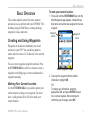
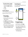
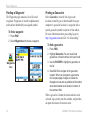
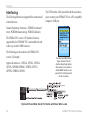
1
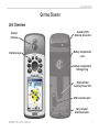
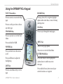
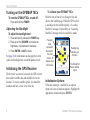
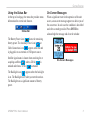
GPSMAP 76Cx ® mapping gps owner’s manual GPSMAP 76Cx shown with optional MapSource® data. © 2007 Garmin Ltd. or its subsidiaries Garmin International, Inc. 1200 East 151st Street, Olathe, Kansas 66062, USA Tel. (913) 397.8200 or (800) 800.1020 Fax (913) 397.8282 Garmin (Europe) Ltd. Liberty House Hounsdown Business Park, Southampton, Hampshire, SO40 9RB UK Tel.+44 (0) 870.8501241 (outside the UK) 0808 2380000 (within the UK) Fax+44 (0) 870.8501251 Garmin Corporation No. 68, Jangshu 2nd Road, Shijr, Taipei County, Taiwan Tel. 886/2.2642.9199 Fax 886/2.2642.9099 All rights reserved. Except as expressly provided herein, no part of this manual may be reproduced, copied, transmitted, disseminated, downloaded or stored in any storage medium, for any purpose without the express prior written consent of Garmin. Garmin hereby grants permission to download a single copy of this manual onto a hard drive or other electronic storage medium to be viewed and to print one copy of this manual or of any revision hereto, provided that such electronic or printed copy of this manual must contain the complete text of this copyright notice and provided further that any unauthorized commercial distribution of this manual or any revision hereto is strictly prohibited. Information in this document is subject to change without notice. Garmin reserves the right to change or improve its products and to make changes in the content without obligation to notify any person or organization of such changes or improvements. Visit the Garmin Web site (www.garmin.com) for current updates and supplemental information concerning the use and operation of this and other Garmin products. Garmin® is a trademark of Garmin Ltd. or its subsidiaries, registered in the USA and other countries. GPSMAP®, AutoLocate®, TracBack®, BlueChart®, and MapSource® are trademarks of Garmin Ltd. or its subsidiaries. These trademarks may not be used without the express permission of Garmin. This product includes technology owned by SiRF Technology, Inc. SiRF’s technology is protected by U.S. and foreign patents pending and issued. SiRF, SiRFstar and the SiRF logo are registered trademarks of SiRF Technology, Inc. SiRFstarIII and SiRF Powered are trademarks of SiRF Technology, Inc. microSD™ is a trademark of The SD Card Association. TransFlash™ is a trademark of SanDisk Corporation. August 2007 Part Number 190-00557-00 Rev.D Printed in Taiwan Introduction Introduction Thank you for choosing the Garmin GPSMAP 76Cx. Both use the proven performance of Garmin GPS and full-featured mapping to create an unsurpassed portable GPS receiver. Take a moment to compare the contents of this package with the packing list on the box. If any pieces are missing, contact your Garmin dealer. Tips and Shortcuts • To quickly return to the Main Menu from any page, press the MENU key twice. • To extend battery life, turn off the GPS when not using the GPSMAP 76Cx for navigation. Decrease the level of the display’s backlight by quickly pressing and releasing the POWER key. GPSMAP 76Cx Owner’s Manual Product Registration Help us better support you by completing our online registration today! Connect to our Web site at http://my.garmin.com. Keep the original sales receipt, or a photocopy, in a safe place. Contact Garmin Contact Garmin if you have any questions while using your unit. Contact Garmin Product Support by phone: (913) 397-8200 or (800) 800-1020, Monday– Friday, 8 AM–5 PM Central Time; or go to www.garmin.com/support/ and click Product Support. In Europe, contact Garmin (Europe) Ltd. at +44 (0) 870.8501242 (outside the UK) or 0808 2380000 (within the UK). Optional �Accessories ����������� For a complete list of available accessories and maps for use with the GPSMAP 76 Cx refer to http://buy.garmin.com. Introduction Table of Contents Introduction.........................................................i Tips and Shortcuts................................................i Product Registration.............................................i Contact Garmin.....................................................i Optional Accessories............................................i Operating the GPSMAP 76Cx.............................iii Warnings..............................................................iv Important Information.........................................iv Getting Started...................................................1 Unit Overview.......................................................1 Using the GPSMAP 76Cx Keypad.......................3 Turning on the GPSMAP 76Cx............................4 Initializing the GPS Receiver...............................4 Basic Operation.................................................7 Creating and Using Waypoints...........................7 Using the Find Menu..........................................11 Using Tracks...................................................... 18 Creating a Route................................................ 22 Main Pages.......................................................25 Satellite Page..................................................... 26 Map Page............................................................ 26 ii Compass Page................................................... 29 Trip Computer Page.......................................... 32 Main Menu........................................................33 Tracks................................................................. 33 Route Page......................................................... 33 Highway Page.................................................... 33 Setup Menu........................................................ 34 Calendar............................................................. 42 Calculator........................................................... 42 Stopwatch.......................................................... 42 Sun and Moon.................................................... 42 Hunt & Fish........................................................ 42 Games Menu...................................................... 42 Appendix..........................................................43 Specifications.................................................... 43 Interfacing.......................................................... 44 Connecting Your GPSMAP 76Cx to a Computer...................................................... 45 Caring for the GPSMAP 76Cx........................... 46 FCC Compliance................................................ 47 Limited Warranty............................................... 48 Software License Agreement........................... 49 Index.................................................................50 GPSMAP 76Cx Owner’s Manual Introduction Operating the GPSMAP 76Cx Understanding Terms Select—move the highlighted area on the screen up, down, left, or right with the ROCKER key to select individual fields. Key—when you are directed to press a key, press and quickly release the key. Field—the location on a page where data or an option can be shown or entered. On-screen button—use the ROCKER key to select a button, and press ENTER. Scroll bar—when viewing a list of items too long to appear on the screen, a scroll bar appears next to the list. To scroll through a list, press up or down on the ROCKER, or use the In and Out keys. Default—the factory setting saved in the unit’s memory. You can change the settings, and revert to the factory settings when you select Restore Defaults. Highlighted field Field On-screen buttons Manual Conventions In this manual, when you are instructed to select an item, small arrows (>) appear in the text. They indicate that you should highlight a series of items on the screen using the ROCKER, and press ENTER after each item. For example, if you see “select Service > Show Info,” you should highlight Service, and press ENTER. Then highlight Show Info, and press ENTER again. GPSMAP 76Cx Owner’s Manualiii Introduction Warnings Failure to avoid the following potentially hazardous situations could result in an accident or collision resulting in death or serious injury. • When navigating, carefully compare information displayed on the unit to all available navigation sources, including information from visual sightings, and maps. For safety, always resolve any discrepancies or questions before continuing navigation. • Use the electronic chart in the unit only to facilitate, not to replace, the use of authorized government charts. Official government charts and notices to mariners contain all information needed to navigate safely. • Use this unit only as a navigational aid. Do not attempt to use the unit for any purpose requiring precise measurement of direction, distance, location, or topography. WARNING: This product, its packaging, and its components contain chemicals known to the State of California to cause cancer, birth defects, or reproductive harm. This Notice is provided in accordance with California’s Proposition 65. See �www.garmin.com/prop65 for more information. The California Electronic Waste Recycling Act of 2003 requires the recycling of certain electronics. For more information on the applicability to this product, see www.erecycle.org. Important Information MAP DATA INFORMATION: One of the goals of Garmin is to provide customers with the most complete and accurate cartography that is available to us at a reasonable cost. We use a combination of governmental and private data sources, which we identify in product literature and copyright messages displayed to the consumer. Virtually all data sources contain some inaccurate or incomplete data. In some countries, complete and accurate map information is either not available or is prohibitively expensive. iv GPSMAP 76Cx Owner’s Manual Getting Started Getting Started Unit Overview Internal antenna Interface keys Auxiliary GPS Antenna Connector Battery compartment cover Battery compartment locking D-ring External Data/ Auxiliary Power Port USB connector port Carry lanyard attachment slots GPSMAP 76Cx Owner’s Manual Getting Started Batteries, microSD Card, and Lanyard The GPSMAP 76Cx operates on two AA batteries (not included), which are located in the back of the unit. You can use Alkaline, NiMH, or Lithium batteries. See page 34 for information on setting the battery type. 1. Remove the battery cover by turning the D-ring 1/4 turn counter-clockwise and pulling the cover loose. 2. Insert the batteries, observing the proper polarity. 3. Reinstall the battery cover. MICRO SD CARD To install the batteries: 1. Remove the battery cover by turning the D-ring 1/4 turn counter-clockwise and pulling the cover loose. 2. Locate the microSD card in the slot below the batteries and press down on the top edge of the card until you feel it click. Then gently allow the card to release. 3. Press down again to install the card, making certain the card is fully in place to prevent damage when reinstalling the battery cover. To install the lanyard: 1. Place the loop of the lanyard throught the slot at the base of the unit. 2. Route the strap through the loop, and pull tight. Remove the batteries from your unit when you do not expect to use the unit for several months. Stored data is not lost when batteries are removed. microSD card slot (with microSD card in position for insertion) To install the microSD card: Install the carry lanyard in the slot at the bottom of the unit GPSMAP 76Cx Owner’s Manual Getting Started Using the GPSMAP 76Cx Keypad IN/OUT Zoom Keys ROCKER Key Press to zoom in or out on the Map page. Press up, down, left, or right to highlight options and to enter data, or move the map panning arrow. Press to scroll up or down a list on any other page. FIND/MOB Key PAGE Key Press to cycle through the main pages. Press at any time to view the Find Menu. Press and hold for MOB. MENU Key POWER Key Press to view page options. Press and hold to turn the unit on or off. Press twice to view the Main Menu. ENTER/MARK Key Press and Release to adjust the backlighting. Press and release to enter highlighted options, data or confirm on-screen messages. QUIT Key Press to cancel data entry or exit a page. GPSMAP 76Cx Owner’s Manual Press and hold at any time to mark your current location as a waypoint. Getting Started Turning on the GPSMAP 76Cx To turn the GPSMAP 76Cx on and off: Press and hold the POWER. Adjusting the Backlight To adjust the backlight level: 1. Press and quickly release the POWER key. 2. Press up on the ROCKER to increase the brightness, or press down to decrease. 3. Press ENTER or QUIT to close. See page 34 for information on changing the screen colors and backlight time out and brightness levels. Initializing the GPS Receiver The first time you turn on your unit, the GPS receiver must collect satellite data and establish its current location. To receive satellite signals, you should be outdoors and have a clear view of the sky. To initialize your GPSMAP 76Cx: Hold the unit in front of you facing the sky and observe the Satellite page. While the GPS receiver is searching for the satellite signals, a “Locating Satellites” message is replaced by an “Acquiring Satellites” message until a location fix is made. The outer circle represents the horizon. The inner circle is 45 degrees from the horizon. Heading bug indicates your direction The Strength of each satellite signal. Initialization Options If the unit cannot get a satellite fix, an options menu with a list of solutions appears. Highlight the appropriate solution and press ENTER. GPSMAP 76Cx Owner’s Manual Getting Started Using the Status Bar At the top of each page, the status bar provides status information for several unit features. Status Bar On-Screen Messages When a significant event in the operation of the unit occurs, an on-screen message appears to advise you of the occurrence. In each case the condition is described and often a remedy provided. Press ENTER to acknowledge the message and close the window. The Battery Power icon ( ) shows the remaining battery power. The Auxiliary Power icon ( ) or Cable Connection icon ( ) appears when the unit is plugged in to an external or USB power source. Satellite signal status is shown when searching for or acquiring satellites ( ), when a 2D fix ( ) is attained and when a 3D fix ( ) is attained. On-Screen Messages The Backlight icon ( ) appears when the backlight is on. The Backlight is off when you turn the unit on. The Backlight uses a significant amount of battery power. GPSMAP 76Cx Owner’s Manual Getting Started Using the Databases The included USB Interface Cable or an optional PC interface cable (with a serial connector) can be used to transfer MapSource CD-ROM data to the microSD card. Higher capacity and pre-loaded microSD map data cards are also available. microSD card slot located in battery compartment MICRO SD CARD Optional MapSource CD-ROMs enhance the versatility of your GPSMAP 76Cx. This data is loaded to the microSD Card already installed in the unit. With optional MapSource City Navigator data, you can view listings of nearby restaurants, lodging, shopping centers, attractions and entertainment, and even retrieve addresses and phone numbers for any listed location. USB interface cable connection under opened battery cover Map data transfer requires the USB Interface Cable provided with the unit to transfer MapSource data from a PC to the microSD card when installed in the GPSMAP 76Cx. Use the USB Mass Storage feature to transfer other files to the microSD as explained on page 35. See http://www.garmin.com/cartography/ for compatible MapSource products. GPSMAP 76Cx Owner’s Manual Basic Operation Basic Operation This section explains some of the more common operations you can perform with your GPSMAP 76Cx including using the Find Menu, creating and using waypoints, tracks, and routes. Creating and Using Waypoints To mark your current location: 1. Press and hold the ENTER/MARK key until the Mark Waypoint page appears. A default threedigit name and symbol are assigned to the new waypoint. Waypoint symbol Waypoint name Waypoints are locations or landmarks you record and store in your GPS. You can add waypoints to routes and even create a Go To directly to the selected waypoint. You can create waypoints using three methods. Press the ENTER/MARK key while at a location, create a waypoint on the Map page, or enter coordinates for a waypoint manually. Marking Your Current Location Use the ENTER/MARK key to quickly capture your current location creating a new waypoint. You must have a valid position (2D or 3D) fix to mark your current location. Mark Waypoint Page 2. To accept the waypoint with the default information, highlight OK. OR To change any information, select the appropriate field, and press ENTER to open the on-screen keypad. After entering and confirming your changes, select OK. GPSMAP 76Cx Owner’s Manual Basic Operation Creating Waypoints Using the Map To create a waypoint using the Map page: 1. On the Map page, use the ROCKER to move the pointer to the map item you want to mark. 2. Press and quickly release ENTER/MARK to capture the pointer location and open the information page for the map item. 3. Select Save. If there is no information for that point, a “No map information at this point. Do you want to create a user waypoint here?” prompt appears. Select Yes. Editing Waypoints You can edit waypoints to change the symbol, name, note, location, elevation, and depth. To edit a waypoint: 1. Press FIND.. 2. Select Waypoints.. 3. Select the waypoint you want to edit, and press ENTER. 4. Make changes by highlighting each field and use the waypoint symbol chart, and alphanumeric keypad to enter new data. To delete a waypoint: From the Waypoints page, select the waypoint you want to delete > Delete. Note: When you delete a waypoint, you cannot recover it from the unit. To move a waypoint on the Map page: 1. Press FIND > Waypoints. 2. Select the waypoint you want to move, and press ENTER. 3. Select Map to show the waypoint on the map. 4. Press ENTER again to place a MOVE marker next to the waypoint. 5. Use the ROCKER to move the waypoint to a new location, and press ENTER. Averaging a Waypoint’s Location You can average a new waypoint location over time to produce a more accurate location. Note: You must have a GPS Satellite fix before you can average a waypoint’s location. GPSMAP 76Cx Owner’s Manual Basic Operation To calculate a location by averaging: 1. Find a location you want to calculate an average for, press MARK > Avg to begin averaging. 2. Press Save. Projecting a Waypoint Create a new waypoint by projecting the distance and bearing from one location to a new location. Proximity Waypoints Use the Proximity Waypoints page to define an alarm circle around a waypoint. Radius field Proximity icon Empty line To project a waypoint: 1. Press FIND > Waypoints. 2. Select the waypoint you want to project. The Waypoint page opens. 4. Press MENU to open the Options menu. 5. Select Project Waypoint, and press ENTER to open the Project Waypoint page. 6. Enter the distance and bearing to the projected waypoint in the appropriate fields at the bottom of the page, and press QUIT when finished. GPSMAP 76Cx Owner’s Manual Proximity Alarm Tones button To add a proximity waypoint 1. Press MENU twice > Proximity. 2. Select an empty line, and press ENTER. 3. Select a waypoint from the Waypoints List or from any other group of Find items to open the information page for the item. 4. Select Use to add the point to the list on the Proximity Waypoints page. Basic Operation 5. Using the ROCKER to select the Radius field and enter a value. To clear one or all proximity waypoints from the list: To remove or review a single entry, press ENTER. To remove all waypoints from the list, press MENU > Remove All. To turn proximity alarms on or off: 1. Press MENU twice to open the Main Menu. 2. Highlight the Proximity icon and press ENTER to open the Proximity Waypoints page. 3. Highlight the Proximity Alarm Tones button, and press ENTER to open the Alarm Tones page. Place a check in the Proximity Alarms box to activate alarms. As you approach a proximity waypoint, a tone sounds and a “Near Proximity Point” message appears. When you move outside the set radius, a “Leaving Proximity Point” message is shown. Use this page to select tones for each alarm. 10 Man OverBoard (MOB) Another method for creating a waypoint is the Man Overboard (MOB) feature. Use this application for marking a location on water where you cannot stop quickly and must return to a point where there are no landmarks for reference. To create a waypoint using the MOB feature: 1. Press and hold FIND/MOB to mark the MOB waypoint. 2. Press ENTER to open the Map page showing the path from your current location to the MOB point. Use the Compass page for additional guidance to the MOB point. GPSMAP 76Cx Owner’s Manual Basic Operation Using the Find Menu Use the Find Menu to search for waypoints, geocaches, cities, and exits included in the GPSMAP 76Cx basemap. Additional icons appear depending on the optional BlueChart or MapSource data loaded to the unit. Press FIND to open the Find Menu. Waypoint Options Menu Find Menu with optional MapSource data Cities Options Menu Find By Name Use Find By Name if you know the name of the location you want to find. To find a location using Find By Name: 1. Press FIND to open the Find Menu. 2. Select the icon for the type of item for which you want to search for, or search the entire database by selecting All Points of Interest. 3. Press MENU > Find By Name. 4. Use the ROCKER to operate the on-screen keypad and enter the name of the location you want to find. When the Find list contains a match, highlight OK. 5. Select the location item from the Find list, and press ENTER. The item’s information page opens, allowing you to save the item as a waypoint, show the item on the map, or automatically create a route to the item (Go To). When you access a Find list, it contains items near your current location or the pointer. The options menu for each category contains a submenu of search options. Select a category. GPSMAP 76Cx Owner’s Manual11 Basic Operation Recent Finds The Recent Finds page shows a list of the last 50 items you have searched for or gone to recently. To go to a recently found item: 1. Press FIND. 2. Select Recent Finds. Using the Find Information Page When you select an item from the Find List and press ENTER, an information page shows detailed information about the item. Each information page contains three on-screen buttons. Different buttons appear depending on whether you are selecting an item to navigate to or adding an item. Find Information Page Options To use the Options Menu: Recent Finds icon List of recently found items 3. Use the ROCKER to select the item you want to go to, and press ENTER. 4. Select Go To to begin navigation. 12 1. With an information page open for a Find item, press MENU to open the Options Menu. 2. Use the ROCKER to select an option: • Average Location—sample a new waypoint location over time and average the result for a more accurate location reference. See page 9. • Project Waypoint—create a new waypoint by entering bearing and distance from a referenced location. See page 9. • Find Near Here—return to the Find Menu to search for map items near the item. GPSMAP 76Cx Owner’s Manual Basic Operation • Change Reference—point to a new location on the Map page using the pointer. • Set Proximity—program an alarm to sound when you are within a specified radius of an item. See page 9. • Add To Route—include this item on a new route or add it to an existing route. See “Creating and Using Routes” on page 22. • View Sun and Moon—view Sun and Moon tables for this item location. See page 42. • View Hunt and Fish—view Hunt and Fish tables for this item location. See page 42. • Map Information—show the map from which the map item originated. See the Appendix for information about downloading detailed maps. 4. Press MENU, select Find Near Here. The Find Menu opens again with each category containing items near the item selected. 5. Select a category icon and press ENTER to open a Find list of items near the item. To find an item from another location on the map: 1. Press FIND. 2. Select an icon on the Find Menu. 3. Press MENU, select Change Reference. The Map page appears. 4. Use the ROCKER to pan the arrow (pointer) to the map location you want. The Find list shows a list of items near the new map location. To find an item near another item: 1. Press FIND. 2. Select an icon on the Find Menu. 3. Select an item in the Find list. GPSMAP 76Cx Owner’s Manual13 Basic Operation Finding a Waypoint The Waypoints page contains a list of all saved waypoints. Waypoints are stored in alphanumeric order and are identified by an assigned symbol. To find a waypoint: 1. Press FIND. 2. Select Waypoints and choose a waypoint. Waypoints icon Finding a Geocache Select Geocache to view the list of geocache locations created by you or downloaded from your computer. A geocache location is a waypoint with a special geocache symbol to separate it from others. For more information about geocaching log on to http://my.garmin.com and click “Go Geocaching.” To find a geocache: 1. Press FIND. 2. Highlight Geocache. You can view found geocaches or those that have not been found. 3. Use the ROCKER to highlight a geocache on the list. 4. Select Go To to navigate to the geocache location. When you navigate to a geocache, the Compass page changes to Geocache Navigation mode and any additional information about downloaded cache location is shown in the comment field. When a geocache is found, the unit marks the cache as found, logs an entry into the calendar, and provides an option that shows the nearest cache. 14 GPSMAP 76Cx Owner’s Manual Basic Operation Finding a City Select Cities from the Find Menu to find any city listed in the mapping data. To find a city: 1. Press FIND. 2. Select Cities. The Cities page shows a list of cities near your current location. 3. Select a city from the list and press ENTER. OR If the city you want is not listed, press MENU > select a search method. Finding an Interstate Exit 3. Use the ROCKER to select an exit, and press ENTER. This page contains the exit description, a list of available services near the exit, and the distance and bearing from the exit to the highlighted service. 4. Select a service from the list, press ENTER. Finding an Address If you downloaded detailed mapping data, use the Addresses icon on the Find Menu to find an address. When you enter the street number, street name, and city, the find feature matches that data with addresses in the map database. Use the Exits icon on the Find Menu to find an interstate exit. To find an interstate exit: 1. Press FIND. 2. Select Exits. A list of interstate exits near your location is shown. Addresses icon Addresses Page GPSMAP 76Cx Owner’s Manual15 Basic Operation To find an address: 1. Press FIND. 2. Select Addresses. Note: If your unit has a GPS fix, the <Enter Region> field is populated with your current region. You do not have to specify a city in the <Enter City>, as the database has information for the entire region. \ 3. Select <Enter Number> and type the street number using the screen keypad. Select OK. 4. Select <Enter Street Name>. The street list opens. 5. Use the screen keypad to enter enough of the street name to show a match. Select OK. A list of matches appears. 6. Select the address you want. Finding an Intersection Finding a Marine Point If using MapSource BlueChart marine cartograpy, use the Marine menu which contains subcategories including Wrecks, Tides, Navaids, Marine Services, Anchorages, and Restricted Areas. The Tide icon contains a list of tide stations with information in a 24-hour span starting at midnight station time is available for each tide station. The chart shows a 24-hour block of time, with the time progressing from left to right. The solid vertical lines represent 4 hour increments; the dotted vertical lines represent 1 hour increments. Enter the date for which you want to view the tide information Height of tide This feature also requires detailed mapping data. Follow the basic steps for finding an address when searching for an intersection. Tide Prediction Station 16 GPSMAP 76Cx Owner’s Manual Basic Operation To view the tide chart for another date: 1. From the Tide menu with the chart shown, select Date, and press Enter. 2. Enter the date with the ROCKER. You can also use the Zoom In and Out keys to view information for another date. Press and hold In or Out to scroll quickly through dates. 3. Press Enter. The unit shows the chart for the date you entered or selected. To use the current date again, select the Date field. Press Menu > Use Current Date. Searching for a Point of Interest If you downloaded MapSource detailed mapping, use All Points of Interest to locate items such as nearby restaurants, lodging, landmarks, and public buildings. If you are searching for a restaurant that is part of a national chain, only the restaurant nearest to your location is shown when you search using the Find Nearest option. If you search using the By Name option, all of the locations for that chain in the mapping database are shown with the closest to your current location listed first. POI Loader and Custom Points of Interest You can create your own category for points of interest by using the Garmin POI Loader utility available from the Garmin Web site www.garmin.com/products/poiloader/. Follow the Help instructions to use POI Loader. To find a point of interest: 1. Press FIND. 2. Select All Points of Interest to show a list of all points near your current location. 3. Press MENU. 4. Select an item from the list, and press ENTER. GPSMAP 76Cx Owner’s Manual17 Basic Operation Using Tracks To clear the track log: The Tracks feature creates an electronic bread crumb trail or “track log” on the Map page as you travel. The track log contains information about points along its path, including time, location, elevation, and depth (depth requires NMEA input, see page 35). 1. Press MENU twice to open the Main Menu. 2. Select Tracks. 3. Select the Clear button. A confirmation message appears. 4. Select OK. The track log starts recording as soon as the unit gets a location fix. The percentage of memory used by the current track log appears at the top of the Tracks page. To set up a track log: Percentage of memory used List of saved tracks Tracks Page 18 1. Press MENU twice > Tracks. 2. Select Setup. • Wrap When Full—the track log records over the oldest data with new data. • Record Method—Distance records track points after a specified distance is traveled. Time creates track points after a specified time has elapsed. Auto allows you to choose from five intervals. • Interval—records a track according to the Record Method and Interval. Enter a specific distance, time, or frequency. • Color—select the color of the active track on the map. GPSMAP 76Cx Owner’s Manual Basic Operation • Log Track to Data Card—records the current track log to the microSD card in addition to the unit’s internal memory. Using this option allows you to record a large number of track points (depending on the capacity of the microSD card.) Track logs on the data card are .gpx GPS position data files, and are not used by your unit. To save the entire track log: 1. Press MENU twice > Tracks. 2 Select Save. A message appears asking you if you want to save the entire track. 3. Select Yes to save the track. Track name Track distance Calculated area Track color To save a portion of the track log: 1. Press MENU twice > Tracks. 2. Select Save. A message appears asking you if you want to save the entire track. 3. Select No to save only a portion of the track log. 4. Use the ROCKER to move the pointer to the point on the track line that you want to be the beginning point, and press ENTER. 5. Repeat to select an ending point. Select OK. To log tracks to the microSD card: 1. With the Track Log setup page shown, select Data Card Setup. 2. Highlight the Log Track to Data Card option, and then press ENTER. A current date .gpx file appears in the Data Card Tracks list. This file is a continuous compilation of all track data for the indicated date. As long as this feature is enabled, a new file is recorded for each day you use the unit. Recording continues until the card is filled. Saved Track Page GPSMAP 76Cx Owner’s Manual19 Basic Operation 3. Use the USB cable to connect to your computer and then access the USB Mass Storage feature as explained on page 35. Open the track logs using Garmin MapSource or another .gpx filecompatible application. 4. To delete these track logs from the microSD card, highlight individual logs, and then press ENTER. Use the Delete All button to clear the entire list. Note: Do not remove the microSD card from the unit while logging a track, as corruption of the data can result. To view a track on the map: On the Saved Track page, select the Map. A map showing the entire track appears. Begin and End markers and user waypoints are added to the track. To calculate the area of a track: 1. With the Track Log page open and the Track Log on, press MENU. 2. Select Area Calculation, and press ENTER. 20 3. Press ENTER to start the area calculation. As you begin to move and define the area’s boundaries, a Stop button appears at the bottom of the page. 4. When finished defining the area, press ENTER and select Save. Track Profiles A Track Elevation Profile is created when using Digital Elevation Model (DEM) maps. Refer to the Garmin Web site for information about these maps. To view a track profile: 1. Open the Saved Track page, and press MENU. 2. Highlight Profile. The beginning of the track is marked by a flag. Use the ROCKER to scroll across the track profile. At any point along the profile, press ENTER to show that point on the map. 3. Press MENU to use Zoom Ranges and Hide Symbols options. GPSMAP 76Cx Owner’s Manual Basic Operation Elevation Begin marker Distance from Begin and End points End marker 4. Move in the direction of the first turn. At the first turn, directions to the next turn are shown, and so on, until you reach your destination. 5. Press MENU > Stop Navigation to exit. To create a waypoint on a saved track: 1. With the saved track on the map, use the ROCKER to move the pointer on the track point that you want to mark as a user waypoint. 2. Press ENTER. Track Profile Page Navigating a Saved Track To use the TracBack feature: 1. With the Saved Tracks page for the track or the Track Log open, select TracBackto show the track. Select the point to TracBack. 2. Use ROCKER to move the pointer to the point on the map to start navigating the TracBack. 3. Select Follow Road to route back to the point using available roadways, or select Follow Track to retrace your original path of travel. The Map page gives directions to the first turn on the track. GPSMAP 76Cx Owner’s Manual21 Basic Operation Creating a Route Routing creates a sequence of waypoints that lead you to your final destination. The GPSMAP 76Cx stores 50 routes with up to 250 points each. Create or modify a route using the Routes page, and add waypoints to a route. Create complex routes using MapSource map data. To create a route: 1. Press MENU twice > Routes. 2. Select New > <Select Next Point>. Route Page 22 3. Use the Find Menu to select a route waypoint from one of the Find groups. 4. Select Use to add it to the route. 5. Select Navigate . Methods for routing you to a destination • If you select Go To on the Waypoint page, or other Find items, a straight path is created. • If you select Navigate when on a Route page, the GPSMAP 76Cx uses a route made of waypoints or Find Menu items. It navigates directly from point to point. • If you select the Follow Roads option on the Routing Setup page. Both Go To navigation and point-to-point allow you to Auto-route using roads. Auto-routing uses roadways in the map database to automatically calculate a route to your destination. Turns on roadways are preceded by a guidance message with a graphic of the turn. Route on the Map Page GPSMAP 76Cx Owner’s Manual Basic Operation Navigating a Route To navigate a saved route: 1. Press MENU twice > Routes. 2. Select a saved route > Navigate. 3. Select Follow Road or Off Road from the prompt. 4. To stop navigating, press MENU > Stop Navigation. To preview the turns for an active route: 1. From the Routes page, select a saved route. 2. Select Navigate to begin navigation. 3. Press QUIT to view the list of turns on the route. To view an individual turn, select it. Using Auto-Routing This feature is enabled when using City Navigator® mapping data. When you select a destination, and select Go To, you are queried, “Follow Road” or “Off Road.” Using Follow Roads increases the number of turns and shows an Active Route page. Select Off Road, to view only a list of route points. A “Calculating Route” message appears until the route calculation is complete. Your route appears as a magenta line overlaying the map. Active Route Page when following roads Turn Preview Page 4. Use the ROCKER to scroll through all turns. GPSMAP 76Cx Owner’s Manual23 Basic Operation Editing a Route Use the Route page to edit, change the route name, and review route points. To change the name of the route: 1. Press MENU twice > Routes. 2. Select a saved route > select the route name field at the top of the Route page. To review individual route points: 1. Press MENU twice > Routes. 2. Select a saved route > select a point on the Route page > ENTER > Review. 3. Select Save, Map, or Go To. To delete a route: From the page for that route, press MENU > Delete Route. To select the off-road transition for a route: 1. Press MENU twice > Routes > MENU. 2. Select Off Road Transition > Route Leg Transition. 3. Select Manual or Distance when advancing to the next point. 24 Select Distance to enter a radius so that when you are within the entered distance, you are led to the next point. Select Manual to transition to the next waypoint anytime while navigating a route. Route Page Options • Remove All—removes waypoints from a saved route. • Reverse Route—reverses the order of the route points in the saved route. • Profile—creates a vertical profile of the route when using US DEM Topo maps. • Copy Route—makes a copy of the saved route with the same name, followed by a number. • Delete Route—deletes the saved route. • Change Data Fields—select different values for the two data fields at the bottom of the page. • Restore Defaults—restore route settings to the factory default settings. GPSMAP 76Cx Owner’s Manual Main Pages Main Pages The GPSMAP 76Cx has six main pages: Satellite page, Trip Computer page, Map page, Compass page, Altimeter page, and the Main Menu. Cycle through these pages by pressing the PAGE key to move forward or pressing the QUIT key to reverse. Add additional pages by using the Page Sequence option on the Main Menu. The Active Route page appears when you are actively navigating. Each page has an Options Menu. To view the Options Menu for a page, press MENU. Satellite Page Satellite Page Options Menu Trip Computer Page Trip Computer Page Options Menu Map Page Map Page Options Menu Compass Page Compass Page Options Menu Main Menu No Options Available for the Main Menu GPSMAP 76Cx Owner’s Manual25 Main Pages Satellite Page The Satellite page appears when you turn the unit on and shows the receiver status, satellite locations, satellite signal strength, and the receiver’s current location. Map Page A built-in basemap that includes cities, interstates, state and county highways, exit information, and lake and river outlines. The basemap can be enhanced with the addition of MapSource or BlueChart data. Satellite Page Options • Use With GPS Off/On—enables you to turn the GPS receiver on or off. • Track Up/North Up—indicates whether satellites are shown with the rings oriented with North toward the top of the screen or your current track toward the top of the screen. • Multicolor/Single Color—indicates whether each satellite is shown in a different color or the same color. • New Location—use if you have moved the unit more than 600 miles and you are having trouble locking onto satellite signals. • GPS Elevation—shows your current GPS elevation. 26 Data fields Show sub-menu Map Page with data fields Two map operating modes, position mode and pan mode, determine what is shown on the map. Position mode pans the map to keep your present location in the screen area. The position marker shows your travel on the Map page. When you press the GPSMAP 76Cx Owner’s Manual Main Pages ROCKER, the GPSMAP 76Cx enters pan mode, which moves the map to keep the white arrow (map pointer) within the screen area. When you are in pan mode, you can move the map pointer about the page to highlight and identify map items. Add and configure up to four optional data fields to the top of the page to provide a variety of travel and navigational information. To show data fields on the Map Page: 1. Press MENU > Data Field. 2. Select the number of data fields you want to show on the Map page, and press ENTER. To change a data field: 1. Press MENU > Change Data Fields. The first data field is highlighted. 2. Press ENTER. 3. Select an option. 4. Move to the next field and repeat. Using Additional Map Data View listings such as nearby restaurants, lodging, shopping centers, attractions, and entertainment, and you can retrieve addresses and phone numbers for any listed location when using optional MapSource data. Using BlueChart data, you can view marine navaids, wrecks, obstructions, and anchorage locations. To review map information: 1. From the Map page, press MENU > Setup Map. 2. Select the Map Setup-information page. The list of maps stored on the microSD card appears. A check mark means a map is active. Changing the Zoom Range Press IN to decrease the Zoom Range and show an area with greater detail; press OUT to increase the Zoom Range and show a larger area with less detail. The current Zoom Range setting is shown in the lower left corner of the Map page. If no further map information is available, “overzoom” appears under the Zoom Range When using MapSource detailed maps, “mapsource” appears below the scale. GPSMAP 76Cx Owner’s Manual27 Main Pages Map Orientation There are two map orientations in the Map Setup option North Up orients the map like a paper map. Track Up orients the map in the direction of travel. Map Page Options • Stop (Resume) Navigation—stops/resumes navigation. • Recalculate—recalculates a route. • Data Fields—opens the Show sub menu so you can select the number of data fields to show: Map Only, 1 wide, 2, 2 wide, 3, or 4 data fields. • Change Data Fields—allows you to select the type of data in the data fields. This option is available only if data fields are selected. • Guidance Text—shows messages on the screen advising you of your next navigation move. • Setup Map—accesses to six pages of display options. • Measure Distance (Stop Measuring)— measures the distance from your current location to the map pointer. 28 • Turn Declutter On (Off)—eliminates items on the map that can block road details. • Restore Defaults—returns to factory defaults. Guidance Text When navigating, guidance text appears above the map. Guidance text To show guidance text: 1. Press MENU > Guidance Text. 2. Select Always Show, Never Show, or Show When Navigating. If you select Always Show, a guidance message always appears. If you select Show When Navigating, a guidance message shows until you select Stop Navigation. Setup Map See page 36 for detailed instructions. GPSMAP 76Cx Owner’s Manual Main Pages Measuring Distance To measure distance between two points: 1. Press MENU > Measure Distance. An onscreen arrow appears on the map at your current location with REF below it. 2. Move the arrow to the reference point (the starting point you want to measure from), and press ENTER. A push pin icon marks the starting point on the map. 3. Move the arrow to the point you want to measure to. The distance between the two points is shown in the upper-right corner. Push pin indicating the beginning point of the measurement Compass Page The Compass page guides you to your destination with a graphic compass and a bearing or course pointer. Bearing Pointer The Compass Ring moves to indicate North Orientation. Measured distance Compass Page End point of measurement labeled REF The rotating compass ring indicates the direction you are heading. The bearing and course pointers indicate the direction (bearing to or course of travel) to your destination, relative to your current heading direction. Choose a bearing pointer or course pointer for guidance. GPSMAP 76Cx Owner’s Manual29 Main Pages Compass Page Options • Stop (Resume) Navigation—turns active navigation for a route or Go To on and off. • Recalculate—recalculates the path to a destination. • Course or Bearing Pointer—toggles between the course pointer and the bearing pointer. • Data Fields—selects the number of data fields that appear on the Compass page. • Change Data Fields—selects the type of data you want to show in the data fields. • Restore Defaults—returns to factory settings. Using the Course Pointer or Bearing Pointer The bearing pointer and course pointer are independent of each other. The bearing pointer indicates the direction to your destination, and the course pointer indicates your relationship to a course line leading to the destination. If the bearing pointer arrow is pointing straight up, for example, you are going directly to your destination. If it points any direction other than up, turn toward that direction until the arrow is pointing up and then continue in that direction. The bearing pointer points to the destination. The Bearing Pointer always indicates the direction to your destination from your current location. 30 GPSMAP 76Cx Owner’s Manual Main Pages If you are using the course pointer option, and you drift away from the line of travel from your original location to your destination, the course deviation indicator (an arrow with horizontal dotted line) provides graphic indication of drift (right or left) according to the scale shown on the compass ring. Move to the right or left to get back on course. To select the course pointer or the bearing pointer: 1. Press MENU to open the Compass page options menu. The bearing pointer is the factory default. When the bearing pointer option is shown, the course pointer is active and vice versa. 2. Highlight the bearing or course pointer option, and press ENTER to start. Data Fields You can show two wide, three or four data fields on the Compass page. 0.25 mi Scale The Course Pointer indicates your course of travel from your original location and the distance off course. GPSMAP 76Cx Owner’s Manual31 Main Pages Trip Computer Page The Trip Computer page shows eight types of navigation data. Choosing Big Numbers arranges the page in three large data fields. Trip Computer Page Each data field is selectable and can contain one of many data information options. When the data field title is selected, press ENTER to make a new choice. 32 Trip Computer Page Options • Reset—stars a new record of the trip computer. Before each trip, reset the trip information by highlighting Reset from the Options Menu, and pressing ENTER. The Reset page offers options for resetting trip computer data, clearing the Track Log, and deleting Saved Tracks, Waypoints and Routes. This page allows you select individual items, select all, and deselect all. When your selections are made, highlight Apply, and press ENTER. Answer OK to the “The Data You Have Selected Will Be Permanently Deleted” prompt, and press ENTER to complete the reset. • Big Numbers—shows fewer fields with larger numbers. • Change Data Fields—allows you to select the type of data you want to show in the data fields. • Restore Defaults—allows you to return the page to factory settings. GPSMAP 76Cx Owner’s Manual Main Menu Main Menu The Main Menu contains settings and features not found on the main pages and sub-menus. The time and date are shown at the bottom of this page. The Main Menu is accessible from any page by pressing MENU twice. To select an item on the Main Menu, highlight the menu item, and press ENTER. Main Menu NOTE: If a page is added to the page sequence, the page icon does not appear on the Main Menu. Tracks For more information, see page 18. Route Page For more information, see page 24. Highway Page This page takes you point by point to your destination. Highway Page To use the Highway page: Select the Highway page from the Main Menu and observe your path on the highway graphic. GPSMAP 76Cx Owner’s Manual33 Main Menu Setup Menu To access the Setup Menu: From the Main Menu, select Setup. System Setup Page To access the System Setup: From the Setup Menu select System. • GPS—choose on the GPS options other than Normal to save battery power. • WAAS/EGNOS—set to Enable or Disable. • Battery Type—choose the type of battery being used in order to produce a more accurate battery capacity report. • Text Language—set the unit’s on-screen language. • External Power Lost—set the unit to turn off if external power is lost. • Proximity Alarms—turns custom POI and Proximity alarms on and off. Use the option menu to restore defaults, read microSD card information, or view the version of unit software and the Unit I.D. number. 34 Display Setup Page You can choose a display mode, a color scheme for day and for night viewing, adjust the amount of time that the backlight stays on, and set the level of brightness. To access the Display Setup page: From the Setup Menu, select Display. • Display Mode—set for Auto (changes from day to night mode and back again at dusk and dawn), Day only, or Night only. • Daytime Color Scheme—set in Day mode to one of 10 color schemes. • Nighttime Color Scheme—set in Night mode to one of 10 color schemes. • Backlighting Timeout—choose from Stays On or delays of 15 seconds, 30 seconds, one minute, or two minutes. • Backlight Intensity Level—use the slider to adjust the brightness. GPSMAP 76Cx Owner’s Manual Main Menu Interface Setup Page Use when connecting to a computer. To access the Interface Setup page: From the Setup Menu, select Interface. Serial Data Format—sets the data format to one of the following: • GARMIN—the proprietary format used to exchange waypoint, route, track log and MapSource data with a computer. • NMEA In/NMEA Out—Supports input and output of standard NMEA 0183 version 3.01 data. • TEXT OUT—Allows ASCII text output of location and velocity information. No input. • NONE—Provides no interfacing capabilities. USB Mass Storage—allows the microSD card to be used as a USB Mass Storage device. It also allows transfer of Track Log Data to Garmin MapSource. To activate ��������������������������� USB Mass Storage for HCx units: 1. Connect the unit to a computer. 2. Select USB Mass Storage, and press Enter. 3. Double click My Computer to observe a new Removable Drive listing. To view information for the microSD card: Press Menu prior to opening the USB Mass Storage page and, select Card Info. To transfer files to the microSD card: 1. Double-click the My Computer icon. 2. Browse the computer for the file. 3. For a computer, select the file, Edit > Copy. Note: If you have several network drives mapped to your computer, log on without connecting to the network or click Start > Settings > Control Panel > Administrative Tools > Computer Management > Storage > Disk Management and remap a drive letter for the storage device. 4. After the transfer, end the USB cable connection. GPSMAP 76Cx Owner’s Manual35 Main Menu Tones Setup Page This setup page allows you to select a unique tone for each of the tone applications. (For proximity alarm tones, see page 10.) Page Sequence Setup Add, remove, or reorder any of the Main pages. To move, insert or remove a Main page: 1. From the Setup Menu, select Page Seq. 2. To rearrange a page in the page sequence, select the page and press in. Select Move. 3. To insert a new page, select the page you want to insert if before, press ENTER > Insert. Map Setup Page Use the Map Setup page to adjust how items are shown on the Map page. To customize the Map page display: 1. Press MENU > Setup Map. The top of the page contains icons for each setup page. 2. Use the ROCKER to select a page and to move up and down the feature fields on each page. General Tracks Points Text Information Marine 3. With a Map Setup feature highlighted, press ENTER to show the list of options for that feature. Each page has a sub-menu of general options. To access this menu, press MENU with the preferred setup page displayed. 36 GPSMAP 76Cx Owner’s Manual Main Menu Map Setup – General Page The Map Setup – General page contains the settings for Orientation, Below, Auto Zoom, Detail, and Lock On Road. • Lock On Road—locks the map pointer to display on the nearest road, compensating for variances in map position accuracy. Map Setup – Tracks Page Use the Map Setup –Tracks page settings for Saved Tracks, Track Log, Track Points, and Go To Line. Map Setup – General Page • Orientation—selects how the map is shown. North Up always shows north at the top of the page. Track Up shows your current track toward the top of the page. • Below—sets the map scale at which the Track Up feature displays. All scales above that revert to the North Up map orientation. • Auto Zoom—zooms the map scale to include the beginning and ending points of a route. • Detail—selects the degree of map detail shown. Map Setup – Tracks Page • Saved Tracks—sets the maximum zoom range at which saved tracks are shown on the map. • Track Log—sets the maximum zoom range at which active track logs are shown. • Track Points—sets the maximum number of track points used to record a track. • Go To Line—selects either a bearing or course line for navigating a track. GPSMAP 76Cx Owner’s Manual37 Main Menu Map Setup – Points Page Use the Map Setup – Points page to set the map scale at which Map Points, User Waypoints, Street Label, and Land Cover appear on the Map page. Select Auto, Off, or from 20 ft to 800 mi (50 m to 800 km). Map Setup – ����������������� Information Page Use the Map Setup – Information page to view a list of downloaded detailed maps such as topographic, marine charts, and maps with auto-routing capability. Highlight a map to show it on the map or turn it off. Map Setup – Information Page Map Setup – Points Page Map Setup – Text Page Use the Map Setup – Text page to select the text size for descriptions of map items on the Map page. You can select from Small, Medium, or Large. Map Setup – Text Page 38 Press MENU to view options for displaying maps. Map Setup – Marine Page Use the Map Setup – Marine page to customize settings for marine colors, spot soundings, light sectors, and symbol sets. Map Setup – Marine Page GPSMAP 76Cx Owner’s Manual Main Menu • Marine Colors—toggles colors on or off. • Spot Soundings—toggles spot soundings on or off. • Light Sectors—select from On, Off, and Auto. • Symbol Set—select the symbol set to use (Auto, GARMIN, NOAA, International). Routing Setup Use to customize the wayrouting functions behave. To access the Routing Setup page: From the Setup Menu, select Routing > Follow Road Options. Guidance Method—calculate routes based on: • Prompted—you are prompted to select a preference before the route is calculated. • Follow Road—increases the number of turns the route contains. • Off Road—creates a direct line from your current location to your destination. This is useful when traveling outside of the detailed map coverage area or where no roads exist. Follow Road Method—select how the unit calculates follow road routes based on: • Prompted—you are prompted to select a preference before the route is calculated. • Faster Time—routes calculated are faster to drive but might be longer in distance. • Shorter Distance—routes calculated are shorter in distance but take more time to drive. Next Turn Pop-up—turns the Next Turn pop-up window on or off. Routing Setup Page Follow Road Options GPSMAP 76Cx Owner’s Manual39 Main Menu Follow Road Options Off Route Recalculation—set whether the unit prompts you when it is recalculating your route (Prompted) or recalculates automatically. You can turn off-route recalculation off. Calculation Method—set how the unit searches for the route. • Quickest Calculation—calculates the route the quickest, but it might not produce the best route. • Quick Calculation—takes more time to calculate but generates a better quality route. • Better Route—generates an even better quality route but uses a longer calculation time. • Best Route—generates the optimal route but takes the longest time to calculat. • Calculate Routes For—set route calculation for the vehicle you are operating to optimize the route for your vehicle type. Avoid—avoid certain road types and maneuvers on your route. 40 Geocache Setup See the Garmin web site for information on geocache locations log into http://my.garmin.com, and click Go Geocaching. To setup the Geocache feature: 1. Access the Setup Menu, select Geocache. 2. Select the symbol fields if you want to assign other symbols. 3. Select Yes or No for a calendar entry when a geocache is found. Marine Alarms Setup To access the Marine Setup page: From the Setup Menu, select Marine. • Anchor Drag Alarm—sets an alarm when you exceed a specified drift distance. • Off Course Alarm—sets an alarm to sound when off course. • Deep Water Alarm—sets the depth at which the alarm sounds. • Shallow Water Alarm—sets the depth at which the alarm sounds. GPSMAP 76Cx Owner’s Manual Main Menu Time Setup To access the Time Setup page: From the Setup Menu, select Time. • Time Format—choose from 12-hour or 24hour time format. • Time Zone—set to one of the eight US Time Zones, or 24 International Time Zones. • Daylight Saving Time—On or Off or Auto. Units Setup To access the Units Setup page: From the Setup Menu, select Units. • Position Format—sets the coordinate system in which a location is shown. • Map Datum—sets the description for geographic location for, mapping, and navigation and is not an actual map in the unit. • Distance/Speed—sets the unit of measurement to show your speed and distance. • Elevation (Vert. Speed)—sets the unit of measurement (Feet (ft/min), Meters (m/min), or Meters (m/sec). • Depth—select the unit of measurement (Feet, Fathoms, or Meters). • Temperature—sets the unit of measurement (Fahrenheit or Celcius) to indicate the temperature. Heading Setup Page You can select the type of heading mode. To access the Heading Setup page: From the Setup Menu, select Heading. • Display—choose from Cardinal Letters, Degrees or Mils. • North Reference—choose from True, Magnetic, Grid or User options. Welcome Page Setup Insert a message when you turn the unit on. Proximity Waypoints Use the Proximity Waypoints page to define an alarm circle around a waypoint. See page 9. GPSMAP 76Cx Owner’s Manual41 Main Menu Calendar To access the Calendar: From the Main Menu, select Calendar. Calculator To access the Calculator: From the Main Menu, select Calculator. Stopwatch To access the Stopwatch: Hunt & Fish To view predictions for a date and location: From the Main Menu, select Hunt & Fish to view the predictions for a different date. Select Date to open the on-screen keypad. For a location, select the Location field. Games Menu To open the Games Menu: From the Main Menu, select Games. From the Main Menu, select Stopwatch. Sun and Moon To access the Sun and Moon page: From the Main Menu, select Sun and Moon. 42 GPSMAP 76Cx Owner’s Manual Appendix Appendix Specifications Physical Power Source: Two 1.5 volt AA batteries, USB power, 12 V Adapter Cable, or up to 36 VDC external power Battery Life: Up to 18 hours (typical use)* Weight: 7.6 ounces (216 g) w/batteries installed. *Alkaline batteries lose a significant amount of their capacity as the temperature decreases. Use Lithium batteries when operating the GPSMAP 76Cx in below-freezing conditions. Extensive use of screen backlighting, electronic compass, and audible tones significantly reduce battery life. Display: 1.5" W x 2.2" H, 256-color, high resolution, transreflective (160 x 240 pixels) with backlighting. Accuracy Size: 6.2" H x 2.7" W x 1.4" D Case: Rugged, fully gasketed, water resistant, IEC-529, IPX7 Temp Range: 5 to 158oF (-15 to 70oC)* GPS: <10 meters (33 feet) 95% typical* *Subject to accuracy degradation to 100 m 2DRMS under the U.S. DoD imposed Selective Availability (SA) Program when activated. *The temperature rating of the GPSMAP 76Cx may exceed the usable range of some batteries. Some batteries can rupture at high temperatures. DGPS: 3-5 meters (10-16 feet) 95% typical* Performance Velocity: 0.05 meter/sec steady state Acquisition Times*: Approx. 1 second (warm start) Approx. 38 seconds (cold start) Approx. 45 seconds (factory reset) Data Storage Life: Indefinite: no memory battery required Receiver: WAAS/EGNOS enabled *On average for a stationary receiver with an open sky view. Update Rate: 1/second, continuous Antenna: Built-in quad helix, remote antenna capability. * WAAS accuracy in North America. Interfaces: NMEA 0183 version 2.3, and RS-232 and USB for PC interface Map Storage: Dependant on the formatted capacity of the microSD Digital Card (A small portion of the card capacity has been used in formatting the card for use.) GPSMAP 76Cx Owner’s Manual43 Appendix Interfacing The following formats are supported for connection of external devices. The USB Interface Cable provided with this unit allows you to connect your GPSMAP 76Cx to a PC-compatible computer’s USB port. Garmin Proprietary Sentences—PGRME (estimated error), PGRMM (datum string), PGRMZ (altitude). The NMEA 0183 version 3.01 interface format is supported by the GPSMAP 76Cx and enables the unit to drive up to three NMEA devices. The following are the sentences for NMEA 0183, version 3.01 output: Approved sentences—GPGGA, GPGLL, GPGSA, GPGSV, GPRMB, GPRMC, GPRTE, GPVTG, GPWPL, GPBOD, GPAPB The Advanced NMEA Setup Page, accessed from the Interface Setup Page Options Menu allows you to enable or disable NMEA sentences, set waypoint ID’s and the precision of Lat/Lon minutes. Optional Power/Data Serial Port Cable with Bare Wire Leads 44 GPSMAP 76Cx Owner’s Manual Appendix Connecting Your GPSMAP 76Cx to a Computer You can connect your GPSMAP 76Cx to your computer using either a serial port or USB connector cable. Note: Fully install the supplied MapSource program, Trip & Waypoint Manager, on your computer before connecting the USB cable to the computer. To connect your GPSMAP 76Cx to your computer: 1. Lift the USB protective cover from the back of the GPSMAP 76Cx and insert the smaller connector on the USB cable into the matching port. 2. Connect the remaining cable end to your computer's USB port. To connect to your computer using a Serial Port connector: 1. Lift the Serial Port protective cover from the back of the GPSMAP 76Cx and insert the round indexed connector on the cable into the matching port. 2. Connect the remaining cable end to your PC Serial port or other appropriate device. 3. Set your GPSMAP 76Cx interface setting to the appropriate interface format. Refer to Interface Setup on page 35. Information About USB Drivers The USB drivers should have been automatically installed when you installed the MapSource program that came with your GPSMAP 76Cx. When you initially connect the GPSMAP 76Cx to a USB port, your computer might prompt you to locate the destination of the drivers for the device. You only need to install the drivers once. After the drivers are installed, your computer always detects your GPSMAP 76Cx when it is connected. USB drivers might be updated periodically. You can find updates at www.garmin.com. GPSMAP 76Cx Owner’s Manual45 Appendix Caring for the GPSMAP 76Cx Storage Cleaning the Case Clean the unit’s outer casing (except for the screen) using a cloth dampened with a mild detergent solution and then wipe dry. Avoid chemical cleaners and solvents that may damage plastic components. Do not store the GPSMAP 76Cx where prolonged exposure to temperature extremes may occur (such as in the trunk of a car) as permanent damage may result. User information, such as waypoints and routes are retained in the unit’s memory without the need for external power. It is always a good practice to back up important user data by manually recording it or downloading it to a computer (transferring it to MapSource). Cleaning the Screen Water Immersion The GPSMAP 76Cx case is constructed of high quality materials and does not require user maintenance except cleaning. The unit’s lens is coated with a special anti-reflective coating that is sensitive to skin oils, waxes and abrasive cleaners. Cleaners containing ammonia, alcohol, abrasives, or anti-grease detergents will harm the anti-reflective coating. It is important to clean the lens using an eyeglass lens cleaner (that is specified as safe for anti-reflective coatings) and a clean, lint-free cloth. 46 The unit is waterproof to IEC Standard 60529 IPX7. It can withstand immersion in 1 meter of water for 30 minutes. Prolonged submersion can cause damage to the unit. After submersion, be certain to wipe and air dry the unit before reuse. GPSMAP 76Cx Owner’s Manual Appendix FCC Compliance This product has been tested and found to comply with Part 15 of the FCC interference limits for Class B digital devices FOR HOME OR OFFICE USE. These limits are designed to provide more reasonable protection against harmful interference in a residential installation, and are more stringent than “outdoor” requirements. Operation of this device is subject to the following conditions: (1) this device may not cause harmful interference, and (2) this device must accept any interference received, including interference that may cause undesired operation. This equipment generates, uses, and can radiate radio frequency energy and may cause harmful interference to radio communications if not installed and used in accordance with the instructions. However, there is no guarantee that interference will not occur in a particular installation. If this equipment does cause harmful interference to radio or television reception, which can be determined by turning the equipment off and on, the user is encouraged to try to correct the interference by one of the following measures: • Reorient or relocate the receiving antenna. • Increase the separation between the equipment and the receiver. • Connect the equipment into an outlet that is on a different circuit from the GPS unit. • Consult the dealer or an experienced radio/TV technician for help. This product does not contain any user-serviceable parts. Repairs should only be made by an authorized Garmin service center. Unauthorized repairs or modifications could result in permanent damage to the equipment, and void your warranty and your authority to operate this device under Part 15 regulations Industry Canada Compliance Category I radiocommunication devices comply with Industry Canada Standard RSS-210. Category II radiocommunication devices comply with Industry Canada Standard RSS-310. Declaration of Conformity Hereby, Garmin declares that this GPSMAP 76Cx is in compliance with the essential requirements and other relevant provisions of Directive 1999/5/EC. To view the full Declaration of Conformity, see the Garmin Web site for your Garmin product: www.garmin.com/products/gpsmap76cx/. Click Manuals and then select the Declaration of Conformity. GPSMAP 76Cx Owner’s Manual47 Appendix Limited Warranty This Garmin product is warranted to be free from defects in materials or workmanship for one year from the date of purchase. Within this period, Garmin will, at its sole option, repair or replace any components that fail in normal use. Such repairs or replacement will be made at no charge to the customer for parts or labor, provided that the customer shall be responsible for any transportation cost. This warranty does not cover failures due to abuse, misuse, accident, or unauthorized alteration or repairs. This product is intended to be used only as a travel aid and must not be used for any purpose requiring precise measurement of direction, distance, location or topography. Garmin makes no warranty as to the accuracy or completeness of map data in this product. THE WARRANTIES AND REMEDIES CONTAINED HEREIN ARE EXCLUSIVE AND IN LIEU OF ALL OTHER WARRANTIES EXPRESS, IMPLIED, OR STATUTORY, INCLUDING ANY LIABILITY ARISING UNDER ANY WARRANTY OF MERCHANTABILITY OR FITNESS FOR A PARTICULAR PURPOSE, STATUTORY OR OTHERWISE. THIS WARRANTY GIVES YOU SPECIFIC LEGAL RIGHTS, WHICH MAY VARY FROM STATE TO STATE. IN NO EVENT SHALL GARMIN BE LIABLE FOR ANY INCIDENTAL, SPECIAL, INDIRECT, OR CONSEQUENTIAL DAMAGES, WHETHER RESULTING 48 FROM THE USE, MISUSE, OR INABILITY TO USE THIS PRODUCT OR FROM DEFECTS IN THE PRODUCT. Some states do not allow the exclusion of incidental or consequential damages, so the above limitations may not apply to you. Garmin retains the exclusive right to repair or replace the unit or software or offer a full refund of the purchase price at its sole discretion. SUCH REMEDY SHALL BE YOUR SOLE AND EXCLUSIVE REMEDY FOR ANY BREACH OF WARRANTY. To obtain warranty service, contact your local Garmin authorized dealer or call Garmin Product Support for shipping instructions and an RMA tracking number. Securely pack the unit and a copy of the original sales receipt, which is required as the proof of purchase for warranty repairs. Write the tracking number clearly on the outside of the package. Send the unit, freight charges prepaid, to any Garmin warranty service station. Online Auction Purchases: Products sold through online auctions are not eligible for rebates or other special offers from Garmin. Online auction confirmations are not accepted for warranty verification. To obtain warranty service, an original or copy of the sales receipt from the original retailer is required. Garmin will not replace missing components from any package purchased through an online auction. International Purchases: A separate warranty is provided by international distributors for units purchased outside the United States. This warranty is provided by the local inGPSMAP 76Cx Owner’s Manual Appendix country distributor and this distributor provides local service for your unit. Distributor warranties are only valid in the area of intended distribution. Units purchased in the United States or Canada must be returned to the Garmin service center in the United Kingdom, the United States, Canada, or Taiwan for service. Garmin International, Inc. 1200 East 151st Street, Olathe, Kansas 66062, USA Tel. (913) 397-8200 or (800) 800-1020 Fax (913) 397-8282 Garmin (Europe) Ltd. Liberty House Hounsdown Business Park, Southampton, Hampshire, SO40 9RB UK Tel.+44 (0) 870.8501241 (outside the UK) 0808 2380000 (within the UK) Fax+44 (0) 870.8501251 Garmin Corporation No. 68, Jangshu 2nd Road, Shijr, Taipei County, Taiwan Tel. 886/2.2642.9199 Fax 886/2.2642.9099 Software License Agreement BY USING THE GPSMAP 76Cx, YOU AGREE TO BE BOUND BY THE TERMS AND CONDITIONS OF THE FOLLOWING SOFTWARE LICENSE AGREEMENT. PLEASE READ THIS AGREEMENT CAREFULLY. Garmin grants you a limited license to use the software embedded in this device (the “Software”) in binary executable form in the normal operation of the product. Title, ownership rights, and intellectual property rights in and to the Software remain in Garmin. You acknowledge that the Software is the property of Garmin and is protected under the United States of America copyright laws and international copyright treaties. You further acknowledge that the structure, organization, and code of the Software are valuable trade secrets of Garmin and that the Software in source code form remains a valuable trade secret You agree not to decompile, disassemble, modify, reverse assemble, reverse engineer, or reduce to human readable form the Software or any part thereof or create any derivative works based on the Software. You agree not to export or re-export the Software to any country in violation of the export control laws of the United States of America. GPSMAP 76Cx Owner’s Manual49 Index Index Symbols 2D navigation 5 3D navigation 5 A addresses 15 advanced NMEA setup 44 averaging a location 8 B backlight 4 batteries 2 battery type 34 bearing pointer 30 C calculate area 20 calculator 42 calendar 42 cleaning 46 color 34 compass 29 course deviation indicator 31 course pointer 30 creating waypoints 7, 8 50 D databases 6 data fields 27 declutter 28 deleting waypoints 8 depth 8, 18, 41 display setup 34 E editing routes 24 editing waypoints 8 Enter/Mark key 3 F FCC 46 Find/MOB key 3 find menu city 15 geocache 14 intersection 16 interstate exit 15 waypoints 14 G games 42 geochache 14, 40 GPS off/on 34 guidance text 28 H heading setup 41 highway page 33 hunt and fish 13 I In/Out zoom keys 3 initializing the GPS 4 interfacing 44 intersections 16 L language 34 lock on road 37 log track to data card 19 M man overboard (MOB) 10 map page options 28 setup 36 MapSource 6 marine alarms setup 40 measuring distance 29 Menu key 3 messages 5 N navigating routes 23 saved tracks 21 new location 26 O off road transition 24 P Page key 3 point of interest 17 pojecting waypoints 9 Power key 3 preview turns 23 proximity alarms 10 proximity waypoints 9 Q Quit key 3 R Rocker key 3 routes auto-routing 23 creating 22 methods for routing 22 navigating 23 setup 39 GPSMAP 76Cx Owner’s Manual Index S satellite page 4, 26 saved tracks 19 setup map 36 status bar 5 stopwatch 42 storage 46 sun and moon 13 system setup 34 T tide stations 16 time setup 41 time zone 41 tones setup 36 TracBack 21 tracks 18 track log record method 18 track up 28 turning on/off 4 waypoints 7, 8 averaging location 8 creating 7 current location 7 editing 8 finding 14 MOB 10 projecting 9 proximity 9 using 7 Z zoom ranges 20 U units setup 41 USB mass storage 35 W warranty 48 water immersion 46 GPSMAP 76Cx Owner’s Manual 51 For the latest free software updates (excluding map data) throughout the life of your Garmin products, visit the Garmin Web site at www.garmin.com. © 2007 Garmin Ltd. or its subsidiaries Garmin International, Inc. 1200 East 151st Street, Olathe, Kansas 66062, USA Garmin (Europe) Ltd. Liberty House, Hounsdown Business Park, Southampton, Hampshire, SO40 9RB UK Garmin Corporation No. 68, Jangshu 2nd Road, Shijr, Taipei County, Taiwan www.garmin.com Part Number 190-00557-00 Rev. D