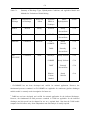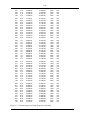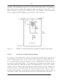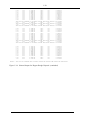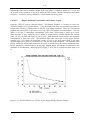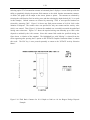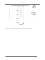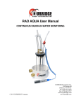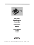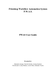
1
EVALUATION OF DREDGED MATERIAL
PROPOSED FOR DISCHARGE IN WATERS OF THE U.S. - TESTING MANUAL
(FINAL, WORKGROUP DRAFT)
(INLAND TESTING MANUAL)
Prepared by
ENVIRONMENTAL PROTECTION AGENCY
Office of Water
Office of Science and Technology
Washington, D. C.
and
DEPARTMENT OF THE ARMY
United States Army Corps of Engineers
Washington, D.C.
March 1995
APPENDIX C
EVALUATION OF MIXING
i
TABLE OF CONTENTS
Page No.
Table of Contents
List of Tables
List of Figures
i
iii
iv
APPENDIX C - EVALUATION OF INITIAL MIXING
C1.0
C1.1
C1.2
C1.3
C1.3.1
C1.3.2
C1.3.3
C1.4
C1.4.1
C1.4.2
C1.4.3
C1.4.4
C1.5
C1.5.1
C1.5.2
C1.5.3
C2.0
C2.1
C2.2
C2.2.1
C2.2.2
C2.2.3
C2.3
C2.3.1
C2.3.2
C2.3.3
C2.3.4
C2.4
C2.5
C2.6
C2.6.1
C2.6.2
INTRODUCTION . . . . . . . . . . . . . . . . . . . . . . . . . . . . . . . . . . . . . . . . . .
Background . . . . . . . . . . . . . . . . . . . . . . . . . . . . . . . . . . . . . . . . . . . . . .
Regulatory Considerations . . . . . . . . . . . . . . . . . . . . . . . . . . . . . . . . . . . .
Potential Applications of Initial Mixing . . . . . . . . . . . . . . . . . . . . . . . . . .
Screen to Determine Need for Additional Water Column Testing . . . . . . .
Evaluation of Dissolved Contaminant Concentrations by Comparison with
Water Quality Standards . . . . . . . . . . . . . . . . . . . . . . . . . . . . . . . . . . . . .
Evaluation of Concentrations of Suspended Plus Dissolved Constituents by
Comparison with Toxicity Test Results . . . . . . . . . . . . . . . . . . . . . . . . . . .
Physical Characteristics of Dredged Material Discharges . . . . . . . . . . . . .
Barge Discharge . . . . . . . . . . . . . . . . . . . . . . . . . . . . . . . . . . . . . . . . . . .
Hopper Dredge Discharge . . . . . . . . . . . . . . . . . . . . . . . . . . . . . . . . . . . .
Pipeline Dredge Discharge . . . . . . . . . . . . . . . . . . . . . . . . . . . . . . . . . . . .
Confined Disposal Facility (CDF) Effluent Discharge . . . . . . . . . . . . . . . .
Applicability of Models and Techniques . . . . . . . . . . . . . . . . . . . . . . . . .
General Considerations . . . . . . . . . . . . . . . . . . . . . . . . . . . . . . . . . . . . . .
Considerations for Tidally Influenced Rivers and Estuaries . . . . . . . . . . . .
Recommended Models and Techniques . . . . . . . . . . . . . . . . . . . . . . . . . . .
.
.
.
.
.
.
.
.
.
.
SHORT TERM FATE MODEL FOR OPEN WATER
HOPPER DISCHARGES (STFATE) . . . . . . . . . . . . . . . .
Introduction . . . . . . . . . . . . . . . . . . . . . . . . . . . . . . . . . .
Theoretical Basis . . . . . . . . . . . . . . . . . . . . . . . . . . . . . . .
Convective Descent . . . . . . . . . . . . . . . . . . . . . . . . . . . . .
Dynamic Collapse . . . . . . . . . . . . . . . . . . . . . . . . . . . . . .
Transport-diffusion . . . . . . . . . . . . . . . . . . . . . . . . . . . . .
Model Capabilities . . . . . . . . . . . . . . . . . . . . . . . . . . . . . .
Disposal Methods . . . . . . . . . . . . . . . . . . . . . . . . . . . . . . .
Ambient Environment . . . . . . . . . . . . . . . . . . . . . . . . . . .
Time-varying Fall Velocities . . . . . . . . . . . . . . . . . . . . . . .
Conservative Constituent Computations . . . . . . . . . . . . . .
Model Input . . . . . . . . . . . . . . . . . . . . . . . . . . . . . . . . . .
Model Output . . . . . . . . . . . . . . . . . . . . . . . . . . . . . . . . .
General Instructions for Running the Model . . . . . . . . . . .
Target Hardware Environment . . . . . . . . . . . . . . . . . . . .
Installation and Starting . . . . . . . . . . . . . . . . . . . . . . . . .
.
.
.
.
.
.
.
.
.
.
.
.
.
.
.
.
BARGE AND
............
............
............
............
............
............
............
............
............
............
............
............
............
............
............
............
.
.
.
.
.
.
.
.
.
.
C-1
C-1
C-2
C-2
C-3
. . C-3
.
.
.
.
.
.
.
.
.
.
C-3
C-4
C-4
C-4
C-5
C-5
C-6
C-6
C-7
C-8
C-10
C-10
C-10
C-11
C-12
C-12
C-15
C-15
C-16
C-16
C-17
C-17
C-17
C-21
C-21
C-22
ii
C2.6.3
C2.7
C2.8
C2.8.1
C2.8.1.1
C2.8.1.1.1
C2.8.1.1.2
C2.8.1.1.3
C2.8.1.1.4
C2.8.1.1.5
C2.8.1.1.6
C2.8.1.1.7
C2.8.1.2
C2.8.1.2.1
C2.8.2.2.2
C2.8.2.2.3
User Interface . . . . . . . . . . . . . . . . . . . . . . . . . . . . . . . . . . . .
Steps in Using the Model . . . . . . . . . . . . . . . . . . . . . . . . . . . .
STFATE Application Examples . . . . . . . . . . . . . . . . . . . . . . .
Split-hull Barge or Scow Example . . . . . . . . . . . . . . . . . . . . .
Entering STFATE and the Input Data File Selection Menu . . .
Site Description Data . . . . . . . . . . . . . . . . . . . . . . . . .
Velocity Data . . . . . . . . . . . . . . . . . . . . . . . . . . . . . . .
Input, Execution and Output Keys . . . . . . . . . . . . . . .
Material Description Data . . . . . . . . . . . . . . . . . . . . . .
Disposal Operation Data . . . . . . . . . . . . . . . . . . . . . . .
Coefficients . . . . . . . . . . . . . . . . . . . . . . . . . . . . . . . .
Saving Input Data Menu . . . . . . . . . . . . . . . . . . . . . .
Description of Barge Disposal Example Output . . . . . . . . . . . .
Barge Disposal Water Column Concentrations
Distribution . . . . . . . . . . . . . . . . . . . . . . . . . . . . . . . .
Barge Disposal Water Column Concentrations . . . . . .
Plots of Concentration Following Barge Disposal . . . . .
Multiple-bin Hopper Dredge Example . . . . . . . . . . . . . . . . . .
Entering STFATE and the Input Data File Selection Menu . . .
Site Description Data . . . . . . . . . . . . . . . . . . . . . . . . .
Velocity Data for Hopper Disposal Example . . . . . . . .
Input, Execution and Output Keys . . . . . . . . . . . . . . .
Material Description Data . . . . . . . . . . . . . . . . . . . . . .
Operation Data . . . . . . . . . . . . . . . . . . . . . . . . . . . . .
Coefficients . . . . . . . . . . . . . . . . . . . . . . . . . . . . . . . .
Saving Input Data Menu . . . . . . . . . . . . . . . . . . . . . .
Description of Example Hopper Disposal Output . . . . . . . . . .
Hopper Disposal Water Column Concentrations
Distribution . . . . . . . . . . . . . . . . . . . . . . . . . . . . . . . .
Hopper Water Column Concentrations . . . . . . . . . . . .
Hopper Maximum Concentration and Contour Graphs
C3.0
CORNELL MIXING ZONE EXPERT SYSTEM (CORMIX) . . . . . . . . . . . C-60
C4.0
MACINTYRE ANALYTICAL METHOD FOR
RIVERINE CONDITIONS . . . . . . . . . . . . . . . .
Introduction . . . . . . . . . . . . . . . . . . . . . . . . . . .
Data Requirements . . . . . . . . . . . . . . . . . . . . . .
Calculation Procedure . . . . . . . . . . . . . . . . . . . .
Example Mixing-Zone Calculation . . . . . . . . . . .
C2.8.1.2.2
C2.8.1.2.3
C2.8.2
C2.8.2.1
C2.8.2.1.1
C2.8.2.1.2
C2.8.2.1.3
C2.8.2.1.4
C2.8.2.1.5
C2.8.2.1.6
C2.8.2.1.7
C2.8.2.2
C2.8.2.2.1
C4.1
C4.2
C4.3
C4.4
CDF
.....
.....
.....
.....
.....
....
....
....
....
....
....
....
....
....
....
....
....
....
and
....
....
....
....
....
....
....
....
....
....
....
....
....
and
....
....
....
.
.
.
.
.
.
.
.
.
.
.
.
.
....
....
....
....
....
....
....
....
....
....
....
....
....
Area
.....
.....
.....
.....
.....
.....
.....
.....
.....
.....
.....
.....
.....
Area
.....
.....
.....
DISCHARGE
...........
...........
...........
...........
...........
.
.
.
.
.
IN
..
..
..
..
..
.
.
.
.
.
.
.
.
.
.
.
.
.
C-22
C-22
C-29
C-30
C-30
C-33
C-33
C-35
C-35
C-36
C-36
C-37
C-37
.
.
.
.
.
.
.
.
.
.
.
.
.
C-38
C-38
C-42
C-45
C-45
C-45
C-48
C-49
C-50
C-50
C-51
C-51
C-52
. C-53
. C-53
. C-57
.
.
.
.
.
C-61
C-61
C-62
C-62
C-66
C5.0
FASTTABS MODELING SYSTEM FOR EVALUATION OF
HYDRODYNAMIC TRANSPORT . . . . . . . . . . . . . . . . . . . . . . . . . . . . . . . C-72
C6.0
C6.1
C6.2
DILUTION VOLUME METHOD FOR CDF EFFLUENT DISCHARGES . C-73
Approach . . . . . . . . . . . . . . . . . . . . . . . . . . . . . . . . . . . . . . . . . . . . . . . . . C-73
Sample Computations . . . . . . . . . . . . . . . . . . . . . . . . . . . . . . . . . . . . . . . . C-76
C7.0
REFERENCES . . . . . . . . . . . . . . . . . . . . . . . . . . . . . . . . . . . . . . . . . . . . . C-78
iii
LIST OF TABLES
Page No.
Table C-1.
Summary of Discharge Types, Hydrodynamic Conditions, and Applicable
Models and Methods for Evaluation of Initial Mixing.
C-9
Table C-2.
STFATE Model Input Parameters.
C-18
Table C-3.
STFATE Input Variables for Section 404(b)(1) Regulatory Analysis of
Navigable Waters Using a Scow/Barge Disposal.
C-31
STFATE Input Variables for Section 404(b)(1) Regulatory Analysis of
Navigable Waters Using a Multiple-bin Hopper Dredge Disposal.
C-46
Table C-4.
iv
LIST OF FIGURES
Page No.
Figure C-1.
Illustration of Placement Processes.
C-11
Figure C-2.
Velocity Profile Available for Use in PC Model.
C-16
Figure C-3.
Menu Tree for STFATE Model.
C-23
Figure C-4.
STFATE Input Menus.
C-24
Figure C-5.
Schematic of Example Disposal Site for Barge Disposal.
C-34
Figure C-6.
X-direction Velocity Profile for Barge Example.
C-34
Figure C-7.
Selected Output for Barge Disposal.
C-39
Figure C-8.
Peak Lead Concentration in Water Column as a F(Time) for the Barge
Disposal Example.
C-43
Lead Concentration Contours for 15 ft Depth at 3600 sec for the Barge
Disposal Example.
C-44
Figure C-10.
Plot of Required Mixing Zone for the Barge Disposal Example.
C-44
Figure C-11.
Schematic of Example Disposal Site for Multiple-bin Hopper Dredge Disposal.
C-48
Figure C-12.
X-direction Velocity Profile for Hopper Dredge Example.
C-49
Figure C-13.
Schematic of Hopper Dredge with 6 Bins.
C-51
Figure C-14.
Selected Output for Hopper Dredge Disposal.
C-54
Figure C-15.
Peak Fluid Ratio as a F(Time) for the Hopper Dredge Disposal Example.
C-57
Figure C-16.
Fluid Ratio Contours for 20 ft Depth at 3600 sec for the Hopper Dredge
Disposal Example.
C-58
Figure C-17.
Plot of Required Mixing Zone for the Hopper Disposal Example.
C-59
Figure C-18.
Schematic of a Mixing Zone for a Single Effluent Source.
C-61
Figure C-19.
Projected Surface Area and Volume Equations for CDF Effluent Discharge
with Prevailing Current.
C-74
Figure C-9.
C-1
C1.0
INTRODUCTION
This appendix presents a variety of techniques for evaluating the size of mixing zones for dredged
material discharges. These techniques include analytical approaches and computer models for evaluation of discrete discharges from barges or hoppers, for continuous discharges from pipelines, and for
effluent discharges from confined disposal facilities (CDFs). Discussions of the applicability and
limitations of the techniques and stepwise procedures for performing the required calculations or
applying the models are presented.
C1.1
Background
Whenever contaminant concentrations in a dredged material discharge are above water quality standards, there will be some limited initial mixing zone (or zone of dilution) in the vicinity of the discharge point where receiving water quality standards may be exceeded. The Guidelines recognize that
it is not possible to set universal standards for the acceptable size of mixing zones since receiving
water conditions vary so much from one location to another. The Guidelines therefore instruct that, as
part of the dredging permit process, the size of any proposed mixing zone should be estimated and
submitted to the permitting authority. The permitting authority must then consider receiving water
conditions at the proposed site and decide if the proposed mixing-zone size is acceptable.
Many state regulatory agencies may specify a limit to mixing-zone dimensions as a condition in granting the State water quality certification. In this case the mixing zone necessary to meet applicable
standards must be smaller than the specified limits.
The size of a mixing zone depends on a number of factors including the contaminant or dredged
material concentrations in the discharge, concentrations in the receiving water, the applicable water
quality standards, discharge density and flow rate, receiving water flow rate and turbulence, and the
geometry of the discharge vessel, pipeline, or outlet structure and the receiving water boundaries.
Since the maximum allowable mixing zone specified by regulatory agencies is usually on the order of
hundreds of meters, the evaluation of mixing-zone sizes must necessarily be based on calculation of
near-field dilution and dispersion processes.
There are a variety of possible estimation techniques for most real mixing-zone problems, but any
choice of a suitable technique involves some tradeoffs. The available techniques may be thought of as
ranging from sophisticated computer models, which are sometimes capable of very accurate
predictions, to simple approximations that yield order-of-magnitude estimates. The most sophisticated
models may not run on a microcomputer, and they may require a considerable amount of measured
C-2
data and personpower for calibration of the model to a single site.
By contrast, the simplest of
approximations may be made on the basis of several simplifying assumptions and hand calculations.
C1.2
Regulatory Considerations
Any evaluation of potential water column effects has to consider the effects of mixing. Section 230.3(m) of the Guidelines defines the mixing zone as follows:
The term "mixing zone" means a limited volume of water serving as a zone of initial
dilution in the immediate vicinity of the discharge point where receiving water quality
may not meet quality standards or other requirements otherwise applicable to the
receiving water. The mixing zone should be considered as a place where wastes and
water mix and not as a place where wastes are treated.
Further, Section 230.11(f) requires that:
The mixing zone shall be confined to the smallest practicable zone within each
specified disposal site that is consistent with the type of dispersion determined to be
appropriate by the application of these Guidelines. In a few special cases under unique
environmental conditions, where there is adequate justification to show that widespread
dispersion by natural means will result in no significantly adverse environmental
effects, the discharged material may be intended to be spread naturally in a very thin
layer over a large area rather than be contained within the disposal site.
C1.3
Potential Applications of Initial Mixing
There are three potential applications of initial mixing evaluations:
a)
screen to determine the need for additional water column testing under Tier II
b)
evaluate dissolved contaminant concentrations by comparison with water quality
standards after allowance for mixing under Tier II
c)
evaluate concentrations of suspended plus dissolved constituents by comparison with
toxicity test results after allowance for mixing under Tier III.
C-3
C1.3.1
Screen to Determine Need for Additional Water Column Testing
The screen determines the necessity for additional water column testing. This determination is based
on a standardized calculation comparing the bulk contamination of the dredged material with water
quality standards, considering the effects of initial mixing. This "worst case" approach assumes that
all of the contaminants from the dredged material are released to the fluid fraction and subsequently to
the water column. Mixing evaluations need only be made for the contaminant requiring the greatest
dilution to meet its water quality standard. The key parameter derived from the evaluation is the
maximum concentration of the contaminant in the water column at the boundary of the mixing zone.
This concentration is compared with the applicable water quality standard to determine if additional
water column testing is necessary. This evaluation cannot be used to predict water column impacts
but only to determine the need for additional water column testing.
C1.3.2
Evaluation of Dissolved Contaminant Concentrations by Comparison with Water
Quality Standards
If additional water column testing is necessary, the potential for water column impacts may be
evaluated under Tier II by comparison of predicted dissolved contaminant concentrations, as
determined by an elutriate test, with the water quality standards, considering the effects of mixing.
This approach is used if there are water quality standards for all contaminants of concern; if these
conditions are not met, the procedure in Section C1.3.3 is used.
The mixing evaluation need only be
made for the contaminant requiring the greatest dilution to meet its water quality standard. The key
parameters derived from the model are the maximum dissolved concentration of the contaminant at the
boundary of the mixing zone. This concentration is compared to the applicable water quality standard
to determine if the discharge complies with the Guidelines.
C1.3.3
Evaluation of Concentrations of Suspended Plus Dissolved Constituents by
Comparison with Toxicity Test Results
If additional water column testing is necessary, the potential for water column impact may be
evaluated under Tier III by comparison of predicted concentrations of the suspended plus dissolved
constituents of the dredged material with toxicity test results, considering the effects of mixing. For
this case, the dilution of the dredged-material elutriate expressed as a percent of the initial volume of
disposed fluid in a given volume of water column is calculated. The key parameters derived from the
evaluation are the maximum concentration of dredged-material elutriate in the water column at the
C-4
boundary of the mixing zone. These concentrations are compared to 0.01 of the LC50 or EC50 as
determined by toxicity tests to determine if the discharge complies with the Guidelines.
C1.4
Physical Characteristics of Dredged Material Discharges
Knowledge of the physical characteristics of dredged material discharges is necessary for proper
selection of a technique or model for evaluation of initial mixing. Dredged material can be placed in
open-water sites using direct pipeline discharge, direct mechanical placement, or release from hopper
dredges or scows. Discharges of effluent from CDFs can be introduced to the receiving waters in a
variety of ways including direct pipeline outfalls or open channels. For purposes of evaluation of
initial mixing, barges or hopper dredge discharges are discrete discharges, while direct discharge from
a pipeline dredge or CDF effluent should be considered continuous discharges.
C1.4.1
Barge Discharge
Bucket or clamshell dredges remove the sediment being dredged at nearly its in situ density and place
it on a barge or scow for transportation to the disposal area. Although several barges may be used so
that the dredging is essentially continuous, disposal occurs as a series of discrete discharges. Barges
are designed with bottom doors or with a split-hull, and the contents may be emptied within seconds,
essentially as an instantaneous discharge. Often sediments dredged by clamshell remain in fairly large
consolidated clumps and reach the bottom in this form.
Whatever its form, the dredged material
descends rapidly through the water column to the bottom, and only a small amount of the material
remains suspended.
Clamshell dredge operations may also be used for direct material placement
adjacent to the area being dredged. In these instances, the material also falls directly to the bottom as
consolidated clumps.
C1.4.2
Hopper Dredge Discharge
The characteristics and operation of hopper dredges result in a mixture of water and solids stored in
the hopper for transport to the disposal site. At the disposal site, hopper doors in the bottom of the
ship’s hull are opened, and the entire hopper contents are emptied in a matter of minutes; the dredge
then returns to the dredging site to reload. This procedure produces a series of discrete discharges at
intervals of perhaps one to several hours. Upon release from the hopper dredge at the disposal site,
the dredged material falls through the water column as a well-defined jet of high-density fluid which
may contain blocks of solid material. Ambient water is entrained during descent. After it hits bottom,
C-5
most of the dredged material comes to rest. Some material enters the horizontally spreading bottom
surge formed by the impact and is carried away from the impact point until the turbulence of the surge
is sufficiently reduced to permit its deposition.
C1.4.3
Pipeline Dredge Discharge
Pipeline dredges are commonly used for open-water disposal adjacent to channels. Material from this
dredging operation consists of a slurry with solids concentration ranging from a few grams per liter to
several hundred grams per liter. Depending on material characteristics, the slurry may contain clay
balls, gravel, or coarse sand material. This coarse material quickly settles to the bottom. The mixture
of dredging site water and finer particles has a higher density than the disposal site water and therefore
can descend to the bottom forming a fluid mud layer. Continuing the discharge may cause the fluid
mud layer to spread. There will be a vertical gradient of fine suspended solids forming a turbidity
layer above the fluid mud layer, created by the discharge momentum and resulting turbulence and
entrainment of disposal site water into the discharge plume. The suspended solids concentration of the
fluid mud layer is typically 10 g/L or greater while the overlying turbidity layer is defined as less than
10 g/L. Characteristics of the plume are determined by: discharge rate, characteristics of the slurry
(both water and solids), water depth, currents, meteorological conditions, salinity of receiving water,
and discharge configuration.
C1.4.4
Confined Disposal Facility (CDF) Effluent Discharge
Dredged material hydraulically placed in a confined disposal area settles, resulting in a thickened deposit of material overlaid by a clarified supernatant. The supernatant waters are discharged from the
site as effluent during active dredging operations.
The effluent may contain both dissolved
contaminants and suspended colloidal particles with associated (adsorbed or held by ion exchange)
contaminants. Supernatant waters from confined disposal sites are discharged after a retention time of
up to several days. Furthermore, actual withdrawal of the supernatant is governed by the hydraulic
characteristics of the ponded area and the discharge weir. The effluent suspended solids concentration
is typically less than 100 mg/L for sediments dredged from estuarine environments and less than a few
grams per liter for sediments dredged from freshwater environments.
C-6
C1.5
Applicability of Models and Techniques
C1.5.1
General Considerations
Equations can be derived from a simplistic approach to the problem of estimating mixing-zone size
that make it possible to use a combination of empirical and analytical solutions.
However, the
simplifications that make the calculations easily manageable are somewhat restrictive, and a more
advanced set of similar empirical and analytical solutions could be used to estimate mixing-zone sizes
under more complex conditions.
The more advanced analytical solutions involve many more
computations, and for this reason they are more easily dealt with by use of a computer.
The
simplicity and limited data requirements of analytical solutions make them an attractive tool. However, analytical solutions cannot be used for receiving water where there are complex hydrodynamic
conditions, nor can they be applied under dynamic (unsteady) flow conditions.
Where these
conditions exist, a numerical model must be used, and numerical dispersion models are not
susceptible to hand calculation. In addition to requiring a computer solution technique, numerical
models generally require a much more detailed set of input data, and the collection of such data can
be expensive.
No models have been identified that are suitable for a broad range of mixing zone conditions, and
there are no readily available models suitable for modeling the first few hundred metres downstream
from the discharge point.
This is because the overwhelming majority of computer models are
concerned with far-field solutions where concentrations can be adequately described by a twodimensional or a one-dimensional model and the initial characteristics of the discharge are relatively
unimportant. These models are generally inadequate in the immediate vicinity of a discharge, where
a three-dimensional description of concentrations is often necessary and where the initial characteristics of the discharge can be highly significant. Within the first few hundred metres of the discharge,
there are several different processes that may be significant, so a general model must be able to
estimate each of the processes (for example, momentum, buoyancy, dispersion) and to identify the
zones within which the processes are dominant. A general mixing-zone model must therefore be a
series of submodels, each of which can handle a zone that is dominated by one of the principal
mixing processes.
The sub-models must be capable of determining the limits of their applicable
zones and passing concentration values at these limits on to other submodels so that the entire mixing
zone may be estimated. The following tabulation presents a summary of the steady-state physical
processes that might be suitable for inclusion as submodels in a general mixing-zone model. Sources
that presently seem to present the most promising empirical and analytical solutions to these submodel processes are also presented in the tabulation.
C-7
Physical Process to be Handled by a Submodel
Source
Momentum and/or buoyancy-dominated jets
Zeller et al. (1971)
Motz and Benedict (1972)
Buhler and Hauenstein (1981)
Jirka et al. (1981)
Wright (1984)
Doneker and Jirka (1990)
3-dimensional dispersion in receiving water
Prakash (1977)
Fischer et al. (1979)
Johnson et al. (1994)
King (1992)
2-dimensional vertically averaged dispersion
Stefan and Gulliver (1978)
Paily and Sayre (1978)
Gowda (1984a, b)
Thomas and McAnally (1990)
C1.5.2
Considerations for Tidally Influenced Rivers and Estuaries
The assumptions necessary for evaluation of mixing are more difficult to satisfy in estuaries and the
tidally influenced portions of rivers. The assumption that velocities in the water body near the mixing
zone can be represented by a single mean velocity parallel to the bank is usually a reasonable one in
the non-tidally influenced portion of a river.
However, it is not always acceptable in estuaries.
Typically the downstream section of an estuary exhibits horizontal circulation patterns, so that the
horizontal water velocity and direction vary with distance parallel to the bank, distance perpendicular
to the bank, and time. Under these conditions, water near the mixing zone may not always travel
parallel to the bank. Therefore, simple mixing-zone equations may not be applicable to the wide, open
low-velocity sections of estuaries.
Also, mixing-zone equations are not theoretically applicable as the mean velocity tends to zero. This
is because the equations are dependent upon the process of advection, which does not exist in the
absence of a flow velocity, and also because the primary source of dispersion is assumed to be the
turbulence caused by the horizontal movement of water.
However, in a real water body, as the
velocity tends to zero, the primary sources of turbulence and dispersion are the wind and waves.
The rate of change of water velocity due to tidal effects can also cause problems.
The time taken for
material to travel the length of the mixing zone should be an order of magnitude smaller than the time
taken for a 10-percent change in the mean water velocity. It may be possible to satisfy this condition
C-8
in a river, but it will probably not be possible to do so in most estuaries during a significant portion of
the tidal cycle.
Another potential difficulty in estuaries is the phenomenon of stratification. Estuaries with low water
velocities sometimes have a layer of relatively fresh water near the surface with a much more saline
denser layer of water near the bottom and with quite a distinct interface between the two layers. The
abrupt change of density at the interface tends to inhibit vertical mixing through the entire depth of the
water column.
C1.5.3
Recommended Models and Techniques
Several models and approaches for evaluation of initial mixing are provided in this appendix. Table
C-1 provides a summary of the characteristics of the various types of dredged material discharges,
hydrodynamic environments, and the models recommended for use in evaluation of initial mixing for
those conditions. Descriptions of each of the models and details on applying the models are provided
in the following sections of this appendix.
C-9
Table C-1.
Summary of Discharge Types, Hydrodynamic Conditions, and Applicable Models and
Methods for Evaluation of Initial Mixing.
Type of
Discharge
Characteristics
of Discharge
Near-Field
Effects
Applicable
Model or
Model
Section
Hydrodynamics
Technique
BARGE
Discrete
Strong
STFATE
Steady
C2.0
Non-uniform
HOPPER
Semi-Discrete
Moderate
STFATE
Steady
C2.0
Non-uniform
PIPELINE
Continuous
Moderate
CD-
Steady
1
CORMIX
Uniform
TABS2
Unsteady
C3.0
C5.0
Non-uniform
CDF
Continuous
Weak
MacIntyre
Steady Uniform
C4.0
CORMIX
Steady Uniform
C3.0
TABS2
Unsteady
C5.0
EFFLUENT
Non-uniform
Dilution
Steady
Volume
Uniform
C6.0
Method
1
CD-CORMIX has not been developed and verified for national application. However, the
fundamental processes contained in CD-CORMIX are applicable for continuous pipeline discharges
and this model is currently under investigation for future use.
2
TABS has not been developed and verified for national application for the indicated discharges.
However, the fundamental far-field processes contained in TABS are applicable for the indicated
discharges and this model can be adapted for use on a regional basis. Note that the TABS model
computes far-field effects only. Some independent near-field analysis is usually required.
C-10
C2.0
SHORT TERM FATE MODEL FOR OPEN WATER BARGE AND HOPPER
DISCHARGES (STFATE)
C2.1
Introduction
The model described in this section is the STFATE (Short-Term FATE of dredged material disposal in
open water) model (Johnson et al., 1994) developed from the DIFID (Disposal From an Instantaneous
Discharge) model originally prepared by Koh and Chang (1973).
This model is used for discrete
discharges from barges and hoppers. STFATE is a module of the Automated Dredging and Disposal
Alternatives Management System (ADDAMS) (Schroeder and Palermo, 1990) and can be run on
DOS-based personal computers (PC) having 80386 or higher processors with math coprocessors.
ADDAMS is an interactive computer-based design and analysis system in the field of dredged-material
management. The general goal of ADDAMS is to provide state-of-the-art computer-based tools that
will increase the accuracy, reliability, and cost effectiveness of dredged-material management activities
in a timely manner.
An executable version of the STFATE model for use on IBM-compatible microcomputers can be
downloaded from the Internet web site http://www.epa.gov/OST/pubs/ITM.html (see Section C2.6.2).
The model is appropriate for instantaneous discharges from barges or scows and sequential discharges
from hopper dredges.
C2.2
Theoretical Basis
The behavior of the material during disposal is assumed to be separated into three phases: convective
descent, during which the disposal cloud falls under the influence of gravity and its initial momentum
is imparted by gravity; dynamic collapse, occurring when the descending cloud either impacts the
bottom or arrives at a level of neutral buoyancy where descent is retarded and horizontal spreading
dominates; and passive transport-dispersion, commencing when the material transport and spreading
are determined more by ambient currents and turbulence than by the dynamics of the disposal
operation. Figure C-1 illustrates these phases.
C-11
Figure C-1.
Illustration of Placement Processes.
C2.2.1
Convective Descent
In STFATE, multiple convecting clouds that maintain a hemispherical shape during convective descent
are assumed to be released. By representing the disposal as a sequence of convecting clouds released
at a constant time interval during the total time required for the material to leave the disposal vessel,
real disposal operations can be more accurately simulated. For example, a moving hopper dredge
disposal can be modeled by assuming that the material in each bin convects downward as one cloud.
In addition, through the use of multiple convecting clouds with varying characteristics the consolidation that often occurs in scows or barges can be accounted for more accurately. Since the solids concentration in discharged dredged material is usually low, each cloud is expected to behave as a dense
liquid; thus, a basic assumption is that a buoyant thermal analysis is appropriate.
The equations
governing the motion are those for conservation of mass, momentum, buoyancy, solid particles, and
vorticity.
These equations are straightforward statements of conservation principles; details are
presented in Koh and Chang (1973) and Brandsma and Divoky (1976). It should be noted that the
entrainment coefficient associated with the entrainment of ambient fluid into a descending
hemispherical cloud is assumed to vary smoothly between its value for a vortex ring and the value for
C-12
turbulent thermals. Model results are relatively sensitive to the entrainment coefficient, which in turn
is dependent upon the material being disposed (the higher the moisture content, the larger the value of
the entrainment coefficient).
Laboratory studies by Bowers and Goldenblatt (1978) resulted in
analytical expressions for the entrainment, drag, and added mass coefficients as functions of the
moisture content. These have been incorporated into STFATE. As these clouds move downward,
material and fluid with dissolved contaminants may be stripped away. Stripped material is handled
through the concept of Gaussian clouds discussed below. The amount of material stripped away and
stored in the Gaussian clouds is computed as a coefficient times the downward velocity of the cloud
times the cloud surface area. The value of the "stripping" coefficient is selected so that approximately
2-5 percent of the total volume of fine material is stripped away at disposal sites of 100 ft or less.
Based upon field data collected by Bokuniewicz et al. (1978), this will result in the amount of stripped
material being on the conservative side.
C2.2.2
Dynamic Collapse
Whether by disposal from a split-hull barge or scow or discharge from a multi-bin hopper dredge, the
disposed material cloud grows during convective descent as a result of entrainment. Eventually, either
the material reaches the bottom, or the density difference between the discharged material and the
ambient water column becomes small enough for a position of neutral buoyancy to be assumed. In
either case, the vertical motion is arrested and a dynamic horizontal spreading occurs.
The basic shape assumed for each collapsing cloud is an oblate spheroid if collapse occurs in the water
column, whereas a general ellipsoid is assumed for collapse on a sloping bottom. With the exception
of vorticity, which is assumed to have been dissipated by the stratified ambient water column, the
same conservation equations used in convective descent but now written for either an oblate spheroid
or an ellipsoid are applicable. For the case of collapse on the bottom, a frictional force between the
bottom and the collapsing cloud is included which accounts for energy dissipation as a result of the
spreading.
Other than the changes noted above, the same equations presented in Brandsma and
Divoky (1976) apply.
C2.2.3
Transport-diffusion
When the rate of spreading in the dynamic collapse phase becomes less than an estimated rate of
spreading due to turbulent diffusion in both the horizontal and vertical directions, the collapse phase is
terminated. Laboratory experiments by Johnson et al. (1994) as well as field data collected by Kraus
(1991) imply that fine material is lost to the water column at the top of the collapsing cloud. As these
C-13
particles leave the main body of material, they are also stored in small clouds that are characterized by
a Gaussian distribution, i.e.,
(1)
where
m = volume of solids in the cloud, ft3
σx,σy,σz = standard deviations, ft
x,y,z = spatial coordinates, ft
xo,yo,zo = coordinates of cloud centroid, ft
At the end of each time-step, each cloud is advected horizontally by the input velocity field. The new
position of the cloud centroid is determined by
(2)
where
u,w = input ambient velocities, fps
∆t = long-term time-step, sec
In addition to the advection or transport of the cloud, the cloud grows both horizontally and vertically
as a result of turbulent diffusion.
four-thirds power law.
The horizontal diffusion is based upon the commonly assumed
Therefore, the diffusion coefficient,
Kx,z , (up to a maximum value of
2
100 ft /s) is given as
(3)
where AL is an input dissipation parameter and L is set equal to four standard deviations. As
illustrated in Figure 2.4 of Brandsma and Divoky (1976), a value of 100 ft2/sec for the horizontal
diffusion coefficient corresponds to a length scale of 103-104 feet. With the computational grid cell
typically being on the order of 100-500 ft, a length scale greater than 1,000 ft would normally be
associated with mean flow rather than turbulence. Thus, restricting the diffusion coefficient to less
than 100 ft2/sec is reasonable.
C-14
Horizontal growth is achieved by employing the Fickian expression
(4)
where
σx,z = a standard deviation
t = time since formation of the cloud
From Equation 4,
(5)
and thus,
(6)
where
σx,z = σx,z at the current time step, ∆t
new
σx,z = σx,z at the previous time step, ∆t
old
In a similar manner, the vertical growth is written as
(7)
where Ky is a function of the stratification (including the effect of the sediment) of the water column.
The maximum value of Ky is input as a model coefficient and occurs when the water density is
uniform. It should be noted that since computations are made for each solid fraction independently
from the remaining material, the effect of the total volume of suspended material on reducing vertical
diffusion is not modeled. This can sometimes lead to confusing results; e.g., a small amount of sand
may become diffused over the entire water column while a much larger amount of silt might have its
vertical diffusion suppressed due to the larger concentration. Modifications to correct this problem are
under investigation.
If long-term output is desired at the end of a particular time-step, the concentration of each solid type
is given at each grid point by summing the contributions from individual clouds to yield
C-15
(8)
where N is the number of small clouds of a particular solid type and y (the vertical position at
which output is desired) is specified through input data. This approach for the transport-diffusion
phase follows the work of Brandsma and Sauer (1983). The surface and all solid boundaries except
the bottom are handled by assuming reflection from the boundaries.
In addition to the horizontal advection and diffusion of material, settling of the suspended solids also
occurs.
Therefore, at each net point the amount of solid material deposited on the bottom and a
corresponding thickness are also determined. Since a normal distribution is assumed for material in
the small clouds, deposited material is also assumed to take a normal distribution horizontally on the
bottom. A basic assumption in the model is that once material is deposited on the bottom, it remains
there; i.e., no allowance is made for either erosion or bed-load movement of material.
However,
deposition is prohibited if the computed bottom shear stress exceeds a specified critical shear stress for
deposition for each solid fraction. This allows for application at dispersive sites.
The discussion presented above for transport-diffusion of solids also applies to the disposed fluid with
its dissolved constituents. It is conservatively assumed that all of the fluid remaining in the collapsing
cloud and its dissolved contaminants are released to the water column in Gaussian clouds during
collapse.
The contaminants are assumed to be conservative with no further adsorption on or
desorption from the solids in the water column or deposited on the bottom.
C2.3
Model Capabilities
STFATE enables the computation of the physical fate of dredged material disposed in open water.
The following discussion describes particular capabilities or special features.
C2.3.1
Disposal Methods
Disposal is assumed to occur from either a split-hull barge or a hopper dredge.
C-16
C2.3.2
Ambient Environment
As illustrated in Figure C-2, time-invariant velocity profiles that allow for flow reversal can be
prescribed.
These profiles are applied at each grid point.
Another option is to specify a time-
invariant, spatially varying depth-averaged velocity. The ambient density profile at the deepest point
on the grid must also be prescribed.
Figure C-2.
Velocity Profile Available for Use in PC Model.
C2.3.3
Time-varying Fall Velocities
If a solid fraction is specified as being cohesive, the settling velocity is computed as a function of the
suspended sediment concentration of that solid type. The algorithm used is
(9)
where
Vs = settling velocity, fps
C = suspended sediment concentration, mg/L
This approach is taken from Ariathurai et al. (1977).
C-17
C2.3.4
Conservative Constituent Computations
STFATE allows for the dredged material to contain a conservative constituent with perhaps a nonzero
background concentration of that constituent.
Computing the resultant time-history of that
concentration provides information on the dilution that can be expected over a period of time at the
disposal site and enables the computation of mixing zones in water column evaluations.
C2.4
Model Input
Input data for the model are grouped into the following general areas: (1) description of the disposal
site, (2) description of site velocities, (3) controls for input, execution, and output, (4) description of
the dredged materials, (5) description of the disposal operation, and (6) model coefficients.
Ambient conditions include current velocity, density stratification, and water depths over a
computational grid. The dredged material is assumed to consist of a number of solid fractions, a fluid
component, and conservative dissolved contaminants. Each solid fraction has to have a volumetric
concentration, a specific gravity, a settling velocity, a void ratio for bottom deposition, critical shear
stress, and information on whether or not the fraction is cohesive and/or strippable. For initial-mixing
calculations, information on initial concentration, background concentration, and water quality
standards for the constituent to be modeled have to be specified.
The description of the disposal
operation includes the position of the disposal barge or hopper dredge on the grid; the barge or hopper
dredge velocity, dimensions, and draft; the volume of dredged material to be discharged. Coefficients
are required for the model to accurately specify entrainment, settling, drag, dissipation, apparent mass,
and density gradient differences. These coefficients have default values that should be used unless
other site-specific information is available. Table C-2 lists the necessary input parameters with their
corresponding units. Table C-2 also lists the input parameters for determining the contaminant of
concern to be modeled based on dilution needs. More detailed descriptions and guidance for selection
of values for many of the parameters is provided directly online in the system.
C2.5
Model Output
The output starts by echoing the input data and then optionally presenting the time history of the
descent and collapse phases. In descent history the location of the cloud centroid, the velocity of the
cloud centroid, the radius of the hemispherical cloud, the density difference between the cloud and the
ambient water, the conservative constituent concentration and the total volume and concentration of
each solid fraction are provided as functions of time since release of the material.
C-18
Table C-2.
STFATE Model Input Parameters.
Parameter
Disposal*
Operation
Types
Units
Options**
Contaminant Selection Data
Solids concentration of dredged material
Contaminant concentration in the
bulk sediment
Contaminant concentration in the
elutriate
Contaminant background concentration
at disposal site
Contaminant water quality standards
g/L
µg/Kg
µg/L
µg/L
µg/L
Site Description
Number of grid points (left to right)
Number of grid points (top to bottom)
Spacing between grid points
(left to right)
Spacing between grid points
(top to bottom)
Constant water depth
Roughness height at bottom of
disposal site
Slope of bottom in x-direction
Slope of bottom in z-direction
Number of points in density profile
Depth of density profile point
Density at profile point
Salinity of water at disposal site
Temperature of water at disposal site
Grid points depths
H, B
H, B
H, B
ft
H, B
H, B
ft
ft
H,
H,
H,
H,
H,
H,
H,
H,
H,
ft
degrees
degrees
B
B
B
B
B
B
B
B
B
ft
g/cc
ppt
Celsius
ft
Velocity Data
Type of velocity profile
Water Depth for Averaged Velocity
Vertically averaged x-direction
velocity
Vertically averaged z-direction
velocity
Water depths for 2-point profile
Velocities for 2-point profile in
x-direction
Velocities for 2-point profile in
z-direction
Velocities for entire grid in
x-direction
Velocities for entire grid in
z-direction
H, B
H, B
ft
H, B
ft/sec
H, B
H, B
ft/sec
ft
H, B
ft/sec
H, B
ft/sec
H, B
ft/sec
H, B
ft/sec
H,
H,
H,
H,
sec
sec
Input, Execution and Output Keys
Processes to simulate
Duration of simulation
Long-term time step for diffusion
Convective descent output option
B
B
B
B
C
Optional
Optional
V
C-19
Table C-2.
STFATE Model Input Parameters (continued)
Parameter
Disposal*
Operation
Types
Units
Option**
Input, Execution and Output Keys (continued)
Collapse phase output option
Number of print times for long-term
diffusions
Location of upper left corner of
mixing zone on grid
Location of lower right corner of
mixing zone on grid
Water quality standards at border of
mixing zone for contaminant of
concern
Contaminant of concern
Contaminant concentration in sediment
Background concentration at disposal
site
Location of upper left corner of
zone of initial dilution (ZID)
on grid
Location of lower right corner of
zone of initial dilution (ZID)
on grid
Water quality standards at border of
ZID for contaminant of concern
Number of depths in water column
for which output is desired
Depths for transport - diffusion output
Predicted initial concentration in
fluid fraction
Dilution required to meet toxicity
standards
Dilution required to meet toxicity
standards at border of ZID
H, B
H, B
H, B
ft
H, B
ft
H, B
H, B
H, B
mg/L
H, B
mg/L
H, B
ft
H, B
ft
H, B
mg/L
H, B
H, B
ft
H, B
mg/L
H, B
percent
H, B
percent
H
H, B
H, B
H, B
yd3
H,
H,
H,
H,
H,
H,
B
B
B
B
B
B
yd3/yd3
ft/sec
H,
H,
H,
H,
B
B
B
B
B
B
yd3
B
ft/sec
B
ft/sec
mg/Kg
Material Description Data
Total volume of dredged material in
the Hopper dredge
Number of distinct solid fractions
Solid-fraction descriptions
Solid-fraction specific gravity
Solid-fraction volumetric
concentration
Solid-fraction fall velocity
Solid-fraction deposited void ratio
Solid-fraction critical shear stress
Cohesive? (yes or no)
Stripped during descent? (yes or no)
Moisture content of dredged material
as multiple of liquid limit
Water density at dredging site
Salinity of water at dredging site
Temperature of water at dredging site
Desired number of layers
Volume of each layer
Velocity of vessel in x-direction
during dumping of each layer
Velocity of vessel in z-direction
during dumping of each layer
lbs/sq ft
Cohesive
g/cc
ppt
Celsius
Optional
Optional
C-20
Table C-2.
STFATE Model Input Parameters (continued)
Parameter
Disposal*
Operation
Types
Units
H, B
ft
H, B
H, B
H, B
H
H
H
H
ft
ft
ft
ft
ft
ft
sec
Option**
Disposal Operation Data
Location of disposal point from
top of grid
Location of disposal point from
left edge of grid
Length of disposal vessel bin
Width of disposal vessel bin
Distance between bins
Pre-disposal draft of Hopper
Post-disposal draft of Hopper
Time required to empty all Hopper bins
Number of Hopper bins opening
simultaneously
Number of discrete openings of sets
of Hopper bins
Vessel velocity in x-direction during
each opening of a set of Hopper bins
Vessel velocity in z-direction during
each opening of a set of Hopper bins
Bottom depression length in x-direction
Bottom depression length in z-direction
Bottom depression average depth
Pre-disposal draft of disposal vessel
Post-disposal draft of disposal vessel
Time needed to empty disposal vessel
H
H
H
ft/sec
H
H, B
H, B
H, B
B
B
B
ft/sec
ft
ft
ft
ft
ft
sec
Optional
Optional
Optional
Coefficients
Settling coefficient
Apparent mass coefficient
Drag coefficient
Form drag for collapsing cloud
Skin friction for collapsing cloud
Drag for an ellipsoidal wedge
Drag for a plate
Friction between cloud and bottom
4/3 Law horizontal diffusion
dissipation factor
Unstratified water vertical
diffusion coefficient
Cloud/ambient density gradient ratio
Turbulent thermal entrainment
Entrainment in collapse
Stripping factor
H,
H,
H,
H,
H,
H,
H,
H,
B
B
B
B
B
B
B
B
H, B
H,
H,
H,
H,
H,
B
B
B
B
B
*
The use of a parameter for disposal operations by a multiple bin hopper dredge is indicated in the table
by an H while a parameter used for disposal from a split-hull barge or scow is indicated by a B.
**
The use of a parameter for the constant depth option or variable depth option is indicated in the table by
a C or V, respectively. Other optional uses for parameters are so indicated.
C-21
At the conclusion of the collapse phase, time-dependent information concerning the size of the
collapsing cloud, its density, and its centroid location and velocity as well as contaminant and solids
concentrations can be requested.
The model performs the numerical integrations of the governing
conservation equations in the descent and collapse phases with a minimum of user input. Various
control parameters that give the user insight into the behavior of these computations are printed before
the output discussed above is provided.
At various times, as requested through input data, output concerning suspended sediment
concentrations can be obtained from the transport-diffusion computations.
With Gaussian cloud
transport and diffusion, only concentrations at the water depths requested are provided at each grid
point.
For evaluations of initial mixing, results for water column concentrations can be computed in terms of
milligrams per liter of dissolved constituent for Tier II evaluations or in percent of initial concentration
of suspended plus dissolved constituents in the dredged material for Tier III evaluations.
The
maximum concentration within the grid and the maximum concentration at or outside the boundary of
the disposal site are tabulated for specified time intervals.
Graphics showing the maximum
concentrations inside the disposal-site boundary and anywhere on the grid as a function of time can
also be generated. Similarly, contour plots of concentration can be generated at the requested water
depths and at the selected print times.
C2.6
General Instructions for Running the Model
C2.6.1
Target Hardware Environment
The system is designed for the 80386 based processor class of personal computers using DOS. This
does not constitute official endorsement or approval of these commercial products. In general, the
system requires a math coprocessor, 640 KB of RAM and a hard disk. The STFATE executable
model requires about 565 KB of free RAM to run; therefore, it may be necessary to unload network
and TSR software prior to execution. The model is written primarily in Fortran 77 but some of the
higher-level operations and file-management operations are written in BASIC and some of the screen
control operations in the Fortran 77 programs are performed using an Assembly language utility
program.
C-22
C2.6.2
Installation and Starting
An executable version of the STFATE model can be downloaded from the Internet web site
http://www.epa.gov/OST/pubs/ITM.html. Go to "Short Term Fate Model for Open Water Barge and
Hopper Discharges (STFATE)," and download the two zipped files "STFATE1.zip" and STFATE2.zip"
to a directory on the hard disk dedicated for the STFATE model, e.g. C:\STFATE. Unzip each file
using pkunzip, type "loadfate" to dearchive the files, then type "STFATE" to start the model. (When
unzipping, the user should type "y" when queried as to overwriting a particular file. A demonstration
model, "DEMO," can also be downloaded to another directory on the hard disk. Type "startdem" to
unzip and run the demonstration model.
C2.6.3
User Interface
The STFATE module of ADDAMS employs a menu-driven environment with a full-screen data entry
method. In general, single keystrokes (usually the F1 through F10 function keys, the number keys,
Esc key or the arrow keys and the Enter key) are required to select menu options in the system.
Menus are displayed on the screen. Cursor keys are used to select from among highlighted input
fields (displayed in reverse video) much like a spreadsheet program. To enter alphanumeric data, the
user moves the cursor to the cell of interest, using the up and down arrows to move, respectively, up
and down, the Tab and Shift-Tab keys to move, respectively, right and left. The Enter key is also
used to move forward through the cells. The left and right arrow keys are used to move the cursor
within a selected cell to edit the cell’s contents. The Backspace key is used to clear a single character
in a cell. The spacebar will insert a space in alphanumeric cells. The PgDn key advances the cursor
to the next data entry screen and the PgUp key returns control to the previous data entry screen. The
Esc key returns control to exit to the previous menu without loss of data. The Home key permits the
user to exit from the current data entry screen to the Main Menu for the application without loss of
data.
Results from computations are generally displayed in tabular format on the screen and/or written to
print files or devices.
C2.7
Steps in Using the Model
The menu-driven environment for applying the model is illustrated in Figures C-3 and C-4.
The general steps and menus used in applying the model for a disposal operation are as follows:
C-23
Figure C-3.
Menu Tree for STFATE Model.
C-24
Figure C-4.
STFATE Input Menus.
C-25
a.
Starting
Change the directory to make directory containing the STFATE module the default directory.
Start the program by entering ADDAMS or STFATE at the DOS prompt.
If started by
entering ADDAMS, the program will display first the ADDAMS logo and then an Application
Selection Menu. An application in the ADDAMS software consists of one or more standalone
computer programs or numerical models for performing a specific analysis.
The only
ADDAMS application module provided on diskette with this manual is named STFATE.
STFATE consists of programs for evaluating open-water disposal of dredged material. Select
the STFATE application module from the Application Selection Menu.
The module will
display some logos and then a reference screen with points of contact. After the user strikes
any key, the module displays the STFATE Activity Selection Menu. If started by entering
STFATE, the module starts with STFATE logos and the reference screen and proceeds in the
same manner as if the module was started by entering ADDAMS.
b.
Activity Selection Menu
The activity selection menu may be considered the main menu for the STFATE application.
The first option is used to build or edit an input data file. The second option executes the
simulation. The third option is used to print or view output. The fourth option generates
graphics. The fifth option is used to configure the graphics software for the hardware present.
c.
Evaluation Selection Menu
Selecting F1 from the STFATE Activity Selection Menu brings up the STFATE Evaluation
Selection Menu. There are four options available. The two options of interest here are F3 Section 404(b)(1) Reg. Analysis for Navigable Waters (see step g) and F4 - Determine
Contaminant of Concern Based on Dilution Needs (see step d). This option is used only for
Tier II evaluations.
d.
Contaminant Data File Selection Menu
Selecting F4 from the Evaluation Selection Menu brings up this menu which has the same
structure as the Input Data File Selection Menu (see step g). Use one of the options to select
an active file.
C-26
e.
Menu for Selection of a Contaminant for Modeling
Selecting F4 from the Contaminant Data File Selection Menu brings up this menu. A data
analysis routine controlled by this menu is used to select a specific contaminant for modeling.
Such a selection is necessary under the Tier II analysis both for evaluation of the need for
additional testing and for water quality comparisons with standards. Execution of the openwater disposal model for these Tier II analyses allows use of only one contaminant; this option
is used to select that contaminant.
Bulk sediment and background contaminant concentrations and water quality standards are
required to compute the required dilutions for the evaluation of the need for additional testing.
The contaminant requiring the largest dilution should be subsequently modeled.
Elutriate and background concentrations and water quality standards are required to compute
the required dilutions for the dissolved contaminants. The contaminant requiring the largest
dilution should be subsequently modeled in the Tier II water quality analysis.
f.
Contaminant Data File Saving Menu
This menu has the same structure as the Input File Saving Menu (see step j). The contaminant
data files are saved with an extension of .DUD. The contaminant data files store the userspecified data, including contaminant names, particulate-associated concentrations of
contaminants in the bulk sediment, sediment solids concentration, standard elutriate
concentrations of contaminants, water quality standards for the contaminants, and
concentrations of contaminants in the background water at the disposal site.
g.
Input Data File Selection Menu
Selecting F3 from the Evaluation Selection Menu brings up the Input Data File Selection
Menu. An input data file needs to be selected only when the user wants to edit data that were
previously entered. The changes can be saved to the same file or to a new file. The first
option is used to specify the name of the file to be used. The file specified in this option
becomes the active data file. If needed, the second option is used to specify the DOS path to
the location where the data file should be read. If a path is not specified, the program will use
the default directory, where the STFATE program is, for file storage.
The third option
displays a directory of STFATE input data files for the current path, that is files having an
extension of .DUI in the directory specified in the path. An existing data file name may be
selected from the list to use as the active data file name for reading existing data. After the
C-27
input file has been selected, press F4 to build or edit the input data file. The input data that
are stored in the selected file are then read and will later be displayed on the input data
screens to be reviewed and edited. If the specified file could not be found (did not exist), the
program will provide the user the opportunity to initialize the file and start creating a new data
set.
h.
Disposal Operation Selection Menu
Selecting F4 from the Input Data File Selection Menu brings up this menu. The selection of a
disposal type under this menu controls the input data requests, the type of execution data file
that will be built, and the open-water disposal model that will be executed.
appropriate type of disposal:
Select the
F1 - Disposal from a Multiple Bin Hopper Dredge, or F2 -
Disposal from a Split-Hull Barge or Scow. The STFATE Input Selection Menu will then be
displayed.
i.
Input Selection Menu
Five types of input data have to be entered as shown in Table C-2 and Figure C-4, plus any
desired changes in the default set of model coefficients, before an execution data file can be
written. Default values are included for all of the model coefficients requested. Enter data by
paging down through the data entry screens, making selections and filling in the cells for each
option. An input data file may be written at any point to save all the data that have been
entered up to that point. After entering all of the data, the data must be saved before returning
to the STFATE Activity Selection Menu to avoid losing the changes. The data are saved in
input data and execution data files by selecting F7 from the Input Selection Menu to bring up
the Input File Saving Menu.
j.
Input File Saving Menu
This menu provides the opportunity to write an input data file to save the input data for future
editing under the STFATE Input Selection Menu and an execution data file for use during
execution of the STFATE model. Execution data files are the actual input data files used by
the open-water disposal model to perform the analysis and generate output. These files are
unique in structure to the input requirements of a particular open-water disposal operation and
contain data only for the specific options selected in the input. The files are stored with the
same name as the input data file but with an extension of .DUE instead of .DUI. The input
data file stores data for all possible options in evaluations, disposal operations and methods of
data entry, allowing the user to perform comparisons between options without re-entering
C-28
previously specified data. This menu is similar to the Input Data Selection Menu (see step g).
The only difference is that the name of the file to be saved instead of read should be specified.
The same file as read can be used but the input and execution data files will be overwritten. If
the input data are complete, an execution data file will also be saved. After the files are
saved, the program returns control to the Input Selection Menu. At this point data entry is
complete and the user should return to the Activity Selection Menu by hitting the Esc key.
k.
Execute
Selecting F2 from the Activity Selection Menu (see step b) initiates execution by bringing up
the Execution Data File Selection Menu.
After selecting the execution data file (same
procedure as the other file selection menus), pressing F4 begins the simulation. This option
uses the execution data file to generate an output file and three graphics files of the same
name as the execution data file selected but with an extension of .DUO, .DUP, .DUC, and
.DUT, respectively, instead of .DUE. The execution may take a few minutes or several hours,
depending on the simulation selected and the computer hardware used, but typically 30
minutes is sufficient. After termination of the simulation the program returns to the Activity
Selection Menu.
l.
Print or View Output
Select F3 from the Activity Selection Menu to print or view text output. A STFATE Output
Data File Selection Menu will be displayed that is similar to the other file selection menus.
The output files have the same name as the execution data files used to generate them except
that they have a .DUO extension instead of a .DUE extension. The other difference in the
menu is that it has an option to view the output on the monitor using the LIST.COM utility
program. Instructions on using the LIST program are provided on the menu bar and on-line
by pressing the ? key. The output is an ASCII text file having 132 characters per line and
should be printed using compressed print or wide paper. The program will automatically use
compressed print on some printers, mainly Epson and IBM printers. It may be necessary to
turn on compressed printing on your printer prior to printing the output, or to print the output
outside the STFATE program, using the DOS print command or a word processor. The output
contains an interpretive listing of the input data, computational indicators, convective descent
results, collapse results, information on cloud generation for transport-diffusion simulation,
accumulation and thickness of deposited materials, spatial distribution of concentrations of
materials in the water column, and water quality comparisons with standards for determining
water quality violations or mixing zone requirements.
C-29
m.
Generate Graphics
Selecting F4 from the Activity Selection Menu brings up the Graphics File Selection Menu
which is similar to the other file selection menus. Unlike the other file selection procedures,
there are three graphics files, not one as for input, execution and output. All three files have
the same name as the execution file used to generate the output and graphics files, but have
different extensions.
The graphics file selection procedure uses the graphics file with an
extension of .DUT for its directory listing and file searching.
Selecting F4 (Generate
Graphics with Selected File) brings up the Graphics Generation Menu from which there are
three options for plotting the data, one for each of three types of graphics files. The three
options are F1 - Maximum Concentrations Versus Time, using the file with a .DUP
extension; F2 - Concentration Contours in Horizontal Plane, using the file with a .DUC
extension; and F3 - Deposition Thickness at End of Simulation, using the file with a .DUT
extension. The plots can be viewed on the monitor, or sent to a printer or plotter as desired.
However, before plots can be generated the software must be configured for the hardware
present.
n.
Perform Hardware Configuration for Graphics
Select F5 from the Activity Selection Menu to choose the proper printer, plotter and video
information for the computer system being used.
o.
Ending
To exit the program, press Esc repeatedly until you obtain a DOS prompt. During execution
of a particular application’s program, the user has to wait until the sometimes lengthy
computations are computed. The program can also be terminated by a Control-Break which
will stop the execution after the next screen update and provide partial output. Alternatively,
the program can be stopped by turning off or rebooting the computer, but loss of data and
output will occur.
These methods of ending are not recommended.
Similar methods are
available during printing of output.
C2.8
STFATE Application Examples
Two example applications of the use of the numerical model STFATE are described.
The first
example addresses the instantaneous disposal of dredged material from a split-hull barge or scow.
These barges or scows may hold anywhere from approximately 400 to 6000 yd3 of material and
C-30
dispose of the material by means of opening the split-hull and discharging the material through the
bottom opening. The material then descends through the water column to the bottom of the water
body. The second example illustrates the modeling of dredged material disposal from a multiple-bin
hopper dredge. A hopper dredge fills its bins with dredged material and then transports it to the
disposal site where it discharges the material. Each bin has a separate opening in the ship’s bottom
through which the dredged material is discharged into the water column.
Typically there are
anywhere from about 4 to 20 bins in a hopper dredge which can carry a total of approximately 1000
to 9000 yd3 of material. During disposal one or more bins are opened sequentially until all of the
bins have been emptied. The required input data for both examples are described and the results or
output from the STFATE model are illustrated and discussed. Additionally, the input and output files
for each of the examples are included on an executable version of the STFATE model which can be
downloaded from the Internet web site http://www.epa.fov/OST/pubs/ITM.html (see section C2.6.2)
C2.8.1
Split-hull Barge or Scow Example
An example of dredged material disposal is modeled for an instantaneous disposal using STFATE for
a 3000 yd3 disposal from a split-hull barge at a constant 40 ft depth site for Section 404(b)(1)
regulatory analysis for water quality. The input data for this example are given in Table C-3. No
mixing zone dimensions are specified for this example, therefore the dimensions of a mixing zone
required to meet the water quality standard are calculated. A description follows for entering the
required example data and the use of the STFATE module.
C2.8.1.1
Entering STFATE and the Input Data File Selection Menu
The STFATE model is executed from the disk operating system (DOS) prompt and the "STFATE
Activity Selection Menu" is reached as presented earlier. The menus are shown in Figs. C-3 and C4. To proceed, the "Build or edit input data file" option is selected and the "STFATE - Short-term
Fate of a Disposal in Open Water Evaluation Selection Menu" appears. For this example, the option
"Section 404(b)(1) Reg. Analysis for Navigable Waters" is selected. Next, the "STFATE Input Data
File Selection Menu" is presented and the key F1 is pressed to enter name of input data file to be
built or edited. For this example, BARGE is typed and the ENTER key is pressed. Option F4,
"Build or edit input data file," is then selected to read the input data file if it exists or to initialize it
if it is a new file. A descriptive title, "Barge dump without specified mixing zone (Tier II W.Q.)" is
typed and entered (Press ENTER). The "Disposal Operation Selection Menu" is presented next.
"Disposal from a Split-Hull Barge or Scow" is selected and the "STFATE Input Selection Menu"
C-31
Table C-3.
STFATE Input Variables for Section 404(b)(1) Regulatory Analysis of Navigable
Waters Using a Scow/Barge Disposal.
INPUT PARAMETER
SITE DESCRIPTION
Number of grid points (L-R, +z dir)
Number of grid points (T-B, +x dir)
Grid spacing (L-R), f(V)
Grid spacing (T-B), f(V)
Constant water depth
Bottom roughness
Bottom slope (x-dir)
Bottom slope (z-dir)
Number of points in density profile
Density at point one (surface)
Density at point two (bottom)
VELOCITY
Type of velocity profile
Water depth 2-point profile
Vel for 2-point x-direction
Vel for 2-point z-direction
UNITS
INPUT VALUE
g/cc
g/cc
32
32
50
200
40
0.005
0
0
2
1.0000
1.0002
ft
ft/s
ft/s
2 pt
30, 38
0.5, 0.3
0, 0
ft
ft
ft
ft
deg
deg
INPUT, EXECUTION & OUTPUT KEYS
Process to simulate
Duration of simulation
s
Time step for diffusion, f(V)
s
Convective descent output
Collapse phase output option
Number of print times for diffusion
Upper left corner mixing zone
ft
Lower right corner mixing zone
ft
Contaminant
Lead
mg/l
0.0032
Predicted initial concentration in fluid
mg/L
Background concentration
mg/L
Number of depths for output
Depths for output
ft
Disp. from Split-Hull Barge/Scow
3600
300
Yes
Yes
Quarterly
0, 0
0, 0
WQ standard at edge of mixing zone
0.174
0.0002
2
15, 39
(Continued)
C-32
Table C-3 (continued).
STFATE Input Variables for Section 404(b)(1) Regulatory Analysis of
Navigable Waters Using a Scow/Barge Disposal.
INPUT PARAMETER
MATERIAL DESCRIPTION
Number of solids fraction
Solid fraction descriptions
Solid fraction specific gravity
Solid fraction volume concentration
Solid fraction fall velocity
Solid fraction depositional void ratio
Solid fraction critical shear stress
Cohesive (Y/N)
Stripped during descent(Y/N)
Dredge site water density
Number of layers
Volume of each layer
Vessel velocity in x-direction
Vessel velocity in z-direction
DISPOSAL OPERATION
Disposal point top of grid
Disposal point left edge of grid
Length of vessel bin
Width of vessel bin
Bottom depression length x-direction
Bottom depression length z-direction
Bottom depression average depth
Predisposal draft
Postdisposal draft
Time to empty vessel
UNITS
INPUT VALUE
yd3
ft/s
ft/s
3
clumps, sand, clay
1.6, 2.7, 2.65
0.1, 0.2, 0.05 / 0.0, 0.15, 0.10
3.0, 0.1, 0.002
0.4, 0.6, 5.0
99, 0.025, 0.002
N, N, Y
N, Y, Y
1.0
2
2000 / 1000
6/6
0/0
ft
ft
ft
ft
ft
ft
ft
ft
ft
s
1300
750
200
50
0
0
0
17
5
20
yd3/yd3
ft/s
lb/ft2
g/cc
COEFFICIENTS
Settling coef (BETA)
Apparent mass coefficient (CM)
Drag coefficient (CD)
Form drag collapse cloud (CDRAG)
Skin friction collapse cloud (CFRIC)
Drag ellipse wedge (CD3)
Drag plate (CD4)
Friction between cloud and bottom (FRICTN)
4/3 Law horizontal diffusion coefficient (ALAMDA)
Unstratified vertical diffusion coefficient (AKY0)
Cloud/ambient density gradient ratio (GAMA)
Turbulent thermal entrainment (ALPHA0)
Entrainment collapse (ALPHAC)
Stripping factor (CSTRIP)
(Concluded)
0.0
1.0
0.5
1.0
0.01
0.1
1.0
0.01
0.001
0.025
0.25
0.235
0.1
0.003
C-33
appears on the computer monitor. Now the entering of the input given in Table C-3, developed from
Table C-2, begins.
C2.8.1.1.1
Site Description Data
"F1 - Site Description" is selected from the "STFATE Input Selection Menu" by pressing key F1 or
by using arrow keys to highlight the selection and pressing ENTER. The number of grid points is
selected as 32 in both the x-direction (top to bottom) and z-direction (left to right). The spacing is
picked as 50 ft in the z-direction and 150 ft in the x-direction. These spacings are selected since the
velocity, described later, is 0.5 ft/s in the x-direction and 0.0 ft/s in the z-direction.
disposal site (Fig. C-5) is 1550 ft wide and 4650 ft long.
Thus, the
In the first screen of data entry, the
constant water depth is entered as 40 ft and the bottom roughness is input as the mid range value of
0.005. The bottom is assumed to be flat so a slope of zero is entered for the x- and z-directions.
Data entry on this screen is complete so the "PAGE DOWN" key is pressed.
requests information describing the water density profile at the site.
The next screen
First, the number of points
required to describe the density profile is entered as 2. This is the minimum number because the
surface (zero depth) and the bottom (40 ft) must be entered. Additional depths may be needed to
describe more complicated profiles with the maximum number of depths being 5. Next, the method
of entering density data is determined by selecting "YES" for direct entry of depth and density or
"NO" for entering depth, salinity and temperature from which density is automatically computed. For
this example, "YES" is selected and highlighted boxes are presented for entering depth (ft) and
density (g/cm3) of 0.0, 1.0000 and 40.0, 1.0002 respectively. The data entry is now complete and
pressing PAGE DOWN results in the return of the "STFATE Input Selection Menu".
C2.8.1.1.2
Velocity Data
The selection of "F2-Velocity Data" from the "STFATE Input Selection Menu" brings the "Velocity
Profile Selection Menu" up on the monitor. For this example, a 2-point velocity profile (Fig. C-6)
for a constant depth is selected by pressing the F2 key or highlighting the selection using arrow keys
and pressing PAGE DOWN or ENTER. A velocity profile data entry screen appears and the velocity
and depth data are entered by typing the data in the highlighted box and then pressing ENTER. A xdirection velocity of 0.5 ft/s at a depth of 30 ft and 0.3 ft/s at 38 ft are entered. The z-direction
velocity is 0 ft/s. Although zero velocity can be input, it is recommended that the speed of the
resultant velocity vector be set at least 0.1 ft/s because most open bodies of water have some motion
occurring at all times. When the input of velocity data is complete, press PAGE DOWN to return to
the "STFATE Input Selection Menu."
C-34
Figure C-5.
Schematic of Example Disposal Site for Barge Disposal.
Figure C-6.
X-direction Velocity Profile for Barge Example.
C-35
C2.8.1.1.3
Input, Execution and Output Keys
At this point, "F3-Input, Execution and Output Keys" is selected in the same method as previously
described which brings the "Simulation Selection Menu" to the monitor.
Since initial mixing
calculations are desired, "F3-DESCENT, COLLAPSE AND LONG-TERM DIFFUSION" is selected.
Next, the "Evaluation Selection Menu"appears on the monitor, and since this example requires
comparison to water quality concentrations for lead, the "F2-TIER II, COMPARE WATER
QUALITY" is chosen. This selection also provides for calculation of the size (length and width) of
the mixing zone required to prevent violation of a specified water quality standard. When calculation
of the mixing zone is desired, zeros are entered in the boxes for the upper and lower mixing zone
corners. In this example, the contaminant of concern is lead which has a background concentration
of 0.0002 mg/L. The predicted initial concentration in the fluid fraction is 0.174 mg/L and the water
quality standard at border or mixing zone is 0.0032 mg/L.
After data are entered, press PAGE
DOWN to receive a screen which asks if a zone of initial dilution is desired. For this example, the
answer NO is selected using arrow keys. Press PAGE DOWN to specify the depths at which water
quality results are desired. The number of depths, between 2 and 5, and the corresponding depth
value are entered. In this example, two depths of 15 and 39 ft are entered. Using PAGE DOWN, a
data entry screen for the duration of simulation, long term time step, and specifications for printed
output are displayed. Since the example is for water column evaluation, a one hour (3600 s) duration
and a time step of 300 s is input. Output concerning convective descent and collapse phase are
requested to permit review of the simulation. Particular times are not of importance for an example,
so NO is chosen and the output is produced quarterly (900, 1800, 2700 and 3600 s). Specific times
can be requested by choosing YES and another screen will appear for entering these times, but the
times must be increments of the selected time step. Again, PAGE DOWN is pressed returning to the
"STFATE Input Selection Menu."
C2.8.1.1.4
Material Description Data
The material description data are entered after choosing the "F4-Material Description Data" from the
"STFATE Input Selection Menu." Next, the first material description data entry screen appears and
requests information on the number of layers (1 to 6) of material in the barge and the total volume of
each layer. In the example, the number of layers is 2 and their volumes are 2000 and 1000 yd 3,
respectively. Press PAGE DOWN to get the next screen which provides for specifying the barge
velocity in terms of x- and z-direction components for each layer. The barge velocity is assumed to
be constant at 6 ft/s in the x-direction. After pressing PAGE DOWN, material separation in the
barge is selected as YES for this example; that is, the concentration of solids vary from layer to layer
in the discharges from the barge. Also requested is the number of solid fractions (1 to 4) in the
C-36
material, such as clumps, gravel, sand, silt or clay; this example uses 3 solid fractions. The next
screen inputs the physical characteristics of the solids fractions which are entered in the highlighted
boxes on the screen. Typical values and their ranges are shown at the top of the screen. For the
example, the input values are shown in Table C-3. Press PAGE DOWN to get the next screen which
asks if the adjustment of the entrainment and drag coefficients based on the moisture content is
desired. Typically, this is not necessary and NO is selected as was done for the example. The final
screen for material description requests input on the density of the dredging site water which is in the
barge with the dredged material solids. For the example, the density is entered directly (YES to first
question) and the value of 1.000 g/cc is accepted. If the density is different, it can be entered in the
highlighted box. If salinity and temperature data only are available, then NO is selected and another
screen will appear to allow for the input of those data. At this point, PAGE DOWN is pressed which
brings back the "STFATE Input Selection Menu."
C2.8.1.1.5
Disposal Operation Data
To describe the disposal operation, "F5-Disposal Operation Data" is selected which brings up a
screen requesting input concerning location of disposal point, length and width of barge bin, the
barge draft before and after disposal, and the time needed to empty the barge. The actual data are
entered into the respective highlighted boxes on the screen. For this example the location of the
disposal point in distance from the top of grid of 1000 ft and from the left edge of grid of 750 ft are
entered. The length and width of barge bin are entered as 200 and 50 ft, respectively. The pre- and
post-disposal draft are entered as 17 ft and 5 ft, and the time to empty barge is 20 s. Pressing PAGE
DOWN gets the next screen which requests information concerning disposal in a pre-existing
depression. For the example no depression is used and the values of zero are accepted.
PAGE
DOWN is pressed again completing data entry and returning to the "STFATE Input Selection Menu."
C2.8.1.1.6
Coefficients
The "STFATE Input Selection Menu" is now displayed on the monitor and the next selection is "F6Coefficients (Default Values)".
Highlighting this selection and pressing ENTER or pressing F6
shows the numerical model coefficients. In most cases in the absence of calibration data, the default
values should be chosen, and this is done in the example by pressing PAGE DOWN. If other values
are required, then enter them in the highlighted box before pressing PAGE DOWN. Expert guidance
should be obtained before using coefficient values other than the default numbers.
C-37
C2.8.1.1.7
Saving Input Data Menu
Data entry is now complete as indicated by asterisks by each data entry option. The next step is to
save the input data file for use in the execution of STFATE. To proceed, press the F7 key or select
"F7-Saving Input Data Menu" from the "STFATE Input Selection Menu" and press ENTER. The
"Saving Input Data Menu" appears and requests input as to whether a new file name is desired or the
active data file should be used for storing the data. The file name entered at the beginning of the
input process appears as the active data file. To save the data or changes in the active data file,
select option "F4-Save data in (or to) the active data file". For this example, the active data file
BARGE is selected. If the active data file exists, the program indicates the active data file already
exists and requests to overwrite the file. Therefore, "Y" is entered to overwrite and the program then
requests the entering or editing of a descriptive title for the file. For this example the title "Barge
dump without specified mixing zone (Tier II W.Q.)" is entered. Sometimes a file is being edited but
the original data file needs to be kept unchanged. At this point a new file name can be selected
using "F1-Enter name of file to be saved"; the changes are then saved using option F4. After the
data are saved, the "STFATE Input Selection Menu" reappears and all of the selections show an
asterisk indicating each selection has been completed. The final step of the input process is to press
ESC and return to the "SFTATE Activity Menu" which is the screen at which the input process
began.
Once the input file is complete and saved, the STFATE model can be executed by first
selecting "F2-Execute STFATE" which then requests the input data file to be input. BARGE is input
to obtain results for this example which are discussed in the next section.
C2.8.1.2
Description of Barge Disposal Example Output
A general description of the output available from the STFATE has been described. The objective in
this section is to illustrate and describe selected portions of the results. The results concerning the
accumulation of sediment on the bottom are not discussed since the emphasis is on results for water
column concentrations for Tier II and III evaluations.
However, bottom sediment accumulation
output is contained in the BARGE.DUO file in the STFATE model. Output related to the convective
descent and collapse phase is also contained in the output file for the barge example (BARGE.DUO)
for information purposes.
The results discussed are water column concentrations of the solids
fractions, contaminant and the fluid associated with the dredged material in the barge.
Results are in the form of tabular output and graphical presentations which can be accessed through
the "STFATE Activity Selection Menu". This screen provides two options for output, "F3-Print or
view output" and "F4-Generate graphics." If option F3 is selected, the "STFATE Output Data File
Selection Menu" appears, and it provides several possibilities. First, the option "F1-Enter name of
C-38
data file used during execution" is used and for this example, the filename BARGE is entered after
selecting this option. Once the filename is identified, the options "F4-Print selected output file" or
"F5-View selected output file" are used. There is considerable model output and all of the output is
usually not desired. The F5 option provides viewing of the output file by paging through it using the
PAGE UP and PAGE DOWN keys. The viewing software can also be used to select specific portions
of the output for printing selected hard copy.
Pressing the ESC key returns the "STFATE Activity
Selection Menu".
C2.8.1.2.1
Barge Disposal Water Column Concentrations and Area Distribution
In this example, water column concentrations of the solids fraction and the contaminant were requested
at 15 and 39 ft. Thus, the concentrations for clumps, sand, clay and lead at every grid point location
for both depths are contained in the output file.
In addition, results are available showing the
maximum concentration occurring at each grid point over the depth of the water column for the
duration of the simulation. The top section of Figure C-7 shows the output for lead concentration in
mg/L at 15 ft at the end of the model run (3600 s). The concentration values at each grid point are
must be multiplied by the appropriate scale factor, shown at top of the table, to get actual
concentration. In this example the maximum value on the grid is 1.6 which is multiplied by 0.001
yielding a maximum lead concentration of 0.0016 mg/L at x- and z-grid locations of 20 and 16,
respectively. Recall from the input that the distance between x-grid points is 150 ft and between zgrid points is 50 ft. Therefore, the maximum concentration occurs 2850 ft from top of grid and 750 ft
from left edge of grid. The disposal began at an x- and z-distance of 1000 ft (grid point 8) and 750 ft
(grid point 16). Both the barge and water velocity were in the positive x-direction so it is reasonable
to find the maximum concentration down grid from the disposal point. The lead concentration area at
15 ft is evaluated by determining the number of grid rectangles which have a value representing lead
concentration and multiplying it by the area of the grid rectangle (50 x 1500 = 7500 ft2). A total of
129 grid points have a lead concentration above background of at least 10-5 mg/L, an area of 9.675 x
105 ft2 . Since the barge and the water current are moving in the positive x-direction, it is expected
that the distance in the x-direction should be longer than that in the z-direction. The display of this
area in Figure C-7 appears to be wider than it is long, but that is because of the grid spacing. It is
actually 1000 ft wide and 1200 ft long (x-direction).
C2.8.1.2.2
Barge Disposal Water Column Concentrations
The water column concentrations over the duration of the simulation are tabulated in the middle
sections of Figure C-7. This shows the clay and lead concentrations. The clumps and sand settled to
C-39
CONCENTRATIONS ABOVE BACKGROUND OF LEAD (MG/L) IN THE CLOUD 3600.00 SECONDS AFTER DUMP
15.00 FT BELOW THE WATER SURFACE
...MULTIPLY DISPLAYED VALUES BY 0.1000E-02
(LEGEND... + = .LT. .01 . = .LT. .0001 0 = .LT. .000001)
M N= 2
3
4
5
6
7
8
9
10
11
12
13
14
15
16
17
18
19
20
21
22
23
24
25 26 27 28
29 30 31
2 OOOOOOOOOOOOOOOOOOOOOOOOOOOOOOOOOOOOOOOOOOOOOOOOOOOOOOOOOOOOOOOOOOOOOOOOOOOOOOOOOOOOOOOOOOOOOOOOOOOOOOOOOOOOOOOO
3 OOOO
0
0
0
0
0
0
0
0
0
0
0
0
0
0
0
0
0
0
0
0
0
0
0
0
0
0
0 0
OOOO
4 OOOO
0
0
0
0
0
0
0
0
0
0
0
0
0
0
0
0
0
0
0
0
0
0
0
0
0
0
0 0
OOOO
5 OOOO
0
0
0
0
0
0
0
0
0
0
0
0
0
0
0
0
0
0
0
0
0
0
0
0
0
0
0 0
OOOO
6 OOOO
0
0
0
0
0
0
0
0
0
0
0
0
0
0
0
0
0
0
0
0
0
0
0
0
0
0
0 0
OOOO
7 OOOO
0
0
0
0
0
0
0
0
0
0
0
0
0
0
0
0
0
0
0
0
0
0
0
0
0
0
0 0
OOOO
8 OOOO
0
0
0
0
0
0
0
0
0
0
0
0
0
0
0
0
0
0
0
0
0
0
0
0
0
0
0 0
OOOO
9 OOOO
0
0
0
0
0
0
0
0
0
0
0
0
0
0
0
0
0
0
0
0
0
0
0
0
0
0
0 0
OOOO
10 OOOO
0
0
0
0
0
0
0
0
0
0
0
0
0
0
0
0
0
0
0
0
0
0
0
0
0
0
0 0
OOOO
11 OOOO
0
0
0
0
0
0
0
0
0
0
0
0
0
0
0
0
0
0
0
0
0
0
0
0
0
0
0 0
OOOO
12 OOOO
0
0
0
0
0
0
0
0
0
0
0
0
0
0
0
0
0
0
0
0
0
0
0
0
0
0
0 0
OOOO
13 OOOO
0
0
0
0
0
0
0
0
0
0
0
0
0
0
0
0
0
0
0
0
0
0
0
0
0
0
0 0
OOOO
14 OOOO
0
0
0
0
.
.
.
.
.
.
.
.
.
.
.
.
.
.
.
.
.
.
0
0
0
0
0 0
OOOO
15 OOOO
0
0
.
.
.
.
+
+
+
+
+
+
+
+
+
+
+
+
+
+
+
.
0
0
0
0
0 0
OOOO
16 OOOO
0
0
+
+
+
+
+
+
+
+
+
.01 .01 .01 .01 .01 +
+
+
+
+
+
0
0
0
0
0 0
OOOO
17 OOOO
0
0
+
+
+
.01 .01 .02 .04 .06 .08 .10 .11 .12 .11 .10 .08 .06 .04 .02 .01 .01 0
0
0
0
0 0
OOOO
18 OOOO
0
0
+
.01 .02 .04 .08 .13 .21 .30 .40 .49 .55 .57 .55 .49 .40 .30 .21 .13 .08 .04 0
0
0
0
0 0
OOOO
19 OOOO
0
0
.01 .02 .05 .10 .19 .33 .51 .73 .97 1.1 1.3 1.4 1.3 1.1 .97 .73 .51 .33 .19 .10 0
0
0
0
0 0
OOOO
20 OOOO
0
0
.01 .03 .06 .12 .23 .39 .61 .88 1.1 1.4 1.6 1.6 1.6 1.4 1.1 .88 .61 .39 .23 .12 0
0
0
0
0 0
OOOO
21 OOOO
0
0
+
.01 .03 .07 .13 .23 .36 .51 .68 .84 .95 .99 .95 .84 .68 .51 .36 .23 .13 .07 0
0
0
0
0 0
OOOO
22 OOOO
0
0
+
+
.01 .02 .03 .06 .10 .14 .19 .23 .26 .28 .26 .23 .19 .14 .10 .06 .03 .02 0
0
0
0
0 0
OOOO
23 OOOO
0
0
+
+
+
+
+
+
.01 .01 .02 .03 .03 .03 .03 .03 .02 .01 .01 +
+
+
0
0
0
0
0 0
OOOO
24 OOOO
0
0
0
0
0
0
0
0
0
0
0
0
0
0
0
0
0
0
0
0
0
0
0
0
0
0
0 0
OOOO
25 OOOO
0
0
0
0
0
0
0
0
0
0
0
0
0
0
0
0
0
0
0
0
0
0
0
0
0
0
0 0
OOOO
26 OOOO
0
0
0
0
0
0
0
0
0
0
0
0
0
0
0
0
0
0
0
0
0
0
0
0
0
0
0 0
OOOO
27 OOOO
0
0
0
0
0
0
0
0
0
0
0
0
0
0
0
0
0
0
0
0
0
0
0
0
0
0
0 0
OOOO
28 OOOO
0
0
0
0
0
0
0
0
0
0
0
0
0
0
0
0
0
0
0
0
0
0
0
0
0
0
0 0
OOOO
29 OOOO
0
0
0
0
0
0
0
0
0
0
0
0
0
0
0
0
0
0
0
0
0
0
0
0
0
0
0 0
OOOO
30 OOOO
0
0
0
0
0
0
0
0
0
0
0
0
0
0
0
0
0
0
0
0
0
0
0
0
0
0
0 0
OOOO
31 OOOOOOOOOOOOOOOOOOOOOOOOOOOOOOOOOOOOOOOOOOOOOOOOOOOOOOOOOOOOOOOOOOOOOOOOOOOOOOOOOOOOOOOOOOOOOOOOOOOOOOOOOOOOOOOO
SUMMARY OF CONCENTRATIONS FOR CLAY
TIME
(HR)
MAX CONC ABOVE
BACKGROUND
DEPTH
ON ENTIRE GRID
(FT)
(MG/L)
X-LOC
(FT)
Z-LOC
(FT)
0.25
0.50
0.75
1.00
15.0
15.0
15.0
15.0
0.306E+03
0.473E+03
0.318E+03
0.293E+03
1500.
1950.
2400.
2400.
750.
750.
750.
750.
0.25
0.50
0.75
1.00
39.0
39.0
39.0
39.0
0.430E+04
0.815E+03
0.427E+03
0.544E+02
1350.
1650.
1950.
2400.
750.
750.
750.
750.
SUMMARY OF CONCENTRATIONS FOR LEAD
TIME
(HR)
0.08
0.17
0.25
0.33
0.42
0.50
0.58
0.67
Figure C-7.
MAX CONC ABOVE
BACKGROUND
DEPTH
ON ENTIRE GRID
(FT)
(MG/L)
15.0
0.286E-12
15.0
0.212E-02
15.0
0.604E-02
15.0
0.511E-02
15.0
0.435E-02
15.0
0.374E-02
15.0
0.323E-02
15.0
0.281E-02
MAX CONC
ON GRID
(MG/L)
0.200E-03
0.232E-02
0.624E-02
0.531E-02
0.455E-02
0.394E-02
0.343E-02
0.301E-02
Selected Output for Barge Disposal.
X-LOC
(FT)
1200.
1350.
1500.
1650.
1800.
1950.
2100.
2250.
Z-LOC
(FT)
750.
750.
750.
750.
750.
750.
750.
750.
C-40
0.75
0.83
0.92
1.00
15.0
15.0
15.0
15.0
0.246E-02
0.216E-02
0.191E-02
0.169E-02
0.266E-02
0.236E-02
0.211E-02
0.189E-02
2400.
2550.
2700.
2850.
750.
750.
750.
750.
0.08
0.17
0.25
0.33
0.42
0.50
0.58
0.67
0.75
0.83
0.92
1.00
39.0
39.0
39.0
39.0
39.0
39.0
39.0
39.0
39.0
39.0
39.0
39.0
0.103E-01
0.231E-02
0.112E-02
0.950E-03
0.810E-03
0.695E-03
0.601E-03
0.522E-03
0.457E-03
0.401E-03
0.355E-03
0.315E-03
0.105E-01
0.251E-02
0.132E-02
0.115E-02
0.101E-02
0.895E-03
0.801E-03
0.722E-03
0.657E-03
0.601E-03
0.555E-03
0.515E-03
1200.
1350.
1500.
1650.
1800.
1950.
2100.
2250.
2400.
2550.
2700.
2850.
750.
750.
750.
750.
750.
750.
750.
750.
750.
750.
750.
750.
0.08
0.17
0.25
0.33
0.42
0.50
0.58
0.67
0.75
0.83
0.92
1.00
0.0
0.0
0.0
0.0
0.0
0.0
0.0
0.0
0.0
0.0
0.0
0.0
0.524E-02
0.135E-02
0.185E-02
0.156E-02
0.133E-02
0.114E-02
0.988E-03
0.859E-03
0.752E-03
0.661E-03
0.584E-03
0.518E-03
0.544E-02
0.155E-02
0.205E-02
0.176E-02
0.153E-02
0.134E-02
0.119E-02
0.106E-02
0.952E-03
0.861E-03
0.784E-03
0.718E-03
1200.
1350.
1500.
1650.
1800.
1950.
2100.
2250.
2400.
2550.
2700.
2850.
750.
750.
750.
750.
750.
750.
750.
750.
750.
750.
750.
750.
0.08
0.17
0.25
0.33
0.42
0.50
0.58
0.67
0.75
0.83
0.92
1.00
10.0
10.0
10.0
10.0
10.0
10.0
10.0
10.0
10.0
10.0
10.0
10.0
0.237E-01
0.695E-02
0.421E-02
0.357E-02
0.304E-02
0.261E-02
0.226E-02
0.196E-02
0.171E-02
0.151E-02
0.133E-02
0.118E-02
0.239E-01
0.715E-02
0.441E-02
0.377E-02
0.324E-02
0.281E-02
0.246E-02
0.216E-02
0.191E-02
0.171E-02
0.153E-02
0.138E-02
1200.
1350.
1500.
1650.
1800.
1950.
2100.
2250.
2400.
2550.
2700.
2850.
750.
750.
750.
750.
750.
750.
750.
750.
750.
750.
750.
750.
0.08
0.17
0.25
0.33
0.42
0.50
0.58
0.67
0.75
0.83
0.92
1.00
20.0
20.0
20.0
20.0
20.0
20.0
20.0
20.0
20.0
20.0
20.0
20.0
0.393E-01
0.126E-01
0.683E-02
0.578E-02
0.492E-02
0.423E-02
0.365E-02
0.318E-02
0.278E-02
0.244E-02
0.216E-02
0.191E-02
0.395E-01
0.128E-01
0.703E-02
0.598E-02
0.512E-02
0.443E-02
0.385E-02
0.338E-02
0.298E-02
0.264E-02
0.236E-02
0.211E-02
1200.
1350.
1500.
1650.
1800.
1950.
2100.
2250.
2400.
2550.
2700.
2850.
750.
750.
750.
750.
750.
750.
750.
750.
750.
750.
750.
750.
Figure C-7. Selected Output for Barge Disposal. (continued)
C-41
0.08
0.17
0.25
0.33
0.42
0.50
0.58
0.67
0.75
0.83
0.92
1.00
30.0
30.0
30.0
30.0
30.0
30.0
30.0
30.0
30.0
30.0
30.0
30.0
0.239E-01
0.794E-02
0.414E-02
0.350E-02
0.299E-02
0.256E-02
0.221E-02
0.193E-02
0.168E-02
0.148E-02
0.131E-02
0.116E-02
0.241E-01
0.814E-02
0.434E-02
0.370E-02
0.319E-02
0.276E-02
0.241E-02
0.213E-02
0.188E-02
0.168E-02
0.151E-02
0.136E-02
1200.
1350.
1500.
1650.
1800.
1950.
2100.
2250.
2400.
2550.
2700.
2850.
750.
750.
750.
750.
750.
750.
750.
750.
750.
750.
750.
750.
0.08
0.17
0.25
0.33
0.42
0.50
0.58
0.67
0.75
0.83
0.92
1.00
40.0
40.0
40.0
40.0
40.0
40.0
40.0
40.0
40.0
40.0
40.0
40.0
0.531E-02
0.172E-02
0.924E-03
0.781E-03
0.666E-03
0.572E-03
0.494E-03
0.430E-03
0.376E-03
0.330E-03
0.292E-03
0.259E-03
0.551E-02
0.192E-02
0.112E-02
0.981E-03
0.866E-03
0.772E-03
0.694E-03
0.630E-03
0.576E-03
0.530E-03
0.492E-03
0.459E-03
1200.
1350.
1500.
1650.
1800.
1950.
2100.
2250.
2400.
2550.
2700.
2850.
750.
750.
750.
750.
750.
750.
750.
750.
750.
750.
750.
750.
ESTIMATES OF AREAS CURRENTLY IN VIOLATION (SNAPSHOT) AND MIXING ZONES
(ACCUMULATED AREA OF VIOLATION)
TIME
(SEC)
AREA(SQ FT)
300.0
600.0
900.0
1200.0
1500.0
800.0
2100.0
2400.0
2700.0
3000.0
3300.0
3600.0
0.975000E+05
0.600000E+05
0.450000E+05
0.450000E+05
0.375000E+05
0.225000E+05
0.225000E+05
0.750000E+04
0.000000E+00
0.000000E+00
0.000000E+00
0.000000E+00
SNAPSHOT
L(FT)
W(FT)
570.
391.
391.
391.
292.
212.
212.
158.
0.
0.
0.
0.
171.
154.
115.
115.
129.
106.
106.
47.
0.
0.
0.
0.
ACCUMULATED
AREA(SQ FT)
L(FT)
0.975000E+05
0.112500E+06
0.150000E+06
0.187500E+06
0.225000E+06
0.247500E+06
0.270000E+06
0.277500E+06
0.277500E+06
0.277500E+06
0.277500E+06
0.277500E+06
Figure C-7. Selected Output for Barge Disposal (concluded).
570.
570.
695.
828.
966.
1107.
1250.
1395.
1395.
1395.
1395.
1395.
W(FT)
171.
197.
216.
227.
233.
224.
216.
199.
199.
199.
199.
199.
C-42
the bottom before 900 s so there is no history for those sediment fractions. Concentrations for clay
are shown to decrease with time for both requested depths and the quarterly time entered in the input
data. The lead concentrations are shown for every time step for the two depths of 15 and 39 ft as well
as depths 0, 10, 20, 30 and 40 ft. The model evaluates concentrations at five additional depths based
on the location of clouds to better estimate the peak concentration of contaminant in the water column.
The last section of Figure C-7 shows the snapshot mixing zone (at a instant in time) and accumulated
mixing zone (from the beginning of simulation). The snapshot columns show the area that exceeds the
water quality standard at the time of the results. For example, at 300s a region 570 ft long, 171 ft
wide and 97,500 ft2 in area has a lead concentration that exceeds the water quality standard. Areas
were in violation up to and including 2400 seconds. The accumulated columns show the area that
exceeds or previously exceeded the standard at the time of the results.
The appropriate required
2
mixing zone has an area of 277,500 ft , a length of 1395 ft, and a width of 199 ft.
C2.8.1.2.3
Plots of Concentration Following Barge Disposal
From the "STFATE Activity Selection Menu," "F4-Generate Graphics" is selected to receive the
"STFATE Graphics File Selection Menu" which has several options. First, the name of the data file
used during execution is entered after selecting "F1-Enter name of data file used during execution".
Next, the "F4-Generate graphics with selected file" is pressed to receive the "STFATE Graphics
Generation Menu".
The first option is to select "F1-Maximum concentrations versus time" which
brings up a screen with selections for how the graph is to be displayed (screen, printer, plotter), which
solids fraction or contaminant (clumps, sand, clay or lead in this example) is desired, and what depth
(15, 39 or peak) are desired.
Peak means the water column depths at which the maximum
concentrations occur. The maximum concentration versus time for lead in this barge disposal example
(Fig. C-8) shows the maximum (0.039 mg/L) occurring 5 min after disposal and rapidly dropping to
below the mixing zone standard (0.0032 mg/L) at 41 min. It then stays under the standard for the
remainder of the simulation.
Referring back to the middle sections of Figure C-7,
it can be
determined that the depth where the peak occurred is 20 ft.
Selecting the option "F2-Concentration contours in horizontal plane" displays a screen which provides
the ability to graphically display the concentration contours of the contaminant or the solids fraction.
It also provides capability for graphically displaying the predicted mixing zone required. As before,
the graphs can be output to the screen, plotter or printer. Concentration contours are obtained by
selecting the solid fraction or contaminant (clumps, sand, clay or lead) and then selecting the depth
desired (15, 39, or peak in this example). The user may select default contours (YES) or specify the
desired contours (NO).
Selecting NO to specify contours and then pressing PAGE DOWN, the
desired contours are entered sequentially on the next screen. The water quality standards will already
C-43
Figure C-8.
Peak Lead Concentration in Water Column as a F(Time) for the Barge Disposal
Example.
be specified when the mixing zone, contaminant or fluid is selected for display. Figure C-9 shows
contours of concentrations of lead above background at a depth of 15 ft after 3600 s. The contour
values are specified for contours 1, 2 and 3 as 0.0032, 0.0001 and 0.00005 mg/L. As shown, contour
1 is not displayed in Figure C-9 indicating the concentration value of 0.0032 mg/L above background
which is the water quality standard entered in the input file is not exceeded on the grid. For this
example, the input requested that the mixing zone be predicted. Figure C-10 shows the predicted
"peak" mixing zone outside of which the 0.0032 mg/L standard is not exceeded during the simulation
at any depth. To plot the predicted mixing zone, press the F2 key from the "STFATE Graphics
Generation Menu" which displays a new screen.
Now, select the box "Mixing" and the desired
depth. Press PAGE DOWN to receive the next screen and select time and whether defaultcontours
are used. In this example, choose NO and press PAGE DOWN. The following screen requests userspecified contour values.
Insert contour values and press PAGE DOWN to receive graph.
This
completes the example and the ESC key is pressed repeatedly to return to the "STFATE Activity
Selection Menu" or to quit the program and return to DOS prompt.
C-44
Figure C-9.
Lead Concentration Contours for 15 ft Depth at 3600 sec for the Barge Disposal
Example.
Figure C-10.
Plot of Required Mixing Zone for the Barge Disposal Example.
C-45
C2.8.2
Multiple-bin Hopper Dredge Example
An example of dredged material disposal is modeled using STFATE for a 3000 yd3 disposal from a
hopper dredge at a constant 40 ft depth site for Section 404(b)(1) regulatory analysis for water
column toxicity.
A mixing zone is specified for this example, therefore the calculated dredged
material concentrations at the boundary of the mixing zone are compared to the allowable
concentrations as determined by bioassay tests.
A description follows for entering the required
example data and the use of the STFATE module.
C2.8.2.1
Entering STFATE and the Input Data File Selection Menu
Many of the steps and procedures for entering the STFATE model for application to a multiple-bin
hopper disposal operation are the same as that previously described for the barge disposal (Section
2.8.1.2). Therefore some repetition is contained in this section and a complete description is given
for the purpose of clarity.
The STFATE is executed from the DOS prompt, and the "STFATE Activity Selection Menu" is
reached as described previously. To proceed, the "Build or edit input data file" option is selected.
This results in the "STFATE - Short-Term Fate of a Disposal in Open Water Evaluation Selection
Menu" being presented. For this example, the option F3 for "Section 404(b)(1) Reg. Analysis for
Navigable Waters" is selected. As a result, the "STFATE Input Data File Selection Menu" appears
and key F1 is pressed to enter the name of the input data file to be built or edited. In this example,
HOPPER is typed in the highlighted box and then the ENTER key is pressed. Option F4 is then
selected to read the input data file if it exists or to initialize it if a new file. A descriptive title,
"Example hopper dredge disposal with specified mixing zone (Tier III)," is entered (Press ENTER).
The "Disposal Operation Selection Menu" appears and "Disposal from a Multiple-Bin Hopper
Dredge" is selected (F2 key) which brings up the "STFATE Input Selection Menu." Entering of the
input data given in Table C-4 now begins.
C2.8.2.1.1
Site Description Data
From the "STFATE Input Selection Menu", "F1-Site Description" is selected by pressing key F1 or
by using arrow keys to highlight selection and pressing ENTER. On the first data entry screen, the
number of grid points is selected as 32 in both the x-direction (top to bottom) and z-direction (left to
right). The spacing is picked as 50 ft in the z-direction and 150 ft in the x-direction. These spacings
are selected because the water velocity, described later, is 0.5 ft/s in the x-direction and 0.0 ft/s in the
C-46
Table C-4. STFATE Input Variables for Section 404(b)(1) Regulatory Analysis of Navigable Waters
Using a Multiple-bin Hopper Dredge Disposal.
INPUT PARAMETER
UNITS
INPUT VALUE
SITE DESCRIPTION
Number of grid points (L-R, +z dir)
Number of grid points (T-B, +x dir)
Grid spacing (L-R), f(V)
Grid spacing (T-B), f(V)
Constant water depth
Bottom roughness
Bottom slope (x-dir)
Bottom slope (z-dir)
Number of points for density profile
Density at point one (surface)
Density at point two (bottom)
g/cc
g/cc
32
32
50
200
40
0.005
0
0
2
1.0000
1.0002
VELOCITY
Type of velocity profile
Water depth of averaged velocity
Vertically averaged x-dir velocity
Vertically averaged z-dir velocity
ft
ft/s
ft/s
1 pt. depth ave., logarithmic
40
0.5
0
ft
ft
ft
ft
deg
deg
INPUT, EXECUTION & OUTPUT KEYS
Process to simulate
Duration of simulation
s
Time step for diffusion, f(V)
s
Convective descent output
Collapse phase output option
Number of print times for diffusion
Upper left corner mixing zone
ft
Lower right corner mixing zone
ft
Toxicity standard for dilution
%
Number of depths for output
Depths of transport-diffusion output
ft
MATERIAL DESCRIPTION
Number of solids fraction
Solid fraction descriptions
Solid fraction specific gravity
Solid fraction volume concentration
Solid fraction fall velocity
yd3/yd3
ft/s
(Continued)
Disp. from Multiple-bin Hopper Dredge
3600
300
No
No
Quarterly
1000, 450
3000, 1050
0.4
2
20 / 39
3
sand, silt, clay
2.7, 2.65, 2.65
0.1, 0.07, 0.04
0.1, 0.01, 0.002
C-47
Table C-4 (continued).
STFATE Input Variables for Section 404(b)(1) Regulatory Analysis of
Navigable Waters Using a Multiple-bin Hopper Dredge Disposal.
Solid fraction depositional void ratio
Solid fraction critical shear stresslb/ft2
Cohesive (Y/N)
Stripped during descent(Y/N)
redge site water density
INPUT PARAMETER
DISPOSAL OPERATION
Disposal point top of grid
Disposal point left edge of grid
Length of vessel bin
Width of vessel bin
Distance between bins
Time required to empty all hopper bins
Number of bins opening simultaneously
Number of discrete openings of bins
Vessel velocity in x-dir for each set
Vessel velocity in z-dir for each set
Bottom depression length x-direction
Bottom depression length z-direction
Bottom depression average depth
Predisposal draft
Postdisposal draft
g/cc
0.6, 3.0, 5.0
0.025, 0.01, 0.002
N, N, Y
N, Y, Y
1.0
UNITS
INPUT VALUE
ft
ft
ft
ft
ft
s
1300
750
60
20
5
60
2
3
6/6/6
0/0/0
0
0
0
18
5
ft/s
ft/s
ft
ft
ft
ft
ft
COEFFICIENTS
Settling coef (BETA)
Apparent mass coefficient (CM)
Drag coefficient (CD)
Form drag collapse cloud (CDRAG)
Skin friction collapse cloud (CFRIC)
Drag ellipse wedge (CD3)
Drag plate (CD4)
Friction between cloud and bottom (FRICTN)
4/3 Law horizontal diffusion coefficient (ALAMDA)
Unstratified vertical diffusion coefficient (AKY0)
Cloud/ambient density gradient ratio (GAMA)
Turbulent thermal entrainment (ALPHA0)
Entrainment collapse (ALPHAC)
Stripping factor (CSTRIP)
(Concluded)
0.0
1.0
0.5
1.0
0.01
0.1
1.0
0.01
0.001
0.025
0.25
0.235
0.1
0.003
C-48
z-direction. Thus, the disposal site (Fig. C-11) is 1550 ft wide and 4650 ft long. A constant water
depth is entered as 40 ft, and the bottom roughness is input as the mid range value of 0.005. A flat
bottom is assumed so a slope of zero is entered for the x- and z-directions. Once the data entry
screen is complete, the PAGE DOWN key is pressed to move to the next screen.
Figure C-11.
Schematic of Example Disposal Site for Multiple-bin Hopper Dredge Disposal.
C2.8.2.1.2
Velocity Data for Hopper Disposal Example
The selection of "F2-Velocity Data" from the "STFATE Input Selection Menu" brings up the
"Velocity Profile Selection Menu." In this example a depth averaged water velocity profile (Fig. C12) for a constant depth is selected by pressing the F2 key or highlighting the selection using arrow
keys and then pressing PAGE DOWN. The next data entry screen appears on the monitor, and the
velocity and constant water depth data are entered in the highlighted boxes. In this case, x-direction
velocity of 0.5 ft/s at a depth of 40 ft and z-direction velocity of 0 ft/s are entered. Although zero
velocity can be input, it is recommended that the speed of the resultant velocity vector be at least 0.1
ft/s because most open bodies of water have some motion occurring at all times. When the input of
velocity data is complete, press PAGE DOWN to return to the "STFATE Input Selection Menu."
C-49
Figure C-12.
X-direction Velocity Profile for Hopper Dredge Example.
C2.8.2.1.3
Input, Execution and Output Keys
"F3-Input, Execution and Output Keys" is selected as previously described and the "Simulation
Selection Menu" appears.
Initial mixing calculations are desired for the hopper disposal so "F3-
DESCENT, COLLAPSE AND LONG-TERM DIFFUSION" is selected.
Next, the "Evaluation
Selection Menu" appears on the monitor, and since this example requires comparison to toxicity
results, the "F3-TIER III, COMPARE TOXICITY RESULTS" is chosen. The first input, execution
and output keys data entry screen appears and provides for the input of the mixing zone
characteristics and the toxicity standard for dilution as a percentage of the initial water column
concentration prior to disposal. For this example, the mixing zone upper left corner (x = 750 ft, z =
450 ft) and lower right corner (x = 3000 ft, z = 1050 ft) are entered and the dilution requirement to
meet the toxicity standard is appropriately entered.
The percent of initial concentration is 0.4%.
After entering the data, press PAGE DOWN to receive the next screen. It asks if a zone of initial
dilution is desired, and the answer is NO for this example. Press PAGE DOWN to receive the next
screen which requests the number of depths (2 to 5) and depths where output on concentrations are
desired. In this example 2 depths, 20 and 39 ft, are entered. Using PAGE DOWN, the next data
entry screen requests further input concerning the duration of simulation, long-term time step and
specifications for printed output. Since the example is for water column evaluation, the one hour
(3600 s) duration and a time step of 300 s are input. Output concerning convective descent and
collapse phase are not of particular interest for this example, so NO is selected. Also, particular
C-50
times for printing time diffusion results are not of importance since summary concentration data are
provided for all time steps, so NO is chosen which causes output to be produced quarterly (900,
1800, 2700 and 3600 s). Again, PAGE DOWN is pressed and the "STFATE Input Selection Menu"
is returned.
C2.8.2.1.4
Material Description Data
The material description data are entered after choosing the "F4-Material Description Data" from the
"STFATE Input Selection Menu." The next data entry screen appears and requests information on
the total volume of dredged material in the hopper dredge (total of all bins) and the number of solids
fractions in the material. For this hopper disposal example, the total volume is 3000 yd 3, and the
number of solid fractions is 3. The next screen is used to enter the physical characteristics of the
solids fractions which are entered in the highlighted boxes on the screen. Typical values and their
ranges are shown at the top of the screen, and the input values are shown at the bottom of the data
entry screen and are tabulated in Table C-4. Press PAGE DOWN to get the next screen which asks
if the adjustment of the entrainment and drag coefficients based on the moisture content are desired.
Typically, this is not necessary and NO is selected as is done in this example. The final screen for
material description requests input on the density of the dredging site water which is in the hopper
with the dredged material solids. For the example, the density is entered directly (YES to first
question) and the value of 1.000 g/cc is accepted. If the density is different, it can be entered in the
highlighted box. If salinity and temperature data are only available, then NO is selected and another
screen will appear to allow for the input of that data. At this point, PAGE DOWN is selected and
the "STFATE Input Selection Menu" returns.
C2.8.2.1.5
Operation Data
To describe the disposal operation, "F5-Disposal Operation Data" is selected and the first data entry
screen is used to enter data concerning location of disposal point, length and width of disposal vessel
(hopper) bin, distance between bins, pre- and post-disposal hopper draft, total time needed to empty
all bins and the number of bins that are opened simultaneously. A schematic of the hopper dredge
bin layout is illustrated in Figure C-13. The actual data are entered into the respective highlighted
boxes, and the input data values are given in Table C-4. For this example, the disposal point is 1000
ft from the top edge of grid and 750 ft from left edge of grid (Fig. C-11). The length and width of
each is 60 and 20 ft, respectively, and the distance between the edge of bins is 5 ft. The pre- and
post-disposal drafts are 18 and 5 ft, respectively, and it takes 60 s to empty all bins. Press PAGE
DOWN to get next screen which requests information concerning the number of discrete openings of
pairs of hopper bins and the velocity of the hopper dredge. For this example there are three discrete
openings of sets of two hopper bins. Also, the hopper dredge is assumed to travel at a constant
C-51
Figure C-13.
Schematic of Hopper Dredge with 6 Bins. In this example, the bins are opened in
sets of two (bins 1 & 2, bins 3 & 4 and bins 5 & 6).
velocity of 6 ft/s during all three discrete openings. After entering these data and pressing PAGE
DOWN, the next screen requires data entry concerning disposal in a pre-existing depression, and for
this example values of zero are accepted. PAGE DOWN is pressed again and the "STFATE Input
Selection Menu" reappears on the monitor.
C2.8.2.1.6
Coefficients
The "STFATE Input Selection Menu" is now on the monitor and the next selection is "F6Coefficients (Default Values)".
Highlighting this selection and pressing ENTER or pressing F6
displays the numerical model coefficients. In most cases the default values should be chosen and this
was done for the example by pressing PAGE DOWN. If other values are required, they may be
entered in the appropriate highlighted box before pressing PAGE DOWN. Expert advice should be
obtained before using coefficient values different from the default numbers.
C2.8.2.1.7
Saving Input Data Menu
The entering of data is now complete as indicated by the asterisks by each data entry option. The
next step is to save the input data file for use in the execution of STFATE. On the "STFATE Input
C-52
Selection Menu," press the F7 key or highlight "F7-Saving Input Data Menu" and press ENTER.
The "Saving Input Data Menu" appears and requests input as to whether a new file name is desired
or the active data file should be used for storing the data. The file name entered at the beginning of
the input process appears as the active data file. Sometimes a file is being edited, but the original
data file needs to be kept unchanged. At this point a new file name can be selected using option
"F1-Enter name of file to be saved" and then option "F4-Save data in (or to) the active data file" is
chosen to save the data. For the example, the active data file HOPPER is selected. If the active data
file exists, the program indicates so and requests permission to overwrite the file. In this example,
"Y" is entered and the next screen requests a descriptive title for the file.
Discharge with specified mixing zone (Tier III)" is entered.
The title "Hopper
Next, the "STFATE Input Selection
Menu" reappears and all of the selections show an asterisk indicating each selection has been
completed. To complete the process, ESC is pressed and the "STFATE Activity Menu" appears.
Now the input file is complete and saved, and the STFATE model can be executed by selecting "F2Execute STFATE" which then requests the input data file to be entered. HOPPER is entered to
obtain results for this example which are discussed int the next section.
C2.8.2.2
Description of Example Hopper Disposal Output
The objective of this section is to illustrate and describe selected portions of the hopper dredge
disposal results. Accumulation of sediment on the bottom is not discussed since the emphasis is on
results for water column concentrations for Tier II and III evaluations. The results discussed are
concentrations of the solids fractions, contaminant and the fluid associated with the dredged material
in the hopper bins.
As previously explained in the barge example, results are accessed through the "STFATE Activity
Selection Menu". This screen provides two options for output, "F3-Print or view output" and "F4Generate graphics."
If option F3 is selected, the "STFATE Output Data File Selection Menu"
appears and provides several possibilities. First, the option "F1-Enter name of data file used during
execution" is used, and
the filename HOPPER is entered after selecting this option.
Once the
filename is entered, the options "F4-Print selected output file" or "F5-View selected output file" can
be used. There is considerable output from the model and all of the output is usually not desired.
The F5 option provides viewing of the output file by paging through it using the PAGE UP and
PAGE DOWN keys. The viewing software can be used to select specific portions of the output for
printing a hard copy. Pressing the ESC key returns the "STFATE Activity Selection Menu".
C-53
C2.8.2.2.1
Hopper Disposal Water Column Concentrations and Area Distribution
In this example, water column concentrations of the solids fractions and the fluid volume ratio
(volume of dumped fluid/volume of ambient water) are requested at 20 and 39 ft.
Thus, the
concentrations for sand, silt, clay and the fluid at every grid point location for both depths are
contained in the output file provided the material has not settled to the bottom. In addition, results
are also available showing the maximum concentration occurring at each grid point for anywhere in
the water column as well as at the requested depths throughout the duration of the simulation. The
top portion of the selected output shown in Figure C-14 shows the output for fluid volume ratio
(volume of fluid from the discharge / volume of water column at the grid point) at 20 ft at the end of
the model run (3600 s). These values at each grid point are multiplied by the appropriate scale factor
(0.01) as given at the top of the output. These values would be multiplied by 100 if the results were
desired with units of percent.
In this example the maximum value on the grid is 1.6 which is
multiplied by 0.01 yielding a maximum fluid volume ratio of 0.016 at x- and z-grid locations of 21
and 16 respectively. Recall from the input that the distance between x-grid points is 150 ft and
between z-grid points is 50 ft. Therefore the maximum concentration occurs 3000 ft from top of grid
and 750 ft from left edge of grid. The disposal began at an x- and z-distance of 1000 ft (grid point
8) and 750 ft (grid point 16). Both the hopper dredge and water velocity were in the positive xdirection so it is reasonable to find the maximum concentration down grid from the disposal point.
Since the hopper and the water current are moving in the positive x-direction, it is expected that the
distance in the x-direction affected by the discharge should be longer than that in the z-direction.
The display of the area with concentrations greater than 10-8 vol/vol in Figure C-14 appears to be
wider than it is long, but that is because of the difference in grid spacing between the x- and zdirection. It is actually 800 ft wide (z-direction) and 1500 ft long (x-direction).
C2.8.2.2.2
Hopper Water Column Concentrations
The water column concentrations over the duration of the simulation are tabulated in Figure C-14.
This shows the clay and percent fluid values versus time. The sand settled to the bottom before 900
s so there is no history for this sediment fraction. Maximum concentrations for silt and clay on the
entire grid are shown to decrease with time for both requested depths and the quarterly time entered
in the input data while outside the mixing zone the concentrations increased as the plume moved out
from the mixing zone. The fluid volume ratio is shown for every time step and at the two depths of
20 and 39 ft as well as the model selected depths of 0, 10, 20, 30, and 40 ft. The simulation
C-54
CONCENTRATIONS ABOVE BACKGROUND OF FLUID (VOLUMETRIC RATIO OF DUMP FLUID TO AMBIENT WATER) IN THE CLOUD
3600.00 SECONDS AFTER DUMP
20.00 FT BELOW THE WATER SURFACE
...MULTIPLY DISPLAYED VALUES BY 0.1000E-01 (LEGEND... + = .LT. .01 . = .LT. .0001 0 = .LT. .000001)
M N= 2
3 4
5
6
7
8
9
10 11 12 13 14 15 16 17 18 19 20 21 22 23 24 25 26 27 28 29 30 31
2 OOOOOOOOOOOOOOOOOOOOOOOOOOOOOOOOOOOOOOOOOOOOOOOOOOOOOOOOOOOOOOOOOOOOOOOOOOOOOOOOOOO
3 OOOO 0 0
0
0
0
0
0
0
0
0
0
0
0
0
0
0
0
0
0
0
0
0
0 0 0 0 0 0 OOOO
4 OOOO 0 0
0
0
0
0
0
0
0
0
0
0
0
0
0
0
0
0
0
0
0
0
0 0 0 0 0 0 OOOO
5 OOOO 0 0
0
0
0
0
0
0
0
0
0
0
0
0
0
0
0
0
0
0
0
0
0 0 0 0 0 0 OOOO
6 OOOO 0 0
0
0
0
0
0
0
0
0
0
0
0
0
0
0
0
0
0
0
0
0
0 0 0 0 0 0 OOOO
7 OOOO 0 0
0
0
0
0
0
0
0
0
0
0
0
0
0
0
0
0
0
0
0
0
0 0 0 0 0 0 OOOO
8 OOOO 0 0
0
0
0
0
0
0
0
0
0
0
0
0
0
0
0
0
0
0
0
0
0 0 0 0 0 0 OOOO
9 OOOO 0 0
0
0
0
0
0
0
0
0
0
0
0
0
0
0
0
0
0
0
0
0
0 0 0 0 0 0 OOOO
10 OOOO 0 0
0
0
0
0
0
0
0
0
0
0
0
0
0
0
0
0
0
0
0
0
0 0 0 0 0 0 OOOO
11 OOOO 0 0
0
0
0
0
0
0
0
0
0
0
0
0
0
0
0
0
0
0
0
0
0 0 0 0 0 0 OOOO
12 OOOO 0 0
0
0
0
0
0
0
0
0
0
0
0
0
0
0
0
0
0
0
0
0
0 0 0 0 0 0 OOOO
13 OOOO 0 0
0
0
0
0
0
0
0
0
0
0
0
0
0
0
0
0
0
0
0
0
0 0 0 0 0 0 OOOO
14 OOOO 0 0
0
0
0
0
0
0
0
0
0
0
0
0
0
0
0
0
0
0
0
0
0 0 0 0 0 0 OOOO
15 OOOO 0 0
0
0
0
0
0
0
0
0
0
0
0
0
0
0
0
0
0
0
0
0
0 0 0 0 0 0 OOOO
16 OOOO 0 0
0
0
0
0
0
0
0
.
.
.
.
.
.
.
.
.
0
0
0
0
0 0 0 0 0 0 OOOO
17 OOOO 0 0
0
0 .
.
.
.
.
+ + + + + + + + + .
.
0
0
0 0 0 0 0 0 OOOO
18 OOOO 0 0
0
0
.
+ + + + + + .01 .01 .01 .01 .01 + + + + 0
0 0 0 0 0 0 0 OOOO
19 OOOO 0 0
0
0 + + + .01 .03 .06 .09 .13 .16 .17 .16 .13 .09 .06 .03 .01 0
0
0 0 0 0 0 0 OOOO
20 OOOO 0 0
0
0
+ .01 .03 .08 .16 .29 .46 .63 .76 .81 .76 .63 .46 .29 .16 .08 0
0 0 0 0 0 0 0 OOOO
21 OOOO 0 0
0
0
+ .02 .07 .16 .33 .58 .90 1.2 1.5 1.6 1.5 1.2 .90 .58 .33 .16 0
0 0 0 0 0 0 0 OOOO
22 OOOO 0 0
0
0
+ .02 .06 .15 .30 .53 .83 1.1 1.3 1.4 1.3 1.1 .83 .53 .30 .15 0
0 0 0 0 0 0 0 OOOO
23 OOOO 0 0
0
0
+ .01 .02 .06 .13 .23 .35 .48 .59 .62 .59 .48 .35 .23 .13 .06 0
0 0 0 0 0 0 0 OOOO
24 OOOO 0 0
0
0 + + + .01 .02 .04 .06 .08 .10 .10 .10 .08 .06 .04 .02 .01 0
0
0 0 0 0 0 0 OOOO
25 OOOO 0 0
0
0
.
+ + + + + + + + + + + + + + + 0
0
0 0 0 0 0 0 OOOO
26 OOOO 0 0
0
0
0
0
0
0
0
0
0
0
0
0
0
0
0
0
0
0
0
0
0 0 0 0 0 0 OOOO
27 OOOO 0 0
0
0
0
0
0
0
0
0
0
0
0
0
0
0
0
0
0
0
0
0
0 0 0 0 0 0 OOOO
28 OOOO 0 0
0
0
0
0
0
0
0
0
0
0
0
0
0
0
0
0
0
0
0
0
0 0 0 0 0 0 OOOO
29 OOOO 0 0
0
0
0
0
0
0
0
0
0
0
0
0
0
0
0
0
0
0
0
0
0 0 0 0 0 0 OOOO
30 OOOO 0 0
0
0
0
0
0
0
0
0
0
0
0
0
0
0
0
0
0
0
0
0
0 0 0 0 0 0 OOOO
31 OOOOOOOOOOOOOOOOOOOOOOOOOOOOOOOOOOOOOOOOOOOOOOOOOOOOOOOOOOOOOOOOOOOOOOOOOOOOOOOOOOO
INITIAL MIXING COMPUTATIONS RESULTS FOR SILT:
TIME
(HR)
0.25
0.50
0.75
1.00
DEPTH
(FT)
20.0
20.0
20.0
20.0
0.25
0.50
0.75
1.00
39.0
39.0
39.0
39.0
MAX CONC ABOVE
BACKGROUND
ON ENTIRE GRID
(MG/L)
0.493E+03
0.456E+03
0.311E+03
0.217E+03
0.137E+04
0.751E+02
0.511E+02
0.357E+02
X-LOC
(FT)
1800.
2100.
2550.
3000.
Z-LOC
(FT)
750.
750.
750.
750.
1650.
2100.
2550.
3000.
750.
750.
750.
750.
X-LOC
(FT)
1800.
2100.
2550.
3000.
Z-LOC
(FT)
750.
750.
750.
750.
1500.
2100.
2550.
3000.
750.
750.
750.
750.
MAX CONC ABOVE
BACKGROUND OUTSIDE
MIXING ZONE
(MG/L)
0.504E-04
0.146E-01
0.507E+00
0.217E+03
0.162E-04
0.240E-02
0.834E-01
0.357E+02
INITIAL MIXING COMPUTATIONS RESULTS FOR CLAY:
TIME
(HR)
0.25
0.50
0.75
1.00
DEPTH
(FT)
20.0
20.0
20.0
20.0
0.25
0.50
0.75
1.00
39.0
39.0
39.0
39.0
MAX CONC ABOVE
BACKGROUND
ON ENTIRE GRID
(MG/L)
0.477E+03
0.299E+03
0.209E+03
0.147E+03
0.244E+03
0.492E+02
0.343E+02
0.241E+02
Figure C-14. Selected Output for Hopper Dredge Disposal.
MAX CONC ABOVE
BACKGROUND OUTSIDE
MIXING ZONE
(MG/L)
0.476E-04
0.215E-01
0.516E+00
0.147E+03
0.214E-04
0.353E-02
0.849E-01
0.241E+02
C-55
INITIAL MIXING COMPUTATIONS RESULTS FOR FLUID:
MAX CONC ABOVE
BACKGROUND
TIME
DEPTH
ON ENTIRE GRID
X-LOC
Z-LOC
(HR)
(FT)
(PERCENT)
(FT)
(FT)
0.08
20.0
0.203E+01
1350.
750.
0.17
20.0
0.548E+01
1500.
750.
0.25
20.0
0.485E+01
1650.
750.
0.33
20.0
0.427E+01
1800.
750.
0.42
20.0
0.376E+01
1950.
750.
0.50
20.0
0.331E+01
2100.
750.
0.58
20.0
0.292E+01
2250.
750.
0.67
20.0
0.258E+01
2400.
750.
0.75
20.0
0.228E+01
2550.
750.
0.83
20.0
0.202E+01
2700.
750.
THE TOXICITY STANDARD IS VIOLATED OUTSIDE THE MIXING ZONE
0.92
20.0
0.180E+01
2850.
750.
THE TOXICITY STANDARD IS VIOLATED OUTSIDE THE MIXING ZONE
1.00
20.0
0.160E+01
3000.
750.
THE TOXICITY STANDARD IS VIOLATED OUTSIDE THE MIXING ZONE
0.08
0.17
0.25
0.33
0.42
0.50
0.58
0.67
0.75
0.83
0.92
1.00
39.0
39.0
39.0
39.0
39.0
39.0
39.0
39.0
39.0
39.0
39.0
39.0
0.245E+01
0.902E+00
0.797E+00
0.702E+00
0.618E+00
0.544E+00
0.480E+00
0.424E+00
0.375E+00
0.332E+00
0.295E+00
0.263E+00
1500.
1500.
1650.
1800.
1950.
2100.
2250.
2400.
2550.
2700.
2850.
3000.
750.
750.
750.
750.
750.
750.
750.
750.
750.
750.
750.
750.
MAX CONC ABOVE
BACKGROUND OUTSIDE
MIXING ZONE
(PERCENT)
0.823E-26
0.305E-05
0.559E-04
0.480E-03
0.240E-02
0.794E-02
0.195E-01
0.386E-01
0.649E-01
0.627E+00
AT 0.83 HOURS.
0.162E+01
AT 0.92 HOURS.
0.160E+01
AT 1.00 HOURS.
0.805E-26
0.503E-06
0.920E-05
0.789E-04
0.395E-03
0.131E-02
0.321E-02
0.634E-02
0.107E-01
0.103E+00
0.267E+00
0.263E+00
0.08
0.0
0.135E+01
1350.
750.
0.560E-26
0.17
0.0
0.148E+01
1500.
750.
0.735E-06
0.25
0.0
0.131E+01
1650.
750.
0.151E-04
0.33
0.0
0.116E+01
1800.
750.
0.130E-03
0.42
0.0
0.102E+01
1950.
750.
0.649E-03
0.50
0.0
0.896E+00
2100.
750.
0.215E-02
0.58
0.0
0.789E+00
2250.
750.
0.528E-02
0.67
0.0
0.697E+00
2400.
750.
0.104E-01
0.75
0.0
0.617E+00
2550.
750.
0.176E-01
0.83
0.0
0.547E+00
2700.
750.
0.170E+00
0.92
0.0
0.486E+00
2850.
750.
0.439E+00
THE TOXICITY STANDARD IS VIOLATED OUTSIDE THE MIXING ZONE AT 0.92 HOURS.
1.00
0.0
0.433E+00
3000.
750.
0.433E+00
THE TOXICITY STANDARD IS VIOLATED OUTSIDE THE MIXING ZONE AT 1.00 HOURS.
0.08
10.0
0.672E+01
1350.
750.
0.251E-25
0.17
10.0
0.338E+01
1500.
750.
0.180E-05
0.25
10.0
0.299E+01
1650.
750.
0.345E-04
0.33
10.0
0.264E+01
1800.
750.
0.296E-03
0.42
10.0
0.232E+01
1950.
750.
0.148E-02
0.50
10.0
0.204E+01
2100.
750.
0.490E-02
0.58
10.0
0.180E+01
2250.
750.
0.120E-01
0.67
10.0
0.159E+01
2400.
750.
0.238E-01
0.75
10.0
0.141E+01
2550.
750.
0.401E-01
0.83
10.0
0.125E+01
2700.
750.
0.387E+00
0.92
10.0
0.111E+01
2850.
750.
0.100E+01
THE TOXICITY STANDARD IS VIOLATED OUTSIDE THE MIXING ZONE AT 0.92 HOURS.
1.00
10.0
0.989E+00
3000.
750.
0.989E+00
THE TOXICITY STANDARD IS VIOLATED OUTSIDE THE MIXING ZONE AT 1.00 HOURS.
Figure C-14. Selected Output for Hopper Dredge Disposal. (continued)
C-56
0.08
20.0
0.122E+02
1500.
750.
0.414E-25
0.17
20.0
0.548E+01
1500.
750.
0.305E-05
0.25
20.0
0.485E+01
1650.
750.
0.559E-04
0.33
20.0
0.427E+01
1800.
750.
0.480E-03
0.42
20.0
0.376E+01
1950.
750.
0.240E-02
0.50
20.0
0.331E+01
2100.
750.
0.794E-02
0.58
20.0
0.292E+01
2250.
750.
0.195E-01
0.67
20.0
0.258E+01
2400.
750.
0.386E-01
0.75
20.0
0.228E+01
2550.
750.
0.649E-01
0.83
20.0
0.202E+01
2700.
750.
0.627E+00
THE TOXICITY STANDARD IS VIOLATED OUTSIDE THE MIXING ZONE AT 0.83 HOURS.
0.92
20.0
0.180E+01
2850.
750.
0.162E+01
THE TOXICITY STANDARD IS VIOLATED OUTSIDE THE MIXING ZONE AT 0.92 HOURS.
1.00
20.0
0.160E+01
3000.
750.
0.160E+01
THE TOXICITY STANDARD IS VIOLATED OUTSIDE THE MIXING ZONE AT 1.00 HOURS.
0.08
30.0
0.798E+01
1500.
750.
0.251E-25
0.17
30.0
0.333E+01
1500.
750.
0.187E-05
0.25
30.0
0.294E+01
1650.
750.
0.339E-04
0.33
30.0
0.259E+01
1800.
750.
0.291E-03
0.42
30.0
0.228E+01
1950.
750.
0.146E-02
0.50
30.0
0.201E+01
2100.
750.
0.481E-02
0.58
30.0
0.177E+01
2250.
750.
0.118E-01
0.67
30.0
0.156E+01
2400.
750.
0.234E-01
0.75
30.0
0.138E+01
2550.
750.
0.393E-01
0.83
30.0
0.123E+01
2700.
750.
0.380E+00
0.92
30.0
0.109E+01
2850.
750.
0.984E+00
THE TOXICITY STANDARD IS VIOLATED OUTSIDE THE MIXING ZONE AT 0.92 HOURS.
1.00
30.0
0.971E+00
3000.
750.
0.971E+00
THE TOXICITY STANDARD IS VIOLATED OUTSIDE THE MIXING ZONE AT 1.00 HOURS.
0.08
0.17
0.25
0.33
0.42
0.50
0.58
0.67
0.75
0.83
0.92
1.00
RESULT:
40.0
40.0
40.0
40.0
40.0
40.0
40.0
40.0
40.0
40.0
40.0
40.0
0.167E+01
0.742E+00
0.656E+00
0.578E+00
0.509E+00
0.448E+00
0.395E+00
0.348E+00
0.308E+00
0.273E+00
0.243E+00
0.217E+00
1500.
1500.
1650.
1800.
1950.
2100.
2250.
2400.
2550.
2700.
2850.
3000.
750.
750.
750.
750.
750.
750.
750.
750.
750.
750.
750.
750.
0.560E-26
0.412E-06
0.757E-05
0.649E-04
0.325E-03
0.107E-02
0.264E-02
0.522E-02
0.878E-02
0.848E-01
0.220E+00
0.217E+00
THE TOXICITY STANDARD WAS VIOLATED OUTSIDE THE MIXING ZONE DURING THE SIMULATION.
Figure C-14. Selected Output for Hopper Dredge Disposal. (concluded)
C-57
indicates the 0.4% toxicity standard entered in the input phase is violated at depths of 0, 10, 20, and
30 ft, but it is not violated at 39 and 40 ft within the 3600 seconds. Thus the statement at the bottom
of Figure C-14 says the toxicity standard is violated outside the mixing zone.
C2.8.2.2.3
Hopper Maximum Concentration and Contour Graphs
From the "STFATE Activity Selection Menu," "F4-Generate Graphics" is selected to receive the
"STFATE Graphics File Selection Menu." First, the name of the data file used during execution is
entered after selecting "F1-Enter name of data file used during execution." Next, the "F4-Generate
graphics with selected file" is pressed to receive the "STFATE Graphics Generation Menu." The first
option is to select "F1-Maximum concentrations versus time" which brings a screen up to select
where and what to plot. Either the screen, printer or plotter must be selected and then the material
(sand, silt, clay or fluid) and depth (20, 39 or peak). Peak means the depth at which the maximum
concentrations or fluid ratio occur. The maximum fluid ratio versus time in this hopper disposal
example (Fig. C-15) shows the maximum percent (12.2%) on the grid occurs about 5 min after
disposal begins and it drops to just below 1.6% near the end of the simulation. The maximum fluid
percent outside the mixing zone, defined in the input, is initially below the toxicity standard (0.4%),
but the standard is violated at about 49 min after disposal begins and remains in violation for the
remainder of the simulation. Referring back to Figure C-14, it can be seen that the peak depth is 20
ft.
Figure C-15. Peak Fluid Ratio as a F(Time) for the Hopper Dredge Disposal Example.
C-58
Selecting option "F2-Concentration contours in horizontal plane" displays a screen which provides the
ability to graphically display the percent fluid contours or the solids fraction concentration contours.
As before, the graphs can be output to the screen, plotter or printer. The contours are obtained by
selecting the solid fraction, fluid or mixing zone and then selecting the depth desired (20, 39, or peak
in this example). Default contours are selected by answering "YES" or user-specified contours are
selected by answering "NO". Figure C-16 shows one fluid percent contour at 20 ft for 3600 s after
initiation of disposal. The contour value was specified for only one contour and the toxicity value
(0.4%) was entered. Thus, Figure C-16 shows the standard was exceeded just outside the predefined
mixing zone at that time. Figure C-17 shows the required mixing zone boundary up to 3600 s after
disposal as outlined by the 0.4% contour. Since this contour falls outside the specified mixing, the
figure shows a violation of the standard. The highlighted box with "Mixing" is selected from the
screen appearing after pressing the F2 option on the "STFATE Graphics Generation Menu" to obtain
this result. The ESC key is now pressed repeatedly to return to the "STFATE Activity Selection
Menu."
Figure C-16. Fluid Ratio Contours for 20 ft Depth at 3600 sec for the Hopper Dredge Disposal
Example.
C-59
Figure C-17. Plot of Required Mixing Zone for the Hopper Disposal Example.
C-60
C3.0
CORNELL MIXING ZONE EXPERT SYSTEM (CORMIX)
The Cornell Mixing Zone Expert System (CORMIX) is a steady state three-dimensional model
(Doneker and Jirka, 1990).
CORMIX was developed to predict the dilution and trajectory of a
submerged single port discharge of arbitrary density (positive, neutral, or negative) into a stratified or
uniform-density ambient environment with or without cross-flow. CORMIX is an integral model that
accounts for most near-field and some far-field steady state dynamics.
CORMIX is presently
designed for use in shallow water systems where the jet mixing processes are expected to encounter
bottom boundary interaction.
CORMIX is capable of representing negatively buoyant plume
dynamics through application of mirroring principals; however, the present version does not include
sediment settling and deposition.
The current version of the CORMIX model requires some modifications to extend its capabilities to
simulate the characteristics of dredged material discharges. Efforts are underway for adaptations of
the CORMIX model for simulating the mixing hydrodynamics of several types of dredged material
discharges.
When these efforts are completed, the revised CORMIX model will be included in
subsequent revisions of this appendix1.
1
The latest release of CORMIX (Version 3.2) can be obtained without charge from U.S. EPA Office of
Research and Development, Center for Exposure Assessment Modeling (CEAM), Athens Environmental
Research Laboratory, 960 College Station Road, Athens, Georgia 30605-2720. CORMIX can be either
downloaded from CEAM’s on-line Bulletin Board System by calling 1-706-546-3402 (FTS 250 3402), or
sent through the mail by sending user-supplied diskettes or 9-track magnetic tapes to the CEAM Model
Distribution Coordinator at the above address. User documentation is also available from the same
source.
C-61
C4.0
MACINTYRE ANALYTICAL METHOD FOR CDF DISCHARGE IN RIVERINE
CONDITIONS
C4.1
Introduction
This section presents a simplified approach that is applicable to relatively shallow confined riverine
water bodies.
The method involves a simplistic two-dimensional calculation based on dispersion
principles (MacIntyre, 1987). If the mixing-zone size as calculated using simple approximations is
within mixing-zone guidelines specified by regulatory agencies, more precise calculations may not be
necessary. The mixing-zone calculations depend on a number of assumptions that are difficult to
satisfy for estuaries and the tidally influenced portions of rivers. The difficulties are discussed after
the presentation of the procedure to be used for a riverine environment.
The analytical solution technique for calculating mixing-zone size described in this section is based
on theoretical and empirical relationships for dispersion as summarized by Fischer et al. (1979).
Only equations for calculating mixing-zone size resulting from a single-point discharge are presented.
A schematic illustrating a typical single-source effluent discharging into a receiving water body is
shown in Figure C-18. For such a condition, the mixing-zone length extends downstream and the
body of the mixing zone remains close to the shoreline of the receiving water body.
Figure C-18. Schematic of a Mixing Zone for a Single Effluent Source.
C-62
C4.2
Data Requirements
The following data are required for evaluating mixing-zone sizes for confined disposal area effluents:
a. Effluent concentrations at the point of discharge and receiving water background
concentrations for all contaminants of concern.
b. Water quality standards applicable at the limit of the allowable mixing zone for all
contaminants of concern.
c. Depth, cross-sectional area, and current velocity of the receiving water body during
expected low flow conditions during the period of dredging.
d. Effluent volumetric flow rate.
C4.3
Calculation Procedure
Step 1.
Verify that the assumptions on which the equations depend are reasonable for conditions at
the proposed discharge site.
Step 2.
Use effluent, receiving water, and water quality standard concentrations of all contaminants
of concern to identify the critical contaminant. The critical contaminant is the one that
requires the greatest dilution, which will define the boundary of the mixing zone.
If
mixing evaluations are conducted for toxicity test results the background concentration of
dredged material is assumed to be zero and the percentages of dredged material are used to
calculate the required dilution.
Step 3.
Use receiving-water depth and velocity data to calculate a lateral mixing coefficient. This
coefficient is a measure of how rapidly the effluent is dispersed through the receiving
water.
Step 4.
Calculate mixing-zone length.
Step 5.
Check assumptions that depend on mixing-zone length.
Step 6.
Calculate the maximum width of the mixing zone.
Step 1 - Assumptions.
In order to apply the analytical solution described in this section, the
following assumptions are required:
C-63
a. No major change in cross-sectional shape, sharp bends, major inflows or outflows, or
obstructions to flow exist in the receiving water body in proximity to the mixing zone.
b. The receiving water body can be reasonably approximated by a shallow rectangular cross
section.
c. The confined disposal area effluent enters the receiving water as a point source at the bank
with negligible horizontal momentum.
d. Differences in density between the effluent and receiving water and in settling rates of
suspended particles within the boundary of the mixing zone are negligible.
e. The flow condition in the vicinity of the mixing zone can be approximated as a steadystate velocity flowing parallel to the bank of the receiving water.
f. The major cause of dispersion in the receiving water body is the turbulence and shear flow
associated with the horizontal water flow.
g. The effluent plume is vertically well mixed, so that contaminant concentrations do not vary
significantly with depth.
h. The width of the effluent plume is small enough that its lateral dispersion is not restricted
by the opposite bank of the receiving water body.
Step 2 - Identify critical contaminant. It is necessary to calculate the dilution required within the
mixing zone in order to reach applicable water quality standards for all contaminants of concern.
This requires an estimate of the effluent concentrations of regulated contaminants. The contaminant
that requires the greatest amount of dilution should be calculated as described in Section 5.3.
The maximum boundary of the mixing zone will be defined as the isopleth (line of constant
concentration) where the concentration of the most critical contaminant is reduced to the
concentration specified by the appropriate water quality standard.
It should be noted that if
background concentrations exceed the water quality standard, the concept of a mixing zone is
inapplicable.
Also, this approach for calculating required dilution is not applicable to turbidity (an optical property
of water), which is reduced in an nonlinear fashion by dilution. A correlation curve for TSS versus
turbidity should be used to define the TSS concentration corresponding to the water quality standard
for turbidity.
Step 3 - Estimate of lateral mixing coefficient.
Step 3.1. The depth of a simplified rectangular cross section for the receiving water body should be
calculated as follows:
C-64
where
d = average depth of the receiving water body channel, m
A = cross-sectional area of the channel, m2
W = surface width of the channel, m
Check to ensure that
W is equal to or greater than 10 times the average depth d. If not, the
estimate of a lateral mixing coefficient is likely to be inadequate.
Step 3.2. Estimate the shear velocity by one of the following methods. In rivers where the mean
channel slope is known, use:
In rivers where the channel slope is not known, use:
where
u* = shear velocity in receiving water, m/sec-1
g = gravitational acceleration, 9.81 m/sec-2
d = average channel depth, m
S = slope of river bed (dimensionless)
u = average of instantaneous velocities across the channel cross section, m/sec-1.
If the flow rate of the receiving water is known, u can be calculated as the flow rate divided by the
channel cross-sectional area. If the receiving-water flow rate is not known, u must be determined
from velocity measurements taken at the proposed site.
It should be noted that u should not be
determined over a period of time during which velocity changes occur due to changes in the
receiving-water flow rate.
Step 3.3. Estimate the lateral mixing coefficient by using one of the following equations.
In rivers:
C-65
In estuaries:
where
Et = lateral mixing coefficient, m2/sec-1
d = average channel depth, m
u* = shear velocity, m/sec-1
The values of lateral mixing coefficient are derived from Fischer et al. (1979) and are based on
experimental studies of dispersion in various rivers. Lateral mixing coefficients have been shown to
vary widely from one location to another, and the above equations give the lowest reasonable values
so that estimates of mixing zone size will be conservative.
Step 4 - Estimate mixing-zone length. If the assumptions presented earlier are valid, the mixing zone
will have a shape similar to the one shown in Figure C-18. The length of the mixing zone (measured
parallel to the bank) can be estimated as:
where
L = mixing zone length, m
Qe = effluent volumetric discharge rate, m3/sec-1
Step 5 - Check length-dependent assumptions.
Step 5.1. The flow in the water body near the mixing zone can be treated as a steady-state flow as
long as:
C-66
where
L = predicted mixing zone length, m
u = cross-sectional average velocity (instantaneous or averaged over a few minutes), m/sec-1
Tc = time taken for the observed value of u to change by 10 percent, in seconds
Step 5.2. The lateral dispersion of the effluent plume will not be restricted by opposite bank of the
receiving water body as long as:
where W = surface width of receiving water channel, m.
Step 6 - Estimate maximum width of mixing zone.
The maximum width of the mixing zone
(measured perpendicular to the bank as shown in Figure C-18 can be estimated as:
where Y = maximum width of the mixing zone, m.
C4.4
Example Mixing-Zone Calculation
Following is a hypothetical mixing-zone calculation designed to illustrate the use of the mixing-zone
estimation equations. A proposed dredged material containment area is expected to discharge into a
river 480 ft (146.3 m) wide.
From a study of US Geological Survey stream gage records, it is
anticipated that while effluent will be discharged, the lowest river flow will be about 7,600 ft 3/sec
(212.8 m3/sec) and that the river has a cross-sectional area of 4,000 ft2 (371.6 m2) at this flow rate.
The local bed slope of the river is known to be very variable due to sediment transport.
The
containment area is expected to have a peak discharge of 15 cfs. The only effluent contaminant that
exceeds water quality standards will be cadmium, which is expected to have an effluent concentration
of 3.5 µg/L. The background concentration of cadmium in the river is below the detection limit of
0.1 µg/L, and the applicable cadmium water quality standard is 0.25 µg/L. It has been specified that
the maximum acceptable mixing-zone size is a 750-ft (228.6-m) radius centered on the effluent
outfall.
C-67
Step 1 - Assumptions. Since the purpose of this hypothetical problem is to demonstrate the use of
the mixing-zone calculations, it has been defined so that all the assumptions on which the
calculations depend are valid. Decisions on whether the assumptions are valid depend largely on the
professional judgement of personnel familiar with the disposal site.
Step 2 - Identify critical contaminant. Cadmium is the only effluent contaminant that exceeds water
quality standards for this example. It is therefore unnecessary to determine the critical contaminant.
Step 3 - Estimate lateral mixing coefficient.
Step 3.1. From the problem statements,
Calculate depth from equation 2:
Check that W ≥ 10 d . It is.
Step 3.2. Since the local bed slope is known to vary due to sediment transport, the shear velocity
should be estimated from the mean velocity. Calculate the mean velocity by dividing the river flow
of 7,600 ft3/sec (212.8 m3/sec) by the cross-sectional area of 4,000 ft2 (371.6 m2):
C-68
and calculate the shear velocity of the receiving waters as follows:
Step 3.3. In rivers, the lateral mixing coefficient should be estimated as:
Step 4 - Estimate mixing-zone length. Estimate using the problem statements:
In order to be conservative, it would be wise to assume that the background concentration is only just
under the detection limit, rather than zero. Therefore use:
C-69
Calculate mixing-zone length:
Step 5 - Check length-dependent assumptions.
Step 5.1:
Verify that the flow of the water body near the mixing zone can be treated as a steady state flow.
therefore:
C-70
This is acceptable since the river flow will certainly not change by 10 percent in less than 1 hour.
Step 5.2:
This condition is amply satisfied since W equals 146 m.
Step 6 - Estimate maximum width of mixing zone. Estimate the maximum mixing zone width as:
C-71
Since the mixing zone is predicted to have a length of 623 ft (190 m) and a maximum width of 10.7
ft (3.3 m), it is within the allowable limits of 750 ft (228.6 m) from the effluent outfall.
C-72
C5.0
FASTTABS MODELING SYSTEM FOR EVALUATION OF HYDRODYNAMIC
TRANSPORT
Rivers, reservoirs, and estuaries have been modeled for a number of years using the USACE TABS
numerical modeling system.
TABS is a family of two-dimensional numerical models that can
simulate hydrodynamic, sediment, and constituent transport processes in these water bodies. TABS
has been used to simulate far-field dispersion of instantaneous and continuous dredged material
discharges. Some independent near-field analysis is usually required. TABS can handle complex
geometries and unsteady flow conditions. Either particulate or dissolved phases of dredged material
can be modeled.
The TABS system consists of many separate programs that individually address different aspects of
the modeling process (Thomas and McAnally, 1990). These include mesh development, geometry
input file generation, boundary condition definition, hydrodynamic input file generation, job status
monitoring, and post-processing of the results.
A new graphical implementation of TABS (FastTABS) (Lin et al., 1991) has been developed that
successfully addresses the need for efficient model setup, execution, and analysis. It is mouse driven
with pull down menus and requires a minimum of manual data entry to complete an application from
start to finish. FastTABS was designed to allow easy application of each of the models in the TABS
system which include hydrodynamics, constituent and sediment transport. The FastTABS software
runs on Macintosh and DOS-based personal computers as well as most UNIX workstations.
2
primer, user’s manual, and tutorial are available .
2
A limited government license allows USACE office use of the FastTABS software supplied through the USACE
Waterways Experiment Station (WES). Other users may obtain the software from Brigham Young University, (801)-3785713. The point of contact for additional information is: Mr. David R. Richards, USACE Waterways Experiment Station,
ATTN: CEWES-HE-S, 3909 Halls Ferry Road, Vicksburg, MS 39180-6199, (601)-634-2126.
A
C-73
C6.0
DILUTION VOLUME METHOD FOR CDF EFFLUENT DISCHARGES
C6.1
Approach
A simplified approach to evaluation of mixing zones for CDF effluent discharges is presented in this
section in which the volume of water required for dilution is expressed as a rate of flow
(Environmental Effects Laboratory, 1976). This approach is generally applicable in both riverine and
estuarine conditions.
However, the approach should only be applied where there is a discrete
discharge source such as a conduit or a weir. Since the effluent discharge will occur at a specified
rate Vp, the volume of ambient site water per unit time that would be required to dilute the discharge
to acceptable levels can be defined as:
where
VA = volume of site water/unit time required for dilution, cfs
Vp = rate of effluent discharge, cfs
Ce = concentration of the contaminant in the effluent in µg/L
CBG = background concentration of the contaminant in the disposal site
water in µg/L
CWQ = applicable water quality standard for the contaminant in µg/L
It is assumed that the mixing zone associated with an effluent discharge will resemble the shape in
Figure C-19. Therefore, once the required volume per unit time has been calculated, the next step is
to determine the dimensions of the mixing zone. The required volume per unit time can also be
expressed as:
where
VA = required volume of water per unit time, cfs
L = width of mixing zone at time t, ft
d = depth, ft
Vw = velocity of water at disposal site, ft/sec
C-74
Figure C-19. Projected Surface Area and Volume Equations for CDF Effluent Discharge with
Prevailing Current.
Since the depth and water velocity are known or can be measured, the width of the front edge of the
mixing zone can be calculated as:
Based on Brooks (1960) and Johnson and Boyd (1975), the time required for the front edge of the
mixing zone to spread laterally to the required width L can be computed from:
C-75
where
t = required time for lateral spreading, sec
L = necessary width of the front edge of mixing zone, ft
r = one-half initial width of the plume at point of discharge (radius of initial surface mixing),
ft
λ = turbulent dissipation parameter
Values for λ range from 0.00015 to 0.005 with a value of 0.005 being appropriate in a dynamic
environment such as an estuary (Brandsma and Divoky, 1976). As discussed earlier, values for r
will be influenced by the method of disposal and will be site specific.
The calculated time can then be used to determine the longitudinal distance the discharge will travel
as it is spreading to the required width. This distance can be computed from:
where
X = longitudinal movement of discharge, ft
Vw = velocity of water at disposal site, ft/sec
t = necessary time of travel, sec
The results of the previous equations can then be combined to estimate the projected surface area of
the proposed discharge. This area can be computed as:
where
A = surface area, ft2
L = width of front edge of mixing zone, ft
r = radius of initial surface mixing, ft
X = length of the mixing zone, ft
C-76
This approach will characterize a proposed discharge by defining the volume of dilution water per
unit time that will be required to achieve some acceptable concentration at the edge of the mixing
zone. Also, the length and width (and hence the surface area) of the necessary mixing zone will be
approximated.
C6.2
Sample Computations
The following computations are presented to illustrate the dilution volume method for a continuous
effluent discharge.
The following input values are used in the sample computations:
Volume of effluent discharge per unit time Vp
= 44 cu ft/sec
Turbulent dissipation parameter λ
= 0.005
Water column depth d
= 10 ft
Water velocity Vw
= 0.5 ft/sec
Initial width of plume 2r
= 30 ft
Background concentration CBG
= 0.1 mg/L
Effluent discharge concentration Ce
= 30 mg/L
Applicable water quality standard, CwQ
= 0.5 mg/L
The required volume per unit time will be:
The required width of the mixing zone will be:
The time required to achieve the lateral spread L will be:
C-77
The length of the mixing zone will be:
Thus the proposed mixing zone would have dimensions of:
This information would be used in considering the compatibility of the size of the mixing zone
required to dilute the discharge with the available mixing zone.
C-78
C7.0
REFERENCES
Ariathurai, R., R.C. MacArthur and R.B. Krone. 1977. Mathematical model of estuarial sediment
transport.
Technical Report D-77-12, U.S. Army Engineer Waterways Experiment
Station, Vicksburg, MS.
Bokuniewicz, H.J., et al. 1978. Field study of the mechanics of the placement of dredged material
at open-water disposal sites. Technical Report D-78-7, U.S. Army Engineer Waterways
Experiment Station, Vicksburg, MS.
Bowers, G.W. and M.K. Goldenblatt. 1978. Calibration of a predictive model for instantaneously
discharged dredged material.
U.S. Environmental Protection Agency, Corvallis, OR.
EPA-699/3-78-089.
Brandsma, M. G. and D.J. Divoky. 1976. Development of models for prediction of short-term fate
of dredged material discharged in the estuarine environment. Contract Report D-76-5,
DACW39-74-C-0075, prepared by Tetra Tech, Inc., under contract to U.S. Army
Engineer Waterways Experiment Station, Vicksburg, MS.
Brandsma, M. G. and T.C. Sauer, Jr. 1983. Mud discharge model: report and user’s guide. Exxon
Production Research Co., Houston, TX.
Brooks, N. H.
1960.
Diffusion of sewage effluent in an ocean current.
Proceedings of First
International Conference on Waste Disposal in the Marine Environment, Pergamon Press,
NY, NY.
Buhler, J. and W. Hauenstein.
1981.
Axismetric jets in a crossflow.
19th Congress of the
International Association of Hydraulic Research, New Delhi, India, February 1-8, 1981.
Donekar, R.L. and Jirka, G.H. 1990. Expert System for Hydrodynamic Mixing Zone Analysis of
Conventional and Toxic Submerged Singe Port Discharges (CORMIX1).
U.S.
Environmental Protection Agency. PA/600/3-90/012.
Environmental Effects Laboratory. 1976. Ecological evaluation of proposed discharge of dredged or
fill material into navigable waters, interim guidance for implementation of Section
404(b)(1) of Public Law 92-500 (Federal Water Pollution Control Act Amendments of
1972).
Miscellaneous Paper D-76-17, U.S. Army Engineer Waterways Experiment
Station, Vicksburg, MS.
C-79
Fischer, H. R. et al. 1979. Mixing in Inland and Coastal Waters. Academic Press, Inc., New York,
NY.
Gowda, T. P. H. 1984a. Critical point method for mixing zones in rivers. J. Environ. Engineer.,
Am. Soc. Civil Engineers 110: 244-262.
Gowda, T. P. H. 1984b. Water quality prediction in mixing zones of rivers. J. Environ. Engineer.,
Am. Soc. Civil Engineers 110: 751-769.
Jirka, G. H. et al. 1981. Buoyant surface jets. J. Hydraul. Engineer. Am. Soc. Civil Engineers 107:
1467-1487.
Johnson, B. H. 1990. User’s guide for models of dredged material disposal in open water. Technical
Report D-90-5, US Army Engineer Waterways Experiment Station, Vicksburg, MS.
Johnson, B. and M. B. Boyd.
1975.
Mixing zone estimate for interior guidance.
Unpublished
Memo., Mathematical Hydraulics Division, Hydraulics Laboratory, U.S. Army Engineer
Waterways Experiment Station, Vicksburg, MS.
Johnson, B.H., D.N. McComas, D.C. McVan and M.J. Trawle. 1994. Development and verification
of numerical models for predicting the initial fate of dredged material disposed in open
water. Report 1, Physical model tests of dredged material disposal from a split-hull barge
and a multiple bin vessel.
Draft Technical Report, U.S. Army Engineer Waterways
Experiment Station, Vicksburg, MS.
King, I. P. 1992. A Finite Element Model for Stratified Flow-RMA10-User’s Guide-Version 4.3.
Report prepared by Resource Management Associates for U.S. Army Engineer Waterways
Experiment Station, Vicksburg, MS.
Koh, R.C.Y. and Y.C. Chang.
1973.
Mathematical model for barged ocean disposal of waste.
Environmental Protection Technology Series EPA 660/2-73-029, U.S. Army Engineer
Waterways Experiment Station, Vicksburg, MS.
Kraus, N.C. 1991. Mobile, Alabama, field data collection project, 18 August-2 September 1989.
Report 1, dredged material plume survey data report. Technical Report DRP-91-3, U.S.
Army Engineer Waterways Experiment Station, Vicksburg, MS.
C-80
Lin, H. J., Jones, N. L., and Richards, D. R.
1991.
A Microcomputer-Based System for Two-
Dimensional Flow Modeling. Proceedings of the 1991 National Conference on Hydraulic
Engineering, ASCE, Nashville, TN.
MacIntyre, D. F. 1987. Interim procedures for estimating mixing zones for effluent from dredged
material disposal sites.
Technical Note EEDP-04-5, US Army Engineer Waterways
Experiment Station, Vicksburg, MS.
Motz, L. H. and B. A. Benedict. 1972. Surface jet model for heated discharges. J. Hydraul. Div.,
Am. Soc. Civil Engineers 98: 181-199.
Prakash, A. 1977. Convective-dispersion in perennial streams. J. Environ. Engineer., Am. Soc.
Civil Engineers 103: 321-340.
Schroeder, P.R. and M.R. Palermo.
1990.
Automated dredging and disposal alternatives
management system, User’s Guide. Technical Note EEDP-06-12, U.S. Army Engineer
Waterways Experiment Station, Vicksburg, MS.
Stefan, H., and J. S. Gulliver. 1978. Effluent mixing zone in a shallow river. J. Environ. Engineer.,
Am. Soc. Civil Engineers 104: 199-213.
Thomas, W. A., and McAnally, W. H., Jr.
1990.
User’s Manual for the Generalized Computer
Program System: Open-Channel Flow and Sedimentation, TABS-2. U.S. Army Engineer
Waterways Experiment Station, Vicksburg, MS.
Wright, S. J. 1984. Buoyant jets in density-stratified crossflow. J. Hydraul. Engineer., Am. Soc.
Civil Engineers 110: 643-656.
Zeller, R. W., et al. 1971. Heated surface jets in steady crosscurrent. J. Hydraul. Engineer., Am.
Soc. Civil Engineers 97: 1403-1426.