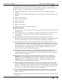
1
INTREPID User Manual
Library | Help | Top
GDADS GUIs——Map display (D12)
1
| Back |
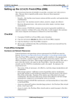
GDADS GUIs——Map display (D12)
Top
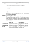
See "Map Display (GDADS Front-Office) (D08)" for a description of Map Display as
shipped, and Section "Map Display User Interface (Front-Office)" in Map Display
(GDADS Front-Office) (D08) for a description of Map Display as implemented in the
Front-Office for the GDADS customer-user. This following description includes
several options which are not currently implemented.
1
2
3
4
5
6
7
8
9
10
11
12
13
14
15
16
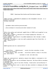
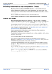
This description of GDADS' Map Display interface documents all possible features of
the interface. Some of these may not appear in the current version of GDADS.
Note: Some capabilities developed in earlier versions of GDADS are not used in the
current implementation (partly superseded by the development of GDADS FrontOffice visualisation and Purchase Data wizard). These unused functions are able to
be turned off by using the GDADS configuration file, Properties.txt. These
functions could be reimplemented, with further customisation to user requirements
by Intrepid Geophysics.
Library | Help | Top
© 2006 Intrepid Geophysics
| Back |
INTREPID User Manual
Library | Help | Top
GDADS GUIs——Map display (D12)
2
| Back |
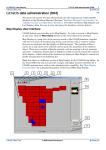
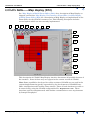
The Map Display is GDADS' initial interface to users. It provides a graphical
representation of the survey datasets in the GDADS database, against background
graphics, such as a country outline or standard map sheets.
1
Main map display panel. Use the database button (2) to change the display
contents
2
Database button. Opens the dialog box used to manage the contents of the map
display
3
Mouse mode: Zoom In
4
Mouse mode: Zoom Out
5
Zoom to Extents
6
Mouse mode: Pan
7
Mouse mode: Select
8
SQL query builder (Currently disabled)
Drag & Drop Panels
Using the mouse in select mode, select a map object, then drag, and drop it on the
selected panel.
9
Drag & Drop Panel: (i) = Information. Displays the database's metadata for the
selected object. In the case of a survey object, the display is the survey
specifications.
10 Drag & Drop Panel: FTP (Currently disabled) A data delivery function.
Developed as an alternative mechanism for delivering data to customers. Enables
the data administrator to extract and make data available on an FTP site.
11 Drag & Drop Panel: Order (Currently disabled) A data delivery function. An
early implementation of the data ordering, suitable for ordering data for a given
survey (or map sheet). This interface requested quite comprehensive user details
(for example, name, company), and recorded these plus the order details in the
GDADS database. Now superseded by a more sophisticated Purchase Data
wizard, implemented in GDADS Front-Office.
12 Drag & Drop Panel: Connection (Currently disabled) Allows GDADS to connect
to different databases. This concept of multiple GDADS databases provides
further options to the data administrator for managing diverse types of datasets
in the GDADS environment.
13 Drag & Drop Panel: Export (Currently disabled) A data delivery function.
EXPORT has the 'scissoring' function, allowing GDADS to extract data subsets
from grid files and INTREPID line databases. Data files are written to the
EXPORT directory. Now superseded by a more sophisticated Purchase Data
wizard, implemented in GDADS Front-Office.
14 Drag & Drop Panel (not visible in the above screen capture!): Image View. Drag a
survey, and drop it onto this panel to view the survey's main ('for sale') image
datasets. This Image View is made available in the Back-Office, but is primarily
designed as the Front-Office Image View tool, for use by GDADS customer-users.
See "Image View (GDADS Front-Office) (D09)" for details.
15 GDADS (Back-Office) Main Functions Buttons. Allows the user to navigate to
each of GDADS' different GUI interfaces which provide its four primary (BackOffice) functions.
16 Status Panels: Latitude & Longitude feedback from current mouse position in the
map panel.
Library | Help | Top
© 2006 Intrepid Geophysics
| Back |