1
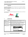
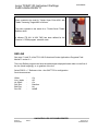
Procedure
Survey
Management System
LEICA TCRA1103
INSTRUMENT SETTINGS
SURV-GEN-20030711
Revision: draft D
Document Owner
OLIVER GLOCKNER – CONTRACT MINE SURVEYOR
Date Originated
11-July-03
Approval Date
Deployment Date
Archive Date
Next Revision Date
Printed
UNCONTROLLED COPY WHEN PRINTED
Leica TCRA1103 Instrument Settings
SURV-GEN-20030711
Procedure
Table of Contents
1
PURPOSE............................................................................................................................. 3
2
SCOPE................................................................................................................................. 3
3
DEFINITIONS ........................................................................................................................ 3
4
PROCEDURE ........................................................................................................................ 4
5
REFERENCES....................................................................................................................... 8
6
DOCUMENT REVISION HISTORY....................................................................................................................... 8
7
APPENDICES ……………………………………………………………………………………………… 9
UNCONTROLLED COPY WHEN PRINTED
Revision:
Review Date:
draft D
Page 2 of 10
Printed 28/07/03
Leica TCRA1103 Instrument Settings
SURV-GEN-20030711
1
Procedure
PURPOSE
This procedure describes how to check, and change some of the instrument configuration
settings in the Leica TCRA1103.
Without the knowledge of these settings, a surveyor may be caught out, and incorrectly
carry out some field work.
2
SCOPE
This document applies to general mine surveying, Surpac software, and the Leica TCRA1103
style of instruments.
3
DEFINITIONS
This is the Surpac menu on the Leica that has been around
Version 1 - (Standard)
for years during Surpac versions 2, 3.2, and 4.1
Leica Surpac Menu
This is the Surpac Menu on the Leica, based on Brendon
Version 2 - B.McC. WallMcCormacks’ work, suited for wall-stations (Used code 40
stn v1 Surpac menu
and 11 to start/stop resection recordings).
This is the Surpac Menu on the Leica, based on Brendon
Version 3 - B.McC. WallMcCormacks’ work, suited for wall-stations (Uses the
stn v2 Surpac menu
process_GSIv2.cmd macro to process work).
UNCONTROLLED COPY WHEN PRINTED
Revision:
Review Date:
draft D
Page 3 of 10
Printed 28/07/03
Leica TCRA1103 Instrument Settings
SURV-GEN-20030711
4
Procedure
PROCEDURE
CAUTION
Check the following in the instrument:
VERTICAL ANGLE MODES
The Leica has the ability to have the vertical angle continuously updated, or stay fixed after a
distance measurement.
See page 77 of the TPS1100 Professional Series User Manual version 2.2
Check that the Leica is set to the free, running mode. Having it set to fixed encourages the
potential for errors, especially when doing any field bookings such as underground station
traversing.
Select Main Menu > 5 Configuration > 1 Instrument Configuration > 1 Units, Decimals.
Scroll down to check that V-Angle: Running is set.
PRISM CONSTANTS
See page 70 and 71 of the TPS1100 Professional Series User Manual version 2.2
Prism constant for Leica circular prism is 0.0mm
UNCONTROLLED COPY WHEN PRINTED
Revision:
Review Date:
draft D
Page 4 of 10
Printed 28/07/03
Leica TCRA1103 Instrument Settings
SURV-GEN-20030711
Procedure
Prism constant to be used for Trimble Super Prism #021 with
Tiltable Traversing Target #850 is 34.0mm.
The prism constant is the same for a Trimble Small Tiltable
Reflector #100.
A reflector [TR 021 W 850 TAR] has been defined for the
Function 3 > EDM program selection menu
REFLINE
See page 71 and 72 of the TPS1100 Professional Series Applications Programs Field
Manual 1 version 2.1
The Leica Refline program can have the delta heights displayed based either on the first of
the line (fixed heighting), or on gradient of the line.
Select PROG > 7 Reference Line > the SHIFT F2 for configuration
Scroll down and set:
Offset
Line / alpha
Ht. Offset
Ref. Elev.
Edit Elev.
Rec Diff.
:
:
:
:
:
:
Revision:
Review Date:
draft D
On
Off
On
Baseline
No
NONE
UNCONTROLLED COPY WHEN PRINTED
Page 5 of 10
Printed 28/07/03
Leica TCRA1103 Instrument Settings
SURV-GEN-20030711
Procedure
OFFSETS
The use of Offsets in the Leica TCRA1103 is very flexible.
You may choose to use option 4 from the Surpac menu (original version 1 – pre Brendon
McCormack versions) or you can use the offset function within the TCRA1103.
If you choose to use the TCRA1103 offset function, your instrument will re-calculate the
bearing and distance to the offset point and record this new information as the measured
line.
The Caution is that the offset may not be shown in the display - pending mask definition,
and that it may be set to a permanent offset value!
To use Leica’s Offset function press “FNC” 7 “Increment Offset”. Enter the offset values and
if required change the Offset mode between “Permanent” & “Reset after REC”.
If you choose the Surpac option, the actual offset values will be recorded and Surpac will
reduce this offset point as part of its download procedure. In this option, the entered values
will be retained for editing when next you need to offset a point.
DRILL HOLE SURVEYS BY EXTENDED ROD METHOD
Field Routine: (for standard Surpac Menu on a Leica)
Place staff into collar of hole, and align with the hole trace.
Code 7, Enter hole ID. For example, ring 5 hole 3 could be R5H3
q At the Enter Distance Collar to Point1 prompt, enter the distance, or if sighting directly to
collar, just press F1 for CONT.
q At the next three prompts just press F1 for CONT.
q Take measurements and record (F1 for ALL).
q Sight to bottom of staff (point furthest from collar).
q Caution: Set the Point Id in the Meas menu back to the hole number (it will have
incremented to the next one). For example, set back to R5H3 again.
q Take measurements and record (F1 for ALL).
Move on to the next hole.
q
q
Caution: The Brendon McCormack v2 menu on the Leica differs from the (pre-wall station)
standard Surpac Menu:
• The readings must be taken in Reflectorless>Standard mode – it won’t work
properly in tracking mode.
• It doesn’t seem to have the ability to use the DIST button, check the reading, and
then press REC. Only the ALL button seems to work.
• It doesn’t have the Point Id numbering bug – as in the standard Surpac Menu
mentioned above.
• The pick-ups will need to be processed on Surpac via the Brendon McCormack
process_GSIv2.cmd macro – Surpac will not recognise the data recorder format
in its Surveying Module, and the output will differ from that of Surpac.
UNCONTROLLED COPY WHEN PRINTED
Revision:
Review Date:
draft D
Page 6 of 10
Printed 28/07/03
Leica TCRA1103 Instrument Settings
SURV-GEN-20030711
Procedure
CARD READER WITH WINDOWS 2000 BUGS
Caution: The FlashReader card reader model: UISA2SE (usb) used with Windows 2000 is
prone to having the memory cards corrupted.
Tip: If reformatting is required, do so on the PC using FAT(16) – not FAT32 system.
Below is an email Jason SpalI sent to C.R.Kennedy consultants 04/09/02.
----- Forwarded by Jason Spall/CRKENNEDY on 28/07/2003 11:54 AM -----
Dear All,
We have discovered a hardware issue with Win2000 and the USB Card Drives.
It appears that when you write data to the card, Win2000 doesn't write the
end of file information at the time of the transfer. This corrupts the
data on the card thus causing the instruments to state that the card needs
formatting. Although writing data to the card can cause problems, reading
the data on the drives works fine.
To solve the problem, you have to follow these steps:
1. Copy all the data to the card that needs to go onto it.
2. Select the "removable device" icon (the one that looks like a card with
an arrow above it) from the "system tray" in the bottom right corner of
your display and stop the card. Just as you would on your Laptop. This
actually stops the USB drive completely and Windows writes the end of file
info to the card.
3. Put the card in the instrument and everything should work correctly.
Note: You have to unplug the drive and plug it back in again so that
Windows will recognise the drive again.
I understand that this method is not practical or acceptable but I have
forwarded the problem onto Verbatim for help.
This Tip Seems to Work: I have also noticed that if the drive has been shared
on a network and you write to the data from a networked computer to the
drive on another computer, the data is written correctly. If someone is in
a position to test this, could they please try it and let me know of the
results.
I do not believe that this is a problem with the Parallel drives but I
have yet to be able to test it myself.
Please advise all your clients using Win2000 and the USB drives of this
issue and let me know of any other issues with these drives.
Regards,
Jason Spall
UNCONTROLLED COPY WHEN PRINTED
Revision:
Review Date:
draft D
Page 7 of 10
Printed 28/07/03
Leica TCRA1103 Instrument Settings
SURV-GEN-20030711
5
Procedure
REFERENCES
Surpac Help Notes
Surveying – leica.htm
Leica Instrument Manuals
TPS1100 Professional Series User Manual v2.2
TPS1100 Professional Series Applications
Programs Field Manual 1 v2.1
TPS1100 – Surpac instructions.doc
Brendon McCormack’s Macro and Leica TPS1100 – SurPac Wall Stn Coding Menu.doc
Leica menu documentation
Haefeli-Lysnar Survey Equipment
6
Product Catalogue
DOCUMENT REVISION HISTORY
Revision Events
Rev.
Author
Changes
Date
Draft A
OG
Initial draft
11/07/03
Draft B
OG
Inclusion of Offset, and Extended Rod cautions
13/07/03
Draft C
OG
Extended Rod – Drill Hole Survey cautions
27/07/03
Draft D
OG
Card Reader – Windows 2000 bug
28/07/03
UNCONTROLLED COPY WHEN PRINTED
Revision:
Review Date:
draft D
Page 8 of 10
Printed 28/07/03
Leica TCRA1103 Instrument Settings
SURV-GEN-20030711
7
Procedure
APPENDICES
Following is an extract from the Brendon McCormack “Leica TPS1100 – SurPac Wall Stn Coding
Menu.doc”
Surpac (B.McC. Wall-Stn v2) Coding Menu V2
A Geobasic program written for the TPS1100 range of total stations.
Drill hole survey - extended rod method
4. Drill Hole
Survey
Used for surveying drill holes via the "rod"
method. A rod is inserted into a drill hole and
two points along the rod are surveyed. When
processed the holes collar coordinates, dip and
azimuth are calculated.
This application allows the surveyor to survey two points along a rod which is
inserted in a drill hole. No calculations are performed on the instrument. The
observations are recorded and processed. The processed result is the hole collar
coordinates, and the holes dip and azimuth.
Execute the drill hole survey program from the main Surpac menu. The screen to
the left is displayed.
Enter hole id number and distance from drill hole collar to first target point. This
maybe zero if the collar is surveyed directly.
This distance is used to calculate the actual position of the drill hole collar.
After entering the hole id and collar distance the next screen to be displayed is the
measure "Collar Point 1". Three Function keys are active.
UNCONTROLLED COPY WHEN PRINTED
Revision:
Review Date:
draft D
Page 9 of 10
Printed 28/07/03
Leica TCRA1103 Instrument Settings
SURV-GEN-20030711
Procedure
ALL - To measure a distance and record values to the measure file.
DIST - To measure and display a distance.
QUIT - Quit screen.
Sight to collar point 1 and press the F1 "ALL" key.
The next screen displayed is the measure "Rod Point 2". Three Function keys are
active.
ALL - To measure a distance and record values to the measure file.
DIST - To measure and display a distance.
QUIT - Quit screen.
Sight to rod point 2 and press the F1 "ALL" key. The program will end and return to
the standard measure screen.
Sample GSI code written to the "Meas job" file
410136+00000009 42....+0000DDH1 43....+00000150
110137+000000R2 21.324+00409120 22.324+09018210 31..00+00005633 87..10+00000000 71..10+00000001
110138+000000R2 21.324+04259560 22.324+08259590 31..00+00005933 87..10+00000000 71..10+00000001
The code 9 signifies a drill hole survey, code block 42 is the drill hole id, and code
block 43 is the offset distance between the drill hole collar and the first rod point.
The next 2 lines of data are the rod observations.
UNCONTROLLED COPY WHEN PRINTED
Revision:
Review Date:
draft D
Page 10 of 10
Printed 28/07/03