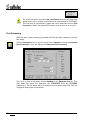
1
Software License Agreement
Grant of Limited License
softelec grants the right to install the full version software on one (1) computer - workstation or network server - at any one
time. softelec also grants the right for one (1) user or - in the case of a network license - for the number of users stated in the
network license agreement to use and activate the software at any one time. For demonstration software versions, unlimited
multiple installations are permissible. This limited license supercedes any other previous agreement unless granted in writing
and signed by softelec.
Copyright
The contents of this manual and the associated software (recorded in diskettes and/or CD's) are the sole property of softelec
and are protected by applicable copyright law. This software may not be altered, decrypted, decompiled, changed, or
disassembled in any manner without written authorization from softelec. A single backup copy is authorized. The user agrees
not to transfer title of this software at any one time without first notifying softelec. All rights are reserved. No part of this
manual may be reproduced, transmitted, transcribed, stored on a retrieval system or translated into any language or
computer language, in any form or means, electronic, mechanical, magnetic, optical, chemical, manual, or otherwise without
the express written consent of softelec as punishable by applicable copyright law. softelec is a licensee of Szki Recognita AG
and is entitled to use the OCR software Recognita Plus exclusively in all VP products.
The use of this software constitutes agreement to the terms said herein. If you do not agree with the terms of this agreement DO NOT OPEN AND INSTALL THE SOFTWARE, promptly return the software, including manuals, binders, hardware lock key,
written material, and containers to the location from which you obtained them for refund.
Terms
This license agreement becomes effective on the day of purchase and remains in full force until termination. softelec may
terminate the license in the case the purchaser fails to comply with any of the terms and conditions of this agreement. The
purchaser may terminate the license agreement at any time by returning the complete software (recorded on diskettes and/or
CD's), including manuals, binders, hardware lock key, written material, and containers.
Disclaimer
softelec reserves the right to modify the hardware lock key, the manual and/or the associated software at any time,
particularly with the intent of further development, and undertakes no guarantee to issue notification of modifications,
additions, or further developments; nor does the company obligate itself to implement such modifications, additions, or
further developments in earlier versions of the manual or the software. Any such modifications are considered upgrades in
which the registered license holder shall have the option to purchase.
Limited Warranty
softelec warrants that the media containing the software is free from defects in material and workmanship. This limited
warranty is valid for a period of ninety (90) days from the date of delivery as evidenced by a copy of receipt, provided any
faults or defects that may, in spite of the care taken in manufacture, become apparent are reported to softelec within thirty
(30) days of their occurrence. The only entitlement granted by this warranty is repair or replacement of the supplied product
at the sole discretion of softelec. Regardless of the nature of any damage or loss in any way connected with the software,
sole and exclusive liability to be borne by softelec shall not exceed the purchase price of the product.
THIS PROGRAM IS PROVIDED "AS IS." SOFTELEC SPECIFICALLY DISCLAIMS ALL OTHER WARRANTIES, EXPRESSED OR
IMPLIED, INCLUDING BUT NOT LIMITED TO IMPLIED WARRANTIES FOR MERCHANTABILITY AND FITNESS FOR A
PARTICULAR PURPOSE WITH RESPECT TO DEFECTS IN THE CD, DISKETTE, HARDLOCK, OR DOCUMENTATION, AND
THE SOFTWARE LICENSE GRANTED HEREIN IN PARTICULAR, AND WITHOUT LIMITING OPERATION OF THE SOFTWARE
LICENSE WITH RESPECT TO ANY PARTICULAR APPLICATION, USE OR PURPOSE. IN NO EVENT SHALL SOFTELEC BE
LIABLE FOR ANY LOSS OF PROFIT OR ANY OTHER COMMERCIAL DAMAGE, INCLUDING BUT NOT LIMITED TO SPECIAL,
INCIDENTAL, CONSEQUENTIAL OR OTHER DAMAGES.
U.S. Government Use
This software and documentation are provided with RESTRICTED RIGHTS for US Government customers. Use, duplication, or
disclosure by the U.S. Government is subject to restrictions as set forth in FAR 52.227-19 (Commercial Computer Software
Restricted Rights) and DFAR 252.277-7013(c)(1)(ii) (Rights in Technical Data and Computer Software), as applicable.
Manufacturer is softelec gmbh at the address set forth below.
V 6-7 / E
License Agreement
i
Legal Action
This agreement shall be construed, interpreted, and governed by the laws of the Federal Republic of Germany. Venue for any
cause of legal actions shall be in the city of Munich.
Trademarks
IBM PC/AT and PS/2 are registered trademarks of International Business Machines Corporation.
MS-DOS, Windows 3.1x, Windows 95, Windows 98, and Windows NT are registered trademarks of Microsoft Corporation.
AutoCAD and AutoCAD LT are registered trademarks of Autodesk, Inc.
Recognita Plus is a registered trademark of SzKI Recognita AG.
softelec and logo, Greek head design, VPstudio, VPmax, VPlite, VPraster, VPselect, RasterDWG, DLC are registered
trademarks of softelec gmbh.
softelec gmbh
Joseph-Seifried-Strasse 8, D-80995 Muenchen, Germany
Phone: +49-89-158-1430 • Fax: +49-89-158-143-33
E-mail: [email protected] • Internet: http://www.softelec.com
ii
License Agreement
V 6-7 / E
Table of Content
SECTION 1: INTRODUCTION ............................................................................................. 1
Welcome to the "World of Raster and Vector!".......................................................................... 1
What is VP HybridCAD and who needs it?................................................................................. 1
Basics: Raster data / Vector data ............................................................................................... 2
Vector Post Process ..................................................................................................................... 6
Product Features .......................................................................................................................... 6
Concept of this manual.............................................................................................................. 10
Conclusion .................................................................................................................................. 10
SECTION 2: INSTALLATION............................................................................................. 11
Introduction ................................................................................................................................ 11
Software License (Hardlock) ..................................................................................................... 11
Hardlock Driver...................................................................................................................... 12
Package Contents....................................................................................................................... 12
Attaching the Hardlock (Dongle)............................................................................................... 12
Installing VP HybridCAD Software ........................................................................................... 13
General .................................................................................................................................. 13
Performing the Installation.................................................................................................... 14
Registration ................................................................................................................................ 15
Uninstalling................................................................................................................................. 15
Updating / Upgrading / Patching.............................................................................................. 16
System Requirements................................................................................................................ 16
Installing the VPLicenseManager.............................................................................................. 17
Requirements ........................................................................................................................ 17
Installation ............................................................................................................................. 17
Monitoring VPLicenseManager................................................................................................. 18
Introduction ........................................................................................................................... 18
Menus .................................................................................................................................... 19
SECTION 3: TUTORIAL ..................................................................................................... 23
Lesson One: First Steps............................................................................................................ 26
Lesson Two: I. Raster Objects.................................................................................................. 34
Lesson Two: II. Raster Objects – complex Editing................................................................ 39
Lesson Three: Merging two Raster Files ................................................................................. 45
Lesson Four: Rubber Sheeting................................................................................................. 47
Lesson Five: Tracing (Line Following) ..................................................................................... 53
Lesson Six: Color Reduction/Separation ................................................................................ 59
V 6-7 / E
Table of Content
iii
Lesson Seven: Color Classification ..........................................................................................66
Lesson Eight : Vectorization (Auto R2V) .................................................................................73
SECTION 4: OPERATION: GENERAL FUNCTIONS ......................................................... 83
Basics...........................................................................................................................................83
Specials with AutoCAD 2000 and AutoCAD LT 2000 ...............................................................83
Specials with AutoCAD LT 97/98/2000 .....................................................................................83
Working with Multiple Raster Images.......................................................................................83
VP HybridCAD Menu ..................................................................................................................84
Program Settings...................................................................................................................86
Show Toolbars .......................................................................................................................88
Load Raster Image.................................................................................................................89
Save Raster Image.................................................................................................................90
Save RasterDWG ...................................................................................................................92
Create New Raster .................................................................................................................92
Scan .......................................................................................................................................92
Show Raster Image Info ........................................................................................................93
Rasterize Entities....................................................................................................................93
Rasterize to Paper Format .....................................................................................................95
Raster File Edit .......................................................................................................................96
Split Raster Image .................................................................................................................96
Merge Raster Image ..............................................................................................................96
Cut to Paper Format ..............................................................................................................96
Rubber Sheeting....................................................................................................................97
Vectorize.................................................................................................................................97
Edit Raster ..............................................................................................................................97
Erase Raster ...........................................................................................................................97
Draw Raster ...........................................................................................................................97
Tracing ...................................................................................................................................97
Color/Filter .............................................................................................................................97
Raster Snap [F11] [on/off]......................................................................................................97
Delete Raster Background [on/off] (under vectors)..............................................................98
Auto Regenerate [on/off] .......................................................................................................98
Show Raster [on/off]..............................................................................................................98
Dynamic Width [on/off] .........................................................................................................98
Zoom Active Image................................................................................................................98
Select Active Image ...............................................................................................................98
Regenerate.............................................................................................................................99
Raster-to-Vector Conversion .....................................................................................................99
Basics .....................................................................................................................................99
Main Menu .............................................................................................................................99
VPraster pro Graphic Display ..............................................................................................100
General Functions................................................................................................................100
Status Display ......................................................................................................................100
iv
Table of Content
V 6-7 / E
Using the Mouse ................................................................................................................. 100
Combined Mouse Keyboard Operation.............................................................................. 101
Settings................................................................................................................................ 102
Display ...................................................................................................................................... 102
Status Bar ............................................................................................................................ 102
Raster [F4]............................................................................................................................ 103
Vector [F5] ........................................................................................................................... 103
Zoom.................................................................................................................................... 103
Pan [Cursor Keys]................................................................................................................ 104
Drawing Aids....................................................................................................................... 104
Grid [F7] ............................................................................................................................... 104
Coord Snap [F9]................................................................................................................... 104
Raster Snap [F11] ................................................................................................................ 104
Vector Snap [F8] .................................................................................................................. 104
Polygon Select [F6] ............................................................................................................. 104
Redraw [Ctrl + R] ................................................................................................................ 105
Distance [F2]........................................................................................................................ 105
Options...................................................................................................................................... 106
Settings................................................................................................................................ 106
Toolbars ............................................................................................................................... 109
Object Creation.................................................................................................................... 109
Purge Table Entries ............................................................................................................. 111
Block Definitions.................................................................................................................. 111
OCR Options ........................................................................................................................ 114
Drawing Aids....................................................................................................................... 115
CAD Options ........................................................................................................................ 117
Parameter Post Processing................................................................................................. 119
Abort Process [ESC] ............................................................................................................ 119
SECTION 5: OPERATION: HYBRID EDITOR FOR RASTER/VECTOR DATA................ 121
General Information ................................................................................................................. 121
Basic Editing Commands......................................................................................................... 121
Edit Raster (Functions)............................................................................................................. 121
Create Raster Object ........................................................................................................... 122
Create Raster Object (Erase Background) .......................................................................... 122
Erase Raster......................................................................................................................... 122
Copy Raster ......................................................................................................................... 122
Move Raster......................................................................................................................... 123
Smooth Object..................................................................................................................... 124
Raster Selection................................................................................................................... 124
Select Arc ............................................................................................................................ 125
Select Circle......................................................................................................................... 125
Select Line ........................................................................................................................... 126
Select Polygon..................................................................................................................... 126
V 6-7 / E
Table of Content
v
Select Rectangle ..................................................................................................................126
Select Inside Window ..........................................................................................................127
Pick Element.........................................................................................................................127
Raster Text ................................................................................................................................128
Fill Raster ..................................................................................................................................130
Draw Raster (Functions)...........................................................................................................131
Draw Line .............................................................................................................................131
Draw Polyline.......................................................................................................................131
Draw Arc ..............................................................................................................................131
Draw Circle...........................................................................................................................132
Draw Rectangle....................................................................................................................132
Erase Raster (Functions)...........................................................................................................133
Erase Line.............................................................................................................................133
Erase Polyline.......................................................................................................................133
Erase Arc..............................................................................................................................133
Erase Circle ..........................................................................................................................133
Erase Rectangle ...................................................................................................................133
SECTION 6: OPERATION: RASTER FILE EDITING ........................................................ 135
General Information .................................................................................................................135
Raster Functions .......................................................................................................................135
Auto Cleanup .......................................................................................................................135
All .........................................................................................................................................136
Cut Window..........................................................................................................................136
Crop......................................................................................................................................136
Deskew.................................................................................................................................136
Invert ....................................................................................................................................137
Rotate Arbitrary ...................................................................................................................137
Horizontal Mirror .................................................................................................................138
Vertical Mirror......................................................................................................................138
Remove Speckles (B/W files only).......................................................................................138
Smooth Raster ..........................................................................................................................140
Scale Drawing...........................................................................................................................140
SECTION 7: OPERATION: COLOR REDUCTION, COLOR SEPARATION,
COLOR CLASSIFICATION, FILTERS ......................................................... 141
General ......................................................................................................................................141
Scanning Colors........................................................................................................................141
Reducing Colors / Gray Scale ..................................................................................................142
Preview.................................................................................................................................143
Histogram View....................................................................................................................144
vi
Table of Content
V 6-7 / E
Automatic Reduction........................................................................................................... 145
Interactive Color Separation ............................................................................................... 146
Color Classification .................................................................................................................. 149
General ................................................................................................................................ 149
Classification........................................................................................................................ 149
Pick Probe............................................................................................................................ 150
Process Classification.......................................................................................................... 151
Filter Functions......................................................................................................................... 152
Filter Raster Image .............................................................................................................. 152
Filter Table ........................................................................................................................... 155
Palette Transformation ............................................................................................................ 156
General ................................................................................................................................ 156
Convert To Palette ............................................................................................................... 156
Transformation .................................................................................................................... 156
Palette Transformation Table.............................................................................................. 161
Histogram Dialog Box Displays............................................................................................... 162
SECTION 8: OPERATION: RUBBER SHEETING, SPLIT, MERGE ................................. 163
Multi Point Rubber Sheeting ................................................................................................... 163
Rubber Sheeting Functions................................................................................................. 163
Set Up User Coordinate System......................................................................................... 165
Rubber Sheet Settings ........................................................................................................ 166
Input of Reference Points.................................................................................................... 169
Rubber Sheeting of Technical Drawings/ Cut to Paper Format............................................ 172
Quick Calibration...................................................................................................................... 172
Preparation .......................................................................................................................... 172
Cut to Paper Format ................................................................................................................ 174
Split a File................................................................................................................................. 175
Merge two Files........................................................................................................................ 176
SECTION 9: OPERATION: INTERACTIVE TRACING ..................................................... 179
General Information ................................................................................................................. 179
Trace Settings .......................................................................................................................... 180
Contour Trace Tab............................................................................................................... 180
Pick Trace Tab ..................................................................................................................... 182
CAD Trace................................................................................................................................. 184
Contour Trace........................................................................................................................... 184
Contour Trace Linetype ........................................................................................................... 185
Undo Trace ............................................................................................................................... 185
Pick Trace ................................................................................................................................. 186
Stop Tracing ............................................................................................................................. 186
V 6-7 / E
Table of Content
vii
SECTION 10: OPERATION: RASTER-TO-VECTOR CONVERSION
(VECTORIZATION) ................................................................................... 187
General Information .................................................................................................................187
Vectorizing (Generation of Raw Vectors) ...............................................................................188
Vectorization Method...........................................................................................................188
Area ......................................................................................................................................189
Post Processing ........................................................................................................................190
Parameters Post Processing ...............................................................................................190
Regeneration.............................................................................................................................201
SECTION 11: OPERATION: HYBRID EDITOR IN THE VP HYBRIDCAD WINDOW ...... 203
General Information .................................................................................................................203
Layer.....................................................................................................................................203
Object Color .........................................................................................................................203
Line Types ............................................................................................................................204
Orthogonal Drawing ............................................................................................................204
Erase Raster [Ctrl+E] (under vectors).................................................................................204
CAD Options ........................................................................................................................205
Undo [Ctrl+Z].......................................................................................................................205
Redo [Ctrl+A].......................................................................................................................205
Redraw [Ctrl+R]...................................................................................................................205
General Editing Commands .....................................................................................................206
Explode (Origin) ...................................................................................................................206
Cut ........................................................................................................................................206
Make Corner ........................................................................................................................206
Trim ......................................................................................................................................206
Review Text..........................................................................................................................207
Delete [Del] ..........................................................................................................................208
Layer Assignment ................................................................................................................208
Line Type Assignment .........................................................................................................208
Text Style Assignment.........................................................................................................209
Move Object(s).....................................................................................................................209
Copy Object(s)......................................................................................................................209
Copy to Clipboard [Ctrl+C]..................................................................................................209
Paste from Clipboard [Ctrl+V].............................................................................................210
Last Selection [Ctrl+L].........................................................................................................210
Properties [Enter] .................................................................................................................211
Correct Hatch .......................................................................................................................212
CAD Functions ..........................................................................................................................213
Pen .......................................................................................................................................213
Line.......................................................................................................................................213
Polyline.................................................................................................................................213
Closed Polyline.....................................................................................................................214
viii
Table of Content
V 6-7 / E
Spline................................................................................................................................... 214
Arc (3-point)......................................................................................................................... 214
Arc (4-point)......................................................................................................................... 214
Arc (with connection).......................................................................................................... 214
Circle (Radius) ..................................................................................................................... 215
Circle (2-point) ..................................................................................................................... 215
Circle (3-point) ..................................................................................................................... 215
Ellipse .................................................................................................................................. 215
Text ...................................................................................................................................... 216
Dimension Arrow ................................................................................................................ 216
Pointing Arrow .................................................................................................................... 216
Donut ................................................................................................................................... 216
Hatch (Fill)............................................................................................................................ 217
Insert Block .......................................................................................................................... 217
Combining Vector Elements.................................................................................................... 218
Combine to Line .................................................................................................................. 218
Combine to Ortho Line........................................................................................................ 218
Combine to Polyline ............................................................................................................ 219
Combine to Spline............................................................................................................... 219
Combine to Arc ................................................................................................................... 219
Combine to Circle................................................................................................................ 219
Combine to Ellipse .............................................................................................................. 219
Combine to Text (Interactive Text Recognition)................................................................. 219
Combine to Dimension ....................................................................................................... 220
Combine to Block ................................................................................................................ 221
Assign Elevation.................................................................................................................. 221
SECTION 12: OPERATION: BLOCKS ............................................................................ 223
General Information ................................................................................................................. 223
Creating Blocks ........................................................................................................................ 223
Combine to Block ................................................................................................................ 223
Insert Block .......................................................................................................................... 227
Modifying Block Definitions ................................................................................................ 228
SECTION 13: OPERATION: SYMBOL SEARCH/REPLACEMENT .......................... 229
General Information ................................................................................................................. 229
Symbols .................................................................................................................................... 229
Search! ................................................................................................................................ 230
Create/Add........................................................................................................................... 230
Load ..................................................................................................................................... 233
Remove................................................................................................................................ 233
Modify .................................................................................................................................. 233
V 6-7 / E
Table of Content
ix
SPECIFICATIONS ............................................................................................................ 235
APPENDIX A: ERROR AND SYSTEM MESSAGES........................................................ 241
APPENDIX B: SCANNER INTERFACE ........................................................................... 251
INDEX
x
...................................................................................................................... 257
Table of Content
V 6-7 / E
Section 1
Introduction
This section applies to:
Welcome to the "World of Raster and Vector!"
Congratulations on your VP HybridCAD software purchase from softelec, a
specialist and market leader in raster-to-vector conversion and hybrid editing
software for the PC. Since its introduction in 1990, VP HybridCAD software has
constantly been improved for quality and productivity. New algorithms and
programming techniques have resulted in extraordinary quality improvements,
including needle pegging conversion speeds. Our VP HybridCAD technology
assures that you are obtaining the finest in professional products for your
scanning, archiving, raster and vector editing, and conversion applications.
What is VP HybridCAD and who needs it?
The importance of raster data processing has seen notable growth in the field of
CAD. Legacy information such as "old" drawings and technical documents often
found as paper (copies, blueprints, transparencies) or come as gray level and color
images (photographs, films, color prints). Redrawing them manually into CAD
(using CAD functions or a digitizer) is very time consuming, can be inaccurate, and
costly. To overcome these drawbacks, scanners for small and large formats are
used to generate raster data (digital photographs) from legacy documents which
can then be quickly converted to CAD entities.
VP HybridCAD is a family of software products with advanced raster editing
capabilities, as both stand-alone and for use inside AutoCAD. In addition, image
data can be converted into intelligent vectors your CAD system understands. As an
application to AutoCAD and/or AutoCAD LT VPraster series software is capable of
loading, hybrid editing, plotting, and saving raster data of black/white, color, or
gray scale images. RasterDWG is a true AutoCAD DWG format that contains both
vector and raster data. Raster can be in color, gray scale, or black and white. A
freeware utility called RasterDWG (RDWG), once installed into AutoCAD is all that
is required to load, view, and plot the raster entities while in AutoCAD. No more
broken links to external image references, because with RasterDWG it's all in a
single file.
VP HybridCAD applications are for:
V 6-7 / E
•
Architects, structural and civil engineers, regional and interregional planning
departments, and facilities equipment and maintenance
•
Mechanical design and process engineering
•
Cartography and GIS applications in general
Section 1
Introduction
1
•
Land Survey engineers and Land Register documents
•
Any structural planning and design
Everyone using a CAD system will inevitably face this question: "How do I capture
paper information for use in my CAD system in a manner that saves time and
money?" At softelec, we firmly believe that VP HybridCAD software clearly
responds to this question in many positive ways and that it offers the best solution
available for any application.
Basics:
Raster data / Vector data
Scanners or other devices generate raster data when they scan a document. In the
case of a monochrome rendition the document's contents are represented as a
matrix of black and white pixels. In gray level rendition, representation will also be
in pixels (commonly 8 bit, corresponding with 256 gray tones). Color scanning will,
of course, result in color pixel representation with 8, 12, 16, 24 or 32 bits of color
depth. The individual pixels bear no logical relation to each other. They represent
some sort of a "digital photography" of the document's content as computer data.
Figure 1: B/W Raster Representation
Pixel density is specified as number per unit of length, in most cases as DPI (dots
per inch). Numerous raster data formats exist (TIFF, GP4, RLC, PCX, BMP, GIF,
etc.); they describe position and color of the pixels comprising the image.
2
Section 1
Introduction
V 6-7 / E
Today, monochrome large format scanners are common in technical CAD
applications. These scanners generate binary raster data (black and white pixels)
which make for extremely compact raster files resulting from high-compression
algorithms (most well known formats: TIFF group 4 or CALS group 4).
In the field of cartography, for instance, satellite recording generates gray level and
color images. They usually contain additional information which are processed and
analyzed in GIS applications. Basically, gray level and color raster files do not differ
from binary raster data. Their file sizes, however, disproportionately increase due
to very limited compression options without loss of information. Thus, DIN A0 (Esize) color drawings may result in raster files of 500 MB or more.
All AutoCAD elements are vector data representing geometrical elements, such as
lines, circles, arcs, text, etc. They form the basic elements in a CAD system and
any other – more complex – drawing element will be composed of them.
Moreover, all vector elements can easily be picked, moved, deleted, or copied as
entities on-screen (and in-file, of course). Color coding serves as an additional
information marker representing line width, hierarchical structuring, area bounds,
and others.
Figure 2: B/W Vector Representation
With the introduction of scanner technology, manually created drawings are
obviously easy to render as digital data. The raster files created, however, are only
of real use in CAD programs once they have either been made available by suitable
software: Either directly through a raster-to-vector conversion or through hybrid
technology allowing for parallel editing of raster and vector structures.
V 6-7 / E
Section 1
Introduction
3
Raster-to-Vector Conversion
Every raster-to-vector conversion (vectorization) involves a process of
interpretation in which the pixels of the raster images are converted to vector
elements. If the original document contains clear and unambiguous pixels, the
process generates a 100% vector file that can be edited in CAD programs.
However, unclear or missing areas in a poor drawing caused by the effects of age,
the imperfect manual preparation, and weathering of ink, pencil, or foil does not
provide logical raster structures; therefore the scanned image will be converted
inaccurately. Nevertheless, using comparisons and approximations, it is still
possible to generate the most probable vector representation. Once the raster file
has been converted into a vector file, modifications and corrections of any
misinterpretations can easily be made with an elaborate source of "smart" editing
tools.
There are different methods of vectorizing raster data, depending on their color
depth. Since the vectorization process is based upon binary files, i.e. the file must
only contain active foreground pixels on an inactive background, B/W images (bilevel) can be converted without additional operation. Vectorizing colored or gray
scale images (multiple color or gray level) can only be achieved by generating
binary images through color reduction and separation, followed by converting and
merging the conversion results as a single CAD file. For example, all red raster
pixels can be separated as a raster object and converted using the same procedure
as with B/W images. Similarly, gray scale files can be vectorized by separating
levels of gray.
For most technical drawings and documents, and including cartography (GIS)
applications, there are two principal vectorizing methods, plus a third alternative:
•
Centerline Vectorization:
based on a skeleton (thinning) method
•
Outline Vectorization:
based on a outline tracing method.
•
Centerline+Outline Vectorization:
based on thinning and outline tracing.
Centerline vectorization is used if the image contains lines, circles, arcs, and other
more complex elements based on these elements, but in the absence of solid
raster objects. The raster image is reduced (thinned down), starting with the edges
of the areas of set (active) pixels until only the pixels in the center are left. These
are then replaced by a series of line elements (polylines) in which the nodes
exactly reproduce the topology of the scanned image (raw vector data).
Information regarding line widths in pixels is stored and interpreted later for layer
separation using automatic post-processing techniques.
4
Section 1
Introduction
V 6-7 / E
Figure 3: Centerline Vectorization
Outline vectorization is where the perimeter of all pixels is represented by closed
polylines. This "hollowing out" method is suitable for vector-based representation
of an area which centerline vectorization would normally render as a single line of
relevant width.
Figure 4: Outline Vectorization
The two methods described can also be used in combination as Centerline/Outline
Vectorization. It is used when a drawing contains both, line structures and solid
filled areas. A defined raster width value (threshold) determines when the
vectorization process uses centerline, (below the threshold value), or outline
vectorization (whenever the raster width equals or exceeds the threshold value).
Drawings having both: thin lines and solid objects convert best using this method.
A small threshold value will be more sensitive to smaller solid objects or pixel
clusters. User experimentation may be required for best results.
V 6-7 / E
Section 1
Introduction
5
Vector Post Process
The actual interpretative intelligence becomes evident with vector postprocessing. Based on the topology of raw vector data it applies tolerance criteria
and comparative interpretation techniques to recognize and extract lines, circles,
arcs, and higher elements such as text, symbols, blocks, and hatch. This process is
controlled by parameter settings that can be adjusted to achieve the best possible
result.
Product Features
The VPraster series of VP HybridCAD consists of powerful ARX applications to
both: AutoCAD R14/2000 and/or AutoCAD LT 97/98/2000. In joint operation with
the CAD system they provide the most efficient way to process and edit raster and
vector data. Moreover, all CAD data (e.g. raster and vector data) can be saved in
one hybrid DWG file (RasterDWG®). Importantly, this will ease the file
administration and the exchange of hybrid drawings with other companies.
All VP HybridCAD software products are based on the most advanced 32-bit
programming methods. They also feature a high standard in user-friendly
operation and the integration into AutoCAD leaving no considerable difference in
processing either vectors or raster.
General Raster Data Handling
One or more raster files (B/W, gray level, or color) can be imported or loaded as an
external reference to a standard AutoCAD R14 DWG file or loaded from a
RasterDWG file.
A hybrid drawing can be plotted with the standard AutoCAD plot command. Raster
information and AutoCAD elements can be sent – together or separately – to the
plotter.
Options for saving raster files include the standard AutoCAD procedure with
indexed separate raster files and the VP HybridCAD RasterDWG procedure saving
raster and AutoCAD elements in one single hybrid file. This RasterDWG file is
compatible with AutoCAD while all contained AutoCAD elements will be read by
any AutoCAD system. A freeware utility (RDWG) is provided to also display and
plot the embedded raster information if VPraster or VPraster LT is not installed.
6
Section 1
Introduction
V 6-7 / E
Scanner Interface
The integrated scanner interface for the most popular large format B/W and color
scanners allows for direct capture of drawing data into AutoCAD. Thus, the time
consuming process of activating any external scan software, saving the raster data
and then importing the data is eliminated. (See Appendix B for scanners
supported.)
Raster File Editor
The professional raster file editor in VP HybridCAD products has been designed for
extensive file editing of the complete raster image: crop, trim, deskew, rotate,
despeckle, fill holes, mirror the file, split, and merge raster files, rubber sheeting,
etc. The rubber sheeting function provides elimination of local distortions in the
loaded raster image, which can be caused by aging, incorrect drawing design,
and/or scanning tolerance errors. This will result in high precision calibration which
is especially important in cartographic applications (GIS).
Oversized raster images, exceeding the maximum processing capacities of
VP HybridCAD software can still be loaded and split into as many as 25 single
image files. Additionally, raster files can be merged with options of free
positioning, rotation, and scaling for best placement to each other.
Hybrid Editor
The hybrid editor provides functions to edit raster data and vectors. This includes
the drawing of lines, circles, and arcs using different lines and line styles, the
copying and deleting of elements or areas, and the editing and insertion of text and
many more using the standard AutoCAD drawing and editing commands. While
drawing a vector entity, the underlying raster data can be automatically deleted by
user settings. At any time, however, single or grouped elements can be made part
of the raster file by rasterization.
V 6-7 / E
Section 1
Introduction
7
Vector Editor
On the vector side, single vectors can be combined to lines, circles, or arcs. Text
generated by the automatic character recognition function can be reviewed and
edited if necessary. You can transfer elements to different layers, correct angles,
and drawing errors or interpretation faults. Different elements can be associated to
form blocks, and these blocks can be subsequently exploded.
In addition, new vector elements can be generated, moved, copied, or replaced.
Entering new text and hatch pattern creation are also supported. All elements
recognized during the vector post-processing can be manually drawn.
Raster-to-Vector Conversion
Raster files that you have modified or "cleaned up" using the raster editors can be
vectorized using VPraster pro in whole as a single operation or in sections. The
vectorization process consists of two steps:
•
•
Raw Vectorization
Vector Post Processing
You select one of three vectorization methods followed by an automatic post
processing operation. The first step creates a 'raw' vector overlay, which is
displayed in white above the raster image. To complete the conversion, the post
processing is executed as a second step running on user defined parameters.
VP HybridCAD software provides an initial set of predefined parameter files (.PCF)
for various applications; these files can be modified to meet specific recognition
requirements and saved for later use. Select a suitable parameter file, make any
modifications, and then start vector post processing. The result of this operation
replaces the raw vector data with intelligent vector entities. Colors are used to
denote line-width classes and different elements, such as arcs, circles, text,
symbols, blocks, and hatches.
Symbol Search
Symbols can also be searched for and converted into blocks, even with associated
attributes. First, the search symbol (prototype) is created by selecting one or
several target symbols, which is then saved as a prototype symbol file and used for
the search and replacement of matching objects. The symbol files become a part of
the user's library.
8
Section 1
Introduction
V 6-7 / E
Tracing (Line Following)
The tracing module provides interactive and selectable raster-to-vector conversion
of raster entities or areas. Options include the generating of CAD entities (lines,
circles, etc.) or outlines (polylines/splines). The latter is important in GIS applications. The underlying raster of a traced element can be erased automatically if
necessary.
Gray Scale and Color Processing
Very simple yet powerful functions are available for color and gray scale images:
conversion, reduction, and manipulation. Special classification algorithms provide
for color pattern recognition assigning a new color to a selected pattern area. The
intelligent picking applies not only to B/W structures, but also to a color or a color
pattern.
V 6-7 / E
Section 1
Introduction
9
Concept of this manual
This manual has been organized to help you to quickly find operation terms,
commands, and description of functions. The manual applies to the following VP
products: VPraster pro, VPraster and VPraster LT. The icon on the top right on
each page indicates to which product(s) the information and/or commands apply. If
specific commands on a page are limited to other products or product groups this
is marked with a corresponding icon.
Great efforts have been made to define each function and each setting of a
parameter only once in detail. Therefore, an alphabetic index provides a quick
means of finding these descriptions.
Keys and key combinations are represented by [ ] enclosing the keys' designation.
For example, the "Enter" or "Return" key is shown as [Enter] whereas a key
combination (short-cut) opens as [Ctrl + C].
Menu and command line commands are printed in bold italics.
Functions that can be mouse-clicked for activation/deactivation in a check box are
represented as [on/off].
Value entries are either quoted with the absolute value range by [unit] or they
depend on the selected drawing unit [bu].
The given value ranges do not necessarily define an internal limitation, but specify
a meaningful range – be aware that using values outside of the "normal" range can
cause unexpected results. Default values represent values either set up during
installation or which will be used, e.g. when parameter values are reset.
Conclusion
So, once again we say: "Welcome to the softelec world of raster and vector".
This manual will familiarize you with all the functions of VP HybridCAD software. It
is meant to be both: a source of reference and a guideline to the latest
raster/vector processing technology. The most expedient way to learn your
selection of VP HybridCAD software is to first take the opportunity to view the VP
TOUR multimedia from the CD, though this tour is more specific for VP-Win standalone products, but the command functions are identical. Afterwards, install the
VP HybridCAD software selection you've purchased and start with the Tutorial
(Section 3) and follow the applicable lesson series. Once completed, you will have
command of VP HybridCAD that can only increase your CAD productivity.
Have fun with VP HybridCAD!
As a reminder, please visit our web at http://www. softelec.com for the latest
information and updates.
10
Section 1
Introduction
V 6-7 / E
Section 2
Installation
This section applies to:
Introduction
The VP HybridCAD products VPraster pro, VPraster and VPraster LT are AutoCAD
Applications (ARX) and require AutoCAD R14/2000 or AutoCAD LT 97/98/2000.
Depending on the configuration of your computer network you may install the
software using different methods.
Local Installation
This is the recommended setup, where all program files are installed on the users
computer. If the computer is not on a network, VP HybridCAD software can only
be installed as a local system. Also, the local installation provides the speediest
operation and does not generate network traffic, even if part of a network — except
for file transfers on the network.
Server Installation
On a computer network you may install the software onto the server hard disk.
User dependent configuration files are generated locally by a special client setup to
allow customization. It may take some time to start the software when the server is
busy. If the server is down or there are other network problems, VP HybridCAD
will not operate.
Software License (Hardlock)
A VP HybridCAD hardlock may contain one or more product licenses. Regardless
of the installation mode and the number of licenses controlled by the hardlock
there are two methods of operation:
1. Local Licensing: You need to attach the hardlock (dongle) to one of the parallel
ports of the computer where VP HybridCAD is installed. Typically, this method
of operation is used if the hardlock contains a single license only. Then, for
every additional VP HybridCAD installation an additional single license hardlock
is required.
Local Licensing does not require the installation of the
VPLicenseManager. All Windows operating systems (see above) are
permissible.
V 6-7 / E
Section 2
Installation
11
2. Network Licensing: This method of operation is used for hardlocks containing
two or more VP HybridCAD licenses, but also may be used for a single license.
If you want to use this as a "floating" license, where you can access
VP HybridCAD on any networked computer, but only one operation at a time.
You need to attach the hardlock to a network server ("dongle server") running
the VPLicenseManager so that the license(s) is accessible by other
workstations.
The VPLicenseManager requires an additional installation and only is
supported in Windows NT.
Hardlock Driver
The workstation or server having the hardlock on its parallel port needs a system
driver for proper operation. This driver is provided with your package and is
installed together with the VP HybridCAD software. You may also install it
manually by following the instructions found in the file README.TXT on the CD.
Package Contents
Your VP HybridCAD package contains the following:
•
•
•
•
1 User manual
1 VP HybridCAD CD
1 Hardlock (dongle)
1 Registration form
Attaching the Hardlock (Dongle)
Attach the male side (the side with the pins) of the hardlock to one of your
computer's/server's parallel ports (LPT1, 2, or 3). Typically, up to five hardlocks can
usually be stacked together including a printer to the device(s). If a printer is
connected, it should be turned on to provide proper termination, otherwise the
hardlock may see false signals (due to reflections) that will cause the program to
request a hardlock installation.
It is physically possible to attach the female side of the hardlock (the side
with the sockets) to certain types of serial port connectors (25-pin male
connector). The hardlock will not work when connected this way and may
even be damaged.
12
Section 2
Installation
V 6-7 / E
Do not connect devices like a tape streamer, a CD ROM drive or similar
equipment to the same parallel port as your hardlock. Also running file
copying applications like Laplink or similar products on the same parallel
port causes malfunction to the hardlock or the application.
Installing VP HybridCAD Software
General
The install program SETUP_VP.EXE walks you through each step to successfully
install and configure the software and the hardlock driver. If your CD autorun is
enabled, the initial screen will pop up automatically upon insertion of the CD
offering you several choices. Also, enjoy an introduction to the features and
functions of VP HybridCAD following the multimedia show.
The Local Installation and the Server Installation are executed with the same setup
which allows you to specify several options. These include the target location and
the components of the VP HybridCAD software.
Before starting the setup routine please make sure to terminate any running
applications and read the file README.TXT which is located on the CD.
To install a new version of your VP HybridCAD program, you MUST
uninstall the original installed product first!
Start and close AutoCAD at least once before installing VPraster pro,
VPraster or VPraster LT.
The system driver for accessing the hardlock (dongle) will be automatically
installed together with the VP HybridCAD software.
Administrator rights are necessary to install the hardlock driver under
Windows NT.
After a successful installation of the software, it is often necessary to reboot the
computer in order to allow the operating system to update the DLLs, especially for
NT and AutoCAD users. A dialog box will appear, asking the user to restart the
computer now or at a later time.
V 6-7 / E
Section 2
Installation
13
Performing the Installation
The setup is started automatically after inserting the CD into your CD-ROM drive
(autorun). Only if your Operating System (OS) does not support this or autorun is
disabled you have to start the setup program SETUP_VP.EXE manually from the
root directory of the CD.
Installing under Windows 95/98 & Windows NT 4.x/2000
Click on the Start button to activate the Control Panel from the Settings menu.
Double-click the icon named Add/Remove Software and follow the instructions.
Alternatively you may double-click SETUP_VP.EXE directly from the Explorer.
In the initial setup window click the item "VP HybridCAD Products" and select the
desired program language from the dialog. In the sequel you are guided through
the setup dialogs allowing user defined settings.
Local Installation
Follow the steps through the installation. We recommend to choose "typical" as the
setup type.
Server Installation
Follow the steps through the installation. You must choose the "custom" setup type
and then check on the component "Server Installation Files".
After a successful installation you will find the subdirectory client in your
VP HybridCAD directory (on the server). This contains the file SETUP.EXE which
must be executed on every workstation (client). Through this setup the program
icons will be created and the user specific files will be copied to the workstation.
Local Licensing
During setup you will be asked whether your hardlock resides locally or on the
network server. Choose "Local".
14
Section 2
Installation
V 6-7 / E
Network Licensing
During setup, you will be asked whether your hardlock resides locally or on the
network server. Choose "Network Server". The next dialog prompts you for the
name of the server bearing the hardlock ("dongle server"). You don't need to enter
the two trailing backslashes "\\" (e.g. type only "SOFTELEC_DOMAIN").
If you don't know the name of the "dongle server" you may leave this entry empty
and proceed with the installation. On startup VP HybridCAD will search the entire
network for an appropriate VP license (e.g. a hardlock). However, this may take
some time if your workstation participates in a large network.
In order to use Network Licensing the VPLicenseManager (see below), the
hardlock driver, and the hardlock (dongle) must be installed on the same
computer.
Registration
Fill out the attached registration form completely and legibly - best done during
installation - and send it or fax it back to softelec.
You will receive technical support and update/upgrade notices provided
you have properly registered VP HybridCAD software with softelec.
Registration of VP HybridCAD products with your VAR or reseller does not
constitute proper registration and will prevent you from obtaining
software support or immediate upgrades (even those free of charge).
Uninstalling
To remove VP HybridCAD software from your computer, click on the icon
Uninstall. If you have installed the same VP HybridCAD product twice without
uninstalling the previous one, only the last VP installation will be removed.
The hardlock driver will not be removed. If the driver is not required by any other
program, you can remove it from the Driver list in the Control Panel.
V 6-7 / E
Section 2
Installation
15
Updating / Upgrading / Patching
Software upgrades (to a higher level VP HybridCAD product) or updates (to a new
release of the same VP HybridCAD product) may require a password that is issued
to you upon purchase. After installing the upgrade or update and starting it for the
first time, you will be asked to enter the password. After successful entry, the
password can be discarded.
For updating a VP network license hardlock (the lock is attached to the VP server)
use the program UPDATELOCK.EXE residing in the CD directory VPHardlock. For
more information please read the text file ReadMe.TXT in the route directory of the
CD.
Free updates do not require a password, but it is important that you register your
VP HybridCAD software for prompt notification.
Although you may update your current VP HybridCAD product by installing the
new version into the same directory (patching), we recommend you do a fresh
installation. First uninstall the old version, then install the new product version.
System Requirements
The VP HybridCAD software has been developed using the most powerful and
state-of-the-art programming techniques specifically designed for high power PCs
in order to be able to process the huge quantity of data of large images and
technical drawings. However, proper operation requires a specific configuration of
hardware and software to guarantee overall functionality. The fastest CPU in your
PC is the most desirable!
VP HybridCAD software requires at least 32+ MB of RAM when running this
application inside AutoCAD. Drawing formats of DIN A0 (E size) and larger, gray
scale or color images of any size require a minimum of 64 MB RAM, 128 MB or
more is recommended. File size and entity contents of a drawing define the actual
amount of RAM required. In general: The larger and denser the drawing and the
more recognition options are selected, the larger the amount of RAM required.
Otherwise disk swapping will become necessary and will noticeably slow down
program operations.
16
Section 2
Installation
V 6-7 / E
Installing the VPLicenseManager
The VPLicenseManager needs to be installed only if you have a computer network
and the hardlock is attached to a remote computer ("dongle server"). This software
controls and manages the VP HybridCAD licenses in the network.
Requirements
The VPLicenseManager may be installed as a service only on a Windows NT
4.0/2000 computer (server or workstation). It will not operate under Windows
95/98!
The software clients may run under Windows 95/98 or Windows NT 4.0 or higher. It
is necessary that the clients have access to the "dongle server" (an account must
exist for each user). We strongly recommend to install the VPLicenseManager on
the Domain Controller Server!
Installation
For the following steps you must to be logged on to the dongle server as
"Administrator"!
Follow these steps for installation:
1. Attach the Hardlock Module to the server's parallel port.
2. Install the Sentinel Driver from the VP HybridCAD CD
([CDROM:]\DRIVERS\SENTINEL\WIN_NT\SETUPX86.EXE).
3. From the VPLicenseManager directory on the VP HybridCAD CD run the
following program:
VPLMSetup.exe
4. Reboot the server.
After rebooting the VPLicenseManager service is active.
V 6-7 / E
Section 2
Installation
17
Monitoring VPLicenseManager
Introduction
The VPnetManager application can be started on any computer operating under
Windows 95/98 or Windows NT 4.0/2000. It monitors the activity of the
VPLicenseManager. After the first start of the application, the following dialog
appears:
The application automatically starts to search the network for VPLicenseManager
Servers. The search may be stopped by selecting Servers – Search Servers (in the
pull-down menu) or by clicking the icon once more.
After the search has been completed the left window frame displays the symbols
for an active VPLicenseManager server (with a green screen) and with a connected
hardlock module:
If the search is stopped before a valid server has been found, a server can be
manually added by selecting Servers – Add Server or clicking this icon and
entering the network name of the server.
With Servers – Remove Server the currently selected server will be removed from
the list.
18
Section 2
Installation
V 6-7 / E
A red screen indicates that the computer is not operating or the net path may be
wrong.
The blue screen indicates that the computer is not a VPLicenseManager server.
A yellow screen indicates that the computer is operating, but another error has
occurred.
If the hardlock is not attached to the "dongle server" the symbol for the hardlock is
missing.
The following dialog box displays an active VPLicenseManager server on the
computer SOFTELEC_DOMAIN with one hardlock module containing 8 product
categories each marked by a key symbol. Each category may contain several
licenses of that product. In this example there are currently two licenses of
VPstudio in use. An Administrator is logged on to the VPLicenseManager server
having access to one VPstudio license.
Menus
File
Exit: The program will be terminated. The server list will be saved automatically
and will be available when starting the program once again. Quitting the program
when no servers are listed the subsequent program start will invoke a new
automatic server search.
V 6-7 / E
Section 2
Installation
19
General
Logon: This menu item is available if a server has been selected (by mouse click).
After installing the VPLicenseManager only two users are defined:
User "Administrator" (password: Administrator; user type: Administrator)
User "MonitorUser" (no password required; user type: MonitorUser).
With the first logon the Administrator's password should be changed
immediately!
When starting the VPnetManager a "MonitorUser" will initially be used not assigned
to a password, yet. That means any user having access to the program will be able
to view all license information (except for information on other users logged on the
VPLicenseManager), but he does not have rights for modifications.
If no other information, except for information on the servers shall be visible after
starting the VPnetManager, the user "MonitorUser" must to be deleted on the
server. However, individual users may be provided with an account using a
dedicated name and a password. The user status may either be "MonitorUser" or
"Administrator".
The user will be logged on to the server displayed. Note that the user name and the
password entry are case sensitive! VPnetManager will attempt to log on the new
user to any listed VPLicenseManager server. If this fails the user will be prompted
to enter the password for a specific server.
Servers
Default Server: This menu item allows for assigning the VPLicenseManager server
to a local workstation for providing a network license if available. Usually, the client
will (after the first start-up) search the entire network environment for a
VPLicenseManager server. If this fails, either by error or intention, this option
allows for entering a requested server for providing a license authorization. If
access to this server is denied, or all licenses are exploited the network will be
searched continuously for any other available VPLicenseManager service.
20
Section 2
Installation
V 6-7 / E
The server can be selected from the list of existing servers.
Search Servers: This function starts a new search for servers throughout the entire
network. In general this will only become necessary if a new VPLicenseManager
server has been added to the list and thus, cannot be displayed, yet. Alternatively,
a server name can also be entered directly (Server – Add Server).
Add Server: The entered server is added to the list. It will be displayed in red if no
VPLicenseManager server could be found on this computer.
Remove Server: A selected server will be deleted from the list without any security
challenge.
User
Change Password (registered users only): Changes a user's password. A
"MonitorUser" may only change his own password.
V 6-7 / E
Section 2
Installation
21
Create (registered "Administrator" users only): Depending on the selected option a
new user of the selected type, either of type "Administrator" or "MonitorUser" will
be created. With the activated option On All Servers the system will try to newly
register the user on all servers listed bearing his registration. The password default
is the user name.
Delete (only registered "Administrator" users have access to this command):
A dialog box appears to delete users from the user list. All registered server users
are displayed. Deletion will not invoke any security challenges.
22
Section 2
Installation
V 6-7 / E
Section 3
Tutorial
This section applies to:
This tutorial has been designed to guide and teach you how to use the
VP HybridCAD software products, including the VP HybridCAD Demos. We
strongly recommend that you complete all of the tutorial exercises, otherwise you
will not be able to appreciate VP HybridCAD 's editing and conversion capabilities.
You will be guided step by step through all major command operations as well as
setting up the program's parameters for optimum conversions. Please note that
this tutorial will not detail every command or parameter settings. Detailed
information on commands, settings, and processing procedures can be found in
the following sections.
Latest information on updates and product news are also available on the softelec
web site at http://www.softelec.com.
Getting Started
After installing the VP HybridCAD software, you will find the VP icon within the VP
program group.
For full versions of VP HybridCAD software products only:
Any VP HybridCAD full version needs a valid license for execution.
For a local operation attach the hardlock (dongle) to the parallel port
(male side!) of your computer. If a printer or other devices are connected
to this port, the hardware lock should first be attached to the printer port
followed by the printer cable.
For network operation the VPLicenseManager must be installed on the
computer in the network where the hardlock (dongle) has been attached
(for installation details see Section 2).
If a valid license cannot be found during startup, the following message
will appear (sample: VPraster) and the software then operates in the
demo mode:
V 6-7 / E
Section 3
Tutorial
23
For VP HybridCAD Demos only:
A hardlock containing a license is not required. However, the maximum
file size that can be edited using VP HybridCAD functions is limited to
approx. 1800 x 1200 pixels. After importing a raster file larger than the
limits and starting any VP command, a message appears asking for the
positioning (mouse click) the center point of a window to be cut out of the
image for further processing. This cut area can be fully processed with all
VP commands including exporting to all supported formats.
Click the VP icon to start AutoCAD (AutoCAD LT) with the VP HybridCAD
application. The AutoCAD main window appears including the VP menu entry and
the VP toolbars depending on the installed VP HybridCAD software.
The sample below shows AutoCAD 2000 with VPraster pro:
Toolbars
The VP HybridCAD toolbars can be handled like the AutoCAD toolbars (except for
the VPraster tools toolbar). Additional, removed VP HybridCAD toolbars can be
reactivated with menu commands: From the VP HybridCAD main menu open the
submenu Show Toolbars. A list of all VP HybridCAD toolbars is displayed – select
the toolbar you want to reactivate.
24
Section 3
Tutorial
V 6-7 / E
Move Toolbars
To move a toolbar into a new position, click and hold the left mouse button on the
edge of the toolbar. Now drag the toolbar to any position on the screen. When
releasing the mouse button the bar will be set to this position.
The bar will appear as a separate window bearing a title bar when placed in the
workspace. When placed on the upper, left, right, or lower frame it will be added to
the toolbar space.
Using VP HybridCAD commands
There three possibilities to call a VP HybridCAD function:
1. The VP HybridCAD Menu: This menu contains all VP HybridCAD commands.
2. VP toolbars: Most of the VP HybridCAD functions can be activated by clicking
the corresponding icon of a VP toolbar. Some toolbars are designed in flyout
style, i.e. you can only see one icon of this toolbar (the last selected) at a time.
3. Command line: Each VP HybridCAD function can be called via command line
input. Each VP HybridCAD command always starts with the characters vpr....
AutoCAD LT 97/98/2000
There are no limitations in functionality for VP HybridCAD running with AutoCAD
LT 97/98/2000. Only the command line operation implies some special
requirements:
V 6-7 / E
•
A special command must precede the VP HybridCAD command:
image when using AutoCAD LT 97/98
vprlt when using AutoCAD LT 2000
After this command enter a space and the VP HybridCAD command, e.g.
image vprLoad or
vprlt vprLoad, respectively
•
The [Enter] key for repeating the last command will not work with most of the
VP HybridCAD functions.
Section 3
Tutorial
25
Lesson One: First Steps
During this lesson you will learn how to
•
load/save a raster file,
•
edit the whole raster image (raster file),
•
edit parts of the raster image,
•
export the image to a raster file raster.
Loading and Saving the Raster File ARCH.CG4
Loading a Raster File
VP HybridCAD provides a special interface for loading raster files in addition to the
AutoCAD native functions. For the consecutive raster editing it doesn't matter
which interface you use. Depending on the raster file format used, some raster files
can only be read with either VP HybridCAD or with AutoCAD (see also
Specifications).
If you are running AutoCAD LT 97/98/2000 you can only load raster files using the
VP HybridCAD interface.
Create a new drawing. To open the VP HybridCAD dialog click on the icon Load
Raster Image (command line: vprload). In the dialog box browse to VP's
subdirectory TUTORIAL. Select the file ARCH.CG4 and click Open.
The raster image is displayed in the AutoCAD workspace at position 0, 0, 0.
26
Section 3
Tutorial
V 6-7 / E
Saving a Raster File
VP HybridCAD offers three different ways to save a raster image:
AutoCAD Save: The AutoCAD command SAVE or SAVEAS creates a DWG-file (or
saves changes to an existing file) which includes one or several links to the
raster files in use. The menu command Insert – Raster Images displays a list
of all raster images, including name and path of the corresponding raster
file. If you have created a new raster image or modified an existing raster file
with VP HybridCAD you will be asked for a file name to also save (export)
the new or modified image to a file.
VP HybridCAD Save: This command allows you to select the raster image you
want to save (export) into a raster file. The raster data is saved to a raster file
specified in the Save dialog. You can select different raster file formats.
RasterDWG: This command creates a DWG file containing all vector entities and
raster data in one file. The path of any previously inserted raster image will
be deleted.
We will use the RasterDWG format: From the VP HybridCAD menu select Save as
RasterDWG or click this icon (command line: vprsaverdwg). Save the file as
ARCH_1.DWG.
Editing the Raster File
Now, the Active Image (= raster file) is going to be vertically mirrored and
deskewed.
Deskew and Mirror – Method 1
Click the icon Raster File Edit All (command line: vprrfe). The dialog box Raster
File Edit appears offering several editing options.
V 6-7 / E
Section 3
Tutorial
27
Please, mark Deskew and Vertical Mirror and click OK.
Next, a reference line has to be defined to deskew the drawing accordingly. In the
workspace the mouse cursor appears as a triple frame box to indicate a zoom
action with the next mouse click.
Click on the lower right corner of the floor plan. The area around the frame box will
be zoomed in. If active, disable the raster snap by clicking the Raster Snap icon
(command line: vprsnap). Now, mark the starting point of the reference line by
clicking in the center of the corner. The frame box reappears with the reference
line's free end attached to it. The program automatically zooms out to the general
view. Click on the upper right corner and mark the end point of the reference line in
the center of this corner.
The edit process (deskewing and mirroring) starts immediately. The image will be
mirrored and deskewed.
Deskew and Mirror – Method 2
For cleaning the raster file (despeckling) and deskewing you may use the function
Auto Cleanup instead.
Again, Open the same original file and click on Auto Cleanup. The raster data
are automatically despeckled and deskewed. Speckles which could be dots
(e.g. parts of decimal numbers) or small lines from dashed lines etc. remain
unerased.
To finally mirror the file click on this icon and select Vertical Mirror or select
the function Vertical Mirror from the flyout.
Scaling
The raster image is going to be scaled to fit to AutoCAD units. At this time, only
the display of the raster image will be scaled – not the raster file itself. Therefore,
we will use the AutoCAD scale command.
28
Section 3
Tutorial
V 6-7 / E
By measuring the kitchen's width and length and by comparing the results with the
given floor space we found that the floor plan has to be scaled as follows:
Metric: 3.9
English:100
Start the scaling by clicking the Scale icon of AutoCAD's Modify toolbar. In the
command line you are asked to select objects: click with the cursor on the frame of
the raster image – if selected, it will appear with a hatch. Press [Enter] to end the
selection mode. Now you are asked for the base point – enter 0, 0 in the command
line. The last parameter you are asked for is the scale factor – enter 3.9 or 100
depending on your system setup.
After the image has been scaled, you can check the results by repeated measuring.
The kitchen's width should be 340, its length 400 units.
To save the current status, use the AutoCAD's Save function. This command keeps
the current file format so that the RDWG file ARCH_1.DWG will be updated.
Editing the Raster Image
Deleting, Moving, and Copying Raster
The bathroom installation in the upper right part of the floor plan is going to be
rearranged: the toilet and the wash basin will be removed and vectors from a
library element will be inserted.
Deleting Raster Elements
Zoom in to the bathroom and click the function Erase Raster (command line:
vprerase). The toolbar Raster Selection appears in the workspace for choosing the
appropriate selection method. Select the mode Select Rectangle and drag a
window around the toilet. The selected raster structure appears green.
If you have accidentally erased more than necessary, use the AutoCAD command
Undo. This command is applicable on most of the VP HybridCAD commands.
For selecting the wash basin, use the selection mode Select Polygon. Draw a
polygon around the wash basin. Do not accidentally select parts of the wall where
the wash basin is attached. Close the polygon with a right mouse click or with
[Enter].
V 6-7 / E
Section 3
Tutorial
29
After you selected all necessary raster entities to be removed from the image,
press [Enter]. The selected entities are deleted.
Save the changes to ARCH_1.DWG.
Inserting and Rasterizing Vector Entities
From a library, three additional elements for the bathroom are going to be
inserted.
Start the AutoCAD command Insert Block, click File, and select the file
SHOWER1.DWG from the TUTORIAL directory. Insert this block at the upper right
corner of the bathroom. Keep the scaling and the angle of the block (X scale factor
= Y scale factor = 1.0, rotation = 0.0).
Insert another block: WC1.DWG. Place the block at the left wall of the bathroom,
keep the scaling (X scale factor = Y scale factor = 1.0), but rotate the block by 90
degrees. When you are done you may have to correct the position of the block –
move it to the wall.
It may occur that while working on the second block the first one disappears: it is
hidden by the raster. In this case just click Regenerate (command line: vprtoback)
to restore the original drawing order.
Insert a third block: WB1.DWG and attach the block to the lower wall next to the
door (scaling: X scale factor = Y scale factor = 1.0, rotation = 0.0). Insert the same
block again right next to the previous block.
To convert the inserted vector entities into the raster they have to be rasterized.
Click the icon Rasterize Entities (command line: vprplot). The dialog box Rasterize
opens. All vector elements should be rasterized and thereafter deleted. Select
Rasterize only Vector Objects, All, and Delete Objects after Rasterization.
30
Section 3
Tutorial
V 6-7 / E
Close the Dialog with OK. The next dialog box displays the line width for
rasterization, depending on the color of the entity. Click OK to accept the settings
and to start the rasterizing. This will take some time, depending on the speed of
your computer.
The editing results should look like this:
Save the changes to ARCH_1.DWG.
Erase and Draw Raster Tools
The door to the patio in the lower part of the floor plan is going to be replaced by a
wall. For this, we will use VP HybridCAD's raster erase and draw tools.
Zoom to the door in the lower part of the raster image:
Erasing the old raster section
Activate Dynamic Width (Command line: vprpickwidth) to enable an automatic
assignment of the line width while drawing or erasing raster structures.
V 6-7 / E
Section 3
Tutorial
31
Activate the Erase Line function by clicking this icon (command line: vpreline).
With this command you specify a raster line that will be erased immediately. Set
the first point of the line on the door wing at top right and the second point on the
corner of the wall. The specified raster is erased. End the function (right mouse
button or [Esc]).
Proceed in the same way with the raster line representing the closed door and the
line of the wall opposite of those already erased.
For the remaining raster line of the door start the Erase Arc function (command
line: vprearc). Set the start point of the erase arc at one end of the raster arc, the
second point to the middle of the arc, and the end point at the end of the arc.
To erase part of the tiles use the function Erase Raster (command line:
vprerase) and Select Polygon. Draw the area to be erased with the polygon
(to close the polygon press [Enter]). Press [Enter] again for execution.
The raster is now prepared for further modifications:
Drawing new raster elements
First, close the gap in the wall. Click the icon Draw Line (command line: vprdline).
The line you draw will be rasterized immediately into the raster image. The line
should have the same width as the border of the wall, therefore click the icon
Dynamic width (command line: vprpickwidth). With this option the width of the
raster at the start point is used to set the line width.
Click on the border line in one part of the wall and draw the line to the other part.
To avoid wrong width measurements select the start point of the draw line
carefully: avoid raster junctions or holes.
32
Section 3
Tutorial
V 6-7 / E
Setting the second point the line will be rasterized. End the function and close the
gap in the other wall border.
For a hatch of the wall deactivate the Dynamic Width option and instead, set the
Pen Width to 4 pixels:
Draw the hatch lines with the same spacing as those already included in the raster
image. For experienced user: You can also copy a part of the existing wall (use
polygon select) instead of drawing new raster lines.
The result of this editing should look like this:
Save the changes to ARCH_1.DWG.
Scaling and saving (exporting) the modified raster data.
The scaling set up for this lesson only affected the display in AutoCAD. To make
the scaling permanent, e.g. in the raster file, we use a VP HybridCAD command.
From the flyout toolbar Raster File Edit select the icon Scale Raster Image to open
the dialog box Scale Drawing (command line: vprscale). Select the isotropic
scaling with the parameter
1.0 = 3.9 or 100
depending on your system setup and click OK to start the scaling.
Start the function Save Raster Image (command line: vprsave). You are asked to
select the raster image to be saved (exported): click on the border of the floor plan.
A save dialog opens – enter ARCH2 as raster file name and select TIFF as file type.
Click OK to save the raster.
V 6-7 / E
Section 3
Tutorial
33
Lesson Two: I. Raster Objects
The raster object functions provide the tools for editing even complex raster
layouts. They enable copy and cut functions for parts of the raster, which can be
edited later (using the move, rotate, scale, and delete commands). During this
lesson you will learn how to
•
cut and copy raster objects,
•
paste raster objects from files.
Preparation
Start with a new drawing and load the raster file FLANGE.TIF from the TUTORIAL
directory:
Save the drawing with the attached raster file using the AutoCAD command Save
as (command line: SAVEAS) as FLANGE_1.DWG, the raster file as FLANGE_1.TIF.
The raster drawing will be edited in two steps: First the drillings will be corrected,
followed by adding another raster from a second file.
34
Section 3
Tutorial
V 6-7 / E
Drawing Construction Lines
Switch off the Erase Raster Background mode if it is still active (command line:
vprerasebg). Draw two diagonal vector lines and a circle:
Turn on AutoCAD's Ortho mode and activate AutoCAD's Line function. Draw a
horizontal and a vertical line near the raster center lines in the image. It does not
matter if you don't place the lines exactly. This will be done with the next step.
Turn off the Ortho mode and select the two vectors. Start the AutoCAD Move
function and set the Base Point to the intersection of the two vector lines. Drag this
point on the intersection of the two raster lines and place the vectors there. Select
the two vectors again and activate AutoCAD's Rotate function. Set the Base Point
on the intersection of the vectors and enter 45 degrees as rotation angle.
Select AutoCAD's Circle function. Set the circle's center point to the drawing's
center and increase the radius until the circle runs through the upper right drilling.
Selecting and Moving Raster
The upper left drilling is to be deskewed to the construction lines.
Zoom in to the left upper drilling and click the icon Move Raster (command line:
vprmove). The toolbar Raster Selection appears inside the workspace. Since this
drilling consists of an isolated raster element without connections to the rest of the
drawing, you can use the Pick Element for selection. Click anywhere on the drilling
element and it turns to the color green. Since there are no parts missing in the
move, click [Enter].
V 6-7 / E
Section 3
Tutorial
35
Select the raster object and move it to the desired position using AutoCAD's Move
function: Click on the crossing point of the two circle center lines. The object is
now attached to the cursor. Move it onto the intersection of the construction lines
(circle and line). Do not press the left mouse key (otherwise the object would be
immediately inserted into the image). Instead enter angle into the command line.
Now you can rotate the object around the selected base point – deskew the object
according to the construction lines. Then, click with the left mouse key for
confirmation of the rotation and click again to end the move command. The object
will be inserted at the new position.
Now, the lower left drilling is to be deskewed to the construction lines.
Again, zoom in to this area and click Move Raster. Since the drilling is connected
to the outer circle a different selection method must be used to select the drilling
only. Select Inside Window is the appropriate selection method. Drag a window
around the drilling in a way that all raster parts of the drilling to be selected are
inside the window. Since the outer circle exceeds the window, it will not be
selected. If the drilling was not completely selected, Undo (with the AutoCAD
command) the selection and try again.
When the drilling is fully selected, (green), confirms the selection and position the
raster object at the new position. Use moving the object center to the center of the
drilling.
Deleting Raster Objects
The lower right drilling indicates a wrong diameter. It will be deleted and replaced
by a raster object.
Zoom in to the lower right drilling and click on Erase Raster. Use either Pick
Element or Select Inside Window for selection. If all of the drilling to be removed
has been selected, (red) confirm selection and the selected raster is deleted.
Copying Raster Objects
The upper right drilling is to be copied, rotated and placed at the correct position in
the lower right sector.
Zoom in to the upper right drilling and click on Copy Raster (command line
vprcopy). Select Pick Element and click with the pipette on the drilling. Confirm the
selection and move the raster object to the lower right sector and position it with
its drilling center on the crossing of the construction line with the circle. Rotate the
object 90° using [Shift] while rotating. Confirm the final position (right mouse key).
36
Section 3
Tutorial
V 6-7 / E
Delete Construction Lines
The construction line are no longer needed. Select these vector elements and
delete them. When completed successfully, the raster drawing should look like
this:
Pasting Raster from a File
Load the raster file FLANGE_A.TIF from the TUTORIAL directory. This file provides
a raster object that will be added to the bottom and top of the current drawing.
Copy the raster image with the AutoCAD copy command and place the copy in the
upper part of the drawing. Rotate the raster by 180 degrees, position it at the top
edge of the component, and adjust it to the center line.
Select the lower raster image and move it to the bottom edge of the component
just the way you did with the first object.
Execute the rasterization process with the default settings (Rasterize only Vector
Objects, All, and Delete Objects after Rasterization).
V 6-7 / E
Section 3
Tutorial
37
In its final design the edited component should look like this:
38
Section 3
Tutorial
V 6-7 / E
Lesson Two: II. Raster Objects – complex
Editing
During this lesson you will learn how to
•
edit complex raster structures,
•
modify raster text.
Preparation
Start with a new drawing and import the raster file BEARING.TIF from the
TUTORIAL directory:
V 6-7 / E
Section 3
Tutorial
39
Erase Raster
Select Raster
The hatch and lines of the cut section in the drawing at the lower right will be
erased. The center lines of the circle should remain.
Zoom in to the lower right section.
Click on the Raster Erase icon (command line: vprerase) and select the mode
Select Polygon. Draw a polygon around the area to be modified:
Close the polygon (right mouse click or [Enter]). All the raster inside the polygon is
selected (red).
40
Section 3
Tutorial
V 6-7 / E
Deselect Selected Raster Structures
Since not all of the selected raster should be erased, some raster entities have to
be deselected.
Click on Select Line and keep the [Ctrl] key pressed whenever you want to
deselect previously selected raster entities. Draw a horizontal line on top of the
horizontal circle center line. Start and end outside the polygon, e.g. on the white
part of the horizontal raster line.
The horizontal circle center line is all red again, i.e. deselected. Deselect the vertical
circle center line the same way.
Now, deselect the outer contour line of the component. Use the selection
modes Select Arc and Select Line. Since the de-selection cannot be completed
in one step, repeat the selection until all parts of the contour are deselected.
For de-selection of the arrow use the Select Polygon command.
Accept the final (remaining) selection ([Enter]). The area should look like this:
Create Raster Object
The drilling at the lower left including the accordingly dimensioning will be newly
deskewed to the circle center lines. A copy of this part will be placed on the
previously (see above) edited area.
V 6-7 / E
Section 3
Tutorial
41
Zoom in to the following area:
Select Raster
Click the Create Raster Object (Erase Background) icon (command line:
vpreobject). Select with the appropriate selection commands the circle, the arc
and both the vertical dimension help lines (Select Circle, Select Arc, Select Line).
For the dimensioning section (line, arrows, and text) use Select Window for
selection. Drag a window around these entities and everything inside the window
will be selected. Therefore, make the window as small as possible.
End the selection ([Enter]).
Move Raster Object
For an optimal positioning we will set the object insertion point to the center of the
drilling circle.
We will use the raster snap to locate the center point. Click on the icon Change
Settings, activate the Raster Snap function and select the snap modes Center and
Crossing. Close the dialog with OK.
Select the raster object and click on the AutoCAD function Move. Activate the
Raster Snap and move the cursor towards the raster circle line until the raster snap
displays the circle center snap (with a little color circle). If you now click with the
mouse, then the base point for moving the object will be the center of the circle. If
no little circle appears, then your snap mode is set to Crossing. Press [Tab] to
change to Center.
42
Section 3
Tutorial
V 6-7 / E
Since the raster snap operates only on the topmost raster image, we will first
insert the object into the area previously erased (to the right).
Again we will use the Raster Snap function. Move the raster object to the right
until the cursor is in the area of the crossing of the two construction lines. Change
with [Tab] to the snap mode Crossing. A colored cross indicates the snap point –
click with the left mouse key to insert the object.
Copy Raster
The previously moved raster object will be copied and inserted to the left.
Copy the raster object with the corresponding AutoCAD command. Position the
base point with the help of raster snap mode Center into the center of the drilling
hole.
Follow the same procedure: Move the raster object to the left and insert it with
raster snap mode Crossing on the crossing of the two circle center lines.
Execute Rasterizing with standard setting in order to merge the raster objects with
the raster image.
The dimensioning text is crossed by a vertical line. Erase the part of that line
interfering with the text using the function Erase Raster and selection mode
Select Line.
The edited part should look like this:
V 6-7 / E
Section 3
Tutorial
43
Edit Raster Text
We will modify some of the dimensioning numbers.
The procedure is as follows: First, select the text with a rectangle (2-Point for
horizontal or vertical text, or 3-Point for text at any angle). This rectangle also
defines the area of deletion in the current image. Then, edit the text in the dialog
box; on OK the rectangle area will be erased and the new text rasterized.
Zoom in to the dimension text 56 at the lower area of the drawing and start the
function Draw Text (command line: vprdtext). Since this is a horizontal text use
the 2-Point rectangle (default). Drag the rectangle around the text starting at the
lower left corner.
The dialog Edit Raster Text opens, displaying the selected area with the raster text
(rotated if necessary, so that the text appears horizontal) and its OCR interpretation.
Modify the text to 74 and activate the option Show Text before Rasterizing. This
option allows to move, position, and scale the text after the dialog has been closed
with OK. The new text is placed as a raster object on top of the original text (now
erased). Click the right mouse key to confirm the final position; then the new text
appears in the drawing.
The same way modify the following dimensioning numbers:
Original no.
56
64
144
37
New no.
74
84
190
50
With some of the text strings having an angle you need to select them with a 3Point rectangle: Before clicking, choose the Window option from the command
line, then click in the lower left corner of the text. The second click specifies the
angle and width of the text (lower right corner); the third click defines the text
height (upper right corner).
At the end the completed drawing looks like this:
44
Section 3
Tutorial
V 6-7 / E
Lesson Three: Merging two Raster Files
During this lesson you will learn how to merge two raster files to form a new one.
Loading the First Raster File
Start with a new drawing and load the raster file SUPPLY_A.TIF from the
TUTORIAL directory.
Loading and Editing the Second Raster File
To load the second raster file click the Merge Raster Images icon (command line:
vprmerge). Choose the file SUPPLY_B.TIF in the TUTORIAL directory from the
Import dialog box.
V 6-7 / E
Section 3
Tutorial
45
The dialog box Adjust Object/Merge appears. The raster can be moved, rotated,
and scaled. Choose Fit and click OK - the cursor appears as a frame box in the
workspace, as in the deskew operation learned earlier.
Now, you must specify a first pick point: place the frame box cursor at the upper
left reference cross of the last inserted raster and click on the left mouse button.
The program zooms in to this position while the cursor changes into a crosshair
display. Specify the first merge point of the image to be moved by clicking on the
cross-center. The first raster image will be zoomed out and the frame box cursor
reappears with a "rubber band" line. (Clicking on the right mouse button will undo
your last step). Proceed in the same manner, as described above, to specify the
second end point of the line. Specifically choose the upper left cross.
The raster will be re-positioned according to the moving vector. Next, you must
determine rotation and scaling factors. Proceed as described above. Place the
second vector's starting point on the lower right cross of the last inserted raster
object whereas the end point should be placed on the raster lower right cross.
After entering the points, rotation and scaling processes will be executed while the
cursor changes to OK (if you now click on the right mouse button you can enter
two new points for another rotation or scaling process). Click on the left mouse
button to confirm your previous action and to execute rasterization.
Since the second raster had been loaded with the raster Merge function the
drawing size now has been changed and adjusted to the new raster drawing you
have generated. The result should look like this:
Save the raster as SUPPLY_1.TIF to the TUTORIAL directory.
46
Section 3
Tutorial
V 6-7 / E
Lesson Four: Rubber Sheeting
During this lesson you will learn how to
•
rubber sheet a raster image by using the multi point method,
•
enter reference points with and without grid snap.
Preparation
Start with a new drawing with Metric default settings and load the raster file
MAP.TIF from the TUTORIAL directory.
V 6-7 / E
Section 3
Tutorial
47
Settings
The map is to be rubber sheeted in a way that the coordinates of the reference
points correspond with the map's details.
In the menu VP HybridCAD call the sub menu Rubber Sheeting and select the
function General (Multi Point) (command line: vprrubber). You are asked to set up
the coordinate system. In the User Coordinate System dialog box
set the User Units to Meter since this map has been drawn in Gauss-Krueger
coordinates. Set the Drawing Scale to 1:1000 as indicated on the map. The lower
left reference point on the map will serve as the Origin: enter 4485500 for the x
value and 5382500 for the y value.
Click on Pick UCS Origin. Zoom in to the respective reference point (on the lower
left of the drawing) and click on the center of the raster cross point. The origin is
specified.
Accept all other settings in this dialog box with OK.
Entering of Reference Points
Next, you will be asked for drawing aids. The current raster map contains reference
points which are structured in a grid. The distance between each point is 100 m.
48
Section 3
Tutorial
V 6-7 / E
Entering with Grid Snap
The grid structure of the points in our example prompts for using the 'grid snap on
second point' method first. In the Rubber Sheet Settings dialog box
mark the options Grid Snap on second point (set the grid distance to 100.00) and
Automatic zoom Factor = (set factor to 1:2). Click OK.
The main dialog box Rubber Sheeting opens.
Since Grid Snap has been chosen a grid will be overlaying the whole raster image
with the specified spacing. This grid correlates with the origin. At the grid's line
intersections the reference points are expected. At this stage of processing the grid
is visible and can easily be modified, e.g. if you see that the grid distance does not
match with the raster image's reference points just click on Grid/UCS and adjust
the grid settings.
Now activate the Input Points option to start entering reference points. The grid
display will be switched off for a better view of the raster while the grid's functional
significance is still active.
V 6-7 / E
Section 3
Tutorial
49
The program will zoom to the first grid point on the lower left. Click on the center
of the cross point.
After clicking the first reference point the next grid point will be zoomed in. The
grid points are addressed from left to right and from bottom to top. Proceed the
same way for all remaining reference points. The points you enter will be
numbered. The target values (grid points) will be indicated as green crosses while
the entered actual values will be displayed as blue crosses. The deviation between
both values is shown by a green line. In the case that a residual error remains after
the rubber sheeting process the actual value's new position will be indicated as a
yellow cross. In detail this will look like this, e.g. for reference point no. 6:
Depending on the number and position of reference points you have entered the
highest transformation function (rubber sheeting function) possible will be selected
automatically - in our example the Quadratic function is chosen.
Entering without Grid Snap
Maps which do not contain reference points in a grid structure require the entering
of points without the grid snap option. We'll demonstrate this method with our
sample map. First, delete all points you have already entered. Click the button
Delete Point in the Rubber Sheeting dialog box repeatedly to delete all entries
from the reference point list. Then click the AutoCAD icon Redraw All to redraw
the raster.
50
Section 3
Tutorial
V 6-7 / E
Open the Rubber Sheet Settings dialog box with Grid/UCS Switch off the Grid
Snap on second point function and confirm with OK. The cursor changes to a
frame box.
Now, click on the upper right reference point. The point will be zoomed in
according to the previous zoom settings. Place the cursor into the center of that
point (Cross) and click. The Edit Point dialog box opens:
It shows the point's actual value and the target value. For the target value enter
4485700 as x value and 5382700 as y value. Confirm with OK. Proceed with
entering more reference points:
upper left:
x = 4485500
y = 5382700
lower left:
x = 4485500
y = 5382500
lower right:
x = 4485700
y = 5382500
center:
x = 4485600
y = 5382600
Just like working with a grid snap the transformation function will change
depending on the number of points you have entered - since you have entered
fewer points now only the Linear function is selected.
To rubber sheet a map accurately you have to enter a sufficient number of
points. On the other hand these points should have some distance
between each other so that their x and y values differ considerably. If that
is not the case, a warning message appears and/or a lower class function
is selected.
V 6-7 / E
Section 3
Tutorial
51
Editing Reference Points
You can edit individual points by highlighting the respective point in the selection
listing and clicking on Edit Point. The point will be zoomed in and you can modify
the target value in the Edit Point dialog box.
Rubber Sheeting
Click OK to start the rubber sheeting process - this will take a few seconds. When
rubber sheeting is completed you can review the reference points on the image:
The values displayed now correspond with the map's coordinates.
Close the Rubber Sheeting dialog box with OK and save the raster file as
MAP_1.TIF. The raster map is now prepared for further processing.
52
Section 3
Tutorial
V 6-7 / E
Lesson Five: Tracing (Line Following)
In a raster drawing only certain lines are going to be vectorized. The following
steps are necessary:
•
tracing contours,
•
tracing CAD elements.
Tracing of Lines and Export of Generated Vectors
Preparation
Start with a new drawing and load the raster file BEARING.TIF from the TUTORIAL
directory.
V 6-7 / E
Section 3
Tutorial
53
Settings
Click the Trace Settings icon (command line: vprstrace) to open the respective
dialog box. Click on the tab Contour Trace and set the Straightening option to
Weak. You can experiment with these values later. Stronger settings will reduce
number of vertices found that results in straighter lines, such as found in
mechanical drawings. However, a weak setting is advised for contour drawings for
accurate contour replication.
Leave the dialog box with OK.
Tracing Contours
We are going to vectorize only the contours of the drawing's component.
To trace the contours click the Trace Contours icon in the Trace Mode flyout
toolbar (command line: vprtrace). A dialog box comes up asking you to define a
work area.
54
Section 3
Tutorial
V 6-7 / E
Close this dialog with OK to work on the entire image. The work area will now be
prepared for tracing. As long as the contour trace function is activated a green
frame marks the work area and the cursor appears as a 4-Way cursor. Click on the
component's upper outline just right of the vertical axis. The outline will be
recognized up to the interruption on the right.
Left of the starting point you see an intersection. The tracing process stops and a
zoom window opens showing an enlargement of this intersection.
By clicking either in the zoom window or in the active raster image you determine
the next trace direction. In this example let the tracing continue to the left, so click
on the outline left of the vertical axis.
The tracing process will continue in the specified direction and will stop at an
interruption. The cursor then changes to an OK? to ask you to verify the current
line trace was correct. If not, you can click the Undo Trace icon (command line:
vprbtrace) to go back to the last ramification point. Clicking on the right mouse
button will undo the traced line while the left mouse button confirms.
Confirm the line with a left mouse click - the cursor changes back to a 4-Way
cursor.
The next fraction of the outline is to be attached to the polyline we have generated.
Keep the [Shift] key pressed - a plus sign will be added to the cursor - and click on
the fraction. The outline will be traced up to the next interruption.
Continue tracing the entire outline the same way. At the final interruption the
process stops, the remaining gap will not be closed. End the tracing mode by
clicking the icon End Trace (command line: vpretrace) and zoom to this gap.
Select the polyline, click on one of the two end points, and drag it onto the
opposite one. Deselect the polyline – the outline is now vectorized as a single,
continuous polyline.
V 6-7 / E
Section 3
Tutorial
55
Tracing Dashed Contours
The component's recess drawn in dashes is going to be edited.
To change the current line type from continuous to dashed, click the AutoCAD icon
Linetype and load the line type Dashed2. Close the dialog box and set this line
type as active line type.
Start the Trace Dashed Contours function and close with OK the upcoming dialog
Trace Work Area with the option setting Keep Current Work Area selected by
default. The work area remains unchanged and is marked by a green frame around
the entire drawing.
Click the icon Trace Options and activate the Append Mode. This mode has the
same functionality as the [Shift] key: a newly trace line will be appended to the
previous one.
Click on the line fraction on the lower right of the centerline. It appears marked in
the current layer color. Click on the line fraction just to the right of it. This way the
system will adjust the gap length to continue in the automatic trace mode. The
color changes to magenta (for dashed line type).
The line tracing mode stops when reaching an interconnection - proceed as
described above. If the gaps between individual line structures become too large
the function will stop. In this case, you will have to start at a new line piece
whereby the cursor is connected by a line to the end of the previous line indicating
the append mode. Go on this way until the end of the dashed raster line. It is new
converted into one dashed vector line.
End the trace mode. For better display of the dashed polylines change the
properties of each polyline by marking the LT Gen option.
CAD Tracing
CAD elements like lines, circles, and arcs can be vectorized as entities directly
when using the CAD Trace function. Call this function (command line:
vprcadtrace) and keep the current work area. The needle and thread cursor
appears.
Click on the drilling circle on the lower left. The circle will be recognized and drawn
automatically. Now click on the upper drilling circle. Only an arc will be recognized
for the drilling has not been drawn all through originally. To add the remaining
fractions keep the [Shift] key pressed and pick all circle fractions successively.
Proceed the same way with the other drilling circles in the center section and on
the lower left.
56
Section 3
Tutorial
V 6-7 / E
Switch off the Raster Display for a better view of the vector data (end the trace
mode before). Now, the drawing should look like this:
Save the drawing as BEARING_1.DWG.
Editing Raster by Tracing
In a raster drawing some solid lines are going to be exchanged by dashed lines.
The following steps are necessary:
•
•
vectorizing lines interactively
rasterizing vectorized lines
Preparation
Start with a new drawing and load the raster file GEO.TIF from the SAMPLES
directory.
V 6-7 / E
Section 3
Tutorial
57
Tracing Contours
Click the Erase Raster Background mode icon (command line: vprerasebg) to
delete the raster data during tracing.
Change the current line type to Dashed2 as described above.
Disable the option Append Mode in the dialog Trace Settings.
Start the Contour Trace function (command line: vprtrace), set the work area to
the entire drawing, and trace all contour lines assigned to 1000 or 1200. End the
trace mode. For better display of the dashed polylines change the properties of
each polyline by marking the LT Gen option.
Rasterizing Vectors
Click the function Rasterize (command line: vprplot) to open the dialog. Select
Rasterize only Vector Objects, All, and Delete Objects after Rasterizing. Close the
dialog.
In the following dialog box change the Width of color 7 (black) to 0.05. Click OK to
start the rasterize process. All polylines generated during tracing will be converted
into raster data. The result of this operation should look like this:
Save the raster as Geo_1.TIF to the TUTORIAL directory.
58
Section 3
Tutorial
V 6-7 / E
Lesson Six: Color Reduction/Separation
During this lesson you will learn how to
•
combine colors,
•
change colors,
•
export raster data separated by colors.
Preparation
Start with a new drawing and load the raster file KAT.TIF from the TUTORIAL
directory.
Color Reduction
While scanning the drawing, the colors red, blue, and black have been paled
through the white background, i.e. there are intermediate colors added to the basic
colors. In the following process the number of colors will be reduced down to four.
From the VP HybridCAD menu, click on the sub menu Color Tools. Choose the
function Color Reduction to display the Histogram dialog box:
V 6-7 / E
Section 3
Tutorial
59
Depending on the screen resolution there are three different dialog boxes,
which are slightly different in appearance, but similar in operation (the
snapshot shown is the one for 1024*768 pixel, see Section 6 for the other
two).
In the field Automatic in the upper left section you see that this raster file contains
256 color entries but only 15 colors are used in the raster image. Reduce the
number of entries to these 15 colors by entering 15 into the edit field and click on
Execute. With this action no color has been changed or deleted in the raster image.
However, the appearance of the Histogram changes: only the 15 colors in use are
displayed, each as a frequency bar showing the proportionate use.
60
Section 3
Tutorial
V 6-7 / E
Selecting and Combining Colors directly from the Image
First start with editing the color red:
Zoom in the Preview to the number 10002 in the lower left section of the drawing
using the Zoom Window function of the Dialog Box. The digits consist of four
different red color tones altogether. The brightest one, also bearing transitions
between the last two digits, is to be replaced by the background color white, i.e.
both colors are going to be combined.
To combine colors the following steps are necessary:
•
select the target color,
•
select the colors which should be combined with the target color,
•
execute the Combine command.
In this case, the bright red color should be combined with the white color to white
– so the white color is the target color.
V 6-7 / E
Section 3
Tutorial
61
To select the white color click on the white background raster with the pipette
cursor – in the Histogram the white color label, below the bar, appears to be
recessed. Being the first selection (target color) the color will be assigned a
highlighted frame, a flashing action area and displayed in the Target Color icon.
The RGB and CMY values are displayed in the Color field.
You can undo your selection of individual colors by either pressing the [Shift] key
and clicking on the same raster pixel again, or by clicking the color label in the
Histogram dialog box. Clicking on the first color you have selected (highlighted
frame) the entire selection will be undone.
Add the light red tone between the digits to your selection by clicking with the
pipette on one of the pixels. As the Preview option is activated by default, the
Preview immediately reflects the change in the image. Activate the Flash option.
You see the Preview changing automatically between the Preview on and off state.
Thus you see the pixels being affected by the Combine command much better.
Verify that important information will not be lost in the image by zooming back to
the general view. It is easier to notice immediate changes when the Flash option is
activated.
Click on Combine - all selected colors will be combined to the target color.
Alternatively you can use the context sensitive popup menu (click on the right
mouse button in the Preview or the Histogram field).
Keep the changes the way they are. Zoom in (very close) to an area of the image
where a blue and a black raster line cross. Both lines include a light gray tone.
Detect the exact color tones by clicking to both edges with the Pipette cursor. In
the Histogram dialog box you will see that only one color tone has been selected.
Both edges bear the same color tone so they cannot be combined to either blue or
black. Otherwise the black line would receive a blue edge and vice versa. Solution:
combine to white with the background color. Deselect the color and proceed as
described above: First select white as the target color, then light gray. Combine
both colors. Just remember that the first selected color is always used as the
reference color to which all subsequently picked colors will be converted into.
The blue line primarily consists of two blue tones. Select and combine them (the
order of color selection is not relevant).
The gray color tones will be combined to a new color. To choose a new target
color, click the Target Color icon, select the color black in the Windows dialog box
Colors from Basic Colors (red=0, green=0, blue=0) and close the dialog box.
62
Section 3
Tutorial
V 6-7 / E
Now, select the colors to be combined: Zoom in to the black number 3846 in the
upper half of the image. Click the left mouse button and move the mouse to draw a
rectangle around the last digit:
All colors found in this rectangle are added to the selection: white and four gray
tones. Deselect the white color by clicking on the color label in the Histogram.
Combine the four selected gray tones to the new Target Color black.
Choosing Colors in the Histogram and Combining to a New Color
Select the three remaining red tones by clicking on the respective color labels in
the Histogram dialog box. To change the target color click the Target Color icon.
The standard Windows dialog box Colors appears - choose the color red from
Basic Colors (red=255, green=0, blue=0) and close the dialog box.
Modifying Colors
The color blue is to be modified to the basic color blue. Click on the color label in
the Histogram dialog box. Then select the Modify Color(s) function. You also can
use a double click on the blue frequency bar to change the color. In the Colors
dialog box you can modify the color deliberately. Select as the Basic Color blue
(red=0, green=0, blue=255) and close the dialog box. Just like the combination of
colors, these modifications can be undone and redone.
You also can modify several colors by selecting them subsequently and then
clicking on Modify Color(s).
You cannot modify any color to a new color that is in use. In this case, use
the combine method.
V 6-7 / E
Section 3
Tutorial
63
Remaining Colors
Three dominant colors are now apparent along with a few other random colors not
having any color correlation to the dominant. You can determine or compare the
pixel number of these colors in Percent and Absolute by clicking on the respective
color bars. Another way to view the minor colors is by using the sliding Scale bar
to the right of the Histogram. When moving the slider up, you will see the color
bars expand or grow in height. This amplified view helps to note the differential
intensities of the remaining colors compared to the dominant colors. These
remaining low level or residual remaining colors, generally just a few pixels, can
now be combined with any of the remaining major color of your choice and should
not affect the image.
Select white, either from the Preview or the Histogram, then click on the left color
label of the three remaining colors with the right mouse button. Keep the button
pressed and move the cursor to the right until all three colors are selected (window
selection) and Combine them.
Review the raster image to ensure that you will not lose or color distort any
important information when using this reduction operation.
Save Reduction
The color reduction is now completed. The color reduction method used can be
saved for use on other similar images. Click the Save button of the Histogram
dialog and name the file KAT.VPL.
Leave the dialog with OK (make sure that the convert option Change Pixels is
activated and Color Separation deactivated). The raster will be changed according
to the previous reduction. At this point a Redo is no longer possible.
Color Separation
Instead of saving the raster file, reload the file once again, ignoring save warnings.
Open the Color Reduction dialog (Raster-Color-Color Reduction) and load the file
KAT.VPL using the Load command. A color reduction will be performed according
to the reduction information saved in the VPL file.
Our raster image has now been reduced to four colors. Each of these colors can be
exported and saved as individual black & white raster files. You are limited to a
maximum of 16 exported files. It is important to first reduce to this maximum limit
of 16 or less colors. Activate the convert option Color Separation and click on OK.
Then, for each color a B/W raster file will be generated and exported. Enter KAT_1
as the base file name. The name for each raster file will be extended by two digits
incrementing from 01 to 04.
64
Section 3
Tutorial
V 6-7 / E
The new B/W raster files, which can be cleaned up and vectorized as usual, should
look like this:
V 6-7 / E
KAT_101.TIF: white
KAT_102.TIF: black
KAT_103.TIF: red
KAT_104.TIF: blue
Section 3
Tutorial
65
Lesson Seven: Color Classification
Another approach to reduce the number of colors is the classification method.
While color reduction is a palette based process, that is, the entries of the color
palette are modified and each modification changes all pixels with this color. The
classification gets additional information from the position and the environment of
each pixel (e.g. color pattern), so pixels of the same color can be matched with
different associative color blends to "different" color patterns.
In this example, classification of colors is preferable for raster images where pixels
of similar colors relate to a specific meaning. That is, the many shades of blue
relates to the water regions, shades of green to the grassy parks, white for the
streets, black for text, etc. By reducing colors to mean specific regions of the
image, you also significantly reduce the file size.
During this lesson you will learn how to
•
analyze colored raster with classes,
•
define the classes,
•
perform the classification.
Preparation
Start a new drawing with English default settings and load the raster file CITY.TIF
from the TUTORIAL directory.
66
Section 3
Tutorial
V 6-7 / E
Scale the raster image with the AutoCAD command (Base Point: 0, 0, 0; scale
factor: 400). Open the dialog box Units control (menu Format - Units) and change
the Precision to 0. In the command line enter Image quality and change the setting
to Draft.
Classification
Open the Classification dialog box with VP HybridCAD - Color Tools Classification or click the Classification icon in the corresponding toolbar.
Analyzing the raster, determination of classes
The first step is to determine how many regions/classes the raster consists of. In
this raster image there are 7 classes:
•
water,
•
black text,
•
red text,
•
buildings,
•
streets,
•
parks,
•
and, as a special class, the foreign trade zone (ftz).
To define the class Water, select the first class from the list box Active Class and
click on New/Modify Class. Enter in the Class dialog box Water as class name and
choose the color Blue. Close the dialog box and define all classes the same way
according to this table:
V 6-7 / E
Section 3
Tutorial
67
Class
1
2
3
4
5
6
7
Name
Water
Text
Red Text
Buildings
Streets
Parks
FTZ (Foreign Trade Zone)
Color
Blue
Black
Dark Red
Yellow
White
Green
Red
Classifying colors
The next (and main) step is to define probes for each class. A probe consists of
pixels selected from the raster that later ought to be part of this class. By defining
probes the class gets information about what color tones it should contain. It is not
necessary to select all color tones of a class (selecting color tones means selecting
pixels with the desired color tone), this will be done later automatically.
However, it is important to select color tones that cover the range of the class
color. For instance, the water region has color tones ranging from bright blue to
dark blue. In this case the bright and the dark blue tone must be selected with one
or more probes in addition to some (but not all) color tones in between.
Picking area probes
Start with the class Water: Select Water as the Active Class and switch the Pick
Probe mode to Area. The cursor appears as a bucket indicating that you can pick
rather large areas.
Zoom to the second water region on the top of the raster image and click in the
lower half of this region (below the red line). The selected part of the image will
appear as a magenta area overlaying the blue part of the image. All pixels in this
area become part of the probe. The Active Class window shows Water (1) Probes
indicating that one probe has been picked for the class Water.
As you will notice, the dark blue edge of the water region has not been covered,
although it should be part of the class. There are two ways to go on now: You may
either pick another probe containing these pixels, or you remove the last probe and
try to find a new one which includes all important color tones of this class. We will
go the second way.
68
Section 3
Tutorial
V 6-7 / E
Click on Remove Probe – the magenta area will disappear. For the new probe click
on one of the dark blue pixels on the edge. The magenta area will cover a large
area of the blue and of the yellow region: this probe cannot be used. Remove it
(click on Remove Probe or on the right mouse button) and try to pick one of the
less dark blue pixels.
The goal is not to find a probe that includes all pixels of the region/class
but to find a probe that bears all major color tones of the region.
The magenta area does not have to cover all pixels of the class, since it already
contains most of the dark blue pixels on the edge, most of the lighter ones in the
center, and no yellow pixels. To get a good probe click at the coordinates 382, 755
– the magenta area will look like this:
Since all major color tones are included in this probe, no additional probes are
necessary for this class.
Change the active class to Buildings and zoom to the block between "Battery" and
"Sansome" street. Click right into the block's center. Depending on which pixels you
hit, only a small area is selected or almost the whole block is covered. Try to find a
probe that includes most of the block's interior and most of the darker yellow pixels
on the edge. Do not hit any black/dark gray pixels from the edge. To get a proper
probe for this lesson, click on 473, 438.
In case edges should be part of a class probes have to include pixels of
these edges. If you do not want to include edges in a class make sure that
no edge pixels will be selected in the probe.
As different probes alter the classification results it is essential that you use probes
from regions with the following coordinates:
V 6-7 / E
Section 3
Tutorial
69
Class
Water
Buildings
Streets
Parks
FTZ
Coordinate
382, 752
472, 437
387, 448
71, 385
713, 389
Pick Probe Mode
Picking line/text probes
Select Text as the active class. Change the Pick Probe mode to Line/Text. With
this mode rather small areas will be selected.
Zoom to the text TELEGRAPH HILL and click on the letter R. Try to find a probe
that covers most of the letter but does not touch the yellow region. Again, it is
important to be aware of the edges. Use the coordinates 213, 395.
Change to the Red Text class and zoom to the red number 200. Click on position
285, 210.
Class
Text
Red Text
Coordinate Pick Probe Mode
212, 396
285, 210
Testing the classification
All previously defined classes have been assigned probes. Now we are going to
test the probes whether they contain enough information for a working
classification.
Before testing the classification the probes have to be processed – click on Process
Probes. The dialog Classification disappears and a progress bar shows up.
Depending on the processing speed of your computer this will take some time.
When the processing is completed click on Test Classification. Choose the center
area of the raster image as test area with a window frame. The classification for this
area will take some time.
70
Section 3
Tutorial
V 6-7 / E
Compare the results with the original image by switching the test area off and on
(click the checkbox Show in the Test Areas field). The quality of the probes is
displayed in the fields Active Class and Probes of Active Class. Probes with a low
percentage should be revised and replaced by more suitable one. In the test area
you will see some errors:
•
the black street names are in blue,
•
the black text in the water region is almost erased,
•
the red text COIT TOWER is in black,
•
there are white spots in the building region.
Obviously, there were too few color tones included in the probes, especially for the
black text. To get better classification probes additional colors have to be picked.
For the black text we only looked at black text on yellow background. For
improvement we also have to consider black text on green, on white, and on blue
background. Take the probes from the areas that were assigned to the wrong
class:
Class
Text
Coordinate
716, 463
378, 331
107, 385
Pick Probe Mode
For the classes Red Text and Buildings click probes at the following coordinates:
Class
Red Text
Buildings
Coordinate
77, 304
261, 383
Pick Probe Mode
Clear the test area and test the new probes. Don't forget to process the probes
first! Now the results look much better than before, however it can still be
improved: The black text on the yellow background is to thick. Some color tones
belonging to the buildings class were assigned to the text class.
V 6-7 / E
Section 3
Tutorial
71
They have to be picked with a probe of the buildings class:
Class
Buildings
Coordinate
266, 409
Pick Probe Mode
Once again test the classification (Process Probes and Test Classification). Now
the text reads better.
Saving probes and classification
Click on Save Probes and save your classes with the assigned probes to
CITY_1.VPS. If you have similar raster images you can create a VPS file containing
classes and belonging probes that are likely to apply to these images as well. Then,
for each raster image load your VPS file and just add the classes and probes which
are unique in this image.
Save the processed classification values with Save Classification to CITY_1.VCS.
With this file you can classify raster images with the same regional structure.
Click on OK, and the image will be converted to seven colors corresponding with
the seven generated classes.
72
Section 3
Tutorial
V 6-7 / E
Lesson Eight : Vectorization (Auto R2V)
During this lesson you will learn how to
•
prepare a raster file for the vectorization,
•
vectorize the raster file,
•
edit the vectorized data.
Preparing the raster file
Start with a new drawing and import the raster file TUTOR.TIF from the TUTORIAL
directory.
The entire raster file is going to be horizontally mirrored, deskewed, and cleaned
(despeckled).
Next, single raster elements will be deleted, redrawn, or moved.
Mirror, Deskew, and Despeckle
To mirror the raster use the function Horizontal Mirror. Next, click on Auto
Cleanup – the raster data are automatically deskewed and despeckled.
V 6-7 / E
Section 3
Tutorial
73
Erasing Raster Elements
The remaining speckles are to be removed.
Click the function Erase Raster (command line: vprerase), select the
mode Select Rectangle and mark the remaining speckles. To end the
selection click on Confirm Raster Selection or press [Enter].
Draw Raster Line
Next, a line will be drawn over a fragmented raster line.
Zoom into the area around the upper horizontal measure line (ø33). This line's
raster representation is interrupted at several positions.
Activate the Dynamic Width option (command line: vprpickwidth) and start
the function Draw Line (command line: vprdline).
Set the starting point of the new line on the left part of the measure line – the width
of the new line is adapted to this part. Click on the opposite part of the measure
line to place the end point there and end the function.
Move Raster
The left vertical dimensioning string 55 is to be placed on the left side of the
dimensioning line.
Zoom in to this area and click on Move Raster (command line: vprmove). Mark the
string (selection mode Select Rectangle) and end the selection. Move the raster
object left of the dimensioning line.
74
Section 3
Tutorial
V 6-7 / E
Vectorizing the Raster File
The edited raster file is to be vectorized.
Click on Vectorize (command line: vprvec) to open the vectorization window of
VPraster pro:
Raw Data Vectorization
Click on the Vectorize icon or select from the menu Vectorize the function
Vectorize In the respective dialog box select the settings Centerline Vectorization
and Whole Drawing. Both are defaults. Keep these settings and start the
vectorization with OK. Note that this action only takes a few seconds, depending
on your PC speed. The progress bar (in the status bar) displays the processing
completion status.
The initial conversion result displays the raw vectors as an overlay above the
raster data (Both will appear in the same color). To view the vectors, you can
toggle the display on/off with the [F4] key or with the Raster Display icon.
You can also use the [F5] key or the Vector Display icon for switching on/off the
vector display.
V 6-7 / E
Section 3
Tutorial
75
The initial conversion produces raw vectorization data and will purposely
appear quite poor in quality and should never be exported as CAD-Ready.
This first step of vectorization creates raw vector data that must be Post
Processed to obtain the desired CAD entities such as lines, arcs, text, etc.
Post Processing
We'll now load a post processing parameter file that has been created for use with
this image.
Click the Parameters icon or select from the menu Options the function Parameter
Post Processing to open the dialog box Parameters Post Processing.
First, click on one of the empty entries (Untitled) in the Parameter Set list. Then
click Load and select the parameter file TUTOR.PCF from the TUTORIAL
subdirectory. The file name will be inserted into the marked entry field. The preconfigured settings are now available.
76
Section 3
Tutorial
V 6-7 / E
Now click on the tab Layer and then on Preview. The preview function requires
your screen display set to 256 colors or more. If the graphics board in use has less
than 256 colors a warning message will be displayed. You can now adjust your
Line Weight classification dynamically. Set the bar between red and yellow in
such a way that you will get a good separation of line weight classes focusing on
the dimension lines (red color) and object geometry (yellow color). Move the dialog
box for a better view on the drawing. Ideally, in this case, you want to separate the
spring geometry from the dimension data. Close the preview, the first limit should
be around
0.40 [mm] or 0.016 [inch].
These values cannot be entered via keyboard; instead, use the sliders!
In the General tab, you will note that the Straightening parameter is set to Strong.
This increases the tolerance and assigns the maximum line straightening, i.e. rather
arcs, circles, lines etc. than polylines are generated. Angles will be corrected at 0°,
45°, and 90° (i.e. the angle orientation of a 43° line will be corrected to 45° if the
deviation tolerance is set for ±3°). The Text option in the Basic tab is set to Only
Horizontal. In the drawing, however, there is also vertical text (dimensioning):
Change this setting to Horizontal and Vertical.
Switch to the Advanced panel and mark the setting for Arrowheads. Measure the
actual arrow length by clicking first into the enter field, then pressing the [F2] key.
Zoom in to one of the arrowheads and draw a two-point line starting from the tip
and ending on the base (second mouse click). The length value of the drawn line
will now appear in the enter field and should be approximately:
4.50 [mm] or 0.18 [inch].
All other parameter values are pre-configured for the included sample file. You
should review each one for understanding the values chosen. Note that unused
parameters will be grayed out. It is important to remember that for optimum post
processing, you should not activate any parameter settings for patterns that do not
exist in the image. That is, if your drawing does not have dashed lines, leave the
dashed line parameter setting 'off'. Avoid using random or "wild" settings, as this
will only lead to unexpected results. Refer to your manual for further instructions.
Confirm your settings with OK and click on the Post Process icon - the parameter
dialog box opens once again to let you check if the correct settings are active. Start
the Post Processing by clicking OK. The process can include a total of seven
processing steps depending on the parameters. In the status bar the progress
during processing will be indicated. When completed the generated vectors will
overlay the raster data as colored entities. Switch off the raster display with [F4] or
by clicking the Raster Display icon for an isolated display of the vector data.
Save the file, according to our previous settings in the Save and Save As dialog.
The VCF file is now ready for vector editing or final clean up before exporting it.
V 6-7 / E
Section 3
Tutorial
77
Editing Vector Data
During this lesson you will learn how to edit the vectorized data and to export the
vectorized data into a DXF file.
Line Weight Classification
In the vector display, you will notice that the vector lines of the spring object are
yellow in color as per the L2 layer definition. Double click on one of two circles in
cyan color to open the property dialog box Circle. The selected circle resides in
layer L2-C (C for circles) as defined for layer L2. Similarly, you will see that the
spring's arc elements in green color are assigned to layer L2-A (A for arcs).
Some of the dimension lines, however, are displayed yellow instead of red. This
means that they were assigned to another layer because the arrowhead widths
affected the average line width value.
These lines are easily transferred to layer L1. Select all dimensioning lines that are
in yellow instead of red by clicking on them consecutively (these lines will be
displayed dashed as a highlight). Then click on the Set L1 Active icon. All lines
previously selected will now be transferred to layer L1 and become red.
Reviewing Text
Click on the Review Text icon. A dialog box appears. It displays the raster section
of the first text string found along with the recognition result. Also, the text position
in the drawing will be zoomed in and the selected text vectors are displayed and
highlighted. If the recognition is incorrect, mark the respective character(s) with
your mouse and enter the correction from your keyboard or from within the box's
menu item Shortcuts. Enter the ø sign via [Alt + 1] (Shortcut function). In the
menu Shortcuts this special character has been defined by default. Text Style (text
height), Text Angle and Start Point may be edited directly.
78
Section 3
Tutorial
V 6-7 / E
Sometimes unrecognized text can appear together with a recognized text string.
These vectors can be combined with the partially recognized text by picking the
vectors you want to also combine, followed by placing the cursor in the text frame
and manually type in the desired text. You also can deselect vectors not belonging
to the text by holding the [Shift] key and clicking on the desired vector(s).
Clicking Next allows you to inspect the next text sequence for editing, and so on.
Interactive Text Recognition
The lower left dimensioning string ø7,3 may not have been recognized (which was
purposely distorted), which is why this text string does not appear during the
process Review Text. Drawings with very poor text imaging are best modified
using the interactive text command.
Zoom in to this area and window select all vectors belonging to this text (the
selected vectors turn into dashed lines as a highlight). Click the Combine to Text
icon.
The raster area and the recognized text string are displayed in the dialog window. If
it shows correctly ø7,3, click OK, otherwise edit the text appropriately. Now, all text
strings are correct.
V 6-7 / E
Section 3
Tutorial
79
Changing Text Heights
Sometimes text strings are represented as different text heights, though they
appear to be the same height. This is easily corrected. Select all text strings (they
will receive the color magenta) and click on the Set T3 Active icon. For bulk
conversion of text height of the entire drawing, window pick the whole drawing,
then click the desired T#.
Changing Line Types
The extension line on the left has been drawn in dashes instead of dash dots.
Change this line type by selecting the line and then clicking on the Set DD1 Active
icon. Use the Redraw function to refresh the image.
Combining Line Fragments
The vertical dimension line next to the 55 text string consists of several line
fragments due to poor raster quality, which is often encountered. Select the three
line fragments (you can also use window crossing) and click on the Combine to
Ortho Line icon. The line fragments are instantly combined to a single line. When
combining lines (non-ortho), lines become connected at the angle of the algebraic
sum difference(s).
Two or more vectors are required in order to be combined for arcs and
circles. Refer to your operating manual for more information.
Deleting Vectors
Some of the raw vectors belonging to the dash dotted lines or circles have not
been assigned correctly. They are drawn as individual red lines, e.g. in the case of
the magenta colored circle. The short line pieces can be deleted. Also, there might
be some arrowheads in the center of the spring object not belonging there.
Select the line pieces and the arrowheads - zoom in to the drawing to find all other
short lines - and click on the Delete icon or press the [Del] key. All selected vectors
will be deleted. Use the Redraw function to refresh the display.
It may occur that several arrowheads are overlaying each other, i.e. only the
uppermost arrowhead has been deleted while the one underneath will now appear
in display. Keep on deleting all false arrowheads repetitively.
Use the Undo function to undo any delete action and to restore vectors that have
been deleted by mistake.
80
Section 3
Tutorial
V 6-7 / E
CAD Tools
Set Dimension Arrows
Select CAD Options (icon) and set Length of dim. arrowhead to 4.5 [mm] = 0.18
[inch].
Arrowheads are missing on the lower horizontal dimension line, since there were
none in the raster image. Click on the Dimension Arrow icon, then first on the
dimension line and second on the extension line. The arrowhead is set. Repeat this
procedure on the opposite dimension line end.
It is possible that the dimension arrows on the lower left vertical extension line (ø
7,3) were not recognized or that an arrowhead was set in error. Delete any of the
misplaced dimension arrowheads and insert new ones in the correct orientation.
Exit from this function by clicking on the arrowhead icon when finished. Remember
that when an icon appears extruded, it is off, and when recessed with a lighter
background, it is active.
Moving a Circle
Click on the dash dotted magenta center circle in the top view. Two handles
appear, one (containing a cross) marks the center point of the circle, the other one
the radius.
Click with the left mouse button on the center point handle and keep the button
pressed. Now you can move the circle - move it into the intersection of the two
axes. Release the mouse button and deselect the entity with a click on the right
mouse button.
Create a New Hatch
Click on the Hatch icon and select the outer and inner cyan circles in the top view
of the spring object. Then press the [Enter] key - the spring's sectional view will be
hatched. Exit from this function by clicking the Hatch icon again.
V 6-7 / E
Section 3
Tutorial
81
The vectorized and edited drawing is now completed.
Switch back to AutoCAD
Click on this icon or select Switch to AutoCAD from the menu to switch back to
the AutoCAD main window. All vector data is transferred to the actual drawing.
End of Tutorial: Going Ahead
We highly recommend that you review and edit our other sample raster files. It is
very important that you become familiar with VP HybridCAD software. After a little
practice, you will become expert in determining the optimum methods and system
settings.
Good Success with VP HybridCAD software!
82
Section 3
Tutorial
V 6-7 / E
Section 4
This section applies to:
Operation: General Functions
Basics
The program design is in full compliance with conventions AutoCAD R14/2000 or
AutoCAD LT 97/98/2000. Basic knowledge in the use AutoCAD is assumed. Please
refer to your AutoCAD manual for details concerning AutoCAD functionality.
Specials with AutoCAD 2000 and AutoCAD LT 2000
AutoCAD (LT) 2000 can open more than one drawing at a time with MDI (Multi
Document Interface). This feature is not available when operating AutoCAD (LT)
2000 with VP HybridCAD. This means, AutoCAD (LT) 2000 + VP HybridCAD can
only use the SDI (Single Document Interface) feature.
Specials with AutoCAD LT 97/98/2000
There are no limitations in functionality for AutoCAD LT 97/98/2000. Only the
command line operation implies some special requirements:
•
A special command must precede the VP HybridCAD command:
image when using AutoCAD LT 97/98
vprlt when using AutoCAD LT 2000
After this command enter a space and the VP HybridCAD command, e.g.
image vprLoad or
vprlt vprLoad, respectively
•
The [Enter] key for repeating the last command will not work with most of the
VP HybridCAD functions.
Working with Multiple Raster Images
VP HybridCAD indicates one of the attached raster images of the current
drawing as the Active Image.
All raster editing tools globally affect the whole image (e.g. raster file
edit, color/filter tools, tracing, rasterization, etc.) are automatically
related to the Active Image. The Active Image is shown in red (all red for
B/W images , a red frame for colored images).
V 6-7 / E
Section 4
General Functions
83
The Active Image name is displayed in the combo box of the Tools toolbar. You
can change the Active Image by selecting another name from the combo box.
Clicking this button or with the Active Image function from the VP HybridCAD
menu you can also select a raster image to become the Active Image.
At the command prompt, enter vprselimage
VP HybridCAD Menu
VP HybridCAD adds by default a VP HybridCAD menu item and 8 toolbars to the
AutoCAD menu:
• General
• Raster File Edit
• Edit
• Tools
• Draw/Erase Raster
• Trace
• Vectorize
• Color/Filter
Except for Tools you can modify these toolbars via the standard AutoCAD toolbar
command. The Tools toolbar is a special toolbar which cannot be modified. Also,
this toolbar requires the space of a whole "line" in the AutoCAD dock bar.
84
Section 4
General Functions
V 6-7 / E
All functions available in VP HybridCAD are located in this menu:
V 6-7 / E
Section 4
General Functions
85
Program Settings
Settings are available for Raster Snap, Colors, and License.
At the command prompt, enter vprsettings
Raster Snap Tab
If Raster Snap is on, the desired Raster Snap Modes can be activated by clicking
the according check boxes. There are five modes available:
•
•
•
•
•
Nearest
Intersection
End Point
Center
Quadrant
snaps to the nearest middle point of the raster element.
snaps to the nearest intersection of the raster element.
snaps to the nearest end point of a raster element.
snaps to the center of the nearest raster circle or arc.
snaps to a quadrant (0°, 90°, 180°,270°) of the nearest raster
circle or arc.
The sensitive area of the Raster Snap (about. 200 by 200 pixels at the present
mouse position) is fixed preset to guarantee the optimal usability with a maximum
of speed.
While using the raster snap the active mode can be changed clockwise to a
different snap mode using the [TAB]-key.
The different snap modes are displayed with the symbols shown in the dialog box.
With Marker Size and Marker Color the symbols can modified accordingly .
Default:
86
Section 4
Marker Size :
Marker Color:
General Functions
6 pixels
Yellow
V 6-7 / E
Colors Tab
The color of the following items can be modified (default values in brackets):
•
•
•
Active Image
Draw Objects
Erase Objects
(red)
(green)
(blue)
•
•
Speckles
Holes
(green)
(yellow)
License Tab
Enable Full Version[on/off]
Allows the permanent setting to a VP HybridCAD full version product. Otherwise,
the software operates in the demo mode and does not search for a license
(hardlock).
If there is a Network License available, with License Server you can predefine
where to search for a VP HybridCAD network license.
V 6-7 / E
Section 4
General Functions
87
Enable Network Search[on/off]
If set on, the whole network will be scanned for a valid VP Network License, if no
license was found at the predefined location. This operation may take some time.
If the Sentinel driver for the hardlock is not installed (e.g. only the Demo Version is
installed), the button Install hardware lock driver is active. Click on the button for
installation.
Administrator rights are necessary to install the hardlock driver.
Show Toolbars
For displaying the VP HybridCAD toolbars you can use the following functions and
also the standard AutoCAD toolbar command.
General
Shows the General toolbar for basic raster Input/Output commands.
At the command prompt, enter toolbar
Raster File Edit
Shows the Raster File Edit toolbar for basic raster file manipulation, such as
despeckling, cut window ,deskew, etc.
At the command prompt, enter toolbar
Edit
Shows the Edit toolbar for raster pixel manipulation, such as erase, copy, move
raster. Also, this toolbar offers enhanced raster selection functionality.
At the command prompt, enter toolbar
Tools
Shows the Tools toolbar. This is a special VP HybridCAD toolbar indicating the
Active Image and containing buttons for Raster Snap, Erase Raster, etc.
At the command prompt, enter vprshowtb
88
Section 4
General Functions
V 6-7 / E
Erase/Draw Raster
Shows the Erase/Draw toolbar. This toolbar contains some basic draw functions
for erasing or drawing into the active raster image without the requirement of
rasterizing.
At the command prompt, enter toolbar
Trace
Shows the Trace toolbar for tracing/line following commands.
At the command prompt, enter toolbar
Color/Filter
Shows the Color/Filter toolbar for manipulation of colored and gray scale images.
At the command prompt, enter toolbar
Vectorize
Shows the Vectorize toolbar for the vectorize command.
At the command prompt, enter toolbar
Load Raster Image
When clicking this command a dialog box opens to select a raster file.
At the command prompt, enter vprload
All supported raster file types are displayed. After selecting a file a preview is
shown if the Preview check box is switched on and the file format is supported.
We strongly recommend to use this function to attach new raster images
to your AutoCAD drawing instead of the AutoCAD image attach
command. Only the Load Raster File will read and store all necessary
information, such as the image size, the DPI value (Dots Per Inch), etc. in
order to support raster processes, for example rubber sheeting etc.
V 6-7 / E
Section 4
General Functions
89
Save Raster Image
Saves a raster image.
At the command prompt, enter vprsave
Select Image <Active Image>: Select the raster image you want to save by
clicking on its frame or press [Enter] to save the Active Image.
After the selection a dialog box opens for selecting the format, the file name, and a
valid directory. The following formats can be exported:
TIFF, GP4, CG4, C4, CAL, RLC, PCX, BMP, GIF, RLE, CIT, JPG, CRL
With Options a dialog box opens when JPG or TIF formats are selected allowing
for more detailed format specification.
If JPG was selected, you can here specify the Quality of the JPEG-file. Low Quality
means high compression but also high color quality loss, High Quality means low
compression but image will remain in high quality.
TIFF Export Options
Exporting raster images using the TIFF file format provides a choice of several
compression methods, strip sizes, and to create an additional World File. The
current settings are saved and will be used for future TIFF export operations.
Modification of the settings is recommended only in the case problems are
encountered when loading exported files into other applications.
For most images the default settings produce the smallest file sizes that can be
loaded into most applications.
Clicking the Reset button, all options are reset to default values.
90
Section 4
General Functions
V 6-7 / E
Strip Control
TIFF data can be written in whole (single strip) or in strips. Select between:
•
Auto
calculates the strip size so that it amounts to roughly 8
KB of uncompressed data.
•
Single Strip
writes the file in whole.
•
Multi Strips
The number of Rows Per Strip can be entered into the
edit field.
Default: 512
Default:
Single Strip
A large number of strips result in large file sizes. Also, do not choose the
option Auto with wide images (> 6.000 pixels).
Compression
The compression method substantially affects the resulting file size.
Colored images can be compressed as follows:
•
Uncompressed
the data will not be compressed.
•
LZW
typically generates the smallest file sizes.
•
Packbits
compresses data using the Packbits method.
Monochrome (B/W) images allow these options:
•
Uncompressed
the data will not be compressed.
•
CCITT Group 4
generates highly compressed data.
Write Out World File (TFW)
Activating this check box results in the creation of an additional World File, where
geo-referencing information is registered that is used together with the raster data
for mapping or GIS applications. The World File bears the associated TIFF file's
name with the extension TFW.
In order to generate a valid TFW file it is necessary to choose Meter (m) as
User Units. Entering any other unit will bring up a message box indicating
that a TFW file cannot be created.
V 6-7 / E
Section 4
General Functions
91
Enable Multipage Support
Activate this check box if you want to create or modify an existing TIFF-Multipage
file. If an existing file has been selected in the Export dialog and this option is
enabled the Multipage dialog is displayed where you can choose to append the
current image to the selected file or replace an existing page.
Save RasterDWG
Saves the drawing as a RasterDWG file.
At the command prompt, enter vprsaverdwg
A dialog box opens for selecting the file name and a valid directory. RasterDWG is
a special VP HybridCAD DWG format, saving all data of your current drawing, i.e.
vector and raster data into one DWG file.
Especially the raster images can be saved into the RasterDWG file. Even if no
VP HybridCAD application is installed to an AutoCAD, this file can be loaded,
viewed, and plotted in AutoCAD using our free RasterDWG driver (RDWG). This
driver is part of your VP HybridCAD CD. You can share it with any of your
customers, clients, etc.
Create New Raster
A new and empty raster image is created.
At the command prompt, enter vprcreate
New Image – Color/ < Black&White >: Type c for color or press [Enter]
Image Resolution [dpi] <400>: Enter a value or press [Enter]
Insertion Point <0,0>: Specify a point, enter a value, or press [Enter]
Other Corner: Specify a point or enter a value
Scan
Scans a drawing into AutoCAD.
At the command prompt, enter vprscan
92
Section 4
General Functions
V 6-7 / E
Large format scanners can be operated directly from within the program.
Depending on the type of scanner a corresponding dialog box opens to enter the
essential parameter settings according to the respective scanner's specifications.
For more information regarding supported scanners and their operation see the
Appendix.
Dialog Box used for CONTEX Scanners
Show Raster Image Info
A Dialog pops up showing all information about a selected raster image or the
Active Image
At the command prompt, enter vprimageinfo
Select Image <Active Imager>: Select a raster image or press [Enter]
Rasterize Entities
Rasterizes vector entities into the Active Image.
At the command prompt, enter vprplot
A dialog box pops up for a pre-selection what to rasterize:
V 6-7 / E
Section 4
General Functions
93
Objects to Rasterize
Select the type of entities to be rasterized.
Rasterize only Raster Objects rasterizes only these elements into the Active
Image.
Rasterize only Vector Objects rasterizes only vector data.
Rasterize Raster and Vector Objects rasterizes all of the entities of the drawing
into the Active Image.
If Erase Mode or All Vectors in Erase Mode is on, all raster structures under-laying
the vector elements are erased. The vector elements remain after rasterization or
will be deleted if Delete Objects after Rasterization has been selected.
Which Objects
Select, whether All entities of the drawing or only a Selection will be rasterized. If
Selection is on, you will be asked after OK to select the entities.
Delete Objects after Rasterization [on/off]
If on, the selected entities for rasterization will be deleted afterwards.
If any vector data have been selected for rasterization (no matter whether in Erase
Mode or not), a dialog box opens to assign the line Width for each Color used for
drawing the vector elements. Dimension in [bu].
94
Section 4
General Functions
V 6-7 / E
Rasterize Color
If set to on all entities with the selected, color will be rasterized.
Since VP HybridCAD uses the AutoCAD plotter driver for executing rasterization, a
long list of commands may be prompted in the command line during rasterization.
Just wait.
Rasterize to Paper Format
Rasterizes all raster and vector entities into a new raster image. A dialog pops up
for specifying the size of the target raster image.
At the command prompt, enter vprrtopaper.
Form Size allows to select the size of the target raster image from a list of standard
formats. The best fitting form is pre-selected. The format named "Exact" is a special
format that adapts its size to the extents of all raster and vector entities.
The button New Form opens a dialog box to enter the data of a new form. The
values refer to the setting of Drawing Units (pixels, mm, or inches).
Delete Form deletes the selected form.
V 6-7 / E
Section 4
General Functions
95
Resolution specifies the desired resolution in DPI for the target raster image.
If Colored is checked (set to on) the target image will contain the standard color
palette and colored raster or vector entities are rasterized in color.
Scaling allows to set a scale factor for the target raster image.
Paper Position places the raster and vector entities on the target raster image:
With Center raster and vector entities are positioned on the center of the paper.
Manually allows for an individual placement of the entities. After closing the dialog
with OK use the mouse to position the paper frame.
Clicking OK opens the dialog for specifying line widths for rasterization (see above).
Raster File Edit
A set of raster file editing functions, such as despeckling, cut window, deskew, etc.
are available. See Section 6.
Split Raster Image
Splits the Active Image into several raster files. See Section 8.
At the command prompt, enter vprsplit
Merge Raster Image
Merges a raster file with the Active Image. See Section 8.
At the command prompt, enter vprmerge
Cut to Paper Format
Cuts a raster file fitting to a selected format. See Section 8.
At the command prompt, enter vprcutformat
96
Section 4
General Functions
V 6-7 / E
Rubber Sheeting
A set of rubber sheeting functions is available. See Section 8.
Vectorize
Vectorization and a set of editing tools is available. See below and Section 10.
Edit Raster
A set of raster editing functions, such as erase, move, copy, etc. and some raster
select functions are available. See Section 5.
Erase Raster
A set of enhanced erase functions is available. See Section 5.
Draw Raster
A set of raster drawing functions is available. See Section 5.
Tracing
A set of tracing/line following functions is available. See Section 9.
Color/Filter
A set of color/palette manipulations is available. See Section 7.
Raster Snap [F11] [on/off]
The raster snap can be switched on or off. Define the active Raster Snap Modes
with VP HybridCAD - Program Settings - Tab Raster Snap.
At the command prompt, enter vprsnap
V 6-7 / E
Section 4
General Functions
97
Delete Raster Background [on/off] (under vectors)
When redrawing or tracing raster structures, Delete Raster Background can be
used to simultaneously erase the raster structures in the background.
At the command prompt, enter vprerase
Auto Regenerate [on/off]
If set to on an automatic regeneration occurs after every operation modifying the
raster to keep the raster image in the background. With large drawings this may
slow down the performance of raster editing. Then switch off and use the
VP HybridCAD Regenerate command to update the display whenever required.
At the command prompt, enter vprautoregen
Show Raster [on/off]
Switches the display of raster images on and off.
At the command prompt, enter vprshowraster
Dynamic Width [on/off]
If set to on the raster draw functions use the original raster width as line width.
See Section 5.
At the command prompt, enter vprpickwidth
Zoom Active Image
Zooms to the Active Image's extents.
At the command prompt, enter vprzimage
Select Active Image
Selects the new Active Image from the drawing.
At the command prompt, enter vprselimage
Select Image: Pick the frame of a raster image
98
Section 4
General Functions
V 6-7 / E
Regenerate
Executes a send to back command for the Active Image and a regen to update the
display accordingly.
At the command prompt, enter vprtoback
Raster-to-Vector Conversion
Basics
After invoking the VPraster pro vectorization mode the main program window
changes providing special VP HybridCAD functions for vectorization of the Active
Image. AutoCAD functions and entities are not available during this mode.
Most functions and routines can be activated through graphic symbols (icons) or
by clicking on commands listed in the pull-down menus. Using [F1] offers access
to an extensive online help at any time.
In order to leave the vectorization mode and transfer the vectorized and edited
entities to the AutoCAD window click this icon or the menu Switch to AutoCAD.
Main Menu
After invoking the VPraster pro vectorization mode the main program window is
changed:
VPraster pro vectorization mode showing all Toolbars
V 6-7 / E
Section 4
General Functions
99
In Options - Toolbars the user can activate his icon groups individually, according
to the needs of the specific application on hand. Moreover, these icon groups are
subject to deliberate positioning on the screen, even within the working area.
VPraster pro Graphic Display
These pull down menus are available:
•
•
•
•
•
•
•
File
Entities
Vectorize
Display
Options
Help
Switch to AutoCAD
Their sub-menus contain all of the program's commands and available process
routines. Additionally, the main functions can be activated directly either through
icons or short-cuts.
General Functions
Icons are activated by clicking on the left mouse button. When Show Tool Tips in
Options - Toolbars is activated and the cursor (arrow) is placed on an icon without
clicking, the function's designation opens. Also, a short description of the function
is given in the status line at the bottom of the window.
Functions that cannot be activated in the program's current status appear "grayed"whether as an icon or as a pull-down menu command.
Status Display
There is a comment box at the lower screen margin showing the appropriate
activated function with references to its meaning. When no function has been
activated the comment box remains empty while a 'For Help, press F1' indication
opens.
Using the Mouse
When positioned in the window's workspace, the mouse pointer normally opens as
a crosshair; when moved to the menu bar, the icons or the status bar, it opens as
the standard windows cursor.
100
Section 4
General Functions
V 6-7 / E
A triple white frame box instead of the standard crosshair indicates, that with the
next mouse click this area will be zoomed in to scale 1:1 in order to allow a precise
positioning of the next point (click).
Selecting Vector elements in graphic mode can be done in three different ways:
•
Clicking:
•
Click on the respective element within the cursor's snapping
range.
Only one element will be selected per click. When only one
vector element is selected it is displayed bearing handles.
Window:
•
You select elements inside a rectangle by holding down the left
mouse button and dragging the mouse to the right.
All vector elements fully enclosed by the box are selected.
When only one vector element is selected it is displayed bearing
handles.
Crossing:
This is similar to Window, except you move the mouse to the
left. A box opens with a dashed outline.
All vector elements touched or enclosed by this box are
selected.
The appearance of elements changes to indicate that they have been selected.
Their colors may change or can appear in a brighter hue, or be highlighted as
another line type.
Combined Mouse Keyboard Operation
Pressing [Shift] while moving the mouse limits its angle of movement as follows:
•
With 2 point lines including positioning (help) lines (such as text direction etc.)
only horizontal, vertical, or n x 45° directions are permitted.
•
With polylines the drawing direction of the second and all further segments is
limited to only follow a multiple rectangle (n x 90°) with reference to the first
segment. This allows the drawing of rectangle polygons having a base (1st
segment) at any angle.
Holding down [Ctrl] while placing a left mouse click on a selected polyline or spline
will add (= clicking on the desired position of the line) or remove
(= clicking the vertex) a vertex.
The moving handle's position of a selected single element can be changed by
pressing [Ctrl] and [Shift] followed by a left mouse click on the desired position of
the base point.
To deselect individual elements, pick them while holding down [Shift]. To cancel a
selection or to deselect all selected vector elements, press the right mouse button.
V 6-7 / E
Section 4
General Functions
101
Settings
With Options - Settings a dialog box opens to choose from or enter the system's
general settings:
From these three options
•
•
•
General
Colors
Shortcuts
general settings such as measuring unit, text font, auto panning, screen colors,
hotkeys, etc. can be selected in a way that allows for tailored configuration
according to the user's requirements.
Display
This menu contains the functions that control the on screen display and the
zooming, redrawing, and measuring functions.
Status Bar
Switches the status bar on/off. When switched on, this is indicated by a check mark
next to the item in the menu.
102
Section 4
General Functions
V 6-7 / E
Raster [F4]
This function toggles the display of raster data on and off. When you load a raster
file, the display of raster data is enabled automatically. This is indicated by a check
mark next to the item in the menu.
Vector [F5]
This function toggles the display of vector data on and off. When you load a vector
file the display of vector data is enabled automatically. This is indicated by a check
mark next to the item in the menu.
Zoom
All zooming functions are contained in a submenu; they can also be selected via
icons.
Extents
The drawing is displayed in full. Its center is mapped to the center of the display.
Window
When you select this item you can define the window size by picking points with
the mouse.
First click
Second click
=
=
picks the first corner of the window.
defines the window size and zooms the drawing in the
window.
Pixel
1:1 pixel zoom. Each raster pixel is represented by one dot on the screen.
In [+]
This option zooms in incrementally to the maximum pixel viewing level while
maintaining the viewing center point.
Out [-]
This option zooms out incrementally maintaining the screen center point in view, if
possible.
Previous
This option lets you work your way back through previous zoomed views. The
program remembers a maximum of 32 views. It does not recall pan operations.
V 6-7 / E
Section 4
General Functions
103
Pan [Cursor Keys]
Using the scroll bars on the bottom and right window margin or with the sub-menu
commands the image display can be moved in x- and y- orientation.
Drawing Aids
This icon or Options - Drawing Aids will show the dialog box Drawing Aids. They
serve to activate and specify the drawing aids Grid, Coordinate Snap, and Raster
Snap.
Grid [F7]
The grid specified in the menu Options - Drawing Aids can be switched on/off with
this icon or using [F7].
Coord Snap [F9]
The coord snap specified in the menu Options - Drawing Aids can be switched
on/off with this icon or using [F9].
Raster Snap [F11]
The raster snap specified in the menu Options - Drawing Aids can be switched
on/off with this icon or using [F11].
Vector Snap [F8]
The vector snap specified in the menu Options - Drawing Aids can be switched
on/off with this icon or using [F8].
Polygon Select [F6]
Allows the selection of elements inside a polygonal area. Switches off mouse
select functions "Pick", "Window", and "Crossing" while "Polygon Select" is
switched on.
104
Section 4
General Functions
V 6-7 / E
Redraw [Ctrl + R]
This option causes the display to be redrawn using the current data.
Distance [F2]
Pressing this key enables measurement of the distance and angle between two
mouse click points using a phantom line. After the second point is set,
measurement information is displayed inside a pop-up box. The drawing unit and
scan resolution parameters are used for calculation, as determined by the DPI of
the drawing and the base units set in the Settings. All length measurements are
also displayed in the User Units (user coordinate system).
You can also use this function to measure parameter values that depend on
drawing data. You click the parameter field and select the Distance (or Angle)
function by pressing [F2]. The result is transferred directly to the parameter field
and displayed there.
V 6-7 / E
Section 4
General Functions
105
Options
General system settings, definitions, and parameters are determined and saved
here. Additionally, the parameter panels controlling vector post processing can be
loaded here.
Settings
A dialog box opens where you can select and enter different system settings:
General Tab
Drawing Units
You can choose mm, inches, or pixels. The drawing units you select determine
how the raster image will be interpreted in terms of units of measure. The units
have an effect on the X/Y coordinate system and all values and parameter settings
that depend on them.
106
Section 4
General Functions
V 6-7 / E
Default Text Font
Selection of the default text fonts for creation of text styles. All existing and
scaleable True Type Fonts in your Windows system can be chosen.
Default Font:
Arial
Scanner Resolution
A raster file's resolution is detected and displayed whenever it is loaded. When
restarted or after the New command the program defaults to the value set in the
Image Tab.
Pick Box Size
This setting controls the size of the cursor square box used when selecting
elements (pick area).
Default:
8 [pixels]
Auto Panning
With Autopan switched on the system automatically pans the view while drawing a
new entity and thereby getting close to the border of the work space.
The parameters Delay and Pan Size define the delay time and the percentage of
the current view to be panned respectively.
Default:
off
Default Pan Size: 20 [%]
Default Delay:
0.5 [sec]
Color Tab
These screen colors can be user set:
Screen color:
white on black
•
•
•
•
•
•
•
V 6-7 / E
Window background
Raster background
Raster foreground
Crosshair
Image Border
Move Grip
Other Grips
(black)
(black)
(light gray)
(green)
(blue)
(black)
(black)
Section 4
Screen color:
black on white
(white)
(white)
(black)
(black)
(black)
(white)
(white)
General Functions
107
The System Default values (shown in brackets) can be re-activated when clicking
on the white on black and black on white buttons respectively.
Shortcuts Tab
For frequent insertions, you can set up to 24 ASCII character strings as character
shortcuts, which are not available from a direct keyboard entry. While entering or
correcting text strings use [Alt + 1] thru [Alt + 9] and [Alt+A] thru [Alt+O] to read
them back. (See also Appendix A)
Default shortcuts: See above Dialog Box
For Advanced Windows Users:
You can also change the keys for reading back your special characters.
Use the registry editor (regedit.exe in your windows directory) and search
for the key:
HKEY_CURRENT_USER\Software\softelec\VPraster pro\vp\Shortkeys
Modify the key names in the Map (erase the old name and then enter a
new one). All modifications you made to the key names imply appropriate
modifications in the Special Keys with key values from 1 to 24.
If you are not familiar with modifying the Windows' registry, we strongly
advise you not to attempt the above procedure.
108
Section 4
General Functions
V 6-7 / E
Toolbars
When activated the following dialog box opens for selection of various toolbars to
be displayed:
When clicking on the check box Show Tool Tips and putting the cursor on the
respective icon the functions' descriptions will be displayed.
Object Creation
The following dialog box appears.
Layers, Line Types, Text Styles, and raster elements' Colors can be defined or
created for further processing. They will stay permanently available when saved as
a prototype drawing. Once they have been created their names cannot
subsequently be changed. Unused entries can be deleted with Options - Purge
Table Entries.
V 6-7 / E
Section 4
General Functions
109
Layers Tab
Name, color, line width, and status can be defined or changed.
Default layers:
L1, L2, and L3
Width
Gives the displayed width of lines. Width 0.00 means that these elements will
always be displayed in a width of one screen pixel no matter what zoom factor has
been set. (This is a common representation of CAD vectors, since their actual line
width for plotting is classified by color.) Other width settings are possible.
Default value:
0.00 [mm, inch]
Status [on/off]
When switched off elements in these layers will not be displayed. New elements,
however, can be drawn (invisible) in or transferred to these layers.
Line Types Tab
Solid, Dashed, and Dash Dotted line types can be created or changed. At least the
line type SOLID must exist.
Default line types: SOLID, D1, and DD1
Text Styles Tab
Allows for optional creation and modification of different Fonts, Text Heights, and
Height/Width Relations. At all times, T1 must be available.
Default text styles: T1, T2, T3, T4, T5, and T6
Default text font: As set in Options - Settings
Colors Tab
When editing raster data the following elements' display colors can be defined
here. Brackets show their default settings:
•
•
•
•
110
Section 4
General Functions
Draw Objects
Erase Objects
Holes
Speckles
(red)
(blue)
(red)
(green)
V 6-7 / E
Purge Table Entries
A dialog box opens for purging of created but unused layers, line types, text
styles, and block definitions.
Block Definitions
When activated, a dialog box opens listing all blocks saved in the current file
including their graphic scheme. The block definitions can be erased, exchanged by
others, modified, or attributes can be attached to them.
Delete
A block definition will be automatically deleted if it is not used by a block in the
loaded file.
When the block definition is used by a block in the loaded file the following
selection is available:
V 6-7 / E
"Yes"
"No"
deletes the block definition and all its blocks
deletes the block definition; all blocks, however, will be
exploded to their basic elements ("origin")
"Cancel"
cancels the delete command
Section 4
General Functions
111
Exchange
The selected block definition can be exchanged by any other existing block
definition.
After OK and Close all blocks of the former block definition in the current file will be
exchanged by the "new" block definition. For attributes bearing the same name the
former values will be assigned. For all others the attribute definition's default values
are valid.
Modify
Block definition layer, insertion point, and, when existing, attribute definitions
can be displayed and modified.
The insertion point can be moved with the mouse. It automatically snaps to cross
points (intersections). If attributes have been attached - selection with Attributes +
Insertion Points - the insertion point, angle, and parameter can also be modified
for each attribute.
When New Attribute is selected another dialog box opens to enter attribute
specification corresponding with those of AutoCAD.
112
Section 4
General Functions
V 6-7 / E
Instead of using only "one" Default Value, there are six predefined Default Values
available in a combo box:
@Circumference
@Area
Calculates the circumference of the block
Calculates the area of the block
@Angle
Assigns the block insertion angle
@Y-Position
Assigns the y-coordinate of the block insertion
@X-Position
Assigns the x-coordinate of the block insertion
@Name
Assigns the name of the block
These values will only be active and displayed in an exported vector file
(DXF, IGES, DWG, DGN).
An attribute can be assigned as:
•
Invisible
Attribute will not be displayed in block
•
Constant
AutoCAD Flag: Attribute value cannot be edited or
positioned in block
•
Verify
AutoCAD Flag: here of no significance
•
Preset
AutoCAD Flag: here of no significance
When attributes exist, they can be selected and modified individually or can be
erased with Delete Attribute.
V 6-7 / E
Section 4
General Functions
113
Review
All blocks in the current file can be edited. They will be displayed successively with
their attributes:
Clicking Next or Previous switches to the next or previous block.
Explode will restore those elements formerly replaced by the block (by symbol
search or by Combine to Block).
Close exits from function.
See also Section 12.
OCR Options
Recognition Level allows the setting of a tolerance threshold to define the
acceptance level for each recognized character. A character having a lower level
will be rejected and displayed as question mark instead. Experimentation for
drawing extremes may be required. However, please do not expect the OCR of
poor text to be improved.
Range:
Default:
0 thru 99%
36%
Character Set specifies the recognized letters or digits.
The text recognition can be customized to specific requirements in a drawing.
Selection options include:
114
Section 4
•
Any European language with definable special characters
•
Digits and definable special characters only. Handwritten characters optional.
•
Definable special characters only.
General Functions
V 6-7 / E
Drawing Aids
A dialog box opens for selection and value input.
Coord Snap [on/off]
After activation (click on check box) enter the values for x- and y-spacing. The
values refer to the user coordinate system.
Default:
x = y = 0.1 [mm]
Grid [on/off]
After activation (click on check box) enter the values for x- and y-spacing. The
values refer to the user coordinate system.
Default:
x = y = 5 [mm]
Snap Mode
There are two Snap choices:
•
•
Raster Snap
Vector Snap
If both are activated the priority snap function has to be defined.
Default:
V 6-7 / E
Snap first on Vector
Section 4
General Functions
115
There are five different snap modi available:
•
•
•
•
•
Nearest
Intersection
End Point
Center
Quadrant
snaps to the nearest middle point of the element.
snaps to the nearest intersection of the element.
snaps to the nearest end point of a element.
snaps to the center of the nearest circle or arc.
snaps to a quadrant (0°, 90°, 180°,270°) of the nearest circle
or arc.
The sensitive area of the Raster Snap (about. 200 by 200 pixels at the present
mouse position) is fixed preset to guarantee the optimal usability with a maximum
of speed.
While using the snap the active mode can be change clockwise to a different snap
mode with [TAB].
The different snap modes are displayed with the symbols shown in the dialog box.
With Marker Size and Marker Color the symbols can be modified accordingly.
Default:
Marker Size :
Marker Color:
6 pixels
Yellow
The status bar on the right displays the actual settings of the snap function. The
different colors of the snap symbols, which represent different snap modes
according to the dialog, have the following meaning:
•
•
Grey
Black
•
Green
•
Yellow
snap mode is turned off.
snap is mode turned on, but this snap type is not possible
at the current mouse position.
snap mode is turned on and this snap type is possible
at the current mouse position. Use [TAB] to select one of
the green marked snap types for activation.
the activated snap type is displayed. It appears also on the
drawing close to the mouse position if the snap can work.
A particular snap mode can be turned on or off by clicking on the respective
symbol in the status bar. A double click pops up the Drawing Aids dialog.
116
Section 4
General Functions
V 6-7 / E
CAD Options
A dialog box opens for selection and value input.
General
The following settings apply to all drawing functions.
Zoom-In on first click [on/off]
In on position while in the drawing mode the software zooms in on the first mouse
click of a set point for more precise positioning (second mouse click).
Zoom Factor specifies the factor of zooming in from the current zoom state.
Default:
off
Default Zoom Factor: 1 : 4
Transparency
Transparency is not available in VPraster pro.
V 6-7 / E
Section 4
General Functions
117
Polyline
As Multiline [on/off]
In on position a new polyline will be drawn only of independent 2-point lines. Each
line can be assigned to different layer, color, and linetype while drawing.
Default:
off
Create Block from Polyline [on/off]
After drawing a polyline this polyline becomes a block. The Block Prototype is a
dummy block reference (not the geometry!) from which all its attributes are copied
to the block. The default block prototype AREA for example has the attributes
CIRCUMFERENCE and AREA with the default values @Circumference and @Area
assigned to it. These attribute values are automatically calculated.
User defined Block Prototypes can be created with other attributes.
Default:
off
Default Block Prototype:
AREA
Allow Line Picking [on/off]
When activated existing lines or polylines can be picked which then become a
vertex or vertices of the new polyline.
Default:
off
Arrowhead
The size of either a Pointing Arrowhead or a Dimension Arrowhead can be
defined. Values can be entered according to the selected drawing unit. The new
values only relate to redrawing of these elements.
Default:
118
Section 4
3.50 [mm], 3.50 [mm] = 1.38 [inch]
General Functions
V 6-7 / E
Hatch
Solid
The hatch pattern is formed by a number of solids. This option allows for the filling
of vector areas.
Lines
A normal line pattern will be generated according to the selected option. Cross
Hatch can be switched on or off. In off position the standard hatch pattern is on.
Default:
off
The values Hatch Angle and Line Distance specify angular direction and density of
the hatch.
Default Angle:
45°
Default Distance: 2.5 [mm] = 0.1 [Inch]
Parameter Post Processing
A dialog box opens to choose from parameter sets for automatic vectorization post
processing or to load, modify, and save individual parameter files. Detailed
information for the proper setting of these parameters can be found in the
Vectorization section, on Section 10.
Abort Process [ESC]
Will end any active running process.
V 6-7 / E
Section 4
General Functions
119
This page has been left blank intentionally.
120
Section 4
General Functions
V 6-7 / E
Section 5
This section applies to:
Operation: Hybrid Editor for
Raster/Vector Data
General Information
All editing functions described in this section operate on any loaded raster
image. This means that you are not limited to the Active Image.
All AutoCAD entities can be rasterized. Thus, you can use all of AutoCAD's
drawing/constructing functionality for editing a raster image. Since VPraster series
uses a special plotter driver for rasterization, the line width is defined by the entity's
color (i.e. the color of its layer). You can use standard layer control commands for
a pre-selection of the entities to be rasterized. See Section 4 for further information
on rasterization.
When redrawing (with AutoCAD commands) or tracing raster structures Delete
Raster Background can be used to simultaneously erase the raster data in the
background. Intersections or connections will be kept.
This function is only available for B/W raster entities.
This function only works with basic AutoCAD entities, such as lines,
polylines, arcs, circles etc. Higher entities, especially combined entities
like blocks are not supported by the Delete Raster Background command.
Basic Editing Commands
Edit Raster (Functions)
Raster structures are combined to one object with Create Raster Object
or Create Raster Object (Erase Background). The resulting object is
copied on top of the original raster data
Raster objects will be created as new raster images using the current AutoCAD
layer and color. This way they will be saved as separate raster images when saving
the drawing. Raster objects may be scaled, rotated, moved, and copied like blocks.
All raster objects command are available in the menu VP HybridCAD - Edit Raster.
V 6-7 / E
Section 5
Hybrid Editor for Raster/Vector Data
121
The functions: Erase Raster, Copy Raster, Move Raster, and
Smooth Object do not generate Raster Objects on top of the
raster image. Instead, they modify the raster data.
Erase Raster, Create Raster Object (Erase Background), Move Raster,
and Smooth Object are only available with B/W images.
All raster functions may be aborted with [ESC]. Undo operate as usual.
On calling one of these raster functions the Raster Selection toolbar (see below)
appears for selecting the appropriate raster selection mode.
Create Raster Object
After the Raster Selection process the raster object is positioned on top of the
original raster.
At the Command prompt, enter vprobject
Create Raster Object (Erase Background)
After the Raster Selection process the raster object is positioned on top of the
original raster. The background corresponding to the object is deleted from the
raster image.
At the Command prompt, enter vpreobject
Erase Raster
After the Raster Selection process the selected raster structures are deleted from
the raster image.
At the Command prompt, enter vprerase
Copy Raster
After the Raster Selection process the raster object is positioned on top of the
original raster. It can be moved, rotated, or scaled. When confirming its final
position it will be copied into the current raster image.
122
Section 5
Hybrid Editor for Raster/Vector Data
V 6-7 / E
Select Base Point <X,Y>:
Specify the base point or [Enter] for the default
value (center of the raster object)
Angle/Scaling/<Second Point>: Type a for rotating or s for scaling if applicable
or specify new insertion point
Angle:
Angle<0.0>:
Scaling:
Scaling<1.0>:
Enter value, specifying the rotation angle, or press [Enter] for 0°
Enter value, specifying the scaling, or press [Enter] for scale
factor 1.0
Second Point:
<Second Point >: Enter point, specifying the new insertion point, or [Enter] for the
actual position
At the Command prompt, enter vprcopy
Copying raster areas between images with different colors will cause
unexpected results.
Move Raster
After the Raster Selection process the raster object is positioned on top of the
original raster. It can be moved, rotated, or scaled. When confirming its final
position it will be copied into the current raster image at the new position and the
first selected object is deleted.
Select Base Point <X,Y>:
Specify the base point or [Enter] for the default
value (center of the raster object)
Angle/Scaling/<Second Point>: Type a for rotating or s for scaling if applicable
or specify new insertion point
Angle:
Angle<0.0>:
Scaling:
Scaling<1.0>:
Enter value, specifying the rotation angle, or press [Enter] for 0°
Enter value, specifying the scaling, or press [Enter] for scale
factor 1.0
Second Point:
<Second Point >: Enter point, specifying the new insertion point, or [Enter] for the
actual position
V 6-7 / E
Section 5
Hybrid Editor for Raster/Vector Data
123
At the Command prompt, enter vprmove
During the selection process the selected raster structures may show
interruptions at intersections with remaining entities. These interruptions
do not apply to the moved or copied raster object.
Moving raster areas between images with different colors will cause
unexpected results.
Smooth Object
Limited raster entities e.g. line, circle, arc can be smoothed. The selected raster
objects are smoothly redrawn, gaps are closed and the objects are straightened.
At the Command prompt, enter vprosmooth
See above.
Raster Selection
The following set of icons appear after activating one of the raster object functions
for choosing the best suited raster selection mode. Not all of the modes are
available with some raster object functions. Then, some of the icons are grayed
out.
Raster structures generated with any of the selection modes are displayed in the
current Object Color (default: green). Repeated selection will expand the object
continuously if the "+" button is active.
If the "-" button is active while re-selecting any previously selected raster entity or
structure, this part will be deselected from the total selection.
Pressing the [Ctrl] key while selecting will change the selection mode from adding
to removing and vice versa.
124
Section 5
Hybrid Editor for Raster/Vector Data
V 6-7 / E
The Undo button or the AutoCAD Undo command (u) is available to undo the last
selection step.
Clicking on the " ü" button or pressing [Enter] confirms the selection.
1.
2.
The raster selection modes Select Arc, Select Circle, Select Line, and
Select Inside Window are only available with B/W images.
De-selection is only available with B/W images.
Select Arc
Generates an arc object through three points:
Select First Point:
Specify start point on arc
Select Second Point Specify end point on arc
Select Third Point
Specify third point (curvature and direction)
At the Command prompt, enter a
The raster structure under-laying the arc is selected. Crossing raster structures are
ignored. However, when using the functions Create Raster Object, Copy Raster,
Move Raster, or Smooth Object, the generated object is traced completely.
Select Circle
Generates a circle object through three points on the circle.
The raster structure under-laying the circle is selected. Crossing raster structures
are ignored. However, when using the functions Create Raster Object, Copy
Raster, Move Raster, or Smooth Object, the generated object is traced completely.
Select First Point:
Specify first point on circle
Select Second Point Specify second point on circle
Select Third Point
Specify third point on circle
At the Command prompt, enter c
V 6-7 / E
Section 5
Hybrid Editor for Raster/Vector Data
125
Select Line
Generates an individual 2-point line.
The raster structure under-laying the line is selected. Crossing raster structures are
ignored. However, when using the functions Create Raster Object, Copy Raster,
Move Raster, or Smooth Object, the generated object is traced completely.
Select First Point:
Specify line's start point
Select Second Point Specify line's end point
At the Command prompt, enter l
Select Polygon
All raster pixels inside a closed polygon are selected. Close the polygon with
[Enter].
With color raster images the Pick Element command is disabled until this raster
operation is concluded.
From Point:
Enter value or specify first point of polygon
To Point:
Enter value, specify point, or [Enter] to close and finish
At the Command prompt, enter p
Select Rectangle
All raster pixels inside a dragged window are selected.
With color raster images the Pick Element command is disabled until the raster
operation is concluded.
First Corner:
Other Corner:
Enter value or specify first point
Enter value or specify rectangle
At the Command prompt, enter r
126
Section 5
Hybrid Editor for Raster/Vector Data
V 6-7 / E
Select Inside Window
Raster elements representing continuous lines, arcs, circles, etc. are selected if
they are located entirely inside the selection frame. Elements which extend beyond
the frame will be ignored.
Crossing raster structures are ignored. However, when using the functions Create
Raster Object, Copy Raster, or Move Raster, the generated object is traced
completely.
First Corner:
Other Corner:
Enter value or specify first point
Enter value or specify rectangle
At the Command prompt, enter w
Pick Element
The cursor is replaced with a pipette. The Pick Element functionality depends on
the type of raster file.
Pick Raster:
Specify point on raster
At the Command prompt, enter e
B/W Raster File
Clicking on the raster with the left mouse button all pixels connected to that point
will be picked and hereby selected.
Pressing the [Ctrl] key during a picking operation will remove all pixels connected
to that pick point from the current selection.
Color Raster File
Clicking with the left mouse button will generate a mono-colored area object
depending on the environmental color pattern. Minor color variations of areas or
dithered areas (color patterns) will be combined to the selection. The generated
object will be selected. The target color taken from the palette is the closest color
to the average of all combined colors.
Clicking on the raster again, another area will be generated using the same search
pattern and the same target color. The generated object will be added to the
selection.
Since undesired results may occur, Undo will reverse the last operation.
The Select Polygon and Select Window commands are disabled until the raster
pick operation is concluded.
V 6-7 / E
Section 5
Hybrid Editor for Raster/Vector Data
127
Add to Selection
If this button is pressed subsequent selections are added to the current object.
Remove from Selection
If this button is pressed subsequent selections are removed from the current
object.
Undo Last Raster Selection
Undo's the last selection or de-selection command.
Confirm Raster Selection [Enter]
This icon or [Enter] ends the raster selection and proceeds in the current raster
object function.
Raster Text
Allows for interpretation and modification of raster text in the loaded raster image.
At the Command prompt, enter vprdtext.
Window (3 Points)/<Rectangle>: First Corner:
Draw a rectangle (2 points) for capturing the raster text or type
"w" to capture rotated raster text (3 points):
The original raster text will be selected for further processing according to the
selection window. All raster information within the rectangle will be transferred to
the OCR using default settings.
128
Section 5
Hybrid Editor for Raster/Vector Data
V 6-7 / E
Then, a dialog box for text verification and modification appears:
In the dialog box you can modify the text and any of the text properties. A
maximum of twenty-four special characters (if configured) are directly accessible
via [Alt+1] thru [Alt+9] and [Alt+A] thru [Alt+O] or using Shortcuts.
If Rasterize Text is activated the previously selected raster structure will be deleted
and the new text rasterized into the raster image.
If the option Show Text after Editing is on the edited text will be displayed after
clicking ok.
Edit Text: the text can be moved, rotated, or scaled. Pressing [Enter] will first
delete all raster structures previously selected with the rectangle and then rasterize
the new text into the raster image.
If Create Vector Text is activated the new text will replace the original raster as
vector representation.
V 6-7 / E
Section 5
Hybrid Editor for Raster/Vector Data
129
Fill Raster
Fills a raster area or removes raster structures from the image. Creates
monochrome raster structures with color images.
At the Command prompt, enter vprfill
Select seed point:
Specify point
The cursor is overlayed by a "bucket". The Fill Raster functionality depends on the
type of raster file.
B/W Raster File
Clicking on raster data erases all pixels connected to that point from the raster
image. Clicking on the background fills the entire background up to the raster
border.
Color Raster File
Clicking on raster data generates a monochrome area under consideration of the
environment. Minor color variations of areas or dithered areas (color patterns) will
be combined. There are two options available for the target color for this area:
Choose color:
Select/<Automatic>
Automatic: The target color taken from the palette is the
closest color to the average of all combined colors.
Select: A dialog is displayed for selection of the target color.
130
Section 5
Hybrid Editor for Raster/Vector Data
V 6-7 / E
Draw Raster (Functions)
There is a set of draw/erase commands for simple raster structures, such as lines,
arcs, circles, etc. They are based on the standard AutoCAD drawing functions.
Please refer to your AutoCAD manual for further guidance. The entities you
draw/erase will directly modify the raster.
The current AutoCAD linetype settings are ignored. To draw raster entities
with a linetype use the standard AutoCAD commands and then Rasterize
these entities.
Drawing occurs with the specified pixel width. By clicking on the Dynamic Width
icon, the line width can also be detected or calculated by clicking the raster
element. This assigned line weight remains fixed until a new width is detected.
This function is only available for B/W raster files.
At the Command prompt, enter vprpickwidth
Due to the roughness of a raster element the dynamic width derived from
it may differ by 1-2 pixels.
With colored images the current AutoCAD settings for layer/color are used.
Draw Line
Draws a raster line with the specified line weight.
At the Command prompt, enter vprdline
Draw Polyline
Draws a raster polyline with the specified line weight.
At the Command prompt, enter vprdpline
Draw Arc
Draws a raster arc with the specified line weight.
At the Command prompt, enter vprdarc
V 6-7 / E
Section 5
Hybrid Editor for Raster/Vector Data
131
Draw Circle
Draw a raster circle with the specified line weight.
At the Command prompt, enter vprdcircle
Draw Rectangle
Draws a raster rectangle with the specified line weight.
At the Command prompt, enter vprdrectang
132
Section 5
Hybrid Editor for Raster/Vector Data
V 6-7 / E
Erase Raster (Functions)
The raster structure underlying the drawn entity is erased while intersecting or
connecting structures will be kept.
These functions are only available for B/W images.
Erase Line
Erases a raster line.
At the Command prompt, enter vpreline
Erase Polyline
Erases a raster polyline
At the Command prompt, enter vprepline
Erase Arc
Erases a raster arc.
At the Command prompt, enter vprearc
Erase Circle
Erases a raster circle.
At the Command prompt, enter vprecircle
Erase Rectangle
Erases a raster rectangle.
At the Command prompt, enter vprerectang
V 6-7 / E
Section 5
Hybrid Editor for Raster/Vector Data
133
This page has been left blank intentionally.
134
Section 5
Hybrid Editor for Raster/Vector Data
V 6-7 / E
Section 6
This section applies to:
Operation: Raster File Editing
General Information
The sub menu VP HybridCAD-Raster File Edit contains editing functions only
applicable to raster data. They provide functions for clean-up of scanned raster
data. All these functions apply to the Active Image.
Raster Functions
The following editing functions, affecting always the entire file can be run
individually:
Function
AutoCAD command
•
•
•
•
•
•
•
•
•
•
•
vprcutwindow
vprcrop
vprdeskew
vprinvert
vprrotate
vprhmirror
vprvmirror
vprspeckles
vprsmooth
vprscale
vprclean
Cut Window
Crop
Deskew
Invert
Rotate
Horizontal Mirror
Vertical Mirror
Remove Speckles
Smooth Raster
Scale
Auto Cleanup
Auto Cleanup
This icon or VP HybridCAD – Raster File Editing - Auto Cleanup starts an
automatic despeckling, filling raster holes, and deskewing of the loaded raster file.
The maximum size of the removed speckles or filled holes is 128 pixels. Speckles
with a regular outline (e.g. dots, dots of dashed lines, decimal dots) will not be
removed.
Deskewing is performed by selecting a major vertical line of the raster image.
At the Command prompt, enter vprclean
Auto Cleanup of poor drawings, e.g. weak, thin, and fragmented raster
elements will show additional degeneration of the image due to
despeckling. Always insure of good quality scans.
V 6-7 / E
Section 6
Raster File Editing
135
All
This icon and VP HybridCAD - All opens a dialog box where several editing
functions for sequential processing can be activated.
At the command prompt, enter vprrfe
Cut Window
This function cuts a section from Active Image for selective editing and
conversion. You determine the desired image area by dragging a window with the
mouse. The new raster file will contain information according to the selected
window frame.
At the command prompt, enter vprcutwindow
Crop
This function erases all raster information from the Active Image outside of the
selected window size. The original raster file size (length x width in pixels) remains.
At the command prompt, enter vprcrop
Deskew
This function lets you correct small skew errors that frequently occur during
scanning. The whole file will be aligned according to a horizontal or a vertical
reference line.
At the command prompt, enter vprdeskew
136
Section 6
Raster File Editing
V 6-7 / E
When you choose this function the cursor appears with a triple frame box which
you position at the first starting point of the reference line you wish to define.
When you click on the first point, the area is enlarged to a ratio of 1:1. The standard
screen cursor appears allowing you to accurately pick the starting point of the
magnified reference line with a mouse click. After doing this, the program zooms
back to the extents, and the cursor returns with a triple frame box again. You
apply the box in the same way to pick the end point of the reference line. The
program immediately begins the transformation of deskewing the image. A
progress indicator is displayed. If deskewing is unnecessary, the program displays
a corresponding message.
The Raster Snap function [F8]
deskewing accuracy.
should be switched off for optimum
Invert
This function inverts the Active Image, e.g. white pixels become black and vice
versa; it is available for B/W, gray scale, and colored raster files.
At the command prompt, enter vprinvert
Rotate Arbitrary
This function rotates the Active Image through any angle you wish. A dialog box
appears where you enter the rotation angle and select the basis of rotation.
You specify the angle by entering the value via keyboard (absolute rotation angle).
North will rotate the raster file in such a way that the reference line is vertical after
rotation. Horizontal will rotate the raster file until the reference line becomes
horizontal.
At the command prompt, enter vprrotate
V 6-7 / E
Section 6
Raster File Editing
137
Entry:
Range:
Default:
keyboard
- 360° thru +360°
0°
Horizontal Mirror
The raster file is mirrored across the vertical axis (y-axis).
At the command prompt, enter vprhmirror
Vertical Mirror
The raster file is mirrored across the horizontal axis (x-axis).
At the command prompt, enter vprvmirror
Remove Speckles (B/W files only)
This function clears artifacts (unwanted isolated clusters of pixels, e.g. "dirt") from
the raster data or fills in any vacant pixels (holes) in the raster. A dialog box opens
in which you set the number of pixels to remove or add. The speckle and/or hole
size can also be set by picking a sample speckle and/or hole from the raster file.
At the command prompt, enter vprspeckles
The Remove Speckles function is only available for B/W raster files.
138
Section 6
Raster File Editing
V 6-7 / E
Black Speckle Size
Here you specify the number of pixels that constitute the maximum size of artifacts
you wish to search for. The formation of an artifact is not important, but the cluster
must be isolated from touching larger raster objects.
Entry:
Range:
Default:
keyboard or via button 'Pick from ...'
1 thru 128 pixels
0
White Speckle Size
Here you specify the maximum number of pixels required to fill a hole. The hole
must be circumferenced by active pixels otherwise the hole will not fill.
Entry:
Range:
Default:
keyboard or via button 'Pick from ...'
1 thru 128 pixels
0
Search in Window [on/off]
If you enable this option, only the window in question will be despeckled.
OK starts the function or waits for pulling up a window. A progress bar indicator is
displayed.
Once the operation is completed, the specific raster elements detected are
displayed as follows:
Dirt
Holes
= green
= yellow
If the program has selected raster elements that you do not wish to remove, even if
they do not exceed the sizes defined in the Black Speckle Size- or White Speckle
Size settings (e.g., the decimal points in numbers), you can deselect any marked
element by selecting Delete Marker at the command prompt and then select the
elements to be removed (pick, window, crossing) and end the deselection with
[Enter].
With the next [Enter] the rasterizing process starts and removes the remaining
speckles.
V 6-7 / E
Section 6
Raster File Editing
139
Smooth Raster
The Smooth Raster function can be activated if a B/W raster file has been loaded.
The function eliminates rough surfaces and isolated pixels and is active on both
black and white speckles.
At the command prompt, enter vprsmooth
Original:
Smooth Raster:
Scale Drawing
At the Command prompt, enter vprscale
Allows to scale a raster drawing in Isotropic or Non-isotropic mode. A dialog box
opens to select the scaling method and to enter the required values:
When Isotropic mode is selected, the drawing will be scaled with equal values in x
and y direction. A scale rate can be entered.
Default value:
1:1 (actual value: target value)
Non-isotropic mode allows for different scaling values in x and y directions.
Default value:
140
Section 6
Raster File Editing
(x = y) = 1:1 (actual value: target value)
V 6-7 / E
Section 7
This section applies to:
Operation: Color Reduction, Color Separation,
Color Classification, Filters
General
When color or gray scale originals are scanned with corresponding scanner
devices, you will get very large raster files and possibly containing millions of
colors. To process these files in CAD programs, it is important to optimize the color
and gray scale information. This can be done either by reducing adjacent colors,
combining colors, or by leveling color transitions to reduce the information for
each of the remaining colors, thus making a proper interpretation possible.
To reach this goal, VPraster pro's and VPraster's built-in scanner interface limits
the number of colors to be captured to a maximum of 256 colors. This is
accomplished by using a color conversion table (image palette) based on either a
standard color palette or an adaptive palette created during a prescan.
Using the color reduction process, the original total number of colors can be
reduced to create bold solid colors to enhance the image as well as to reduce the
original file size dramatically. The overall goal is to reduce the number of colors or
gray scale levels to a total of about 6 to 16 color values.
Color separation creates separate black & white (bi-level) raster files out of the
remaining or individually selected colors. These files can be processed just like any
other "regular" B/W files.
Scanning Colors
After inserting an original and setting up the scanner (see your scanner manual
and/or Appendix), the assignment of a palette can be activated or an existing
palette can be selected. Otherwise a dialog box will appear after Scan or Forward
to define the palette (color map) for the color reduction to a maximum number of
256 colors:
V 6-7 / E
Section 7
Color Reduction, Color Separation, Color Classification, Filters
141
When choosing Linear Color Map conversion will be executed according to the
standard color palette.
When choosing Computed Color Map a prescan will follow to define the existing
colors in your actual original. Out of these colors an individual color palette will be
set up.
In the selection box the desired maximum number can be specified.
The dialog box disappears with OK followed by the prescan and the calculation of
the color palette. Then, the selected function (Scan, Forward) will be executed.
After every Stop action in the scan menu or when reaching the document end, the
current calculated palette will no longer be valid. By repeating the scan action, a
new palette will be recalculated and assigned. If you switch from Forward to Scan
directly, though, the same palette will be used.
Reducing Colors / Gray Scale
If the Active Image is an indexed color or grayscale raster image, select the Color
Reduction command from the VP HybridCAD-Color Tools pull-down menu bar or
click on this icon.
At the command prompt, enter vprreduce
The dialog box for color manipulation appears, containing the histogram of the
existing colors in the raster image (to improve the color presentation no frequency
bars will be displayed for more than 48 colors).
142
Section 7
Color Reduction, Color Separation, Color Classification, Filters
V 6-7 / E
The dialog boxes contain two main areas: The "Preview" displays the image as it
will look after any step of the color reduction and the "Histogram View" shows the
colors of the image.
Depending on the screen resolution, there are three different dialog boxes
which are slightly different in appearance but similar in operation. The
sample shown is the one for 1024*768 pixels. (See the last page of this
section for other possible display resolutions).
Preview
The image display in the preview window can be changed using the three Preview
options: On, Flash, and False Color.
In the Preview the default cursor is a pipette, which allows colors to be selected
from the preview window by clicking with the left mouse button. To select more
than one color you can move the mouse for a window selection of all colors
enclosed.
To deselect colors from within the Preview hold the [Shift] key while proceeding as
described above.
A context sensitive popup menu can be opened by clicking the right mouse button.
The available functions are the same as those accessible through the Combine,
Modify Color(s), Export, and Explode buttons. See below for more information on
these functions.
The popup menu command Mark unused adds all unused colors to the list of
selected colors. Cancel Menu closes the menu without action.
To move around the Preview you can use the scrollbars. There are several zoom
commands available:
Zoom Extents shows the entire image in the preview window. This is the initial
state when the dialog opens.
Zoom Window switches the cursor in the preview into a crosshair for an image
area selection to zoom.
Zoom In and Zoom Out.
V 6-7 / E
Section 7
Color Reduction, Color Separation, Color Classification, Filters
143
Zoom Previous shows the previous view of the image.
Zoom Next shows the view before the Zoom Previous state.
Zoom 1:1 switches the cursor to a magnifier glass in the Preview. Click the
desired center of the view with the left mouse button.
Histogram View
In this area the image colors are represented either as a "Histogram" (if 48 or less
colors remain) or as an array of buttons, with one button for each color of the
current palette. The buttons are for the selection of colors (if not picked from the
image) and for controlling which colors have been selected.
The histogram's column heights indicate the frequency of each color present in the
original. There is also an action button below each color column. Clicking the
action button adds or removes this color to or from the list of selected colors.
When the Histogram is displayed the slider on the right can be moved up and
down to scale the frequency bars of the histogram. This option is intended for a
better view of small frequencies.
Clicking the right mouse button and moving the mouse activates the window select
mode in the Histogram View. Each color inside the selection window will toggle
from selected to unselected and vice versa.
When clicking on a color bar the color's frequency in the entire image is displayed
in the "Pixels" area in Percent or as an Absolute value.
Colors that are in the palette but do not appear in the image (unused colors) are
displayed in different ways. In the Histogram they are displayed without a
frequency bar. In the button array unused colors are indicated by a circle on the
action area.
Double clicking on a color bar opens the standard Windows Colors dialog box for
selection.
144
Section 7
Color Reduction, Color Separation, Color Classification, Filters
V 6-7 / E
A context sensitive popup menu can be opened by clicking the right mouse button.
The available functions are the same as those accessible through the Combine,
Modify Color(s), Export, and Explode buttons. See below for more information on
using these functions.
The popup menu command Mark unused adds all unused colors to the list of
selected colors. Cancel Menu closes the menu without action.
Automatic Reduction
The palette's total number of colors and the number of colors actually used will be
displayed in the "Automatic" field. In the edit field you can enter the desired number
of colors the palette should contain after the automatic reduction. After Execute,
the image will be updated and displayed in the preview dialog window with the
reduced color palette.
Undo and Redo will undo or redo the individual reduction steps. This way
you can test the effects of reduction on a varying number of colors.
For best results, do not make a big reduction in the number of colors at
one time, but instead take several reduction steps. As a suggestion,
choose 32, then 16. From here, you can combine specific colors for
additional reduction.
If the reduction leads to unwanted results use the Undo or Reset button and
decrease the number of colors again from that point on.
Color Filling
The cursor in the Preview is changed to a fill cursor to fill areas in the
image with one single color. The output color is automatically calculated.
Unwanted results can be discarded using Undo.
V 6-7 / E
Section 7
Color Reduction, Color Separation, Color Classification, Filters
145
Interactive Color Separation
There are two ways for picking a color: Either by clicking on the respective button
in the Histogram View or by clicking on an image pixel in the Preview. In the latter,
the cursor appears as a pipette. The selected color is indicated by the inverse
(pressed) button state in the Histogram View. The color selected first will be the
"Target Color", thus receiving a highlighted frame and a flashing action area.
To deselect a color click on the corresponding color button or click on a pixel of
the respective color in the Preview while pressing the [Shift] key.
If the Target Color is deselected, all other selected colors will be deselected.
The "Color" edit fields display the target color's RGB values, the CMY values are
indicated in brackets. When a single color has been picked, the color's frequency in
the original will be displayed in the "Pixels" field. When several colors have been
picked their frequency sum will be indicated in Percent or in Absolute values.
Preview
The preview options apply to the Preview window.
On activates the preview. Selected colors are marked in the Preview with the
Target Color.
Flash toggles the view of the selected colors on and off automatically.
For better distinction, False Color can be selected which shows the selected colors
not in the target color but in a special complementary color.
Combine
Picking several colors and then combining them to one identical color (Target
Color) will reduce the number of colors.
The Target Color icon indicates the color the selected colors will be combined to.
Clicking on the icon a new target color can be specified in a color dialog box. The
icon will appear in pushed state with a highlighted frame. When in pushed state a
repeated click on the icon will cancel the entire selection.
Combine will generate a combination of the selected colors to the Target Color.
The Preview will be redrawn with the modified color palette. Undo and Redo will
undo or redo the individual modification steps.
146
Section 7
Color Reduction, Color Separation, Color Classification, Filters
V 6-7 / E
Modify Color(s)
Using Modify Color(s), selected colors can be changed to another color, provided
that this color is not used in the original. If more than one color has been selected,
a new color value will be requested for each target color prior to executing the
modification. A double click on the frequency bar will also call up the color
modification dialog box.
When the Target Color icon is in pushed state only the Target Color will be
changed.
To select a new color, the standard Windows Colors dialog box opens.
Undo and Redo will undo or redo the individual modification steps.
Entering new RGB values directly in the edit fields, Red, Green and Blue also can
modify the target color. However, these modifications cannot be undone with the
Undo option once executed!
Export (Color Separation)
Export will generate an individual B/W raster file for each of the selected colors.
After entering a file name all files will be assigned a three-digit counter and saved
in TIF format. The colors will be numbered from left to right and from top to
bottom according to the Histogram View.
Explode
The selected color is exploded into its colors from the previous reduction step
(automatically or manually). The colors remain selected and the Target Color
shows the combined color. Unwanted colors can be deselected as described
above.
Load
Load opens the load dialog for loading a color reduced palette (VP Palette).
Included in this file are the image's original and reduced palettes. You can only load
a color reduced palette if the original palette and the saved reduced palette match.
In case you want to apply a certain color reduced palette to several scanned
images you always have to scan to the same palette in order to use this feature.
V 6-7 / E
Section 7
Color Reduction, Color Separation, Color Classification, Filters
147
Save
Save opens the save dialog for saving a color reduced palette (VP Palette). You can
load the palette with Load in this dialog, in the Scan dialog, or with Raster-ColorLoad Palette.
Reset
Reset will undo all modifications on the color palette and on filled areas. It restores
the original palette file. In this case Redo will not be available.
Cancel
Cancel will close the dialog box without changes to the original image.
Convert
The conversion changes the original pixel values of the image if you choose the
option Change Pixels. This way not only the palette but every pixel in the image
can be changed. You should switch this option off if you only want to change the
image's palette. When saving a color reduced palette you can conserve the original
image and read it back with Raster-Color-Load Palette.
The Color Separation function is available from 16 colors or less. It generates an
individual B/W raster file for each remaining color. This file will be saved with a
base name (user defined) and an appended two-digit automatic counter.
If the palette has been reduced to only two colors the original can be converted
directly into a B/W raster image with Convert to B/W providing further editing.
OK closes the dialog box and all modifications on the color palette will become
permanent. Hence, there is an option to Export colors before closing the dialog
box with Cancel. This way colors can be separated into multiple B/W raster files
without any modifications in the original.
148
Section 7
Color Reduction, Color Separation, Color Classification, Filters
V 6-7 / E
Color Classification
General
The classification of colors is an alternative method to reduce the number of colors
(i.e. the amount of data) in an image – especially of color patterns. The process as
featured in VP HybridCAD software and described in this chapter is a combination
of user interaction and automatic routines.
The principal concept of color classification is based on combining color patterns
scattered over an image into a single color automatically. This is based upon
probes taken from the image and then extracting the color pattern information into
"class" information.
Imagine a scanned map having many shades of blue colors that represent water
areas. In order to reduce the number of these different blue tone patterns, they will
be gathered, then "classified" automatically and assigned as a single class with the
color BLUE. At the end, this color will be given a title "nickname" to symbolize
"water areas" in the map. Hence, now the color graphic information has been
simplified, such as "blue" for water, "brown" for land, "green" for vegetation, "red" for
streets, "black" for text, and so on.
To attain a proper automatic classification, you need to initially set the program to
the colors you want to assign as these color group classes. This is done by
assigning color probes from representative areas in the image. The program will
then process and generalize this information to be used for the entire image. The
operational steps are described as follows.
Classification
Select a color or gray scale raster file as Active Image and call Classification from
the VP HybridCAD-Color Tools menu or click this icon.
At the command prompt, enter vprclassify
The Classification dialog appears.
V 6-7 / E
Section 7
Color Reduction, Color Separation, Color Classification, Filters
149
Pan and zoom commands can be used transparently.
The first step to classify an image is to define the desired classes. Select
New/Modify Class from the dialog. In the upper section of the appearing dialog
enter a name of the class and assign a color (target color).
Image classes can be defined like this (sample):
Class
Color
buildings
streets
parks
white
black
green
You can enter up to 16 different classes (colors). Choose the target color of the
class according to the image's color pattern or assign any color except magenta, as
this color is used internally by the program and lead to confusion by the user.
There is no interaction between the color pattern to be classified and the target
color!
The second step is to window or individually pick representative colors probes for
the class from the image. With the combo box Active Class you select the class to
which the probes will be assigned.
If you take more probes for a particular class, the classification quality can
improve. This is especially important if color patterns vary in different
areas. It is recommended that you do not reduce colors until you have
completed classification of colors. This will assure best construction of the
color classification.
Pick Probe
In Pick Probe select whether to take an Area probe (a bucket cursor
appears) or Line/Text structure probe (a pipette cursor appears).
To pick a probe click with the left mouse button on the image. The probe will be
displayed in magenta (hence, do not use magenta as a class color). If the picked
probe is not appropriate for a specific class click the right mouse button to discard
it or click on the button: Remove Probe.
Pick one or more probes for each class.
150
Section 7
Color Reduction, Color Separation, Color Classification, Filters
V 6-7 / E
Process Classification
Continue with Process Probes until all assigned probes have been taken.
The generated color classification is likely to generate bad results if the
progress bar appears for a very long or a very short period of time.
After a color classification has been generated you can test it in a suitable area of
the image with Test Classification. The dialog disappears and the program
prompts for a window selection for testing the classification in this area.
The results will be displayed. You can cancel the selected test areas by pressing
Test Areas - Clear or you can suppress them temporarily with the Test Areas Show checkmark switched off.
For a better view, you can also switch off the display of previously picked probes
with Probes - Show. The function Probes - All Of Active Class displays all picked
probes of the active class in the highlight color.
After generating a classification, hit rate values (in percent) are displayed in the
Active Class and in the Probes of Active Class listings. You can review the probes
with low hit rate values (which are most likely the ones to prevent good results) by
selecting them with Probes of Active Class. The active probe is displayed in
magenta. Discard it with Remove Probe and pick (a) new probe(s) instead.
Generate a new classification by pressing Process Probes in order to assign the
new probes to the classification. When the classification suits your needs you can
save it with Save Classification.
The classification can now be applied to other images of the same type by loading
it with Load Classification.
OK processes the entire image with a generated or loaded Classification.
Cancel leaves the dialog without prompting to save a generated classification!
Load Probes loads probes, but the picked areas will not be displayed.
Save Probes saves the picked probes to disk.
V 6-7 / E
Section 7
Color Reduction, Color Separation, Color Classification, Filters
151
Filter Functions
With filter functions, you can improve the image quality of a scanned original
before starting with color reduction or before vectorizing B/W originals. When
filters are used originals should still contain 256 colors or 256 gray scales.
Filter Raster Image
From the VP HybridCAD-Color/Filter menu select Filter Raster Image (this
function is only available, if the Active Image is a color and gray scale image).
At the command prompt, enter vprfilter
The application of filters in image processing is a very complex subject that cannot
be described in detail in this manual. Only those with color processing experience
should work with the items in this section, since unpredictable and unwanted
image manipulations are likely to occur otherwise!
Preview opens a window to view how the selected filter affects the actual image.
Use the scrollbars if available, to move around the 1:1 scaled view of the image.
Close returns to the filter settings dialog. The progress bar indicates the filtering
process.
152
Section 7
Color Reduction, Color Separation, Color Classification, Filters
V 6-7 / E
This dialog box allows for several filter options to be defined for the current
original. With three, five, and seven you can switch between the available filter
sizes. If a matrix size applies to a filter it will be listed in the list box. Otherwise the
filter will not be listed and the matrix elements receive a 0 default value.
Rotate - 90° rotates the displayed filter a quarter-turn clockwise.
Rotate +90° rotates the displayed filter a quarter-turn counter clockwise.
Rotate - 45° rotates the displayed filter an eighth-turn clockwise.
Rotate +45° rotates the displayed filter an eighth-turn counter clockwise.
The selection list provides for the selection of the available filters.
New opens a dialog box where a filter name that does not yet exist in the matrix
size's setting may be entered. No wildcard character (*) will be accepted in the
name. If there are more than 13 characters entered the name will be truncated to
this length automatically. The list box will now display the name with a * character
at the end, meaning the filter has not yet been saved.
Save will save the current filter to the registry. The * character disappears.
Delete removes the displayed filter. Filters bearing the same name will be
overwritten, except those with different sizes.
The Same Average check box provides for a selection whether the filter's
coefficient should be weighted in a way that the average value in the original
remains unaffected. This option has no meaning for filters bearing a coefficient
sum of 0. For this kind of filters the image's dynamic range will be shifted to enable
the display of possibly generated negative values.
V 6-7 / E
Section 7
Color Reduction, Color Separation, Color Classification, Filters
153
Choosing Remap a new image palette will be calculated after filtering. Otherwise
the filtered image will be displayed with the prevailing palette.
Weight controls the filtering result being multiplied with the entered value, thus
stretching or compressing the generated result (contrast) .
Offset moves the filtering result is to brighter values with a positive offset and to
darker values with a negative offset (brightness).
Preview works in the same way as described above in Median and Blur Filters.
Apply Filter will activate the current filter option on the original.
Close exits from the dialog box. If there are modified or new filters which have not
been saved, the user will have the opportunity to cancel the closing action in a
dialog box. Otherwise modifications on existing or new filters will be lost.
154
Section 7
Color Reduction, Color Separation, Color Classification, Filters
V 6-7 / E
Filter Table
Filter Type
Name
Blur Filters
Edge Detection Filters
5
7
blur
ü
ü
ü
gaussian
ü
crosshatch
ü
horizontal
ü
vertical
ü
kirsch_e
ü
kirsch_n
ü
kirsch_ne
ü
kirsch_nw
ü
kirsch_s
ü
kirsch_sw
kirsch_w
ü
Section 7
ü
ü
ü
ü
l2rdiagonal
ü
laplace1
ü
laplace2
ü
laplace3
ü
sharpen
ü
speckle
ü
sobel_horiz.
ü
sobel_vert.
ü
north
ü
south
ü
west
ü
east
ü
ü
ü
deeppress
ü
jigglevert
ü
woodcut
0
0
3d
V 6-7 / E
Direction
3
kirsch_se
Effect Filters
Size
ü
Color Reduction, Color Separation, Color Classification, Filters
155
Palette Transformation
General
A scanned image containing up to 256 colors (or grayscales) will be based on
pixels carrying an index that is scaled from 0 to 255. This index represents a
specific color by its portions of the three basic colors red, green, and blue (each
basic color having a value from 0 to 255) that have been assigned during the scan
process to a palette. Hence, a palette is a table where each of the image's colors
(max. 256 or less) is assigned proportions of the basic red, green, and blue color
(i.e. RGB).
The transformation of such a palette compensates of possible scan weaknesses
(e.g. contrast or brightness) or to modify an image's color representation to
individual needs. This is of even more importance if a color scanner or the original
document is not available.
There are several palette transformation functions to choose from, depending on
how the image should look like after it is transformed. However, each
transformation function will not change the index structure of the image palette but
only the assigned values for the three basic colors. Thus, the original pixel
information remains untouched.
Convert To Palette
From the VP HybridCAD-Color Tools menu select Convert To Palette. This
function generates an indexed color image from the actual true color image.
At the command prompt, enter vprrgb2pal
Select Image:
Select the image to convert.
Transformation
If the Active Image is an indexed color or gray scale raster file (image) call Palette
Transformation from the menu VP HybridCAD-Color Tools or click this icon.
At the command prompt, enter vprtrans
The dialog box for palette transformation appears.
156
Section 7
Color Reduction, Color Separation, Color Classification, Filters
V 6-7 / E
It is organized in three sections:
•
•
•
Transformation
Output
Input
Transformation determines how palette entries will be modified. The Input and
Output both contain views of the actual image ("Output View" and "Input View").
The Input View shows the original image, the Output View the image based on the
transformed palette.
On the left of Transformation, the transformation name and a numerical
representation ("Numerical View") is displayed; on the right a graphical
representation of the transformation is shown ("Transformation View").
The vertical axis in the Transformation View represents the Output values of the
current palette (black is on the bottom, white on top). In case you have chosen a
colored image the axis is displayed in red, green, and blue. Otherwise, it will
appear in gray. The palette‘s Input values are represented accordingly by a
horizontal axis (black is on the left, white on the right). The Output axis‘ color
succession can be reversed using the Invert checkmark. The following diagram
shows how to read the Transformation View:
V 6-7 / E
Section 7
Color Reduction, Color Separation, Color Classification, Filters
157
With two different transformation used in this example the same value of the Input
palette is transformed into two different Output values.
The combo box allows selection of one of the available transformation:
•
•
•
•
•
•
•
•
Automatic Brightness/Contrast*
Brightness/Contrast*
Automatic Smooth*
Smooth*#
Gamma Correction
S-Gamma Correction
Steps
Lines
The transformation marked with (*) bear a default setting when selected depending
on the image. "Automatic" transformation do not carry settings that can be
modified. Transformations marked with (#) can only be modified in the Numerical
View. Selecting a new transformation changes both the Numerical and the
Transformation View. To modify the transformation settings you can edit in both
views.
When the Connect checkmark is on and a color image is to be processed, then the
three basic colors red, green, and blue will be treated together. Thus, only one
curve is displayed in the Transformation View.
Moreover, the combined treatment of the three basic colors with Connect will set a
primary active color. It is the one that carries handles, even if the Handles
checkmark is not set. It is also highlighted in the Numerical View, or it is the only
color that is represented by a curve (if Show RGB is deactivated). With Connect,
the active color's current attribute values will be assigned to the remaining two
basic colors.
158
Section 7
Color Reduction, Color Separation, Color Classification, Filters
V 6-7 / E
If the checkmark View RGB is on and Connect is off with a color image, there are
three curves, each with a different color. If Connect is on Windows 95 displays a
yellow curve whereas Windows NT shows a RGB curve.
To modify only one color set Connect to off. Then the active color's curve (red,
green, or blue) is displayed. Depending on the View RGB checkmark setting the
other two colors will either be accessible, too, or they are not displayed.
There are three ways to select a specific color for modification:
1. Select the desired color (Red, Green or Blue) in the Numerical View.
2. Click with the right mouse button in the Transformation View window.
A popup menu appears for selecting a color.
3. Set the Handles checkmark and click on the desired color's curve handle.
The parameter settings of a transformation can be modified in the Numerical View
or in the Transformation View.
In the Numerical View, select the parameter by expanding (i.e. double clicking) the
desired color, and click on one of the parameters. You can modify the value either
by moving the slider or by entering the desired value in the edit field. The affected
handle will be indicated by changing to a brighter color. The Transformation View
and the Output View display the new setting accordingly.
In the Transformation View, dragging any one of the curve handles can modify the
transformation. To move the transformation curves with the appropriate handle the
cursor symbol changes. The Numerical View and the Output View will display the
new setting accordingly.
The Steps and Lines transformation do not carry curve handles by default.
However, you can place optional handles on the curves in the Transformation View
by clicking with the left mouse button. To remove a handle click on it with the right
mouse button.
Reset sets the actual transformation back to its initial state.
Cancel closes the dialog without modifying the image‘s palette.
OK closes the dialog, confirming the modifications to the image's palette.
V 6-7 / E
Section 7
Color Reduction, Color Separation, Color Classification, Filters
159
Output
The Output area is organized in two sections: the Output View and a set of buttons
to modify the Output View and, thus, the image's palette.
Red, Green, and Blue display an image in the corresponding colors of the palette.
Gray generates a gray scale representation of a color image while All displays an
image in all of the three basic colors.
The Output axis of the Transformation View reflects a modification to these
settings. Selecting Red, Green, Blue, or Gray can also change the Numerical View
and the Transformation View.
With Move set to on, the Output View will be synchronized with the movements of
the Input View sliders.
Input
The Input View shows the whole image by default. The view can be modified using
the two sliders and the Zoom In [+] and Zoom Out [-] buttons. The maximum
Zoom In displays a 1:1 view of the image.
The Output View changes according to the modifications of the Input View.
160
Section 7
Color Reduction, Color Separation, Color Classification, Filters
V 6-7 / E
Palette Transformation Table
Transformation
Effect
Automatic Brightness/ The palette is stretched to fit the
Contrast
whole dynamic range without loss of
information.
Brightness/Contrast
The brightness and contrast of the
image can be adjusted.
Value, Handle
-
Brightness(X),
Brightness(Y),
Contrast,
Automatic Smooth
The palette is modified so that in the
Output every palette entry has the
same frequency.
-
Smooth
The palette is modified so that in the
Output each palette entry has the
same frequency. The scale factor
modifies the transformation.
Scalefactor,-
Gamma Correction
Black and white remain unchanged
while the intermediate palette values
are modified:
Gamma,
Gamma<1: stretching of lighter
values, compression of darker
values.
Gamma >1: stretching of darker
values compression of lighter
values.
S-Gamma Correction
Black, white, and the Turnpoint
remain unchanged while
intermediate palette values will be
modified.
Gamma,
Turnpoint,
Gamma<1: stretching of lighter and
darker values, compression of values
within the Turnpoint range
Gamma>1: compression of lighter
and darker values; stretching of
values within the Turnpoint range.
Steps
Lines
V 6-7 / E
A range of Input values is
transformed to one Output value.
Handle X,
Multiple effects depending on
individual value settings (handles).
Handle X,
Section 7
Handle Y,
Handle Y,
Color Reduction, Color Separation, Color Classification, Filters
161
Histogram Dialog Box Displays
Dialog box with 800*600 pixels resolution:
Dialog box with 1280*1024 pixels resolution:
162
Section 7
Color Reduction, Color Separation, Color Classification, Filters
V 6-7 / E
Section 8
This section applies to:
Operation: Rubber Sheeting,Split, Merge,
Cut to Paper Format
Multi Point Rubber Sheeting
To complete the rubber sheeting of raster files efficiently, especially in cartographic
and cadastral applications, the following parameter settings and functions should
be considered:
1. Step:
2. Step:
3. Step:
Adjustment of the coordinate system according to the specific map.
Rubber sheeting set-up.
Entering of reference points including correction values, if necessary.
4. Step:
Completion of rubber sheeting with previous selection of the required
transformation function.
The user will be guided through all necessary steps automatically.
Choose the VP HybridCAD function General (Multi Point) to perform multi point
rubber sheeting on the Active Image.
At the Command prompt, enter vprrubber
Rubber Sheeting Functions
You can choose from six transformation functions supporting different rubber
sheeting requirements. With each function, a minimum number of coordinate
values (reference points) is indicated for successful completion.
Function
Helmert
V 6-7 / E
Min. no. of
ref. points
2
Original state
Result
Rotated square
Affine
3
Arbitrary parallelogram
Linear
4
Arbitrary rectangle
Quadratic
6
Cubic
10
Exact
3
Arbitrary quadrangle incl.
local distortion
Arbitrary quadrangle incl.
increased local distortion
Any distortion
Section 8
Orthogonal
or
Aligned
Square
Rubber Sheeting, Split, Merge
163
Reference points should be evenly spread out on the map. If this is not the case,
local distortions can have an effect on the entire raster file.
Higher functions (quadratic and cubic) should be performed with about twice the
minimum number of points. When using a grid a minimum of 16 points (quadratic)
or 25 points (cubic) should be entered. Also, there should be an even number in
each of the x and y directions.
The Exact function can be used to correct any (nonlinear) distortion in a map or
drawing. It is especially useful if you need to correct particular points to exact
positions. However, high deviations of the displacement direction within an area
may lead to bent or cornered lines.
A warning message will appear in cases where the mathematical equation cannot
be solved properly. Entering additional reference points or, when these do not
exist, choosing a lower transformation function can solve the problem.
Imagine a square with different grades of distortion. Rubber sheeting functions can
correct the following distortions:
164
Section 8
Rubber Sheeting, Split, Merge
V 6-7 / E
Set Up User Coordinate System
When selecting VP HybridCAD - Rubber Sheeting - General (Multi Point) a dialog
box appears to set up the User Coordinate System. The Active Image will be
moved and scaled to fit these coordinate settings for the rubber sheeting:
User Units
All standard units from pixels to miles are available for selection.
Default:
Millimeter [mm]
Drawing Scale
Select the scale of your drawing or any other scale if you wish to convert your
drawing scale.
Default:
1:1
Precision
With reference to the selected User Units you can specify the number of decimal
places. Internally each value will be mathematically rounded to the last digit.
Default:
V 6-7 / E
0.00
Section 8
Rubber Sheeting, Split, Merge
165
Origin in User Units
Enter the origin of the coordinate system in User Units. By default the lower left
corner of the image will have the entered coordinates. To specify a different point
on the drawing press Pick UCS Origin to pick a position on the image.
Default:
x=y=0
Rubber Sheet Settings
After setting up the User Coordinate System a dialog box appears to enter rubber
sheet settings.
Raster Snap on first point [on/off]
If suitable, the raster snap option can be used for easy positioning of the reference
point's actual position.
It is not recommended to use this setting unless this image grid consists
of thin lines or reference crosses.
Default:
off
Automatic Zoom Factor [on/off]
When switched on, the area at the selected reference point will be zoomed in
according to the selected zoom factor prior to positioning the reference point.
Default:
Default value:
166
Section 8
off
1:2
Rubber Sheeting, Split, Merge
V 6-7 / E
Coordinate Snap [on/off]
If the reference points are evenly spread throughout the drawing on the connection
points of a virtual grid or the coordinates are saved in a text file VP HybridCAD can
assist you with the input of the actual coordinates by panning automatically to the
target coordinates. The user may only click sequentially the marked reference
points in the drawing.
Default:
off
From File allows to enter a file name and file settings in the subsequently displayed
dialogs containing coordinate target values (see below).
Choosing Grid Snap on second point you can setup grid properties for the target
positions. Enter the grid point distance for the X coordinate. If the grid has a
different spacing in the x and y direction switch on Different grid and enter the
corresponding spacing into the X and Y fields. In case of a rotated image enter the
angle in the field Grid Angle.
Default Grid Snap on second point: on
Default X:
0
Default Grid Angle:
0°
Images with rotated grids will be deskewed according to the grid after
rubber sheeting. If the image should remain rotated, set the value of
the registry key HKEY-CURRENT-USER\software\softelec\VPxxx\VP\
RubberSheet\KeepGridAngle to "1".
Administrative rights are required.
If Show Grid during input is activated the grid will be displayed permanently
during the rubber sheeting procedure.
Default:
off
Cut Window allows for drawing a window, which limits the area of input of the
reference points. Only grid positions inside this window will be offered.
Default:
off
From File
For target reference points stored in a text file you can use this function to read the
target coordinates. Clicking OK in the dialog Rubber Sheet Settings allows you
specify the text file in a subsequent dialog if the this option is enabled.
V 6-7 / E
Section 8
Rubber Sheeting, Split, Merge
167
After confirmation of the settings with [OK] a dialog displays the number of the
actual input points required.
Lines in the text file containing coordinate values must begin with a
number at the first position. Otherwise the line is suppressed.
Begin Coordinates with row
Coordinate files that have been generated by other applications may contain
additional text information. If it is located at the beginning of the file you can skip it
by entering the line number where to start the import of coordinate values. You
can get the line number from the displayed list. Then all preceding data is removed
from the list and the row number is set to 1.
Default:
1
Separator
Select the characters that are used in the text file to separate consecutive
coordinate value from each other. In the displayed list you may check the correct
settings. X and Y coordinates must be displayed in individual columns.
168
Section 8
Rubber Sheeting, Split, Merge
V 6-7 / E
Select columns
Enter the columns of the X and Y coordinates which you can read from the head
line of the displayed list.
Default X: 1
Default Y: 2
Input of Reference Points
After completing the rubber sheeting set-up, a dialog box appears prompting the
entry of reference points and choice of a rubber sheeting function. If Grid Snap on
second point has been switched on a grid appears displaying the reference net
that need to be specified. Use Grid/UCS to properly adjust the grid's fitting. The
grid will be displayed until the Input Points checkbox is activated.
Input Points [on/off]
The input of reference points can be switched on or off. The checkbox is switched
off by default. When switched on, the program is ready for input of reference
points.
When Automatic Zoom and Grid Snap are selected the origin (as set in the user
coordinate system) will be zoomed in to position the first actual point. The
program jumps to the origin. If the origin has not been set on, the first reference
point, the program zooms in to the lower left corner of the raster file (default
origin). You must search for the first point.
With a click on the actual point, the target point will then be set automatically to
the next grid point. In the dialog box, both the actual and target coordinates are
listed. The cursor will jump to the next reference point according to the preset grid
spacing and continues likewise until finished.
V 6-7 / E
Section 8
Rubber Sheeting, Split, Merge
169
As soon as the minimum number of reference points is entered (according to the
selected rubber sheeting function), the remaining offset from the target position for
each reference point after the rubber sheeting process will be calculated and
displayed. According to the number of entered reference points, the system will
automatically select a higher transformation function and will calculate accordingly.
If the Grid Snap jumps to an area with a missing or unclear reference point
(sometimes you may even look at an "empty" screen), you should first zoom out
using the (-) zoom icon, or if you are out of the drawing extents, then skip this point
by using the right mouse button.
At each reference position cross signs and vectors indicate:
• Number of the reference point
• Blue cross
= actual value
• Green cross
= target value
• Yellow cross
= attainable correction according to selected
rubber sheeting function
• Distance green/yellow
= remaining offset from the target value
After all reference points have been entered according to the grid spacing, Input
Points is switched [off].
If the Grid Snap has not been activated - only the Automatic Zoom - then the
cursor appears as a frame box to zoom in to any desired position for clicking a
reference point (actual position). Then an input box appears containing the
coordinates for the reference point as actual (= Adjust from:) and target (= To:)
position. The target value may be entered (modified) by keyboard.
You may decide to either enter cartesian (X and Y) or polar coordinates (distance
and angle). At least one cartesian coordinate value must be entered before you can
input polar coordinates.
After OK the frame box cursor re-appears while the screen switches to extent view.
If neither Grid Snap nor Automatic Zoom are activated the input box appears with
each click on the raster drawing. In this case the user will have to zoom in
unassisted.
Clicking on Input will end enter mode of reference points.
Default:
170
Section 8
off
Rubber Sheeting, Split, Merge
V 6-7 / E
Rubber Sheeting Function
Select the rubber sheeting function. There are six different functions to choose
from. While in input mode the program suggests a suitable function automatically
and will calculate correction values concurrently. In proportion to the number of
entered reference points the system will suggest a higher transformation function,
i.e. providing the highest attainable rubber sheeting precision. A lower
transformation function can always be chosen.
If the mathematical equation cannot be solved properly, a warning
message will appear. In this case more reference points ought to be
entered or a lower function should be selected.
Button-Functions
Save allows saving of reference values and settings to a file (extension .RYP)
preferably in the raster file's directory.
You also can export a text file (extension .TXT) containing all information of the
current rubber sheeting setup for documentation (e.g. reference point coordinates).
Load will load a .RYP file to continue with rubber sheeting operation.
Error Statistics opens an info box showing error statistics:
Delete Point deletes the current reference point.
Edit Point opens another dialog box to edit a reference point.
Grid/UCS returns to the rubber sheeting settings..
Cancel will terminate rubber sheeting operations at any time.
OK starts the rubber sheeting. After completion the corrected file will be displayed
containing yellow and green cross signs to review the accuracy of rubber sheeting.
Termination with OK. The new file should be saved.
V 6-7 / E
Section 8
Rubber Sheeting, Split, Merge
171
Rubber Sheeting of Technical Drawings/
Cut to Paper Format
Quick Calibration
This function operates on the Active Image and is especially designed for rubber
sheeting of technical drawings based on the drawing's paper format. Usually,
technical drawings are created on transparent paper material with a drawing frame
bearing an orientation to the paper format. This drawing frame will be used as a
scale reference for the necessary rubber sheeting process. It is also assumed that
the drawing's contents will remain in the desired scale after the completed rubber
sheeting.
Preparation
Initially, the drawing should be rotated so that the desired paper edge appears at
the screen's top (VP HybridCAD - Raster File Edit- Rotate).
After selecting VP HybridCAD - Rubber Sheeting - Drawing Format (4 Point), the
format selection box appears to define drawing formats and margin widths.
At the command prompt, enter vprformat
172
Section 8
Rubber Sheeting, Split, Merge
V 6-7 / E
Form Size
The list having the majority of standard forms will be used for processing the
closest match to the dimensions of the raster file (outer frame).
The button New Form opens a dialog box to enter the data of a user specific form.
Values refer to Drawing Units settings (pixels, mm, or inches).
The button Modify Form opens a dialog box to modify the specifications of the
selected form.
Delete Form will delete the selected form.
Crop
This function erases all raster information within the specified margins (e.g.
between the two rectangles).
Default:
off
Margins
Enter margin values for:
Left, Right, Top, Bottom
The 4 margins determine the distances between the drawing frame and the
physical paper edge (= drawing format). For example, the length of the paper form
(taken from edge to edge of the paper) minus both margins (left and right) will
define the effective drawing frame's length after the rubber sheeting process..
While each paper format can bear different values for margin distances, Save as
Default saves the actual margins for permanent use with the selected form size.
V 6-7 / E
Section 8
Rubber Sheeting, Split, Merge
173
Different Margins [on/off]
When on, different margin values can be defined. When off, the Left margin value
will be set for all margins.
After selection of Form Size and Margins and clicking OK the paper format
rectangle will be placed on your drawing. If there are margins specified a double
rectangle will be displayed instead. The upper left corner of the drawing frame will
be zoomed in while the cursor appears as a triple frame box. Click the corner of
the drawing frame box again to zoom in further and then position the end of the
rubber sheeting reference line precisely on the raster corner (final click). Then
proceed accordingly for upper right, lower left, and lower right.
After entering the 4th corner position, the program zooms back to the extents. All
four reference positions are marked by green crosses. OK will start rubber
sheeting. Save the new file.
Cut to Paper Format
This function allows you to cut the Active Image as a definable format (size).
At the Command prompt, enter vprcutformat
The drawing should first be deskewed and rotated to the desired
orientation before starting this procedure.
On selection of the menu VP HybridCAD – Cut to Paper Format the format
selection box (see Rubber Sheeting of Technical Drawings) appears to select a
fitting drawing format or to define new format settings.
After selecting the Form Size and the Margins click OK. The cursor will then be
replaced by a rectangle (or a double rectangle if margins have been specified)
representing the new image boundaries. Place the (inner) rectangle at the desired
position with a left mouse click. To rotate the rectangle by 90° press [Shift] while
positioning the rectangle. A new raster image will be generated according to the
outer rectangle boundaries.
174
Section 8
Rubber Sheeting, Split, Merge
V 6-7 / E
Split a File
At the command prompt, enter vprsplit
You can split the Active Image into a maximum of 25 sections by positioning up to
four horizontal and four vertical split lines on the drawing. Each section is then
saved into a separate raster file.
This function is especially useful to split large raster files which cannot be processed in their original size. The maximum size of the raster file to be split is:
Horizontal:
Vertical:
64,000 pixels
Unlimited
When executing this command, a box appears with operational instructions. Then
the raster file to be split must be selected and loaded. A dialog box appears to
define the number of horizontal and the number of vertical sections:
If more than the maximum of 5 sections (for each direction) are selected, an error
message appears.
The status line calls for positioning of the first horizontal split line. Follow these
steps for positioning all horizontal and then vertical split lines:
•
Click where the first line should be positioned.
•
The split line appears in green.
•
Clicking with the right button (cancel) deletes the last split line and you can
reposition it.
•
Continue until all horizontal and vertical lines have been selected. Click once
again after positioning the last line for total confirmation.
•
Then you are requested to enter the base file name for all split files containing
six characters max. Two digits will be appended as 00, 01, etc.
During the consecutive saving of all files, the system adds two digits to the base
name from 0 to 4 (max.), defining the position of the split file in correspondence
with the original file:
First digit:
Second digit:
Horizontal position
Vertical position
The origin (00) resides at the upper left. After all files have been saved, they will be
deleted from memory.
V 6-7 / E
Section 8
Rubber Sheeting, Split, Merge
175
Merge two Files
Two raster files - even having different raster data formats - can be merged into
one file.
At the command prompt, enter vprmerge
In order to allow subsequent editing and processing the maximum size of the
merged file can not exceed the following values:
Total width:
Total length:
Total area:
max. 64,000 pixels
max. 64,000 pixels
4 billion pixels
The process always merges the Active Image with one raster object. The system
requests to select one raster file and loads it.
A dialog box appears to select the appropriate merging method:
As is merges the two files as they are displayed on screen.
Move allows the raster object to be moved with respect to the first loaded raster
file without scaling and/or rotation according to one moving vector. Then both files
are merged.
Fit calls for two moving vectors, whereby the raster object can be scaled, moved,
and/or rotated according to the two vectors with respect to the first loaded file.
Then both files are merged.
Cut Edge, similar to Fit, uses two moving vectors for fitting the second loaded file
to the initial one. The function cuts both images along a line through the target
points of the two vectors.
Draw Edge [on/off] allows for drawing a user defined line for cutting both images
instead of the line through the target points.
176
Section 8
Rubber Sheeting, Split, Merge
V 6-7 / E
Update View updates the display after entering each of the moving vectors (only
with B/W images). If one or both files are colored, the display will only be updated
prior to the final confirmation.
The Opaque option is only functional on B/W images. It allows for non-transparent
overlaying of two files.
If the two files to be merged must fit very precisely to each other, then
both files should be rubber sheeted prior to the merging process.
After file selection (the first being the Active Image, the second loaded as a raster
object), the moving vector(s) - one or two depending on the merge mode - have to
be drawn. The cursor appears with a frame box to be positioned in the region of
the starting point of the first moving vector on the raster object. When clicking that
point the area will be enlarged and the normal cursor appears, allowing for a
precise pick of the starting point with the next mouse click. Once this is done, the
program zooms back to the extents; the cursor has a frame box again to which the
free end of the moving vector is attached.
The end point of the moving vector has to be defined in the same way on the first
loaded raster file and then the 2nd vector if necessary (Fit mode). After each vector
has been drawn the graphic representation is updated accordingly (moved,
rotated, or scaled).
The right mouse button (cancel) deletes one set point with each click to allow
redefinition into another or more precise position (e.g. with four right button clicks
all set points of the two vectors are reset).
Click once again with the left button for final confirmation and to start the merging
process. The new file is displayed and should be saved.
V 6-7 / E
Section 8
Rubber Sheeting, Split, Merge
177
This page has been left blank intentionally.
178
Section 8
Rubber Sheeting, Split, Merge
V 6-7 / E
Section 9
This section applies to:
Operation: Interactive Tracing
General Information
The trace function allows for interactive raster-to-vector conversion.
All trace functions work on the currently Active Image.
The raster file is loaded and should be cleaned up or corrected before proceeding.
Depending on the type of original, the CAD Trace function can be used to generate
CAD elements such as lines, circles or arcs. The Contour Trace function can only
create polylines and splines. The Contour Trace Linetype function, when selected
generates dashed polylines and splines.
Calling one of these functions opens a dialog to specify the work area for tracing.
You can select either Keep Current Work Area (if a working area has already been
selected) or Set New Work Area (if no working area is specified or a new area
should be defined).
Select Image as Work Area: The entire image becomes the new work area.
Select Rectangular Work Area: The size of the new work area has to be specified
by drawing a rectangle on-screen.
The selected work area is prepared for tracing and marked with a colored
rectangle.
Remove Artifacts: When activated, short line segments ("artifacts") which would
lead to a branch stop are removed upon preparation of the work area. This function
can take some time to run on large files. Apart from the Standard setting you can
also specify a maximum Size of artifacts to be removed. This value is a fictitious
value in the range [1 to 9].
V 6-7 / E
Section 9
Interactive Tracing
179
Pick Trace can be used to trace along connected areas (in B/W images) or along
areas of minor color variations (in color images). Pick Trace does not need a valid
work area to be specified.
To automatically erase raster elements following the tracing routine, click the
Delete Raster Background icon before tracing. During tracing, the raster elements
are covered with the screen's background color.
Trace Settings
To edit trace settings click this button or choose the command Trace Options from
the VP HybridCAD-Tracing pull-down menu bar.
The dialog box opens to define trace settings.
At the command prompt, enter vprstrace
Contour Trace Tab
Straightening
By setting the tolerance to Straightening = Strong, you can reduce the number of
vertices. This is particularly useful if you want to reduce the amount of data or the
processing time required for long splines.
Default:
180
Section 9
Weak
Interactive Tracing
V 6-7 / E
Tools
Show Zoom Window [on/off]
During tracing, a zoom window appears at branch points to provide an enlarged
view for selecting the continuing direction of the trace.
Default:
on
Assign Elevation [on/off]
After tracing a polyline or a spline you are prompted for an elevation. This option
can be useful to create 3D models of a contour map.
Default:
off
Append Mode [on/off]
After tracing a polyline or spline a dashed line between the cursor and the end of
the trace entity appears indicating that the next element to be traced will be
appended. For example, if you have broken raster lines this option allows to easily
combine trace elements. Clicking the right mouse button will interrupt the Append
Mode to start a new line.
If Zoom to Line End is on, the system automatically zooms in to the end of the last
traced line. This will help to find the next line to continue with.
Default:
off
Trace Only One Direction [on/off]
If Trace Only One Direction is on, the selected line will only be traced in one
selected direction. After clicking the raster line for tracing two direction arrows will
be displayed for selection of the trace direction. Then, tracing starts.
Default:
off
Produce Splines [on/off]
Generate splines instead of polylines.
Default:
V 6-7 / E
off
Section 9
Interactive Tracing
181
Pick Trace Tab
Vectorization Method
Select Centerline Vectorization for tracing along the center of line structures or
Outline Vectorization for tracing the outline of filled areas or other two
dimensional structures. The Centerline/Outline mode is a combination of both
vectorization methods. The specified Threshold is used to toggle between the two
methods according to the width of the raster structures.
Default:
Centerline/Outline
Threshold: 15
Straightening
By setting the tolerance to Straightening = Strong, you can reduce the number of
vertices. This is particularly useful if you want to reduce the amount of data or the
processing time required for long splines.
Default:
Weak
Artifacts
When Remove Artifacts is activated, short line segments or line spurs ("artifacts")
which would lead to unwanted trace results are removed while tracing.
Default:
on
This function can take some time to run on large files.
182
Section 9
Interactive Tracing
V 6-7 / E
Line Chaining [on/off]
If Line Chaining is on, polylines or splines (check on Create Splines) are generated
instead of single lines.
Default Line Chaining:
Default Create Splines:
on
off
With Only Along Outlines switched on, polylines (splines) are generated only
between intersection. With Even Across Intersection the polylines (splines)
continue at intersections into the direction of the least change of angle.
Only Along Outlines
Default:
Gap Jump [on/off]
Small interruptions in the raster data, due to faded and old originals, will be
automatically joined together with lines, circles, and arcs up to a reasonable
distance. A high value setting may result in false line or arc joins.
If the value is set too high, neighboring vectors can be connected!.
Default:
Default value:
V 6-7 / E
on
0.1[mm]
Section 9
Interactive Tracing
183
CAD Trace
To activate this function click this button or choose the command Contour Trace
from the VP HybridCAD-Tracing pull-down menu bar.
Using this option, line, circle and arc CAD elements are recognized and assigned to
the current layer.
At the command prompt, enter vprcadtrace
After clicking on the CAD Trace icon, the Needle and Thread cursor appears,
which is used for picking on raster data for conversion. Pressing the [Shift] key
(which adds a "+" sign to the cursor) while clicking causes the last traced CAD
element to be continued preserving the element type (line, arc, circle) of the
element initially traced. Arcs covering an angle of close to 360° are an exception;
these are converted to circles.
Contour Trace
To activate this function click this button or choose the command Contour Trace
from the VP HybridCAD-Tracing pull-down menu bar.
This function converts raster elements to polylines or splines in the currently
active layer. Use the 4-Way cursor to click on the line you wish to convert. The
trace module runs in one direction from this point, until it reaches the next branch
or the end of the line. Upon reaching the end of the line, or if the process is
canceled by clicking the right mouse button at a branch, the opposite direction is
automatically.
At the command prompt, enter vprtrace
The tracer stops at branches and arrows appear for selecting the next tracing
direction. In the main window or in the zoom window, click on the arrow for the
desired direction. When pressing [Enter] the line will follow the most obvious
direction (yellow arrow). Clicking the right mouse button cancels the trace at the
current branch.
The "OK?" cursor appears when a line has been completely traced. Click the left
mouse button to confirm the trace and generate the CAD element. Click the right
mouse button to discard the result.
To continue a line with gaps, press the [Shift] key while clicking on the next part of
the line. In this case, the 4-Way cursor appears with a "+" sign.
If you are in the Append Mode, a dashed line appears between the cursor and the
end of the traced line and the next part will be automatically appended without
pressing the [Shift] key. Clicking the right mouse button will interrupt the Append
Mode to start a new line.
184
Section 9
Interactive Tracing
V 6-7 / E
In order to add new vertices to a traced contour at the current position press the
[Ctrl] key. A "pin" cursor appears and a dashed line is drawn from the current
cursor position to the end of the traced contour. Upon clicking the left mouse
button a new vertex will be generated at the "pin" cursors position. From here the
tracing may continue.
Contour Trace Linetype
To activate this function click this button or choose the command Dashed Contour
Trace from the VP HybridCAD-Tracing pull-down menu bar.
This function converts dashed raster structures into a dashed polyline (or spline)
in the current layer.
At the command prompt, enter vprdtrace
On the first line click, the current line segment length is converted. The second
click on the next line segment then determines the gap length and continues
tracing automatically.
The tracer stops at branches and arrows appear for selecting the continued tracing
direction. In the main window or in the zoom window, click on the arrow for the
desired direction. When pressing [Enter] the line will follow the most obvious
direction (yellow arrow). Clicking the right mouse button cancels the trace at the
current branch.
This function might continue tracing on neighboring lines in tight spots.
This function is only available for B/W raster entities.
Undo Trace
To activate this function click this button or choose the command Undo Trace from
the VP HybridCAD-Tracing pull-down menu bar.
This function is only applicable to the Contour Trace and Contour Trace Line
Type. If you select the "wrong" direction at a branch, this function allows you to
undo the last trace segment performed (e.g. up to the previous branch).
At the command prompt, enter vprbtrace
The Undo Trace icon appears grayed out when the function is not available.
V 6-7 / E
Section 9
Interactive Tracing
185
If you wish to undo the tracing of an entire line, use the Edit - Undo
[Ctrl+Z] command or click on this icon.
Pick Trace
To activate this function click this button or choose the command Pick Trace from
the VP HybridCAD-Tracing pull-down menu bar.
Pick Trace can be used to trace along connected areas (in B/W images) or along
areas of minor color variations (in color images). This area is traced along its
outlines or centerlines producing lines and polylines or splines in the current layer.
At the command prompt, enter vprptrace
This function does not need a valid work area.
In colored images the considered area and, thus, the tracing result are
highly dependent on the click point.
Stop Tracing
To activate this function click this button or choose the command Stop Tracing
from the VP HybridCAD-Tracing pull-down menu bar.
This function ends the current trace mode.
At the command prompt, enter vpretrace
186
Section 9
Interactive Tracing
V 6-7 / E
Section 10
This section applies to:
Operation: Raster-to-Vector Conversion
(Vectorization)
General Information
If a raster image has been currently loaded this icon switches to the vectorization
mode. The standard AutoCAD window is temporarily disabled and special
VP HybridCAD functions are available for the Active Image.
When calling Vectorize again for an already vectorized raster image, the previously
generated vector entities will be displayed for editing.
Only the Active Image (raster image) is accessible in the vectorization
mode. No AutoCAD vector entities can be processed therein.
Only bi-level (monochrome) raster data can be vectorized. With color
raster data you must first process color separation.
The vectorization process consists of two steps:
1. Raw vectors are created from the raster data (the entire file or only parts
thereof) using Vectorize.
2. CAD elements, text, hatch, dimension arrows, and similar items are recognized
during the second step, Post Processing, according to the parameters in the
Post Processing Parameters Set.
In order to obtain optimal results, the file or section to be vectorized should be
prepared (e.g. cleaned and corrected) as well as possible using the raster file
editing tools.
After leaving the vectorization mode the raster and all newly created vector entities
are added to the AutoCAD database and displayed.
V 6-7 / E
Section 10
Raster-to-Vector Conversion (Vectorization)
187
Vectorizing (Generation of Raw Vectors)
Clicking on the icon or invoking the function brings up the following dialog box:
Choose the vectorization method and vectorization area.
Vectorization Method
Three vectorization methods are available:
•
•
•
Centerline Vectorization
Outline Vectorization
Centerline/Outline Vectorization
Centerline Vectorization
The middle (centerlines) of each raster structure is determined by thinning inward
from the edges and displayed as line chains consisting of individual line segments.
In the case of raster structures with an area of more than 62 pixels, centerline
vectorization switches to outline vectorization for the remaining area, e.g. after
thinning inwards 62 pixels; these remaining raster structures are represented by
contours using line chains.
Centerline vectorization is the best vectorization method for technical drawings.
In order to avoid objects from "hollowing out" when using centerline, do
not scan above 600 dpi. Raster line widths can easily exceed the 62 pixel
threshold.
188
Section 10
Raster-to-Vector Conversion (Vectorization)
V 6-7 / E
Outline Vectorization
Converts the contours of raster structures to line chains, creating line structures
which wrap around all of the raster elements. This vectorization method is best
suited for the conversion of originals containing filled areas, text, and logos.
Exact [on/off]
The standard Outline Vectorization will straighten vectors across edges to smooth
the raster outline. With Exact set to on, the outlines follow exactly the raster. This
can be useful when vectorizing text outlines or in other applications.
Centerline/Outline Vectorization
Toggling between centerline and outline vectorization can be set to occur at any
desired value (in pixels) by entering a threshold value. One application for this
combined vectorization method is the conversion of architectural floor plans, in
which the main walls are represented by broad, filled areas. These are converted to
vectors with their contours.
Threshold
This parameter can only be set with centerline/outline vectorization. Its pixel value
determines the point at which filled raster structures are no longer represented by
their centerlines, but by their contours instead.
The threshold value must be carefully calculated. It should be a value
wider than the widest line (for centerline recognition) yet small enough so
as not to centerline objects that should be outlined. Otherwise you run the
risk of alternately switching between centerline and outline vectorization
along the length of an element, due to its varying widths.
Range:
Default:
5 thru 32 [pixels]
15 pixels
Area
The available options are:
•
•
•
V 6-7 / E
Whole Drawing
Rectangular Area
Polygon Area
Section 10
Raster-to-Vector Conversion (Vectorization)
189
The rectangular area option makes it possible, especially in the case of large
originals, to "test" (on one or several sections) the correct parameter settings for
achieving optimal results, before converting the entire drawing.
These options are not accessible if raster objects have been selected.
Post Processing
Vector post processing is initiated. All vector data or only the selected vector data
are post processed according to the active parameter values. Vector post
processing can occur with raw vector data or also - using different parameter
values - with previously post processed vectors. Selections are made using
Window, Cross, Pick.
Parameters Post Processing
Clicking on this icon or choosing Options - Parameters Post Processing brings up
the following dialog box:
190
Section 10
Raster-to-Vector Conversion (Vectorization)
V 6-7 / E
The five tabs
•
•
•
•
•
General
Basic
Advanced
Blocks
Layers
are used for setting all parameters which control the post processing of vector
data. To obtain best results, the parameter values should be adjusted to the
requirements of the drawing on hand.
Using Save and Load, parameter settings can be saved for later use. By default,
settings are saved in the SUPPORT subdirectory with a .PCF extension and can be
loaded into one of the 8 parameter fields. The selected parameter file overwrites all
parameters with those stored in the file. If a parameter value is changed manually,
the name of the active parameter file is set in parentheses.
Reset restores all parameter values to their default settings and deletes the
parameter file name, replacing it with Untitled.
Standard Parameter Files
VP HybridCAD software includes four parameter combinations created for
originals of the following types:
•
•
•
•
Mechanical
Architecture
Cadastral maps
Geological maps
(MECH.PCF)
(ARCH.PCF)
(GROUND.PCF)
(GEO.PCF)
These four default parameter files are matched for sample images included in this
installation and should not be used without modifications as defaults for your own
drawings within this classification. However, these parameter files can be easily
modified to meet your drawing needs and should be saved with a new name. The
files are located in the SUPPORT subdirectory and are loaded into the first four
positions.
General Tab
These parameters control the amount of line straightening, angle correction, line
chaining, gap jump and grid snap.
V 6-7 / E
Section 10
Raster-to-Vector Conversion (Vectorization)
191
Straightening
This parameter influences the quality of line straightening as well as circle, ellipse,
and arc extraction. The following options are available:
•
•
•
•
None
Weak
Medium
Strong
The None setting passes raw vector data on as uncorrected post processed data.
While this setting achieves the highest degree of precision in the correspondence
of raster structure and vector data, the recognition and extraction of geometric
elements is not possible. This setting is recommended for artistic artwork, such as
logos.
Strong. This setting forces the extraction of as many long, straight lines (long 2point lines), circles, and arcs as possible. The tolerance range is expanded to favor
a greater degree of extraction particularly for architectural and engineering
drawings.
Weak or Medium. This setting aims for a compromise between the extraction of
lines, circles, and arcs versus congruence with the raster image. This usually leads
to the generation of a larger number of fragmented line segments, or for instance
arcs instead of a circle, especially when the raster circle does not have an even
radius.
A setting of Weak or - where the highest degree of centerline precision is
required - None is useful for geological maps or contour level lines, when
the Line Chaining parameter is used to generate polylines from raw data.
A setting of Strong or Medium is especially suitable for originals that are
predominantly orthogonal oriented and not too dense (mechanical
engineering, architecture, etc.).
Line Chaining [on/off]
This setting controls the chaining of individual lines bordering each other into
polylines. In the case of geographic contour maps, for example, polylines are
produced if Line Chaining is activated. The best possible conformity with the
original is achieved when Straightening is set to None (but this creates large
vector files because of the large number of vertices!) or Weak.
•
Only Along Outlines limits chaining to areas between intersections.
•
Even Across Intersections chains lines across intersections. The direction of
the smallest angle change at the intersection is chosen for chaining.
Create Splines [on/off] is used to create splines instead of polylines.
192
Section 10
Raster-to-Vector Conversion (Vectorization)
V 6-7 / E
Angle Correction [on/off]
Despite the necessity of deskewing the raster file to a reference line using the
raster editor, parallel lines are usually not precisely parallel, horizontal, or vertical.
The Angle Correction function corrects individual lines within the drawing at 0°
and 90° angles as well as at a maximum of three additional angles of your choice.
Deviation determines the maximum deviation from the reference angle that is to be
corrected. Since substantial angle deviations can occur in individual line segments
in the raw data, the value should usually be 2 - 5°. If the value is too high, you run
the risk of snapping lines that should run within this angle setting without
correction.
Default:
3°
When angle correction is set, 0° and 90° are the default angles. There are three
other possible preferred angles that can be entered or measured using [F2].
Range:
Default:
0° thru 90°
0°, 0°, 0°
Gap Jump [on/off]
Small breaks in the raster data, due to faded and old originals, can be joined
together in lines, circles, and arcs up to a reasonable distance. A high value setting
will result in false lines or arcs.
If the value is set too high, neighboring vectors can be connected! To
correct this, simply lower the distance length and post process again.
Default:
0 [mm, inch, pixel]
Grid Snap
The length of an orthogonal line, the radius of an arc and the center point and
diameter of a circle is rounded to the nearest grid snap value. This is a helpful
feature in parametric design issues, but the drawing should first be scaled out to
the original size.
If the value is set too high, distance errors occur that will cause severe
vector length or diameter distortions. To correct this, simply lower the
rounding number and post process again.
Default:
V 6-7 / E
0.10 [mm] or 0.004 [inch]
Section 10
Raster-to-Vector Conversion (Vectorization)
193
Basic Tab
In this tab you can choose text recognition (OCR), circle and arc extraction, as well
as recognition of dashed and dash dotted lines.
Text [on/off]
Choose the maximum Text Selection Height
either Text Separation or Text Recognition
Horizontal and Vertical or Only Horizontal
accuracy of recognition and search speed and
The same applies for Text Height.
for searching text structures when
is needed. Limiting the search to
text will significantly increase the
should selected whenever possible.
Text Selection Height
Defines the maximum size of the isolated structures to be processed during
separation or recognition.
Range:
Default:
According to drawing unit
4 [mm] or 0.157 [inch]
Text Separation
The raw vectors separated through Text Selection Height are grouped and
displayed in the layer "Text" as pseudo text, i.e. empty ASCII strings (showing the
"raw" vectors in white color). They can be edited (especially replaced by any ASCII
characters) with the Review Text function.
194
Section 10
Raster-to-Vector Conversion (Vectorization)
V 6-7 / E
Text Recognition
When active all "raw" vectors separated through Text Selection Height are
interpreted using the OCR function and converted into ASCII text strings. (See also
Options – OCR Options).
Text Search Direction
The search for different text orientation can be limited. The more directions are
enabled, the longer the text interpretation process will take (only available with
Text Recognition). Selections are:
•
•
•
Only Horizontal
Horizontal and Vertical
Arbitrary Direction
Arcs [on/off]
In order to avoid unwanted arc interpretations, arc recognition is determined by the
Min. Angle and Min. Radius parameters.
Minimum Angle
Only arcs including a greater angle than the value entered are recognized as arcs.
For technical drawings, the value should be set to at least 25°, since shorter arcs
seldom occur. The angle limit does not apply to arcs having a very large radius.
Range:
Default:
0° thru 90°
25°
Minimum Radius
Lower limit for arc extraction. Arcs smaller than the value entered are extracted as
line segments.
Default:
2 [mm] or 0.079 [inch]
Circles [on/off]
Min. Diameter sets the lower limit for circle recognition.
Default:
V 6-7 / E
2 [mm] or 0.079 [inch]
Section 10
Raster-to-Vector Conversion (Vectorization)
195
Line Types [on/off]
Toggles the recognition of dash dotted and dashed line types on and off. An
individual line type is usually generated for every line in the original, which is not a
solid line. However, the number of line types can be limited by using As many as.
At least three partial segments are required to be able to recognize a line type. In
the case of arcs and circles, at least five are required.
As many as needed
An individual line type is generated for each line found.
As many as
The found lines are classified. The value for As many as determines how many
types of dash dotted and dashed lines are created. The value of Max. Dash Length
is divided by the value of As many as. Line types are then created consisting of
dash lengths of once, twice ... n times this fraction. The classification occurs by
assigning each found line type to the next larger line type. If, however, the line
types D1…Dn or DD1…DDn have been predefined in the source drawing, their
dash and gap lengths are used.
Default:
3
Max. Gap Length
Defines the maximum gap length in a dashed or dash dotted line to be found.
Default:
0 [mm, inch, pixel]
Max. Dash Length
Defines the maximum length of a single dash element in a dashed or dash dotted
line to be found.
Default:
0 [mm, inch, pixel]
Poor drawings with weak solid lines can generate false dashed lines. It is
best to consider that if the drawing to be converted has only a few dashed
line segments, to leave this function off. After post processing, you can
easily combine the line pieces to one line and then convert it into a dashed
or dash dotted line.
196
Section 10
Raster-to-Vector Conversion (Vectorization)
V 6-7 / E
Advanced Tab
In this tab, you set the parameters for the recognition of small circles, dimension
arrows (arrowheads), donuts, and ellipses.
Small Circles [on/off]
This option is for recognition of small circles up to a diameter of approximately 2
[mm] or 0.08 [inch], corresponding to approximately 25 pixels at 300 dpi with
increased tolerance. Arcs spanning an angle larger than 270° are closed to form full
circles.
Diameter
Enter the average diameter of circles to be found. This diameter is assigned to all
extracted small circles.
Default:
1.5 [mm] or 0.047 [inch]
Extend Lines to Center [on/off]
This option extends lines ending at the circle, but pointing at the circle's center, all
the way to the center of a small circle.
Assign New [on/off]
A new diameter can be assigned to recognized circles.
Default:
1.5 [mm] or 0.047 [inch]
Replace by Block Entity [on/off]
Each recognized small circle will be replaced by a block. Instead of the default
block: MPOINT any block can be used.
V 6-7 / E
Section 10
Raster-to-Vector Conversion (Vectorization)
197
Arrowheads [on/off]
Dimension arrow recognition requires filled dimension arrows in the raster data,
whose points touch a line (extension line). The length of dimension arrows can be
set by the user. The length/width ratio is set to 3.
The degree of recognition of dimension arrows depends to a great extent
on their random design, size, and surface shape in the original.
Occasionally, arrowheads are "recognized" at line intersections, even
though none are actually present - the lines are merely thicker in some
places. The degree of recognition is determined by the straightening
parameter: the greater this value, the greater the chance that dimension
arrows will be recognized.
Default:
3.5 [mm] or 0.138 [inch]
Donuts [on/off]
This option searches for filled circles at line intersections, e.g. as they occur in
electrical and electronic wiring diagrams. As with the recognition of dimension
arrows, the degree of recognition depends on the straightening parameter. The
user can set the donut diameter, but the vectors (in whole or selected) must be
post processed again to reflect the changed diameter.
Default:
1.0 [mm] or 0.039 [inch]
Ellipses [on/off]
Ellipses with an eccentricity greater than the set value are extracted. Eccentricity is
the degree of the ellipse's deviation from a circle; the smaller the value, the greater
the likelihood that circles will be recognized as ellipses.
Only horizontal ellipses will be recognized.
In order to increase the recognition quality for ellipses, circle recognition
should be turned off, for example in the case of isometric representations,
which tend not to contain circles.
Default:
198
Section 10
0.10
Raster-to-Vector Conversion (Vectorization)
V 6-7 / E
Blocks Tab
This is where you specify extraction parameters for elements to be saved as
blocks.
Hatch [on/off]
This option toggles the search for hatch on and off. The value to set is Max. Line
Distance. The lines assigned to a hatch pattern are collected and saved in a Block.
A minimum of five lines are required to create a hatch block. Hatch is recognized if
the angular deviation of its lines relative to one of the three base angles is less than
± Angle Range and the angle tolerance of the individual elements is less than or
equal to 5°.
Max. Line Distance
Default:
5 [mm] or 0.2 [inch]
Angle Range
Range:
Default:
5 thru 35°
25°
Base Angle
A maximum of three angles can be entered.
Defaults:
V 6-7 / E
45°, 45°, 45°
Section 10
Raster-to-Vector Conversion (Vectorization)
199
Symbols [on/off]
Use this option to turn on and off searching for symbols during vector post
processing.
Clicking on Prototypes opens the dialog box for the selection of symbol prototypes
for the later search process.
If you wish to search for specific symbols in the original, they must be set up as
prototypes, activated, and listed in the Symbols to search selection box.
For information on creating prototypes, see Section 12.
Layers Tab
The Layers tab allows you to dynamically assign three layers to define three line
width classes.
The values for the two class limits determine the maximum widths up to which
lines, circles, arcs, etc. are assigned to the layers L1, L2, or L3. The layer limits can
be changed using the slider controls. It is not possible to enter values via the
keyboard.
Preview offers a practical, simple, and precise setting of the limits, if raw
vectorization has already occurred and is displayed on-screen. After changing the
limits using the sliders, you can immediately view the resulting changes.
For each base layer (L1, L2, L3), VP generates additional sub-layers for arcs,
circles, and other line types, which belong to one of the three base layers
according to their width classification. (See also "Layer Structure" in Appendix B.)
200
Section 10
Raster-to-Vector Conversion (Vectorization)
V 6-7 / E
Regeneration
This command is used to regenerate the vector data. In contrast to Redraw, not
only the screen is redrawn based on the internal data, but the structural
connections of the vector data are regenerated and displayed as well.
Regeneration is especially helpful for interactive editing of the vectors. If, for
example, several line segments are connected to form a single line, or if a nonorthogonal line is deskewed to run orthogonal, overlaps, or gaps may occur at the
points where other lines (e.g. hatch lines) attach to this line. Regeneration
eliminates this effect and creates a clean vector drawing.
Regeneration can be done at any time when vectors are present. Either all vector
data or selected ones (pick, window, crossing) will be regenerated. A progress bar
appears during regeneration.
After Regeneration, it is no longer possible to execute Undo [Ctrl+Z] or
Redo [Ctrl+A].
The following post processing parameters also affect regeneration:
•
•
•
•
V 6-7 / E
Angle correction
Gap jump
Grid snap
Small circle parameters
Section 10
Raster-to-Vector Conversion (Vectorization)
201
This page has been left blank intentionally.
202
Section 10
Raster-to-Vector Conversion (Vectorization)
V 6-7 / E
Section 11
This section applies to:
Operation: Hybrid Editor in the
VP HybridCAD Window
General Information
In the vectorization mode the Active Image and vector entities created by the
vectorization process can be edited using VP HybridCAD's hybrid editing
functions.
The Object Creation function manages all layers, line types and text styles, as well
as raster object colors. The settings made in this dialog box apply to all draw/edit
functions (see also Section 4).
Layer
Drawing always occurs in the chosen current layer. The color and weight
of elements displayed are determined by the settings entered for this layer
in Object Creation tab Layer.
Object Color
Raster objects are drawn in the user specified color. The color indication icon
may show one of these designs on top of the color. They indicate one of the
following statuses:
• A cross on the icon indicates the color BYLAYER.
• A blank icon showing only a color indicates that this color has been
selected from the actual color palette.
After clicking the icon a dialog box appears, showing the current color palette either the palette loaded with a color file or the VP default palette, which contains
16 basic colors and 240 grayscale values. The selected color becomes the current
color and is shown on the icon. Also, the selected color will be highlighted in the
color dialog.
V 6-7 / E
Section 11
Hybrid Editor in the VP HybridCAD Window
203
By default, the color BYLAYER is assigned to vector objects. They are displayed in
the color specified for their layer. Once the Object Color is changed, this color is
assigned to all new drawn vector objects until either another color is specified or a
new layer is selected.
If elements are selected the current color will be assigned.
Line Types
The current line type is used for drawing. In addition to Solid line types, you
can draw Dashed or Dash dotted line types. Line and gap lengths are set in
the Object Creation tab Line Types.
Orthogonal Drawing
Pressing the [Shift] key constrains the drawing direction to n x 45° of the
coordinate system or orthogonal in relation to a reference line. To draw a rectangle
at an angle (Closed Polyline), press the [Shift] key after drawing the first polyline
segment at the desired angle. Any additional line segments will be drawn at a right
angle to the first line segment.
Erase Raster [Ctrl+E] (under vectors)
When redrawing or tracing raster structures, Erase Raster can be used to
simultaneously erase the raster original in the background. If vector elements are
selected when switching on this function, the associated raster background will be
erased. Initially, the raster structure is erased by simulation, which appears as
imperfect. The erasure becomes complete and permanent after using the Rasterize
command.
This function is only available for B/W raster files.
204
Section 11
Hybrid Editor in the VP HybridCAD Window
V 6-7 / E
CAD Options
A dialog box opens for selection and value input. For details see Section 4.
Undo [Ctrl+Z]
Clicking on this icon will undo the previous editing function for a maximum of the
last 32 editing steps. This icon is normally grayed out until an edit command is
executed, however, after choosing the Rasterize, Save, Vectorize, Post Process,
Regenerate or Clear commands, the undo command is cleared.
Redo [Ctrl+A]
Use this command to repeat the last editing command that had been undone. If no
editing command has been undone, this function is unavailable and the icon is
grayed out.
Redraw [Ctrl+R]
The screen is redrawn or refreshed. In the alternative, you can use [CTRL+R].
V 6-7 / E
Section 11
Hybrid Editor in the VP HybridCAD Window
205
General Editing Commands
Explode (Origin)
Reduces the structure hierarchy of the selected elements. Blocks, hatch, polylines,
splines, and text are exploded and separated into their component elements.
Lines, arcs, circles, and ellipses generated during vectorization are separated into
their raw vectors in Layer P0. This allows the user to correct misinterpretation
resulting from post processing.
Cut
Use this function to cut lines, circles, arcs, ellipses, polylines, and splines. After
you activate the command, pick the element to be cut, then use the scissors cursor
to cut. Click on the cut point with this cursor; both component parts are
automatically deselected.
A line is only cut if it runs through the snap box of the scissors cursor.
Make Corner
The end points of two selected elements (line, raw lines, arcs) are lengthened or
shortened to form a corner. Open polylines are closed.
An error message appears if it is not possible to execute this function.
Trim
The selected elements are connected in such a way that all of them end on the
element which was selected first. This occurs via trimming or extending.
If the element selected first is text, all additional text elements are oriented towards
the first one. Other elements (lines, circles, etc.) are ignored.
An error message appears if it is not possible to complete this command.
206
Section 11
Hybrid Editor in the VP HybridCAD Window
V 6-7 / E
Review Text
Use this function to verify and, if necessary, edit text extracted during
vectorization. The function can be used when parameters Text Separation or Text
Recognition were activated and a value for the appropriate text height was set.
A dialog box appears with the raster text displayed at the top (if a raster file is
currently loaded). In addition, the corresponding text in the vectorized drawing is
magnified, and the vectors comprising the text are selected. The scaling factor
depends on the size of the text. From this value, choose Zoom State to
increase/decrease this factor.
In this dialog box, you can change all text properties and edit the text directly
(using the keyboard). A maximum of twenty-four special characters are directly
available via [Alt+1] thru [Alt+9] and [Alt+A] thru [Alt+O] or using Shortcuts, if
pre-configured. Note that vector elements to be replaced with text can be included
by selecting those elements. If you've selected an element by mistake, deselect it
by [Shift] and clicking the highlighted element(s). On occasion, you may want to
deselect a true line element converted to text: Simply delete the text to restore the
original vector(s). This is a form of exploding.
If the check box Show Text after Editing is activated, clicking on Next will display
the current edited text, which can then be positioned, rotated, and scaled as
desired before moving to the next text element by clicking Next again [Enter].
V 6-7 / E
Section 11
Hybrid Editor in the VP HybridCAD Window
207
Use Next and Previous to sequentially browse and, if necessary, edit all text
elements. All changes are automatically accepted. The operation is complete when
all text elements have been checked.
Explode separates the selected elements into their raw vectors.
Close/Pause ends the operation. The next time this function is chosen, the process
continues at the text element you checked last, which allows you to make other
corrections while running the Review Text function.
If the function is activated and elements (e.g. text) are selected only these will be
processed.
Delete [Del]
Deletes the selected elements. There is no such icon in VPselect although the
function is available.
Layer Assignment
Selected elements are transferred into the Current Layer or into Layers
L1, L2, and L3. The sub-layers for arcs, circles, and line types are
automatically addressed according to the selected elements.
Clicking on L1, L2, or L3 makes it the Current Layer.
Selection and placement of the Current Layer.
Line Type Assignment
The selected elements are assigned the Current Line Type, while the
elements are transferred to the corresponding layers, if necessary.
Clicking on one of the three line type icons makes the selected line type
the Current Line Type.
Every line type that has been set up can be selected and used as the
Current Line Type.
208
Section 11
Hybrid Editor in the VP HybridCAD Window
V 6-7 / E
Text Style Assignment
Selected text is formatted in the current text style (first icon) or the
newly-selected text style, which then becomes the current text style.
If other text styles have been set up in addition to T1 through T6, that
style can be chosen here as the current text style.
Move Object(s)
If an individual vector element is selected, this function is automatically activated.
The element is given handles so you can move (handle with cross), rotate and
scale (empty handles) it.
When pressing the [Shift] key, the element's original direction is preserved during
scaling. During a move operation, the element's direction is constrained to n x 45°.
In Properties [Enter] relative distances in x- and y-direction may be entered into
the coordinate fields using the [@] character as prefix to the new value(s).
If multiple objects are selected, the handles disappear upon selection of the second
element. After choosing Move Object(s) a move handle and handles for rotating
and scaling are assigned to the selected elements treated as one object (Raster
Objects are displayed only as rectangles in this mode).
Copy Object(s)
After activation of this function, the selected elements are copied and attached to
the mouse for multiple placement. Clicking on the left mouse button completes the
copy function.
Copy to Clipboard [Ctrl+C]
Selected vector entities or raster objects will be copied to one of eight available
slots of an internal clipboard. When objects have been selected the Copy to
Clipboard command (Edit - Copy to Clipboard) or using [Ctrl+C] will bring up the
following dialog box:
V 6-7 / E
Section 11
Hybrid Editor in the VP HybridCAD Window
209
Choose one of the eight slots. The preview window displays an object if the chosen
slot already contains data. Otherwise a black cross indicates an empty slot. Click
OK to copy into this slot. Copying an object to a slot that already contains data will
result in overwriting. When no objects have been selected the command appears
grayed in the Edit menu.
Paste from Clipboard [Ctrl+V]
This command is only available when objects have been previously copied to the
clipboard (see above). Otherwise the command appears grayed in the Edit menu.
The Paste from Clipboard command (Edit – Paste from Clipboard) or using
[Ctrl+V] will bring up the following dialog box allowing for a selection of a slot to
paste from:
Only those slots containing object data will be available. Click the desired slot
followed by OK. The slot's contents will be pasted to the screen. If only one slot
contains data it is pasted without showing this dialog box. Object handles allow for
moving, scaling, and rotating (Raster Objects are displayed only as rectangles in
this mode). When clicking the left mouse button the object will be inserted into the
drawing.
Last Selection [Ctrl+L]
Re-selects the elements last edited or the elements created in the last editing
operation.
210
Section 11
Hybrid Editor in the VP HybridCAD Window
V 6-7 / E
Properties [Enter]
The properties of the selected element are displayed. This function can also be
activated by double-clicking on an element.
If several elements have been selected, the following overview dialog box appears
after entering this command or after double-clicking following the last selection. All
selected elements are listed:
After using the mouse to select an element from the list, clicking Show will display
detailed information about the selected element. This information can be modified
using the usual procedures for selection and entry.
Click on UnSelect to remove an element from the selection list, i.e. undoing its
original selection.
Click on Delete to delete a selected element from the list and the vector data. If no
element is selected, the first element in the list is deleted.
V 6-7 / E
Section 11
Hybrid Editor in the VP HybridCAD Window
211
Click on Close to close the dialog box and display the remaining elements from the
selection list in the drawing with any changes you may have made.
Correct Hatch
For false Hatch elements, the Properties function allows you to remove elements
from the grouping. When the function is activated, all hatch elements turn to the
color white in the drawing background. Clicking on the element to be removed, it
becomes highlighted (inverted) in the list. Use Remove to delete the element from
the hatch, which then becomes an individual element.
Color can be modified by choosing from the referring list.
To add lines to a hatch, select the lines and the hatch block, and choose Combine
to Block (block name HATCH).
212
Section 11
Hybrid Editor in the VP HybridCAD Window
V 6-7 / E
CAD Functions
Drawing always occurs in the current layer, in the current line type and in
the current color.
When you choose a vector layer, the current color changes to BYLAYER; in the
RASTER layer it changes to the Draw Objects color (selecting the RASTER layer
using the pen icon) or to the Erase Objects color (selecting the RASTER layer using
the eraser icon). If the color is explicitly changed after selecting the layer, the new
color is used.
While drawing an entity all construction lines (not the entity) will be shown with a
default width of 0.25 mm (0.01 inch). This width is assigned to the
CONSTRUCTION layer. In Object Creation you can modify the width to your
individual needs. To save a new width and have this setting permanently available,
create the layer CONSTRUCTION in an empty drawing, assign the desired line
width and save this file under a name of your choice as your new prototype
drawing (see also Settings Tab Files, Section 4).
Pen
For freehand drawing (left mouse button) or freehand erasing (right mouse button)
in the raster layer (B/W or color, depending on the raster file).
Direction of movement is constrained to n x 45° by pressing the [Shift] key.
Line weight is set using the Line Weight dialog box and applies to drawing as well
as erasing.
Line
For drawing individual 2-point lines.
Polyline
For drawing a polyline with any number of corner points. Complete the line by
double-clicking the left mouse button or press [Enter].
See also Section 4.
Close an open polyline by selecting it first and then choosing Make Corner.
V 6-7 / E
Section 11
Hybrid Editor in the VP HybridCAD Window
213
Closed Polyline
For drawing a closed polyline with any number of corner points (vertices).
Complete by double-clicking the left mouse button or pressing [Enter].
Hold the [Shift] key to draw orthogonal vertices to a previous vertex in any
orientation.
Hold the [Ctrl] key to draw orthogonal rectangles. Complete by clicking the
second point.
Spline
For drawing a B-spline through the click points. Complete by double-clicking the
left mouse button or press [Enter]. See also Section 4.
Arc (3-point)
For drawing an arc through three points in arc sub-layer "Name"-A.
1st click point
2nd click point
3rd click point
=
=
=
start point arc
end point arc
arc curvature and direction
Arc (4-point)
Draws a counterclockwise arc with a defined radius in arc sub-layer "Name"-A.
1st click point
2nd click point
3rd click point
4th click point
=
=
=
=
center
radius
start point arc
end point arc
Arc (with connection)
For drawing an arc with a tangential connection at two selected line ends in arc
sub-layer "Name"-A.
After selecting the two lines, radius, position and, if desired, lengthening or
shortening of the lines are defined with a third mouse click.
Pressing the [Shift] key creates orthogonal connections.
214
Section 11
Hybrid Editor in the VP HybridCAD Window
V 6-7 / E
Circle (Radius)
For drawing a circle by defining the center (first click) and radius (second click) in
circle sub-layer "Name"-C.
Circle (2-point)
For drawing a circle through two points (= diameter) in circle sub-layer "Name"-C.
Circle (3-point)
For drawing a circle through three points in circle sub-layer "Name"-C.
Ellipse
For drawing an ellipse with the center point (first click), one major (second click)
and one minor (third click) half axis in ellipse sub-layer "Name"-E.
V 6-7 / E
Section 11
Hybrid Editor in the VP HybridCAD Window
215
Text
For writing text in the TEXT layer (if a vector layer is currently active) or in the
RASTER layer (if it is currently active). After selecting this function, draw a line to
determine the text start point (first click) and its direction. Use the [Shift] key for
orthogonal placement. A dialog box appears for text entry:
Use the text font to set text height and the width ratio as well. Enter preset special
characters (under Options - Settings - Shortcuts) using [Alt+1] thru [Alt+9] or
[Alt+A] thru [Alt+O] or the menu item Shortcuts.
Dimension Arrow
For placing a dimension arrow at the end of a dimension line (first selection), which
intersects with or ends on an extension line (second selection). The point ends at
the second line. See CAD Options regarding arrowhead size.
Pointing Arrow
For placing a pointing arrow onto a line. First mouse click selects the line on which
you wish to place the arrowhead. Second mouse click sets the position of the
arrowhead. See CAD Options regarding arrowhead size.
Donut
For placing a donut at the selected position on a line. In the area of line
intersections or forks it is placed precisely at this position if it lies within range of
cursor snap. Donut size is determined by the active post processing parameter
setup.
216
Section 11
Hybrid Editor in the VP HybridCAD Window
V 6-7 / E
Hatch (Fill)
After selecting this function, select the bordering lines in sequence. Pressing
[Enter] creates the hatch or fill (solids) inside the borders in accordance with the
settings made in CAD Options. At a selected text string inside the borders the
hatch will be cut out to allow the text string to stay separate.
If the area to be hatched is not completely enclosed by bordering lines, it can result
in missing hatch lines.
Insert Block
After they have been created, blocks can be selected and inserted. After placing a
block, it can be modified using the handles to move, scale or rotate it. After
making any corrections, confirm the operation by clicking the right mouse button.
The block is attached to the cursor for an additional placement. Clicking the right
mouse button a second time aborts the Insert Block operation.
See also Section 11.
V 6-7 / E
Section 11
Hybrid Editor in the VP HybridCAD Window
217
Combining Vector Elements
The program allows you to combine selected (vector) elements to form a whole or
even a new element. These functions can be applied to vectors generated by
vectorization as well as to manually drawn elements.
In this sense, "to combine" means to group elements, for example, two or more
lines segments to form a single line or a complete single arc. Due to a poor original
or imprecise drawings, the vectorization process often results in broken lines,
several arcs instead of a circle, etc. Using the Combine to commands, clean-up can
be accomplished easily, quickly and precisely.
If several elements are combined to create a new element, the new element is
calculated according to the method of the least square error. For example, the
outer end points of two lines being joined are not necessarily identical to the
endpoints of the new line. By applying the Regeneration command, all elements,
which originally ended on the individual lines, are drawn to the new line.
If elements with differing properties (e.g. layer or line type) are combined, the
properties of the resulting object are determined by the most important (i.e.
largest) element.
There are two basic methods for combining elements:
•
Select the elements first, then click on the function icon (single call).
•
Select the function by clicking on the icon, then select the elements and
complete the function by pressing [Enter]. The function remains active for a
subsequent operation (multiple call).
Combine to Line
Combines the selected elements to a single line. The angle of the resulting line is
the mean angle of the combined elements. Arcs can be combined to lines as well.
Combine to Ortho Line
Combines the selected elements to an orthogonal line. This function can be used
to deskew individual, non-orthogonal lines.
218
Section 11
Hybrid Editor in the VP HybridCAD Window
V 6-7 / E
Combine to Polyline
Combines the selected elements to a polyline. With the exception of lines, any
element is exploded into its raw vectors. Use this command to combine individual
polyline segments (e.g. on a map) to a single polyline. See also Section 4.
Combine to Spline
Combines the selected elements to a B-spline. See also Section 4.
Combine to Arc
Combines selected elements to an arc.
Combine to Circle
Combines selected elements into a circle.
Combine to Ellipse
Combines selected elements to an ellipse.
Combine to Text (Interactive Text Recognition)
Transfers the selected elements (usually a window selection) to the text
recognition routine. Preferably, those text passages which were not or only
incompletely converted during automatic text recognition are selected. It is
possible to include previously interpreted text in the selection.
A text recognition dialog box appears, displaying a section of the selected raster
area so you can check the process.
V 6-7 / E
Section 11
Hybrid Editor in the VP HybridCAD Window
219
Recognized text appears in the Text window, where it can be edited if desired.
Other values provided are Text Angle, Start Point, Text Style, Layer, and Color.
These values can be changed as well.
The Upside Down check box allows you to rotate the text by 180°.
The Fixed Angle check box "freezes" the search angle for subsequent operations to
the set Text Angle. The values for Layer, Text Style, and Color will also be kept.
Deactivating this option results in immediate reinterpretation of the text at a
calculated search angle.
Clicking on OK enters the data; the text is displayed in the selected text style, and
the selected vector elements are deleted.
Combine to Dimension
Combines the selected elements (lines, dimension arrows, text) of a measurement
to a dimension block and transfers the block into the layer DIMENSION.
Please note the sequence in which you select the lines. Select the dimension line
first, then the extension line(s). In any case a text string must be included in the
selection.
220
Section 11
Hybrid Editor in the VP HybridCAD Window
V 6-7 / E
Combine to Block
The selected elements are combined to form a block. A dialog box appears, in
which you can enter a block name of your choice:
The last-used block name is suggested and its geometry displayed. When you
accept it (OK), the selected elements are replaced by this block. If you enter a new
block name, the geometry of the selected elements is displayed. Click OK to form
the block.
If you choose HATCH as a block name, this does not create a new block, but the
selected elements are combined to a hatch.
See Section 11 for detailed information about blocks and attributes.
Assign Elevation
Automatic:
After clicking this icon select the group of polylines/splines to be
assigned by drawing a line crossing the polylines/splines. The
selected elements are displayed white or black (depending on the
background color).
Manually:
After first selecting polylines/splines using the standard selection
techniques (pick, window, cross) and then clicking this icon the
elevation value for each polyline/spline can be entered. The
element in process is displayed white or black (depending on the
background color).
Each polyline/spline being modified will automatically be moved into the layer
ELEVATION, which has the default color green.
V 6-7 / E
Section 11
Hybrid Editor in the VP HybridCAD Window
221
For entering the required elevation data a dialog box opens:
Automatic
Start at Elevation determines the elevation value of the first polyline (e.g. the
polyline/spline which was the first crossed by the selection line).
Step Size is the value of each step, which will be added to or subtracted from the
elevation value at each following line.
Increasing or Decreasing determines whether the step value will be added or
subtracted.
If Stop and Show each Polyline is on the assigning process will stop at each
polyline displayed in white/black color and the dialog box shows the actual
elevation value in the field Start at Elevation for manual editing.
If Stop and Show each Polyline is off, the whole process is performed
automatically. Use Edit-Properties [Enter] for reviewing and editing the assigned
elevations.
Manually
Elevation determines the elevation value of the currently processed polyline/spline.
Skip ignores the assignment for the currently processed polyline/spline.
Clicking OK will move the assigned polyline/spline into the layer ELEVATION and
step to the next polyline/spline of the selection.
222
Section 11
Hybrid Editor in the VP HybridCAD Window
V 6-7 / E
Section 12
Operation: Blocks
This section applies to:
General Information
In the following sections, it is well to understand the distinction between a block
definition and a block:
•
A block definition defines the geometric structure of a block as well as the
number and types of its attributes. A block definition is unique and is not part of
the displayed drawing.
•
A block is the image of a block definition at a given position. It can be rotated
and scaled (isotropic and non-isotropic). Any number of blocks of a block
definition can be inserted in a drawing.
Selected elements can be combined to a block. Only vectors can be part of a block
definition. You create a block with previously selected elements by using the
Combine to Block command. These become part of the file you are editing and
can be placed at any location using Insert Block.
When switching to the vectorization mode, all block definitions of the AutoCAD
database will be also available. These blocks will be displayed only with the name
of the block definition.
A block definition can be assigned attributes, whose procedure and functionality
are similar to AutoCAD. Assignment of attributes is especially important for symbol
searches, since replacing the found symbol with a block makes it possible to read
the attribute text from the drawing.
Creating Blocks
Combine to Block
The selected elements are replaced by a block. A dialog box appears for selecting
a block definition:
V 6-7 / E
Section 12
Blocks
223
The name of the last-used block definition is suggested and its geometry displayed.
If an existing block definition is chosen from the list of available names, the
selected elements are replaced by that block.
If you enter a new block name (that hasn't yet been used), the geometry of the
selected elements is displayed. Clicking on OK creates a new block definition with
this appearance, and the selected elements are replaced by a block of this type.
The insertion point of the block reference is placed in the geometric center of the
block structure.
Offset determines the position of the block in the drawing. If the default is not
modified (via the keyboard or [F2]), the insertion point is calculated from the
geometry of the selected elements and the block definition.
Defaults:
0, 0
Scaling and Angle determine the size and angular placement of the blocks when
inserted. The block definition itself remains unmodified and corresponds to its
elements in location and size.
Defaults:
1, 1, 0°
Use Layer to assign a layer to the block.
Default layer:
224
Section 12
Blocks
BLOCKS
V 6-7 / E
Convert Text into Attribute Definitions [on/off]: This check box is only accessible
when generating a new block definition and when text have been selected. When
this option is turned on, the selected text is interpreted not as geometric block
elements, but as attribute text, if Attributes/Insertion Point is clicked afterwards
and attribute names are assigned.
If the selected or newly-created block definition contains attributes without fixed
values, clicking on OK will bring up a dialog box for entering the relevant text
attributes.
Attributes/Insertion Point
This function can only be accessed when a new block definition is being created
and attributes can be assigned. A dialog box appears in which you can move the
insertion point, change the block definition's layer, and set attributes.
If Convert Text into Attribute Definitions is activated, a dialog box appears first for
each text so that you can set the attribute definition (see New Attributes).
If Insertion Point is highlighted in the selection list, it can be moved using the
mouse; the insertion point snaps to line ends and intersection points. If an attribute
definition is highlighted in the selection list, the corresponding text is highlighted in
color and has handles for moving and rotating. In addition, the parameters are
displayed in the corresponding fields and can be changed as desired.
Clicking OK/Cancel returns you to the Block dialog box. A new block definition is
provided in either case. (By choosing Cancel, any changes made to the insertion
point and attribute definitions are undone.) The button Attribute/Insertion Point
and the block name field are now inactive. Clicking on OK again finally transfers the
block definition into the drawing's database.
V 6-7 / E
Section 12
Blocks
225
New Attributes
New Attributes opens an additional dialog box for defining attributes.
The following settings must be entered for each attribute:
•
•
•
Attribute Definition Name
Default value of the attribute when the block is inserted. If
Default Value
the Default value is not defined, the attribute name is
displayed instead in the block definition preview. (See the
topic New Attribute in Section 4 for more information on
Default Value).
Prompt
(Brief) text displayed instead of the attribute name when
viewing attribute values.
In addition, Angle and Text Style can be set.
Default Angle:
Default Textstyle:
0°
T1
The attribute function can be set using the following checkboxes:
•
Invisible
Attribute not displayed in the block
•
Constant
AutoCAD flag: Attribute value cannot be edited or
positioned in the block
•
Verify
AutoCAD flag: has no meaning here
•
Preset
AutoCAD flag: has no meaning here
Clicking OK completes definition of attributes and closes the dialog box. The new
attribute definition is displayed with its default name in the geometry of the block
definition. It automatically becomes the highlighted entry in the selection list and is
displayed as such.
226
Section 12
Blocks
V 6-7 / E
Click on New Attributes again to create additional attribute definitions for this
block definition.
Insert Block
Any available block can be selected and inserted. After placing a block, it can be
modified using the handles to move, scale, or rotate it. After making any
corrections, confirm the operation by clicking the right mouse button. The block is
attached to the cursor for an additional placement. Clicking the right mouse button
a second time aborts the Insert Block operation.
If attributes have been assigned, a dialog box appears for entering the attribute text
before placing the block.
V 6-7 / E
Section 12
Blocks
227
On the left side all attributes without a fixed value are listed; the attributes are set
with the default text.
After entering the information and clicking OK, the block and its insertion point are
attached to the cursor for placement. The block has handles for
•
•
•
•
moving
isotropic scaling
non-isotropic scaling (x and y direction)
rotating
In addition, every attribute not set with a fixed value has two handles for
•
•
positioning and
rotating
Click the right mouse button for final placement. Due to the multi-placement
function, the block is again attached to the cursor, or the dialog box for entering
attribute values reappears. Cancel or complete the operation by clicking the right
mouse button.
Modifying Block Definitions
Using Options - Block Definitions, existing blocks can be modified, attributes can
be added or deleted, and block definitions can be replaced.
228
Section 12
Blocks
V 6-7 / E
Section 13
This section applies to:
Operation: Symbol Search/Replacement
General Information
Symbols searches for vector structures identical or very similar to a preset
prototype symbol. The vector structures found are replaced either by an existing
block of the same name in the drawing, or by a block assigned to the prototype
when it was created. The blocks can be generated by the program (see Section
10). The blocks should approximate the search symbol in size and appearance
(connections).
Prototypes of the symbol to be found serve as the basis for a symbol search in an
original document. The prototypes are created from 1 to 3 symbol structures in an
original by marking them with a window. Using the selected symbols,
VP HybridCAD generates a prototype with tolerance values and displays it
graphically. If you choose the symbol structures correctly, you can precisely isolate
the search symbols while allowing as much tolerance as necessary to ensure the
recognition of as many symbols as possible. Prototypes are saved as .PSB files,
preferably in the SUPPORT subdirectory, so they are available for other originals as
well.
Symbols with a high degree of complexity cause long search times and
poor search results, even without finding a match. In this event, the
alternate choice is to manually replace symbols with a block.
Symbols
Invoking this command brings up a dialog box displaying all loaded prototypes
and the corresponding blocks.
When you click on a symbol name, it is graphically displayed with the exchange
block and activated for a Search!. To search for multiple symbols, activate them by
pressing [Ctrl] or [Shift] when selecting.
V 6-7 / E
Section 13
Symbol Search/Replacement
229
Search!
The Search! button is only functional after the activation of at least one prototype.
When you press Search!, the program searches the whole drawing or the
previously selected areas for the selected prototypes. The number of symbols
found is displayed upon completion of the search.
The displayed block replaces all symbols found of a given prototype. The block is
fitted into the drawing in such a way as to provide maximum geometrical
congruence of the original and replacement symbols.
Please note that blocks are only rotated, not scaled! (See item Modify for
scaling).
Create/Add
An additional dialog box appears:
Clicking Mark Symbol hides all dialog boxes, allowing you to mark a symbol
structure with its text if it will be assigned to the symbol block later in the drawing
using a selection window.
230
Section 13
Symbol Search/Replacement
V 6-7 / E
Several symbol structures can be marked in succession. These are later used to
generate the prototype, thus expanding the tolerance range. When a symbol is
marked, the Number of Structures is incremented by 1. When making a selection,
the window should completely enclose the symbol, and a short length of any
diverging lines should be included. Text selected along with the symbol serve only
to identify the location of the attribute text in the drawing in the case of exchange
blocks with attributes. This location need not be identical to its location in the
exchange block. The geometry of each marked symbol structure is displayed in the
graphical window.
If no text strings have been selected but the exchange block does have attributes,
the drawing is searched for text at the relevant attribute locations in the exchange
block.
If text strings have been selected but the exchange block does not have attributes,
the drawing is searched for text although they are not necessary to recognize the
symbol.
Create
When you click on Create, the marked symbol structures are used to generate the
prototype, which must be saved (with a name of your choice) with the .PSB
extension before it can be used in a symbol search. If the prototype contains text,
you are asked to which attributes of the exchange block (if available) these text are
to be assigned. Accordingly, the prototype does not display the text contents, but
the names of the exchange block's attributes.
If the exchange block does not have attributes or any prototype's text(s) are not
assigned to the attributes, the string "text" appears in the graphic display of the
prototype.
If no exchange block is available as yet, a block is created from the symbol
structure which was marked first. If it contains text, a message appears prompting
you to assign each text item the desired meaning from a selection list.
V 6-7 / E
Section 13
Symbol Search/Replacement
231
Remove from block definition. The displayed text string does not become part of
the exchange block.
Keep as text. The displayed text becomes part of the exchange block.
Convert into attribute definition. The displayed text string is removed from the
block and converted to an attribute definition. After you enter its name, the text
becomes the default of the attribute. Insertion point, text size and parameters of the
attributes can then be modified using Options - Block Definitions - Modify.
By default all PSB files are saved in the SUPPORT subdirectory.
Add to
An additional search structure with a different geometry is created for an existing
prototype. The program searches for this additional search structure just like
another prototype, but the same exchange block is used. A search symbol
(prototype) can contain any number of search structures; even symbols of a very
different appearance can be replaced by an identical new symbol (block).
Remove
If you have made an incorrect selection, click this button to delete a marked
symbol.
Close
The dialog box closes, and the Search Symbols dialog box is reactivated. No
prototype is created.
232
Section 13
Symbol Search/Replacement
V 6-7 / E
Load
You can load existing prototypes (.PSB files). When a file is loaded, the display
shows the search symbol (prototype) as well as the block, which is inserted instead
of the symbol.
Remove
A currently loaded and selected prototype file is removed from the list. The button
is only active if at least one file is loaded.
Modify
The prototype's searching parameters can be changed. In addition, the symbol
exchange block can be replaced by another existing block, and the block can be
scaled.
Searching Parameters
If several different prototypes have been set up for a search, the search tolerance
values can be set individually for each prototype by using the Struct. selection box.
The individual search structures are displayed.
Tolerance (%) defines the permissible tolerance range for a search.
Range:
Default:
V 6-7 / E
5 thru 75 %
15 %
Section 13
Symbol Search/Replacement
233
Max. Gap is the largest break (e.g. open line segments in the symbol contour) in
pixels that will be tolerated during a search.
Range:
Default:
1 thru 20 Pixels
3 Pixels
The values displayed have been calculated by the program during creation of the
prototype. Recommended minimum settings are Tolerance = 15% and Max. Gap
= 3 Pixels.
Exchange Block
A different exchange block can be assigned to the prototype (i.e. to all of its search
structures). All blocks contained in the drawing are available.
Use X-Scaling and Y-Scaling to adapt a block to the geometric requirements of the
original.
Please ensure that the block's connection shape and size correspond to
the search symbol.
234
Section 13
Symbol Search/Replacement
V 6-7 / E
Specifications
This section applies to:
General VPraster Series
Input Formats
Raster
Vector
Hybrid (Raster + Vector)
Output Formats
Raster
Vector
Hybrid (Raster + Vector)
B/W:
TIFF (uncompressed, Group 3 and 4, Packbits), NIF,
GP4 (CALS Group 4), CAL (Group 4), MIL, CG4, RST,
C4 (EDMICS), IG4, RLC, RLE, CIT, PCX, BMP, GIF
Color / Gray scale levels:
TIFF (uncompressed, LZW, Packbits), PCX, BMP, GIF*,
JPG, CRL, TPE, LSR
Additional:
All monochrome, gray scale, or color raster formats
supported by AutoCAD
AutoCAD supported formats
RasterDWG®
B/W:
TIFF (uncompressed, Group 4), GP4, CAL (Group 4),
C4 (EDMICS), CG4, RLC, RLE, PCX, BMP, GIF
Color / Gray scale levels:
TIFF (uncompressed, LZW, Packbits), PCX, BMP, GIF*,
JPG, CRL
Additional:
All raster formats supported by AutoCAD
AutoCAD supported formats
RasterDWG®
Image Formats
Dependent upon the scanning resolution:
64,000 x 64,000 pixel max.
General Functions
Raster display on/off
Select Active Image
Zoom Active Image
Create raster image
Raster snap
Erase raster area (rectangle, polygon)
Erase raster background
Regenerate/Auto-Regenerate drawing
Rasterize AutoCAD entities
Rasterize to Paper Format
Plot/print raster and/or vectors
VPraster pro/VPraster only:
Dynamic line weight assignment
* GIF format limited to 256 colors max.
V 6-7 / E
Specifications
235
Functions of Raster Editor
VPraster/VPraster pro only:
Window cut*, crop*, cut to format*
Deskew raster file*
Rotate raster file*
Mirror raster file*
Invert raster file*
Rubber sheeting (4 point, multi point)*
Scale drawing*
Despeckle raster file/window (B/W): 1 thru 128 pixels
Fill holes in raster file/window (B/W): 1 thru 128 pixels
Filter: Smooth raster
Copy/move raster (rectangle, polygon)
Split raster file
Merge, adjust 2 raster files
Min. System Requirements
AutoCAD R14/ 2000 or AutoCAD LT 97/98/2000,
Pentium CPU, 32 MB RAM,
SVGA adapter with 256 colors min.,
resolution 800x600 pixels min.
Recommended Hardware
Pentium 300 or higher,
32/64 MB RAM for B/W or small color drawings
128+ MB RAM for standard color drawings
400 MB free hard disk space (for color drawings)
1024x768 SVGA adapter with windows accelerator
* True color operation possible
236
Specifications
V 6-7 / E
VPraster/VPraster pro
Scanner Interface
CalComp, Colortrac, Contex, Imtec, Océ, Vidar,
WideCom, Xerox
Draw/Erase Raster Elements
Line, polyline, arc, circle, rectangle
Raster Editing
Copy*, Move, Erase raster selection (arc, circle, line,
polygon*, window*, pick*, or inside window)
Smooth raster selection (arc, circle, line)
Fill raster, Erase raster (B/W only)
Edit raster text
Raster Object
Paste from file*
Copy to file
Create by arc, circle, line, polygon*, window*, pick*,
or inside window selection
Move*, Copy*, Scale*, Rotate*
Rasterize*
Tracing
(Line Following)
File or window area
Background (B/W) erasure of raster selectable
CAD entities (line, arc, circle)
Contour line
Dashed contour line (B/W only)
Pick tracing*
Settings
Accuracy
Color Operations
Zoom window
Produce splines
Assign elevation
Vectorization method:
Centerline – Outline – Centerline/Outline
Straightening parameter
± 1 pixel = ± 0.0635 mm = ± 2.5 mils (@ 400 DPI)
Filter*:
custom filter up to size 7×7 pixels
Color reduction: automatic/interactive
Color separation
Color classification*
Load/save palette
Contrast/brightness/gamma correction
* True color operation possible
V 6-7 / E
Specifications
237
VPraster pro
Vectorization (B/W)
Area
Methods of Vectorization
Threshold
Max. Size
Accuracy
File, window or polygon area
Centerline
Outline
Centerline/outline
selectable 5 thru 63 pixels
64,000 x 64,000 pixels
± 1 pixel = ± 0.0635 mm = ± 2.5 mils (@ 400 DPI)
Vector Post Processing
Whole file or selected items
Line, arc, circle, ellipse extraction
Small circle recognition/replacement
Line width (weight) classification
Line straightening, line chaining
Line type recognition: dashed, dash-dotted
Element and line width assignment to layers
Angle correction
Gap jump
Coord snap
Arrowhead, Connection dot (donut) recognition
Hatch extraction
Text recognition (OCR)
Symbol Search
Symbol search and extraction/replacement with
automatic attribute assignment
Parameter files (load, edit, save)
Settings
CAD Entities
Settings
Functions of Vector Editor
238
Specifications
Draw:
line, polyline, spline, arc, circle, ellipse,
Insert:
arrowhead, connection dot (donut)
Hatch:
create, explode, erase
Entities:
adjust, move, copy
Text:
create, move, rotate, scale
Block:
insert, create, rotate, scale
Object snap general, to end of entity, to center of line
Length of pointing and dimension arrowhead
Hatch: single/cross, angle, line distance
Transparency: on/off, fix/variable
Edit, chain, adjust:
line, polyline, spline, arc, circle, ellipse
Edit line types, text
Modify layer assignments
Review texts
Create, explode, edit blocks
Create and edit block attributes
Explode entity
V 6-7 / E
Functions of Vector Editor
Create, edit dimension
Build corners between elements
Smooth transitions between elements
Trim elements
Assign elevation
OCR
Choose character set from 28 languages
Special characters, handwritten text recognition
V 6-7 / E
Specifications
239
This page has been left blank intentionally.
240
Specifications
V 6-7 / E
Appendix A
This section applies to:
Error and System Messages
All data belonging to this parameter set will be deleted. Do you wish to continue?
The selected parameter set will be overwritten with the system default values, thus
irrevocably deleting the previously contained data. If you want to keep them, you
have to save the parameter data to a PCF file first. This function deletes only data in
memory, not the corresponding file on disk.
An Error "number" occurred during the Hardlock conversion.
Please contact your dealer!
You have tried to update your hardlock, but the error "number" has occurred.
Contact your dealer or softelec for assistance.
Block "name" already exists. Do you want to redefine it?
The system checks for already existing blocks in the vector data base. If it finds
matching block names, only the original or the imported block will be kept. If you
click on 'Yes', all instances of this block in the drawing will be updated the next time
the image is redrawn. If you choose 'No', however, the block definition in the
imported file will be ignored.
Cannot cut object.
The requested operation could not be performed on that vector type or block.
Cannot load "name": "reason"
The given file could not be loaded for the given reason. Therefore, the current
action will be aborted. Correct the problem and try again.
Cannot open file "name". System error code: "number"
The given file cannot be loaded. The specified system error code depends on the
operating system. Reasons for the load failure include corrupted files or insufficient
physical memory. If this message reappears while having at least 5MB of free
memory at program startup, you have to re-install the file.
V 6-7 / E
Appendix
Error Messages - Scanner Interface
241
Cannot save "name": "reason"
The given file could not be saved for the given reason. Therefore, the current
action will be aborted. Correct the problem and try again.
Color already used! No changes!
It is not possible to change the entry of a palette to a value that already exists in
this palette. The modifications you have tried are discarded.
Corner creation not possible. Cannot find a cross point inside the search area or
wrong selection. Select two lines or two arcs or one line and one arc or one polyline
(to close it) only.
The operation could not be carried out logically. Ensure that there are no additional
objects accidentally selected such as a stray arc or a third line.
Could not trim. Object has no crosspoint with reference object or wrong selection.
Selectable objects: polylines, lines, arcs, and circles (only as reference object).
The operation requires that the trim line or the line to which other lines will be
extended be selected first, if not the command aborts with an error message.
Ensure that there are no additional objects accidentally selected that cannot be
extended such as a circle.
"count" symbols found.
When the symbol search completes its search, it displays the number of symbols
found. If required, the Redraw command display these blocks as a different color
on screen. In the event that not all symbols are found or none at all, try getting
better results by varying the selected patterns in the prototype generation. If all
fails, because of a poor drawing, manually create blocks using the Block icon.
Deskewing is not necessary, since you specified a deskew angle of zero degrees.
No real explanation necessary. However, if you also invoked the speckle
command, etc., it will be aborted. Do speckle removal separately.
242
Appendix
Error Messages - Scanner Interface
V 6-7 / E
Error loading classification!
The classification could not be loaded, the process was aborted. The file may be
corrupt. Try to load again.
Error loading probes!
The probes could not be loaded, the process was aborted. The file may be corrupt.
Try to load again.
Error opening file!
The file could not be loaded, try loading file again.
Error saving classification!
The classification could not be saved, the process was aborted. Try to save again.
Error saving probes!
The probes could not be saved, the process was aborted. Try to save again.
Error writing to palette file!
The palette file could not be saved, the action was aborted. Try another file name
or disk.
File error reading signature!
The file you have tried to load has valid extension, but was not generated with
VP HybridCAD software.
Invalid file signature.
The given file is not a valid raster image. Either it does only accidentally have a
known extension or it has been corrupted or overwritten. Create a new file.
V 6-7 / E
Appendix
Error Messages - Scanner Interface
243
No block reference. Create or import a block reference first.
The vector data do not contain a block for insertion. Use the Combine to block
command to first create a block.
Palettes do not match! Loading cancelled!
The palette you have tried to load is not the same as the actual palette of the
image. Loading was cancelled and the palette remains unchanged.
Pick point is outside drawing boundaries.
The split line is placed outside the drawing. If you have accidentally entered too
many split lines first, abort this command (right mouse button) and try again.
Requested palette type not found in palette file.
You have tried to load a VP HybridCAD palette file that does not contain all the
information required for this operation. The file was probably saved using Raster –
Color – Save Palette. You need a palette file saved using the Save option of the
Color Reduction dialog.
Rotation is not necessary, since the drawing does already have the requested
orientation.
No explanation necessary.
Security key not found.
There is no access to the software hardware lock. Check the key installation and try
again.
You have not installed your hardware lock. Connect it to one of the parallel ports of
your computer (LPT 1...3) and try again. If a printer or some other device is
connected to the same port, it must be switched on to ensure proper operation of
the hardware lock.
244
Appendix
Error Messages - Scanner Interface
V 6-7 / E
The automatic zoom in feature will be disabled since the specified grid is too dense.
The specified grid is too dense to compute the related zoom positions. In this case
the automatic zoom in function is disabled, but the grid stays active for the second
point. This may happen, if the Drawing Scale or the Units of the User Coordinate
System are not set up properly.
The entered Serial Number is not valid!
You have tried to update your hardlock, but the entered serial number (which is
printed on the softelec label on your hardlock) is not correct. Please check your
serial number and try again.
The entered Update Password or the Password Length is not valid!
You have tried to update your hardlock, but the password(s) or the password
length (=number of passwords) is not correct. Please refer to the information along
with the software for the correct password(s) and password length. Contact your
dealer or softelec for assistance.
The raster transformation could not be carried out correctly, since there was a
internal error detected.
This message usually only appears when you ignore the Abort Transformation?
message. During the transformation an error occurred, which stopped the
transformation.
The speckle size is too large. It can have a maximum value of "number" pixels.
The despeckling function limits the size of speckles and holes that can be found
automatically. Only objects consisting of less than "number" pixels can be found.
There are already vector data present in the vectorization area. Do you want to clear
them first?
Where you want to execute multiple vectorization commands on the same
drawing, the system keeps track of the vectorization areas in order to avoid
overlaying vector data. Click 'Yes' if you want to delete previously generated
vectors. In some cases, however, it may be useful to obtain multiple vectorized
data on top of each other, for example, generated by different vectorization
methods. Then click 'No' to keep them.
V 6-7 / E
Appendix
Error Messages - Scanner Interface
245
There are too many elements selected. The hatch processor can only handle 100
vector objects.
The area you want to hatch is too complex. Try to simplify it using the Combine to
commands.
This drawing is too large for the demo version.
If you choose "Yes" you will be asked to cut out a window (click in the middle of a
1800 x 1200 Pixel large area you want to work on). If you choose "No" you won't be
able to use any VP HybridCAD function.
This is a limitation of the demo version of the VP HybridCAD software. You can
only process a small part of your drawing which you can select arbitrarily from the
loaded image. Click wherever you like, the left mouse button to cut out a valid
drawing area for testing. Please ask your local dealer to get a full version of the
program.
This function is only available in the full version.
This is a limitation of the demo version of the software. Please refer to your local
dealer to get a full version of the program.
This function requires a display driver that supports 256 colors or more.
The layer preview takes full advantage of the features of the installed graphics
board to achieve its tremendous speed. This, however, requires installation of a
video display driver supplied by your graphics board manufacturer that supports at
least 256 colors. Use Windows Setup to install your display board driver.
246
Appendix
Error Messages - Scanner Interface
V 6-7 / E
Unknown compression scheme.
The given file uses an unsupported compression scheme. Please use a conversion
program that generates one of the following supported formats:
Extension
Format
TIF
Uncompressed, compressed (Group 3 and 4),
LZW, Packbits
Navy TIFF
Packbits
CALS Group 4 Type 1 and 2
Run Length Coded
LZW
Only uncompressed
EDMICS VI, Group 4
Group 4
Intergraph Color
JPEG
NIF
PCX
CAL, MIL, GP4, CG4, RST
RLC, RLE
GIF
BMP
C4
CIT, IG4
TPE, LSR, CRL
JPG
Unknown file format.
The file you have selected for loading is not recognized as a valid file format. If the
file, for example, is a valid TIFF file but without the extension ".TIF" you can use the
alias extensions described in Appendix B to be able to load the file.
Unsupported color information.
The given file contains an unsupported color information. Please use a conversion
program that generates one of the following supported formats:
V 6-7 / E
Extension
Format
TIF
NIF
PCX
CAL, MIL, GP4, CG4, CIT, IG4, RST
RLC, RLE, C4
GIF
BMP
TPE, LSR, CRL
JPG
B/W, 256 colors (paletted), true color
B/W, 256 colors (paletted), true color
B/W, 256 colors (paletted), true color
B/W
B/W
B/W, 256 colors (paletted)
B/W, 16 colors, 256 colors, true color
256 colors (paletted)
256 colors (paletted), true color
Appendix
Error Messages - Scanner Interface
247
Update of Hardlock not possible!
More than one softelec Hardlock is connected to this computer!
None of the hardlocks currently connected to your computer is able to run this
Version of VP HybridCAD. If you have an update password for one or more of
these hardlocks, only one hardlock can be updated at a time. Disconnect all other
hardlocks but the one with the serial number according to your update password
and try to start VP HybridCAD again. Then, follow the instructions. Contact your
dealer or softelec for assistance.
Warning: Your reference points may cause unexpected results. We recommend you to
select more reference points or to select a lower order transformation function. Abort
transformation?
The parameters of the transformation function change significantly with only small
changes in the coordinates of the inserted reference points. This produces
unstable mathematical equations for calculating the target raster file (after rubber
sheeting) causing unexpected results. This message may occur when using the
Quadratic or Cubic function with a small number of reference points. Solve this
problem by using a lower order function or insert more reference points. We
recommend inserting at least 16 points using the quadratic function, and 25 points
using the cubic function.
Wrong selection. Select a line or a polyline.
You can insert a Donut only on a line or a polyline.
Wrong selection. Select a line, a polyline, an arc, or a circle.
You can insert an Arrowhead only along the specified objects.
Wrong selection. Select a line, a polyline, an arc or a circle.
The selected object cannot be part of a contour for hatch. Only the specified
objects are allowed.
Wrong selection. Select the point of the arrowhead on the selected object.
To insert a Pointing Arrowhead the selected object must be picked twice. The
second click specifies the point position of the arrowhead.
248
Appendix
Error Messages - Scanner Interface
V 6-7 / E
Wrong selection. Select two lines or two arcs or one line and one arc or one polyline
(to close it) only.
The operation could not be carried out. Ensure that there are no additional objects
accidentally selected.
Wrong selection. Select at least two objects.
The operation will refuse to run if only one object is selected. First select a
reference object and then additional objects which should be extended to this.
You cannot place more than 4 borders.
The number of split borders is limited to four in each (horizontal and vertical)
direction. If you want to split the drawing in more parts, you have to use this
command repeatedly.
Your current hardware lock does not allow you to run this program. Please enter
update password below.
The hardware lock currently connected to your computer belongs to an older or
different version of VP HybridCAD. Please enter the update password that you
received together with the software. Contact your dealer or softelec for assistance.
V 6-7 / E
Appendix
Error Messages - Scanner Interface
249
This page has been left blank intentionally.
250
Appendix
Error Messages - Scanner Interface
V 6-7 / E
Appendix B
Scanner Interface
This section applies to:
Supported Scanners
The following table contains all currently supported scanners:
Manufacturer
CalComp
BW / Grayscale
ScanPlus III 300
ScanPlus III 500
ScanPlus III 600
ScanPlus III 800
ScanPlus III 1000
ScanPlus III 80
ScanPlus III 400-T
ScanPlus III 600-T
ScanPlus III 800-T
ScanPlus III 1200-T
ScanPlus III 1800-T
ScanPlus III 800 T PLUS
ScanPlus III 800 T COPY
Colortrac
Contex
V 6-7 / E
Color
ScanPlus III 500 C
ScanPlus III 800-C
CT 36-400
360 CX
360 GX
380 CX
380 GX
FSS 3000 MP
FSS 5000 MP
FSS 8000 MP
FSS 10000 MP
FSS 3200 DSP
FSS 5200 DSP
FSS 6200 DSP
FSS 8200 DSP
FSS 10200 DSP
TDS 8000 DSP
FSS 4300 DSP
FSS 6300 DSP
FSS 8300 DSP
FSS 12300 DSP
FSS 18300 DSP
FSS 8300 PLUS DSP
FSS 8300 COPY DSP
Appendix
FSC 5000 DSP
FSC 8000 DSP
FSC 3010 DSP
FSC 5010 DSP
FSC 6010 DSP
FSC 8010 DSP
FSC 5010 COPY DSP
FSC 8010 COPY DSP
FSC 3040 CHROMA
FSC 6040 CHROMA
FSC 8040 CHROMA
FSC 3050 MAGNUM
FSC 6050 MAGNUM
FSC 8050 MAGNUM
Error Messages - Scanner Interface
251
Imtec
3520
3720C
Océ
G6015
G6035
G6045
G6055
G6015-S (4710)
G6035-S
G6035-Sx (4720)
G6045-S
4715
4725
4730
4740
4750
4780
4790
Vidar
TruScan 800
TruScan Flash
TruScan Select
TruScan Spectra
TruScan TITAN
WideCom
SLC436
SLC836
SLC436C
SLC836C
XEROX
7346
7356
The software supports the following scan modes:
•
•
•
•
Black/white
Grayscale
Color (Indexed, 256 colors max.)
True color
All other options will be activated or deactivated according to the specifications of
the connected scanner device.
252
Appendix
Error Messages - Scanner Interface
V 6-7 / E
Scan Dialog
Dialog
Above screen interface may not always be available with WideCom
scanners.
Functions
The upper area of the dialog is divided into two areas:
Left window:
Display of zoomed area, scaled 1:1
Right window:
Overview window: A small frame indicates which area is
currently displayed in the left window.
Buttons:
V 6-7 / E
Scan
Start scan
Forw.
Prescan forwards
Halt
Halt prescan (rocker mode)
Backw.
Prescan backwards
Stop
Stop scan
Close
Close scan dialog
Appendix
Error Messages - Scanner Interface
253
General Functions:
Scan Mode
Sets the current scan mode (B/W, gray scale, and color).
Scan Width
Resolution
Depending on scanner type: Format and/or Variable
With CalComp, Océ, Contex scanners:
• Variable: Paper is left or right aligned
• Format:
Paper is centered
Scan Width is set according to scale on scanner
Depending on scanner type: fixed and/or variable
Scan to File
Scan directly to file
Palette
Scan using a previously generated palette (only in color
mode).
Black/White Options:
Depending on the scanner type the following functions are available:
Line Enhancement
Increases the line thickness
Dynamic Enhance
Increases the contrast
Adaptive Threshold
Area dependent thresholding
Threshold
Standard threshold (0 thru 255)
Adaptive Level
Contrast threshold (0 thru 100)
Background
Suppression
Suppression of speckles (0 thru 100)
Color and Grayscale Options:
Brightness
Range: -128 thru 128
Contrast
Range: 10 thru 1000 (in %)
Blur
Filter to reduce dithering in color scans : 0 thru 3
If no palette has been selected for a color scan, the following dialog box appears
after pressing Scan or Forw.:
254
Appendix
Error Messages - Scanner Interface
V 6-7 / E
Computed Color Map
Linear Color Map
The system performs a prescan to calculate an
optimized palette for the current drawing. The palette
size can be selected between 4 and 256 colors.
A standard palette will be used for the scan. The palette
represents the whole color space.
8, 16, 27, 125, or 216 colors max. can be selected.
Description of Terms
Different manufacturers use different terms for the same functions of their
scanners. The following table shows the terms used by VP HybridCAD software
and their equivalents:
V 6-7 / E
VP HybridCAD Dialog
Scanner Function
Adaptive Threshold
•
Adaptive Area Threshold
2D-Adaptive Threshold
Adaptive Level
•
Area Brightness
Background Suppression
•
Variability
Line Enhancement
•
Edge Enhancement
Dynamic Enhancement
•
Dark Enhancement
Appendix
Error Messages - Scanner Interface
255
This page has been left blank intentionally.
256
Appendix
Error Messages - Scanner Interface
V 6-7 / E
Index
Arc................................................................................................................................................... 214
Arrowhead Definition ..................................................................................................................... 118
Assign Elevation ............................................................................................................................. 221
Attaching the Hardlock (Dongle) ...................................................................................................... 12
Auto Cleanup .................................................................................................................................. 135
Auto Panning .................................................................................................................................. 107
Automatic Color Reduction ............................................................................................................ 145
Block Definition............................................................................................................................... 111
Blocks.............................................................................................................................................. 223
CAD Functions ................................................................................................................................ 213
CAD Options ........................................................................................................................... 117, 205
CAD Trace....................................................................................................................................... 184
Centerline Vectorization ................................................................................................................. 188
Centerline/Outline Vectorization .................................................................................................... 189
Circle ............................................................................................................................................... 215
Closed Polyline ............................................................................................................................... 214
Color Classification ................................................................................................................. 141, 149
Color Definition............................................................................................................................... 110
Color Reduction .............................................................................................................................. 141
Color Separation............................................................................................................................. 141
Combine to Arc............................................................................................................................... 219
Combine to Block ........................................................................................................................... 221
Combine to Circle ........................................................................................................................... 219
Combine to Dimension................................................................................................................... 220
Combine to Ellipse.......................................................................................................................... 219
Combine to Line ............................................................................................................................. 218
Combine to Ortho Line ................................................................................................................... 218
Combine to Polyline ....................................................................................................................... 219
Combine to Spline .......................................................................................................................... 219
Combine to Text (Interactive Text Recognition)............................................................................ 219
Combined Mouse Keyboard Operation ......................................................................................... 101
Contour Trace ................................................................................................................................. 184
Coord Snap..................................................................................................................................... 115
Copy Object(s) ................................................................................................................................ 209
Copy Raster .................................................................................................................................... 122
Copy to Clipboard........................................................................................................................... 209
Correct Hatch.................................................................................................................................. 212
Create New Raster ............................................................................................................................ 92
Create Raster Object....................................................................................................................... 122
Create Raster Object (Erase Background)...................................................................................... 122
Create/Add Symbol ........................................................................................................................ 230
Creating Blocks ............................................................................................................................... 223
Crop ................................................................................................................................................ 136
Cut................................................................................................................................................... 206
Cut to Paper Format ....................................................................................................................... 174
V 6-7 / E
Index
257
Cut Window.....................................................................................................................................136
Default Text Font.............................................................................................................................107
Delete ..............................................................................................................................................208
Delete Raster Background ................................................................................................................98
Deskew ............................................................................................................................................136
Dimension Arrow ............................................................................................................................216
Display.............................................................................................................................................102
Distance...........................................................................................................................................105
Donut ...............................................................................................................................................216
Draw Elements into Raster .............................................................................................................131
Drawing Aids...................................................................................................................................115
Drawing Units..................................................................................................................................106
Dynamic Width..................................................................................................................................98
Edit Raster (Functions)....................................................................................................................121
Ellipse ..............................................................................................................................................215
Enable Full Version ...........................................................................................................................87
Enable Network Search ....................................................................................................................88
Erase Elements from Raster ...........................................................................................................133
Erase Raster ....................................................................................................................................122
Erase Raster (under vectors) ..........................................................................................................204
Error and System Messages...........................................................................................................241
Exact Outline Vectorization.............................................................................................................189
Explode............................................................................................................................................206
Fill Raster .........................................................................................................................................130
Filter Functions................................................................................................................................152
Filter Table.......................................................................................................................................155
Filters ...............................................................................................................................................141
General Functions .............................................................................................................................83
Grid ..................................................................................................................................................115
Hardlock Driver .................................................................................................................................12
Hatch (Fill) .......................................................................................................................................217
Hatch Definition...............................................................................................................................119
Horizontal Mirror .............................................................................................................................138
Hybrid Editor for Raster/Vector Data..............................................................................................121
Hybrid Editor in the VP HybridCAD Window .................................................................................203
Input of Reference Points (Rubber Sheeting).................................................................................169
Insert Block.............................................................................................................................. 217, 227
Installing the Software ......................................................................................................................13
Installing the VPLicenseManager......................................................................................................17
Interactive Color Separation ...........................................................................................................146
Interactive Tracing ..........................................................................................................................179
Invert................................................................................................................................................137
Last Selection ..................................................................................................................................210
Layer Assignment ...........................................................................................................................208
Layer Definition ...............................................................................................................................110
258
Index
V 6-7 / E
Line.................................................................................................................................................. 213
Line Type Assignment.................................................................................................................... 208
Line Type Definition........................................................................................................................ 110
Line Types....................................................................................................................................... 204
Make Corner ................................................................................................................................... 206
Merge .............................................................................................................................................. 163
Merge two Files .............................................................................................................................. 176
Modify Color(s) ............................................................................................................................... 147
Modify Symbol ............................................................................................................................... 233
Modifying Block Definitions ........................................................................................................... 228
Monitoring VPLicenseManager ........................................................................................................ 18
Move Object(s) ............................................................................................................................... 209
Move Raster.................................................................................................................................... 123
Multi Point Rubber Sheeting .......................................................................................................... 163
Object Color.................................................................................................................................... 203
Object Creation............................................................................................................................... 109
OCR Options ................................................................................................................................... 114
Options Menu ................................................................................................................................. 106
Outline Vectorization ...................................................................................................................... 189
Package Contents ............................................................................................................................. 12
Palette Transformation ................................................................................................................... 156
Palette Transformation Table ......................................................................................................... 161
Pan .................................................................................................................................................. 104
Parameter: Angle Correction ......................................................................................................... 193
Parameter: Arcs.............................................................................................................................. 195
Parameter: Arrowheads ................................................................................................................. 198
Parameter: Circles .......................................................................................................................... 195
Parameter: Donuts ......................................................................................................................... 198
Parameter: Ellipses......................................................................................................................... 198
Parameter: Gap Jump .................................................................................................................... 193
Parameter: Grid Snap..................................................................................................................... 193
Parameter: Hatch............................................................................................................................ 199
Parameter: Line Chaining ............................................................................................................... 192
Parameter: Line Types ................................................................................................................... 196
Parameter: Line Width Classes ...................................................................................................... 200
Parameter: Small Circles................................................................................................................ 197
Parameter: Straightening ............................................................................................................... 192
Parameter: Symbols....................................................................................................................... 200
Parameter: Text .............................................................................................................................. 194
Parameter: Text Recognition ......................................................................................................... 195
Parameter: Text Search Direction.................................................................................................. 195
Parameter: Text Selection Height .................................................................................................. 194
Parameter: Text Separation ........................................................................................................... 194
Parameters Post Processing........................................................................................................... 190
Paste from Clipboard...................................................................................................................... 210
V 6-7 / E
Index
259
Pen...................................................................................................................................................213
Pick Box Size ...................................................................................................................................107
Pick Raster Element ........................................................................................................................127
Pick Trace ........................................................................................................................................186
Pointing Arrow ................................................................................................................................216
Polygon Select ................................................................................................................................104
Polyline ............................................................................................................................................213
Polyline Definition ...........................................................................................................................118
Post Processing...............................................................................................................................190
Program Settings ..............................................................................................................................86
Properties of Vector Entities ...........................................................................................................211
Purge Table Entries .........................................................................................................................111
Raster File Editing ...........................................................................................................................135
Raster Selection ..............................................................................................................................124
Raster Snap .......................................................................................................................................97
Rasterize Entities ...............................................................................................................................93
Raster-to-Vector Conversion ..........................................................................................................187
Redo ................................................................................................................................................205
Redraw .................................................................................................................................... 105, 205
Reducing Colors / Gray Scale.........................................................................................................142
Regenerate ........................................................................................................................................99
Regeneration of Vectors .................................................................................................................201
Registration .......................................................................................................................................15
Remove Speckles (B/W files only)..................................................................................................138
Review Text.....................................................................................................................................207
Rotate Arbitrary...............................................................................................................................137
Rubber Sheeting .............................................................................................................................163
Rubber Sheeting Functions ............................................................................................................163
Rubber Sheeting of Technical Drawings ........................................................................................172
Save Raster Image ............................................................................................................................90
Save RasterDWG...............................................................................................................................92
Scale Drawing .................................................................................................................................140
Scan...................................................................................................................................................92
Scanner Interface, Supported Scanners ........................................................................................251
Scanner Resolution .........................................................................................................................107
Scanning Colors ..............................................................................................................................141
Screen Colors..................................................................................................................................107
Select Active Image ..........................................................................................................................98
Select Raster Arc.............................................................................................................................125
Select Raster Circle .........................................................................................................................125
Select Raster in Polygon .................................................................................................................126
Select Raster in Rectangle ..............................................................................................................126
Select Raster Inside Window ..........................................................................................................127
Select Raster Line............................................................................................................................126
Settings............................................................................................................................................102
260
Index
V 6-7 / E
Shortcuts......................................................................................................................................... 108
Show Raster...................................................................................................................................... 98
Show Raster Image Info ................................................................................................................... 93
Smooth Object................................................................................................................................ 124
Smooth Raster (B/W files only) ...................................................................................................... 140
Software License (Hardlock) ............................................................................................................ 11
Specials with AutoCAD 2000 and AutoCAD LT 2000 ...................................................................... 83
Specials with AutoCAD LT 97/98/2000 ............................................................................................ 83
Specifications ................................................................................................................................. 235
Spline .............................................................................................................................................. 214
Split ................................................................................................................................................. 163
Split a File ....................................................................................................................................... 175
Standard Parameter Files ............................................................................................................... 191
Status Display ................................................................................................................................. 100
Symbol Search ............................................................................................................................... 229
System Requirements ...................................................................................................................... 16
Text ................................................................................................................................................. 216
Text Style ........................................................................................................................................ 110
Text Style Assignment ................................................................................................................... 209
Threshold (Vectorization) ............................................................................................................... 189
TIFF Export Options.......................................................................................................................... 90
Toolbars .................................................................................................................................... 88, 109
Trace Settings ................................................................................................................................. 180
Trim................................................................................................................................................. 206
Tutorial .............................................................................................................................................. 23
Undo ............................................................................................................................................... 205
Uninstalling ....................................................................................................................................... 15
Updating / Upgrading / Patching...................................................................................................... 16
Using the Mouse............................................................................................................................. 100
Vectorizing (Generation of Raw Vectors)....................................................................................... 188
Vertical Mirror................................................................................................................................. 138
VP HybridCAD Menu ........................................................................................................................ 84
VP Product Features ........................................................................................................................... 6
Working with Multiple Raster Images .............................................................................................. 83
Zoom............................................................................................................................................... 103
Zoom Active Image .......................................................................................................................... 98
Zoom-In on first click...................................................................................................................... 117
V 6-7 / E
Index
261
This page has been left blank intentionally.
262
Index
V 6-7 / E