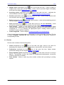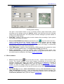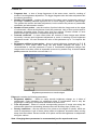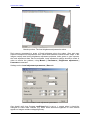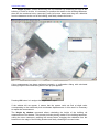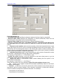
1
Digital Photogrammetric System
Version 5.21
USER
MANUAL
Orthomosaic Building
Orthomosaic building
2011
1. General info........................................................................................................................................ 4
2. Installation and starting of PHOTOMOD Mosaic ............................................................................ 4
3. Recommended procedure of orthomosaic building...................................................................... 4
4. Main program menu .......................................................................................................................... 5
4.1. Images .......................................................................................................................................... 6
4.2. View .............................................................................................................................................. 8
4.3. Project........................................................................................................................................... 8
4.4. Regions of Interest ....................................................................................................................... 9
4.5. Mosaic .......................................................................................................................................... 9
4.6. Service........................................................................................................................................ 10
4.7. Block scheme ............................................................................................................................. 11
4.8. Window ....................................................................................................................................... 12
4.9. Help ............................................................................................................................................ 12
5. Working with a single image .......................................................................................................... 12
5.1. Loading images .......................................................................................................................... 12
5.2. Creating Regions of Interest....................................................................................................... 12
5.2.1. Regions of Interest by default ............................................................................................................. 12
5.2.2. Cutlines creating rules ....................................................................................................................... 13
5.2.3. Creating and editing Regions of Interest............................................................................................ 13
5.2.4. Regions of Interest load and save....................................................................................................... 15
5.3. Single image window.................................................................................................................. 16
5.4. Using images from other projects............................................................................................... 18
6. Parameters and preferences .......................................................................................................... 18
6.1. Type of DTM............................................................................................................................... 18
6.1.1. Orthorectification at the constant elevation....................................................................................... 19
6.1.2. Control points interpolation ............................................................................................................... 19
6.1.3. External DEM .................................................................................................................................... 20
6.2. Orthoimage................................................................................................................................. 20
6.2.1. Setting up the channels of the output image ....................................................................................... 22
6.3. Brightness adjustment ................................................................................................................ 23
6.3.1. Global brightness adjustment............................................................................................................. 25
6.3.2. Local brightness adjustment............................................................................................................... 25
6.3.3. Additional recommendations.............................................................................................................. 28
6.3.3.1. Tutorial on setting up brightness adjustment in PHOTOMOD Mosaic ........................................................ 30
6.4. Splitting into sheets .................................................................................................................... 33
6.5. Preferences ................................................................................................................................ 33
6.5.1. Settings composition of channels for viewing orthoimages................................................................ 37
7. Import of PHOTOMOD Mosaic project .......................................................................................... 37
8. Mosaic preview ................................................................................................................................ 38
9. Splitting mosaic into map sheets .................................................................................................. 40
9.1. Splitting parameters.................................................................................................................... 42
9.2. Splitting preview ......................................................................................................................... 45
9.3. Load sheet coordinates .............................................................................................................. 46
10. DEM with variable resolution ....................................................................................................... 49
11. Orthorectification accuracy control ............................................................................................ 49
11.1. By triangulation points .............................................................................................................. 49
11.2. On cutlines................................................................................................................................ 51
12. Building orthomosaic.................................................................................................................... 52
12.1. Building and viewing orthomosaic ............................................................................................ 52
12.2. Building orthomosaic for the block fragment ............................................................................ 56
12.3. Orthomosaic editing in Dust Correct application ...................................................................... 56
©2011
2
PHOTOMOD 5.21
12.4. Measurements over orthomosaic ............................................................................................. 59
12.5. Loading orthomosaic ................................................................................................................ 60
12.6. Roofs vectorization ................................................................................................................... 60
12.7. Creating marginalia for orthophotomap.................................................................................... 64
12.7.1. Workflow for creating marginalia.................................................................................................... 64
12.7.2. Marginalia parameters..................................................................................................................... 67
12.7.2.1. Marginalia 1:2000....................................................................................................................................... 67
12.7.2.1.1. MicroStation DGN.......................................................................................................................... 67
12.7.2.1.2. MapInfo MIF/MID ......................................................................................................................... 69
12.7.2.1.3. MicroStation DGN (arbitrary)......................................................................................................... 70
12.7.2.1.4. MapInfo MIF/MID (arbitrary) ........................................................................................................ 72
12.7.2.2. Marginalia 1:5000....................................................................................................................................... 73
12.7.2.2.1. MicroStation DGN.......................................................................................................................... 73
12.7.2.2.2. MapInfo MIF/MID ......................................................................................................................... 73
12.7.2.2.3. MicroStation DGN (arbitrary)......................................................................................................... 73
12.7.2.2.4. MapInfo MIF/MID (arbitrary) ........................................................................................................ 73
12.7.2.3. Marginalia 1:10 000.................................................................................................................................... 73
12.7.2.3.1. MicroStation DGN .......................................................................................................................... 73
12.7.2.3.2. MapInfo MIF/MID ......................................................................................................................... 75
12.7.2.4. Marginalia 1:25 000.................................................................................................................................... 75
12.7.2.4.1. MicroStation DGN .......................................................................................................................... 75
12.7.2.4.2. MapInfo MIF/MID ......................................................................................................................... 76
12.7.2.5. Marginalia 1:50 000.................................................................................................................................... 76
12.7.2.5.1. MicroStation DGN.......................................................................................................................... 76
12.7.2.5.2. MapInfo MIF/MID ......................................................................................................................... 76
12.8. Distributed creation of orthomosaic.......................................................................................... 76
13. Export of orthomosaic to PHOTOMOD VectOr .......................................................................... 78
14. Georeference file ........................................................................................................................... 79
14.1. PHOTOMOD Geo file ............................................................................................................... 79
14.2. Arc World file ............................................................................................................................ 79
14.3. MapInfo file ............................................................................................................................... 80
3
RACURS Co., Ul. Yaroslavskaya, 13-A, office 15, 129366, Moscow, Russia
Orthomosaic building
2011
1. General info
Program PHOTOMOD Mosaic is used for orthorectification and mosaicking of images of the
source block. The output “block” orthoimage (orthomosaic) may be also split into
quadrangle sheets selected by user.
As a result of orthorectification process all distortions caused by geometry, perspective, tilt
and relief are removed so that all features in an orthoimage are in their true orthographic
positions. Created orthomosaic is georeferenced to selected coordinate system and has a
cell size defined by user. Tools of brightness adjustment and creation of regions of interest
(ROI) – fragments of each source image included to the output mosaic, are also available.
Borders of regions of interest are named cutlines.
2. Installation and starting of PHOTOMOD Mosaic
PHOTOMOD Mosaic is not a stand-alone program and can be started with Project | Mosaic
menu command or by PHOTOMOD Core
toolbar button.
3. Recommended procedure of orthomosaic building
Prior to orthomosaic creation you should specify block boundaries, output sheets size,
orthophoto pixel size, map scale as well as output file format and georeference type. Digital
elevation model (DEM) on the block is usually built in PHOTOMOD DTM module and could
be used for orthorectification process. In this case TIN with linked breaklines also is used as
input data.
Make the following operations to create orthomosaic:
1) Build DEM in PHOTOMOD Core with cell size multiple to the input mosaic cell size.
Recommended ratio between these values (Interpolation cell size) is 20-40. For example, if
you need to create orthoimage with pixel size 0.3 (m), you should assign interpolation cell
size to 20. Then assign cell size for DEM building to 6 (m). South and west DEM boundaries
should be assigned to appropriate block boundaries. After that start DEM building.
2) Start PHOTOMOD Mosaic from PHOTOMOD Core by pushing the icon
in main
toolbar or menu command Project | Mosaic. Open Parameters window in PHOTOMOD
Mosaic program (main panel icon
, menu command Mosaic | Parameters or by CtrlAlt-M shortcut (if there is a stereopair selected in 2D-window)). Setup “Cell size” parameter
on Orthoimage tab and select the DEM option on Type of DTM tab (see the chapter
External DEM). Then check the parameter Interpolation cell size on the same tab, it equals
20 in this case and the value is unavailable for changing.
If initial images contain the objects which are considerably towering over the relief (bridges,
for instance) you should load 3D vectors describing them and turn on the option Use
breaklines (Type of DTM tab). Otherwise such objects could be deformed on orthomosaic.
Also it is necessary to build the vectors into initial TIN.
3) Usually the initial images of the block have considerable brightness and color differences
and additional processing is required to obtain visually continual orthophotomosaic. For such
processing you should set global and local brightness adjustment parameters on Brightness
adjustment tab in Parameters window. If the neighbour images of the block differ in
brightness and color you should use By average brightness option for global adjustment.
©2011
4
PHOTOMOD 5.21
The local adjustment improves the brightness inside each image. In most cases it is
recommended also to use Seams feathering option for brightness differences adjustment on
merging edges of the images (see the chapter Brightness adjustment).
4) Draw regions of interest (ROI) on the initial images according to the rules described in the
chapter Cutlines creating rules. On this stage you can also exclude unused images from the
project and set the order (“upper-lower”) of images supposed to be included to the resulting
mosaic.
5) If you would like to split the resulting orthomosaic into sheets, check the option Regular
splitting on Split into sheets tab and set sheets boundaries (south and west) and size in
Splitting parameters window opened by the Parameters button on the same tab (see the
chapter Splitting mosaic into map sheets). After pushing the Apply button sheets number is
calculated automatically. You can correct this number if needed and close Splitting
parameters window and also Parameters window by the OK button.
6) Build mosaic preview (see the chapter Mosaic preview) and check that all sheets are
inside the DEM boundaries. If some of them are out you could correct DEM boundaries to
extend them otherwise the parts of sheets located outside the DEM will be colored as a
background.
7) If brightness and color differences are not properly adjusted and are visible on preview,
you should change local adjustment parameters and global adjustment type. You can also
change cutlines close to unsatisfactory parts of image to improve the local adjustment. All
these efforts lead to the required brightness quality.
8) In Parameters window on Orthoimage tab (opened by menu command Mosaic |
Parameters) you can set the parameters of the orthoimage file compression (if necessary),
as well as background color and georeference file type. After pushing the Scale button an
additional panel is opened allowing you to input the scale of resulting mosaic (by filling in
Orthoimage scale field) and also to recalculate its size and resolution (see the chapter
Orthoimage).
9) After that start creating orthomosaic with preset parameters. See the chapter Building
orthomosaic.
Note.
1. After each mosaic building stage mentioned above, save mosaic project to
PHOTOMOD system resource
2. You can also make cutlines and brightness adjustment prior to DEM creating. In this
case it is recommended to check the option “Control points interpolation” on Type of
DTM tab
4. Main program menu
After starting, PHOTOMOD Mosaic opens a window with a main menu in its upper part.
5
RACURS Co., Ul. Yaroslavskaya, 13-A, office 15, 129366, Moscow, Russia
Orthomosaic building
2011
PHOTOMOD Mosaic user interface
The main PHOTOMOD Mosaic menu consists of the following items.
4.1. Images
Images menu is used for loading source images to PHOTOMOD Mosaic and includes the
following options:
•
Open (duplicated by the
icon of the main icon bar or hot keys Ctrl-O) – opens a list
of the source rasters for selection and loading a single image (see the chapter Working
with a single image). While loading rasters (basically for ROI creation and editing) you
can open unlimited number of windows. You can use standard OS Windows tools (Shift
and Ctrl keys) for group selection of source image files in the window with images list.
And also you may search for image in the list by its name
•
icon of the main icon bar or hot keys Ctrl-N) – loads
Next image (duplicated by the
the next image of the source block to the current window
•
Previous image (duplicated by the
icon of the main icon bar or hot keys Ctrl-P) –
loads the previous image of the source block to the current window
•
Current + next (duplicated by the
with the current and next images
•
icon of the main icon bar) – opens 2 windows
Previous + current (duplicated by the
– with the previous and current images
Remove non-existing - search and removal of non-existing rasters.
•
©2011
icon of the main icon bar) – opens 2 windows –
6
PHOTOMOD 5.21
•
Background color option - allows you to set the background color of the original images,
containing non-informative data like the background with a constant value of brightness
and color. To manually set the background color for these images, you should select
Images | background color | Set color, which opens the Background color window.
In case a window with one of the source images is open, it is possible to set the color for that
image only. Also it is possible to set the background color for all images in the mosaic
project.
In case the background is concentrated at the edges of images (for example, due to rotated
raster), it possible to automatically define it for each of the images. In order to do it, you
should check the Images |Background color | Automatically option.
If it is necessary to cancel selection of background for one or all images it is necessary to
check the Images |Background color | None option, which opens the Background color
window.
In order to make the specified background color transparent, you should use menu command
Images | Background color| Transparent background when building mosaic
•
Exit (duplicated by the
PHOTOMOD Mosaic.
icon of the main icon bar or hot keys Ctrl-X) – exits
Note. In case the PHOTOMOD project has been restored with an incomplete set of
rasters, before start of work you should execute the "Images | Remove non-existing"
command.
A list of recently opened images is maintained for more comfortable operation. This list is
called by Images | Recent list menu command. An image is opened by clicking on
corresponding list item.
7
RACURS Co., Ul. Yaroslavskaya, 13-A, office 15, 129366, Moscow, Russia
Orthomosaic building
2011
4.2. View
This menu is intended for setting the image view in active window or in all windows. At that
there are the following options:
• Hide all – hides all objects
• ROIs – shows/hides regions of interest (ROI’s): all or user defined, duplicated by button
•
•
•
•
•
•
or Alt-Z hot keys
bar icon
Cutlines – shows/hides cutlines on the image. Cutlines are borders of ROI’s which are
used to build resulting mosaic (see the chapter Cutlines creating rules)
Breaklines – shows/hides breaklines involved to the orthorectification process (if the
option Mosaic | Parameters | Type of DTM | Use breaklines is ON) or available in
current PHOTOMOD project. At that you can select breaklines resources in the window,
appeared after pushing the
button, located on the same panel.
Triangulation points – shows/hides triangulation points (in preview or mosaic window),
icon
duplicated by
Local adjustment – in preview or mosaic window turns on/off small rectangles marking
the places where local brightness adjustment statistics was taken (see the chapter Local
brightness adjustment)
DEM – shows/hides schematic DEM created during the project processing (see the
Project processing User Manual), duplicated by
icon
Show in all windows – shows/hides all abovementioned objects in all windows: source
images, preview and mosaic.
4.3. Project
This menu is used to work with Mosaic project – PHOTOMOD system resource, which stores
all settings such as brightness, contrast and gamma of images, regions of interest and
parameter values. Project menu consists of the following options:
• New – restores all preview and mosaic building settings into initial ones without module
exit, that allows to create new Mosaic project
•
Open (duplicated by the
icon of the main icon bar) – opens a window for selecting
PHOTOMOD resource with mosaic project for loading. Allows also to open the project
from backup copy, if the appropriate option is selected, see the chapter Preferences.
•
icon of the main icon bar) – opens a window for selecting
Save (duplicated by the
PHOTOMOD resource name for mosaic project saving
Save as – opens a window for selecting PHOTOMOD resource name for mosaic project
saving with name different from initial
Import – allows to import several PHOTOMOD Mosaic projects into a common one, that
is useful when ROI's are created by several operators, see the chapter Import of
PHOTOMOD Mosaic project
•
•
•
icon of the main icon bar) – selecting source images
Add images (duplicated by the
for including to the mosaic project. By default when starting PHOTOMOD Mosaic all
images of the source block are loaded, but in some cases you may want to orthorectify
only a portion of the block so you can add and remove images. Use standard OS
Windows tools (Shift and Ctrl keys) in this window for group selection of images to be
added. Search of the image in the list by its name is also available
©2011
8
PHOTOMOD 5.21
•
Add from other project (duplicated by the
icon of the main icon bar) – selecting
source images from other project for including to the current mosaic project (see the
chapter Using images form other projects)
•
icon of the main icon bar) – opens the window
Remove images (duplicated by the
with images list of the current project for removing selected images. Use standard OS
Windows tools (Shift and Ctrl keys) in this window for group selection of images to be
deleted. Search of the image in the list by its name is also available. Restart the Mosaic
module to let the changes take effect (to hide removed image from the block scheme, for
example).
4.4. Regions of Interest
This menu is used to create regions of interest (ROI) – see the chapter Creating regions of
interest. ROIs are fragments of each source image included to the output mosaic. The menu
includes the following items:
•
ROIs editor (duplicated by the
icon of the main icon bar) – opens additional button
bar used for creating and editing of Regions of interest. See the chapter Creating and
editing regions of interest
•
icon of the main icon bar) – used to
Trim off images edges (duplicated by the
change a size of rectangular default ROIs. See the chapter Default regions of interest
Polygon ⇔ rectangle – converts selected ROI to the rectangle for the current image. In
this case the ROI becomes available for editing as described in the chapter Creating and
editing regions of interest
Polygon ⇔ rectangle for all – the same operation for all images
Autobuilding – automatic ROI creation on selected image
Delete all ROIs – cancels ROIs creation and shows default ROIs. See the chapter
Regions of interest by default
Cutlines accuracy report – allows to create a report on accuracy control on cutlines,
see the chapter 10.2 On cutlines
•
•
•
•
•
•
•
•
•
icon of the main icon bar)
Update cutlines on neighbor images (duplicated by the
- speeds up update of cutlines of neighbor images.
Load ROIs – loading ROIs from PHOTOMOD vector resource. See the chapter Regions
of interest import and export
Save ROIs – saving ROIs to PHOTOMOD vector resource. See the chapter Regions of
interest import and export
Save cutlines – saving cutlines to PHOTOMOD vector resource. See the chapter
Regions of interest import and export
4.5. Mosaic
This menu is used to start parameters selection and orthomosaicking process. It consists of
the following options:
•
Parameters… (duplicated by the
icon of the main icon bar) – opens a parameters
selection dialog (see the chapter Parameters and preferences)
•
icon of the main icon bar) – opens a window of
Coordinates (duplicated by the
displaying and editing of the orthomosaic corners coordinates and also its width and
length
9
RACURS Co., Ul. Yaroslavskaya, 13-A, office 15, 129366, Moscow, Russia
Orthomosaic building
2011
•
Images order (duplicated by the
icon of the main icon bar) – opens a dialog of
images order in the output mosaic (upper - lower). Used to process images overlapping
areas (see the chapter Additional recommendations)
•
icon of the main icon bar) – estimates the
Accuracy control (duplicated by the
orthorectification accuracy (see the chapter Orthorectification accuracy control)
•
icon of the main icon bar) – shows mosaic preview with
Preview (duplicated by the
low resolution (see the chapter Mosaic preview).
•
icon of the main icon bar) – starts orthomosaicking process
Build (duplicated by the
(see the chapter Building orthomosaic).
•
icon of the main icon bar or hot keys Ctrl-Alt-O) – loads
Open (duplicated by the
previously created orthomosaic for viewing (see the chapter Loading orthomosaic).
Load vectors – allows to load linear and point objects from PHOTOMOD vector
resources and visualize them over resulting mosaic. Also user can load points as a set of
coordinates X, Y, Z, by selecting the appropriate option. Loading vectors option is
available if mosaic window is opened.
Create marginalia – see the chapter Creating marginalia for orthophotomap.
•
•
A list of recently opened orthomosaics is maintained for more comfortable operation. This list
is called by Mosaic | Recent list menu command. An image is opened by clicking on
corresponding list item.
4.6. Service
Service menu consists of the following items:
•
Colors (duplicated by the
icon of the main icon bar). Used to set colors for
displaying such objects as cutlines, DEM borders, selected ROI, and other objects.
•
icon of the main icon bar). Opens system
Preferences (duplicated by the
preferences dialog (see the chapter System preferences).
•
icon of the main icon bar or hot keys
Show regulation panel (duplicated by the
Ctrl-T) – shows/hides a panel with sliders for brightness/contrast/gamma corrections
located in lower part of window.
Print window – allows to print any active module window with pre-setting of printing
options:
•
©2011
10
PHOTOMOD 5.21
Printing options setting
•
•
•
•
Left part of this window allows to set up printing options: paper sheet fields, printer
selecting and its settings (using the Options button), and also input the title of printed
image in the appropriate field. You can preview all these settings in preview window in
the right part of the window.
Print map – allows to print any active module window with pre-setting of print options
and splitting the image into sheets.
Execute PHOTOMOD Dust Correct (duplicated by the
icon of the main icon bar) –
opens a window intended for cleaning mosaic image from artifacts, see the chapter
Orthomosaic editing in Dust Correct application. If a window with any image
(orthomosaic) was active when the command is executed, this image is automatically
opened in Dust Correct (and closed on Mosaic).
Save DEM outline – allows to save boundaries of DEM opened in the project into vector
resource of PHOTOMOD system. See Project Processing User Manual.
Roofs vectorization - a tool for outlining roofs of buildings on the source (nonorthotransformed) images and using this information during orthotransformation to shift
the roofs to their true positions. See chapter Roofs vectorization.
4.7. Block scheme
•
•
11
Show (duplicated by the
icon of the main icon bar) – opens a block scheme on the
screen. The relative position of the block images corresponds to the source input
sequence (images and strips). The number of images to be displayed is defined in
Service | Preferences | Windows panel (see the chapter Preferences). The block
scheme is used for adding regions of interest (see the chapter Creating regions of
interest) since it is convenient to see the ROI not only on the current but also on adjacent
images.
Up (Ctrl-Alt-Up hot keys), down (Ctrl-Alt-Down hot keys), left (Ctrl-Alt-Left hot keys),
right (Ctrl-Alt-Right hot keys) – loads corresponding adjacent scheme portions. The
overlap of the current and loading portions of the block scheme is set in the Service |
Preferences | Windows dialog (see the chapter Preferences).
RACURS Co., Ul. Yaroslavskaya, 13-A, office 15, 129366, Moscow, Russia
Orthomosaic building
2011
4.8. Window
Window is a standard menu item used to locate windows on the screen and includes the
following options:
• Cascade
• Tile vertically
• Tile horizontally
• Minimize all
• Close – closes active window with current image
• Close all – closes all windows.
4.9. Help
Includes the following items:
• Contents (or F1 key) – runs Help system for PHOTOMOD Mosaic.
• About program… – opens a window with information related to version number, serial
number, date of version compiling, etc.
5. Working with a single image
5.1. Loading images
Images menu items described in the chapter Images are used for loading image to single
image window.
5.2. Creating Regions of Interest
5.2.1. Regions of Interest by default
Orthomosaic is build by rectification of initial images. Image area, which is included to
orthomosaic, is called region of interest (ROI) and its boundary – cutline.
Each source image has a rectangular region of interest (ROI) by default. This area excludes
10% of the image from each side just to make sure to avoid areas with fiducial marks from
the output mosaic. You can change the size of this rectangular ROI using menu command
ROIs | Trim off images edges or by pushing the icon
(Trim off images edges) or by
drag-and-drop the green cutline on the image. If you are not going to create more complex
cutlines (for example based on the rules of the classic photogrammetry) you can just start
building mosaic or preview image using these default ROIs. The images order in the output
mosaic (which image is lower or upper in the overlapping area) is defined by the order
selected in the window opened by the
icon (Images order), see the chapter Additional
recommendations. The source rectangles may be converted to 4-corner polygons using
menu command ROIs | Polygon ⇔ rectangle (see the chapter Single image window). After
that ROI becomes available for editing as described in the chapter Creating and editing
regions of interest.
©2011
12
PHOTOMOD 5.21
5.2.2. Cutlines creating rules
Cutlines are boundaries of Regions of interest – areas on the source images used to be
rectified and merged to the output mosaic. It is recommended to draw cutlines manually to
improve orthoimage quality, considering the following rules.
1. Draw ROIs as close as possible to the image principal point, to increase geometrical
accuracy of images matching.
2. Cutlines should not intersect the objects which are considerably towering over the relief
(bridges, tall buildings, power lines piers etc.). Otherwise the objects could furcate or partially
disappear from the mosaic.
3. Cutlines should not go along the extended objects with brightness different from the main
background (forest area boundary, road etc.). Otherwise the edge smearing effect occurs on
the object boundary if the option Seams feathering is ON. It is recommended either to
intersect such objects on the right angle or draw the cutline on some distance (not less than
one and a half interpolation cell size, in pixels) from the boundary.
4. Re-draw the cutlines over alternating areas on the image with different color, or draw it in
parallel with the objects boundary but on some distance from it, to avoid abnormally bright
areas on the resulting orthoimage when local adjustment option is ON (see p.3).
5. The local adjustment works in such a way that images of each strip are adjusted first, and
on the second step the strips are inter-adjusted. So the best situation is when ROIs borders
inside every strip are “continuous” and the strips have some overlapping area. See also the
chapter Additional recommendations.
5.2.3. Creating and editing Regions of Interest
Usually ROIs are created on each source image loading one by one. It is convenient to have
on the screen two-three windows with adjacent images of the source block (see the chapter
Images). To view a block fragment “around” the current image, open block scheme using the
command Window | Block scheme or click the icon
(see the chapter Block scheme).
ROIs are created using cutlines editor which opens by the
icon or command ROI |
ROIs editor. While adding ROIs you should create them with overlap to avoid “holes” on the
output orthomosaic. For this purpose it is useful to see ROIs from adjacent images on the
current one (push the icon
of the main panel).
At that, the images order in the overlapping areas on resulting orthomosaic (upper-lower)
corresponds with the sequence preset in Images order table (opens by the icon
of the
main panel). ROIs of images, located above the current image, are hatched (see the chapter
Additional recommendations).
If the hatched ROIs from the adjacent images are shown on the current image, you should
draw the cutlines precisely (considering terrain features, local brightness, buildings, etc.) on
the areas without hatching. But you can continue the cutline “under” the hatched areas
schematically, keeping only the overlapping with the adjacent ROI.
During transformation of overlapping ROIs into cutlines the algorithm of “holes” finding
between cutlines is working. If such “hole” is found, you get the warning and this area is
shown by red hatching on preview image if the option Fill holes between cutlines is ON
(Service | Preferences menu command, General tab).
13
RACURS Co., Ul. Yaroslavskaya, 13-A, office 15, 129366, Moscow, Russia
Orthomosaic building
2011
You should also take into account that the global orthomosaic area is defined by the DEM
created from TINs, built during the PHOTOMOD project processing in PHOTOMOD Core
(see Project processing User Manual) and used for the orthorectification. Push the
to display DEM border.
icon
Push the button
(ROIs editor) (or click menu command ROIs | ROI’s editor) to open a
panel with the following simple vector editing tools used for creating polygons:
•
(duplicated by Insert key) - adds ROI (starting ROI creation)
•
- removes ROI
•
(duplicated by S key or double mouse click) - selects ROI
•
- unselects ROI
•
(duplicated by Insert key) - adds new vertex to ROI. In case of selected ROI
inserts a vertex “between” two closest ones. In case of creating ROI add a new vertex
•
(duplicated by Delete key) - deletes selected vertex
•
(duplicated by single mouse click) - selects vertex
•
•
- unselects vertex
To move a vertex, select it and move by mouse button along with pressed Ctrl key.
The last group of icons is used to assign to the ROI the following properties:
•
•
- orthorectification area. The default mode: the ROI is included to the mosaic
- transparent area. Portions from other images that are visible “through” the current
one in accordance with the images order defined in the window opened by the Images
order icon (
)
•
- background area. A “hole” in the output mosaic is colored by background color
(specified in the Mosaic | Parameters | Orthoimage window)
•
- area where detailed DEM is used for mosaic creation (see the chapter DEM with
variable resolution).
It is convenient to use mouse settings when working with ROI (see the chapter
Preferences). For example it is easier to click right or middle mouse button instead of Insert
key on the keyboard.
For editing and creating of ROI you may use marker=mouse mode (which is turned on by
F4 key). At that marker on the screen becomes invisible and all mouse’ moves leads
automatically to appropriate marker’ moves without additional mouse clicks.
For convenient ROI’s creation use the commands of context menu (appeared after right
mouse click in the image window), which duplicate above mentioned operations with ROI.
©2011
14
PHOTOMOD 5.21
When editing cutlines you may select group of cutline’s vertices by mouse drag along with
pressed Shift key, and also move the selected group by mouse along with pressed Ctrl key.
Press Esc key to cancel vertices selection.
In the process of editing ROIs for the scanner projects, in some cases display cutlines from
neighbor images possible may become slow. This is due to the considerable computational
cost for projects of this type. In such cases, it is possible to enter a mode, in which the
recalculation of the cutlines from image to image will be performed only at the request of the
operator. In order to achieve this, an option Auto-update of neighbor cutlines on the
Windows tab in Preferences window should be turned off. In this mode cutlines are
updated manually with the Update cutlines on neighbor images button on the toolbar.
5.2.4. Regions of Interest load and save
Import and export of ROIs is carried out via loading and saving respectively to standard
PHOTOMOD vector resources, while editing and import/export to external exchange data
formats is performed by common means of PHOTOMOD Core.
For loading Regions of Interest, the ROIs | Load ROIs menu command is used. When the
command is activated, the system brings up the standard dialog window for opening vector
resource, followed by the parameters dialog window:
Field Attribute name is used for specifying an attribute, values of which for the loaded vector
objects correspond to either image name or code. For convenience, the field contains dropdown list with all attribute names found in the resource.
The Referencing method option sets the image characteristic used to match region with
each image.
The Swap X,Y option specifies whether it is necessary to swap X and Y coordinates of
vertices during load.
The Elevation panel allows selecting the source for the Z coordinate of the loaded regions.
ROIs must be converted to pixel coordinates of images, while the vector objects being
loaded are given in the coordinate system of the PHOTOMOD project. Thus Z coordinate of
each point must be known. If the vector objects being loaded have real Z coordinates
assigned, than the option From objects should be chosen. Otherwise a correct elevation
model has to have been assigned in Mosaic parameters before loading ROIs (a DEM in most
cases), and option From current DEM should be used in this dialog.
For saving Regions of Interest, the ROIs | Save ROIs menu command is used. When the
command is activated, the system brings up the parameters dialog window:
15
RACURS Co., Ul. Yaroslavskaya, 13-A, office 15, 129366, Moscow, Russia
Orthomosaic building
2011
Field Attribute name defines name for the attribute holding image reference in the created
vector resource.
The Referencing method option specifies image characteristic to be saved in the attribute of
vector objects.
The Swap X, Y option defines specifies whether it is necessary to swap X and Y coordinates
of vertices during save.
After the ОК button is clicked, the standard dialog for selecting vector resource name to save
is shown.
For saving cutlines, the ROIs | Save cutlines menu command is used. The command is
identical to the Save ROIs command except that cutlines are saved into vector resource
instead of ROIs.
5.3. Single image window
Single image window
©2011
16
PHOTOMOD 5.21
At the lower part of the window there are standard icons for displaying raster image:
•
- one step zooming out (duplicated by “/” key)
•
- one step zooming out (duplicated by “/” key) for all images opened
•
- 1:1 mode (image cell corresponds to the screen pixel) (duplicated by “Alt-1” keys)
•
- one step zooming in (duplicated by “*” key)
•
- one step zooming in (duplicated by “*” key) for all images opened
•
- fitting the whole image into the window (duplicated by “Alt-Enter” keys)
•
- zoom all images to fit in windows (duplicated by “Shift-Alt-Enter” keys)
Current image zoom is shown in title bar in brackets after image name and in the lower part
of the window as
.
You can also use the following hot keys to zoom arbitrary image fragment or to move it:
• Ctrl + Alt + mouse
zooming in by zoom box, “drawn” by mouse
• Ctrl + Alt + Shift + mouse
zooming out by zoom box
• Alt + mouse
panning the image
• Mouse wheel
mouse wheel steering allows to zoom in/zoom out
image on the screen
,
,
), located at the bottom of the window, are used to set up
Following sliders (
brightness, contrast and gamma respectively for the active image. When working with color
images there is a possibility to adjust these radiometric parameters separately by channels
(using the buttons
). Right click any slider and select the option Set original
BCG correction to restore BCG settings by default.
Note. These settings are memorized and used while output mosaic creation
Last 2 icons are intended for ROI creation (see the chapter Creating and editing ROI):
•
•
- shows/hides ROI on images. Each cutline and ROI is displayed by different color
hatch and labeled by the corresponding image number.
- shows/hides DEM to show the entire orthorectification area.
The lower string of image window consists of three parts with information helpful to estimate
the following values of resulting mosaic:
▪
▪
▪
▪
▪
▪
17
Number of map sheets of resulting mosaic according to the selected parameters (see the
chapter Splitting mosaic into map sheets)
Raster size of resulting mosaic in pixels (height and width)
The last multiplier in this section is number of bits per pixel of mosaic to be created. 8
means that resulting image is black and white (8-bit), number 24 shows that the mosaic is
color – 24-bit
Mosaic volume in kilobytes. Shows the mosaic of approximately 94 Mb volume
XY coordinates of current cursor position on active image in pixel coordinates
XYZ coordinates of current cursor position on active image in user (terrain) coordinates –
you may copy these coordinates to the clipboard (by Ctrl-C) and paste them into selected
application (by Ctrl-V).
RACURS Co., Ul. Yaroslavskaya, 13-A, office 15, 129366, Moscow, Russia
Orthomosaic building
2011
5.4. Using images from other projects
The images from the other PHOTOMOD projects can be used for output mosaic creation.
Use the command Project | Add images from another project to load them. In the panel
opened select the project name, images numbers and push OK.
On the figure below you can see an example of mosaic creation using images obtained by
different sensors (ASTER and IKONOS) on the same territory and of different spatial
resolution and processed in different PHOTOMOD system projects.
Orthomosaic created from the images taken from different projects
Note. The projects must be referenced to the same coordinate system
6. Parameters and preferences
or Mosaic | Parameters option to open Parameters dialog consisting of
Use the icon
the following tabs:
6.1. Type of DTM
Type of DTM tab allows you to select a type of relief model used for the orthorectification,
and also to use breaklines and polygons for mosaic creation.
©2011
18
PHOTOMOD 5.21
Type of DTM tab
There are 3 possible choices available:
6.1.1. Orthorectification at the constant elevation
In this the same elevation value case is assigned to the whole model area. The surface is
approximated by plane. The elevation value is setup in the Constant elevation text field.
The default is an average elevation value for the area covered by the source block of
images, calculated from ties and control points used in the block adjustment.
6.1.2. Control points interpolation
In this case the relief is approximated by a polynomial surface computed by 3D points used
during the block adjustment. These points are control, check and tie points (see Aerial
triangulation and Block adjustment User Manuals).
19
RACURS Co., Ul. Yaroslavskaya, 13-A, office 15, 129366, Moscow, Russia
Orthomosaic building
2011
6.1.3. External DEM
Text field Interpolation cell size displays a value of the ratio between DEM and the output
orthomosaic cell sizes. Thus if the DEM resolution is 2 meters per cell and the mosaic
resolution is 0.2 meters per cell, the parameter value is 10. You can increase this value to
speed up the orthorectification process. In this case DEM is resampled accordingly, with
some reducing of orthorectification accuracy. See also the chapter DEM with variable
resolution.
If you setup cell size less than 8 for mosaic projects covering huge territory, it does not
increase orthorectification accuracy distinctly, but output orthomosaic will be created much
longer. That is why when you try to create a mosaic cell size less than 8 you get a warning
message.
Use constant for unknowns parameter allows you to use a value set in the Constant
elevation for the “holes” (cells with unknown elevation value) in the DEM.
If DEM used for mosaic building consists of several parts you are recommended to turn ON
the option Search for DEM fragments on tab General in Preferences window (see the
chapter Preferences), to find and load separate DEM fragments.
You can also use vector objects of PHOTOMOD system for output mosaic building turning
ON the option Use breaklines. Push the PHOTOMOD button and select necessary resource
in opened window.
6.2. Orthoimage
The Orthoimage tab is used to set up the following parameters:
©2011
20
PHOTOMOD 5.21
•
•
•
•
•
21
Cell size – this text field is used to enter the size of the orthoimage cell on the ground.
This parameter should be specified in units shown in brackets. By default the cell size is
equal to the cell size of the first image of mosaic project. The Calculate button opens a
dialog used to set an orthoimage size in pixels and recalculate its cell size accordingly.
The Scale (TIFF, BMP) button opens a dialog used to calculate print size and resolution
according to the resulting mosaic scale input by the user. Output raster button is used to
setup the parameters of output raster (see chapter Setting up the channels of the output
image).
Create MS TIFF – used to create pyramid image of output mosaic inside TIFF or
GeoTIFF file created, that allows to speed up the image zooming.
Options in the Output images compression panel are used to compress the output
mosaic image. Check the JPEG compression of TIFF files box and use the Image
quality (0-100%) slider if you want to apply the compression. The default value of
compression quality is 75% (usually it causes the 5-7 times compression).
Background color – used to set a color of orthoimage background (since it always
inscribes into a rectangular raster). Following options of background color are provided:
Black, White, Other (the last one opens standard OS Windows dialog of color selection).
In case of grayscale output selected color is replaced by corresponding grayscale value
(with the same intensity).
Resampling method – allows to choose brightness interpolation mode for orthomosaic
creation: bilinear, cubic and nearest neighbour.
RACURS Co., Ul. Yaroslavskaya, 13-A, office 15, 129366, Moscow, Russia
Orthomosaic building
•
•
•
•
•
•
•
•
2011
Georeference file – allows to select the format of the additional file created along with
output orthomosaic and containing the information for mosaic referencing to coordinate
system. See the chapter Georeference file.
Swap X,Y – allows to swap output mosaic coordinates if necessary.
Create georeference only – allows to create just georeference file without building the
mosaic. They are saved to the path selected into file format indicated in the
Georeference file drop-down list
Output coordinate system – allows to change coordinate system of output orthoimage
using the window opened by pushing the Select button. Work in this window is described
in the appropriate chapter of PHOTOMOD Project creation User Manual. Source
coordinate system button turns off the conversion of output orthophoto to another
coordinate system using the coordinate system of the PHOTOMOD current project as an
output coordinate system.
Rotation angle – allows to rotate output mosaic. It is helpful when initial images block
has elongated shape, and you need to cut unnecessary background in rectangle window
of resulting mosaic.
Set background color as “transparent” – when saving the resulting mosaic in MapInfo
format (selected in Georeference file drop-down list), you can set the background color
which will be shown in MapInfo system, as transparent.
Replace background color – allows to change color of pixels located inside mosaic
image to avoid pixels on orthophoto with the same color as its background.
Save georeference as "NonEarth" – when saving the resulting mosaic in MapInfo
format (selected in Georeference file drop-down list), allows you to save georeference
as NonEarth coordinate system. Used if MapInfo system does not support coordinate
system of PHOTOMOD project.
Push the File names button to open Sheets file window:
In this window you can edit the file type (its format) and the path to sheet files, where the
sheets are stored after orthophoto creation. Files of map sheets have the same format, as
the mosaic, which is not divided into sheets, see the chapter Building and viewing
orthomosaic.
6.2.1. Setting up the channels of the output image
PHOTOMOD Mosaic is capable of creating output images with arbitrary quantity and order of
channels (bands), with 8 or 16 bits per channel sample. The button Output raster in the
Orthoimage tab of Parameters window is used to set up the channels. Pressing it brings up
the following dialog window:
©2011
22
PHOTOMOD 5.21
The Use radiometric pre-correction option defines whether radiometric correction
parameters saved in the PHOTOMOD project should be used for viewing source images and
creating orthoimages. When this option is switched, channels configuration in the Channels
list panel is reset to default state for the given option value.
The Channels list panel allows setting number and order of channels in the output
orthoimage. The list to the left contains all supported channel types. The list to the right
contains chosen channel configuration.
The
button adds selected channel from the left list to the right one.
The
button deletes selected channel from the right list.
The
button clears the right list.
The Data format dropdown list allows selecting 8 or 16 bps output format.
The Monochrome output option controls whether a single channel grayscale image is
created, with this single channel formed by averaging values of channels set in the right list
of the Channels list panel.
Note: When any of the settings is changed in the Output image parameters dialog, the
cached local and global brightness adjustment results are reset.
6.3. Brightness adjustment
The Brightness adjustment panel is used for radiometric correction of source images in
order to produce seamless output mosaic.
23
RACURS Co., Ul. Yaroslavskaya, 13-A, office 15, 129366, Moscow, Russia
Orthomosaic building
2011
Brightness adjustment parameters
This panel allows you to setup global brightness adjustment of resulting mosaic (see the
chapter Global brightness adjustment) and also local adjustment parameters (see the
chapter Local brightness adjustment). Moreover, here you can turn on/off the Seams
feathering option which causes smoothing in the narrow zone around the seam between
adjacent images. The size of smoothing zone is defined by the Interpolation cell size
parameter (see the chapter DTM from TIN).
Use brightness pre-correction option is used to include/exclude brightness-gammacontrast adjustments done on initial images windows during resulting mosaic creation.
The Not use for brightness adjustment option allows ignoring in the process of brightness
adjustment of specific areas specified by a set of polygonal vector objects. Such sites may
include anomalous brightness areas, for example, clouds, shadows from the clouds, small
water surfaces. Using this option in such cases can significantly improve the quality of
brightness adjustment.
©2011
24
PHOTOMOD 5.21
6.3.1. Global brightness adjustment
The global brightness adjustment (Global adjustment panel) applies selected type of
transformation to all pixels of every source image.
Following radio-buttons are used to select a brightness adjustment type:
• None – allows to use un-adjusted images
• By average brightness – brightness and contrast are adjusted basing on average
values calculated over all mosaic images. This method is recommended when there are
big differences between brightness’ of images but each of them contains relatively
smooth scenes. Thus in cases of scenes with sharp different brightness within one image
(for example the sea and the coast) this method may produce incorrect results.
• By selected image – mosaic brightness and contrast are adjusted in accordance with
corresponding parameters of selected (“reference”) image. Use red arrow buttons for the
image selection. The option Use only overlapping areas causes using only overlapping
image areas for the brightness adjustment. In this case it is recommended to select an
image from the middle part of the block as a “reference” one. However in case of
abnormal brightness fluctuations (“trends”) you can face a problem of smooth increasing
or reducing of the brightness from the reference image to the block edges. So it’s not a
recommended option for such kind of data.
6.3.2. Local brightness adjustment
The local adjustment of image brightness applies some brightness transformation along
cutlines of images that are merged into mosaic with a smoothing going down to the image
central point and mosaic edges. During this process the brightness (additive component) and
contrast (multiplicative component) of initial images are changed at the same time. Use the
Local adjustment panel on the Brightness adjustment tab on the Parameters window to
setup the process parameters.
There are some suggestions for creating cutlines for local brightness adjustment: it is
recommended to draw cutlines along the borders of uniform color objects but at some offset
from it to avoid border blurring when using the Seams feathering option (see the chapter
Brightness adjustment). The offset size should be about one-two Interpolation cell sizes
(see the chapter DEM types) taking into account the ratio between source images and output
orthoimage scales. For example interpolation cell size = 32, source image cell size = 0.17 m
and the required orthoimage cell size is 0.5 meters. The ratio between source and output
scales is about 3, so you can draw a cutline at distance 3*32 = 100-200 pixels from the
object edge.
Sometimes the local adjustment produces bad looking seams or small abnormal brightness
or color spots close to seams. You should change the cutline position to resolve the first
problem. The color spots can be removed by adding “pins” inside them, while working with
the image in Preview window. So open Preview window and put “pins” inside spot areas
using the Insert key. The pins are displayed with yellow circles and are selected by mouse
click, deselected by Esc key and deleted by Del key.
Use the option View | Local adjustment when Preview and Mosaic windows are opened to
display areas where statistical parameters were calculated. Areas between images of one
strip are green, areas between images of separate strips are blue and areas inside single
images are yellow. This information would help you to view and understand the reason of
local brightness unevenness.
25
RACURS Co., Ul. Yaroslavskaya, 13-A, office 15, 129366, Moscow, Russia
Orthomosaic building
2011
Local brightness adjustment in preview window
Local brightness parameters are adjusting in appropriate window (opened by the
Parameters button) on two tabs: Base – contains parameters influencing on brightness
inside images and between them, and Edges – contains parameters influencing on
brightness of external orthomosaic borders.
Base parameters
©2011
26
PHOTOMOD 5.21
On Base tab:
•
•
•
•
•
Fragment size − a size of image fragments of the same name, used for creating of
model of local brightness adjustment. The bigger fragment size the better adjustment but
the slower processing.
Number of fragments − number of fragments of the same name (rectangular regions of
the image, containing identical regions of two or more images), located on each image.
The greater the number the better adjustment, but the slower the process of parameters
calculation and orthomosaic creation.
Number of inner points − sets the number of points inside the image and on the edges
of orthomosaic, where the brightness should be preserved. Lack of inner points leads to
brightness anomalies when moving away from the cutlines. Excess number of inner
points causes the brightness un-adjustment along the cutlines.
Contrast coefficient – in some cases when the contrast of initial images was defined
incorrectly it causes poor brightness adjustment or errors in creating of local brightness
adjustment model. You can increase the value of this parameter up to 7 to improve the
result.
Brightness addition in inner points – allows to setup brightness (separately by R, G, B
channels) in inner points either along the strip and/or between the strips. It is
recommended to use this parameter in case of considerable brightness change from
image center to its sides, which is impossible to remove by another way. At that the Inner
points parameter should be not more than 1-2.
Brightness parameters on mosaic edges
Edges tab contains the following parameters:
• Brightness addition − allows to setup smooth brightness change on 4 sides of
orthomosaic. Color imbalance on orthoimage sides is unnoticeable, that is why the
brightness is changing in all spectral channels at the same time.
• Trim off percent – allows to exclude corresponding percent of image area along the
orthomosaic sides from processing (because there are auxiliary signs, marks, etc.).
• Density coefficient − sets the amount of tie points on the edges of mosaic, which are
used for adjustment. Lack of these points leads to brightness anomalies when moving
away from the cutlines. Excess number of tie points causes the brightness un-adjustment
along the cutlines.
Note. Changing these parameters is recommended just for experienced users
27
RACURS Co., Ul. Yaroslavskaya, 13-A, office 15, 129366, Moscow, Russia
Orthomosaic building
2011
Note. Since local adjustment parameters depend on cut lines location, then any
cutlines change results in recalculation of the parameters, when you start mosaic or
preview building
Note. It is recommended to exclude from the mosaic each second image in every strip
when using local brightness adjustment. Obviously it is necessary to have triple
overlap (greater than 50 percent) between images in this case
If you get message Interpolation model building error during mosaic creation, it means
that local brightness adjustment has been done incorrectly and you should change the
Contrast coefficient parameter, as described above or correct cutlines.
6.3.3. Additional recommendations
In most cases the local brightness adjustment procedure provides satisfactory results. But if
you want the algorithm to work ideally you should draw the cut lines as described below.
The local adjustment works in such a way that images of each strip are adjusted first and on
the second step the strips are inter-adjusted. So the best situation is when ROIs borders
inside every strip are “continuous” as it is showed on the picture.
image 1
image 2
image 3
image 4
overlapping
areas
continuous cutline
inside the strip
©2011
28
PHOTOMOD 5.21
Then the strips are adjusted with some overlapping area:
strip 1
overlapping
areas
strip 2
strip 3
You should pay attention on the order of images insight the strip – because ROIs taken from
“upper” image are included to the resulting mosaic and their brightness is considered during
brightness adjustment of the orthoimage.
For brightness adjustment of resulting mosaic it is enough to change images order by using
menu command Mosaic | Images order (or the
window.
icon) which opens Images order
Images order change
The color in this table highlights the images of the same strip. You can move images in the
list using icons
- Upper,
- Lower,
- To top,
- To bottom, selecting those
which will be included in resulting mosaic in overlapping area. It is convenient to use the
following operations for work with images list:
- by images order – restore the initial order of the images and cancels all changing.
29
RACURS Co., Ul. Yaroslavskaya, 13-A, office 15, 129366, Moscow, Russia
Orthomosaic building
2011
invert order of selected images – allows to sort selected images in the revert order.
invert order of all images – allows to sort all images in the revert order.
copy to clipboard – copies list of images names into clipboard in text format, allowing
to paste them into text editor, send by e-mail, etc.
find – starts image search in the list using its name after name input to search field.
Select image name by mouse click. And group of images is selected with pressed left mouse
button along with Ctrl and Shift keys. You can also move selected names using buttons with
arrows in this window, described above.
6.3.3.1. Tutorial on setting up brightness adjustment in PHOTOMOD Mosaic
If the final mosaic image contains clearly observed boundaries between areas with different
brightness/contrast along some of the cutlines (when the options of local and global
brightness adjustment are on) - it is necessary to check whether the local brightness
adjustment is active for these cutlines. If not, parameters of the mosaic creation should be
tuned.
Example of the problem - the boundary between the SPOT and Formosat images (about one
third of the sheet from its left side):
The local brightness adjustment is active
The local brightness adjustment is not active
To find the cutlines, along which the local brightness adjustment has not activated, it
is necessary to turn on the display of adjustment areas on the mosaic preview (local
brightness adjustment must be activated in the parameters of the mosaic creation) menu command View | Local brightness adjustment. After this, the preview takes the
following view:
©2011
30
PHOTOMOD 5.21
The problem area is outlined by the red ellipse the resulting mosaic fragment is
shown
Mosaic preview. The local brightness adjustment is not active.
If the local brightness adjustment is not active, a warning message is displayed.
The problem area is outlined by the red ellipse in the resulting mosaic fragment
shown
31
RACURS Co., Ul. Yaroslavskaya, 13-A, office 15, 129366, Moscow, Russia
Orthomosaic building
2011
Mosaic preview. The local brightness adjustment is active.
Red squares correspond to areas of fixed brightness along the edges. Gree and cyan
squares correspond to adjustments ares inside and between nominal mosaic strips. If the
images overlap area having brightness adjustment problems, lacks green or cyan squares,
the local adjustment there has not activated. Local adjustment settings should be tuned in
order to resolve the problem, using Mosaic | Parameters | Brightness adjustment |
Parameters command.
Settings on the Local adjustment parameters | Base tab:
Basic local adjustment parameters
One should verify that Contrast coefficient field is set to 1, except when it should be
changed for some other reasons (e.g. when some abnormal brightness or color defects
appear on images outside overlapping areas).
©2011
32
PHOTOMOD 5.21
Increase the Number of fragments value (set to twice the initial value for the first time, then
increase more depending on the influence of the changes on the result). On screenshots
with local adjustment not activated, it is the result of number of fragments set to 32;
on screenshots with local adjustment activated successfully - this number had been
set to 64.
Settings on the Local adjustment parameters | Edges tab:
Local adjustment parameters on edges
For satellite images, Trim off percent should be set to 0.
Generic workflow should be as follows: before creating output mosaic, check if local
adjustment has activated as described, then choose a pair of images with different
radiometric characteristics and create a sample mosaic covering only their overlapping area,
in order to make sure the adjustment works correctly.
There is no need making all the overlapping area covered by the squares. It is enough to
have several for each overlap; further increase of the quantity of the squares does not lead to
any noticeable quality increase.
6.4. Splitting into sheets
Process of output mosaic splitting into map sheets is described in details in the chapter
Splitting mosaic into map sheets.
6.5. Preferences
The Preferences window opens by the
command Service | Preferences.
33
icon of the main button bar or the menu
RACURS Co., Ul. Yaroslavskaya, 13-A, office 15, 129366, Moscow, Russia
Orthomosaic building
2011
PHOTOMOD Mosaic preferences are located on the following tabs:
General:
• Autocentering to marker – automatically centers window into marker position on the
image after image zoom in/out
• Fill DEM area – shows DTM area as dashed polygon. If this option is off just DTM border
is displayed.
• Calculate DEM errors – is used for calculating errors of DEM created while the
orthorectification. The errors are differences between source TIN nodes and
corresponding DEM cells in Z coordinate. After DEM creation appears a window, which
displays Maximum error, Average error and RMS. Decreasing a value of the
Interpolation cell size parameter (see the chapter Type of DTM) reduces the errors,
since in this case the DEM “describes” a source TIN more precisely.
• Save DEM – allows to save the DEM created during orthorectification in Surfer ASCII grid
format (with grd extension) in the same folder and the same name as orthoimage. The
DEM has the same parameters as the orthoimage (resolution, sampling, etc.).
• Rotate images – turns off/on the using of rotation and flipping parameters pre-set in
PHOTOMOD Core module for source images preview.
• Paint raster in separate thread – allows to output ortho-mosaic in separate thread. The
visualization after that is smoother but slower, with pre-loading of white background, that
is not convenient for panning. It is recommended to use the option for viewing the rasters
with large volume or from slow media (CD, network).
• Fill holes between cutlines – if this option is ON then empty areas (“holes”) between
ROIs created during cutlines drawing are hatched by red color. (See also the chapter
Creating and editing Regions of Interest).
• Search for DEM fragments – when loading DEM used for mosaic building (see the
chapter External DEM), turn this option ON to find and load separate DEM fragments, if
the initial DEM consists of several parts
• When convertion ROIs into cutlines, the Search for holes option allows to track
discrepancies between the cutlines and to issue a warning message.
©2011
34
PHOTOMOD 5.21
Windows:
•
•
•
•
•
•
•
•
•
•
35
Preview raster size – allows to select maximum raster size (by lines or columns) in
Preview window (the default value is 600). Increasing the parameter value improves
raster quality but slows down the Preview building.
Block scheme – allows to select number of strips and images included to the block
scheme (see the chapter Block scheme). For example if this parameter is 3 x 4 the block
scheme consists of 3 strips by 4 images. The Overlap parameter is used to set up
number of overlapping images in adjacent portions of the block scheme.
Use right window for current image – sets an order of images in block scheme when
previous image in the strip is located to the left from the next image
Display output mosaic – opens window with resulting orthomosaic after its building
Open all sheets – if this option is OFF and you are building the mosaic splitted into
sheets, the only one of sheets is opened, and other ones you can view using the icons of
,
). If the option is ON you will get all sheets opened in
upper button bar (
separate windows.
Show images names – turns off/on images names in images windows and also in
preview and resulting mosaic.
Synchronous marker movement – while working with block scheme window the marker
will move synchronously on adjacent images, which overlap with the current one. The
option is ON by default and is saved not with project but with the mosaic. Use X key to
turn on the option in image window.
Autocentering by synchronous marker movement – if synchronous marker movement
is ON (see previous option), the adjacent image is moved when marker moves on the
first image to center the window into marker position.
During editing ROIs on scanner projects, in some cases displaying cutlines from adjacent
images can be slow. This is due to large computational overhead for projects of this
type. In such cases it is possible to set a mode in which updating of cutlines from
adjacent images is executed only by command of the operator. To achieve this, disable
the Auto-update of neighbor cutlines option in the Preferences window on Window
tab.
Vertices size - allows selecting the vertices size of ROIs in the preview window.
RACURS Co., Ul. Yaroslavskaya, 13-A, office 15, 129366, Moscow, Russia
Orthomosaic building
•
2011
The Show ROIs option enables display of ROIs.
The Additional tab of Preferences window is used to setup the parameter Cell size
decimal places, which allows to input decimal places amount, used for mosaic pixel size
calculating.
Preferences of mosaic's additional
The View parameters button opens a dialog for setting view parameters of the output
orthophotos (see chapter Setting up the channels of the output image).
The option Save color adjustment parameters is used when the project contains a
number of images. In this case brightness adjustment parameters, selected on
corresponding tabbed page (see the chapter Brightness adjustment), are stored in file of
mosaic project. It allows to open a preview image more quickly when open the project for
next time.
big
the
the
the
Create backup – the option allows to create a backup copy of a resource when saving a
mosaic project into PHOTOMOD resource. It allows to restore the project when needed. You
can setup number of backups to be saved in the Backup depth field.
Use the window called by menu command Project | Open to open project's backup copy. If
resources with backup copies are invisible, open context menu in the right list of resources
using right mouse click, and mark the option Show hidden resources. Then select the
Backup folder in the left list of resources, and select backup copy in the right list. After that
click OK and the project will be restored.
The Histogram left cutting part and Histogram right cutting part options define the part of
histogram which is not taken into consideration during calculation of the global brightness
adjustment parameters. These options allow properly adjusting images which contain
anomalous light and dark objects, such as clouds.
©2011
36
PHOTOMOD 5.21
The Number of images for preview rebuild query option defines the minimum number of
images in a project when PHOTOMOD Mosaic starts requesting confirmation for creatin the
preview.
The Cutlines offset for mosaic view option determines the indentation (in units of output
CS) of painting cutlines polygons on both sides of the actual cutline in mosaic viewing
window, which increases the convenience of visual controlling cutlines.
The Mouse tab is used to assign operations for mouse buttons (such as duplicating of
Insert, Enter, S and other keys). These settings allow to simplify cutlines creation.
6.5.1. Settings composition of channels for viewing orthoimages
In many cases viewing orthoimages requires changing types and order of channels
corresponding to red, green and blue colors. This task is solved with button View
parameters situated in the Additional tab of the Preferences dialog. Pressing it results in
the following dialog window:
The Channels list panel allows setting number and order of channels for viewing images.
The list to the left contains all supported channel types. The list to the right contains channel
types corresponding to red, green and blue displayed channels respectively.
The
button adds selected channel from the left list to the right one.
The
button deletes selected channel from the right list.
The
button clears the right list.
The Monochrome output option controls whether a single channel grayscale image is
displayed, with this single channel formed by averaging values of channels set in the right list
of the Channels list panel.
7. Import of PHOTOMOD Mosaic project
In order to provide separate work of several operators when creating ROI's you may use
import of PHOTOMOD Mosaic projects.
If, for instance, several operators are working on separate projects and are creating their own
part of ROI's. Then these separate projects could be imported one after another into basic
37
RACURS Co., Ul. Yaroslavskaya, 13-A, office 15, 129366, Moscow, Russia
Orthomosaic building
2011
project of PHOTOMOD Mosaic. At that ROI's are joined together in this project, which is
used for creating of orthomosaic afterward.
Select menu command Project | Import to open a window for indicating of PHOTOMOD
Mosaic project containing ROI to be imported. After that the window of the following import
settings is opened:
Parameters of project import
Import ROI's – turns on/off import of ROI's from imported project. If the option is off the
options Add new images to project, Replace existing ROI's are unavailable.
Add new images to project – allows to add images to current project that are not existing in
it, if there are ROI's to be imported.
Replace existing ROI's – allows to replace ROI's of current project by imported ones.
Remove images without ROI's from project – allows to remove all images without ROI's
(images with trimmed edges) from project after import.
Import project settings – allows to import all settings of imported project, like DEM,
brightness adjustment settings, etc.
Note: if you need to preserve the order of ROI's of imported project you should create
the project (or save it at least once) in PHOTOMOD Mosaic version, containing this
kind of projects' import
8. Mosaic preview
Once all necessary parameters are set, select menu command Mosaic | Preview or push
to see a mosaic preview. In this case orthomosaic is built in fast mode with low
the icon
accuracy. It is convenient to use a preview mode for example to estimate the results of
mosaic color adjustment.
©2011
38
PHOTOMOD 5.21
Orthomosaic preview window
At the lower left part of Preview window there are standard icons for displaying raster image:
•
- one step zooming out (duplicated by “/” key)
•
- one step zooming out (duplicated by “/” key) for all images opened
•
- 1:1 mode (image cell corresponds to the screen pixel) (duplicated by “Alt-1” keys)
•
- one step zooming in (duplicated by “*” key)
•
- one step zooming in (duplicated by “*” key) for all images opened
•
- fitting the whole image into the window (duplicated by “Alt-Enter” keys)
•
- zoom all images to fit in windows (duplicated by “Shift-Alt-Enter” keys)
Current image zoom is shown in title bar in brackets after image name and in the lower part
of the window as
.
You can also use the following key combinations to zoom or move arbitrary image fragment:
• Ctrl + Alt + mouse
zooming in by zoom box, “drawn” by mouse
• Ctrl + Alt + Shift + mouse
zooming out by zoom box
• Alt + mouse
panning the image
• Mouse wheel
mouse wheel steering allows to zoom in/zoom out
image on the screen
,
,
), located at the bottom of the window, are used to set up
Following sliders (
brightness, contrast and gamma respectively for the active image. When working with color
images there is a possibility to adjust these radiometric parameters separately by channels
39
RACURS Co., Ul. Yaroslavskaya, 13-A, office 15, 129366, Moscow, Russia
Orthomosaic building
2011
(using the buttons
). Right click any slider and select the option Set original
BCG correction to restore BCG settings by default.
Note. Current coordinates of marker on the preview image (in project coordinate
system) are shown in the rightmost field of Status panel. You can copy them to
clipboard (by Ctrl-C) and paste afterward into chosen application (by Ctrl-V)
If you need to setup brightness of one image included to the mosaic select it by click inside
the corresponding ROI (ROIs are displayed by pushing the
settings will affect only the selected image.
icon). In this case all BCG
Note. These settings are memorized and used for output mosaic creation
In the preview window the following main menu icons are used:
•
- opens/hides a window for specifying the Images order for including fragments of
sources images into output mosaic in the overlapping area, see the chapter Additional
recommendations
•
•
- shows/hides regions of interest in preview and output mosaic windows
- shows/hides sheet borders if output mosaic is divided into map sheets (the
appropriate option is ON in Splitting into sheets tab of Parameters window, see the
chapter Splitting mosaic into map sheets)
•
- shows/hides DTM area
•
- shows/hides triangulation points. If you start precision control operation (Mosaic |
, see the chapter Orthorectification
Accuracy control command or the icon
accuracy control) you can select a point in the list and it will be also selected on the
image.
Select a rectangular area in the Preview window to orthorectify only a corresponding portion
of the source block of images. Use mouse move along with pressed Shift key to draw a
rectangle on the image. The polygon can be resized by dragging special marks on its sides
or moved by dragging. See also the chapter Building orthomosaic for the block fragment.
9. Splitting mosaic into map sheets
Output mosaic could be divided into map sheets. Use the tab Mosaic | Parameters | Split
into sheets to specify splitting parameters.
©2011
40
PHOTOMOD 5.21
Use the following ways to split output mosaic into sheets:
•
Regular splitting – select the option Regular splitting and specify splitting parameters,
see the chapter Splitting parameters. At that the whole orthoimage is divided into
sequential map sheets according to the parameters selected.
•
Sheets extents from resources select the Sheets extents from resources option to
load sheet borders from PHOTOMOD system resources (with the button
•
) from
current all any other project. The
(Clear) button cancels the selection of sheets. See
the chapter Load sheet coordinates from the text file.
By images – borders of images are used as borders of orthophoto sheets, if the option
By images is selected. At that each initial image of mosaic project is considered as map
sheet. Since each sheet contains the only image, the whole process could be considered
as batch orthorectification of separate images. Orthophotos for each sheet are created in
appropriate regions of interest on their images. Sheet names are defined as initial images
names in PHOTOMOD project (and they could be changed if necessary). Sheets
management (turn ON/OFF, rename) is the same as for Regular sheets splitting, see the
chapter Splitting parameters.
If the check box Remove sheets out of project is marked (by default) the map sheets on
the image area which is out of project territory will be not created. If it is necessary to import
41
RACURS Co., Ul. Yaroslavskaya, 13-A, office 15, 129366, Moscow, Russia
Orthomosaic building
2011
and show all sheets irrespective of their location on mosaic project, clear the check box and
re-build the preview to see where the sheets are located.
You can also exclude sheets manually on preview image as described in the chapter
Splitting preview.
The Raster offset of sheet parameter parameter defines the size in pixels of raster
overshoot beyond the sheet frame. Such overshoot may be necessary to prevent appearing
of blank areas between sheets of complex geometric shapes, as well as in case the size of a
rectangular sheet is not a multiple of orthophoto pixel size.
The Parameters and Sheet list buttons open the corresponding dialogues (see chapter
Splitting parameters).
9.1. Splitting parameters
If you split the mosaic into Regular sheets or By images, specify the parameters of splitting
in the window opened by the button Parameters from the tab Mosaic | Parameters |
Splitting into sheets.
To change the extents of the orthomosaic enter new coordinate values of output orthoimage
corners in West, South text fields. Sizes of map sheets are defined in Width and Height text
fields in meters on the terrain. As a result number of sheets by X and Y axes are displayed in
Number of sheets / Horizontally and Number of sheets / Vertically text fields. You can
also set overlapping areas of adjacent sheets in meters (Overlap (m) / Horizontally and
Overlap (m) / Vertically).
©2011
42
PHOTOMOD 5.21
If the Trim off “null” edges option is on the size of uppermost and rightmost sheets are
changed to cut them off by the mosaic border. In this case number of sheets is calculated
automatically and can not be edited. If this option is off all sheets are of the same size
(defined by Width and Height parameters) and the North and East coordinates are
calculated automatically and can not be edited.
In Sheets base name field you should input “root” name of mosaic sheets (Sheet by
default). At that full file name of the sheet is formed as follows: <Base name (5
characters)>_<literal number of the sheet along the South-North direction (A, B, …,
Z)>_<numerical number of the sheet along the West-East direction (1,2,3,…) >.<file
extension according to the selected file type>.
See also the chapter Sheet file names.
Push the button Sheet list to open a window with full information corresponding to current
state of the block sheets: total number of sheets, number of selected sheets to be
orthorectified and the information about each separate sheet: file name, border and status
(create orthoimage / not create orthoimage).
In this window you can change the sheet status (create/skip) by checking/clearing the check
box in Create column.
For editing of file name of selected sheet push the button
(change sheet name) and
input new name in the window appeared. For editing of selected sheet name you can use the
following keys: F2 – to start editing, Enter – to save new name, Esc – to cancel changing.
(rename created sheets),
If you need to change all sheets names push the button
which opens a window intended for renaming of all mosaic sheets in the following way.
43
RACURS Co., Ul. Yaroslavskaya, 13-A, office 15, 129366, Moscow, Russia
Orthomosaic building
2011
Mosaic sheets renaming
Input new sheet name in the Base sheets name field and its starting number in First sheet
number field. In the First sheet panel select the position of a sheet which number is start of
numeration for the whole sheets block. For that indicate a number of row (starting from the
bottom of mosaic scheme) and column (from leftmost one on scheme) in appropriate fields.
You may indicate the Renaming direction (bottom-to-top or top-to-bottom on scheme),
and also input a step value for sheets numeration increasing (in Sheet number step field).
For renaming of sheets that are skipped during mosaic creation, mark Use skipped sheets
check box (they have no numeration by default).
You can select all sheets in the list using the icon
selection by the icon
Select all, and invert previous
Invert selection.
To search a sheet by its name or name fragment in the File name column of sheets list,
input symbols into search field and push the button
Find sheet or press Enter.
To save splitting into sheets which is displayed in this window into vector resource of
PHOTOMOD system, push the
(Save) button and in the opened dialog box set an
attribute, into which the names of sheets should be written, and then the name of output
resource.
To exit Sheet list window click the icon
or cancel parameters editing by clicking Esc.
Note. Block must contain at least one sheet. When the number of sheets is one its
status is always “To be created” and it cannot be excluded from processing
Once splitting parameters are selected, push OK and open preview window with splitting
results, see the chapter Splitting preview.
©2011
44
PHOTOMOD 5.21
9.2. Splitting preview
To display the results of splitting mosaic into sheets push the
icon of the main icon bar
or select menu command Mosaic | Preview to open Preview window.
Preview of splitting into map sheets
When the button
(Sheet extents) is pushed, click the selected sheet in preview image
and it will be bounded by yellow frame and its file name will be displayed under preview
window. Its Status parameter can be one of two choices – to be created / to be skipped.
The lower string of the window (Status) shows the number of map sheets and a volume of
resulting mosaic in kilobytes.
Frame of a sheet to be created is green and of a sheet to be skipped – red.
To include / exclude selected mosaic sheet from processing (change its status) use mouse
double click in preview window.
You can select and include/exclude a group of map sheets to/from output mosaic on preview
image by the following ways:
•
45
When using regular or by images splitting on map sheets (see the chapter Splitting
mosaic into map sheets) you can include/exclude sheet's group by frame using mouse
along with Shift key pressed. For that click sheet in a corner of group (its border
becomes yellow), then click opposite corner of a group along with Shift key pressed. If
the first sheet selected was excluded from output mosaic, the whole group of sheets will
be excluded either.
RACURS Co., Ul. Yaroslavskaya, 13-A, office 15, 129366, Moscow, Russia
Orthomosaic building
2011
•
When using custom sheets (created using the option Sheets extents from resources,
see the chapter Splitting mosaic into map sheets) you can exclude sheets by frame using
mouse along with Ctrl-Shift pressed.
•
To include custom sheets by frame use mouse along with pressed Ctrl key.
Note. Block must contain at least one sheet. When the number of sheets is one its
status is always “To be created” and it cannot be excluded from processing
You can create frames and marginalia for mosaic sheets in styles and symbols used in
Russian State Land Use Survey in 1:2,000 1:5,000, 1:10,000 and 1:25,000 map scales for
MicroStation and MapInfo systems, see the chapter Creating marginalia for orthophotomap.
9.3. Load sheet coordinates
The following procedure may be used to create mosaic sheets borders in PHOTOMOD
Mosaic project:
Create a file in any text editor (like Notepad) and save it with the *. CSV extension, filling it
with coordinates of the sheets borders with the following pattern:
Name, X1, Y1, X2, Y2, X3, Y3, X4, Y4
Where
Name - the alleged name of the sheet
(Xn, Yn) - coordinates of the n-th vertex of the border
for example:
Sheet_1,535017.208,164805.265,535517.248,164805.265,535517.248,165305.305,535017.
208,165305.305
Sheet_2,535517.208,164805.265,536017.248,164805.265,536017.248,165305.305,535517.
208,165305.305
Sheet_3,536017.208,164805.265,536517.248,164805.265,536517.248,165305.305,536017.
208,165305.305
Sheet_4,536517.208,164805.265,537017.248,164805.265,537017.248,165305.305,536517.
208,165305.305
Sheet_5,535017.208,165305.265,535517.248,165305.265,535517.248,165805.305,535017.
208,165805.305
To import the text file (see chapter Import-Export of Project processing User manual), use
the menu command Vectors | Import | CSV. A dialog opens to select the imported file that
contains the coordinates of the sheet cutting and attribute names of the sheets. Once the
desired file is selected, a window Import data from CSV opens.
©2011
46
PHOTOMOD 5.21
Push the OK button to perform import.
To load the imported sheets frames into PHOTOMOD Mosaic, save them in PHOTOMOD
internal format using the Vectors | Save as menu command, choosing any name for the
resource with frames coordinates and names.
Open the PHOTOMOD Mosaic. To load sheets data, go to the Mosaic | Settings | Cutting
into sheets tab. Dialog for selecting a file to load is opened by pushing the
47
button.
RACURS Co., Ul. Yaroslavskaya, 13-A, office 15, 129366, Moscow, Russia
Orthomosaic building
2011
The Options dialog box opens once the desired file is selected.
The Attribute name field defines attribute, values of which correspond to names of the
sheets (see chapter Import from CSV format of Project processing User manual). The
Number of vertices field allows selecting, polylines with which number of vertices would be
used as sheets. It can be either Arbitrary (all objects would be loaded) or a specific Value.
Push the OK button.
The similar workflow may be used to import mosaic sheet frames into PHOTOMOD Mosaic
project from any other external vector format (see Import/Export section of Project
processing User manual.
Note: 4-point sheet frames may be imported from CSV format into ordinary vector
layer without classfier. If there are any sheets with vertices number other than 4, it is
necessary to use DXF format and a layer with classifier.
©2011
48
PHOTOMOD 5.21
If it is necessary to use a vector object created in PHOTOMOD Core as the boundaries of
the sheet, the object must be created in a layer with classifier and assigned the name of the
sheet using the Window | Objects attributes menu command (see Project processing
User Manual).
10. DEM with variable resolution
Before the mosaic creating, you should pre-set the parameter Interpolation cell sizes (see
the chapter DEM from TIN), which is applied to the initial grid step. However, in some special
areas (for example around the bridges), where the mosaics resolution should be higher, you
have to select the areas for more accurate mosaic creation. The areas could be selected by
on the cutlines editor panel
(see the chapter Creating and editing
clicking the icon
Regions of Interest). In that case, the DEM with variable resolution will be applied to different
areas, that allows to optimize the mosaic’s creating.
11. Orthorectification accuracy control
11.1. By triangulation points
PHOTOMOD Mosaic allows you to control an accuracy of the orthorectification process (it
calculates the residuals in X and Y coordinates for ground control, check, targeted and tie
points). To view the residuals select menu command Mosaic | Accuracy control or click the
icon
49
of the main icon bar. As a result the following window opens:
RACURS Co., Ul. Yaroslavskaya, 13-A, office 15, 129366, Moscow, Russia
Orthomosaic building
2011
Accuracy control window
In this window you can view X and Y residuals for each point as well as RMS error for all
points and maximum X and Y residuals. You can exclude point from RMS and Maximum
calculations by clearing of check box in the Use column. If you have a big error (which
significantly differs from the adjustment results) on some point, check the TIN around it
during the project processing. Probably it contains some artifacts. Note that if the control
point is placed on the roof of building or somewhere else, not on the ground, the
corresponding error occurs due to height difference of objects.
The Max buttons are used to select a point with a maximum error value. If there is an
Orthomosaic (see the chapter Building orthomosaic) or Preview (see the chapter Preview)
window on the screen you can select a point in the list and estimate its position on the image
– marker on orthoimage moves to selected point’s position.
Red color on the image shows error vectors, which are directed from the ground position of
triangulation points to their rectified position on orthoimage. Red vectors are helpful for
estimation of size and direction of this shift.
Points list shown in the table is sorted by name, type, and also by X, Y and XY deviations,
using mouse click on the appropriate column header.
The In use only option allows to hide points excluded from mosaic building (points with red
circles in the Use column). There would be many of such points in case of import from
PAT-B.
List of control, tie and check points opens by clicking the button
Report located in left
lower corner of the window. The following parameters are shown for each point: point type;
image name, where the point is located; X, Y and XY residuals. Besides, at the end of the
table there are the following total parameters – RMS, maximum “-”, maximum “+” deviations
and mean absolute – which allow estimating the orthomosaic accuracy.
Orthomosaic accuracy control report window
Push the
print it.
Save icon to save this information to the text file or use the icon
You can also change report’s font (the
(the
©2011
Print to
button) or close this window without saving to file
button).
50
PHOTOMOD 5.21
Since the orthorectification process works with the regular surface model (DEM) but the
source relief model is TIN (in case of model type Convert TIN to DEM – see the chapter
Type of DTM) the accuracy of the output orthoimage also depends on the accuracy of
DEM-TIN conversion. To estimate the DEM-TIN conversion errors turn ON the option
Calculate DEM errors on tab Service | Preferences | General (see the chapter
Preferences). The errors are differences between source TIN nodes and corresponding DEM
cells in Z coordinate. After DEM creation appears a window, which displays Maximum error,
Average error and RMS. Decreasing a value of Interpolation cell size parameter (see the
chapter Type of DTM) reduces the errors since in this case the DEM “describes” a source
TIN more precisely.
Loading and viewing control vectors or points from a vector resource may be used as an
additional way to control accuracy of created orthphoto. This option is available only when
there is an open window with orthophoto. To load e.g. control points, use menu command
Mosaic | Load vectors | XYZ-points. For assessment of orthophoto accuracy it may be
convenient to use the distance measurement tool described in the Measurement over
orthomosaic section.
11.2. On cutlines
You can create report about accuracy of orthophotomosaic creation not only by triangulation
points but on cutlines either. The operation of accuracy control creates small fragments of
orthophotos of adjacent images along cutlines. Then the program compares them and
calculates mutual discrepancies, then shows them in the report.
Parameters of the process are setup in the window opened by menu command ROIs |
Cutlines accuracy report as follows.
Parameters of accuracy control by cutlines
•
•
•
•
•
51
Fragment size (pix) – size of orthophotomosaic fragments, built using current
settings of PHOTOMOD Mosaic (DEM, pixel size, etc.)
Search area size (pix) – maximal supposed size of mutual discrepancy used during
search.
Min. correlation coefficient – minimal value of correlation function, under which
fragments from adjacent images are considered of the same name.
Min. fragment RMS – minimal value of RMS of fragments brightness, under which
the fragments are considered as nonhomogeneous background (water surface, etc.),
i.e. suitable for comparison.
Step along cutlines (pix) – step along cutlines in pixels. The less the value the more
points are included to the report, but the more time is consumed for search.
RACURS Co., Ul. Yaroslavskaya, 13-A, office 15, 129366, Moscow, Russia
Orthomosaic building
2011
Report on accuracy control on cutlines
12. Building orthomosaic
12.1. Building and viewing orthomosaic
of
Mosaic creation is started by menu command Mosaic | Build! or by clicking the icon
the main icon bar, that opens standard OS Windows dialog of output file name selection
(Save as window). In case of splitting the mosaic into sheets (if the appropriate option is ON,
see the chapter Splitting mosaic into map sheets), the dialogue appears, allowing you to
input file name of output map sheets (see the chapter Sheet file names).
©2011
52
PHOTOMOD 5.21
Selecting output mosaic format
The orthomosaic is created in the following output formats selected from drop-down list:
•
•
•
•
•
•
•
•
•
•
•
Tag Image File Format (TIFF) – allows to save output mosaic with or without JPEG
compression (depending on the option in Mosaic | Parameters | Orthoimage window,
see the chapter Orthoimage
Windows Bitmap File (BMP)
VectOr format (see the chapter Export orthomosaic to PHOTOMOD VectOr)
GeoTIFF – TIFF format, containing special tags with georeference data. This option is
not available for local and Cartesian coordinate systems
ERDAS IMAGINE (IMG) – raster format of ERDAS system
NITF (NITF)
JPEG (JPEG)
PNG (PNG)
DGN (DGN) – raster format of MicroStation system, allows to save adaptive color palette
for output mosaic
PCIDSK (PIX) – raster format with georeference data in its header, developed by PCI
Geomatics
JPEG2000(JP2) – raster format with jpeg-compressing and georeference data in its
header, output image in this format has volume limited up to 500 Mb.
After path and file name input push the Save button to start mosaic creation. At that
georeference file is saved along with orthomosaic file in the same folder, see the chapter
Georeference file.
When the building is complete a window with output mosaic opens, if the option Display
output mosaic is ON (see the chapter Preferences).
53
RACURS Co., Ul. Yaroslavskaya, 13-A, office 15, 129366, Moscow, Russia
Orthomosaic building
2011
Window of output orthomosaic
At the lower left part of orthomosaic window there are standard icons for raster image
managing:
•
- one step zooming out (duplicated by “/” key)
•
- one step zooming out (duplicated by “/” key) for all images opened
•
- 1:1 mode (image cell corresponds to the screen pixel) (duplicated by “Alt-1” keys)
•
- one step zooming in (duplicated by “*” key)
•
- one step zooming in (duplicated by “*” key) for all images opened
•
- fitting the whole image into the window (duplicated by “Alt-Enter” keys)
•
- zoom all images to fit in windows (duplicated by “Shift-Alt-Enter” keys)
Current image zoom is shown in title bar in brackets after image name and in the lower part
of the window as
.
You can also use the following key combinations to zoom or move arbitrary image fragment:
• Ctrl + Alt + mouse
zooming in by zoom box, “drawn” by mouse
• Ctrl + Alt + Shift + mouse
zooming out by zoom box
• Alt + mouse
panning the image
• Mouse wheel
mouse wheel steering allows to zoom in/zoom out
image on the screen
,
,
), located at the bottom of the window, are used to set up
Following sliders (
brightness, contrast and gamma respectively for the active image. When working with color
©2011
54
PHOTOMOD 5.21
images there is a possibility to adjust these radiometric parameters separately by channels
(using the buttons
). Right click any slider and select the option Set original
BCG correction to restore BCG settings by default.
Note. These settings are temporary and do not affect the mosaic file
Show the regions of interest on the output orthomosaic by pushing the icon
also using save/load operations for ROI’s.
, that allows
For convenient assessment of cutlines quality on created orthomosaic, there is an option for
displaying cutlines as double lines offset from the actual cutline rather than single lines over
the cutline. In order to enable this function, it is necessary to set Cutlines offset for mosaic
view parameter on Additional tab of Preferences window to non-zero value. After that, the
cutlines will be displayed as shown:
Note: In this mode, in areas where several cutlines meet or cutlines have sharp
angles, the double line may have visible artifacts.
. If you start precision control
Show triangulation points on screen by pushing the icon
operation (see the chapter Orthorectification accuracy control) you can select a point in the
list and it will be also selected on the image.
55
RACURS Co., Ul. Yaroslavskaya, 13-A, office 15, 129366, Moscow, Russia
Orthomosaic building
2011
Note. Current coordinates of marker on the preview image (in project coordinate
system) are shown in the rightmost field of Status panel. You can copy them to
clipboard (by Ctrl-C) and paste afterward into chosen application (by Ctrl-V)
12.2. Building orthomosaic for the block fragment
You can select a rectangular area in the Preview window (see the chapter Mosaic preview)
to create mosaic only for corresponding portion of the source block of images. Use Shift +
left mouse button to draw a rectangle on the image. You can resize the polygon by dragging
special marks on its sides or move it by the mouse. To input coordinates of the fragment
corners from the keyboard use the Coordinates window, opened by menu command
Mosaic | Coordinates or by the icon
. Once the fragment is specified, start mosaicking
icon or menu command Mosaic | Build!). This mode
in a standard way (by clicking the
is useful for quick visual results control on small mosaic portions.
12.3. Orthomosaic editing in Dust Correct application
After orthophoto building you can “clean” the artifacts there – images of dust particles, photo
emulsion defects etc. For this purpose, you can use special application Dust Correct, which
opens by pushing the icon
in main menu of PHOTOMOD Mosaic module.
Note. Dust Correct application works with the images in Windows BMP and Stripped
SingleScale TIFF formats without compression. If you try to open the image of any
other format, it will open in “read only” mode
Open the image selected from the list appeared after clicking main menu command File |
.
Open image or the hot keys Ctrl-O or pushing the icon
For the convenient search of the artifact, zoom in the initial image (by the hot key “*”, for
instance) and find the defect using panning the image by hot keys Alt-mouse or by the
keyboard (Shift-keyboard arrows). Then select the fragment, containing not only artifact but
also an image part with similar texture for substitute (cleaning) the image.
©2011
56
PHOTOMOD 5.21
Image processing result in Dust Correct application window
57
RACURS Co., Ul. Yaroslavskaya, 13-A, office 15, 129366, Moscow, Russia
Orthomosaic building
2011
For selecting the fragment by green frame use Shift-mouse combination, to cancel selection
click Esc.
You may open and edit the fragment selected either in PHOTOMOD built-in editor or in
external software. To open selected image in built-in editor open the Parameters panel using
menu command Parameters | Parameters and check out the option Use internal editor.
Then copy the fragment to the clipboard (using standard OS Windows command – Ctrl-C or
pushing the icon
Copy to clipboard of Dust Correct main menu). After that, the Editor
window containing the fragment selected opens.
Editor window
In the Editor window place the mouse cursor in the “source point” (by Shift-mouse click) –
the exact place, where the image texture fits closely the needed one. At that you can set the
) – the diameter of the circle around
aperture value (in the upper numeric field
the “source point”, which is the source of the “patch” texture. Afterwards clean the artifact
using mouse moves. Use the following buttons to perform undo/redo operations:
©2011
58
PHOTOMOD 5.21
- undo all – to cancel all actions in the Editor window
(or Ctrl-Z shortcut) - cancel – to cancel the last action in the Editor window
(or Shift-Ctrl-Z shortcut) - redo – to redo cancelled action.
Quite often images to process in DustCorrect contain at the borders non-informative part
such as background with constant value of brightness and color. It is obvious that image
correction at the borders of raster images and background could lead to changes of pixel
values of background. This is inadmissible, because during further processing may a
necessity appear to separate background and raster image by values of brightness and
color. For correct processing of raster images at borders an option was added to take
background color into account
. For correction not to affect the
background, it is necessary to enable the option and select the appropriate color. Drop-down
menu for color selection contains 3 points: Black, White and Other. When choosing Other
item, the standard Windows palette window is shown for color selection.
When obtained satisfying result push the icon
that closes the Editor window and allows
to return to the Dust Correct window and paste edited fragment. To cancel editing results
and exit without image change, just close the Editor window.
Also for convenience in cleaning raster images from artifacts in joints, it's possible to upload
multiple images in one window by pressing
button or key combination Shift-Ctrl-O. For
actions order image corrections please see chapter Orthomosaic editing in Dust Correct
application
If you prefer to edit the image in the external graphic software, copy the image or its fragment
there by standard OS Windows operations copy/paste (Ctrl-C/Ctrl-V) or use the icons
Copy to clipboard and
Paste from clipboard. At that the option Use internal editor
in Parameters panel (opened by menu command Parameters | Parameters) should be
cleared.
The icon
(Disable changes) or Ctrl-L shortcut is used for fixation of the fragment frame
size, intended for external editing (to fit its former place after editing).
12.4. Measurements over orthomosaic
There is a possibility to make control measurements of distances on the orthomosaic. Press
the left mouse button, combined with the button Shift, drag a line to the point you need and
release the buttons. You will get a distance value L displayed at the bottom of window. This
operation is useful for example for estimation of orthomosaic accuracy along the cutlines. To
perform an additional accuracy control of the orthomosaic you can load “external” control
points from a text file (consisted of strings with X and Y coordinate values delimited by
comma or space). Beside triangulation points visualization on mosaic (if the
icon is
pushed) and automatic errors calculating on them (see the chapter Orthorectification
accuracy control), you can also load additional control points using menu command Mosaic |
Load vectors | XYZ-points. Then you can measure distances between control points and
corresponding terrain features on the orthomosaic. These shifts of points’ position are shown
in preview window as red color error vectors.
59
RACURS Co., Ul. Yaroslavskaya, 13-A, office 15, 129366, Moscow, Russia
Orthomosaic building
2011
12.5. Loading orthomosaic
You can load and view previously created orthomosaic (using menu command Mosaic |
or hot keys Ctrl-Alt-O) from the following formats:
Open or the icon
• Tag Image File Format (TIFF) – selected folder should contain tiff file with mosaic and
also georeference file with the same name (see the chapter Georeference file).
• Windows Bitmap File (BMP)
• VectOr (SIT, RSW, MTW) – raster format of PHOTOMOD VectOr system, see the
chapter Export of orthomosaic to PHOTOMOD VectOr
• IMG – raster format of ERDAS system
• NITF
• JPEG
• GIF
• PNG
• USGS DEM (DEM)
12.6. Roofs vectorization
Traditionally, orthophotos are created using elevation model of the surface. But in
case of city scape processing, the roofs of tall buildings on the resulting orthophoto may be
shifted from their true position (foundation). The magnitude of this shift is determined by the
building height and distance of the building from nadir point of the image. If further
processing of the orthophoto is planned involving vectorization of the building by its roof, it is
necessary to shift the roofs to their true position on surface.
In order to solve the task, a tool Roofs vectorization was introduced inside the
PHOTOMOD Mosaic module, which permits outlining the roofs of the buildings on the source
images and then use this information to shift the roofs to their true position. To use this tool,
one should activate a window with a source image and the execute menu command Service |
Roofs vectorization. This brings up a window with the same name containing the list of all
roofs already digitized, displaying for each roof the order number, the height of the roof in the
coordinate system of the project (not the building height!), and the number of vertices of the
polygon describing the roof.
©2011
60
PHOTOMOD 5.21
Editing polygons describing the roofs is fully identical to editing regions of interest
(see chapter Creating and editing Regions of Interest). To set the roof height, it is necessary
to right-click the Roofs vectorization window, which brings up the following popup menu:
Change height allows user to set / change the height of the roof. When selecting this
option, the following window opens:
Note: This window is used to set the absolute height of the roof in the coordinate
system of the project. So, the height of the building must be added to the terrain
elevation at the point.
61
RACURS Co., Ul. Yaroslavskaya, 13-A, office 15, 129366, Moscow, Russia
Orthomosaic building
2011
Height by wall - allows determining the roof elevation by measuring an edge of the
building. In order to do this, it is necessary to position the marker to the building basement,
then call the mentioned menu command, press left mouse button and drag the rubberline
from the basement to the roof of the building, and finally release the button.
If the measurement has been performed correctly, a confirmation dialog with calculated
building height in the coordinate system of the project appears.
Pressing OK button in it assigns the height to the object.
If the window did not appear, it means that the system could not find a height value
corresponding to the measured pixel coordinates displacements. In this case it is necessary
to repeat the measurement.
The Height by shadow command allows calculating the height of the building via
measurement of its shadow. This process includes placing marker to the building basement,
calling the menu command, pressing left mouse button, dragging the rubberline from the
basement to the edge of the building shadow and finally releasing the mouse button.
©2011
62
PHOTOMOD 5.21
If the measurements are performed correctly, then following window opens:
By setting the Sun elevation above the horizon at the time of surveying, we obtain
the desired height. When pushing the OK button, the height is assigned to the current object.
The window doesn't appear if it was not possible to calculate such height of the roof which
would lead to the measured roof displacement on image. In this case the measurement
should be repeated.
Delete - removes the roof selected in the Roofs vectorization window.
Clear - removes all the roofs after a warning message.
63
RACURS Co., Ul. Yaroslavskaya, 13-A, office 15, 129366, Moscow, Russia
Orthomosaic building
2011
Load - allows user to load vector objects vectorized or imported from external formats in
PHOTOMOD Core as roofs. In this case the roof height is taken from the Z coordinate of the
first vertex of PHOTOMOD vector object.
Save - allows user to export vectorized roofs to PHOTOMOD vector resource.
The Use for mosaic option allows turn on / turn off taking into account of this information in
the process of orthorectification.
Note: When the roofs are shifted during orthophoto creation, their original
position is filled with the mosaic background color.
12.7. Creating marginalia for orthophotomap
It is possible to create map frame and marginalia in styles and symbols used in Russian
State Land Use Survey in map scales
• 1:2000
• 1:5000
• 1:10 000
• 1:25 000
• 1:50 000
for MicroStation and MapInfo systems, using the command Mosaic | Create marginalia.
Marginalia contains the following data:
• Decoration – image frame, outer bold frame, text labels, scale segment, scheme of
sheets, names of the negihbor sheets in frame cutouts.
• Grid – coordinate grid lines.
• Frames – frames of all the created sheets.
Marginalia for MicroStation consists of one DGN file for every orthophot sheet (containing
Decoration and Grid), and a single file for the entire project contaning Frames.
Marginalia for MapInfo is saved as two (Decoration and Grid), or three (Decoration, Grid and
Text data) MIF/MID file pairs per each orthophoto sheet, plus single Frames file pair for the
entire project.
12.7.1. Workflow for creating marginalia
Described int this section is the workflow for creating marginalia for MicroStation in 1:2000
map scale symbols.
After the orthophoto itself has been created, execute the menu command Mosaic | Create
Marginalia 1:2000 | MicroStation DGN.
©2011
64
PHOTOMOD 5.21
Marginalia parameters
In the parameters window, set path to the output marginalia files, and adjust if necessary:
contents of the text labels for outside the frame (in the Names tab), frame style (in the Frame
parameters tab) and DGN specific parameters on the corresponding tab. After the OK
button is clicked, DGN files containing marginalia are saved in the folder specified.
Open the created DGN file in MicroStation, then open corresponding orthophoto raster sheet
(File | Raster management | File | Attach), and the program displays the orthophoto with
marginalia.
An orthophoto in MicroStation window
65
RACURS Co., Ul. Yaroslavskaya, 13-A, office 15, 129366, Moscow, Russia
Orthomosaic building
2011
Marginalia can be created for the orthophoto as a whole as well as for the sheets in which it
is split.
Sometimes it may be necessary to rename sheet image files together with marginalia files to
working numbers.
When there is a CSV file containing necessary information (coordinates of sheet corners and
nomenclature), Mosaic | Parameters | Split into sheets | CSV command may be used to set
up renaming image and marginalia files to working numbers.
Besides, already created 1:2000 and 1:5000 orthophoto sheets with marginalia files may be
renamed to working numbers. To do this, use menu commands Mosaic | Create Marginalia
1:2000 | Rename to work numbers or Mosaic | Create Marginalia 1:5000 | Rename to work
numbers, when the preview window is open for the mosaic sheets of which are to be
renamed. Then in the dialogue box that appears, select the folder where files with marginalia
and files with sheets, which must be renamed, are stored. As a result of this operation, the
files contained in the selected folder will obtain the names used in the PHOTOMOD Mosaic
module by default, for example, Sheet_1, Sheet_2 etc. Files extensions will correspond to
their content: for example, tiff - for sheets files, tab - for sheets georeferencing in MapInfo,
mif / mid - for files with marginalia.
If necessary the orthophoto marginalia, created in scales 1:2 000 and 1:5 000, may be
configured in accordance with the requirements of the user. To do this, use the following
commands:
Mosaic | Marginalia 1:2000 | MicroStation DGN (arbitrary)
Mosaic | Marginalia 1:2000 | MapInfo MIF / MID (arbitrary)
or
Mosaic | Marginalia 1:5000 | MicroStation DGN (arbitrary)
Mosaic | Marginalia 1:5000 | MapInfo MIF / MID (arbitrary).
In the window that appears, you can edit the layout parameters in the appropriate fields.
Edition of standard marginalia.
©2011
66
PHOTOMOD 5.21
On the Frame parameters tab, besides frame and coordinate grid properties, you may
select a file to load data on the nomenclature of neighborhood sheets which should be
shown at each of the 4 sides of the sheet frame. In order to do this, in Type of file with
neighbor sheets panel specify the path to the file containing neighborhood sheets
nomenclature list, and set up the import parameters in the left panel.
There may be chosen one of the following Type of file with neighbor sheets values:
•
No - names of the neighbor sheets are calculated automatically based on the SK-42
topomaps nomenclature.
• Scheme - a CSV file is used as the scheme file, which contains only the sheet names in
accordance with the sheets topology. Row numbers correspond to north-south direction.
Column numbers correspond to west-south direction. For example:
P-54-76-В-б-1,P-54-76-В-б-2
P-54-76-В-б-3, P-54-76-В-б-4
•
•
List – file in the CSV format, containing description of one sheet in each line. The line
should contains the name of the sheet and the eight coordinates of four vertices of
sheet. For example:
P-54-76-В-б-3,1848.0,824.0,5848.0,824.0,5848.0,4824.0,1848.0,4824.0
P-54-76-В-б-4,5848.0,824.0,9848.0,824.0,9848.0,4824.0,5848.0,4824.0
P-54-76-В-б-1,1848.0,4824.0,5848.0,4824.0,5848.0,8824.0,1848.0,8824.0
P-54-76-В-б-2,5848.0,4824.0,9848.0,4824.0,9848.0,8824.0,5848.0,8824.0
12.7.2. Marginalia parameters
This section contains detailed description of marginalia creation parameters for all supported
scales.
12.7.2.1. Marginalia 1:2000
12.7.2.1.1. MicroStation DGN
Marginalia is created using the menu command Mosaic | Create Marginalia 1:2000 |
MicroStation DGN.
This command brings up the following dialog box with parameters:
67
RACURS Co., Ul. Yaroslavskaya, 13-A, office 15, 129366, Moscow, Russia
Orthomosaic building
2011
The Names tab contains the following parameters:
• Path to marginalia files - the directory where the sheets with marginalia will be saved. By
default, this is the folder where orthophoto has been created. If the setting is changed, it is
saved and used the next time.
• Coord. system, Country, State, District - Text lines placed consequently at the upper left
corner of marginalia.
• Caption, City - Text lines placed consequently at the top center of marginalia.
• Stamp - Text line placed at the upper right corner of marginalia.
Next come 5 strings placed consequently at the bottom right corner of marginalia.
The fields for entering numeric values to the right of some text input fields specify horizontal
shift of the corresponding lines. The shift is given in the units of the PHOTOMOD project
(usually in meters).
Frame parameters tab:
• Coordinate grid step specifies the distance between the lines of grid on marginalia.
• External frame offset specifies the indentation of external (thickened) frame from the
frame along the outer edges of the corresponding image.
• External frame width specifies thickness of external (thickened) frame.
• Internal / external frame layer, Coordinates grid layer, Coordinates grid labels layer
and Text layer specify the layer numbers (in DGN file) on which the relevant information is
placed.
• Frames file suffix specifies a text line attached to the base sheet name to get the
combined file name with all created sheets frames.
• 8 neighbour sheets only option constrains the sheet scheme situated in the left bottom
corner by 9 sheets. Current sheet is placed in the center, with not more than 8 neighbour
sheets around it.
©2011
68
PHOTOMOD 5.21
DGN parameters tab:
The tab is used for setting standard DGN v7 parameters
• Names for MU and SU units
• Ratios MU / SU and SU / Pos.Units
• Origin of coordinates in a file - automatic selection or manual setting.
12.7.2.1.2.
MapInfo MIF/MID
Marginalia is created using the menu command Mosaic | Create Marginalia 1:2000 |
MapInfo MIF/MID.
This command brings up the following dialog box with parameters:
Names tab is identical to the one in the parameters dialog for 1:2000 marginalia in
DGN format.
Frame parameters tab is identical to the one in the parameters dialog for 1:2000
marginalia in DGN format.
69
RACURS Co., Ul. Yaroslavskaya, 13-A, office 15, 129366, Moscow, Russia
Orthomosaic building
2011
MIF / MID parameters tab :
• User units field specifies the name of the units of measurement in the MIF / MID file.
•
Decoration file suffix and Grid file suffix fields specify the lines which are appended
to the base name of the sheet to obtain separate files with corresponding data.
•
Neighbour sheets on the frame option allows, along with the scheme of sheets in the
lower left corner, insert the names of the neighbour sheets in the cut-outs of the external
(thickened) frame.
•
Labels in separate file option allows to save all text captions in a separate file with the
specified suffix.
12.7.2.1.3.
MicroStation DGN (arbitrary)
Marginalia is created using the menu command Mosaic | Create marginalia 1:2000 |
MicroStation DGN (arbitrary).
This command brings up the following dialog box with parameters:
©2011
70
PHOTOMOD 5.21
Names tab is identical to the one in the parameters dialog for 1:2000 marginalia standard,
except for additional Contours and Elevation system parameters, which specify two text
strings, which are written consequently at the center bottom.
Frame parameters tab:
• Coordinate grid step specifies the distance between the lines of grid on marginalia.
• External frame offset specifies the indentation of external (thickened) frame from the
frame along the outer edges of the corresponding image.
• External frame width specifies thickness of external (thickened) frame.
71
RACURS Co., Ul. Yaroslavskaya, 13-A, office 15, 129366, Moscow, Russia
Orthomosaic building
2011
• Internal / external frame layer, Coordinates grid layer, Coordinates grid labels layer
and Text layer specify the layer numbers (in DGN file) on which the relevant information is
placed.
• Frames file suffix specifies a text line attached to the base sheet name to get the
combined file name with all created sheets frames.
• Insert names in frames option causes writing the names of sheets to a file with frames
not only into the corresponding attribute, but also as a text string.
There may be chosen one of the following Type of file with neighbor sheets values:
•
No - names of the neighbor sheets are calculated automatically based on the SK-42
topomaps nomenclature.
• Scheme - a CSV file is used as the scheme file, which contains only the sheet names in
accordance with the sheets topology. Row numbers correspond to north-south direction.
Column numbers correspond to west-south direction. For example:
P-54-76-В-б-1,P-54-76-В-б-2
P-54-76-В-б-3, P-54-76-В-б-4
•
•
List – file in the CSV format, containing description of one sheet in each line. The line
should contain the name of the sheet and the eight coordinates of four vertices of sheet.
For example:
P-54-76-В-б-3,1848.0,824.0,5848.0,824.0,5848.0,4824.0,1848.0,4824.0
P-54-76-В-б-4,5848.0,824.0,9848.0,824.0,9848.0,4824.0,5848.0,4824.0
P-54-76-В-б-1,1848.0,4824.0,5848.0,4824.0,5848.0,8824.0,1848.0,8824.0
P-54-76-В-б-2,5848.0,4824.0,9848.0,4824.0,9848.0,8824.0,5848.0,8824.0
•
Start import from string option causes the import process to start from the given line
in the file, skipping the previous lines.
•
Column with sheets names - number of CSV column, which contains the names of
the sheets.
•
Column with X1 - Column with X4, Column with Y1 - Column with Y4 parameters define the numbers of CSV columns, which contain corresponding coordinates of the sheets
corners.
•
Swap X, Y - if this option is checked then during import X and Y coordinates of objects
vertices are swapped.
•
The Separators panel is used to select the symbols that separate fields in the CSV file;
comma and space are selected as separators by default.
Frame parameters tab is identical to the one in the parameters dialog for 1:2000 marginalia
standard in DGN format.
12.7.2.1.4. MapInfo MIF/MID (arbitrary)
Marginalia is created using the menu command Mosaic | Create Marginalia 1:2000 |
MapInfo MIF/MID (arbitrary).
This command brings up the following dialog box with parameters.
Names tab is identical to the one in the parameters dialog for 1:2000 marginalia in
DGN (arbitrary) format.
Frame parameters tab is identical to the one in the parameters dialog for 1:2000
marginalia in DGN (arbitrary) format.
MIF/MID parameters tab is identical to the one in the parameters dialog for 1:2000
marginalia standard in MIF/MID format.
©2011
72
PHOTOMOD 5.21
12.7.2.2. Marginalia 1:5000
12.7.2.2.1. MicroStation DGN
Marginalia is created using the menu command Mosaic | Create Marginalia 1:5000 |
MicroStation DGN.
This command brings up a dialog box with parameters, which is identical to the one in the
parameters dialog for 1:2000 marginalia in DGN format.
12.7.2.2.2.
MapInfo MIF/MID
Marginalia is created using the menu command Mosaic | Create Marginalia 1:5000 |
MapInfo MIF/MID.
This command brings up a dialog box with parameters, which is identical to the one in the
parameters dialog for 1:2000 marginalia in MIF/MID format.
12.7.2.2.3. MicroStation DGN (arbitrary)
Marginalia is created using the menu command Mosaic | Create Marginalia 1:5000 |
MicroStation DGN (arbitrary).
This command brings up the following dialog box with parameters.
Names tab is identical to the one in the parameters dialog for 1:2000 marginalia
standard in DGN format.
Frame parameters tab is identical to the one in the parameters dialog for 1:2000
marginalia in DGN (arbitrary) format.
DGN parameters tab is identical to the one in the parameters dialog for 1:2000 marginalia
standard in DGN format.
12.7.2.2.4. MapInfo MIF/MID (arbitrary)
Marginalia is created using the menu command Mosaic | Create Marginalia 1:5000 |
MapInfo MIF/MID (arbitrary).
This command brings up the following dialog box with parameters.
Names tab is identical to the one in the parameters dialog for 1:2000 marginalia
standard in DGN format.
Frame parameters tab is identical to the one in the parameters dialog for 1:2000
marginalia in DGN (arbitrary) format.
MIF/MID parameters tab is identical to the one in the parameters dialog for 1:2000
marginalia standard in MIF/MID format.
12.7.2.3. Marginalia 1:10 000
12.7.2.3.1.
MicroStation DGN
Marginalia is created using the menu command Mosaic | Create Marginalia 1:10 000 |
MicroStation DGN.
This command brings up the following dialog box with parameters.
Names tab is identical to the one in the parameters dialog for 1:2000 marginalia
standard in DGN format.
73
RACURS Co., Ul. Yaroslavskaya, 13-A, office 15, 129366, Moscow, Russia
Orthomosaic building
2011
Frame parameters tab:
• Coordinate grid step specifies the distance between the lines of grid on marginalia.
• External frame offset specifies the indentation of external (thickened) frame from the
frame along the outer edges of the corresponding image.
• External frame width specifies thickness of external (thickened) frame.
• Internal / external frame layer, Coordinates grid layer, Coordinates grid labels layer
and Text layer specify the layer numbers (in DGN file) on which the relevant information is
placed.
•
Rename to work number option causes renaming of the sheet (trapezoid) name in the
upper right corner and in the cut-out of external (thickened) frame to the work number. This
requires the CSV file having both names of the sheets (the column number is defined by a
column with the nomenclature parameter) and work numbers (the columns number is defined
by the column with numbers of trapezoid parameter).
•
Add sheet work name option causes appending the work number of trapezoid to name
of the sheet in parentheses at the top right corner of marginalia.
For example: "P-54-76-B-b-1" -> "P-54-76-B-b-1 (49)"
• Frames file suffix specifies a text line attached to the base sheet name to get the
combined file name with all created sheets frames.
•
Delete first letter of nomenclature option causes deleting the first symbol in the
nomenclature of the sheet.
For example: "P-54-76-B-b-1" -> "54-76-B-b-1"
There may be chosen one of the following Type of file with neighbor sheets values:
•
No - names of the neighbor sheets are calculated automatically based on the SK-42
topomaps nomenclature.
• Scheme - a CSV file is used as the scheme file, which contains only the sheet names in
accordance with the sheets topology. Row numbers correspond to north-south direction.
Column numbers correspond to west-south direction. For example:
P-54-76-В-б-1,P-54-76-В-б-2
P-54-76-В-б-3, P-54-76-В-б-4
©2011
74
PHOTOMOD 5.21
•
List – file in the CSV format, containing description of one sheet in each line. The line
should contain the name of the sheet and the eight coordinates of four vertices of sheet.
For example:
P-54-76-В-б-3,1848.0,824.0,5848.0,824.0,5848.0,4824.0,1848.0,4824.0
P-54-76-В-б-4,5848.0,824.0,9848.0,824.0,9848.0,4824.0,5848.0,4824.0
P-54-76-В-б-1,1848.0,4824.0,5848.0,4824.0,5848.0,8824.0,1848.0,8824.0
P-54-76-В-б-2,5848.0,4824.0,9848.0,4824.0,9848.0,8824.0,5848.0,8824.0
•
Start import from string option causes the import process to start from the given line
in the file, skipping the previous lines.
•
Column with sheets names - number of CSV column, which contains the names of
the sheets.
•
Column with X1 - Column with X4, Column with Y1 - Column with Y4 parameters define the numbers of CSV columns, which contain corresponding coordinates of the sheets
corners.
•
Swap X, Y - if this option is checked then during import X and Y coordinates of objects
vertices are swapped.
•
The Separators panel is used to select the symbols that separate fields in the CSV file;
comma and space are selected as separators by default.
Frame parameters tab is identical to the one in the parameters dialog for 1:2000 marginalia
standard in DGN format.
12.7.2.3.2.
MapInfo MIF/MID
Marginalia is created using the menu command Mosaic | Create Marginalia 1:10 000 |
MapInfo MIF/MID.
This command brings up the following dialog box with parameters.
Names tab is identical to the one in the parameters dialog for 1:2000 marginalia
standard in DGN format.
Frame parameters tab is identical to the one in the parameters dialog for 1:10 000
marginalia in DGN format.
MIF/MID parameters tab is identical to the one in the parameters dialog for 1:2000
marginalia standard in MIF/MID format.
12.7.2.4. Marginalia 1:25 000
12.7.2.4.1. MicroStation DGN
Marginalia is created using the menu command Mosaic | Create Marginalia 1:25 000 |
MicroStation DGN.
This command brings up the following dialog box with parameters.
Names tab is identical to the one in the parameters dialog for 1:2000 marginalia
standard in DGN format.
Frame parameters tab is identical to the one in the parameters dialog for 1:10 000
marginalia in DGN format.
DGN parameters tab is identical to the one in the parameters dialog for 1:2000 marginalia
standard in DGN format.
75
RACURS Co., Ul. Yaroslavskaya, 13-A, office 15, 129366, Moscow, Russia
Orthomosaic building
12.7.2.4.2.
2011
MapInfo MIF/MID
Marginalia is created using the menu command Mosaic | Create Marginalia 1:25 000 |
MapInfo MIF/MID.
This command brings up the following dialog box with parameters.
Names tab is identical to the one in the parameters dialog for 1:2000 marginalia
standard in DGN format.
Frame parameters tab is identical to the one in the parameters dialog for 1:10 000
marginalia in DGN format.
MIF/MID parameters tab is identical to the one in the parameters dialog for 1:2000
marginalia standard in MIF/MID format.
12.7.2.5. Marginalia 1:50 000
12.7.2.5.1.
MicroStation DGN
Marginalia is created using the menu command Mosaic | Create Marginalia 1:50 000 |
MicroStation DGN.
This command brings up the following dialog box with parameters.
Names tab is identical to the one in the parameters dialog for 1:2000 marginalia
standard in DGN format.
Frame parameters tab is identical to the one in the parameters dialog for 1:10 000
marginalia in DGN format.
DGN parameters tab is identical to the one in the parameters dialog for 1:2000 marginalia
standard in DGN format.
12.7.2.5.2.
MapInfo MIF/MID
Marginalia is created using the menu command Mosaic | Create Marginalia 1:50 000 |
MapInfo MIF/MID.
This command brings up the following dialog box with parameters.
Names tab is identical to the one in the parameters dialog for 1:2000 marginalia
standard in DGN format.
Frame parameters tab is identical to the one in the parameters dialog for 1:10 000
marginalia in DGN format.
MIF/MID parameters tab is identical to the one in the parameters dialog for 1:2000
marginalia standard in MIF/MID format.
12.8. Distributed creation of orthomosaic
Distributed creation of orthomosaic using multiple computers of the local network is possible
when splitting of output mosaic into sheets is enabled. Detailed information on setting up
PHOTOMOD for distributed processing is given in the PHOTOMOD Overview User Manual.
The tasks for distributed mosaic creation are created in PHOTOMOD Mosaic module by the
menu command Mosaic | Distributed mosaic.
For the distributed mosaic creation to be possible, the following conditions must be met:
• PHOTOMOD must be properly setup for the distributed processing on the computer
(see PHOTOMOD Overview User Manual)
• Splitting into sheets mode must be set to Regular splitting or Sheets extents from
resources (see chapter Splitting mosaic into map sheets)
• Mosaic project must not contain unsaved changes (i.e. it must be saved before
creating the tasks).
©2011
76
PHOTOMOD 5.21
This conditions are checked automatically and if any not met, corresponding error message
pops up. Otherwise if everything is correct, the Distributed mosaic creation dialog is
brought up.
This dialog contains the following fields:
• Mosaic sheets to build - read-only information field showing the total quantity of
sheets to be created
• Number of tasks for distributed processing - sets the number of tasks for
processing which should be created. Each task contains creation of an integer
number of sheets and is executed by single Mosaic process. Number of tasks lays in
range from 1 to the total quantity of mosaic sheets. It is recommended to set this
number something higher than the total maximum number of simultaneously
executing tasks in the network, which is displayed in the status panel of the
Computers groupbox of the State monitoring window.
• Target folder - output folder where the output sheets should be saved. If more than
one computer is used for processing and it is required that all sheets are saved in one
folder, the path must be given in UNC format (i.e. \\Computer\Share\Path).
Otherwise, if the folder is specified like C:\SomeFolder, the output sheets will be
saved in C:\SomeFolder folder of each computer involved. In some cases such
capability may be useful.
• Create Mosaic projects, but do not create tasks for distributed processing - an
auxiliary feature which may be used if it is necessary just to split Mosaic project into
several subprojects containing approximately equal number of sheets. If this option is
checked, no tasks for distributed processing are created; instead, in the resource
folder where the source Mosaic project is saved, the given number of new projects is
created having names in the form <source project name>_pp_<num>, where num
ranges from 1 to the value of Number of tasks field.
• Overwrite existing sheets - if output files already exist in the target folder and this
option is checked, those files are overwritten.
Note. In case of network processing, it is necessary to make sure that output folder is
accessible for reading and writing from all the computers involved.
After the OK button is pressed, if the Create Mosaic projects, but do not create tasks for
distributed processing has not been checked, the set of tasks is created and the State
monitoring window is opened automatically (see PHOTOMOD Overview User Manual).
77
RACURS Co., Ul. Yaroslavskaya, 13-A, office 15, 129366, Moscow, Russia
Orthomosaic building
2011
Further control of the distributed mosaic creation process is performed using the
PHOTOMOD System Monitor as described in the mentioned Manual.
13. Export of orthomosaic to PHOTOMOD VectOr
PHOTOMOD VectOr is a GIS and Desktop Cartography module of PHOTOMOD system,
used basically for creating and printing out digital maps (see VectOr User Manual).
PHOTOMOD Mosaic supplies export of orthomosaic and corresponding DEM to
PHOTOMOD VectOr.
To export orthomosaic to VectOr format, select menu command Mosaic | Build! and specify
output file type as VectOr (RSW).
Map file selection dialog
In the window opened input the name and path of output mosaic in SIT file name field. If you
need also to export DEM used for orthomosaic creation, mark the option Export DEM to SIT.
In case of new VectOr map creation you get a dialog with the following fields to be filled in:
•
•
•
SIT scale – select the scale of output orthoimage (1:2,000 by default)
Work area name – arbitrary name of output map region (up to 31 character)
Resource file name – name of file with a map symbol library (.rsc file). Several standard
“classifiers” for different map scales are included to PHOTOMOD system (stored in
PHOTOMOD \ VectOr folder). See also PHOTOMOD VectOr User Manual.
Note. Since VectOr always works with a left-handed coordinate system (X – to the
north, Y – to the east) orthomosaic coordinates will be swapped accordingly
Click the button Continue to start creating orthophoto in PHOTOMOD VectOr format.
©2011
78
PHOTOMOD 5.21
14. Georeference file
When the orthomosaic file is created, its georeference file is saved to the same folder. This
file is used for referencing the mosaic to the coordinate system and has formats, described in
the chapter PHOTOMOD Geo file, ArcWorld file and MapInfo file. The georeference file
format is selected on the tab Mosaic | Parameters | Orthoimage (see the chapter
Orthoimage).
Note. In case of mosaic export to GeoTIFF, VectOr, MicroStation, ERDAS Imagine the
georeference information is stored directly in the file and the separate georeference
file is not created
14.1. PHOTOMOD Geo file
PHOTOMOD georeference file has .geo extension and contains pixel and ground
coordinates of 4 orthomosaic cells as well as cell size by X and Y axes in given units.
Example of geo file:
Orthomosaic created by PHOTOMOD 10.01.07
Units: (m)
Linscale: 8.600
Colscale: 8.600
(0.5, 0.5) (8271360.000 East, 1857514.200 North)
(0.5, 2446.5) (8271360.000 East, 1836470.000 North)
(2612.5, 0.5) (8293831.800 East, 1857514.200 North)
(2612.5, 2446.5) (8293831.800 East, 1836470.000 North)
Coordinate system: UTM, (North)
14.2. Arc World file
Georeference file, used by Arc INFO (.tfw extension at export to TIFF format)
Example of .tfw file:
1.000000
0.000000
0.000000
-1.000000
551286.128054
200588.824470
After orthomosaic export to other formats, georeference files (of text format likewise .tfw file)
are created with the following extensions:
After export to BMP georeference file with .bpw extension is created.
After export to JPG georeference file with .jgw extension is created.
After export to NITF georeference file with .nfw extension is created.
After export to DGN georeference file with .dgw extension is created.
After export to PNG georeference file with .pgw extension is created.
79
RACURS Co., Ul. Yaroslavskaya, 13-A, office 15, 129366, Moscow, Russia
Orthomosaic building
2011
14.3. MapInfo file
Georeference file, used by MapInfo (.tab extension)
Example of .tab file:
!table
!version 300
!charset WindowsLatin1
Definition table
File "mosaic.tif"
Type "RASTER"
(143424.937,2635592.133) (0,0) Label "Point 1",
(224834.937,2635592.133) (1163,0) Label "Point 2",
(143424.937,2565592.133) (0,1000) Label "Point 3",
(224834.937,2565592.133) (1163,1000) Label "Point 4"
CoordSys Earth Projection 8, 104, "m", 33.000000, 0.000000, 0.999600, 500000.000000,
0.000000
©2011
80