1
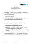
Tech Note - Adjusting Rover Antenna
Height Before Post-Processing
There is a general rule that the vertical accuracy of any GPS receiver is between two and
three times that of the horizontal accuracy. A mapping-grade receiver offering 2-3 meters
of horizontal accuracy should therefore deliver vertical accuracy between 4 and 9 meters.
Because a typical GIS/GPS receiver is held about 1.5 meters off the ground – a value
well within the vertical error range – and given that elevation has not traditionally been
very important in GIS maps, compensating for the 1.5 meters of known vertical error has
not been important.
However, there are three factors that today converge to make compensating for
MobileMapper antenna height more important:
- Post-processing software improving vertical accuracy from 4-9 meters to 1-2 meters.
- Increased use of external antennas on 2-meter range poles.
- Increased use of 3D maps and databases.
The following is an easy way to use MobileMapper Office to compensate for the fact that
the MobileMapper’s GPS antenna, either internal or external, is elevated above the
ground. This method assumes that you held the receiver a relatively uniform height above
the ground throughout the survey and that you are post-processing the data.
1. After downloading reference station data, click on the reference station file name
in MMO’s Differential Correction window.
2. Click on the Reference Station properties icon (the third from the right).
3. Make sure that the coordinate system displayed in the Reference Station
Information window is the same as that used by the reference station data
provider, e.g. the NGS. You can select the correct coordinate system in the
Reference Station Information window by clicking on the arrow next to the
Coordinate System field. The section in the MobileMapper User Manual on
Coordinate Systems explains how to do this.
4. Check that the Height listed for this Site ID agrees with that published by the
reference station data provider.
5. Subtract the average distance the GPS antenna was held above the ground to the
Height value displayed in the Reference Station Information window and click
the OK button.
6. Click the Process Data icon.
Thales
Tech Note - Adjusting Rover Antenna Height Before Post-Processing
Page 1
All the differentially corrected positions will automatically be adjusted to compensate for
the height of the GPS antenna above the ground – even positions for which you entered a
vertical offset. Please note that every time you edit the Reference Station Information
window, the changes are persistent. In the future, if you wish to post-process rover data
that was recorded with the GPS antenna at a different height you should readjust the
Height value in the window to compensate for the new height of the antenna above the
ground.
If any of the positions were not differentially corrected (no overlapping reference station
data, not enough SVs, etc.), their elevations will not be adjusted. To do so, you can use
the GPS Position Display Filter (under Options in MMO’s main menu) to highlight
which positions were not post-processed. When you click on any of these features, you
can subtract the height of the GPS antenna above the ground from the feature’s vertical
offset field in the Feature Properties window – as seen in the example below where 2
meters were subtracted to compensate for an external antenna placed on a 2-meter range
pole.
Thales
Tech Note - Adjusting Rover Antenna Height Before Post-Processing
Page 2