1
INTREPID User Manual
Library | Help | Top
Merging gravity datasets (T56)
1
| Back |
Merging gravity datasets (T56)
Top
The INTREPID Gravity Merge tool can combine two vector datasets so that data
points from matching groups are stored in the same group in the output dataset.
Gravity Merge is intended for combining gravity datasets where the data is grouped
by station number. You can merge two datasets so that INTREPID stores the data
from each station in the same group.
For general purpose merging, use the Merge Datasets tool (see Merging datasets
(T04)).
Generally speaking, both the input and output dataset must have the same fields and
field names for the Gravity Merge process to work.
Gravity Merge will report:
•
Eliminated duplicates
•
Nulls
•
Duplicate locations with different 'group by' (usually station number) field values
•
Duplicate 'group by' (usually station number) field values with the same location
field values
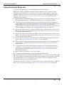
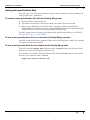
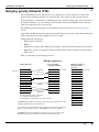
Here is a diagram of the merge process.
Merge process
Input dataset
Append
Group 1
D
2
3
Pre-existing
output dataset
R
Merged output
dataset after
process
1 Group
1 Group
2
R
D
D
D
Update
D
Append
2
U
3
R
Append
3
4
R = Suspected error reported
U = Updated data point
D = Duplicate ignored or used for update
INTREPID appends data points from the input dataset to any
existing data in the output dataset.
R
4
If a point in the input dataset has fewer nulls than a duplicate
point in the output dataset, INTREPID uses it for update.
INTREPID reports different locations for the same key and
different keys for the same location as suspected errors.
Library | Help | Top
© 2012 Intrepid Geophysics
| Back |
INTREPID User Manual
Library | Help | Top
Merging gravity datasets (T56)
2
| Back |
Using the Gravity Merge tool
To use Gravity Merge with the INTREPID graphic user interface
Note: If you wish to identify duplicate locations with the same 'group by' field
(usually station number), we recommend that you use geographical coordinates
(latitude / longitude). These coordinates are superior for locating duplicate points
spatially. See Old Datum and Projection Conversion (T12) for instructions on
changing to this system.
1
Choose Merge with Master from the Gravity menu in the Project Manager, or use
the command merge.exe. INTREPID displays the Gravity Merge window.
2
If you have previously prepared file specifications and parameter settings for
Gravity Merge, load the corresponding task specification file using Load Options
from the File menu. (See Specifying input and output files for detailed
instructions.) If all of the specifications are correct in this file, go to step 6. If you
wish to modify any settings, carry out the following steps as required.
3
Specify the dataset that you wish to include in the output dataset using Gravity
Merge. Use Specify Input from the File menu. (See Specifying input and output
files for detailed instructions.)
4
Specify the dataset into which you wish to insert the input dataset using Gravity
Merge. Use Specify Output from the File menu. (See Specifying input and output
files for detailed instructions.)
5
Specify the Key ('group by') field using the corresponding option from the File
menu (See Gravity Merge Key ('group by') field for details).
6
When you have made specifications and settings according to your requirements,
choose Apply. INTREPID will perform the Gravity Merge process and save
output dataset.
7
If you wish to record the specifications for this process in a task specification
(.job) file in order to repeat a similar task later or for some other reason, use
Save Options from the File menu. See Specifying input and output files for
detailed instructions.
8
If you wish to repeat the process, go to step 2.
9
To exit from Gravity Merge, choose Quit from the File menu.
This tool has a number of options available only if you use a task specification (.job)
file. The headings describing these options have parentheses (for example, (Turning
date stamping on or off)). A summary of the features appears in Notes in Task
specification file notes and example below.
You can execute Gravity Merge as a batch task using a task specification (.job) file
that you have previously prepared. See Using task specification files for details.
Library | Help | Top
© 2012 Intrepid Geophysics
| Back |
INTREPID User Manual
Library | Help | Top
Merging gravity datasets (T56)
3
| Back |
Specifying input and output files
To use Gravity Merge, you will need to specify the two vector datasets to be combined
and the key field.
Choose the options as required from the File menu.
In each case INTREPID displays an Open or Save As dialog box. Use the directory
and file selector to locate the file you require. (See "Specifying input and output files"
in Introduction to INTREPID (R02) for information about specifying files).
Vector dataset notes
•
INTREPID will identify X and Y fields from the dataset aliases for the process.
The dataset must have the following aliases identifying appropriate fields.
Alias
Field
X
X coordinate (location)
Y
Y coordinate (location)
•
If you wish to identify duplicate locations with the same 'group by' field (usually
station number), we recommend that you use geographical coordinates (latitude /
longitude). If you do not have a set of latitudes and longitudes available for
assigning to aliases, you can create them using the Projection Conversion tool.
See INTREPID’s supported datums and projections (R09) for instructions.
See "Vector dataset field aliases" in INTREPID database, file and data structures
(R05) for more information about aliases.
Specify Input
Use this option to specify the input dataset that you wish to include in the output
dataset. This dataset should contain the second part of the data to be combined.
Specify Key Field
Use this option to specify the name of the 'group by' for linking the data in the merge
process. Both datasets require the linking 'group by' field to have this name. See
Gravity Merge Key ('group by') field for details.
Specify Output
Use this option to specify the output dataset into which you wish to insert the input
dataset. This dataset may contain the first part of the data to be combined or can be
a new dataset. After the process it will contain all of the data. If you specify an
existing output dataset, INTREPID will build two internal hash tables to index the
existing key and location fields.
Load Options
If you wish to use an existing task specification file to specify the Gravity Merge
process, use this option to specify the task specification file required. INTREPID will
load the file and use its contents to set all of the parameters for the Gravity Merge
process. (See Using task specification files for more information).
Save Options
If you wish to save the current Gravity Merge file specifications and parameter
settings as an task specification file, use this option to specify the filename and save
the file. (See Using task specification files for more information).
Library | Help | Top
© 2012 Intrepid Geophysics
| Back |
INTREPID User Manual
Library | Help | Top
Merging gravity datasets (T56)
4
| Back |
Gravity Merge Key ('group by') field
The key ('group by') field is the field that links the datasets for the merge operation.
The datasets must each have a 'group by' field with the name you specify. INTREPID
combines the datasets so that data from the input dataset is included in the matching
groups in the output dataset.
The most common purpose for this tool is combining gravity datasets for the same
region. The normal gravity dataset 'group by' field is the station number. Gravity
Merge can combine the datasets so that all of the data for a station is in the same
group.
We recommend that you do not use Gravity Merge with a dataset which has the same
'group by' field value for two or more groups (e.g, if you have used the Split Group
operation in the Spreadsheet Editor). Edit such a dataset using the Spreadsheet
Editor before merging to ensure that all groups have unique merge key values in each
dataset.
To specify the key ('group by') field:
Choose Specify Key Field from the File menu, and select the field from the input
dataset.
Detecting duplicates and updating
During the merge process, INTREPID examines the X, Y and merge key (usually
station number) fields and identifies suspected duplicate data points. These four
fields make the default fields to compare list. If you use a task specification file you
can add fields to this list using the ReportOn statement. See (Specifying further
fields to compare).
(Specifying further fields to compare)
If you are using a task specification (.job) file for the Gravity Merge task you can
specify additions to the fields to compare list using the ReportOn statement.
ReportOn = "fieldname, fieldname, ..."
Example: ReportOn = "Elevation"
Deleting duplicates
If the values for the fields to compare list are the same, INTREPID regards the data
point as a duplicate and ignores the record in the input dataset.
Reporting suspected errors
If X and Y are the same but the merge keys are different or the merge keys are the
same but X and Y are different, INTREPID retains both data points and reports them
as suspected duplicates or errors.
If the difference between the X and Y is only a question of precision (number of
significant figures), and two records are, in fact, duplicates, you will be able to note
this from the report. You can use the Spreadsheet tool to manually delete the data
point that you don't require. The number_samples() function can show you the
number of data points in each group (See "INTREPID Functions" in INTREPID
expressions and functions (R12)).
Library | Help | Top
© 2012 Intrepid Geophysics
| Back |
INTREPID User Manual
Library | Help | Top
Merging gravity datasets (T56)
5
| Back |
Updating with more complete data
If the values for the fields to compare list are the same but there are some nulls,
INTREPID uses the data point with fewer nulls and ignores the other. (If the data
point with fewer nulls is in the input dataset, then we can say that the output dataset
data point is updated.)
(Merging only the last data point in each group)
You can instruct INTREPID to merge only the last data point in each group of the
input dataset. This is a normal practice in the context of gravity dataset processing.
This option is only available if you are using a task specification (.job) file.
To merge only the last record in each input dataset group
Set the MergeLastOnly = statement in the task specification file to YES. See Using
task specification files for details.
Gravity Merge process algorithm
Here is a structured English statement of the algorithm used by the Gravity Merge
tool for the merging process.
For each data point in the input dataset:
Compare it with each data point in the output dataset:
If (key field values are the same and values in the fields to compare list are
the same)
Then the input data point is a duplicate
Ignore it or use it for update
Else the input data point is not a duplicate
Append it to the output dataset.
Gravity Merge reports and records
Gravity Merge reports
INTREPID prepares a report of the merge process which includes statistics on
•
Duplicate data points found,
•
Nulls found,
•
Differences in merge key field values for the same location and
•
Differences in locations for the same merge key field values.
See "Diagnostic reporting options" in Configuring and using INTREPID (R04) for
information about process reporting in INTREPID.
Library | Help | Top
© 2012 Intrepid Geophysics
| Back |
INTREPID User Manual
Library | Help | Top
Merging gravity datasets (T56)
6
| Back |
Algorithm for reporting the merge process
Here is a structured English statement of the algorithm used by the Gravity Merge
tool for reporting the process.
For each data point in the input dataset:
Compare it with each data point in the output dataset:
If (key field values are the same)
Then
If all fields to compare list values are the same then it is a duplicate
Report 'data point ignored';
If X or Y field values are not the same, then there are two different locations
with the same key (usually station number).
Report 'duplicate key'
Else
If X and Y field values match then there are two key values (usually station
numbers) for the same location
Report 'duplicate location';
If (any fields to compare list values are null)
Then
Report 'null fields'
Date stamping merged data points
INTREPID can 'date stamp' data points as they are merged to the output dataset. If
the field HISTORYDate exists in the output dataset, INTREPID will set it to the
current date (using a "yyyy/mm/dd" string) in each data point that it appends or
updates.
(Turning date stamping on or off)
If you are using a task specification file you can turn date stamping off or on. Set the
TimeStamp = statement to YES or NO according to your requirements. See Using
task specification files for details.
Apply
When you choose Apply, INTREPID will carry out the merge process that you have
specified.
(Processing a specified number of data points)
If you are using a task specification (.job) file you can limit the number of records
that INTREPID reads from the input dataset. This may save time when you are
trialing a process.
To specify the maximum number of input dataset records to process
Use the StopAfter = statement in the task specification file.
Example: StopAfter = 1000
Exit
To exit from the Gravity Merge tool, choose Quit from the File menu.
Library | Help | Top
© 2012 Intrepid Geophysics
| Back |
INTREPID User Manual
Library | Help | Top
Merging gravity datasets (T56)
7
| Back |
Using task specification files
You can store sets of file specifications and parameter settings for Gravity Merge in
task specification (.job) files.
To create a task specification file with the Gravity Merge tool
1
Specify all files and parameters.
2
If possible, execute the task (choose Apply) to ensure that it will work.
3
Choose Save Options from the File menu. Specify a task specification file
(INTREPID will add the extension .job) INTREPID will create the file with the
settings current at the time of the Save Options operation.
For full instructions on creating and editing task specification files see INTREPID
task specification (.job) files (R06).
To use a task specification file in an interactive Gravity Merge session
Load the task specification (.job) file (File menu, Load Options), modify any settings
as required, then choose Apply.
To use a task specification file for a batch mode Gravity Merge task
Type the command merge.exe with the switch -batch followed by the name (and
path if necessary) of the task specification file.
For example, if you had a task specification file called surv329.job in the current
directory you would use the command
merge.exe -batch surv329.job
Library | Help | Top
© 2012 Intrepid Geophysics
| Back |
INTREPID User Manual
Library | Help | Top
Merging gravity datasets (T56)
8
| Back |
Task specification file notes and example
Here is an example of a Gravity Merge task specification file.
Process Begin
Name = merge
Input = d:/survey/suppdata
Key = station_number
MergeWith = d:/survey/maindata
ReportOn = "Elevation"
MergeLastOnly = NO
TimeStamp = YES
StopAfter = 100
Process End
Notes
•
Input = refers to the input dataset.
MergeWith = refers to the output dataset.
Library | Help | Top
•
You can specify additions to the fields to compare list using the ReportOn =
"fieldname, fieldname, ..." statement. See Detecting duplicates and
updating for further information.
•
You can instruct INTREPID to merge only the last data point in each group of the
input dataset using the MergeLastOnly = YES|NO statement. This is a normal
practice in the context of gravity dataset processing. See (Merging only the last
data point in each group) for details.
•
You can turn date stamping off or on using the TimeStamp = YES|NO statement.
See Date stamping merged data points for further details.
•
You can limit the number of records that INTREPID reads from the input dataset
using the StopAfter = number_of_data_points statement. This may save
time when you are trialing a process.
© 2012 Intrepid Geophysics
| Back |