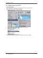
1
cGPSmapper User Manual
First Published Date:
Version:
Published Date:
Total Page Count:
2005-04-01
2.4.5
2009-07-16
125
cGPSmapper Manual
1 Contents
1
COTETS .................................................................................................................. 2
2
ITRODUCTIO ........................................................................................................ 5
2.1
PURPOSE OF THIS DOCUMENT .................................................................................. 5
2.2
BASIC CONCEPTS ..................................................................................................... 5
2.2.1
What is Polish Format (PFM)? ...................................................................... 5
2.2.2
What is cGPSmapper?.................................................................................... 5
2.2.3
What is sendmap?........................................................................................... 5
2.3
DOCUMENT CONVENTIONS ...................................................................................... 5
2.3.1
PFM Code ...................................................................................................... 5
2.3.2
cGPSmapper versions .................................................................................... 6
2.4
MANUAL AUTHORS ................................................................................................. 6
3
OVERVIEW ................................................................................................................. 7
4
MAP PROJECT ........................................................................................................... 8
4.1
MAP CREATION ....................................................................................................... 8
4.2
PFM SYNTAX DESCRIPTION..................................................................................... 8
4.2.1
Header ............................................................................................................ 9
4.2.2
Declarations ................................................................................................. 15
4.2.2.1
4.2.2.2
4.2.2.3
4.2.2.4
4.2.3
4.2.3.1
4.2.3.2
4.2.3.3
4.2.3.4
4.2.3.5
4.2.4
4.2.4.1
4.2.4.2
4.2.4.3
4.2.4.4
4.2.4.5
4.2.4.6
4.2.4.7
4.2.4.8
Countries ........................................................................................................................................ 15
Regions........................................................................................................................................... 15
Cities .............................................................................................................................................. 16
Chart Info ....................................................................................................................................... 16
Advanced Declarations................................................................................. 18
Background .................................................................................................................................... 18
Dictionary....................................................................................................................................... 18
Highways........................................................................................................................................ 18
ZIP Codes....................................................................................................................................... 18
Definitions...................................................................................................................................... 18
Body (Objects) .............................................................................................. 18
Point of Interest .............................................................................................................................. 19
Polygon .......................................................................................................................................... 21
Polyline .......................................................................................................................................... 23
Point of Interest from OziExplorer ................................................................................................. 24
Polyline or Polygon from OziExplorer........................................................................................... 24
Shapes ............................................................................................................................................ 25
MapDekode file.............................................................................................................................. 30
File ................................................................................................................................................. 30
4.2.5
Object elevation............................................................................................ 30
4.2.6
Road numbers ............................................................................................... 31
4.2.7
Special codes for object labels ..................................................................... 32
4.3
MARINE CHARTS ................................................................................................... 34
4.4
LEVELS .................................................................................................................. 42
4.4.1
Introduction .................................................................................................. 42
4.4.2
Concepts and Terminology........................................................................... 43
4.4.3
Using levels when defining map objects....................................................... 45
4.4.3.1
Tailoring shape according to level.................................................................................................. 46
4.4.4
Idiosyncrasies of GPS hardware .................................................................. 47
4.5
DICTIONARY .......................................................................................................... 47
http://cgpsmapper.com/
2 of 125
cGPSmapper Manual
4.5.1
4.5.2
4.5.3
Introduction .................................................................................................. 47
Concepts and Terminology........................................................................... 48
Using Dictionary .......................................................................................... 48
5
ROUTABLE MAPS ................................................................................................... 51
5.1
INTRODUCTION ...................................................................................................... 51
5.2
GENERAL REMARKS ............................................................................................... 51
5.3
CONCEPT OF INPUT DATA ....................................................................................... 51
5.4
ROAD CLASS .......................................................................................................... 53
5.5
SPEED ATTRIBUTE .................................................................................................. 53
5.6
ROUTING ATTRIBUTES PMF .................................................................................. 54
5.7
ROUTING DATA DEFINED FOR ESRI FILES .............................................................. 55
5.7.1
Segment of the road ...................................................................................... 56
5.7.2
Defining routing data in [DEFI8ITIO8S] ................................................... 56
5.7.3
Defining attributes of road segments in [DEFI8ITIO8S] .......................... 57
5.7.4
Defining restriction data in [DEFI8ITIO8S] .............................................. 57
5.7.5
Secton [DEFI8ITIO8S] ............................................................................... 58
6
ATIOAL CHARACTERS - IDEXIG............................................................ 61
6.1
CODEPAGES ........................................................................................................... 61
6.2
INDEXING .............................................................................................................. 61
6.3
PREPARING MAPS FOR INDEXING ........................................................................... 62
6.4
MULTI ATTRIBUTES ASSIGNMENT .......................................................................... 62
6.5
INDEXING WITH CPREVIEW PROGRAM .................................................................... 63
7
PROTECTIG IMG FILES - LOCKIG............................................................... 64
7.1
RESPONSIBILITY .................................................................................................... 64
7.2
TECHNOLOGY ........................................................................................................ 65
7.3
LOCKING MAPS WITH CGPSMAPPER ...................................................................... 67
7.4
CREATING PREVIEW – MAPSET............................................................................... 67
7.5
UNLOCK CODES ..................................................................................................... 68
7.6
UNLOCKING MAPS ON SD CARD ............................................................................ 69
8
CREATIG CUSTOM TYPE FILE ........................................................................ 69
8.1
CREATING THE SOURCE FILE .................................................................................. 70
8.2
CUSTOM TYPE DEFINITION .................................................................................... 73
8.3
PUTTING IT ALL TOGETHER .................................................................................... 80
9
MAPSOURCE ............................................................................................................ 84
9.1
INSTALLING MAPS TO BE USED WITH MAPSOURCE ................................................ 84
9.2
MAPSOURCE DATA STRUCTURE ............................................................................ 84
9.3
CREATING PREVIEW MAP FILES .............................................................................. 85
9.4
MAKING THE REGISTRY ENTRIES ........................................................................... 85
9.5
LOADING THE MAPS INTO THE GPS ....................................................................... 87
10
FAQS ....................................................................................................................... 89
10.1 NAME VARIABLES AND WHERE THEY SHOW UP ...................................................... 89
10.1.1 Introduction .................................................................................................. 89
10.1.2 PFM File ...................................................................................................... 89
11.2.2 PFM Preview File ........................................................................................ 89
http://cgpsmapper.com/
3 of 125
cGPSmapper Manual
11.2.3 Sendmap ....................................................................................................... 90
10.2 ACTIVATION OF MAPS IN THE GPS......................................................................... 91
10.3 SAVING OBJECTS AS [RGNX0] VS. [POI], [POLYGON], [POLYLINE]............... 92
10.3.1 Equivalences................................................................................................. 92
10.3.2 Impact of saving objects in one format or the other..................................... 92
10.3.3 Preferred method.......................................................................................... 92
10.4 RELATIONSHIP BETWEEN LEVELS IN THE DETAIL MAPS AND THE PREVIEW MAPS ... 93
10.5 FILLING (GAS) STATIONS NOT SHOWING IN THE FIND FUNCTION OF THE GPS ....... 93
10.6 ISLANDS AND CLEARINGS ...................................................................................... 93
11
GLOSSARY ............................................................................................................ 95
12
APPEDICES......................................................................................................... 96
12.1 CGPSMAPPER COMPILATION ERRORS AND WARNINGS.......................................... 96
12.2 EXITS ................................................................................................................... 100
12.2.1 Valid exit facility types ............................................................................... 100
12.2.2 Directions ................................................................................................... 101
12.2.3 Facilities ..................................................................................................... 101
12.3 CGPSMAPPER OBJECT TYPES LIST ........................................................................ 101
12.3.1 [POI] types ................................................................................................. 102
12.3.2 [POLYLI8E] types ..................................................................................... 112
12.3.3 [POLYGO8] types...................................................................................... 114
12.3.4 Custom types name substitution ................................................................. 117
12.3.5 How do I create XPM definitions? ............................................................. 118
12.4 CGPSMAPPER VERSIONS ...................................................................................... 119
12.5 CGPSMAPPER FILES ............................................................................................. 120
13
IDEX AD TABLES......................................................................................... 121
13.1 TABLE OF FIGURES .............................................................................................. 121
13.2 VERSION CONTROL LOG ...................................................................................... 121
13.3 INDEX .................................................................................................................. 122
http://cgpsmapper.com/
4 of 125
cGPSmapper Manual
2 Introduction
The latest version of this document can be found at http://www.cgpsmapper.com/.
Feel free to e-mail your comments / contributions to the present document to
[email protected].
2.1 Purpose of this document
This manual explains how to create vector maps and then upload them to your Garmin®
GPS receiver (or see them in the MapSource software), utilizing the cGPSmapper /
sendmap software.
2.2 Basic Concepts
2.2.1 What is Polish Format (PFM)?
Polish Format is a convenient, text based, format used for saving map information on a
computer and transferring map information between computer programs.
Polish format map files cannot be sent directly to a GPS unit. First they must be converted
into a format which is understandable to your GPS receiver. A program which performs
this conversion is called a "map compiler".
2.2.2 What is cGPSmapper?
cGPSmapper is a command line program which "compiles" files in polish format (PFM)
and produces a vector map in file(s) of a format understandable by your GPS receiver and
Garmin® MapSource.
There are different cGPSmapper versions (refer to section 12.3.4 on page 117) with diverse
features.
2.2.3 What is sendmap?
sendmap is a command line program used to transfer vector map files (generated with
cGPSmapper) to your GPS receiver.
2.3 Document Conventions
Text in italics is shown in the Glossary (page 95).
2.3.1 PFM Code
Text in monospace font represents literals (to be inserted literally in the PFM file).
Text in underlined monospace font represents metavariables - which appear to the
right of the equals sign (=) in many statements. Metavariables should be replaced with
appropriate values, as described in the explanation (or self-evident).
Text in normal font is explanatory and should not be inserted into the source file.
The number sign special metavariable (#) takes a numeric value. E.g. Data# stands for
Data0, Data1, etc.
The special iteration operator ... in a statement line has its intuitive meaning. This operator
in a separate line denotes that the preceding statement may be repeated zero or more times
http://cgpsmapper.com/
5 of 125
cGPSmapper Manual
with various (typically consecutive) values of the metavariable #. If the iteration operator is
preceded by a pair of statements with # metavariables, the whole pair should be repeated
(see specific statements for examples).
Text in orange colour (e.g. Name=) are mandatory statements in the given section. Text in
olive colour (e.g. Label=) are optional statements.
2.3.2 cGPSmapper versions
The table below contains the meaning of the different symbols used in this document to
represent the cGPSmapper Version to which a certain concept applies.
Symbol cGPSmapper Version
Freeware
φ
Shareware
σ
Pro
π
₪
Routable
The different cGPSmapper versions are explained in section 12.3.4, on page 117.
2.4 Manual Authors
This manual was written by Stanislaw Kozicki (the author of cGPSmapper), Gary Turner,
Graham Bowring, Hans Scheffler, Keith Sheppard, Greg Rikker and Mauricio Zalba.
http://cgpsmapper.com/
6 of 125
cGPSmapper Manual
3 Overview
Creating a map to be uploaded to a GPS receiver may be compared to programming: you
write a program (i.e. a map) in the programming language (i.e. in PFM) and then compile
it. Alternatively - just as with programming - tools exist to generate the source code
visually or semi-automatically or to assist in other ways in the code preparation.
The source code format used by the cGPSmapper compiler is referred to as PFM (Polski
Format Mapy - Polish Map Format) or the "Polish format". The standard file extension for
maps in the PFM format is .mp (in previous versions, the .txt extension was used, which is
still acceptable, but not recommended).
A map consists of map objects which fall into four categories: POIs (points of interest, e.g.
hotel, restaurant), points (non-indexed point objects, e.g. summit, building), polylines
(linear objects, e.g. street, stream), and polygons (area objects, e.g. lake, forest). For nondimensional objects (POIs and points), it is necessary to define the object attributes, such as
label and type, as well as the object coordinate pair (latitude, longitude). For dimensional
objects (polylines and polygons), it is necessary to define the object attributes, as well as
coordinate pairs of all object vertices. Providing the coordinates is the most laborious part
of map authoring.
You may prepare the map source file (.mp) using various methods: by writing the complete
source code with any text editor, by generating it visually (by drawing on the screen) with
any visual editor, by importing objects (waypoints and tracks) created by the OziExplorer
mapping software, or by various combinations of those methods.
When you have finished your map, you can compile it with cGPSmapper (a number of
methods are available) and preview it after compilation. The standard file extension for
compiled maps is .img. Finally, you can upload the resulting compiled map file (.img) to
your GPS with sendmap or MapSource. All those operations and variants are described in
relevant sections below.
http://cgpsmapper.com/
7 of 125
cGPSmapper Manual
4 Map Project
4.1 Map Creation
You write the source file in the PFM format (the .mp file) using any text editor. All maprelated information is provided in relevant statements. Then the map is compiled with the
cGPSmapper compiler and the resulting .img file is uploaded using sendmap or
MapSource.
The PFM format is described section 4.2 (PFM syntax Description), on page 8.
When you have finished your map (or at any time during the map creation process), you
may preview it on the computer screen. Some software packages allow you to preview
PFM format files directly. Alternatively you can compile it and preview the resultant .img
file using MapSource. Finally the .img file may be uploaded to your GPS.
4.2 PFM syntax Description
A PFM format file contains comment lines and statements. Blank lines are also permitted
A comment line starts with the ";" character. Comment lines and blank lines may appear at
anywhere in the file and are ignored1 by the compiler.
Statements are grouped into sections. Sections are identified with a section name, enclosed
between "[]" and finish with an [END] identifier.
[END-section_identifier] can also be used to finish a section. E.g. [IMG ID]
... [END-IMG ID], instead of [IMG ID] ... [END].
The following types of sections exist:
Section Type
Identifier(s)
[IMG ID]
Header
[COUNTRIES]
Declarations
[REGIONS]
[CITIES]
[CHART INFO]
[DICTIONARY]
Advanced
[BACKGROUND]
Declarations
[HIGHWAYS]
[ZIPCODES]
[DEFINITIONS]
1
However, GPSMapEdit uses special syntax of comments to specify attachments and such
comments are interpreted by GPSMapEdit.
http://cgpsmapper.com/
8 of 125
cGPSmapper Manual
Section Type
Body (Objects)
Identifier(s)
[POI]
[POLYLINE]
[POLYGON]
[PLT]
[WPT]
[DBX]
[SHP]
[FILE]
[RGN10]
[RGN20]
[RGN40]
[RGN80]
The header section is mandatory and must appear as the first section in the source file. All
other sections are optional. Declaration and advanced sections (if any) must appear after the
header section, in the order specified here. These sections cannot be repeated.
Objects must appear after declaration and advanced sections (if any), may be in any order,
and may be repeated as many times as necessary.
The order of statements in the section body (i.e. between the section keyword statement and
the [END] statement) is insignificant.
4.2.1 Header
[IMG ID]
ID=########
Name=map_name
LBLcoding=x
http://cgpsmapper.com/
Section identifier
Unique identifier (up to 8 decimal digits) for the map.
May be only written in a decimal format
11000204
Map name to be displayed in the GPS receiver's Map Info
menu.
Refer to section 10.1 (on page 89) for details.
80 characters maximum.
6 compressed label coding (smallest maps)
9 full-byte (8-bit) coding (supports national
characters, depending on the GPS firmware)
10 Unicode / MBCS (depending on the GPS
firmware)
Default = 6
9 of 125
cGPSmapper Manual
Codepage=xx
Datum=xxx
Transparent=x
₪
MG=x
π
Numbering=x
http://cgpsmapper.com/
≠ 0 full-byte (8-bit) character coding with the
specified codepage is used (depending on the GPS
firmware)
0 single-byte coding
Note: Refer to section 0 on page 55
Note: The delimiters for road numbers ( refer to section
4.2.6, on page 31, for details) are different if full-byte coding
is used.
Note: Special codes are different for 8-bit coding!
Default = 0
W84 WGS-84
Custom Custom
dx, dy, dz, semiMajorAxis, invFlattening
E.g. for (for WGS84): Custom: 0,0,0,6378137.000,
298.257223563
≠ W84 & ≠ Custom refer to the
Datum_List.txt file (in the cGPSmapper directory)
for the full list of supported datums
Default = W84
Y a full transparent map will be created
N a transparent map will not be created
S a semi-transparent map will be created
Default = N
When a transparent map is displayed on a GPS unit, features
in the unit's basemap will also be visible. If your map is not
transparent, it will obscure the basemap when visible.
Semi-transparent map is created in a way a usual map is
created, but no background object is created. Full transparent
map is created in a way that no background object is created
and information in IMG is stored that map is transparent.
In some cases – to have a nice overlapping map it is
necessary to use semi-transparency instead of fulltransparency.
Lock on road, search for intersection and show next street
name active:
Y Yes
N no
Default = N
Lock on road, show next street name and house numbers
along street active:
Y Yes
N no
Default = N
10 of 125
cGPSmapper Manual
₪
Routing=x
₪
Lock=x
₪
ProductCode=x
τ
π
₪
CopyRight=xxxxxxx
Elevation=x
σ
τ
π
₪
τ
π
₪
POIOnly=x
POIIndex=x
POINumberFirst=x
POIZipFirst=x
τ
π
₪
σ
τ
π
₪
CountryName=countr
y_name
=country_name
http://cgpsmapper.com/
Lock on road, show next street name active, house numbers
along street and routable maps active:
Y Yes
N no
Note: for routable maps a special data format required!
Default = N
Final IMG file will require unlock code specific for each
GPS device.
Y Yes
N no
Default = N
Subfamily identifier used for locked IMG files only – value
between 1 and 60. Each subfamily can be unlocked with
universal unlock code or separately with individual unlock
code.
Default = 1
Text visible in welcome page of GPS.
Refer to section 10.1 (on page 89) for details.
80 characters maximum.
m metres
f feet
Default = f
No longer used / supported.
N objects will be indexed only if POI index info is
explicitly provided
Y all POI objects will automatically be indexed (may
be searched by the Find function in the GPS)
Default = N
N the house number will be after the street name
Y the house number will be before the street name
Default = Y
N the ZIP code will be after the street name
Y the ZIP code will be before the street name
Default = Y
Should be used in conjunction with RegionName.
Defines the default region name for automatic city indexing.
If not defined, cities will be indexed only if city index info is
explicitly provided.
80 characters maximum.
This is a replacement of depreciated key:
DefaultCityCountry
11 of 125
cGPSmapper Manual
σ
τ
π
₪
RegionName==region
_name
Should be used in conjunction with CountryName.
Defines the default country name for automatic city
indexing.
If not defined, cities will be indexed only if city index info is
explicitly provided.
80 characters maximum.
This is a replacement of depreciated key:
DefaultRegionCountry
TreSize=n
Maximum allowed region size. A higher value increases the
allowable region size, but may decrease the map
performance; a lower value may increase the map size.
Suggested values:
topo maps: 1000-2000
city (dense streets): 2000-5000
countryside: 6000-10000
Maximal number of elements in one region.
Can be any value between ~50 and 1024 (values less than 50
don't make sense).
Recent experiments show that this parameter does not impact
map performance and can be set to maximum allowed value:
1024.
Suggested value:
1024
Simplify level for Douglas-Peucker simplification algorithm.
The higher value, the less simplification is done. It is
important to note, that with high value, gridding (limitation
coming from the format) might be visible.
Default = 1
Valid range is from 0.1 up to 10
RgnLimit=n
SimplifyLevel=n
http://cgpsmapper.com/
12 of 125
cGPSmapper Manual
PreProcess=x
http://cgpsmapper.com/
Kind of pre-processing:
G generalization only (faster method, but 'crossroad'
nodes might be removed).
Also the nodes from intersections may be removed.
Data will be simplified using Douglas-Peucker polyline
simplification algorithm which will ensure that the output
is not jagged.
F (or Y) full generalization + intersection detection
for polylines.
Unnecessary nodes are not removed if there are
intersections (this is important for more advanced maps at intersections, all the intersecting roads have to have
nodes or 'find intersection' won't work).
This is very similar to 'G' with one important exception all intersection points of the roads are preserved too
(even if according to the simplification algorithm these
points should be reduced) - this is especially important
when we are interested in using 'find intersection'
functionality.
Intersections are detected only for the most
detailed layer, for the others no trace is done.
P very similar to option ‘F’ - full generalization +
intersection detection for polylines and polygons. Should
be used with caution, as process time might be much
longer.
Intersections for polygons are detected for all the
layers, for polylines – only for the most detailed
layer.
N no generalization and no intersection detection.
Unnecessary nodes (from the resolution point of view)
will be removed automatically.
There will be no reduction of the 'oversampled' points in
the objects - the only reduction of the points will be done
because of alignment to the same coordinates.
This option should be used if input data is prepared
separately for each layer - the data for each layer having
already been adjusted to the map author's requirements.
Used only if you explicitly provide data for all layers.
Default = F
13 of 125
cGPSmapper Manual
Levels=n
Level#=g
Zoom#=#
Preview=x
AlignMethod
BlockSize
LevelFill
LevelLimit
WorldMap
DrawPriority=#
Marine=x
http://cgpsmapper.com/
Refer to section 4.4 (on page 42) for details.
Number of levels (layers) in the map (at least 2, not more
than 10).
2
3
4
5
6
7
8
9
10
Note: the last layer must always be empty, e.g. Levels=3
means that two layers only are available for map objects.
Grid size for layer # (layer 0 is the most detailed one).
Refer to section 4.4 (on page 42) for details.
Refer to section 4.4 (on page 42) for details.
Refer to section 9.3 (Creating preview map files), on
page 85, for details.
N map designated for use with GPS will be created
Y map designated for use as preview map for
MapSource will be created
Default = N
No longer used / supported.
No longer used / supported.
No longer used / supported.
No longer used / supported.
No longer used / supported.
Value between 0 and 31 indicating the priority used by the
GPS to draw the map. The highest value – the highest
priority is set.
Priority for the transparent maps is calculated by adding
always 32 to the set priority by DrawPriority value.
Default = 25.
Indicates if the map is of marine type.
N or 0 non-marine map
Y or 1 marine map
B or 2 marine map – compatible with G2 devices
X or 3 non-marine map – compatible with G2 devices
– be aware – Garmin does not produce such non-marine
maps compatible with G2 devices only
Default = N.
Refer to section 0 (on page 31) for details.
14 of 125
cGPSmapper Manual
LeftSideTraffic=x
NT=x
[END]
Indicates if driving side is right (default) or left.
N or 0 driving side is right
Y or 1 driving side is left
Default = N.
Used for routable maps only – for proper display of
roundabout icon / other maneuver icons.
Experimental. Changes storage format to NT-like. This is
NOT YET real Garmin NT format.
N or 0 normal storage format
Y or 1 Experimental NT format
Default = N.
Section terminator.
4.2.2 Declarations
The DECLARATION elements must be in the order shown herewith.
4.2.2.1 Countries
Although this section is obsolete, it is still supported.
[COUNTRIES]
Declares all countries used for city indexing
Country#=country_n Name and abbreviation used to identify country #.
ame~[0x1d]abbrevia The first # must always be one.
tion
E.g.: Country1=United States~[0x1d]US
80 characters maximum.
...
The statement above can be repeated as needed.
# must be in ascending order.
[END]
Section terminator
4.2.2.2 Regions
Although this section is obsolete, it is still supported.
[REGIONS]
Declares all regions used for city indexing
Region#=region_nam Name and abbreviation used to identify region #.
e~[0x1d]abbreviati The first # must always be one. Subsequent # must be
on
ordered ascending.
E.g.: Region1=New York~[0x1d]NY
80 characters maximum.
CountryIdx#=countr The country_index represents the number in the
y_index
corresponding Country# statement.
The first # (CountryIdx) must always be one.
Subsequent2 # must be in ascending order.
If included, there must be at least 1 region per country. In
theory, the limit is 13,107.
E.g.: CountryIdx1=1, means that the current region is located
in country 1 (right side of the equals sign).
...
The statements above can be repeated as needed.
2
Unlikely, since each region normally is located in a single country.
http://cgpsmapper.com/
15 of 125
cGPSmapper Manual
[END]
Section terminator.
4.2.2.3 Cities
Although this section is obsolete, it is still supported.
[CITIES]
Declares all cities used for indexing
City#=ciy_name
Name used to identify the city #.
The first # must always be one. Subsequent # must be in
ascending order.
E.g.: City1=New York
80 characters maximum.
RegionIdx#=region_ The region_index represents the number in the
index
corresponding Region# statement.
The first # (RegionIdx) must always be one. Subsequent3
# must be in ascending order.
If included, there must be at least 1 city per Region. In
theory, the limit is 13,107.
E.g.: RegionIdx1=1, means that the current city is located in
Region 1 (right side of the equal sign).
...
The statements above can be repeated as needed.
[END]
Section terminator.
4.2.2.4 Chart Info
[CHART INFO]
Name=xxx
Number=xxx
Projection=xxx
Published=xxx
Scale=###
DeltaSN=###
DeltaWE=###
IALA=x
Print=mmyyyy
3
Declarations for marine charts, attached to the 'marine chart'
object - which is created automatically as well (similar to the
background object) - and also attached to the 'marine border'
line.
This section should only be present if in the [IMG ID]
section, there is a definition Marine=Y
Chart Name (e.g. La Plata to Nueva Palmira).
Chart Code (e.g. Gb3561(a)).
Chart Projection (e.g. Mercator).
Place where the chart was published (e.g. United Kingdom).
Map scale (e.g. 1:100000).
Longitude Delta.
Latitude Delta.
IALA system. The areas that use the 'B' system are the
Americas, Japan and the Philippines. The remainder of the
world uses the 'A' system.
A
B
Default = A
Paper chart print date.
Note that MapSource will show the day as "01" (the day
field is not available in the GPS).
Unlikely, since each city normally is located in a single region.
http://cgpsmapper.com/
16 of 125
cGPSmapper Manual
Edition=mmyyyy
σ
π
₪
σ
π
₪
Correction=ddmmyyy
y
Text=xxx
TextFile=file_name
ReferenceEllipsoid
=###
http://cgpsmapper.com/
Paper chart edition date.
Note that MapSource will show the day as "01" (the day
field is not available in the GPS).
Paper chart correction date.
Very long description / information.
There could be several Text entries in a single object.
16kb maximum (each entry).
File containing a very long description / information.
There could be several TextFile entries in a single object.
The path could be either
absolute or
relative to the current directory.
For platform portability, it is recommended to use slashes "/"
instead of backslashes "\" to separate directories in the path.
In Unix, file_name is case sensitive.
16kb maximum (each entry).
Reference Ellipsoid.
0 Krassovsky
1 Airy
2 Modified Airy
3 Australian National
4 Bessel 1841
5 Bessel 1841 (Namibia)
6 Clarke 1866
7 Clarke 1880
8 Everest (Brunei)
9 Everest (India 1830)
10 Everest (India 1956)
11 Everest (W Malaysia 1948)
12 Everest (W Malaysia 1969)
13 Modified Everest
14 Fischer 1960/Mercury
15 Modified Fischer 1960
16 Fischer 1968
17 GRS 1967
18 GRS 1980
19 Helmert 1906
20 Hough
21 International
22 South American 1969
23 WGS-60
24 WGS-66
25 WGS-72
26 WGS-84
27 Unknown
17 of 125
cGPSmapper Manual
[END]
Section terminator.
4.2.3 Advanced Declarations
The ADVANCED DECLARATIONS elements must be in the order shown herewith.
4.2.3.1 Background
[BACKGROUND]
Name=file_name
[END]
τ π ₪ Declares a custom shape for the map – another way to
define a custom shape for the map is to use a [POLYGON]
section (or [RGN80]) as described in section 4.2.4.2 .
Name of the ESRI file without extension
This should be the full or relative path for the ESRI file,
without the extension (which should be .shp for files
containing ESRI data)
Section terminator.
4.2.3.2 Dictionary
[DICTIONARY]
Level#RGNnn=bitmas
k
[END]
Refer to section 4.5 (on page 47) for details.
bitmask mask used to show / hide the objects.
# level on which the bitmask is applied.
nn type of object to which the bitmask is applied.
Section terminator.
4.2.3.3 Highways
♣ This section will be further documented in a future version of this manual.
[HIGHWAYS]
[END]
Section terminator.
4.2.3.4 ZIP Codes
Although this section is obsolete, it is still supported.
♣ This section will be further documented in a future version of this manual.
[ZIPCODES]
[END]
Section terminator.
4.2.3.5 Definitions
Refer to section 5.7, on page 55, for further details.
[DEFINITIONS]
[END]
Section terminator.
4.2.4 Body (Objects)
BODY objects may be specified in any order.
http://cgpsmapper.com/
18 of 125
cGPSmapper Manual
4.2.4.1 Point of Interest
[POI]
Type=object_type
SubType=object_typ
e
Point of interest section identifier. [RGN10] (meaning point
of interest) and [RGN20] (meaning point) may be used
instead.
Type of element, may be written in hex or decimal or as a
name (valid names are defined in file RGNtyps.txt which
you can customised to your requirements).
SubType defines the second byte of the Type value.
The type of element can be defined either by using the Type
key only or by using the Type and SubType keys.
Example:
Type=0x0211
can be also written as:
Type=0x02
SubType=0x11
Extended / marine types can be stored in 3 bytes
as follow:
Type=0x010203
Marine=x
City=x
Label=object_name
EndLevel=#
http://cgpsmapper.com/
What correspond to:
Type=0x02
SubType=0x03
Marine=Y
Indicates if the object is extended / marine type.
N or 0 standard type
Y or 1 extended type
Default = N
Indicates if the POI is a city.
Only used if the [POI] alias is used.
N or 0 not a city (instead of [RGN10])
Y or 1 city (instead of [RGN20])
Default = N
Name of the object to be shown on the map.
80 characters maximum.
Refer to section 4.4 (on page 42) for details.
The coordinates in the lowest numbered Data# line apply
up to the specified EndLevel=#.
19 of 125
cGPSmapper Manual
Data#=(lat,lon)
StreetDesc=xxx
OvernightParking=x
Highway=xxx
σ
π
₪
CityName=xxx
σ
π
₪
RegionName=xxx
σ
π
₪
CountryName=xxx
σ
π
₪
Zip=xxx
4
Origin#=(lat,lon) may be used instead.
Object data for layer #.
Refer to section 4.4 (on page 42) for details.
Coordinates are in degrees, using the datum defined in the
header4 (or default).
Applies to [RGN10] only.
Address for the [RGN10] object.
80 characters maximum.
Applies to [RGN10] only.
Indicates if 24 hr parking is allowed.
N or 0 No
Y or 1 POI at the exit of a highway will have an
'overnight parking' flag.
Default = N
Applies to [RGN10] only.
Name of the Highway.
This name will be added to the list of available highways, so
it can be searched in some GPS devices.
Garmin does not support this feature.
80 characters maximum.
For [RGN20] CityName has the same meaning as Label.
If both Label and CityName are provided, the one which
appears later in the file is used.
For [RGN10] CityName is the name of the city to which
the object belongs.
Can be used only together with keys RegionName and
CountryName.
80 characters maximum.
Name of region to which the object belongs.
Can be used only together with keys CityName and
CountryName.
80 characters maximum.
Name of country to which the object belongs.
Can be used only together with keys RegionName and
CityName.
80 characters maximum.
Object Zip Code.
80 characters maximum.
Refer to section 4.2.1, on page 9, for further details.
http://cgpsmapper.com/
20 of 125
cGPSmapper Manual
Exit#=(type_of_exi
t_facility),(direc
tion_to_facility),
(facilities),(labe
l)
[END]
Applies to [RGN10] only.
Additional facilities available at the exit.
+
type_of_exit_facility
+
direction_to_facility
+
facilities
+
label
Integer hex or decimal values as indicated on section
12.2 (Exits), on page 100.
80 characters maximum.
Section terminator.
4.2.4.2 Polygon
[POLYGON]
Type=object_type
SubType=object_typ
e
Marine=x
Label=object_name
EndLevel=#
http://cgpsmapper.com/
Polygon section identifier. [RGN80] may also be used
instead. It is used to define lakes, parks, forests, etc.
Refer to section 4.2.4.1 (on page 19) for details.
SubType defines the second byte of the Type value.
The type of element can be defined either by using the Type
key only or by using the Type and SubType keys.
Example:
Type=0x0211
can be also written as:
Type=0x02
SubType=0x11
Indicates if the object is extended / marine type.
N or 0 standard type
Y or 1 extended type
Default = N
Refer to section 4.2.4.1 (on page 19) for details.
Refer to section 4.2.4.1 (on page 19) for details.
21 of 125
cGPSmapper Manual
Background=x
Declare the custom shape of the map.
The background object defines the area of the basemap
which is covered by this map.
It is recommended that background be only used with maps
which have irregular boundaries.
If there is only one object set as the background, then the
EndLevel is automatically set to 9.
If there is no background object, or more than one, then the
EndLevel is not changed.
''It is a common mistake to use a background object when
defining an island. An island is implemented simply as a
hole in the containing polygon. Refer to section 10.6 for
details. To create a background object in the shape of the
island is quite wrong.
A background object is not a 'land'. It should only be
used to describe the total area covered by your map.
Most maps do not require the use of this object at all!
The only exception is when you want to create map
with an irregular boundary. In which case you should
create ONLY ONE BACKGROUND OBJECT
which covers the whole map.
Data#=(lat1,lon1),
(lat2,lon2)...
[END]
5
If you create a lot of background objects - don't be
surprised that map is 'strange', slow etc...
N No
Y Yes
Default = N
Origin#=(lat1,lon1),(lat2,lon2) may be used
instead.
Object data for layer #.
Refer to section 4.4 (on page 42) for details.
Coordinates are in degrees, using the datum defined in the
header5 (or default).
Normally there will be no more than one data# line for each
level. The exception is when creating a polygon with holes in
it. Holes in polygons are used to represent islands in lakes or
seas, clearings in woods etc.
Refer to section 10.6 for information on creating
polygons with holes.
Section terminator.
Refer to section 4.2.1, on page 9, for further details.
http://cgpsmapper.com/
22 of 125
cGPSmapper Manual
4.2.4.3 Polyline
[POLYLINE]
Type=object_type
SubType=object_typ
e
Marine=x
Label=object_name
Label2=object_name
EndLevel=#
Data#=(lat1,lon1),
(lat2,lon2)...
StreetDesc=xxx
DirIndicator=x
σ
π
₪
CityName=xxx@yyy@z
zz
Polyline section identifier. [RGN40]may also be used
instead. It is used to define linear objects such as streets,
streams, etc.
Refer to section 4.2.4.1 (on page 19) for details.
SubType defines the second byte of the Type value.
The type of element can be defined either by using the Type
key only or by using the Type and SubType keys.
Example:
Type=0x0211
can be also written as:
Type=0x02
SubType=0x11
Indicates if the object is extended / marine type.
N or 0 standard type
Y or 1 extended type
Default = N
Refer to section 4.2.4.1 (on page 19) for details.
Secondary name of the object –only applies to roads.
Refer to section 4.2.4.1 (on page 19) for details.
Refer to section 4.2.4.2 (on page 21) for details.
Street alias or secondary street name.
80 characters maximum.
Show direction of the road when selecting intersection in
GPS
0 No
1 Yes
Default = 0
Name of city to which this object belongs.
Can be used only together with keys RegionName and
CountryName.
80 characters maximum.
Since version 0.97 of cGPSmapper it is possible to assign
more than one city as attribute to street – used for search
purposes. That can be used for city name and quarter name –
to enable search by both names.
σ
π
₪
RegionName=xxx@yyy
@zzz
http://cgpsmapper.com/
Refer to section 6.4 (on page 62) for details.
Name of region to which this object belongs.
Can be used only together with keys CityName and
CountryName.
80 characters maximum.
23 of 125
cGPSmapper Manual
σ
π
₪
CountryName=xxx
σ
π
₪
₪
π
₪
₪
₪
Zip=xxx
Name of country to which this object belongs.
Can be used only together with keys RegionName and
CityName.
80 characters maximum.
Object Zip Code.
80 characters maximum.
RoadID=xxx
Numbers#=xxx
Refer to section 4.2.6 (on page 31) for details.
Routeparam=xxx
NodID#=xxx
[END]
Section terminator.
4.2.4.4 Point of Interest from OziExplorer
[WPT]
RgnType=object_cat
egory
Type=object_type
EndLevel=#
File#=file_name
[END]
Point of interest section identifier, with data imported from
an OziExplorer .wpt file.
The object labels are derived from the waypoint description
field, not from the waypoint name field
0x10 POI
0x20 point
Refer to section 4.2.4.1 (on page 19) for details.
Refer to section 4.2.4.1 (on page 19) for details.
.wpt file from which data will be imported to layer #.
The path could be either
absolute or
relative to the current directory.
For platform portability, it is recommended to use slashes "/"
instead of backslashes "\" to separate directories in the path.
In Unix, file_name is case sensitive.
Section terminator.
4.2.4.5 Polyline or Polygon from OziExplorer
[PLT]
RgnType=object_cat
egory
Type=object_type
http://cgpsmapper.com/
Polygon / Polyline section identifier, with data imported
from an OziExplorer .plt file.
0x40 polyline
0x80 polygon
Refer to section 4.2.4.1 (on page 19) for details.
24 of 125
cGPSmapper Manual
Label=object_name
DirIndicator=#
EndLevel=#
File#=file_name
[END]
Refer to section 4.2.4.1 (on page 19) for details.
If the track imported in the [PLT] section contains multiple
segments (i.e. objects), all segments will take the same label
(name), as defined by the Label statement. However, it is
possible to give a different name to each segment. To
achieve this, omit the Label statement and specify the names
in an additional file, which should have the same name as the
.plt file (including the extension) and the additional
extension .txt, e.g. Highways.plt.txt). The file must be in the
same directory as the .plt file. Each line in this file specifies
the name for the corresponding track segment.
Direction indicator, only for streets, highways, etc.
0 no direction
1 the GPS will show direction of the road (calculated
internally by GPS)
Default = 0
Refer to section 4.2.4.1 (on page 19) for details.
.plt file from which data will be imported to layer #.
The path could be either
absolute or
relative to the current directory.
For platform portability, it is recommended to use slashes "/"
instead of backslashes "\" to separate directories in the path.
In Unix, file_name is case sensitive.
Section terminator.
4.2.4.6 Shapes
σ
τ
π
₪
[SHP]
ESRI shape file section identifier.
name=file_name
Name of the ESRI files without extension.
This should be the full or relative path for the ESRI files,
without the extension (which should be .shp for files
containing ESRI data).
Type of objects to be imported from the ESRI files
16 or RGN10 POI
32 or RGN20 cities
64 or RGN40 lines
128 or RGN80 polygons
2 or RGN02 marine polygons
3 or RGN03 marine lines
4 or RGN04 marine points
Name of the field - in the associated .dbf file - from which
cGPSmapper will get the Label for each object.
Type=xxx
LabelField=field_n
ame
http://cgpsmapper.com/
25 of 125
cGPSmapper Manual
Label2Field=field_
name
TypeField=field_na
me
SubTypeField=field
_name
DirField=field_nam
e
Level=#
EndLevel=#
DefaultType=object
_type
σ
τ
π
₪
CityName=field_nam
e
σ
τ
π
₪
RegionName=field_n
ame
http://cgpsmapper.com/
Secondary name for roads. Used in cases where you want a
road to have a numeric ID and a name.
The secondary name of the road (road number if highway for
example) - is not visible in the GPS but is used when
searching street by name.
Name of the field - in the associated .dbf file - from which
cGPSmapper will get the object_type for each object.
The field_name field must contain a decimal or
hexadecimal value representing the object type.
If both DefaultType and TypeField are specified, an
error occurs, but at least one of them must be specified.
Refer to section 4.4 (on page 42) for details on the valid
object types.
Name of the field – in associated .dbf file – from which
cGPSmapper will get the second byte of the object_type
this is an optional field because the object_type can be
defined using only TypeField
N or 0 Hide street direction on crossroads
Y or 1 Show street direction on crossroads
Default = N
Level into which objects will be imported.
Refer to section 4.4 (on page 42) for details.
The coordinates from Level=# line apply up to the
specified EndLevel=#.
Decimal or hexadecimal value representing the object type to
be applied when the TypeField is not specified.
If both DefaultType and TypeField are specified, an
error occurs, but at least one of them must be specified.
Refer to section 4.4 (on page 42) for details on the valid
object types.
Name of the field - in the associated .dbf file - from which
cGPSmapper will get the CityName for each object.
Only used for polylines (i.e. when Type=RGN40 or
Type=64) and POIs (i.e. when Type=RGN20 or Type=32
or Type=RGN10 or Type=16).
Name of the field - in the associated .dbf file - from which
cGPSmapper will get the RegionName for each object.
Should not be present if the DefaultRegionCountry
element is present in the [IMG ID] section.
Only used for polylines (i.e. when Type=RGN40 or
Type=64) and POIs (i.e. when Type=RGN20 or Type=32
or Type=RGN10 or Type=16).
26 of 125
cGPSmapper Manual
StreetDesc=field_n
ame
Name of the field - in the associated .dbf file - from which
cGPSmapper will get the CountryName for each object.
Should not be present if the DefaultCityCountry
element is present in the [IMG ID] section.
Only used for polylines (i.e. when Type=RGN40 or
Type=64) and POIs (i.e. when Type=RGN20 or Type=32
or Type=RGN10 or Type=16).
House number written as a string.
Used for address search and routing.
Only used for POIs (Type=RGN10 or Type=16).
Street name or additional description.
Only used for POIs (Type=RGN10 or Type=16).
PhoneNumber=field_
name
Phone number written as a string.
Only used for POIs (Type=RGN10 or Type=16).
Zip=field_name
Name of the field - in the associated .dbf file - from which
cGPSmapper will get the Zip for each object.
Only used for polylines (i.e. when Type=RGN40 or
Type=64) and POIs (Type=RGN10 or Type=16).
Unique ID number for the road. This is internally used by
cGPSmapper to maintain routing data creation.
Used for routing.
This attribute defines the maximum allowed speed - it is
used mainly for calculating fastest possible route.
There are 8 of them:
7 128 km/h
6 108 km/h
- Can be adjusted in MapSource
5 93 km/h
- Can be adjusted in MapSource
4 72 km/h
- Can be adjusted in MapSource
3 56 km/h
- Can be adjusted in MapSource
2 40 km/h
- Can be adjusted in MapSource
1 20 km/h
0 8 km/h (ferry)
Used for routing.
This attribute defines the importance of the road for routing.
It is one of the most important attributes for routing.
The lowest importance is 0, the highest is 4.
Road class 4 should be used for Major highways and other
main roads.
Used for routing.
σ
τ
π
₪
CountryName=field_
name
τ
π
₪
τ
π
₪
τ
π
₪
τ
π
₪
HouseNumber=field_
name
₪
RoadID=field_name
₪
SpeedType=field_na
me
₪
RoadClass=field_na
me
http://cgpsmapper.com/
27 of 125
cGPSmapper Manual
₪
OneWay=field_name
₪
₪
Toll=field_name
VehicleE=field_nam
e
VehicleD=field_nam
e
VehicleC=field_nam
e
VehicleB=field_nam
e
VehicleT=field_nam
e
VehicleP=field_nam
e
VehicleI=field_nam
e
VehicleR=field_nam
e
TextFileLines=fiel
d_name
TextStart=line_num
ber
TextEnd=line_numbe
r
TextFile=file_name
Color=field_name
Style=field_name
Height=field_name
Depth=field_name
DepthUnit=field_na
me
HeightUnit=field_n
ame
Position=field_nam
e
DepthFlag=field_na
me
FoundationColor=fi
eld_name
Light=field_name
₪
₪
₪
₪
₪
₪
₪
http://cgpsmapper.com/
1 one way road, where the permitted direction is
always from the beginning of the road to the end,
considering the digitalisation direction.
-1 one-way road, opposite to the digitalisation
direction.
0 two-way road.
Used for routing.
Defines that it is a toll road.
1 no emergency vehicles allowed on the road.
1 no delivery vehicles allowed on the road.
1 no cars allowed on the road.
1 no buses allowed on the road.
1 no taxis allowed on the road.
1 no pedestrians allowed on the road.
1 no bicycles allowed on the road.
1 no trucks allowed on the road.
Name of the file with long text for very long description of
the object
Starting line number from TextFileLines file to be imported
Ending line number from TextFileLines file to be imported
Text file name to be imported
Refer to section 0 (on page 31) for details.
Refer to section 0 (on page 31) for details.
Refer to section 0 (on page 31) for details.
Refer to section 0 (on page 31) for details.
Refer to section 0 (on page 31) for details.
Refer to section 0 (on page 31) for details.
Refer to section 0 (on page 31) for details.
Refer to section 0 (on page 31) for details.
Refer to section 0 (on page 31) for details.
Refer to section 0 (on page 31) for details.
28 of 125
cGPSmapper Manual
σ
τ
π
₪
σ
τ
π
₪
σ
τ
π
₪
σ
τ
π
₪
σ
τ
π
₪
σ
τ
π
₪
σ
τ
π
₪
σ
τ
π
₪
σ
τ
π
₪
σ
τ
π
₪
LightType=field_na
me
Note=field_name
Refer to section 0 (on page 31) for details.
LocalDesignator=fi
eld_name
Refer to section 0 (on page 31) for details.
InternationalDesig
nator=field_name
Refer to section 0 (on page 31) for details.
Period=field_name
Refer to section 0 (on page 31) for details.
HeightAboveFoundat
ion=field_name
Refer to section 0 (on page 31) for details.
HeightAboveDatum=f
ield_name
Refer to section 0 (on page 31) for details.
HeightAboveFoundat
ionUnit=field_name
Refer to section 0 (on page 31) for details.
HeightAboveDatumUn
it=field_name
Refer to section 0 (on page 31) for details.
LeadingAngle=field
_name
Refer to section 0 (on page 31) for details.
Racon=field_name
Refer to section 0 (on page 31) for details.
http://cgpsmapper.com/
Refer to section 0 (on page 31) for details.
29 of 125
cGPSmapper Manual
σ
τ
π
₪
σ
τ
π
₪
DoubleLights=field
_name
Refer to section 0 (on page 31) for details.
DoubleLightsHorizo
ntal=field_name
Refer to section 0 (on page 31) for details.
FacilityPoint=fiel
d_name
[END]
Refer to section 0 (on page 31) for details.
Section terminator.
4.2.4.7 MapDekode file
♣ This section will be further documented in a future version of this manual.
[DBX]
name=file_name
Name of a MapDekode file (including extension) to be
processed in the current compilation.
[END]
Section terminator.
4.2.4.8 File
[FILE]
name=file_name
[END]
Lists other PFM files to be included in the current
compilation.
Name of a PFM file (including extension) to be processed in
the current compilation.
The compiler processes all the objects (and sections) in the
specified file as if they were part of the current file.
The file included may contain any section but the [IMG
ID] section.
You may specify either the full path or the path relative to
the current directory.
Section terminator.
4.2.5 Object elevation
By default, the elevation is defined in feet in PFM. To define the elevation in metres, the
Elevation=m statement should be defined in the header section ( refer to section
4.2.1 on page 9). Since this is a global definition, all elevations on a map must be in the
same units (either all in feet or all in metres).
Elevation can be specified for POI objects like summit (Type 0x6616) and depth / height
points (Types 0x6200 to 0x6600) as well as for polyline objects like land / depth contours
(Types=0x20 to 0x25).
Whenever POI label starts with numbers or numbers are placed after ~[0x1f]
separator, they are treated as elevation and might be converted (depends of Elevation
setting in the header.
http://cgpsmapper.com/
30 of 125
cGPSmapper Manual
The elevation is entered in the label field of the objects. The following code extract defines
a height point with elevation of 668 m (assuming Elevation=m is defined in the header
section):
[RGN10]
Type=0x6300
Label=668
Origin0=(-33.93497,18.38925)
[END-RGN10]
A minor land contour with elevation of 1080 m can be defined like this:
[RGN40]
Type=0x20
Label=1080
Data0=(-33.96727,18.42540),(-33.96725,18.42557),
(-33.96709,18.42600),(-33.96693,18.42624),(33.96682,18.42630),
(-33.96662,18.42627),(-33.96646,18.42581),(33.96641,18.42557)
[END-RGN40]
Text can be combined with the elevation in the label by using the ~[0x1f] delimiter to
indicate the elevation. Example of a summit with 1084 m elevation:
[RGN10]
Type=0x6616
Label=Table Mountain~[0x1f]1084
Origin0=(-33.96664,18.42569)
[END-RGN10]
Type 0x6616 require a special code separation before the height value – ~[0x1f] – in case
– there is no name of the summit – label should looks like:
Label=~[0x1f]1084
4.2.6 Road numbers
House numbers along the streets can be defined using NUMBERS# key within [RGN40]
declaration. There could be up to 60 definitions of numbers for a single road.
Each definition consist from the NumbersX definition where X is increasing value from 1
up to 60
For using house numbering along streets when working with ESRI data please refer to
section 5.7, on page 55.
http://cgpsmapper.com/
31 of 125
cGPSmapper Manual
[RGN40]
Type=6
Numbers1=0,E,1,9,O,4,20,2999,2999,Warszawa,Mazowieckie,Polska
,Warszawa,Mazowieckie,Polska
Numbers2=3,B,21,40,N,0,0,2999,2999,Warszawa,Mazowieckie,Polsk
a,Warszawa,Mazowieckie,Polska
[END-RGN40]
Where –
NumbersX=
[index of point in the polyline – 0 based],
[left side numbering style],
[first number on left side],
[last number on left side],
[right side numbering style],
[first number on right side],
[last number on right side],
[left side zip code],
[right side zip code],
[left side city],
[left side region],
[left side country],
[right side city],
[right side region],
[right side country]
Some of the information are optional – if no zip code – it can be replaced by ‘-1’, if no city,
region and country info – also it can be replaced by ‘-1’
Numbers1=0,E,1,9,O,4,20,-1,-1,-1,-1
First ‘-1’ replaces zip code on left side, second – zip code on the right side, then ‘-1’
replaces city/region/country info on left side and the last – on the right side.
This is equivalent of:
Numbers1=0,E,1,9,O,4,20
Numbering style can be: N,E,O,B – which suits to: one, Even, Odd, Both.
4.2.7 Special codes for object labels
It is possible to use some special codes for labialisation of the objects in the map – these
special codes are responsible for both – adding graphics around the label and special
behaviour of the label.
Special codes are different for 6-bit and 8-bit coding – for which LBLcoding parameter is
responsible.
http://cgpsmapper.com/
32 of 125
cGPSmapper Manual
6-bit coding
~[0x1b]
~[0x1b2b]
8-bit coding
~[0x1b2c]
~[0x1c]
~[0x1e]
~[0x1e]
~[0x1f]
~[0x1f]
~[0x2a]
~[0x01]
Code meaning
Used before a letter forces it to be a lower case
Separation: on the map visible only the second
section (when over 1km), with the mouse sees
displayed one the word completely, not separated
Separation: on the map visible only the first section
(when over 1km), with the mouse sees displayed
one the word completely, not separated
Separation: on the map visible only the second
section (when over 1km), with the mouse sees
displayed one the word completely, by blank
separated
Separation: on the map visible only the first section
(when over 1km), with the mouse sees displayed
one the word completely, by blank separated.
Normally used as a separator before elevation
Example:
[RGN10]
..
Label=~[0x1f]500
• Interstate symbol
name can consist only from digits!
allowed only at beginning of label
Example:
[RGN40]
Label=~[0x2a]11
..
~[0x2b]
~[0x02]
US Highway – shield
name can consist only from digits!
allowed only at beginning of label
~[0x2c]
~[0x03]
US Highway – round symbol
name can consist only from digits!
allowed only at beginning of label
~[0x2d]
~[0x04]
Highway – big
allowed only at beginning of label
~[0x2e]
~[0x05]
Main road – middle
allowed only at beginning of label
~[0x2f]
~[0x06]
Main road – small
allowed only at beginning of label
http://cgpsmapper.com/
33 of 125
cGPSmapper Manual
4.3 Marine Charts
Marine charts are a special kind of cartography - similar to Garmin's BlueChart - that is
used as navigational aid and contains its own set of marine elements.
Although marine charts are generated, managed and compiled in the same way as ordinary
maps, certain restrictions apply to the attributes of the objects (e.g. extended attributes like
CityName, RegionName, StreetDesc are not applicable - marine objects are not searchable).
Such restrictions are explained in the present section.
All the attributes listed herewith are meant to be included in one of the following sections:
[POI], [POLYLINE], [POLYGON].
Refer to section 4.2 (on page 8) for details on these sections.
Marine maps cannot be transparent.
Most of marine types can be now used on usual ‘land’ maps.
Marine=x
Indicates if the object is of marine type.
N or 0 non-marine object
Y or 1 extended / marine object
Default = Marine value from the [IMG ID] section. If
not present, default = N.
This key is no longer necessary if extended 3-bytes type
definition is used:
Extended / marine types can be stored in 3 bytes
as follow:
Type=0x010203
What correspond to:
Type=0x02
SubType=0x03
Marine=Y
Marine objects use many additional special attributes, which are listed below.
Marine objects have only the following keys in common:
Type=object_type
Type of element, may be written in hex or decimal or as a
name (valid names are defined in file RGNtyps.txt which
you can customised to your requirements).
http://cgpsmapper.com/
34 of 125
cGPSmapper Manual
SubType=object_typ
e
Label=object_name
Data#=(lat,lon)
EndLevel=#
σ
π
₪
σ
π
₪
SubType defines the second byte of the Type value.
The type of element can be defined either by using the Type
key only or by using the Type and SubType keys.
Example:
Type=0x0211
can be also written as:
Type=0x02
SubType=0x11
Optional name of the object to be shown on the map.
80 characters maximum.
Origin#=(lat,lon) may be used instead.
Object data for layer #.
Refer to section 4.4 (on page 42) for details.
Coordinates are in degrees, using the datum defined in the
header6 (or default).
Refer to section 4.2.4.1 (on page 19) for details.
Marine objects may also have the following keys, depending on the object_type:
Text=xxx
Very long description / information displayed in the
properties windows of the object.
There could be several Text entries in a single object.
Applies only to following marine types:
polygons of types 0x0700 and 0x0704
points of types 0x0801 and 0x0902
16kb maximum (each entry).
TextFile=file_name File containing a very long description / information
displayed in the properties windows of the object.
There could be several TextFile entries in a single object.
The path could be either
absolute or
relative to the current directory.
For platform portability, it is recommended to use slashes "/"
instead of backslashes "\" to separate directories in the path.
In Unix, file_name is case sensitive.
16kb maximum (each entry).
6
Refer to section 4.2.1, on page 9, for further details.
http://cgpsmapper.com/
35 of 125
cGPSmapper Manual
Color=##
Style=##
Object colour.
0
1
2
3
4
5
6
7
8
9
10 11 12 13 14 15 Applies only to following marine types:
polylines of types 0x04XX to 0x06XX
points of types 0x0500 (coloured text)
Valid values - sum of:
0x00 to 0x03 (basic styles)
0x10 to 0x30 (extended styles)
0x00 0x01 0x02 0x03 0x10 0x11 0x12 0x13 0x20 0x21 0x22 0x23 0x30 0x31 0x32 0x33 Applies only to following marine types:
polylines of types 0x04XX to 0x06XX
polyline of type 0x0108 (Recommended Route - valid
values are only between 0x00 and 0x03)
http://cgpsmapper.com/
36 of 125
cGPSmapper Manual
Height=##.#
Depth=##.#
Alias name for Depth.
Can not be present if Depth is present.
Point depth / height value with one decimal (e.g. 20.1).
The maximum value is 65535, when value is defined as
integer; and 6553, when value is defined as real.
Warning:
This value is not displayed if the “Spot Soundings” setting in
the GPS receiver is set to “Off”. Please note also that this
setting affects also some of the objects (mainly soundings):
they will not be displayed at all (because they have no visual
representation except the depth/height value). This is
dangerous for navigation since very important information
will be hidden from the chart. There is also the “Spot
Soundings” setting in Preferences of MapSource.
DepthUnit=x
HeightUnit=x
Position=#
http://cgpsmapper.com/
Applies only to following marine types (as height / depth):
polylines of types 0x0105 to 0x0107, 0x03XX
polygon of types 0x0105 to 0x0107, 0x03XX
points of types 0x03XX (soundings, building, spot
height)
points of types 0x04XX (obstruction)
Alias name for HeightUnit.
Can not be present if HeightUnit is present.
Allowed only when either Depth or Height is present.
m metres
f feet
Default = Elevation value from the [IMG ID]
section.
Allowed only when either Depth or Height is present.
Position of the obstruction.
0 unknown
1 (empty)
2 doubtful
3 existence doubtful
4 approximate
5 reported
Applies only to following marine types:
points of types 0x04XX (obstruction)
37 of 125
cGPSmapper Manual
DepthFlag=#
FoundationColor=#
http://cgpsmapper.com/
Depth info of the obstruction.
0 empty (no depth flag)
1 unknown, dangerous for navigation
2 awash at chart datum
3 unknown, safe for navigation
4 unknown
Applies only to following marine types:
points of types 0x04XX (obstruction)
Foundation colour.
0x00 (generic symbol)
0x01 red
0x02 green
0x03 yellow
0x04 white
0x05 black
0x06 black-yellow
0x07 white-red
0x08 black-red
0x09 white-green
0x0a red-yellow
0x0b red-green
0x0c orange
0x0d black-yellow-black
0x0e yellow-black
0x0f yellow-black-yellow
0x10 red-white
0x11 green-red-green
0x12 red-green-red
0x13 black-red-black
0x14 yellow-red-yellow
0x15 green-red
0x16 black-white
0x17 white-orange
0x18 orange-white
0x19 green-white
Applies only to following marine types:
points of types 0x02XX
38 of 125
cGPSmapper Manual
Light=colour
Light=(colour,rang
e)
Definition of light colour and range.
There are several accepted formats:
- Light=2 define colour of the light (valid for types
0x02XX)
- Light=(3,4)
colour 3 and range 4 nm
Ranges always in nautical miles.
σ
τ
π
₪
Light=(colour,rang
e,angle)...(colour
,range,angle)
Light colours:
0x00 unlit
0x01 red
0x02 green
0x03 white
0x04 blue
0x05 yellow
0x06 violet
0x07 amber
Applies only to following marine types:
points of types 0x02XX (accepts ONLY colour
attribute!)
points of types 0x01XX
Definition of light colour, nominal range and light sectors.
Light = (2,3,10.0), (3,3,205.0) defines colour 2, range 3 nm
from angle 10.0 to 205.0 and colour 3, range 3 nm from
angle 205.0 to 10.0
The true (geographic) angles should be used (as opposed to
magnetic). Angles are arranged clockwise and are given
from seaward toward the light. These are bearings of the
light as seen from a vessel crossing the sector lines.
Please note that you can change the “Light sectors” setting
both in MapSource and in your GPS receiver to suit your
needs.
Applies only to following marine types:
points of types 0x02XX (accepts ONLY colour
attribute!)
- points of types 0x01XX
http://cgpsmapper.com/
39 of 125
cGPSmapper Manual
LightType=xxx
Definition of the light type.
Can be a number (as decimal or hex) or a letter.
If the value is a letter, then the light type is set to 0x0b
(Morse code) and letter is used as a Morse code letter.
Hex values:
0x00 unlit
0x01 fixed
0x02 isophase
0x03 flashing
0x04 group flashing
0x05 composite group flashing
0x06 occulting
0x07 group occulting
0x08 composite group occulting
0x09 long flashing
0x0a group long flashing
0x0b Morse letter - see above
0x0c quick
0x0d group quick
0x0e group quick and long flashing
0x0f interrupted quick
0x10 very quick
0x11 group very quick
0x12 group very quick and long flashing
0x13 interrupted very quick
0x14 ultra quick
0x15 interrupted ultra quick
0x16 fixed and occulting
0x17 fixed and group occulting
0x18 fixed and isophase
0x19 fixed and flashing
0x1a fixed and group flashing
0x1b fixed and long flashing
0x1c alternating
0x1d alternating occulting
0x1e alternating flashing
0x1f alternating group flashing
σ
τ
π
₪
Note=xxx
http://cgpsmapper.com/
Applies only to following marine types:
points of types 0x01XX and 0x02XX
Text visible in the properties window of the object.
Applies only to following marine types:
points of types 0x01XX and 0x02XX
40 of 125
cGPSmapper Manual
σ
τ
π
₪
σ
τ
π
₪
LocalDesignator=xx
x
Text visible in the properties window of the object.
Applies only to following marine types:
points of types 0x01XX and 0x02XX
InternationalDesig
nator=xxx
Text visible in the properties window of the object.
Applies only to following marine types:
points of types 0x01XX and 0x02XX
Period=xxx
Period(s) of the light. Can be single value or series of values.
Examples:
Period=2.3
Period=2.3,2.1,2.3,1.0
Applies only to following marine types:
points of types 0x01XX
Height above foundation. Value visible in the properties
window of the object.
Applies only to following marine types:
points of types 0x01XX
Height above datum. Value visible in the properties window
of the object.
Applies only to following marine types:
points of types 0x01XX
m metres
f feet
Default = Elevation value from the [IMG ID]
section.
Allowed only when HeightAboveFoundation is
present.
m metres
f feet
Default = Elevation value from the [IMG ID]
section.
Allowed only when HeightAboveDatum is present.
Leading angle (in degrees) for the light, value with one
decimal.
Example: LeadingAngle=120.1
Applies only to following marine types:
points of types 0x01XX
Y yes
N no
Default = N
Applies only to following marine types:
Points of types 0x01XX
σ
τ
π
₪
σ
τ
π
₪
σ
τ
π
₪
HeightAboveFoundat
ion=##
σ
τ
π
₪
HeightAboveDatumUn
it=##
σ
τ
π
₪
LeadingAngle=##.#
σ
τ
π
₪
Racon=x
HeightAboveDatum=#
#
HeightAboveFoundat
ionUnit=##
http://cgpsmapper.com/
41 of 125
cGPSmapper Manual
σ
τ
π
₪
σ
τ
π
₪
DoubleLights=x
DoubleLightsHorizo
ntal=x
FacilityPoint=xxx
Additional info shown in the properties window. Number
of light bubbles. Valid values are from 1 to 7.
Applies only to following marine types:
Points of types 0x01XX
Additional info shown in the properties window. Double
lights horizontal / vertical flag.
Y yes
N no
Default = N
Applies only to following marine types:
points of types 0x01XX
Facility point, sum of flags.
0x000001 boat ramp
0x000002 drinking water
0x000004 restrooms
0x000008 picnic area
0x000010 campground
0x000020 marina
0x000040 fuel
0x000080 marine supply
0x000100 bait and tackle
0x000200 groceries
0x000400 restaurant
0x000800 water/electric hook-up
0x001000 boat/motor rental
0x002000 guide service
0x004000 lodging
0x008000 dump station
0x010000 handicap accessible
Applies only to following marine types:
points of types 0x0903
4.4 Levels
4.4.1 Introduction
Every Garmin® GPS with mapping capability gives you the option to zoom in or out on the
map page, either displaying a small area in great detail, or a larger area in less detail.
The selection of map objects which it is appropriate for the unit to display is dependent on
the zoom level. For example, when you are zoomed in, you would probably want to see
individual buildings on your map. As you zoom out, this level of detail would be
inappropriate because it would make the map too cluttered.
Using levels in your PFM file allows you to dictate the zoom settings at which your map
objects will be visible.
Levels also allow you to display map objects in different ways depending on the zoom
level. For example, a lake might appear as a region at some zoom levels but a single point
at others. This is achieved by creating two map objects to represent your lake - one a region
http://cgpsmapper.com/
42 of 125
cGPSmapper Manual
and the other a single point, and choosing levels for them so that the appropriate one is
displayed at each zoom setting.
You may also want to show only
the most important objects like
main roads and cities at a wide
zoom level and include secondary
roads - and other objects such as
railroads - at more detailed zoom
levels.
Figure 1: less detail map
Figure 2: more detail
example
map example
You can even have different sets of coordinates for the same map object at different zoom
levels. The most usual use for this is to include more detail - perhaps showing every bend
in a river, when zoomed in and less detail when zoomed out. Normally this will not be
necessary though, because cGPSmapper automatically reduces the number of points in
higher zoom levels.
4.4.2 Concepts and Terminology
When you zoom in and out on your GPS' map page, a scale line is displayed in the bottom
left corner of the map screen†. This is annotated with the current scale, such as "800ft" or
"2km" or whatever. In a PFM file, these zoom levels are identified using an integer value
called the Hardware Zoom Level. Hardware zoom levels are in the range 1-24. Note that
there isn't a precise one-to-one mapping between the hardware zoom levels and all possible
device zoom settings. The hardware zoom level is simply a guide.
Hardware zoom level 24 represents the most detailed map levels on the device. Each
successively lower zoom level number maps onto twice the map scale of the previous
number.
The approximate mapping of hardware zoom levels onto actual device zoom settings is
shown in the table below. Note that this is only approximate. The matching of levels to
Garmin® display zoom levels is, unfortunately, not an exact science.
Level no.7 GPS Equivalent (Metric) GPS Equivalent (Imperial)
24
Up to 120m
Up to 500ft
23
200m, 300m
800ft to 0.2 miles
22
500m
0.3 miles
21
800m to 1.2km
0.5 miles
20
2km
0.8 miles to 1.2 miles
†
eTrex series. Other models may vary.
As previously indicated, the map level settings dictate the level at which objects are
visible assuming the GPS user has their unit's map detail level set to Normal.
7
http://cgpsmapper.com/
43 of 125
cGPSmapper Manual
Level no.7
19
18
17
16
15
14
13
12
GPS Equivalent (Metric)
3km
5km to 8km
12km
20km to 30km
50km
80km to 120km
200km to 300km
500km to 800km
GPS Equivalent (Imperial)
2 miles to 3 miles
5 miles
8 miles to 12 miles
20 miles to 30 miles
50 miles
80 miles to 120 miles
200 miles to 300 miles
500 miles
The principle of doubling the map scale for each successive zoom number continues
beyond level 12 but lower hardware zoom levels are not really useful. Zoom level 12
represents the most "zoomed out" setting for current Garmin® devices.
The hardware zoom levels described above are only ever referred to directly in the [IMG
ID] section of your PFM file. The remainder of the file uses a different level numbering
scheme called Map Zoom Levels.
Map zoom levels are defined by the map author. Any map can use up to ten map zoom
levels numbered 0 to 9. If you use fewer than ten map zoom levels you should use
consecutive map zoom level numbers starting at zero.
Within your [IMG ID] section you specify the number of map zoom levels you will be
using with a line of the form EndLevel=n. The relationship between your chosen map
zoom levels and the hardware zoom levels using a set of Levelm=h lines, where m is the
map zoom level and h is the corresponding hardware zoom level.
For example:
[IMG ID]
Levels=4
Level0=23
Level1=21
Level2=20
Level3=17
The above extract specifies that the map uses four map zoom levels. Map zoom level zero
corresponds to hardware zoom level 23; map zoom level 1 corresponds to hardware zoom
level 21 and so on.
The hardware zoom levels do not need to be consecutive, but each successive map zoom
level must correspond to a smaller hardware zoom level number than the previous one.
The settings in our example specify that map objects and coordinates defined as map level
zero, will be used at hardware zoom levels 23 and above. Objects defined as map level 1
will be used at hardware zoom levels 21 and 22, and so on.
The highest numbered map zoom level that you define dictates the zoom level at which
your map replaces the GPS unit's base map. In our example, the highest numbered map
zoom level is 3 and this corresponds to hardware zoom level 17. What this means is that if
the GPS device user zooms in to level 17 or higher it will see your uploaded map. At
hardware zoom levels 16 and below it will see the base map.
Your highest map zoom level is only used for the purpose of specifying when your map
takes over from the base map. You are not allowed to define map objects and coordinates at
this level. So, in our example, map zoom levels 0, 1 and 2 are the only ones available for
http://cgpsmapper.com/
44 of 125
cGPSmapper Manual
defining map objects. Map zoom level 3 is only used to dictate when our map replaces the
base map.
This means that you must always define one more map zoom level than you actually need
for your map objects, and every map definition must therefore include at least two map
zoom levels.
Having understood the relationship between map zoom levels and hardware zoom levels
you can effectively ignore hardware zoom levels during the map design process. Within the
rest of this section, the term level should be interpreted as meaning map zoom level unless
explicitly stated to the contrary.
4.4.3 Using levels when defining map objects
Here is an extract from a PFM file defining the village of Remenham (Berkshire, UK) as a
Point of Interest:
[RGN10]
Type=3328
Label=Remenham
Data0=(51.551744,-0.889936)
[END]
Note that the coordinate definition line starts Data0=. The digit following the word Data
specifies the level at which these coordinates will be used. This definition only specifies
coordinates for level zero. That means that the village will only be visible on the user's GPS
at zoom level zero.
Suppose we change this to:
[RGN10]
Type=3328
Label=Remenham
Data1=(51.551744,-0.889936)
[END]
Now we have defined coordinates for level 1 only. That means that the village will be
visible only at zoom level 1. If the GPS user zooms out further than that, or if he zooms in
closer, the village will not be visible.
Let's say you want the village to be visible at levels zero, one and two. You could write:
[RGN10]
Type=3328
Label=Remenham
Data0=(51.551744,-0.889936)
Data1=(51.551744,-0.889936)
Data2=(51.551744,-0.889936)
[END]
However there is an easier and better way. The above definition can be abbreviated using
an EndLevel=n line:
http://cgpsmapper.com/
45 of 125
cGPSmapper Manual
[RGN10]
Type=3328
Label=Remenham
EndLevel=3
Data0=(51.551744,-0.889936)
[END]
What the EndLevel=n line says is that the coordinates in the highest numbered Datan=
line apply up to the specified EndLevel=n, starting with the level number in the Datan=
line. In our example, EndLevel=3, combined with Data0= means that the coordinates
apply for three consecutive levels commending with level 0 (i.e. levels 0, 1, 2 and 3).
Levels and Levelsumber are "old" equivalents of EndLevel.
4.4.3.1 Tailoring shape according to level.
In the previous example, our map object had the same coordinates at all the levels in which
it was visible. For single point objects, there's no need for the coordinates to vary. You
don't want your village moving around the countryside as the user zooms in or out on your
map!
For lines and regions, you may wish to modify the coordinates according to zoom level.
Consider the following footpath:
[RGN40]
Type=22
Label=
EndLevel=3
Data0=(51.562624,-1.070283),(51.561637,1.070592),(51.561272,-1.069878), (51.560059,-1.064277)
[END]
This path will be visible, and have exactly the same shape, at levels 0 to 3. Now let's
change it slightly:
[RGN40]
Type=22
Label=
EndLevel=2
Data0=(51.562624,-1.070283),(51.561637,1.070592),(51.561272,-1.069878), (51.560059,-1.064277)
Data1=(51.562624,-1.070283),(51.561272,1.069878),(51.560059,-1.064277)
[END]
The path is still visible at levels 0 to 3 but the shape changes subtly between level zero (the
greatest detail) and level one. At level zero there are four vertices in the line. At levels one
and two this reduces to three vertices. What we are actually doing here is specifying that we
are only interested in the precise shape of the bend in the path at the highest zoom level.
Reducing the detail at higher zoom levels can reduce the size of your digital map, reducing
upload times and helping to fit in memory where otherwise it wouldn't.
In practice, you don't normally need to specify reduced detail explicitly in this way because
cGPSmapper automatically detects when there is unnecessary detail for the target zoom
http://cgpsmapper.com/
46 of 125
cGPSmapper Manual
level. cGPSmapper automatically averages out consecutive points which are too close to be
distinguishable on the GPS screen and discards unnecessary points.
Nevertheless it is useful for the map author to understand how it is possible to take explicit
control over the shape of map objects at different levels if and when necessary.
4.4.4 Idiosyncrasies of GPS hardware
The foregoing sections have explained how the map author can control the levels at which
map objects are displayed. That's the theory. In practice things can be slightly different.
The first thing to note is that the map level settings dictate
the level at which objects are visible assuming the GPS user
has their unit's map detail level set to 8ormal. In the eTrex
series, for example, the map set-up screen offers five
choices for detail level: Most, More, 8ormal, Less and
Least.
Figure 3: Map Detail
Setup
At higher detail levels, map objects will continue to be visible even if the user zooms out
further than the greatest level at which you have defined them. At lower detail levels the
user will have to zoom in more than expected before the objects become visible. The extent
to which the detail setting affects the levels at which objects become visible has not been
determined by the authors of this guide. If this is important to you, you will just have to
experiment.
Perhaps more bizarrely, the level at which things become visible can also be affected by
what type of object it is. You may find, for example, that two points of interest with
identical map level settings but different types (for example, one is a building and the other
a village) become visible at different zoom settings on the GPS screen. Precise
determination of how the object type affects its visibility is beyond the resources of the
authors. Again, if this is important to you, you will just have to experiment. As mentioned
near the start of this section, choosing correct zoom levels is not a precise science.
4.5 Dictionary
4.5.1 Introduction
Section 4.4 (Levels) explains how you can dictate the zoom settings at which your map
objects will be visible. However if you have a large map with many map objects and you
need to change the display level for all objects of a specific type, changing the EndLevel=
tag for each instance can be a cumbersome and time-consuming task.
http://cgpsmapper.com/
47 of 125
cGPSmapper Manual
Fortunately the Polish file format has a solution called 'Dictionary' which allows you to
switch map objects of the same type on or off for each level. [DICTIOARY] is an
optional section and follows after the [IMG ID] section.
4.5.2 Concepts and Terminology
[Dictionary] uses strings of 0's and 1's where the position of each digit in the string
corresponds to a specific map object type and thus controls the display of that object type.
Programmers refer to this as a bit mask. (A bit is a binary digit. In binary there are only two
digits, 0 and 1. In a bit mask 0 normally represents 'false' or 'off' and 1 represents 'true' or
'on').
In PFM each map object type has a code. Refer to section 12.3 - on page 101 - for a list
of object types with codes in hexadecimal and decimal.
You do not have to be familiar with hexadecimal; the decimal equivalent works just as
well. (In hexadecimal there are 16 digits, 0 to 9 plus a to f).
In the [Dictionary] 'bit mask' each bit (digit) refers to the object type code corresponding to
the bit position, counting from the left of the string. E.g. the first bit refers to map object
type 1, the second bit refers to map object type 2 and bit 20 refers to object type 20 and so
on.
The PFM allows for a 'bit mask' to be defined for each map level.
The format is Level#RGnn=<bit mask> where # indicates the level, nn the object class
(10, 20, 40 or 80) and <bit mask> is a string of 0's and 1's.
If you set the first bit in the 'bit mask' to 0, no objects of type 1 will display on the
corresponding level, and if you set the first bit to 1 all objects of type 1 defined for the
specific level will display. This is explained much better by an example, see 4.5.3 below
Note that you still need to specify EndLevel=# or Data#= for each object to extend the
object to the required level #. The dictionary 'bit mask' only filters out objects on layers
they are defined on. However when using dictionary, you can set EndLevel= to your
highest map level for all objects and control which type of objects display at which map
levels with the dictionary 'bit mask'.
Since all object are by default displayed on the most detailed map level, level 0, it is not
necessary to define a dictionary 'bit mask' for level 0.
The [Dictionary] tag is optional, but very useful to filter map objects per type per level.
4.5.3 Using Dictionary
The following is an extract from a PFM file defining a Dictionary 'bit mask' for polyline
[RGN40] objects. In this example major (thick) and principal (medium) highways (types 1,
2 & 3) will be displayed on levels 0 to 3, arterial roads (types 4 & 5) will be displayed on
levels 0, 1 and 2 and residential streets (type 6) will be displayed on levels 0 and 1. No
other polyline objects will be displayed. Level 4 is the last level of this map and cannot
contain map objects.
http://cgpsmapper.com/
48 of 125
cGPSmapper Manual
The first two lines start with ';' indicating that these are comment lines and are ignored by
cGPSmapper. They are there so that you do not need to actually count the digits to
determine which one refers to which object code.
[DICTIONARY]
;
0
1
2
3
4
;
1234567890123456789012345678901234567890123
Level1RGN40=1111110000000000000000000000000000000000000
Level2RGN40=1111100000000000000000000000000000000000000
Level3RGN40=1110000000000000000000000000000000000000000
Level4RGN40=0000000000000000000000000000000000000000000
[END DICTIONARY]
[RGN40]
Type=0x01
Label=Highway N1
EndLevel=3
Data0=(51.562624,-1.070283), (51.561637,-1.070592),
(51.561272,-1.069878), (51.560059,-1.064277)
[END]
...
In the same way we can use dictionary to filter polygon [RGN80] and point of interest
[RGN10 & 20] objects by defining 'bit masks' using Level#RG80= and Level#RG10=.
Dictionary for POI [RGN10 and 20] objects works slightly differently in that the POI
objects are controlled in groups.
Refer to section 12.3 - on page 101 - for a list of object types with codes in
hexadecimal and decimal. Object type codes for POI consist of a group code and a subtype
code. For the decimal codes the subtype is shown in brackets after the group code.
The hexadecimal POI object codes are of the form 0x##nn where ## is the group code and
nn the subtype code.
The Dictionary filter operates on the whole group and thus 'bit mask' position ## controls
POI group ##. As far as the Dictionary filter is concerned, you can ignore the nn subtype
code.
The following PFM dictionary section will filter out all POI objects and display only dining
type POIs 0x2A00 to 0x2AFF on levels 1 to 3.
In this example the comment lines count in hexadecimal, but you can count in decimal if
you prefer.
http://cgpsmapper.com/
49 of 125
cGPSmapper Manual
[DICTIONARY]
;
0
1
2
;
123456789abcdef0123456789abcdef0123456789abcdef
Level1RGN10=00000000000000000000000000000000000000000100000
Level2RGN10=00000000000000000000000000000000000000000100000
Level3RGN10=00000000000000000000000000000000000000000100000
Level4RGN10=00000000000000000000000000000000000000000000000
[END DICTIONARY]
Note that the Dictionary 'bit mask' only operates on the objects defined on a layer. To
define a specific object on a layer, a Data#= entry or an appropriate EndLevel= entry is
required for the object. Refer to section 4.4 (on page 42) for details.
http://cgpsmapper.com/
50 of 125
cGPSmapper Manual
5
Routable maps
5.1 Introduction
Preparing maps data for making routable maps is a challenge due to additional complexity
of the source data comparing to non-routable maps. There are several additional rules that
have to be followed in order to have a working map at the end.
The most important thing is to prepare a correct network for roads – assigning route class
value to roads does this. Meaning of this attribute is – importance of the road for routing
(which usually follow type of the road – but not necessary).
Road network should never be broken – network of most important roads (which are
defined by road class attribute) cannot be broken, with lower class attributes insertion – or
route calculation will fail.
5.2 General remarks
When preparing routable maps – following rules should be followed:
IMG file should be created with Level 0 equal to 24 – otherwise distance
calculation might be wrong
A street cannot intersect itself (i.e. a roundabout from one object is not
possible as it has common begin with end)
The minimal distance between Node ID points is 5.4 meters
When preparing routable preview map (what is required when mapset is composed from
more than one IMG file – if routing has to work properly under MapSource software)
Roundabouts are not permitted
Any 2 different streets cannot be connected to each other by both sides
The minimal distance between NodeID points is 10 meters
Neither CGPSmapper nor cpreview generates automatically routable preview IMG (or MP –
in case cpreview) file. Such routable preview map has to be created manually – MP file
generated by cpreview program can be used as initial step.
5.3 Concept of input data
The idea of preparing routable data for cGPSmapper base on network of roads – where
each road can be defined by its ID number (RoadID) and virtual set of connection points –
nod points – where each such node is having its unique ID value (NodeID).
Whenever any two points of roads are sharing same NodeID value – cGPSmapper will make
a connection between these roads at given points.
http://cgpsmapper.com/
51 of 125
cGPSmapper Manual
Having above picture, if we define in our data:
RoadID Node(point) NodeID
520763
3
25008
532674
2
25008
This will be understood by the program as follow – at point with index 3 of road 520763
(where each point of the road is indexed starting from beginning with index 0) we define
NodeID: 25008, then at point with index 2 of road 532674 we define NodeID: 25008 – that
means – these roads are connected there – as they are sharing same NodeID value.
To code it in PFM we would look like:
[RGN40]
Label=road 1
RoadID=520763
Data0=…
Nod1=3,25008
[END-RGN40]
http://cgpsmapper.com/
52 of 125
cGPSmapper Manual
[RGN40]
Label=road 2
RoadID=532674
Data0=…
Nod1=2,25008
[END-RGN40]
5.4 Road class
The main attribute for routing calculation – as it has been mentioned already – is road class
attribute. On one hand it is important to prepare data with non broken road network keeping
specific road class, on the other hand it is important to keep well balanced percentage of
roads with highest versus other road class roads.
In ideal situation – for usual mixed area (with city and rural areas) – percentage of roads
with specific road class should be:
Road
Approximate number of
class
roads
4
0.5% - 1.5%
3
1% - 3%
2
4% - 7%
1
10%-20%
0
60%-80%
Road Class attribute is used as a main indicator for ‘fastest route’ calculation
5.5 Speed attribute
Second in importance of attributes used for routing calculation is speed attribute – which is
used for ‘fastest route’ calculation.
Speed
class
7
6
5
4
3
2
1
0
Speed attribute
128 km/h
108 km/h
93 km/h
72 km/h
56 km/h
40 km/h
20 km/h
8 km/h
Comment
Can be adjusted in MapSource
Can be adjusted in MapSource
Can be adjusted in MapSource
Can be adjusted in MapSource
Ferry
This attribute is independent of the route class attribute.
http://cgpsmapper.com/
53 of 125
cGPSmapper Manual
5.6 Routing attributes PMF
Routing attributes of the road in MP
[RGN40]
Label=road 1
RoadID=520763
Data0=…
RouteParam=2,3,1
Nod1=3,25008
[END-RGN40]
Route attributes are defined by a single key – RouteParam. Each attribute is separated by
comma. At lease first two values has to be defined – rest of attributes is optional.
RouteParam=speed,road_class,one_way,toll,denied_emergency,den
ied_delivery,denied_car,denied_bus,denied_taxi,denied_pedestr
ain,denied_bicycle,denied_truck
Speed
Road_class
One_way
Toll
Denied_emergency
Denied_delivery
Denied_car
Denied_bus
Denied_taxi
http://cgpsmapper.com/
Speed attribute
Road class attribute
0 both directions allowed
1 one way road, direction from beginning to end is
allowed only
Default = 0
0 normal
1 toll road
Default = 0
0 normal
1 emergency car cannot use road
Default = 0
0 normal
1 delivery car cannot use road
Default = 0
0 normal
1 car cannot use road
Default = 0
0 normal
1 bus cannot use road
Default = 0
0 normal
1 taxi cannot use road
Default = 0
54 of 125
cGPSmapper Manual
Denied_pedestrian
Denied_bicycle
Denied_truck
0 normal
1 pedestrian cannot use road
Default = 0
0 normal
1 bicycle cannot use road
Default = 0
0 normal
1 truck cannot use road
Default = 0
For definition of connection – as it was written already –
Nod key is used. For each connection separate key is used :
[RGN40]
Label=road 1
RoadID=520763
Data0=…
RouteParam=2,3,1
Nod1=3,25008
Nod2=4,26005
Nod3=8,99330
[END-RGN40]
NodX=point_index,NodeID,bound
Point_index
NodeID
Bound
Index of the point in line definition. Starting point has index
0
Index of virtual routing point – NodeID
0 normal NodeID definition
1 bound point NodeID definition – this point will be
used as entry/exit point of the map – connection to other
separate IMG files
Default = 0
Bound attribute defines Entry/Exit points of single IMG file – if no NodeID point with such
attribute is defined in the map – there is no way device can enter / exit the map. Typically
every road crossing borders of the map, at the border, shall have NodeID point with this
attribute set to ‘1’.
5.7 Routing data defined for ESRI files
When working with ESRI data, routing data can be defined directly for shape files and
stored in a DBF file. There can be only one DBF file which defines routing information.
This file is used also to define house numbering along streets as well as some other
attributes.
http://cgpsmapper.com/
55 of 125
cGPSmapper Manual
Maproute program which is available for free as a generator of routable data by default
generates DBF file which is ready to use in the [DEFINITIONS] section of the MP file.
For declaring the MP format [DEFINITIONS] section needs to be used. It is important to
note that this section defines only what DBF file should be used and which fields from this
particular DBF shall be used to define input data.
Section [DEFINITIONS] declare use of one or two DBF files. First one (declared with field
ROUTING) can hold following attributes:
- Routing data
- City / Region / Country attributes
- Zip code attributes
Second DBF file (declared with field RESTRICTIONS) is strictly used for restrictions for
routing definitions.
5.7.1 Segment of the road
Routing data – when declared in DBF file – as well as all the additional attributes for roads
– are referring to a ‘segment of road’. Segment is basically a part of road starting at certain
point index of the road (where index 0 refers to a starting point of the road) and ending at
the point where next segment starts or at the end of the road.
Let assume – we have a following data in the DBF file :
odeID
1
2
3
RoadID
100
100
100
100
ode
0
2
5
7
LeftStart
10
14
0
22
LeftEnd
12
20
0
28
That define first segment of road (road id = 100) starting at the beginning of the road up to
point with index 2 – there (as in above example) road numbers will change from 10 (at
point index 0) up to 12 (at point index 2). Next segment of this road is starting at point
index 2 and ends at point index 5…
As seen in above example, segment definitions does not really needs to be aligned to the
routable notes (even if that’s most common).
It is not required that data in the input file are sorted in any specific way.
5.7.2 Defining routing data in [DEFI9ITIO9S]
General rule is that each row in the DBF file used in the [DEFINITIONS] section
correspond to single NODID point definition.
http://cgpsmapper.com/
56 of 125
cGPSmapper Manual
For a proper NODID point definition – in the input DBF file must exists fields which will
at least define :
NODEID
ID of the routable node (Second parameter in the NodX of
the MP format NODEID)
ROADID
ID of the road (RoadID in the MP format)
NODE
Index of the point in line definition. Starting point has index
0 (First parameter in the NodX of the MP format)
Optional fields are :
BOUND
Entry / Exit point of the map -
5.7.3 Defining attributes of road segments in [DEFI9ITIO9S]
Same DBF file which define routing data can hold also following additional data – City /
Region / Country information for each segment of the road (for left and right side of the
road), zip code information and house numbering along the road.
Each segment is defined by the NODE field – which defines at which point of the road
segment definition starts. Segment definition is valid till next definition of segment or up to
end of the road.
City / Region / Country information definition require definitions of the following fields :
LEFTCITYNAME
Field holding city name on the left side of the segment
RIGHTCITYNAME
Field holding city name on the right side of the segment
LEFTREGIONNAME
Field holding region name on the left side of the segment
RIGHTREGIONNAME
Field holding region name on the right side of the segment
LEFTCOUNTRYNAME
Field holding country name on the left side of the segment
RIGHTCOUNTRYNAME
Field holding country name on the right side of the segment
LEFTZIPNAME
Field holding zip code on the left side of the segment
RIGHTZIPNAME
Field holding zip code on the right side of the segment
5.7.4 Defining restriction data in [DEFI9ITIO9S]
Restriction data needs to be defined in a different DBF file than all the other attributes
(routing definition, other road attributes)
Each single restriction is defined in a single row of data in the DBF file. Following fields
are required in order to define restriction data:
RESTRICTIONS
Name of the DBF file with restrictions
NODEID1
First NODEID point of restriction
NODEID2
Second NODEID point of restriction
NODEID3
Third NODEID point of restriction
http://cgpsmapper.com/
57 of 125
cGPSmapper Manual
NODEID4
ROADID1
ROADID2
ROADID3
Fourth (only for 4-points restrictions) NODEID point of
restriction
First road ID of the restriction
Second road ID of the restriction
Third (only for 4-points restrictions) road ID of the
restriction
5.7.5 Secton [DEFI9ITIO9S]
Routing data, house numbers and restrictions section
identifier.
Routing and road attributes part
Routing=file_name
Name of the DBF files with extension for routing and
attribute definition.
This should be the full or relative path for the DBF file.
Bound=field_name
0 normal NodeID definition
1 bound point NodeID definition – this point will be
used as entry/exit point of the map – connection to other
separate IMG files
Default = 0
NodeID=field_name
Name of the field - in the associated .dbf file - from which
cGPSmapper will get the NodeID
RoadID=field_name
Name of the field - in the associated .dbf file - from which
cGPSmapper will get the RoadID
Node=field_name
Name of the field - in the associated .dbf file - from which
cGPSmapper will get the NODE
LeftCityName=field Name of the field - in the associated .dbf file - from which
_name
cGPSmapper will get the City name on left side of the road
for the current segment
RightCityName=fiel
d_name
LeftRegionName=fie Name of the field - in the associated .dbf file - from which
ld_name
cGPSmapper will get the Region name on left side of the
road for the current segment
RightRegionName=fi
eld_name
LeftCountryName=fi Name of the field - in the associated .dbf file - from which
eld_name
cGPSmapper will get the Country name on left side of the
road for the current segment
RightCountryName=f
ield_name
LeftZipName=field_ Name of the field - in the associated .dbf file - from which
name
cGPSmapper will get the Zip code on left side of the road for
the current segment
[DEFINITIONS]
http://cgpsmapper.com/
58 of 125
cGPSmapper Manual
RightZipName=field
_name
LeftType=field_nam
e
RightType=field_na
me
LeftStart=field_na
me
RightStart=field_n
ame
LeftEnd=field_name
RightEnd=field_nam
e
Restrictions part
Restrictions=file_
name
NodeID1=field_name
NodeID2=field_name
NodeID3=field_name
NodeID4=field_name
RoadID1=field_name
RoadID2=field_name
RoadID3=field_name
http://cgpsmapper.com/
Name of the field - in the associated .dbf file - from which
cGPSmapper will get the numbering type for the left side of
the road. This field is optional – as type can be determined
from LeftStart and LeftEnd fields.
0 No numbers
1 Even numbers only
2 Odd numbers only
3 Even and odd numbers on this side of the street
Name of the field - in the associated .dbf file - from which
cGPSmapper will get the starting number for the left side of
the road.
Name of the field - in the associated .dbf file - from which
cGPSmapper will get the ending number for the left side of
the road.
Name of the DBF files with extension for restrictions
This should be the full or relative path for the DBF file.
Name of the field - in the associated .dbf file - from which
cGPSmapper will get the first point (NodeID) of the
restriction
Name of the field - in the associated .dbf file - from which
cGPSmapper will get the second point (NodeID) of the
restriction
Name of the field - in the associated .dbf file - from which
cGPSmapper will get the third point (NodeID) of the
restriction
Name of the field - in the associated .dbf file - from which
cGPSmapper will get the fourth (optional – for 4-point
restrictions only) point (NodeID) of the restriction
Name of the field - in the associated .dbf file - from which
cGPSmapper will get the first road (Road ID) of the
restriction
Name of the field - in the associated .dbf file - from which
cGPSmapper will get the second road (Road ID) of the
restriction
Name of the field - in the associated .dbf file - from which
cGPSmapper will get the third (optional – for 4-points
restrictions only) road (Road ID) of the restriction
59 of 125
cGPSmapper Manual
VehicleE=field_nam
e
VehicleD=field_nam
e
VehicleC=field_nam
e
VehicleB=field_nam
e
VehicleT=field_nam
e
VehicleP=field_nam
e
VehicleI=field_nam
e
VehicleR=field_nam
e
http://cgpsmapper.com/
If from defined field TRUE or larger than 0 value is taken –
then restriction apply to emergency vehicles.
If from defined field TRUE or larger than 0 value is taken –
then restriction apply to delivery vehicles
If from defined field TRUE or larger than 0 value is taken –
then restriction apply to cars
If from defined field TRUE or larger than 0 value is taken –
then restriction apply to buses
If from defined field TRUE or larger than 0 value is taken –
then restriction apply to taxis
If from defined field TRUE or larger than 0 value is taken –
then restriction apply to pedestrians
If from defined field TRUE or larger than 0 value is taken –
then restriction apply only to bicycles
If from defined field TRUE or larger than 0 value is taken –
then restriction apply only to trucks
60 of 125
cGPSmapper Manual
6
ational characters - indexing
Garmin map format allows to use several different character coding schema, 6-bit coding
which allow to use only basic character set, 8-bit coding and 2 bytes coding. There are
however some important constrains when selecting coding schema.
6.1 Codepages
Only 8-bit coding and 2-byte coding allows to use specific codepages. Map format allow to
use following codepages:
Codepage
936
950
932
949
874
1252
1251
1256
1257
1250
1253
1254
1255
9ame
Simplified Chinese
Traditional Chinese
Japanes
Korean
Thai
Western European
Cyrilic
Arabic
Baltic
Central Europe
Greek
Turkish
Hebrew
It is important to know however that the only codepage fully supported by all (or most of)
receivers is 1252 – Western European. It is possible to use other codepages – but then
national characters may not be shown correctly.
The only fully supported codepage is 1252 – Western European, only with this codepage it
is possible to use lowercase characters
Codepage 1252 is the only one that allows using full character set – including lowercase
characters. No other codepage is capable to show lowercase characters. While using any
other codepage – in the input MP file – all labels should be uppercase – or they will not be
correctly presented in receiver.
For every codepage except 1252 All labels must be written in CAPITALS
6.2 Indexing
http://cgpsmapper.com/
61 of 125
cGPSmapper Manual
With certain versions of cGPSmapper it is possible to create indexes that allow searching
for certain POI, city or road. With more advanced version it is possible to create global
index which collect information from several separate IMG files.
When creating global index, it is possible to index in a simply way (whole labels) or multibody (if label consist of more than one word, each word is indexed separately).
6-bit coding does not allow to create multi-body indexes.
At the moment cGPSmapper starting from version 0.94 is capable to create maps which
handles correctly for indexing only following codepages:
Codepage
1252
1251
1256
1257
1250
9ame
Western European
Cyrilic
Arabic
Baltic
Central Europe
More codepages will be implemented in the future.
6.3 Preparing maps for indexing
When maps are indented to support ‘find’ functionality – by city name, region and country
– it is very important to use consistent information when preparing source data for
compilation.
cGPSmapper starting from version 0.95 during normal IMG file generation is also creating
additional IDX file which is used later by cpreview program. IDX file contain index
information of objects which is normally lost during conversion from MP format to final
IMG format.
After index generation with use of cpreview program, all IDX files can be removed.
It is important to define CODEPAGE in every MP file in the section [IMG ID] – to assure
that indexing will work correctly.
By intention there is a special meaning of opening bracket ‘{‘ – if first character of street
name is such opening bracket – street will not be indexed.
If opening bracket will be not used as a first character – then street will be indexed.
Whenever multi word indexing is used – all words within the label will be indexed except
words after opening bracket.
6.4 Multi attributes assignment
http://cgpsmapper.com/
62 of 125
cGPSmapper Manual
Single street can be assigned to more than one city (region) – what is useful whenever we
want to make possibility of searching by city name and (for example) by quarter name.
Program can handle up to 3 names assigned to a single street.
[RGN40]
Label=road 1
CityName=city1@city2
RegionName=region
CountryName=country
Data0=…
[END-RGN40]
In above example street will be searchable by both names – city1 and city2 – both
belonging to region.
[RGN40]
Label=road 1
CityName=city1@city2@city3
RegionName=region1@region2
CountryName=country
Data0=…
[END-RGN40]
Above example shows how to use multi city and multi region configuration. cGPSmapper
will assign city1 to region1 and both - city2, city3 to region2.
Depreciated format with CityIdx is supported as well:
[RGN40]
Label=road 1
CityIdx=2@3
Data0=…
[END-RGN40]
So the road will belongs to both cities – with index 2 and 3.
6.5 Indexing with cpreview program
Indexes for global search are prepared by cpreview external program. Cpreview program
accepts same preview control file as one used by cgpsmapper with ‘pv’ command.
Cgpsmapper preview generation from now is considered as obsolete – however still
available.
As for indexing it is important that a proper sort order – dependant of the codepage – is
used, it is important that a proper codepage is defined in the control preview file.
http://cgpsmapper.com/
63 of 125
cGPSmapper Manual
[MAP]
…
CodePage=1252
FID=..
ProductCode=..
ID=..
The ID key defines map ID value of the preview IMG file. Usually it has to be set to 1. For
the meaning of rest of the keys – please see next chapter.
Cpreview program should be used (same as cgpsmapper) from command line – windows
shell:
Cpreview pv.txt
Where pv.txt is a control file for preview generation. As the result following files will be
generated:
[name].mp
[name].tdb
[name].reg
And – with the version of the program able to generate global indexes:
[name].MDX
[name]_MDR.IMG
Global index file can be generated only with use of the Routable, Personal or Pro version
of cGPSmapper.
If option ‘-r’ is used:
Cpreview pv.txt -r
Then first selection when searching for address is for region – instead country.
Refer to chapter on preparing preview files for rest of details.
If option ‘-m’ is used:
Cpreview pv.txt -m
Then each separate word in street name will be indexed. For example – Albert Einstein
street can be found by ‘Albert’ and ‘Einstein’.
7
Protecting IMG files - locking
7.1 Responsibility
http://cgpsmapper.com/
64 of 125
cGPSmapper Manual
It must be understood that author of the cGPSmapper did not implement locking
mechanism by reverse engineering of any of the Garmin original software. All the work has
been done basing on 3rd party software not coming originally from Garmin.
THERE IS NO RESPONSIBILITY ON THE AUTHOR SIDE FOR USING THE LOCK
TECHNOLOGY – END USER DECIDE ON OWN RESPONSIBILITY TO USE IT
KNOWING THAT THIS TOOL WAS NOT APPROVED BY GARMIN AND GARMIN
MAY NOT ACCEPT SITUATION THAT 3RD PARTIES ARE CREATING LOCKED
MAPS.
7.2 Technology
Starting from the version 0.91 of the cGPSmapper it is possible to prepare locked IMG
files. Such files can be used with GPS device only with unique unlock key generated
exclusively for the given device. Special registration of cGPSmapper is required.
Locked IMG contains some portion of the data crypt – this data is used by the device to
decide whether the end user pose rights to use the map or not. Locking base on using
several user defined values – some of them cannot be changed while some of them can.
Each IMG file is locked using 3 values:
FID
– Family ID value – unique identifier for map creator. FID value is hard-coded
into the cGPSmapper registration – to ensure that each map creator is using
unique value. Some registrations are holding range of allowed FID values – then
this value has to be defined in the header of map.
Product Code
- Unique value for product identification – maximum allowed value is 60
therefore map creator can create up to 60 separate products.
Region Code
- Each product can consist from several separate regions. There could be up to
255 regions within single product, each region can have its own unlock code as
well as it is possible to generate universal unlock key for every region within a
product. It is worth to note that single map set can be build from several
different regions – allowing to unlock only specific part of the whole map.
In order to use map in device – it is necessary to use 4th value – GPS ID of the device. This
ensure that each sold copy of the map requires unique unlock key. GPS ID value can be
usually found in GPS menu under system entry.
It is not possible to use unlock key generated for different GPS ID. The exception is
MapSource – which allow to see the map with any valid unlock key – not important for
what GPS ID generated.
http://cgpsmapper.com/
65 of 125
cGPSmapper Manual
Starting from cGPSmapper version 0.94 it is possible to generate unlock keys in 2 forms –
basing on GPS ID value or locking map to SD card. For that a special key generator is
delivered which is working only on Pocket PC platform.
http://cgpsmapper.com/
66 of 125
cGPSmapper Manual
7.3 Locking maps with cGPSmapper
Locking with cGPSmapper is as easy as adding few more entries into the [IMG ID] section.
This is:
[IMG ID]
…
Lock=Y
ProductCode=
RegionID=
FID=
…
[END]
Lock=Y
ProductCode=
RegionID=
FID=
this will turn on generation of the locked IMG file
value within a range of 1 up to 60
value within a range of 1 up to 255
key valid only with multi-FID registrations
IMG created with such additional keys will be locked – meaning – useless without a proper
unlock key.
FID value defines general identification of the whole mapset – it has to be unique within all
maps uploaded to GPS / used with MapSource.
ProductCode value defines product ID within one FID. Each product is visible as a separate
map in MapSource / GPS – however all maps with same FID are sharing the same global
index file (MDR file) – therefore it is very important to build a common index file for all
the products within the FID.
RegionID value defines a single region within map – which might be unlocked separately.
It means that map can be unlocked only in a part – not the whole map at once. Please note –
when preparing unlock key – if RegionID is set to 0 (zero) – then it will unlock all regions
in the map at once.
7.4 Creating preview – mapset
As locking introduces several new possibilities of creating products, it is important to
understand differences.
http://cgpsmapper.com/
67 of 125
cGPSmapper Manual
As it has been mentioned already – single product (mapset) can contain several different
regions. Each region may be unlocked separately or end user can use universal unlock key.
To achieve that – there are some changes in the preview control file.
First of all – section [MAP]
[MAP]
…
Lock=Y
ProductCode=
FID=
Lock=Y
this will turn on generation of the preview for locked IMG files
ProductCode=
value within a range of 1 up to 60 – must be consistent with detail
IMG files – all IMG files must belongs to same product
FID=
Unique map creator identification, if value used is inconsistent with
the one defined by the cGPSmapper registration – it is automatically
fixed
Section [FILES]
[Files]
region=1,region1
img=10002011.img
img=10002012.img
img=10002013.img
region=2,region2
img=10003011.img
...
[END-Files]
It is important to note one new key – region – which is used to define to which region
belong following IMG files. In the example above – files 10002011, 10002012, 10002013
belongs to region ID = 1 with name ‘region1’. File 10003011 belongs to region ID = 2 with
region name ‘region2’.
It is important to ensure that region ID and product code values are consistent with IMG
files itself – as during creation of the IMG file in the [IMG ID] such values are defined.
Failure to do so will result in not working mapsets!
7.5 Unlock codes
http://cgpsmapper.com/
68 of 125
cGPSmapper Manual
Along with cGPSmapper there is another program – cGPSmapperKey – which is used to
generate unlock codes for products. Program can work in a batch mode or user enter mode.
To check how it can work in a batch mode just start the program and examine the help
screen.
To generate unlock key following information needs to be provided:
FID
ProductCode
RegionID
GPSID
Expiration date (if exist)
Note on RegionID – to generate universal unlock code working for every region
within a given Poduct Code put ‘0’.
Note on Expiration date – if unlock code shall not expire – then put ‘0’
7.6 Unlocking maps on SD card
Second method of unlocking maps is to distribute them on SD memory cards with
GMAPSUPP.UNL file.
Whole process of distributing maps should be similar – create locked detailed IMG files,
prepare appropriate preview files and at the end – creation of GMAPSUPP.IMG file. This
file should be then placed in a GARMIN folder at SD card.
In order to enable the map on this particular card, unlock code specific to the card has to be
created (in opposite to unlock code specific to the GPS ID value). For that SDLock tool has
to be used. This tool is able to retrieve SD serial ID value and generate GMAPSUPP.UNL
file that will unlock map on a particular SD card.
SDLock tool – as an optional part of cGPSmapper package – is a Windows Mobile
software running on a PocketPC. This special platform requirement comes from the fact
that usual PC is not able to read the serial ID value of SD card – while all PocketPC devices
have access to this value (of course when the SD slot is built-in into device).
SD card can be processed with SDLock tool before or after putting on the card
GMAPSUPP.IMG file. If GARMIN folder is not yet existing on the card – it will be
created automatically by the tool.
In addition to the GMAPSUPP.UNL file – SDLocker will create also id.txt file which
contains serial ID value of SD card. This file is only for information.
8
Creating custom type file
cGPSmapper creates custom TYP files when invoked with the ‘typ’ switch. For example,
cGPSmapper.exe typ MyCustomTypes.txt
http://cgpsmapper.com/
69 of 125
cGPSmapper Manual
Your custom .TYP file may be combined with .IMG files into GMAPSUPP.IMG for
uploading into a compatible Garmin GPSr using SendMap 2.0 v3.3 or later, available at
http://cgpsmapper.com/en/buy.htm. We believe that any Garmin receiver which works
with Garmin’s POILoader may have custom type definitions installed with your .IMG file.
Installed .TYP files do not affect the rendering of Garmin maps – only GMAPSUPP.IMG
files uploaded by SendMap.
The generated .TYP file may also be added to your Windows registry enabling MapSource
to display your custom types. All installed mapsets are rendered with your .TYP file. This
is useful for quickly testing and evaluating your custom types under development.
8.1 Creating the source file
The custom type input file is a simple text file. At this time we recommend using the .TXT
extension so it will open with your default text editor.
[_ID] Section
The [_ID] section defines the Family ID (FID) that associates this custom type file with
your map file. Product Code should be 1; your FID should match the FID declared in the
[MAP] section of your preview source file. This definition is used when viewing your
custom types in MapSource.
[_id]
ProductCode=1
FID=888
CodePage=1252
[End]
[_drawOrder] Section
At a minimum, your input file must define the draw order for ALL polygon types – not just
your custom ones. Even if you don’t define any custom polygon types in your source file,
this section is mandatory. If a polygon type is not defined in the [_drawOrder] section,
it will not be rendered on your GPSr. If a polygon type is not showing up, check to make
sure that it is listed in your [_drawOrder] section, and that it has a higher priority
number than any other overlapping polygons.
Each statement in the [_drawOrder] section includes the hex ID of the defined polygon
type and its relative draw order. Higher numbers are rendered later. Therefore, a polygon
defined with a priority of 1 will be drawn first, and overwritten by an overlapping polygon
defined with a higher number (2-8). Priority numbers are between 1 and 8. For example,
in the [_drawOrder] section below, a Shopping center (Type 8, priority 3) will be shown on
top of a large urban area (Type 0x01, priority 1).
http://cgpsmapper.com/
70 of 125
cGPSmapper Manual
http://cgpsmapper.com/
71 of 125
cGPSmapper Manual
[_drawOrder]
;Type=POLYGON_CODE(HEX),PRIORITY
Type=0x01,1
; Large urban area >200k
Type=0x02,1
; Small urban area <200k
Type=0x03,1
; Rural housing area
Type=0x04,1
; Military base
Type=0x05,1
; Parking lot
Type=0x06,1
; Parking garage
Type=0x07,1
; Airport
Type=0x08,3
; Shopping center
Type=0x09,1
; Marina
Type=0x0a,2
; University/college
Type=0x0b,2
; Hospital
Type=0x0c,2
; Industrial complex
Type=0x0d,2
; Reservation
Type=0x0e,2
; Airport runway
Type=0x13,2
; Building/Man-made area
Type=0x14,2
; National park
Type=0x15,2
; National park
Type=0x16,2
; National park
Type=0x17,3
; City park
Type=0x18,3
; Golf course
Type=0x19,3
; Sports complex
Type=0x1a,4
; Cemetery
Type=0x1e,2
; State park
Type=0x1f,2
; State park
Type=0x20,2
; State park
Type=0x28,1
; Sea/Ocean
Type=0x29,1
; Blue-Unknown
Type=0x32,1
; Sea
Type=0x3b,1
; Blue-Unknown
Type=0x3c,8
; Large lake (250-600 km2)
Type=0x3d,8
; Large lake (77-250 km2)
Type=0x3e,8
; Medium lake (25-77 km2)
Type=0x3f,8
; Medium lake (11-25 km2)
Type=0x40,8
; Small lake (0.25-11 km2)
Type=0x41,8
; Small lake (<0.25 km2)
Type=0x42,8
; Major lake (>3.3tkm2)
Type=0x43,8
; Major lake (1.1-3.3tkm2)
Type=0x44,4
; Large lake (0.6-1.1tkm2)
Type=0x45,2
; Blue-Unknown
Type=0x46,2
; Major river (>1km)
Type=0x47,2
; Large river (200m-1km)
Type=0x48,3
; Medium river (20-200km)
Type=0x49,4
; Small river (<40m)
Type=0x4c,5
; Intermittent water
Type=0x4d,5
; Glacier
http://cgpsmapper.com/
72 of 125
cGPSmapper Manual
Type=0x4e,5
Type=0x4f,5
Type=0x50,3
Type=0x51,6
Type=0x52,4
Type=0x53,5
[end]
;
;
;
;
;
;
Orchard/plantation
Scrub
Forest
Wetland/swamp
Tundra
Sand/tidal/mud flat
8.2 Custom Type Definition
Your custom type definitions will replace the default imagery on your GPSr or Mapsource.
All other objects will be rendered with their default imagery.
[_point] Definitions
Points (POIs) define your replacement bitmap for the associated POI type using the XPM
format. For example,
[_point]
Type=0x01
Dayxpm=”16 16 2 1”
“
c None”
“X
c #000000”
"XXXXXXXXXXXXXXXX"
"X
X"
"X
X"
"X
X"
"X
X"
"X
X"
"X
X"
"X
X"
"X
X"
"X
X"
"X
X"
"X
X"
"X
X"
"X
X"
"X
X"
"XXXXXXXXXXXXXXXX"
[end]
defines a daytime replacement image for POI type 0x01 (Large city). The rendered image
will be a 16 pixel square rectangle with a 1 pixel black border and a transparent interior, as
shown in the rendering above.
Extended / marine types can be customized using full, 3-byte type definition :
Type=0x010402 (wreck)
http://cgpsmapper.com/
73 of 125
cGPSmapper Manual
In addition, you may also specify up to four language strings defining the default name for
the POI category. This is the name displayed when the cursor is over an unlabeled object.
For example,
string1=0x04,Large city
string2=0x08,Ciudad grande
; 0x04 = English
; 0x08 = Spanish
defines the string ‘Large city’ when the GPSr is set for English, and ‘Ciudad grande’ when
the GPSr is set for Spanish. Refer to section 12.3.4 (Custom types name substitution),
on page 117 for more information about supported language types.
Point bitmap definitions may be up to 24 x 24 pixels and 254 colors. There may be
different definitions for the daytime bitmap and the nighttime bitmap. For nighttime
definitions, use Nightxpm=. If you do not plan to use Nightxpm, it is better to use
xpm= for a single bitmap definition which will be used in both day and night modes. The
first line of the definition describes the bitmap dimensions, number of colors, and number
of ASCII characters used to represent each pixel. We will use the following simple
definition to describe the individual parts of the definition:
[_point]
Type=0x01
Dayxpm=”4 4 2 1”
“
c None”
“X
c #000000”
"XXXX"
"X X"
"X X"
"XXXX"
[end]
Dayxpm=”4 4 2 1” declares that the definition is 4 pixels wide x 4 pixels tall, with 2
defined colors, and 1 character representing each pixel in the bitmap.
Bitmap colors are defined using hex RGB values. Each color should be declared explicitly
– cGPSmapper does not support reserved literals representing standard colors. The only
literal allowed is ‘None’ for transparent pixels.
“
c None”
color
“X
c #000000”
;Special declaration for transparent
;Black
The first character is the ASCII character used to represent the associated color in the
bitmap. In this example, we are using a space to represent transparent pixels and an ‘X’ to
represent black pixels. Next is a tab, then the letter ‘c’ which indicates a color definition,
followed by a space, ‘#’, then the hex RGB color value.
http://cgpsmapper.com/
74 of 125
cGPSmapper Manual
Following the color declarations is the bitmap description.
"XXXX"
"X X"
"X X"
"XXXX"
This definition describes a 4x4 rectangle with a black 1-pixel border and a transparent
center.
Refer to section 12.3.5 (How do I create XPM definitions?), on page 118 for a
discussion of how to create XPM descriptions using a graphics editor and conversion tools.
http://cgpsmapper.com/
75 of 125
cGPSmapper Manual
[_line] Definitions
Line definitions are used to replace the standard polyline types, including roads. There are
two ways to define a line. You may either declare the line’s color and thickness attributes
for its interior and border, or you may provide a custom bitmap. Both methods allow
transparency in the definitions.
Line declaration method 1: Declare a line thickness and border thickness.
[_line]
Type=0x01
LineWidth=5
BorderWidth=1
xpm="0 0 4 0"
"1 c #20c818"
"2 c #309838"
"3 c #20c818"
"4 c #086808"
string1=0x04,Toll Road
string2=0x08,Carretera de pago
[end]
This definition specifies a replacement for polyline 0x01, Major highway. LineWidth is
specified as 5 pixels, BorderWidth is specified as 1 pixel.
xpm="0 0 4 0"
(4)
; Define both day and night colors
This line indicates that there is no pixel bitmap, only color definitions. There are 4 colors
defined, 2 for daytime, and 2 for nighttime.
"1
"2
"3
"4
c
c
c
c
#20c818"
#309838"
#20c818"
#086808"
;
;
;
;
Daytime interior color
Daytime border color
Nighttime interior color
Nighttime border color
When describing lines using LineWidth and BorderWidth, note that the color declarations
use a different format. The first character represents either daytime interior (1), daytime
border (2), nighttime interior (3) or nighttime border (4).
As with POIs and polygons, you may use up to four language substitution strings for the
generic type description.
http://cgpsmapper.com/
76 of 125
cGPSmapper Manual
Line declaration method 2: Describe a bitmap using XPM.
[_line]
Type=0x0a
Xpm="32 5 4 1"
"= c #b0b0b0"
" c none"
"3 c #585858"
"4 c none"
"================================"
"
=======
=======
"
"
=======
=======
"
"
=======
=======
"
"================================"
;12345678901234567890123456789012
string1=0x04,Unpaved
string2=0x08,Camino revistida
[end]
The first line of the xpm declaration indicates a definition 32 pixels wide, 5 pixels tall, with
4 colors, using 1 character for the pixel representations in the bitmap. This declaration
uses a transparent background, represented by the space character in the ASCII bitmap. In
the image above, notice that the transparency reveals whatever texture is underneath the
line.
[_polygon] Definitions
Polygon definitions are limited to 32x32 xpm bitmaps using using 2 colors each for the
daytime and nighttime definitions. They are tiled when rendered.
http://cgpsmapper.com/
77 of 125
cGPSmapper Manual
In this screen capture from a Garmin nüvi, four polygon types are shown. The one on the
left is a custom definition (described below), and the following three are standard type
0x4F, 0x50 and 0x51. The black boxes show 32x32 tiles. Notice that the leftmost tile uses
two colors, while the next three tiles use transparency. When defining a polygon bitmap,
transparency may be used in either the foreground or background color position.
You may define 2 colors, which will be used for both day and night rendering, or 4 colors
with colors 3 and 4 used for nighttime rendering.
http://cgpsmapper.com/
78 of 125
cGPSmapper Manual
[_polygon]
Type=0x4e
string1=0x04,Wilderness
string1=0x08,Yermo
xpm="32 32 4 1"
"!
c #faf889"
"#
c #77c1c2"
"3
c #77c1c2"
"4
c #faf889"
"!!!!!!!!!!!!!!!!!!!!!!!!!!!!!!!!"
"#!!!!!!!!!!!!!!!!!!!#!!!!!!!!!!!"
"#!!!!!!!!!!!!!!!!!!##!!!!!!!!!!!"
"!!!!##!!!!!!!!!!!!!!!!!!!#!!!!!!"
"!!!!!!!!!!!!!!!!!!!!!!!!!!!!!!!!"
"!!!!!!!!!!!!!!#!!!!!!!!!!!!!!!!!"
"#!!!!!!!!!!!!!!!!!##!!!!!!!!!!!!"
"!!!##!!!!!!!!!!!!!!!!!!#!!!!!!!!"
"!!!!#!!!##!!!!!!!!!!!!!#!!!!#!!!"
"!!!!!!!!##!!!!!!!!!!!!!!!!!!!!!!"
"!!!!!!!!!!!!!!!!!!!!!!!!!!!!!!!!"
"!!!!!!!!!!!!!!!!!##!!!!!!!!!!!!!"
"!!!!!!!!!!!!!!!!!!!!!!##!!!!!!!!"
"!!!!!!!#!!!!!!!!!!!!!!#!!!!#!!!!"
"!!!!!!!!!!!##!!!!!!!!!!!!!!!!!!!"
"!!!!!!!!!!!!!!!!#!!!!!!!!!!!!!!!"
"!!!!!!!!!!!!!!!!!!!!!#!!!!!!!!!!"
"!!!!!##!!!!!!!!!!!!!##!!!!!!!!!!"
"!!!!!!#!!!##!!!!!!!!!!!!!!!!!!!!"
"!!!!!!!!!!##!!!!!!!!!!!!!!!!!!#!"
"!!!!!!!!!!!!!!!#!!!!!!!!!!!!!!!!"
"##!!!!!!!!!!!!!!!!!##!!!!!!!!!!!"
"!!!!##!!!!!!!!!!!!!!#!!!!!!!!!!!"
"!!!!!#!!!!!!!!!!!!!!!!!!!!!!!#!!"
"!!!!!!!!!!!!!!#!!!!!!!!!!!!!!!!!"
"!!!!!!!!!!!!!!#!!!##!!!!!!!!!!!!"
"!!!!!!!!!!!!!!!!!!##!!!!!!!!!!!!"
"!!!!!!!!!!!!!!!!!!!!!!!#!!!!!!!!"
"!!!!!!!!!!!!!!!!!!!!!!!!!!!!!!!!"
"!!!!!!!!!!!!!!!!!!!!!!!!!!!!!!!!"
"!!!!!!!!!!!!!!!!!##!!!!!!!!!!!!!"
"!!#!!!!!!!!!!!!!!!!!!!#!!!!!!!!!"
[end]
http://cgpsmapper.com/
;
;
;
;
Daytime foreground
Daytime background
Nighttime foreground
Nighttime background
79 of 125
cGPSmapper Manual
8.3 Putting it all together
If you are serious about creating custom types, I recommend that you prepare a small Polish
format test file so that you can quickly check your work. Once you have things the way
you want them, then you should apply your TYP file to your larger maps.
I use MapSource to test my work in progress, as it is much quicker than making a
GMAPSUPP.IMG file and downloading it to the unit. Once I’m satisfied with the
appearance in MapSource, then I proceed to do the download and inspect the results on the
GPSr. Working with small files makes this process much, much easier.
I’ve also created a template .MP file formatted to fill the nuvi screen exactly. This makes it
easy to compose test images that won’t be blocked by the menu and on-screen zoom
buttons. It’s fairly simple to create such a template for your specific unit, and it will save
you a lot of time in the long run. I recommend it.
Workflow
• Create a .MP file with the object types you are customizing. See CustomDemo.mp
for an example. Select all of the objects in the file and drag them a location near
where your GPSr thinks it is. When you look at your files on the GPSr, you’ll only
have to drag the map a little bit to see the results. Compile your .MP file.
• Create a .TXT file with your custom type definitions. Use CustomTypesDemo.txt
as a starting point to create your own variations.
• Compile your custom type file with cGPSmapper, using the typ switch:
cGPSmapper typ CustomTypesDemo.txt
• Use Sendmap 2.0 v 3.3 to assemble your .img file and your .typ file into a single
GMAPSUPP.IMG.
• Download GMAPSUPP.IMG into your GPSr. Turn off any loaded mapsets other
than your .IMG file to make it easier to find and view your work.
• Repeat.
http://cgpsmapper.com/
80 of 125
cGPSmapper Manual
Sample screens from MapEdit of CustomDemo.mp:
http://cgpsmapper.com/
81 of 125
cGPSmapper Manual
Sample screen from MapSource of CustomDemo.img:
http://cgpsmapper.com/
82 of 125
cGPSmapper Manual
Sample screens from nüvi:
Standard roads and cities
Custom roads and cities
Standard Scrub, camping, mountain range
Custom scrub, camping, mountain range
http://cgpsmapper.com/
83 of 125
cGPSmapper Manual
9 MapSource
MapSource is Garmin's Windows (and only Windows!) PC based GPS interface program.
As with most similar programs, it allows upload and download of waypoints, routes and
tracks.
Of more interest to us, is the fact that it is also capable of displaying vector-based mapping
on the PC, and also uploading the map data to mapping-capable GPS units.
The MapSource program is included with maps bought from Garmin. The same program is
shared between the various map sets that Garmin supplies. Recently, Garmin have been
supplying MapSource 'Trip and Waypoint manager' free with their mapping GPS units.
This program can also be configured to read custom maps.
It was largely the fact that MapSource has to be able to read these maps, that enabled
cGPSmapper to be written because the developer was able to use MapSource as a
diagnostic tool.
9.1 Installing maps to be used with MapSource
With the most recent version of cGPSmapper sample installation script for Gdansk
Routable map is distributed. It requires use of Inno Setup. It simplify installation of map to
be used by MapSource to the following steps:
- Build detailed IMG files with use of cGPSmapper
- Build preview files with use of cpreview
- Build preview IMG file from MP file created by cpreview using cGPSmapper
- Prepare installation setup using prepared Inno Setup script
- Distribute map
Below topics are still valid – to be aware of issues when installing maps to be used by
MapSource – however in most of the cases use of installation script will be just enough.
The only thing to take care is to update FID value in the script as well as names of files to
be installed.
9.2 MapSource Data structure
MapSource arranges its map sets as 'products'. Each product - such as 'Metroguide Europe'
or 'U.S. Topo' has a top-level 'preview' map, and several/many 'detail' maps. The detail
maps can be graphically selected with the program, for upload to the GPS.
Internally, these map sets are configured using data in the Windows registry. Each product
requires three registry entries. One entry points at the preview map, one at a 'tdb' file, and
one at the location of the detail maps. If you wish to install a custom map set into
MapSource, you will need to (a) create the preview map and the tdb file, and (b) create the
registry entries to tell MapSource where your files are located.
More recent map products, with routing information - such as Metroguide - are registered
in a slightly different way.
http://cgpsmapper.com/
84 of 125
cGPSmapper Manual
9.3 Creating preview map files
To create the preview and tdb file, you will need to re-run cGPSmapper again after you
have created your .img file. You need to create another text file - similar to a Polish format
file, which tells cGPSmapper which detail maps you want to read, and some configuration
options. cGPSmapper will then read your detail maps, picking up the map details from the
map files, and using these to create the preview map.
C:\mymaps> cGPSmapper pv mypv.mp
From version 0.94 of cGPSmapper it is recommended to use a separate program to create
preview files - cpreview. It uses exactly same input as cGPSmapper for preview generation.
It does not however require command ‘pv’.
C:\mymaps> cpreview mypv.mp
In future it is expected that cpreview program will be responsible for global index
generation.
The only difference between using cGPSmapper and cpreview solution for preview files
generation is a fact that cGPSmapper creates preview IMG file ready to use, while
cpreview generates preview map as MP file which then needs to be compile to IMG file.
That however allows to easily modify MP file before creating IMG file.
It is required to compile MP file created by cpreview in order to get IMG file. As IMG file
used for preview usually is named by name – not by numbers, preferred method of
compilation is:
C:\mymaps> cgpsmapper mymap.mp
9.4 Making the registry entries
To make the registry entries, you can use 3 different methods:1. Use the windows registry editor ( Start/run/regedit ) to directly edit the registry take EXTREME care doing this, as you can completely destroy your PC
configuration if you do something silly.
2. Create or edit a registry file, which you can simply double-click to create your
entries. You can get a template for this file by doing a registry export. Note that you
need double slashes in filenames. If you are distributing your maps to others, this is
the simplest way to get them to make the necessary registry changes.
3. Use a GUI program such as MapManager http://vip.hyperusa.com/~dougs/GPSSM/index.html#GPSMM
The entries are stored in the registry under:
HKEY_LOCAL_MACHINE\SOFTWARE\Garmin\MapSource\Products\##
http://cgpsmapper.com/
85 of 125
cGPSmapper Manual
Where ## is the unique product ID, and must correlate with the number you specified with
ProductCode=## in your mypv.mp file.
•
•
•
The 3 entries are;
Tdb : the name of the tdb file
Bmap : the name of the preview img file
Loc : the directory where the detail img files are stored.
An example registry file:
REGEDIT4
[HKEY_LOCAL_MACHINE\SOFTWARE\Garmin\MapSource\Products\6
67]
"Loc"="D:\\maps\\garmin\\NZ Topo\\"
"Bmap"="D:\\maps\\garmin\\NZ Topo\\NZTopo.img"
"Tdb"="D:\\maps\\garmin\\NZ Topo\\NZTopo.tdb"
You only need to do this registration once - for each 'product' that you create. As you edit
or create more detail maps, and/or update your preview maps, as long as they stay in the
same place on your disk, you do not need to do anything to your registry.
If you plan on distributing your maps, it is NOT a good idea to use the default value - i.e.
66 for the product ID. Rob Mech runs an 'Unofficial Garmin Product ID Database UGPID' on keenpeople.com - where you can register an ID that hopefully only you will
use. Go to:
http://www.keenpeople.com/index.php?option=com_maplist&Itemid=78
http://cgpsmapper.com/
86 of 125
cGPSmapper Manual
9.5 Loading the maps into the GPS
1. Choose the map(s)
Once in MapSource, the map(s) to be loaded in the GPS must be chosen first.
This is done via any of the following methods:
Under Switch to Product, in the View menu.
Via the corresponding combo located in the View Toolbar.
The quantity of maps available will vary depending on the maps installed.
http://cgpsmapper.com/
87 of 125
cGPSmapper Manual
2. Select the map(s)
The map(s) to be loaded in the GPS must be selected.
This is done via any of the following methods:
Under Map, in the Tools menu.
Via the respective button located in the Tools Toolbar.
Once this is done, the map to be selected must be clicked (in order to select it).
The maps to be transferred to the GPS (and the bytes they occupy) will be shown to the
left of the screen.
3. Send the map(s) to the GPS
This is done via any of the following methods:
Under Send To Device, in the Transfers menu.
Via the respective button located in the Transfer Toolbar.
Once the transfer is done, the program will confirm the map(s) transfer finished
successfully.
http://cgpsmapper.com/
88 of 125
cGPSmapper Manual
10 FAQs
10.1 9ame variables and where they show up
10.1.1 Introduction
There are three locations where the names of maps, map sets, and related information
("name data") are specified:
•
•
•
the PFM file;
the PFM Preview file; and
sendmap options.
There are various locations where the name data is displayed both on the GPS unit and in
the Garmin MapSource software. Figure 4 shows the relationship between where the name
data is specified and where it is displayed.
10.1.2 PFM File
The name data in the PFM file is used to describe a single PFM file as opposed to a
collection of PFM files. The name data is specified between the [IMG ID] tags.
[IMG ID]
Name=map_name
The name of the map. This field is the first field displayed on
the GPS unit under the "Map Information" section. It is
displayed in the MapSource software on the "maps" tab
when the map is selected and in the Map Properties window.
OTE: The name field will not be displayed on the GPS
unit if the ID field in the PFM is not specified as a decimal
field or is not listed correctly.
11.2.2 PFM Preview File
The name data in the PFM Preview File is used to describe a collection of PFM files. The
name data is specified between the [Map] tags.
[MAP]
MapsourceName=x The Product name. This field is not displayed on the GPS
xxxxxx
unit. This field is displayed on the product menu bar and
product menu in the MapSource software.
MapSetName=xxxx
xxx
CDSetName=xxxxx
xx
http://cgpsmapper.com/
The Area name. This field is the second field displayed on
the GPS unit under the "Map Information" section. It is
displayed in the MapSource software on the "maps" tab
when the map is selected and in the Map Properties window.
The CD Set Name. This field is not displayed on the GPS
unit. This field is displayed in the MapSource software when
displaying the Product Information.
89 of 125
cGPSmapper Manual
MapVersion=nnn
The software version of the CDSetName. This field is not
displayed on the GPS unit. This field is displayed in the
MapSource software when displaying the Product
Information. It will be displayed as n.nn.
For example:
MapVersion=153
will be displayed as
Data Version 1.53
Copy1=xxxxxxx
Copy2=xxxxxxx
Copy3=xxxxxxx
This field can only contain numeric characters and must be
three characters long (i.e. 000 through 999).
The first line of the copyright text associated with the
CDSetName. This field is not displayed on the GPS unit.
This field is displayed in the MapSource software when
displaying the Product Information.
If you wish to include a copyright symbol ("©") in your text,
you can do in your favourite text editor. Hold down the ALT
key, type the numbers 0169 on the numeric keypad and then
release the ALT key. You must use the numbers on the
numeric keypad as opposed to the numbers across the top of
the keyboard. You must also have Num Lock turned on.
The second line of the copyright text associated with the
CDSetName. See above.
The third line of the copyright text associated with the
CDSetName. See above.
11.2.3 Sendmap
The name data specified when using Sendmap is used to describe a collection of PFM files.
The name data is specified as command line options.
Sendmap –M
"MapSetName"
filename1.img
[filename2.img] […]
http://cgpsmapper.com/
The Area name. This field is the second field displayed on
the GPS unit under the "Map Information" section. Sendmap
is not used with the MapSource software.
90 of 125
cGPSmapper Manual
Figure 4: How name variables are shown
10.2 Activation of maps in the GPS
1. Activation of the map(s) in the GPS
If the map image is not shown in the GPS, check that the map is selected to be shown.
The method for doing this depends on the GPS model. For example you may find it on
the MapSource Info screen, accessed from the unit's main menu or on the information
page of the Setup Map screen. Consult your unit's documentation to find out how to
access this screen display.
http://cgpsmapper.com/
91 of 125
cGPSmapper Manual
2. Activation / Deactivation of the GPS' base map
Loaded maps usually have more detail of the zone than the base map (which comes from
the factory with the GPS).
Some GPS models allow you to deactivate the base map in the GPS (so that zoom levels
do not mix up with the other loaded maps). Depending on the GPS model, this is done
via the option Basemap in the Map tab, in the Setup Map menu (which can be accessed
by pressing the key Menu once in the map page).
Note that you can also use the Transparent= line in your PFM file header section.
Refer to section 4.2.4.1 (on page 19) for details.
10.3 Saving Objects as [RG9x0] vs. [POI], [POLYGO9], [POLYLI9E]
10.3.1 Equivalences
Notation 1
Notation 2
[POLYLINE]
[RGN40]
[POLYGON]
[RGN80]
[POI]
City=Y
[RGN20]
...
[END]
[POI]
City=N (or no city key)
[RGN10]
...
[END]
[POI] covers both [RGN10] and [RGN20]. The difference is made with the 'City=y' key.
10.3.2 Impact of saving objects in one format or the other
There is no impact. [POI], [POLYGON], [POLYLINE] are more understandable to the
human reader.
10.3.3 Preferred method
There is no preferred method.
http://cgpsmapper.com/
92 of 125
cGPSmapper Manual
10.4 Relationship between levels in the detail maps and the preview maps
The lowest zoom level in the PV should be the smaller at least by one from the highest in
the detailed map.
The preview is displayed up to this switch over point.
When you zoom in more in MapSource the GPS detail map is displayed.
Example
In your detail IMG file:
Level0=24
Level1=22
...
Level4=18
Zoom0=0
Zoom1=1
..
Zoom4=4
And in the preview file:
;Smaller by one from the top level in the detailed map – which is Level4=18
Level0=17
Level1=16
Zoom0=5
Zoom1=6
(Does not overlap with detail IMG file)
10.5 Filling (Gas) Stations not showing in the find function of the GPS
Use 0x2F01 (instead of 0x4400) if you want to show it in the find function of your GPS
receiver.
10.6 Islands and Clearings
Islands, clearings, etc. are created by defining polygons with "holes" in them. For example,
a hole in a polygon representing a lake or the sea will be displayed on your GPS as an
island. For this reason, the following technique is often referred to loosely as creating an
island. However the same technique may also be used for creating holes in other polygon
types. For example, a hole in a wood would represent a clearing and so on.
A hole can be defined in any region by including a second or subsequent Data#= line with
the same level, or layer, number as the enclosing polygon. The Data# line defining the hole
should come after the Data#= line for the enclosing polygon and should define a polygon
which is wholly contained within the enclosing polygon.
For example, here is a definition of a simple wood containing a clearing:
http://cgpsmapper.com/
93 of 125
cGPSmapper Manual
[RGN80]
Type=80
Label=Some Wood
Levels=3
Data0=(52.636651,2.189029),(52.844893,4.709805),(51.465289,5.
707034),(49.799352,4.128087),
(50.033624,2.853849),(51.283077,1.524209)
Data0=(51.595440,2.604541),(52.272227,3.961882),(50.762472,4.
405095),(50.710411,3.906480)
[END]
http://cgpsmapper.com/
94 of 125
cGPSmapper Manual
11 Glossary
♣ This section will be further documented in a future version of this manual.
Term
Definition
Vector Map
cGPSmapper
Map compiler.
sendmap
PFM
Polish Format is a convenient, text based, format used for saving map
information on a computer and transferring map information between
computer programs. Polish format map files cannot be sent directly to
a GPS unit. First they must be converted into a format which is
understandable to your GPS receiver. A program that performs this
conversion is called a "map compiler".
http://cgpsmapper.com/
95 of 125
cGPSmapper Manual
12 Appendices
12.1 cGPSmapper compilation Errors and Warnings
The table below contains a list of the different errors and warnings that could occur at
compilation time. Codes starting with either "E" or "R" apply only to routable maps. Codes
starting with "W" are warnings. Although the compilation will stop after an error occurs, it
will not stop when a warning message occurs.
♣ This section will be further documented in a future version of this manual.
V Code Warning / Error Text
Description / Workaround
W001 Could not open include file.
W002 No zip codes file defined.
W003 No highways file defined.
W004 Cannot determine type of
element, type cannot be
defined before RGNTYPE.
W005 Error reading data.
W006 Null exit facility name for
RGN10 element.
W007 Wrong coordinates.
E.g. incorrectly separated coordinates like
(2.2,3.2),,(2.2,2.3)
W008 Element spans more than 10
degrees!
W009 Invalid [WPT] section RGNTYPE is not defined.
W010 ELEVATION parameter is
depreciated.
W011 Invalid [PLT] section RGNTYPE is not defined.
W012 - no longer used
W013 TRESIZE smaller than 100.
W014 RGNLIMIT should not be
A small RGNLIMIT derives in the creation of a
smaller than 500.
bigger map, with no gain in speed.
W015 TRESIZE larger than 5000 When the TreSize value in [IMG ID] is too big - the
TRESIZE is fixed (i.e. the
resulting map IMG file renders more and more
TRESIZE is automatically
slowly on a GPS receiver. This value should never
changed to 5000).
be higher than 5000. If the value is larger than
5000, it is internally changed to 5000 and the
warning is shown.
Note that for a preview map, this warning won't be
shown. There is a new key in [IMG ID] to specify
that a preview map is created ('Preview=Y').
W016
W017
- no longer used
- no longer used
http://cgpsmapper.com/
96 of 125
cGPSmapper Manual
V Code Warning / Error Text
W018 ID of map should be larger
than 0x10000 (65536) or may
not work in MapSource.
W019 More than ONE background
object defined - switching to
full manual background
creation mode.
W020 Object has more than 255
nodes - it is allowed only for
the PREVIEW map - did you
forget to add 'Preview=Y' in
[IMG ID]?.
W021 Missing [_DRAWORDER]
section - polygons may not
be visible.
W022 DRAWPRIORITY must be
between 0 and 31.
W023 Wrong index information.
Search by city / region /
country will NOT work.
W24
E001
E002
E003
E004
E005
E006
E007
E008
E009
E010
Description / Workaround
This error means that more than one
[BACKGROUND] object is defined. Defining
more than one background object is not
recommended.
Each city which is intended to be used as attribute
for POI or road must has its representation as object
(RGN20) object – otherwise index for search
functionality will not work
Type of element should not
be 0.
Could not open file with
country name definitions.
Invalid name for Country
Field in [DEFINITIONS].
Could not open file with
region name definitions.
Invalid name for Region
Field in [DEFINITIONS].
Invalid name for Region
Country Idx in
[DEFINITIONS].
Could not open file with city
name definitions.
Invalid name for City Field in
[DEFINITIONS].
Invalid name for City Region
Idx in [DEFINITIONS].
Invalid name for ZipCode
Field in [DEFINITIONS].
Invalid name for Highway
Region Idx in
[DEFINITIONS].
http://cgpsmapper.com/
97 of 125
cGPSmapper Manual
V Code
E011
E012
E013
E014
E015
E016
E017
E018
₪ E019
E020
E021
E022
E023
Warning / Error Text
Invalid name for Highway
Field in [DEFINITIONS].
Invalid sequence in
[COUNTRIES].
Invalid sequence in
[REGIONS].
Invalid sequence in
[CITIES].
Invalid sequence in
[ZIPCODES].
Invalid sequence in
[HIGHWAYS].
Cannot parse coordinates.
Type of element for
RGN40/RGN80 cannot be
higher than 128.
Street cannot intersect with
itself! Split this element!
No more than 8 active layers
allowed.
Grid definition for layers
must be descending (check
Level# keys in [IMG ID]).
STREETNUMBERSSTART
and
STREETNUMBERSEND
keys are no longer supported
- use ROADID instead.
Layer detail level too high to
cover non-splittable objects
from lower layer - decrease
detail level (use higher
Level#).
http://cgpsmapper.com/
Description / Workaround
e.g. (2.3.4,2.2)
Only applies to a routable map.
This error is similar to error E024, but this error
applies to preview maps.
The maximum size of any object strictly depends
on the bit resolution. For resolution 24, the
maximum size ≈ 1.5 metre * 65535. Similarly, for
resolution 23, the maximum size ≈ 3 metre *
65535. This means that if the object is too big to fit
into the given layer of the map, the bit resolution of
this layer needs to be decreased so the layer can
accept bigger objects.
98 of 125
cGPSmapper Manual
V Code
E024
Warning / Error Text
Top layer detail level too
high to cover entire map decrease detail level of the
less detail layer (use higher
Level#).
Description / Workaround
This error needs a little more explanation since it is
often a source of confusion.
The last layer (the empty one) must always have
one 'tre region'. The maximum size of this region is
65535/2 * resolution (grid). If the map covers a
large area, the selected grid may be too low to
allow the desired 'tre region' to be created.
The maximum size of any object strictly depends
on the bit resolution. For resolution 24, the
maximum size ≈ 1.5 metre * 65535. Similarly, for
resolution 23, the maximum size ≈ 3 meter *
65535. This means that if the object is too big to fit
into the given layer of the map, the bit resolution of
this layer needs to be decreased so the layer can
accept bigger objects.
E025
E026
E027
Zoom definition for layers
must be ascending (check
Zoom# keys in [IMG ID]).
More than 65535 Tre regions
were created in a single layer
- use bigger TRESIZE and
RGNLIMIT or split your
map.
Timeout limit - compilation
interrupted because of the
timeout set by administrator
E028
E029
E030
E031
E032
E033
E034
Used only in the Mapcenter special version
Region and Country information defined by
HIGHWAY is not consistent with definition of
CITY
ID of map is not an integer
value.
Name of the file for preview
must be composed always
from 8 digits
For the preview creation
name '00000008.img' is not
permitted
Layer 0 of the map cannot be
empty
Less than 2 layers not
allowed
Not enough columns for
XPM bitmap definition
http://cgpsmapper.com/
Most detailed layer of the map cannot be empty
99 of 125
cGPSmapper Manual
V Code
E035
E036
E037
E038
₪ R001
₪ R002
₪ R003
₪ R004
₪ R005
₪ R006
₪ R007
₪ R008
₪ R010
₪ R011
₪ R012
₪ R013
₪ R014
Warning / Error Text
Wrong XPM bitmap
definition
ID of map cannot be higher
than 268435455
(0x0FFFFFFF)
City index beyond the
number of defined cities.
Description / Workaround
Cannot find segment for
routing.
Routing between same
points.
Routable object cannot be
filtered - check your
[DICTIONARY] section.
Removing element which can
be routable.
Maximum allowed NODID
value is 1048575.
Creating connections error.
Node reduction.
Too short road to be routable
- coordinates were aligned to
same place
No data for routing - remove
'ROUTING=Y' from [IMG
ID]
for non routable maps!
NODID points cannot be
closer than 5.4 meter!
NODID point defined for non
existing point of the road!
Restriction defined for non
existing NODID
Several DataX key for
routable road is not permitted
12.2 Exits
12.2.1 Valid exit facility types
Mnemonic Description
0x00
Truck/Lorry Stop / 24-hour Diesel Fuel With Restaurant
0x01
HGV / Diesel Fuel With Large Vehicle Clearance
0x02
Fuel
http://cgpsmapper.com/
100 of 125
cGPSmapper Manual
Mnemonic
0x03
0x04
0x05
0x06
0x07
0x08
0x09
0x0a
0x0b
0x0c
0x0d
Description
Food / Restaurant
Lodging / Hotel / Motel
Auto service / Vehicle Repair and Service
Auto service / Diesel Engine Service
Auto service / Commercial Vehicle Wash
Camp / Campground and RV Service
Hospital / Medical Facilities
Store / Automated Teller Machines
Park / Forest, Park, Preserve, or Lake
Point Of Interest / Useful Services, Sites, or Attractions
Fast Food
12.2.2 Directions
Mnemonic Description
N
North of
S
South of
E
East of
W
West of
I
Inner Side of
O
Outer Side of
B
Both Sides of
EMPTY
12.2.3 Facilities
Facilities can be combined - i.e. facility with Car Wash + Open 24 Hours is 0x48
Mnemonic Description
0x01
HGV/RV Parking
0x02
Convenience Store
0x04
Diesel Fuel
0x08
Car Wash
0x10
Liquid Propane
0x20
HGV Scales
0x40
Open 24 Hours
0x80
not used
12.3 cGPSmapper object types list
The list below contains the map element types and their associated codes in both
hexadecimal and decimal format. This list is distributed with cGPSmapper in two formats:
a text file (RGNtype.txt), and an Excel spreadsheet (RGNtype.xls). Both of these files can
be found in the cGPSmapper installation directory. The Excel spreadsheet contains a
graphical representation of many of the element types.
http://cgpsmapper.com/
101 of 125
cGPSmapper Manual
When a "Y" is present in the marine column (represented with a ), it indicates that the
element is only valid when either:
in the [IMG ID] section, there is a definition Marine=Y
in the element definition section ([POI] / [POLYLINE] / [POLYGON]), there is a
definition Marine=Y
12.3.1 [POI] types
Code (Hex)
N
N
N
N
N
N
N
N
N
N
N
N
N
N
N
N
N
N
N
N
N
N
N
N
N
N
N
N
N
N
N
N
N
N
N
0x0100-0x0500
0x0600-0x0A00
0x0B00
0x0C00
0x0D00
0x0E00-0x1100
0x1400-0x153F
0x1E00-0x1E3F
0x2000-0x203F
0x210F
0x2100-0x213F
0x2200-0x223F
0x2300-0x233F
0x2400-0x243F
0x2500-0x253F
0x2600-0x263F
0x2700-0x273F
0x2800-0x283F
0x2A00
0x2A01
0x2A02
0x2A03
0x2A04
0x2A05
0x2A06
0x2A07
0x2A08
0x2A09
0x2A0A
0x2A0B
0x2A0C
0x2A0D
0x2A0E
0x2A0F
0x2A10
http://cgpsmapper.com/
Code
(Decimal)
256-1280
1536-2560
2816
3072
3328
3584-4352
5120-5439
7680-7743
8192-8255
8463
8448-8511
8704-8767
8960-9023
9216-9279
9472-9535
9728-9791
9984-10047
10240-10303
10752
10753
10754
10755
10756
10757
10758
10759
10760
10761
10762
10763
10764
10765
10766
10767
10768
Filter
(Dec.)
1-5
6-10
11
12
13
14-17
20-21
30
32
33
33
34
35
36
37
38
39
40
42
42
42
42
42
42
42
42
42
42
42
42
42
42
42
42
42
Find
(GPS)
Description
City name (Point, fat, big)
City name (Point, big)
City name (Point, small)
City name (Point, small)
City name (Point, small)
City name (Point, big)
Region name (no Point, big)
Region name (no Point, middle)
Exit
Exit (Service)
Exit (with facilities)
Exit (Restroom)
Exit (Convenience Store)
Exit (Weight Station)
Exit (Toll Booth)
Exit (Information)
Exit
Region name (no Point, small)
Dining (Other)
Dining (American)
Dining (Asian)
Dining (Barbecue)
Dining (Chinese)
Dining (Deli/Bakery)
Dining (International)
Fast Food
Dining (Italian)
Dining (Mexican)
Dining (Pizza)
Dining (Sea Food)
Dining (Steak/Grill)
Dining (Bagel/Donut)
Dining (Cafe/Diner)
Dining (French)
Dining (German)
102 of 125
cGPSmapper Manual
Code (Hex)
N
N
N
N
N
N
N
N
N
N
N
N
N
N
N
N
N
N
N
N
N
N
N
N
N
N
N
N
N
N
N
N
N
N
N
N
N
N
N
N
N
N
0x2A11
0x2B00
0x2B01
0x2B02
0x2B03
0x2B04
0x2C01
0x2C02
0x2C03
0x2C04
0x2C05
0x2C06
0x2C07
0x2C08
0x2C09
0x2C0A
0x2C0B
0x2C0C
0x2D01
0x2D02
0x2D03
0x2D04
0x2D05
0x2D06
0x2D07
0x2D08
0x2D09
0x2D0A
0x2D0B
0x2E01
0x2E02
0x2E03
0x2E04
0x2E05
0x2E06
0x2E07
0x2E08
0x2E09
0x2E0a
0x2E0b
0x2F00
0x2F01
http://cgpsmapper.com/
Code
(Decimal)
10769
11008
11009
11010
11011
11012
11265
11266
11267
11268
11269
11270
11271
11272
11273
11274
11275
11276
11521
11522
11523
11524
11525
11526
11527
11528
11529
11530
11531
11777
11778
11779
11780
11781
11782
11783
11784
11785
11786
11787
12032
12033
Filter
(Dec.)
42
43
43
43
43
43
44
44
44
44
44
44
44
44
44
44
44
44
45
45
45
45
45
45
45
45
45
45
45
46
46
46
46
46
46
46
46
46
46
46
47
47
Find
(GPS)
Description
Dining (British Isles)
Hotel (Other)
Hotel/Motel
Bed & Breakfast inn
Camping/RV-Park
Resort
Amusement Park
Museum/History
Library
Land Mark
School
Park
Zoo
Sport spark, Stadium (point)
Fair, Conference (point)
Vineyard/Winery (point)
Place of Worship
Hot Spring
Theatre
Bar
Cinema
Casino
Golf
Ski Centre
Bowling
Ice/Sporting
Swimming
Sports (point)
Sport Airport
Department Store
Grocery
General Merchandiser
Shopping Centre
Pharmacy
Convenience Store
Apparel
House and Garden
Home Furnishing
Special Retail
Computer/Software
Generic Service
Fuel/Gas
103 of 125
cGPSmapper Manual
Code (Hex)
N
N
N
N
N
N
N
N
N
N
N
N
N
N
N
N
N
N
N
N
N
N
N
N
N
N
N
N
N
N
N
N
N
N
N
N
N
N
N
N
N
N
0x2F02
0x2F03
0x2F04
0x2F05
0x2F06
0x2F07
0x2F08
0x2F09
0x2F0A
0x2F0B
0x2F0C
0x2F0D
0x2F0E
0x2F0F
0x2F10
0x2F11
0x2F12
0x2F13
0x2F14
0x2F15
0x2F16
0x3000
0x3001
0x3002
0x3003
0x3004
0x3005
0x3006
0x4000-0x403F
0x4100-0x413F
0x4200-0x423F
0x4300-0x433F
0x4400-0x443F
0x4500-0x453F
0x4600-0x463F
0x4700-0x473F
0x4800-0x483F
0x4900-0x493F
0x4A00-0x4A3F
0x4B00-0x4B3F
0x4C00-0x4C3F
0x4D00-0x4D3F
http://cgpsmapper.com/
Code
(Decimal)
12034
12035
12036
12037
12038
12039
12040
12041
12042
12043
12044
12045
12046
12047
12048
12049
12050
12051
12052
12053
12054
12288
12289
12290
12291
12292
12293
12294
16384-16447
16640-16703
16896-16959
17152-17215
17408-17471
17664-17727
17920-17983
18176-18239
18432-18495
18688-18751
18944-19007
19200-19263
19456-19519
19712-19775
Filter
(Dec.)
47
47
47
47
47
47
47
47
47
47
47
47
47
47
47
47
47
47
47
47
47
48
48
48
48
48
48
48
64
65
66
67
68
69
70
71
72
73
74
75
76
77
Find
(GPS)
Description
Car Rental
Car Repair
Airport
Post Office
Bank
Car Dealer (point)
Bus Station
Marina
Wrecker Service
Parking
Restroom
Automobile Club
Car Wash
Garmin Dealer
Personal Service
Business Service
Communication
Repair Service
Social Service
Utility
Truck/Lorry Stop
Generic Emergency/Government
Police Station
Hospital
Public Office
Justice
Concert hall (point)
Border Station (point)
Golf
Fish
Wreck
Marina
Gas
Restaurant
Bar
Boat Ramp
Camping
Park
Picnic Area
Hospital
Information
Parking
104 of 125
cGPSmapper Manual
Code (Hex)
N
N
N
N
N
N
N
N
N
N
N
N
N
N
N
N
N
N
N
N
N
N
N
N
N
N
N
N
N
N
N
N
N
N
N
N
N
N
N
N
N
N
0x4E00-0x4E3F
0x4F00-0x4F3F
0x5000-0x503F
0x5100-0x513F
0x5200-0x523F
0x5300-0x533F
0x5400-0x543F
0x5500-0x553F
0x5700-0x573F
0x5800-0x583F
0x5900
0x5901
0x5902
0x5903
0x5904
0x5905-0x593F
0x5D00-0x5D3F
0x5E00-0x5E3F
0x6200
0x6300
0x6400
0x6401
0x6402
0x6403
0x6404
0x6405
0x6406
0x6407
0x6408
0x6409
0x640A
0x640B
0x640C
0x640D
0x640E
0x640F
0x6410
0x6411
0x6412
0x6413
0x6414
0x6415
http://cgpsmapper.com/
Code
(Decimal)
19968-20031
20224-20287
20480-20543
20736-20799
20992-21055
21248-21311
21504-21567
21760-21823
22272-22335
22528-22591
22784
22785
22786
22787
22788
22789-22847
23808-23871
24064-24127
25088
25344
25600
25601
25602
25603
25604
25605
25606
25607
25608
25609
25610
25611
25612
25613
25614
25615
25616
25617
25618
25619
25620
25621
Filter
(Dec.)
78
79
80
81
82
83
84
85
87
88
89
89
89
89
89
89
93
94
98
99
100
100
100
100
100
100
100
100
100
100
100
100
100
100
100
100
100
100
100
100
100
100
Find
(GPS)
Description
Restroom
Shower
Drinking Water
Telephone
Scenic Area
Skiing
Swimming
Dam
Danger Area
Restricted Area
Generic Airport
Large Airport
Medium Airport
Small Airport
Heliport
Airport
Daymark, Green Square
Daymark, Red Triangle
Depth with point one decimal place
Height without point no decimal place
Manmade Feature
Bridge
Building
Cemetery
Church
Civil
Crossing
Dam
Hospital
Levee
Locale
Military
Mine
Oil Field
Park
Post
School
Tower
Trail
Tunnel
Drink water
Ghost Town
105 of 125
cGPSmapper Manual
Code (Hex)
N
N
N
N
N
N
N
N
N
N
N
N
N
N
N
N
N
N
N
N
N
N
N
N
N
N
N
N
N
N
N
N
N
N
N
N
N
N
N
N
N
N
0x6416
0x6500
0x6501
0x6502
0x6503
0x6504
0x6505
0x6506
0x6507
0x6508
0x6509
0x650A
0x650B
0x650C
0x650D
0x650E
0x650F
0x6510
0x6511
0x6512
0x6513
0x6600
0x6601
0x6602
0x6603
0x6604
0x6605
0x6606
0x6607
0x6608
0x6609
0x660A
0x660B
0x660C
0x660D
0x660E
0x660F
0x6610
0x6611
0x6612
0x6613
0x6614
http://cgpsmapper.com/
Code
(Decimal)
25622
25856
25857
25858
25859
25860
25861
25862
25863
25864
25865
25866
25867
25868
25869
25870
25871
25872
25873
25874
25875
26112
26113
26114
26115
26116
26117
26118
26119
26120
26121
26122
26123
26124
26125
26126
26127
26128
26129
26130
26131
26132
Filter
(Dec.)
100
101
101
101
101
101
101
101
101
101
101
101
101
101
101
101
101
101
101
101
101
102
102
102
102
102
102
102
102
102
102
102
102
102
102
102
102
102
102
102
102
102
Find
(GPS)
Description
Subdivision
Water Feature
Arroyo
Sand Bar
Bay
Bend
Canal
Channel
Cove
Falls
Geyser
Glacier
Harbour
Island
Lake
Rapids
Reservoir
Sea
Spring
Stream
Swamp
Land Feature
Arch
Area
Basin
Beach
Bench
Cape
Cliff
Crater
Flat
Forest
Gap
Gut
Isthmus
Lava
Pillar
Plain
Range
Reserve
Ridge
Rock
106 of 125
cGPSmapper Manual
Code (Hex)
N
N
N
N
N
N
N
N
N
N
N
N
N
N
N
N
N
N
N
N
N
N
N
N
N
N
N
N
N
N
N
N
N
N
N
N
N
N
N
N
N
N
0x6615
0x6616
0x6617
0x6618
0x1C00
0x1C01
0x1C02
0x1C03
0x1C04
0x1C05
0x1C06
0x1C07
0x1C08
0x1C09
0x1C0A
0x1C0B
0x1D01
0x1B01
0x1A01
0x1901
0x1801
0x1701
0x1601
0x1B02
0x1A02
0x1902
0x1802
0x1702
0x1602
0x1B03
0x1A03
0x1903
0x1803
0x1703
0x1603
0x1B04
0x1A04
0x1904
0x1804
0x1704
0x1604
0x1B05
http://cgpsmapper.com/
Code
(Decimal)
26133
26134
26135
26136
7168
7169
7170
7171
7172
7173
7174
7175
7176
7177
7178
7179
7425
6913
6657
6401
6145
5889
5633
6914
6658
6402
6146
5890
5634
6915
6659
6403
6147
5891
5635
6916
6660
6404
6148
5892
5636
6917
Filter
(Dec.)
102
102
102
102
28
28
28
28
28
28
28
28
28
28
28
28
29
27
26
25
24
23
22
27
26
25
24
23
22
27
26
25
24
23
22
27
26
25
24
23
22
27
Find
(GPS)
Description
Slope
Summit
Valley
Woods
Unclassified Obstruction
Wreck
Submerged Wreck, dangerous
Submerged Wreck, non-dangerous
Wreck, cleared by Wire-drag
Obstruction, visible at high Water
Obstruction, awash
Obstruction, submerged
Obstruction, cleared by Wire-drag
Rock, awash
Rock, submerged at low Water
Sounding
Tide Prediction
Fog Horn
Fog Horn
Fog Horn
Fog Horn
Fog Horn
Fog Horn
Radio Beacon
Radio Beacon
Radio Beacon
Radio Beacon
Radio Beacon
Radio Beacon
Racon
Racon
Racon
Racon
Racon
Racon
Daybeacon, red Triangle
Daybeacon, red Triangle
Daybeacon, red Triangle
Daybeacon, red Triangle
Daybeacon, red Triangle
Daybeacon, red Triangle
Daybeacon, green Square
107 of 125
cGPSmapper Manual
Code (Hex)
N
N
N
N
N
N
N
N
N
N
N
N
N
N
N
N
N
N
N
N
N
N
N
N
N
N
N
N
N
N
N
N
N
N
N
N
N
N
N
N
N
N
0x1A05
0x1905
0x1805
0x1705
0x1605
0x1B06
0x1A06
0x1906
0x1806
0x1706
0x1606
0x1B07
0x1A07
0x1907
0x1807
0x1707
0x1607
0x1B08
0x1A08
0x1908
0x1808
0x1708
0x1608
0x1B09
0x1A09
0x1909
0x1809
0x1709
0x1609
0x1B0A
0x1A0A
0x190A
0x180A
0x170A
0x160A
0x1B0B
0x1A0B
0x190B
0x180B
0x170B
0x160B
0x1B0C
http://cgpsmapper.com/
Code
(Decimal)
6661
6405
6149
5893
5637
6918
6662
6406
6150
5894
5638
6919
6663
6407
6151
5895
5639
6920
6664
6408
6152
5896
5640
6921
6665
6409
6153
5897
5641
6922
6666
6410
6154
5898
5642
6923
6667
6411
6155
5899
5643
6924
Filter
(Dec.)
26
25
24
23
22
27
26
25
24
23
22
27
26
25
24
23
22
27
26
25
24
23
22
27
26
25
24
23
22
27
26
25
24
23
22
27
26
25
24
23
22
27
Find
(GPS)
Description
Daybeacon, green Square
Daybeacon, green Square
Daybeacon, green Square
Daybeacon, green Square
Daybeacon, green Square
Daybeacon, white Diamond
Daybeacon, white Diamond
Daybeacon, white Diamond
Daybeacon, white Diamond
Daybeacon, white Diamond
Daybeacon, white Diamond
unlit Navaid, white
unlit Navaid, white
unlit Navaid, white
unlit Navaid, white
unlit Navaid, white
unlit Navaid, white
unlit Navaid, red
unlit Navaid, red
unlit Navaid, red
unlit Navaid, red
unlit Navaid, red
unlit Navaid, red
unlit Navaid, green
unlit Navaid, green
unlit Navaid, green
unlit Navaid, green
unlit Navaid, green
unlit Navaid, green
unlit Navaid, black
unlit Navaid, black
unlit Navaid, black
unlit Navaid, black
unlit Navaid, black
unlit Navaid, black
unlit Navaid, yellow or amber
unlit Navaid, yellow or amber
unlit Navaid, yellow or amber
unlit Navaid, yellow or amber
unlit Navaid, yellow or amber
unlit Navaid, yellow or amber
unlit Navaid, orange
108 of 125
cGPSmapper Manual
Code (Hex)
N
N
N
N
N
N
N
N
N
N
N
N
N
N
N
N
N
N
N
N
N
N
N
N
N
N
N
N
N
N
N
N
N
N
N
N
N
N
N
N
N
N
0x1A0C
0x190C
0x180C
0x170C
0x160C
0x1B0D
0x1A0D
0x190D
0x180D
0x170D
0x160D
0x1B0E
0x1A0E
0x190E
0x180E
0x170E
0x160E
0x1B0F
0x1A0F
0x190F
0x180F
0x170F
0x160F
0x1B10
0x1A10
0x1910
0x1810
0x1710
0x1610
0x1B11
0x1A11
0x1911
0x1811
0x1711
0x1611
0x1B12
0x1A12
0x1912
0x1812
0x1712
0x1612
0x1B13
http://cgpsmapper.com/
Code
(Decimal)
6668
6412
6156
5900
5644
6925
6669
6413
6157
5901
5645
6926
6670
6414
6158
5902
5646
6927
6671
6415
6159
5903
5647
6928
6672
6416
6160
5904
5648
6929
6673
6417
6161
5905
5649
6930
6674
6418
6162
5906
5650
6931
Filter
(Dec.)
26
25
24
23
22
27
26
25
24
23
22
27
26
25
24
23
22
27
26
25
24
23
22
27
26
25
24
23
22
27
26
25
24
23
22
27
26
25
24
23
22
27
Find
(GPS)
Description
unlit Navaid, orange
unlit Navaid, orange
unlit Navaid, orange
unlit Navaid, orange
unlit Navaid, orange
unlit Navaid, multi coloured
unlit Navaid, multi coloured
unlit Navaid, multi coloured
unlit Navaid, multi coloured
unlit Navaid, multi coloured
unlit Navaid, multi coloured
Navaid, unknown
Navaid, unknown
Navaid, unknown
Navaid, unknown
Navaid, unknown
Navaid, unknown
lighted Navaid, white
lighted Navaid, white
lighted Navaid, white
lighted Navaid, white
lighted Navaid, white
lighted Navaid, white
lighted Navaid, red
lighted Navaid, red
lighted Navaid, red
lighted Navaid, red
lighted Navaid, red
lighted Navaid, red
lighted Navaid, green
lighted Navaid, green
lighted Navaid, green
lighted Navaid, green
lighted Navaid, green
lighted Navaid, green
lighted Navaid, yellow or amber
lighted Navaid, yellow or amber
lighted Navaid, yellow or amber
lighted Navaid, yellow or amber
lighted Navaid, yellow or amber
lighted Navaid, yellow or amber
lighted Navaid, orange
109 of 125
cGPSmapper Manual
Code (Hex)
N
N
N
N
N
N
N
N
N
N
N
N
N
N
N
N
N
N
N
N
N
N
N
Y
Y
Y
Y
Y
Y
Y
Y
Y
Y
Y
Y
Y
Y
Y
Y
Y
Y
Y
0x1A13
0x1913
0x1813
0x1713
0x1613
0x1B14
0x1A14
0x1914
0x1814
0x1714
0x1614
0x1B15
0x1A15
0x1915
0x1815
0x1715
0x1615
0x1B16
0x1A16
0x1916
0x1816
0x1716
0x1616
0x0100
0x0102
0x0103
0x0104
0x0105
0x0106
0x0107
0x0108
0x0109
0x010a
0x0200
0x0201
0x0202
0x0203
0x0204
0x0205
0x0206
0x0207
0x0208
http://cgpsmapper.com/
Code
(Decimal)
6675
6419
6163
5907
5651
6932
6676
6420
6164
5908
5652
6933
6677
6421
6165
5909
5653
6934
6678
6422
6166
5910
5654
256
258
259
260
261
262
263
264
265
266
512
513
514
515
516
517
518
519
520
Filter
(Dec.)
26
25
24
23
22
27
26
25
24
23
22
27
26
25
24
23
22
27
26
25
24
23
22
1
1
1
1
1
1
1
1
1
1
2
2
2
2
2
2
2
2
2
Find
(GPS)
N
N
N
N
N
N
N
N
N
N
N
N
N
N
N
N
N
N
N
Description
lighted Navaid, orange
lighted Navaid, orange
lighted Navaid, orange
lighted Navaid, orange
lighted Navaid, orange
lighted Navaid, violet
lighted Navaid, violet
lighted Navaid, violet
lighted Navaid, violet
lighted Navaid, violet
lighted Navaid, violet
lighted Navaid, blue
lighted Navaid, blue
lighted Navaid, blue
lighted Navaid, blue
lighted Navaid, blue
lighted Navaid, blue
lighted Navaid, multi coloured
lighted Navaid, multi coloured
lighted Navaid, multi coloured
lighted Navaid, multi coloured
lighted Navaid, multi coloured
lighted Navaid, multi coloured
Light
Light with north topmark
Light with south topmark
Light with east topmark
Light with west topmark
Isolated danger light
Port hand light
Starboard hand light
Special purpose light
Safe water light
Buoy
Buoy
Buoy with north topmark
Buoy with south topmark
Buoy with east topmark
Buoy with west topmark
Beacon
Spar buoy
Isolated danger buoy
110 of 125
cGPSmapper Manual
Code (Hex)
Y
Y
Y
Y
Y
Y
Y
Y
Y
Y
Y
Y
Y
Y
Y
Y
Y
Y
Y
Y
Y
Y
Y
Y
Y
Y
Y
Y
Y
Y
Y
Y
Y
Y
Y
Y
Y
Y
Y
Y
Y
Y
0x0209
0x020a
0x020b
0x020c
0x020d
0x020e
0x020f
0x0210
0x0211
0x0212
0x0213
0x0214
0x0215
0x0216
0x0217
0x0218
0x0300
0x0301
0x0302
0x0303
0x0304
0x0305
0x0306
0x0307
0x0308
0x0309
0x030a
0x030b
0x0400
0x0401
0x0402
0x0403
0x0404
0x0405
0x0406
0x0407
0x0408
0x0409
0x040a
0x040b
0x040c
0x040d
http://cgpsmapper.com/
Code
(Decimal)
521
522
523
524
525
526
527
528
529
530
531
532
533
534
535
536
768
769
770
771
772
773
774
775
776
777
778
779
1024
1025
1026
1027
1028
1029
1030
1031
1032
1033
1034
1035
1036
1037
Filter
(Dec.)
2
2
2
2
2
2
2
2
2
2
2
2
2
2
2
2
3
3
3
3
3
3
3
3
3
3
3
3
4
4
4
4
4
4
4
4
4
4
4
4
4
4
Find
(GPS)
N
N
N
N
N
N
N
N
N
N
N
N
N
N
N
N
N
N
N
N
N
N
N
N
N
N
N
N
Y
Y
Y
Y
Y
Y
Y
Y
Y
Y
Y
Y
Y
Y
Description
Port hand buoy
Starboard hand buoy
Special purpose buoy
Safe water buoy
Platform buoy
Beacon with north topmark
Beacon with south north topmark
Beacon with east topmark
Beacon with west topmark
Isolated danger beacon
Port hand beacon
Starboard hand beacon
Special purpose beacon
Mooring buoy
Fixed point
Pole
Depth point
Depth point invisible
Depth point underscore
Spot height
Building
Chimney
Church
Tanks
Tower
Rock
Triangulation point
Radio mast
Isolated danger
Obstruction
Wreck
Exposed wreck
Well
Foul
Explosive
Fish haven
Obstruction that covers
Marine farm
Dangerous rock
No bottom found
Exposed rock
Dangerous rock
111 of 125
cGPSmapper Manual
Code (Hex)
Y
Y
Y
Y
Y
Y
Y
Y
Y
Y
Y
Y
Y
Y
Y
Y
Y
Y
Y
Y
Y
0x040e
0x040f
0x0500
0x0600
0x0700
0x0701
0x0702
0x0703
0x0704
0x0705
0x0706
0x0707
0x0708
0x0709
0x070a
0x070b
0x070c
0x0801
0x0901
0x0902
0x0903
Code
(Decimal)
1038
1039
1280
1536
1792
1793
1794
1795
1796
1797
1798
1799
1800
1801
1802
1803
1804
2049
2305
2306
2307
12.3.2 [POLYLI9E] types
Code
Code (Hex)
(Decimal)
N 0x01
1
N 0x02
2
N 0x03
3
N 0x04
4
N 0x05
5
N 0x06
6
N 0x07
7
N 0x08
8
N 0x09
9
N 0x0a
10
N 0x0b
11
N 0x0c
12
N 0x14
20
N 0x15
21
N 0x16
22
N 0x18
24
N 0x19
25
http://cgpsmapper.com/
Filter
(Dec.)
4
4
5
6
7
7
7
7
7
7
7
7
7
7
7
7
7
8
9
9
9
Find
(GPS)
Y
Y
N
N
N
Y
N
N
N
Y
Y
Y
N
N
N
N
N
N
N
N
N
Description
Underwater rock (non-dangerous rock)
Shoal
Label point
Centred label
Miscellaneous point
Recommended anchorage
Pilot boarding place
Yacht harbour
Pile
Anchoring prohibited
Fishing prohibited
Precautionary area
Radio report point
Anchorage berths
Rescue station
Fishing harbour
Airport
Information
Bottom conditions
Fishing information
Facility
Description
Major Highway-thick
Principal Highway-thick
Principal Highway-medium
Arterial Road–medium
Arterial Road-thick
Road-thin
Alley-thick
Ramp
Ramp
Unpaved Road-thin
Major Highway Connector-thick
Roundabout
Railroad
Shoreline
Track/Trail
Stream-thin
Time-Zone
112 of 125
cGPSmapper Manual
Code (Hex)
N
N
N
N
N
N
N
N
N
N
N
N
N
N
N
N
N
N
Y
Y
Y
Y
Y
Y
Y
Y
Y
Y
Y
Y
Y
Y
Y
Y
Y
Y
Y
Y
Y
Y
Y
Y
0x1a
0x1b
0x1c
0x1d
0x1e
0x1f
0x20
0x21
0x22
0x23
0x24
0x25
0x26
0x27
0x28
0x29
0x2a
0x2b
0x0100
0x0101
0x0102
0x0103
0x0104
0x0105
0x0106
0x0107
0x0108
0x0109
0x0300
0x0301
0x0307
0x0400
0x0401
0x0402
0x0403
0x0404
0x0405
0x0406
0x0407
0x0408
0x0409
0x040a
Code
(Decimal)
26
27
28
29
30
31
32
33
34
35
36
37
38
39
40
41
42
43
256
257
258
259
260
261
262
263
264
265
768
769
775
1024
1025
1026
1027
1028
1029
1030
1031
1032
1033
1034
http://cgpsmapper.com/
Description
Ferry
Ferry
Political Boundary
County Boundary
International Boundary
River
Land Contour (thin)
Land Contour (medium)
Land Contour (thick)
Depth Contour (thin)
Depth Contour (medium)
Depth Contour (thick)
Intermittent River
Airport Runway
Pipeline
Power line
Marine Boundary (no line)
Marine Hazard (no line)
Miscellaneous line
Line
Cartographic line
Road
Clearing line
Contour line
Overhead cable
Bridge
Recommended route
Chart border
Depth contour
Depth contour value
Intertidal zone border
Obstruction line
Submarine cable
Submarine pipeline
Pile barrier
Fishing stakes
Supply pipeline area
Submarine cable area
Dumping ground
Explosive dumping ground
Danger line
Overhead cable
113 of 125
cGPSmapper Manual
Code (Hex)
Y
Y
Y
Y
Y
Y
Y
Y
Y
Y
Y
Y
Y
Y
Y
Y
Y
Y
Y
Y
Y
Y
Y
Y
Y
Y
Y
Y
Y
Y
Y
Y
0x040b
0x040c
0x0500
0x0501
0x0502
0x0503
0x0504
0x0505
0x0506
0x0507
0x0508
0x0600
0x0601
0x0602
0x0603
0x0604
0x0605
0x0606
0x0607
0x0608
0x0609
0x060a
0x060b
0x060c
0x060d
0x060e
0x060f
0x0610
0x0611
0x0701
0x0702
...
0x0706
Code
(Decimal)
1035
1036
1280
1281
1282
1283
1284
1285
1286
1287
1288
1536
1537
1538
1539
1540
1541
1542
1543
1544
1545
1546
1547
1548
1549
1550
1551
1552
1553
1793
1794
1798
12.3.3 [POLYGO9] types
Code
Code (Hex)
(Decimal)
N 0x01
1
N 0x02
2
N 0x03
3
N 0x04
4
N 0x05
5
http://cgpsmapper.com/
Description
Submerged construction
Pier/jetty
Restriction
Anchoring prohibited
Fishing prohibited
Prohibited area
Military practice area
Anchoring and fishing prohibited
Limit of nature reservation
Restricted area
Minefield
Miscellaneous line
Cartographic line
Traffic separation line
International maritime boundary
Straight territorial sea baseline
Seaward limit of territorial sea
Anchorage area
Quarantine anchorage area
Fishery zone
Swept area
Traffic separation zone
Limit of exclusive economic zone
Established direction of traffic flow
Recommended direction of traffic flow
Harbour limit
Inadequately surveyed area
Inshore traffic zone
Limit of traffic lane
River channel
Submerged object
Chart boundary
Description
City
City
City
Military
Car Park (Parking Lot)
114 of 125
cGPSmapper Manual
Code (Hex)
N
N
N
N
N
N
N
N
N
N
N
N
N
N
N
N
N
N
N
N
N
N
N
N
N
N
N
N
N
N
N
N
N
N
N
N
N
N
N
N
N
N
0x06
0x07
0x08
0x09
0x0a
0x0b
0x0c
0x0d
0x0e
0x13
0x14
0x15
0x16
0x17
0x18
0x19
0x1a
0x1e
0x1f
0x28
0x3b
0x32
0x3b
0x3c
0x3d
0x3e
0x3f
0x40
0x41
0x42
0x43
0x44
0x45
0x46
0x47
0x48
0x49
0x4b
0x4c
0x4d
0x4e
0x4f
Code
(Decimal)
6
7
8
9
10
11
12
13
14
19
20
21
22
23
24
25
26
30
31
40
59
50
59
60
61
62
63
64
65
66
67
68
69
70
71
72
73
75
76
77
78
79
http://cgpsmapper.com/
Description
Parking Garage
Airport
Shopping Centre
Marina
University
Hospital
Industrial
Reservation
Airport Runway
Man made area
National park
National park
National park
City Park
Golf
Sport
Cemetery
State Park
State Park
Ocean
Blue-Unknown
Sea
Blue-Unknown
Lake
Lake
Lake
Lake
Lake
Lake
Lake
Lake
Lake
Blue-Unknown
River
River
River
River
Background
Intermittent River/Lake
Glacier
Orchard or plantation
Scrub
115 of 125
cGPSmapper Manual
Code (Hex)
N
N
N
N
Y
Y
Y
Y
Y
Y
Y
Y
Y
Y
Y
Y
Y
Y
Y
Y
Y
Y
Y
Y
Y
Y
Y
Y
Y
Y
Y
Y
Y
Y
Y
Y
Y
Y
Y
Y
Y
Y
0x50
0x51
0x52
0x53
0x0100
0x0101
0x0102
0x0103
0x0104
0x0105
0x0300
0x0301
0x0302
0x0303
0x0304
0x0305
0x0306
0x0307
0x0400
0x0401
0x0402
0x0403
0x0404
0x0405
0x0406
0x0407
0x0408
0x0409
0x040a
0x040b
0x040c
0x0500
0x0501
0x0502
0x0503
0x0504
0x0505
0x0506
0x0507
0x0508
0x0600
0x0601
Code
(Decimal)
80
81
82
83
256
257
258
259
260
261
768
769
770
771
772
773
774
775
1024
1025
1026
1027
1028
1029
1030
1031
1032
1033
1034
1035
1036
1280
1281
1282
1283
1284
1285
1286
1287
1288
1536
1537
http://cgpsmapper.com/
Description
Woods
Wetland
Tundra
Flats
Land - white
Land - non-urban
Land - urban
Chart exclusion area
Chart background
Bridge
Depth area - white 1
Intertidal zone
Depth area - blue 1
Depth area - blue 2
Depth area - blue 3
Depth area - blue 4
Depth area - blue 5
Depth area - white
Obstruction (invisible)
Submarine cable (invisible)
Submarine pipeline (invisible)
Pile barrier (invisible)
Fishing stakes (invisible)
Supply pipeline area/line (invisible)
Submarine cable area/line (invisible)
Dumping ground (invisible)
Explosive dumping ground (invisible)
Danger line (invisible)
Overhead cable (invisible)
Submerged construction (invisible)
Pier/jetty (invisible)
Restriction area/line (invisible)
Anchoring prohibited (invisible)
Fishing prohibited (invisible)
Prohibited area (invisible)
Military practice area (invisible)
Anchoring and fishing prohibited (invisible)
Limit of nature reservation (invisible)
Restricted area (invisible)
Minefield (invisible)
Miscellaneous area
Cartographic area
116 of 125
cGPSmapper Manual
Code (Hex)
Y
Y
Y
Y
Y
Y
Y
Y
Y
Y
Y
Y
Y
Y
Y
0x0602
0x0603
0x0604
0x0605
0x0606
0x0607
0x0608
0x0609
0x060a
0x060b
0x060c
0x0701
0x0702
0x0703
0x0704
Code
(Decimal)
1538
1539
1540
1541
1542
1543
1544
1545
1546
1547
1548
1793
1794
1795
1796
Description
Traffic separation area
International maritime boundary
Straight territorial sea baseline
Seaward limit of territorial sea
Anchorage area
Quarantine anchorage area
Fishery zone
Swept area
Traffic separation zone
Limit of exclusive economic zone
Established direction of traffic flow
Fishing area
Restricted area
Anchorage area
Fishing Hot Spots chart
12.3.4 Custom types name substitution
You may create up to 4 default names in different languages to be used if the
object does not have a label. For example:
[_line]
Type=0x01
String1=0x01,Route
String2=0x02,Landstraße
String3=0x04,Highway
String4=0x08,Carretera
LineWidth=5
BorderWidth=1
xpm="0 0 4 0"
colors (4)
"1 c #20c818"
"2 c #309838"
"3 c #20c818"
"4 c #086808"
[end]
Code
0x00
0x01
0x02
0x03
0x04
0x05
Language
Unspecified
French
German
Dutch
English
Italian
http://cgpsmapper.com/
; French
; German
; English
; Spanish
; Define both day and night
;
;
;
;
Daytime interior color
Daytime border color
Nighttime interior color
Nighttime border color
Code
0x12
0x13
0x14
0x15
0x16
0x17
Language
Czech
Croatian
Hungarian
Polish
Turkish
Greek
117 of 125
cGPSmapper Manual
0x06
0x07
0x08
0x09
0x0a
0x0b
0x0c
0x0d
0x0e
0x0f
0x10
0x11
Finnish
Swedish
Spanish
Basque
Catalan
Galican
Welsh
Gaelic
Danish
Norwegian
Portuguese
Slovak
0x18
0x19
0x1a
0x1b
0x1c
0x1d
0x1e
0x1f
0x20
0x21
0x22
Slovenian
Russian
Estonian
Latvian
Romanian
Albanian
Bosnian
Lithuanian
Serbian
Macedonian
Bulgarian
12.3.5 How do I create XPM definitions?
If you want to create any other than the simplest shapes for your POIs, you will
want to use graphics tools to manage your source bitmaps and ultimate XPM
definition. Here’s a description of one approach using Photoshop Elements,
IconXP and Microsoft Word; this is certainly not the only way.
Photoshop steps:
• Create the original full-color image. You may find it easier to edit the image
at a multiple of its target size. For example, 96x96 is a good size, as it
scales well to 24x24, 16x16, 12x12 and 8x8 nicely. Or, you can edit at the
target dimensions.
• Create your transparent areas as desired.
• Resize as needed to your target dimensions.
• Save in PNG-24 format with transparency.
IconXP steps:
• Go to http://www.aha-soft.com/iconxp/index.htm to download a trial version
of IconXP. (The registered version is $20US)
• Open your .PNG file from Photoshop.
• Export As .XPM
Microsoft Word steps:
• Open the .xpm file.
• Look for any instances of color definitions using ‘black’ or ‘white’; replace
them with #000000 or #FFFFFF. cGPSmapper does not support these
literals.
• Copy the definition into your source file, starting with the quotation mark
before the first line of the declaration, all the way to the closing brace.
Notepad steps:
• Add the necessary header, type, strings and [end] statement.
http://cgpsmapper.com/
118 of 125
cGPSmapper Manual
12.4 cGPSmapper versions
The table below lists the various versions of cGPSmapper and illustrates the main
differences between each of the versions. For more information, including the latest prices,
visit http://www.cgpsmapper.com/.
Version
Freeware
• No city or POI indexing
φ
• No additional city information
• No additional POI information
• No map copyright
• Maps created with this version should not be sold
Shareware
• Direct support for ESRI shape format
σ
• City and POI indexing is limited to 100 cities and
POIs in standard maps. Indexing means that cities
and POIs may be searched using the GPS receiver's
"Find by name" function (subject to the receiver
limitations).
• City and POI indexing is limited to 65,500 cities and
POIs in so-called POI maps, i.e. maps containing
only cities and POIs, with no dimensional objects
(such as roads or forests) (maps created with '-i'
switch)
• Additional POI information: country, region, city,
and description (displayed in the details window),
but no phone number and full address
• Additional city information: country and region
• The purchased copy is registered permanently to the
purchaser's name and e-mail address (this
information is displayed by the receiver in the map
copyright section)
• Maps created with this version should not be sold
Pro
• Building numbering
π
• Additional city, region and country information for
roads and POI
• Search by address - street name, house number and
optionally zip code and city
• Search for intersection
• City and POI indexes are not limited, creation of
global indexing (multi IMG mapsets)
• Full POI address and additional descriptions
• 'lock on road' feature
• User defined copyright text
• Limited support
http://cgpsmapper.com/
119 of 125
cGPSmapper Manual
₪
Version
Routable Personal Edition
₪
Routable
This version has full scope of functionality – including
creation of routable maps - with the following
exceptions
• Hardcoded copyright string 'name surname
[email protected], cGPSmapper personal edition'
• No support for creating routable maps! Only basic
support regarding the input data format
• No permission for commercial use
Fully routable maps - find fastest or shortest route,
support for all kinds of restrictions and time limited
restrictions
12.5 cGPSmapper files
♣ This section will be further documented in a future version of this manual.
The table below lists the contents of the main files that are distributed with the compiler.
File
Contents
cGPSmapper-Help .txt How to obtain further details to use the compiler.
cgpsmapper.exe
cGPSmapper compiler binary executable.
Datum_List.txt
Full list of supported datums to be used in the Datum
element.
Refer to section 4.2.1 (on page 9) for details.
Readme.first
Description of the sample files provided and how to obtain
further details to use the compiler.
Readme0080.txt
Release notes with details on the improvements made to
the compiler.
RGNtype.txt
cGPSmapper element types list in plain text format.
Refer to section 12.3 (on page 101) for details.
RGNtype.xls
cGPSmapper element types list in Excel format. Contains
the graphical representation of many of the element types.
Refer to section 12.3 (on page 101) for details.
Strings.txt
Character coding documentation.
Refer to section ♣ (on page ♣) for details.
Test_Map
Directory containing a sample map.
Licence.txt
Terms of use of the free version of cGPSmapper
http://cgpsmapper.com/
120 of 125
cGPSmapper Manual
13 Index and Tables
13.1 Table of Figures
FIGURE 1: LESS DETAIL MAP EXAMPLE................................................................................... 43
FIGURE 2: MORE DETAIL MAP EXAMPLE ................................................................................. 43
FIGURE 3: MAP DETAIL SETUP .............................................................................................. 47
FIGURE 4: HOW NAME VARIABLES ARE SHOWN ..................................................................... 91
13.2 Version Control Log
Ver#
1.0
1.1
Date
2005-04-01
2005-04-04
Edited by Section
M. Zalba
H.Scheffler
2.4
1.2
2.0
2005-05-23
2005-07-08
H.Scheffler
M. Zalba
4.2
4.2.1
4.2.2.4
4.2.4.1
4.2.4.2
4.2.4.3
4.2.4.6
4.3
8.1
8.3
8.3.1
8.3.2
8.3.3
8.4
2.1
2006-10-10
http://cgpsmapper.com/
G.Rikker
5
Changes
Initial Release
Removed some author names as
requested
PDF with higher resolution images
Added marine documentation and
updated ESRI documentation.
PFM syntax Description
Added [CHART INFO] section to the
end of the Declarations section.
Header
"Marine" element added.
"DrawPriority" element added.
Chart Info
New section.
"SubType" element added to Points of
Interest, Polygons and Polylines.
Shapes
Section updated.
Marine Charts
New section.
cGPSmapper compilation Errors and
Warnings
Changed W014
Added: R010, R011, R012
cGPSmapper object types list
Note about the marine objects added.
Marine objects and their description
added.
"Find" (GPS) feature added.
cGPSmapper versions
Marine version added.
Custom TYP file
121 of 125
cGPSmapper Manual
Ver#
4.0
Date
2006-12-01
4.4.4
2008
Edited by
S.Kozicki
Section
-
2009
Changes
Locking with cGPSmapper
Corrections
Codepages
Added [DEFINITIONS] section
description
Corrections
13.3 Index
[
[_drawOrder] ........................................ 70
[_ID] ..................................................... 70
[_line] ................................................... 76
[_point] ................................................. 73
[_polygon] ............................................ 77
[CHART INFO].................................... 16
[CITIES] ............................................... 16
[COUNTRIES] ..................................... 15
[DEFINITIONS]................................... 58
[DICTIONARY]............................. 18, 48
[FILE] ................................................... 30
[IMG ID] .......................................... 9, 89
[MAP]................................................... 89
[PLT] .................................................... 24
[POI] ..................................................... 19
types................................................ 102
[POLYGON] ........................................ 21
types................................................ 114
[POLYLINE] ........................................ 23
types................................................ 112
[REGIONS] .......................................... 15
[RGN10] ..................................See [POI]
[RGN20] ..................................See [POI]
[RGN40] .....................See [POLYLINE]
[RGN80] ..................... See [POLYGON]
[RGNx0] ............................................... 92
[SHP] .................................................... 25
[WPT] ................................................... 24
{
{ 62
A
Addressing............................................ 31
AlignMethod......................................... 14
http://cgpsmapper.com/
Appendices............................................ 96
B
Background ..................................... 18, 22
BlockSize .............................................. 14
Border Width......................................... 76
Bound .................................................... 58
Bound point..................................... 55, 58
C
CDSetName .......................................... 89
cGPSmapper............................................ 5
files.................................................. 120
versions ........................................... 119
versions notation ................................. 6
cGPSmapperKey................................... 69
Cities ..................................................... 16
City.................................................. 16, 19
CityName .................................. 20, 23, 26
Clearings ............................................... 93
Codepage......................................... 10, 61
Color................................................ 28, 36
Copy1 .................................................... 90
Copy2 .................................................... 90
Copy3 .................................................... 90
CopyRight ....................................... 11, 89
CopyWrite....................................... 11, 89
Correction.............................................. 17
Countries ............................................... 15
Country.................................................. 15
CountryIdx ............................................ 15
CountryName ...................... 11, 20, 24, 27
cpreview .......................................... 63, 85
Custom Type Definiton......................... 73
Custom type file .................................... 69
D
Data# ............................. 20, 22, 23, 35, 93
122 of 125
cGPSmapper Manual
Datum ........................................... 10, 120
Dayxpm .......................................... 73, 74
Declarations
Advanced .......................................... 18
DefaultCityCountry .............................. 11
DefaultRegionCountry ......................... 12
DefaultType .......................................... 26
Definitions ............................................ 18
DeltaSN ................................................ 16
DeltaWE ............................................... 16
Depth .............................................. 28, 37
DepthFlag ....................................... 28, 38
DepthUnit ....................................... 28, 37
Dictionary ....................................... 18, 47
Using................................................. 48
DirIndicator .......................................... 25
Document Conventions .......................... 5
DoubleLights .................................. 30, 42
DoubleLightsHorizontal ................. 30, 42
DrawPriority ......................................... 14
Driving side .......................................... 15
E
Edition .................................................. 17
Elevation......................................... 30, 33
EndLevel................. 21, 22, 24, 25, 26, 35
Errors .................................................... 96
Exists
valid exit facility types ................... 100
Exit# ..................................................... 21
Exits.................................................... 100
F
FacilityPoint ................................... 30, 42
File ........................................................ 30
File# ................................................ 24, 25
files
shipped with cGPSmapper ............. 120
FoundationColor............................. 28, 38
G
Gas Stations .......................................... 93
Global index ......................................... 62
Glossary................................................ 95
H
Header..................................................... 9
Height ............................................. 28, 37
HeightAboveDatum........................ 29, 41
http://cgpsmapper.com/
HeightAboveDatumUnit ................. 29, 41
HeightAboveFoundation................. 29, 41
HeightAboveFoundationUnit.......... 29, 41
HeightUnit....................................... 28, 37
Highway................................................ 20
Highways .............................................. 18
HouseNumber ....................................... 27
I
IALA ..................................................... 16
ID ............................................................ 9
IDX........................................................ 62
Index.................................................... 122
Indexing ................................................ 61
Indexing words...................................... 64
InternationalDesignator................... 29, 41
Islands ................................................... 93
L
Label........................ 19, 21, 23, 25, 32, 35
Label2.................................................... 23
Label2Field ........................................... 26
LabelField ............................................. 25
LBLcoding ........................................ 9, 32
LeadingAngle.................................. 29, 41
LeftCityName........................................ 58
LeftCountryName ................................. 58
LeftEnd.................................................. 59
LeftRegionName................................... 58
LeftStart ................................................ 59
LeftType................................................ 59
LeftZipName......................................... 58
Level................................................ 14, 26
Level#RGNnn ....................................... 18
LevelFill ................................................ 14
LevelLimit............................................. 14
levels ..................................................... 93
Levels .............................................. 14, 42
Using ................................................. 45
Light ................................................ 28, 39
LightType........................................ 29, 40
LineWidth ............................................. 76
LocalDesignator .............................. 29, 41
Locked IMG.......................................... 65
Locking ................................................. 64
M
Manual
123 of 125
cGPSmapper Manual
Notation .... See Document Conventions
map
activation in the GPS ........................ 91
creating preview files........................ 85
creation ............................................... 8
loading into the GPS......................... 87
project ................................................. 8
Mapcenter ............................................. 99
MapDecode........................................... 30
MapSetName ........................................ 89
MapSource............................................ 84
MapsourceName................................... 89
MapVersion .......................................... 90
Marine........................... 14, 19, 21, 23, 34
Marine Charts ....................................... 34
MG........................................................ 10
Multi city street..................................... 62
9
Name............................... 9, 16, 25, 30, 89
Name substitution............................... 117
Node ..................................................... 58
NodeID ........................................... 52, 58
NodeID1 ............................................... 59
NodeID2 ............................................... 59
NodeID3 ............................................... 59
NodeID4 ............................................... 59
Note ................................................ 29, 40
NT......................................................... 15
Number ................................................. 16
Numbering............................................ 10
Numbers ......................................... 24, 31
O
OneWay................................................ 28
opening bracket..................................... 62
Origin#...................................... 20, 22, 35
OvernightParking ................................. 20
OziExplorer
Point Of Interest ............................... 24
Polyline or Polygon .......................... 24
P
PFM ........................................................ 5
PhoneNumber ....................................... 27
PMF ............................................ See PFM
Pocket PC ............................................. 66
POIIndex............................................... 11
http://cgpsmapper.com/
POINumberFirst.................................... 11
POIOnly ................................................ 11
POIZipFirst ........................................... 11
Position............................................ 28, 37
PreProcess ............................................. 13
Preview.................................................. 67
Print....................................................... 16
Projection .............................................. 16
Published............................................... 16
R
Racon .............................................. 29, 41
ReferenceEllipsoid ................................ 17
Region ................................................... 15
RegionIdx.............................................. 16
RegionName........................ 12, 20, 23, 26
Regions.................................................. 15
Restrictions............................................ 59
RgnLimit ............................................... 12
RgnType................................................ 24
RightCityName ..................................... 58
RightCountryName ............................... 58
RightEnd ............................................... 59
RightRegionName................................. 58
RightStart .............................................. 59
RightType.............................................. 59
RightZipName....................................... 59
Road class ............................................. 53
RoadClass.............................................. 27
RoadID ............................................ 27, 58
RoadID1 ................................................ 59
RoadID2 ................................................ 59
RoadID3 ................................................ 59
Routing...................................... 11, 51, 58
Routing attributes.................................. 54
Routing ESRI ........................................ 55
S
Scale ...................................................... 16
SD card map locking............................. 66
SDlock................................................... 69
Segment................................................. 56
sendmap ............................................ 5, 90
Shapes ................................................... 25
Speed..................................................... 53
SpeedType............................................. 27
StreetDesc ................................. 20, 23, 27
Style ................................................ 28, 36
124 of 125
cGPSmapper Manual
SubType.............................. 19, 21, 23, 35
SubTypeField ....................................... 26
T
Table of Contents ................................... 2
Table of Figures.................................. 121
Text................................................. 17, 35
TextEnd ................................................ 28
TextFile..................................... 17, 28, 35
TextFileLines........................................ 28
TextStart ............................................... 28
Toll ....................................................... 28
Transparent ..................................... 10, 14
TreSize.................................................. 12
TYP file ................................................ 73
Type ........................ 19, 21, 23, 24, 25, 34
TypeField.............................................. 26
U
Unlock key............................................ 65
V
vector map .............................................. 5
VehicleB ......................................... 28, 60
VehicleC ......................................... 28, 60
http://cgpsmapper.com/
VehicleD ......................................... 28, 60
VehicleE.......................................... 28, 60
VehicleI........................................... 28, 60
VehicleP .......................................... 28, 60
VehicleR.......................................... 28, 60
VehicleT.......................................... 28, 60
Version Control Log ........................... 121
W
Warnings ............................................... 96
Windows registry .................................. 85
WorldMap ............................................. 14
X
XPM ................................................ 73, 77
Z
Zip ......................................................... 27
ZIP................................................... 20, 24
Codes................................................. 18
zoom.......................................... 14, 42, 43
Hardware Zoom Level ................ 43, 44
levels ........................................... 43, 44
Map Zoom Level................................ 44
125 of 125