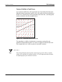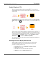
1
Introduction to CPS-3
Lecture Notes
GeoFrame 4
June 12, 2002
GF4_CPS3_17Jan02.pdf
www.geoquest.com
Copyright Notice
© 2002 Schlumberger. All rights reserved.
No part of this manual may be reproduced, stored in a retrieval system, or
translated in any form or by any means, electronic or mechanical, including
photocopying and recording, without the prior written permission of
GeoQuest, 5599 San Felipe, Suite 1700, Houston, TX 77056-2722.
Disclaimer
Use of this product is governed by the License Agreement. Schlumberger
makes no warranties, express, implied, or statutory, with respect to the product
described herein and disclaims without limitation any warranties of
merchantability or fitness for a particular purpose. Schlumberger reserves the
right to revise the information in this manual at any time without notice.
Trademark Information
GeoFrame™, CPS-3™ and certain other software applications mentioned in
this material are trademarks of Schlumberger.
All other products and product names are trademarks or registered trademarks
of their respective companies or organizations.
Schlumberger
Contents
Contents
••••••
Chapter 1
GullFaks Training Data - Inventory and Description
Naming Conventions . . . . . . . . . . . . . . . . . . . . . . . . . . . . 12
Volumetrics Notes . . . . . . . . . . . . . . . . . . . . . . . . . . . . . . 12
Data Inventory for GullFaks CPS-3 Training. . . . . . . . . . . . . 13
Location Data . . . . . . . . . . . . . . . . . . . . . . . . . . . . . . . . . . 13
Interpretation. . . . . . . . . . . . . . . . . . . . . . . . . . . . . . . . . . . 13
Interval Definitions . . . . . . . . . . . . . . . . . . . . . . . . . . . . . . 16
Properties . . . . . . . . . . . . . . . . . . . . . . . . . . . . . . . . . . . . . 16
Lease Information . . . . . . . . . . . . . . . . . . . . . . . . . . . . . . . 16
Project Coordinate System Information . . . . . . . . . . . . . . 17
Project Units . . . . . . . . . . . . . . . . . . . . . . . . . . . . . . . . . . . 17
Project Location . . . . . . . . . . . . . . . . . . . . . . . . . . . . . . . . 17
Selected Fault Patterns . . . . . . . . . . . . . . . . . . . . . . . . . . . 19
Reservoir Geometry . . . . . . . . . . . . . . . . . . . . . . . . . . . . . 20
Chapter 2
CPS-3 Menu Organization and Capabilities Overview
CPS-3 Main Module . . . . . . . . . . . . . . . . . . . . . . . . . . . . . . . . 22
Main Module Dialog Box . . . . . . . . . . . . . . . . . . . . . . . . . 22
X,Y Tracker Display. . . . . . . . . . . . . . . . . . . . . . . . . . . . . 24
Measuring Tool. . . . . . . . . . . . . . . . . . . . . . . . . . . . . . . . . 25
Main Module Status Window . . . . . . . . . . . . . . . . . . . . . . 26
UNIX Environment. . . . . . . . . . . . . . . . . . . . . . . . . . . . . . 28
CPS-3 Map Editor. . . . . . . . . . . . . . . . . . . . . . . . . . . . . . . 29
CPS-3 Model Editor . . . . . . . . . . . . . . . . . . . . . . . . . . . . . 30
CPS-3 Color Palette Editor . . . . . . . . . . . . . . . . . . . . . . . . 31
CPS-3 Control Point Data Editor . . . . . . . . . . . . . . . . . . . 32
CPS-3 Set-Subset Reorganizer . . . . . . . . . . . . . . . . . . . . . 33
CPS-3 Map Layer Manager . . . . . . . . . . . . . . . . . . . . . . . 36
Menu Navigation by Topic . . . . . . . . . . . . . . . . . . . . . . . . . . . 38
GeoFrame 4 Introduction to CPS-3
i
Schlumberger
Contents
Icon Definitions . . . . . . . . . . . . . . . . . . . . . . . . . . . . . . . . . . . 42
Chapter 3
Current Integration Status of CPS-3 in GeoFrame
CPS Local Data Store (dsl) and GeoFrame Storage . . . . . . . . 44
Controlling Where Sets are Stored or Retrieved. . . . . . . . 44
Accessing Data in GeoFrame and IESX - Data Links and Menus45
Binary Data Links for CPS-3 . . . . . . . . . . . . . . . . . . . . . . 45
How to access specific data types from CPS-3. . . . . . . . . 45
Geoshare Links for Cartography. . . . . . . . . . . . . . . . . . . . 46
Geographic Coordinate Systems. . . . . . . . . . . . . . . . . . . . . . . 47
Rules of the Road for Automatic Coordinate System
Conversion in CPS-3 Sets. . . . . . . . . . . . . . . . . . . . . . . . . 47
Enhancements in CPS-3 for GeoFrame 4.0 . . . . . . . . . . . . . . 49
Enhancements in CPS-3 for GF4.0. . . . . . . . . . . . . . . . . . 49
Examples of Macro Enhancements. . . . . . . . . . . . . . . . . . 51
Chapter 4
Enhancements in CPS-3 for GeoFrame 4.0
Enhancements in CPS-3 for GF4.0. . . . . . . . . . . . . . . . . . 56
Examples of Macro Enhancements. . . . . . . . . . . . . . . . . . 58
Chapter 5
Understanding CPS-3 Set Types in the CPS Partition
(DSL)
A Typical CPS partition in a GeoFrame Project. . . . . . . . 61
Session Sets (or Session Files) . . . . . . . . . . . . . . . . . . . . . 62
Data Sets (.dcps) . . . . . . . . . . . . . . . . . . . . . . . . . . . . . . . . 62
Fault Sets (.fcps) . . . . . . . . . . . . . . . . . . . . . . . . . . . . . . . . 64
Polygon Sets (.pcps) . . . . . . . . . . . . . . . . . . . . . . . . . . . . . 65
Surface Sets (.scps) . . . . . . . . . . . . . . . . . . . . . . . . . . . . . . 66
Map Sets (.mcps) . . . . . . . . . . . . . . . . . . . . . . . . . . . . . . . 67
Chapter 6
ii
Introduction to Display and Modeling Environments
Definition of Mapping Environment Components . . . . . . . . . 71
Display Environment . . . . . . . . . . . . . . . . . . . . . . . . . . . . 71
Modeling Environment . . . . . . . . . . . . . . . . . . . . . . . . . . . 72
The Relationship between CPS-3 Modeling Environments and
GeoFrame Binsets (Grid Libraries) . . . . . . . . . . . . . . . . . 72
More Notes on Binsets . . . . . . . . . . . . . . . . . . . . . . . . . . . 73
GeoFrame 4 Introduction to CPS-3
Schlumberger
Contents
Making Use of Environments . . . . . . . . . . . . . . . . . . . . . . 74
Multiple Environments . . . . . . . . . . . . . . . . . . . . . . . . . . . 76
Setting Up for Horizontal and Vertical Scaling and Limiting77
Storing and Retrieving Environment Definitions . . . . . . . 77
Rotated Grids . . . . . . . . . . . . . . . . . . . . . . . . . . . . . . . . . . 79
Association of Environments with Sets . . . . . . . . . . . . . . 79
iii
Chapter 7
Locating Seismic Interpretation Components for CPS-3
Mapping.
Gridding 3D interpretation . . . . . . . . . . . . . . . . . . . . . . . . 82
How do I distinguish an interpretation grid from other grids?82
Interpretation Models and CPS-3 . . . . . . . . . . . . . . . . . . . 83
Destinations of Interpretation Components When Imported into
CPS-3 . . . . . . . . . . . . . . . . . . . . . . . . . . . . . . . . . . . . . . . . 84
Chapter 8
Gridding Fundamentals
What is Gridding? . . . . . . . . . . . . . . . . . . . . . . . . . . . . . . . 86
Judging the Quality of the Model . . . . . . . . . . . . . . . . . . . 87
Gridding Algorithms. . . . . . . . . . . . . . . . . . . . . . . . . . . . . 87
How Do I Prepare for Gridding? . . . . . . . . . . . . . . . . . . . 88
How Do I Choose A Gridding Algorithm?. . . . . . . . . . . . 90
List of CPS-3 Gridding Algorithms . . . . . . . . . . . . . . . . . 91
How Do I Set Gridding Parameters? . . . . . . . . . . . . . . . . 93
Common Gridding Problems and Their Solutions . . . . . . 94
How Do Fault Traces Affect Gridding? . . . . . . . . . . . . . . 94
Gridding Decisions - 2D/3D Seismic Examples. . . . . . . . 96
Importance of Fault Zone Definition During Gridding . . 99
Techniques for Filling in Fault Zones. . . . . . . . . . . . . . . 100
Contour Visibility in Fault Zones . . . . . . . . . . . . . . . . . . 101
Chapter 9
Decisions for Gridding
Selecting the Grid Spacing . . . . . . . . . . . . . . . . . . . . . . . 104
Simple Guidelines for Choosing SNAP/CONVERGENT
parameters for Seismic data . . . . . . . . . . . . . . . . . . . . . . 112
Defining the Fault Zone in a Horizon - Yes or No . . . . . 113
When Are Fault Surfaces Needed? . . . . . . . . . . . . . . . . . 115
GeoFrame 4 Introduction to CPS-3
Schlumberger
Contents
iv
Chapter 10
Fault Surfaces
Creating Fault Surfaces. . . . . . . . . . . . . . . . . . . . . . . . . . 118
Predefined Techniques for Fault Surface Gridding . . . . 119
Chapter 11
Computing a Volumetric Envelope
RecommendedSequenceforComputinganIsochoreforVolumetrics
122
Location of the Zero Line in Isochores. . . . . . . . . . . . . . 123
Accounting for Non-vertical Fault Discontinuities in the
Volumetric Isochore . . . . . . . . . . . . . . . . . . . . . . . . . . . . 125
Example of Creating a Structural Envelope . . . . . . . . . . 126
Chapter 12
Applying Reservoir Properties to the Gross_Isochore for
Oil in Place
Origin of property data used by CPS-3. . . . . . . . . . . . . . 134
Quality and Characteristics of Property Grids . . . . . . . . 136
Continuing with the OIP Equation . . . . . . . . . . . . . . . . . 138
Computing Oil in Place with Volumetrics . . . . . . . . . . . 139
Chapter 13
Overview of Model Editor
Starting the Model Editor . . . . . . . . . . . . . . . . . . . . . . . . 142
Model Editor functions . . . . . . . . . . . . . . . . . . . . . . . . . . 144
Typical Editor session. . . . . . . . . . . . . . . . . . . . . . . . . . . 144
Tips Regarding Grid Editing. . . . . . . . . . . . . . . . . . . . . . 145
Overview of the CPS-3 Map Editor . . . . . . . . . . . . . . . . . . . 146
Starting the Map Editor. . . . . . . . . . . . . . . . . . . . . . . . . . 147
Pull-down menus . . . . . . . . . . . . . . . . . . . . . . . . . . . . . . 148
Chapter 14
Overview of the CPS-3 Map Editor
Starting the Map Editor. . . . . . . . . . . . . . . . . . . . . . . . . . 154
Pull-down menus . . . . . . . . . . . . . . . . . . . . . . . . . . . . . . 155
Chapter 15
Creating, Using and Editing Macros
Basic Macro Format . . . . . . . . . . . . . . . . . . . . . . . . . . . . 160
Creating Macros . . . . . . . . . . . . . . . . . . . . . . . . . . . . . . . 160
Running Macros . . . . . . . . . . . . . . . . . . . . . . . . . . . . . . . 161
Making a Macro Universally Useful. . . . . . . . . . . . . . . . 161
Current Constraints: Macro Execution and Environments166
GeoFrame 4 Introduction to CPS-3
Schlumberger
Contents
Compatibility: Running Pre-GF3.5 Macros . . . . . . . . . . 167
Managing Macros - Enhancements for GF4.0 . . . . . . . . 167
v
Chapter 16
Display/Graphic Operations and the Environment
Graphic Display in CPS . . . . . . . . . . . . . . . . . . . . . . . . . 170
Honoring the Active Display Environment . . . . . . . . . . 170
When Are Graphic Objects Clipped? . . . . . . . . . . . . . . . 171
Chapter 17
Technical Note - Formatting Data for the CPS-3 ASCII
Data Loader
General Requirements/Options. . . . . . . . . . . . . . . . . . . . 174
Defining Subsets During Loading . . . . . . . . . . . . . . . . . 174
Extended and Non-Extended Data Sets . . . . . . . . . . . . . 178
Examples of File Formats . . . . . . . . . . . . . . . . . . . . . . . . 179
Data Transformations . . . . . . . . . . . . . . . . . . . . . . . . . . . 183
Chapter 18
Technical Note - The Convergent Gridding Algorithm Explained
Iterative Procedure . . . . . . . . . . . . . . . . . . . . . . . . . . . . . 186
Blending Algorithm . . . . . . . . . . . . . . . . . . . . . . . . . . . . 187
Chapter 19
Glossary of Computer Mapping Terms for CPS-3
GeoFrame 4 Introduction to CPS-3
Contents
vi
Schlumberger
GeoFrame 4 Introduction to CPS-3
Contents
vii
Schlumberger
GeoFrame 4 Introduction to CPS-3
Contents
viii
Schlumberger
GeoFrame 4 Introduction to CPS-3
Contents
ix
Schlumberger
GeoFrame 4 Introduction to CPS-3
Contents
x
Schlumberger
GeoFrame 4 Introduction to CPS-3
••••••
LECTURE for Topic 2
GullFaks Training Data - Inventory and
Description
Overview
In this chapter, we’ll make an inventory of data in the GeoFrame GullFaks
project which is used by this class.
The GullFaks field is well-documented and information on this field is
available via the Schlumberger intranet.
This course uses only some of the data available in the project and includes
•
•
•
•
•
Well top locations, bottom locations, and well paths
Geologic markers
3D seismic interpretation, both horizons and fault segments
Fault boundaries
Layer-based net, gross, porosity and saturation averages
Other data used in the class includes
• 2D seismic line data from ASCII files
• Lease block polygon data from ASCII files
Velocity functions have been provided for the seismic cube, so that both
seismic and well data are available in time and depth. In this training course,
we will use depth data.
GeoFrame 4.0 Introduction to CPS-3
LECTURE for Topic 2 - 1
Schlumberger
GullFaks Training Data - Inventory and Description
Table 2.1- Seismic Horizon Data and Geological Marker Names
Geological
Marker in
GeoFrame
Seismic Horizon
in IESX
CPS
Horizon
Name
Fault Interpretation Density /
Poly Description
BUNNKRITT
BUNNKRITT
Bunnkritt
no
unfaulted/asap(1X1)
TARBERT
TARBERT
Tarbert
yes
sparse (20X20)
NESS
NESS
Ness
yes
dense/2d3d + asap (1.x1)
RANNOCH
RANNOCH
Rannoch
no
sparse (20x20)
DRAKE
DRAKE
Drake
no
dense (1x1)
Naming Conventions
Be aware that since projects can be shared by several persons in different
disciplines, different names for different versions of interpretation, names of
GeoFrame containers, marker names, and the like must be coordinated
among those working in the project.
Volumetrics Notes
In this class, we will compute volume between the Tarbert and the Ness
horizons. Because of large erosion zones in the Tarbert caused by the Bunkritt
unconformity, the top of the reservoir must be a merging of the Tarbert and the
unconformity.
Most of the data for this course will come from the GeoFrame data base.
There will be several methods for gaining access to it from CPS-3. In addition,
some of the data will come from outside of the project. Regardless of its
origin, the next section provides an inventory of the data sets which will be
used in CPS-3 for this course.
LECTURE for Topic 2 - 2
GeoFrame 4.0 Introduction to CPS-3
Schlumberger
GullFaks Training Data - Inventory and Description
Data Inventory for GullFaks CPS-3 Training
Location Data
2D Locations
•mm_2d_gullfaks_shtpt.dat (ASCII)
3D Locations
• mm_3d_85acip_survey
• mm_3d_g1_survey
• mm_3d_offset_survey
Well Top Locations
• mm_Well_Locations_wtloc
Well Bottom Locations
• mm_Well_Locations_wbloc
Well Paths
• mm_Boreholes_Depth_wpath
Interpretation
Horizons/Fault Polygon Sets (Time)
BUNKRITT
• BUNKRITT_time_intrp
TARBERT
• TARBERT_time_intrp
• TARBERT_time_intrp_fpolys
NESS
• NESS_time_intrp
• NESS_time_intrp_fpolys
RANNOCH
• RANNOCH_time_intrp
• RANNOCH_time_intrp_fpolys
GeoFrame 4.0 Introduction to CPS-3
LECTURE for Topic 2 - 3
GullFaks Training Data - Inventory and Description
Schlumberger
DRAKE
• DRAKE_time_intrp
• DRAKE_time_intrp_fpolys
Horizons/Fault Polygon Sets (Depth)
BUNKRITT
• mm_BUNNKRITT-1_BU-285_Depth_intrp
TARBERT
• mm_TARBERT_smooth_Depth_intrp
• mm_Tarbert
NESS
• mm_NESS_smooth_Depth_intrp
• mm_Ness
RANNOCH
• mm_RANNOCH_smooth_Depth_intrp
DRAKE
• mm_DRAKE_smooth_Depth_intrp
Fault Segments (Time)
• F2...etc...
• F2a
• F3
• F4
• F5
• F6
• F6a
• F7
• F7a
• F8
• F9
• F11
• F12
• F13
• F14
LECTURE for Topic 2 - 4
GeoFrame 4.0 Introduction to CPS-3
Schlumberger
GullFaks Training Data - Inventory and Description
•
•
•
•
•
•
•
•
F15
F15a
F16
F17
F18
F19
F20
F21
Fault Segments (Depth)
• mm_F2_Depth_fsegs
• mm_F2a_Depth_fsegs
• mm_F3_Depth_fsegs
• mm_F4_Depth_fsegs
• mm_F5_Depth_fsegs
• mm_F6_Depth_fsegs
• mm_F6a_Depth_fsegs
• mm_F7_Depth_fsegs
• mm_F7a_Depth_fsegs
• mm_F14_Depth_fsegs
• mm_F15_Depth_fsegs
• mm_F15a_Depth_fsegs
• mm_F16_Depth_fsegs
• mm_F17_Depth_fsegs
• mm_F18_Depth_fsegs
• mm_F20_Depth_fsegs
• mm_F21_Depth_fsegs
GeoFrame 4.0 Introduction to CPS-3
LECTURE for Topic 2 - 5
GullFaks Training Data - Inventory and Description
Schlumberger
Well Marker Sets (Depth)
• mm_BUNNKRITT_Depth_wmrkr
• mm_TARBERT_Depth_wmrkr
• mm_NESS_Depth_wmrkr
• mm_RANNOCH_Depth_wmrkr
• mm_DRAKE_Depth_wmrkr
Well Marker Sets (Time)
• BUNNKRITT_Time_wmrkr
• TARBERT_Time_wmrkr
• NESS_Time_wmrkr
• RANNOCH_Time_wmrkr
Interval Definitions
Zone Versions
• (none at present)
Zones
• (none at present)
Properties
Net-to-Gross Thickness (Data set)
• mm_TARBERT_NESS_net-gross
Net Pay Porosity (Data set)
• mm_TARBERT_NESS_Porosity
Net Pay Water Saturation (Data set)
• mm_TARBERT_NESS_WSat
Lease Information
Lease polygons
• mm_north_leases.ply (ascii)
• mm_North_Leases
LECTURE for Topic 2 - 6
GeoFrame 4.0 Introduction to CPS-3
Schlumberger
GullFaks Training Data - Inventory and Description
Project Coordinate System Information
Datum: European 1950, Norway and Finland
Ellipsoid: International 1924
Projection: UTM, Zone 31, CM = 3.0
Hemisphere: Northern
Project Units
Metric
Project Location
North Sea
Figure 2.1
GeoFrame 4.0 Introduction to CPS-3
GullFaks Fault Patterns and 3D survey
LECTURE for Topic 2 - 7
GullFaks Training Data - Inventory and Description
Schlumberger
Above, you can see fault patterns over the area as well as the limits of the 3D
survey in black. Two platforms are the source of many well trajectories
shown in red. The white dotted rectangle shows the approximate interpretation
coverage of the highest of the horizons - the Tarbert. Subsequently lower
horizons will cover more and more area towards the East. Well coverage for
the higher horizons such as the Tarbert are restricted to the lower SE quadrant
of the dotted rectangle
The interpretation for the upper unconformity (Bunnkritt) covers all of the 3D
rectangular area except for a small portion in the NW corner.
The figure below shows a smaller area which is focused on the extent of the
well paths. The Bunkritt interpretation is in white, and covers just about all the
3D survey. The Tarbert interpretation is shown in grey and covers only the
Western half. The Eastern platform has more and better distributed wells, but
does not overlap with the best seismic.
.
Figure 2.2
LECTURE for Topic 2 - 8
Well paths, Bunkritt interpretation, and Tarbert interpretation
GeoFrame 4.0 Introduction to CPS-3
Schlumberger
GullFaks Training Data - Inventory and Description
Selected Fault Patterns
For purposes of the CPS-3 training, we will use only the larger faults as shown
below.
GeoFrame 4.0 Introduction to CPS-3
LECTURE for Topic 2 - 9
GullFaks Training Data - Inventory and Description
Schlumberger
Reservoir Geometry
The area of the GullFaks field which we will be mapping consists of a series
of tilted fault blocks with the upper horizon of the group, the Tarbert,
containing erosion zones where no interpretation exists above the Bunnkritt
unconformity.
Bunkritt
Tarbert
Ness
Figure 2.3
LECTURE for Topic 2 - 10
Reservoir profile displaying the stratigraphic relationship of the
horizons
GeoFrame 4.0 Introduction to CPS-3
••••••
LECTURE for Topic 4
CPS-3 Menu Organization and
Capabilities Overview
Overview
This chapter will give you a brief overview of all functionality provided in
CPS-3, and how it is organized. An overview of the menu hierarchy of the
CPS-3 Main Module is also provided.
The full capability of CPS-3 is divided among the following independent
modules which are described in this chapter:
• Main Module - modeling and mapping tools
• Map Editor - simple graphic editing of Map sets
• Model Editor - comprehensive grid and data editing
• Color Palette Editor - customize/create palettes
In addition, the following data management tools are available from the Main
Module:
•
•
•
Control Point Editor - interactive spreadsheet editor for Data sets
Subset Reorganizer - a fault management tool
Map Layer Manager - a tool for reorganizing graphic layers of a map
In this chapter we also present a convenient “How To...” Matrix which crossreferences common mapping operations with the menu navigation instructions
for how to get there. This cross-reference is at the end of the chapter.
GeoFrame 4.0 Introduction to CPS-3
LECTURE for Topic 4 - 1
CPS-3 Menu Organization and Capabilities Overview
Schlumberger
CPS-3 Main Module
The Main Module is where most of the traditional modeling and mapping
tools are located, and where you will probably spend most of your time in
CPS-3. In the previous chapter, we learned how to invoke the Main Module
from either a stand-alone or a GeoFrame 3.0-or-later installation. In this
chapter, we will learn many things about the environment of the Main
Module - its conventions, resources, organization, and concepts.
Main Module Dialog Box
The figure on the opposite page displays the current Main Module graphic
dialog box. Note the following features emphasized in the figure.
• Pull-Down Menus:
All CPS-3 functionality can be accessed through these pull-down
cascading menus.
LECTURE for Topic 4 - 2
•
Icons:
For more convenient access to commonly used functions, these icons
can be a shortcut instead of traversing the menu tree.
•
Icon Descriptions:
As the cursor is moved over the icons, a description of each is
presented here.
•
Scroll Bars:
When zoomed in, use these slider bars for panning across the display.
•
Display Environment Box:
Every display environment you define in CPS-3 contains the definition
of an x, y, z box called the Volume of Interest (VOI). What is shown
here is simply the x, y portion of the box. The system attempts to
maximize the amount of canvas space allocated to your currently
active x, y box.
•
Canvas:
This is simply the total potential screen area (or paper plot area, when
plotting) where the x, y box can be located. The lower left corner of
the canvas represents the origin(0,0) for the internal graphic coordinate
system in inches or centimeters.
GeoFrame 4.0 Introduction to CPS-3
Schlumberger
CPS-3 Menu Organization and Capabilities Overview
Pull-Down Menus
Icons
Icon Descriptions
Figure 4.1
GeoFrame 4.0 Introduction to CPS-3
Scroll Bars
Display Environment Box
Canvas
CPS-3 Main Module
LECTURE for Topic 4 - 3
CPS-3 Menu Organization and Capabilities Overview
Schlumberger
X,Y Tracker Display
When moving the graphic cursor during zooming, the x,y location of the
cursor is echoed at the bottom of the Main Module dialog box as shown in
the following figure. The position is echoed in both engineering units and
plotter (viewport) units.
The x,y tracking also occurs during screen digitizing initiated from the
Digitize pull-down menu.
Figure 4.2
Main Module displaying x,y locations of graphic cursor
For convenience, the tracker may also be invoked at any time with the tracker
icon:
Figure 4.3
LECTURE for Topic 4 - 4
Display x and y position at cursor icon (aka Tracker icon)
GeoFrame 4.0 Introduction to CPS-3
Schlumberger
CPS-3 Menu Organization and Capabilities Overview
Measuring Tool
The measure distance icon in the following figure provides facilities for
measuring distances and angles on the graphic display.
Figure 4.4
Measure distance icon
Figure 4.5
Determining distance using the Measure distance icon
GeoFrame 4.0 Introduction to CPS-3
LECTURE for Topic 4 - 5
Schlumberger
CPS-3 Menu Organization and Capabilities Overview
Main Module Status Window
The figure on the next page provides an example of the Main Module status
window, on which the following components should be noted:
• Currently open Data set:
This table provides a list of the currently open sets by set type (Data,
Fault, Polygon, Surface, and Map). This particular example shows
one active Data set. Note that the table scrolls downward and has
room for up to seven active sets per type.
•
Currently open Surfaces:
In this example, there is one open Surface set.
•
Native Command Entry:
By clicking the cursor in this box, you can type native commands here,
as an alternative to menu or icon selection.
•
Online status report dialog:
This window displays a real-time status report of all operations you
perform during the CPS-3 session. This information is also written to a
file called
<username>.rep
where <username> is your login id. This file is overwritten each time
you start another CPS-3 session.
•
LECTURE for Topic 4 - 6
Swap Screens Icon:
The CPS-3 Status Information window can be instantly moved from
the current screen to the opposite screen by simply toggling the Swap
Screens icon in the upper right of the display.
GeoFrame 4.0 Introduction to CPS-3
Schlumberger
CPS-3 Menu Organization and Capabilities Overview
Currently open Data set
Native Command Entry
Figure 4.6
GeoFrame 4.0 Introduction to CPS-3
Currently open Surfaces
Swap
Screens
Icon
Online status report dialog
Main Module displaying CPS-3 Status Information window
LECTURE for Topic 4 - 7
CPS-3 Menu Organization and Capabilities Overview
Schlumberger
UNIX Environment
In the Main Module go to User > Show Environment to bring up the CPS-3
Environment window. This window can remain visible while you perform
other mapping operations. It’s purpose is to provide you with information
about where CPS-3 is installed, and where the configurable resource files are
located. It also serves to remind you of the path to your open project, so that
copying of configuration files into your project area from an xterm is
simplified.
Figure 4.7
LECTURE for Topic 4 - 8
CPS-3 Environment window
GeoFrame 4.0 Introduction to CPS-3
Schlumberger
CPS-3 Menu Organization and Capabilities Overview
CPS-3 Map Editor
The Map Editor in the following figure is a graphic editing tool used after
creating the Map Set in the CPS-3 Main Module. Users can edit attributes
such as colors and fonts. Overposting can be cleaned up interactively.
Symbols and text can be added. Composite maps can also be created in the
Map Editor.
Figure 4.8
GeoFrame 4.0 Introduction to CPS-3
CPS-3 Map Editor
LECTURE for Topic 4 - 9
CPS-3 Menu Organization and Capabilities Overview
Schlumberger
CPS-3 Model Editor
The Model Editor in the figure below is for editing surfaces, points, faults,
polygons, and features. Users can make changes to the model (surface) by
moving, deleting, or redrawing contours, modifying data (points), modifying
fault data, using polygons for constraints, adding feature data, or by modifying
the actual grid nodes.
After each edit, the model is regridded and saved upon completion of the
editing. The final model (grid) is then brought back into the CPS-3 Main
Module.
Figure 4.9
LECTURE for Topic 4 - 10
CPS-3 Model Editor
GeoFrame 4.0 Introduction to CPS-3
Schlumberger
CPS-3 Menu Organization and Capabilities Overview
CPS-3 Color Palette Editor
The Color Palette Editor in the following figure allows users to define their
own color palettes to use when drawing color shaded contour maps. Colors
can be associated with a specific z-value. Each individual color can be set, or
the system will interpolate between two colors set by the user. The color
palettes are then saved to a color palette name in the user’s project directory.
These palettes can be accessed in the Main Module when specifying
parameters for displaying color shaded contours.
Figure 4.10
GeoFrame 4.0 Introduction to CPS-3
CPS-3 Color Palette Editor
LECTURE for Topic 4 - 11
CPS-3 Menu Organization and Capabilities Overview
Schlumberger
CPS-3 Control Point Data Editor
In the CPS-3 Main Module, go to Utilities > Sets > Edit Data Set to access
the spreadsheet-formatted data editor which is shown below. This feature is
very useful for removing z-fields, changing subset names, and editing graphic
symbology such as symbol codes, or even well names in data sets.
The data set shown below is a well marker data set, which was loaded as an
Extended data set with three z-fields, a well name, and symbol code - all of
which are available for editing.
The Help text for this dialog is very useful.
Figure 4.11
LECTURE for Topic 4 - 12
Main Module displaying spreadsheet-formatted data editor
GeoFrame 4.0 Introduction to CPS-3
Schlumberger
CPS-3 Menu Organization and Capabilities Overview
CPS-3 Set-Subset Reorganizer
This utility performs data management functions among various CPS-3 set
types, reordering information from one domain into useful information in
another. For example, assume that you mapped three surfaces, each with two
major fault polygons having z-values attached. The three fault polygons
migrate in x and y as they move downdip in each of the horizons. If you now
wanted to create gridded surfaces for the two faults, it would be impossible
with the fault sets because the x,y,z points are organized by horizon
(Figure 4.12). What is needed is a resorting of these x,y,z points by fault,
rather than by horizon (Figure 4.13). Individual files in these figures are
indicated by separate fill patterns.
Figure 4.12
GeoFrame 4.0 Introduction to CPS-3
Sorted x, y, z points according to horizon
LECTURE for Topic 4 - 13
Schlumberger
CPS-3 Menu Organization and Capabilities Overview
Figure 4.13
Sorted x, y, z points according to fault
The Set/Subset Reorganizer will perform this reordering for you. As the
different shades of gray in the first diagram above indicate, x,y,z fault traces
are grouped in Fault sets, one per horizon. In the Set/Subset Reorganizer
dialog box, select the Fault sets for all horizons which contain valid x,y,z
points to use in the gridding of the fault surfaces. From each of those selected
fault sets, you can choose any or all of its subsets (individual fault traces for a
single fault) which you want to be included in the output data sets.
In this example, we have asked for the output to be written to a Data set as
shown below. There will be as many output Data sets as there are unique
subset names (fault names) in the selected Fault sets. Each of the output Data
sets can then be gridded to obtain a model of the fault surface.
The Help text for the Set/Select Reorganizer is very informative.
LECTURE for Topic 4 - 14
GeoFrame 4.0 Introduction to CPS-3
Schlumberger
CPS-3 Menu Organization and Capabilities Overview
Figure 4.14
GeoFrame 4.0 Introduction to CPS-3
Set/Subset Reorganizer
LECTURE for Topic 4 - 15
CPS-3 Menu Organization and Capabilities Overview
Schlumberger
CPS-3 Map Layer Manager
The Map Layer Manager (Figure 4.15) is an extremely useful tool for
reordering the subsets stored in a map set. It is often the case that color shaded
contours (Figure 4.16) obliterate other map elements simply because of the
order in which they were displayed on the screen. The Map Layer Manager
will allow you to reposition map layers (subsets) to optimize your graphic
output without having to regenerate the graphics on the screen.
Figure 4.15
LECTURE for Topic 4 - 16
Map Layer Manager
GeoFrame 4.0 Introduction to CPS-3
Schlumberger
CPS-3 Menu Organization and Capabilities Overview
In this example, the picture below and on your screen was generated with
separate graphic commands; then the Map Layer Manager (Figure 4.15) was
invoked with the Manipulate current map layers icon (Figure 4.17).
Figure 4.16
Example of colored contour map
Figure 4.17
Manipulate current map layers icon
Each layer on the screen is shown as a line in the dialog table.
To reorder the layers of an existing map, simply clear the screen, display the
map, then invoke the Map Layer Manager.
Layers can be temporarily turned on or off. Layers may also be deleted. As
with other CPS-3 dialogs, the Help text for this facility is very useful.
GeoFrame 4.0 Introduction to CPS-3
LECTURE for Topic 4 - 17
Schlumberger
CPS-3 Menu Organization and Capabilities Overview
Menu Navigation by Topic
GENERAL
Set expert level - UTIL/ SYSTEM/ SET-EXPERT-LEVEL
Set control switches - UTIL/ SYSTEM/ SET-TOGGLE-SWITCHES
Find out the path to the CPS dsl - USER/ SHOW-ENVIRONMENT
See statistics on a CPS-3 set - UTIL/ SETS/ VIEW-CONTENTS-...
Look at the CPS-3 on-line User’s Manual - TOOLS/ USER-MANUAL
DISPLAY
Create display environment • Sixth icon from top on left, then click CREATE on the Display row.
Display borders, labels, North arrow, titles, etc. - DISPLAY /BASEMAP
Display contours and color shaded maps - DISPLAY/ CONTOURS
Display cross-sections - DISPLAY/ 2D-XSECTION
Display color bar - DISPLAY/ COLOR-SHADING-PALETTE
Display ortho contours - DISPLAY/ CONTOUR/Orthocontours
Erase/delete/reorganize graphic layers - DISPLAY/ MAP-LAYERS
Save display as map set • Fifth icon from bottom on left
Zoom in- VIEW/ ZOOM-IN
Zoom out - VIEW/ ZOOM-OUT
Erase the screen • Big red X icon
Erase last graphic layer
• Blue back-arrow icon above big red X icon
Set graphic margins - DISPLAY/DISPLAY_FUNCTIONS/
SET_GENERAL_DISPLAY_PARAMETERS/
LECTURE for Topic 4 - 18
GeoFrame 4.0 Introduction to CPS-3
Schlumberger
CPS-3 Menu Organization and Capabilities Overview
GRIDDING/MODELING
Create a modeling environment • Sixth icon from top on left/ then click CREATE on the Modeling row
Create a grid from data - MODELING/ SINGLE-SURFACE
Use faults during gridding • MODELING/ SINGLE-SURFACE/ Make sure Fault is clicked on and
selected
Select the gridding algorithm • MODELING/ SINGLE-SURFACE/ Click on the Algorithm box
Conformal Gridding - MODELING/CONFORMAL_SURFACE
SINGLE GRID MODIFICATION
Refine a grid - OPERATIONS/ GRID/ REFINE
Smooth a grid - OPERATIONS/ GRID/ SMOOTH
Differentiate a grid - OPERATIONS/ GRID/ DIFFERENTIATE
Blank a grid - OPERATIONS/ GRID/ BLANK
Clip a grid -OPERATIONS/ GRID/ LOGICAL/ Use 1ST or 3rd Operation
Perform grid arithmetic - OPERATIONS/ GRID/ SINGLE-GRID
Tie a grid to data - OPERATIONS/GRID/TIE_GRID_TO_DATA
Chance a grid lattice - OPERATIONS/GRID/MODIFY_GRID_LATTICE
Extract a grid (Peek) - OPERATIONS/GRID/EXTRACT_GRID
Insert a grid (Poke) - OPERATIONS/GRID/INSERT_GRID
MULTIPLE GRID ARITHMETIC/LOGIC
Subtract two grids to create a thickness grid -
GeoFrame 4.0 Introduction to CPS-3
LECTURE for Topic 4 - 19
Schlumberger
CPS-3 Menu Organization and Capabilities Overview
•
OPERATIONS/ GRID/ MULTIPLE-GRIDS
Merge two grids -]
• OPERATIONS/ GRID/ Under MULTI-GRIDS, use Operations 1 - 4
MACROS
Run a macro - MACROS/ EXECUTE
Create a macro - MACROS/ CREATE
Edit a macro - Create a macro, then user the text editor of your choice
DIGITIZE
Digitize data, faults, polygons, text - DIGITIZE as needed
DATA POINT ARITHMETIC
Compute values from a grid at arbitrary (well) locations • OPERATIONS/ CONTROL POINTS/Interpolate from........,
Perform arithmetic on control point z-fields OPERATIONS/ C.P./CONTROL-POINT-MATH
SET MANAGEMENT/SET MANIPULATION
Rename a z-field - UTILITIES/ SYSTEM/ MANAGE Z-FIELD NAMES
Delete a set - UTILITIES/ SETS/ DELETE
Copy a set - UTILITIES/ SETS/ COPY
Rename a set - UTILITIES/ SETS/ RENAME
Unlock a set - UTILITIES/ SETS/ UNLOCK
Edit a data set - UTILITIES/ SETS/ EDIT DATA SET
View all subsets of a set UTILITIES/SETS/VIEW_CONTENTS_&_STATISTICS/ LIST_SUBSETS
LECTURE for Topic 4 - 20
GeoFrame 4.0 Introduction to CPS-3
Schlumberger
CPS-3 Menu Organization and Capabilities Overview
Print all values in a set UTILITIES/SETS/VIEW_CONTENTS_&_STATISTICS/ LIST_CONTENTS
OTHER CPS-3 APPLICATIONS
Run the Model Editor - TOOLS/MODEL-EDITOR
Run the Map Editor TOOLS/MAP-EDITOR
Run the Color Palette Editor TOOLS/ COLOR-PALETTE-EDITOR
Run SurfViz - TOOLS/ SURFVIZ
Run the GeoFrame Link - TOOLS/ GEOFRAME-LINK
Run the IESX/CPS Link - in Visualization Catalog under CPS-3
Run the Charisma/CPS Link - from Charisma menu
DATA IMPORT/EXPORT
Import/export ascii files - FILE/ IMPORT and EXPORT
GeoFrame 4.0 Introduction to CPS-3
LECTURE for Topic 4 - 21
Schlumberger
CPS-3 Menu Organization and Capabilities Overview
Icon Definitions
Stop current process
Zoom in
Reveal all graphics
Unzoom to last zoom
View set statistics
Subset utilities
List/Manage sets
Get x,y coordinates
DisplayEnv from Zoom
Measure distance/angle
Select/edit environment
Quick map
Set map scale
Undo last graphic display
Single surface gridding
2D Profiles
Erase the screen
Borehole intersections
Refresh display
Volumetrics
Basemap menu
Model editor
Contour
Color palette editor
Map layers
Customize icon bar
Save display as mapset
Record a macro
Stop recording macro
Execute a macro
Hide icons
GeoFrame Link
GF grid data manager
GF grid library data manager
Unlock a set
LECTURE for Topic 4 - 22
GeoFrame 4.0 Introduction to CPS-3
••••••
LECTURE A for Topic 5
Current Integration Status of CPS-3 in
GeoFrame
Overview
This chapter reviews the nature and extent of data integration for CPS-3
within the GeoFrame data base.
In GF4.0, CPS-3 still maintains its own local data store, that subdirectory
known as the CPS-3 DSL, where all CPS-3 binary sets are stored. However,
much of the data in GeoFrame is visible to CPS-3, either directly, or via the
GeoFrame data link, GFLink.
GeoFrame 4.0 Introduction to CPS-3
LECTURE A for Topic 5 - 1
Current Integration Status of CPS-3 in GeoFrame
Schlumberger
CPS Local Data Store (dsl) and GeoFrame Storage
Historically, CPS-3 has used an internal data management system called the
Storage Manager. This internal data store will eventually be replaced by the
GeoFrame Oracle data base, but in GeoFrame, the CPS-3 internal storage
facility is still in place. Even so, there are some CPS-3 sets which may, at the
user’s option, be stored in the GeoFrame data base at the time of their
creation. In particular,
• Data sets may be stored in GeoFrame as scatter sets, however, subset
organization is lost.
• Fault sets may be stored in GeoFrame with subset (fault name)
organization maintained.
•
Surfaces sets may be stored in GeoFrame with the fault set
association maintained.
Controlling Where Sets are Stored or Retrieved
•
During Set Creation:
At the time any CPS-3 set is created, the menus give you the choice of
storing the data in either the CPS local data store or in GeoFrame.
•
During Set Selection:
At the time any existing CPS-3 set is being selected, the menus show
you the current storage location of all available sets (CPS local data
store or GeoFrame), and allow you to select from either location.
GeoFrame data items are synonymous with CPS-3 sets, but data items stored
in GeoFrame must now also be identified with the following attributes:
• Container name
• Container type
• Property code
• Unit of measurement
LECTURE A for Topic 5 - 2
GeoFrame 4.0 Introduction to CPS-3
Schlumberger
Current Integration Status of CPS-3 in GeoFrame
Accessing Data in GeoFrame and IESX - Data Links and
Menus
Binary Data Links for CPS-3
The previous IESX and CHARISMA Links for Seismic Locations and
Interpretation are no longer necessary for CPS-3, since seismic data,
navigation data, and interpretation are now stored directly in the GeoFrame
data base and can be accessed by CPS-3 in other ways. The GeoFrame Link
(GFLink), on the other hand, is still required, and has been expanded and
improved for GF4.0.
How to access specific data types from CPS-3
Here is a brief summary of how selected data classes are accessed from CPS-3
in GF4.0:
2D survey location data are now accessed via the GFLink and can be posted
with the existing Extended data seismic line posting feature.
3D survey location data is accessed and displayed via the Display menu. A
new 3D seismic line posting feature is available.
Horizon interpretation is now seen from the CPS-3 file selection dialogs as
grids in GeoFrame. Use the “Source” set attribute to distinguish actual
interpretation grids from derivative grids. Note that in Modeling Office,
Horizon Modeling has been modified to accept GeoFrame grids directly as
input. In the CPS-3 Main Module, however, GeoFrame interpretation grids
must be Copied to Data sets before using them in Single Surface Gridding.
Fault Segment Interpretation is accessed as Fault Cut Sets from GFLink.
Fault Boundary Interpretation is seen in the CPS-3 file selection dialogs as
fault boundary sets in GeoFrame, just as before.
Fault Contact Interpretation is seen in the CPS-3 file selection dialogs as
scatter Data sets in GeoFrame.
IESX Cartography, which will not reside in GeoFrame, will be brought into
CPS-3 with a new Culture Loader which will be invoked from the CPS-3
menus and from the Visualization catalog in place of the old IESX Link.This
facility will not be released in 4.0, but in one of the later versions such as 4.01.
Well location data, such as top location, bottom hole locations, and borehole
trajectories are accessed from the GFLink, just as before.
GeoFrame 4.0 Introduction to CPS-3
LECTURE A for Topic 5 - 3
Current Integration Status of CPS-3 in GeoFrame
Schlumberger
Well markers for specific Horizons are accessed from the GFLink, just as
before.
Property summations for specific Zones are accessed from the GFLink, just
as before.
Tip Loops created by Framework 3D are stored in GeoFrame, but are visible
from CPS-3 as Polygons.
All other GeoFrame surfaces, scatter sets, and fault boundaries can be seen
directly in the CPS-3 file selection dialogs, and, if necessary, can be COPYed
to the CPS-3 dsl, just as before.
Geoshare Links for Cartography
Although a CPS-3 Geoshare sender and receiver have been more or less
unavailable in GF3.5 through GF3.8, a facility exists in GF3.8 to import.rp66
and .gf66 files which have been created by Finder, and contain cartographic
information. Use the File > Import > Geoshare Culture menu path to this
facility.
The new menu item File/Import_IESX_Cartography is now available and
supersedes the previous IESX Link.
LECTURE A for Topic 5 - 4
GeoFrame 4.0 Introduction to CPS-3
Schlumberger
Current Integration Status of CPS-3 in GeoFrame
Geographic Coordinate Systems
Although the decision to store or not store data in GeoFrame is optional, the
use of geographic coordinate systems is not. Every set created in CPS-3
must be associated with a coordinate system which has been defined in
GeoFrame.
Sets are associated with a geographic coordinate system, or with the default
coordinate system at the time of their naming and creation.
If two sets are associated with different coordinate systems, CPS-3 will
automatically perform the numerical conversions required during operations
which use both sets. Specific rules for these conversions are covered in a later
chapter.
••••••
Tip:
You may load data having any range of cartesian X,Y values into any
GeoFrame project. As long as you reference the same GeoFrame coordinate
system definition where necessary, the system will not attempt any kind of
conversion. It will simply accept the data as it is.
Rules of the Road for Automatic Coordinate System
Conversion in CPS-3 Sets
Every set in CPS-3 is now associated with a particular coordinate system by
virtue of its assigned Display or Modeling environment under which it is
created. Here are the basic rules governing how coordinate systems are
initiated or modified under certain common conditions.
••••••
Best Practice: Unless your project requires something different, the recommendation is to use
one coordinate system for all sets in your project.
Note that only coordinate systems (which includes rotation) are
automatically converted in CPS-3. There are no ad hoc facilities for
conversion of either units (feet, meters,...), or domain (time, depth,...).
GeoFrame 4.0 Introduction to CPS-3
LECTURE A for Topic 5 - 5
Current Integration Status of CPS-3 in GeoFrame
LECTURE A for Topic 5 - 6
Schlumberger
•
Surfaces:
In practice, surfaces cannot be transformed from one coordinate
system to another. However, graphic manifestations of a surface, such
as contours or postings of nodes, can be transformed.
•
Reading ASCII data in geographic coordinates:
Data with geographic coordinates (degrees, minutes, seconds, or
decimal degrees) will be transformed using the currently active
Display environment.
•
Reading ASCII data in x, y coordinates:
In this instance, no conversion takes place. The data being loaded takes
on the stamp of the active Display environment.
•
Surface Arithmetic and Surface Operations:
The environments of all surfaces in the operation must match the
current Modeling environment.
•
Gridding:
During gridding, control points and fault traces are transformed to
match the coordinate system of the active Modeling environment.
•
Graphic Display:
Any set displayed will be transformed to match the coordinate system
of the currently active Display environment.
•
Data Links such as GFLink:
Any data moved into CPS-3 via these data links will be automatically
transformed to match the coordinate system of the currently active
Display environment. Note that units and domain of the output set is
established by the GeoFrame Display Units, not the currently active
CPS-3 Display environment.
GeoFrame 4.0 Introduction to CPS-3
Schlumberger
Current Integration Status of CPS-3 in GeoFrame
Enhancements in CPS-3 for GeoFrame 4.0
In this technical note, we’ll outline the enhancements added to CPS-3 in
GeoFrame 4.0.
Enhancements in CPS-3 for GF4.0
1
2
3
Framework 3D Integrated into Modeling Office (MO)
•
provides FW3D and P3D on same canvas
•
reverse thrust fault capability added to Framework 3D
•
ITC selection added to Model Editor for communication with Modeling
Office
New CPS-3 Menus for Viewing FW3D output
•
Display Framework contours including reverse fault contouring
•
Display Framework Cross-sections
•
Display Framework Allen diagrams
Model Editor enhanced with ITC for communication with MO
•
4
5
surface changes in Modeling Office are seen in the Model Editor session
New modeling feature in Single Surface gridding allows conformal
modeling
•
uses upper and lower reference surfaces
•
uses same algorithm as Horizon Modeling, but without fault framework
New surface operation allows “updating” of a grid with a new data
set
•
gives user ability to establish radius of influence for the data set
6
New versions of MSEDIT, MSPEEK, and MSPOKE are available and
support rotated grids
7
Grid operations with automatic lattice matching to current
modeling environment
8
New icon added to create display environment from current zoom
window (GF3.8.1)
9
Macro facilities enhanced
GeoFrame 4.0 Introduction to CPS-3
LECTURE A for Topic 5 - 7
Schlumberger
Current Integration Status of CPS-3 in GeoFrame
•
can now spawn a system task from a macro and wait (GF3.8)
•
can now spawn a background task (GF3.8)
•
access to macros from three categories - system, project, user
•
can add descriptions to macros which are visible during macro selection
•
define and assign macro categories which are displayed during selection
•
new “Yes/No” prompt type
•
new prompt facility - select from list of options
•
prompt titles and prompt strings can now be variables
•
can load extended data with existing format
•
can define set attributes
10 Faster color-shading algorithm
11 New, faster contouring algorithm
12 Vector display function enhanced to accommodate rotated grids
13 Ability to delete rows in Data Editor
14 Polygon fill limit increased to 5000 vertices
15 Controls for posting fault names and z-values has been enhanced
16 Added creation/modification time and date as new set attributes
17 Added capability to select which attributes to display in the set
selector dialog
18 Added set utility (copy, delete...) icons to List/Manage Sets dialog
19 “Expert Level” removed
20 Ability to customize the Display menu
21 GFLINK now has better borehole selection tools
22 GFLINK can now access fault cuts.
23 Specify line echo color in Digitizing dialog.
24 3D Seismic Survey Display
LECTURE A for Topic 5 - 8
GeoFrame 4.0 Introduction to CPS-3
Schlumberger
Current Integration Status of CPS-3 in GeoFrame
Examples of Macro Enhancements
The following macro excerpt shows how you can now use a variable string for the
dialog title and the prompting text. It also shows a simple Unix command can be
spawned.
Spawning detached tasks can also be done with the spawn command if you use the
ampersand at the end.
The next example shows how to establish the set attributes for new sets.
GeoFrame 4.0 Introduction to CPS-3
LECTURE A for Topic 5 - 9
Current Integration Status of CPS-3 in GeoFrame
Schlumberger
The example menu below shows that you may have three basic sources for
collections of macros a system-wide collection, a project-related collection, and
any number of “user” collections which can be identified simply by a path name.
In this menu, the project-based collection of macros has been selected and its
macros listed. One of them has been highlighted which causes its internal
description lines to be displayed.
The next figure shown an example of a “macro_index.txt” file, whose purpose is to
subdivide a collection of macros into categories. In this example, each category is
defined with a “CATEGORY:” keyword followed by the user-supplied category
name. Following this, all macros belonging to that category are listed. The macros
and the “macro_index.txt” file must be in the same directory.
LECTURE A for Topic 5 - 10
GeoFrame 4.0 Introduction to CPS-3
Schlumberger
Current Integration Status of CPS-3 in GeoFrame
In this example, the System macro group has been chosen, and the names of all
macros in the “Display” category have been displayed for selection.
GeoFrame 4.0 Introduction to CPS-3
LECTURE A for Topic 5 - 11
Current Integration Status of CPS-3 in GeoFrame
LECTURE A for Topic 5 - 12
Schlumberger
GeoFrame 4.0 Introduction to CPS-3
••••••
LECTURE B for Topic 5
Enhancements in CPS-3 for GeoFrame
4.0
Overview
In this technical note, we’ll outline the enhancements added to CPS-3 in
GeoFrame 4.0.
GeoFrame 4.0 Introduction to CPS-3
LECTURE B for Topic 5 - 1
Schlumberger
Enhancements in CPS-3 for GeoFrame 4.0
Enhancements in CPS-3 for GF4.0
1
2
3
Framework 3D Integrated into Modeling Office (MO)
•
provides FW3D and P3D on same canvas
•
reverse thrust fault capability added to Framework 3D
•
ITC selection added to Model Editor for communication with Modeling
Office
New CPS-3 Menus for Viewing FW3D output
•
Display Framework contours including reverse fault contouring
•
Display Framework Cross-sections
•
Display Framework Allen diagrams
Model Editor enhanced with ITC for communication with MO
•
4
5
surface changes in Modeling Office are seen in the Model Editor session
New modeling feature in Single Surface gridding allows conformal
modeling
•
uses upper and lower reference surfaces
•
uses same algorithm as Horizon Modeling, but without fault framework
New surface operation allows “updating” of a grid with a new data
set
•
gives user ability to establish radius of influence for the data set
6
New versions of MSEDIT, MSPEEK, and MSPOKE are available and
support rotated grids
7
Grid operations with automatic lattice matching to current
modeling environment
8
New icon added to create display environment from current zoom
window (GF3.8.1)
9
Macro facilities enhanced
LECTURE B for Topic 5 - 2
•
can now spawn a system task from a macro and wait (GF3.8)
•
can now spawn a background task (GF3.8)
GeoFrame 4.0 Introduction to CPS-3
Schlumberger
Enhancements in CPS-3 for GeoFrame 4.0
•
access to macros from three categories - system, project, user
•
can add descriptions to macros which are visible during macro selection
•
define and assign macro categories which are displayed during selection
•
new “Yes/No” prompt type
•
new prompt facility - select from list of options
•
prompt titles and prompt strings can now be variables
•
can load extended data with existing format
•
can define set attributes
10 Faster color-shading algorithm
11 New, faster contouring algorithm
12 Vector display function enhanced to accommodate rotated grids
13 Ability to delete rows in Data Editor
14 Polygon fill limit increased to 5000 vertices
15 Controls for posting fault names and z-values has been enhanced
16 Added creation/modification time and date as new set attributes
17 Added capability to select which attributes to display in the set
selector dialog
18 Added set utility (copy, delete...) icons to List/Manage Sets dialog
19 “Expert Level” removed
20 Ability to customize the Display menu
21 GFLINK now has better borehole selection tools
22 GFLINK can now access fault cuts.
23 Specify line echo color in Digitizing dialog.
GeoFrame 4.0 Introduction to CPS-3
LECTURE B for Topic 5 - 3
Enhancements in CPS-3 for GeoFrame 4.0
Schlumberger
Examples of Macro Enhancements
The following macro excerpt shows how you can now use a variable string for the
dialog title and the prompting text. It also shows a simple Unix command can be
spawned.
Spawning detached tasks can also be done with the spawn command if you use the
ampersand at the end.
The next example shows how to establish the set attributes for new sets.
LECTURE B for Topic 5 - 4
GeoFrame 4.0 Introduction to CPS-3
Schlumberger
Enhancements in CPS-3 for GeoFrame 4.0
The example menu below shows that you may have three basic sources for
collections of macros a system-wide collection, a project-related collection, and
any number of “user” collections which can be identified simply by a path name.
In this menu, the project-based collection of macros has been selected and its
macros listed. One of them has been highlighted which causes its internal
description lines to be displayed.
The next figure shown an example of a “macro_index.txt” file, whose purpose is to
subdivide a collection of macros into categories. In this example, each category is
defined with a “CATEGORY:” keyword followed by the user-supplied category
name. Following this, all macros belonging to that category are listed. The macros
and the “macro_index.txt” file must be in the same directory.
GeoFrame 4.0 Introduction to CPS-3
LECTURE B for Topic 5 - 5
Enhancements in CPS-3 for GeoFrame 4.0
Schlumberger
In this example, the System macro group has been chosen, and the names of all
macros in the “Display” category have been displayed for selection.
LECTURE B for Topic 5 - 6
GeoFrame 4.0 Introduction to CPS-3
••••••
LECTURE for Topic 6
Understanding CPS-3 Set Types in the
CPS Partition (DSL)
Overview
In this lesson, we will describe the way in which CPS-3 sets are organized
within its local data store. This local data store is maintained by the CPS-3
Project Manager independently of the GeoFrame data base. Please refer to a
previous lesson which discusses the integration status between CPS-3 and
GeoFrame.
A Typical CPS partition in a GeoFrame Project
The CPS partition is simply a pointer to a disk directory, for example:
/home/disk1/user1/projects/CLOUDSPIN/CPS
The first part of the path /home/disk1/user1/projects is determined by
the owner of the project CLOUDSPIN.
The remainder of the path /CLOUDSPIN/CPS is determined by
GeoFrame.
In this example, the full path shown above defines the location of the CPS
local data store, or partition, within the GeoFrame project Cloudspin. In this
directory, you will find everything which is managed by the CPS Project
Manager.
As mentioned in the previous lesson about GeoFrame integration, it is
possible in this release to optionally store some CPS-3 sets in the GeoFrame
data base, which is separate from this partition.
GeoFrame 4.0 Introduction to CPS-3
LECTURE for Topic 6 - 1
Schlumberger
Understanding CPS-3 Set Types in the CPS Partition (DSL)
Ultimately, the data to which you have access in CPS-3 will be stored in one
or more of the file types outlined below. These files will reside in your CPS
dsl. Note that each is distinguished by its UNIX file extension which is not
seen in the CPS-3 menus or dialogs.
• .1cps files - session files; files containing parameter values
• .dcps files - data files; x,y,z files
• .fcps files - fault trace files; x,y files; optionally, x,y,z files
• .pcps files - polygon files; x,y only
• .scps files - surface (grid) files; z only; x,y is inferred
• .mcps files - map files; picture files
• .tcps files - table files such as created by Framework3D
Data, Fault, and Surface sets may optionally be stored in either the local
project files, as shown above, or in the GeoFrame Oracle data base, or both.
Each CPS-3 set can consist of one or more named subsets.
Session Sets (or Session Files)
Usually, there is only one session set in your dsl location. It has the name
<your login id>.1cps and contains the most recent values for all parameters
you set during your CPS-3 session. This includes definitions of your modeling
and mapping environments. You will also see session files created for batch
processes you initiate from CPS-3. Each will have a unique file name.
Data Sets (.dcps)
Description
Data sets contain information which is to be gridded or displayed, such as data
points. Examples are well markers, seismic interpretation, and scatter data.
Data Types
CPS-3 uses a data set’s Data Type to compute defaults for some of the
modeling and display parameters. Most of the Data Types indicate a type of
spatial distribution pattern which can be exploited by certain algorithms. Data
types are shown in the following lists:
LECTURE for Topic 6 - 2
GeoFrame 4.0 Introduction to CPS-3
Schlumberger
Understanding CPS-3 Set Types in the CPS Partition (DSL)
Data Types Having Z-values
• Scattered points
• Contours
• 2D Interpretation
• 3D Interpretation
• Fault Segments/Cuts
• Fault Contacts
• Pseudo Grid
• Feature Lines
• Borehold Trajectories
• Well Markers
Data Types Without Z-values
• 2D Lines (locations)
• 3D Lines (locations
• Well Surface Locations
• Well Bottom Hole Locations
Data Content - Z Fields
Each data point loaded into CPS-3 must have at least an X and Y coordinate,
but may also have up to 50 z-fields. These z-fields are numeric, and can
represent any variable which is spatially distributed. A vertical well, for
example, might have one z-field value for each horizon it passes through
(markers), or a single well point may have one horizon depth value, and an
associated thickness to the next layer. Z-fields may also contain dip and strike
information for the horizon being mapped. There are no predefined
combinations of z-fields which are required for CPS-3. Each z-field can
represent anything you like. The most common data files loaded by CPS-3 are
data files containing x,y, and a z-value representing time or depth.
As you will see when loading data for the course, there are two attributes
associated with each z-field:
• Z Field Name (z1, z2, top, bottom,...
• Z Field Type (depth, elevation, isochore,...
GeoFrame 4.0 Introduction to CPS-3
LECTURE for Topic 6 - 3
Understanding CPS-3 Set Types in the CPS Partition (DSL)
Schlumberger
Data Content - Text Fields
Some data files contain textual information for each point which is to be
posted on the map; for example, well name or operator name. There are two
methods for storing Data sets in CPS-3 - Extended Data, and non-extended
Data.
Non-Extended Data
A data point in stored in this form may have up to 50 numeric z-fields, but no
text fields. The only text allowed with this form of storage is a subset name.
For well data, this can represent the well name if you select the x,y,z + Name
Field option for loading. Use this type of Data for simple x,y,z points to be
gridded when no special display capabilities are required.
Extended Data
This type of data allows all of the above, but also allows the storage and
posting of up to 10 text fields, as well as the storage and utilization of graphic
symbology attributes. Symbology attributes, such as symbol type, size, and
color, can be associated with each data point. At present, Extended Data
cannot be exported from CPS-3, nor can Extended Data be loaded by the use
of macros.
Subsets
Data sets can be organized into subsets which makes certain processing easier.
For example, line-oriented data (2D seismic, digitized contours) should be
identified as such during ASCII loading so that each line becomes an
identifiable subset in CPS-3. Several formats suitable for controlling
line-oriented data will be illustrated below in the examples.
Fault Sets (.fcps)
Description
Fault sets in CPS-3 store those polylines which are commonly referred to as
fault traces, or in GeoFrame terminology, fault boundaries. To the CPS-3
procedures, it does not matter how these polylines are geometrically defined.
For example, a non-vertical fault pattern associated with a particular horizon
can consist of two separate lines - an upthrown line and a downthrown line, or
it may consist of a single closed polygon.
LECTURE for Topic 6 - 4
GeoFrame 4.0 Introduction to CPS-3
Schlumberger
Understanding CPS-3 Set Types in the CPS Partition (DSL)
Types of Faults
Faults can be categorized by the user in CPS-3 as either vertical or
non-vertical at the time the faults are loaded. In other cases, some CPS-3
operations in Framework3D automatically classify faults which they have
created as being fault traces, fault centerlines, or fault polygons.
Fault Attributes
Each fault trace must have an x,y coordinate, but other information is optional.
For example, if z-values are available on the trace, then these values should be
loaded along with the x,y values to help in the gridding of the associated
horizon. Vertical and horizontal separation, as well as dip values are also
valid numeric fields which can optionally be loaded with fault traces.
Associations
Fault traces used as input to a gridding operation are automatically associated
with the surface which is created. That is, the name of the fault set is stored in
the parameter block of the surface set. This means that when contouring, you
don’t have to remember which fault set to use for each surface.
Subsets
In a fault set for one horizon in CPS-3, there is typically one fault trace
pattern for each named fault in the reservoir. The pattern for each named fault
is stored as a separate subset in the fault set. Several loading formats will be
shown in the examples to ensure that individual lines are identifiable in
CPS-3.
Polygon Sets (.pcps)
Description
There are two main purposes for polygon sets - the first is to define some
cartographic basemapping feature, such as a shoreline which is to be posted
on a basemap. Note that unclosed polylines are also valid to store in a polygon
set. The other use of polygon sets is to define some region in the modeling
area within which operations are to be performed or excluded from being
performed, for example, grid blanking or volumetrics calculation.
Types
Polygon sets can be typed as either open (polylines) or closed (polygons).
GeoFrame 4.0 Introduction to CPS-3
LECTURE for Topic 6 - 5
Understanding CPS-3 Set Types in the CPS Partition (DSL)
Schlumberger
Subsets
A polygon set can consist of multiple polygons, or polylines, each of which is
a separate subset.
Surface Sets (.scps)
Description
Surface sets hold the grids in CPS-3. Only the z-value at each grid node is
stored. Parameters stored with the surface, such as the lower left corner of the
grid, and the grid spacing in x and y, are used by the system to compute the
x,y coordinates of each node location when needed.
Classification
Surfaces can be classified as one of the following:
• horizon surface
• fault surface
• truncated (blanked)
• truncated (filled)
These classifications are generated automatically by the software, in
particular, the Framework3D operations.
Associations
As mentioned under Fault Sets, the input fault trace set is associated with the
output surface in a gridding operation. In addition, there are spreadsheet-like
operations in CPS-3, particularly in Framework3D, where groups of surfaces
are defined. These groups of surfaces become associated during the creation of
a Table set (a .tcps file in the project directory). For example, a fault
framework Table set is created as the user loads surfaces in to the framework.
If a surface in a table happens to be deleted, the system will recognize its
absence the next time the table set is invoked.
LECTURE for Topic 6 - 6
GeoFrame 4.0 Introduction to CPS-3
Schlumberger
Understanding CPS-3 Set Types in the CPS Partition (DSL)
Map Sets (.mcps)
Description
Essentially, a Map set is a picture file. The picture on the screen can be saved
to a Map set at any time in CPS-3. Although it is possible, Map sets are not
usually loaded into CPS-3 from ASCII source files.
Subsets/Map Layers
All graphic components created by a single graphic operation are grouped as a
separate subset in the saved map set. These separate graphic layers can be
deleted, moved, or even hidden temporarily in CPS-3 with the Map Layer
Manager.
In the map set shown below, there are seven subsets, each of which is created
by a separate display operation.
• Border
• Border Labels
• Scale Bar
• Contours
• Wells
• Seismic Lines
• Fault Traces
GeoFrame 4.0 Introduction to CPS-3
LECTURE for Topic 6 - 7
Schlumberger
Understanding CPS-3 Set Types in the CPS Partition (DSL)
Figure 6.1
LECTURE for Topic 6 - 8
Example of a map set displaying seven subsets
GeoFrame 4.0 Introduction to CPS-3
••••••
LECTURE for Topic 9
Introduction to Display and Modeling
Environments
Overview
Here, we will discuss the concept of mapping environments and their
attributes. We will show the difference in environment attributes required to
perform display functions, versus the attribute requirements to perform
modeling operations. We will discuss the reason for having multiple
environments, and, in a later chapter, we will have exercises to create
environments, store them, and edit them.
Just to get started, we will make the following simple, but true, statement:
“Before you can display anything, like the map below, you have to define a
display environment. Before you can create a grid, you have to define a
modeling environment”.
GeoFrame 4.0 Introduction to CPS-3
LECTURE for Topic 9 - 1
Introduction to Display and Modeling Environments
Schlumberger
Granted, a default mapping and modeling environment is provided as
environment #1, however, it may not cover the exact area nor grid lattice that
you really want.
The material in this section is designed to provide formal definitions of
environments, their attributes, overall purpose, and management in a fairly
concise lecture format. You will learn most about environments by working
with your data. However, it is anticipated that you may refer to this section
frequently until you have gained a full understanding of the use of
environments.
LECTURE for Topic 9 - 2
GeoFrame 4.0 Introduction to CPS-3
Schlumberger
Introduction to Display and Modeling Environments
Definition of Mapping Environment Components
An Environment is a named collection of information associated with the
creation of maps or surface models in a CPS-3 project.
Attributes which are associated with environments are:
• Name and optional Description
• Usage Classification
— Both Modeling and Display, or
— Display only
• Volume of Interest - minimum and maximum values for x, y, and z,
defining the mapping area and its vertical extents.
• Geographic Coordinate System specification
— Geodetic datum (ellipsoid plus shifts)
— Map projection: transformation method and associated parameters
— Rotation: origin and angle
• Definition of horizontal and vertical units
• Definition of horizontal and vertical scale factors
• Definition of vertical property code
Attributes which are associated with Modeling operations are:
• Definition of a grid geometry
— name, description, units
— lattice origin, offset
— lattice spacing
— rotation angle
Display Environment
A Display environment is used only for display purposes. It does not contain
the definition of a grid geometry. Data displayed through the currently active
Display environment will undergo the following procedures:
• transformed to the active Geographic Coordinate System
• scaled to the active scale
• converted to the active horizontal units
• clipped in x and y by the active Volume of Interest
GeoFrame 4.0 Introduction to CPS-3
LECTURE for Topic 9 - 3
Introduction to Display and Modeling Environments
Schlumberger
Modeling Environment
A Modeling environment is used to create a grid or perform other modeling
operations. Think of a modeling environment as simply a display environment
to which a grid geometry has also been added. An environment which does
not contain a binset definition cannot be used for modeling, only display.
Grids created in modeling operations will assume the grid origin and spacing
of that defined in the currently active Modeling environment.
The Relationship between CPS-3 Modeling Environments
and GeoFrame Binsets (Grid Libraries)
The new concept of CPS-3 mapping environments is tied to the GeoFrame
data base, at least in terms of binsets or grid libraries. Every Modeling
environment in CPS-3 must point to a specific binset in GeoFrame. Display
environments, as you will discover, do not require grid lattice definitions.
Just as all sets must be associated with a particular coordinate system in
GeoFrame, the grid spacing in all CPS-3 surfaces must now be defined in
terms of a specified Grid library (binset). All binsets are stored in
GeoFrame. A binset is a formal definition of a grid lattice and has several
attributes, including x-spacing, y-spacing, rotation, x-offset, and y-offset, but
not all of the parameters are associated with a CPS-3 Modeling environment.
At present, however, all we need to know is that we must either define a new
binset (the most common option), or select one from an existing list, in order
to specify x and y spacings for surfaces.
Later in this course, exercises will be provided to demonstrate the mechanics
of how data can be stored in either CPS-3 or GeoFrame. Also, we will
demonstrate how to create, delete, and edit mapping environments.
LECTURE for Topic 9 - 4
GeoFrame 4.0 Introduction to CPS-3
Schlumberger
Introduction to Display and Modeling Environments
More Notes on Binsets
1. Binsets existed in GeoFrame before CPS-3 began offering Display
and Modeling environments. All three concepts are similar, in that
they define a collection of mapping parameters which control
high-level display operations and/or the granularity of a geological
model. The related concept of Grid Library, which is effectively
synonymous with binset in GeoFrame, was invented years ago to
guarantee that grids from different applications would overlay. Nodes
from all grids created under the same grid library would, by definition,
overlay.
2. Once a binset has been created, it cannot be modified through the
CPS-3 menus. Even if you could, you would NOT want to do this
because, in a sense, binsets are shared by all users in the GeoFrame
project, and modification would cause problems for all child-objects.
3. Be careful if you delete binsets because every surface you delete,
which was created with the binset to be deleted, will become unusable
in GeoFrame. Use the following procedure to find out which
GeoFrame surfaces were created with a particular binset:
Procedure: Determining a Particular Binset
1. From the GeoFrame Data Manager, go to Grid Libraries. (This opens the
Project Grid Library Data Manager.)
2. Highlight the desired binset and click the Get information... icon. (You will see
a list of all Surfaces containing grids which were created with the selected
binset.)
4. In our example, we picked x and y-intervals which divided evenly into
our x and y ranges. When the division is uneven, the system
automatically increases the x-maximum and/or y-maximum values so
that the division will be exact.
5. The coordinate system defined for the binset always becomes
associated with the environment for which we are defining a binset.
Thus, any previous coordinate system in the active environment will be
overwritten by the one in a selected binset. This is true for the binset
we created, and would also be true had we used a method of creating
our Modeling environment which involved the picking of an existing
binset from the list.
GeoFrame 4.0 Introduction to CPS-3
LECTURE for Topic 9 - 5
Introduction to Display and Modeling Environments
Schlumberger
Making Use of Environments
To perform any function in, an appropriate environment must be selected.
• Listing Available Environments
Environments are selected, created, and edited using the Select
Environment icon
which opens the following dialog box.
Figure 9.1
LECTURE for Topic 9 - 6
Select Environment dialog box
•
Selecting An Environment for Display or Modeling or Both
Select an environment by clicking on it with MB1 in order to highlight
it in the Select Environment dialog box, and then clicking Select under
the Modeling or Display panel, or both, as appropriate. If the
highlighted environment has no binset defined, it will show No under
the Model column, and cannot be used for modeling.
•
Creating A New Environment
Click Create under the Modeling or Display panel, as appropriate.
•
Editing An Environment
Highlight the desired environment, and click Edit Current under the
Modeling or Display panel, as appropriate, or simply click the Edit
icon.
GeoFrame 4.0 Introduction to CPS-3
Schlumberger
Introduction to Display and Modeling Environments
•
Reviewing Environment Attributes
Highlight the desired environment, then click the Review icon.
•
Deleting Environments
Highlight the desired environment, then click the Delete icon.
In the many exercises which follow, you will become familiar with the use of
these functions.
• Notes
— If during the creation or editing of an a Modeling environment,
you select an existing binset, then the binset’s x,y box and
geographic coordinate system replaces the x,y box and coordinate
system of the Modeling environment you are creating or editing.
— Environments you define are stored in your current session file,
<login id>.1cps, which is located in the CPS partition of the
project. Refer to a later section regarding the storing and
retrieval of session files.
— Because of the closer integration with GeoFrame, and the
institution of environments, CPS-3 procedures have become more
sensitive to units and domains. For example, an attempt to
compute borehole intersections with a surface set, which is stored
in milliseconds from a borehole set which was loaded from
GeoFrame in seconds, will result in an error message.
— Just as procedure sensitivity to environments may cause error
messages in some cases, it will also provide benefits. For example,
during many operations, input data from sets with differing
coordinate systems will be automatically converted to match the
coordinate system of the output set.
GeoFrame 4.0 Introduction to CPS-3
LECTURE for Topic 9 - 7
Introduction to Display and Modeling Environments
Schlumberger
Multiple Environments
The most apparent characteristic of a display or modeling environment is its
x,y extent - the area of interest, or, as it used to be called, the “engineering
window”.
From the sample map at the beginning of this section, it can be seen why more
than one environment is needed in typical projects. The Modeling
environment, as its name suggests, is used for defining that area where grid
nodes are computed. The Display environment, on the other hand, has more
to do with defining the extent of the graphic entities making up a basemap.
Continuing with the example map, a basemap might be required which
included all available seismic surveys including the 2D, but the area required
for gridding and volumetric calculation may cover only the smaller 3D survey.
In this case, we would define a small Display/Modeling environment
covering the 3D survey area, and a larger Display environment covering the
entire 2D extents, as shown below.
Figure 9.2
Example of CPS-3 ability to define 2D and 3D data on same
basemap
Thus, with this version of CPS-3, it is possible to perform graphic operations
covering one geographic area, while creating grids in another area at the same
time.
LECTURE for Topic 9 - 8
GeoFrame 4.0 Introduction to CPS-3
Schlumberger
Introduction to Display and Modeling Environments
Setting Up for Horizontal and Vertical Scaling and
Limiting
Besides establishing a traditional x,y map scale, Display environments let
you define the attributes needed to control vertical scaling, which is an issue
during 3D visualization provided by the Assembly tab in Modeling Office, as
well as the display of profiles, or cross sections.
This is how you set the horizontal
scale along the baseline for your
cross sections.
This is how you set the Z-limits for
Extended Statistics and 2D cross-sections.
This is how you set the Z-scaling
for your cross-sections. Exaggerated
Horizontal is a linear multiplier of the
baseline scale above, left.
Figure 9.3
Setting vertical and horizontal scaling and limits
Storing and Retrieving Environment Definitions
The current Environment Selector and Environment Editor are sufficient
for the management of environments in most cases. However, because your
environments are actually stored in your session file, they are somewhat at risk
when it becomes necessary to remove the session file during remedial project
cleanup activities. Certain temporary problems can be cleared up in CPS-3 by
removing the session file, and allowing the system to create a new version.
Unfortunately, you lose your environment definitions because they are stored
there. For this reason, the recommendation is to make use of the save and
read commands to periodically backup your current environment definitions.
These commands are activated in the Command line box at the bottom of the
Status Window. Here is how it works.
GeoFrame 4.0 Introduction to CPS-3
LECTURE for Topic 9 - 9
Schlumberger
Introduction to Display and Modeling Environments
•
Make a permanent copy of your environments periodically
Whenever you create a new environment, save your session file as
follows:
Type save <file name> in the command line.
This causes your entire session file, which contains the latest values of
all parameters you have set, plus your environment definitions, to be
written to the file name <file name>.1cps. This file will reside in your
CPS partition.
•
Reinstating lost environments
If your session file is lost, you can reload all your environments in
append mode to your current session file as follows:
Type read <file name> in the command line.
This will cause all parameters and environments in the file
<file name>.1cps to be appended to your current session file.
••••••
Tip:
LECTURE for Topic 9 - 10
When an environment with an associated binset is loaded, the system searches
the GeoFrame data base for the first binset which matches the attributes of
the one in the session file, and links it to the environment being loaded,
regardless of the name of the original binset. If a matching binset is not found,
the environment is not loaded. For this reason, it is not recommended to make
use of sessions files from other projects.
GeoFrame 4.0 Introduction to CPS-3
Schlumberger
Introduction to Display and Modeling Environments
Rotated Grids
By virtue of the attributes available in the definition of Modeling
environments, a new facility is now available in CPS-3 — the ability to
create rotated grids. The rotation attribute in the coordinate system
specifications allows the definition of grids like the one shown in the map
below, which is based on the survey azimuth.
Figure 9.4
Example of a fault map with rotated grid
Association of Environments with Sets
Whenever any of these set types are created, attributes from the unrotated
active Modeling environment are stored in the parameter block of the set:
Data, Fault, Polygon. Attributes from the rotated active Modeling
environment are stored in the parameter block of the set: Surface, Map.
GeoFrame 4.0 Introduction to CPS-3
LECTURE for Topic 9 - 11
Introduction to Display and Modeling Environments
Schlumberger
Specifying the Characteristics of Display and Modeling
Environments
As you create these two types of environments, you will notice that there is a
wide degree of flexibility in the specification of such parameters as X and Y
limits, and even grid spacing.
For example, when specifying the X and Y limits of a Display environment,
you can use the existing X and Y limits of any selected set. You can also type
the X and Y limits in directly in cartesian coordinates, or you can specify
them in decimal degrees.
When creating Modeling environments, you have the same flexibility. For
example, you have the ability to create a Modeling environment by simply
pointing to an existing binset in GeoFrame. If you use this procedure, please
make note of the following:
••••••
Note:
LECTURE for Topic 9 - 12
If you happen to choose a method to create your Modeling environment
which involves the selection of a particular binset from the GeoFrame list of
binsets, you should know that binsets contain not only a grid lattice definition,
but specifications for x, y limits and a coordinate system, both of which will
supersede those values you may have already entered for your new
environment in the CPS-3 dialogs.
GeoFrame 4.0 Introduction to CPS-3
••••••
LECTURE for Topic 10
Locating Seismic Interpretation
Components for CPS-3 Mapping.
Overview
In GeoFrame 4.0, the components of seismic interpretation are effectively
stored in the GeoFrame data base and are accessible to CPS-3 in a variety of
methods. Some discussion of these new data relationships is needed, however,
before the exercises become intuitive. Here is a summary:
3D seismic interpretation is stored as Grids in the data base and is visible
directly in the CPS-3 Set Selector dialog.
2D interpretation is stored as “Line/Scatter” Data and must be loaded into
the CPS-3 dsl by the GeoFrame Link.
Fault Cuts are not directly visible from CPS-3 and are loaded into the CPS-3
dsl with the GeoFrame Link.
Fault Contacts are not directly visible from CPS-3 and are loaded into the
CPS-3 dsl with the GeoFrame Link.
Fault Polygons are directly visible in the CPS-3 Set Selectors as Fault sets.
Seismic Attributes are stored as Grids in GeoFrame and are directly visible
in the CPS-3 Set Selector dialog.
2D locations are not directly visible in CPS-3 and are loaded into the CPS-3
with the GeoFrame Link.
3D locations are visible in CPS-3 and can be posted in the Display menu
Cartography in IESX can be imported into CPS-3 using
File/Import/IESX_Culture
GeoFrame 4.0 Introduction to CPS-3
LECTURE for Topic 10 - 1
Locating Seismic Interpretation Components for CPS-3 Mapping.
Schlumberger
Gridding 3D interpretation
Now, when gridding a 3D horizon, CPS-3 must be able to accept grids in
GeoFrame as input to the gridding algorithms. The Gridding menus have been
changed accordingly. Note the Single Surface gridding dialog now allows the
selection of either Data or Grid input:
How do I distinguish an interpretation grid from other
grids?
One of the most common objects stored in GeoFrame are grids. The problem
arises on how to identify the primary interpretation grids from other derivative
grids which can be computed by dozens of other applications.
In any GeoFrame dialog which allows the display of component attributes,
you can examine the “Source Code” and “Property Code” attributes of a
grid. If the Source is “Charisma” or “IESX”, and the Property Code is “Time”,
then this is a pretty good indication that you are looking at the primary time
interpretation for a particular horizon. A Property Code of “Depth” would
indicate primary interpretation in depth. Other, derivative grids will have
different Property Codes, for example, “Integrated_Reflection_Strength”. A
different Source Code also indicates that the grid is not primary interpretation,
for example, “Surface Manager” means that the grid was derived from some
other grid.
LECTURE for Topic 10 - 2
GeoFrame 4.0 Introduction to CPS-3
Schlumberger
Locating Seismic Interpretation Components for CPS-3 Mapping.
Interpretation Models and CPS-3
A new concept in GF4.0 is the Interpretation Model. The interpretation model
is a name given to some collection of interpretation objects - 2D line
interpretation, 3D grid interpretation, fault cuts, fault contacts, and fault
boundaries, which are related in some way, for example, all being done by the
same interpreter. The interpretation model may consist of several horizons and
each horizon can consist of multiple patches.
In many applications, the Interpretation Model can be used as a filter when
selecting data. For example, during Horizon Modeling in Framework
Modeling, you may choose to select input data only from a particular
interpretation model. At this time, CPS-3 does not interact with the
Interpretation Model concept. All data is seen in the set selection dialog,
regardless of its model.
GeoFrame 4.0 Introduction to CPS-3
LECTURE for Topic 10 - 3
Schlumberger
Locating Seismic Interpretation Components for CPS-3 Mapping.
Destinations of Interpretation Components When
Imported into CPS-3
When imported from GeoFrame, IESX, or Charisma, the following
interpretation components are stored as indicated:
• Geological horizon markers (A) are stored as CPS-3 Data sets
(.dcps)
• 2D horizon interpretations (B) are stored as CPS-3 Data sets (.dcps)
• 3D horizon interpretations (B) are stored as CPS-3 Grid sets (.scps)
• 2D/3D fault segment interpretations (C) are stored as CPS-3 Data
sets (.dcps)
• Seismic fault contacts (D) are stored as CPS-3 Data sets (.dcps)
• Seismic fault polygons (E) are stored as CPS-3 Fault sets (.fcps)
A
Figure 10.1
LECTURE for Topic 10 - 4
B
C
D,E
Display of interpretation components
GeoFrame 4.0 Introduction to CPS-3
••••••
LECTURE for Topic 11
Gridding Fundamentals
Overview
Figure 11.1
Data coverage polygon and grid lattice
The purpose of this chapter is to introduce you to the most important aspects
of gridding. You will learn how to select the most critical gridding parameters
which affect the quality and appearance of your surface. There are many
algorithms from which to choose, and many parameters which can affect your
map. However, for the typical mapping task, very good maps can be generated
using only a few of these parameters. An Advanced Topics class is available
for those who wish to study the inner workings of the gridding algorithms
more deeply, but the schedule for this course does not allow for all algorithms
and their parameters to be covered in depth. In this course, we will try to take
the pragmatic approach and give you the tools to get the best map possible in
the shortest time.
It is recommended to read the chapter in the on-line User’s Guide which
covers gridding. It gives many details which may be overlooked in this course.
GeoFrame 4.0 Introduction to CPS-3
LECTURE for Topic 11 - 1
Schlumberger
Gridding Fundamentals
What is Gridding?
Gridding is the process of transforming randomly located or other data into a
regularly spaced lattice of values representing the z-dimension of the x, y, and
z data. After the transformation, the data points are redundant and
unnecessary, since the model of the surface is now embodied totally within the
grid and the associated fault traces, if any. Even though defined by a finite
number of points, the grid is meant to be thought of as continuous surface.
Grid Terminology
1
2
5
Grid Columns
6
7
8
9
YMAX
4550
Row 2
Grid Node
Row 3
Row 4
YINC
Row 5
Grid
Cell
1800
YMIN
3400
XINC
XMIN
7800
XMAX
Figure 11.1
Map grid and components
The above grid covers a range in X of 3400 to 7800, and in Y of 1800 to 4550.
This grid is a 6 by 9 grid, meaning 6 rows by 9 columns. The grid cell size,
the number of rows and columns and the grid range are related as follows:
• X-interval = Range in X divided by (Number of Columns -1)
• Y-interval = Range in Y divided by (Number of Rows -1)
CPS-3 may increase XMIN or YMAX to ensure that the range in x and y is
evenly divisible by xinc and yinc.
LECTURE for Topic 11 - 2
GeoFrame 4.0 Introduction to CPS-3
Schlumberger
Gridding Fundamentals
Judging the Quality of the Model
After the gridding has taken place, the quality of the model can be determined
by inspection of some manifestation of the grid, for example, contours. If the
contours indicate that the values of the grid near the data points are consistent
with the data point values, then the first criteria has been passed.
Next, examine the contours in the areas of the grid between the data points.
• Are the contours reasonable?
• Are they what you would expect?
• Are they relatively smooth, considering the data?
• Do they continue the trends established by the data?
If the answer to these questions is yes, then the second criteria has probably
been fulfilled. Remember that after gridding, your model is represented by the
grid and fault traces - the data has become redundant.
Gridding Algorithms
As you will see, CPS-3 has many gridding algorithms, but each of them is
designed to solve the basic gridding problem below:
Given the data points and fault traces above, create a model of regularlyspaced grid points which honor the data and exhibit a smooth transition of
the surface between data points and the edge of the map.
Figure 11.1
GeoFrame 4.0 Introduction to CPS-3
Common gridding problem showing data and fault traces
LECTURE for Topic 11 - 3
Schlumberger
Gridding Fundamentals
How Do I Prepare for Gridding?
At first, we will assume that the only data to be gridded is the well data shown
above. The data for this class includes both 2D and 3D seismic interpretation
as well, but for the moment we will disregard it and focus on the wells.
Following is a checklist to help you most effectively grid your data:
• Inspect your data points
• Inspect your fault traces
• Decide on the modeling area
• Decide on grid spacing
• Decide which algorithm to use
• Decide how to set gridding parameters
Data Inspection and Selection of Modeling Area
Inspecting our data shown in the previous figure, let us assume for a minute
that we want to create a grid from only this well data and the faults shown. We
will assume that we want to include the far western well in the grid and so the
modeling area will cover the area shown. Looking at the fault traces, we note
that the horizontal separation is narrow for some of the faults, but significant
for others. We also note fairly thin fault blocks between several of the faults.
Determining the Grid Cell Size
In its most basic form, the method for determining the proper grid spacing can
be stated as follows:
Find the closest two data points whose difference must be distinguishable in
the grid and let the grid spacing be 1/2 the distance between them.
This method is almost guaranteed to yield a grid having the desired criteria,
that is, a contour map which shows the difference between the two chosen
points. However, there may be other limiting conditions which you should
consider before settling on this grid spacing. For example, it could be that
such spacing generates a grid whose number of rows and columns is so large
that the gridding takes an inordinate amount of time. Is is also possible that
such a spacing is so small that it produces a grid which contains a very large
amount of high-frequency noise. While the stated method of choosing a grid
interval is a very good way to start, there are even more reasons why you
should look at other characteristics of your data as shown below.
LECTURE for Topic 11 - 4
GeoFrame 4.0 Introduction to CPS-3
Schlumberger
Gridding Fundamentals
Looking at our simple example again in the figure below, we can get a better
feel for the scale of our data and the grid spacing by introducing a graphic
lattice on the display. The lattice shown is 500 meters on a side. Judging from
the spacing of the well points, 500m is not a good grid spacing since there are
several points closer than this whose difference we will want to see.
Also note the size of the grid cell relative to the size of the thin fault blocks.
These blocks will hardly be defined with such large spacing. Sometimes, the
ultimate criteria for defining a grid size is the horizontal separation in the fault
zone. If it is desired to define the fault zones for volumetric purposes, then the
chosen grid size must provide enough nodes in each fault zone so that it can
be modeled along with the fault blocks.
Figure 11.1
Data points and fault traces with grid lattice
If we were to use the “distance between the two closest points” criteria for
selecting the interval in this data set, we might choose the two points, each of
which borders on a north/south-oriented fault trace toward the southeast center
of the map. As we have just noted, however, the width of the fault blocks in
that area is even smaller than the distance between these points. Clearly, the
width of these fault blocks should be the defining feature to be resolved in
the final grid. We would therefore choose a grid interval of approximately
100m in this example, which will allow us to define the fault blocks, but not
all of the fault zones.
GeoFrame 4.0 Introduction to CPS-3
LECTURE for Topic 11 - 5
Schlumberger
Gridding Fundamentals
Considering only the well data and the fault patterns, we have determined a
reasonable grid interval based on close inspection of the features in our data.
But in your project data, you may also have 2D or 3D seismic interpretation
to go along with the well data. This same sort of analysis should be applied to
the seismic data.
As you can see, there is no magic formula for determining a gridding interval,
other than deciding on the size of the smallest feature you want to resolve in
the resulting surface.
How Do I Choose A Gridding Algorithm?
If your gridding task falls into one of the following special categories, you
should use the algorithms which are especially recommended for those tasks.
Otherwise, you should use the Convergent Gridding algorithm.
• create a stratigraphic display of rock types
• create fault plane maps whose features are highly linear
• create a grid honoring very dense grid-like data
• gridding isopachs with partial penetration data
• create a grid having a constant value
• create a mathematically-correct trend grid
• create a mathematically-exact evaluation of a polynomial in x and y
• create a grid of distance or density statistics from a data set
Those gridding tasks mentioned above are special cases and do not represent
the typical task of creating a structural model from well data, fault traces, and
seismic interpretation, which is the most common modeling exercise. The
operations above and the algorithms used for the creation of their surfaces are
important to learn about, but in the exercises for this chapter, we will focus on
the Convergent Gridding algorithm, which is recommended for day-to-day
structural modeling.
LECTURE for Topic 11 - 6
GeoFrame 4.0 Introduction to CPS-3
Schlumberger
Gridding Fundamentals
List of CPS-3 Gridding Algorithms
Convergent
A very stable, fast, general purpose algorithm for computing a smooth, but
accurate fit to almost all types of data. This algorithm provides trend-like
extrapolation, and being the “flagship” of the CPS-3 gridding algorithms, it
should be the first one considered for almost any structural data.
Below is a schematic showing the refinement of a surface being created by
successive iterations of the Convergent Gridding algorithm. After
establishing an initial trend with a coarse grid, each successive step reduces
both the grid cell size, and the radius of influence for each control point, until
the surface is locally “tied” to the data.
Figure 11.1
GeoFrame 4.0 Introduction to CPS-3
Internal surface refinement by the Convergent Gridding
algorithm
LECTURE for Topic 11 - 7
Schlumberger
Gridding Fundamentals
Contour to Grid
Contour to Grid is a derivative of the Convergent Gridding algorithm with
the parameters optimized to honor digitized contour data. When generating a
grid using digitized contour data as your input, this algorithm will provide the
best fit to the contour data.
Least Squares
Least Squares is a general purpose algorithm used for computing a best-fit to
scattered data points. It retains the regional trend surrounding grid nodes,
while effectively smoothing out some local variation. Although not a good
extrapolator, this algorithm is sometimes used for gridding fault surfaces
which have little curvature. Before the Convergent Gridding algorithm was
developed, Least Squares was the vanguard gridding algorithm in CPS-3.
Moving Average
This is a simple, general purpose algorithm used for computing an average fit
to scattered data. Moving Average is mostly used for a quick-look or for
gridding noisy or statistical data. Use this algorithm when you do not want the
surface to contain values which fall beyond the range of the data.
SNAP
SNAP is the building block algorithm incorporated into Convergent
Gridding. It can be used by itself to grid dense data (3D Seismic,
Bathymetry), or for fitting data to an existing grid.
Isopach
Isopach is a specialized version of Least Squares or Convergent Gridding
which treats zero values as surface limits. All positive, non zero-values are
honored while zero-values are used to define the zero line for the Isochore.
Trend
Trend is a general purpose algorithm used for computing data trends. You
specify the order of the trend (1st, 2nd, etc.).
Polynomial
Polynomial is a special purpose algorithm used for computing fixed value
grids as polynomial functions of x and y.
LECTURE for Topic 11 - 8
GeoFrame 4.0 Introduction to CPS-3
Schlumberger
Gridding Fundamentals
Step
Step is a special purpose algorithm for use in producing lithology, soil or
variable hydrocarbon contact maps. Grid node values are set to the value of
the nearest control point.
Distance
Distance is a special purpose algorithm used to quantify the spatial
distribution of the data points. Grid node values equal the distance to the
nearest control point.
Density
Density is a special purpose algorithm used for modeling data distribution.
Grid values are set to the number of data points falling within the Search
Limit Radius (SLM) centered on the node.
How Do I Set Gridding Parameters?
In this course, we will focus on the Convergent Gridding algorithm. For the
purpose of this course, and possibly for most of the data you will be gridding
in the near future, there are only a few parameters which you will routinely
consider changing.
• Final grid interval
• Initial grid interval (Computed)
• Number of Nodes To Snap To (16)
There are many other parameters which can be manipulated in the
Convergent algorithm, but for the scope of this class, we will highlight these
three as being by far the most important.
In the first gridding attempt of any new surface, the recommendation is to
determine the Final grid interval, just as we discussed earlier in this chapter,
and to take the default values (shown in bold italics above) for the other two.
The only time you may not want to take the default value for the Initial grid
interval is when you know that you have very dense data. If this is the case,
you may want to reduce this number to only twice the Final grid interval,
and also reduce the Number of Nodes to Snap To to 2 - 4.
If, after the first attempt, you are not satisfied with the grid, use the following
guidelines for changing one or several of the three parameters above.
GeoFrame 4.0 Introduction to CPS-3
LECTURE for Topic 11 - 9
Schlumberger
Gridding Fundamentals
Common Gridding Problems and Their Solutions
The following table contains some of the common gridding problems
encountered and their solutions.
Problem
Solution
Grid does not honor control points
Make Final grid interval smaller
Grid takes forever to compute
Make Final grid interval larger or Initial
grid interval smaller
Not enough extrapolation beyond data
points
Make Initial grid interval bigger
Holes in the final grid
Make Initial grid interval bigger
Grid too noisy
Make Final grid size larger or do a single
smoothing operation
Grid does not show features inherent in Make Final grid interval smaller
the data
How Do Fault Traces Affect Gridding?
Many surfaces to be gridded are known to be faulted, and the intersections
have already been located within the horizon as “fault traces” or “fault
boundaries”. Other than for display considerations, it does not matter how a
fault boundary is geometrically defined in CPS-3. For example, a non-vertical
fault boundary could be digitized in any of these ways:
• a series of straight-line segments
• an upthrown polyline and a downthrown polyline
• a closed polygon around the entire fault zone
Regardless of the gridding algorithm chosen, fault boundaries are utilized in
the same manner by all algorithms as explained below.
The spacing of the nodes in the figure below represents the 50m x 50m grid
spacing which we decided to use for this training data. This figure shows a
zoomed-in area of our data, and, for purposes of this faulting discussion, we
will assume that the only data we are using for gridding is the well data.
This figure shows how data is selected to be used or not used during the
computation of a grid node value, depending upon its spatial relationship to
the node being computed and the fault patterns.
LECTURE for Topic 11 - 10
GeoFrame 4.0 Introduction to CPS-3
Schlumberger
Gridding Fundamentals
Figure 11.1
Representation of 50m x 50m grid node spacing
Any algorithm in CPS-3 which is computing the value of a grid node, such as
the one marked “+” in the figure above, will treat each fault line segment as a
“barrier” during the interpolation process. Data points which can potentially
contribute to the value of a node, must first pass a visibility test to see if they
will be used or discarded. If any point is in the “shadow” of any fault line
segment, then it will not be used in the computation of the node. For example,
in the figure above, points A, B, C, and D are in the shadow of at least one of
the faults, and will therefore not be used in the computation of that node’s
value. None of the other points are in the shadow of any other faults, and so
they will be used for the computation.
The idea is that only data points which are on the same side of a fault as the
node being computed will be used to compute that node’s value. Nodes on the
other side of a fault or on another fault block are not used.
Note that this same visibility criteria is also used by the CPS-3 grid-based
interpolator during the computation of other manifestations of a surface, such
as contouring, volumetrics, and refinement. That is, all grid-based procedures
in CPS-3 are cognizant of where the faults are located and will modify their
results based on the faults, as long as they are specified on input.
GeoFrame 4.0 Introduction to CPS-3
LECTURE for Topic 11 - 11
Schlumberger
Gridding Fundamentals
Gridding Decisions - 2D/3D Seismic Examples
We have discussed how to choose a grid cell size with simplistic well data,
and now we provide some guidelines for other geometries. For each of the
types of data distributions shown below, we will give recommendations for the
Final grid spacing, the Initial grid spacing, and Number of Nodes to Snap
To.
2D Seismic
In general, for 2D seismic:
• Final interval - roughly the same as the shot point spacing, but be
careful not to make it so small as to create noise along the lines
• Initial interval - as large as 1/2 the distance between the two
furthest-apart “contiguous” lines
• Number of Nodes To Snap To - 16
Figure 11.1
LECTURE for Topic 11 - 12
2D seismic display
GeoFrame 4.0 Introduction to CPS-3
Schlumberger
Gridding Fundamentals
Line-Decimated 3D
The characteristics of line-decimated data is similar to 2D seismic - very
dense points along lines which are far apart, relative to the points. This type of
data results when the interpreter interprets every 5th, 10th...etc. line.
Figure 11.1
Example of Line-Decimated 3D data
For Line-Decimated 3D:
• Final interval - 1/2 to 1/4 the distance between lines
• Initial interval - distance between lines
• Number of Nodes to Snap To - 4
GeoFrame 4.0 Introduction to CPS-3
LECTURE for Topic 11 - 13
Schlumberger
Gridding Fundamentals
Dense 3D
The characteristic of this data is its homogeneous density. In the example
below the homogenous pattern is prevalent, but broken by large void areas in
the data. Here, the interpreter appears to have interpreted every line or every
other line, except in the void areas. Some of the void areas represent faults,
others may represent unclear seismic information.
Figure 11.1
An example of dense 3D interpretation
For dense 3D, the first thing to decide is if you really need all the data points
which may be present. In some cases, 25m or 50m cdp spacing may lead to
grids in CPS-3 which exceed the reasonable limits. At present “reasonable
limits” are determined accordingly:
• 150x150 grid - a modest grid
• 300x300 grid - an average-to-large grid
• 500x500 grid - a very large grid which is manageable, but may cause
some delay in processing and require lots of storage if many horizons
are involved
• 1000x1000 grid - unless you have an extremely fast server and lots of
swap space and lots of storage, grids of this size are not manageable at
this time.
LECTURE for Topic 11 - 14
GeoFrame 4.0 Introduction to CPS-3
Schlumberger
Gridding Fundamentals
For this type of data, the interpretation is typically at a density which is equal
to or greater than the Final interval you might choose. For this reason, the
proper algorithm to select for gridding is SNAP, not Convergent. Choosing
SNAP and setting the parameters as indicated below will produce either a
literal copy of your interpretation (without any interpolation taking place), or a
sub-sampling of it, depending upon whether the data density is, respectively,
equal to, or greater than the selected Final interval.
• Final interval: decide based on how much you want to invest in
gridding time, grid maintenance time, and storage space.
• Initial interval: same as Final interval
• Number of Nodes to Snap To: 1
Importance of Fault Zone Definition During Gridding
If your goal involves accurate volume computations between horizons with
non-vertical faults, it is important to get a reasonable thickness grid definition
in the fault zones. The reason for this is that unless the fault wedge zones for
the two horizons are defined in their grids, their resulting isochore grid will
not be suitable for accurate volume calculations. If, for example, in the figure
below, the Top surface were defined in the grid only in its upthrown and
downthrown blocks, and not in the fault wedge zone from A to B, then the
thickness grid cannot be defined in the interval from A to B. Similarly, if the
Base horizon is blank in its fault zone, the thickness grid will also be blank
from C to D. In those locations where the initial thickness grid is blank, no
volume will be computed
Figure 11.1
GeoFrame 4.0 Introduction to CPS-3
Non-vertical fault zone displaying fault wedge zones
LECTURE for Topic 11 - 15
Schlumberger
Gridding Fundamentals
As an integral part of the horizon being mapped, the fault zone should receive
as much attention as the fault blocks.
Techniques for Filling in Fault Zones
In order to fully define these fault zones, there are several techniques
available. A summary is presented below.
Blanking and Regridding
In this technique, you first grid the horizon’s fault blocks as well as possible,
while using the fault boundaries during gridding. This ensures the integrity of
shape for each block. When this initial grid is complete, blank out this grid
inside all fault polygons. This cleans the fault zones of any spurious
definitions caused by data which happened to fall in the fault zones. Next,
copy the blanked grid to a data set, then use that data set to recreate a grid of
the horizon with the convergent algorithm WITHOUT using the faults. The
theory of this technique is that the best possible data to define the fault zones
are the grid nodes right at their edges.
Using Fault Polygon Z-values
If you have quality z-values on your fault boundaries, then this is excellent
data to use to define the fault zone. Simply make sure that the gridding
algorithm can see and will use these z-values by setting the appropriate
switches when specifying gridding parameters. This technique requires only
one step, but also requires some quality control for the fault boundaries and
their z-values, and assumes there is no conflicting data which might happen to
fall in the fault zones.
Using Existing Fault Surfaces
This technique is not an easy one if you have more than a few faults. It does,
however, lend itself to being incorporated into a macro. The reason for this is
that it requires several operations per fault. Here is the outline of the steps for
one fault:
• blank the existing fault surface outside of its associated fault boundary
polygon
• perform the surface operation which replaces nodes in one grid (the
horizon grid) with nodes from another (the blanked fault surface). In
particular, the surface operation required is the 10th Multiple Surface
Logical Operation, “A in Union”, otherwise defined as
“C=A, but if A or B is Null, then C = Valid(A,B) (-255)
LECTURE for Topic 11 - 16
GeoFrame 4.0 Introduction to CPS-3
Schlumberger
Gridding Fundamentals
Contour Visibility in Fault Zones
It is sometimes difficult to tell if grid nodes have been defined in fault zones.
When horizontal separation is small, only a few nodes can fit across the heave.
In this case, contours may not be generated in the fault zone, even though the
nodes are defined. (See the example below.)
Figure 11.1
Grid nodes across a fault zone
The algorithm’s visibility of grid nodes is sometimes restricted by the
upthrown and downthrown traces as it tries to compute inside the fault zone.
Not enough nodes are visible to generate reasonable contours. The best way to
determine if nodes are defined here or not is to turn off the System switch
“Show Graphic Entities When Z is Null”, and display the grid nodes
themselves. Null grid nodes will not appear on the display.
GeoFrame 4.0 Introduction to CPS-3
LECTURE for Topic 11 - 17
Gridding Fundamentals
LECTURE for Topic 11 - 18
Schlumberger
GeoFrame 4.0 Introduction to CPS-3
••••••
LECTURE for Topic 12
Decisions for Gridding
Overview
The purpose of this chapter is to apply the information we learned in the
chapter about Gridding Fundamentals to specific data sets. We’ll discuss the
following:
1. Assuming that we will use both well data and seismic data in gridding,
we’ll go through the decision-making process to settle on a Final
gridding increment for the sample data sets.
2. We will present some easy-to-remember guidelines for choosing the
most important Convergent/Snap gridding parameters - Starting Grid
Interval and Number of Nodes to Snap.
3. We will also discuss the topic of defining the fault zones in a horizon,
and when it is necessary.
4. Finally, we’ll talk about when it is convenient to grid the fault surfaces
themselves, and describe a macro which uses a specific technique for
gridding fault surfaces.
GeoFrame 4.0 Introduction to CPS-3
LECTURE for Topic 12 - 1
Schlumberger
Decisions for Gridding
Selecting the Grid Spacing
The Rule of Thumb
As you may recall from Chapter 11 - Gridding Fundamentals, the grid
spacing required to replicate all features in a data set is sometimes determined
two methods:
•
•
half the distance between the two closest points
half the distance between the two closest points whose
difference you wish to distinguish
This rule of thumb works fine most of the time for well data. However, for
very dense seismic interpretation, we may end up with a grid which is too fine.
Let us now examine our data in detail to help us pick the appropriate spacing.
Well data
Let’s look only at our well data for a minute. In the map below, several of the
wells are fairly close together. The closest are about 50 feet apart.
Figure 12.1
Well location map
Things to Consider When Choosing a Grid Interval
In some cases, wells can be so close that choosing a gridding interval, based
on their distance, can lead to a grid which contains an inordinate number of
nodes. If we choose an xinc based on the two closest wells, according to the
rule of thumb, we will have a grid with a spacing of 25 feet, 490 columns, and
600 rows.
LECTURE for Topic 12 - 2
GeoFrame 4.0 Introduction to CPS-3
Schlumberger
Decisions for Gridding
If this were all the data we had, and our concern was to reflect all data in the
grid as accurately as possible, then we might use the 25 foot spacing,
especially if the z-values in the two closest wells indicated a substantial
difference in slope from the rest of the map. This would guarantee that each
data point fell in its own grid cell, and the difference in z-values between the
two points would be preserved in the grid and the resulting contours.
If, as is often the case, the z-values of the two wells are not very different,
then, for all practical purposes, we only need one of them in the gridding
operation. This means that we could ignore their separation as a criteria for the
grid spacing and use a larger grid separation.
Here is another way to look at it. There are only two wells which are as close
as 50 feet. If there were many wells in the data set, then one might be willing
to accept a bit of averaging in the grid around these two wells, if it meant the
difference between a modest grid and a very large grid.
Looking at the rest of the wells, it appears that the next smallest separation is
approximately 100 or 200 feet. Let us assume that the difference in z-values of
the two closest wells is not significant. Then, this inspection of only the well
data tells us that we might use a grid interval of about 100 feet. This will
provide a surface which is relatively modest in size, but which will resolve any
important features inherent in this well data.
••••••
Note:
It is appropriate to look closely at the well data when determining a grid
spacing, since traditionally, well data is considered to be of a higher quality
than the seismic interpretation.
Let us now look at the seismic data to see if it tells us anything different about
the grid spacing.
GeoFrame 4.0 Introduction to CPS-3
LECTURE for Topic 12 - 3
Schlumberger
Decisions for Gridding
Seismic Data
As seen below, seismic data comes in a variety of densities and geometries.
The one characteristic of all these different interpreted horizons, however, is
based on the fact that both cdp and shot point spacing is 55 feet in the
Cloudspin project. This defines the closest points in the seismic data. Let us
see if this affects our chosen grid interval.
Figure 12.2
LECTURE for Topic 12 - 4
Seismic data in a variety of densities and geometries
GeoFrame 4.0 Introduction to CPS-3
Schlumberger
Decisions for Gridding
Varieties of Seismic data geometries in Cloudspin
1. Seed Interpretation
Seed interpretation, or line-decimated interpretation, is interpretation which
has been done at a subsampling of the cdp or inline spacing - for example,
every 20th inline and crossline, as seen in the figure below. This is a good way
to get a horizon interpreted quickly - pick every 20 inline/crossline and let
ASAP fill in the rest!
Figure 12.3
Seed interpretation subsampling every 20th inline/crossline
Cloudspin interpreted horizons having INTRP in their names fall into this
category. This means that the lines are about 1100 feet apart. This particular
geometric distribution of data points is characterized by lines which are
relatively far apart with respect to the density of points along each line.This
type of data distribution sometimes requires extra work in the normally simple
gridding operations, especially when a grid spacing is chosen which is close to
the distance between points on the lines.
The reason for the extra work is to overcome the tendency of any gridding
algorithm to tie the grid closely to the many points along the line, while giving
an average solution at nodes between the lines. The following figure shows
why the extra step is sometimes needed. It shows a grid computed from seed
interpretation data where only a simple convergent step was applied. Note
the bull’s-eyes along the lines.
GeoFrame 4.0 Introduction to CPS-3
LECTURE for Topic 12 - 5
Schlumberger
Decisions for Gridding
Figure 12.4
Seed interpretation grid displaying noise and bull’s-eyes along
data
With this type of data, it is sometimes necessary to increase the final grid size
in order to reduce the noise and bull’s-eyes along the data line. If you have
several horizons which must maintain the same x,y extent and grid spacing,
this can be a problem, only if this type of data happens to be available for one
of the horizons. In this case, the recommendation is to grid the data at the
smallest final grid interval which minimizes the bull’s-eyes, but then refine the
grid down to the smaller required size.
2. ASAP Interpretation
Cloudspin horizons having ASAP in their name fall in this category. This
type of geometry infers that every cdp in the survey area is potentially defined,
as is almost the case in the portion of our Jakarta horizon shown in the
following figure.
LECTURE for Topic 12 - 6
GeoFrame 4.0 Introduction to CPS-3
Schlumberger
Decisions for Gridding
Figure 12.5
Horizon interpretation using ASAP
The IESX automatic picking procedure called ASAP was used in the above
figure to finish the horizon interpretation between the 20x20 lines picked by
the interpreter. Dense data like this is usually very simple to grid. However,
holes in the interpretation can cause gridding problems. For example, in an
ASAP version of the Kobe horizon below, we see patches of missing
interpretation, especially below the Hobart fault in the lower part of the map.
Figure 12.6
GeoFrame 4.0 Introduction to CPS-3
Example of holes in the interpretation
LECTURE for Topic 12 - 7
Schlumberger
Decisions for Gridding
When using the Convergent gridding algorithm, the key is to make the
Starting interval large enough to that holes in the grid are avoided. For the
Least Squares algorithm, make the Search Radius larger when unwanted
holes in the grid are identified.
3. Combinations
The Paris horizon below contains both 20x20 and ASAP interpretation
geometry, but it should not be any more difficult to grid than the others. All
data distribution types shown here can easily be gridded with the Snap and
Convergent Gridding algorithms, as we will demonstrate.
Figure 12.7
LECTURE for Topic 12 - 8
Horizon displaying 20x20 and ASAP interpretation geometry
GeoFrame 4.0 Introduction to CPS-3
Schlumberger
Decisions for Gridding
4. 2D Only
This type of data is similar to the seed distribution type, in that, data exists in
very dense points along lines which are sparsely distributed. As with the seed
data, the potential exists for bull’s eyes along the lines if a too small xinc is
used initially. Either post-refinement of a somewhat larger final grid size, as
mentioned above, or smoothing of a required final grid size can help here.
5. Other Seismic Considerations
There are many options available in seismic interpretation packages, and some
can affect the way in which data is gridded in the mapping stages. For
example, in the Cloudspin project, not all horizons were interpreted with the
automatic smoother activated. We will see one or more of our horizons
exhibit high-frequency noise in the initial contours. A small bit of smoothing
in CPS-3 can remove this noise with little affect to data tying.
Conclusion of the data inspection
We chose a grid spacing of 100 feet based on the well data, but note that for
the densely-interpreted seismic horizons, many of the data points are 55 feet
apart. The choice of a 50 foot grid spacing would give us a grid having 225
columns and 280 rows. This is not an extremely large grid, and 50 feet would
be an appropriate spacing if this reservoir were modeled with the intent of
computing accurate oil in place.
GeoFrame 4.0 Introduction to CPS-3
LECTURE for Topic 12 - 9
Schlumberger
Decisions for Gridding
Simple Guidelines for Choosing SNAP/CONVERGENT
parameters for Seismic data
1. If the seismic interpretation data is dense enough that interpretation
exists in every grid cell of the selected gridding lattice in all locations
of the map where grid definition is desired, then use SNAP with
Number of Nodes = 1
2. If the interpretation contains holes or does not exist in areas where the
grid must be defined, then use the CONVERGENT algorithm with
Number of Nodes = 16, and Starting Grid Interval = half the diameter
of the largest hole in the data.
A
Figure 12.8
Incompletely defined seismic interpretation
For example, if the figure above represents 3D seismic interpretation, the
Starting Grid Interval should be at least several times the distance between the
data points in order for the grid to fill in the holes in the data.
LECTURE for Topic 12 - 10
GeoFrame 4.0 Introduction to CPS-3
Schlumberger
Decisions for Gridding
Defining the Fault Zone in a Horizon - Yes or No
As you prepare to create grids for your horizons, you should think ahead to
the end of your particular workflow. If your only concern is to create a
structure map, it is common practice to blank out the fault zones on the
contour map. You can do this by blanking the grid inside of the fault zone, or
you may choose to do it graphically, by simply color-filling the fault zone
during display.
As you will see in the exercises, defining the fault zones in a horizon does not
require the presence of a surfaces for the faults, which is discussed in a
different context below.
Importance of Fault Zone Definition
In horizons with non-vertical faults, it is very important to get a reasonable
thickness grid definition in the fault zone if your goal involves accurate
volume computations. The reason for this is that unless the fault wedge zones
for the two horizons are defined in the grid, their resulting isochore grid will
not be suitable for accurate volume calculations. If, for example, in the figure
below, the Top surface were defined in the grid only in its upthrown and
downthrown blocks, and not in the fault wedge zone from A to B, then the
thickness grid cannot be defined from A to B. Similarly, if the Base horizon is
blank in its fault zone, the thickness grid will also be blank from C to D. In
those locations where the initial thickness grid is blank, no volume will be
computed
Figure 12.9
GeoFrame 4.0 Introduction to CPS-3
Non-vertical fault zone displaying fault wedge zones
LECTURE for Topic 12 - 11
Schlumberger
Decisions for Gridding
Contour Visibility in Fault Zones
It is sometimes difficult to tell if grid nodes have been defined in fault zones.
When horizontal separation is small, only a few nodes can fit across the heave.
In this case, contours may not be generated in the fault zone, even though the
nodes are defined. (See the example below.)
Figure 12.10
Grid nodes across a fault zone
The algorithm’s visibility of grid nodes is sometimes restricted by the
upthrown and downthrown traces as it tries to compute inside the fault zone.
Not enough nodes are visible to generate reasonable contours.
••••••
Tip:
LECTURE for Topic 12 - 12
Even though display functions like contouring may not be able to visually
render every portion of a gridded surface, it is still important that the nodes
be defined properly for structural reasons.
GeoFrame 4.0 Introduction to CPS-3
Schlumberger
Decisions for Gridding
When Are Fault Surfaces Needed?
Figure 12.11
Normal faults in profile view
Then answer to this question depends on how much detail you want in the
structural envelope you create for volumetrics. If your structural envelope
does not involve sealing faults, then you probably don’t need to grid your fault
surfaces. If the envelope does involve one or more sealing faults, but having
very modest horizontal and vertical separation, you may still decide not to
grid the fault surfaces, and simply treat the faults as vertical faults. However,
in the case of large throw or large heaves on the sealing faults, you will
probably get more accurate results in your volumetrics if you include the fault
surface in the structural envelope.
A Predefined Technique for Fault Surface Gridding
Here, we’ll discuss a technique for gridding fault data which may not be
necessary for all fault data sets, but which is a very useful alternative to
Convergent gridding. The origin of this gridding technique is the realization
that most fault surfaces have strong linear components in the direction of dip.
With the typically sparse data provided by fault segments, as interpreted in the
seismic, strong linear trends are not always honored by the Convergent
algorithm. The gridding technique consists of the following:
•
•
•
•
Create an initial 2nd order Trend grid from the fault data points.
At all data point locations, compute the difference between the Trend
surface and the z-value in the data point.
Subtract the two values, creating a new z-field called Error.
Create a grid of the Error and add it to the initial Trend grid, giving
the final grid which contains a strong fault-like trend downdip, but also
ties to the observed data.
This technique is contained in the macro called k_grid_fault.mac
GeoFrame 4.0 Introduction to CPS-3
LECTURE for Topic 12 - 13
Decisions for Gridding
LECTURE for Topic 12 - 14
Schlumberger
GeoFrame 4.0 Introduction to CPS-3
••••••
LECTURE for Topic 16
Fault Surfaces
Overview
In this chapter, we will turn our attention to another step in the workflow
whose culmination will be the computation of oil in place in a reservoir
O/W
Fault A
Figure 16.1
Fault B
Sealing Faults
In those cases where a reservoir is bounded by sealing faults, it will be
necessary to make grids of the fault surfaces, unless they are actually vertical.
We have already discussed the importance of defining the fault zones when
volumetrics is the workflow focus, and we should have already accommodated
this requirement when gridding the top and base structures as depicted below.
GeoFrame 4.0 Introduction to CPS-3
LECTURE for Topic 16 - 1
Schlumberger
Fault Surfaces
Horizon 1
Fault
Zones
Horizon 2
We are careful when creating grids to be used in volumetrics to define all fault
zones in each horizon. There are many techniques for doing this as discussed
in a previous chapter, and not all of them require an actual fault surface. The
definition, during gridding, of all fault zones should be done for volumetrics
whether there are any sealing faults or not. It simply guarantees that the top
and base envelope will be continuous and that the resulting isochore will not
have any holes in it due to undefined fault zones
Creating Fault Surfaces
In this chapter, we continue with modeling requirements in the case of sealing
faults, where one or more fault surfaces must be integrated into the top or base
envelope, or both.
The technique is to simply define the fault surface as well as possible with
whatever data is available. This data could be
• scatter points
• fault cuts (segments) from seismic interpretation
• digitized contours
• external grid
There are many algorithms to choose from when gridding faults, just as there
are when gridding any data. One of the differences between typical horizon
interpretation data and fault interpretation data is that the fault data tends to be
sparser and of a lower quality. For this reason, it is not always possible to
obtain a good model of the fault on the first iteration.
LECTURE for Topic 16 - 2
GeoFrame 4.0 Introduction to CPS-3
Schlumberger
Fault Surfaces
Try the Convergent algorithm first, or any other algorithm you choose. If you
like the resulting grid and it honors the data, then that’s probably as far as you
need to go.
In the GeoQuest modeling system called Framework 3D, faults are gridded
many at a time, and a specific algorithm is used there which has a high
probability of creating a good grid on the first try. This algorithm can be
“duplicated” by several CPS-3 procedures and embodied in a macro. There is
another algorithm which has already been put into a macro which uses even
another technique. Both of these are discussed below.
Both of these techniques work well for. Be aware the output grid may not tie
to all of the data points, but it works well for fault input data which is either
very noisy or very sparse. Below is a description of it.
Predefined Techniques for Fault Surface Gridding
Trend Method
This is a technique for gridding fault data which may not be necessary for all
fault data sets, but which is a very useful alternative to Convergent gridding.
The origin of this gridding technique is the realization that most fault surfaces
have strong linear components in the direction of dip. With typically sparse
data, strong linear trends are not always honored by the Convergent
algorithm, nor ingrained in the fault cut data set.
This particular technique is directly available in the CPS-3 set of System
macros. It’s called “GridFault”. Here is an outline of how it works:
• Create an initial 2nd order Trend grid from the fault data points.
• At all data point locations, compute the difference between the Trend
surface and the z-value in the data point.
• Subtract the two values, creating a new z-field called Error.
• Create a grid of the Error and add it to the initial Trend grid, giving
the final grid which contains a strong fault-like trend downdip, but also
ties to the observed data.
• Display the contours for the fault grid
• Display the original data points for the grid.
Slope Method
In FW3D, a new fault gridding algorithm for GF4.0 has been installed which,
in most cases, gives better results than the Trend Method. It may not be in the
CPS-3 set of System Macros, depending of the version of your software, but it
works like this:
GeoFrame 4.0 Introduction to CPS-3
LECTURE for Topic 16 - 3
Schlumberger
Fault Surfaces
•
•
•
LECTURE for Topic 16 - 4
Use the data you have to create a fault surface using the Convergent
gridding algorithm for a grid which is 4 times a coarse as the desired
final grid size.
Use the Control Point operations to compute slopes at all control
points so that you have an augmented control point set containing
X,Y,Z,dZ/dX, dZ/dY.
Use the augmented control point set to create the fault grid at the final
grid size.
GeoFrame 4.0 Introduction to CPS-3
••••••
LECTURE for Topic 18
Computing a Volumetric Envelope
Overview
The first step in computing oil in place within an interval is to define the top
and the base of the oil-bearing rock. If the top and base horizons were flat
surfaces, cleanly defined across the entire area, then the gross rock thickness
could be computed by simply subtracting the two surfaces. However, we must
consider the common case where both of these surfaces intersect, or at least
onlap or baselap an unconformity or other bounding strata. In addition, we
will also consider the common condition where a fault surface seals the
envelope along one of its boundaries as well. These surface-to-surface
interactions mean that we must perform other mapping operations to create an
envelope which surrounds only the oil-bearing rock in this interval.
Since we must also account for the presence of water and gas within the
structural envelope, one of the last steps will be the integration of the gas/oil
and oil/water contacts into the final envelope.
Here, we will outline all the steps required to compute a volumetric envelope.
These steps should also work for any reservoir that you encounter outside of
class.
GeoFrame 4.0 Introduction to CPS-3
LECTURE for Topic 18 - 1
Schlumberger
Computing a Volumetric Envelope
Recommended Sequence for Computing an Isochore for
Volumetrics
The following steps should be taken when computing an oil-only isochore
between two horizons. This procedure is designed to preserve the true location
of the zero line in the isochore. Refer to following section, Location of the
Zero-Line in Isochores. Z-units are assumed to be in depth.
Procedure: Derive top structural envelope
1. Identify the top of the interval for which the isochore is to be computed.
2. If the top is intersected by any unconformity, merge the two grids, retaining the
deeper portions of both.
3. If the top intersects any other sealing features, merge the two appropriately.
4. Merge the result of step 2 with the gas/oil contact, if any, retaining the deeper
portions of both.
Procedure: Derive the bottom structural envelope
1. Identify the base of the interval for which the isochore is to be computed.
2. If the base intersects any lower sealing surface, including faults, merge the two,
retaining the shallower portions of both.
3. Merge the result of step 6 with the oil/water contact, if any, retaining the
shallower portions of both.
4. Subtract the top envelope, the result of step 3, from the base envelope, the
result of step 6, giving the final isochore.
••••••
Tip:
LECTURE for Topic 18 - 2
One important goal of these operations is to end up with a top envelope and a
base envelope which cleanly intersect, but do not overlap (are not coincident)
along their edges.
GeoFrame 4.0 Introduction to CPS-3
Schlumberger
Computing a Volumetric Envelope
Location of the Zero Line in Isochores
Isochores, created for the purpose of contouring or volumetrics, should
preserve the location of the zero line in the grid by containing negative values
on the other side of the zero line. This does not have to be artificially
introduced, since it can be a natural by-product of the process of creating the
structural envelopes. If the isochores are left clipped to zero, as can happen
when surfaces are prematurely truncated, it effectively moves the zero contour
line, shrinking the perimeter of the positive isochore. The contouring and
volumetrics algorithms will both do a much better job when isochores are not
clipped. You should, however, clip isochores to zero when using them for
surface operations, such as adding them to a top or base structure.
A visual symptom of isochores which have been clipped to zero are ragged
contours along the zero line. See example below which exhibits a wobbly zero
contour in the north.
Figure 18.1
Isochore clipped to zero displaying ragged contour along zero
line
In this example, the clipping was not explicitly performed. It was the result of
premature merging or truncation of surfaces, as is explained below.
GeoFrame 4.0 Introduction to CPS-3
LECTURE for Topic 18 - 3
Computing a Volumetric Envelope
Schlumberger
How Did the Top and Base Envelope Become Coincident?
The profile below shows a top envelope and a base envelope which are the
origin of the isochore contoured above. There is a section along the profile on
the left where both surfaces are coincident. This is what is causing the flat
zero area in the isochore, and the loss of the true location of the intersection.
The coincidence in the envelopes was caused when the two original horizons
were truncated along an unconformity at some step along the way. While
these envelopes are geologically correct, they are not formed to gain the best
results from volumetric calculations.
Figure 18.2
Top envelope and base envelope of isochore in Figure 18.1
If the preceding Preferred Sequence of Operations had been followed, this
loss of volume would not have happened, because the base envelope would
not have been merged with the upper unconformity. Only the top envelope
interacts with the upper unconformity.
LECTURE for Topic 18 - 4
GeoFrame 4.0 Introduction to CPS-3
Schlumberger
Computing a Volumetric Envelope
Accounting for Non-vertical Fault Discontinuities in the
Volumetric Isochore
For the most accurate results involving faulted horizons, an extra step is
needed for the preparation of the fault boundary sets used during the volume
calculations. Thinning of the isochore is the reason for this extra step, and is
shown in the following figure. A is the location of the upthrown side of the
fault boundary for the Top. B is the location of the downthrown side. C and D
are the corresponding locations for the Base.
Figure 18.3
Non vertical zone displaying wedge zones
As you can see, the thickness grid resulting from the subtraction of two
faulted structure grids, is, itself, faulted, or at least discontinuous in z in the
fault zones. It requires the boundary sets of both of the structure grids to
separate one discontinuous zone from another, and to allow the algorithm to
compute the most accurate results. For this reason, we will prepare fault sets
to use during the volume calculations for both intervals. Each prepared fault
set will be the combination of the fault traces for the top and bottom of the
associated envelope. We will do this below with a simple Copy/Merge
operation for each isochore.
It should be noted that if the fault zones are large, fault surfaces should
normally be used as part of the structural envelope, if available, and if the
faults are sealing.
GeoFrame 4.0 Introduction to CPS-3
LECTURE for Topic 18 - 5
Schlumberger
Computing a Volumetric Envelope
Example of Creating a Structural Envelope
We use an example from the GullFaks field. Below is the diagram of a typical
section through a reservoir. Our job at the moment is to identify those
structural components which contribute to the TOP of the reservoir. First, we
recognize that the F-2 fault will become the Western edge of the BASE of the
envelope, and so this gives us a convenient starting place for identifying the
top of the envelope.
Starting just to the right of the sealing F-2 fault, at the Tarbert horizon, we will
examine each intersection which occurs, noting which of the two intersecting
grids is the stratigraphicly LOWEST at the right of the intersection. That one
which is lower then becomes the upper boundary. For example the first
intersection with the Tarbert is along the 2100 g/o contact. Moving to the
right, the g/o contact then intersects the Unconformity, which now becomes
the boundary. Continuing on in this manner we can see that, excluding the
faults, the top of the reservoir is formed by sections of the Tarbert, the 2100
o/w contact, the Unconformity, and the F-4 fault.
Therefore, it is these four grids which we must merge to form the top.
F-2
U
Tarbert
F-4
2100
2200
Ness
Merging takes place two grids at a time, using a CPS-3 logical operation
which will take the stratigraphicly lower value of the two grids at each node
location. When one grid does not exist, output takes the other value.
Note that in all cases, the concept of “maximum”, “minimum”, “highest”,
and “lowest” in CPS-3 are to be taken ALGEBRAICALLY, not
GEOLOGICALLY. This means that you must consider the Z-units of the
grids which you are manipulating. If your units are in elevation, rather than
depth, then your choice of operation from the table below will be different.
LECTURE for Topic 18 - 6
GeoFrame 4.0 Introduction to CPS-3
Schlumberger
Computing a Volumetric Envelope
The operation highlighted in the dialog above is the one we want for merging
the top envelope components, since we are in depth. When units are in depth,
the lower component will have the higher depth values.
Luckily, it does not matter which order in which these operations occur, the
result will be the same. Let’s merge these components in the following order:
• Merge the Tarbert with the Unconformity
• Merge the result with the G/O contact
• Merge the result with the F_4 fault
See each result below
GeoFrame 4.0 Introduction to CPS-3
LECTURE for Topic 18 - 7
Schlumberger
Computing a Volumetric Envelope
F-2
F-4
U
2100
Tarbert
F-2
F-4
U
2100
Tarbert
F-2
U
F-4
2100
Tarbert
LECTURE for Topic 18 - 8
GeoFrame 4.0 Introduction to CPS-3
Schlumberger
Computing a Volumetric Envelope
Now for the bottom of the envelope. We can see that its components are the
F_2 fault, the Ness horizon, and the O/W contact.
In the same manner we can merge these components, using a different logical
operation, one that takes the minimum (higher values in depth) from the two
grids at each step. We’ll merge in this order:
• Merge F_2 fault with Ness, giving the result below
F-2
F-4
2200
Ness
•
Merge result with O/W contact.
F-2
F-4
2200
Ness
The next step, of course, is to make sure that the top envelope and the base
envelope cross at the edges, so that their subtraction will result in positive
isochore, where needed, as well as negative isochore where needed.
GeoFrame 4.0 Introduction to CPS-3
LECTURE for Topic 18 - 9
Schlumberger
Computing a Volumetric Envelope
Below, we have superimposed the top and base envelopes.
F-2
F-4
U
2100
Tarbert
2200
Ness
(-)
(+)
(-)
(+)
(-)
0.0
Isochore
We see that top and base envelopes cross well, but we see some characteristics
which may not be what we want. We note the small negative component in the
isochore in the middle of the map, but realize that this will not cause any
problems and can be disregarded. However, the top and the base of the
isochore have three areas where they are coincident. We would like to avoid
this, if possible. Therefore, when the isochore map is created, we must
examine the extent of these resulting flat zero areas. They may be small and
insignificant, but it is also possible that the isochore may need some repair.
Let’s see how these coincident areas occurred and what we can do about them.
LECTURE for Topic 18 - 10
GeoFrame 4.0 Introduction to CPS-3
Schlumberger
Computing a Volumetric Envelope
Fault
Coincident
Zone
Top
Top
Base
Base
A
B
In the case of a bounding fault grid which forms one side of the reservoir, a
potential problem exists in the isochore. If the Fault is merged with the Base
to form the bottom envelope, and the Top is left by itself to form the top
envelope as in Case A, then when they are subtracted, there will be a small
zone where the top envelope and bottom envelope overlap, causing a flat zero
area in the isochore grid, where, instead, there should be an abrupt change to
negative values. In many cases, there areas are very small and insignificant,
but, in others, must be addressed. On way to address this problem is to edit the
top envelope so that it does not coincide with the base envelope, but cuts
cleanly across it, as in Case B.
GeoFrame 4.0 Introduction to CPS-3
LECTURE for Topic 18 - 11
Computing a Volumetric Envelope
LECTURE for Topic 18 - 12
Schlumberger
GeoFrame 4.0 Introduction to CPS-3
••••••
LECTURE for Topic 20
Applying Reservoir Properties to the
Gross_Isochore for Oil in Place
Overview
In this chapter we will learn how to gain access to the necessary reservoir
property data from GeoFrame so that we can compute oil in place according
to this simple formula:
Oil in Place = Gross Isochore Volume* Net/Gross * Porosity * Saturation
We’ll discuss the origins of the Zone properties, as stored in GeoFrame, and
demonstrate the calculation of each of the property grids, as well as the
series of volumetric grids:
• Net Isochore
• Net Pore Volume
• Net Pay
Finally, we’ll demonstrate the use of the volumetric procedure and discuss the
report which it produces.
GeoFrame 4.0 Introduction to CPS-3
LECTURE for Topic 20 - 1
Applying Reservoir Properties to the Gross_Isochore for Oil in Place
Schlumberger
Origin of property data used by CPS-3
The origin of the property data used in volumetrics are the well logs.
Reservoir engineers or petrophysicists determine accurate values for many of
the reservoir properties such as porosity and saturation. In GeoFrame, the
tools required to do this are found on the Geology and Petrophysics catalogs.
Applications such as BoreView, PetroViewPlus, WellPix, Stratlog, and
ResSum all help to define these property values.
Ultimately, average property values are computed by ResSum for properties
in each lithozone. There can be many “versions” of these average
calculations, and so they are grouped and categorized by Zone Version. When
we compute volumes in CPS-3 for a particular interval, or lithozone, we need
to make sure and extract the property values from the proper Zone Version.
Zone Versions allow different interpretations to exist for the same lithozone.
For each property calculation within a specific Zone Version, ResSum
provides accumulations of the value based on different geometries - for
example, according to True Vertical Thickness (TVT), Measured Depth (MD),
and others. Where available, TVT or TVD computations should be chosen for
volumetrics.
Let’s assume that we wish to compute Oil in Place between two horizons
named Jakarta and Kobe. A typical GeoFrame workflow for computing the
required properties in ResSum is:
• Load the appropriate well logs
• Create the geological markers for the Jakarta and the Kobe, either in
WellPix or by loading them with the General Ascii Loader
• In Well Pix, define a lithozone between the Jakarta and the Kobe and
establish a Zone Version.
•
In ResSum, calculate the ratios and property averages for the layer.
When imported into CPS-3 via the GeoFrame link, each property value for a
particular Zone Version will take on the characteristics similar to a set of
markers; that is, a set of scatter points based on the well paths. The X and Y
values for these property values do not sit at the top or base of the lithozone,
but, rather, in the middle of it as seen below, depending on the particular
computational geometry chosen (TVT, MD, ...).
LECTURE for Topic 20 - 2
GeoFrame 4.0 Introduction to CPS-3
Schlumberger
Applying Reservoir Properties to the Gross_Isochore for Oil in Place
Approximate
property “marker”
locations
Lithozone
Zone Property Values and Grid Calculations
Typically, the following ResSum properties are the ones used in the
volumetric equation for CPS-3:
Net Thickness, Gross Thickness, Net Porosity, and Net Pay Water Saturation.
Each is retrieved as a scatter set from the GeoFrame data base with the
GFLink. and then gridded. These property grids can then be applied to the
gross isochore with CPS-3 surface arithmetic operations.
GeoFrame 4.0 Introduction to CPS-3
LECTURE for Topic 20 - 3
Schlumberger
Applying Reservoir Properties to the Gross_Isochore for Oil in Place
Quality and Characteristics of Property Grids
In the example shown, note that the gross isochore (shaded area) covers only a
portion of our Area of Interest (AOI). When we look at the quality of each
property grid we create, we will not be concerned with areas which are not
within this pay zone. Within the pay zone, however, there are certain criteria
which must be met:
• Porosity and Saturation values must remain between 0. and 1.0.
This means that we may have to change parameters, or even gridding
algorithms if too much slope is introduced into the grids by the
algorithm.
• The grids must be completely defined within the pay zone. No holes
in the grid are allowed, otherwise, no volume can be calculated there.
• As with other grids, the grid values must honor the values in the
wells.
• The grids should be relatively smooth between the well data points,
and should not contain sharp discontinuities which are not
associated with the existing fault boundaries, if used.
LECTURE for Topic 20 - 4
GeoFrame 4.0 Introduction to CPS-3
Schlumberger
Applying Reservoir Properties to the Gross_Isochore for Oil in Place
Typical Difficulties When Gridding Properties
1. Faulting can affect property values during deposition, as well as after
deposition. In some reservoirs, the fault boundaries for either the top
of zone or base of zone are used during property gridding to help
provide discrete ranges of the property value in certain fault blocks,
where appropriate.
2. Good property data for all lithozones is typically hard to come by and
data from the wells is usually sparse. This type of data can be
challenging to model adequately. We see that in the example below, the
data points for which we have property values barely reaches into the
reservoir area.
If seismic attributes exist for which it can be shown that there is a correlation
with property data, then interval property grids can be improved with various
techniques including the use of the application Log Property Mapping
(LPM) which can extend the accurate extent of property grids beyond the
lateral limits imposed by the well data.
Gridding Guidelines
With sparse data, we will probably get the best results using the Convergent
algorithm. When gridding property data, it is almost invariable that
extrapolation will be required.
GeoFrame 4.0 Introduction to CPS-3
LECTURE for Topic 20 - 5
Schlumberger
Applying Reservoir Properties to the Gross_Isochore for Oil in Place
The only other issue to worry about is the value for the Starting Grid Interval
when using the Convergent algorithm. The rules of thumb we discussed in the
earlier gridding chapter can be summarized here for sparse data:
Pick the larger of
• the largest empty distance between control points
• the largest empty distance between a control point and the edge of the
pay zone.
Remember, this number is not critical to determine the very first time. If it is
too small (pay zone not fully defined, or holes in the grid), then we’ll simply
re-grid and make it bigger the next time.
Continuing with the OIP Equation
Once the individual property grids exist, the following series of grids are
normally computed individually with Single and Multiple Surface Operations.
• Net-to-Gross = Net Thickness / Gross Thickness
• Net Isochore = Net-to-Gross * Gross_Isochore
• Net Pore Volume = Net Isochore * Net Porosity
• Net Pay = Net Pore Volume * (1.0 - Net Pay Water Saturation)
Items in boldface are the individual property grids. The Gross_Isochore is the
structural envelope thickness, which is simply the difference of the top and
base structural envelopes. The final Net Pay grid becomes the input to the
Volumetrics operation, along with any associated fault polygons and the lease
polygons.
All operations involve only surface arithmetic when applying the properties.
When we created the structural envelope, we used primarily surface logical
operations.
Using the Formula Processor for a Shortcut
Instead of computing the grids above independently, it is possible to compute
the Net Pay grid from the Gross_Isochore and the individual property grids
in a single operation. In the exercises for this chapter, we’ll show you how to
solve the OIP equation at the beginning of the chapter in one step from the
dialog under OPERATIONS/FORMULA.
LECTURE for Topic 20 - 6
GeoFrame 4.0 Introduction to CPS-3
Schlumberger
Applying Reservoir Properties to the Gross_Isochore for Oil in Place
Note on Arithmetic and Logical Operations
In all the logical operations which we have performed to shape the envelope,
and all the surface arithmetic we have performed to compute the Net_Pay
grid, we have not used the fault boundaries (traces) at all. The reason for this
is that the CPS-3 logical operations and surface arithmetic functions perform
their calculations node-by-node, vertically, on corresponding grid nodes of
the input grids.
Computing Oil in Place with Volumetrics
We use the CPS-3 Volumetrics procedure to calculate oil in place. This
procedure has the ability to perform numerical integration between a
surface and a base plane. It accumulates volume grid cell by grid cell and
has the ability to differentiate the volumes on either side of a fault or lease
polyline when a cell is dissected by the line. Refer to the on-line
documentation for this procedure for an summary of its operation.
If the volumetric input surface were a gross isochore, the results would
simply be volume of rock. However, having applied all of the required rock
properties to the thickness grid, the volumetric input surface is no longer in a
simple thickness domain, and the result on the volumetrics report will be oil in
place. We have an option to report the results in barrels or other units, if
desired. A separate report for each lease polygon is generated.
The inputs to the Volumetric procedure are:
• single Net_Pay grid which we have just calculated.
• set of combined top and base fault boundaries
• lease polygons
The output from the Volumetric procedure is a report such as the example
shown below.
GeoFrame 4.0 Introduction to CPS-3
LECTURE for Topic 20 - 7
Applying Reservoir Properties to the Gross_Isochore for Oil in Place
Schlumberger
Volume is the integrated volume between the surface and the base plane
Flat Area is the flat area of that portion of the surface ABOVE or BELOW
the base plane. The area of the polygon (lease) is also a flat area.
Surface area is the curvilinear area of that portion of the surface ABOVE or
BELOW the base plane and should always be equal or greater than the Flat
Area.
For a Net_Pay volumetric grid which is based on an isochore, and whose
values of interest should be positive, we are only interested in numbers above
zero, and so we need only to look at the Integrated Results ABOVE the
Horizontal Reference Plane in the report. The other sections are useful when
the volumetric grid is a structural model and Civil Engineering issues are to be
studied, such as cut and fill for highway design.
LECTURE for Topic 20 - 8
GeoFrame 4.0 Introduction to CPS-3
Schlumberger
••••••
Overview of Model Editor
LECTURE A for Topic 21
Overview of Model Editor
Overview
Figure 21.1
CPS-3 Model Editor displaying its Pan/Zoom feature
The CPS3 Model Editor is a powerful tool that lets you edit gridded surface
models, along with data, faults, polylines, and cultural features. Surfaces are
edited though manipulation of contour lines and/or data values and fault
locations. After the edits are complete, the surface is then regridded using the
changed contours and/or data.
You may also change a grid by simply editing the node values directly in a
variety of ways.
GeoFrame 4.0 Introduction to CPS-3
LECTURE A for Topic 21 - 1
Schlumberger
Overview of Model Editor
The Model Editor gives you greater control during modeling, and allows you
to focus in specific areas for modification. It lets you integrate your knowledge
and interpretation into the modeling process.
Aside from editing the gridded model itself, the Model Editor has many
provisions for making changes to your Data sets, Fault sets, and Polygon
sets.
Starting the Model Editor
There are four locations at which the Model Editor may be launched. There
are also two modes in which launching occurs: independent mode and open
mode.
Independent Mode
When launched in independent mode, the Model Editor makes no
assumptions regarding the sets which you may wish to edit. After it comes up,
you load each set you want by clicking File > Load as below.
Figure 21.1
CPS-3 Model Editor displaying its load features
The Model Editor is launched in independent mode from the following two
two locations:
• In the GeoFrame Visualization Catalog, click on Model Editor.
— At the bottom, designate on which monitor you want the Model
Editor to be launched.
— < machine_name>:0.0 will launch it on the left monitor, :0.1 will
launch to the right.
— Click OK.
• In the CPS-3 Main Module, click Tools > Model Editor.
LECTURE A for Topic 21 - 2
GeoFrame 4.0 Introduction to CPS-3
Schlumberger
Overview of Model Editor
Open Set Mode
When launched in open set mode, the Model Editor assumes that you want it
to load those sets which are currently open in your CPS-3 session. Look at
your CPS-3 Status Information window and it will show you the currently
open sets at the top of the window. The following dialog box appears in open
set mode, and you can change any of the set names before the Model Editor
launches and loads them.
Figure 21.1
Link to Model Editor dialog box
The Model Editor is launched in open set mode in the following two
methods:
• In the CPS-3 Main Module, click Operations > Surface/Model
Editor.
• Click on the Model Editor icon.
GeoFrame 4.0 Introduction to CPS-3
LECTURE A for Topic 21 - 3
Schlumberger
Overview of Model Editor
Model Editor functions
The Model Editor has many features within its icons and menus, and there
are many ways to actually modify a grid, based on personal preference. Here,
we refer you to the on-line CPS-3 User’s Guide which contains
menu-by-menu and icon-by-icon documentation of every feature included in
the Model Editor.
We recommend that you read this documentation if you intend to use the
Model Editor to any degree.
In this chapter, however, we want to go through examples of some of the most
common editing tasks using the Model Editor, rather than recite the function
of each menu and icon. which is well done in the document above.
Typical Editor session
•
•
•
•
•
•
•
•
LECTURE A for Topic 21 - 4
Launch Model Editor.
— Load the surface set, along with relevant data and faults, if any.
— Generate surface contours lines.
Identify the area need to be edited, zoom in if necessary.
Edit the contours, data points, faults, polylines, etc., as needed.
Set an edit window to enclose all your modifications in this area.
Regrid the area defined by the edit window.
— If the regridded results, showing as contours in a different color,
are NOT satisfactory, Undo regrid.
— Go back to editing, and regrid again.
Recalculate contours to match the contours for the regridded node
values, if the regridding reached the desired results.
Repeat Step 2 - 6, as needed, until you are satisfied with the entire
surface.
Save your edits.
GeoFrame 4.0 Introduction to CPS-3
Schlumberger
Overview of Model Editor
Tips Regarding Grid Editing
•
•
•
•
•
GeoFrame 4.0 Introduction to CPS-3
It is better to edit your data and regrid the entire surface in the CPS-3
Main Module, if possible, to make the corrections you desire. In this
way you are able to recreate the grid at any time, as long as the
original data is available.
If your surface requires editing in large areas, do not try to do it in the
Model Editor. The Model Editor was not designed to do regional
edits, but is most useful in small local edits to simply clean up a grid.
3. Edit each area independently, zooming into the smallest area
possible, and setting the smallest regridding area possible.
4. Save your grid often; use the Save As to retain intermediate versions
so that you do not lose your work.
5. Try to finish all your data and fault edits before moving on to your
surface edits.
LECTURE A for Topic 21 - 5
Schlumberger
Overview of Model Editor
Overview of the CPS-3 Map Editor
The CPS-3 Map Editor lets you perform simple graphic editing on saved
map sets. Map sets are saved during sessions in the CPS-3 Main Module and
contain graphic objects and their attributes. Map sets are identifiable by their
UNIX file extension, .mcps. The Map Editor is not a substitute for a fullfeatured CAD program. It does, however, provide a number of useful editing
features.
• Add, move, copy, and delete text and symbols.
• Modify graphical attributes, such as font, size, color, rotation angle,
justification, etc., for text and symbols.
• Modify graphical attributes for lines and polygons (polylines), such as
line color, style, thickness.
• View and edit map subsets.
• Combine up to five map sets into a composite map.
••••••
Tip:
LECTURE A for Topic 21 - 6
The Map Editor performs only graphic editing, and is limited to moving and
creating simple objects and modifying their attributes, such as color, font, size,
line style, width. The main use of this application is to clean up maps which
have already been created. The Map Editor is NOT designed for editing
contours, data sets, fault sets, polygon sets, or grids. These should be edited in
the CPS-3 Model Editor. Changes made in the Map Editor will only be
reflected in the CPS-3 Map set.
GeoFrame 4.0 Introduction to CPS-3
Schlumberger
Overview of Model Editor
Starting the Map Editor
There are two ways to start the Map Editor.
• GeoFrame Application Manager > Visualization icon >
Visualization Catalog
— Click on the CPS-3 folder
— Click once on Map Editor to highlight it, and at the bottom,
designate the monitor on which to launch it.
— Click OK.
• You may also launch the Map Editor from the CPS-3 Main Module,
under Tools. (The target screen is controlled at the bottom of the
Visualization Catalog.
Figure 21.1
GeoFrame 4.0 Introduction to CPS-3
CPS-3 Map Editor main menu
LECTURE A for Topic 21 - 7
Schlumberger
Overview of Model Editor
Pull-down menus
The pull-down menus - File, Activate, Mode, View and Options are located
across the top of the Map Editor window. Most of the functions under the
pull-down menus are also available as icons in the tool bar. Here are some of
the functions:
File
•
•
•
•
•
Load: you may load up to 5 map sets for each session;
Save: save the edited map set;
Save as: save the edited map set under a different name;
Unload: unload a map set from the session;
Exit: exit the session.
Activate
• Map set: same as the icon (ACTIVATE:) Map. Among the loaded
map sets (up to 5 sets), only one of them is active. If not picked here,
the last one loaded to the session will be the active map set, which is
the one on display.
• Editable Layers: same as the icon (ACTIVATE:) E Layers. All
elements/subsets of the active map set are listed here as separate
layers. You may turn ON and OFF any of them to allow selected ones
to be edited. The layers you turn off may NOT be edited.
• Viewable Layers: same as the icon (ACTIVATE:) V Layers. All
elements/subsets of the active map set are listed here as separate
layers. You may turn off certain layers to hide them temporarily if you
do not want them to be on display.
Mode
Under Mode, you will see three groups of functions, Select, Add and
Composite. Functions under each group are also iconized in the tool bar.
Figure 21.1
LECTURE A for Topic 21 - 8
CPS-3 Map Editor bar menu
GeoFrame 4.0 Introduction to CPS-3
Schlumberger
Overview of Model Editor
Select Mode
• Browse: This function displays the x,y location of the cursor as you
click the mouse button.
• Move: This function allows you to move an object. Click on the Move
button, and click on the object that you want to move. You will see a
white frame enclosing the object you just picked. Leave the cursor
inside the white frame and click the mouse button again to pick the
white frame up and drop to the place you want to move to. You can
only move one object at a time.
• Delete: This function allows you to delete an object. Click on the
Delete button, and click on the object that you want to delete. You will
see a white frame enclosing the object you just picked. Leave the
cursor inside the white frame and click the mouse button again to
delete the object. You can only delete one object at a time.
• Copy: This function allows you to copy an object. Click on the Copy
button, and click on the object that you want to copy. You will see a
white frame enclosing the object you just picked. Leave the cursor
inside the white frame and click the mouse button again to pick the
white frame up and drop to the place you want to copy to. You can
only copy one object at a time.
• Attribute: This function allows you to change the graphic attributes of
an object. To change attributes, click on the Attr button, and click on
the object you want to change. You will see a white frame enclosing
the object that you just picked. Leave the cursor inside the white frame
and click the mouse button again, an attribute dialog box will pop up.
If the object you picked is text, you can change the text content, size,
rotation angle, font, color, quality and justification. If it is a symbol,
you will be able to select a different symbol, along with size, color and
rotation angle. If it is a line, you may change the line style, width,
color and smoothness. After you input the new attributes, click on
Apply button. The changes will display on screen. You can only
change attributes on one object at a time.
••••••
Note:
Changing of text font will not show up in the Map Editor display.
GeoFrame 4.0 Introduction to CPS-3
LECTURE A for Topic 21 - 9
Schlumberger
Overview of Model Editor
Add Mode
This feature allows you add text and symbols to a map set.
• Text: To add text, click on the (ADD:) Text button, displaying a dialog
box which allows you to specify text attributes. After setting the text
attributes, click on the Apply button. Then move the cursor to the Map
Editor window, a white frame will appear. Locate the white frame at
where you want the text to be, click the mouse button again to display
it.
• Symbol: To add a symbol, click on the (ADD:) Symbol button,
displaying a dialog box which allows to you pick a symbol from the
library and specify its attributes. After setting the symbol attributes,
click on the Apply button. Then move the cursor to the Map Editor
window, a white frame will appear. Locate the white frame at where
you want the symbol to be, click on mouse button again to display it.
Composite Mode
Composite functions allow you to combine up to five map sets to make a
single, composite map.
• Base: This provides you with a blank canvas on which you can size
and arrange the active map set, leaving space for pasting additional
map sets. If Grid is turned ON, the canvas will show grid marks. If the
Snap to Grid function is ON, the size of the map set will be snapped
to the nearest grid mark.
• Paste: Other than the active map set, all additional map sets loaded
into the session (up to four sets) can be pasted onto the canvas. You
can resize and rearrange these map sets. The Grid and Snap function
works the same way as in Base mode.
• Frame: This function allows you to enlarge the border of your
composite map set.
• Grid: This function allows you to turn the grid mark on the canvas ON
and OFF, turn Snap to Grid function ON and OFF, and define the size
of the grid on the canvas.
View
• Refresh - redraws the contents of the screen.
• Zoom - provides zoom functions - In, Out, Extents
LECTURE A for Topic 21 - 10
GeoFrame 4.0 Introduction to CPS-3
Schlumberger
Overview of Model Editor
Options
• Icon Bar -toggles to icon bar on and off.
• Info Window - toggles the info window on and off
• Set Background Color - changes the background color of the canvas
• Set Line Edit On - edits a line
• Set Point Edit On - edits a single point
• Set Quick Screen Repair - sets quick refresh
GeoFrame 4.0 Introduction to CPS-3
LECTURE A for Topic 21 - 11
Overview of Model Editor
LECTURE A for Topic 21 - 12
Schlumberger
GeoFrame 4.0 Introduction to CPS-3
••••••
LECTURE B for Topic 21
Overview of the CPS-3 Map Editor
Overview
The CPS-3 Map Editor lets you perform simple graphic editing on saved
map sets. Map sets are saved during sessions in the CPS-3 Main Module and
contain graphic objects and their attributes. Map sets are identifiable by their
UNIX file extension, .mcps. The Map Editor is not a substitute for a fullfeatured CAD program. It does, however, provide a number of useful editing
features.
• Add, move, copy, and delete text and symbols.
• Modify graphical attributes, such as font, size, color, rotation angle,
justification, etc., for text and symbols.
• Modify graphical attributes for lines and polygons (polylines), such as
line color, style, thickness.
• View and edit map subsets.
• Combine up to five map sets into a composite map.
••••••
Tip:
The Map Editor performs only graphic editing, and is limited to moving and
creating simple objects and modifying their attributes, such as color, font, size,
line style, width. The main use of this application is to clean up maps which
have already been created. The Map Editor is NOT designed for editing
contours, data sets, fault sets, polygon sets, or grids. These should be edited in
the CPS-3 Model Editor. Changes made in the Map Editor will only be
reflected in the CPS-3 Map set.
GeoFrame 4.0 Introduction to CPS-3
LECTURE B for Topic 21 - 1
Schlumberger
Overview of the CPS-3 Map Editor
Starting the Map Editor
There are two ways to start the Map Editor.
• GeoFrame Application Manager>Visualization icon>Visualization
Catalog
— Click on the CPS-3 folder
— Click once on Map Editor to highlight it, and at the bottom,
designate the monitor on which to launch it.
— Click OK.
• You may also launch the Map Editor from the CPS-3 Main Module,
under Tools. (The target screen is controlled at the bottom of the
Visualization Catalog.
Figure 25.1
LECTURE B for Topic 21 - 2
CPS-3 Map Editor main menu
GeoFrame 4.0 Introduction to CPS-3
Schlumberger
Overview of the CPS-3 Map Editor
Pull-down menus
The pull-down menus - File, Activate, Mode, View and Options are located
across the top of the Map Editor window. Most of the functions under the
pull-down menus are also available as icons in the tool bar. Here are some of
the functions:
File
•
•
•
•
•
Load: you may load up to 5 map sets for each session;
Save: save the edited map set;
Save as: save the edited map set under a different name;
Unload: unload a map set from the session;
Exit: exit the session.
Activate
• Map set: same as the icon (ACTIVATE:) Map. Among the loaded
map sets (up to 5 sets), only one of them is active. If not picked here,
the last one loaded to the session will be the active map set, which is
the one on display.
• Editable Layers: same as the icon (ACTIVATE:) E Layers. All
elements/subsets of the active map set are listed here as separate
layers. You may turn ON and OFF any of them to allow selected ones
to be edited. The layers you turn off may NOT be edited.
• Viewable Layers: same as the icon (ACTIVATE:) V Layers. All
elements/subsets of the active map set are listed here as separate
layers. You may turn off certain layers to hide them temporarily if you
do not want them to be on display.
Mode
Under Mode, you will see three groups of functions, Select, Add and
Composite. Functions under each group are also iconized in the tool bar.
Figure 25.1
GeoFrame 4.0 Introduction to CPS-3
CPS-3 Map Editor bar menu
LECTURE B for Topic 21 - 3
Overview of the CPS-3 Map Editor
Schlumberger
Select Mode
• Browse: This function displays the x,y location of the cursor as you
click the mouse button.
• Move: This function allows you to move an object. Click on the Move
button, and click on the object that you want to move. You will see a
white frame enclosing the object you just picked. Leave the cursor
inside the white frame and click the mouse button again to pick the
white frame up and drop to the place you want to move to. You can
only move one object at a time.
• Delete: This function allows you to delete an object. Click on the
Delete button, and click on the object that you want to delete. You will
see a white frame enclosing the object you just picked. Leave the
cursor inside the white frame and click the mouse button again to
delete the object. You can only delete one object at a time.
• Copy: This function allows you to copy an object. Click on the Copy
button, and click on the object that you want to copy. You will see a
white frame enclosing the object you just picked. Leave the cursor
inside the white frame and click the mouse button again to pick the
white frame up and drop to the place you want to copy to. You can
only copy one object at a time.
• Attribute: This function allows you to change the graphic attributes of
an object. To change attributes, click on the Attr button, and click on
the object you want to change. You will see a white frame enclosing
the object that you just picked. Leave the cursor inside the white frame
and click the mouse button again, an attribute dialog box will pop up.
If the object you picked is text, you can change the text content, size,
rotation angle, font, color, quality and justification. If it is a symbol,
you will be able to select a different symbol, along with size, color and
rotation angle. If it is a line, you may change the line style, width,
color and smoothness. After you input the new attributes, click on
Apply button. The changes will display on screen. You can only
change attributes on one object at a time.
••••••
Note:
LECTURE B for Topic 21 - 4
Changing of text font will not show up in the Map Editor display.
GeoFrame 4.0 Introduction to CPS-3
Schlumberger
Overview of the CPS-3 Map Editor
Add Mode
This feature allows you add text and symbols to a map set.
• Text: To add text, click on the (ADD:) Text button, displaying a dialog
box which allows you to specify text attributes. After setting the text
attributes, click on the Apply button. Then move the cursor to the Map
Editor window, a white frame will appear. Locate the white frame at
where you want the text to be, click the mouse button again to display
it.
• Symbol: To add a symbol, click on the (ADD:) Symbol button,
displaying a dialog box which allows to you pick a symbol from the
library and specify its attributes. After setting the symbol attributes,
click on the Apply button. Then move the cursor to the Map Editor
window, a white frame will appear. Locate the white frame at where
you want the symbol to be, click on mouse button again to display it.
Composite Mode
Composite functions allow you to combine up to five map sets to make a
single, composite map.
• Base: This provides you with a blank canvas on which you can size
and arrange the active map set, leaving space for pasting additional
map sets. If Grid is turned ON, the canvas will show grid marks. If the
Snap to Grid function is ON, the size of the map set will be snapped
to the nearest grid mark.
• Paste: Other than the active map set, all additional map sets loaded
into the session (up to four sets) can be pasted onto the canvas. You
can resize and rearrange these map sets. The Grid and Snap function
works the same way as in Base mode.
• Frame: This function allows you to enlarge the border of your
composite map set.
• Grid: This function allows you to turn the grid mark on the canvas ON
and OFF, turn Snap to Grid function ON and OFF, and define the size
of the grid on the canvas.
View
• Refresh - redraws the contents of the screen.
• Zoom - provides zoom functions - In, Out, Extents
GeoFrame 4.0 Introduction to CPS-3
LECTURE B for Topic 21 - 5
Overview of the CPS-3 Map Editor
Schlumberger
Options
• Icon Bar -toggles to icon bar on and off.
• Info Window - toggles the info window on and off
• Set Background Color - changes the background color of the canvas
• Set Line Edit On - edits a line
• Set Point Edit On - edits a single point
• Set Quick Screen Repair - sets quick refresh
LECTURE B for Topic 21 - 6
GeoFrame 4.0 Introduction to CPS-3
••••••
LECTURE for Topic 22
Creating, Using and Editing Macros
Overview
One of the most useful features in a mapping package is the ability to perform
a series of predefined steps at different times or under different conditions.
CPS-3 has had the ability to make macros for some time, but macro
extensibility has not been generally possible. Recently, however, macros were
made much more powerful with the introduction of a flexible macro
command language, which are an addition to the current macro structure, and
allow prompting, variable substitution, and other features to make macros
more powerful than before.
There are 3 categories of macros, defined by where they are stored:
1. System macros - stored in <install_path>/cps3_run_mac/
2. Project macros - stored in the project’s CPS-3 dsl.
3. User macros - stored in user-specified location
GeoFrame 4.0 Introduction to CPS-3
LECTURE for Topic 22 - 1
Creating, Using and Editing Macros
Schlumberger
Basic Macro Format
A macro is a simple ASCII file that contains a series of CPS-3 native
mapping commands. Native commands are documented in the Reference
Manual, which is available on-line under Tools in the CPS-3 Main Module.
You do not need to know native commands in order to use macros. Those who
run macros frequently become knowledgeable about native commands, but it
is not necessary to begin using them. Being stored in ASCII files, macros are
easily transported and edited. A portion of an ASCII macro file is shown
below as seen from the Unix “TextEdit: file editor.
Creating Macros
Macros are built, one command at a time, interactively in the CPS-3 Main
Module, as you step through the dialog boxes performing the actions which
you want to be stored in the macro. You can choose to only “go through the
motions” when creating a macro, or you can literally execute the steps as you
LECTURE for Topic 22 - 2
GeoFrame 4.0 Introduction to CPS-3
Schlumberger
Creating, Using and Editing Macros
create it. By executing the steps as you go, you can catch errors which you
would not see if you only “go through the motions”, however, both methods
have their uses.
Once created, the macro is placed in the Project macro directory, which is the
project’s CPS-3 dsl.
Macro Grouping
For all your macros, you have the option to organize them into meaningful
groups. Read how to do this in the online CPS-3 User Manual. You can
define group names in a simple file, and assign each macro to a different
group. As you access the Macro functions from the Main Module menu, you
then have the opportunity to select your macros by group.
Running Macros
After you create a macro from CPS-3, you can run it macro interactively, or
“in the background” while you continue other mapping tasks. Macros enable
you to automate common, repetitive mapping tasks, as well as mapping tasks
that take a long time to complete.
Making a Macro Universally Useful
As created from CPS-3, macros contain the actual set names which were used
for input and output as the macro was created. This limits the flexibility of
macros, and this is why the macro command language was added to the
system - to be able to transform the fixed-name initial macro into a universal
tool which itself is able to prompt the user for the names of input and output
sets. The macro command language also adds other capabilities to macros
besides prompting such as executing loops, executing system commands, and
calling other macros.
Below, you’ll see how to modify a fixed-name macro into one which prompts
for input.
Besides the Project macros, this version of CPS-3 supports access to an
existing library of macros called System macros which are found in the
GeoFrame installation directory under the sub-directory .../cps3_run_mac/.
GeoFrame 4.0 Introduction to CPS-3
LECTURE for Topic 22 - 3
Creating, Using and Editing Macros
Schlumberger
The New Macro Language Abilities
The new language provides you with a variety of abilities within any macro
you create with CPS-3. These abilities are listed below.
• Establish named variables in a macro for your own purposes.
Variables can contain characters, numbers, set names, or colors.
• Perform arithmetic and logical operations between variables.
• Control the flow of the macro with these operators:
— While statement
— If - Then - Else
• Add interactive prompting inside the macro to establish variable
values.
• Perform substitution operations on set names and parameter values
before the macro is run.
• Spawn detached processes, or spawn a process and wait for it to finish.
••••••
Note:
LECTURE for Topic 22 - 4
For detailed descriptions of each of these language facilities, please refer to
the chapter about Macros in the CPS-3 User’s Manual.
GeoFrame 4.0 Introduction to CPS-3
Schlumberger
Creating, Using and Editing Macros
Basic Facts about Macro Syntax and Organization
• Every line in the macro which starts with an exclamation point is a
comment.
• Every line in the macro which starts with a six-letter command
beginning with F, such as F1SWIT is a parameter-setting command.
• Each value following a parameter-setting command sets the value of a
specific parameter. Some commands contain only one parameter,
others contain many more parameters.
• Every line in the macro which starts with a six-letter command
beginning with M, such as M1OPEN, is an operation command.
• Some operation commands rely on previous parameter-setting
commands to establish how the command will be executed, such as
MSTRN1. Others rely on parameters which occur on the same line of
the operation, such as M1OPEN.
• All parameter-setting commands and operation commands are
documented in detail in the CPS-3 Reference Manual, which can be
found under Tools in the CPS-3 Main Module.
GeoFrame 4.0 Introduction to CPS-3
LECTURE for Topic 22 - 5
Schlumberger
Creating, Using and Editing Macros
Typical Prompting Language Added to a Macro
Below, you see some typical macro commands relating to prompting
components which are added to macros. These commands are in a file call
k_prompt.mac in the external training data for CPS-3.
This file could be inserted as it is into a macro if you wanted to prompt for a
Data set, and an output Surface set name. As you can see, this file could be
used as simple template and you can change the names, or even add others
sets to be prompted for. Refer to the on-line User’s Manual for details.
Looking at each command in this example, we see that
“declare” defines variables such as set names or strings.
“let” assigns initial values to the variables
“begin_dlg” and “end_dlg” bracket the prompting commands for a single
dialog
“prompt” activates a single prompt line in the dialog for one variable
In general, variables should be declared as set, if they will be used for the
selection of existing input sets. Variables declared as string are set by the user
only by typed response.
Substituting Fixed Set Names with Variable Names
The next phase in making a macro universally useful is to find all places lower
in the macro where the fixed-name sets are specified, and change them to the
appropriate variable name. For example, if the original unedited macro
contained the line
LECTURE for Topic 22 - 6
GeoFrame 4.0 Introduction to CPS-3
Schlumberger
Creating, Using and Editing Macros
M1OPEN “DA” “mysetname” “UNKNOWN”
which opens a Data set named mysetname, we should replace the fixed set
name (including double quotes) with the variable name $DATA1 (including
the Dollar sign):
M1OPEN “DA” $DATA 1“UNKNOWN”
After all fixed set names have been replaced as shown with the proper variable
name, the macro will have been converted into a universally useful tool which
can be passed around for anyone to use in their own project.
Scan the Edited Macro for Errors
If you like you can scan an edited macro for errors before you actually try to
use it. Use the MACROS/SCAN features
GeoFrame 4.0 Introduction to CPS-3
LECTURE for Topic 22 - 7
Schlumberger
Creating, Using and Editing Macros
Current Constraints: Macro Execution and Environments
1. At present, no information is written to a macro during Macro Creation
during Environment selection, creation, or editing.
2. At present, there is no macro command language to create new
environments or edit existing environments
3. At present, when a macro executes, it assumes that the currently
active display and modeling environments are to be used. You can
change this, as will be shown below, by inserting various environmentrelated commands in the macro.
Getting Around the Constraints
Future releases may improve upon these constraints, but until then, we must
use whatever tools are available to help us manage environments within
macros. Below, we document what is available in this release of the software.
These capabilities exist because environments are stored in the CPS-3 session
files.
To cause a specific session file be used in a macro:
Add the following line in the macro.
READ <full path to a saved session file name>
Session files are files of the form <login_id>.1cps.
To add a display environment specification in a macro:
Add the following line in the macro:
F1DRAW n
where n is an environment number in the current session file. The only way to
determine n is to view all environments in CPS-3 and identify it in the GUI.
To add a modeling environment specification in a macro
Add the following line in the macro:
F1MODL n
where n is an environment number in the current session file.
LECTURE for Topic 22 - 8
GeoFrame 4.0 Introduction to CPS-3
Schlumberger
Creating, Using and Editing Macros
To save the currently defined modeling environments to a session
file when in CPS-3:
Although not specifically applicable inside of a macro, this function is run
from the CPS-3 Main Module and is useful in preparing a session file for a
macro to use. In the CPS-3 Status Information window, enter the following
command at the bottom of the dialog box in the field labeled CPS-3
Command. This command can be done at any time, but should probably be
done just before you begin to make your macro.
SAVE <name of file to contain the saved session file>
Compatibility: Running Pre-GF3.5 Macros
Since many internal formats and parameter storage mechanisms have changed,
older macros must be converted to the current macro format before being
executed. The rules for pre-GF3.5 macros are as follows:
The macro is read and then converted to a 6.0 macro, having a naming
convention of CPS60_<old name>. During this process, older native
commands such as F1WINE, F1GINC, F1ZTYP, F1UNIT, and F1VSCL,
which were previously used to establish a primitive mapping environment, are
commented out.
After a macro has been converted, it contains a header record at the beginning
of the file which looks like
!CPS_VERSION_6.0 T=98
which means that CPS-3 will read and execute the macro without assuming
that it needs conversion. All macros created in GF3.5 and later will contain the
same header, so that no conversion will be attempted.
Managing Macros - Enhancements for GF4.0
Please refer to the Lecture Document I40_c05_Newfor40 which describes
new capabilities for macros regarding their organization, description, and
selection.
GeoFrame 4.0 Introduction to CPS-3
LECTURE for Topic 22 - 9
Creating, Using and Editing Macros
LECTURE for Topic 22 - 10
Schlumberger
GeoFrame 4.0 Introduction to CPS-3
••••••
LECTURE for Topic 23
Display/Graphic Operations and the
Environment
Overview
In this chapter, you will be introduced to many concepts in CPS-3 associated
with the creation, storage, modification, clipping, viewing, and plotting of
graphic displays. In earlier chapters, we talked about mapping environments
and how the X,Y box is the most visible of environment attributes. Here, we
will show how graphic objects are classified and how each interacts with the
X,Y box of the changing Display environments during your CPS-3 session.
GeoFrame 4.0 Introduction to CPS-3
LECTURE for Topic 23 - 1
Schlumberger
Display/Graphic Operations and the Environment
Graphic Display in CPS
Whenever anything is displayed on the screen in CPS-3, it is recorded in
screen memory, which is actually a hidden CPS-3 map set used to refresh the
screen quickly.
If a permanent copy of the screen contents is desired, use the Save currently
displayed map icon
to write screen memory to a permanent CPS-3 map
set.
Saved map sets retain all displayed graphic components and their attributes. In
addition, subset markers are written into the map set so that the graphic output
of one process can be distinguished from another. These layers of a saved map
set can be deleted, or rearranged, if desired. Use the Manipulate current
map layers icon
to invoke the Map Layer Manager.
We will perform an exercise later in the course to illustrate how map layers are
rearranged and deleted.
Honoring the Active Display Environment
Before anything is actually stored in screen memory, the active display
environment determines if any type of transformation is required. In
particular, the displayed data may be:
• transformed to the active Geographic Coordinate System
• scaled to the active scale
• converted to the active horizontal and vertical units
• clipped by the active Volume of Interest (VOI)
LECTURE for Topic 23 - 2
GeoFrame 4.0 Introduction to CPS-3
Schlumberger
Display/Graphic Operations and the Environment
It is the last operation, clipping, which provides the main focus for this
chapter. We will discuss conditions when graphic displays become clipped, or
when they are merely hidden.
••••••
Note:
The basic 2D clipping rectangle is defined by the X and Y extents of the
Volume of Interest. However, these can be enlarged by the temporary
specification of a Top, Bottom, Right, and Left margin, if desired.
When Are Graphic Objects Clipped?
Two Display Classes
For clipping purposes, objects to be displayed in CPS-3 fall into one of two
classes - Inside objects and Outside objects.
Inside
Inside objects (see the following) are clipped to the Volume of Interest
during display.
• Data
• Faults
• Polygons
• Surfaces
• Maps (optional)
Any graphic manifestations of the CPS-3 set types shown above, such as point
display, polylines, data value display, or contouring, are also considered to be
Inside objects, and any graphics generated outside the X,Y box will be
discarded.
Upon displaying a Map set, you will be given the choice of treating it as an
Inside or Outside object, as desired.
Outside
Outside objects are NOT clipped during display. The following are
considered Outside objects:
• Maps (optional)
• Borders,
• Labels
GeoFrame 4.0 Introduction to CPS-3
LECTURE for Topic 23 - 3
Schlumberger
Display/Graphic Operations and the Environment
•
•
•
Title blocks
North arrows
In general, graphic output from all Basemap dialog boxes, except
Display Set and Lines and Annotation sections, is considered
Outside graphic objects.
Clipping During Graphic Display
When Inside objects are displayed on the screen, they are clipped exactly to
the active Volume of Interest, and then stored in Screen Memory. This
occurs whether the user is zoomed in or not.
When Outside objects are displayed on the screen, they are NOT clipped, and
are stored in their entirety in Screen Memory, even though they may not be
visible. Again, this occurs whether or not the user is zoomed in. Even though
Outside graphics may not fall within the visible area of the display, they can
be made visible by creating and activating a Display environment whose
display volume is large enough to include the data.
Alternatively, clicking the Reveal all graphics icon,
graphic elements currently in screen memory.
will show all
The Reveal all graphics icon is activated when the current display does not
show all graphic components stored in Screen Memory. An example might be
a title block which was placed at some x and y offset from the lower left
corner of the map, but which fell outside the current viewing area.
••••••
Note:
There was no mention of the current zoom window in the previous discussion
concerning clipping. Since there is now only one clipping window, which is
defined by the X, Y limits of the currently active Display environment, and the
margins, display of data while zoomed in will NOT cause the data to be
clipped to the zoom window. This means that when you zoom out again after
having displayed some data, you will see all of it inside the X, Y limits, not just
a piece of it, as in earlier versions.
In the exercises which follow, we will demonstrate the concept of graphic
clipping, and the difference between Inside and Outside graphic objects.
The exercises for this chapter will provide the opportunity to demonstrate the
principles discussed here.
LECTURE for Topic 23 - 4
GeoFrame 4.0 Introduction to CPS-3
••••••
LECTURE for Topic 25
Technical Note - Formatting Data for
the CPS-3 ASCII Data Loader
Overview
The CPS-3 ASCII Data Loader is invoked from the CPS-3 Main Module
menu bar and offers a very wide variety of data loading features.
Click on File > Import > ASCII to see that you can load any of the five basic
set types in CPS-3 from ASCII files.
Figure 27.1
Available ASCII file types
The Extended Data type at the bottom is an enhanced method of loading
Data sets when it contains textual information or graphic symbology in the
file. This will be explained later.
While the CPS-3 ASCII Data Loader is very flexible and can load many
different file formats, there are certain conventions, regarding the organization
of these files, which are outlined in this chapter.
GeoFrame 4.0 Introduction to CPS-3
LECTURE for Topic 25 - 1
Technical Note - Formatting Data for the CPS-3 ASCII Data Loader
Schlumberger
General Requirements/Options
In general, each physical record in a data file represents one data point or
vertex in CPS-3.
All information associated with one point must be on the same physical
record.
There is a storage limit of 50 z-attributes per data point. That is, a data point
can have up to 50 z-values, each representing a measurement.
You can skip any number of records at the beginning of a file, but you
CANNOT skip any at the end. Trailer records, which are not data records,
must be physically deleted from the end of the file before loading.
Comments, prefaced with a “!” in column 1 of a record, can be embedded in
any of the ASCII file types, and will be ignored.
The order of x, y, z, text, and symbology fields in each record is irrelevant,
since the location of each can be identified during input, This is not true,
however, when using the Ordered Input/Output loading method because the
system expects data fields to occur in this order: x, y, z1, z2,...zn.
Each x, y, z, text, and symbology field must be justified to the same column in
each record.
Defining Subsets During Loading
There are three ways to maintain the integrity of line-oriented data when
loading into CPS-3 from ASCII files. These methods apply to the loading of
Data, Fault, and Polygon sets.
• Use subset markers in the file.
• Encode the identifying name in each record in the file.
• If no subset markers or names exist in the file, then a “difference
threshold” criteria will be initiated by CPS-3 while loading the points
to help it identify separate lines. The threshold works like this:
— Let D1 be the distance between the current point being loaded and
the previous point loaded.
— Let D2 be the distance between the previous point loaded and the
point before it.
— If D1/D2 is greater than the threshold, then the current point being
loaded is considered to be the beginning of a new line.
LECTURE for Topic 25 - 2
GeoFrame 4.0 Introduction to CPS-3
Schlumberger
Technical Note - Formatting Data for the CPS-3 ASCII Data Loader
ASCII Data Loading Menu
Most of the parameters on the following menu are self-explanatory, such as
the Number of Z fields parameter. File Type and Format, however, may need
some extra explanation.
Figure 27.2
Read/Write an ASCII File dialog box
Format
Format actually refers to the manner in which you want to define the contents
of the data fields in the ASCII file. These options apply to Data, Fault,
Polygon, Surface, and Map set loading.
1. Fortran Format Specification
In earlier versions of CPS-3, you could actually specify a Fortran format
statement to be used by CPS-3 when loading the different fields in your
ASCII data file. You can still do this by typing in the format in the menu, or
by including the format statement as the first record in the file. However, more
convenient methods are available as alternative choices in the menu.
GeoFrame 4.0 Introduction to CPS-3
LECTURE for Topic 25 - 3
Schlumberger
Technical Note - Formatting Data for the CPS-3 ASCII Data Loader
2. Ordered Input/Output
This method causes the system to read data in the following order from each
record without the user having to specify a format:
x, y, z1 ....zn
Each field must be separated by a comma and/or at least one space.
3. Point to Fields
This option provides you with a special menu on which your data file is
displayed so that you can pick the column limits for each field you want to
read into CPS-3.
File Types
There are almost no limits to the way in which ASCII data can be organized.
However, these predefined formats are simplistic enough to cover just about
any kind of data which is loaded into CPS-3.
1. X,Y,Z Only
This file format contains only x,y,z values in each data record and is typically
read using non-extended mode.
x1
y1 z1
. . . z1.n
x2
y2 z2
. . . z2.n
x3
y3 z3
. . . z3.n
...
2. X, Y, Z Plus Name Field
This format includes the name (for example, line name or well name) in each
record. This type is typically read using non-extended mode. All points having
the same name field will be grouped into the same subset with that name. If
the name field is a unique well name, then each well becomes its own subset,
and its name can be posted during graphic display.
x1 y1 z1 . . . z1.n
JOE
x2 y2 z2 . . . z2.n
SALLY
x3 y3 z3 . . . z2.n
FRED
...
LECTURE for Topic 25 - 4
GeoFrame 4.0 Introduction to CPS-3
Schlumberger
Technical Note - Formatting Data for the CPS-3 ASCII Data Loader
3. CPS-3 ASCII Format
Unlike other formats, this one incorporates the setting of parameter values at
the top of the file and uses subset markers to define subsets. When exported in
this format, the parameters associated with the set are automatically recorded
by the system. This can be an advantage when transferring sets from one
network node to another while still retaining certain set characteristics
embodied in the parameters. It is not common practice to load data with these
parameters unless reloading one which was exported from CPS-3. The main
advantage of this format is the use of the subset markers to define individual
lines and polylines. As with the other set formats, multiple z-fields may be
present.
! comments
! comments
...
native parameter command 1
native parameter command 2
native parameter command 3
...
->subset 1 name
x1
y1 z1
...
x2
y2 z2
...
x3
y3 z3
...
->subset 2 name
x4
y4
z4
...
x5
y5
z5
...
x6 y6
z6
...
...
GeoFrame 4.0 Introduction to CPS-3
LECTURE for Topic 25 - 5
Schlumberger
Technical Note - Formatting Data for the CPS-3 ASCII Data Loader
4. X,Y,Z with Text Fields and Symbology
In this format, multiple text fields exist in each record, as well as symbol
codes or other graphic attributes which are to be associated with the individual
data point or vertex represented by the record. As with other file formats,
multiple z-fields may be present. Data in this format should be loaded with the
Extended Data loader, so that all fields and symbology can be stored and
used.
x1 y1 z1
. . . Text1.1, 1.2 . . . Attribute1.1, 1.2 . . .
x2 y2 z2
. . . Text2.1, 2.2 . . . Attribute2.1, 2.2 . . .
x3 y3 z3
. . . Text3.1, 3.2 . . . Attribute3.1, 3.2 . . .
Extended and Non-Extended Data Sets
When loading Data sets, there are two loaders to choose from as mentioned
previously - the standard Data loader and the Extended Data loader.
Load data into non-extended data sets if it does not contain, or you do not
wish to use, textual or symbology fields. For example, if your ASCII data file
contains a well name and a well symbol code, but you do not plan to make use
of them, load just the x,y,z portion into a non-extended data set, ignoring the
other fields in the record.
Load data into extended data sets if the ASCII file contains text, numerics, or
symbology fields which you wish to display, or make use of, on a base map.
• Examples of text fields - well name and operator name
• Examples of numeric fields- shot point number and line number
• Examples of symbology - well symbol, well symbol size, and well
symbol color
LECTURE for Topic 25 - 6
GeoFrame 4.0 Introduction to CPS-3
Schlumberger
Technical Note - Formatting Data for the CPS-3 ASCII Data Loader
Examples of File Formats
Data Files
Here is an example of an X,Y,Z Only data file:
6438.0
3593.0
1017.91
6176.0
2636.2
991.80
6903.7
5122.1
967.90
Here is an example of X,Y,Z Only with multiple z-fields:
6438.0
3593.0
1017.91
43.4
6176.0
2636.2
991.80
52.9
6903.7
5122.1
967.90
46.7
Here is an example of well data in X,Y,Z Plus Name Field format with a well
name:
6438.0
3593.0
1017.9
R-01
6176.0
636.2
991.80
R-02
6903.7
5122.1
67.90
R-03
Here is an example of the same portion of the data file above in which the
fields are separated only by commas. This file can be read by selecting the
Ordered Input/Output format.
6438.0,3593.0,1017.9,R-01
6176.0,636.2,991.80,R-02
6903.7,5122.1,967.90,R-03
GeoFrame 4.0 Introduction to CPS-3
LECTURE for Topic 25 - 7
Schlumberger
Technical Note - Formatting Data for the CPS-3 ASCII Data Loader
Here is an example of simple 2D seismic data CPS-3 ASCII format:
! This data contains 2D seismic lines from the Wellington survey
! Use the vertical faults for Block Beta
->RAD-90-001
5547.700
2264.800
1131.000
5580.413
2284.136
1124.000
5613.125
2303.473
1119.000
5649.281
2324.845
1114.000
5691.462
2349.779
1108.000
5744.835
2381.328
1100.000
5792.182
2409.315
1094.000
5823.173
2427.634
1089.000
->CON-66-004
7472.566
3590.510
1021.000
5251.076
3663.922
1025.153
6405.266
1892.124
1097.970
...
Here is an example of X,Y,Z with Text Fields and Symbology with some
comments at the top, three z-fields, a well name, operator name, symbol code,
and a symbol color associated with each well location.The Extended Data
loader is best used to load these types of data files.
! This file contains example well data,
! for three horizons, Z1, Z2 and Z3,
! including a well name and symbol code
6438.0 3593.0 1017.9 1047.9 1.E+30 R-01 Mobil
2 4
6176.0 2636.2 991.80 1023.8 1054.3 R-02 Mobil
13 5
6903.7 5122.1 967.90 1000.9 1.E+30 R-03 Chevron 18 3
7472.5 3590.5 1021.0 1064.5 1104.0 R-04 Chevron 18 4
5251.0 3663.9 1025.1 1051.5 1.E+30 R-05 Chevron 19 2
6405.2 1892.1 1097.9 1136.9 1187.4 R-06 Chevron 56 3
5596.1 5106.4 993.00 1020.0 1.E+30 R-07 Chevron 42 7
6667.8 4027.9 1039.0 1073.0 1089.5 R-08 Mobil
19 5
5374.2 2944.7 1077.4 1103.4 1111.4 R-09 Chevron 18 5
7054.7 3155.6 1037.7 1070.5 1188.5 R-10 Chevron 18 6
6682.0 6009.0 969.10 1000.1 1.E+30 Z-01 Chevron 12 2
5420.7 4355.6 1009.4 1036.9 1.E+30 R-12 Chevron 17 1
LECTURE for Topic 25 - 8
GeoFrame 4.0 Introduction to CPS-3
Schlumberger
Technical Note - Formatting Data for the CPS-3 ASCII Data Loader
6505.1 3030.2 1003.0 1034.0 1049.0 R-13 Chevron 42 1
6432.7 4873.2 1039.3 1068.8 1.E+30 R-14 Mobil
16 5
6720.8 3555.2 975.00 1012.6 1035.6 R-15 Mobil
55 4
5705.2 4187.9 996.10 1022.6 1.E+30 R-16 Chevron 16 5
3533.2 3956.2 1135.7 1157.7 1.E+30 Z-02 Chevron 13 1
Fault Files
Here is an example of a fault file showing the use of the subset markers to
define the separate fault traces for each named fault. It is valid for fault
vertices to contain z-values to aid in the gridding process. We would choose a
fault attribute of x,y only and a file type of CPS-3 format for loading this
data.
->Northwest_vertical
6101.402
2260.635
6037.690
2552.553
5958.145
2881.542
5867.917
3162.905
5905.114
2886.946
5989.938
2520.760
6101.402
2260.635
->Southern_Green_A
GeoFrame 4.0 Introduction to CPS-3
6398.598
3401.793
6387.917
3629.874
6387.917
3667.197
6377.361
3959.115
6377.361
4192.600
6414.432
3969.671
6430.392
3746.742
6425.114
3640.556
LECTURE for Topic 25 - 9
Technical Note - Formatting Data for the CPS-3 ASCII Data Loader
Schlumberger
Next is an example showing the same fault traces, but having the fault name
encoded on each vertex record, removing the need for the subset markers.We
would choose the attribute x,y only attribute, and the X,Y Plus Name Field
file type to load these faults.
6101.402
2260.635 Northwest_vertical
6037.690
2552.553 Northwest_vertical
5958.145
2881.542 Northwest_vertical
5867.917
3162.905 Northwest_vertical
5905.114
2886.946 Northwest_vertical
5989.938
2520.760 Northwest_vertical
6101.402
2260.635 Northwest_vertical
6398.598
3401.793 Southern_Green_A
6387.917
3629.874 Southern_Green_A
6387.917
3667.197 Southern_Green_A
6377.361
3959.115 Southern_Green_A
6377.361
4192.600 Southern_Green_A
6414.432
3969.671 Southern_Green_A
6430.392
3746.742 Southern_Green_A
6425.114
3640.556 Southern_Green_A
Polygon Files
Here is an example of a polygon lease file with lease names used as the subset
names.
->Smith_Hawking Lease
4101.402
2660.635
4037.690
2852.553
3958.145
2281.542
3867.917
3362.905
3905.114
2786.946
3989.938
2120.760
->Wiley_Chevron Lease
6698.598
2401.793
6787.917
2629.874
6787.917
2667.197
6477.361
2959.115
6477.361
3192.600
LECTURE for Topic 25 - 10
GeoFrame 4.0 Introduction to CPS-3
Schlumberger
Technical Note - Formatting Data for the CPS-3 ASCII Data Loader
Data Transformations
As ASCII data is imported or exported from CPS-3, transforms can be
applied to the data to move it, rotate it, scale it, or perform other arithmetic
operations. The transformation menu is shown below
Figure 27.3
GeoFrame 4.0 Introduction to CPS-3
Data Transforms dialog box
LECTURE for Topic 25 - 11
Technical Note - Formatting Data for the CPS-3 ASCII Data Loader
Schlumberger
List of Arithmetic Transforms
Absolute value of X
Absolute value of Y
Absolute value of Z
Translate in X
Translate in Y
Translate in Z
Scale in X, centered about an X-position
Scale in Y, centered about a Y-position
Scale in Z, centered about a Z-position
Rotate parallel to X-axis about a Y-Z position
Rotate parallel to Y-axis about a Z-X position
Rotate parallel to Z-axis about a X-Y position
Min/max limit in X
Min/max limit in Y
Min/max limit in Z
Set min/max limit condition to CLIP
Set min/max limit condition to REJECT (default)
Log of X
Log of Y
Log of Z
Set log to BASE-10 log
Set log to NATURAL log (default)
Reject record if any Z-field is INDT
Reject record if Z-field “n” is INDT
LECTURE for Topic 25 - 12
GeoFrame 4.0 Introduction to CPS-3
••••••
LECTURE for Topic 26
Technical Note - The Convergent
Gridding Algorithm Explained
Overview
The Convergent gridding algorithm has proven to be a very reliable and
predictable general-purpose gridding algorithm. Its innovative methodology
has clearly set a standard for the industry. In this chapter, we will give you a
brief overview of the mechanics of its operation, so that you can use the
information to your advantage.
Figure 28.1
GeoFrame 4.0 Introduction to CPS-3
Internal surface refinement in Convergent gridding
LECTURE for Topic 26 - 1
Technical Note - The Convergent Gridding Algorithm Explained
Schlumberger
Iterative Procedure
Convergent gridding gets its name from a process whereby grid node values
are converged upon by iteratively assigning control point values to nearby grid
nodes. The process starts with a large grid cell size, the Starting Interval, in
the first iteration, and the process ends when the grid cell size reaches its
desired size, the Final Interval. The grid is refined to smaller and smaller cell
sizes between each iteration. At each iteration, each control point value is
assigned to a certain number of the closest grid nodes, specified by the
parameter Number of Nodes to snap to. Thus, the most important parameters
associated with the Convergent gridding algorithm are:
• Starting Interval
• Final Interval
• Starting Number of Nodes to snap to (max = 16)
At each iteration, the algorithm performs the following operations:
•
•
•
assigns or interpolates control point values to nearby nodes. (In the
case of nodes already having a values, implement the blending scheme
described in the following Blending Algorithm section.)
smooths the grid
refines the grid
Through all iterations, the following become smaller:
— The grid cell size
— The Number of Nodes to snap to parameter (1 on the last
iteration)
As you can see, in the early iterations, each control point contributes to a large
geographic area, but in the final iterations, each control point is tied to a very
small area. The result of the Convergent gridding technique is that areas
outside of the data have been modeled with a smooth, trend-like solution, but
yet in the middle of the data, the grid ties the data as closely as the final grid
size will allow.
In the case of faulted surfaces, the Convergent algorithm applies the standard
visibility criteria when determining if a particular data point is appropriate to
use in the computation of grid node values.
LECTURE for Topic 26 - 2
GeoFrame 4.0 Introduction to CPS-3
Schlumberger
Technical Note - The Convergent Gridding Algorithm Explained
Blending Algorithm
Multiple weighted Z values assigned by several control points to the same grid
node are mathematically merged using a sophisticated blending function. The
function is based on the Taylor Series, which allows the prediction of a shape
at any point “x” by knowing the behavior of the shape at several points “a”.
2
( f″ ( a ) )
f ( x ) = f ( a ) + f′ ( a ) ( x – a ) + ----------------- ( x – a )
2!
“X” is the grid node location, and “a” are the data point locations.
The Convergent process involves multiple iterations of interpolation,
smoothing and refining to achieve a trend like surface in extrapolation and an
accurate fit in the presence of data. It starts with course grid interval which
controls the extrapolation and ends with a fine grid interval approximating the
data density, therefore controlling the accuracy of the model.
Slope and curvature information is calculated on the first iteration and carried
from one iteration to the next.
There are certain options available during gridding:
• Gridding inside of a polygon
• Weighting the different control point sets
• Providing dip and strike information along with the z-value in the
control points.
We will not explicitly discuss these options in class, but you can read about
them in the on-line User’s Guide.
To help you see how the Convergent algorithm computes the final grid, the
following schematics of several iterations illustrate the process.
GeoFrame 4.0 Introduction to CPS-3
LECTURE for Topic 26 - 3
Schlumberger
Technical Note - The Convergent Gridding Algorithm Explained
1
2
3
X
X
X
X
5
4
6
YINC
X
X
X
X
8
7
XINC
Figure 28.1
9
XINC = YINC = 2200m
Number of Nodes to snap to = 16 (max. possible)
Convergent gridding: first iteration
At the beginning of the first iteration, the grid is null, and all control points
will contribute, to some degree, to all grid node values. The effect of each data
point depends upon its distance to the grid node. At the end of the first
iteration, the grid is essentially a weighted average. Note that the amount of
overall extrapolation desired around the edge of the data can be controlled by
the Initial grid interval.
LECTURE for Topic 26 - 4
GeoFrame 4.0 Introduction to CPS-3
Schlumberger
Technical Note - The Convergent Gridding Algorithm Explained
1
2
3
7
8
4
5
9
10
X 14
15
19
20
X
6
X
X
11
12
13
X
16
X
X
17
18
YINC
X
21
22
23
XINC
Figure 28.1
24
25
XINC = YINC = 1100m
Number of Nodes to snap to = 8
Convergent gridding: second iteration
In this iteration, the grid starts with the refined values of the first iteration, and
the area affected by each control point has become smaller. For example, the 8
closest nodes for the upper left control point are 1, 2, 6, 7, 11, 12, 8, and 3.
Because the grid starts with existing values in this iteration, the assignment of
control point values now becomes the projection of control point values using
the slopes and curvature computed from the grid.
GeoFrame 4.0 Introduction to CPS-3
LECTURE for Topic 26 - 5
Schlumberger
Technical Note - The Convergent Gridding Algorithm Explained
X
X
X
X
X
X
X
X
XINC = YINC = 550m
Number of Nodes to snap to = 4
Figure 28.1
Convergent gridding: third iteration
In this iteration, the grid begins with the refined values from the second
iteration, and the area affected by each control point has become even smaller.
Each control point in this iteration will change only the four nodes of the cell
in which it falls, but the overall trend in the grid is retained. The change and
readjustment of the four nodes continues as the projection of control point
values along the slopes and curvature computed from the grid.
LECTURE for Topic 26 - 6
GeoFrame 4.0 Introduction to CPS-3
••••••
LECTURE for Topic 27
Glossary of Computer Mapping Terms
for CPS-3
anisotropic: Having properties that differ according to the direction of
measurement. Least-Squares gridding allows for directional bias based on
user-defined trends.
Ex. If a region is known to have high porosity trends running northeastsouthwest, the user may wish to use anisotropic weighting when gridding.
area of interest (AOI): A rectangular geographic area in which CPS-3
models data, performs data and surface operations and displays 2-D graphics.
The AOI boundaries are defined by the minimum and maximum, X and Y
engineering coordinates. (See also engineering window.)
audit trail: When activated, the audit trail records all parameters and
operations used to create or modify data, grids, faults, polygons and maps.
The user can request an audit report for a specific set or all sets in the project.
azimuth: Direction used to specify dip direction or 3-D viewing angle.
Measured clockwise from north.
batch execution: The execution of a user-specified list of commands (macro)
as a background computer process without user intervention. This mode is
useful when immediate results are not necessary or when cup intensive
mapping tasks are to be run in offbeat computer load periods. This mode is
also used when hardcopy graphics are required.
bathymetric data: x,y,z data sets describing the depth of large bodies of
water
biharmonic filter: See smoothing.
blanking: A procedure for setting the value of selected grid nodes to a null
(indeterminate) value. Nodes are usually selected by enclosing them in
polygons.
GeoFrame 4.0 Introduction to CPS-3
LECTURE for Topic 27 - 1
Glossary of Computer Mapping Terms for CPS-3
Schlumberger
bulls-eye: A contour pattern consisting of tightly spaced concentric circular
contours which stand out as an anomalous area on the map. This pattern is
generally the result of a bad data point, seismic misties, or data that varies
greatly, in relation to the contour interval, within a small distance.
cell: The base unit of the grid; bounded by four grid nodes. The dimensions of
a cell are defined by the x- and y-increment.
clipping: There are two types of clipping. 1.Surface clipping--Surface
operations can be used to ensure a surface is not greater than/less than a user
specified cutoff value. All areas of the surface greater than/less than the cutoff
will be set either to the cutoff value or to indeterminate. 2.Map clipping--CPS3 allows graphics to be deleted from an existing map set either inside or
outside user specified polygons.
color-shade contours: A user specified color palette is used to color the space
between contour intervals. A single color from the palette is used to paint the
area of the surface falling within a defined contour interval. Adjacent contour
intervals are painted with adjacent colors from the color palette.
column: Within a computed grid, all nodes with equal X locations, but
different Y locations comprises a single grid column
command: A single word entered at the command line to invoke a mapping
function or procedure. (See the CPS-3 Quick Reference Guide.)
conformal limiting: An option used during surface modeling (gridding,
surface operations) to control the z minimum and maximum of the created
surface. The surface limits can be controlled by either user defined constants
or surfaces.
container: A named collection of information in GeoFrame. For example, a
surface container holds various versions of gridded models for a specific
horizon and the fault traces which are associated with them; a data container
holds various versions of data points or scatter points for a particular
horizon.A container has no intrinsic data except as a holding tank for other
collections of information.
contours: There are two types of contours within CPS-3. 1.Normal contours-lines on a map joining points of equal z-values (elevation). 2. Orthogonal
contours--These are generally drawn perpendicular to normal contours to
indicate direction of flow.
contour interval: The difference between z-values of adjacent normal
contours (see contours).
contour-to-grid: See gridding.
LECTURE for Topic 27 - 2
GeoFrame 4.0 Introduction to CPS-3
Schlumberger
Glossary of Computer Mapping Terms for CPS-3
control points: A point on a map represented as X,Y,Z1,Z2...Zn where X and
Y determine the location of the point on the map and Zn represents the value
of surface n at that point.
convergent gridding: See gridding.
coordinate system: A means of spatially locating X and Y data on a flat plane
such as a map. It may be a simple XY coordinate system in which the area has
been defined by a minimum to maximum X and Y values. If the data is
located by another means such as latitude and longitude, the X,Y axes must be
defined with those coordinates. Latitude/Longitude may transformed to other
coordinate systems via different projections (UTM, Lambert, etc).
cultural data: Any information, such as political boundaries, roads, rivers and
lease boundaries used as reference points on a map.
data transformation: Any function that can be performed on the data during
it's import/export into CPS-3. System functions include scaling, shifting the
origin, rotation, or converting from latitude/longitude to X,Y.
default (default value): A software supplied answer to a question posed by
the program. Most default values represent a typical situation. The default
value may be changed or left as is.
density gridding: See gridding.
deterministic data: Control points with very precise Z-values, such as well
data.
digitize: Method of directly entering new data into CPS-3 via a mouse
attached to a digitizing tablet or the screen.
digitizing tablet: A peripheral device for converting 2-D picture (hardcopy)
data such as cultural data, contours, or well locations into CPS-3 format.
dip: The amount of slope at a particular control point measured in degrees
from horizontal.
distance gridding: See gridding.
edge effect: Term used to describe undesirable gridding (contouring) results
beyond the edge of the data limits. This is due to erroneous extrapolation
outside the data limits; most often associated with least squares gridding.
engineering units: The units of measure contained within the users' data,
usually feet, meters, miles, or kilometers.
GeoFrame 4.0 Introduction to CPS-3
LECTURE for Topic 27 - 3
Glossary of Computer Mapping Terms for CPS-3
Schlumberger
engineering window: A three dimensional geographic area in which CPS-3
models data, performs data and surface operations and displays graphics. The
boundaries are defined by the minimum and maximum X, Y and Z
engineering coordinates. The Z limits are used for 3-D graphic displays only.
(see also area of interest).
extrapolation: The process of projecting, extending, or expanding slope and
gradient information from known data into an unknown area. CPS-3 uses
extrapolation during the gridding process.
fault boundaries: These are equivalent to polygonal fault traces (see below).
In IESX, fault boundaries can be digitized directly, or initialized from the fault
contacts (see below).
fault contacts: Those points computed in IESX which are the actual or
projected intersection of an interpreted fault surface and a specific interpreted
horizon along a seismic line. Viewed in plan view, the fault contacts for a
particular horizon and fault approximate the fault boundaries which, in IESX,
can be derived from the contacts. Fault contacts in IESX can be identified by
horizon, by fault, and by upthrown or downthrown side. Typically, the fault
contacts are used as a guide to digitize or initialize the fault boundaries
(polygons).
fault cuts or fault segments: Seismic interpretation of a fault surface along
one or more seismic lines. The collection of fault cuts for a particular fault can
be used as data points to create a gridded model of the surface.
fault intersections: These are equivalent to fault boundaries, fault traces,
and fault polygons.
fault trace (fault): A line marking any discontinuity (abrupt change in
elevation or slope) in a surface model. Typically a fault trace marks the
intersection of a fault surface with the modelled surface as viewed from the
top. Fault traces are minimally defined by X,Y vertices. A more complete fault
definition can include elevation (Z) and vertical throw (T) in the format of
(X,Y,Z,T). Non-vertical faults are represented by closed polygons (fault
traces) and vertical faults are represented by lines.
field: Within an ASCII data file, a field contains one item of information in a
computer record (a record may have one or more fields). In multiple records, a
given field should always contain the same type of data. An example is a well
record in which one field stores the well name, an X-field contains latitude, a
Y field contains longitude and the Z-field contains a formation top.
LECTURE for Topic 27 - 4
GeoFrame 4.0 Introduction to CPS-3
Schlumberger
Glossary of Computer Mapping Terms for CPS-3
filter: There are two types of filters within CPS-3. 1.File filter--The graphical
interface allows the user to limit the file list when dealing with files external to
CPS-3. Ex. When importing ascii fault files into CPS-3, the user, by default, is
allowed to select the file from a list of all existing .flt files. If the users file has
a different extension (.dat), the filter can be changed to .dat. The user will
then be allowed to select the correct file. 2.Smoothing Filter--There are two
types of filters which may be used during the smoothing process: a. The
biharmonic filter is a converging filter requiring one or more passes through
the surface to converge on the final smoothed surface model. This filter
minimizes curvature without affecting local slopes. This is usually the
preferred filter and is always used during snap or convergent gridding. b. The
ring convolution filter is a non-converging filter that passes through the grid a
user-specified number of times to create the final smoothed surface model.
This filter reduces both slope and curvature. (see also smoothing).
fishnet isometric: A common method of representing a surface in three
dimensions. The user specifies an azimuth and elevation from which to view
the surface. The surface is represented by a grid lattice where grid nodes are
placed at their correct grid elevation revealing the peaks and valleys of the
model. There are two such types of 3-D displays. 1.No Hidden Line Removal
(Fishnet)--All segments of the grid lattice are displayed regardless of whether
they would be obscured from the users view because they fall behind other
features of the surface. 2.Hidden Line Removal (Isometric)--Grid lattice
segments which fall behind portions of the surface being displayed are not
displayed.
graphic displays: Two or three-dimensional map view representations of any
data, cultural information, faults, surfaces, etc.
grid: A model showing the distribution of a user defined attribute such as
depth, porosity or contaminant concentration. Often referred to as a surface.
The grid consists of a set of ordered Z (attribute)-values occurring at regular
intervals of rows and columns usually calculated from a set of user-defined
attributes at irregular X,Y locations. As a verb, grid is the process of creating
the model from the data (see also gridding).
grid blanking: See blanking.
grid cell: See cell.
grid column: See column.
grid increment: See increment.
grid node: See node.
grid refinement: See refine.
GeoFrame 4.0 Introduction to CPS-3
LECTURE for Topic 27 - 5
Schlumberger
Glossary of Computer Mapping Terms for CPS-3
grid row: See row.
gridding: The basic computer mapping process for transforming user x,y,z
data into a regularly distributed x,y,z data set referred to as a grid. There are
several algorithms within CPS-3 for creating grids.
contour-to-grid--Modified convergent gridding algorithm used
for creating grids from digitized contour data.
convergent--Iterative gridding process which begins with a very
coarse grid increment which continually refines and reties data to
the grid until the final grid increment is reached. Excellent
algorithm for all common data type Minimizes edge effects
producing a model more closely resembling a hand drawn contour
map.
density--Grid node values are set to the number of valid control
points within the search limit radius.
distance--Grid node values are set to the distance between the
grid node and nearest control point.
isopach--Specialized gridding for data sets where a zero value
indicates the modelled attribute is not present at that location.
Commonly used for gridding isopach data. Uses a data
preprocessor to project a proper zero line and assign the
appropriate negative number to the zero data value before
gridding takes place. Can be used with both convergent and least
squares gridding techniques.
least squares--One of the oldest methods of computing grids. Can
be used for all types of data except digitized contours. Should not
be used where extrapolation across large areas is required due to
undesirable edge effects.Can use dip and azimuth information at
control points if available. Allows for anisotropic weighting of the
data.
moving average--Does not consider slope or curvature
information when creating the grid. Performs a weighted average
on data within the Search Limit Radius to calculate the grid node
value. Not recommended for most data types. Produces acceptable
results for point-source data or dispersion modelling
polynomial--Grids created from the function:
Z=C1+C2*X+C3*Y+C4*X^2+C5*X*Y+C6*Y^2+C7*X^3+C8*X^2*
Y+C9*X*Y^2+C10*Y^3
where C# is a user-specified constant. A constant value
grid is created by setting C1 to the constant value and C2-C10 to
0.
LECTURE for Topic 27 - 6
GeoFrame 4.0 Introduction to CPS-3
Schlumberger
Glossary of Computer Mapping Terms for CPS-3
gridding (continued)...
snap--A single iteration of convergent gridding. Data is tied to the
nodes of a new or existing surface. Excellent for quick look
gridding (especially 3-D seismic).Also used to tie an existing
surface to new or modified data.
step--Grid node values are set to the value of the closest control
point.
trend--Used to generate regional trend and residual maps. An
approximation of the data model which reveals gross features only
and hides local data variations.
horizon: A particular stratigraphic geologic sequence. In most instances this
may also be referred to as a grid or surface. FFMS uses the horizon name as a
key word for naming the surfaces and faults it calculates.
increment (interval): This is the basic measuring unit of a grid. It
corresponds to the X, Y dimensions of a grid cell and determines the
resolution of the map or model.
indeterminate value (INDT): A value used to indicate a null condition such
as the absence of data at a particular location. When assigned to a grid node,
the surface is undefined in that area. The abbreviation used by CPS-3 is INDT.
The value is internally stored as 1.0E+30.
interactive execution: The processing mode in which the software performs
operations immediately upon command of the user. Graphic output is
normally sent to a terminal for immediate viewing. This mode is sometimes
referred to as foreground execution. (see also batch execution).
interpolation: A process used during gridding to estimate values that lie
between two known values.
inverse interpolation: A process that back-interpolates a z-value from a grid
at a given xy location or cursor location as in the browse facility in the model
editor.
isochore: A surface which represents the true vertical thickness between two
other surfaces. Often the result of subtracting two surfaces.
isometric display: See fishnet isometric
GeoFrame 4.0 Introduction to CPS-3
LECTURE for Topic 27 - 7
Glossary of Computer Mapping Terms for CPS-3
Schlumberger
isopach: Literally it is the true stratigraphic thickness between two other
surfaces. This surface is always greater than or equal to the isochore thickness.
CPS-3 does not calculate true isopach surfaces. However, many people use the
term isopach synonymously with isochore, particularly when the bed dip
angle is negligible.
isopleth: A grid representing the spatial distribution of some property or
attribute.
isotropic: Having equal properties in any direction of measurement. Most
gridding assumes isotropic properties. (see also anisotropic).
lattice: The wire-mesh figure created by drawing line segments through each
column and row in a grid.
least squares gridding: See gridding
macro: A text file consisting of one or more commands which perform one or
more mapping tasks. These can be built interactively using the macro build
command within CPS-3 and recording your commands or macros can be built
using the macro builder under the CPS-3 Application Manager.
map: The entire graphic image generated by CPS-3. Maps may be displayed
on the screen or sent to plotters for hardcopy output.
menu: A list of options presented to the user for selection. Menu choices may
invoke mapping functions or lead to other menus.
moving average gridding: See gridding
multiple surface operations: Algebraic or logical operations which can be
performed between two surfaces.
native commands: Low-level commands underlying CPS-3 that provide
access to the functions of the subroutine library. (see also parameter,
procedure)
node: The intersection points of the rows and columns of the grid lattice.
These are the locations of the calculated Z-attributes of the grid model.
normal contours: See contours
orthogonal contours: See contours
LECTURE for Topic 27 - 8
GeoFrame 4.0 Introduction to CPS-3
Schlumberger
Glossary of Computer Mapping Terms for CPS-3
parameter: User- or system-specified values that a procedure uses to perform
a task. For example, the native command FSGRID is a parameter specifying
the initial grid interval for gridding. The naming convention for CPS
parameters is as follows:
Fcxxxx--where “F” signifies this is a parameter, “c” identifies the category
(system, data, fault polygon, surface, map), and xxxx is a mnemonic
descriptor. (See also procedure.)
plotting units: The units of measure used to define the size of graphical items
posted on the plot or the size of the plot itself. The default units of measure
are inches but can be changed to centimeters.
plotting window: A rectangle which positions the engineering window on the
plotting device (screen or plotter). If a map scale is not set, displays will be
created to fit within the specified treated as a temporary work file or
permanent archive from session to session. It stores data, faults, surfaces,
maps. The project file will be obsolete from CPS-3 v4.0 onward.
projection: Used to convert data defining a three-dimensional body, such as a
sphere, into a two-dimensional drawing (a flat plane). In cartography, many
different projections exist to represent points on the earth in map view.
Example: Mercator, Transverse Mercator, Lambert Conformal Conic.
refine: The process of changing the X- and Y-increment of an existing grid to
a different (larger/smaller) X- and Y-increment by resampling the existing
grid.
report file: During each interactive CPS-3 mapping session a file called
project_name.rep is created. This file contains a summary of all the
commands and parameters used during that session.
response file: A text file that stores all the user responses made during
creation of a macro within the Macro Builder Module. The response file is
used to edit a macro previously created with the module. Response files have
an .rsp extension.
ring convolution filter: See filter.
row: Within a computed grid, all nodes with equal Y locations, but different
X-locations comprises a single grid row.
search limit (SLM): The length of the radius used to describe a circle which
contains all control point data used to calculate a value for a grid node at the
center of the circle. A search limit radius is used in least squares and moving
average gridding algorithms.
GeoFrame 4.0 Introduction to CPS-3
LECTURE for Topic 27 - 9
Schlumberger
Glossary of Computer Mapping Terms for CPS-3
single surface operations: Algebraic or logical operations which can be
performed on an existing surface.
smoothing: A procedure performed on a surface (grid) to reduce the surface
curvature and produce a surface that is smooth and free of irregularities. There
are two types of filters which may be used by the smoothing process. (also see
filters).
snap gridding (snapping): See gridding.
statistical data: Control points with relatively imprecise Z-values, such as
magnetometer and seismic data. Statistical data is not meant to be honored as
strictly as deterministic data.
step gridding: See gridding.
strike: The direction of a line formed by the intersection of a fault with a
surface. In the CPS-3 FFMS module, by default, this is measured in degrees
positively counter-clockwise from north.
subroutine library: The core of the CPS-3 system. The library is comprised
of a set of highly organized subroutines for performing all of the mapping
functions available with the software.
surface: See grid.
surface strike: The direction normal to the dip of a surface. Normal contours
follow surface strike.
switch: See toggle switch
symbol code: A numeric code used by CPS-3 to post the appropriate symbol
at a particular location. Numbers 1-65 represent stroked symbols. The default
symbols and codes are shown in Appendix C of the CPS-3 User's manual.
Symbol numbers 1001 and greater are machine symbols and are posted much
quicker.
throw: The amount of vertical separation across a fault trace.
toggle (switch): To change the status of a parameter or other item from ON to
OFF or vice versa. CPS-3 provides a number of global parameters (also called
“switches”) that can be turned ON or OFF. Example. INDT is a switch which
when ON displays all graphic items. When it is OFF, only items with a valid
z-value are displayed.
transformation sequence: The order in which X,Y and/or Z values are
manipulated during CPS-3 input/output. (See data transformation.)
LECTURE for Topic 27 - 10
GeoFrame 4.0 Introduction to CPS-3
Schlumberger
Glossary of Computer Mapping Terms for CPS-3
trend gridding: See gridding.
unconformity: A surface of erosion or non deposition that separates younger
strata from older rocks.
vertices: The x,y locations defining a polygon or fault.
viewport: See plotting window.
volumetric: The computations performed on one or more surfaces to compute
the volumes within an enclosed area.
X-increment: The length of a grid cell along the x-axis measured in
engineering units. The distance between grid columns.
Y-increment: The length of a grid cell along the y-axis measured in
engineering units. The distance between grid rows.
Z-value: Value of any attribute to be modeled at a specific location. Typical
attributes are depth, porosity and saturation values. Data points, grid nodes
and fault vertices can all contain z-values.
GeoFrame 4.0 Introduction to CPS-3
LECTURE for Topic 27 - 11
Glossary of Computer Mapping Terms for CPS-3
LECTURE for Topic 27 - 12
Schlumberger
GeoFrame 4.0 Introduction to CPS-3