1
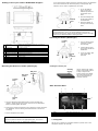
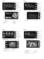
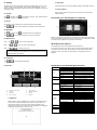
TERMS & CONDITIONS HARDWARE USER MANUAL Lokatoo B1000 Version 2.4 1. The maps data and/or preloaded software (“Software”) in this device are licensed by third parties to Amtel Cellular Sdn Bhd (“The Company”). The Software is sub-licensed on a limited, non-exclusive, non-transferable and revocable basis for use by you solely on this device only and is not sold together with the device. If upgrades, updates or supplements to the Software are obtained, the use of such upgrades, updates or supplements is governed by these Terms and Conditions and any amendments that may accompany them and may be subject to additional payments and conditions. You must not reproduce, distribute, publish, transmit, modify, adapt, translate, display, distribute, sell, license, publicly perform, prepare derivative works based upon, or otherwise use or exploit the Software. The foregoing limited right does not give you any ownership of Software and nothing contained in this Agreement may be construed as conferring to you any licence or right to the Software under any copyright or any other intellectual property right. 2. The Software is provided by the copyright holders "AS IS" and any express or implied warranties, including, but not limited to, the implied warranties of merchantability and fitness for a particular purpose, are disclaimed. In no event shall the copyright owner be liable for any direct, indirect, incidental, special, exemplary, or consequential damages however caused and on any theory of liability, whether in contract, strict liability, or tort (including negligence or otherwise) arising in any way out of the use of the Software, even if advised of the possibility of such damage. The entire risk to the quality and performance of the Software is borne by you. This disclaimer of warranty constitutes and essential part of the licence granted to you to use the Software. 3. The trademarks, logos, and service marks (“Trademark”) displayed on this Software and device, are owned by the Company and third parties. All Trademarks not owned by the Company are the property of their respective owners, and are used with permission. Nothing contained herein may be construed as granting any right or licence to use any Trademark. 4. The maps and any information stored in this device is strictly a navigation guide for reference use only. It is the sole responsibility of the User’s to use this device prudently. Information provided may change over time and you should decide the route based on the actual road conditions and traffic laws. The Company makes no representation or warranty, whether expressly or impliedly as to the accuracy, completeness, timeliness, reliability or fitness for any particular purpose of the maps stored therein. 5. The planned, shortest, quickest routes and estimated time to desired destinations are obtained from optimal route calculations based on the map database and should be used as a reference only. This device must not be used for any purpose requiring precise measurement of direction, distance, location or topography. 6. Do not fix or mount the device on such part of the windscreen that will interfere with driving of the motor vehicle or be hazardous or dangerous to the driver or occupants in the motor vehicle. User shall be responsible for his/her use of the maps stored therein and the device, and shall at all times comply with all traffic laws and regulations of the country of usage. 7. The usage of this device is dependent on the Global Positioning System (GPS) which is operated by the United States government and is solely responsible for its accuracy and maintenance. The system is subject to changes which may affect the performance and accuracy of the GPS navigator devices. 8. The use of the device is at the User’s own risk. Lokatoo and the company is not liable for any fines, penalties, damages or loss whether direct, indirect, incidental, special, exemplary, or consequential damages however caused and on any theory of liability, whether in contract, strict liability, or tort (including negligence or otherwise) arising in any way out of the use of the device. Precautions and Notices What is in the box? 01. 02. 03. 04. 05. 06. 07. 08. 09. 10. 11. 12. 13. 14. 15. 16. 17. Lokatoo B1000 GPS Navigator Stylus Pouch Holder (Stand-type) Cradle Backup base Suction pad protector Cleaning sponge In-car charger Travel adaptor USB cable CD containing map and manual SDMMC Card c/w navigation software & map Quick guide Software user manual Hardware user manual Warranty card For your own safety, do not operate the controls of the product while driving. When you get off the car, do not leave your device on the dashboard that is subject to direct sunlight. The overheating of the battery can cause malfunction and/or danger. Global Positioning System (GPS) is operated and managed by the United States of America Department of Defense, which is solely responsible for the performance of GPS. Any change or modification may affect the accuracy of the GPS and its related systems. GPS satellite signals cannot pass through solid materials (except glass). When you are inside a tunnel or building, GPS positioning is not available. A minimum of 3 GPS satellite signals is needed to determine current GPS position. Signal reception can be affected by situations such as bad weather or dense overhead obstacles (e.g. trees and tall buildings). Other wireless devices in the vehicle might interfere with the reception of satellite signals and cause the reception to be unstable. A car holder is needed when using the device in a car. Be sure to place the device in an appropriate place, so as not to obstruct the driver’s view, or deployment of airbags. Please remove SD/MMC card only when the device is in power off status. When USB transmitting, Do Not disconnect the USB cable. When other applications are operating, Do Not connect USB cable. The navigation software may be updated from time to time. If the description shown in this manual is different, please follow the software version currently on hand. Battery Information For optimal performance of the Li-polymer battery, take note of the following: For the latest version of this manual, please visit www.lokatoo.com Amtel Cellular Sdn Bhd (278151-D) No 5, Jalan PJS 7/19, Bandar Sunway, 46150 Petaling Jaya, Selangor D.E., Malaysia. Tel: 03-5632 6788 Fax: 03-5632 5678 E-mail: [email protected] Customer Service Hotline: 1 800 88 0308 This unit contains a non user replaceable internal Li-polymer battery. The battery can inflate and release hazardous chemicals. To reduce the risk of fire or burns, do not disassemble, crush, puncture, or dispose of in fire or water. The icon at the top right corner on the main interface of system indicates the current remaining power. Disconnect device from charger when it is fully charged. Battery may damage if it is over charged. Do not immediately turn on your device after connecting the Travel Adaptor to charge a power-depleted battery. If you need to turn on the device again, wait for at least one minute. Do not charge the battery where the temperature is high. This may be harmful to the battery. (e.g. in direct sunlight). It is unnecessary to fully discharge the battery before charging. You can charge the battery even if it is only partially discharge. If you do not use the device long period of time, charge the battery at least once every two weeks. Over discharge battery can affect the charging performance. Only connect the In-Car Charger to the device after starting the car. Failure to do so may cause irreversible damage to the device. In the event that the holder cannot be mounted onto the car dashboard due to the material of the instrument panel, a backup base with adhesive can be used as a platform for the holder. Getting to know your Lokatoo B1000 GPS navigator 1. To use the backup base, remove the adhesive protector at the bottom of the base. Backup base 2. Stick the backup base at the desired spot of the dashboard. 3. Mount the holder at the top of the backup base. Important As the backup base uses a very strong adhesive to stick to the dashboard permanently, please decide carefully and choose the right location on the dashboard before sticking the base Removing the holder (Stand-type) Locking knob 1 Power button 2 3 4 5 Reset button AVIN Connector Mini-USB Connector Charging Indicator 6 7 Headphone Connector SD/MMC Card slot 8 9 10 11 12 Speaker Stylus Bracket block slot Display screen Microphone Pressing the power button for more than 2 seconds will switch off the device completely. Pressing it briefly will turn the device to sleep mode. To reset the device. Connect to external AVIN wired receiver module. (Optional) Connect to the USB cable for file transfer or battery charging. Static red indicate that external power is connected and charging. Static green indicate a fully charged battery. Connect to stereo headphone. To access navigation software, map, song and video files stored in SD/MMC card. Produces audio. For inputting via touch screen. To lock the device to holder. Display screen with touch screen capability. For inputting via voice. (Dependent on software capability) Mounting The Device To Holder (Stand-type) 1. Turn the locking knob clockwise to loosen the mounting. 2. Lift the tab and ‘peel’ the suction pad off the dashboard. Suction pad protector Tab 3. Cover the suction pad with suction pad protector. Cleaning the suction pad Cleaning Sponge Ball joint (female) Ball joint (male) Use for cleaning the suction surface of the holder when it is dirty to improve the suction power of the holder. The sponge should be wet (Do not use detergent or alcoholic content). Locking knob Main Interface Menu Tab A Suction pad B 2 C 1 3 1. Turn the tightening knob anticlockwise to loosen the ball joint (female). Insert the ball joint (male) as shown on the illustration above, and then tighten the knob. 2. Remove the suction pad protective film. Attach the suction pad to the car dashboard. Turn the locking knob anticlockwise to secure the mounting. 3. Fit the navigator to the holder. 4 A B C Date Time Battery Indicator 5 6 Display date, month and year. Display the current time. Display the battery level of the device. Important Be sure to place the device in an appropriate place, so as not to obstruct the driver’s view, or deployment of airbags. 1. Navigation Tap this icon to launch the navigation software. (Please refer to the navigation software user manual) 4. Ebook 2. Music Close and exit Close and exit Page up Page up Page down Page down Back to previous folder After the desired music file is selected, the music file will be played with player interface shown below. Back to previous folder After the desired text file is selected, the text file will be displayed as below. J E I D H C G F B A E B A C D A. Shuffle all songs F. Previous track B. Repeat all songs G. Next track C. Progress bar H. Play / Pause D. Volume I. Previous page E. Stop J. Close and exit 3. Picture A. Numeric keyboard to enter page no. D. Page up B. Previous folder E. Close and exit C. Page down 5. Movie Close and exit Close and exit Page up Page up Page down Page down Back to previous folder Back to previous folder Go to picture viewing page After the desired movie file is selected, the movie file will be played with player interface shown below. After the desired picture file is selected, the picture file will be displayed as below. A H H G G F F A B E E D C D A. Previous picture E. Rotate picture B. Next picture F. Zoom out C. Slide show (in full screen)* G. Zoom in D. Back to previous folder H. Close and exit C B A. Display screen – double tap to enter full screen* E. Fast-forward B. Progress bar F. Stop C. Volume G. Play / Pause D. Back to previous folder H. Close and exit * Double tap the screen to exit full screen mode. * Double tap the screen to exit full screen mode. 6. Setting ii. GPS Reset Tap Setting icon from main menu to enter the setting page. Here you can set the volume, power, backlight, time and date and language. You can also view system information, perform touch screen calibration, GPS reset and factory reset. Tap GPS Reset to clear up the Signal-to-Noise of the data received. iii. Factory Reset When Factory Reset is tap, the device will go back to the factory default setting. 6.1 Volume Tap to increase and to decrease the volume. Tick “Enable sounds for taps” to enable screen tapping sound. Connecting your GPS navigator to computer 6.2 Power The “Battery Level” displays the remaining charge of the battery. Tap or to set the time before the navigator enter sleep mode. A B 6.3 Backlight Tap to increase and Tap or to decrease the screen brightness. to set the time before the screen is turned off. When the navigator is connected to computer using USB cable, the screen above will appear. Tap A to only charge the battery of the navigator and B to access to the navigator’s storage (for file transfer). 6.4 Date & Time Time – Tap or to set the hour and minute. Date - Tap or to set the year, month and day. Zone - Tap or to set the time zone. Wired Rear-View Camera (For B1000 that comes with Wired Rear-View Camera) Note: You do not need to adjust the date and time. When the device is connected to GPS satellite, the current date and time will be downloaded to the device. To use the wired rear-view camera, please ensure that the AVIN cable is connected to the AVIN port. The camera view will be displayed on the navigator screen only when car transmission is engaged to reverse position. 6.5 Language Tap or to set the desired language. 6.6 Sys Info. Specifications (Portable Navigation Device) Physical H G F Dimension Net Weight Operating system CPU System A B C E D Core Shell Language Multimedia SD RAM NAND Flash Storage 2 Languages Movie Music Picture Ebook Travel Adaptor Power In-Car Charger i ii iii A. Signal distortion ratio E. Vehicle speed B. Channel F. Number of satellite C. Longitude G. Altitude D. Time to first fix H. Latitude i. Calibration Please perform screen calibration to correct the preciseness of the touch screen. Press and briefly hold a stylus or any similar nonmarking instrument to the center of the target. Repeat as the target moves around the screen. When the calibration is completed, simply tap anywhere on the screen to exit. Battery Usage time Specification Display Navigation Feature Temperature Pixels Brightness GPS Frequency Channels Sensitivity Precision Capture Time Refreshing Rate Com port Baud Rate Operation Storage USB AV IN Video Format Input Impedance Input Voltage Audio Format 134 x 88 x 18mm 220g Windows CE6.0 SiRFAtlas IV, CPU 500MHz, RAM11; DSP 250MHz. 128MB 128M (SLC) Support up to max 4GB SD/SDHC/MMC English & Simplified Chinese MP4, ASF, WMV, AVI and 3GP MP3, WMA and WAV BMP, JPG, PNG and GIF TXT INPUT: AC 100-240V OUTPUT: DC 5V/2A INPUT: DC 12-24V OUTPUT: DC 5V/1.5A 3.7V / 1600mAH Approx. 3-4 hours 5” TFT LCD, 4 line resistance flat touch screen 480 x 272, TFT with flat touch panel Adjustable 1575.42MHz 64 -161dBm Position: <10 meters Hot start: ≤3 sec, average Warm start: ≤38 sec, average Cold start: ≤45 sec, average 0.1/second COM7 38400 -20 to 70˚C -25 to 75˚C USB 2.0 high speed CLBS (PAL & NTSC) 75Ω 1.5Vpp Analog Signal