1
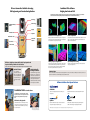
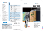
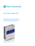
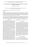
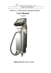
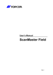
GLS-1500 Standard Configuration
•
•
•
•
•
•
•
•
•
•
•
•
•
•
•
•
•
•
GLS-1500 scanner unit
Target sheet (medium)
Magnet target (small)
Magnet target (medium)
Adhesive target (small) x 5
Adhesive target (medium) x 10
BT-65Q battery x 4
BC-30D dual-battery charger x 2
(with AD-14 AC adapter x 2)
Tribrach with optical plummet
Wireless LAN card
Head cover
SD memory card (1GB)
Tools
Silicone cloth
USB cable
User manual
Warranty certificate
Carrying case
Optional Accessories
Tilting base
Tilts the GLS-1500 unit to scan upper and lower
portions of tunnels, buildings and other large structures.
Maximum ±90° tilting range with 15° steps.
SCANNING UNIT
Maximum range
90% reflectivity
18% reflectivity
Minimum range
Single point accuracy
Distance (at 1 to 150m)
Angle (H&V)
Surface accuracy (at 1 to 150m)
Target detection accuracy
Scan rate (maximum)
Scan resolution
Spot size
Sample density (maximum)
Field of view (per scan)
Horizontal
Vertical
Laser
Type
Wavelength
Laser class
DIGITAL CAMERA
Field of view
Number of pixels
TILT COMPENSATOR
Type
Compensation range
DISPLAY
Type
INTERFACE
Memory
Wireless LAN
USB
POWER SUPPLY
Removable battery (BT-65Q)
Operating time
Input voltage
ENVIRONMENTAL
Operating temperature
Storage temperature
Dust and water protection
PHYSICAL
Dimensions w/handle
Instrument height
Weight
GEODETIC 3D LASER SCANNER
Normal mode: 330m Long mode: 500m
Normal mode: 150m Long mode: 230m
1m
GLS-1500
3D Laser Scanner
Normal mode: 4mm Long mode: 7mm
6"
Normal mode: 2mm Long mode: 3mm
3" at 50m (164ft.)
30,000 points/second
<6mm at 1 to 40m
1mm at 20m
360° (maximum)
±35° (maximum)
Pulsed (time of flight)
1535nm (invisible, eye-safe)
Class 1
Approx. 22° (V) x 16.5° (H)
2 megapixels
Dual-axis tilt sensor
±6'
LCD with backlight, 20 characters x 4 lines
SD and SDHC memory cards
IEEE 802.11b
Type mini B Rev. 2.0
5Ah, 7.4V
4 hours per 4 removable batteries
12V DC
0°C to +40°C
-10°C to +60°C
IP52 (IEC 60529)
High-Speed, Long-Range,
High-Precision,
All-in-One 3D Laser Scanner
240 (D) x 240 (W) x 566 (H) mm
410mm
16kg (excluding battery and tribrach)
TOPCON CORPORATION
Class 1
75-1 Hasunuma-cho, Itabashi-ku, Tokyo 174-8580, Japan
Phone: (+81)3-3558-2993 Fax: (+81)3-3960-4214
www.topcon.co.jp
Your local Authorized Topcon Dealer is:
Specifications subject to change without notice
©2010-2011 Topcon Corporation All rights reserved. P-63-3
GLS-1500
GLS-1500 SPECIFICATIONS
• Long-Range 500m
• High-Speed Scan with 30,000 points/second
• Topcon Precise Scan Technology Provides Clean,
Ultra-Low-Noise Scan Data
• 4mm Distance Accuracy at 150m
• All-in-One Solution for Superior Mobility
• Quick Sighting with Jog Dial Controls
• Built-in Digital Camera
• ScanMaster Software for Powerful Data Processing
• Presents Photo-realistic Point Clouds
• Remote Control via Wireless LAN
GLS-1500 Stretches the Boundaries of Your Survey Technology
Photo-realistic Point Clouds
The GLS-1500 captures point clouds and picture
images simultaneously. The combination of point
clouds and RGB picture data generates full-color,
photo-realistic 3D point clouds.
Picture Images
Digital Camera
Laser
3D Point Clouds
GLS-1500
Road Surface Profile
Large Structure
Tunnel
Monitoring of Critical Infrastructures such
as Bridges, Towers, and Dams
Scan data of large structures allow for early detection of
deteriorated areas to be maintained or reinforced. 3D data can be
utilized for measurements of size and geometry, as well as volume
calculations of necessary materials.
Periodic monitoring is one of the most effective methods to
prevent collapse of structures.
Profile Measurement and Convergence Monitoring
GLS-1500 captures 3D data of tunnel wall surfaces in a short
period of time. Even the most complex surface profile can be
modeled without difficulty. Monitoring of wall convergence is an
essential measure to prevent collapse of tunnels both under
construction and in operation.
Measures Ruts and Bumps for Maintenance Purposes
GLS-1500 captures 3D road surface shapes with exceptional ease and speed.
From roadside or other convenient locations, GLS-1500 quickly scans the road surface
without an assistant on the road.
Highly accurate 3D road surface model facilitates determination of repair locations as well
as volume calculation of pavement materials.
GLS-1500 dramatically increases work efficiency and safety, and saves material costs. Traffic
congestion by blocking a lane is also eliminated.
Full-color, Photo-realistic 3D Point Clouds
Scanning Procedures
Historical Architecture
A laser scanner captures object surface with a huge
Creation and Preservation of As-built Data
number of points, each one with 3D coordinate
Full color, photorealistic 3D model will be the most valuable record
of historical architectures. 2D floor plans and cross-sectional
drawings can be easily created from 3D point clouds.
Disaster and Accident
values. Scans at multiple positions are needed to
capture the entire shape of objects. Multiple scan
Detailed Survey with the Fastest Speed
3D terrain models can be easily created with scan data. GLS-1500
acquires accurate and detailed terrain data with exceptional speed
and safety.
GLS-1500 quickly scans disaster areas or accident scenes. 3D
models allows for computer simulations of disasters and accidents.
data can be docked and aligned by using common
tie-points which are separately scanned with
retro-reflective targets.
Geo-referenced 3D point clouds and mesh objects
created by Topcon ScanMaster software can be
©Saqqara Laser Scanning Survey 2008
©Saqqara Laser Scanning Survey 2008
POINT VIEW PRO, Pointools Ltd.
exported to users’ software, allowing for 3D
measurement, 3D modeling, displacement
observation, as-built survey, and other applications.
Aligning Point Clouds
Targets for tie-points
A
B
Volume Measurement
Increases Safety, Efficiency and Accuracy
A+B
A
B
Volume measurement is indispensable for land preparation, open-pit and underground
mining, waste landfills and sediment control facilities.
GLS-1500 allows the operators to take measurements with an incomparable safety by
eliminating the need for working in the midst of heavy machines.
High density point clouds allow for accurate calculations of volume and geometry that no
other technology can offer.
Flood Control
Rivers, Dams, and Embankments
High density 3D point clouds can be utilized for creating contour
maps and profile drawings, and for volume calculations. Simulation
of water flow paths greatly facilitates flood control and disaster
prevention planning.
Archaeology
EVE VIEW, Develo Solutions
©Saqqara Laser Scanning Survey 2008
Photorealistic 3D Models of Ruins
Cutting-edge laser scanning technology realizes preservation of
valuable ruins in detailed 3D models.
GLS-1500 provides archaeologists with full color, high resolution
pictures that have precise 3D coordinate values.
Topcon Precise Scan Technology Quickly Acquires Ultra-Low-Noise,
High-Precision 3D Data and 500m Long-Range scanning!
Topcon Precise Scan Technology integrates two distance measurement methods, the Time of Flight and the
Phase Shift. Time of Flight technology utilizes an instantaneous emission of pulse laser. Measurement accuracy
tends to be affected by a slight fluctuation of the waveform. Topcon Precise Scan Technology resolves the pulse
waveform and processes the filtered signals with a Phase Shift algorithm to achieve the highest possible accuracy
and data quality.
Enable to select from 2 range mode, maximum
500m range mode is prepared in addition to
existing 330m high-accuracy scanning.
Range Accuracy GLS-1500 Normal Range Mode
15
10
10
Total
Total
5
Calculates the high order digits of distance
Returned pulse
SAW - Filter
Calculates lower order digits
with Phase Shift algorithm.
Reliability is increased by
constantly averaging multiple
measurement results.
5
Noise
Noise
Start pulse
SAW - Filter
Range Accuracy GLS-1500 Long Range Mode
15
Accuracy [mm]
Selectable two-range mode
Accuracy [mm]
Outline of Topcon Precise Scan Technology
0
50
100
150
200
250
300
350
400
450
500
0
0
100
Range [m]
Ultra-Low-Noise Data!
The most crucial technological challenge in
scanning technology is how to minimize the
noise included in the captured data. Topcon
Precise Scan Technology achieves dramatic
noise reduction that makes it possible to
present the finest texture of scanned
objects.
0
200
300
400
500
Range [m]
Various scanning mode
ScanMaster controls the GLS-1500 scanner unit via
wireless LAN. Scan area can be easily specified on
video or picture images on a computer screen.
All-in-One, stand-alone scanner unit provides easy
operation and superior portability, similar to the
total stations. GLS-1500L has palm-of-your-hand
operations via compact tablet PC.
Remote Control Using Video Images
Stand-alone
Topcon Precise Scan Technology!
Ultra-Low-Noise, High-Precision,
High-Quality Scanning
Distance accuracy: 4mm@150m
Angle accuracy (H&V): 6 arc-seconds
Topcon Precise Scan Technology maximizes the accuracy and the
data quality by minimizing noise and measurement deviation.
Increased Scanning Speed!
30,000 points per second
GLS-1500 incorporates newly developed laser diode that constantly
emits laser beam at 30,000 times per second, 10 times faster than
the previous model.
Higher-density point clouds can be captured in a shorter time,
increasing productivity and the quality of laser scanning.
Tablet PC
3D Laser Scanner Best Suited for Surveying,
Civil Engineering, and Construction Applications
ScanMaster Office Software
Bridging Scan Data and CAD
ScanMaster software provides exceptional processing power to prepare 3D data for CAD applications. Featuring an array of automated
functions and instrument control capability, ScanMaster dramatically increases both office and field work efficiency.
Vertical jog
Horizontal jog
Sighting collimator /
Mirror
Display
Wireless LAN
Cut/fill volume using design plane
Keyboard
Dual-axis tilt sensor
Removable
batteries
SD card slot
Volume regions
Automated Tie-Point Registration
Volume Computation
Multiple scan data taken from different instrument positions can be merged with
unmatched speed and ease by automatic tie-point recognition. Geo-referencing can
also be automated when the project includes control points.
Creating volume meshes allows for cut/fill and total volume calculations. Cut and fill
regions can be visually checked with different colors, and the boundaries of each
region can be automatically extracted.
Variable post-processing functions
Quick and Easy Noise Cleaning
Specialized post-processing software enables adjustments to be made quickly and
accurately ex) Volume Calculation, Region Extraction and Edge Extraction. These
functions are designed to reduce your office work. In particular, Edge Extraction
function has been significantly enhanced from previous version.
Automated region extraction quickly separates the region and noise, dramatically
increasing noise cleaning efficiency.
USB connector
All-in-One, Stand-alone Scanner Unit Provides Easy Operation and
Superior Portability, Similar to the Total Stations
GLS-1500 can be operated in a similar manner to total stations. A tripod is the only external device needed.
Dual-axis Tilt Sensor
GLS-1500 automatically
compensates the instrument tilt
within ±6’ using a built-in dual-axis
tilt sensor. This capability increases
accuracy of station setting using
instrument point and backsight
data.
Station Setting with
Backsight Coordinates
In addition to orientation using geo-referenced
tie-point targets, GLS-1500 can determine the
coordinate system using instrument point and
backsight data, thanks to the high accuracies in
distance, angles and tilt compensation. This
capability increases work efficiency by minimizing
number of targets needed for orientation.
ScanMaster Viewer
This free PC software enables not only data viewing, but also data capturing with the GLS series scanners. It allows you to efficiently present scan data to your clients. You can
also take it to the field with the GLS scanner while keeping the complete software in the office.
Software Solutions from Topcon Partners
GEOKOSMOS
kubit
Geokosmos offers highly reputed expertise in laser-scanning and 3D
modeling services.
kubit software enables the laser scan data to be directly used within AutoCAD
software.
Rich Functions, Easy Operation
Rapidform
POINTOOLS
ScanMaster Field allows you to use live video images when you
specify scan area, check scanning progress, and perform target
scan. Tablet PC can be connected with the GLS scanner using a
USB cable or Wireless LAN.
Rapidform® software allows for creating 3D models from scan data for
redesign, reverse engineering and inspection purposes.
Pointools provides complete point cloud processing and data management
solutions as well as various plug-in for popular application software.
ScanMaster Field Free Controller Software
“ScanMaster Field”, a free tablet PC software, controls
Topcon GLS series laser scanners. Operations are made
simple with a compact tablet PC in the palm of your
hand.
* Tablet PC needs to be prepared separately.
* For the details, please contact nearest dealers.
*Availability of products and services vary depending on country. For more details, please consult Topcon dealer or representative in your region.
GLS-1500 Standard Configuration
•
•
•
•
•
•
•
•
•
•
•
•
•
•
•
•
•
•
GLS-1500 scanner unit
Target sheet (medium)
Magnet target (small)
Magnet target (medium)
Adhesive target (small) x 5
Adhesive target (medium) x 10
BT-65Q battery x 4
BC-30D dual-battery charger x 2
(with AD-14 AC adapter x 2)
Tribrach with optical plummet
Wireless LAN card
Head cover
SD memory card (1GB)
Tools
Silicone cloth
USB cable
User manual
Warranty certificate
Carrying case
Optional Accessories
Tilting base
Tilts the GLS-1500 unit to scan upper and lower
portions of tunnels, buildings and other large structures.
Maximum ±90° tilting range with 15° steps.
SCANNING UNIT
Maximum range
90% reflectivity
18% reflectivity
Minimum range
Single point accuracy
Distance (at 1 to 150m)
Angle (H&V)
Surface accuracy (at 1 to 150m)
Target detection accuracy
Scan rate (maximum)
Scan resolution
Spot size
Sample density (maximum)
Field of view (per scan)
Horizontal
Vertical
Laser
Type
Wavelength
Laser class
DIGITAL CAMERA
Field of view
Number of pixels
TILT COMPENSATOR
Type
Compensation range
DISPLAY
Type
INTERFACE
Memory
Wireless LAN
USB
POWER SUPPLY
Removable battery (BT-65Q)
Operating time
Input voltage
ENVIRONMENTAL
Operating temperature
Storage temperature
Dust and water protection
PHYSICAL
Dimensions w/handle
Instrument height
Weight
GEODETIC 3D LASER SCANNER
Normal mode: 330m Long mode: 500m
Normal mode: 150m Long mode: 230m
1m
GLS-1500
3D Laser Scanner
Normal mode: 4mm Long mode: 7mm
6"
Normal mode: 2mm Long mode: 3mm
3" at 50m (164ft.)
30,000 points/second
<6mm at 1 to 40m
1mm at 20m
360° (maximum)
±35° (maximum)
Pulsed (time of flight)
1535nm (invisible, eye-safe)
Class 1
Approx. 22° (V) x 16.5° (H)
2 megapixels
Dual-axis tilt sensor
±6'
LCD with backlight, 20 characters x 4 lines
SD and SDHC memory cards
IEEE 802.11b
Type mini B Rev. 2.0
5Ah, 7.4V
4 hours per 4 removable batteries
12V DC
0°C to +40°C
-10°C to +60°C
IP52 (IEC 60529)
High-Speed, Long-Range,
High-Precision,
All-in-One 3D Laser Scanner
240 (D) x 240 (W) x 566 (H) mm
410mm
16kg (excluding battery and tribrach)
TOPCON CORPORATION
Class 1
75-1 Hasunuma-cho, Itabashi-ku, Tokyo 174-8580, Japan
Phone: (+81)3-3558-2993 Fax: (+81)3-3960-4214
www.topcon.co.jp
Your local Authorized Topcon Dealer is:
Specifications subject to change without notice
©2010-2011 Topcon Corporation All rights reserved. P-63-3
GLS-1500
GLS-1500 SPECIFICATIONS
• Long-Range 500m
• High-Speed Scan with 30,000 points/second
• Topcon Precise Scan Technology Provides Clean,
Ultra-Low-Noise Scan Data
• 4mm Distance Accuracy at 150m
• All-in-One Solution for Superior Mobility
• Quick Sighting with Jog Dial Controls
• Built-in Digital Camera
• ScanMaster Software for Powerful Data Processing
• Presents Photo-realistic Point Clouds
• Remote Control via Wireless LAN