1
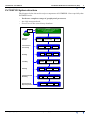
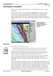
INTREPID User Manual
Library | Help | Top
INTREPID Guided Tours Introduction (G01)
1
| Back |
INTREPID Guided Tours Introduction (G01)
Top
This book contains illustrated step by step instructions for a demonstration of basic
INTREPID operations. The demonstration uses sample INTREPID data provided in
the INTREPID installer. You can use the demonstration as a first step in evaluating
INTREPID or as introductory training in its use.
INTREPID is published by
Intrepid Geophysics (formerly trading as Desmond Fitzgerald and Associates Pty
Ltd).
How to evaluate INTREPID
We suggest the following process for evaluating INTREPID:
•
Obtain an evaluation license from Intrepid Geophysics (IG) or one of our agents.
•
Work through the Guided Tours to help you decide if INTREPID is suitable for
processing your data. Contact IG or our agents for technical support if necessary.
•
Contact IG or one of our Agents for any information you need before evaluating
INTREPID further.
•
Carry out a second level evaluation. IG provides resources to help you through
this more detailed evaluation using your own data with an INTREPID evaluation
licence.
How to contact us
For contact information, go to the Intrepid Geophysics website.
World Wide Web: www.intrepid-geophysics.com
Library | Help | Top
© 2012 Intrepid Geophysics
| Back |
INTREPID User Manual
Library | Help | Top
INTREPID Guided Tours Introduction (G01)
2
| Back |
Brief Description of INTREPID
INTREPID is a geophysical processing and interpretation software package with the
following features:
•
Library | Help | Top
INTREPID can perform all stages of your geophysical data processing
using a common database format and graphic user interface. Functionality
includes:
•
Acquisition processing,
•
General processing
•
Interpretation.
•
INTREPID consists of a number of independent software modules. You are not
obliged to purchase the entire package.
•
INTREPID operates under SOLARIS, LINUX, Windows, Mac OS X.
•
INTREPID has 64 bit versions for all operating systems
•
INTREPID uses innovative graphical and visual feedback techniques to support
ease of use and rapid learning.
•
INTREPID uses a database to support and integrate all functions. This database
•
Has no systemic size limits (The size of a dataset is only limited by the
resources of your computer);
•
Can be accessed seamlessly by all INTREPID tools.
© 2012 Intrepid Geophysics
| Back |
INTREPID User Manual
Library | Help | Top
INTREPID Guided Tours Introduction (G01)
3
| Back |
INTREPID System structure
The diagram below shows the major components of INTREPID. Note especially that
INTREPID tools:
•
Perform a complete range of geophysical processes,
•
Are fully integrated and
•
Can all access the same binary database.
Import,
Export
Database
Native INTREPID OR INTREPID-compatible format
Line, point, polygon, grid data
No systemic size limits
Other data
format
Editing &
Utilities
Corrections &
Processing
Spreadsheet,
Line Profile &
Flight Path Editing
Magnetic
Gravity
Projection
Conversion
Radiometrics
Grid
Merge
Gridding
Grid
Operations
Levelling
Tie Line &
Network
Levelling
Decorrugation
Micro
levelling
Filtering
FFT Grid
Filtering
Spatial Grid
Filtering
Line
Filtering
Gridding
Interpretation &
Modeling
Visualisation &
Map Composition
Library | Help | Top
Append,
Subsection,
Split Cruise
Naudy
Euler
Visualisation
Edge
`
Detection
Magnetic
Map
Composition
Map
Printing
© 2012 Intrepid Geophysics
| Back |
INTREPID User Manual
Library | Help | Top
INTREPID Guided Tours Introduction (G01)
4
| Back |
Guided tour pathways
Depending on your interests and level of expertise, the Guided Tours have a number
of pathways that you can follow.
Basic magnetics pathway
This sequence of Guided Tours demonstrates the basic processing sequence for
magnetic data using INTREPID, from beginning (data import) to final (data export).
To follow this pathway, complete the following tours:
•
Importing data to INTREPID (G03)
•
Introduction to the Spreadsheet Editor (G04)
•
Levelling—removing the GRF component (G12)
•
Levelling—tie line levelling (G13)
•
Levelling—decorrugation and microlevelling (G14)
•
Exporting data from INTREPID (G18)
This series uses the Albury dataset. See The Albury dataset
Sample datasets—installing, locating, naming
The Ebagoola dataset
Ebagoola is a magnetics dataset covering a region of Cape York Peninsula in
Queensland, Australia (between 143°E 14°S and 143°30’E 14°30’S). For the exercises
we provide a small portion of the Ebagoola dataset (ebagoola_S) which includes
about 30 acquisition lines and two tie lines.
The Albury dataset
This dataset is a small section of data from Albury, Victoria. The data custodians are
Geoscience Victoria, Department of Primary Industries, Melbourne, Australia. The
data is freely available through the Geoscience Australia GDADS (Geophysical Data
Archive Delivery System).
Availability of sample data for exercises
The sample data is automatically available in the CD-ROM version of INTREPID.
We call the larger version of the download by this name for historic reasons. The
advent of fast internet downloads, means that we can routinely expect a user to not
be worried about a down load of 300MBytes or more. The web download version does
not bundle the sample data.
Installing or reinstalling sample data for exercises
When you install INTREPID, use Custom Install to include this data.
For Windows: if you installed INTREPID before and now want to install the sample
data, either insert the CD-ROM, or double click on the MSI installer packkage and
use Add or Remove Programs in the Control Panel to Change the installation and
include the sample data.
If you have changed the sample data and want a ‘factory reset’ of it, you can restore
the original files:
Library | Help | Top
1
Make a copy of any results that you want to keep
2
Insert the CD-ROM (if you have one) and use Add or Remove Programs in the
© 2012 Intrepid Geophysics
| Back |
INTREPID User Manual
Library | Help | Top
INTREPID Guided Tours Introduction (G01)
5
| Back |
Control Panel to Repair the installation.
For LINUX, the installer is a simple jar file, that is functionaly similar to the MSI
Location of sample data for Guided Tours
We provide two complete sets of sample datasets, one in INTREPID format and one
in Geosoft format. INTREPID works equally well with both formats. When you want
to open a dataset, navigate to the directory containing the required data format.
Where install_path is the path of your INTREPID installation, the project
directories for the Guided Tours sample data are
install_path\sample_data\guided_tours\intrepid_datasets and
install_path\sample_data\guided_tours\geosoft_datasets.
For example, if INTREPID is installed in
C:\Program Files\Intrepid\Intrepid4.5.nnn,
then you can find the INTREPID format sample data at
C:\Program Files\Intrepid\Intrepid4.5.nnn\sample_data\
guided_tours\intrepid_datasets
This is the default location for the sample data. If you have installed INTREPID
normally, the data resides there. If you have installed INTREPID elsewhere, the
exercises will work just as well. Just use the appropriate pathnames.
For more information about installing the sample data, see "Sample datasets—
installing, locating, naming" in INTREPID Guided Tours Introduction (G01)
For a more detailed description of INTREPID datasets, see Introduction to the
INTREPID database (G20). For even more detail, see INTREPID database, file and
data structures (R05).
Location of sample data for CookBooks
Right next to the Guided tours data, is a rich set of more exotic geophysics datasets
and grids, already prepared for the cookbook training sessions. A casual user might
also gain some trial and error insights into the capbilities of the software, just by
testing the Project Manger’s ability to preview and describe the attributes of each of
the cookbook datasets.
INTREPID file and dataset names
Generally speaking, you can use any name that is acceptable to your operating
system for INTREPID datasets but we recommend that you note the following:
Library | Help | Top
•
We recommend that you do not use spaces in file, folder or vector dataset field
names. Use ‘_’ instead.
•
INTREPID uses the '.' character for cetain purposes. We recommend that you
don’t use it in file, folder or vector dataset field names.
•
INTREPID is file-compatible between UNIX and Windows. This means that you
can create and process the same datasets with either version of INTREPID.
There are some small issues to remember, however.
•
Windows and Mac OS are case insensitive but case preserving. For example if a
dataset is called MyGrid.ers, it will always show as MyGrid.ers. However, if
you type mygrid.ers when specifying the dataset, INTREPID locates
MyGrid.ers for you.
© 2012 Intrepid Geophysics
| Back |
INTREPID User Manual
Library | Help | Top
Library | Help | Top
INTREPID Guided Tours Introduction (G01)
6
| Back |
•
Linux and Solaris are case sensitive and case preserving. This means that
theoretically you could have two datasets existing side by side, one called
MyGrid.ers and the other called mygrid.ers.
•
To minimise risk of confusion, it may be easier to avoid capital letters and spaces
in file names.
© 2012 Intrepid Geophysics
| Back |
INTREPID User Manual
Library | Help | Top
INTREPID Guided Tours Introduction (G01)
7
| Back |
Solution datasets and file names
In a set of guided tours like this we can’t assume that you will wish to exhaustively
carry out every single step. For this reason we have provided solution datasets and
files for every step of the process. You can choose whether to use the dataset or file
you have created or the equivalent solution dataset or file provided as input for a
subsequent step that requires it.
We use a naming system for files and datasets you create during the guided tours and
the corresponding solution datasets and files provided. The names of datasets and
files you create are the same as the solution datasets or file names but with a 1
added.
For example, if the guided tour specifies an output dataset called raw_grid1, then
the solution dataset provided will be called raw_grid. You can use either dataset if
required for input in a later process.
Whenever you need to specify a previously created dataset or file for input, we
recommend that you use the solution dataset provided rather than the one you create.
This will help to streamline your first overview of INTREPID. You will have
opportunities to verify that INTREPID works properly during later evaluation stages
with your own data.
Importing your own data into INTREPID datasets
INTREPID can import a wide range of data formats into its database structure.
INTREPID also offers direct support for a range of different formats, such as Geosoft
line and grid datasets, relational databases such as Oracle and Postgress, ESRI shape
files, MapInfo TAB files, and GMT, DODDS/DAPS grids. If INTREPID cannot import
your data we will write a special import facility for you. INTREPID can also export
data in a wide range of formats.
If you are impressed with INTREPID after going through the Guided Tours and want
to see more, please contact us. We will arrange an extended evaluation licence so that
you can process your own data.
Gradient, tensor and other advanced datasets
INTREPID has many innovative tools that support vector, tensor and other advanced
geophysical datasets in a coherent, simple and direct manner. It keeps the related
channels together using tensor and observed vector data types.
These features are available for you to test. Example vector, tensor line datasets as
well as full tensor grids are available for training and testing. Contact our support
service for assistance.
Library | Help | Top
© 2012 Intrepid Geophysics
| Back |
INTREPID User Manual
Library | Help | Top
INTREPID Guided Tours Introduction (G01)
8
| Back |
Guided tour format
Each guided tour contains a brief introduction, illustration of the main tool that it
demonstrates and the following sections:
Overview
This section contains a list of the main features of the tools you will use and a brief
introduction to the exercise you will carry out.
Context of this guided tour
This section explains where the exercise would fit into a ‘real life’ data processing
cycle.
Should you complete this guided tour?
This section classifies the tour as introductory or advanced and states its relative
importance to your understanding of INTREPID.
What you will do
This section contains a simple flowchart describing the guided tour.
Steps to follow
This section gives detailed illustrated steps for the exercise that you will carry out.
Key points for this guided tour
This section summarises the main points to note about the tools and processes
demonstrated in this tour.
Frequently asked questions
This section contains the answers to questions that potential users may ask about the
tools and processes demonstrated in this tour.
Additional information
Tip: ‘Tip’ text contains background information that will help your understanding
of INTREPID but is not essential for completing the Guided Tour.
Library | Help | Top
© 2012 Intrepid Geophysics
| Back |
INTREPID User Manual
Library | Help | Top
INTREPID Guided Tours Introduction (G01)
9
| Back |
Check points and short cuts in the Guided Tours case study
These guided tours use a case study approach, where you process one set of data from
the raw state to the final corrected and enhanced state. There are, of course, several
stages in the process and in a real situation you would use the output from one
process as the input for another.
You may have limited time for completing these guided tours and may therefore wish
to skip some steps and processes. These guided tours have a number of features to
speed your progress:
•
•
•
•
Library | Help | Top
Solution datasets and files provided—You never need to have completed a
previous process in order to perform one that is of interest;
Optional steps in the tours. Tours often contain processes covered in detail by
an earlier tour. You may not learn anything new by repeating the process, so we
mark these steps as optional, using the symbol appearing to the left of this
paragraph. If you omit an optional step you may need to use a solution dataset or
file for some subsequent step. Steps where you compare data from before and after
a process are also marked as optional;
Should you complete this guided tour? Each chapter has a section with this
heading, also indicated by the symbol shown at the left of this paragraph. The
section gives advice about the relevance of the processes in the chapter to your
interests;
Task specification (job) files. You can use these to automatically set
parameters for a process instead of using menus and dialog boxes. Instructions for
using them appear below. We use the symbol shown to the left of this paragraph
wherever you can use a job file;
© 2012 Intrepid Geophysics
| Back |
INTREPID User Manual
Library | Help | Top
INTREPID Guided Tours Introduction (G01)
10
| Back |
Task specification (job) file short cuts
The INTREPID task specification file system allows you to preload an interactive tool
with settings for a task. Task specification files are also known as job files. We have
provided sets of job files for as many of the exercises as possible. You can use them as
shortcuts for setting parameters etc., if you wish. (You can also try using them if you
experience difficulty with the interactive operation of the INTREPID tools.)
The exercise in INTREPID batch processing (G19) demonstrates further how you can
save time by using job files in your processing.
Using task specification (job) file short cuts
Wherever you can use a job file short cut we include a paragraph similar to the one
shown here:
You can specify the input, output and parameters for this section of the guided tour
using the job file ch07_1.job. If you wish, load it into the Grid Merge tool as
described in "Task specification (job) file short cuts" in INTREPID Guided Tours
Introduction (G01), then continue from Step 3, omitting Step 6.
>> To use the job file
Library | Help | Top
1
Choose Load Options from the File menu of the tool you are using.
2
Locate and select the job file (they always have a .job extension) in the File
Name list.
3
Choose OK. INTREPID will load the task specifications into the tool.
© 2012 Intrepid Geophysics
| Back |
INTREPID User Manual
Library | Help | Top
INTREPID Guided Tours Introduction (G01)
11
| Back |
List of INTREPID tools, Scope of Guided Tours
This edition of the Guided Tours covers a selection of the available INTREPID tools.
The table below contains a complete list of INTREPID tools. It includes notes on the
introductory documentation currently available for each tool.
INTREPID tool
Guided
tour?
Project Manager
Yes
Import/Export
Yes
Navigation (GPS)
Yes
Projection Conversion
Yes
Visualisation
Yes
Gridding
Yes
Editors
Yes
Hard Copy and Map Composition
Yes
Line Filtering
Yes
Grid Filtering (FFT)
Yes
Grid Merging
Yes
Grid Operations
Other introductory material
Refer to the Reference Manual
Refer to Reference Manual
Tie Line Levelling
Yes
Decorrugation and Microlevelling
Yes
Radiometrics
(3 Channel and 256 channel)
See INTREPID Cookbook
Interpretation 1
(MagMage), Interpretation 2
See INTREPID Cookbook
Gravity Data Processing
(ground and moving platform)
See INTREPID Cookbook
ERMapper, ModelVision and ARC/
INFO Links
Refer to Reference Manual
Library | Help | Top
© 2012 Intrepid Geophysics
| Back |
INTREPID User Manual
Library | Help | Top
INTREPID Guided Tours Introduction (G01)
12
| Back |
INTREPID documentation and help
Apart from this INTREPID Guided Tours book, we provide the following
documentation and help for INTREPID users.
INTREPID Reference Manual
INTREPID has a multi-volume reference manual, which details all aspects of this
extensive system. All documentation is included on the INTREPID CD-ROM, and is
also available on the Intrepid Geophysics website (www.intrepid-geophysics.com).
INTREPID Cookbooks
The INTREPID Cookbooks contain discussions, explanations, examples and
suggestions for using INTREPID tools. These have been prepared by our skilled and
experienced team of geophysicists, programmers, educators and technical writers and
will assist you to make the best use of INTREPID.
INTREPID On-line help
If you choose a subject from the Help menu, INTREPID displays a brief summary of
the subject. For more detailed information, refer to the Reference Manual on the CDROM or web-site.
INTREPID Training notes
We are available to conduct a full range of training courses in the use of INTREPID
should you require it. These courses have comprehensive sets of notes, which are
available to INTREPID customers on request.
INTREPID Technical support service
We provide a full technical support service to INTREPID customers, using telephone,
fax, electronic mail, post and site visits.
We also provide a new support service using interactive media and such tools as
VSEE and Skype.
Library | Help | Top
© 2012 Intrepid Geophysics
| Back |