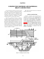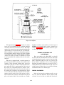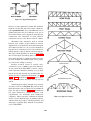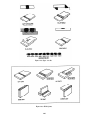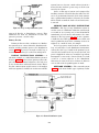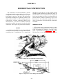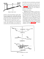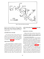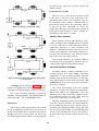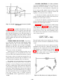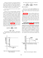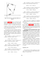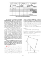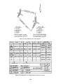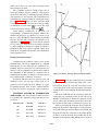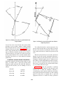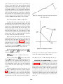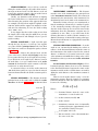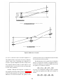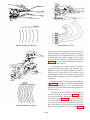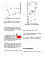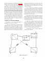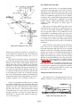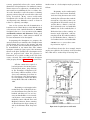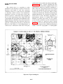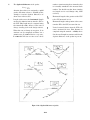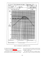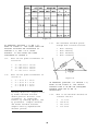
1
NONRESIDENT
TRAINING
COURSE
Engineering Aid 2
NAVEDTRA 14337
DISTRIBUTION STATEMENT A: Approved for public release; distribution is unlimited.
PREFACE
About this course:
This is a self-study course. By studying this course you can improve your professional/military knowledge,
as well as prepare for the Navywide advancement-in-rate examination. It contains subject matter about dayto-day occupational knowledge and skill requirements and includes text, tables, and illustrations to help you
understand the information. An additional important feature of this course is its references to useful
information to be found in other publications. The well-prepared Sailor will take the time to look up the
additional information.
Any errata for this course can be found at https://www.advancement.cnet.navy.mil under Products.
History of the course:
•
•
Jan 1994: Original edition released.
Apr 2003: Administrative update released. Entered errata. Changes were made to content.
Published by
NAVAL EDUCATION AND TRAINING
PROFESSIONAL DEVELOPMENT
AND TECHNOLOGY CENTER
https://www.cnet.navy.mil/netpdtc
POINTS OF CONTACT
• E-mail: [email protected]
• Phone:
Toll free: (877) 264-8583
Comm: (850) 452-1511/1181/1859
DSN: 922-1511/1181/1859
FAX: (850) 452-1370
ADDRESS
COMMANDING OFFICER
NETPDTC N331
6490 SAUFLEY FIELD ROAD
PENSACOLA FL 32559-5000
NAVSUP Logistics Tracking Number
0504-LP-101-9253
TABLE OF CONTENTS
CHAPTER
PAGE
1. Construction Methods and Materials: Heavy Construction ...................................
1-1
2. Construction Methods and Materials: Electrical and Mechanical Systems ...........
2-1
3. Horizontal Construction .........................................................................................
3-1
4. Project Drawings....................................................................................................
4-1
5. Specifications/Material Estimating/Advanced Base Planning ...............................
5-1
6. Care and Adjustment of Surveying Equipment......................................................
6-1
7. Indirect Leveling/Level and Traverse Computations.............................................
7-1
8. Topographic Surveying and Mapping....................................................................
8-1
9. Plane-Table Topography and Map Projection .......................................................
9-1
10. Engineering and Land Surveys ..............................................................................
10-1
11. Horizontal and Vertical Curves..............................................................................
11-1
12. Electronic Surveying Equipment ...........................................................................
12-1
13. Materials Testing....................................................................................................
13-1
APPENDIX
I. References Used to Develop the Nonresident Training Course.............................
I-1
II. Useful Tables .........................................................................................................
II-1
III. Sample Survey Field Notes ....................................................................................
III-1
IV. Other Useful References ........................................................................................
IV-1
V. Unified Soil Classification System ........................................................................
V-1
VI. Answers to Review Questions ...............................................................................
VI-1
CHAPTER 1
CONSTRUCTION METHODS AND MATERIALS:
HEAVY CONSTRUCTION
This chapter will discuss basic heavy construction
methods and materials.
As a general rule, the term heavy construction refers
to the type of construction in which large bulks of
materials and extra-heavy structural members are used,
such as steel, timber, concrete, or a combination of these
materials. In the Naval Construction Force, heavy
construction includes the construction of bridges,
waterfront structures, and steel flame structures.
BRIDGE CONSTRUCTION
A bridge is a structure used to carry traffic over a
depression or an obstacle, and it generally consists of
two principal parts: the lower part, or substructure; and
the upper part, or superstructure. When a bridge is
supported only at its two end supports, or abutments, it
is called a single-span bridge. A bridge that has one or
more intermediate supports, such as the one shown in
figure 1-1, is known as a multispan bridge. Although
bridges may be either fixed or floating, only fixed
bridges will be discussed in this training manual
(NRTC). The following is a discussion of the components of a fixed bridge.
The Seabee’s construction functions, in support of
the Navy’s and Marine Corps’ operating forces, might
include the design and construction of these various
structures or their rehabilitation; therefore, you, as an
EA, should understand the terminology, the basic
principles, and the methodology used in the construction
of these facilities. Your knowledge of the methods and
materials used in heavy construction will greatly assist
you in the preparation of engineering drawings
(original, modified, or as-built).
Figure 1-1.—A multispan (trestle-bent) bridge.
1-1
Figure 1-2.—Types of fixed-bridge abutments.
between the stringers. The timber-sill abutment should
not be more than 3 feet high. It can be used to support
spans up to 25 feet long.
The timber-bent abutment shown in figure 1-2, view
C, can be used with timber or steel stringers on bridges
with spans up to 30 feet. The deadman is used to
provide horizontal stability. These abutments do not
exceed 6 feet in height.
Other types of fixed-bridge abutments are pile
abutments and concrete abutments. Timber- or
steel-pile abutments can support spans of any length,
can be used with steel or timber stringers, and can reach
a maximum height of 10 feet. A timber-pile abutment is
shown in figure 1-2, view B. Concrete abutments are the
most permanent type. They may be mass or reinforced
concrete, can be used with spans of any length, and can
be as high as 20 feet. They may be used with either steel
or timber stringers.
ABUTMENTS
There are different types of fixed bridge abutments.
First, let us discuss the footing-type abutment. In figure
1-2, views A and C show two types of footing abutments.
View A shows a timber-sill abutment, and view C shows
a timber-bent abutment. By studying both of these
views, you should see that there are three elements that
are common to a footing-type abutment. Each type has
a footing, a sill, and an end dam.
If you will notice, the timber-sill abutment shown
in figure 1-2, view A, is the same footing-type abutment
that is shown for the bridge in figure 1-1. In this type of
abutment, loads are transmitted from the bridge
stringers to the sill, which, in turn, distributes the load
to the footing. The footing then distributes the combined
load over a sufficient area to keep the support from
sinking into the ground. The end dam is a wall of planks
that keeps the approach-road backfill from caving in
1-2
Figure 1-3.—Typical pile bent.
INTERMEDIATE SUPPORTS
Bents and piers provide support for the bridge
superstructure at points other than the bank ends. A bent
consists of a single row of posts or piles, while a pier
consists of two or more rows of posts or piles. The
following text discusses some of the different types of
bents and piers.
The pile bent shown in figure 1-3 consists of the
bent cap, which provides a bearing surface for the bridge
stringers, and the piles, which transmit the load to the
soil. The support for the loads may be derived either
from column action when the tip of the pile bears on
firm stratum, such as rock or hard clay, or from friction
between the pile and the soil into which it is driven. In
both cases, earth pressure must provide some lateral
support, but traverse bracing is often used to brace the
bent laterally.
A timber pile bent consists of a single row of piles
with a pile cap. It should be braced to the next bent or
to an abutment to reduce the unbraced length and to
provide stability. This bent will support a combined span
length of 50 feet
The trestle bent shown in figure 1-4 is similar to the
pile bent except that the posts, taking the place of the
piles, transmit the load from the cap to the sill. The sill
transmits the load to the footings, and the footings
transmit the load to the soil. Timber trestle bents are
normally constructed in dry, shallow gaps in which the
soil is firm. They are not suitable for use in soft soil or
swift or deep streams. The bent can support a combined
span length of up to 30 feet and can be 12 feet high.
Figure 1-4.—Timber trestle bent.
1-3
Figure 1-5.—Typical pile pier.
The pile pier (fig. 1-5) is composed of two or more
As seen in the figure, those structural members
resting on and spanning the distance between the
intermediate supports or abutments are called stringers.
The stringers are the mainload-carrying members of the
superstructure. They receive the load from the flooring
and transmit it to the substructure. Although the figure
shows both steel and timber stringers, in practice only
one type would normally be used.
The flooring system includes the deck; the wearing
surface, or tread, that protects the deck; and the curb and
handrail system. The plank deck is the simplest to design
and construct, and it provides considerable savings in
time compared to other types of decks. Plank decking is
normally placed perpendicular to the bridge center line
(direction of traffic) for ease and speed of construction.
A better arrangement, however, is provided if the
decking is placed at about a 30- to 60-degree skew to
pile bents. In this figure, notice the common cap. The
cap transmits the bridge load to the corbels, which in
turn, transmit the combined load to the individual bent
caps. Piers are usually provided with cross bracing that
ties the bents together and provides rigidity in the
longitudinal direction.
SUPERSTRUCTURE
The superstructure of a bridge consists of the
stringers, flooring (decking and treads), curbing, walks,
handrails, and other items that form the part of the bridge
above the substructure. Figure 1-6 is an illustration of a
superstructure.
1-4
Figure 1-6.—Nomenclature of a fixed highway bridge superstructure.
the center line. A space of approximately one-quarter
inch should be provided between the planks to allow for
swelling, to provide water drainage, and to permit air
circulation. The minimum thickness of decking is 3
inches in all cases; however, when the required
thickness of plank decking exceeds 6 inches, then a
laminated type of decking should be used.
compressed soil at or near the bottom. A bearing pile
sustains a downward load and may be driven vertically
or otherwise; however, when a bearing pile is driven
other than vertically, it is known as a batter pile.
Another type of pile is the sheet pile. It is used to resist
lateral soil pressure.
The following discussion is intended to introduce
and familiarize you with some of the common types of
foundations and piles that you may be required to
include in your construction drawings.
FOUNDATIONS AND PILES
That part of a building or structure located below
the surface of the ground is called the foundation. Its
purpose is to distribute the weight of the building or
structure and all live loads over an area of subgrade large
enough to prevent settlement and collapse.
A pile is a slender structural unit driven into the
ground to transmit loads to the underground strata. It
transfers loads to the surrounding underground strata by
friction along its surface or by direct bearing on the
FOUNDATIONS
In general, all foundations consist of three essential
parts: the foundation bed, which consists of the soil or
rock upon which the building or structure rests; the
footing, which is normally widened and rests on the
foundation bed; and the foundation wall, which rises
from the foundation to a location somewhere above the
1-5
Figure 1-7.—wall and column foundations.
Figure 1-9.—Plan and section of a mat foundation.
beam located at grade level around the entire perimeter
of a building, and it is supported by a series of concrete
piers extending into undisturbed soil. The building loads
are supported by the grade beam, which distributes the
load to the piers. The piers then distribute the load to the
foundation bed
A spread foundation, such as the one shown in
figure 1-8, is often required where heavy concentrated
loads from columns, girders, or roof trusses are located.
This type of foundation may be located under isolated
columns or at intervals along a wall where the
concentrated loads occur. Spread footings are generally
reinforced with steel. They may be flat, stepped, or
sloped, such as shown in figure 1-7.
Figure 1-9 shows the plan and section of a typical
mat foundation. In this type of foundation, a heavily
reinforced concrete slab extends under the entire
building and distributes the total building load over the
entire site. This minimizes problems created by unequal
settlement when the subsoil conditions are uneven. The
mat foundation is often referred to as a floating
foundation.
Figure 1-8.—Plan and section of a typical spread footing.
ground. The foundation wall, contrary to its name, may
be a column or a pedestal instead of a wall. But, when
it is a wall, it forms what is known as a continuous
foundation. Figure 1-7 shows common types of wall
and column foundations.
The continuous foundation is the type of foundation
that is most commonly used for small buildings. The size
of the footing and the thickness of the foundation wall
are specified on the basis of the type of soil at the site.
Most building codes also require that the bottom of the
footing be horizontal and that any slopes be
compensated for by stepping the bottom of the footing.
Another type of foundation is the grade-beam
foundation. A grade beam is a reinforced concrete
PILE CONSTRUCTION
Piles include many different types and materials.
The following text discusses the more common types.
1-6
Figure 1-11.—Steel sheetpiling.
Figure 1-10.—Types of concrete piles.
Bearing Piles
Figure 1-12.—Wood sheet piles.
Timber bearing piles are usually straight tree trunks
with the limbs and bark removed. These piles, if kept
continuously wet, will last for centuries; however, they
are used for low design loads because of their
vulnerability to damage while they are being driven into
the ground. The small end of the pile is called the tip;
the larger end is called the butt. Timber piles range from
16 to 90 feet in length with a tip diameter of at least 6
inches. The butt diameter is seldom less than 12 inches.
A steel bearing pile might be an H-pile (having an
H-shaped cross section). These piles are usually used for
driving to bedrock. A steel pile can also be a pipe pile
with a circular cross section. A pipe pile can be either an
open-end pile or a closed-end pile, depending on
whether the bottom end is open or closed.
Concrete piles, such as those shown in figure 1-10,
may be either precast or cast in place. Most precast piles
used today are pretensioned and are manufactured in
established plants. These piles are made in square,
cylindrical, or octagonal shapes. If they are being driven
into soft or mucky soil, they are usually tapered.
Cast-in-place piles are cast on the jobsite and are
classified as shell type or shell-less type. The shell type
is formed by driving a hollow steel tube (shell), with a
closed end, into the ground and filling it with concrete.
The shell-less type is formed by first driving a casing
and core to the required depth. The core is removed and
the casing is filled with concrete. The casing is then
removed, leaving the concrete in contact with the earth.
Sheet Piles
Sheet piles, made of wood, steel, or concrete, are
equipped or constructed for edge-joining, so they can be
driven edge-to-edge to form a continuous wall or
bulkhead. A few common uses of sheet piles are as
follows:
1. To resist lateral soil pressure as part of a
temporary or permanent structure, such as a retaining
wall
2. To construct cofferdams or structures built to
exclude water from a construction area
3. To prevent slides and cave-ins in trenches or
other excavations
The edges of steel sheetpiling are called interlocks
(fig. 1-11) because they are shaped for locking the piles
together edge-to-edge. The part of the pile between the
interlocks is called the web.
A wood sheet pile might consist of a single, double,
or triple layer of planks, as shown in figure 1-12.
Concrete sheet piles are cast with tongue-and-groove
edges for edge-joining.
1-7
Figure 1-13.—Rubble-mound breakwater or jetty.
Figure 1-14.—Composite breakwater or jetty.
WATERFRONT STRUCTURES
Waterfront structures may be broadly divided into
three types as fpllows: (1) harbor-shelter structures,
(2) stable-shoreline structures, and (3) wharfage
structures.
HARBOR-SHELTER STRUCTURES
Harbor-shelter structures are offshore structures
that are designed to create a sheltered harbor. Various
types of these structures are discussed below.
Figure 1-15.—Caisson breakwater or jetty.
A breakwater is an offshore barrier, erected to
break the action of the waves and thereby maintain an
area of calm water inside the breakwater. A jetty is a
similar structure, except that its main purpose is to direct
the current or tidal flow along the line of a selected
channel.
70 feet. The width of its base depends on the width of
the cap, height of the structure, and the slopes of the
inner and outer faces. For a deepwater site or from
with an extra-high tide range, a rubble-mound
breakwater may be topped with a concrete cap structure,
The simplest type of breakwater or jetty is the
rubble-mound (also called rock-mound) type shown in
figure 1-13. The width of its cap may vary from 15 to
such as shown in figure 1-14. A structure of this type is
called a composite breakwater or jetty. In figure 1-14,
the cap structure is made of a series of precast concrete
1-8
Figure 1-6.—Various types of seawalls.
STABLE-SHORELINE STRUCTURES
boxes called caissons, each of which is floated over its
place of location, and then sunk into position. A
monolithic (single-piece) concrete cap is then cast along
the tops of the caissons. Sometimes, breakwaters and
jetties are built entirely of caissons, as shown in figure
1-15.
These structures are constructed parallel with the
shoreline to protect it from erosion or other wave
damage.
A seawall is a vertical or sloping wall that offers
protection to a section of the shoreline against erosion
and slippage caused by tide and wave action. A seawall
is usually a self-sufficient type of structure, such as a
gravity-type retaining wall. Seawalls are classified
according to the types of construction. A seawall may
be made of riprap or solid concrete. Several types of
seawall structures are shown in figure 1-16.
A groin is a structure similar to a breakwater or jetty,
but it has a third purpose. A groin is used in a situation
where a shoreline is subject to alongshore erosion,
caused by wave or current action parallel or oblique to
the shoreline. The groin is run out from the shoreline
(usually there is a succession of groins at intervals) to
check the alongshore wave action or deflect it away
from the shore.
A bulkhead has the same general purpose as a
seawall; namely, to establish and maintain a stable
shoreline. However, while a seawall is self-contained,
relatively thick, and is supported by its own weight, the
bulkhead is a relatively thin wall. Bulkheads are
classified according to types of construction, such as the
following:
A mole is a breakwater that is paved on the top for
use as a wharfage structure. To serve this purpose, it
must have a vertical face on the inner side, or harborside.
A jetty may be similarly constructed and used, but it is
still called a jetty.
1-9
Figure 1-17.—Steel sheet-pile bulkhead.
1. Pile-and-sheathing bulkhead
2. Wood sheet-pile bulkhead
3. Steel sheet-pile bulkhead
4. Concrete sheet-pile bulkhead
Most bulkheads are made of steel sheet piles, such
as shown in figure 1-17, and are supported by a series
of tie wires or tie rods that are run back to a buried
anchorage (or deadman). The outer ends of the tie rods
are anchored to a steel wale that runs horizontally along
the outer or inner face of the bulkhead. The wale is
usually made up of pairs of structural steel channels that
are bolted together back to back.
Figure 1-18.—Two types of tie-rod anchorages for bulkheads.
order of construction sequence. First, the shore and
bottom will be excavated to the level of the long, sloping
dotted line. The sheet piles for the bulkhead and
anchorage will then be driven. The intervening dotted
lines, at intervals of 19 feet 4 inches, represent
supporting piles, which will be driven to hold up the tie
rods. The piles will be driven next, and the tie rods then
set in place. The wales will be bolted on, and the tie rods
will be tightened moderately (they are equipped with
turnbuckles for this purpose).
In stable soil above the groundwater level, the
anchorage for a bulkhead may consist simply of a buried
timber, a concrete deadman, or a row of driven and
buried sheet piles. A more substantial anchorage for
each tie rod is used below the groundwater level. Two
common types of anchorages are shown in figure 1-18.
In view A, the anchorage for each tie rod consists of a
timber cap, supported by a batter pile, which is bolted
to a bearing pile. In view B, the anchorage consists of a
reinforced concrete cap, supported by a pair of batter
piles. As shown in the figure, tie rods are supported by
piles located midway between the anchorage and the
bulkhead.
Backfilling to the bulkhead will then begin. The first
backfilling operation will consist of filling over the
anchorage, out to the sloping dotted line. The
turnbuckles on the tie rods will then be set up to bring
the bulkhead plumb. Then the remaining fill, out to the
bulkhead, will be put in. Finally, outside the bulkhead,
the bottom will be dredged to a depth of 30 feet.
Bulkheads are constructed from working drawings
like those shown in figure 1-19. The detail plan for the
bulkhead shows that the anchorage consists of a row of
sheet piles to which the inner ends of the tie rods are
anchored by means of a channel wale.
To make it possible for ships to come alongside the
bulkhead, it will be fitted with a timber cap and batter
fender piles, as shown in figure 1-20. These piles,
installed at proper intervals, will provide protection
against the impact of ships and will protect the hulls of
ships from undue abrasion.
The section view shows that the anchorage will lie
58 feet behind the bulkhead. This view also suggests the
1-10
Figure 1-19.—Working drawings for steel sheet-pile bulkhead.
Figure 1-20.—Cap and fender pile for bulkhead.
1-11
by bulkheads. However, a pier or marginal wharf
usually consists of a timber, steel, or concrete
superstructure, supported on a substructure of timber-,
steel-, or concrete-pile bents.
Working drawings for advanced-base piers are
contained in Facilities Planning Guide, Volume 1,
NAVFAC P-437. Figures 1-22, 1-23, and 1-24 are
portions of the advanced-base drawing for a 40-foot
timber pier.
Each part of a pier lying between adjacent pile bents
is called a bay, and the length of a single bay is equal to
the on-center spacing of the bents. In the general plan
shown in figure 1-22, you can see that the 40-foot pier
consists of one 13-foot outboard bay, one 13-foot
inboard bay, and as many 12-foot interior bays as needed
to meet the length requirements for the pier.
The cross section shown in figure 1-24 shows that
each bent consists of six bearing piles. The bearing piles
are braced transversely by diagonal braces. Additional
transverse bracing for each bent is provided by a pair of
batter piles. The batter angle is specified as 5 in 12. One
pile of each pair is driven on either side of the bent, as
shown in the general plan. The butts of the batter piles
are joined to 12-inch by 12-inch by 14-foot longitudinal
batter-pile caps, each of which is bolted to the
undersides of two adjacent bearing-pile caps in the
positions shown in the part plan. The batter-pile caps are
placed 3 feet inboard of the center lines of the outside
bearing piles in the bent. They are backed by 6- by
14-inch batter-pile cap blocks, each of which is bolted
to a bearing-pile cap. Longitudinal bracing between
bents consists of 14-foot lengths of 3 by 10 planks,
bolted to the bearing piles.
Figure 1-21.—Types of wharfage structures.
WHARFAGE STRUCTURES
Wharfage structures are designed to allow ships to
lie alongside for loading and discharge. Figure 1-21
shows various plan views of wharfage structures. Any
of these may be constructed of fill material, supported
Figure 1-22.—General plan of an advanced-base 40-foot timber pier.
1-12
Figure 1-23.—Part plan of an advanced-base timber pier.
Figure 1-24.—Cross section of an advanced-base timber pier.
1-13
Figure 1-25.—Dolphins.
The superstructure (fig. 1-24) consists of a single
layer of 4 by 12 planks laid on 19 inside stringers
measuring 6 inches by 14 inches by 14 feet. The inside
stringers are fastened to the pile caps with driftbolts. The
outside stringers are fastened to the pile caps with bolts.
The deck planks are fastened to the stringers with 3/8by 8-inch spikes. After the deck is laid, 12-foot lengths
of 8 by 10 are laid over the outside stringers to form the
curbing. The lengths of curbing are distributed as shown
in the general plan. The curbing is bolted to the outside
stringers.
dolphins, located 15 feet beyond the end of the pier. A
dolphin is an isolated cluster of piles, constructed as
shown in figure 1-25. A similar cluster attached to a pier
is called a pile cluster.
TIMBER FASTENERS AND
CONNECTORS
From your studies of the EA3 NRTC, you should
be aware that it is usually unnecessary to call out in
working drawings the types of fasteners used for light
frame construction. This is not the case, however, for
heavy timber construction. As an EA preparing
drawings for timber structures, you need to have a
working knowledge of timber fasteners and connectors
and the manner in which they are used. The following
text discusses the more common types.
The pier is equipped with a fender system for
protection against shock, caused by contact with vessels
coming or lying alongside. Fender piles, spaced as
shown in the part plan, are driven along both sides of the
pier and bolted to the outside stringers. The heads of
these bolts are countersunk below the surfaces of the
piles. An 8-by-10 fender wale is bolted to the backs of
the fender piles. Lengths of 8-by-10 fender-pile chocks
are cut to fit between the piles and bolted to the outside
stringers and the fender wales. The spacing for these
bolts is shown in the part plan. As shown in the general
plan, the fender system also includes two 14-pile
TIMBER FASTENERS
Bolts used to fasten heavy timbers usually come in
1/2-, 3/4-, and 1-inch diameters and have square heads
and nuts. In use, the bolts are fitted with round steel
1-14
Figure 1-26.—Scabs.
Figure 1-28.—Shear plate and shear-plate joints.
smaller than the bolt diameter and about 3 inches shorter
than the bolt length. Driftbolts are from 1/2 to 1 inch in
diameter and 18 to 26 inches long.
Butt joints are customarily connected using
driftbolts; however, another method of making
butt-joint connections is to use a scab. A scab is a short
length of timber that is spiked or bolted to the adjoining
members, as shown in figure 1-26.
Figure 1-27.—Split ring and split-ring joints.
washers under both the bolt head and the nut. The bolts
are then tightened until the washers bite well into the
wood to compensate for future shrinkage. Bolts should
be spaced a minimum of 9 inches on center and should
be no closer than 2 1/2 inches to the edge or 7 inches to
the end of the timber.
TIMBER CONNECTORS
A timber connector is any device used to increase
the strength and rigidity of bolted lap joints between
heavy timbers. For example, the split ring (fig. 1-27) is
embedded in a circular groove. These grooves are cut
with a special bit in the faces of the timbers that are to
be joined. Split rings come in diameters of 2 1/2 and 4
inches. The 2 1/2-inch ring requires a 1/2-inch bolt, and
the 4-inch ring uses a 3/4-inch bolt.
Driftbolts, also called driftpins, are used primarily
to prevent timbers from moving laterally in relation to
each other, rather than to resist pulling apart. They are
used more in dock and trestle work than in trusses and
building frames. A driftbolt is a long, threadless rod that
is driven through a hole bored through the member and
into the abutting member. The hole is bored slightly
Shear plates are shown in figure 1-28. These
connectors are intended for wood-to-steel connections,
as shown in view B. But when used in pairs, they may
1-15
Figure 1-29.—Toothed ring and toothed-ring joints.
Figure 1-31.—Spike grids and spike-grid joints.
(fig. 1-29) functions in much the same manner as
the split ring but can be embedded without the
necessity of cutting grooves in the members. The
toothed ring is embedded by the pressure provided
from tightening a high-tensile strength bolt, as
shown in figure 1-30. The hole for this bolt is
drilled slightly larger than the bolt diameter so that
the bolt may be extracted after the toothed ring is
embedded. The spike grid is used as shown in
figure 1-31. A spike grid may be flat (for joining
flat surfaces), single-curved (for joining a flat and
a curved surface), or double-curved (for joining
two curved surfaces). A spike grid is embedded in
the same manner as a toothed ring.
Figure 1-30.—Embedding toothed rings.
be used for wood-to-wood connections (view C). When
making a wood-to-wood connection, the fabricator first
cuts a depression into the face of each of the wood
members. These depressions are cut to the same depth
as the shear plates. Then a shear plate is set into each of
the depressions so that the back face of the shear plate
is flush with the face of the wood members. Finally, the
wood members are slid into place and bolted together.
Because the faces are flush, the members easily slide
into position, which reduces the labor necessary to make
the connection. Shear plates are available in 2 5/8- and
4-inch diameters.
STRUCTURAL STEEL
Structural steel is one of the basic materials
commonly used in structures, such as industrial and
commercial buildings, bridges, and piers. It is produced
in a wide range of shapes and grades, which permits
great flexibility in its usage. It is relatively inexpensive
to manufacture and is the strongest and most versatile
material available to the construction industry. This
For special applications, toothed rings and spike
grids are sometimes used. The toothed ring connector
1-16
Figure 1-32.—Structural steel shapes and designations.
section describes structural steel shapes, the
terminology applied to structural steel members, the use
of these members, and the methods by which they are
connected.
STRUCTURAL STEEL SHAPES
Structural steel is manufactured in a wide variety of
cross-sectional shapes and sizes. Figure 1-32 shows
many of these various shapes.
Figure 1-33 shows cross-sectional views of the
W-shape (wide flange), the S-shape (American
Standard I-beam), and the C-shape (American Standard
channel). The W-shape is the most widely used
structural member for beams, columns, and other
load-bearing applications. As seen in the figure, it has
parallel inner and outer flange surfaces that are of
constant thickness. This flange design provides greater
cross-sectional area in the flanges, which results in
greater strength than is provided by the S-shape, which
has a slope of approximately 17 degrees on the inner
flange surfaces. The C-shape is similar to the S-shape in
that its inner flange surface is also sloped approximately
17 degrees. The C-shape is especially useful in locations
Figure 1-33.—Structural shapes.
where a single flat surface on one side is required. When
used alone, the C-shape is not very efficient as a beam
or column. However, efficient built-up members maybe
constructed of charnels assembled together with other
structural shapes and connected by rivets or welds.
The W-, S-, and C-shape structural members are
designated by their nominal depth, in inches, along the
1-17
Figure 1-34.—Angles.
Figure 1-36.—Weight and thickness of steel plate.
Figure 1-37.—Bars.
Figure 1-35.—Built-up column section.
web and the weight, in pounds, per foot of length. A
W14 x 30, for example, indicates a W-shape that is 14
inches deep along its web and weighs 30 pounds per
linear foot. Hence a 20-foot length of this size W-shape
would weigh a total of 600 pounds.
component parts of built-up structural members, such as
the built-up column shown in figure 1-35. Plates cut to
specific sizes may be obtained in widths ranging from
8 inches to 120 inches or more and in various
thicknesses.
The bearing pile, HP-shape, is almost identical to
the W-shape. The only difference is the thickness of the
web and flange. In the bearing pile, the web and flange
thickness are equal, whereas the W-shape has unequal
web and flange thickness.
Plates are identified by their thickness, width, and
length, all measured in inches; for example, PL
An angle is a structural shape whose cross section
resembles the letter L. As pictured in figure 1-34, angles
are available with either equal or unequal legs. The
dimension and thickness of its legs are used to identify
an angle; for example, L6 x 4 x 1/2. The dimension of
each leg is measured along the outside of the angle, and
for unequal-leg angles, the dimension of the wider leg
is always given first, as in the example just cited. The
third dimension applies to the thickness of the legs,
which always have equal thickness. Angles are used
primarily to support, brace, or connect other structural
members. They may be used as single members, or they
may be used in combinations of two or four to form main
members.
Steel plate is a structural member that has a width
greater than 8 inches and a thickness of 1/4 inch or more.
Plates are generally used as connections between other
structural members. They may also be used as
1-18
1/2 x 18 x 30. Sometimes, you may also hear plate
referred to by its approximate weight per square foot for
a specified thickness. As shown in figure 1-36, 1 cubic
foot of steel weighs 490 pounds. This weight divided by
12 gives you 40.8 pounds, which is the weight of a steel
plate measuring 1 foot square and 1 inch thick. By
dropping the fractional portion, a 1-inch plate is called
a 40-pound plate; and, with similar reasoning, a 1/2-inch
plate is called a 20-pound plate.
The structural shape referred to a bar has a width
of 8 inches or less and a thickness greater than 3/16 inch.
The edges of bars usually are rolled square, like
universal mill plates. The dimensions are expressed in
a similar manner as that for plates; for instance, bar
6 x 1/2. Bars are available in a variety of cross-sectional
shapes-round, hexagonal, octagonal, square, and flat.
Three different shapes are shown in figure 1-37. Both
squares and rounds are commonly used as bracing
members of light structures. Their dimensions, in
Figure 1-38.—Structural steel skeleton construction.
construction, skeleton construction, and longspan construction.
inches, apply to the side of the square or the diameter
of the round.
In wall-bearing construction, exterior and
interior masonry walls are used to support structural
members, such as steel beams and joists, which carry
the floors and roof. It should be noted that while
this section of your NRTC discusses steel structures,
wall-bearing construction is applicable to nonsteel
structures as well. Wall-bearing construction is one of
the oldest and most common methods in use.
Although modern developments in reinforced
concrete masonry make the use of this method
feasible for high-rise structures, wall-bearing
construction is normally restricted to relatively low
structures, such as residences and light industrial
buildings.
STEEL FRAME STRUCTURES
The construction of a framework of structural
steel involves two principal operations: fabrication
and erection. Fabrication involves the processing of
raw materials to form the finished members of the
structure. Erection includes all rigging, hoisting, or
lifting of members to their proper places in the
structure and making the finished connections
between members.
A wide variety of structures are erected using
structural steel. Basically, they can be listed as
buildings, bridges, and towers; most other structures
are modifications of these three.
A tall building with a steel frame, such as shown
in figure 1-38, is an example of skeleton construction.
In this type of construction, all live and dead loads
are carried by the structural-frame skeleton. For this
reason, the exterior walls are nonbearing curtain
walls. Roof and floor loads are transmitted to beams
and girders,
Buildings
There are three basic types of steel construction.
These may be designated as wall-bearing
1-19
Figure 1-39.—Typical built-up girders.
which are, in turn, supported by columns. The horizontal
members or beams that connect the exterior columns are
called spandrel beams. If you add additional rows of
columns and beams, there is no limitation to the area of
floor and roof that can be supported using skeleton
construction. One limitation on using skeleton
construction, however, is the distance between columns.
Oftentimes, large structures, such as aircraft
hangars, may require greater distances between
supports than can be spanned by the standard structural
steel shapes. In this case, one of several methods of
long-span steel construction is used. One method uses
built-up girders to span the distances between supports.
Two types of built-up girders are shown in figure 1-39.
As seen in this figure, the built-up girder consists of steel
plates and shapes that are combined together to meet the
necessary strength. The individual parts of these girders
are connected by welding or riveting.
Another method, which is usually more
economical, is to use a truss to span large distances.
As you learned in the EA3 NRTC, a truss is a framework of structural members consisting of a top chord,
bottom chord, and diagonal web members that are
usually placed in a triangular arrangement. (See figs.
1-40 and 1-41.) As shown in figure 1-40, trusses can be
fabricated to conform to the shape of nearly any roof
system.
A third long-span method, although not as versatile
as trusses, is the use of bar joists. Bar joists are much
lighter than trusses and are fabricated in several different
types. One type is shown in figure 1-42. Prefabricated
bar joists, designed to conform to specific load
requirements, are obtainable from commercial
companies. Other long-span construction methods
involve several different types of framing systems,
which include steel arches, cable-hung frames, and
other types of systems. These methods are beyond the
scope of this NRTC.
Figure 1-40.—Typical steel trusses.
1-20
Figure 1-41.—Steel truss fabricated from angle-shaped members.
Figure 1-42.—Clear span bar joists.
1-21
Figure 1-43.—Truss bridge.
.
Figure 1-44.—Types of bridge spans.
Bridges
Figure 1-43 shows the structural framework of a
single-span truss bridge. As with all bridges, the floor
and traffic loads of the truss bridge are carried by the
stringers. In the truss bridge, however, the stringers are
supported by transverse beams rather than by the bridge
abutments (and intermediate supports when needed). As
seen in the figure, these transverse beams are supported
Figure 1-45.—A trestle tower.
diagonal end members, adjacent to the abutments, are
normally called end posts.
The truss framework and the manner in which the
trusses are used may differ depending upon the design
of the truss bridge. Figure 1-44 shows three examples.
View A shows a through truss span. In it, the traverse
beams are connected to the bottom chord of the trusses,
and the top chords are braced by a lateral bracing system
under which traffic passes. In the deck truss span, view
B, the traverse beams are carried by the top chord
by the structural framework of the two trusses. Finally,
the entire bridge structure plus any traffic loads are
transmitted through the end pedestals and bearing
plates to the supporting abutments. As you will note, the
nomenclature of the truss members is the same as
discussed in the preceding section; however, the
1-22
Figure 1-46.—Completed 40' x 100' x 14' preengineered metal building.
Figure 1-47.—Structural members of a preengineered metal building.
Preengineered Metal Structures
Again, a lateral bracing system is used between the
trusses. The pony truss span is the same as that
discussed in the preceding paragragh. Because of the
small depth of the trusses, no top lateral bracing is used.
Preengineered metal structures are commonly used
in military construction. These structures are usually
designed and fabricated by civilian industry to conform
with specifications set forth by the military. Rigid frame
buildings, steel towers, communications antennas, and
steel tanks are some of the most commonly used
structures, particularly at overseas advanced bases.
Prerengineered structures offer an advantage in that they
are factory built and designed to be erected in the
shortest amount of time possible. Each structure is
shipped as a complete kit, including all the materials and
instructions needed to erect it.
Towers
Towers are framework structures designed to
provide vertical support. They may be used to support
another structure, such as a bridge, or they may be used
to support a piece of equipment, such as a communication antenna. Since the prime purpose of a tower is to
provide vertical support for a load applied at the top, the
compression members providing this support are the
only ones that require high-structural strength. The rest
of the structure is designed to stiffen the vertical
members and to prevent bending under load. Primarily,
the bracing members are designed to take loads in
tension and are based on a series of diagonals. A typical
trestle tower used in bridge construction is shown in
figure 1-45.
Of the preengineered metal structures available, the
one that is perhaps most familiar to the Seabees is the
preengineered metal building (PEB) shown in figures
1-46 and 1-47. Figure 1-47 shows the nomenclature of
the various parts of the PEB. For definition of this
nomenclature, erection details, and other important
1-23
However, you should have a general knowledge of the
principal welding processes and the different types of
welds and their applications, and you should know how
welding symbols are used to identify welded
connections shown in working drawings.
information regarding the PEB, you should refer to the
current Steelworker NRTC.
STRUCTURAL STEEL CONNECTORS
There are four basic connectors used in making
structural steel connections. They are bolts, welds, pins,
and rivets. Bolts and welds are the most common
connectors used in military construction. Pins are used
for connections at the ends of bracing rods and various
support members that require freedom of rotation.
Commercial prefabricated steel assemblies may be
received in the field with riveted conectors. Types and
uses of the four basic connectors are discussed in the
following text.
The two principal welding processes used in
structural work are electric arc welding and oxy-MAPP
gas welding. In the electric arc welding process, welding
heat, sufficient to fuse the metal together, is developed
by an electric arc formed between a suitable electrode
(welding rod) and the base metal (the metal of the parts
being welded). In the oxy-MAPP gas welding process,
heat is obtained by burning a mixture of MAPP gas and
oxygen as it is discharged from a torch designed for this
purpose. While electric arc welding is normally used for
metals that are 1/8 inch or larger in thickness,
oxy-MAPP gas welding is usually restricted to thinner
metals.
Bolts
Bolts are used more than any other type of
connectors. They are easy to use and, in contrast to all
other types of connectors, require little special
equipment. The development of higher strength steels
and improved manufacturing processes have resulted in
the production of bolts that will produce strong
structural steel connections.
The principal types of welds and welded joints that
are suitable for structural work are shown in figures 1-48
and 1-49.
On drawings, special symbols are used to show the
kinds of welds to be used for welded connections. These
symbols have been standardized by the American
Welding Society (AWS). You should become familiar
with the basic welding symbols and with the standard
location of all elements of a welding symbol.
Specifications for most bolted structural joints call
for the use of high-strength steel bolts tightened to a high
tension. The bolts are used in holes slightly larger than
the nominal bolt size. Joints that are required to resist
shear between connected parts are designated as either
friction-type or bearing-type connectors.
The distinction between a weld symbol and a
welding symbol should be noted. A weld symbol is a
basic symbol used to indicate the type of weld. Basic
weld symbols are shown at the top of figure 1-50. The
supplementary symbols shown in the figure are used
when necessary in connection with the basic weld
symbols.
Bolted parts should fit solidly together when they
are assembled and should NOT be separated by gaskets
or any other type of compressible material. Holes should
be a nominal diameter, not more that 1/16 inch in excess
of the nominal bolt diameter. When the bolted parts are
assembled, all joint surfaces should be free of scale,
burrs, dirt, and other foreign material. Contact surfaces
with friction-type joints must be free of oil, paint, or
other coatings.
A welding symbol consists of the following eight
elements, or as many of these elements as are required:
(1) reference line, (2) arrow, (3) basic weld symbol,
(4) dimensions and other data, (5) supplementary
symbols, (6) finish symbols, (7) tail, and (8) specification, process, or other reference. These elements of the
welding symbol have specific standard locations with
respect to each other, as shown in figure 1-50. When a
finish symbol is used in a welding symbol, it indicates
the method of finish, not the degree of finish. For
example, a C is used to indicate finish by chipping, an
M indicates machining, and a G indicates grinding.
Welds
Welding is a highly specialized skill, and welding
of load-bearing parts of a structure should be performed
only by properly qualified personnel. As an EA, you will
not be expected to perform welding operations.
1-24
Figure 1-48.—Types or welds.
Figure 1-49.—Welded joints.
1-25
Figure 1-50.—Standard symbols for welded joints.
terms and definitions are found in Standard Welding
Terms and Definitions, ANSI/AWS A3.0-89.
Figure 1-51 shows the use of a welding symbol. This
figure shows a steel-pipe column that is to be welded to
a baseplate. The symbol identifies to the welder that the
Pins
type of weld to be used is a fillet weld, that the weld is
to extend completely around the pipe-to-column joint,
and that the weld is to be made in-place in the field rather
than in a fabrication shop.
Pins for very large structures are manufactured
especially for the type of job and may have diameters of
24 inches or more and be several feet in length. For most
types of jobs, however, pins are between 1 1/4 inches
and 10 inches in diameter. The two types of pins
commonly used are threaded-bridge pins and cotter
A detailed explanation of welding symbols and their
usage is contained in Symbols for Welding and
Nondestructive Testing, ANSI/AWS A2.4-86. Welding
1-26
Figure 1-53.—Structural rivets.
Figure 1-51.—Example of a welding symbol in use.
holes while the rivet is red hot; consequently, the holes
are drilled or punched 1/16 inch larger in diameter than
the nominal diameter of the cold rivet.
Rivets are manufactured with one whole head
already fixed. The rivet shank is cylindrical and the
second head is formed by driving it with a pneumatic
hammer. The rivet set, which is inserted in the end of the
hammer, has a cavity of the proper shape to form the
head of the rivet. Most Structural rivets are two full heads
(fig. 1-53). Manufactured heads of rivets may also be
obtained in countersunk shape to fit into holes
countersunk in the material to be connected. When a
driven countersunk head is to be formed, the rivet is
driven with a flat-ended rivet set to fill the countersunk
cavity in the material.
Figure 1-52.—Pins for structural steel connections.
QUESTIONS
The following questions are strictly for your use in
determining how well you understand the topics
discussed in this chapter AND IN THE REFERENCES
SPECIFICALLY CITED IN THIS CHAPTER. The
intent of these questions is to help you learn the topics
contained in the chapter and in the references.
Remember, when you participate in the advancement
examination for EA2, you may be asked questions that
are drawn not only from this NRTC, but from the
cited references as well. Therefore, it is to your benefit
to answer the review questions. You do NOT have to
submit your answers to these review questions to
anyone for grading. Similar review questions will be
included at the end of each chapter of this NRTC.
After answering the questions, you may turn to appendix
VI of this book to see how well you performed.
pins. (See fig. 1-52.) Threaded pins are held in place
after insertion by threaded recessed nuts on both ends
of the pin. Cotter pins are held in place by small cotters
that pass through holes drilled in the pins. Washers and
separators, made from lengths of steel pipe, are used to
space members longitudinally on pins. Holes for small
pins are drilled; larger pinholes are bored.
Rivets
Rivets are manufactured of soft steel in various
nominal sizes and lengths. The sizes most often used in
structural work are 3/4 inch and 7/8 inch in diameter.
The lengths differ according to the thickness of
materials to be connected. Rivets are inserted in the rivet
1-27
Q1.
What are the three principal types of abutments
used for fixed bridges?
Q5.
What is the name of the breakwater that serves
a dual function as a wharfage structure?
Q2. Other than the material used, what is the
difference between a timber pile bent and a steel
pile pier?
Q6.
Between a W12 x 50 structural steel shape and
Q3.
an S12 x 50 shape, which one provides the
greater strength? Why?
In general, what are the three essential elements
that are common to all foundations?
Q7. Define wall-bearing construction.
Q8. In a preengineered metal building, what is the
primary purpose of the girts?
Q4. What type of pile is used to resist lateral loads?
1-28
CHAPTER 2
CONSTRUCTION METHODS AND MATERIALS:
ELECTRICAL AND MECHANICAL SYSTEMS
used in the design and construction of these systems are
the same as those used for building plumbing.
Therefore, you also should find it helpful to review
chapter 8 of Engineering Aid 3.
The responsibility for the design of electrical and
mechanical systems rests with the engineering officer.
However, as an EA assisting the engineering officer, you
should be familiar with the methods, materials, and
terminology used in the design and construction of these
systems. This chapter provides that familiarity.
This chapter expands on the EA3 NRTC discussion
of exterior electrical distribution systems. You should find
it helpful to review chapter 9 of that NRTC before
beginning the study of the following text.
This chapter also discusses water distribution and
sewage collection systems that are exterior to buildings.
You will find that some of the materials and terminology
ELECTRICAL POWER SYSTEM
Overall, an electrical power system includes the
electrical lines, or circuits, and all of the associated
equipment that are necessary to supply power from a
generation point to the users of the supplied power.
Generally, the power system is considered to consist of
two parts: the transmission system and the distribution
system. Figure 2-1 shows a typical electrical power
Figure 2-1.—Typical electrical power system.
2-1
system that includes both the transmission and
distribution systems. To explain the two systems, we
will begin with the transmission system.
TRANSMISSION SYSTEM
Refering to figure 2-1, you will see that the starting
point for electrical power is its place of generation, or
generating station, which uses fossil fuels, water
pressure, or, in some locations, nuclear energy to drive
turbine generators. The energy generated in these
stations is generally in the range of 13,200 to 24,000
volts. That voltage is insufficient for economical
transmission over long distances. Therefore, the voltage
is raised to transmission levels of 138,000 to 765,000
volts at a transmission substation located at the
generating station. A substation is a facility that contains
transformers, switches, and other equipment that is used
to raise or lower voltages to transmission or distribution
levels and to protect the substation and the transmission
lines or distribution feeders against faults.
Sets of conductors that are energized with high
voltage and transmit large bulks of power over relatively
long distances are known as transmission lines or
transmission circuits. Usually, these circuits are run
overhead with structures supporting the conductors,
which are attached to insulators. In some locations
where it is not practical or permissible to have overhead
high-voltage lines, the transmission lines may be run
underground. The transmission lines shown in figure
2-1 are overhead and supported by towers.
As shown in the figure, the transmission lines, or
circuits, deliver power from the transmission substation located at the generating plant to customers
located along the route. Where required throughout its
length, transmission circuits are equipped with
additional transmission substations that lower the
voltage to reduced transmission (or subtransmission)
levels. The transmission circuits are also equipped with
distribution substations that reduce the voltage to
required distribution levels. It is at the distribution
substations that the distribution system begins.
Figure 2-2.—Elements of a power distribution system.
Figure 2-3.—Radial distribution system.
system. Since it is less costly to construct, the overhead
system is more common. However, in some instances,
such as near an airfield, an underground system may be
required. This chapter will discuss mainly the overhead
distribution system.
DISTRIBUTION SYSTEM
The distribution system is that portion of the
electrical power system that connects the transmission
system to the user’s equipment. It includes distribution
substations, feeder circuits, distribution centers,
primary mains, distribution transformers, protective
devices, secondary circuits, and services. Figure 2-2
shows the principal elements of a distribution system.
A power distribution system may be either an
overhead distribution line or an underground cable
Substations
The distribution substation transforms the transmission voltage to the proper distribution voltage levels
and protects the substation and transmission lines
against faults occurring in the feeder circuits. At
advanced bases, the source of power may be generators
2-2
system, however, because a fault or short circuit in a
main feeder may result in a power outage to all the users
served by the system.
Service on this type of system can be improved by
installing automatic circuit breakers that will reclose the
service at predetermined intervals. If the fault continues
after a predetermined number of closures, the breaker
will be locked out until the fault is cleared and service
is restored.
PRIMARY LOOP (OR RING) DISTRIBUTION
SYSTEM.— The loop (or ring) distribution system is
one that starts at a distribution substation, runs through
or around an area serving one or more distribution
transformers or load centers, and returns to the same
substation. The loop system (fig. 2-4) is more expensive
to build than the radial type, but it is more reliable and
may be justified in areas where continuity of service is
required—at a medical center, for example.
In the loop system, circuit breakers sectionalize the
loop on both sides of each distribution transformer
connected to the loop. A fault in the primary loop is
cleared by the breakers in the loop nearest the fault, and
power is supplied the other way around the loop without
interruption to most of the connected loads. If a fault
occurs in a section adjacent to the distribution
substation, the entire load can be fed from one direction
over one side of the loop until repairs are made.
Figure 2-4.—Loop (or ring) distribution system.
connected directly to distribution centers. This
eliminates the need for substations because the
generator generates a usable voltage.
Primary Feeders
Primary feeders are those conductors in a distribution system that are connected from the distribution substations and that transfer power to the distribution
centers (fig. 2-2). They may be arranged as radial, loop, or
network systems and may be overhead or underground.
RADIAL DISTRIBUTION SYSTEM.— A
schematic example of a radial distribution system is
shown in figure 2-3. In this system, primary feeders take
power from the distribution substation to the load areas
by way of subfeeders and lateral-branch circuits. This is
the most common system used because it is the simplest
and least expensive to build. It is not the most reliable
NETWORK SYSTEM.— The network system
(fig. 2-5) is the most flexible type of primary feeder
Figure 2-5.—Network distribution system.
2-3
Figure 2-6.—Typical pole-mounted feeders, primary mains, transformers, and secondaries.
system. It provides the best service reliability to the
distribution transformers or load centers, particularly
when the system is supplied from two or more
distribution substations. Power can flow from any
substation to any distribution transformer or load center
in the network system. The network system is more
flexible about load growth than the radial or loop
system. Service can readily be extended to additional
points of usage with relatively small amounts of new
construction. The network system, however, requires
large quantities of equipment and is, therefore, more
expensive than the radial system.
through fused or automatic cutouts. Figure 2-6 shows
the primary main to which the transformer is tapped.
The cutouts, one on each primary line, contain the fuses
that protect the transformer against overload and short
circuits.
Distribution Transformers
Most electrical equipment in the Navy uses 120/208
volts. The primary voltage on Navy shore installations,
however, is usually 2,400/4, 160 volts. For this reason, a
distribution transformer is required to reduce (step
down) the high primary voltage to the utilization voltage
of 120/208 volts. Figure 2-6 shows one of various
different types of transformer arrangements and
installations. Regardless of the type of installation or
arrangement, transformers must be protected by fuses
or circuit breakers and lightning protection.
Primary Mains
Primary mains are connected to the primary feeders.
In overhead installations, these mains are always
installed below the feeders on a pole. The distribution
transformers are connected to the primary mains
2-4
two-, three-, or four-wire conductors or a single cable
containing the required number of conductors. A service
drop may be connected to a secondary main to provide
service to a small load. Where a transformer bank
services a building requiring a large power load, the
secondary becomes the service drop, since it feeds
current to one load only.
Most Navy buildings are not metered. However,
where it is desired to know how much electricity is being
consumed, a meter is installed ahead of the main switch
to the building. In this case, the service drop is connected
to the meter before it is connected to the mains.
There are three general types of single-phase
distribution transformers. The conventional type (fig.
2-6) requires a lightning arrester and fused cutout on the
primary phase conductor feeding it. The self-protected
(SP) type has a built-in lightning protector. The
completely self-protected (CSP) type has the lightning
arrester and current-overload devices connected to the
transformer. It requires no separate protective devices.
Secondary Mains
Secondary mains or circuits are the lines that carry
the electric power from the secondary side of the
transformer through a distribution system to supply the
electrical loads. They may or may not be on the same
pole with the feeder lines. If on the same pole, they may
be either on a crossarm below the feeder lines or, as
shown in figure 2-6, on spool racks attached to the side
of the pole below the feeder lines. The secondary circuits
may have several wires (service drops) connected to
various buildings to serve their electrical needs. Where
a large load is in demand, a transformer or transformer
bank may be located at the building site.
CONTROL AND PROTECTIVE DEVICES
A power-distribution circuit, like any other
electrical circuit, requires the use of special devices to
provide control and to protect the system from internal
or external influences that may damage the circuit or
injure personnel.
Distribution Cutouts, Switches,
Reclosers, and Circuit Breakers
SINGLE PHASE.— Single-phase secondary
circuits usually supply current for electrical lighting
loads, small electric appliances, and small (1 horsepower and under) single-phase electric motors. The
secondaries consist of two hot conductors and one
neutral conductor. In overhead construction, these
conductors are mounted on the bottom crossarm on a
pole or on spools attached to the side of a pole. (See fig.
2-6.) One transformer will feed this circuit if the
required load to be served is not too heavy. Where the
load is heavy or where several buildings are served, a
bank of three transformers may feed the circuit.
The normal voltage of a single-phase circuit is 120
volts from either one of the energized conductors to the
neutral or 240 volts across the two energized
conductors.
A distribution cutout is used to protect the
distribution system or the equipment connected to it.
Distribution cutouts are used with the installation of
transformers (fig. 2-6), capacitors, cable circuits, and at
sectionalizing points on overhead circuits.
Two types of switches used in power distribution
are the air switch and the oil switch. Both devices are
used to connect or disconnect a portion of the power
distribution system. The air switch is used for the
overhead section of the distribution system, and the oil
switch is used with underground portions.
Reclosers are for overload protection and are
designed to open a circuit in an overload condition and
then automatically reclose the circuit. Reclosers come
in single-or three-phase models and can either be pole
mounted or installed in a substation.
Oil, air, gas, and vacuum circuit breakers are used
to switch electric circuits and equipment in and out of
the system. They may be operated manually, by remote
control, or automatically under predetermined
conditions or when electrical failures in the system
occur.
THREE PHASE.— Some facilities, such as motor
pools, industrial shops, and water and sewage plants,
may have equipment using three-phase motors, which
require three-phase power. Transformer banks are
installed to supply this power. If a number of buildings
in the area require three-phase power, cluster mount
may be installed with the three-phase secondaries
extending in two or three directions and with service
drops extending from the secondary to the buildings.
Lightning Arresters
The purpose of installing a lightning arrester (fig.
2-6) on primary lines is twofold: first, to provide a point
in the circuit at which a lightning impulse can pass to
earth, through a ground wire, without injuring line
insulators, transformers, or other connected equipment;
Service Drops
As you learned in the EA3 NRTC, each
building requiring electric current must have lead-in
conductors, known as service drops. These may be
2-5
and second to prevent any follow-up power current
from flowing to ground Lightning arresters must be
installed on the primary side of all substations,
distribution centers, distribution transformers, and
capacitor banks.
provide safe working conditions for linemen working
on the lines. All clearances have minimum requirements
that are set by the American National Standards Institute
(ANSI) and the National Fire Protection Association
(NFPA). These requirements are specified in the
National Electrical Safety Code (NESC), ANSI C2-87,
and the most recent edition of the National Electrical
Code ®(NEC ®).
Engineers also consider local conditions when
determining the length of poles. For example, poles
located in densely popular high-traffic areas need to
be higher than those located in sparsely populated rural
areas. In the Navy, the MINIMUM height of a wooden
transformer pole is 35 feet and of all other wood poles,
30 feet. Other guidance regarding the heights and
classes of poles is found in Power Distribution Systems,
MIL-HDBK-1004/2.
CONDUCTOR SUPPORTS
An important element in any overhead electrical
distribution system is a structure that is designed to
support the weight of the conductors and all equipment
mounted on the structure. The structure is also designed
to provide required clearances from the ground to the
conductors and between conductors. Common types of
structures used for this purpose are wood poles,
reinforced concrete poles, metal poles, and metal
towers. The following text discusses poles.
CONCRETE POLES.— Concrete poles are
preferred where the life of wood poles is shortened by
local conditions. Concrete poles may be solid or hollow.
Solid concrete poles are made in a trough form with steel
reinforcing rods running lengthwise. The hollow type of
pole is made by placing the concrete and reinforcing
rods into a cylinder of the desired length and taper and
then revolving the cylinder in a lathelike machine. The
hollow type is lighter than the solid type and, in addition,
provides a means for making connections through the
pole to underground cables or services. This technique
allows wires to be concealed from view and protected
from the weather.
The exterior form of concrete poles can be changed
to meet almost any need. Gains (cut notches) for
crossarms and holes for bolts are cast in the pole. Either
metal pole steps are solidly cast into the pole or
prethreaded holes for the steps are installed.
Although concrete poles last longer and are stronger
than wood poles, they are also expensive to make and
install. However, the rising cost of wood poles and their
treatment and maintenance plus better landscaping have
brought on an increased use of concrete poles.
Types of Poles
Poles used in the Navy can be wood, reinforced
concrete, or metal (steel or aluminum). However,
concrete and metal poles should be used only when they
are more economical or when special considerations
warrant their use.
WOODEN POLES.— Wood poles are available in
various types, depending upon species of trees available
in the area. For example, yellow pine is commonly used
in the eastern United States. The length and
circumference of poles also vary. Poles are available in
5-foot incremental lengths and with top circumferences
varying in 2-inch increments. Therefore, we have poles
that measure 30, 35, 40 feet, and so on, in length and 17,
19, 21 inches, and so on in top circumference.
The classification (or class) to which a wood pole,
of given length and top circumference, belongs is
determined from the circumference of the pole
measured at a point 6 feet up from the butt. The class
determines the strength of the pole, which is the ability
of a pole to resist loads applied 2 feet from the top of the
pole. Pole classes are numbered from 1 to 10, with 1
being the strongest. A Class 2 pole, for example, will
withstand a force of 3,700 pounds and a Class 4 pole
will withstand 2,400) pounds of force.
Wood poles are used mostly in distribution systems
and light-duty transmission lines. The class of pole used
depends on what the pole is used for. In other words, is
the pole to be used as a line pole, corner pole, or
transformer pole? The length of pole used is determined,
in part, by the clearances required for the voltage of the
circuits on the poles, the number of circuits, and the
location of the pole in relation to streets, railroads,
buildings, and so forth. Clearances are also required to
METAL POLES.— Metal poles used in the Navy
are either steel or aluminum. Steel poles are not used in
ordinary power-line distribution circuits except for
unusual circumstances, such as where there is a high
stress or heavy load placed on the pole. Aluminum poles
are used for lightweight distribution, such as streetlights.
Guying of Poles
As poles must be strengthened sufficiently to carry
heavy conductors and pole-mounted equipment, the
2-6
Figure 2-7.—Anchors.
proper anchoring and guying of pole lines is essential.
These precautions also help to support poles that are set
in sandy or swampy ground, and they counteract added
strains caused by the elements, such as high winds,
snow, and ice.
Various types of guy anchors have been developed
to hold imposed loads securely in varying soil
conditions. Some of these types are shown in figure 2-7.
There are many different uses of guys, some of
which are shown in figures 2-8 through 2-13. Each
usage has its own terminology as follows:
1. DOWN GUYS. The most common type of guy
is the down guy. With this type of guy, the wire is run
from the top of the pole to an anchor in the ground. Some
common uses of the down guys areas follows:
a. SIDE GUY. A side guy (fig. 2-8) is used to
Figure 2-8.—Side guy.
reinforce a pole line against an unbalanced side pull of
the conductors. Such pulls are developed at curves,
angles, or sharp turns in the line.
2-7
Figure 2-11.—Line guy, or storm guy.
Figure 2-9.—Terminal down guy.
Figure 2-10.—Corner guy.
b. TERMINAL DOWN GUY. As shown in
figure 2-9, this type of guy is usually placed at the end
of a pole line to counterbalance the pull of the line
conductors. The terminal down guy can, at times, be
called a corner guy.
Figure 2-12.—Head guy.
2. HEAD GUY. A head guy runs from one pole to
c. CORNER GUY. The corner guy (fig. 2-10)
is used where there is a directional change in the line.
the next pole down the line. It is used to transfer the load
supported by one line pole to another, as shown in figure
d. LINE GUY. A line guy is installed in a
straight pole line where an unusual stress or strain comes
from farther down the pole line or where there is a
chance the conductors may break and cause excessive
damage. Many times, line guys are installed in pairs, as
shown in figure 2-11. A line guy is often called a storm
3. PUSH BRACE. A push brace (fig. 2- 13) is used
where a pole cannot be guyed and is too small to be
guy.
the brace is bolted to the pole.
2-12.
self-sustaining. It is used in marshy or sandy soils where
anchors cannot be firmly embedded. The upper end of
2-8
Figure 2-13.—Push brace.
on the side that is most free of other lines and trees.
When trees line the road, it might be better to locate the
line a short distance away from the road. That way the
trees are preserved, tree trimming is eliminated, there
Laying Out of Pole Lines
Pole lines are designed based on materials and
construction methods specified in Overhead Electrical
Work, NAVFAC NFGS-16302. The following
paragraphs briefly describe some of the things that are
considered when designing and constructing a pole line.
As an EA preparing construction drawings or
performing surveying operations, you may be directly
involved in some of them. The following discussion is
intended as familiarization so you will understand why
the engineer plans a line the way he does:
are no outages caused by trees falling into the line, and
maintenance of the line is simplified.
3. Follow the farmer’s property or section lines.
This is normally not a major concern in the military.
However, the engineer may have to consider bomb
ranges and other such areas. If railroad tracks run
through the area, it is best to follow them since the path
has already been cut.
1. Use the shortest possible route. Most of the
time the shortest route is the least expensive. The pole
line should be run as straight as possible from one point
to another.
4. Route in the direction of possible future loads.
The route of the pole line should go as close to new load
centers as possible.
2. Follow highways and roadways as much as
possible. This makes it easy to build the line and to
inspect and maintain it. As much as possible, the pole
line should be located on the same side of the road, and
5. Avoid going over hills, ridges, swamps, and
bottom lands. Hills and ridges are subject to lightning
storms. Swamps and bottom lands are subject to
2-9
Figure 2-14.
2-10
4. Identify and describe all electrical manholes
and handholes by location, identification number, type,
dimensions, and top and invert elevations.
flooding. Following these routes also makes it difficult
to deliver materials.
6. Avoid disrupting the environment. Taking into
consideration environmental codes and regulations, the
engineer should select routes that cause the least
disturbance to the environment. The engineer should
also consider aesthetics when reviewing possible routes.
5. Describe all transformer vaults, either aboveground or belowground, with dimensions, top and invert
elevations, numbers, type, and electrical data.
6. Electrical data for all substations.
7. The location and type of all sectionalizing
switches.
ELECTRICAL DISTRIBUTION
DRAWINGS
8. The number, size, type, and voltage of all
overhead conductors.
The following text discusses the types of electrical
distribution drawings that you may prepare when you
are assisting the engineering officer in a construction
battalion or when assigned to the engineering division
of a public works department.
9. The location, identification, material, class,
and height of all poles.
10. The number and rating of all pole-mounted
transformers.
11. Street-lighting systems, light standards, type,
and rating of lights.
Electrical Distribution Plans
12. The number, size, voltage, and type of streetlighting circuits.
The type and extent of information placed on an
electrical distribution plan depends on the purpose of the
plan. Figure 2-14 is a distribution plan for a Navy
activity that is taken from that activity’s master plan. As
you can see, it shows the routes of the distribution
circuits, but it only identifies them as aboveground or
belowground. For this plan, you would find a brief
narrative description of the circuits located in the text of
the master plan.
13. Note any buildings containing street-lighting
transformers and control equipment together with type
and rating of transformers.
To simplify the drawing, it is common practice to
place much of the above information in appropriate
schedules. For example, in an overhead distribution
plan, you need only show the location and identification
number of the poles on the plan. The material, class, and
height of the poles can be placed in a pole schedule that
is listed by the pole identification numbers.
Obviously, a drawing of the type shown in figure
2-14 is of little use to an engineer or lineman who
requires specific information about the distribution
system. For this purpose, you should prepare a detailed
electrical distribution plan. The detailed plan is drawn
using the proper electrical symbols found in ANSI
Y32.9. Similar to figure 2-14, the detailed plan shows
all buildings and facilities and the routing of the
distribution lines. In addition and as applicable to the
type of system you are drawing, you also should include
the following information:
Site Plans
Site plans are discussed in the EA3 NRTC. As you
should recall from your study of that training
manual, a site plan furnishes the essential data for
laying out a proposed facility. It shows property
boundaries, contours, roads, sidewalks, existing and
proposed buildings or structures, references, and
other significant physical features, such as existing
utility lines. For small, uncomplicated buildings, you
can often show all proposed electrical and other new
utility lines on the same site plan. For the average
facility, however, it is common practice to prepare
separate utility plans that are included, as applicable,
in the plumbing and electrical divisions of a set of
project plans.
1. The source of power (power plant, public
utility line, substation, or standby generator with
electrical data).
2. The number, type, and size of underground
conduit or cable ducts and the size, number, voltage, and
type of cable.
3. Where cable runs are made without installed
ducts, indicate the location, dimensions, and description
of splice boxes.
2-11
Figure 2-15.—Electrical site plan.
Figure 2-15 shows a simple electrical site plan. This
plan shows the routing of a new 13.8-kilovolt (kV)
installation, the electrical designer prepares additional
electrical details.
primary service line to a new dining facility. The new
service is tapped to an existing 13.8-kV overhead
primary feeder, runs down existing pole Number 126,
and then runs underground to a new pad-mounted
75-kilovoltampere (kVA) transformer located next to
the new facility.
Although a competent Construction Electrician or
contractor could install this new service line from only
the site plan, as shown in figure 2-15, he would have to
prepare additional drawings or sketches to show his
workmen the specific details of the construction.
Therefore, to provide a better description of the
Electrical Details
The purpose of details is to leave little doubt about
the exact requirements of a construction job. In preparing the details for the installation shown in figure
2-15, the designer chose to begin at the existing pole and
work towards the new transformer pad. Figure 2-16 is a
detail of the existing pole. This detail leaves little doubt
about the requirements at the pole. For example, it
shows the existing pole, crossarm, the existing 13.8-kV
feeder, and required clearance distances. It also shows
that the new circuit taps the existing conductors and then
2-12
Figure 2-16.—Pole detail for use with the site plan shown in figure 2-15.
2-13
Figure 2-17.—Cable-trench detail for use with the site plan shown in Figure 2-15.
runs to three new 10-ampere fused cutouts before
running to the new cable terminals and lightning
arresters.
Figure 2-16 also shows that a new three-wire
shielded cable is connected to the cable terminators
and runs down the pole. From the pole, the cable is
then run, as shown in figure 2-17, at a specified
distance underground to the new transformer pad.
Figure 2-18 is a detail of the pad that the designer
included in the working drawings for the circuit
installation. As you can see, these details leave little
doubt about the job requirements. However, other
information, such as specified material requirements
for the concrete, cables, conduit, and so forth;
specified procedures for backfilling the trench and
placing the concrete; and any other information
necessary to a fill understanding of the material and
installation requirements should also be shown on the
drawings or in the project specifications.
The preceding discussions of electrical transmission and distribution systems, distribution plans, and
electrical details should leave you in a better position to
aid the engineering officer or other design engineers.
However, to increase your knowledge and to become
even more valuable as an EA, you should further your
studies by reading other publications, including the
CE NRTCs and commercial publications, such as The
Lineman’s and Cableman’s Handbook by Kurtz and
Shoemaker.
Now let us look at some other utility systems that
you will be involved with.
2-14
WATER SUPPLY AND DISTRIBUTION
A water supply system consists of all the facilities,
equipment, and piping that are used to obtain, treat, and
transport water for a water distribution system. A
distribution system is a combination of connected pipes
that carry the supplied water to the users. In this section,
we will discuss water distribution so you will be familiar
with the elements of a distribution system and types of
information that is required on distribution drawings.
First,, however, we will discuss water sources and the
need for water treatment. Although it is the engineer’s
responsibility to select a water source for use, to
determine the methods of developing the source, and to
design the supply and distribution system, you should
have a general knowledge of this subject so you, as a
technician, will be better able to assist the engineer.
WATER SOURCES AND TREATMENT
While the Navy prefers to obtain potable water from
nearby public sources, it is sometimes not possible to do
so. The following text briefly discusses the different
types of water sources, source selection and develop
ment, and the need for water treatment.
Water Sources
For most uses, the principal source of water is rain.
This source is classified as surface water and groundwater.
Figure 2-18.—Transformer pad details for use with the site plan shown in figure 2-15.
areas or during a drought, the supply may be minimal
or significantly reduced.
Groundwater is the water that percolates through
the soil and builds up as underground sources. As
groundwater seeps through the soil, it collects over an
impervious stratum (a layer of earth, usually rock, that
the water cannot penetrate) and forms a water level
Surface water is rain that runs off the ground into
streams, rivers, and lakes. It is the most common source
used for a water supply. The availability of this source,
though, depends on the amount of rainfall an area
receives. In areas where there is substantial rain, the
amount of surface water may be plentiful; but in dry
2-15
known as the water table. The depth of the water
table-or the distance from the ground surface to the
water level—varies considerably with the amount of
rainfall. During droughts, the water table may be
lowered, but during a rainy season it will probably rise.
As you should understand from your studies of soil
formation, the stratum over which groundwater
accumulates is an irregular, rather than a continuously
flat, plane. Therefore, unless the water is confined, it
flows horizontally over the irregular stratum and is
nearer the surface in some places than it is in other
places. Where this underground water flows near the
surface and the ground area is low, the water may flow
out as a spring. Or, it may seep out and create a swampy
area. The underground, flowing water also may become
entrapped between impervious layers. In this case,
enough water pressure may buildup to create an artesian
well if the strata is penetrated by drilling or by a natural
opening.
In some regions of the world, there is not enough
surface water or groundwater available to support the
need for water. In these areas alternative sources are
necessary. Rain, itself, can be an alternative source. In
some locations, large catchment areas are constructed to
collect rain and store it for future use. These catchment
areas are usually constructed on the side of a mountain
or a hill facing the prevailing direction of rainfall. In
other areas, snow and ice may be used as alternative
sources. Another source, although costly to develop for
use, is seawater that has had the salt removed by
desalination.
source, the engineer studies data, such as hydrological
data, to determine the variations that maybe expected
at the water source. Geological data should be studied
since geological formations can limit the quantity and
flow of water available. Also, legal advice may be
necessary when selecting a water source since the laws
regulating and controlling water rights may vary
considerably from state to state and country to country.
The third primary factor the engineer must consider
when selecting a water source is the quality of the water.
Practically all water supplies have been exposed to
pollution of some kind. Therefore, to ensure that water
is potable and palatable, it must be tested to determine
the existence of any impurities that could cause disease,
odor, foul taste, or bad color. In most cases, the water
will require treatment for the removal of these
impurities. In water treatment, the water is subjected to
various filtration and sedimentation processes, and in
nearly all cases is disinfected using chlorine or other
disinfecting chemicals.
Once the water source has been selected, development of the source can begin. Developing a water source
includes all work that increases the quantity and
improves the quality of the water or makes it more
readily available for treatment and distribution. In
developing a source, the engineer may use the
construction of dams, digging or drilling of wells, and
other improvements to increase the quantity and quality
of the water.
For a more detailed discussion of water source
selection, development, and treatment, you should refer
to UT Basic, Volume 1, NAVEDTRA 14265, or UT
(Advanced), NAVEDTRA 14259. For NAVFAC guidance,
you should refer to Water Supply System, MIL-HDBK-1005/7.
Now that you are familiar with water sources, let us
move onto water distribution.
Selection and Development of Water Sources
When selecting a water source for development, the
engineer must consider three primary factors: water
quantity, water reliability, and water quality.
The quantity factor considers the amount of water
that is available at the source and the amount of water
that will be required or demanded for use. The amount
of water that maybe available at the source depends on
variables, such as the amount of precipitation, the size
of the drained area, geology, ground surface,
evaporation, temperature, topography, and artificial
controls. Water demands are estimated using per capita
requirements and other controlling factors, such as
water requirements for fire protection, industrial use,
lawn sprinkling, construction, vehicles, and water
delivered to other activities.
The reliability of a water supply is one of the most
important factors that the engineer considers when
selecting a water source. A reliable water source is one
that will supply the required amount of water for as long
as needed. To determine the reliability of the water
DISTRIBUTION SYSTEM ELEMENTS
AND ACCESSORIES
The elements of a water distribution system include
distribution mains, arterial mains, storage reservoirs,
and system accessories. These elements and accessories
are described as follows:
1. DISTRIBUTION MAINS. Distribution mains
are the pipelines that make up the distribution system.
Their function is to carry water from the water source
or treatment works to users.
2. ARTERIAL MAINS. Arterial mains are
distribution mains of large size. They are interconnected
with smaller distribution mains to form a complete
gridiron system.
2-16
Figure 2-19.—Typical distribution system layout.
3. STORAGE RESERVOIRS. Storage reservoirs
are structures used to store water. They also equalize the
supply or pressure in the distribution system. A common
example of a storage reservoir is an aboveground water
storage tank.
4. SYSTEM ACCESSORIES. System accessories
include the following:
a. BOOSTER STATIONS. Booster stations are
used to increase water pressure from storage tanks or
low-pressure mains.
d. METERS. Meters record the flow of water
in a part of the distribution system.
e. SERVICE CONNECTIONS. Service
connections are used to connect individual buildings or
other plumbing systems to the distribution system
mains.
f. BACKFLOW PREVENTERS. A crossconnection is any connection between a potable and
nonpotable water system through which a
contaminating flow can occur. Backflow preventers,
such as air gaps and vacuum breakers, are used to
prevent flow through potential cross-connections.
b. VALVES. Valves control the flow of water
DISTRIBUTION SYSTEM LAYOUT
in the distribution system by isolating areas for repair or
by regulating system flow or pressure.
When distribution systems are carefully planned,
the pipes are usually laid out in a grid or belt system. A
network of large pipes divides the community or base
into areas of several blocks each (fig. 2-19). The streets
c. HYDRANTS. Hydrants are designed to
allow water from the distribution system to be used for
fire-fighting purposes.
2-17
found in emergencies. All buried small- and
medium-sized valves should be installed in valve boxes.
For large shutoff valves (about 30 inches in diameter
and larger), it may be necessary to surround the valve
operator or entire valve within a vault or manhole to
allow repair or replacement.
within each area are served by smaller pipes connected
to the larger ones. If possible, the network is planned so
the whole pipe system consists of loops, and no pipes
come to a dead end. In this way, water can flow to any
point in the system from two or more directions. This
eliminates the need to cut off the water supply for
maintenance work or to repair breaks.
Older water systems frequently were expanded
without planning and developed into a treelike system.
This consists of a single main that decreases in size as
it leaves the source and progresses through the area
originally served. Smaller pipelines branch off the main
and divide again, much like the trunk and branches of a
tree. A treelike system is not desirable because the size
of the old main limits the expansion of the system
needed to meet increasing demands. Also, there are
many dead ends in the system where water remains for
long periods, causing undesirable tastes and odors in
nearby service lines.
MIL-HDBK-1005/7 provides specific guidance to
follow when planning the location of mains. In general,
mains should be located so they are clear of other
structures and should be adjacent and parallel to streets
but not within roadways, if possible. Mains also should
be separated from other utilities to ensure the safety of
potable water and to lessen interference with other
utilities during maintenance.
HYDRANT LOCATIONS
Criteria for fire hydrants are found in Fire
Protection for Facilities Engineering, Design, and
Construction, MIL-HDBK-1008A. Street intersections
are the preferred locations for fire hydrants because fire
hoses can be laid along any of the radiating streets.
Hydrants should be located a minimum of 6 feet and a
maximum of 7 feet from the edge of paved roadway
surfaces. If they are located more than 7 feet from the
edge of a road, then ground stabilizing or paving next to
the hydrants may be necessary to accommodate
fire-fighting equipment.
Hydrants should not be placed closer than 3 feet to
any obstruction and never in front of entranceways. In
general, hydrants should be at least 50 feet from a
building and never closer than 25 feet to a building,
except where building walls are blank fire walls.
GENERAL REQUIREMENTS FOR
WATER DISTRIBUTION DRAWINGS
VALVE LOCATIONS
The following text provides general information on
the contents of water distribution plans and details.
The purpose of installing shutoff valves in water
mains at various locations within the distribution system
is to allow sections of the system to be taken out of
service for repairs or maintenance without significantly
curtailing service over large areas. Valves should be
installed at intervals not greater than 5,000 feet in long
supply lines and 1,500 foot in main distribution loops or
feeders. All branch mains connecting to feeder mains or
feeder loops should have valves installed as close to the
feeders as practical. In this way, branch mains can be
taken out of service without interrupting the supply to
other locations. In the areas of greatest water demand or
when the dependability of the distribution system is
particularly important, valve spacing of 500 feet maybe
appropriate.
At intersections of distribution mains, the number
of valves required is normally one less than the number
of radiating mains. The valve omitted from the line is
usually the one that principally supplies flow to the
intersection As for as practical, shutoff valves should
be installed in standardized locations (that is, the
northeast comer of intersections or a certain distance
from the center line of streets), so they can be easily
Plans
The MINIMUM information that you should show
on a water distribution plan is listed as follows:
1. Locations and lengths of mains
2. Sizes and types of piping materials
3. Locations, sizes, and types of all valves
4. Location of fire hydrants; meter pits; outlets on
piers; elevated, ground, or underground water storage
reservoirs; water wells; pump houses; and valve boxes,
vaults, and manholes
5. Capacities and heads of all water pumps in pump
houses, including minimum average and maximum
residual pressures at points of connection to municipal
water systems
6. Exterior sprinklers or fire mains, including
indicator and main shutoff valves
2-18
Figure 2-20.—Diagram of a wastewater collection system.
WASTEWATER SYSTEMS
Details
trench details for underground piping, details for
In addition to drawings of electrical and water
distribution systems, you may be required to prepare
detailed drawings of wastewater systems. This section
provides a brief overview of these systems so you will
be familiar with the elements and structures used in
wastewater systems and the general content
requirements for wastewater system drawings.
aboveground pipe supports, and plans and details for
SYSTEM ELEMENTS AND STRUCTURES
valve boxes, vaults, and so forth. The design engineer
A wastewater system (fig. 2-20) consists of the
collection of sewer pipes and pumps that are designed
Details that should be included in a set of
construction drawings of a water distribution system are
varied and numerous. You may, for example, prepare
plans, elevations, and details for a new water storage
tank. Other examples are as follows: thrust block details,
will determine the details to be shown.
2-19
Figure 2-21.—An inverted siphon.
to convey domestic and industrial wastes and to
transport them to a wastewater treatment plant. The
purpose of these systems is to safeguard public health
by preventing disease-producing bacteria, viruses, and
parasites getting into groundwater or drinking water
systems. A description of the various elements and
structures used in a wastewater system is as follows:
by gravity action at a rate of not less that 2 feet per
second. Where gravity flow is not practical or possible,
a lift station, such as the one shown in figure 2-20, is
constructed to pump wastewater to a higher level. From
the lift station, the wastewater is pumped through a pipe,
called a force main, to higher elevation gravity pipes.
Unlike gravity piping, force mains always flow
complete] y filled and under pressure.
1. SANITARY SEWER. A sanitary sewer system
carries mostly domestic wastes but may carry some
industrial waste. These systems are NEVER designed to
carry storm water or groundwater. (To convey storm
water, groundwater, or other surface water to disposal
points, a storm sewer system is designed and
constructed separately from the sanitary sewer system.)
Sanitary sewer system piping includes the following:
3. INVERTED SIPHON. Another sewer pipe
designed to flow full and under pressure is the inverted
siphon. These pipes dip below the designed gradient of
the gravity pipes and are used to avoid obstacles, such
as open-cut railways, subways, and streams. An
example of an inverted siphon is shown in figure 2-21.
The inverted siphon may have one, two, or more pipes
and is designed to flow at a rate of at least 3 feet per
second to keep the pipe(s) clear of settleable solids. It
should have manholes constructed at both ends for
maintenance.
a. BUILDING, OR HOUSE, SEWER. A
service-connection pipe that connects an individual
building to the wastewater system. These pipes are 4
inches or larger in diameter and are commonly concrete,
cast iron, or plastic. The building, or house, sewer is the
smallest pipe in a wastewater collection system. All
other pipes must be a MINIMUM of 8 inches in
diameter.
4. MANHOLE. A manhole is a concrete or
masonry structure used for inspection and maintenance
of sewer lines. Examples of manholes are shown in
figure 2-22. The bottom portion of a manhole is usually
cylindrical and has an inside diameter of at least 4 feet.
The upper portion usually tapers to the street or ground
surface and is fitted with a cast-iron cover. For proper
sewage flow, the bottom of the manhole slopes toward
a built-in charnel that has a depth of three fourths of the
diameter of the sewer pipe. For sewers up to
approximate] y 60 inches in diameter, manholes are
usually spaced 300 to 400 feet apart. They are also
required at all locations where sewer lines intersect or
where the sewer lines change direction, grade, or pipe
size.
b. LATERAL SEWER. Piping that receives
discharge from house sewers.
c. SUBMAIN, OR BRANCH, SEWER. A pipe
that receives waste from two or more lateral sewers.
d. MAIN, OR TRUNK, SEWER. A pipe that
takes discharge from two or more submains or from a
submain plus laterals.
e. INTERCEPTING SEWER. One that
receives wastewater from more than one main, or trunk
sewer.
DESIGN
f. RELIEF SEWER. A sewer built to relieve an
existing sewer that has an inadequate capacity.
Design guidance for wastewater systems is
contained in Domestic Wastewater Control,
MIL-HDBK-1005/8.
2. LIFT STATION. Most piping in a wastewater
system consists of gravity pipes that are designed to flow
2-20
Figure 2-22.—Types of manholes
water is not constant. Use is greater in the summer than
When designing a wastewater system, the design
engineer begins by first determining the types and
quantities of sewage to rehandled. This is accomplished
through a careful study of the area to be served. The
design engineer bases his design on the average daily
use of water per person in the area to be served. A typical
value is 100 gallons per person per day. But, the use of
in the winter and greater during the morning and evening
than it is in the middle of the day or at night. Therefore,
the average daily flow (based on the average utilization)
is multiplied by a peak flow factor to obtain the design
flow.
2-21
Typical peak flow factors range from 4 to 6 for small
areas down to 1.5 to 2.5 for larger areas. An allowance
for unavoidable infiltration of surface and subsurface
water into the lines is sometimes added to the peak flow
to obtain the design flow. A typical infiltration allowance
is 500 gallons per inch of pipe diameter per mile of
sewer per day. From the types of sewage and the
estimated design flow, the engineer can then tentative] y
select the types, sizes, slopes, and distances below grade
of the piping to be used for the system.
and structures, such as manholes and lift stations.
Construction plans and details are also included for
those appurtenances and structures.
QUESTIONS
Q1.
Name the two systems that comprise an overall
power system.
Q2.
Then preliminary drawings of the system are
prepared. The preliminary drawings should include both
plans and profiles of the proposed wastewater system
and all buildings, roads, waterways, utilities, geology,
and so forth, that may affect the design. As an EA, you
may be called upon to assist in the preparation of the
preliminary plans. When existing topographic maps of
sufficient detail are available, they may be used in
selecting the routing of the proposed system. However,
when existing maps are not available or to ensure
sufficient detail, you may be required to conduct
topographic and preliminary route surveying upon
which the routing will be based. The procedures for
these surveys are explained in chapters 8 through 10 of
this manual.
What system of arranging primary feeders is the
least reliable but the most commonly used?
Q3.
What is the purpose of a distribution transformer?
Q4.
In relation to the primary mains, where on a
power distribution pole should the secondaris
be located?
Upon acceptance of the preliminary designs, final
design may begin. During this phase, adjustments to the
preliminary design should be made as necessary, based
upon additional surveys, soil analysis, or other design
factors. The final designs should include a general map
of the area that shows the locations of all sewer lines and
structures. They also should include detailed plans and
profiles of the sewers showing ground elevations, pipe
sizes and slopes, and the locations of any appurtenances
Q5.
Under what circumstances are concrete power
distribution poles authorized for use on a Navy
installation?
Q6.
On a drawing of an overhead electrical distribution system what information should you
show for the overhead conductors?
Q7.
Define water table.
Q8.
What three primary factors must an engineer
consider when selecting a water source?
Q9.
When, if ever, is it permissible to install a water
line and a sanitary sewer line in the same trench?
Q1O.
In a waste water system, what is the purpose of a
lift station?
2-22
CHAPTER 3
HORIZONTAL CONSTRUCTION
through the jungle. The type of road required depends
mainly upon the missions of the units that use it. In
forward combat zones, the requirements are usually met
by the most expedient road; that is, one that will get the
job done with no attempt for permanency. In the rear
zones, however, the requirements usually call for some
degree of permanency and relatively high construction
standards.
The construction of roads and airfields, or portions
of roads and airfields, is often tasked to the Seabees for
accomplishment. As an Engineering Aid, you can expect
involvement in projects of this type. This involvement
may include assisting the engineering officer in the
design of these facilities or in the surveying operations
required before, or during, construction. Whatever your
involvement is, you must be familiar with the
terminology, methods, and materials of road and airfield
construction. This chapter will provide that familiarity.
NOMENCLATURE
When assigned to the engineering division, you may
help prepare the working plans for the construction of
roads and airfields; for example, a two-lane, earth,
gravel, or paved-surface road. Figures 3-1 and 3-2 show
the basic parts of a road. The following paragraphs give
ROADS
A military road is defined as any route used by the
military for transportation of any type. This includes
everything from a superhighway to a simple path
Figure 3-1.-Perspective of road showing road nomenclature.
Figure 3-2.—Typical cross section showing road nomenclature.
3-1
definitions of some terms that you are likely to use when
preparing the working plans for a road:
17. TOE OF SLOPE. The extremity of the fill
(where the existing grade intercepts the fill).
1. CUT. Has two connotations: (1) an excavation
through which the road passes and (2) the vertical
distance the final grade is below the existing grade.
18. INTERCEPTOR DITCH. A ditch cut to
intercept the water table or any subsurface drainage.
Also, a ditch cut along the top of fills to intercept surface
drainage.
2. FINAL, OR FINISHED, GRADE. The
elevation to which the road surface is built.
19. WIDTH OF CLEARED AREA. The width of
the entire area that is cleared for the roadway.
3. SURFACE. That portion of the road that
comes into direct contact with traffic.
20. SLOPE RATIO. A measure of the relative
steepness of the slope, expressed as the ratio of the
horizontal distance to the vertical distance.
4. EXISTING GRADE. The undisturbed earth
before construction begins.
21. CENTER LINE. The exact center, or middle,
of the roadbed.
5. FILL. Has two connotations: (1) earth that has
been piled up to make the road and (2) the vertical
distance the final grade is above the existing grade.
22. BLANKET COURSE. A 1- or 2-inch layer of
sand or screening spread upon the subgrade to prevent
mixing of base and subgrade.
6. SUBGRADE. The foundation of a road which
can be either undisturbed earth (for a cut) or material
placed on top of the existing grade.
23. CROWN. The difference in elevation between
the center line and the edge of the traveled way.
7. BASE. Select material (crushed stone, gravel,
etc.) placed in a layer over the subgrade for the purpose
of distributing the load to the subgrade.
24. SUPERELEVATION. The difference in
elevation between the outside and inside edge of the
traveled way in a horizontal curve.
8. TRAFFIC LANE. That portion of the road
surface over which a single line of traffic traveling in
the same direction will pass.
25. STATION. A horizontal distance generally
measured in intervals of 100 feet along the centerline.
26. STATION NUMBER. The total distance from
the beginning of construction to a particular point (for
example, 4 +58 is equal to 458 feet).
9. TRAVELED WAY. That portion of the
roadway upon which all vehicles travel (both lanes for
a two-lane road).
10. SHOULDERS. The additional width
immediate y adjacent to each side of the traveled way.
SURVEY
11. ROADBED. The entire width (including the
traveled way and the shoulders) upon which a vehicle
may stand or travel.
When it is decided that a road is needed through a
particular area, the first and logical step is to determine
a route for it to follow. This mute may be chosen by the
use of maps, aerial photographs, aerial reconnaissance,
ground vehicle reconnaissance, walk-through
reconnaissance, or by any combination of these. Once
the route is chosen, a surveying crew makes the
preliminary survey. This survey consists of a series of
traverse lines connecting a series of traverse stations.
A survey party will stake in each of the traverse
stations and determine the bearing and distance of the
connecting traverse lines. From this information, an
Engineering Aid will draw the points of intersection
(PI) and the connecting lines. Then an engineer will
compute the horizontal curves at each point of
intersection, and an Engineering Aid will draw the
curves and mark the stationing. This drawing is the
proposed center line.
12. ROADWAY. The entire width that lies within
the limits of earthwork construction.
13. ROADWAY DITCH. The excavation, or
channel, adjacent and parallel to the roadbed.
14. DITCH SLOPE. The slope that extends from
the outside edge of the shoulder to the bottom of the
ditch. (Sometimes called front slope or side slope.)
15. BACK SLOPE. The slope from the top of the
cut to the bottom of the ditch (Sometimes called cut
slope.)
16. FILL SLOPE. The slope from the outside edge
of the shoulder to the toe of the fill. (Also, sometimes
called front slope or side slope.)
3-2
Figure 3-3.—The road plan.
the EA3 NRTC, you know, then, that the distance from
the beginning station to the last full station shown
(13 + 00) is 1,300 feet.
All man-made and natural objects, such as trees,
buildings, fences, wells, and so on, are also plotted on
the plan if they are in the right-of-way or construction
limits. (Right-of-way is the land acquired for the road
construction.) Identification and location of these
objects are taken from the surveyor’s notebook Their
location is determined by a station number and distance
from the center line. All measurements and distances are
made perpendicular to the center line of the particular
station unless otherwise noted.
The drawing of the proposed center line is then
given to a final location party, which stakes in the center
line and curves. With the approval of the engineer, the
party chief may make changes in alignment of the center
line, but the changes must be recorded.
Once the final location is determined, all
information and changes pertinent to the location are
used to prepare a second and final drawing, showing the
final center-line location, construction limits, all curves
and curve data, station marks, control points, natural and
man-made terrain features, trees, buildings, and
anything else that is helpful in construction. This
drawing, known as a road plan (fig. 3-3), is a
“bird’s-eye view” of the road and shows what you
should see from a position directly above. The road plan
is drawn on the upper portion of plan-and-profile paper,
using any scale desired. The bottom portion of the
plan-and-profile paper, which, as you know, is
composed of grid lines, is reserved for drawing the road
profile.
Horizontal Curves
The road center line consists of straight lines and
curves. The straight lines are called tangents, and the
curves are called horizontal curves. These curves are
used to change the horizontal direction of the road. All
information necessary to draw a curve should be
furnished by the engineer or taken from the surveyor’s
notebook. The necessary information is known as curve
data. Below is the data for curve No. 1 in figure 3-3 and
an explanation of the terms.
ROAD PLAN
The road plan, or plan view, shows the actual
location and length of the road measured along the
center line. The length is determined by station points,
which are set at full station (full stations are 100 feet or
100 meters apart), half station, or one-tenth station
intervals. Odd-station points are set at major breaks in
the terrain. Referring to figure 3-3, you see the manner
in which the beginning station (0 + 00) is shown, and
you also see the manner in which the full stations and
the partial stations are shown. Recalling your study of
∆
= 56°00'
D = 23°00'
R = 240.11'
T = 132.53'
L = 243.48'
3-3
normal crown to a superelevated curve. The transition
length is generally 150 feet and starts 75 feet before the
PC is reached. The same is true in leaving curves. The
transition begins 75 feet before the PT and ends 75 feet
beyond. The beginning and end of the superelevation
are noted on the plan.
1. The symbol A (Delta), or the symbol I,
represents the intersecting angle, which is the
deflection angle made by the tangents where they
intersect.
2. D is the degree of curvature, or degree of
curve. It is the angle subtended by a 100-foot arc or
chord (to be discussed in chapter 11 of this NRTC).
Control Points
3. R is the radius of the curve, or arc. The radius
is always perpendicular to the curve tangents at the
point of curvature (PC) and the point of tangency
A control point maybe a PT, PC, PI, or a point on
tangent (POT). Since these control points may be
destroyed during construction, you must reference them
to other points. In the field, a common practice that you
should use is to drive iron pins or other reference stakes
at right angles to the control point on each side of the
center line, and then measure and record the distance
from the pins to the control point. If room allows, these
reference points should be drawn on the road plan
opposite the control points, as shown in figure 3-3. If
not, you should show the control points and references
on a separate sheet, called a reference sheet.
(PT).
4. T is the tangent distance, which is measured
from the PI to the PC and the PT. The PC is the beginning
of the curve, and the PT is the end of the curve.
5. L is the length of the curve measured in feet
along the curve from the PC to the PT.
A horizontal curve is generally selected to fit the
terrain. Therefore, some of the curve data will be known.
The following formulas show definite relationships
between elements and allow the unknown quantities to
be computed:
ROAD PROFILE
1. To find the radius (R), or degree of curvature
(D), use the following formula:
The procedure used to plot road profiles is discussed
in chapter 7 of the EA3 NRTC. From your study of
that NRTC, you know that a profile is the
representation of something in outline. When applied to
roads, this means that a profile is a longitudinal-section
view of the earth along the centerline, and it is always
viewed perpendicular to the centerline.
2. To find the tangent distance (T), compute as
follows:
As you know, profile-leveling procedures are used
to determine the ground elevations at each of the station
points along the center line. These elevations are
recorded in the surveyor’s notebook, which is used by
the draftsman to prepare the profile drawing. Generally,
the profile is drawn on the bottom portion of
plan-and-profile paper, directly below the road plan. An
example of a road profile is shown in figure 3-4.
3. To find the length of curve (L), use the following
formula:
The PC and PT are designated on the plan by a
partial radius drawn at each point and a small circle on
the center line. The station numbers of PC and PT are
noted as shown in figure 3-3. The length of the curve
(L) is added to the PC station to obtain the station of the
PT. The curve data is noted on the inside of the curve it
pertains to and is usually between the partial radii.
A road grade line is also drawn on the lower portion
of the plan-and-profile paper and is represented by a
heavy solid line, as shown in figure 3-4. Like the profile,
the grade line is a longitudinal section taken along the
center line and shows the elevations to which the road
is built. The grade line is normally the center-line
elevations of the finished surface but may be the
center-line elevations of the subgrade. If the subgrade
was used, make a special note of it.
Since most horizontal curves have superelevation
(that is, the outside edge of the traveled way is higher
than the inside edge), there must be a transition distance
in which the shape of the road surface changes from a
The grade lines are a series of straight lines that are
connected, where necessary, by curves (called vertical
3-4
Figure 3-4.-Road profile.
curves), which will be discussed shortly. The grade lines
may be level or sloped. If the lines slope upward, the
grade is positive; if downward, the grade is negative.
The slopes are in reference to the direction of increasing
stations. The amount of slope is lettered above the grade
line and is usually indicated as the percent of slope. In
figure 3-4, the slope from station 66 + 00 to 71 + 00 is
+2.00 percent. This means the center-line grade rises 2
feet in 100 feet horizontal distance. If the slope is -1.50
percent, the grade would fall 1.50 feet in 100 feet
horizontal distance.
offsets from the two tangents. A vertical curve at the
crest or top of a hill is called a summit curve, or
oververtical; one at the bottom of a hill or a dip is called
a sag curve, or undervertical.
Drawing the Grade Lines
You should use the same horizontal and vertical
scale to draw the grade line as to draw the profile. ‘Ibis
allows the amount of cut or fill for a particular point to
be measured. If the grade line is higher than the profile,
fill is required; if lower, cut is required.
At vertical curves, the straight lines are tangents that
intersect at a point called the point of vertical
intersection (PVI). This point is comparable to the PI
of horizontal curves.
The profile and grade-line drawings also show the
relative locations of drainage structures, such as box
culverts and pipe. You use only the vertical scale to draw
these structures. You can plot the heights of the
structures accurately, using the vertical scale. However,
because of the exaggerated difference between the
vertical and horizontal scales, you cannot draw the
width of the structures to scale. Therefore, you should
draw the width of the structures just wide enough to
indicate the type of structure. You should show a box
culvert as a high, narrow rectangle and a round pipe as
a high, narrow ellipse.
Vertical Curves
If the road is to offer safe, comfortable driving
conditions, the PVI should not break sharply. The length
of the curve depends upon the steepness of the
intersecting grades. In most cases, a vertical curve is
symmetrical in that its length is the same on both sides
of the PVI. Unlike the length of a horizontal curve, the
length of a vertical curve is the horizontal distance from
beginning to end of the curve, rather than the distance
along the curve. The station on which the curve begins
and ends is called the point of vertical curvature (PVC)
and point of vertical tangency (PVT), respectively.
Unlike horizontal curves, vertical curves are parabolic;
they have no constant radius. Therefore, the curves are
plotted, usually in 50-foot lengths, by computing the
ROAD DIMENSIONS
The type of dimensioning used for road plans is a
variation of the standard dimensioning. In road
dimensioning, numerical values for elevations, cuts,
fills, and stations are considered dimensions also. Most
road dimensions appear on the profile and grade-line
3-5
3-6
7. DRAINAGE STRUCTURES. Dimension all
drainage structures, such as pipes and culverts, by notes.
Note the station number, size of opening, length of pipe,
and flow-line elevation.
drawing. Refer to the example in figure 3-5, and read
the following explanation:
1. STATION NUMBERS. The station numbers
are lettered horizontally below the profile and grade line
and are centered on the appropriate vertical grid line.
8. TITLE. In this example, the title, “PROFILE
AND GRADE LINE is lettered below the ditch
dimensions. Below this are noted the horizontal and
vertical scales.
2. ELEVATIONS. At the bottom of the sheet, the
profile and grade-line elevations for each station are
lettered vertically. The grade-line elevations are lettered
just above the profile elevations. Any station numbers
other than full stations are noted as plus stations,
vertically, just outside the bottom border.
SEQUENCE OF CONSTRUCTION
In constructing a road, the construction crews
should follow a specific sequence. First, they clear the
area through which the road must pass of trees, stumps,
brush, boulders, and other debris. The width of the
clearing varies greatly but is always at least 12 feet
greater than the roadway width; that is, the crew should
clear at least 6 feet behind the construction limit on both
sides of the road.
The next step is the grading operations and the
laying of cross-drain pipes, or culverts. The grading
operations are carried on by the Equipment Operators
until the subgrade is completed. In fill areas, the grading
is brought up in layers and compacted. In cuts, the
excavation is carried on until the subgrade elevation is
reached, and then the earth is compacted. Throughout
this step of the road construction, workers place the
culverts when and where required. These culverts are
placed in their appropriate positions and at the required
slopes according to the roadway plans.
After the subgrade is completed, Equipment
Operators place abase course on the subgrade. The base
course material can be gravel, sand, crushed stone, or
more expensive and permanent materials. Finally, the
Equipment Operators place a surface course over the
base. This material can be sand, asphalt, blacktop,
concrete, or similar materials.
In some cases, traffic may be allowed to travel over
the subgrade itself. In others, traffic may require only a
gravel or stone surface. A high-speed road, however,
requires abase and a hard, durable surface.
3. CUTS AND FILLS. Above the profile and
grade-line elevations are lettered the cuts and fills. They
are also in a vertical position. The grade points, or
points where the profile crosses the grade line, are also
noted in this row. They are designated by the word
GRADE lettered vertically above the grade-point
station.
4. DITCHES. The procedure for dimensioning
ditches has two steps as follows:
a. First, draw extension lines from the ends of
a ditch or any point in the ditch where the ditch grade
changes. These lines should be extended downward, and
dimension lines (with heavy arrowheads) should be
drawn between them. These extension and dimension
lines should be drawn heavier than normal so they may
be distinguished from grid lines.
b. Next, above the dimension line, letter the
information necessary to describe the ditch. If the
lettering is crowded, you may also use the space below
the line. You should furnish the following information:
percent of grade of the ditch, depth relative to center
line, type of ditch, and width of ditch. Give the elevation
and station at the ends of the ditches and at changes of
grade.
5. VERTICAL CURVES. Each vertical curve on
the grade line is also dimensioned. Draw extension lines
upward from the PVC and PVT. Then draw a dimension
line between the extension lines and letter the length of
the curve above. Letter the station and elevation of the
PVC, PVI, and PVT vertically over these points and
above the dimension line.
SECTIONS
As you should recall from your study of the EA3
NRTC, a section is a view of an object that has been cut
by a plane that is perpendicular to the line of sight. For
road sections, the line of sight is perpendicular to the
roadway center line.
Sections are used for a variety of purposes during
the various phases of road design and construction. One
purpose is to define what the materials and design
6. CORRELATION WITH PLAN. All points on
the profile and grade line coincide with center-line
points on the plan. For example, you should show the
beginning and ending of construction on the plan view
and also on the profile and grade line. Also, note the
elevations at these points.
3-7
Figure 3-6.—Typical section.
the type and thickness of the base and surface materials,
the crown, superelevation, ditch slope, cut slope, fill
slope, and all horizontal widths of components, such as
surface, shoulders, and ditches. Since slight deviations
will occur during construction, a tolerance in
construction is allowed. However, the shape and
construction of the road should conform as closely as
possible to the typical section. (For general provisions
and design criteria, refer to NAVFAC DM-5.5.)
Typical sections are prepared for both straight and
curved portions of the road. The typical section for a
curved portion of a road differs from the straight portion
in that the shape of the roadbed is different. In a typical
configuration of the completed road should be. You will
also use sections for staking out roads, for determining
earthwork requirements, and for determining how
closely the completed road conforms to its original design.
Typical Section
In the construction of a road, certain conditions or
requirements must be met. One requirement is that the
shape and features of the road be as uniform as possible.
This and other requirements are stipulated in the typical
section for the road. (See fig. 3-6.)
The typical section of a road shows exactly what the
road should look like after it is constructed. It includes
3-8
wheels. They run closer to the inside edge on the inside
lane and closer to the centerline on the outside lane. This
presents a safety hazard when two vehicles meet in
curves. Curve widening partially eliminates this hazard.
Figure 3-7 is a superelevated section showing curve
widening. Specific guidance for curve widening is
contained in NAVFAC DM-5.5.
Preliminary Cross Section
Figure 3-7.-Curve section.
section for a curve, the pavement is a plane surface
instead of crowned and is usually superelevated to
account for centrifugal force encountered in curves. The
outside shoulder slope is the same as the superelevated
pavement slope, but the inside shoulder slope is either
the same or greater slope. (Inside shoulder refers to the
shoulder closest to the center of the arc, or curve.)
Most curves are also widened on the inside to allow
for the “curve straightening” effect of long wheelbase
vehicles. The back wheels of the trailer in a
tractor-trailer rig do not follow in the tracks of the tractor
Preliminary cross sections are sectional views of
the existing terrain taken at each station point along the
center line of the route the road is to take. These sections
are usually taken after the roadway has been cleared but
may be taken before. If the sections are taken before, the
thickness of the sod to be stripped off is normally
deducted from the elevations. The preliminary cross
section shows the elevations of the natural, or original,
ground. These sections, when superimposed on the
desired finished roadbed sections, are used for studying
various alignments of the road and for preliminary
earthwork estimating. Figure 3-8 shows typical
preliminary cross sections.
Figure 3-8.—Preliminary cross sections.
3-9
Figure 3-9.-Subsurface drainage.
problem of drainage is mainly one of preventing
standing puddles on the roadway. This problem is solved
by slanting the worked surface of the road so that water
can run off quickly or by cutting ditches, called bleeders,
so that the water maybe carried away as it accumulates.
Subsurface drainage problems are solved by raising
the grade line of the road or lowering the water table. In
either case, the distance between the water table and the
top of the subgrade should be as great as possible. There
are several ways of lowering the water table. In one way,
deep, open ditches are set back beyond the roadway
limits. These ditches intercept the water table, allowing
groundwater to seep through the sides. The water then
flows along the bottom and out the end of each ditch
In another way of lowering the water table, a deep
trench is dug exactly where the finished roadway ditch
would be. The trench is then backfilled to a designated
depth with rocks or large gravel of varying size, with the
larger size at the bottom. The rocks are capped with a
layer of branches or straw and the remainder of the
trench backfilled with soil and compacted This trench
is called a french drain (fig. 3-9). A tile drain, also
shown in figure 3-9, is the same as a french drain except
that a perforated pipe or tile is placed in the bottom of
the trench. The trench is then backfilled with gravel to
the desired depth. The minimum pipe grade is 0.3
percent with the maximum varying to meet conditions.
Surface drainage involves water from direct
precipitation, surface runoff, rivers, and streams.
(Surface runoff is rainfall that is not absorbed by the soil
but runs off a surface in sheets or rivulets.) Rainfall has
an immediate effect upon a roadway. Obviously,
rainwater would be a safety hazard or cause weak spots
on the roadway if it were allowed to stand. Water that
Final Cross Section
When the final vertical and horizontal alignments
of the road are fairly well fixed, final design is
commenced. During this phase, final construction
drawings are prepared and construction may begin.
Before actual construction starts, final cross sections
are prepared. From these final cross sections, slope
stakes are set as described in the EA3 NRTC. Final
cross sections are taken at each station along the center
line of the road. They show the actual shape of the road,
the horizontal width of components and their distances
from the center line, the finish elevations, and the
extremities of the cut and fill. They also show the slopes
of the roadbed surface, ditches, and shoulders. The term
final cross section is also applied to the as-built sections
that are taken after the road is completed.
The procedures used to plot cross sections are
discussed in chapter 14 of the EA3 NRTC. You
should review that chapter if you are unsure of the
procedures.
DRAINAGE
Drainage is a major problem in the location,
construction, and design of roads. A route should never
be located where the drainage presents a problem that
cannot be handled or would be too costly to handle. A
route may have to be relocated because there is not
enough material available to build a particular type of
road. It may also have to be relocated because of a
swamp or underground spring, high flood waters that
can cover the road, or flash floods that can completely
wash out the road. These are some of the reasons for
planning alternate routes. During construction, the
3-10
Figure 3-10.-Check dams.
the “lay of the land,” and the maximum and minimum
ditch grades.
The slopes of the surface, shoulders, and backslopes
affect the volume. A steep slope increases the rate of
runoff, thereby causing a greater instantaneous volume
of water in the ditch. On the other hand, a lesser slope
decreases the rate of runoff but exposes more surface
area on the backslope, which increases the amount of
runoff.
The choice of slopes to be used is governed by other
factors, however. The foremost factors are whether the
additional excavation is needed in the roadway
construction and the type of soil. A lesser slope would
be required if the cut is in sand instead of clay or rock.
The usual cut slope, or backslope, is 1 1/2:1 (1 1/2 foot
horizontal, 1 foot vertical). This slope maybe decreased
for sandy soil or greatly increased for rock cuts. The
usual ditch slope, from the shoulder to the bottom of the
ditch, is 3:1. All these soil types have different amounts
of runoff. The runoff from a sandy soil is small, but from
a clay soil or solid rock it is large.
An important design factor is the ditch grade itself.
The minimum grade is 0.5 percent, and the desirable
maximum grade is 4 percent. A grade greater than 4
percent would cause excessive erosion due to the greater
velocity of the water. In this case, low dams of wood or
stones, called check dams (fig. 3-10), are built across
falls upon the surface, or traveled way, is drained by
crowning the surface; that is, constructing the traveled
way so that the middle is higher than the edges.
The traveled way in curves is drained by
superelevating the surface; that is, constructing the
traveled way so that the inside edge of the curve is lower
than the outside edge.
The water that drains from the surface continues
over the shoulders. The shoulders always have a slope
greater than, or at least equal to, the surface slope. This
slightly increases the speed of the draining water and
therefore increases the rate of drainage. The water then
flows from the shoulder down the side of the fall, if in a
fill section of a roadway. If the section is in a cut, the
water flows into a roadway ditch. Roadway ditches are
not normally in a fill section.
Roadway Ditches
The functioning of a roadway ditch is the most
important factor in roadway drainage. If this ditch,
which runs alongside the roadway, becomes obstructed
or is inadequate for the volume of water, then the roadbed becomes flooded. Not only can this block traffic,
but it can also wash away surface and shoulder material.
There are several factors to consider in determining
the size and type of roadway ditches, such as volume of
water to be carried, the slope of the backslope, soil types,
3-11
Figure 3-11.—Types of ditches
Figure 3-12.—Drainage systems.
the bottom of the ditch to slow down the water. In
general, a moderate velocity is desirable because it
prevents excessive erosion and can offset the pending
effect of slower moving water.
One factor involving the volume of water that
cannot be controlled is the rainfall itself. The more
intense the rainfall and the longer the duration, the
greater the volume of water the ditch has to carry.
Talking to local residents and observing high-water
marks along streams are helpful to the engineer in
3-12
determining the heaviest rainfall to expect in a particular
area.
The engineer must consider not only the factors
involving the volume of water but also the design of the
ditch itself. Two common types of ditches are the
V-bottom and the flat bottom, or trapezoidal, ditch.
Examples of these ditches are shown in figure 3-11.
Under similar conditions, water flows faster in a
V-bottom ditch than in a trapezoidal ditch. The side
slope for a shallow V-bottom ditch is 4:1 or greater. For
Figure 3-13.-Types of culverts.
Culverts
a deep V-bottom ditch, the side slope is 3:1, 2:1, or 1:1.
The side slope for a trapezoidal ditch is 3:1,2:1, or 1:1.
The flat bottom is generally 2 feet wide but can range
from 1 foot to 6 feet or more.
Sometimes it is necessary to have the water flow
from one side of the road to the other or have the road
cross a small stream. You do this with cross drains. They
are called culverts if they are 10 feet or less in width.
Over 10 feet wide, they are called bridges. Culverts are
made of many materials, such as corrugated metal,
reinforced concrete, concrete pipe, timber, logs, and
even open-ended oil drums. The type of material
selected is dependent upon various factors including, in
part, the type and life expectancy of the road.
For permanent roads and highways with concrete or
asphalt paving, the most durable of materials, such as
reinforced concrete or concrete pipe, should be used.
Concrete pipe is one of the strongest and most durable
materials used in making culverts. The shell thickness
and length depend on the pipe diameter. (The larger the
diameter, the thicker the shell and longer the section.)
Pipe diameters are nominal inside dimensions. For
semipermanent and temporary roads, the design
engineer may choose to use materials such as those
shown in figure 3-13.
Interceptor Ditches
The volume of water draining into a roadway ditch
can be decreased by the use of shallow ditches that
extend around the top of the cut and intercept the water
draining from the original ground toward the roadway.
An interceptor ditch shown in figure 3-12 is dug 2 or 3
feet behind the backslope limits. Its size depends on the
original ground slope, runoff area, type of soil and
vegetation, and other factors related to runoff volume.
Diversion Ditches
As it leaves the cut, water from the roadway ditches
cannot be allowed to pond in the ditches or against the
roadway fill. Therefore, diversion ditches are dug to
carry the water away from the roadway to natural drains.
These drains can be rivers, streams, gullies, sinkholes,
natural depressions, or hollows.
3-13
Figure 3-14.
3-14
Figure 3-15.-Runway approach zone.
AIRFIELDS
Road construction and airfield construction have
much in common, such as construction methods,
equipment used, and sequence of operations. Each road
or airfield requires a subgrade, base course, and surface
course. The methods of cutting and falling, grading and
compacting, and surfacing are all similar. As with roads,
the responsibility for designing and laying out lies with
the same person-the engineering officer. Again, as
previously said for roads, you can expect involvement
when airfield projects occur.
In this section, you will be introduced to airfields
and airfield terminology. More information on airfields
will be discussed in a later chapter of this NRTC.
AIRFIELD TERMINOLOGY
Figure 3-14 is a plan view of a small advanced-base
airfield. Afield of this type is constructed for operational
use in a combat area. It contains a minimum of servicing
facilities and is not intended for permanent occupancy.
Some of the terms shown in the figure are defined as
follows:
APPROACH ZONE. A trapezoidal area
established at each end of a runway. The approach zone
must be free of obstructions on the plane of a specific
glide angle. (See fig. 3-15.)
APRON. A stabilized, paved or metal-plank surface
area, designed for the temporary parking of aircraft
3-15
Figure 3-16.—Typical flexible pavement and terminology.
other than at hardstands. Aprons are classified as
service, warm-up, and parking.
HARDSTAND. A stabilized, paved, or metalplank-surfaced parking area of sufficient size and
END ZONE. A cleared and graded area that extends
strenght tp accomodate a limited number of aircraft.
Handstands are usually dispersed over the ground area
beyond each end of the runway. The dimensions of the
end zone depend upon the safety clearances specified
by the design criteria for advanced-base airfields. (See
fig. 3-15.)
beyond the safety clearance zones of a landing strip.
They provide protection for aircraft on the field by
dispersal, concealment, and revetment
LANDING AREA. The paved portion, or runaway,
GLIDE ANGLE. The angle between the flight path
of an airplane during a glide for landing or takeoff and
a horizontal plane fixed relative to the runway. The glide
angle is measured from the outer edge of the end zone.
(See fig. 3-15.)
of the landing field. The landing area should have
unobstructed approaches and should be suitable for the
safe landing and takeoff of aircraft under ordinary
weather conditions.
3-16
LANDING STRIP. Includes the landing area, end
zones, shoulders, and cleared areas.
REVETMENT. A protective pen usually made by
excavating into the side of a hill or by constructing earth,
timber, sandbag, or masonry traverse around the
hardstands. Such pens provide protection against bomb
fragments from high-altitude bombing but provide little
protection against ground strafing. They may actually
draw this type of fire if they are not well concealed.
RUNWAY. That portion of the landing strip, usually
paved, that is used for the landing and takeoff of aircraft.
SHOULDER. The graded and stabilized area
adjacent to the runway or taxiway. Although it is made
capable of supporting aircraft and auxiliary equipment
(such as crash trucks) in emergencies, its principal
function is to facilitate surface drainage.
TAXIWAY. A specially prepared area over which
aircraft may taxi to and from the landing area.
TRANSITION SURFACE. A sloping plane
surface (about 1 foot rise to 7 feet run) at the edge of a
landing strip. Its function is to provide lateral safety
clearances for planes that accidental] y run off the strip.
(See fig. 3-15.)
PLANNING AN AIRFIELD
Planning for aviation facilities requires special
consideration of the type of aircraft to be
accommodated; physical conditions of the site,
including weather conditions, terrain, soil, and
availability y of construction materials; safety factors,
such as approach zone obstructions and traffic control;
the provision for expansion; and defense. Under
wartime conditions, tactical considerations are also
required. All of these factors affect the number,
orientation, and dimensions of runways, taxiways,
aprons, hardstands, hangars, and other facilities.
Figure 3-17.-Typical pavements using stabilized layers.
operations for road and airfield construction since they
adapt to nearly all situations and can be built by any
construction battalion unit in the Naval Construction
Force (NCF).
FLEXIBLE PAVEMENT STRUCTURE
A typical flexible pavement is constructed as shown
in figure 3-16, which also defines the parts or layers of
pavement. All layers shown in the figure are not present
in every flexible pavement. For example, a two-layer
structure consists of a compacted subgrade and a base
course only. Figure 3-17 shows a typical flexible
pavement using stabilized layers. (The word pavement,
when used by itself, refers only to the leveling, binder,
and surface course, whereas flexible pavement refers to
the entire pavement structure from the subgrade up.)
The use of flexible pavements on airfields must be
limited to paved areas not subjected to detrimental
effects of jet fuel spillage and jet blast. In fact, their use
is prohibited in areas where these effects are severe.
SUBBASE AND BASE COURSE
Pavements (including the surface and underlying
courses) may be divided into two classes—rigid and
flexible. The wearing surface of a rigid pavement is
constructed of portland cement concrete. Its flexural
strength enables it to act as abeam and allows it to bridge
over minor irregularities in the base or subgrade upon
which it rests. All other pavements are classified as
flexible. Any distortion or displacement in the subgrade
of a flexible pavement is reflected in the base course and
upward into the surface course. These courses tend to
conform to the same shape under traffic. Flexible
pavements are used almost exclusively in the theater of
3-17
Deposits of partially disintegrated rock consisting of
fragments of rock, clay, and mica flakes should not be
confused with sand-clay soil. Mistaking such material
for sand-clay is often a cause of base course failure
because of reduced stability caused by the mica content.
With proper proportioning and construction methods,
satisfactory results can be obtained with sand-clay soil.
It is excellent in construction where a higher type of
surface is to be added later.
Processed materials are prepared by crushing and
screening rock, gravel, or slag. A properly graded
crushed-rock base produced from sound, durable rock
particles makes the highest quality of any base material.
Crushed rock may be produced from almost any type of
rock that is hard enough to require drilling, blasting, and
crushing. Existing quarries, ledge rock, cobbles and
gravel, talus deposits, coarse mine tailings, and similar
hard, durable rock fragments are the usual sources of
processed materials. Materials that crumble on exposure
to air or water should not be used. Nor should processed
materials be used when gravel or sand-clay is available,
except when studies show that the use of processed
materials will save time and effort when they are made
necessary by project requirements. Bases made from
processed materials can be divided into three general
types-stabilized, coarse graded, and macadam. A
stabilized base is one in which all material ranging from
coarse to fine is intimately mixed either before or as the
material is laid into place. A coarse-graded base is
composed of crushed rock, gravel, or slag. This base
may be used to advantage when it is necessary to
produce crushed rock, gravel, or slag on site or when
commercial aggregates are available. A macadam base
is one where a coarse, crushed aggregate is placed in a
relatively thin layer and rolled into place; then fine
aggregate or screenings are placed on the surface of the
coarse-aggregate layer and rolled and broomed into the
coarse rock until it is thoroughly keyed in place. Water
may be used in the compacting and keying process.
When water is used, the base is a water-bound macadam.
The crushed rock used for macadam bases should
consist of clean, angular, durable particles free of clay,
organic matter, and other objectional material or
coating. Any hard, durable crushed aggregate can be
used, provided the coarse aggregate is primarily one size
and the fine aggregate will key into the coarse aggregate.
Flexible pavements are generally satisfactory for
runway interiors, taxiways, shoulders, and overruns.
Rigid pavements or special types of flexible pavement,
such as tar rubber, should be specified in certain critical
operational areas.
MATERIALS
Select materials will normally be locally available
coarse-grained soils, although fine-grained soils maybe
used in certain cases. Lime rock, coral, shell, ashes,
cinders, caliche, disintegrated granite, and other such
materials should be considered when they are
economical.
Subbase
Subbase materials may consist of naturally
occurring coarse-grained soils or blended and processed
soils. Materials, such as lime rock, coral, shell, ashes,
cinders, caliche, and disintegrated granite, maybe used
as subbases when they meet area specifications or
project specifications. Materials stabilized with
commercial admixes may be economical as subbases in
certain instances. Portland cement, cutback asphalt,
emulsified asphalt, and tar are commonly used for this
purpose.
Base Course
A wide variety of gravels, sands, gravelly and sandy
soils, and other natural materials such as lime rock,
corals, shells, and some caliches can be used alone or
blended to provide satisfactory base courses. In some
instances, natural materials will require crushing or
removal of the oversize fraction to maintain gradation
limits. Other natural materials may be controlled by
mixing crushed and pit-run materials to form a
satisfactory base course material.
Many natural deposits of sandy and gravelly
materials also make satisfactory base materials. Gravel
deposits vary widely in the relative proportions of
coarse and fine material and in the character of the rock
fragments. Satisfactory base materials often can be
produced by blending materials from two or more
deposits. Abase course made from sandy and gravel] y
material has a high-bearing value and can be used to
support heavy loads. However, uncrushed, clean
washed gravel is not satisfactory for a base course
because the fine material, which acts as the binder and
fills the void between coarser aggregate, has been
washed away.
Sand and clay in a natural mixture maybe found in
alluvial deposits varying in thickness from 1 to 20 feet.
Often there are great variations in the proportions of
sand and clay from the top to the bottom of a pit.
Other Materials
In a theater of operations where deposits of natural
sand and gravel and sources of crushed rock are not
available, base courses are developed from materials
that normally would not be considered. These include
3-18
coral, caliche, tuff, rubble, lime rock, shells, cinders,
iron ore, and other select materials. Some of these are
primarily soft rock and are crushed or degraded under
construction traffic to produce composite base
materials. Others develop a cementing action, which
results in a satisfactory base. The following text
describes the characteristics and usage of some of these
materials:
the base compacted with sheepsfoot rollers. The surface
is then graded, compacted, and finished.
1. CORAL. Uncompacted and poorly drained
coral often results in an excessive moisture content and
loss of stability. The bonding properties of coral, which
are its greatest asset as a construction material, vary with
the amount of volcanic impurities, the proportion of fine
and coarse material, age, length of exposure to the
elements, climate, traffic, sprinkling, and method of
compaction. Proper moisture control, drainage, and
compaction are essential to obtain satisfactory results.
Bituminous mixtures are frequently used as base
courses beneath high-type bituminous pavements,
particularly for rear-area Wields which carry heavy
traffic. Such base courses may be used to advantage
when locally available aggregates are relatively soft and
otherwise of relatively poor quality, when mixing plant
and bituminous materials are readily available, and
when a relatively thick surface course is required for the
traffic. In general, a bituminous base course may be
considered equal on an inch-for-inch basis to other types
of high-quality base courses. When a bituminous base
course is used, it will be placed in lifts not exceeding 3
1/2 inches in thickness. If a bituminous base is used the
binder course may be omitted, and the surface course
may be laid directly on the base course.
4. RUBBLE. It may be advantageous to use the
debris or rubble of destroyed buildings in constructing
base courses. If so, jagged pieces of metal and similar
objects are removed.
Bituminous Base
2 CALICHE. A variable material that consists of
sand, silt, or even gravel, that when saturated with water,
compacted, and allowed to settle, can be made into
high-quality base courses, especially caliches that are
cemented with lime, iron oxide, or salt. Caliches vary,
however, in content (limestone, silt, and clay) and in
degree of cementation; therefore, it is important that
caliche of good uniform quality be obtained from
deposits and that it be compacted at optimum moisture.
QUESTIONS
Q1. What is the correct nomenclature for each of the
items labeled in figure 3-18?
3. TUFF. A porous rock usually stratified, formed
by consolidation of volcanic ashes, dust, and so forth,
and other cementitious materials of volcanic origin, may
be used for base courses. Tuff bases are constructed the
same as other base courses except that after the tuff is
dumped and spread, the oversize pieces are broken and
Q2. What feature is normally provided in a
horizontal curve to counteract the effect of
centrifugal force?
Q3. What type of section is used to set slope stakes
and to show as-built conditions?
Figure 3-18.-Typical section.
3-19
CHAPTER 4
PROJECT DRAWINGS
PROJECT DRAWING DIVISIONS
As you learned in chapter 10 of the EA3 NRTC, a
construction drawing maybe one of several different
types depending upon its intended use; and, in practice,
more than one type may be used during the design and
construction of a new facility or structure. For instance,
a presentation drawing (often based on a NAVFAC
definitive design) maybe prepared to “sell” an idea or
concept for anew facility. Them, after the design phase
is completed, the facility is constructed using one or
more sets of shop drawings and, of course, a set of
project (or working) drawings. Shop drawings, as you
recall, are those drawings, diagrams, or other-related
data that are used to illustrate a material, product, or
system; for example, a shop drawing might be an
assembly drawing, prepared by a manufacturer, to
describe the proper steps in assembling a set of
commercially purchased cabinets. Project drawings are
those drawings that describe to construction crews the
construction of a complete facility or structure. These
drawings are most often supplemented with shop
drawings and project specifications (discussed in
chapter 5 of this NRTC).
The following paragraphs briefly describe the
contents of the drawing categories or divisions
mentioned above.
CIVIL DIVISION
The drawings contained in the civil division are
those that describe the existing conditions and planned
development of a project site. As applicable to any
particular project, the division typically includes
drawings that describe, at a minimum, the following
information:
1. Project location (shown on regional and vicinity
maps)
2. Soil boring logs and profiles.
3. Existing site conditions to include terrain
contours, buildings or structures, utilities, drainage, and
other physical features on or near the project site. For
small projects, this information can be shown in the site
(plot) plan; however, for large or complex construction
projects, it is often shown in a separate existing
conditions plan.
Our discussions in this chapter center on project
drawings as they pertain mostly to building
construction. In the EA3 NRTC, you learned that
NAVFAC project drawings are divided into the
following categories or divisions: civil, architectural,
structural, mechanical, electrical, and fire protection.
Our discussions will include a brief review of the
information you learned in the EA3 NRTC
concerning these divisions. We also will expand on the
EA3 NRTC information by including a discussion of
heating, ventilating, and air-conditioning systems and
drawings; riser diagrams for plumbing; and electrical
wiring diagrams and schedules. In addition, you will be
provided with information and tips that you can use
when checking and editing project drawings.
4. Planned demolition of existing buildings,
structures, utilities, or other physical features that must
be demolished as a part of the project. Dependent upon
the complexity of the project, you may show this in the
site plan or in a separate demolition plan.
5. Planned grading for surface drainage (shown by
contours or a combination of contours and spot
elevations) and the planned grading and paving of
driveways, access roads, and parking areas. For grading
and paving, you should show plans, profiles, cross
sections, and paving details as necessary to describe the
new construction fully. Also show details for any curbs,
gutters, sidewalks, and so forth. Again, dependent upon
the complexity of the project, you may show all of this
in the site plan or in a separate grading and paving plan.
For NAVFAC policy regarding project drawing
sizes, formats, and conventions, you should refer to
Policy and Procedures for Project Drawing and
Specification Preparation, MIL-HDBK-1006/1 and to
the various Department of Defense (DOD) standards,
military standards, and American National Standards
Institute (ANSI) standards referred to in
MIL-HDBK-1006/1.
6. Proposed site plan showing property
boundaries, construction limits, and exactly defined
locations and finished floor elevations of new buildings
or structures. Each building or structure should be
located using a minimum of two location dimensions.
4-1
Figure 4-1.—Hot- and cold-water riser diagram.
Show the location and direction of all new utilities,
unless separate utility site plans are included in other
divisions, such as the mechanical, plumbing, or
electrical divisions. That is sometimes done for large,
complex projects.
of all materials, such as concrete and reinforcing steel.
Again, you should review chapter 10 of the EA3
NRTC.
ARCHITECTURAL DIVIS1ON
The mechanical division includes the plans, details,
and schedules that describe the heating, ventilating, and
air-conditioning (HVAC) systems equipment and
installation requirements. We’ll discuss more about
these systems later in this chapter.
The mechanical division also includes plumbing
drawings that show the fixtures, water supply and waste
disposal piping, and related equipment that are to be
installed in a building. The drawings include plumbing
plans, riser diagrams, details, and fixture schedules.
Remember, that in the order of drawings, plumbing
drawings always follow the HVAC drawings.
As you recall from your study of chapters 8 and 10
of the EA3 NRTC, a plumbing plan (or layout) is a
plan view of the fixtures, lines, and fittings to be
installed in a building. For an uncomplicated building
containing, let’s say, one water closet and one lavatory,
you can easily prepare a plumbing plan that can be
clearly interpreted by the planners and estimators,
inspectors, or other users of the drawing. For such a
building, the plumbing plan might well be all that is
MECHANICAL DIVISION
The architectural division includes drawings, such
as floor and roof plans, interior and exterior elevations,
millwork, door and window schedules, finish schedules,
special architectural treatments, and nonstructural
sections and details. For a discussion of these drawings,
you should review chapter 10 of the EA3 NRTC.
STRUCTURAL DIVISION
The structural division is comprised of all of the
drawings that fully describe the structural composition
and integrity of a building or structure. Included in the
division are the foundation plan and details; floor, wall,
and roof framing plans and details; reinforcing plans and
details; beam and column details; and other such
structural plans and details. In a set of drawings, the first
sheet in the structural division also should include, when
applicable, roof, floor, wind, seismic, and other loads,
allowable soil bearing capacity, and allowable stresses
4-2
Figure 4-2.—Riser diagram for waste and soil piping.
common practice to label the fixtures using an
alphanumeric coding, keyed to a fixture schedule.
Another type of riser diagram, though less often
used in construction drawings, is the orthographic riser
diagram that shows the plumbing system in elevation.
When used, it is normally reserved for buildings that are
two or more stories in height. Also, since you probably
cannot clearly describe an entire plumbing system for a
building in a single elevation, more than one
orthographic riser diagram is necessary for the building.
Examples of these diagrams can be found in
Architectural Graphic Standards, by Ramsey and
Sleeper.
needed to install the plumbing system. As the
complexity of the building plumbing increases,
however, your ability to describe the plumbing layout
accurately and clearly using only a plumbing plan
diminishes. This can easily lead to misinterpretations by
the users of the plan. In such cases as this, it is common
practice to supplement the plumbing plan with riser
diagrams.
The most commonly used type of riser diagram for
plumbing is the isometric riser diagram. As you see in
the examples shown in figures 4-1 and 4-2, the isometric
riser diagram provides a three-dimensional
representation of the plumbing system. Although a riser
diagram is usually not drawn to scale, it should be
correctly proportioned. In other words, a long run of
piping in the plumbing plan should be shown as a long
run of piping in the riser diagram. Conversely, short runs
should be shown as short runs. Make sure, too, that you
use proper symbols (from MIL-STD-17B) for the
piping and fittings. This makes it easy for someone
familiar with the symbols to read and interpret the
drawing. A glance at figure 4-1 tells you, for example,
that the plumbing system contains three gate valves and
that all of the fittings are screw-type fittings. Be sure that
the pipe sizes are properly labeled, especially where
changes in pipe size occur. Label all fixture connections
to identify to what fixture the piping connects. In figure
4-1, the fixtures are spelled out; however, it is also
ELECTRICAL DIVISION
Included in the electrical section are power and
lighting plans, electrical diagrams, details, and
schedules. Chapters 9 and 10 of the EA3 NRTC
provide a discussion of interior wiring materials and the
drawing of electrical plans.
Electrical single-line block diagrams are drawings
that show electrical components and their related
connections in a diagrammatic form. The diagrams,
seldom drawn to scale, use standard symbols to
represent individual pieces of electrical equipment and
lines to represent the conductors or wires connecting the
equipment.
4-3
Figure 4-3.—Example of a power-riser diagram.
A simple example is the power-riser diagram shown
in figure 4-3. In this example, you see the manner in
which two electrical panels (L1 and L2) are planned for
installation in a two-story building. As you see, notes
are used to identify each piece of equipment and to
indicate the number, size, and type of conductors in each
conduit. A panelboard schedule for each of the panels
should also be included in the drawings to indicate the
components, such as fuses or circuit breakers, contained
in the each panelboard.
A schematic wiring diagram is similar to the
single-line block diagram; however, it provides more
detailed information and the actual number of wires
used in each circuit is shown. Complete schematic
wiring diagrams are usually used for unique and
complicated systems, such as control circuits. An
example of a schematic diagram is shown in figure 4-4.
Figure 4-4.—Example of a schematic diagram
FIRE PROTECTION DIVISION
HVAC SYSTEMS AND DRAWINGS
This division includes the plans, details, and
schedules that describe the fire protection systems that
are to be installed in the building. These systems can
include, as applicable, wet-pipe or dry-pipe sprinkler
systems, monitoring equipment, and alarms. A
discussion of these systems is beyond the scope of this
NRTC.
Although it’s the engineers responsibility to design
heating, ventilating, and air-conditioning systems, the
drafter who prepares drawings of the systems should
have a basic understanding of the operating principles
of each. Those principles, and a typical heating and air
conditioning layout for a building, are discussed in the
4-4
Figure 4-5.—Forced-air heating system.
following paragraphs. For a discussion of heating
principles (including theory, measurement of heat, and
heat transfer) and a discussion of the principles of
refrigeration and air conditioning, you should refer to
Utilitiesman Basic, Vol. 2, NAVEDTRA 14279. and
Utilitiesman (Advanced), NAVEDTRA 14259.
is needed. One type, the wall heater, draws in cold air
near the floor, passes the air over a heating unit, and then
exhausts the warmed air to heat the surrounding area
Another type is the gravity warm-air furnace. It is a
direct-fired furnace that transfers heat by convection In
other words, warmed air circulating through the furnace
rises through ductwork to the areas to be heated and
then, as the air cools, it descends to the furmace to be
reheated Since the installation of this type of system
requires abasement and large, unsightly ductwork, it is
seldom used in new construction.
HEATING SYSTEM
The purpose of designing and installing a heating
system in a building is to provide proper heat
distribution to the various rooms or zones within the
building. This can be done by means of various types of
heating systems.
A more commonly used type of warm-air furnace is
the forced-air furnace (fig. 4-5). In this type, an oil or
gas burner heats the fins of a heat exchanger. The heat
exchanger warms the cool air passing over it. The
warmed air is then forced, by fan, through relatively
Warm-Air Furnace Systems
A warm-air furnace can be any type of heating
device that circulates warmed air to locations where it
4-5
small supply ducts to the areas to be heated. The air is
then returned through return ducts to the furnace for
reheating. Outside air can be supplied to the return ducts
for a continual supply of fresh air.
out of the system through thermostatically controlled air
wolves at the radiators. When the air has been expelled
and steam reaches the valve, the valve closes
automatically. As the steam gives up heat through the
radiators, it condenses and runs back to the boiler
through the bottom of the supply piping. In the one-pipe
system, the mains must be large and sloped to allow the
condensate to flow back to the boiler without interfering
with the flow of steam.
Forced-air furnaces are controlled by two thermostats: a room thermostat to control the burner and
another thermostat to control the blower. Most of these
furnaces have filters that eliminate any solid particles in
the air before it is heated. These furnaces are also
frequently equipped with humidifiers to replace
moisture that has been removed from the heated air.
In a two-pipe system, the steam flows into one end
of the radiator and out the opposite end through a
thermostatically controlled drip trap that is set to open
automatically when the temperature drops below 180°F.
When enough condensate has collected in the radiator
to cool it, the drip trap opens, allowing the condensate
to flow into return lines where it is carried to a collecting
tank.
Ducts for forced-air furnace systems can be round,
square, or rectangular in shape and can be fabricated
from tin-plated steel, fiberglass, or more commonly,
galvanized sheet metal using methods discussed in
chapter 11 of Steelworker, Vol. 2, NAVEDTRA 14251.
Insulation for the ducts usually consist of 1/2-inch to
2-inch-thick fiberglass or rock-wool blankets wrapped
around the ducts.
A radiator used in a steam- (or hot water) heating
system usually consists of a series of interconnected,
vertical cast-iron sections. As the steam flows through
the radiator, the surface of the sections radiates heat to
the surrounding walls, objects, and the surrounding air.
As the surrounding air is heated, it rises towards the
ceiling, setting into motion a convection current that
transfers heat throughout the room.
Supply and return outlets may be located in walls,
ceilings, or floors. The cover for the outlet may be a
decorative grill that covers the end of the duct opening,
or it can be a register that can be adjusted to vary the
amount of airflow. Diffusers are used to direct the flow
of air. They can be either adjustable or nonadjustable
and can also include a register. Supply outlets carrying
only hot air are best located in or near the floor. That
way, the hot air is introduced to the coolest part of the
room, and the cold air is returned through return outlets
located near or in the ceiling. When the ducts are used
also for supplying cooled air, then the opposite location
arrangement is best. A small building, such as a
residence, may have a single return air grill located in a
central hallway. In this case, doors leading to the hall are
undercut by about 1 or 2 inches.
Convectors usually consist of iron or copper pipes
surrounded by metal fins and are most often placed near
the floor. Openings at the top and bottom of the
convector unit allow circulation of air over the fins. That
movement of air over the fins transfers heat to the
surrounding area. Small connectors placed around the
base of the wall are termed baseboard heaters.
For a more thorough discussion of steam-airheating
systems and equipment, you should refer to
Utilitiesman Basic, Vol. 2, NAVEDTRA 14279.
For a more thorough discussion of warm-airheating
systems and equipment, you should refer to
Utilitiesman Basic, Vol. 2, NAVEDTRA 14279.
Water-Heating Systems
Steam-Heating Systems
A water-heating system includes a boiler, a piping
system, radiators or connectors (discussed above), and
a water-circulating pump that is used to force the water
to the radiators or connectors and back to the boiler. For
water heating, three types of piping systems are used.
Steam-heating systems consist of a boiler, a piping
system, and radiators or connectors. The boiler is fired
by oil, gas, coal, or electricity. Although there are many
variations and combinations of steam-heating systems,
they are all basically either one-pipe or two-pipe
systems.
The one-pipe system (fig. 4-6) consists of a single
supply main that carries hot water to each radiator in
turn. To overcome a loss of water temperature at each
successive radiator, you must balance the size of the
piping or the orifice at the radiator.
The one-pipe system uses the same pipe to convey
the steam to the radiator and to return the condensate to
the boils. When the unit is started, the steam pushes air
4-6
on walls in large, open areas of garages, shops, and
similar facilities.
Radiant-Heating Systems
When you are in a cold room, your sensation of chill
is due more to the loss of your body heat to the
surrounding surfaces than to the temperature of the air.
To compensate for this condition, a radiant-heating (or
panel-heating) system warms the surrounding surfaces
so that you are more comfortable at a lower air
temperature. This type of heating system consists of
hot-air pipes, hot-water pipes, or electric coils that are
embedded in walls, floors, or ceilings.
Figure 4-6.—One-pipe water-heating system.
VENTILATING SYSTEMS
Most ventilating systems take advantage of the
natural environment. The ventilating system is designed
to use the natural forces of wind and interior-exterior
temperature differences to cause circulation and
maintain a continuous freshening of the internal air. In
general, air is permitted to enter through openings at or
near floor level and allowed to escape through openings
high on the walls or in ceilings and roof.
In mechanical ventilation, air circulation is induced
by mechanical means-usually by fans-that may be
combined with supply and exhaust duct systems.
AIR-CONDITIONING SYSTEMS
Providing complete “comfort conditioning” for a
building involves more than simply controlling
temperature. It also includes providing balanced
humidity; fresh and clean air that is free of odors, dirt,
dust, and lint particles; and controlled air motion. Air
conditioning is the process that provides and controls
all of those conditions.
Figure 4-7.—Two-pipe water-heating system: A. direct return;
B. reverse return.
A two-pipe system is shown in figure 4-7. In this
system, the supply main carries hot water, and the
cooled water is returned through a separate return pipe.
The cooling and warming of the air is usually
referred to as winter and summer air conditioning.
Winter and summer air conditioning is done by
installing both cooling and heating equipment in the
air-conditioning system. Of course, single units for
heating and cooling may be used separately.
For a more thorough discussion of hot-water
systems and equipment, you should refer to
Utilitiesman Basic, Vol. 2, NAVEDTRA 14279.
Heating equipment for winter air conditioning is
most often automatic. Heating coils, usually built into
the air-conditioning unit, give up heat from the water or
steam that passes through them from a heating unit. Heat
may also be generated within an air-conditioning unit
directly by a gas-heating unit or by an electric heater.
No matter what type of heat is used, the goal is to heat
the air.
Unit Heaters
Unit heaters are either gas-fired units or they consist
of coils of tubing that circulate hot water or steam. A
built-in fan behind the unit or coils blows the heated air
throughout the area it is heating. When used, unit heaters
are usually suspended from ceilings or are mounted high
4-7
Figure 4-8.—Window air conditioner.
Figure 4-9.—Window air conditioners, showing airflow patterns for cooling, ventilating, and exhausting.
4-8
Figure 4-11.-Refrigerating cycle of a package type airconditioning unit.
floor-mounted units (fig. 4-10). Both types of units
contain a complete system of refrigeration components.
The window units need not be installed in windows.
They also can be installed in transoms, or they can be
framed into outside walls. The use of outside walls is
Figure 4-10.-FIoor-mounted air-conditioning unit (shown with
cover panels removed).
important for proper performance. When the unit is
operating, the compressor (fig. 4-11) forces a high-pressure (high-temperature) refrigerant gas to the
Cooling equipment for air conditioning must be of
a type that will satisfactorily cool the air for a particular
space that is being air conditioned. One method used to
cool air in air-conditioning units is to evaporate water.
A discussion of this method, called evaporative cooling,
can be found in Utilitiesman Basic, Vol. 2, NAVEDTRA 14279.
Another method, and one of the most important, is
mechanical refrigeration. In this method, the air that
is to be conditioned and cooled is blown through cooling
coils having a temperature of about 50°F. This not only
cools, but dehumidifies the air. A discussion of this
method can also be found Utilitiesman (Advanced),
NAVEDTRA 14259.
There are various types of air-conditioning units and
systems. A few of the common types are discussed
below.
condenser. The condenser fan draws in and blows
outside air over the condenser coils. This movement of
the relatively cooler outside air over the hot condenser
coils changes the gas to a liquid, giving off heat that is
exhausted to the outside. The liquid then passes through
a control device that regulates the flow of the liquid to
the evaporator. In the evaporator, the liquid changes to
a low-pressure (low-temperature) gas that is circulated
through the evaporator coils. The inside or room air is
then circulated by an evaporator fan over the cold
evaporator coils. This action removes heat from the air
and returns the cooled air back to the room.
A variation of this type of unit is the heat pump. In
a heat pump, the roles of the condenser and the
evaporator can be reversed so that the unit draws in and
heats outside air and expels cold inside air. In this way,
Self-Contained (Package) Units
the unit functions as a heating unit, rather than a cooling
Self-contained refrigerative air-conditioning units
are either window units (figs. 4-8 and 4-9) or larger
unit.
4-9
These spaces (all the toilets, for example) may contain
odors or gases that would make it inadvisable to connect
them with the air-conditioning duct system. On each of
the radiators, the heating capacity, in British thermal
units (BTUs), is inscribed. In each space not connected
to the air-conditioning system, you can see an exhaust
fan (for ventilation) shown. On each fan, the air capacity,
in cubic feet per minute (CFM), is noted.
Cooling Coils
Most forced-air furnaces are designed for the
addition of a cooling coil. The coil is placed on the
output side of the furnace and uses a forced-air furnace
blower to circulate the air over the cooling coils. The
addition of a dehumidifier reduces moisture in the air.
The cooling unit, placed in any convenient location
outside the building, produces chilled water that is
circulated through the cooling coils near the airconditioned space. The air to be conditioned is then
blown over the cooling coils and is cooled by the chilled
water absorbing the heat from the air. The warmed water
is then returned to the unit.
In each air-conditioned room, you see a circle (or
more than one circle) on the duct. This indicates an
outlet for the conditioned air. In this case, the outlets are
diffusers, and the capacity of each diffuser, in CFM, is
inscribed. Note that this capacity varies directly with the
size of the space serviced by the outlet.
Fan-Coil Units
Steam lines from the boiler in the mechanical
equipment room to the air-conditioning units and
radiators appear as solid lines. Small diagonal lines on
these indicate that they are low-pressure steam lines.
Returns appear as dashed lines.
You have probably seen fan-coil units in a school or
motel room. These units contain a fan, coil, falter,
condensate drain, and sometimes, an outside-air inlet. A
central unit furnishes air to the unit, and duct coils heat
or cool the air. The amount of air moving over the coils
and the temperature of the coils can be manually or
thermostatically controlled. A piping system provides
hot or cold water to each unit.
In the upper left corner, a detail shows the valve
arrangement on the steam and condensate return lines
to each of the air conditioners. Referring to the
mechanical symbols specified in MIL-STD-17B, the
detail indicates that in the steam line, the steam headed
for the unit passes agate valve, then a strainer, and then
an electrically operated modulating valve. This last
reduces the pressure to that for which the unit coils are
designed.
HEATING AND AIR-CONDITIONING LAYOUT
Figure 4-12 (located at the end of this chapter) shows
a heating and air-conditioning layout for a hospital.
You can see that the air-conditioning plant consists
of four separate self-contained units, three of which
are located in the mechanical equipment room, and
one on the porch of the ward. Note the cooling towers,
that have not as yet been mentioned. In a watercooled air-conditioning system, cold water is run over the
coils of the condenser (rather than air being blown over
the coils). The purpose of the cooling tower is to cool
the water. Water is sprayed at the top of the tower, and
as it falls through the redwood louvers, it is cooled by
the air. Sometimes, large blowers force air through
the water, making the cooling tower more efficient.
You can read more about cold-water airconditioning systems in the Utilitiesman Basic, Vol. 2,
NAVEDTRA 14279, and Utilitiesman (Advanced),
NAVEDTRA 14259.
In figure 4-12, you can see the line of airconditioning ducts running from each of the airconditioning units. Note that the section dimensions of
each length of specified size are noted on the drawing.
Notice, too, that these dimensions decrease as distance
away from the unit increases.
You should notice, also, that some spaces are heated
by radiators, rather than the air-conditioning system.
The steam condensate leaving the unit first passes a
gate valve, then a strainer, then a union, and then a steam
trap. This trap is a device that performs two functions:
(1) it provides a receptacle in which steam condenses
into water and (2) it contains an automatic valve system
that periodically releases this water into the rest of the
return lines.
Beyond the steam trap, there is another union, next
comes a check valve, and finally a gate valve. A check
valve, as you know from the EA3 NRTC, is a
one-way valve. It permits passage in one direction and
prevents backup in the opposite direction.
CHECKING AND EDITING
CONSTRUCTION DRAWINGS
Every drawing prepared in the drafting room must
be checked and edited. As a capable EA2, you maybe
delegated the job of doing so. When checking a
drawing, you are inspecting it to make sure that it
accurately conveys the information contained in the data
source. That source may be survey field notes, sketches,
4-10
d. Architectural.
written data, another drawing, or any combination of
these. Any error or omission of information in these
sources will result in inaccuracies in the drawing;
therefore, the first check is to make sure that the source
accurately provides everything needed to make the
drawing. “Editing” means that you are inspecting the
drawing to make sure that the procedures and
conventions prescribed in relevant NAVFAC
publications and military standards are followed. It
might be said that editing begins as soon as drawings
begin-meaning that you must constantly edit drawings
to ensure that proper procedures and conventions are
followed at the time the drawings are made.
e. Structural.
f. Mechanical (heating, ventilating, and air
conditioning).
g. Plumbing.
h. Electrical.
i. Fire protection.
If the overall check is satisfactory, proceed with
more detailed questions, such as the following:
1. Is the method of projection appropriate?
When checking and editing a detail drawing, the
checker ALWAYS uses a print of the drawing, rather
than the original. That way, any corrections that need to
be made can be marked with a colored pencil or pen on
the print without disturbing or destroying the original.
The detail drafter then uses the marked-up print to make
corrections to the original drawing. After all of the
corrections have been made, the checker compares a
print of the corrected drawing with the originally
marked-up print.
2. Are the views shown the minimum number
required to show all the data?
3. Are sectional views constructed correctly and
is the section lining correct?
4. Are line conventions and symbols consistent
with the requirements of appropriate and current
standards? Are all symbols (especially nonstandard
ones) explained in a legend?
5. Are proper scales used for the drawing and are
the scales shown? Appropriate scales for construction
drawings are as follows:
For a thorough job of checking and editing, you
should first make an overall check with the following
questions in mind:
a. Floor plans and elevations: 1/4", 3/16", 1/8",
1. Does the drawing reproduce well? Any poorly
defined or weak line work and lettering must be
corrected.
or 1/16" = 1´ – O".
b. Architectural details: 3/4", 1 1/2", or
3" = 1´ – 0´.
2. Does the size and format of the drawing conform
to the MIL-HDBK-1006/1 requirements for Naval
Facilities Engineering Command (NAVFACENGCOM) drawings? As specified in that publication, the
project drawings should be prepared on flat C-, D-, or
F-size paper. It also specifies that a vertical title block
format is mandatory for D-size drawings and optional
for F-size. Examples of both horizontal and vertical
format title blocks can be found in MIL-HDBK-1006/1.
c. Molding sections and similar details: full
scale or half scale.
d. Mechanical and electrical details: 3/8", 1/2",
3/4", or 1" = 1´ – 0´.
e. Structural details: 3/8", 1/2", 3/4", or
1" = 1´ – 0´.
f. Structural erection drawings (such as
structural floor and roof framing plans): 1/8" or
1/16" = 1´ - 0".
3. For a set of drawings, is a different drawing
number assigned to each sheet and are all of the drawing
numbers correct? Is the set of drawings arranged in the
correct order as specified in MIL-HDBK-1006/1. That
is, are they arranged as follows:
g. Site (plot) plans: 1" = 10´, 20´, 30´, 40´, 50´,
60´, 100´, or 200´.
h. Utility plans: 1" = 20´, 30´, 40´, or 50´.
a. Title sheet and index of drawings (only for
projects containing 60 or more drawings).
6. Are graphic scales shown as required by
NAVFACENGCOM (MIL-HDBK-1006/1)?
b. Plot and vicinity plans (including civil and
utility plans). This sheet should include an index for
small projects.
7. Do the dimensions agree with those shown in
the data source? Does the sum of partial dimensions
equal the overall dimensions?
c. Landscape and irrigation.
4-11
QUESTIONS
8. Are all of the required dimensions shown? Are
there superfluous dimensions that are not needed?
Q1.
9. Are all necessary explanatory notes given? Are
all general notes in their proper location on the drawing?
drawings that &scribe each of the following
types of information?
10. Are terms and abbreviations consistent with
military standards? Are the abbreviations (especially
a. Number and size of treads and risers in a
stairway
unusual ones) explained in a legend?
b. Bearing and distance of property lines
In addition to all of the above, you also should be
constantly alert to misspellings and the improper use of
phases and statements. Oftentimes, phases and
statements that are used in common practice are not
acceptable for use in project drawings. Listed below are
some of the most common errors found in project
c. Equipment for HVAC systems
d. Steel reinforcing requirements for beams
and columns
Q2.
a. It uses a fan for circulation of the heated air
b. It requires smaller ductwork
1. Incorrect: “As instructed by the architect.”
c. It can be equipped with cooling coils
“As directed” (Note, however, that
you should avoid using this type of
language since it indicates uncertainty as to what the requirements
are.)
d. All of the above
Q3.
Q4.
Q6.
When using the international system of units,
should you NOT use for project drawings ?
(Usually no statement is necessary
since the government recognizes only
the prime contractor.)
Q7.
What title block format must you use when
preparing NAVFACENGCOM project drawings
on 22- by 34-inch tracing paper?
Q8.
For a large set of project drawings, what letter
should you place near the title block to designate
those sheets of drawings that are in the plumbing
“Metal flashing.” (Metals are referred
to only as metal and not as a particular
kind or gauge. Type and weight
should be covered in the project
specifications.)
division?
6. Incorrect: “Formica.”
Correct:
What NAFACENGCOM publication provides
basic guidance and policy for the preparation of
project drawings?
what SI unit (meter, millimeter, or centimeter)
5. Incorrect: “12 gauge zinc-coated steel flashing.”
“copper flashing.”
Correct:
Q5.
“By the Government.”
4. Incorrect: “By the electrical contractor.”
“By the plumber.”
“By the plumbing contractor.”
Correct:
“Effective temperature” is the net effect of three
factors that affect human health and comfort
What are those three factors?
“As approved.”
3. Incorrect: “By the Navy.”
“By others.”
Correct:
In what primary way does a heat pump differ
from a window air-conditioning unit?
2. Incorrect: “As approved by the architect.”
Correct:
In which of the following ways does a forced-air
furnace differ from a gravity warm-air furnance?
drawings. (A correction follows each incorrect phrase
or grouping of phrases.)
Correct:
Into what drawing divisions should you place
“Laminated plastic.” (Proprietary or
brand names are not permitted.)
Q9.
When is it permissible for you to reuse a
NAVFAC drawing number?
Q10.
What is the primary reason that you should
always check line weights when checking and
editing drawings?
4-12
4-13
Figur
e 4-12
Heating and-conditioning
air
layout.
Figure 4-12
Heating and air-conditioning layout
4-14
Continued.
Figure 4-12
Heating and air-conditioning layout
4-15
Continued.
CHAPTER 5
SPECIFICATIONS/MATERIAL
ESTIMATING/ADVANCED BASE PLANNING
As an Engineering Aid assigned to either a
construction battalion or a Public Works Department,
you may be required to assist in the preparation of
specifications for a construction project. You will, most
certainly, use construction specifications in your
day-to-day job, especially when surveying or testing
materials. This chapter briefly discusses the
organization and content of construction specifications.
NAVFAC SPECIFICATIONS
NAVFAC specifications are prepared by the Naval
Facilities Engineering Command (NAVFACENGCOM), which sets forth standards for all construction
work performed under its jurisdiction. This includes
work performed by the Seabees. There are three types
of NAVFAC specifications. These types are discussed
as follows:
In addition, EAs frequently are involved in
estimating material requirements for a project and
assisting in the planning of advanced bases. This chapter
introduces you to those topics.
1. NAVFACENGCOM GUIDE SPECIFICATIONS (NFGS). NAVFACENGCOM guide specifications are the primary basis for preparing specifications
for construction projects. These specifications define
and establish minimum criteria for construction,
materials, and workmanship and must be used as
guidance in the preparation of project specifications.
Each of these guide specifications (of which there are
more than 300) has been written to encompass a wide
variety of different materials, construction methods, and
circumstances, and must be tailored to suit the work
actually required by the specific project. To better
explain this, let’s look at figure 5-1, which is a page
taken from a NAVFACENGCOM guide specification.
In this figure, you can see that there are two paragraphs
numbered 3.2.1. This indicates that the spec writer must
choose the paragraph that best suits the particular project
for which he is writing the specification. The capital
letters I and J in the right-hand margin next to those
paragraphs refer to footnotes (contained elsewhere in
the same guide specification) that the spec writer must
follow when selecting the best paragraph. Additionally,
you can see that some of the information in figure 5-1
is enclosed in brackets ([ ]). This indicates other choices
that the spec writer must make. Guide specifications,
also, should be modified and edited to reflect the latest
proven technology, materials, and methods.
SPECIFICATIONS
Because many aspects of construction cannot be
shown graphically, even the best prepared construction
drawings are most often not entirely adequate in
revealing all the aspects of a construction project; for
instance, how can anyone show on a drawing the quality
of workmanship required for the installation of doors
and windows or who is responsible for supplying the
materials, except by extensive hand-lettered notes? The
standard procedure then is to supplement construction
drawings with detailed written instructions. These
written instructions, called specifications (or more
commonly specs), define and limit the materials and
fabrication according to the intent of the engineer or the
designer.
Usually, it is the design engineer’s responsibility to
prepare project specifications. As an EA, you maybe
required to help the engineer in doing this. You also will
be required to read, interpret, and use specifications in
your work performance as a surveyor or soils technician.
To help the engineer in writing specs, you need to be
familiar with the various types of reference specifications that are used in preparing project specs. These
reference specifications include various federal,
military, and nongovernmental specifications. When
assisting the engineer in preparing specifications or
when using specifications, you also need to be familiar
with the general format and terminology used in
specifications. This section provides that familiarity.
2. EFD REGIONAL GUIDE SPECIFICATIONS. These specifications are used in the same way
as the NAVFACENGCOM guide specifications but are
used only in an area that is under the jurisdiction of one
of the engineering field divisions (EFDs) of the Naval
Facilities Engineering Command. When the spec writer
is given a choice between using an EFD regional guide
specification or a NAVFACENGCOM guide
5-1
Figure 5-1.—Sample page from a NAVFACENGCOM guide specification.
5-2
association specifications contain the requirements
among the companies within a given industry.
specification with the same identification number, the
writer must use the one that has the most recent date.
This is because there can only be one valid guide
specification for a particular area at any one time.
3. MANUFACTURER’S SPECIFICATIONS.
These specifications contain a manufacturer’s precise
description for the manner and process for making,
constructing or compounding, and using any items the
manufacturer produces. They should not be referenced
or copied verbatim in project specifications but maybe
used to aid in preparing project specifications.
3. STANDARD SPECIFICATIONS. These
specifications are written for a small group of
specialized structures that must have uniform
construction to meet rigid operational requirements.
NAVFAC standard specifications contain references to
federal, military, other command and bureau, and
association specifications. NAVFAC standard
specifications are referenced or copied in project
specifications. When it is necessary to modify
requirements of a standard specification, it must be
referenced and exceptions taken.
PROJECT SPECIFICATIONS
Construction drawings are supplemented by written
project specifications. Project specifications give
detailed information regarding materials and methods
of work for a particular construction project. They cover
various factors relating to the project, such as general
conditions, scope of work, quality of materials,
standards of workmanship, and protection of finished
work.
EXAMPLE: “The magazine shall be Arch, Type I,
conforming to Specifications S-M8E, except that all
concrete shall be Class F- 1.”
OTHER SPECIFICATIONS
The drawings, together with the project specifications, define the project in detail and show exactly how
it is to be constructed. Usually, any set of drawings for
an important project is accompanied by a set of project
specifications. The drawings and project specifications
are inseparable. The drawings indicate what the project
specifications do not cover; the project specifications
indicate what the drawings do not portray, or they further
clarify details that are not covered amply by the
drawings and notes on the drawings. When you are
preparing project specification, it is important that the
specifications and drawings be closely coordinated so
that discrepancies and ambiguities are minimized.
Whenever there is conflicting information between the
drawings and project specs, the specifications take
precedence over the drawings.
The following specifications establish requirements
mainly in terms of performance. Referencing these
documents in project specifications assures the
procurement of economical facility components and
services while considerably reducing the verbiage
required to state such requirements.
1. FEDERAL AND MILITARY SPECIFICATIONS. Federal specifications cover the characteristics of materials and supplies used jointly by the Navy
and other government agencies. These specifications do
not cover installation or workmanship for a particular
project but specify the technical requirements and tests
for materials, products, or services. The engineering
technical library should contain all of the commonly
used federal specifications pertinent to Seabee
construction. Military specifications are those
specifications that have been developed by the
Department of Defense. Like federal specifications,
they also cover the characteristics of materials. They are
identified by “DOD” or “MIL” preceding the first letter
and serial number.
Organization of Specifications
For consistency, the Construction Standards
Institute (CSI) organized the format of specifications
into 16 basic divisions. These divisions, used throughout
the military and civilian construction industry, are listed
in order as follows:
2. TECHNICAL SOCIETY AND TRADE
ASSOCIATION SPECIFICATIONS. Technical
society specifications— for example, those published
by the American National Standards Institute (ANSI),
American Society for Testing and Materials (ASTM),
Underwriter’s Laboratories (UL), and American Iron
and Steel Institute (AISI)—should be referenced in
project specifications when applicable. T r a d e
1. General Requirements. Includes information
that is of a general nature to the project, such as
inspection requirements and environmental protection.
2. Site Work. Includes work performed on the
site, such as grading, excavation, compaction, drainage,
site utilities, and paving.
5-3
3. Concrete. Precast and cast-in-place concrete,
formwork, and concrete reinforcing.
Project Drawing and Specification Preparation,
MIL-HDBK-1006/1. The Division 1 sections,
sometimes referred to as “boilerplate”, are generally
common to all projects that are accomplished under a
construction contract.
4. Masonry. Concrete masonry units, brick,
stone, and mortar.
5. Metals. Includes such items as structural steel,
open-web steel joists, metal stud and joist systems,
ornamental metal work, grills, and louvers. (Sheetmetal work is usually included in Division 7.)
Divisions 2 through 16 contain the technical
sections that pertain to the specific project for which the
spec writer has prepared the specification. These
technical sections follow the CSI-recommended
three-part section format. The first part, General,
includes requirements of a general nature. Part 2,
Products, addresses the products or quality of materials
and equipment to be included in the work. The third part,
Execution, provides detailed requirements for
performance of the work.
6. Wood and Plastics. Wood and wood framing,
rough and finish carpentry, foamed plastics, fiber-glass
reinforced plastics, and laminated plastics.
7. Thermal and Moisture Protection. Includes
such items as waterproofing, dampproofing, insulation,
roofing materials, sheet metal and flashing, caulking,
and sealants.
Guidance
8. Doors and Windows. Doors, windows, finish
hardware, glass and glazing, storefront systems, and
similar items.
Usually, the engineer or spec writer prepares each
section of a specification based on the appropriate guide
specification listed in the most recent edition of
Engineering and Design Criteria for Navy Facilities,
MIL-BUL-34. This military bulletin (issued quarterly
by the Naval Construction Battalion Center, Port
Hueneme, California) lists current NAVFACENGCOM
guide specifications, standard specifications and
drawings, definitive drawings, NAVFAC design
manuals, and military handbooks that are used as design
criteria.
9. Finishes. Includes such items as floor and wall
coverings, painting, lathe, plaster, and tile.
10. Specialties. Prefabricated products and
devices, such as chalkboards, moveable partitions,
fire-fighting devices, flagpoles, signs, and toilet
accessories.
11. Equipment. Includes such items as medical
equipment, laboratory equipment, food service
equipment, kitchen and bath cabinetwork and counter
tops.
As discussed earlier, when writing the specifications for a project, you must modify the guide
specification you are using to fit the project. Portions of
guide specifications that concern work that is not
included in the project will be deleted. When portions
of the required work are not included in a guide
specification, then you must prepare a suitable section
to cover the work, using language and form similar to
the guide specification. Do not combine work covered
by various guide specifications into one section unless
the work is minor in nature. Do NOT reference the guide
specification in the project specifications. You must use
the guide spec only as a manuscript that can be edited
and incorporated into the project specs.
12. Furnishings. Prefabricated cabinets, blinds,
drapery, carpeting, furniture, and seating.
13. Special Construction. Such items as
prefabricated structures, integrated ceiling systems, and
swimming pools.
14. Conveying Systems. Dumbwaiters, elevators,
moving stairs, material-handling systems, and other
similar conveying systems.
15. Mechanical Systems. Plumbing, heating, air
conditioning, fire-protection systems, and refrigeration
systems.
The preceding discussion provides only a brief
overview of construction specifications. For additional
guidance regarding specification preparation, you
should refer to MIL-HDBK-1006/1.
16. Electrical Systems. Electrical service and
distribution systems, electrical power equipment,
electric heating and cooling systems, lighting, and other
electrical items.
MATERIAL ESTIMATING
Each of the above divisions is further divided into
sections. You can find a discussion of the required
sections of Division 1 in Policy and Procedures for
A material estimate is a listing and description of
the various materials required to construct a given
5-4
project. An estimator is one who evaluates the
requirements of a construction task and determines the
quantities of materials needed to accomplish that task
As an EA2, you maybe called upon to assist in preparing
material estimates, especially for bulk materials, such as
fill materials, concrete, and asphaltic paving materials.
To be a good estimator, you must have sound and
thorough construction knowledge and experience, and
you must be familiar with the techniques and pitfalls of
material estimating. It is beyond the scope of this book
to give you the construction knowledge and experience
you will need; however, this section does introduce you
to some of the techniques and pitfalls that you will use
or encounter when estimating material requirements.
unusual or unfamilar. These notes should also contain
reminders for use during examination of the drawings.
A list of activities and materials that are described or
mentioned in the specifications will be helpful in
checking quantity estimates.
The Seabee Planner's and Estimator Handbook,
NAVFAC P-405, is a publication that has been prepared
specifically for the Seabee estimator. Whenever
possible, the tables and the diagrams contained in the
P-405 are based on the Seabees’ experience. Where
suitable information was not available, construction
experience was adjusted to represent production under
the range of conditions encountered in Seabee
construction. Using the P-405 will save you time in
preparing estimates and, when understood and used
properly, will give accurate results.
USE OF DRAWINGS AND
SPECIFICATIONS
Construction drawings are the main basis for
defining required construction activities and for
measuring quantities of material. Accurate estimating
requires a thorough examination of the drawings. All
notes and references should be read carefully, and all
details and reference drawings should be examined. The
orientation of sectional views should be checked
carefully. Dimensions shown on drawings or computed
figures shown from those drawings should be used in
preference to those obtained by scaling distances. An
overall dimension shown on a drawing should be
checked to see if it tallies with the sum of the partial
lengths. If scaling is unavoidable, the graphic scale must
be checked for possible expansion or shrinkage at a rate
different from that of other parts of the drawing. The
revision block should be checked for changes made to
the drawings. The construction plan, the specification,
and the drawing must be verified to see if they are, in
fact, all talking about the same project. When there are
inconsistencies between general drawings and details,
details should be followed unless they are obviously
wrong. When there are inconsistencies between
drawings and specifications, the specifications should
be followed.
Need for Accuracy
Quantity estimates are used as a basis for purchasing
materials, for determining equipment, and for
determining manpower requirements. They are also
used in scheduling material deliveries, equipment, and
manpower. Because of this widespread use, accuracy in
preparing quantity estimates is very important,
especially since an error in quantity tends to multiply
itself; for example, consider that a certain concrete slab
is to measure 100 feet by 800 feet. If the estimator
misreads the dimension for the 800-foot side as 300 feet,
the computed area of the slab will be 30,000 square feet,
when it should actually be 80,000 square feet. Since this
area will be the basis for ordering materials, there will
be a shortage of concrete ingredients, lumber,
reinforcing materials, and everything else involved in
mixing and pouring the concrete. This includes
equipment time, manpower, and man-hours.
Checking Estimates
Quantity estimates should be checked in a manner
that will eliminate as many errors as possible. One of
the best ways to check your quantity estimate is to have
another person make an independent estimate and then
to compare the two estimates after both are completed.
Any differences should be checked to see which
estimate is right. A less effective way of checking is for
another person to take your quantity estimate and check
all measurements, recordings, computations,
extensions, and copy work.
The estimator must first study the specifications and
then use them with the drawings when preparing
quantity estimates. The estimator should become
thoroughly familiar with all the requirements stated in
the specifications. Most estimators will have to read the
specifications more than once to fix these requirements
in their minds. If the estimator makes notes while
reading the specifications, these notes will prove helpful
when the drawings are examined. In the notes, the
estimator should list items of work or materials that are
5-5
Figure 5-2.—Foundation plan and detail.
Omissions are usually the result of careless
examination of the drawings. Thoroughness in
examining drawings and specifications will usually
eliminate errors of omission. Checklists should be used
to assure that all activities or materials have been
included in the estimate. If drawings are revised after
takeoff, new issues must be compared with the copy
used for takeoff and appropriate revisions made in the
estimate.
Sources of Error
Failure to read all the notes on a drawing or failure
to examine reference drawings results in many
omissions; for example, an estimator may overlook a
note that states “symmetrical about ~’ and thus
compute only half of the required quantity.
Errors in scaling obviously mean erroneous
quantities. Great care should be taken in scaling
drawings so that correct measurements are recorded
Construction materials are subject to waste and loss
through handling, cutting to fit, theft, normal breakage,
and storage loss. Failure to make proper allowance for
waste and loss results in erroneous estimates.
Some common scaling errors are using the wrong scale
and failing to note that a detail being scaled is drawn to
a scale different from that of the rest of the drawing.
Remember that some drawings are not drawn to scale.
Other sources of error are copying errors,
inadvertent figure transpositions, and computational
and arithmetic errors.
These, of course, cannot be scaled for dimensions.
Sometimes a wrong interpretation of a section of the
specifications can cause errors in the estimate. If the
estimator has any doubt concerning the meaning of any
ESTIMATING BULK MATERIAL
REQUIREMENTS
portion of the specification, he should request an
All material estimates, including those for bulk
materials, are used as a basis for material procurement
explanation of that portion.
5-6
inches long (allowing for overlap at the foundation
corners). Then, the separate estimates were added
together, the waste factor was applied, and the final
cubic feet of concrete was converted to cubic yards.
and as a check to determine if sufficient materials are
available to constructor complete a project. In general,
the term bulk material refers to concrete, bituminous
paving materials, and mineral products, such as sand,
gravel, or rock. A few examples of estimating these
materials are described below.
Now let’s see how much compacted fill will be
required for this job. For this example, we will assume
that the project specifications call for sand to be used as
the fill material.
Concrete
Estimating the amount of concrete required for a
project consists of determining the volume (in cubic
yards or, in many locations outside the United States, in
cubic meters) of the spaces that will be occupied by the
concrete. As an example, let’s look at figure 5-2. This
figure shows the foundation plan and a typical
foundation detail for a small 20 foot by 32 foot building.
As shown in the detail, the foundation is continuous and
the floor is a 4-inch-thick concrete slab. Our task is to
determine the amount of concrete that will be required
for the foundation and slab. Since in any concrete job a
certain amount of concrete will be unavoidably lost
during placement, we will include a 10-percent waste
factor. You can find this waste factor listed in the P-405.
Figure 5-2 shows that the fill material is to be 8
inches thick after compaction. Therefore, the volume of
the compacted fill is 383.65 cubic feet. However, from
your knowledge of soils, you know that compacted sand
occupies less volume than loose sand. Since the sand for
this project will be delivered to the jobsite in a loose
condition, a compaction factor must be applied.
NAVFAC P-405 lists compaction factors for various
materials. For sand, the compaction factor listed is 1.17.
So, the total amount of sand required for this project is
383.65 x 1.17=448.87 cubic feet, or 16.6 cubic yards.
Again, however, we know that a certain amount of sand
will be wasted. So, let’s increase the total by 10 percent.
Now we need approximately 18 cubic yards of sand for
the job.
Although we could proceed in various ways to
estimate the amount of concrete that is required, an easy
method is tabulated as follows:
Bituminous Paving
Although not always, most bituminous paving
projects that are accomplished by the Seabees use
hot-mixed bituminous concrete that is purchased from
a central plant. In this case, the job of estimating consists
of determining the compacted volume, in cubic feet, of
the pavement. This volume is then multiplied by the unit
weight of the mix, in pounds per cubic foot (pcf), and
the final result is converted to tons of mix required. An
equation for determining the required tons of mix can
be expressed as follows:
Foundation wall:
(32.00 ft x .67 ft x 2 fi) x 2 = 85.76 cu ft
(18.67 ft x .67 ft x 2 ft) x 2 = 50.04 cu ft
Footing:
(33.33 ft x 2 ft x 1 ft) x 2 = 133.032 cu ft
(17.33 ft x 2 ft x 1 ft) x 2 = 69.32 cu ft
Slab:
Tons of mix =
18.67 ft x 30.67 ft x .33 ft = 188.96 cu ft
527.40 cu ft
L x W x T x U W
12 x 2000
Where:
x 1.10 (10% waste)
L = Length of paved area in feet
580.14 cu ft
W = Width of paved area in feet
= 21 cu yd
T = Compacted thickness of the pavement in
inches
From the above tabulation, you can see that separate
estimates were prepared for the foundation wall,
footing, and slab. You can also see that both the
foundation wall and the footing were further subdivided
based on the length and width of the building; for
example, the foundation wall consists of two walls
measuring 32 feet long and two measuring 18 feet 8
UW = Unit weight of the mix in pounds per
cubic foot
To illustrate the use of this formula, let’s assume
that we are estimating a 2-inch-thick hot-mix
5-7
briefly discuss the ABFC System and the Facilities
Planning Guide, NAVFAC P437.
bituminous pavement on a 150-foot by 600-foot parking
lot. The unit weight (which usually ranges from 140 to
160 pcf) should be determined from laboratory testing
when possible; however, when the unit weight is not
known, an estimated weight of 160 pcf maybe used. In
this example, let’s assume a unit weight of 147 pcf. From
this, we can estimate the tons of plant mix required by
substitution into the above formula as follows:
ADVANCED BASE FUNCTIONAL
COMPONENTS SYSTEM
A thorough discussion of the Advanced Base
Functional Components System may be found in the
Naval Construction Force (NCF) Manual, NAVFAC
P-315, and in volume II of the Facilities Planning
Guide, NAVFAC P-437. Briefly, however, the overall
ABFC System comprises a preplanned collection of
individual functional components, each of which is
designed and organized to perform a specific function
at an advanced base. These functional components are
given code numbers and names to indicate their
function; for example, Component P-26 is a Seabee
Team, and Component N-24A is a 750-man tent camp.
600 x 150 x 2 x 147
= 1,102.5 tons.
12 x 2000
Then if we include a loss factor of, let’s say 5 percent,
we will need 1,158 tons of plant mix for this parking lot.
Now, let’s assume that this same parking lot is to be
laid over a compacted-soil subbase. In this case, we will
need a prime coat also. The prime coat is a low-viscosity
liquid bitumen that is sprayed on the subbase. It provides
a seal and promotes adhesion between the subbase and
the pavement. To estimate the amount of bitumen
required for the prime coat, multiply the area to be
treated by the rate of application The estimate should
include enough bitumen for an additional width of 1 foot
on each side of the pavement. A formula for estimating
the number of gallons of primer needed is as follows:
Gallons =
By using the ABFC System, planners for logistics,
facilities, and construction can readily identify the
equipment, facilities, materials, construction effort, and
other pertinent information that is needed for each
component. The basic document that identifies all of this
data is the NAVFAC P-437.
L x W x AR
9
NAVFAC P-437
Where:
The Facilities Planning Guide, NAVFAC P-437, is
the basic tool that you should consult when tasked to
assist in planning the construction of an advanced base.
This document identifies the structures and supporting
utilities of the Navy ABFC System. It was developed to
make preengineered facility designs and corresponding
material lists available to planners at all levels. While
these designs relate primarily to expected needs at
advanced bases and to the Navy ABFC System, they can
also be used to satisfy peacetime requirements.
Facilities, logistic, and construction planners will each
find the information required to select and document the
material necessary to construct facilities.
L = Length of paved area in feet
W = Width of paved area in feet
AR = Application rate of bitumens in gallons
per square yard
So, if the project specs for the parking lot we have
been discussing call for an application rate of 0.3 gallons
of prime coat per square yard of surface and if we
assume a 5 percent loss factor, how many gallons of
primer will be required? You can try this one on your
own.
NAVFAC P437 consists of two volumes. Although
it may seem unusual to do so, let’s first discuss
volume II.
ADVANCED BASE PLANNING
During World War II when bases were constructed
across the island chains of the Pacific Ocean, it became
apparent that significant savings in both time and
material could be realized if units of materials,
equipment, and personnel required to perform specific
functions were standardized. This was the beginning of
the Advanced Base Functional Components (ABFC)
System that is still in use today. In this section we will
Volume II
Volume II of the P-437 is organized into three parts.
Part 1 (Components) contains data displays foreachof
the ABFC components and is indexed by code number.
These data displays list and describe the facilities that
make up each ABFC component. Figure 5-3 is an
5-8
Figure 5-3.—Typical data display for a component.
5-9
Figure 5-4.—Typical data display for a facility.
5-10
material that is required for one complete assembly.
Also, on this data display, you can find the estimated
number of man-hours and the recommended size of
crew needed to assemble and install one of these
assemblies.
example of one of the data displays that you can find in
part 1.
As you can see, figure 5-3 is for Component P-25.
The name of this component is Naval Mobile
Construction Battalion. The specific function, or
purpose, of this component is shown directly below the
component name. Listed below the function are all of
the facilities that comprise Component P-25. For each
facility, you find the single-facility capacity, total
quantity, and total facility capacity required for the
component; for example, there is a total of two
water-storage facilities (Facility Number 841 40E)
required for the complete component. Each of these
storage facilities has a capacity of 30,000 gallons, and
the total water-storage capacity for the component is
60,000 gallons. Also listed for each facility is the weight,
cube, dollar value, and estimated construction effort for
the total quantity of each facility. At the bottom of figure
5-3, you find additional information concerning the
complete component. This includes a breakdown, by
Seabee rating, of the estimated direct-labor man-hours
that are needed to construct the component.
Volume I
Refer again to figures 5-3,5-4, and 5-5. In each of
these figures, you see reference to a drawing. It is for
these drawings that you use volume I of the P-437.
Volume I contains reproducible engineering drawings
and is organized as follows:
Part 1 (Component Site Plans) is indexed by
component designation and includes typical site plans
for the ABFC components. When a component does not
have a site plan, the word None appears on the data
display for the component.
Part 2 (Facility Drawings and Networks) is
indexed by facility number and contains detailed
construction drawings of the ABFC facilities. Also
included in part 2 are construction networks. A network
is a diagram that is used to guide and manage a
construction project. It includes information, such as the
sequence of construction activities, start and finish dates
of each construction activity, duration of each activity,
and other information that is of use to the crew leaders,
supervisors, and managers of a project. The Seabee
Planner’s and Estimator Handbook, NAVFAC P-405,
provides detailed guidance on reading and preparing
construction networks.
Part 2 (Facilities) includes a data display for each
of the ABFC facilities. This part, indexed by facility
number, is used to identify the assemblies that are
required for each facility. For our discussion, let’s stay
with the requirements for the P-25 Component and look
at the data display for Facility Number 123 10F. This
data display, found in part 2, is shown in figure 5-4.
At the top of this data display (fig. 5-4) is the facility
number and nomenclature of the facility. Below this,
you see a listing, by assembly number, of all of the
assemblies that are needed for one complete facility.
This listing includes the description, quantity, weight,
cubic feet, dollar value, and the estimated construction
effort required for each assembly. Below the listing of
assemblies, you also find other information regarding
the complete facility; for example, you can see that
Facility 123 10F requires a land area of 1.28 acres, that
a 30-day supply of gasoline (MOGAS) will be needed,
and that the estimated EA direct labor required to install
this facility is 8 man-hours.
Part 3 (Assembly Drawings) contains working
drawings of the ABFC assemblies. It is indexed by
assembly number.
The above is only a brief overview of Advanced
Base Functional Components. For more information,
you should refer to the NAVFAC P-437, volume II.
QUESTIONS
Part 3 (Assemblies) is indexed by assembly
number and contains data displays that list all of the
materials required for each assembly. For an example,
let’s look at the data display for Assembly Number
20002 that is required for Facility 123 10F. This data
display, which you could find in part 3, is shown in
figure 5-5. On this display, you see the national stock
number (NSN), description, unit of issue, quantity,
weight, cubic feet, and dollar value for each line item of
5-11
Q1.
What type of guide specifications is mandatory
for use when preparing project specifications for
a nonspecialized structure?
Q2.
When there is conflicting information between
the drawings and the specifications, which takes
precedence?
Q3.
Into how many divisions are project specifications divided?
Figure 5-5.—Typical data display for an assembly.
5-12
Q4.
As a surveyor, you have been tasked to stake out
a sanitary sewer line for a project. In which
division of the specifications should you find the
gradient requirements for the sewer piping?
Q5.
Referring to the above question, in what part of
the specification division should you find the
gradient requirements?
Q6.
What estimating publication has been prepared
specifically for Seabee construction?
Q7.
You have been tasked to prepare the concrete
estimate for a 150-foot long retaining wall that
has atypical cross section as shown in figure 5-6.
Including a lo-percent waste factor, how many
cubic meters of concrete will be required?
Q80
When detaining how many sheets of plywood
will be required as forming material for the
retaining wall shown in figure 5-6, what waste
factor (according to NAVFACP-405) should you
use if the plywood is to be used twice?
Q9.
What is the basic planning tool that you should
use when assisting in the planning of an
advanced base?
Q1O.
Where in the Facilities Planning Guide,
NAVFAC P-437, will you find recommended
crew sizes?
Figure 5-6.—Typical retaining wall.
5-13
CHAPTER 6
CARE AND ADJUSTMENT OF
SURVEYING EQUIPMENT
hand and forearm. If you are walking along a sidehill,
you should always carry the instrument on the downhill
shoulder. This leaves the uphill arm and hand free to
catch yourself should you trip or stumble. Before
climbing over a fence, you should first place the
instrument on the other side with the tripod legs well
spread. Also, when carrying an instrument, you should
ensure that all clamp screws are only lightly clamped so
that the parts will move if the instrument is struck. Avoid
carrying the instrument on your shoulder through
doorways or beneath low-hanging branches; instead,
you should carry it under your arm with the head of the
instrument to the front.
Every transit, theodolite, or level comes equipped
with a carrying box or case. The instrument and its
accessories can be stowed in the case in a manner that
ensures a minimum of motion during transportation.
The instrument should ALWAYS be stowed in the
carrying case when it is not in use.
Bags are provided for carrying stakes and hubs.
These are usually canvas bags equipped with a shoulder
strap and closely resemble a newsboy’s bag. A
newsboy’s bag, in fact, makes an excellent carrying bag
for stakes and hubs. So does a Navy seabag, equipped
with a shoulder strap.
Various types of leather or canvas bags and sheaths,
such as chaining-pin quivers, plumb-bob sheaths, and
sheaths for Abney and Locke levels, are provided for
various items of equipment. Most of these can be
attached to the belt. Leather pouches, also usually
attachable to the belt, are available for carrying small
tools, marking equipment, turning-point pins, and the
like. In time you will learn various conveniences, such
as carrying your supply of surveyor’s tacks stuck in a
rubber ball or in a piece of softwood attached to your
belt.
To a great extent, the accuracy and quality of your
surveys will depend upon how well you take care of your
surveying equipment; therefore, the first part of this
chapter reviews the proper instrument handling,
stowing, and maintenance practices that you studied in
the EA3 NRTC. While to some readers this review
may seem redundant, taking care of your equipment
properly cannot be overemphasized.
In this chapter we also discuss instrument
adjustment and repair. As used in this chapter, the term
adjustment means bringing the various fixed parts of an
instrument into proper relationship with one another. It
is different from the ordinary operations of leveling the
instrument, aligning the telescope, and so forth.
CARE OF INSTRUMENTS
As you know, every instrument is accompanied by
a user’s manual that tells you not only the proper
operation and components of the instrument but also its
proper care and maintenance. Study this user’s manual
thoroughly before you even attempt to use the
instrument. Some suggestions for the care and
maintenance of surveying equipment are discussed in
the following paragraphs.
HANDLING, CARRYING, AND STOWING
Always exercise care in handling instruments, such
as the transit, level, theodolite, or plane table. When
removing an instrument from its carrying case, NEVER
grasp the telescope. Wrenching the telescope in this
manner could damage a number of delicate parts. When
you set up an instrument, make sure that it is securely
fastened to the tripod head. In tightening the various
clamp screws, leveling screws, and adjustment screws,
bring them only to a firm bearing. Overtightening these
screws may strip the threads, twist off the screw, bend
the connecting part, or place undue stresses in the
instrument. NEVER leave an instrument unattended
while it is set upon a street, near construction work or
in any other place where it can be damaged.
When you carry an instrument mounted on a tripod,
place the instrument and tripod on one shoulder with the
tripod legs pointing forward and held together by your
CLEANING AND LUBRICATION
All surveying instruments, equipment, or tools must
be thoroughly cleaned immediately after you have used
them; for example, after each use, you must dust off the
transit or theodolite and wipe it dry before placing it
back in its case. Remove all dust with a soft brush before
wiping dirty components with a clean cloth. When the
6-1
1. They must be familiar with the principles upon
which the adjustments are based.
instrument becomes wet, you should remove it from its
carrying case and dry it thoroughly at room temperature
once you get home. NEVER leave a wet instrument
stored in the carrying case.
NEVER rub the lenses of a telescope with your
fingers or with a rough cloth. Clean chamois leather or
a lint-free soft cloth is suitable for this purpose.
Occasionally, you may clean the lenses with a soft cloth
that is dampened with a mixture of equal parts of water
and alcohol.
You should always remove mud and dirt from
tripods, range poles, leveling rods, and so forth,
immediately after each use. This is very important,
especially when the surveying gear is made of a material
that is susceptible to rust action or decay.
When lubricating instruments, you must use the
right lubricant that is recommended for the climatic
condition in your area; for instance, it is recommended
that graphite be used to lubricate the moving parts of a
transit when the transit is to be used in sub-zero
temperatures; however, in warmer climates you should
use alight film of oil (preferably watch oil).
Consult the manufacturer’s manual or your senior
EA whenever you are in doubt before doing anything to
an instrument.
2. they must know the methods or tests used to
determine if an instrument is out of adjustment.
3. They must know the procedure for making
adjustments and the correct sequence by which
adjustments must be made.
4. They must be able to tell what effect the
adjustment of one part will have on other parts of the
instrument.
5. They must understand the effect of each
adjustment upon the instrument when it is actually used
for measurement.
Generally, instrument adjustments involve the level
tubes, the telescope, and the reticle; for example, if one
or both of the plate-level bubbles of an engineer’s transit
are centered when the plate is, in fact, not level, the
instrument is out of adjustment. An optical instrument
equipped with vertical and horizontal cross hairs is out
of adjustment if the point of intersection between the
cross hairs does not coincide with the optical axis. If the
reflected bubble on a Locke or Abney level is centered
when the optical axis is other than horizontal, the
instrument is out of adjustment.
The process of adjustment chiefly involves the steps
that are necessary to bring a bubble to center when it
should be at center or to bring a cross-hair point of
intersection into coincidence with the optical axis.
Instrument manufacturers publish handbooks
containing recommended adjustment procedures. These
are usually small pamphlets, obtainable free of charge.
The following discussion is intended to give you an
idea of general instrument adjustment procedures. For
adjusting your particular instruments, however, you
should follow the appropriate manufacturer’s
instructions.
INSTRUMENT ADJUSTMENTS AND
REPAIRS
Making minor adjustments and minor repairs to
surveying instruments are among the responsibilities of
EA personnel. Minor adjustments and minor repairs are
those that can generally be done in the field using simple
tools. Major adjustments and major repairs are those
generally done in the factory. If the defect in the
instrument cannot be corrected by minor adjustment or
minor repair, do not attempt to disassemble it; instead,
make necessary arrangements for sending the
instrument to the manufacturer. Most surveying
instruments are precision instruments for which major
adjustments and recalibration require special skills and
tools that can be provided only by the instrument
company or its subsidiaries.
General Adjustment Procedures
Instruments should be carefully checked
periodically to determine whether or not they need
adjustment. There is an adage that an instrument should
be checked frequently but adjusted rarely. The basis for
this adage is the fact that modern quality instruments get
out of adjustment much less frequently than is generally
believed; consequently, a need for adjustment is
frequently caused by a previous improper adjustment
that was not really required but resulted from errors in
checking.
INSTRUMENT ADJUSTMENTS
As stated previously, adjustment, as used in this
chapter, means the process of bringing the various parts
of an instrument into proper relationship with one
another. The ability to make these adjustments is an
important qualification of any surveyor. To make proper
adjustments, the surveyor should have the following
knowledge:
6-2
whether or not an adjustment has been disturbed by a
subsequent adjustment.
In the following sections, we will discuss the field
tests and adjustments that you need to know how to
perform for the engineer’s level and the transit. While
the principles of performing the adjustments are nearly
the same for one manufacturer’s level or transit as
compared to those produced by another manufacturer,
there are some differences in detail. For this reason,
when preparing to perform an adjustment to an
instrument, you should first consult the operator’s
manual for that instrument.
When a high degree of accuracy is required for
surveying results, the level or transit used must be in
perfect adjustment. In this event, you must perform the
tests described in the following sections and make any
necessary adjustments to the instrument. When results
of lower accuracy can be tolerated, however, you can
usually compensate for the maladjustment of a part until
a proper adjustment can be made. Therefore, at the end
of each of the following instrument-adjustment
discussions, a method of compensating for the
maladjustment is noted. You should keep in mind,
however, that if you frequently check your instruments
and keep them in good adjustment, these compensations
should seldom be necessary.
Before assuming that adjustment is necessary, you
must positively ascertain that an apparent maladjustment actually exists. The following procedures apply, in
general, to all tripod-mounted optical instruments that
you may use in surveying:
1. Check the instrument on a cloudy day, if
possible.
2. Ascertain that the tripod shoes are tight and that
the instrument is screwed all the way down on the tripod.
3. Set the tripod up on firm ground in the shade,
but in a good light, where a sight of at least 200 feet can
be taken in opposite directions.
4. Spread the tripod feet well apart and place them
so that the plate is approximatel y level. Press the shoes
in firmly, or set them in cracks or chipped depressions
if on a hardened surface. (Avoid setting up on asphalt
pavement in warm weather.)
5. After the tripod feet are set, release and then
retighten the wing nuts. The purpose of this is to release
any possible residual friction that, if not released, might
cause an eventual shift in the legs.
6. Level the instrument with particular care. After
leveling, loosen all level screws slightly (again to
release residual friction) and relevel. Tighten all screws
with equal firmness but avoid overtightening. Too much
tightness will eventually deform the centers, causing
both friction and play.
Engineer’s Level Adjustments
Regardless of how well an engineer’s level is
manufactured, you should perform certain checks and
field adjustment at regular intervals; for example, you
should test the instrument every day before starting
work. You also should check it for proper adjustment
anytime the level is bumped or jolted. The parts of the
level that you will check are the level tube and the cress
hairs. For the latter, be sure that parallax is removed and
that the cross hairs and objective are sharply focused.
To do this, use a well-defined object at least 250 feet
away. When parallax is present, the image is not exactly
in the plane of the cross hairs, and the objective focusing
must be refined. Since this condition can occur each
time the objective lens is focused, you must make a
parallax check each time you observe a new object.
When adjusting the engineer’s level, it is important
that you accomplish the tests and adjustments in a
prescribed sequence. The reason for this is that one
adjustment may depend upon, or alter, another
adjustment. The following paragraphs describe, in
proper sequence, the test and adjustment procedures that
you should follow when checking and adjusting the
engineer’s level.
7. Carry out all checks in the order prescribed for
the instrument. Do NOT make an adjustment unless the
same check, repeated at least three times, indicates the
same amount of error every time.
8. Remember that most tests show an error that is
double the actual displacement error in the instrument.
Be especially watchful for creep; that is, a change
in position caused by settlement or by temperature
change in the instrument. To detect any possible creep,
you should allow every set bubble or setline of sight to
stand for a few seconds and ensure that no movement
occurs during the interval.
Before an adjustment is made, consider whether or
not the error discovered will have a material effect on
field results. Make adjustments in a prescribed order.
After making an adjustment, retighten the adjusting
parts firmly but not too tightly. Then repeat the original
check and readjust if necessary. After making all the
contemplated adjustments, repeat the entire round of
checks in the prescribed order. This will indicate
6-3
5. Check the final adjustment by noting that the
bubble remains in the center of the tube during the entire
revolution about the vertical axis.
NOTE: When the level tube is out of adjustment,
you can compensate for it by releveling the instrument
before each sighting.
ADJUSTING THE HORIZONTAL CROSS
HAIR.— For the horizontal cross hair to lie in a truly
horizontal plane when the instrument is leveled, the
horizontal cross hair must be perpendicular to the
vertical axis. To make the horizontal cross hair (fig. 6-2)
lie in a plane perpendicular to the vertical axis, you
should perform the following steps:
Figure 6-1.—Adjusting the level tube.
ADJUSTING THE LEVEL TUBE.— The vertical
axis of rotation of the instrument is the basis for all
adjustments to the engineer’s level. When the
instrument is set up and leveled the vertical axis of
rotation and the longitudinal axis of the level tube should
be perpendicular to one another. If they are not
perpendicular, then the vertical axis cannot be made
truly vertical. Adjustment of the level tube makes the
axis of the level tube perpendicular to the vertical axis.
To check and adjust the level tube, you should follow
the procedures below:
1. With the instrument carefully leveled, sight one
end of the horizontal cross hair on a well-defined point
at least 250 feet away. Turn the telescope slowly about
the vertical axis, using the slow motion screw. If the
cross hairs are in adjustment, the horizontal cross hair
will stay on the point through its entire length.
2. If it does not stay on the point, loosen two
adjacent reticle capstan screws and rotate the reticle by
lightly tapping two opposite screws.
1. Setup the instrument and approximately level
the bubble over each pair of opposite leveling screws.
Then carefully center the bubble over one pair of screws,
as shown in view A, figure 6-1.
3. Sight on the point again. If the horizontal cross
hair does not stay on the point through its entire length,
rotate the ring again.
2. Rotate the instrument 180°. If the bubble
remains centered, then the level tube is in proper
adjustment. If the bubble does NOT remain centered
note the movement of the bubble away from center
(view B, fig. 6-1).
4. Repeat this process until the condition is
satisfied.
NOTE: To compensate for the above maladjustment, you should use only that part of the horizontal
cross hair that is closest to the vertical hair for all
sightings.
3. Bring the bubble half the distance back to the
center of the tube by turning the capstan nuts at one end
of the tube (view C, fig. 6-1).
ADJUSTING THE LINE OF SIGHT.— For a
perfectly adjusted level, the line of sight is parallel to the
axis of the level tube. When the level meets this
condition, the line of sight will generate a truly
horizontal plane when the instrument is rotated. When
4. Relevel with the leveling screws (view D, fig.
6-1) and rotate the instrument again. Repeat Step 3
above if the bubble does not remain at the center of the
tube.
Figure 6-2.—Adjusting the horizontal cross hair.
6-4
Figure 6-3.—Two-peg test method.
for accurate reading. Move the horizontal cross hair to
the correct reading (on target) by loosening the correct
vertical screw and tightening the opposite screw.
the line of sight is not parallel to the axis of the level
tube, then you must adjust the line of sight. The method
used for adjustment is known as the two-peg test (fig.
6-3). This method requires you to do the following steps:
5. Check the horizontal cross hair adjustment
again. The ring may have rotated during this adjustment.
1. Setup and level the instrument (first setup, fig.
6-3). Drive stake (peg) A about 150 feet away, then drive
stake B at the same distance in the opposite direction.
6. Rerun the peg test to check the adjustment.
NOTE: The compensation for the above maladjustment is careful balancing of your backlights and
foresights.
2. Take a rod reading a on stake A and a rod reading
b on stake B. With the instrument exactly halfway
between the two stakes, b-a is the true difference in
elevation between the stakes.
Transit Adjustments
3. Move the instrument close to stake A (second
setup, fig. 6-3) so that the eyepiece is within a half inch
from the rod. Then, by sighting through the
objective-lens end of the telescope, take a rod reading c
on stake A. Next, take a rod reading d on stake B in the
normal manner. If the instrument is in adjustment, d-c
You must be capable of performing six commonly
performed tests and adjustments of the transit. All tests
and adjustments of the transit are made with the
instrument mounted on its tripod and setup in the shade.
You must make these tests periodically and in the
sequence in which they are discussed in the following
paragraphs. When one of the tests indicates that an
adjustment is necessary, you must make this adjustment
and then you must repeat all previous tests before
proceeding with the next test.
will equal b-a.
4. If the instrument is out of adjustment, calculate
what the correct rod reading e should be on the farther
rod B (e = c + b - a). Set the rod reading e with a target
6-5
Figure 6-4.—Adjusting the plate bubbles.
in azimuth, and bringing the bubbles halfway back
ADJUSTING THE PLATE BUBBLES.— The
purpose of adjusting the plate bubbles is to make the axis
of the plate-level tubes perpendicular to the vertical axis
(fig. 6-4). This ensures that when the instrument is set
up and leveled, the vertical axis is truly vertical. When
this condition is met, horizontal angles are measured in
a truly horizontal plane and vertical angle do not incur
index error because of an inclined vertical axis.
using the leveling screws.
ADJUSTING THE VERTICAL CROSS
HAIR.— In a perfectly adjusted transit, the vertical
cross hair should lie in a plane that is perpendicular to
the horizontal axis. In this way, any point on the hair
may be used when measuring horizontal angles or
running lines.
You should make the plate-bubble test every time
you set up the instrument for use and always before
making any other tests and adjustments of the transit.
Make this test and adjustment using the following steps:
To make the vertical cross hair lie in a plane
perpendicular to the horizontal axis (fig. 6-5), you
should follow the procedure below:
1. Rotate the instrument about the vertical axis and
bring each level tube parallel to a set of opposite leveling
screws. Bring both bubbles to the center of their tubes
by turning the leveling screws (view A, fig. 6-4).
1. See that parallax is eliminated. Sight the vertical
cross hair on a well-defined point; and with all motions
clamped, move the telescope slightly up and down on
its horizontal axis, using the vertical slow motion
tangent screw. If the instrument is in adjustment, the
vertical hair will appear to stay on the point through its
entire length.
2. Rotate the instrument 180° about its vertical
axis. If the bubbles remain centered, no adjustment is
necessary. If the bubbles do not remain centered, note
the amount of distance that the bubbles move from their
center (view B, fig. 6-4) and proceed with Steps 3
through 5.
2. If it does not stay on the point, loosen the two
capstan screws holding the cross hairs and slightly rotate
the ring by tapping the screws lightly.
3. Bring each bubble half the distance back to the
center of its tube by turning the capstan screws at the
end of each tube.
3. Sight again on the point. If the vertical cross hair
does not stay on the point through its entire length as the
telescope is moved up and down, rotate the ring again.
4. Relevel the instrument using the leveling screws
and rotate the instrument again. Make a similar
correction if the bubbles do not remain in the center of
the tubes.
5. Check the final adjustment by noting that the
bubbles remain in the center of the tubes during the
entire revolution about the vertical axis (view C, fig.
6-4).
NOTE: You can compensate for out-of-adjustment
plate levels by leveling the instrument, rotating it 180°
Figure 6-5.—Adjusting the vertical cross hair.
6-6
Figure 6-6.—Adjusting the line of sight.
4. Repeat this process until the condition is
connected.
Figure 6-7.—Adjusting the horizontal axis.
NOTE: To compensate for the above maladjustment, use only that part of the vertical hair that is closest
to the horizontal cross hair.
5. Measure the distance BC and place a point, D,
one fourth of this distance back toward the original
point, B.
ADJUSTING THE LINE OF SIGHT.— In a
perfectly adjusted telescope, the line of sight should be
perpendicular to the horizontal axis at its intersection
with the vertical axis. To make the line of sight
perpendicular to the horizontal axis (fig. 6-6), you
should proceed as follows:
6. Move the cross-hair reticle horizontally by
loosening the screws on one side of the telescope tube
and tightening the opposite screw until the vertical cross
hair appears to have moved from C to the corrected
position, D.
7. Repeat this operation from number 1 above,
until no error is observed.
1. Sight on a point, A, at a distance of not less than
200 feet with the telescope normal; clamp both plates.
8. Repeat the test described for adjusting the
vertical cross hair, since the vertical cross hair may have
rotated during this adjustment.
2. Plunge the telescope and set another point, B, on
the ground at a distance from the instrument equal to the
first distance and at about the same elevation as point A.
NOTE: You can compensate for the above
maladjustment by double centering (discussed in the
EA3 NRTC).
3. Unclamp the upper motion, rotate the instrument
about its vertical axis, sight on the first point (telescope
inverted), and clamp the upper motion.
ADJUSTING THE HORIZONTAL AXIS.—
When you plunge the telescope, the line of sight should
generate a truly vertical plane. For this to occur, the
horizontal axis of the telescope must be perpendicular
to the vertical axis. To make the horizontal axis of the
telescope perpendicular to the vertical axis (fig. 6-7),
you should perform the following steps:
4. Plunge the telescope and observe the second
point. If the instrument is in adjustment, the point over
which it is set will be on a straight line, AE, and point B
will fall at position E. If the instrument is not in
adjustment, the intersection of the cross hairs (point C)
will fall to one side of the second point, B.
6-7
Figure 6-8.—Adjusting the telescope level.
computing the reading that should be made on the far
rod (fig. 6-3), you set the horizontal cross hair on the
computed reading using the vertical slow motion screw.
Then you move one end of the spirit level vertically by
means of the adjusting nuts until the bubble is centered
in the tube (fig. 6-8).
1. Sight the vertical cross hair on some high point,
A, at least 30° above the horizontal and at a distance of
200 feet, such as the tip of a church steeple or other
well-defined object, and clamp the plates.
2. Depress the telescope and mark a second point,
B, at about the same level as the telescope.
3. Plunge the telescope, unclamp the lower plate,
and rotate the instrument about its vertical axis.
NOTE: As with the engineer’s level, you should
compensate for the above maladjustment by careful
balancing of all backlights and foresights.
4. Sight on the first point, A.
5. Clamp the lower plate and depress the
telescope. If the vertical cross hair intersects the second
or lower point, B, the horizontal axis is in adjustment.
In this case, point B is coincident with point D in both
direct and reverse positions of the telescope.
ADJUSTING THE VERTICAL CIRCLE
VERNIER.— For vertical angles to be measured
without index error caused by displacement of the
vertical circle vernier, the vernier should read zero when
the plate bubbles and telescope bubbles are properly
leveled. To make the vertical circle vernier read zero
when the instrument is leveled (fig. 6-9), you should
perform the following steps:
6. If not, mark the new point, C, on this line and
note the distance, BC, between this point and the original
point.
1. With the plate bubbles leveled, bring the
telescope bubble to the center of the tube and read the
vernier of the vertical circle.
7. Mark point D exactly midway of the distance
BC. CD is the amount of correction to be made.
8. Adjust the horizontal axis by turning the small
capstan screw in the adjustable bearing at one end of the
horizontal axis until point C appears to have moved to
point D.
2. If the vernier does not read zero, loosen the
capstan screws holding the vernier and move the index
until it reads zero on the vertical circle.
9. Repeat this test until the vertical cross hair
passes through the high and low points in the direct and
inverted position of the telescope.
3. lighten the screws and read the vernier with all
the bubbles in the center of their tubes to make sure that
10. Check all previous adjustments.
NOTE: When you cannot immediately correct the
above condition, you can compensate by repeating any
survey procedure with the telescope reversed and then
use the average of the results.
ADJUSTING THE TELESCOPE LEVEL.— To
be able to use a transit for direct leveling and to measure
vertical angles without index error, you must ensure that
the axis of the telescope level is parallel to the line of
sight. To adjust the telescope level of the transit, use the
same two-peg method that we discussed previously for
the engineer’s level. The only difference is that you must
level the telescope carefully before each reading. After
Figure 6-9.—Adjusting the vertical circle vernier.
6-8
the vernier still reads zero and has not moved during the
operation.
supply system. Expendable items are procured in the
same manner.
NOTE: To compensate for the above maladjustment, you should read all vertical angles direct and
reversed; then use the average of the result.
Navy Supply System
This concludes our discussion of instrument
adjustment. As a reminder, you should always check
your surveying instruments frequently for proper
adjustment and then make those adjustments either
immediately or as soon as practicable. Do not put it off
or you may quickly forget to do it until it is too late. Also,
be sure to check the manufacturer’s instructions before
making the adjustments described above or when you
need to adjust other instruments, such as the automatic
level, alidade, or hand level.
Each individual item of equipment or supply that is
available through the Navy supply system is identified
by a stock number and listed and described in a stock
catalog. Identification of the items that may be drawn
from supply by a battalion and the maximum number of
each item a battalion may have are set forth in an
allowance list. When the number of items available in a
battalion falls short of the allowance (because of
expenditure, wear, casualty, loss, or some other type of
attrition), the shortage must be replaced.
MINOR REPAIRS AND REPLACEMENT
PROCEDURES
Some items, such as range poles, chaining pins,
bull-points, turning-point pins, targets, stake bags,
equipment boxes, and the like, may be replaced by using
the battalion or PWD shops personnel expertise. Most
items, however, are replaced from supply; that is, they
are ordered from the nearest available naval supply
depot.
As stated earlier in this chapter, minor repairs to
surveying instruments and equipment are those that can
be done in the field with the use of simple tools. Major
repairs are done by instrument specialists who are
generally employed by the manufacturers of the
instruments. You should never attempt to make a major
repair yourself.
To replenish an item, you must order by stock
number and follow a prescribed procedure. To learn the
correct procedures, you should get in touch with one
of the supply petty officers in the battalion or study
the chapters on the Navy supply system in
Military Requirements for Petty Officers Third
and Second Class, NAVEDTRA 14504.
Repair It or Replace It?
Whether or not you or someone else in the battalion
should attempt the repair of a damaged item of
equipment depends on the nature of the damage and the
character of the item. A broken tape, for example, can
easily be spliced (explained in the EA3 NRTC). On
the other hand, whether or not you should attempt to
straighten a bent compass needle depends on the type of
compass —for an ordinary pocket compass, perhaps
yes; for the compass on a transit, perhaps no. Many types
of damage to such articles as range poles, tripod legs,
and the like may be repaired in the battalion or PWD
shops. Minor damage to instruments maybe repaired
occasionally in the battalion machine shop. However,
major repairs to instruments, when they are
economically worthwhile at all, should be done by
manufacturers or their authorized representatives or by
competent Navy instrument repairmen.
NMCB Surveyor’s Kit
Every NMCB is properly outfitted with adequate
surveying supplies and equipment. These necessary
items are listed in the NMCB Table of Allowance (TOA)
and are contained in Surveyor Kit #80010. For this
reason, no attempt will be made to list all the equipment
and supplies currently carried in the standard surveyor
kit. Normally, four complete kits will be carried in the
battalion allowance. They are available for check-out to
the surveyor section supervisor or the senior EA. It is
the responsibility of each survey party chief to make
sure that the kit assigned to the crew is complete. The
kits are required to be inventoried during turnover and
at twice-monthly intervals throughout deployment. The
purpose of these inventories is to ensure 100-percent
accountability of the items contained in the kit and to
ensure that all of those items are in a proper state of good
repair. Remember, if you have custody of the kit, you
When in the judgment of the senior EA or the
engineering of!icer concerned an instrument is beyond
economical repair, it must be surveyed (properly
disposed of) by standard survey procedures. Then a
replacement instrument must be ordered fkom the Navy
6-9
Q2.
can be held financially accountable for items missing or
damaged through negligence.
You should never attempt to adjust an instrument
until the same test, repeated how many times,
shows the same amount of error?
Most consumable items contained in the kit, such as
pencils, pencil leads, lumber crayon, and surveyor’s
flaggings, are stocked in the battalion supply department
for kit replenishment. Additional supplies and
equipment are also stocked in the engineering office
surveyor’s linker to supplement the kits.
Q3. What is the purpose of adjusting the line of sight
of a level or a transit?
Q4. Why is it necessary for the vertical cross hair of
a transit to be perpendicular to the horizontal
axis of the instrument?
QUESTIONS
Q5.
Q1. According to your textbook, the vertical axis is
the basis of all adjustments made to the
engineer’s level. What is the basis for
adjustments to the transit?
As you have learned when apart, such as a level
tube or a cross hair, is out of adjustment, there
is a method of compensating for the maladjustment. When should you use these compensating
methods?
6-10
CHAPTER 7
INDIRECT LEVELING/LEVEL AND
TRAVERSE COMPUTATIONS
fluctuations from hour to hour in 1 day. Barometric
observations are, therefore, usually taken at a fixed
station during the same period that observations are
made on a second barometer that is carried from point
to point in the field. The use of two barometers enables
you to correct for atmospheric disturbances that could
not be readily detected if only one barometer were used.
This method is not normally used in construction
surveying, except when a construction surveyor may
need to run his own preliminary topographic control.
Barometric or altimeter surveys are run by one of
three methods: the single-base, the two-base, and the
leapfrog. The single-base method requires a minimum
number of observers and less equipment. However, the
method needs a series of corrections and is neither as
practical nor as accurate as the other two. The two-base
method is generally accepted as the standard method for
accuracy and is the one most widely used. It requires
fewer corrections than the single-base method. The
leapfrog method uses the same type of corrections as the
single-base, but the altimeters are always in close
relationship to each other and are operating under
reasonably similar atmospheric conditions. The results
of the leapfrog method are more accurate than the
single-base method and compare favorably with the
two-base method.
The two-base method will be described here only to
give you an idea of how this system works. There are
several factors and limitations that must be observed in
barometric leveling, which are beyond the scope of this
training manual. For actual barometric leveling, you
should consult the instruction manual that goes with the
instrument. The theory of two-base barometric leveling
is explained below.
In the two-base method, you need at least three
altimeters, one at each lower and upper base where
elevations are known initially and one or more
altimeters roving where elevations are needed between
the upper and lower base elevations. Obviously, for this
operation, points of unknown elevations to be
determined must lie in heights within the range of the
elevations of the lower and upper base stations. The
readings of the altimeters at the unknown elevations are
taken at the same instant that both the upper and the
lower base altimeters are read. When there is no radio
As you know, leveling is the surveying operation
that determines the difference in elevation between
points on the earth’s surface. This operation is divided
into two major categories: direct leveling and indirect
leveling. From your study of the EA3 NRTC, you
should, by now, be familiar with the methods and
procedures used in direct leveling. In this chapter you
will be introduced to the theory and basic procedures
used in indirect leveling.
You also learned in the EA3 NRTC that perfect
closure in level nets and traverses is seldom, if ever,
obtained. There is nearly always a certain amount of
linear or angular error. When this error exceeds a
prescribed amount, then the level net or traverse must
be rerun. However, when the error is within the specified
allowable limits, then certain adjustments can be made.
In this chapter you will study those adjustments and the
calculations needed to make the adjustments.
Also discussed in this chapter are various methods
that you can use to determine the area of traverses.
INDIRECT LEVELING
Indirect methods of leveling include barometric
leveling and trigonometric leveling. A discussion of
these methods is discussed in the following paragraphs.
BAROMETRIC LEVELING
Barometric leveling makes use of the fact that
differences in elevation are proportional to differences
in the atmospheric pressure. Therefore, when you read
the atmospheric pressure with a barometer at various
points on the earth’s surface, you have a measurement
of the relative elevation of these points. A mercurial
barometer, aneroid barometer, or sensitive altimeter
may be used for this purpose. However, the mercurial
barometer is too cumbersome to take out into the field.
Barometric leveling is used mostly in reconnaissance
surveys where differences in elevations are large; for
example, in mountainous regions. Elevations
determined by barometric leveling probably are several
feet in error even after they are corrected for the effects
of temperature and humidity. These errors are caused by
the day-to-day pressure fluctuations, even by
7-1
Figure 7-1.—Diagram of a two-base altimeter survey.
cause fluctuations in the altimeter reading. Steady
barometric pressures generally occur on days with
gentle winds and an overcast sky. The recommended
time for observations is 2 to 4 hours after sunrise and 2
to 4 hours before sunset. Midday observation must be
avoided if possible. Remember, you must shade the
instrument at all times, and you must avoid jarring the
instrument suddenly during its transfer from one station
to another.
communication, a timepiece is needed for each
altimeter. These timepieces are synchronized, and the
altimeter readings are taken at prearranged intervals.
Figure 7-1 shows a diagram of the two-base method
when three altimeters are used. This figure shows the
known elevations of the lower (Sta. A) and upper (Sta.
B) base stations. Altimeter readings at each of the base
stations and at field station C are also shown. The
difference in elevation is computed by direct proportion,
using either the lower base or the upper base as
reference. For example, to find the differences in
elevation between Sta. A and Sta. C, we proceed as
follows:
TRIGONOMETRIC LEVELING
When you know the vertical angle and either the
horizontal or slope distance between two points, you can
apply the fundamentals of trigonometry to calculate the
difference in elevation between the points. That is the
basic principle of trigonometric leveling. This method
of indirect leveling is particularly adaptable to rough,
uneven terrain where direct leveling methods are
impracticable or too time consuming. As in any survey,
the equipment that you will use in trigonometric leveling
depends on the precision required. For most
trigonometric-leveling surveys of ordinary precision,
angles are measured with a transit, or alidade, and
distances are measured either with a tape or by stadia,
which you will study in chapter 8. On reconnaissance
surveys the vertical angles may be measured with a
clinometer, and distances maybe obtained by pacing.
The method used in trigonometric leveling is
described in the following paragraphs:
Then this result is added to the elevation of Sta. A, as
shown in solution No. 1, figure 7-1. If we use the upper
base as a reference, you compute the difference in
elevation by using the same method; but to compute
from Sta. B, subtract the result, as shown in solution No.
2, figure 7-1.
For a more accurate result, altimeter surveys should
be made on days when there is not much variation in
barometric pressure. Windy days when detached clouds
are traveling rapidly should be avoided because
alternating sunlight and shade over the survey area can
7-2
Figure 7-2.—Difference in elevation in trigonometry leveling.
Figure 7-3.—Lines of indirect levels.
In figure 7-2, a transit is setup and leveled at A. The
rodman holds a rod on B. The instrumentman trains the
telescope on C, which is an easily read value (usually a
full foot) on the rod. With the telescope trained on C, the
vertical angle (a) is read. Then either the horizontal
distance or the slope distance between the instrument
and rod is determined. Now one side and one angle of a
right triangle (OCD) are known. From your knowledge
of trigonometry, you know that the other sides and angle
can be computed. However, in trigonometric leveling,
you are concerned only with determining the length of
the side opposite the measured angle (side CD). The
length of this side is the difference in elevation (DE).
As-you can see in figure 7-2, the DE is the distance
between the height of instrument (HI) and the
intersection of your line of sight with the rod (point C).
Computing the DE consists of multiplying the measured
distance by the proper trigonometric function of the
measured angle (sine, when slope distance (OC) is
measured; tangent, when horizontal distance (OD) is
measured).
The following paragraphs discuss typical situations
that you will encounter in trigonometric leveling. You
will see in each of these situations the reamer in which
the computed DE is applied to determine the HI and
required elevations.
1. DEPRESSION ANGLE BACKSIGHT (fig.
7-3, view A). The rod is on point B below the instrumerit.
The measured vertical angle (a) is a depression (minus)
7-3
angle. To compute the HI, the rod reading RB and the
DE are added to the elevation of B, or
c. Differences in elevation for given slope
distances and gradients from 0° to 45°
HI = RB + DE + Elev. B.
d. Horizontal distances for given slope
distances and gradients from 0° to 45°
2. DEPRESSION ANGLE FORESIGHT (fig, 7-3,
view B). The rod is below the instrument, and the
vertical angle is minus. The elevation at C equals the HI
minus the DE and minus the rod reading RC, or
3. When using stadia, you should refer to the stadia
procedures and formulas described in chapter 8 of this
NRTC. With practice, stadia provides a rapid means of
determining the horizontal distances and elevations.
Elev. C = HI – DE – R C .
4. Electronic distance-measuring devices measure
the straight-line horizontal or slope distance between
instruments. When you use the same setup for slopes,
replace the electronic equipment with a theodolite and
either a target or a rod to measure the vertical angle. The
measured vertical angle can be used to convert the
measured slope distance to DE by multiplying by the
sine of the vertical angle.
3. ELEVATION ANGLE BACKSIGHT (fig. 7-3,
view C). The rod is above the instrument, and the
vertical angle is plus. The HI at F equals the elevation
at C plus the rod reading (RC) and minus the DE, or
HI = Elev. C + RC – DE.
4. ELEVATION ANGLE FORESIGHT (fig. 7-3,
view D). The rod is above the instrument and the angle
is plus. The elevation of G equals the HI plus the DE and
minus the rod reading (RG), or
LEVEL AND TRAVERSE
COMPUTATIONS
In this section we provide information on
procedures used in making level and traverse
computations. We also discuss methods of differential
leveling, including steps to follow in checking level
notes. Coverage includes information on adjusting
intermediate bench marks as well as a level net. In
addition, we describe several methods of plotting
horizontal control that may be used in determining the
bearing of the traverses. These methods include plotting
angles by protractor and scale, plotting angles from
tangents, and plotting by coordinates. We point out some
of the common types of mistakes that the EA may
encounter in making or checking computations, and we
provide some information about locating mistakes.
Elev. G = HI + DE – R G .
As mentioned earlier in this section, the horizontal
or slope distances used for calculating the DE may be
obtained using various methods. For each method, there
are requirements and limitations that must be adhered
to. These requirements and limitations are discussed as
follows:
1. Measured distances obtained by horizontal
chaining should be corrected for standard error,
temperature, and sag before you compute the DE. These
corrections are discussed in chapter 12 of the EA3
NRTC. Under ordinary circumstances in the
Seabees, corrections for earth curvature and refraction
are not necessary. However, methods to perform these
corrections can be found in commercial publications,
such as Surveying Theory and Practice, by Davis,
Foote, Anderson, and Mikhail.
PRELIMINARIES TO COMPUTATIONS
Before computations are started, a close check on
the field data for completeness and accuracy is required.
This includes checking the field notes to ensure that they
accurately reflect what was actually measured; for
example, a deflection-angle note 79°01'R must be
checked to be sure that the angle actually measured
79°01' (by ascertaining that the sum of the angle and the
closing angle is 360° or within allowable differences)
and to ensure that the angle was actually turned to the
right.
2. Measured distances obtained by slope chaining
also should be corrected as discussed above. In addition,
you must convert the slope distance to a horizontal
distance before computing the DE. As an aid in
computations, tables have been developed that provide
the following data:
A field measurement may itself require
transformation (called reduction) before it can be
applied as a value in computations; for example, field
notes may show plate readings for two-, four-, or
a. Inclination corrections for 100-foot tape
b. Differences in elevation forgiven horizontal
distances and gradients from 0° to 45°
7-4
Figure 7-4.—Differential-level circuit and notes for differential leveling.
mark (BM); that is, by determining that the correct BM
was used and its correct elevation was duly recorded.
six-time angles. Each of these must be reduced to the
mean angle, as explained in the EA3 NRTC. For
another example: field notes may show a succession of
chained slope distances. Unless the order of precision
of the survey permits slope corrections to be ignored,
each of these slope distances must be reduced to the
corresponding horizontal distance.
Then check the arithmetical accuracy with which
you added backlights and subtracted foresights. The
difference between the sum of the foresights taken on
BMs or turning points (TPs) and the sum of the
backlights taken on BMs or TPs should equal the
difference in elevation between the initial BM or TP and
the final BM or TP. This fact is shown in figure 7-4.
In a closed traverse you must attain a ratio of linear
error of closure and a ratio of angular error of closure
that are within the maximums specified for, or implied
from, the nature of the survey.
You must remember that this checks the arithmetic
only. It does not indicate anything about how accurately
you made the vertical distance measurements.
An error that is within the maximum allowable is
eliminated by adjustment. “Adjustment” means the
equal distribution of a sum total of allowable error over
the separate values that contribute to the total. Suppose,
for example, that for a triangular closed traverse with
interior angles about equal in size, the sum of the
measured interior angles comes to 179°57´. The angular
error of closure is 03´. Because there are three interior
angles about equal in size, 01´ would be added to the
measured value of each angle.
Adjusting Intermediate Bench
Mark Elevations
Level lines that begin and end on points that have
fixed elevations, such as benchmarks, are often called
level circuits. When leveling is accomplished
between two previously established bench marks or
over a loop that closes back on the starting point, the
elevation determined for the final bench mark is
seldom equal to its previously established elevation.
The difference between these two elevations for the
same bench mark is known as the error of closure.
The REMARKS column of figure 7-4 indicates that
the actual elevation of BM 19 is known to be
LEVEL COMPUTATIONS
In making level computations, be sure to check the
notes for a level run by verifying the beginning bench
7-5
136.442 ft. The elevation found through differential
leveling was 136.457 ft. The error of closure of the level
circuit is 136.457 – 136.442 = 0.015 ft.
therefore, is the actual distance leveled. For third-order
leveling, the allowable error is
Assume that errors have occurred progressively
along the line over which the leveling was
accomplished. You make adjustments for these errors by
distributing them proportionally along the line as shown
by the following example. If you refer to figure 7-4, you
will notice that the total distance between BM 35 and
BM 19, over which the line of levels was run, is 2,140
ft. The elevation on the closing BM 19 is found to be
0.015 ft greater than its known elevation. You must
therefore adjust the elevations found for the
intermediate BMs 16, 17, and 18.
Refer again to figure 7-4. By adding the sight distances
in the sixth and seventh columns of the figure, you will
find that the length of the level circuit is 2,140 ft (or
0.405 miles). The allowable error of closure, then, is
Since the actual error is only 0.015 ft, the results are
sufficiently accurate for third-order precision.
First- and second-order levels usually close on
themselves; that is, the leveling party runs a line of levels
from an old BM or station to the new BM or station, and
then doubles back to the old BM for closure. The actual
distance leveled is twice the length of the level circuit.
The amount of correction is calculated as follows:
For second-order leveling, the allowable error is
BM 16 is 440 ft from the starting BM. The total length
distance between the starting and closing BMs is 2,140
ft. The error of closure is 0.015 ft. By substituting these
values into the above formula, the correction is as
follows:
First-order leveling is even more precise. The
allowable error cannot be greater than
Adjusting Level Nets
Since the observed elevation of the closing BM
is greater than its known elevation, the adjustments
are subtracted from the intermediate BMs.
Therefore, for BM 16, the adjusted elevation is
134.851 – 0.003 = 134.848. The adjustments for intermediate BMs 17 and 18 are made in a similar manner.
When a level survey system covers a large area, you,
in turn, adjust the interconnecting network in the whole
system. Adjustment of an interconnecting network of
level circuits consists of adjusting, in turn, each separate
figure in the net, with the adjusted values for each circuit
used in the adjustment of adjacent circuits. This process
is repeated for as many cycles as necessary to balance
the values for the whole net. Within each circuit the error
of closure is normally distributed to the various sides in
proportion to their lengths. Figure 7-5 represents a level
net made up of circuits BCDEB, AEDA, and EABE.
Calculating the Allowable Error
The error of closure that can be allowed depends on
the precision required (first, second, or third order). The
allowable error of closure in leveling is expressed in
terms of a coefficient times the square root of the
horizontal length of the actual route over which the
leveling was accomplished
Along each side of the circuit is shown the length
of the side in miles and the observed difference in
elevation in feet between terminal BMs. The difference
in elevation (plus or minus) is in the direction indicated
by the arrows. Within each circuit is shown its total
length (L) and the error of closure (Ec) that is determined
by summing up the differences in elevation in a
clockwise direction. Figure 7-6 shows the computations
required to balance the net. The circuits, sides, distances
(expressed in miles and in percentages of the total), and
differences in elevation (DE) are listed.
Most differential leveling (plane surveying) is
third-order work. In third-order leveling, the closure is
usually made on surveys of higher accuracy without
doubling back to the benchmark at the original starting
point of the level circuit. The length of the level circuit,
7-6
difference in elevation (10.94 + 0.07 = +11.01). That
sum is entered on the first line under the heading CORR
DE (corrected difference in elevation). The same
procedure is followed for the remaining lines CD, DE,
and EB of circuit BCDEB.
The sum of the corrections must have the opposite
sign and be equal to the error of closure. The algebraic
sum of the corrected differences in elevation must equal
zero. The lines in circuit AEDA are corrected in the same
manner as BCDEB, except that the corrected value of
ED (+27.08 instead of +27.15) is used. The lines of
EABE are corrected using the corrected value of EA
(+17.97 instead of +17.91) and BE (+5.13 instead of
+5.23). In the column Cycle II, the procedure of Cycle
I is repeated. You should always list the latest corrected
value from previously adjusted circuits before
computing the new error of closure. The cycles are
continued until the corrections become zero. The
sequence in which the circuits are taken is immaterial as
long as they are repeated in the same order for each
cycle. Computations may be based on corrections rather
than differences in elevation.
Figure 7-5.–Adjustmmt of level nets.
For circuit BCDEB, the error of closure is –0.40 ft.
This is distributed among the lines in proportion to their
lengths. Thus, for the line BC, the correction is
TRAVERSE COMPUTATIONS
(Notice that the sign is opposite to that of the error of
closure.) The correction of +0.07 ft is entered on the first
line of the column headed CORR and is added to the
Traverse operations are conducted for mapping; for
large construction projects, such as a military post or an
Figure 7-6.—Computations required to balance the level net.
7-7
air base; for road railroad, and pipeline alignment; for
the control of hydrographic surveys; and for many other
projects. A traverse is always classified as either a closed
traverse or an open traverse. A closed traverse starts and
ends at the same point or at points whose relative
horizontal positions are known. An open traverse ends
at the station whose relative position is not previously
known and, unlike a closed traverse, provides no check
against mistakes and large errors. In the EA3
NRTC, you studied field procedures for laying out
traverses. In this chapter you will study computations
that are necessary for adjusting and determining the
areas of traverses.
Figure 7-7.—Closed traverse by deflection-angle method.
Checking and Reducing Angles
Figure 7-7 shows a traverse in which one of the
deflection angles was turned to the lefft, all others to the
Begin traverse computations by checking to make
sure that all the required angles (including closing
angles) were turned and that the notes correctly indicate
their sizes. For deflection angles, check to make sure
that angles marked L or R were actually turned and have
been turned in those directions. Check your sketches and
be sure they agree with your field notes. Next, you
reduce repeated angles to mean angles using the
procedures that you learned in the EA3 NRTC.
right. The sum of the right deflection angles is 444°59'.
Then, by subtracting the left deflection angle (85°01'),
you find that the angular error of closure is 02', which
is an average of 20" per deflection angle. This average
angular error of closure is then added to each right
deflection angle and subtracted from each left
deflection angle. After applying this adjustment to each
deflection angle in this example, you find, then, that the
Checking and Reducing Distances
sum of the adjusted angles to the right equals 445°00'40"
and that the sum of the left angles (of which there is only
Check to make sure that all required linear distances
have been chained. Reduce slope distances when
needed. If you broke chain on the slopes, you check to
make sure that the sums of break distances were
correctly added.
one) is 85°00'40". The difference between these values
is 360°00'00", as it should be.
Remember that in adjusting the angles in a
deflection-angle traverse, you apply the adjustments to
right and left angles in opposite direction.
Finally, you should apply standard error, tension,
and temperature corrections if needed.
Adjusting for Linear Error of Closure
Adjusting Angles
The procedure for distributing a linear error of
closure (one within the allowable maximum, of course)
over the directions and distances in a closed traverse is
called balancing or closing the traverse. Before you can
understand how to do this, you must have a knowledge
of latitude and departure.
From your study of the EA3 NRTC, you should
recall the following three conditions for a closed
traverse: (1) the theoretical or geometrical sum of the
interior angles is 180° x (n – 2), n being the number of
angles measured; (2) the sum of the exterior angles is
180° x (n + 2), where n = number of angles measured;
and (3) the difference between the sum of the right
deflection angles and the sum of the left deflection
angles is 360°. Any discrepancy between one of these
sums and the actual sum of the angles as turned or
measured constitutes the angular error of closure.
LATITUDE AND DEPARTURE.— Latitude and
departure are values that are employed in the method
of locating a point horizontally by its plane coordinates.
In the plane coordinate system, a point of origin is
arbitrarily y selected for convenience. The location of a
point is given in terms of its distance north or south and
its distance east or west of the point of origin. The plane
coordinate system will be explained later in this chapter.
You adjust the angles in a closed traverse by
distributing an angular error of closure that is within the
allowable maximum equally among the angles.
7-8
Figure 7-9.—Latitude equals length of traverse line times
twine of angle of bearing.
Figure 7-8.—Latitude and departure.
The latitude of a traverse line means the length of
the line as projected on the north-to-south meridian
running through the point of origin. The departure of a
traverse line means the length of the line as projected on
the east-to-west parallel running through the point of
origin. To understand this, you should examine figure
7-8. The point of origin is at O. The line NS is the
meridian through the point of origin; the line EW is the
parallel through the point of origin. The latitude of AB
is the length of AB as projected on NS; the departure of
AB is the length of AB as projected on EW. You can see
that for a traverse line running due north and south, the
latitude would equal the length of the line and the
departure would be zero. For a line running due east and
west the departure would equal the length of the line and
the latitude would be zero.
Now, for a line running other than north to south or
east to west, you can determine the latitude or departure
by simple triangle solution. Figure 7-9 shows a traverse
line 520.16 feet long bearing S61°25'E. To determine
the latitude, you solve the triangle ABC for the length
of the side AC. From the bearing, you know that the size
of angle CAB (the angle of bearing) is 61°25'. The
triangle is a right triangle; therefore
Figure 7-10.—Departure equals length of traverse line times
sine of angle of bearing.
The departure of a traverse line, then, equals the
length of the line times the sine of the angle of bearing.
AC = 520.16 cos 61°25' = 248.86 ft.
The latitude of a traverse line is designated north or
south and the departure is designated east or west
following the compass direction of the bearing of the
line. A line bearing northeast, for example, has a north
latitude and east departure. In computations, north
latitudes are designated plus and south latitudes minus;
east departures are designated plus and west departures
minus.
The latitude of a traverse line, then, equals the
product of the length of the line times the cosine of the
angle of bearing.
To determine the departure, you solve the triangle
for the length of the side CB shown in figure 7-10.
CB = 520.16 sin 61°25' = 456.76 ft.
7-9
CLOSING A TRAVERSE.— You close or balance
a traverse by distributing the linear error of closure (one
within the allowable maximum, of course) over the
traverse. There are several methods of doing this, but
the one most generally applied is based on the so-called
compass rule. By this rule you adjust the latitude and
departure of each traverse line as follows:
1. Correction in latitude equals the linear error of
closure in latitude times the length of the traverse line
divided by the total length of traverse.
2. Correction in departure equals the linear error of
closure in departure times the length of the traverse line
divided by the total length of traverse.
Figure 7-11.—Graphic solution of a closed traverse by latitude
and departure.
Figure 7-12 shows a closed traverse with bearings
and distances notes. Figure 7-13 shows the computation
of the latitudes and departures for this traverse entered
on the type of form that is commonly used for this
purpose. As you can see, the error in latitude is +0.33
foot, and the error in departure is +2.24 feet. The linear
error of closure, then, is
Figure 7-11 is a graphic demonstration of the fact
that, in a closed traverse, the algebraic sum of the plus
and minus latitudes is zero; and the algebraic sum of the
plus and minus departures is zero. The plus latitude of
CA is equal in length to the sum of the two minus
latitudes of AB and BC; the minus departure of BC is
equal in length to the sum of the two plus departures of
CA and AB.
The total length of the traverse is 2614.85 feet; therefore,
the ratio of error of closure is 2.26:2614.85, or about
1:1157.
LINEAR ERROR OF CLOSURE.— In practice,
as you will learn, the sum of the north latitudes usually
differs from the sum of the south latitudes. The
difference is called the error of closure in latitude.
Similarly, the sum of the east departures usually differs
from the sum of the west departures. The difference is
called error of closure in departure.
We will assume that this ratio is within the allowable
maximum. Proceed now to adjust the latitudes and
departures by the compass rule. Set down the latitudes
and departures on a form like the one shown in figure
7-14 with the error of closure in latitude at the foot of
the latitudes column and the error of closure in departure
at the foot of the departures column.
From the error of closure in latitude and the error of
closure in departure, you can determine the linear error
of closure. This is the horizontal linear distance between
the location of the end of the last traverse line (as
computed from the measured angles and distances) and
the actual point of beginning of the closed traverse.
For example, you come up with an error of closure
in latitude of 5.23 feet and an error of closure in
departure of 3.18 feet. These two linear intervals form
the sides of a right triangle. The length of the hypotenuse
of this triangle constitutes the linear error of closure in
the traverse. By the Pythagorean theorem, the length of
the hypotenuse equals approximately 6.12 feet. Suppose
the total length of the traverse was 12,000.00 feet. Then
your ratio of linear error of closure would be
6.12:12,000.00, which approximately equates to
1:2,000.
Figure 7-12.—Closed traverse by bearings and distances.
7-10
Figure 7-13.—Form for computing latitudes and departures.
Figure 7-14.—Form for adjusting latitudes and departures.
The error of closure in latitude is plus; therefore, the
Next, you use the compass rule to determine the
latitude correction and departure correction for each
line. For All, the latitude correction equals
correction is minus.
Note that the sum of the applied latitude corrections
equals the error of closure in latitude and the sum of the
applied departure corrections equals the error of closure
7-11
Figure 7-15.—Sample pages from traverse table.
distances of from 1 to 100 feet. For a particular traverse
in departure. The corrections, however, are opposite in
sign to the error of closure.
line, you determine the latitudes and departures by
breaking down the distance, moving decimal points, and
adding up results as in the following example:
Traverse Tables/Adjusting Bearings
and Distances
Suppose you want to determine the latitude and
In computing latitudes and departures, your
arithmetical calculations can be greatly expedited by the
use of a traverse table, in which latitudes and
departures for any bearing and distance can be
determined mostly by looking for them in the table.
departure for a traverse line 725.32 feet long, bearing
N15°30'E. To get the latitude, do it as follows. In the
latitude column under 15 1/2°, lookup the latitude for
70 feet. You read 67.45 feet. If the latitude for 70 feet is
67.45 feet, the latitude for 700 feet is 674.50 feet. Note
Figure 7-15 shows sample pages from a table that
gives angle-of-bearing values to the nearest quarterdegree (15'). More precise tables give angular values to
the nearest 01'.
this in your notes.
Next, you look up the latitude for 25 feet under the
same 15 1/2° latitude column, which is 24.09 feet. The
latitude for 725 feet, then, is 674.50+ 24.09= 698.59
Under each of the bearing values at the head of the
page, a double column gives latitudes and departures for
feet.
7-12
The adjusted length of AB, then, is 584.22 feet.
Finally, for the 0.32 foot, look up the latitude for
32 feet, which is 30.84 feet. If the latitude for 32 feet is
30.84 feet, the latitude for 0.32 foot must be 0.3084 fret,
which rounds off at 0.31 foot. The numerical value of
the latitude then is 698.59 + 0.31 = 698.90 feet. Because
the line AB bears northeast, the latitude is positive.
Plane Coordinates
You get the departure in the same way by using the
departure column.
The location of a point by plane coordinates means
to describe the location of the point in terms of its
distance north or south and east or west from a point of
origin.
Finally, you enter the adjusted latitudes and adjusted
departures in the last two columns. Determine the values
in each case by applying the correction to the original
latitude or departure. Note that the negative latitudes
now equal the positive latitudes and the negative
departures equal the positive departures. This indicates
that the errors of closure have been entirely distributed.
Figure 7-17 shows how coordinate distances are
measured on an axis (called the Y axis) running north to
south through the point of origin. East to west
coordinates are measured on an X axis running east to
west through the point of origin. Values on the Y axis
north of the point of origin are plus; values south of the
point of origin are minus. Values on the X axis east of
the point of origin are plus; values west of the point of
origin are minus.
With the adjusted latitudes and departures, you can
now adjust the original bearings and distances by the
method called inversing. Inversing simply means
computing the bearing and length of a traverse line from
the latitude and departure. Again the process is one of
simple triangle solution. Figure 7-16 shows traverse line
AB with the adjusted latitude and departure noted. To
determine the adjusted angle of bearing, you solve the
triangle AA'B for angle A'AB as follows:
PLANE COORDINATES FROM LATITUDE
AND DEPARTURE.— Figure 7-17 also shows the
relationship between the plane coordinates of the end
stations on a traverse line and the latitude and departure
of the line. You can see that the difference between the
Y coordinate of A and the Y coordinate of B (which is
200.00 feet) equals the latitude of AB. Also, you can see
that the difference between the X coordinate of A and
the X coordinate of B (which is 600.00 feet) equals the
departure of AB. Therefore, if you know the coordinates
of one of the stations in a traverse, you can determine
the coordinates of the others from the latitudes and
The adjusted bearing of AB, then, is N3°42'E. For
the adjusted distance, solve the triangle for AB as
follows:
Figure 7-16.—Adjusted bearing and distance from adjusted
latitude and departure.
Figure 7-17.—Location by plane coordinates.
7-13
The Y coordinate of station C equals the Y
coordinate of station B minus the latitude of C or
998.30 – 153.53 = 844.77 ft.
The X coordinate of station C equals the X
coordinate of station B plus the departure of BC or
158.34 + 590.65 = 748.99 ft.
The Y coordinate of station D equals the Y
coordinate of station C minus the latitude of CD or
844.77 – 694.07 = 150.70 ft.
The X coordinate of station D equals the X
coordinate of station C minus the departure of CD or
Figure 7-18.—Closed traverse with adjusted latitudes and
departures.
748.99 – 192.69 = 556.30 ft.
These are the same coordinates you originally
computed for station D, a fact that serves as a check on
your accuracy.
departures. Figure 7-18 shows a closed traverse with
adjusted latitudes and departures notes. You want to
assign plane coordinates to the traverse stations. To
avoid the necessity of working with negative
coordinates, you select as point of origin a point O that
is west of the most westerly traverse station and south
of the most southerly traverse station.
You enter these values on a form that is similar to
the one shown in figure 7-19. In actual practice,
however, you will use a wider form on which all values
and computations from the original station through
bearing and distance, latitude and departure, and
coordinates can be entered.
You determine the bearing and length of dotted line
OD and compute from these values the latitude and
departure of OD. You can see that the Y coordinate of
station D must equal the latitude of OD, or 150.70 feet
Also the X coordinate of D must equal the departure of
OD or 556.30 feet.
LATITUDE AND DEPARTURE FROM PLANE
COORDINATES.— The numerical values of latitude
and departure of a traverse line are easily computed
from the coordinates of the end stations of the line. For
traverse line AB, for example, the numerical value of
latitude equals the difference between the Y coordinate
of A and the Y coordinate of B, while the numerical value
of departure equals the difference between the X
coordinate of A and the X coordinate of B.
The Y coordinate of station A equals the Y
coordinate of D plus the latitude of AD or
To determine whether a latitude or departure
computed this way is positive or negative, the best
method is to examine a sketch of the traverse to
determine the compass direction of the bearing of the
line in question. If the line bears northeast, the latitude
is positive, or north, and the departure is positive, or east.
If the line bears southwest, both latitude and departure
are negative.
150.70 + 591.64 = 742.34 ft.
The X coordinate of station A equals the X
coordinate of D minus the departure of AD or
556.30 – 523.62 = 32.68 ft.
The Y coordinate of station B equals the Y
coordinate of station A plus the latitude of AB or
742.34 + 255.96 = 998.30 ft.
Computing Areas
The X coordinate of station B equals the X
coordinate of station A plus the departure of AB or
Various methods are used in computing areas. Some
of the common methods with which the EA should be
familiar are discussed below.
32.68 + 125.66 = 158.34 ft.
7-14
Figure 7-19.—Form for computing coordinates
AREA BY DOUBLE MERIDIAN DISTANCE.—
The meridian distance of a traverse line is equal to the
length of a line running east to west from the midpoint
of the traverse line to a reference meridian. The
reference meridian is the meridian that passes through
the most westerly traverse station.
In figure 7-20, the dotted lines indicate the meridian
distances of the traverse lines to which they extend from
the reference meridians. You can see that the meridian
distance of the initial line AB equals one half of the
departure of AB. The meridian distance of the next line
BC equals the meridian distance of AB, plus one half of
the departure of AB, plus one half of the departure of
BC.
You can also see that the meridian distance of CD
equals the meridian distance of BC, plus one half of the
departure of BC, minus one half of the departure of DC.
Similarly, the meridian distance of AD equals the
meridian distance of DC, minus one half of the
departure of DC, minus one half of the departure of AD.
Figure 7-20.—Meridian distances.
You should now be able to understand the basis for
the following rules for determining meridian distance:
line, plus one half of the departure of the preceding line,
plus one half of the departure of the line itself. However,
it is the algebraic sum that results—meaning that plus
departures are added but minus departures are
subtracted.
1. For the initial traverse line in a closed traverse,
the meridian distance equals one half of the departure.
2. For each subsequent traverse line, the meridian
distance equals the meridian distance of the preceding
7-15
Figure7-21.—Area from double meridian distances.
departure of CD (which is minus 192.69, and therefore
is subtracted), or 1239.93 feet. The DMD of DA equals
the DMD of CD (1239.93), plus the departure of CD
(–192.69), plus the departure of DA (–523.62), or 523.62
feet. Note that the DMD of this last traverse line equals
the departure of the line, but with an opposite sign. This
fact serves as a check on the computations.
For convenience, it is customary to use double
meridian distance (DMD) rather than meridian
distance in calculations. When the meridian distance of
the initial traverse line in a closed traverse equals one
half of the departure of the line, the DMD of this line
equals its departure. Again, from the rule for meridian
distance of the next line, the DMD of that line equals the
DMD of the preceding line, plus the departure of the
preceding line, plus the departure of the line itself.
The double area for AB equals the DMD times the
latitude or
It can be shown geometrically that the area
contained within a straight-sided closed traverse equals
the sum of the areas obtained by multiplying the
meridian distance of each traverse line by the latitude of
that line. Again the result is the algebraic sum. If you
multiply a positive meridian distance (when the
reference meridian runs through the most westerly
station, all meridian distances are positive) by a plus or
north latitude, you get a plus result that you add. If you
multiply a positive meridian distance by a minus or
south latitude, however, you get a minus result that you
subtract.
125.66 x 255.96 = 32,163 .93square feet.
The double area for BC equals 841.97 (the DMD) times
minus 153.53 (the latitude), or minus 129,267.65
square feet. The double area of CD is
1,239.93 x (-694.07) = –860,598.21 square feet.
Therefore, if you multiply for each traverse line the
double meridian distance by latitude instead of meridian
distance by latitude, the sum of the results will equal
twice the area, or the double area. To get the area, you
simply divide the double area by 2.
Figure 7-21 shows entries for the computations of
the DMD of the area of the traverse we have been
working on. Because AB is the initial traverse line, the
DMD of AB equals the departure. The DMD of BC
equals the DMD of AB (125.66), plus the departure of
AB (125.66), plus the departure of BC (590.65), or
841.97 feet. The DMD of CD equals the DMD of BC
(841.97), plus the departure of BC (590.65), plus the
Figure 7-22.—Parallel distances.
7-16
Figure 7-23.—Area from double parallel distances.
for the double area of each traverse line, you multiply
the DPD by the departure instead of multiplying the
DMD by the latitude.
Figure 7-23 shows entries for the computation of the
area of DPD for the traverse we are working on. Note
that the result is identical with that obtained by the
computation of the DMD.
The double area of DA is
523.62 x 591.64 = 309,794.54 square feet.
The difference between the sum of the minus double
areas and the sum of the plus double areas is the double
area which is 647,907.39 square feet. The area is one
half of this, or 323,953.69 square feet. Land area is
generally expressed in acres. There are 43,560 square
feet in 1 acre; therefore, the area in acres is
AREA FROM COORDINATES.— Before we
explain the method of computing area from coordinates,
let us set coordinates for the stations of the traverse we
are working on. To avoid using negative coordinates, we
will measure Y coordinates from an X axis passing
through the most southerly station and X coordinates
from a Y axis passing through the most westerly station,
as shown in figure 7-24.
AREA BY DOUBLE PARALLEL DISTANCE.—
You can check the accuracy of the area computation of
a DMD by computing the same area from double
parallel distances (DPD).
As shown in figure 7-22, the parallel distance of a
traverse line is the north-to-south distance from the
midpoint of the line to a reference parallel. The reference
parallel is the parallel passing through the most
southerly traverse station.
You can see that the solution for parallel distance is
the same as the one used for meridian distance, except
that to compute parallel distance you use latitude instead
of departure. The parallel distance of the initial traverse
line (which is DA in this case) equals one half of the
latitude. The parallel distance of the next line, AB, equals
the parallel distance of the preceding line, DA, plus one
half of the latitude of the preceding line DA, plus one
half of the latitude of line AB itself.
It follows from the above that the DPD of the initial
traverse line DA equals the latitude of the line. The DPD
of the next line, AB, equals the DPD of the preceding
line, DA, plus the latitude of the preceding line, DA, plus
the latitude of the line AB itself. The solution for area is
the same as for area by meridian distance except that,
Figure 7-24.—Computations of a closed traverse by coordinate
method.
7-17
Figure 7-25.—Coordinate entries for computation of figure 7-24.
Figure 7-26.—First step for tabulated computation of figure 7-24.
The X coordinate of C equals the X coordinate of B
plus the departure of BC or 125.66 + 590.65 = 716.31
feel.
Figure 7-25 shows the coordinate entries. You can
see that the Y coordinate of A equals the latitude of DA,
or 591.64 feet, while the X coordinate of A is zero. The
The Y coordinate of D obviously is zero; however,
it computes as the Y coordinate of C minus the latitude
of CD of 694.07 – 694.07, which serves as a check. The
X coordinate of D equals the X coordinate of C minus
Y coordinate of B equals the Y coordinate of A plus the
latitude of AB or 591.64 + 255.96 = 847.60 feet.
The X coordinate of B equals the departure of AB,
or 125.66 feet. The Y coordinate of C equals the Y
the departure of CD or 716.31 – 192.69 = 523.62 feet.
‘This is the same as the departure of DA, but with an
opposite sign—a fact which serves as another check.
coordinate of B minus the latitude of BC o r
847.60 – 153.53 = 694.07 feet.
7-18
Figure 7-27.—Second step for tabulated computation of figure 7-24.
line. For illustration purpose, let us assume that figure
7-28 is a parcel of land in which the south, east, and west
boundaries are straight lines per pendicular to each other,
but the north boundary is a meandering shoreline.
Figures 7-26 and 7-27 show the method of
determining the double area from the coordinates. First,
multiply pairs of diagonally opposite X and Y
coordinates, as shown in figure 7-26, and determine the
sum of the products. Then, multiply pairs diagonally in
the opposite direction, as shown in figure 7-27, and
determine the sum of the products. The difference
between the sums (shown in fig. 7-26) is the double area
or 1,044,918.76 – 397,011.37 = 647,907.39 square feet
To determine the area of this figure, first lay off
conveniently equal intervals (in this case, 50.0-foot
intervals) from the west boundary and erect perpendiculars as shown. Measure the perpendiculars. Call the
equal interval d and the perpendiculars (beginning with
the west boundary and ending with the east boundary)
hl through k.
The symbol shown beside the sum of the coordinate
products is the capital Greek letter (Z) sigma In this
case, it simply means sum.
Now, you can see that for any segment lying
between two perpendiculars, the approximate area, by
the rule for determining the area of a trapezoid, equals
the product of d times the average between the
perpendiculars. For the most westerly segment, for
example, the area is
AREA BY TRAPEZOIDAL FORMULA.— It is
often necessary to compute the area of an irregular
figure, one or more of whose sides do not forma straight
The total area equals the sum of the areas of the
segments; therefore, since d is a factor common to each
segment, the formula for the total area may be expressed
as follows:
Figure 7-28.—Area of irregular figure by trapezoidal rule.
7-19
figure is to plot the figure on a sheet of graph paper
(plotting is explained later in this chapter). Then you
determine the area by counting the squares within the
figure outline and multiplying the result by the area
represented by each square.
Figure 7-29 shows the same figure shown in figure
7-28 but plotted to scale on a sheet of graph paper on
which each of the small squares is 5 feet x 5 feet or 25
square feet. When you count the squares within the
outline, you will find that they total 1,038 squares which
means
Figure 7-29.—Computing area by counting the squares.
1,038 x 25 = 25,950 square feet.
However, this works out to
AREA BY PLANIMETER.— A planimeter is a
mechanical device that you can use to compute the area
of an irregular figure after tracing the perimeter of a
scale drawing of the figure with the tracing point on the
planimeter. The most commonly used instrument is
called the polar planimeter.
And this, in turn, reduces to
Substituting in the formula the data from figure
7-26, you have
Figure 7-30 shows a polar planimeter. Its parts
include an anchor point, P; a tracing point, T, with a
guide, G; a vernier, V; and a roller, R. An adjustable arm,
A, is graduated to permit adjustment to conform to the
scale of the drawing. This adjustment provides a direct
ratio between the area traced by the tracing point and the
revolutions of the roller. As the tracing point is moved
over the paper, the drum, D, and the disk F, revolve.
The disk records the revolutions of the roller in units and
If you work this out, you will find that the result is
25,950 square feet or approximately 0.6 acre.
AREA BY COUNTING THE SQUARES.—
Another method of computing the area of an irregular
Figure 7-30.—Polar planimeter.
7-20
Figure 7-31.—Area within straight-line and curved-line boundaries (curved segments).
figure of known size, and (3) the number of revolutions
taken to trace the figure of unknown size. B y ratio and
proportion, you can then determine the unknown area.
tenths; the drum, in hundredths; and the vernier, in
thousandths.
Specific instructions for using the polar planimeter
are found in the instruction booklet that is provided with
the instrument. With minimal practice, you will find that
the planimeter is a simple instrument to operate. You
should remember, though, that the accuracy obtained
with the planimeter depends mostly on the skill of the
operator in accurately tracing the boundary lines of the
figure with the tracing point of the planimeter.
PARCELS THAT INCLUDE CURVES.— Not all
parcels of land are bounded entirely by straight lines.
You may have to compute the area of a construction site
that is bounded in part by the center lines or edges of
curved roads or the right-of-way lines of curved roads.
Figure 7-31 shows a construction site with a shape
similar to the traverse you have been studying in
previous examples. In this site, however, the traverse
lines AB and CD are the chords of circular curves, and
the boundary lines AB and CD are the arcs intercepted
by the chords. The following sections explain the
method of determining the area lying within the
straight-line and curved-line boundaries.
If the instruction booklet has been lost, do not worry.
The planimeter can still be used. Simply determine how
many revolutions of the roller it takes to trace a figure
of known area (drawn to the same scale as the figure you
wish to determine the area of). Then trace the figure you
are working with and read the number of revolutions
taken to trace the unknown area. You now know three
values as follows: (1) the area of the figure of known
size, (2) the number of revolutions taken to trace the
The data for each of the curves is inscribed on figure
7-31; that is, the radius R, the central angle A, the arc
length A (to be discussed in chapter 11 of this
7-21
Figure 7-32.—Computation of area which includes curve segments.
NRTC), the tangent length T and the chord bearing
and distance C~.
The crosshatched areas lying between the chord
and arc are called segmental areas. To determine the
area of this parcel, you must (1) determine the area
lying within the straight-line and chord (also straightline) boundaries, (2) determine the segmental areas,
(3) subtract the segmental area for Curve 1 from the
straight-line boundary area and (4) add the segmental
area for Curve 2 to the straight-line boundary area.
The method of determining a segmental area was
explained in the EA3 NRTC. The straight-line area
may be determined by the coordinate method, as
explained in this chapter. For figure 7-31, the segmental
area for Curve 1 works out to be 5,151 square feet; for
Curve 2, it is 29,276 square feet.
Figure 7-32 shows atypical computation sheet for
the area problem shown in figure 7-31. Included with
the station letter designations in the station column are
designations (Chord #1 and Chord #2) showing the
bearings and distances that constitute the chords of
Curves 1 and 2. The remainder of the upper part of the
form shows the process (with which you are now
familiar) of determining latitudes and departures from
the bearings and distances, coordinates from the
latitudes and departures, double areas from cross
multiplication of coordinates, double areas from the
difference between the sums of north and sums of east
coordinates, and areas from half of the double areas. As
you can see in figure 7-32, the area within the
straight-line boundaries is 324,757 square feet. From
this area, segmental area No. 1 is subtracted. Then
segmental area No. 2 is added.
To obtain the area of the parcel as bounded by the
arcs of the curves, you must add or subtract the
segmental areas depending on whether the particular
area in question lies inside or outside of the actual
curved boundary. In figure 7-31, you can see that the
segmental area for Curve 1 lies outside and must be
subtracted from the straight-line area, while that for
Curve 2 lies inside and must be added. With the
segmental areas accounted for, the area comes to
348,882 square feet or 8.01 acres.
The second method of determining a curvedboundary area makes use of the external areas rather
than the segmental areas of the curves, as shown in
figure 7-33. The straight-line figure is defined by the
tangents of the curves, rather than by the chords. This
method may be used as an alternative to the chord
method or to check the result obtained by the chord
method.
The computation sheet shown in figure 7-34 follows
the same pattern as the one shown in figure 7-32.
However, there are two more straight-line boundaries,
7-22
Figure 7-33.—Area within the curve and its tangents.
Figure 7-34.—Computation of area which includes external area of curves.
7-23
in this case, because each curve has two tangents rather
than a single long chord.
The coordinates of A, B, C, and D are the same as
in the first example, but the coordinates of the points of
intersection (PIs) must be established from the latitudes
and departures of the tangents. The computations for
determining the tangent bearings are shown in the lower
left of figure 7-34. When you have only the chord
bearing, you can compute the tangent bearing by adding
or subtracting one half of delta (A) as correct. The angle
between the tangent and the chord equals N2.
After setting coordinates on the PIs, you
cross-multiply, accumulate the products, subtract the
smaller from the larger, and divide by 2, as before, to get
the area of the straight-line figure running around the
tangents. You then add or subtract each external area as
appropriate. In figure 7-33, you can see that the external
area for Curve 1 is inside the parcel boundary and must
be added, while that of Curve 2 is outside and must be
subtracted. The area comes to 348,881 square feet,
which is an acceptable check on the area obtained by
using segmental areas.
Plotting Horizontal Control
Computations for horizontal control become greatly
clarified when you can see a plot (that is, a graphic
representation to scale) of the traverse on which you are
working. A glance at the plot of a closed traverse, for
instance, tells you whether you should add or subtract
the departure or the latitude of a traverse line in
computing the departure or latitude of an adjacent line
or in computing the coordinates of a station.
For linear distances that are given in feet and
decimals of feet, you use the correct scale on an
engineer’s scale for laying off linear distances on a plot.
For plotting traverses, there are three common methods:
by protractor and scale, by tangents, and by coordinates.
Figure 7-35.—Traverse plotted by protractor-and-scale method.
Figure 7-35 shows the method of how to plot this
traverse with a scale and protractor. First select a scale
that will make the plot fit on the size of your paper. Select
a convenient point on the paper for stations A and draw
a light line NS, representing the meridian through the
station.
AB bears N26°9'E. Set the protractor with the
central hole on A and the 00 line at NS, and lay off
26°09'E. You will have to estimate the minutes as best
PLOTTING ANGLES BY PROTRACTOR
AND SCALE.— For the traverse on which you have
been working, the adjusted bearings and distances are
as follows:
Traverse Line
Bearing
Distance
AB
N26°09'E
285.14 feet
BC
S75°26'E
610.26 feet
CD
S15°31'W
720.28 feet
DA
N41°31'W
789.96 feet
you can. Draw a line in this direction from A, and on the
line measure off the length of AB (285. 14 feet) to scale.
This locates station B on the plot. Draw a light line
NS through B parallel to NS through A, and representing
the meridian through station B. BC bears S75°26'E. Set
the protractor with the central hole on B and the 00 line
on NS, lay off 75°26' from the S leg of NS to the E, and
measure off the length of BC (610.26 feet) to scale to
7-24
Figure 7-36.—Plotting traverse lines by parallel method from
a single meridian.
Figure 7-37.—Plotting by tangent-offset method from deflection
angles larger than 45°.
locate C. Proceed to locate D in the same manner. This
procedure leaves you with a number of light meridian
lines through stations on the plot. A procedure that
eliminates these lines is shown in figure 7-36. Here you
draw a single meridian NS, well clear of the area of the
paper on which you intend to plot the traverse. From a
convenient point O, you layoff each of the traverse lines
in the proper direction. You can then transfer these
directions to the plot by one of the methods for drawing
parallel lines.
You could plot from these angles by protractor. Lay
off one of the traverse lines to scale; then lay off the
direction of the next line by turning the deflection angle
to the right of the firt line extension by protractor and
soon.
However, the fact that you can read a protractor
directly to only the nearest 30 minutes presents a
problem. When you plot from bearings, your error in
estimation of minutes applies only to a single traverse
line. When you plot from deflection angles, however,
the error carries on cumulatively all the way around. For
this reason, you should use the tangent method when
you are plotting deflection angles.
PLOTTING ANGLES FROM TANGENTS.—
Sometimes instead of having bearing angles to plot
from, you might want to plot the traverse from
deflection angles turned in the field. The deflection
angles for the traverse you are working on are as
follows:
AB to BC
78°25'R
BC to CD
90°57'R
CD to DA
122°58'R
DA to AB
67°40'R
Figure 7-37 shows the procedure of plotting
deflection angles larger than 45°. The direction of the
starting line is called the meridian, following a
conventional procedure, that the north side of the figure
being plotted is situated toward the top of the drawing
paper. In doing this, you might have to plot the
appropriate traverse to a small scale using a protractor
7-25
and an engineer’s scale, just to have a general idea of
where to start. Make sure that the figure will fit
proportionately on the paper of the desired size. Starting
at point A, you draw the meridian line lightly. Then you
lay off AO, 10 inches (or any convenient round-figure
length) along the referenced meridian. Now, from O you
draw a line OP perpendicular to AO. Draw a light line
OP as shown. In a trigonometric table, look for the
natural tangent of the bearing angle 26°90', which
equals to 0.49098. Find the distance OP as follows:
Figure7-38.—Plotting by tangent-offset method from deflection
angle smaller than 45°.
OP = AO tan 26°09' = 4.9098, or 4.91 inches.
You know that OP is equal to 4.91 inches. Draw AP
extended; then you lay off the distance AB to scale along
AP. Remember that unless you are plotting a closed
traverse, it is always advantageous to start your offsets
from the referenced meridian. The reason is that, after
you have plotted three or more lines, you can always use
this referenced meridian line for checking the bearing
of the last line plotted to find any discrepancy. The
bearing angle, used as a check should also be found by
the same method (tangent-offset method).
Now to plot the directions of lines from deflection
angles larger than 45°, you have to use the complementary angle (90° minus the deflection angle). To
plot the direction of line BC in figure 7-37, draw a light
perpendicular line towards the right from point B.
Measure off again a convenient round-figured length,
say 10 inches, representing BOJ. The complement of the
deflection angle of BC is 90° – 78°25' = 11°35'.
Figure 7-39.—Plotting by coordnates.
The natural tangent value of 11°35’ is equal to
0.20497. From O1 draw OIP1 perpendicular to BOI.
Solving for OIPl, you will have
in this case, the deflection angle. Assume that this is
23°21'. The formula for the length of OP is
O]PX = BO] tan 11°35' = 2.0497, or 2.05 inches.
Now lay off the distance OIPA Draw a line from B
through PI extended; lay off the distance BC to scale
along this line. The remaining sides, CD and DA, are
plotted the same way. Make sure that the angles used for
your computations are the correct ones. A rough sketch
of your next line will always help to avoid major
mistakes.
OP = BO tan 23°21' = 500 x 0.43170= 215.85 feet.
PLOTTING BY COORDINATES.— A common
and accurate method of plotting by coordinates is shown
in figure 7-39. Here you simply locate each station by
its coordinates and have no angular measurements to
bother about. To plot station B, for instance, you would
layoff from O on the Y axis a distance equal to the
Y coordinate of B (847.60 feet). Draw a light line from
this point perpendicular to the Y axis, and measure off
on this line a distance equal to the X coordinate of B
(125.66 feet). The remaining points are plotted in the
same way.
When the deflection angle is less than 45°, the
procedure of plotting by tangent is as shown in figure
7-38. Here you measure off a convenient round-figure
length (say 500.00 feet) on the extension of the initial
traverse line to locate point O, and from O, draw OP
perpendicular to AO. The angle between BO and BC is,
7-26
Mistakes in Computations
An involved computation, such as determining an
area by DMDs, involves a large number of calculations
that present the possibility of a large number of errors.
Some of the most common types of mistakes are
discussed below in the hope that, if you know what they
are, you may be able to avoid them.
MISTAKES WITH SIGNS.— You must be
extremely careful to give a value (such as a latitude or
departure) its correct sign in the first place and to apply
the sign correctly in addition, subtraction, multiplication, and division. The matter of signs is such a
fertile field for mistakes that a good idea is never to write
a value without including the sign. The practice of
omitting plus signs is a correct procedure, but it is safer
to write in the plus signs. Then, if you find a value
without a sign, you know that you forgot to put the sign
in and that it might just as possibly be a minus as a plus.
Figure 7-40.—Proper compass direction of a closed traverse.
or in computations. If you get an outsized angular and
linear error of closure, you check first to make sure that
you have not dropped one of the traverse lines.
WRONG COLUMN.— A WRONG COLUMN
mistake may be an entry made in a wrong column or a
reading taken from a wrong column. To avoid such
mistakes, make both entries and readings with
deliberation; that is, without undue haste and always
with close attention to the column in which it should be
entered or read.
WRONG DECIMAL PLACE.— The incorrect
placement of a decimal point is a common mistake.
Suppose, for example, you are determining an
approximate double area by multiplying a DMD of
+841.97 feet by latitude of –153.53 feet If you were to
mistakenly use a value of –1535.3 instead of the correct
–153.53, you obviously will not arrive at the correct
result.
WRONG QUADRANT.— When you mistake the
quadrant in which a line lies, you get a bearing that may
have the correct angular value but that has the wrong
compass direction. The usual mistake of this kind is to
set down the compass direction of the back bearing
rather than of the front bearing.
Locating Mistakes
If you cannot locate and correct a particular mistake,
you must rerun the whole traverse to find it. However,
this can often be avoided if you know a few tricks for
locating mistakes.
A common cause of this mistake is viewing the
direction of a line from the wrong station. In figure 740,
the direction of AB is northeast but the direction of BA
is southwest. AB and BA are, however, the same traverse
line. But if you are determining the direction of AB, that
direction is northeast. But if you are determining the
direction of BA, that direction is precisely the opposite,
or southwest. To minimize direction error, you may
place arrows on the diagram showing the direction of
the line.
OUTSIZED ANGULAR ERROR OF CLOSURE.— The size of an outsized angular error of
closure may be a clue to the location of the particular
mistake. Suppose, for example, that for a six-sided
closed traverse, you measure interior angles as follows:
90°18'
118°48'
154°42'
147°18'
101°12'
612°18'
WRONG AZIMUTH.— The same consideration
applies to azimuths. Suppose that the bearing of AB in
figure 7-40 is N46°E. Then the azimuth of AB is
(measured from north) 46°. BA is the same traverse line;
but the azimuth of BA is definitely not 46°, but 226°.
The interior angles in a six-sided closed traverse
should add up to 720°00'. The difference between
720°00' and 612°18' is 107°42'. This large difference
suggests that you dropped an angle measuring about
LEAVING OUT A TRAVERSE LINE.— A
common source of mistakes is leaving out (commonly
called dropping) a traverse line, either in the field notes
7-27
Figure 7-42.—Graphical method to locate angular mistake in
a closed traverse (see angle A).
Figure 7-41.—Gaphical method to locate angular mistake in
a closed traverse (see angle C).
A perpendicular bisector from AA' points directly at the
faulty angle C.
107°42' along the way. You should look for an angle of
about this size in the traverse.
If a perpendicular bisector from the line of linear
error of closure does not point at any angle, the faulty
angle may lie at the point of the beginning of the
traverse. In figure 7-42, the bearings of all lines are
correct for closure except that of the initial line AB. Line
AB should be N29°09'E for closure but was plotted
N16°09'E. A perpendicular from AA' does not point at
any angle in the traverse.
Suppose that in a four-sided traverse, the difference
between the sum of the R-deflection angles and the sum
of the L-deflection angles comes to 180°. For a
four-sided traverse, this difference should be 360°. The
larger difference suggests that you have given one of the
angles a wrong direction. Look for an angle measuring
about half the error of closure (in this case, measuring
half of 180°, or 90°), and see whether you may have
given this angle the wrong direction.
OUTSIZED LATITUDE AND/OR DEPARTURE ERROR OF CLOSURE.— When both the
latitudes and departures fail to close by large amounts,
there is probably a mistake in an angle or a distance.
When one closure is satisfactory and the other is not, a
computational mistake is probably the cause of the
outsized closure error.
If you have not dropped an angle, a large interiorangle error of closure probably means a large mistake
in measuring or in recording the measuring of one of the
angles. You may be able to locate the doubtful angle by
plotting the traverse from the measured angles. ‘Then
draw in the line of the linear error of closure and erect a
perpendicular bisector from this line. The bisector may
point to the dubious angle.
OUTSIZED LINEAR ERROR OF CLOSURE.— When an angular error of closure is within
allowable limits and there is an outsized linear error of
closure, you should check for mistakes as follows:
For example: In figure 7-41, all the bearings are
correct except the bearing of CD, which should be
1. Ascertain that you have not dropped a traverse
S15°31'W for closure, but inadvertently you made a
line.
mistake and have S05°31'W. Because of this error, the
2. Ascertain that each latitude and departure is in
the correct column.
traverse fails to close by the length of the dotted line AA'.
7-28
of closure on the plot. Often, the traverse line that
contains the mistake is parallel to this line. If there is a
line that is parallel, you should start your rerun with this
one.
3. Make sure that, in computing latitudes and
departures, you have not accidently used cosine instead
of sine or vice versa. The latitude of a traverse line
equals the product of the length times the cosine of the
bearing; the departure equals the product of the length
times the sine of the bearing.
QUESTIONS
4. Make sure that you have given each bearing the
proper compass direction; that is, the direction of the
front bearing, NOT that of the back bearing.
Q1. What are the two principal methods of indirect
leveling?
5. Make sure that you copied all bearings and
distances correctly.
7. Make sure that you made no arithmetical errors.
Q2. Refering to figure 7-43, you have determined
the slope distance from BM31 to point A to be
404.163 meters. If you disregard corrections for
standard error, temperature, and sag, what is
(a) the horizontal distance from BM31 to point
A and(b) the elevation at point A?
If none of these procedures serves to identify the
mistake, you will have to rerun the traverse. If you must
do this, examine the direction of the line of linear error
Q3. Refer to figure 7-44. What is the error of closure?
Is this error of closure satisfactory for
third-order leveling?
6. Make sure that you copied all cosines and sines
correctly.
Figure 7-43.—Trigonometric leveling scenario for question Q2.
Figure 7-44.—Field notes for a differential-level circuit.
7-29
closure in departure of +2.01 feet. What is the
ratio of error of closure?
Q7. Compute the bearing of traverse line AB when
the coordinates of station A and B are follows:
Station A: X = 627.42, Y= 326.87
Station B: X = 864.81, Y= 542.50
Q8.
Refer to figure 7-46. What is the approximate
area contained within the traverse?
Figure 7-45.—Level net for use in answering question Q4.
Q4.
Refer to the level circuit ABCA shown in figure
7-45. What is (a) the error of closure in the
circuit, and (b) the corrected difference in
elevation (cycle I) for line AB?
Q5.
What is the latitude of a 300-foot traverse line
running due east and west?
Q6.
Assume that you are working with a traverse that
has a total length of 2,541.35 feet, an error of
closure in latitude of –1.73 feet, and an error of
7-30
Figure 7-46.—Closed traverse for use with question Q8.
CHAPTER 8
TOPOGRAPHIC SURVEYING AND MAPPING
by triangulation (discussed in EA 1 NRTC), or by the
combined use of both methods. On an important,
large-area survey, there may be both primary control, in
which a number of widely separated primary control
points are located with a high degree of precision; and secondary control, in which stations are
located with less precision within the framework of the
primary control points.
Topography refers to the characteristics of the land
surface. These characteristics include relief, natural
features, and artificial (or man-made) features. Relief
is the conjuration of the earth’s surface and includes
such features as hills, valleys, plains, summits,
depressions, and other natural features, such as trees,
streams, and lakes. Man-made features are highways,
bridges, dams, wharfs, buildings, and so forth.
A graphic representation of the topography of an
area is called a topographic map. A topographic map
is simply a drawing that shows the natural and artificial
features of an area. A topographic survey is a survey
conducted to obtain the data needed for the preparation
of a topographic map. This data consists of the
horizontal and vertical locations of the features to be
shown on the map.
The routing of a primary traverse should be
considered carefully. It should follow routes that will
produce conveniently located stations. Such routes
might run along roads, ridges, valleys, edges of wooded
areas, public land lines, or near the perimeter of tracts
of land. This latter route is of particular importance for
small areas. When all the details in the area can be
conveniently located from stations on the primary
traverse, you do not need secondary traverses. However,
the size or character of the terrain or both usually make
secondary traverses necessary. Consider, for example,
the situation shown in figure 8-1. This figure shows a
tract bounded on three sides by highways and on the
fourth side by a fence. For simplification, the figure
shows only the items to be discussed. An actual
complete plan would include a title, date, scale, north
arrow, and so forth.
In this chapter and the following chapter, you will
study methods and procedures used to perform
topographic surveying and to prepare topographic
maps.
TOPOGRAPHIC SURVEYING
The fieldwork in a topographic survey consists
principally of (1) the establishment of a basic framework of horizontally and vertically located control
points (called instrument points or stations) and (2) the
determination of the horizontal and vertical locations of
details in the vicinity of each instrument point. We will
begin our discussions with topographic control.
TOPOGRAPHIC CONTROL
Topographic control consists of two parts:
(1) horizontal control, which locates the horizontally
fixed position of specified control points, and
(2) vertical control, in which the elevations of specified
bench marks are established. This control provides the
framework from which topographic details, such as
roads, buildings, rivers, and the elevation of ground
points, are located.
Horizontal Control
Locating primary and secondary horizontal control
points or stations may be accomplished by traversing,
Figure 8-1.-Primary traverse and secondary traverse.
8-1
The primary traverse ABCD runs around the
perimeter of the tract. Were this tract sufficiently small
and level, then details within the whole tract could be
located from only the primary control points; that is,
from stations A, A1, B, B1, C, C1, D, and D1. In this case,
however, the size (or perhaps the character) of the terrain
made it necessary to establish additional control points
within the perimeter of the tract, such as D2, A2, and B2.
These stations were established by running traverse
lines (called crossties) across the area from one primary
traverse station to another. It should be noted that, since
each secondary traverse closes on a primary control
point, errors cannot accumulate any farther than the
distance between the primary stations.
Field notes for the survey sketched in figure 8-1
must contain (1) notes showing the horizontal locations
of the stations and (2) level notes for determining the
elevations of the stations.
4. 0.5 foot i distance in miles. This order is used
for a contour interval of 10 feet and may be done by
stadia leveling, a method that is very advantageous in
hilly terrain. Stadia will be discussed later in this
chapter.
You use the third or fourth orders of precision for a
large-scale map that generally has a contour interval of
1 or 2 feet. For an extensive survey of a large area, use
the third order; for surveys of a smaller area, use the
fourth order.
Once the topographic control has been established,
your next major step in a topographic survey is to locate
the details horizontally and vertically in the vicinity of
each control point or station. These details consist of
(1) all natural or artificial features that will appear on
the map and (2) enough ground points and spot
elevations to make the drawing of contour lines
possible.
The methods and the instruments used in
topographic surveys depend upon the purpose of the
survey, the degree of precision needed, the nature of the
terrain to be covered, the map scale, and the contour
interval. For a high degree of accuracy, you should
locate azimuths with a theodolite or transit. Measure
horizontal distances with the chain or the electronic
distance measurement (EDM) device. Determine
elevations with a level.
The following sections discuss two methods that are
commonly used to locate topographic details. A third
method (topography by plane table) is discussed in the
next chapter of this NRTC.
Vertical Control
In topographic surveying, bench marks serve as
starting and closing points for the leveling operations
when you are locating details. Although for some
surveys the datum may be assumed, it is preferable that
all elevations be tied to bench marks which are referred
to the sea-level datum. In many areas, particularly in the
United States, series of permanent and precisely
established bench marks are available. As a surveyor,
you must make every feasible effort to tie in your
surveys to these bench marks to ensure proper location
and identification. Often, the established horizontal
control marks are used as the bench marks because the
level routes generally follow the traverse lines.
Vertical control is usually carried out by direct
leveling; however, trigonometric leveling may be used
for a limited area or in rough terrain. When you establish
the primary vertical control to use in a topographic
survey for an intermediate-scale map, four degrees of
precision are used as follows:
LOCATING DETAILS BY
TRANSIT AND TAPE
In the EA3 NRTC you studied the procedures
used to tie in and locate points, using a transit and tape.
These same procedures are used for tying in and locating
topographic details. Determine the vertical location (or
elevation) of the detail points, using direct or
trigonometric leveling procedures. Horizontally locate
the details either by directions or distances or a
combination of both. Use a method, or a combination of
methods, that requires the least time in a particular
situation. Directly measure the dimensions of structures,
such as buildings, with tapes. When details are
numerous, assign each one a number in the sketch and
key the detail to a legend of some kind to avoid
overcrowding. For directions, use azimuths instead of
deflection angles to minimize confusion. Locate details
as follows:
1. 0.05 foot ~ distance in miles. This order is used
as the standard for surveys in flat regions when the
contour interval is 1 foot or less. It is also used on
surveys that require the determination of the gradient of
streams or to establish the grades for proposed drainage
and irrigation systems.
2. 0.1 foot i distance in miles. This order is used
in a survey when the contour interval of the map is 2
feet.
3. 0.3 foot ~ distance in miles. This order is used
for a contour interval of 5 feet.
8-2
Figure 8-2.-Stadia hairs.
1. measure the angle and distance from transit
stations
are of a lower order of precision than is obtainable by
taping, EDM, or differential leveling. However, the
results are adequate for many purposes, such as
lower-order trigonometric leveling.
A thorough understanding of stadia is highly
important to any surveyor. You should supplement the
knowledge that you gain from the following discussion
by reading other books, such as Surveying Theory and
Practice, by Davis, Foote, Anderson, and Mikhail.
2. measure angles from two transit stations
3. measure distances from two known points
4. measure an angle from one station and distance
from another station
5. measure swing offsets and range ties
As you can well imagine, detailing by transit and
tape is a time-consuming process that requires chaining
many distances and taking many level shots. This is
necessary when a high degree of accuracy is required.
However, for lower-precision (third and fourth order)
surveys, a less time-consuming method is to locate the
details by transit and stadia.
STADIA RODS.— Where sight distances do not
exceed 200 feet, a conventional rod, such as a
Philadelphia rod, is adequate for stadia work. For longer
distances, however, you should use a stadia rod. Stadia
rods usually have large geometric designs on them so
that they may be read at distances of 1,000 to 1,500 feet
or even farther. Some rods do not have any numerals on
them. From the geometric pattern on the rod, you can
observe intervals of a tenth of a foot and sometimes a
hundredth of a foot.
Stadia rods generally are 10 to 15 feet long, 3 to 5
inches wide, and about 3/4 inch thick. They may be
made in one piece or in sections for ease in carrying
them. Some stadia rods are flexible and maybe rolled
up when not in use. Flexible rods are merely graduated
oilcloth ribbons, tacked to a board.
Some examples of stadia rods are shown in chapter
11 of the EA3 NRTC.
LOCATING DETAILS BY
TRANSIT AND STADIA
As an EA, most of the topographic surveying that
you will do is of a lower degree of accuracy that is well
suited to the transit and stadia method. When you are
using this method, horizontal distances and differences
in elevation are indirectly determined by using
subtended intervals and angles observed with a transit
on a leveling rod or stadia board To explain the meaning
of this, we will first discuss the principles of stadia and
then look at field procedures that are used in stadia work.
STADIA HAIRS.— The telescope of transits (as
well as theodolites, plane-table alidades, and many
levels) is equipped with two hairs, called stadia hairs,
that are in addition to the regular vertical and horizontal
cross hairs. Figure 8-2 shows two types of stadia hairs
as viewed through a telescope. As shown in this figure,
one stadia hair is located above and the other an equal
distance below the horizontal (or middle) cross hair. On
most equipment, the stadia hairs are not adjustable and
remain equally spaced.
Stadia Equipment Terms, and Principles
The following discussion will familiarize you with
the equipment, terminology, and principles used in
stadia surveying. Although this discussion of stadia
surveying is included in this chapter on topography, you
should be aware that stadia can be used in any situation
in which it is desired to obtain horizontal distances and
differences in elevation indirectly. The results, though,
8-3
equal to the stadia constant (k) times the stadia reading
(s).
STADIA INTERVAL.— As you look at a stadia rod
through a transit telescope, the stadia hairs seem to
intercept an interval on the rod. The distance on the rod
between the apparent positions of the two stadia hairs is
the stadia interval or stadia reading.
Usually, you determine stadia intervals by sighting
the lower stadia hair at a convenient foot mark and
then observing the position of the upper stadia hair;
for example, the lower hair might be sighted on the
2.00 foot mark and the upper hair might be in line
with 6.37. By subtracting, we have the stadia reading
(6.37 -2.00 = 4.37).
It may happen that the stadia reading is more than
the length of the rod. By using the middle hair, you may
observe a half-interval and multiply it by 2 to get the
stadia reading.
INSTRUMENT CONSTANT.— The distance
from the center of the instrument to the principal focus
is the instrument constant. Usually, this constant is
determined by the manufacturer of the instrument. You
should find it stated on the inside of the instrument box.
Externally focusing telescopes are manufactured so
that the instrument constant may be considered equal to
1. For internally focusing telescopes, though, the
objective in the telescope is so near the center of the
instrument that the instrument constant may be
considered as zero. This, as you will learn in the
following discussion of stadia reduction formulas, is a
distinct advantage of internally focusing telescopes.
Most modem instruments are equipped with internally
focusing telescopes.
STADIA CONSTANT.— Light rays that pass
through the lens (objective) of a telescope come together
at a point called the principal focus of the lens. Then
these light rays continue in straight-line paths, as shown
in figure 8-3.
The distance between the principal focus and the
center of the lens is called the focal length(f) of the lens.
For any particular lens, the focal length does not change.
If you divide the focal length by the distance between
the stadia hairs (i), you get a number known as the stadia
constant (k). Sometimes the stadia constant is called the
stadia factor or stadia interval factor.
A convenient value to use for the stadia constant is
100. Stadia hairs usually are spaced so that the interval
between them will make the stadia constant equal to
100.
STADIA REDUCTION FORMULAS.— In stadia
work we are concerned with finding two values as
follows: (1) the horizontal distance from the center of
the instrument to the stadia rod and (2) the vertical
distance, or difference in elevation, between the center
of the instrument and middle-hair reading on the rod. To
obtain these values, you must use stadia reduction
formulas.
Stadia Formula for Horizontal Sights.— For a
horizontal sight, the distance that we need to determine
is the horizontal distance between the center of the
instrument and the stadia rod. This distance is found by
adding the stadia distance to the instrument constant as
follows:
Write ks for the stadia distance and (f + c) for the
instrument constant. Then the formula for computing
horizontal distances when the sights are horizontal
becomes the following:
STADIA DISTANCE.— The distance from the
principal focus to the stadia rod is called the stadia
distance. As shown in figure 8-3, this distance (d) is
Where:
h = horizontal distance from the center of the
instrument to a vertical stadia rod
k = stadia constant, usually 100
s = stadia interval
f+c
= instrument constant (zero for internally
focusing telescopes; approximately 1 foot
for externally focusing telescopes)
f = focal lengths of the lens
c = distance from the center of the instrument to
the center of the lens
Figure 8-3.—Light rays converge at principal focus of a lens.
8-4
Horizontal distance usually is stated to the nearest
foot. Occasionally on short distances (under 300 feet),
it maybe specified that tenths of a foot be used.
Stadia Formulas for Inclined Sights.— -Most often
the sights needed in stadia work are not horizontal. It
may be necessary to incline the telescope upward or
downward at a vertical angle. This vertical angle (a)
may be either an angle of elevation or an angle of
depression, as shown in figure 8-4. If the line of sight is
elevated above the horizontal, you speak of it as an angle
of elevation. If the line of sight is depressed below the
horizontal, the vertical angle is an angle of depression.
In either case, you find the horizontal and vertical
distances by using the following formulas:
Figure 8-4.-(A) Angle of elevation and (B) angle of depression.
The instrument constant is the same for all readings.
Suppose that you are using an externally focusing
instrument with an instrument constant of 1.0. If the
stadia interval is 1 foot, then the horizontal distance is
as follows:
h = (100)(1) + 1 = 101 feet.
These two expressions are called the stadia
formulas for inclined sights in which
If the stadia interval is 2 feet, the horizontal distance is
as follows:
h = horizontal distance
h = (100) (2) + 1 = 201 feet.
v = vertical distance
Now suppose that you are using an internally
focusing instrument. In this case, the instrument
constant is zero and can be disregarded. This is the
advantage of an internally focusing telescope. So, if the
stadia interval is 1 foot, the horizontal distance is simply
the stadia distance which is 100 feet. For a stadia reading
of 2 feet, the horizontal distance is 200 feet.
h = stadia distance
a = vertical angle
f + c = instrument constant
Refer to figure 8-5 for clarification of the terms in
the stadia formulas for inclined sights.
Figure 8-5.-Stadia Interval—inclined sight.
8-5
Figure 8-6.—Ground elevations: (A) Telescope raised and (B) telescope depressed.
DISTANCE AND ELEVATION FOR
INCLINED SIGHTS.— The following example will
The vertical distance to the middle-hair reading on the
rod is 326.28 feet.
describe the use of the stadia reduction formulas for
inclined sights. Assume you have a stadia interval of
To find the elevation of the ground at the base of the
rod, subtract the center-hair rod reading from this
vertical distance and add the height of instrument (HI).
(See fig. 8-6, view A). If the HI is 384.20 feet and the
center-hair rod reading is 4.50 feet, then the ground
elevation is
8.45 and an angle of elevation of 25014’, as shown in
figure 8-6, view A. Let the instrument constant be 1.0.
Substituting the known values in the stadia formula
for the horizontal distance, you have
326.28 - 4.5 + 384.20 = 705.98 feet
h=kscos2a +(f+c)cosa
If the angle of inclination were depressed, then you
would have to add the center-hair rod reading to the
vertical distance and subtract this sum from the HI. As
you see from figure 8-6, view B, the ground elevation
would be
h = 100 (8.45) (0.90458)2 + (1) (0.90458) = 692.34
The horizontal distance is 692 feet.
Substituting the known values in the formula for the
vertical distance, you have
384.2- (326.28 + 4.5) = 53.42 feet.
STADIA TABLES.— You may save time in finding
the horizontal distance and the vertical distance
(difference in elevation between two points) by using
the stadia reduction tables in appendix II. Here the
v = 50 (8.45) (0.77125) + (1) (0.42631)
v = 326.28.
8-6
values of 100 cos2a and 1/2(100) sin 2a are already
computed at 2-minute intervals for angles up to 30°. You
need to multiply the values in the table by the stadia
reading, then add the value of the instrument constant
given at the bottom of the page.
To find the values from the stadia table, for the
example that we have been discussing, read under 25°
and opposite 14’. Under Hor. Dist. you find that
100 COS2 25°14’ = 81.83.
Under Diff. Elev. you see that
1/2 (100) sin 2 (25014’) = 38.56.
The values of the term containing the instrument
constant are given at the bottom of the page.
For
You find
Figure 8-7.-Stadia arc (multiplier type).
Therefore
Using these values in the formulas, you have
and
Figure 8-8.-Stadia arc (horizontal scale subtraction type).
To compensate for these errors, topographers often
regard the instrument constant as zero in stadia
surveying of ordinary precision, even if the instrument
has an externally focusing telescope. In this way, the last
terms in the stadia formulas for inclined sights vanish;
that is, become zero. Then the approximate
expressions for horizontal and vertical distance are
APPROXIMATE FORMS OF STADIA
FORMULAS.— Because of the errors common in
stadia surveying, it has been found that approximate
stadia formulas are precise enough for most stadia work
If you will refer again to figures 8-5 and 8-6, you will
notice that it is customary to hold the stadia rod plumb
rather than inclined at right angles to the line of sight.
Failure to hold the rod plumb introduces an error causing
the observed readings to be longer than the true
readings. Another error inherent in stadia surveying is
caused by the unequal refraction of light rays in the
layers of air close to the earth’s surface. The refraction
error is smallest when the day is cloudy or during the
early morning or late afternoon hours on a sunny day.
Unequal refraction, also, causes the observed readings
to be longer than the true readings.
BEAMAN STADIA ARC.— The Beaman stadia
arc is a specially graduated arc on the vertical scale of
the transit (fig. 8-7) or on the plane-table alidade (fig.
8-8). The Beaman arc on the transit is also known as the
stadia circle. These arcs are used to determine distances
and differences in elevation by stadia without using
vertical angles and without using tables or diagrams. A
stadia arc has no vernier, but readings are indicated by
index marks.
8-7
shoot the rod at a point that will give you an even reading
on the V scale.
The stadia arc shown in figure 8-7 is the multiplier
stadia arc (the vertical index is at zero); that is, the
observed stadia interval is multiplied by the Hor stadia
arc reading to get the horizontal distance; or the stadia
interval is multiplied by the Vert stadia arc reading to
obtain the vertical distance from the center of the
instrument to the point sighted on the rod This vertical
distance, combined with the HI and the rod reading, will
give the difference in elevation between the instrument
station and the point where the rod is held
Because the reading was 71, the value you will use
is
71 –50, or 21%.
This means that the difference in elevation between the
HI and the point you sighted on the rod is 21 percent of
the slope distance. The slope distance, in this case, was
245.0 feet; therefore, the difference in elevation is
The stadia arc, as shown is figure 8-8, is called the
horizontal scale subtraction stadia arc (the vertical
index is at 50). The use of the Beaman stadia arc to
obtain a horizontal distance and difference in elevation
is explained in the following sections.
245.0 x 0.21 = 51.45 feet.
Now that you know how to read stadia and compute
horizontal and vertical distances using stadia, we will
now discuss typical field procedures.
Horizontal Distance (Subtraction Scale).— The
H scale gives you a percentage that you can apply to an
inclined stadia shot with the alidade to get the
corresponding horizontal distance from the slope
distance. Suppose that with the telescope inclined (that
is, at a vertical angle other than 0°), you read an interval
of 2.45 feet on the stadia rod. The slope distance, then
Field Procedures
Figure 8-9 shows two situations that are
encountered in transit-stadia work First, let us discuss
the common situation in which you desire to determine
the difference in elevation between an instrument station
of known elevation and a ground point of unknown
elevation. This situation is shown in figure 8-9, view A.
In this view, the elevation of the instrument station P is
known and it is desired to determine the difference in
elevation between P and the rod station P 1. The
horizontal center-line height of the instrument (h.i.)
above point P is equal to PA. As you can see, this h.i. is
different than the HI that you are accustomed to working
with indirect leveling. The rod reading is P1B.
What is the corresponding horizontal distance? You read
the graduation indicated by the Beaman arc indicator on
the H scale, and find that the reading is 5. This means
that the horizontal distance is 5 percent less than the
slope distance, or
245 feet – (0.05 x 245 feet), or
From your studies, you know that the difference in
elevation (DE) between P and P1 can be expressed as
follows:
245 – 12.25 = 232.8 feet.
Difference in Elevation (Vertical Index at
50).— The V scale on the Beaman arc is used to
determine the difference in elevation between the
elevation of the line of sight through the telescope (that
is, the HI) and the elevation of the point you sighted on
the level rod Note that when the telescope is horizontal,
the V scale on the Beaman arc reads 50. This
arrangement makes the use of minus values unnecessary
when you are sighting with the telescope at a negative
vertical angle.
Therefore, the ground elevation at P1 can be expressed
as follows:
Now let us sight on the rod such that P1B = PA = h.i. In
this case, the situation occurs in which a similar triangle
(PC1P1) is formed at the instrument station P. From
observation of these similar triangles, you can see that
the DE= P1C1 = BC. Therefore, the ground elevation at
P1 can be simply expressed as follows:
To read the V scale, you take the difference between
50 and whatever you read on the scale and apply this
difference as follows to determine the difference in
elevation.
Suppose that when you made the shot previously
described (where you read 5 on the H scale), the reading
on the V scale was 71. In practice, it is the custom to
This is an important concept to understand when
shooting stadia from a station of known elevation As
8-8
Figure 8-9.-Difference in elevation.
ground (P1 and P2) from an instrument station (E) that
is located between the two points.
you can see, when the center cross hair is sighted on a
rod graduation that is equal to the h.i. before reading the
vertical angle, then calculating the difference in
For this discussion, let us assume that a backsight is
taken on a rod held at P1 and then a foresight is taken to
P2. Now the difference in elevation (DE) between the
two points can be written as follows:
elevation is greatly simplified. Obviously, though, if the
line of sight is obstructed and you cannot sight on a rod
graduation that is equal to the hi., then you must sight
on some other graduation.
Another, although less frequent, occurrence in
In reverse, if a backsight was taken to P2 with a foresight
to P1, then the expression for DE can be written as
follows:
topographic work using stadia is shown in figure 8-9,
view B. In this situation it is desired to determine the
difference in elevation between two points on the
8-9
Figure 8-10.-Notes for locating topographical details by transit and stadia.
the vertical distance (hi.) from the point or marker at D1
to the center of the instrument above D1 is 4.8 feet. This
vertical distance was carefully determined by
measurement with a tape or rod held next to the
instrument.
Now let us see how all that you have learned about
transit-stadia topography is used in the field Figure 8-10
shows field notes for locating topographic details by
transit and stadia. The details shown by numbers in the
sketch on the Remarks side are listed on the data side by
numbers in the column headed Obj. At the top of the
page on the data side, you see that control point D1 was
used as the instrument station. Immediately below this,
you see that from instrument-station D1, the transit was
backsighted to point A and that all horizontal angles
were measured to the right from the backsight on A.
Now let us see how each of the objective points was
detailed. We will begin with point 1. Remember that in
this example, D1 is the instrument station from which all
observations are made.
To determine the direction of point 1, train the
transit telescope on A and match the zeros. Next turn the
telescope right to train on point 1 and read the horizontal
angle (30010’).
In the third line from the top on the data side, you
see that the known elevation of D1 is 532.4 feet and that
8-10
Figure 8-11.-Horizontal distances and elevations from stadia readings.
For the horizontal distance and elevation of point 1,
set a rod on the point, and train the lower stadia hair of
the transit telescope on a whole-foot mark on the rod so
that the center hair is near the 4.8 graduation. (This is a
common practice in stadia work that makes reading the
stadia interval easier.) Then read and record the stadia
interval (in this case 6.23 feet). Next, rotate the telescope
about the horizontal axis until the center hair is on the
4.8 rod graduation. Lock the vertical motion and read
are reading and recording the vertical angle, the rodman
can be moving to the next point. This will help speed up
the survey.
From the stadia interval and the vertical angle
reading, the horizontal distance (entered in the fifth
column of fig. 8-10) and the difference in elevation (in
the sixth column) are determined from a stadia reduction
table. Figure 8-11 shows the page from a stadia
reduction table that applies to the data for point 1 in
and record the vertical angle (-3026’). Be sure to record
each vertical angle correctly as plus or minus. While you
figure 8-10. For this point, the vertical angle is –3026’,
8-11
TOPOGRAPHIC
and the stadia interval is 6.23 feet. In the table under 3°
and opposite 26’, note that the multiplier for horizontal
distance is 99.64, while the one for difference in
elevation is 5.98. If the final distance is ignored, the
horizontal distance is
MAPPING
Now you know how to perform and record a
topographic survey, using the transit-tape or
tranSit-stadia methods. Next, we will see how the
draftsman (who also might be you) prepares a
topographic map. To enhance the explanation of
topographic mapping, we will also discuss some
additional field methods the surveyor uses.
The difference is elevation is
REPRESENTATION OF RELIEF
To these figures, add the corrections for focal distance
given at the bottom of the page. For an instrument with
a focal distance of 1 foot, add 1 foot to the horizontal
difference (making a total horizontal distance of 622
feet) and 0.06 foot to the difference in elevation This
makes the difference in elevation round off to 37.4 feet;
One of the purposes of a topographic map is to
depict relief. In fact, this is the main feature that makes
a topographic map different from other types of maps.
Before you go any further, refresh your memory on the
subject of topographic relief. Relief is the term for
variance in the vertical configuration of the earth’s
surface. You have seen how relief can be shown in a
plotted profile or cross section. These, however, are
views on a vertical plane, but a topographic map is a
view on a horizontal plane. On a map of this type, relief
may be indicated by the following methods.
and since the vertical angle has a negative (-) sign, the
difference in elevation is recorded as –37.4 feet.
In the first column on the Remarks side of figure
8-10, enter the elevation of each point, computed as
follows. For point 1, the elevation equals the elevation
of instrument station D 1 (532.4 feet) minus the
difference in elevation (37.4 feet), or 495.0 feet.
Subtract the difference in elevation, in this case, because
the vertical angle you read for point 1 was negative. For
a positive vertical angle (as in the cases of points 12 and
13 through 17 of your notes), add the difference in
elevation
A relief model is a three-dimensional relief
presentation-a molded or sculptured model, developed
in suitable horizontal and vertical scales, of the hills and
valleys in the area.
Shading is a pictorial method of showing relief by
the use of light and dark areas to suggest the shadows
that would be created by parallel rays of light shining
across the area at a given angle.
The remainder of the points in this example were
detailed in a similar reamer except for point 13. When
a detail point is at the same, or nearly the same, elevation
as the instrument station, the elevation can be
determined more readily by direct leveling. ‘That was the
case for point 13. As seen in the vertical-angle column
of the notes, the vertical angle was 0° at a rod reading
of 5.6 feet. Therefore the elevation of point 13 is equal
to the elevation of the instrument station (532.4 feet)
plus the h.i. (4.8 feet) minus the rod reading (5.6 feet),
or 531.6 feet.
Hachures area pictorial method similar to shading
except that the light-and-dark pattern is created by short
hachure lines, drawn parallel to the steepest slopes.
Relative steepness or flatness is suggested by varying
the lengths and weights of the lines.
Contour lines are lines of equal elevation; that is,
each contour line on a map is drawn through a
succession of points that are all at the same elevation. A
contour is the real-life equivalent; that is, a line of equal
elevation on the earth’s surface.
In the above example, as you recall, the transit was
initially backsighted to point A and the zeros were
matched This was because the azimuth of D1A was not
known. However, if you knew the azimuth of D1A, you
could indicate your directions in azimuths instead of in
angles right from D1A. Suppose, for example, that the
azimuth of D1A was
All of these methods of indicating relief are
illustrated in figure 8-12. The contour-line method is the
one most commonly used on topographic maps.
CONTOUR LINES
Train the telescope on A and
Contour lines indicate a vertical distance above, or
below, a datum plane. Contours begin at sea level,
normally the zero contour, and each contour line
represents an elevation above (or below) sea level. The
set the horizontal limb to read
Then when you
train on any detail point, read the azimuth of the line
from D1 to the detail point.
8-12
Figure 8-13.—Traverse with contour lines.
horizontal and vertical locations of these ground points
are called ground point systems. The systems most
frequently used are (1) tracing contours, (2) grids, (3)
control points, and (4) cross profiles. In practice,
combinations of these methods may be used in one
survey.
Tracing Contours
Figure 8-12.-Methods of indicating relief.
vertical distance between adjacent contour lines is
known as the contour interval. Starting at zero
elevation the topographer draws every fifth contour line
with a heavier line. These are known as index contours.
At some place along each index contour, the line is
broken and its elevation is given. The contour lines
falling between index contours are called intermediate
contours. They are drawn with a finer line than the
index contours and, usually, do not have their elevations
given. Examples of index contours and intermediate
contours are shown in figure 8-13.
GROUND POINT SYSTEMS
The essential data for showing relief by contour
lines consists of the elevation of a sufficient number of
ground points in the area. Methods of determining the
In the tracing contours system, the ground points
located are points on the actual contours. Points on a
given contour are plotted on the map, and the contour
line is drawn through the plotted points. The method
may be illustrated by the following simple example.
Refer again to the traverse shown in figure 8-13. In
this figure, assume that the traverse runs around the
perimeter of a small field. The elevations at comers A,
B, C, and D are as shown. Obviously the ground slopes
downward from AB toward DC and from AD toward
BC.
You want to locate contours at a contour interval of
1 fret; that is, you want to plot the 112-foot contour line,
the 110-contour line, the 110-foot contour line, and so
forth. In this example, we will assume that the required
order of precision is low, such as you may encounter in
a reconnaissance survey, and because of this you are
using a hand level.
You stand at station A with a hand level. The
elevation of this station is 112.5 feet. Assume that the
8-13
vertical distance from your eye level to the ground is 5.7
feet. ‘Then with the hand level at your eye and with you
standing on station A, the HI is
112.5 + 5.7= 118.2 feet.
If a level rod is set up anywhere on the 112.0-foot
contour, the reading you would get from station A would
be
118.2 – 112.0= 6.2 feet.
Therefore, to determine the point where the 112.0 foot
contour crosses AB, you only need to have the rodman
back out from point A along AB until he comes to the
point where you read 6.2 feet on the rod. You can
determine the point where the 112.0-foot contour
crosses AD in the same reamer as AB. You can measure
the distance from A to each point and then record the
distance from A to the 112.0-foot contour on AB and AD.
When all of the contours have been located on AB
and AD, you can shift to station C and carry out the same
procedure to locate the contours along BC and CD. You
have now located all the points where contours at a
l-foot interval intersect the traverse lines. If the slope of
the ground is uniform (as it is presumed to be in fig.
8-13), you can plot the contour lines by simply drawing
lines between points of equal elevation, as shown in that
figure. If there were irregularities in the slope, you
would send the rodman out along one or more lines laid
across the irregular ground, locating the contours on
these lines as you located them on the traverse lines.
Grid Coordinate System
Figure 8-14.-Grid system of ground points
Assume that the slope from A to D is uniform. The
difference in elevation is 8.1 feet (263.3 – 255.2) for
200.0 feet. The difference in elevation between 255.2
and 260.0 feet (elevation of the desired contour) is 4.8
feet. The distance from A to the point where
the 260.0-foot contour crosses AD is the value of x
in the proportional equation: 8.1:200 = 4.8:x o r
x = 118.5 feet. Lay off 118.5 feet from A on AD and
make a mark.
In the same manner, you locate and mark the points
where the 260.0-foot contour crosses BE,EF, EH, and
GH. The 260.0-foot contour crosses the ridge,
obviously, between point b (elevation 266.1 feet) and
point c (elevation 258.3 feet). The distance between b
and c is again 200.0 feet. Therefore, you obtain the
location of the point of crossing by the same procedure
just described.
In the grid coordinate system, the area is laid out in
squares of convenient size, and the elevation of each
comer point is determined. While this method lends
itself to use on relatively level ground, ridge or valley
lines must be located by spot elevations taken along the
lines. The locations of the desired contours are then
determined on the ridge and valley lines and on the sides
of the squares by interpolation. This gives a series of
points through which the contour lines may be drawn
Figure 8-14 illustrates this method. Assume that the
squares here measure 200.0 feet on each side. Points a,
b, and c are points on a ridge line, also 200.0 feet apart.
You need to locate and draw the 260.0-foot contour line.
By inspection, you can see that the 260.0-foot contour
must cross AD since the elevation of A is 255.2 feet and
the elevation of D is 263.3 feet. However, at what point
does the 260.0-foot contour cross AD? This can be
determined by using a proportional equation as follows.
You now have six plotted points: one on the ridge
line between b and c and the others on AD, BE, EF, EH,
and GH. A line sketched by hand through these points
is the 260.0-foot contour line. Note that the line is, in
effect, the line that would be formed by a horizontal
plane that passed through the ridge at an elevation of
260.0 feet. Note, too, that a contour line changes
direction at a ridge summit.
Control Points
This explanation illustrates the fact that any contour
line may be located by interpolation on a uniform slope
between two points of known elevation a known
distance apart. We, also, demonstrated how a ridge line
is located in the same manner.
If you locate and plot all the important irregularities
in an area (ridges, valleys, and any other points where
8-14
Figure 8-15.-Control-point method of locating contour.
Figure 8-17.-Cross profiles.
which are points at the foot of the hill. It is desired to
draw the 340.0-foot contour. Point a on the contour line
is interpolated on the line from A to B, point b is
interpolated on the line from A to C, point c is
interpolated on the line from A to D, and soon.
Figure 8-16 shows a more complicated example in
which contours are interpolated and sketched between
controlling spot elevations taken along a stream.
Cross Refiles
In the cross-profile system, elevations are taken
along selected lines that are at right angles to a traverse
line. Shots are taken at regular intervals or at breaks or
both in the ground slope. The method is illustrated in
figure 8-17. The line AB is a traverse along which
100-foot stations are shown. On each of the dotted
cross-section lines, contours are located. The particular
contour located at a particular station depends on (1) the
ground elevations and (2) the specified contour interval.
In this instance, it is 2 feet. The method used to locate
the contours is the one described earlier for tracing a
contour system. When the even-numbered 2-foot
interval contours are located on all the cross-profiles
lines, the contour lines are drawn through the points of
equal elevation.
Figure 8-16.-Sketching contours by interpolation between
control points of known elevations.
elevation changes radically), you can draw a contour
map of the area by interpolating the desired contours
between the control points.
A very elementary application of the method is
shown in figure 8-15. Point A is the summit of a more
or less conical hill. A spot elevation is taken here. Spot
elevations are also taken at points B, C, D, E, and F,
8-15
Figure 8-18.-Typical contour formations.
CHARACTERISTICS OF CONTOUR LINES
contour lines intersect would be a point with two
different elevations-an obvious impossibility.
A contour line is a line of equal elevation; therefore,
In forming a mental image of the surface
configuration from a study of contour lines, it is helpful
for you to remember that a contour line is a level line;
that is, a line that would be formed by a horizontal plane
passing through the earth at the indicated elevation. If
you keep this concept of levelness in mind you can
usually get the “feel” of the rise and fall of the ground
as you study the contour lines on the map.
two different lines must indicate two different
elevations. So two different contour lines cannot
intersect or otherwise contact each other except at a
point where a vertical or overhanging surface, such as a
vertical or overhanging face of a cliff, exists on the
ground Figure 8-18 shows an overhanging cliff. You
can see how the segments of contour lines on this cliff
are made as dotted (or hidden) lines. Aside from the
A contour line must close on itself somewhere—
either within or beyond the boundaries of the map. A line
exception mentioned, any point where two different
8-16
Figure 8-19.-Uniform, gentle slope.
Figure 8-21.-Concave slope.
that appears on the map completely closed may indicate
either a summit or a depression. If the line indicates a
depression, this fact is sometimes shown by a succession
of short hachure lines, drawn perpendicular to the inner
side of the line. An example of a depression is shown in
figure 8-18. A contour line marked in this fashion is
called a depression contour.
On a horizontal or level plane surface, the elevation
of all points on the surface is the same. Therefore, since
different contour lines indicate different elevations,
there can be no contour lines on a level surface. On an
inclined plane surface, contour lines at a given equal
interval will be straight, parallel to each other, and
equidistant.
A number of typical contour formations are shown
in figure 8-18. For purposes of simplification, horizontal
scales are not shown; however, you can see that various
intervals are represented. The arrows shown indicate the
direction of slope.
Generally, the spacing of the contour lines indicates
the nature of the slope. Contour lines (fig. 8-19) that are
evenly spaced and wide apart indicate a uniform, gentle
slope. Contour lines (fig. 8-20) that are evenly spaced
and close together indicate a uniform, steep slope. The
closer the contour lines are to each other, the steeper the
slope. Contour lines closely spaced at the top and widely
spaced at the bottom indicate a concave slope (fig. 8-21).
Figure 8-20.-Unifrom, steep slope.
8-17
Figure 8-22.-Convex slope
Figure 8-24.-Valley and draw.
horizon, which is always of military importance, with
intervening features, such as crests, woods, structures,
roads, and fences. Figures 8-23 through 8-29 show
panoramic sketches and maps. Each figure shows a
different relief feature and its characteristic contour
pattern. Each relief feature illustrated is defined in the
following paragraphs.
A hill is a point or small area of high ground (fig.
8-23). When you are on a hilltop, the ground slopes
down in all directions.
Figure 8-23.-Hill.
Contour lines widely spaced at the bottom indicate a
convex slope (fig. 8-22).
A stream course that has at least a limited extent of
reasonably level ground and is bordered on the sides by
higher ground is a valley (fig. 8-24). The valley,
A panoramic sketch is a pictorial representation of
the terrain in elevation and perspective as seen from one
point of observation. This type of map shows the
generally, has maneuvering room within it. Contours
indicating a valley are U-shaped and tend to parallel a
major stream before crossing it. The more gradual the
8-18
Figure 8-25.-Ridge and spur.
Figure 8-26.-Saddle.
fall of a stream, the farther each contour parallels it. The
curve of the contour crossing always points upstream.
A draw is a less-developed stream course where
there is essentially no level ground and, therefore, little
or no maneuvering room within its sides and towards
the head of the draw. Draws occur frequently along the
sides of ridges at right angles to the valley between them.
Contours indicating a draw are V-shaped with the point
of the V toward the head of the draw.
A ridge is a line of high ground that normally has
minor variations along its crest (fig. 8-25). The ridge is
not simply a line of hills; all points of the ridge crest are
appreciably higher than the ground on both sides of the
ridge.
A spur is usually a short continuously sloping line
of higher ground normally jutting out from the side of a
ridge (fig. 8-25). A spur is often formed by two roughly
parallel streams that cut draws down the side of the
ridge.
A saddle is a dip or low point along the crest of a
ridge. A saddle is not necessarily the lower ground
between the two hilltops; it maybe simply a dip or break
along an otherwise level ridge crest (fig. 8-26).
Figure 8-27.-Depression.
A depression is a low point or sinkhole, surrounded
on all sides by higher ground (fig. 8-27).
8-19
Table 8-1.-Recommended Contour Intervals–Topographic Map
Cuts and fills are man-made features that result
when the bed of a road or railroad is graded or leveled
off by cutting through high areas and filling in low areas
along the right-of-way (fig. 8-28).
A vertical or near vertical slope is a cliff. As
described previously, when the slope of an inclined
surface increases, the contour lines become closer
together. In the case of a cliff, the contour lines can
actually join, as shown in figure 8-29. Notice the tick
marks shown in this figure. These tick marks always
point downgrade.
MAP SCALES AND CONTOUR INTERVALS
A topographic map is called either large scale,
intermediate scale, or small scale by the use of the
following criteria:
Large scale: 1 inch= 100 feet or less
Intermediate scale: any scale from 1 inch= 100 feet
to 1 inch= 1,000 feet
Small scale: 1 inch= 1,000 feet or more.
The designated contour interval varies with the
purpose and scale of the map and the character of the
terrain. Table 8-1 shows the recommended contour
intervals that you may use to prepare a topographic
map.
Figure 8-28.-Contour (cut and fill).
8-20
Figure 8-29.—Cliff.
CONTOUR MAP CONSTRUCTION
If EAs can perform ordinary engineering drafting
chores, they will not have any difficulty in constructing
a topographic map. To some degree, topographers must
draw contour lines by estimation. Their knowledge of
contour line characteristics and the configuration of the
terrain that the contour lines represent will be a great
help. Topographers must use their skill and judgment to
draw the contour lines so that the lines are the best
representation of the actual configuration of the ground
surface.
Figure 8-30.—Plotting detail and contouring.
points or contour points will be used as guides for the
proper location of the contour lines.
3. Construct contour lines at given contour
intervals.
Take special care, in the field, to locate ridge and
valley lines because you usually draw these lines first
on the map before plotting the actual contour points.
(See fig. 8-30, view A.) Since contours ordinarily
change direction sharply where they cross these lines
and the slopes of ridges and valleys are fairly uniform,
these lines aid you in drawing the correct contour lines.
After the ridge and valley lines are plotted, space
contour crossings (by interpolation) along them before
Basically, the construction of a contour map
consists of three operations. They are as follows:
1. Plot horizontal control that will serve as the
framework of the map.
2. Plot details, including the map location of
ground points of known ground elevation. These ground
8-21
for the elevations. The numbers that represent these
elevations are written this way so that they maybe read
from one or two sides of the map. Some authorities
prefer that elevations also be written in a way that the
highest elevation numbers are arranged from the lowest
to the highest uphill. Spot elevations are shown at
important points, such as road intersections.
Figure 8-30, view C, shows the completed contour
map. For more refined work, the EA must trace the map,
using a contour pen on tracing paper or other appropriate
medium, to allow reproduction of more copies, if
needed.
Often on a large-scale map, you can represent the
true shape of features to scale. On small-scale maps,
however, you often use symbols for buildings and other
features. Center the symbol on the true position, but
draw it larger than the scale of the map. Detail of this
type is portrayed on the map by means of standardized
topographic symbols, such as shown in figure 8-31.
When you are plotting contours, remember that
stream and ridge lines have a primary influence on the
direction of the contour lines. Also, remember that the
slope of the terrain controls the spacing of the contour
lines. Contour lines crossing a stream follow the general
direction of the stream on both sides, then cross the
stream in a fairly sharp V that points upstream. Also,
remember that contour lines curve around the nose of
ridges in the form of a U pointing downhill and cross
ridge lines at approximate y right angles.
INTERPOLATING CONTOUR LINES
In the examples of interpolation previously given, a
single contour line was interpolated between two points
of known elevation, a known horizontal distance apart,
and by mathematical computation. In actual practice,
usual] y more than one line must be interpolated between
a pair of points; and large numbers of lines must be
interpolated between many pairs of points.
Mathematical computation for the location of each line
would be time-consuming and would be used only in a
situation where contour lines had to be located with an
unusually high degree of accuracy.
Figure 8-31.-Commonly used map symbols.
making any attempt to interpolate or to draw the
complete contour lines. (See fig. 8-30, view B.)
For most ordinary contour-line drawings, one of
several rapid methods of interpolation is used. In each
case it is assumed that the slope between the two points
of known elevation is uniform.
Contour lines can be smoothly drawn freehand with
uniform width and with best results if a contour pen is
used. Breaks in the lines are provided to leave spaces
Figure 8-32 shows the use of an engineer’s scale to
interpolate the contours at 2-foot intervals between A
and B. The difference in elevation between A and B is
8-22
Figure 8-32.—Interpolating contour lines with a scale.
Figure 8-33.—Graphic method of interpolating contour lines.
between 11 and 12 feet. Select the scale on the
engineer’s scale that has 12 graduations for a distance
and comes close to matching the distance between A and
B on the map. In figure 8-32, this is the 20 scale. Let the
0 mark on the 20 scale represent 530.0 feet. Then the 0.2
mark on the scale will represent 530.2 feet, the elevation
of A. Place this mark on A, as shown.
For a steeper slope, the contour lines would be
closer together. If the contour lines were too close, you
might find it advisable to give the numbers on the
graphic sheet different values, as indicated by the
numerals in the right-hand margin. Here the space
between each pair of lines represents not 0.1 foot, but
If the 0 mark on the scale represents 530.0 feet, then
the 11.7 mark represents
0.2 foot. Points A´ and B´ have the same elevations as
points A and B, but the fact that the horizontal distance
between them is much shorter shows that the slope
between them is much steeper. You can see how the
1-foot contours between A´ and B´ can be located, using
the line values shown in the right margin.
530.0 + 11.7, or 541.7 feet,
the elevation of B. Place the scale at a convenient angle
to the line from A to B, as shown, and draw a line from
the 11.7 mark to B. You can now project the desired
contour line locations from the scale to the line from A
to B by drawing lines from the appropriate scale
graduations (2, 4, 6, and so on) parallel to the line from
the 11.7 mark to B.
A third method of rapid interpolation involves the
use of a rubber band, marked with the correct, equal
decimal intervals. The band is stretched to bring the
correct graduations on the points.
Figure 8-33 shows a graphic method of
interpolating contour lines. On a transparent sheet, draw
a succession of equidistant parallel lines. Number the
lines as shown in the left margin. The 10th line is number
1; the 20th, number 2, and so on. Then the interval
between each pair of adjacent lines represents 0.1 feet.
GENERAL REQUIREMENTS FOR
TOPOGRAPHIC MAPS
The scale and contour interval of a map that you are
preparing will be specified according to the purpose for
which the map will be used. Obviously, a map that will
be used for rough design planning of a rural dirt road
will be on a smaller scale and have a larger contour
interval than one to be used by builders to erect a
structure on a small tract in a built-up area.
Figure 8-33 shows how you can use this sheet to
interpolate contour lines at a 1-foot interval between
point A and point B. Place the sheet on the map so that
the line representing 1.7 feet (elevation of A is
500.0 + 1.7, or 501.7 feet) is on A, and the line
representing 6.2 feet (elevation of B is 500.0 + 1.7, or
506.2 feet) is on B. You can see how you can then locate
the l-foot contours between A and B.
The extent to which details must be shown may also
be specified; if not, it is usually inferred from the
8-23
purpose of the map. The following guidelines suggest
the nature of typical map specifications.
7. Sidewalks and other walkways with widths and
elevations.
A map should present legibly, clearly, and concisely
a summation of all information needed for the use
intended, such as planning, design, construction, or
record.
8. Railroads, including center-line location,
top-of-rail elevations, and any turnouts or crossovers.
9. Utilities and drainage facilities, such as gas,
power, telephone, water, sanitary sewer and storm sewer
lines, including locations of all valve boxes, meter
boxes, handholes, manholes, and the invert elevations
of sewers and appurtenances.
Topographic maps for preliminary site planning
should preferably have a scale of 1 inch = 200 feet and
a contour interval of 5 feet. These maps should show all
topographic features and structures with particular
attention given to boundary lines, highways, railroads,
power lines, graveyards, large buildings or groups of
buildings, shorelines, docking facilities, large rock
strata, marshlands, and wooded areas. Secondary roads,
small isolated buildings, small streams, and similar
minor features are generally of less importance.
10. Locations, dimensions, and finished floor
(usually first floor) elevations of all structures.
QUESTIONS
Topographic maps for detailed design for
construction drawings should show all physical
features, both natural and artificial, including
underground structures. Scales commonly used are
1 inch= 20 feet, 1 inch= 40 feet, and 1 inch = 50 feet.
The customary contour interval is 1 foot or 2 feet,
depending on the character and extent of the project and
the nature of the terrain. Besides contour lines, show any
spot elevations required to indicate surface relief.
Q1.
Describe topographic control.
Q2.
Assume that you are establishing the primary
vertical control for a topographic survey. The
terrain is level and the desired contour interval
is 1 foot. What is the maximum error closure?
Can you use stadia leveling to achieve this error
of closure?
Q3.
You are detailing a point from a primary control
station that has a known elevation of 174.3 feet.
Your height instrument (h.i.) above the station
is 5.6 feet. After reading a stadia interval of 2.45,
you train the center hair of your telescope on the
rod to match your h.i. and read a vertical angle
of +6 °36t. If the stadia constant is 100 and the
instrument constant is 1, what is the (A)
horizontal distance, (B) difference in elevation
and (C) elevation of the detail point? (Use the
exact stadia formulas.)
Q4.
Your transit equipped with a stadia arc, is set up
at point A (elevation = 245.2 feet) and you are
sighting on point B. Your h.i. is 4.3 feet. The line
of sight is at 5.8 on the rod and the stadia reading
is 6.43. The stadia arc has index marks of H = 0
and V= 50. The stadia arc readings are V = 63
and H = 12. Your stadia constant is 100 and the
instrument constant is O. What is (A) the
horizontal distance to point B and (B) the
elevation of B?
Q5.
Define contour interval.
Q6.
On a topographic map, when a contour line
closes on itself, what is being portrayed?
Additional detail features that are usually required
include the following:
1. Plane coordinates for grid systems, grid lines,
and identification of the particular system or systems.
2. Directional orientation, usually indicated by
the north arrow.
3. Survey control with ties to the grid system, if
there is one. This means that the principal instrument
stations from which details were located should be
indicated in a suitable manner.
4. All property, boundary, or right-of-way lines
with identification.
5. Roads and parking areas, including center-line
location and elevation, curbs, gutters, and width and
type of pavement.
6. Airport runways, taxiways, and apron
pavements, including center-line locations with profile
elevations and width and type of pavement.
8-24
CHAPTER 9
PLANE-TABLE TOPOGRAPHY AND MAP
PROJECTION
In the previous chapter, you studied the procedures used to perform topographic surveying using the
transit-tape or transit-stadia methods. As you know,
when either of these methods is used, a topographic
map is prepared as a separate operation that uses
the field notes from the survey to prepare the map.
Another method used in topographic surveying and
mapping is the plane-table method. This method is
preferred by many surveyors since it combines the
fieldwork and the office work into one operation that
produces a completed, or nearly completed, map in the
field. This chapter discusses the basic principles and
procedures that you will use when performing planeable topography.
disadvantages of the plane-table method are discussed
later in this chapter.
A plane-table field party for a large survey should
consist of an instrumentman, a note keeper or computer, and one or more rodmen. The instrumentman
operates the plane table and alidade, makes the
observations, and performs the plotting and sketching.
The note keeper reduces stadia readings to horizontal
and vertical distances and computes the ground elevations for rod observations. He also carries and
positions an umbrella to shade the plane table. The
rodman carries a stadia board or Philadelphia rod and
holds it vertically at detail points and critical terrain
features.
Another topic discussed in this chapter is map
projection. As you will learn, maps can be prepared
using various projection methods to portray all or part
of the earth’s surface on the flat plane of a map or
chart. As an EA, you will seldom use most of these
methods in drawing maps. However, it is important
that you understand the principles of map projection
so that you will be able to read and interpret accurately
the various types of maps that you will use when
plotting control points for surveys or when plotting
fire missions as a mortar platoon member in a construction battalion.
Chapter 11 of the EA3 NRTC describes the
plane-table equipment and uses. That discussion
includes the procedures used to setup and level a plane
table and a description of various types of alidades.
For plane-table topography, a telescopic alidade,
rather than an open-sight alidade, is preferred. Before
proceeding further in this chapter, it is strongly
recommended that you review pages 11-33 through
11-35 of the EA3 NRTC.
LOCATING DETAILS BY PLANE TABLE
We will briefly explain the use of the plane table
as follows. Take into the field a sheet of plane-table
paper of suitable size and which has the control
traverse (fig. 9-1) already plotted to suitable scale.
Naturally, you use the same scale as the control
traverse to lay off horizontal distances on the map.
PLANE-TABLE TOPOGRAPHY
As mentioned above, the plane-table method of
topographic surveying and mapping combines fieldwork (surveying) with office work (drafting) to produce a topographic map. This is so, because when you
use plane-table equipment, topographic details
are plotted directly on the map in the field. The planeable method is advantageous in open country and
when many irregular lines need to be plotted. It is
also advantageous for small-scale mapping. There
are, however, some disadvantages. For example, you
are required to spend mom time in the field, more
equipment (some awkward to handle) must be carried,
and you will need mom time to become skilled in
using the plane table. Other advantages and
Attach the paper to the table. Then set up and
carefully level the table so that D 1 on the paper is
directly over D1 on the ground. In this example, D1 is
a point of known elevation (532.4 feet). Now the table
must be oriented before any detail points can be
located. In other words, the table has to be rotated or
turned so that the points plotted on the plane-table
sheet are in relationship to the corresponding points
on the ground. So, with the edge of the alidade blade
on D1 and the telescope trained on A, orient the table
by rotating it to bring D1A on the paper in line with the
9-1
Figure 9-1.—Primary traverse and secondary traverse.
edge of the blade. A more in-depth discussion of
orienting the plane table will follow later in this chapter.
Figure 9-2.-Sketch of topographic detail points.
Next, carefully measure the vertical distance between the horizontal line of sight through the telescope
and the ground level at D1. Let’s say this distance is
4.5 feet. This means that, whenever you sight on a rod,
you will line up the horizontal cross hair with the
4.5-foot graduation on the rod.
On the V-scale, you read 44. You know that the
value you use is the difference between what you read
and 50. In this case, it is 6. Therefore, the difference
in elevation is 6 percent of the slope distance, or
Figure 9-2 is a sketch of the detail points that we
are plotting. Point D1 and point A in this figure correspond to the same points in figure 9-1. Assuming that
623.0 x 0.06 = 37.4 feet.
Then, the elevation of point 1 is the elevation of
D1 minus the difference in elevation, or
your alidade is equipped with a Beaman stadia arc
(some alidades are not), plot point 1 of figure 9-2 in
the following way. With the edge of the alidade blade
exactly on D1 on the paper, train the telescope on a rod
held on point 1, and line up the horizontal cross hair
with the 4.5-foot mark on the rod.
532.4 -37.4 = 495.0 feet.
As you know, the difference in elevation was
subtracted because the vertical angle was negative.
Finally, with the edge of your alidade blade still
on D] and your telescope still trained on point 1, you
can draw a light line and measure off 622 feet from D1
along the line to locate point 1. At that distance along
the line, mark and label the point and write in the
elevation. Many topographers use the decimal point in
the elevation to mark the point.
You read a rod intercept of 6.23 feet. This means
the slope distance is 623.0 feet. On the H-scale of the
Beaman arc, you read three-tenths of one percent; you
will have to estimate this less than one-percent reading. The horizontal distance, then, is three-tenths of
one-percent less than the slope distance, or
ORIENTATION METHODS
623.0 feet - (623.0 x 0.003 feet) = 623.0-1.87.
This rounds off to the nearest foot at 621 feet. Add
a focal distance of 1 foot, and the result is 622 feet.
As you learned from the above example, plotting
of detail points cannot begin until the plane-table
9-2
drawing board or table is oriented. Orientation
consists of rotating the leveled table around its vertical
axis until the plotted information is in exactly the same
relationship as the data on the ground. There are
several methods of orienting the plane table. Some of
these methods are discussed below.
the table about its vertical axis until the established
bearing (usually magnetic north) is observed. If
the compass is attached to the alidade, you first place
the straightedge along a previously drawn line
that represents a north-south line. The table is then
oriented by rotating it until the compass needle points
north.
Backlighting
As you should recall from your study of the EA3
NRTC, you know that the earth’s magnetic field
and local attraction will greatly affect the pointing of
the compass needle. For these reasons, you should
avoid using the compass to orient the plane table when
orientation by backlighting can be accomplished.
The usual method of orienting the plane table
is by backlighting. Using this method, you orient the
board by backlighting along an established line for
which the direction has previously been plotted. Figure 9-3 illustrates this method.
Resection
In figure 9-3, points a and b are the previously
plotted locations of points A and B on the ground.
First, you set up and level the table at point B. Then
you place the straightedge of the alidade along line ba
and rotate the table until the alidade is sighted on
point A. Once the alidade is sighted on A, the table is
clamped and the orientation is checked by sighting
on another visible and previously plotted point. The
direction to any other visible point can be plotted as a
ray from the plotted position of the occupied station.
Orienting a plane table by backlighting or by
compass requires occupying a station whose position
has been plotted. Resection, however, enables you to
orient the plane table without setting up at a previously
plotted station. This technique uses two or more
visible points whose positions are plotted on the plane
table. From these plotted points, rays are drawn back
toward the occupied but unplotted point.
TWO-POINT METHOD.— The two-point
method of resection is used to orient the plane table
and establish the position of a station when two
previously plotted points cannot be occupied. A
description of the two-point method is as follows:
Orientation by Compass
For rough mapping at a small scale, you can use a
magnetic compass to orient the plane table. If the
compass is fixed to the table, you orient by rotating
In figure 9-4, A and B are visible, but inaccessible,
control points. Points a and b are the plotted positions
of A and B. The location of unplotted point C is
approximately estimated and marked c. D is a selected
Figure 9-4.—Two-point method of resection.
Figure 9-3.-Orientation by backlighting.
9-3
three rays will intersect at a single point. Usually,
however, the first orientation is not accurate, and the
rays intersect at three points (ab, bc, and ac) forming
a triangle, known as the triangle of error.
and marked point when rays from A and B will give
a strong intersection (angle ADB is greater than 300).
First set up and level the plane table at point D
(first setup, fig. 9-4). Using plotted points a and b,
draw resection rays from A and B. These rays intersect
at d which is the tentative position of D. Draw a ray
from d’ toward C. Plot c’ on this line at the estimated
distance from D to C.
From the geometry involved, the location of the
desired point, P, must fulfill the following three
conditions with respect to the triangle:
1. It will fall to the same side of all three rays; that
is, either to the right or to the left of all three rays.
Next, set up the plane table at C (second setup, fig.
9-4) and orient by backlighting on D. Sight on A and
draw a ray through c’ intersecting line ad’ at a’. In a
like manner, sight on B to establish b’. You now have
a quadrilateral a’b’d’c’ that is similar to ABDC. Since,
in these similar quadrilaterals, line a’b’ should always
be parallel to line AB, the error in orientation is
indicated by the angle between ab and a’b’.
2. It will be proportionately as far from each ray as
the distance from the triangle to the respective plotted
point.
3. It will be inside the triangle of error if the
triangle of error is inside of the main plotted triangle
and outside the triangle of error if it is outside the main
triangle.
To correct the orientation, place the alidade on
line a’b’ and sight on a distinctive distant point. Then
move the alidade to line ab and rotate the table to sight
on the same distant point. The plane table is now
oriented, and resection lines from A and B through a
and b plot the position of point C.
In figure 9-5, notice that the triangle of error is
outside the main triangle, and almost twice as far from
B as from A, and about equally as far from C as from
B. The desired point, P, must be about equidistant
from the rays to B, and to C, and about one half as far
from the ray to A, and the three measurements must be
made to the same side of the respective rays. As drawn,
only one location will fulfill all these conditions and
that is near P’. This is assumed as the desired location.
THREE-POINT METHOD.— The three-point
method involves orienting the plane table and plotting
a station when three known plotted stations can be
seen but not conveniently occupied.
The plane table is reoriented using P’ and backlighting on one of the farther points (B). The new rays
(a’, b’, and c’) are drawn. Another (smaller) triangle of
error results. This means that the selected position, P’,
was not quite far enough. Another point, P, is selected
using the above conditions, the table is reoriented, and
the new rays are drawn. If the tri- angle had become
larger, a mistake was made and the selected point was
on the wrong side of one of the rays. The directions
should be rechecked and the point reselected in the
proper direction.
Set up the plane table at the unknown point P
(fig. 9-5) and approximately orient the table by eye or
compass. Draw rays to the known points A, B, and C.
The point ab denotes the intersection of the ray to A
with the ray to B. Points bc and ac are similar in their
notation. If the plane table is oriented properly, the
B
The new point, P, shows no triangle of error when
the rays are drawn. It can be assumed to be the desired
location of the point over which the plane table is set.
In addition, the orientation is correct. Using a fourth
known and plotted point as a check, a ray drawn from
that point should also pass through P. If not, an error
has been made and the process must be repeated.
Normally the second or third try should bring the
triangle of error down to a point. If, after the third try,
the triangle has not decreased to a point, you should
draw a circular arc through one set of intersections (ab,
a’b’) and another arc through either of the other sets
(bc, b’c’, or ac, a’c’). The intersections of the two arcs
Figure 9-5.—Three-point method of resection.
9-4
will locate the desired point, P. This intersection is
used to orient the plane table. A check on a fourth
location will prove the location.
plotted points as the third side. The newly plotted
position of the third point will be at the intersection of
the rays. The rays to the unknown point maybe drawn
while occupying the known stations. This is called
intersection. The rays also may be drawn while
occupying the unknown point, and this is known as
resection.
TRACING-CLOTH METHOD.— Another
method you can use to plot the location of an unknown
point from three known points is the tracing-cloth
method of resection. Figure 9-6 illustrates this
method.
Resection
In the figure, points a, b, and c are the plotted
positions of three corresponding known stations (A, B,
and C). P is the point of unknown location over which
the plane table is set. To plot the location of P you
first place a piece of tracing paper (or clear plastic)
over the map and select any convenient point on the
paper as P’. Then you draw rays from P’ toward the
three known stations. Next, you loosen the tracing
paper and shift it until the three rays pass through the
corresponding plotted points a, b, and c. T h e
intersection of the rays marks the location of P, which
can be pricked through the tracing paper to locate the
point on the map.
The methods of resection were explained in the
discussion of plane-table orientation. As you know,
when using resection methods it is unnecessary to
occupy known stations. While resection can be used
with two known points, you should use mom than two
points to determine the location of a point to a higher
degree of precision.
Intersection
Intersection is accomplished by setting up and
orienting the plane table at each of two or more known
stations in turn. At each station, the alidade is pointed
toward the unknown point, and a ray is drawn from
the plotted position of the occupied station toward the
point being plotted. As such rays are drawn from two
or more stations, their point of intersection is the
plotted position of the required station. Two points are
the minimum requirement to establish a location. For
more accuracy, however, you should occupy three or
more points.
POINT LOCATION
The horizontal location of points can be
determined by triangulation using the plane table. Any
two points plotted on the plane-table sheet can act as
a base for triangulation. A ray drawn from each of
these points to some unknown point will form a
triangle, with the distance between the two known
Radiation
In plane-table surveys when intersection is used,
a series of radiating rays are drawn and marked. These
rays all radiate from known stations. Points are located
by drawing rays from one or more known stations. The
intersection of the rays determines the plotted location
of the desired points. When drawing rays, be sure to
identify clearly the object that each ray is being drawn
to. This is important since an object viewed from one
direction may appear differently when viewed from
another direction. This can lead to rays being drawn
to the wrong object which will result in errors in
plotting point locations.
Progression
Progression, or plane-table traverse, starts from
a known position and uses a continuous series of
Figure 9-6.-Tracing-cloth method of resection.
9-5
direction and distances to establish positions. This
method of point location is illustrated in figure 9-7.
After you set up and orient the plane table at the
first station, you draw the direction to the next point
on the survey with a radiating ray. The distance
between the occupied station and the new point is
measured and plotted along the ray. The new plotted
position is now considered a known position and can
be occupied and used as the next station on the line.
The plane table is setup and oriented over this station
and another radiating ray is drawn to the next point.
This process continues for the length of the traverse.
Orientation plays an important role in plane-table
traverse. Slight errors in direction at each setup can
accumulate rapidly and become large in a short time.
Long traverses should be avoided except in
reconnaissance surveys.
position has been plotted on the map. If the edge of the
blade does not contact the proper point or points, an
error is indicated. An error thus located can be easily
corrected on the spot.
2. Since all computation and plotting is performed
in the field, the keeping of field notes is not a mandatory
requirement in plane-table topography; the decision is
left up to your supervisor; however, plane-table field
notes are useful as a training device. You should keep
this in mind when, later in your career, you are training
junior EAs in plane-table work.
3. The graphic solutions of the plane table are
much quicker than the same solutions by methods
requiring angular measurements, linear measurements,
and computations. Thus a great deal more area can be
covered in much less time.
VALUES OF PLANE-TABLE METHOD
4. When the country is open and level, the
plane-table topographer has a wider choice in the
selection of detail points. He need not be hampered by
backsight-foresight requirements. He can locate
inaccessible points easily by graphic triangulation or
quickly determine the location of a point with reference
to one, two, or three points of known location.
Advantages of the plane-table method of
topographic surveying are as follows:
1. The map is made directly in the field, thus
combining the data collection and drafting into a single
operation. The area under survey is visible as a whole,
which tends to minimum the overlooking of important
data. Errors in measurement maybe easily checked by
taking check observations on a prominent point whose
5. Irregular lines, such as streams, banks, and
contours, can be sketched.
Figure 9-7.-Progression.
9-6
4. CORRECT H DIST: Corrected horizontal
distance. This distance is computed as explained in
chapter 8 of this NRTC.
6. Fewer points are required for the same precision
in locating contours (only 50 to 60 percent of the
number on a comparable transit-stadia survey are
required to locate contours with the same degree of
5. V-SCALE: Reading from the Beaman arc
vertical scale when the middle cross hair was sighted on
the rod and RC (column 7) was recorded. (Vertical scale
index = 50.)
accuracy).
Disadvantages of the plane table method are as
follows:
6. PRODUCT *: Product difference; you
compute this by subtracting 50 from the V-scale
(column 5) and then multiplying this difference by the
stadia interval (column 2). Indicating the correct sign,
+ or -, is very important.
1. The plane table and its plotting and drawing
accessories are more difficult to transport than
transit-stadia equipment.
2. Weather not bad enough to rule out transit-stadia
will make plane-table work impossible.
7. RC: Rod reading when the vertical scale was
read and the center cross hair was sighted on the rod.
The RC is always negative because it is considered a
foresight.
3. The use of the plane table is limited to relatively
level, open country. It is unsuitable for wooded country.
4. Control must be plotted in advance for precise
8. DE*: Algebraic sum of columns 6 and 7.
work on the plane table.
As mentioned above, keeping field notes is not
9. HI: Height of instrument obtained by adding
backsight reading to existing elevation.
mandated for plane-table topographic work; however,
when notes are kept, they should appear as shown in
figure 9-8. An explanation of the columns shown in
these notes is as follows:
10. ELEV: Computed elevation; algebraic sum of
columns 8 and 9.
11. REMARKS: Self-explanatory.
1. OBJ: Self-explanatory.
When other types of alidades are used, you may
find it necessary or advantageous to alter the format
of your field notes. Remember, too, that before you
use any instrument, including the alidade, you should
always read and fully understand the operating
instructions for the instrument.
2. ROD INT (S): Rod or stadia interval.
3. H-SCALE: Reading from the Beaman arc
horizontal scale when the stadia interval was taken. (In
this example, the stadia arc we are using is a horizontal
scale subtraction type: vertical scale index = 50.)
Figure 9-8.-Plane-table notes.
9-7
3. Have a least one vertical control for each three
hubs of a traverse, and show all known elevations.
PLANE-TABLE POINTERS
One of the troublesome problems in operating a
plane table is the difficulty of keeping the alidade
blade on the plotted position of the occupied point,
such as P in figure 9-9. As the alidade is moved to sight
a detail, the edge moves off point P. A solution sometimes tried is to use a pin at P and pivot around it, but
a progressively larger hole is gouged in the paper with
each sight. To eliminate this problem, use two triangles to draw a parallel line with the straightedge of
the telescope over pivot point P. The small error
produced by the eccentric sight is no greater than that
resulting from not being exactly over the ground point,
P, or even that caused by the telescope axis not being
over the edge of the blade.
4. Cover the portion of the map not being used.
5. Setup the table slightly below elbow height.
6. Check the orientation on two or more lines if
possible.
7. Check the distance and elevation difference in
both directions when setting a new hub.
8. Read the distance first and then the vertical
angle; or with a Beaman arc, read the H-scale and then
the V-scale.
9. To keep the paper cleaner, lift the forward end
of the alidade blade to pivot instead of sliding the blade.
Other pointers that may be helpful concerning the
use of the plane table are as follows:
10. Clean the paper frequently to remove graphite.
1. Use buff or green detail paper to lessen the
11. Check the location of hubs by resection and
cutting in (sighting and plotting) prominent objects.
glare.
12. Draw short lines at the estimated distances on
the map to plot points. Do not start the lines at the hub
occupied.
2. Plot and ink the traverse in advance of the
detailing, showing lengths of traverse lines; coordinates
of triangulation stations, if known; and useful signals
13. Identify points by consecutive numbers or
names as they are plotted.
14. Have the rodman make independent sketches
on long shots for later transference to the plane-table
map.
15. Use walkie-talkie sets to enable the rodmen to
describe topographic features when the observer cannot
identify them because of distance and obstacles.
16. Use the same points to locate details and
contours whenever possible.
17. Sketch contours after three points have been
plotted. Points on the maps lose their value if they
cannot be identified on the ground.
18. Show spot elevations for summits, sags,
bridges, road crossings, and all other critical points.
19. Tie a piece of colored cloth on the stadia rod at
the required rod reading to speed work in locating
contours by the direct method.
20. Use vertical aerial photographs for plane-table
sheets. The planimetric details can be checked and
contours added.
Figure 9-9.—Transfer of pivot point.
21. Use a 6H or harder pencil to avoid smudging.
9-8
sufficiently for your use; if not, plan to use assumed
coordinates. In the latter case, decide on the source of
the meridian: adjacent surveys, magnetic, assumed, or
shooting the Sun or Polaris (discussed in Engineering
Aid 1, NAVEDTRA 14336).
Sources of Error in Plane-Table Work
Sources of error in plane-table operation include
the following conditions or procedures:
1. Table not level
Next, perform a reconnaissance survey. Observe
the vegetation and decide how many men that you, as
party chief, will need to cut brush. Select main control
traverse stations at points appropriate for plane-table
setups. Decide on the number and location of crossties
or secondary traverse lines needed to provide
sufficient plane-table stations. Select these points so
that plane-table setups will have to be extended only
a minimum distance before checking back into
control.
2. Orientation disturbed during detailing
3. Sights too long for accurate sketching
4. Poor control
5. Traversing and detailing simultaneously
6. Too few points taken for good sketching
Mistakes in Plane-Table Work
Some typical mistakes made in plane-table work
are as follows:
The next step is to run the traverse lines; you
should check their directions from time to time, where
necessary, on long traverses. Checks could be done
by astronomical methods, by cutoff lines, or by
connecting the traverse with established points.
Then run the levels, taking elevation on all
traverse stations. Close, balance, and coordinate the
main traverse. Then adjust the crossties into the main
traverse. Balance the levels. Plot the traverse stations by coordinates on the plane-table sheets.
Be sure that each sheet overlaps sufficiently. Also,
be sure there is sufficient control on each sheet for
orientation and for extension of setups (if
necessary). Number the traverse stations with the
same numbers marked on the guard stakes in the field,
and show the elevations.
1. Detailing without proper control
2. Table not level
3. Orientation incorrect
DEVELOPMENT OF A
TOPOGRAPHIC MAP
In this final section on topography, we will discuss
the typical steps leading to the production of a
topographic map. In this discussion, you should notice
the different operations that are commonly involved
and how those operations interplay with one another.
In developing a topographic map, you should first
gather all available maps, plans, survey data, and
utilities data that pertain to the site and study them
carefully. Consider the boundaries of the site in
relation to the intended use of the topo map. If the map
is to be used for design purposes, certain off-site
information will be even more important than on-site
details; for example, the location and elevations of
utilities and nearby streets are vital. The location of
drainage divides above the site and details of outfall
swales and ditches below the site are necessary for the
design of the storm drainage facilities. Topographic
details of an off-site strip of land all around the
proposed limits of construction are necessary so that
grading can be designed to blend with adjacent areas.
Decide what datum and bench marks are to be used;
consider previous local surveys, U.S. Coast and
Geodetic Survey (USC&GS) monuments, sanitary
sewer inverts (not rims—they are frequently
adjusted), and assumed datum. Determine whether
there is a coordinate system in the area monumented
The plane-table work is the final big step of the
fieldwork, but some transit and level work may still
need to be done. The location of some details (such as
street center lines or buildings) may need to be more
precise than the precision obtainable with the plane
table; tie in such details to the traverse by transit tape
survey. For design purposes, the elevation of some
points (such as the inverts of culverts, paved flumes,
sewers, and tops of curbs and gutters) may need to be
more precise than the precision obtainable with the
plane table. Use the level to obtain such elevations.
The final step in the production of the topographic
map is, of course, tracing the information from the
plane-table sheets onto the final drawing.
Random traversing, as previously described, is not
the only way of establishing horizontal control. Grids
are frequently used. One good way of identifying grid
lines is to assign a letter to each line in one set and then
run stationing along each line. Another method is
described in the paragraphs below.
9-9
I
the line at predetermined intervals; in this case, at
every 500-foot station. Transit-level party No. 2 runs
a lateral base line from 0 + 00 perpendicular to the
main base line and sets hubs at every 500-foot station.
From every 500-foot station on the main base line,
party No. 1 will run a lateral, perpendicular to the main
base line. Likewise, from each station on the lateral
base line, party No. 2 will run a longitudinal,
perpendicular to the lateral base line (and therefore
parallel to the main base line). Hubs are driven at the
intersection of each lateral and longitudinal (except in
the water area). As you can see in figure 9-10, it is
these lateral and longitudinal lines that form the grid
net work.
Referring to figure 9-10, suppose that this site has
been chosen (through reconnaissance) for an advanced base with airstrip facilities. As you see in
figure 9-10, there is a sheltered water area for a potential harbor; a strip of woodland extending back from
the shore; and then a strip of clear, level country where
an airstrip could be constructed.
Although topographic data for a map of this area
could be obtained by one field party, it would involve
extensive time and effort. Therefore, let’s assume that
three field parties will be used. Two of these parties
are transit-level parties since they will use either transits or levels as appropriate to the work performed.
The third party is a plane-table party. The plane-table
party will work in the clear area and the transit-level
parties will operate in the wooded and the water areas.
Basic horizontal control for both the plane-table
party and the transit-level parties is the main base
line, which is run along the edge of the wooded area
as shown in figure 9-10. Topographic details in the
clearing will be plotted from plane-table stations tied
to the main base line. Details in the wooded area and
offshore will be plotted from stations on a grid network that is tied to the main base line.
The grid network can be established in the
following manner: transit-level party No. 1 runs the
main base line from station 0 + 00, located at random.
While running the main base line, hubs are set along
From your previous studies you know that points
within the grid can be located by coordinates, using
the main base line as the X axis and the lateral base
line as the Y axis; for example in terms of stations, the
X coordinate of point A in figure 9-10 is 15 +00 and
the Y coordinate is 10 + 00. For simplicity, these
coordinates can be stated in a fractional form as
1500/1000.
With regard to vertical control for a advance base
site such as we are discussing, there may be no
established bench marks in the immediate area. In this
case, a level net may have to be run from an
established monument some distance away, perhaps
several miles, to establish a bench mark in the area. If
this is not possible, then a series of rod readings should
be taken over a succession of high and low tides or on
the high-water mark wash line along the beach. You
may then use the average of these readings as a
temporary vertical control datum until a more accurate
datum is obtained from tide gauge readings. From a
temporary bench mark at or near the beach, a line of
levels can be run to station 0 + 00 on the main base
line. Temporary elevations of hubs on the main base
line and the lateral base line can then be determined.
Finally, the transit-level parties will shoot the
detail in the vicinity of each of the intersecting grid
lines.
MAP PROJECTION
Now let’s discuss map and chart projection. This
discussion includes the characteristics and
development of various types of projections.
A paper cylinder (without ends) and a paper cone
can be cut along the side and flattened out without
distortion. For this reason, the two most common basic
projection methods are the Mercator, in which the
Figure 9-10.—Advanced base site.
9-10
You can see that there are two elements of
distortion here, each of which progressively increases
with latitude. One is the fact that the meridians, which
on the earth itself converge at each of the poles, are
parallel (and therefore equidistant) for their entire
length on the cylinder. The other is the fact that the
parallels, which are actually equidistant on the sphere
itself, become progressively farther apart as latitude
increases.
earth’s surface is projected onto a cylinder, and the
conic, in which the surface is projected onto a cone.
A third method is the gnomonic method, in which the
earth’s surface is projected onto a plane placed tangent
to a particular point. For a polar gnomonic chart, this
point is one of the earth’s geographical poles.
MERCATOR PROJECTION
To grasp the concept of Mercator projection,
imagine the earth to be a glass sphere with a strong
light at the center. Imagine, also, that the geographical
meridians and parallels are inscribed as lines on the
These two elements produce the familiar
distortion that is characteristic of a Mercator map of
the world. On such a map the island of Greenland,
which has an area of only about 46,740 square miles,
is considerably larger in outline than the continental
United States, which has an area (excluding Alaska)
of about 2,973,776 square miles.
sphere at a given interval (for example, every 15
degrees). Now imagine a paper cylinder placed
around the sphere, tangent to the equator, as shown in
figure 9-11. The shadow images of the meridians will
appear on the paper as equally spaced, parallel, vertical lines. The shadow images of the parallels will
likewise appear as straight lines running perpendicular to the shadow images of the meridians. The parallels are not actually equally spaced, however; instead,
Figure 9-12 shows the meridians and parallels at
15-degree intervals of the earth’s surface on a Mercator projection. Note that the parallels extend only to
80 degrees north and south. Because the cylinder has
no ends, Mercator projection of regions in latitudes
higher than about 80 degrees is impossible. Note, too,
that although the distance along a meridian between
(for example) 15°N and 30°N and between 60°N and
75°N is the same on the ground, these distances are
much different on a Mercator projection. Still another
characteristic to note is the fact that a meridian is
perpendicular to all parallels it intersects and that all
the meridians are parallel to each other.
the distance between adjacent parallels will progressively increase as latitude (distance north or south of
the equator, the line of tangency) increases.
Transverse Mercator Projection
On a Mercator projection the cylinder is placed
tangent to the earth’s central parallel, the equator. On
Figure 9-12.—Meridians and parallels on a Mercator
projection.
Figure 9-11l.—Mercator projection.
9-11
they lie in the same latitude, they would have the
same size on a Mercator projection. On the transverse
Mercator projection, however, the area in the higher
longitude would be larger.
The important thing to note about the transverse
Mercator, however, is the fact that in any given area
the distortion is about the same in all directions. It is
this fact that makes the transverse Mercator the most
feasible projection for use with the military grid reference system.
A rhumb line is a curve on the surface of a
sphere that cuts all meridians at the same angle. A
mathematical navigational device, developed to plot
the Mercator-projected maps, makes the rhumb line
a straight line on the chart, thus preserving the
same angle of bearing with respect to the intersected
a transverse Mercator projection, the cylinder is rotated 90 degrees from this position to bring it tangent
to a meridian. Figure 9-13 shows the appearance of the
meridians and parallels on the transverse Mercator
world projection when the cylinder is flattened out.
In this case, the cylinder was placed tangent to the
meridian running through 0-degrees and 180-degrees
longitude.
You can see that, in general, a transverse Mercator
projection has less distortion than a Mercator projection does. You also can see that, unlike distortion
on a Mercator projection, distortion on a transverse
Mercator increases with longitude as well as with
latitude away from the meridian of tangency. This is
indicated by the shaded areas shown in figure 9-13.
These areas are the same size on the ground. Since
Figure 9-13.—Meridians and parallels on a transverse Mercator projection.
9-12
study on elements of map projection, you may refer to
special publications published by the U.S. Coast and
Geodetic Survey that deal with this subject.
meridians as does the track of a vessel under a true
course. On the globe the parallels become shorter
toward the poles, and their length is proportionate to
the cosine of latitude. In the Mercator projection the
parallels are equally long. This means that any parallel
is increased by 1/cos θ, or sec θ, where θ is the latitude
in degrees. To have the same scale along the parallels
as along the meridians, you must increase each degree
of latitude by the secant of the latitude. In this mathematical transformation, the tangent cylinder concept
was not employed, nor is it ever employed, in the
Mercator projection. A Mercator projection table is
used to plot the meridional distances. For intensive
Universal Transverse Mercator Military Grid
An extensive application of the transverse
Mercator projection is in a grid reference system for
military maps called the universal transverse
Mercator (UTM) military grid system. In this
system a reference plane grid, like those used in our
state grid systems, is imposed on transverse Mercator
projections of relatively small areas. The basic
Figure 9-14.—(A) Grid zone designations of the military grid reference system; (B) 100,000-meter-square designations in the UTM
military grid system,
9-13
Starting at the 180th meridian and progressing
eastward by the compass, the earth’s surface is divided
into a succession of north-south zones, each
extending for 6 degrees of longitude. These zones are
numbered from 1 through 60. Between latitude 80°S
and 84°N, each zone is divided into a succession of
east-west rows, each containing 8 degrees of latitude,
with the exception of the northernmost row, which
contains 12 degrees of latitude. Rows are designated
by the letters C through X, with the letters I and O
omitted. The lettering system begins at the
southernmost row and proceeds north. For a particular
zone-row area, the designation consists of first, the
zone number and next, the row letter, such as 16S,
which means row S in zone 16.
The polar regions (that is, the areas above 84°N
and below 80°S) have only two zones in each area.
These lie on either side of the 0-degrees and 180degrees meridian. In the North Polar region, the half
of the region that contains the west longitudes is zone
Y; that containing the east longitudes is zone Z. No
numbers are used with these designations. Similarly,
in the South Polar region, the half containing the west
longitudes is zone A; that containing the east
longitudes, zone B.
In the UTM Military Grid System, a particular
point on the earth is further identified by the 100,000meter square in which it happens to lie. Each of the
6-degree longitude by 8-degree latitude zone-row
areas in the system is subdivided into squares
measuring 100,000 meters on each side. Each northsouth column of 100,000-meter squares is identified
by letter as follows. Beginning at the 180th meridian
and proceeding eastward, you will find six columns of
full squares in each 6-degree zone. Besides the full
columns, usually partial columns also run along the
zone meridians. The partial columns and full columns
in the first three zones are lettered from A through Z,
again with the letters I and O omitted. In the next time
zones, the lettering systems begins over again.
Observe, for example, figure 9-14, view B. This
figure shows the zone-row areas in 1N, 2N, and 3N,
and 1P, 2P, and 3P. The zone meridians shown are
180°W, 174°W, 168°W, and 162°W; the zone-row
parallels shown are the equator (0° latitude), 8°N, and
16°N. The first 100,000-meter-square column to the
east of 180 degrees is the partial column A. Next
comes six full columns: B, C, D, E, F, and G. Then
comes partial column H, to the west of the zone
meridian 174°W. The first column to the east of zone
meridian 174°W is partial column J; then comes the
full-size columns K, L, M, N, P, and Q, followed by
partial column R. To the east of zone meridian 168°W,
the first column is partial column S; then comes the
six full columns T, U, V, W, X, and Y, and the partial
column Z to the west of zone meridian 162°W.
The east-west rows of 100,000-meter squares are
designated by the letters A through V, again with I and
O omitted. For columns in the odd-numbered zones,
the first row of squares north of the equator has the
letter designation A; for columns in the evennumbered zones, the first row of squares north of the
equator has the letter designation F. Rows above and
below this row are designated alphabetically. The first
row south of the equator in the odd-numbered zones,
for example, has the letter designation V, while the
first row south of the equator in the even-numbered
zones has the letter designation E.
The complete designation for a particular
100,000-meter square consists of the number-letter,
zone-row designation plus the two-letter, 100,000meter-square designation. For example, the
designation 1NBA means the first full square east of
the 180th meridian and north of the equator (square
BA) in zone-row 1N, as shown in figure 9-14, view B.
If you know the latitude and longitude of a certain
point on the earth, you can determine the designation
of the 100,000-meter square in which the point lies.
Take Fort Knox, Kentucky, for example, which lies
approximately at latitude
longitude
You will find this latitude and longitude in
figure 9-15. The point lies in column 16, row S, and
100,000-meter square ES; therefore, the 100,000meter-square designation for Fort Knox, Kentucky, is
16SES.
The location of a particular point within a
100,000-meter square is given by naming the grid
coordinates of the 100-meter square (or, for more
precise location, of the 10-meter square) in which the
point lies. Within each zone the point of origin for
measuring these coordinates is the point of
intersection between the zone central meridian and
the equator. A false easting of 500,000 meters, instead
of a value of O meters, is assigned to the central
meridian to avoid the use of west or negative east-west
coordinates. For points in the earth’s Southern
Hemisphere, the equator is assigned a false northing
of 10,000,000 meters to avoid the use of south or
negative north-south coordinates, and northing values
decrease from the equator toward the South Pole. For
points in the Northern Hemisphere, the equator has a
coordinate value of 0 meters, and northing values
increase toward the North Pole.
This procedure results in very large coordinate
values when the coordinates are referenced to the
9-14
9-15
1,000 meters on each side. Note that the casting grid
lines are identified by printed coordinates in which
only the principal digits are shown, and of these, even
the initial number 5 is in small type. The understood
value of the number 589 is 589,000 meters. In setting
down the coordinate for this line, even the 5 should be
omitted and only the 89 written down.
Similarly, in expressing the grid location of a
point, some of the digits of the coordinates are often
point of origin. For example, for the bullion
depository at Fort Knox, Kentucky, the coordinates of
the lo-meter square in which the depository is located
are casting 590,990 meters, northing 4,193,150
meters; however, since the grid zone-row designation
pins the coordinate down to a relatively small area
some of the digits of the coordinates are often omitted.
Consider, for example, the part of a map shown in
figure 9-16. The grid squares on this map measure
Figure 9-16.-Portion of a military map.
9-16
If four digits are given in a coordinate element, the
coordinates pin a point down to a particular 10-meter
square. Consider figure 9-17, for example. For the
point X, the two-digit coordinates 8893 would mean
that the point is located somewhere within the 1,000meter-grid square 8893. To pin the location down to
a particular 100-meter square within that square, you
would have to add another digit to each coordinate
element. The X lies four-tenths of 1,000 meters
between line 88 and line 89; therefore, the casting of
the 100-meter square is 884. By the same reasoning,
the northing is 933. The coordinate for the 100-meter
square is therefore 884933. To pin the point down to
a particular 10-meter square, you should add another
pair of digits, these being determined by scale
measurement on the map. It follows from all this that
the coordinates previously given for the bullion at Fort
Knox (909993 15) locate this building with reference
to a particular lo-meter square.
Figures 9-18 and 9-19 show the marginal
information usually given on a UTM grid military
map. Note the reference box, which gives the grid
zone-row and 100,000-meter-square designation. The
Figure 9-17.-Division of a grid square.
omitted; for example, the grid location of the bullion
depository at Fort Knox may be given as
16SES90999315. This means zone-row 16S, 100,000meter square ES, casting 9099, northing 9315.
Actually, the casting is 590,990 and the northing
4,193,150.
Figure 9-18.-Marginal information on a military map (1).
9-17
Figure 9-19.—Marginal information on a military map (2).
9-18
indicate that the map covers parts of both. Note, too,
that the direction of grid north (that is, the direction
of the north-south grid lines in the map) varies from
that of true north by O“39’E and from the magnetic
north by l“15’W.
CONIC PROJECTION
To grasp the concept of conic projection, again
imagine the earth as a glass sphere with a light at the
center. Instead of a paper cylinder, image a paper cone
placed over the Northern Hemisphere tangent to a
parallel, as shown in figure 9-20. The North Pole will
be projected as a point at the apex of the cone. The
meridians will radiate outward from the North Pole as
straight lines. The parallels will appear as concentric
circles, growing progressively smaller as latitude increases. When the cone is cut along a meridian and
flattened out, the meridians and parallels will appear
as shown in figure 9-21. In this case, the Northern
Hemisphere was projected onto a cone placed tangent
to the parallel at 45°N, and the cone was cut along the
180th meridian.
Figure 9-20.-Conic projection.
GNOMONIC PROJECTION
To grasp the concept of gnomonic projection,
again imagine the lighted sphere—this time with
a flat-plane paper placed tangent to the North Pole
(fig. 9-22). The North Pole will project as a point from
which the meridians will radiate outward as straight
lines; and the parallels will appear as concentric
circles, growing progressively smaller as latitude
increases. The difference between this and conic
Figure 9-21.—Appearance of meridians and parallels on a
conic projection.
Figure 9-22.-Gnomonic projection.
9-19
projection of the polar region is the fact that in the
conic projection, the cone is cut and flattened
out to form the map or chart, whereas the gnomonic
projection will appear as is. On the conic projection,
points lying close together on either side of the
meridian along which the cone is cut will be widely
separated on the map. The gnomonic projection, on
the other hand, will give a continuous and contiguous
view of the areas. Figure 9-23 shows the appearance
of meridians and parallels on a polar gnomonic projection.
directional conformality, the meridians (which indicate
the direction of true north) must be parallel, and the
parallels (which indicate true east-west direction) must
be parallel to each other and perpendicular to the
meridians.
2. It must be a projection on which the distance
scale north and south is the same as the distance scale
east and west.
Obviously, none of the projections that we have
described have both of these characteristics. The only
one that has the first characteristic is the Mercator. On
this projection the meridians are parallel, and the
parallels are parallel to each other and perpendicular
to the meridians; therefore, the direction of north or
east is the same anywhere on the map. With regard to
the second characteristic, however, a distance of
15 degrees (for example) is longer in any part of the
map north-south than a distance of 15 degrees
east-west (even in the same part).
CONFORMALITY
According to some authorities, to be conformal,
a projection must possess both of the following
characteristics:
1. It must be a projection on which direction is the
same in all parts of the map. Obviously, for this
Figure 9-23.-Meridians and parallels on a polar gnomonic projection.
9-20
As for the transverse Mercator, the conic, and the
gnomonic projections, a glance at the appearance of
meridians and parallels on any one of these indicates
not only that direction is different in different parts of
the map, but that the direction of North (for example)
in one part of the map may be precisely opposite to
that of north in another. Let’s call the two types of
conformality we have mentioned directional conformality and distance conformality. Some
authorities hold that directional conformality is all that
is required for a conformal projection. A Mercator
projection has this type of conformality, and this fact
makes that type of projection highly advantageous for
navigational charts. A navigator is primarily
interested in determining geographical location of his
ship; and the principal disadvantage of Mercator
projection—the north-south compared to east-west
distance distortion (which increases with latitude)–is
negligible in navigational practice. This statement
applies only to navigation in customary latitudes,
however, since Mercator projection of the polar
regions (above about 80-degrees latitude) is
impossible.
For surveying and other purposes in which distance measurements must be consistent in every direction, Mercator projection presents disadvantages. To
understand these, you have only to reflect on the fact
that no distance scale could be consistently applied to
all parts of a Mercator projection, which means that
no square grid system could be superimposed on a
Mercator projection; however, the transverse
Mercator projection, as it is used in conjunction with
the UTM military grid, provides relatively small-area
maps that are virtually conformal, both direction-wise
and distance-wise.
Figure 9-24.—Polyconic projection of North America.
showing areas extending for 7°30’ of latitude and
longitude. An index map is available, which gives
you the quadrangle divisions and the name of the map
that covers a particular area.
POLYCONIC PROJECTION
In polyconic projection a near approach to
direction conformality is obtained in relatively smallarea maps by projecting the area in question onto more
than one cone. A central meridian on the map is
straight; all the others are slightly curved and not quite
parallel. Similarly, the parallels are slightly curved
and not quite parallel; therefore, they are not precisely
perpendicular to the meridians. An example of a
polyconic map projection is shown in figure 9-24.
That polyconic projection is not conformal
distance-wise is indicated by the fact that one of these
quad sheets, though it shows an area that is square on
the ground, is oblong rather than square. The vertical
or latitudinal length of the map is always greater than
the horizontal or longitudinal length. The reason is
that latitude is measured along a meridian, which is
always a great circle, while longitude is measured
along a parallel; and every parallel other than the
equator is less than a great circle.
Polyconic projection is extensively used for the
quadrangle maps (familiarly called quad sheets) of
areas of the United States published by the Geological
Survey. For most of the built-up areas of the States,
these maps are available on a scale of 1:24,000,
An understanding of the concept of the great circle
is essential to a thorough understanding of map and
9-21
equator lies in a plane that does not pass through the
earth’s center; therefore, no parallel other than the
equator is a great circle.
Now, 1 minute of arc measured along a great
circle is equal to 1 nautical mile (6076.115 ft) on the
ground. But 1 minute of arc measured along a small
circle amounts to less than 1 nautical mile on the
ground. Therefore, a minute of latitude always
represents a nautical mile on the ground, the reason
being that latitude is measured along a meridian and
every meridian is a great circle. A minute of longitude
at the equator represents a nautical mile on the ground
because, in this case, the longitude is measured along
the equator, the only parallel that is a great circle. But
a minute of longitude in any other latitude represents
less than a nautical mile on the ground; and the higher
the latitude, the greater the discrepancy.
LAMBERT CONFORMAL CONIC
PROJECTION
The Lambert conformal conic projection
attains such a near approach to both directional and
distance conformality as to justify its being called a
conformal projection. It is conic, rather than
polyconic, because only a single cone is used, as
shown in figure 9-25. Instead of being considered
tangent to the earth’s surface, however, the cone is
considered as penetrating the earth along one
standard parallel and emerging along another.
Direction is the same at any point on the map, and the
distance scale at a particular point is the same in all
Figure 9-25.-Lambert conformal conic projection.
chart projection. A great circle is any line on the
earth’s surface (not necessarily a meridian or the
equator) that lies in a plane that passes through the
earth’s center. Any meridian lies in such a plane; so
does the equator. But any parallel other than the
Figure 9-26.-distortion of the Lambert conformal conic projection with the standard parallels at 29 degrees and 45 degrees.
9-22
directions. However, the distance scale that applies to
the whole map is exact only at the standard parallels,
as shown in figure 9-26. Between the parallels the
scale is a little too small; beyond them, it is a little too
large. The discrepancy is small enough to be ignored
in work of ordinary precision or less. For work of
higher precision, there are correction factors that may
be applied.
The Lambert conformal conic projection is the
base for the state coordinate systems devised by the
Coast and Geodetic Survey for zones of limited northsouth dimension and indefinite east-west dimension.
For zones whose greater dimension is north-south, the
Coast and Geodetic Survey uses the transverse
Mercator projection.
Figure 9-27.-Cross section of a plane-table tripod head.
QUESTIONS
Q1.
Q2.
Q3.
Which one of the wingnuts, labeled A and B, in
figure 9-27 permits a leveled plane table to be
rotated in azimuth?
Q4.
Compute the missing column entries for point 5
in figure 9-8.
Q5.
Why is transverse Mercator projection the preferred projection method for use with the military grid reference system ?
Assume you are using three-point resection to
plot the location of point P and the triangle of
error is inside the main triangle formed by the
three known points. Where in relation to the
triangle of error is point P located?
What point-location method can you use to run
a traverse using a plane table?
Q6.
Refer to figure 9-14. What is the complete designation for the first full square east of meridian
168°W and south of the equator?
Q7.
Measured along any meridian, what is the approximate distance in statute miles between
16°30’N latitude and 0°30f$ latitude ?
9-23
CHAPTER 10
ENGINEERING AND LAND SURVEYS
ROUTE SURVEYS
This chapter discusses important factors of engineering surveying and is presented from the viewpoint
of the party chief. Included in the discussion are design-data surveys, such as route surveys; and construction surveys that include stakeout and as-built
surveys.
A route survey, as the name implies, is a survey
that deals with the route or course that a highway,
road, or utility line will follow. While the end product
of a route survey for a highway certainly differs from
that for a utility line, it may, nevertheless, be said that
the purposes of any route survey are to
Also discussed in this chapter is land surveying
which is a special type of surveying performed for
the purpose of establishing or reestablishing land
boundaries, preparing legal property descriptions, and
subdividing tracts of land. Although a complete coverage of land surveying is beyond the scope of this
NRTC, you will be acquainted with the procedures
and some of the legal aspects involved.
1. select one or more tentative general routes for
the roadway or utility,
2. gather enough information about the general
route to make it possible for designers to select the final
location of the route, and
3. mark this final location.
Consistent with these purposes, a route survey is
usually broken down into reconnaissance, preliminary, and final-location survey phases that
satisfy, respectively, each of the purposes given
above. Sometimes, however, circumstances may preclude the requirement to perform all three phases; for
example, if a new road or utility line is to be
constructed on a military installation having wellmarked vertical and horizontal control networks and
up-to-date topographic maps and utility maps, then
perhaps the reconnaissance and preliminary survey
phases would not be required. Chapter 14 of the EA3
NRTC discusses each phase of route surveying as applied to roads and highways. That discussion is
presented in sufficient enough depth to preclude the
need to further discuss highway route surveying in
this NRTC. You should, however, review that discussion and read other publications dealing with the
subject of route surveying.
ENGINEERING SURVEYS
In the EA3 NRTC, you learned that engineering surveys are subdivided into design-data surveys
and construction surveys. A design-data survey is an
orderly process of obtaining data that is needed for
the planning and design of an engineering project.
The activities involved in design-data surveying vary
according to the type and complexity of the engineering or construction project; for example, the activities
might include simply obtaining topographic data for a
proposed building site, or they may include extensive
route surveying and soils investigation for a highway.
Construction surveying is divided into (1) the layout,
or stakeout, survey and (2) the as-built survey. The
layout, or stakeout, survey consists of locating
and marking (staking) horizontal and vertical control
points to guide construction crews, and giving line and
grade as needed to establish additional control points
Aside from roads and highways, other uses of
route surveys are for aboveground utility lines-most
commonly power and communication lines—and for
underground utilities, such as power, communication,
sewer, water, gas, and fuel lines. The character of the
route survey for a utility will vary, of course,
with different circumstances; for example, a sanitary
sewer, water distribution line, or an electrical
distribution line in an urban area will generally follow
the streets on which the buildings it serves are located.
Also, since these areas will, in all likelihood, have
and to reestablish disturbed stakes. The as-built survey
includes making measurements to verify the locations
and dimensions of completed elements of a new
structure and to determine the amount of work
accomplished up to a given date.
Let’s begin the subject of engineering surveys
with a discussion of route surveying.
10-1
the preliminary survey, incorporate all pertinent
topographic information into the field notes. Note
particularly any existing overhead or underground
lines and indicate whether they are power or
communications lines. Locate such features as hills,
ridges, marshes, streams, forests, roads, railways,
power plants, buildings, and adjacent military camps
or bases.
other existing utilities, there should be existing
utilities maps that can be used in the design of the new
utility line. Consequently, in cases such as this,
reconnaissance and preliminary surveys are seldom
necessary. On the other hand, a power transmission
line or other utility running through open country on
a large military installation may require reconnaissance and preliminary surveys in addition to the finallocation survey.
When the preliminary mapping is completed, the
engineer selects the final route. Again, the engineer
considers the principles listed above to select the
route.
For discussion purposes, let’s consider route
surveys for overhead electrical lines.
Route Surveys for Overhead Electrical
Distribution and Transmission Lines
POLE LINE SURVEYS.— When the route has
been selected, a plan and profile are plotted. The plan
shows the route the line will follow and the significant
topography adjacent to the route. The profile shows
the ground elevation along the line and the top elevations of the poles. These elevations are set in accordance with minimum allowable clearances specified in
the National Electrical Safety Code (NESC), ANSI
C2, and the most recent edition of the National
Electrical Code® (NEC ®).
The reconnaissance survey for electrical power
lines employs many of the same principles and
practices that you studied for highway work; however,
the design considerations are different. For a power
line, the design engineer considers principles that
you studied in chapter 2 of this NRTC to select one or
more tentative routes over which the line will pass. For
convenience, those principles are listed as follows:
For distribution lines, poles should be placed on
the side of the street that is most free of other lines and
trees. Try to keep off the main streets. As much as
possible, you should use the same side of the road
throughout the length of the line. For straight portions
of lines, the usual spacing between poles is about 125
feet (100 feet minimum and 150 feet maximum);
however, to make the poles come in line with property
lines or fences, the span length may need to be
adjusted. The engineer will determine the spans.
Along roads, poles should be placed 2 feet from the
inside edge of the curb or 2 feet from the edge of the
road surface where curbs do not exist. On open
roadways or highways, poles should be set 18 inches
from the outside of fences.
1. Select the shortest possible route.
2. Follow the highways and roads as much as
possible.
3. Follow the farmer’s property or section lines.
4. Route in the direction of possible future loads.
5. Avoid going over hills, ridges, swamps, and
bottom lands.
6. Avoid disrupting the environment.
During the reconnaissance phase, you should first
study all available maps of the area to gain a general
understanding of the landscape. If a portion of the line
is off the military installation, determine the ownership of the lands through which the line will pass. That
is necessary to obtain permission to run the line. Look
for any existing utilities that may already exist in
the area. If there are existing utilities, then look for
existing utilities maps. Visit the area to examine the
terrain and look for any natural or man-made features
that may hinder or help the construction. In short,
gather all information that the engineer will need to
select one or more general routes for the power line.
For transmission lines, poles should be located in
high places so that shorter poles can be used and still
maintain the proper ground clearance at the middle of
the span. Avoid locating poles along the edge of
embankments or streams where washouts can be
expected. In rolling country, the grading of the line
should be considered when determining pole
locations. A well-graded line does not have any abrupt
changes up or down the line and will appear nearly
horizontal regardless of small changes in ground level.
Sometimes, by shifting a pole location a few feet, a
standard length pole can be used where otherwise an
odd-sized pole would be needed. In addition,
transmission line poles should be located at least 2 feet
With the tentative route or routes selected, you are
ready to conduct a preliminary survey from which a
map is prepared showing the country over which the
line will pass. Since the final location is not known, a
wide strip of land needs to be mapped. When running
10-2
from curbs, 3 feet from fire hydrants, 12 feet from the
nearest track of a railroad track, and 7 feet from
railway sidings.
sewers carry surface runoff water to natural water
courses or basins. In either case the utility line must
have a gradient; that is, a downward slope toward the
disposal point, just steep enough to ensure a gravity
flow of waste and water through the pipes. This
gradient is supplied by the designing engineer.
When you are staking pole locations, the center of
each pole is marked with a hub on the line; the hub
may be offset. On the guard stake, you put the pole
number, the line elevation, and the distance from the
top of the hub to the top of the pole obtained from the
profile.
Natural Drainage. —To understand the controlling considerations affecting the location and other
design features of a storm sewer, you must know
something about the mechanics of water drainage
from the earth’s surface.
TOWER LINE SURVEYS.— High-voltage
lines are often supported by broad-based steel towers.
For a tower line, construction economy requires that
changes in direction be kept at a minimum. That is
because a tower located where a line changes direction
must withstand a higher stress than one located in a
straight direction part of the line. In general, tower
construction is cheaper in level country than in broken
country; however, the line may be run over broken
country to minimize changes in direction, to make the
distance shorter, or to follow a line where the cost of
obtaining right-of-way is inexpensive. Lines should
be located adjacent to existing roads, whenever
practical, to provide easier access for construction and
future maintenance. When a change in direction in a
tower line is unavoidable, it should be made gradually
in as small-angular increments as possible. Suppose,
for example, a change in direction of 90° is required.
Instead of an abrupt change in direction of 90°, towers
should be set so as to cause the line to follow a gradual
curve in a succession of chords around an arc of 90°.
When rainwater falls on the earth’s surface, some
of the water is absorbed into the ground. The amount
absorbed will vary, of course, according to the
physical characteristics of the surface. In sandy soil,
for instance, a large amount will be absorbed; on a
concrete surface, absorption will be negligible.
Of the water not absorbed into the ground, some
evaporates, and some, absorbed through the roots and
exuded onto the leaves of plants, dissipates through a
process called transpiration.
The water that remains after absorption, evaporation, and transpiration is technically known as runoff.
This term relates to the fact that this water, under the
influence of gravity, makes its way (that is, runs off)
through natural channels to the lowest point it can
attain. To put this in terms of a general scientific
principle, water, whenever it can, seeks its own level.
The general, final level that unimpeded water on the
earth’s surface seeks is sea level; and the rivers of the
earth, most of which empty into the sea, are the earth’s
principal drainage channels. However, not all of the
earth’s runoff reaches the great oceans; some of it is
caught in landlocked lakes, ponds, and other nonflowing inland bodies of water.
Route Surveys for Drainage
When man-made structures are erected in a certain
area, it is necessary to plan, design, and construct an
adequate drainage system. Generally, an underground
drainage system is the most desirable way to remove
surface water effectively from operating areas. An
open drainage system, like a ditch, is economical;
however, when not properly maintained, it is unsightly
and unsafe. Sometimes, an open drainage system also
causes erosion, thus resulting in failures to nearby
structures. Flooding caused by an inadequate drainage
system is the most prevalent cause leading to the rapid
deterioration of roads and airfields. The construction
and installation of drainage structures will be
discussed later in this chapter. At this point we are
mainly interested in drainage systems and types of
drainage.
Let’s consider, now, a point high in the mountains
somewhere. As rain falls in the area around this point,
the runoff runs down the slopes of a small gully and
forms a small stream, which finds a channel downward through the ravine between two ridges. As the
stream proceeds on its course, it picks up more and
more water draining in similar fashion from high
points in the area through which the stream is passing.
As a result of this continuing accumulation of runoff,
the stream becomes larger until eventually it either
becomes or joins a large river making its way to the
sea—or it may finally empty into a lake or some other
inland body of water.
DRAINAGE SYSTEM.—Sanitary sewers carry
waste from buildings to points of disposal; storm
In normal weather conditions, the natural
channels through which this runoff passes can
10-3
example, an area originally containing many hills and
ridges is graded off flat, the previously existing natural
drainage channels are removed, and much of the effect
of gravity on runoff is lost. When an area of natural
soil is covered by artificial paving, a quantity of water
that previously could have been absorbed will now
present drainage problems.
generally contain and dispose of all the runoff.
However, during the winter in the high mountains,
runoff is commonly interrupted by snow conditions;
that is, instead of running off, the potential runoff
accumulates in the form of snow. When this
accumulated mass melts in the spring, the runoff often
attains proportions that overwhelm the natural
channels, causing flooding of surrounding areas. In
the same fashion, unusually heavy rainfall may
overtax the natural channels.
In short, when man-made structures, such as
bridges, buildings, and so forth, are erected in an area,
it is usually necessary to design and construct an
artificial drainage system to offset the extent to which
the natural drainage system has been upset. Storm
sewers are usually the primary feature of an artificial
Artificial Drainage.— When artificial structures
are introduced into an area, the natural drainage
arrangements of the area are upset. When, for
Figure 10-1.—Working drawing for a typical curb inlet.
10-4
junction boxes. A manhole is a box that is installed,
of necessity, at a point where the trunk changes direction, gradient, or both. The term manhole originally
related to the access opening at one of these points;
however, a curb inlet and a junction box nearly always
have a similar access opening for cleaning, inspection,
and maintenance purposes. One of these openings is
often called a manhole, regardless of where it is
located. However, strictly speaking, the access
opening on a curb inlet should be called a curb-inlet
opening; and on a junction box, a junction-box
opening. Distances between manholes are normally
300 feet, but this distance may be extended to a
maximum of 500 feet when specified.
drainage system; however, there are other features,
such as drainage ditches. Both storm sewers and
ditches carry surface runoff. The only real difference
between a drainage ditch and a storm sewer is the fact
that the ditch lies on the surface and the storm sewer
lies below the surface.
Similarly, there is no essential difference in
mechanical principle between an artificial and a
natural drainage system. Like a natural channel, an
artificial channel must slope downward and must
become progressively larger as it proceeds along its
course, picking up more runoff as it goes. Like a
natural system, an artificial system must reach a
disposal point—usually a stream whose ultimate
destination is the sea or a standing inland body of
water. At the terminal point of the system where the
accumulated runoff discharges into the disposal point,
the runoff itself is technically known as discharge.
The discharge point in the system is called the outfall.
The access opening for a manhole, curb inlet, or
junction box consists of the cover and a supporting
metal frame. A frame for a circular cover is shown in
figure 10-2. Some covers are rectangular. The frame
usually rests on one or more courses of adjusting
blocks so that the rim elevation of the cover can be
varied slightly to fit the surface grade elevation by
varying the vertical dimensions, or the number of
courses, of the adjusting blocks.
Ditches.— A surface drainage system consists
principally of ditches that form the drainage channels.
A ditch may consist simply of a depression formed in
the natural soil, or it may be a paved ditch. Where a
ditch must pass under a structure (such as a highway
embankment, for example), an opening called a
culvert is constructed. A pipe culvert has a circular
opening; a box culvert has a rectangular opening.
Walls constructed at the ends of a culvert are called
end walls. An end wall, running perpendicular to the
line through the culvert, may have extensions called
wings (or wing walls), running at an oblique angle to
the line through the culvert.
A junction box is similar to a manhole but is
installed, of necessity, at a point where two or more
trunk lines converge. The walls of an inlet, manhole,
or junction box maybe constructed of special concrete
masonry units or of cast-in-place concrete. The
bottom consists of a formed slab, sloped in the
Storm Sewers. —An underground drainage
system (that is, a storm sewer) consists, broadly
speaking, of a buried pipeline called the trunk or
main, and a series of storm water inlets, which admit
surface runoff into the pipeline. An inlet consists of a
surface opening that admits the surface water runoff
and an inner chamber called a box (sometimes called
a catch basin). A box is usually rectangular but may
be cylindrical. An inlet with a surface opening in the
side of a curb is called a curb inlet. A working drawing
of a curb inlet is shown in figure 10-1. An inlet with a
horizontal surface opening covered by a grating is
called a grate (sometimes a drop) inlet. A general
term applied in some areas to an inlet that is neither a
curb nor a grate inlet is yard inlet.
Appurtenances. —Technically speaking, the
term storm sewer applies to the pipeline; the inlets are
called appurtenances. There are other appurtenances,
the most common of which are manholes a n d
Figure 10-2.—Frame for an access opening.
10-5
direction of the line gradient and often shaped with
channels for carrying the water across the box from
the inflowing pipe to the outflowing pipe.
21-inch pipe at the manhole is 91.47 feet; that of the
inflowing 18-inch pipe is to be 92.33 feet. Obviously,
there is a drop here of 0.86 foot. Of this drop, 0.25 foot
is because of the difference in diameters; the other
0.61 foot is probably because of structural and
velocity head losses.
STORM SEWER ROUTE SURVEY.— The
character of the route survey for a storm sewer
depends on the circumstances. The nature of the
ground may be such as to indicate, without the
necessity for reconnaissance and preliminary location
surveys, just where the line must go. This is likely to
be the case in a development area; that is, an area that
will be closely built up and in which the lines of the
streets and locations of the buildings have already
been determined. In these circumstances, the
reconnaissance and preliminary surveys may be said
to be done on paper.
From the invert in at the manhole, the new pipe
will extend 230 horizontal feet to the invert at the
center line of the curb inlet. The difference in
elevation between the invert elevation at the manhole
and the invert elevation at the curb inlet will be the
product of 2.39 (the grade percentage) times 2.30
(number of 100-foot stations in 230 horizontal feet),
or 5.50 feet. Therefore, the invert elevation at the curb
inlet will be 92.33 feet (invert elevation at the
manhole) plus 5.50 feet, or 97.83 feet. The invert
elevation at any intermediate point along the line can
be obtained by similar computation.
On the other hand, a line—or parts of it—often
must be run for considerable distances over rough,
irregular country. In these circumstances the route
survey consists of reconnaissance, preliminary
location, and final-location surveys. If topographic
maps of the area exist, they are studied to determine
the general area along which the line will be run. If no
such maps exist, a reconnaissance party must select
one or more feasible route areas, run random traverses
through these, and collect enough topo data to make
the planning of a tentative route possible.
The plan shown in figure 10-3 is greatly simplified
for the sake of clearness—it contains the bare
minimum of data required for locating the new line.
Plans used in actual practice usually contain more
information.
The plan and profile constitute the paper location
of the line. A final-location survey party runs the line
in the field. Where variations are required because of
circumstances discovered in the field (such as the
discovery of a large tree or some similar obstruction
lying right on the line), the direction of the line is
altered (after receiving approval to do so) and the new
line is tied to the paper location. The final-location
party may simply mark the location of the line and take
profile elevations, or it may combine the final-location
survey and the stakeout (which is part of the
construction survey, rather than the route survey) in
the same operation.
After these data have been studied, a tentative
route for the line is selected. A preliminary survey
party runs this line, making any necessary adjustments
required by circumstances encountered in the field,
taking profile elevations, and gathering enough topo
data in the vicinity of the line to make design of the
system possible.
The system is then designed, and a plan and profile
are made. Figure 10-3 shows a storm sewer plan and
profile. The project here is the installation of 230 feet
of 18-inch concrete sewer pipe (CSP) with a curb inlet
(CI “A”). The computational length of sewer pipe is
always given in terms of horizontal feet covered. The
actual length of a section is, of course, greater than the
computational length because of the slope.
Other Route Surveys
While highways and the various types of utilities
have differing design requirements that must be
considered when conducting route surveys, you have
probably observed in your studies that much of route
surveying is similar regardless of the type of
construction being planned. This is especially true
during the reconnaissance phase. Therefore, with a
firm understanding of the preceding paragraphs and
of the EA3 NRTC discussion of route surveying,
you should have little difficulty in planning and
performing other types of route surveys. For roads
and highways, however, you also must have an
The pipe in figure 10-3 is to run downslope from
a curb inlet to a manhole in an existing sewer line. The
reason for the distorted appearance of the curb inlet
and manhole, which look much narrower than they
would in their true proportions, is the exaggerated
vertical scale of the profile. The appearance of the pipe
is similarly distorted.
The pipe to be installed is to be placed at a gradient
of 2.39 percent. The invert elevation of the outflowing
10-6
Figure 10-3.—Storm sewer plan and profile.
understanding of horizontal and vertical curves. Those
will be discussed in the next chapter.
cross-sectional areas) and then multiply that averageend area by the known horizontal distance between the
stations to determine the volume of cut.
Earthwork Computations
To determine the area of a cross section easily, you
can run a planimeter around the plotted outline of the
section. Counting the squares, explained in chapter 7
of this NRTC, is another way to determine the area of
a cross section. Three other methods are explained
below.
Computing earthwork volumes is a necessary
activity for nearly all construction projects and is often
accomplished as a part of route surveying, especially
for roads and highways. Suppose, for example, that a
volume of cut must be removed between two adjacent
stations along a highway route. If the area of the
cross section at each station is known, you can
compute the average-end area (the average of the two
AREA BY RESOLUTION.— Any regular or
irregular polygon can be resolved into easily
calculable geometric figures, such as triangles and
10-7
trapezoids. Then, by computing the area of each
triangle and trapezoid and determining the sum of the
areas, you obtain the area of the polygon.
Where:
s = one half of the perimeter of the triangle,
and that for each trapezoid, you can calculate the area
using the formula:
Take, for example, the plot of station 305 + 00
shown in figure 10-4. Figure 10-5 illustrates how this
figure can be resolved into two triangles, ABH and
DFE, and two trapezoids, BCGH and CGFD. For each
of these figures, the approximate dimensions have
been determined by the scale of the plot. From your
knowledge of mathematics, you know that the area of
each triangle can be determined using the following
formula:
When the above formulas are applied and the sum
of the results are determined, you find that the total
area of the cross section at station 305 is 509.9
square feet.
AREA BY FORMULA.— A regular section area
for a three-level section can be more exactly
determined by applying the following formula:
Figure 10-4.—A cross section plotted on cross-section paper.
Figure 10-5.—Cross section resolved into triangles and trapezoids.
10-8
In this formula, W is the width of the highway; hl
and hr, are the vertical distances of the left and right
slope stakes above grade; dl and dr are the center-line
distances of the left and right slope stakes; and c is the
depth of the center-line cut or fill. Applying the
formula for station 305 + 00 (fig. 10-4), you get the
following results:
A = (40/4)(8.2+ 12.3)+ (9.3/2)(29.8+ 35.3)= 507.71
square feet.
AREA OF FIVE-LEVEL OR IRREGULAR
SECTION.— Figures 10-6 and 10-7 are the field notes
and plotted cross sections for two irregular sections. To
Figure 10-7.—Cross-section plots of stations 305 and 306
noted in figure 10-6.
Figure 10-6.—Field notes for irregular sections.
10-9
determine the area of sections of this kind, you should
use a method of determining area by coordinates.
For explanation purpose, let’s consider station 305
(fig. 10-6). First, consider the point where the center
line intersects the grade line as the point of origin for
the coordinates. Vertical distances above the grade line
are positive Y coordinates; vertical distances below the
grade line are negative Y coordinates. A point on the
grade line itself has a Y coordinate of 0. Similarly,
horizontal distances to the right of the center line are
positive X coordinates; distances to the left of the center
line are negative X coordinates; and any point on the
center line itself has an X coordinate of 0.
Plot the cross section, as shown in figure 10-7, and
be sure that the X and Y coordinates have their proper
signs. Then, starting at a particular point and going
successively in a clockwise direction, write down the
coordinates, as shown in figure 10-8.
After writing down the coordinates, you then multiply each upper term by the algebraic difference of
the following lower term and the preceding lower term,
as indicated by the direction of the arrows (fig. 10-8).
The algebraic sum of the resulting products is the
double area of the cross section. Proceed with the
computation as follows:
Since the result (1,080.70 square feet) represents
the double area, the area of the cross section is one
half of that amount, or 540.35 square feet.
By similar method, the area of the cross section at
station 306 (fig. 10-7) is 408.40 square feet.
EARTHWORK VOLUME.— As discussed
previously, when you know the area of two cross
sections, you can multiply the average of those
cross-sectional areas by the known distance between
them to obtain the volume of earth to be cut or filled.
Consider figure 10-9 that shows the plotted cross
sections of two sidehill sections. For this figure, when
you multiply the average-end area (in fill) and the
average-end area (in cut) by the distance between the
two stations (100 feet), you obtain the estimated
amount of cut and fill between the stations. In this
case, the amount of space that requires filling is
computed to be approximately 497.00 cubic yards and
the amount of cut is about 77.40 cubic yards.
MASS DIAGRAMS.— A concern of the highway
designer is economy on earthwork. He wants to know
exactly where, how far, and how much earth to move
in a section of road. The ideal situation is to balance
the cut and fill and limit the haul distance. A technique
for balancing cut and fill and determining the
Figure 10-9.—Plots of two sidehill sections.
Figure 10-8.—Coordinates for cross-section station 305 shown in figure 10-7.
10-10
economical haul distance is the mass diagram
method.
diagram a great help in the attempt to balance cuts and
fills within the limits of economic haul.
A mass diagram is a graph or curve on which the
algebraic sums of cuts and fills are plotted against
linear distance. Before these cuts and fills are
tabulated, the swells and compaction factors are
considered in computing the yardage. Earthwork that
is in place will yield more yardage when excavated
and less yardage when being compacted. An example
of this is sand: 100 cubic yards in place yields 111
cubic yards loose and only 95 cubic yards when
compacted. Table 10-1 lists conversion factors for
various types of soils. These factors should be used
when you are preparing a table of cumulative yardage
for a mass diagram. Cuts are indicated by a rise in the
curve and are considered positive; fills are indicated
by a drop in the curve and are considered negative.
The yardage between any pair of stations can be
determined by inspection. This feature makes the mass
The limit of economic haul is reached when the
cost of haul and the cost of excavation become equal.
Beyond that point it is cheaper to waste the cut from
one place and to fill the adjacent hollow with material
taken from a nearby borrow pit. The limit of economic
haul will, of course, vary at different stations on the
project, depending on the nature of the terrain, the
availability of equipment, the type of material,
accessibility, availability of manpower, and other
considerations.
The term free-haul distance means a distance over
which hauling material involves no extra cost. This
distance is usually taken to be about 500 feet–
meaning that it is only for hauls longer than 500 feet
that the limits of economic haul need to be considered.
Table 10-1.—Soil Conversion Factors (Conversion Factors for Earth-Volume Change)
10-11
–305, making a net of –240. The cumulative total at
station 9 + 00, then, is (–563)+ (–240), or –803.
Tabulating Cumulative Yardage.— The first
step in making a mass diagram is to prepare a table of
cumulative yardage, like the one shown in table 10-2.
Under End Areas, you put the cross-sectional area at
each station—sometimes this is cut, sometimes fill,
and sometimes (as at stations 9 + 00 and 15 + 00) part
cut and part fill. Under Volumes, you put the volumes
of cut or fill between stations, computed from the
average end areas and the distance between sections
in cubic yards. Note that, besides the sections at each
full station, sections are taken at every plus where both
the cut and the fill are zero. Note also that cut volumes
are designated as plus and fill volumes as minus.
Plotting Mass Diagram.— Figure 10-10 shows
the values from the table of cumulative yardage
plotted on a mass diagram. The vertical coordinates
are cumulative volumes, plus or minus, from a line of
zero yardage, each horizontal line representing an
increment of 200 cubic yards. The horizontal
coordinates are the stations, each vertical line
representing a full 100-foot station.
As you can see, the mass diagram makes it
possible for you to determine by inspection the
yardage of cut or fill lying between any pair of
stations. Between station 0 + 00 and station 3 + 50, for
example, there are about 800 cubic yards of cut.
Between station 3 + 50 and station 7 + 00, there are
about 800 cubic yards of fill (descending curve).
Between station 7 + 00 and station 10 + 50, there are
about 850 cubic yards of fill (curve still descending),
and so on.
Under Algebraic Sums Volumes, Cumulative,
you put the cumulative volume at each station and
each plus, computed, in each case, by determining the
algebraic sum of the volume at that station or plus and
the preceding cumulative total; for example, at station
8 + 00 the cumulative total is –563. At station 9 + 00
there is a volume of cut of +65 and a volume of fill of
Table 10-2.—Table of Cumulative Yardage
10-12
Figure 10-10.—Profile and mass diagram.
Remember that sections where the volume
(yardage) changes from cut to fill correspond to a
maximum in the mass diagram curve, and sections
where it changes from fill to cut correspond to a
minimum. The peaks and the lowest points of the mass
diagram that represent the maximum or minimum
yardage, occur at, or near, the grade line on the profile.
Balancing Cuts and Fills.— To understand the
manner in which the mass diagram is used to balance
cuts and fills and how haul limit is determined, let’s
examine figure 10-10. Here the profile of a road, from
stations 0 + 00 to 20 + 00, has been plotted above the
mass diagram. You can see that they are plotted on the
same horizontal scale. The labeled sections and arrows
on the profile show relatively what is to be done to the
cuts and fills; and where the limit of economical haul
is exceeded, the cut is wasted, and the fill is borrowed.
In figure 10-10, a 500-foot haul-limit line has been
inserted into the mass diagram curve above and below
the lines of zero yardage. (The 500-foot distance is
laid out to scale horizontally parallel to the line of zero
yardage.) The terminal points of these haul-limit
distances were projected to the profile curve, as
indicated. You can see that the cut lying between
stations 1 + 00 and 3 + 50 can be hauled economically
as far as station 6 + 00; that lying between stations 10
+ 50 and 13 + 00, as far as station 8 + 00; and that lying
between stations 14 + 00 and 16 + 50, as far as station
19 + 00. This leaves the cut between stations 0 + 00
and 1 + 00, the fill between stations 6 + 00 and 8 + 00,
the cut between stations 13 + 00 and 14 + 00, and the
fill between stations 19 + 00 and 20 + 00.
As indicated in figure 10-10, the cut between
stations 0 + 00 and 1 + 00, lying outside the limit of
economical haul distance, would be wasted; that is,
dumped into a nearby spoil area or ravine. The cut
10-13
between stations 1 + 00 and 3 + 50 would be dumped
into the adjacent fill space between stations 3 + 50 and
6 + 00. The fill space between stations 6 + 00 and 8 +
00 would be filled with borrow; that is, material taken
from a nearby borrow pit. The fill space between
stations 8 + 00 and 10 + 50 would be filled with the
cut between 10 + 50 and 13 + 00, and the space
between stations 16 + 50 and 19 + 00 would be filled
with the cut lying between stations 14 + 00 and 16 +
50. You will notice that the haul limit on the last
section of the mass diagram (between stations 14 + 00
and 19 + 00) is almost on the line of zero yardage. This
haul-limit distance also is called the balance line,
because the volume of cut is equal to the volume of
fill. If, for example, the balance line on the last section
of the mass diagram in figure 10-10 is only about 400
feet, then instead of wasting the cut between stations
13 + 00 and 14 + 00, you would use that to fill the
hollow between stations 19 + 00 and 20 + 00. Surplus
cut remaining would naturally be wasted after
allowing for shrinkage in the filled spaces.
CONSTRUCTION SURVEYS
In this section we will discuss construction
surveying, as it pertains to the stakeout of various
types of construction, such as bridges and culverts,
sewer lines, airfield runways, and waterfront
structures. For a refresher of stakeout surveys for other
types of construction, such as buildings and
pavements, you should review chapter 14 of the EA3
NRTC.
As mentioned early in this chapter, as-built
surveying is performed for two purposes: (1) to
determine the horizontal and vertical location of
points as they are actually constructed in the field and
(2) to determine the amount of work accomplished up
to a given date. Towards the first of those purposes,
little can be said that is not adequately covered in the
EA3 NRTC; therefore, the below discussion of
as-built surveying is geared towards the second
purpose.
First, however, let’s consider an aspect of both
as-built and stakeout surveying that is of particular
significance to the party chief; that is, the party chief
must maintain close liaison with the other crews
working on the project. Survey parties work
independently on many types of surveys, such as
establishing horizontal and vertical control, running
preliminary lines, shooting topo, and gathering
engineering data. But in stakeout, the survey party is
an integral part of the construction team. Timing and
scheduling are important. When line and grade stakes
are not set at the right place and at the right time, the
work of entire construction crews are delayed. The
party chief must also be constantly aware of the need
for replacing stakes that have been knocked out by
accident or design. Frequently, changes in grade and
alignment will be authorized in the field to best meet
the conditions encountered. These field-change orders
will, in many cases, require immediate computations
in the field and revisions to the stakeout. It is best to
obtain as-built data as soon as a section of the work is
complete. This is particularly true if field changes
have been made, since the press of further construction
may prevent a timely return to the job to obtain the
as-built data. When this data is not obtained, users of
the plans may be seriously misled in supposing that
the construction conformed to the original drawings.
As-Built Surveys for Monitoring
Construction Progress
In the Seabees, the percentage of completion for
construction projects is based on a work in place
(WIP) concept. To explain this, let’s consider a simple
example in which Charlie company is required to paint
out three rooms totaling 1,100 square feet of wall and
ceiling surface. When half of the total square footage
is completed, the work in place is 550 square feet and
the painting work is 50 percent complete. When all
surfaces have been painted, then the work is 100
percent complete.
Now let’s assume that a construction battalion is
tasked with the construction of 15 miles of
bituminous-paved road. As you know from your study
of chapter 3 of this NRTC, the construction of this
road will include construction activities, such as
clearing, excavation for base and subbase courses,
installation of drainage structures, placement of base
and subbase courses, prime coating, and laying the
bituminous-surface course. Each of those activities
represents a certain percentage of the total project.
Let’s assume that the construction activity for clearing
is estimated to be 5 percent of the total project and that
this activity involves the removal of 528,000 square
yards of brush and overburden. When all of the
clearing is completed and no other work has been
accomplished, then the project is 5 percent complete;
however, if only 130,000 square yards has been
removed and no other work has been accomplished,
then about 25 percent of the clearing activity has been
completed and the project is .05 x .25 = 1 percent
complete.
10-14
For projects such as this, the EA surveyor is often
required to perform as-built surveys to determine the
work in place for each of the construction activities.
These surveys are usually performed on a periodic
basis, such as biweekly or monthly. The results of
these surveys are then used to determine the
completion percentage of the project.
When doing as-built surveys for the purpose of
monitoring and reporting progress, the techniques, or
methods, that you use are nothing unique. Simply use
the method that is best suited for the job at hand. Also,
for this type of as-built surveying, extreme accuracy
is usually not required; for example, if you are
determining how much of a total road surface has been
paved, measurements to the nearest foot are usually
sufficient.
Now let’s look at some stakeout surveys.
Culverts and Bridges
As in other types of layout for construction, the
stakeout of culverts and bridges generally includes
providing line and grade. The procedures and
precision required will vary with the magnitude and
complexity of the job.
DITCHES AND CULVERTS.— For minor open
drains or outfall ditches a few feet deep, a single line
of stakes will serve for both alignment and grade. By
running profile levels, you can determine the
elevations of the tops of the stakes. As a guide to the
construction workers, mark the cut on each stake to
show the depth of drain below each station.
For drains that are very deep, you must crosssection the line and set slope stakes. The grade for a
ditch is measured along the flow line; that is, along the
bottom of the ditch.
When pipe culverts without wing walls and aprons
are staked, only the alignment and invert grade are
required; however, when head walls, wing walls, and
aprons are used to intercept drainage water, to retain
earthwork, and to prevent erosion, grade stakes, as
well as horizontal alignment stakes, will be required.
Large bridge culverts and box culverts require stakes
and hubs for batter board alignment similar to those
required for a building layout.
Figure 10-11 illustrates the stakeout of a box
culvert that crosses below an airfield taxiway. The
angle at which the culvert crosses below the taxiway
may be written on the plans, or it may be taken from
the plans.
Assume that this angle is 84°30´, as shown. To run
the center line of the culvert, setup the transit at A and
turn the 84°30´ angle from the center line of the
taxiway.
Place reference stakes at B, C, D, and E along the
culvert center line far enough beyond the limits of the
culvert to make sure they are not disturbed by the
construction work. In this case, points B and D are set
arbitrarily at 5 feet (measured at right angles) from the
location of the outside face of the culvert headwalls.
Figure 10-11.—Stakeout of a box culvert.
10-15
To facilitate the stakeout, set a stake at point h.
From h the locations of points j and k may be measured
and staked. The distance used is one half of the length
of the headwall as that length is shown on the design
plans. Set stakes at points F and G directly opposite
and on lines at right angles to the ends of the
headwalls. Set stakes similarly at L and M. Set grade
stakes near B and D for the invert or flow line of the
culvert.
The stakes set in this way are sufficient to locate
the forms for the headwalls and for the barrel of the
culvert. Figure 10-12 shows one of a number of types
of pipe inlets and culverts. The type shown is suitable
for picking up side-surface drains adjacent to a landing
strip or roadway embankment. Stakes for both
horizontal alignment and elevations are required.
Figure 10-13 shows the stakeout of a pipe culvert,
wing wall, and apron.
BRIDGE SUBSTRUCTURES.— As you know
from chapter 2 of this NRTC, the substructure of a
fixed bridge consists of the end and intermediate
supports and their foundations. Bridge substructures
are divided into two main types of supports: end
supports called abutments and intermediate supports
called bents or piers.
Abutments.— The ground support at each end of
a bridge is called an abutment. Construction plans will
show the details of the abutments. Check the layout
after excavation and before pouring the concrete. You
must check abutment elevations, and when concrete is
used, establish lines for setting forms. Abutments
must be staked by following the construction plans,
Figure 10-12.—Ditch inlet and pipe culvert
Figure 10-13.—Stakeout of a pipe culvert, wing wall, and apron.
10-16
and abutment stakes should be tied to the horizontal
control system to meet accuracy requirements.
The following is a typical procedure for surveying an abutment that is to be at right angles to the
center line of the bridge. In figure 10-14, the
foundation of a concrete abutment, ABDC, is shown
in the plan. AB is the face of the abutment foundation.
Establish two convenient points, H and J, near the
abutment CD, on the bridge center line. Set a stake at
E (station 41 + 37.50)—the station designated on the
plan for the abutment face.
Set up the transit at E, train on H, match the zeros,
and turn 90° angles to locate A and B at the correct
distance from E. Reference the line AB by setting
stakes at F and G at the indicated distances from A and
B. Set temporary stakes at C and D to mark the other
corners of the foundation.
Sometimes the alignment of a bridge is not at right
angles to the center line of the stream or road it crosses.
When this occurs, the abutment is askew (other than a
right angle) to the center line of the stream or road.
Then slight modifications are necessary to stake out
an askew abutment.
Figure 10-15 shows the plan for an askew
near-side abutment of a railroad bridge over a
highway. The outside line of the foundation is ABCD.
The neat line of the face of the abutment is MN. Set
stakes to define the direction of MN and ends AD and
BC. The stakes P, S, U, R, V, and T are offset from the
abutment so they will not be disturbed by foundation
excavating. The general procedure is as follows:
Figure 10-15.—Staking an askew abutment.
1. Take the dimensions for setting necessary stakes
from the abutment plans. Set the temporary point O at
the station location indicated.
2. With the instrument at O, sight along the center
line of the railroad, turn the skew angle (71°45´), set the
permanent stakes P and R, and set points M and N.
3. With the instrument at M, sight R, turn 90°, and
set permanent stakes S and T.
4. With the instrument at N, sight P, turn 90°, and
set permanent stakes U and V.
The face of the abutment is defined by P and R.
Stakes S, T, U, and V define the face of the end forms.
When construction begins, set stakes at A, B, C, and
D by measuring from the offset stakes. (These stakes
are knocked out as the excavation progresses.)
Concrete for the foundation is poured into the
excavation; if forms are needed for the foundation,
measure the distances from the reference offset stakes.
Set the elevations of the top and bottom of the
foundation from bench marks outside the excavation
area.
Figure 10-14.—Staking a right-angle abutment.
When the foundation has been poured to grade and
has had a day to set, mark temporary points on the top
at M and N by measuring 10 feet plus the distance AM
10-17
and BN from the offset stakes S and U. Check the
forms by measuring the equal diagonals MC and ND.
Mark points denoting elevation directly on the forms
and give the data to the petty officer in charge of the
construction project.
After the bridge seat is poured, mark point O.
After the rear wall has been poured, mark points
defining the girder center lines: a, b, c, d, e, and f.
These points will be used for the accurate location of
the bearing plates that will support the girders.
Abutment Wing Walls.— Figure 10-16 illustrates the stakeout of abutment wing walls. A typical
procedure is as follows:
1. Set up the instrument at B; turn the wing angle
from G; set reference stakes H and I; measure distances
BH and BI. Set up at A and repeat this procedure to
establish J and K. Use reference lines FG, BH, and AJ
to set temporary stakes marking the corners of the
excavation for the foundation. Then the method
described earlier for abutments is followed. If abutment
or wing-wall faces are battered (inclined, rather than
vertical), lines are established for both top and bottom.
2. To stake out wing walls for askew abutments to
the center line of a bridge, follow the procedure
described for askew abutments. Set up the instrument
over N (fig. 10-15); sight on R; turn the wing angles; set
reference stakes to establish the wing line from N.
Establish the wing line from M in the same manner.
Piers.— After the center line of the bridge is established, locate the piers by chaining if possible. If
chaining is impracticable, locate the piers by triangulation. Set stakes establishing the center line on each
side of the river. Lay out CD and EF approximately at
right angles to the center line, as shown in figure
10-17. For well-proportioned triangles, the length of
the base lines should equal at least one-half CE. To
Figure 10-17.—Method of locating piers.
locate piers at A and B, you may use the following
procedure:
1. Establish base lines CD and EF and carefully
reference them.
2. Measure the length of each base line with a
degree of accuracy suitable for the required accuracy of
the line CE.
3. Measure all angles of the triangles CDE and
EFC.
4. Compute the distance CE from the triangle CDE
and check against the same distance computed from
triangle EFC. The difference in computed lengths must
be within the prescribed limits of error.
5. Compute angles BDC, ADC, BFE, and AFE.
6. Draw a triangulation diagram, showing
computed angles and distances and measured angles
and distances.
7. Turn the computed angles BDC, ADC, BFE, and
AFE.
8. Set targets DA and DB on the far shore and FB
and FA on the near shore so that the intersecting lines
can be reestablished without turning angles. Carefully
reference these points.
Figure 10-16.—Staking out abutment wing walls.
9. Use two instruments to position piers. Occupy
two points, such as C and D, simultaneously, using the
intersection of sights CE and DA to locate the pier.
Check the locations of points A and B if they are within
the limits of error by sighting along the center line, CE.
10-18
Piles.— You may be required to position piles,
record pile-driving data and mark piles for cutoff.
Figure 10-18 shows points A and B established as a
reference line 10 feet from the center line of a bridge.
Stretch a wire rope between points A and B with a piece
of tape or a wire rope clip at each pile-bent position
(such as C or D).
Locate the upstream pile (pile No. 1) by measuring
an offset of 4 feet from the line AB at C. A template is
then floated into position and nailed to pile No. 1 after
it is driven. The rest of the piles are positioned by the
template.
If it is impractical to stretch a wire rope to the far
shore, set up a transit at a convenient distance from the
center line of the bridge. Position the piles by sighting
on a mark located the same distance from the center line
of the template. Before driving piles, you must measure
the length of piles. Measure the distance between the
piles by chaining.
During pile driving, keep a complete record of the
following: location and number of piles, dimensions,
kind of woods, total penetration, average drop of
hammer, average penetration under last five blows,
penetration under last blow, and amount of cutoff.
Mark elevations on the two end piles by nailing two
3- by 12-inch planks to guide the saw in cutting the
piles to the specified height.
BRIDGE GRADE STAKES.— Elevations are
taken from bench marks set in, or near, the
Figure 10-18.—Method of positioning piles.
construction area. Consider permanency, accessibility, and convenience when setting bench marks. Set
grade stakes for a bridge site in the same manner as
the grade stakes on any route survey. Make sure that
the senior petty officer in charge of the job has sufficient information so that the exact method being
used to designate the grade can be understood.
Sewer Stakeout
To stake out a sewer, you obtain data from a plan
and profile that shows (1) the horizontal location of each
line in the system, (2) the horizontal location and character of each manhole, (3) the invert elevations at each
manhole, and (4) the gradient of each line. You will also
have detail drawings of each type of appurtenance. If
manholes in the same category are of different types,
you may identify them by letter symbol, as CI “A,” and
so on. In addition, identification of a particular appurtenance may be by consecutive number, as CI “A” #3.
The stakeout consists of setting hubs and stakes to
mark the alignment and indicate the depth of the sewer.
The alignment may be marked by a row of offset hubs
and stakes or by both offset hubs and a row of centerline stakes. Cuts may be shown on cut sheets (also called
grade sheets or construction sheets) or may be marked
on the stakes, or both. The cuts shown on the center-line
stakes guide the backhoe operator or ditcher operator;
they are usually shown to tenths; they generally represent the cut from the surface of the existing ground to
the bottom of the trench, taking into account the depth
to the invert, the barrel thickness, and the depth of any
sand or gravel bed. The cuts marked on the stakes next
to the hubs are generally shown to hundredths and
usually represent the distance from the top of the hub to
the invert; these cuts guide the pipe crew. The use of
these cuts in transferring the information to batter
boards or various types of offset string lines are described in chapter 14 of the EA3 NRTC.
If the survey party stakes only the offset hubs, then
the construction crew usually sets center-line stakes for
line only and uses the hubs as a guide for the depth of
excavation. The extent of the stakeout and computations performed by the survey party and the corresponding extent of such work done by the construction crew
depend on the capabilities and the availability of personnel and the work load. In any case, hubs and/or
stakes are generally set at 25-foot intervals, though
50-foot and even 100-foot intervals have been known
to suffice.
Sewer hubs are usually offset from 5 to 8 feet from
the center line. Before you enter the field, you
compute from the profile the invert elevation at every
10-19
station where you will set a hub. Consider figure 10-19, for example. This is a plan showing a line
running from a curb inlet through two manholes to an
outfall. The dotted lines are offsets (greatly
exaggerated for clearness) to points where you will set
the hubs. Note that at stations 5 + 75 and 1 + 70.21,
you set two hubs, one for the invert in and the other
for the invert out.
The invert elevations at the manhole (MH) are
given on the profile. Suppose that the invert out at CI
“A” #2 is 122.87 feet. The gradient for this pipe is 2.18
percent. Station 8 + 50 lies 0.50 station from CI “A”
#2; therefore, the invert elevation at station 8 + 50 is
122.87 feet minus (0.50 x 2.18), or 122.87 feet minus
1.09, or 121.78 feet. You compute the invert
elevations at the other intermediate stations in the
same manner.
Suppose now that you are starting the stakeout at
CI “A” #2. The final-location party left a center-line
stake at this station. You occupy this point, turn 90
degrees left from the line to MH “A” #1, and measure
off the offset; for example, 8 feet. This is presuming
that, if the ground slopes across the line, the high side
is the side on which the hubs are placed in figure
10-19. Hubs are always placed on the high side to
prevent them from being covered by earth dozed off
to form a bench for the trench-digging rig.
You drive a hub 8 feet offset from station 9 + 00
and determine the elevation of the top of the hub. The
vertical distance from the top of the hub to the invert
at station 9 + 00 is the difference between the invert
elevation and the elevation of the top of the hub. The
invert elevation at station 9 + 00 is 122.87 feet.
Suppose the elevation of the top of the hub is 126.94
feet. Then you would mark the guard stake for this
hub, CI “A” #2 inv. C 4.07´. Suppose the elevation of
the top of the hub driven at station 8 + 50 is 127.33.
The invert elevation at this station is 121.78; therefore,
you would mark the guard stake for this station, 8 +
50, C 5.55´.
The manner in which the construction crew will
use these hubs to dig the trench to grade will vary
according to the preference of the supervisor for one
of several methods. One method involves the erection
of a batter board across the trench at each hub. The top
of each board is placed on the posts at a set distance
above invert elevation; for example, 10 feet. Figure 10-20 illustrates this method.
Take station 9 + 00 in figure 10-19, for example.
The elevation of the top of the hub is 126.94 feet and
the invert elevation is 122.87 feet. To be 10 feet above
invert elevation, the top of the batter board must be
placed on the post 5.93 feet above the top of the hub.
To get this distance, the field constructor would simply
Figure 10-19.—Sewer stakeout plan.
10-20
Laser Method of Laying Pipe
Another useful device for controlling pipeline
excavations and laying pipe is the laser. So many
applications are being found for the laser that it may
eventually be the only tool needed for the layout and
control of construction projects. It can be quickly,
accurately, and economically used for purposes such
as distance measurement, alignment for tunnel
borings, setting of pipes with desired grades, and
setting of line and grade for many types of
construction.
The laser is an intense light beam that can be
concentrated into a narrow ray, containing only one
color (red) or wavelength of light. The resulting beam
can be projected for short or long distances and is
clearly visible as an illuminated spot on a target. It is
not disturbed by wind or rain, but it will not penetrate
fog. A laser can be set up on a bracket or even attached
to a transit telescope. The beam is aligned in the proper
direction at the desired grade and can be left relatively
unattended.
Figure 10-20.—Setting sewer line to grade.
subtract the specified cut from 10 feet. At station 8 +
50, for example, the height of the top of the batter board
above the top of the hub would be 10 – 5.55, or
4.45 feet.
The offset is measured off from a point directly
above the hub along the batter board; a mark here is
directly over the center of the pipeline. Battens are
nailed on the batter board to indicate sewer center-line
alignment. A string is stretched and tacked along
these battens; this string indicates the horizontal location of the line and follows the gradient of the line, but
at a distance of 10 feet above the invert. The amount
of cut required to be taken out at any point along the
line can be determined by setting a measuring pole
alongside the string. If the string indicates 8.5 feet, for
example, another 1.5 feet of cut must be taken out.
Today, instead of using batter boards and strings,
lasers can be used to control the alignment for excavating trench and setting a pipe. The laser can be set so that
it shines on the boom of a backhoe so that the equipment
operator can clearly see the illuminated spot. By its
position, the operator can closely control the depth of
digging. For laying the pipe, the laser is set in the proper
direction at the desired distance above the pipe invert.
With the aid of the L-shaped pole or templet, as shown
in figure 10-21, the workmen can control the invert
elevation. It may also be possible to direct the laser
beam from the inside of manholes through the pipes
being laid and to control the grade without any interference from the backill operations. This can be done even
if the pipes are too small for human access.
Underground Duct System Layout
The stakeout for an underground power line is
similar to that for a sewer. For the ducts, cuts are
Corners of rectangular manhole boxes are staked
out much as building corners are staked out. For a box
located where a line changes direction, it may be desired
that the center line of the box bisect the angle between
the lines. The box for a curb inlet must be exactly
located with respect to a street curb to be constructed in
the future; therefore, curb inlets are usually staked out
with reference to the street plan, rather than with reference to the sewer plan.
Figure 10-21.—Pipe laying with a laser.
10-21
measured to the elevation prescribed for the bottom of
the duct, plus the thickness of the concrete encasement, if any. In an underground power system, the
bottom of the manhole is usually about 2 feet below
the bottoms of the incoming and outgoing ducts.
Power and communications manholes are often combined; figure 10-22 shows plan and section views of a
combination power and communications manhole.
connections from main-line manholes run to smallsubsurface openings called handholes on the secondary line. The handhole contains connections for
takeoff to the consumer outlet. Figure 10-23 shows
plan and section views of a handhole.
Conduit and cable connections to buildings,
street-lighting systems, traffic light systems, and
the like, are low-voltage secondary lines. Duct
Several construction situations have been mentioned in which line and grade for construction are
obtained from a line (or perhaps from two lines) of
Construction Sheets
Figure 10-22.—Combination power and communication manhole.
10-22
offset hubs. A guard stake adjacent to one of these
hubs usually gives the station and elevation of the hub,
grade for the structure at this station, and the vertical
distance between the top of the hub and grade, marked
C or F.
This information is often recorded on a construction
sheet (familiarly known as a cut sheet) like the one
shown in figure 10-24. One advantage of the use of cut
sheets that the information applying to every hub is
preserved in the event that guard stakes are accidentally
Figure 10-23.—Handhole.
Figure 10-24.—Typical construction sheet.
10-23
Figure 10-25.—Runway approach zone
10-24
displaced. Another advantage is that reproductions of
the cut sheet can be given to construction supervisors
so that they may always have access to all the essential
construction data.
AIRFIELD SURVEYS
Airfield construction is of a special kind; for this
reason, it is discussed here under a separate heading.
AIRFIELD ROUTE SURVEYS
The route for an airfield is the horizontal location
of the runway center line; if there is more than one
runway, there is, of course, more than one route. The
principal consideration regarding the direction of a
runway center line is the average direction of the
prevailing wind in the area, since planes must take off
into the wind. The azimuth of the center line will be
as nearly as possible the same as the average azimuth
of the prevailing wind. A study of the meteorological
conditions is therefore a part of the reconnaissance
survey. Other data gathered on this survey (which may
be conducted on foot, by ground surface vehicle, by
plane, or by all three) include the land formation,
erosional markings, vegetation, configuration of
drainage lines, flight hazards, approach zone
obstructions, and soil types.
a runway. It must be free of obstruction not only on
the ground but also off the ground at a specific glide
angle. The size of the approach zone depends on the
type and stage of development of the field. For
permanent naval air stations, the trapezoidal area
might be 10,000 feet long with a width of 4,000 feet
at the outer end. For purposes of explanation only, we
will assume that these are the dimensions of the
approach zone for which you are surveying.
The glide angle for most types of aircraft is 2
percent, usually given as 50:1, or a rise (or drop) of 1
vertical for 50 horizontal. Figure 10-25 shows, in
plan, profile, and isometric, an approach zone and its
adjacent transition surfaces and end of runway. You
must stake out this approach zone and check it for
clearance by the following procedure:
Figure 10-26 shows the approach zone in plan.
The dotted line BC lies 750 feet from the center line.
The angle at B can be determined by solving the
From the reconnaissance data, one or more
preliminary center lines are selected for location by
preliminary survey. For quick preliminary stakeout,
there may be two parties, working away from station
0 + 00 located at the approximate midpoint of the
center line. In such cases, stations along the azimuth
may be designated as plus and those along the back
azimuth as minus.
Level parties follow immediately behind the
transit parties, taking profile levels and cross sections
extending the width of the strip, plus an overage for
shoulders and drainage channels. From the
preliminary survey data, a plan and profile are made
of each tentative location, and from these, a selection
of a final location is made.
AIRFIELD STAKEOUT
Airfield runways, taxiways, hardstands, and
aprons are staked out much as a highway is staked out.
There are, however, certain special considerations
applying to approach zones.
As you know from chapter 3, an approach zone is
a trapezoidal area beyond the end zone at each end of
Figure 10-26.—Plan view of approach zone.
10-25
triangle CBD, tan B = 1,250/10,000, or 0.125000;
therefore, angle B measures 7°7´30´´. Determining the
distance from the dotted line to the edge of the
approach zone at any station is similarly a simple
right-triangle solution. Suppose that AB is located at
station 0 + 00. Then at station 1 + 00, the distance
from the dotted line to the edge of the approach zone
is 100 tan 7°7´30´´, or 12.5 feet; therefore, the distance
between the center line and the edge of the approach
zone at this station is 750 + 12.5, or 762.5 feet.
To check for obstructions, you must setup a transit
at the narrow end of the approach zone, set the
telescope at a vertical angle equal to the one that the
glide plane makes with the horizontal, and take
observations over the whole approach zone, as
indicated in figure 10-27. Determining the vertical
angle is a simple right-triangle solution. If the glide
angle is 50:1, then the tangent of the vertical angle is
1/50, or 0.020000, and the angle measures 1°8´45´´.
Figure 10-27 shows how the exact vertical
location of the glide plane varies with the character of
the surface of the end zone.
WATERFRONT SURVEYS
Under some circumstances it is possible to chain
distances over the water; however, it is usually more
Figure 10-27.—Approach clearance for different types of end zones.
10-26
convenient to triangulate offshore distances from a
shore base line. No matter how you get offshore
distances, however, offshore points cannot be marked
like ground points with hubs or stakes. Therefore, in
the location of offshore points, there must usually be
coordination between a survey party on the beach and
a party afloat.
first offshore pile in each line would have to be
determined.
Consider figure 10-29, for example. Here the
angle between each line and the base line (either as
prescribed or as measured by protractor on a plan) is
60°40´. You can determine the distance between
transit setups by solving the triangle JAB for AB, JA
being drawn from transit setup B perpendicular to the
OFFSHORE LOCATION BY CHAINING
Figure 10-28 shows a situation in which offshore
locations of piles for a wharf were determined by
chaining. We will call each series of consecutive piles
running offshore a line and each series running
parallel to the shore a row. Alignment for each line
was obtained by transit—set up on a shore base line
offset from the inboard row of piles. In each line the
distance from one pile to the next was chained, as
shown.
In figure 10-28 the lines are perpendicular to the
base line, which means that the angle turned from the
base line was 90° and the distance from one transit
setup to the next was the same as the prescribed
distance between lines. If the lines were not
perpendicular to the base line, both the angle turned
from the base line, the distance from one transit setup
to the next, and the distance from the base line to the
Figure 10-29.—Offshore location in line oblique to the base
line.
Figure 10-28.—Offshore location by chaining
10-27
line from transit setup A through piles 1, 2, 5, 10, 16,
and 25. AB measures 50/sin 60°40´, or 57.35 feet. This,
then, is the distance between adjacent transit setups on
the base line.
The distance from the base line to the first offshore
pile in any line also may be determined by
right-triangle solution. For pile No. 1 this distance is
prescribed as 50 feet. For piles 2, 3, and 4, first solve
the triangle A2L for 2L, which is 100/tan 29°20´, or
177.95 feet. The distance from 2 to Q is 150 feet;
therefore, QL measures 177.95 – 150, or 27.95 feet.
QD amounts to 27.95/tan 60°40´, or 15.71 feet.
Therefore, the distance from transit setup D to pile No.
8 is 50 + 15.71, or 65.71 feet. Knowing the length of
QL and the distance from setup point B to pile No. 3
by solving the right triangle LB3 for B3.
You can determine the distance E9 by solving the
right triangle M5A and proceeding as before. You can
determine the distance F15, G22, and H23 by solving
the right triangle AN10 and proceeding as before. For
pile No. 24, the distance I24 amounts to 50 tan 29°20´,
or 28.10 feet.
OFFSHORE LOCATION BY
TRIANGULATION
For piles located farther offshore, the
triangulation method of location is preferred. A pile
location diagram is shown in figure 10-30. It is
presumed that the piles in section X will be located by
the method just described, while those in section Y will
be located by triangulation from the two control
stations shown.
The base line measures (1,038.83 – 433.27), or
595.56 feet, from control station to control station.
The middle line of piles runs from station 7 + 41.05,
making an angle of 84° with the base line. The piles
Figure 10-30.—File location diagram.
10-28
in each bent are 10 feet apart; bents are identified by
letters; and piles, by numbers. The distance between
adjacent transit setups in the base line is 10/sin 84°, or
10.05 feet.
Bents are located 20 feet apart. The distance
from the center-line base line transit setup at station
7 + 41.05 to pile No. 3 is 70 feet. The distance from
station 7 + 51.10 to pile No. 2 is 70 + 10 tan 6°, or
70 + 1.05, or 71.05 feet. The distance from station
7 + 61.15 to pile No. 1 is 71.05 + 1.05, or 72.10 feet.
The distance from station 7 + 31.00 to pile No. 4 is
70 - 1.05, or 68.95 feet; and from station 7 + 20.95 to
pile No. 5 is 68.95 – 1.05, or 67.90 feet.
You can determine the angle you turn, at a control
station, from the base line to any pile location by
triangle solution. Consider pile No. 61, for example.
This pile is located 240 + 72.10, or 312.10 feet, from
station 7 + 61.15 on the base line. Station 7 + 61.15 is
located 1,038.83 – 761.15, or 277.68 feet, from control
station 10 + 38.83. The angle between the line from
station 7 + 61.15 through pile No. 61 and the base line
measures 180°- 84°, or 96°. Therefore, you are dealing
with the triangle ABC shown in figure 10-31. You want
to know the size of angle A. First solve for b by the law
2
2
of cosines, in which b2 = a + c - 2ac cos B, as follows:
b 2 = 312.102 + 277.682- 2(312.10)(277.68) cos 96°
b = 438.89 feet
Knowing the length of b, you can now determine
the size of angle A by the law of sines. Sin A = 312.10
sin 96°/438.89, or 0.70722. This means that angle A
measures, to the nearest minutes, 45°00´.
Figure 10-32.—Trigonometric solution for pile No. 65.
To determine the direction of this pile from
control station 4 + 43.27, you would solve the triangle
DBC shown in figure 10-31. You do this in the same
manner as described above. First solve for b using the
law of cosines and then solve for angle D using the
law of sines. After doing this, you find that angle D
equals 47°26´.
It would probably be necessary to locate in this
fashion only the two outside piles in each bent; the
piles between these two could be located by measuring
off the prescribed spacing on a tape stretched between the two. For the direction from control station
10 + 38.83 to pile No. 65 (the other outside pile in
bent M), you would solve the triangle shown in figure
10-32. Again, you solve for b using the law of cosines
and then use the law of sines to solve for angle A.
For each control station, a pile location sheet like
the one shown in figure 10-33 would be made up. If
desired, the direction angles for the piles between No.
61 and No. 65 could be computed and inserted in the
intervening spaces.
Figure 10-33.—File location sheet.
Figure 10-31.—Trigonometric solution for pile No. 61.
10-29
DREDGING SURVEYS
deed. To constitute a valid transfer, a deed must meet
a considerable number of legal requirements, some of
which vary in different states. In all the states,
however, a deed must contain an accurate description
of the boundaries of the property.
The excavation of material in underwater areas is
called dredging, and a dredge is an excavator afloat
on a barge. A dredge may get itself into position by
cross bearings, taken from the dredge on objects of
known location on the beach, or by some other piloting
method. Many times, however, dredges are positioned
by survey triangulation. The method of determining
direction angles from base line control points is the
same as that just described.
A right in real property need not be complete,
outright ownership (called fee simple). There are
numerous lesser rights, such as leasehold (right to
occupancy and use for a specified term) or easement
(right to make certain specified use of property
belonging to someone else). But in any case, a valid
transfer of any type of right in real property usually
involves an accurate description of the boundaries of
the property.
LAND SURVEYING
Land surveying includes surveys for locating and
monumenting the boundaries of a property;
preparation of a legal description of the limits of a
property and of the area included; preparation of a
property map; resurveys to recover and remonument
property corners; and surveys to subdivide property.
As mentioned previously, the EA may be required
to perform various land surveys. As a survey team or
crew leader, you should have a knowledge of the
principles of land surveys in order to plan your work
accordingly.
It is sometimes necessary to retrace surveys of
property lines, to reestablish lost or obliterated
corners, and to make ties to property lines and corners;
for example, a retracement survey of property lines
may be required to assure that the military operation
of quarry excavation does not encroach on adjacent
property where excavation rights have not been
obtained. Similarly, an access road from a public
highway to the quarry site, if it crosses privately
owned property, should be tied to the property lines
that are crossed so that correctly executed easements
can be obtained to cross the tracts of private property.
PROPERTY BOUNDARY DESCRIPTION
EAs may be required to accomplish property
surveys at naval activities outside the continental
limits of the United States for the construction of naval
bases and the restoration of such properties to property
owners. The essentials of land surveying as practiced
in various countries are similar in principle. Although
the principles pertaining to the surveys of public and
private lands within the United States are not
necessarily directly applicable to foreign countries, a
knowledge of these principles will enable the EA to
conduct the survey in a manner required by the
property laws of the nation concerned.
In the United States, land surveying is a survey
conducted for the purpose of ascertaining the correct
boundaries of real estate property for legal purposes.
In accordance with federal and states laws, the right
and/or title to landed property in the United States can
be transferred from one person to another only by
means of a written document, commonly called a
A parcel of land may be described by metes and
bounds, by giving the coordinates of the property
corners with reference to the plane coordinates
system, by a deed reference to a description in a
previously recorded deed, or by references to block
and individual property numbers appearing on a
recorded map.
By Metes and Bounds
When a tract of land is defined by giving the
bearings and lengths of all boundaries, it is said to be
described by metes and bounds. This is an age-old
method of describing land that still forms the basis for
the majority of deed descriptions in the eastern states
of the United States and in many foreign lands. A good
metes-and-bounds description starts at a point of
beginning that should be monumented and referenced
by ties or distances from well-established monuments
or other reference points. The bearing and length of
each side is given, in turn, around the tract to close
back on the point of beginning. Bearing may be true
or magnetic grid, preferably the former. When
magnetic bearings are read, the declination of the
needle and the date of the survey should be stated. The
stakes or monuments placed at each corner should be
described to aid in their recovery in the future. Ties
from corner monuments to witness points (trees,
poles, boulders, ledges, or other semipermanent or
permanent objects) are always helpful in relocating
10-30
corners, particularly where the corner markers
themselves lack permanence. In timbered country,
blazes on trees on or adjacent to a boundary line are
most useful in reestablishing the line at a future date.
It is also advisable to state the names of abutting
property owners along the several sides of the tract
being described. Many metes-and-bounds
descriptions fail to include all of these particulars and
are frequently very difficult to retrace or locate in
relation to adjoining ownerships.
Another form of a lot description maybe presented as
follows:
“Beginning at the northeasterly
corner of the tract herein described;
said corner being the intersection of the
southerly line of Trenton Street and the
westerly line of Ives Street; thence running S6°29´54´´E bounded easterly by
said Ives Street, a distance of two hundred and twenty-seven one hundredths
(200.27) feet to the northerly line of
Wickenden Street; thence turning an
interior angle of 89°59´16´´ and run-
One of the reasons why the determination of
boundaries in the United States is often difficult is that
early surveyors often confined themselves to minimal
description; that is, to a bare statement of the metes
and bounds, courses and distances. Today, good
practice requires that a land surveyor include all
relevant information in his description.
In preparing the description of a property, the
surveyor should bear in mind that the description must
clearly identify the location of the property and must
give all necessary data from which the boundaries can
be reestablished at any future date. The written
description contains the greater part of the information
shown on the plan. Usually both a description and a
plan are prepared and, when the property is
transferred, are recorded according to the laws of the
county concerned. The metes-and-bounds description
of the property shown in figure 10-34 is given below.
ning S83°39´50´´W bonded southerly
by said Wickenden Street, a distance of
one hundred and no one-hundredths
(100.00) feet to a corner; thence turning an interior angle of. . . .”
You will notice that in the above example, interior
angles were added to the bearings of the boundary
lines. This will be another help in retracing lines.
“All that certain tract or parcel of
land and premises, hereinafter particularly described, situate, lying and being
in the Township of Maplewood in
the County of Essex and State of New
Jersey and constituting lot 2 shown on
the revised map of the Taylor property
in said township as filed in the Essex
County Hall of Records on March 18,
1944.
“Beginning at an iron pipe in the
northwesterly line of Maplewood Avenue therein distant along same line four
hundred and thirty-one feet and seventy-one-hundredths of a foot northeasterly from a stone monument at the
northerly corner of Beach Place and
Maplewood Avenue; thence running
(1) North forty-four degrees thirty-one
and one-half minutes West along land
of. . .”
Figure 10-34.—Lot plan by metes and bounds.
10-31
By Rectangular System
In the early days (from 1785) of the United States,
provisions were made to subdivide territorial lands
into townships and sections thereof, along lines
running with the cardinal directions of north-south,
east-west. Later, as additional lands were added to the
public domain, such lands were subdivided in a
similar manner.
However, these methods of subdividing lands do
not apply in the eastern seaboard (original 13 states)
and in Hawaii, Kentucky, Tennessee, Texas, and West
Virginia. For laws regulating the subdivision of public
lands and the recommended surveying methods, check
the instruction manual published by the Bureau of
Land Management, Washington, D.C.
By Plane Coordinates
For many years the triangulation and traverse
monuments of various domestic and foreign survey
agencies have been defined by their geographic
positions; that is, by their latitudes and longitudes.
Property corners might be definitely fixed in position
in the same way. The necessary computations are
involved, and too few land surveyors are sufficiently
well versed in the theory of geodetic surveying for this
method to attain widespread use. In recent years, plane
coordinate systems have been developed and used in
many states and in many foreign countries. These grid
systems involve relatively simple calculations, and
their use in describing parcels of land is increasing.
Every state in the American Union is now covered by
a statewide coordinate system commonly called a grid
system.
As with any plane-rectangular coordinate system,
a projection employed in establishing a state
coordinate system may be represented by two sets of
parallel straight lines, intersecting at right angles. The
network thus formed is the grid. A system of lines
representing geographic parallels and meridians on a
map projection is termed graticule. One set of these
lines is parallel to the plane of a meridian passing
approximately through the center of the area shown on
the grid, and the grid line corresponding to that
meridian is the Y-axis of the grid. The Y- axis is also
termed the central meridian of the grid. Forming right
angles with the Y- axis and to the south of the area
shown on the grid is the X-axis. The point of
intersection of these axes is the origin of coordinates.
The position of a point represented on the grid can be
defined by stating two distances, termed coordinates.
One of these distances, known as the X-coordinate,
gives the position in an east- and -west direction. The
other distance, known as the Y-coordinate, gives the
position in a north- and- south direction; this
coordinate is always positive. The X -coordinates
increase in size, numerically, from west to east; the
Y -coordinates increase in size from south to north. All
X -coordinates in an area represented on a state grid are
made positive by assigning the origin of the
coordinates: X = 0 plus a large constant. For any point,
then, the X -coordinate equals the value of X adopted
for the origin, plus or minus the distance (X´) of the
point east or west from the central meridian (Y -axis);
and the Y -coordinate equals the perpendicular
distance to the point from the X -axis. The linear unit
of the state coordinate systems is the foot of 12 inches
defined by the equivalence: 1 international meter
= 39.37 inches exactly.
The linear distance between two points on a state
coordinate system, as obtained by computation or
scaled from the grid, is termed the grid length of the
line correcting those points. The angle between a line
on the grid and the Y -axis, reckoned clockwise from
the south through 360°, is the grid azimuth of the line.
The computations involved in obtaining a grid length
and a grid azimuth from grid coordinates are
performed by means of the formulas of plane
trigonometry.
A property description by metes and bounds might
include points located by coordinates as follows:
“Commencing at U.S. Coast and
Geodetic Survey Monument ‘Bradley,
Va’, having coordinates y = 75,647.13 ft
and x = 35,277.48 ft, as based on the
Virginia Coordinate System, North
Zone, as are all the coordinates, bearings,
and distances in this description; thence
S 36°30´E, 101.21 ft to the intersection of Able Street and Baker Avenue,
whose coordinates are y = 75,565.77 ft
and x = 35,337.45 ft, . . . .”
By Blocks, Tracts, or Subdivisions
In many counties and municipalities the land of
the community is divided into subdivisions called
blocks, tracts, or subdivisions. Each of these
subdivisions is further subdivided into lots. Blocks
and tracts usually have numbers, while a subdivision
usually has a name. Each lot within a block, tract, or
subdivision usually has a number.
10-32
From data obtained in a tax map survey, or
cadastral survey, a map book is prepared that shows
the location and boundaries of each major subdivision
and of each of the lots it contains. The map book is
filed in the county or city recorder’s office, and
henceforward, in deeds or other instruments, a
particular lot is described as, for example, “Lot 72 of
Tract 5417 as per map recorded in book 72, pages 16
and 17, of maps, in the office of the county/city
recorder of [named] county/city”; or as “Lot 32 of
Christopher Hills Subdivision as per. . . .”
JOB REQUIREMENTS OF
THE LAND SURVEYOR
In resurveying property boundaries and in
carrying out surveys for the subdivision of land, the
EA performing land surveys has the following duties,
responsibilities, and liabilities:
1. Locate in the public records all deed
descriptions and maps pertaining to the property and
properly interpret the requirements contained therein.
2. Set and properly reference new monuments
and replace obliterated monuments.
3. Be liable for damages caused by errors
resulting from incompetent professional work.
4. Attempt to follow in the tracks of the original
surveyor, relocating the old boundaries and not
attempting to correct the original survey.
5. Prepare proper descriptions and maps of the
property.
6. May be required to connect a property survey
with control monuments so that the grid coordinates of
the property corners can be computed.
7. Report all easements, encroachments, or
discrepancies discovered during the course of the
survey.
8. When original monuments cannot be
recovered with certainty from the data contained in the
deed description, seek additional evidence. Such
evidence must be substantial in character and must not
be merely personal opinion.
9. In the absence of conclusive evidence as to the
location of a boundary, seek agreement between
adjoining owners as to a mutually acceptable location.
The surveyor has no judicial functions; he may serve as
an arbiter in relocating the boundary according to
prevailing circumstances and procedures set forth by
local authority.
10. When a boundary dispute is carried to the
courts, he may be called upon to appear as an expert
witness.
11. He must respect the laws of trespass. The right
to enter upon property in conducting public surveys is
provided by law in most localities. In a few political
subdivisions, recent laws make similar provision with
respect to private surveys. Generally, the military
surveyor should request permission from the owner
before entry on private property. When the surveyor
lacks permission from an adjoiner, it is usually possible
to make the survey without trespassing on the adjoiner’s
land, but such a condition normally adds to the
difficulty of the task. The surveyor is liable for actual
damage to private property resulting from his
operations.
A primary responsibility of a land surveyor is to
prepare boundary data that may be submitted as
evidence in a court of law in the event of a legal
dispute over the location of a boundary. The
techniques of land surveying do not vary in any
essential respect from those used in any other type of
horizontal-location surveying—you run a landsurvey boundary traverse, for example, just as you do
a traverse for any other purpose. The thing that
distinguishes land surveying from other types of
surveying is that a land surveyor is often required to
decide the location of a boundary on the basis of
conflicting evidence.
For example, suppose you are required to locate,
on the ground, a boundary line that is described in a
deed as running, from a described point of beginning
marked by a described object, N26°15´E, 216.52 feet.
Suppose you locate the point of beginning, run a line
therefrom the deed distance in the deed direction, and
drive a hub at the end of the line. Then you notice that
there is, a short distance away from the hub, a driven
metal pipe that shows signs of having been in the
ground a long time. Let’s say that the bearing and
distance of the pipe from the point of beginning are
N26°14´E, 215.62 feet.
You can see that there is conflicting evidence
here. By deed evidence the boundary runs N26°15´E,
216.52 feet; but the evidence on the ground seems to
indicate that it runs N26°14´E, 215.62 feet. Did the
surveyor who drove the pipe drive it in the wrong
place, or did he drive the pipe in the right place and
then measure the bearing and distance wrong? The
land surveyor, on the basis of experience, judgment,
and extensive research, must frequently decide
questions of this kind. That is to say, he must possess
10-33
the knowledge, experience, and judgment to select the
best evidence when the existing situation is
conflicting.
There are no specific rules that can be
consistently followed. In the case mentioned, the
decision as to the best evidence might be influenced
by a number of considerations. The pipe is pretty
close to the deed location of the end of the boundary.
This might, everything else being equal, be a point in
favor of considering the pipe bearing and distance,
rather than the deed bearing and distance, to be
correct. If the pipe were a considerable distance away,
it might even be presumed that it was not originally
intended to serve as a boundary marker. Additionally,
the land surveyor would consider the fact that, if the
previous survey was a comparatively recent one done
with modern equipment, it would be unlikely that the
measured bearing to the pipe would be off by much
more than a minute or the distance to the pipe off by
much more than a tenth of a foot. However, if the
previous survey was an ancient one, done perhaps
with compass and chain, larger discrepancies than
these would be probable,
Further considerations would have to be weighed
as well. If the deed said, “From [point of beginning]
along the line of Smith N26°15’E, 216.52 feet,” and
you found the remains of an ancient fence on a line
bearing N26°15’E, these remains would tend to vouch
for the accuracy of the deed bearing regardless of a
discrepancy in the actual bearing of the pipe or other
marker found.
LAND SURVEY GENERAL
PROCEDURE
As there are no universal rules for the weighing of
evidence, so there are no universal, unvarying rules
for land-survey procedures. The typical problem,
however, usually breaks down into the following
major action phases:
1. The location, study, and (when necessary)
interpretation of all the available deeds, contracts,
maps, wills, or other documents that contain a
description of the boundaries. The principal repository
for most of these instruments is usually the files in a city
or county records office. The mere deciphering of
ancient, handwritten documents is an art in itself. And
here again it is not unusual to encounter conflicting
evidence in the shape of documents that purport to
describe the same property but that describe it
differently. Or you may find a document in which some
of the languages may bear more than one interpretation.
In this last case you apply, as well as you can, a legal
maxim to the effect that an ambiguous document should
be given the sense that the maker of the document may
be reasonably presumed to have intended.
2. The determination, after study of all the
documents and related evidence, of what the true
property description may be presumed to be, and from
this a determination of what physical evidence of the
boundary location exists in the field. Physical evidence
means for the most part monuments. In land-surveying
speech, a monument is any identifiable object that
occupies a permanent location in the field and serves as
a reference point or marker for a boundary. A monument
may be a natural monument, such as a rock, a tree, or
the edge of a stream; or it may be an artificial
monument, such as a pipe or a concrete monument. Do
not use perishable markers for monuments, such as a
wooden marker that decays easily.
To sum up, in any case of conflicting evidence,
you should (1) find out as much as you can about all
the evidential circumstances and conditions, using all
feasible means, including questioning of neighboring
owners and local inhabitants and examination of
deeds and other documents describing adjacent
property, and (2) select the best evidence on the basis
of all the circumstances and conditions.
As in many other professions, the primary—in
this case, the surveyor—may be held liable for
incompetent services rendered. For example, if the
surveyor has been given, in advance, the nature of the
structure to be erected on a lot, he may be held liable
for all damages or additional costs incurred as a result
of an erroneous survey; and pleading in his defense
that the survey is not guaranteed will not stand up in
court. Since a civilian professional surveyor must be
licensed before he can practice his profession, he must
show that degree of prudence, judgment, and skill
reasonably expected of a member of his profession.
3. The location, in the field, of the existing
physical evidence of the boundaries.
4. The establishment of the boundary. That
involves those decisions previously mentioned as to the
best evidence. It also involves the setting, referencing,
and marking of points that should have been marked in
previous surveys but were not or that were marked with
markers that have since disappeared.
5. The preparation of the property description.
10-34
PLATS OF SURVEYED
LANDS
The official plat of a township or other
subdivision is the drawing on which is shown the
direction and length of each line surveyed,
established, retraced, or resurveyed; the relationship
to adjoining official surveys; the boundaries,
designation, and area of each parcel of land; and,
insofar as practical, a delineation of the topography of
the area and a representation of the culture and works
of man within the survey limits. A subdivision of the
public lands is not deemed to have been surveyed or
identified until the notes of the field survey have been
approved, a plat prepared, the survey accepted by the
Director of the Bureau of Land Management as
evidenced by a certification to that effect on the plat,
and the plat has been filed in the district land office.
Figure 10-35 shows a typical township plat. The
original drawing shows both a graphical scale and a
representative fraction for both the township as a
whole and for the enlarged diagram. Because the plat
has been photographically reduced, the representative
fraction and scale are no longer true. Plats are drawn
on sheets of uniform size, 19 inches by 24 inches in
trimmed dimensions, for convenience in filing. The
usual scale is 1 inch = 40 chains, equivalent to a
representative fraction of 1:31,680. Where detail
drawings of a portion of the survey area are required,
scales of 1 inch = 20 chains or 1 inch = 10 chains may
be used. A detail of a small area may be shown
(fig. 10-34) as an inset on the main plat. Larger details
are drawn on separate sheets. When the drawing is
simple, with few topographic or hydrographic
Figure 10-35.—Typical township plat.
10-35
3. Streams, roads, wooded areas, and other natural
features, whether or not they serve as natural
monuments.
features or works of man to be shown, the entire
drawing is in black ink. When, as shown in figure
10-35, the features other than the survey lines are
quite extensive, color printing is used. Survey lines,
numbers, lettering, and railroads are printed in black;
topographic relief, roads, highways, trails, culture,
alkali flats, sandy-bottom draws, and sand dunes are
shown in brown; rivers, lakes, streams, and marshes
are shown by conventional symbols in blue; and
timbered areas are indicated in green. Where such a
green overprint might obscure other details, the
presence of timber may be indicated in a note (fig.
10-35). These several colors are not shown on the
reproduction of the plat presented in figure 10-35,
although the various features are indicated in
appropriate colors on the original map from which
this figure was reproduced.
4. Surveyor’s certificate. This is a statement
(required by law in many states) in which the surveyor
makes a personal affidavit as to the accuracy of the
survey, A typical certificate might read as follows: I,
(surveyor’s name), registered land surveyor, hereby
certify that this plat accurately shows property of
(owner’s name), as acquired in Deed Book 60, page 75,
of the land record of (named) County, State of (name).
5. The area of the property.
LAND SURVEY PRECISION
Most land surveying of tracts of ordinary size is
done by using transit-tape methods. For a large tract,
however (such as a large government reservation),
comers might be located by triangulation, or primary
horizontal control might be by triangulation and
secondary control by supplementary traversing.
A property plat plan must contain the following:
1. Directional orientation, usually indicated by a
north arrow.
2. Bearing and distance of each boundary.
3. Corner monuments.
4. Names of adjacent owners, inscribed in areas of
their property shown.
5. Departing property lines. A departing property
line is one that runs from a point on one of the
boundaries of the surveyed lot through adjacent
property. It constitutes a boundary between areas
belonging to two adjacent owners,
The precision used for land surveying varies
directly with the value of the land and also with such
circumstances as whether or not important structures
will be erected adjacent to the property lines.
Obviously, a tract in lower Manhattan, New York
(where land may sell for more than $1 million per
acre), would be surveyed with considerably higher
precision than would a rural tract.
Again there are no hard-and-fast rules. However,
the prescribed order of precision for surveying the
boundaries of a naval station might require the
following:
6. Names of any natural monuments that appear on
the plat (such as the name of a stream), or the character
of any natural monuments (such as “10-inch oak tree”)
that have no names.
1. Plumb bobs used for alignment and for
transferring chained distances to the ground
2. Tape leveled by a Locke level
7. Title block, showing name of owner, location of
property, name of surveyor, date of survey, scale of plat,
and any other relevant data.
3. Tension applied by spring balance
4. Temperature correction made
The preceding items are those that usually appear
on any plat. Some land surveyors add some or all of
the following as well:
5. Angles turned four times
If you turn angles four times with a 1-minute
transit, you are measuring angles to approximately the
nearest 15 seconds. The equivalent precision for
distance measurement would be measurement to the
nearest 0.01 foot. Four-time angles might be precise
enough for lines up to 500.00 feet long. For longer
lines, a higher angular precision (obtained by
repeating six or eight times) might be advisable.
1. Grid lines or ticks (a grid tick is a marginal
segment of a grid line, the remainder of the line between
the marginal ticks being omitted), when determinable.
2. On a plat on which grid lines or ticks are shown,
comer locations by grid plane coordinates.
10-36
Figure 10-36.—Profile and cross-section levels.
QUESTIONS
location of points as they are constructed in the
Into what three phases are route surveys usually
broken?
field differ from an as-built survey that is per-
Q2.
For what reasons should overhead electrical
pole lines be located on the side of a street that
is most free from other lines and trees?
tion progress?
Q3.
As it relates to the surface drainage of water,
what does the term “runoff” mean?
Q4.
Refer to figure 10-3. What is the invert of the pipe
at station 1 + 50?
Q5.
Refer to the field notes shown in figure 10-36.
Assuming the road is 30 feet wide, what is the (a)
area of the cross section at station 6 +00 and (b)
volume between stations 6 + 00 and 6 + 50?
Q1.
formed for the purpose of monitoring construca. The amount of time allowed to perform the
survey
b. The equipment used to perform the survey
c. The degree of accuracy required
Q8. When staking out a sewer line, at what interval
of distance should you usually set the center-line
stakes or the offset hubs?
Q9. Refer to figure 10-29. What is the sine of the
anglee that you should turn from station 10 +
38.83 to locate pile No. 8?
Q6.
As related to muss diagrams, what is the limit of
economic haul?
Q10. In land surveying, when a metes-and-bounds
description is being prepared, what may be
Q7.
In which of the following ways does an as-built
survey performed for the purpose of verifying the
added to the bearings of the boundary lines to
help in retracing the lines?
10-37
CHAPTER 11
HORIZONTAL AND VERTICAL CURVES
As you know from your study of chapter 3, the
center line of a road consists of series of straight lines
interconnected by curves that are used to change
the alignment, direction, or slope of the road. Those
curves that change the alignment or direction are
known as horizontal curves, and those that change
the slope are vertical curves.
horizontal curves are computed after the route has
been selected, the field surveys have been done, and
the survey base line and necessary topographic features have been plotted. In urban work, the curves of
streets are designed as an integral part of the preliminary and final layouts, which are usually done on a
topographic map. In highway work, the road itself is
As an EA you may have to assist in the design of
these curves. Generally, however, your main concern
is to compute for the missing curve elements and parts
as problems occur in the field in the actual curve
layout. You will find that a thorough knowledge of the
properties and behavior of horizontal and vertical
curves as used in highway work will eliminate delays
and unnecessary labor. Careful study of this chapter
will alert you to common problems in horizontal and
vertical curve layouts. To enhance your knowledge
and proficiency, however, you should supplement
your study of this chapter by reading other books
containing this subject matter. You can usually find
books such as Construction Surveying, FM 5-233,
and Surveying Theory and Practice, by Davis, Foote,
Anderson, and Mikhail, in the technical library of a
public works or battalion engineering division.
the end result and the purpose of the design. But in
urban work, the streets and their curves are of secondary importance; the best use of the building sites is of
primary importance.
The principal consideration in the design of a
curve is the selection of the length of the radius or the
degree of curvature (explained later). This selection is
based on such considerations as the design speed of
the highway and the sight distance as limited by headlights or obstructions (fig. 11-1). Some typical radii
you may encounter are 12,000 feet or longer on an
interstate highway, 1,000 feet on a major thoroughfare in a city, 500 feet on an industrial access road, and
150 feet on a minor residential street.
HORIZONTAL CURVES
When a highway changes horizontal direction,
making the point where it changes direction a point of
intersection between two straight lines is not feasible.
The change in direction would be too abrupt for the
safety of modem, high-speed vehicles. It is therefore
necessary to interpose a curve between the straight
lines. The straight lines of a road are called tangents
because the lines are tangent to the curves used to
change direction.
In practically all modem highways, the curves are
circular curves; that is, curves that form circular arcs.
The smaller the radius of a circular curve, the sharper
the curve. For modern, high-speed highways, the
curves must be flat, rather than sharp. That means
they must be large-radius curves.
In highway work, the curves needed for the location or improvement of small secondary roads may
be worked out in the field. Usually, however, the
Figure 11-1.—Lines of sight.
11-1
tangent to a simple curve or between simple curves in
a compound curve (view D, fig. 11-2).
TYPES OF HORIZONTAL CURVES
There are four types of horizontal curves. They are
described as follows:
ELEMENTS OF A HORIZONTAL CURVE
1. SIMPLE. The simple curve is an arc of a circle
(view A, fig. 11-2). The radius of the circle determines
the sharpness or flatness of the curve.
The elements of a circular curve are shown in
figure 11-3. Each element is designated and explained
as follows:
2. COMPOUND. Frequently, the terrain will
require the use of the compound curve. This curve
normally consists of two simple curves joined together
and curving in the same direction (view B, fig. 11-2).
PI POINT OF INTERSECTION. The point of
intersection is the point where the back and forward tangents intersect. Sometimes, the point
of intersection is designated as V (vertex).
3. REVERSE. A reverse curve consists of two
simple curves joined together, but curving in opposite
direction. For safety reasons, the use of this curve
should be avoided when possible (view C, fig. 11-2).
I INTERSECTING ANGLE. The intersecting
angle is the deflection angle at the PI. Its value
is either computed from the preliminary
traverse angles or measured in the field.
4. SPIRAL. The spiral is a curve that has a varying
radius. It is used on railroads and most modem
highways. Its purpose is to provide a transition from the
A CENTRAL ANGLE. The central angle is the
angle formed by two radii drawn from the
Figure 11-2.—Horizontal curves.
11-2
Figure 11-3.—Elements of a horizontal curve.
center of the circle (O) to the PC and PT. The
POC
POINT OF CURVE. The point of curve is any
point along the curve.
L
LENGTH OF CURVE. The length of curve is
the distance from the PC to the PT, measured
along the curve.
T
TANGENT DISTANCE. The tangent distance
is the distance along the tangents from the PI
to the PC or the PT. These distances are equal
on a simple curve.
LC
LONG CHORD. The long chord is the
straight-line distance from the PC to the PT.
Other types of chords are designated as
follows:
value of the central angle is equal to the I angle.
Some authorities call both the intersecting
angle and central angle either I or A.
R
RADIUS. The radius of the circle of which the
curve is an arc, or segment. The radius is
always perpendicular to back and forward
tangents.
PC
POINT OF CURVATURE. The point of curvature is the point on the back tangent where the
circular curve begins. It is sometimes
designated as BC (beginning of curve) or TC
(tangent to curve).
PT
C
POINT OF TANGENCY, The point of
The full-chord distance between adjacent stations (full, half, quarter, or onetenth stations) along a curve.
tangency is the point on the forward tangent
where the curve ends. It is sometimes
designated as EC (end of curve) or CT (curve
c]
to tangent).
11-3
The subchord distance between the PC
and the first station on the curve.
c?
E
EXTERNAL DISTANCE. The external
distance (also called the external secant) is the
distance from the PI to the midpoint of the
curve. The external distance bisects the interior
angle at the PI.
M
MIDDLE ORDINATE. The middle ordinate is
the distance from the midpoint of the curve to
the midpoint of the long chord. The extension
of the middle ordinate bisects the central angle.
D
typical radii for various roads were cited. Stating the
radius is a common practice in land surveying and in
the design of urban roads. For highway and railway
work, however, curvature is expressed by the degree
of curve. Two definitions are used for the degree of
curve. These definitions are discussed in the following
sections.
The subchord distance between the last
station on the curve and the PT.
Degree of Curve (Arc Definition)
The arc definition is most frequently used in highway design. This definition, illustrated in figure 11-4,
states that the degree of curve is the central angle
formed by two radii that extend from the center of a
circle to the ends of an arc measuring 100 feet long
(or 100 meters long if you are using metric units).
Therefore, if you take a sharp curve, mark off a portion
so that the distance along the arc is exactly 100 feet,
and determine that the central angle is 12°, then you
have a curve for which the degree of curvature is 12°;
it is referred to as a 12° curve.
DEGREE OF CURVE. The degree of curve
defines the sharpness or flatness of the curve.
DEGREE OF CURVATURE
The last of the elements listed above (degree of
curve) deserves special attention. Curvature may be
expressed by simply stating the length of the radius of
the curve. That was done earlier in the chapter when
Figure 11-4.—Degree of curve (arc definition).
11-4
design speed and allowable superelevation. Then the
radius is calculated.
By studying figure 11-4, you can see that the ratio
between the degree of curvature (D) and 360° is the
same as the ratio between 100 feet of arc and the
circumference (C) of a circle having the same radius.
That may be expressed as follows:
Since the circumference of a circle equals
above expression can be written as:
Degree of Curve (Chord Definition)
The chord definition (fig. 11-5) is used in railway
practice and in some highway work. This definition
states that the degree of curve is the central angle
formed by two radii drawn from the center of the circle
to the ends of a chord 100 feet (or 100 meters) long.
If you take a flat curve, mark a 100-foot chord, and
determine the central angle to be 0°30’, then you have
a 30-minute curve (chord definition).
the
Solving this expression for R:
From observation of figure 11-5, you can see the
following trigonometric relationship:
and also D:
Then, solving for R:
For a 1° curve, D = 1; therefore R = 5,729.58 feet, or
meters, depending upon the system of units you are
using.
For a 10 curve (chord definition), D = 1; therefore R =
5,729.65 feet, or meters, depending upon the system of
units you are using.
In practice the design engineer usually selects the
degree of curvature on the basis of such factors as the
Figure 11-5.—Degree of curve (chord definition).
11-5
and solving for T,
Notice that in both the arc definition and the chord
definition, the radius of curvature is inversely
proportional to the degree of curvature. In other
words, the larger the degree of curve, the shorter the
radius; for example, using the arc definition, the radius
of a 1° curve is 5,729.58 units, and the radius of a 5°
curve is 1,145.92 units. Under the chord definition, the
radius of a 1° curve is 5,729.65 units, and the radius
of a 5° curve is 1,146.28 units.
Chord Distance
By observing figure 11-7, you can see that the
solution for the length of a chord, either a full chord
(C) or the long chord (LC), is also a simple
right-triangle solution. As shown in the figure, C/2 is
one side of a right triangle and is opposite angle N2.
The radius (R) is the hypotenuse of the same triangle.
Therefore,
CURVE FORMULAS
The relationship between the elements of a curve
is expressed in a variety of formulas. The formulas for
radius (R) and degree of curve (D), as they apply to
both the arc and chord definitions, were given in the
preceding discussion of the degree of curvature.
Additional formulas you will use in the computations
for a curve are discussed in the following sections.
and solving for C:
Tangent Distance
Length of Curve
By studying figure 11-6, you can see that the
solution for the tangent distance (T) is a simple
right-triangle solution. In the figure, both T and R are
sides of a right triangle, with T being opposite to angle
N2. Therefore, from your knowledge of trigonometric
functions you know that
In the arc definition of the degree of curvature,
length is measured along the arc, as shown in view A
of figure 11-8, In this figure the relationship between
D, & L, and a 100-foot arc length may be expressed
as follows:
Figure 11-6.—Tangent distance.
Figure 11-7.—Chord distance.
11-6
with a residential street. In this case, the length of the
radii you are working with is short. However, what if
you are laying out a road with a 1,000- or 12,000- or
even a 40,000-foot radius? Obviously, it would be
impracticable to swing such radii with a tape.
In usual practice, the stakeout of a long-radius
curve involves a combination of turning deflection
angles and measuring the length of chords (C, Cl, or
CZ as appropriate). A transit is set up at the PC, a sight
is taken along the tangent, and each point is located by
turning deflection angles and measuring the chord
distance between stations. This procedure is
illustrated in figure 11-9. In this figure, you see a
portion of a curve that starts at the PC and runs through
points (stations) A, B, and C. To establish the location
of point A on this curve, you should set up your
instrument at the PC, turn the required deflection
angle (all/2), and then measure the required chord
distance from PC to point A. Then, to establish point
B, you turn deflection angle D/2 and measure the
required chord distance from A to B. Point C is located
similarly.
Figure 11-8.-Length of curve.
Then, solving for L,
This expression is also applicable to the chord
definition. However, L., in this case, is not the true arc
length, because under the chord definition, the length
of curve is the sum of the chord lengths (each of which
is usually 100 feet or 100 meters), As an example, if,
as shown in view B, figure 11-8, the central angle (A)
is equal to three times the degree of curve (D), then
there are three 100-foot chords; and the length of
“curve” is 300 feet.
As you are aware, the actual distance along an arc
is greater than the length of a corresponding chord;
therefore, when using the arc definition, either a
correction is applied for the difference between arc
Middle Ordinate and
External Distance
Two commonly used formulas for the middle
ordinate (M) and the external distance (E) are as
follows:
DEFLECTION ANGLES
AND CHORDS
From the preceding discussions, one may think
that laying out a curve is simply a matter of locating
the center of a circle, where two known or computed
radii intersect, and then swinging the arc of the
circular curve with a tape. For some applications, that
can be done; for example, when you are laying out the
intersection and curbs of a private road or driveway
Figure 11-9.-Deflection angles and chords.
11-7
length and chord length, or shorter chords are used to
make the error resulting from the difference
negligible. In the latter case, the following chord
lengths are commonly used for the degrees of curve
shown:
100 feet—0 to 3 degrees of curve
50 feet—3 to 8 degrees of curve
25 feet—8 to 16 degrees of curve
10 feet-over 16 degrees of curve
The above chord lengths are the maximum distances in which the discrepancy between the arc
length and chord length will fall within the allowable
error for taping. The allowable error is 0.02 foot per
100 feet on most construction surveys; however,
Figure 11-1O.—Laying out a simple curve.
based on terrain conditions or other factors, the design
or project engineer may determine that chord lengths
SOLVING AND LAYING OUT
A SIMPLE CURVE
other than those recommended above should be used
for curve stakeout.
Now let’s solve and lay out a simple curve using
the arc definition, which is the definition you will
more often use as an EA. In figure 11-10, let’s assume
that the directions of the back and forward tangents
and the location of the PI have previously been
staked, but the tangent distances have not been measured. Let’s also assume that stations have been set as
far as Station 18 + 00. The specified degree of curve
(D) is 15°, arc definition. Our job is to stake half-stations on the curve.
The following formulas relate to deflection
angles: (To simplify the formulas and further
discussions of deflection angles, the deflection angle
is designated simply as d rather than d/2.)
Where:
d = Deflection angle (expressed in degrees)
C = Chord length
Solving a Simple Curve
D = Degree of curve
We will begin by first determining the distance
from Station 18 + 00 to the location of the PI. Since
these points have been staked, we can determine the
distance by field measurement. Let’s assume we have
measured this distance and found it to be 300.89 feet.
Next, we set up a transit at the PI and determine that
deflection angle I is 75°. Since I always equals A, then
A is also 75°, Now we can compute the radius of the
curve, the tangent distance, and the length of curve as
follows:
d = 0.3 CD
Where:
d = Deflection angle (expressed in minutes)
C = Chord length
D = Degree of curve
Where:
d = Deflection angle (expressed in degrees)
C = Chord length
R = Radius.
11-8
is set up at the PC. The deflection angles that we turn
are found by cumulating the individual deflection
angles from the PC to the PT as shown below:
From these computed values, we can determine the
stations of the PI, PC, and PT as follows:
By studying figure 11-10 and remembering
that our task is to stake half-station intervals, you
can see that the first half station after the PC is Station
18 + 50 and the last half station before the PT is
23+ 00; therefore, the distance from the PC to Station
18 + 00 is 42.2 feet [(18 + 50) - (18 + 07.80)].
Similarly, the distance from Station 23+ 00 to the PT
is 7.8 feet. These distances are used to compute the
deflection angles for the subchords using the formula
for deflection angles (d= .3CD) as follows:
Notice that the deflection angle at the PT is equal
to one half of the I angle. That serves as a check of
your computations. Had the deflection angle been
anything different than one half of the I angle, then a
mistake would have been made.
Since the total of the deflection angles should be
one-half of the I angle, a problem arises when the I
angle contains an odd number of minutes and the
instrument used is a 1-minute transit. Since the PT is
normally staked before the curve is run, the total
deflection will be a check on the PC therefore, it
should be computed to the nearest 0.5 degree. If the
total deflection checks to the nearest minute in the
field, it can be considered correct.
The curve that was just solved had an I angle of
75° and a degree of curve of 15°. When the I angle and
degree of curve consists of both degrees and minutes,
the procedure in solving the curve does not change;
but you must be careful in substituting these values
into the formulas for length and deflection angles; for
example I = 42°15’, D = 5°37’. The minutes in each
angle must be changed to a decimal part of a degree.
To obtain the required accuracy, you should convert
them to five decimal places; but an alternate method
for computing the length is to convert the I angle and
degree of curve to minutes; thus, 42°15’ = 2,535 minutes and 5°37’ = 337 minutes. Substituting this information into the length formula gives the following:
A convenient method of determining the deflection
angle (d) for each full chord is to remember that d equals
1/2D for 100-foot chords, 1/4D for 50-foot chords, 1/8D
for 25-foot chords, and 1/20D for 10-foot chords. In this
case, since we are staking 50-foot stations, d = 15/4, or
3°45’.
Previously, we discussed the difference in length
between arcs and chords. In that discussion, you
learned that to be within allowable error, the recommended chord length for an 8- to 16-degree curve is
25 feet. Since in this example we are using 50-foot
chords, the length of the chords must be adjusted. The
adjusted lengths are computed using a rearrangement
of the formula for the sine of deflection angles as
follows:
As you can see, in this case, there is little difference
between the original and adjusted chord lengths;
however, if we were using 100-foot stations rather than
50-foot stations, the adjusted difference for each full
chord would be substantial (over 3 inches).
Now, remembering our previous discussion of
deflection angles and chords, you know that all of the
deflection angles are usually turned using a transit that
11-9
This method gives an exact result. By converting the
minutes to a decimal part of a degree to the nearest fives
places, you obtain the same result.
Simple Curve Layout
To lay out the simple curve (arc definition) just
computed above, you should usually use the
procedure that follows.
1. With the instrument placed at the PI, the
instrumentman sights on the preceding PI or at a distant
station and keeps the chainman on the line while the
tangent distance is measured to locate the PC. After the
PC has been staked out, the instrumentman then trains
the instrument on the forward PI to locate the PT.
2. The instrumentman then sets up at the PC and
measures the angle from the PI to the PT. This angle
should be equal to one half of the I angle; if it is not,
either the PC or the PT has been located in the wrong
position.
3. With the first deflection angle (3°10’) set on the
plates, the instrumentman keeps the chainman on line
as the first subchord distance (42.18 feet) is measured
from the PC.
4. Without touching the lower motion screw, the
instrumentman sets the second deflection angle (6°55’)
on the plates. The chainman measures the chord from
the previous station while the instrumentman keeps the
head chainman on line.
5. The crew stakes out the succeeding stations in
the same manner. If the work is done correctly, the last
deflection angle will point on the PT. That distance will
be the subchord length (7.79 feet) from the last station
before the PT.
When it is impossible to stake out the entire curve
from the PC, a modified method of the procedure
described above is used. Stake out the curve as far as
possible from the PC. If a station cannot be seen from
the PC for some reason, move the transit forward and
set up over a station along the curve. Pick a station for
a backsight and set the deflection angle for that station
on the plates. Sight on this station with the telescope
in the reverse position. Plunge the telescope and set
Figure 11-11.—Inaccessible PI.
11-10
do you do if the PI is inaccessible? This condition is
illustrated in figure 11-11. In this situation, you locate
the curve elements using the following steps:
the remainder of the stations in the same way as you
would if the transit was set over the PC. If the setup
in the curve has been made but the next stake cannot
be set because of obstructions, the curve can be backed
in. To back in a curve, occupy the PT. Sight on the PI
and set one half of the I angle of the plates. The transit
is now oriented so that, if the PC is observed, the plates
will read zero, which is the deflection angle shown in
the notes for that station. The curve stakes can then be
set in the same order shown in the notes or in the
reverse order. Remember to use the deflection angles
and chords from the top of the column or from the
bottom of the column. Although the back-in method
has been set up as a way to avoid obstructions, it is
also very widely used as a method for laying out
curves. The method is to proceed to the approximate
midpoint of the curve by laying out the deflection
angles and chords from the PC and then laying out the
remainder of the curve from the PT. If this method is
used, any error in the curve is in the center where it is
less noticeable.
So far in our discussions, we have begun staking
out curves by setting up the transit at the PI. But what
1. As shown in figure 11-11, mark two intervisible
points A and B on the tangents so that line AB clears the
obstacle.
2. Measure angles a and b by setting up at both A
and B.
3. Measure the distance AB.
4. Compute inaccessible distance AV and BV using
the formulas given in figure 11-11.
5. Determine the tangent distance from the PI to
the PC on the basis of the degree of curve or other given
limiting factor.
6. Locate the PC at a distance T minus AV from the
point A and the PT at a distance T minus BV from point
B.
Field Notes
Figure 11-12 shows field notes for the curve we
solved and staked out above. By now you should be
Figure 11-12.—Field notes for laying out a simple curve.
11-11
familiar enough with field notes to preclude a complete discussion of everything shown in these notes.
You should notice, however, that the stations are
entered in reverse order (bottom to top). In this manner
the data is presented as it appears in the field when you
are sighting ahead on the line. This same practice
applies to the sketch shown on the right-hand page of
the field notes.
elevation of a finished surface at a given point or the
actual elevation of the existing ground at a given
point.) Grades that ascend in the direction of the
stationing are designated as plus; those that descend
in the direction of the stationing are designated as
minus. Grades are measured in terms of percent; that
is, the number of feet of rise or fall in a 100-foot
horizontal stretch of the road.
For information about other situations involving
inaccessible points or the uses of external and middle
ordinate distance, spiral transitions, and other types of
horizontal curves, study books such as those mentioned at the beginning of this chapter.
After the location of a road has been determined
and the necessary fieldwork has been obtained, the
engineer designs or fixes (sets) the grades. A number
of factors are considered, including the intended use
and importance of the road and the existing
topography. If a road is too steep, the comfort and
safety of the users and fuel consumption of the
vehicles will be adversely affected; therefore, the
design criteria will specify maximum grades.
Typical maximum grades are a 4-percent desired
maximum and a 6-percent absolute maximum for a
primary road. (The 6 percent means, as indicated
before, a 6-foot rise for each 100 feet ahead on the
road.) For a secondary road or a major street, the
maximum grades might be a 5-percent desired and an
8-percent absolute maximum; and for a tertiary road
or a secondary street, an 8-percent desired and a
10-percent (or perhaps a 12-percent) absolute
maximum. Conditions may sometimes demand that
grades or ramps, driveways, or short access streets go
as high as 20 percent. The engineer must also consider
minimum grades. A street with curb and gutter must
have enough fall so that the storm water will drain to
the inlets; 0.5 percent is a typical minimum grade for
curb and gutter (that is, 1/2 foot minimum fall for each
100 feet ahead). For roads with side ditches, the
desired minimum grade might be 1 percent; but since
ditches may slope at a grade different from the
pavement, a road may be designed with a zero-percent
grade. Zero-percent grades are not unusual,
particularly through plains or tidewater areas. Another
factor considered in designing the finished profile of
a road is the earthwork balance; that is, the grades
should be set so that all the soil cut off of the hills may
be economically hauled to fill in the low areas. In the
design of urban streets, the best use of the building
sites next to the street will generally be more important
than seeking an earthwork balance.
VERTICAL CURVES
In addition to horizontal curves that go to the right
or left, roads also have vertical curves that go up or
down. Vertical curves at a crest or the top of a hill are
called summit curves, or oververticals. Vertical
curves at the bottom of a hill or dip are called sag
curves, or underverticals.
GRADES
Vertical curves are used to connect stretches
of road that go up or down at a constant slope. These
lines of constant slope are called grade tangents
(fig. 11- 13). The rate of slope is called the gradient,
or simply the grade. (Do not confuse this use of the
term grade with other meanings, such as the design
COMPUTING VERTICAL CURVES
As you have learned earlier, the horizontal curves
used in highway work are generally the arcs of circles.
But vertical curves are usually parabolic. The
Figure 11-13.—A vertical curve.
11-12
parabola is used primarily because its shape provides
a transition and, also, lends itself to the computational
methods described in the next section of this chapter.
Designing a vertical curve consists principally of
deciding on the proper length of the curve. As
indicated in figure 11-13, the length of a vertical curve
is the horizontal distance from the beginning to the
end of the curve; the length of the curve is NOT the
distance along the parabola itself. The longer a curve
is, the more gradual the transition will be from one
grade to the next; the shorter the curve, the more
abrupt the change. The change must be gradual
enough to provide the required sight distance (fig.
11- 14). The sight distance requirement will depend on
the speed for which the road is designed; whether
passing or nonpassing distance is required; and other
assumptions, such as one’s reaction time, braking
time, stopping distance, height of one’s eyes, and
height of objects. A typical eye level used for designs
is 4.5 feet or, more recently, 3.75 feet; typical object
heights are 4 inches to 1.5 feet. For a sag curve, the
sight distance will usually not be significant during
daylight; but the nighttime sight distance must be
considered when the reach of headlights may be
limited by the abruptness of the curve.
Figure 11-15.—Elements of a vertical curve.
PVI
Point of vertical intersection; where the grade
tangents intersect.
PVT
Point of vertical tangency; where the curve
ends.
POVC
Point on vertical curve; applies to any point on
the parabola.
ELEMENTS OF VERTICAL CURVES
POVT
Figure 11-15 shows the elements of a vertical
curve. The meaning of the symbols and the units of
measurement usually assigned to them follow:
Point on vertical tangent; applies to any point
on either tangent.
gI
Grade of the tangent on which the PVC is
located; measured in percent of slope.
g2
Grade of the tangent on which the PVT is
located; measured in percent of slope.
PVC
Point of vertical curvature; the place where the
curve begins.
Figure 11-14.—Sight distance.
11-13
G
number of stations using these formulas, then
The algebraic difference of the grades:
it is usually extended to the nearest whole
G = g2 -g,,
number. You should note that these formulas
wherein plus values are assigned to uphill
grades and minus values to downhill grades;
examples of various algebraic differences are
shown later in this section.
L
for length are for road design only, NOT
railway.
1]
Horizontal length of the portion of the PVC
to the PVI; measured in feet.
Length of the curve; the horizontal length
measured in 100-foot stations from the PVC to
the PVT. This length may be computed using
the formula L = G/r, where r is the rate of
change (usually given in the design criteria).
When the rate of change is not given, L (in
stations) can be computed as follows: for a
summit curve, L = 125 x G/4; for a sag curve,
L = 100 x G/4. If L does not come out to a whole
12
Horizontal length of the portion of the curve
form the PVI to the PVT; measured in feet.
e
Vertical (external) distance from the PVI to the
curve, measured in feet. This distance is
computed using the formula e = LG/8, where
L is the total length in stations and G is the
algebraic difference of the grades in percent.
Figure 11-16.—Algebraic differences of grades.
11-14
x
Horizontal distance from the PVC to any
POVC or POVTback of the PVI, or the distance
from the PVT to any POVC or POVT ahead of
the PW, measured in feet.
y
Vertical distance (offset) from any POVT to
the corresponding POVC, measured in feet;
The selection of the points at which to compute
the y and the elevations of the POVT and POVC
is generally based on the stationing. The horizontal
alignment of a road is often staked out on 50-foot or
100-foot stations. Customarily, the elevations are
computed at these same points so that both horizontal
and vertical information for construction will be provided at the same point. The PVC, PVI, and PVT are
usually set at full stations or half stations. In urban
work, elevations are sometimes computed and staked
every 25 feet on vertical curves. The same, or even
closer, intervals may be used on complex ramps and
interchanges. The application of the foregoing fundamentals will be presented in the next two sections
under symmetrical and unsymmetrical curves.
which is the fundamental relationship of the
parabola that permits convenient calculation
of the vertical offsets.
The vertical curve computation takes place after
the grades have been set and the curve designed.
Therefore, at the beginning of the detailed computations, the following are known: g1, g2, l1, l2, L, and the
elevation of the PVI. The general procedure is to
compute the elevations of certain POVTs and then to
use the foregoing formulas to compute G, then e, and
then the Ys that correspond to the selected POVTs.
When the y is added or subtracted from the elevation
of the POVT, the result is the elevation of the POVC.
The POVC is the finished elevation on the road, which
is the end result being sought. In figure 11-15, the y is
subtracted from the elevation of the POVT to get the
elevation of the curve; but in the case of a sag curve,
the y is added to the POVT elevation to obtain the
POVC elevation.
Symmetrical Vertical Curves
A symmetrical vertical curve is one in which the
horizontal distance from the PVI to the PVC is equal
to the horizontal distance from the PVI to the PVT. In
other words, l1 equals l2.
The solution of a typical problem dealing with a
symmetrical vertical curve will be presented step by
step. Assume that you know the following data:
g 1 = +9%
The computation of G requires careful attention to
the signs of g 1 and g 2. Vertical curves are used at
changes of grade other than at the top or bottom of a
hill; for example, an uphill grade that intersects an
even steeper uphill grade will be eased by a vertical
curve. The six possible combinations of plus and
minus grades, together with sample computations of
G, are shown in figure 11-16. Note that the algebraic
sign for G indicates whether to add or subtract y from
a POVT.
g 2 = –7%
L = 400.00´, or 4 stations
The station of the PVI = 30 + 00
The elevation of the PVI = 239.12 feet
The problem is to compute the grade elevation of the
curve to the nearest hundredth of a foot at each 50-foot
station. Figure 11-17 shows the vertical curve to be
solved.
Figure 11-17.—Symmetrical vertical curve.
11-15
STEP 1: Prepare a table as shown in figure 11-18.
In this figure, column 1 shows the stations; column 2,
the elevations on tangent; column 3, the ratio of x/l;
column 4, the ratio of (M)*; column 5, the vertical
offsets [(x/l)*(e)]; column 6, the grade elevations on
the curve; column 7, the first difference; and column
8, the second difference.
and the elevation at the PVT. The elevation at the PVI
therefore is
239.12 – 14 = 225,12 feet.
In setting stations on a vertical curve, remember
that the length of the curve (L) is always measured as
a horizontal distance. The half-length of the curve is
the horizontal distance from the PVI to the PVC. In
this problem, l1 equals 200 feet. That is equivalent to
two 100-foot stations and may be expressed as 2 + 00.
Thus the station at the PVC is
STEP 2: Compute the elevations and set the
stations on the PVC and the PVT.
Knowing both the gradients at the PVC and PVT
and the elevation and station at the PVI, you can
compute the elevations and set the stations on the PVC
and the PVT. The gradient (g1) of the tangent at the
PVC is given as +9 percent. This means a rise in
elevation of 9 feet for every 100 feet of horizontal
distance. Since L is 400.00 feet and the curve is
symmetrical, l1 equals l2 equals 200.00 feet; therefore,
there will be a difference of 9 x 2, or 18, feet between
the elevation at the PVI and the elevation at the PVC.
The elevation at the PVI in this problem is given as
239.12 feet; therefore, the elevation at the PVC is
30 + 00 minus 2 + 00, or 28 + 00.
The station at the PVT is
30 + 00 plus 2 + 00, or 32 + 00.
List the stations under column 1.
STEP 3: Calculate the elevations at each 50-foot
station on the tangent.
From Step 2, you know there is a 9-foot rise in
elevation for every 100 feet of horizontal distance
from the PVC to the PVI. Thus, for every 50 feet of
horizontal distance, there will be a rise of 4.50 feet
in elevation. The elevation on the tangent at station
28 + 50 is
239.12 – 18 = 221.12 feet.
Calculate the elevation at the PVT in a similar
manner. The gradient (g2) of the tangent at the PVT is
given as –7 percent. This means a drop in elevation of
7 feet for every 100 feet of horizontal distance. Since
l1 equals l2 equals 200 feet, there will be a difference
of 7 x 2, or 14, feet between the elevation at the PVI
221.12 + 4.50 = 225.62 feet.
The elevation on the tangent at station 29 + 00 is
225.62 + 4.50 = 230.12 feet.
Figure 11-18.—Table of computations of elevations on a symmetrical vertical curve.
11-16
The elevation on the tangent at station 29 + 50 is
by e; for example, at station 28 + 50, the ratio of
x/l = 50/200 = 1/4.
230.12 + 4.50 = 234.62 feet.
Therefore, the vertical offset is
The elevation on the tangent at station 30 + 00 is
(1/4)2 e = (1/16) e.
234.62 + 4.50 = 239.12 feet.
In this problem, to find the elevation on the tangent at any 50-foot station starting at the PVC, add
4.50 to the elevation at the preceding station until you
reach the PVI. At this point use a slightly different
method to calculate elevations because the curve
slopes downward toward the PVT. Think of the elevations as being divided into two groups—one group
running from the PVC to the PVI; the other group
running from the PVT to the PVI.
Going downhill on a gradient of –7 percent from
the PVI to the PVT, there will be a drop of 3.50 feet
for every 50 feet of horizontal distance. To find the
elevations at stations between the PVI to the PVT in
this particular problem, subtract 3.50 from the elevation at the preceding station. The elevation on the
tangent at station 30 + 50 is
The vertical offset at station 28 + 50 equals
(1/16)(–8) = –0.50 foot.
Repeat this procedure to find the vertical offset at
each of the 50-foot stations. List the results under
columns 3, 4, and 5.
STEP 6: Compute the grade elevation at each of
the 50-foot stations.
When the curve is on a crest, the sign of the offset
will be negative; therefore, subtract the vertical offset
(the figure in column 5) from the elevation on the
tangent (the figure in column 2); for example, the
grade elevation at station 29 + 50 is
234.62 – 4.50 = 230.12 feet.
Obtain the grade elevation at each of the stations in a
similar manner. Enter the results under column 6.
239.12-3.50, or 235.62 feet.
Note: When the curve is in a dip, the sign will be
positive; therefore, you will add the vertical offset
(the figure in column 5) to the elevation on the tangent
(the figure in column 2).
The elevation on the tangent at station 31 + 00 is
235.62-3.50, or 232.12 feet.
The elevation on the tangent at station 31 + 50 is
STEP 7: Find the turning point on the vertical
curve.
232.12-3.50, or 228.62 feet.
The elevation on the tangent at station 32+00 (PVT) is
When the curve is on a crest, the turning point is
the highest point on the curve. When the curve is in a
dip, the turning point is the lowest point on the curve.
The turning point will be directly above or below the
PVI only when both tangents have the same percent of
slope (ignoring the algebraic sign); otherwise, the
turning point will be on the same side of the curve as
the tangent with the least percent of slope.
The horizontal location of the turning point is
either measured from the PVC if the tangent with the
lesser slope begins there or from the PVT if the tangent
with the lesser slope ends there. The horizontal location is found by the formula:
228.62-3.50, or 225.12 feet,
The last subtraction provides a check on the work you
have finished. List the computed elevations under column 2.
STEP 4: Calculate (e), the middle vertical offset
at the PVI.
First, find the (G), the algebraic difference of the
gradients using the formula
G = g2 – g 1
G = -7 –(+9)
G = –16%
The middle vertical offset (e) is calculated as follows:
e = LG/8 = [(4)(–16) ]/8 = -8.00 feet.
Where:
The negative sign indicates e is to be subtracted from
the PVI.
xt= distance of turning point from PVC or PVT
g = lesser slope (ignoring signs)
STEP 5: Compute the vertical offsets at each
50-foot station, using the formula (x/l) 2e. To find
the vertical offset at any point on a vertical curve,
first find the ratio x/l; then square it and multiply
L = length of curve in stations
G = algebraic difference of slopes.
11-17
is different from the horizontal distance between the
PVI and the PVT. In other words, l1 does NOT equal
l2. Unsymmetrical curves are sometimes described as
having unequal tangents and are referred to as dog
legs. Figure 11-19 shows an unsymmetrical curve with
a horizontal distance of 400 feet on the left and a
horizontal distance of 200 feet on the right of the PVI.
The gradient of the tangent at the PVC is –4 percent;
the gradient of the tangent at the PVT is +6 percent.
Note that the curve is in a dip.
For the curve we are calculating, the computations
would be (7 x 4)/16 = 1.75 feet; therefore, the turning
point is 1.75 stations, or 175 feet, from the PVT (station
30 + 25).
The vertical offset for the turning point is found
by the formula:
For this curve, then, the computation is ( 1.75/2)2 x 8 =
6.12 feet.
As an example, let’s assume you are given the
following values:
The elevation of the POVT at 30 + 25 would be 237.37,
calculated as explained earlier. The elevation on the
curve would be
Elevation at the PVI is 332.68
Station at the PVI is 42 + 00
237.37-6.12 = 231.25.
l1 is 400 feet
STEP 8: Check your work.
l2 is 200 feet
One of the characteristics of a symmetrical parabolic curve is that the second differences between
successive grade elevations at full stations are constant. In computing the first and second differences
(columns 7 and 8), you must consider the plus or
minus signs. When you round off your grade elevation
figures following the degree of precision required, you
introduce an error that will cause the second difference
to vary slightly from the first difference; however, the
slight variation does not detract from the value of the
second difference as a check on your computations.
You are cautioned that the second difference will not
always come out exactly even and equal. It is merely
a coincidence that the second difference has come out
exactly the same in this particular problem.
g 1 is –4%
g 2 is +6%
To calculate the grade elevations on the curve to the
nearest hundredth foot, use figure 11-20 as an example.
Figure 11-20 shows the computations. Set four
100-foot stations on the left side of the PVI (between
the PVI and the PVC). Set four 50-foot stations on the
right side of the PVl (between the PVI and the PVT).
The procedure for solving an unsymmetrical curve
problem is essentially the same as that used in solving
a symmetrical curve. There are, however, important
differences you should be cautioned about.
First, you use a different formula for the
calculation of the middle vertical offset at the PVI. For
an unsymmetrical curve, the formula is as follows:
Unsymmetrical Vertical Curves
An unsymmetrical vertical curve is a curve in
which the horizontal distance from the PVI to the PVC
Figure 11-19.—Unsymmetrical vertical curve.
11-18
Figure 11-20.—Table of computations of elevations on an unsymmetrical vertical curve.
In this example, then, the middle vertical offset at the
PVI is calculated in the following manner:
The procedure is to estimate on which side of the PVI
the turning point is located and then use the proper
formula to find its location. If the formula indicates that
the turning point is on the opposite side of the PVI, you
must use the other formula to determine the correct
location; for example, you estimate that the turning
point is between the PVC and PVI for the curve in figure
11-19. Solving the formula:
e = [(4 x 2)/2(4 + 2)] x [(+6) - (–4)] = 6.67 feet.
Second, you are cautioned that the check on your
computations by the use of second difference does
NOT work out the same way for unsymmetrical curves
as for a symmetrical curve. The second difference will
not check for the differences that span the PVI. The
reason is that an unsymmetrical curve is really two
parabolas, one on each side of the PVI, having a
common POVC opposite the PVI; however, the
second difference will check out back, and ahead, of
the first station on each side of the PVI.
Third, the turning point is not necessarily above
or below the tangent with the lesser slope. The
horizontal location is found by the use of one of two
formulas as follows:
from the PVC
x t= (l 1) 2( g1)/2e
xt= [(4) 2(4)]/(2 x 6.67) = 4.80, or Station 42 + 80.
However, Station 42 + 80 is between the PVI and PVT;
therefore, use the formula:
x t= (l2) 2(g 2)//2e
xt= [(2) 2(6)]/(2 x 6.67) = 1.80, or station 42 + 20.
Station 42 + 20 is the correct location of the turning
point. The elevation of the POVT, the amount of the
offset, and the elevation on the curve is determined as
previously explained.
CHECKING THE COMPUTATION
BY PLOTTING
or from the PVT
Always check your work by plotting the grade
tangents and the curve in profile on an exaggerated
11-19
vertical scale; that is, with the vertical scale perhaps
10 times the horizontal scale. After the POVCs have
been plotted, you should be able to draw a smooth
parabolic curve through the points with the help of a
ship’s curve or some other type of irregular curve; if
you can’t, check your computations.
USING A PROFILE WORK SHEET
After you have had some experience computing
curves using a table as shown in the foregoing
examples, you may wish to eliminate the table and
write your computations directly on a working print
of the profile. The engineer will set the grades and
indicate the length of the vertical curves. You may
then scale the PVI elevations and compute the grades
if the engineer has not done so. Then, using a
calculator, compute the POVT elevations at the
selected stations. You can store the computations in
some calculators. That allows you access to the
grades, the stations, and the elevations stored in the
calculator from one end of the profile to the other. You
can then check the calculator at each previously set
PVI elevation. Write the tangent elevation at each
station on the work sheet. Then compute each vertical
offset: mentally note the x/ 1 ratio; then square it and
multiply by e on your calculator. Write the offset on
the work print opposite the tangent elevation. Next,
add or subtract the offsets from the tangent elevations
(either mentally or on the calculator) to get the curve
elevations; then record them on the work sheet. Plot
the POVC elevations and draw in the curve. Last, put
the necessary information on the original tracing. The
information generally shown includes grades;
finished elevations; length of curve; location of PVC,
PVI, PVT, and the e. Figure 11-21 shows a portion of
a typical work sheet completed up to the point of
drawing the curve.
FIELD STAKEOUT OF
VERTICAL CURVES
The stakeout of a vertical curve consists basically
of marking the finished elevations in the field to guide
the construction personnel. The method of setting a
grade stake is the same whether it is on a tangent or on
a curve, so a vertical curve introduces no special
problem. As indicated before, stakes are sometimes
set closer together on a curve than on a tangent. But
that will usually have been foreseen, and the plans will
show the finished grade elevations at the required
stations. If, however, the field conditions do require a
stake at an odd plus on a curve, you may compute the
needed POVC elevation in the field using the data
given on the plans and the computational methods
explained in this chapter.
Figure 11-21.—Profile work sheet.
11-20
Figure 11-22.—Compound curve.
c . Grade elevation on the curve at the PVI
d. Grade elevation on the curve at station
13 + 50
e. Station number and grade elevation on the
curve at the turning point
Q4. Assume that you are to set half stations for a
600-foot vertical curve. The tangents (g1 = –3
percent, g2 = –8 percent) intersect at Station
15 + 00, which has an elevation of 640 feet above
mean sea level. You may also assume that
l 1 = 400 feet and l2 = 200 feet. Compute the
following information for this curve:
QUESTIONS
Q1.
Using the data given for the compound curve
shown in figure 11-22, compute the stations at
PC1, PI1, PCC (point of compound curvature),
PI2, and PT2.
Q2. Referring again to figure 11-22, assume that you
are tasked to stakeout the compound curve using
full stations. What deflection angles (d1, d2, and
d) and chord lengths (C1, C2, and C) will you use
for the 12° curve?
Q3. Assume that you are to set half stations for a
400-foot symmetrical vertical curve. The tangents (g1 = + 3.2 percent, g2 = –1.6 percent)
intersect at Station 14 + 00. The tangent elevation at the PVI is 131.20 feet. Compute the following information for this curve:
a. Elevation at the PVC
b. Elevation at the PVT
c. Grade elevation on the curve at the PVI
d. Grade elevation on the curve at station
13 + 50
e. Station number and grade elevation on the
curve at the turning point
a. Elevation at the PVC
b. Elevation at the PVT
11-21
CHAPTER 12
ELECTRONIC SURVEYING EQUIPMENT
Chapter 12 of the EA3 NRTC introduced you
to electronic surveying equipment, specifically
electronic distance-measuring equipment. This chapter
is intended to supplement what you learned in the EA3
NRTC discussion, and, in addition, introduces you to
to the basic principles and uses of other types of
electronic surveying equipment.
generation of this equipment was very precise for
measuring long distances; however, it was too bulky and
heavy for the practicing surveyor’s needs. Over the
years, the equipment has undergone rapid improvement
to the extent that modern electromagnetic EDMs are
smaller, more portable, and are being equipped with
direct readout capability.
As a rule, the EA seldom has the need or opportunity
to use any of the equipment discussed in this chapter;
however, when the need and occasion arise, the EA
should have at least a basic familiarity with the different
electronic equipment used in surveying. This chapter
provides that familiarization.
When used, two identical and interchangeable
instruments, such as shown in figure 12-1, are setup at
both ends of the line that you are measuring. This line
must be unobstructed, but intervisibility is not required;
so, you can make observations in fog or during other
unfavorable weather conditions. As illustrated in figure
12-2, the sending (master) instrument transmits a series
of modulated radio waves to the receiving (remote)
instrument. The remote instrument interprets these
signals and sends them back to the master unit that
measures the time required for the radio waves to make
the round trip. The distance is computed based on the
velocity of the radio waves. Because this velocity is
affected by atmospheric conditions, corrections for
temperature and barometric pressure are applied
according to the operating instructions provided with
the equipment.
ELECTRONIC
DISTANCE-MEASURING (EDM)
EQUIPMENT
When electronically determining the straight-line
distance (horizontal or slope) between two points or
stations, you use equipment that (1) sends an electronic
impulse of known velocity or rate of speed and (2)
measures the time it takes for the impulse to travel the
length of the interval between the points. Then, by using
the well-known equation of distance = rate x time, the
length of the interval is determined.
ELECTRO-OPTICAL (LIGHT WAVE)
EDM INSTRUMENTS
Two types of electronic distance meters (simply
referred to as EDMs) are commonly used. They are the
electromagnetic (microwave) instruments and the
electro-optical (light wave) instruments. In this section,
we will briefly discuss both types of instruments;
however, since there are many different makes and
models of EDMs on the market and since you should
always study the manufacturer’s operating instructions
before you try to use the equipment, only the basic
principles of the operation and use of EDM equipment
is covered. For in-depth discussions of EDM principles,
you should read publications, such as Surveying Theory
and Practice, by Davis, Foote, Anderson, and Mikhail.
Electro-optical EDMs use the velocity of light
waves to determine the distance between two points.
The earliest of these instruments, typified by the
Geodimeter, was developed during the same decade as
the electromagnetic EDMs. Figure 12-3 shows an
example of a Geodimeter. Like the electromagnetic
instruments, the first generation of electro-optical
instruments were heavy, bulky, and not well suited to the
needs of the practicing surveyor; however, through later
development, modern electro-optical EDMs are
smaller, lighter, easier to use, and require less power.
Modern short-range instruments have ranges from 0.3
miles to 3 miles. Longer range instruments, using
coherent laser light, have ranges from 50 feet to 36
miles.
ELECTROMAGNETIC (MICROWAVE)
EDM INSTRUMENTS
Electromagnetic EDMs, first developed in the
1950s, use high-frequency radio waves. The first
To use an electro-optical EDM, you set up the
instrument at one end of the line being measured and a
12-1
Figure 12-1.—An electromagnetic distance-measuring instrument.
DIRECTION OF EDM MEASURED LINES
reflector at the other end of the line. As with the
electromagnetic EDM, the line must be free of
obstacles; however, unlike using the electromagnetic
device, the stations at both ends of the line must also
be intervisible. After setup, the EDM sends a
modulated beam of light to the reflector that, acting
like a mirror, returns the light pulse back to the
EDM. When the instrument receives the reflected
light flash, it registers readings that are converted
into linear distance between the EDM and the
reflector (with corrections made for atmospheric
conditions).
As you can see from the above discussion, an
EDM transmitter, by itself, is useful for determining
only the length of a line. So, how is both the length
and direction of a line determined when EDM
equipment is used? With some of the older models of
EDMs, distance and direction are determined by
separate setups of an EDM and a theodolite over the
same station. In more recent EDM systems, the EDM
transmitter is mounted on the theodolite or is built
into the theodolite.
12-2
REDUCTION OF SLOPE DISTANCE
As you learned in the EA3 NRTC, to reduce the
slope distance of a line to horizontal distance, you need
to know either the vertical angle of the line measured
from the instrument or the difference in elevation
between the ends of the line. With that information you
can use the equations that you studied in chapter 12 of
the EA3 NRTC to reduce the slope distance. As
applied to chaining or transit-tape operations, the
calculations are simple; however, as applied to EDM
operations, the procedures are frequently a little more
complicated, as you will see below. The methods of
slope reduction that we will discuss in this chapter
should be used only for slope distances that are less than
2 miles in length or for observed vertical angles that are
less than 5 degrees. For a discussion of slope reduction
when distances of over 2 miles or vertical angles greater
than 5 degrees are encountered, you should study
commercial publications, such as Surveying Theory and
Practice, by Davis, Foote, Anderson, and Mikhail.
Slope Reduction Using the Vertical Angle
When the slope distance and the vertical angle are
obtained from separate setups of an EDM and a
theodolite, additional information is required for
reducing the slope distance. This information includes
the heights above the ground (h.i.) of the EDM
transmitter and the reflector or remote unit, the h.i. of
Figure 12-2.—Electromagnetic distance-measuring equipment
in use.
Figure 12-3.—An electro-optical distance-measuring instrument (Geodimeter).
12-3
Figure 12-4.—Slope reduction using vertical angle and slope distance.
NOTE: The sign of
is a function of the sign of
the difference in h.i., which can be positive or negative.
You should exercise care in calculating ß so as to reflect
the theodolite, and the h.i. of the target. These differing
heights of the equipment must be considered in the
computations since they result in a correction that must
be applied to the observed vertical angle before the slope
distance can be reduced.
the proper sign of a, Ah.i. and
Finally, you can reduce the slope distance, s, to the
horizontal distance, H, by using the following equation:
Figure 12-4 illustrates the situation in which the
slope distance and vertical angle are obtained from
separate setups of an EDM and a theodolite. In the
figure, the EDM transmitter, reflector, theodolite, and
target are each shown at their respective h.i. above the
To understand how the above equations are used in
practice, let’s consider an example. Let’s assume that the
slope distance, s, from stations A to B (corrected for
meteorological conditions and EDM system constants)
is 2,762.55 feet. The EDM transmitter is 5.52 feet above
the ground, and the reflector is 6.00 feet above the
ground. Angle a is the observed vertical angle and A. is
the correction that must be calculated to determine the
corrected vertical angle, ß, of the measured line. To
reduce the slope distance, s, we must first make
adjustment for the differing heights of the equipment.
ground. The observed vertical angle is–4°30´00". The
theodolite and target are 5.22 feet and 5.40 feet above
the ground, respectively. Our job is to calculate the
horizontal distance. To solve this problem, we proceed
as follows:
This adjusted difference in instrument heights (Ah.i. ) can
be calculated as follows:
&h.i.
.
= (h.i. reflector – h.i. target)
- (h.i. EDM - h.i. theodolite).
With Ah.i. known, you can now solve for
that is needed
to determine the corrected vertical angle. You can
determine
as follows:
The above example is typical of situations in which
the slope distance and the vertical angle are observed
using separate setups of an EDM and a theodolite over
the same station. Several models of the modern
Now, solve for corrected vertical angle, ß, by using the
formula:
12-4
ELECTRONIC POSITIONING
SYSTEMS
Three classes of modern positioning systems are
used to determine positions on the surface of the earth.
Two of the classes are the initial positioning systems
and the doppler positioning systems. The initial
positioning systems require experience with navigational systems on board aircraft, and the doppler
systems deal with signals received from satellites. Both
systems are beyond the scope of our discussions;
however, the doppler positioning systems will be
discussed briefly at the EA1 level. The third class
of positioning systems is the electronic positioning
systems.
Figure 12-5.—Slope reduction using difference in elevation.
Electronic positioning systems consist of specially
designed short-to-medium range EDMs that are
attached to, or built into, a theodolite and can be used to
determine distances and directions from a single setup
of the instrument. Although many different electronic
positioning systems are manufactured, each individual
instrument is classed into one of three general groups as
follows:
electro-optical systems, however, have the EDM
transmitter built into the theodolite. In this way, the
vertical angle and the slope distance can be observed
simultaneously. In some of these models, there is a
vertical offset between the electrical center of the
transmitter and the optical center of the theodolite. Also,
the height of the EDM reflector may not be at the same
height as the target used to observe the vertical angle.
For these conditions, you still need to consider these
vertical offsets in the reamer described above.
1. Combined theodolite and EDM. Instruments
within this group consists of an optical-reading
repeating or direction theodolite with an attached EDM
transmitter that can be removed for independent use of
the theodolite.
Slope Reduction Using the Difference in
Elevation Between End Points
2. Computerized theodolite and EDM. The
instruments in this group are similar to those within the
combined theodolite and EDM group but have built-in
electronic computers.
Now let’s refer to figure 12-5 to see how to reduce
a slope distance using the difference in elevation
between two stations.
3. Electronic tachometers. The equipment in this
integrated, digitized, electronic systems consist of a
digitized theodolite, microprocessor, and EDM
transmitter incorporated into one instrument. The
instruments in this group also can be equipped with
solid-state memory and magnetic tape or punchedpaper-tape storage units for storage of data.
In figure 12-5, the EDM transmitter is located at
station A and has an h.i. equal to AD. The reflector, at
station B, has an h.i. equal to BE. The ground elevations
at A and B are known and the difference between these
elevations is designated &-B. To reduce the slope
distance, s, you first determine the difference in
elevation between D and E. This can be done using the
following equation:
The above systems can be applied to nearly any type
of surveying that is discussed in this or the EA3
NRTC; however, for the normal day-to-day work
that the EA surveyor performs, you will have little need
for these types of instruments since most of the surveys
you perform require only lower-order precision. When
its use is justified, however, an electronic tachometer
is available as augment equipment for the Naval Mobile
Construction Battalions. The equipment consists of an
electronic digitized theodolite, an EDM unit, a
microprocessor, a keyboard and display register, and a
data storage unit. By inputting certain controlling data,
In other words, & = &-B – h.i. of EDM + h.i. of
reflector.
Now, looking again at figure 12-5, you see that CDE
is a right triangle; therefore, since the slope distance was
observed and recorded using the EDM, and having
calculated ADE, the horizontal distance, CD, can be
simply determined using the Pythagorean theorem.
12-5
Figure 12-6.—Rotating laser level.
and transits, and lasers used for alignment of pipes,
drains, and tunneling equipment.
such as temperature and atmospheric pressure that
the built-in atmospheric correction system needs, and
by proper manipulation of the instrument controls,
the operator can obtain horizontal angles, vertical
angles, slope distances, horizontal distances, relative
elevation, and coordinates of an unknown point. The
data obtained is displayed through a liquid crystal
display and can be transmitted and stored in a
separate data
collector.
Complete
operating
instructions are provided with the tacheometer.
2. Rotating laser levels. These are instruments
in which the laser beam is rotated by rapidly
spinning optics to provide a reference plane in space
over open areas.
SINGLE-BEAM LASER
ALIGNMENT INSTRUMENTS
A
typical
single-beam
laser
alignment
instrument can be mounted on a transit-like
framework with horizontal and vertical motions, a
spirit level that is parallel to the axis of the laser, and
both vertical and horizontal circles. A telescope is
attached to the laser housing to allow the operator to
sight the location of the transmitted laser spot. A
separate fanning lens, when attached, allows the
laser beam to be converted to a horizontal or vertical
line instead of a spot.
LASER EQUIPMENT
Laser light is of a single color, the light waves
are in step with each other, and the light beam
spreads only slightly as the distance from the light
generator
to
the
target
increases.
These
characteristics make the laser useful for surveying
equipment used in various types of construction
layout. Although a wide variety of special-purpose
laser instruments are manufactured, most of these
have been designed for construction layout and are
classified into two general groups as follows:
ROTATING LASER LEVEL
A self-leveling, rotating laser is shown in figure
12-6. In this instrument, the laser unit is mounted
vertically on a platform containing two orthogonally
mounted sensors that act like spirit levels and deviate
from center when the platform is not level. The
amount of deviation is detected electronically, and the
1. Single-beam laser alignment instruments.
These instruments project a single beam of light that
is visible on targets under all lighting conditions.
Included in this group are laser equipped theodolites
12-6
Figure 12-7.—Laser-level rod equipped with a laser detector.
sensor will seek the beam, average the position of the
beam, and then lock onto it, giving a beep to alert the
operator to read the scale. The float mode enables the
sensor to fix on the laser beam and continue reading
the beam, as the rod is moved up and down. The lock
mode is used for normal leveling and determination
of elevation or position. The float mode is useful when
forms or stakes must be adjusted. The sensor is
controlled by a mode switch at the top of the rod.
consequent electrical impulses drive servomotors that
automatically level the base and make the axis of the
laser vertical. The laser beam is emitted at an angle
90 degrees to the axis of the laser by an optical train,
and the optics rotate to form a horizontal reference
plane. This device also can be side-mounted so the
axis of the laser is in a horizontal position, and a
vertical plane can be formed by the rotating beam. An
electronic sensing device, parallel to the axis of the
laser, allows self-plumbing of the rotating beam. The
instrument is self-leveling and self-plumbing within a
range of 8 degrees. Beyond 8 degrees, it will not
operate. This is a safety feature. The tolerance
specified for the position of the reference plane with
respect to true level or true vertical is 20 seconds of
arc. Thus, in a distance of 330 feet, a deviation of 0.03
feet is possible.
Uses and Advantages of
the Laser Plane
Some uses and advantages of the laser plane
areas follows:
1. The laser plane replaces the horizontal line of
sight of the engineer’s level, and the laser beam
replaces a string line.
Laser Rod
2. The operation of setting a grade stake to a
given elevation is the same as using an engineer’s
level, except that there is no need for instructions
from the operator of the instrument.
A laser rod equipped with a laser detector (fig.
12-7) contains a sliding battery-powered sensor on
the front face of the rod. When within 0.45 feet above
or below the rotating laser beam, this sensor locks
onto the beam and emits a beep that indicates that a
reading should be taken. The operator then reads the
rod directly to the nearest 0.01 feet.
3. It is not necessary to have an operator
stationed at the instrument when you desire to get on
line or obtain a rod reading.
There are two modes for the sensor: the lock
mode and the float mode. The lock mode means the
4. When a laser target is properly attached to a
machine used in operations, such as grading, paving,
12-7
Figure 12-8.—Grading machine controlled by laser level and laser detector.
and tunneling, the operator of the machine can stay
on the proper alignment and grade. Figure 12-8
shows a laser level mounted on a tripod and a power
grader with laser detectors mounted on each end of
the blade.
Q2. Assume that you have used an EDM to measure
the slope distance from points A to B and that you
observed the vertical angle using a separate
theodolite. The slope distance is 730.65 meters
and the observed vertical angle is 3°25´30´´. The
recorded heights above the ground for the EDM,
reflector, theodolite, and target are 1.75 meters,
meters, 1.60 meters, and 1.70 meters, respectively.
Calculate the horizontal distance.
5. The laser level shuts off when the laser beam
deflects from horizontal.
6. It increases the number of rod readings, as
each rodman can set elevations without waiting for
the instrumentman, thereby increasing the area of
survey within a given time frame.
QUESTIONS
Q3. You are using a specially designed short-range
EDM mounted on an optical-reading repeating
theodolite to locate the position of a point. To
what class of positioning systems does your
instrument belong?
Q1. What two general types of electronic distance
meters are in common use?
Q4. For normal leveling operations, in what mode
should the laser detector on your laser rod be set?
12-8
CHAPTER 13
MATERIALS TESTING
permeability, and compressibility. Compaction is a
standard procedure used in the construction of earth
structures, such as embankments, subgrades, and
bases for road and airfield pavement.
As you know by now, materials testing is a major
part of an EAs responsibilities, especially for those
EAs assigned to the Seabee construction battalions.
The EA3 NRTC introduced you to the subject of
materials testing. You learned many of the
basic soils and concrete tests that an EA performs.
This chapter furthers your knowledge of the subject
area.
In the field, compaction is accomplished by
rolling or tamping the soil with special construction
equipment. In the laboratory, compaction can be
accomplished by the impact of hammer blows,
vibration, static loading, or any other method that
does not alter the water content of the soil. Usually,
however, laboratory compaction is accomplished by
placing the soil into a cylinder of known volume and
dropping a tamper of known weight onto the soil from
a known height for a given number of blows. The
amount of work done to the soil per unit volume of
soil is called compactive effort.
In this chapter you will be introduced to several
soils tests that the EA2 is expected to perform. You
will study the constituent ingredients used in the
production of concrete and will be introduced to many
different procedures for testing those ingredients. You
will learn about the tests used for concrete mixture
design purposes and for determining the strength of
concrete. Also, you will study bituminous materials,
learn about methods used to test those materials, and
will be introduced to various tests used in the design
of bituminous pavement mixtures.
For most soils and for a given compactive effort,
the density of the soil will increase to a certain point,
as the moisture content is increased. That point is
called the maximum density. After that point, the
density will start to decrease with any further increase
in moisture content. The moisture content at which
maximum density occurs is called the optimum
moisture content (OMC). Each compactive effort for
a given soil has its own OMC. As the compactive
effort is increased, the maximum density generally
increases and the OMC decreases.
Although some of the tests discussed in this
chapter are covered in seemingly thorough detail, it is
not the intent of this NRTC to teach you how to perform the tests; instead, you will learn the purpose
and principles of the tests, but only the fundamental
procedures. For each test, the discussion identifies an
authoritative source that you should refer to for
detailed procedural guidance. Always use those
sources when actually performing any of the materials
tests.
The following discussion briefly describes the
equipment and procedures of the ASTM compaction test
that determines the OMC and the maximum density
obtainable under a given compactive effort. You can find
a full discussion of the test in Materials Testing,
NAVFAC MO-330.
SOILS TESTING
Soil compaction and density testing are two of the
most common and important soils tests that an EA
must learn to perform. Those tests, as well as the
California bearing ratio test and hydrometer analysis,
are discussed in this section.
Equipment
COMPACTION TEST
The principal equipment used for the compaction
test is the compaction cylinders and the compaction
tamper that are shown in figure 13-1.
Compaction is the process of increasing the density
(amount of solids per unit volume) of soil by mechanical
means to improve such soil properties as strength,
There are two compaction cylinders. The smaller
cylinder (Proctor mold) is 4 inches in diameter and has
a volume of 1/30 (0.0333) cubic feet. It is used for
materials passing the No. 4 sieve. The Proctor mold is
13-1
Figure 13-1.—Apparatus for soil compaction testing.
determine the OMC at which the maximum density
for a given compactive effort will occur. For the
Proctor mold, about 6 pounds for each specimen
(about 30 pounds total) is needed. For the CBR mold,
you will need about 12 to 14 pounds per specimen, or
about 60 to 70 pounds total.
fitted with a detachable base plate and a removable
extension collar that is 2 1/2 inches high.
The larger cylinder is the CBR mold. It is 6
inches in diameter, 7 inches high, and is fitted with a
base plate and a 2-inch-high extension collar. When
you are compacting a soil sample, a 2 1/2-inch-thick
spacer disk is placed inside the CBR mold to control
the thickness of the compacted sample. With the
spacer disk in place, the volume of the mold is about
0.0735 cubic feet. The CBR mold is used for samples
containing material retained on the No. 4 sieve.
Before the compacting begins, the sample is airdried and a moisture content of the air-dried material
is determined. Airdrying is done by spreading out the
material in the sun or in front of an electric fan. The
water content of the air-dried material is determined
as a basis for estimating the amount of water you
need to add to each trial specimen. The driest
specimen should contain just enough water to
produce a damp mixture that crumbles readily. For
each succeeding specimen, increase the water content
by about 2 percent until the wettest specimen is quite
wet and plastic.
The compaction tamper consists of a drop tamper
in a cylindrical guide. The tamper has a drop weight
that weighs 10 pounds and has a striking face that is
2 inches in diameter. The guide sleeve regulates the
height of drop to 18 inches. To use the compaction
tamper, you place the guide on top of the specimen
and then draw the tamper to the top of the guide and
allow it to drop.
The compaction procedures for nongravelly and
gravelly soils are the same with two exceptions. First,
the 4-inch Proctor mold is used for fine-grained soil,
and the CBR mold is used for gravelly soil. Second, 25
tamper blows per layer are used for the Proctor mold,
and 55 blows per layer are used in the CBR mold.
That results in equal compactive efforts for the two
mold sizes and soil volumes.
Other items that you need to perform compaction
testing are a balance or scale for weighing the
material in grams, a 3/4-inch and a No. 4 sieve,
moisture canisters, and tools, such as a mixing pan,
spoon, trowel, spatula, and a steel straightedge for
striking excess material from the top of the mold after
compaction.
To compact the soil, you first attach the base
plate and collar to the mold. Then you fill the mold to
the top of the collar with the material placed in five
equal layers, compacting each layer with the
appropriate 25 or 55 equally distributed blows. After
compacting the
Sample Preparation and Compaction
Procedures
About five specimens, containing successively
increasing moisture contents, are needed to
13-2
Figure 13-2.—Data sheet for soil compaction test.
material, you remove the collar and weigh the mold and
compacted material. Then take moisture content
samples from the top and bottom of the specimen and
determine the moisture content for each. If the two
moisture contents differ, use the average between
them.
soil and mold was recorded for each run. From this, the
weight of the mold was subtracted to get the weight of
the soil for each run. Then the wet unit weight was
computed using the formula shown.
Lines A, B, C, D, and E contain the data for the
moisture-content test for each run. Note that for each
run, there were two tests: one from the top of the mold
and the other of soil from the bottom. The averages
were set down beside average moisture content.
Finally, the dry unit weight (density) in pounds per
cubic foot (pcf) for each run was calculated by the
formula shown. As you can see, for the same
compactive effort, the density varied with the average
moisture content.
A modification of the above procedure uses a 5
1/2-pound tamper and the material is placed in three
equal layers, rather than five; otherwise, the test is the
same. The procedures can be found in ASTM D 698.
Data and Calculations
Figure 13-2 shows the test results and calculations
for a compaction test. As you can see, this test used a
10-pound tamper and Proctor mold. Five runs were
made. After compaction, the weight of the compacted
The ultimate objective of the compaction test is to
determine the OMC; that is, the moisture content that
yields maximum density for a given compactive effort.
13-3
Figure 13-3.—Determination of optimum moisture content.
the curve indicates that the maximum attainable density
for the given compactive effort was 127.2 pcf for which
the OMC was 10.9 percent.
The dotted line marked “98% maximum density”
indicates that, in this case, the project specifications
You determine this by applying the test results to plot a
curve like the one shown in figure 13-3.
In this curve, the horizontal coordinates are the
average moisture contents; the vertical coordinates are
the dry densities. For the test results used in the example,
13-4
Figure 13-4.—Sand-displacement method apparatus.
not within the specified range, additional rolling may be
necessary or the moisture content may have to be
adjusted.
Several different methods are used to determine the
in-place density of a soil; however, the methods that EAs
are most apt to use are the sand-displacement method
and the nuclear moisture-density meter method.
required that 98 percent of the maximum density be
obtained through compaction. The maximum attainable
was 127.2 pcf; 98 percent of this is 124.7 pcf. The dotted
line is drawn at the 124.7 pcf level. Any moisture content
lying in the crosshatched area above this line would
produce the specified density for a given compactive
effort; therefore, the range of permissible moisture
content is from 9 to 13 percent.
Sand-Displacement Method
DENSITY TESTS
A full discussion of the procedures used in the
sand-displacement method can be found in Test Method
for Pavement Subgrade, Subbase, and Base-Course
Material, MIL-STD-621A, and in NAVFAC MO-330.
This method, often called the sand-cone method, may
be used for both fine-grained and coarse-grained
materials. In general, the test consists of digging out a
sample of the material to be tested, using calibrated sand
to determine the volume of the hole from which the
sample was removed and to determine the dry unit
weight of the sample.
From the preceding discussion, you know that
compaction testing is performed to determine the OMC
and the maximum density that can be obtained for a
given soil at a given compactive effort. You also know
that, using the maximum density, you can determine a
range of densities and moisture contents that will satisfy
the compaction requirements for a project. During the
construction of that project, however, a control must be
in place to measure whether or not the compaction
requirements have been met. That control is density
testing. If the results of the density test determine that
the compaction process has produced a density within
the range specified, then the compaction is complete. On
the other hand, if the test results reflect densities that are
EQUIPMENT AND TOOLS.— The essential
equipment and tools that you will need to perform the
test are shown in figure 13-4. In addition to these, you
13-5
Figure 13-5.—Sample data sheet, calibration of sand-cone density apparatus.
content while the test is performed. Uniformly graded
and well-rounded sand passing the No. 20 sieve and
retained on the No. 40 sieve is most suitable for the test.
Almost no material finer than the No. 200 sieve should
be in the sand. This sand is usually purchased in bulk
quantities that can be used for many sand-cone tests
performed over extended lengths of time. The density
of the sand may be determined soon after the sand is
received; however, since the bulk density of the sand is
affected by changes in temperature and humidity, you
must recalibrate the sand before each test.
will also need a baking pan, moisture content canisters,
a paintbrush with moderately long bristles, and some
modeling clay.
CALIBRATION.— The sand-displacement method
includes three calibration procedures that must be
completed before you conduct the test.
The first of the calibration procedures is the
apparatus calibration that determines the volume of
the jar and connecting cone (up through the cone valve).
To perform the calibration, you first weigh the
assembled apparatus (jar and cone) when it is empty,
clean, and dry. Record this weight on a data sheet similar
to figure 13-5. Then you weigh the apparatus when the
jar and the smaller end of the cone is filled with water
(making sure that no air is entrapped in the water).
Record this weight on the data sheet and then empty the
water from the apparatus. After repeating these steps at
least three times, you can then determine the average
weight of the water and compute the volume of the
apparatus, using the formulas shown in figure 13-5.
To calibrate (or recalibrate) the sand, you first weigh
the assembled apparatus when it is empty, clean, and dry.
This weight is recorded on line 2 of DD Form 1215 (fig.
13-6A). Next, the apparatus is filled with air-dried sand
by pouring the sand into the apparatus through the large
end of the cone. When the jar and lower end of the cone
is filled and all excess sand is removed, weigh the
sand-filled apparatus. Record that weight on line 1. Then
by subtracting these weights, you can determine the
weight of the sand (in grams). Finally, to determine the
The second calibration that you must make before
performing the sand-cone test is sand calibration.
calibrated density of the sand, you convert the weight of
the sand to pounds and divide by the volume of the
apparatus.
The sand that you use in the sand-cone test must be
clean, dry, and free-flowing with a constant moisture
13-6
Figure 13-6A.—Data sheet (DD Form 1215) for in-place soil density, sand-cone method.
13-7
An alternate method of sand calibration uses a
container of known weight, such as a Proctor mold. In
this method, you first weigh the mold and the attached
base plate. Then, after attaching the mold collar, you
pour the sand through the sand cone into the mold. Next,
you remove the collar, strike off the excess sand, brush
off the outside of the mold and base plate, and weigh the
sand-filled mold (with the base plate attached). The
difference in weights (filled and empty) divided by the
known volume of the mold is equal to the density of the
sand.
VOLUME-OF-HOLE DETERMINATION.—
The volume-of-hole determination consists of digging
out a soil sample through the center of the template and
computing the volume of the resulting hole.
The hole that is dug through the center hole of the
template tray should be about 6 inches deep and
approximately the same diameter as the hole in the
tray. When digging, keep the inside of the hole as free
from pockets and sharp protuberances as possible.
Make sure that ALL material removed from the hole
is placed in a container of known and recorded weight
(line 23, fig. 13-6B). Keep the lid on the container as
much as possible to prevent excessive moisture loss
until it is weighed. When all removed material has
been placed in that container, immediately weigh it
and record the weight of the container and the material
on line 15. Mark the container for later identification
when the soil moisture content is determined.
The third calibration (surface calibration) is
discussed as part of the site preparation since it must be
performed at the test site.
SITE PREPARATION.— Site preparation consists of preparing the test surface, seating the template
tray, and surface calibration of the tray.
Begin your site preparation by choosing an area of
the compacted surface that appears most level. You may
have to remove some loose debris; however, make no
attempt to pack or smooth the surface. Next, you seat
the template tray flush on the surface, especially around
the center hole. If necessary, seal any spaces around the
center hole of the tray with modeling clay. Then force
nails through the holes in the tray to hold it firmly in
place. Now you are ready to perform the surface
calibration.
Next, place the sand-cone apparatus over the hole
in the tray and open the valve to allow the sand to flow
into the hole that you have just dug. When the sand
stops flowing, close the valve and weigh the apparatus
with its remaining sand. Record this weight on line 11
(fig. 13-6A). The weight of the sand required to fill
the hole and the volume of the hole can then be
determined by following the instructions printed on
the data sheet.
DENSITY DETERMINATION.— Now that you
have determined the volume of the hole, the only
remaining requirements are to determine the moisture
content and the dry density of the sample that was
removed from the hole. The moisture content should be
determined using the oven-dried method that you
studied in the EA3 NRTC. Lines 15 through 21 of
DD Form 1215 (fig. 13-6B) are used to record the
moisture-content data.
Surface calibration accounts for surface irregularities of the area to be tested. With the valve closed,
turn the sand-filled apparatus over and place the large
cone over the center hole of the template tray. Open
the valve and allow the sand to pass through until the
large cone is completely filled. Do NOT shake or
vibrate the apparatus. Then close the valve, weigh the
apparatus with the remaining sand, and enter this
weight on line 8 of DD Form 1215 (fig. 13-6A). The
difference between the initial weight (line 7) and the
final weight (line 8) is the weight of the sand that
passed through the cone valve into the lower cone and
the center hole of the template. Enter that weight on
line 9.
The wet density or unit weight (line 25) is
computed by dividing the wet soil weight (line 24) by
453.6 to convert the grams to pounds and then by the
volume of the hole (line 14, fig. 13-6A). The dry
density or unit weight is then computed using the
formula shown on line 26 of DD Form 1215.
After performing the surface calibration, recover
as much of the sand from the tray as possible without
disturbing the template tray or the soil in the hole.
Brush the remaining sand particles lightly from within
the tray. Leave the template in place for the volumeof-hole determination to be discussed next.
Nuclear Moisture-Density
Meter Method
Another method for determining the moisture
content and density of in-place soil uses a nuclear
13-8
Figure 13-6B.—Reverse of data sheet (DD Form 1215) for sand-cone method.
13-9
Figure 13-7.—Nuclear moisture-density meter.
moisture-density meter, such as the one illustrated in
figure 13-7.
The meter contains sealed radioactive materials,
typically cesium and a combination of americium mixed
with beryllium powder. The cesium emits gamma
radiation that the detector in the meter can count when
it is passed through the soil. This count can be translated
to density. The americium, interacting with the
beryllium, emits neutrons following collision with
hydrogen that are moderated and detected by the meter.
The moisture content can be determined by measuring
the hydrogen concentration in the soil.
When you are using the moisture-density meter,
counts or readings are obtained and used with a
calibration chart to determine the wet density and
moisture content. The dry density is computed from the
wet density.
CAUTION
Before using the nuclear moisture-density
meter, you must complete specialized training
and receive certification through the Naval
Construction Training Center at either Gulfport,
Mississippi, or Port Hueneme, California.
BEARING TESTS
The bearing capacity of a soil is expressed in terms
of shear resistance, which means the capacity of the
load-bearing portion of a material or member to resist
displacement in the direction of the force exerted by the
load.
There are various types of load-bearing tests. For
description purposes we will briefly discuss the
California bearing ratio (CBR) test.
The California bearing ratio is a measure of the
shearing resistance of a soil under carefully controlled
conditions of density and moisture. The CBR is
determined by a penetration shear test and is used with
empirical curves for designing flexible pavements.
The test procedure used to determine the CBR
consists of two principal steps. First, the soil test
13-10
Figure 13-8.—Laboratory CBR test equipment and tools.
specimens are prepared; second, a penetration test is
performed upon the prepared soil samples. Although
one standardized procedure has been established for the
penetration portion of the test, it is not possible to
establish one procedure for the preparation of test
specimens since soil conditions and construction
methods vary widely. The soil test specimens are
prepared to duplicate the soil conditions existing (or
expected to occur later) in the field. Although
penetration tests are most frequently performed on
laboratory-compacted test specimens, they may also be
performed upon undisturbed soil samples or in the field
upon the soil in place. Detailed procedures for preparing
the test samples and performing the test can be found in
NAVFAC MO-330.
CBR Test Equipment and Tools
Figure 13-8 illustrates the equipment and tools
needed to perform the CBR test. The principal piece of
equipment is the CBR loading press. It is used to force
the penetration piston into the compacted CBR
specimen. The complete loading-press assembly (fig.
13-9) includes a penetration piston, proving ring and
proving-ring dial, penetration dial, and a mechanical (or
Figure 13-9.—Assembled CBR loading press.
13-11
motorized) type of jack. Three proving rings are
available with capacities of 2,000, 5,000, and 7,000
pounds, respectively. The surcharge weights are used to
approximate (within + 5 pounds) the expected weight of
the pavement and base in the field. The tripod
attachment (when fitted with a dial indicator) and the
swell plate are used to measure the expansion, or swell,
of the material in the CBR mold. Other items needed to
perform the test are equipment and tools, such as a
balance or scale, a CBR mold, a 10-pound tamper,
mixing bowls, spoons, spatulas, a soaking tank or
bucket, and moisture canisters.
Preparation of Test Samples
When a bearing-ratio test is made of a compacted
sample, you will use the 6-inch-diameter CBR mold
with a 2 1/2-inch spacer disk in the mold beneath the
sample. The use of the spacer reduces the depth of the
sample to 4 1/2 inches. The use of another size spacer
will result in volume and compactive effort changes that
may not meet ASTM or other recognized standards for
the CBR test.
Figure 13-10.—Apparatus for soaking a CBR test sample.
number of surcharge weights needed to approximate the
expected in-place weight of the pavement and base. One
5-pound surcharge weight is equivalent to 3 inches of
overlying material. Then set in place the tripod
attachment, dial, and swell plate, as shown in figure
13-10.
The method of preparing the test specimens and the
number of specimens depend upon such factors as the
type of airfield or road and the soils encountered at the
site. The soil sample should be tested in the laboratory
at a density comparable to the density required at the
construction site. There are situations where moisture
conditions are favorable and the subgrade will not
accumulate moisture approaching a saturated condition.
In these cases, samples should be tested at a moisture
content that approximates actual moisture conditions
expected during the time the road or airfield is used. In
all other conditions, the samples are laboratory tested in
a saturated condition.
The saturated condition is attained by soaking the
sample. First, place the sample in the mold and compact
it. The compactive effort used and the number of
compacted samples required depend upon the soil type,
weight and type of field compaction equipment, and
other job conditions. Normally, compactive efforts of
12, 26, and 55 blows per layer (for five layers) are used
in each of three successive compaction tests. The
10-pound tamper is used for compacting the samples.
After compacting the sample, trim it and remove the
base plate and spacer disk. Then place a piece of filter
paper over the trimmed or struck-off top of the sample
and place the base plate over this top. Turn the mold over
and set it in a bucket on the base plate. The bottom of
the sample, which was next to the spacer disk during
compaction, is now uppermost. Apply the appropriate
Immerse the mold and the sample in water in the
bucket and leave them to soak for about 4 days. An initial
reading of the tripod dial is made when the sample is
first placed in the water. Then, at the end of the soaking
period, the dial is read again to determine the amount of
swell. A swell in excess of 3 percent of the initial height
of the specimen is considered to be excessive. After
making the final reading of the dial, you remove the
sample and mold from the water and allow them to drain
for about 15 minutes before conducting the penetration
test.
Penetration Test
In the penetration test, the bearing capacity of a soil
is determined by measuring the extent to which the
sample, placed in a mold, is penetrated by a penetration
piston. The sample (in the CBR mold) is placed in the
loading press, as shown in figure 13-9. The piston is
placed on top of the material, and a proving ring is
placed between the top of the piston and the top of the
loading press.
As the jack is cranked upward, the dial in the center
of the proving ring records the pressure being applied to
13-12
Figure 13-11A.—Front of data sheet (DD Form 1212) for California bearing ratio test.
the piston. The penetration dial (fig. 13-9) measures the
extent to which the piston penetrates the material in the
CBR mold.
To better understand the test procedure, let’s study
figure 13-11A. This figure shows an example of the data
for a CBR test. In this example, figure 13-11A indicates
that the sample was compacted in five layers with the
10-pound tamper, 55 blows per layer. A surcharge
weight of 25 pounds is listed. That means that a
6-inch-diameter circular section of, in this case, the
surface and base course of the airfield pavement is
expected to weigh 25 pounds. As previously described,
this weight was simulated using surcharge weights
totaling 25 pounds.
13-13
Figure 13-11B.—Stress-penetration curves (reverse of CBR test data sheet DD Form 1212).
The 5,000-pound proving ring was used for which
the proving-ring constant was 12 pounds for every
0.0001 read on the proving-ring dial; for example,when
the proving-ring dial reads 0.0111, the force being
starting at 0.025 inch and increasing to 0.500 inch. The
second column lists standard unit loads. The test was
carried out by cranking the jack until the penetration dial
reaches the standard penetration, then reading the load
exerted by the piston is 12 x 111, or 1,332 pounds.
for that penetration on the proving-ring dial. Notice that
In the penetration data portion of the data sheet, you
see that the first column lists standard penetrations
for each dial reading there is a corrected dial reading that
is 0.003 inch less that the uncorrected reading. This
13-14
Figure 13-12.—Adjusting the zero point of the curve.
indicates that the proving-ring dial used for this test
contained a previously determined index error of 0.003
inch. An error of this kind develops as a result of
repeated compressions of the proving ring during
testing.
The figures under total load are the results obtained
by multiplying the corrected dial reading by the
proving-ring constant. Each unit load was obtained by
dividing the total load by 3.
Figure 13-11B is the reverse side of the CBR test
data sheet. This side of the data sheet is used to plot the
unit loads against the penetration depths to determine if
a correction to the unit load is necessary.
In figure 13-11B you see the curve for sample
SF-PI-4 that we have been discussing. The convex shape
of this curve indicates that no corrections were
necessary. Sometimes, however, surface irregularities in
the soil sample or disturbances during the test will result
in curves having an initially concave shape, such as
shown in figure 13-11B for samples SF-PI-5 and
SF-PI-6. This shape indicates that a correction is
necessary to obtain the true or corrected load. In this
case, you must first adjust the zero point of the curve.
Figure 13-12 illustrates the procedure you should use to
adjust the zero point. First, draw a line that is tangent to
the steepest portion of the concave curve and extend the
tangent to the zero base line. The point of intersection
of the tangent and the base line is the new
zero-penetration point. The distance of the new zero
point from the original zero point (distance X) is the
distance that the 0.1 and 0.2 points are moved to the right
to establish the corrected unit load.
Finally, let’s look again at figure 13-11A and discuss
how the CBR values are determined. To compute the
CBR values, you divide the unit load (or corrected unit
load) at 0.1 and 0.2 inch by the standard unit loads of
1,000 and 1,500 psi, respectively. Each result is then
multiplied by 100 to obtain the CBR in percent. The
CBR is usually selected at 0.1 inch; however, when the
CBR at 0.2 inch is greater, you should first rerun the test
and then if the check tests give similar results at 0.2-inch
penetration, the CBR at 0.2 inch should be used.
13-15
Figure 13-13.—Apparatus for grain size distribution by hydrometer analysis.
HYDROMETER ANALYSIS
Apparatus
You learned in the EA3 NRTC that a soil is
considered susceptible to frost when it contains 3
percent or more by weight of particles smaller than
0.020 mm in diameter. To determine whether or not a
soil contains an excessive amount of that size particle,
you must perform a particle-size analysis of the
materials passing the No. 200 (0.074-mm) sieve. You
do this by hydrometer analysis. This discussion
identifies the items used for a hydrometer analysis and
will briefly summarize the procedures used. For a full
discussion of the procedures, you should refer to
NAVFAC MO-330 or to ASTM D 422. You also should
review the topic of hydrometer analysis on page 15-24
of the EA3 NRTC before continuing with the following discussion.
Figure 13-13 shows some of the items that you will
need to perform a hydrometer analysis. Another item
you will need is an ASTM hydrometer (fig. 13-14).
ASTM hydrometers are graduated by the manufacturer
to read in either specific gravity or in grams per liter and
are calibrated at a standard temperature of 68°F (20°C).
Other needed items are a dispersion cup and stirrer (fig.
13-15), a thermometer accurate to 1°F (0.5°C), and a
clock, or watch, with a second hand.
Sample Preparation and Test Procedure
Samples for hydrometer analysis are taken from
representative material finer than the No. 10 sieve. The
approximate size of the sample varies according to the
type of soil being tested. For clays and silty soils, you
13-16
Figure 13-14.—ASTM hydrometer.
Figure 13-15.—Dispersion cup and stirrer.
will need 30 to 50 grams of air-dry material. When the
sample is mostly sand, you will need approximately 75
to 100 grams.
flocculating (adhering to each other in clusters) should
be used. After it has soaked for approximately 16 hours,
the soil-water slurry is transferred to the dispersion cup
First, place the sample in an evaporating dish. Then
pour a solution of water (distilled or demineralized) and
a dispersing agent, such as sodium hexametaphosphate,
over the sample to make a soil-water slurry. Only
enough water to submerge the sample completely and
enough dispersing agent to keep the soil particles from
(fig. 13-15) and is mixed for 1 to 10 minutes depending
on the plasticity of the soil.
Next, you transfer the soil-water suspension to a
1,000-milliliter (mL) sedimentation cylinder and add
distilled or demineralized water to fill the cylinder to the
13-17
Figure 13-16.—Data sheet for hydrometer analysis.
Calculations
1,000-mL graduation. Bring the suspension to the
temperature expected to prevail during the test.
Readings taken with the hydrometer require
correction due to the following factors: (1) the
difference between the test temperature at each reading
and the standard temperature of 68°F, (2) the affect of
the dispersing agent on the liquid density of the
soil-water suspension, and (3) the difficulty of reading
the hydrometer at the meniscus of the murky soil-water
Vigorously agitate the solution for 1 minute before
taking and recording (fig. 13-16) your first hydrometer
reading. Then, without further agitating the solution,
take and record additional readings after elapsed times
of 4, 15, and 30 minutes and 1, 2, 4, and 24 hours.
Remove the hydrometer from the suspension after each
reading and place it in a graduate of clean water.
13-18
suspension. The manner in which the correction factors
are determined and applied to obtain corrected readings
can be found in ASTM D 422 and NAVFAC MO-330.
The corrected readings are used to determine the percent
passing and the particle sizes corresponding to each
reading.
As you know, the larger particles in a soil-water
suspension settle more rapidly than the smaller
particles; therefore, for each hydrometer reading, the
percent passing is the percentage of soil remaining in
suspension at the level at which the hydrometer
measures the density of the soil-water suspension. That
percentage, for each hydrometer reading, can be
calculated using the formulas given in NAVFAC
MO-330 or ASTM D 422. The particle sizes
corresponding to each of those percentages is calculated
on the basis of Stokes’ law, that relates the terminal
velocity of a free-falling sphere in a liquid to its
diameter. To calculate the sizes, use the formulas given
in ASTM D 422 or use the nomograph procedure
discussed in NAVFAC MO-330.
CONCRETE AND CONCRETE TESTING
As you learned in the EA3 NRTC, concrete is one
of the most economical, versatile, and universally
used construction materials. It is one of the few building
materials that can be produced directly on the jobsite to
meet specific requirements. In this section, you will
study the materials used to produce concrete and you
will further your knowledge of concrete testing.
COMPOSITION
Concrete is a synthetic construction material made
by mixing cement, fine aggregate, coarse aggregate, and
water together in proper proportions. The following
paragraphs discuss each of these materials:
Cement
Cement is a substance that hardens with time and
holds or entraps objects or particles in a definite
relationship to each other. For concrete, portland
cement is usually used. Portland cement is
manufactured by a standardized process consisting of
grinding limestone and clay, mixing them in
proportions, heating the mixture to a high temperature
to form clinkers, and then pulverizing the clinkers so
that 95 percent of the material will pass through a No.
200 sieve. The following paragraphs describe the
various types of Portland cement:
. TYPE I. Normal portland cement is an
all-purpose type used to make ordinary concrete
pavements, buildings, bridges, masonry units, and the
like.
. TYPE II. Modified portland cement is a type
that generates less heat during the curing process than
Type I. The hydration process generates heat that, in a
large mass of concrete, can become high enough to
affect the concrete adversely. Type II is also more
sulphur-resistant than Type I. Sulphur exists in water or
soil having a high alkali content and has an adverse
effect on the concrete.
. TYPE III. High-early-strength portland
cement, as the name suggests, is used where a high
strength is needed quickly. That maybe due to a demand
for early use, or in cold-weather construction to reduce
the period of protection against low or freezing
temperatures.
. TYPE IV. Low-heat portland cement has the
heat-resistant quality of Type II, but to a higher degree.
It develops strength at a slower rate than Type I but helps
prevent the development of high temperatures in the
structure with the attendant danger of thermal cracking
upon later cooling.
. TYPE V. Sulphate-resistant portland cement
has a higher degree of sulphate resistance than Type II
and is for use where high sulphate resistance is desired.
Other types of cements maybe variations of the five
types above or may be special types. Some of these types
are as follows:
. TYPE IS. Portland blast-furnace slag cement
uses granulated slag, which is rapidly chilled or
quenched from its molten state in water, steam, or air.
The slag (from 25 to 65 percent of the total weight of
the cement) is interground with cement clinker. This
cement is for general use in concrete construction.
. TYPE IP. Pozzolan cement uses a mixture of
from 15 to 40 percent of pozzolan with the cement
clinker. Pozzolan is a siliceous or siliceous and
aluminous material, such as fly ash, volcanic ash,
diatomaceous earth, or calcined shale. The strength of
concrete made with pozzolanic cements is not as great
as concrete made with the same amount of Portland
cement, but its workability may be better for some uses.
. AIR-ENTRAINED CEMENT. Concrete made
with air-entrained cement is resistant to severe frost
action and to salts used for ice and snow removal. It is
produced by adding air-releasing materials to the
13-19
clinker, as it is ground. In general, air-entrainment may
be controlled to a much greater extent by the use of
admixtures with normal cements during mixing. This
combination results in a concrete with tiny, distributed,
and separated air bubbles (up to millions per cubic foot).
The entrained air bubbles improve the workability of the
fresh concrete. These bubbles reduce the capillary and
water channel structure within hardened concrete and
restrict the passage of water. That prevents the buildup
of damaging water pressure in the pores when concrete
is frozen; therefore, air-entrained concrete has greatly
increased durability in outdoor locations exposed to
freezing weather. types I, II, III, IS, and IP cements are
available as air entrained. The letter A is added after the
type to signify that it is air entrained; for example,
air-entrained pozzolan cement is known as Type IP-A.
In addition to the types described above, there are
white cement, waterproofed cement, and oil well
cement. White cement is made from selected materials
to prevent coloring, staining, or darkening of finished
concrete. Waterproofed cement has water-repellent
materials added. The finished and set concrete has a
water-repellent action. Oil well cement is specially
made to harden properly when used under high
temperature in deep oil wells.
Identification of Cement
The EA assigned to a construction battalion may be
asked to identify unknown material received by the
supply department. Every effort should be made to
identify the material directly by obtaining and, if
necessary, translating, all labels, tags, shipping
documents, manufacturing sheets, and all other papers
that may contain applicable information. When this does
not produce satisfactory results, the simple procedures
outlined in the following paragraphs generally will
supply enough information to permit a tentative, if not
conclusive, identification. The positive identification of
cement, because of the wide variety of related- or
similar-appearing materials, requires a complete
chemical analysis and physical tests.
Make the following tests to determine whether the
material is a cement, and then attempt an identification
of its type.
HARDENING.— Select a small sample of the
material and mix it with enough water to make a plastic
paste of a consistency similar to that generally used in
cement mortars. Then mold it into a pat about 3 inches
in diameter and 3/4 inch thick. Observe the paste several
times an hour to determine whether or not the paste is
setting (hardening). The cement has attained a final set
when the surface is hard enough to be unmarked when
a pencil point or a fingernail is pressed against it with
moderate force. If it sets within 1 to 10 hours, the
material is probably a cement.
COLOR.— If it has been fairly well established that
the material in question is a cement, color may serve as
a means of further classification. If the material is gray,
it is likely to be a portland cement; if brownish gray, it
may be a natural cement; if black, an aluminous cement;
and if white, it probably is hydraulic lime, plaster, or
possibly white Portland cement,
AIR-ENTRAINED CEMENT.— In the test to
determine whether or not a given material contains an
air-entraining agent, place a sample of the material in a
glass cylinder to a depth of about 1 inch. Add water to
a depth of about 6 inches and shake the cylinder and its
contents vigorously. If a considerable volume of stable,
persistent foam forms on the surface, the cement
probably contains an air-entraining agent.
HIGH-EARLY-STRENGTH CEMENT.— A
way to recognize high-early-strength cement (Type III)
is to make a batch of concrete using the unknown
material and at the same time a similar batch using a
known cement. Concrete that contains high-earlystrength cement will usually harden in less time than
concrete containing regular portland cement. Highearly-strength concrete, if molded into standard
concrete beams and tested after 3 days for flexural
strength, should have a modulus of rupture more than
150 pounds per square inch higher than similar
specimens containing regular portland cement concrete.
A discussion of flexural strength testing will follow later
in this chapter.
Water
Water plays an important part in the concrete mix.
Its principal uses are to make the mix workable and to
start hydration. Any material in the water that retards or
changes the hydration process is detrimental. A good
rule of thumb is “if it’s good enough to drink, it may be
used for concrete.”
ORDINARY WATER.— The materials found in
some types of water include organic compounds, oil,
alkali, or acid. Each has its effect on the hydration
process. Organic material and oil tend to coat the
aggregate and cement particles and to prevent the full
chemical reaction and adherence. The organic material
may also react with the chemicals in the cement and
create a weakened cementing action, thus contributing
13-20
to deterioration and structural failure of the concrete.
Alkalis, acids, and sulfates in the water tend to react with
the chemicals in the cement. The result is inadequate
cementing and weakened concrete. Water must be free
of these chemicals to be used in concrete mixing.
SEAWATER.— The salts in seawater are normally
thought of as being corrosive; however, seawater is used
sometimes in concrete mixing with satisfactory results.
A loss of 10 to 20 percent in compressive strength can
be expected when the same amount of seawater as fresh
water is used. That can be compensated somewhat by
reducing the water-cement ratio.
Aggregates
The aggregates normally used for concrete are
natural deposits of sand and gravel, where available. In
some localities, the deposits are hard to obtain and large
rocks must be crushed to form the aggregate. Crushed
aggregate usually costs more to produce and will require
more cement paste because of its shape. More care must
be used in handling crushed aggregate to prevent poor
mixtures and improper dispersion of the sizes through
the finished concrete. At times, artificial aggregates,
such as blast-furnace slag or specially burned clay, are
used.
TYPES OF AGGREGATE.— Aggregates are
divided into two types as follows:
. FINE AGGREGATE. “Fine aggregate” is
defined as material that will pass a No. 4 sieve and will,
for the most part, be retained on a No. 200 sieve. For
increased workability and for economy as reflected by
use of less cement, the fine aggregate should have a
rounded shape. The purpose of the fine aggregate is to
fill the voids in the coarse aggregate and to act as a
workability agent.
. COARSE AGGREGATE. Coarse aggregate is a
material that will pass the 3-inch screen and will be
retained on the No. 4 sieve. As with fine aggregate, for
increased workability and economy as reflected by the
use of less cement, the coarse aggregate should have a
rounded shape. Even though the definition seems to
limit the size of coarse aggregate, other considerations
must be accounted for.
When properly proportioned and mixed with
cement, these two groups yield an almost voidless stone
that is strong and durable. In strength and durability,
aggregate must be equal to or better than the hardened
cement to withstand the designed loads and the effects
of weathering.
It can be readily seen that the coarser the aggregate,
the more economical the mix. Larger pieces offer less
surface area of the particles than an equivalent volume
of small pieces. Use of the largest permissible maximum
size of coarse aggregate permits a reduction in cement
and water requirements.
One restriction usually assigned to coarse aggregate
is its maximum size. Larger pieces can interlock and
form arches or obstructions within a concrete form. That
allows the area below to become a void, or at best, to
become filled with finer particles of sand and cement
only. That results in either a weakened area or a
cement-sand concentration that does not leave the
proper proportion to coat the rest of the aggregate. The
maximum size of coarse aggregate must be no larger
than the sizes given in table 13-1. The capacity of the
mixing equipment may also limit the maximum
aggregate size.
GRADATION.— Gradation of aggregate refers to
the amount of each size of particle used in the mix. Too
large a proportion of coarse aggregate leaves voids that
require more cement paste to fill. That affects the
Table 13-1.—Maximum Recommended Size of Coarse Aggregate
13-21
economy of the mix. Too much fine aggregate, besides
preventing a good bonding, also increases the surface
area that must be coated with cement paste. That
weakens the concrete. Good gradation results in a dense
mass of concrete with a minimum volume of voids, an
economical mix, and a strong structure. Optimum
strength, watertightness, and durability in the hardened
concrete require careful control of aggregate gradation.
DURABILITY.— Durability is the ability to resist
the elements of weathering and the load pressures. Weak
or easily crushed rock or other mineral particles that
break down under the applied loads will cause changes
in the internal stresses and a breakdown of the concrete.
Rocks or mineral particles that are absorptive or
susceptible to swelling when saturated will disintegrate
when acted upon by different weather conditions.
Freezing moisture causes expansion stresses that can
easily rupture absorptive rocks. Radiant heat from the
sun causes rocks to swell. If the heat is then followed by
sudden cooling because of a shower and temperature
drop, shrinkage and a breakdown of some rocks
frequently occur. The aggregate must be chosen to
withstand these forces of nature.
DETERIORATION.— Deterioration of concrete,
in many cases, can be traced to the aggregate. An
excessive amount of organic material in or on the
aggregate prevents the cement paste from forming an
adequate bond with the aggregate particles. A large
percentage of clay or fine silts adhering to the aggregate
may prevent the cement paste from reaching the
particles. That results in a structurally weak concrete
that also is susceptible to breakdown by weathering.
Washing the aggregate to remove the silts, clays, and
organic material prevents this problem.
sample should contain at least four times as much
material as is needed for testing and should be reduced
to the size desired for testing by quartering. The standard
method for sampling aggregate can be found in ASTM
D 75.
Stockpile samples should be taken at or near the
base, at about the middle, and at the top of the pile. Three
or four such samples should be taken and recombined.
A board shoved into the pile just above the point of
sampling will prevent the material above the sampling
point from falling or sifting into the sample.
Unprocessed sources of sand and gravel should be
taken by channeling exposed faces, or they should be
taken from pits if exposures are not available. Take care
to ensure that the samples include only those materials
that are below the overburden or strip zone.
TESTS FOR GRADATION.— A sieve analysis
indicates whether an aggregate is coarse or fine and
whether it is evenly or unequally distributed between the
larger and smaller sizes. This information is useful in
deciding whether the aggregate will make good
concrete. Analysis methods can be found in ASTM C
136. Table 13-2 shows the acceptable gradation limits.
Table 13-2.—Desirable Gradation for Aggregates in Concrete
CHEMICAL COMPOSITION.— Chemical composition of the aggregate is also important. Any
chemical reaction between aggregate and cement in the
presence of water reduces the hardening and cementing
process. Any reduction in the amount of water-cement
paste caused by a chemical reaction reduces the amount
available to bond to the aggregate. This result is similar
to one caused by an insufficient amount of cement.
Tests for Aggregates
For aggregate tests to be worthwhile, the sample
secured for testing must be representative of the supply
of aggregates. If possible, samples should represent the
processed and ready-for-use aggregate. Sufficient
samples should be taken from the processing plant
discharge to represent the material in the stockpile. The
13-22
up the cement paste and reduces the amount available
to bind and hold the aggregate. The small particles also
tend to float up to the surface when the concrete is
finished (especially when wet mixes are used). That
results in a surface covered by hairline cracks and a
tendency for the fines to dust off when dry. For some
purposes a small amount of fine material may improve
workability; however, amounts in excess of 3 to 5
percent of the total weight of the aggregate are generally
considered harmful to the concrete.
Fine aggregate grading limits are specified by the
American Society for Testing and Materials; however,
since many gradings of fine aggregate can produce a
good quality concrete, the engineer should compute the
fineness modulus of the aggregate and compare it to the
specified concrete class requirements.
The fineness modulus is an empirical factor that
gives a relative measure of the proportions of fine and
coarse particles in an aggregate. It is a value widely used
to indicate the relative fineness or coarseness of a fine
aggregate. To obtain the fineness modulus, sieve a
500-gram sample of sand through a series of sieves
(Nos. 4, 8, 16, 30, 50, and 100). Convert the weight
retained on each sieve into a cumulative percentage
retained, starting with the No. 4 sieve. Divide the sum
of the six percentages by 100. The resulting answer is
the fineness modulus. Typical fineness modulus values
are as follows:
Fine sand
The specific procedures that you should follow
when testing for these fine materials can be found in
ASTM C 117 and in NAVFAC MO-330. Briefly, you
oven-dry and weigh a sample of the aggregate. Then the
dried sample is brought to suspension in water and is
carefully poured through a nest of sieves (No. 16 and
No. 200) until the wash water is clear. Finally, the
material remaining on the sieves is oven-dried and
weighed. The percent of material finer than the No. 200
sieve is then calculated using the following formula:
= 2.20 to 2.60
Medium sand = 2.60 to 2.90
Coarse sand
= 2.90 to 3.20
Where:
TESTS FOR SOUNDNESS.— Soundness is the
property of aggregate to resist disintegration when
subjected to freezing and thawing. Two methods are
used to test for soundness. In the freeze-thaw test
method (ASTM C 666), concrete specimens, made with
the aggregate in question, are placed in water and then
subjected to alternate cycles of freezing and thawing. An
alternate method, requiring considerably less equipment
and time, is the salt test. This procedure involves
solutions of special salts (sodium sulfate or magnesium
sulfate) in which the aggregate is immersed and
saturated. The crystals of these salts are permitted to
grow that creates a disruptive force similar to freezing
water. You can find the procedures to perform the salt
test in ASTM C 88 and in NAVFAC MO-330.
P = Percentage of fines
wd=
W dw =
original dry weight of sample
dry weight after washing
The method described above is accurate, but
time-consuming. When time is critical and less accurate
results are acceptable, you can place a 1,000-gram
sample into a quart mason jar to a depth of about 2
inches. Then fill the jar three-fourths full of water, shake
the mixture vigorously, and allow it to stand for 1 hour.
The silt and clay will form a layer at the top of the sand.
If the layer is more than 1/8 inch thick, the material has
more than 3 percent fines and should be washed before
using.
TESTS FOR IMPURITIES.— The quality of
aggregate is another important consideration. The
presence of organic material, excessive quantities of silt
or clay and shale, or other water-absorbing particles can
be detrimental to the concrete strength, watertightness,
and durability. Tables showing the recommended limits
of deleterious materials in fine and coarse aggregate can
be found in NAVFAC MO-330.
Test for Clay Lumps and Friable Particles.— This
test is performed on the material remaining after you
determine the material finer than the No. 200 sieve. The
size of samples needed and the specific test procedures
that you should use are in ASTM C 142 or in NAVFAC
MO-330. Spread the sample in a thin layer on the bottom
of a flat pan and cover it with distilled water. After about
24 hours, you break up all particles by crushing them
between the fingers. Next, you remove the broken clay
lumps and friable particles by wet sieving over the
appropriate one of the following sieves: aggregate—No.
20; No. 4 to 3/8 inch—No. 8; over 3/8 inch—No. 4.
Test for Material Finer Than No. 200 Sieve.— The
extremely fine mineral material (clay, silt, dust, or loam)
occurring in most aggregates can affect concrete in two
ways. The added surface area of the fine particles picks
13-23
Color Test for Organic Matter.— Any sand that
gives a color darker than the standard of this test
probably contains an excess of organic matter that will
reduce the strength of the concrete in which the sand is
used. If you determine that organic matter is present, it
is possible that it can be removed by washing; if not,
better sand should be obtained. If neither of these things
can be done, it will be necessary to use a lower
water-cement ratio and control the concrete production
carefully to obtain the desired strength.
Oven-dry and weigh the material retained. Then you can
calculate the percentage of clay lumps and friable
particles using the following equation:
Where:
P = percent of clay lumps and friable
particles
w1=
original weight of test sample
W 2=
weight of retained sample after wet
sieving and drying
For the color test, you will need the items illustrated
in figure 13-17. To perform the test, you add the sample
being tested to a solution of sodium hydroxide and
water. After allowing the sample to stand for 24 hours,
you then compare the color of the liquid above the
sample to a standard color solution consisting of tannic
acid, alcohol, and sodium hydroxide. If the liquid above
the sample is darker in color than the standard solution,
the sand may contain organic impurities. NAVFAC
MO-330 provides full details for preparing the solutions
and performing the test.
Test for Undesirable Lightweight Material.—
Soft, laminated pieces of aggregate, such as chert or
shale, are harmful to concrete. Coal and lignite, also, are
harmful and are distinguished from the lightweight
materials by the brownish black or black color of the
particles. Visual examination of the coarse aggregate
will often show these minerals. The amount of these
minerals in an aggregate can be determined by
submersing the aggregate in a liquid with a specific
gravity that will allow the shale or other light particles
to float and heavier particles to sink.
As an alternative, the color of the liquid above the
sample can be compared with the colors given in the
ASTM standard color plate. Then decide whether the
sand contains an excessive amount of organic matter.
For specific testing procedures, you should refer to
ASTM C 123 or to NAVFAC MO-330. Briefly, you
perform the test by first sieving the dried sample over a
No. 50 sieve for fine aggregate and a No. 4 sieve for
coarse aggregate. Weigh the sample and then place it
into a heavy liquid, such as zinc chloride (specific
gravity of 1.95 at 78°F). Agitate the mixture to allow the
lightweight particles to rise to the surface and skim them
off. When repeated agitation causes no further particles
to rise, you wash the sample in alcohol and then dry and
weigh it. The percentage of undesirable, lightweight
particles can then be calculated using the following
formula:
SPECIFIC GRAVITY, ABSORPTION, AND
SURFACE MOISTURE.— These tests must be
performed on the aggregate before the necessary
calculations can be made to design a concrete mixture.
For aggregates used in portland cement concrete,
measurements are made to determine the bulk specific
gravity of the aggregates in a saturated, surface-dry
(SSD) condition. Specific gravity is thus based on
determining the total volume occupied by the aggregate
particles, including the permeable pore space.
Absorption and surface moisture determinations are
necessary to calculate the amount of mixing water used
in a concrete mixture. Absorption, determined as a
percentage, represents the moisture content of the
aggregate when the aggregate is in a SSD condition.
Surface moisture is the water that is present in both fine
and coarse aggregate, exceeding that which corresponds
to a SSD condition.
Where:
L = percentage of lightweight material
Concrete-mixture design is discussed at the EA1
level.
W1 = dry weight of lightweight material
W2=
dry weight of initial sample retained
on No. 50 sieve for fine aggregate or
No. 4 sieve for coarse aggregate
Specific Gravity and Absorption, Coarse
Aggregate (ASTM C 127).— The summarized steps in
determining the bulk specific gravity of SSD coarse
13-24
Figure 13-17.—Items required for testing sand for organic matter.
And:
aggregate and the percentage of absorption are as
follows:
1. Dry a representative sample of the aggregate
(approximately 5,000 grams) to a constant weight at
110°C. Then cool the sample for 1 to 3 hours, immerse
it in water, and allow it to soak for about 24 hours.
Where:
A
2. Remove the sample from the water and dry it to
a saturated, surface-dry condition by rolling the sample
in an absorbent cloth until visible films of water are
removed and the particle surfaces appear slightly damp.
= weight of oven-dried sample in air (in
grams)
B = weight of SSD sample in air (in grams)
C = immersed weight of saturated sample (in
grams)
3. Weigh the sample in the SSD condition and
record the weight to the nearest 0.5 gram. Then
immediately place the sample into a container or wire
basket and determine its immersed weight (or weight in
water) at 23°C. Be sure that any entrapped air is
removed by shaking the container or basket while it is
immersed. Record the immersed weight to the nearest
0.5 gram.
Specific Gravity and Absorption, Fine Aggregate
(ASTM C 128).— The procedures for determining the
bulk specific gravity of the fine aggregate in a SSD
condition and the percentage of absorption are as
follows:
1. Dry a representative sample of the fine
4. Dry the sample to a constant weight at 110°C,
cool it for 1 to 3 hours, and then weigh the oven-dried
sample. Record the weight to the nearest 0.5 gram.
aggregate (about 1,000 grams) to a constant weight at
110°C. Then cool the sample, immerse it in water, and
allow it to soak for about 24 hours.
5. The bulk specific gravity (SSD condition) and
the percentage of absorption can now be calculated
using the following formulas:
2. After the soaking is completed, spread the
sample on a flat, nonabsorbent surface and stir it to
obtain uniform drying. Continue drying the sample until
it approaches a SSD condition.
13-25
3. Next, you place a water-absorption cone (fig.
13-18) large end down on a smooth surface and fill it
loosely with the aggregate. Then lightly tamp the
surface of the aggregate 25 times with the metal
tamper.
4. Lift the cone vertically from the sand and
observe the action of the sample. If it retains its
conical shape, free moisture is present and continued
drying (Step 2) followed by repeated tamping (Step 3)
is required. If the sample slumps slightly, the fine
aggregate has reached the desired SSD condition.
5. Weigh exactly 500 grams of the SSD sample
and place it in a partially water-filled pycnometer
top-and-jar assembly (fig. 13-19). Fill the jar with
additional water to approximately 90 percent of its
capacity.
6. Agitate the sample in the pycnometer
assembly to remove any entrapped air, adjust the
water temperature to 23°C, and fill the pycnometer to
its calibrated capacity. Then weigh the filled
pycnometer to the nearest 0.1 gram and record the
weight.
Figure 13-18.—Water-absorption cone and
tamper.
7. Remove the sample from the pycnometer and
dry it to a constant weight at 110°C. Then cool the
sample in air for about 1 hour and weigh it. Record
this weight to the nearest 0.1 gram.
8. Determine the weight of the pycnometer filled
to its calibrated capacity with water at 23° + 1.7°C.
Record this weight.
9. You can now calculate the specific gravity of
the SSD fine aggregate and the percentage of
absorption by using the following formulas:
SSD bulk specific gravity =
And:
% absorption = (
500
B + 500 – C
500 – A
A
) x 100
Figure 13-19.—Pycnometer top-and-jar
assembly.
Where:
percentage of surface moisture in either fine or coarse
aggregate are as follows:
A = weight of the oven-dried specimen in air (in
grams)
B = weight of pycnometer filled with water (in
grams)
C = weight of pycnometer, sample, and water (in
grams)
1. Secure and weigh a sample of the aggregate
that is representative of the moisture content of the
material being tested.
2. Dry the sample to a constant weight at 110°C.
You should take care to avoid loss of material during
testing. The sample is thoroughly dry when further
Surface Moisture (ASTM C 70 and ASTM C
566).— A summary of the ASTM procedures used to
determine the total moisture content and the
13-26
heating causes, or would cause, less than 0.1 percent
Where:
additional loss in weight.
P = percent of surface moisture
3. Weigh and record the weight of the oven-dried
sample.
V s = weight of displaced water (in grams)
W s = Weight of sample (in grams)
40 Calculate the total moisture content using the
following formula:
Vd = weight of sample in grams divided by the
bulk specific gravity of the sample
ADMIXTURES
Where:
P
= total moisture content (percent)
W = weight of original sample (in grams)
D = weight of oven-dried sample (in grams)
The surface moisture is equal to the difference
between the total moisture content and the absorption.
An alternate determination of surface moisture in
fine aggregate is obtained by displacement as follows:
1. Select a representative sample of the fine
aggregate weighing not less than 200 grams.
2. Weigh a pycnometer filled to the calibration
mark with water.
3. Place the sample in the pycnometer half filled
with water. Add additional water to the calibration mark
and remove all entrapped air. Weigh the pycnometer,
water, and sample.
4. Calculate the weight of the water displaced by
the sample using the following formula:
Several chemical agents, or admixtures, are
available to improve workability, increase resistance to
freezing and thawing, and compensate for inadequate
curing time and conditions.
Accelerators
Sometimes it is desirable to accelerate the hydration
reactions. The result is a high-early strength and a higher
rate of heat production. This combination can be useful
in winter operations. The addition of a chemical
accelerator (generally calcium chloride) to the mix will
produce the desired conditions. The amount specified is
usually 2 percent of the weight of cement and rarely
more than 3 percent. The main reaction with calcium
chloride occurs within the first 3 days. The ultimate
strength of concrete is not affected by the use of this
chemical.
Retarders
Retarders are used when excessively high heat and
too rapid setting of concrete would prevent full
hydration. Many materials retard setting of concrete.
Basically, these materials are types of fatty acids,
starches, or sugars.
Workability Agents or Plasticizers
Where:
Vs = weight of displaced water (in grams)
Wc = weight of water-filled pycnometer (in
grams)
W s = weight of sample (in grams)
W = weight of pycnometer, water, and sample
(in grams)
5. Calculate the percent of surface moisture using
the following formula:
The workability of concrete is governed by the
amount of aggregate in the mix. Where reduction of
aggregate (or increase in cement) is impractical,
workability is increased by adding a plasticizer.
Air-entraining agents, when used, are plasticizers. Other
substances include calcium chloride, lime, fly ash, and
other pozzolans. Calcium chloride is also an accelerator.
Lime increases the cementing properties of cement, as
do pozzolans combined with lime. Fly ash is
inexpensive compared to cement and is used as a partial
replacement (up to as much as 50 percent) of the cement.
It changes both the plastic and the hardened properties
of concrete. Fly ash improves workability and reduces
segregation, bleeding, and the heat of hydration. The
13-27
depends upon the presence of moisture and the correct
temperature within the mix.
concrete will not be as watertight as a cement-only
concrete, nor will it have as much initial strength.
Additional tests may have to be made to determine when
to remove the forms. Its final strength, however, will be
as great as a cement-only concrete.
Densifiers
Dense concrete is required in some types of
construction, such as in prestressed structures. This
density is achieved when cement particles are separated
evenly throughout the mix or at least prevented from
attaching to each other (flocculating). A detergent
admixture will disperse the particles individually and
will create a more uniform paste. These admixtures also
reduce the formation of a cement gel that expands at the
early stages of hydration and pushes the particles apart,
thus increasing the volume. Prevention of this expansion
results in a denser paste.
Waterproofing Agents
Watertightness can be controlled to a great extent by
lowering the water-cement ratio. This may not always
be practical, and sometimes even with a low
water-cement ratio, capillaries still form through the
concrete. Densifying or using an accelerator like
calcium chloride improves the watertightness.
Air-Entraining Agents
The greatest improvement in watertightness and
resistance to deterioration under freezing and thawing
is obtained by incorporating 4 to 6 percent, by volume,
of entrained air into the mix. Workability of fresh
concrete is enhanced by such entrained air. Airentrained cement contains the necessary admixture.
Soaps, butylstearate, some of the fine pozzolans, and
several proprietary compounds are available for use as
air-entraining admixtures with ordinary cements. These
agents minimize the formation of capillaries and plug
the tiny holes with a water-repellant or sealing material.
They provide small, uniformly spaced, discrete air voids
that prevent the buildup of damaging pressures from the
expansion of freezing water into ice.
CURING
Concrete does not develop its full strength until the
chemical process of curing (or hydration) is complete.
Curing takes place over an extended period—the most
critical portion of which is from the day of placement
through the 10th day. The extent and rate of curing
Temperature
The ideal temperatures for concrete work are
between 55°F and 70°F. Above this, rapid evaporation
of moisture creates a problem. At lower temperatures,
the curing or setting is delayed. Temperatures below
32°F stop the hydration process. Since the chemical
action gives off some heat, some method must be used
to keep the heat within the structure during times of low
temperatures. Cold weather construction may even
require heating the ingredients, or mix, and covering the
emplaced concrete or providing a heated enclosure. In
hot weather, extra care is required to prevent a high
temperature rise and too rapid drying of the fresh
concrete. Moistening the aggregate with cool water will
lower the generated temperature. The water is kept cool
as possible by the application of reflective white or
aluminum paint to water supply lines and storage tanks.
On massive construction, such as dams and heavy
retaining walls, the mixing water is often cooled
artificially or ice is substituted for part of the water. This
ice must be melted by the time the concrete is fully
mixed and ready to leave the mixer. Cement replacement materials (such as pozzolans of diatomaceous
earth, pumicites, or fly ash) may be used to depress
concrete temperature by reduction of the heat of
hydration in a structure; however, pozzolans vary
widely and may have adverse effects on strength, air
content, and durability, if used in excessive amounts.
Moisture
Concrete curing depends upon chemical action in
the presence of water. Any loss of moisture during the
process by seepage or evaporation prevents complete
hydration and development of optimum strength and
watertightness. Saturating the subgrade on which the
concrete will be placed will delay, if not prevent,
seepage. Wood forms should be thoroughly wetted if
they have not been treated otherwise. Covering the
concrete without marring the surface as soon as possible
after finishing is one method used to reduce evaporation.
This covering may be some material, such as burlap,
straw, or plastic film, or it may be a chemical curing
compound that is sprayed over the finished surface.
After the initial set is attained, water can be applied
directly to the surface to keep the hydration process in
action. This water application can be part of the
temperature control. The increase on concrete
compressive strength with age is shown by curves in
13-28
Figure 13-20.—Increase of concrete compressive strenth with
curing age.
figure 13-20. Note the long-time gain in strength that
occurs when proper temperature and moisture
conditions are maintained.
Figure 13-21.—Apparatus for air-content test.
CONCRETE TESTING
Several tests, such as slump, air content, and weight
determination, are necessary to determine the quality of
freshly mixed concrete. In addition, strengths tests are
needed to determine whether a hardened concrete
satisfies specified strength requirements. This section
briefly discusses those tests.
Slump Test
As you know, the measure of the workability or
consistency of a concrete mix is its slump. With too little
slump, the mixture may be too difficult to work into the
forms and around the reinforcing steel. On the other
hand, with too much slump, the concrete ingredients
may segregate and excessive bleeding or migration of
water to the top surface of the freshly placed concrete
may occur. Excess bleeding increases the water-cement
ratio near the top surface of the concrete and results in
a weak top layer with poor durability.
To determine whether a freshly mixed concrete
satisfies the specified requirements for slump, you must
perform a slump test. By now, you should be thoroughly
familiar with the procedures of slump testing. If not, you
should review the discussion of slump testing that is in
the EA3 NRTC.
Air-Content Test (ASTM C 231)
An air-entraining admixture is added to the concrete
mix so that enough air will be entrained to improve
workability and durability of the mixture, but not
enough to reduce strength substantially. Air-entraining
cements may also be available for use in some military
situations. The desired amount of air is generally from
4.0 to 7.5 percent of the total mix.
The equipment for determining the percentage of
entrained air is included in the boxed test kit. The basic
tool is the pressure type of indicator, as illustrated in
figure 13-21. The equipment furnished in these kits
varies with the manufacturers. Each kit contains the
complete equipment for conducting the test, including a
detailed instruction pamphlet and the calibration
procedure for the particular meter. Before the air content
of a concrete mixture can be determined, the
13-29
1. Fill the measure with fresh concrete
consolidated in three layers, as described for the
air-content test. After each layer is rodded, tap the sides
of the container 10 to 15 times with a rubber or rawhide
mallet to remove any air pockets.
entrained-air indicator must be calibrated accurately,
and the correction factor for the aggregate contained in
the concrete must be determined.
To perform the test, follow the procedures contained
in NAVFAC MO-330 and in the instruction book
furnished with the meter. The instruction book also
describes the calculations for determining the
entrained-air content.
2. After filling and consolidating, strike off the top
surface, taking care to leave the measure level full.
3. Clean all excess concrete from the exterior of the
measure. Then weigh it and determine the net weight of
the concrete inside the measure by subtracting the tare
weight of the measure from the gross weight of the
measure and concrete.
Unit Weight (ASTM C 138)
The unit weight, or density, of concrete varies with
the amount and density of the aggregate, the amount of
entrapped or entrained air, and the water and cement
contents. Conventional concrete used in structures, such
as buildings and pavements, has a unit weight in the
range of 140 to 150 pounds per cubic foot (pcf). For
other types of concrete, the unit weight ranges from 15
pcf for lightweight insulating concrete to 400 pcf for
heavyweight concrete.
To determine the unit weight of freshly mixed
concrete, you will need a cylindrical metal measure
(container) of either 1/10-, 1/5-, or 1/2-cubic-foot
capacity. If necessary, you should calibrate the measure
before performing the test procedures. To calibrate the
measure, you first determine the tare weight of the
measure, and then fill the measure with water at room
temperature. Then determine the temperature, density,
and weight (in pounds) of the water. To determine the
density of the water, use table 13-3 and interpolate, if
necessary. Next, calculate the calibration factor of the
measure by dividing the density of the water by the
weight of the water required to fill the measure.
The ASTM procedures for determining the unit
weight are summarized as follows:
Table 13-3.—Density of Water
4. Calculate the unit weight by multiplying the net
weight of the concrete by the calibration factor for the
measure.
Compressive Strength Test (ASTM C 39)
The compressive strength of hardened concrete is
determined from compression tests on standard
cylindrical specimens. As you know, compressive
strength tests are used during concrete mix design to
evaluate the performance of the materials and to
establish mixture proportions that will give the required
strength. The tests are used also to control the quality of
the concrete in the field.
“Compressive strength” is defined as the average of
the strengths of all cylinders of the same age made from
a sample taken from a single batch of concrete. At least
two cylinders, or preferably three, are required to
constitute a test. So, if tests are to be made at 7 and 28
days, you will need four or six specimens. The standard
specimen is 6 inches in diameter by 12 inches long and
is capped with a suitable material to provide a
smooth-bearing surface on each end of the specimen.
You learned the procedures for preparing and capping
compressive strength specimens in the EA3 NRTC.
If necessary, you should review those procedures. The
following paragraphs discuss only the procedures used
to perform compression tests on the prepared
specimens.
The equipment you will use to perform the
compression test is a compression-testing machine,
having a capacity of 250,000 pounds. An example of
that machine, shown with a test cylinder in place, is
illustrated in figure 13-22.
The procedures for conducting the compression test
are as follows:
1. Prepare the testing machine by cleaning the
bearing plates and, if needed, cleaning and lubricating
13-30
Figure 13-23.—Normal fracture of concrete test cylinder in
compression.
Figure 13-22.—Compression-testing machine.
the spherical seat. Check the operation of the machine.
Keep the previously prepared test specimen moist by
covering it with wet burlap during the period between
removing the specimen from the curing environment
and testing. That applies to each specimen you will test.
2. Determine the diameter of the test specimen to
the nearest 0.01 inch by averaging two diameters
measured at right angles to each other at midheight of
the cylinder. Measure the length, including caps, to the
nearest 0.1 inch. Record the dimensions on a prepared
data sheet.
3. Place the specimen on the lower bearing block,
bring the upper block almost to contact, and align the
axis of the specimen with the center of thrust of the
spherical head. Carefully and slowly bring the spherical
head into contact with the specimen, rotating the
movable portion gently by hand so that uniform seating
is obtained. Apply the test load continuously and
without shock at a rate of 20 to 50 pounds per square
inch (psi). Observe and record the maximum load during
the test. Observe the type of fracture and record any
unusual features. The normal cone type of fracture is
illustrated in figure 13-23.
4. Calculate the compressive strength of the
concrete using the following formula:
Where:
f´c = compressive strength (in psi)
P = maximum load (in pounds)
A = cross-sectional area of specimen (in
inches)
13-31
Figure 13-24.—Flexural-strength testing assembly for 6-inch
by 6-inch by 21-inch concrete beam.
Figure 13-25.—Alternate testing assembly using CBR test
equipment.
For each tested specimen, your test report should
include the identification, diameter, length, maximum
load, compressive strength, irregular fracture or defect
in caps or specimen, and age of specimen at test. Report
the average compressive strength of all cylinders from
the same concrete sample.
that are cast for testing purposes. The standard test beam
measures 6 inches by 6 inches by 21 inches. When
performing the test for mix-design purposes, you will
need at least five beam specimens for each mixture
design being evaluated. Two of the specimens are
broken at 7 days to permit an early evaluation of the mix.
The remaining beams are broken at 28 days. The
procedures for preparing test beams is discussed in the
EA3 NRTC. If necessary, you should review those
procedures. The following paragraphs discuss only the
procedures used to perform the test.
When performing the flexural-strength test, you use
a concrete beam tester with third-point loading. An
example of that equipment is illustrated in figure 13-24.
An alternate testing assembly can be made from the
loading frame and certain attachments provided with the
California bearing ratio (CBR) test set, the breaker
(third-point loading), and the 10,000-pound capacity
proving ring. That alternate assembly is shown in figure
13-25.
Flexural-Strength Test (ASTM C 78)
Flexural strength is the ability to resist an applied
bending force such as encountered by concrete
pavements or other slabs on ground. A determination of
the flexural strength is frequently necessary as part of
the design of concrete mixtures to check compliance
with established specifications or to provide information necessary to the design of an engineering structure.
In the flexural-strength test, a test load is applied to
the sides of a test beam. Although the test can be
performed upon beams sawed from existing concrete
structures, it is more commonly performed upon beams
13-32
The procedures for conducting the flexural-strength
test are as follows:
1. Assemble the loading device, as shown in figure
13-24. Turn the test beam so that the finished surface is
to the side and centered in the loading assembly. Operate
the testing apparatus until the loading blocks are brought
into contact with the upper surface of the beam. Be sure
to secure full contact between the loading (and
supporting) surfaces and the beam. If the surface of the
specimen is so rough that full contact is not secured,
grind the specimen to secure full contact.
2. Apply the test load at a rate such that the increase
in extreme fiber stress in the beam is between 125 and
175 pounds per square inch per minute. The extreme
fiber stress corresponding to any load maybe estimated
from the equation given in Step 4a below. Obtain
readings on the proving-ring dial, and convert them to
corresponding total loads in pounds by applying the
proving-ring constant. Aside from the reading used to
control the rate of application of the load, the only
reading necessary is the one that corresponds to the
maximum load applied to the beam.
the span length, calculate the modulus of rupture as
follows:
Where:
R
= modulus of rupture (in psi)
P
= maximum applied load (in pounds)
a
= distance (in inches) between the line of
fracture and the nearest support, measured
along the center line of the bottom surface
of the beam
b
= average width of specimen (in inches)
d
= average depth of specimen (in inches)
c. If the specimen broke outside the middle
third of the span length by more than 5 percent of the
span length, discard the results of the test.
5. The report of the test for flexural strength should
include the following information:
a. Identification number
3. After the specimen has broken, obtain dimensions of the cross section at which failure occurred to
the nearest 0.1 inch. These dimensions represent the
average width and average depth of the section in
failure.
b. Average width to the nearest 0.1 inch
4. The flexural strength, expressed in terms of
modulus of rupture, is given in psi, and can be
calculated as follows:
f. Modulus of rupture to the nearest 5 psi
a. If the specimen broke within the middle third
of the span length, use the following equation:
Where:
R
= modulus of rupture (in psi)
P
= maximum applied load (in pounds)
L
= span length (in inches)
b
= average width of specimen (in inches)
d
= average depth of specimen (in inches)
c. Average depth to the nearest 0.1 inch
d. Span length
e. Maximum applied load
g. Defects in specimen
h. Age of specimen
Values of the modulus of rupture vary widely,
depending on the concrete tested. Specification relative
to concrete pavements frequently require modulus of
rupture in excess of 600 to 650 psi (28-day curing,
third-point loading). The flexural strength (modulus of
rupture) generally may be expected to be approximately
15 percent of the compressive strength for comparable
conditions of age and curing.
An approximate relationship between modulus of
rupture and compressive strength can be calculated from
the following formula:
Where:
f ´c = compressive strength (in psi)
b. If the specimen broke outside the middle
third of the span length by not more than 5 percent of
R = modulus of rupture (in psi).
13-33
Figure 13-26.—Simplified flow chart showing recovery and refining of petroleum asphaltic materials.
Other Concrete Strength Tests
805) and the pullout test method (ASTM C 900), also
The compressive and flexural strength tests that you
studied above are the two strength tests that you, as an
EA, are expected to know how to perform. One should
not gain the opinion, however, that those are the only
ways to determine the strength of hardened concrete.
Other methods, such as the rebound method (ASTM C
are used.
The rebound method employs a rebound hammer
that measures the rebound of a spring-loaded plunger
striking a smooth concrete surface. A rebound number
reading indicates the compressive strength of the
concrete. In the pullout test, the enlarged end of a steel
13-34
Figure 13-27.-Simplified flow chart showing production of road tars from bituminous coals.
rod is cast into the concrete to be tested. Then the force
required to pull the rod from the concrete is measured.
The measured strength is the direct shear strength of the
concrete. By correlating the shear strength with the
compressive strength, a measurement of the in-place
strength is made.
No. 8 sieve. The fine aggregate is fine gravel and sand,
small enough to pass the No. 8 sieve, but too large to
pass the No. 200. Fine rock dust that will pass the No.
200 sieve is called mineral dust. A small amount of this
may be included in a paving mix, or a small amount of
mineral filler may be added to the mix. Commonly used
mineral fillers are portland cement, pulverized
limestone (called limestone dust), silica and hydrated
lime.
BITUMENS AND
BITUMINOUS-MATERIALS TESTING
Aggregates
Bituminous pavements are a mixture of well-graded
mineral aggregates, mineral filler, and a bituminous
cement or binder. They are used as the top portion of a
flexible-pavement structure to provide a resilient,
waterproof, load-distributing medium that protects the
base course from detrimental effects of water and the
abrasive action of traffic. This chapter discusses the
materials used in the construction of bituminous
surfaces and the methods of identifying and testing these
materials.
Aggregates may consist of crushed stone, crushed
or uncrushed gravel, slag, sand, and mineral filler, or a
combination of some of these materials. Aggregates
normally constitute 90 percent or more, by weight, of
bituminous mixtures, and their properties have an
important effect upon the finished product.
Bituminous Cements
Bituminous cement is the adhesive agent in the
bituminous mixture and may be either an asphaltic
material or a tar. Asphalt may sometimes be obtained
from natural deposits but are most generally obtained
from the distillation of crude petroleum (fig. 13-26).
Tars are obtained from the destructive distillation of
bituminous coal (fig. 13-27). The functions of
BITUMINOUS-PAVEMENT MATERIALS
Bituminous-pavement materials are made up of a
mixture of coarse and fine aggregate, bound together by
a liquid or semisolid bituminous binder. The coarse
aggregate is stone or gravel that is too large to pass the
13-35
Table 13-4.-Penetration Grades and AP Numbers of Asphalt Cement
bituminous cement are to hold the aggregate particles
together and to seal the surface, which then resists the
penetration of water.
Bituminous cements are available in several forms
suitable for different procedures of mixing or
application under wide variations in temperature. Some
asphalts and tars are solid or semisolid at room
temperature. Other grades are relatively viscous (thick)
liquids at room temperatures, and all become liquid at
higher temperatures. Mixing bitumens with petroleum
solvents or water produces cutbacks or emulsions that
become liquid at atmospheric temperatures. Such liquid
asphalts and tars are used for cold mixes or applied as
sprays in building pavements.
ASPHALTS.— Asphalts may be natural or manufactured and they maybe solid, semisolid or liquid in
consistency. Natural asphalts occur in lakes (as lake
asphalt), pits, or rock structures (as rock asphalts).
Asphalt cement is one of the by-products from the
refining of crude petroleum.
Generally, the military engineer depends upon the
manufactured asphalts that are obtained when crude
petroleum is refined for the purpose of separating the
various fractions (fig. 13-26). The crude oil vapors are
separated into gasoline, kerosene, and fuel oils, and the
residue is asphalt cement and lubricating oils. The
longer the process and the higher the temperatures, the
harder the residue becomes because of the increased loss
in volatiles.
Asphalt cement is commercially available in
different standard ranges of consistency (grades). The
ranges for the penetration grade are based on
measurements by the penetration test in which the
relative hardness of asphalt cement is determined by the
distance that a standard needle, under a standard
loading, will penetrate a sample in a given time under
known temperature conditions. The asphalt petroleum
(AP) number is a number from 00 to 7 that is assigned
to these penetration ranges. Table 13-4 lists the ranges
presently recognized along with relative consistencies
corresponding to those ranges.
Asphalt cement is also graded on the basis of
viscosity, using special testing equipment (not in the
Naval Construction Force Table of Allowance) to
measure the time that a given amount of liquid asphalt
material will flow through a tube of standard dimensions
under rigidly controlled temperature and pressure
conditions. Multiplying that measured time by a
calibration factor for the equipment gives a numerical
designation called kinematic viscosity, measured in
stokes (square centimeters per second) or centistokes
(stokes 100).
The viscosity grades of asphalt cement are available
in two series. One series includes grades AC-2.5, AC-5,
AC-10, AC-20, and AC-40. The other series includes
grades AR-1000, AR-2000, AR4000, AR-8000, and
AR-16000. Normally, but not always, the lower
viscosity-graded asphalts correlate with the softer
asphalts having higher penetration values, and the
higher viscosity-graded asphalts correlate with the
lower penetration grades.
Since all asphalt cements are solid or semisolid at
room temperature (77°F), they must be converted in one
of three ways to a fluid state before they can be pumped
or sprayed through pipes or nozzles and be mixed with
aggregate. One way to liquify an asphalt cement is to
heat it. Then, when it cools, it becomes a semisolid
cementing material. The other methods to liquify
asphalt cement are dissolution (producing cutback
asphalt) and emulsification (producing emulsified
asphalt).
CUTBACKS.– When asphalt cement is dissolved
in volatile petroleum solvents (called cutterstock or
flux oils), the resulting liquid is known as cutback
asphalt. The idea behind cutback asphalt is that upon
13-36
Table 13-5.-Asphalt Cutback Composition (Expressed in Percent of Total Volume)
Figure 13-28.-Viscosity grades at room temperature.
exposure to air the solvents evaporate and the asphalt
cement is left to perform its function.
The classification of the cutback is based on the rate
of evaporation of the distillate that is in the mixture.
Gasoline or naphtha (highly volatile) will produce a
rapid-curing cutback (RC); kerosene (medium
volatility), a medium-curing cutback (MC); and a fuel
oil (low volatility), a slow-curing cutback (SC). At
times, reference will be found to road oils, which are one
of the SC grades of liquid asphalt, or in effect, a heavy
petroleum oil. Table 13-5 shows the percentage of
components by grade for the three types of asphalt
cutbacks.
As more cutterstock is mixed with a given amount
of asphalt cement, a thinner liquid results. In practice,
different amounts of cutterstock are added to a given
amount of asphalt cement to obtain various viscosities,
or grades, of cutbacks. The number assigned to each
grade corresponds to the lower limit of kinematic
viscosity measured in stokes or centistokes. The upper
limit of each grade is equal to twice the lower limit or
grade number. Thus a number 70 cutback refers to a
viscosity range of 70 to 140 centistokes. The other
grades and their limits are 250 (250-500), 800
(800-1600), and 3000 (3000-6000); in addition, the MC
has a 30 grade. Figure 13-28 shows the scale of viscosity
grades. The higher the viscosity, the thicker the liquid.
Asphaltic penetrative soil binder is a special cutback
asphalt composed of low penetration grade asphalt and
a solvent blend of kerosene and naphtha. It is similar in
character to a standard low viscosity, medium-curing
13-37
Table 13-6.-Characteristics of Bituminous Materials
cutback asphalt, but differs in many specific properties.
It is used as a soil binder and dust palliative.
EMULSIONS.– Emulsification is the third process
in which asphalt is liquified. In the emulsification
process, hot asphalt cement is mechanically separated
into minute globules and is dispersed in water that is
treated with a small quantity of an emulsifying agent,
such as soap, colloidal clay, or one of numerous other
organic agents. The rate at which the asphalt globules
separate from the water is called the breaking or setting
time. This rate is generally dependent upon the
emulsifier used and the proportion of water to asphalt.
Based in the breaking time, emulsions are described
as rapid setting (RS), medium setting (MS), and slow
setting (SS). They are also described by viscosity
numbers (fig. 13-28).
Emulsions are also grouped according to their
ability to mix with damp aggregate. The RS emulsion
breaks so fast that it cannot be mixed; therefore, it is
called a nonmixing emulsion. The MS and SS emulsions
break slowly enough to permit good mixing; that is, each
particle of the aggregate is uniformly coated. Emulsions
may be satisfactorily used as a tack coat for bituminous
pavements.
ROAD TARS.— Tars are products of the
distillation of coal. No natural sources of tar exist. Coal
tar is a general term applied to all varieties of tar
obtained from coal. It is produced by one of several
methods, depending on the desired end product. When
13-38
Table 13-7.—Typical Uses of Bituminous Materials
bituminous coal is destructively distilled, coke and gas
are formed, and tar, ammonia, light oils, sulfur, and
phenol may be recovered. Coke-oven tar is produced in
the greatest amount, and its chemical, physical, and
adhesive characteristics make it most suitable for
road-tar purposes. Water-gas tar is obtained in the
manufacture of carbureted (mixed with hydrocarbons)
water gas. The nature of the carbureting oil largely
determines the character of the water-gas tar produced.
This tar may vary widely in specific gravities,
viscosities, and other physical and chemical properties.
Road tars are manufactured in 12 grades of viscosity
(figs. 13-27 and 13-28). There are also some special
grades for use in rubberized-tar binders. Grades 1
through 7 are liquid at room temperature, and grades 8
through 12 are semisolid or solid. The difference occurs
because of different amounts of the liquid coal distillates
in the tar; the more distillate, the more liquid (or less
solid) the tar. The road-tar cutbacks (RTCBs) are the
products of cutting back the heavier or harder grades
with coal tar distillates. Road-tar cutbacks are
manufactured in two viscosity grades (5 and 6) only.
Tar, which is insoluble in petroleum distillates, is
sometimes mixed with oil-resistant, unvulcanized
rubber to form a rubberized-tar binder material.
CHARACTERISTICS AND
USES OF BITUMENS
Selection of a particular bituminous material
depends upon the type of pavement, climatic conditions,
seasonal factors, and availability of equipment. In
general, soft penetration grades of asphalt cement are
preferred for use in cold climates, medium grades in
moderate climates, and hard grades in warm climates.
Heavier grades of asphalt cutbacks and tars are normally
used in warm weather and lighter grades in cold weather.
Tables 13-6 and 13-7 list the bituminous materials,
sources, curing, temperatures, and grades associated
with bituminous operations.
13-39
Figure 13-29.-Field identification of unknown bituminous materials.
Advantages and disadvantages of the bituminous
materials used in construction are discussed.
Asphalt cement cutbacks are flammable. Also, all
asphalts can be dissolved by petroleum products that
may be spilled on them, such as during refueling at an
airfield. Tars, on the other hand, are not affected by
petroleum derivatives since they are products of coal.
Tars, when used as a prime for base courses, also seem
to possess better penetration qualities than asphalts. Tars
are very temperature-susceptible, having a wide range
in viscosity with normal ambient temperature changes.
Tar can become so soft during warmer weather that the
pavement will rut under traffic. In colder weather it can
become so brittle that the pavement will crack.
Asphalt emulsions are not flammable and are liquid
at normal temperatures. Since they are mixed with
water, they can be used with a damper aggregate than
required for the cutbacks. Additional water may be
13-40
added to the emulsion up to proportions of 1:3 for use
in slurry seal coats. Because emulsions contain water,
they have certain disadvantages. During freezing
weather the emulsions can freeze, and the components
can separate. Also, emulsions are difficult to store for
extended periods because they tend to “break” even in
unopened drums. When emulsions are shipped, the
water in the mixture takes up valuable space, which
could be used to transport hard-to-obtain materials.
FIELD IDENTIFICATION OF BITUMENS
A fairly accurate identification of bituminous
materials is necessary to make decisions regarding types
and methods of construction, types and quantities of
equipment, and applicable safety regulations. Field tests
must be performed to identify a bituminous material as
asphalt cement, asphalt cutback asphalt emulsion, road
tar, or road-tar cutback and to field-identify the grade.
Field identification of bitumens is summarized in
figure 13-29.
Test for Solubility
The first procedure in the identification of an
unknown bituminous material is to determine whether
it is an asphalt, an emulsion, or a tar. Bituminous
materials may be differentiated by a volubility test. To
perform the test, you simply dissolve an unknown
sample (a few drops, if liquid, or enough to cover the
head of a nail, if solid) in any petroleum distillate.
Kerosene, gasoline, diesel oil, or jet fuel is suitable for
this test. One or more of these distillates is usually
available to the EA in the field Since asphalt is derived
from petroleum, it will dissolve in the petroleum
distillate. If the material is an emulsion, it can be
detected by the appearance of small black globules, or
beads, which fall to the bottom of the container. Road
tar will not dissolve. If the sample is an asphalt, the
sample-distillate mix will be a dark, uniform liquid If
it is a road tar, the sample will be a dark, stringy,
undissolved mass in the distillate. You can make a check
by spotting a piece of paper or cloth with the mix. If no
stain results, the material is a tar; however, if a brown to
black stain appears, then it is asphalt. The volubility test
provides a positive method of identification.
Tests for Asphalt Cement
When the volubility test determines that the
bituminous material is an asphalt you should then
perform a pour test to distinguish whether the asphalt
material is asphalt cement or asphalt cutback. In this test
you place a small sample of asphalt into a container and
attempt to pour it at mom temperature (77°F). Since
asphalt cement is a solid at room temperature, it will not
pour. Even the highest penetration grade (200 to 300)
will not pour or immediately deform. The thickest
asphalt cutback, however, will start to pour in
13 seconds at a temperature of 77°F.
The various grades of asphalt cement are
distinguished by their hardness, as measured by a field
penetration test. For purposes of field identification,
the consistency of asphalt cement maybe approximated
at room temperature as hard (penetration 40-85),
medium (penetration 85- 150), and soft (penetration
150-300. These limitations are flexible, as complete
accuracy is not essential. You can make an
approximation of the hardness while in the field by
attempting to push a sharpened pencil or nail into the
asphalt at 77°F with a firm pressure of approximately
10 pounds. When the pencil point penetrates with
difficulty or breaks, the asphalt cement is hard. When it
penetrates slowly with little difficulty, the asphalt
cement is medium. If the pencil penetrates easily, the
asphalt cement is a high penetration or soft grade.
Tests for Asphalt Cutbacks
In addition to distinguishing asphalt cement from
asphalt cutback as discussed above, the pour test will
identify the viscosity grade of the cutback at a room
temperature of 77°F. After the pour test, the approximate
viscosity grade of the cutback is known, but the actual
type (RC, MC, SC) is not. Asphalt cement is “cut back”
with a petroleum distillate to make it more fluid. If the
material does not pour, it is an asphalt cement. If it pours,
it is a cutback or emulsion. It has been found that the
cutbacks of a given viscosity grade will pour like the
following substances:
3 0 - Water
7 0 - Light syrup
250- syrup
800- Molasses
3 0 0 0 - Barely deform
A smear test is used to distinguish an RC cutback
from an MC or SC cutback. The test is based on the fact
that RCs are cut back with a highly volatile material
(naphtha or gasoline) that evaporates rapidly. To
perform the test, you simply apply a thin smear of the
material on a nonabsorbent surface, such as a piece of
13-41
glazed paper. If the material is an RC, most of the
volatiles will evaporate within 10 minutes, and the
surface of the smear will become extremely tacky. This
is not so for the lighter MC or SC grades, which remain
fluid and oily for some time-for hours or days, in some
cases. An 800- or 3000-grade MC or SC cutback
however, also may become sticky in a few minutes. That
is because these grades of cutback contain such small
amounts of cutterstock, therefore, you should confirm
the identification of the sample by a prolonged smear
test.
A prolonged smear test is used to identify the 800
and 3000 grades of MC or SC cutback. In this test, a thin
smear of asphalt cutback is placed on a nonabsorbent
surface and allowed to cure for at least 2 hours. If at the
end of that time, the smear is uncured and still quite
tacky, the material is an MC or SC; however, if the smear
is hard and only slightly tacky, then the material is not
an MC or SC. An RC 3000 cutback will cure completely
in 3 hours and an RC 800 in about 6 hours; but, an MC
or SC will still be sticky even after 24 hours.
The odor given off from a heated cutback helps
differentiate an MC (cutback with kerosene) from an SC
(cutback with fuel oil). In the heat-odor test, you heat
the unknown sample in a closed container to capture the
escaping vapors. (Use MINIMAL heat.) An MC
sample will give off a strong kerosene odor. An SC
sample will not smell of kerosene, but may have a slight
odor of hot motor oil.
Tests for Asphalt Emulsions
You can distinguish asphalt emulsions from other
bitumens in various ways as follows:
1. By observing the color of the material.
Emulsions are dark brown in color, but other bitumens
are black.
2. Emulsions mixed in kerosene or some other
petroleum distillate can be detected by the appearance
of small black globules, or beads, which fall to the
bottom of the container.
3. When an emulsion is mixed with water, the
emulsion will accept the extra water and still remain a
uniform liquid. Other bitumens will not mix with water.
4. Since an emulsion contains water, a small piece
of cloth saturated with it will not burn. Other bitumens
will burn or flame.
Once you have established that a bitumen in
question is an emulsion, you can then determine whether
it is a mixing grade (medium or slow setting) or a
nonmixing grade (rapid setting). To do so, attempt to
mix a small amount (6 to 8 percent by weight) of the
emulsion with damp sand, using a metal spoon. A
fast-setting (RS) emulsion will not mix with the sand,
but a medium-setting (MS) or slow-setting (SS)
emulsion will readily mix and completely coat the sand.
Identifying the emulsion as a mixing or nonmixing type
is sufficient for field conditions. Difference in viscosity
is unimportant since there are so few grades. No
distinction is necessary between MS and SS emulsions
because both are mixing types and are used largely for
the same purpose.
Tests for Tars
A pour test is used to identify the viscosity grades
of tar. Viscosity grades of road tars are comparable to
the viscosity grades of asphalt cutbacks and asphalt
cement, as shown in figure 13-28. RT-1, the most fluid,
is similar in viscosity to the MC-30 asphalt cutback.
RT-8 is similar to grade 800 asphalt cutback. RT-12 has
the approximate consistency of asphalt cement; that is,
200 to 300 penetration.
Referring again to figure 13-28, you see that road
tars RT-4 to RT-7 and road-tar cutbacks RTCB-5 and
RTCB-6 have similar viscosities; therefore, if an
identified tar has a viscosity range of RT-4 to RT-7, you
must perform a smear test to distinguish whether it is a
road tar or a road-tar cutback. The test is performed in
the manner previously described for cutback asphalt.
Like rapid-curing cutback asphalts, road-tar cutbacks
are thinned with highly volatile materials, which
evaporate quickly, leaving a sticky substance within a
10-minute period. On the other hand, because the fluid
coal oil in road tars evaporates slowly, road tars will
remain at about the same consistency at the end of an
identical period. It is not important to determine whether
the road-tar cutback is RTCB-5 or RTCB-6 since both
are used under approximately the same conditions.
LABORATORY TESTS OF BITUMENS
Laboratory testing provides a more positive
identification of bituminous materials than is possible
with field testing. That, however, is not the only purpose
of the various laboratory tests. For example, specific
gravity testing (discussed in NAVFAC MO-330) is
sometimes needed for the purpose of other tests and for
checking the uniformity of successive asphalt
shipments. Other tests are performed for mix design
purposes, for checking compliance with project
13-42
specifications, and for establishing safe handling
procedures.
Bituminous materials are manufactured to meet
specifications established by the federal government,
American Association of State Highway and
Transportation Oficials (AASHTO), and American
Society for Testing and Materials (ASTM). These
specifications define the extreme limits permitted in the
manufacture of the material and assure the user that the
material will possess definite characteristics and fulfill
the project requirements. Some of the different tests the
EA should be able to perform in the laboratory are
discussed below. Other tests that you are less likely to
perform, but should be aware of, are discussed in
NAVFAC MO-330.
Identification Tests
The laboratory identification kit for bitumens
consists of a number of jars containing samples of
bitumens in all the recognized categories. To use this kit,
you must bring an unidentified sample to approximately
the same temperature as the kit samples, and then,
following instructions that come with the kit, make
identification on the basis of similarity of color, feel,
consistency, and odor.
A bituminous material suitable for use in pavement
has a considerably higher ductility (which may be
roughly defined as stretchability) than one that is
suitable only for use as a waterproofer, roofing binder,
or crack filler. Any crude method of determining the
presence or absence of ductility (such as stretching the
material like an elastic) will indicate whether or not the
unidentified samples lies somewhere in the category of
pavement material.
The grade of RC, MC, or SC increases with the ratio
of bitumen to distillate. Obviously, the higher the
percentage of bitumen, the more solid the material will
be, and, therefore, the higher the grade. For RC and MC,
the percentage of bitumen for a given grade is the same,
as shown in the following example:
These figures mean that for MC-30, for example,
the percentage of bitumen is 54—the percentage of
distillate being determinable, of course, by subtracting
the percentage of bitumen from 100.
For SC the bitumen percentages are somewhat
lower as follows:
From the distillation test, you can determine the
bitumen percentage and whether the material is SC, RC,
or MC. If it turns out to be RC or MC, the speed with
which the distillate evaporates during the test (naphtha
or gasoline will evaporate much more rapidly than
kerosene) will indicate whether it is RC or MC.
Figure 13-30 shows the apparatus used in
distillation testing. A measured quantity (measured by
volume) of the bitumen is placed in a distillation flask
Distillation Test
If the unknown bitumen proves to be an asphalt and
has an odor that indicates the presence of a distillate
(such as the odor of kerosene or naphtha), a distillation
test will indicate the character and approximate grade.
In making this test, bear in mind that the basic material
for RC and MC is asphaltic cement; that is, penetration
asphalt. The basis for SC, however, is not asphaltic
cement, but an asphalt residual oil too fluid to be
penetration-tested for grade.
RC, MC, and SC all contain a distillate; that is, a
volatile liquid that evaporates during the curing process.
For RC and MC, the distillate is highly volatile and
evaporates quickly; for SC, it is considerably less
volatile.
Figure 13-30.-Apparatus for distillation testing.
13-43
that has a thermometer running through the stopper, as
shown. The flask and contents are heated. As the
temperature rises, distillate is given off in the form of
vapor. A condenser returns the vapor to liquid form, and
the liquid (the distillate) is caught in a volumetric beaker.
The test indicates what can be expected in the
application and use of the materials. The distillation
temperature ranges from 374°F to 680°F for RC asphalt
cutbacks, from 437°F to 680°F for MC, and only at
680°F for SC. Road tars are distilled at temperatures that
range from 338°F to 572°F, and tar-rubber blends from
170°F to 355°F. The amount distilled is expressed as a
percentage of the total. The residue is the difference
between the distillate and the total. The percentages of
distillation may be as little as 1 percent for tar-rubber
distilled at 170°C (338°F) to as much as 59 percent when
RC and MC cutbacks and tars are heated to the higher
temperatures.
Record the volume of bitumen remaining in the
flask. If the residue is solid enough to be tested, it is
subjected to the penetration test described later in this
chapter. If it is solid enough for this test, the residue must
be asphaltic cement, and the original material was either
RC or MC. If it is not solid enough for penetration
testing, the original material was SC.
Finally, you can determine the grade by calculating
the percentage of bitumen and comparing it with the
ranges previously given.
Figure 13-31.—Tag open-cup flash point tester.
Flash Point Tests
The flash point of a bitumen that contains a volatile
distillate is the temperature at which it begins to give off
ignitable vapor. The principal purpose of flash-point
testing is to determine maximum safe mixing and
applying temperatures; however, these tests are an aid
to identification as well. Referring again to table 13-6,
you see that RC and MC have flash points below 175°F.
MC-30 and SC-70 have flash points around 150°F, but
the other grades of SC have flash points above 175°F.
Testing for a flash point below 175°F is done with
the tag open-cup equipment shown in figure 13-31.
When testing for flash points above 175°F, use the
Cleveland open-cup equipment shown in figure 13-32.
When using either of these testers, you need to follow
the procedures described in NAVFAC MO-330. While
there are important procedural differences, flash-point
testing using either equipment is similar in that you use
the equipment to heat the test sample at a prescribed rate
of temperature increase. Then, when the temperature
reading on the thermometer nears the estimated flash
point (table 13-6), you use an alcohol torch to begin
passing a flame across the surface of the sample. The
flash point is reached when the test flame produces a
distinct flicker or flash on the surface of the sample. At
this point you read the thermometer and record the
temperature.
Penetration Test
Figure 13-33 shows an asphalt penetrometer that is
used to determine the grade of asphalt cement. In
performing the test, the needle is carefully brought to
contact with the surface of the sample, then released so
as to exert a pressure of 100 grams. The seconds after
the needle is released, the distance it penetrated the
sample is read, to the nearest 0.01 centimeter, on the
penetrometer dial. The reported penetration is the
average of at least three tests on the same material whose
values do not differ more than four points between
maximum and minimum. Detailed procedures can be
found in NAVFAC MO-330.
13-44
Figure 13-33.-Asphalt penetrometer.
Figure 13-32.-Cleveland open-cup flash point tester.
In addition to grade determination, the penetration
test is useful for other purposes, such as detecting
overheating or prolonged heating of asphalts in storage
tanks. Also, when the asphalt is extracted from a
pavement, the penetration test is useful in determining
how the asphalt has changed with age and weathering.
TESTS ON AGGREGATE
The desired characteristics of aggregates used for
bituminous paving include angular shape, rough
surface, hardness, and gradation. These qualities and
grain distribution largely affect the quality of the
resulting pavement. The larger, coarse aggregate
particles are the main structural members of the
pavement; however, if there were nothing but large
particles, there would be many unfilled voids between
adjacent particles. The fewer voids the mixture has, the
more dense the pavement and, therefore, the more
durable it is. Ideal density is obtained by filling the voids
between the largest particles with smaller particles, and
soon, right down through the whole range of sizes from
coarsest to finest.
Common practice divides the aggregates used for
bituminous paving into coarse aggregate (retained on
the No. 10 sieve), fine aggregate (retained on the No.
200 sieve), and mineral filler. Usually 65 percent or
more of the mineral filler will pass the No. 200 sieve.
The distribution of the sizes determines how many voids
will remain and aids in determining how much bitumen
will be needed.
The EA must be able to perform a number of tests
on aggregates to determine their acceptability y for
bituminous construction. One test is the grain size
distribution test that is done by sieve analysis, using the
same procedure as described for soil in the EA3
NRTC. Tests for mineral dust and specific gravity are
also needed. Instructions for conducting both these tests
are contained in the following paragraphs.
13-45
Figure 13-34.-Dunagan apparatus for specific gravity test.
Test for Mineral Dust
In bituminous paving, particles finer than the No.
200 sieve are referred to a mineral dust. To measure the
amount of mineral dust in a selected sample, you
perform a washed sieve analysis (discussed in the EA3
NRTC), using the No. 40 and No. 200 sieves. After all
the material possible has passed the No. 200 sieve
and has been discarded, the materials remaining on the
sieve are returned to the original washed sample,
oven-dried, and weighed The amount of mineral dust is
then calculated, using the following formula:
voids filled with bitumens. Apparent specific gravity
used with aggregate blends showing water absorption
of less than 2 1/2 percent is based upon the apparent
volume of the material, which does not include those
pore spaces in the aggregate that are permeable to water.
Bulk-impregnated specific gravity is used for aggregate
blends with 2 1/2 percent or greater water absorption
The methods for determining absorption were discussed
earlier in this chapter in the discussion of concrete
aggregates.
The apparent specific gravity can be determined
using the methods described in NAVFAC MO-330 for
apparent and bulk specific gravity. It may also be
determined using the Dunagan apparatus shown in
figure 13-34. The procedures are as follows:
1. Select approximately 5,000 grams of aggregate
from the sample, not including particles smaller than the
3/8-inch sieve.
Tests for Specific Gravity
The specific gravities of aggregates used in
bituminous paving mixtures are required in the
computation of the percent of air voids and percent of
2. Wash the aggregate to remove any dust or other
coating and dry it to constant weight in the oven. Record
the total weight of ovendry aggregate on the data sheet,
as shown in figure 13-35.
3. Immerse the aggregate in water at 15°C to 25°C
for a period of 24 hours.
13-46
Figure 13-35.—Data sheet for specific gravity of bituminous mix components (DD Form 1216).
13-47
4. After soaking the sample, place it in the bucket,
which is filled with water. Then turn the bucket and
aggregate sharply back and forth to help remove any air.
5. Suspend the bucket from the brass hanger and
bring the water level up to the overflow pipe.
6. Determine the submerged weight using weights
placed in the scoop on the right-hand pan. Record the
weights in the appropriate spaces on the data sheet. The
calculations required for the determination of the
apparent specific gravity of coarse aggregate are shown
on the data sheet and are self-explanatory.
MIX DESIGN TESTS
Mixture design tests for bituminous pavement are
carried out on samples mixed and compacted in the
laboratory to determine the optimum bitumen content,
the optimum aggregate content, and gradation required
to produce a pavement that will meet given quality
specifications. Mixes with various bitumen and
aggregate contents and gradations are prepared,
compacted to specified density, and tested. From the test
results, design engineers determine optimum values.
Mix design test procedures vary considerably. this
course can give only a general description of typical
procedures. Mixture design is more fully discussed in
NAVFAC MO-330 and at the EA1 level.
Selection of Sample Bitumen Contents
Bitumen content for laboratory test mixes must be
estimated to get the tests started. Tests are made with a
minimum of five contents: two above, two below, and
one at a content estimated to be about right. Bitumen
content is expressed in terms of percentage of bitumen
by weight to the total weight of the mix. Percentages
commonly run from 3 to 7, depending upon the type of
binder used and the specification requirements.
Preparation of Aggregate
A quantity of aggregate of the selected blend
sufficient to make the required number of test samples
is dried at 230°F. The dry aggregate is separated into
several size ranges by sieving, and a sieve analysis is
then made of each range.
From this procedure, design engineers can
determine trial percentages for test blends. Test blends
are then made with these trial percentages. Again, a
sieve analysis is made, this time to determine a blending
gradation, such as shown in figure 13-36.
The explanation of figure 13-36 is as follows. The
aggregate here was first sifted into four categories:
coarse, fine, fine river bar sand (FRBS), and limestone
dust (LSD)-the last being a commonly used mineral
filler. All of the coarse aggregate consisted of material
that would not pass the No. 8 sieve; 89.5 percent of fine
aggregate consisted of material that would not pass the
No. 80 sieve; and 90 percent of the FRBS consisted of
material that would not pass the No. 200 sieve. These
three sieves, then, were the ones used to make the
original broad separation. Limestone dust was added to
the extent of 2 percent.
After the sample was broadly divided, a sieve
analysis was made of each broad division category, as
shown. This analysis was studied by experts, who
estimated, among other things, the probable void
percentages that would exist in pavements made with
the aggregate used in various combinations.
Percentages that would minimize void percentages were
estimated.
For trial blend No. 1, these percentages are listed
under “percent used.” The percentages are 27 coarse, 63
fine, 8 FRD, and 2 LSD. A blend containing these
percentages was made, and again the material in each
category was sieve-analyzed, as shown. From these
individual analyses, the blend analysis (that is, the sieve
analysis for the mixed blend) was determined by adding
together the percentages in each column.
Thus an aggregate gradation for the blend was
obtained. If tests showed that this particular gradation
produced a mix that met the specifications for the
pavement, this gradation would be specified for the
aggregate used in the highway.
Specimen Mixing and Compacting for Testing
To prepare an aggregate blend for testing,
thoroughly mix and heat enough blend for two
specimens (about 3,000 grams) to the desired mixing
temperature. Trough the aggregate blend; then heat the
test amount of bitumen to mixing temperature and pour
it into the trough. Mix the aggregate and bitumen
together thoroughly with a mechanical mixer if one is
available. Then place the mix in a compaction mold and
compact it with a tamper. Give the number of blows
required to produce the density that will be attained
under the traffic for which the pavement is being
designed. NAVFAC DM-5.4, Civil Engineering,
specifies 50 blows for secondary roads and 75 blows for
13-48
Figure 13-36.-Data sheet for aggregate gradation of trial blends (DD Form 1217).
primary roads. Seventy-five blows produce the
equivalent of a tire pressure of 200 psi; 50 blows
produce the equivalent of a tire pressure of 100 psi. After
the compaction process, place the mold in a
bearing-ratio jack and extract the compacted sample
with extraction equipment.
Density and Voids Determination
Density of the specimens should be determined by
weighing in air and in water. A direct weight in water of
open-textured or porous specimens will give erroneous
results because of absorption of water, and other means
must be used to determine the volume of the specimen.
One means of measuring the volume of a porous
specimen is to coat the specimen with paraffin to seal
.
all the voids and then weigh the coated specimen in air
and in water. A correction is made for the weight and
volume of the paraffin. The difference between these
two weights, in grams, gives the volume of the specimen
in cubic centimeters. You can then determine the unit
weight (density) of the mix in pounds per cubic foot for
each specimen by multiplying the specific gravity of the
specimen by 62.4 pounds (weight of 1 cubic foot of
water). Before carrying out the calculations for percent
of voids, you must know the specific gravity of the
aggregate blend and the asphalt content used.
Stability and Flow Determination
A full discussion of the method used to test for
stability and flow can be found in NAVFAC MO-330;
13-49
HAZARDOUS-MATERIAL
PRECAUTIONS
Although the Navy has exacting definitions for the
terms hazardous material, hazardous chemical, and
hazardous substance, let’s, for simplicity of discussion,
lump them all together and simply say that these
materials, because of their quantities, concentration, or
hazardous properties, pose a substantial hazard to
human safety and health or to the environment. The risks
associated with these materials include flammability,
toxicity, corrosivity, and reactivity. From your study of
this chapter and the EA3 NRTC, you should be able to
to see readily how many of the materials you test, or use
for testing, in the laboratory fall within the above
definition. Heated asphalt can cause severe burns if
allowed to come into contact with the skin, and asphalt
cutbacks are highly flammable with low flash points.
Some of the chemicals that you will use in materials
testing are highly toxic and corrosive. Others react with
water, forming explosive gases; however, not all of the
hazardous materials that an EA uses are confined to the
laboratory. For example, the ammonia used with
reproduction equipment gives off highly toxic fumes.
For these and other reasons, all such materials must be
handled, used, stored, and disposed of properly and with
caution. As a crew leader, you must recognize the threat
that hazardous materials pose to all personnel present
on the jobsite and take action to prevent mishaps.
Figure 13-37.-Marshall stability testing head mounted in CBR
jack.
however, we’ll briefly discuss the method here. The
apparatus used for testing stability and flow of the
specimen is shown in figure 13-37. This figure shows a
Marshall stability testing head containing the specimen,
mounted on the plunger of a bearing-ratio jack. This test
head consists of upper and lower breaking heads. A
5,000-pound proving ring with a dial is installed in the
jack.The test for stability is made by applying pressure
gradually, about 2 inches per minute, and reading the
maximum pressure the specimen sustains before failing.
The test for flow is carried out simultaneously by
holding a flow meter over the testing head guide rod
(vertical rod shown running through the testing heads)
and reading the meter at the instant the specimen fails
under pressure. This reading indicates the flow value of
the specimen in inches to the nearest 0.01 inch.
Material Safety Data Sheets (MSDS) must be
received and maintained for all hazardous materials in
your work space. The MSDS identifies any hazards
associated with exposure to a specific material. It
identifies personal protective equipment and other
safety precautions required as well as first aid or medical
treatment required for exposure. By federal law, a crew
leader is required to inform his or her crew members of
the risks and all safety precautions associated with any
hazardous material present on the jobsite. A good time
for you to do this is during your daily standup safety
lectures.
A safe practice concerning hazardous materials is to
not draw more material than will be used in 1 day.
Storing hazardous materials in the workspace or on the
jobsite requires the use of approved storage containers.
Some of these materials require separate storage; for
example, flammable materials and corrosive materials
cannot be stored together. When in doubt about storage
requirements, consult with your supervisor or the safety
officer.
Excess hazardous materials or hazardous waste
products must be disposed of through an authorized
13-50
hazardous material disposal facility. Check with your
Q7.
When the cement paste in a concrete mix does
not bond with the aggregate particles, what is
the probable cause?
Q8.
When a concrete mix contains an excessive
amount of silt or clay, what surface defect may
occur when the concrete is placed?
Q9.
As related to aggregate used in concrete, define
the term surface moisture.
Q1O.
What is the primary reason for adding an
air-entraining agent to a concrete mix?
Q11.
Define the term hydration as it applies to
concrete.
Q12.
In concrete flexural-strength testing, when
should you use the formula R = 3Pa/bd2?
Q13.
In what three ways can asphalt be liquified?
Q14.
To identify an unknown bituminous material
what is the first field test that you should
perform?
Q15.
To distinguish the type and determine the
approximate grade of an unknown asphalt
cutback, what laboratory test should you
perform?
supervisor, safety officer, or hazardous materials
representative for proper procedures.
QUESTIONS
Q1.
What is the primary purpose of soil-compaction
testing?
Q2.
When performing a compaction test on a sandy
soil, (a) what mold should you use and (b) how
many tamper blows per layer are required?
Q3.
What is the overall objective of density testing?
Q4.
In the sand-displacement method of density
testing, the sand is calibrated to determine its
bulk density. Why must you do this before each
test?
Q5.
The California bearing ratio (CBR) test
measures the capacity of a soil to resist what type
of force?
Q6.
Of the cements discussed in the NRTC, which one
is most sulphate resistant?
13-51
APPENDIX I
REFERENCES USED TO DEVELOP
THE NONRESIDENT TRAINING COURSE
Although the following references were current when this
Nonresident Training Course was published, their continued currency
cannot be assured. When consulting these references, keep in mind
that they may have been revised to reflect new technology or revised
methods, practices, or procedures. Therefore, you need to ensure that
you are studying the latest references.
Chapter 1
Builder 3 & 2, Vol. 2, NAVEDTRA 14044, Naval Education and Training Program
Management Support Activity, Pensacola, Fla., 1989.
Merritt, Frederick S., Standard Handbook for Civil Engineers, 3d ed., McGraw-Hill,
New York, 1983.
Steelworker, Vol. 2, NAVEDTRA 14251, Naval Education and Training Program
Management Support Activity, Pensacola, Fla., 1988.
U.S. Department of the Army, Bridge Specialist, Part III, 2d ed., Engineer
Subcourse, ENO507, U.S. Army Engineer School, Fort Belvoir, Va.
Watson, Don A., Construction Materials and Processes, 3d ed., McGraw-Hill, New
York, 1981.
Chapter 2
Construction Electrician 1, NAVEDTRA 14046, Naval Education and Training
Management Support Activity, Pensacola, Fla., 1990.
Construction Electrician Basic, NAVEDTRA 14026, Naval Education and Training
Management Support Activity, Pensacola, Fla., 1992.
Dagostino, Frank R., Mechanical and Electrical Systems in Construction and
Architecture, Reston Publishing Co., Inc., Reston, Va., 1978.
Kurtz, Edwin B., and Thomas M. Shoemaker, The Lineman’s and Cableman’s
Handbook, 7th ed., McGraw-Hill, New York, 1986.
Merritt, Frederick S., Standard Handbook for Civil Engineers, 3d ed., McGraw-Hill,
New York, 1983.
AI-1
Traister, John E., Electrical Blueprint Reading, Howard W. Sams and Co.,
Indianapolis, Ind., 1975.
U.S. Department of the Air Force, Electrical Power Line Specialist, Vol. 3, 3700
Technical Training Group, Sheppard Air Force Base, Tex.
Utilitiesman Basic, Vol. 1, 14265, Naval Education and Training Program
Management Support Activity, Pensacola, Fla., 1989.
Utilitiesman Basic, Vol. 2, 14279, Naval Education and Training Program
Management Support Activity, Pensacola, Fla., 1990.
Water Supply Systems, MIL-HDBK-1005/7, Southern Division, Naval Facilities
Engineering Command, Charleston, S.C., 1988.
Chapter 3
General Provisions and Geometric Design for Roads, Streets, Walks, and Open
Storage Areas, NAVFAC DM-5.5, Office of the Chief of Engineers, Washington,
D.C., 1977.
U.S. Department of the Army, Construction Drafting, TM5-581B, U.S. Army
Engineer School, Fort Belvoir, Va., 1972.
Chapter 4
Muller, Edward J., Architectural Drawing and Light Construction, 3d ed., PrenticeHall, Englewood Cliffs, N.J., 1985.
Traister, John E., Electrical Blueprint Reading, Howard W. Sams and Co.,
Indianapolis, Ind., 1975.
Utilitiesman (Advanced), 14259, Naval Education and Training Program
Management Support Activity, Pensacola, Fla., 1990.
Watson, Don A., Construction Materials and Processes, 3d ed., McGraw-Hill, New
York, 1981.
Chapter 5
Facilities Planning Guide, Vol. 2, NAVFAC P-437, Commander, Naval Facilities
Engineering Command, Alexandria, Va., 1990.
Policy and Procedures for Project Drawing and Specification Preparation, MILHDBK-1006/1, Chesapeake Division, Naval Facilities Engineering Command,
Washington, D.C., 1987.
AI-2
Seabee Planner’s and Estimator Handbook, NAVFAC P-405, Civil Engineering
Support Office, Construction Battalion Center, Port Hueneme, Calif., 1989.
Watson, Don A., Construction Materials and Processes, 3d ed., McGraw-Hill, New
York, 1981.
Chapter 6
Davis, Raymond E., Francis S. Foote, James M. Anderson, and Edward M. Mikhail,
Surveying Theory and Practice, 6th ed., McGraw-Hill, New York 1981.
Chapter 7
Davis, Raymond E., Francis S. Foote, James M. Anderson, and Edward M. Mikhail,
Surveying Theory and Practice, 6th ed., McGraw-Hill, New York 1981
Chapter 8
Davis, Raymond E., Francis S. Foote, James M. Anderson, and Edward M. Mikhail,
Surveying Theory and Practice, 6th ed., McGraw-Hill, New York 1981
Chapter 9
U.S. Department of the Army, Elementary Surveying, TM5-232, Headquarters,
Department of the Army, Washington, D.C., 1971.
Davis, Raymond E., Francis S. Foote, James M. Anderson, and Edward M. Mikhail,
Surveying Theory and Practice, 6th ed., McGraw-Hill, New York 1981
Chapter 10
Croft, Terrell, and Wilford I. Summers, American Electricians Handbook, 12th ed.,
McGraw-Hill, New York 1992.
Kurtz, Edwin B., and Thomas M. Shoemaker, The Lineman’s and Cableman’s
Handbook, 7th ed., McGraw-Hill, New York, 1986.
U.S. Department of the Army, Construction Surveying, FM5-233, Headquarters,
Department of the Army, Washington, D.C., 1985.
Davis, Raymond E., Francis S. Foote, James M. Anderson, and Edward M. Mikhail,
Surveying Theory and Practice, 6th ed., McGraw-Hill, New York 1981
Chapter 11
Davis, Raymond E., Francis S. Foote, James M. Anderson, and Edward M. Mikhail,
Surveying Theory and Practice, 6th ed., McGraw-Hill, New York 1981.
U.S. Department of the Army, Construction Surveying, FM5-233, Headquarters,
Department of the Army, Washington, D.C., 1985.
AI-3
Chapter 12
U.S. Department of the Army, Construction Surveying, FM5-233, Headquarters,
Department of the Army, Washington, D.C., 1985.
Chapter 13
Asphalt Technology and Construction Practices, Instructors Guide, 2d ed., The
Asphalt Institute, College Park, Md., 1983.
Kosmatka, Steven H., and William C. Panarese, Design and Control of Concrete
Mixtures, 13th ed., Portland Cement Association, Skokie, Ill., 1990.
Materials Testing, NAVFAC MO-330, U.S. Army Engineers School, Fort Belvoir,
Va., 1987.
AI-4
APPENDIX II
USEFUL TABLES
Table AII-1.—Natural Sines and Cosines
AII-1
Table AII-1.—Natural Sines and Cosines—Continued
AII-2
Table AII-1.—Natural Sines and Cosines—Continued
AII-3
Table AII-1.—Natural Sines and Cosines—Continued
AII-4
Table AII-1.—Natural Sines and Cosines—Continued
AII-5
Table AII-1.—Natural Sines and Cosines—Continued
AII-6
Table AII-1.—Natural Sines and Cosines—Continued
AII-7
Table AII-1.—Natural Sines and Cosines—Continued
AII-8
Table AII-1.—Natural Sines and Cosines—Continued
AII-9
Table AII-2.—Natural Tangents and Cotangents
AII-10
Table AII-2.—Natural Tangents and Cotangents—Continued
AII-11
Table AII-2.—Natural Tangents and Cotangents—Continued
AII-12
Table AII–2.—Natural Tangents and Cotangents—Continued
AII-13
Table AII-2.—Natural Tangents and Cotangents—Continued
AII-14
Table AII-2.—Natural Tangents and Cotangents—Continued
AII-15
Table AII-2.—Natural Tangents and Cotangents—Continued
AII-16
TableAII-2.-Natural TangentsandCotangents-Continued
-----------------------------------~--------~--------l-l
ss____-_-__-----_--___-----------------------------x
N
TAN
COY
______--____-_-_-____^__________________----------
TAN
0 I 0.70021
I 1.4281s
I 0.72LS4
l I 0.70064
I 1.42726.
I 0.72699
2 I 0.70107
I 1.4263B
I 0.72743
3 I 0.70151
I 1.42550
I 0.72788
4 I 0.70194
I 1.42462
I 0.72832
5 I 0.70238
I 1.42374
I 0.72877
6 I 0.70281
I 1.42286
I 0.72921
7 I 0.70325
I 1.42198
I 0.72966
8 I 0.70368
I 1.42110
I 0.73010
9 I 0.70412
I 1.42022
I 0.73055
10 I 0.70455
I 1.41934
I 0;73100
11 I 0.70499
I 1.41847
I 0.73144
12 I 0.70542
I 1.41759
I 0.73189
13 I 0.70SBL
I 1.4167~ 9 I 0.73234
14 I 0.70629
I 1.41584
I 0.73278
1S I 0.70673
I 1.41497
I 0.73323
16 I 0.70717
I 1.41409
I 0.73368
17 I 0.70760
I 1.41322
I 0.73413
le
I 0.70804
I 1.41235
1 0.73457
19 I 0.70848
I 1.41148
I 0.73502
20
I 0.70891
I 1.41061
I 0.73547
21
I 0..70935
I 1.40974
I 0.73392
22.1
0.70979
I 1.40887
I 0.73637
23
I 0.71023
I 1.40600
1 0.73681
24
I 0.71066
I 1.40714
I 0.75726
ZS I 0.71110
I 1.40627
1 0.73771
26
I 0.71154
I 1.40540
I 0.73816
27
I 0.71198
I 1.40454
I 0.73861
2B I 0.71242
I 1.40367
I 0.73906
29
I 0.712821
I 1.40281
I 0.73951
30
I 0.71329
I 1.40195
I 0.73996
31
I 0.71373
I 1.40109
I 0.74041
32
I 0.71417
I 1.40022
I 0.74006
53
I 0.71461
I 1.39936
I 0.74131
54
I 0.71505
I 1.39850
I 0.74176
55
I 0.71549
I 1.39764
I 0.74221
36
I 0.71593
I 1.39679
I 0.74267
37
I 0.71637
I 1.39593
I 0.74312
38
I 0.71681
I 1.59507
I 0.743S7
39
I 0.71715
I 1.39421
I 0.74402
40
I 0.71769
I 1.39336
I 0.74447
41
I 0.71813
I 1.392SO
I 0.74492
42
I 0.71857
I 1.39165
I 0.74538
43
I 0.71901
I 1.39079
I 0.74583
44
I 0.71946
I 1.38994
I 0.74628
45
I 0.71990
I l.JfHO’?
I 0.74674
46
I 0.72034
I 1.38824
I 0.74719
47
I 0.72078
I 1.38738
I 0.74764
48
I 0.72122
I 1.38653
I 0.74610
49
I 0.72167
I 1.38568
I 0.74855
50
I 0.72211
I 1.38484
I 0.74900
Sl
I 0.72255
I 1.38599
I 0.74946
52
1 0.72299
I 1.38514
I 0.74991
53
I 0.72344
I 1.38229
I 0.75037
54
I 0.72388
I 1.3814s
I 0.7SO82
55
I 0.72432
I 1.38060
I 0.7S128
56
I 0.72477
I 1.37976
I 0.75173
57
I 0.72521
I 1.37891
I 0.75219
58
I 0.72565
I I.37807
I 0.75264
I 0.75310
59
1 0.72610
I 1.37722
60
I 0.72654
I 1.37638
I 0.755%
__-------__--__---_________I____________-------------TAN
COY
COY
-_--------_------______________I________---------IcJ4-----------------___------------------------------
37’
5&+COY
YAN
COY
YAN
COY
TAN
COY
I 1.37638
I 1.37554
I 1.37470
I 1.37386
I 1.37302
I 1.37218
I 1.37134
I 1.37050
I 1.36967
I 1.36e83
I 1.36800
I 1.36716
I 1.36633
I 1.36S49
I 1.36466
I 1.36383
I 1.36300
1 1.36217
I 1.36134
I 1.36051
I 1.35968
I l.SSBBS
I 1.35802
I 1.35719
I 1.35637
I 1.35554
J 1.35472
I 1.35389
I l.JS307
I 1.35224
I 1.35142
I 1.39060
I 1.34978
I 1.34896
I I.34814
I 1.34732
I 1.34650
I 1.34568
I 1.34487
I 1.34405
I 1.34323
I 1.34242
I 1.34160
I 1.34079
I 1.35998
I 1.33916
I 1.33835
I 1.33754
I 1.33673
I 1.33592
I 1.33511
I 1.33430
I 1.33349
I 1.33268
I 1.33187
I 1.33107
I 1.33026
I 1.32946
I I.32865
I 1.32785
I 1.32704
I 0.75355
I 0.75401
I 0*-7S447
I 0.75492
I 0.75538
I 0.75584
I 0.75629
I 0.75675
I 0.75721
I 0.75767
I 0.75812
I 0.75858
I 0.75904
I 0.75950
I 0.75996
I 0.76042
I 0.76088
I 0.76134
I 0.76180
I 0.76226
I 0.76272
I 0.76318
I 0.76364
I 0.76410
I 0.76456
I 0.76SO2
I 0.76548
I 0.76S94
I 0.76640
I 0.76686
I 0.76733
I 0.76779
I 0.76825
I 0.76871
I 0.76918
I 0.76964
I 0.77010
I 0.77057
I 0.77103
I 0.77149
I 0.77196
I 0.77242
I 0.77289
I 0.77335
I 0.77382
I 0.77428
I 0.77475
I 0.77521
I 0.77568
I 0.77615
I 0.77661
I 0.77708
I 0.77754
I 0.77801
I 0.77848
I 0.77895
I 0.77941
I 0.77988
I 0.78035
I 0.78082
I 0.78129
I 1.32704
I 1.32624
I 1.32544
I 1.32464
I I.32384
I 1.32304
I 1.32224
I 1.32144
I 1.32064
I 1.31984
I 1.51904
I 1.31825
I 1.31745
I 1.31666
I 1.31S86
I 1.31so7
I 1.31427
I 1.31348
I 1.31269
I 1.31190
I 1.31110
I 1.31031
I 1.30952
I 1.30873
I 1.30795
I 1.30716
I ‘1.30637
I 1.30558
I 1.30480
I 1.30401
I 1.30323
I 1.30244
I 1.30166
I 1.30087
I 1.30009
I 1.29931
I 1.29853
I 1.29775
I 1.29696
I 1.29618
I 1.29541
I 1.29463
I 1.29385
I 1.29307
I 1.29229
I 1.29152
I 1 .29074
I 1.28997
I 1.28919
I 1.28842
I 1.28764
I 1.26687
I 1 .2B610
I 1 -28533
I 1 .28456
I 1.28379
I 1 .2!3302
I 1.28225
I I.28148
I 1.28071
I 1 .27994
I 0.78129
I 0.78175
I 0.78222
I 0.78269
I 0.78316
I 0.78363
I 0.78410
I 0.78457
I 0.78504
I 0.78551
I .0.78598
I 0.78645
I 0.78692
I 0.78739
I 0.78786
I 0.78834
I 0.78881
I 0.78928
I 0.78975
I 0.79022
I 0.79070
I 0.79117
I 0.79164
I 0.79212
I 0.79259
I 0.79306
I 0.79354
I 0.73401
I 0.79449
I 0.79496
I 0.79S44
I 0.79591
L 0.79639
I 0.796B6
I 0.79734
I 0.79781
I 0.79829
I 0.79877
I 0.79924
I 0.79972
I 0.80020
I 0.80067
I 0.80115
I 0.80163
I 0.80211
I 0.002%
I 0.80306
I 0.80354
I 0.80402
I 0.80450
I 0.80498
I 0.80546
I 0.80594
I 0.80642
I 0.80690
I 0.80739
I 0.80786
I 0.80834
I 0.80882
I 0.80930
I 0.80978
1 1.27994
I 1.27917
I 1.27841
I 1.27764
I 1.27688
I 1.27611
I 1.27535
I 1.27458
I 1.27382
I 1.27306
I 1..27230
I 1.27153
I 1.27077
I 1.27001
I 1.26925
I 1.. -‘6849
I 1.26774
I 1.26698
1 1.26622
I 1.26546
I 1.26471
I 1.26395
I 1.26319
I 1.26244
I 1.26169
I 1.26093
I 1.26018
I 1.25943
I 1.25867
I 1.25792
I 1.25717
I 1.25642
I I.25567
I 1.25492
I 1.25417
I 1.25343
I 1.2S26B
I 1.25193
I 1.25118
I 1.25044
I 1.24969
I 1.24895
I 1.24820
I 1.24746
I 1.24672
I 1.24597
I 1.24523
I 1.24449
I 1.24375
I 1.24301
I 1.24227
I 1.24153
I 1.24079
I 1.24005
I 1.23931
I 1.23858
I 1.23784
I 1.23710
I 1.23637
I I -23563
I 1.23490
I 0.80978
I 0.131027
I 0.81075
I 0.81123
I 0.81171
I 0.81220
I 0.61268
I 0.81316
I 0.81364
I 0.81413
I 0.81461
I 0.81510
I 0.81558
I 0.81606
I 0.816SS
I 0.81703
I 0.81752
I 0.81800
I 0.81849
1 0.81898
I 0.81946
1 0.8199S
I 0.82044
I 0.82092
I 0.82141
I 0.82190
I 0.82238
I 0.82287
I 0.82336
I 0.8238s
I 0.82434
I 0.82483
I 0.82531
I O.ElZJBO
I 0.82629
I 0.82678
I 0.82727
I 0.82776
I 0.82825
I 0.82874
I 0.82923
I 0.82972
I 0.83022
I 0.83071
I 0.83120
I 0.83169
I 0.85218
I 0.83268
I 0.83317
I 0.83366
I 0.83419
I 0.85465
I O.KSSl4
I 0.85564
I 0.83613
I 0.83662
I 0.83712
I 0.83761
I 0.83811
I 0.83860
I 0.83910
I 1.23490
I 1.23416
I 1.23343
I 1.23270
I 1.23196
I 1.23123
I 1.23050
I 1.22977
I 1.22904
I 1.22831
I 1.22758
I 1.22685
I 1.22612
I 1.22539
I 1.22467
I I. 22394
I 1.22321
I 1.22249
I 1.22176
I 1.22104
I.l.22031
I 1.21959
I 1.218%
1 1.21814
I 1.21742
I 1.21670
I 1.21598
I 1.21526
I 1.214S4
I 1.21382
I 1.21310
I 1.212JE
I 1.21166
I 1.21094
I 1.21023
I I.20951
I 1.20879
I 1.20808
I 1.20736
I 1.2066s
I 1.20593
I 1.20522
I 1.20451
I 1.20379
I 1.20308
I 1.20237
I 1.20166
I 1.20095
I 1.20024
I 1.19953
I 1.19882
I 1.19811
I 1.19740
I 1.19669
I 1.19579
I 1.19528
I 1. 19457
I 1.19387
I 1.19316
I 1.19246
1 1.19175
TAN
55’
39’
38’
YAN
COY
52’
AH-17
TAN
COY
s.1’
----
TAN
COY
SO’
I 60
I 59
I Se
I 57
I 56
I SS
I S4
I 53
I S2
I 51
I SO
I 49
I 48
I 47
I 46
I 45
I 44
I 43
1 42
I 41
I 40
I 39
I 38
I 37
I 36
1 3S
I 34
I 33
I 32
I 31
I 30
I 29
I 2fJ
I 27
I 26
I 2S
I 24
I 23
I 22
I 21
I 20
I 19
I 16
I 17
I 16
I 15
I 14
I 13
I 12
I 11
I 10
I
9
I
8
I
7
I
6
I
5
I
4
I
3
I
2
I
1
I
0
M
x
----
N
Table AII-2.—Natural Tangents and Cotangents—Continued
AII-18
Table AII-3.—Stadia Reduction
AII-19
Table AII-3.—Stadia Reduction—Continued
AII-20
Table AII-3.—Stadia Reduction—Continued
AII-21
Table AII-3.—Stadia reduction—Continued
AII-22
Table AII-3.—Stadia Reduction—Continued
AII-23
Table AII-3.—Stadia Reduction—Continued
AII-24
Table AII-3.—Stadia Reduction—Continued
AII-25
Table AII-3.—Stadia Reduction—Continued
AII-26
APPENDIX III
SAMPLE SURVEY FIELD NOTES
The field notes contained in this Appendix are
presented to show you, the EA2 survey party chief or
the EA1 supervisor, how a series of notes are indexed
and arranged in a field notebook For completeness, the
field notes shown in appendix V of the EA3 NRTC are
are repeated in this Appendix.
The field notes in this Appendix are samples of the
types of notes that are kept in surveying. They are not
intended to describe how the notes should be kept. That
is up to you. You are the one who decides what minimum
information is necessary to achieve complete notes, and
you are the one who decides how that information is to
be recorded. As you are well aware, note keeping is not
only an art that makes your notes clean and legible but
it is also a science that makes your notes meaningful and
correct.
once direct and once reverse, using the procedures you
studied in chapter 13 of the EA3 NRTC for
measuring angles by repetition.
Turn all angles, direct and reverse, to the right.
Enter means, and if mean does not match single reading
to ±30", reshoot the angles. Never proceed to the next
station until horizon closure (360° ±30") has been
achieved.
Figures AIII-6 and AIII-7 show, respectively, notes
for a station-angle traverse and a deflection-angle
traverse.
Figures AIII-1 and AIII-2 are samples of the front
page and index of a notebook. The front page should be
filled out as required by your unit. A separate book
should, when possible, be kept for each major project.
The index should show all surveying projects by page
number and must be kept up-to-date at all times.
An example of recording horizontal measurements
is shown in figure AIII-3. To record taping problems,
record distance measured (by parts of tapes, if
measured) going from one station to the next. Record
in the direction in which measured; that is, down for
forward measurements, up for backward measurements.
A page check of a direct-level circuit is shown in
figure AIII-4. As you recall, when page checking you
are determining that the difference between the sum of
the backlights and the sum of the forsights is equal to
the difference in elevation between the initial
benchmark or turning point and the final benchmark or
turning point. For direct-level notes exceeding one page,
the page check should always be made for each separate
page of the notes. The final page should, in addition,
show also a check from start to finish of the entire
circuit. Remember, too, that when making a page check,
you are checking only the accuracy of the arithmetic,
not the accuracy of the level shots.
Figure AIII-5 shows horizon closure for a traverse
station. In this example, each angle was repeated twice,
AIII-1
Figure AIII-1.—Front page of a notebook.
Figure AIII-2.—Index.
The set of horizontal angle control notes shown in
figure AIII-8 indicates that the instrument was first set
up over station 0 + 00 and indexed on point No. 1. The
horizontal angle (to the right) to PI No. 1 was then
turned, as well as the horizontal angle to a church
steeple. This locates the traverse and ties it to a point that
will not be disturbed The instrument was then moved
to PI No. 1 and the deflection angle between 0 + 00 and
PI No. 2 was turned (twice), making sure that the angle
was recorded with its proper direction: right (R). The
instrument was then moved to PI No. 2 and the
procedures repeated
‘The set of horizontal taping notes in figure AIII-9
shows the proper way to tape and record distances
between points. The line in question is taped in both
directions, showing each distance and the mean
distance. The mean distance must be within 1 in 5,000,
or third-order accuracy. A good complete sketch is
required.
Differential leveling notes are shown in figure
AIII-10. When making the page check do not add the
foresight for station 0 + 00, as it is a side shot. Also, note
that the stadia distance to 0 + 00 has been omitted for
the same reason. When making your sketch, you do not
need to show the backsight and foresight distances on
the sketch-only on the traverse points, and so forth,
normally found on a sketch.
Horizontal curve notes (fig. AIII-11) should include
all the curve data plus the deflection angles that are to
be turned during the layout of the curve. The sketch
should be as shown here. All stations that were staked
out should be shown and labeled on the sketch.
Profile and cross-section level notes (fig. AIII-12)
are best recorded from the bottom to the top of the page.
The left-hand side of the notes should contain columns
for stations, backsight (+), height of instrument (HI),
foresight (-), and elevations. The right side, as shown,
has left, center-line, and right columns. The top number
AIII-2
Figure AIII-3.—Horizontal taping.
is the ground elevation at that point, the center number
is the rod reading, and the bottom number is the
perpendicular distance to the centerline. An additional
example of profile levels is shown in figure AIII-13.
Slope-stake notes (fig. AIII-14), as with profile
notes, are best recorded from the bottom to the top of
the page. As you see in the figure, in addition to grade
rod, the right-hand page of the notes has left, center-line,
and right columns. In these columns the amount of cut
or fill, ground rod, and the distance of the slope stakes
from the center line are recorded for each station.
Notes for a building layout are shown in figure
AIII-15. Building corner numbers on the sketch must
agree with the designation on the left-hand side of the
notes. Grade rod setting is computed in the field. Batter
elevations are entered in the first column on the
right-hand side of the notes—after having been
computed at the jobsite. The sketch must show all
pertinent data for locating the building.
Typical notes for a plane-table survey are shown in
figure AIII-16.
AIII-3
Figure AIII-4.—Page check.
AIII-4
Figure AIII-5.—Horizon closure.
AIII-5
Figure AIII-6.—Station-angle traverse.
AIII-6
Figure AIII-7.—Deflection-angle traverse.
AIII-7
Figure AIII-8.—Horizontal angle control.
AIII-8
Figure AIII-9.—Horizontal taping between stations.
AIII-9
Figure AIII-10.—Differential leveling.
AIII-10
Figure AIII-11.—Horizontal curve layout.
AIII-11
Figure AIII-12.—Profile and cross-section levels.
AIII-12
Figure AIII-13.—Additional example of profile levels.
AIII-13
Figure AIII-14.—Slope-stake notes.
AIII-14
Figure AIII-15.—Building layout.
AIII-15
Figure AIII-16.—Plane-table notes.
AIII-16
APPENDIX IV
OTHER USEFUL REFERENCES
NOTE: Listed in this Appendix are a few references that you may find useful
when assigned to duty outside the Naval Construction Force. They are NOT required
study for advancement. Following each reference is a brief description of its purpose.
Facilities Planning Criteria for Navy and Marine Shore Installations
(NAVFAC P-80)
This publication provides planning criteria for determining the requirements for
shore-based facilities needed to support Fleet and Marine Corps Operations. In
addition, these criteria are used to evaluate the adequacy of existing facilities, to
identify facility deficiencies or excesses, and to validate construction project
submittals.
Facilities Projects Manual (OPNAVINST 11010.20 SERIES)
This instruction provides detailed guidance for the administration of facilities
projects at naval shore activities. It includes definitions of the various typesof special
projects and the preparation and submittal procedures for special projects.
Naval Mobile Construction Battalion Facilities (NAVFAC P80.2)
This publication is similar in purpose to NAVFAC P-80, described above;
however, it is tailored specifically to facilities needed to support Naval Mobile
Construction Battalion Operations.
Shore Facilites Planning Manual (NAVFACINST 11010.44 SERIES)
T’his instruction explains the process for the planning of shore facilities. It
provides guidance on the preparation of Military Construction (MILCON) and
Nonappropriated Funded (NAF) project documentation, and for the preparation of
site approval documentation required for MILCON, NAF, and special projects.
AIV-1
APPENDIX V
UNIFIED SOIL CLASSIFICATION
SYSTEM
The figure and tables in appendix V relate to identification and classification of
soil.
Table AV-1 presents useful information concerning the Unified Soil
Classification System.
Figure AV- 1 concerns the classification of soil after the soil has been visually
identified as coarse grained, fine grained, or highly organic.
Table AV-2 shows soil characteristics pertinent to roads and airfields.
Table AV-3 shows soil characteristics pertinent to embankments and
foundations.
AV-1
Table AV-1.
Unified Soil Classification System.
AV-2
Table AV-1.
Unified Soil Classification System
AV-3
Continued.
AV-4
Figure AV-1.
Identification of soils.
AV-5
Figure AV-1.
Identification of soils
Continued.
Table AV-2.
Soil Classification Pertinent to Roads and Airfields.
AV-6
Table AV-2.
Soil Classification Pertinent to Roads and Airfields
AV-7
Continued.
Table AV-3.
Soil Classification Pertinent to Embankments and Foundations.
AV-8
Table AV-3.
Soil Classification Pertinent to Embankments and Foundations
AV-9
Continued.
APPENDIX VI
ANSWERS
NOTE: This appendix provides answers to the review questions found at the
end of each chapter of this NRTC. When a question was drawn from a source
other than this NRTC, the reference source is included with the answer.
Chapter 1
A1. Footing abutment, pile abutment, and concrete abutment.
A2. The numbers of rows of piles. A bent has one row of piles; a pier has two
or more rows.
A3. Foundation bed, footing, and foundation wall.
A4. A sheet pile.
A5. A mole.
A6. The W12 x 50 wide flange shape. Because it has a greater cross-sectional
area.
A7. The type of construction that uses masonry walls to support floor and
roof loads.
A8. According to Steelworker, Vol. 2, NAVEDTRA 14251, girts are used
primarily as attachment members for the metal siding.
Chapter 2
A1. The transmission system and the distribution system.
A2. The radial distribution system.
A3. To step down primary voltage to utilization level.
A4. On a crossarm or spool rack located below the primary mains.
A5. When they are shown to be more economical or when special
circumstances warrant the use of concrete poles.
A6. Number size, type, voltage, and location.
A7. The level of underground water that has collected over an impervious
stratum.
A8. Water quantity, reliability, and quality.
A9. NEVER. Water distribution and sewage collection piping must always be
separated.
A10. To pump sewage from a lower level to a higher level because gravity flow
is no longer possible or practical at the lower level.
Chapter 3
A1. (A) Traveled way, (B) shoulder, (C) crown, (D) base course, (E) subbase
course, (F) surface or surface course.
AVI-1
A2. Superelevation.
A3. Final cross sections.
Chapter 4
A1. (A) Architectural, (B) civil (C) mechanical, (D) structural.
A2. D.
A3. The roles of the condenser and evaporators can be reversed so that the
heat pump can be used for both heating and cooling.
A4. Temperature, humidity, and air motion. (Source: Utilitiesman Basic,
Vol. 2, NAVEDTRA 14279, page 7-1.)
A5. Policy and Procedures for Project Drawing and Specification
Preparation, MIL-HDBK-1006/1.
A6. Centimeter. (Source: MIL-HDBK-1006/1.)
A7. Vertical.
A8. The letter P. (Source: MIL-HDBK-1006/1.)
A9. Never.
A10. To make sure the drawing can be clearly reproduced.
Chapter 5
A1. NAFACENGCOM guide specifications.
A2. Specifications take precedence over drawings.
A3. 16.
A4. Division 2: Site Work
A5. Part 3: Execution.
A6. Seabee Planner’s and Estimator Handbook, NAVFAC P-405.
A7. 94 cubic meters.
A8. 5 percent. (Source: Seabee Planner’s
NAFAC P-405, appendix C.)
and Estimator’s
Handbook,
A9. Facilities Planning Guide, NATFAC P-437.
A10. Volume II, Part 3 (Assemblies).
Chapter 6
A1. The vertical axis.
A2. Three times.
A3. To make the line of sight parallel to the horizontal axis of the instrument
so that the line of sight will generate a true horizontal plane when the
instrument is rotated about the vertical axis.
A4. To enable you to use any point on the vertical cross hair when you are
measuring angles or running lines.
A5. Only when a low degree of accuracy can be tolerated and an adjustment
cannot be made immediately.
AVI-2
Chapter 7
A1. Barometric leveling and trigonometric leveling.
A2. (A) 398.303 meters, (B) –46.506 meters. (If your answer to Part A is
incorrect, then you should review Engineering Aid 3, pages 12-18 and
AIII-13.)
A3. (A) 0.08 feet, (B) no.
A4. (A) –0.21 feet, (B) +23.02 feet.
A5. 0 feet.
A6. 1/959 (or 1/1,000).
A7. N47°45´E.
A8. 8,520 square feet.
Chapter 8
A1. Topographic control is the establishment of the horizontal and vertical
control points from which the location and elevation of all topographic
details are determined.
A2. 0.05 distance in miles. No.
A3. (A) 243 feet, (B) +28.1 feet, (C) 202.4 feet.
A4. (A) 566 feet, (B) 327.3 feet.
A5. The vertical distance between adjacent contour lines.
A6. Either a summit or a depression.
Chapter 9
A1. Wingnut B. (Source: Engineering Aid 3, NAVEDTRA 14069.)
A2. Inside the triangle of error.
A3. Progression or plane-table traverse.
A4. Correct H-Dist = 365; Product = + 7.3; DE = +0.6; Elev = 117.3.
A5. For any given area distortion is nearly the same in all directions.
A6. 3MTV.
A7. 1,174 miles.
Chapter 10
A1. Reconnaissance, preliminary, and final-location survey phases.
A2. To make installation, inspection, and maintenance of the line easier and
to lessen the requirement for tree trimming.
A3. The water remaining after absorption, evaporation, and transpiration.
A4. 95.92 feet.
A5. (A) 233.3 square feet, (B) 480.7 cubic yards.
A6. A distance at which the cost of haul equals the cost of excavation.
AVI-3
A7. (C) The degree of accuracy required.
A8. 25 feet.
A9. 0.27974.
A10. Interior angles.
Chapter 11
A1. Station at PC1: 19 + 11.71
Station at PI1: 23 + 84.28
Station at PCC: 27 + 68.85
Station at PI2: 29 + 66.62
Station at PT2: 31 + 43.85
A2. d1 = 1052.1´, d2 = 2°37.9´, d = 6°, C1 = 31.13fi, C2 = 43.84ft, C = 99.81 ft.
A3. (A) 124.80 feet, (B) 128.00 feet, (C) 128.80 feet, (D) 128.25 feet,
(E) Station 14 + 67, elevation on tune equals 129.0 feet.
A4. (A) 652.00 feet, (B) 624.00 feet, (C) 636.67 feet, (D) 643.20 feet,
(E) Station 11 + 00, elevation = 652.00 feet. (The turning point is the
high or low point on a vertical curve. When the tangent grades are equal,
the high or low point will be at the center of the tune. When the tangent
grades are both plus, the low point is at the PVC and the high point is at
the PVT. When both tangent grades are negative, the high point is at the
PVC and the low point is at the PVT. When unequal plus and minus
tangent grades are encountered, the high or low point will fall on the side
of the curve that has the flatter gradient.)
Chapter 12
A1. Electromagnetic EDMs and electro-optical EDMs.
A2. 729.35 meters.
A3. Electronic positioning systems.
A4. The lock mode.
Chapter 13
A1. To determine the moisture content at which the maximum density for a
given compactive effort occurs.
A2. (A) Proctor, (B) 25.
A3. To ensure that densities obtained in the field conform to the project
specification requirements.
A4. The bulk density can change due to varying temperature and humidity
conditions.
A5. Shear.
A6. Type V (sulphate-resistant portland cement).
A7. The aggregate contains exessive organic material.
AVI-4
A8. Hairline cracking.
A9. Water that is in excess of the amount needed for a saturated, surface-dry
condition.
A10. For improved watertightness and increased resistance to frost action.
A11. The chemical reaction between cement and water that causes a concrete
to harden.
A12. When the test specimen breaks outside the middle third of span length by
less than 5 percent.
A13. By heating, dissolution, and emulsifiication.
A14. The volubility test.
A15. A distillation test.
AVI-5
Assignment Questions
Information: The text pages that you are to study are
provided at the beginning of the assignment questions.
ASSIGNMENT 1
Textbook Assignment: “Construction Methods and Materials: Heavy Construction,” chapter 1,
pages 1-1 through 1-28.
1-3.
Learning Objective: Identify the
different components of a bridge
and describe how those components
are used.
1-1.
1.
2.
3.
4.
In the Naval Construction Force
(NCF), to what does the term “heavy
construction” refer?
1-4.
1.
2.
3.
4.
1-2.
A project in which extra-heavy
structural members are used
A project in which large bulks
of materials are used
Bridge or waterfront
construction
Each of the above
single span
intermediate span
multispan
double span
A.
Substructure
B.
Abutment
C.
Sill
D.
Footing
E.
Corbel
F.
Pier
A
B
C
D
The aggregate total of all bridge
components located below the
strinqers.
1. A
2. B
3. E
4. F
1-5.
A bridge having only one intermediate support is referred to
as a/an
1.
2.
3.
4.
That part of an overall bridge
structure that transmits the
combined live and dead loads
directly to the earth foundation.
A type of structural framework that
includes two or more rows of posts
or piles.
1.
2.
3.
4.
1-6.
B
C
E
F
One of two supports located at the
ends of a bridge superstructure.
1. B
2. C
3. D
4. E
1-7.
The part of a timber-sill abutment
that carries the loads imposed by
the stringers.
1.
2.
3.
4.
Figure 1A
IN ANSWERING QUESTIONS 1-3 THROUGH 1-7,
SELECT FROM FIGURE 1A THE TERM THAT IS
BEST DEFINED BY THE QUESTION.
1
A
C
D
E
1-8.
1.
2.
3.
4.
1-9.
1-12.
Which of the following components
is NOT a part of the flooring
system of a bridge?
Curb
Deck
Stringers
Handrails
1.
2.
3.
4.
What structural member(s) of a
bridge carry(ies) only the live
load of the traffic plus the dead
load of the flooring?
1.
2.
3.
4.
1-13.
Abutment sill
Pile or post caps
Stringers
Corbels
2.
3.
4.
Both are always constructed
of reinforced concrete
Both distribute the total
weight of a building or
structure to the natural earth
Both are used to resist only a
vertically applied load
None of the above
1-15.
1.
2.
3.
Foundation bed
Foundation wall
Footing
2
Bearing
Sheet
Batter
H
To join the edges of concrete sheet
piles, in what form or shape are
the edges cast?
1.
2.
3.
4.
What element of a foundation
ultimately carries the total
dead and live loads imposed
by a building or structure?
butt
tip
shank
closed end
What type of piles should you
specify for use in preventing the
walls of a trench from caving in?
1.
2.
3.
4.
Which, if any, of the following
characteristics is common to both
foundations and piles?
1.
1-11.
1-14.
Continuous
Spread
Grade beam
Mat
The larger end of a tapered precast
concrete pile is its
1.
2.
3.
4.
Learning Objective: Describe the
terminology, methods, and materials
used in foundation and pile
construction.
1-10.
A structural engineer is preparing
to design the foundation for a
large building that is to be built
on a site known to have uneven
subsoil conditions. What type of
foundation can the engineer design
that will minimize the possible
effects of this condition?
Deep
Arch
Interlock
Tongue and groove
1-19.
Learning Objective: Identify types
of waterfront structures and their
uses.
1-16.
In which of the following
conditions can a concrete cap
structure be used on a breakwater
or jetty?
1.
2.
3.
In which of the following ways are
a breakwater and a jetty both
(a) similar and (b) different?
4.
1.
2.
3.
4.
1-17.
1-18.
(a) Both are used to direct
the current flow in a channel
(b) a breakwater is an
alongshore structure
(a) Both are alongshore
structures used to break
the action of waves
(b) a jetty has a paved top
for vehicular traffic
(a) Both are offshore
structures used to break the
action of waves
(b) a jetty directs the current
flow along the line of a
channel
(a) Both are harbor-shelter
structures
(b) a breakwater extends out
from the shoreline
1-20.
How are the individual units
of a precast cap structure for
a breakwater (a) taken to and
(b) placed in their proper
location?
1.
2.
3.
4.
1-21.
To establish a definite shoreline
and maintain it against wave
erosion, what type of structure
should the engineer design?
2.
1.
2.
3.
4.
3.
4.
To allow ships to lie alongside
for loading and unloading, what
type of structure should be used?
1.
2.
3.
4.
Wharfage
Offshore
Stable shoreline
Mole
1-22.
Floated (b) sunk
Carried (b) driven
Craned
(b) dropped
(b) unloaded
Barged
(a) Both protect a shoreline
against erosion
(b) a bulkhead is supported
by its own weight
(a) Both protect a shoreline
against erosion
(b) a bulkhead is relatively
thin and usually consists of
steel sheet piles
(a) Both are relatively thin
and self-contained
(b) bulkheads are normally
cast-in-place concrete
structures
(a) Both are relatively thick
and self-contained
(b) a bulkhead can be
constructed using wooden sheet
piles
To allow ships to come alongside,
bulkheads are fitted with
1.
2.
3.
4.
3
(a)
(a)
(a)
(a)
In which of the following uays are
a seawall and a bulkhead both
(a) similar and (b) different?
1.
Seawall
Breakwater
Jetty
Groin
Deep-water site only
Extra-high tide range only
Deep-water site or extra-high
tide range
Shallow-water site
wales and anchors
piles and quays
timber caps and batter fenders
mooring cleats and dolphins
1-23.
In what way, if any, does the
purpose of a dolphin differ
from that of a pile cluster?
1.
2.
3.
4.
1-28.
Dolphins are used to protect
a pier, while pile clusters
protect offshore structures
Dolphins are used to protect
moles, while pile clusters
protect groins
Dolphins are used to protect
ships only, while pile clusters
protect piers only
None. They are both used as
protection for both piers and
ships
1.
2.
3.
4.
1-29.
Pin
Bolt
Spike
Rail
In timber construction, what is
the minimum spacing, in inches,
between bolts?
1-31.
1-27.
1-32.
lag bolt
driftbolt
cleat
dowel
For what reason does the W-shape
provide greater strength than the
S-shape?
1.
2.
A short length of timber that is
spiked or bolted to the adjoining
members of a joint is a
1.
2.
3.
4.
What standard structural shape is
most commonly used for columns?
1. C
2. HP
3. S
4. W
A timber fastener that is used
primarily to prevent one member
from moving laterally in relationship to another is called a
1.
2.
3.
4.
Toothed ring only
Spike grid only
Toothed ring and spike grid
None of the above
Learning Objective: Identify
different structural steel shapes
and their uses.
1. 9
2. 7
3. 3 1/2
4. 1 1/2
1-26.
Spike grid
Toothed ring
Split ring
Shear plate
Which, if any, of the following
rings is/are are embedded by
pressure?
1.
2.
3.
4.
What type of heavy-timber fastener
has square heads and nuts?
1.
2.
3.
4.
1-25.
1-30.
Driftpins
Spike grids
Expansion bolts
Timber connectors
What type of connector is embedded
in circular grooves in the faces of
the timbers being jointed?
1.
2.
3.
4.
Learnning Objective: Describe the
types of fasteners and connectors
used in heavy-timber construction.
1-24.
What is the general term applied
to the variety of devices used in
bolted-lap joints between heavy
timbers?
3.
4.
connector
scab
cleat
block
4
Its flanges have a greater
cross-sectional area
Its web has a greater
cross-sectional area
The inner faces of its flanges
are tapered towards the web
The width of the flanges is
always much greater than those
of the S-shape
1-33.
1.
2.
3.
4.
1-34.
1-38.
What does the structural-steel
designation “W14 x 74” signify?
A W-shape member that is 74
inches long with 14-inch-wide
flanges
A W-shape member that is 74
feet long with a 14-inch-deep
web
A W-shape member with a
14-inch-deep web and a weight
of 74 pounds per linear foot
A W-shape member that weighs
14 pounds per linear foot and
is 74 feet long
1.
2.
3.
4.
1-39.
1-40.
2.
3.
4.
1-35.
The width of its flanges are
slightly larger
It has a greater
cross-sectional area overall
Its flanges have a greater
cross-sectional area only
Its web has a greater
cross-sectional area only
The S-shape structural steels have
a cross section shaped like what
letter?
1-36.
What is the symbol used for an
American Standard channel?
1-42.
A structural steel shape whose
cross section resembles the
letter L is a/an
1.
2.
3.
4.
S-shape
C-shape
Angle
Flat or round bar
Learning Objective: Describe
differing steel construction
methods used for steel frame
structures.
1. SC
2. MC
3. C
4. [
1-37.
1-inch plate
2-inch plate
1 1/2-inch plate
2 1/2-inch plate
What structural shape should you
specify for bracing and connecting
heavy structural msmbers?
1.
2.
3.
4.
1. C
2. I
3. S
4. W
steel plate
sheet metal
bar
A 40-pound plate is the same as a
1.
2.
3.
4.
1-41.
Wider leg
Narrow leg
Thickness
Length
A flat structural steel shape
having a cross section that
measures 6 1/2 inches by 3/4 Inches
is called
1.
2.
3.
In what way does an HP-shape member
differ from a correspondingly sized
M-shape structural steel member?
1.
In the designation of a structural
steel angle having unequal legs,
what dimsnsion should you list
first?
The processing of raw materials
to form finished members of steel
structures is called
1.
2.
3.
4.
bar
angle
tee
plate
5
election
manufacturing
prefabrication
fabrication
1-43.
1.
2.
3.
4.
1-44.
1-47.
2.
3.
Skeleton
Long span
Wall bearing
4.
1-49.
Skeleton
Long span
Wall bearing
3.
4.
lintels
girders
floor beams
spandrel beams
4.
Add additional
Add additional
Add additional
and girders
Add additional
beams only
They can be quickly erected
The individual members or
components are factory-built
They are chipped as complete
kits
Each of the above
Learning Objective: Identify
common connectors used in steel
frame structures.
In skeleton construction, by what
means can the size of a structure
be enlarged to provide additional
floor space?
1.
2.
3.
Decking, stringers, transverse
beams, trusses, end pedestals,
bearing plates
Decking, trusses, stringers,
transverse beams, bearing
plates, end pedestals
Trusses, decking, transverse
beams, stringers, end
pedestals, bearing plates
Trusses, transverse beams,
decking, stringers, end
pedestals, bearing plates
Which of the following reasons is
an advantage of preengineered metal
structures?
1.
2.
Horizontal structural members
connecting the exterior columns
of a skeleton structure are called
1.
2.
3.
4.
A vehicle passes over a steel-truss
bridge. In what order is the
imposed loading from the truck
transmitted through the bridge
members to the supporting
abutments?
1.
Built-up girders, trusses, and bar
joists are all commonly used in
what method of steel construction?
1.
2.
3.
1-46.
Fabrication
Erection
Construction
Prefabrication
What method of steel construction
uses masonry walls to support
structural floor- and roof-framing
members?
1.
2.
3.
1-45.
1-46.
The rigging and hoisting of steel
members to their proper places in
a steel structure is part of what
process?
1-50.
In the military, what connectors
are most comnonly used for steel
construction?
1.
2.
3.
4.
columns only
beams only
columns, beans,
Pins and welds
Pins and rivets
Bolts and welds
Rivets and bolts
columns and
1-51.
What type of connector is used at
the ends of bracing rods or where
freedom of rotation is required?
1.
2.
3.
4.
6
Bolt
Pin
Weld
Rivet
1-52.
1-56.
In steel building construction,
what type of connector is used
more that any other type?
What does the small flag shown
in the symbol indicate?
1.
1.
2.
3.
4.
1-53.
Weld
Bolt
Pin
Rivet
2.
3.
When bolts are used, how does the
hole size compare to the nominal
bolt size?
1.
2.
3.
4.
4.
Half-size larger
Same size
Slightly smaller
Slightly larger
1-57.
When a reference is not required,
what part of a welding symbol can
be omitted?
1.
2.
3.
4.
1-58.
The “other side” weld only
is to be made in the shop
The “arrow side” weld only
is to be made in the field
Both the “other side” and
“arrow side” welds are to
be made in the shop
Both the “other side” and
“arrow side” welds are to
be made in the field
The
The
The
The
arrow
reference line
tail
detail reference symbol
For structural work, the diameter
of rivets most often used are
Figure 1B
1. 1
and 1 1/4 inches
7/8 inch
3/4 and
2.
5/8 inch
1/2 and
3.
3/8 inch
1/4 and
4.
IN ANSWERING QUESTIONS 1-54 THROUGH 1-56,
REFER TO FIGURE 1B.
1-54.
What type and size of weld is
to be made on the “other side”?
1.
2.
3.
4.
1-55.
1/4-inch
1/4-inch
1/2-inch
1/2-inch
1-59.
bevel weld
vee weld
fillet weld
bevel weld
For a 1-inch-diameter rivet, what
size hole should be drilled?
1.
2.
3.
4.
1
inch
1 1/16 inches
1 3/16 inches
1 1/4 inches
What does the numeral 4 mean?
1-60.
1.
2.
3.
4.
The length of the weld
in inches
The length of the weld
in millimeter
The center-to-center spacing
of the weld in inches
The center-to-center spacing
of the weld in millimeters
For structural steework, rivets
are manufactured from what type
of material?
1.
2.
3.
4.
7
Iron
Hard steel
Soft steel
Aluminum
ASSIGNMENT 2
Textbook Assignment: “Construction Methods and Materials: Electrical and Mechanical
Systems,” chapter 2, pages 2-1 through 2-22.
Learning Objective: Describe
electrical power systems and
equipment.
2-1.
Which of the following items are
NOT part of a power transmission
system?
A.
Radial system
B.
Loop system
c.
Network system
Figure 2A
1.
2.
3.
4.
2-2.
2-6.
4.
To step-up
To step-up
TO provide
faults
Both 2 and
2-7.
voltage only
or step-down voltage
protection against
2-8.
3 above
2-5.
the
the
the
the
generating plant
distribution substation
distribution center
distribution transformer
Readily adaptable to future
requirements.
1. A
2. B
3. C
Which of the following items are
NOT part of a typical power
distribution system?
1.
2.
3.
4.
Uses subfeeders and branch circuits
to take power to load centers.
1. A
2. B
3. C
2-9.
At
At
At
At
Least costly but most unreliable
type of feeder system.
1. A
2. B
3. C
At what location in a power system
does the distribution system begin?
1.
2.
3.
4.
Starts and ends at the same
distribution substation.
1. A
2. B
3. C
Overhead on poles or towers
Direct-buried
Underground in cable duct
All of the above
For which of the following purposes
are substations used in an
electrical power system?
1.
2.
3.
2-4.
IN ANSWERING QUESTIONS 2-6 THROUGH 2-9,
SELECT FROM FIGURE 2A THE TYPE OF FEEDER
SYSTEM THAT BEST MATCHES THE
CHARACTERISTIC GIVEN AS THE QUESTION.
In which of the following manners
are transmission circuits most
often run?
1.
2.
3.
4.
2-3.
Power generating plants
Circuits carrying large bulks
of high-voltage power
Subtransmission substations
Primary feeders
Circuit breakers
Service entrances
Service drops or laterals
All of the above
8
2-10.
Conductors used for connecting
distribution transformers to the
feeder circuit are called
1.
2.
3.
4.
2-11.
The primary purpose of a
distribution transformer is to
1.
2.
3.
4.
2-12.
3.
4.
Single-phase primaries only
Single- or three-phase
primaries
Single-phase secondaries only
Single- or three-phase
secondaries
Figure 2B
IN ANSWERING QUESTIONS 2-15 THROUGH 2-20,
REFER TO FIGURE 26.
To neutralize an underground branch
circuit in the distribution system,
which of the following control or
protective devices should the
electrician open?
1.
2.
3.
4.
2-14.
increase voltage to primary
distribution levels
protect the primary feeders
against overloads
protect secondary feeders
against overloads
decrease voltage to utilization
levels
What overhead circuits carry power
from the transformer to the
customer through one or more
service drops?
1.
2.
2-13.
distribution mains
secondary mains
primary mains
service drops
2-15.
1.
2.
3.
4.
An air switch
An oil switch
A recloser
A distribution cutout
2-16.
Lightning arresters are required at
which of the following locations?
1.
2.
3.
4.
What type of distribution line is
identified by the letter “A”?
What type of distribution line is
identified by the letter “B”?
1.
2.
3.
4.
At all substations
On the primary side of all
transformers
At all distribution centers and
capacitor banks
All of the above
2-17.
Primary feeder
Primary main
Secondary main
Service drop
What type of distribution line is
identified by the letter “C”?
1.
2.
3.
4.
9
Primary feeder
Primary main
Secondary main
Service drop
Primary feeder
Primary main
Secondary main
Service drop
2-18.
What is the device identified by
the letter “D”?
1.
2.
3.
4.
2-19.
Insulator
Lightning arrester
Fused cutout
Circuit breaker
2.
Recloser
Circuit breaker
Air switch
Fused cutout
3.
4.
The transformers shown are what
type?
1.
2.
3.
Completely self-protected
Self-protected
Conventional
2-23.
Learning Objective: Describe
conductor supports, methods of
guying poles, and factors
considered in pole layout.
In an electrical power system, the
supporting structures for the
conductors must be designed to
1.
2.
3.
4.
support the ueight of the
conductors
support the ueight of all
transformers or other equipment
mounted on the support
provide required clearances
from the ground to the
conductors and between the
conductors
do all of the above
2.
3.
4.
When a longer pole is needed to
obtain necessary clearances
When a stronger pole is needed
to support the loads that will
be applied to the pole
When a pole having a smaller
butt circumference is required
due to local conditions on the
ground
When the design loads are less
than those requiring a Class 2
pole
Which of the following criteria
is/are NOT considered when an
engineer determines the required
length of a wooden power
distribution pole?
1.
2.
3.
4.
10
Strength
Species
Size
Class
When designing an overhead
distribution system, for which of
the following reasons might an
engineer select a Class 2 pole,
rather than a Class 5 pole?
1.
2-25.
When the system is to be
installed in an area subject to
major termite damage
When underground installation
is justified on the basis of
initial construction cost only
When an economic analysis shows
that construction and long-term
maintenance costs are less for
underground installation
When the system to be installed
would impede airfield traffic
The availability of wood poles at
any given naval installation
depends upon which of the following
factors?
1.
2.
3.
4.
2-24.
2-21.
Which of the following
circumstance provide the best
justification for placing an
electrical distribution system
underground, rather than overhead?
1.
What is the device identified by
the letter “E”?
1.
2.
3.
4.
2-20.
2-22.
Usage of the pole
Future growth index of the area
Both 1 and 2 above
Safety and working clearances
2-26.
2-30.
In the Navy, which of the following
types of poles may be used for
street-lighting circuits?
4.
Aluminum or steel only
Aluminum, wood. or concrete
only
Aluminum, steel, wood, or
concrete
Aluminum or concrete only
A.
Side guy
B.
Terminal down guy
C
Head guy
1.
2.
3.
1.
2.
3.
4.
Push brace
Figure 2C
IN ANSWERING QUESTIONS 2-27 THROUGH 2-29,
SELECT FROM FIGURE 2C THE TYPE OF POLE GUY
OR SUPPORT THAT CAN BE USED TO BEST
SATISFY THE CONDITION GIVEN AS THE
QUESTION.
2-27.
Used to transfer loads from one
pole to another.
1. A
2. B
3. C
4. D
2-28.
You are preparing a preliminary
site plan for a new public works
maintenance facility. On this site
plan, the electrical design
engineer requires information, such
as the location, identification,
and class of existing distribution
poles; the location,
identification, and capacity of
existing transformers; and the
size, type, and voltage of existing
overhead and underground
conductors. In what source(s)
should you look first to find this
information?
1.
2.
3.
4.
Used at the end of a pole line.
1. A
2. B
3. C
4. D
2-29.
Future maintenance economy
Trends in population growth
Distance and terrain conditions
All of the above
Learning Objective: Describe
electrical distribution drawings,
their uses, and their requirements.
2-31.
o.
Which of the following factors are
important for an engineer to
consider when selecting the route
for a new overhead distribution
line?
2-32.
Electrical manholes are identified
on electrical utility drawings by
1.
2.
Counterbalances the pull of
conductors in a curved portion of
the line when guy anchors are
impracticable.
3.
1. A
2. B
3. C
4. D
4.
11
The station’s electrical
distribution drawings or plans
The surveyor’s field books
The station master plan
The electrical site plans for
all surrounding buildings or
facilities
number and type only
symbol, dimensions, and
elevation
identification number,
location, type, dimensions, and
top and invert elevations
number, type, and complete
electrical data
2-33.
In distribution drawings, what
element of a pole schedule keys the
schedule to the plan?
2-37.
The term “water table” refers to
the
1.
1.
2.
3.
4.
2-34.
2.
3.
When using the as-built
construction drawings of a large
Navy building, in what division of
the drawings should you look to
find the size, type, and voltage of
the service laterals leading to the
building?
1.
2.
3.
4.
2-35.
Identification number
Pole classification
Drawing symbol
Pole location
4.
Civil
Architectural
Mechanical
Electrical
2-38.
For the construction of a
reinforced concrete transformer
vault, which of the following
information would more likely be
found in the construction
specifications, rather than the
construction drawings?
1.
2.
3.
4.
Dimensions of the vault
Capacity of the transformers to
be housed in the vault
Slump and strength requirements
for the concrete
Size and spacing of the
reinforcing steel
Learning Objective: Identify
different types of water sources
and describe the factors considered
when selecting a water source for
development.
1.
2.
3.
4.
2-41.
surface water
subsurface water
groundwater
rainwater
plentiful
potable
reliable
palatable
The two most important factors that
influence water quantity within a
given area are
1.
2.
3.
4.
12
Artesian wells and springs
Public reservoirs
Catchment basins
Natural lakes and streams
A water source that supplies
sufficient water for unlimited time
is said to be
1.
2.
3.
4.
In general, the earth’s most common
source for supplying water is
classified as
Rainfall
Surface runoff
Soil permeability
Subsurface geology
On Navy or Marine Corps
installations, what is the most
common source of potable water?
1.
2.
3.
4.
2-40.
2-36.
Which of the following factors has
the greatest influence on the water
table in any given geographic
region?
1.
2.
3.
4.
2-39.
upper level of groundwater
collected over an impervious
stratum
lower level of groundwater
collected over an impervious
layer of earth
distance from the ground
surface to the upper level of
groundwater collected over an
impervious stratum
distance from the ground
surface to the lower level of
groundwater collected over an
impervious layer of earth
geology and rainfall
availability and demand
population growth and climate
topography and geology
2-42.
Before the quality of a water
source can be deemed suitable for
human needs, what action must first
be taken?
1.
2.
3.
4.
2-43.
2-47.
Filtering
Treating
Disinfecting
Testing
1.
2.
3.
4.
What special development process or
action must be performed to make
brackish water acceptable as a
water supply for human needs?
1.
2.
3.
2-48.
Desalination
Chlorination
Sedimentation
Which of the following descriptions
best define a water supply system?
1.
2.
3.
4.
2-50.
Large size water lines that
interconnect with smaller
distribution mains are called
1.
2.
3.
4.
2-46.
25
50
75
100
trunk mains
arterial mains
branch mains
feeder mains
For this to be a detailed water
distribution drawing that meets
MINIMUM requirements, which of the
following additional information
should be shown for the 10-inch
line that roughly parallels the
B & O Railroad tracks?
1.
2.
What system accessories are used
for fire-fighting purposes?
3.
1.
2.
3.
4.
feet
feet
feet
close as possible
IN ANSWERING QUESTION 2-51, REFER TO
FIGURE 2-19 IN YOUR TEXTBOOK.
2-51.
2-45.
25
50
75
As
Under preferable conditions, a
hydrant should be located no closer
than how many feet from a building?
1.
2.
3.
4.
Learning Objective: Describe the
elements and layout of a water
distribution system.
Loop
Tree
Cross
Lateral
On branch mains, a shutoff valve
should be installed at what
distance from the feeder?
1.
2.
3.
4.
All of the piping used to
transport water
All of the piping, reservoirs,
and system accessories used to
transport and store water
All of the facilities,
equipment, and piping used to
obtain, treat, and transport
water
A combination of connected
pipes that carry supplied water
to its users
Booster valve
Main-line meter
Backflow preventer
Service conection
What type of branch is best for
water distribution?
1.
2.
3.
4.
2-49.
2-44.
Which of the following components
should be used to protect against
nonpotable water contaminating the
water system?
Valves
Hydrants
Booster stations
Backflow preventers
4.
13
Type of pipe only
Type of pipe and the location,
size, and type of shutoff
valve(s), if any, that are
needed to isolate the line
Type of pipe and its depth
below grade
Type of pipe and its gradient
2-56.
Learning Objective: Describe the
elements and structures of a
typical wastewater collection
system
A.
Main sewer
B.
Submain sewer
C
Building sewer
D.
Force main
E.
Inverted siphon
For gravity piping in general, the
gradient should be such that the
wastewater moves at what minimum
rate of speed?
1.
2.
3.
4.
2-57.
1
2
3
4
foot
feet
feet
feet
per
per
per
per
second
second
second
second
What system elements or structures
should be placed at all locations
where wastewater piping changes
direction, grade, or size?
1.
2.
3.
4.
Force mains
Inverted siphons
Manhole
Intercepting sewers
Figure 2D
2-58.
IN ANSWERING QUESTIONS 2-52 THROUGH 2-55,
SELECT FROM FIGURE 2D THE SYSTEM ELEMENT
OR STRUCTURE THAT BEST SATISFIES THE
CONDITION GIVEN AS THE QUESTION.
2-52.
2-53.
A
B
C
D
3.
4.
2-59.
A
B
C
E
A
A
D
D
4.
only
and D
only
and E
2-60.
When the water line is
installed 3 feet below the
sewer line
When the sewer line is
installed 3 feet below the
water line
When the water pipe is encased
in a concrete sleeve
Never
When an engineer determines the
design flow of a sewer line, what
two factors are sometimes combined
by addition?
1.
2.
3.
Designed to flow full and under
pressure.
1.
2.
3.
4.
2-55.
2.
May receive affluent from a branch
sewer plus a lateral.
1.
2.
3.
4.
2-54.
1.
May be less than 8 inches in
diameter.
1.
2.
3.
4.
When, if ever, is it permissible to
run a sanitary sewer line and a
water line in the same trench?
Daily flow and peak flow
Average usage and daily flow
Peak flow and infiltration
allowance
Daily flow and infiltration
allowance
In wastewater system design, the
average daily flow is based on an
average per capita usage of how
many gallons of water per day?
Also called a trunk sewer.
1.
2.
3.
4.
1. A
2. B
3. C
4. D
14
75
100
150
200
ASSIGNMENT 3
Textbook Assignment: “Horizontal Construction.” Pages 3-1 through 3-19.
3-4.
Learning Objective: Identify
and describe road nomenclature
and associated terminology used
in construction drawings.
3-1.
1. A
2. B
3. D
4. F
Which of the following is NOT an
example of a military road?
1.
2.
3.
4.
3-5.
Two-lane highway
Airfield runway
Parking apron
Quarry hauling road
Cut
B.
Final grade
C.
Existing grade
D.
Fill
E.
Subgrade
F.
Surface
IN ANSWERING QUESTIONS 3-2 THROUGH 3-5,
SELECT FROM FIGURE 3A THE TERM THAT IS
BEST DEFINED BY THE QUESTION.
1.
2.
3.
4.
3-3.
road
3-8.
surface
3.
4.
The undisturbed earth on an initial
survey.
1.
2.
3.
4.
B
C
E
F
15
Roadbed
Shoulder
Traveled way
Roadway
You are the notetaker on a road
survey crew. All man-made objects
should be noted in the book in what
manner?
1.
2.
B
C
E
F
Slope ratio
Superelevation
Crown
Roadway
What term defines the limits
of the earthwork for a road?
1.
2.
3.
4.
Figure 3A
The completed
elevation.
What term best describes the
difference in elevation between
the edge of the finished road
and the center line?
1.
2.
3.
4.
3-7.
3-2.
The portion of the road that
is at final grade.
1. C
2. D
3. E
4. F
3-6.
A.
The distance required to get down
to the final grade.
By station number only
By distance from the center
line only
By station number and distance
from the center line
By the approximate location and
distance
3-9.
The drawing that contains
construction limits, station
markings, and all curve information
is known by what name?
1.
2.
3.
4.
3-10.
3-15.
1.
2.
3.
4.
Profile plan
Road plan
Plan-and-profile sheet
Site plan
3-16.
What is the minimum information
needed by a survey crew to perform
the preliminary route survey?
1.
2.
3.
4.
Selected route
Aerial photographs
Area topography
Plan-and-profile sheet
3-12.
45°
90°
45°
90°
angle
angle
angle
angle
(b)
(b)
(b)
(b)
90°
45°
45°
90°
angle
angle
angle
angle
3-20.
2.
3.
4.
3-21.
1.
2.
3.
4.
198.90
189.90
190.98
198.98
ft
ft
ft
ft
4.
16
Positive only
Negative only
Positive or negative
True
False
True
False
A vertical curve differs from a
horizontal curve in which, if any,
of the following ways?
1.
2.
3.
What is the radius of a 30° curve?
True
False
A grade line may represent final
elevation or subgrade elevation.
1.
2.
From the PI to the PC and the
PT
Along the curve from the PC
to the PT
Along the radius to the PT
Along the radius to the PC
the PT
A road profile is a vertical
section along the center line.
1.
2.
The length of a curve is measured
from what points?
1.
3-14.
(a)
(a)
(a)
(a)
3-19.
line and the inside edge
edge and the outside
Vertical curves may have which
of the following values?
1.
2.
3.
Which of the following angles
describe the relationship between
the radius and (a) the point of
curvature and (b) the point of
tangency?
1.
2.
3.
4.
3-13.
3-18.
line and the outside
A control point cannot be a PT
or POT.
1.
2.
Degree of curvature
Deflection angle
Radius
Interior angle
ft
ft
ft
ft
“Superelevation” is defined as the
difference in elevation between the
center
edge
2 . center
3. inside
edge
4. PC and
Which of the following terms is
another name for “I” when
discussing curve data?
1.
2.
3.
4.
206.67
206.76
207.67
207.76
1.
3-17.
3-11.
If I = 62° and D = 30°, what is
the length of the curve?
The way the length is measured
The stations start at 0 + 00
Laid out using a constant
radius
None of the above
3-22.
1.
2.
3.
4.
3-23.
2.
3.
4.
3-26.
3-28.
+3.0%
-3.0%
+4.0%
-4.0%
3-29.
Station
Profile
Elevation
Grade
2.
3.
4.
3-31.
3-32.
1.
2.
3.
4.
station
type
detail
notes
How it looks before
construction begins
HOW it will look upon
completion
How it should look after
construction
How it looks at station 0 + 00
and the final station only
Shape of the road only
Width of the road only
Shape and width of the road
You have completed a route survey
and are to draw cross sections from
the notes. What type of section
will be drawn first?
1.
2.
3.
4.
17
base
subgrade
subbase
roadbed
A typical straight road section
differs from a typical curve
section in what way?
1.
2.
3.
In a profile and grade-line
drawing, all drainage structures
are dimensioned by
Sand
Gravel
Concrete
Each of the above
A typical section of a road shows
exactly what about the road?
1.
(a) Horizontally above the
profile
(b) right of the appropriate
vertical grid line
(a) Horizontally below the
profile
(b) left of the appropriate
vertical grid line
(a) Horizontally above the
profile
(b) centered on the appropriate
vertical grid line
(a) Horizontally below the
profile
(b) centered on the appropriate
vertical grid line
ft
ft
ft
ft
The surface course is placed over
the
1.
2.
3.
4.
3-30.
5
6
10
12
Which of the following materials
may be used as a base course in
road construction?
1.
2.
3.
4.
On a road plan. station numbers
are (a) lettered and (b) located
in what manner?
1.
The minimum clearing width on the
left side of the roadway is how
much greater than construction
limits?
1.
2.
3.
4.
In a road plan, what term is used
to designate grade points?
1.
2.
3.
4.
3-25.
Sag
Undervertical
Overhead
Summit
When the center-line grade rises
3 feet in 75 feet horizontal
distance, what is the slope of
the grade line?
1.
2.
3.
4.
3-24.
3-27.
A vertical curve at the crest of
a hill is what type of curve?
Preliminary
Final
Typical
As-built
3-33.
1.
2.
3.
4.
3-34.
3-38.
Preliminary cross sections are used
in conjunction with (a) what
sections and (b) for which of the
following purposes?
You lay out a 50-foot ditch for
subsurface drainage. What is the
minimum grade, in feet, allowed?
1.
2.
3.
4.
(a) Final (b) to determine asbuilt conditions
(a) As-built (b) to determine
construction errors
(a) Typical (b) to determine
existing material usefulness
(a) finished roadbed (b) to
determine earthwork
requirements
3-39.
Which, if any, of the following
effects does rainfall have on a
roadway?
1.
2.
3.
Final cross sections show which of
the following information?
4.
1.
2.
3.
4.
3-35.
4.
When planned through a forest
When located in a floodplain
When underground springs are a
mile away
Never
3-41.
2.
3.
4.
3-42.
1.
2.
3.
4.
3-43.
18
Excessive erosion
Increased water-runoff velocity
Ponding effect
The purpose of check dams is to
1.
2.
3.
4.
French drain
Trenching
Bleeders
Tile drain
Soil types
Lay of the land
Volume of water
Each of the above
Which of the following conditions
occur when using a minimum grade
on ditches?
1.
2.
3.
A perforated pipe is placed in the
bottom of a trench and backfilled
to a designated depth to lower the
water table. What term describes
this action?
Superelevation
Drainage
Ditching
Crown
Which of the following factors
should you consider when
determining the size and type
of roadway ditches?
1.
2.
3.
4.
Slant the worked surface of the
road to provide quicker runoff
Cut ditches outside the
construction limits
Raise the final grade of the
roadway
None of the above
Cleans the road surface
Erodes the roadway
Weakens road if allowed to
stand
None of the above
Your center-line elevation is
0.25 feet higher than the edge of
the road. What term best describes
this condition?
1.
2.
3.
4.
Which, if any, of the following
actions should be taken during road
construction to prevent standing
puddles on the roadway?
1.
3-37.
3-40.
When, if ever, should a route be
relocated due to drainage problems?
1.
2.
3.
3-36.
Finished elevation
Actual cross-sectional shape of
the curves
Distances of ditches from the
center line
Each of the above
0.10
0.15
0.25
0.30
collect water
slow waters
form ponds
beautify the roaduay
3-44.
1.
2.
3.
4.
3-45.
V-bottom
Diversion
Trapezoidal
Flat bottom
3-51.
Stones
Solid rock
Sand
Silt
a
a
a
a
culvert
bridge
diversion ditch
channel
Diversion ditches drain excess
water away from the roadway to what
system?
1.
2.
3.
4.
Interceptor ditches
Natural earth drains
Culverts
Storm drains
3-53.
True
False
What asphaltic coat is used to help
bind the base course to the surface
course?
1.
2.
3.
4.
3-54.
3-49.
The terms “flexible pavement” and
“pavement” may be interchanged.
1.
2.
Learning Objective: Identify and
describe airfield nomenclature as
used in the construction of
standard technical drawings.
3-48.
Refueling sites
Shoulders
Service aprons
Runways
Learning Objective: Identify
and describe pavements and the
basic standard materials used
in the construction of roads and
airfields.
3-52.
3-47.
Federal Aviation Authority
Air wing commander
Aircraft industry
ABFC design criteria
On airfields, flexible pavements
can be used in which of the
following locations?
1.
2.
3.
4.
In road construction, whenever a
road crosses a stream with a 9-foot
cross drain, the drain structure
used is called
1.
2.
3.
4.
The dimensions for the end zone are
specified by what authority?
1.
2.
3.
4.
Which of the following materials
has the greatest amount of runoff?
1.
2.
3.
4.
3-46.
3-50.
What type of ditch should be used
to move a large volume of water?
Tack coat
Seal coat
Rain coat
Prime coat
What is another name for a runway?
Which of the following materials
can be used as a subbase for roads
and airfields?
1.
2.
3.
4.
1.
2.
3.
4.
Landing strip
Landing area
Taxiway
Transition surface
What surface provides access to
and from the runway for aircraft?
1.
2.
3.
4.
3-55.
Apron
Hardstand
Taxiway
End zone
Uncrushed, washed gravel should NOT
be used as base course material due
to which of the following factors?
1.
2.
3.
4.
19
Portland cement
Ashes
Tar
Each of the above
Too high a moisture content
Lack of fine material
Too much binder material
Lack of clay content
3-56.
1.
2.
3.
4.
3-57.
3-60.
3-61.
Stabilized
Coarse graded
Waterbound
Macadam
Moisture content
Gradation
Compactive effort
Drainage
What type of equipment is
recommended for the compaction of
tuff?
1.
2.
3.
4.
Grader
Scraper
Sheepsfoot roller
Smooth drum roller
What is the maximum lift for a
bituminous base course, in inches?
1. 1.5
2. 2.5
3. 3.5
4. 4.5
When sand, gravel, and crushed rock
are not available, a base course
can be developed from which of the
following materials?
1.
2.
3.
4.
What is the most important
consideration when using caliche?
1.
2.
3.
4.
For light loads with
low-bearing values
For limited use
For heavy loads with
high-bearing values
Never
A coarse, crushed aggregate is
placed in a relatively thin layer
and rolled into place. This is
the first step in preparing what
type of base?
1.
2.
3.
4.
3-58.
3-59.
When, if ever, should a base course
of sandy and gravelly material be
used?
3-62.
Cinders
Iron ore
Shells
Each of the above
What thickness of bituminous base
course, in inches, is equal to 6
inches of concrete base course?
1. 6
2. 8
3. 3
4. 4
20
ASSIGNMENT 4
Textbook Assignment: “Project drawings.”Pages 4-1 through 4-13.
“Specifications/Material Estimating/Advanced Base Planning.”
Pages 5-1 through 5- 13.
4-5.
Learning Objective: Describe the
different divisions of project
drawings and the types of drawings
and information that is contained
in each division.
4-1.
For which of the following reasons
is the use of isometric riser
diagrams preferred over
orthographic riser diagrams?
1.
2.
Which of the following information
should you provide in the civil
division of project drawings?
3.
1.
2.
3.
4.
4-2.
Learning Objective: Describe
HVAC systems and equipment.
4-6.
Foundation plan
Building cross section
Rebar bending schedules
Both 2 and 3 above
4-7.
Civil
Mechanical
Fire protection
Each of the above, depending
upon the usage of the piping
2.
3.
4.
On the first sheet of
project drawings
On the first sheet of
civil drawings
On the first sheet of
structural drawings
On the first sheet of
electrical drawings
the
the
the
the
21
Ducts
Fans
Pumps
Heat exchanger
What component(s) of a warm-air
heating system is/are used to
circulate the heated air?
1.
2.
3.
4.
When needed, where in a set of
project drawings should you show
seismic design data?
1.
What component(s) of a warm-air
heating system is/are used to
distribute the heated air?
1.
2.
3.
4.
The size of water piping is ALWAYS
specified in what dividion(s) of a
project drawing?
1
2.
3.
4.
4-4.
4.
Which of the following drawings
is/are NOT part of the structural
division?
1.
2.
3.
4.
4-3.
Direction and distance for all
property boundaries
Demolition requirement
Existing site conditions
All of the above
They use standard symbo1s to
represent pipe fittings and
connections
They can be drawn with less
regard to proper projection
methods
They show in elevation each
section of a piping system
They are three-dimensional
representations of an entire
piping system
Ducts
Fans
Pumps
Heat exchanger
4-8.
4-13.
A gravity warm-air heating system
must be installed in a basement for
which of the following reasons?
1.
2.
3.
4.
To allow warm air to be blown
upward by fans
To hide unsightly ductwork
To allow heated air to rise
through the ductwork into the
areas reguiring heat
To provide the necessary floor
space for the large-size
furnace
What part of a window airconditioning unit changes the
liquid refrigerant to a lowpressure gas?
1.
2.
3.
4.
4-14.
Which of the following descriptions
best describes a heat pump?
1.
4-9.
What type of heating system is
most often used for heating large
industrial shops?
2.
1.
2.
3.
4.
Forced-air furnace
Unit heaters
Steam
Hot water
3.
4-10.
What type of heating system is
designed to compensate for the
loss of body heat to surrounding
surfaces?
1.
2.
3.
4.
4-11.
4-15.
Which of the following conditions
apply to the term comfort
conditioning?
1.
2.
3.
4.
4-12.
4.
Forced-air furnace
Steam
Hot water
Radiant
Controlled
Controlled
Controlled
motion
All of the
above
MIL-HDBK-1006/1
MIL-STD-17B
MIL-STD-14A
MIL-STD-100E
Learning Objective: Describe the
various attributes that you should
look for when checking and editing
project drawings.
In addition to cooling, a secondary
effect that you achieve with
mechanical refrigeration is higher
humidity.
1.
2.
A self-contained
air-conditioning unit that you
can use for both cooling and
heating
A device that is built into a
window air conditioner that
pumps the high-temperature
refrigerant gas to the
condenser
A built-in pump that blows
heated air into a room from a
self-contained air-conditioning
unit
A control device that regulates
the flow of liquid refrigerant
to the evaporator coils
What publication provides
information on the standard
mechanical symbols used for
preparing HVAC drawings?
1.
2.
3.
4.
room temperature
humidity
air quality and
Condenser
Condenser coils
Evaporator
Evaporator coils
True
False
22
4-16.
When editing a drawing, you are
performing what action?
1.
2.
3.
4.
4-17.
4-20.
Inspecting the drawing to
ensure that all information
shown is in compliance with
the various data sources
Making editorial changes to
the drawing
Making sure that all
appropriate conventions and
practices are followed
Ensuring that the red-line
drawings reflect all changes
that occurred during
construction
1.
2.
3.
4.
You begn to edit a construction
drawing at what point in the
development process?
4-21.
1.
2.
3.
4.
When the drawing is
approximately 30-percent
complete
When the drawing is completed
and ready for review
As soon as the drawing first
begins
As soon as the red-line data
is ready to be recorded
When you look at the reverse side
of a drawing as it is held against
a bright light, what are you
checking?
1.
2.
3.
4-19.
4-23.
When, if ever, should you allow the
preparation of a roll–size project
drawing?
1.
2.
3.
4.
23
3/4 inch equals 1 foot
3/4 inch equals 1 inch
1 1/2 inches equals 1 foot
Half scale
For a flat, D-size project drawing,
what title-block format should you
use?
1.
2.
3.
When the required scale of
the drawing is too large for
flat-size paper
When the drawing is deemed to
satisfy any of the exceptions
noted in MIL-HDBK-1006/1
When the size reguirement
listed in MIL–STD-100E
overrides MIL-HDBK-1006/1
Never
One
Two
Three
Four
You are checking a drawing that
includes a cross-sectional detail
of a chair rail. What is the
minimum scale that the detail
should be drawn?
1.
2.
3.
4.
The translucency of the tracing
paper or vellum
The reproducibility of the
drawing
The opaqueness of the tracing
paper or vellum
Architectural, civil,
structural, electrical,
mechanical, plumbing, and fire
protection
Index, civil, architectural,
structural, electrical,
mechanical, and plumbing
Civil, landscaping,
architectural, structural,
mechanical, plumbing, and
electrical
Title sheet, civil,
landscaping, architectural,
structural, mechanical, fire
protection, and plumbing
When checking a site plan, you
should expect to find at least how
many dimensions used to locate a
building or structure?
1.
2.
3.
4.
4-22.
4-18.
Which of the following groups of
drawings is arranged in the proper
order?
Horizontal only
Vertical only
Horizontal or vertical,
depending upon your preference
or the direction given by your
supervisor
4-24.
When reviewing a set of A-E
prepared project drawings, You
find the incorrect phase “By the
plumber.” What correct phrase, if
any, should have been used?
1.
2.
3.
4.
4-25.
“By the Government”
“By others”
“By the UT”
None
B.
Military
C.
Manufacturer’s
D.
NAVFACENGCOM standard
specification
E.
EFD regional guide
specification
4-29.
4.
4-30.
A
B
A
C
and B
and C
and C
only
Should NEVER be copied verbatim
in project specifications.
1.
2.
3.
4.
True
False
What are the basic types of
reference specifications that
you should use to prepare project
specifications for a project
located on a Marine Corps
installation?
3.
Covers only the characteristics
of materials.
1.
2.
3.
4.
Building structure information
that CANNOT be shown graphically
should be documented in the form
of specifications.
1.
2.
specification
IN ANSWERING QUESTIONS 4-28 THROUGH 4-31,
SELECT FROM FIGURE 4A THE TYPE OF
SPECIFICATION THAT BEST SATISFIES THE
CONDITION GIVEN AS THE QUESTION.
MIL-HDBK-1006/1
DOD-STD-100E
MIL-STD-100E
NAVFAC DM-6
4-28.
1.
2.
specification
Figure 4A
Learning Objective: Identify
and describe project specifications and the different types
of reference specifications.
4-27.
Federal specification
What publication provides basic
guidance and NAVFAC policy for
the preparation of project drawings
and specifications?
1.
2.
3.
4.
4-26.
A.
A
C
D
E
Must be referenced and must
denote any exceptions taken
to NAVFACENGCOM directions or
requirements.
1. A
2. B
3. D
4. E
Federal specifications
EFD regional guide
specification
NAVFACENGCOM guide
specifications
Standard specifications
4-31.
May be used in a given geographical
area provided it is just as current
as the NAVFACENGCOM guide spec
having the same identification
number.
1. A
2. B
3. D
4. E
24
4-32.
Which of the following factors
should NOT be included in project
specifications?
1.
2.
3.
4.
4-33.
Quality of materials
Workmanship standards
Crew sizes
Description of materials
Comply
Comply
Obtain
Obtain
with the
with the
guidance
guidance
4-39.
drawings
specifications
from S-3
from the ROICC
4-36.
A contractor desiring to bid on
a government construction project
should find specific bidding
requirements in what division
of the project specifications?
True
False
Learning Objective: Define
terminology and describe technigues
used in material estimating.
4-40.
Which of the following qualities is
required to be a good estimator?
1.
2.
The quality of all lumber to be
used in a project is specified
under what division of project
specifications?
1. 10
2.
8
3.
6
4.
4
3.
4.
4-41.
What division of the project
specifications will normally
specify the gauge of metal to
be used for HVAC ductwork?
3.
4.
4-42.
The type of materials used in a
plumbing system should be specified
in what part of the division
dealing with plumbing?
25
General always
Detail unless it is obviously
wrong
Detail always
Neither, contact the drafter
What step should the estimator do
first when starting an estimate?
1.
2.
3.
4.
1. 1
2. 2
3. 3
Sound construction knowledge
Knowledge of material
estimating procedures
Knowledge of material
estimating pitfalls
Each of the above
When a conflict exists between the
general drawing and a detail, which
drawing, if either, should you
follow?
1.
2.
1.
5
2.
7
3. 13
4. 15
4-37.
To save time and effort, you should
make reference to NAVFAC and EFD
guide specifications in the project
specs. This is a common and
accepted practice of spec writers.
1.
2.
1.
1
2. 10
3.
3
4. 13
4-35.
The specified fastening method for
ceiling installation of gypsum
wallboard should be identified in
what part of the Finishes division
of the project specifications?
1. 1
2. 2
3. 3
The project supervisor should take
which of the following actions when
conflicts occur between the project
drawings and the specification?
1.
2.
3.
4.
4-34.
4-38.
Review the drawings
Read NAVFAC P-405
Study the specifications
Make a rough estimate from
the drawings
4-43.
1.
2.
3.
4.
4-44.
4-49.
The NAVFAC P-405 is based on
general construction knowledge
timed sample projects
Seabees' experience
the dart board theory
1.
2.
3.
Quantity estimates serve a variety
of purposes. Which of the following items is NOT based on the
quantity estimate?
4-50.
1.
2.
3.
4.
4-45.
Start dates
Manpower needs
Delivery schedules
Equipment needs
4-51.
2.
3.
4.
4-46.
Do two separate estimates
yourself
Have someone review your
estimate
Have someone else do an
estimate and then compare
it with your results
Have two people do an estimate
at the same time and compare
their results
True
False
All drawings are NOT drawn to
scale. You cannot scale them to
obtain information for an estimate.
1.
2.
4-48.
3.
4.
Which of the following NAVFAC
publications contains estimating
information on common facilities
and assemblies?
1.
2.
3.
4.
True
False
Omissions in material estimations
are the result of careless
examination. Which of the
following examples results in
omissions?
1.
2.
NAVFAC P-315
NAVFAC P-405
NAVFAC P–437
NAVEDTRA 12540
Learning Objective: Describe the
contents and use of NAVFAC P-437
for the planning and installation
of ABFC components, facilities,
and assemblies.
4-52.
4-47.
Concrete
Prime coat material
Crushed rock
Each of the above
You are calculating an estimate for
fill. What reference provides you
the compaction factor for a
particular type of fill?
1.
2.
3.
4.
When preparing a material estimate,
you do NOT need to read drawing
notes to have an accurate estimate.
1.
2.
No, you must allow for a waste
factor
Yes, this is the amount needed
No, you must allow for excess
material build up for future
projects
The term bulk material refers to
which of the following materials?
1.
2.
3.
4.
What method is recommended to check
your quantity estimate?
1.
Your material estimate calls for
100 board feet of 2 x 4s. Should
you order the exact amount?
4-53.
26
P-315
P-437, Volume I
P-437, Volume II
P-405
What is an NMCB according to the
P-437?
1.
2.
3.
4.
Failure to check for revisions
Failure to ensure all the pages
are available
Failure to review the
specifications
All of the above
NAVFAC
NAVFAC
NAVFAC
NAVFAC
P-25,
P-25,
P-26,
P-26,
component
assembly
facility
component
4-54.
4-56.
Volume II of NAVFAC P-437 lists
by national stock number (NSN) the
material requirements for which of
the following units?
1.
2.
3.
4.
Volume I of the P-437 contains
which of the following information?
1.
2.
Facility
Assembly
Component
Each of the above
3.
4.
4-55.
Which of the following statements
is not true of the ABFC system?
1.
2.
3.
4.
Seabees construct assemblies
Facilities comprise components
Assemblies comprise facilities
Components comprise assemblies
27
Sizes of the crews required
to operate components
Number of acres required
for an assembly
Drawings of facilities and
assemblies
Amount of fuel needed to
operate components
ASSIGNMENT 5
Textbook Assignment: “Care and Adjustment of Surveying Equipment.” Pages 6-1 through 6-10.
5-4.
Learning Objective: Identify ways
to care for surveying instruments
properly.
What is the preferred method for
carrying an instrument on a
sidehill?
1.
2.
5–1.
In chapter 6, adjustment is best
described by which of the following
definitions?
3.
4.
1.
2.
3.
4.
Aligning the fixed parts of the
instrument
Aligning the telescope for
leveling work
Aligning the instrument for a
level run
Aligning a transit scope for
use with a level
5-5.
Which, if any, of the following
items come with an instrument to
assist you with care and
maintenance?
1.
2.
3.
4.
5-3.
3.
4.
A tool kit to repair the
instrument
A prepaid shipping box to
return it to the manufacturer
for repairs
A user’s manual
None of the above
5–7.
2.
3.
4.
2.
3.
4.
5-8.
An orange canvas bag with a
shoulder strap
A newsboy’s bag
A seabag
Each of the above
What is the recommended method for
carrying surveyor’s tacks?
1.
2.
3.
4.
28
In the carrying case
Placed on a shelf in the survey
locker
Mounted on the tripod
Any place that is convenient
Which of the following bags may be
used to carry stakes and hubs?
1.
Setting up the instrument in a
street
Removing the instrument from
the case by the telescope
Tightening the instrument to
the tripod head during setup
Tightening all screws to a firm
bearing
True
False
When an instrument is not in use,
you should store it in what manner?
1.
2.
Which of the following situations
should you avoid when handling or
caring for your instrument?
1.
All clamp screws should be securely
tightened when an instrument is
transported.
1.
2.
5-6.
5–2.
On the uphill shoulder
Walk the instrument on the
tripod legs
Under the arm on the downhill
side
On the downhill shoulder
In the tack box
In a pocket on the surveyor’s
bag
Stuck in a rubber ball or piece
of softwood
In your shirt pocket for quick
access
5-9.
You should NEVER carry any
equipment in sheathes, pouches, or
on your belt.
1.
2.
5-10.
2.
3.
4.
3.
4.
5-16.
Store the instrument in the
carrying case
Blow-dry the instrument with a
hair dryer
Wipe it down with a cloth
Remove it from the case and dry
the instrument at room
temperature
5-17.
5-18.
5-12.
What type of lubricant is recommended
for lubricating transits in subzero
temperature?
1.
Watch oil
Whale oil
Graphite
10W-30
3.
4.
5–13.
Which of the following sources
should you consult before doing
anything to an instrument?
1.
2.
3.
4.
5-14.
5-19.
Tech library
Senior EA
Manufacturer’s manual
Either 2 or 3 above
1.
2.
3.
5-20.
To prevent rust or decay
For neatness
To keep the Chief happy
The ability to tell the effect
of the adjustment on other
parts
The ability to perform tests
used to determine when the
instrument is out of adjustment
The proper sequence for making
adjustments
Each of the above
Tripod head
Cross hairs
Level tubes
Both 2 and 3 above
The cross hairs on a telescope are
out of adjustment when they fail to
align with
1.
2.
3.
4.
29
senior EA
manufacturer
supply department
instrumentman
Which of the following instrument
parts is/are used to make
instrument adjustments for levels?
1.
2.
3.
4.
Why is it important to clean mud
and dirt from your equipment after
use?
The
The
The
The
To make proper adjustments, the
surveyor should have which of the
following information?
2.
1.
2.
3.
4.
True
False
Recalibration should by done by
whom?
1.
2.
3.
4.
True
False
For inspection purposes
For quality work and accurate
surveys
Both 1 and 2 above
For safety
Major repairs and major adjustments
are among the responsibilities of
the EA.
1.
2.
You should clean the lens of the
telescope with a chamois or lintfree cloth only.
1.
2.
Why is it important to take good
care of your equipment?
1.
2.
True
False
You have been surveying and were
caught in the rain. Upon returning
to the office, what should you do
with the instrument?
1.
5–11.
5-15.
the
one
the
the
object being sited
another
optical axis
alignment points
5-21.
1.
2.
3.
5–22.
2.
3.
4.
5-27.
and adjust often
rarely and adjust rarely
often and adjust rarely
rarely and never adjust
5-28.
5-29.
2.
3.
4.
5-30.
2.
3.
4.
Check your instrument for
maladjustment
Figure the compensation for
adjustments to the instrument
Oil the tripod head
None of the above
Learning Objective: Recognize the
correct test and procedures to be
used in relation to an engineer’s
level.
What purpose, if any, does
retightening the wing nuts on the
tripod legs accomplish?
1.
True
False
YOU are performing a survey
requiring a high degree of
accuracy. Which, if any, of the
following procedures should be one
of the first steps you perform?
1.
Asphalt
Chipped hardened surface
Sand
Plywood
Position shift due to heat
Settlement of the instrument
Position shift due to cold
All of the above
The operator’s manual is your first
source of information when
instruments need adjustment.
1.
2.
Ensure the instrument is
screwed down on the tripod
Set the instrument up in the
shade
Repeat the checks at least
three times
All of the above
Half the actual error
Double the actual error
Equal to the actual error
Three times the actual error
What is creep in relation to the
instrument?
1.
2.
3.
4.
What type of surface should you use
to set up an instrument for
adjustment?
1.
2.
3.
4.
5-25.
Check
Check
Check
Check
Most tests show an error equal to
what amount of the actual
displacement error?
1.
2.
3.
4.
You feel your instrument is out of
adjustment. Which of the following
procedures should you do before
making any adjustments?
1.
5–24.
Check the reflected bubble with
the instrument in a horizontal
plane
Check the reflected bubble with
the instrument in a vertical
plane
Check the plate level bubbles
What is a general rule regarding
the freguency of adjustment?
1.
2.
3.
4.
5–23.
5-26.
HOW do you determine if an Abney or
Locke level is out of adjustment?
To prevent a possible shifting
of the legs
To ensure the nuts did not
loosen themselves
To keep the tripod head from
moving
None
You are assigned to a survey party.
You get the level along with your
other equipmnet. What procedure,
if any, should you perform on the
instrument before starting work?
1.
2.
3.
4.
30
Check the instrument for proper
adjustment
Adjust all the bubble tubes to
the maximum angle
Perform a two–peg test
None
5-31.
1.
2.
5-32.
5-35.
When adjusting a level, you should
follow an exact order for making
all the adjustments.
1.
2.
3.
4.
True
False
You have found the level tube out
of adjustment on a level. You set
the instrument up and then level
the bubble over each set of
leveling screws. What is your next
step?
1.
2.
3.
4.
How should you compensate in the
field for a maladjusted level tube
on a level?
5-36.
Rotate the instrument 90° and
adjust the bubble half the
distance to the center of the
tube
Rotate the instrument 180°,
check the bubble, and adjust
the bubble to the center of the
tube
Rotate the instrument 180° and
adjust the bubble half the
distance to the center of the
tube
Rotate the instrument 180°,
loosen the capstan screws, and
rotate the reticle until the
bubble is half the distance of
the tube
What
any,
have
hair
1.
2.
3.
4.
5-37.
1.
Adjustments on a level should be
made in what order?
3.
1.
4.
2.
3.
4.
5–34.
Vertical cross hair, level
tube, and line of sight
Horizontal cross hair, line of
sight, and level tube
Level tube, line of sight, and
horizontal cross hair
Level tube, horizontal cross
hair, and line of sight
3.
4.
Always sight on a horizontal
plane
Use the part of the horizontal
cross hair closest to the
vertical cross hair
Use the part of the horizontal
cross hair on the outside of
the scope
None
balance your foresights and
backlights
take short foresights and long
backsights
level the instrument after
every foresight
reverse the rod for backsights
Learning Objective: Recognize the
correct test and adjustment
procedures to be used in relation
to a surveyor’s transit.
The two-peg test is used for what
purpose?
1.
2.
is the recommended method, if
for doing fieldwork when you
a maladjusted horizontal cross
on a level?
To compensate for a maladjusted
line of sight on a level in the
field, you should
2.
5-33.
Replace the tube
Balance all your shots
Relevel before each reading
Run a two-peg test after
several shots
5-38.
All transit adjustments
Adjusting line of sight on
levels
Aligning the vertical cross
hair
Adjusting the line of sight on
transits
Where should your transit be
located when you are testing and
adjusting it?
1.
2.
3.
4.
31
In the office on a desk
In the shade on the hood of a
vehicle
In the shade on a tripod
In the shade on a workbench
5–39.
You are adjusting the telescope
level on a transit. When you
complete this adjustment, what is
your next step?
1.
2.
3.
4.
5-40.
2.
3.
4.
5–42.
4.
5-46.
Horizontal angles are measured
in a true horizontal plane
Vertical angles are measured in
an inclined plane
Index error is very small
Plate level tubes are parallel
to the vertical axis
5-47.
5-48.
Navy cal lab
Local PWD
Battalion machine shop
Each of the above
Learning Objective: Identify where
to find information regarding
surveying equipment and supply
requirements for a battalion.
5-49.
By double centering
By turning multiple angles
By rotating the cross hairs
When a piece of equipment is
damaged beyond repair, it must be
replaced. You may obtain a
replacement from what source?
1.
2.
3.
4.
When you are using a transit for
direct leveling and the telescope
level is out of adjustment, what is
the correct method of compensating?
1.
2.
3.
4.
Monthly
Weekly
Every 2 weeks
Whenever it is needed
Which of the following activities
may perform minor repairs?
1.
2.
3.
4.
To lay out a fence line
To lay out utility poles
To lay out a building 90° to
another building
Each of the above
True
False
Equipment in need of adjustment
should be adjusted at what
interval?
1.
2.
3.
4.
Telescope level
Line of site
Plate bubbles
Vertical circle vernier
read all vertical angles
reversed only
read all angles horizontal only
read all vertical angles direct
only
read all vertical angles direct
and reversed and then use the
average
The EA should make minor and major
repairs to all equipment.
1.
2.
If the line of sight is maladjusted
in a transit, how do you compensate
for it in the field?
1.
2.
3.
5–44.
4.
Which of the following situations
requires the use of the vertical
cross hair?
1.
2.
3.
5-43.
2.
3.
Check the plate bubbles
Recheck the telescope level
Check the vertical vernier
Begin the survey
What test should be performed every
time you set up a transit?
1.
2.
3.
4.
To compensate for a misaligned
vertical vernier, you should
1.
When the plate bubbles are properly
aligned on a transit, this will
ensure what condition?
1.
5-41.
5-45.
Same as the engineer’s level
Repair it before use
Ignore it as it has no effect
Replace the telescope
32
PWD
Equipment manufacturer
Army/Navy surplus store
Navy supply system
5-50.
What source/reference determines
the maximum number of any item
allowed in a battalion?
1.
2.
3.
4.
5-51.
The supply department
Table of Allowance
An authorization list
The naval supply depot
Which of the following sources
should you refer to when checking
on the quantity of surveying kits
in a battalion?
1.
2.
3.
4.
33
Table of Allowance
80010 inventory list
Military Requirements for Petty
Officer Third Class
NAVFAC P-315
ASSIGNMENT 6
Textbook Assignment: “Indirect Leveling/Level and Traverse Computations.” Page 7-1 through
7-30.
6-5.
Learning Objective: Recognize
characteristics and procedures
associated with barometric and
trigonometric leveling and
compute elevations.
You are to determine the difference
in elevation between two points by
trigonometric leveling. In doing
so, you should measure
1.
2.
6–1.
Barometric leveling is used to
measure the difference in
elevations by which of the
following methods?
1.
2.
3.
4.
6-2.
By measuring
By measuring
pressure
By measuring
distance
By measuring
offset
3.
4.
the slope angle
the atmospheric
6-6.
the slope
1.
2.
3.
4.
6-7.
6-3.
6-4.
Layout
Route
Reconnaissance
Navigational
five
two
three
four
6-8.
Barometric leveling should be
performed at what time of day?
3.
4.
Midday
2 to 4
2 to 4
2 to 4
2 to 4
2 to 4
2 to 4
hours
hours
hours
hours
hours
hours
before sunrise or
after sunset
after sunrise or
before sunset
before sunset or
after sunset
2.
3.
4.
34
Tangent
Cosine
Sine
Cotangent
When the horizontal or slope
distance is measured by chaining,
which of the following corrections
must be computed before you
determine the difference of
elevation?
1.
1.
2.
Cosecant
Secant
Tangent
Cotangent
When the slope distance is
measured, what trigonometric
function is used to help determine
the difference in elevation?
1.
2.
3.
4.
The minimum number of altimeters
required for a two-base method of
barometric leveling is
1.
2.
3.
4.
When the horizontal distance is
measured, what trigonometric
function is used to help determine
the difference in elevation?
the vertical
Barometric leveling is used
mostly in which of the following
types of surveys?
1.
2.
3.
4.
the horizontal distance and the
azimuth angle
the vertical angle and then take
the stadia intercept
the vertical and azimuth angle
and then take the rod reading
the slope distance and then take
the stadia intercept
Repair adjustment, sag, and
temperature
Standard error, sag, and tension
Sag, temperature, and standard
error
Tension, heat, and number of
movements
6-9.
6-14.
When you do trigonometric
leveling with an electronic
distancing measuring device, what
other instrument is used to
measure your angles?
Since the error of closure is
distributed proportionally, what
information must be obtained while
running the level loop or circuit?
1.
1.
2.
3.
4.
6-10.
6-15.
Reduce slope measurements
Reduce angles to mean angles
Check notes for completeness
Each of the above
6-16.
fudging of the numbers
alignment of columns
equal distribution of the
total error
1.
2.
3.
4.
6-17.
2.
3.
4.
6-13.
The term error of closure is
defined as the difference between
1.
2.
3.
6-18.
the beginning elevation and
the ending elevation of two
different points
the beginning elevation and
ending elevation of a level
loop
the ending elevation of a
level circuit and measured
elevation of that point
First
Second
Third
Fourth
True
False
The rod location in relation to
the instrument
The value of the vertical angle
The instrument location in
relation to the rod
Each of the above
In first- or second-order leveling,
which of the following statements
is true?
1.
2.
3.
4.
35
foresights only
backsights only
and humidity
The terms elevation angle and
depression angle refer to which of
the following situations
1.
Balanced foresights and
backsights
Arithmetic accuracy
Error of closure
BM elevation
foresights and
When adjusting a level net, you
adjust each leg only once,
regardless of a leg being in more
than one circuit.
1.
2.
What are you verifying by
checking the difference in
foresights and backsights?
Distance of
backsights
Distance of
Distance of
Temperature
You have just completed a level
circuit run of 2,640 feet. The
error of closure was .021 feet.
What order of precision is this
leveling work?
1.
2.
3.
4.
When you are discussing
computations, the term adjustment
refers to
1.
2.
3.
6-12.
2.
3.
4.
Before beginning computations
based on your field notes, you
should perform which of the
following actions?
1.
2.
3.
4.
6-11.
Transit
Theodolite
Level
Alidade
These level circuits never close
on themselves
The actual distance leveled is
the length of the circuit
These level circuits close on
the beginning bench mark
These circuits are less precise
than third-order level circuits
Figure 6A
IN ANSWERING QUESTIONS 6-19 THROUGH 6-23, REFER TO FIGURE 6A.
6-19.
1.
2.
3.
4.
6-20.
6-21.
What is the error of closure of
the level circuit?
-0.08
+0. 08
-3.26
+3.26
1.
2.
3.
4.
6-22.
What is the distance form (a)
BM 16 to BM 17 and (b) the total
adjustment applied to the computed
elevation?
1.
2.
3.
4.
(a)
(a)
(a)
(a)
990
990
500
500
What is the adjusted elevation of
TP 1?
ft
ft
ft
ft
(b)
(b)
(b)
(b)
0.01
0.07
0.01
0.07
This level circuit meets the
requirements for third-order work.
1.
2.
ft
ft
ft
ft
6-23.
True
False
This level circuit was conducted
according to the requirements for
first-order or second–order work.
1.
2.
36
97.98
98.00
97.92
98.06
True
False
6-28.
What is the value of the difference
in elevation of line AC that you
will use to adjust level circuit
ACDA?
1.
2.
3.
4.
6-29.
IN ANSWERING QUESTIONS 6-24 THROUGH 6-30,
REFER TO FIGURE 6B.
6-24.
6-25.
-0.21
+0.21
-0.32
+0. 32
6-31.
-23.02
+23.02
-21.84
+21.84
What is the first step in traverse
computations?
1.
2.
3.
What is the corrected difference
in elevation (cycle I) for line
CA?
1.
2.
3.
4.
+9.08
-9.08
+8.92
-8.92
Learning Objective: Perform
traverse computation in such areas
as adjusting angles, locating a
point horizontally by its plane
coordinates, figuring error of
closure, closing a traverse,
calculating departure of a
traverse, and adjusting bearings
and distances.
What is the corrected difference
of elevation (Corr DE) for line AB
(cycle I)?
1.
2.
3.
4.
6-27.
True
False
+17.83
-17.83
+17.93
-17.93
What is the corrected difference in
elevation for line DA?
1.
2.
3.
4.
What is the error of closure (EC)
in level circuit ABCA?
1.
2.
3.
4.
6-26.
6-30.
If you adjust the level net ABCDA,
the adjustment of the level
circuit will affect the adjustment
of the level circuit ACDA.
1.
2.
What is the corrected elevation of
line AC in level circuit ACDA?
1.
2.
3.
4.
Figure 6B
+17.83
-17.83
+17.91
-17.91
4.
+17.83
-17.83
+17.91
-17.91
6-32.
Distribution of angular error of
closure is performed
1.
2.
3.
4.
37
Calculating mean angles
Checking notes for all data
Correcting distance
measurements
Verifying the crew members
proportionally by angle size
proportionally by distance
between angles
equally among all angles
subtracting the error from all
angles
IN ANSWERING QUESTIONS 6-33 THROUGH 6-35,
USE THE FOLLOWING INFORMATION. YOU HAVE
MEASURED A CLOSED TRAVERSE HAVING FOUR
ANGLES. THE SUM OF THE LEFT DEFLECTION
ANGLES EQUALS 435°03’00”, AND THE SUM OF
THE RIGHT DEFLECTION ANGLES EQUALS
75°01’12”.
6-33.
6-39.
360°
510°
1,080°
1,260°
6-40.
6-35.
2.
3.
4.
6-36.
4.
6-41.
0
1
50
100
the sum of the departures
the difference in the
departures and latitudes
the error of latitude
the use of the Pythagorean
theorem with error of closure
in latitude and departure
What is the most commnon method of
balancing a traverse?
1.
2.
3.
4.
Rule of thumb
Compass rule
Closure rule
Grid rule
IN ANSWERING QUESTIONS 6-42 THROUGH 6-44,
USE THE FOLLOWING INFORMATION.
TOTAL LENGTH OF TRAVERSE = 2,541.35
ERROR OF CLOSURE IN LATITUDE = -1.73
ERROR OF CLOSURE IN DEPARTURE = +2.01
distance east
distance south
distance north or south
the distance east or west
distance south and west
6-42.
What is the linear error of
closure?
1.
2.
3.
4.
What is the latitude of a
100-foot-long traverse line
running due east?
1.
2.
3.
4.
The linear error of closure is
determined by
3.
4.
By subtracting 27” from the
right deflection angles only
By adding 27” to the right
deflection angles and by
subtracting 27” from the left
deflection angles
By subtracting 27” from each
angle
By adding 27” to each
deflection angle
Its
Its
Its
and
Its
ft
ft cos 40°
ft sin 40°
ft tan 40°
A positive latitude and a negative
departure characterize a traverse
line bearing
1.
2.
You are giving the location by
plane coordinates of a point. In
what terms should you give the
location of that point in relation
to the point of origin?
1.
2.
3.
6-37.
-01’12”
+01’12”
-01’48”
+01’48”
How is the amount of adjustment
distributed among the angles?
1.
100
100
100
100
1. NE
2. NW
3. SE
4. SW
What is the angular error of
closure?
1.
2.
3.
4.
What is the departure of a
100-foot-long traverse line with
bearing N 40°E?
1.
2.
3.
4.
What is the sum of the exterior
angles?
1.
2.
3.
4.
6-34.
6-38.
ft
ft
ft
ft
38
0.24
0.57
1.93
2.65
ft
ft
ft
ft
6-43.
1.
2.
3.
4.
6-44.
6-47.
What is the ratio of error of
closure?
Plane coordinates describe the
location of a point in what manner?
1.
1/959
1/1320
1/4500
1/10600
2.
What is the corrected latitude for
a traverse line of 485.35 ft with
a bearing of N 35°30’E?
3.
4.
1.
2.
3.
4.
+394 .80
+395.13
+395.39
+395.46
Learning Objective: Compute
coordinates from latitude and
departure; compute latitude and
departures from coordinates.
IN ANSWERING QUESTION 6-45, REFER TO
FIGURE 7–15.
6-45.
Compute the departure of a
traverse line 647.85 feet long,
bearing N 15°45’W.
1.
2.
3.
4.
6-46.
IN ANSWERING QUESTIONS 6-48 THROUGH 6-50,
ASSUME THAT A TRAVERSE LINE HAS THE
FOLLOWING PLANE COORDINATES
-613.56
+613.56
-175.89
+175.89
STATION A X = 627.42 Y = 326.87
STATION B X = 864.81 Y = 542.50
What is meant by the term
inversing?
1.
2.
3.
4.
By a distance north or south
and east or west from a point
of origin
By bearing north or south and
east or west from a point of
origin
By bearing and distance from a
point of origin
By the line of sight from a
point of origin
6-48.
Computing the latitude and
departure of a traverse line
from its bearing and length
Computing the bearing and
length of a traverse line from
its latitude and departure
Computing the ratio of linear
error of closure of a traverse
from its length and error of
closure
Computing the latitude and
departure from the corrected
angles and distances
What is the latitude of the
traverse line?
1.
2.
3.
4.
6-49.
-215.63
+215.63
-237.39
+237.39
ft
ft
ft
ft
What is the bearing of the traverse
line?
1.
2.
3.
4.
39
ft
ft
ft
ft
What is the departure of the
traverse line?
1.
2.
3.
4.
6-50.
-215.63
+215.63
-237.39
+237.39
N47°45’E
N42°15’E
S47°45’W
S42°15’W
Figure 6C
6-53.
IN ANSWERING QUESTIONS 6-51 AND 6-52.
REFER TO FIGURE 6C. THE FIGURE SHOWS THE
ADJUSTED LATITUDES AND DEPARTURES OF
STATIONS A, B, AND C OF A CLOSED
TRAVERSE. IT ALSO SHOWS THE PLANE
COORDINATES OF STATION A.
6-51.
1.
2.
3.
4.
Most
Most
Most
Most
easterly
westerly
northerly
southerly
What are the plane coordinates of
station B?
1.
2.
3.
4.
6-52.
The reference meridian passes
through what traverse station?
Y
Y
Y
Y
=
=
=
=
248.28
250.32
253.31
253.31
X
X
X
X
=
=
=
=
156.04
158.22
160.88
162.02
What are the plane coordinates of
station C?
Figure 6D
1.
2.
3.
4.
Y
Y
Y
Y
=
=
=
=
83.16
83.16
85.24
85.24
X
X
X
X
=
=
=
=
14.32
16.18
16.18
14.32
IN ANSWERING QUESTIONS 6-54 THROUGH 6-56,
REFER TO THE FIGURE 6D. THE INITIAL
TRAVERSE LINE IS AB AND THE SUBSEQUENT
TRAVERSE LINES ARE BC AND CA.
RESPECTIVELY.
Learning Objective: Compute areas
by double meridian distance.
double parallel distance, from
coordinates, by trapezoidal
formula, by counting squares, and
by planimeter. Compute meridian
and double meridian distance.
Compute areas by segmented and
external parcels.
6-54.
What is the meridian distance of
traverse line BC?
1.
2.
3.
4.
40
79.36
104.24
143.92
168.80
ft
ft
ft
ft
6-55.
1.
2.
3.
4.
6-56.
337.60
258.24
129.12
79.36
ft
ft
ft
ft
8,520
17,040
25,200
50,400
sq
sq
sq
sq
The coordinates of stations A, B,
and C of a closed straight-sided
traverse are given. What is the
area contained within the closed
traverse?
1.
2.
3.
4.
What is the approximate area
contained within the closed
traverse?
1.
2.
3.
4.
6-57.
6-58.
What is the double meridian
distance of traverse line CA?
75
100
125
150
sq
sq
sq
sq
ft
ft
ft
ft
ft
ft
ft
ft
What is the major difference
between the DMD method of
determining area and the DPD
method?
1.
2.
3.
4.
The DPD of the initial
traverse line is twice the
departure
A reference parallel is used
instead of a reference
meridian
The distances are calculated
using latitude instead of
departure
Both 2 and 3 above
Figure 6F
IN ANSWERING QUESTIONS 6-59 AND 6-60,
REFER TO FIGURE 6F.
6-59.
Using the trapezoidal rule, the
area of the figure equals
1.
2.
3.
4.
6-60.
FIGURE 6E
IN ANSWERING QUESTION 6-58, REFER TO
FIGURE 6E.
What is the initial step in finding
the area of the figure by counting
squares?
1.
2.
3.
4.
41
Plot it to scale on graph paper
Use a planimeter to determine
the area
Divide it into 100-foot squares
Determine the bearings of the
lines
6-61.
1.
2.
3.
6-62.
6-63.
You have a planimeter but do not
know the constant for the
instrument. How may you determine
an area with this instrument?
1. A
2. B
3. C
By measuring the drum
By measuring a known area of
the same scale and
establishing a ratio
By measuring the area you want
to know and calculate using
the drawing scale
6-64.
2.
3.
6-65.
Always subtract the areas from
the area of the parcel
Always add the areas to the
area of the parcel
Determine if the segmental
areas are inside or outside
the parcel straight-line and
chord boundaries, then add or
subtract as required
Protractor
B.
Tangent
C.
Coordinates
This method uses deflection angles
and a reference meridian.
1. A
2. B
3. C
6-66.
This method uses
to lay out each
you use parallel
these directions
a single meridian
bearing line. Then
lines to transfer
to the plot.
1. A
2. B
3. C
Learning Objective: Recognize
correct procedures for plotting
angles by the protractor-and-scale
method, tangents, and coordinates.
A.
This method uses linear distances
from reference lines, locates
points, and then connects them with
lines.
1. A
2. B
3. C
Once you have determined the
segmental areas, what do you do
with this information to find the
area of the whole parcel?
1.
This method uses a NS meridian to
lay out each angle.
Learning Objective: Identify
surveying computation mistakes,
their causes, and methods to
correct them. Also, identify ways
to prevent future mistakes.
6-67.
A bearing that has the correct
angular value, but the wrong
compass direction is usually caused
by which of the following surveying
mistakes?
Figure 6G
1.
IN ANSWERING QUESTIONS 6-63 THROUGH 6-66,
SELECT FROM FIGURE 6G THE METHOD OF
PLOTTING TRAVERSES THAT IS BEST DEFINED
BY THE QUESTIONS. SOME RESPONSES MAY BE
USED MORE THAN ONCE.
2.
3.
4.
42
Viewing the direction of a
traverse line from the wrong
station
Dropping a traverse line
Taking a reading from a wrong
column of a traverse table
Omitting the plus or minus sign
of a written value
6-68.
6-72.
You may prevent direction error by
1.
2.
3.
4.
placing directional arrows on
the traverse diagram
quickly adding up the angles
to ensure the traverse lines
were not dropped
making both readings and field
note entries with deliberation
never writing a value without
including the appropriate sign
After you check computations and
ensure that no angle was dropped in
the process, you still have a large
error of closure. What further
check, if any, should you attempt
at this time?
1.
2.
6-69.
Which of the follwing errors uses
the same prevention method as
direction error prevention?
1.
2.
3.
4.
6-70.
4.
When you have an outsized linear
error of closure, what should you
check first?
1.
2.
3.
4.
6-71.
3.
Dropped signs
Dropped traverse lines
Wrong azimuths
Missing decimal points
Your latitudes and departures
are correct
A dropped traverse line
Your arithmetic
The bearings computations
In your traverse
interior angles,
final sum of the
What mistake, if
made?
1.
2.
3.
4.
6-73.
When you have an outsized error of
closure for latitudes but not
departures, what should you check?
1.
2.
3.
4.
containing five
you compute a
angles of 500°.
any, was probably
6-74.
One of the angles was probably
dropped, since the sum of the
angles should be 540°
The angles were probably added
incorrectly, since the sum
should be 360°
You will have to return to the
field to find the mistake
None
A mistake in an angle
A mistake in a distance
An arithmetic error
A dropped traverse line
When you have an outsize linear
error of closure but an acceptable
angular error of closure, you
should check to see whether you
used the
1.
2.
3.
4.
43
See if an angle is exactly
equal to the error of closure;
if so, there is a deflection
angle error
Construct a perpendicular
bisector from the line of the
linear error of closure to
indicate possibly the erroneous
measurement involved
Construct a line parallel to
the suspected erroneous line to
find the error
None; you must return to the
field
sine of the bearing when
finding the latitude of the
course
sine of the bearing when
finding the departure of the
course
cosine of the bearing when
finding the departure of the
course
tangent of the bearing when
finding the latitude of the
course
6-75.
You cannot locate your error and
the traverse will not close. You
must rerun the traverse, so where
should you begin?
1.
2.
3.
4.
With a traverse line parallel
to the linear error of closure
With the initial traverse line
With the final traverse line
With a line perpendicular to
the line of linear closure at
its midpoint
44
ASSIGNMENT 7
Textbook Assignment: “Topographic Surveying and Mapping.” Pages 8-1 through 8-24.
Learning Objective: Recognize
procedures and definitions
associated with horizontal and
vertical control.
7-1.
Which of the following elements is
representative of topographic maps?
1.
2.
3.
4.
7-2.
The earth’s surface
The earth’s natural features
The man-made features
Each of the above
7-6.
Topographic map information is
obtained in what manner?
1.
2.
3.
4.
7-3.
Learning Objective: Recognize
procedures used in locating
topographic details by the
transit-tape method and the
transit-stadia method. Compute
horizontal distances and
elevations.
1.
2.
3.
From photographs
From other maps
By a topographic survey
By observation from aircraft
4.
7-7.
Control points are located in what
manner?
1.
2.
3.
4.
When topographic maps require a
high degree of accuracy, what
method of finding detai1s is
recommended?
By triangulation only
By traversing only
Both 1 and 2 above
By indirect leveling
When time is more critical than a
high degree of accuracy, what
method of locating details is
recommended?
1.
2.
3.
4.
7–4.
In a topographic survey of an area,
what kind of control is established
by crossties from one side of the
area to another?
1.
2.
3.
4.
7-5.
7-8.
Primary
Secondary
Horizontal
Vertical
1.
2.
3.
4.
2.
3.
4.
Direct leveling
Trigonometric leveling
Barometric leveling
Indirect leveling
45
Transit and tape
Transit and stadia
Transit and trigonometric
leveling
EDM and level
Which of the following actions
should you take to avoid
overcrowding and confusion when
sketching details during fieldwork?
1.
Vertical control is normally
established by which of the
following means?
Transit and tape
Transit and stadia
Transit and trigonometric
leveling
EDM and level
Use azimuths instead of
deflection angles
Use numbers and legends for a
large number of details
Both 1 and 2 above
Estimate distances and angles
7-9.
The stadia method provides
horizontal distances of a higher
precision than those obtained by
taping, EDM, or differential
leveling.
1.
2.
7-13.
Stadia distance is equal to
1.
2.
3.
4.
True
False
7-14.
Learning Objective: Identify
characteristics of instruments used
for determining horizontal
distances and elevations. Identify
procedures for determining the
vertical angle of a point by the
transit-stadia method. Use basic
terms and formulas and also perform
computations that are used on
topographic surveys.
7-10.
7-11.
2.
3.
4.
7-12.
2.
3.
4.
0.01 ft with a target
0.1 ft over 300 ft
the nearest foot
close as possible
Focal
distance
Elevation A
Instrument height
Rod reading
True
False
POINT
the reading on the rod between
the stadia hairs
the distance to the stadia rod
the reading between the upper
stadia hair and the middle
cross hair
the reading between the lower
stadia hair and the middle
cross hair
ROD
7-15.
7-17.
ft
ft
ft
ft
26.1
26.2
26.4
26.6
ft
ft
ft
ft
What is the elevation of point B?
1.
2.
3.
4.
46
451.6
452.6
452.8
453.5
The difference in elevation between
station A and point B is
1.
2.
3.
4.
Read a half-interval using the
middle cross hair and then
multiply the reading by 2
Hold two rods together
Make a rod in the BU shop that
will be long enough
Shorten your sighting
+3°18’
-2°44’
What is the horizontal distance AB?
1.
2.
3.
4.
7-16.
=
1.00 ft
= 431.8 ft
=
4.5 ft
=
4.5 ft
INTERCEPT VERTICAL ANGLE
4.54
6.42
B
C
When your stadia reading is more
than the length of the rod, what
procedure do you use?
1.
To
To
To
As
IN ANSWERING QUESTIONS 7-15 THROUGH 7-19,
ASSUME THAT YOU ARE LOCATING POINTS B AND
C BY THE TRANSIT-STADIA METHOD WITH THE
INSTRUMENT SET UP AT STATION A. USE THE
FOLLOWING INFORMATION:
The stadia interval is defined as
1.
Stadia horizontal distances are
normally recorded to what degree of
accuracy?
1.
2.
3.
4.
Philadelphia rods should be used
for stadia work for distances up to
1,500 feet.
1.
2.
the rod reading
the rod reading divided by the
stadia constant
the stadia interval
the stadia interval times the
stadia constant
405.6
405.7
457.9
458.0
ft
ft
ft
ft
7-18.
If station A and points
in a straight line with
between points B and C,
distance between points
1.
2.
3.
4.
640.5
641.5
1,095.0
1,096.0
7-23.
B and C are
station A
what is the
B and C?
ft
ft
ft
ft
1.
2.
7-24.
7-19.
What is the difference in elevation
between points B and C?
1.
2.
3.
4.
56.7
46.3
30.6
16.5
The stadia circle provides
conversion factors that are used
with the stadia interval to
determine vertical and horizontal
distances.
How is the arc reading of a
multiplier scale used in
computations?
1.
ft
ft
ft
ft
2.
3.
7-20.
Stadia tables use a constant stadia
distance of
4.
1.
2.
3.
4.
7-21.
ft
ft
ft
ft
7-25.
Unequal refraction caused by the
sun’s rays will have what effect on
your data?
1.
2.
3.
4.
7-22.
50
100
101
200
7-26.
How do you compensate for
refraction?
1.
2.
3.
4.
7-27.
506.7
523.6
563.0
602.4
ft
ft
ft
ft
The elevation of station A is
325.5 ft and the HI is 329.7 ft.
You are sighted on point B. You
have a -7 reading on the vertical
stadia arc, a rod reading of 4.2,
and a rod intercept of 5.1. What
is the elevation of point B?
1.
2.
3.
4.
47
True
False
You are using a transit with a
multiplier stadia arc. You have a
93 reading on the horizontal stadia
arc with a depressed vertical
angle. The rod intercept is 5.63.
What is the horizontal distance?
1.
2.
3.
4.
By ignoring the instrument
constant
By taking all readings at two
different times of the day
By shading the instrument
By using the refraction
compensation formula
Multiplied by the rod intercept
to obtain the stadia distance
Subtracted from the stadia
distance
Added to the rod intercept and
then multiplied by the stadia
constant
Multiplied by the stadia
interval to obtain the
horizontal distance
The subtraction scale gives a
percentage reading that is used to
reduce your stadia distances to
obtain the actual distances.
1.
2.
Cause longer distances than
actual to be read
Cause shorter distances than
actual to be read
Cause reversed vertical angles
to be read
Cuuse smaller vertical angles
than actual to be read
True
False
289.8
318.8
361.2
372.9
ft
ft
ft
ft
7-28.
The Beaman stadia arc uses which of
the following methods to determine
horizontal distances?
1.
2.
3.
4.
7-29.
Multiplier scale
Addition scale
Indirect scale
Subtraction scale
337.5
371.3
378.8
412.5
2.
ft
ft
ft
ft
3.
You have a reading of 80 on the V
scale of the Beaman stadia arc.
The rod intercept is 3.75. What is
the difference in elevation between
the instrument and the point
sighted?
1.
2.
3.
4.
-10.25
+10.25
-30.00
+30.00
Which of the following procedures
should you follow in determining
the vertical angle of a point in a
transit-stadia method?
1.
The rod intercept is 3.75 for point
B. The H scale on the Beaman arc
reads 10. What is the horizontal
distance from the instrument to
point B?
1.
2.
3.
4.
7-30.
7-31.
4.
ft
ft
ft
ft
7-32.
Read the angle when the lower
stadia hair intercepts the
graduation mark on the stadia
rod that corresponds to the
actual HI above the ground
surface
Read the angle when the upper
stadia hair intercepts the
graduation mark on the stadia
rod that corresponds to the
actual HI
Read the angle when the
horizontal stadia hair
intercepts the graduation mark
on the stadia rod that
corresponds to the actual HI
above the ground surface
Read the angle when the
vertical stadia hair intercepts
the graduation mark on the
stadia rod that corresponds to
the actual HI above the ground
surface
What method is used to determine
the instrument height?
1.
2.
3.
4.
Take a rod reading on the point
before the instrument setup
Use a tape or rod to measure
the height after setting up
over the point
Use balanced foresights and
backsights and then obtain an
average
Set the instrument up to your
eye alignment
IN ANSWERING QUESTIONS 7-33 THROUGH 7-36,
REFER TO APPENDIX II, TABLE AII-3. ALSO
USE THE FOLLOWING INFORMATION:
Elevation station A = 525.3 ft
Rod reading on point B 4.3
HI
4.3 ft
6.1
Stadia interval
+5°20’
Vertical angle to B
Focal length
0.75
48
7-33.
1.
2.
3.
4.
7-34.
7-39.
ft
ft
ft
ft
5.64
6.10
56.40
604.80
7-40.
ft
ft
ft
ft
1.
2.
3.
4.
Add
Add
Add
Add
1.00
0.75
0.09
0.07
ft
ft
ft
ft
to
to
to
to
the
the
the
the
7-41.
elevation
elevation
elevation
elevation
7-37.
7-42.
7-43.
1.
2.
3.
4.
the difference in elevation
variation in the features of
the earth’s surface
variation of natural features
of the earth’s surface
man-made variations of the
earth’s surface
cross profiles
control points
grid control
tracing contours
The grid coordinate system works
best on what type of features?
1.
2.
3.
4.
49
Index contour
Contour interval
Intermediate contour
Elevation interval
During a topographic survey, the
actual contour points on the ground
are located and plotted. This
system is called
1.
2.
3.
4.
Relief, as applies to surveying, is
defined as
The guickest route
Boundaries
Rivers and streams
Relief
What is the difference between the
values of adjacent contour lines
called?
1.
2.
3.
4.
Learning Objective: Identify the
purpose of contour lines and
identify definitions of related
terms. Recognize procedures for
using and interpreting contour
lines; recognize the procedure for
interpolating contour lines.
contour line
elevation line
hachure line
grid line
Contour lines are used to show what
type of information on a
topographic map?
1.
2.
3.
4.
What correction factor do you apply
to the elevation for the focal
length?
3-D models
Hachure lines
Shading representing shadows
Each of the above
On a map, a line that represents
the same elevation for all points
on the line is called a/an
1.
2.
3.
4.
What is the difference in elevation
between station A and point B?
1.
2.
3.
4.
7-36.
615.2
610.0
604.8
56.4
Which of the following methods are
used for relief maps?
1.
2.
3.
4.
99.14
98.78
99.43
9.25
What is the horizontal distance
from station A to point B?
1.
2.
3.
4.
7-35.
7-38.
What is the multiplier used to find
the horizontal distance?
Slopes
Relatively level ground
Valleys
Shorelines and cliffs
7-44.
Two points, A and B, are 125 feet
apart. A 100-foot contour passes
through point A and a 125-foot
contour passes through point B and
the slope is uniform. How far from
point A, to scale, should you
interpolate the 115-foot contour?
1.
2.
3.
4.
7-45.
7-51.
Scale
Interpolate
Average
Randomize
valley
gentle, uniform slope
steep, uniform slope
ridge
7-52.
3.
4.
7-53.
7-48.
Contour lines represent what in
relation to the earth’s surface?
1.
2.
3.
4.
7-49.
Horizontal planes
Vertical planes
Grid lines
Different points of elevation
7-54.
1.
2.
3.
4.
In contour lines
In elevation
In perspective
Both 2 and 3 above
ft
ft
ft
ft
1
2
10
20
ft
ft
ft
ft
Plotting horizontal control
Plotting details and ground
points
Determining slope distances
Drawing contour lines
Spur and ridge lines
Vertical control and spur lines
Spur and valley lines
Ridge and valley lines
For clarity on small-scale maps,
how should buildings and other
features be shown?
1.
2.
3.
4.
50
=
50
120
=
500
=
= 1,000
What lines are drawn before the
actual contour lines are plotted on
a topographic map?
1.
2.
3.
4.
A panoramic sketch shows the
terrain in what manner?
in.
in.
in.
in.
Which of the following operations
is NOT one of the basic operations
for construction of a topographic
map?
1.
2.
Upstream
Westward
Downstream
Eastward
1
1
1
1
Which of the following contour
intervals should you use to prepare
an intermediate-scale map of a
hill?
1.
2.
3.
4.
In what direction does the curve of
a contour line cross a stream?
1.
2.
3.
4.
Which of the following scales
represent a large-scale topographic
map?
1.
2.
3.
4.
An area on a topographic map where
contour lines are evenly spaced and
wide apart represents a
1.
2.
3.
4.
7-47.
7-50.
ft
ft
ft
ft
When drawing contour lines by using
control points, what must you do to
locate contour lines?
1.
2.
3.
4.
7-46.
15
50
75
115
Learning Objective: Recognize
appropriate scale for topographic
maps; identify correct design and
placement of topographic
specifications.
To scale
Larger than scale and true to
shape
Larger than scale and by
symbols
By location in the notes
7-55.
1.
2.
3.
4.
7-56.
7-57.
Which of the following devices is
useful for interpolating contour
lines rapidly?
1.
2.
3.
4.
Engineer’s scale
Tracing cloth
Graduated rubber band
Each of the above
Topographic maps used for the
design of construction drawings
normally use what contour interval?
1.
2.
3.
4.
Topographic maps used for
preliminary site planning show
which of the following features?
1 or 2 ft
1, 2, or 5 ft
10 ft
20 ft
51
Only
Only
Only
Each
man-made
natural
minor
of the above
ASSIGNMENT 8
Textbook Assignment: “Plane Table Topography and Map Projection.” Pages 9-1 through 9-23.
8-5.
Learning Objective: Describe the
methods and procedures used to
locate topographic details in the
field and to produce a topographic
map using a plane table and
alidade.
The term table orientation is
defined by which of the following
statements ?
1.
2.
3.
8-1.
Surveyors prefer the plane-table
method for which of the following
reasons?
4.
8-6.
1.
2.
3.
4.
8-2.
Provides a nearly complete map
Works well in poor lighting
Requires the least amount of
equipment
Provides quick setup and easy
movement
1.
2.
3.
4.
What method of marking your point
on your sketch is recommended?
1.
2.
3.
4.
The plane table method is
advantageous under which of the
following conditions?
8-7.
Surveying hilly terrain
Drawing a large-scale map
Plotting a large number of
irregular lines in open country
Working in a very humid climate
1.
2.
The note keeper on a plane-table
survey party is responsible for
what tasks?
4.
8-8.
1.
2.
3.
4.
8-4.
All computations
Preparing the sketches
Assisting the rodman
Operating the alidade
1.
2.
3.
4.
Open sight
Telescopic
Self-leveling
Direct reading
8-9.
Accurate small scale
Accurate large scale
Rough large scale
Rough small scale
Which of the following items may
affect the orientation of the plane
table by compass?
1.
2.
3.
4.
52
By sighting on an established
bench mark
By plotting a traverse line
once you set up
By using a plotted established
line
By balancing all your shots
Orientating the plane table by
compass is recommended for what
type of mapping?
1.
2.
3.
4.
What type of alidade is preferred
for topography?
Use the decimal point in your
horizontal distance
Use the O symbol
Use an “X”
Use the decimal point of the
elevation
Orientation by backsighting is
accomplished by what method?
3.
8-3.
Table alignment and orientation
Sight and point alignment using
the alidade blade
Scope orientation with paper
rotation
Table rotation and eye
alignment
Local attraction
The earth’s magnetic field
Both 1 and 2 above
Electrical parallax
8-10.
1.
2.
8-11.
8-13.
True
False
3.
4.
cannot be seen from all points
are aligned
cannot be conveniently occupied
are outside the triangle of
error
8-17.
2.
3.
In the three-point method certain
conditions must be met. Which of
the following statements is one of
the conditions?
1.
2.
3.
4.
4.
The point will not be on the
same side of all the rays
If the error is inside your
triangle, the point will be
outside the triangle
The point will fall to the left
of all rays or right of all
rays
The point is located by
bisecting perpendicular lines
8-18.
Set up on unknown points, sight
the known points, and then draw
plotting rays on the table
Set up on known points, sight a
unknown point, and then
establish it as a known point
for the next setup
Set up on known points, sight
the unknown point, and then
draw rays from the known points
to plot the unknown point
Set up at an known point, sight
on the known point, and then
measure the angles and distance
Why is it important to identify
points when locating them with
radiation rays?
1.
2.
3.
4.
53
Requires more points
Requires occupying a known
point
Requires more backsights
No difference
Intersection method of surveying is
accomplished by which of the
following techniques?
1.
Triangle of closure
Triangle of error
Pythagorean triangle
Open triangle
Backsighting
Compass
Two point
Resection
Horizontal location of points may
be performed by resection. How, if
at all, does location by resection
differ from resectioning in
orientation?
1.
2.
Using the three-point method, the
table is not normally aligned on
the first attempt. This
misalignment causes what situation?
1.
2.
3.
4.
8-14.
8-16.
The three-point method is used when
you have three known points that
1.
2.
3.
4.
The tracing-cloth method is an
example of which of the following
types of orientation?
1.
2.
3.
4.
True
False
The two-point method of resection
refers to using two known points
without setting up on either point
to align the plane table.
1.
2.
8-12.
8-15.
Orientation of the plane table by
resection requires the instrument
to be set up over one of the points
used .
They may appear differently
from other points resulting in
improper sightings
You are sighting multiple
points from each point and
could miss a point
You want to ensure proper point
verification
You need to have proper tie-in
to the progressive traverse
8-19.
The progressive method of
horizontal location is performed in
what manner?
1.
2.
3.
4.
8-20.
Establishing several known
points from one setup
Establishing an unknown point
as a known point by alignment
and distance for use as the
next point
Establishing an unknown point
as a known point from several
previously known points
Using an existing traverse to
plot all points for the
topographic map
2.
3.
4.
2.
3.
4.
8-24.
8-25.
Errors in measurements are
easily checked
It reduces the possibility of
overlooking important data
It combines data collection and
the drafting operation
Each of the above
2.
3.
4.
More points
Less points
The same amount
1.
Which of the following
disadvantages apply to the
plane-table method?
1.
2.
3.
4.
3.
4.
Unsuitable for wooded areas
Adverse weather conditions
More difficult to transport the
equipment
All of the above
8-27.
the sights are too short for
accurate sketching
too few points for good
sketching
the use of aerial photographs
the use of the same points to
locate details and contours
You should ensure which of the
following conditions are met to
keep mistakes and errors in
plane-table work to a minimum?
1.
2.
3.
4.
54
Clean the paper at the end of
the day to remove graphite
Use a soft lead pencil to
prevent smudging
Lift the blade when moving it
to prevent smudging
All of the above
A possible source of error in your
plane-table work is
2.
8-22.
Provides a good background
Reduces the glare
Absorbs the ink to reduce runs
Reproduces well
In maintaining the plane-table
drawing, you should follow which of
the following drafting practices?
1.
8-26.
Use two triangles to draw a
parallel line with the
telescope straightedge
Use a pin as a pivot point
Use two triangles to pivot
around a pin
Clamp the blade in place
What is the purpose of using buff
or green detail paper?
1.
2.
3.
4.
In comparison with the
transit-stadia method, how many
points are used in the plane-table
method for the same degree of
accuracy?
1.
2.
3.
What method is recommended to keep
the blade aligned with the occupied
point?
1.
Which of the following advantages
apply to plane-table surveying?
1.
8-21.
8-23.
Table is level
Orientation is maintained
Both 1 and 2 above
Perform traverse and detailing
simultaneously
8-28.
1.
2.
8-29.
8-34.
In developing a topographic map,
you do NOT need to consider any
elevations or utilities outside the
survey area.
1.
2.
3.
4.
True
False
8-35.
The first step in developing a
topographic map is to
1.
2.
3.
4.
How many base lines should you
establish for a grid network?
perform a reconnaissance survey
run a traverse
gather all available maps and
other pertinent data
perform a plane-table survey
When surveying along a shoreline
and there is no established trench
mark, which of the following
actions should you take to
establish a temporary datum?
1.
2.
8-30.
When performing the reconnaissance
survey, what task should you be
thinking about when planning a
plane-table survey?
1.
2.
3.
4.
8-31.
3.
4.
Appropriate setup points
Sufficient number of stations
Both 1 and 2 above
Length of the traverse run
Five
Two
Three
Four
Take rod readings at hourly
intervals
Take rod readings at high and
low tide, then average
Set up a tide gauge
Establish a TBM at the
waterline
Learning Objective: Identify and
interpret Mercator, transverse
Mercator projections, and military
maps.
Traverse stations should be
numbered in what manner on the
plane-table sheets?
1.
2.
3.
4.
In ascending order clockwise
In ascending order
counterclockwise
Same as the stakes in the field
In the order each station is
reached
A.
Mercator
B.
Conic
C.
Gnomonic
Figure 8A
8-32.
The plane-table work is the final
step in the fieldwork.
1.
2.
8-33.
IN ANSWERING QUESTIONS 8-36 AND 8-37, USE
THE TERMS IN FIGURE 8A.
True
False
8-36.
When you are establishing
horizontal control, what other
method besides random traversing
may be used?
1.
2.
3.
4.
The earth’s surface is projected on
a plane tangent to the equator in
this type of projection.
1. A
2. B
3. C
Grids
Sextant
Transit and level
Theodolite
8-37.
The earth’s surface is projected
onto a cylinder in this type of
projection.
1. A
2. B
3. C
55
8-38.
1.
2.
3.
4.
8-39.
2.
3.
4.
8-42.
2.
3.
4.
True
False
8-44.
Rotated to tangent to the
Tropic of Cancer
Rotated 45° to lessen the
distortion of the higher
latitudes
Rotated 90° tangent to a
meridian
Altered to show all features in
the proper prospective
8-45.
3.
4.
8-46.
On the globe the parallels become
shorter towards the poles. Their
length is proportionate to what?
1.
2.
3.
4.
2.
3.
4.
8-47.
10,000,000 meters and the value
increases toward the South Pole
10,000,000 meters and the value
decreases toward the South Pole
500,000 meters and the value
increases toward the South Pole
500,000 meters and the value
decreases toward the South Pole
The value assigned to the central
meridian to prevent dealing with
westerly values is called
1.
2.
3.
4.
56
(a) 6 (b) numbered 0 through 9
(a) 6 (b) lettered A through Z
with I and 0 omitted
(a) 8 (b) lettered A through Z
with I and 0 omitted
(a) 12 (b) alphanumeric
What value is assigned to the
equator to prevent dealing with
negative values south of the
equator?
1.
Sine of the parallel
Cosine of the parallel
Sine of the latitude
Cosine of the latitude
Same as all other regions
Into two zones
Into 100,000-meter squares
Zones A and B
In a grid system, each 100,000meter square is divided into (a)
how many columns and (b) designated
in what manner?
1.
2.
Conic
Mercator
Transverse Mercator
Gnomonic
6° longitude by 8° latitude
zones
100,000-meter squares
8° longitude by 6° latitude
zones
6° longitude by 12° latitude
zones
In a transverse Mercator grid
system, each polar region is
divided in what manner?
1.
2.
3.
4.
The military grid system is derived
for what projection?
1.
2.
3.
4.
The basic arrangement of grids
based on the transverse Mercator
projection is divided in what
manner between latitude 80°S and
84°N?
1.
A transverse Mercator projection is
a Mercator projection that is
altered in what manner?
1.
8-41.
East or west from 0° longitude
South of the Arctic circle
North of Antarctica
North or south from the equator
Standard Mercator projections
provide excellent data of the polar
regions.
1.
2.
8-40.
8-43.
A Mercator projection increases
distortion as you move in what
direction?
a
a
a
a
false
false
false
false
easterly
westerly
northing
southing
value
value
value
value
8-48.
You are using a
and you provide
coordinate for
accurately have
point?
1.
2.
3.
4.
8-49.
Within
Within
Within
Within
a
a
a
a
8-51.
military grid map
a six-digit
a location. How
you located this
What is the difference between a
gnomonic projection and a conic
projection of the polar region?
1.
1000-meter square
100-meter square
10-meter square
1-meter square
2.
Figures 9-18 and 9-19 show some of
the marginal information of the
frid map. Which of the following
items are part of the marginal
information?
1.
2.
3.
4.
Index to state boundaries
Latitude and longitude of the
SW corner of the grid map
Both 1 and 2 above
Grid north
3.
4.
Learning Objective: Identify
concepts of conic, gnomonic, and
polyconic projections. Recognize
characteristics of conformality.
8-52.
8-50.
In figure 9-20, what point is the
apex of the cone?
1.
2.
3.
4.
A Mercator projection is useful as
a navigational chart due to which
of the following factors?
1.
2.
3.
North Pole
South Pole
Equator
30th parallel
4.
8-53.
Directional conformity only
Distance conformity only
Distance and directional
conformity
Distance conformity and near
directional conformity
Conformity for projections meets
which of the following
descriptions?
1.
2.
3.
4.
57
In the gnomonic projection, the
cone is cut and flattened out
to form a map; whereas, the
conic projection will appear as
is
In the gnomonic projection, the
points lying close together on
either side of the meridian
along which the cone is cut
will be widely separated on the
map; whereas, the conic
projection will give a
continuous and contiguous view
of the area
In the conic projection, the
cone is cut and flattened out
to form a conformal map;
whereas, the gnomonic
projection will appear as is
In the conic projection, the
cone is cut and flattened out
to form a map; whereas, the
gnomonic projection will appear
as is
Meridians are parallel to each
other and equidistant from
parallels
Direction is relative to the
point occupied
Distance is proportional to the
location
Distance scale is the same for
north and south as east and
west
8-54.
What is the disadvantage in using a
Mercator projection for surveying
purposes?
1.
2.
3.
4.
8-55.
8-56.
1.
2.
3.
4.
Mercator projections of the
equatorial regions are
impossible
Mercator projections provide
relatively large-area maps that
are conformal in distance only
The parallels are slightly
curved. They are neither
parallel nor precise
No distance scale can be
consistently applied to all
parts of the Mercator
projections
8-57.
3.
4.
8-58.
2.
3.
4.
3.
4.
58
1 minute of longitude
1 minute on an arc on a great
circle
1 minute of latitude
Both 2 and 3 above
What map projection is used as a
base for the state coordinate
systems for zones whose greater
dimension is north-south?
1.
2.
Largs-area maps are projected
onto several cones and the
spliced together
Small-area maps are projected
onto several cones and built
around a central meridian
Small-area maps are projected
on more than one cone to have
parallel meridians
Small-area maps are projected
on more than one cone to have
parallels perpendicular to
meridians
All parallels are great circles
All meridians are great circles
The equator is a great circle
Both 2 and 3 above
A nautical mile is equivalent to
1.
2.
A polyconic projection has near
conformal direction due to what
factor?
1.
Which of the following statements
regarding great circles are true?
Transverse Mercator projection
Lambert conformal conic
projection
Polyconic projection
Gnomonic projection
ASSIGNMENT 9
Textbook Assignment: “Engineering and Land Surveys.” Pages 10-1 through 10-29.
9-5.
Learning Objective: Identify the
types, purpose, and objectives of
route surveys. Describe the
general procedures used in route
surveys.
9-1.
1.
2.
3.
4.
A data-design survey obtains what
type of information?
9-6.
1.
2.
3.
4.
9-2.
9-3.
9-7.
2.
3.
4.
9-8.
2.
3.
4.
Which of the following elements
of a route survey must always be
performed?
1.
2.
3.
4.
9-9.
Reconnaissance survey
Preliminary survey
Both 1 and 2 above
Final-location survey
Prior to selecting tentative
routes
Before the reconnaissance
survey
Just prior to the stakeout
survey
After the tentative routes
have been selected
When the route for the distribution
line has been selected, a plan and
profile are plotted. Which of the
following elevations are shown?
1.
2.
3.
4.
59
Study all the available maps
of the area
Visit the proposed site
Prepare a topographic map
Locate existing utilities
When should the preliminary route
survey be conducted?
1.
Above-ground utilities
Underground utilities
Roads
Each of the above
True
False
When performing a reconnaissance
survey, you should perform what
action first?
1.
Route
Layout
As-built
Preliminary
Reconnaissance
Preliminary
Both 1 and 2 above
Final location
The reconnaissance survey for
electrical lines is performed by
guidelines unique to that survey.
1.
2.
Route surveys may be used for which
of the following purposes?
1.
2.
3.
4.
9-4.
Preliminary data needed
for planning a project only
Topographic information
for highways only
Information for planning
and designing a project
The same information as
a route survey
What type of construction survey
locates both horizontal and
vertical control points?
1.
2.
3.
4.
The power transmission lines are
being replaced. Which of the
following surveys should you
perform?
Finish grade
Existing grade
Top of the poles
Both 2 and 3 above
9-10.
1.
2.
3.
4.
9-11.
9-15.
When you stake pole locations, the
guard stake for the offset hub
contains which of the following
information?
1.
2.
3.
4.
Finished elevation
Line elevation
Station number
Existing elevation
9-16.
When laying out a route for towers,
how are changes in direction
handled?
1.
2.
3.
4.
The walls constructed at the
outfall of a culvert are called
What appurtenance for a storm sewer
system is located where trunk lines
converge?
1.
2.
3.
4.
In 30° increments
In 15° increments
In whatever manner possible
In a gradual curve in a
succession of chords
9-17.
3.
4.
9-12.
1.
2.
3.
4.
9-13.
2.
3.
4.
4.
By the length of the pipe
By the horizontal distance
covered
By the vertical distance
covered
By any of the above methods
Preliminary
Reconnaissance
Final-location
As-built
Learning Objective: Compute
cross sections by resolving
into triangles, by formula for
three-level section, and by
coordinates for a five-level or
irregular section.
The amount of rainfall not
absorbed
Water attempting to attain the
lowest point due to gravity
Only the water collected in
collection ponds
Water carried by the storm
sewer system
9-19.
Artificial drainage is used for
what purpose?
1.
2.
3.
manhole
box
junction box
grate
A plan and profile of a storm sewer
line is developed after which of
the following surveys?
1.
2.
3.
4.
Underground
Open ditch
Collection ponds
French drain
What does the term runoff mean in
relation to drainage?
1.
9-14.
9-18.
What type of drainage system is
the most desirable way to remove
surface water?
A
A
A
A
Stationing for sewer pipe is laid
out in what manner?
1.
2.
Learning Objective: Recognize
principles and practices
associated with natural and
artificial drainage.
wing walls
catch basin walls
end walls
outlet walls
Area by resolution involves dividing the area into what type of
figures for ease of calculation?
1.
2.
3.
4.
To aid the natural drainage
To impede the natural drainage
To offset damage to the natural
drainage due to construction
To improve the efficiency of
the drainage ditches
60
Irregular polygons
Trapezoids
Triangles
Both 2 and 3 above
9-20.
9-24.
The dimensions for computations of
area by resolution are obtained in
what manner?
1.
2.
3.
4.
What is the area of the cross
section?
1.
2.
3.
4.
By scale of the plot
By field measurements
Both 1 and 2 above
By interpolation
166.8
228.1
373.7
475.6
ft
ft
ft
ft
IN ANSWERING QUESTIONS 9-25 THROUGH 9-28,
USE THE COORDINATES METHOD TO DETERMINE
THE CROSS-SECTIONAL AREA AT STATION
3 + 00. THREE OF THE NEEDED COORDINATES
ARE SHOWN IN THE NOTES; YOU WILL NEED
THREE MORE COORDINATES. ONE OF THESE IS
THE POINT OF ORIGIN THAT WILL BE AT
CENTER-LINE FINISHED GRADE (COORDINATES
0/0). THE OTHER TWO COORDINATES ARE THE
THREE ROAD EDGES TO THE LEFT AND TO THE
RIGHT.
Figure 9A
9-25.
IN ANSWERING QUESTIONS 9-21 THROUGH 9-29,
REFER TO THE FIELD NOTES SHOWN IN FIGURE
9A. THE ROAD IS 30 FEET WIDE WITH 2:1
FILL SLOPES. (IN THE NOTES, CUT IS PLUS
AND FILL IS MINUS.)
1.
2.
3.
4.
IN ANSWERING QUESTIONS 9-21 THROUGH 9-24,
COMPUTE THE CROSS-SECTIONAL AREA AT
STATION 2 + 00 BY USING THE FOLLOWING
FORMULA:
9-21.
9-22.
17.4
24.8
27.2
29.0
ft
ft
ft
ft
9-27.
-6.1
-5.6
-4.9
-6.1
9-28.
What is the value of h1?
1.
2.
3.
4.
1.2
4.1
4.9
5.6
61
-4.1[29 - 17.4]
-4.1[-15 - 17.4]
-1.2[-15-0]
-1.2[-17.4 - (-15)]
What is the area of the cross
section?
1.
2.
3.
4.
ft
ft
ft
ft
-7[29 - 15]
-7[15 - 0]
-7[4.1 - 0]
-7[-17.4 - (-15)]
Continuing with the above procedure, the last computation
would be
1.
2.
3.
4.
ft
ft
ft
ft
0/15
0/-15
1.2/17.4
7.0/29.0
When you write down the coordinates
beginning at the right edge of the
road and go clockwise around the
cross section, your first
multiplication would be
1.
2.
3.
4.
What is the value of c?
1.
2.
3.
4.
9-23.
9-26.
What is the value of dr?
1.
2.
3.
4.
What is the coordinate of the left
edge of the road?
67.3
85.3
156.6
313.2
sq
sq
sq
sq
ft
ft
ft
ft
9-29.
9-33.
Using the average-end-area method,
what is the volume between stations
2 + 00 and 3 + 00?
1.
2.
3.
4.
69.0
712.4
1,424.8
2,429.6
cu
cu
cu
cu
1.
2.
3.
yd
yd
yd
yd
9-34.
Learning Objective: Apply principles and procedures associated
with the use of the mass diagram
method to balance cut and fill
as well as to limit haul distance
in earthwork construction.
9-30.
2.
3.
4.
9-31.
Determining the different
volumes of the soil in various
conditions
Determining the shrinkage of
the volume when excavated
Determining the loss of
material when hauled
Determining the waste created
during excavation
2.
3.
4.
When the cost of the haul
equals the cost of excavation
Any distance over 1,000 ft
One half of the free haul
distance
When the cost of excavation
equals twice the cost of the
haul
9-36.
yardage
yardage
line
zero yardage
As-built surveys are performed to
determine which of the following
purposes?
1.
2.
3.
4.
9-37.
400
500
750
1,000
Minimum
Maximum
Balance
Line of
Learning Objective: Recognize
the procedures of performing
stakeout and as-built surveys
for bridges, culverts, and
underground utilities.
What distance is normally
considered the free-haul distance?
1.
2.
3.
4.
a cut becomes a fill
a fill becomes a cut
the haul limit is exceeded
the volume of fill equals
the volume of cut
On a mass diagram, what term
describes the section where a
fill becomes a cut?
1.
2.
3.
4.
What is considered the limit of
economic haul?
1.
9–32 .
9-35.
By scaling the cross sections
By area-by-formula method
By average end area and
distance
The term balance line refers to
the point on a mass diagram where
1.
2.
3.
4.
What is the importance of knowing
the swell and compaction factors
of the different types of soil?
1.
When you prepare the table of
cumulative yardage, how are the
volumes obtained?
ft
ft
ft
ft
At what point in construction
should as-built data be collected?
1.
2.
3.
4.
62
Quantity of work left to
complete
Points as actually constructed
Quantity of work actually
completed
Both 2 and 3 above
At the completion of a section
of the work
At the end of a job
At the completion of work for
each sheet of the drawing
Each of the above
9-38.
1.
2.
3.
4.
9-39.
9-43.
Work in place is based on what
information?
Dollar value of material used
Quantity of planned work
completed
Square footage of work surface
Man-hours expended
At the time the skew angle is
turned the instrument is located
at which intersection?
1.
2.
3.
The grade of the ditch is measured
at what point?
4.
1.
2.
3.
4.
9-40.
Complexity of the culvert
Length of the culvert
Depth of the culvert
Location of the culvert
9-45.
2.
3.
4.
a near-side abutment
a far-side abutment
an askewed abutment
a misaligned abutment
9-46.
IN ANSWERING QUESTION 9-43, REFER TO
FIGURE 10-15 IN YOUR TEXTBOOK.
center line of the road
faces of the abutments
offset stakes
wing wall guide stakes
One half of the distance
between the stakes establishing
the bridge center line
Twice the distance between the
stakes establishing the bridge
center line
One half of the distance
between the stakes establishing
the piers
Twice the distance between the
stakes establishing the piers
After the first pile is driven, a
template is attached to it. What
is the purpose of the template?
1.
2.
3.
4.
63
The
The
The
The
A two pier bridge is to be built
across a river. By triangulation,
you are locating the sites of the
piers. The base line should be of
what minimum length to ensure wellproportioned triangles?
1.
a pier
an abutment
a bent
the bridge support
When a bridge does not align at
right angles to the road or stream,
this term is defined as
1.
2.
3.
4.
When laying out the wing walls,
what point(s) should you use?
1.
2.
3.
4.
The ground support at the end
of a bridge is called
1.
2.
3.
4.
9-42.
9-44.
When you stake out culverts, the
detail of the work is based upon
what factor?
1.
2.
3.
4.
9-41.
The shoulder of the ditch
The flow line of the ditch
The bottom of ditch
Both 2 and 3 above
A girder center line and neat
line of the abutment face
The railroad center line and
the outside edge of the
foundation
The railroad center line and
neat line of the abutment face
A girder center line and the
outside line of the foundation
To assist in positioning other
piles
To assist in positioning the
guy lines
To aid in marking piles for
length
To aid in measuring the
distance between piles
9-47.
9-52.
Which pile should be located first?
1.
2.
3.
4.
The
The
The
The
downstream pile
pile farthest from shore
pile closest to shore
upstream pile
1.
2.
3.
4.
Learning Objective: Recognize
principles and practices associated
with stakeout and as-built surveys.
Identify the purpose of a
construction sheet.
9-48.
9–53.
9-54.
2.
3.
4.
9-49.
9-55.
hubs
stakes only
only
and offset stakes
2.
3.
4.
The invert
inlet
The center
The invert
outlet
The invert
inlets and
9-56.
elevation of the
line of the manhole
elevation of the
The cut for the sewer line is
measured from what point in the
field?
1.
2.
3.
4.
From the
From the
From the
From the
stake
existing ground
top of the hub
top of the guard stake
top of the center-line
64
Batter boards only
Batter boards and hubs
Hubs and strings
Batter boards and strings
One
Two
Three
Four
Which of the following aids assists
the worker in controlling the
invert elevation of the pipes being
laid with a laser?
1.
2.
3.
4.
elevation of all
outlets
sewer plan
curbing plan
street plan
drainage plan
A laser light beam consists of how
many wavelengths of light?
1.
2.
3.
4.
When staking out a manhole that has
a line running through it, you
should place hubs that list what
type of information?
1.
9-51.
Center-line
Center-line
Offset hubs
Offset hubs
the
the
the
the
The use of a laser to control the
alignment for excavating a trench
and setting a pipe also eliminates
the need for what other equipment?
1.
2.
3.
4.
The alignment may be marked by
which of the following methods?
1.
2.
3.
4.
9-50.
The utilities sheet of the
drawing
The plan and profile
The grade sheet
The site plan
Indicate the center line
of the pipe
Brace the batter boards
Indicate the amount of cut
Set the pipe to the proper
elevation
Sewer curb inlets are staked out
with reference to
1.
2.
3.
4.
When performing a stakeout for a
sewer, you obtain the data for the
stakeout from what source?
1.
Battens serve what purpose in sewer
stakeout construction?
An L-shaped pole
The laser beam
Hubs
A string line and plumb bob
9-57.
1.
2.
3.
4.
9-58.
9-61.
In relation to the incoming and
outgoing ducts, where is the bottom
of a manhole for an underground
power system usually located?
1. 1°
2. 1°8’45”
3. 1°50’
4. 2°
About 6 in. below the inverts
of the incoming and outgoing
ducts
About 6 in. below the bottoms
of the incoming and outgoing
ducts
About 2 ft below the bottoms of
the incoming and outgoing ducts
About 2 ft below the inverts of
the incoming ducts
IN ANSWERING QUESTIONS 9-62 AND 9-63,
REFER TO FIGURE 10-29 IN YOUR TEXTBOOK.
9-62.
A construction sheet is prepared
during a stakeout survey for what
purpose?
1.
2.
3.
4.
To provide a permanent
construction record
To provide a ready reference
for computing earthwork
To record the surveyors’
accomplishments
To preserve the description
of the location and elevation
of all hubs
9-63.
4.
9-60.
9-64.
Landing area
Parking apron
Direction of the prevailing
wind
Drainage
What is the normal glide angle
for most aircraft?
1.
2.
3.
4.
179.9 ft
2.
3.
187.6 ft
190.6 f t
4.
191.4 ft
When locating piles by triangulation, you would normally locate
how many piles?
65
As many
Half of
The two
of each
Two
as possible
each bent
outside piles
bent
What type of notes, for each
control station, should be
maintained when shooting in piles?
1.
2.
3.
4.
1-ft vertical to 100-ft
horizontal
1-ft vertical to 75-ft
horizontal
1-ft vertical to 50-ft
horizontal
2-ft horizontal to 100-ft
vertical
ft
ft
ft
ft
1.
4.
9-65.
60
67
174
267
What is the distance from set-up
point E to pile No. 29?
1.
2.
3.
When laying out a runway, you must
consider what factor?
1.
2.
3.
What is the distance between
9 and M?
1.
2.
3.
4.
Learning Objective: Determine
distances and locations for given
airfield and waterfront surveys.
9-59.
You are tasked to check for
obstructions at the end of an
airfield approach zone. What
vertical angle should be used?
Field notes
As-built drawings
Stakeout drawings
A pile location sheet
ASSIGNMENT 10
Textbook kAssignment: “Engineering and Land Surveys.” Pages 10-30 through 10-37 and
“Horizontal and Vertical Curves.” Pages 11-1 through 11-21.
10-4.
Learning Objective: Indicate
the purpose, principles, and
practical uses of land surveys.
Identify the duties of the land
surveyor.
10-1.
10-2.
3.
4.
Geodetic
Hydrographic
Land
Each of the above
10-5.
2.
3.
4.
surveyor is permitted to
determine the boundaries of
another person’s real property
person denies the use of his
real property for a specific
purpose to another person
person transfers his right
to real property to another
person
surveyor is permitted to
occupy real property to
determine the boundaries
of other real property
3.
4.
10-6.
1.
2.
3.
4.
10-7.
A leasehold
An easement
An accurate boundary
description
A judge’s signature
True
Fa1se
From which of the following
points should a metes-and-bounds
description start?
1.
2.
3.
4.
66
Computed azimuths
Declination and date
of the survey
Plane coordinate of
the corner monuments
Geodetic coordinates
of the corner monuments
Modern surveying practice calls
for a surveyor to supplement
metes-and-bounds descriptions
of boundaries with additional
descriptive elements when
available.
1.
2.
All real estate deeds written in
the United States must contain
what information?
Deed references
The coordinates of
property corners
Blocks, tracts, or
subdivisions
Metes and bounds
When magnetic bearings are read,
which of the following information
should be stated on the description of the land tract?
1.
2.
The term deed is a legal
instrument whereby a
1.
10-3.
1.
2.
What type of survey determines
the boundaries and areas of a
property?
1.
2.
3.
4.
When a particular land tract is
defined by the lengths and
bearings of its boundaries, the
tract is described by what term?
At
At
At
At
an established monument
a base line
a neighboring boundary
a bench mark
10-8.
1.
2.
3.
4.
10-9.
2.
3.
4.
10-14.
Azimuths
Back azimuths
Exterior angles
Interior angles
2.
3.
4.
10-15.
Bureau of Public Highways
Bureau of Land Management
U.S. Coast and Geodetic Survey
Naval Facilities Engineering
Command
2.
3.
4.
10-16.
10-12.
How are blocks, tracts, and
subdivisions indicated on maps?
2.
3.
4.
Tracts and subdivisions are
numbered; whereas, blocks are
named
Subdivisions are numbered;
whereas, blocks and tracts
are named
Tracts are numbered; whereas,
blocks and subdivisions are
named
Tracts and blocks are
numbered; whereas,
subdivision are named
2.
3.
4.
67
To ensure the etablishment
of blocks, tracts, and
subdivision
To meet the requests of the
property owners
To prepare data that may be
submitted as evidence for
property disputes
To verify previous surveys so
property may be transferred
HOW do land surveys differ from
other types of surveys?
1.
1.
Correction to the original
survey
Encroachments, easements, or
any discrepancies
Man-hours spent on the survey
All errors made during the
survey
What is a primary responsibility
for a land surveyor making surveys
on property boundaries?
1.
X-axis
Y-axis
Southern grid basis line
Graticule
Subdivision boundaries
and locations
Map history
Bench mark locations
Listing of all the pertinent
maps for a subdivision
During a boundary survey, which of
the following information must be
reported by the surveyor?
1.
The grid line that forms a right
angle to the central meridian on a
state grid system is known by what
name?
1.
2.
3.
4.
Which of the following types of
data is contained in the map books
that are filed in the recorder’s
office?
1.
What agency publishes manuals
that provide regulations on the
subdivision of public lands?
1.
2.
3.
4.
10-11.
Federal
State
County
City
In preparing a metes-and-bounds
description, you may add the
bearings of the boundary lines
for retracing the lines to which
of the following measurements?
1.
2.
3.
4.
10-10.
10-13.
When property is transferred, what
laws must be followed when the
description and plan are recorded?
The surveyor may be required
to make boundary decisions
from conflicting evidence
More experience is required
to perform land surveys
The accuracy required for
land surveys is more precise
Methods for determining
horizontal locations are
different
10-17.
10-22.
What is normally the first step
in performing a land survey?
1.
2.
3.
4.
Obtain copies of all boundary
descriptions and records
Locate and study all boundary
records
Locate in the field all
existing boundaries
Relocate all existing
monuments
When an extensive drawing is
printed in color on a plat, how,
if at all, are wooded areas
indicated when other important
details are located in the woods?
1.
2.
3.
10-18.
Who is held responsible for
inaccuracies in a survey?
4.
1.
2.
3.
4.
The
The
The
The
note keeper
surveyor
property owner
original surveyor
10-23.
10-19.
Which of the following types
of boundary markers should be
avoided?
1.
2.
3.
4.
Tree
Edge of a stream
2-in. by 2-in. hub
2-in.-diameter steel pipe
What is the final step, required
by law in some states, to be
completed by the land surveyor
before a plat is filed in the
district land office?
1.
2.
3.
10-20.
One of the procedures for
establishing property boundaries
is the marking of points that have
been destroyed since previous
surveys.
1.
2.
10-21.
4.
10-24.
True
False
2.
3.
1.
2.
3.
4.
9
11
17
19
in.
in.
in.
in.
x
x
x
x
12
14
22
24
in.
in.
in.
in.
4.
10-25.
A boundary line that has
been moved or reestablished
A boundary line that is in
dispute
A boundary line that can only
be referenced to one permanent
monument
A boundary line from one
boundary through adjacent
property
What information is required on
a property plat?
1.
2.
3.
4.
68
Certification of the plat
Preparation of the property
description
Preparation of the plat and
a recheck of the accuracy
Approval of the field survey
notes
On a plat of surveyed land, what
is a departing property line?
1.
Plats are drawn on what size
sheet?
The wooded area is shaded
light green
The wooded area is indicated
by a note in the margin of
the plat
The words WOODED AREA are
printed in black in the area
of the woods
The wooded area would not be
indicated because the marking
would obscure the other
details
Name of all adjacent
property owners
Grid lines
Surveyor’s certification
statement
Area of the enclosed property
10-26.
By which of the following methods
would the corners of a large naval
station normally be located for a
boundary survey?
1.
2.
3.
4.
10-27.
Transit-tape survey
Triangulation
Geodetic survey
Traversing
4.
Point of curve
D.
IN ANSWERING QUESTIONS 10-31 THROUGH
10-36, SELECT FROM FIGURE 10A THE ELEMENT
OF A CURVE DESCRIBED BY THE ITEM.
INDIVIDUAL RESPONSES MAY BE USED MORE
THAN ONCE OR NOT AT ALL.
Experience of the surveyor
Value of the property
Types of structures that
will be constructed near
the boundary lines
Both 2 and 3 above
10-32.
traverses
radii
tangents
center lines
10-33.
10-34.
1.
2.
3.
4.
10-35.
Simple
Compound
Spiral
Reverse
A
B
C
D
This determines the flatness
or sharpness of a highway:
1.
2.
3.
4.
69
A
B
C
D
The angle formed by the radii
of a simple curve:
1.
2.
3.
4.
What type of curve consists of
two joined circular curves that
have radii on the same side of
the highway?
A
B
C
D
A point on the curve:
1.
2.
3.
4.
Speed of the highway
Degree of curvature
Length of the radius
Both 2 and 3 above
A
B
C
D
The angle formed by two radii that
subtend an arc of 100 feet:
1.
2.
3.
4.
What is the principle consideration in curve design?
1.
2.
3.
4.
The angular value that is equal
to the intersecting angle (I):
1.
2.
3.
4.
A highway is composed of a series
of curves and straight lines. The
term for these straight lines is
1.
2.
3.
4.
Central angle
Figure 10A
Learning Objective: Recognize
terms associated with horizontal
curves; identify types and
elements of horizontal curves;
identify some basic formulas
associated with simple
computation.
10-30.
B.
C. External distance
10-31.
10-29.
Degree of curve
The precision of a land survey is
determined on the basis of which
of the following factors?
1.
2.
3.
10-28.
A.
A
B
C
D
10-36.
1.
2.
3.
4.
10-37.
10-41.
This bisects the interior angle
at the point of intersection:
1.
2.
A
B
C
D
3.
4.
For a degree of curvature of 1°,
the radius is 5,729.58 ft. Which
of the following equations could
be used to derive this value?
10-42.
1.
2.
Each of the above
10-39.
10-40.
10-43.
Point of tangency
Point of curvature
Central angle and radius
Each of the above
10-44.
10-45.
70
ft
ft
ft
ft
12
12
20
20
+
+
+
+
11.10
12.60
38.10
40.20
What station should you mark
the stake at the PT?
1.
2.
3.
4.
True
False
708.20
716.20
720.20
728.20
What is the plus station at the
PC?
1.
2.
3.
4.
Chord distance
Curve distance
Tangent distance
External distance
When calculating the length of the
curve using the chord definition,
you obtain a value sightly less
than the true length of the curve.
1.
2.
HOW long is the radius(R) for the
curve?
1.
2.
3.
4.
You must know the degree of the
curve to solve for which of the
following information?
1.
2.
3.
4.
ft
ft
ft
ft
PI = Sta. 16 + 24.60
I = 60°
D = 8°
To solve for the tangent distance,
you must know what information?
1.
2.
3.
4.
10
25
50
100
IN ANSWERING QUESTIONS 10-43 THROUGH
10-52, YOU ARE TO LAY OUT A HORIZONTAL
CURVE BY ARC DEFINITION, USING THE
FOLLOWING DATA:
Learnning Objective: Recognize
correct procedures and perform
mathematical computations to solve
simple horizontal curve
situations.
10-38.
Swing the arc with a tape
Set up a transit at the PI
and turn the interior angles
Set up a transit at the PC
and turn the interior angles
Set up the transit at the PC
and turn deflection angles
The degree of curve required for
the layout of a road section is
20°. When you lay out this curve,
what chord length should you use
to minimize the difference between
arc and chord distances?
1.
2.
3.
4.
3.
4.
What is the recommended procedure
for laying out a curve?
23
23
19
19
+
+
+
+
74.60
46.10
61.10
51.10
10-46.
10-53.
What is the value of the external
distance (E)?
1.
2.
3.
4.
108.10
110.80
112.80
114.60
ft
ft
ft
ft
The degree of curve and the
intersecting angle are both given
in degrees and minutes. Which of
the following actions should you
take during the computation to
maintain the degree of accuracy?
1.
10-47.
What is the value of the middle
ordinate (M)?
1.
2.
3.
4.
10-48.
4.
10-54.
716.20
718.20
720.10
722.10
ft
ft
ft
ft
The first step in staking out a
simple curve is to set the
instrument up at what point?
1.
2.
3.
4.
What is the size of the deflection
angle you would use for a 50-foot
chord?
1.
2.
3.
4.
10-50.
3.
ft
ft
ft
ft
HOW long is the long chord (LC)?
1.
2.
3.
4.
10-49.
75.95
82.55
89.85
95.95
2.
10-55.
1°30’
2°00’
2°30’
3°00’
With a chord length of 50 feet,
what is the distance from the PC
to the first point on the curve?
10-51.
11.10
25.40
38.90
50.00
1.
2.
ft
ft
ft
ft
4.
10-56.
The deflection angle used for
the distance above is
1°30’
1°33’
1°35’
1°45’
2.
3.
10-52.
What is the deflection angle, d2,
for the last subchord to the PC?
1.
2.
3.
4.
4.
0°15’30"
0°25’34"
0°26’38"
0°30’35"
71
One half of the central angle
One half of the intersecting
angle
The total of the deflection
angles
Each of the above
What is gained by using the
“backing-in” method of staking
out a horizontal curve?
1.
1.
2.
3.
4.
PC
PI
PT
Midpoint
As a check during the stakeout of
a simple curve, the angle from the
PI to the PT is measured while the
instrument is still at the PC.
The angle should equal which of
the following values?
3.
1.
2.
3.
4.
Round off angles to the
nearest tenth of a degree
Round off angles to the
nearest hundredths of a degree
Convert angles to minutes for
computations
Convert angles to seconds for
computations
Fieldwork is accomplished much
faster
Curve distortion is minimized
by applying the error at the
center of curve
Fewer instrument setups are
needed
Deflection angles can be
turned more accurately
Learning Objective: Recognize
terms associated with vertical
curves; identify types and
elements of vertical curves.
10-57.
What is a vertical curve at the
bottom of a hill?
1.
2.
3.
4.
10-58.
10-62.
Grade
Grade tangents
Gradient
Each of the above
10-63.
2.
3.
4.
Parabolic
Circular
Elliptical
Hyperbolic
10-64.
4.
Where the curve
Where the curve
Where the grade
intersect
At any point on
begins
ends
tangents
107
112
116
120
ft
ft
ft
ft
the tangent
Vertical curves are used at
locations other than the top
or bottom of a hill.
1.
2.
At full stations or half
stations
At 25-foot intervals
Points on the same parabola
Any of the above
Given a PVC elevation of 100 ft, a
first slope of +4%, a second slope
of +2%, and L = 400 ft. On a
symmetrical curve, what is the
elevation of the PVT?
1.
2.
3.
4.
10-65.
10-61.
g1 equals g2
1 1 equals 1 2
Both 2 and 3 above
G equals zero
Usually , the PVC and PVT are
designed to be set at what
location along the survey?
1.
In a vertical curve system, the
point of vertical tangency is
located at what point?
1.
2.
3.
What factor makes a curve
symmetrical?
1.
2.
3.
4.
Vertical curves are usually
what shape?
1.
2.
3.
4.
10-60.
Summit curve
Oververtical curve
Sag curve
Compound curve
A constant slope between curves
is known by what term?
1.
2.
3.
4.
10-59.
Learning Objective: Recognize
and use the fundamental principles
of symmetrical and unsymmetrical
curve computation; recognize basic
procedures associated with checking computation by plotting, using
a profile work sheet, and making a
field stakeout of vertical curves.
True
False
Given a PVC elevation of 100 ft, a
first slope of+ 4%, a second slope
of +2%, and L = 400 ft. What is
the value of the middle vertical
offset?
1.
2.
3.
4.
72
-0.5
-1.0
-1.5
-2.0
ft
ft
ft
ft
10-66.
10-70.
The middle vertical offset on a
symmetrical vertical curve is 2 ft
and L = 400 ft. What is the value
of the vertical offset at the
first station ahead of the PVC?
1.
2.
3.
4.
2.0
1.5
1.0
0.5
1.
2.
3.
4.
ft
ft
ft
ft
10-71.
10-72.
29
34
38
44
+
+
+
+
31.3
00.0
31.3
00.0
The turning point for this curve
will be located at what station?
1.
2.
3.
4.
1.
2.
3.
4.
47
44
40
40
+
+
+
+
33.0
24.5
91.2
24.5
10-73.
The elevation of the turning point
is
1.
2.
3.
4.
10-69.
ft
ft
ft
ft
Vertical curve computation should
be checked by plotting the curve
on an exaggerated scale in which
the vertical scale is larger than
the
PVC IS AT STA. 39 + 00 ELEV = 100.00 FT
L = 1000 FT g 1 = +10% g 2 = -2%
10-68.
6
10
16
20
The turning point is at station
1.
2.
3.
4.
IN ANSWERING QUESTIONS 10-67 AND 10-68,
USE THE FOLLOWING INFORMATION.
10-67.
The middle vertical offset is
142.49
142.92
143.20
143.32
ft
ft
ft
ft
1.
2.
3.
4.
10-74.
second differences in
elevations of successive
stations
vertical offsets of
successive stations
second differences in
elevations of adjacent
stations
e value at successive stations
g 2 = +4% 1l =
500
ft
73
Tangent elevations
The vertical offsets
Length of the curve
x/1 ratio
The procedure used to set grade
stakes for a POVC differs greatly
from the procedure used to set
grade stakes for a point on a
grade tangent.
1.
2.
IN ANSWERING QUESTIONS 10-70 and 10-71,
YOU ARE LAYING OUT A 1,500-FOOT VERTICAL
CURVE. THE ELEVATION AT THE PVC IS 326.21
FT. THE PVC IS LOCATED AT STATION
29 + 00.
g 1= -8%
The original tracing of a road
profile will contain which of
the following information?
1.
2.
3.
4.
When computing the elevations of
symmetrical vertical curves, you
can check the accuracy of your
computation through a derived
constant value for the
vertical offset
horizontal scale
ship’s curve
stationing
True
False
ASSIGNMENT 11
Textbook Assignment: “Electronic Surveying Equipment.” Page6 12-1 through 12-8. “Material
Testing.” Pages 13-1 through 13-28.
11-5.
Learning Objective: Display a
basic familiarity with the
electronic distance measurement
(EDM) system by identifying
related processes and devices.
11-1.
11-2.
1.
2.
3.
4.
In the EDM system, a linear
distance can be computed by
multiplying the time it takes a
flash of light to travel a given
distance by the velocity of the
light.
1.
2.
11-6.
True
False
11-7.
11-3.
11-8.
Sending
Remote
Receiver
Geodimeter
2.
1.
2.
3.
4.
3.
4.
11-9.
Electromagnetic EDMs do not
require an unobstructed line
Electromagnetic EDMs can be
used in fog or inclement
weather
Electromagnetic EDMs require
only one instrument
None
Computerized theodolite
and EDM
Combined theodolite and
EDM
Electronic tachometers
None of the above
What equipment is available to
the NMCB as augment equipment for
high-order precision surveying?
1.
2.
3.
4.
74
Initial positioning system
Electronic positioning system
Doppler positioning system
Each of the above
Which, if any, of the following
groups contain data storage units?
1.
What advantage, if any, does the
electromagnetic instrument have
over the electro-optical
instrument?
The temperature
The target h.i. only
The reflector h.i.
Both 2 and 3 above
Which of the following positioning
systems utilizes satellites?
1.
2.
3.
4.
Which of the following instruments
originates and transmits the
signal?
1.
2.
3.
4.
11-4.
Microwaves
Light Waves
Both 1 and 2 above
Refracted light
A theodolite
A transit
A direct reading level
None
You have used separate setups for
measuring the vertical angle and
the distance. Besides the h.i.
of the instruments, which of the
following data is required to
reduce the slope distance?
1.
2.
3.
4.
Electronic distance meters operate
using which of the following
methods?
1.
2.
3.
4.
What instrument, if any, is
used with an EDM to measure
the direction of the line?
Computerized theodolite
Combined theodolite and EDM
Doppler system
Electronic tachometers
11-10.
1.
2.
3.
4.
11-11.
11-15.
The laser light beam consists
of what number of color(s) of
the color spectrum?
1.
2.
One
Two
Three
Four
11-16.
The single-beam laser does NOT
emit a visible light beam and
cannot be used for alignment.
1.
2.
As the moisture content is
increased, the density will
also continue to increase.
What effect does an increased
compactive effort have on the
density and OMC?
1.
2.
True
False
3.
11-12.
A rotating laser level is selfleveling within what range?
1.
2.
3.
4.
11-13.
20
8
16
90
4.
seconds
degrees
degrees
degrees
11-17.
1.
2.
3.
4.
Requires less time to take the
same number of rod readings
Does not require an
instrumentman for shooting
a line
Uses a laser beam instead
of a string line
Each of the above
11-16.
11-19.
11-14.
11-20.
1.
2.
3.
4.
Strength
Flexibility
Moisture content
Cohesiveness
foot
foot
foot
feet
10
14
18
24
inches
inches
inches
inches
1%
2%
1 1/2%
2 1/2%
The objective of the compaction
test is to determine what factor?
1.
2.
3.
4.
75
cubic
1/3 cubic
3
cubic
1/30 cubic
When you prepare your samples for
the compaction test, the moisture
content of each sample is
increased by what increment?
1.
2.
3.
4.
Compaction improves which of
the following soil properties?
1
The compaction tamper has a
drop of what distance?
1.
2.
3.
4.
Learning Objective: Recognize
the procedures used to perform
various soils tests and identify
the apparatus and equipment used
for each procedure.
Increases both the OMC
and the density
Increases the density
and decreases the OMC
Increases the OMC and
decreases the density
Decreases both the OMC
and the density
What is the volume of the
Proctor mold?
1.
2.
3.
4.
Which of the following advantages
applies when using a laser plane?
True
False
The
The
The
The
OMC
maximum density
compactive effort required
soil weight
11-21.
During construction, what check is
performed to test the compactive
effort?
1.
2.
3.
4.
11-22.
4.
4.
11-25.
4.
11-28.
Penetration method
Load-bearing method
Nuclear moisture-density
meter method
Hydrometer method
11-29.
11-30.
5
6
3
4
11-31.
11-32.
1.
2.
3.
4.
The alcohol burn-off method
The Speedy moisture tester
method
The oven-dried method
The air-dried method
76
CBR mold
Tripod attachment
Surcharge weight
Soaking tank
How many successive tests are
performed for the CBR test?
1.
2.
3.
4.
What method is recommended to
determine the moisture content
of a sample?
MIL-STD-621A
NAVFAC MO-330
ASTM D 422
NAVFAC P-437
Which of the following tools
are part of the loading-press
assembly?
1.
2.
3.
4.
Absorption of moisture
Sample loss
Moisture loss
Density
Load bearing
Moisture
Soil analysis
Procedures for sample preparation
for the CBR test are found in what
publication?
1.
2.
3.
4.
inches
inches
inches
inches
True
False
The California bearing ratio
test is what type of test?
1.
2.
3.
4.
Determine the jar volume
Determine the sand density
Determine the volume of the
cone, template, and surface
irregularities
Each of the above
Measures the hydrogen
concentration in the soil
Counts the gamma rays emitted
Measures the moisture
evaporated by radiation
Measures oxygen in the soil
Before operating the nuclear
moisture-density meter, you must
receive specialized training and
obtain certification.
1.
2.
A soil-sample container must
be kept closed to prevent what
problem?
1.
2.
3.
11-26.
2.
3.
What is the depth of the hole for
the sand-displacement method?
1.
2.
3.
4.
The nuclear moisture-density
meter determines the moisture
in the soil by what method?
1.
Before you perform the sanddisplacement method for in-place
density, certain calibration must
be performed. Which of the
following calibration must be
completed?
1.
2.
3.
11-24.
Moisture test
CBR test
Soil compaction test
Density test
When determining in-place density,
which of the following methods
should you use?
1.
2.
3.
11-23.
11-27.
Five
Two
Three
Four
11-33.
1.
2.
3.
4.
11-34.
2.
3.
4.
11-37.
11-39.
minutes
hours
hours
hours
11-40.
11-41.
1.
2.
1.
2.
3.
4.
4.
3.
inch
inch
inch
inch
2.
3.
4.
10
50
100
200
sieve
sieve
sieve
sieve
30
6
12
16
minutes
hours
hours
hours
Temperature different from
the standard
The effect of the dispersing
agent on the liquid density
Difficulty in reading the
meniscus
Each of the above
Learning Objective: Recognize
the types of cement and the tests
used to identify them.
When is soil considered
susceptible to frost?
1.
No.
No.
No.
No.
Readings taken with the hydrometer
require correction due to which of
the following factors?
When determining the CBR values,
what penetration value should you
normally use?
0.1
0.2
0.3
0.4
a
a
a
a
After you make the soil-water
slurry, how long should the
sample soak?
1.
2.
3.
4.
Multiply the dial reading by
the proving-ring constant
Divide the unit load by three
Multiply the corrected dial
reading by the proving-ring
constant
Multiply the penetration by
the standard load
ASTM D 422
NAVFAC MO-330
Both 1 and 2 above
NAVEDTRA 12540
Samples for the hydrometer
analysis must pass through
1.
2.
3.
4.
When performing the penetration
test, how do you obtain the total
load?
1.
11-36.
15
2
8
24
What publication(s) should you
refer to for the proper procedures
of hydrometer analysis?
1.
2.
3.
4.
5
2
3
4
After you remove the sample from
the water, how long should it
drain before the penetration test
is performed?
1.
2.
3.
4.
11-35.
11-38.
The mold and sample must be soaked
in water for what minimum number
of days?
When the OMC is greater
than 4%
When the soil contains
3% or more by weight of
particles smaller than
0.020 mm in diameter
When the soil contains
3% or more by weight of
particles passing a
No. 200 sieve
When the OMC is between
8% and 12%
11-42.
Cement is another name for
concrete.
1.
2.
77
True
False
11-43.
11-47.
Portland cement is a mixture
of clay and limestone of which
a certain percentage must pass
through a No. 200 sieve?
1.
2.
3.
4.
80%
90%
95%
100%
1.
2.
3.
4.
This type of cement produces
concrete with less strength than
concrete made with portland cement
but the workability is better.
11-48.
A.
Type I
E.
Type V
B.
Type II
F.
Type IP
C
Type III
G.
Type IS
D.
Type IV
H.
Air-entrained
What type of cement is used
to prevent staining or darkening
of finished concrete?
1.
2.
3.
4.
11-49.
D
E
F
G
Waterproofed cement
Air-entrained cement
Pozzolan cement
White cement
What is the maximum time the
hardening test should take to
complete?
Figure 11A
1.
2.
3.
4.
IN ANSWERING QUESTIONS 11-44 THROUGH
11-47, SELECT FROM FIGURE 11A THE TYPE OF
CEMENT THAT IS THE CORRECT RESPONSE. ALL
INDIVIDUAL RESPONSES MAY NOT BE USED.
11-44.
11-45.
11-46.
B
C
D
F
Which of the following types of
cement is not available as air
entrained?
1.
2.
3.
4.
11-50.
C
D
F
G
Which of the following purposes
does water serve in the concrete
mix?
1.
2.
3.
4.
This type of cement is considered
all-purpose and is used in
ordinary construction.
1.
2.
3.
4.
hours
hours
hours
hours
Learning Objective: Identify
types of water used in concrete,
the impurities found in the water,
and the effects the impurities
have on the concrete. Identify
the types and requirements of
aggregate and identify the tests
used on the aggregates.
This type of cement is normally
used is cold-weather construction.
1.
2.
3.
4.
6
10
16
24
11-51.
A
E
G
H
What effect does organic material
have on the hydration process?
1.
2.
3.
4.
78
Starts the hydration
Changes the hydration process
Retards the hydration
Reduces workability
Prevents a full chemical
reaction
Prevents cement adherence
Contributes to concrete
deterioration
Each of the above
11-52.
1.
2.
3.
4.
11-53.
11-58.
When seawater is used to mix
concrete, what compensation must
be made to maintain compressive
strength?
1.
2.
3.
4.
Increase the water-cement
ratio
Decrease the water-cement
ratio
Use Type III cement
Use waterproofed cement
11-59.
Aggregate should have what shape
to increase workability?
1.
2.
3.
4.
What is the maximum size a coarse
aggregate should be in a heavily
reinforced slab, 7 inches thick?
1.
2.
3.
4.
11-55.
11-61.
To remove silts, clays, and
organic material in the aggregate
to be used in a concrete mix,
which of the following actions
should you take?
1.
2.
3.
4.
11-62.
11-56.
What is the recommended amount for
the sampling of a stockpile that
is used for the tests?
1.
2.
3.
4.
11-57.
11-63.
What is the name of the value that
gives a relative measure of the
proportions of fine and coarse
particles in an aggregate?
1.
2.
3.
4.
Fineness
Gradation
Aggregate
Gradation
79
1/4 inch
No. 4
No. 10
No. 50
Before sieve analysis
After sieve analysis
After washing
Both 2 and 3 above
You have performed the color test
and determined that organic
material is present in the sand.
Which of the following options
should be taken?
1.
2.
3.
4.
module
of the sample
grading
limits
grams
grams
grams
grams
When do you perform the test
for clay lumps?
1.
2.
3.
4.
The amount needed
Twice the amount needed
Three times the amount needed
Four times the amount needed
1,895
2,005
2,095
2,100
When you test for undesirable
lightweight material, what is
the size of sieve used for coarse
aggregate?
1.
2.
3.
4.
Drying
Burning
Washing
Heating
0.0 to 1.0 percent
1.1 to 2.9 percent
3.0 to 5.0 percent
Above 5 percent
When the percentage of fines in a
sample is 5 percent and the dry
weight is 1,995 grams, what is the
original dry weight of the sample?
1.
2.
3.
4.
inch
1
2
inches
1 1/2 inches
2 1/2 inches
Fines test
Color test
Salt test
Wash test
What is the recommended amount of
fines in concrete to achieve good
workability?
1.
2.
3.
4.
Rounded
Subrounded
Subangular
Angular
11-60.
11-54.
When you test the aggregate for
soundness, what test, other than
the freeze-thaw test, may be
performed?
Find a replacement sand
Wash the existing sand
Use a lower water-cement ratio
Each of the above
11-64.
1.
2.
3.
4.
11-65.
4.
11-70.
surface moisture
aggregate at SSD
aggregate super-saturated
quantity of water required
the mix
6
12
18
24
11-71.
hours
hours
hours
hours
1.
2.
3.
4.
The
The
and
The
The
11-72.
wet shaking test
water-absorption cone
tamper method
pycnometer
Atterberg limits test
2.
3.
11-68.
1.
2.
3.
4.
4.
1.5%
2.0%
2.5%
3.0%
11-73.
80
From the day of placement
through the 10th day
From the day after placement
through the 10th day
From the day of placement
through the 14th day
From the day of placement
through the 28th day
What is the ideal temperature
ranges for concrete work?
1.
2.
3.
4.
Learning Objective: Identify
admixtures used for concrete and
the effects they have on concrete
characteristics.
Prestressed structures
Overhead pours
Load-bearing walls
Runways
The critical period in the curing
process of concrete occurs at what
time frame?
1.
The oven-dried fines sample
weighed 485 grams. What was
the percentage of absorption?
Calcium chloride
Fly ash
Pozzolan
Each of the above
Dense concrete is required in
what type of concrete work?
1.
2.
3.
4.
What procedure assists you in
determining when fine aggregate
has reached SSD?
Higher rate of heat production
Slows the hydration process
High-early-strength concrete
with a lower strength
Full hydration does not occur
The workability of concrete is
governed by the amount of
aggregate in the mix. When the
aggregate cannot be reduced, what
admixture should you use?
1.
2.
3.
4.
What is the recommended length of
time to soak your sample for the
specific gravity test?
1.
2.
3.
4.
11-67.
The
The
The
The
for
What results are obtained by
adding accelerators to concrete?
1.
2.
3.
Oven-dried
Air-dried
Super-saturated
Saturated, surface-dried
Absorption represents what
moisture content of the aggregate?
1.
2.
3.
4.
11-66.
11-69.
When you are determining bulk
specific gravity, the aggregate
should be in what condition?
Below 35°
Between 35° and 50°
Between 55° and 70°
Between 70° and 90°
11-74.
11-75.
After the initial set is attained,
which of the following actions may
be taken to keep the hydration
process in action?
1.
2.
3.
4.
Apply a curing compound
Cover the concrete with burlap
or plastic
Keep the forms wet
Apply water directly to the
surface
In concrete work, any loss of
moisture during the curing process
by seepage or evaporation prevents
complete hydration and the
development of optimum strength,
as well as watertightness.
1.
2.
81
True
False
ASSIGNMENT 12
Textbook Assignment: “Material Testing.” Pages 13-29 through 13-51.
12-4.
Learning Objective: Identify
tests required for concrete
construction quality control.
Identify procedures used for
preparing and performing these
tests.
When you are determining the unit
weight, what is the purpose of
tapping the side of the sample
container after rodding?
1.
2.
3.
12-1.
What is the purpose of the slump
test?
1.
2.
3.
4.
12-2.
4.
To measure the water content
To check the cement content
To check the workability of
the mix
To check aggregate
cohesiveness
12-5.
12-6.
1.
2.
3.
4.
Increased water-cement ratio
in the mix
Increased water-cement ratio
near the surface
A weaker lower layer but
increased surface durability
Lack of water migration and
slower hydration
What is the desired quantity of
air for an air-entrained mix?
1. 4.0
the
2. 4.0
the
3. 4.0
the
4. 4.0
the
to 7.5
cement
to 7.5
water
to 7.5
total
to 7.5
total
percent of
12-8.
percent of
aggregate
percent of
mix
inch
inch
inch
inch
10
20
30
20
to
to
to
to
20
40
50
50
psi
psi
psi
psi
When the flexural-strength test
is performed, the load is applied
to what portion of the beam?
1.
2.
3.
4.
82
0.001
0.05
0.01
0.1
The test load is applied to the
cylinder at what constant rate?
1.
2.
3.
4.
percent of
One
Two
Three
Four
The diameter of the test specimen
for compressive strength is
determined to the nearest
1.
2.
3.
4.
12-7.
12-3.
What is the minimum number of
cylinders required for a
compressive strength test?
1.
2.
3.
4.
Which of the following effects are
associated with excessive bleeding
of the concrete mix?
To allow the sample to settle
similar to actual placement
To remove air pockets
To cause segregation of the
aggregate
To determine the air content
by the weight differential
Sides
Ends
Top
Bottom
12-9.
1.
2.
3.
4.
12-10.
Five
TW O
Three
Four
250.0
277.8
388.9
583.3
psi
psi
psi
psi
12-14.
If the beam ruptures at point A
under a load of 5,000 pounds, the
test results should be computed
by which, if any, of the following
formulas?
12-15.
The flexural strength of a test
beam is 625 pounds per square
inch. What is the approximate
compressive strength of the
concrete?
Grind the surface
Use another beam
Cap the surface
Shift the beam to achieve
proper contact
An average width and depth should
be obtained before performing the
flexural-strength test.
1.
2.
True
False
1.
2.
3.
4.
Figure 12A
IN ANSWERING QUESTIONS 12-12 THROUGH
12-14, REFER TO FIGURE 12A.
12-12.
What is the modulus of rupture
for the beam if P = 6,000 pounds,
b = 4 inches, and the fracture
occurs at point C?
1.
2.
3.
4.
If the beam sample is too rough
for a proper seat to be formed
by the load surface, what action
should be taken?
1.
2.
3.
4.
12-11.
12-13.
When you perform the flexuralstrength tests for a mix design,
how many samples should be broken
at 7 days?
12-16.
What is the modulus of rupture for
the beam if P = 4,000 pounds,
b = 6 inches, and the fracture
occurs at point B?
1.
2.
3.
4.
61.6
123.5
172.8
379.6
12-17.
Compressive
Shear
Flexural
Load bearing
The pullout-test method is
correlated with compressive
strength to determine what
information?
1.
2.
3.
4.
83
psi
psi
psi
psi
The rebound method uses a hammer
to test what strength of the
concrete?
1.
2.
3.
4.
psi
psi
psi
psi
3,700
3,800
3,900
4,000
In-place strength
Flexural strength
Load-bearing capacity
Curing time
12-23.
Learning Objective: Identify
the materials used to produce
bituminous pavement. Identify
characteristics and uses of
bitumens.
12-18.
12-19.
1.
2.
3.
4.
Coarse aggregate materials used in
bituminous pavement are stone or
gravel retained on what sieve?
1.
2.
3.
4.
12-24.
12-25.
12-26.
12-20.
Normally, bituminous mixtures
contain what percentage of
aggregate by weight?
1.
2.
3.
4.
12-27.
12-21.
Tars are obtained from the
distillation of what material?
1.
2.
3.
4.
2.
3.
12-22.
Which of the following materials
is a residue in the distillation
of crude oil?
1.
2.
3.
4.
4.
12-28.
Gasoline
Fuel oils
Kerosene
Lubricating oi1s
coal-tar cutback that contains
no road tar distillates
hot-tar cutback that contains
road tar distillates
road-tar cutback that contains
no coal tar distillates
road-tar cutback that contains
coal tar distillate
Which of the following factors
determine the selection of
bituminous material to be used
in a pavement?
1.
2.
3.
4.
84
125
250
500
750
RTCB is manufactured only in the
viscosity grades of 5 and 6. RTCB
is the designation for
1.
Bituminous cement
Crude petroleum
Bituminous coal
Creosote
Gasoline
Kerosene
Naphtha
Fuel oil
What is the upper viscosity limit
of an asphalt bitumen classified
as RC-250?
1.
2.
3.
4.
80%
Between 85% and 90%
90% or more
Not less than 95%
cutterstock
emulsified asphalt
road tar
cutback asphalt
What solvent is used to produce
medium-curing cutback?
1.
2.
3.
4.
Silica
Mineral filler
Limestone dust
Mineral dust
9
7
3
00
Asphalt dissolved in petroleum
products is known as
1.
2.
3.
4.
No. 4
No. 8
No. 10
No. 40
Fine rock dust that passes the
No. 200 sieve which is used in a
paving mix is known by what name?
1.
2.
3.
4.
Which of the following asphalt
petroleum numbers correspond to
a hard relative consistency?
Type of pavement
Climatic conditions
Availability of equipment
Each of the above
12-29.
1.
2.
3.
4.
12-30.
12-34.
Which of the following bitumens
would be the recommended surface
for an airfield refueling point?
Road tar
Asphalt cement
Asphalt emulsion
Asphalt cutback
1.
2.
3.
4.
Which of the following bitumens
has a very limited storage time
and should not be exposed to
freezing temperatures?
1.
2.
3.
4.
12-35.
RTCB
Asphalt cement
Asphalt emu1sion
RC asphalt cutback
12-36.
1.
2.
3.
4.
12-32.
Volubility
Smear
Pour
Penetration
12-38.
Field penetration
Pour
Volubility
Stone coating
1.
2.
3.
4.
2.
3.
4.
0-40
40-85
85-150
150-300
85
Pour
Smear
Heat-odor
Solubility
Laboratory tests serve which of
the following purposes?
1.
During the field test, a pencil
point penetrates slowly a sample
of asphalt cement with little
difficulty. What is the grade
of the asphalt cement?
Readily mixes with the sand
Partially coats the sand
Does not mix with the sand
A solidifying of the mixture
will occur
What test is used to distinguish
RTCB from RT-7?
1.
2.
3.
4.
Asphalt cement can be
distinguished from asphalt cutback
by means of the what test?
1.
2.
3.
4.
12-33.
12-37.
Rapid curing
Medium curing
Sl OW curing
When you mix an emulsion with damp
sand, what action identifies the
emulsion as a rapid-setting type?
1.
2.
3.
4.
What test do you perform to
determine if a bitumen is an
asphalt, an emulsion, or a tar?
RC-800
MC-800
SC-800
AC-800
What type of cutback is indicated
when a sample gives off a strong
odor of kerosene when heated?
1.
2.
3.
Learning Objective: Identify
practices and procedures
associated with field and
laboratory identification of
unknown bituminous materials.
12-31.
What is the probable identity of
an asphalt cutback sample that
pours like molasses and was
determined to be tacky as the
result of the smear test?
They establish safe handling
procedures
They provide positive
identification of bituminous
material
They establish a working mix
design
Each of the above
12-39.
12-43.
Composition of a bitumen is
determined by which of the
following methods?
1.
2.
3.
4.
Matching a sample of the
bitumen with previously
marked samples
Determining the elasticity
of the sample
Both 1 and 2 above
Heating the sample to analyze
the breakdown of the bitumen
In addition to grade determination, the penetration test
can be useful for which of the
following purposes?
1.
2.
3.
4.
12-40.
Which of the following types of
equipment may be used to determine
the flash point of a sample of
SC-800?
1.
2.
3.
4.
12-41.
Tag open-cup equipment
Cleveland open-cup equipment
Both 1 and 2 above
Copper water bath apparatus
2.
3.
4.
12-45.
the surface of the material
ignites without the use of
a test flame
the entire surface of the
material produces a blue flame
the test flame produces a
distinct flash on the surface
the surface of the material
remains ignited without the
use of a test flame
2.
3.
4.
12-46.
no more than three tests whose
values differ by three points
or less between maximum and
minimum
not less than three tests
whose values differ by four
points or less between maximum
and minimum
two tests regardless of the
difference
not less than four tests whose
values differ by three points
or less between maximum and
minimum
Pycnometer
Cleveland open-cup
Tag open-cup
Dunagan apparatus
Mix design tests are used to
determine which of the following
data?
1.
2.
3.
4.
86
8.2%
10.9%
12.2%
24.4%
You are to determine the specific
gravity of an aggregate that has
been retained on the 3/8-inch
sieve. What equipment do you use?
1.
2.
3.
4.
12-47.
50%
65%
85%
100%
It is determined that the original
oven-dried weight of a paving mix
aggregate sample is 532 grams.
After it has been thoroughly
washed and oven-dried, the sample
weighs 474 grams. What is the
percentage of mineral dust in the
sample?
1.
2.
3.
4.
The results of the penetration
test should be the average of
1.
What minimum percentage of the
mineral filler should normally
pass the No. 200 sieve?
1.
2.
3.
4.
Flash point is defined as the
temperature at which
1.
12-42.
12-44.
Determining the effect of age
and weathering of existing
pavement
Detecting overheating in
existing pavement
Determining the effect of age
on asphalt in storage tanks
Each of the above
The optimum bitumen content
The optimum aggregate content
The gradation requirement
Each of the above
12-48.
12-50.
What sieves should you use to
divide the aggregate sample before
performing the sieve analysis to
determine the combined gradation
for the test blend?
When mixing and compacting an
aggregate bitumen sample, you
compact the sample with a tamper
for what purpose?
1.
1.
2.
3.
4.
12-49.
Numbers
Numbers
Numbers
Numbers
4,
4,
8,
8,
8, and 80
8, 80, and 200
80, and 200
40, 80, and 200
2.
3.
4.
What is the recommended number of
compaction blows on a compaction
sample for a primary road?
1.
2.
3.
4.
12-51.
50
75
100
200
When you are determining the
density of porous samples, what
method is recommended to prevent
erroneous results due to
absorption?
1.
2.
3.
87
To prepare the sample for
a cohesiveness test
To test the sieve analysis
To produce the same density
that will be attained under
normal traffic
To test the moisture retention
Super-saturate the material
before obtaining the unit
weight
Coat the sample with wax to
seal all the voids
Oven-dry the sample, weigh
it, and then super-saturate