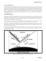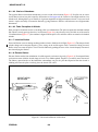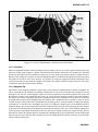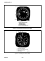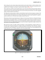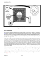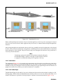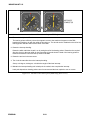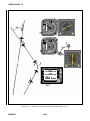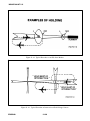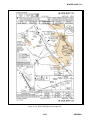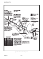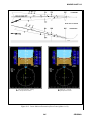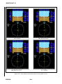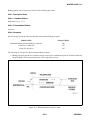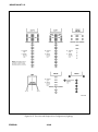
1
NAVAIR 00-80T-112
NATOPS
INSTRUMENT FLIGHT MANUAL
THIS PUBLICATION SUPERSEDES NAVAIR 00-80T-112
DATED 15 OCTOBER 2002.
DISTRIBUTION STATEMENT C — Distribution authorized to U.S.
Government agencies only and their contractors to protect publications
required for official use or for administrative or operational purposes only
(15 November 2006). Other requests for this document shall be referred to
Commander, Naval Air Systems Command (PMA-251), RADM William A
Moffett Bldg, 47123 Buse Rd, Bldg 2272, Patuxent River, MD 20670-1547.
DESTRUCTION NOTICE — For unclassified, limited documents, destroy by
any method that will prevent disclosure of contents or reconstruction of the
document.
ISSUED BY AUTHORITY OF THE CHIEF OF NAVAL OPERATIONS AND
UNDER THE DIRECTION OF THE COMMANDER,
NAVAL AIR SYSTEMS COMMAND.
0800LP1063562
1 (Reverse Blank)
15 NOVEMBER 2006
INTRODUCTION
1
METEOROLOGY
2
PHYSIOLOGY OF
INSTRUMENT FLIGHT
3
AIRCRAFT FLIGHT/
NAVIGATIONAL INSTR
4
ATTITUDE
INSTRUMENT FLIGHT
5
NAVAIDS/FACILITIES &
PROCEDURES
6
INSTRUMENT
FLIGHT
7
INDOCTRINATION &
FLIGHT EVALUATION
8
APPENDICES
& INDEX
A1−H60BB−NFM−000
1/(2 blank)
ORIGINAL
NAVAIR 00-80T-112
DEPARTMENT OF THE NAVY
NAVAL AIR SYSTEMS COMMAND
RADM WILLIAM A. MOFFETT BUILDING
47123 BUSE ROAD, BLDG 2272
PATUXENT RIVER, MD 20670-1547
15 November 2006
LETTER OF PROMULGATION
1. The Naval Air Training and Operating Procedures Standardization (NATOPS) Program is a
positive approach toward improving combat readiness and achieving a substantial reduction in the
aircraft mishap rate. Standardization, based on professional knowledge and experience, provides the
basis for development of an efficient and sound operational procedure. The standardization program
is not planned to stifle individual initiative, but rather to aid the Commanding Officer in increasing
the unit’s combat potential without reducing command prestige or responsibility.
2. This manual standardizes ground and flight procedures but does not include tactical doctrine.
Compliance with the stipulated manual requirements and procedures is mandatory except as
authorized herein. In order to remain effective, NATOPS must be dynamic and stimulate rather than
suppress individual thinking. Since aviation is a continuing, progressive profession, it is both
desirable and necessary that new ideas and new techniques be expeditiously evaluated and
incorporated if proven to be sound. To this end, Commanding Officers of aviation units are
authorized to modify procedures contained herein, in accordance with the waiver provisions
established by OPNAV Instruction 3710.7, for the purpose of assessing new ideas prior to initiating
recommendations for permanent changes. This manual is prepared and kept current by the users in
order to achieve maximum readiness and safety in the most efficient and economical manner. Should
conflict exist between the training and operating procedures found in this manual and those found
in other publications, this manual will govern.
3. Checklists and other pertinent extracts from this publication necessary to normal operations and
training should be made and carried for use in naval aircraft.
S. R. EASTBURG
Captain, United States Navy
By direction of
Commander, Naval Air Systems Command
3/(4 blank)
ORIGINAL
NAVAIR 00-80T-112
1/(2 blank)
ORIGINAL
NAVAIR 00-80T-112
INTERIM CHANGE SUMMARY
The following Interim Changes have been canceled or previously incorporated into this manual.
INTERIM
CHANGE
NUMBER(S)
REMARKS/PURPOSE
The following Interim Changes have been incorporated into this Change/Revision.
INTERIM
CHANGE
NUMBER(S)
REMARKS/PURPOSE
Interim Changes Outstanding — To be maintained by the custodian of this manual.
INTERIM
CHANGE
NUMBER(S)
ORIGINATOR/DATE
(or DATE/TIME GROUP)
PAGES
AFFECTED
5/(6 blank)
REMARKS/PURPOSE
ORIGINAL
NAVAIR 00-80T-112
1/(2 blank)
ORIGINAL
NAVAIR 00-80T-112
RECORD OF CHANGES
Change No. and
Date of Change
Date of
Entry
7/(8 blank)
Page Count Verified by
(Signature)
ORIGINAL
NAVAIR 00-80T-112
1/(2 blank)
ORIGINAL
NAVAIR 00-80T-112
NATOPS INSTRUMENT FLIGHT MANUAL
Contents
Page
No.
PART I — INTRODUCTION
CHAPTER 1 — INTRODUCTION
1.1
PURPOSE . . . . . . . . . . . . . . . . . . . . . . . . . . . . . . . . . . . . . . . . . . . . . . . . . . . . . . . . . . . . . 1-1
1.2
SCOPE . . . . . . . . . . . . . . . . . . . . . . . . . . . . . . . . . . . . . . . . . . . . . . . . . . . . . . . . . . . . . . . 1-1
1.3
GENERAL . . . . . . . . . . . . . . . . . . . . . . . . . . . . . . . . . . . . . . . . . . . . . . . . . . . . . . . . . . . . 1-1
1.4
1.4.1
1.4.2
1.4.3
1.4.4
RESPONSIBILITIES . . . . . . . . . . . . . . . . . . . . . . . . . . . . . . . . . . . . . . . . . . . . . . . . . . . .
NATOPS Advisory Group . . . . . . . . . . . . . . . . . . . . . . . . . . . . . . . . . . . . . . . . . . . . . . . . .
NATOPS Cognizant Command . . . . . . . . . . . . . . . . . . . . . . . . . . . . . . . . . . . . . . . . . . . . .
NATOPS Model Manager . . . . . . . . . . . . . . . . . . . . . . . . . . . . . . . . . . . . . . . . . . . . . . . . .
Commanding Officers . . . . . . . . . . . . . . . . . . . . . . . . . . . . . . . . . . . . . . . . . . . . . . . . . . . .
1.5
TRAINING . . . . . . . . . . . . . . . . . . . . . . . . . . . . . . . . . . . . . . . . . . . . . . . . . . . . . . . . . . . . 1-2
1.6
WAIVERS . . . . . . . . . . . . . . . . . . . . . . . . . . . . . . . . . . . . . . . . . . . . . . . . . . . . . . . . . . . . . 1-2
1-1
1-1
1-1
1-2
1-2
PART II — METEOROLOGY
CHAPTER 2 — CONCEPT
2.1
METEOROLOGY FOR NAVAL AVIATORS . . . . . . . . . . . . . . . . . . . . . . . . . . . . . . . . . 2-1
CHAPTER 3 — AIRMASSES
3.1
3.1.1
3.1.2
3.1.3
3.1.4
CONCEPT . . . . . . . . . . . . . . . . . . . . . . . . . . . . . . . . . . . . . . . . . . . . . . . . . . . . . . . . . . . . .
Airmass Classification . . . . . . . . . . . . . . . . . . . . . . . . . . . . . . . . . . . . . . . . . . . . . . . . . . . .
Airmass Development . . . . . . . . . . . . . . . . . . . . . . . . . . . . . . . . . . . . . . . . . . . . . . . . . . . .
Airmass Modification . . . . . . . . . . . . . . . . . . . . . . . . . . . . . . . . . . . . . . . . . . . . . . . . . . . .
Airmass Weather . . . . . . . . . . . . . . . . . . . . . . . . . . . . . . . . . . . . . . . . . . . . . . . . . . . . . . . .
3-1
3-1
3-1
3-1
3-2
CHAPTER 4 — FRONTS
4.1
INTRODUCTION . . . . . . . . . . . . . . . . . . . . . . . . . . . . . . . . . . . . . . . . . . . . . . . . . . . . . . . 4-1
4.2
RELATION OF FRONTS TO CYCLONES . . . . . . . . . . . . . . . . . . . . . . . . . . . . . . . . . . 4-1
4.3
4.3.1
4.3.2
4.3.3
4.3.4
RELATION OF FRONTS TO AIRMASSES . . . . . . . . . . . . . . . . . . . . . . . . . . . . . . . . . .
Cold Fronts . . . . . . . . . . . . . . . . . . . . . . . . . . . . . . . . . . . . . . . . . . . . . . . . . . . . . . . . . . . .
Warm Fronts . . . . . . . . . . . . . . . . . . . . . . . . . . . . . . . . . . . . . . . . . . . . . . . . . . . . . . . . . . .
Occluded Fronts . . . . . . . . . . . . . . . . . . . . . . . . . . . . . . . . . . . . . . . . . . . . . . . . . . . . . . . .
Stationary Fronts . . . . . . . . . . . . . . . . . . . . . . . . . . . . . . . . . . . . . . . . . . . . . . . . . . . . . . . .
4.4
PRESSURE AT FRONTS . . . . . . . . . . . . . . . . . . . . . . . . . . . . . . . . . . . . . . . . . . . . . . . . . 4-7
9
4-1
4-1
4-3
4-5
4-5
ORIGINAL
NAVAIR 00-80T-112
Page
No.
4.5
4.5.1
4.5.2
FRONTAL MOVEMENT . . . . . . . . . . . . . . . . . . . . . . . . . . . . . . . . . . . . . . . . . . . . . . . . . 4-7
Speed . . . . . . . . . . . . . . . . . . . . . . . . . . . . . . . . . . . . . . . . . . . . . . . . . . . . . . . . . . . . . . . . . 4-7
Modifications . . . . . . . . . . . . . . . . . . . . . . . . . . . . . . . . . . . . . . . . . . . . . . . . . . . . . . . . . . 4-7
CHAPTER 5 — TROPICAL METEOROLOGY
5.1
INTRODUCTION . . . . . . . . . . . . . . . . . . . . . . . . . . . . . . . . . . . . . . . . . . . . . . . . . . . . . . . 5-1
5.2
5.2.1
5.2.2
5.2.3
TROPICAL WAVES . . . . . . . . . . . . . . . . . . . . . . . . . . . . . . . . . . . . . . . . . . . . . . . . . . . . .
Stable Wave . . . . . . . . . . . . . . . . . . . . . . . . . . . . . . . . . . . . . . . . . . . . . . . . . . . . . . . . . . . .
Neutral Wave . . . . . . . . . . . . . . . . . . . . . . . . . . . . . . . . . . . . . . . . . . . . . . . . . . . . . . . . . . .
Unstable Wave . . . . . . . . . . . . . . . . . . . . . . . . . . . . . . . . . . . . . . . . . . . . . . . . . . . . . . . . . .
5.3
INTERTROPICAL CONVERGENCE ZONE . . . . . . . . . . . . . . . . . . . . . . . . . . . . . . . . . 5-2
5.4
CONVERGENCE ZONES . . . . . . . . . . . . . . . . . . . . . . . . . . . . . . . . . . . . . . . . . . . . . . . . 5-2
5.5
SHEAR LINES . . . . . . . . . . . . . . . . . . . . . . . . . . . . . . . . . . . . . . . . . . . . . . . . . . . . . . . . . 5-3
5-1
5-1
5-1
5-1
CHAPTER 6 — WEATHER HAZARDS TO FLIGHT
6.1
6.1.1
6.1.2
6.1.3
THUNDERSTORMS . . . . . . . . . . . . . . . . . . . . . . . . . . . . . . . . . . . . . . . . . . . . . . . . . . . .
Thunderstorm Development . . . . . . . . . . . . . . . . . . . . . . . . . . . . . . . . . . . . . . . . . . . . . . .
Thunderstorm Weather . . . . . . . . . . . . . . . . . . . . . . . . . . . . . . . . . . . . . . . . . . . . . . . . . . .
Thunderstorm Classification . . . . . . . . . . . . . . . . . . . . . . . . . . . . . . . . . . . . . . . . . . . . . . .
6.2
SQUALL LINES . . . . . . . . . . . . . . . . . . . . . . . . . . . . . . . . . . . . . . . . . . . . . . . . . . . . . . . . 6-4
6.3
TORNADOES AND WATERSPOUTS . . . . . . . . . . . . . . . . . . . . . . . . . . . . . . . . . . . . . . 6-4
6.4
6.4.1
6.4.2
TURBULENCE . . . . . . . . . . . . . . . . . . . . . . . . . . . . . . . . . . . . . . . . . . . . . . . . . . . . . . . . 6-6
Mountainous Terrain . . . . . . . . . . . . . . . . . . . . . . . . . . . . . . . . . . . . . . . . . . . . . . . . . . . . . 6-6
Clear-Air Turbulence . . . . . . . . . . . . . . . . . . . . . . . . . . . . . . . . . . . . . . . . . . . . . . . . . . . . . 6-7
6.5
6.5.1
6.5.2
6.5.3
6.5.4
FOG . . . . . . . . . . . . . . . . . . . . . . . . . . . . . . . . . . . . . . . . . . . . . . . . . . . . . . . . . . . . . . . . . .
Radiation Fog . . . . . . . . . . . . . . . . . . . . . . . . . . . . . . . . . . . . . . . . . . . . . . . . . . . . . . . . . .
Advection Fog . . . . . . . . . . . . . . . . . . . . . . . . . . . . . . . . . . . . . . . . . . . . . . . . . . . . . . . . . .
Frontal Fog . . . . . . . . . . . . . . . . . . . . . . . . . . . . . . . . . . . . . . . . . . . . . . . . . . . . . . . . . . . .
Arctic Fog . . . . . . . . . . . . . . . . . . . . . . . . . . . . . . . . . . . . . . . . . . . . . . . . . . . . . . . . . . . . .
6.6
6.6.1
AIRCRAFT ICING . . . . . . . . . . . . . . . . . . . . . . . . . . . . . . . . . . . . . . . . . . . . . . . . . . . . . . 6-9
Structural Icing . . . . . . . . . . . . . . . . . . . . . . . . . . . . . . . . . . . . . . . . . . . . . . . . . . . . . . . . . 6-9
6.7
6.7.1
6.7.2
6.7.3
6.7.4
6.7.5
STRUCTURAL DEICING . . . . . . . . . . . . . . . . . . . . . . . . . . . . . . . . . . . . . . . . . . . . . . .
Airfoil . . . . . . . . . . . . . . . . . . . . . . . . . . . . . . . . . . . . . . . . . . . . . . . . . . . . . . . . . . . . . . .
Propeller . . . . . . . . . . . . . . . . . . . . . . . . . . . . . . . . . . . . . . . . . . . . . . . . . . . . . . . . . . . . .
Pitot-Static/Angle of Attack (AOA) Systems . . . . . . . . . . . . . . . . . . . . . . . . . . . . . . . . .
Structural Icing Precautions . . . . . . . . . . . . . . . . . . . . . . . . . . . . . . . . . . . . . . . . . . . . . .
Aircraft Engine Icing . . . . . . . . . . . . . . . . . . . . . . . . . . . . . . . . . . . . . . . . . . . . . . . . . . . .
6.8
6.8.1
6.8.2
LOW-LEVEL WINDSHEAR . . . . . . . . . . . . . . . . . . . . . . . . . . . . . . . . . . . . . . . . . . . . . 6-11
Convective Windshear . . . . . . . . . . . . . . . . . . . . . . . . . . . . . . . . . . . . . . . . . . . . . . . . . . . 6-12
Nonconvective Windshear . . . . . . . . . . . . . . . . . . . . . . . . . . . . . . . . . . . . . . . . . . . . . . . . 6-12
6.9
MICROBURSTS . . . . . . . . . . . . . . . . . . . . . . . . . . . . . . . . . . . . . . . . . . . . . . . . . . . . . . . 6-12
ORIGINAL
10
6-1
6-1
6-3
6-3
6-7
6-7
6-8
6-8
6-8
6-10
6-10
6-10
6-11
6-11
6-11
NAVAIR 00-80T-112
Page
No.
PART III — PHYSIOLOGY OF INSTRUMENT FLIGHT
CHAPTER 7 — INTRODUCTION TO INSTRUMENT FLIGHT PHYSIOLOGY
7.1
GENERAL . . . . . . . . . . . . . . . . . . . . . . . . . . . . . . . . . . . . . . . . . . . . . . . . . . . . . . . . . . . . 7-1
7.2
7.2.1
7.2.2
7.2.3
7.2.4
7.2.5
YOUR SENSES . . . . . . . . . . . . . . . . . . . . . . . . . . . . . . . . . . . . . . . . . . . . . . . . . . . . . . . .
Motion (Inner Ear) . . . . . . . . . . . . . . . . . . . . . . . . . . . . . . . . . . . . . . . . . . . . . . . . . . . . . . .
Semicircular Canals . . . . . . . . . . . . . . . . . . . . . . . . . . . . . . . . . . . . . . . . . . . . . . . . . . . . . .
Otolith Organs . . . . . . . . . . . . . . . . . . . . . . . . . . . . . . . . . . . . . . . . . . . . . . . . . . . . . . . . . .
Postural (Seat of the Pants) . . . . . . . . . . . . . . . . . . . . . . . . . . . . . . . . . . . . . . . . . . . . . . . .
Sight . . . . . . . . . . . . . . . . . . . . . . . . . . . . . . . . . . . . . . . . . . . . . . . . . . . . . . . . . . . . . . . . .
7-1
7-1
7-1
7-4
7-4
7-5
CHAPTER 8 — SPATIAL DISORIENTATION
8.1
8.1.1
8.1.2
8.1.3
FALSE PERCEPTION (GENERAL) . . . . . . . . . . . . . . . . . . . . . . . . . . . . . . . . . . . . . . . . 8-1
Illusions: Primarily Inner Ear . . . . . . . . . . . . . . . . . . . . . . . . . . . . . . . . . . . . . . . . . . . . . . 8-1
Visual Illusions and Problems . . . . . . . . . . . . . . . . . . . . . . . . . . . . . . . . . . . . . . . . . . . . . . 8-9
False Perceptions During Helicopter Flights . . . . . . . . . . . . . . . . . . . . . . . . . . . . . . . . . 8-10
8.2
SPATIAL MISORIENTATION . . . . . . . . . . . . . . . . . . . . . . . . . . . . . . . . . . . . . . . . . . . . 8-12
CHAPTER 9 — FACTORS THAT INCREASE THE POTENTIAL FOR
SPATIAL DISORIENTATION
9.1
GENERAL . . . . . . . . . . . . . . . . . . . . . . . . . . . . . . . . . . . . . . . . . . . . . . . . . . . . . . . . . . . . 9-1
9.2
PERSONAL FACTORS . . . . . . . . . . . . . . . . . . . . . . . . . . . . . . . . . . . . . . . . . . . . . . . . . . 9-1
9.3
ENVIRONMENTAL FACTORS . . . . . . . . . . . . . . . . . . . . . . . . . . . . . . . . . . . . . . . . . . . 9-1
9.4
9.4.1
9.4.2
9.4.3
FACTORS RELATED TO TYPE OR PHASE OF FLIGHT . . . . . . . . . . . . . . . . . . . . . .
Takeoff and Landing Phases . . . . . . . . . . . . . . . . . . . . . . . . . . . . . . . . . . . . . . . . . . . . . . .
ACM or Air-to-Ground Ordnance Deliveries . . . . . . . . . . . . . . . . . . . . . . . . . . . . . . . . . .
Formation Flight . . . . . . . . . . . . . . . . . . . . . . . . . . . . . . . . . . . . . . . . . . . . . . . . . . . . . . . .
9-1
9-1
9-2
9-2
CHAPTER 10 — MEDICATIONS, ALCOHOL, AND NUTRITION
10.1
GENERAL . . . . . . . . . . . . . . . . . . . . . . . . . . . . . . . . . . . . . . . . . . . . . . . . . . . . . . . . . . . 10-1
10.2
NUTRITION . . . . . . . . . . . . . . . . . . . . . . . . . . . . . . . . . . . . . . . . . . . . . . . . . . . . . . . . . . 10-1
10.3
EXERCISE . . . . . . . . . . . . . . . . . . . . . . . . . . . . . . . . . . . . . . . . . . . . . . . . . . . . . . . . . . . 10-1
10.4
DRUGS . . . . . . . . . . . . . . . . . . . . . . . . . . . . . . . . . . . . . . . . . . . . . . . . . . . . . . . . . . . . . . 10-1
11
ORIGINAL
NAVAIR 00-80T-112
Page
No.
10.5
ILLNESS . . . . . . . . . . . . . . . . . . . . . . . . . . . . . . . . . . . . . . . . . . . . . . . . . . . . . . . . . . . . . 10-2
10.6
DENTAL CARE . . . . . . . . . . . . . . . . . . . . . . . . . . . . . . . . . . . . . . . . . . . . . . . . . . . . . . . 10-2
10.7
IMMUNIZATION/INJECTIONS . . . . . . . . . . . . . . . . . . . . . . . . . . . . . . . . . . . . . . . . . . 10-2
10.8
BLOOD DONATION . . . . . . . . . . . . . . . . . . . . . . . . . . . . . . . . . . . . . . . . . . . . . . . . . . . 10-2
CHAPTER 11 — PREVENTION OF SPATIAL DISORIENTATION
11.1
GENERAL . . . . . . . . . . . . . . . . . . . . . . . . . . . . . . . . . . . . . . . . . . . . . . . . . . . . . . . . . . . 11-1
11.2
11.2.1
11.2.2
11.2.3
11.2.4
11.2.5
11.2.6
TRAINING . . . . . . . . . . . . . . . . . . . . . . . . . . . . . . . . . . . . . . . . . . . . . . . . . . . . . . . . . . .
Sensation of Climbing During a Turn . . . . . . . . . . . . . . . . . . . . . . . . . . . . . . . . . . . . . . .
Sensation of Diving During Recovery From a Turn . . . . . . . . . . . . . . . . . . . . . . . . . . . .
False Sensations of Tilting to Right or Left . . . . . . . . . . . . . . . . . . . . . . . . . . . . . . . . . .
False Sensation of Reversal of Motion . . . . . . . . . . . . . . . . . . . . . . . . . . . . . . . . . . . . . .
Sensation of Diving or Rolling Beyond the Vertical Plane . . . . . . . . . . . . . . . . . . . . . . .
Sensation of Climbing During Straight-and-Level Flight . . . . . . . . . . . . . . . . . . . . . . . .
11.3
EXPERIENCE . . . . . . . . . . . . . . . . . . . . . . . . . . . . . . . . . . . . . . . . . . . . . . . . . . . . . . . . 11-3
11-1
11-1
11-2
11-2
11-2
11-2
11-2
CHAPTER 12 — OVERCOMING SPATIAL DISORIENTATION
12.1
GENERAL . . . . . . . . . . . . . . . . . . . . . . . . . . . . . . . . . . . . . . . . . . . . . . . . . . . . . . . . . . . 12-1
12.2
SINGLE-SEAT AIRCRAFT . . . . . . . . . . . . . . . . . . . . . . . . . . . . . . . . . . . . . . . . . . . . . . 12-1
12.3
DUAL-SEAT AIRCRAFT . . . . . . . . . . . . . . . . . . . . . . . . . . . . . . . . . . . . . . . . . . . . . . . 12-2
12.4
MULTICREWED AIRCRAFT . . . . . . . . . . . . . . . . . . . . . . . . . . . . . . . . . . . . . . . . . . . . 12-2
12.5
FORMATION FLIGHTS IN NIGHT OR WEATHER . . . . . . . . . . . . . . . . . . . . . . . . . . 12-2
PART IV — AIRCRAFT FLIGHT/NAVIGATIONAL INSTRUMENTATION
CHAPTER 13 — INTRODUCTION TO AIRCRAFT FLIGHT INSTRUMENTS
13.1
GENERAL . . . . . . . . . . . . . . . . . . . . . . . . . . . . . . . . . . . . . . . . . . . . . . . . . . . . . . . . . . . 13-1
CHAPTER 14 — ATTITUDE INSTRUMENTS
14.1
GENERAL . . . . . . . . . . . . . . . . . . . . . . . . . . . . . . . . . . . . . . . . . . . . . . . . . . . . . . . . . . . 14-1
14.2
14.2.1
14.2.2
14.2.3
14.2.4
HEADS-UP DISPLAY . . . . . . . . . . . . . . . . . . . . . . . . . . . . . . . . . . . . . . . . . . . . . . . . . .
HUD Limitations . . . . . . . . . . . . . . . . . . . . . . . . . . . . . . . . . . . . . . . . . . . . . . . . . . . . . . .
Global Orientation . . . . . . . . . . . . . . . . . . . . . . . . . . . . . . . . . . . . . . . . . . . . . . . . . . . . . .
HUD Field of View . . . . . . . . . . . . . . . . . . . . . . . . . . . . . . . . . . . . . . . . . . . . . . . . . . . . .
Conventional Cross-Check . . . . . . . . . . . . . . . . . . . . . . . . . . . . . . . . . . . . . . . . . . . . . . .
ORIGINAL
12
14-1
14-1
14-1
14-3
14-3
NAVAIR 00-80T-112
Page
No.
CHAPTER 15 — PERFORMANCE INSTRUMENTS
15.1
15.1.1
15.1.2
15.1.3
15.1.4
15.1.5
15.1.6
COMPASSES . . . . . . . . . . . . . . . . . . . . . . . . . . . . . . . . . . . . . . . . . . . . . . . . . . . . . . . . .
Standby Magnetic Compass . . . . . . . . . . . . . . . . . . . . . . . . . . . . . . . . . . . . . . . . . . . . . .
Variation . . . . . . . . . . . . . . . . . . . . . . . . . . . . . . . . . . . . . . . . . . . . . . . . . . . . . . . . . . . . .
Deviation . . . . . . . . . . . . . . . . . . . . . . . . . . . . . . . . . . . . . . . . . . . . . . . . . . . . . . . . . . . . .
Magnetic Dip . . . . . . . . . . . . . . . . . . . . . . . . . . . . . . . . . . . . . . . . . . . . . . . . . . . . . . . . . .
Acceleration Error . . . . . . . . . . . . . . . . . . . . . . . . . . . . . . . . . . . . . . . . . . . . . . . . . . . . . .
Oscillation Error . . . . . . . . . . . . . . . . . . . . . . . . . . . . . . . . . . . . . . . . . . . . . . . . . . . . . . .
15-1
15-1
15-1
15-3
15-3
15-4
15-4
15.2
AIRSPEED INDICATOR . . . . . . . . . . . . . . . . . . . . . . . . . . . . . . . . . . . . . . . . . . . . . . . . 15-4
15.3
15.3.1
15.3.2
VERTICAL SPEED INDICATOR (VSI/VVI) . . . . . . . . . . . . . . . . . . . . . . . . . . . . . . . . 15-4
VSI Error . . . . . . . . . . . . . . . . . . . . . . . . . . . . . . . . . . . . . . . . . . . . . . . . . . . . . . . . . . . . . 15-4
Dial Calibration . . . . . . . . . . . . . . . . . . . . . . . . . . . . . . . . . . . . . . . . . . . . . . . . . . . . . . . . 15-4
15.4
15.4.1
15.4.2
TURN AND SLIP INDICATOR . . . . . . . . . . . . . . . . . . . . . . . . . . . . . . . . . . . . . . . . . . . 15-4
Turn Indicator (Needle) . . . . . . . . . . . . . . . . . . . . . . . . . . . . . . . . . . . . . . . . . . . . . . . . . . 15-6
Slip Indicator (Ball) . . . . . . . . . . . . . . . . . . . . . . . . . . . . . . . . . . . . . . . . . . . . . . . . . . . . . 15-6
15.5
ANGLE OF ATTACK INDICATOR . . . . . . . . . . . . . . . . . . . . . . . . . . . . . . . . . . . . . . . 15-8
15.6
HOVER INDICATOR . . . . . . . . . . . . . . . . . . . . . . . . . . . . . . . . . . . . . . . . . . . . . . . . . . . 15-8
15.7
CLOCK . . . . . . . . . . . . . . . . . . . . . . . . . . . . . . . . . . . . . . . . . . . . . . . . . . . . . . . . . . . . . . 15-8
15.8
OUTSIDE AIR TEMPERATURE GAUGE . . . . . . . . . . . . . . . . . . . . . . . . . . . . . . . . . . 15-8
CHAPTER 16 — POSITION INSTRUMENTS
16.1
16.1.1
16.1.2
ALTIMETERS . . . . . . . . . . . . . . . . . . . . . . . . . . . . . . . . . . . . . . . . . . . . . . . . . . . . . . . . 16-1
Pressure Altimeter . . . . . . . . . . . . . . . . . . . . . . . . . . . . . . . . . . . . . . . . . . . . . . . . . . . . . . 16-1
Radio/Radar Altimeters . . . . . . . . . . . . . . . . . . . . . . . . . . . . . . . . . . . . . . . . . . . . . . . . . . 16-4
16.2
RANGE INDICATOR . . . . . . . . . . . . . . . . . . . . . . . . . . . . . . . . . . . . . . . . . . . . . . . . . . . 16-4
16.3
16.3.1
16.3.2
16.3.3
BEARING INDICATORS . . . . . . . . . . . . . . . . . . . . . . . . . . . . . . . . . . . . . . . . . . . . . . .
Radio Magnetic Indicator (RMI) . . . . . . . . . . . . . . . . . . . . . . . . . . . . . . . . . . . . . . . . . . .
Bearing-Distance-Heading Indicator (BDHI) . . . . . . . . . . . . . . . . . . . . . . . . . . . . . . . . .
Horizontal Situation Indicator (HSI) . . . . . . . . . . . . . . . . . . . . . . . . . . . . . . . . . . . . . . . .
16.4
16.4.1
16.4.2
COURSE INDICATOR . . . . . . . . . . . . . . . . . . . . . . . . . . . . . . . . . . . . . . . . . . . . . . . . . 16-10
VOR/TACAN Display . . . . . . . . . . . . . . . . . . . . . . . . . . . . . . . . . . . . . . . . . . . . . . . . . 16-11
ILS Display . . . . . . . . . . . . . . . . . . . . . . . . . . . . . . . . . . . . . . . . . . . . . . . . . . . . . . . . . . 16-11
16.5
FLIGHT DIRECTOR SYSTEM . . . . . . . . . . . . . . . . . . . . . . . . . . . . . . . . . . . . . . . . . . 16-12
16.6
OTHER POSITION INSTRUMENTS . . . . . . . . . . . . . . . . . . . . . . . . . . . . . . . . . . . . . 16-12
13
16-6
16-6
16-6
16-6
ORIGINAL
NAVAIR 00-80T-112
Page
No.
PART V — ATTITUDE INSTRUMENT FLIGHT
CHAPTER 17 — ATTITUDE INSTRUMENT FLYING
17.1
GENERAL . . . . . . . . . . . . . . . . . . . . . . . . . . . . . . . . . . . . . . . . . . . . . . . . . . . . . . . . . . . 17-1
17.2
17.2.1
AIRCRAFT CONTROL . . . . . . . . . . . . . . . . . . . . . . . . . . . . . . . . . . . . . . . . . . . . . . . . . 17-1
Attitude Control . . . . . . . . . . . . . . . . . . . . . . . . . . . . . . . . . . . . . . . . . . . . . . . . . . . . . . . 17-2
17.3
17.3.1
17.3.2
17.3.3
17.3.4
17.3.5
17.3.6
17.3.7
17.3.8
INSTRUMENT GROUPINGS . . . . . . . . . . . . . . . . . . . . . . . . . . . . . . . . . . . . . . . . . . . .
Control Instruments . . . . . . . . . . . . . . . . . . . . . . . . . . . . . . . . . . . . . . . . . . . . . . . . . . . . .
Performance Instruments . . . . . . . . . . . . . . . . . . . . . . . . . . . . . . . . . . . . . . . . . . . . . . . . .
Position Instruments . . . . . . . . . . . . . . . . . . . . . . . . . . . . . . . . . . . . . . . . . . . . . . . . . . . .
Instrument Scan . . . . . . . . . . . . . . . . . . . . . . . . . . . . . . . . . . . . . . . . . . . . . . . . . . . . . . . .
Functions of Instruments — Full Panel Scan . . . . . . . . . . . . . . . . . . . . . . . . . . . . . . . . .
Scan Technique . . . . . . . . . . . . . . . . . . . . . . . . . . . . . . . . . . . . . . . . . . . . . . . . . . . . . . . .
Scan Analysis . . . . . . . . . . . . . . . . . . . . . . . . . . . . . . . . . . . . . . . . . . . . . . . . . . . . . . . . .
Use of Angle of Attack . . . . . . . . . . . . . . . . . . . . . . . . . . . . . . . . . . . . . . . . . . . . . . . . . .
17.4
AIRCRAFT TRIM . . . . . . . . . . . . . . . . . . . . . . . . . . . . . . . . . . . . . . . . . . . . . . . . . . . . . 17-9
17.5
INSTRUMENT HOVERING . . . . . . . . . . . . . . . . . . . . . . . . . . . . . . . . . . . . . . . . . . . . 17-10
17-4
17-4
17-4
17-4
17-4
17-4
17-6
17-7
17-7
CHAPTER 18 — INSTRUMENT FLIGHT MANEUVERS
18.1
18.1.1
APPLICATION . . . . . . . . . . . . . . . . . . . . . . . . . . . . . . . . . . . . . . . . . . . . . . . . . . . . . . . . 18-1
Planning . . . . . . . . . . . . . . . . . . . . . . . . . . . . . . . . . . . . . . . . . . . . . . . . . . . . . . . . . . . . . . 18-1
18.2
18.2.1
INSTRUMENT TAKEOFF (ITO) . . . . . . . . . . . . . . . . . . . . . . . . . . . . . . . . . . . . . . . . . 18-2
Pretakeoff Procedures . . . . . . . . . . . . . . . . . . . . . . . . . . . . . . . . . . . . . . . . . . . . . . . . . . . 18-2
18.3
18.3.1
18.3.2
STRAIGHT-AND-LEVEL FLIGHT . . . . . . . . . . . . . . . . . . . . . . . . . . . . . . . . . . . . . . . 18-4
Maintaining a Desired Altitude . . . . . . . . . . . . . . . . . . . . . . . . . . . . . . . . . . . . . . . . . . . . 18-4
Level Turns . . . . . . . . . . . . . . . . . . . . . . . . . . . . . . . . . . . . . . . . . . . . . . . . . . . . . . . . . . . 18-8
18.4
18.4.1
18.4.2
CLIMBS AND DESCENT . . . . . . . . . . . . . . . . . . . . . . . . . . . . . . . . . . . . . . . . . . . . . . 18-12
Constant Airspeed Climbs and Descents . . . . . . . . . . . . . . . . . . . . . . . . . . . . . . . . . . . 18-12
Constant-Rate Climbs and Descents . . . . . . . . . . . . . . . . . . . . . . . . . . . . . . . . . . . . . . . 18-14
18.5
18.5.1
18.5.2
18.5.3
18.5.4
18.5.5
18.5.6
18.5.7
ROTARY-WING INSTRUMENT FLYING . . . . . . . . . . . . . . . . . . . . . . . . . . . . . . . . .
Attitude Stabilization . . . . . . . . . . . . . . . . . . . . . . . . . . . . . . . . . . . . . . . . . . . . . . . . . .
Yaw Stabilization . . . . . . . . . . . . . . . . . . . . . . . . . . . . . . . . . . . . . . . . . . . . . . . . . . . . . .
Altitude Stabilization . . . . . . . . . . . . . . . . . . . . . . . . . . . . . . . . . . . . . . . . . . . . . . . . . .
Attitude Control . . . . . . . . . . . . . . . . . . . . . . . . . . . . . . . . . . . . . . . . . . . . . . . . . . . . . .
Power Control . . . . . . . . . . . . . . . . . . . . . . . . . . . . . . . . . . . . . . . . . . . . . . . . . . . . . . . .
Altitude Control . . . . . . . . . . . . . . . . . . . . . . . . . . . . . . . . . . . . . . . . . . . . . . . . . . . . . .
Airspeed Control . . . . . . . . . . . . . . . . . . . . . . . . . . . . . . . . . . . . . . . . . . . . . . . . . . . . . .
18.6
18.6.1
18.6.2
PARTIAL PANEL FLIGHT . . . . . . . . . . . . . . . . . . . . . . . . . . . . . . . . . . . . . . . . . . . . . 18-17
Heading Indicator Failure . . . . . . . . . . . . . . . . . . . . . . . . . . . . . . . . . . . . . . . . . . . . . . . 18-17
Attitude Indicator Failure . . . . . . . . . . . . . . . . . . . . . . . . . . . . . . . . . . . . . . . . . . . . . . . 18-18
ORIGINAL
14
18-15
18-15
18-16
18-16
18-16
18-16
18-16
18-16
NAVAIR 00-80T-112
Page
No.
CHAPTER 19 — INSTRUMENT PATTERNS AND CONFIDENCE MANEUVERS
19.1
PURPOSE . . . . . . . . . . . . . . . . . . . . . . . . . . . . . . . . . . . . . . . . . . . . . . . . . . . . . . . . . . . . 19-1
19.2
19.2.1
19.2.2
19.2.3
19.2.4
19.2.5
19.2.6
INSTRUMENT PATTERNS . . . . . . . . . . . . . . . . . . . . . . . . . . . . . . . . . . . . . . . . . . . . . .
Vertical S-1, S-2, S-3, S-4 . . . . . . . . . . . . . . . . . . . . . . . . . . . . . . . . . . . . . . . . . . . . . . . .
Steep Turns . . . . . . . . . . . . . . . . . . . . . . . . . . . . . . . . . . . . . . . . . . . . . . . . . . . . . . . . . . .
OSCAR Pattern . . . . . . . . . . . . . . . . . . . . . . . . . . . . . . . . . . . . . . . . . . . . . . . . . . . . . . . .
CHARLIE Pattern . . . . . . . . . . . . . . . . . . . . . . . . . . . . . . . . . . . . . . . . . . . . . . . . . . . . . .
BRAVO Pattern . . . . . . . . . . . . . . . . . . . . . . . . . . . . . . . . . . . . . . . . . . . . . . . . . . . . . . . .
YANKEE Pattern . . . . . . . . . . . . . . . . . . . . . . . . . . . . . . . . . . . . . . . . . . . . . . . . . . . . . . .
19.3
19.3.1
19.3.2
19.3.3
19.3.4
19.3.5
19.3.6
CONFIDENCE MANEUVERS . . . . . . . . . . . . . . . . . . . . . . . . . . . . . . . . . . . . . . . . . . . 19-7
Wingover . . . . . . . . . . . . . . . . . . . . . . . . . . . . . . . . . . . . . . . . . . . . . . . . . . . . . . . . . . . . . 19-7
Barrel Roll . . . . . . . . . . . . . . . . . . . . . . . . . . . . . . . . . . . . . . . . . . . . . . . . . . . . . . . . . . . . 19-7
Aileron Roll . . . . . . . . . . . . . . . . . . . . . . . . . . . . . . . . . . . . . . . . . . . . . . . . . . . . . . . . . . . 19-9
Loops . . . . . . . . . . . . . . . . . . . . . . . . . . . . . . . . . . . . . . . . . . . . . . . . . . . . . . . . . . . . . . . . 19-9
Immelmann . . . . . . . . . . . . . . . . . . . . . . . . . . . . . . . . . . . . . . . . . . . . . . . . . . . . . . . . . . 19-11
Half Cuban Eight . . . . . . . . . . . . . . . . . . . . . . . . . . . . . . . . . . . . . . . . . . . . . . . . . . . . . . 19-11
19-1
19-1
19-4
19-4
19-5
19-6
19-6
CHAPTER 20 — UNUSUAL ATTITUDES
20.1
INTRODUCTION . . . . . . . . . . . . . . . . . . . . . . . . . . . . . . . . . . . . . . . . . . . . . . . . . . . . . . 20-1
20.2
ATTITUDE INTERPRETATION . . . . . . . . . . . . . . . . . . . . . . . . . . . . . . . . . . . . . . . . . . 20-2
20.3
20.3.1
20.3.2
20.3.3
RECOVERY PROCEDURES . . . . . . . . . . . . . . . . . . . . . . . . . . . . . . . . . . . . . . . . . . . .
Nose-High Recovery . . . . . . . . . . . . . . . . . . . . . . . . . . . . . . . . . . . . . . . . . . . . . . . . . . . .
Nose-Low Recovery . . . . . . . . . . . . . . . . . . . . . . . . . . . . . . . . . . . . . . . . . . . . . . . . . . . .
Partial Panel Unusual Attitudes . . . . . . . . . . . . . . . . . . . . . . . . . . . . . . . . . . . . . . . . . . .
20-2
20-2
20-4
20-4
PART VI — NAVIGATIONAL AIDS/FACILITIES AND PROCEDURES
CHAPTER 21 — VHF OMNIDIRECTIONAL RANGE (VOR)
21.1
INTRODUCTION . . . . . . . . . . . . . . . . . . . . . . . . . . . . . . . . . . . . . . . . . . . . . . . . . . . . . . 21-1
21.2
21.2.1
21.2.2
EQUIPMENT AND OPERATION . . . . . . . . . . . . . . . . . . . . . . . . . . . . . . . . . . . . . . . . . 21-1
Equipment . . . . . . . . . . . . . . . . . . . . . . . . . . . . . . . . . . . . . . . . . . . . . . . . . . . . . . . . . . . . 21-1
Operation . . . . . . . . . . . . . . . . . . . . . . . . . . . . . . . . . . . . . . . . . . . . . . . . . . . . . . . . . . . . . 21-3
15
ORIGINAL
NAVAIR 00-80T-112
Page
No.
21.3
21.3.1
21.3.2
21.3.3
21.3.4
21.3.5
21.3.6
21.3.7
21.3.8
21.3.9
21.3.10
21.3.11
21.3.12
PROCEDURES . . . . . . . . . . . . . . . . . . . . . . . . . . . . . . . . . . . . . . . . . . . . . . . . . . . . . . . . 21-4
Proceeding Direct to Station . . . . . . . . . . . . . . . . . . . . . . . . . . . . . . . . . . . . . . . . . . . . . . 21-4
Course Interceptions . . . . . . . . . . . . . . . . . . . . . . . . . . . . . . . . . . . . . . . . . . . . . . . . . . . . 21-4
Inbound Procedures . . . . . . . . . . . . . . . . . . . . . . . . . . . . . . . . . . . . . . . . . . . . . . . . . . . . . 21-6
Outbound Procedures — Immediately After Station Passage . . . . . . . . . . . . . . . . . . . . 21-6
Outbound Procedures . . . . . . . . . . . . . . . . . . . . . . . . . . . . . . . . . . . . . . . . . . . . . . . . . . 21-16
Completing the Intercept . . . . . . . . . . . . . . . . . . . . . . . . . . . . . . . . . . . . . . . . . . . . . . . . 21-17
Estimating Drift Correction . . . . . . . . . . . . . . . . . . . . . . . . . . . . . . . . . . . . . . . . . . . . . . 21-17
Homing . . . . . . . . . . . . . . . . . . . . . . . . . . . . . . . . . . . . . . . . . . . . . . . . . . . . . . . . . . . . . 21-17
Time-Distance Check . . . . . . . . . . . . . . . . . . . . . . . . . . . . . . . . . . . . . . . . . . . . . . . . . . 21-21
30˚ Method . . . . . . . . . . . . . . . . . . . . . . . . . . . . . . . . . . . . . . . . . . . . . . . . . . . . . . . . . . 21-23
Station Passage . . . . . . . . . . . . . . . . . . . . . . . . . . . . . . . . . . . . . . . . . . . . . . . . . . . . . . . 21-23
Holding . . . . . . . . . . . . . . . . . . . . . . . . . . . . . . . . . . . . . . . . . . . . . . . . . . . . . . . . . . . . . 21-27
CHAPTER 22 — TACTICAL AIR NAVIGATION (TACAN)
22.1
INTRODUCTION . . . . . . . . . . . . . . . . . . . . . . . . . . . . . . . . . . . . . . . . . . . . . . . . . . . . . . 22-1
22.2
22.2.1
22.2.2
22.2.3
22.2.4
EQUIPMENT AND TRANSMISSION PRINCIPLES . . . . . . . . . . . . . . . . . . . . . . . . . 22-1
Ground Equipment . . . . . . . . . . . . . . . . . . . . . . . . . . . . . . . . . . . . . . . . . . . . . . . . . . . . . 22-2
TACAN Characteristics . . . . . . . . . . . . . . . . . . . . . . . . . . . . . . . . . . . . . . . . . . . . . . . . . . 22-5
TACAN Procedures . . . . . . . . . . . . . . . . . . . . . . . . . . . . . . . . . . . . . . . . . . . . . . . . . . . . . 22-7
TACAN Approach Procedures . . . . . . . . . . . . . . . . . . . . . . . . . . . . . . . . . . . . . . . . . . . 22-18
CHAPTER 23 — ADF, UHF/ADF, MARKER BEACONS
23.1
23.1.1
23.1.2
AUTOMATIC DIRECTION FINDING (ADF) . . . . . . . . . . . . . . . . . . . . . . . . . . . . . . . 23-1
Automatic Direction Finding (ADF) Procedures . . . . . . . . . . . . . . . . . . . . . . . . . . . . . . 23-1
UHF Nondirectional Radio Beacon (Homer) . . . . . . . . . . . . . . . . . . . . . . . . . . . . . . . . 23-11
23.2
MARKER BEACONS . . . . . . . . . . . . . . . . . . . . . . . . . . . . . . . . . . . . . . . . . . . . . . . . . 23-14
CHAPTER 24 — INSTRUMENT LANDING SYSTEM (ILS)
24.1
INTRODUCTION . . . . . . . . . . . . . . . . . . . . . . . . . . . . . . . . . . . . . . . . . . . . . . . . . . . . . . 24-1
24.2
24.2.1
24.2.2
EQUIPMENT AND OPERATION . . . . . . . . . . . . . . . . . . . . . . . . . . . . . . . . . . . . . . . . . 24-1
Ground Equipment . . . . . . . . . . . . . . . . . . . . . . . . . . . . . . . . . . . . . . . . . . . . . . . . . . . . . 24-1
Airborne Equipment . . . . . . . . . . . . . . . . . . . . . . . . . . . . . . . . . . . . . . . . . . . . . . . . . . . . 24-4
24.3
24.3.1
24.3.2
24.3.3
24.3.4
24.3.5
ILS PROCEDURES . . . . . . . . . . . . . . . . . . . . . . . . . . . . . . . . . . . . . . . . . . . . . . . . . . . . 24-5
Performing the ILS Approach . . . . . . . . . . . . . . . . . . . . . . . . . . . . . . . . . . . . . . . . . . . . . 24-5
Localizer Approaches . . . . . . . . . . . . . . . . . . . . . . . . . . . . . . . . . . . . . . . . . . . . . . . . . . 24-10
Simplified Directional Facility (SDF) . . . . . . . . . . . . . . . . . . . . . . . . . . . . . . . . . . . . . . 24-10
Radar Vectors . . . . . . . . . . . . . . . . . . . . . . . . . . . . . . . . . . . . . . . . . . . . . . . . . . . . . . . . 24-10
Localizer (LOC) Back Course Approach . . . . . . . . . . . . . . . . . . . . . . . . . . . . . . . . . . . 24-11
ORIGINAL
16
NAVAIR 00-80T-112
Page
No.
CHAPTER 25 — RADAR APPROACHES
25.1
25.1.1
25.1.2
INTRODUCTION . . . . . . . . . . . . . . . . . . . . . . . . . . . . . . . . . . . . . . . . . . . . . . . . . . . . . . 25-1
Principles of Radar . . . . . . . . . . . . . . . . . . . . . . . . . . . . . . . . . . . . . . . . . . . . . . . . . . . . . 25-1
Radar Traffic Information Service . . . . . . . . . . . . . . . . . . . . . . . . . . . . . . . . . . . . . . . . . . 25-1
25.2
25.2.1
RADAR EQUIPMENT AND OPERATION . . . . . . . . . . . . . . . . . . . . . . . . . . . . . . . . . 25-2
Equipment . . . . . . . . . . . . . . . . . . . . . . . . . . . . . . . . . . . . . . . . . . . . . . . . . . . . . . . . . . . . 25-2
25.3
25.3.1
RADAR APPROACH PROCEDURES . . . . . . . . . . . . . . . . . . . . . . . . . . . . . . . . . . . . . 25-3
Radar Approaches . . . . . . . . . . . . . . . . . . . . . . . . . . . . . . . . . . . . . . . . . . . . . . . . . . . . . . 25-3
CHAPTER 26 — GLOBAL POSITIONING SYSTEM (GPS)
26.1
INTRODUCTION . . . . . . . . . . . . . . . . . . . . . . . . . . . . . . . . . . . . . . . . . . . . . . . . . . . . . . 26-1
26.2
26.2.1
26.2.2
26.2.3
26.2.4
26.2.5
26.2.6
26.2.7
26.2.8
26.2.9
SYSTEM OVERVIEW . . . . . . . . . . . . . . . . . . . . . . . . . . . . . . . . . . . . . . . . . . . . . . . . . .
Signal Accuracy . . . . . . . . . . . . . . . . . . . . . . . . . . . . . . . . . . . . . . . . . . . . . . . . . . . . . . .
GPS Segments . . . . . . . . . . . . . . . . . . . . . . . . . . . . . . . . . . . . . . . . . . . . . . . . . . . . . . . . .
Integrated Systems . . . . . . . . . . . . . . . . . . . . . . . . . . . . . . . . . . . . . . . . . . . . . . . . . . . . .
Flight Management System (FMS) . . . . . . . . . . . . . . . . . . . . . . . . . . . . . . . . . . . . . . . . .
Required Navigation Performance (RNP) . . . . . . . . . . . . . . . . . . . . . . . . . . . . . . . . . . . .
Waypoints . . . . . . . . . . . . . . . . . . . . . . . . . . . . . . . . . . . . . . . . . . . . . . . . . . . . . . . . . . . .
RNAV Leg Types . . . . . . . . . . . . . . . . . . . . . . . . . . . . . . . . . . . . . . . . . . . . . . . . . . . . . .
Course Sensitivity . . . . . . . . . . . . . . . . . . . . . . . . . . . . . . . . . . . . . . . . . . . . . . . . . . . . . .
Navigation Database . . . . . . . . . . . . . . . . . . . . . . . . . . . . . . . . . . . . . . . . . . . . . . . . . . . .
26-1
26-1
26-1
26-1
26-2
26-2
26-3
26-3
26-4
26-7
26.3
26.3.1
26.3.2
26.3.3
26.3.4
26.3.5
26.3.6
26.3.7
RESTRICTIONS ON THE USE OF GPS . . . . . . . . . . . . . . . . . . . . . . . . . . . . . . . . . . .
Specific Capabilities and Restrictions . . . . . . . . . . . . . . . . . . . . . . . . . . . . . . . . . . . . . . .
Use of GPS Outside of the U.S. National Airspace System (NAS) . . . . . . . . . . . . . . . .
Receiver Autonomous Integrity Monitoring (RAIM) . . . . . . . . . . . . . . . . . . . . . . . . . . .
Database Requirements . . . . . . . . . . . . . . . . . . . . . . . . . . . . . . . . . . . . . . . . . . . . . . . . . .
RNAV in the Terminal Area . . . . . . . . . . . . . . . . . . . . . . . . . . . . . . . . . . . . . . . . . . . . . .
GPS Approach Restrictions . . . . . . . . . . . . . . . . . . . . . . . . . . . . . . . . . . . . . . . . . . . . . . .
Alternate Airport Restrictions . . . . . . . . . . . . . . . . . . . . . . . . . . . . . . . . . . . . . . . . . . . . .
26-7
26-7
26-7
26-7
26-8
26-8
26-8
26-9
26.4
26.4.1
26.4.2
26.4.3
26.4.4
GPS APPROACH NOMENCLATURE . . . . . . . . . . . . . . . . . . . . . . . . . . . . . . . . . . . . . 26-9
GPS Stand-Alone Approaches . . . . . . . . . . . . . . . . . . . . . . . . . . . . . . . . . . . . . . . . . . . . 26-9
GPS Overlay Approaches . . . . . . . . . . . . . . . . . . . . . . . . . . . . . . . . . . . . . . . . . . . . . . . . 26-9
RNAV (GPS) Approaches . . . . . . . . . . . . . . . . . . . . . . . . . . . . . . . . . . . . . . . . . . . . . . . 26-10
RNAV (RNP) Approaches . . . . . . . . . . . . . . . . . . . . . . . . . . . . . . . . . . . . . . . . . . . . . . . 26-10
26.5
26.5.1
26.5.2
26.5.3
26.5.4
26.5.5
26.5.6
26.5.7
AIRCREW ACTIONS . . . . . . . . . . . . . . . . . . . . . . . . . . . . . . . . . . . . . . . . . . . . . . . . .
Preflight . . . . . . . . . . . . . . . . . . . . . . . . . . . . . . . . . . . . . . . . . . . . . . . . . . . . . . . . . . . . .
Terminal Area Operations and Departure . . . . . . . . . . . . . . . . . . . . . . . . . . . . . . . . . . .
En Route Operations . . . . . . . . . . . . . . . . . . . . . . . . . . . . . . . . . . . . . . . . . . . . . . . . . . .
Prior to Descent . . . . . . . . . . . . . . . . . . . . . . . . . . . . . . . . . . . . . . . . . . . . . . . . . . . . . . .
Terminal Area Operations and Arrival . . . . . . . . . . . . . . . . . . . . . . . . . . . . . . . . . . . . .
Be Prepared to Use Traditional NAVAIDs . . . . . . . . . . . . . . . . . . . . . . . . . . . . . . . . . .
Approach Procedures . . . . . . . . . . . . . . . . . . . . . . . . . . . . . . . . . . . . . . . . . . . . . . . . . . .
17
26-10
26-10
26-10
26-11
26-11
26-11
26-11
26-12
ORIGINAL
NAVAIR 00-80T-112
Page
No.
26.6
26.6.1
26.6.2
26.6.3
GPS NAVIGATION TRAINING . . . . . . . . . . . . . . . . . . . . . . . . . . . . . . . . . . . . . . . . .
General . . . . . . . . . . . . . . . . . . . . . . . . . . . . . . . . . . . . . . . . . . . . . . . . . . . . . . . . . . . . .
Ground Instruction . . . . . . . . . . . . . . . . . . . . . . . . . . . . . . . . . . . . . . . . . . . . . . . . . . . .
GPS Navigation Flight Training . . . . . . . . . . . . . . . . . . . . . . . . . . . . . . . . . . . . . . . . . .
26-14
26-14
26-14
26-15
26.7
26.7.1
26.7.2
FUTURE IMPROVEMENTS TO GPS . . . . . . . . . . . . . . . . . . . . . . . . . . . . . . . . . . . . 26-16
Wide Area Augmentation System (WAAS) . . . . . . . . . . . . . . . . . . . . . . . . . . . . . . . . . 26-16
Local Area Augmentation System (LAAS) . . . . . . . . . . . . . . . . . . . . . . . . . . . . . . . . . 26-17
PART VII — INSTRUMENT FLIGHT
CHAPTER 27 — FLIGHT PLANNING
27.1
PREFLIGHT PREPARATION . . . . . . . . . . . . . . . . . . . . . . . . . . . . . . . . . . . . . . . . . . . . 27-1
27.2
27.2.1
27.2.2
27.2.3
WEATHER BRIEFING, SUPPORT PRODUCTS, AND SEVERE WEATHER
RESTRICTIONS AND PRODUCTS . . . . . . . . . . . . . . . . . . . . . . . . . . . . . . . . . . . . . . .
Weather Briefing . . . . . . . . . . . . . . . . . . . . . . . . . . . . . . . . . . . . . . . . . . . . . . . . . . . . . . .
Support Products . . . . . . . . . . . . . . . . . . . . . . . . . . . . . . . . . . . . . . . . . . . . . . . . . . . . . . .
Severe Weather Restrictions and Products . . . . . . . . . . . . . . . . . . . . . . . . . . . . . . . . . . .
27-1
27-1
27-1
27-2
27.3
27.3.1
27.3.2
27.3.3
27.3.4
FOLLOW IFR PROCEDURES EVEN WHEN OPERATING VFR . . . . . . . . . . . . . . .
Flight Plan — VFR Flights . . . . . . . . . . . . . . . . . . . . . . . . . . . . . . . . . . . . . . . . . . . . . . .
Flight Plan — Defense VFR (DVFR) Flights . . . . . . . . . . . . . . . . . . . . . . . . . . . . . . . . .
Composite Flight Plan (VFR/IFR Flights) . . . . . . . . . . . . . . . . . . . . . . . . . . . . . . . . . . .
Flight Plan — IFR Flights . . . . . . . . . . . . . . . . . . . . . . . . . . . . . . . . . . . . . . . . . . . . . . .
27-4
27-5
27-5
27-5
27-5
27.4
IFR OPERATIONS TO HIGH-ALTITUDE DESTINATIONS . . . . . . . . . . . . . . . . . . . 27-9
27.5
FLIGHTS OUTSIDE THE U.S. AND U.S. TERRITORIES . . . . . . . . . . . . . . . . . . . . 27-10
27.6
CHANGE IN FLIGHT PLAN . . . . . . . . . . . . . . . . . . . . . . . . . . . . . . . . . . . . . . . . . . . 27-11
27.7
CHANGE IN PROPOSED DEPARTURE TIME . . . . . . . . . . . . . . . . . . . . . . . . . . . . . 27-11
27.8
CLOSING VFR/DVFR FLIGHT PLANS . . . . . . . . . . . . . . . . . . . . . . . . . . . . . . . . . . 27-11
27.9
CANCELING IFR FLIGHT PLAN . . . . . . . . . . . . . . . . . . . . . . . . . . . . . . . . . . . . . . . 27-11
CHAPTER 28 — FLIGHT CLEARANCE
28.1
CLEARANCE . . . . . . . . . . . . . . . . . . . . . . . . . . . . . . . . . . . . . . . . . . . . . . . . . . . . . . . . . 28-1
28.2
CLEARANCE PREFIX . . . . . . . . . . . . . . . . . . . . . . . . . . . . . . . . . . . . . . . . . . . . . . . . . 28-1
28.3
28.3.1
28.3.2
28.3.3
28.3.4
28.3.5
CLEARANCE ITEMS . . . . . . . . . . . . . . . . . . . . . . . . . . . . . . . . . . . . . . . . . . . . . . . . . .
Clearance Limit . . . . . . . . . . . . . . . . . . . . . . . . . . . . . . . . . . . . . . . . . . . . . . . . . . . . . . . .
Departure Procedure . . . . . . . . . . . . . . . . . . . . . . . . . . . . . . . . . . . . . . . . . . . . . . . . . . . .
Route of Flight . . . . . . . . . . . . . . . . . . . . . . . . . . . . . . . . . . . . . . . . . . . . . . . . . . . . . . . .
Altitude Data . . . . . . . . . . . . . . . . . . . . . . . . . . . . . . . . . . . . . . . . . . . . . . . . . . . . . . . . . .
Holding Instructions . . . . . . . . . . . . . . . . . . . . . . . . . . . . . . . . . . . . . . . . . . . . . . . . . . . .
28.4
AMENDED CLEARANCES . . . . . . . . . . . . . . . . . . . . . . . . . . . . . . . . . . . . . . . . . . . . . 28-3
ORIGINAL
18
28-1
28-1
28-1
28-2
28-2
28-2
NAVAIR 00-80T-112
Page
No.
28.5
SPECIAL VFR CLEARANCES . . . . . . . . . . . . . . . . . . . . . . . . . . . . . . . . . . . . . . . . . . 28-3
28.6
28.6.1
28.6.2
PILOT RESPONSIBILITY UPON CLEARANCE ISSUANCE . . . . . . . . . . . . . . . . . . 28-4
Record ATC Clearance . . . . . . . . . . . . . . . . . . . . . . . . . . . . . . . . . . . . . . . . . . . . . . . . . . 28-4
ATC Clearance/Instruction Readback . . . . . . . . . . . . . . . . . . . . . . . . . . . . . . . . . . . . . . . 28-4
28.7
IFR CLEARANCE VFR-ON-TOP . . . . . . . . . . . . . . . . . . . . . . . . . . . . . . . . . . . . . . . . . 28-4
28.8
VFR/IFR FLIGHTS . . . . . . . . . . . . . . . . . . . . . . . . . . . . . . . . . . . . . . . . . . . . . . . . . . . . 28-5
28.9
ADHERENCE TO CLEARANCE . . . . . . . . . . . . . . . . . . . . . . . . . . . . . . . . . . . . . . . . . 28-5
28.10
IFR SEPARATION STANDARDS . . . . . . . . . . . . . . . . . . . . . . . . . . . . . . . . . . . . . . . . . 28-7
28.11
SPEED ADJUSTMENTS . . . . . . . . . . . . . . . . . . . . . . . . . . . . . . . . . . . . . . . . . . . . . . . . 28-7
28.12
RUNWAY SEPARATION . . . . . . . . . . . . . . . . . . . . . . . . . . . . . . . . . . . . . . . . . . . . . . . . 28-8
28.13
VISUAL SEPARATION . . . . . . . . . . . . . . . . . . . . . . . . . . . . . . . . . . . . . . . . . . . . . . . . . 28-9
28.14
28.14.1
28.14.2
28.14.3
28.14.4
28.14.5
28.14.6
USE OF VISUAL CLEARING PROCEDURES . . . . . . . . . . . . . . . . . . . . . . . . . . . . . . 28-9
Before Takeoff . . . . . . . . . . . . . . . . . . . . . . . . . . . . . . . . . . . . . . . . . . . . . . . . . . . . . . . . . 28-9
Climbs and Descents . . . . . . . . . . . . . . . . . . . . . . . . . . . . . . . . . . . . . . . . . . . . . . . . . . . . 28-9
Straight and Level . . . . . . . . . . . . . . . . . . . . . . . . . . . . . . . . . . . . . . . . . . . . . . . . . . . . . 28-10
Traffic Pattern . . . . . . . . . . . . . . . . . . . . . . . . . . . . . . . . . . . . . . . . . . . . . . . . . . . . . . . . 28-10
Traffic at VHF Omnidirectional Range (VOR) Sites . . . . . . . . . . . . . . . . . . . . . . . . . . 28-10
Training Operations . . . . . . . . . . . . . . . . . . . . . . . . . . . . . . . . . . . . . . . . . . . . . . . . . . . . 28-10
28.15
TRAFFIC ALERT AND COLLISION AVOIDANCE SYSTEM
(TCAS I AND II) . . . . . . . . . . . . . . . . . . . . . . . . . . . . . . . . . . . . . . . . . . . . . . . . . . . . . 28-10
CHAPTER 29 — EN ROUTE PROCEDURES
29.1
29.1.1
29.1.2
29.1.3
AIR ROUTE TRAFFIC CONTROL CENTER (ARTCC) COMMUNICATIONS . . . .
Direct Communications, Controllers and Pilots . . . . . . . . . . . . . . . . . . . . . . . . . . . . . . .
Air Traffic Control (ATC) Frequency Change Procedures . . . . . . . . . . . . . . . . . . . . . . .
ARTCC Radio Frequency Outage . . . . . . . . . . . . . . . . . . . . . . . . . . . . . . . . . . . . . . . . . .
29-1
29-1
29-1
29-2
29.2
29.2.1
29.2.2
29.2.3
29.2.4
POSITION REPORTING . . . . . . . . . . . . . . . . . . . . . . . . . . . . . . . . . . . . . . . . . . . . . . . .
Position Identification . . . . . . . . . . . . . . . . . . . . . . . . . . . . . . . . . . . . . . . . . . . . . . . . . . .
Position Reporting Points . . . . . . . . . . . . . . . . . . . . . . . . . . . . . . . . . . . . . . . . . . . . . . . .
Position Reporting Requirements . . . . . . . . . . . . . . . . . . . . . . . . . . . . . . . . . . . . . . . . . .
Position Report Items . . . . . . . . . . . . . . . . . . . . . . . . . . . . . . . . . . . . . . . . . . . . . . . . . . .
29-3
29-3
29-3
29-3
29-4
29.3
29.3.1
ADDITIONAL REPORTS . . . . . . . . . . . . . . . . . . . . . . . . . . . . . . . . . . . . . . . . . . . . . . . 29-4
At All Times . . . . . . . . . . . . . . . . . . . . . . . . . . . . . . . . . . . . . . . . . . . . . . . . . . . . . . . . . . 29-4
29.4
29.4.1
29.4.2
AIRWAYS AND ROUTE SYSTEMS . . . . . . . . . . . . . . . . . . . . . . . . . . . . . . . . . . . . . . 29-5
Area Navigation (RNAV) Routes . . . . . . . . . . . . . . . . . . . . . . . . . . . . . . . . . . . . . . . . . . 29-6
Radar Vectors . . . . . . . . . . . . . . . . . . . . . . . . . . . . . . . . . . . . . . . . . . . . . . . . . . . . . . . . . 29-6
29.5
AIRWAY OR ROUTE COURSE CHANGES . . . . . . . . . . . . . . . . . . . . . . . . . . . . . . . . 29-7
19
ORIGINAL
NAVAIR 00-80T-112
Page
No.
29.6
CHANGEOVER POINT (COP) . . . . . . . . . . . . . . . . . . . . . . . . . . . . . . . . . . . . . . . . . . . 29-8
29.7
REDUCED VERTICAL SEPARATION MINIMUMS (RVSM) . . . . . . . . . . . . . . . . . . 29-8
29.8
29.8.1
29.8.2
29.8.3
29.8.4
29.8.5
29.8.6
29.8.7
HOLDING . . . . . . . . . . . . . . . . . . . . . . . . . . . . . . . . . . . . . . . . . . . . . . . . . . . . . . . . . . . . 29-8
Descriptive Terms . . . . . . . . . . . . . . . . . . . . . . . . . . . . . . . . . . . . . . . . . . . . . . . . . . . . . 29-11
Airspeeds . . . . . . . . . . . . . . . . . . . . . . . . . . . . . . . . . . . . . . . . . . . . . . . . . . . . . . . . . . . . 29-11
Entry Procedures . . . . . . . . . . . . . . . . . . . . . . . . . . . . . . . . . . . . . . . . . . . . . . . . . . . . . . 29-12
Timing . . . . . . . . . . . . . . . . . . . . . . . . . . . . . . . . . . . . . . . . . . . . . . . . . . . . . . . . . . . . . . 29-12
Distance Measuring Equipment (DME) . . . . . . . . . . . . . . . . . . . . . . . . . . . . . . . . . . . . 29-13
Pilot Action . . . . . . . . . . . . . . . . . . . . . . . . . . . . . . . . . . . . . . . . . . . . . . . . . . . . . . . . . . 29-14
Nonstandard Holding Pattern . . . . . . . . . . . . . . . . . . . . . . . . . . . . . . . . . . . . . . . . . . . . 29-14
29.9
UPDATING OF WEATHER DATA . . . . . . . . . . . . . . . . . . . . . . . . . . . . . . . . . . . . . . . 29-16
CHAPTER 30 — TERMINAL PROCEDURES
30.1
STANDARD TERMINAL ARRIVAL (STAR), FLIGHT MANAGEMENT
SYSTEM PROCEDURES (FMSP) FOR ARRIVALS . . . . . . . . . . . . . . . . . . . . . . . . . . 30-1
30.2
LOCAL FLOW TRAFFIC MANAGEMENT PROGRAM . . . . . . . . . . . . . . . . . . . . . . 30-2
30.3
30.3.1
APPROACH CONTROL . . . . . . . . . . . . . . . . . . . . . . . . . . . . . . . . . . . . . . . . . . . . . . . . 30-2
Radar Approach Control . . . . . . . . . . . . . . . . . . . . . . . . . . . . . . . . . . . . . . . . . . . . . . . . . 30-2
30.4
ADVANCE INFORMATION ON INSTRUMENT APPROACH . . . . . . . . . . . . . . . . . 30-3
30.5
30.5.1
30.5.2
30.5.3
30.5.4
30.5.5
30.5.6
30.5.7
30.5.8
INSTRUMENT APPROACH PROCEDURE CHARTS . . . . . . . . . . . . . . . . . . . . . . . . 30-4
Minimum Safe Altitude (MSA) . . . . . . . . . . . . . . . . . . . . . . . . . . . . . . . . . . . . . . . . . . . 30-5
Terminal Arrival Area (TAA) . . . . . . . . . . . . . . . . . . . . . . . . . . . . . . . . . . . . . . . . . . . . . 30-6
Minimum Vectoring Altitude (MVA) . . . . . . . . . . . . . . . . . . . . . . . . . . . . . . . . . . . . . . 30-16
Visual Descent Point (VDP) . . . . . . . . . . . . . . . . . . . . . . . . . . . . . . . . . . . . . . . . . . . . . 30-21
Visual Portion of the Final Segment . . . . . . . . . . . . . . . . . . . . . . . . . . . . . . . . . . . . . . . 30-21
Vertical Descent Angle (VDA) on Nonprecision Approaches . . . . . . . . . . . . . . . . . . . 30-21
Pilot Operational Considerations When Flying Nonprecision Approaches . . . . . . . . . 30-21
Area Navigation (RNAV) Instrument Approach Charts . . . . . . . . . . . . . . . . . . . . . . . . 30-22
30.6
APPROACH CLEARANCE . . . . . . . . . . . . . . . . . . . . . . . . . . . . . . . . . . . . . . . . . . . . 30-26
30.7
INSTRUMENT APPROACH PROCEDURES . . . . . . . . . . . . . . . . . . . . . . . . . . . . . . 30-27
30.8
30.8.1
PROCEDURE TURN . . . . . . . . . . . . . . . . . . . . . . . . . . . . . . . . . . . . . . . . . . . . . . . . . . 30-28
Limitations on Procedure Turns . . . . . . . . . . . . . . . . . . . . . . . . . . . . . . . . . . . . . . . . . . 30-29
30.9
TIMED APPROACHES FROM A HOLDING FIX . . . . . . . . . . . . . . . . . . . . . . . . . . 30-30
ORIGINAL
20
NAVAIR 00-80T-112
Page
No.
30.10
RADAR APPROACHES . . . . . . . . . . . . . . . . . . . . . . . . . . . . . . . . . . . . . . . . . . . . . . . 30-30
30.11
RADAR MONITORING OF INSTRUMENT APPROACHES . . . . . . . . . . . . . . . . . 30-33
30.12
PARALLEL ILS/MLS APPROACHES (DEPENDENT) . . . . . . . . . . . . . . . . . . . . . . 30-34
30.13
30.13.1
30.13.2
SIMULTANEOUS PARALLEL ILS/MLS APPROACHES (INDEPENDENT) . . . . . 30-35
System . . . . . . . . . . . . . . . . . . . . . . . . . . . . . . . . . . . . . . . . . . . . . . . . . . . . . . . . . . . . . . 30-35
Radar Monitoring . . . . . . . . . . . . . . . . . . . . . . . . . . . . . . . . . . . . . . . . . . . . . . . . . . . . . 30-36
30.14
30.14.1
30.14.2
30.14.3
30.14.4
SIMULTANEOUS CLOSE PARALLEL ILS PRM APPROACHES
(INDEPENDENT) . . . . . . . . . . . . . . . . . . . . . . . . . . . . . . . . . . . . . . . . . . . . . . . . . . . . .
System . . . . . . . . . . . . . . . . . . . . . . . . . . . . . . . . . . . . . . . . . . . . . . . . . . . . . . . . . . . . . .
Requirements . . . . . . . . . . . . . . . . . . . . . . . . . . . . . . . . . . . . . . . . . . . . . . . . . . . . . . . . .
Radar Monitoring . . . . . . . . . . . . . . . . . . . . . . . . . . . . . . . . . . . . . . . . . . . . . . . . . . . . .
Differences Between ILS and ILS PRM Approaches of Importance to the Pilot . . . . .
30.15
SIMULTANEOUS CONVERGING INSTRUMENT APPROACHES . . . . . . . . . . . . 30-39
30.16
SIDESTEP MANEUVER . . . . . . . . . . . . . . . . . . . . . . . . . . . . . . . . . . . . . . . . . . . . . . . 30-39
30.17
30.17.1
30.17.2
30.17.3
30.17.4
30.17.5
30.17.6
30.17.7
APPROACH AND LANDING MINIMUMS . . . . . . . . . . . . . . . . . . . . . . . . . . . . . . .
Landing Minimums . . . . . . . . . . . . . . . . . . . . . . . . . . . . . . . . . . . . . . . . . . . . . . . . . . . .
Published Approach Minimums . . . . . . . . . . . . . . . . . . . . . . . . . . . . . . . . . . . . . . . . . .
Obstacle Clearance . . . . . . . . . . . . . . . . . . . . . . . . . . . . . . . . . . . . . . . . . . . . . . . . . . . .
Straight-In Minimums . . . . . . . . . . . . . . . . . . . . . . . . . . . . . . . . . . . . . . . . . . . . . . . . . .
Sidestep Maneuver Minimums . . . . . . . . . . . . . . . . . . . . . . . . . . . . . . . . . . . . . . . . . . .
Circling Minimums . . . . . . . . . . . . . . . . . . . . . . . . . . . . . . . . . . . . . . . . . . . . . . . . . . . .
Instrument Approach at a Military Field . . . . . . . . . . . . . . . . . . . . . . . . . . . . . . . . . . . .
30.18
MISSED APPROACH . . . . . . . . . . . . . . . . . . . . . . . . . . . . . . . . . . . . . . . . . . . . . . . . . 30-42
30.19
30.19.1
30.19.2
30.19.3
VISUAL APPROACH . . . . . . . . . . . . . . . . . . . . . . . . . . . . . . . . . . . . . . . . . . . . . . . . .
Operating to an Airport Without Weather Reporting Service . . . . . . . . . . . . . . . . . . . .
Operating to an Airport With an Operating Control Tower . . . . . . . . . . . . . . . . . . . . .
Separation Responsibilities . . . . . . . . . . . . . . . . . . . . . . . . . . . . . . . . . . . . . . . . . . . . . .
30.20
CHARTED VISUAL FLIGHT PROCEDURE (CVFP) . . . . . . . . . . . . . . . . . . . . . . . . 30-45
30.21
CONTACT APPROACH . . . . . . . . . . . . . . . . . . . . . . . . . . . . . . . . . . . . . . . . . . . . . . . 30-46
30.22
LANDING PRIORITY . . . . . . . . . . . . . . . . . . . . . . . . . . . . . . . . . . . . . . . . . . . . . . . . . 30-46
30.23
OVERHEAD APPROACH MANEUVER . . . . . . . . . . . . . . . . . . . . . . . . . . . . . . . . . . 30-46
30.24
APPROACH LIGHT SYSTEM (ALS) . . . . . . . . . . . . . . . . . . . . . . . . . . . . . . . . . . . . 30-47
21
30-37
30-37
30-37
30-37
30-38
30-39
30-39
30-40
30-40
30-40
30-40
30-40
30-42
30-42
30-42
30-45
30-45
ORIGINAL
NAVAIR 00-80T-112
Page
No.
30.25
30.25.1
30.25.2
30.25.3
30.25.4
30.25.5
VISUAL GLIDESLOPE INDICATORS . . . . . . . . . . . . . . . . . . . . . . . . . . . . . . . . . . .
Visual Approach Slope Indicator (VASI) . . . . . . . . . . . . . . . . . . . . . . . . . . . . . . . . . . .
Precision Approach Path Indicator (PAPI) . . . . . . . . . . . . . . . . . . . . . . . . . . . . . . . . . .
Tricolor Systems . . . . . . . . . . . . . . . . . . . . . . . . . . . . . . . . . . . . . . . . . . . . . . . . . . . . . .
Pulsating Systems . . . . . . . . . . . . . . . . . . . . . . . . . . . . . . . . . . . . . . . . . . . . . . . . . . . . .
Alignment of Elements Systems . . . . . . . . . . . . . . . . . . . . . . . . . . . . . . . . . . . . . . . . . .
30-49
30-49
30-49
30-49
30-52
30-53
30.26
RUNWAY END IDENTIFIER LIGHTS (REIL) . . . . . . . . . . . . . . . . . . . . . . . . . . . . . 30-53
30.27
RUNWAY EDGE LIGHT SYSTEMS . . . . . . . . . . . . . . . . . . . . . . . . . . . . . . . . . . . . . 30-53
30.28
30.28.1
30.28.2
30.28.3
30.28.4
IN-RUNWAY LIGHTING . . . . . . . . . . . . . . . . . . . . . . . . . . . . . . . . . . . . . . . . . . . . . .
Runway Centerline Lighting System (RCLS) . . . . . . . . . . . . . . . . . . . . . . . . . . . . . . .
Touchdown Zone Lights (TDZL) . . . . . . . . . . . . . . . . . . . . . . . . . . . . . . . . . . . . . . . . .
Taxiway Lead-Off Lights . . . . . . . . . . . . . . . . . . . . . . . . . . . . . . . . . . . . . . . . . . . . . . .
Land and Hold Short Lights . . . . . . . . . . . . . . . . . . . . . . . . . . . . . . . . . . . . . . . . . . . . .
30.29
CONTROL OF LIGHTING SYSTEMS . . . . . . . . . . . . . . . . . . . . . . . . . . . . . . . . . . . . 30-55
30.30
PILOT CONTROL OF AIRPORT LIGHTING . . . . . . . . . . . . . . . . . . . . . . . . . . . . . . 30-55
30.31
AIRPORT/HELIPORT BEACONS . . . . . . . . . . . . . . . . . . . . . . . . . . . . . . . . . . . . . . . 30-57
30.32
30.32.1
30.32.2
30.32.3
30.32.4
30.32.5
TAXIWAY LIGHTS . . . . . . . . . . . . . . . . . . . . . . . . . . . . . . . . . . . . . . . . . . . . . . . . . . .
Taxiway Edge Lights . . . . . . . . . . . . . . . . . . . . . . . . . . . . . . . . . . . . . . . . . . . . . . . . . . .
Taxiway Centerline Lights . . . . . . . . . . . . . . . . . . . . . . . . . . . . . . . . . . . . . . . . . . . . . .
Clearance Bar Lights . . . . . . . . . . . . . . . . . . . . . . . . . . . . . . . . . . . . . . . . . . . . . . . . . . .
Runway Guard Lights . . . . . . . . . . . . . . . . . . . . . . . . . . . . . . . . . . . . . . . . . . . . . . . . . .
Stop Bar Lights . . . . . . . . . . . . . . . . . . . . . . . . . . . . . . . . . . . . . . . . . . . . . . . . . . . . . . .
30-54
30-54
30-54
30-54
30-55
30-57
30-57
30-58
30-58
30-58
30-58
PART VIII — INDOCTRINATION AND FLIGHT EVALUATION
CHAPTER 31 — THE INSTRUMENT FLIGHT EVALUATION
31.1
PURPOSE OF THE INSTRUMENT FLIGHT EVALUATION . . . . . . . . . . . . . . . . . . 31-1
31.2
REQUIREMENTS FOR INSTRUMENT FLIGHT EVALUATIONS . . . . . . . . . . . . . . 31-1
31.3
31.3.1
31.3.2
31.3.3
THE INSTRUMENT FLIGHT EVALUATION PROCESS . . . . . . . . . . . . . . . . . . . . . .
Instrument Ground Training . . . . . . . . . . . . . . . . . . . . . . . . . . . . . . . . . . . . . . . . . . . . . .
Instrument Ground Evaluation . . . . . . . . . . . . . . . . . . . . . . . . . . . . . . . . . . . . . . . . . . . .
Instrument Flight Evaluation . . . . . . . . . . . . . . . . . . . . . . . . . . . . . . . . . . . . . . . . . . . . . .
31-1
31-1
31-1
31-2
31.4
31.4.1
31.4.2
31.4.3
FLIGHT EVALUATION GRADING CRITERIA . . . . . . . . . . . . . . . . . . . . . . . . . . . . .
Basic Instrument Flying (Part One) Grading Criteria . . . . . . . . . . . . . . . . . . . . . . . . . . .
Instrument Flight in Controlled Airspace (Part Two) Grading Criteria . . . . . . . . . . . . .
Flight Evaluation Grade Determination . . . . . . . . . . . . . . . . . . . . . . . . . . . . . . . . . . . . .
31-3
31-3
31-4
31-6
ORIGINAL
22
NAVAIR 00-80T-112
Page
No.
31.5
INSTRUMENT EVALUATION FINAL GRADE DETERMINATION . . . . . . . . . . . . 31-6
31.6
RECORDS AND REPORTS . . . . . . . . . . . . . . . . . . . . . . . . . . . . . . . . . . . . . . . . . . . . . 31-6
31.7
MAINTAINING ALL-WEATHER READINESS . . . . . . . . . . . . . . . . . . . . . . . . . . . . . 31-6
APPENDIX A — REFERENCES
A.1
PURPOSE . . . . . . . . . . . . . . . . . . . . . . . . . . . . . . . . . . . . . . . . . . . . . . . . . . . . . . . . . . . . . A-1
INDEX . . . . . . . . . . . . . . . . . . . . . . . . . . . . . . . . . . . . . . . . . . . . . . . . . . . . . . . . . . . . . . . . . . . . . . . . . . Index-1
23/(24 blank)
ORIGINAL
NAVAIR 00-80T-112
1/(2 blank)
ORIGINAL
NAVAIR 00-80T-112
LIST OF ILLUSTRATIONS
Page
No.
CHAPTER 3 — AIRMASSES
Figure 3-1
Air Mass Source Regions . . . . . . . . . . . . . . . . . . . . . . . . . . . . . . . . . . . . . . . . . . . . . . . . . . 3-2
CHAPTER 4 — FRONTS
Figure 4-1
Figure 4-2
Figure 4-3
Figure 4-4
Figure 4-5
Figure 4-6
Figure 4-7
Figure 4-8
Figure 4-9
Figure 4-10
Frontal System (Without Clouds Shown) . . . . . . . . . . . . . . . . . . . . . . . . . . . . . . . . . . . . . . 4-2
Vertical Cross Section of a Slow-Moving Cold Front . . . . . . . . . . . . . . . . . . . . . . . . . . . . 4-2
Vertical Cross Section of a Fast-Moving Cold Front . . . . . . . . . . . . . . . . . . . . . . . . . . . . . 4-3
Vertical Cross Section of a Warm Front . . . . . . . . . . . . . . . . . . . . . . . . . . . . . . . . . . . . . . . 4-4
Vertical Cross Section of a Warm-Type Occlusion . . . . . . . . . . . . . . . . . . . . . . . . . . . . . . . 4-5
Vertical Cross Section of a Cold-Type Occlusion . . . . . . . . . . . . . . . . . . . . . . . . . . . . . . . . 4-6
Occlusions (in the Horizontal) and Associated Upper Front . . . . . . . . . . . . . . . . . . . . . . . . 4-6
Effect of Adiabatic Heating . . . . . . . . . . . . . . . . . . . . . . . . . . . . . . . . . . . . . . . . . . . . . . . . . 4-8
Effect of Mountains on a Cold Front . . . . . . . . . . . . . . . . . . . . . . . . . . . . . . . . . . . . . . . . . 4-10
Effect of Mountains on a Warm Front . . . . . . . . . . . . . . . . . . . . . . . . . . . . . . . . . . . . . . . . 4-11
CHAPTER 5 — TROPICAL METEOROLOGY
Figure 5-1
Figure 5-2
Vertical Cross Section of a Stable Easterly Wave . . . . . . . . . . . . . . . . . . . . . . . . . . . . . . . . 5-2
Weather Conditions in an Active Portion of the ITCZ . . . . . . . . . . . . . . . . . . . . . . . . . . . . 5-3
CHAPTER 6 — WEATHER HAZARDS TO FLIGHT
Figure 6-1
Figure 6-2
Figure 6-3
Figure 6-4
Figure 6-5
Thunderstorm Development . . . . . . . . . . . . . . . . . . . . . . . . . . . . . . . . . . . . . . . . . . . . . . . . 6-2
Squall Line Thunderstorms . . . . . . . . . . . . . . . . . . . . . . . . . . . . . . . . . . . . . . . . . . . . . . . . . 6-5
A Tornado . . . . . . . . . . . . . . . . . . . . . . . . . . . . . . . . . . . . . . . . . . . . . . . . . . . . . . . . . . . . . . 6-5
A Waterspout . . . . . . . . . . . . . . . . . . . . . . . . . . . . . . . . . . . . . . . . . . . . . . . . . . . . . . . . . . . . 6-6
Profile of a Microburst . . . . . . . . . . . . . . . . . . . . . . . . . . . . . . . . . . . . . . . . . . . . . . . . . . . 6-13
CHAPTER 7 — INTRODUCTION TO INSTRUMENT FLIGHT PHYSIOLOGY
Figure 7-1
Figure 7-2
Figure 7-3
Figure 7-4
Figure 7-5
Figure 7-6
Senses Used for Maintaining Equilibrium and Orientation . . . . . . . . . . . . . . . . . . . . . . . . 7-2
The Inner Ear . . . . . . . . . . . . . . . . . . . . . . . . . . . . . . . . . . . . . . . . . . . . . . . . . . . . . . . . . . . . 7-2
Semicircular Canals . . . . . . . . . . . . . . . . . . . . . . . . . . . . . . . . . . . . . . . . . . . . . . . . . . . . . . . 7-3
Otolith Organs . . . . . . . . . . . . . . . . . . . . . . . . . . . . . . . . . . . . . . . . . . . . . . . . . . . . . . . . . . . 7-4
Postural (Seat-of-the-Pants) Sense . . . . . . . . . . . . . . . . . . . . . . . . . . . . . . . . . . . . . . . . . . . 7-5
The Sense of Sight . . . . . . . . . . . . . . . . . . . . . . . . . . . . . . . . . . . . . . . . . . . . . . . . . . . . . . . . 7-6
25
ORIGINAL
NAVAIR 00-80T-112
Page
No.
CHAPTER 8 — SPATIAL DISORIENTATION
Figure 8-1
Figure 8-2
Figure 8-3
Figure 8-4
Figure 8-5
Figure 8-6
Figure 8-7
Figure 8-8
Figure 8-9
Figure 8-10
Figure 8-11
Figure 8-12
The Leans . . . . . . . . . . . . . . . . . . . . . . . . . . . . . . . . . . . . . . . . . . . . . . . . . . . . . . . . . . . . . . 8-1
The Graveyard Spin . . . . . . . . . . . . . . . . . . . . . . . . . . . . . . . . . . . . . . . . . . . . . . . . . . . . . . . 8-3
Forward Acceleration Illusion of Noseup . . . . . . . . . . . . . . . . . . . . . . . . . . . . . . . . . . . . . . 8-4
Noseup Illusion During Catapult Launch . . . . . . . . . . . . . . . . . . . . . . . . . . . . . . . . . . . . . . 8-5
Deceleration Illusion of Nosedown . . . . . . . . . . . . . . . . . . . . . . . . . . . . . . . . . . . . . . . . . . . 8-6
False Perception of Attitude During Flat Turn . . . . . . . . . . . . . . . . . . . . . . . . . . . . . . . . . . 8-7
False Perception of Attitude During Coordinated Turn . . . . . . . . . . . . . . . . . . . . . . . . . . . 8-7
The Inversion Illusion . . . . . . . . . . . . . . . . . . . . . . . . . . . . . . . . . . . . . . . . . . . . . . . . . . . . . 8-8
The Elevator Illusion . . . . . . . . . . . . . . . . . . . . . . . . . . . . . . . . . . . . . . . . . . . . . . . . . . . . . . 8-8
Confusion of Ground Lights with Stars . . . . . . . . . . . . . . . . . . . . . . . . . . . . . . . . . . . . . . . 8-9
Sloping Cloud Decks . . . . . . . . . . . . . . . . . . . . . . . . . . . . . . . . . . . . . . . . . . . . . . . . . . . . . 8-10
Visual Autokinesis . . . . . . . . . . . . . . . . . . . . . . . . . . . . . . . . . . . . . . . . . . . . . . . . . . . . . . . 8-11
CHAPTER 14 — ATTITUDE INSTRUMENTS
Figure 14-1
Figure 14-2
Attitude Indicator . . . . . . . . . . . . . . . . . . . . . . . . . . . . . . . . . . . . . . . . . . . . . . . . . . . . . . . . 14-2
Heads-Up Display (HUD) . . . . . . . . . . . . . . . . . . . . . . . . . . . . . . . . . . . . . . . . . . . . . . . . . 14-3
CHAPTER 15 — PERFORMANCE INSTRUMENTS
Figure 15-1
Figure 15-2
Figure 15-3
Figure 15-4
Figure 15-5
Figure 15-6
Figure 15-7
Figure 15-8
Magnetic Standby Compass . . . . . . . . . . . . . . . . . . . . . . . . . . . . . . . . . . . . . . . . . . . . . . . 15-2
Lines of Equal Magnetic Variation in the United States . . . . . . . . . . . . . . . . . . . . . . . . . . 15-3
Airspeed Indicators . . . . . . . . . . . . . . . . . . . . . . . . . . . . . . . . . . . . . . . . . . . . . . . . . . . . . . 15-5
Vertical Speed Indicator . . . . . . . . . . . . . . . . . . . . . . . . . . . . . . . . . . . . . . . . . . . . . . . . . . . 15-6
Coordinated Single Needle Width Turn Indicator . . . . . . . . . . . . . . . . . . . . . . . . . . . . . . . 15-7
Unbalanced Flight . . . . . . . . . . . . . . . . . . . . . . . . . . . . . . . . . . . . . . . . . . . . . . . . . . . . . . . 15-7
Angle of Attack Indicator . . . . . . . . . . . . . . . . . . . . . . . . . . . . . . . . . . . . . . . . . . . . . . . . . 15-9
Hover Indicator . . . . . . . . . . . . . . . . . . . . . . . . . . . . . . . . . . . . . . . . . . . . . . . . . . . . . . . . . 15-9
CHAPTER 16 — POSITION INSTRUMENTS
Figure 16-1
Figure 16-2
Figure 16-3
Figure 16-4
Figure 16-5
Figure 16-6
Figure 16-7
Figure 16-8
Figure 16-9
Figure 16-10
Figure 16-11
ORIGINAL
Three-Pointer Altimeter . . . . . . . . . . . . . . . . . . . . . . . . . . . . . . . . . . . . . . . . . . . . . . . . . . . 16-2
Altimeter . . . . . . . . . . . . . . . . . . . . . . . . . . . . . . . . . . . . . . . . . . . . . . . . . . . . . . . . . . . . . . 16-2
Effect of Temperature on Altitude . . . . . . . . . . . . . . . . . . . . . . . . . . . . . . . . . . . . . . . . . . . 16-3
Inherent Altimeter Error Due to Pressure Changes . . . . . . . . . . . . . . . . . . . . . . . . . . . . . . 16-3
Types of Altitude . . . . . . . . . . . . . . . . . . . . . . . . . . . . . . . . . . . . . . . . . . . . . . . . . . . . . . . . 16-5
Typical Radar Altimeter . . . . . . . . . . . . . . . . . . . . . . . . . . . . . . . . . . . . . . . . . . . . . . . . . . 16-7
Range Indicator . . . . . . . . . . . . . . . . . . . . . . . . . . . . . . . . . . . . . . . . . . . . . . . . . . . . . . . . . 16-7
Bearing-Distance-Heading Indicator (BDHI) . . . . . . . . . . . . . . . . . . . . . . . . . . . . . . . . . . 16-8
Radio Magnetic Indicator (RMI) . . . . . . . . . . . . . . . . . . . . . . . . . . . . . . . . . . . . . . . . . . . . 16-8
Horizontal Situation Indicator (HSI) . . . . . . . . . . . . . . . . . . . . . . . . . . . . . . . . . . . . . . . . . 16-9
Course Indicator . . . . . . . . . . . . . . . . . . . . . . . . . . . . . . . . . . . . . . . . . . . . . . . . . . . . . . . 16-10
26
NAVAIR 00-80T-112
Page
No.
CHAPTER 17 — ATTITUDE INSTRUMENT FLYING
Figure 17-1
Figure 17-2
Figure 17-3
Figure 17-4
Figure 17-5
Figure 17-6
Figure 17-7
Figure 17-8
Attitude Instrument Flying . . . . . . . . . . . . . . . . . . . . . . . . . . . . . . . . . . . . . . . . . . . . . . . . 17-1
Control Axes of an Aircraft . . . . . . . . . . . . . . . . . . . . . . . . . . . . . . . . . . . . . . . . . . . . . . . . 17-2
Pitch Attitude Indications . . . . . . . . . . . . . . . . . . . . . . . . . . . . . . . . . . . . . . . . . . . . . . . . . 17-3
Bank Attitude Indications . . . . . . . . . . . . . . . . . . . . . . . . . . . . . . . . . . . . . . . . . . . . . . . . . 17-3
Position, Control, and Performance Instrument Groupings . . . . . . . . . . . . . . . . . . . . . . . 17-5
Function of Instruments (Full Panel) . . . . . . . . . . . . . . . . . . . . . . . . . . . . . . . . . . . . . . . . 17-6
Instrument Scan Technique . . . . . . . . . . . . . . . . . . . . . . . . . . . . . . . . . . . . . . . . . . . . . . . . 17-8
Trim Technique . . . . . . . . . . . . . . . . . . . . . . . . . . . . . . . . . . . . . . . . . . . . . . . . . . . . . . . . . 17-9
CHAPTER 18 — INSTRUMENT FLIGHT MANEUVERS
Figure 18-1
Figure 18-2
Figure 18-3
Figure 18-4
Figure 18-5
Figure 18-6
Figure 18-7
Figure 18-8
Figure 18-9
Figure 18-10
Figure 18-11
Figure 18-12
Figure 18-13
Figure 18-14
Typical Instrument Flight . . . . . . . . . . . . . . . . . . . . . . . . . . . . . . . . . . . . . . . . . . . . . . . . . 18-1
Instrument Takeoff . . . . . . . . . . . . . . . . . . . . . . . . . . . . . . . . . . . . . . . . . . . . . . . . . . . . . . . 18-3
Adjusting the Attitude Indicator . . . . . . . . . . . . . . . . . . . . . . . . . . . . . . . . . . . . . . . . . . . . 18-5
Correcting to the Desired Altitude . . . . . . . . . . . . . . . . . . . . . . . . . . . . . . . . . . . . . . . . . . 18-7
Leading the Level-Off . . . . . . . . . . . . . . . . . . . . . . . . . . . . . . . . . . . . . . . . . . . . . . . . . . . . 18-7
For Turns 30° or Less, Limit the Angle of Bank to the Number of Degrees
to be Turned . . . . . . . . . . . . . . . . . . . . . . . . . . . . . . . . . . . . . . . . . . . . . . . . . . . . . . . . . . . . 18-8
Effects of Precession on Attitude Indicators . . . . . . . . . . . . . . . . . . . . . . . . . . . . . . . . . . . 18-9
Use of Power . . . . . . . . . . . . . . . . . . . . . . . . . . . . . . . . . . . . . . . . . . . . . . . . . . . . . . . . . . 18-10
Leading the Rollout . . . . . . . . . . . . . . . . . . . . . . . . . . . . . . . . . . . . . . . . . . . . . . . . . . . . . 18-11
General Turning Performance (Constant Altitude, Steady Turn) . . . . . . . . . . . . . . . . . . 18-13
Constant Airspeed Maneuver . . . . . . . . . . . . . . . . . . . . . . . . . . . . . . . . . . . . . . . . . . . . . 18-14
Constant-Rate Maneuver . . . . . . . . . . . . . . . . . . . . . . . . . . . . . . . . . . . . . . . . . . . . . . . . . 18-15
Performing the Timed Turn . . . . . . . . . . . . . . . . . . . . . . . . . . . . . . . . . . . . . . . . . . . . . . . 18-17
Function of Instruments — Partial Panel . . . . . . . . . . . . . . . . . . . . . . . . . . . . . . . . . . . . 18-18
CHAPTER 19 — INSTRUMENT PATTERNS AND CONFIDENCE MANEUVERS
Figure 19-1
Figure 19-2
Figure 19-3
Figure 19-4
Figure 19-5
Figure 19-6
Figure 19-7
Figure 19-8
Figure 19-9
Figure 19-10
Figure 19-11
Figure 19-12
Figure 19-13
Vertical S-1 . . . . . . . . . . . . . . . . . . . . . . . . . . . . . . . . . . . . . . . . . . . . . . . . . . . . . . . . . . . . 19-2
Vertical S-2 . . . . . . . . . . . . . . . . . . . . . . . . . . . . . . . . . . . . . . . . . . . . . . . . . . . . . . . . . . . . 19-2
Vertical S-3 and S-4 . . . . . . . . . . . . . . . . . . . . . . . . . . . . . . . . . . . . . . . . . . . . . . . . . . . . . . 19-3
Steep Turn Pattern . . . . . . . . . . . . . . . . . . . . . . . . . . . . . . . . . . . . . . . . . . . . . . . . . . . . . . . 19-4
OSCAR Pattern . . . . . . . . . . . . . . . . . . . . . . . . . . . . . . . . . . . . . . . . . . . . . . . . . . . . . . . . . 19-5
BRAVO/CHARLIE Pattern . . . . . . . . . . . . . . . . . . . . . . . . . . . . . . . . . . . . . . . . . . . . . . . . 19-6
YANKEE Pattern (High-Performance Aircraft) . . . . . . . . . . . . . . . . . . . . . . . . . . . . . . . . 19-7
Wingover . . . . . . . . . . . . . . . . . . . . . . . . . . . . . . . . . . . . . . . . . . . . . . . . . . . . . . . . . . . . . . 19-8
Barrel Roll . . . . . . . . . . . . . . . . . . . . . . . . . . . . . . . . . . . . . . . . . . . . . . . . . . . . . . . . . . . . . 19-8
Aileron Roll . . . . . . . . . . . . . . . . . . . . . . . . . . . . . . . . . . . . . . . . . . . . . . . . . . . . . . . . . . . . 19-9
Loop . . . . . . . . . . . . . . . . . . . . . . . . . . . . . . . . . . . . . . . . . . . . . . . . . . . . . . . . . . . . . . . . . 19-10
Immelmann Recovery . . . . . . . . . . . . . . . . . . . . . . . . . . . . . . . . . . . . . . . . . . . . . . . . . . . 19-11
Half Cuban Eight . . . . . . . . . . . . . . . . . . . . . . . . . . . . . . . . . . . . . . . . . . . . . . . . . . . . . . . 19-12
27
ORIGINAL
NAVAIR 00-80T-112
Page
No.
CHAPTER 20 — UNUSUAL ATTITUDES
Figure 20-1
Figure 20-2
Unusual Attitude . . . . . . . . . . . . . . . . . . . . . . . . . . . . . . . . . . . . . . . . . . . . . . . . . . . . . . . . 20-1
Bank Attitude Interpretation . . . . . . . . . . . . . . . . . . . . . . . . . . . . . . . . . . . . . . . . . . . . . . . 20-3
CHAPTER 21 — VHF OMNIDIRECTIONAL RANGE (VOR)
Figure 21-1
Figure 21-2
Figure 21-3
Figure 21-4
Figure 21-5
Figure 21-6
Figure 21-7
Figure 21-8
Figure 21-9
Figure 21-10
Figure 21-11
Figure 21-12
Figure 21-13
Figure 21-14
Figure 21-15
Figure 21-16
Figure 21-17
Figure 21-18
Figure 21-19
Figure 21-20
Figure 21-21
Figure 21-22
Figure 21-23
Figure 21-24
Figure 21-25
Figure 21-26
Figure 21-27
Figure 21-28
Figure 21-29
Figure 21-30
ORIGINAL
Radials . . . . . . . . . . . . . . . . . . . . . . . . . . . . . . . . . . . . . . . . . . . . . . . . . . . . . . . . . . . . . . . . 21-1
Signal Phase Angle Relationship . . . . . . . . . . . . . . . . . . . . . . . . . . . . . . . . . . . . . . . . . . . 21-2
Control Panel . . . . . . . . . . . . . . . . . . . . . . . . . . . . . . . . . . . . . . . . . . . . . . . . . . . . . . . . . . . 21-3
Proceeding Direct to Station . . . . . . . . . . . . . . . . . . . . . . . . . . . . . . . . . . . . . . . . . . . . . . . 21-5
Inbound Course Interception (RMI Only) . . . . . . . . . . . . . . . . . . . . . . . . . . . . . . . . . . . . . 21-7
Inbound Course Interception (Course Indicator and RMI) . . . . . . . . . . . . . . . . . . . . . . . . 21-9
Inbound Course Interception (CDI Only) . . . . . . . . . . . . . . . . . . . . . . . . . . . . . . . . . . . . 21-11
Course Interception Immediately After Station Passage (Course
Indicator and RMI) . . . . . . . . . . . . . . . . . . . . . . . . . . . . . . . . . . . . . . . . . . . . . . . . . . . . . 21-13
Outbound Course Interception — Away from the Station (RMI Only) . . . . . . . . . . . . . 21-15
Outbound Course Interception — Away from the Station (Course
Indicator and RMI) . . . . . . . . . . . . . . . . . . . . . . . . . . . . . . . . . . . . . . . . . . . . . . . . . . . . . 21-18
Outbound Course Interception (CDI Only) . . . . . . . . . . . . . . . . . . . . . . . . . . . . . . . . . . . 21-20
Maintaining Course . . . . . . . . . . . . . . . . . . . . . . . . . . . . . . . . . . . . . . . . . . . . . . . . . . . . . 21-22
Curved Flightpath as a Result of Homing with a Crosswind Condition . . . . . . . . . . . . . 21-24
Time — Distance Check . . . . . . . . . . . . . . . . . . . . . . . . . . . . . . . . . . . . . . . . . . . . . . . . . 21-25
Bow-to-Beam Bearing Time/Distance Check . . . . . . . . . . . . . . . . . . . . . . . . . . . . . . . . . 21-26
Double-the-Angle-on-Bow Time/Distance Check . . . . . . . . . . . . . . . . . . . . . . . . . . . . . 21-26
30° Turn Method of Time/Distance Check . . . . . . . . . . . . . . . . . . . . . . . . . . . . . . . . . . . 21-27
Typical Procedure on an ILS Outer Marker . . . . . . . . . . . . . . . . . . . . . . . . . . . . . . . . . . 21-28
Typical Procedure at Intersection of Radio Range Courses . . . . . . . . . . . . . . . . . . . . . . 21-28
Typical Procedure at Intersection of VOR Radials . . . . . . . . . . . . . . . . . . . . . . . . . . . . . 21-29
Typical Procedure at DME Fix . . . . . . . . . . . . . . . . . . . . . . . . . . . . . . . . . . . . . . . . . . . . 21-29
Descriptive Terms . . . . . . . . . . . . . . . . . . . . . . . . . . . . . . . . . . . . . . . . . . . . . . . . . . . . . . 21-30
Standard Pattern . . . . . . . . . . . . . . . . . . . . . . . . . . . . . . . . . . . . . . . . . . . . . . . . . . . . . . . . 21-30
DME Holding . . . . . . . . . . . . . . . . . . . . . . . . . . . . . . . . . . . . . . . . . . . . . . . . . . . . . . . . . 21-31
VOR Non-DME Teardrop High-Altitude Approach . . . . . . . . . . . . . . . . . . . . . . . . . . . . 21-35
Dual VOR High-Altitude Approach . . . . . . . . . . . . . . . . . . . . . . . . . . . . . . . . . . . . . . . . 21-37
VOR Low-Altitude Straight-in Approach . . . . . . . . . . . . . . . . . . . . . . . . . . . . . . . . . . . . 21-38
VOR Low-Altitude Approach, Procedure Turn Type . . . . . . . . . . . . . . . . . . . . . . . . . . . 21-40
VOR Low-Altitude Approach, Teardrop Required . . . . . . . . . . . . . . . . . . . . . . . . . . . . . 21-41
VOR Low-Altitude Approach, Holding Type . . . . . . . . . . . . . . . . . . . . . . . . . . . . . . . . . 21-43
28
NAVAIR 00-80T-112
Page
No.
CHAPTER 22 — TACTICAL AIR NAVIGATION (TACAN)
Figure 22-1
Figure 22-2
Figure 22-3
Figure 22-4
Figure 22-5
Figure 22-6
Figure 22-7
Figure 22-8
Figure 22-9
Figure 22-10
Figure 22-11
Figure 22-12
Figure 22-13
Figure 22-14
Figure 22-15
Figure 22-16
Figure 22-17
Figure 22-18
Determining Aircraft Position by TACAN . . . . . . . . . . . . . . . . . . . . . . . . . . . . . . . . . . . . 22-1
TACAN Ground Beacon Antenna . . . . . . . . . . . . . . . . . . . . . . . . . . . . . . . . . . . . . . . . . . . 22-2
TACAN Antenna Pattern . . . . . . . . . . . . . . . . . . . . . . . . . . . . . . . . . . . . . . . . . . . . . . . . . . 22-3
Combined Course and Fine Bearing Signals . . . . . . . . . . . . . . . . . . . . . . . . . . . . . . . . . . . 22-4
Interrogation and Reply Pulses for DME . . . . . . . . . . . . . . . . . . . . . . . . . . . . . . . . . . . . . 22-4
Slant Range Distance . . . . . . . . . . . . . . . . . . . . . . . . . . . . . . . . . . . . . . . . . . . . . . . . . . . . . 22-5
TACAN Control Panel . . . . . . . . . . . . . . . . . . . . . . . . . . . . . . . . . . . . . . . . . . . . . . . . . . . 22-8
Groundspeed Check . . . . . . . . . . . . . . . . . . . . . . . . . . . . . . . . . . . . . . . . . . . . . . . . . . . . . . 22-9
Indication of Station Passage . . . . . . . . . . . . . . . . . . . . . . . . . . . . . . . . . . . . . . . . . . . . . . 22-9
Intercepting an Arc from a Radial . . . . . . . . . . . . . . . . . . . . . . . . . . . . . . . . . . . . . . . . . . 22-11
Correcting to Maintain the Arc . . . . . . . . . . . . . . . . . . . . . . . . . . . . . . . . . . . . . . . . . . . . 22-12
Intercepting a Radial from an Arc (No Wind) . . . . . . . . . . . . . . . . . . . . . . . . . . . . . . . . . 22-13
Visualize Problem after Turning to Computed Heading . . . . . . . . . . . . . . . . . . . . . . . . . 22-15
The Technique of Proceeding Direct Between TACAN Fixes . . . . . . . . . . . . . . . . . . . . 22-16
The Direction of TACAN Holding is Relative to the Holding Fix, Not the Station . . . . 22-17
Typical TACAN Approaches . . . . . . . . . . . . . . . . . . . . . . . . . . . . . . . . . . . . . . . . . . . . . . 22-19
TACAN Approach . . . . . . . . . . . . . . . . . . . . . . . . . . . . . . . . . . . . . . . . . . . . . . . . . . . . . . 22-21
TACAN Low-Altitude Approaches . . . . . . . . . . . . . . . . . . . . . . . . . . . . . . . . . . . . . . . . . 22-22
CHAPTER 23 — ADF, UHF/ADF, MARKER BEACONS
Figure 23-1
Figure 23-2
Figure 23-3
Figure 23-4
Figure 23-5
Figure 23-6
Figure 23-7
Figure 23-8
Figure 23-9
Figure 23-10
Figure 23-11
Effects of Volume Control on Null Width . . . . . . . . . . . . . . . . . . . . . . . . . . . . . . . . . . . . . 23-3
Inbound Course Interception Less Than 45° . . . . . . . . . . . . . . . . . . . . . . . . . . . . . . . . . . . 23-4
Inbound Course Interception Greater Than 45° (Timed Distance Method) . . . . . . . . . . . 23-5
Course Interception Immediately After Station Passage . . . . . . . . . . . . . . . . . . . . . . . . . . 23-8
Time-Distance Check . . . . . . . . . . . . . . . . . . . . . . . . . . . . . . . . . . . . . . . . . . . . . . . . . . . 23-11
Maintaining Course Inbound . . . . . . . . . . . . . . . . . . . . . . . . . . . . . . . . . . . . . . . . . . . . . . 23-12
Maintaining Course Outbound . . . . . . . . . . . . . . . . . . . . . . . . . . . . . . . . . . . . . . . . . . . . 23-12
Curved Flightpath as a Result of Homing with a Crosswind Condition . . . . . . . . . . . . . 23-13
Automatic Direction Finding Signal Pattern . . . . . . . . . . . . . . . . . . . . . . . . . . . . . . . . . . 23-14
Typical ADF High-Altitude Penetration and Approach . . . . . . . . . . . . . . . . . . . . . . . . . 23-16
Typical ADF Low-Altitude Approach . . . . . . . . . . . . . . . . . . . . . . . . . . . . . . . . . . . . . . . 23-17
CHAPTER 24 — INSTRUMENT LANDING SYSTEM (ILS)
Figure 24-1
Figure 24-2
Figure 24-3
Figure 24-4
Figure 24-5
Figure 24-6
Instrument Landing System . . . . . . . . . . . . . . . . . . . . . . . . . . . . . . . . . . . . . . . . . . . . . . . . 24-2
Typical ILS Approach . . . . . . . . . . . . . . . . . . . . . . . . . . . . . . . . . . . . . . . . . . . . . . . . . . . . 24-6
Course Indicator Presentation (Front Course) . . . . . . . . . . . . . . . . . . . . . . . . . . . . . . . . . . 24-7
Course and Glideslope Deviation vs. Actual Displacement from Touchdown . . . . . . . . . 24-9
Course Indicator Presentations . . . . . . . . . . . . . . . . . . . . . . . . . . . . . . . . . . . . . . . . . . . . 24-12
LOC Back Course Approach . . . . . . . . . . . . . . . . . . . . . . . . . . . . . . . . . . . . . . . . . . . . . . 24-13
29
ORIGINAL
NAVAIR 00-80T-112
Page
No.
CHAPTER 25 — RADAR APPROACHES
Figure 25-1
Figure 25-2
Figure 25-3
Figure 25-4
Radio Wave Reflection . . . . . . . . . . . . . . . . . . . . . . . . . . . . . . . . . . . . . . . . . . . . . . . . . . . 25-2
Typical Radarscopes . . . . . . . . . . . . . . . . . . . . . . . . . . . . . . . . . . . . . . . . . . . . . . . . . . . . . 25-3
Precision Approach . . . . . . . . . . . . . . . . . . . . . . . . . . . . . . . . . . . . . . . . . . . . . . . . . . . . . . 25-5
Surveillance Approach . . . . . . . . . . . . . . . . . . . . . . . . . . . . . . . . . . . . . . . . . . . . . . . . . . . 25-7
CHAPTER 26 — GLOBAL POSITIONING SYSTEM (GPS)
Figure 26-1
Figure 26-2
Figure 26-3
Figure 26-4
Figure 26-5
U.S. Standard RNP Levels . . . . . . . . . . . . . . . . . . . . . . . . . . . . . . . . . . . . . . . . . . . . . . . . 26-3
Track to Fix Leg Type . . . . . . . . . . . . . . . . . . . . . . . . . . . . . . . . . . . . . . . . . . . . . . . . . . . . 26-4
Direct to Fix Leg Type . . . . . . . . . . . . . . . . . . . . . . . . . . . . . . . . . . . . . . . . . . . . . . . . . . . 26-5
Course to Fix Leg Type . . . . . . . . . . . . . . . . . . . . . . . . . . . . . . . . . . . . . . . . . . . . . . . . . . . 26-6
Radius to Fix Leg Type . . . . . . . . . . . . . . . . . . . . . . . . . . . . . . . . . . . . . . . . . . . . . . . . . . . 26-6
CHAPTER 29 — EN ROUTE PROCEDURES
Figure 29-1
Figure 29-2
Figure 29-3
Figure 29-4
Figure 29-5
Figure 29-6
Adhering to Airways or Routes . . . . . . . . . . . . . . . . . . . . . . . . . . . . . . . . . . . . . . . . . . . . . 29-7
Holding Patterns . . . . . . . . . . . . . . . . . . . . . . . . . . . . . . . . . . . . . . . . . . . . . . . . . . . . . . . 29-10
Holding Pattern Descriptive Terms . . . . . . . . . . . . . . . . . . . . . . . . . . . . . . . . . . . . . . . . . 29-11
Holding Pattern Entry Procedures . . . . . . . . . . . . . . . . . . . . . . . . . . . . . . . . . . . . . . . . . . 29-13
Inbound Leg Toward NAVAID . . . . . . . . . . . . . . . . . . . . . . . . . . . . . . . . . . . . . . . . . . . . 29-14
Inbound Leg Away from NAVAID . . . . . . . . . . . . . . . . . . . . . . . . . . . . . . . . . . . . . . . . . 29-15
CHAPTER 30 — TERMINAL PROCEDURES
Figure 30-1
Figure 30-2
Figure 30-3
Figure 30-4
Figure 30-5
Figure 30-6
Figure 30-7
Figure 30-8
Figure 30-9
Figure 30-10
Figure 30-11
Figure 30-12
Figure 30-13
Figure 30-14
Figure 30-15
Figure 30-16
Figure 30-17
Figure 30-18
ORIGINAL
Basic “T” Design . . . . . . . . . . . . . . . . . . . . . . . . . . . . . . . . . . . . . . . . . . . . . . . . . . . . . . . . 30-7
Basic “T” Design . . . . . . . . . . . . . . . . . . . . . . . . . . . . . . . . . . . . . . . . . . . . . . . . . . . . . . . . 30-8
Modified Basic “T” . . . . . . . . . . . . . . . . . . . . . . . . . . . . . . . . . . . . . . . . . . . . . . . . . . . . . . 30-9
Modified “T” Approach to Parallel Runways . . . . . . . . . . . . . . . . . . . . . . . . . . . . . . . . . 30-10
“T” Approach with Common IAFs to Parallel Runways . . . . . . . . . . . . . . . . . . . . . . . . 30-11
“T” Approach with Common IAFs to Parallel Runways . . . . . . . . . . . . . . . . . . . . . . . . 30-11
TAA Areas . . . . . . . . . . . . . . . . . . . . . . . . . . . . . . . . . . . . . . . . . . . . . . . . . . . . . . . . . . . . 30-13
Sectored TAA Areas . . . . . . . . . . . . . . . . . . . . . . . . . . . . . . . . . . . . . . . . . . . . . . . . . . . . 30-14
RNAV Approach Chart . . . . . . . . . . . . . . . . . . . . . . . . . . . . . . . . . . . . . . . . . . . . . . . . . . 30-15
TAA with Left- and Right-Base Areas Eliminated . . . . . . . . . . . . . . . . . . . . . . . . . . . . . 30-17
TAA with Right Base Eliminated . . . . . . . . . . . . . . . . . . . . . . . . . . . . . . . . . . . . . . . . . . 30-18
Examples of a TAA with Feeders from an Airway . . . . . . . . . . . . . . . . . . . . . . . . . . . . . 30-19
Minimum Vectoring Altitude Charts . . . . . . . . . . . . . . . . . . . . . . . . . . . . . . . . . . . . . . . . 30-20
Timed Approaches from a Holding Fix . . . . . . . . . . . . . . . . . . . . . . . . . . . . . . . . . . . . . . 30-31
Parallel ILS Approaches . . . . . . . . . . . . . . . . . . . . . . . . . . . . . . . . . . . . . . . . . . . . . . . . . 30-34
Staggered ILS Approaches . . . . . . . . . . . . . . . . . . . . . . . . . . . . . . . . . . . . . . . . . . . . . . . 30-35
Simultaneous Parallel ILS Approaches . . . . . . . . . . . . . . . . . . . . . . . . . . . . . . . . . . . . . . 30-36
ILS PRM Approaches . . . . . . . . . . . . . . . . . . . . . . . . . . . . . . . . . . . . . . . . . . . . . . . . . . . 30-38
30
NAVAIR 00-80T-112
Page
No.
Figure 30-19
Figure 30-20
Figure 30-21
Figure 30-22
Figure 30-23
Figure 30-24
Figure 30-25
Figure 30-26
Figure 30-27
Figure 30-28
Figure 30-29
Figure 30-30
Figure 30-31
Figure 30-32
Final Approach Obstacle Clearance . . . . . . . . . . . . . . . . . . . . . . . . . . . . . . . . . . . . . . . . 30-41
Circling and Missed Approach Obstruction Clearance Areas . . . . . . . . . . . . . . . . . . . . . 30-43
Missed Approach . . . . . . . . . . . . . . . . . . . . . . . . . . . . . . . . . . . . . . . . . . . . . . . . . . . . . . . 30-44
Overhead Maneuver . . . . . . . . . . . . . . . . . . . . . . . . . . . . . . . . . . . . . . . . . . . . . . . . . . . . . 30-47
Precision and Nonprecision Configuration (Lighting) . . . . . . . . . . . . . . . . . . . . . . . . . . 30-48
28-Bar VASI . . . . . . . . . . . . . . . . . . . . . . . . . . . . . . . . . . . . . . . . . . . . . . . . . . . . . . . . . . 30-50
3-Bar VASI . . . . . . . . . . . . . . . . . . . . . . . . . . . . . . . . . . . . . . . . . . . . . . . . . . . . . . . . . . . 30-50
VASI Variations . . . . . . . . . . . . . . . . . . . . . . . . . . . . . . . . . . . . . . . . . . . . . . . . . . . . . . . . 30-51
Precision Approach Path Indicator (PAPI) . . . . . . . . . . . . . . . . . . . . . . . . . . . . . . . . . . . 30-51
Tricolor Visual Approach Slope Indicator . . . . . . . . . . . . . . . . . . . . . . . . . . . . . . . . . . . . 30-52
Pulsating Visual Approach Slope Indicator . . . . . . . . . . . . . . . . . . . . . . . . . . . . . . . . . . . 30-53
Alignment of Elements . . . . . . . . . . . . . . . . . . . . . . . . . . . . . . . . . . . . . . . . . . . . . . . . . . 30-54
Runways with Approach Lights . . . . . . . . . . . . . . . . . . . . . . . . . . . . . . . . . . . . . . . . . . . 30-55
Runways without Approach Lights . . . . . . . . . . . . . . . . . . . . . . . . . . . . . . . . . . . . . . . . . 30-56
APPENDIX A — REFERENCES
Figure A-1
Other Publications Related to Instrument Flight . . . . . . . . . . . . . . . . . . . . . . . . . . . . . . . . A-1
31/(32 blank)
ORIGINAL
NAVAIR 00-80T-112
1/(2 blank)
ORIGINAL
NAVAIR 00-80T-112
Bibliography
1. AFMAN Instrument Flight Manual.
2. Cohen, M. M., et al., “Disorienting Effects of Aircraft Catapult Launchings,” Aerospace Med. 44(1): 37-39,
1973.
3. Cohen M. M., “Disorienting Effects of Aircraft Catapult Launchings: II. Visual and Postural Contributions.”
Aviat. Space Environ. Med. 47(1):39-41, 1976.
4. Cohen, M. M., “Disorienting Effects of Aircraft Catapult Launchings: III. Cockpit Displays and Piloting
Performance.” Aviat. Space Environ. Med. 48(9):797-804, 1977.
5. Cutting, W. C., Guide to Drug Hazards in Aviation Medicine. Federal Aviation Agency, U.S. Government
Printing Office, Washington, D.C., 1962.
6. Dhenin, G. (Ed.), Aviation Medicine — Physiology and Human Factors. Tri-Med Books Limited, London,
1978, p 405-467.
7. Flying Training — Instrument Flying. AF Manual 51-37, 15 October 1982, Chapter 7, “Spatial
Disorientation,” p.7-1 to 7-14.
8. Gillingham, K. K. and Krutz, R. W., Effects of the Abnormal Acceleratory Environment of Flight.
Aeromedical Review 10-74, SAM-TR-74-57, p. 55-82.
9. Lawrence, F. H. and Dully, F. E., Jr., “An Aviators Guide to Self-Destruction.” Approach, May 1979.
10. Malcolm, R., “Pilot Disorientation and the Use of a Peripheral Vision Display,” The 1983 Annual Harry G.
Armstrong Lecture; Aviat. Space Environ. Med. 1984 55(3):231-38.
11. Malov, I. S., “False Perceptions in Flyers During Helicopter Flights.” J. Milit. Med., Vol. #9, Moscow, 1964.
12. “Medication and Alcohol.” Flying Safety, December 1981.
13. NAVTOPS Instrument Flight Manual, Department of the Navy, Office of Naval Operations, 15 June 1972.
14. OPNAV INSTRUCTION 3710.7S, 15 Nov 2001.
15. Spence, AERONAUTICAL INFORMATION MANUAL 2002.
16. U.S. Naval Aerospace Physiologist’s Manual, NAVAIR 00-80T-99, Bio Technology, Inc., September 1972.
17. U.S. Naval Flight Surgeon’s Manual, 2nd ed., Bio Technology, Inc., 1978.
18. Voge, V. M., “Aha! It’s the tonic water, after all!” Approach, October 1981.
19. “Weight Loss and Decongestants,” Weekly Summary of Aircraft Mishaps No. 40-81 (27 September − 3
October 1981).
33/(34 blank)
ORIGINAL
NAVAIR 00-80T-112
1/(2 blank)
ORIGINAL
NAVAIR 00-80T-112
GLOSSARY
A
identification and frequencies of radio aids,
selected airports, minimum en route and
minimum obstruction clearance altitudes, airway
distances, reporting points, restricted areas, and
related data. Area charts, which are a part of this
series, furnish terminal data at a larger scale in
congested areas.
absolute altitude. The altitude above the terrain
directly below the aircraft.
aeronautical chart. A map used in air navigation
containing all or part of the following: topographic
features, hazards and obstructions, navigation aids,
navigation routes, designated airspace, and airports.
Commonly used aeronautical charts are:
5. En route high altitude charts. Provide
aeronautical information for en route instrument
navigation (IFR) in the high altitude stratum.
Information includes the portrayal of jet routes,
identification and frequencies of radio aids,
selected airports, distances, time zones, special
use airspace, and related information.
1. Sectional aeronautical charts (1:500,000).
Designed for visual navigation of slow- or
mediumspeed
aircraft.
Topographic
information on these charts features the portrayal
of relief and a judicious selection of visual
checkpoints for VFR flight. Aeronautical
information includes visual and radio aids to
navigation, airports, controlled airspace,
restricted areas, obstructions, and related data.
6. Instrument
Approach
Procedure
(IAP)
charts. Portray the aeronautical data that is
required to execute an instrument approach to an
airport. These charts depict the procedures,
including all related data, and the airport
diagram. Each procedure is designated for use
with a specific type of electronic navigation
system including NDB, TACAN, VOR,
ILS/MLS, and RNAV. These charts are identified
by the type of navigational aid(s) that provide
final approach guidance.
2. VFR terminal area charts (1:250,000). Depict
Class B airspace, which provides for the control
or segregation of all the aircraft within Class B
airspace. The charts depict topographic
information and aeronautical information, which
includes visual and radio aids to navigation,
airports, controlled airspace, restricted areas,
obstructions, and related data.
7. Instrument
Departure
Procedure
(DP)
charts. Designed to expedite clearance
delivery and to facilitate transition between
takeoff and en route operations. Each DP is
presented as a separate chart and may serve a
single airport or more than one airport in a given
geographical location.
3. World
Aeronautical
Charts
(WACs)
(1:1,000,000). Provide a standard series of
aeronautical charts covering land areas of the
world at a size and scale convenient for
navigation by moderate- speed aircraft.
Topographic information includes cities and
towns, principal roads, railroads, distinctive
landmarks, drainage, and relief. Aeronautical
information includes visual and radio aids to
navigation, airports, airways, restricted areas,
obstructions, and other pertinent data.
8. Standard
Terminal
Arrival
(STAR)
charts. Designed to expedite air traffic control
arrival procedures and to facilitate transition
between en route and instrument approach
operations. Each STAR procedure is presented as
a separate chart and may serve a single airport or
more than one airport in a given geographical
location.
9. Airport taxi charts. Designed to expedite the
efficient and safe flow of ground traffic at an
airport. These charts are identified by the official
airport name (e.g., Ronald Reagan Washington
National Airport).
4. En route low altitude charts. Provide
aeronautical information for en route instrument
navigation (IFR) in the low altitude stratum.
Information includes the portrayal of airways,
limits of controlled airspace, position
35
ORIGINAL
NAVAIR 00-80T-112
helicopter operations, tactical and close-air
support. Elevation values are given in feet.
10. Operational Navigation Chart (ONC). The
ONC is the standard worldwide small-scale
(1:1,000,000) aeronautical chart series, and
contains cartographic data with an aeronautical
overprint depicting obstructions, aerodromes,
special use airspace, navigational aides,
Maximum Elevation Figures (MEFs), and
related data. Because of scale, some features,
including obstructions, are generalized in
developed regions. A Military Grid is
overprinted for interoperability, especially in
regions of no TPC coverage. Designed for
medium altitude high-speed visual and radar
navigation. Also used for mission planning/
analysis and intelligence briefings, and as source
for navigational filmstrips, special purpose, and
cockpit/ visual display products.
13. Jet Navigational Chart (JNC). The JNC is a
standard worldwide small-scale aeronautical
chart series published by NGA. These charts are
on a scale of 1:2,000,000 and intended for
high-altitude, high-speed, extended long-range
navigation and bombing by strategic aircraft,
pre-flight mission and operational planning. The
charts show principal towns, drainage, primary
roads and railroads, prominent culture, shaded
relief, and spot elevations. The series comprises
complete world coverage at 122 charts.
14. Global Navigational Chart (GNC). The GNC
is a worldwide series of aeronautical charts
produced by NGA. These charts are on a scale of
1:5,000,000 and intended for high-altitude,
high-speed, extended long-range navigation and
flight planning. The charts show principal towns,
drainage, primary roads and railroads, prominent
culture, shaded relief, and spot elevations.
11. Tactical Pilotage Chart (TPC). The TPC is the
standard worldwide medium-scale aeronautical
chart series (1:500,000) produced by NGA. The
TPC is designed to provide an intermediate scale
translation of cultural and terrain features for
pilots/navigators flying at very low altitudes
(below 500 feet above ground level) through
medium altitudes or low altitude, high speed
operations. TPCs provide essential cartographic
data appropriate to scale, and are overprinted
with stable aeronautical information such as
contour lines, aerodromes, obstructions, special
use air-space, navigational aids, and related data.
Cartographic data with aeronautical overprint
depicting obstructions, MEFs, special use
airspace, navigational aids and related data.
Because of scale, some features, including
obstructions, are generalized in developed
regions. A Military Grid is overprinted for
interoperability. Designed for very low-altitude
through medium-altitude high-speed visual and
radar navigation. TPCs are also used for mission
planning/analysis and intelligence briefings, and
are source for navigational filmstrips, special
purpose, and cockpit/visual display products.
air defense identification zone. The area of
airspace over land or water, extending upward from
the surface, within which the ready identification, the
location, and the control of aircraft are required in the
interest of national security.
1. Domestic Air Defense Identification Zone. An
ADIZ within the United States along an
international boundary of the United States.
2. Coastal Air Defense Identification Zone. An
ADIZ over the coastal waters of the United
States.
3. Distant Early Warning Identification Zone
(DEWIZ). An ADIZ over the coastal waters of
the state of Alaska.
air route traffic control center. A facility
established to provide traffic control service to
Instrument Flight Rules (IFR) flights operating
within controlled airspace and principally during the
en route phase of flight.
12. Joint Operations Graphic (JOG). The JOG is a
standard large-scale series modified for
aeronautical use (1:250,000). The JOG displays
topographic data and aeronautical overprint
depicting obstructions, aerodromes, special use
airspace, navigational aids and related data. The
JOG supports tactical and other air activities
including low altitude visual navigation,
ORIGINAL
air traffic clearance. An authorization by air
traffic control for the purpose of preventing collision
between known aircraft, for an aircraft to proceed
under specified traffic conditions within controlled
36
NAVAIR 00-80T-112
minimums when circling to land. The categories are
as follows:
airspace. The pilot in command of an aircraft may not
deviate from the provisions of a Visual Flight Rules
(VFR) or Instrument Flight Rules (IFR) air traffic
clearance except in an emergency or unless an
amended clearance has been obtained. Additionally,
the pilot may request a different clearance from that
issued by Air Traffic Control (ATC) if information
available to the pilot makes another course of action
more practicable or if aircraft equipment limitations
or company procedures forbid compliance with the
clearance issued. Pilots may also request
clarification or amendment, as appropriate, any time
a clearance is not fully understood or considered
unacceptable because of safety of flight. Controllers
should, in such instances and to the extent of
operational practicality and safety, honor the pilot’s
request. 14 CFR Part 91.3(a) states: “The pilot in
command of an aircraft is directly responsible for,
and is the final authority as to, the operation of that
aircraft.” THE PILOT IS RESPONSIBLE TO
REQUEST AN AMENDED CLEARANCE if ATC
issues a clearance that would cause a pilot to deviate
from a rule or regulation or, in the pilot’s opinion,
would place the aircraft in jeopardy.
1. Category A.
Speed less than 91 knots.
2. Category B. Speed 91 knots or more but less
than 121 knots.
3. Category C. Speed 121 knots or more but less
than 141 knots.
4. Category D. Speed 141 knots or more but less
than 166 knots.
5. Category E.
Speed 166 knots or more.
aircraft classes. For the purposes of Wake
Turbulence Separation Minimums, ATC classifies
aircraft as Heavy, Large, and Small as follows:
1. Heavy. Aircraft capable of takeoff weights of
more than 255,000 pounds whether or not they
are operating at this weight during a particular
phase of flight.
2. Large. Aircraft of more than 41,000 pounds,
maximum certificated takeoff weight, up to
255,000 pounds.
3. Small. Aircraft of 41,000 pounds or less
maximum certificated takeoff weight.
air traffic control clearance. Authorization by
air traffic control, for the purpose of preventing
collision between known aircraft, for an aircraft to
proceed under specified traffic conditions within
controlled airspace.
AIRMET advisory. AIRMETs (WAs) are issued
separately by the National Weather Service to amend
relevant portions of Aviation Area Forecasts (FAs)
whenever the phenomena are not adequately forecast
in the FA. The purpose of this service is to notify en
route pilots of weather phenomena that may be
potentially hazardous to aircraft. Although the
criteria for AIRMETs (see Chapter 27) are not as
hazardous as that used for SIGMETs, they are still
worthy of evaluation by the pilot in regard to the
operational limits of his/her aircraft.
air traffic control service. A service provided for
the purpose of promoting the safe, orderly, and
expeditious plan of air traffic including airport,
approach, and en route air traffic control service.
aircraft approach category. A grouping of
aircraft based on a speed of 1.3 times the stall speed in
the landing configuration at maximum gross landing
weight. An aircraft shall fit in only one category. If it
is necessary to maneuver at speeds in excess of the
upper limit of a speed range for a category, the
minimums for the next higher category should be
used. For example, an aircraft that falls in Category
A, but is circling to land at a speed in excess of
91 knots, should use the approach Category B
airport. A defined area on land or water (including
any buildings, installations, and equipment) intended
to be used either wholly or in part for the arrival,
departure, movement, and servicing of aircraft.
airport advisory area. The area within 10 statute
miles of an uncontrolled airport on which is located a
flight service station so depicted on the appropriate
sectional aeronautical chart.
37
ORIGINAL
NAVAIR 00-80T-112
angle of attack. The angle at which an airfoil meets
the relative wind, measured between the chordline of
the wing and the direction of aircraft movement.
airport advisory service. A service provided by
flight service stations located at airports not serviced
by a control tower. This service consists of providing
information to arriving and departing aircraft
concerning wind direction and speed, favored
runway, altimeter setting, pertinent known traffic,
pertinent known field conditions, airport taxi routes
and traffic patterns, and authorized instrument
approach procedures. This information is advisory in
nature and does not constitute an ATC clearance.
approach control. A term used to indicate an air
traffic control facility providing approach control
service.
approach control service. Air traffic control
service, provided by a terminal area traffic control
facility, for arriving and/or departing IFR flights and,
on occasion, VFR flights.
airport surface detection equipment. A
short-range radar for a panoramic presentation of all
aircraft and vehicles, moving or stationary, on an
aerodrome for use by air traffic controllers for
expeditious movement of surface aircraft on the
ramp, taxiway, and runway.
approach sequence. That order in which aircraft
are positioned while awaiting approach clearance or
while on approach.
area navigation. A method of navigation that
permits aircraft operations on any desired course
within the coverage of station-referenced navigation
signals or within the limits of self-contained system
capability.
airport surveillance radar. Radar providing
position of aircraft by azimuth and range data
without elevation data.
automatic direction finder. A type of radio
compass that, when properly tuned to a transmitting
station, automatically indicates the direction of the
station in relation to the heading of the aircraft.
airport traffic. All traffic on the maneuvering area
of an airport and all aircraft flying in the vicinity.
airport traffic control tower. A unit established to
provide air traffic control service to airport traffic.
The term “airport traffic control tower” is normally
used in areas under FAA control.
automatic terminal information service. The
continuous broadcast of recorded noncontrol
information in selected high activity terminal areas.
Its purpose is to improve controller effectiveness and
to relieve frequency congestion by automating the
repetitive transmission of essential but routine
information.
alert area. An airspace that may contain a high
volume of pilot training activities or an unusual type
of aerial activity, neither of which is hazardous to
aircraft.
B
alternate airport. An airport specified in the flight
plan to which an aircraft may proceed when landing
at the intended destination becomes inadvisable.
altitude. The vertical distance of a level, a point, or
an object considered as a point, measured from a
given surface.
back-taxi. A term used by air traffic controllers to
taxi an aircraft on the runway opposite to the traffic
flow. The aircraft may be instructed to back-taxi to
the beginning of the runway or at some point before
reaching the runway end for the purpose of departure
or to exit the runway.
altitude reservation. The prior approval by the
appropriate air traffic control agencies of flight
plans, requesting use of certain airspace for the
purpose of expediting mass movement of aircraft, or
other special air operations.
braking action (good, fair, poor, or nil). A
report of conditions on the airport movement area
providing a pilot with a degree/quality of braking that
he/she might expect. Braking action is reported in
terms of good, fair, poor, or nil.
ORIGINAL
38
NAVAIR 00-80T-112
C
calibrated airspeed.
installation error.
Airspeed
corrected
2. Locator Middle Marker (LMM). A compass
locator installed at the site of the middle marker
of an instrument landing system.
for
contact approach. An approach wherein an
aircraft on an IFR flight plan, having an air traffic
control authorization, operating clear of clouds with
at least 1 mile flight visibility and a reasonable
expectation of continuing to the destination airport in
those conditions, may deviate from the instrument
approach procedure and proceed to the destination
airport by visual reference to the surface. This
approach will only be authorized when requested by
the pilot and the reported ground visibility at the
destination airport is at least 1 statute mile.
calibrated altitude. Indicated altitude corrected
for static-pressure error, installation error, and
instrument error.
ceiling. The height above the surface of the Earth of
the lowest layer of clouds or obscuration phenomena
that is reported as “broken,” “overcast,” or
“obscuration” and not classified as “thin” or
“partial.” As applied to TERPS, a ceiling is
expressed in feet above the published airport
elevation and is equal to or greater than the height of
the associated Decision Height (DH) or Minimum
Descent Altitude (MDA).
controlled airspace. An airspace of defined
dimensions within which air traffic control service is
provided to IFR flights and to VFR flights in
accordance with the airspace classification.
circle-to-land maneuver. A maneuver initiated
by the pilot to align the aircraft with a runway for
landing when a straight-in landing from an
instrument approach is not possible or is not
desirable. At tower-controlled airports, this
maneuver is made only after ATC authorization has
been obtained and the pilot has established required
visual reference to the airport.
1. Controlled airspace is a generic term that covers
Class A, Class B, Class C, Class D, and Class E
airspace.
2. Controlled airspace is also that airspace within
which all aircraft operators are subject to certain
pilot qualifications, operating rules, and
equipment requirements in 14 CFR Part 91 (for
specific operating requirements, refer to
14 CFR Part 91). For IFR operations in any class
of controlled airspace, a pilot must file an IFR
flight plan and receive an appropriate ATC
clearance. Each Class B, Class C, and Class D
airspace area designated for an airport contains at
least one primary airport around which the
airspace is designated (for specific designations
and descriptions of the airspace classes, refer to
14 CFR Part 71).
clearance limit. The fix to which an aircraft is
issued an air traffic clearance.
codes. The numbers assigned to the multiple pulse
reply signals transmitted by Air Traffic Control
Radar Beacon System (ATCRBS) and SIF
transponders.
compass locator. A low-power, Low- or
Medium-Frequency (L/MF) radio beacon installed at
the site of the outer or middle marker of an
Instrument Landing System (ILS). It can be used for
navigation at distances of approximately 15 miles or
as authorized in the approach procedure.
3. Controlled airspace in the United States is
designated as follows:
a. Class A. Generally, that airspace from
18,000 feet MSL up to and including FL 600,
including the airspace overlying the waters
within 12 nautical miles of the coast of the
48 contiguous states and Alaska. Unless
otherwise authorized, all persons must
operate their aircraft under IFR.
1. Locator Outer Marker (LOM). A compass
locator installed at the site of the outer marker of
an instrument landing system.
39
ORIGINAL
NAVAIR 00-80T-112
b. Class B. Generally, that airspace from the
surface to 10,000 feet MSL surrounding the
busiest airports of the nation in terms of
airport operations or passenger enplanements.
The configuration of each Class B airspace
area is individually tailored and consists of a
surface area and two or more layers (some
Class B airspace areas resemble upside-down
wedding cakes) and is designed to contain all
published instrument procedures once an
aircraft enters the airspace. An ATC clearance
is required for all aircraft to operate in the
area, and all aircraft that are so cleared receive
separation services within the airspace. The
cloud clearance requirement for VFR
operations is “clear of clouds.”
entering the airspace and thereafter maintain
those communications while in the airspace.
No separation services are provided to VFR
aircraft.
e. Class E. Generally, if the airspace is not
Class A, Class B, Class C, or Class D, and it
is controlled airspace, it is Class E airspace.
Class E airspace extends upward from either
the surface or a designated altitude to the
overlying or adjacent controlled airspace.
When designated as a surface area, the
airspace will be configured to contain all
instrument procedures. Also in this class are
Federal airways, airspace beginning at either
700 or 1,200 feet AGL used to transition
to/from the terminal or en route environment,
en route domestic, and offshore airspace areas
designated below 18,000 feet MSL. Unless
designated at a lower altitude, Class E
airspace begins at 14,500 MSL over the
United States, including that airspace
overlying the waters within 12 nautical miles
of the coast of the 48 contiguous states and
Alaska, up to, but not including, 18,000 feet
MSL, and the airspace above FL 600.
cruise. A word used in an ATC clearance to
authorize a pilot to conduct flight at any altitude from
the Minimum En Route Altitude/Minimum
Obstruction Clearance Altitude (MEA/MOCA) up to
and including the altitude specified in the clearance.
The pilot may level off at any intermediary altitude
within this block of airspace. Climb/descent within
the block is to be made at the discretion of the pilot;
however, once the pilot starts descent and reports
leaving an altitude in the block, he/she may not return
to that altitude without additional ATC clearance.
Further, it is approval for the pilot to proceed to and
make an approach at destination airport, and can be
used in conjunction with:
c. Class C. Generally, that airspace from the
surface to 4,000 feet above the airport
elevation (charted in MSL) surrounding those
airports that have an operational control
tower, are serviced by a radar approach
control, and have a certain number of IFR
operations or passenger enplanements.
Although the configuration of each Class C
area is individually tailored, the airspace
usually consists of a surface area with a 5
nautical-mile (nm) radius, an outer circle with
a 10 nm radius that extends from 1,200 feet to
4,000 feet above the airport elevation, and an
outer area. Each person must establish
two-way radio communications with the ATC
facility providing air traffic services prior to
entering the airspace and thereafter maintain
those communications while within the
airspace. VFR aircraft are only separated from
IFR aircraft within the airspace.
d. Class D. Generally, that airspace from the
surface to 2,500 feet above the airport
elevation (charted in MSL) surrounding those
airports that have an operational control
tower. The configuration of each Class D
airspace area is individually tailored and when
instrument procedures are published, the
airspace will normally be designed to contain
the procedures. Arrival extensions for
instrument approach procedures may be Class
D or Class E airspace. Unless otherwise
authorized, each person must establish
two-way radio communications with the ATC
facility providing air traffic services prior to
ORIGINAL
1. An airport clearance limit at locations with an
approved/prescribed
instrument
approach
procedure. The FARs require that if an
instrument letdown to an airport is necessary, the
pilot shall make the letdown in accordance with
an approved/prescribed instrument approach
procedure for that airport, or
2. An airport clearance limit at locations that are
within/below/outside controlled airspace and
40
NAVAIR 00-80T-112
incorporated in DoD FLIP for use in the National
Airspace System (NAS).
without an approved/prescribed instrument
approach procedure. Such a clearance is not
authorization for the pilot to descend under IFR
conditions below applicable MEA/MOCA nor
does it imply ATC is exercising control over
aircraft in uncontrolled airspace; however, it
provides a means for the aircraft to proceed to
destination airport and descend and land in
accordance with applicable FARs governing
VFR flight operations. Also, this provides search
and rescue protection until such time as the IFR
flight plan is closed.
domestic airspace. Airspace that overlies the
continental land mass of the United States plus
Hawaii and U.S. possessions. Domestic airspace
extends to 12 miles offshore.
downburst. A strong downdraft that induces an
outburst of damaging winds on or near the ground.
Damaging winds, either straight or curved, are highly
divergent. The sizes of downbursts vary from ½ mile
or less to more than 10 miles. An intense downburst
often causes widespread damage. Damaging winds,
lasting 5 to 30 minutes, could reach speeds as high as
120 knots.
D
decision height. The height, specified in MSL,
above the highest runway elevation in the touchdown
zone at which a missed approach shall be initiated if
the required visual reference has not been
established. This term is used only in procedures
where an electronic glideslope provides the
reference for descent, as in ILS or Precision
Approach Radar (PAR).
due regard. A phase of flight wherein an aircraft
commander of a state-operated aircraft assumes
responsibility to separate his/her aircraft from all
other aircraft.
E
defense visual flight rules. Special visual flight
rules applicable to those flights that operate within or
penetrate an ADIZ.
emergency safe altitude. An altitude expressed
in 100-foot increments providing 1,000 feet of
clearance (2,000 feet in designated mountainous
areas) over all obstructions/terrain within 100 miles
of the navigational aid on which the instrument
approach (AL/JAL) chart is centered.
density altitude. Pressure altitude corrected for
existing free air temperature.
departure control. Air traffic control service
provided to pilots departing an airport.
equivalent
airspeed. Calibrated
corrected for compressibility error.
distance measuring equipment. Electronic
navigation equipment for finding the slant range
distance in nautical miles between an aircraft and a
ground station by measuring time interval between
pulses from an airborne radar and the reception of
answering pulses from a transponder at the ground
station.
expected further clearance time. The time at
which it is expected that additional clearance will be
issued to an aircraft.
airspeed
expedite. Used by ATC when prompt compliance is
required to avoid the development of an imminent
situation. Expedite climb/descent normally indicates
to a pilot that the approximate best rate of
climb/descent should be used without requiring an
exceptional
change
in
aircraft
handling
characteristics.
DoD FLIP. Department of Defense Flight
Information Publications used for flight planning, en
route, and terminal operations. FLIP is produced by
the National Geospatial-Intelligence Agency (NGA)
for worldwide use. United States Government Flight
Information Publications (en route charts and
instrument approach procedure charts) are
F
federal airway. Airspace of defined dimensions in
which certain additional rules apply (described in
41
ORIGINAL
NAVAIR 00-80T-112
ATC directs a lower altitude, the resultant lower
intercept position is then the FAF.
FAR Part 71) and depicted as a colored or VOR
airway that extends upward from 700 or 1,200 feet
AGL to, but not including, 18,000 feet MSL except
that Federal airways for Hawaii have no upper limit.
flight plan. Specified information provided to air
traffic service units, relative to the intended flight of
an aircraft.
global positioning system. A space-based radio
positioning, navigation, and time-transfer system.
The system provides highly accurate position and
velocity information, and precise time, on a
continuous global basis, to an unlimited number of
properly equipped users. The system is unaffected by
weather and provides a worldwide common grid
reference system. The GPS concept is predicated
upon accurate and continuous knowledge of the
spatial position of each satellite in the system with
respect to time and distance from a transmitting
satellite to the user. The GPS receiver automatically
selects appropriate signals from the satellites in view
and translates these into three-dimensional position,
velocity, and time. System accuracy for civil users is
normally 100 meters horizontally.
flight service station. Air traffic facilities that
provide pilot briefing, en route communications and
VFR search and rescue services, assist lost aircraft
and aircraft in emergency situations, relay ATC
clearances, originate Notices to Airmen, broadcast
aviation weather and NAS information, receive and
process IFR flight plans, and monitor NAVAIDs. In
addition, at selected locations, FSSs provide En route
Flight Advisory Service (Flight Watch), take weather
observations, issue airport advisories, and advise
Customs and Immigration of transborder flights.
go around. Instructions for a pilot to abandon
his/her approach to landing. Additional instructions
may follow. Unless otherwise advised by ATC, a
VFR aircraft or an aircraft conducting visual
approach should overfly the runway while climbing
to traffic pattern altitude and enter the traffic pattern
via the crosswind leg. A pilot on an IFR flight plan
making an instrument approach should execute the
published missed approach procedure or proceed as
instructed by ATC; for example, “GO AROUND”
(additional instructions if required).
flight watch. A shortened term for use in air-ground
contacts to identify the flight service station
providing En route Flight Advisory Service (e.g.,
“Oakland Flight Watch).”
ground controlled approach. A radar approach
system operated from the ground by air traffic
control personnel transmitting instructions to the
pilot by radio.
final approach — IFR. The flightpath of an aircraft
that is inbound to the airport on an approved final
instrument approach course, beginning at the point of
interception of that course and extending to the
airport or the point where circling for landing or
missed approach is executed.
flight level. A level of constant atmospheric
pressure that is related to the standard pressure datum
of 29.92 inches of mercury.
groundspeed.
effects.
G
glideslope intercept altitude. The minimum
altitude to intercept the glideslope/path on a
precision approach. The intersection of the published
intercept altitude with the glideslope/path,
designated on government charts by the lightning
bolt symbol, is the precision Final Approach Fix
(FAF); however, when the approach chart shows an
alternative lower glideslope intercept altitude, and
ORIGINAL
True airspeed corrected for wind
H
heading. The direction in which the longitudinal
axis of an aircraft is pointed, usually expressed in
degrees from North (true, magnetic, or compass).
height above airport. Indicates the height of the
MDA above the published airport elevation. Height
42
NAVAIR 00-80T-112
indicated altitude. Altitude as shown by a pressure
or barometric altimeter uncorrected for instrument
error and uncompensated for variations from
standard atmospheric conditions.
Above Airport (HAA) will be published in
conjunction with all circling minimums.
height above touchdown. Indicates the height of
the DH or MDA above the highest runway elevation
in the touchdown zone. Height Above Touchdown
(HAT) will be published in conjunction with all
straight-in minimums.
indicated Mach number.
on the Mach indicator.
Mach number displayed
initial approach. That part of an instrument
approach procedure consisting of the first approach
to the first navigational facility associated with the
procedure or to a predetermined fix.
helipad (touchdown area). That part of the
landing and takeoff area where it is preferred that the
helicopter alight.
heliport. An area, either at ground level or elevated
on a structure, that is used or intended to be used for
the landing and takeoff of helicopters and includes
some or all of the various facilities useful to
helicopter operation such as helicopter parking,
waiting room, fueling, and maintenance equipment.
instrument approach procedure. A series of
predetermined maneuvers for the orderly transfer of
an aircraft under instrument flight conditions from
the beginning of the initial approach to a landing or to
a point from which a landing may be made visually. It
is prescribed and approved for a specific airport by
competent authority.
helistop. A heliport, either at ground level or
elevated on a structure, for the landing and takeoff of
helicopters, but without auxiliary facilities such as
waiting room, hangar parking, maintenance, or
fueling equipment.
instrument landing system. A precision
instrument approach system that normally consists
of the following electronic components and visual
aids:
1. Localizer.
holding fix. A specified fix used as a reference point
in establishment of and maintaining the position of
an aircraft while holding.
2. Glideslope.
3. Outer marker.
holding procedure. A predetermined maneuver
that keeps an aircraft within a specified airspace
while awaiting further clearance.
4. Middle marker.
5. Approach lights.
I
instrument
meteorological
conditions.
Meteorological conditions expressed in terms of
visibility, distance from clouds, and ceiling less than
the minimums specified for visual meteorological
conditions. Instrument Meteorological Conditions
(IMC) exist anytime a visible horizon is not
distinguishable.
IFR aircraft. An aircraft conducting flights in
accordance with the instrument flight rules.
IFR flight. Flight conducted in accordance with the
instrument flight rules.
immediately. Used by ATC or pilots when such
action compliance is required to avoid an imminent
situation.
international civil aviation organization. A
specialized agency of the United Nations whose
objective is to develop the principles and techniques
of international air navigation and to foster planning
and development of international civil air transport.
indicated airspeed. The airspeed displayed by the
airspeed indicator.
43
ORIGINAL
NAVAIR 00-80T-112
designated ATC facility that may authorize transit of
a restricted area.
There are seven ICAO regions that are described in
the DoD FLIP General Planning and Area Planning
publications.
K
international flight information manual. A
publication designed primarily as a pilot’s preflight
planning guide for flights into foreign airspace and
for flights returning to the U.S. from foreign
locations.
knot.
L
land and hold short operations. Operations that
include simultaneous takeoffs and landings and/or
simultaneous landings when a landing aircraft is able
and is instructed by the controller to hold short of the
intersecting runway/taxiway or designated
hold-short point. Pilots are expected to inform the
controller promptly if the hold-short clearance
cannot be accepted.
interrogator. The ground-based surveillance radar
beacon transmitter/receiver that scans in
synchronism with a primary radar, transmitting
discrete radio signals that repetitiously request all
transponders on the mode being used to reply. The
replies received are then mixed with the primary
radar video to be displayed on the plan position
indicators.
landing minimums. The minimum visibility
prescribed for landing a civil aircraft while using an
instrument approach procedure. The minimum
applies with other limitations set forth in 14 CFR
Part 91 with respect to the Minimum Descent
Altitude (MDA) or Decision Height (DH) prescribed
in the instrument approach procedures as follows:
J
jet routes. A high-altitude route system at
18,000 feet MSL to flight level 450, inclusive. Jet
routes are predicated on high-altitude navigational
aids.
1. Straight-in landing minimums. A statement of
MDA and visibility, or DH and visibility,
required for a straight-in landing on a specified
runway, or
joint military/civil airport. An airport owned by
the military or a community, or both, where an
agreement exists for joint civil/military, fixed-based
aviation operations.
2. Circling minimums. A statement of MDA and
visibility required for the circle-to-land
maneuver.
Note
joint use restricted area. An area wherein an
aircraft may operate if prior permission has been
granted by either the restricted area “using agency”
or the “controlling agency.” (1) The using agency
organization, or military command whose activity
within a restricted area necessitated the area being so
designated; except that, in the case of those restricted
area/military climb corridors that do not have a
designated controlling agency, the using agency is a
military air traffic control facility that may be
contacted for transit through the climb corridor. The
using agency notifies the controlling agency
whenever permission may be granted by the
controlling agency for transit of, or flight within, a
restricted area. (2) The controlling agency is a
ORIGINAL
One nautical mile (6,076.1033 feet) per hour.
Descent below the established MDA or DH
is not authorized during an approach unless
the aircraft is in a position from which a
normal approach to the runway of intended
landing can be made and adequate visual
reference to required visual cues is
maintained.
localizer. The component of an ILS that provides
course guidance to the runway.
localizer-type directional aid. A facility of
comparable utility and accuracy to a localizer but
which is not part of a complete ILS and will not be
aligned with the runway. Localizer-type Directional
Aid (LDA) is more accurate than SDF.
44
NAVAIR 00-80T-112
lost communications. Loss of the ability to
communicate by radio. Aircraft are sometimes
referred to as NORDO (No Radio). Standard pilot
procedures are specified in 14 CFR Part 91. Radar
controllers issue procedures for pilots to follow in the
event of lost communications during a radar
approach when weather reports indicate an aircraft
will likely encounter IFR weather conditions during
the approach.
only for those special military operations that are
specified in a letter of agreement or other appropriate
FAA or military documents.
minimum
altitude
(instrument
approach). MSL altitude vertical to a geographic
location below which an aircraft may not descend
during an instrument approach until after passing the
location. The requirement for a minimum altitude
may be created by obstruction clearance criteria or
airspace separation criteria. On the approach plates, a
minimum altitude will be depicted as an underlined
number.
M
Mach number. A number expressing the ratio of the
speed of a body or of a point on a body with respect to
the surrounding air or other fluid, or speed of a flow,
to the speed of sound in the medium. Thus, a Mach
Number of 1.0 indicates a speed equal to the speed of
sound.
minimum crossing altitude. The lowest altitude
at certain radio fixes at which an aircraft must cross
when proceeding in the direction of a higher
minimum en route IFR altitude.
minimum descent altitude. An altitude, specified
in feet above MSL, below which descent will not be
made until visual reference has been established with
the runway environment and the aircraft is in a
position to execute a normal landing. Minimum
descent altitudes apply to nonprecision, straight-in,
and circling approaches.
maintain. The altitude/flight level instructions in an
ATC clearance normally require that a pilot
“maintain” the altitude/flight level at which the flight
will operate when in controlled airspace.
Altitude/flight level changes while en route should
be requested prior to the time the change is desired.
mandatory
altitude
(instrument
approach). The MSL altitude vertical to a
graphic location that an aircraft must maintain during
a portion of an instrument approach. The
requirement for such may be created by airspace
separation criteria or airspace separation criteria in
conjunction with obstruction clearance criteria. A
mandatory altitude will be depicted as an underlined
number with a line above it.
minimum en route altitude. The altitude
established between navigational aids or reporting
points on airways, air routes, or advisory routes, that
will meet obstruction clearance requirements and
will also ensure acceptable navigational signal
coverage unless otherwise indicated.
minimum fuel. Indicates that an aircraft’s fuel
supply has reached a state where, upon reaching the
destination, it can accept little or no delay. This is not
an emergency situation but merely indicates an
emergency situation is possible should any undue
delay occur.
maximum authorized altitude.
A Maximum
Authorized Altitude (MAA) is the highest altitude at
which adequate reception of navigational aid signals
is assured. The establishment of an MAA at 40,000
feet MSL means that adequate reception on a jet route
so designated is assured up to, and including, 40,000
feet MSL.
minimum IFR altitudes. Minimum altitudes for
IFR operations as prescribed in 14 CFR Part 91.
These altitudes are published on aeronautical charts
and prescribed in 14 CFR Part 95 for airways and
routes and in 14 CFR Part 97 for standard instrument
approach procedures. If no applicable minimum
altitude is prescribed in 14 CFR Part 95 or
military assumes responsibility for separation
of aircraft. Military Assumes Responsibility for
Separation of Aircraft (MARSA) shall be authorized
45
ORIGINAL
NAVAIR 00-80T-112
within a 100-mile radius of the navigation
facility upon which the procedure is predicated
and normally used only in military procedures.
These altitudes are identified in published
procedures as “Emergency Safe Altitudes.”
14 CFR Part 97, the following minimum IFR
altitude applies:
1. In designated mountainous areas, 2,000 feet
above the highest obstacle within a horizontal
distance of 4 nautical miles from the course to be
flown; or
minimum vectoring altitude. The lowest
altitude, expressed in feet above mean sea level, that
aircraft will be vectored by a radar controller. This
altitude ensures communications and radar coverage
and meets obstruction clearance criteria.
2. Other than mountainous areas, 1,000 feet above
the highest obstacle within a horizontal distance
of 4 nautical miles from the course to be flown;
or as otherwise authorized by the Administrator
or assigned by ATC.
missed approach.
minimum obstruction clearance altitude. The
specified altitude in effect between radio fixes on
VOR/TACAN/LF airway, off-airway routes, or route
segments, that meets obstruction clearance
requirements for the entire route segment and
ensures acceptable navigational signal coverage only
within 22 nautical miles of a VOR.
1. A maneuver conducted by a pilot when an
instrument approach cannot be completed to a
landing. The route of flight and altitude are
shown on instrument approach procedure charts.
A pilot executing a missed approach prior to the
Missed Approach Point (MAP) must continue
along the final approach to the MAP. The pilot
may climb immediately to the altitude specified
in the missed approach procedure.
minimum reception altitude. The lowest altitude
required to receive adequate signals to determine
specific VOR/VORTAC/TACAN fixes.
2. A term used by the pilot to inform ATC that
he/she is executing the missed approach.
At locations where ATC radar service is provided, the
pilot should conform to radar vectors when provided by
ATC in lieu of the published missed approach
procedure.
minimum safe altitude. Altitudes depicted on
approach charts that provide at least 1,000 feet of
obstacle clearance for emergency use within a
specified distance from the navigation facility upon
which a procedure is predicated. These altitudes will
be identified as Minimum Sector Altitudes or
Emergency Safe Altitudes and are established as
follows:
missed approach point. A point prescribed in
each instrument approach procedure at which a
missed approach procedure shall be executed if the
required visual reference does not exist and/or a safe
landing cannot be made.
1. Minimum sector altitudes. Altitudes depicted
on approach charts that provide at least
1,000 feet of obstacle clearance within a 25-mile
radius of the navigation facility upon which the
procedure is predicated. Sectors depicted on
approach charts must be at least 90 degrees in
scope. These altitudes are for emergency use
only and do not necessarily ensure acceptable
navigational signal coverage.
mode. The number or letter referring to the specific
pulse spacing of the signal transmitted by an
interrogator. (See radar beacon.)
N
NAVAID classes. VOR, VORTAC, and TACAN
aids are classed according to their operational use.
The three classes of NAVAIDs are:
2. Emergency safe altitudes. Altitudes depicted
on approach charts that provide at least
1,000 feet
of
obstacle
clearance
in
nonmountainous areas and 2,000 feet of obstacle
clearance in designated mountainous areas
ORIGINAL
46
1. T.
Terminal.
2. L.
Low altitude.
3. H.
High altitude.
NAVAIR 00-80T-112
nautical mile. A unit of distance equal to 1 minute
of a great circle (6,076.1033 feet).
the use of radar (e.g., vertical, lateral, or
longitudinal separation).
notice to airmen. A notice containing information
(not known sufficiently in advance to publicize by
other means) concerning the establishment,
condition, or change in any component (facility,
service, or procedure of, or hazard in, the National
Airspace System) the timely knowledge of which is
essential to personnel concerned with flight
operations.
nonjoint use of restricted area. For restricted
areas that are not joint use, or for areas not controlled
by Air Traffic Service (ATS), the pilot filing an IFR
or VFR-on-top flight plan must obtain clearance
from the using activity. Failure to advise ATS that
clearance has been obtained will result in ATS
routing to avoid the area. An exception applies to
aircraft flying in accordance with an approved
Altitude Reservation (ALTRV). When flying VFR,
the pilot is responsible for obtaining approval from
the using or controlling agency prior to penetration or
transit of a restricted area.
1. NOTAM(D). A NOTAM given (in addition to
local dissemination) distant dissemination
beyond the area of responsibility of the flight
service station. These NOTAMs will be stored
and available until canceled.
nonprecision approach procedure. A standard
instrument approach procedure in which no
electronic glideslope is provided.
2. NOTAM(L). A
NOTAM
given
local
dissemination by voice and other means, such as
telautograph and telephone, to satisfy local user
requirements.
nonradar. Precedes other terms and generally
means without the use of radar, such as:
3. FDC NOTAM. A NOTAM regulatory in
nature, transmitted by a U.S. NOTAM Facility
(USNOF) and given system-wide dissemination.
1. Nonradar approach. Used to describe
instrument approaches for which course
guidance on final approach is not provided by
ground-based precision or surveillance radar.
Radar vectors to the final approach course may or
may not be provided by ATC. Examples of
nonradar approaches are VOR, NDB, TACAN,
and ILS/MLS approaches.
O
option approach. An approach requested and
conducted by a pilot that will result in a
touch-and-go, missed approach, low approach,
stop-and-go, or full stop landing.
overhead maneuver. A series of predetermined
maneuvers prescribed for aircraft (often in
formation) for entry into the Visual Flight Rules
(VFR) traffic pattern and to proceed to a landing. An
overhead maneuver is not an Instrument Flight Rules
(IFR) approach procedure. An aircraft executing an
overhead maneuver is considered VFR and the IFR
flight plan is canceled when the aircraft reaches the
initial point on the initial approach portion of the
maneuver. The pattern usually specifies the
following:
2. Nonradar approach control. An ATC facility
providing approach control service without the
use of radar.
3. Nonradar arrival. An aircraft arriving at an
airport without radar service or at an airport
served by a radar facility and radar contact has
not been established or has been terminated due
to a lack of radar service to the airport.
4. Nonradar route. A flight path or route over
which the pilot is performing his/her own
navigation. The pilot may be receiving radar
separation, radar monitoring, or other ATC
services while on a nonradar route.
1. The radio contact required of the pilot.
2. The speed to be maintained.
5. Nonradar separation. The spacing of aircraft in
accordance with established minimums without
3. An initial approach 3 to 5 miles in length.
47
ORIGINAL
NAVAIR 00-80T-112
4. An elliptical pattern
180-degree turns.
consisting
of
(elevation), and the distance (range) from the
touchdown point on the runway as displayed on the
radarscope.
two
5. A break point at which the first 180-degree turn
is started.
Note
The abbreviation PAR is also used to denote
preferential arrival routes in Air Route
Traffic Control (ARTCC) computers.
6. The direction of turns.
7. Altitude (at least 500 feet above the conventional
pattern).
pressure altitude. The altitude above the standard
datum plane. This standard datum plane is where the
air pressure is 29.92 inches of mercury (corrected to
+15 °C).
8. A rollout on final approach not less than ¼ mile
from the landing threshold and not less than 300
feet above the ground.
P
penetration. That portion of a published high
altitude terminal instrument approach procedure that
prescribes a descent path, from the fix on which the
procedure is based, to a fix or altitude from which an
approach to the airport is made.
procedure turn inbound. That point of a
procedure turn maneuver where course reversal has
been completed and an aircraft is established
inbound an intermediate approach segment or final
approach course. A report of PROCEDURE TURN
INBOUND is normally used by ATC as a position
report for separation purposes.
pilot-to-dispatcher. A communication facility
established to enable pilots to transmit non-ATC
information (e.g., servicing, maintenance, VIP
information, etc.) to base operations.
prohibited area. A specified area within the land
areas of a state, or territorial waters adjacent thereto,
through which the flight of aircraft is prohibited.
Q
pilot’s discretion. When used in conjunction with
altitude assignments, means that ATC has offered the
pilot the option of starting climb or descent whenever
he/she wishes and conducting the climb or descent at
any rate he/she wishes. He/she may temporarily level
off at any intermediate altitude; however, once
he/she has vacated an altitude, he/she may not return
to that altitude.
QNE. The barometric pressure used for the standard
altimeter setting (29.92 inches Hg).
QNH. The barometric pressure as reported by a
particular station.
R
radar. A device that, by measuring the time interval
between transmission and reception of radio pulses
and correlating the angular orientation of the radiated
antenna beam or beams in azimuth and/or elevation,
provides information on range, azimuth, and/or
elevation of objects in the path of the transmitted
pulses.
precision approach radar. Radar equipment in
some ATC facilities operated by the FAA and/or the
military services at joint-use civil/military locations
and separate military installations to detect and
display azimuth, elevation, and range of aircraft on
the final approach course to a runway. This
equipment may be used to monitor certain nonradar
approaches, but is primarily used to conduct a
precision instrument approach (PAR) wherein the
controller issues guidance instructions to the pilot
based on the position of the aircraft in relation to the
final approach course (azimuth), the glidepath
ORIGINAL
1. Primary radar. A radar system in which a
minute portion of a radio pulse transmitted from
a site is reflected by an object and then received
back at that site for processing and display at an
air traffic control facility.
48
NAVAIR 00-80T-112
deviations from its authorized flightpath, airway,
or route. As applied to the monitoring of
instrument approaches from the final approach
fix to the runway, it also includes the provision of
advice on position relative to approach fixes and
whenever the aircraft proceeds outside the
prescribed safety zones.
2. Secondary radar/radar beacon (ATCRBS). A
radar system in which the object to be detected is
fitted with cooperative equipment in the form of
a radio receiver/transmitter (transponder). Radar
pulses transmitted from the searching
transmitter/receiver (interrogator) site are
received in the cooperative equipment and used
to trigger a distinctive transmission from the
transponder. This reply transmission, rather than
a reflected signal, is then received back at the
transmitter/receiver site for processing and
display at an air traffic control facility.
2. Radar navigation guidance.
to provide course guidance.
Vectoring aircraft
3. Radar separation. Radar spacing of aircraft in
accordance with established minimums.
radar advisory. Term used to indicate that the
provision of advice and information is based on radar
observation.
4. Radar surveillance. The radar observation of a
given geographical area for the purpose of
performing some radar function.
radar contact. The term air traffic controllers use to
indicate that an aircraft is identified on the radar
display and that radar service can be provided until
radar identification is lost or radar service is
terminated; when the aircraft is informed of RADAR
CONTACT, it automatically discontinues reporting
over compulsory reporting points.
5. Radar vector. A heading issued to an aircraft to
provide navigational guidance by radar.
radial. A radial is a magnetic bearing extending from
a VOR, VORTAC, or TACAN.
radio magnetic indicator. A radio-navigation
instrument coupled with a gyrosyn compass or the
like that indicates magnetic heading and bearing with
respect to a transmitting station.
radar flight following. The general observation of
the progress of identified aircraft targets to retain
their identity sufficiently or the observation of the
movement of specific radar targets.
radar service. A term that encompasses one or
more of the following services, based on the use of
radar, which can be provided by a controller to a pilot
of a radar-identified aircraft:
reduced
vertical
separation
minimums. Reduced
Vertical
Separation
Minimums (RVSM) reduce the vertical separation
between Flight Level (FL) 290 to 410 from 2,000 feet
to 1,000 feet and make six additional FLs available
for operation. The additional FLs enable more
aircraft to fly more time/fuel efficient profiles and
provide the potential for enhanced airspace capacity.
RVSM operators must receive authorization from the
appropriate civil aviation authority. RVSM aircraft
must meet required equipage and altitude-keeping
performance standards. Operators must operate in
accordance with RVSM policies/procedures
applicable to the airspace where they are flying.
Additional information is found in the AIM/FAR.
1. Radar monitoring. The radar flight-following
of an aircraft, the primary navigation of which is
being performed by its pilot, to observe and note
reporting point. A specified geographic location in
relation to which the position of an aircraft can be
reported.
radar handoff. That action whereby radar
identification of, radio communications with, and,
unless otherwise specified, control responsibility for
an aircraft is transferred from one controller to
another without interruption of radar flight
following.
radar identification. The process of ascertaining
that a radar target is the radar return from a particular
aircraft.
49
ORIGINAL
NAVAIR 00-80T-112
rescue coordination center. A center established
within an assigned search and rescue area to promote
efficient organization of search and rescue.
ZERO OR CLIMB TO EIGHT THOUSAND
IMMEDIATELY).
SIGMET advisory. These advisories are issued by
the National Weather Service and are identified as
either Nonconvective-WS or Convective-WST.
These advisories are issued individually and their
information may be included in relevant portions of
Aviation Area Forecasts (FAs). Normally, WSs and
WSTs are issued separately and will automatically
amend the relevant portion of the FA for the period of
the advisory. The purpose of this service is to notify
en route pilots of the possibility of encountering
hazardous flying conditions that may not have been
provided in preflight weather briefings. Refer to
Chapter 27 for SIGMET criteria.
restricted area. A specified area within the land
areas of a state, or territorial waters adjacent thereto,
designated for other than air traffic control purposes,
over which the flight of aircraft is restricted in
accordance with certain specified conditions.
runway
condition
reading. Numerical
decelerometer reading provided by air traffic
controllers at USAF bases for use by the pilot in
determining runway braking action. The Flight
Information Handbook supplement provides a
suggested table of equivalents for use by naval
aviators in converting these readings to a comparable
braking action description.
simplified directional facility. A facility of
comparable utility and accuracy to a localizer, but
that is not part of a complete ILS and will not be
aligned with the runway. An approach facility similar
to a localizer, except it may be offset up to 3 degrees
from runway and the course may be wider. Less
accurate than LDA.
S
safety alert. A safety alert issued by ATC to aircraft
under their control if ATC is aware the aircraft is at an
altitude that, in the controller’s judgment, places the
aircraft in unsafe proximity to terrain, obstructions,
or other aircraft. The controller may discontinue the
issuance of further alerts if the pilot advises he/she is
taking action to correct the situation or has the other
aircraft in sight.
single-frequency approach. A service provided
under a letter of agreement to military single-piloted
turbojet aircraft that permits use of a single UHF
frequency during approach for landing. Pilots will
not normally be required to change frequency from
the beginning of the approach to touchdown except
that pilots conducting an en route descent are
required to change frequency when control is
transferred from the air route traffic control center to
the terminal facility. The abbreviation to SFA in the
DoD
FLIP
IFR
Supplement
under
“Communications” indicates this service is available
at an aerodrome.
1. Terrain/obstruction alert. A safety alert issued
by ATC to aircraft under their control if ATC is
aware the aircraft is at an altitude that, in the
controller’s judgment, places the aircraft in
unsafe proximity to terrain/obstructions (e.g.,
LOW ALTITUDE ALERT, CHECK YOUR
ALTITUDE IMMEDIATELY).
single-piloted aircraft. Any aircraft that has only
one set of flight controls or any aircraft that has two
sets of flight controls and instruments and is being
operated by only one pilot who meets the
requirements of the NATOPS manual for that model
aircraft.
2. Aircraft conflict alert. A safety alert issued by
ATC to aircraft under their control if ATC is
aware of an aircraft which is not under their
control at an altitude which, in the controller’s
judgment, places both aircraft in unsafe
proximity to each other. With the alert, ATC will
offer the pilot an alternate course of action when
feasible (e.g., TRAFFIC ALERT, ADVISE
YOU TURN RIGHT HEADING ZERO NINER
ORIGINAL
skid. A sidewise movement of an aircraft toward the
outside of the turn.
50
NAVAIR 00-80T-112
slip. A sidewise movement of an aircraft toward the
inside of the turn.
6. Warning area. A warning area is airspace of
defined dimensions extending from 3 nautical
miles outward from the coast of the United States
that contains activity that may be hazardous to
nonparticipating aircraft. The purpose of such
warning area is to warn nonparticipating pilots of
the potential danger. A warning area may be
located over domestic or international waters or
both.
special use airspace. Airspace of defined
dimensions identified by an area on the surface of the
Earth wherein activities must be confined because of
their nature and/or wherein limitations may be
imposed upon aircraft operations that are not a part of
those activities. Types of special use airspace are:
special VFR conditions (special VFR minimum
weather conditions). Weather conditions that
are less than basic VFR weather conditions and that
permit flight in a control zone clear of clouds with 1
mile visibility.
1. Alert area. Airspace that may contain a high
volume of pilot training activities or an unusual
type of aerial activity, neither of which is
hazardous to aircraft. Alert areas are depicted on
aeronautical charts for the information of
nonparticipating pilots. All activities within an
alert area are conducted in accordance with
Federal aviation regulations, and pilots of
participating aircraft as well as pilots transiting
the area are equally responsible for collision
avoidance.
special VFR operations. Aircraft operating in
accordance with clearances within control zones in
weather conditions less than the basic VFR weather
minimums.
standard instrument departure. A preplanned,
coded air traffic control IFR departure routing,
preprinted for pilot use in graphic and textual or
textual form only.
2. Controlled firing area. Airspace wherein
activities are conducted under conditions so
controlled as to eliminate hazards to
nonparticipating aircraft and to ensure the safety
of persons and property on the ground.
standard rate turn. A turn in an aircraft in which
the heading changes at the rate of 3° per second.
3. Military Operations Area (MOA). A MOA is
airspace established outside of Class A airspace
area to separate or segregate certain
nonhazardous military activities from IFR traffic
and to identify for VFR traffic where these
activities are conducted.
standard terminal arrival route. A preplanned,
coded air traffic control IFR arrival routing,
preprinted for pilot use in graphic and textual or
textual form only.
4. Prohibited area. Airspace designated under
14 CFR Part 73 within which no person may
operate an aircraft without the permission of the
using agency.
surveillance approach. An instrument approach
conducted in accordance with directions issued by a
controller referring only to the surveillance radar
display.
5. Restricted area. Airspace designated under
14 CFR Part 73, within which the flight of
aircraft, though not wholly prohibited, is subject
to restriction. Most restricted areas are
designated joint use and IFR/VFR operations in
the area may be authorized by the controlling
ATC facility when it is not being utilized by the
using agency. Restricted areas are depicted on en
route charts. Where joint use is authorized, the
name of the ATC controlling facility is also
shown.
T
TACAN. An ultrahigh frequency tactical air
navigation system combining the functions of the
omnidirectional radio range and distance measuring
equipment to indicate the distance and bearing of an
aircraft from a transmitting station.
TACAN-only aircraft. An aircraft possessing
TACAN but no VOR navigational system capability.
51
ORIGINAL
NAVAIR 00-80T-112
terminal
radar
service
area. Airspace
surrounding designated airports wherein ATC
provides radar vectoring, sequencing, and separation
on a full-time basis for all IFR and participating VFR
aircraft. The AIM contains an explanation of
Terminal Radar Service Area (TRSA). TRSAs are
depicted on VFR aeronautical charts. Pilot
participation is urged but is not mandatory.
separation of aircraft based on IFR, VFR, and/or
weight, and sequencing of VFR arrivals to the
primary airport(s).
track. The projection on the surface of the Earth of
the path of an aircraft, the direction of which at any
point is usually expressed in degrees from North
(true or magnetic).
transition.
terminal VFR radar service. A national program
instituted to extend the terminal radar services
provided to Instrument Flight Rules (IFR) aircraft to
Visual Flight Rules (VFR) aircraft. The program is
divided into four types service referred to as basic
radar service, TRSA service, Class B service, and
Class C service. The type of service provided at a
particular location is contained in the
Airport/Facility Directory.
1. The general term that describes the change from
one phase of flight or flight condition to another
(e.g., transition from en route flight to the
approach or transition from instrument flight to
visual flight).
2. A published procedure (DP Transition) used to
connect the basic DP to one of several en route
airways/jet routes, or a published procedure
(STAR Transition) used to connect one of several
en route airways/jet routes to the basic STAR.
(Refer to DP/STAR charts.)
1. Basic radar service. These services are
provided for VFR aircraft by all commissioned
terminal radar facilities. Basic radar service
includes safety alerts, traffic advisories, limited
radar vectoring when requested by the pilot, and
sequencing at locations where procedures have
been established for this purpose and/or when
covered by a letter of agreement. The purpose of
this service is to adjust the flow of arriving IFR
and VFR aircraft into the traffic pattern in a safe
and orderly manner and to provide traffic
advisories to departing VFR aircraft.
transitional airspace. That portion of controlled
airspace wherein aircraft change from one phase of
flight or flight condition to another.
transponder. Airborne radar beacon receiver/
transmitter that automatically receives radio signals
from all interrogators on the ground and selectively
replies with a specific reply pulse or pulse group only
to those interrogations being received on the mode to
which it is set to respond.
tricolor visual approach slope indicator. The
tricolor approach slope indicator normally consists
of a single light unit projecting a three-color visual
approach path into the final approach area of the
runway upon which the system is installed. In all of
these systems, a below glidepath indication is red, or
amber, and the on path indication green.
2. TRSA service. This service provides, in
addition to basic radar service, sequencing of all
IFR and participating VFR aircraft to the primary
airport and separation between all participating
VFR aircraft. The purpose of this service is to
provide separation between all participating
VFR aircraft and all IFR aircraft operating within
the area defined as a TRSA.
true airspeed. Equivalent airspeed corrected for air
density error.
3. Class C service. This service provides, in
addition to basic radar service, approved
separation between IFR and VFR aircraft,
sequencing of VFR aircraft, and sequencing of
VFR arrivals to the primary airport.
true altitude. Calibrated altitude corrected for
nonstandard atmospheric conditions. Actual height
above mean sea level.
true Mach number.
error.
4. Class B service. This service provides, in
addition to basic radar service, approved
ORIGINAL
52
Mach corrected for installation
NAVAIR 00-80T-112
U
altitude (as specified in 14 CFR and as restricted by
ATC). A pilot receiving this authorization must
comply with the VFR visibility, distance from cloud
criteria, and the minimum IFR altitudes specified in
14 CFR Part 91. The use of this term does not relieve
controllers of their responsibility to separate aircraft
in Class B and Class C airspace or TRSAs as required
by FAAO 7110.65.
united states standard for terminal instrument
procedures. The
approved
criteria
for
formulating instrument approach procedures.
urgency. A condition of being concerned about
safety and of requiring timely but not immediate
assistance; a potential distress condition.
visibility. The ability, as determined by atmospheric
conditions and expressed in units of distance, to see
and identify prominent unlighted objects by day and
prominent lighted objects by night. Visibility is
reported as statute miles, hundreds of feet, or meters.
V
vertical speed indicator. A flight instrument that
indicates the rate of climb or rate of descent of an
aircraft in any convenient unit (e.g., feet per minute).
1. Flight visibility. The average forward
horizontal distance, from the cockpit of an
aircraft in flight, at which prominent unlighted
objects may be seen and identified by day and
prominent lighted objects may be seen and
identified by night.
VFR aircraft. An aircraft conducting flight in
accordance with visual flight rules.
VFR conditions. Weather conditions equal to or
better than the minimum for flight under visual flight
rules. The term may be used as an ATC
clearance/instruction only when:
2. Ground
visibility. Prevailing
horizontal
visibility near the surface of the Earth as reported
by the United States National Weather Service or
an accredited observer.
1. An IFR aircraft requests a climb/descent in VFR
conditions.
3. Prevailing visibility. The greatest horizontal
visibility equaled or exceeded throughout at least
half the horizon circle, which need not
necessarily be continuous.
2. The clearance will result in noise abatement
benefits where part of the IFR departure route
does not conform to an FAA-approved noise
abatement route or altitude.
4. Runway Visibility Value (RVV). The visibility
determined for a particular runway by a
transmissometer. A meter provides a continuous
indication of the visibility (reported in miles or
fractions of miles) for the runway. RVV is used
in lieu of prevailing visibility in determining
minimums for a particular runway.
3. A pilot has requested a practice instrument
approach and is not on an IFR flight plan.
VFR flight. A flight conducted in accordance with the
visual flight rules. (See OPNAVINST 3710.7 series.)
5. Runway
Visual
Range
(RVR). An
instrumentally derived value, based on standard
calibrations, that represents the horizontal
distance a pilot will see down the runway from
the approach end. It is based on the sighting of
either high-intensity runway lights or on the
visual contrast of other targets, whichever yields
the greater visual range. RVR, in contrast to
prevailing or runway visibility, is based on what
a pilot in a moving aircraft should see looking
down the runway. RVR is horizontal visual
range, not slant visual range. It is based on the
VFR not recommended. An advisory provided by
a flight service station to a pilot during a preflight or
in-flight weather briefing that flight under visual
flight rules is not recommended. To be given when
the current and/or forecast weather conditions are at
or below VFR minimums. It does not abrogate the
pilot’s authority to make his/her own decision.
VFR-on-top. ATC authorization for an IFR aircraft
to operate in VFR conditions at any appropriate VFR
53
ORIGINAL
NAVAIR 00-80T-112
clearly visible to the aircrew. Aircrew should not
descend below the MDA prior to reaching the VDP
and acquiring the necessary visual reference.
measurement of a transmissometer made near the
touchdown point of the instrument runway and is
reported in hundreds of feet. RVR is used in lieu
of RVV and/or prevailing visibility in
determining minimums for a particular runway.
visual
meteorological
conditions. Basic
weather conditions prescribed for flight under visual
flight rules.
a. Touchdown RVR. The RVR visibility
readout values obtained from RVR equipment
serving the runway touchdown zone.
visual separation. A means of separating IFR,
DVFR, and, where special programs are in effect,
VFR aircraft in terminal areas wherein either of the
following methods is applied:
b. Mid-RVR. The RVR readout values
obtained from RVR equipment located
midfield of the runway.
c. Rollout RVR. The RVR readout values
obtained from RVR equipment located
nearest the rollout end of the runway.
1. The tower controller sees the aircraft involved
and issues information and instructions, as
necessary, to ensure the aircraft avoid each other.
visual approach. An approach wherein an aircraft
on an IFR flight plan, operating in VFR conditions
and having received an air traffic control
authorization, may deviate from the prescribed
instrument approach procedures and proceed to the
airport of destination by visual reference to the
surface.
2. The pilot sees the other aircraft involved and,
upon instructions from the controller, provides
his/her own separation by maneuvering his/her
aircraft as necessary to avoid it. This may involve
following in-trail behind another aircraft or
keeping it in sight until it is no longer a factor. A
pilot’s acceptance of traffic information and
instructions to follow another aircraft or provide
visual separation from it is considered to
constitute acknowledgement that he/she sees the
other aircraft and will avoid it.
visual approach slope indicator. A lighting
system usable at night, or in limited visibility, that
aids the pilot in maintaining a predetermined
glidepath on final approach. The lights are visible up
to 15 miles at night and 5 miles by day. Each unit is
equipped with a high-beam white light and a
low-beam red filter that enables the pilot, when on
the proper glidepath, to see the front row of lights as
white and the back row of lights as red on both sides
of the runway. If glidepath is too high, both rows of
lights show white; if too low, they show red.
wake turbulence. Phenomena resulting from the
passage of an aircraft through the atmosphere. The
term includes vortices, thrust stream turbulence, jet
blast, jet wash, propeller wash, and rotorwash both
on the ground and in the air.
visual descent point. A defined point on the final
approach course of a nonprecision straight-in
approach procedure from which normal descent
from the MDA to the runway touchdown point may
be commenced, provided the approach threshold of
that runway, or approach lights, or other markings
identifiable with the approach end of that runway are
waypoint. A predetermined geographical position
used for route/instrument approach definition,
progress reports, published VFR routes, visual
reporting points or points for transitioning and/or
circumnavigating controlled and/or special use
airspace, that is defined relative to a VORTAC
station or in terms of latitude/longitude coordinates.
ORIGINAL
W
54
NAVAIR 00-80T-112
List of Abbreviations and Acronyms
A
AAS.
Airport Advisory Service.
ACLS.
Automated Carrier Landing System.
ACM.
Advise Customs (message).
ADF.
Automatic Direction Finder/Finding.
ADI.
Attitude Direction Indicator.
ADIZ.
Automatic Distribution Requirements List.
AFCS.
Automatic Flight Control System.
AFM.
Aircraft Flight Manual.
AGL.
Above Ground Level.
AIM.
Aeronautical Information Manual.
AIRMET.
AL.
Air Traffic Control.
AOA.
ATD.
Along Track Distance.
ATIS.
Automatic Terminal Information Service.
ATS.
Air Traffic Service.
Azimuth/Elevation Scope Presentation.
B
BARO-VNAV.
Navigation.
Airmen’s Meteorological Information.
Vertical
(altitude)
BDHI.
Bearing-Distance-Heading Indicator.
BRC.
Base Recovery Course.
C/A.
Angle of Attack.
Area Planning (FLIP).
ASDE.
Barometric
C
Altitude Reservation.
ARTCC.
Air Traffic Control Radar Beacon
Airport Traffic Control Tower.
Approach Light System.
ALTRV.
ASE.
ATC.
AZ-EL.
ALSF. Approach Light System with Sequential
Flashing Lights.
AP.
Antisubmarine Warfare.
AWOS. Automated Weather Observing System
(broadcasts).
Low-Altitude Approach.
ALS.
ASW.
ATCT.
Air Defense Identification Zone.
ADRL.
Airport Surveillance Radar.
ATCRBS.
System.
Air Combat Maneuvering.
ADCUS.
ASR.
Coarse Acquisition (GPS).
CAS.
Calibrated Airspeed.
CAT.
Clear Air Turbulence.
CDI.
Course Deviation Indicator.
CERAP.
Air Route Traffic Control Center.
CF.
Airport Surface Detection Equipment.
Automatic Stabilization Equipment.
ASOS. Automated Surface Observing System (WX
broadcasts).
Course to Fix. (GPS).
CFIT.
Controlled Flight Into Terrain.
CFR.
Code of Federal Regulations.
CONUS.
55
Center Radar Approach Control.
Continental United States.
ORIGINAL
NAVAIR 00-80T-112
COP.
Changeover Point.
CTAF.
CV.
Common Traffic Advisory Frequency.
Aircraft Carrier.
CVFP.
Charted Visual Flight Procedure.
D
DA.
Decision Altitude.
DEWIZ.
Distant Early Warning Identification Zone.
FAF.
Final Approach Fix.
FAR.
Federal Aviation Regulation.
FAWP.
Final Approach Waypoint (GPS).
FBWP.
Fly-By Waypoint (GPS).
FDC.
Flight Data Center (FAA).
FDS.
Flight Director System.
FIR.
DF.
Direct to Fix (GPS).
FL.
DG.
Directional Gyro.
FLIP.
DH.
Decision Height.
FM.
DINS. Defense
System.
Internet
NOTAM
Distance Measuring Equipment.
DoD.
Department of Defense.
Flight Information Publications.
Frequency Modulation.
FM/CW.
Distribution
Departure Procedure.
DVFR.
Flight Level.
FMS.
DME.
DP.
Flight Information Region.
Defense VFR.
Frequency Modulation/Continuous Wave.
Flight Management System.
FMSP.
Flight Management System Procedure.
FOWP.
Fly-Over Waypoint (GPS).
FSDO.
Flight Standards District Office.
FSS.
Flight Service Station.
E
EAS.
G
Equivalent Airspeed.
EFAS.
En Route Flight Advisory Service.
GCA.
Ground Controlled Approach.
GEO.
Geostationary Satellite.
EFC.
Expected Further Clearance Time.
EGT.
Exhaust Gas Temperature.
ESA.
Emergency Safe Altitude.
ETA.
Estimated Time of Arrival.
GLS PA. GNSS
Approach (GPS).
ETD.
Estimated Time of Departure.
GNC.
ETE.
Estimated Time En Route.
GNSS.
GIP.
GLS.
GP.
F
FA.
FAA.
GPS.
Aviation Area Forecast.
GS.
Federal Aviation Administration.
ORIGINAL
Government-Industry Partnership (GPS).
56
GNSS Landing System (GPS).
Landing
System
Precision
Global Navigational Chart.
Global Navigation Satellite System (GPS).
General Planning (FLIP).
Global Positioning System.
Groundspeed.
NAVAIR 00-80T-112
GSI.
ITO.
Glideslope Indicator.
GUS.
Instrument Takeoff.
J
Ground Uplink Station (GPS).
H
JAL.
High-Altitude Approach.
HAA.
Height Above Airport.
JNC.
Jet Navigational Chart.
HAT.
Height Above Touchdown.
JOG.
Joint Operations Graphic.
HDTA.
HIRL.
K
High Density Traffic Airport.
KIAS.
High Intensity Runway Lighting.
L
HIWAS. Hazardous In-Flight Weather Advisory
Service.
HSI.
L/MF.
Horizontal Situation Indicator.
HUD.
LDA.
I
IAP.
Instrument Approach Procedure.
IAS.
Indicated Airspeed.
IAWP.
Initial Approach Waypoint (GPS).
ICAO.
International Civil Aviation Organization.
IF.
LF.
Identification Friend or Foe.
IFIM.
Low Frequency.
LFM.
Low-Power Fan Marker.
LIRL.
Low Intensity Runway Lighting.
LMM.
Locator Middle Marker.
Lateral Navigation (GPS).
LOC.
Localizer.
LOM.
Locator Outer Marker.
LPV.
Localizer Performance with Vertical Guidance.
International Flight Information Manual.
IFR.
Instrument Flight Rules.
ILS.
Instrument Landing System.
IM.
Land And Hold Short Operations.
Localizer-type Directional Aid.
LNAV.
Intermediate Fix.
IFF.
Local Area Augmentation System (GPS).
LAHSO.
HWD. Horizontal Weather Depiction.
Initial Approach Fix.
Low/Medium Frequency (NAVAIDs).
LAAS.
Heads-Up Display.
IAF.
Knots Indicated Airspeed.
M
MAA.
MAHWP.
(GPS).
Inner Marker.
IMC.
Instrument Meteorological Conditions.
IMN.
Indicated Mach Number.
IPA.
Initial Penetration Altitude.
ITCZ.
Maximum Authorized Altitude.
Missed Approach Holding Waypoint
MALSF. Medium Intensity Approach Light System
with Sequential Flashing Lights.
MALSR. Medium Intensity Approach Light System
with Runway Alignment Indicator Lights.
MAP.
Intertropical Convergence Zone.
57
Missed Approach Point.
ORIGINAL
NAVAIR 00-80T-112
MARSA. Military Assumes Responsibility for
Separation of Aircraft.
MAWP.
Minimum Crossing Altitude.
MDA.
Minimum Descent Altitude.
MDF.
Manual Direction Finder.
MEA.
Minimum En Route Altitude.
MEF.
Maximum Elevation Figure.
MF.
Medium Frequency.
MH.
Magnetic Heading.
MHA.
Navy Inventory Control Point.
Non-Directional Beacon.
NFDC.
National Flight Data Center.
NFO.
Naval Flight Officer.
NGA.
National Geospatial-Intelligence Agency.
NM.
Nautical Mile(s).
NORDO.
No Radio.
NOTAM.
Notice to Airmen.
NTSB.
NTZ.
Minimum Holding Altitude.
NWS.
National Transportation Safety Board.
No-Transgression Zone.
National Weather Service.
Minimum IFR Altitude.
MIRL.
O
Medium Intensity Runway Lighting.
MLS.
MN.
NDB.
Missed Approach Waypoint (GPS).
MCA.
MIA.
NAVICP.
OAT.
Microwave Landing System.
ODALS. Omnidirectional
System.
Mach Number.
MOA.
ONC.
Military Operations Area.
MOCA.
Outside Air Temperature.
Optimum Path Aircraft Routing System.
MRA.
Minimum Reception Altitude.
ORM.
MSA.
Minimum Safe Altitude.
MSL.
Mean Sea Level.
OROCA. Off-Route
Altitude.
MTI.
MVA.
Minimum Vectoring Altitude.
MWWA.
Military Weather Warning Advisory.
N
NAS.
National Airspace System/Naval Air Station.
NATOPS. Naval Aviation Training and Operating
Procedures Standardization.
NAVAID.
Navigation Aid.
ORIGINAL
Operational Risk Management.
Obstruction
P
Moving Target Indicator.
58
Lighting
Operational Navigation Chart.
OPARS.
Minimum Obstruction Clearance Altitude.
Approach
PAPI.
Precision Approach Path Indicator.
PAR.
Precision Approach Radar.
PFR.
Primary Flight Reference.
PIREP.
Pilot Report.
PMSV.
Pilot-to-Metro Service.
PPS.
Precise Position Service (GPS).
PRM.
Precision Runway Monitor.
Clearance
NAVAIR 00-80T-112
PRMS.
PRN.
PT.
RVSM.
Precision Runway Monitor System.
RVV.
Pseudo Random Noise.
Reduced Vertical Separation Minimums.
Runway Visibility Value.
S
Procedure Turn.
PTD.
SA.
Pilot-to-Dispatcher.
SAAAR. Special
Aircraft
Authorization Required.
Q
QFE (ICAO). A pressure type altimeter with a QFE
Setting indicates altitude above the aerodrome
providing the setting (Absolute Altitude).
SAR.
QNH (ICAO). A pressure type altimeter with a QNH
Setting indicates altitude above mean sea level (true
altitude).
Resolution Advisory (TCAS II).
RCAG.
Remote Center Air/Ground (ARTCC).
RCLS.
Runway Centerline Lighting System.
Simplified Directional Facility.
SFA.
Single-Frequency Approach.
SFL.
Sequenced Flashing Lights.
Standard Instrument Approach Procedure.
SID.
Standard Instrument Departure.
SIF.
Selective Identification Feature.
SIGMET.
RAIM. Receiver Autonomous Integrity Monitoring
(GPS).
SM.
Aircrew
Special Category 1 Differential GPS.
SDF.
SIAP.
R
and
Search and Rescue.
SCAT-1.
QNE (ICAO). The QNE Setting is the Standard
Altimeter Setting of 29.92 inches. It shows the
altitude above the Standard Datum Plane (Pressure
Altitude).
RA.
Selective Availability (GPS).
Significant Meteorological Information.
Statute Mile(s).
SPS.
Standard Positioning Service (GPS).
SRT.
Standard Rate Turn.
RCR.
Runway Condition Reading.
SSALR. Simplified Short Approach Light System
with Runway Alignment Indicator Lights.
REIL.
Runway End Identifier Lights.
STAR.
REILL.
RF.
SVN.
Low-Intensity REIL.
Standard Terminal Arrival.
Satellite Vehicle Number (GPS).
T
Radio Frequency/Radius to Fix (GPS).
RMI.
RNAV.
TA.
Radio Magnetic Indicator.
TAA.
Area Navigation.
RNP.
Required Navigation Performance.
RPM.
Revolutions Per Minute.
RVR.
Runway Visual Range.
Traffic Advisory (TCAS).
Terminal Arrival Area.
TACAN.
TAS.
Tactical Air Navigation.
True Airspeed.
TCAS. Traffic Alert and Collision Avoidance
System.
59
ORIGINAL
NAVAIR 00-80T-112
TDZL.
TERPS.
TF.
VGSI.
Touchdown Zone Lights.
Visual Glideslope Indicator.
VHF.
Terminal Instrument Procedures.
Very High Frequency.
VMC.
Track to Fix (GPS).
Visual Meteorological Conditions.
TLS.
Tactical Landing System.
VNAV.
Vertical Navigation (GPS).
TMN.
True Mach Number.
VOR.
VHF Omnidirectional Range.
TPC.
Tactical Pilotage Chart.
TPP.
Terminal Procedures Publication (FAA).
VORTAC. VOR and TACAN Navigation Facilities
Co-located.
TRSA.
Terminal Radar Service Area.
TWEB.
Transcribed Weather Broadcast.
USNS.
U.S. NOTAM Facility.
U.S. NOTAM System.
V
VASI.
VASIL.
Vertical Velocity Indicator.
WAAS.
United States Air Force.
USNOF.
VVI.
WA. AIRMET.
Ultrahigh Frequency.
USAF.
Vertical Speed Indicator.
W
U
UHF.
VSI.
WAC.
World Aeronautical Chart.
WMS.
Wide-Area Master Station (GPS).
WOD.
Wind-Over-Deck.
WP.
Visual Approach Slope Indicator.
WRS.
Low-Intensity VASI.
Wide Area Augmentation System (GPS).
WS.
Waypoint.
Wide-Area Ground Reference Station (GPS).
SIGMET.
VDA.
Vertical Descent Angle.
VDP.
Visual Descent Point.
WST. Convective
Information.
VFR.
Visual Flight Rules.
WW.
ORIGINAL
60
SIGMET
Meteorological
Severe Weather Watch Bulletin.
NAVAIR 00-80T-112
PREFACE
SCOPE
NATOPS manuals are issued by the authority of the Chief of Naval Operations and under the direction of the
Commander, Naval Air Systems Command in conjunction with the Naval Air Training and Operating Procedures
Standardization (NATOPS) program. NATOPS publications provide the best available operating instructions for
most circumstances. However, no manual can cover every situation or be a substitute for sound judgment; operational
situations may require modification of the procedures contained therein. Read these publications from cover to cover.
It is your responsibility to have a complete knowledge of their contents.
Note
See Chapter 1 for more information on the scope and purpose of this
manual, and for any special requirements or procedures that compliment
those contained in this preface.
DETERMINING THE CURRENT VERSION OF THIS PUBLICATION
The current versions of NATOPS publications are listed in the NATOPS Status Report which is available online at
https://airworthiness.navair.navy.mil. Upon receiving a copy of a NATOPS, consult the NATOPS Status Report to
determine its current configuration (through the latest revision, change, and interim change). Before using this
publication, users shall ensure that they have the current version of it.
OBTAINING COPIES OF THIS PUBLICATION
One-Time Orders
Copies of this publication and the current changes thereto may be ordered from the Naval Logistics Library (NLL)
using NAVICP Pub 2003, which is available online at https://nll.ahf.nmci.navy.mil, or procured through the supply
system in accordance with NAVSUP P-409 (MILSTRIP/MILSTRAP). This manual is also available in pdf format
and may be viewed on, and downloaded from, the NATEC or AIRWORTHINESS websites, www.natec.navy.mil or
https://airworthiness.navair.navy.mil, respectively.
Note
D When the current revision of a publication is ordered through NLL or
NAVSUP, copies of all active changes to the publication will be forwarded
along with it. The printed changes to a revision need not be ordered in
addition to ordering the revision.
D An order for a publication that exceeds the maximum order quantity posted
on the NLL website will be filled not to exceed the maximum order
quantity. Additional orders will be required in order for an activity to
receive more than the posted maximum order quantity of a publication.
D Interim changes to NATOPS publications are not stocked within the NLL
or NAVSUP systems and must be obtained separately. Active interim
changes to NATOPS publications are published in electronic media only
and most are available online at www.natec.navy.mil and
https://airworthiness.navair.navy.mil for viewing and downloading.
61
ORIGINAL
NAVAIR 00-80T-112
AUTOMATIC DISTRIBUTION
NATEC automatically sends copies of new revisions and changes to users whose NAVAIR publication requirements
are maintained within its Automatic Distribution Requirements List (ADRL) database. Detailed procedures for
establishing and maintaining an ADRL account are contained in NAVAIR technical manual 00-25-100 work package
(WP) 017-00, which is available online at www.natec.navy.mil.
Note
D When a user’s ADRL account has not been updated within the last 12
months, all automatic distribution to the user will be suspended until the
account has been updated.
D To avoid the gross cost and delivery inefficiencies that have resulted from
excessive or insufficient distributions, the NATOPS Program Manager has
been granted authority to adjust the automatic distribution quantities of
NATOPS publications. Units requiring large or unusual distribution
quantities of NATOPS publications should confirm them with the
NATOPS Program Manager in advance of distribution to ensure that the
quantities they will receive will be acceptable.
KEEPING THIS PUBLICATION CURRENT
To be effective, NATOPS publications must be kept current through an active manual change program. Corrections,
additions to, deletions from, and suggestions for improvement of contents should be submitted as NATOPS change
recommendations as soon as possible after discovery. Suggestions for improvement should avoid vague and
generalized language and shall be worded as specifically as possible. Detailed standards for NATOPS publications
are found in MIL-DTL-85025B(AS), which is available online at https://airworthiness.navair.navy.mil. Change
recommendations may be submitted by anyone in accordance with OPNAVINST 3710.7 series. All users are
encouraged to contribute to the currency, accuracy, and usefulness of this and other NATOPS publications by
submitting timely change recommendations for these publications.
SUBMITTING CHANGE RECOMMENDATIONS
Types of Change Recommendations
Change recommendations should be submitted as URGENT, PRIORITY or ROUTINE. Urgent and Priority change
recommendations are changes that cannot be allowed to wait for implementation until after the next review
conference. These usually involve safety-of-flight matters. Some priority change recommendations may be upgraded
to URGENT by NATOPS Program Manager, Program Class Desk, or NAVAIR (AIR 4.0P) following receipt and
initial review.
Submitting Change Recommendations to NATOPS Publications
While each type of change recommendation is processed and approved differently, the preferred means of submitting
all of them is through the Airworthiness Issue Resolution System (AIRS) which may be accessed online at
https://airworthiness.navair.navy.mil, or on SIPRNET at https://airworthiness.navair.navy.smil.mil for classified or
otherwise sensitive change recommendations. AIRS provides the fastest and most efficient means of processing and
resolving NATOPS change recommendations. It expedites distribution of the URGENT and PRIORITY change
recommendations to those who need to act on them and compiles the ROUTINE change recommendations into their
respective review conference agenda packages.
ORIGINAL
62
NAVAIR 00-80T-112
In the event that a worldwide web connection to AIRS is not available, PRIORITY change recommendations may
be submitted via Naval message in accordance with OPNAVINST 3710.7 series. When AIRS is not accessible,
ROUTINE change recommendations may be submitted on a NATOPS/Tactical Change Recommendation (Form
OPNAV 3710/6), a copy of which is contained within the preface of this manual. The completed change
recommendation forms for changes to this manual should be sent by U.S. Mail to the NATOPS Model Manager of
this publication at:
Message PLAD:
TRARON THREE ONE CORPUS CHRISTI TX(UC)
Address:
Commanding Officer Training Squadron 31
ATTN: IFM NATOPS Evaluator
501 Bataan St., Suite B,
NAS Corpus Christi,
Texas 78419
Telephone:
Commercial (361) 961-2876
DSN 861-2876
Email:
v31_co−[email protected]
ISSUING UPDATES TO NATOPS PUBLICATIONS
Interim Changes
Approved NATOPS urgent and priority change recommendations are issued via Naval messages and may involve
making pen-and-ink entries and/or replacing pages. Copies of interim change messages and their replacement pages
are posted on the NATEC website at www.natec.navy.mil, https://airworthiness.navair.navy.mil, or
https://airworthiness.navair.navy.smil.mil for viewing and downloading. Interim change replacement pages are
always issued in electronic format and are not distributed in paper format except under unusual circumstances.
Following the incorporation of an interim change into this publication, its entry shall be recorded on the Interim
Change Summary page within this publication.
Revisions, Changes and Errata
Routine change recommendations are compiled into a conference agenda and held for review at the next NATOPS
review conference for this publication. Change recommendations approved by the review conference are published
by the NATOPS Model Manager in a review conference report and then incorporated into a revision or change to this
manual, copies of which are mailed on paper and/or electronic media to users that have a listed requirement for it
in the NATEC ADRL system database. Copies of most unclassified publications are also posted on the NATEC and
Airworthiness websites. When printing errors are found in publications, errata may also be prepared and posted
and/or distributed in electronic or paper form in the same manner as for revisions and changes. After incorporating
a change or errata into this publication, you should page check and record its entry on the Record of Changes page
within this publication.
CHANGE SYMBOLS
Revised text is indicated by a black vertical line in the outside margin of the page, like the one printed next to this
paragraph. The change symbol shows where there has been a change. The change might be material added or
information restated. A change symbol in the margin by the chapter number and title indicates a new or completely
revised chapter.
63
ORIGINAL
NAVAIR 00-80T-112
Form OPNAV 3710/6
ORIGINAL
64
NAVAIR 00-80T-112
SPECIAL TERMINOLOGY IN NATOPS PUBLICATIONS
The following special terminology and meanings apply to the contents of this and other NATOPS publications:
Warnings, Cautions, and Notes
The following definitions apply to WARNINGS, CAUTIONS, and Notes:
An operating procedure, practice, or condition, etc., that may result in
injury or death, if not carefully observed or followed.
CAUTION
An operating procedure, practice, or condition, etc., that may result in
damage to equipment, if not carefully observed or followed.
Note
An operating procedure, practice, or condition, etc., that is essential to
emphasize.
Requirement for compliance.
The concept of word usage and intended meaning adhered to in preparing this manual is as follows:
“Shall” is used only when application of a procedure is mandatory.
“Should” is used only when application of a procedure is recommended.
“May” and ”need not” are used only when application of a procedure is optional.
“Will” is used only to indicate futurity, and never to indicate any degree of requirement for applicability of
a procedure.
Requirement for landing aircraft.
“Land immediately” means execute a landing without delay. The primary consideration is to ensure the
survival of the occupants. (Applicable to helicopters and other VTOL aircraft).
“Land as soon as possible” means land at the first landing site at which a safe landing may be made.
“Land as soon as practical” means extended flight is not recommended. The landing and duration of flight is
at the discretion of the pilot in command.
65/(66 blank)
ORIGINAL
NAVAIR 00-80T-112
1/(2 blank)
ORIGINAL
NAVAIR 00-80T-112
PART I
Introduction
Chapter 1 − Introduction
67/(68 blank)
ORIGINAL
NAVAIR 00-80T-112
1/(2 blank)
ORIGINAL
NAVAIR 00-80T-112
CHAPTER 1
Introduction
1.1
PURPOSE
This manual presents an overview of information required for flying U.S. Navy and Marine Corps aircraft under
Instrument Flight Rules (IFR) and conditions in various operating environments. It has been prepared for use as a
reference for U.S. Navy and Marine Corps Aircrew preparing for their annual instrument flight evaluations,
especially those unable to attend instrument ground training. It also provides guidance and standardization for
instrument flight evaluators and aircrews on criteria for evaluating the instrument flying abilities and proficiency of
aircrew members and conducting NATOPS Instrument Flight Evaluations.
1.2
SCOPE
This manual is intended as a general reference for those aviators and evaluators reviewing the information and
procedures and preparing for instrument flights, and/or for aviators receiving and evaluators performing instrument
flight evaluations. It contains information on the spectrum of subjects that provide the necessary background of
information for those planning and executing flights under instrument flight rules. This manual includes a review
of meteorology and of the physiological factors that may arise during flights under instrument conditions, as well
as the procedures for countering their effects. It addresses aircraft instrumentation, and communications and
navigation equipment and use. It discusses aircraft attitude instrument flying, aircraft navigational aids, Air Traffic
Control (ATC) facilities, and the procedures for using them. It also describes the procedures for planning, filing and
executing an IFR flight from takeoff through landing within the air traffic control system. The last part in this manual
complements OPNAVINST 3710.7 series instrument flight evaluation policy and requirements by providing
standards for content, conduct and grading criteria or instrument flight evaluations. This manual shall be used in the
renewal of instrument ratings by and for designated Naval Aviators only. Initial instrument ratings shall only be
granted by authority of Commander, Navy Air Training Command.
1.3
GENERAL
If conflicts develop between the contents in this manual and OPNAVINST 3710.7 series, the requirements in
OPNAVINST 3710.7 series shall take precedence.
1.4
RESPONSIBILITIES
1.4.1 NATOPS Advisory Group
NATOPS Advisory Group member relationships, responsibilities and procedures are contained in OPNAVINST
3710.7 series.
In accordance with OPNAVINST 3710.7 series, each commander shall designate his NATOPS Advisory Group
representative in writing and forward copies of this correspondence to NAVAIR (AIR 4.0P), and CNAF(N455), and
CNATRA (N7) on each occasion when a new representative is assigned.
1.4.2 NATOPS Cognizant Command
Commander, Naval Air Training Command is assigned as the NATOPS Cognizant Command and is responsible for
the contents and maintenance of this manual in accordance with OPNAVINST 3710.7 series.
1-1
ORIGINAL
NAVAIR 00-80T-112
1.4.3 NATOPS Model Manager
The NATOPS Model Manager for this manual is listed in the Preface of this manual.
1.4.4 Commanding Officers
Commanding Officers are responsible for ensuring assigned aircrew are familiar with this publication and its
contents.
1.5
TRAINING
Training requirements for aircrew instrument flight evaluations are contained in Part VIII of this manual.
1.6
WAIVERS
There are no waivers authorized for the provisions contained in this manual. Grading criteria for instrument flight
evaluations are contained in Part VIII of this manual. Instrument evaluation policy, requirements and administrative
procedures are contained in OPNAVINST 3710.7. Procedures for extensions of instrument flight ratings and
qualification, restrictions on instrument ratings, and revocation of instrument ratings are all contained in
OPNAVINST 3710.7.
ORIGINAL
1-2
NAVAIR 00-80T-112
PART II
Meteorology
Chapter 2 — Concept
Chapter 3 — Airmasses
Chapter 4 — Fronts
Chapter 5 — Tropical Meteorology
Chapter 6 — Weather Hazards to Flight
69/(70 blank)
ORIGINAL
NAVAIR 00-80T-112
1/(2 blank)
ORIGINAL
NAVAIR 00-80T-112
CHAPTER 2
Concept
2.1
METEOROLOGY FOR NAVAL AVIATORS
Meteorology for Naval Aviators, NAVAIR 00-80U-24, looks into the fundamentals of meteorology and how it can
be applied to aviators. In today’s Navy, the concept of Operational Risk Management (ORM) is not only a buzzword,
it is a way of life that is both paramount and mandatory. Naval aviators and flightcrews must become thoroughly
familiar with the above document and be able to apply the concept of ORM for each and every flight.
The following chapters, though short and basic in discussion, provide naval aviators with weather information that
is designed to alert you to the possible consequences of misunderstanding Mother Nature. Each of the following
chapters provides fundamental weather information only. As a result, all aviators and crewmen are encouraged to
learn as much as possible about aviation meteorology.
These chapters deal primarily with aviation weather and the potential impact to flight. It is important to note that
preflight planning is an integral part of all missions, especially where weather is involved. Short discussions include
airmasses, fronts, cloud types/recognition, basic radar and satellite interpretation, tropical meteorology, and conclude
with weather hazards to flight.
2-1/(2-2 blank)
ORIGINAL
NAVAIR 00-80T-112
2-1/(2-2 blank)
ORIGINAL
NAVAIR 00-80T-112
CHAPTER 3
Airmasses
3.1
CONCEPT
The airmass concept is one of the most important developments in the history of meteorology. By definition, an
airmass is a large body of air whose physical properties, particularly temperature and moisture distribution, are nearly
homogeneous, level for level. Forecasting is largely a matter of recognizing various airmasses, determining their
characteristics, predicting their behavior/modification, and identifying their boundaries.
3.1.1 Airmass Classification
Airmasses are classified geographically and thermodynamically.
The geographical classification, which refers to the source region of the airmass, is divided into four basic categories:
these are arctic or antarctic (A), polar (P), tropical (T), and equatorial (E). The first three of these are further
subdivided into maritime (m) and continental (c). An airmass is considered to be maritime if its source of origin is
over an oceanic surface. If the airmass originates over a land surface, it is considered to be continental. It should be
noted that maritime arctic/antarctic airmasses are rare because there is a predominance of landmass or icefields in
the polar regions. On the other hand, virtually all equatorial airmasses are considered to be maritime in origin.
Additionally, there is one other airmass classification that is sometimes used in addition to the four basic categories
mentioned above. This airmass is called a superior (S) airmass. A superior airmass is extremely dry and is generally
found aloft over the southwestern United States. On occasion, this airmass does appear at or near the surface.
The thermodynamic classification applies to the relative warmth or coldness of the airmass. A warm airmass (w) is
one that is warmer than the underlying surface; a cold airmass (k) is one that is colder than the underlying surface.
3.1.2 Airmass Development
The airmass source region is the area where the airmass initially develops. The conditions that are ideal for the
development of an airmass are the stagnation of air over a surface (water, land, or icecap) of uniform temperature and
humidity. While the airmass is stagnant over the source region, it acquires definite properties and characteristics from
the surface up and becomes virtually homogeneous throughout; its properties become uniform at each level. It should
be noted that in the middle latitudes, the land and sea areas are generally not homogeneous enough to serve as a source
region; therefore, these areas act as transitional (modification) zones for airmasses after they leave their source
regions.
The source regions for airmasses are depicted in Figure 3-1. Note the uniformity of the underlying surfaces; also note
the relatively uniform climatic conditions in the various source regions such as the southern North Atlantic and Pacific
Oceans for maritime tropical air (mT), and the deep interiors of North America and Asia for continental polar air (cP).
3.1.3 Airmass Modification
As soon as an airmass begins to leave its source region, it undergoes modification. When changes in the physical
properties of an airmass take place, they usually start in the lower levels and travel upward. The changes to the airmass
depend greatly on the nature of the surface over which it travels, the difference between the original properties and
those of the surface, its speed of movement, and the time that has elapsed since it left its source region. For example,
if a warm, moist airmass moves over cold, dry land, its characteristics are modified in that moisture is lost and the
temperature is lowered. It must be remembered that this process is not necessarily rapid and that time away from the
original source region is important. If an airmass has recently left its source region, it will not become as modified
as another similar airmass that has been removed from its source region for a longer period of time.
3-1
ORIGINAL
NAVAIR 00-80T-112
Figure 3-1. Air Mass Source Regions
3.1.4 Airmass Weather
With an airmass, weather is controlled primarily by the moisture content of the air, the relationship between the
surface temperature and temperature of the airmass, and the terrain over which it is located or passing (upslope or
downslope). Rising air is cooled, whereas descending air is warmed. Condensation takes place when the air is cooled
to its dewpoint. A cloud warmed above its dewpoint temperature will evaporate and dissipate. Stability tends to
increase if the surface temperature is lowered or if the temperature of the air at higher levels is increased while the
surface temperature remains the same. Stability tends to be reduced if the surface temperature remains the same and
the temperature aloft is lowered.
An airmass that has a cyclonic trajectory will be predominantly unstable in the lower layers, whereas an airmass with
an anticyclonic trajectory will be stable in the lower layers.
Smooth stratiform clouds are associated with stable air, whereas convective clouds and thunderstorms are associated
with unstable air.
ORIGINAL
3-2
NAVAIR 00-80T-112
CHAPTER 4
Fronts
4.1
INTRODUCTION
Because most major changes in the weather are associated with fronts, it is essential that aviators be totally familiar
with them. This requires a thorough understanding of the relationship of fronts to cyclones and airmasses, their
characteristics, and the weather phenomena associated with the various types of fronts.
4.2
RELATION OF FRONTS TO CYCLONES
A cyclone is defined as a low pressure system around which the air flows in a counterclockwise motion (in the
Northern Hemisphere). In most cases, frontal activity is associated with low pressure systems. Normally, low pressure
systems are associated with bad weather, and the fronts branching out from the system are also zones of bad weather.
4.3
RELATION OF FRONTS TO AIRMASSES
A front is defined as a boundary or line of discontinuity separating two different airmasses. When viewing a surface
map, a front would only be indicated as a line separating the two airmasses. Viewing fronts in this manner does not
give the true picture because airmasses have vertical extent (Figure 4-1). For example, a cold airmass, being heavier,
tends to underrun a warm airmass; thus, the cold air is below and the warm air is above the surface of discontinuity.
This vertical line of discontinuity is called the frontal slope. The average slope of a cold frontal surface is usually 1:50
(1 mile vertical for 50 miles horizontal), whereas the slope of a warm frontal surface is 1:300 (1 mile vertical for 300
miles horizontal). The slope of a front is of considerable importance in visualizing and understanding the weather
along the front. In general, all cross sections of fronts as shown in this chapter summarize pictorially all the pertinent
features of all types of fronts under average conditions.
4.3.1 Cold Fronts
A cold front is the line of discontinuity along which a wedge of cold air is underrunning and displacing a warmer
airmass.
There are certain weather characteristics and conditions that are typical of cold fronts. In general, with the passage
of a cold front, the temperature and humidity decrease, the pressure rises, and, in the Northern Hemisphere, the surface
wind usually veers from the southwest to the northwest. Visibilities improve considerably, and the ceiling increases
almost immediately. The distribution and type of cloudiness and the intensity and distribution of precipitation, along
and in advance of the cold front, depend primarily on the vertical velocity within the warm airmass. On the basis of
this factor, these fronts are classified as either slow-moving or fast-moving cold fronts. When viewing a cold frontal
system, it is important that they be characterized as either a slow-moving or fast-moving system.
4.3.1.1 Slow-Moving Cold Fronts
A slow-moving cold front is defined as a cold front with an average speed of 15 knots or less and an average slope
of 1:100; however, near the surface, the slope is much steeper than in the upper atmosphere. The cloud and
precipitation areas associated with this type front are extensive, with showers, thunderstorms, and squalls that persist
for hundreds of miles along the front. Additionally, extensive cloud cover and precipitation extend for several hundred
miles behind the front. The development of convective activity is largely dependent on the original instability
characteristics of the warm airmass. Within the cold airmass there may be some stratified clouds in the rain area, but
there are no clouds in the cold air beyond this area unless the cold airmass in unstable. See Figure 4-2 for a cross section
of a typical slow-moving cold front.
4-1
ORIGINAL
NAVAIR 00-80T-112
Figure 4-1. Frontal System (Without Clouds Shown)
FEET
MILES
Figure 4-2. Vertical Cross Section of a Slow-Moving Cold Front
ORIGINAL
4-2
NAVAIR 00-80T-112
4.3.1.2 Fast-Moving Cold Fronts
These types of cold fronts are very important in that they move very rapidly and normally are associated with violent
weather. Their adverse slope is 1:40 to 1:80, with an average speed of 25 to 30 knots. The development of squall lines,
and in some situations, tornado activity, are not uncommon with these systems. Normally, after the passage of a
fast-moving cold front, rapid clearing will take place. Figure 4-3 shows a typical cross section of a fast-moving cold
front.
4.3.2 Warm Fronts
A warm front is the line of discontinuity where the forward edge of an advancing mass of warm air is replacing a
retreating colder airmass. As in the case of the cold front, the term is used inexactly when referring to a warm frontal
surface.
Certain characteristics and weather conditions are associated with warm fronts. The winds shift from southeast to
southwest or west, but the shift is not as pronounced as with the cold front. The average slope of a warm front is 1:150.
A characteristic phenomena of a typical warm front is the sequence of cloud formation. This cloud formation is
noticeable in the following sequence: cirrus, cirrostratus, altostratus, nimbostratus, and stratus. With a typical warm
front, cirrus clouds may appear 700 to 1,000 miles ahead of the surface front, followed by cirrostratus at about 600
miles, altostratus at 500 miles, and nimbostratus and stratus clouds within 300 miles of the actual frontal surface. As
stated earlier, convective activity is frequently embedded along and in advance of the frontal surface. Clearing usually
occurs after the passage of a warm front; however, under certain conditions, drizzle and fog may occur within the
warm sector of the frontal system. Figure 4-4 shows a typical cross section of a warm front.
FEET
MILES
Figure 4-3. Vertical Cross Section of a Fast-Moving Cold Front
4-3
ORIGINAL
NAVAIR 00-80T-112
FEET
MILES
FEET
MILES
Figure 4-4. Vertical Cross Section of a Warm Front
ORIGINAL
4-4
NAVAIR 00-80T-112
4.3.3 Occluded Fronts
An occluded front occurs when the cold front overtakes the warm front, and one of the two fronts is forced aloft,
thereby creating a situation where the warm air between the fronts is displaced above the surface. Occluded fronts
either display a combination of both warm and cold frontal type weather or a predominate weather pattern that is more
relative to either a warm or cold frontal system. When dealing with an occluded front, the zone of the most adverse
weather is located near the apex of the warm and cold frontal surfaces. Figures 4-5 and 4-6 provide a vertical cross
section of warm and cold type occlusions, respectively, and Figure 4-7 provides occlusions in the horizontal and
associated upper front.
4.3.4 Stationary Fronts
When a front is stationary, the cold airmass, as a whole, does not move either toward or away from the front. In terms
of wind direction, this means that the wind above the friction layer blows neither toward nor away from the front,
but parallel to it. It follows that the isobars, too, are nearly parallel to a stationary front. This characteristic makes it
easy to recognize a stationary front on a weather map.
The frictional inflow of warm air toward a stationary front causes a slow upglide of air on the frontal surface. As the
air is lifted to and beyond its lifting condensation level, clouds form in the warm air above the front.
If the warm air in a stationary front is stable, the clouds are stratiform. Drizzle may then fall; and as the air is lifted
beyond the freezing level, icing conditions develop and light rain or snow may fall. At very high levels above the top
of the front, ice clouds are present.
If the warm air is conditionally unstable and sufficient lifting occurs, the clouds are then cumuliform or stratiform
with cumuliform protuberances. If the energy release is great (warm, moist, unstable air), thunderstorms result.
Rainfall is generally showery.
Figure 4-5. Vertical Cross Section of a Warm-Type Occlusion
4-5
ORIGINAL
NAVAIR 00-80T-112
Figure 4-6. Vertical Cross Section of a Cold-Type Occlusion
Figure 4-7. Occlusions (in the Horizontal) and Associated Upper Front
ORIGINAL
4-6
NAVAIR 00-80T-112
Within the cold airmass, extensive fog and low ceiling may result, where the cold air is saturated by warm rain or
drizzle falling through it from the warm airmass above. If the temperature is below 32 _F, icing may occur, but
generally is light.
The width of the band of precipitation and low ceiling varies from 50 miles to approximately 200 miles, depending
upon the slope of the front and the temperatures of the airmasses. One of the most annoying characteristics of a
stationary front is that it may greatly hamper and delay air operations by persisting in the area for several days.
4.4
PRESSURE AT FRONTS
One of the important characteristics of all fronts is that on both sides of a front, the pressure is higher than at the front.
This is true even though one of the airmasses is relatively warm and the other is relatively cold; hence, there is always
a net movement of air upward in the region of a front. This is another important characteristic of fronts, as the lifting
of the air causes condensation, clouds, and weather.
Whereas air motion within an area of high pressure is downward and outward (divergence), motion in a frontal zone
is inward and upward (convergence).
4.5
FRONTAL MOVEMENT
The weather is greatly affected by the movement of frontal systems. From the time the front develops until it passes
out of the weather picture, it is watched closely. The speed at which it travels and the modifications that it undergoes
are important considerations in analyzing and forecasting the weather.
4.5.1 Speed
The speed of the movement of frontal systems is an important determining factor of weather conditions. Rapidly
moving fronts usually cause more severe weather than slower-moving fronts. For example, fast-moving cold fronts
often cause severe prefrontal squall lines, which are extremely hazardous to flying. The fast-moving front does have
the advantage of moving across the area rapidly, permitting the particular locality to enjoy a quick return of good
weather. Slow-moving fronts, on the other hand, may cause extended periods of unfavorable weather. A stationary
front, which may bring bad weather, can disrupt flight operations for several days in succession.
4.5.2 Modifications
There are many factors that can modify the movement of frontal systems. In this section, only a few of the more
important factors are considered.
4.5.2.1 Effect of Mountains
Mountain ranges affect the speed, the slope, and the weather associated with a front. The height and horizontal
distance of the mountain range, along with the angle of the front along the mountain range, are the influencing factors.
The effect of mountain ranges differs in regard to cold fronts and warm fronts.
As a cold front approaches a mountain range, the lower portion of the front is retarded as the upper portion pushes
up and over the mountain. On the windward side of the mountain, precipitation is increased due to the additional lift
as the warm air is pushed up along the mountain slope. After the front reaches the crest of the mountain, the air behind
the front commences to flow down the leeward side of the range. If the air on the leeward side of the mountain is
warmer than the air in the rear of the cold front, the warmer air is forced away and replaced by the colder airmass.
As the cold air descends the lee side of mountain, the air warms adiabatically (Figure 4-8) and clearing occurs within
it; however, because the cold air is displacing warm air, typical cold frontal clouds and precipitation may occur within
the warm air if the warm air is sufficiently moist and conditionally unstable. In some cases, maritime polar air that
has crossed the Rockies is less dense then maritime tropical air from the Gulf of Mexico, which may lie just east of
4-7
ORIGINAL
NAVAIR 00-80T-112
the mountains. If the maritime polar air is moving with a strong westerly wind current, the maritime polar air is moving
with a strong westerly wind current, and the maritime tropical air is moving with a strong southerly wind current, the
maritime polar air may overrun the maritime tropical air. This results in extremely heavy showers and violent
thunderstorms and is one of the conditions under which tornadoes occur.
If colder stagnant air lies to the lee side of the mountain range, the cold front, on passing over the range, does not reach
the surface and travels as an upper cold front. Under this condition, frontal activity is at a minimum. This situation
does not continue indefinitely; either the stagnant air mixes with the air above and the surface of separation becomes
spread out, or the cold front breaks through to the ground with the development of thunderstorms and squalls.
As a cold front passes a mountain range, it may develop a bulge or a wave as a portion of the front is retarded. In the
case of an occlusion, a new and separate cyclone circulation may occur at the peak of the warm sector as the occluded
front is retarded by a mountain range.
In general, it may be said that the area of precipitation is widened as the front approaches the range and that there is
increased intensity of the precipitation area and cloud system on the windward side of the range and a decrease on
the leeward side (Figure 4-9).
Consider the effect of a mountain range on a warm front. When a warm front approaches a mountain range, the upper
section of the frontal surface is above the effects of the mountain range and does not come under its influence. As
the lower portion of the frontal surface approaches the range, the underlying cold wedge is cut off, forming a more
or less stationary front on the windward side of the range. The inclination of the frontal surface above the range
decreases and becomes more horizontal near the mountain surfaces, but the frontal surface maintains its original slope
at higher altitudes. Whereas the stationary front on the windward side of the range may be accompanied by prolonged
precipitation, the absence of ascending air on the leeward side of the range causes little or no precipitation. The warm
air descending the leeward side of the range causes the cloud system to dissipate and the warm front to travel as an
upper front.
11,000’ –20 _C
1,000’ )10 _C
Figure 4-8. Effect of Adiabatic Heating
ORIGINAL
4-8
NAVAIR 00-80T-112
Frontogenesis (the formation of a new front or the regeneration of an old front) may occur in the pressure-trough area
that accompanies the front. The frontal surface then gradually forms downward as the frontal system moves away
from the mountain, and it extends to the surface of the Earth again; therefore, the effect of the mountain range on
a warm front is to widen and prolong the precipitation on the windward side of the range, while on the leeward
side the precipitation band is narrowed and weakened, or dissolved (Figure 4-10).
Mountain ranges have much the same effect on occluded fronts as they do on warm and cold fronts. Cold-type
occlusions behave as cold fronts and warm-type occlusions behave as warm fronts. The occlusion process is
accelerated when an open wave approaches a mountain range because the warm front is retarded whereas the cold
front continues its normal movement until is reaches the mountain range.
4.5.2.2 Effect of Ocean Currents
Ocean currents have a modifying effect on frontal movement. To understand why ocean currents have such an effect,
it is necessary to consider the movement of the currents.
In middle latitudes, ocean currents carry warm water away from the equator along the eastern coasts of continents
and carry cold water toward the equator along the western coasts of continents. The most active frontal zones of the
winter season are found where cold continental air moves over warm water off eastern coasts. This situation is
noticeable over the Atlantic Ocean off the east coast of the United States. As a cold front moves off the coast and over
the Gulf Stream, it becomes intensified, causing wave development to occur near the Cape Hatteras area. This gives
the east coast of the United States much cloudiness and precipitation. A similar situation occurs off the east coast of
Japan. That area in the Pacific generates more cyclones than any other area in the world.
4.5.2.3 Other Effects
The movement of a frontal system from one area to another often has a great modifying effect, causing the front to
be regenerated in some instances and to be dissipated in others. Transition affects waves and cyclones as well as fronts.
When dissipating, extratropical cyclones enter regions of frontogenesis and cyclogenesis; they are frequently
regenerated into active disturbances. This is usually caused by an influx of warm, moist air to the east and cold air
to the west of the center. In a situation in which a well-defined cyclone, associated with a front (or fronts), moves
eastward over the Rocky Mountains, the frontal system is usually weakened by the time it descends the eastern slopes.
If there is an influx of warmer moist air from the Gulf of Mexico, the frontal system is regenerated as it moves
eastward. If the circulation to the east of the mountain range is such that no moist air is drawn into the cyclone or frontal
system, frontolysis (the process of a front weakening or dissolving) takes place.
Frontal systems moving from water to land areas tend to weaken if an influx of moist air is not brought into the
situation; on the other hand, a frontal system moving from land areas to water areas is generally regenerated by the
influx of moist air. For example, a frontal system may become quasi-stationary in the vicinity of the east coast of the
United States. This frontal system is usually oriented in a northeast-southwest direction and occurs mostly during the
summer and autumn months, when outbreaks of continental polar air (cP) move southeastward over the states. These
fronts usually lose their intensity over the southern states and movement ceases. Frequently, stable waves develop
and travel along this frontal system, causing unfavorable weather conditions. When these waves move out to sea and
warmer moist air is brought into them, they become unstable waves and are regenerated as they move across the ocean.
4-9
ORIGINAL
NAVAIR 00-80T-112
Figure 4-9. Effect of Mountains on a Cold Front
ORIGINAL
4-10
NAVAIR 00-80T-112
Figure 4-10. Effect of Mountains on a Warm Front
4-11/(4-12 blank)
ORIGINAL
NAVAIR 00-80T-112
4-1/(4-2 blank)
ORIGINAL
NAVAIR 00-80T-112
CHAPTER 5
Tropical Meteorology
5.1
INTRODUCTION
With the advent of satellite data and the application of high-speed computers, the quality of forecasts for tropical
regions has improved greatly. The most effective rule of thumb used in forecasting in the tropics is to identify areas
where a change in the normal weather pattern(s) is taking place, then determining what atmospheric feature is
inducing said change. When viewing tropical weather in general, significant weather may occur over, or adjacent to,
land areas or in areas affected by certain atmospheric features. Two significant features that are worthy of discussion
are tropical waves and areas of converging wind flow, such as the Intertropical Convergence Zone (ITCZ).
5.2
TROPICAL WAVES
A tropical wave, more commonly known as an easterly wave, is defined as a wavelike disturbance that moves from
east to west in the tropical easterlies (Northern Hemisphere). When viewed in a vertical plane, the wave appears as
an inverted trough that will slope to the east, west, or be nearly vertical (no slope). The slope of a wave may change
with time. Adverse weather associated with a tropical wave is an indication of the slope of the wave. Weather
associated with waves is showery precipitation and thunderstorms. Cloud patterns usually consist of cumulus
congestus and cumulonimbus, arranged in parallel bands, with layers of altocumulus and altostratus clouds along with
higher layers of cirrus clouds associated with convective activity. Embedded thunderstorms may also be present in
areas of extensive cloud precipitation areas. Tropical waves also support the development of haze conditions; this
haze normally reduces visibility and will be present in advance of the wave.
There are three types of tropical waves: stable, neutral, and unstable.
5.2.1 Stable Wave
This type of wave slopes to the east with height. To the west of the trough line, winds at the surface and aloft are
predominantly northeasterly. This area experiences falling pressures, but because of divergence at all levels, fair
weather prevails. East of the trough line, the surface and upper air winds veer to the southeast. The intense
convergence found in this area produces widespread cloudiness and shower activity. This is the most common
type of easterly wave (Figure 5-1).
5.2.2 Neutral Wave
With a neutral wave, the bad weather is symmetrical around the trough line, with the most intense weather occurring
along the trough line. This type of wave is vertical (no slope) and is typical of a wave that is intensifying.
5.2.3 Unstable Wave
This type of wave has the most violent weather and is often associated with the development of typhoons and
hurricanes. The weather associated with the unstable wave is ahead of the trough line, and the wave slopes to the west
with height.
5-1
ORIGINAL
NAVAIR 00-80T-112
FEET
MILES
Figure 5-1. Vertical Cross Section of a Stable Easterly Wave
5.3
INTERTROPICAL CONVERGENCE ZONE
The ITCZ appears as an extensive band of clouds and weather that is caused by the convergence of the northeast trade
winds of the Northern Hemisphere and the southeast trade winds of the Southern Hemisphere. In most cases, the ITCZ
has no sharp frontal discontinuity, and its width may vary from 50 to 400 miles.
As the intensity of the converging wind fields may vary from place to place, the extent of the weather associated with
the zone will vary correspondingly in width and intensity.
The ITCZ is a migratory zone that reaches it northernmost position in February and its southernmost position in
August. In the Atlantic and Eastern Pacific oceans, the ITCZ normally remains north of the equator year round,
whereas in the Indian Ocean and Western Pacific, the zone will lie south of the equator during the Northern
Hemisphere winter.
The intensity of the weather within the ITCZ depends on the level of instability and the extent of convergence
that is present. Weather within the zone may vary between an area of solid cumulonimbus clouds with many thick
cloud layers at several levels and an area of broken to overcast cloud layers, with little or no convective activity
(Figure 5-2).
At times, fractures along the zone will occur. In some cases these fracture zones may spawn a hurricane or typhoon.
5.4
CONVERGENCE ZONES
On occasion, converging windflow in areas other than the ITCZ will produce cloud conditions that would not be
present under normal conditions. Although convective activity is not normally encountered in convergence zones
unless they are associated with major features such as tropical waves, the presence of clouds above the freezing level,
or convergence zones of intensities within a relatively shallow layer within the atmosphere, will produce icing or
turbulence, respectively.
ORIGINAL
5-2
NAVAIR 00-80T-112
FEET
Figure 5-2. Weather Conditions in an Active Portion of the ITCZ
5.5
SHEAR LINES
A shear line is defined as a line or narrow zone across which there is an abrupt change in the horizontal wind
component parallel to said line. It most commonly refers to lines of cyclonic shear. Monsoon and upper tropospheric
troughs, as well as remnants of cold fronts, are examples of shear lines.
It has been known for many years that cold fronts from midlatitude penetrate deep into the tropics and occasionally
move across the equator. The leading edge of the front is usually marked by a pronounced line of convection and a
series of convecting lines oriented parallel to the front (and to the wind) may occur on the poleward side of the main
line. The average tops in these shear lines are usually not high (10,000 to 15,000 feet), but the associated low ceilings
and rainfall along the line may cause poor terminal weather conditions, especially with orographic effects.
5-3/(5-4 blank)
ORIGINAL
NAVAIR 00-80T-112
5-1/(5-2 blank)
ORIGINAL
NAVAIR 00-80T-112
CHAPTER 6
Weather Hazards to Flight
6.1
THUNDERSTORMS
It is estimated that more than 44,000 thunderstorms occur daily over the surface of the Earth. The frequency with
which these destructive storms occur, the quantity of energy they release, and the variety of forms this energy may
take — hail, lightning, strong gusty winds, abundant rainfall, and, on occasion, tornadoes — mark thunderstorms as
the most serious threat to the safe and successful accomplishment of the naval aviation mission.
6.1.1 Thunderstorm Development
A certain combination of atmospheric conditions is necessary for the formation of a thunderstorm to take place. These
conditions are an unstable temperature lapse rate, high moisture content, and some type of lifting action. The lifting
action may be caused by heating, terrain, fronts, or converging wind fields.
The fundamental structural element of the thunderstorm is the unit of convective circulation known as a convective
cell. A mature thunderstorm contains several of these cells, which vary in diameter from 1 to 6 miles, and it has been
determined that, generally, each cell is independent of surrounding cells of the same storm. Each cell progresses
through a cycle that lasts from 1 to 3 hours. In the initial stage, the cloud consists of a single cell, but, as the
development progresses, new cells form and older cells dissipate. The life cycle of the thunderstorm consists of three
distinct stages (Figure 6-1).
6.1.1.1 Cumulus Stage
Although most cumulus clouds do not become thunderstorms, the initial stage of a thunderstorm is always a cumulus
cloud. The distinguishing feature of this cumulus (building) stage is the presence of an updraft, which prevails
throughout the entire cell. These updrafts may vary from a few fpm to as much as 6,000 fpm in cells approaching the
mature stage (Figure 6-1).
When transiting through an area where the rate of cumulus development is such that potential exists for further
development to thunderstorm intensity, aircraft should make every effort to circumnavigate or overfly these cells,
rather than fly through or under the cells. The reason for such action is that because the point where the cell will reach
the mature stage cannot be predicted, aircraft flying through or under these cells could be exposed to unexpected
downdrafts that could produce disastrous effects, especially when operating at low altitudes or involved in the landing
or approach phases of flight.
6.1.1.2 Mature Stage
The mature stage is often called the precipitation or hail stage. This stage begins when precipitation from the cell first
reaches the ground. The beginning of this surface rain also indicates the presence of both updrafts and downdrafts
within and adjacent to the cell. Normally, a cell that has reached the mature stage will have reached a height of 20,000
feet Above Ground Level (AGL) or more. As raindrops begin to fall within the cell, the frictional drag between the
drops and the surrounding air causes the air to begin a downward motion. The descending saturated air eventually
reaches a level where it is colder and denser than the surrounding air. Consequently, its rate of downward motion is
accelerated, thus creating a downdraft. Shortly after rain initially starts to fall, the updraft within the cell will reach
its maximum speed. The speed of updrafts increases with altitude, whereas downdrafts are usually strongest at the
middle and lower levels. The mature stage of a thunderstorm is the most dangerous of development in that all hazards
may be found in this stage.
6-1
ORIGINAL
NAVAIR 00-80T-112
Centered on converging surface
winds, an updraft drives warm,
moist air past condensation levels,
where Cumulus clouds form.
Vertical development is aided by air
entering from sides, heat energy
released by condensing water
vapor, and outflow aloft.
Rain and snow begin to fall within
the cloud and an ice phase appears
in the towers. The formation and
precipitation of solid or liquid
particles marks the thunderstorm’s
mature stage, when a downdraft
joins the updraft and lightning
begins.
Eventually the downdraft destroys
the parent cell. As surface winds
shift from convergent to divergent,
the updraft is cut off from its source
of energy, precipitation weakens,
stops, and the downdraft ceases.
Figure 6-1. Thunderstorm Development
6.1.1.3 Dissipating Stage
Also known as the anvil stage, the dissipating stage is characterized by the gradual spreading of the downdrafts as
they take the place of dissipating updrafts. As this process continues, the entire lower portion of the cell becomes an
area of downdrafts. At this point, the high winds aloft have now carried the upper section of the cloud into an anvil
form, thus indicating that gradual dissipation is occurring.
Thunderstorms have been accurately measured as high as 67,000 feet. In some cases, the tops of some severe
thunderstorms have attained a height greater than 70,000 feet. Normally, the maximum height of a thunderstorm will
be between 40,000 and 45,000 feet. In general, airmass thunderstorms extend to greater heights than frontal types.
6.1.1.4 Severe Thunderstorms
Less frequently encountered, but far more dangerous, severe thunderstorms are capable of producing surface wind
gusts in excess of 50 knots, hail three-fourths of an inch or greater, and, in some cases, tornadoes. They are normally
found within squall lines, or in airmass situations, either singularly or embedded in lines or clusters, primarily during
the spring and summer in the midwestern and southeastern United States. Severe thunderstorms often reach massive
proportions, covering an area of hundreds of square miles, and produce an extensive cirrus shield, from their anvil
top, which may spread over an area of nearly 1,000 square miles. A confrontation with a severe thunderstorm should
be avoided at all costs.
The penetration of a thunderstorm, regardless of its stage of development,
or level of intensity, should never be attempted.
ORIGINAL
6-2
NAVAIR 00-80T-112
6.1.2 Thunderstorm Weather
6.1.2.1 Precipitation
Liquid precipitation may be ascending, if encountered in a strong updraft; it may be suspended, seemingly without
motion, yet extremely concentrated; or it may be falling to the ground. Rain is found in almost every case below the
freezing level. The greatest incidence of heavy rain occurs in the middle and lower levels of the storm. Frozen
precipitation is found in the form of snow and hail. The maximum frequency of moderate to heavy snow occurs
several thousand feet above the freezing level. Snow, mixed in many cases with supercooled rain, may be encountered
in updraft areas at all altitudes above the freezing level. This type of action will cause wet snow to become packed
on the leading edge of the aircraft wings, resulting in the formation of rime ice. Hail, if present, is most often found
in the mature stage and it is normally found at more than one or two levels within the cell. The maximum occurrence
of hail is at middle levels.
6.1.2.2 Turbulence
Within the thunderstorm cell, there is a definite correlation between turbulence and precipitation. The intensity of
turbulence, in most cases, varies proportionately with the intensity of the precipitation.
6.1.2.3 Icing
This phenomenon may be encountered at any level where the temperature is below freezing. Both rime and clear ice
occur, with rime predominate in regions of snow and mixed rain and snow, and clear ice more predominant at levels
where supercooled water droplets (temperature of −4 to −8 °C) are present. As the freezing level is also the zone of
strongest precipitation and turbulence, this altitude is considered to be the most hazardous.
6.1.2.4 Lightning
There are four types of lightning associated with thunderstorms: (1) cloud to ground, (2) cloud to cloud, (3) cloud
discharges (lightning that takes place within the cloud), and (4) air discharges (discharges that pass from the cloud
to the air, but do not strike the ground or reach to another cloud). Lightning will occur in, near, or over the top of a
storm area, and has been known to strike objects as far as 35 miles from the convective cell.
6.1.3 Thunderstorm Classification
All thunderstorms are similar in their physical makeup. Their classification is based on the type of weather situation
that generates them; therefore, there are two basic classifications of thunderstorms: airmass or frontal.
6.1.3.1 Airmass Thunderstorms
These thunderstorms are subdivided into several types.
6.1.3.1.1 Convective Thunderstorms
Convective thunderstorms are a form of airmass thunderstorm that may occur over land or water almost anywhere
in the world. They are generated within a large airmass of moist, unstable air. Their formation is caused by solar
heating of various areas of the land or sea, which in turn provides heat to the air above. The type of convective
thunderstorms that forms over land normally develops during the afternoon hours and usually begins to dissipate
during the early evening hours. These thunderstorms are usually scattered over a broad area; however, these
thunderstorms have been known to form in large groups (clusters), especially where a unique topographical feature
is present. Convective thunderstorms also form over bodies of water in the same manner as those over land, except
they form during the evening hours and dissipate by late morning. The coastal areas of Florida, Cuba, and the
Philippines are perfect examples of areas where both the land and water area types of convective thunderstorms are
common.
6-3
ORIGINAL
NAVAIR 00-80T-112
6.1.3.1.2 Orographic Thunderstorms
Orographic thunderstorms are triggered when the air is lifted over terrain that slopes upward, such as mountains and
hills. This type of thunderstorm forms on the windward side of the topographical feature and at times may form a long
unbroken line of storms that will be similar to a cold front. Orographic thunderstorms will persist as long as the
circulation continues to produce an upslope motion. When approaching from the lee side, an orographic barrier along
which thunderstorms are developing, the outline of each storm is normally plainly visible; however, when
approaching from the windward side, it may be difficult to identify storms or individual cells because they may be
obscured by other clouds. Orographic thunderstorms, almost without exception, will enshroud mountain peaks or
hills.
6.1.3.2 Frontal Thunderstorms
These thunderstorms are associated with either warm, cold, occluded, or stationary frontal systems.
6.1.3.2.1 Warm Front Thunderstorms
The warm front thunderstorm is caused when warm, moist, unstable air is forced aloft over the colder (denser),
retreating air. Warm front thunderstorms are generally scattered and they are difficult to identify because they are
frequently embedded within other cloud layers. The use of radar is extremely helpful when dealing with warm front
thunderstorms.
6.1.3.2.2 Cold Front Thunderstorms
The cold front thunderstorm is caused by the forward motion of a wedge of cold air into a body of warm, moist,
unstable air. This type of thunderstorm is normally positioned along the frontal surface in what appears to be a
continuous line. Cold fronts normally have rapid movement and a steep frontal slope. Although the line of
thunderstorms is relatively narrow, 50 to 100 miles wide, the line may extend for hundreds of miles with scarcely a
break between the cells. The density of these storms presents a serious hazard to aviation operations. In a few cases,
squall lines may be associated with cold fronts, and more frequently with fast-moving cold fronts.
6.1.3.2.3 Occluded and Stationary Fronts
Thunderstorms are also encountered with occluded and stationary fronts. The occluded front is actually a combination
of a cold front and a warm front. When penetrating such a weather system, the pilot can expect to experience weather
patterns synonymous with both types of fronts. The most severe weather associated with an occluded front is normally
found near the apex of the system (the point where the cold front meets the warm front at the surface). Whenever this
situation exists, the flight should be planned to avoid this area, if at all possible.
6.2
SQUALL LINES
Squall lines (Figure 6-2) are generally associated with fast-moving cold fronts. They are a line of prefrontal
thunderstorms that develop when surface friction retards the forward motion of the cold air at the surface to an extent
that the cold air aloft is advanced many miles ahead of the surface front; therefore, this action causes the warm air
ahead of the front to rise at a greater distance ahead of the front. Squall lines will normally form at ranges from 50
to 100 miles in advance of a cold front. These systems are very violent, produce widespread low cloudiness, and
support the development of tornadic activity.
6.3
TORNADOES AND WATERSPOUTS
A tornado (Figure 6-3) may occur in association with severe squall line conditions. A tornado is a violent whirlpool
of air with an average diameter of approximately 250 yards. Within its funnel-shaped cloud, winds are estimated at
100 to more than 300 knots, making it the most violent of all storms. Not only is it small in area, but usually it wears
itself out in an hour. Nobody has ever flown into a tornado and survived.
ORIGINAL
6-4
NAVAIR 00-80T-112
Figure 6-2. Squall Line Thunderstorms
Figure 6-3. A Tornado
6-5
ORIGINAL
NAVAIR 00-80T-112
Waterspouts (Figure 6-4) are much the same, but waterspouts occur over the ocean and contain much moisture,
whereas the tornado contains much dust and debris from the surface.
6.4
TURBULENCE
6.4.1 Mountainous Terrain
Flight in mountainous terrain must take account of altimeter errors, turbulence, thunderstorm development, and
frontal modifications over large continental ridges. The following factors must also be considered during flight over
mountainous terrain:
1. Windward approach — An aircraft approaching a ridge from windward is lifted over the ridge by the airstream
blowing up the slope.
2. Leeward approach — An aircraft approaching a ridge while flying into the wind will experience difficulty in
maintaining altitude in the downdraft and eddies on the leeward slopes.
3. Eddy pattern — In rough, mountainous terrain, the complex eddy pattern will cause turbulence. The amount
of turbulence will increase with the windspeed and the roughness of the terrain.
Extreme caution should be exercised for the following factors:
4. Strong winds — Strong winds blowing around and over peaks cause a deflection of the airstream similar to
the flow over the leading edge of an airfoil. Pressure is locally lowered by this distortion of the airstream.
5. Low pressure — An aircraft flying in the low pressure caused by the deflected airstream will have an altimeter
indication showing the aircraft considerably above the actual height.
Figure 6-4. A Waterspout
ORIGINAL
6-6
NAVAIR 00-80T-112
6.4.2 Clear-Air Turbulence
One of the major hazards to modern, high-performance aircraft is the problem of Clear Air Turbulence (CAT) — a
rough cobblestone type of bumpiness experienced in cloudless portions of the sky. This bumpiness, occurring without
visual warning, may be violent enough to disrupt tactical operations and possibly cause serious aircraft stresses. The
turbulent areas are both patchy in space and variable in time. Most cases of pronounced clear air turbulence can be
associated with the jetstream, or more specifically with abrupt vertical windshears (increases or decreases of wind
velocity with altitude), and are experienced more frequently during the winter months when jetstream winds are
strongest. Statistically, this type of turbulence usually occurs with windshears in excess of 8 knots per 1,000 feet.
Because of its random and transient nature, exact locations of clear air turbulence are extremely difficult to forecast.
6.5
FOG
Fog is a restriction to visibility caused by moisture condensing in the atmosphere and forming a cloud at the surface
of the Earth. Fog is reported when the horizontal visibility at an air terminal is reduced to less than 5/8 mile (1
kilometer). Fog is formed when the atmosphere is saturated by the air being cooled to the dewpoint temperature or
the addition of sufficient moisture to raise the dewpoint to the temperature of the atmosphere.
Radiation and advection fogs are examples of the former; frontal, steam, and arctic-ice fogs are examples of the latter
means of saturating the air.
Being formed by different conditions, the various types of fog are characteristically found in particular areas of the
world. The pilot should be aware of the natural processes working in his/her area that could result in fog formation
and dissipation.
Although fog often forms very quickly and can cover large areas, formation is seldom without warning. The pilot must
be alert for the indicators that foretell the formation of fog. He/she must also recognize the more vexing and dangerous
situation when fog has not formed, though conditions are favorable for its imminent formation. This situation is
precarious because the tendency may be to ignore the potential hazard that ceiling and visibility could very quickly
go from that which is completely adequate for normal operations to zero-zero. The general indicators for the pilot
to carefully watch for fog formation are dewpoint spread and wind direction and speed. The following paragraphs
contain a short description of the four primary categories of fog, the conditions necessary for their formation, and the
areas in which they are most likely to occur.
Note
When filing to an area where fog is present, the pilot should request that the
forecaster identify what type of fog condition is present, either advection
or radiation.
6.5.1 Radiation Fog
Radiation fog or ground fog is formed on clear, relatively calm nights when the surface cools by radiating its heat
to a deep layer of the atmosphere. If there is sufficient cooling to reduce the air temperature to the dewpoint at the
surface and a very light breeze to stir the saturated air, fog will form. A wind of more than 8 knots will stir the air to
a greater depth and inhibit the formation of fog, although it may lead to the formation of low stratus clouds. Cloud
cover will also inhibit radiation fog formation by acting as a blanket and keeping the heat of the Earth in the lower
layers of the atmosphere. This usually prevents the temperature from approaching the dewpoint.
Theoretically, the relative humidity should be 100 percent for the formation of fog, but in actuality it is normally
something less due to impurities in the atmosphere that absorb moisture at humidities less than saturation. Visibility
will start to deteriorate at temperature dewpoint spreads of 5 to 8 °F. In industrial areas, fog can form at even greater
temperature dewpoint spreads because of large amounts of the products of combustion in the air, which have a strong
affinity for moisture. In this case, the visibility reduction is actually because of a combination of smoke and fog and
is called “smog,” a familiar term in many large cities.
6-7
ORIGINAL
NAVAIR 00-80T-112
Radiation fog normally reaches its greatest intensity shortly after sunrise, which is because of the increased mixing
in the lowest layers of the atmosphere by the initial heating of the sun. This same heating will normally dissipate the
fog within 1 to 4 hours after sunrise.
6.5.2 Advection Fog
Advection fog is formed when moist air moves over a surface that is cool enough to reduce the temperature in the
lower levels of the airmass to the dewpoint. This type of fog is often found in coastal regions and can blanket very
large geographic areas. An example is the winter fogs over the eastern United States formed by Gulf air moving north
over progressively cooler land. These fogs have at times virtually stopped all aircraft operations east of the Mississippi
River.
Advection fogs are common over land areas during the late winter months along the receding edge of the continental
snow cover. In these areas, the melting of the snow maintains a temperature of 32 °F at the surface; thus, warm air
moving northward over the snow is both cooled and saturated, forming fog.
Both the North Atlantic and North Pacific have large areas often covered by advection fogs where warm, moist air
moves out of the regions of subtropical high pressure across cool Arctic Ocean currents. The most common areas for
these sea fogs are off the maritime provinces of Canada and near the Aleutian Islands. Unlike radiation fog, which
is normally dispersed by wind greater than 10 knots, the density of advection fog will often increase with increasing
windspeeds. This is especially true of sea fogs, which can persist for long periods with winds of 40 knots or greater.
Another type of advection fog is upslope fog. This type of fog is common along the windward slopes of mountain
ranges and in some cases can be produced by rather modest topography. It is formed when gently moving moist air
is forced aloft by the topographic slope of the land and is cooled to condensation. The altitude at which the fog forms
is a function of the temperature dewpoint spread. The wider the dewpoint spread, the farther up the slope the fog will
form.
Note
Forecasting the dissipation of advection fog is extremely difficult, even for
the most seasoned forecaster; therefore, pilots should ensure that when
dealing with a situation that involves advection fog, whenever possible, the
aerodrome selected as the alternate field should be outside the geographic
area being influenced by the advection fog.
6.5.3 Frontal Fog
Frontal fogs are a result of precipitation falling from the warm air aloft through the wedge of cold air and saturating
it by evaporation. In the case of a warm front, where most of the weather precedes the passing of the surface front,
it is called prefrontal fog. This type of fog can precede the surface front by as much as 200 miles, although it is usually
much less. Postfrontal fog follows a surface cold front and, again, is the result of precipitation evaporating in the
wedge of cold air, causing saturation. Due to the narrow band of weather normally associated with a cold front,
postfrontal fogs are much less common than prefrontal fog.
6.5.4 Arctic Fog
Two types of fog are common to arctic regions: steam fog and ice fog. Steam fog, often called sea smoke, forms when
very cold air blows over warmer water in the presence of an inversion aloft. Moisture evaporating from the water is
immediately condensed by the cold air and it takes on the appearance of wisps of smoke. Sea smoke can become quite
dense and reach altitudes as high as 500 feet. The principal hazard to aviation caused by sea smoke occurs when it
is formed in the vicinity of carrier operations or near a land area where it can be advected over an airfield.
Ice fogs form in the regions of the Arctic and Antarctic ice cap under very cold temperatures. They are caused by
moisture changing directly into ice crystals and remaining suspended in the atmosphere. Many ice fogs form around
ORIGINAL
6-8
NAVAIR 00-80T-112
regions of human habitation during periods of very light winds when the products of combustion and melted snow
act as a moisture source. Ice fogs can also form as a result of moist air being advected into an arctic region. These
fogs can cover a large geographic region and have been known to extend to altitudes as high as 8,000 feet.
6.6
AIRCRAFT ICING
Aircraft icing creates many hazards to the safe operation of aircraft. Ice on the airframe can alter or destroy the
effectiveness of airfoils, load an aircraft beyond its weight-carrying ability, reduce the effectiveness of
communications antennae, create serious cockpit visibility problems, and introduce large errors in air
pressure-actuated flight instruments. Structural icing occurs only in clouds or precipitation. Engine icing can occur
in clear air as well as in the clouds. Under certain conditions, it can reduce the available power output of either turbine
or piston engines and, in some cases, cause their complete failure. Because of the different conditions under which
they form, structural icing and engine icing will be treated separately.
6.6.1 Structural Icing
Structural icing will only form when two conditions are met: the aircraft must be flying through liquid moisture in
the form of clouds or precipitation, and the temperatures must be below freezing. Structural icing is possible in the
temperature range between 0 and −40 °C; however, very little icing occurs at the colder temperature due to the
infrequent occurrence of supercooled water droplets at those temperatures. Structural icing occurs most frequently
between 0 and −17 °C, with the majority of cases falling in the temperature range between −3 and −12 °C. Avoid flying
in clouds at those temperatures. There are three basic types of structural ice: rime ice, clear or glaze ice, and frost.
The rate of accumulation and the type of ice collected are dependent on many conditions.
6.6.1.1 Rime Ice
Rime ice is the result of many small, supercooled moisture droplets freezing instantly as they strike an aircraft and
forming a milky white agglomeration of small ice particles. It is usually porous and brittle and collects on any part
of the aircraft that offers an impact area to particles in the airstream. This includes the leading edge of airfoils, the
nose and windscreen of the aircraft, propellers and prop hubs, antennae, and even rivet heads. Rime ice is most
commonly encountered in stable clouds containing small, supercooled water droplets. It is also formed in unstable
clouds at temperatures colder than −15 °C.
6.6.1.2 Clear Ice
Clear ice is a mass of clear, solid ice. It is far more dangerous than rime ice because of its greater weight, the difficulty
of removing it, and its tendency to spread along the skin of the aircraft beyond the operating areas of deicing
equipment. Clear ice forms when the aircraft encounters large water droplets under subfreezing conditions in unstable
(cumuliform) clouds. The larger droplets do not freeze instantly as in rime ice formation, but spread back across the
airfoils and fuselage as they freeze, causing the buildup of a large mass of solid ice.
Clear ice can also form as a result of freezing rain. This occurs when cold air is overlain by warm air (as in a warm
front) and rain falls into freezing temperatures. When the rain strikes the cold surface of an aircraft, it spreads, cools,
and freezes, adhering to the surface. Freezing rain is one of the most hazardous conditions encountered in aviation
and should always be avoided. If a pilot finds him/herself encountering freezing rain he/she should, as soon as
possible, climb to a higher altitude into the warmer air above.
The most common temperature range for the formation of clear ice is between 0 and −8 °C. Under certain conditions,
at temperatures below −8 °C in unstable clouds, a mixture of clear and rime ice will form on the airframe.
6.6.1.3 Frost
When encountered in flight, frost is only considered a hazard in that it restricts visibility by covering the windscreen
and windows of the aircraft. Frost is somewhat more of a hazard on the ground. A light coating of frost, though
seemingly insignificant, can sufficiently disrupt the airflow over wings and control surfaces to alter the takeoff
characteristics of an aircraft. A takeoff should never be attempted under such conditions.
6-9
ORIGINAL
NAVAIR 00-80T-112
The rate of ice accumulation on an aircraft is dependent on several factors: the temperature, the liquid moisture
content of the air, the airspeed, and the airfoil shape. The relationship between icing rate and liquid water content of
the air is obvious. The higher the water content, the greater the ice accumulation rate. The same holds true for airspeed.
A higher airspeed causes the aircraft to encounter a greater amount of moisture in a given period of time, resulting
in a greater ice accumulation rate. Although the rate of ice accumulation is less at low airspeeds, the underside area
of the aircraft exposed to moisture particles is greatly increased because of the increased angle of attack required for
slow flight; thus, in very slow flight at high angles of attack, the aircraft may actually pick up a greater load of ice
then at cruising airspeeds where the angle of attack is slight and only the leading edge of airfoils and fuselage is
exposed to ice accumulation.
The airfoil shape determines deflection characteristics. A thick airfoil found on most propeller-driven aircraft will
cause a large deflection in the air passing the airfoil. This in turn deflects much of the moisture around the leading
edge. A thin airfoil, more common to jet aircraft, causes only a small deflection in the air passing it; hence, the water
drops are much more likely to impinge on the leading edge. Fortunately, for jet aircraft, most icing occurs in the lower
and middle flight altitudes, and only a small percentage at jet cruising levels. The principal icing danger to jet aircraft
occurs during approach and landing.
6.7
STRUCTURAL DEICING
The following discussion is general in nature. In all cases of discussion of techniques, the NATOPS procedures for
the aircraft in question should be followed. Most aircraft are equipped with means either to prevent or remove ice
from critical areas of the aircraft. These areas are the leading edge of airfoils, radomes, propellers, windshields, and
the pitot-static air system. Notable exceptions to this rule are attack and fighter-type jet aircraft and most training
aircraft. The design of high-performance jet aircraft is not readily adaptable to deicing gear, and in the normal
operation of this type of aircraft, little time is spent at the lower, more potential icing altitudes.
Note
Preventive icing systems are not designed to remove ice and should be used
when icing is anticipated.
6.7.1 Airfoil
Airfoil deicing is accomplished by inflatable boots. Between 1/4 and 1/2 inch of ice is allowed to build up on the boot
prior to inflating it to break the ice off. The inflation cycle, once activated, is automatic to give the optimum breaking
action. If the boot is activated with less than 1/8 inch of ice, the ice sometimes breaks up in small pieces, some of them
adhering to the boot and collecting further ice that cannot readily be removed.
Hot wing anti-icers deliver heat to the leading edge of wings and empennage to prevent ice formation. Airfoil heaters
may be activated prior to entry into icing conditions to be used effectively as an anti-icing system. If operated after
a significant amount of ice has accumulated, the airfoil heaters will often only melt a cavity under the ice. The air (or
water vapor) in this cavity acts as an insulator and prevents the heat from melting further ice, rendering the anti-icing
system ineffective. Some aircraft must use airfoil heaters as a deicing system because of a problem of runback of
melted ice off the leading edge, which could freeze farther back on the airfoil surface, or possibly build up on flap
and control surfaces, which have no anti-ice/deice capability. In these aircraft, the procedure is to let a certain amount
of ice build up and then heat the leading edge, loosening the inner layers of ice and allowing the airstream to blow
the ice off the leading edge.
6.7.2 Propeller
Propeller anti-icing is accomplished by electrically produced heat on the leading edge or alcohol that is sprayed on
the base of the propeller and forced out along the leading edge by centrifugal force. Both systems are designed to be
preventive but can serve to remove ice if necessary. Propeller ice can seldom be identified visually except on the prop
hub; however, its presence may be inferred by the formation of ice on other parts of the aircraft and by vibration from
unbalanced propellers.
ORIGINAL
6-10
NAVAIR 00-80T-112
6.7.3 Pitot-Static/Angle of Attack (AOA) Systems
The pitot-static and Angle of Attack (AOA) systems are anti-iced by electric heating elements in the pitot tube or AOA
probe that provide sufficient heat to prevent the formation of ice, or melt ice that has already formed. Static ports are
normally located in areas of the fuselage where the formation of ice is unlikely and where there is no deicing system.
Some aircraft are equipped with an alternate static air inlet in case there is a failure of the static air system.
6.7.4 Structural Icing Precautions
The following procedures are recommended when structural icing is encountered or expected:
1. Avoid prolonged operations in weather conditions that could lead to the formation of structural ice. Monitor
the outside air temperature gauge.
2. Increase airspeed when climbing or descending through icing conditions. This accomplishes a threefold
purpose: It decreases the length of time spent in icing conditions; the decreased angle of attack reduces ice
accumulation on the underside of the airfoils, control surfaces, and fuselage; and the increased speed is
necessary during approach and landing due to the increased stall speed caused by an ice buildup.
3. Do not lower flaps or landing gear until needed. Ice collects rapidly on flaps and landing gear. This adds to the
weight of the aircraft and can possibly cause structural damage if the flaps or landing gear are retracted when
covered with ice.
4. Keep controls moving to keep ice from jamming the control surfaces. This is also true of trim tabs and
governors. Both should be cycled occasionally to ensure they remain free.
5. Climb to escape freezing rain.
6. Sleet particles are frozen raindrops that indicate a layer of freezing rain above. In sleet, it it best to maintain
altitude, as sleet will not adhere to the aircraft.
7. After takeoff from a slush- or snow-covered runway, either leave the landing gear extended or recycle them
to alleviate the possibility of the landing gear freezing in the wheel wells.
6.7.5 Aircraft Engine Icing
6.7.5.1 Turbine Icing
Turbine engines, whether prop or pure jet, are subject to structural ice that obstructs engine air intakes. This reduces
the volume of air available to the engine and shows up on the instrument panel as a loss in rpm and an increase in
exhaust gas temperature or a loss of power. The conditions that lead to jet engine intake icing are the same as those
that cause other structural icing, as described in previous paragraphs.
When in icing conditions in jet aircraft, and a combination of Exhaust Gas Temperature (EGT) rise and rpm drop is
noted, suspect engine icing and land at the nearest suitable airfield. Refer to the appropriate NATOPS flight manual
for the type of anti-icing/deicing equipment used.
6.8
LOW-LEVEL WINDSHEAR
In the past, low-level windshear has been proven as the cause of several major mishaps as documented by flight data
recorders. Windshear is defined as a change in wind direction and/or speed over a relatively short distance in the
atmosphere. As the atmosphere is very dynamic, pure speed shears or pure directional shears are rare; most shears
involve a change in both direction and speed. A common result of this phenomena is known as clear air turbulence.
6-11
ORIGINAL
NAVAIR 00-80T-112
Low-level windshear is defined in the same manner stated above with the exception that it relates to the atmosphere
below 1,500 feet AGL. Low-level windshear can adversely affect an aircraft performance during the landing and
takeoff phases of flight.
An aircraft experiences hazardous low-level windshear when the change in direction or speed takes place faster than
the airplane can accelerate or decelerate to compensate for the change in forces.
Low-level wind shear is categorized into two types: convective and nonconvective.
6.8.1 Convective Windshear
This phenomena is produced by downdrafts spreading outward from the bottom of a cumulonimbus cloud. The most
common type of this windshear is the first gust front associated with thunderstorms, which will normally extend
outward to 10 to 15 miles. The speed of the first gust is normally the highest gust recorded during storm passage. The
wind direction in a first gust can vary as much as 180° from the previously prevailing surface wind. First gust
windspeeds in excess of 75 knots have been recorded. In nearly all cases, forecasters are readily capable of accurately
forecasting this phenomena, however, there are other types of convective windshear, such as microbursts and
downbursts, which are less frequent, nearly impossible to forecast, yet are capable of producing far more severe
conditions. These phenomena are discussed in paragraph 6.9.
6.8.2 Nonconvective Windshear
Development of this type of shear is related to synoptic patterns, major topographical features, or local terrain.
Examples of situations that produce nonconvective windshear are (1) frontal shear; (2) low-level jets caused by
radiation inversions; (3) funnelling, which may be induced by local terrain or, in some cases, surface obstructions such
as large hangars; (4) land and sea breezes; and (5) mountain waves.
As there is no existing instrumentation that will effectively detect and measure windshear, there are no foolproof
procedures for forecasting this phenomena within an acceptable level of accuracy. The disastrous effect windshear
can have on aircraft during the approach and departure phases of flight cannot be overly stressed. Increased
monitoring of cockpit indicators, whenever the potential for shear exists, is the most prudent procedure to follow.
The best indication that an aircraft is experiencing low-level windshear is a fluctuation in Indicated Airspeed (IAS)
and the rate of descent/ascent. The relationship is a simple one; for example, if a decrease in airspeed is experienced
during approach, then the Vertical Speed Indicator (VSI) rate of descent will increase; if a decrease in airspeed occurs
during takeoff, then the rate of ascent decreases. The converse is true for increases of airspeed. The best rule of thumb
is that whenever strong surface winds or convective activity is present, the pilot can expect to encounter some type
of shear situation.
6.9
MICROBURSTS
By definition, a microburst is a small-sized downburst of air from the base of a cumulonimbus cloud that is capable
of producing peak winds of more than 135 knots. Microbursts will normally last for 2 to 5 minutes. Some microbursts
occur as large-scale downbursts. These are called macrobursts. An intense macroburst will often cause widespread
tornado-like damage, last for a period of 5 to 20 minutes, and produce a peak wind in excess of 135 knots.
There are no set patterns associated with the development or occurrence of microbursts. Not all severe thunderstorms
produce microbursts; likewise, some small-to-moderate thunderstorms have produced this phenomena. The most
recent theory on how microbursts occur is that the high pressure dome at the center of the downburst is surrounded
by a low pressure ring toward which the outward flowing winds are accelerated (Figure 6-5).
Microbursts may either be wet (associated with heavy rainfall) or classified as dry, when only virga (rain evaporating
prior to reaching the surface) is present.
ORIGINAL
6-12
NAVAIR 00-80T-112
Figure 6-5. Profile of a Microburst
Research in the area of microbursts indicates there are some visual indicators that frequently occur when a microburst
is taking place. These indicators are virga (a pronounced rain shaft reaching the ground), dust rings (circular areas
of dust near convective activity), or lines of cumulus clouds spreading outward from the convective activity. The fact
that there are no proven observation or forecasting methods available to predict microbursts cannot be overly stressed.
In most cases, the presence of a microburst is not detected until it actually occurs.
From the cockpit of an aircraft, a microburst may look like a local shower, either light or heavy in intensity; however,
there is no proven method by which the pilot can visually determine that a microburst will take, or has taken, place.
When an aircraft is approaching an area of convective activity, at or below the base of the clouds, the pilot should
look for an unusual increase in the airspeed and lift (increase in altitude) of the aircraft, which will indicate the onset
of the microburst. If this scenario takes place, the pilot must take prompt and appropriate measures to deal with the
rapid onset of a downflow, tailwind, crosswind, or a combination of said elements.
Microbursts pose a serious threat to aircraft, especially those conducting the
arrival or departure phase of flight, or operating at low altitudes adjacent
to areas of convecting activity. The rapid onset of dangerous downflow and
tailwind shear must be met with quick responsive action by the pilot. The
only safe way to deal with a microburst is to avoid flying in areas where
microbursts may develop. Specifically, pilots should delay takeoffs,
approaches, and/or landings when operating near convective activity until
the convective activity has moved safely away from the flightpath.
6-13/(6-14 blank)
ORIGINAL
NAVAIR 00-80T-112
6-1/(6-2 blank)
ORIGINAL
NAVAIR 00-80T-112
PART III
Physiology of Instrument Flight
Chapter 7 — Introduction to Instrument Flight Physiology
Chapter 8 — Spatial Disorientation
Chapter 9 — Factors That Increase the Potential for Spatial Disorientation
Chapter 10 — Medications, Alcohol, and Nutrition
Chapter 11 — Prevention of Spatial Disorientation
Chapter 12 — Overcoming Spatial Disorientation
71/(72 blank)
ORIGINAL
NAVAIR 00-80T-112
1/(2 blank)
ORIGINAL
NAVAIR 00-80T-112
CHAPTER 7
Introduction to Instrument
Flight Physiology
7.1
GENERAL
Spatial disorientation is a condition that exists when a pilot does not correctly perceive his/her position, attitude, or
motion relative to the Earth. During flight, the sense of sight is used to determine the aircraft attitude in relation to
the surface of the Earth. In visual flight conditions, aircraft attitude is determined by reference to the horizon of the
Earth and flight instruments. During instrument flight conditions when the horizon is not visible, aircraft attitude must
be determined by reference to the aircraft attitude indicator and other flight instruments. Under instrument flight
conditions, the visual sense may disagree with supporting senses, resulting in a conflict between what the pilot sees
on his/her flight instruments and what he/she “feels” his/her attitude in space to be. It is this conflict that may lead
to spatial disorientation and loss of aircraft control.
Sensory illusions can occur regardless of the pilot’s experience or proficiency; however, the effects of spatial
disorientation may be decreased, provided the pilot believes his/her instrument indications and maintains proficiency
in instrument flight. In addition, an understanding of the physiological basis of various illusions, the flight conditions
where these illusions may be expected, and ways to prevent or overcome an episode of spatial disorientation
effectively is of great importance.
7.2
YOUR SENSES
The ability to maintain equilibrium and orientation depends on sensations or signals from three sources. These
sensations come from the motion-sensing organs of the inner ear (vestibular system); the postural senses of touch,
pressure, and tension (proprioceptive system); and the sense of sight. In the absence of good visual references, the
ability to maintain equilibrium and orientation based on the other senses is markedly reduced.
The three sensory systems function adequately for normal earthbound activities, but when a person is subjected
to the flight environment, these organs may relay false information, resulting in spatial disorientation or vertigo
(Figure 7-1).
7.2.1 Motion (Inner Ear)
The sense of motion originates in the inner ear. The motion-sensing organs are the otolith organs and semicircular
canals (Figure 7-2).
7.2.2 Semicircular Canals
The semicircular canals register rotational acceleration. They can detect turns, slips, and skids during flight.
This organ consists of three canals oriented at right angles to each other so that angular accelerations in the pitch, yaw,
and roll planes can be detected. The canals are filled with fluid that moves when angular accelerations are applied
to the head. The movement bends the sensory hairs, which result in nerve impulses being sent to the brain. The pilot
interprets this as rotary motion. If the fluid catches up to the canal walls, such as in a prolonged turn, the sensory hairs
are no longer bent and no motion is perceived. Also, very small or short-lived angular accelerations may not be
perceived; thus, patterns of acceleration experienced in flight are different from those experienced on the ground. This
can result in an erroneous perception of position in flight (Figure 7-3).
7-1
ORIGINAL
NAVAIR 00-80T-112
Figure 7-1. Senses Used for Maintaining Equilibrium and Orientation
Figure 7-2. The Inner Ear
ORIGINAL
7-2
NAVAIR 00-80T-112
Figure 7-3. Semicircular Canals
7-3
ORIGINAL
NAVAIR 00-80T-112
7.2.3 Otolith Organs
The otolith organs are stimulated by linear accelerations or gravity force. These organs consist of sensory hairs
projecting into a gel on which rest small crystals (otoliths). When the head is tilted with respect to gravity, the crystals
move and bend the hairs, creating the sensation of tilting the head or body in relation to the true vertical (gravity).
During flight, inertial forces are combined with the force of gravity. The resultant force that acts upon the otolith organ
is almost never the direction of the true vertical. The brain monitors this and determines which way is “down”;
therefore, the brain will be deceived much of the time in flight (Figure 7-4).
7.2.4 Postural (Seat of the Pants)
The postural sense derives its sensations from the expansion and contraction of muscles and tendons and from touch
and pressure. This is the so-called seat-of-the-pants sense not considered reliable in flying. A greater increase in this
pressure occurs in climbing, and any maneuver that produces pressure against the seat may be interpreted as climbing;
therefore, without visual aid, this sense often interprets centrifugal force as a false climb or descent. Without visual
reference to the natural horizon or flight instruments, a steep turn could be interpreted as a steep climb and a shallow,
descending turn could be perceived as straight-and-level flight; therefore, the postural senses, like those of the inner
ear, are unreliable without visual aid. Pilots are aware that they cannot fly by feel alone but must subordinate these
false sensations to their flight instruments (Figure 7-5).
Figure 7-4. Otolith Organs
ORIGINAL
7-4
NAVAIR 00-80T-112
Figure 7-5. Postural (Seat-of-the-Pants) Sense
7.2.5 Sight
The only reliable information for a pilot to maintain spatial orientation is provided by the visual system. On a clear
day when adequate visual reference is available, spatial disorientation is unlikely to happen despite the presence of
linear or angular accelerations. Any false sensory inputs from the inner ear and postural senses are naturally and easily
suppressed and ignored. Recent studies have postulated that the principal functions of the semicircular canals must
be to stabilize the eyes in space during head movement and the otolith to provide a sense of direction at the resultant
G vector.
At night or in IFR conditions, a pilot should be aware that what is seen outside the aircraft may be confusing and can
potentially lead to sensory conflicts. One must maintain visual dominance solely by reference to aircraft instruments.
Chief among those instruments is the attitude indicator, which provides a representation of aircraft attitude in relation
to the Earth. Other instruments give valuable supporting information. Instrument proficiency with an efficient
instrument cross-check will make it possible for a pilot to maintain visual dominance and to ignore potentially
disorienting sensory data (Figure 7-6).
7-5
ORIGINAL
NAVAIR 00-80T-112
THE PILOT MUST RELY ON
THE SENSE OF SIGHT TO
INTERPRET FLIGHT
INSTRUMENTS PROPERLY.
Figure 7-6. The Sense of Sight
ORIGINAL
7-6
NAVAIR 00-80T-112
CHAPTER 8
Spatial Disorientation
8.1
FALSE PERCEPTION (GENERAL)
8.1.1 Illusions: Primarily Inner Ear
Illusions related to the inner ear can result from semicircular canal stimulation (angular motion) and from otolith
organ stimulation (linear motion).
8.1.1.1 The Leans
This is a common illusion and is caused by rolling or banking the aircraft after the pilot establishes a false impression
of the true vertical. In a prolonged turn, the semicircular canals may perceive a roll to wings level as a turn in the
opposite direction. This causes pilots to lean in an attempt to assume what they think is a true vertical posture. Should
a pilot establish a very subtle roll to the left that does not stimulate the semicircular canals and then roll rapidly to
level flight, the pilot may retain the false impression of only having rolled to the right. Again, the pilot may fly
adequately in spite of this illusion, although the pilot may lean to assume a false vertical posture (Figure 8-1).
Figure 8-1. The Leans
8-1
ORIGINAL
NAVAIR 00-80T-112
8.1.1.2 A False Sensation of Rotation (Somatogyral Illusion)
This condition can occur when the semicircular canals are abnormally stimulated by certain turning maneuvers and
the resulting angular acceleration. Examples include the following:
8.1.1.2.1 Graveyard Spin
When the semicircular canals are stimulated by the angular acceleration produced by the spin entry, the first
impression of the pilot is accurate (i.e., a spin is perceived). After approximately 10 to 20 seconds, the fluid in the
canals reaches a constant speed and the sensing mechanism returns to the resting position, whereupon, the sensation
of spinning is replaced by one of no rotary motion despite the fact the spin continues. If the spin is then terminated,
an angular deceleration is produced, which acts upon the semicircular canals to cause a sensation of spinning the
opposite direction. Suffering from the illusion of spinning in the opposite direction, the pilot may try to correct for
this false impression by putting the aircraft back into the original spin (Figure 8-2).
8.1.1.2.2 Graveyard Spiral
This maneuver is similar to the graveyard spin except the aircraft is in a descending turn rather than a stalled condition.
The constant rate of turn causes one to lose the sensation of turning after a period of time. The pilot, noting the loss
of altitude, may pull back on the stick or perhaps add power in an attempt to gain the lost altitude. Unless the sink
attitude is first corrected, such actions can only serve to tighten a downward spiral. Once the spiral has been
established, the pilot will suffer the illusion of turning in the opposite direction after the turning motion of the aircraft
stops. Under these circumstances, the wrong corrective action may be taken, which will result in reestablishment of
the spiral.
8.1.1.3 Coriolis Illusion
The coriolis illusion is perhaps the most dangerous of the inner ear illusions because it causes an overwhelming
disorientation of the pilot, which can be extremely dangerous at low altitudes. This reaction is most apt to occur when
a pilot is in a constant-rate turn, such as in a penetration turn or holding pattern. When the body is in a prolonged turn,
the fluid in those canals that were stimulated by the onset of the turn eventually come up to speed with the canal walls.
If the head is then tipped, the angular momentum of the fluid causes it to move again relative to the canal walls. The
resulting sensation is one of rotation in the plane of the new position of the canal even though no actual motion has
occurred in that plane; thus, abrupt head movements may cause false sensations of angular motion and erroneous
perceptions of attitude. An attempt to correct for this is likely to result in a loss of aircraft control. To prevent this
reaction, pilots should avoid sudden extreme head movements, especially while making turns. The head movement
often results in an overwhelming sensation of a roll coupled with a climb or dive. Correction for this apparent unusual
attitude should be made on the aircraft attitude indicator and not by reflex action. The solution is simple: minimize
head movement.
8.1.1.4 Nystagmus
Nystagmus often accompanies coriolis illusion. During and immediately after maneuvers resulting from particularly
violent angular accelerations such as spins and rapid aileron rolls, the eyes can exhibit an uncontrollable oscillatory
movement called nystagmus. This eye movement generally results in an inability to focus either on flight instruments
or on outside visual references. Rolling maneuvers are especially likely to result in visual blurring because of
nystagmus. Normally, nystagmus ceases several seconds after termination of angular acceleration, but under
conditions of inner ear dominance and high task loading, nystagmus and blurring of vision can persist much longer
— long enough to prevent recovery.
ORIGINAL
8-2
NAVAIR 00-80T-112
Figure 8-2. The Graveyard Spin
8-3
ORIGINAL
NAVAIR 00-80T-112
8.1.1.5 Pressure Vertigo
This condition is also of inner ear origin, although the exact mechanism is not understood. Symptoms include blurring
of vision, nystagmus, and illusory sensations of turning. These symptoms occur more commonly and more severely
when there is an explosive increase in middle ear pressure (e.g., with the Valsalva maneuver), although they can occur
with gradual increases in middle ear pressure (such as with aircraft ascent). Pressure vertigo usually occurs when there
is some difficulty or hesitation in “clearing the ears,” especially if the individual has a cold or flu.
8.1.1.6 Illusion of Attitude Change (Somatogravic Illusion)
This illusion can occur when the otolith organs are abnormally stimulated by linear acceleration. Examples include
the following:
8.1.1.6.1 Illusion of Noseup
This illusion can occur when an aircraft accelerates forward while in level flight and gives the pilot the sensation of
being in a noseup attitude. This may occur as a result of a missed approach or during takeoff. The chest-to-spine
acceleration experienced by the pilot is vectored with gravity, and the combined gravitational-inertial acceleration
vector is increased in length and rotated as the acceleration continues (Figure 8-3). This can generate both visual and
postural illusions. The visual illusion causes objects to appear to rise above their true physical positions, and the
postural illusion causes the pilot to feel that his/her body is being tilted backwards. Because of these illusions, the
pilot can become disoriented; the entire array of cockpit instruments may appear to rise, and the pilot may feel that
his/her aircraft is climbing in an excessively high, noseup attitude. If a pilot were to correct for this illusion, he/she
might inadvertently dive the aircraft.
Figure 8-3. Forward Acceleration Illusion of Noseup
ORIGINAL
8-4
NAVAIR 00-80T-112
This type of illusion can be extremely dangerous during catapult launching of carrier-based aircraft and deserves
special mention here. When an aircraft is launched from the deck of a carrier, the pilot is exposed to a sudden and
dramatic change in the accelerative forces acting on his/her body. The pilot is pushed sharply back into his/her seat
as the aircraft hurtles forward, accelerating rapidly to attain adequate airspeed. Although the acceleration is of brief
duration, lasting for only 2 to 4 seconds, it is of sufficient intensity that the pilot may be disoriented during its
application and for some time after the catapult launch accelerations have been terminated. The visual impression
of a noseup attitude can lead to control errors, especially on a moonless, starless, black, overcast night when there
is little opportunity for external visual cues to override the illusion; thus, if the pilot was deprived of appropriate
information concerning the true pitch attitude, the natural tendency would be to reduce the illusory excessive noseup
attitude of the aircraft by easing forward on the stick. This could result in a fatal water collision accident (Figure 8-4).
Although flight instruments can help the pilot to overcome disorientation, the value of the instruments depends
critically on how closely they are monitored, how accurately they are interpreted, and how well they provide the pilot
with information needed to control the aircraft. The prescribed technique in instrument flight immediately following
a catapult launching at night is for the pilot to scan the cockpit instruments continuously, making certain that the end
airspeed is sufficiently high to support flight, a positive rate of climb is established, the angle of attack and the pitch
attitude of the aircraft are appropriate, adequate airspeed is maintained, and altitude is increasing. Instrument
scanning should be continued throughout the entire climbout procedure, and trim, stick, and rudder adjustments
should be made to keep all flight variables within general specified limits. Clearly, the pilot’s workload during the
climbout procedure is high, and lapses in performance can hold fatal consequences.
Figure 8-4. Noseup Illusion During Catapult Launch
8-5
ORIGINAL
NAVAIR 00-80T-112
8.1.1.6.2 Illusion of Nosedown
The opposite illusion of nosedown attitude may occur as a result of deceleration (Figure 8-5). If a pilot were to correct
for the illusion of nose-low pitch caused by deceleration on final approach, the corrective action might result in a low
altitude stall. Although this type of illusion is of greatest magnitude in high-performance aircraft, it can occur in all
aircraft. A pilot can readily overcome the illusion by giving attention to distinct, valid references or to flight attitude
instruments.
8.1.1.6.3 False Perception of Attitude
False perception of attitude can also occur during a flat or coordinated turn. The pilot can equate the sustained resultant
(R) with the vertical (gravity); therefore, in a flat turn (Figure 8-6), the pilot may feel as if rolled out of the turn. In
a coordinated turn (Figure 8-7), the resultant is aligned with the pilot’s axis, and there will be no sensation of a banked
attitude.
8.1.1.7 Inversion Illusion
Inversion illusion can occur during an abrupt pushover from a climb into level flight (Figure 8-8). The abrupt aircraft
attitude change and consequent negative g force acting on the otolith organs cause a sensation of being inverted.
Reflex action can cause the pilot to correct for this illusion by pushing the nose of the aircraft abruptly downward,
thus intensifying the illusion.
8.1.1.8 Elevator Illusion
Elevator illusion results from stimulation of otolith organs by an increase in gravity (Figure 8-9). If an upward linear
acceleration occurs while the aircraft wings are level, as in a sudden updraft, the pilot’s eyes reflexly move downward.
The illusory upward motion of the immediate surroundings can give the pilot the impression that the aircraft is
climbing and cause the pilot to reflexly place the aircraft into a dive.
Figure 8-5. Deceleration Illusion of Nosedown
ORIGINAL
8-6
NAVAIR 00-80T-112
Figure 8-6. False Perception of Attitude During Flat Turn
Figure 8-7. False Perception of Attitude During Coordinated Turn
8-7
ORIGINAL
NAVAIR 00-80T-112
Figure 8-8. The Inversion Illusion
Figure 8-9. The Elevator Illusion
ORIGINAL
8-8
NAVAIR 00-80T-112
The opposite of the elevator illusion (oculoagravic illusion) can occur during a sudden downdraft. The eyes will react
with an upward shift, resulting in apparent downward shift of objects interpreted as a nosedown aircraft attitude. The
pilot may react by pulling back on the stick, and enter an unperceived climb.
8.1.2 Visual Illusions and Problems
The aircraft instruments are extensions of the pilot’s senses. As long as the pilot correctly interprets and uses the
instruments when deprived of external visual references, orientation will remain; however, there are certain
conditions encountered during VFR and formation flight that may cause confusion, illusions, and spatial
disorientation.
8.1.2.1 Confusion of Ground Lights with Stars
Confusion of ground lights with stars is a common problem associated with night flying (Figure 8-10). Incidents have
been recorded where pilots have put their aircraft into very unusual attitudes to keep some ground lights above
because they believed the lights were stars. Sometimes pilots have mistaken certain geometric patterns of ground
lights, such as freeway lights, with runway and approach lights, or assumed a line of ground lights represented the
horizon. In doing so, the possibility exists of flying into the ground because the perceived horizon is below the actual
one. Sometimes pilots confuse unlighted areas of the Earth with an overcast night sky. They are likely to perceive
certain ground features such as a seashore as the horizon and fly into the unlighted water or the terrain above it.
8.1.2.2 False Vertical and Horizontal Cues
False vertical and horizontal cues can occur while flying over sloping cloud decks or land that slopes gradually
upward into mountainous terrain (Figure 8-11). Pilots are often compelled to fly with their wings parallel to the slope
rather than straight and level. A related phenomenon is the disorientation caused by the aurora borealis, in which false
vertical and horizontal cues generated by the aurora result in attitude confusion in pilots trying to fly formation or
refuel at night in northern regions.
Figure 8-10. Confusion of Ground Lights with Stars
8-9
ORIGINAL
NAVAIR 00-80T-112
Figure 8-11. Sloping Cloud Decks
8.1.2.3 Visual Autokinesis
A stationary light stared at for several seconds in the dark will appear to move (Figure 8-12). This phenomenon can
cause considerable confusion in pilots flying formation at night. Increasing the brilliance, size, or number of lights,
or causing the lights to flash on and off, will diminish the effect of this phenomenon.
8.1.3 False Perceptions During Helicopter Flights
The problem of illusions in helicopter pilots is not totally understood due to various complicating factors: the
fundamental difference between a helicopter and other aircraft, the complexity of its piloting, its instability in flight,
and excessive noises and vibrations. All of these probably have definite effects on the pilot’s spatial orientation and
at the same time may promote the development of false perceptions.
Poorly developed habits of instrument flying are the most frequent cause of false perceptions, especially during flights
with limited visibility and few definite clouds, when the pilot is distracted from instrument flying and tries to orient
him/herself visually. Illusions develop under conditions hampering orientation in space, such as flights over the sea
on moonless starry nights, in calm twilight, or when caught in thickly falling snow. Other factors contributing to
illusions are poor rest before flight, fatigue during lengthy flights, indulgence in alcohol on the eve of the flight, and
poor adjustment to instrument flight.
8.1.3.1 Illusion of Banking
This illusion is connected with the persistent tendency of helicopters to bank during flight. The inhibitory processes
in the pilot’s brain are intensified under the influence of noise and vibration, especially if the pilot has had insufficient
preflight rest, use of alcohol on the eve of flight, or recent cold or flu. The false perception can hold for a few seconds
or as long as 15 minutes.
ORIGINAL
8-10
NAVAIR 00-80T-112
Figure 8-12. Visual Autokinesis
When this illusion develops, the pilot should concentrate all attention on the instruments. If the false perception does
not pass, it is necessary to transfer the control to the copilot and rest awhile. After this, the illusion generally
disappears. In certain instances, the illusion ceases after the helicopter is positioned by the second pilot.
8.1.3.2 Illusion of Deviation
During entry into clouds, or during a flight through occasional clouds, pilots can experience the illusion that the
helicopter deviates from its course. This can occur if the pilot has not completely switched to instrument flying.
Oncoming clouds, flowing around the helicopter, swerve to the side, creating the impression that the helicopter is
deviating from the course. As the pilots are seated at the sides of the helicopter, they only see the part of the oncoming
cloud flow that bypasses at their side; thus, in pilots sitting at the left, an illusion develops that the helicopter is
diverging to the right, and in the pilots sitting at the right, this deviation seems to be to the left. The illusion can last
from 1 to 1.5 minutes and disappears as soon as the pilot completely switches to instruments.
8.1.3.3 Illusion of Pivoting on Longitudinal Axis
Weak instrument technique causes this illusion, which can appear in dense masses of homogeneous clouds. The
motion of an approaching mass of clouds is least marked but, instead, a downward flow directed by the shape of the
supporting structure is distinctly apparent. This creates the impression that the front portion of the helicopter is rising
and the tail girder dropping. The helicopter seems to pivot on its longitudinal axis. The pilot feels as if he/she were
not sitting but lying on his/her spine. This illusion lasts for a few seconds to 1 minute. Switching attention completely
to instruments, or the appearance of varied density or illumination of the clouds, brings about cessation of the illusion.
8-11
ORIGINAL
NAVAIR 00-80T-112
8.1.3.4 Illusion of Vertical Flight
This illusion is caused by simultaneous excitation of the receptors of the inner ear and visual analyzers. A change in
body position and simultaneous observations of uniformly moving background (in particular the flow of clouds
downward from the rotors) give rise to false impressions as to the position and direction of the helicopter. An
impression is created that the helicopter has turned 90° downward on its longitudinal axis and is flying vertically. This
illusion can appear in pilots at the moment of forward acceleration with the sudden increase in the angle formed by
the horizontal and longitudinal axis of the helicopter (angle of pitch) while the pilot is at the same time watching the
downward flow of the cloud stream from the rotors. With a change of no more than 5° in the angle formed by the
longitudinal axis of the helicopter and the horizontal, the illusory perception of angle change may reach 90°. The
illusion lasts 20 to 30 seconds and disappears completely.
8.1.3.5 Flicker Vertigo
This term refers to the feelings of dizziness that may be accompanied by nausea caused by intermittently flickering
lights. Sources of flickering lights include sunlight through rotor blades, windshield wipers, or reflection of
anticollision lights off clouds. Turning off distracting lights or changing direction may help reduce flicker vertigo.
8.1.3.6 Preventive Measures
The study and awareness of illusions by flight personnel have definite value in prevention. All flight personnel should
be acquainted during flight briefings with the flight conditions and the possibility of false perceptions arising during
one or another portion of the flight. If the pilot would be aware beforehand of what might be encountered, this could
help forestall illusions. A strict regime of work and rest should be observed. When fatigued during a flight, the pilot
should pass the control to the copilot. Instruments should be trusted and the aircraft flown to make them read correctly.
8.2
SPATIAL MISORIENTATION
Unlike spatial disorientation, spatial misorientation occurs unrecognized by the pilots and aircrew. Spatial
misorientation mishaps are characterized by controlled, 1-G collisions with the ground or obstacles on the ground.
Terms that have been used to describe symptoms of spatial misorientation include unrecognized spatial
disorientation, task overload, task saturation, loss of situational awareness, fixation, distraction, or preoccupation.
Typically, a pilot who experiences spatial misorientation is mistakenly comfortable with the attitude or flightpath of
the aircraft, or is distracted from monitoring flight instrument cross-checks. The pilot unconsciously accepts
peripheral visual cues such as outside horizons, cloud banks, etc. for attitude flying, instead of central visual cues such
as cockpit instruments. Factors that prevent or distract a pilot from utilizing central visual cues for cross-checking
flight/attitude instruments are numerous, but are especially present during times of high pilot workload, fatigue, and
night flying. Preflight considerations should take into account the type of mission, anticipated workloads, time of day,
etc., which might distract a pilot from using visual cues for cross-checking flight/attitude instruments.
ORIGINAL
8-12
NAVAIR 00-80T-112
CHAPTER 9
Factors That Increase the Potential for
Spatial Disorientation
9.1
GENERAL
There are a number of factors that will increase the potential for spatial disorientation. Some of these are personal
in nature whereas others are external and related to the flying environment and various phases of flight. Pilot and
supervisor awareness may reduce the risks associated with these factors.
The key to success in instrument flying is an efficient instrument cross-check. Any situation or factor that interferes
with this flow of information will increase the potential for disorientation.
9.2
PERSONAL FACTORS
A pilot who is mentally stressed, preoccupied with personal problems, fatigued, ill, or taking unprescribed medication
is at increased risk. A pilot preoccupied with significant family problems may not be able to fully concentrate on the
tasks related to flying duties. Any of these factors may be detrimental to an effective instrument cross-check and can
adversely affect the pilot’s ability to interpret and process information provided by aircraft instruments.
9.3
ENVIRONMENTAL FACTORS
Certain environmental factors and situations, when the visual system becomes compromised, can reduce a pilot’s
ability to maintain spatial orientation. Some of these factors include:
1. Weather. In particular, transfer from external visual to instrument cues.
2. Night. Isolated light sources can enhance the probability of sensory illusions. Confusing ground lights with
stars can also occur.
9.4
FACTORS RELATED TO TYPE OR PHASE OF FLIGHT
Prolonged linear acceleration or deceleration, prolonged angular motion, subthreshold changes in attitude, or ascent
or descent are flight maneuvers that can precipitate an episode of spatial disorientation. Specific types and phases of
flight are described in the following paragraphs.
9.4.1 Takeoff and Landing Phases
Spatial disorientation mishaps have occurred after takeoff, in the initial climbout following takeoff, during the
penetration, following a penetration turn, or in the transition to final approach and landing. The takeoff and landing
phases of flight are dynamic, demanding environments. Aircraft acceleration, speed, trim requirements, rate of
climb/descent, and rate of turn are flight parameters undergoing frequent change. The aircraft may pass in and out
of Visual Meteorological Conditions (VMC) and Instrument Meteorological Conditions (IMC). At night, ground
lights may add confusion. Radio channel or Identification Friend or Foe/Selective Identification Feature (IFF/SIF)
changes may be directed during a critical phase of flight while close to the ground. Unexpected changes in climbout
or approach clearances may increase workload and interrupt an efficient instrument cross-check. An unexpected
requirement to make a missed approach or a circling approach at night or in IMC conditions is particularly demanding.
At a strange field with poor runway lighting, this may be especially dangerous.
9-1
ORIGINAL
NAVAIR 00-80T-112
9.4.2 ACM or Air-to-Ground Ordnance Deliveries
A critical phase of flight with a high potential for spatial disorientation is the maneuvering associated with Air Combat
Maneuvering (ACM) or air-to-ground ordnance deliveries during night or periods of reduced visibility. Under such
conditions, the only reliable information related to aircraft attitude is provided by the flight instruments. Because of
the nature of the mission, the pilot’s attention is directed outside the cockpit. Potential for distraction is great. Failure
to scan an important instrument parameter such as bank or pitch attitude, airspeed, or vertical velocity during a critical
phase of the weapons delivery may occur. These factors can lead to spatial disorientation or to a “lack of situational
awareness” in which the pilot inadvertently places the aircraft into a position from which recovery may be impossible.
Distraction, lack of situational awareness, and spatial disorientation are not the same, but the root causes of each are
related (i.e., failure to maintain an effective instrument cross-check). One can lead to the other and any one of the three
may result in a fatal mishap.
9.4.3 Formation Flight
The most critical situation for developing spatial disorientation is night or weather formation flights. Formation flying
can present special problems to the pilot in maintaining spatial orientation. First and most important, the pilot flying
wing cannot maintain visual dominance during orientation-information processing and is deprived of any reliable
visual information concerning aircraft attitude related to the surface of the Earth. The pilot cannot see the true horizon
and has little or no time to scan the aircraft instruments. Under these conditions, it becomes difficult to suppress
information provided by unreliable sources such as the inner ear. Illusions are almost inevitable. A pilot’s
concentration on maintaining proper wing position may be diverted by what the pilot “feels” the aircraft attitude to
be. Lack of confidence in the lead will increase tension and anxiety. An inexperienced, rough flight lead will most
certainly aggravate the situation. Poor in-flight communications and the lack of specific procedures (properly briefed)
to recover a disoriented wingman will increase the potential for an aircraft mishap.
ORIGINAL
9-2
NAVAIR 00-80T-112
CHAPTER 10
Medications, Alcohol, and Nutrition
10.1 GENERAL
Self-medication in aviation is a common and potentially dangerous act. With the increasing medical sophistication
of the general public through media advertising, there is a definite possibility of self-diagnosis and self-prescription.
Self-medication and taking medicine in any form while flying can be extremely hazardous to a pilot. Even simple,
over-the-counter remedies may seriously impair judgment and coordination, adversely affect the pilot’s ability to
interpret and process information provided by aircraft instruments, or produce inner ear effects that may precipitate
or intensify experiences of vertigo in aircraft. OPNAVINST 3710.7 series prohibits the use of all drugs by flight
personnel unless specifically approved by a flight surgeon, aviation medical examiner, or aviation medical officer.
The adverse effects of drugs on the human body are further complicated by the complex interactions that occur in
the body between drugs, between drugs and alcohol, and between drugs and food additives, including caffeine and
nicotine. Adverse drug effects are additive but can be synergistic, where the resulting effect is greater than the sum
of the individual effects.
The insidious incapacitation that may result from the effects of drugs and alcohol is increased when the pilot is
fatigued, frustrated, or in a state of mild hypoxia. In addition, it is an even greater problem when a drug is used over
a period of several days, weeks, or even longer. Never take medication before flying except on the advice of a flight
surgeon.
10.2 NUTRITION
All flight and ground support personnel shall be provided a positive program of information for the establishment
and maintenance of good dietary habits. Failure to eat within 12 hours preceding end of flight may impair performance
and ability to control aircraft adequately. Reducing diets should be under strict supervision of a flight surgeon.
10.3 EXERCISE
Planned physical fitness programs promote health. All levels of command are encouraged to establish approved
physical fitness programs for all personnel in accordance with OPNAVINST 6110.1. Due consideration must be given
to avoiding contact sports, skiing, etc. Adequate rest periods must be provided for aviators before flying following
participation in competitive or particularly tiring sports activity. Twelve hours should normally be adequate.
10.4 DRUGS
Drugs are defined as any chemical that when taken into the body causes a physiological response. All flight and
support personnel shall be provided appropriate information by a command drug abuse education program.
1. Legal drugs are those medically prescribed or legally purchased for treatment of illness.
a. Prescription drugs — Taking drugs prescribed by competent medical authority shall be considered
sufficient cause for recommendation of grounding unless their use is specifically approved by a flight
surgeon, or a waiver of specific drug use has been granted by Chief of Naval Personnel or the Commandant
of the Marine Corps. Consideration shall be given to the removal of ground support personnel from critical
duties, for the duration of the drug effects, if appropriate. Medicines such as antihistamines, antibiotics,
tranquilizers, sleeping pills, etc. obtained by prescription shall be discarded if all are not used during the
period of medication.
b. Over-the-counter drugs — Because of the possibility of adverse side effects and unpredictable reactions,
the use of over-the-counter drugs by flight personnel is prohibited unless specifically approved by a flight
surgeon. Ground support personnel shall be briefed on the hazards of self-medication and should be
discouraged from using such drugs.
10-1
ORIGINAL
NAVAIR 00-80T-112
c. Alcohol — The well-recognized effects (i.e., intoxication and hangover) are detrimental to safe operations.
Consumption of any type of alcohol is prohibited within 12 hours of flight planning. Adherence to the letter
of this rule does not guarantee a crewmember will be free from the effects of alcohol after a period of
12 hours. Alcohol can adversely affect the vestibular system for as long as 48 hours after consuming, even
when blood-alcohol content is zero. Special caution should be exercised when flying at night, over water,
or in Instrument Meteorological Conditions (IMC). In addition to abstaining from alcohol for 12 hours prior
to flight planning, flightcrews shall ensure they are free of hangover effects prior to flight. Detectable blood
alcohol or symptomatic hangover shall be cause for grounding of flight personnel and the restriction of the
activities of aviation ground personnel.
d. Tobacco — Smoking has been shown to cause lung disease and impair night vision, dark adaptation, and
increase susceptibility to hypoxia. Smoking is hazardous to nonsmokers, as the effects occur whether smoke
is inhaled directly or secondarily. Persons desiring to smoke shall show due consideration for the desires
of nonsmokers in the vicinity and abstain from smoking if asked. Further guidance on smoking is contained
in OPNAVINST 3710.7 series.
e. Caffeine — Excessive intake of caffeine from coffee, tea, cola, etc. can cause excitability, sleeplessness,
loss of concentration, decreased awareness, and dehydration. Caffeine intake should be limited to not more
than 450 mg per day, or 3 to 4 cups of coffee.
2. The use of illicit drugs is prohibited.
10.5 ILLNESS
Acute minor illnesses such as upper respiratory infections, vomiting, or diarrhea can produce serious impairment of
flight personnel. All illnesses shall be evaluated by competent medical authority. Recommendations for grounding
shall be accomplished by the submission of a grounding notice (NAVMED 6410/1). Clearance notices
(NAVMED 6410/2) shall be issued only by a flight surgeon. Where a flight surgeon is not available, clearance notices
shall be handled in accordance with BUMEDINST 6410.5. Flight personnel who are hospitalized shall be evaluated
in accordance with BUMED directives and a clearance notice issued prior to flight. Ground support personnel should
be similarly monitored. Aircrew shall not fly for at least 48 hours after general, spinal, or epidural anesthetic. Return
to flying status thereafter shall be upon the recommendation of a flight surgeon and at the discretion of the
commanding officer.
10.6 DENTAL CARE
Dental procedures that involve the use of injectable drugs (e.g., novocaine) shall be cause for grounding for a period
of 24 hours.
10.7 IMMUNIZATION/INJECTIONS
Flight personnel shall not participate in flight duties for 12 hours after receiving an immunization or injection unless
cleared sooner by a flight surgeon. Those showing protracted or delayed reaction shall be grounded until cleared by
a flight surgeon.
10.8 BLOOD DONATION
Although blood donated in small quantities is quickly replaced and does not adversely affect ground activities, the
hazards of hypoxia and reduced barometric pressure make it desirable to limit such donations by flight personnel in
accordance with the following:
1. Flight personnel shall not be regular blood donors.
2. Flight personnel in combat or flying in a shipboard environment shall not donate blood within 4 weeks prior
to such flying.
3. Flight personnel shall not participate in flight duties or perform low-pressure chamber runs for 4 days following
donation of 450 cc of blood (1 pint).
ORIGINAL
10-2
NAVAIR 00-80T-112
CHAPTER 11
Prevention of Spatial Disorientation
11.1 GENERAL
In the prevention of spatial disorientation, there are primarily two aspects: training and experience.
11.2 TRAINING
The training aspect includes lectures and reading material on the unreliability of bodily senses in flight and factors
favoring disorientation. Most important are the training and qualifications of learning to fly by instruments and
maintaining proficiency in instrument flight.
Training in controlled spatial disorientation situations is also helpful. A number of maneuvers can be used to
demonstrate spatial disorientation. Each maneuver normally creates a specific reaction; however, any reaction
resulting in a false sensation is effective. The purpose of these maneuvers is to help pilots understand how susceptible
the human system is to disorientation. They demonstrate that interpretations of aircraft attitudes from bodily
sensations are frequently false and unrealistic and provide a better understanding of how disorientation relates to
aircraft motion and head movement. They instill in the pilot a greater confidence in flight instrument interpretation
by the sense of sight to determine the aircraft attitude.
The following spatial disorientation maneuvers are selected because of their relationship with normal instrument
and/or turbulent flight. Other maneuvers, more violent and prolonged, may have a disorienting effect; however, they
are not the type of maneuver or situation likely to be inadvertently encountered.
Note
The following maneuvers should be simulated and practiced only under
direct supervision. They should not be accomplished in single-place
aircraft.
11.2.1 Sensation of Climbing During a Turn
This sensation can be induced by having the pilot close his/her eyes while the aircraft is in a straight-and-level attitude.
The supervisory pilot should execute, with a relatively slow entry, a well-coordinated 90° turn using approximately
1-1/2 positive g’s. While the aircraft is turning under the effect of positive g and with the pilot’s eyes still closed, the
supervisory pilot should ask the pilot his/her version of the aircraft attitude. The usual sensation is that of a climb.
When the pilot responds, have him/her open his/her eyes. The pilot can then see that a slowly established coordinated
turn produces a climb sensation from the action of centrifugal force on the equilibrium organs.
11.2.1.1 Correlation Under Actual Instrument Conditions
If the aircraft enters a slight, coordinated turn in either direction while the eyes are diverted away from the instruments,
the sensation of a noseup attitude may occur. The instantaneous application of similar forces may create this same
illusion without the aircraft actually turning.
When a change of direction in any one of the three planes of motion occurs and the rate of angular acceleration in
the turn is 2_ per second per second or less, the body cannot detect this motion without some positive visual reference;
consequently, the positive g applied during the turn is the only motion perceived. Positive g is usually associated with
a climb. This association is an unconscious habit developed through experience with g forces, as well as a conscious
feeling of climbing because of the effect of gravity on the inner ear mechanism.
11-1
ORIGINAL
NAVAIR 00-80T-112
11.2.2 Sensation of Diving During Recovery From a Turn
This sensation can be created by repeating the turning procedure described in paragraph 11.2.1, except that the pilot
keeps his/her eyes closed until the recovery from the turn is approximately one-half completed. While the recovery
is being executed and with the pilot’s eyes still closed, the supervisory pilot should note the pilot’s version of the
aircraft attitude. The usual response is that the aircraft is descending. This false sensation is apparent when the pilot
opens his/her eyes while the aircraft is still recovering from the turn.
11.2.2.1 Correlation Under Actual Instrument Conditions
If the eyes are diverted from the instruments during a turn under instrument conditions, a slow, inadvertent recovery
will cause the body to perceive only the decrease in positive g forces. This sensation causes the pilot to believe he/she
has entered a descent.
11.2.3 False Sensations of Tilting to Right or Left
This sensation may be induced from a straight-and-level attitude with the pilot’s eyes closed. The supervisory pilot
should maintain wings level and use right rudder to produce a slight skid to the left. The usual sensation is that of being
tilted to the right. This false sensation is the effect of side-to-side accelerative forces on the organs of equilibrium.
11.2.3.1 Correlation Under Actual Instrument Conditions
If the eyes are momentarily diverted from the instruments as a skid to one side occurs, a false sensation of tilting the
body to the opposite side may occur.
11.2.4 False Sensation of Reversal of Motion
This false sensation can be demonstrated in any one of the three planes of motion. The pilot should close his/her eyes
while in straight-and-level flight. The supervisory pilot should roll the aircraft to between 30° and 45° of bank. The
roll should be stopped abruptly and the bank attitude held. The usual reaction is a sense of rapid rotation in the opposite
direction. After this false sensation is noted, the supervisory pilot should have the pilot open his/her eyes and observe
the attitude of the aircraft. The false sensations produced from stopping the roll abruptly may result in a strong urge
to apply reverse aileron pressure for recovery.
11.2.4.1 Correlation Under Actual Instrument Conditions
If the aircraft rolls or yaws with an abrupt stop while the eyes are diverted from the instruments, a sensation of rolling
or yawing to the opposite direction may occur; therefore, the natural response to this false sensation would result in
a reentry or an increase of the original roll or yaw. This response is a common error in rolls or spins when the visual
references are poor. The sense of sight is the only sense that should be relied upon for correct recovery techniques.
11.2.5 Sensation of Diving or Rolling Beyond the Vertical Plane
This maneuver should be started from straight-and-level flight while the pilot sits normally and either closes his/her
eyes or lowers his/her gaze to the floor. The supervisory pilot should start a normal coordinated turn to between 30°
and 45° angle of bank. As the aircraft is turning, have the pilot lean forward and turn his/her head to either side, then
rapidly resume the normal upright position. The supervisory pilot should time the maneuver so that the turn is stopped
just as the pilot resumes his/her normal position.
11.2.6 Sensation of Climbing During Straight-and-Level Flight
This maneuver may be demonstrated by starting from straight-and-level flight at the aircraft normal final approach
airspeed. While the pilot closes his/her eyes, the supervisory pilot should increase the airspeed and maintain
straight-and-level flight. During the latter part of the airspeed increase, the supervisory pilot should ask the pilot,
whose eyes are still closed, what is his/her sensation of the aircraft attitude. The usual sensation perceived without
visual reference is that the aircraft is climbing.
ORIGINAL
11-2
NAVAIR 00-80T-112
11.2.6.1 Correlation Under Actual Instrument Conditions
This sensation may be very strong during an instrument missed approach. The false sensation of an excessive climb
is produced by the change in aircraft attitude and aircraft acceleration. This sensation may occur prior to the climb
and after level-off. The use of afterburners usually increases this illusion. The degree of disorientation and physical
response is dependent upon the attitude change and the rate of aircraft acceleration.
This maneuver usually produces an intense disorientation by giving the sensation of falling in the direction of roll
and downward. The sensation is so strong and rapid that it may result in a quick and forcible movement upward and
backward in the opposite direction. The marked physical response associated with this type of sensation can be very
dangerous if it occurs at low altitude.
11.2.6.2 Correlation Under Instrument Conditions
Severe spatial disorientation may result when the aircraft enters a turn while the pilot’s head is moved down and
sideways and then suddenly returned to the upright position. The usual reflex and almost uncontrollable urge to move
physically in the opposite direction may be transferred to the aircraft controls. If this reflex is not controlled, it could
easily cause exaggerated aircraft attitudes and further disorientation. Cockpit duties and/or distractions most likely
to create this sensation under actual instrument conditions are changing radio frequencies, reaching for maps or
charts, studying terminal instrument approach procedures, looking for obscure switches or controls, etc. The degree
of disorientation and physical response is dependent upon the motion of the aircraft, the motion of the head, and the
time element.
Extreme care should be taken to limit rapid head movements during
descents and turns, particularly at low altitudes. Cockpit duties should be
subordinate to maintaining aircraft control. If possible, these duties should
be delegated to other crewmembers so that sufficient attention can be given
to the attitude indicator and other flight instruments.
11.3 EXPERIENCE
Through experience, the pilot learns to recognize those factors that favor an episode of spatial disorientation. Most
of these are related to situations in which the visual system is compromised in its ability to provide orientation
information. Most important is the experience of flying by instruments. Inexperienced pilots with little actual
instrument time are particularly susceptible to spatial disorientation. It takes time and experience to “feel”
comfortable in a new aircraft system and develop a solid, effective instrument cross-check. Pilots who still must
search for switches, knobs, and controls in the cockpit have less time to concentrate on their flight instruments and
may be distracted during a critical phase of an instrument flight. The cockpit chores and workload associated with
single-seat fighter aircraft are particularly significant for the recent pilot graduate or pilots new to these systems. A
second crewmember is not available to change radio channels, set up navigational aids, and share other cockpit
chores. The potential for spatial disorientation during the transition phase into these new aircraft is great.
Total flying time does not protect an experienced pilot from spatial disorientation. More important is current
proficiency and the number of flying hours or sorties in the past 30 days. Aircraft mishaps due to spatial disorientation
almost always involve a pilot who has very few flying hours in the past 30 days. Instrument flying proficiency is
directly related to overall general flying proficiency. Flying proficiency deteriorates rapidly after 3 or 4 weeks out
of the cockpit. Vulnerability to spatial disorientation is high for the first couple of flights following a significant break
in flying duties.
11-3/(11-4 blank)
ORIGINAL
NAVAIR 00-80T-112
11-1/(11-2 blank)
ORIGINAL
NAVAIR 00-80T-112
CHAPTER 12
Overcoming Spatial Disorientation
12.1 GENERAL
Some general suggestions for overcoming an episode of spatial disorientation include:
1. Get on instruments. They are supplying correct information about the aircraft position.
2. Believe the instrument indications. The pilot must be able to know that the instruments are correct, even if
his/her sensations are indicating a different aircraft position or attitude.
3. Make the instruments read correctly by controlling the aircraft.
4. Minimize head movements.
5. Fly straight and level, if permissible, to allow the sensations of disorientation to dissipate.
6. Seek help if severe disorientation persists. Call ground controller or other aircraft. If flying with another
aircraft, the other pilot may be able to talk the disoriented pilot into believing his/her instruments by describing
his/her aircraft attitude to him/her over the radio.
7. Transfer control to copilot or autopilot (in dual-piloted aircraft) until disorientation is overcome.
8. Egress. If control cannot be regained, abandon aircraft with safe ground clearance according to the procedures
outlined by the aircraft NATOPS manual. Do not leave it too late!
Crewmembers must have an established set of procedures to follow in the event they experience spatial disorientation.
Specific procedures may differ depending on whether the aircraft system is a single-seat fighter, dual-seat fighter, or
multicrewed aircraft. Additional procedures should be established for formation flight. Commands should ensure
specific procedures are established for aircraft systems under their control. A few general principles are stated in the
following paragraphs.
12.2 SINGLE-SEAT AIRCRAFT
1. If a pilot begins to feel disoriented, the key is to recognize the problems early and take immediate corrective
actions before aircraft control is compromised.
2. Actions are directed at reestablishing visual dominance. The pilot should keep his/her head in the cockpit, defer
all cockpit chores that are not essential, and concentrate solely on flying basic instruments. Frequent reference
should be made to the attitude indicator, which is the primary instrument in establishing and maintaining visual
dominance. Do not rely on the Heads-Up Display (HUD)!
3. If the symptoms do not improve after 30 to 60 seconds or if they get worse, the pilot should bring the aircraft
to straight and level using the attitude indicator. Maintain straight and level until the symptoms abate. Declare
an emergency if necessary (clearance limits) and advise Air Traffic Control (ATC) of the problem.
4. If action is not taken early, the pilot may not be able to resolve the sensory conflict. It is possible for spatial
disorientation to proceed to a point (a true state of “panic”) where the pilot is unable to either see, interpret,
or process information from the flight instruments. Further, the pilot may not be able to hear or respond to
verbal instructions. Aircraft control in such a situation is obviously impossible. The pilot must recognize this
and eject.
12-1
ORIGINAL
NAVAIR 00-80T-112
12.3 DUAL-SEAT AIRCRAFT
1. Principles outlined previously also apply here. A second crewmember is generally available to share the
cockpit workload. The second crewmember can assist the pilot by copying clearances, changing radio/IFF
channels, and acquiring information from flight publications.
2. The division of workload between the crewmembers should be clearly understood and covered in the preflight
briefing.
3. During a penetration or en route descent and approach, the second crewmember should closely monitor and
call out altimeter settings, altitudes, and airspeeds.
4. If the pilot experiences spatial disorientation to a degree that interferes with maintaining aircraft control, then
control of the aircraft should be transferred to the second crewmember if that crewmember is able to control
the aircraft safely.
5. The second crewmember should be specifically tasked to monitor aircraft airspeed, altitude, and attitude while
maneuvering on range missions at night or during periods of reduced visibility.
12.4 MULTICREWED AIRCRAFT
1. Principles outlined previously also apply to multiengine, multicrewed aircraft systems.
2. The potential for spatial disorientation is less in these systems because of the difference in maneuverability.
Additional crewmembers are available to reduce pilot workload. Illusions and sensory conflicts are possible
and do occur. Illusions that are experienced are more likely to be visual in origin rather than vestibular.
3. Weather- and night-related mishaps do occur in these systems, but the cause is usually related to either
distraction or poor crew coordination during an approach to a strange field, generally with a poor runway
lighting system. Fatigue and circadian rhythm problems may be aggravating factors on long flights in
cargo-type aircraft.
4. Specific procedures concerning division of workload and crew coordination should be covered in the preflight
briefing.
12.5 FORMATION FLIGHTS IN NIGHT OR WEATHER
1. The potential for spatial disorientation is greatest for formation flights during night or weather conditions.
2. Night joinups are dangerous, particularly when conducted at low altitude over dark terrain or water under an
overcast. Alternative profiles such as a trail departure and climbout should be selected if possible.
3. Pilots scheduled for formation flights in night/Instrument Meteorological Conditions (IMC) conditions should
be current and proficient in instrument, night, and formation flying. Particular attention should be directed to
the number of sorties and flying hours in the past 30 days.
4. The flight leader in the preflight briefing should cover specific procedures to manage a disoriented wingman.
Note
Lost wingman procedures are designed to ensure safe separation between
aircraft in a flight when a wingman loses sight of the lead. Lost wingman
procedures are not for the purpose of recovering a wingman with severe
spatial disorientation. Precise execution is required to execute lost
wingman procedures, which a severely disoriented pilot will not be able to
accomplish.
ORIGINAL
12-2
NAVAIR 00-80T-112
5. There are two essential requirements for safe formation flight in weather. First, the flight leader must be
experienced, competent, and smooth. Second, the wingman must be proficient in formation flying. The
wingman must have total confidence in the lead and concentrate solely on maintaining a proper wing position.
6. If the weather encountered during a formation flight is either too dense or turbulent to ensure safe flight, the
flight leader should separate the aircraft under controlled conditions. This would be better than having a
wingman initiate lost wingman procedures at a time that may be inopportune or, worse yet, losing sight of the
wingman who may be severely disoriented.
7. Flight lead should encourage the wingman to advise when the wingman begins to feel disoriented. Early, a few
words from the lead may reassure the wingman and help the wingman form a mental picture of the wingman’s
position in space. For example, “TWO, WE ARE LEVEL AT 20,000 FEET IN A 30° LEFT TURN AT 300
KNOTS.” This may be all that is necessary. Simply calling “ROLLING OUT” when rolling out of a turn will
help minimize disorientation for a wingman at night or in weather.
8. If the wingman continues to have problems, lead should bring the flight to straight and level and advise the
wingman, “TWO, WE ARE STRAIGHT AND LEVEL AT 20,000 FEET, 300 KNOTS.” Maintain straight and
level for at least 30 seconds (60 seconds, if possible). Generally, the wingman’s symptoms will subside in 30
to 60 seconds. Advise ATC if necessary.
9. If the preceding procedures are not effective, the lead should consider transferring the flight lead position to
the wingman while straight and level: “TWO, WE ARE STILL STRAIGHT AND LEVEL, TAKE THE
LEAD NOW.”
Note
The wingman should be briefed to go straight to the attitude indicator and
maintain straight-and-level flight for 60 seconds before initiating turns,
climbs, or descents. The objective is for the wingman to reestablish visual
dominance as quickly as possible. Again, a wingman who is severely
disoriented should not elect or be directed to “go lost wingman.” The
wingman will be unable to accomplish these procedures precisely or safely.
10. At this point, the mission should be terminated and the flight recovered by the simplest and safest means
possible. The safest method to recover flight formations in IMC conditions is a single-frequency straight-in
penetration or en route descent to the Final Approach Fix (FAF). Teardrop penetrations and arc approaches
greatly task the skills of a wingman.
12-3/(12-4 blank)
ORIGINAL
NAVAIR 00-80T-112
12-1/(12-2 blank)
ORIGINAL
NAVAIR 00-80T-112
PART IV
Aircraft Flight/Navigational Instrumentation
Chapter 13 — Introduction to Aircraft Flight Instruments
Chapter 14 — Attitude Instruments
Chapter 15 — Performance Instruments
Chapter 16 — Position Instruments
73/(74 blank)
ORIGINAL
NAVAIR 00-80T-112
1/(2 blank)
ORIGINAL
NAVAIR 00-80T-112
CHAPTER 13
Introduction to Aircraft Flight Instruments
13.1 GENERAL
Aircraft flight instruments are divided into three categories according to their specific function. The attitude
instrument indicates the aircraft attitude in relation to the surface of the Earth.
The position instruments convey the aircraft location in space and the performance instruments indicate how the
aircraft is performing as a result of attitude changes.
For information concerning a specific aircraft instrument, consult the applicable NATOPS flight manual.
13-1/(13-2 blank)
ORIGINAL
NAVAIR 00-80T-112
13-1/(13-2 blank)
ORIGINAL
NAVAIR 00-80T-112
CHAPTER 14
Attitude Instruments
14.1 GENERAL
The primary flight instrument in all naval aircraft is the attitude indicator. It provides the pilot with a substitute for
the Earth’s horizon as a reference in instrument flight. The instrument shows a horizontal bar representing the horizon,
upon which a miniature aircraft is superimposed. There are graduated scales on the instrument face to indicate angles
of bank and pitch. The combined indications provide a constant visual presentation of the flight attitude of the aircraft
as to longitudinal, vertical, and horizontal information. Some aircraft installations may have additional information
displayed on the instrument, such as heading, glideslope information, turn and bank, and yaw and course deviation.
The pilot should refer to the appropriate NATOPS flight manual for detailed operation of a particular system
(Figure 14-1).
14.2 HEADS-UP DISPLAY
Heads-Up Displays (HUDs) are electronic instruments with a centralized means of displaying a large amount of
information. They can be used for display of attitude, performance, and position depending on the aircraft and its
technology. Figure 14-2 shows a typical HUD configuration and some of the terms for its symbology. The pilot should
refer to the appropriate NATOPS flight manual for detailed operation of a particular system.
14.2.1 HUD Limitations
HUDs not endorsed as a Primary Flight Reference (PFR) may be integrated into the normal instrument cross-check,
but concerns about insidious failures and its use in maintaining attitude awareness and recovering from unusual
attitudes preclude its use as a sole-source instrument reference. Improvements in information integrity and failure
indications have increased confidence in the reliability of HUDs; however, the combination of symbology and
mechanization enabling their use as a sole-source attitude reference has not been incorporated into all HUDs.
14.2.2 Global Orientation
Many HUDs are incapable of providing intuitive global orientation information because of the small sections of space
that they represent. Also, because many HUDs provide only a partial picture of the aircraft attitude, a pilot who tries
to use the HUD to confirm an unusual attitude may see only a blur of lines and numbers. In a fast-moving environment,
the pilot may not be able to differentiate or recognize the difference between the solid climb lines from the identical,
but dashed, dive lines in the flightpath scale. Any confusion or delay in initiating proper recovery inputs may make
recovery impossible.
Unless your HUD is endorsed as a PFR, do not use it when spatially
disoriented, for recovery from an unusual attitude, or during lost wingman
situations; use the heads-down display anytime an immediate attitude
reference is required. Typically, heads-down displays are inherently easier
to use in these situations because of the larger attitude coverage, color
asymmetry between the solid ground and sky, and reduced interference
from the outside visual scene (glare, optical illusions, etc.).
14-1
ORIGINAL
NAVAIR 00-80T-112
Figure 14-1. Attitude Indicator
ORIGINAL
14-2
NAVAIR 00-80T-112
14.2.3 HUD Field of View
HUD symbology may also obscure objects within the HUD field of view. When nonessential HUD information is
displayed or when the HUD brightness level is excessive, the probability of obscuration is dramatically increased.
Proper HUD settings (including elimination of non-task-essential information and adjusting the brightness to the
proper level) are imperative to prevent potential hazards to safe flight.
14.2.4 Conventional Cross-Check
Pilots should remain proficient in the conventional instrument cross-check for their specific aircraft. Regardless of
the type HUD you have, it is important to fly an instrument approach or accomplish a level-off occasionally without
using the HUD so you retain your proficiency in the event of a HUD malfunction. Using HUD information incorrectly
or at the wrong time can actually increase pilot workload, but timely, proper use of it can help you fly more precise
instruments on a routine basis.
Figure 14-2. Heads-Up Display (HUD)
14-3/(14-4 blank)
ORIGINAL
NAVAIR 00-80T-112
14-1/(14-2 blank)
ORIGINAL
NAVAIR 00-80T-112
CHAPTER 15
Performance Instruments
15.1 COMPASSES
Compasses provide Magnetic Heading (MH) information. Some magnetic compasses are not gyro-stabilized and are
subject to some errors, whereas the gyro-stabilized compasses largely eliminate these errors. Only nongyro-stabilized
(standby) compasses will be discussed in this section. Gyro-stabilized compasses are discussed in paragraph 16.3.
15.1.1 Standby Magnetic Compass
The standby magnetic compass is simple in construction. It contains two steel magnetized needles mounted on a float,
around which is mounted the compass card. The needles are parallel, with their north-seeking ends pointed in the same
direction. The needles react to the Earth’s magnetic field and cause the compass card to indicate magnetic heading
relative to magnetic north. The compass card has letters for cardinal headings and numbers every 30° in between. The
last zero of the degree indication is omitted. Between these numbers, the card is graduated for each 5° (Figure 15-1).
The float assembly, comprised of the magnetized needles, compass card, and float, is housed in a bowl filled with
acid-free white kerosene. This liquid dampens out excessive oscillations of the compass card, and its buoyancy
relieves part of the weight of the float from the bearings.
Mounted behind the compass glass face is a lubber or reference line by which compass indications are read. If the
face is broken, the fluid is lost and the compass becomes inoperative.
The standby compass is used for training or cross-check purposes and when any kind of failure renders the
gyro-stabilized compass useless. One of the principal reasons for the reduced importance of the standby compass is
the large and variable amount of deviation present. Variable electrical loads, armament, and the position of the nose
landing gear create deviation errors for which compass correction cards cannot provide sufficient tolerance. The
gyro-stabilized compasses largely eliminate these errors.
The standby compass is so mounted that when the aircraft is in straight-and-level unaccelerated flight, the vertical
component of the Earth’s magnetic field has no effect on the compass indication; however, when the aircraft is banked,
on or near a heading of north or south, or when it is accelerated or decelerated on or near east or west headings, the
compass indications are erroneous. Because of this dip error, precision flying without the use of a gyro-stabilized
heading indicator is difficult, especially in rough air. Another disadvantage is that the fluid in which the panel compass
is immersed to dampen oscillation is subject to swirl, which may create noticeable error. Additionally, the
comparatively small size of the compass bowl restricts the use of efficient dampening vanes.
In extreme latitudes (near the North or South Poles), the standby magnetic compass is useless because of the proximity
to the magnetic poles. This may cause the compass to spin erratically or display other incorrect indications.
The following are descriptions of the various standby magnetic compass errors:
15.1.2 Variation
The angular difference between true and magnetic north is known as variation. It is different for different spots on
the Earth. Lines of equal magnetic variation are called isogonic lines and are plotted on aeronautical charts with the
amounts shown in degrees of variation east or west (Figure 15-2). A line connecting the 0° points of variation is termed
the agonic line. These lines are replotted periodically to take care of any change that may occur as a result of the
shifting of the pole.
15-1
ORIGINAL
NAVAIR 00-80T-112
Figure 15-1. Magnetic Standby Compass
ORIGINAL
15-2
NAVAIR 00-80T-112
Figure 15-2. Lines of Equal Magnetic Variation in the United States
15.1.3 Deviation
Electrical equipment mounted in the aircraft and accessories made of iron or steel, such as guns and armor plate, may
affect the reading of the magnetic compass. The difference between the indications of a compass on a particular
aircraft and the indications of an unaffected compass at the same point on the Earth’s surface is called deviation.
Deviation may change for each piece of electrical equipment turned on. In addition, the magnetism of the aircraft itself
may change as a result of severe jolts; therefore, it is necessary to swing the compass periodically and prepare a new
correction card. Because deviation also changes with latitude, the compass should be swung on arrival at a new base
of materially different latitude from the old base.
15.1.4 Magnetic Dip
The tendency of the magnetic compass to point down as well as north in certain latitudes is known as magnetic dip.
This is responsible for the northerly and southerly turning error as well as the acceleration and deceleration error on
headings of east and west. At the magnetic equator, the vertical component of the Earth’s magnetic field is zero and
the magnetic compass is not disturbed by this factor. As you fly from the magnetic equator to the higher latitudes,
the effect of the vertical component of the Earth’s magnetic field becomes pronounced. The tendency is not noticed
in straight-and-level unaccelerated flight because the compass card is mounted in such a way that its center of gravity
is below the pivot point and the card is well balanced in the fluid; however, when the aircraft is banked, the compass
card banks too, as a result of the centrifugal force acting on it. While the compass card is in this banked attitude in
northern latitudes, the vertical component of the Earth’s magnetic field causes the north-seeking ends of the compass
to dip to the low side of the turn, giving the pilot an erroneous turn indication. This error, called northerly turning error,
is most apparent on headings of north and south. In a turn from a heading of north, the compass briefly gives an
indication of a turn in the opposite direction; in a turn from a heading south, it gives an indication of a turn in the proper
direction, but at a more rapid rate than is actually the case. In southern latitudes, all these errors are reversed and are
called southerly turning error.
15-3
ORIGINAL
NAVAIR 00-80T-112
15.1.5 Acceleration Error
Acceleration error is also due to the action of the vertical component of the Earth’s magnetic field. Because of its
pendulous-type mounting, the compass card is tilted during changes of speed. This deflection of the card from the
horizontal results in an error that is most apparent on headings of east and west. When the aircraft is accelerating or
climbing on either of these headings, the error is in the form of an indication of a turn to the north; when the aircraft
is decelerating or descending, the error is in the form of an indication of a turn to the south. Acceleration error is
constantly present during climb and descent.
15.1.6 Oscillation Error
This error is due to the erratic swinging of the compass card, probably the result of rough air or rough pilot technique.
The fluid serves to reduce this oscillation. When the errors and characteristics of the magnetic compass are thoroughly
understood, it offers a reliable means of determining the direction in which the aircraft is headed. When reading the
compass to determine direction, make certain the aircraft is as steady as possible; is not in a turn, climb, or dive; and
is flying at a constant airspeed.
15.2 AIRSPEED INDICATOR
An airspeed indicator is a presentation of the forward velocity in knots of the aircraft through the surrounding airmass.
Components within the instrument case react to the difference between ram and static pressure inputs, causing a
mechanically linked pointer to indicate the airspeed on a graduated scale. As the ram/static pressure differential
changes, the pointer indicates a change in airspeed. Depending upon the type instrument, the airspeed depicted may
be either in terms of indicated, true, or displayed as a Mach number (Figure 15-3).
15.3 VERTICAL SPEED INDICATOR (VSI/VVI)
The Vertical Speed Indicator (VSI) or Vertical Velocity Indicator (VVI) (Figure 15-4) measures change of aircraft
altitude in feet per minute (fpm). It indicates the rate of climb or descent by measuring the rate of change in
atmospheric pressure. This information is valuable in maintaining specific rates of descent during instrument
approaches or for maintaining and correcting to a desired altitude.
15.3.1 VSI Error
Vertical speed indicators are subject to two types of error: lag and reversal. After entering or completing an altitude
change, approximately 6 seconds is required for the pressure differential within the instrument itself to equalize. This
time delay is an inherent error called lag. The vertical speed indicator is also subject to reversal error. This error is
caused by inducing false static pressure in the static system and normally occurs during sudden or abrupt pitch
changes. The reversal error is not synonymous with lag error; however, both may occur simultaneously. The
magnitude of this error varies with the aircraft and the abruptness of pitch changes. The reversal error can be
minimized by making small and/or smooth pitch changes.
15.3.2 Dial Calibration
The vertical speed indicator uses a single pointer to indicate rate of altitude change on a fixed circular scale. The scale
is calibrated in 1,000-foot increments. Between 0 and 1, the scale is graduated in 100-foot increments with a
0.5 (500-foot) reference for ease of interpretation. The 100-foot increments are beneficial in maintaining a glideslope
and to indicate trends from level flight. Beyond the 1,000 fpm indications, the scale markings vary; some are
graduated in 200-foot increments and others use 500-foot increments. The pointer will not indicate rates of altitude
change in excess of 6,000 fpm.
15.4 TURN AND SLIP INDICATOR
Cockpit instrumentation includes a rate of turn indicator and a slip indicator. Though these are usually integrated in
one instrument, they will be discussed separately.
ORIGINAL
15-4
NAVAIR 00-80T-112
Figure 15-3. Airspeed Indicators
15-5
ORIGINAL
NAVAIR 00-80T-112
Figure 15-4. Vertical Speed Indicator
15.4.1 Turn Indicator (Needle)
The turn indicator is a vertical needle pointer or, in some aircraft, a miniaturized horizontal sliding bar on the attitude
indicator. A gyroscope is used in its operation. Though some turn indicators still use vacuum-driven gyros, most are
now electrically powered.
The primary function of the turn indicator is to measure the rate at which the aircraft is turning. A secondary function
is to provide an indication of bank as a backup for the attitude indicator.
The needle on the turn indicator is designed to deflect, in the direction the aircraft is turning, one needle width to
indicate a turn at the rate of 360° every 2 or 4 minutes. A single needle width deflection on a 2-minute turn needle
indicates the aircraft is turning 3° per second. A single needle width deflection on a 4-minute turn needle indicates
the aircraft is turning 1-1/2° per second.
15.4.2 Slip Indicator (Ball)
The slip indicator, called the ball, is a simple inclinometer. It consists of a marble in a slightly curved clear tube
containing a liquid. The ball indicates the relationship between the angle of bank and the rate of turn. The forces acting
on the ball are gravity and centrifugal force. During a coordinated turn, these forces are in balance and the ball will
remain centered (Figure 15-5). When the forces acting on the ball become unbalanced, the ball moves away from
center, indicating uncoordinated flight — a skid or slip (Figure 15-6). In a skid, the rate of turn is too large for the
angle of bank, and the excessive centrifugal force causes the ball to move to the outside of the turn. Correcting to
coordinated flight requires increasing the angle of bank or decreasing the rate of turn using less rudder or a
combination of both. In a slip, the rate of turn is too slow for the angle of bank, and the lack of centrifugal force causes
the ball to move to the inside of the turn. Correcting to coordinated flight requires decreasing the angle of bank or
increasing the rate of turn using more rudder or a combination of both.
ORIGINAL
15-6
NAVAIR 00-80T-112
Figure 15-5. Coordinated Single Needle Width Turn Indicator
Figure 15-6. Unbalanced Flight
15-7
ORIGINAL
NAVAIR 00-80T-112
15.5 ANGLE OF ATTACK INDICATOR
Angle of attack is the angle between the mean aerodynamic chord of the wing of a moving aircraft and the relative
wind. The angle of attack instrument is a visual indication of aircraft performance. If the angle of attack is used to
set the aircraft up for a phase of flight (e.g., maximum range cruise, best rate of climb, optimum landing speed), many
airspeed calculations can be saved. Optimum angle of attack for any phase of flight does not vary with gross weight,
bank angle, or density altitude (as does airspeed).
Angle of attack is measured by a sensor on the outside of the aircraft. The sensor aligns itself with the relative wind
and transmits an electric signal to the cockpit instrument (Figure 15-7), which is a pointer needle against a fixed dial.
The instrument displays the angle of attack in numerical units, degrees, or symbols.
15.6 HOVER INDICATOR
The hover indicator (Figure 15-8) operates on information provided from a Doppler radar unit. The Doppler radar
employs continuous wave Doppler radar to measure automatically, continuously, and accurately horizontal and
vertical components of the helicopter velocity. Output of the Doppler radar is fed to the hover indicator and is
displayed as deflection of horizontal and vertical bars as well as a vertical pointer. To indicate fore and aft flight, the
horizontal bar will move opposite to the direction of flight; to indicate drift, the vertical bar will move in a direction
opposite to the direction of drift; therefore, the pilot flies toward the bars for correction to a hover. The vertical pointer
indicates vertical velocity in either direction and is centered in level flight. The hover indicator provides information
in terms of Groundspeed (GS), drift, and rate of climb or descent. It is used by HS/HC aircraft for instrument takeoffs
and to determine zero groundspeed for rescue or Antisubmarine Warfare (ASW) sonar operations.
15.7 CLOCK
A mechanical clock is installed in the instrument presentation, and hours, minutes, and seconds can be read from the
dial. Some aircraft are equipped with clocks that have an elapsed time counter feature.
15.8 OUTSIDE AIR TEMPERATURE GAUGE
Outside Air Temperature (OAT) (free air temperature) is indicated in the cockpit of many aircraft. The temperature
of the airmass surrounding the aircraft is shown in either degrees Celsius (°C) or Fahrenheit (°F). Regardless of the
scale used, a conversion table will frequently be necessary as temperatures aloft are given in °C and surface
temperatures are given in °F. This information is useful for, but not limited to, determining true airspeed, true altitude,
power required, and power available.
ORIGINAL
15-8
NAVAIR 00-80T-112
Figure 15-7. Angle of Attack Indicator
Figure 15-8. Hover Indicator
15-9/(15-10 blank)
ORIGINAL
NAVAIR 00-80T-112
15-1/(15-2 blank)
ORIGINAL
NAVAIR 00-80T-112
CHAPTER 16
Position Instruments
16.1 ALTIMETERS
An altimeter is a flight instrument that measures the height of the aircraft above a given reference and displays it on
a calibrated dial (Figures 16-1 and 16-2). The reference may either be barometric (pressure altimeters) or absolute
(radio/radar altimeters).
16.1.1 Pressure Altimeter
Atmospheric pressure decreases with altitude, causing the pressure altimeter (which is a simple barometer, measuring
the weight of the air above it) to indicate altitude (in feet) above the preset reference (altimeter setting).
16.1.1.1 The Altimeter Setting
The altimeter setting is a correction for nonstandard surface pressure only. Atmospheric pressure is measured at each
ground station and the value obtained is corrected to sea level according to the surveyed field elevation. The altimeter
setting, then, is a computed sea level pressure and should be considered valid only in close proximity to the station
and the surface. It does not reflect nonstandard temperatures (Figure 16-3) nor distortion of atmospheric pressure at
higher altitudes; however, except for terrain clearance, the pilot should disregard nonstandard atmospheric effect for
air traffic control purposes. All pressure altimeters within close proximity of one another react to these effects in the
same way; thus, normal vertical separation is provided.
During instrument flight below the transition level (18,000 feet in Continental United States [CONUS]), the
importance of obtaining the latest altimeter setting cannot be overemphasized, particularly when flying from an area
of high pressure into a low-pressure area. Refer to Figure 16-4. Above the transition altitude (18,000 feet in CONUS),
pressure altitude is used because it is not as important to maintain true altitude as it is indicated altitude. (Midair
collision is a more serious problem than terrain clearance.) Therefore, for high-altitude flights, the altimeter shall be
set at 29.92 inches of mercury climbing through 18,000 feet Mean Sea Level (MSL). The current local altimeter
setting shall be set prior to descent through the lowest usable Flight Level (FL) as defined in the current Flight
Information Publications (FLIP), Section II.
Altimeters not equipped with mechanical stops near the barometric scale
limits can inadvertently be set with a 10,000-foot error; therefore, when
setting the altimeter, ensure the 10,000-foot pointer is reading correctly.
16-1
ORIGINAL
NAVAIR 00-80T-112
Figure 16-1. Three-Pointer Altimeter
INDICATED ALTITUDE IS 3,200 FEET
5
4
3
1
2
1. BAROMETRIC SCALE
2. BAROMETRIC PRESSURE SET KNOB
3. 10,000-FOOT COUNTER AND LOW
ALTITUDE WARNING SYMBOL
4. 1,000-FOOT COUNTER
5. 100-FOOT COUNTER
Figure 16-2. Altimeter
ORIGINAL
16-2
NAVAIR 00-80T-112
Figure 16-3. Effect of Temperature on Altitude
Figure 16-4. Inherent Altimeter Error Due to Pressure Changes
16-3
ORIGINAL
NAVAIR 00-80T-112
16.1.1.2 Setting the Pressure Altimeter
The barometric scale located on the face of the altimeter is calibrated in inches of mercury and is used to set a reference
plane into the instrument. Setting the barometric scale to the altimeter setting causes the altimeter to read indicated
altitude. If the altimeter setting is given in millibars, an appropriate conversion table must be used.
Each 0.01 change on the barometric scale is equivalent to 10 feet of indicated altitude.
The altimeter must be checked and set prior to each flight. This is accomplished thusly:
1. Dial the current altimeter setting into the barometric scale.
2. Note the difference between the indicated altitude and the known field elevation.
3. If the difference is greater than 75 feet, the altimeter is not acceptable for Instrument Flight Rules (IFR) flight.
Note
IFR flight may be conducted if an aircraft has but one usable pressure
altimeter.
16.1.1.3 Types of Altitude
(Figure 16-5.)
16.1.2 Radio/Radar Altimeters
Basically, both the radio and radar altimeters (Figure 16-6) measure altitude electronically by determining how long
it takes for a transmitted signal to be reflected back to a receiver antenna. Both types are similar in principle of
operation and cockpit presentation and measure absolute altitude. Radio/radar altimeters are FM/CW (frequency
modulation/continuous wave) type, and radar altimeters are of the pulse type. Both indicate terrain clearance with
increments that vary from small scale at low levels through larger scales at higher levels. Pilots should refer to the
appropriate NATOPS flight manual for the system used in their type aircraft.
16.2 RANGE INDICATOR
The range indicator (Figure 16-7), the Distance Measuring Equipment (DME) readout, displays slant range distance
from the aircraft to a selected ground station in nautical miles. The presentation may be separate or integrated with
a bearing instrument. The aircraft DME transmitter sends an interrogating pulse, which triggers a ground station
response pulse. The distance measuring equipment of the aircraft measures round-trip time and converts it to a display
representing nautical mileage on the range indicator. The interrogation/reply cycle is continuous, and the indicator
constantly shows slant range. When the aircraft is overhead the ground station, altitude is shown in nautical miles.
DME should be considered unusable unless it tests within one-half nautical mile (nm) or 3 percent of the distance
to the station, whichever is greater. The appearance of the warning bar/flag signifies an unusable or unreliable signal
and value.
ORIGINAL
16-4
NAVAIR 00-80T-112
TYPES OF ALTITUDE
Altitude
The vertical distance of a level, a point, or an object considered as a point,
measured from a given surface.
Absolute Altitude
The altitude above the terrain directly below the aircraft. (QFE)
Pressure Altitude
The altitude above the standard datum plane. This standard datum plane is
where the air pressure is 29.92 inches of mercury (corrected to +15 °C). (QNE)
Density Altitude
Pressure altitude corrected for temperature. Pressure and density altitudes are
the same when conditions are standard (refer to standard atmosphere table).
As the temperature rises above standard, the density of the air decreases,
hence an increase in density altitude.
Indicated Altitude
Altitude displayed on the altimeter.
Calibrated Altitude
Indicated altitude corrected for installation error. If an altimeter correction card
is available, this definition may include scale error.
True Altitude
Calibrated altitude corrected for nonstandard atmospheric conditions. Actual
height above mean sea level. (QNH)
Flight Level
A surface of constant atmospheric pressure related to the standard datum
plane. In practice, a calibrated altitude maintained with a reference of 29.92
inches of mercury on the barometric scale. (QNE)
Figure 16-5. Types of Altitude
16-5
ORIGINAL
NAVAIR 00-80T-112
16.3 BEARING INDICATORS
Current typical navigational bearing displays are discussed in the following paragraph.
16.3.1 Radio Magnetic Indicator (RMI)
The RMI displays aircraft heading with navigational bearing data. It consists of a rotating compass card and two
bearing pointers. The compass card is actuated by the aircraft compass system so that it continually displays aircraft
magnetic heading. The aircraft current magnetic heading is displayed on the compass card beneath the top index
(Figure 16-8).
The bearing pointers display Automatic Direction Finder (ADF), VOR, or Tactical Air Navigation (TACAN)
magnetic bearings to the selected navigational station. Radial position is displayed under the tail of the bearing
pointers.
Note
Bearing pointers do not function in relation to ILS signals.
Unlike the ADF pointer, the VOR and TACAN bearing pointers do not “point” to an area of maximum signal
strength. VOR and TACAN navigation receivers electronically measure the magnetic course/bearing for display
by the bearing pointers; therefore, if there is a malfunction in the compass system or compass card, the ADF bearing
pointer will continue to point to the station, but displays relative bearing only. In the same compass failure situation,
the VOR or TACAN bearing pointers do not point to the station; however, they may still indicate proper magnetic
bearings.
When a compass malfunction is known or suspected to exist, the VOR and
TACAN radial displays must be considered unreliable until verified by
other means.
When navigating with TACAN, distance from the ground station is displayed on a range indicator (DME)
(Figure 16-7).
16.3.2 Bearing-Distance-Heading Indicator (BDHI)
The BDHI displays aircraft heading with navigational bearing data and range information. Except for the range
indicator, the BDHI is similar in appearance and function to the RMI described in paragraph 16.3.1.
The BDHI consists of a rotating compass card, two bearing pointers, a range indicator, and a range warning flag
(Figure 16-8). Some BDHIs also have a heading marker, a heading set knob, and a power warning flag.
The compass card is activated by the aircraft master compass system, and it continually displays aircraft heading. The
BDHI compass card can be operated in various slaved and nonslaved (DG) modes.
The heading marker, if incorporated, may be positioned on the compass card by use of the heading set knob. Once
positioned, the marker remains fixed relative to the compass card. When the aircraft is on the selected heading, the
heading marker is aligned beneath the top index.
Bearing pointer and range information function identically as described under range indicator and Radio Magnetic
Indicator (RMI) (Figure 16-9).
16.3.3 Horizontal Situation Indicator (HSI)
The HSI displays navigation information to the pilot as though the pilot were above the aircraft looking down. It is
essentially a combination of a rotating compass card (actuated by the aircraft master compass system), a radio
magnetic indicator, course indicator, and range indicator (Figure 16-10).
ORIGINAL
16-6
NAVAIR 00-80T-112
Figure 16-6. Typical Radar Altimeter
Figure 16-7. Range Indicator
16-7
ORIGINAL
NAVAIR 00-80T-112
Figure 16-8. Bearing-Distance-Heading Indicator (BDHI)
Figure 16-9. Radio Magnetic Indicator (RMI)
ORIGINAL
16-8
NAVAIR 00-80T-112
Figure 16-10. Horizontal Situation Indicator (HSI)
The aircraft heading is displayed on the rotating compass card under the top index lubber line.
The bearing pointer indicates the magnetic bearing from the aircraft to the navigation aid selected (VOR, TACAN,
or ADF) while the radial position of the aircraft is indicated by the tail of the same bearing pointer. When selecting
a course with the course selector knob, a digital display of the course selected will appear in the course selection
window, while a graphic relationship between the course selected and the present heading will be shown by the course
arrow. The TO-FROM indicator displays whether the course selected, when intercepted and flown, will direct the
aircraft to or from the navigation station selected by the relationship of that station to the fixed aircraft symbol. The
purpose of the course deviation indicator (bar) shows the relative position of the radial/course desired (selected in
the course selector window) and the fixed aircraft symbol. The series of four dots in the gauge center are scaled to
represent distance off course in degrees. The exact calibration varies between models of aircraft.
The function and use of the heading set and course set knobs are explained fully in applicable NATOPS flight manuals.
When range information is available through DME, the distance to the TACAN station or VOR-DME station is
displayed in nautical miles.
If the aircraft is not receiving a usable DME signal, the range indicator will be obscured. Loss of bearing information
will be indicated by an OFF flag appearing near the top of the rotating compass card.
The pilot may select the type of magnetic bearing information desired for display on the bearing pointer.
Note
The bearing pointer will not function in relation to ILS signals.
When ADF bearing information is displayed, the bearing pointer will point to the area of maximum signal strength;
however, when either VOR or TACAN bearing information is displayed, the bearing pointer will not point to the area
16-9
ORIGINAL
NAVAIR 00-80T-112
of maximum strength. VOR and TACAN navigation receivers electronically measure the magnetic course/bearing
for display by the bearing pointer; therefore, if there is a malfunction in the compass system or compass card, and
ADF bearing information is being displayed, the pointer will continue to point to the navigation aid but displays
relative bearing only. In the same compass failure situation, when either VOR or TACAN bearing information is
displayed, the bearing pointer will not point to the navigation aid; however, it may still indicate the proper magnetic
bearing to that station.
When a compass malfunction is known or suspected to exist, the VOR and
TACAN bearing displays must be considered unreliable until verified by
other equipment.
16.4 COURSE INDICATOR
The course indicator displays aircraft heading and position relative to a selected VOR/TACAN course. When used
in conjunction with an Instrument Landing System (ILS) localizer and glideslope, the course indicator displays lateral
(course) and vertical (glideslope) position relative to a desired instrument approach path (Figure 16-11). Aircraft
heading has no relation to the Course Deviation Indicator (CDI). When the CDI is centered, the aircraft is on the
selected course, either TO or FROM as indicated, regardless of aircraft heading.
1
2 3
4
5
6
O
F
F
OFF
10
1.
2.
3.
4.
5.
6.
7.
8.
9.
10.
9
8
7
TO-FROM INDICATOR
COURSE DEVIATION SCALE
GLIDESLOPE DEVIATION SCALE
COURSE SELECTOR WINDOW
HEADING POINTER
MARKER BEACON LIGHT
GLIDESLOPE INDICATOR
COURSE DEVIATION INDICATOR (CDI)
COURSE AND GLIDESLOPE WARNING FLAGS
COURSE SET KNOB
Figure 16-11. Course Indicator
ORIGINAL
16-10
NAVAIR 00-80T-112
16.4.1 VOR/TACAN Display
When the course indicator is used to display VOR or TACAN information, the desired course is set in the course
selector window with the course set knob. The heading pointer, connected to the course set knob and the compass
system, displays aircraft heading relative to the selected course. When the aircraft heading is the same as the course
selected, the heading pointer indicates 0° of heading deviation at the top of the course indicator. The heading deviation
scales at the top and bottom of the course indicator are scaled in 5° increments up to 45°.
Airborne and ground VOR checkpoints and VOR test procedures are listed in FLIP Planning Section II.
TACAN/DME checkpoints are normally established on the ground at most airfields. Should a position indication
error exist in excess of ±4° through use of a ground check or ±6° using an airborne check, the gauge should not be
considered as acceptable for IFR flight.
The TO-FROM indicator shows whether the course selected, if intercepted and flown, will lead the aircraft to or from
the selected navigation system. The CDI bar displays the position of the selected course relative to the actual path
of flight of the aircraft. Turning the aircraft until the heading pointer points toward the CDI will correct the aircraft
heading toward the selected course. The four dots on the course deviation scale are used in conjunction with the course
deviation indicator bar to signify a specific number of degrees right or left of the course. The exact calibration varies
between models of aircraft. A course OFF flag will appear at the top of the gauge whenever the course information
signal is too weak or unreliable to provide accurate course, or course deviation, information. Should the course
deviation information presented on the course indicator vary from that course information presented by the bearing
pointers on the RMI, BDHI, or HSI (whichever is in use), the bearing pointer should be considered to be more
accurate.
16.4.2 ILS Display
When the course indicator is used to display ILS signals, the course indicator provides precise ILS localizer course
and glideslope information for a specific approach. The following information pertains to course indicator functions
and display when used on an ILS approach:
1. The TO-FROM indicator is blank.
2. Full-scale deflection on the course indication scale represents approximately 2-1/2° of localizer course
deviation.
3. The course set knob and the course selected have no effect on CDI display. The CDI displays only whether the
aircraft is on course or right or left of course, based upon signal information from a specific selected localizer
transmitter; however, even though the course selected has no effect on the CDI, always set the published
inbound front course of the ILS in the course selector window. This enables you to interpret aircraft position
through use of the heading pointer in the same manner described for VOR/TACAN course and position
determination.
The Glideslope Indicator (GSI) displays glideslope position in relation to the actual position of the aircraft. For
example, if the GSI bar is above the center of the gauge, the glideslope is above the aircraft. Each of the four dots
in the vertical row represents approximately 1/4° of deviation from the glideslope.
Note
ILS course and glideslope displays are reliable only if their warning (OFF)
flags are not in view and the aural ILS identification is being received.
The marker beacon light(s) on the course indicator lights to indicate proximity to a 75-MHz marker beacon (e.g., ILS
outer or middle marker). As the aircraft flies through the marker beacon signal pattern, the light flashes in Morse code,
indicating the type of beacon being overflown. The marker beacon light is not used in conjunction with VOR or
TACAN.
16-11
ORIGINAL
NAVAIR 00-80T-112
16.5 FLIGHT DIRECTOR SYSTEM
Flight Director Systems (FDS) are essentially practical arrangements or groupings of various flight instruments such
as an attitude indicator (director), a position indicator, and a computer. The flight director computer receives position
information from the navigation systems and attitude information from the attitude gyro. Depending upon the modes
available and selected, the computer supplies pitch and/or bank commands to the pitch/bank steering bars of the
attitude indicator. The functions of the computer vary with the systems used and the number of inputs provided
(Navigation Aids [NAVAIDs], data link, Doppler) and may be processed electronically by the system. Refer to the
appropriate NATOPS flight manual for the specific capabilities of the system installed in your aircraft.
16.6 OTHER POSITION INSTRUMENTS
Modern naval aircraft are tending toward more sophisticated instruments for determining aircraft position. Some of
these systems include radar, inertial, and computerized visual displays. These systems are explained in appropriate
NATOPS flight manuals.
ORIGINAL
16-12
NAVAIR 00-80T-112
PART V
Attitude Instrument Flight
Chapter 17 — Attitude Instrument Flying
Chapter 18 — Instrument Flight Maneuvers
Chapter 19 — Instrument Patterns and Confidence Maneuvers
Chapter 20 — Unusual Attitudes
75/(76 blank)
ORIGINAL
NAVAIR 00-80T-112
1/(2 blank)
ORIGINAL
NAVAIR 00-80T-112
CHAPTER 17
Attitude Instrument Flying
17.1 GENERAL
Attitude instrument flying (Figure 17-1), like visual flying, uses reference points to determine the attitude of the
aircraft. When flying by visual reference to the Earth’s surface, the attitude of the aircraft is determined by observing
the relationship between the nose and wings of the aircraft and the natural horizon. When flying by reference to flight
instruments, the attitude of the aircraft is determined by observing indications on the instruments. These indications
give essentially the same information as obtained by visual reference to the Earth’s surface. The same control
techniques are employed during attitude instrument flying that are used in visual flying. The largest learning factor
in attitude instrument flying is correctly interpreting the indications of the various instruments to determine the
attitude of the aircraft.
17.2 AIRCRAFT CONTROL
Aircraft control consists of controlling the aircraft about its three axes (pitch, roll, and yaw) and maintaining the power
(thrust) at the desired level. Pitch is the movement of the aircraft about its lateral axis. Roll is the movement of the
aircraft about its longitudinal axis. Yaw is the movement of the aircraft about its vertical axis. Power control is the
adjustment of engine or accessory controls to alter thrust and, therefore, the thrust/drag relationship. When necessary,
the appropriate control is applied by reference to the power indicator(s) in the cockpit. Power is not generally affected
by such factors as turbulence, improper trim, or inadvertent aircraft control pressures (Figure 17-2).
Figure 17-1. Attitude Instrument Flying
17-1
ORIGINAL
NAVAIR 00-80T-112
Figure 17-2. Control Axes of an Aircraft
After interpreting the pitch, bank, or yaw attitude from the applicable instruments, control pressures are exerted to
attain the desired attitude.
17.2.1 Attitude Control
Proper control of aircraft attitude is the result of maintaining a constant attitude, smoothly changing the attitude a
definite amount, and knowing when and how much to change the attitude. Aircraft attitude control is accomplished
by proper use of the attitude indicator. The attitude indicator provides an immediate, direct, and corresponding
indication of any change in aircraft pitch or bank attitude. In addition, by means of the attitude indicator, small pitch
or bank changes are easily seen and changes of any magnitude can readily be accomplished.
17.2.1.1 Pitch Control
Pitch changes are accomplished by changing the pitch attitude of the miniature aircraft or fuselage dot definite
amounts in relation to the horizon bar. The fuselage dot is generally referred to as the pipper, and pitch changes are
referred to as pipper widths, or fractions thereof, and/or degrees depending upon the type of attitude indicator
(Figure 17-3).
17.2.1.2 Bank Control
Bank changes are accomplished by changing the bank attitude or bank pointer(s) definite amounts in relation to the
bank scale. The bank scale is graduated at 0°, 10°, 20°, 30°, 60°, and 90°. This scale is located at the bottom of some
attitude director indicators (Figure 17-4).
17.2.1.3 Yaw Control
Yaw changes are made with the rudder pedals. Yaw control in conjunction with bank control is used to maintain the
aircraft in balanced flight (centered ball on the turn and slip indicator).
ORIGINAL
17-2
NAVAIR 00-80T-112
20° CLIMB
10° DIVE
Figure 17-3. Pitch Attitude Indications
30° LEFT BANK
30° RIGHT BANK
Figure 17-4. Bank Attitude Indications
17-3
ORIGINAL
NAVAIR 00-80T-112
17.3 INSTRUMENT GROUPINGS
17.3.1 Control Instruments
Power and attitude indicators are termed control instruments. A proper combination of pitch, roll, yaw, and power
control will achieve the desired aircraft performance (Figure 17-5).
17.3.2 Performance Instruments
The performance of the aircraft is determined by reference to the vertical speed indicator; heading indicator;
airspeed/Mach indicator; Angle of Attack (AOA) indicator; clock, turn, and slip indicator (needle and ball indicator);
and, in some cases, the altimeter. Although the altimeter is primarily a position instrument, in some maneuvers it can
be used as a cross-check on aircraft performance. These instruments are termed performance instruments and indicate
the aircraft performance, regardless of whether the pilot is referring to the Earth’s horizon, the attitude indicator, or
both, to control the aircraft attitude (Figure 17-5).
17.3.3 Position Instruments
The aircraft position is determined by a third group of instruments termed position instruments. These instruments
include various types of course indicators, range indicators, glideslope indicators, and altimeter and bearing pointers.
By knowing the aircraft position, the pilot can determine what control changes are required to achieve desired aircraft
performance (Figure 17-5).
17.3.4 Instrument Scan
During instrument flight, the pilot’s attention must be divided between the control, performance, and position
instruments. Proper division of attention and the sequence of checking the instruments (scan) varies among pilots and
throughout various phases of flight. There is no one set order for scanning the instruments, as it depends on the type
of maneuver to be executed as to which instruments are of prime importance; however, the pilot should become
familiar with the factors to be considered in dividing attention between instruments properly. The pilot should also
know the symptoms that enable recognition of correct and incorrect scan technique. These factors and symptoms are
discussed in the following paragraphs.
As an example of how improper scanning occurs, consider the case of a pilot attempting to reduce the airspeed and
hold straight-and-level flight. As the power is reduced, the pilot observes the engine performance gauge so closely,
in order to make the proper adjustments, that the pilot neglects to observe the additional instruments that would
indicate a deviation from straight-and-level flight. This failure to maintain a systematic and effective instrument scan
is one of the major causes of poorly executed flight maneuvers.
17.3.5 Functions of Instruments — Full Panel Scan
The combination of a particular power setting and aircraft attitude will deliver a specific performance. In simple
terms:
Power + Attitude = Performance.
A thorough understanding of this principle is essential to building an efficient scan pattern. Although the Vertical
Speed Indicator (VSI), altimeter, heading indicator, airspeed indicator, and turn needle ball are referred to as the
position or performance instruments, depending on aircraft maneuver, it should be understood that the specific
function of these instruments in a full panel scan depends on the maneuver being completed.
ORIGINAL
17-4
NAVAIR 00-80T-112
CONTROL AND PERFORMANCE CONCEPT
Procedural Steps:
1. Establish an attitude and/or power setting on the control instrument(s) which should result in the desired
performance.
2. Trim until control pressures are neutralized.
3. Crosscheck the performance instruments to determine if the established attitude and/or power setting are
providing the desired performance.
4. Adjust the attitude and power setting on the control instruments if a correction is necessary.
Figure 17-5. Position, Control, and Performance Instrument Groupings
17-5
ORIGINAL
NAVAIR 00-80T-112
For every full panel maneuver, the attitude gyro is the primary reference instrument for both nose and wing attitude;
however, the instruments comprising the performance group are used to verify the desired attitude and performance
of an aircraft and to detect any deviation from them. Thus, the performance instruments also function as attitude
cross-checks; for example, in straight-and-level flight, the altimeter and VSI function as nose attitude cross-checks,
and the heading indicator serves as the wing attitude cross-check (i.e., the altimeter and VSI are checked to verify
a constant altitude, and the heading indicator is checked to verify constant heading). The airspeed indicator is the only
one of the so-called performance instruments that is actually being scanned for performance (desired airspeed) during
straight-and-level flight (Figure 17-6).
Basic Attitude
Instrument
Nose Attitude
Cross Check
Instruments
Wing Attitude
Cross Check
Instruments
Performance
Instruments
Supporting
Instruments
Straight and level
Attitude gyro
Altimeter, VSI
Heading indicator,
Needle ball
Airspeed
indicator
Power,
Angle of attack
Constant airspeed
climbs and descents
Attitude gyro
Airspeed
indicator
Heading indicator,
Needle ball
Altimeter
Power,
Angle of attack
Constant rate
climbs and descents
Attitude gyro
Airspeed
indicator
Heading indicator,
Needle ball
Altimeter,
Clock, VSI
Power,
Angle of attack
Constant angle of
bank turns (level)
Attitude gyro
Altimeter, VSI
Heading
indicator,
Airspeed
indicator
Needle Ball,
Power
Constant rate turns
(level)
Attitude gyro
Altimeter, VSI
Needle ball
Heading
indicator,
Airspeed
indicator
Power
Climbing or
descending turns at a
constant rate
Attitude gyro
Airspeed
indicator
Needle ball
Hovering
Attitude gyro
Hover indicator
Hover indicator,
Needle ball
Maneuver
Heading
Power,
indicator, Clock, Angle of attack
VSI, Altimeter
Radar altimeter,
Heading
indicator;
See Note
Power
Note
The inherent lag and relatively large scaling of pressure-sensitive instruments precludes their use as
performance instruments while hovering in close proximity to the surface.
Figure 17-6. Function of Instruments (Full Panel)
17.3.6 Scan Technique
A major factor influencing scan technique is the characteristic manner in which instruments respond to attitude and
power changes. The control instruments provide a direct and immediate indication of attitude and power changes,
but indications on the performance instruments lag and must be accepted as an inherent factor. Lag will not
appreciably affect the tolerances within which the pilot controls the aircraft; however, at times, a slight, unavoidable
delay in knowing the results of attitude and/or power changes will occur.
When the attitude and power are smoothly controlled, the lag factor is negligible and the indications on the
performance instruments will stabilize or change smoothly. Do not make abrupt control movements in response to
the lagging indications on the performance instruments without first checking the control instruments. Failure to do
so leads to erratic aircraft maneuvers, which will cause additional fluctuations and lag in the performance instruments.
Frequent scanning of the control instruments assists in maintaining smooth aircraft control.
ORIGINAL
17-6
NAVAIR 00-80T-112
The attitude indicator is the instrument that should be used to develop all maneuvering attitudes and should be scanned
most frequently. This is shown by the following description of a normal scan: A pilot glances from the attitude
indicator to a performance instrument; back to the attitude indicator; then a glance at another performance instrument;
back to the attitude indicator; and so on.
It is often necessary to compare the indications of one performance instrument against another before knowing when
or how much to change the attitude or power. An effective scan technique may require that the attitude indicator be
scanned between glances at the performance instruments being compared (Figure 17-7).
17.3.7 Scan Analysis
An incorrect scan technique may be recognized by analyzing certain symptoms. If the correct attitude and power
indications are not established and maintained, and other instrument indications fluctuate erratically, the pilot is
probably fixating on a single instrument or not scanning the control instruments often enough. This is usually
accompanied by lack of precise aircraft control.
Too much attention being devoted to the control instruments, although rarely encountered, is normally caused by a
pilot’s desire to maintain performance indications within close tolerances. If the pilot has a smooth, positive, and
continuous control over the indications of the control instruments, but large deviations are observed to occur on the
performance instruments, a more frequent scan of the performance instruments is required.
An incorrect scan can result in the omission of, or insufficient reference to, one or more instruments during the
scanning process. For example, during a climb or descent, a pilot may become so engrossed with pitch attitude control
that he/she fails to observe an error in the aircraft heading. A 4° heading change is not as eye-catching as a 300- to
400-fpm change on the vertical speed indicator.
Through deliberate effort and proper habit, the pilot must ensure all the instruments are included in his/her scan.
Continuous analysis of a pilot’s scan technique will assist in early recognition and correction of errors or omissions
and will result in improved aircraft control.
17.3.8 Use of Angle of Attack
Angle of attack information is most valuable during an instrument approach. In the event of airspeed indicator failure,
angle of attack information can be used throughout a flight if equivalent values are known. As with the other flight
instruments, the angle of attack indicator and components should be checked for proper alignment and calibration
and freedom of movement prior to takeoff.
During takeoff, the airspeed indicator may be used to determine acceleration speed, takeoff speed, minimum control
speed, etc.; however, the angle of attack indicator should be used in conjunction with the attitude indicator to establish
the proper angle of attack for takeoff. Angle of attack information may also be used to varying degrees to establish
best climb angles, maximum endurance, long-range cruise, glides, and other flight maneuvers. The final approach
airspeed given in the NATOPS flight manual is based on a given constant angle of attack. Because the angle of attack
during the approach phase of flight remains the same regardless of weight, it is a more direct indication of best final
approach speed than indicated or Calibrated Airspeed (CAS).
During an approach, the landing configuration and approach angle of attack should be established prior to
commencing the final approach descent. To establish the approach angle of attack, reduce airspeed and maintain
altitude until the desired indications are established on the angle of attack indicator/indexer. The resulting airspeed
will be the best final approach for that weight; thus, the airspeed and angle of attack indicators may be used to
supplement one another.
Control of angle of attack and rate of descent require coordinated power and pitch changes. If the aircraft is above
the glideslope with the desired angle of attack, the pilot should decrease power to increase rate of descent and adjust
the nose to maintain the desired angle of attack, the pilot should increase power to decrease the rate of descent and
adjust the nose to maintain the desired angle of attack.
17-7
ORIGINAL
NAVAIR 00-80T-112
Primary instrument scan should focus on the attitude indicator, with periodic
scans to airspeed, heading, altitude, VVI, turn & slip, and engine indications.
Figure 17-7. Instrument Scan Technique
ORIGINAL
17-8
NAVAIR 00-80T-112
17.4 AIRCRAFT TRIM
The aircraft is correctly trimmed when it is maintaining a desired attitude with all control pressures neutralized. By
relieving all control pressures, the pilot will find that it is much easier to hold a given attitude. Also, more attention
can be devoted to the navigation instruments and additional cockpit duties. Proper trim technique is essential for
smooth and precise aircraft control during all phases of flight.
An aircraft is placed in trim by applying control pressure(s) to establish a desired attitude and then adjusting the trim
so that the aircraft will maintain that attitude when the flight controls are released. The aircraft should be trimmed
for coordinated flight by first centering the ball on the turn and slip indicator, followed by trim corrections to the
elevator and aileron controls. On multiengine aircraft, where differential power control is possible, balanced
power/thrust will aid in maintaining coordinated flight. Changes in attitude, power, or configuration may require a
trim adjustment. Use of trim to change the aircraft attitude will probably lead to erratic aircraft control. Smooth and
precise attitude changes are best attained by a combination of control pressures and trim adjustments (Figure 17-8).
Note
The preceding concepts of attitude instrument flying apply to helicopters
authorized for instrument flight; however, power changes are normally
made with collective pitch, and attitude changes with cyclic stick.
Figure 17-8. Trim Technique
17-9
ORIGINAL
NAVAIR 00-80T-112
17.5 INSTRUMENT HOVERING
Many Search and Rescue (SAR) and Antisubmarine Warfare (ASW) helicopters are equipped with Doppler radar
hover instruments (as described in paragraph 15.6), which allows the pilots to accomplish a hover without visual
reference to the surface. As with all instrument flight, this is a full panel maneuver and must include a scan of all flight
instruments. The primary scan instrument should be the attitude gyro, while the hover indicator should be used as
the nose and wing attitude cross-checks.
The demanding nature of this maneuver, particularly in an uncoupled environment, requires a very rapid scan. Every
effort should be made to determine a stable hover reference position on the attitude gyro and all hover corrections
should be made back to this position. The hover indicator is commonly mistaken for the primary scan instrument,
but because of the inherent lag of this indicating system, it is better used as a cross-check instrument. For specific
flight procedures, consult the applicable aircraft NATOPS manuals.
ORIGINAL
17-10
NAVAIR 00-80T-112
CHAPTER 18
Instrument Flight Maneuvers
18.1 APPLICATION
The maneuvers described in this chapter are those most commonly used during instrument flight. Additional
maneuvers or some modification of these maneuvers may be required for specific unit training requirements. The
degree of proficiency attained in accomplishing these maneuvers will assist the pilot in adapting to actual instrument
flight.
An instrument flight, regardless of its length or complexity, is a series of connected basic instrument flight maneuvers
(Figure 18-1). Failure to consider each portion of the flight as a basic instrument maneuver often leads to erratic
aircraft control.
18.1.1 Planning
The information received from the navigational instruments or an air traffic controller should be considered as
advising the pilot what maneuver to perform, when to perform it, or what adjustments, if any, are required. Terminal
approach charts and similar publications should be considered as pictorial presentations of a series of connected
instrument flight maneuvers. Keeping these considerations in mind and calling upon previous practice, the pilot will
find that he/she is always performing a familiar maneuver. By visualizing the next maneuver, the pilot can plan ahead
and know exactly what cross-check and aircraft control techniques to employ at the time of entry into the maneuver.
Figure 18-1. Typical Instrument Flight
18-1
ORIGINAL
NAVAIR 00-80T-112
18.2 INSTRUMENT TAKEOFF (ITO)
18.2.1 Pretakeoff Procedures
The ITO procedures and techniques are an invaluable aid during takeoffs at night, toward and over water or deserted
areas, and during periods of reduced visibility. These takeoffs are accomplished by combined use of outside visual
reference and the flight instruments. The amount of attention given to each ITO varies with the individual, the type
of aircraft, and existing weather. As the ITO is a composite visual/instrument takeoff, it should not be confused nor
used interchangeably with hooded takeoffs.
Prior to commencing an instrument flight, the pilot shall check the flight and navigation instruments and the required
publications. This check will be made in accordance with the NATOPS flight manual and must include all control,
performance, and position instruments. Many airdromes display navigational data on a sign near the end of the runway
for checking the navigational equipment and altimeter. After this pretakeoff check is complete, select the navigational
aids to be used for the departure and set the navigational instruments and switches as required.
The air traffic control clearance and departure procedures must be thoroughly understood prior to takeoff. The
appropriate instrument approach charts shall be readily available in the event that an instrument approach becomes
necessary immediately after takeoff.
18.2.1.1 ITO Procedures (Fixed Wing)
The ITO for specific aircraft is discussed in the applicable NATOPS flight manual. Use pitot heat and other anti-ice
equipment as appropriate. When cleared, align the aircraft with the runway centerline and complete any remaining
checklists. Pay special attention to the heading and attitude indicators for any errors induced by turning while taxiing.
When directed, select the assigned departure frequency and monitor Guard frequency during takeoff.
When cleared for takeoff, release the brakes simultaneously to minimize initial directional control difficulties.
Directional control immediately following brake release should be accomplished predominantly by outside visual
references (Figure 18-2). As the takeoff progresses, the pilot’s scan should transition from outside references to the
heading, airspeed, angle of attack, and attitude indicators. The rate of transition is directly proportional to the rate at
which the outside reference deteriorates. It is essential that the pilot establish his/her instrument scan prior to losing
all visual reference.
The takeoff attitude will normally be established on the attitude indicator at rotation or just prior to reaching takeoff
airspeeds. Pilots should know the takeoff attitude indicator picture required for their aircraft. The takeoff attitude
should be maintained as the aircraft leaves the ground. If available, the angle of attack indicator should be used to
cross-check the attitude indicator for optimum takeoff performance. Check the vertical speed indicator and altimeter
for positive climb indications and comply with the applicable NATOPS flight manual for specific aircraft before
retracting the gear and wing flaps. While the gear and flaps are being retracted, maintain or adjust the pitch attitude
as necessary to ensure the desired climb.
Note
Some attitude indicators are susceptible to precession errors due to aircraft
acceleration. This phenomenon causes the horizon bar to lower slightly and
appears as an increased pitch attitude. To avoid lowering the nose
prematurely, the pilot must cross-check the vertical speed, angle of attack
indicator, and altimeter throughout this phase of flight to ensure proper
climb performance.
After the gear and flaps are retracted, the pitch attitude should be controlled to provide an increase in airspeed while
climbing until the normal climb schedule is reached.
ORIGINAL
18-2
NAVAIR 00-80T-112
Figure 18-2. Instrument Takeoff
18.2.1.2 Rotary Wing ITO
If visibility will permit, establish a normal hover to perform the safety checks of flight controls, engines, and
automatic stabilization equipment. When a normal hover is not possible, the helicopter may be flown off the deck
and into a normal climb without any outside reference. In the event of full instrument takeoff when outside visual
reference cannot be maintained at hover altitudes, use the hover indicator, when available, to determine a positive
rate of climb, indicate sideward drift, and indicate fore and aft groundspeed prior to reliable airspeed indications.
Heading control may be maintained with the yaw stabilization channel of the automatic stabilization equipment.
Steadily increase collective as the helicopter lifts off. Maintain level attitude on the attitude indicator.
Note
To maintain a stable hover with no sideward drift, it may be necessary in
some helicopters to hover with a slight wing-down attitude.
As altitude increases through approximately 15 feet, use the radar altimeter and lower the nose to approximately 5°
below hover attitude. (See applicable NATOPS flight manuals for variations.) Simultaneously increase the collective
to the best climb setting and adjust the nose attitude to accelerate to the recommended climbing airspeed.
Note
When passing through translational lift, the nose attitude may require
readjustment to maintain the attitude desired.
18.2.1.3 Night (Instrument) Catapult Launch
The night (instrument) launch from a carrier deck differs considerably from an ITO in that it is a demanding maneuver
performed entirely on instruments. Prior to taxiing from a deck spot to the catapult, it is absolutely essential that all
aircraft systems communication and navigation equipment be checked for proper operation and set on the desired
18-3
ORIGINAL
NAVAIR 00-80T-112
frequency. At night, the exterior lights should be set up in accordance with the CV NATOPS manual. The aircraft
should also be configured (flaps set) for catapult launch in accordance with the applicable NATOPS flight manual
for the launch gross weight and Wind-Over-Deck (WOD).
En route to the catapult, performance and position instruments should be checked for proper operation (turn needle,
Horizontal Situation Indicator [HSI], wet compass, Tactical Air Navigation [TACAN]). While being spotted on the
catapult, pilot attention must necessarily be outside the cockpit; however, once the signal to “TAKE TENSION” is
given, the pilot is from that time on instruments. The desired departure course should be checked and set in, the
Bearing-Distance-Heading Indicator (BDHI) heading cross-checked with the Base Recovery Course (BRC), and the
attitude instrument(s) should be checked for proper operation and alignment. When satisfied that you and the aircraft
are ready for launch, the appropriate signal is given.
The primary instrument during the catapult stroke is the attitude gyro. At the end of the catapult stroke, the desired
climb attitude is established on the attitude indicator and then cross-checked with the vertical speed indicator and
altimeter for a positive climb indication while maintaining launch heading. Once comfortably established in a climb,
the gear can be raised and an airborne radio transmission can be made. After accelerating to the airspeed/altitude
prescribed for the type aircraft, a transition to a clean/cruise configuration can be effected. During the transition from
launch to cruise configuration, the angle of attack should be checked to ensure optimum attitude performance is being
maintained. Normal Case II or III departure procedures should be complied with during climb to en route operating
altitude.
The standby attitude gyro should be illuminated with a flashlight during
catapult launch. Failure to do so could result in the loss of attitude
information in the event of a generator failure and cause subsequent loss of
the aircraft.
Radio frequency changes should not be attempted until above 2,500 feet unless level flight for an extended period
of time is planned.
18.2.1.4 Rotary Wing Night (Instrument) Shipboard Takeoffs
During night shipboard operations, instrument takeoffs should be utilized any time weather is less than 1,000 feet
ceiling and 3 miles visibility or there is no visible horizon. When flight deck conditions permit, takeoffs should be
made utilizing available flight deck during transition to forward flight. Both pilots must closely monitor initial rate
of climb utilizing both radar altimeter and Vertical Speed Indicator (VSI). Descent or lack of climb during takeoff
requires immediate corrective action. Heading, radio frequency, and control changes should not be initiated prior to
200 feet.
18.3 STRAIGHT-AND-LEVEL FLIGHT
Straight-and-level unaccelerated flight consists of maintaining a constant altitude, heading, and airspeed. Bank is
used with yaw to maintain balanced flight and to maintain or adjust the heading. Pitch and power control should not
be considered independently because coordinated control of both is necessary to maintain or adjust altitude or
airspeed.
18.3.1 Maintaining a Desired Altitude
Maintaining a desired altitude requires the ability to maintain a specific pitch attitude and, when necessary, to
smoothly and precisely adjust this attitude. This ability is developed through proper use of the attitude indicator and
is simplified by good trim techniques. The pilot must recognize and understand the application of these requirements.
The pilot should also be thoroughly familiar with the procedures in attitude instrument flying.
ORIGINAL
18-4
NAVAIR 00-80T-112
After leveling off at cruise airspeed, adjust the pitch trim knob on the attitude indicator so that the miniature aircraft
is aligned with the horizon bar. This will aid in observing small pitch changes. Subsequent readjustments may be
required because of changes in aircraft gross weight and cruise airspeeds (Figure 18-3).
The first indication of altitude deviation normally appears on the vertical speed indicator. By observing the initial rate
of movement, the pilot may estimate the amount of pitch change required on the attitude indicator and prevent large
altitude deviations. If the estimated pitch change was correct, the vertical speed will return to zero with a negligible
change of indicated altitude on the altimeter.
The small pitch corrections required to maintain a desired altitude are made in fractions of pippers or in degrees. The
pilot should become familiar with the vertical speed changes that result when specific pitch adjustments are made
at various airspeeds and configurations; thus, the pilot can determine what nose attitude adjustment is required to
produce the desired rate of correction when an altitude deviation is observed.
When the pilot makes these pitch adjustments, the altimeter and vertical speed indications will lag behind changes
of pitch attitude on the attitude indicator. This lag should be recognized and accepted as an inherent error in the
differential pressure instruments. The error is even more pronounced at supersonic airspeeds. Because of this error,
the pilot must maintain the adjusted pitch attitude on the attitude indicator while waiting for changes on the altimeter
and vertical speed to occur. The pilot must not make a snap decision that the adjusted pitch change is ineffective and
be lured into overcontrolling the nose attitude.
With experience, the pilot can usually estimate the suitability of a pitch adjustment by noting the initial rate of
movement of the vertical speed indicator. For example, assume a pitch adjustment has been made that is expected
to result in a 200- to 300-feet-per-minute rate of climb. If the initial rate of movement on the vertical speed indicator
is rapid and obviously will stabilize at a rate greater than desired, the pitch change was too large. Readjust the pitch
attitude rather than wait for a stabilized indication on the vertical speed indicator.
Figure 18-3. Adjusting the Attitude Indicator
18-5
ORIGINAL
NAVAIR 00-80T-112
When a deviation from the desired altitude occurs, exercise good judgment in determining a rate of correction. The
correction must not be too large and cause the aircraft to overshoot the desired altitude, nor should it be so small that
it is unnecessarily prolonged. As a guide, the pitch attitude change on the attitude indicator should produce a rate of
vertical speed approximately twice the size of the altitude deviation. Usually pitch changes are made in fractions (1/4,
1/2, 3/4, etc.) of pippers or degrees. For example, if the aircraft is 100 feet off the desired altitude, a
200-feet-per-minute rate of correction would be a suitable amount. By knowing the present rate of climb or descent
and the results to be expected from a pitch change, the pilot can closely estimate how much to change the pitch attitude.
Initially, this pitch change is an estimated amount; therefore, the adjusted pitch attitude must be held constant until
the rate of correction is observed on the vertical speed indicator. If it differs from that desired, further adjustment of
the nose attitude is required (Figure 18-4).
When approaching the desired altitude, determine a lead point on the altimeter for initiating a level-off pitch attitude
change. A suitable lead point prevents overshooting and permits a smooth transition to level flight. The amount of
lead required varies with pilot technique and rate of correction. As a guide, the lead point on the altimeter should be
approximately 10 percent of the vertical speed. For example, if the rate of correction to the desired altitude is 300 feet
per minute, initiate the level-off approximately 30 feet before reaching the desired altitude (Figure 18-5).
Devoting too much attention to the vertical speed indicator can lead to “chasing” its indications and result in erratic
nose attitude control; although the vertical speed indicator is an important performance instrument, limitation such
as oscillation in rough air, lag, etc. should be thoroughly understood to prevent overcontrolling the pitch attitude. For
this reason, the pilot must recognize and understand that sufficient reference to the attitude indicator is necessary to
ensure smooth and precise pitch adjustments for effective altitude control.
18.3.1.1 Maintaining a Desired Heading
Maintaining a desired heading is accomplished by maintaining a wings-level attitude in balanced flight. By observing
the heading indicator, the pilot determines if the desired heading is being maintained. Heading deviations are not
normally as eye-catching as altitude deviations; therefore, be aware of this characteristic and develop a habit of
cross-checking the heading indicator frequently to prevent significant heading deviations.
When a deviation from the desired heading occurs, refer to the attitude indicator and smoothly establish a definite
angle of bank that will produce a suitable rate of return. As a guide, the angle-of-bank change on the attitude indicator
should equal the heading deviation in degrees. For example, if the heading deviation is 10°, then 10° of bank on the
attitude indicator would produce a suitable rate of correction (Figure 18-6). This guide is particularly helpful during
instrument approaches at relatively slow airspeeds. At higher true airspeeds, a larger angle of bank may be required
to prevent a prolonged correction. Proper pitch and bank attitude control requires the pilot to recognize the effects
of gyroscopic precession on attitude indicators. This precession is most noticeable following a turn or change of
airspeed. As a result, small altitude and heading deviations may occur when a wings-level attitude is established on
the attitude indicator following these maneuvers; therefore, the pilot may have to establish temporarily a pitch or bank
attitude other than that ordinarily expected. For example, to maintain straight-and-level flight on the performance
instruments after completing a normal turn, the attitude indicator may depict a slight turn, climb or descent, or a
combination of both. The attitude indicator will gradually resume its normal indications as the erection mechanism
automatically corrects these errors. When these errors occur, apply the basic cross-check procedure (Figure 18-7).
18.3.1.2 Establishing and Maintaining Airspeed
Establishing or maintaining an airspeed is accomplished by referring to the airspeed and/or Mach indicator and
adjusting the power and/or aircraft attitude. A knowledge of the approximate power required to establish a desired
airspeed will aid in making power adjustments. After the approximate power setting is established, a cross-check of
the airspeed indicator will indicate if subsequent power adjustments are required. The pilot should make it a point
to learn and remember the approximate power settings and attitudes for the aircraft at various airspeeds and
configurations used throughout a normal mission.
ORIGINAL
18-6
NAVAIR 00-80T-112
YOU SEE THAT THE AIRCRAFT IS
100 FEET BELOW THE DESIRED
ALTITUDE AND DECIDE THAT YOU
SHOULD CLIMB BACK AT 200 FPM.
WITH PRACTICE YOU
CAN CLOSELY ESTIMATE
THE AMOUNT OF PITCH
CHANGE REQUIRED TO
RETURN TO THE
DESIRED ALTITUDE.
YOU NOTE THAT YOU
ARE DESCENDING AT
300 FPM.
Figure 18-4. Correcting to the Desired Altitude
LEAD THE
ALTITUDE
30 FEET.
Figure 18-5. Leading the Level-Off
18-7
ORIGINAL
NAVAIR 00-80T-112
Figure 18-6. For Turns 30° or Less, Limit the Angle of Bank to the Number of Degrees to be Turned
When an airspeed deviation is observed, a power or pitch adjustment, or a combination of both, may be required to
correct back to the desired airspeed; however, check the altimeter and vertical speed before making a power
adjustment. If below the desired altitude with a higher-than-desired airspeed, a small pitch adjustment may regain
both the desired airspeed and altitude. Conversely, when maintaining the desired airspeed, a pitch adjustment will
induce the need for a power adjustment.
Changes of airspeed in straight-and-level flight are accomplished by adjusting the power and/or drag devices. To
increase the airspeed, advance the power beyond the setting required to maintain the new desired airspeed. As the
airspeed increases, the aircraft gains lift and will have a tendency to climb. Adjust the nose attitude as required to
maintain altitude. When the airspeed approaches the desired indication, reduce the power to an estimated setting that
will maintain the new airspeed. To reduce the airspeed, reduce the power below the setting estimated for maintaining
the new desired airspeed. As the airspeed decreases, the aircraft loses lift and will have a tendency to descend. Adjust
the nose attitude as required to maintain altitude. When the airspeed approaches the desired indication, advance the
power to an estimated setting that will maintain the new airspeed (Figure 18-8). If available, drag devices may be used
for relatively large or rapid airspeed reductions. If used, it is normally best to reduce the power to the estimated setting
that will maintain altitude at the new airspeed and then extend the drag device(s). Extending or retracting the drag
devices may induce a pitch change. To overcome this tendency, note the nose attitude on the attitude indicator just
before operating the drag devices and then maintain that attitude constant as they are extended or retracted. When
approaching the new airspeed, retract the drag devices and adjust power if required.
18.3.2 Level Turns
Many of the pitch, bank, and power principles discussed in maintaining straight-and-level flight apply while
performing level turns. Performing a level turn requires an understanding of several factors: how to enter the turn;
how to maintain bank, altitude, and airspeed during the turn; and how to recover from the turn.
ORIGINAL
18-8
NAVAIR 00-80T-112
IMMEDIATELY
AFTER TURNING
It may be necessary
to maintain this
indication due to
precession.
ATTITUDE
INDICATION
PRIOR TO TURN
Figure 18-7. Effects of Precession on Attitude Indicators
18-9
ORIGINAL
NAVAIR 00-80T-112
Figure 18-8. Use of Power
18.3.2.1 Bank Control
Prior to entering a turn, the pilot should decide upon an angle of bank to be used. Factors to consider are True Airspeed
(TAS) and the desired rate of turn. A slow turn rate may unnecessarily prolong the turn, whereas a high rate of turn
may cause overshooting of the heading and difficulty with nose attitude control. As a guide for small turns (30° or
less), the angle of bank used should approximate the number of degrees to be turned. For turns of more than 30°, a
bank angle of 30° is normally used. High true airspeed and/or flight manual procedures for the equipment being used
may require other angles of bank.
To enter a turn, the pilot should refer to the attitude indicator while applying smooth and coordinated control pressures
to establish the desired angle of bank. Bank control should then be maintained throughout the turn by reference to the
attitude indicator. Cross-check the heading indicator and/or turn needle to determine if the angle of bank is satisfactory.
Trim may be helpful during prolonged turns to assist in aircraft control. To enter a turn, the pilot should refer to the
attitude indicator while applying smooth and coordinated control pressures to establish the desired angle of bank. Bank
control should then be maintained throughout the turn by reference to the attitude indicator. Cross-check the heading
indicator and/or turn needle to determine if the angle of bank is satisfactory. Trim may be helpful during prolonged turns
to assist in aircraft control.
To roll out of a turn on a desired heading, a lead point must be used. The amount of lead required depends upon the
amount of bank used for the turn, the rate the aircraft is turning, and the rate at which the pilot rolls out. As a guide,
a lead point on the heading indicator equal to approximately one-third the angle of bank may be used. With experience
and practice, a consistent rate of rollout can be developed. A lead point can then accurately be estimated for any
combination of angle of bank and rate of turn. Make a note of the rate of movement of the heading indicator during the
turn. Estimate the lead required by comparing this rate of movement with angle of bank being used and the rate of
rollout (Figure 18-9).
ORIGINAL
18-10
NAVAIR 00-80T-112
LEAD ROLLOUT HEADING
BY 1/3 ANGLE OF BANK (8°)
Figure 18-9. Leading the Rollout
18.3.2.2 Altitude Control
The techniques for maintaining a constant altitude during a turn are similar to those used in maintaining
straight-and-level flight. During the initial part of the roll-in, hold the same pitch attitude as was used to maintain
altitude with the wings level. As the bank is increased, the pilot should anticipate a tendency for the aircraft to lose
altitude because of the loss of vertical lift. Adjust the nose attitude as necessary by reference to the pipper of the
miniature aircraft relative to the horizon bar. After the turn is established, small pitch adjustments may be
required to maintain the desired altitude because of pitch errors in the attitude indicator as a result of precession.
When rolling out of a turn, anticipate a tendency for the aircraft to gain altitude. This results from a combination
of an increase in the vertical component of lift and a failure to compensate for trim or backpressure used during the
turn; therefore, be aware of these factors, anticipate their effects, and monitor the pitch attitude during the rollout
in the same manner as during the roll-in.
18.3.2.3 Airspeed Control
The power control techniques for maintaining airspeed during a turn are similar to those used during
straight-and-level flight. Anticipate a tendency for the aircraft to lose airspeed in a turn. This is caused by induced
drag resulting from the increased nose attitude required to compensate for loss of vertical lift. The increased drag
will require additional power to maintain airspeed during a turn. The additional power required will be less at high
true airspeeds than at low true airspeeds. At low airspeeds, particularly in jet aircraft, a large power change may
be required. If pilot response to this power change is slow, the airspeed may decrease rapidly to the point where
a descent is required to regain the desired airspeeds; therefore, at low airspeeds, it may be desirable to add an
estimated amount of power as the turn is established rather than waiting for the first indication of a loss in airspeed.
Accomplish changes of airspeed during a turn as described under straight-and-level flight, paragraph 18.3.
18-11
ORIGINAL
NAVAIR 00-80T-112
18.3.2.4 Turning Performance
When an aircraft is flown in a steady, coordinated turn at specific values of bank angle and velocity, the turn rate
and turn radius are fixed and independent of aircraft type. As an example, an aircraft in a steady, coordinated turn
at a bank angle of 30° and a velocity of 300 knots TAS would have a rate of turn of 2.10° per second and a turn radius
of 13,800 feet, or approximately 2-1/4 nm.
It is desirable for pilots to learn the approximate turning performance for the normal operating airspeeds and angles
of bank of their aircraft. A desired rate of turn is best flown by establishing a specific angle of bank on the attitude
indicator; therefore, it is desirable to know the approximate angle of bank required. Also, a knowledge of turn radius
will aid in planning turns requiring accurate aircraft positioning (Figure 18-10).
18.4 CLIMBS AND DESCENT
Climbing and descending maneuvers are classified into two general types: constant airspeed or constant rate. The
constant airspeed maneuver is accomplished by maintaining a constant power indication and varying the nose attitude
as required to maintain a specific airspeed (Figure 18-11). The constant-rate maneuver is accomplished by varying
power as required to maintain constant vertical speed and nose attitude to maintain a constant airspeed. Either type
of climb or descent may be performed while maintaining a constant heading or while turning. These maneuvers
should be practiced using airspeeds, configurations, and altitudes corresponding to those that will be used in actual
instrument flight.
18.4.1 Constant Airspeed Climbs and Descents
Before entering the climb or descent, decide what power setting is to be established and estimate the amount of pitch
attitude change required to maintain the airspeed. Normally, the pitch and power changes are made simultaneously.
The power change should be smooth, uninterrupted, and at a rate commensurate with the rate of pitch change. In some
aircraft, even though a constant throttle setting is maintained, the power may change with altitude; therefore, it may
be necessary to cross-check the power indicator(s) occasionally.
While the power is being changed, refer to the attitude indicator and smoothly accomplish the estimated pitch change.
As smooth, slow power applications will also produce pitch changes, only slight control pressures are needed to
establish the pitch change. Also, very little trim change is required, as the airspeed is constant. With a moderate
amount of practice, the pitch and power changes can be properly coordinated so the airspeed will remain within close
limits as the climb or descent is entered.
Remember, the initial nose attitude change was an estimated amount to maintain the airspeed constant at the new
power setting. The airspeed indicator must be cross-checked to determine the need for subsequent pitch adjustments.
When making a pitch adjustment to correct for an airspeed deviation, the airspeed indicator will not reflect an
immediate change. The results of pitch attitude changes can often be determined more quickly by referring to the
vertical speed indicator. For example, while climbing, a pilot notes that the airspeed is remaining slightly high and
realizes that a small pitch adjustment is required. If the pitch adjustment results in a small increase of vertical speed,
the pilot knows, even though the airspeed may not yet show a change, that the pitch correction was approximately
correct.
In a similar manner, the vertical speed indication will help a pilot note that an inadvertent change in pitch attitude has
been made. For example, assume that the desired airspeed and the vertical speed have been remaining constant, but
then, inadvertently, the pitch attitude is allowed to change. The vertical speed indicator will generally show the result
of this inadvertent pitch change more quickly than the airspeed indicator; therefore, the vertical speed indicator is an
excellent aid in maintaining the airspeed constant.
ORIGINAL
18-12
NAVAIR 00-80T-112
Figure 18-10. General Turning Performance (Constant Altitude, Steady Turn)
18-13
ORIGINAL
NAVAIR 00-80T-112
POWER IS
CONSTANT
PITCH ATTITUDE
DETERMINES
AIRSPEED
ATTITUDE
PERCENT R.P.M.
VERTICAL
VELOCITY
TURN & SLIP
Figure 18-11. Constant Airspeed Maneuver
Upon approaching the desired altitude, select a predetermined level-off lead point on the altimeter. As a guide, use
10 percent of the vertical speed. Smoothly adjust the power to an approximate setting required for level flight, and
simultaneously change the nose attitude to the level flight attitude.
18.4.2 Constant-Rate Climbs and Descents
Constant-rate climbs and descents are accomplished by maintaining a constant vertical speed as well as constant
airspeed. They are proficiency maneuvers for practicing the techniques involved during precision instrument
approaches. Nose attitude control is coordinated with power changes or adjustments to establish and maintain the
desired vertical speed and airspeed. The relationship between airspeed and pitch control in high-performance aircraft
is especially important at relatively low airspeeds such as when operating at normal final approach airspeed and near
stall or minimum control speeds. The resulting high angle of attack and low airspeeds may reach a point where pitch
and power changes will not produce the desired vertical speed changes. This condition is termed the region of reverse
command, commonly known as being behind the power curve.
Prior to initiating a climb or descent, estimate the amount of power required to produce the desired vertical speed and
the amount of pitch change required to maintain a constant airspeed. Enter the climb or descent by adjusting the pitch
and power. Scan the performance instruments to determine the resultant changes (Figure 18-12).
Cross-check the vertical speed indicator to determine if there is a need for power adjustments. A cross-check of the
airspeed will indicate the need for pitch adjustments. The climb or descent is terminated by using normal level-off
procedures when approaching the desired altitude.
ORIGINAL
18-14
NAVAIR 00-80T-112
ALTITUDE
AIRSPEED
PITCH ATTITUDE
CONTROLS
AIRSPEED
ATTITUDE
PERCENT R.P.M.
POWER
CONTROLS
RATE
VERTICAL
VELOCITY
TURN & SLIP
Figure 18-12. Constant-Rate Maneuver
18.4.2.1 Climbing and Descending Turns
When constant-rate climbs and descents are accomplished during a turn, a decrease in the aircraft vertical lift
component affects nose attitude control. For example, when entering a turn after a constant airspeed climb has already
been established, the nose attitude will have to be decreased slightly to maintain constant airspeed. When entering
a turn while performing a constant-rate descent, be prepared to raise the nose of the aircraft slightly to maintain the
airspeed and add power to maintain the vertical speed.
18.5 ROTARY-WING INSTRUMENT FLYING
The principles of fixed-wing aircraft basic instrument maneuvers generally apply to rotary-wing aircraft as well;
however the basic differences in the aerodynamics of the two types require some consideration. Most helicopters are
equipped with Automatic Stabilization Equipment (ASE)/Automatic Flight Control System (AFCS) and artificial
cyclic stick trim to compensate for their inherent instability. The ASE/AFCS provides stabilization in the pitch, roll,
and yaw axis. Altitude retention may also be incorporated.
18.5.1 Attitude Stabilization
The ASE/AFCS receives pitch and roll information from the vertical gyro. Corrections are automatically applied to
maintain the attitude selected by the pilot with the cyclic stick. Electrical trim is provided to give an artificial feel
similar to that experienced in fixed-wing aircraft trimmed for a condition of flight. Any neutral cyclic stick position
can be selected with the electrical trim and that attitude will be maintained by the ASE without control pressure. The
electrical trim can be overcome with slight control pressure and will return to the original position when the pressure
is released.
18-15
ORIGINAL
NAVAIR 00-80T-112
18.5.2 Yaw Stabilization
The yaw channel on the ASE/AFCS receives information from the compass system and provides corrections to the
rotary rudder to maintain heading. Balanced flight is achieved through coordinated use of the cyclic stick and rudder
pedals.
18.5.3 Altitude Stabilization
The altitude channel of the ASE/AFCS receives information from the barometric altitude controller. The altitude
channel may be engaged or disengaged at will, whenever the ASE/AFCS is engaged, and will maintain or correct to
the altitude at which it was engaged. During climbs or descents, the altitude channel must momentarily be disengaged
until reaching the desired altitude and then engaged.
18.5.4 Attitude Control
Attitude control is achieved through control of the tip path plane by cyclic control over the pitch of the individual
blades. Aircraft reactions to pitch and roll movements of the cyclic stick are similar to those experienced in fixed-wing
aircraft and manifest themselves in the same way on the attitude indicator and performance instruments.
18.5.5 Power Control
The amount of lift produced by the rotor system is dependent on two controllable factors: rotary wing rpm and pitch
of the blades. Since the rotary wing operates efficiently only in a narrow range of rpm, power must be supplied in
sufficient quantities to drive the rotor within the normal range. The second controllable factor is the collective pitch
of the blades. This is controlled from the cockpit with the collective pitch lever. Any change in the collective pitch
of the blades will change the requirement for power to maintain rotor rpm. Mechanical or electrical linkages between
the collective pitch lever and the power plant(s) compensate, at least in part, for these changes. Adjustments, if
required, may be made manually. For purposes of this manual, power control is defined as collective pitch control.
For simplicity, consider the force generated by the rotor disc to be exerted perpendicular to the plane of rotation. This
is the result of the thrust and lift components. In effect, horizontal velocity is achieved by tilting the rotor disc in the
desired direction and creating a thrust component. The magnitude of the thrust component (airspeed) is controlled
by the degree of tilt (pitch attitude). Adjustment of pitch attitude has an immediate effect on airspeed equilibrium.
It also has an immediate, but much less pronounced, effect on altitude equilibrium. The effect of forces in forward
flight is nearly vertical; therefore, change in its magnitude (collective pitch) has a pronounced effect on the lift
component (altitude). The effect on thrust (airspeed) is much less significant.
18.5.6 Altitude Control
Minor corrections to maintain a desired altitude at a constant airspeed are accomplished with adjustments of collective
pitch.
Any change in nose attitude will result in a change of airspeed. Climbs and descents may be accomplished by
increasing or decreasing the collective pitch. Airspeed changes to achieve the recommended climbing or descending
airspeed should be initiated as the maneuver is commenced. Constant-rate climbs and descents are accomplished at
a constant nose attitude by varying the collective pitch setting.
18.5.7 Airspeed Control
Airspeed control is achieved by control of nose attitude. Except for minor airspeed corrections, an adjustment of
collective pitch will be necessary to maintain altitude, rate of climb, or descent during the change.
ORIGINAL
18-16
NAVAIR 00-80T-112
18.6 PARTIAL PANEL FLIGHT
18.6.1 Heading Indicator Failure
Heading indicator failure may require use of the magnetic compass for heading information. Remember that this
instrument provides reliable information only during straight-and-level unaccelerated flight. Due to this limitation,
timed turns are recommended when making heading changes by reference to the magnetic compass. This is an
emergency condition and should be treated as such.
A timed turn is accomplished by establishing a bank attitude on the attitude indicator that will result in a desired rate
of turn as shown by the turn needle. If the attitude indicator has failed (following paragraph), the rate of turn should
be maintained by proper positioning of the turn needle. In order to turn to a particular heading, divide the number of
degrees to turn by the rate of turn (1-1/2° per second [1/2 standard rate turn] or 3° per second [standard rate turn])
and turn for the required number of seconds. Roll-in and rollout should be commenced on time.
In this case, 30 seconds should lapse from the time control pressures were applied to enter the turn until control
pressures are applied when rolling out of the turn (Figure 18-13).
Although timed turns are preferred when using the magnetic compass as a heading reference, an alternate method
may be used. Turns to headings can be made by applying control pressures to roll out of a turn when reaching a
predetermined lead point on the magnetic compass. When using the magnetic compass in this manner, the aircraft
angle of bank should not exceed 15° in order to minimize dip error. Dip error must also be considered in computing
the lead point at which to begin rolling out of a turn. This is particularly noticeable when turning to a heading of north
or south. For example, turns to north require a normal lead point plus a number of degrees equal to the flight latitude.
Turns to south require turning past the desired heading by a number of degrees equal to the flight latitude minus the
normal lead. This error is negligible when turning to east or west; therefore, use the normal amount of lead when
turning to either of these headings.
START
TURN
STOP
TURN
Figure 18-13. Performing the Timed Turn
18-17
ORIGINAL
NAVAIR 00-80T-112
18.6.2 Attitude Indicator Failure
The attitude indicator is the single most important instrument required for instrument flight. Since failures of the
attitude gyro do occur, all pilots must be proficient at controlling the aircraft under instrument conditions without the
use of this instrument. The primary attitude control (nose and wing) in partial panel will consist of one instrument
for the primary nose attitude indication and another for wing attitude. Figure 18-14 shows the function of the
instruments in a scan pattern with the attitude gyro inoperative. The table is applicable to all Navy aircraft for general
instrumentation. When flying under partial panel conditions, the pilot should anticipate the desired indications on the
performance instruments due to the slight lag inherent in these instruments. Failure to do so will usually result in
overcontrol of the aircraft.
Maneuver
Straight and
level
Level turns
Straight climbs
and descents
Climbing or
descending
turns
Attitude
Nose
Wing
Nose
Primary
Attitude
Instrument
Attitude
Cross-Check
Instrument
Altimeter,
VSI
Needle-ball
Wing
Altimeter,
VSI
Needle-ball
Nose
Airspeed
Wing
Needle-ball
Nose
Airspeed
Wing
Needle-ball
Performance
Instruments
Supporting
Instruments
Airspeed
Power,
Magnetic
Compass
Airspeed,
Heading indicator,
Clock
Power,
Magnetic
Compass
Altimeter,
VSI
Power,
Magnetic
Compass
Altimeter,
VSI,
Heading indicator
Power,
Magnetic
Compass
Heading
indicator
Heading
indicator
Figure 18-14. Function of Instruments — Partial Panel
ORIGINAL
18-18
NAVAIR 00-80T-112
CHAPTER 19
Instrument Patterns and
Confidence Maneuvers
19.1 PURPOSE
Present missions require some aircraft to be flown at all attitudes under instrument conditions. Instrument patterns
incorporate fundamental airwork into a sequence wherein the pilot is faced with continuous changes of attitude and
speed. Confidence maneuvers are basic aerobatic maneuvers developed for increasing confidence in the use of
attitude indicators in attitudes of extreme pitch and bank. Practice of these maneuvers develops good timing precision
and smoothness in aircraft control and increases the speed of scanning. Mastery of these maneuvers also will aid the
pilot in recovery from unusual attitudes. Prior to flight, the pilot should consult the NATOPS flight manual for
additional maneuvers, performance characteristics, and limitations.
19.2 INSTRUMENT PATTERNS
19.2.1 Vertical S-1, S-2, S-3, S-4
The vertical S maneuvers are proficiency maneuvers designed to improve a pilot’s cross-check and aircraft control.
There are four types: the 1, 2, 3, and 4.
19.2.1.1 Vertical S-1
The vertical S-1 maneuver (Figure 19-1) is a continuous series of rate climbs and descents flown on a constant
heading. The altitude flown between changes of vertical direction and rate of vertical speed must be compatible with
aircraft performance.
The vertical S-1 should be flown at a constant airspeed.
19.2.1.2 Vertical S-2
The vertical S-2 is the same as a vertical S-1 except that a 1/2 Standard Rate Turn (SRT) is maintained during the climb
and descent.
The turn is established simultaneously with the initial climb or descent (Figure 19-2).
19.2.1.3 Vertical S-3
The vertical S-3 (Figure 19-3) is the same as a vertical S-2 except that the direction of turn is reversed at the beginning
of each descent. Enter the vertical S-3 in the same manner as the vertical S-2 (Figure 19-2).
19.2.1.4 Vertical S-4
The vertical S-4 (Figure 19-3) is the same as the vertical S-3 except that the direction of turn is reversed
simultaneously with each change of vertical direction. Enter the vertical S-4 in the same manner as the vertical S-2
or S-3.
Any of the vertical S maneuvers may be initiated with a climb or descent. Conscientious practice of these maneuvers
will greatly improve the pilot’s familiarity with the aircraft, instrument scan, and overall aircraft control during
precision instrument approaches. For this reason, the maneuvers should be practiced at approach speeds and
configurations, and at low altitudes, as well as at cruise speeds, clean, and at higher altitudes.
19-1
ORIGINAL
NAVAIR 00-80T-112
Figure 19-1. Vertical S-1
A
LEVEL FLIGHT
C
CHANGE OF VERTICAL DIRECTION
B
CONSTANT BANK AND DESCENT
D
CONSTANT BANK AND CLIMB
Figure 19-2. Vertical S-2
ORIGINAL
19-2
NAVAIR 00-80T-112
FOR S-4
REVERSE BANK
AT EACH
CHANGE OF
VERTICAL
DIRECTION
A
D
CONSTANT BANK AND DESCENT
B
CHANGE OF VERTICAL DIRECTION
C
CONSTANT BANK AND CLIMB
CONSTANT BANK AND DESCENT
Figure 19-3. Vertical S-3 and S-4
19-3
ORIGINAL
NAVAIR 00-80T-112
19.2.2 Steep Turns
A steep turn is one in which the angle of bank used is larger than that required for normal instrument flying. In most
aircraft, 30_ is the normal maximum angle of bank used because of the ease of control and precision afforded.
Entry into a steep turn is accomplished the same as for a normal turn. As the bank is increased past normal, greater
loss of vertical lift occurs, requiring more pitch adjustment. The use of trim in steep turns varies with individual
aircraft characteristics and pilot technique. Additional power will be required to maintain airspeed as the bank is
increased.
Bank should be held constant because varying the angle of bank during the turn contributes significantly to difficulty
in pitch control. Precession error in the attitude indicator is more pronounced during steep turns. If altitude deviation
becomes excessive, reduce the angle of bank as necessary to regain positive pitch control.
When rolling out of a steep turn, be alert to correct for the higher-than-normal pitch attitude and power used during
the turn. Roll out at the same rate used with normal turns. The performance instruments should be scanned closely
during rollout, as the attitude indicator may have considerable precession error (Figure 19-4).
19.2.3 OSCAR Pattern
OSCAR pattern (Figure 19-5) is entered in the following sequence:
1. Enter pattern on base altitude at normal cruise.
2. Climbing left SRT, gain 1,000 feet.
3. 1 to 2 minutes straight and level at slow cruise.
Figure 19-4. Steep Turn Pattern
ORIGINAL
19-4
NAVAIR 00-80T-112
Figure 19-5. OSCAR Pattern
4. Descending right SRT, lose 1,000 feet.
5. Recover straight and level; return to normal cruise.
19.2.4 CHARLIE Pattern
CHARLIE pattern (Figure 19-6) is entered in the following sequence:
1. Start straight and level 2 minutes normal cruise.
2. Climb 667 feet per minute, SRT for 270_, gain 1,000 feet.
3. Fast cruise 2 minutes, straight and level.
4. Reduce power and slow first 90_ of turn, then descend standard rate 360_.
5. Commence standard rate climb; 2 minutes gain 1,000 feet.
6. Level off, left SRT for 270_, accelerate to normal cruise.
7. Climb standard rate, straight, for 2 minutes.
8. Lower wheels going into right SRT, descend 800 fpm.
9. Recover at starting altitude, at normal cruise.
19-5
ORIGINAL
NAVAIR 00-80T-112
Figure 19-6. BRAVO/CHARLIE Pattern
19.2.5 BRAVO Pattern
A BRAVO pattern is the same as the CHARLIE pattern with the following exceptions:
1. Maintain a constant altitude and normal cruise.
2. All legs 1 minute.
19.2.6 YANKEE Pattern
YANKEE pattern (Figure 19-7) is entered in the following sequence:
1. Start 4,000 to 6,000 feet per minute descent, speed brakes out, 1 minute.
2. Commence 1/2 SRT for 180_.
3. Level off at one-half starting altitude.
4. Straight and level 1 minute.
5. Commence 1/2 SRT, 45_.
6. Assume landing configuration straight and level 1 minute.
7. Commence SRT 180_.
8. Transition to desired approach speed straight and level 30 seconds.
9. Commence recommended rate of descent 2 minutes.
10. Wave off.
ORIGINAL
19-6
NAVAIR 00-80T-112
Figure 19-7. YANKEE Pattern (High-Performance Aircraft)
19.3 CONFIDENCE MANEUVERS
Note
The following maneuvers are not applicable to rotary-wing aircraft.
19.3.1 Wingover
The wingover is a combination climbing and diving turn with approximately 180_ of heading change (Figure 19-8).
The maneuver is commenced from straight-and-level flight after obtaining the desired airspeed. Start a steep climbing
turn in either direction so that the heading of the aircraft has changed approximately 90_ as the aircraft approaches
90_ angle of bank. When the angle of bank reaches 90_, allow the nose of the aircraft to start down. As the nose of
the aircraft passes through the horizon, smoothly decrease the angle of bank to a wings-level attitude. The rate of roll
during the recovery should be the same as the rate of roll used during the entry.
19.3.2 Barrel Roll
The barrel roll is a combination climbing and diving maneuver that is accomplished by smoothly rolling the aircraft
about a point 45_ off the aircraft heading on the horizon. The maneuver is accomplished by commencing a
simultaneous climb and roll at a rate that will achieve a 90_ change of heading as the aircraft completes 180_ of roll
(inverted flight). The nose should reach a point about 45_ above the horizon as 90_ of roll is completed. As the nose
drops below the horizon, the roll should be continued and backpressure increased as necessary to place the aircraft
straight and level at the completion of the roll (Figure 19-9).
Note
This maneuver should be attempted only in aircraft equipped with the
three-axis Attitude Direction Indicator (ADI).
19-7
ORIGINAL
NAVAIR 00-80T-112
A
E
60° BANK
B
BANK INCREASING TO 90°
(NOSE COMING DOWN)
C
D
90° BANK
60° BANK RECOVERING
BANK DECREASING
(NOSE LOW)
Figure 19-8. Wingover
B
A
B
180° OF ROLL (INVERTED)
90° CHANGE OF HEADING
C
D
A
BEGIN ROLL
C
D
RECOVERY
Figure 19-9. Barrel Roll
ORIGINAL
19-8
RECOVERING
NAVAIR 00-80T-112
19.3.3 Aileron Roll
Begin the maneuver from straight-and-level flight after obtaining the desired airspeed. Smoothly increase the pitch
attitude with the wings level and as directed by the applicable NATOPS flight manual. Start a roll in either direction
and adjust the rate of roll so that, when inverted, the wings will be level as the fuselage dot of the miniature aircraft
passes through the horizon bar. Continue the roll and recover in a nose-low, wings-level attitude (Figure 19-10). The
entire maneuver should be accomplished by reference to the attitude indicator. The rate of roll should be constant and
continuous throughout the maneuver.
19.3.4 Loops
Advance the power and lower the nose to attain a desired entry airspeed compatible with aircraft performance. Refer
to the attitude indicator and smoothly raise the nose to the horizon with the wings level. Upon reaching the horizon,
increase back-pressure, ensuring sufficient g’s are applied to pull the aircraft up through the vertical and over the top
of the loop without exceeding aircraft limitations (Figure 19-11).
Bear in mind that some attitude indicators reverse themselves by controlled precession as the aircraft passes through
a vertical attitude. It is essential that the aircraft wings are level prior to and after this reversal. An easy method of
keeping the wings level is to keep the bank pointer centered at the top of the attitude indicator prior to reversal and
then keeping it centered at the bottom after reversal. Be alert to recognize and then disregard the attitude indications
during this short period of controlled precession.
As the airspeed decreases in the pullup, pitch control may become less effective and further backpressure may be
required to maintain constant g force. As the airspeed drops to the point where the g can no longer be maintained in
the control region without stalling, release some backpressure.
A
BEGIN ROLL
B
C
90° OF ROLL
INVERTED
D
RECOVERY
Figure 19-10. Aileron Roll
19-9
ORIGINAL
NAVAIR 00-80T-112
A
D
90° CLIMB
B
LEVEL FLIGHT
E
INVERTED
C
40° CLIMB
F
INVERTED DIVE
Figure 19-11. Loop
ORIGINAL
19-10
60° CLIMB
G
DIVE
NAVAIR 00-80T-112
A
INVERTED (NOSE SLIGHTLY BELOW
HORIZON, BEGIN ROLLOUT)
B
90° OF ROLL
C
RECOVER
(NOSE LOW)
Figure 19-12. Immelmann Recovery
Ensure sufficient backpressure remains to fly the aircraft through the top of the loop with a safe margin of airspeed
above the stall. In some aircraft, rudder application may be necessary to maintain balanced flight throughout the
maneuver.
After passing through the inverted attitude at the top of the loop, gradually increase the backpressure as the airspeed
increases. Recover from the resultant dive, being alert for controlled precession on the attitude indicator as the aircraft
passes through the vertical attitude. Keep the aircraft wings level throughout the maneuver, being careful not to
exceed any aircraft limitations.
Note
Considering varying load conditions with resultant accelerated stall speeds
and feel/buffet changes, reference to the angle of attack indicator in aircraft
so equipped is recommended during critical segments of the loop.
19.3.5 Immelmann
The Immelmann (Figure 19-12) is executed in the same manner as the first half of a loop followed by a half roll to
an upright attitude. Maintain inverted flight through the top of the maneuver until just before the fuselage dot of the
miniature aircraft passes through the horizon bar. Release backpressure upon approaching the horizon and roll to an
upright level attitude. Do not reduce power until the maneuver is completed.
19.3.6 Half Cuban Eight
The Half Cuban Eight is the first half of a loop with a rollout from the inverted nosedown attitude, resulting in a 180_
heading change. It differs from the Immelmann turn in that the rollout is in a nose-low attitude rather than a level
attitude. This maneuver is practiced to develop the pilot’s confidence in the attitude indicator (Figure 19-13).
19-11
ORIGINAL
D
ORIGINAL
C
Figure 19-13. Half Cuban Eight
19-12
B
40° CLIMB
60° CLIMB
90° CLIMB
B
C
D
E
E
INVERTED
A
A
F
ROLLOUT
LEVEL FLIGHT
G
INVERTED DIVE
F
G
H
(180° CHANGE
OF HEADING)
RECOVER
NOSE LEVEL
H
NAVAIR 00-80T-112
NAVAIR 00-80T-112
CHAPTER 20
Unusual Attitudes
20.1 INTRODUCTION
An unusual attitude is an aircraft attitude occurring inadvertently (Figure 20-1). It may result from one factor or a
combination of several factors such as turbulence, distraction of cockpit duties, instrument failure, inattention, spatial
disorientation, etc. In most instances, these attitudes are mild enough for the pilot to recover by reestablishing the
proper attitude for the desired flight condition and resuming a normal cross-check.
Techniques of recovery should be compatible with the severity of the unusual attitude, the characteristics of the
aircraft, and the altitude available for the recovery. The procedures outlined in this chapter are not designed to recover
from controlled tactical maneuvers. They are applicable to unusual attitudes wherein recovery can be accomplished
before entering areas of critical aerodynamics peculiar to a specific type of aircraft.
1. Decreasing the angle of bank in a dive should assist pitch control.
2. Increasing the angle of bank in a climb may assist pitch control.
3. In most aircraft, a decrease of angle of attack is an acceptable recovery technique (near zero g), and in some
aircraft this is the only acceptable technique, as an increase of bank will aggravate the recovery (refer to
applicable NATOPS flight manual).
4. Power and drag devices used properly will assist airspeed control.
Figure 20-1. Unusual Attitude
20-1
ORIGINAL
NAVAIR 00-80T-112
20.2 ATTITUDE INTERPRETATION
Normally, an unusual attitude is recognized in one of two ways: an unusual attitude picture on the attitude indicator
or unusual performance on the performance instruments. Regardless of how the attitude is recognized, verify an
unusual attitude exists by comparing control and performance instrument indications prior to initiating recovery on
the attitude indicator. This precludes entering an unusual attitude as a result of making control movements to correct
for erroneous instrument indications. During this process, the attitude must correctly be interpreted. Additional
attitude indicating sources (standby attitude indicator, copilot attitude indicator, etc.) should be used. If there is any
doubt as to proper attitude indicator operation, recovery should be made using attitude indicator inoperative
procedures.
The following techniques will aid aircraft attitude interpretation on the attitude indicator:
1. For attitude indicators with a single bank pointer and bank scale at the top, the bank pointer can be considered
a sky pointer. It always points up and should be in the upper half of the case. Rolling toward the bank pointer
to place it in the upper half of the case will correct an inverted attitude.
2. For those attitude indicators with the bank scale at the bottom, rolling in the direction that will place the pitch
reference scale right-side up will correct an inverted attitude (Figure 20-2).
Ease of pitch interpretation varies with the type of attitude indicator installed. Attitude indicators having pitch
reference scales in degrees and grey/black attitude spheres can easily be interpreted for climb or dive indications. For
those aircraft not so equipped, the airspeed indicator, altimeter, or vertical speed indicator generally present the most
easily interpreted indications of a climb or a dive. Attitude interpretation is a skill that must be highly developed by
practice in flight or on the ground in simulators or with mockups.
20.3 RECOVERY PROCEDURES
Unusual attitudes are generally classified as nose high or nose low. Each has distinct recovery techniques that are
generally applicable to all aircraft. Refer to the NATOPS flight manual for specific recovery procedures.
20.3.1 Nose-High Recovery
Factors to consider in nose-high recoveries are pitch attitude and airspeed. If the pitch attitude is not extreme and
airspeed is not approaching the stall ranges, recovery can be considered to be a normal nose-high attitude.
To recover from a normal nose-high unusual attitude, use power as necessary, and smoothly lower the nose toward
the level flight attitude. As the nose approaches the level flight attitude, level the wings and readjust power as
necessary.
If the pitch attitude is extreme or airspeed is approaching the stall range, recovery can be considered to be for an
extreme nose-high attitude.
To recover from an extreme nose-high unusual attitude, roll the aircraft in the shortest direction toward the wingover
position. As the nose falls through the horizon, level the wings and raise the nose to the level flight attitude. Use power
as necessary throughout the recovery.
Note
For swept-wing aircraft, the wingover recovery method is not acceptable.
Instead, a decrease in angle of attack (zero g) is used until sufficient
airspeed is gained to prevent an accelerated stall or spin condition. For
further information, consult the applicable NATOPS flight manual.
ORIGINAL
20-2
NAVAIR 00-80T-112
ADI
ROLLING TO PLACE THE PITCH
REFERENCE SCALE “RIGHT SIDE UP”
WILL CORRECT AN INVERTED ATTITUDE.
Figure 20-2. Bank Attitude Interpretation
20-3
ORIGINAL
NAVAIR 00-80T-112
20.3.2 Nose-Low Recovery
Factors to be considered in recovering from nose-low unusual attitudes are altitude and g loading during pullout. If
altitude permits, avoid rolling pullouts, as allowable stresses in an angle of bank are considerably lower than those
allowed in a wings-level pullout.
To recover from a nose-low unusual attitude, roll to a wings-level upright position, then raise the nose to the level
flight attitude. Adjust power and/or drag devices as appropriate.
During unusual attitude recoveries, the pilot should coordinate the amount of bank and power used with the rate at
which airspeed and pitch are being controlled. Bank and power used must be compatible with aircraft and engine
characteristics.
Note
For helicopters encountering blade stall, in a nose-high attitude, collective
pitch (power) must be reduced before applying attitude corrections. To
avoid blade stall when recovering from steep diving attitudes, reduce
collective pitch and bank attitude before initiating a pitch change. In all
cases, avoid abnormal positive g loads; prevent negative g loads and
inverted flight.
20.3.3 Partial Panel Unusual Attitudes
With an inoperative attitude indicator, successful recovery from unusual attitudes depends greatly on pilot proficiency
and early recognition of attitude indicator failure. For example, attitude indicator failure should immediately be
suspected if control pressures were applied for a turn without corresponding attitude indicator changes. Another
example would be satisfactory performance instrument indications that contradict the picture on the attitude indicator.
20.3.3.1 Recovery Procedures — Partial Panel
Should an unusual attitude be encountered with an inoperative attitude indicator, determine whether the aircraft is
in a climb or a dive by reference to the airspeed, altimeter, and vertical speed indicators.
If nose low, roll to center the turn needle and recover from the dive. Adjust power and/or drag devices as appropriate.
If nose high, use power as required. Apply controls as necessary to decrease the aircraft g to not less than zero g. After
reaching level flight and if the aircraft is in a turn, smoothly roll to center the turn needle; reversal of the altimeter
and vertical speeds tends to indicate passage of a level flight attitude. (Refer to the appropriate NATOPS flight manual
for detailed aircraft limitations.)
As the level flight attitude is approached, as indicated by the decrease in rate of change of airspeed and altitude, a
correction will be required to prevent chasing the vertical speed indicator. For example, in recovery from a nose-low
unusual attitude, once the turn needle has been centered, back stick pressure is applied until the performance
indicators show the approach of level flight. Because of the slight lag inherent in these instruments, the pilot should
anticipate the performance instruments and apply opposite pressure as the indicators show the approach of the level
flight attitude. Failure to do so will usually result in the progressing from one unusual attitude to another (in this
example, from nose low to nose high).
Spatial disorientation may become severe during the recovery from
unusual attitudes with an inoperative attitude indicator. Extreme attitudes
may result in an excessive loss of altitude and possible loss of aircraft
control; therefore, the pilot should decide upon an altitude at which
recovery attempts will be discontinued and the aircraft abandoned.
ORIGINAL
20-4
NAVAIR 00-80T-112
PART VI
Navigational Aids/Facilities and Procedures
Chapter 21 — VHF Omnidirectional Range (VOR)
Chapter 22 — Tactical Air Navigation (TACAN)
Chapter 23 — ADF, UHF/ADF, Marker Beacons
Chapter 24 — Instrument Landing System (ILS)
Chapter 25 — Radar Approaches
Chapter 26 — Global Positioning System (GPS)
77/(78 blank)
ORIGINAL
NAVAIR 00-80T-112
1/(2 blank)
ORIGINAL
NAVAIR 00-80T-112
CHAPTER 21
VHF Omnidirectional Range (VOR)
21.1 INTRODUCTION
The VHF Omnidirectional Range (VOR) is a radio facility that eliminated many of the difficulties previously
encountered when navigating with the radio compass. VOR course information is not affected by weather or other
factors common to ADF. With a course indicator, it is possible to select and precisely fly any 1 of 360 courses to or
from a VOR.
21.2 EQUIPMENT AND OPERATION
21.2.1 Equipment
The VOR provides 360 courses that radiate from the station like spokes from the hub of a wheel. These courses, known
as radials, are identified by their magnetic bearing from the station; thus, regardless of heading, an aircraft on the 90_
radial is physically located due east of the station. Flying to the station on this radial, the magnetic course is 270_.
As the transmitting equipment is in the VHF band, the signals are free of atmospheric disturbances but subject to
line-of-sight reception. Reception range varies according to the altitude of the aircraft (Figure 21-1).
Figure 21-1. Radials
21-1
ORIGINAL
NAVAIR 00-80T-112
21.2.1.1 Principle of Operation
The transmission principle of the VOR is based on the creation of a phase difference between two signals. One of
these signals, the reference phase, is omnidirectional and radiates from the station in a circular pattern. The phase of
this signal is constant throughout 360_. The other signal, the variable phase, rotates uniformly at 1,800 rpm, which
causes its phase to vary at a constant rate.
Magnetic north is used as the baseline for electronically measuring the phase relationship between the reference and
variable phase signals. At magnetic north, the signals are exactly in phase; however, a phase difference exists at any
other point around the station. This phase difference is measured electronically by the aircraft receiver and displayed
on the navigation instruments (Radio Magnetic Indicator [RMI], course indicator, etc.) (Figure 21-2).
21.2.1.2 Control Panel
Typical VOR control panels contain a power switch, frequency selector knobs, a frequency window, and a volume
control (Figure 21-3).
The VHF navigation frequency band is as follows:
1. ILS — 108.1 to 111.9 MHz (odd tenths).
2. VOR — 108.0 to 117.95 MHz.
Figure 21-2. Signal Phase Angle Relationship
ORIGINAL
21-2
NAVAIR 00-80T-112
Figure 21-3. Control Panel
Since a large portion of the frequency band overlaps into the VHF communication band (108.0 to 135.9 MHz), the
VOR receiver may be used as a secondary VHF communication receiver.
The volume control knob controls the level of the signals going into the headset only. It has no effect on the signal
reception of the VOR receiver.
21.2.2 Operation
21.2.2.1 Tuning
To tune the VOR equipment, flip the power switch ON, select the desired frequency, and identify the station. The
station identification may be a three-letter Morse code, a recorded voice, or a combination of both. The voice
announcement alternates with the usual Morse code identification. If no air/ground communications facility is
associated with the VOR, the phrase “UNATTENDED VOR” (VORTAC) precedes the station name. Positively
identify the selected station. Through human error or equipment malfunction, it is possible that the station intended
to be selected is not the one being received. This may occur as the result of failing to select the correct frequency or
failure of the receiver to channel to the new frequency.
After identifying the VOR station, an unreliable signal can be identified on the instrument (refer to specific aircraft
NATOPS). Some VOR stations transmit Transcribed Weather Broadcasts (TWEBs), Hazardous In-Flight Weather
Advisory Service (HIWAS), Airmen’s Meteorological Information (AIRMETs), Significant Meteorological
Information (SIGMETs), and possibly communications from air traffic control.
Note
During periods of maintenance, the coded identification is removed.
21-3
ORIGINAL
NAVAIR 00-80T-112
After the set is tuned, check the bearing pointer, Course Deviation Indicator (CDI), and TO-FROM indicator for
proper operation. The bearing pointer should point to the magnetic bearing to the station. The CDI should center when
this bearing is set in the course selector window, and the TO-FROM indicator should indicate TO.
Note
Although the RMI is used with the course indicator in the accompanying
text and illustrations, the Bearing-Distance-Heading Indicator (BDHI)
display of bearing information is identical.
21.2.2.2 VOR/DME Paired Frequencies
Distance Measuring Equipment (DME) consists of airborne and ground equipment, usually co-located. The DME
provides distance (and in some systems groundspeed) information only from the ground facility. DME operates in
the Ultrahigh Frequency (UHF) band; however, its frequency can be “paired” with VOR or Instrument Landing
System (ILS) or Localizer (LOC) frequencies. The receiving equipment in most aircraft provide for automatic DME
selection through a coupled VOR/lLS receiver. Selection of the appropriate VOR or ILS frequency automatically
tunes the DME. Some equipment then allows the user to manually tune another VOR/ILS frequency and keep the
DME paired to the previously selected VOR/ILS frequency. The UHF/VHF paired frequency chart can be found in
the Flight Information Handbook.
21.3 PROCEDURES
21.3.1 Proceeding Direct to Station
To proceed directly to the station, turn the aircraft in the shorter direction to place the bearing pointer under the top
index of the RMI. Set the bearing read under the head of the bearing pointer into the course selector window. If this
does not center the CDI exactly, rotate the course set knob until the CDI does center. Maintain this course to the station.
If either the compass card or the bearing pointer is inoperative, the course indicator may be used to determine the
bearing to the station by rotating the course set knob until the CDI centers and TO is read in the TO-FROM indicator.
The magnetic bearing from the aircraft to the station then appears in the course selector window (Figure 21-4).
21.3.2 Course Interceptions
Course interceptions are performed in most phases of instrument navigation. The equipment used varies, but an
intercept heading must be flown that results in an angle or rate of intercept sufficient to solve a particular problem.
Rate of intercept, seen by the pilot as bearing pointer or CDI movement, is a result of the following factors:
1. The angle at which the aircraft is flown toward a desired course (angle of intercept).
2. True airspeed and wind (groundspeed).
3. Distance from the station.
The angle of intercept is the angle between the heading of the aircraft (intercept heading) and the desired course.
Controlling this angle by selection and/or adjustment of the intercept heading is the easiest and most effective way
to control course interceptions. Angle of intercept must be greater than the degrees from course, but should not exceed
90_. At 90_, rate of intercept is the maximum possible. Within this limit, adjust to achieve the most desirable rate
of intercept.
When selecting an intercept heading, the key factor is the relationship between distance from the station and degrees
from the course. Each degree, or radial, is 1 nm wide at a distance of 60 nm from the station. Width increases or
decreases in proportion to the 60 nm distance. For example, 1_ is 2 nm wide at 120 nm and 1/2 nm wide at 30 nm.
For a given groundspeed and angle of intercept, the resultant rate of intercept varies according to the distance from
the station.
ORIGINAL
21-4
NAVAIR 00-80T-112
4
MAINTAIN COURSE
INBOUND TO THE
STATION.
3
ROTATE COURSE
SET KNOB TO
CENTER THE CDI.
2
TURN TO PLACE
BEARING POINTER
UNDER TOP INDEX.
1
TUNE TO NEW FREQUENCY.
Figure 21-4. Proceeding Direct to Station
21-5
ORIGINAL
NAVAIR 00-80T-112
When selecting an intercept heading to form an angle of intercept, consider the following factors:
1. Degrees from course.
2. Distance from the station.
3. True airspeed and wind (groundspeed).
21.3.3 Inbound Procedures
To intercept a radial while flying to a station, a number of varying methods may be employed. Generally, setting up
a 45_ angle of intercept is recommended; 30_ angle of intercept is equally correct, as is the double the angle off the
bow method if the number of radials to be crossed is not in excess of 45. The double-the-angle-off-the-bow method
is described in detail in Chapter 22, as is the timed distance method for radial changes in excess of 45_.
21.3.3.1 RMI Only
Inbound course interceptions utilizing only the RMI are described in detail in Figure 21-5. The essential element is
to visualize the problem utilizing the RMI center as the station and the tail of the bearing pointer as the present aircraft
position. Then a pilot can visualize the new radial that the pilot wants to intercept as is done in Tactical Air Navigation
(TACAN) point to point. As distances are not known, a standard 45_ angle of intercept is recommended. It is
important to disregard aircraft heading until the intercept heading is computed. Then, turn in the shortest direction
to that heading.
21.3.3.2 RMI and CDI
Inbound course interceptions utilizing RMI and CDI are described in detail in Figure 21-6. Essentially these can be
accomplished exactly as under RMI only with the additional aid of using the CDI in the final phase.
21.3.3.3 CDI Only
Inbound course interceptions utilizing the CDI only are described in detail in Figure 21-7. The essential element is
to visualize the problem on an RMI or on any compass card and then proceed as under RMI and CDI. Some CDIs
do not have heading pointers and some VOR sets do not employ a bearing pointer. In these cases, it is essential to
disregard aircraft heading until the intercept heading is determined. Then, turn in the shortest direction to that heading
(utilizing a timed turn if all compass cards are inoperative).
21.3.4 Outbound Procedures — Immediately After Station Passage
Intercepting courses immediately after station passage does not require large intercept angles. Because of radial
convergence, actual aircraft displacement from course is relatively small compared to bearing pointer or CDI
indications. For example, a 30_ off-course indication when 2 nm from the station represents approximately 1 nm off
course.
Paralleling the desired outbound course while allowing the bearing pointer or CDI to stabilize is acceptable. If this
method is utilized, proceed as outlined below for outboard course interceptions.
Continuing to turn to intercept the outbound course may be preferred in order to expedite the intercept. This method
is described in Figure 21-8.
Utilize the RMI or CDI as available. Use an angle or intercept equal to the number of degrees of radial change desired;
however, to prevent overshooting, do not turn more than 45_ beyond the heading required to parallel course.
ORIGINAL
21-6
NAVAIR 00-80T-112
Figure 21-5. Inbound Course Interception (RMI Only) (Sheet 1 of 2)
21-7
ORIGINAL
NAVAIR 00-80T-112
Inbound Procedural Steps — RMI Only
1. Tune and identify the VOR station.
The bearing pointer will then point to the magnetic course to the station as it appears on the RMI;
heading has nothing to do with the radial the aircraft is on. The aircraft can be visualized on the tail of the
bearing pointer with the station at the center of the RMI.
2. Determine intercept heading.
Determine which radial the aircraft is on by noting the tail of the bearing pointer. Determine the required
direction of turn to the new radial. An intercept angle is formed when the head of the bearing pointer is
between the desired course and the top index of the RMI.
3. Determine and set in the new course.
4. Turn in the shortest direction to the intercept heading.
Set up a 45-degree, 30-degree, or double-the-angle-off-the-bow intercept.
5. Maintain the intercept heading until a lead point is reached, then complete the intercept.
Lead point depends on bearing pointer rate of movement and the time required to turn on course.
Figure 21-5. Inbound Course Interception (RMI Only) (Sheet 2 of 2)
ORIGINAL
21-8
NAVAIR 00-80T-112
TO
TO
Figure 21-6. Inbound Course Interception (Course Indicator and RMI) (Sheet 1 of 2)
21-9
ORIGINAL
NAVAIR 00-80T-112
TO
4
TO
INTERCEPT
COMPLETED
5
Inbound Procedural Steps — Course Indicator and RMI
1. Tune and identify the VOR station.
The bearing pointer will function as described in Figure 21-5.
2. Set the desired inbound course in the course selector window and check for a TO indication.
3. Determine intercept heading as described in Figure 21-5.
4. Turn in the shortest direction to the intercept heading.
The CDI heading pointer should be positioned on the upper half of the CDI when established in the
intercept heading. Both the heading pointer and course bar must be on the same side of the CDI while
intercepting the desired course. The CDI heading pointer should be deflected in a manner that
corresponds to the angle of intercept.
5. Maintain the intercept heading until a lead point is reached, then complete the intercept.
Lead point depends on bearing pointer/CDI rate of movement and the time required to turn on course.
Figure 21-6. Inbound Course Interception (Course Indicator and RMI) (Sheet 2 of 2)
ORIGINAL
21-10
NAVAIR 00-80T-112
6
TO
TO
TO
Step 1
Figure 21-7. Inbound Course Interception (CDI Only) (Sheet 1 of 2)
21-11
ORIGINAL
NAVAIR 00-80T-112
TO
TO
Inbound Procedural Steps — Course Indicator Only
1. Tune and identify the VOR station.
2. Center the CDI with TO in the TO-FROM indicator.
Note the course displayed in the course selector window and visualize on any compass card a bearing
pointer pointing to the course displayed and the desired inbound radial.
3. Determine an intercept heading using RMI only procedures.
4. Set the desired inbound course in the course selector window and check for a TO indication.
5. Turn to the intercept heading.
Turn in the shortest direction to the intercept heading. If a CDI heading pointer is installed, ensure the
pointer is positioned in the upper half of the CDI when established on the intercept heading.
Note
If all compass cards are inoperative, make a timed turn to the intercept heading using
the magnetic compass.
6. Maintain the intercept heading until a lead point is reached, then complete the intercept.
Lead point depends on the CDI rate of movement and the same required to turn on course.
Figure 21-7. Inbound Course Interception (CDI Only) (Sheet 2 of 2)
ORIGINAL
21-12
NAVAIR 00-80T-112
FROM
FROM
Step 1
Figure 21-8. Course Interception Immediately After Station Passage (Course Indicator and RMI) (Sheet 1 of 2)
21-13
ORIGINAL
NAVAIR 00-80T-112
FROM
5
FROM
INTERCEPT
COMPLETED
Outbound Procedural Steps Immediately After Station Passage — Course Indicator and RMI
1. Tune and identify the VOR station.
This should already be accomplished.
2. Turn in the shortest direction to a heading that will parallel or intercept the outbound course.
Turning to parallel the desired outbound course is acceptable. Continuing the turn to an intercept heading
may be preferable to expedite the intercept. If turning immediately to intercept, utilize an angle of
intercept equal to the number of degrees or radial desired, not to exceed 45 degrees.
3. Set the desired course in the course selector window and check for FROM indication.
4. Turn to an intercept heading, if not previously accomplished.
5. Maintain the intercept heading until a lead point is reached, then complete the intercept.
Lead point depends on bearing pointer/CDI rate of movement and the time required to turn on course.
Figure 21-8. Course Interception Immediately After Station Passage (Course Indicator and RMI) (Sheet 2 of 2)
ORIGINAL
21-14
NAVAIR 00-80T-112
Figure 21-9. Outbound Course Interception — Away from the Station (RMI Only) (Sheet 1 of 2)
21-15
ORIGINAL
NAVAIR 00-80T-112
Outbound Procedural Steps — RMI Only
1. Tune and identify the VOR station.
2. Determine which radial the aircraft is on by noting the tail of the bearing pointer.
Determine the direction of turn to the new radial.
3. Determine and set in the new course.
4. Turn to the intercept heading in the direction determined in step 2.
Set up a 45-degree, 30-degree, or double-the-angle-off-the-bow intercept.
5. Maintain the intercept heading until a lead point is reached, then complete the intercept.
Lead point depends on bearing pointer rate of movement and the time required to turn on course.
Figure 21-9. Outbound Course Interception — Away from the Station (RMI Only) (Sheet 2 of 2)
21.3.5 Outbound Procedures
To intercept a radial while flying from a station, several methods may be employed. Whereas a 45_ angle of intercept
is recommended, a 30_ angle of intercept or the double the angle off the bow (as described in Figure 21-16) may be
used.
21.3.5.1 RMI Only
Outbound radial interceptions utilizing only the RMI are described in detail in Figure 21-9. The essential element is
to visualize the problem utilizing the RMI center as the station and the tail of the bearing pointer as the present aircraft
position. Then a pilot can visualize the new radial that the pilot wants to intercept as is done in TACAN point to point.
As distances are not known, the pilot can picture the aircraft at the middle of the bearing pointer with the desired point
of interception at the outer edge of the compass card.
21.3.5.2 RMI and CDI
Outbound radial interception utilizing RMI and CDI are described in detail in Figure 21-10. Essentially, these can
be accomplished exactly as described in paragraph 21.3.5.1 with the additional aid of using the CDI in the final phase.
21.3.5.3 CDI Only
Outbound radial interceptions utilizing the CDI only are described in detail in Figure 21-11. The essential element
is to visualize the problem on an RMI or on any compass card and then proceed as under RMI and CDI. Some CDIs
do not have a heading pointer, and some VOR sets do not employ a bearing pointer. In these cases, it is essential to
disregard aircraft heading until the intercept heading is determined. Then turn in the shortest direction to that heading
(utilizing a timed turn if all compass cards are inoperative).
ORIGINAL
21-16
NAVAIR 00-80T-112
21.3.6 Completing the Intercept
After the intercept heading has been established, adjustments may be required to achieve a more desirable angle
or rate of intercept. As the aircraft approaches course, determine a lead point for turning because of turn radius.
A properly selected lead point will result in the turn being completed as the course is intercepted. Lead point is
determined by comparing bearing pointer/CDI movement (rate of intercept) to the time required to turn to
course. Whenever the CDI is fully deflected, monitor the bearing pointer to detect unusually slow or fast rates
of intercept. Remember that the CDI remains fully deflected until the aircraft is within 10_ of course. As CDI
movement can be accurately compared with angle of intercept displayed by the heading pointer, use the course
indicator for completing intercepts whenever possible. If it is obvious that the lead point selected will result in
undershooting the desired course, reduce the angle of bank or roll out of the turn and resume the intercept. If the
lead point selected results in an overshoot, continue the turn and roll out with an intercept heading. Aircraft is
on course when CDI is centered and/or the bearing pointer points to the desired course. Complete turn to course
with a correction applied for known wind.
21.3.7 Estimating Drift Correction
After completing the turn to course with the CDI centered, maintain heading until the CDI indicates deviation from
the selected course. At the first indication of course deviation, turn toward the CDI to reintercept course. Follow the
same procedure used for a normal course interception and consider the same factors (i.e., degrees from course,
distance from the station, True Airspeed [TAS], and wind). After returning to course from a deviation caused by wind,
reestimate the drift correction and increase or decrease the one previously held. To keep the CDI centered, make
further corrections from this new heading. When close to the station, the CDI may show a rapid movement from the
on-course indication because of radial convergence; however, actual course deviation is probably small, especially
if wind drift has been solved. Avoid overcorrecting in this situation.
To maintain a course to the station using only the RMI, maintain heading until the bearing pointer shows a deviation
from the desired course. To return to course, use normal course interception procedures. The aircraft is back on course
when the desired course is again shown under the head of the bearing pointer. If you have applied the correct wind
drift, the pointer should continue to point to the desired course. If the pointer moves toward the top index, the drift
correction is too small; if it moves away from the top index, it is too large.
To maintain an outbound course, use outbound course interception procedures. Apply corrections to keep the desired
course under the tail of the bearing pointer. After applying a wind drift correction outbound and the tail of the pointer
moves toward the top index, the drift correction is too large; if it moves away from the top index, the drift correction
is too small (Figure 21-12).
21.3.8 Homing
After the VOR station is tuned, the VOR bearing pointer will point to the magnetic bearing of the selected station.
To home to the station, turn the aircraft to place the head of the bearing pointer under the top index. By keeping the
bearing pointer under the index, the station will always be directly ahead of the aircraft. As homing does not
incorporate wind drift correction, in a crosswind, the aircraft follows a curved path to the station. Homing is not an
approved IFR procedure and, therefore, should be used only when close to the station (Figure 21-13).
21-17
ORIGINAL
NAVAIR 00-80T-112
FROM
3
FROM
Figure 21-10. Outbound Course Interception — Away from the Station (Course Indicator and RMI) (Sheet 1 of 2)
ORIGINAL
21-18
NAVAIR 00-80T-112
FROM
4
FROM
INTERCEPT
COMPLETED
Outbound Procedural Steps — RMI Only
1. Tune and identify the VOR station.
2. Set the desired outbound course in the course selector window.
Determine the direction of turn as in RMI only.
3. Turn to an intercept heading.
Set up a 45-degree, 30-degree, or double-the-angle-off-the-bow intercept.
4. Maintain the intercept heading until a lead point is reached, then complete the intercept.
Lead point depends on bearing pointer/CDI rate of movement and the time required to turn on course.
Figure 21-10. Outbound Course Interception — Away from the Station (Course Indicator and RMI) (Sheet 2 of 2)
21-19
ORIGINAL
NAVAIR 00-80T-112
FROM
FROM
31
Figure 21-11. Outbound Course Interception (CDI Only) (Sheet 1 of 2)
ORIGINAL
21-20
NAVAIR 00-80T-112
FROM
FROM
Outbound Procedural Steps — Course Indicator Only
1. Tune and identify the VOR station.
2. Set the desired outbound course in the course selector window.
3. Turn to an intercept heading.
Determine direction of turn as in RMI only by visualizing the intercept on any compass card.
4. Maintain the intercept heading until a lead point is reached, then complete the intercept.
Lead point depends on the CDI rate of movement and the time required to turn on course.
Figure 21-11. Outbound Course Interception (CDI Only) (Sheet 2 of 2)
21.3.9 Time-Distance Check
To compute time and distance from an omnirange, first turn the aircraft to place the bearing pointer on the nearest
90_ index. Set the bearing read under the head of the bearing pointer into the course selector window. If this does not
center the CDI exactly, rotate the course set knob until the CDI does center. Note the time and maintain heading. When
the CDI shows a definite displacement from center, set a 10_ bearing change in the course window by rotating the
course set knob in the direction of CDI movement. Check that the CDI has moved over the heading pointer. Maintain
heading until the CDI recenters. Note elapsed time, and apply the following formulas:
Time in seconds between bearings
+ Minutes to station.
Degrees of bearing change
TAS or groundspeed in nm per minute times minutes from the station will give distance. Expressed as a formula, this
is:
* TAS
60
minutes from the station = nm from the station.
*If known, groundspeed should be substituted for TAS.
For example, if it requires 2 minutes to fly a 10_ bearing change at a TAS of 360 knots, you are:
120 seconds
+ 12 minutes from the station .
10 degrees
360 knots
60
12 = 72 nm from the station.
21-21
ORIGINAL
NAVAIR 00-80T-112
ROLL OUT ON COURSE WITH ESTIMATED
WIND DRIFT CORRECTION APPLIED.
MAINTAIN HEADING UNTIL FIRST
INDICATION OF COURSE DEVIATION.
Figure 21-12. Maintaining Course
ORIGINAL
21-22
NAVAIR 00-80T-112
The time from the station is easily calculated provided a 10_ bearing change is flown and the elapsed time for the
bearing change is noted in seconds. The time from the station in minutes is determined by counting off 1 decimal point
from the elapsed time for the bearing change; thus, if it requires 75 seconds to fly a 10_ bearing change, the aircraft
is 7.5 minutes from the station.
Determining the TAS in nm per minute can be easily approximated by referring to indicated Mach, if available. For
example, Mach 0.6 equals approximately 6 nm per minute; Mach 0.7 equals 7 nm per minute, etc. (Figure 21-14).
There are several other methods for determining time and distance from a radio station. If it is a station to be passed
abeam, the conventional bow and beam bearing method utilized for visible bearings in navigation may be used
(Figure 21-15). The double the angle on the bow method, similar to the same system discussed for intercepting a
bearing, may also be used (Figure 21-16). More often, however, the pilot will be in a situation where the pilot desires
time/distance from a station that is the destination. If no specific course or bearing is required for the approach, it is
suggested one be selected suitable for the double-the-angle-on-the-bow interception, or one 10_ off your inbound
track for the 30_ turn method (explained in paragraph 21.3.10), and request clearance to approach on that bearing.
The 30_ turn method of time/distance check is preferable because it requires very little alteration of heading; however,
it may or may not be accurate in an unknown wind situation.
21.3.10 30° Method
This method (Figure 21-17) is begun when tracking toward station. To start the check, turn 30_ right or left and note
the time (to 1 second). Hold this new heading. If the VOR had read zero before the turn, it should now read 330_ or
30° relative. If drift correction was being held, it should now read 330_ or 30_ relative, plus or minus that correction.
This heading should be maintained on the remote compass or RMI until the needle of the VOR has moved 10_ toward
the wingtip position. Note the exact time, turn toward the station, and track to the station. The time from this second
turn to the station will be three times the time between turns.
The distance to the station is also three times the distance between turns. (Compute the time/distance at groundspeed
if groundspeed is known, or at the TAS if groundspeed is not known.)
There are two minor precautions to observe in connection with the 30_ turn method. First, determine drift before starting.
If the pattern is flown under conditions of no wind and there is a wind blowing the aircraft off course, the results obtained
will not be accurate. In fact, if the needle does not progress toward the wingtip at all, the aircraft is drifting to the other
side of the station entirely.
The accuracy of time and distance checks is governed by the existing wind, the degree of bearing change, and the
accuracy of timing. The number of variables involved causes the result to be an approximation; however, by flying
an accurate heading and checking the time and bearing closely, you can get a reasonable estimate of time and distance
from the station.
Time and distance checks using only the course indicator employ the same principles. First, rotate the course set knob
until the CDI centers, then turn to a heading 90_ from the bearing in the course window. After completing this turn,
rotate the course set knob to recenter the CDI and accomplish the time and distance check as previously described.
For VOR time-distance checks using the RMI only, refer to ADF time-distance check in Chapter 23.
21.3.11 Station Passage
The cone of confusion is encountered just before passing over the VOR station. As the width of the cone varies with
altitude, the actual time spent in the cone varies according to altitude and groundspeed. As the aircraft enters the cone
of confusion, the bearing pointer may swing from side to side, the CDI will reflect the bearing pointer movement,
the TO-FROM indicator may fluctuate between TO and FROM, and the course warning flag may appear. For timing
purposes, station passage occurs when the TO-FROM indicator makes the first positive change to FROM. After the
bearing pointer stabilizes, the CDI resumes its normal indications.
When making course changes over a VORTAC and range is available, the pilot may begin the turn just before station
passage so as to roll out on the desired outbound course.
21-23
ORIGINAL
NAVAIR 00-80T-112
Figure 21-13. Curved Flightpath as a Result of Homing with a Crosswind Condition
ORIGINAL
21-24
NAVAIR 00-80T-112
DISTANCE CHECK CAN BE
MADE WITH HSI USING
THE SAME TECHNIQUE.
D
C
WHEN CDI CENTERS, STOP TIME
AND COMPUTE TIME-DISTANCE
FROM THE STATION.
WHEN CDI DISPLACES
FROM CENTER POSITION,
SET 10_ BEARING
CHANGE INTO COURSE
SELECTOR WINDOW.
(CHECK THAT CDI HAS
MOVED OVER THE
HEADING POINTER.)
B
AFTER COMPLETING TURN, CENTER THE CDI BY
SETTING THE BEARING TO THE STATION INTO
THE COURSE SELECTOR WINDOW, NOTE TIME.
A
TURN TO PLACE THE BEARING POINTER
ON THE NEAREST 90_ INDEX.
Figure 21-14. Time — Distance Check
21-25
ORIGINAL
NAVAIR 00-80T-112
Figure 21-15. Bow-to-Beam Bearing Time/Distance Check
Figure 21-16. Double-the-Angle-on-Bow Time/Distance Check
ORIGINAL
21-26
NAVAIR 00-80T-112
21.3.12 Holding
(Figures 21-18, 21-19, 21-20, 21-21, 21-22, 21-23, and 21-24.)
1. When holding at a VOR station, pilots should begin the turn to the outbound leg at the time of the first complete
reversal of the TO-FROM indicator.
2. Patterns at the most generally used holding fixes are depicted on appropriate charts. Pilots are expected to hold
in the pattern depicted unless specifically advised otherwise by Air Traffic Control (ATC).
3. ATC clearance requiring that an aircraft be held at a holding point where the pattern is not depicted will include
the following information:
a. General holding instructions.
(1) The direction to hold from holding point. (The direction to hold with relation to the holding fix will be
specified as one of eight general points of the compass [i.e., north, northeast, east, etc.].)
(2) Holding fix.
(3) On (specified) radial course, magnetic bearing airway number of jet route.
(4) Outbound leg length in nm, if DME is to be used.
(5) Left turns, if nonstandard pattern is to be used.
Figure 21-17. 30° Turn Method of Time/Distance Check
21-27
ORIGINAL
NAVAIR 00-80T-112
Figure 21-18. Typical Procedure on an ILS Outer Marker
Figure 21-19. Typical Procedure at Intersection of Radio Range Courses
ORIGINAL
21-28
NAVAIR 00-80T-112
Figure 21-20. Typical Procedure at Intersection of VOR Radials
Figure 21-21. Typical Procedure at DME Fix
21-29
ORIGINAL
NAVAIR 00-80T-112
Figure 21-22. Descriptive Terms
Figure 21-23. Standard Pattern
ORIGINAL
21-30
NAVAIR 00-80T-112
When the inbound course is toward the NAVAID and
the fix distance is 10 nm and the leg length is 5 nm,
then the end of the outbound leg will be reached
when the DME reads 15 nm.
END OUTBOUND LEG
NAVAID
15 nm
DME FIX
10 nm
When the inbound course is away from the NAVAID
and the fix distance is 28 nm and the leg length is
8 nm, then the end of the outbound leg will be reached
when the DME reads 20 nm.
28 nm
20 nm
DME FIX
NAVAID
END OUTBOUND LEG
Figure 21-24. DME Holding
(6) Time to expect further clearance.
b. Detailed holding instructions: Same as a (1), (2), and (3) above with following additions to (4) and (5):
(1) or minute(s) if DME is not to be used.
(2) or right turns if standard pattern is to be used.
4. Holding pattern airspace protection is based on the following procedures. They are the only procedures for
entry and holding recommended by the Federal Aviation Administration (FAA).
a. Entry procedures.
(1) Descriptive terms.
(2) Airspeed (maximum) — Refer to Flight Information Publications (FLIP) general planning.
(3) Entry.
(a) Parallel Procedure — Parallel holding course, turn left, and return to holding fix or intercept holding
course. (Also called left turn.)
(b) Teardrop procedure — Proceed on outbound track of 30_ (or less) to holding course, turn right to
intercept holding course.
(c) Direct entry procedure — Turn right and fly the pattern. (Also called right turn.)
Note
Text and illustration are standard pattern, turns are opposite for nonstandard
pattern.
21-31
ORIGINAL
NAVAIR 00-80T-112
(4) Timing.
Note
The initial outbound leg should be flown for 1 minute or 1-1/2 minutes
(appropriate to altitude). Timing for subsequent outbound legs should be
adjusted as necessary to achieve proper inbound leg time.
(a) Outbound timing begins over or abeam the fix, whichever occurs later. If the abeam position cannot
be determined, start timing when turn to outbound is completed.
(5) Distance Measuring Equipment (DME).
(a) DME holding is subject to the same entry and holding procedures except that distances (nm) are used
in lieu of time values. The outbound course of a DME holding pattern is called the outbound leg of
the pattern. The length of the outbound leg will be specified by the controller. The end of the
outbound leg is determined by the DME reading.
(6) Pilot action.
(a) Cross holding fix initially at or below maximum holding airspeed. Effect speed reduction within 3
minutes prior to estimated initial time over the holding fix.
(b) Make all turns during entry and while holding at: (1) 3_ per second, (2) 30_ bank angle, or (3) 25_
bank angle (provided a flight director system is used), whichever requires the least bank angle.
(c) Compensate for known effect of wind, except when turning.
(d) Determine entry turn from aircraft heading upon arrival at the holding fix. Plus or minus 5_ in
heading is considered to be within allowable good operating limits for determining entry.
(e) Advise ATC immediately if any increased airspeed is necessary due to turbulence, icing, etc., or if
unable to accomplish any part of the holding procedures. After such higher speeds are no longer
necessary, operate according to the appropriate published holding speed and notify ATC.
Note
Airspace protection for turbulent air holding is based on a maximum of 280
Knots Indicated Airspeed (KIAS) or Mach 0.8, whichever is lower.
Considerable impact on traffic flow will result when turbulent air holding
patterns are used; thus, pilot discretion will ensure their use is limited to
bona fide conditions/requirements.
(7) Nonstandard holding pattern — Fix end and outbound end turns are made to the left. Entry procedures
to a nonstandard pattern are oriented in relation to the 70_ line on the holding side just as in the standard
pattern.
5. When holding at a fix, and instructions are received specifying the time of departure from the fix, the pilot
should adjust the flightpath within the limits of the established holding pattern in order to leave the fix at the
exact time specified. After departing the holding fix, normal speed is to be resumed with respect to other
governing speed requirements, such as terminal area speed limits, specific ATC requests, etc. Where the fix
is associated with an instrument approach, and timed approaches are in effect, a procedure turn shall not be
executed unless the pilot advises ATC, as aircraft holding is expected to proceed inbound on final approach
directly from the holding pattern when approach clearance is received.
ORIGINAL
21-32
NAVAIR 00-80T-112
6. Radar surveillance of outer fix holding pattern airspace areas.
a. Whenever aircraft are holding at an outer fix, ATC will usually provide radar surveillance of the outer fix
holding pattern airspace area, or any portion of it, if it is shown on the controller’s radarscope.
b. The controller will attempt to detect any holding aircraft that stray outside the holding pattern airspace area
and will assist any detected aircraft to return to the assigned airspace area.
c. Many factors could prevent ATC from providing this additional service, such as workload, number of
targets, precipitation, ground clutter, and radar system capability. These circumstances may make it
unfeasible to maintain radar identification of aircraft or to detect aircraft straying from the holding pattern.
The provision of this service depends entirely upon whether the controller believes to be in a position to
provide it and does not relieve a pilot of the pilot’s responsibility to adhere to an accepted ATC clearance.
21.3.12.1 Wind Correction Techniques
21.3.12.1.1 Crosswind Correction
After entering the holding pattern, the pilot should compensate for wind in order to arrive at an outbound position
from which a turn inbound will place the aircraft on the holding course.
This is normally accomplished by utilizing a larger drift correction on the outbound leg.
21.3.12.1.2 Headwind or Tailwind Corrections
After completing the first circuit of the holding pattern, adjust the time outbound as necessary to provide the desired
inbound time. For example, if the inbound leg was 30 seconds too long, subtract 30 seconds from the outbound leg.
In extreme wind conditions, even though the turn inbound is initiated when abeam the station, the inbound leg may
exceed the 1 or 1-1/2 minute limit. In this case only is the pilot authorized to exceed the time limit inbound.
21.3.12.1.3 Meeting an Expected Further Clearance Time (EFC)
The holding pattern may be shortened (never lengthened) as required to meet the Expected Further Clearance Time
(EFC). Planning to meet the EFC should be based on the point of departure from the holding pattern. Two factors to
consider in planning are the length of time required to make the two turns and the inbound leg time compared to the
outbound leg.
21.3.12.2 Approaches
A limited number of VOR instrument approaches utilizing a VORTAC facility have been approved for use for
TACAN equipped aircraft. These procedures are identified by the phrase “or TACAN” printed adjacent to the name
of the procedure (e.g., VOR or TACAN Rwy 17). Approaches designated as VORTAC may be executed by aircraft
using either TACAN or VOR with DME; DME is required. Approaches designated VOR/DME shall be executed by
aircraft utilizing VOR with DME, and both the VOR and DME are required.
The approach procedures discussed in this section are for basic instruction
only. Consult the latest Aeronautical Information Manual/Federal Aviation
Regulation (AIM/FAR) for detailed procedures.
21.3.12.3 Transition to the Initial Approach Fix (IAF)
Published routes on the terminal chart provide a course and distance from the en route structure to the Initial Approach
Fix (IAF). If other than a published routing is used, ensure it does not exceed the operational limitation of the
Navigation Aid (NAVAID). Limitations according to type NAVAID, aircraft altitude, and range from the facility are
published in FLIP.
21-33
ORIGINAL
NAVAIR 00-80T-112
Before reaching the IAF, review the approach chart, recheck the weather at destination and alternate, and obtain
clearance for the approach.
An IAF may be approached from directions not favorable to intercepting the initial approach course upon arrival at
the fix. When this occurs, and prior approach clearance has been received, the pilot must maneuver to intercept the
initial approach course. Preapproach intercept maneuvers should be accomplished as follows:
1. Turn at the IAF in the shortest direction to intercept the initial approach course.
2. Begin descent from the Initial Penetration Altitude (IPA) when established on a segment of the published
approach.
3. If holding is not required, reduce to penetration airspeed or below before crossing the IAF.
21.3.12.4 High-Altitude Approach Procedures
21.3.12.4.1 Non-DME Teardrop Approach
After crossing the IAF, turn in the shorter direction toward the penetration course. Set the altimeter in accordance with
FLIP procedures. Start descent when the aircraft is over or abeam the fix, headed in the direction of the penetration
course. Correct to course using “immediately after station passage interception” procedures described in
paragraph 21.3.4. Some penetrations include altitude restrictions for a specified number of miles. In these cases,
intercept the outbound course and descend as depicted on the approach chart. Before reaching the penetration turn
altitude, set the inbound course in the course selector window. Recheck the altimeter and the minimum altitude for
completion of the penetration turn.
Perform the penetration turn as published. If it appears the course will not be intercepted upon completion of the
penetration turn, roll out with an intercept to the inbound course. Normally, a 30_ to 45_ intercept angle is sufficient;
however, vary the angle as necessary depending upon groundspeed, displacement from course, and range from the
station.
Descend from the altitude specified for completion of penetration turn when on the inbound course. Before reaching
the Final Approach Fix (FAF), configure the aircraft for landing in accordance with the flight manual. Cross the FAF
at the published altitude, start timing, intercept the final approach course, and report to the controlling agency.
Note
The time-distance tables published in the approach charts are based on
groundspeed; therefore, TAS and the existing wind must be considered in
order to accurately determine the time from the final approach fix to the
missed approach point.
Descend to the Minimum Descent Altitude (MDA) so that visual references for landing may be acquired as soon as
practical. Comply with any published altitude restrictions between the final approach fix and Missed Approach Point
(MAP). The descent to the MDA should be completed before reaching the missed approach point. Descent below
MDA is authorized when visual reference with the runway environment is sufficient to complete the landing. Part
VII discusses landing from a straight-in or circling approach.
The MDA should not be confused with the weather minimums for the approach being flown. The weather minimums
indicate the ceiling and visibility required before the approach may be started (reference OPNAV 3710.7 series,
Chapter 5, Approach Criteria for Multipiloted Aircraft). The MDA indicates the minimum altitude Mean Sea Level
(MSL) to which the aircraft may be flown. Use Runway Visual Range (RVR) for the visibility minimum when
available. The RVR is found in the landing minimums block next to the MDA (Figure 21-25).
ORIGINAL
21-34
NAVAIR 00-80T-112
Figure 21-25. VOR Non-DME Teardrop High-Altitude Approach
21-35
ORIGINAL
NAVAIR 00-80T-112
Perform the missed approach when:
1. Visual reference with the runway environment at the missed approach point is insufficient to complete the
landing.
2. Instructed by the controlling agency.
3. A safe landing is not possible.
21.3.12.4.2 Dual-Facility Approaches
This type of approach may use dual VOR, ADF, or a combination of the two facilities. Figure 21-26 illustrates one
type of dual-facility approach. With dual navigational receivers, this type of approach offers a few advantages over
the non-DME teardrop approach. The pilot can maintain course on one facility and monitor his progress by reference
to the second facility. Normally, the distance between the IAF and FAF is published in the profile view of the approach
chart. If the pilot is position oriented, the pilot can better approximate the time available to configure the aircraft for
the final approach.
With only a single VOR (or ADF) receiver, this type of approach may require a high degree of pilot proficiency. In
the illustration, a pilot flying this approach would have to retune the VOR several times in order to intercept and
maintain course and, at the same time, determine the aircraft position in relation to the intersection(s). Consider
weather, aircraft equipment, and pilot proficiency when planning a dual-facility approach.
Note
Dual receivers are required when an intersection (formed by a radial from
another facility) is used as a step-down fix between the final approach fix
and missed approach point.
21.3.12.5 Low-Altitude Approach Procedures
The reduction of airspace and the predominant use of the procedure turn are two factors that distinguish the Low- (AL)
from the High-Altitude Approach (JAL). Pilots of high-performance aircraft that have an operational requirement
to use the low-altitude charts (AL) should maneuver at airspeeds compatible with the depicted procedure. Category
E will be depicted on low-altitude (AL) procedures only where an operational requirement exists. Procedure turns
are discussed under paragraph 21.3.12.6. Some low-altitude VOR (or ADF) approaches do not use the procedure turn
(Figure 21-27). The guidance concerning transition found preceding high-altitude approach procedures also applies
to low-altitude approach procedures.
21.3.12.5.1 Straight-In Approaches
A straight-in approach is an instrument approach conducted by proceeding over the FAF at the prescribed altitude and
continuing inbound on the final approach course to the airport without making a Procedure Turn (PT). When issued
a clearance for a straight-in approach while conducting a timed approach from a holding fix, when the initial approach
published on the Instrument Approach Procedure (IAP) is designated NoPT (procedure turn not required), or when
ATC radar vectors to a final approach position are provided, the pilot shall not make a procedure turn unless the pilot
so advises ATC and an appropriate clearance is received. Some instrument approach procedures specifically prohibit
use of a procedure turn (Figure 21-27).
An aircraft cleared to a holding fix, other than the IAF, then subsequently cleared for a straight-in approach (even if
the aircraft has not yet entered holding) is expected by ATC to proceed to the IAF via the holding fix to commence
the approach. If route of flight directly to the IAF is desired, it should be so stated by the controller. If doubt exists,
contact ATC to determine the correct route of flight.
ORIGINAL
21-36
NAVAIR 00-80T-112
Figure 21-26. Dual VOR High-Altitude Approach
21-37
ORIGINAL
NAVAIR 00-80T-112
Figure 21-27. VOR Low-Altitude Straight-in Approach
ORIGINAL
21-38
NAVAIR 00-80T-112
When operating on an unpublished route or while being radar vectored when an approach clearance is received, the
pilot shall maintain the last assigned altitude: unless a different altitude is assigned by ATC or until the aircraft is
established on a segment of a published route or instrument approach procedure. Descend from the initial approach
altitude to the next altitude depicted after established on the initial approach course. If there is insufficient time to
intercept course and comply with the first altitude restriction, before starting the approach, request ATC clearance
to maneuver for a favorable alignment with the initial approach course. Before reaching the FAF, configure the aircraft
for landing in accordance with the applicable NATOPS flight manual. At the FAF, start the time, intercept the final
approach course, and call the controlling agency, if required.
If no FAF is depicted, treat the point of interception of the final approach course as the FAF.
Note
The time-distance tables published in the approach charts are based on
groundspeed; therefore, TAS and the existing wind must be considered to
determine accurately the time from the final approach fix to the missed
approach point.
Descend to the MDA so that visual references for landing may be acquired as soon as practical. Comply with any
published altitude restriction between the FAF and missed approach point. Descent below MDA is authorized when
visual reference with the runway environment is sufficient to complete the landing. Perform the missed approach
when:
1. Visual reference with the runway environment at the missed approach point is insufficient to complete the
landing.
2. Instructed by the controlling agency.
3. A safe landing is not possible.
21.3.12.6 Procedure Turns (PT)
A Procedure Turn (PT) is a maneuver that is designed to place the aircraft on an inbound course to the FAF. Further,
it provides for descent to the FAF altitude and affords the pilot time to establish the final approach configuration. A
procedure turn is normally associated with the low-altitude approach (AL); however, it may be included as a part of
the High-Altitude Approach (JAL) procedure (Figures 21-28 and 21-29).
21.3.12.6.1 Entry
Initial entry for a procedure turn may be accomplished as described under paragraph 21.3.12, or may be made by the
aircraft turning in the shortest direction to proceed outbound. On U.S. Government charts, a barbed arrow indicates
the direction or side of the outbound course on which procedure turn is made. Headings are provided for course
reversal using the 45 degree type procedure turn; however, the point at which the turn may be commenced and the
type and rate of turn is left to the discretion of the aircrew. Some of the options are the 45 degree procedure turn, the
racetrack pattern, the teardrop procedure turn, or the 80/260 degree course reversal. Some procedure turns are
specified by procedural track. These turns must be flown exactly as depicted.
When the approach procedure involves a procedure turn, a maximum speed of not greater than 200 knots Indicated
Airspeed (IAS) should be observed from first overheading the course reversal IAF through the procedure turn
maneuver to ensure containment within the obstruction clearance area.
21-39
ORIGINAL
NAVAIR 00-80T-112
COMMENCE PROCEDURE TURN.
Note
Figure 21-28. VOR Low-Altitude Approach, Procedure Turn Type
ORIGINAL
21-40
NAVAIR 00-80T-112
Note
Figure 21-29. VOR Low-Altitude Approach, Teardrop Required
21-41
ORIGINAL
NAVAIR 00-80T-112
On the outbound leg, the aircraft shall not exceed the protected airspace depicted. At the completion of the outbound
leg, course reversal may be accomplished by utilizing the 90-270 method, the depicted procedure turn headings, or
any other method that safely reverses course and keeps the aircraft on the Procedure Turn (PT) side of the approach
course within the protected airspace. If on a teardrop approach, at the completion of outbound timing, turn in the
shortest direction toward the inbound course.
When nonstandard distances are specified, adjust timing in order to comply with the depicted procedure. The standard
procedure turn length is 10 nm (15 nm on terminal charts where Category E minimums are published). For those
procedure turns prescribed from a DME fix, adhere to published distance restrictions in lieu of timing.
21.3.12.6.2 Descent
Initiate descent from the initial approach altitude to the published procedure turn altitude when the aircraft is abeam
the fix or wings level outbound, whichever occurs last. Start descent from procedure turn altitude to final approach
fix altitude when the aircraft is headed inbound on the inbound course. If a teardrop is performed from a fix without
outbound course guidance, descend from procedure turn altitude when the aircraft is on course inbound.
Before reaching the final approach fix, configure the aircraft for landing in accordance with the NATOPS flight
manual. At the final approach fix, note the time, make the mandatory position report, and intercept the final approach
course to the airfield. If no FAF is depicted, treat the point at which the aircraft has intercepted the inbound course
as the FAF.
Note
The time-distance tables published on the approach charts are based on
groundspeed; therefore, TAS and the existing wind must be considered in
order to determine accurately the time from the final approach fix to the
missed approach point.
Descend to the MDA so that visual references for landing may be acquired as soon as practical. Comply with any
published altitude restriction between the FAF and missed approach point. Descent below MDA is authorized when
visual reference with the runway environment is sufficient to complete the landing and the Visual Descent Point
(VDP) has been reached.
Perform the missed approach when:
1. Visual reference with the runway environment at the missed approach point is insufficient to complete the
landing.
2. Instructed by the controlling agency.
3. A safe landing is not possible.
21.3.12.7 Approaches from Holding
21.3.12.7.1 Holding Type Approach
When executing an approach that specifies a holding pattern in lieu of a procedure turn, the pilot must fly the holding
pattern and does not retain the option of executing a procedure turn or teardrop (Figure 21-30). When established in
holding and cleared for the approach, the pilot may start the descent from any position in the pattern. The aircraft will
be configured for landing prior to reaching the FAF.
21.3.12.7.2 Holding Pattern Located on the Initial Approach Course
When cleared to hold in a pattern depicted on the approach plate on the initial approach course, and subsequently
cleared for the approach, the pilot may depart holding from any position and need not return to the holding fix. Pilots
may intercept the teardrop or procedure turn course directly and commence descent from IAF altitude immediately.
They may also remain in the holding pattern to dissipate excessive altitude power to proceeding outbound on the
procedure turn or teardrop course (Figure 21-29).
ORIGINAL
21-42
NAVAIR 00-80T-112
REDUCE TO MANEUVERING
AIRSPEED. OBTAIN APPROACH
CLEARANCE.
MAINTAIN MINIMUM
DEPICTED HOLDING
PATTERN ALTITUDE.
TURN TO INTERCEPT
INBOUND COURSE.
CALL CONTROLLING
AGENCY. BEGIN
DESCENT.
COMMENCE TURN TO
OUTBOUND HEADING.
NOTE TIME. INTERCEPT FINAL
APPROACH COURSE. CALL
CONTROLLING AGENCY.
DESCEND TO MINIMUM DESCENT
ALTITUDE.
EXECUTE MISSED
APPROACH IF NECESSARY.
START TIME FOR
HOLDING PATTERN. SET
INBOUND COURSE IN
SELECTOR WINDOW.
Note
ATC MAY RADAR VECTOR AN AIRCRAFT FOR
A STRAIGHT-IN VERSION OF THIS APPROACH.
NORMALLY, THIS WOULD BE VIA THE CRP 138
RADIAL INBOUND TO THE FAF.
Figure 21-30. VOR Low-Altitude Approach, Holding Type
21-43/(21-44 blank)
ORIGINAL
NAVAIR 00-80T-112
21-1/(21-2 blank)
ORIGINAL
NAVAIR 00-80T-112
CHAPTER 22
Tactical Air Navigation (TACAN)
22.1 INTRODUCTION
Although VHF Omnidirectional Range (VOR) was a great improvement over earlier navigation systems, a gap still
existed in information presented to the pilot. The Tactical Air Navigation (TACAN) system was developed to fill this
gap by providing the pilot with information needed for precise, geographical orientation within TACAN range.
TACAN added a continuous display of range information to the course information already available. Distance
Measuring Equipment (DME), an integral part of TACAN, provides continuous slant range distance information.
Like VOR, TACAN provides 360 courses radiating from the station. In addition, because TACAN ground equipment
is compact and relatively easy to transport, it provides for greater versatility in beacon installation and mobility than
the VOR system (Figure 22-1).
22.2 EQUIPMENT AND TRANSMISSION PRINCIPLES
TACAN operates in the Ultrahigh Frequency (UHF) (1000 MHz) band. The TACAN system has a total of 126
two-way channels. Suffixes X or Y are used for discrimination between the sets, totaling 252 possible channels.
Air-to-ground frequencies (DME) for these channels are in the 1025 to 1150 MHz range; associated ground-to-air
frequencies are in the 962 to 1024 MHz and 1151 to 1213 MHz ranges. Channels are spaced at 1-MHz intervals in
these bands.
MAGNETIC
BEARING TO
STATION 090°
Figure 22-1. Determining Aircraft Position by TACAN
22-1
ORIGINAL
NAVAIR 00-80T-112
22.2.1 Ground Equipment
The ground equipment consists of a rotating type antenna for transmitting bearing information and a
receiver-transmitter (transponder) for transmitting distance information. The TACAN identifies itself aurally through
international Morse code every 35 seconds. Permanent TACAN ground stations are usually dual-transmitter equipped
(one operating and one on standby), fully monitored installations that automatically switch to the standby transmitter
when a malfunction occurs. The ground monitor (set to alarm at any radial shift of ±1_) is usually located in the base
control tower or approach control and sets off a light and buzzer to warn the groundcrew when an out-of-tolerance
condition exists. Anytime TACAN reception is suspected or bearing/distance unlock conditions are encountered in
flight, a pilot can check on the status of the ground equipment by calling Air Traffic Control (ATC). When ground
equipment is undergoing repairs that might cause it to transmit erroneous signals, its identification must be silenced;
therefore, always listen for identification signals during flight (Figure 22-2).
22.2.1.1 TACAN Signal Pattern
The signal pattern for bearing information is formed by varying the nondirectional pattern sent from the stationary
central element of the antenna. This is done by rotating a cylinder around the central element of the antenna at
15 revolutions per second (rps) (Figure 22-3, part A). A metal wire embedded vertically in the plastic cylinder distorts
the radiated signal into a cardioid (heart-shaped) pattern, and its rotation causes the cardioid pattern to also revolve
at 15 rps. This resulting rotating pattern is referred to as the course pattern. From this, the aircraft receives a 15
cycles-per-second (cps) amplitude modulation. This means that the strength of the signal goes from maximum to
minimum and back to a maximum at the rate of 15 cps.
Another larger cylinder, with nine wires in it, is mounted around the central element and the smaller cylinder and also
rotates at 15 rps. This is the fine antenna that superimposes nine lobes on the already-formed course pattern. This
forms a 135 cps signal (Figure 22-3, part B).
Figure 22-2. TACAN Ground Beacon Antenna
ORIGINAL
22-2
NAVAIR 00-80T-112
Figure 22-3. TACAN Antenna Pattern
To determine the aircraft position in bearing from the station, a phase angle must be measured electronically. To
measure the phase angle, a fixed reference is established. This fixed reference is a 15-cps nondirectional pulse signal
normally referred to as the main reference bearing pulse. One main reference pulse occurs with each revolution of
the antenna. In addition to the main reference pulse, eight auxiliary reference pulses also occur during one revolution
of the ground beacon antenna; therefore, a reference pulse occurs each 40_ of antenna rotation (360_ = 9 pulses).
The airborne equipment electronically measures the time lapse between the main reference pulse and the maximum
amplitude (signal strength) of the 15-cps rotating signal pattern. This determines the aircraft bearing from the station
within a 40_ sector. Then, the time lapse between the auxiliary reference pulses and the maximum amplitude of the
135-cps signal is measured to determine the aircraft position within the 40_ sector. The accuracy of this measurement
determines the position of the aircraft relative to the station within ±1_ (Figure 22-4).
22.2.1.2 Distance Measuring Equipment (DME)
Distance is determined with TACAN equipment by measuring the elapsed time between transmission of interrogating
pulses of the airborne set and reception of corresponding reply pulses of the ground station. The aircraft transmitter
starts the process by sending out the distance interrogation pulse signals. Receipt of these signals by the ground station
receiver triggers its transmitter, which sends out the distance reply pulse signals. These pulses require approximately
12 microseconds round trip travel time per nm of distance from the ground beacon. The range indicator displays
distance to the TACAN beacon in nm (Figure 22-5).
22-3
ORIGINAL
NAVAIR 00-80T-112
Figure 22-4. Combined Course and Fine Bearing Signals
Figure 22-5. Interrogation and Reply Pulses for DME
ORIGINAL
22-4
NAVAIR 00-80T-112
As a large number of aircraft could be interrogating the same beacon, the airborne set must sort out only the pulses
that are replies to its own interrogations. Interrogation pulses are transmitted on an irregular, random basis by the
airborne set, which then searches for replies synchronized to its own interrogations. If the signals are interrupted, a
memory circuit maintains the last distance indication on the range indicator for approximately 10 seconds to prevent
the search operation from recurring. The searching process starts automatically whenever the airborne set is tuned
to a new beacon or when there is a major interruption in beacon signals. Depending upon the aircraft actual distance
from the beacon at the time, the searching process may require up to 22 seconds (Figure 22-6).
22.2.2 TACAN Characteristics
22.2.2.1 Bearing/Distance Unlock
TACAN bearing and distance signals are subject to line-of-sight restrictions. Because of the transmission/reception
principles, unlock (rotating of bearing pointer and/or range indicator) will occur if these signals are obstructed.
Temporary obstruction of TACAN signals can occur in flight when aircraft fuselage, wing, gear, external stores, or
wingmen get between the ground and aircraft antenna. Aircraft receiver memory circuits prevent unlock when signals
are obstructed for short periods (approximately 10 seconds for DME and 2 seconds for azimuth), but beyond this,
unlock occurs and will persist until the obstruction is removed and search cycles are completed. Unlock may occur
during procedure or penetration turns, or during maneuvers that cause the aircraft antenna to be obstructed for longer
than 2 to 10 seconds.
Figure 22-6. Slant Range Distance
22-5
ORIGINAL
NAVAIR 00-80T-112
22.2.2.2 Azimuth Cone of Confusion
The structure of the cone of confusion over a TACAN station is considerably different from other navigational aids.
The azimuth cone can be up to 100_ or more in width (approximately 15 nm wide at 40,000 feet). Indications on the
aircraft instruments make it appear even wider to the pilot. Approaching the TACAN station, usable azimuth
information is lost before the actual cone is reached, although actual azimuth unlock is prevented by the memory
circuit until after the aircraft is into the cone. After the cone is crossed and usable signals are regained, the search cycle
function (22 seconds for a full cycle) prior to regaining lock-on extends the unusable area beyond the actual cone.
22.2.2.3 DME Cone of Confusion
The DME cone is much narrower and is actually insignificant to TACAN operation as DME unlock should never
occur when crossing the station except for hovering or very slow aircraft. Faster aircraft should get through the DME
cone area regardless of altitude before unlock occurs. On crossing a TACAN station, the DME should decrease until
the center of the cone is reached, stop, then begin to show an increase as the signal is regained.
22.2.2.4 Range Indicator Fluctuations
Slight oscillations up to approximately 1/4 nm are normal for range indicator operation due to the pulses generated
by the transmit/receive function. When a usable signal is lost, the memory circuit maintains the indicated range for
approximately 10 seconds, after which unlock will occur unless usable signals are regained.
22.2.2.5 Erroneous TACAN Indications
Several forms of malfunction of airborne equipment or interference between ground stations can give false or
erroneous TACAN information to a pilot. These discrepancies are easier to recognize and guard against if the pilot
is aware they can occur.
22.2.2.5.1 40_ Azimuth Error Lock-On
As previously explained, the construction of the TACAN ground antenna is such that it transmits a series of nine signal
lobes (eight auxiliary and one main reference pulse) 40_ apart. With the airborne receiver working correctly, these
pulses lock on the airborne equipment with the main reference at 90_. With a weak airborne receiver, the main
reference pulse may slide over or miss the 90_ slot and lock on at one of the auxiliary positions. When this occurs,
azimuth indications will be 40_ or some multiple of 40_ in error. Rechanneling the airborne receiver to deliberately
cause unlock gives the set another chance to lock on properly. When VOR or ADF bearing information is available,
use it to verify the existence of suspected TACAN errors.
22.2.2.5.2 Adjacent Channel Interference
Adjacent channel interference occurs when an aircraft is in a position to receive TACAN signals from more than one
ground station on the same frequency. Normally, this occurs only at high altitudes when distance separation between
like frequencies is inadequate. DME, azimuth, or identification from either ground station may be received. This is
not a malfunction of either air or ground equipment, but a result of ground equipment location and aircraft position.
22.2.2.5.3 False or Incorrect Lock-On
False or incorrect lock-on indications in the aircraft can be caused by misalignment or excessive wear of the airborne
crystal selector assembly. Selection of a numbered TACAN channel activates a drum and wiper arrangement in the
aircraft black box, which rotates until the wiper contacts the proper crystal on the drum. These crystal contact points
are very small (pinhead size) and close together. Wear of this assembly or misalignment can cause the wiper to miss
the proper crystal and contact the wrong one, resulting in the wrong TACAN being tuned in, or the wiper can miss
contact entirely, resulting in constant unlock. When this occurs, rechanneling from the selected channel number and
back (preferably from the opposite direction than the original setting) sometimes results in proper channelization.
This is an airborne equipment malfunction.
ORIGINAL
22-6
NAVAIR 00-80T-112
22.2.2.5.4 Precautionary Actions
Several precautionary actions should be taken by pilots to guard against in-flight use of erroneous navigation signals:
1. Always check the identification of any navigational aid station and monitor it during flight. Always utilize all
suitable navigation equipment aboard the aircraft and cross-check heading and bearing information.
2. Never overfly preplanned Estimated Times of Arrival (ETAs) without careful cross-check of navigational aids
and ground checkpoints.
3. Check Notices to Airmen (NOTAMs) and Flight Information Publications (FLIP) before flight for possible
malfunctions or limitations on navigational aids to be used.
4. Discontinue use of any suspected navigational aid and, if necessary, confirm aircraft position with radar or
other equipment.
Note
If there is a malfunction of the compass system or card, consider the
TACAN bearing information unreliable and merely advisory until verified
by radar or other navigational equipment.
22.2.3 TACAN Procedures
As TACAN presents bearing information in the same manner as VOR, use the same homing, proceeding direct, course
interception, and maintaining course procedures explained in Part 1 (VOR Navigation); however, with the addition
of range information, additional procedures have been devised to use TACAN to its full advantage. The remainder
of this chapter is devoted to those procedures that differ from VOR.
22.2.3.1 Tuning
The TACAN control panel (Figure 22-7) consists of a power switch, volume control, and channel selector. The power
switch has four positions: OFF, REC, T/R, and A/A. Selecting either the REC or T/R position turns on the set. (As
some TACAN sets require a warmup period in the REC position, before selecting the T/R position, refer to the
appropriate aircraft flight manual for instructions.) In the REC position, only bearing information and station
identification are available. In the T/R position, bearing/distance information and station identification are available.
After turning on the equipment, select the desired channel, adjust the volume, and identify the station. After
identifying the TACAN station, an unreliable signal can be identified on the instrument (refer to specific aircraft
NATOPS).
Tune and check the set before takeoff. After tuning, check the bearing pointer, Course Deviation Indicator/Horizontal
Situation Indicator (CDI/HSI) TO-FROM indicator, and range indicator for proper operation. The bearing pointer
should point to magnetic bearing to the station. The CDI/HSI should center when this bearing is set in the course
selector window, and the TO-FROM indicator should indicate TO. The range indicator should indicate the distance
to the station.
22.2.3.2 Groundspeed Check
A groundspeed check can be made while maintaining a course to or from a TACAN station; however, as a guide,
groundspeed checks should be performed only when the aircraft slant range distance is more than the aircraft altitude
divided by 1,000. For example, if the aircraft is at Flight Level (FL) 200, groundspeed checks should be performed
when beyond 20 nm. Checks made below 5,000 feet are accurate at any distance.
22-7
ORIGINAL
NAVAIR 00-80T-112
1
7
1.
2.
3.
4.
5.
6.
7.
2
3
6
5
4
VOLUME CONTROL
CHANNEL DISPLAY
POWER SWITCH
X/Y CHANNEL SELECTOR SWITCH
RIGHT KNOB SELECTS UNITS DIGITS
LEFT KNOB SELECTS 100 AND 10 DIGITS
AIR-TO-AIR (A/A)/AIR-TO-GROUND (A/G) SELECTOR SWITCH
Figure 22-7. TACAN Control Panel
To perform the groundspeed check, begin timing when the range indicator shows a whole number. After the
predetermined time has elapsed, check the range indicator and note the distance flown. Apply this information to the
following formula to determine groundspeed:
Distance flown
60 = Groundspeed elapsed time in minutes.
For precise computation, time for longer periods and solve the problem on a computer. To simplify computations,
use a 2-minute time check and multiply the distance traveled by 30; for a 3-minute time check, multiply distance by
20; for a 6-minute time check, multiply distance by 10 (Figure 22-8).
22.2.3.3 Station Passage
Because of the azimuth cone of confusion over the TACAN station, station passage is determined when the range
indicator stops decreasing. Flying directly over the station, the range indicator will stop decreasing when it indicates
the approximate aircraft altitude above the station in nm. One nm is equal to approximately 6,000 feet. For example,
an aircraft cruising at FL 300 is at an altitude of approximately 5 nm; therefore, the range indicator should stop
decreasing at approximately 5 nm when directly over a station at sea level. If the station elevation is 6,000 feet, the
indicated range over the station would be approximately 4 nm (Figure 22-9).
22.2.3.4 TACAN Arcs
Sometimes used during approaches and departures, a TACAN arc is flown around the station at a specific distance.
Some approaches require the entire final approach to be flown along an arc, using radials to determine the Final
Approach Fix (FAF) and the Missed Approach Point (MAP). On the other hand, an arc may be used to transition to
the FAF and the MAP. During departures, it may be necessary to fly an arc soon after takeoff to transition to a departure
radial. Arc instructions are given as “VIA (NUMBER OF MILES) MILE ARC (DIRECTION) OF (NAME OF
NAVAID).” Direction will be given as “ARC SOUTH” or “ARC EAST,” etc.
ORIGINAL
22-8
NAVAIR 00-80T-112
Figure 22-8. Groundspeed Check
Figure 22-9. Indication of Station Passage
22-9
ORIGINAL
NAVAIR 00-80T-112
22.2.3.5 Arc Interceptions
To intercept an arc from a radial, a turn of approximately 90_ is required to place the bearing pointer on the wingtip
with a range indication equal to the desired arc. Determine the direction to turn and the desired lead point. Lead point
will equal 0.5 percent of groundspeed (200 knots
.005 = 1 nm). Rollout heading is based on determining if the
aircraft is inside or outside of desired arc track. Detailed techniques for correcting to the arc are discussed under
paragraph 22.2.3.6.
22.2.3.5.1 Techniques for Determining Lead
When using 30_ of bank, an approximate lead point for the arc may be determined from the aircraft Groundspeed
(GS) or Mach. Groundspeed in nm per minute minus 2 represents the approximate lead (e.g., 6 nm per minute, use
4 nm lead). A Mach indicator may be used in the same manner to determine a no-wind lead point because 0.5 Mach
is approximately 5 nm per minute, 0.6 Mach is 6 nm per minute, etc. Lead points based on aircraft turn radius may
be approximated as follows: 1 percent GS = nm lead for 1-1/2_ per second rate of turn, 1/2 percent GS = nm
lead for 3_ per second rate of turn. For groundspeeds below 150 knots, 1/2 nm lead point is satisfactory (Figure 22-10).
22.2.3.6 Maintaining Arcs
In theory, it is a simple matter to maintain an arc. Under no-wind conditions, the aircraft will fly in an exact circle
around the station by maintaining a relative bearing of 90_ or 270_. In practice, a method for maintaining an arc is
to fly a series of short legs, keeping the bearing pointer on or near the wingtip position while maintaining the desired
range. With the bearing pointer on the wingtip and the aircraft at the desired range, maintain heading and allow the
bearing pointer to move 5_ to 10_ behind the wingtip position. This will cause the range to increase slightly. Next,
turn toward the station to place the bearing pointer 5_ to 10_ ahead of the wingtip, and maintain this heading until
the bearing pointer is again behind the wingtip.
During crosswind conditions, the reference point (wingtip) will change. If the wind is blowing the aircraft away from
the station, the reference point is ahead of the wingtip. If the wind is blowing the aircraft toward the station, the
reference point is behind the wingtip. While proceeding around the arc, the drift correction will constantly be
changing for a constant wind direction and velocity. As a guide, correct approximately 10_ to 20_ for each 1/2 mile
deviation from the desired arc. For example, under no-wind conditions, if the aircraft is 1/2 mile outside the arc and
the bearing pointer is on the wingtip, the aircraft should be turned approximately 20_ toward the station to return to
the arc. The actual amount of correction required for a given error varies. Factors to consider are the size of the arc,
groundspeed of the aircraft, whether the aircraft is inside or outside of the arc, etc. These variables are seen by the
pilot as rates of deviation. Establish a correction according to the rate of deviation and adjust as necessary according
to the rate of correction. Remember that the curve of small arcs is relatively sharp, and corrections from the inside
are assisted by the arc curving toward the aircraft. Conversely, the aircraft outside small arc requires larger corrections
because of the curvature away from the aircraft. Large arcs are easier to fly because of their flatter curve. High
groundspeeds require more pilot attention to maintain an arc because of higher rates of deviation and correction
(Figure 22-11).
22.2.3.7 Intercepting a Radial from an Arc
To intercept a radial from an arc, set the desired course in the course selector window as soon as practical. Monitor
the rate of bearing pointer movement while flying the arc, and remember that the interception angle will be
approximately 90_. Changing the lead point used for the arc interception from nautical miles to degrees is a technique
that can be used to determine an approximate lead point. Use the relationship that 1_ is 1 nm wide at 60 nm from the
station and its width increases or decreases in proportion to the distance. For example, with a 200-knot groundspeed
(using a 3_ per second rate of turn), a 1-nm lead point was used to intercept the 10-nm arc. Because 1_ of travel along
the 10 nm arc represents 1/6 nm, the lead point when intercepting a radial from the arc (no wind) would be 6_
(Figure 22-12).
ORIGINAL
22-10
NAVAIR 00-80T-112
Figure 22-10. Intercepting an Arc from a Radial
22-11
ORIGINAL
NAVAIR 00-80T-112
Figure 22-11. Correcting to Maintain the Arc
ORIGINAL
22-12
NAVAIR 00-80T-112
Figure 22-12. Intercepting a Radial from an Arc (No Wind)
22-13
ORIGINAL
NAVAIR 00-80T-112
22.2.3.8 Technique of Navigating Point to Point
When an aircraft approaches a terminal area, air traffic control normally clears it to the holding fix or the initial
approach fix. This clearance may be to the station and out the radial, along an arc to a radial, or direct to the fix. If
cleared direct to the fix, the pilot may use a radar vector or point-to-point navigation.
A single TACAN providing bearing and distance information is sufficient for navigating directly to any fix (radial
and distance) within reception range of the station.
Basic navigation principles are used and include:
1. Establishing two fixes (aircraft and desired).
2. Connecting the fixes with a line.
3. Reading the heading to the desired fix.
The technique of applying these principles in the aircraft without cumbersome charts is simple. The key to this
technique is in learning to visually establish the aircraft and the desired fix on the compass card of a Radio Magnetic
Indicator (RMI) or similar type instrument (Figure 22-13). The following factors will aid in developing this ability:
1. The TACAN station is always at the center of the compass card. The compass card is merely a compass rose
around the station.
2. The fix having the greater distance is always established on its radial at the outer edge of the compass card.
3. The remaining fix is established along its radial at a point whose distance from the center of the card is
proportional to the distance represented by the outer edge of the compass card.
For example, assume an aircraft to be on the 180_ radial (indicated by the tail of the bearing pointer) at 60 nm. The
pilot desires to proceed direct to a fix located on the 90_ radial at 30 nm.
If not proceeding in the general direction of the fix, turn to a heading approximately halfway between the head of the
bearing pointer and the desired fix radial, then:
1. Establish the fix with the greater distance (60 nm) on the edge of the card at its radial (180_). The distance
represented from the center to the edge of the compass card is now 60 nm.
2. Establish the remaining fix (90_/30_) along the 90_ radial at a proportionate distance from the center (i.e.,
halfway).
3. Connect the two fixes with an imaginary line or with the aid of a pencil or other straight edge. Move the line
to the center of the compass card so that it is parallel to the original line.
4. Read the no-wind heading at the point where the second line crosses the compass card (30_). Always read
direction from the aircraft position to the desired fix. Turn to this heading and apply wind correction.
As the distance from the center to the edge of the compass card represents 60 nm, the diameter of the card provides
a 120-nm scale. The distance between the aircraft fix and the desired fix may be determined using this scale
(approximately 65 miles in the example). The Estimated Time En Route (ETE) to the desired fix may then be
determined by applying aircraft groundspeed. For better accuracy, repeat the entire technique occasionally while en
route (Figure 22-14).
ORIGINAL
22-14
NAVAIR 00-80T-112
22.2.3.9 TACAN Holding
Holding is maneuvering an aircraft in relation to a navigational fix while awaiting further clearance. Initial entry for
TACAN holding is identical to that described earlier for VOR, except a TACAN DME fix is substituted for a VOR
as the holding fix. The standard no-wind holding pattern is flown by following a specified holding course inbound
to the holding fix, making a 180_ turn to the right, flying a heading outbound to parallel the holding course, and
making another 180_ turn to the right to intercept and follow the holding course to the fix. The length of the legs while
using TACAN is usually specified in nautical miles. Pilots should not confuse TACAN holding fix (radial/distance)
with the TACAN station when considering the direction of holding. As illustrated in Figure 22-15, the direction of
holding is relative to the 30-nm fix rather than the TACAN station. The direction of turn is not included for standard
holding patterns. While in the holding pattern, turns are initiated at the indicated range as published or issued by the
controller. To meet the expected approach time, the pattern may be shortened, but never lengthened. The inbound
course to the holding fix should be set in the course selector window. As the holding pattern may be a considerable
distance from the TACAN station, course corrections to intercept course prior to reaching the holding fix will be larger
than those normally used in VOR or ADF holding. For example, 6_ off course at 30 miles is a 3-mile course error,
whereas 6_ off course at 10 miles is only a 1-mile course error.
Figure 22-13. Visualize Problem after Turning to Computed Heading
22-15
ORIGINAL
NAVAIR 00-80T-112
C
B
A
C
B
A
Figure 22-14. The Technique of Proceeding Direct Between TACAN Fixes
ORIGINAL
22-16
B
NAVAIR 00-80T-112
Figure 22-15. The Direction of TACAN Holding is Relative to the Holding Fix, Not the Station
22-17
ORIGINAL
NAVAIR 00-80T-112
22.2.4 TACAN Approach Procedures
With range information available, many different types of penetrations are depicted on the approach charts. Some
TACAN approaches are relatively simple and involve only a straight-in flightpath along a radial. Others require
extensive planning and may involve intercepting an arc from a radial, a radial from an arc, or any combination of the
above to arrive at the final approach fix (Figure 22-16).
A limited number of VOR instrument approaches based on a VORTAC facility have been approved for use by
TACAN-equipped aircraft. These procedures are identified by the phrase “or TACAN” printed adjacent to the name
of the procedure (e.g., VOR TACAN Rwy 17). Approaches designated VORTAC may be executed by aircraft using
either TACAN or VOR with DME, but DME is required. Approaches designated VOR/DME may be executed by
aircraft utilizing VOR with DME, and the DME is required.
22.2.4.1 Transition to the Initial Approach Fix
Published routes on the terminal chart may provide a course and range from the en route structure to the Initial
Approach Fix (IAF). If a routing other than one published is used, ensure it does not exceed the operational limitation
of the Navigation Aid (NAVAID) being used. Limitations according to type NAVAID, aircraft altitude, and range from
the facility are published in FLIP. Before reaching the IAF, recheck the weather, review the approach chart, and obtain
clearance for the approach.
An IAF may be approached from directions not favorable to intercepting the initial approach course upon arrival at
the fix. When this occurs, and prior approach clearance has been received, the pilot must maneuver to intercept the
initial approach course. Preapproach intercept maneuvers should be accomplished as follows:
1. Turn at the IAF in the shortest direction to intercept the initial approach course.
2. Begin descent from the Initial Penetration Altitude (IPA) when established on a segment of the published
approach.
3. If holding is not required, reduce to penetration airspeed or below before crossing the IAF.
22.2.4.2 High-Altitude Penetration and Approach
When over the IAF, turn in the shorter direction toward the penetration course. Descent may be started when
established on a segment of the published approach. Crossing the arc forming the IAF is considered abeam. Intercept
the initial penetration course and fly the approach as depicted.
At or before reaching the FAF, configure the aircraft for landing in accordance with the NATOPS flight manual. At
the FAF, report to the controlling agency. Descend to the Minimum Descent Altitude (MDA) to acquire visual
references for landing as soon as practical. Comply with any published altitude restriction between the FAF and
missed approach point. The descent to the MDA should be completed before reaching the missed approach point.
Descent below MDA is authorized when visual reference with the runway environment is sufficient to complete the
landing and the Visual Descent Point (VDP) has been reached.
There are a few approaches that have the final approach course along an arc. On these approaches, the FAF and missed
approach point are designated by radials rather than range.
Perform the missed approach when:
1. Visual reference with the runway environment at the missed approach point is insufficient to complete the
landing.
2. Instructed by the controlling agency.
3. A safe landing is not possible.
ORIGINAL
22-18
NAVAIR 00-80T-112
Figure 22-16. Typical TACAN Approaches
22-19
ORIGINAL
NAVAIR 00-80T-112
Example: Figure 22-17 illustrates a straight-in TACAN approach to RWY 34R (S-TAC-34R) that combines arc and
radial segments to arrive at the missed approach point. The published weather approach minimums are 300 feet and
3/4 of a mile.
Approach control will assign an initial approach fix altitude. After passing the initial approach fix, call “DEPARTING
THE INITIAL APPROACH FIX.” Also call “LEAVING THE ASSIGNED ALTITUDE,” unless you will be
maintaining altitude until the 130_ radial. Use a lead point based on aircraft turn radius to intercept the 23-nm arc
and the 157_ radial. Before the 5-nm final approach fix, reduce airspeed and establish the landing configuration.
Note the altitude restrictions. After intercepting the 157_ radial inbound, you have approximately 17.5 nm to descend
from 8,000 feet to the 680-foot MDA at the 1.5-nm missed approach point. Although the altitudes published on the
157_ radial at 9 nm, 5 nm, and 3.3 nm are minimum rather than mandatory altitudes, it is advantageous to be near
this altitude. The altitude loss in relation to the distance to travel is significant and may require a continual descent;
therefore, control airspeed so that the final approach configuration may be established not later than the FAF.
Call the controlling agency at the final approach fix (e.g., “EL TORO APPROACH CONTROL, BEEFEATER 301,
FINAL APPROACH FIX WITH GEAR”). You may add intentions as to landing or low approach to this call. Descend
to the 680-foot MDA. If a safe landing is not possible after reaching the missed approach point (1.5 nm), perform
the missed approach.
22.2.4.3 Low-Altitude Approach
The primary differences between the TACAN low-altitude approach (Figure 22-18) and the high-altitude penetration
and approach are the altitude loss and the length of the approach. Before crossing the IAF, establish the airspeed and
the configuration specified in the NATOPS flight manual for low-altitude maneuvering. Category E will be depicted
on low-altitude (AL) charts only when an operational requirement exists. The relatively short length of many
low-altitude approaches may require you to establish the final approach configuration during the transition to the IAF.
When operating on an unpublished route or while being radar vectored when an approach clearance is received, the
pilot shall maintain the last assigned altitude unless a different altitude is assigned by ATC or until the aircraft is
established on a segment of a published route or instrument approach procedure. If in holding, commence descent
as described previously under VOR. Descend from the IAF altitude when established on the initial approach course.
If there is insufficient time to intercept course and comply with the first altitude restriction before starting the
approach, request ATC clearance to maneuver for a favorable alignment with the initial approach course. At or before
reaching the final approach fix, configure the aircraft for landing in accordance with the NATOPS flight manual.
Descend to the MDA on the approach chart to acquire visual reference for landing as soon as practical. Comply with
any published altitude restriction between the FAF and missed approach point. Descent below MDA is authorized
when visual reference with the runway environment is sufficient to complete the landing and the Visual Descent Point
(VDP) has been reached. Perform the missed approach when:
1. Visual reference with runway environment at missed approach is insufficient to complete the landing.
2. Instructed by the controlling agency.
3. A safe landing is not possible.
ORIGINAL
22-20
NAVAIR 00-80T-112
Figure 22-17. TACAN Approach
22-21
ORIGINAL
NAVAIR 00-80T-112
Figure 22-18. TACAN Low-Altitude Approaches
ORIGINAL
22-22
NAVAIR 00-80T-112
CHAPTER 23
ADF, UHF/ADF, Marker Beacons
23.1 AUTOMATIC DIRECTION FINDING (ADF)
The radio compass low-frequency receiver is capable of Automatic Direction Finding (ADF). Most direction finding
equipment will receive any frequency between 100 and 1750 kHz. Most other low-frequency receivers have a
frequency range of 190 to 1750 kHz. The en route supplement lists the location and frequency of the Low-Frequency
(LF) radio ranges and radio beacons. Those beacons coded SAB provide continuous weather information.
Both high- and low-altitude instrument approaches are found in the applicable terminal approach procedures books.
23.1.1 Automatic Direction Finding (ADF) Procedures
Whenever possible, use a nondirectional radio beacon. Commercial broadcasting stations should be used with caution
because some have highly directional radiation patterns. Also, they are not flight-checked for navigational use.
Positive identification of the commercial station being used is imperative.
The radio compass automatically determines the bearing to any radio station within its frequency and sensitivity
range. The radio compass also may be used as an auxiliary receiver for the reception of weather broadcasts and other
broadcast information.
The operation of a radio compass depends chiefly upon the characteristics of a loop antenna. A loop-receiving antenna
gives maximum reception when the plane of the loop is parallel to, or in line with, the direction of wave travel. As
the loop is rotated from this position, volume gradually decreases and reaches a minimum when the plane of the loop
is perpendicular to the direction of wave travel.
These characteristics of a loop antenna result from the fact that the receiver input from a loop antenna is the resultant
of the opposing voltages in the two halves of the loop. When current flows in a looped conductor, it must flow in
opposite directions in each half of the loop. This occurs when the plane of the loop is in line with the station. The fact
that one side of the loop is closer to the transmitter causes a slight delay between the time the radio wave reaches one
side and the time it reaches the other; therefore, there is a phase difference between the voltages induced in each half
of the loop. This causes a resultant current to flow through the transformer and creates a signal input to the receiver.
When the plane of the loop is parallel to the direction of wave travel, a maximum voltage is induced in the loop, and
the strength of the signals heard in the headset is also at a maximum. Conversely, when the plane of the loop is
perpendicular to the direction of wave travel, both sides of the loop are equidistant from the station, and the radio wave
reaches both sides of the loop at the same point in its cycle. The induced voltage is theoretically zero, and the strength
of the received signal is at a minimum. This position of the loop is called the null position.
The null position of the loop, rather than the maximum position, is used for direction finding; that is, a bearing is
obtained when the plane of the loop is perpendicular to the line on which the radio waves are traveling when they strike
the loop. The null position is preferred because it can be determined more exactly than the maximum. A 25_ rotation
from the maximum position changes total signal strength less than 10 percent, whereas a 25_ rotation from the
minimum or null position changes the signal strength 50 percent.
With the loop rotated to a null position, the radio station being received is on a line perpendicular to the plane of the
loop; however, the direction of the radio station from the aircraft may be either one of two directions 180_ apart. The
inability of the loop antenna to determine which of the two possible directions is correct is called the 180_ ambiguity
of the loop.
23-1
ORIGINAL
NAVAIR 00-80T-112
The 180_ ambiguity is eliminated with a nondirectional or sensing antenna.
The loop antenna of the radio compass is automatically rotated to the null position when signals are being received
over both the sensing and loop antennas. The combination of signals energizes a phasing system that operates a motor
on the loop drive. As the motor turns, it rotates the loop. The bearing pointer is electrically synchronized and turns
with the loop, indicating the bearing to the station when the loop has stopped in the null position.
The loop antenna continuously positions itself to remain perpendicular to the station. As the loop antenna can move
about only one axis (i.e., it can turn but cannot tilt), an error is induced whenever the aircraft is in a banked attitude.
This is called dip error. The magnitude of this error depends on the position of the aircraft from the station, its altitude
and range, and the angle of bank used. Dip error is most noticeable when the aircraft is banked and the station is on
the nose or tail of the aircraft. The ADF bearing pointer should be considered as giving accurate bearings only in
wings-level flight.
23.1.1.1 Tuning
The radio compass is normally tuned for ADF operation. The ADF feature is used for ease of operation; however,
if reception of radio signals is poor due to static, thunderstorms, or distance from the stations, use Manual Direction
Finder (MDF) procedures described later in this section. Since most ADF receivers do not have a “flag” to warn the
pilot when erroneous bearing information is being displayed, the pilot should continuously monitor the
Non-Directional Beacon (NDB) identification (refer to specific aircraft NATOPS).
Note
See the appropriate Flight Information Publications (FLIP) en route for the
procedures peculiar to tuning foreign low-frequency stations.
ADF tuning:
1. Interphone control panel and radio compass filter switch as required.
2. Obtain control of the set.
3. Function switch — ANT position.
4. VOICE-CW switch — VOICE.
5. Select the frequency band.
6. Tune to the desired frequency for best audible signal. Under conditions of static and/or interferences, a weak
station can sometimes be tuned by using the LOOP position. When tuning in LOOP, an increase in volume will
generally be required.
7. Identify the station.
8. Function switch — COMP/ADF position.
9. Retune for maximum needle deflection on the tuning meter.
Tuning with the nonmetered radio control compass panel:
As this control panel does not incorporate a tuning meter, do fine tuning for ADF with the function switch in the ANT
position and the VOICE-CW switch in the CW position. Tune for minimum or zero modulated tone, return the
VOICE-CW switch to VOICE and the function switch to ADF, and reidentify the station.
ORIGINAL
23-2
NAVAIR 00-80T-112
Note
Tuning for zero modulation is an accurate method of obtaining maximum
signal strength and can be used if difficulty is experienced determining
maximum needle deflection on the tuning meter. See Figure 23-1 for
volume effects on null width.
23.1.1.2 Course Interceptions
Inbound course interceptions may be done identically to those described in paragraph 21.3.3.1. An alternate method:
To determine the intercept heading, locate the bearing from the station that you are presently on, the bearing that you
want to intercept, and measure the angular difference. If the angular difference is less than 45_, turn toward the desired
bearing in the shortest direction with an angle of intercept equal to the computed angular difference. The time to the
station will be approximately equal to the time necessary to complete the intercept (Figure 23-2). If the angular
difference is greater than 45_, a series of time-distance check maneuvers (discussed under paragraph 23.1.1.5) may
be performed if distance/time to the station is unknown. The pilot may select any angular interception if timing is not
essential, 30_ to 45_ being generally sufficient (Figure 23-3).
23.1.1.3 Station Passage
23.1.1.3.1 ADF Procedure
When close to the station, the bearing pointer becomes unsteady and erratic due to the area of signal confusion. This
characteristic increases with altitude. Also, a small, lateral displacement from the desired course causes a large
off-course bearing indication. A bearing pointer deflection of 5_, when the aircraft is 10 miles from the station, means
that the aircraft has departed from the desired course approximately 1 nm, whereas the same 5_ displacement at 1
mile would represent a distance of approximately 600 feet. Do not chase the bearing pointer when it starts moving
rapidly to the side; instead, maintain a constant heading, as the station is very near.
Figure 23-1. Effects of Volume Control on Null Width
23-3
ORIGINAL
NAVAIR 00-80T-112
3
Procedural Steps
1. Tune and identify station.
2. Determine the bearing from the radio beacon you are on (240_) by looking at the tail of the No. 2 needle.
3. Determine the bearing from the radio beacon you desire to intercept (210_).
Visualize this on your heading indicator.
4. Measure the angular difference (30_).
Since it is less than 45_, compute your intercept heading based on the number of degrees in the
computed angular difference (30_) and your present inbound course to the station (060_). The computed
intercept heading would be (090_). Since the bearing visualized on the heading indicator is to the right of
your present bearing, the 30_ is added to your inbound course.
5. Look at your aircraft heading and turn in the shortest direction to the computed intercept heading.
Start the clock.
6. Maintain the intercept heading until a lead point is reached, then complete the intercept.
Lead points depend on the No. 2 needle rate of movement.
Figure 23-2. Inbound Course Interception Less Than 45°
ORIGINAL
23-4
NAVAIR 00-80T-112
Figure 23-3. Inbound Course Interception Greater Than 45° (Timed Distance Method) (Sheet 1 of 2)
23-5
ORIGINAL
NAVAIR 00-80T-112
Procedural Steps
1. Tune and identify the station.
2. Determine the bearing from the radio beacon you are on (240_) by looking at the tail of the No. 2 needle.
3. Determine an intercept heading.
a. Determine the bearing from the radio beacon you desire to intercept (330_). Visualize this on the
heading indicator.
b. Measure the angular difference (90_).
c. Since it is greater than 45_, compute your initial heading based on the present course to the station
(060_) and the figure 70_.
d. Since the shortest direction to the bearing is to the left, subtract 70_ from the present course to the
station. The computed initial Magnetic Heading (MH) is 350_.
e. Turn in the shortest direction to the computed initial MH.
4. Intercept sequence.
a. When intercepting the 270_ bearing, start the clock and maintain heading.
b. After completing 20_ of bearing shift, note the time, start the clock again, and turn the aircraft 20_
toward the radio beacon.
c. Continue with the 20_ time distance checks until a lead point is reached, then complete the intercept.
d. Lead points depend on the rate of movement of the No. 2 needle.
Note
If heading indicators are inoperative, the No. 2 needle will still point to the station. Utilize the magnetic
compass to determine bearings and make timed turns.
Figure 23-3. Inbound Course Interception Greater Than 45° (Timed Distance Method) (Sheet 2 of 2)
ORIGINAL
23-6
NAVAIR 00-80T-112
Initial station passage is positively determined when the pointer moves through the wingtip position. This usually
occurs shortly after the aircraft has actually passed the station. Timing should begin that instant regardless of further
oscillations.
23.1.1.4 Outbound — Immediately After Station Passage
Turn to parallel the desired outbound course (compensate for wind). Maintain heading and allow the bearing pointer
to stabilize. Note the number of degrees between the tail of the bearing pointer and the desired course. To correct back
on course, use outbound course interception technique (Figure 23-4).
23.1.1.4.1 Outbound — Away from the Station
First, note the position of the bearing pointer tail. Then, on the compass card, look from the tail in the short direction
to the desired course. Any heading beyond the desired course is a no-wind intercept heading. Normally, 45_ beyond
the desired course is a good intercept heading as it also forms a 45_ or “average” angle of intercept; however, as in
inbound intercepts, consider the known factors of groundspeed and distance from the station when selecting an
intercept heading. Outbound procedures are essentially identical with those for VHF Omnidirectional Range (VOR)
— Radio Magnetic Indicator (RMI) only (Figure 21-9).
23.1.1.4.2 Completing the Intercept
After the intercept heading has been established, adjustments may be required to achieve a more desirable angle or
rate of intercept. As the aircraft approaches course, it is necessary to determine a lead point for turning because of
the radius of turn. The lead point will depend upon the rate of movement of the bearing pointer and the time required
to complete the turn to course. Factors affecting the lead point are groundspeed, distance from the station, intercept
angle, and rate of turn. Complete the turn to course, simultaneously applying a correction for known wind.
23.1.1.5 Time-Distance Check
It is possible to calculate the time and distance from the station using ADF.
23.1.1.5.1 ADF Procedures
After tuning the radio compass for ADF, note the position of the bearing pointer. The number of degrees the bearing
pointer is deflected from the wingtip position indicates the magnitude and direction of turn required to place the
pointer on the wingtip position. Turn to this predetermined heading. If the bearing pointer is not within 5_ of the
wingtip position after you have made the turn, make a corrective turn to place it on the wingtip. Note the exact time
at the completion of this turn, and maintain a constant heading until the pointer shows a bearing change of 5_ to 20_
(Figure 23-5).
23.1.1.6 Tracking
It is possible to maintain a course to or from a station using the radio compass bearing pointer, regardless of whether
the compass card is working properly or not, because the bearing pointer will point to the station and show the relative
bearing of the aircraft to the station.
23.1.1.6.1 Inbound
After completing a turn to course, maintain heading until the bearing pointer shows a deflection from the desired
course. Turn toward the pointer and beyond a sufficient number of degrees to return to course.
After reintercepting course with the correct wind drift correction applied, the pointer will continue to point to the
desired course and be displaced from the top index the number of degrees equal to the applied drift correction. If the
pointer moves toward the top index, the correction is too small; if it moves away from the top index, the correction
is too large (Figure 23-6).
23-7
ORIGINAL
NAVAIR 00-80T-112
Figure 23-4. Course Interception Immediately After Station Passage (Sheet 1 of 2)
ORIGINAL
23-8
NAVAIR 00-80T-112
Outbound Procedural Steps — ONLY
1. Tune and identify the station.
This should already be accomplished.
2. Turn in the shortest direction to a heading that will parallel or intercept the outbound course.
Turning to parallel the desired outbound course is always acceptable. Continuing the turn to an intercept
heading may be preferable when the bearing pointer is stabilized or when the pilot knows the aircraft
position in relation to the desired course. The effect that airspeed, wind, and magnitude of turn will have
on aircraft position during the turn to an intercept heading should be carefully considered.
3. Determine number of degrees off course.
Note the angular difference between the tail of the bearing pointer and the desired course.
4. Determine an intercept heading.
If a suitable intercept angle was not established during the initial turn, look from the tail of the bearing
pointer to the desired course. Any heading beyond the desired course is a no-wind intercept heading.
Turn in this direction an amount approximately equal to the number of degrees off course. Normally, to
avoid overshooting the course, do not use an intercept angle greater than 45_.
Note
On some aircraft, the RMI/Bearing-Distance-Heading Indicator (BDHI) bearing pointer does not have a tail.
In this case, turn to the magnetic heading of the desired course. Continue on the outbound magnetic heading
of the desired course until the bearing pointer stabilizes. Note the number of degrees the bearing pointer is
off the tail of the aircraft. This is the number of degrees off course. Any heading change in the direction toward
the head of the bearing pointer is a no-wind intercept heading. Turn in the direction of the head of the bearing
pointer an amount approximately equal to the number of degrees off course. Normally, to avoid overshooting
the course, do not use an intercept angle greater than 45_.
5. Turn to an intercept heading, if not previously accomplished.
6. Maintain the intercept heading until a lead point is reached, then complete the intercept.
Lead point depends on bearing pointer rate of movement and the time required to turn on course.
Figure 23-4. Course Interception Immediately After Station Passage (Sheet 2 of 2)
23-9
ORIGINAL
NAVAIR 00-80T-112
23.1.1.6.2 Outbound
To maintain an outbound course, use outbound course interception procedures. Apply corrections to keep the desired
course under the tail of the bearing pointer. After applying a wind drift correction outbound, and the tail of the pointer
moves toward the top index, the drift correction is too large; if it moves away from the top index, the drift correction
is too small (Figure 23-7).
For ease of computation, it is desirable to use 10_ of bearing change. When the bearing pointer shows the desired
bearing change, again note the exact time. Turn immediately to place the bearing pointer under the top index and
maintain that course to the station. Determine the time to the station by applying the following formula:
Time in seconds between bearings
+ Minutes to station.
Degrees of bearing change
For example, if it requires 2 minutes (120 seconds) to fly a bearing change of 10_, the aircraft is:
120 = 12 minutes to the station.
10
The time from the station may also be calculated by using a short method based on the above formula, provided a
10_ bearing change is flown. If the elapsed time for the bearing change is noted in seconds and a 10_ bearing change
is made, the time from the station in minutes is determined by counting off 1 decimal point; thus, if it requires 75
seconds to fly a 10_ bearing change, the aircraft is 7.5 minutes from the station.
When the bearing pointer is moving rapidly or when several corrections are required to place the pointer on the
wingtip position, the aircraft is very close to the station. For all practical purposes, this can be considered station
passage.
The distance from the station may be computed by multiplying True Airspeed (TAS) or groundspeed (in miles per
minute) by the previously determined time in minutes. For example, if the aircraft is 4 minutes from the station, flying
at a TAS of 300 knots (or 5 nm per minute), the distance from the station is:
5
4 = 20 nm.
The preceding are methods of computing approximate time and distance. For increased accuracy, use only a small
amount of bearing change (about 10_) and correct for existing winds.
By flying a constant heading and checking the time and bearing progression closely, you can determine the estimated
time of arrival over the station, or the position and distance from a station not directly on the flightpath.
23.1.1.7 Homing
Homing is essentially keeping the nose of the aircraft pointed at the station while proceeding inbound. As homing
in a crosswind will result in a curved flightpath to the station, use it only for short distances (i.e., transition from one
radio facility to another in the immediate area) (Figure 23-8).
Note
Homing is not an accepted instrument procedure.
23.1.1.7.1 ADF Homing Procedures
Observe the position of the radio compass bearing pointer and turn in the shorter direction to place the head of the
bearing pointer under the top index of the compass card. Maintain this indication while proceeding to the station.
ORIGINAL
23-10
NAVAIR 00-80T-112
23.1.2 UHF Nondirectional Radio Beacon (Homer)
The Ultrahigh Frequency (UHF) homer ground station transmits a continuous carrier in the frequency range of 275
to 287 MHz, modulated with a 1020-cycle tone for identification purposes. Some UHF homers also have a voice
capability. The power output is approximately 15 watts. The pilot of an aircraft equipped with UHF/ADF equipment
can determine the relative bearing of, and home on, the ground equipment. The airborne equipment extracts the
information from signals received by the aircraft UHF communications receiver. The relative bearing of the signal
source is indicated on a heading indicator. Best results are obtained under straight-and-level flight conditions
(Figure 23-9).
23.1.2.1 UHF/ADF Navigation Auxiliary Receivers
UHF/ADF navigation auxiliary equipment receives UHF signals from any UHF radio beacon operating in the range
of 265.0 to 284.9 MHz. The equipment operates on any 1 of 20 preset crystal-controlled channels. To determine the
preset channel from a known frequency, subtract the number 264 from the known frequency, disregarding the
decimal;. thus, 265.2 MHz will be channel 1, 280.4 MHz will be channel 16, etc. A separate crystal-controlled Guard
channel, operating on an alternate basis with the main receiver, is also available. This Guard channel is preset on an
assigned frequency of 243.0 MHz.
The equipment is primarily designed for use in normal automatic direction finding; however, it may also be used to
provide auxiliary or emergency voice reception if the normal radio receiver should fail. When functioning in the
normal automatic direction finding mode, this equipment operates with the UHF homing adapter equipment and the
appropriate needle on the course indicator or RMI. As the relationship between the navigation equipment and the
communications equipment will vary between types of aircraft, the pilot should refer to the applicable NATOPS flight
manual for more specific procedures.
Figure 23-5. Time-Distance Check
23-11
ORIGINAL
NAVAIR 00-80T-112
Figure 23-6. Maintaining Course Inbound
Figure 23-7. Maintaining Course Outbound
ORIGINAL
23-12
NAVAIR 00-80T-112
Figure 23-8. Curved Flightpath as a Result of Homing with a Crosswind Condition
23-13
ORIGINAL
NAVAIR 00-80T-112
Figure 23-9. Automatic Direction Finding Signal Pattern
23.1.2.2 UHF Homing Adapters
These systems are used with UHF transceivers as a navigational aid. They provide a continuous indication of the
approximate relative bearing of an RF signal source transmitted by another aircraft, surface craft, or ground station
on a frequency range of 225.0 to 399.9 MHz. The approximate relative bearing will be indicated by the appropriate
needle on the course indicator or RMI.
Whenever the function selector switch on the UHF control panel is set to the T/R or T/R+G position, the homing
equipment will automatically be placed in the standby condition. When this selector is set to ADF, the command
equipment is placed in circuit with the homing equipment, enabling the latter to receive the frequency selected by
the channel selector switch on the command set control panel. In the ADF position, the auxiliary guard receiving
capability will be lost.
23.1.2.3 Approach Procedures
ADF procedures for holding, high-altitude penetration and approach, procedure turn and approach, and missed
approach are the same as those for VOR (refer to Chapter 21) except that normal ADF interception procedures are
used. Remember, dip error in turns causes erroneous bearing indications; therefore, make all turns to predetermined
headings (Figures 23-10 and 23-11).
23.2 MARKER BEACONS
Marker beacons serve to identify a particular location in space along an airway or on the approach to an instrument
runway. This is done by means of a 75-MHz transmitter that transmits a directional signal to be received by aircraft
flying overhead. These markers are generally used in conjunction with low-frequency radio ranges and the Instrument
Landing System (ILS) as point designators. Four classes of markers are now in general use: Frequency Modulation
(FM), Low-Power Fan Marker (LFM), station location or Z-markers, and the ILS marker beacons.
ORIGINAL
23-14
NAVAIR 00-80T-112
FM and LFM fan markers are keyed to indicate on which radio range course they are located. The radio range courses
are numbered clockwise beginning at true north with the north (or near north) course being designated No. 1. Fan
markers located on course number one are keyed to emit single dashes, those on course two, two dashes, etc. When
two fan markers are located on the same radio range course, the identification of the outermost marker is preceded
by two dots; thus, the identification of the outermost marker on a number one course is two dots and one dash.
The class FM fan markers are used to provide a positive identification of positions at definite points along the airways.
The transmitters have a power output of approximately 100 watts. Two types of antenna array are used with class FM
fan markers. The first type, generally referred to as the standard type, produces an elliptical-shaped pattern, which
at an elevation of 1,000 feet above the station is approximately 4 miles wide and 12 miles long. At 10,000 feet, the
pattern widens to approximately 12 miles wide and 35 miles long. (The long axis lies across the airway or radio range.)
The second array produces a dumbbell or boneshaped pattern, which at the “handle” is approximately 3 miles wide
at 1,000 feet. The boneshaped marker is preferred at approach control locations where timed approaches are used.
The class LFM or low-power fan markers have a rated power output of 5 watts and are usually located within 5 miles
of the radio range stations with which they are associated. The antenna array produces a circular pattern, which
appears elongated at right angles to the airway due to the directional characteristics of the aircraft receiving antenna.
The station location, or Z-marker, was developed to meet the need for a positive position indicator for aircraft
operating under instrument flying conditions to show the pilot when the aircraft was passing directly over a
low-frequency radio range station. The marker consists of a 5-watt transmitter and a directional antenna array that
is located on the range plot between the towers or the loop antennas.
ILS marker beacon information is included in paragraph 24.2.1.3.
23-15
ORIGINAL
NAVAIR 00-80T-112
Figure 23-10. Typical ADF High-Altitude Penetration and Approach
ORIGINAL
23-16
NAVAIR 00-80T-112
Figure 23-11. Typical ADF Low-Altitude Approach
23-17/(23-18 blank)
ORIGINAL
NAVAIR 00-80T-112
23-1/(23-2 blank)
ORIGINAL
NAVAIR 00-80T-112
CHAPTER 24
Instrument Landing System (ILS)
24.1 INTRODUCTION
The Instrument Landing System (ILS) (Figure 24-1) is a precision approach system that provides azimuth and
glideslope information to the pilot. It consists of a highly directional localizer (course) and glideslope transmitter with
associated marker beacons, compass locators, and, at some sites, Distance Measuring Equipment (DME). The system
is automatically monitored and provides changeover to a standby localizer or glideslope transmitter when the main
system malfunctions.
The system may be divided functionally into three parts:
1. Guidance information: localizer, glideslope.
2. Range information: marker beacon, DME.
3. Visual information: approach lights, touchdown and centerline lights, runway lights.
24.2 EQUIPMENT AND OPERATION
24.2.1 Ground Equipment
24.2.1.1 Localizer Transmitter
Localizer transmitters are located approximately 1,000 feet beyond and to the side of the nonapproach end of the ILS
runway. The antenna is in line with the runway centerline. The 90- and 150-cycle signal patterns are radiated on
opposite sides of the extended runway centerline. The 150-cycle signal is on the right when looking at the runway
from the outer marker; the 90-cycle signal is on the left. The course is formed along the runway centerline extended
(toward outer marker) where the signals overlap and are of equal strength. This course is referred to as the front course.
The front course envelope is approximately 5_ wide, extending 2-1/2_ either side of the course centerline. Most
localizer transmitters also provide a signal pattern around the runway so that course signals also overlap in the
opposite direction, forming a back course. There are few published ILS back course approaches and a glideslope is
not provided for them.
CAUTION
Unless the aircraft ILS equipment includes reverse sensing capability,
when flying inbound on the back course it is necessary to steer the aircraft
in the direction opposite the needle deflection when making corrections
from off-course to on-course. This “flying away from the needle” is also
required when flying outbound on the front course of the localizer. Do not
use back course signals for approach unless a back course approach
procedure is published for that particular runway and the approach is
authorized by Air Traffic Control (ATC).
On aircraft without reverse sensing capability, selecting the front course on your Course Deviation Indicator (CDI)
will prevent the need to fly away from needle deflection. The CDI will deflect in the proper direction, whether you
are on a back course or outbound on a front course.
24-1
ORIGINAL
NAVAIR 00-80T-112
Figure 24-1. Instrument Landing System
ORIGINAL
24-2
NAVAIR 00-80T-112
ILS localizer transmitters use the odd decimal VHF frequencies from 108.1 to 111.9 MHz (e.g., 110.3 MHz). The
localizer transmitter emits continuous identification in the form of a coded three-letter station identifier preceded by
the letter I (e.g., I-EMH). Some have voice transmission capabilities.
Note
Momentary localizer flag activity and course aberrations may be observed
when other aircraft cross over the localizer antenna or are in a position to
affect the radiated signal.
24.2.1.2 Glideslope
1. The Ultrahigh Frequency (UHF) glideslope transmitter, operating on 1 of the 20 ILS channels within the
frequency range 329.3 to 335.0 MHz, radiates its signals principally in the direction of final approach. Any
instrument indications of a glideslope at azimuths other than those within the angular width of the localizer
front course should be disregarded.
2. The glideslope transmitter is located between 750 and 1,250 feet from the approach end of the runway (down
the runway) and offset 400 to 600 feet from the runway centerline. It transmits a glideslope beam 1.4_ wide.
3. The glideslope projection angle is normally adjusted to 2.5_ to 3_ above horizontal so that it intersects the
middle marker at approximately 200 feet and the outer marker at approximately 1,400 feet above the runway
elevation.
4. In addition to the desired glideslope, false course and reversal in sensing will occur at vertical angles
considerably greater than the usable slope. The proper use of the glideslope requires that the pilot maintain
alertness as the glideslope interception is approached and interpret correctly the “fly-up” and “fly-down”
instrument indications to avoid the possibility of attempting to follow one of the higher angle courses.
5. Extreme caution should be used to avoid exceeding a deviation of one dot (or approximately one-half scale)
below the glideslope up to the middle marker and to avoid any deviation below the glideslope from the middle
marker to completion of landing.
6. The glideslope facilities provide a signal that flares from 18 to 27 feet above the runway; therefore, the
glideslope should not be expected to provide guidance completely to a touchdown point on the runway.
7. DME may be installed at the glideslope transmitter site. Range and the three-letter station identifier are
available through the Tactical Air Navigation (TACAN) receiver. Bearing information is not provided.
24.2.1.3 Marker Beacons
Marker beacons are very low-powered, 75-MHz transmitters located along the ILS final approach course to mark a
specific position. Normally, two marker beacons are used for this purpose, and they are depicted on the terminal chart
by the letters OM and MM (Outer Marker and Middle Marker).
An additional beacon called an Inner Marker (IM) may also be installed. The beacons are identified in the aircraft
visually (marker beacon light) and/or aurally depending on aircraft equipment. The reception area of the aural signal
is larger than that of the visual signal. Marker beacons are not installed for navigation purposes but merely to indicate
a fix on the localizer course.
The Outer Marker (OM) is normally located 4 to 7 miles from the end of the runway. Outer marker identification
consists of continuous dashes. Aurally, the dashes are comparatively low pitched (400 Hz). The published altitude
at the outer marker is what the altimeter should indicate when the aircraft is over the marker and on the glideslope;
however, there are no specific limits. The outer marker altitude may also be the procedure turn or glideslope
interception altitude.
24-3
ORIGINAL
NAVAIR 00-80T-112
The Middle Marker (MM) is located approximately 3,500 feet from the runway and is identified by alternating dots
and dashes. The aural signal is comparatively high pitched (1,300 Hertz) and easily distinguished from the outer
marker signal. This is also the position where an aircraft on glidepath will be at an altitude of approximately 200 feet
above the elevation of the touchdown zone.
The IM, where installed, will indicate a point at which an aircraft is at a designated Decision Height (DH) for Category
II equipped aircraft on the glideslope between the middle marker and landing threshold. The IM is modulated at 3000
Hz and identified with continuous dots keyed at the rate of six dots per second.
24.2.1.4 Compass Locators
If installed, compass locators are placed at the marker beacon sites (usually only at the OM) as aids to navigation
around the ILS. They are low-powered nondirectional radio beacons operating between 200 and 415 kHz with a
reliable reception range of at least 15 nm; however, higher-powered, low-frequency nondirectional radio beacons
may be collocated with the marker beacons and used as compass locators. These generally carry transcribed weather
broadcast information.
On the approach chart, the radio data information box for the locator is broken at the top by the letter L. Within the
box are the frequency and the identification of the facility.
The locator identification consists of two letters. When installed at an outer marker, it will normally transmit the first
two letters of the three-letter ILS localizer identification. If installed at a middle marker, it will transmit the last two
letters. For example, with an ILS localizer identified by the letters I-FAT, the compass locator identification at the
outer marker is FA, and at the middle marker is AT. On the profile view of the approach chart, the locators are depicted
by the letters LOM or LMM (Locator Outer Marker or Locator Middle Marker).
During periods of routine or emergency maintenance, the coded identification (or code and voice, where applicable)
will be removed from ILS localizers but not from Non-Directional Beacon (NDB) compass locators or 75-MHz
marker beacons (Figure 24-1).
Note
ILS minimums, with all components operative, normally establish a DH
(decision height MSL) with a Height Above Touchdown (HAT) of 200 feet
and a visibility of one-half statute mile.
24.2.2 Airborne Equipment
The control panel for tuning the ILS localizer is the same as that used for VHF Omnidirectional Range (VOR) in most
aircraft. The glideslope receiver is automatically tuned when the localizer frequency is selected.
A course indicator is used in this chapter to illustrate procedures for flying ILS. The flight director display is illustrated
in Figure 24-3.
The radio magnetic indicator has no function with ILS frequencies; however, bearing information to other radio
facilities (compass locators, TACAN, etc.) can be of considerable value. All available navigation equipment should
be used when appropriate during any approach.
24.2.2.1 ILS Channel/Frequency
ILS are being commissioned utilizing all 20 channels allotted to ILS by International Civil Aviation Organization
(ICAO) in Aeronautical Telecommunications Annex 10. Aircraft equipment should be checked to ensure the
receiving capability of all channels.
ORIGINAL
24-4
NAVAIR 00-80T-112
24.3 ILS PROCEDURES
24.3.1 Performing the ILS Approach
Information for planning an ILS and transitioning to it from other Navigation Aids (NAVAIDs) is found in the
terminal flight information publications (Figure 24-2). The approach should be considered in its entirety from en route
transition through landing or missed approach. Refer to other Flight Information Publications (FLIP) documents such
as Planning and the En Route IFR Supplement.
Pilots should tune the ILS receiver and identify and monitor the localizer identification signal as soon as practical
during the transition procedure. The course and glideslope indicators are reliable only when (1) their warning flags
are not displayed, (2) the localizer identifier is received, and (3) the aircraft is within the usable range of the
equipment. The localizer is considered reliable within 18 miles of the transmitter within 10_ or 10 miles within 35_
of the course centerline unless the published approach depicts a transition point at a farther distance. The glideslope
interception point and altitude are designated on the terminal chart; the glideslope is considered reliable within 10
miles of the transmitter, provided the aircraft is on the localizer course.
Before localizer interception, set the published front course in the course selector window so that the aircraft
heading/localizer relationship is displayed on the course indicator. The transition may require a large turn onto the
localizer course (e.g., a teardrop penetration or procedure turn). If the CDI indicates full-scale deflection (course
deviation 2-1/2_ or greater) during the latter portion of the turn, roll out with an intercept angle that will ensure
localizer interception prior to the glideslope intercept point. Normally a 30_ to 45_ intercept is sufficient; however,
groundspeed, distance from the localizer course, and final approach fix may require another intercept angle.
When the localizer is intercepted, maintain the published heading until the first movement of the CDI. The rate of
CDI movement will aid in estimating the force and direction of the wind. Heading corrections should be sufficient
to stop the CDI movement and return the aircraft to course. After returning to course, apply the drift correction
necessary to keep the CDI centered. Heading corrections should be reduced as the aircraft continues inbound
(increments of 5_ or less are usually sufficient).
The pilot should maintain the glideslope interception altitude, configure the aircraft for landing, and establish the final
approach airspeed before reaching the glideslope intercept point. Do not descend below glideslope interception
altitude if the CDI indicates full-scale deflection. Call the controlling agency at the final approach fix or as directed.
As the Glideslope Indicator (GSI) moves downward from its upper limits, prepare to intercept the glideslope. Slightly
before the GSI reaches the center position, establish a pitch attitude on the attitude indicator and a power setting that
will result in the vertical velocity and airspeed required to maintain the glidepath. The amount of pitch change
required will depend on the glideslope angle. One technique that may be used when intercepting the glideslope
(provided the final approach airspeed and configuration have been established) is to change the pitch attitude on the
attitude indicator the same number of degrees as the glideslope angle (i.e., normally 2-1/2_ to 3_).
The glideslope facility provides a path that flares from 18 to 27 feet above
the runway; therefore, the glidepath should not be expected to provide
guidance completely to a touchdown point on the runway.
Corrections are made using coordinated pitch and power changes. Normally pitch changes should result in vertical
velocity changes of less than 300 fpm. A 1_ pitch change on the attitude indicator is usually a sufficient amount of
correction to achieve a vertical velocity change of 200 to 300 fpm for groundspeeds between 120 and 180 knots.
As indicated in Figure 24-3, the size of the course and glideslope envelope reduces progressively throughout the
approach; therefore, the size of the pitch and bank corrections should be gradually reduced as the distance to
touchdown decreases.
24-5
ORIGINAL
NAVAIR 00-80T-112
Figure 24-2. Typical ILS Approach
ORIGINAL
24-6
NAVAIR 00-80T-112
LOCALIZER
C
B
D
F
E
A
NOTE: NOT TO SCALE
GLIDESLOPE
C
A
D
B
F
E
A
B
Front Course Approach − Turning
to intercept the ILS Localizer
Rolling out — on course,
glideslope above aircraft.
Figure 24-3. Course Indicator Presentation (Front Course) (Sheet 1 of 2)
24-7
ORIGINAL
NAVAIR 00-80T-112
C
E
D
Left of course,
on glideslope.
Left of course, correct right,
glideslope below aircraft.
F
Right of course, correct left,
glideslope above aircraft.
On course.
On glideslope.
Figure 24-3. Course Indicator Presentation (Front Course) (Sheet 2 of 2)
ORIGINAL
24-8
NAVAIR 00-80T-112
The most common tendency when flying an ILS approach is to “fly” the CDI and GSI. An ILS approach is a basic
instrument maneuver similar to a radar approach. Immediate and smooth corrections should be made on the control
instruments based on aircraft and flightpath performance indications. The importance of precise aircraft control
cannot be overemphasized. Lateral distances in relation to CDI displacement can be considerable, especially at
installations where the distance from the localizer transmitter at minimum altitude may be more than 2 miles. For
example, in the lateral deviation chart of Figure 24-4, a full-scale deviation at 1 mile from touchdown places the
aircraft 617 feet from the centerline. If the CDI was deflected 2_ at a missed approach point 1/2 nm from the end of
this runway, the aircraft would be approximately 400 feet from the centerline. Do not attempt to fly the final approach
with full-scale deflection on the CDI or GSI, as obstruction clearance will not be assured; consideration should be
given to executing a missed approach.
The most critical period of the approach occurs while the pilot is busy maintaining course, glidepath, and airspeed,
and is approaching the published DH. Ensure the altimeter is being included in the cross-check. The DH is the lowest
altitude at which a missed approach will be initiated if sufficient visual reference with the runway environment has
not been established. Perform the missed approach when:
1. At the DH and visual reference with the runway environment is insufficient to complete the landing (runway
or runway/approach lights).
2. Instructed by the controlling agency.
3. A safe landing is not possible.
Figure 24-4. Course and Glideslope Deviation vs. Actual Displacement from Touchdown
24-9
ORIGINAL
NAVAIR 00-80T-112
If the course warning flag is displayed during the final approach, initiate the
missed approach procedure. If the glideslope warning flag is displayed, the
approach should be flown no lower than the published localizer-only
altitude or, if not published, no lower than circling-minimum altitude for the
aircraft category. Localizer-only approaches are planned for and flown as
a nonprecision approach.
24.3.2 Localizer Approaches
Most Navy aircraft do not have glideslope capability, but may execute an ILS approach as a localizer approach. In
this case, proceed as outlined for a full ILS approach. A localizer approach is a nonprecision approach and the pilot
should execute a missed approach when he has reached the missed approach point and the runway environment is
not in sight.
Note
Many ILS missed approach procedures require the use of VOR; hence,
pilots may have to retune their VOR receiver.
The Localizer-type Directional Aid (LDA) is of comparable utility and accuracy to a localizer, but is not part of a
complete ILS. The LDA will not be aligned with the runway, but the angle of divergence will not exceed 30_.
24.3.3 Simplified Directional Facility (SDF)
The Simplified Directional Facility (SDF) provides a final approach that is similar to that of the ILS localizer and
LDA; however, the SDF may have a wider course width of 6_ or 12_. It does not provide glideslope information. The
SDF transmits on frequencies 108.10 to 111.95 MHz. For the pilot, the approach techniques and procedures used in
the performance of an SDF instrument approach are essentially identical to those employed in executing a standard
no-glideslope localizer approach, except that the SDF course is seldom aligned with the runway and the course may
be wider, resulting in less precision.
24.3.4 Radar Vectors
When being radar vectored to an ILS final, the pilot should retain the radar service until established at a point where
a transition to the published procedure can be made. The controller should establish the aircraft with a 30_ or less
intercept angle to the localizer course at an altitude that will intercept the glideslope before the final approach fix.
When the controller issues the final vector, altitude, and clearance for the approach, the pilot must know his position
in relation to the airfield. If the aircraft is at a range beyond the coverage of the approach chart, maintain the last
assigned ATC altitude until within the area depicted on the approach chart. When within the area depicted on the
approach chart and after intercepting the localizer, the pilot may follow those altitudes depicted on the approach chart
at the specified fixes. Query the controller if there is any doubt concerning position or altitude clearance.
Note
Use radar monitoring service, when available, as an additional source of
information.
ORIGINAL
24-10
NAVAIR 00-80T-112
24.3.5 Localizer (LOC) Back Course Approach
Localizer (LOC) back course (Figures 24-5 and 24-6) approaches are nonprecision approaches and glideslope
information is not provided. To maintain the proper aircraft heading/localizer course relationship, set the published
front course in the course selector window. When inbound on the back course or outbound on the inbound course,
the heading pointer will be in the bottom half of the course indicator. Turning to place it toward the CDI in the lower
half of the instrument case will correct the aircraft toward course. Back course approaches are flown using techniques
similar to those for localizer approaches.
24-11
ORIGINAL
NAVAIR 00-80T-112
B
C
PUBLISHED FRONT COURSE
SET IN COURSE SELECTOR
WINDOW.
A
Figure 24-5. Course Indicator Presentations
ORIGINAL
24-12
NAVAIR 00-80T-112
Figure 24-6. LOC Back Course Approach
24-13/(24-14 blank)
ORIGINAL
NAVAIR 00-80T-112
24-1/(24-2 blank)
ORIGINAL
NAVAIR 00-80T-112
CHAPTER 25
Radar Approaches
25.1 INTRODUCTION
The word radar is derived from the words radio detection and ranging. Radar equipment determines the distance and
direction of objects by transmission and return of radio waves.
Radar is used in many ways to increase operational effectiveness. One of its principal uses is to provide a precision
approach system for aircraft landing during conditions of restricted visibility and/or low ceilings.
25.1.1 Principles of Radar
The basic principle of radar may be stated in a a single word — reflection. An echo is a simple demonstration of the
reflection of sound waves. A radiated noise strikes a reflecting surface and is returned to its source. The time lag
between the original sound and its echo is directly proportional to the distance the sound must travel. This same
principle applies in the use of radio waves.
The frequency band used contains very short radio waves of ultrahigh or super-high frequency that travel, essentially,
in a straight line and are easily reflected from objects in their path.
Longer radio waves are not as easily reflected; they continue around obstacles and tend to follow the curvature of the
Earth.
A very short radio wave is produced and transmitted in a certain direction in the form of a short pulse lasting from
one-half to several microseconds (millionths of a second). When this pulse strikes a reflecting surface, some of the
reflected waves return to the point of origin, where the energy is picked up by a receiver. Multiplying the time interval
by the velocity of the radio waves and dividing the product by two gives the distance to the reflecting object
(Figure 25-1).
The best means of presenting the return of the echo is by use of cathode-ray tubes, commonly called scopes. With
this type presentation, the object (aircraft) reflecting the radio wave appears as a pip on a scope. Through scope
interpretation, the radar controller determines position, range, and also elevation of the aircraft during a precision
approach.
25.1.2 Radar Traffic Information Service
Radar Traffic Information Service advises pilots of any radar target observed in the proximity that warrants attention.
This service does not relieve pilots of their responsibility to see and avoid. The surveillance radar used by Air Traffic
Control (ATC) does not provide altitude information on aircraft that are not equipped with Mode C. Several factors
influence the availability of radar traffic information services (e.g., weather, controller workload, and traffic volume).
Traffic information is provided to all aircraft operating on an IFR Flight Plan, unless operation in Class A airspace
or the pilot declines service. When receiving Visual Flight Rules (VFR) advisory service, pilots should monitor the
assigned frequency at all times and advise the controller when changing VFR cruising altitude. When the service is
no longer required, advise ATC and change transponder code to 1200.
25-1
ORIGINAL
NAVAIR 00-80T-112
Figure 25-1. Radio Wave Reflection
25.2 RADAR EQUIPMENT AND OPERATION
25.2.1 Equipment
The precision radar approach system displays azimuth, elevation, and range information on the same scope and
enables one operator to closely observe aircraft position during the approach. The scope used for this presentation
is called AZ-EL, for azimuth and elevation. The elevation presentation appears on the upper portion of the scope, the
azimuth on the lower portion. In addition to the glidepath and the runway course-line cursors, range marks are also
electronically traced on the AZ-EL display. These range marks, occurring at 1-mile intervals, are spaced
approximately in logarithmic relationship. The first mile from touchdown on the display occupies a greater distance
than the second mile, and so forth. This has the effect of expanding the display as the aircraft approaches the runway
and provides the controller with increasingly precise indications of the aircraft flightpath.
Most radar units incorporate a Moving Target Indicator (MTI) that is adjustable, allowing only moving targets above
a certain velocity to appear on the scope.
In addition to the radar facility, a complete Precision Approach Radar (PAR) system will have an approved approach
light system, which is necessary to support lowest minimums (Figure 25-2).
25.2.1.1 Limitations of Radar
Radar sets using MTIs are susceptible to radar cancellation speed, commonly called blind speed. This phenomenon
causes momentary loss of the target.
Jet aircraft having small reflective surfaces are difficult to track unless transponders (e.g., IFF) are used.
ORIGINAL
25-2
NAVAIR 00-80T-112
Figure 25-2. Typical Radarscopes
Because of the short wavelength used by radar, rain droplets, snow, and the like cause scope clutter. This makes scope
interpretation difficult during heavy rain or other heavy precipitation. Later model radar sets use circular polarization
(a grid placed over the antenna) to help eliminate clutter caused by precipitation. The radar controller uses circular
polarization only if there is a possibility of losing the target in precipitation clutter. With circular polarization, the
controller might unknowingly vector an aircraft through areas of intense precipitation, so the pilot will be advised
of possible flight through precipitation not visible on the radarscope.
25.3 RADAR APPROACH PROCEDURES
25.3.1 Radar Approaches
Radar control is one of the most precise methods used for accomplishing an instrument approach. A radar approach
system consists of Airport Surveillance Radar (ASR) and/or Precision Approach Radar (PAR), controllers, and
associated communication equipment. Controllers interpret radar displays and transmit course and glideslope
information to the pilot. As directed, the pilot maneuvers the aircraft to a position from which it can safely land.
Information as to radar availability, frequencies, minimums, glideslope angle, and type of approach can be found in
Flight Information Publications (FLIP). The FLIP terminal approach charts provide runway and airfield pictorial
presentations (i.e., obstructions, approach lighting, length and width of runways, and the relative positions of
navigational aids). When planning for a radar approach, check the en route supplement, terminal charts, and Notices
to Airmen (NOTAMs).
There are three basic types of approaches: the precision approach, the nonprecision (surveillance) approach, and the
Automated Carrier Landing System (ACLS) automatic approach. The precision approach provides the pilot with
precise course, glideslope, and range information. The surveillance approach provides only course and range
information and is classified as a nonprecision approach. Both the precision and nonprecision approaches are divided
25-3
ORIGINAL
NAVAIR 00-80T-112
into two segments: transition to final, and the final approach segment. The ACLS approach is discussed in the
appropriate NATOPS manual.
25.3.1.1 Transition to Final
The transition to final segment of the approach is controlled by surveillance radar equipment. This segment includes
all maneuvering up to a point where the aircraft is inbound on the final approach course and approximately 8 nm from
touchdown. During the transition to final, the radar controller directs heading and altitude changes as required to
position the aircraft on final approach. Turns and descents should be initiated immediately after instructions are
received. Perform turns by establishing an angle of bank on the attitude indicator, which will approximate a standard
rate turn for the True Airspeed (TAS) flown (not to exceed 30_ of bank). When the aircraft or mission characteristics
dictate very low turn rates, it is advisable to inform the controller. The controller uses this information to assist in
determining lead points for turns and/or corrections.
As lost communication instructions must be noted and understood, and they are not generally available to the pilot
in published form, the controller transmits them. In addition, the controller gives changes in current weather, direction
of landing, runway information, and the latest altimeter setting.
While transitioning to final, at NAS, the pilot is advised to perform a prelanding cockpit check. Perform the check
and review approach minimums, lost communications procedures, final approach airspeed, and approximate initial
rate of descent desired (consider glideslope angle and groundspeed of the aircraft). In addition, use all navigational
receivers to remain position oriented and/or ready to comply with lost communications procedures. Throughout this
segment, the controller will periodically advise you of the aircraft position relative to the airfield. Do not hesitate to
request additional information.
25.3.1.2 Precision Final Approach
The precision final approach starts when the aircraft is within range of the precision radar and contact is established
with the final controller. A precision approach radar system includes two antennas, one scanning vertically and the
other scanning horizontally. The range is limited to 10 miles, azimuth to 20 degrees, and elevation to 7 degrees. The
initial call to the final controller should include the last assigned heading, altitude, and the current status of the gear,
if applicable. The required final approach airspeed and configuration should be set prior to glideslope interception,
and the landing checklist completed in accordance with the appropriate NATOPS flight manual. The controller will
advise the pilot of any change in lost communications procedures. These procedures must be noted and understood.
Upon request, the controller will furnish the pilot with the published decision height.
When the controller advises that the aircraft is intercepting glideslope, adjustment of the power and/or drag devices
is required to establish the predetermined rate of descent. Adjust the pitch attitude on the attitude indicator to maintain
the final approach speed. When the airspeed and glidepath are being maintained, note the power, attitude, and vertical
velocity. Use the values as guides during the remainder of the approach.
If the aircraft is observed to deviate above or below the glidepath, the pilot is given the relative amount of deviation
by use of terms “slightly” or “well” and asked to adjust the rate of descent to return to the glidepath. Correct these
deviations with coordinated pitch and power changes. Maintain a constant airspeed during the approach. When power
changes are required, avoid excessive throttle movements. Corrections should be made immediately after instructions
are given or when deviations from established attitude or performance indications are desired to return the aircraft
to the glidepath.
Accuracy of heading is important for runway alignment during the final approach phase. When instructed to make
heading changes, make them immediately. Instructions to turn are preceded by the phrase “turn right” or “turn left.”
To prevent overshooting, the angle of bank should approximate the number of degrees to be turned, not to exceed a
1/2 standard rate turn. At high final approach speeds, a larger angle of bank may be required to prevent a prolonged
correction, but do not exceed the 1/2 standard rate turn. After a new heading is directed, the controller assumes it is
being maintained. Additional heading corrections will be based on the last assigned heading.
ORIGINAL
25-4
NAVAIR 00-80T-112
If an aircraft is observed by the controller to proceed outside of specified safety zone limits in azimuth and/or elevation
and continue to operate outside these prescribed limits, the pilot will be directed to execute a missed approach or to
fly a specified course unless the pilot has the runway environment (runway, approach lights, etc.) in sight.
Navigational guidance in azimuth and elevation is provided to the pilot until the aircraft reaches the published
Decision Height (DH) (Figure 25-3).
Note
After reaching DH, the precision final controller will continue to provide
course and flightpath information until the aircraft passes over the landing
threshold. The information is strictly advisory in nature.
A missed approach shall be initiated immediately when any of the following occurs:
1. Upon reaching DH with runway environment not in sight.
2. When instructed by the controller when runway environment is not in sight.
3. When directed by the tower, wheels watch, or runway duty officer.
4. When a safe landing cannot be made.
Note
A pilot may execute a missed approach at his/her own discretion at any
time.
Figure 25-3. Precision Approach
25-5
ORIGINAL
NAVAIR 00-80T-112
25.3.1.3 Surveillance Final Approach
There may be times when the precision radar equipment is inoperative or not available for the landing runway. Under
these conditions, surveillance radar is used to furnish information required to align the aircraft with the approach
runway. As surveillance radar is not as accurate as precision radar and does not provide elevation data, the landing
weather minimums are higher than for precision approaches (Figure 25-4).
Course corrections are not as accurate as those given during a precision approach because of less precise radarscope
presentations. At 1 mile from the landing threshold, the controller will advise the pilot to report the runway in sight
or to perform the missed approach. It is important to remember that the controller cannot observe aircraft elevation
during the surveillance approach.
Surveillance final approach instructions are similar to those received during the precision approach to the point of
establishing the descent. Although no elevation information is provided, on pilot request the controller will give
recommended altitudes each mile. Recommended altitudes decrease 300 feet per mile (approximates a 3_ glideslope).
The pilot should establish a rate of descent that will ensure reaching the Minimum Descent Altitude (MDA) at or
before the Missed Approach Point (MAP). If the MDA is reached before the missed approach point, fly the aircraft
at this altitude until the controller advises the pilot the aircraft has reached the missed approach point. Perform the
missed approach when:
1. Visual reference with the runway environment at the MAP is insufficient for landing.
2. Instructed by the controller when the runway is not in sight.
3. A safe landing is not possible.
4. Directed by the tower.
Note
The DH, MDA, and weather minimums for the PAR and ASR approach are
published in the FLIP Terminal Publication. When available, use the
Runway Visual Range (RVR) as the visibility value for straight-in
approaches. Prevailing Visibility (PV) is always used as the visibility value
for circling approaches.
25.3.1.4 No Gyro Approach (Heading Indicator Inoperative)
If the heading indicator should fail during flight, advise the radar controller and request no gyro approach. Perform
turns during the transition to final by establishing an angle of bank on the attitude indicator that will approximate a
standard rate turn (not to exceed 30_ of bank). Perform turns on final approach by establishing an angle of bank on
the attitude indicator that will approximate a 1/2 standard rate turn. If unable to comply with these turn rates, advise
the controller so that the controller may determine lead points for turns and heading corrections. Execute turns
immediately upon hearing the words “turn right” or “turn left.” Stop the turn on receipt of the words “stop turn.”
25.3.1.5 Voice Procedures
The radar approach is predicated entirely upon voice instructions from the controller. During an approach, repeat all
headings, altitudes, and altimeter settings; acknowledge all other instructions unless otherwise advised. During
high-density radar operations, a limiting factor is the communication time available. Keep transmissions brief and
specific, commensurate with safety of flight. Never sacrifice aircraft control to acknowledge receipt of instructions.
ORIGINAL
25-6
NAVAIR 00-80T-112
Figure 25-4. Surveillance Approach
25-7/(25-8 blank)
ORIGINAL
NAVAIR 00-80T-112
25-1/(25-2 blank)
ORIGINAL
NAVAIR 00-80T-112
CHAPTER 26
Global Positioning System (GPS)
26.1 INTRODUCTION
The Global Positioning System (GPS) is a space-based navigation system that provides highly accurate
three-dimensional navigation information to an infinite number of equipped users anywhere on or near the Earth. The
typical GPS integrated system will provide position, velocity, time, altitude, steering information, groundspeed,
ground track error, heading, and variation.
26.2 SYSTEM OVERVIEW
26.2.1 Signal Accuracy
GPS measures distance by timing a radio signal that starts at the satellite and ends at the GPS receiver. The signal
carries with it data that discloses satellite position and time of transmission and synchronizes the aircraft GPS system
with satellite clocks. There are two levels of accuracy available: Standard Positioning Service (SPS) and Precise
Positioning Service (PPS). Coarse Acquisition (C/A) data can be received by anyone with a GPS receiver. Until
recently, the accuracy of this signal was degraded through the use of Selective Availability (SA). (SA was set to zero
on 1 May 2000, thus greatly improving the accuracy of GPS for civilian [SPS] users.) It has been reported that current
accuracy for SPS users is better than 10 meters horizontal. Precision (P) data can be received only by authorized users
(PPS) in possession of the proper codes. The design specification for PPS GPS dictates 6 meters of accuracy but
specific testing has indicated greater accuracy.
26.2.2 GPS Segments
GPS is composed of three major segments: space, control, and user.
26.2.2.1 Space Segment
The GPS constellation is composed of multiple satellites, the orbits and spacing of which are arranged to optimize
the GPS coverage area.
26.2.2.2 Control Segment
The control segment includes a number of monitor stations and ground antennas located throughout the world. The
monitor stations use GPS receivers to track all satellites in view and accumulate ranging data from the satellite signals.
The information from the monitor stations is processed at the Master Control Station (MCS) and is used to manage
the satellite system.
26.2.2.3 User Segment
The user segment consists of GPS equipment used in a variety of ways: aircraft avionics, surveying equipment,
handheld GPS receivers, etc. GPS equipment uses data transmitted by the satellites to provide instantaneous position
information.
26.2.3 Integrated Systems
Integration of GPS into each aircraft navigation system will vary depending on the mission of the aircraft. GPS can
greatly enhance the performance of an Inertial Navigation System (INS), and the INS, in turn, increases the usefulness
26-1
ORIGINAL
NAVAIR 00-80T-112
of GPS equipment. INS has the ability to accurately measure changes in position and velocity over short periods of
time using no external signal; however, errors are cumulative and increase with time. GPS can provide a continuous
position update, which allows the INS to calculate error trends and improve its accuracy as time increases. The INS
aids the GPS receiver by improving GPS position predictions between position updates as well as improving system
anti-jam performance. When GPS is not available (due to mountain shadowing of satellites, jamming, or high
dynamic maneuvers), the improved INS will provide the integrated navigation system with accurate position
information until the satellites are back in view or the jamming is over. GPS can also provide in-flight alignment
capability for the INS.
26.2.4 Flight Management System (FMS)
An FMS is an integrated suite of sensors, receivers, and computers, coupled with a navigation database. These
systems generally provide performance and Area Navigation (RNAV) guidance to displays and automatic flight
control systems. Inputs can be accepted from multiple sources such as GPS, Distance Measuring Equipment (DME),
VHF Omnidirectional Range (VOR), Localizer (LOC), and Inertial Reference Unit (IRU). These inputs may be
applied to a navigation solution one at a time or in combination. Some FMSs provide for the detection and isolation
of faulty navigation information. When appropriate navigation signals are available, FMSs will normally rely on GPS
and/or DME/DME (i.e., the use of distance information from two or more DME stations) for position updates. Other
inputs may also be incorporated based on FMS system architecture and navigation source geometry.
26.2.5 Required Navigation Performance (RNP)
RNP is intended to provide a single performance standard for aircraft manufacturers, airspace designers, pilots,
controllers, and international aviation authorities. Some RNP procedures will take advantage of improved navigation
capabilities and will result in increased flight path predictability and repeatability. Typically, various sensor inputs
are processed by an RNAV system to arrive at a position estimate having a high statistical degree of accuracy and
confidence. When RNP is specified, a combination of systems may be used, provided the aircraft can achieve the
required navigation performance. Although it has been a goal for RNP to be sensor-generic, this goal is unachievable
as long as the aircraft capability is in any way dependent on external signals. The aircraft navigation system always
consists of specific sensors or sensor combinations and the navigation infrastructure consists of specific systems. The
RNP capability of an aircraft will vary depending upon the aircraft equipment and the navigation infrastructure. For
example, an aircraft may be equipped and certified for RNP 1.0, but may not be capable of RNP 1.0 operations due
to limited Navigation Aid (NAVAID) coverage.
26.2.5.1 RNP Levels
An RNP “level” or “type” is applicable to a selected airspace, route, or procedure. The International Civil Aviation
Organization (ICAO) has defined RNP values for the four typical navigation phases of flight: oceanic, en route,
terminal, and approach. The RNP level or type is a value typically expressed as a distance in nautical miles from the
intended centerline of a procedure, route, or path. RNP applications also account for potential errors at some multiple
of RNP level. U.S. standard values supporting typical RNP airspace are as specified in Figure 26-1. Other RNP levels
as identified by ICAO, other states, and the Federal Aviation Administration (FAA) may also be used. The applicable
RNP level will be depicted on affected charts and procedures.
ORIGINAL
26-2
NAVAIR 00-80T-112
Segment
RNP Level
Primary Route Width (nm) −
Centerline to Boundary
En Route
2.0
8.0 nm (+4.0)
Initial
1.0
4.0 nm (+2.0)
Intermediate
1.0
4.0 nm (+2.0)
Final
0.3
1.2 nm (+0.6)
Missed Approach
1.0
4.0 nm (+2.0)
Departure
1.0
4.0 nm (+2.0)
Figure 26-1. U.S. Standard RNP Levels
26.2.6 Waypoints
RNAV (GPS) approaches make use of both fly-over and fly-by waypoints. Fly-by waypoints are used when an aircraft
should begin a turn to the next course prior to reaching the waypoint separating the two route segments. This is known
as turn anticipation and is compensated for in the airspace and terrain clearances. Approach waypoints, except for
the Missed Approach Waypoint (MAWP) and the Missed Approach Holding Waypoint (MAHWP), are normally
fly-by waypoints. Fly-over waypoints are used when the aircraft must fly over the point prior to starting a turn.
Fly-over waypoints are depicted as a circled waypoint symbol. Overlay approach charts and some early stand-alone
GPS approach charts may not reflect this convention. A Computer Navigation Fix (CNF) is point used for the purpose
of defining the navigation track for an airborne computer system (i.e., GPS or FMS). CNFs are assigned five-letter
names and charted on aeronautical products. These CNFs are not to be used for any Air Traffic Control (ATC)
application, such as holding for which the fix has not already been assessed. CNFs will be charted to distinguish them
from conventional reporting points, fixes, intersections, and waypoints. The CNF name will be enclosed in
parentheses, and the name will be placed next to the CNF it defines. If the CNF is not at an existing point defined by
means such as crossing radials or radial/DME, the point will be indicated by an “X.” The CNF name will not be used
in filing a flight plan or in aircraft/ATC communications. Use current phraseology (e.g., facility name, radial,
distance) to describe these fixes. Unnamed waypoints in the database will be uniquely identified for each airport but
may be repeated for another airport. The runway threshold waypoint, which is normally the MAWP, will be coded
as RW##. The runway threshold waypoint is also used as the center of the Minimum Safe Altitude (MSA) on most
GPS approaches. MAWPs not located at the threshold will have a five-letter identifier.
26.2.7 RNAV Leg Types
A leg type describes the desired path preceding, following, or between waypoints on an RNAV procedure. Leg types
are identified by a two-letter code that describes the path (e.g., heading, course, track, etc.) and the termination point
(e.g., the path terminates at an altitude, distance, fix, etc.). Leg types used for procedure design are included in the
aircraft navigation database, but not normally provided on the procedure chart. The narrative depiction of the RNAV
chart describes how a procedure is flown. The “path and terminator concept” defines that every leg of a procedure
has a termination point and some kind of path into that termination point. Some of the available leg types are described
below.
26.2.7.1 Initial Fix
An Initial Fix leg is used only to define the beginning of a route or procedure.
26.2.7.2 Track to Fix
A Track to Fix (TF) leg is intercepted and acquired as the flight track to the following waypoint. Track to Fix legs
are sometimes called point-to-point legs for this reason (Figure 26-2).
26-3
ORIGINAL
NAVAIR 00-80T-112
26.2.7.3 Direct to Fix
A Direct to Fix (DF) leg is a path described by an aircraft’s track from an initial area direct to the next waypoint
(Figure 26-3).
26.2.7.4 Course to Fix
A Course to Fix (CF) leg is a path that terminates at a fix with a specified course at that fix (Figure 26-4).
26.2.7.5 Radius to Fix
A Radius to Fix (RF) leg is defined as a constant radius circular path around a defined turn center that terminates at
a fix (Figure 26-5).
ALPHA
FLY-BY
TRACK TO FIX
ALPHA
BRAVO
FLY-OVER
BRAVO
Figure 26-2. Track to Fix Leg Type
26.2.7.6 Heading
A Heading leg may be defined as, but not limited to, a Heading to Altitude (VA), Heading to DME range (VD), and
Heading to Manual Termination, that is, Vector (VM).
26.2.8 Course Sensitivity
The Course Deviation Indicator (CDI) sensitivity related to GPS equipment varies with the mode of operation and
the type of equipment. (Refer to your flight manual.) Unlike traditional ground-based NAVAIDs, GPS course
sensitivity is normally linear regardless of the distance from the waypoint. Typically, the following modes provide
the indicated CDI scaling:
ORIGINAL
26-4
NAVAIR 00-80T-112
26.2.8.1 En Route Mode
En route phase, prior to the execution of the instrument approach, the display sensitivity full-scale deflection is 1 times
the RNP value either side of centerline. En route obstacle clearance area is based on the RNP value. Aircrews shall
not assume the primary protected containment for the route of flight en route is ±10 nm (refer to specific aircraft
NATOPS or FMS user’s manual).
26.2.8.2 Terminal Approach Mode
Upon activation of the approach mode, the display sensitivity should smoothly transition from a full-scale deflection
of en route RNP to terminal RNP by 30 nm from the destination airport. Aircrew are reminded that the obstacle
clearance area reduces as the RNP value transitions from en route to terminal. The approach mode must be active to
proceed past the final approach fix on a nonprecision approach.
ALPHA
FLY-OVER WP
DIRECT TO FIX LEG
BRAVO
Figure 26-3. Direct to Fix Leg Type
26-5
ORIGINAL
NAVAIR 00-80T-112
COURSE 150
ALPHA
Figure 26-4. Course to Fix Leg Type
ALPHA
ARC CENTER POINT
Figure 26-5. Radius to Fix Leg Type
ORIGINAL
26-6
BRAVO
NAVAIR 00-80T-112
26.2.8.3 Final Approach Mode
At a distance of 2 nm inbound to the Final Approach Fix (FAF) waypoint, the display sensitivity begins to transition
to a full-scale deflection of 0.3 nm either side of centerline. Some GPS avionics may provide an angular display
between the FAF and Missed Approach Point (MAP) that approximates the course sensitivity of the localizer portion
of an Instrument Landing System (ILS).
26.2.8.4 Missed Approach Mode
When navigation to the missed approach holding point is activated, the CDI display sensitivity transitions back to
terminal area sensitivity (±1 nm).
26.2.9 Navigation Database
Navigation databases supporting GPS equipment certified for en route and terminal operations contain, as a
minimum, all airports, VORs, VORTACs, Non-Directional Beacons (NDBs), and all named waypoints and
intersections shown on en route and terminal area charts, Standard Instrument Departures (SIDs), and Standard
Terminal Arrivals (STARs).
In the terminal area, the database will include waypoints for SIDs and STARs as well as other flight operations from
the beginning of a departure to the en route structure or from an en route fix to the beginning of an approach procedure.
All named waypoints are identified with a five-letter alpha character name provided by the National Flight Data
Center (NFDC). Waypoints unnamed by the NFDC, such as a DME fix, are assigned a five-letter alphanumeric coded
name in the database. (As an example, D234T — This coded waypoint represents a point located on the 234 radial
of XYZ VORTAC at 20 nm. The letter T is the twentieth letter of the alphabet and is used to indicate a distance of
20 nm.)
26.3 RESTRICTIONS ON THE USE OF GPS
26.3.1 Specific Capabilities and Restrictions
Specific GPS equipment capabilities vary widely from aircraft to aircraft; therefore, all pilots must be thoroughly
familiar with the GPS equipment installed in their aircraft, its authorized use, and its limitations. Some USN aircraft
are not capable of performing all of the activities described in this chapter. Aircrews must consult OPNAV 3710.7
series, this manual, wing directives, and the aircraft NATOPS manual to fully determine the capabilities of the aircraft
GPS equipment and restrictions on its use. As per OPNAV 3710.7 series, hand-held GPS receivers shall not be used
for instrument navigation.
26.3.2 Use of GPS Outside of the U.S. National Airspace System (NAS)
GPS use may be further restricted depending on the area of operation. Flight using GPS is not authorized in some
countries. If you plan to use GPS outside the National Airspace System (NAS), check for additional restrictions in
Flight Information Publications (FLIP) General Planning (GP) and Area Planning (AP) documents in your area of
intended operation. The aircrew shall ensure all non-DoD-approved approaches flown outside the U.S. and Canada
using GPS for primary navigation are approved by the Naval Flight Information Group (NAVFIG).
26.3.3 Receiver Autonomous Integrity Monitoring (RAIM)
GPS equipment certified for Instrument Flight Rules (IFR) use must have the capability of verifying the integrity of
the signals received from the GPS constellation. Loss of satellite reception and Receiver Autonomous Integrity
Monitoring (RAIM) warnings may occur due to aircraft dynamics (changes in pitch or bank angle). Antenna location
on the aircraft, satellite position relative to the horizon, and aircraft attitude may also affect reception of one or more
26-7
ORIGINAL
NAVAIR 00-80T-112
satellites. As the relative positions of the satellites are constantly changing, prior experience with the airport does not
guarantee reception at all times, and RAIM availability should always be checked. The integrity of the GPS signal
is verified by determining if the integrity solution is out of limits for the particular phase of flight, if a satellite is
providing corrupted information, or if there is an insufficient number of satellites in view. When the integrity of the
GPS information does not meet the integrity requirements for the operation being performed, the aircraft GPS
avionics will provide a warning in the cockpit. A GPS integrity warning in the cockpit is equivalent to an OFF flag
on your Horizontal Situation Indicator (HSI); your GPS navigation information may no longer be reliable. Refer to
the aircraft NATOPS for specific information regarding your GPS avionics.
26.3.4 Database Requirements
To use GPS for IFR navigation in the terminal area or for GPS nonprecision approaches, the aircraft GPS equipment
must include an updatable navigation database. GPS airborne navigation databases may come from the National
Geospatial-Intelligence Agency (NGA) via the mission planning system or from an approved commercial source.
26.3.4.1 Manual Database Manipulation
Manual entry/update of the validated data in the navigation database is not possible; however, this requirement does
not prevent the storage of user-defined data within the equipment.
26.3.5 RNAV in the Terminal Area
Some GPS equipment will provide the capability to use RNAV procedures in the terminal area. Using GPS equipment
as the primary navigation source for RNAV in the terminal area is only permitted if all of the waypoints defining the
route of flight can be retrieved from the aircraft GPS navigation database. GPS primary-source navigation using
user-defined waypoints may not be used after the Initial Approach Fix (IAF) or prior to the termination point of a SID.
GPS equipment may be used to identify the IAF on Instrument Approach Procedures (IAPs) and the termination point
on SIDs.
26.3.6 GPS Approach Restrictions
There are several important operating restrictions when using GPS to fly approaches.
26.3.6.1 Database Restrictions
Instrument approaches must be accomplished in accordance with approved instrument approach procedures that are
retrieved from the FMS database using the current update cycle.
Aircrew should not manually adjust designed RNP values (retrieved from
database), unless operational requirements dictate. Aircrew shall not use
manual RNP values in terminal mode of flight. RNP values other than
standard RNP will be noted on the terminal procedure. Failure to adhere to
design RNP values (retrieved from database) in the terminal mode may
result in a flight violation or mishap.
26.3.6.2 Integrity Monitoring
Instrument approaches must be conducted in the FMS Approach mode, and GPS integrity monitoring (RAIM) must
be available at the final approach fix, as indicated to the pilot by the INTG annunciator being extinguished.
ORIGINAL
26-8
NAVAIR 00-80T-112
26.3.6.3 Alternate Navigation Equipment
The aircraft must have other approved navigation equipment installed and functioning appropriate for the route to
the destination airport and any required alternate. Ground-based facilities necessary for these routes must also be
operational. GPS-overlay and GPS stand-alone approaches may be flown without the need to tune, ident, or monitor
any other NAVAID (though this is not recommended).
26.3.6.3.1 RNAV Procedural Speed Restrictions
Some arrival and departure procedures will have speed restrictions on a specific segment(s) or the entire procedure.
These restrictions ensure the aircraft remains within the obstacle clearance area or has proper track stabilization prior
to the next programmed waypoint.
26.3.6.4 Scaling and Alerting
The GPS navigation system used for the approach shall use scaling and alerting criteria no less restrictive than
RNP 0.3 prior to continuing past the final approach fix. The RNP criteria shall remain for the entire approach.
26.3.6.5 Multiple GPS Receivers
On aircraft equipped with multiple (installed) GPS receivers the aircrew shall use the integrity function for the GPS
receiver being used for navigation. The integrity function of other installed GPS (SPS or PPS) receivers shall not be
used to indicate the integrity of the GPS receiver being used for navigation.
26.3.7 Alternate Airport Restrictions
When an alternate airport is required, it must be served by an approach based on other-than-GPS navigation, the
aircraft must have operational equipment capable of using that navigation aid, and the required navigation aid must
be operational.
26.4 GPS APPROACH NOMENCLATURE
26.4.1 GPS Stand-Alone Approaches
GPS stand-alone approaches are constructed specifically for use by GPS and do not have a traditional underlying
procedure. GPS stand-alone approaches are identified by the absence of other NAVAIDs in the approach title (e.g.,
GPS RWY 35). Current stand-alone approaches will be renamed over time as RNAV (GPS) approaches (e.g., RNAV
RWY [GPS] 35). The Straight-In Minimums on current GPS charts correspond to the Lateral Navigation (LNAV)
Minimums on RNAV charts.
26.4.2 GPS Overlay Approaches
GPS overlay approaches permit pilots to use GPS avionics under IFR to fly existing instrument approach procedures.
Overlay approaches can be identified by the use of “GPS” in the title (e.g., “VOR or GPS RWY 24”).
26.4.2.1 GPS Not in the Title
Some approaches (typically VORs and NDBs) do not have GPS in the title, yet they are coded into the aeronautical
database used by the GPS and are retrievable. These approaches do not qualify as “overlay” approaches, since “OR
GPS” is not in the title. They can, however, be used as a situational awareness tool to back up the pilot at the controls
while flying a conventional approach.
26-9
ORIGINAL
NAVAIR 00-80T-112
26.4.3 RNAV (GPS) Approaches
The GPS “Stand-alone” and GPS “Overlay” approaches are being replaced by the RNAV (GPS) approach format.
The RNAV (GPS) format is known as a performance-based procedure. The RNP accuracy required to fly these
approaches is RNP 0.3. The minimums section is broken down into sections of LNAV, LNAV/Vertical Navigation
(VNAV), Localizer Performance with Vertical Guidance (LPV), and GNSS Landing System (GLS). The LNAV
approaches generally (but not always) have the highest minimums and are flown to a Minimum Descent Altitude
(MDA) much like a traditional VOR or Tactical Air Navigation (TACAN). The LNAV/VNAV section of the
minimums designates the Decision Altitude (DA) and visibility for aircraft approved for Barometric Vertical
Navigation (BARO-VNAV). The LPV section of the minimums designates the Decision Altitude for equipment
performing to the level of Wide Area Augmentation System (WAAS) specifications. The GLS section of the
minimums is currently designated “N/A” as a placeholder for the GLS. LPV is the only system authorized to occupy
the GLS line.
26.4.4 RNAV (RNP) Approaches
The latest addition to the GPS approach family is the RNAV (RNP) approach also known as Special Aircraft and
Aircrew Authorization Required (SAAAR). These approaches are commonly used to avoid prohibited areas, terrain,
and noise-sensitive areas that require certified aircraft and specific aircrew training. The RNP level required varies
from RNP 0.11 to RNP 0.15 to RNP 0.3. The Naval Flight Information Group is developing SAAAR approaches on
a limited basis for Navy and Marine Corps installations.
26.5 AIRCREW ACTIONS
26.5.1 Preflight
In addition to being intimately familiar with operation of their GPS equipment, pilots need to accomplish several
additional actions prior to flight using GPS.
26.5.1.1 Check NOTAMs
Review Notices to Airmen (NOTAMs) by referring to the installation NOTAMs for your destination and any
alternates. GPS satellite outages are issued as GPS NOTAMs using Pseudo Random Noise (PRN) number or Satellite
Vehicle Number (SVN) and can be accessed using the identifier KGPS. It is important to deselect the affected satellite
on your FMS/GPS. This ensures the particular satellite deselected is not used for the navigation solution, RAIM
calculations, or RAIM prediction.
Receiver manufacturers and/or database suppliers may supply “NOTAM” type information concerning database
errors. Pilots should check these sources, when available, to ensure that they have the most current information
concerning their electronic database.
26.5.1.2 File the Appropriate Equipment Suffix
Aircraft navigating using GPS are considered to be RNAV-equipped aircraft and the appropriate equipment suffix
should be included on the flight plan.
26.5.1.3 GPS Equipment Checks
Check GPS ground equipment by following the specific startup and self-test procedures for the GPS receiver or FMS
as outlined in the aircraft NATOPS manual. Check the currency of your database and predicted RAIM available status
for the approach you plan to fly at your Estimated Time of Arrival (ETA).
26.5.2 Terminal Area Operations and Departure
26.5.2.1 Load SID
If a SID is to be flown, load the appropriate SID by retrieving the route from the navigation database. If the SID cannot
be retrieved from the database, then you may not use RNAV procedures to fly it prior to the SID termination point.
ORIGINAL
26-10
NAVAIR 00-80T-112
26.5.2.2 Terminal Sensitivity
When flying a SID using GPS, the pilot must ensure the terminal sensitivity mode is selected to ensure the correct
scaling of the CDI (±1 nm).
26.5.3 En Route Operations
26.5.3.1 Use of Predictive Integrity
While you are en route to your destination, check the expected integrity (RAIM availability) for the planned approach.
If your check indicates the appropriate integrity for the planned operation may not be available, develop an alternate
plan for landing at the airfield or proceed to your alternate.
26.5.4 Prior to Descent
26.5.4.1 GPS Approach Briefing
Thoroughly brief the entire GPS instrument approach procedure including the missed approach instructions.
Compare the approach retrieved from the GPS navigation database to the instrument approach procedure published
on your approach plate. Should differences between the approach chart and database arise, the published approach
chart, supplemented by NOTAMs, takes precedence.
26.5.4.2 Develop a Backup Plan
Develop a backup plan to use in case of GPS or GPS integrity failure. Pay particular attention to ground-based
NAVAIDs, which can be used to help maintain position awareness. Be sure to consider the possibility of equipment
failure past the FAF.
26.5.4.3 Load STAR
If a STAR is to be flown, load the appropriate STAR by retrieving the route from the navigation database. If the STAR
cannot be retrieved from the database, then you may not use RNAV procedures to fly the procedure. Additionally,
terminal area routing that cannot be retrieved from the navigation database may not be used.
26.5.5 Terminal Area Operations and Arrival
26.5.5.1 Maintain Situational Awareness
As you prepare to enter the busy environment of the terminal area, it is important to maintain a high level of situational
awareness using all available means. Monitor all ground-based NAVAIDs that are available to you (bearing pointers,
DME, etc.), as GPS approaches are flown point to point. With GPS selected, the bearing pointer on your HSI and
distance measurement (DME readout) may be to the next waypoint, not necessarily to the field.
26.5.6 Be Prepared to Use Traditional NAVAIDs
Experience has shown situational awareness can deteriorate when flying GPS approaches if the sequence of events
does not go as planned. Be prepared to go to your backup plan if you become disoriented while flying the GPS
approach.
26.5.6.1 Be Wary of “Heads-Down”
Operating with GPS in the terminal area tends to be more “heads-down” than normal, especially when things do not
go as planned. Being intimately familiar with your GPS equipment and thoroughly preparing for the approach will
allow you more time to clear for other traffic.
26-11
ORIGINAL
NAVAIR 00-80T-112
26.5.6.2 GPS is a New Form of Flying
Flying GPS approaches involves a new way of flying for most military pilots. Setting up a GPS receiver for an
approach usually involves many more operations than are required to configure traditional navigation equipment. The
sequence of events is critical to success. Setup routines are not always intuitive, requiring pilots to be thoroughly
familiar with their equipment before flying GPS approaches in Instrument Meteorological Conditions (IMC). Once
the equipment is properly configured for the approach, the GPS-based approach is much easier and safer to fly than
a terrestrial-based (e.g., VOR, TACAN, etc.) nonprecision approach.
26.5.7 Approach Procedures
Flying a GPS approach is much like flying any other nonprecision approach. For procedures regarding equipment
specifics and setup, reference NATOPS and your FMS/GPS Operator’s Manual. Incorrect inputs into the GPS
receiver are especially critical during approaches. In some cases, an incorrect entry can cause the receiver to leave
the approach mode.
26.5.7.1 Prior to the IAF
Some GPS equipment will automatically “Arm” once the aircraft is within 30 nm from the airfield. Other equipment
will present a pilot selectable function when within 30 nm that requires the pilot to “Arm” the approach (refer to the
specific aircraft NATOPS). If manual arming is required by the equipment, then the aircrew shall “Arm” the approach
mode prior to the IAF. Arming the approach mode will allow your GPS equipment to automatically change from en
route RNP to terminal RNP.
26.5.7.1.1 Inside of 30 nm
If you do not arm the approach mode prior to 30 nm from the airport, your GPS equipment will generate a warning
once your aircraft is 30 nm from the airport. If the system automatically arms, there will be no annunciation at 30 nm.
26.5.7.1.2 3 nm Prior to the FAF
Approximately 3 nm prior to the FAF, your equipment will alert you that display sensitivity is about to change again.
At 3 nm, if you still have not armed the approach mode, it will give you another warning.
26.5.7.1.3 Ramp Down
Beginning 2 nm prior to the FAF, your equipment will (if previously armed) automatically scale from terminal
integrity performance (±1 nm) to approach integrity performance (±0.3 nm). This change in sensitivity is called
ramping down, and depending on your equipment, will occur between 2 nm prior to the FAF and the FAF. After
ramping down, the equipment is considered to be in approach mode.
Aircrew must ensure the equipment has switched from the armed mode to
the active mode by the time the aircraft reaches the FAF. Aircrew shall not
descend below the FAF altitude unless the equipment is in approach mode.
The aircraft may not remain within primary obstacle clearance area of the
instrument approach procedure. Transition to your backup approach (if
available) or proceed to the MAP along the final approach course and
execute the missed approach or comply with ATC instructions.
ORIGINAL
26-12
NAVAIR 00-80T-112
CAUTION
Failure to ramp down to approach mode may be an indication of integrity
failure, failure to arm, the aircraft did not enter the capture gate, or some
other type of failure.
26.5.7.1.4 Two Nautical Mile (2 nm) Lockout
At 2 nm, if you still have not armed the approach mode, your equipment will not let you fly the approach. Your
equipment will flag, and GPS navigation guidance will not be provided beyond the FAF.
26.5.7.1.5 GPS Integrity Warning Prior to FAF
If a GPS integrity warning occurs prior to the FAF, the pilot should not descend to the MDA, but should proceed to
the MAP via the FAF, perform a missed approach, and notify ATC as soon as practical. Alternatively, the pilot may
continue, provided a backup approach is available using another approved source of navigation.
26.5.7.2 Final Approach
The inbound course displayed on the GPS between the FAF and the MAP may be slightly different than that printed
on the approach chart and should not affect approach performance. This is due to the way the GPS connects the
approach waypoints.
26.5.7.2.1 Stepdown Waypoints
Stepdown waypoints in the final approach segment of RNAV (GPS) approaches are named in addition to being
identified by Along Track Distance (ATD). Most RNAV avionics currently do not accommodate waypoints between
the FAF and MAP. Stepdown waypoints may not appear in the sequence of waypoints in the navigation database.
Aircrew can determine the location of stepdown waypoints and visual descent points (if published) by using ATD.
26.5.7.2.2 GPS Integrity Warning After the FAF
A GPS integrity warning occurring after the FAF is a serious situation and pilots must be prepared to take immediate
action. Transition to your backup approach (if available) or proceed to the MAP along the final approach course and
execute the missed approach via the route and altitudes specified in the published missed approach procedure or
comply with ATC instructions.
26.5.7.3 Performing the Published Missed Approach Procedure
26.5.7.3.1 Missed Approach Point (MAP)
The designated MAP will vary depending on the type of approach minimums selected. The MAP for LNAV will be
the runway threshold or a named waypoint. The MAP for LNAV/VNAV will be at the published DA.
26.5.7.3.2 Select Missed Approach Mode
At the MAP, most equipment will not automatically sequence to the next required waypoint; therefore, the pilot must
manually sequence the GPS equipment to the next waypoint (refer to specific aircraft NATOPS).
26.5.7.3.3 Performing the Missed Approach
If the missed approach is initiated prior to the MAP, proceed to the MAP along the final approach course and then
via the route and altitudes specified in the published missed approach procedure or comply with ATC instructions.
If the missed approach procedure includes a turn, do not begin the turn prior to the MAP. The obstacle clearance area
provided for the missed approach is predicated upon the missed approach being started at the MAP.
26-13
ORIGINAL
NAVAIR 00-80T-112
Note
The GPS/FMS may or may not provide proper guidance along the missed
approach path; therefore, it is imperative to review the missed approach
procedure fully prior to flying it.
26.5.7.3.4 Missed Approach Climb Gradient
Regardless of the method used to navigate the missed approach procedure, the pilot is still responsible for terrain and
obstacle avoidance as well as any ATC-required climb gradients. In order to avoid obstacles, pilots must plan to climb
at a minimum gradient of 200 feet per nm unless a higher gradient is published.
26.6 GPS NAVIGATION TRAINING
26.6.1 General
Aircrew should practice GPS approaches under Visual Flight Rules (VFR) until thoroughly proficient with all aspects
of their equipment (receiver and installation) prior to attempting flight under IFR in IMC. Many GPS receivers
provide a simulation mode that can be used to become familiar with receiver operations prior to actual flight
operations. Proper training of GPS navigation in controlled airspace will enhance safety and awareness when using
PPS for combat operations. GPS training will be developed, with assistance from Naval Air Systems Command
PMA-170, by the respective TYCOM/FRS/Type Wing.
26.6.2 Ground Instruction
The use of GPS for flight in controlled airspace requires a thorough knowledge of the terms and nomenclature used
to describe and depict GPS navigation processes. The charting of GPS procedures does not follow the convention
described by previous training. Some of the areas that GPS training should cover are:
1. The meaning and proper use of Aircraft Equipment/Navigation Suffixes.
2. Procedure characteristics as determined from chart depiction and textual description.
a. Depiction of waypoint types (fly-over and fly-by) and path terminators as well as associated aircraft flight
paths.
b. Published material for RNAV routes, SIDs, STARs, and GPS approaches.
3. Utilizing the RAIM prediction function.
4. RNAV/GPS system-specific information.
a. Levels of automation, mode annunciations, changes, alerts, interactions, reversions, and degradation.
b. Functional integration with other aircraft systems.
c. The meaning and appropriateness of route discontinuities as well as related flightcrew procedures.
d. Monitoring procedures for each phase of flight (e.g., monitor PROG or LEGS page).
e. Types of navigation sensors (e.g., IRU, EGI, GEM, MAGR2K) utilized by the RNAV system and associated
system prioritization/weighting/logic.
f. Turn anticipation with consideration to speed and altitude effects.
ORIGINAL
26-14
NAVAIR 00-80T-112
g. Interpretation of electronic displays and symbols.
h. Verify currency of aircraft navigation data.
i. Verify successful completion of RNAV system self-tests.
5. Crew coordination and FMS/CDU etiquette.
6. Using the FMS/CDU/displays to maximize situational awareness.
7. Using the FMS/CDU for visual approaches.
8. Extending a point for interception.
9. Intercepting a route between two points.
10. Conditional waypoints and FMS-generated waypoints.
26.6.3 GPS Navigation Flight Training
The amount and type of flight training should be sufficient to expose the flightcrew to the displays, autopilot use (if
applicable), and aircraft performance when using GPS for navigation.
1. Proceeding direct to a waypoint in the flight plan and not in the flight plan.
2. Inserting an instrument Departure Procedure (DP) into the flight plan, including setting terminal CDI
sensitivity, if required, and the conditions under which terminal RAIM is available for departure.
3. Inserting the destination airport in a flight plan.
4. Determining the correct IAF to proceed to when entering a Terminal Arrival Area (TAA) and determining the
correct altitudes within a TAA.
5. Executing overlay approaches (especially procedure turns and arcs).
6. Changing to another approach after selecting an approach.
7. Executing “direct” missed approaches where the route is direct to the first waypoint after the MAWP.
8. Executing “routed” missed approaches where the route is not direct to a waypoint from the MAWP, particularly
where a course must be manually inserted and flown. This procedure may vary with installation of the receiver.
9. Entering, flying, and exiting holding patterns “manually” (e.g., non-charted holding, holding following a
procedure turn, and holding with a second waypoint in the holding pattern).
10. Flying a “route” from a holding pattern.
11. Executing an approach with radar vectors to the final segment.
12. Actions required for RAIM failure both before and after the Final Approach Waypoint (FAWP).
13. Programming a radial and distance from a VOR.
14. Recovering from sequencing past a waypoint at which holding was intended.
26-15
ORIGINAL
NAVAIR 00-80T-112
15. Operator-recommended levels of automation for phase of flight and workload, including methods to minimize
cross-track error to maintain procedure centerline.
16. Crew coordination and FMS/CDU etiquette.
17. Using the FMS/CDU to maximize situational awareness.
18. Using the FMS/CDU for visual approaches.
19. Extending a point for interception.
20. Intercepting a route between two points.
21. Conditional waypoints and FMS-generated waypoints.
26.7 FUTURE IMPROVEMENTS TO GPS
26.7.1 Wide Area Augmentation System (WAAS)
The Wide Area Augmentation System (WAAS) is a critical component of the FAA strategic objective of a seamless
satellite navigation system for civil aviation. This system will improve the accuracy, availability, and integrity of GPS,
thereby improving the capacity and safety currently provided by the National Airspace System. Ultimately, WAAS
will allow GPS to be used as a primary means of navigation from takeoff through Category I precision approach.
WAAS will provide vertical guidance procedures to achieve an operational capability similar to an instrument landing
system, where suitable airport conditions exist.
Unlike traditional ground-based navigation aids, WAAS will cover a more extensive service area. Wide-Area Ground
Reference Stations (WRSs) have been linked to form a U.S. WAAS network. Signals from GPS satellites are received
by these precisely surveyed ground reference stations and any errors in the signals are identified. Each station in the
network relays the data to one of two Wide-Area Master Stations (WMSs), where correction information for specific
geographical areas is computed. A correction message is prepared and uplinked to a geostationary communications
satellite (GEO) via a Ground Uplink Station (GUS). This message is broadcast on the same frequency as GPS (L1,
1575.42 MHz) to future GPS/WAAS receivers onboard aircraft flying within the broadcast coverage area of WAAS.
Other modes of transportation also benefit from the increased accuracy, availability, and integrity that WAAS will
deliver. The WAAS broadcast message improves GPS signal accuracy from 100 meters to approximately 7 meters.
Planned expansion of the U.S. network will include Canada, Iceland, Mexico, and Panama, and has the potential to
expand to other countries as well. Additionally, Japan and Europe are building similar systems that are planned to
be interoperable with the U.S. WAAS. The merging of these systems will create a worldwide seamless navigation
capability similar to GPS, but with greater accuracy, availability, and integrity.
On March 7, 2006, the FAA declared that WAAS was performing to the level necessary to allow approaches to 200
feet DA. WAAS has provided coverage to 99 percent of the continental U.S. and has an availability rate of 99.87
percent. The FAA is commissioning 300 approaches per year that are WAAS capable. The addition of WAAS
capability will be shown in the minimums section of the approach chart as “LPV.” The LPV minimums shall only
be flown by properly certified aircraft.
ORIGINAL
26-16
NAVAIR 00-80T-112
26.7.2 Local Area Augmentation System (LAAS)
The Local Area Augmentation System (LAAS) will augment the Global Positioning System to provide an all-weather
approach, landing, and surface navigation capability. LAAS focuses its service on a local area (approximately a 20
to 30 mile radius), such as an airport, and broadcasts its correction message via a Very High Frequency (VHF) radio
data link from a ground-based transmitter. LAAS will have a profound impact on aviation navigation. LAAS will
yield the extremely high accuracy, availability, and integrity necessary for Category I, II, and III precision approaches.
It is expected that the end-state configuration will pinpoint the aircraft position to within one meter or less with a
significant improvement in service flexibility and user operating costs. Curved approach paths, not possible using
the current instrument landing systems, will be possible for Category I, II, and III precision approaches. Approaches
will be designed to avoid obstacles, restricted airspace, noise-sensitive areas, or congested airspace. Unlike current
landing systems, LAAS will provide multiple precision approach capabilities to runways within the LAAS coverage
area. Duplication of equipment solely for the purpose of serving multiple runways can be eliminated. Also, airports
with the need for precise surface area navigation may use the accuracy of LAAS for the position determination of
aircraft. Using this capability, controllers will know the location of all airport service vehicles and taxiing aircraft to
assist in the prevention of runway incursions in low visibility conditions. Furthermore, aircraft operators will benefit
from the reduction of expenses associated with purchasing a variety of radio navigation equipment. Potentially,
WAAS and LAAS could use the same aircraft avionics to accomplish both the WAAS and LAAS missions, reduce
avionics maintenance costs, and realize savings in aircrew training.
The FAA has already successfully demonstrated the feasibility of GPS-based Category III precision approaches and
has completed the proposed architecture for LAAS. This architecture was successfully presented and approved by
the International Civil Aviation Organization (ICAO) Global Navigation Satellite System (GNSS) Panel in February
1997. To ensure LAAS will be compatible with international standards, participation in the International Civil
Aviation Organization (ICAO) Global Navigation Satellite System Panel (GNSS-P) has been ongoing. Initial FAA
Category I LAAS is scheduled to be operational by September 2003. Federal Category II/III development is
scheduled to begin in FY03 with production in FY06. The FAA and the Government-Industry Partnership (GIP)
partners will continue working toward a private/public use certified LAAS Category I system with the goal of
transitioning to the Federal Category I procurement as soon as possible.
26-17/(26-18 blank)
ORIGINAL
NAVAIR 00-80T-112
26-1/(26-2 blank)
ORIGINAL
NAVAIR 00-80T-112
PART VII
Instrument Flight
Chapter 27 — Flight Planning
Chapter 28 — Flight Clearance
Chapter 29 — En Route Procedures
Chapter 30 — Terminal Procedures
79/(80 blank)
ORIGINAL
NAVAIR 00-80T-112
1/(2 blank)
ORIGINAL
NAVAIR 00-80T-112
CHAPTER 27
Flight Planning
27.1 PREFLIGHT PREPARATION
Every pilot is required to obtain a preflight weather briefing, review all applicable Notices to Airmen (NOTAMs),
and file a flight plan. The weather briefing should consist of the latest or most current weather, airport, and en route
Navigation Aid (NAVAID) information. Weather briefing services should be obtained at a DoD weather forecasting
office. Weather minimums for naval aviators are defined in OPNAV 3710.7 series.
27.2 WEATHER BRIEFING, SUPPORT PRODUCTS, AND SEVERE WEATHER RESTRICTIONS
AND PRODUCTS
Navy and Marine Corps Meteorology and Oceanography (METOC) activities are tasked with providing METOC
support to the operating forces of the Navy and Marine Corps. These activities are equipped and staffed to provide
full spectrum METOC support products to naval aviators.
27.2.1 Weather Briefing
Pilots are responsible for reviewing and being familiar with weather conditions for the area in which flight is
contemplated. Before obtaining a flight clearance, a pilot must receive a weather briefing where services are
available; the briefing shall be conducted by a qualified meteorological forecaster. These briefings may be conducted
in person, or when available, via weathervision, telephone, or by autographic means. Additionally, a DD Form 175-1
(Flight Weather Briefing) shall be completed for all flights in accordance with OPNAVINST 3710.7 series.
Due to the perishable nature of meteorological data, and in an effort to ensure aviators have the most up-to-date
information, all weather briefings will be assigned a briefing void time. The briefing void time shall not exceed the
“weather briefed” time by more than 3 hours, and it shall never exceed the planned departure time by more than
30 minutes. This time may be extended when, in the opinion of the meteorologist, conditions are such that a review
of the initial form and the deletion/addition of pertinent data is such that a formal rebriefing is not required. When
extending void times, the rule stated above applies with the exception that the “weather rebriefed at” time is used as
the base time.
Flights departing after void time expiration are in violation of OPNAVINST 3710.7 series because, for record
purposes, the briefing never took place, as the official record of the briefing is no longer valid. Requests for extensions,
and proper planning, will eliminate this situation.
As a minimum, terminal forecasts entered on the DD Form 175-1 shall be valid for a period of 1 hour before, until
1 hour after, the planned arrival time at destination(s) and alternates. In the event a pilot is departing from an airfield
with no weather briefing facility, telephone briefings are available from both military and civilian facilities.
Telephone numbers for military briefing facilities are listed in the Flight Information Publications (FLIP). These
facilities may be called collect. The pilot receiving a weather briefing must ensure all essential weather elements have
been included and adequately covered in the briefing. Meteorological forecasters serve as advisors to the aviator;
therefore, pilots should not hesitate to request clarification or additional information when doubt exists. The ease with
which all-weather flights are completed successfully is directly proportional to the pilot’s preparation and
understanding of the environment in which the flight operates.
27.2.2 Support Products
In addition to the DD Form 175-1, there are other weather-related products that are readily available to aviators that
actively support safe and successful mission accomplishment.
27-1
ORIGINAL
NAVAIR 00-80T-112
27.2.2.1 Optimum Path Aircraft Routing System (OPARS)
Optimum Path Aircraft Routing System (OPARS) is a service that combines the latest forecast environmental wind
data fields with the most fuel-efficient flight profile for specific aircraft. A minimum of 2 to 3 hours is required for
submission of OPARS requests and return receipt of the completed product. The OPARS product is constructed
utilizing a database that contains aircraft performance characteristics, high-altitude airways, NAVAIDs, waypoints,
all airports with runways of 5,000 feet or longer (in the Northern Hemisphere), and restricted area information. The
environmental database contains wind data from 1,000 to 53,000 feet out to 48 hours, which is updated every 12 hours.
A typical OPARS flight plan will contain summarized flight times and distances, takeoff and landing weight, as well
as time, distance, airspeed, groundspeed, and fuel usage between NAVAIDs. It will accept any mission with up to three
legs, along standard jet routes from NAVAID point to NAVAID point, rhumbline with checkpoints every 5_ latitude
or longitude, or along great circle routes, and select the optimum path. The aviator selects these options before the
flight plan is submitted. OPARS will route at the most efficient flight level, or between any upper and lower flight
level. For further information on this program, refer to the Aviator’s Guide to OPARS Flight Planning (September
1998), or contact the nearest Naval Oceanography Command Activity.
27.2.2.2 Flight Weather Packets
When available, pilots are encouraged to request a flight weather packet when contemplating extended flights,
especially those flights that will be conducted on long overwater routes. As a minimum, in addition to a
DD Form 175-1, these packets contain surface and upper air charts, a Horizontal Weather Depiction (HWD) chart,
and, for overwater flights, altimeters and ditch headings. Additional charts/data tailored to meet special mission
needs, such as D values, OPARS data, etc., are also available. When considering the preparation time involved, and
the amount of data that must be accumulated and reviewed, every attempt should be made to give a minimum 2 hours
advance notice for this product. While en route, pilots should make every attempt to validate the data contained in
the packet. Upon arrival at destination, the packet should be provided to the local weather activity for review and
forwarding to the forecasting activity that prepared the packet.
27.2.3 Severe Weather Restrictions and Products
Whenever practical, flights shall be planned to circumvent areas of forecasted atmospheric icing and thunderstorm
activity.
27.2.3.1 Aviation Severe Weather Watch Bulletins (WWs)
The National Weather Service (NWS) issues unscheduled Severe Weather Watch Bulletins (WWs) whenever there
is a high probability of severe weather. These WWs are issued for a designated area and for a specified time period.
WWs are used by Naval Oceanography Command activities for forecasting hazardous flying conditions. Except for
operational necessity, emergencies, and flights involving all-weather research projects or weather reconnaissance,
pilots shall not file into or through areas where the National Weather Service has issued a WW unless one of the
following exceptions applies:
1. Performance characteristics of the aircraft permit an en route flight altitude above existing or developing severe
storms; or
2. Storm development has not progressed, as determined by a qualified meteorological forecaster, for the planned
route. In such situations:
a. Visual Flight Rules (VFR) filing is permitted if existing and forecast weather for the planned route permits
such flights.
b. Instrument Flight Rules (IFR) flight may be permitted if aircraft radar is installed and operative, thus
permitting detection and avoidance of isolated thunderstorms.
c. IFR flight is permissible in positive control areas if visual meteorological conditions can be maintained, thus
enabling aircraft to detect and avoid isolated thunderstorms.
ORIGINAL
27-2
NAVAIR 00-80T-112
Note
In most cases, WWs are not issued specifically for immediate coastal
waters or adjacent oceanic areas; however, in some situations, the weather
associated with the WW will also be present over said areas. When dealing
with such a situation, pilots should request evaluation of the maritime area
by a forecaster to ensure WW conditions are not present.
27.2.3.2 Military Weather Warning Advisories (MWWAs)
The U.S. Air Force issues these graphical advisories, which provide an estimate of the weather-producing potential
of existing airmasses. These advisories are used whenever a WW is not in effect, and they are also useful for planning
purposes. MWWAs are posted in all Naval Weather Offices. A MWWA Bulletin that forecasts severe weather does
not constitute a WW.
27.2.3.3 Significant Meteorological Information (SIGMETs) and Airmen’s Meteorological
Information (AIRMETs)
These advisories are prepared by the National Weather Service and broadcast by Flight Service Stations (FSSs) on
VHF Omnidirectional Range (VOR) facilities.
27.2.3.3.1 SIGMETs
These advisories include weather phenomena potentially hazardous to all categories of aircraft. SIGMETs fall under
two categories: convective and nonconvective.
27.2.3.3.2 Convective SIGMETs
Since thunderstorms are the reason for issuing convective SIGMETs, severe or greater turbulence, severe icing, and
low-level windshear associated with thunderstorm activity are implied. The criteria for issuing convective SIGMETs
are as follows:
1. Tornadoes.
2. Line of thunderstorms.
3. Embedded thunderstorm(s).
4. Thunderstorm areas greater than or equal to thunderstorm intensity level 4 with an area coverage of 4/10 (40
percent) or more.
5. Hail equal to or greater than 3/4 inch diameter.
Three convective SIGMET bulletins specifying Eastern (E), Central (C), and Western (W) U.S. will be issued, when
required, on a scheduled basis hourly at 55 minutes past the hour, and as specials on an unscheduled basis. They are
valid for 1 to 2 hours. It should be noted that although Air Route Traffic Control Centers (ARTCCs) may not give
the content of SIGMETs, they do alert IFR traffic that one is being broadcast and provide the identification of the
NAVAID to monitor.
27.2.3.3.3 Nonconvective SIGMETs
The criteria for issuing nonconvective SIGMETs are as follows:
1. Severe and extreme turbulence.
2. Severe icing.
3. Widespread duststorms/sandstorms that lower visibility to less than 3 miles.
27-3
ORIGINAL
NAVAIR 00-80T-112
27.2.3.3.4 AIRMETs
These advisories will only be issued to amend an Aviation Area Forecast (FA) and relate to weather phenomena that
may be potentially hazardous to aircraft concerning the following:
1. Moderate icing.
2. Moderate turbulence.
3. Sustained winds of 30 knots or more at the surface.
4. Widespread areas of ceilings less than 1,000 feet and/or visibility less than 3 miles.
5. Extensive mountain obscurement.
It should be noted that if the above phenomena are adequately forecast in the FA, an AIRMET will not be
issued.
Applicable NOTAMs must be checked before every flight for your departure field, destination, possible alternates,
and the airspace in between. NOTAM information is available from the U.S. NOTAM System (USNS) via the
Defense Internet NOTAM Distribution System (DINS). Further explanation and definitions for all seven types of
NOTAMs can be found in the Aeronautical Information Manual (AIM).
File the DD-175 with the clearing authority at least 30 minutes prior to Estimated Time of Departure (ETD) in
accordance with OPNAV Instruction 3710.7 series and FLIP. If departing from a civil field, follow the procedure
outlined in FLIP. Weight and balance form and passenger manifest, if required, will be submitted with the flight plan.
Instructions for completing the Federal Aviation Administration (FAA) Form 7233-1 flight plan can be found in the
AIM.
Pilots shall use only the latest issue of aeronautical charts in planning and conducting flight operations. Aeronautical
charts are revised and reissued on a regular scheduled basis to ensure that depicted data are current and reliable. In
the conterminous U.S., Sectional Charts are updated every 6 months, IFR En Route Charts every 56 days, and
amendments to civil IFR Approach Charts are accomplished on a 56-day cycle with a change notice volume issued
on the 26-day midcycle. Charts that have been superseded by those of a more recent date may contain obsolete or
incomplete flight information.
FAA by 14 Code of Federal Regulations (CFR) Part 93, Subpart K, has designated High Density Traffic Airports
(HDTAs) and has prescribed air traffic rules and requirements for operating aircraft (excluding helicopter operations)
to and from these airports.
In addition to the filing of a flight plan, if the flight will traverse or land in one or more foreign countries, it is
particularly important that pilots leave a complete itinerary with someone directly concerned and keep that person
advised of the flight progress.
27.3 FOLLOW IFR PROCEDURES EVEN WHEN OPERATING VFR
To maintain IFR proficiency, pilots are urged to practice IFR procedures whenever possible, even when operating
VFR.
Simulated IFR flight is recommended (under the hood); however, pilots are cautioned to review and adhere to the
requirements specified in 14 CFR Section 91.109 before and during such flight.
When flying VFR at night, in addition to the altitude appropriate for the direction of flight, pilots should maintain
an altitude that is at or above the Minimum En Route Altitude (MEA) as shown on charts. This is especially true in
mountainous terrain, where there is usually very little ground reference. Do not depend on your eyes alone to avoid
rising unlighted terrain, or even lighted obstructions such as TV towers.
ORIGINAL
27-4
NAVAIR 00-80T-112
27.3.1 Flight Plan — VFR Flights
Except for operations in or penetrating a Coastal or Domestic Air Defense Identification Zone (ADIZ) or Distant
Early Warning Identification Zone (DEWIZ), a flight plan is not required by the FAA for VFR flight. Local
requirements may differ.
It is strongly recommended that a flight plan (for a VFR flight) be filed. This will ensure you receive VFR Search
and Rescue Protection.
On pilot’s request, at a location having an active tower, the aircraft identification will be forwarded by the tower to
the FSS for reporting the actual departure time for the military arrival notification.
Although position reports are not required for VFR flight plans, periodic reports to FAA FSSs along the route are good
practice. Such contacts permit significant information to be passed to the transiting aircraft and also serve to check
the progress of the flight should it be necessary for any reason to locate the aircraft.
Pilots not operating on an IFR flight plan and when in level cruising flight are cautioned to conform with VFR cruising
altitudes appropriate to the direction of flight.
When filing VFR flight plans, indicate aircraft equipment capabilities by appending the appropriate suffix to aircraft
type in the same manner as that prescribed for IFR flight.
27.3.2 Flight Plan — Defense VFR (DVFR) Flights
VFR flights into a Coastal or Domestic ADIZ/DEWIZ are required to file Defense VFR (DVFR) flight plans for
security purposes. Detailed ADIZ procedures are found in the AIM, National Security and Interception Procedures.
(See 14 CFR Part 99.)
27.3.3 Composite Flight Plan (VFR/IFR Flights)
Flight plans that specify VFR operation for one portion of a flight, and IFR for another portion, are referred to as
Composite Flight Plans. If VFR flight is conducted for the first portion of the flight, pilots should report their departure
time to the FSS with whom the VFR/IFR flight plan was filed and, subsequently, close the VFR portion and request
Air Traffic Control (ATC) clearance from the FSS nearest the point at which change from VFR to IFR is proposed.
Regardless of the type facility with which you are communicating (FSS, center, or tower), it is the pilot’s
responsibility to request that facility to “CLOSE VFR FLIGHT PLAN.” The pilot must remain in VFR weather
conditions until operating in accordance with the IFR clearance.
When a flight plan indicates IFR for the first portion of flight and VFR for the latter portion, the pilot will normally
be cleared to the point at which the change is proposed. After reporting over the clearance limit and not desiring further
IFR clearance, the pilot should advise ATC to cancel the IFR portion of the flight plan. Then, the pilot should contact
the nearest FSS to activate the VFR portion of the flight plan. If the pilot desires to continue the IFR flight plan beyond
the clearance limit, the pilot should contact ATC at least 5 minutes prior to the clearance limit and request further IFR
clearance. If the requested clearance is not received prior to reaching the clearance limit fix, the pilot will be expected
to enter into a standard holding pattern on the radial or course to the fix unless a holding pattern for the clearance limit
fix is depicted on a U.S. Government or commercially produced (meeting FAA requirements) low or high altitude
en route, area, or Standard Terminal Arrival (STAR) chart. In this case, the pilot will hold according to the depicted
pattern.
27.3.4 Flight Plan — IFR Flights
27.3.4.1 General
Prior to departure from within, or entering into, controlled airspace, a pilot must submit a complete flight plan and
receive an air traffic clearance if weather conditions are below VFR minimums. Instrument flight plans are normally
27-5
ORIGINAL
NAVAIR 00-80T-112
submitted through base operations, but can also be submitted to the nearest FSS or Airport Traffic Control Tower
(ATCT) either in person or by telephone (or by radio if no other means are available). Pilots should file IFR flight
plans at least 30 minutes prior to ETD to preclude possible delay in receiving a departure clearance from ATC. In order
to provide FAA traffic management units strategic route planning capabilities, nonscheduled operators conducting
IFR operations above Flight Level (FL) 230 are requested to voluntarily file IFR flight plans at least 4 hours prior
to ETD. To minimize your delay in entering Class B, Class C, Class D, and Class E surface areas at destination when
IFR weather conditions exist or are forecast at that airport, an IFR flight plan should be filed before departure.
Otherwise, a 30 minute delay is not unusual in receiving an ATC clearance because of time spent in processing flight
plan data. Traffic saturation frequently prevents control personnel from accepting flight plans by radio. In such cases,
the pilot is advised to contact the nearest FSS for the purpose of filing the flight plan.
Note
There are several methods of obtaining IFR clearances at nontower,
non-FSS, and outlying airports. The procedure may vary due to
geographical features, weather conditions, and the complexity of the ATC
system. To determine the most effective means of receiving an IFR
clearance, pilots should ask the nearest FSS the most appropriate means of
obtaining the IFR clearance.
When filing an IFR flight plan for a Traffic Alert and Collision Avoidance System (TCAS)/ heavy equipped aircraft,
add the prefix T for TCAS, H for heavy, or B for both TCAS and heavy to the aircraft type.
When filing an IFR flight plan for flight in an aircraft equipped with a radar beacon transponder, Distance Measuring
Equipment (DME), Tactical Air Navigation (TACAN)-only equipment, Global Navigation Satellite System (GNSS),
or a combination of any of these types of equipment, identify the equipment capability by adding a suffix, preceded
by a slant, to the aircraft type.
It is recommended that pilots file the maximum transponder or navigation capability of their aircraft in the equipment
suffix. This will provide ATC with the necessary information to utilize all facets of navigational equipment and
transponder capabilities available.
Note
The suffix is not to be added to the aircraft identification or be transmitted
by radio as part of the aircraft identification.
27.3.4.2 Airways and Jet Routes Depiction on Flight Plan
It is vitally important that the route of flight be accurately and completely described in the flight plan. To simplify
definition of the proposed route, and to facilitate ATC, pilots are requested to file via airways or jet routes established
for use at the altitude or flight level planned.
If flight is to be conducted via designated airways or jet routes, describe the route by indicating the type and number
designators of the airway(s) or jet route(s) requested. If more than one airway or jet route is to be used, clearly indicate
points of transition. If the transition is made at an unnamed intersection, show the next succeeding NAVAID or named
intersection on the intended route and the complete route from that point. Reporting points may be identified by using
authorized name/code as depicted on appropriate aeronautical charts. The following two examples illustrate the need
to specify the transition point when two routes share more than one transition fix.
The route of flight may also be described by naming the reporting points or NAVAIDs over which the flight will pass,
provided the points named are established for use at the altitude or flight level planned.
When the route of flight is defined by named reporting points, whether alone or in combination with airways or jet
routes, and the navigational aids (VOR, VORTAC, TACAN, Non-Directional Beacon [NDB]) to be used for the flight
are a combination of different types of aids, enough information should be included to clearly indicate the route
requested.
ORIGINAL
27-6
NAVAIR 00-80T-112
When filing IFR, it is to the pilot’s advantage to file a preferred route. These routes can be found in FLIP publications.
ATC may issue a DP or a STAR, as appropriate.
Note
Pilots not desiring a DP or STAR should so indicate in the remarks section
of the flight plan as “no DP” or “no STAR.”
27.3.4.3 Direct Flights
All or any portions of the route that will not be flown on the radials or courses of established airways or routes, such
as direct route flights, must be defined by indicating the radio fixes over which the flight will pass. Fixes selected to
define the route shall be those over which the position of the aircraft can be accurately determined. Such fixes
automatically become compulsory reporting points for the flight, unless advised otherwise by ATC. Only those
navigational aids established for use in a particular structure (e.g., in the low or high structures) may be used to define
the en route phase of a direct flight within that altitude structure.
The azimuth feature of VOR aids and that azimuth and distance (DME) features of VORTAC and TACAN aids are
assigned certain frequency-protected areas of airspace that are intended for application to established airway and
route use, and to provide guidance for planning flights outside of established airways or routes. These areas of airspace
are expressed in terms of cylindrical service volumes of specified dimensions called class limits or categories.
An operational service volume has been established for each class in which adequate signal coverage and frequency
protection can be assured. To facilitate use of VOR, VORTAC, or TACAN aids, consistent with their operational
service volume limits, pilot use of such aids for defining a direct route of flight in controlled airspace should not
exceed the following:
1. Operations above FL 450 — Use aids not more than 200 nm apart. These aids are depicted on en route high
altitude charts.
2. Operation off established routes from 18,000 feet Mean Sea Level (MSL) to FL 450 — Use aids not more than
260 nm apart. These aids are depicted on en route high altitude charts.
3. Operation off established airways below 18,000 feet MSL — Use aids not more than 80 nm apart. These aids
are depicted on en route low altitude charts.
4. Operation off established airways between 14,500 feet MSL and 17,999 feet MSL in the conterminous U.S.
— (H) facilities not more than 200 nm apart may be used.
Increasing use of self-contained airborne navigational systems that do not rely on the VOR/VORTAC/TACAN
system has resulted in pilot requests for direct routes that exceed NAVAID service volume limits. These direct route
requests will be approved only in a radar environment, with approval based on pilot responsibility for navigation on
the authorized direct route. Radar flight following will be provided by ATC for ATC purposes.
At times, ATC will initiate a direct route in a radar environment that exceeds NAVAID service volume limits. In such
cases, ATC will provide radar monitoring and navigational assistance as necessary.
Airway or jet route numbers, appropriate to the stratum in which operation will be conducted, may also be included
to describe portions of the route to be flown.
Note
When route of flight is described by radio fixes, the pilot will be expected
to fly a direct course between the points named.
27-7
ORIGINAL
NAVAIR 00-80T-112
Pilots are reminded that they are responsible for adhering to obstruction clearance requirements on those segments
of direct routes that are outside of controlled airspace. The MEAs and other altitudes shown on low altitude IFR en
route charts pertain to those route segments within controlled airspace, and those altitudes may not meet obstruction
clearance criteria when operating off those routes.
27.3.4.4 Area Navigation (RNAV)
Random RNAV routes can only be approved in a radar environment. Factors that will be considered by ATC in
approving random RNAV routes include the capability to provide radar monitoring and compatibility with traffic
volume and flow. ATC will radar monitor each flight; however, navigation on the random RNAV route is the
responsibility of the pilot.
To be certified for use in the National Airspace System, RNAV equipment must meet the specifications outlined in
AC 90-45. The pilot is responsible for variations in equipment capability and must advise ATC if a RNAV clearance
cannot be accepted as specified. The controller need only be concerned that the aircraft is RNAV equipped; if the flight
plan equipment suffix denotes RNAV capability, the RNAV routing can be applied.
Pilots of aircraft equipped with operational area navigation equipment may file for random RNAV routes throughout
the National Airspace System, where radar monitoring by ATC is available, in accordance with the following
procedures:
1. File airport-to-airport flight plans prior to departure.
2. File the appropriate RNAV capability certification suffix in the flight plan.
3. Plan the random route portion of the flight plan to begin and end over appropriate arrival and departure
transition fixes or appropriate navigation aids for the altitude stratum within which the flight will be conducted.
The use of normal preferred departure and arrival routes (DP/STAR), where established, is recommended.
4. File route structure transitions to and from the random route portion of the flight.
5. Define the random route by waypoints. File route description waypoints by using degree-distance fixes based
on navigational aids that are appropriate for the altitude stratum.
6. File a minimum of one route description waypoint for each ARTCC through whose area the random route will
be flown. These waypoints must be located within 200 nm of the boundary of the preceding center.
7. File an additional route description waypoint for each turn point in the route.
8. Plan additional route description waypoints as required to ensure accurate navigation via the filed route of
flight. Navigation is the pilot’s responsibility unless ATC assistance is requested.
9. Plan the route of flight so as to avoid prohibited and restricted airspace by 3 nm unless permission has been
obtained to operate in that airspace and the appropriate ATC facilities are advised.
Pilots of aircraft equipped with latitude/longitude coordinate navigation capability, independent of VOR/TACAN
references, may file for random RNAV routes at and above FL 390 within the conterminous U.S. using the following
procedures:
1. File airport-to-airport flight plans prior to departure.
2. File the appropriate RNAV capability certification suffix in the flight plan.
3. Plan the random route portion of the flight to begin and end over published departure/arrival transition fixes
or appropriate navigation aids for airports without published transition procedures. The use of preferred
departure and arrival routes, such as DP and STAR where established, is recommended.
ORIGINAL
27-8
NAVAIR 00-80T-112
4. Plan the route of flight so as to avoid prohibited and restricted airspace by 3 nm unless permission has been
obtained to operate in that airspace and the appropriate ATC facility is advised.
5. Define the route of flight after the departure fix, including each intermediate fix (turn point) and the arrival
fix for the destination airport in terms of latitude/longitude coordinates plotted to the nearest minute. The
arrival fix must be identified by both the latitude/longitude coordinates and a fix identifier.
6. Record latitude/longitude coordinates by four figures describing latitude in degrees and minutes followed by
a solidus and five figures describing longitude in degrees and minutes.
7. File at FL 390 or above for the random RNAV portion of the flight.
8. Fly all routes/route segments on great circle tracks.
9. Make any in-flight requests for random RNAV clearances or route amendments to an en route ATC facility.
Note
Use NAVAIDs or waypoints to define direct routes and radials/bearings to
define other unpublished routes.
A description of the International Flight Plan Form is contained in the FLIP or the International Flight Information
Manual (IFIM).
27.4 IFR OPERATIONS TO HIGH-ALTITUDE DESTINATIONS
Pilots planning IFR flights to airports located in mountainous terrain are cautioned to consider the necessity for an
alternate airport even when the forecast weather conditions would technically relieve them from the requirement to
file one.
The FAA has identified three possible situations where the failure to plan for an alternate airport when flying IFR to
such a destination airport could result in a critical situation if the weather is less than forecast and sufficient fuel is
not available to proceed to a suitable airport:
1. An IFR flight to an airport where the Minimum Descent Altitudes (MDAs) or landing visibility minimums for
all instrument approaches are higher than the forecast weather minimums specified in 14 CFR Section
91.167(b). For example, there are 3 high-altitude airports in the U.S. with approved instrument approach
procedures where all of the MDAs are greater than 2,000 feet and/or the landing visibility minimums are
greater than 3 miles: Bishop, California; South Lake Tahoe, California; and Aspen-Pitkin Co./Sardy Field,
Colorado. In the case of these airports, it is possible for a pilot to elect, on the basis of forecasts, not to carry
sufficient fuel to get to an alternate when the ceiling and/or visibility is actually lower than that necessary to
complete the approach.
2. A small number of other airports in mountainous terrain have MDAs that are slightly (100 to 300 feet) below
2,000 feet AGL. In situations where there is an option as to whether to plan for an alternate, pilots should bear
in mind that just a slight worsening of the weather conditions from those forecast could place the airport below
the published IFR landing minimums.
3. An IFR flight to an airport that requires special equipment (e.g., DME, glideslope, etc.) in order to make the
available approaches to the lowest minimums. Pilots should be aware that all other minimums on the approach
charts may require weather conditions better than those specified in 14 CFR Section 91.167(b). An in-flight
equipment malfunction could result in the inability to comply with the published approach procedures or,
again, in the position of having the airport below the published IFR landing minimums for all remaining
instrument approach alternatives.
27-9
ORIGINAL
NAVAIR 00-80T-112
27.5 FLIGHTS OUTSIDE THE U.S. AND U.S. TERRITORIES
When conducting flights, particularly extended flights, outside the U.S. and its territories, full account should be taken
of the amount and quality of air navigation services available in the airspace to be traversed. Every effort should be
made to secure information on the location and range of navigational aids, availability of communications and
meteorological services, the provision of air traffic services, including alerting service, and the existence of search
and rescue services.
Pilots should remember that there is a need to continuously guard the VHF emergency frequency 121.5 MHz when
on long overwater flights, except when communications on other VHF channels, equipment limitations, or cockpit
duties prevent simultaneous guarding of two channels. Guarding of 121.5 MHz is particularly critical when operating
in proximity to Flight Information Region (FIR) boundaries (e.g., operations on Route R220 between Anchorage and
Tokyo), as it serves to facilitate communications with regard to aircraft that may experience in-flight emergencies,
communications, or navigational difficulties.
The filing of a flight plan, always good practice, takes on added significance for extended flights outside U.S. airspace
and is, in fact, usually required by the laws of the countries being visited or overflown. It is also particularly important
in the case of such flights that pilots leave a complete itinerary and schedule of the flight with someone directly
concerned and keep that person advised of the flight progress. If serious doubt arises as to the safety of the flight, that
person should first contact the appropriate FSS. Round Robin flight plans to Mexico are not accepted.
All pilots should review the foreign airspace and entry restrictions published in the IFIM, FLIP, and Foreign Clearance
Guide during the flight planning process. Foreign airspace penetration without official authorization can involve both
danger to the aircraft and the imposition of severe penalties and inconvenience to both passengers and crew. A flight
plan on file with ATC authorities does not necessarily constitute the prior permission required by certain other
authorities. The possibility of fatal consequences cannot be ignored in some areas of the world.
Current NOTAMs for foreign locations must also be reviewed. The publication Notices to Airmen,
Domestic/International, published biweekly, contains considerable information pertinent to foreign flight. Current
foreign NOTAMs are also available from the U.S. International NOTAM Office in Washington, D.C., through any
local FSS.
When customs notification is required, it is the responsibility of the pilot to arrange for customs notification in a timely
manner. The following guidelines are applicable:
1. When customs notification is required on flights to Canada and Mexico and a predeparture flight plan cannot
be filed or an Advise Customs message (ADCUS) cannot be included in a predeparture flight plan, call the
nearest en route domestic or International FSS as soon as radio communication can be established and file a
VFR or DVFR flight plan, as required, and include as the last item the advise customs information. The station
with which such a flight plan is filed will forward it to the appropriate FSS, who will notify the customs office
responsible for the destination airport.
2. If the pilot fails to include ADCUS in the radioed flight plan, it will be assumed that other arrangements have
been made and FAA will not advise customs.
3. The FAA assumes no responsibility for any delays in advising customs if the flight plan is given too late for
delivery to customs before arrival of the aircraft. It is still the pilot’s responsibility to give timely notice even
though a flight plan is given to FAA.
4. Air Commerce Regulations of the Bureau of Immigration and Customs Enforcement require all private aircraft
arriving in the U.S. via:
a. The U.S./Mexican border or the Pacific Coast from a foreign place in the Western Hemisphere south of 33
degrees north latitude and between 97 degrees and 120 degrees west longitude; or
ORIGINAL
27-10
NAVAIR 00-80T-112
b. The Gulf of Mexico and Atlantic Coasts from a foreign place in the Western Hemisphere south of 30 degrees
north latitude, shall furnish a notice of arrival to the Customs service at the nearest designated airport. This
notice may be furnished directly to Customs by:
(1) Radio through the appropriate FAA Flight Service Station.
(2) Normal FAA flight plan notification procedures (a flight plan filed in Mexico does not meet this
requirement due to unreliable relay of data); or
(3) Directly to the district Director of Customs or other Customs officer at place of first intended landing
but must be furnished at least 1 hour prior to crossing the U.S./Mexican border or the U.S. coastline.
c. This notice will be valid as long as actual arrival is within 15 minutes of the original Estimated Time of
Arrival (ETA); otherwise, a new notice must be given to Customs. Notices will be accepted up to 23 hours
in advance. Unless an exemption has been granted by Customs, private aircraft are required to make first
landing in the U.S. at one of the following designated airports nearest to the point of border of coastline
crossing.
27.6 CHANGE IN FLIGHT PLAN
In addition to altitude or flight level, destination and/or route changes, increasing or decreasing the speed of an aircraft
constitutes a change in a flight plan; therefore, at any time the average true airspeed at cruising altitude between
reporting points varies or is expected to vary from that given in the flight plan by plus or minus 5 percent, or 10 knots,
whichever is greater, ATC should be advised.
27.7 CHANGE IN PROPOSED DEPARTURE TIME
To prevent computer saturation in the en route environment, parameters have been established to delete proposed
departure flight plans that have not been activated. Most centers have this parameter set so as to delete these flight
plans a minimum of 1 hour after the proposed departure time. To ensure a flight plan remains active, pilots whose
actual departure time will be delayed 1 hour or more beyond their filed departure time are requested to notify ATC
of their departure time.
Due to traffic saturation, control personnel frequently will be unable to accept these revisions via radio. It is
recommended that you forward these revisions to the nearest FSS.
27.8 CLOSING VFR/DVFR FLIGHT PLANS
A pilot is responsible for ensuring that his/her VFR or DVFR flight plan is canceled. You should close your flight
plan with the nearest FSS or, if one is not available, you may request any ATC facility to relay your cancellation to
the FSS. Control towers do not automatically close VFR or DVFR flight plans because they do not know if a particular
VFR aircraft is on a flight plan. If you fail to report or cancel your flight plan within 1/2 hour after your ETA, search
and rescue procedures are started.
27.9 CANCELING IFR FLIGHT PLAN
14 CFR Sections 91.153 and 91.169 include the statement “When a flight plan has been activated, the
pilot-in-command, upon canceling or completing the flight under the flight plan, shall notify an FAA Flight Service
Station or ATC facility.”
An IFR flight plan may be canceled at any time the flight is operating in VFR conditions outside Class A airspace
by pilots stating “CANCEL MY IFR FLIGHT PLAN” to the controller or air/ground station with which they are
communicating. Immediately after canceling an IFR flight plan, a pilot should take the necessary action to change
to the appropriate air/ground frequency, VFR radar beacon code, and VFR altitude or flight level.
27-11
ORIGINAL
NAVAIR 00-80T-112
ATC separation and information services will be discontinued, including radar services (where applicable).
Consequently, if the canceling flight desires VFR radar advisory service, the pilot must specifically request it.
Note
Pilots must be aware that other procedures may be applicable to a flight that
cancels an IFR flight plan within an area where a special program, such as
a designated Terminal Radar Service Area (TRSA), Class C airspace, or
Class B airspace, has been established.
If a DVFR flight plan requirement exists, the pilot is responsible for filing this flight plan to replace the canceled IFR
flight plan. If a subsequent IFR operation becomes necessary, a new IFR flight plan must be filed and an ATC
clearance obtained before operating in IFR conditions.
If operating on an IFR flight plan to an airport with a functioning control tower, the flight plan is automatically closed
upon landing.
If operating on an IFR flight plan to an airport where there is no functioning control tower, the pilot must initiate
cancellation of the IFR flight plan. This can be done after landing if there is a functioning FSS or other means of direct
communications with ATC. In the event there is no FSS and/or air/ground communications with ATC is not possible
below a certain altitude, the pilot should, weather conditions permitting, cancel the IFR flight plan while still airborne
and able to communicate with ATC by radio. This will not only save the time and expense of canceling the flight plan
by telephone but will quickly release the airspace for use by other aircraft.
ORIGINAL
27-12
NAVAIR 00-80T-112
CHAPTER 28
Flight Clearance
28.1 CLEARANCE
A clearance issued by Air Traffic Control (ATC) is predicated on known traffic and known physical airport conditions.
An ATC clearance means an authorization by ATC, for the purpose of preventing collision between known aircraft,
for an aircraft to proceed under specified conditions within controlled airspace. IT IS NOT AUTHORIZATION FOR
A PILOT TO DEVIATE FROM ANY RULE, REGULATION, OR MINIMUM ALTITUDE NOR TO CONDUCT
UNSAFE OPERATION OF THE AIRCRAFT.
14 Code of Federal Regulations (CFR) Section 91.3(a) states: “The pilot-in-command of an aircraft is directly
responsible for, and is the final authority as to, the operation of that aircraft.” If ATC issues a clearance that would
cause a pilot to deviate from a rule or regulation, or in the pilot’s opinion, would place the aircraft in jeopardy, IT IS
THE PILOT’S RESPONSIBILITY TO REQUEST AN AMENDED CLEARANCE. Similarly, if a pilot prefers to
follow a different course of action, such as make a 360-degree turn for spacing to follow traffic when established in
a landing or approach sequence, land on a different runway, take off from a different intersection, take off from the
threshold instead of an intersection, or delay operation, THE PILOT IS EXPECTED TO INFORM ATC
ACCORDINGLY. When the pilot requests a different course of action, however, the pilot is expected to cooperate
so as to preclude disruption of traffic flow or creation of conflicting patterns. The pilot is also expected to use the
appropriate aircraft call sign to acknowledge all ATC clearances, frequency changes, or advisory information.
Each pilot who deviates from an ATC clearance in response to a Traffic Alert and Collision Avoidance System
resolution advisory shall notify ATC of that deviation as soon as possible.
When weather conditions permit, during the time an Instrument Flight Rules (IFR) flight is operating, it is the direct
responsibility of the pilot to avoid other aircraft, as Visual Flight Rules (VFR) flights may be operating in the same
area without the knowledge of ATC. Traffic clearances provide standard separation only between IFR flights.
28.2 CLEARANCE PREFIX
A clearance, control information, or a response to a request for information originated by an ATC facility and relayed
to the pilot through an AG communication station will be prefixed by “ATC clears,” “ATC advises,” or “ATC
requests.”
28.3 CLEARANCE ITEMS
ATC clearances normally contain the following:
28.3.1 Clearance Limit
The traffic clearance issued prior to departure will normally authorize flight to the airport of intended landing. Under
certain conditions, at some locations a short-range clearance procedure is utilized whereby a clearance is issued to
a fix within or just outside of the terminal area and pilots are advised of the frequency on which they will receive the
long-range clearance direct from the center controller.
28.3.2 Departure Procedure
Headings to fly and altitude restrictions may be issued to separate a departure from other air traffic in the terminal
area. Where the volume of traffic warrants, DPs have been developed.
28-1
ORIGINAL
NAVAIR 00-80T-112
28.3.3 Route of Flight
Clearances are normally issued for the altitude or flight level and route filed by the pilot; however, due to traffic
conditions, it is frequently necessary for ATC to specify an altitude or flight level or route different from that requested
by the pilot. In addition, flow patterns have been established in certain congested areas or between congested areas
whereby traffic capacity is increased by routing all traffic on preferred routes. Information on these flow patterns is
available in offices where preflight briefing is furnished or where flight plans are accepted.
When required, air traffic clearances include data to assist pilots in identifying radio reporting points. It is the
responsibility of pilots to notify ATC immediately if their radio equipment cannot receive the type of signals they must
utilize to comply with their clearance.
28.3.4 Altitude Data
The altitude or flight level instructions in an ATC clearance normally require that a pilot maintain the altitude or flight
level at which the flight will operate when in controlled airspace. Altitude or flight level changes while en route should
be requested prior to the time the change is desired.
When possible, if the altitude assigned is different from the altitude requested by the pilot, ATC will inform the pilot
when to expect climb or descent clearance or to request altitude change from another facility. If this has not been
received prior to crossing the ATC facility area boundary and assignment at a different altitude is still desired, the pilot
should reinitiate the request with the next facility.
The term cruise may be used instead of maintain to assign a block of airspace to a pilot from the Minimum IFR Altitude
(MIA) up to and including the altitude specified in the cruise clearance. The pilot may level off at any intermediate
altitude within this block of airspace. Climb/descent within the block is to be made at the discretion of the pilot;
however, once the pilot starts descent and verbally reports leaving an altitude in the block, the pilot may not return
to that altitude without additional ATC clearance.
28.3.5 Holding Instructions
Whenever an aircraft has been cleared to a fix other than the destination airport and delay is expected, it is the
responsibility of the ATC controller to issue complete holding instructions (unless the pattern is charted), an Expected
Further Clearance Time (EFC), and a best estimate of any additional en route/terminal delay.
If the holding pattern is charted and the controller does not issue complete holding instructions, the pilot is expected
to hold as depicted on the appropriate chart. When the pattern is charted, the controller may omit all holding
instructions except the charted holding direction and the statement “AS PUBLISHED” (e.g., “HOLD EAST AS
PUBLISHED”). Controllers shall always issue complete holding instructions when pilots request them.
Note
Only those holding patterns depicted on U.S. government or commercially
produced charts that meet Federal Aviation Administration (FAA)
requirements should be used.
If no holding pattern is charted and holding instructions have not been issued, the pilot should ask ATC for holding
instructions prior to reaching the fix. This procedure will eliminate the possibility of an aircraft entering a holding
pattern other than that desired by ATC. If unable to obtain holding instructions prior to reaching the fix (due to
frequency congestion, stuck microphone, etc.), hold in a standard pattern on the course on which you approached the
fix and request further clearance as soon as possible. In this event, the altitude/flight level of the aircraft at the
clearance limit will be protected so that separation will be provided as required.
When an aircraft is 3 minutes or less from a clearance limit and a clearance beyond the fix has not been received, the
pilot is expected to start a speed reduction so that the aircraft will cross the fix, initially, at or below the maximum
holding airspeed.
When no delay is expected, the controller should issue a clearance beyond the fix as soon as possible and, whenever
possible, at least 5 minutes before the aircraft reaches the clearance limit.
ORIGINAL
28-2
NAVAIR 00-80T-112
Pilots should report to ATC the time and altitude/flight level at which the aircraft reaches the clearance limit and report
leaving the clearance limit.
Note
In the event of two-way communications failure, pilots are required to
comply with 14 CFR Section 91.185.
28.4 AMENDED CLEARANCES
Amendments to the initial clearance will be issued at any time an air traffic controller deems such action necessary
to avoid possible confliction between aircraft. Clearances will require that a flight hold or change altitude prior to
reaching the point where standard separation from other IFR traffic would no longer exist.
Note
Some pilots have questioned this action and requested traffic information
and were at a loss when the reply indicated no traffic report. In such cases,
the controller has taken action to prevent a traffic confliction that would
have occurred at a distant point.
A pilot may wish an explanation of the handling of the flight at the time of occurrence; however, controllers are not
able to take time from their immediate control duties nor can they afford to overload the ATC communications
channels to furnish explanations. Pilots may obtain an explanation by directing a letter or telephone call to the chief
controller of the facility involved.
Pilots have the privilege of requesting a different clearance from that issued by ATC if they believe they have
information that would make another course of action more practical or if aircraft equipment limitations or company
procedures forbid compliance with the clearance issued.
28.5 SPECIAL VFR CLEARANCES
An ATC clearance must be obtained prior to operating within a Class B, Class C, Class D, or Class E surface area
when the weather is less than that required for VFR flight. A VFR pilot may request and be given a clearance to enter,
leave, or operate within most Class D and Class E surface areas and some Class B and Class C surface areas in special
VFR conditions, traffic permitting, and providing such flight will not delay IFR operations. All special VFR flights
must remain clear of clouds. The visibility requirements for special VFR aircraft (other than helicopters) are:
1. At least 1 statute mile flight visibility for operations within Class B, Class C, Class D, and Class E surface areas.
2. At least 1 statute mile ground visibility if taking off or landing. If ground visibility is not reported at that airport,
the flight visibility must be at least 1 statute mile.
3. The restrictions in subparagraphs 1 and 2 do not apply to helicopters. Helicopters must remain clear of clouds
and may operate in Class B, Class C, Class D, and Class E surface areas with less than 1 statute mile visibility.
When a control tower is located within the Class B, Class C, or Class D surface area, requests for clearances should
be to the tower. In a Class E surface area, a clearance may be obtained from the nearest tower, FSS, or center.
It is not necessary to file a complete flight plan with the request for clearance, but pilots should state their intentions
in sufficient detail to permit ATC to fit their flight into the traffic flow. The clearance will not contain a specific
altitude, as the pilot must remain clear of clouds. The controller may require the pilot to fly at or below a certain
altitude due to other traffic, but the altitude specified will permit flight at or above the minimum safe altitude. In
addition, at radar locations, flights may be vectored if necessary for control purposes or on pilot request.
Note
The pilot is responsible for obstacle or terrain clearance.
28-3
ORIGINAL
NAVAIR 00-80T-112
Special VFR clearances are effective within Class B, Class C, Class D, and Class E surface areas only. ATC does not
provide separation after an aircraft leaves the Class B, Class C, Class D, or Class E surface area on a special VFR
clearance.
Special VFR operations by fixed-wing aircraft are prohibited in some Class B and Class C surface areas due to the
volume of IFR traffic. A list of these Class B and Class C surface areas is contained in 14 CFR Part 91, Appendix
D, Section 3. They are also depicted on sectional aeronautical charts.
ATC provides separation between Special VFR flights and between these flights and other IFR flights.
Special VFR operations by fixed-wing aircraft are prohibited between sunset and sunrise unless the pilot is instrument
rated and the aircraft is equipped for IFR flight.
Pilots arriving or departing an uncontrolled airport that has automated weather broadcast capability (Automated
Surface Observing System/Automated Weather Observing System [ASOS/AWOS]) should monitor the broadcast
frequency, advise the controller that they have the one-minute weather and state intentions prior to operating within
the Class B, Class C, Class D, or Class E surface areas.
28.6 PILOT RESPONSIBILITY UPON CLEARANCE ISSUANCE
28.6.1 Record ATC Clearance
When conducting an IFR operation, make a written record of your clearance. The specified conditions that are a part
of your air traffic clearance may be somewhat different from those included in your flight plan. Additionally, ATC
may find it necessary to ADD conditions, such as particular departure route. The very fact that ATC specifies different
or additional conditions means that other aircraft are involved in the traffic situation.
28.6.2 ATC Clearance/Instruction Readback
Pilots of airborne aircraft should read back those parts of ATC clearances and instructions containing altitude
assignments or vectors as a means of mutual verification. The readback of the numbers serves as a double check
between pilots and controllers and reduces the kinds of communications errors that occur when a number is either
misheard or is incorrect.
1. Include the aircraft identification in all readbacks and acknowledgments. This aids controllers in determining
that the correct aircraft received the clearance or instruction. The requirement to include aircraft identification
in all readbacks and acknowledgements becomes more important as frequency congestion increases and when
aircraft with similar call signs are on the same frequency.
2. Read back altitudes, altitude restrictions, and vectors in the same sequence as they are given in the clearance
or instruction.
3. Altitudes contained in charted procedures, such as DPs, instrument approaches, etc. should not be read back
unless they are specifically stated by the controller.
It is the responsibility of the pilot to accept or refuse the clearance issued.
28.7 IFR CLEARANCE VFR-ON-TOP
A pilot on an IFR flight plan operating in VFR weather conditions may request VFR-on-top in lieu of an assigned
altitude. This permits pilots to select an altitude or flight level of their choice (subject to any ATC restrictions).
Pilots desiring to climb through a cloud, haze, smoke, or other meteorological formation and then either cancel their
IFR flight plan or operate VFR-on-top may request a climb to VFR-on-top. The ATC authorization shall contain either
a top report or a statement that no top report is available and a request to report reaching VFR-on-top. Additionally,
the ATC authorization may contain a clearance limit, routing, and an alternative clearance if VFR-on-top is not
reached by a specified altitude.
ORIGINAL
28-4
NAVAIR 00-80T-112
A pilot on an IFR flight plan, operating in VFR conditions, may request to climb/descend in VFR conditions.
ATC may not authorize VFR-on-top/VFR conditions operations unless the pilot requests the VFR operation or a
clearance to operate in VFR conditions will result in noise abatement benefits where part of the IFR departure route
does not conform to an FAA-approved noise abatement route or altitude.
When operating in VFR conditions with an ATC authorization to maintain VFR-on-top/maintain VFR conditions,
pilots on IFR flight plans must:
1. Fly at the appropriate VFR altitude as prescribed in 14 CFR Section 91.159.
2. Comply with the VFR visibility and distance from cloud criteria in 14 CFR Section 91.155 (Basic VFR Weather
Minimums).
3. Comply with instrument flight rules that are applicable to this flight (e.g., minimum IFR altitudes, position
reporting, radio communications, course to be flown, adherence to ATC clearance, etc.).
Note
Pilots should advise ATC prior to any altitude change to ensure the
exchange of accurate traffic information.
ATC authorization to maintain VFR-on-top is not intended to restrict pilots so that they must operate only above an
obscuring meteorological formation (layer). Instead, it permits operation above, below, between layers, or in areas
where there is no meteorological obscuration; however, it is imperative that pilots understand that clearance to operate
VFR-on-top/VFR conditions does not imply cancellation of the IFR flight plan.
Pilots operating VFR-on-top/VFR conditions may receive traffic information from ATC on other pertinent IFR or
VFR aircraft; however, aircraft operating in Class B airspace/Terminal Radar Service Areas (TRSAs) shall be
separated as required by FAA Order 7110.65, Air Traffic Control.
Note
When operating in VFR weather conditions, it is the pilot’s responsibility
to be vigilant so as to see and avoid other aircraft.
ATC will not authorize VFR or VFR-on-top operations in Class A airspace.
28.8 VFR/IFR FLIGHTS
A pilot departing VFR, either intending to or needing to obtain an IFR clearance en route, must be aware of the
position of the aircraft and the relative terrain/obstructions. When accepting a clearance below the Minimum En
Route Altitude (MEA)/MIA/Minimum Vectoring Altitude (MVA)/Off-Route Obstruction Clearance Altitude
(OROCA), pilots are responsible for their own terrain/obstruction clearance until reaching the
MEA/MIA/MVA/OROCA. If pilots are unable to maintain terrain/obstruction clearance, the controller should be
advised and pilots should state their intentions.
Note
OROCA is an off-route altitude that provides obstruction clearance with a
1,000-foot buffer in nonmountainous terrain areas and a 2,000-foot buffer
in designated mountainous areas within the U.S. This altitude may not
provide signal coverage from ground-based navigational aids, air traffic
control radar, or communications coverage.
28.9 ADHERENCE TO CLEARANCE
When air traffic clearance has been obtained under either visual or instrument flight rules, the pilot in command of
the aircraft shall not deviate from the provisions thereof unless an amended clearance is obtained. When ATC issues
28-5
ORIGINAL
NAVAIR 00-80T-112
a clearance or instruction, pilots are expected to execute its provisions upon receipt. ATC, in certain situations, will
include the word “IMMEDIATELY” in a clearance or instruction to impress urgency of an imminent situation and
expeditious compliance by the pilot is expected and necessary for safety. The addition of a VFR or other restriction
(e.g., climb or descent point or time, crossing altitude, etc.) does not authorize a pilot to deviate from the route of flight
or any other provision of the ATC clearance.
When a heading is assigned or a turn is requested by ATC, pilots are expected to initiate the turn promptly, complete
the turn, and maintain the new heading unless issued additional instructions.
The phrase “AT PILOT’S DISCRETION” included in the altitude information of an ATC clearance means that ATC
has offered the pilot the option to start climb or descent when the pilot wishes and the pilot is authorized to conduct
the climb or descent at any rate and to level off temporarily at any intermediate altitude as desired; however, once
the aircraft has vacated an altitude, it may not return to that altitude.
When ATC has not used the phrase “AT PILOT’S DISCRETION” nor imposed any climb or descent restrictions,
pilots should initiate climb or descent promptly on acknowledgement of the clearance. Descend or climb at an
optimum rate consistent with the operating characteristics of the aircraft to 1,000 feet above or below the assigned
altitude, and then attempt to descend or climb at a rate of between 500 and 1,500 fpm until the assigned altitude is
reached. If at any time the pilot is unable to climb or descend at a rate of at least 500 fpm, advise ATC. If it is necessary
to level off at an intermediate altitude during climb or descent, advise ATC, except when leveling off at 10,000 feet
Mean Sea Level (MSL) on descent, or 2,500 feet above airport elevation (prior to entering a Class B, Class C, or Class
D surface area), when required for speed reduction.
Note
Leveling off at 10,000 feet MSL on descent or 2,500 feet above airport
elevation (prior to entering a Class B, Class C, or Class D surface area) to
comply with 14 CFR Section 91.117 airspeed restrictions is commonplace.
Controllers anticipate this action and plan accordingly. Leveling off at any
other time on climb or descent may seriously affect air traffic handling by
ATC. Consequently, it is imperative that pilots make every effort to fulfill
the above expected actions to aid ATC in safely handling and expediting
traffic.
If the altitude information of an ATC DESCENT clearance includes a provision to “CROSS (fix) AT” or “AT OR
ABOVE/BELOW (altitude),” the manner in which the descent is executed to comply with the crossing altitude is at
the pilot’s discretion. This authorization to descend at pilot discretion is only applicable to that portion of the flight
to which the crossing altitude restriction applies, and the pilot is expected to comply with the crossing altitude as a
provision of the clearance. Any other clearance in which pilot execution is optional will so state “AT PILOT’S
DISCRETION.”
In case emergency authority is used to deviate from provisions of an ATC clearance, the pilot in command shall notify
ATC as soon as possible and obtain an amended clearance. In an emergency situation that does not result in a deviation
from the rules prescribed in 14 CFR Part 91 but requires ATC to give priority to an aircraft, the pilot of such aircraft
shall, when requested by ATC, make a report within 48 hours of such emergency situation to the manager of that ATC
facility.
The guiding principle is that the last ATC clearance has precedence over the previous ATC clearance. When the route
or altitude in a previously issued clearance is amended, the controller will restate applicable altitude restrictions. If
altitude to maintain is changed or restated, whether prior to departure or while airborne, and previously issued altitude
restrictions are omitted, those altitude restrictions are canceled, including departure procedures and Standard
Terminal Arrival (STAR) altitude restrictions.
Pilots of turbojet aircraft equipped with afterburner engines should advise ATC prior to takeoff if they intend to use
afterburning during their climb to the en route altitude. Often, the controller may be able to plan traffic to
accommodate a high-performance climb and allow the aircraft to climb to the planned altitude without restriction.
ORIGINAL
28-6
NAVAIR 00-80T-112
If an expedite climb or descent clearance is issued by ATC, and the altitude to maintain is subsequently changed or
restated without an expedite instruction, the expedite instruction is canceled. Expedite climb/descent normally
indicates to the pilot that the approximate best rate of climb/descent should be used without requiring an exceptional
change in aircraft handling characteristics. Normally controllers will inform pilots of the reason for an instruction to
expedite.
28.10 IFR SEPARATION STANDARDS
ATC effects separation of aircraft vertically by assigning different altitudes; longitudinally by providing an interval
expressed in time or distance between aircraft on the same, converging, or crossing courses; and laterally by assigning
different flight paths.
Separation will be provided between all aircraft operating on IFR flight plans except during that part of the flight
(outside Class B airspace or a TRSA) being conducted on a VFR-on-top/VFR conditions clearance. Under these
conditions, ATC may issue traffic advisories, but it is the sole responsibility of the pilot to be vigilant so as to see and
avoid other aircraft.
When radar is employed in the separation of aircraft at the same altitude, a minimum of 3 miles separation is provided
between aircraft operating within 40 miles of the radar antenna site, and 5 miles between aircraft operating beyond
40 miles from the antenna site. These minimums may be increased or decreased in certain specific situations.
Note
Certain separation standards are increased in the terminal environment
when Center Radar Approach Control (CERAP) is being utilized.
28.11 SPEED ADJUSTMENTS
ATC will issue speed adjustments to pilots of radar-controlled aircraft to achieve or maintain required or desired
spacing.
ATC will express all speed adjustments in terms of knots based on Indicated Airspeed (IAS) in 10-knot increments
except that at or above Flight Level (FL) 240, speeds may be expressed in terms of Mach numbers in 0.01-Mach
increments. The use of Mach numbers is restricted to turbojet aircraft with Mach meters.
Pilots complying with speed adjustments are expected to maintain a speed within plus or minus 10 knots or 0.02 Mach
number of the specified speed.
Unless pilot concurrence is obtained, ATC requests for speed adjustments will be in accordance with the following
minimums:
1. To aircraft operating between FL 280 and 10,000 feet, a speed not less than 250 knots or the equivalent Mach
number.
2. To turbine-powered aircraft operating below 10,000 feet:
a. A speed not less than 210 knots, except:
b. Within 20 flying miles of the airport of intended landing, a speed not less than 170 knots.
3. Reciprocating engine or turboprop aircraft within 20 flying miles of the runway threshold of the airport of
intended landing, a speed not less than 150 knots.
4. To departing aircraft:
a. Turbine-powered aircraft, a speed not less than 230 knots.
b. Reciprocating engine aircraft, a speed not less than 150 knots.
28-7
ORIGINAL
NAVAIR 00-80T-112
When ATC combines a speed adjustment with a descent clearance, the sequence of delivery, with the word then
between, indicates the expected order of execution.
Note
The maximum speeds below 10,000 feet as established in 14 CFR Section
91.117 still apply. If there is any doubt concerning the manner in which such
a clearance is to be executed, request clarification from ATC.
If ATC determines (before an approach clearance is issued) that it is no longer necessary to apply speed adjustment
procedures, they will inform the pilot to resume normal speed. Approach clearances supersede any prior speed
adjustment assignments, and pilots are expected to make their own speed adjustments, as necessary, to complete the
approach;however under certain circumstances, it may be necessary for ATC to issue further speed adjustments after
approach clearance is issued to maintain separation between successive arrivals. Under such circumstances,
previously issued speed adjustments will be restated if that speed is to be maintained or additional speed adjustments
are requested. ATC must obtain pilot concurrence for speed adjustments after approach clearances are issued. Speed
adjustments should not be assigned inside the final approach fix on final or a point 5 miles from the runway, whichever
is closer to the runway.
The pilots retain the prerogative of rejecting the application of speed adjustment by ATC if the minimum safe airspeed
for any particular operation is greater than the speed adjustment.
Note
In such cases, pilots are expected to advise ATC of the speed that will be
used.
Pilots are reminded that they are responsible for rejecting the application of speed adjustment by ATC if, in their
opinion, it will cause them to exceed the maximum indicated airspeed prescribed by 14 CFR Section 91.117(a), (c)
and (d). IN SUCH CASES, THE PILOT IS EXPECTED TO SO INFORM ATC. Pilots operating at or above 10,000
feet MSL who are issued speed adjustments that exceed 250 knots IAS and are subsequently cleared below 10,000
feet MSL are expected to comply with 14 CFR Section 91.117(a).
Speed restrictions of 250 knots do not apply to U.S. registered aircraft operating beyond 12 nautical miles from the
coastline within the U.S. Flight Information Region, in Class E airspace below 10,000 feet MSL; however, in airspace
underlying a Class B airspace area designated for an airport, or in a VFR corridor designated through such as a Class
B airspace area, pilots are expected to comply with the 200-knot speed limit specified in 14 CFR Section 91.117(c).
For operations in a Class C and Class D surface area, ATC is authorized to request or approve a speed greater than
the maximum indicated airspeeds prescribed for operation within that airspace (14 CFR Section 91.117(b)).
Note
Pilots are expected to comply with the maximum speed of 200 knots when
operating beneath Class B airspace or in a Class B VFR corridor (14 CFR
Section 91.117(c) and (d)).
When in communications with the Air Route Traffic Control Center (ARTCC) or approach control facility, pilots
should, as a good operating practice, state any ATC-assigned speed restriction on initial radio contact associated with
an ATC communications frequency change.
28.12 RUNWAY SEPARATION
Tower controllers establish the sequence of arriving and departing aircraft by requiring them to adjust flight or ground
operation as necessary to achieve proper spacing. They may HOLD an aircraft short of the runway to achieve spacing
between it and an arriving aircraft; the controller may instruct a pilot to EXTEND DOWNWIND in order to establish
spacing from an arriving or departing aircraft. At times, a clearance may include the word IMMEDIATE (e.g.,
CLEARED FOR IMMEDIATE TAKEOFF). In such cases, IMMEDIATE is used for purposes of air traffic
separation. It is up to the pilot to refuse the clearance if, in the pilot’s opinion, compliance would adversely affect the
operation.
ORIGINAL
28-8
NAVAIR 00-80T-112
28.13 VISUAL SEPARATION
Visual separation is a means employed by ATC to separate aircraft in terminal areas and en route airspace in the NAS.
There are two methods employed to effect this separation:
1. The tower controller sees the aircraft involved and issues instructions, as necessary, to ensure the aircraft avoid
each other.
2. A pilot sees the other aircraft involved and, upon instructions from the controller, provides separation by
maneuvering the aircraft to avoid it. When pilots accept responsibility to maintain visual separation, they must
maintain constant visual surveillance and not pass the other aircraft until it is no longer a factor.
Note
Traffic is no longer a factor when, during approach phase, the other aircraft
is in the landing phase of flight or executes a missed approach; during
departure or en route, traffic is no longer a factor when the other aircraft
turns away or is on a diverging course.
A pilot acceptance of instructions to follow another aircraft or provide visual separation from it is an acknowledgment
that the pilot will maneuver the aircraft as necessary to avoid the other aircraft or to maintain in-trail separation. In
operations conducted behind heavy jet aircraft, it is also an acknowledgment that the pilot accepts the responsibility
for wake turbulence separation.
Note
When a pilot has been told to follow another aircraft or to provide visual
separation from it, the pilot should promptly notify the controller if visual
contact with the other aircraft is lost or cannot be maintained or if the pilot
cannot accept the responsibility for the separation for any reason.
Scanning the sky for other aircraft is a key factor in collision avoidance. Pilots and copilots (or the right seat
passenger) should continuously scan to cover all areas of the sky visible from the cockpit. Pilots must develop an
effective scanning technique that maximizes their visual capabilities. Spotting a potential collision threat increases
directly as more time is spent looking outside the aircraft. One must use timesharing techniques to scan the
surrounding airspace effectively while monitoring instruments as well.
Since the eye can focus only on a narrow viewing area, effective scanning is accomplished with a series of short,
regularly spaced eye movements that bring successive areas of the sky into the central visual field. Each movement
should not exceed 10 degrees, and each area should be observed for at least 1 second to enable collision detection.
Although many pilots seem to prefer the method of horizontal back-and-forth scanning every pilot should develop
a scanning pattern that is not only comfortable but assures optimum effectiveness; however, pilots should remember
that they have a regulatory responsibility (14 CFR Section 91.113(a)) to see and avoid other aircraft when weather
conditions permit.
28.14 USE OF VISUAL CLEARING PROCEDURES
28.14.1 Before Takeoff
Prior to taxiing onto a runway or landing area in preparation for takeoff, pilots should scan the approach areas for
possible landing traffic and execute the appropriate clearing maneuvers to provide them a clear view of the approach
areas.
28.14.2 Climbs and Descents
During climbs and descents in flight conditions that permit visual detection of other traffic, pilots should execute
gentle banks, left and right, at a frequency that permits continuous visual scanning of the airspace about them.
28-9
ORIGINAL
NAVAIR 00-80T-112
28.14.3 Straight and Level
Sustained periods of straight-and-level flight in conditions that permit visual detection of other traffic should be
broken at intervals with appropriate clearing procedures to provide effective visual scanning.
28.14.4 Traffic Pattern
Entries into traffic patterns while descending create specific collision hazards and should be avoided.
28.14.5 Traffic at VHF Omnidirectional Range (VOR) Sites
All operators should emphasize the need for sustained vigilance in the vicinity of VORs and airway intersections due
to the convergence of traffic.
28.14.6 Training Operations
Operators of pilot training programs are urged to adopt the following practices:
1. Pilots undergoing flight instruction at all levels should be requested to verbalize clearing procedures (call out
clear left, right, above, or below) to instill and sustain the habit of vigilance during maneuvering.
2. High-wing airplane: Momentarily raise the wing in the direction of the intended turn and look.
3. Low-wing airplane: Momentarily lower the wing in the direction of the intended turn and look.
4. Appropriate clearing procedures should precede the execution of all turns including chandelles, lazy eights,
stalls, slow flight, climbs, straight and level, spins, and other combination maneuvers.
28.15 TRAFFIC ALERT AND COLLISION AVOIDANCE SYSTEM (TCAS I AND II)
TCAS I provides only proximity warning to assist the pilot in the visual acquisition of intruder aircraft. No
recommended avoidance maneuvers are provided nor authorized as a direct result of a TCAS I warning. It is intended
for use by smaller commuter aircraft holding 10 to 30 passenger seats and general aviation aircraft.
TCAS II provides Traffic Advisories (TAs) and Resolution Advisories (RAs). Resolution advisories provide
recommended maneuvers in a vertical direction (climb or descend only) to avoid conflicting traffic. Airline aircraft,
and larger commuter and business aircraft holding 31 passenger seats or more, use TCAS II equipment.
1. Each pilot who deviates from an ATC clearance in response to a TCAS II RA shall notify ATC of that deviation
as soon as practical and expeditiously return to the current ATC clearance when the traffic conflict is resolved.
2. Deviations from rules, policies, or clearances should be kept to the minimum necessary to satisfy a TCAS II
RA.
3. The serving IFR air traffic facility is not responsible to provide approved standard IFR separation to an aircraft
after a TCAS II RA maneuver until one of the following conditions exists:
a. The aircraft has returned to its assigned altitude and course.
b. Alternate ATC instructions have been issued.
TCAS does not alter or diminish the pilot’s basic authority and responsibility to ensure safe flight. Since TCAS does
not respond to aircraft that are not transponder equipped or aircraft with a transponder failure, TCAS alone does not
ensure safe separation in every case.
At this time, no air traffic service nor handling is predicated on the availability of TCAS equipment in the aircraft.
ORIGINAL
28-10
NAVAIR 00-80T-112
CHAPTER 29
En Route Procedures
29.1 AIR ROUTE TRAFFIC CONTROL CENTER (ARTCC) COMMUNICATIONS
29.1.1 Direct Communications, Controllers and Pilots
Air Route Traffic Control Centers (ARTCCs) are capable of direct communications with Instrument Flight Rules
(IFR) air traffic on certain frequencies. Maximum communications coverage is possible through the use of Remote
Center Air/Ground (RCAG) sites comprised of both VHF and Ultrahigh Frequency (UHF) transmitters and receivers.
These sites are located throughout the U.S. Although they may be several hundred miles away from the ARTCC, they
are remoted to the various ARTCCs by landlines or microwave links. Since IFR operations are expedited through the
use of direct communications, pilots are requested to use these frequencies strictly for communications pertinent to
the control of IFR aircraft. Flight plan filing, en route weather, weather forecasts, and similar data should be requested
through FSSs, company radio, or appropriate military facilities capable of performing these services.
An ARTCC is divided into sectors. Each sector is handled by one or a team of controllers and has its own sector
discrete frequency. As a flight progresses from one sector to another, the pilot is requested to change to the appropriate
sector discrete frequency.
29.1.2 Air Traffic Control (ATC) Frequency Change Procedures
The following phraseology will be used by controllers to effect a frequency change:
Example:
(Aircraft identification) contact (facility name or location name and terminal function) (frequency) at (time, fix, or
altitude).
Note
Pilots are expected to maintain a listening watch on the transferring
controller frequency until the time, fix, or altitude specified. ATC will omit
frequency change restrictions whenever pilot compliance is expected upon
receipt.
The following phraseology should be utilized by pilots for establishing contact with the designated facility:
1. When operating in a radar environment:
a. On initial contact, the pilot should inform the controller of the aircraft assigned altitude preceded by the
words “LEVEL,” or “CLIMBING TO,” or “DESCENDING TO,” as appropriate, and the aircraft present
vacating altitude, if applicable.
Examples:
(Name) CENTER, (aircraft identification), LEVEL (altitude or flight level).
(Name) CENTER, (aircraft identification), LEAVING (exact altitude or flight level), CLIMBING TO or
DESCENDING TO (altitude of flight level).
29-1
ORIGINAL
NAVAIR 00-80T-112
Note
Exact altitude or flight level means to the nearest 100-foot increment. Exact
altitude or flight level reports on initial contact provide ATC with
information required prior to using Mode C altitude information for
separation purposes.
2. When operating in a nonradar environment:
a. On initial contact, the pilot should inform the controller of the aircraft present position, altitude, and time
estimate for the next reporting point.
Example:
(Name) CENTER, (aircraft identification), (position), (altitude), ESTIMATING (reporting point) AT (time).
b. After initial contact, when a position report will be made, the pilot should give the controller a complete
position report.
Example:
(Name) CENTER, (aircraft identification), (position), (time), (altitude), (type of flight plan), (Estimated Time of
Arrival (ETA) and name of next reporting point), (the name of the next succeeding reporting point), AND (remarks).
At times, controllers will ask pilots to verify they are at a particular altitude. The phraseology used will be: “VERIFY
AT (altitude).” In climbing or descending situations, controllers may ask pilots to “VERIFY ASSIGNED ALTITUDE
AS (altitude).” Pilots should confirm that they are at the altitude stated by the controller or the assigned altitude is
correct as stated. If this is not the case, they should inform the controller of the actual altitude being maintained or
the different assigned altitude.
CAUTION
Pilots should not take action to change their actual altitude or different
assigned altitude to the altitude stated in the controller’s verification request
unless the controller specifically authorizes a change.
29.1.3 ARTCC Radio Frequency Outage
ARTCCs normally have at least one backup radio receiver and transmitter system for each frequency, which can
usually be placed into service quickly with little or no disruption of ATC service. Occasionally, technical problems
may cause a delay, but switchover seldom takes more than 60 seconds. When it appears the outage will not be quickly
remedied, the ARTCC will usually request a nearby aircraft, if there is one, to switch to the affected frequency to
broadcast communications instructions; therefore, it is important that the pilot wait at least 1 minute before deciding
that the ARTCC has actually experienced a radio frequency failure. When such an outage does occur, the pilot should,
if workload and equipment capability permit, maintain a listening watch on the affected frequency while attempting
to comply with the following recommended communications procedures:
1. If two-way communications cannot be established with the ARTCC after changing frequencies, a pilot should
attempt to recontact the transferring controller for the assignment of an alternative frequency or other
instructions.
2. When an ARTCC radio frequency failure occurs after two-way communications have been established, the
pilot should attempt to reestablish contact with the center on any other known ARTCC frequency, preferably
that of the next responsible sector, when practicable, and ask for instructions; however, when the next normal
frequency change along the route is known to involve another ATC facility, the pilot should contact that facility,
if feasible, for instructions. If communications cannot be reestablished by either method, the pilot is expected
to request communications instructions from the FSS appropriate to the route of flight.
ORIGINAL
29-2
NAVAIR 00-80T-112
Note
The exchange of information between an aircraft and an ARTCC through
an FSS is quicker than relay via company radio because the FSS has direct
interphone lines to the responsible ARTCC sector. Accordingly, when
circumstances dictate a choice between the two, during an ARTCC
frequency outage, relay via FSS radio is recommended.
29.2 POSITION REPORTING
The safety and effectiveness of traffic control depends to a large extent on accurate position reporting. In order to
provide the proper separation and expedite aircraft movements, ATC must be able to make accurate estimates of the
progress of every aircraft operating on an IFR flight plan.
29.2.1 Position Identification
When a position report is to be made passing a VHF Omnidirectional Range (VOR) radio facility, the time reported
should be the time at which the first complete reversal of the TO-FROM indicator is accomplished.
When a position report is made passing a facility by means of an airborne ADF, the time reported should be the time
at which the indicator makes a complete reversal.
When an aural or a light panel indication is used to determine the time passing a reporting point, such as a fan marker,
Z marker, cone of silence, or intersection of range courses, the time should be noted when the signal is first received
and again when it ceases. The mean of these two times should then be taken as the actual time over the fix.
If a position is given with respect to distance and direction from a reporting point, the distance and direction should
be computed as accurately as possible.
Except for terminal area transition purposes, position reports or navigation with reference to aids not established for
use in the structure in which flight is being conducted will not normally be required by ATC.
29.2.2 Position Reporting Points
Code of Federal Regulations (CFRs) require pilots to maintain a listening watch on the appropriate frequency and,
unless operating under the provisions of subparagraph c, to furnish position reports passing certain reporting points.
Reporting points are indicated by symbols on en route charts. The designated compulsory reporting point symbol is
a solid triangle
and the “on request” reporting point symbol is an open triangle . Reports passing an “on request”
reporting point are only necessary when requested by ATC.
29.2.3 Position Reporting Requirements
29.2.3.1 Flights Along Airways or Routes
A position report is required by all flights regardless of altitude, including those operating in accordance with an ATC
clearance specifying “VFR-on-top,” over each designated compulsory reporting point along the route being flown.
29.2.3.2 Flights Along a Direct Route
Regardless of the altitude or flight level being flown, including flights operating in accordance with an ATC clearance
specifying “VFR-on-top,” pilots shall report over each reporting point used in the flight plan to define the route of
flight.
29-3
ORIGINAL
NAVAIR 00-80T-112
29.2.3.3 Flights in a Radar Environment
When informed by ATC that their aircraft are in “RADAR CONTACT,” pilots should discontinue position reports
over designated reporting points. They should resume normal position reporting when ATC advises “RADAR
CONTACT LOST” or “RADAR SERVICE TERMINATED.”
29.2.4 Position Report Items
Position reports should include the following items:
1. Identification.
2. Position.
3. Time.
4. Altitude or flight level (include actual altitude or flight level when operating on a clearance specifying
VFR-on-top).
5. Type of flight plan (not required in IFR position reports made directly to ARTCCs or approach control).
6. ETA and name of next reporting point.
7. The name only of the next succeeding reporting point along the route of flight.
8. Pertinent remarks.
29.3 ADDITIONAL REPORTS
The following reports should be made to ATC or FSS facilities without a specific ATC request:
29.3.1 At All Times
1. When vacating any previously assigned altitude or flight level for a newly assigned altitude or flight level.
2. When an altitude change will be made if operating on a clearance specifying VFR-on-top.
3. When unable to climb/descend at a rate of at least 500 feet per minute.
4. When approach has been missed. (Request clearance for specific action [e.g., to alternative airport, another
approach, etc.].)
5. Change in the average true airspeed (at cruising altitude) when it varies by 5 percent or 10 knots (whichever
is greater) from that filed in the flight plan.
6. The time and altitude or flight level upon reaching a holding fix or point to which cleared.
7. When leaving any assigned holding fix or point.
Note
The reports in steps 6 and 7 may be omitted by pilots of aircraft involved
in instrument training at military terminal area facilities when radar service
is being provided.
ORIGINAL
29-4
NAVAIR 00-80T-112
8. Any loss, in controlled airspace, of VOR, Tactical Air Navigation (TACAN), ADF, low-frequency navigation
receiver capability, Global Positioning System (GPS) anomalies while using installed IFR-certified
GPS/GNSS receivers, complete or partial loss of ILS receiver capability, or impairment of air/ground
communications capability. Reports should include aircraft identification, equipment affected, degree to which
the capability to operate under IFR in the ATC system is impaired, and the nature and extent of assistance
desired from ATC.
Note
D Other equipment installed in an aircraft may effectively impair safety
and/or the ability to operate under IFR. If such equipment (e.g., airborne
weather radar) malfunctions and in the pilot’s judgment either safety or IFR
capabilities are affected, reports should be made as above.
D When reporting GPS anomalies, include the location and altitude of the
anomaly. Be specific when describing the location and include duration of
the anomaly if necessary.
9. Any information relating to the safety of flight.
29.3.1.1 When Not in Radar Contact
1. When leaving final approach fix inbound on final approach (nonprecision approach) or when leaving the outer
marker or fix used in lieu of the outer marker inbound on final approach (precision approach).
2. A corrected estimate at any time it becomes apparent that an estimate as previously submitted is in error in
excess of 3 minutes.
Pilots encountering weather conditions that have not been forecast, or hazardous conditions which have been forecast,
are expected to forward a report of such weather to ATC.
29.4 AIRWAYS AND ROUTE SYSTEMS
Two fixed route systems are established for air navigation purposes: the VOR and Low/Medium Frequency (L/MF)
system, and the jet route system. To the extent possible, these route systems are aligned in an overlying manner to
facilitate transition between each.
1. The VOR and L/MF Airway System consists of airways designated from 1,200 feet above the surface (or in
some instances higher) up to but not including 18,000 feet Mean Sea Level (MSL). These airways are depicted
on en route low altitude charts.
Note
The altitude limits of a Victor airway should not be exceeded except to
effect transition within or between route structures.
a. Except in Alaska and coastal North Carolina, the VOR airways are predicated solely on VOR or VORTAC
navigation aids; are depicted in blue on aeronautical charts; and are identified by a V (Victor) followed by
the airway number (e.g., V12).
Note
Segments of VOR airways in Alaska and North Carolina (V56, V290) are
based on L/MF navigation aids and charted in brown instead of blue on en
route charts.
(1) A segment of an airway that is common to two or more routes carries the numbers of all the airways
that coincide for that segment. When such is the case, pilots filing a flight plan need to indicate only
that airway number for the route filed.
29-5
ORIGINAL
NAVAIR 00-80T-112
(2) With respect to position reporting, reporting points are designated for VOR Airway Systems. Flights
using Victor airways will report over these points unless advised otherwise by ATC.
b. The L/MF airways (colored airways) are predicated solely on L/MF navigation aids; are depicted in brown
on aeronautical charts; and are identified by color name and number (e.g., Amber One). Green and red
airways are plotted east and west. Amber and blue airways are plotted north and south.
Note
Except for G13 in North Carolina, the colored airway system exists only in
the state of Alaska. All other such airways formerly so designated in the
conterminous U.S. have been rescinded.
2. The jet route system consists of jet routes established from 18,000 feet MSL to Flight Level (FL) 450 inclusive.
a. These routes are depicted on en route high altitude charts. Jet routes are depicted in black on aeronautical
charts and are identified by a J (Jet) followed by the airway number (e.g., J12). Jet routes, as VOR airways,
are predicated solely on VOR or VORTAC navigation facilities (except in Alaska).
Note
Segments of jet routes in Alaska are based on L/MF navigation aids and are
charted in brown color instead of black on en route charts.
b. With respect to position reporting, reporting points are designated for jet route systems. Flights using jet
routes will report over these points unless otherwise advised by ATC.
29.4.1 Area Navigation (RNAV) Routes
1. RNAV is a method of navigation that permits aircraft operations on any desired course within the coverage of
station-referenced navigation signals or within the limits of a self-contained system capability or combination
of these.
2. Fixed RNAV routes are permanent, published routes that can be flight planned for use by aircraft with RNAV
capability. A previously established fixed RNAV route system has been terminated except for a few high
altitude routes in Alaska.
3. Random RNAV routes are direct routes, based on area navigation capability, between waypoints defined in
terms of latitude/longitude coordinates, degree-distance fixes, or offsets from established routes/airways at a
specified distance and direction. Radar monitoring by ATC is required on all random RNAV routes.
Operation above FL 450 may be conducted on a point-to-point basis. Navigational guidance is provided on an area
basis utilizing those facilities depicted on the en route high altitude charts.
29.4.2 Radar Vectors
Controllers may vector aircraft within controlled airspace for separation purposes, noise abatement considerations,
when an operational advantage will be realized by the pilot or the controller, or when requested by the pilot. Vectors
outside of controlled airspace will be provided only on pilot request. Pilots will be advised as to what the vector is
to achieve when the vector is controller initiated and will take the aircraft off a previously assigned nonradar route.
To the extent possible, aircraft operating on RNAV routes will be allowed to remain on their own navigation.
When flying in Canadian airspace, pilots are cautioned to review Canadian Air Regulations.
1. Special attention should be given to the parts that differ from U.S. CFRs.
a. The Canadian Airways Class B airspace restriction is an example. Class B airspace is all controlled low level
airspace above 12,500 feet MSL or the Minimum En Route Altitude (MEA), whichever is higher, within
which only IFR and controlled Visual Flight Rules (VFR) flights are permitted. (Low level airspace means
an airspace designated and defined as such in the Designated Airspace Handbook.)
ORIGINAL
29-6
NAVAIR 00-80T-112
b. Regardless of the weather conditions or the height of the terrain, no person shall operate an aircraft under
VFR conditions within Class B airspace except in accordance with a clearance for VFR flight issued by
ATC.
c. The requirement for entry into Class B airspace is a student pilot permit (under the guidance or control of
a flight instructor).
d. VFR flight requires visual contact with the ground or water at all times.
2. Segments of VOR airways and high level routes in Canada are based on L/MF navigation aids and are charted
in brown color instead of blue on en route charts.
29.5 AIRWAY OR ROUTE COURSE CHANGES
Pilots of aircraft are required to adhere to airways or routes being flown. Special attention must be given to this
requirement during course changes. Each course change consists of variables that make the technique applicable in
each case a matter only the pilot can resolve. Some variables that must be considered are turn radius, wind effect,
airspeed, degree of turn, and cockpit instrumentation. An early turn, as illustrated in Figure 29-1, is one method of
adhering to airways or routes. The use of any available cockpit instrumentation, such as Distance Measuring
Equipment (DME), may be used by the pilot to lead the turn when making course changes. This is consistent with
the intent of 14 CFR Section 91.181, which requires pilots to operate along the centerline of an airway and along the
direct course between navigational aids or fixes.
Turns that begin at or after fix passage may exceed airway or route boundaries. Figure 29-1 contains an example flight
track depicting this, together with an example of an early turn.
Without such actions as leading a turn, aircraft operating in excess of 290 knots True Airspeed (TAS) can exceed the
normal airway or route boundaries depending on the amount of course change required, wind direction and velocity,
Figure 29-1. Adhering to Airways or Routes
29-7
ORIGINAL
NAVAIR 00-80T-112
the character of the turn fix (DME, overhead navigation aid, or intersection), and the pilot technique in making a
course change. For example, a flight operating at 17,000 feet MSL with a TAS of 400 knots, a 25-degree bank, and
a course change of more than 40 degrees would exceed the width of the airway or route (e.g., 4 nautical miles each
side of centerline); however, in the airspace below 18,000 feet MSL, operations in excess of 290 knots TAS are not
prevalent and the provision of additional IFR separation in all course change situations for the occasional aircraft
making a turn in excess of 290 knots TAS creates an unacceptable waste of airspace and imposes a penalty upon the
preponderance of traffic that operates at low speeds. Consequently, the Federal Aviation Administration (FAA)
expects pilots to lead turns and take other actions they consider necessary during course changes to adhere as closely
as possible to the airways or route being flown.
Due to the high airspeeds used at 18,000 feet MSL and above, FAA provides additional IFR separation protection
for course changes made at such altitude levels.
29.6 CHANGEOVER POINT (COP)
Changeover Points (COPs) are prescribed for Federal airways, jet routes, area navigation routes, or other direct routes
for which an MEA is designated under 14 CFR Part 95. The COP is a point along the route or airway segment between
two adjacent navigation facilities or waypoints where changeover in navigation guidance should occur. At this point,
the pilot should change navigation receiver frequency from the station behind the aircraft to the station ahead.
The COP is normally located midway between the navigation facilities for straight route segments or at the
intersection of radials or courses forming a dogleg in the case of dogleg route segments. When the COP is not located
at the midway point, aeronautical charts will depict the COP location and give the mileage to the radio aids.
COPs are established for the purpose of preventing loss of navigation guidance, to prevent frequency interference
from other facilities, and to prevent use of different facilities by different aircraft in the same airspace. Pilots are urged
to observe COPs to the fullest extent.
29.7 REDUCED VERTICAL SEPARATION MINIMUMS (RVSM)
Reduced Vertical Separation Minimums (RVSM) reduce the vertical separation between FL 290 to 410 from 2,000
feet to 1,000 feet and make six additional FLs available for operation. The additional FLs enable more aircraft to fly
more time/fuel efficient profiles and provide the potential for enhanced airspace capacity. RVSM operators must
receive authorization from the appropriate civil aviation authority. RVSM aircraft must meet required equipage and
altitude-keeping performance standards. Operators must operate in accordance with RVSM policies/procedures
applicable to the airspace where they are flying. Additional information is found in the Aeronautical Information
Manual/Federal Aviation Regulation (AIM/FAR).
29.8 HOLDING
Whenever an aircraft is cleared to a fix other than the destination airport and delay is expected, it is the responsibility
of the ATC controller to issue complete holding instructions (unless the pattern is charted), an EFC, and best estimate
of any additional en route/terminal delay.
Note
Only those holding patterns depicted on U.S. government or commercially
produced (meeting FAA requirements) low/high altitude en route, area, or
Standard Terminal Arrival (STAR) charts should be used.
If the holding pattern is charted and the controller does not issue complete holding instructions, the pilot is expected
to hold as depicted on the appropriate chart. When the pattern is charted, the controller may omit all holding
instructions except the charted holding direction and the statement “AS PUBLISHED” (e.g., “HOLD EAST AS
PUBLISHED”). Controllers shall always issue complete holding instructions when pilots request them.
ORIGINAL
29-8
NAVAIR 00-80T-112
If no holding pattern is charted and holding instructions have not been issued, the pilot should ask ATC for holding
instructions prior to reaching the fix. This procedure will eliminate the possibility of an aircraft entering a holding
pattern other than that desired by ATC. If unable to obtain holding instructions prior to reaching the fix (due to
frequency congestion, stuck microphone, etc.), enter a standard pattern on the course on which the aircraft approached
the fix and request further clearance as soon as possible. In this event, the altitude/flight level of the aircraft at the
clearance limit will be protected so that separation will be provided as required.
When an aircraft is 3 minutes or less from a clearance limit and a clearance beyond the fix has not been received, the
pilot is expected to start a speed reduction so that the aircraft will cross the fix, initially, at or below the maximum
holding airspeed.
When no delay is expected, the controller should issue a clearance beyond the fix as soon as possible and, whenever
possible, at least 5 minutes before the aircraft reaches the clearance limit.
Pilots should report to ATC the time and altitude/flight level at which the aircraft reaches the clearance limit and report
leaving the clearance limit.
When holding at a VOR station, pilots should begin the turn to the outbound leg at the time of the first complete
reversal of the TO-FROM indicator.
Patterns at the most generally used holding fixes are depicted (charted) on U.S. Government or commercially
produced (meeting FAA requirements) low/high altitude en route, area, and STAR charts. Pilots are expected to hold
in the pattern depicted unless specifically advised otherwise by ATC.
Note
Holding patterns that protect for a maximum holding airspeed other than
the standard may be depicted by an icon, unless otherwise depicted. The
icon is a standard holding pattern symbol (racetrack) with the airspeed
restriction shown in the center. In other cases, the airspeed restriction will
be depicted next to the standard holding pattern symbol.
An ATC clearance requiring an aircraft to hold at a fix where the pattern is not charted will include the following
information (Figure 29-2):
1. Direction of holding from the fix in terms of the eight cardinal compass points (e.g., N, NE, E, SE, etc.).
2. Holding fix (the fix may be omitted if included at the beginning of the transmission as the clearance limit).
3. Radial, course, bearing, airway or route on which the aircraft is to hold.
4. Leg length in miles if DME or RNAV is to be used (leg length will be specified in minutes on pilot request or
if the controller considers it necessary).
5. Direction of turn if left turns are to be made, the pilot requests, or the controller considers it necessary.
6. Time to expect further clearance and any pertinent additional delay information.
29-9
ORIGINAL
NAVAIR 00-80T-112
Figure 29-2. Holding Patterns
ORIGINAL
29-10
NAVAIR 00-80T-112
Holding pattern airspace protection is based on the following procedures.
29.8.1 Descriptive Terms
29.8.1.1 Standard Pattern
Right turns (Figure 29-3).
29.8.1.2 Nonstandard Pattern
Left turns.
29.8.2 Airspeeds
All aircraft may hold at the following altitudes and maximum holding airspeeds:
Altitude (MSL)
Airspeed (KIAS)
Minimum Holding Altitude (MHA) to 6,000 feet
200
6,001 feet to 14,000 feet
230
14,001 feet and above
265
The following are exceptions to the maximum holding airspeeds:
1. Holding patterns from 6,001 to 14,000 feet may be restricted to a maximum airspeed of 210 Knots Indicated
Airspeed (KIAS). This nonstandard pattern will be depicted by an icon.
Figure 29-3. Holding Pattern Descriptive Terms
29-11
ORIGINAL
NAVAIR 00-80T-112
2. Holding patterns may be restricted to a maximum airspeed of 175 KIAS. This nonstandard pattern will be
depicted by an icon. Holding patterns restricted to 175 KIAS will generally be found on Instrument Approach
Procedures (IAPs) applicable to Category A and B aircraft only.
3. Holding patterns at United States Air Force (USAF) airfields only — 310 KIAS maximum, unless otherwise
depicted.
4. Holding patterns at Navy fields only — 230 KIAS maximum, unless otherwise depicted.
5. When a climb-in hold is specified by a published procedure (e.g., “Climb-in holding pattern to depart XYZ
VORTAC at or above 10,000” or “All aircraft climb-in TRUCK holding pattern to cross TRUCK Int at or above
11,500 before proceeding on course”), additional obstacle protection area has been provided to allow for
greater airspeeds in the climb for those aircraft requiring them. The holding pattern template for a maximum
airspeed of 310 KIAS has been used for the holding pattern if there are no airspeed restrictions on the holding
pattern as specified in step 2 of this section. Where the holding pattern is restricted to a maximum airspeed of
175 KIAS, the 200 KIAS holding pattern template has been applied for published climb-in hold procedures
for altitudes 6,000 feet and below and the 230 KIAS holding pattern template has been applied for altitudes
above 6,000 feet. The airspeed limitations in 14 CFR Section 91.117, Aircraft Speed, still apply.
The following phraseology may be used by an ATCS to advise a pilot of the maximum holding airspeed for a holding
pattern airspace area:
PHRASEOLOGY — (AIRCRAFT IDENTIFICATION) (holding instructions, when needed) MAXIMUM
HOLDING AIRSPEED IS (speed in knots).
29.8.3 Entry Procedures
(Figure 29-4.)
29.8.3.1 Parallel Procedure
When approaching the holding fix from anywhere in sector (a), the parallel entry procedure would be to turn to a
heading to parallel the holding course outbound on the nonholding side for 1 minute, turn in the direction of the
holding pattern through more than 180 degrees, and return to the holding fix or intercept the holding course inbound.
29.8.3.2 Teardrop Procedure
When approaching the holding fix from anywhere in sector (b), the teardrop entry procedure would be to fly to the
fix, turn outbound to a heading for a 30-degree teardrop entry within the pattern (on the holding side) for a period
of 1 minute, then turn in the direction of the holding pattern to intercept the inbound holding course.
29.8.3.3 Direct Entry Procedure
When approaching the holding fix from anywhere in sector (c), the direct entry procedure would be to fly directly
to the fix and turn to follow the holding pattern.
Although other entry procedures may enable the aircraft to enter the holding pattern and remain within protected
airspace, the parallel, teardrop, and direct entries are the procedures for entry and holding recommended by the FAA.
29.8.4 Timing
29.8.4.1 Inbound Leg
1. At or below 14,000 feet MSL: 1 minute.
2. Above 14,000 feet MSL: 1-1/2 minutes.
ORIGINAL
29-12
NAVAIR 00-80T-112
Note
The initial outbound leg should be flown for 1 minute or 1-1/2 minutes
(appropriate to altitude). Timing for subsequent outbound legs should be
adjusted, as necessary, to achieve proper inbound leg time. Pilots may use
any navigational means available (e.g., DME, RNAV, etc.), to ensure the
appropriate inbound leg times.
29.8.4.2 Outbound Leg
Timing begins over or abeam the fix, whichever occurs later. If the abeam position cannot be determined, start timing
when turn to outbound is completed.
29.8.5 Distance Measuring Equipment (DME)
DME holding is subject to the same entry and holding procedures except that distances (nautical miles) are used in
lieu of time values. The outbound course of a DME holding pattern is called the outbound leg of the pattern. The length
of the outbound leg will be specified by the controller. The end of the outbound leg is determined by the odometer
reading (Figures 29-5 and 29-6).
Note
D When the inbound course is toward the Navigation Aid (NAVAID), the fix
distance is 10 nm, and the leg length is 5 nm, the end of the outbound leg
will be reached when the DME reads 15 nm.
D When the inbound course is away from the NAVAID, the fix distance is
27 nm, and the leg length is 8 nm, the end of the outbound leg will be
reached when the DME reads 20 nm.
Figure 29-4. Holding Pattern Entry Procedures
29-13
ORIGINAL
NAVAIR 00-80T-112
29.8.6 Pilot Action
Start speed reduction when 3 minutes or less from the holding fix. Cross the holding fix, initially, at or below the
maximum holding airspeed.
Make all turns during entry and while holding at:
1. 3 degrees per second; or
2. 30-degree bank angle; or
3. 25-degree bank, provided a flight director system is used.
Note
Use whichever requires the least bank angle.
Compensate for wind effect primarily by drift correction on the inbound and outbound legs. When outbound, triple
the inbound drift correction to avoid major turning adjustments (e.g., if correcting left by 8 degrees when inbound,
correct right by 24 degrees when outbound).
Determine entry turn from aircraft heading upon arrival at the holding fix; ±5 degrees in heading is considered to be
within allowable good operating limits for determining entry.
Advise ATC immediately what increased airspeed is necessary, if any, due to turbulence, icing, etc., or if unable to
accomplish any part of the holding procedures. When such higher speeds become no longer necessary, operate
according to the appropriate published holding speed and notify ATC.
29.8.7 Nonstandard Holding Pattern
Fix end and outbound end turns are made to the left. Entry procedures to a nonstandard pattern are oriented in relation
to the 70-degree line on the holding side just as in the standard pattern.
Figure 29-5. Inbound Leg Toward NAVAID
ORIGINAL
29-14
NAVAIR 00-80T-112
Figure 29-6. Inbound Leg Away from NAVAID
When holding at a fix and instructions are received specifying the time of departure from the fix, the pilot should
adjust the aircraft flightpath within the limits of the established holding pattern in order to leave the fix at the exact
time specified. After departing the holding fix, normal speed is to be resumed with respect to other governing speed
requirements, such as terminal area speed limits, specific ATC requests, etc. Where the fix is associated with an
instrument approach and timed approaches are in effect, a procedure turn shall not be executed unless the pilot advises
ATC, as aircraft holding are expected to proceed inbound on final approach directly from the holding pattern when
approach clearance is received.
Radar surveillance of outer fix holding pattern airspace areas.
1. Whenever aircraft are holding at an outer fix, ATC will usually provide radar surveillance of the outer fix
holding pattern airspace area, or any portion of it, if it is shown on the controller radar scope.
2. The controller will attempt to detect any holding aircraft that stray outside the holding pattern airspace area
and will assist any detected aircraft to return to the assigned airspace area.
Note
Many factors could prevent ATC from providing this additional service,
such as workload, number of targets, precipitation, ground clutter, and radar
system capability. These circumstances may make it unfeasible to maintain
radar identification of aircraft to detect aircraft straying from the holding
pattern. The provision of this service depends entirely upon whether
controllers believe they are in a position to provide it and does not relieve
pilots of their responsibility to adhere to an accepted ATC clearance.
29-15
ORIGINAL
NAVAIR 00-80T-112
3. If an aircraft is established in a published holding pattern at an assigned altitude above the published Minimum
Holding Altitude (MHA) and subsequently cleared for the approach, the pilot may descend to the published
minimum holding altitude. The holding pattern would only be a segment of the IAP if it is published on the
instrument procedure chart and is used in lieu of a procedure turn.
For those holding patterns where there are no published minimum holding altitudes, the pilot, upon receiving an
approach clearance, must maintain the last assigned altitude until leaving the holding pattern and established on the
inbound course; thereafter, the published minimum altitude of the route segment being flown will apply. It is expected
that the pilot will be assigned a holding altitude that will permit a normal descent on the inbound course.
29.9 UPDATING OF WEATHER DATA
Pilots shall periodically determine that their intended route of flight remains clear of aviation Severe Weather Watch
Bulletins (WWs) and that weather forecasts for each successive intermediate destination and alternate, when required,
continue to satisfy the minimums established for the aircraft and the filing status (IFR/VFR). These updates are
readily available from U.S. Navy, Marine Corps, and Air Force weather activities through use of the Pilot-to-Metro
Service (PMSV), Automatic Terminal Information Service (ATIS) broadcasts, selected VOR and low-frequency
NAVAIDs, and data provided by Air Route Traffic Control Centers (ARTCCs) and Flight Service Stations (FSSs)
in the form of weather advisory broadcasts and Hazardous In-Flight Weather Advisory Services (HIWAS). When
dealing with situations where adverse weather is involved, such as weather associated with Significant
Meteorological Information (SIGMETs) or WWs, pilots need to obtain more specific guidance or further technical
evaluation of meteorological conditions that could affect the flight. When faced with this situation, the pilot should
initiate communications with one of the activities listed below (in order of preference):
1. Military Pilot-to-Metro Service (PMSV).
2. FAA En Route Flight Advisory Service (EFAS).
3. The nearest FSS.
When utilizing full-service PMSV or EFAS, the pilot will have access to a qualified meteorological forecaster. Most
PMSVs and FSSs are 24 hour facilities, but EFAS runs for specific daytime hours and pertains only to the en route
portion of flight. EFAS is still the preferred method of obtaining en route hazardous weather information if the pilot
cannot utilize PMSV because, unlike FSSs, EFASs are dedicated specifically to weather updates.
ORIGINAL
29-16
NAVAIR 00-80T-112
CHAPTER 30
Terminal Procedures
30.1 STANDARD TERMINAL ARRIVAL (STAR), FLIGHT MANAGEMENT SYSTEM PROCEDURES
(FMSP) FOR ARRIVALS
A Standard Terminal Arrival (STAR) is an Air Traffic Control (ATC) coded IFR arrival route established for
application to arriving Instrument Flight Rules (IFR) aircraft destined for certain airports. FMSPs for arrivals serve
the same purpose but are only used by aircraft equipped with a Flight Management System (FMS). The purpose of
both is to simplify clearance delivery procedures and facilitate transition between en route and instrument approach
procedures.
1. STARs/FMSPs may have mandatory speeds and/or crossing altitudes published. Other STARs may have
planning information depicted to inform pilots what clearances or restrictions to “expect.” “Expect”
altitudes/speeds are not considered STAR/FMSP crossing restrictions until verbally issued by ATC.
Note
The “expect” altitudes/speeds are published so that pilots may have the
information for planning purposes. These altitudes/speeds should not be
used in the event of lost communications unless ATC has specifically
advised the pilot to expect these altitudes/speeds as part of a further
clearance.
2. Pilots navigating on a STAR/FMSP shall maintain last assigned altitude until receiving authorization to
descend so as to comply with all published/issued restrictions. This authorization will contain the phrase
“DESCEND VIA.”
a. A “descend via” clearance authorizes pilots to navigate vertically and laterally, in accordance with the
depicted procedure, to meet published restrictions. Vertical navigation is at pilot discretion; however,
adherence to published altitude crossing restrictions and speeds is mandatory unless otherwise cleared.
(Minimum En Route Altitudes [MEAs] are not considered restrictions; however, pilots are expected to
remain above MEAs.)
b. Pilots cleared for vertical navigation using the phrase “descend via” shall inform ATC upon initial contact
with a new frequency.
Pilots of IFR aircraft destined to locations for which STARs have been published may be issued a clearance containing
a STAR whenever ATC deems it appropriate.
Use of STARs requires pilot possession of at least the approved chart. As with any ATC clearance or portion thereof,
it is the responsibility of each pilot to accept or refuse an issued STAR. Pilots should notify ATC if they do not wish
to use a STAR by placing “NO STAR” in the remarks section of the flight plan or by the less desirable method of
verbally stating the same to ATC.
STAR charts are published in the Terminal Procedures Publications (TPPs) and are available on subscription from
the National Aeronautical Charting Office, AVN-500.
30-1
ORIGINAL
NAVAIR 00-80T-112
30.2 LOCAL FLOW TRAFFIC MANAGEMENT PROGRAM
This program is a continuing effort by the Federal Aviation Administration (FAA) to enhance safety, minimize the
impact of aircraft noise, and conserve aviation fuel. The enhancement of safety and reduction of noise is achieved
in this program by minimizing low altitude maneuvering of arriving turbojet and turboprop aircraft weighing more
than 12,500 pounds and by permitting departure aircraft to climb to higher altitudes sooner as arrivals are operating
at higher altitudes at the points where their flightpaths cross. The application of these procedures also reduces
exposure time between controlled aircraft and uncontrolled aircraft at the lower altitudes in and around the terminal
environment. Fuel conservation is accomplished by absorbing any necessary arrival delays for aircraft included in
this program operating at the higher and more fuel-efficient altitudes.
A fuel-efficient descent is basically an uninterrupted descent (except where level flight is required for speed
adjustment) from cruising altitude to the point when level flight is necessary for the pilot to stabilize the aircraft on
final approach. The procedure for a fuel-efficient descent is based on an altitude loss that is most efficient for the
majority of aircraft being served. This will generally result in a descent gradient window of 250 to 350 feet per nautical
mile.
When crossing altitudes and speed restrictions are issued verbally or are depicted on a chart, ATC will expect the pilot
to descend first to the crossing altitude and then reduce speed. Verbal clearances for descent will normally permit an
uninterrupted descent in accordance with the procedure as described above. Acceptance of a charted fuel-efficient
descent (Runway Profile Descent) clearance requires the pilot to adhere to the altitudes, speeds, and headings depicted
on the charts unless otherwise instructed by ATC.
Note
Pilots receiving a clearance for a fuel-efficient descent are expected to
advise ATC if they do not have runway profile descent charts published for
that airport or are unable to comply with the clearance.
30.3 APPROACH CONTROL
Approach control is responsible for controlling all instrument flight operating within its area of responsibility.
Approach control may serve one or more airfields, and control is exercised primarily by direct pilot and controller
communications. Prior to arriving at the destination radio facility, instructions will be received from the Air Route
Traffic Control Center (ARTCC) to contact approach control on a specified frequency.
30.3.1 Radar Approach Control
1. Where radar is approved for approach control service, it is used not only for radar approaches (Airport
Surveillance Radar [ASR] and Precision Approach Radar [PAR]) but is also used to provide vectors in
conjunction with published nonradar approaches based on radio Navigation Aids (NAVAIDs) (Instrument
Landing System [ILS], Microwave Landing System [MLS], VHF Omnidirectional Range [VOR],
Non-Directional Beacon [NDB], Tactical Air Navigation [TACAN]). Radar vectors can provide course
guidance and expedite traffic to the final approach course of any established Instrument Approach Procedure
(IAP) or to the traffic pattern for a visual approach. Approach control facilities that provide this radar service
will operate in the following manner:
a. Arriving aircraft are either cleared to an outer fix most appropriate to the route being flown with vertical
separation and, if required, given holding information or, when radar handoffs are effected between the
ARTCC and approach control, or between two approach control facilities, aircraft are cleared to the airport
or to a fix so located that the handoff will be completed prior to the time the aircraft reaches the fix. When
radar handoffs are utilized, successive arriving flights may be handed off to approach control with radar
separation in lieu of vertical separation.
ORIGINAL
30-2
NAVAIR 00-80T-112
b. After release to approach control, aircraft are vectored to the final approach course (ILS, MLS, VOR, ADF,
etc.). Radar vectors and altitude or flight levels will be issued as required for spacing and separating aircraft;
therefore, pilots must not deviate from the headings issued by approach control. Aircraft will normally be
informed when it is necessary to vector across the final approach course for spacing or other reasons. If
approach course crossing is imminent and the pilot has not been informed that the aircraft will be vectored
across the final approach course, the pilot should query the controller.
c. The pilot is not expected to turn inbound on the final approach course unless an approach clearance has been
issued. This clearance will normally be issued with the final vector for interception of the final approach
course, and the vector will be such as to enable the pilot to establish the aircraft on the final approach course
prior to reaching the final approach fix.
d. In the case of aircraft already inbound on the final approach course, approach clearance will be issued prior
to the aircraft reaching the final approach fix. When established inbound on the final approach course, radar
separation will be maintained and the pilot will be expected to complete the approach utilizing the approach
aid designated in the clearance (ILS, MLS, VOR, radio beacons, etc.) as the primary means of navigation;
therefore, once established on the final approach course, pilots must not deviate from it unless a clearance
to do so is received from ATC.
e. After passing the final approach fix on final approach, aircraft are expected to continue inbound on the final
approach course and complete the approach or effect the missed approach procedure published for that
airport.
2. ARTCCs are approved for and may provide approach control services to specific airports. The radar systems
used by these centers do not provide the same precision as an ASR/PAR used by approach control facilities
and towers, and the update rate is not as fast; therefore, pilots may be requested to report established on the
final approach course.
3. Whether aircraft are vectored to the appropriate final approach course or provide their own navigation on
published routes to it, radar service is automatically terminated when the landing is completed or when
instructed to change to advisory frequency at uncontrolled airports, whichever occurs first.
30.4 ADVANCE INFORMATION ON INSTRUMENT APPROACH
When landing at airports with approach control services and where two or more IAPs are published, pilots will be
provided in advance of their arrival with the type of approach to expect or informed that they may be vectored for
a visual approach. This information will be broadcast either by a controller or on Automatic Terminal Information
Service (ATIS). It will not be furnished when the visibility is 3 miles or better and the ceiling is at or above the highest
initial approach altitude established for any low-altitude IAP for the airport.
The purpose of this information is to aid the pilot in planning arrival actions; however, it is not an ATC clearance or
commitment and is subject to change. Pilots should bear in mind that fluctuating weather, shifting winds, blocked
runway, etc. are conditions that may result in changes to approach information previously received. It is important
that pilots advise ATC immediately if they are unable to execute the approach ATC advised will be used or if they
prefer another type of approach.
Aircraft destined to uncontrolled airports, which have automated weather data with broadcast capability, should
monitor the (Automated Surface Observing System/Automated Weather Observing System [ASOS/AWOS])
frequency to ascertain the current weather for the airport. Pilots shall advise ATC when They have received the
broadcast weather and state their intentions.
When making an IFR approach to an airport not served by a tower or FSS, after ATC advises “CHANGE TO
ADVISORY FREQUENCY APPROVED,” you should broadcast your intentions, including the type of approach
being executed, your position, and when over the final approach fix inbound (nonprecision approach) or when over
the outer marker or fix used in lieu of the outer marker inbound (precision approach). Continue to monitor the
appropriate frequency (e.g., UNICOM) for reports from other pilots.
30-3
ORIGINAL
NAVAIR 00-80T-112
30.5 INSTRUMENT APPROACH PROCEDURE CHARTS
14 Code of Federal Regulations (CFR) Section 91.175(a), Instrument Approaches to Civil Airports, requires the use
of Standard Instrument Approach Procedures (SIAPs) prescribed for the airport in 14 CFR Part 97 unless otherwise
authorized by the Administrator (including ATC). 14 CFR Section 91.175(g), Military Airports, requires civil pilots
flying into or out of military airports to comply with the IAP and takeoff and landing minimums prescribed by the
authority having jurisdiction at those airports.
1. All IAPs (standard and special, civil and military) are based on joint civil and military criteria contained in the
U.S. Standard for Terminal Instrument Procedures (TERPS). The design of IAPs based on criteria contained
in TERPS takes into account the interrelationship between airports, facilities, and the surrounding
environment, terrain, obstacles, noise sensitivity, etc. Appropriate altitudes, courses, headings, distances, and
other limitations are specified and, once approved, the procedures are published and distributed by government
and commercial cartographers as instrument approach charts.
2. Not all IAPs are published in chart form. Radar IAPs are established where requirements and facilities exist
but they are printed in tabular form in appropriate U.S. Government Flight Information Publications.
3. Straight-in IAPs are identified by the navigational system providing the final approach guidance and the
runway to which the approach is aligned (e.g., VOR RWY 13). Circling only approaches are identified by the
navigational system providing final approach guidance and a letter (e.g., VOR A). More than one navigational
system separated by a slash indicates more than one type of equipment must be used to execute the final
approach (e.g., VOR/Distance Measuring Equipment (DME) RWY 31). More than one navigational system
separated by the word “or” indicates either type of equipment may be used to execute the final approach (e.g.,
VOR or GPS RWY 15). In some cases, other types of navigation systems may be required to execute other
portions of the approach (e.g., an NDB procedure turn to an ILS or an NDB in the missed approach). Pilots
should ensure the aircraft is equipped with the required NAVAID(s) in order to execute the approach, including
the missed approach. The FAA will initiate a program to provide a new notation for Localizer (LOC)
approaches when charted on an ILS approach requiring other navigational aids to fly the final approach course.
The LOC minimums will be annotated with the NAVAID required (e.g., “DME Required” or “RADAR
Required”). During the transition period, ILS approaches will still exist without the annotation. The naming
of multiple approaches of the same type to the same runway is also changing. New approaches with the same
guidance will be annotated with an alphabetical suffix beginning at the end of the alphabet and working
backward for subsequent procedures (ILS Z RWY 28, ILS Y RWY 28, etc.). The existing annotations such as
ILS 2 RWY 28 or Silver ILS RWY 28 will be phased out and eventually replaced with the new designation.
Category II and III ILS procedures are not subject to this naming convention. Wide Area Augmentation System
(WAAS), Lateral Navigation/Vertical Navigation (LNAV/VNAV), and Global Positioning System (GPS)
approach procedures will be charted as RNAV RWY (Number) (e.g., RNAV RWY 21). VOR/DME Area
Navigation (RNAV) approaches will continue to be identified as VOR/DME RNAV RWY (Number) (e.g.,
VOR/DME RNAV RWY 21).
4. Approach minimums are based on the local altimeter setting for that airport, unless annotated otherwise (e.g.,
Oklahoma City/Will Rogers World approaches are based on having a Will Rogers World altimeter setting).
When a different altimeter source is required, or more than one source is authorized, it will be annotated on
the approach chart (e.g., use Sidney altimeter setting; if not received, use Scottsbluff altimeter setting).
Approach minimums may be raised when a nonlocal altimeter source is authorized. When more than one
altimeter source is authorized, and the minimums are different, they will be shown by separate lines in the
approach minimums box or a note (e.g., use Manhattan altimeter setting; when not available, use Salina
altimeter setting and increase all Minimum Descent Altitudes [MDAs] 40 feet). When the altimeter must be
obtained from a source other than air traffic, a note will indicate the source (e.g., obtain local altimeter setting
on Common Traffic Advisory Frequency [CTAF]). When the altimeter setting(s) on which the approach is
based is not available, the approach is not authorized.
ORIGINAL
30-4
NAVAIR 00-80T-112
5. A pilot adhering to the altitudes, flightpaths, and weather minimums depicted on the IAP chart or vectors and
altitudes issued by the radar controller is assured of terrain and obstruction clearance and runway or airport
alignment during approach for landing.
6. IAPs are designed to provide an IFR descent from the en route environment to a point where a safe landing
can be made. They are prescribed and approved by appropriate civil or military authority to ensure a safe
descent during instrument flight conditions at a specific airport. It is important that pilots understand these
procedures and their use prior to attempting to fly instrument approaches.
7. TERPS criteria for the following type of instrument approach procedures:
a. Precision approaches where an electronic glideslope is provided (PAR, ILS, Tactical Landing System
[TLS], and MLS).
b. Precision approaches when vertical guidance is provided (Localizer Performance with Vertical Guidance
[LPV], GNSS Landing System [GLS], and Special Category 1 Differential GPS [SCAT-1]).
c. Nonprecision approaches when vertical guidance is provided (LNAV/VNAV).
d. Nonprecision approaches when no vertical guidance or glidepath is provided (all except for those listed in
subparagraphs a to c above).
The method used to depict prescribed altitudes on instrument approach charts differs according to techniques
employed by different chart publishers. Prescribed altitudes may be depicted in three different configurations:
minimum, maximum, and mandatory. The U.S. Government distributes charts produced by National
Geospatial-Intelligence Agency (NGA) and FAA. Altitudes are depicted on these charts in the profile view with
underscore, overscore, or both to identify them as minimum, maximum, or mandatory.
1. Minimum altitude will be depicted with the altitude value underscored. Aircraft are required to maintain
altitude at or above the depicted value.
2. Maximum altitude will be depicted with the altitude value overscored. Aircraft are required to maintain altitude
at or below the depicted value.
3. Mandatory altitude will be depicted with the altitude value both underscored and overscored. Aircraft are
required to maintain altitude at the depicted value.
Note
The underscore and overscore to identify mandatory altitudes and the
overscore to identify maximum altitudes are used almost exclusively by
NGA for military charts. With very few exceptions, civil approach charts
produced by FAA utilize only the underscore to identify minimum
altitudes. Pilots are cautioned to adhere to altitudes as prescribed because,
in certain instances, they may be used as the basis for vertical separation of
aircraft by ATC. When a depicted altitude is specified in the ATC clearance,
that altitude becomes mandatory as defined above.
30.5.1 Minimum Safe Altitude (MSA)
Minimum Safe Altitudes (MSAs) are published for emergency use on IAP charts. For conventional navigation
systems, the MSA is normally based on the primary omnidirectional facility on which the IAP is predicated. The MSA
depiction on the approach chart contains the facility identifier of the NAVAID used to determine the MSA altitudes.
For RNAV approaches, the MSA is based on the runway waypoint for straight-in approaches, or the airport waypoint
30-5
ORIGINAL
NAVAIR 00-80T-112
for circling approaches. For GPS approaches, the MSA center will be the Missed Approach Waypoint (MAWP).
MSAs are expressed in feet above mean sea level and normally have a 25-nm radius; however, this radius may be
expanded to 30 nm if necessary to encompass the airport landing surfaces. Ideally, a single sector altitude is
established and depicted on the plan view of approach charts; however, when necessary to obtain relief from
obstructions, the area may be further sectored and as many as four MSAs established. When established, sectors may
be no less than 90° in spread. MSAs provide 1,000 foot clearance over all obstructions but do not necessarily ensure
acceptable navigation signal coverage.
30.5.2 Terminal Arrival Area (TAA)
1. The objective of the Terminal Arrival Area (TAA) is to provide a seamless transition from the en route structure
to the terminal environment for arriving aircraft equipped with an FMS and/or GPS navigational equipment.
The underlying instrument approach procedure is an Area Navigation (RNAV) procedure described in
paragraph 30.5.8. The TAA provides the pilot and air traffic controller with a very efficient method for routing
traffic into the terminal environment with little required air traffic control interface and with minimum altitudes
depicted that provide standard obstacle clearance compatible with the instrument procedure associated with
it. The TAA will not be found on all RNAV procedures, particularly in areas of heavy concentration of air
traffic. When the TAA is published, it replaces the MSA for that approach procedure.
2. The RNAV procedure underlying the TAA will be the “T” design (also called the “Basic T”), or a modification
of the “T.” The “T” design incorporates from one to three Initial Approach Fixes (IAFs): an Intermediate Fix
(IF) that serves as a dual purpose IF (IAF), a Final Approach Fix (FAF), and a Missed Approach Point (MAP)
usually located at the runway threshold. The three IAFs are normally aligned in a straight line perpendicular
to the intermediate course, which is an extension of the final course leading to the runway, forming a “T.” The
initial segment is normally from 3 to 6 nm in length, the intermediate 5 to 7 nm, and the final segment 5 nm.
Specific segment length may be varied to accommodate specific aircraft categories for which the procedure
is designed; however, the published segment lengths will reflect the highest category of aircraft normally
expected to use the procedure.
a. A standard racetrack holding pattern may be provided at the center IAF and, if present, may be necessary
for course reversal and for altitude adjustment for entry into the procedure. In the latter case, the pattern
provides an extended distance for the descent required by the procedure. Depiction of this pattern in U.S.
Government publications will utilize the “hold-in-lieu-of-PT” holding pattern symbol.
b. The published procedure will be annotated to indicate when the course reversal is not necessary when flying
within a particular TAA area (e.g., “NoPT”); otherwise, the pilot is expected to execute the course reversal
under the provisions of 14 CFR Section 91.175. The pilot may elect to use the course reversal pattern when
it is not required by the procedure, but must inform air traffic control and receive clearance to do so
(Figures 30-1 and 30-2).
3. The “T” design may be modified by the procedure designers where required by terrain or ATC considerations.
For instance, the “T” design may appear more like a regularly or irregularly shaped “Y,” or may even have one
or both outboard IAFs eliminated, resulting in an upside-down “L” or an “I” configuration (Figures 30-3 and
30-4). Further, the leg lengths associated with the outboard IAFs may differ (Figures 30-5 and 30-6).
4. Another modification of the “T” design may be found at airports with parallel runway configurations. Each
parallel runway may be served by its own “T” IAF, IF (IAF), and FAF combination, resulting in parallel final
approach courses (Figure 30-4). Common IAFs may serve both runways; however, only the intermediate and
final approach segments for the landing runway will be shown on the approach chart (Figures 30-5 and 30-6).
ORIGINAL
30-6
NAVAIR 00-80T-112
Figure 30-1. Basic “T” Design
30-7
ORIGINAL
NAVAIR 00-80T-112
Figure 30-2. Basic “T” Design
ORIGINAL
30-8
NAVAIR 00-80T-112
Figure 30-3. Modified Basic “T”
30-9
ORIGINAL
NAVAIR 00-80T-112
The normal “T” IAFs all parallel runways.
Each runway will require separate IF(IAF).
Only one initial, intermediate and final
segment combination will be depicted on
the approach chart.
Figure 30-4. Modified “T” Approach to Parallel Runways
ORIGINAL
30-10
NAVAIR 00-80T-112
Figure 30-5. “T” Approach with Common IAFs to Parallel Runways
Figure 30-6. “T” Approach with Common IAFs to Parallel Runways
30-11
ORIGINAL
NAVAIR 00-80T-112
5. The standard TAA consists of three areas defined by the extension of the IAF legs and the intermediate segment
course. These areas are called the straight-in, left-base, and right-base areas (Figure 30-7). TAA area lateral
boundaries are identified by magnetic courses to the IF (IAF). The straight-in area can be further divided into
pie-shaped sectors with the boundaries identified by magnetic courses to the IF (IAF) and may contain
stepdown sections defined by arcs based on RNAV distances (DME or Along Track Distance [ATD]) from the
IF (IAF). The right/left-base areas can only be subdivided using arcs based on RNAV distances from the IAF
for those areas. Minimum Mean Sea Level (MSL) altitudes are charted within each of these defined
areas/subdivisions that provide at least 1,000 feet of obstacle clearance or more, as necessary, in mountainous
areas.
a. Prior to arriving at the TAA boundary, the pilot can determine which area of the TAA the aircraft will enter
by selecting the IF (IAF) to determine the magnetic bearing to the IF (IAF). That bearing should then be
compared with the published bearings that define the lateral boundaries of the TAA areas. This is critical
when approaching the TAA near the extended boundary between the left- and right-base areas, especially
where these areas contain different minimum altitude requirements.
b. Pilots entering the TAA and cleared by air traffic control are expected to proceed directly to the IAF
associated with that area of the TAA at the altitude depicted, unless otherwise cleared by air traffic control.
Pilots entering the TAA with two-way radio communications failure (14 CFR Section 91.185, IFR
Operations: Two-Way Radio Communications Failure), must maintain the highest altitude prescribed by
Section 91.185(c)(2) until arriving at the appropriate IAF.
c. Depiction of the TAA on U.S. Government charts will be through the use of icons located in the plan view
outside the depiction of the actual approach procedure (Figure 30-8). Use of icons is necessary to avoid
obscuring any portion of the “T” procedure (altitudes, courses, minimum altitudes, etc.). The icon for each
TAA area will be located and oriented on the plan view with respect to the direction of arrival to the approach
procedure and will show all TAA minimum altitudes and sector/radius subdivisions for that area. The IAF
for each area of the TAA is included on the icon where it appears on the approach to help the pilot orient
the icon to the approach procedure. The IAF name and the distance of the TAA area boundary from the IAF
are included on the outside arc of the TAA area icon. Examples here are shown with the TAA around the
approach to aid pilots in visualizing how the TAA corresponds to the approach and should not be confused
with the actual approach chart depiction.
d. Each waypoint on the “T,” except the missed approach waypoint, is assigned a pronounceable five-character
name used in air traffic control communications, that is found in the RNAV databases for the procedure.
The missed approach waypoint is assigned a pronounceable name when it is not located at the runway
threshold.
6. Once cleared to fly the TAA, pilots are expected to obey minimum altitudes depicted within the TAA icons,
unless instructed otherwise by air traffic control. In Figure 30-9, pilots within the left-base area are expected
to maintain a minimum altitude of 10,000 feet once within 30 nm and a minimum altitude of 9,600 feet once
within 30 nm in the right-base area. Pilots approaching from the northeast are expected to maintain a minimum
altitude of 11,400 feet once within 30 nm, and when within 12 nm of the IF (IAF), descend to a minimum
altitude of 9,100 feet MSL until reaching the IF (IAF).
ORIGINAL
30-12
NAVAIR 00-80T-112
IAF for Left Base area
Figure 30-7. TAA Areas
30-13
ORIGINAL
NAVAIR 00-80T-112
Figure 30-8. Sectored TAA Areas
ORIGINAL
30-14
NAVAIR 00-80T-112
Figure 30-9. RNAV Approach Chart
30-15
ORIGINAL
NAVAIR 00-80T-112
7. Just as the underlying “T” approach procedure may be modified in shape, the TAA may contain modifications
to the defined area shapes and sizes. Some areas may even be eliminated, with other areas expanded as needed.
Figure 30-10 is an example of a design limitation where a course reversal is necessary when approaching the
IF (IAF) from certain directions due to the amount of turn required at the IF (IAF). Design criteria require a
course reversal whenever this turn exceeds 120 degrees. In this generalized example, pilots approaching on
a bearing to the IF (IAF) from 300° clockwise through 060° are expected to execute a course reversal. The term
NoPT will be annotated on the boundary of the TAA icon for the other portion of the TAA.
8. Figure 30-11 depicts another TAA modification that pilots may encounter. In this generalized example, the
right-base area has been eliminated. Pilots operating within the TAA between 360° clockwise to 060° bearing
to the IF (IAF) are expected to execute the course reversal in order to properly align the aircraft for entry onto
the intermediate segment. Aircraft operating in all other areas from 060° clockwise to 360° bearing to the IF
(IAF) need not perform the course reversal, and the term “NoPT” will be annotated on the TAA boundary of
the icon in these areas.
9. When an airway does not cross the lateral TAA boundaries, a feeder route will be established to provide a
transition from the en route structure to the appropriate IAF. Each feeder route will terminate at the TAA
boundary and will be aligned along a path pointing to the associated IAF. Pilots should descend to the TAA
altitude after crossing the TAA boundary and cleared by air traffic control (Figure 30-12).
30.5.3 Minimum Vectoring Altitude (MVA)
The Minimum Vectoring Altitude (MVA) is established for use by ATC when radar ATC is exercised. MVA charts
are prepared by air traffic facilities at locations where there are numerous different minimum IFR altitudes. Each
MVA chart has sectors large enough to accommodate vectoring of aircraft within the sector at the MVA. Each sector
boundary within 40 miles of the radar is at least 3 miles from the obstruction determining the MVA. Each sector
boundary 40 miles or more from the radar is at least 5 miles from the obstruction determining the MVA. To avoid a
large sector with an excessively high MVA due to an isolated prominent obstruction, the obstruction may be enclosed
in a buffer area. This is done to facilitate vectoring around the obstruction (Figure 30-13).
1. The minimum vectoring altitude in each sector provides 1,000 feet above the highest obstacle in
nonmountainous areas and 2,000 feet above the highest obstacle in designated mountainous areas. Where
lower MVA are required in designated mountainous areas to achieve compatibility with terminal routes or to
permit vectoring to an IAP, 1,000 feet of obstacle clearance may be authorized with the use of Airport
Surveillance Radar (ASR). The minimum vectoring altitude will provide at least 300 feet above the floor of
controlled airspace.
Note
The Off-Route Obstruction Clearance Altitude (OROCA) is an off-route
altitude that provides obstruction clearance with a 1,000-foot buffer in
nonmountainous terrain areas and a 2,000-foot buffer in designated
mountainous areas within the U.S. This altitude may not provide signal
coverage from ground-based navigational aids, air traffic control radar, or
communications coverage.
2. Because of differences in the areas considered for MVA, those applied to other minimum altitudes, and the
ability to isolate specific obstacles, some MVA may be lower than the nonradar MEAs, Minimum Obstruction
Clearance Altitudes (MOCAs)or other minimum altitudes depicted on charts for a given location. While being
radar vectored, IFR altitude assignments by ATC will be at or above MVA.
ORIGINAL
30-16
NAVAIR 00-80T-112
Figure 30-10. TAA with Left- and Right-Base Areas Eliminated
30-17
ORIGINAL
NAVAIR 00-80T-112
Figure 30-11. TAA with Right Base Eliminated
ORIGINAL
30-18
NAVAIR 00-80T-112
NoPT approaching the fix from
anywhere in this area.
NoPT approaching the
fix from anywhere in
this area.
NoPT approaching the
fix from anywhere in
this area.
Figure 30-12. Examples of a TAA with Feeders from an Airway
30-19
ORIGINAL
NAVAIR 00-80T-112
Figure 30-13. Minimum Vectoring Altitude Charts
ORIGINAL
30-20
NAVAIR 00-80T-112
30.5.4 Visual Descent Point (VDP)
VDPs are being incorporated in selected nonprecision approach procedures. The VDP is a defined point on the final
approach course of a nonprecision straight-in approach procedure from which normal descent from the MDA to the
runway touchdown point may be commenced, provided visual reference required by 14 CFR Section 91.175(c)(3)
is established. The VDP will normally be identified by DME on VOR and LOC procedures and by a long track
distance to the next waypoint for RNAV procedures. The VDP is identified on the profile view of the approach chart
by the symbol V.
1. VDPs are intended to provide additional guidance where they are implemented. No special technique is
required to fly a procedure with a VDP. The pilot should not descend below the MDA prior to reaching the VDP
and acquiring the necessary visual reference.
2. Pilots not equipped to receive the VDP should fly the approach procedure as though no VDP had been
provided.
30.5.5 Visual Portion of the Final Segment
Instrument procedures designers perform a visual area obstruction evaluation off the approach end of each runway
authorized for instrument landing, straight-in, or circling. Restrictions to instrument operations are imposed if
penetrations of the obstruction clearance surfaces exist. These restrictions vary based on the severity of the
penetrations and may include increasing required visibility, denying VDPs, and prohibiting night instrument
operations to the runway.
30.5.6 Vertical Descent Angle (VDA) on Nonprecision Approaches
Descent angles are currently being published on selected nonprecision approaches. The FAA intends to eventually
publish Vertical Descent Angles (VDAs) on all nonprecision approaches. Published along with the VDA is the
Threshold Crossing Height (TCH) (i.e., the height of the descent angle above the landing threshold). The descent
angle describes a computed path from the FAF and altitude to the runway threshold at the published TCH. The
optimum descent angle is 3.00 degrees; whenever possible, the approach will be designed to accommodate this angle.
1. The VDA provides the pilot with information not previously available on nonprecision approaches. It provides
the means for the pilot to establish a stabilized approach descent from the FAF or stepdown fix to the TCH.
Stabilized descent along this path is a key factor in the reduction of Controlled Flight Into Terrain (CFIT)
incidents. Pilots can use the published angle and estimated/actual groundspeed to find a target rate of descent
from a rate of descent table published with the instrument approach procedures.
2. Normally, the VDA will first appear on the nonprecision approach chart as the procedure is amended through
the normal process; however, in some cases, pilots can expect to see this data provided via a NOTAM(D).
3. Pilots should be aware that the published angle is for information only — it is strictly advisory in nature. There
is no implicit additional obstacle protection below the MDA. Pilots must still respect the published MDA
unless the visual cues stated in 14 CFR Section 91.175 are present. In rare cases, the published procedure
descent angle will not coincide with the Visual Glideslope Indicator (VGSI), Visual Approach Slope Indicator
(VASI) or Precision Approach Path Indicator (PAPI). In these cases, the procedure will be annotated: “VGSI
and descent angle not coincident.”
30.5.7 Pilot Operational Considerations When Flying Nonprecision Approaches
The MAP on a nonprecision approach is not designed with any consideration to where the aircraft must begin descent
to execute a safe landing. It is developed based on terrain, obstructions, NAVAID location, and possibly air traffic
considerations. Because the MAP may be located anywhere from well prior to the runway threshold to past the
30-21
ORIGINAL
NAVAIR 00-80T-112
opposite end of the runway, the descent from the MDA to the runway threshold cannot be determined based on the
MAP location. Descent from MDA at the MAP when the MAP is located close to the threshold would require an
excessively steep descent gradient to land in the normal touchdown zone. Any turn from the final approach course
to the runway heading may also be a factor in when to begin the descent.
1. Pilots are cautioned that descent to a straight-in landing from the MDA at the MAP may be inadvisable or
impossible, on a nonprecision approach, even if current weather conditions meet the published ceiling and
visibility. Aircraft speed, height above the runway, descent rate, amount of turn, and runway length are some
of the factors that must be considered by the pilot to determine if a landing can be accomplished.
2. Visual Descent Points (VDPs) provide pilots with a reference for the optimal location to begin descent from
the MDA, based on the designed VDA for the approach procedure, assuming required visual references are
available. Approaches without VDPs have not been assessed for terrain clearance below the MDA and may
not provide a clear vertical path to the runway at the normally expected descent angle; therefore, pilots must
be especially vigilant when descending below the MDA at locations without VDPs. This does not necessarily
prevent flying the normal angle; it only means that obstacle clearance in the visual segment could be less and
greater care should be exercised in looking for obstacles in the visual segment. Use of VGSI systems can aid
the pilot in determining if the aircraft is in a position to make the descent from the MDA; however, when the
visibility is close to minimums, the VGSI may not be visible at the start descent point for a normal glidepath
due to its location down the runway.
3. Accordingly, pilots are advised to carefully review approach procedures, prior to initiating the approach, to
identify the optimum position(s), and any unacceptable positions, from which a descent to landing can be
initiated (in accordance with 14 CFR Section 91.175(c)).
30.5.8 Area Navigation (RNAV) Instrument Approach Charts
Reliance on RNAV systems for instrument approach operations is becoming more commonplace as new systems such
as GPS, Wide Area Augmentation System (WAAS), and Local Area Augmentation System (LAAS) are developed
and deployed. In order to foster and support full integration of RNAV into the National Airspace System (NAS), the
FAA has developed a new charting format for RNAV IAPs (Figure 30-8). This format avoids unnecessary duplication
and proliferation of instrument approach charts. The approach minimums for unaugmented GPS (the present GPS
approaches) and augmented GPS (WAAS and LAAS when they become operational) will be published on the same
approach chart. The approach chart will be titled RNAV (GPS) RWY XX. The first RNAV approach charts may
appear as stand-alone “GPS” procedures, prior to WAAS becoming operational. Accordingly, the minimums line
associated with WAAS may be marked NA until the navigation system is operational. The chart may contain as many
as four lines of approach minimums: Global Navigation Satellite System (GNSS) Landing System (GLS), LPV,
Lateral Navigation/Vertical Navigation (LNAV/VNAV), LNAV, and CIRCLING. GLS includes WAAS and LAAS.
LNAV/VNAV is a new type of instrument approach with lateral and vertical navigation. During a transition period
when GPS procedures are undergoing revision, the new title RNAV (GPS) approach charts and formats will be
published. ATC clearance for the RNAV procedure will authorize a properly certified pilot to utilize any landing
minimums for which the aircraft is certified. The RNAV (GPS) chart will include formatted information required for
quick pilot or flightcrew reference located at the top of the chart. This portion of the chart, developed based on a study
by the Department of Transportation, Volpe National Transportation Systems Center, is commonly referred to as the
pilot briefing, or EZ Brief.
1. New minimums lines will be:
a. GLS. “GLS” is the acronym for GNSS Landing System; GNSS is the acronym for Global Navigation
Satellite System. The minimums line labeled GLS will accommodate aircraft equipped with precision
approach capable WAAS receivers operating to their fullest capability. WAAS, as its name implies,
augments the basic GPS satellite constellation with additional ground stations and enhanced
position/integrity information transmitted from geostationary satellites. This capability of augmentation
ORIGINAL
30-22
NAVAIR 00-80T-112
enhances both the accuracy and integrity of basic GPS and may support precision (GLS) approach
minimums as low as 200-foot Height Above Touchdown (HAT) and 1/2 statute mile (SM) visibility.
Publication of the lowest GLS minimums requires that certain interrelated conditions of satellite availability
and runway landing environment are met. The suitability of the landing environment to support the lowest
landing minimums is determined by the degree of airport compliance with AC 150/5300-13, Airport
Design. Precision runway and airport compliance factors include runway marking and lighting, obstacle
clearance surfaces, runway length, approach lighting, taxiway layout, etc. Pilots will be informed that all
the requirements of the precision runway landing environment are satisfied by the notation GLS PA (GNSS
Landing System Precision Approach) on the first line of minimums in U.S. Government Terminal
Procedure Publication charts. Pilots will be informed that not all of the precision runway requirements are
met by the notation GLS without the letters “PA” on the first line of minimums. In this latter case, the
airborne WAAS receiver may be operating in the most capable mode, but because the landing environment
does not support the low-visibility operations, minimums no lower than 300-foot HAT and 3/4 SM visibility
will be published. Since computed glidepath guidance is provided to the pilot, procedure minimum altitude
will be published as a Decision Altitude (DA).
b. LNAV/VNAV identifies minimums developed to accommodate an RNAV IAP with vertical guidance, but
with integrity limits larger than a precision approach. LNAV stands for Lateral Navigation; VNAV stands
for Vertical Navigation. Aircraft using LNAV/VNAV minimums will descend to landing via an internally
generated descent path based on satellite or other approach approved VNAV systems. WAAS equipment
may revert to this mode of operation when the signal does not support the highest level of accuracy and
integrity. Since electronic vertical guidance is provided, the minimums will be published as a DA. Other
navigation systems may be specifically authorized to use this line of minimums; see Section A,
Terms/Landing Minimums Data, of the U.S. Terminal Procedures books for a more detailed explanation.
c. LNAV. This minimum is for lateral navigation only, and the approach minimum altitude will be published
as an MDA because vertical guidance is not provided. LNAV provides the same level of service as the
present GPS stand-alone approaches. LNAV minimums support the following navigation systems: WAAS
(when the navigation solution will not support vertical navigation) and GPS navigation systems which are
presently authorized to conduct GPS approaches. The LNAV line on the RNAV chart will allow the present
approach certified receivers to fly the new approaches. Existing GPS approaches will be converted to this
format. (The receiver must be approved for approach operations in accordance with: AC 20-138,
Airworthiness Approval of Global Positioning System [GPS] Navigation Equipment for Use as a Visual
Flight Rules [VFR] and IFR Supplemental Navigation System, for stand-alone TSO-C128 Class A(1)
systems; or AC 20-130A, Airworthiness Approval of Navigation or Flight Management Systems
Integrating Multiple Navigation Sensors, for GPS as part of a multisensor system, qualify for this
minimum.)
2. Other systems may be authorized to utilize these approaches. See the description in Section A of the U.S.
Terminal Procedures books for details. Through a special authorization, aircraft equipped with other IFR
approach approved RNAV systems may fly to the LNAV/VNAV and/or LNAV minimums described above.
These systems may include aircraft equipped with an FMS that can file /E or /F. Operational approval must
also be obtained for Barometric Vertical Navigation (BARO-VNAV) systems to operate to the LNAV/VNAV
minimums. BARO-VNAV may not be authorized on some approaches due to other factors. Pilots are directed
to their local Flight Standards District Office (FSDO) for additional information.
Note
RNAV and BARO-VNAV systems must have a manufacturer-supplied
electronic database that shall include the waypoints, altitudes, and vertical
data for the procedure to be flown. The system shall also be able to extract
the procedure in its entirety, not just as a series of waypoints.
30-23
ORIGINAL
NAVAIR 00-80T-112
3. Required Navigation Performance (RNP).
a. With the widespread deployment of RNAV systems, the advent of GPS, and the imminent implementation
of WAAS, greater flexibility in route, procedure, and airspace design is now possible, with an associated
increase in navigation accuracy and flight safety. To capitalize on the potential of RNAV systems, the FAA
and the International Civil Aviation Organization (ICAO) are effecting a shift toward a new standard of
navigation and airspace management called RNP.
b. Navigation systems have typically been described as being sensor specific, such as VOR, NDB, and ILS
systems. When RNP is specified, it does not matter what the underlying navigation system or combination
of systems is used, provided the aircraft can achieve the required navigation performance. Typically, various
sensor inputs are processed by the RNAV system to arrive at a position estimate having a high statistical
degree of accuracy and confidence. RNP is intended to provide a single performance standard that can be
used and applied to aircraft and aircraft equipment manufacturers, airspace, planners, aircraft certification
and operations, pilots and controllers, and international aviation authorities. RNP can be related to obstacle
clearance or aircraft separation requirements to ensure a consistent level of application.
c. An RNP level or type is applicable to a selected airspace, route, or procedure. The applicable RNP is
expressed as a value that represents a distance in nautical miles from the intended position to the actual
position of an aircraft. It is within this distance that an aircraft would normally be expected to operate. For
general RNAV approach procedures, RNP 0.3 is required.
d. Pilots are advised to refer to the “TERPS/LANDING MINIMUMS DATA” (Section A) of the U.S.
Government Terminal Procedures books for aircraft approach eligibility requirements by specific RNP
level requirements. Aircraft meeting RNP criteria will have an appropriate entry, including special
conditions and limitations, if any, in the Aircraft Flight Manual (AFM) or its supplement. This will only
occur when it has been determined that the aircraft complies with the appropriate provisions of certification.
e. Some aircraft have RNP approval in their AFM without a GPS sensor. The lowest level of sensors that the
FAA will support for RNP service is DME/DME; however, necessary DME NAVAID ground infrastructure
may or may not be available at the airport of intended operations. For those locations having an RNAV chart
published with LNAV/VNAV minimums, a procedure note may be provided (e.g., DME/DME RNP 0.3
NA; this means that RNP aircraft dependent on DME/DME to achieve RNP 0.3 are not authorized to
conduct this approach). Where FAA flight inspection successfully determines the availability and geometry
of DME facilities will support RNP 0.3 and the DME signal meets inspection tolerances, a note such as
“DME/DME RNP 0.3 Authorized” will appear on the chart. Where DME facility availability is a factor,
the note may read “DME/DME RNP 0.3 Authorized; ABC and XYZ Required,” meaning that ABC and
XYZ facilities have been determined by flight inspection to be required in the navigation solution to ensure
RNP 0.3.
4. Chart terminology will change slightly to support the new procedure types.
a. Decision Altitude (DA) replaces the familiar term Decision Height (DH). DA conforms to the international
convention where altitudes relate to MSL and heights relate to Above Ground Level (AGL). DA will
eventually be published for other types of instrument approach procedures with vertical guidance as well.
DA indicates to the pilot that the published descent profile is flown to the DA (MSL), where a missed
approach will be initiated if visual references for landing are not established. Obstacle clearance is provided
to allow a momentary descent below DA while transitioning from the final approach to the missed approach.
The aircraft is expected to follow the missed instructions while continuing along the published final
approach course to at least the published runway threshold waypoint or MAP (if not at the threshold) before
executing any turns.
b. Minimum Descent Altitude (MDA) has been in use for many years and will continue to be used for the
LNAV only and circling procedures.
ORIGINAL
30-24
NAVAIR 00-80T-112
c. Threshold Crossing Height (TCH) has been traditionally used in precision approaches as the height of the
glideslope above threshold. With publication of LNAV/VNAV minimums and RNAV descent angles,
including graphically depicted descent profiles, TCH also applies to the height of the descent angle, or
glidepath, at the threshold. Unless otherwise required for larger type aircraft that may be using the IAP, the
typical TCH is 30 to 50 feet.
5. The minimums format will also change slightly.
a. Each line of minimums on the RNAV IAP will be titled to reflect the RNAV system applicable (e.g., GLS,
LNAV/VNAV, and LNAV). Circling minimums will also be provided.
b. The minimums title box will also indicate the nature of the minimum altitude for the IAP. For example:
(1) DA will be published next to the minimums line title for minimums supporting vertical guidance such
as for GLS or LNAV/VNAV.
(2) MDA will be published where the minimums line supports only lateral guidance. Descent below the
MDA, including during the missed approach, is not authorized unless the visual conditions stated in
14 CFR Section 91.175 exist.
(3) Where two or more systems, such as GLS and LNAV/VNAV, share the same minimums, each line of
minimums will be displayed separately.
6. Chart symbology will change slightly to include:
a. Descent Profile. The published descent profile and a graphical depiction of the vertical path to the runway
will be shown. Graphical depiction of the RNAV vertical guidance will differ from the traditional depiction
of an ILS glideslope (feather) through the use of a simple vertical track (no feather).
(1) It is FAA policy to design IAPs with minimum altitudes established at fixes/waypoints to achieve
optimum stabilized (constant rate) descents within each procedure segment. This design can enhance
the safety of the operations and contribute toward reduction in the occurrence of Controlled Flight Into
Terrain (CFIT) accidents. Additionally, the National Transportation Safety Board (NTSB) recently
emphasized that pilots could benefit from publication of the appropriate IAP descent angle for a
stabilized descent on final approach; therefore, the new RNAV IAP format will include the descent
angle to the hundredth of a degree (e.g., 3.00 degrees). The angle will be provided in the graphically
depicted descent profile.
(2) The stabilized approach may be performed by reference to vertical navigation information provided by
WAAS or LNAV/VNAV systems, or for LNAV-only systems, by the pilot determining the appropriate
aircraft attitude/groundspeed combination to attain a constant rate descent that best emulates the
published angle. To aid the pilot, U.S. Government Terminal Procedures Publication charts publish an
expanded Rate of Descent Table on the inside of the back hard cover for use in planning and executing
precision descents under known or approximate groundspeed conditions.
b. Visual Descent Point (VDP). VDPs are published on most RNAV (GPS) IAPs. VDPs apply only to aircraft
utilizing LNAV minimums, not GLS or LNAV/VNAV minimums.
c. Missed Approach Symbology. In order to make missed approach guidance more readily understood, a
method has been developed to display missed approach guidance in the profile view through the use of quick
reference icons. Due to limited space in the profile area, only four or fewer icons can be shown; however,
the icon may not provide representation of the entire missed approach procedure. The entire set of textual
missed approach instructions is provided at the top of the approach chart in the pilot briefing (Figure 30-8).
30-25
ORIGINAL
NAVAIR 00-80T-112
d. Waypoints. All RNAV or GPS stand-alone IAPs are flown using data pertaining to the particular IAP
obtained from an onboard database, including the sequence of all WPs used for the approach and missed
approach. Included in the database, in most receivers, is coding that informs the navigation system of which
Waypoints (WPs) are fly-over or fly-by. The navigation system may provide guidance appropriately,
including leading the turn prior to a Fly-By Waypoint (FBWP), or causing overflight of a Fly-Over
Waypoint (FOWP). Where the navigation system does not provide such guidance, the pilot must accomplish
the turn lead or waypoint overflight manually. Chart symbology for the FBWP provides pilot awareness of
expected actions. Refer to the legend of the U.S. Terminal Procedures books.
e. TAAs are described in paragraph 30.5.2. When published, the new RNAV chart will depict the TAA areas
through the use of icons representing each TAA area associated with the RNAV procedure. These icons will
be depicted in the plan view of the approach chart, generally arranged on the chart in accordance with their
position relative to the aircraft arrival from the en route structure. The WP, to which navigation is
appropriate and expected within each specific TAA area, will be named and depicted on the associated TAA
icon. Each depicted named WP is the IAF for arrivals from within that area. TAAs may not be depicted on
all RNAV procedures because of the inability for ATC to accommodate the TAA due to airspace congestion.
f. Cold Temperature Limitations. A minimum temperature limitation will be published for each procedure for
which BARO-VNAV operations are authorized. This temperature represents the airport temperature below
which use of the BARO-VNAV will not be authorized to the LNAV/VNAV minimums. An example
limitation will read: “BARO-VNAV NA below –20 °C (–4 °F).” This information will be found in the upper
left-hand box of the pilot briefing.
g. WAAS Channel Number/Approach ID. The WAAS Channel Number is an equipment optional capability
that allows the use of a five-digit number to select a specific instrument approach procedure. The Approach
ID is a unique four-letter combination for verifying selection of the correct procedure. The WAAS Channel
Number and Approach ID will be displayed prominently in the approach procedure pilot briefing. The
WAAS Channel Number and Approach ID provide one method available to the pilot for selecting and
verifying the approach procedure for the runway of intended landing from the onboard databases. Some
equipment may utilize a menu selection method.
(1) The Menu Method. In general, although the steps may vary among equipment types, the pilot first
selects the airport of intended landing using the airborne equipment control panel. From a menu that
is presented for this airport, the pilot then selects the approach runway. Selecting, from the menu, the
Approach ID that matches the Approach ID printed on the approach chart then makes selection of the
specific approach procedure. Finally, the pilot activates the procedure by selecting the IAF with which
to begin the approach.
(2) Five-Digit Channel Number Method. The pilot enters the unique five-digit number provided for the
approach chart, and the receiver recalls a specific approach procedure from the aircraft database. A list
of information including the Approach ID and available IAFs is displayed. The pilot confirms the
correct procedure is selected by comparing the Approach ID listed with that printed on the approach
chart. Finally, the pilot activates the procedure by selecting the appropriate IAF with which to begin the
approach.
30.6 APPROACH CLEARANCE
An aircraft that has been cleared to a holding fix and subsequently “cleared . . . approach” has not received new
routing. Even though clearance for the approach may have been issued prior to the aircraft reaching the holding fix,
ATC would expect the pilot to proceed via the holding fix (the last assigned route) and the feeder route associated
with that fix (if a feeder route is published on the approach chart) to the IAF to commence the approach.
ORIGINAL
30-26
NAVAIR 00-80T-112
Note
When cleared for the approach, the published off airway (feeder) routes that
lead from the en route structure to the IAF are part of the approach
clearance.
If a feeder route to an IAF begins at a fix located along the route of flight prior to reaching the holding fix, and
clearance for an approach is issued, a pilot should commence the approach via the published feeder route (i.e., the
aircraft would not be expected to overfly the feeder route and return to it). The pilot is expected to commence the
approach in a similar manner at the IAF if the IAF for the procedure is located along the route of flight to the holding
fix.
If a route of flight directly to the initial approach fix is desired, it should be so stated by the controller with phraseology
to include the words “direct,” “proceed direct,” or a similar phrase that the pilot can interpret without question. When
uncertain of the clearance, immediately query ATC as to what route of flight is desired.
The name of an instrument approach, as published, is used to identify the approach, even though a component of the
approach aid, such as the glideslope on an instrument landing system, is inoperative or unreliable. The controller will
use the name of the approach as published, but must advise the aircraft at the time an approach clearance is issued
that the inoperative or unreliable approach aid component is unusable.
30.7 INSTRUMENT APPROACH PROCEDURES
Minimums are specified for various aircraft approach categories based upon a value 1.3 times the stalling speed of
the aircraft in the landing configuration at maximum certified gross landing weight. In 14 CFR Section 97.3(b)
categories are listed as follows:
1. Category A: Speed less than 91 knots.
2. Category B: Speed 91 knots or more but less than 121 knots.
3. Category C: Speed 121 knots or more but less than 141 knots.
4. Category D: Speed 141 knots or more but less than 166 knots.
5. Category E: Speed 166 knots or more.
Aircraft approach categories are also discussed in the U.S. Terminal Procedures (commonly called approach plates),
which states, among other things, that “An aircraft shall fit in only one category. If it is necessary to maneuver at
speeds in excess of the upper limit of a speed range for a category, the minimums for the next higher category should
be used.” If it is necessary, while circling to land, to maneuver at speeds in excess of the upper limit of the speed range
for each category, due to the possibility of extending the circling maneuver beyond the area for which obstruction
clearance is provided, the circling minimum for the next higher approach category should be used. For example, an
aircraft that falls in Category C, but is circling to land at a speed of 141 knots or higher, should use the approach
Category D minimum when circling to land.
When operating on an unpublished route or while being radar vectored, the pilot, when an approach clearance is
received, shall, in addition to complying with the minimum altitudes for IFR operations (14 CFR Section 91.177),
maintain the last assigned altitude unless a different altitude is assigned by ATC, or until the aircraft is established
on a segment of a published route or IAP. After the aircraft is so established, published altitudes apply to descent
within each succeeding route or approach segment unless a different altitude is assigned by ATC. Notwithstanding
this pilot responsibility for aircraft operating on unpublished routes or while being radar vectored, ATC will, except
when conducting a radar approach, issue an IFR approach clearance only after the aircraft is established on a segment
of a published route or IAP, or assign an altitude to maintain until the aircraft is established on a segment of a published
route or instrument approach procedure. For this purpose, the procedure turn of a published IAP shall not be
considered a segment of that IAP until the aircraft reaches the initial fix or navigation facility upon which the
procedure turn is predicated.
30-27
ORIGINAL
NAVAIR 00-80T-112
Note
The altitude assigned will ensure IFR obstruction clearance from the point
at which the approach clearance is issued until established on a segment of
a published route or IAP. If uncertain of the meaning of the clearance,
immediately request clarification from ATC.
Several IAPs, using various navigation and approach aids, may be authorized for an airport. ATC may advise that a
particular approach procedure is being used, primarily to expedite traffic. If issued a clearance that specifies a
particular approach procedure, notify ATC immediately if a different one is desired. In this event it may be necessary
for ATC to withhold clearance for the different approach until such time as traffic conditions permit; however, a pilot
involved in an emergency situation will be given priority. If the pilot is not familiar with the specific approach
procedure, ATC should be advised and they will provide detailed information on the execution of the procedure.
At times, ATC may not specify a particular approach procedure in the clearance, but will state “CLEARED
APPROACH.” Such clearance indicates that the pilot may execute any one of the authorized IAPs for that airport.
This clearance does not constitute approval for the pilot to execute a contact approach or a visual approach.
Except when being radar vectored to the final approach course, when cleared for a specifically prescribed IAP (i.e.,
“cleared ILS runway one niner approach”) or when “cleared approach” (i.e., execution of any procedure prescribed
for the airport), pilots shall execute the entire procedure commencing at an IAF or an associated feeder route as
described on the IAP chart unless an appropriate new or revised ATC clearance is received or the IFR flight plan is
canceled.
Pilots planning flights to locations served by special IAPs should obtain advance approval from the owner of the
procedure. Approval by the owner is necessary because special procedures are for the exclusive use of the single
interest unless otherwise authorized by the owner. Additionally, some special approach procedures require certain
crew qualifications training or other special considerations in order to execute the approach. Also, some of these
approach procedures are based on privately owned navigational aids. Owners of aids that are not for public use may
elect to turn off the aid for whatever reason they may have (e.g., maintenance, conservation, etc.). Air traffic
controllers are not required to question pilots to determine if they have permission to use the procedure. Controllers
presume a pilot has obtained approval and is aware of any details of the procedure if an IFR flight plan was filed to
that airport.
When executing an instrument approach and in radio contact with an FAA facility, unless in radar contact, report
passing the final approach fix inbound (nonprecision approach) or the outer marker or fix used in lieu of the outer
marker inbound (precision approach).
Pilots should not rely on radar to identify a fix unless the fix is indicated as RADAR on the IAP. Pilots may request
radar identification of an OM, but the controller may not be able to provide the service due either to workload or not
having the fix on the video map.
If a missed approach is required, advise ATC and include the reason (unless initiated by ATC). Comply with the
missed approach instructions for the instrument approach procedure being executed unless otherwise directed by
ATC.
30.8 PROCEDURE TURN
A procedure turn is the maneuver prescribed when it is necessary to perform a course reversal to establish the aircraft
inbound on an intermediate or final approach course. The procedure turn or hold in lieu of procedure turn is a required
maneuver. The procedure turn is not required when the symbol NoPT is shown, when radar vectoring to the final
approach course is provided, when conducting a timed approach, or when the procedure turn is not authorized. The
hold in lieu of procedure turn is not required when radar vectoring to the final approach course is provided or when
NoPT is shown. The altitude prescribed for the procedure turn is a minimum altitude until the aircraft is established
on the inbound course. The maneuver must be completed within the distance specified in the profile view.
ORIGINAL
30-28
NAVAIR 00-80T-112
1. On U.S. Government charts, a barbed arrow indicates the direction or side of the outbound course on which
the procedure turn is made. Headings are provided for course reversal using the 45-degree type procedure turn;
however, the point at which the turn may be commenced and the type and rate of turn is left to the discretion
of the pilot. Some of the options are the 45-degree procedure turn, the racetrack pattern, the teardrop procedure
turn, or the 80 degree ↔ 260 degree course reversal. Some procedure turns are specified by procedural track.
These turns must be flown exactly as depicted.
2. When the approach procedure involves a procedure turn, a maximum speed of not greater than 200 knots
Indicated Airspeed (IAS) should be observed from first overhead the course reversal IAF through the
procedure turn maneuver to ensure containment within the obstruction clearance area. Pilots should begin the
outbound turn immediately after passing the procedure turn fix. The procedure turn maneuver must be
executed within the distance specified in the profile view. The normal procedure turn distance is 10 miles. This
may be reduced to a minimum of 5 miles where only Category A or helicopter aircraft are to be operated or
increased to as much as 15 miles to accommodate high-performance aircraft.
3. A teardrop procedure or penetration turn may be specified in some procedures for a required course reversal.
The teardrop procedure consists of departure from an initial approach fix on an outbound course followed by
a turn toward and intercepting the inbound course at or prior to the intermediate fix or point. Its purpose is to
permit an aircraft to reverse direction and lose considerable altitude within reasonably limited airspace. Where
no fix is available to mark the beginning of the intermediate segment, it shall be assumed to commence at a
point 10 miles prior to the final approach fix. When the facility is located on the airport, an aircraft is considered
to be on final approach upon completion of the penetration turn; however, the final approach segment begins
on the final approach course 10 miles from the facility.
4. A holding pattern in lieu of procedure turn may be specified for course reversal in some procedures. In such
cases, the holding pattern is established over an intermediate fix or a final approach fix. The holding pattern
distance or time specified in the profile view must be observed. Maximum holding airspeed limitations, as set
forth for all holding patterns, apply. The holding pattern maneuver is completed when the aircraft is established
on the inbound course after executing the appropriate entry. If cleared for the approach prior to returning to
the holding fix, and the aircraft is at the prescribed altitude, additional circuits of the holding pattern are not
necessary nor expected by ATC. If pilots elect to make additional circuits to lose excessive altitude or to become
better established on course, it is their responsibility to so advise ATC upon receipt of their approach clearance.
5. A procedure turn is not required when an approach can be made directly from a specified intermediate fix to
the final approach fix. In such cases, the term NoPT is used with the appropriate course and altitude to denote
that the procedure turn is not required. If a procedure turn is desired, and when cleared to do so by ATC, descent
below the procedure turn altitude should not be made until the aircraft is established on the inbound course,
since some NoPT altitudes may be lower than the procedure turn altitudes.
30.8.1 Limitations on Procedure Turns
1. In the case of a radar initial approach to a final approach fix or position, or a timed approach from a holding
fix, or where the procedure specifies NoPT, no pilot may make a procedure turn unless, when final approach
clearance is received, the pilot so advises ATC and a clearance is received to execute a procedure turn.
2. When a teardrop procedure turn is depicted and a course reversal is required, this type turn must be executed.
3. When a holding pattern replaces a procedure turn, the holding pattern must be followed, except when radar
vectoring is provided or when NoPT is shown on the approach course. The recommended entry procedures
will ensure the aircraft remains within the holding pattern protected airspace. As in the procedure turn, the
descent from the minimum holding pattern altitude to the final approach fix altitude (when lower) may not
commence until the aircraft is established on the inbound course. Where a holding pattern is established in lieu
of a procedure turn, the maximum holding pattern airspeeds apply.
4. The absence of the procedure turn barb in the plan view indicates a procedure turn is not authorized for that
procedure.
30-29
ORIGINAL
NAVAIR 00-80T-112
30.9 TIMED APPROACHES FROM A HOLDING FIX
Timed approaches may be conducted when the following conditions are met:
1. A control tower is in operation at the airport where the approaches are conducted.
2. Direct communications are maintained between the pilot and the center or approach controller until the pilot
is instructed to contact the tower.
3. If more than one missed approach procedure is available, none require a course reversal.
4. If only one missed approach procedure is available, the following conditions are met:
a. Course reversal is not required.
b. Reported ceiling and visibility are equal to or greater than the highest prescribed circling minimums for the
IAP.
5. When cleared for the approach, pilots shall not execute a procedure turn. (14 CFR Section 91.175.)
Although the controller will not specifically state that timed approaches are in progress, the assigning of a time to
depart the final approach fix inbound (nonprecision approach) or the outer marker or fix used in lieu of the outer
marker inbound (precision approach) is indicative that timed approach procedures are being utilized, or in lieu of
holding, the controller may use radar vectors to the final approach course to establish a mileage interval between
aircraft that will ensure the appropriate time sequence between the final approach fix/outer marker or fix used in lieu
of the outer marker and the airport.
Each pilot in an approach sequence will be given advance notice as to the time they should leave the holding point
on approach to the airport. When a time to leave the holding point has been received, the pilot should adjust the flight
path to leave the fix as closely as possible to the designated time (Figure 30-14).
Example:
At 12:03 local time, in the example shown, a pilot holding receives instructions to leave the fix inbound at 12:07.
These instructions are received just as the pilot has completed turn at the outbound end of the holding pattern and is
proceeding inbound toward the fix. Arriving back over the fix, the pilot notes the time is 12:04 and there are 3 minutes
to lose in order to leave the fix at the assigned time. Since the time remaining is more than 2 minutes, the pilot plans
to fly a racetrack pattern rather than a 360-degree turn, which would use up 2 minutes. The turns at the ends of the
racetrack pattern will consume approximately 2 minutes. Three minutes to go, minus 2 minutes required for the turns,
leaves 1 minute for level flight. Since two portions of level flight will be required to get back to the fix inbound, the
pilot halves the 1 minute remaining and plans to fly level for 30 seconds outbound before starting the turn back to
the fix on final approach. If the winds were negligible at flight altitude, this procedure would bring the pilot inbound
across the fix precisely at the specified time of 12:07; however, if expecting headwind on final approach, the pilot
should shorten the 30-second outbound course somewhat, knowing the wind will carry the aircraft away from the fix
faster while outbound and decrease the groundspeed while returning to the fix. On the other hand, compensating for
a tailwind on final approach, the pilot should lengthen the calculated 30-second outbound heading somewhat,
knowing the wind would tend to hold the aircraft closer to the fix while outbound and increase the groundspeed while
returning to the fix.
30.10 RADAR APPROACHES
The only airborne radio equipment required for radar approaches is a functioning radio transmitter and receiver. The
radar controller vectors the aircraft to align it with the runway centerline. The controller continues the vectors to keep
the aircraft on course until the pilot can complete the approach and landing by visual reference to the surface. There
are two types of radar approaches: Precision (PAR) and Surveillance (ASR).
ORIGINAL
30-30
NAVAIR 00-80T-112
Figure 30-14. Timed Approaches from a Holding Fix
30-31
ORIGINAL
NAVAIR 00-80T-112
A radar approach may be given to any aircraft upon request and may be offered to pilots of aircraft in distress or to
expedite traffic; however, an ASR might not be approved unless there is an ATC operational requirement, or in an
unusual or emergency situation. Acceptance of a PAR or ASR by a pilot does not waive the prescribed weather
minimums for the airport or for the particular aircraft operator concerned. The decision to make a radar approach
when the reported weather is below the established minimums rests with the pilot.
PAR and ASR minimums are published on separate pages in the FAA Terminal Procedures Publication (TPP).
1. A Precision Approach (PAR) is one in which a controller provides highly accurate navigational guidance in
azimuth and elevation to a pilot. Pilots are given headings to fly, to direct them to, and keep their aircraft aligned
with the extended centerline of the landing runway. They are told to anticipate glidepath interception
approximately 10 to 30 seconds before it occurs and when to start descent. The published DH will be given
only if the pilot requests it. If the aircraft is observed to deviate above or below the glidepath, the pilot is given
the relative amount of deviation by use of terms “slightly” or “well” and is expected to adjust the aircraft rate
of descent/ascent to return to the glidepath. Trend information is also issued with respect to the elevation of
the aircraft and may be modified by the terms “rapidly” and “slowly” (e.g., “well above glidepath, coming
down rapidly”). Range from touchdown is given at least once each mile. If an aircraft is observed by the
controller to proceed outside of specified safety zone limits in azimuth and/or elevation and continue to operate
outside these prescribed limits, the pilot will be directed to execute a missed approach or to fly a specified
course unless the pilot has the runway environment (runway, approach lights, etc.) in sight. Navigational
guidance in azimuth and elevation is provided the pilot until the aircraft reaches the published DH. Advisory
course and glidepath information is furnished by the controller until the aircraft passes over the landing
threshold, at which point the pilot is advised of any deviation from the runway centerline. Radar service is
automatically terminated upon completion of the approach.
2. A Surveillance Approach (ASR) is one in which a controller provides navigational guidance in azimuth only.
The pilot is furnished headings to fly to align the aircraft with the extended centerline of the landing runway.
Since the radar information used for a surveillance approach is considerably less precise than that used for a
precision approach, the accuracy of the approach will not be as great and higher minimums will apply.
Guidance in elevation is not possible but the pilot will be advised when to commence descent to the MDA or,
if appropriate, to an intermediate stepdown fix Minimum Crossing Altitude (MCA) and subsequently to the
prescribed MDA. In addition, the pilot will be advised of the location of the MAP prescribed for the procedure
and the aircraft position each mile on final from the runway, airport, heliport, or MAP, as appropriate. If
requested by the pilot, recommended altitudes will be issued at each mile, based on the descent gradient
established for the procedure, down to the last mile that is at or above the MDA. Normally, navigational
guidance will be provided until the aircraft reaches the MAP. Controllers will terminate guidance and instruct
the pilot to execute a missed approach unless at the MAP the pilot has the runway, airport, or heliport in sight
or, for a helicopter point-in-space approach, the prescribed visual reference with the surface is established.
Also, if, at any time during the approach the controller considers that safe guidance for the remainder of the
approach cannot be provided, the controller will terminate guidance and instruct the pilot to execute a missed
approach. Similarly, guidance termination and missed approach will be effected upon pilot request and, for
civil aircraft only, controllers may terminate guidance when the pilot reports the runway, airport, heliport or
visual surface route (point-in-space approach) in sight or otherwise indicates continued guidance is not
required. Radar service is automatically terminated at the completion of a radar approach.
ORIGINAL
30-32
NAVAIR 00-80T-112
Note
D The published MDA for straight-in approaches will be issued to the pilot
before beginning descent. When a surveillance approach will terminate in
a circle-to-land maneuver, the pilot must furnish the aircraft approach
category to the controller. The controller will then provide the pilot with the
appropriate MDA.
D ASR approaches are not available when an ATC facility is using Center
Radar Approach Control (CERAP).
3. A no-gyro approach is available to a pilot under radar control who experiences circumstances wherein the
directional gyro or other stabilized compass is inoperative or inaccurate. When this occurs, the pilot should
so advise ATC and request a no-gyro vector or approach. Pilots of aircraft not equipped with a directional gyro
or other stabilized compass who desire radar handling may also request a no-gyro vector or approach. The pilot
should make all turns at standard rate and should execute the turn immediately upon receipt of instructions
(e.g., “TURN RIGHT,” “STOP TURN”). When a surveillance or precision approach is made, the pilot will be
advised after the aircraft has been turned onto final approach to make turns at half standard rate.
30.11 RADAR MONITORING OF INSTRUMENT APPROACHES
PAR facilities operated by the FAA and the military services at some joint-use (civil and military) and military
installations monitor aircraft on instrument approaches and issue radar advisories to the pilot when weather is below
VFR minimums (1,000 and 3), at night, or when requested by a pilot. This service is provided only when the PAR
final approach course coincides with the final approach of the navigational aid and only during the operational hours
of the PAR. The radar advisories serve only as a secondary aid, since the pilot has selected the navigational aid as the
primary aid for the approach.
Prior to starting final approach, the pilot will be advised of the frequency on which the advisories will be transmitted.
If, for any reason, radar advisories cannot be furnished, the pilot will be so advised.
Advisory information, derived from radar observations, includes information on:
1. Passing the final approach fix inbound (nonprecision approach) or passing the outer marker or fix used in lieu
of the outer marker inbound (precision approach).
Note
Parallel approach operations demand heightened pilot situational
awareness. A thorough approach procedure chart review should be
conducted with, as a minimum, emphasis on the following approach chart
information: name and number of the approach, localizer frequency,
inbound localizer/azimuth course, glideslope intercept altitude, decision
height, missed approach instructions, special notes/procedures, and the
assigned runway location/proximity to adjacent runways. Pilots will be
advised that simultaneous ILS/MLS or simultaneous close parallel ILS
Precision Runway Monitor (PRM) approaches are in use. This information
may be provided through the ATIS.
2. The close proximity of adjacent aircraft conducting simultaneous parallel ILS/MLS and simultaneous close
parallel ILS PRM approaches mandates strict pilot compliance with all ATC clearances. ATC assigned
airspeeds, altitudes, and headings must be complied with in a timely manner. Autopilot coupled ILS/MLS
approaches require pilot knowledge of procedures necessary to comply with ATC instructions. Simultaneous
parallel ILS/MLS and simultaneous close parallel ILS PRM approaches necessitate precise localizer tracking
to minimize final monitor controller intervention and unwanted No Transgression Zone (NTZ) penetration.
In the unlikely event of a breakout, ATC will not assign altitudes lower than the minimum vectoring altitude.
Pilots should notify ATC immediately if there is a degradation of aircraft or navigation systems.
30-33
ORIGINAL
NAVAIR 00-80T-112
3. Strict radio discipline is mandatory during parallel ILS/MLS approach operations. This includes an alert
listening watch and the avoidance of lengthy, unnecessary radio transmissions. Attention must be given to
proper call sign usage to prevent the inadvertent execution of clearances intended for another aircraft. Use of
abbreviated call signs must be avoided to preclude confusion of aircraft with similar sounding call signs. Pilots
must be alert to unusually long periods of silence or any unusual background sounds in their radio receiver.
A stuck microphone may block the issuance of ATC instructions by the final monitor controller during
simultaneous parallel ILS/MLS and simultaneous close parallel ILS PRM approaches.
4. Use of Traffic Alert and Collision Avoidance Systems (TCAS) provides an additional element of safety to
parallel approach operations. Pilots should follow recommended TCAS operating procedures presented in
approved flight manuals, original equipment manufacturer recommendations, professional newsletters, and
FAA publications.
30.12 PARALLEL ILS/MLS APPROACHES (DEPENDENT)
Parallel approaches are an ATC procedure permitting parallel ILS/MLS approaches (Figure 30-15) to airports having
parallel runways separated by at least 2,500 feet between centerlines. Integral parts of a total system are ILS/MLS,
radar, communications, ATC procedures, and required airborne equipment.
A parallel (dependent) approach differs from a simultaneous (independent) approach in that the minimum distance
between parallel runway centerlines is reduced there is no requirement for radar monitoring or advisories, and a
staggered separation of aircraft on the adjacent localizer/azimuth course is required (Figure 30-16).
Aircraft are afforded a minimum of 1.5 miles radar separation diagonally between successive aircraft on the adjacent
localizer/azimuth course when runway centerlines are at least 2,500 feet but no more than 4,300 feet apart. When
runway centerlines are more than 4,300 feet but no more than 9,000 feet apart, a minimum of 2 miles diagonal radar
separation is provided. Aircraft on the same localizer/azimuth course within 10 miles of the runway end are provided
a minimum of 2.5 miles radar separation. In addition, a minimum of 1,000 feet vertical or a minimum of 3 miles radar
separation is provided between aircraft during turn onto the parallel final approach course.
Figure 30-15. Parallel ILS Approaches
ORIGINAL
30-34
NAVAIR 00-80T-112
Figure 30-16. Staggered ILS Approaches
Whenever parallel ILS/MLS approaches are in progress, pilots are informed that approaches to both runways are in
use. In addition, the radar controller will have the interphone capability of communicating with the tower controller
where separation responsibility has not been delegated to the tower.
30.13 SIMULTANEOUS PARALLEL ILS/MLS APPROACHES (INDEPENDENT)
30.13.1 System
This approach system permits simultaneous ILS/MLS approaches (Figure 30-17) to parallel runways with centerlines
separated by 4,300 to 9,000 feet and equipped with final monitor controllers. Simultaneous parallel ILS/MLS
approaches require radar monitoring to ensure separation between aircraft on the adjacent parallel approach course.
Aircraft position is tracked by final monitor controllers who will issue instructions to aircraft observed deviating from
the assigned localizer course. Staggered radar separation procedures are not utilized. Integral parts of a total system
are ILS/MLS, radar, communications, ATC procedures, and required airborne equipment. The approach procedure
chart permitting simultaneous parallel ILS/MLS approaches will contain the note “simultaneous approaches
authorized RWYS 14L and 14R,” identifying the appropriate runways as the case may be. When advised that
simultaneous parallel ILS/MLS approaches are in progress, pilots shall advise approach control immediately of
malfunctioning or inoperative receivers, or if a simultaneous parallel ILS/MLS approach is not desired.
30-35
ORIGINAL
NAVAIR 00-80T-112
Figure 30-17. Simultaneous Parallel ILS Approaches
30.13.2 Radar Monitoring
This service is provided for each simultaneous parallel ILS/MLS approach to ensure aircraft do not deviate from the
final approach course. Radar monitoring includes instructions if an aircraft nears or penetrates the prescribed NTZ
(an area 2,000 feet wide located equidistant between parallel final approach courses). This service will be provided
as follows:
1. During turn onto parallel final approach, aircraft will be provided 3 miles radar separation or a minimum of
1,000 feet vertical separation. Aircraft will not be vectored to intercept the final approach course at an angle
greater than 30 degrees.
2. The final monitor controller will have the capability of overriding the tower controller on the tower frequency.
3. Pilots will be instructed to monitor the tower frequency to receive advisories and instructions.
4. Aircraft observed to overshoot the turn-on or to continue on a track that will penetrate the NTZ will be
instructed to return to the correct final approach course immediately. The final monitor controller may also
issue missed approach or breakout instructions to the deviating aircraft.
5. If a deviating aircraft fails to respond to such instructions or is observed penetrating the NTZ, the aircraft on
the adjacent final approach course may be instructed to alter course.
6. Radar monitoring will automatically be terminated when visual separation is applied, the aircraft reports the
approach lights or runway in sight, or the aircraft is 1 mile or less from the runway threshold (for runway
centerlines spaced 4,300 feet or greater). Final monitor controllers will not advise pilots when radar monitoring
is terminated.
ORIGINAL
30-36
NAVAIR 00-80T-112
30.14 SIMULTANEOUS CLOSE PARALLEL ILS PRM APPROACHES (INDEPENDENT)
30.14.1 System
This approach system permits simultaneous ILS PRM approaches (Figure 30-18) to dual runways with centerlines
separated by less than 4,300 feet and equipped with final monitor controllers. To qualify for reduced lateral runway
separation, final monitor controllers must be equipped with high-update radar and high-resolution ATC radar
displays, collectively called a PRM system. The PRM system displays almost instantaneous radar information.
Automated tracking software provides monitor controllers with aircraft identification, position, a 10-second
projected position, as well as visual and aural controller alerts. The PRM system is a supplemental requirement for
simultaneous close parallel approaches in addition to the system requirements for simultaneous parallel ILS/MLS
approaches described in paragraph 30.13. Simultaneous close parallel ILS PRM approaches are identified by a
separate approach procedure chart named ILS PRM (Simultaneous Close Parallel). The name ILS PRM is derived
from the Precision Runway Monitor System (PRMS), which provides a means for simplifying the name of the
simultaneous close parallel ILS approach.
30.14.2 Requirements
The following requirements must be met in order to fly an ILS PRM approach:
1. Air carrier pilots (including Part 121 and Part 135) must complete ILS PRM training, which includes viewing
one of the FAA videos, RDU Precision Runway Monitor: A Pilot’s Approach or ILS PRM Approaches,
Information for Pilots. Watching one of these videos is strongly recommended for all pilots who wish to fly
these approaches.
2. All ATC-directed breakouts, a vector off the ILS prior to the DA, must be hand flown.
3. If the airport has two tower frequencies operating for each runway, the aircraft flying the ILS PRM approach
must have the capability of enabling the pilot(s) to listen to two frequencies simultaneously. Pilots shall advise
air traffic control within 200 miles of the airport of intended landing if the pilot(s) are not qualified and/or the
aircraft is not equipped to fly the approach.
30.14.3 Radar Monitoring
Simultaneous close parallel ILS/MLS approaches require final monitor controllers utilize the Precision Runway
Monitor System (PRMS) to ensure prescribed separation standards are met. Procedures and communications
phraseology are described in paragraph 30.13. To ensure separation is maintained, and in order to avoid an imminent
situation during simultaneous close parallel ILS/MLS approaches, pilots must immediately comply with final
monitor controller instructions to avoid an imminent situation. A minimum of 3 miles radar separation or 1,000 feet
vertical separation will be provided during the turn onto close parallel final approach courses. In the event of a missed
approach, radar monitoring is provided to one-half mile beyond the departure end of the runway. Final monitor
controllers will not notify pilots when radar monitoring is terminated.
30-37
ORIGINAL
NAVAIR 00-80T-112
Figure 30-18. ILS PRM Approaches
30.14.4 Differences Between ILS and ILS PRM Approaches of Importance to the Pilot
30.14.4.1 Runway Spacing
Prior to ILS PRM approaches, most ATC-directed breakouts were the result of two aircraft in trail getting too close
together. Two aircraft going in the same direction did not mandate quick reaction times, but two aircraft along side
each other separated by less than 4,300 feet and closing at 135 feet per second does constitute the need for quick action.
A blunder has to be recognized by one controller, the information passed on to another controller, and breakout
instructions issued to the endangered aircraft. The pilot will not have any warning that a breakout is imminent because
the blundering aircraft will probably be on another frequency. It is important that when a pilot receives breakout
instructions, he/she assumes that a blundering aircraft is heading into his/her approach course and begins the breakout
as soon as safety allows.
30.14.4.2 Communications
To help in avoiding communication problems caused by stuck mikes and two parties talking at the same time, two
tower frequencies for each runway will be in use during ILS PRM approach operations. The tower controller and the
monitor controller will be broadcasting on both of the assigned frequencies. The monitor controller has the capability
of overriding the tower controller. The pilots flying the approach will listen to both frequencies and only broadcast
on the primary tower frequency. If a breakout is initiated by the monitor controller and the primary frequency is
blocked by another transmission, the breakout instruction will be able to be heard on the second frequency.
Antiblocking technology installed in VHF radios might remove the requirement for the second VHF communications
frequency in the near future.
ORIGINAL
30-38
NAVAIR 00-80T-112
30.14.4.3 Hand-Flown Breakouts
The use of the autopilot is encouraged while flying an ILS PRM approach, but the autopilot must be disengaged in
the rare event that a breakout is issued. Simulation studies of breakouts have shown that a hand-flown breakout is
initiated consistently faster than a breakout performed using the autopilot.
30.14.4.4 TCAS
TCAS II-equipped aircraft will fly the ILS PRM approach with the TCAS set to the Traffic Advisory (TA) only mode.
If the TCAS is set to the TA/Resolution Advisory (RA) mode, there is a chance that the TCAS resolution advisory
will be in conflict with the breakout instruction and result in a confusing situation during a critical time. Pilots must
remember to switch back to the TA/RA mode after completing the breakout maneuver.
30.14.4.5 Descending Breakouts
In the past, breakout descents were rarely given to pilots when flying on the lLS localizer and glideslope. A greater
chance exists for the controller to issue a descending breakout when there is a blundering aircraft from an adjacent
approach course crossing an aircraft path. Pilots must be aware that a descending breakout is a possibility. In no case
will the controller descend an aircraft below the Minimum Vectoring Altitude (MVA), which will provide at least
1,000 feet clearance above obstacles. The pilot is not expected to exceed 1,000 feet per minute rate of descent in the
event a descending breakout is issued.
30.15 SIMULTANEOUS CONVERGING INSTRUMENT APPROACHES
ATC may conduct instrument approaches simultaneously to converging runways (i.e., runways having an included
angle from 15 to 100 degrees) at airports where a program has been specifically approved to do so.
The basic concept requires that dedicated, separate standard instrument approach procedures be developed for each
converging runway included. Missed approach points must be at least 3 miles apart and missed approach procedures
ensure missed approach protected airspace does not overlap.
Other requirements are radar availability, nonintersecting final approach courses, precision (ILS/MLS) approach
systems on each runway and, if runways intersect, controllers must be able to apply visual separation as well as
intersecting runway separation criteria. Intersecting runways also require minimums of at least 700-foot ceilings and
2 miles visibility. Straight-in approaches and landings must be made.
Whenever simultaneous converging approaches are in progress, aircraft will be informed by the controller as soon
as feasible after initial contact or via ATIS. Additionally, the radar controller will have direct communications
capability with the tower controller where separation responsibility has not been delegated to the tower.
30.16 SIDESTEP MANEUVER
ATC may authorize a nonprecision approach procedure that serves either one of parallel runways that are separated
by 1,200 feet or less followed by a straight-in landing on the adjacent runway.
Aircraft that will execute a sidestep maneuver will be cleared for a specified nonprecision approach and landing on
the adjacent parallel runway (e.g., “cleared ILS runway 7 left approach, sidestep to runway 7 right”). Pilots are
expected to commence the sidestep maneuver as soon as possible after the runway or runway environment is in sight.
Landing minimums to the adjacent runway will be based on nonprecision criteria and therefore higher than the
precision minimums to the primary runway, but will normally be lower than the published circling minimums.
30.17 APPROACH AND LANDING MINIMUMS
30.17.1 Landing Minimums
The rules applicable to landing minimums are contained in 14 CFR Section 91.175.
30-39
ORIGINAL
NAVAIR 00-80T-112
30.17.2 Published Approach Minimums
Approach minimums are published for different aircraft categories and consist of a minimum altitude (DA, DH,
MDA) and required visibility. These minimums are determined by applying the appropriate TERPS criteria. When
a fix is incorporated in a nonprecision final segment, two sets of minimums may be published: one for the pilot who
is able to identify the fix and a second for the pilot who cannot. Two sets of minimums may also be published when
a second altimeter source is used in the procedure. When a nonprecision procedure incorporates both a stepdown fix
in the final segment and a second altimeter source, two sets of minimums are published to account for the stepdown
fix and a note addresses minimums for the second altimeter source.
30.17.3 Obstacle Clearance
Final approach obstacle clearance is provided from the start of the final segment to the runway or missed approach
point, whichever occurs last. Sidestep obstacle protection is provided by increasing the width of the final approach
obstacle clearance area. Circling approach protected areas are defined by the tangential connection of arcs drawn from
each runway end. The arc radii distance differs by aircraft approach category. Because of obstacles near the airport,
a portion of the circling area may be restricted by a procedural note (e.g., “Circling NA E of RWY 17-35”). Obstacle
clearance is provided at the published minimums for the pilot who makes a straight-in approach, sidesteps, circles,
or executes the missed approach. Missed approach obstacle clearance requirements may dictate the published
minimums for the approach (Figure 30-19).
30.17.4 Straight-In Minimums
Straight-in minimums are shown on the IAP when the final approach course is within 30 degrees of the runway
alignment (15 degrees for GPS IAPs) and a normal descent can be made from the IFR altitude shown on the IAP to
the runway surface. When either the normal rate of descent or the runway alignment factor of 30 degrees (15 degrees
for GPS IAPs) is exceeded, a straight-in minimum is not published and a circling minimum applies. The fact that a
straight-in minimum is not published does not preclude pilots from landing straight-in if they have the active runway
in sight and have sufficient time to make a normal approach for landing. Under such conditions and when ATC has
cleared them for landing on that runway, pilots are not expected to circle even though only circling minimums are
published. If they desire to circle, they should advise ATC.
30.17.5 Sidestep Maneuver Minimums
Landing minimums for a sidestep maneuver to the adjacent runway will normally be higher than the minimums to
the primary runway.
30.17.6 Circling Minimums
In some busy terminal areas, ATC may not allow circling and circling minimums will not be published. Published
circling minimums provide obstacle clearance when pilots remain within the appropriate area of protection. Pilots
should remain at or above the circling altitude until the aircraft is continuously in a position from which a descent
to a landing on the intended runway can be made at a normal rate of descent using normal maneuvers. Circling may
require maneuvers at low altitude, at low airspeed, and in marginal weather conditions. Pilots must use sound
judgment, have an in-depth knowledge of their capabilities, and fully understand the aircraft performance to
determine the exact circling maneuver because weather, unique airport design, and the aircraft position, altitude, and
airspeed must all be considered. The following basic rules apply:
1. Maneuver the shortest path to the base or downwind leg, as appropriate, considering existing weather
conditions. There is no restriction from passing over the airport or other runways.
2. It should be recognized that circling maneuvers may be made while VFR or other flying is in progress at the
airport. Standard left turns or specific instruction from the controller for maneuvering must be considered when
circling to land.
ORIGINAL
30-40
NAVAIR 00-80T-112
Figure 30-19. Final Approach Obstacle Clearance
30-41
ORIGINAL
NAVAIR 00-80T-112
3. At airports without a control tower, it may be desirable to fly over the airport to observe wind and turn indicators
and other traffic that may be on the runway or flying in the vicinity of the airport.
30.17.7 Instrument Approach at a Military Field
When instrument approaches are conducted by civil aircraft at military airports, they shall be conducted in accordance
with the procedures and minimums approved by the military agency having jurisdiction over the airport.
30.18 MISSED APPROACH
When a landing cannot be accomplished, advise ATC and, upon reaching the missed approach point defined on the
approach procedure chart, the pilot must comply with the missed approach instructions for the procedure being used
or with an alternate missed approach procedure specified by ATC.
Protected obstacle clearance areas for missed approach are predicated on the assumption that the missed approach
is initiated at the DH or at the missed approach point and not lower than MDA. A climb of at least 200 feet per nautical
mile is required, unless a higher climb gradient is published on the approach chart. Reasonable buffers are provided
for normal maneuvers, but no consideration is given to an abnormally early turn; therefore, when an early missed
approach is executed, pilots should, unless otherwise cleared by ATC, fly the IAP as specified on the approach plate
to the missed approach point at or above the MDA or DH before executing a turning maneuver.
If visual reference is lost while circling to land from an instrument approach, the missed approach specified for that
particular procedure must be followed (unless an alternate missed approach procedure is specified by ATC). To
become established on the prescribed missed approach course, the pilot should make an initial climbing turn toward
the landing runway and continue the turn until established on the missed approach course. Inasmuch as the circling
maneuver may be accomplished in more than one direction, different patterns will be required to become established
on the prescribed missed approach course, depending on the aircraft position at the time visual reference is lost.
Adherence to the procedure will ensure an aircraft will remain within the circling and missed approach obstruction
clearance areas (Figure 30-20).
At locations where ATC radar service is provided, the pilot should conform to radar vectors when provided by ATC
in lieu of the published missed approach procedure (Figure 30-21).
When approach has been missed, request clearance for specific action (e.g., to alternative airport, another approach,
etc.).
30.19 VISUAL APPROACH
A visual approach is conducted on an IFR flight plan and authorizes a pilot to proceed visually and clear of clouds
to the airport. The pilot must have either the airport or the preceding identified aircraft in sight. This approach must
be authorized and controlled by the appropriate air traffic control facility. Reported weather at the airport must have
a ceiling at or above 1,000 feet and visibility 3 miles or greater. ATC may authorize this type approach when it will
be operationally beneficial. Visual approaches are an IFR procedure conducted under IFR in Visual Meteorological
Conditions (VMC). Cloud clearance requirements of 14 CFR Section 91.155 are not applicable, unless required by
operation specifications.
30.19.1 Operating to an Airport Without Weather Reporting Service
ATC will advise the pilot when weather information is not available at the destination airport. ATC may initiate a
visual approach, provided there is a reasonable assurance that weather at the airport is a ceiling at or above 1,000 feet
and visibility 3 miles or greater (e.g., area weather reports, Pilot Reports [PIREPs], etc.).
ORIGINAL
30-42
NAVAIR 00-80T-112
Figure 30-20. Circling and Missed Approach Obstruction Clearance Areas
30-43
ORIGINAL
NAVAIR 00-80T-112
Figure 30-21. Missed Approach
ORIGINAL
30-44
NAVAIR 00-80T-112
30.19.2 Operating to an Airport With an Operating Control Tower
Aircraft may be authorized to conduct a visual approach to one runway while other aircraft are conducting IFR or
VFR approaches to another parallel, intersecting, or converging runway. When operating to airports with parallel
runways separated by less than 2,500 feet, the succeeding aircraft must report sighting the preceding aircraft unless
standard separation is being provided by ATC. When operating to parallel runways separated by at least 2,500 feet
but less than 4,300 feet, controllers will clear/vector aircraft to the final at an angle not greater than 30 degrees unless
radar, vertical, or visual separation is provided during the turn-on. The purpose of the 30-degree intercept angle is
to reduce the potential for overshoots of the final and to preclude side-by-side operations with one or both aircraft
in a belly-up configuration during the turn-on. Once the aircraft are established within 30 degrees of final, or on the
final, these operations may be conducted simultaneously. When the parallel runways are separated by 4,300 feet or
more, or intersecting/converging runways are in use, ATC may authorize a visual approach after advising all aircraft
involved that other aircraft are conducting operations to the other runway. This may be accomplished through use
of the ATIS.
30.19.3 Separation Responsibilities
If the pilot has the airport in sight but cannot see the aircraft to be followed, ATC may clear the aircraft for a visual
approach; however, ATC retains both separation and wake vortex separation responsibility. When visually following
a preceding aircraft, acceptance of the visual approach clearance constitutes acceptance of pilot responsibility for
maintaining a safe approach interval and adequate wake turbulence separation.
A visual approach is not an IAP and therefore has no missed approach segment. If a go-around is necessary for any
reason, aircraft operating at controlled airports will be issued an appropriate advisory/clearance/instruction by the
tower. At uncontrolled airports, aircraft are expected to remain clear of clouds and complete a landing as soon as
possible. If a landing cannot be accomplished, the aircraft is expected to remain clear of clouds and contact ATC as
soon as possible for further clearance. Separation from other IFR aircraft will be maintained under these
circumstances.
Visual approaches reduce pilot/controller workload and expedite traffic by shortening flightpaths to the airport. It is
the pilot’s responsibility to advise ATC as soon as possible if a visual approach is not desired.
Authorization to conduct a visual approach is an IFR authorization and does not alter IFR flight plan cancellation
responsibility.
Radar service is automatically terminated, without advising the pilot, when the aircraft is instructed to change to
advisory frequency.
30.20 CHARTED VISUAL FLIGHT PROCEDURE (CVFP)
CVFPs are charted visual approaches established for environmental/noise considerations and/or when necessary for
the safety and efficiency of air traffic operations. The approach charts depict prominent landmarks, courses, and
recommended altitudes to specific runways. CVFPs are designed to be used primarily for turbojet aircraft.
These procedures will be used only at airports with an operating control tower.
Most approach charts will depict some NAVAID information, which is for supplemental navigational guidance only.
Unless indicating a Class B airspace floor, all depicted altitudes are for noise abatement purposes and are
recommended only. Pilots are not prohibited from flying other-than-recommended altitudes if operational
requirements dictate.
When landmarks used for navigation are not visible at night, the approach will be annotated “PROCEDURE NOT
AUTHORIZED AT NIGHT.”
30-45
ORIGINAL
NAVAIR 00-80T-112
CVFPs usually begin within 20 flying miles from the airport.
Published weather minimums for CVFPs are based on minimum vectoring altitudes rather than the recommended
altitudes depicted on charts.
CVFPs are not instrument approaches and do not have missed approach segments.
ATC will not issue clearances for CVFPs when the weather is less than the published minimum.
ATC will clear aircraft for a CVFP after the pilot reports siting a charted landmark or a preceding aircraft. If instructed
to follow a preceding aircraft, pilots are responsible for maintaining a safe approach interval and wake turbulence
separation.
Pilots should advise ATC if at any point they are unable to continue an approach or lose sight of a preceding aircraft.
Missed approaches will be handled as a go-around.
30.21 CONTACT APPROACH
Pilots operating in accordance with an IFR flight plan, provided they are clear of clouds and have at least 1 mile flight
visibility and can reasonably expect to continue to the destination airport in those conditions, may request ATC
authorization for a contact approach.
Controllers may authorize a contact approach provided:
1. The contact approach is specifically requested by the pilot. ATC cannot initiate this approach.
2. The reported ground visibility at the destination airport is at least 1 statute mile.
3. The contact approach will be made to an airport having a standard or special instrument approach procedure.
4. Approved separation is applied between aircraft so cleared and between these aircraft and other IFR or special
VFR aircraft.
A contact approach is an approach procedure that may be used by a pilot (with prior authorization from ATC) in lieu
of conducting a standard or special IAP to an airport. It is not intended for use by a pilot on an IFR flight clearance
to operate to an airport not having a published and functioning IAP, nor is it intended for an aircraft to conduct an
instrument approach to one airport and then, when “in the clear,” discontinue that approach and proceed to another
airport. In the execution of a contact approach, the pilot assumes the responsibility for obstruction clearance. If radar
service is being received, it will automatically terminate when the pilot is instructed to change to advisory frequency.
30.22 LANDING PRIORITY
A clearance for a specific type of approach (ILS, MLS, ADF, VOR, or straight in) to an aircraft operating on an IFR
flight plan does not mean that landing priority will be given over other traffic. Airport Traffic Control Towers (ATCTs)
handle all aircraft, regardless of the type of flight plan, on a first-come, first-served basis; therefore, because of local
traffic or runway in use, it may be necessary for the controller, in the interest of safety, to provide a different landing
sequence. In any case, a landing sequence will be issued to each aircraft as soon as possible to enable the pilot to
properly adjust the aircraft flightpath.
30.23 OVERHEAD APPROACH MANEUVER
Pilots operating in accordance with an IFR flight plan in VMC may request ATC authorization for an overhead
maneuver. An overhead maneuver is not an instrument approach procedure. Overhead maneuver patterns are
ORIGINAL
30-46
NAVAIR 00-80T-112
developed at airports where aircraft have an operational need to conduct the maneuver. An aircraft conducting an
overhead maneuver is considered to be VFR and the IFR flight plan is canceled when the aircraft reaches the initial
point on the initial approach portion of the maneuver (Figure 30-22). The existence of a standard overhead maneuver
pattern does not eliminate the possible requirement for an aircraft to conform to conventional rectangular patterns
if an overhead maneuver cannot be approved. Aircraft operating to an airport without a functioning control tower must
initiate cancellation of an IFR flight plan prior to executing the overhead maneuver. Cancellation of the IFR flight
plan must be accomplished after crossing the landing threshold on the initial portion of the maneuver or after landing.
Controllers may authorize an overhead maneuver and issue the following to arriving aircraft:
1. Pattern altitude and direction of traffic. This information may be omitted if either is standard.
2. Request for a report on initial approach.
3. Break information and a request for the pilot to report. The break point will be specified if nonstandard. Pilots
may be requested to report break if required for traffic or other reasons.
30.24 APPROACH LIGHT SYSTEM (ALS)
The ALS provides the basic means to transition from instrument flight to visual flight for landing. Operational
requirements dictate the sophistication and configuration of the approach light system for a particular runway.
The ALS is a configuration of signal lights starting at the landing threshold and extending into the approach area a
distance of 2,400 to 3,000 feet for precision instrument runways and 1,400 to 1,500 feet for nonprecision instrument
runways. Some systems include sequenced flashing lights, which appear to the pilot as a ball of light traveling toward
the runway at high speed (twice a second) (Figure 30-23).
Figure 30-22. Overhead Maneuver
30-47
ORIGINAL
NAVAIR 00-80T-112
Figure 30-23. Precision and Nonprecision Configuration (Lighting)
ORIGINAL
30-48
NAVAIR 00-80T-112
30.25 VISUAL GLIDESLOPE INDICATORS
30.25.1 Visual Approach Slope Indicator (VASI)
The Visual Approach Slope Indicator (VASI) is a system of lights so arranged to provide visual descent guidance
information during the approach to a runway. These lights are visible from 3 to 5 miles during the day and up to 20
miles or more at night. The visual glidepath of the VASI provides safe obstruction clearance within ±10 degrees of
the extended runway centerline and to 4 nm from the runway threshold. Descent, using the VASI, should not be
initiated until the aircraft is visually aligned with the runway. Lateral course guidance is provided by the runway or
runway lights.
VASI installations may consist of 2, 4, 6, 12, or 16 light units arranged in bars referred to as near, middle, and far bars.
Most VASI installations consist of 2 bars, near and far, and may consist of 2, 4, or 12 light units. Some VASIs consist
of three bars (near, middle, and far), which provide an additional visual glidepath to accommodate high-cockpit
aircraft. This installation may consist of either 6 or 16 light units. VASI installations consisting of 2, 4, or 6 light units
are located on one side of the runway, usually the left. Where the installation consists of 12 or 16 light units, the units
are located on both sides of the runway.
Two-bar VASI installations provide one visual glidepath, which is normally set at 3 degrees. Three-bar VASI
installations provide two visual glidepaths. The lower glidepath is provided by the near and middle bars and is
normally set at 3 degrees whereas the upper glidepath, provided by the middle and far bars, is normally 1/4 degree
higher. This higher glidepath is intended for use only by high-cockpit aircraft to provide a sufficient threshold crossing
height. Although normal glidepath angles are 3 degrees, angles at some locations may be as high as 4.5 degrees to
give proper obstacle clearance. Pilots of high-performance aircraft are cautioned that use of VASI angles in excess
of 3.5 degrees may cause an increase in runway length required for landing and rollout.
The basic principle of the VASI is that of color differentiation between red and white. Each light unit projects a beam
of light having a white segment in the upper part of the beam and red segment in the lower part of the beam. The light
units are arranged so that the pilot using the VASIs during an approach will see the combination of lights shown below.
For 28-bar VASI (4 light units), Figure 30-24.
For 3-bar VASI (6 light units), Figure 30-25.
For other VASI configurations, Figure 30-26.
30.25.2 Precision Approach Path Indicator (PAPI)
The PAPI uses light units similar to the VASI but are installed in a single row of either two or four light units. These
systems have an effective visual range of approximately 5 miles during the day and up to 20 miles at night. The row
of light units is normally installed on the left side of the runway and the glidepath indications are as depicted
(Figure 30-27).
30.25.3 Tricolor Systems
Tricolor visual approach slope indicators normally consist of a single light unit projecting a three-color visual
approach path into the final approach area of the runway upon which the indicator is installed. The below-glidepath
indication is red, the above-glidepath indication is amber, and the on-glidepath indication is green. These types of
indicators have a useful range of approximately one-half to 1 mile during the day and up to 5 miles at night depending
upon the visibility conditions (Figure 30-28).
30-49
ORIGINAL
NAVAIR 00-80T-112
Figure 30-24. 28-Bar VASI
Figure 30-25. 3-Bar VASI
ORIGINAL
30-50
NAVAIR 00-80T-112
Figure 30-26. VASI Variations
(3.0 Degrees)
Figure 30-27. Precision Approach Path Indicator (PAPI)
30-51
ORIGINAL
NAVAIR 00-80T-112
Figure 30-28. Tricolor Visual Approach Slope Indicator
Note
D Since the tricolor VASI consists of a single light source that could possibly
be confused with other light sources, pilots should exercise care to properly
locate and identify the light signal.
D When the aircraft descends from green to red, the pilot may see a dark
amber color during the transition from green to red.
30.25.4 Pulsating Systems
Pulsating visual approach slope indicators normally consist of a single light unit projecting a two-color visual
approach path into the final approach area of the runway upon which the indicator is installed. The on-glidepath
indication is a steady white light. The slightly-below-glidepath indication is a steady red light. If the aircraft descends
further below the glidepath, the red light starts to pulsate. The above-glidepath indication is a pulsating white light.
The pulsating rate increases as the aircraft gets farther above or below the desired glideslope. The useful range of the
system is approximately 4 miles during the day and up to 10 miles at night (Figure 30-29).
Note
Since the PVASI consists of a single light source that could possibly be
confused with other light sources, pilots should exercise care to properly
locate and identify the light signal.
ORIGINAL
30-52
NAVAIR 00-80T-112
Figure 30-29. Pulsating Visual Approach Slope Indicator
30.25.5 Alignment of Elements Systems
Alignment of elements systems are installed on some small general aviation airports and are a low-cost system
consisting of painted plywood panels, normally black and white or fluorescent orange. Some of these systems are
lighted for night use. The useful range of these systems is approximately three-quarters of a mile. To use the system,
the pilot positions the aircraft so the elements are in alignment. The glidepath indications are shown in Figure 30-30.
30.26 RUNWAY END IDENTIFIER LIGHTS (REIL)
REILs are installed at many airfields to provide rapid and positive identification of the approach end of a particular
runway. The system consists of a pair of synchronized flashing lights located laterally on each side of the runway
threshold. REILs may be either omnidirectional or unidirectional facing the approach area. They are effective for:
1. Identification of a runway surrounded by a preponderance of other lighting.
2. Identification of a runway that lacks contrast with surrounding terrain.
3. Identification of a runway during reduced visibility.
30.27 RUNWAY EDGE LIGHT SYSTEMS
Runway edge lights are used to outline the edges of runways during periods of darkness or restricted visibility
conditions. These light systems are classified according to the intensity or brightness they are capable of producing:
they are the High Intensity Runway Lighting (HIRL), Medium Intensity Runway Lighting (MIRL), and the Low
Intensity Runway Lighting (LIRL). The HIRL and MIRL systems have variable intensity controls, whereas the LIRLs
normally have one intensity setting.
30-53
ORIGINAL
NAVAIR 00-80T-112
Figure 30-30. Alignment of Elements
The runway edge lights are white, except on instrument runways, where yellow replaces white on the last 2,000 feet
or half the runway length, whichever is less, to form a caution zone for landings.
The lights marking the ends of the runway emit red light toward the runway to indicate the end of runway to a departing
aircraft and emit green outward from the runway end to indicate the threshold to landing aircraft.
30.28 IN-RUNWAY LIGHTING
30.28.1 Runway Centerline Lighting System (RCLS)
Runway centerline lights are installed on some precision approach runways to facilitate landing under adverse
visibility conditions. They are located along the runway centerline and are spaced at 50-foot intervals. When viewed
from the landing threshold, the runway centerline lights are white until the last 3,000 feet of the runway. The white
lights begin to alternate with red for the next 2,000 feet, and for the last 1,000 feet of the runway, all centerline lights
are red.
30.28.2 Touchdown Zone Lights (TDZL)
Touchdown zone lights are installed on some precision approach runways to indicate the touchdown zone when
landing under adverse visibility conditions. They consist of two rows of transverse light bars disposed symmetrically
about the runway centerline. The system consists of steady-burning white lights that start 100 feet beyond the landing
threshold and extend to 3,000 feet beyond the landing threshold or to the midpoint of the runway, whichever is less.
30.28.3 Taxiway Lead-Off Lights
Taxiway lead-off lights extend from the runway centerline to a point on an exit taxiway to expedite movement of
aircraft from the runway. These lights alternate green and yellow from the runway centerline to the runway holding
position or the ILS/MLS critical area, as appropriate.
ORIGINAL
30-54
NAVAIR 00-80T-112
30.28.4 Land and Hold Short Lights
Land and hold short lights are used to indicate the hold short point on certain runways that are approved for Land and
Hold Short Operations (LAHSO). Land and hold short lights consist of a row of pulsing white lights installed across
the runway at the hold short point. Where installed, the lights will be on anytime LAHSO is in effect. These lights
will be off when LAHSO is not in effect. Reference Aeronautical Information Manual (AIM), Pilot Responsibilities
When Conducting Land and Hold Short Operations (LAHSO).
30.29 CONTROL OF LIGHTING SYSTEMS
Operation of approach light systems and runway lighting is controlled by the control tower (ATCT). At some
locations, the FSS may control the lights where there is no control tower in operation.
Pilots may request that lights be turned on or off. Runway edge lights, in-pavement lights, and approach lights also
have intensity controls that may be varied to meet the pilot’s request. Sequenced Flashing Lights (SFL) may be turned
on and off. Some sequenced flashing light systems also have intensity control.
30.30 PILOT CONTROL OF AIRPORT LIGHTING
Radio control of lighting is available at selected airports to provide airborne control of lights by keying the aircraft
microphone. Control of lighting systems is often available at locations without specified hours for lighting and where
there is no control tower or FSS or when the tower or FSS is closed (locations with a part-time tower or FSS) or
specified hours. All lighting systems that are radio controlled at an airport, whether on a single runway or multiple
runways, operate on the same radio frequency (Figures 30-31 and 30-32).
No. of Int.
Steps
Status During
Nonuse Period
Approach Lights
(Med. Int.)
2
Approach Lights
(Med. Int.)
Intensity Step Selected Per No. of Mike Clicks
3 Clicks
5 Clicks
7 Clicks
Off
Low
Low
High
3
Off
Low
Med
High
MIRL
3
Off or Low
•
•
•
HIRL
5
Off or Low
•
•
•
VASI
2
Off
*
*
*
Lighting System
NOTES:
• Predetermined intensity step.
* Low intensity for night use. High intensity for day use as determined by photocell control.
Figure 30-31. Runways with Approach Lights
30-55
ORIGINAL
NAVAIR 00-80T-112
No. of Int.
Steps
Status During
Nonuse Period
MIRL
3
HIRL
Intensity Step Selected Per No. of Mike Clicks
3 Clicks
5 Clicks
7 Clicks
Off or Low
Low
Med.
High
5
Off or Low
Step1 or 2
Step 3
Step 5
LIRL
1
Off
On
On
On
VASIL*
2
Off
•
•
•
REIL*
1
Off
Off
On/Off
On
REIL*
3
Off
Low
Med.
High
Lighting System
NOTES:
• Low intensity for night use. High intensity for day use as determined by photocell control.
* The control of VASIL and/or REIL may be independent of other lighting systems.
Figure 30-32. Runways without Approach Lights
With FAA-approved systems, various combinations of medium-intensity approach lights, runway lights, taxiway
lights, VASI, and/or REIL may be activated by radio control. On runways with both approach lighting and runway
lighting (runway edge lights, taxiway lights, etc.) systems, the approach lighting system takes precedence for
air-to-ground radio control over the runway lighting system, which is set at a predetermined intensity step, based on
expected visibility conditions. Runways without approach lighting may provide radio-controlled intensity
adjustments of runway edge lights. Other lighting systems, including VASI, REIL, and taxiway lights, may either be
controlled with the runway edge lights or controlled independently of the runway edge lights.
The control system consists of a 3-step control responsive to 7, 5, and/or 3 microphone clicks. This 3-step control
will turn on lighting facilities capable of either 3-step, 28-step, or 1-step operation. The 3-step and 28-step lighting
facilities can be altered in intensity, whereas the 1-step cannot. All lighting is illuminated for a period of 15 minutes
from the most recent time of activation and may not be extinguished prior to end of the 15-minute period (except for
1-step and 28-step REILs, which may be turned off when desired by keying the mike 5 or 3 times, respectively).
Suggested use is always to key the mike 7 times initially; this ensures all controlled lights are turned on to the
maximum available intensity. If desired, adjustment can then be made, where the capability is provided, to a lower
intensity (or the REIL turned off) by keying 5 and/or 3 times. Due to the close proximity of airports using the same
frequency, radio-controlled lighting receivers may be set at a low sensitivity requiring the aircraft to be relatively close
to activate the system. Consequently, even when lights are on, always key mike as directed when overflying an airport
of intended landing or just prior to entering the final segment of an approach. This will ensure the aircraft is close
enough to activate the system and a full 15 minutes lighting duration is available. Approved lighting systems may
be activated by keying the mike (within 5 seconds) as indicated below:
Radio Control System
Key Mike
Function
7 times within 5 seconds
Highest intensity available
5 times within 5 seconds
Medium or lower intensity (Lower REIL or REIL off)
3 times within 5 seconds
Lowest intensity available (Lower REIL or REIL off)
For all public use airports with FAA standard systems, the Airport/Facility Directory contains the types of lighting,
runway, and the frequency that is used to activate the system. Airports with IAPs include data on the approach chart
identifying the light system, the runway on which they are installed, and the frequency that is used to activate the
system.
ORIGINAL
30-56
NAVAIR 00-80T-112
Note
Although the CTAF is used to activate the lights at many airports, other
frequencies may also be used. The appropriate frequency for activating the
lights on the airport is provided in the Airport/Facility Directory and the
standard instrument approach procedures publications. It is not identified
on the sectional charts.
Where the airport is not served by an IAP, it may have either the standard FAA-approved control system or an
independent type system of different specification installed by the airport sponsor. The Airport/Facility Directory
contains descriptions of pilot-controlled lighting systems for each airport having other-than-FAA-approved systems
and explains the type lights, method of control, and operating frequency in clear text.
30.31 AIRPORT/HELIPORT BEACONS
Airport and heliport beacons have a vertical light distribution to make them most effective from 1 to 10 degrees above
the horizon; however, they can be seen well above and below this peak spread. The beacon may be an omnidirectional
capacitor-discharge device, or it may rotate at a constant speed, which produces the visual effect of flashes at regular
intervals. Flashes may be one or two colors alternately. The total number of flashes are:
1. 24 to 30 per minute for beacons marking airports, landmarks, and points on Federal airways.
2. 30 to 45 per minute for beacons marking heliports.
The colors and color combinations of beacons are:
1. White and green — lighted land airport.
2. *Green alone — lighted land airport.
3. White and yellow — lighted water airport.
4. *Yellow alone — lighted water airport.
5. Green, yellow, and white — lighted heliport.
Note
*Green alone or yellow alone is used only in connection with a
white-and-green or white-and-yellow beacon display, respectively.
Military airport beacons flash alternately white and green, but are differentiated from civil beacons by dual-peaked
(two quick) white flashes between the green flashes.
In Class B, Class C, Class D, and Class E surface areas, operation of the airport beacon during the hours of daylight
often indicates the ground visibility is less than 3 miles and/or the ceiling is less than 1,000 feet. ATC clearance in
accordance with 14 CFR Part 91 is required for landing, takeoff, and flight in the traffic pattern. Pilots should not rely
solely on the operation of the airport beacon to indicate if weather conditions are IFR or VFR. At some locations with
operating control towers, ATC personnel turn the beacon on or off when controllers are in the tower. At many airports,
the airport beacon is turned on by a photoelectric cell or time clocks and ATC personnel cannot control them. There
is no regulatory requirement for daylight operation and it is the pilot’s responsibility to comply with proper preflight
planning as required by 14 CFR Section 91.103.
30.32 TAXIWAY LIGHTS
30.32.1 Taxiway Edge Lights
Taxiway edge lights are used to outline the edges of taxiways during periods of darkness or restricted visibility
conditions. These fixtures emit blue light.
30-57
ORIGINAL
NAVAIR 00-80T-112
Note
At most major airports, these lights have variable intensity settings and may
be adjusted at pilot request or when deemed necessary by the controller.
30.32.2 Taxiway Centerline Lights
Taxiway centerline lights are used to facilitate ground traffic under low visibility conditions. They are located along
the taxiway centerline in a straight line on straight portions, on the centerline of curved portions, and along designated
taxiing paths in portions of runways, ramps, and apron areas. Taxiway centerline lights are steady burning and emit
green light.
30.32.3 Clearance Bar Lights
Clearance bar lights are installed at holding positions on taxiways in order to increase the conspicuity of the holding
position in low visibility conditions. They may also be installed to indicate the location of an intersecting taxiway
during periods of darkness. Clearance bars consist of three in-pavement steady-burning yellow lights.
30.32.4 Runway Guard Lights
Runway guard lights are installed at taxiway/runway intersections. They are primarily used to enhance the
conspicuity of taxiway/runway intersections during low visibility conditions, but may be used in all weather
conditions. Runway guard lights consist of either a pair of elevated flashing yellow lights installed on either side of
the taxiway or a row of in-pavement yellow lights installed across the entire taxiway at the runway holding position
marking.
Note
Some airports may have a row of three or five in-pavement yellow lights
installed at taxiway/runway intersections. They should not be confused
with clearance bar lights described in paragraph 30.32.3.
30.32.5 Stop Bar Lights
Stop bar lights, when installed, are used to confirm the ATC clearance to enter or cross the active runway in low
visibility conditions (below 1,200 feet runway visual range). A stop bar consists of a row of red, unidirectional,
steady-burning in-pavement lights installed across the entire taxiway at the runway holding position and elevated
steady-burning red lights on each side. A controlled stop bar is operated in conjunction with the taxiway centerline
lead-on lights, which extend from the stop bar toward the runway. Following the ATC clearance to proceed, the stop
bar is turned off and the lead-on lights are turned on. The stop bar and lead-on lights are automatically reset by a sensor
or backup timer.
CAUTION
Pilots should never cross a red illuminated stop bar, even if an ATC
clearance has been given to proceed onto or across the runway.
Note
If, after crossing a stop bar, the taxiway centerline lead-on lights
inadvertently extinguish, pilots should hold their position and contact ATC
for further instructions.
ORIGINAL
30-58
NAVAIR 00-80T-112
PART VIII
Indoctrination and Flight Evaluation
Chapter 31 — The Instrument Flight Evaluation
81/(82 blank)
ORIGINAL
NAVAIR 00-80T-112
1/(2 blank)
ORIGINAL
NAVAIR 00-80T-112
CHAPTER 31
The Instrument Flight Evaluation
31.1 PURPOSE OF THE INSTRUMENT FLIGHT EVALUATION
Maintaining a high degree of instrument flight proficiency is basic to safe and effective flight operations and essential
for meeting unit all-weather operational commitments. The NATOPS instrument flight evaluation program was
established to assist the commanding officer in maintaining a high level of all-weather flying proficiency in his unit.
Instrument flight procedures contained in this manual represent the optimum methods for training for and performing
the various maneuvers that will be required for Instrument Flight Rules (IFR) flight. The NATOPS instrument
evaluation is intended to evaluate the pilot’s knowledge and application of these procedures and techniques during
flight operations in instrument weather conditions.
31.2 REQUIREMENTS FOR INSTRUMENT FLIGHT EVALUATIONS
Together, OPNAVINST 3710.7 and this manual contain the elements that compose the NATOPS evaluation program.
The requirements and administrative procedures for NATOPS instrument flight evaluations are contained in
OPNAVINST 3710.7 series. The conduct, content, and grading criteria for these instrument evaluations, which
compliment the information contained OPNAVINST 3710.7, are contained in this chapter. If conflicts develop
between the contents in this manual and OPNAVINST 3710.7 series, the requirements in OPNAVINST 3710.7 series
shall take precedence.
31.3 THE INSTRUMENT FLIGHT EVALUATION PROCESS
The instrument flight evaluation process requires completion of a formal TYCOM-approved ground training syllabus
(if available), a ground evaluation, and a flight evaluation.
31.3.1 Instrument Ground Training
OPNAVINST 3710.7 series requires that all pilots and Naval Flight Officers (NFOs) in DIFOPS status shall complete
a formal TYCOM-approved ground training syllabus (if one is available). In addition to the subjects normally
addressed during the instrument ground and flight evaluations and listed below, the ground training syllabus shall
include any additional ground training subjects listed in OPNAVINST 3710.7 series.
31.3.2 Instrument Ground Evaluation
Incident to the completion of instrument ground training (if utilized) and prior to the evaluation flight, pilots and
NFOs shall satisfactorily complete an approved written examination. The written examination may be open book
or closed book or both. In addition to any subjects listed for coverage during the ground training and written
examination evaluation phases in OPNAVINST 3710.7 series, the written examination shall include questions on
the following subjects:
1. Pertinent Navy regulations, orders, and instructions.
2. Pertinent parts of the Federal aviation regulations, other regulations, and/or aeronautical publications that are
applicable.
3. Interpretation of weather information normally used in flight planning.
31-1
ORIGINAL
NAVAIR 00-80T-112
The written examination should emphasize air traffic control procedures that have been issued or revised during the
preceding year. The written examination shall be completed with a grade of “Qualified,” in accordance with
OPNAVINST 3710.7 series, prior to the commencement of the instrument evaluation flight.
31.3.3 Instrument Flight Evaluation
Following completion of the ground evaluation, an instrument flight evaluation shall be flown and completed with
a grade of “Qualified.” The number of flights required to complete the instrument flight evaluation should be kept
to a minimum — normally one flight. Areas to be observed and graded on an evaluation flight are outlined in the
grading criteria. The instrument flight evaluation shall consist of two parts. Part One covers basic instrument flying,
and Part Two covers the planning and conduct of a flight under actual or simulated instrument conditions in controlled
airspace. Flight evaluations may be in an aircraft or an approved flight simulator. Instrument flight checks under
actual instrument conditions are encouraged.
31.3.3.1 Basic Instrument Flying (Part One)
Part One of the instrument flight evaluation shall consist of:
1. Instrument takeoff (optional).
*2. Climbing, descending, and timed turns.
*3. Steep turns.
*4. Recovery from unusual attitudes.
5. Positioning aircraft on predetermined VHF Omnidirectional Range (VOR)/Tactical Air Navigation (TACAN)
radial.
*6. Partial panel airwork.
7. ADF orientation.
a. ADF/Manual Direction Finder (MDF) for pilots operating in areas where radio beacons are the primary or
secondary means of instrument navigation.
b. Ultrahigh Frequency (UHF)/ADF for jet aircraft.
Note
Asterisked items above are not required when the evaluation is conducted
under actual instrument conditions.
31.3.3.2 Instrument Flight in Controlled Airspace (Part Two)
Part Two of the instrument evaluation shall consist of:
1. Airways flight — The pilot shall be required to take off and proceed to a destination in accordance with an
Air Traffic Control (ATC) clearance and execute an appropriate published instrument approach, utilizing the
available and pertinent navigation facilities. If weather and other conditions permit, the pilot shall be required
to execute approaches (including ILS/radar or GPS) and missed approaches as applicable, utilizing as many
of the existing navigation aids as practicable. The use of VOR/TACAN shall be emphasized when feasible.
2. The pilot shall demonstrate a thorough working knowledge of the operation and use of all installed
communications and navigation equipment.
ORIGINAL
31-2
NAVAIR 00-80T-112
3. The pilot shall demonstrate ability to cope with any emergency situation that might logically be expected to
occur on an instrument flight, for example:
a. Engine failure.
b. Instrument failure.
c. Communications failure.
d. Navigation equipment failure.
31.4 FLIGHT EVALUATION GRADING CRITERIA
The criteria for determining area adjective grades are outlined in the following paragraphs.
31.4.1 Basic Instrument Flying (Part One) Grading Criteria
31.4.1.1 Instrument Takeoff
31.4.1.1.1 Qualified
Receives and acknowledges ATC clearances. Executes engine runup and instrument checks. Brake release is smooth
and good directional control is maintained. Liftoff is accomplished as required to a positive climbing attitude and
acceleration to climb schedule is expeditiously and safely accomplished.
31.4.1.1.2 Unqualified
Does not receive and acknowledge takeoff clearance, causing unnecessary delay or traffic disruption. Exhibits poor
or unsafe technique in directional control, liftoff, transition, climb attitude, or in establishing climb schedule.
31.4.1.2 Climbing, Descending, and Timed Turns
31.4.1.2.1 Qualified
Smoothly transitions to an angle of bank that approximates that required for the desired rate of turn. Adjusts angle
of bank as required to maintain desired rate of turn. Maintains relatively constant turn throughout maneuver.
31.4.1.2.2 Unqualified
Transition to angle of bank indicates a lack of knowledge of procedure and technique or results in an unsafe maneuver.
Exhibits poor or unsafe technique in attaining desired rate of turn. Does not maintain a relatively constant turn
throughout maneuver.
31.4.1.3 Steep Turns
31.4.1.3.1 Qualified
Maintains positive control and applies proper correction to keep within safe limits of altitude and airspeed.
31.4.1.3.2 Unqualified
Exhibits poor or unsafe control. Allows altitude and airspeed to exceed safe limits.
31-3
ORIGINAL
NAVAIR 00-80T-112
31.4.1.4 Recovery from Unusual Attitudes
31.4.1.4.1 Qualified
Demonstrates proper procedure for recovery from unusual attitudes.
31.4.1.4.2 Unqualified
Not familiar with proper procedures for recovery from unusual attitudes.
31.4.1.5 VOR/TACAN Positioning
31.4.1.5.1 Qualified
Demonstrates proper procedures for positioning aircraft on predetermined VOR/TACAN radial.
31.4.1.5.2 Unqualified
Not familiar with proper procedures for positioning aircraft on predetermined VOR/TACAN radial.
31.4.1.6 Partial Panel Airwork
31.4.1.6.1 Qualified
Maintains control and applies proper corrections to keep within safe limits of altitude, airspeed, attitude, and heading.
31.4.1.6.2 Unqualified
Exhibits poor or unsafe control. Exceeds safe limits of altitude, airspeed, attitude, or heading.
31.4.1.7 ADF/MDF Orientation
31.4.1.7.1 Qualified
Demonstrates proper procedures for aural null/ADF orientation.
31.4.1.7.2 Unqualified
Not familiar with proper procedures for aural null/ADF orientation.
31.4.2 Instrument Flight in Controlled Airspace (Part Two) Grading Criteria
31.4.2.1 Flight Planning
31.4.2.1.1 Qualified
Flight plan and clearance executed in accordance with LOCAL, Flight Information Publications (FLIP), OPNAV,
and other governing instructions. Special factors, as required by the mission or aircraft configuration, are computed
and recorded where applicable. Completes flight planning log for route without major errors. Fuel consumption is
properly computed based upon available planning factors and recorded on the flight log. Ensures that maps and charts
for route, destination, and alternate are available and are current. Weather factors, temperatures and winds aloft
information, and Notices to Airmen (NOTAMs) are used in planning the mission. Standard Instrument Departure
(SID)/IFR departure procedures and routes are obtained, if required, and takeoff/climb planned accordingly.
ORIGINAL
31-4
NAVAIR 00-80T-112
31.4.2.1.2 Unqualified
Flight planning was incomplete or resulted in discrepancies that could possibly prevent successful completion of the
mission.
31.4.2.2 Clearance Compliance
31.4.2.2.1 Qualified
Maintains heading/track, airspeed, and altitude as briefed or cleared by controlling agency. Observes good radio
discipline. Gives required reports clearly and in proper sequence.
31.4.2.2.2 Unqualified
Does not maintain heading/track, airspeed, or altitude as cleared. Little or no radio discipline. Unable to communicate
without excessive words and time. Reports incomplete, requiring repeated transmissions.
31.4.2.3 Instrument Approaches
31.4.2.3.1 Qualified
Executes approaches as published or instructed. Completes prelanding checks and executes smooth, safe aircraft
configuration transitions. Adheres to all altitude restrictions. A successful straight-in or circling approach to landing
can be made.
31.4.2.3.2 Unqualified
Deviations from procedures, restrictions, instructions, or errors in technique jeopardize flight safety.
31.4.2.4 Communication and Navigation Equipment
31.4.2.4.1 Qualified
Executes prompt, proper procedures for activating, tuning, and utilizing installed communication and navigation
equipment.
31.4.2.4.2 Unqualified
Not familiar with operation and use of installed communication and navigation equipment.
31.4.2.5 Emergency Procedures
31.4.2.5.1 Qualified
Properly analyzes the emergency situation and takes appropriate action without deviation, error, or omission.
31.4.2.5.2 Unqualified
Improperly analyzes or takes inappropriate action for emergency situations that jeopardizes the mission or flight
safety.
31.4.2.6 Voice Procedures
31.4.2.6.1 Qualified
Complies with procedures prescribed by military and Federal Aviation Administration (FAA) regulations.
Transmissions are made and received correctly on the proper frequency in minimum time and without interruption
of other transmission. Monitored frequencies and/or facilities at appropriate time. Utilizes backup facilities without
hesitation.
31-5
ORIGINAL
NAVAIR 00-80T-112
31.4.2.6.2 Unqualified
Fails to transmit or receive mandatory reports through omission or lack of familiarity with procedures. Any violation
of military/FAA regulations. Any violation of safety.
31.4.3 Flight Evaluation Grade Determination
All areas on the instrument flight evaluation are critical. An unsatisfactory grade in any area shall result in an
unsatisfactory grade for the flight.
31.5 INSTRUMENT EVALUATION FINAL GRADE DETERMINATION
The final NATOPS instrument evaluation grade shall be the same as the grade assigned for the flight evaluation. An
evaluee who receives an “Unqualified” grade on the ground or flight evaluation shall be placed in an “Unqualified”
instrument flight status until the evaluee achieves a grade of “Qualified” on a reevaluation.
31.6 RECORDS AND REPORTS
A NATOPS Instrument Rating Request OPNAV Form 3710/2 shall be completed for each evaluation and forwarded
to the evaluee’s commanding officer. When completed, this form shall be retained in the individual’s flight training
record. In addition, an entry shall be made in the pilot’s/NFO’s flight log book under “Qualifications and
Achievements” as follows:
QUALIFICATION
Standard (or) special instrument rating.
Exp. (expiration date) DATE (Date issued).
SIGNATURE (Authenticating signature) (Unit issuing rating).
31.7 MAINTAINING ALL-WEATHER READINESS
NATOPS instrument evaluations, combined with a unit training syllabus that includes periodic flights to maintain
these skills, will help each unit prepare for and remain ready to safely and successfully meet its all-weather
commitments.
ORIGINAL
31-6
NAVAIR 00-80T-112
APPENDIX A
References
A.1
PURPOSE
As discussed in Chapter 1, this appendix lists publication series that contain additional information related to
instrument flight. These publications are listed in Figure A-1 below.
Pub Number or Author
Pub Title and Other Significant Information
AFM 11-217V1
USAF Instrument Flight Manual
BUMEDINST 6410.9
Medical Monitoring Flight Personnel in Locations
Where Flight Surgeons are not Available
FAA Order 7110.65
Air Traffic Control
MIL-DTL-85025 (AS)
Draft NATOPS Program Technical Publications and Products;
Style, Format, and Common Technical Content
NAVAIR 00-80T-105
CV NATOPS Manual
NAVAIR 00-80T-106
LHA/LHD NATOPS Manual
NAVAIR 00-80T-111
V/STOL Shipboard and Landing Signal Officer NATOPS Manual
NAVAIR 00-80T-113
NATOPS Aircraft Signals Manual
NAVAIR 00-80T-122
NATOPS Helicopter Operating Procedures For Air-Capable Ships
Manual
NAVMED FM 6410/1
Aeromedical Grounding Notice
NAVMED FM 6410/2
Aeromedical Flight Clearance Notice
OPNAVINST 3710.7
NATOPS General Flight and Operating Instructions
OPNAVINST 6110.1
Physical Readiness Standards
FAA
Aeronautical Information Manual
14 CFR Part 71
Airspace
14 CFR Part 91
General Operating and Flight Rules
Figure A-1. Other Publications Related to Instrument Flight
A-1/(A-2 blank)
ORIGINAL
NAVAIR 00-80T-112
A-1/(A-2 blank)
ORIGINAL
NAVAIR 00-80T-112
INDEX
Page
No.
Page
No.
A
Acceleration error . . . . . . . . . . . . . . . . . . . . . . . . 15-4
ACM or air-to-ground ordnance deliveries . . . . . 9-2
Additional reports . . . . . . . . . . . . . . . . . . . . . . . 29-4
At all times . . . . . . . . . . . . . . . . . . . . . . . . . . 29-4
When not in radar contact . . . . . . . . . . . . . . . 29-5
ADF:
Homing procedures . . . . . . . . . . . . . . . . . . . 23-10
Procedure(s) . . . . . . . . . . . . . . . . . . . . 23-3 , 23-7
Adherence to clearance . . . . . . . . . . . . . . . . . . . 28-5
Adjacent channel interference . . . . . . . . . . . . . . 22-6
Advance information on instrument
approach . . . . . . . . . . . . . . . . . . . . . . . . . . . . . . 30-3
Advection fog . . . . . . . . . . . . . . . . . . . . . . . . . . . . 6-8
Aileron roll . . . . . . . . . . . . . . . . . . . . . . . . . . . . . 19-9
Airborne equipment . . . . . . . . . . . . . . . . . . . . . . 24-4
Aircraft control . . . . . . . . . . . . . . . . . . . . . . . . . . 17-1
Attitude control . . . . . . . . . . . . . . . . . . . . . . . 17-2
Aircraft icing . . . . . . . . . . . . . . . . . . . . . . . . . . . . 6-9
Clear ice . . . . . . . . . . . . . . . . . . . . . . . . . . . . . . 6-9
Frost . . . . . . . . . . . . . . . . . . . . . . . . . . . . . . . . . 6-9
Rime ice . . . . . . . . . . . . . . . . . . . . . . . . . . . . . . 6-9
Structural icing . . . . . . . . . . . . . . . . . . . . . . . . 6-9
Aircraft trim . . . . . . . . . . . . . . . . . . . . . . . . . . . . 17-9
Aircraft:
Control . . . . . . . . . . . . . . . . . . . . . . . . . . . . . . 17-1
Dual-seat . . . . . . . . . . . . . . . . . . . . . . . . . . . . 12-2
Engine icing . . . . . . . . . . . . . . . . . . . . . . . . . . 6-11
Multicrewed . . . . . . . . . . . . . . . . . . . . . . . . . . 12-2
Single-seat . . . . . . . . . . . . . . . . . . . . . . . . . . . 12-1
Trim . . . . . . . . . . . . . . . . . . . . . . . . . . . . . . . . 17-9
Aircrew actions . . . . . . . . . . . . . . . . . . . . . . . . 26-10
Approach procedures . . . . . . . . . . . . . . . . . . 26-12
Be prepared to use traditional
NAVAIDs . . . . . . . . . . . . . . . . . . . . . . . . . . 26-11
En route operations . . . . . . . . . . . . . . . . . . . 26-11
Preflight . . . . . . . . . . . . . . . . . . . . . . . . . . . . 26-10
Prior to descent . . . . . . . . . . . . . . . . . . . . . . 26-11
Terminal area operations and arrival . . . . . . 26-11
Terminal area operations and
departure . . . . . . . . . . . . . . . . . . . . . . . . . . 26-10
Airfoil . . . . . . . . . . . . . . . . . . . . . . . . . . . . . . . . . 6-10
Airmass:
Classification . . . . . . . . . . . . . . . . . . . . . . . . . . 3-1
Development . . . . . . . . . . . . . . . . . . . . . . . . . . 3-1
Modification . . . . . . . . . . . . . . . . . . . . . . . . . . 3-1
Thunderstorms . . . . . . . . . . . . . . . . . . . . . . . . . 6-3
Weather . . . . . . . . . . . . . . . . . . . . . . . . . . . . . . 3-2
AIRMETs . . . . . . . . . . . . . . . . . . . . . . . . . . . . . . 27-4
Airport/heliport beacons . . . . . . . . . . . . . . . . . 30-57
Airspeed(s) . . . . . . . . . . . . . . . . . . . . . . . . . . . . 29-11
Control . . . . . . . . . . . . . . . . . . . . . . . 18-11 , 18-16
Indicator . . . . . . . . . . . . . . . . . . . . . . . . . . . . . 15-4
Airway(s):
And jet routes depiction on flight plan . . . . . 27-6
Or route course changes . . . . . . . . . . . . . . . . . 29-7
Airways and route systems . . . . . . . . . . . . . . . . 29-5
Area navigation (RNAV) routes . . . . . . . . . . 29-6
Radar vectors . . . . . . . . . . . . . . . . . . . . . . . . . 29-6
Alignment of elements systems . . . . . . . . . . . . 30-53
Alternate:
Airport restrictions . . . . . . . . . . . . . . . . . . . . . 26-9
Navigation equipment . . . . . . . . . . . . . . . . . . 26-9
RNAV procedural speed restrictions . . . . . 26-9
Altimeters . . . . . . . . . . . . . . . . . . . . . . . . . . . . . . 16-1
Altitude:
Control . . . . . . . . . . . . . . . . . . . . . . . . . . . . . 18-16
Data . . . . . . . . . . . . . . . . . . . . . . . . . . . . . . . . 28-2
Stabilization . . . . . . . . . . . . . . . . . . . . . . . . . 18-16
Amended clearances . . . . . . . . . . . . . . . . . . . . . . 28-3
Angle of attack indicator . . . . . . . . . . . . . . . . . . 15-8
Application
Planning . . . . . . . . . . . . . . . . . . . . . . . . . . . . . 18-1
Approach and landing minimums . . . . . . . . . . 30-39
Circling minimums . . . . . . . . . . . . . . . . . . . 30-40
Instrument approach at a military field . . . . 30-42
Landing minimums . . . . . . . . . . . . . . . . . . . 30-39
Obstacle clearance . . . . . . . . . . . . . . . . . . . . 30-40
Published approach minimums . . . . . . . . . . 30-40
Sidestep maneuver minimums . . . . . . . . . . . 30-40
Straight-in minimums . . . . . . . . . . . . . . . . . 30-40
Index-1
1
ORIGINAL
NAVAIR 00-80T-112
Page
No.
Page
No.
Approach control . . . . . . . . . . . . . . . . . . . . . . . . 30-2
Radar approach control . . . . . . . . . . . . . . . . . 30-2
Approach(es):
Advance information on instrument . . . . . . . 30-3
Clearance . . . . . . . . . . . . . . . . . . . . . . . . . . . 30-26
Contact . . . . . . . . . . . . . . . . . . . . . . . . . . . . . 30-46
Dual-facility . . . . . . . . . . . . . . . . . . . . . . . . . 21-36
Final . . . . . . . . . . . . . . . . . . . . . . . . . . . . . . . 26-13
From holding . . . . . . . . . . . . . . . . . . . . . . . . 21-42
GPS overlay . . . . . . . . . . . . . . . . . . . . . . . . . . 26-9
GPS stand-alone . . . . . . . . . . . . . . . . . . . . . . 26-9
High-altitude penetration and . . . . . . . . . . . 22-18
Holding type . . . . . . . . . . . . . . . . . . . . . . . . 21-42
Light systems (ALS) . . . . . . . . . . . . . . . . . . 30-47
Localizer . . . . . . . . . . . . . . . . . . . . . . . . . . . 24-10
Localizer (LOC) back course . . . . . . . . . . . . 24-11
Low-altitude . . . . . . . . . . . . . . . . . . . . . . . . . 22-20
Missed . . . . . . . . . . . . . . . . . . . . . . . . . . . . . 30-42
Non-DME teardrop . . . . . . . . . . . . . . . . . . . 21-34
Performing the ILS . . . . . . . . . . . . . . . . . . . . 24-5
Performing the missed . . . . . . . . . . . . . . . . . 26-13
Pilot operational considerations when
flying nonprecision . . . . . . . . . . . . . . . . . . 30-21
Precision final . . . . . . . . . . . . . . . . . . . . . . . . 25-4
Procedures . . . . . . . . . . . . . . . . . . . 23-14 , 26-12
Radar . . . . . . . . . . . . . . . . . . . . . . . . 25-3 , 30-30
Radar monitoring of instrument . . . . . . . . . 30-33
Simultaneous converging instrument . . . . . 30-39
Straight-in . . . . . . . . . . . . . . . . . . . . . . . . . . 21-36
Surveillance final . . . . . . . . . . . . . . . . . . . . . . 25-6
Vertical descent angle (VDA) on
nonprecision . . . . . . . . . . . . . . . . . . . . . . . 30-21
Visual . . . . . . . . . . . . . . . . . . . . . . . . . . . . . . 30-42
Arc interceptions . . . . . . . . . . . . . . . . . . . . . . . 22-10
Arctic fog . . . . . . . . . . . . . . . . . . . . . . . . . . . . . . . 6-8
Area navigation (RNAV) . . . . . . 27-8 , 29-6 , 30-22
Instrument approach charts . . . . . . . . . . . . . 30-22
Routes . . . . . . . . . . . . . . . . . . . . . . . . . . . . . . 29-6
Area
RNAV in the terminal . . . . . . . . . . . . . . . . . . 26-8
ARTCC communications . . . . . . . . . . . . . . . . . . 29-1
ARTCC radio frequency outage . . . . . . . . . . 29-2
ATC frequency change procedures . . . . . . . . 29-1
ORIGINAL
Direct communications, controllers
and pilots . . . . . . . . . . . . . . . . . . . . . . . . . . . 29-1
ATC:
Clearance/instruction readback . . . . . . . . . . . 28-4
Frequency change procedures . . . . . . . . . . . . 29-1
Attitude:
Control . . . . . . . . . . . . . . . . . . . . . . . 17-2 , 18-16
Indicator failure . . . . . . . . . . . . . . . . . . . . . . 18-18
Interpretation . . . . . . . . . . . . . . . . . . . . . . . . . 20-2
Stabilization . . . . . . . . . . . . . . . . . . . . . . . . . 18-15
Automatic direction finding (ADF):
Course interceptions . . . . . . . . . . . . . . . . . . . 23-3
Procedures . . . . . . . . . . . . . . . . . . . . . . . . . . . 23-1
Station passage . . . . . . . . . . . . . . . . . . . . . . . 23-3
Tuning . . . . . . . . . . . . . . . . . . . . . . . . . . . . . . 23-2
Aviation severe weather warning
bulletins (WWs) . . . . . . . . . . . . . . . . . . . . . . . . 27-2
Azimuth cone of confusion . . . . . . . . . . . . . . . . 22-6
B
Bank control . . . . . . . . . . . . . . . . . . . . . . . . . . . . 17-2
Barrel roll . . . . . . . . . . . . . . . . . . . . . . . . . . . . . . 19-7
Basic instrument flying (part one)
grading criteria . . . . . . . . . . . . . . . . . . . . . . . . . 31-3
ADF/MDF orientation . . . . . . . . . . . . . . . . . . 31-4
Climbing, descending, and timed turns . . . . . 31-3
Instrument takeoff . . . . . . . . . . . . . . . . . . . . . 31-3
Partial panel airwork . . . . . . . . . . . . . . . . . . . 31-4
Recovery from unusual attitudes . . . . . . . . . . 31-4
Steep turns . . . . . . . . . . . . . . . . . . . . . . . . . . . 31-3
VOR/TACAN positioning . . . . . . . . . . . . . . . 31-4
Be prepared to use traditional NAVAIDs . . . . . 26-11
Be wary of “heads-down” . . . . . . . . . . . . . . . . 26-11
Bearing indicators:
Bearing-distance-heading
indicator (BDHI) . . . . . . . . . . . . . . . . . . . . . 16-6
Horizontal situation indicator (HSI) . . . . . . . 16-6
Radio magnetic indicator (RMI) . . . . . . . . . . 16-6
Bearing-distance-heading
indicator (BDHI) . . . . . . . . . . . . . . . . . . . . . . . 16-6
Bearing/distance “unlock” . . . . . . . . . . . . . . . . . 22-5
Before takeoff . . . . . . . . . . . . . . . . . . . . . . . . . . . 28-9
Blood donation . . . . . . . . . . . . . . . . . . . . . . . . . . 10-2
BRAVO pattern . . . . . . . . . . . . . . . . . . . . . . . . . 19-6
Index-2
2
NAVAIR 00-80T-112
Page
No.
Page
No.
C
Canceling IFR flight plan . . . . . . . . . . . . . . . . 27-11
CDI only . . . . . . . . . . . . . . . . . . . . . . . . . . . . . . 21-6
Change:
In flight plan . . . . . . . . . . . . . . . . . . . . . . . . 27-11
In proposed departure time . . . . . . . . . . . . . 27-11
Changeover point (COP) . . . . . . . . . . . . . . . . . . 29-8
Characteristics:
TACAN . . . . . . . . . . . . . . . . . . . . . . . . . . . . . 22-5
CHARLIE pattern . . . . . . . . . . . . . . . . . . . . . . . 19-5
Charts:
Area navigation (RNAV) instrument
approach . . . . . . . . . . . . . . . . . . . . . . . . . . 30-22
Instrument approach procedure . . . . . . . . . . . 30-4
Check NOTAMs . . . . . . . . . . . . . . . . . . . . . . . 26-10
Clear ice . . . . . . . . . . . . . . . . . . . . . . . . . . . . . . . . 6-9
Clear-air turbulence . . . . . . . . . . . . . . . . . . . . . . . 6-7
Clearance . . . . . . . . . . . . . . . . . . . . . . . . . . . . . . 28-1
Bar lights . . . . . . . . . . . . . . . . . . . . . . . . . . . 30-58
Limit . . . . . . . . . . . . . . . . . . . . . . . . . . . . . . . 28-1
Prefix . . . . . . . . . . . . . . . . . . . . . . . . . . . . . . . 28-1
Clearance items . . . . . . . . . . . . . . . . . . . . . . . . . 28-1
Altitude data . . . . . . . . . . . . . . . . . . . . . . . . . 28-2
Clearance limit . . . . . . . . . . . . . . . . . . . . . . . . 28-1
Departure procedure . . . . . . . . . . . . . . . . . . . 28-1
Holding instructions . . . . . . . . . . . . . . . . . . . 28-2
Route of flight . . . . . . . . . . . . . . . . . . . . . . . . 28-2
Climbing:
And descending turns . . . . . . . . . . . . . . . . . 18-15
Constant rate climbs and descents . . . . . . . . 18-14
Climbs and descent(s) . . . . . . . . . . . . . . . . . . . . 28-9
Constant airspeed climbs and descents . . . . 18-12
Constant-rate climbs and descents . . . . . . . . 18-14
Clock . . . . . . . . . . . . . . . . . . . . . . . . . . . . . . . . . 15-8
Closing VFR/DVFR flight plans . . . . . . . . . . . 27-11
Cold fronts . . . . . . . . . . . . . . . . . . . . . . . . . . . . . . 4-1
Thunderstorms . . . . . . . . . . . . . . . . . . . . . . . . . 6-4
Communications . . . . . . . . . . . . . . . . . . . . . . . 30-38
Compasses:
Acceleration error . . . . . . . . . . . . . . . . . . . . . 15-4
Deviation . . . . . . . . . . . . . . . . . . . . . . . . . . . . 15-3
Magnetic dip . . . . . . . . . . . . . . . . . . . . . . . . . 15-3
Oscillation error . . . . . . . . . . . . . . . . . . . . . . . 15-4
Standby magnetic compass . . . . . . . . . . . . . . 15-1
Variation . . . . . . . . . . . . . . . . . . . . . . . . . . . . . 15-1
Completing the intercept . . . . . . . . . . . 21-17 , 23-7
Concept:
Airmass classification . . . . . . . . . . . . . . . . . . . 3-1
Airmass development . . . . . . . . . . . . . . . . . . . 3-1
Airmass modification . . . . . . . . . . . . . . . . . . . 3-1
Airmass weather . . . . . . . . . . . . . . . . . . . . . . . 3-2
Confidence maneuvers:
Aileron roll . . . . . . . . . . . . . . . . . . . . . . . . . . 19-9
Barrel roll . . . . . . . . . . . . . . . . . . . . . . . . . . . . 19-7
Half Cuban eight . . . . . . . . . . . . . . . . . . . . . 19-11
Immelmann . . . . . . . . . . . . . . . . . . . . . . . . . 19-11
Loops . . . . . . . . . . . . . . . . . . . . . . . . . . . . . . . 19-9
Wingover . . . . . . . . . . . . . . . . . . . . . . . . . . . . 19-7
Confusion of ground lights with stars . . . . . . . . . 8-9
Constant:
Airspeed climbs and descents . . . . . . . . . . . 18-12
Rate climbs and descents . . . . . . . . . . . . . . . 18-14
Contact approach . . . . . . . . . . . . . . . . . . . . . . . 30-46
Control:
Aircraft . . . . . . . . . . . . . . . . . . . . . . . . . . . . . . 17-1
Airspeed . . . . . . . . . . . . . . . . . . . . . . . . . . . . 18-16
Altitude . . . . . . . . . . . . . . . . . . . . . . . . . . . . 18-16
Approach . . . . . . . . . . . . . . . . . . . . . . . . . . . . 30-2
Attitude . . . . . . . . . . . . . . . . . . . . . . . . . . . . . 17-2
Bank . . . . . . . . . . . . . . . . . . . . . . . . . . . . . . . . 17-2
Instruments . . . . . . . . . . . . . . . . . . . . . . . . . . 17-4
Of lighting systems . . . . . . . . . . . . . . . . . . . 30-55
Panel . . . . . . . . . . . . . . . . . . . . . . . . . . . . . . . 21-2
Pitch . . . . . . . . . . . . . . . . . . . . . . . . . . . . . . . . 17-2
Power . . . . . . . . . . . . . . . . . . . . . . . . . . . . . . 18-16
Radar approach . . . . . . . . . . . . . . . . . . . . . . . 30-2
Segment . . . . . . . . . . . . . . . . . . . . . . . . . . . . . 26-1
Yaw . . . . . . . . . . . . . . . . . . . . . . . . . . . . . . . . 17-2
Convective:
SIGMETs . . . . . . . . . . . . . . . . . . . . . . . . . . . . 27-3
Thunderstorms . . . . . . . . . . . . . . . . . . . . . . . . . 6-3
Wind shear . . . . . . . . . . . . . . . . . . . . . . . . . . . 6-12
Conventional cross-check . . . . . . . . . . . . . . . . . 14-3
Convergence zones . . . . . . . . . . . . . . . . . . . . . . . . 5-2
Coriolis illusion . . . . . . . . . . . . . . . . . . . . . . . . . . 8-2
Correlation:
Under actual instrument
conditions . . . . . . . . . . . . . . . 11-1 , 11-2 , 11-3
Under instrument conditions . . . . . . . . . . . . . 11-3
Index-3
3
ORIGINAL
NAVAIR 00-80T-112
Page
No.
Page
No.
Course indicator . . . . . . . . . . . . . . . . . . . . . . . . 16-10
ILS display . . . . . . . . . . . . . . . . . . . . . . . . . . 16-11
VOR/TACAN display . . . . . . . . . . . . . . . . . 16-11
Course:
Interceptions . . . . . . . . . . . . . . . . . . . 21-4 , 23-3
Sensitivity . . . . . . . . . . . . . . . . . . . . . . . . . . . 26-4
Crosswind correction . . . . . . . . . . . . . . . . . . . . 21-33
Cumulus stage . . . . . . . . . . . . . . . . . . . . . . . . . . . 6-1
D
Database:
Requirements . . . . . . . . . . . . . . . . . . . . . . . . . 26-8
Restrictions . . . . . . . . . . . . . . . . . . . . . . . . . . 26-8
Dental care . . . . . . . . . . . . . . . . . . . . . . . . . . . . . 10-2
Departure procedure . . . . . . . . . . . . . . . . . . . . . . 28-1
Descending breakouts . . . . . . . . . . . . . . . . . . . 30-39
Descent . . . . . . . . . . . . . . . . . . . . . . . . . . . . . . . 21-42
Develop a backup plan . . . . . . . . . . . . . . . . . . . 26-11
Deviation . . . . . . . . . . . . . . . . . . . . . . . . . . . . . . 15-3
Dial calibration . . . . . . . . . . . . . . . . . . . . . . . . . . 15-4
Differences between ILS and ILS PRM
approaches of importance to the pilot . . . . . . 30-38
Direct:
Communications, controllers and pilots . . . . 29-1
Entry procedure . . . . . . . . . . . . . . . . . . . . . . 29-12
Flights . . . . . . . . . . . . . . . . . . . . . . . . . . . . . . 27-7
Display:
ILS . . . . . . . . . . . . . . . . . . . . . . . . . . . . . . . . 16-11
VOR/TACAN . . . . . . . . . . . . . . . . . . . . . . . 16-11
Dissipating stage . . . . . . . . . . . . . . . . . . . . . . . . . 6-2
Distance measuring equipment (DME) . . . . . . . 22-3
DME cone of confusion . . . . . . . . . . . . . . . . . . . 22-6
Drugs . . . . . . . . . . . . . . . . . . . . . . . . . . . . . . . . . 10-1
Dual-facility approaches . . . . . . . . . . . . . . . . . 21-36
Dual-seat aircraft . . . . . . . . . . . . . . . . . . . . . . . . 12-2
E
Elevator illusion . . . . . . . . . . . . . . . . . . . . . . . . . . 8-6
Emergency procedures . . . . . . . . . . . . . . . . . . . . 31-5
En route:
Mode . . . . . . . . . . . . . . . . . . . . . . . . . . . . . . . 26-5
Operations . . . . . . . . . . . . . . . . . . . . . . . . . . 26-11
ORIGINAL
Entry . . . . . . . . . . . . . . . . . . . . . . . . . . . . . . . . . 21-39
Procedures . . . . . . . . . . . . . . . . . . . . . . . . . . 29-12
Environmental factors . . . . . . . . . . . . . . . . . . . . . 9-1
Equipment . . . . . . . . . . . . . . . . . . . . . . . . . . . . . 21-1
Ground . . . . . . . . . . . . . . . . . . . . . . . . . . . . . . 22-2
Radar . . . . . . . . . . . . . . . . . . . . . . . . . . . . . . . 25-2
Equipment and operation:
Airborne equipment . . . . . . . . . . . . . . . . . . . . 24-4
Equipment . . . . . . . . . . . . . . . . . . . . . . . . . . . 21-1
Ground equipment . . . . . . . . . . . . . . . . . . . . . 24-1
Operation . . . . . . . . . . . . . . . . . . . . . . . . . . . . 21-2
Equipment and transmission principles:
Ground equipment . . . . . . . . . . . . . . . . . . . . . 22-2
TACAN approach procedures . . . . . . . . . . . 22-18
TACAN characteristics . . . . . . . . . . . . . . . . . 22-5
TACAN procedures . . . . . . . . . . . . . . . . . . . . 22-7
Erroneous TACAN indications . . . . . . . . . . . . . 22-6
Establishing and maintaining airspeed . . . . . . . 18-6
Estimating drift correction . . . . . . . . . . . . . . . . 21-17
Exercise . . . . . . . . . . . . . . . . . . . . . . . . . . . . . . . 10-1
Experience . . . . . . . . . . . . . . . . . . . . . . . . . . . . . 11-3
ACM or air-to-ground ordnance
deliveries . . . . . . . . . . . . . . . . . . . . . . . . . . . . 9-2
Takeoff and landing phases . . . . . . . . . . . . . . . 9-1
F
Factors related to type or phase of flight:
ACM or air-to-ground ordnance
deliveries . . . . . . . . . . . . . . . . . . . . . . . . . . . . 9-2
Formation flight . . . . . . . . . . . . . . . . . . . . . . . . 9-2
Takeoff and landing phases . . . . . . . . . . . . . . . 9-1
Failure, indicator:
Attitude . . . . . . . . . . . . . . . . . . . . . . . . . . . . 18-18
Heading . . . . . . . . . . . . . . . . . . . . . . . . . . . . 18-17
False perception (general) . . . . . . . . . . . . . . . . . . 8-1
During helicopter flights . . . . . . . . . . . . . . . . 8-10
Illusions: primarily inner ear . . . . . . . . . . . . . . 8-1
Visual illusions and problems . . . . . . . . . . . . . 8-9
False:
Or incorrect lock-on . . . . . . . . . . . . . . . . . . . . 22-6
Perception of attitude . . . . . . . . . . . . . . . . . . . . 8-6
Perceptions during helicopter flights . . . . . . . 8-10
Sensation of reversal of motion . . . . . . . . . . . 11-2
Sensation of rotation . . . . . . . . . . . . . . . . . . . . 8-2
Index-4
4
NAVAIR 00-80T-112
Page
No.
Page
No.
Sensations of tilting to right or left . . . . . . . . 11-2
Vertical and horizontal cues . . . . . . . . . . . . . . . 8-9
Fast-moving cold fronts . . . . . . . . . . . . . . . . . . . . 4-3
File the appropriate equipment suffix . . . . . . . 26-10
Final:
Approach . . . . . . . . . . . . . . . . . . . . . . . . . . . 26-13
Approach mode . . . . . . . . . . . . . . . . . . . . . . . 26-7
Flicker vertigo . . . . . . . . . . . . . . . . . . . . . . . . . . 8-12
Flight evaluation grade determination . . . . . . . . 31-6
Flight evaluation grading criteria . . . . . . . . . . . . 31-3
ADF/MDF orientation . . . . . . . . . . . . . . . . . . 31-4
Basic instrument flying (part one)
grading criteria . . . . . . . . . . . . . . . . . . . . . . . 31-3
Clearance compliance . . . . . . . . . . . . . . . . . . 31-5
Climbing, descending, and timed turns . . . . . 31-3
Communication and navigation
equipment . . . . . . . . . . . . . . . . . . . . . . . . . . 31-5
Emergency procedures . . . . . . . . . . . . . . . . . . 31-5
Flight evaluation grade determination . . . . . . 31-6
Flight planning . . . . . . . . . . . . . . . . . . . . . . . 31-4
Instrument approach(es) . . . . . . . . . . . . . . . . 31-5
Instrument flight in controlled airspace
(part two) grading criteria . . . . . . . . . . . . . . 31-4
Instrument takeoff . . . . . . . . . . . . . . . . . . . . . 31-3
Partial panel airwork . . . . . . . . . . . . . . . . . . . 31-4
Recovery from unusual attitudes . . . . . . . . . . 31-4
Steep turns . . . . . . . . . . . . . . . . . . . . . . . . . . . 31-3
Voice procedures . . . . . . . . . . . . . . . . . . . . . . 31-5
VOR/TACAN positioning . . . . . . . . . . . . . . . 31-4
Flight management system (FMS) . . . . . . . . . . . 26-2
Flight plan:
Composite (VFR/IFR flights) . . . . . . . . . . . . 27-5
Defense VFR (DVFR) flights . . . . . . . . . . . . 27-5
IFR flights . . . . . . . . . . . . . . . . . . . . . . . . . . . 27-5
VFR flights . . . . . . . . . . . . . . . . . . . . . . . . . . 27-5
Flight planning:
Preflight preparation . . . . . . . . . . . . . . . . . . . 27-1
Weather briefing . . . . . . . . . . . . . . . . . . . . . . 27-1
Weather briefing, support products,
and severe weather restrictions and
products . . . . . . . . . . . . . . . . . . . . . . . . . . . . 27-1
Flight(s):
Along a direct route . . . . . . . . . . . . . . . . . . . . 29-3
Along airways or routes . . . . . . . . . . . . . . . . . 29-3
Director system (FDS) . . . . . . . . . . . . . . . . . 16-12
In a radar environment . . . . . . . . . . . . . . . . . . 29-4
Outside the U.S. . . . . . . . . . . . . . . . . . . . . . . 27-10
Weather packets . . . . . . . . . . . . . . . . . . . . . . . 27-2
Fog . . . . . . . . . . . . . . . . . . . . . . . . . . . . . . . . . . . . 6-7
Advection . . . . . . . . . . . . . . . . . . . . . . . . . . . . . 6-8
Arctic . . . . . . . . . . . . . . . . . . . . . . . . . . . . . . . . 6-8
Frontal . . . . . . . . . . . . . . . . . . . . . . . . . . . . . . . 6-8
Radiation . . . . . . . . . . . . . . . . . . . . . . . . . . . . . 6-7
Follow IFR procedures even when
operating VFR . . . . . . . . . . . . . . . . . . . . . . . . . 27-4
Formation flight(s) . . . . . . . . . . . . . . . . . . . . . . . . 9-2
In night or weather . . . . . . . . . . . . . . . . . . . . . 12-2
40° azimuth error lock-on . . . . . . . . . . . . . . . . . 22-6
Frontal movement . . . . . . . . . . . . . . . . . . . . . . . . 4-7
Effect of mountains . . . . . . . . . . . . . . . . . . . . . 4-7
Modifications . . . . . . . . . . . . . . . . . . . . . . . . . . 4-7
Speed . . . . . . . . . . . . . . . . . . . . . . . . . . . . . . . . 4-7
Frontal:
Fog . . . . . . . . . . . . . . . . . . . . . . . . . . . . . . . . . . 6-8
Thunderstorms . . . . . . . . . . . . . . . . . . . . . . . . . 6-4
Frost . . . . . . . . . . . . . . . . . . . . . . . . . . . . . . . . . . . 6-9
Functions of instruments − full panel scan . . . . 17-4
Future improvements to GPS . . . . . . . . . . . . . . 26-16
Local area augmentation system
(LAAS) . . . . . . . . . . . . . . . . . . . . . . . . . . . 26-17
Wide area augmentation system
(WAAS) . . . . . . . . . . . . . . . . . . . . . . . . . . . 26-16
G
Glideslope . . . . . . . . . . . . . . . . . . . . . . . . . . . . .
Global orientation . . . . . . . . . . . . . . . . . . . . . . .
Global positioning system (GPS):
Flight management system (FMS) . . . . . . . .
Introduction . . . . . . . . . . . . . . . . . . . . . . . . . .
Required navigation performance
(RNP) . . . . . . . . . . . . . . . . . . . . . . . . . . . . . .
RNAV leg types . . . . . . . . . . . . . . . . . . . . . . .
System overview . . . . . . . . . . . . . . . . . . . . . .
Waypoints . . . . . . . . . . . . . . . . . . . . . . . . . . .
Index-5
5
24-3
14-1
26-2
26-1
26-2
26-3
26-1
26-3
ORIGINAL
NAVAIR 00-80T-112
Page
No.
Page
No.
GPS approach nomenclature:
Overlay approaches . . . . . . . . . . . . . . . . . . . . 26-9
RNAV (GPS) approaches . . . . . . . . . . . . . . 26-10
RNAV (RNP) approaches . . . . . . . . . . . . . . 26-10
Stand-alone approaches . . . . . . . . . . . . . . . . . 26-9
GPS approach restrictions:
Multiple GPS receivers . . . . . . . . . . . . . . . . . 26-9
RNAV procedural speed restrictions . . . . . . . 26-9
Scaling and alerting . . . . . . . . . . . . . . . . . . . . 26-9
GPS navigation training:
Flight training . . . . . . . . . . . . . . . . . . . . . . . 26-15
General . . . . . . . . . . . . . . . . . . . . . . . . . . . . . 26-14
Ground instruction . . . . . . . . . . . . . . . . . . . . 26-14
GPS:
Approach briefing . . . . . . . . . . . . . . . . . . . . 26-11
Approach restrictions . . . . . . . . . . . . . . . . . . . 26-8
Equipment checks . . . . . . . . . . . . . . . . . . . . 26-10
Integrity warning after the FAF . . . . . . . . . . 26-13
Integrity warning prior to FAF . . . . . . . . . . 26-13
Is a new form of flying . . . . . . . . . . . . . . . . 26-12
Not in the title . . . . . . . . . . . . . . . . . . . . . . . . 26-9
Overlay approaches . . . . . . . . . . . . . . . . . . . . 26-9
Segments . . . . . . . . . . . . . . . . . . . . . . . . . . . . 26-1
Stand-alone approaches . . . . . . . . . . . . . . . . . 26-9
Graveyard:
Spin . . . . . . . . . . . . . . . . . . . . . . . . . . . . . . . . . 8-2
Spiral . . . . . . . . . . . . . . . . . . . . . . . . . . . . . . . . 8-2
Ground equipment . . . . . . . . . . . . . . . . . 22-2 , 24-1
H
Half Cuban eight . . . . . . . . . . . . . . . . . . . . . . . 19-11
Hand-flown breakouts . . . . . . . . . . . . . . . . . . . 30-39
Heading indicator failure . . . . . . . . . . . . . . . . . 18-17
Heads-up display (HUD) . . . . . . . . . . . . . . . . . . 14-1
Conventional cross-check . . . . . . . . . . . . . . . 14-3
Global orientation . . . . . . . . . . . . . . . . . . . . . 14-1
HUD field of view . . . . . . . . . . . . . . . . . . . . . 14-3
HUD limitations . . . . . . . . . . . . . . . . . . . . . . 14-1
Headwind or tailwind corrections . . . . . . . . . . 21-33
High-altitude:
Approach procedures . . . . . . . . . . . . . . . . . . 21-34
Penetration and approach . . . . . . . . . . . . . . . 22-18
ORIGINAL
Holding . . . . . . . . . . . . . . . . . . . . . . . . . . . . . . . 29-8
Instructions . . . . . . . . . . . . . . . . . . . . . . . . . . 28-2
Pattern located on the initial
approach course . . . . . . . . . . . . . . . . . . . . . 21-42
Type approach . . . . . . . . . . . . . . . . . . . . . . . 21-42
Homing . . . . . . . . . . . . . . . . . . . . . . . 21-17 , 23-10
Horizontal situation indicator (HSI) . . . . . . . . . 16-6
Hover indicator . . . . . . . . . . . . . . . . . . . . . . . . . 15-8
HUD:
Field of view . . . . . . . . . . . . . . . . . . . . . . . . . 14-3
Limitations . . . . . . . . . . . . . . . . . . . . . . . . . . . 14-1
I
Icing . . . . . . . . . . . . . . . . . . . . . . . . . . . . . . . . . . . 6-3
IFR:
Clearance VFR-on-top . . . . . . . . . . . . . . . . . . 28-4
Operations to high altitude destinations . . . . 27-9
Separation standards . . . . . . . . . . . . . . . . . . . 28-7
Illness . . . . . . . . . . . . . . . . . . . . . . . . . . . . . . . . . 10-2
Illusion(s):
Coriolis . . . . . . . . . . . . . . . . . . . . . . . . . . . . . . 8-2
Elevator . . . . . . . . . . . . . . . . . . . . . . . . . . . . . . 8-6
Inversion . . . . . . . . . . . . . . . . . . . . . . . . . . . . . 8-6
Of attitude change (somatogravic
illusion) . . . . . . . . . . . . . . . . . . . . . . . . . . . . . 8-4
Of banking . . . . . . . . . . . . . . . . . . . . . . . . . . . 8-10
Of deviation . . . . . . . . . . . . . . . . . . . . . . . . . . 8-11
Of nosedown . . . . . . . . . . . . . . . . . . . . . . . . . . 8-6
Of noseup . . . . . . . . . . . . . . . . . . . . . . . . . . . . . 8-4
Of pivoting on longitudinal axis . . . . . . . . . . 8-11
Of vertical flight . . . . . . . . . . . . . . . . . . . . . . 8-12
Primarily inner ear . . . . . . . . . . . . . . . . . . . . . . 8-1
Somatogravic . . . . . . . . . . . . . . . . . . . . . . . . . . 8-4
Visual illusions and problems . . . . . . . . . . . . . 8-9
ILS channel/frequency:
Radar vectors . . . . . . . . . . . . . . . . . . . . . . . . 24-10
Simplified directional facility (SDF) . . . . . . 24-10
ILS display . . . . . . . . . . . . . . . . . . . . . . . . . . . . 16-11
ILS procedures:
Localizer (LOC) back course
approach . . . . . . . . . . . . . . . . . . . . . . . . . . 24-11
Localizer approaches . . . . . . . . . . . . . . . . . . 24-10
Performing the ILS approach . . . . . . . . . . . . 24-5
Radar vectors . . . . . . . . . . . . . . . . . . . . . . . . 24-10
Simplified directional facility (SDF) . . . . . . 24-10
Index-6
6
NAVAIR 00-80T-112
Page
No.
Page
No.
Immelmann . . . . . . . . . . . . . . . . . . . . . . . . . . . 19-11
Immunization/injections . . . . . . . . . . . . . . . . . . 10-2
In-runway lighting . . . . . . . . . . . . . . . . . . . . . . 30-54
Land and hold short lights . . . . . . . . . . . . . . 30-55
Runway centerline lighting
system (RCLS) . . . . . . . . . . . . . . . . . . . . . 30-54
Taxiway lead-off lights . . . . . . . . . . . . . . . . 30-54
Touchdown zone lights (TDZL) . . . . . . . . . 30-54
Inbound . . . . . . . . . . . . . . . . . . . . . . . . 23-7 , 29-12
Leg . . . . . . . . . . . . . . . . . . . . . . . . . . . . . . . . 29-12
Procedures . . . . . . . . . . . . . . . . . . . . . . . . . . . 21-6
Indications, erroneous TACAN . . . . . . . . . . . . . 22-6
Indicator(s):
Airspeed . . . . . . . . . . . . . . . . . . . . . . . . . . . . . 15-4
Angle of attack . . . . . . . . . . . . . . . . . . . . . . . . 15-8
Bearing . . . . . . . . . . . . . . . . . . . . . . . . . . . . . . 16-6
Bearing-distance-heading (BDHI) . . . . . . . . . 16-6
Course . . . . . . . . . . . . . . . . . . . . . . . . . . . . . 16-10
Failure
Attitude . . . . . . . . . . . . . . . . . . . . . . . . . . 18-18
Heading . . . . . . . . . . . . . . . . . . . . . . . . . . 18-17
Horizontal situation (HSI) . . . . . . . . . . . . . . . 16-6
Hover . . . . . . . . . . . . . . . . . . . . . . . . . . . . . . . 15-8
Radio magnetic (RMI) . . . . . . . . . . . . . . . . . . 16-6
Range . . . . . . . . . . . . . . . . . . . . . . . . . . . . . . . 16-4
Turn and slip . . . . . . . . . . . . . . . . . . . . . . . . . 15-4
Vertical speed (VSI/VVI) . . . . . . . . . . . . . . . 15-4
Visual glideslope . . . . . . . . . . . . . . . . . . . . . 30-49
Inside of 30 nm . . . . . . . . . . . . . . . . . . . . . . . . 26-12
Instrument approach at a military field . . . . . . 30-42
Minimum safe altitude (MSA) . . . . . . . . . . . 30-5
Minimum vectoring altitude (MVA) . . . . . . 30-16
Terminal arrival area (TAA) . . . . . . . . . . . . . 30-6
Visual descent point (VDP) . . . . . . . . . . . . . 30-21
Visual portion of the final segment . . . . . . . 30-21
Instrument approach procedure charts . . . . . . . . 30-4
Area navigation (RNAV) instrument
approach charts . . . . . . . . . . . . . . . . . . . . . 30-22
Minimum safe altitude (MSA) . . . . . . . . . . . 30-5
Minimum vectoring altitude (MVA) . . . . . . 30-16
Terminal arrival area (TAA) . . . . . . . . . . . . . 30-6
Vertical descent angle (VDA) on
nonprecision approaches . . . . . . . . . . . . . . 30-21
Visual descent point (VDP) . . . . . . . . . . . . . 30-21
Visual portion of the final segment . . . . . . . 30-21
Instrument approach procedures . . . . . . . . . . . 30-27
Instrument evaluation final grade
determination . . . . . . . . . . . . . . . . . . . . . . . . . . 31-6
Instrument flight in controlled airspace
(part two) grading criteria . . . . . . . . . . . . . . . . 31-4
Clearance compliance . . . . . . . . . . . . . . . . . . 31-5
Communication and navigation
equipment . . . . . . . . . . . . . . . . . . . . . . . . . . 31-5
Emergency procedures . . . . . . . . . . . . . . . . . . 31-5
Flight planning . . . . . . . . . . . . . . . . . . . . . . . 31-4
Instrument approach(es) . . . . . . . . . . . . . . . . 31-5
Voice procedures . . . . . . . . . . . . . . . . . . . . . . 31-5
Instrument flight physiology:
General . . . . . . . . . . . . . . . . . . . . . . . . . . . . . . . 7-1
Your senses . . . . . . . . . . . . . . . . . . . . . . . . . . . 7-1
Instrument groupings:
Control instruments . . . . . . . . . . . . . . . . . . . . 17-4
Functions of instruments − full
panel scan . . . . . . . . . . . . . . . . . . . . . . . . . . 17-4
Instrument scan . . . . . . . . . . . . . . . . . . . . . . . 17-4
Performance instruments . . . . . . . . . . . . . . . . 17-4
Position instruments . . . . . . . . . . . . . . . . . . . 17-4
Scan analysis . . . . . . . . . . . . . . . . . . . . . . . . . 17-7
Scan technique . . . . . . . . . . . . . . . . . . . . . . . . 17-6
Use of angle of attack . . . . . . . . . . . . . . . . . . 17-7
Instrument patterns . . . . . . . . . . . . . . . . . . . . . . . 19-1
BRAVO . . . . . . . . . . . . . . . . . . . . . . . . . . . . . 19-6
CHARLIE . . . . . . . . . . . . . . . . . . . . . . . . . . . 19-5
OSCAR . . . . . . . . . . . . . . . . . . . . . . . . . . . . . 19-4
Steep turns . . . . . . . . . . . . . . . . . . . . . . . . . . . 19-4
Vertical S-1, S-2, S-3, S-4 . . . . . . . . . . . . . . . 19-1
YANKEE . . . . . . . . . . . . . . . . . . . . . . . . . . . . 19-6
Instrument patterns and confidence
maneuvers . . . . . . . . . . . . . . . . . . . . . . . . . . . . 19-1
Purpose . . . . . . . . . . . . . . . . . . . . . . . . . . . . . 19-1
Instrument takeoff (ITO)
Pretakeoff procedures . . . . . . . . . . . . . . . . . . 18-2
Instrument:
Hovering . . . . . . . . . . . . . . . . . . . . . . . . . . . 17-10
Scan . . . . . . . . . . . . . . . . . . . . . . . . . . . . . . . . 17-4
Integrated systems . . . . . . . . . . . . . . . . . . . . . . . 26-1
Integrity monitoring . . . . . . . . . . . . . . . . . . . . . . 26-8
Intercepting a radial from an arc . . . . . . . . . . . 22-10
Intertropical convergence zone . . . . . . . . . . . . . . 5-2
Index-7
7
ORIGINAL
NAVAIR 00-80T-112
Page
No.
Page
No.
Introduction to aircraft flight instruments
General . . . . . . . . . . . . . . . . . . . . . . . . . . . . . . 13-1
Introduction:
General . . . . . . . . . . . . . . . . . . . . . . . . . . . . . . . 1-1
Purpose . . . . . . . . . . . . . . . . . . . . . . . . . . . . . . 1-1
Responsibilities . . . . . . . . . . . . . . . . . . . . . . . . 1-1
Scope . . . . . . . . . . . . . . . . . . . . . . . . . . . . . . . . 1-1
Training . . . . . . . . . . . . . . . . . . . . . . . . . . . . . . 1-2
Waivers . . . . . . . . . . . . . . . . . . . . . . . . . . . . . . 1-2
Inversion illusion . . . . . . . . . . . . . . . . . . . . . . . . . 8-6
ITO procedures (fixed wing) . . . . . . . . . . . . . . . 18-2
Localizer:
(LOC) back course approach . . . . . . . . . . . . 24-11
Approaches . . . . . . . . . . . . . . . . . . . . . . . . . 24-10
Transmitter . . . . . . . . . . . . . . . . . . . . . . . . . . . 24-1
Loops . . . . . . . . . . . . . . . . . . . . . . . . . . . . . . . . . 19-9
Low-altitude approach . . . . . . . . . . . . . . . . . . . 22-20
Procedures . . . . . . . . . . . . . . . . . . . . . . . . . . 21-36
Low-level wind shear . . . . . . . . . . . . . . . . . . . . . 6-11
Convective wind shear . . . . . . . . . . . . . . . . . . 6-12
Nonconvective wind shear . . . . . . . . . . . . . . . 6-12
L
Magnetic dip . . . . . . . . . . . . . . . . . . . . . . . . . . . 15-3
Maintain(ing):
A desired altitude . . . . . . . . . . . . . . . . . . . . . . 18-4
A desired heading . . . . . . . . . . . . . . . . . . . . . 18-6
All-weather readiness . . . . . . . . . . . . . . . . . . 31-6
Arcs . . . . . . . . . . . . . . . . . . . . . . . . . . . . . . . 22-10
Situational awareness . . . . . . . . . . . . . . . . . 26-11
Manual database manipulation . . . . . . . . . . . . . 26-8
Marker beacons . . . . . . . . . . . . . . . . . . 23-14 , 24-3
Mature stage . . . . . . . . . . . . . . . . . . . . . . . . . . . . . 6-1
Meeting an expected further clearance
time (EFC) . . . . . . . . . . . . . . . . . . . . . . . . . . . 21-33
Meteorology for naval aviators . . . . . . . . . . . . . . 2-1
Microbursts . . . . . . . . . . . . . . . . . . . . . . . . . . . . 6-12
Military weather warning advisories
(MWWAs) . . . . . . . . . . . . . . . . . . . . . . . . . . . . 27-3
Minimum safe altitude (MSA) . . . . . . . . . . . . . . 30-5
Minimum vectoring altitude (MVA) . . . . . . . . 30-16
Missed approach . . . . . . . . . . . . . . . . . . . . . . . 30-42
Climb gradient . . . . . . . . . . . . . . . . . . . . . . . 26-14
Mode . . . . . . . . . . . . . . . . . . . . . . . . . . . . . . . 26-7
Point (MAP) . . . . . . . . . . . . . . . . . . . . . . . . 26-13
Mode:
En route . . . . . . . . . . . . . . . . . . . . . . . . . . . . . 26-5
Final approach . . . . . . . . . . . . . . . . . . . . . . . . 26-7
Missed approach . . . . . . . . . . . . . . . . . . . . . . 26-7
Select missed approach . . . . . . . . . . . . . . . . 26-13
Terminal approach . . . . . . . . . . . . . . . . . . . . . 26-5
Motion (inner ear) . . . . . . . . . . . . . . . . . . . . . . . . 7-1
Mountainous terrain . . . . . . . . . . . . . . . . . . . . . . . 6-6
Multicrewed aircraft . . . . . . . . . . . . . . . . . . . . . . 12-2
Land and hold short lights . . . . . . . . . . . . . . . . 30-55
Landing:
Minimums . . . . . . . . . . . . . . . . . . . . . . . . . . 30-39
Priority . . . . . . . . . . . . . . . . . . . . . . . . . . . . . 30-46
Leans, the . . . . . . . . . . . . . . . . . . . . . . . . . . . . . . . 8-1
Level turns . . . . . . . . . . . . . . . . . . . . . . . . . . . . . 18-8
Lightning . . . . . . . . . . . . . . . . . . . . . . . . . . . . . . . 6-3
Lights:
Clearance bar . . . . . . . . . . . . . . . . . . . . . . . . 30-58
Land and hold short . . . . . . . . . . . . . . . . . . . 30-55
Runway guard . . . . . . . . . . . . . . . . . . . . . . . 30-58
Stop bar . . . . . . . . . . . . . . . . . . . . . . . . . . . . 30-58
Taxiway . . . . . . . . . . . . . . . . . . . . . . . . . . . . 30-57
Taxiway centerline . . . . . . . . . . . . . . . . . . . . 30-58
Taxiway edge . . . . . . . . . . . . . . . . . . . . . . . . 30-57
Taxiway lead-off . . . . . . . . . . . . . . . . . . . . . 30-54
Touchdown zone . . . . . . . . . . . . . . . . . . . . . 30-54
Limitations:
HUD . . . . . . . . . . . . . . . . . . . . . . . . . . . . . . . . 14-1
Of radar . . . . . . . . . . . . . . . . . . . . . . . . . . . . . 25-2
On procedure turns . . . . . . . . . . . . . . . . . . . 30-29
Load:
SID . . . . . . . . . . . . . . . . . . . . . . . . . . . . . . . . 26-10
STAR . . . . . . . . . . . . . . . . . . . . . . . . . . . . . . 26-11
Local:
Area augmentation system (LAAS) . . . . . . 26-17
Flow traffic management program . . . . . . . . 30-2
ORIGINAL
M
Index-8
8
NAVAIR 00-80T-112
Page
No.
Page
No.
N
Navigation database . . . . . . . . . . . . . . . . . . . . . . 26-7
Night (instrument) catapult launch . . . . . . . . . . 18-3
No gyro approach (heading indicator
inoperative) . . . . . . . . . . . . . . . . . . . . . . . . . . . 25-6
Non-DME teardrop approach . . . . . . . . . . . . . . 21-34
Nonconvective:
SIGMETs . . . . . . . . . . . . . . . . . . . . . . . . . . . . 27-3
Wind shear . . . . . . . . . . . . . . . . . . . . . . . . . . . 6-12
Nonstandard:
Holding pattern . . . . . . . . . . . . . . . . . . . . . . 29-14
Pattern . . . . . . . . . . . . . . . . . . . . . . . . . . . . . 29-11
Nose-low recovery . . . . . . . . . . . . . . . . . . . . . . . 20-4
Nutrition . . . . . . . . . . . . . . . . . . . . . . . . . . . . . . . 10-1
Nystagmus . . . . . . . . . . . . . . . . . . . . . . . . . . . . . . 8-2
O
Obstacle clearance . . . . . . . . . . . . . . . . . . . . . . 30-40
Occluded:
And stationary fronts . . . . . . . . . . . . . . . . . . . . 6-4
Fronts . . . . . . . . . . . . . . . . . . . . . . . . . . . . . . . . 4-5
Operating to an airport:
With an operating control tower . . . . . . . . . 30-45
Without weather reporting service . . . . . . . . 30-42
Operation(s):
En route . . . . . . . . . . . . . . . . . . . . . . . . . . . . 26-11
Equipment and . . . . . . . . . . . . . . . . . . 21-1 , 24-1
Principle of . . . . . . . . . . . . . . . . . . . . . . . . . . 21-2
Training . . . . . . . . . . . . . . . . . . . . . . . . . . . . 28-10
Optimum path aircraft routing system
(OPARS) . . . . . . . . . . . . . . . . . . . . . . . . . . . . . 27-2
Orographic thunderstorms . . . . . . . . . . . . . . . . . . 6-4
OSCAR pattern . . . . . . . . . . . . . . . . . . . . . . . . . 19-4
Oscillation error . . . . . . . . . . . . . . . . . . . . . . . . . 15-4
Otolith organs . . . . . . . . . . . . . . . . . . . . . . . . . . . . 7-4
Outbound . . . . . . . . . . . . . . . . . . . . . . . . . . . . . 29-13
Away from the station . . . . . . . . . . . . . . . . . . 23-7
Immediately after station passage . . . . . . . . . 23-7
Leg . . . . . . . . . . . . . . . . . . . . . . . . . . . . . . . . 29-13
Procedures . . . . . . . . . . . . . . . . . . . . . . . . . . 21-16
Procedures − immediately after station
passage . . . . . . . . . . . . . . . . . . . . . . . . . . . . . 21-6
Outside air temperature gauge . . . . . . . . . . . . . . 15-8
Overcoming spatial disorientation:
Dual-seat aircraft . . . . . . . . . . . . . . . . . . . . . . 12-2
Formation flights in night or weather . . . . . . 12-2
General . . . . . . . . . . . . . . . . . . . . . . . . . . . . . . 12-1
Multicrewed aircraft . . . . . . . . . . . . . . . . . . . 12-2
Single-seat aircraft . . . . . . . . . . . . . . . . . . . . . 12-1
Overhead approach maneuver . . . . . . . . . . . . . 30-46
P
Panel
Control . . . . . . . . . . . . . . . . . . . . . . . . . . . . . . 21-2
Recovery procedures − partial . . . . . . . . . . . . 20-4
Parallel ILS/MLS approaches
(dependent) . . . . . . . . . . . . . . . . . . . . . . . . . . 30-34
Parallel procedure . . . . . . . . . . . . . . . . . . . . . . 29-12
Partial panel
Unusual attitudes . . . . . . . . . . . . . . . . . . . . . . 20-4
Partial panel flight:
Attitude indicator failure . . . . . . . . . . . . . . . 18-18
Heading indicator failure . . . . . . . . . . . . . . . 18-17
Performance instruments . . . . . . . . . . . . . . . . . . 17-4
Performing:
The ILS approach . . . . . . . . . . . . . . . . . . . . . 24-5
The missed approach . . . . . . . . . . . . . . . . . . 26-13
The published missed approach
procedure . . . . . . . . . . . . . . . . . . . . . . . . . . 26-13
Missed approach point (MAP) . . . . . . . . 26-13
Personal factors . . . . . . . . . . . . . . . . . . . . . . . . . . 9-1
Pilot responsibility upon clearance
issuance . . . . . . . . . . . . . . . . . . . . . . . . . . . . . . 28-4
ATC clearance/instruction readback . . . . . . . 28-4
Record ATC clearance . . . . . . . . . . . . . . . . . . 28-4
Pilot:
Action . . . . . . . . . . . . . . . . . . . . . . . . . . . . . 29-14
Control of airport lighting . . . . . . . . . . . . . . 30-55
Operational considerations when flying
nonprecision approaches . . . . . . . . . . . . . . 30-21
Pitch control . . . . . . . . . . . . . . . . . . . . . . . . . . . . 17-2
Pitot-static/angle of attack (AOA) systems . . . . 6-11
Planning . . . . . . . . . . . . . . . . . . . . . . . . . . . . . . . 18-1
Position report(ing) . . . . . . . . . . . . . . . . . . . . . . 29-3
Items . . . . . . . . . . . . . . . . . . . . . . . . . . . . . . . 29-4
Points . . . . . . . . . . . . . . . . . . . . . . . . . . . . . . . 29-3
Position identification . . . . . . . . . . . . . . . . . . 29-3
Requirements . . . . . . . . . . . . . . . . . . . . . . . . . 29-3
Index-9
9
ORIGINAL
NAVAIR 00-80T-112
Page
No.
Page
No.
Position:
Identification . . . . . . . . . . . . . . . . . . . . . . . . . 29-3
Instruments . . . . . . . . . . . . . . . . . . . . . . . . . . 17-4
Report items . . . . . . . . . . . . . . . . . . . . . . . . . . 29-4
Reporting points . . . . . . . . . . . . . . . . . . . . . . 29-3
Reporting requirements . . . . . . . . . . . . . . . . . 29-3
Postural (“seat of the pants”) . . . . . . . . . . . . . . . . 7-4
Power control . . . . . . . . . . . . . . . . . . . . . . . . . . 18-16
Precipitation . . . . . . . . . . . . . . . . . . . . . . . . . . . . . 6-3
Precision:
Approach path indicator (PAPI) . . . . . . . . . 30-49
Final approach . . . . . . . . . . . . . . . . . . . . . . . . 25-4
Preflight . . . . . . . . . . . . . . . . . . . . . . . . . . . . . . 26-10
Pressure:
Altimeter . . . . . . . . . . . . . . . . . . . . . . . . . . . . 16-1
At fronts . . . . . . . . . . . . . . . . . . . . . . . . . . . . . . 4-7
Vertigo . . . . . . . . . . . . . . . . . . . . . . . . . . . . . . . 8-4
Pretakeoff procedures . . . . . . . . . . . . . . . . . . . . . 18-2
Prevention of spatial disorientation:
Experience . . . . . . . . . . . . . . . . . . . . . . . . . . . 11-3
General . . . . . . . . . . . . . . . . . . . . . . . . . . . . . . 11-1
Training . . . . . . . . . . . . . . . . . . . . . . . . . . . . . 11-1
Preventive measures . . . . . . . . . . . . . . . . . . . . . . 8-12
Principle(s):
Of operation . . . . . . . . . . . . . . . . . . . . . . . . . . 21-2
Of radar . . . . . . . . . . . . . . . . . . . . . . . . . . . . . 25-1
Prior to descent . . . . . . . . . . . . . . . . . . . . . . . . 26-11
Prior to the IAF . . . . . . . . . . . . . . . . . . . . . . . . 26-12
Procedure turn(s) (PT) . . . . . . . . . . . . 21-39 , 30-28
Entry . . . . . . . . . . . . . . . . . . . . . . . . . . . . . . 21-39
Limitations on . . . . . . . . . . . . . . . . . . . . . . . 30-29
Procedure(s):
ADF . . . . . . . . . . . . . . . . . . . . . . . . . . 23-3 , 23-7
ADF homing . . . . . . . . . . . . . . . . . . . . . . . . 23-10
Approach . . . . . . . . . . . . . . . . . . . . 23-14 , 26-12
ATC frequency change . . . . . . . . . . . . . . . . . 29-1
Departure . . . . . . . . . . . . . . . . . . . . . . . . . . . . 28-1
Direct entry . . . . . . . . . . . . . . . . . . . . . . . . . 29-12
High-altitude approach . . . . . . . . . . . . . . . . 21-34
ILS . . . . . . . . . . . . . . . . . . . . . . . . . . . . . . . . . 24-5
Inbound . . . . . . . . . . . . . . . . . . . . . . . . . . . . . 21-6
Instrument approach . . . . . . . . . . . . . . . . . . 30-27
Low-altitude approach . . . . . . . . . . . . . . . . . 21-36
ORIGINAL
Outbound . . . . . . . . . . . . . . . . . . . . . . . . . . . 21-16
Parallel . . . . . . . . . . . . . . . . . . . . . . . . . . . . . 29-12
Performing the published missed
approach . . . . . . . . . . . . . . . . . . . . . . . . . . 26-13
Pretakeoff . . . . . . . . . . . . . . . . . . . . . . . . . . . . 18-2
Radar approach . . . . . . . . . . . . . . . . . . . . . . . 25-3
Recovery . . . . . . . . . . . . . . . . . . . . . . . . . . . . 20-2
TACAN approach . . . . . . . . . . . . . . . . . . . . 22-18
Teardrop . . . . . . . . . . . . . . . . . . . . . . . . . . . . 29-12
Use of visual clearing . . . . . . . . . . . . . . . . . . 28-9
Voice . . . . . . . . . . . . . . . . . . . . . . . . . . . . . . . 25-6
Proceeding direct to station . . . . . . . . . . . . . . . . 21-4
Propeller . . . . . . . . . . . . . . . . . . . . . . . . . . . . . . . 6-10
Published approach minimums . . . . . . . . . . . . 30-40
Pulsating systems . . . . . . . . . . . . . . . . . . . . . . . 30-52
Purpose of the instrument flight evaluation . . . . 31-1
R
Radar:
Approach control . . . . . . . . . . . . . . . . . . . . . . 30-2
Approach procedures . . . . . . . . . . . . . . . . . . . 25-3
Approaches . . . . . . . . . . . . . . . . . . . 25-3 , 30-30
Equipment and operation . . . . . . . . . . . . . . . . 25-2
Limitations . . . . . . . . . . . . . . . . . . . . . . . . . . . 25-2
Monitoring . . . . . . . . . . . . . . . . . . . 30-36 , 30-37
Monitoring of instrument approaches . . . . . 30-33
Traffic information service . . . . . . . . . . . . . . 25-1
Vectors . . . . . . . . . . . . . . . . . . . . . . . 24-10 , 29-6
Radiation fog . . . . . . . . . . . . . . . . . . . . . . . . . . . . 6-7
Radio magnetic indicator (RMI) . . . . . . . . . . . . 16-6
Radio/radar altimeters . . . . . . . . . . . . . . . . . . . . 16-4
Ramp down . . . . . . . . . . . . . . . . . . . . . . . . . . . 26-12
Range indicator . . . . . . . . . . . . . . . . . . . . . . . . . 16-4
Fluctuations . . . . . . . . . . . . . . . . . . . . . . . . . . 22-6
Receiver autonomous integrity monitoring
(RAIM) . . . . . . . . . . . . . . . . . . . . . . . . . . . . . . 26-7
Record(s):
And reports . . . . . . . . . . . . . . . . . . . . . . . . . . 31-6
ATC clearance . . . . . . . . . . . . . . . . . . . . . . . . 28-4
Recovery from unusual attitudes:
Nose-high recovery . . . . . . . . . . . . . . . . . . . . 20-2
Nose-low recovery . . . . . . . . . . . . . . . . . . . . . 20-4
Partial panel unusual attitudes . . . . . . . . . . . . 20-4
Index-10
10
NAVAIR 00-80T-112
Page
No.
Page
No.
Recovery procedures:
Nose-high recovery . . . . . . . . . . . . . . . . . . . . 20-2
Nose-low recovery . . . . . . . . . . . . . . . . . . . . . 20-4
Partial panel . . . . . . . . . . . . . . . . . . . . . . . . . . 20-4
Partial panel unusual attitudes . . . . . . . . . . . . 20-4
Reduced vertical separation minimums
(RVSM) . . . . . . . . . . . . . . . . . . . . . . . . . . . . . . 29-8
Relation of fronts to airmasses . . . . . . . . . . . . . . . 4-1
Cold fronts . . . . . . . . . . . . . . . . . . . . . . . . . . . . 4-1
Fast-moving cold fronts . . . . . . . . . . . . . . . . . . 4-3
Occluded fronts . . . . . . . . . . . . . . . . . . . . . . . . 4-5
Slow-moving cold fronts . . . . . . . . . . . . . . . . . 4-1
Stationary fronts . . . . . . . . . . . . . . . . . . . . . . . 4-5
Warm fronts . . . . . . . . . . . . . . . . . . . . . . . . . . . 4-3
Relation of fronts to cyclones . . . . . . . . . . . . . . . 4-1
Required navigation performance (RNP) . . . . . 26-2
RNP levels . . . . . . . . . . . . . . . . . . . . . . . . . . . 26-2
Requirements . . . . . . . . . . . . . . . . . . . . 29-3 , 30-37
Database . . . . . . . . . . . . . . . . . . . . . . . . . . . . . 26-8
for instrument flight evaluations . . . . . . . . . . 31-1
Position reporting . . . . . . . . . . . . . . . . . . . . . 29-3
Responsibilities:
Commanding officers . . . . . . . . . . . . . . . . . . . 1-2
NATOPS advisory group . . . . . . . . . . . . . . . . . 1-1
NATOPS cognizant command . . . . . . . . . . . . . 1-1
NATOPS model manager . . . . . . . . . . . . . . . . 1-2
Separation . . . . . . . . . . . . . . . . . . . . . . . . . . 30-45
Restrictions on the use of GPS:
Alternate airport restrictions . . . . . . . . . . . . . 26-9
Database requirements . . . . . . . . . . . . . . . . . . 26-8
GPS approach restrictions . . . . . . . . . . . . . . . 26-8
Receiver autonomous integrity
monitoring (RAIM) . . . . . . . . . . . . . . . . . . . 26-7
RNAV in the terminal area . . . . . . . . . . . . . . 26-8
Specific capabilities and restrictions . . . . . . . 26-7
Use of GPS outside of the U.S. . . . . . . . . . . . 26-7
Rime ice . . . . . . . . . . . . . . . . . . . . . . . . . . . . . . . . 6-9
RMI:
And CDI . . . . . . . . . . . . . . . . . . . . . . . . . . . . 21-6
RMI only . . . . . . . . . . . . . . . . . . . . . . . . . . . . 21-6
RNAV in the terminal area . . . . . . . . . . . . . . . . . 26-8
RNAV leg types . . . . . . . . . . . . . . . . . . . . . . . . . 26-3
Course to fix . . . . . . . . . . . . . . . . . . . . . . . . . 26-4
Direct to fix . . . . . . . . . . . . . . . . . . . . . . . . . . 26-4
Heading . . . . . . . . . . . . . . . . . . . . . . . . . . . . . 26-4
Initial fix . . . . . . . . . . . . . . . . . . . . . . . . . . . . 26-3
Radius to fix . . . . . . . . . . . . . . . . . . . . . . . . . 26-4
Track to fix . . . . . . . . . . . . . . . . . . . . . . . . . . 26-3
Rotary wing instrument flying:
Airspeed control . . . . . . . . . . . . . . . . . . . . . 18-16
Altitude control . . . . . . . . . . . . . . . . . . . . . . 18-16
Altitude stabilization . . . . . . . . . . . . . . . . . . 18-16
Attitude control . . . . . . . . . . . . . . . . . . . . . . 18-16
Attitude stabilization . . . . . . . . . . . . . . . . . . 18-15
Power control . . . . . . . . . . . . . . . . . . . . . . . . 18-16
Yaw stabilization . . . . . . . . . . . . . . . . . . . . . 18-16
Rotary:
Wing ITO . . . . . . . . . . . . . . . . . . . . . . . . . . . . 18-3
Wing night (instrument) shipboard
takeoffs . . . . . . . . . . . . . . . . . . . . . . . . . . . . 18-4
Route of flight . . . . . . . . . . . . . . . . . . . . . . . . . . 28-2
Runway:
Centerline lighting system (RCLS) . . . . . . . 30-54
Edge light systems . . . . . . . . . . . . . . . . . . . . 30-53
End identifier lights (REIL) . . . . . . . . . . . . . 30-53
Guard lights . . . . . . . . . . . . . . . . . . . . . . . . . 30-58
Separation . . . . . . . . . . . . . . . . . . . . . . . . . . . 28-8
Spacing . . . . . . . . . . . . . . . . . . . . . . . . . . . . 30-38
S
Scan:
Analysis . . . . . . . . . . . . . . . . . . . . . . . . . . . . . 17-7
Technique . . . . . . . . . . . . . . . . . . . . . . . . . . . . 17-6
Select missed approach mode . . . . . . . . . . . . . 26-13
Semicircular canals . . . . . . . . . . . . . . . . . . . . . . . 7-1
Sensation of:
Climbing during a turn . . . . . . . . . . . . . . . . . 11-1
Climbing during straight-and-level
flight . . . . . . . . . . . . . . . . . . . . . . . . . . . . . . 11-2
Diving during recovery from a turn . . . . . . . . 11-2
Diving or rolling beyond the vertical
plane . . . . . . . . . . . . . . . . . . . . . . . . . . . . . . 11-2
Separation responsibilities . . . . . . . . . . . . . . . . 30-45
Setting the pressure altimeter . . . . . . . . . . . . . . . 16-4
Severe:
Thunderstorms . . . . . . . . . . . . . . . . . . . . . . . . . 6-2
Weather restrictions and products . . . . . . . . . 27-1
Shear lines . . . . . . . . . . . . . . . . . . . . . . . . . . . . . . 5-3
Index-11
11
ORIGINAL
NAVAIR 00-80T-112
Page
No.
Page
No.
Sidestep maneuver . . . . . . . . . . . . . . . . . . . . . . 30-39
Minimums . . . . . . . . . . . . . . . . . . . . . . . . . . 30-40
Sight . . . . . . . . . . . . . . . . . . . . . . . . . . . . . . . . . . . 7-5
SIGMETs . . . . . . . . . . . . . . . . . . . . . . . . . . . . . . 27-3
AIRMETs . . . . . . . . . . . . . . . . . . . . . . . . . . . . 27-3
Signal accuracy . . . . . . . . . . . . . . . . . . . . . . . . . 26-1
Simplified directional facility (SDF) . . . . . . . . 24-10
Simultaneous close parallel ILS PRM
approaches (independent) . . . . . . . . . . . . . . . 30-37
Differences between ILS and ILS PRM
approaches of importance to the pilot . . . . 30-38
Radar monitoring . . . . . . . . . . . . . . . . . . . . . 30-37
Requirements . . . . . . . . . . . . . . . . . . . . . . . . 30-37
System . . . . . . . . . . . . . . . . . . . . . . . . . . . . . 30-37
Simultaneous converging instrument
approaches . . . . . . . . . . . . . . . . . . . . . . . . . . . 30-39
Simultaneous parallel ILS/MLS approaches
(independent) . . . . . . . . . . . . . . . . . . . . . . . . . 30-35
Radar monitoring . . . . . . . . . . . . . . . . . . . . . 30-36
System . . . . . . . . . . . . . . . . . . . . . . . . . . . . . 30-35
Single-seat aircraft . . . . . . . . . . . . . . . . . . . . . . . 12-1
Slip indicator (ball) . . . . . . . . . . . . . . . . . . . . . . 15-6
Slow-moving cold fronts . . . . . . . . . . . . . . . . . . . 4-1
Space segment . . . . . . . . . . . . . . . . . . . . . . . . . . 26-1
Spatial misorientation . . . . . . . . . . . . . . . . . . . . 8-12
Special VFR clearances . . . . . . . . . . . . . . . . . . . 28-3
Specific capabilities and restrictions . . . . . . . . . 26-7
Speed . . . . . . . . . . . . . . . . . . . . . . . . . . . . . . . . . 18-6
Adjustments . . . . . . . . . . . . . . . . . . . . . . . . . . 28-7
Establishing and maintaining air . . . . . . . . . . 18-6
Spin
Graveyard . . . . . . . . . . . . . . . . . . . . . . . . . . . . 8-2
Squall lines . . . . . . . . . . . . . . . . . . . . . . . . . . . . . . 6-4
Standard:
Pattern . . . . . . . . . . . . . . . . . . . . . . . . . . . . . 29-11
Terminal arrival (STAR), flight
management system procedures
(FMSP) for arrivals . . . . . . . . . . . . . . . . . . . 30-1
Standby magnetic compass . . . . . . . . . . . . . . . . 15-1
Station
Outbound − away from the . . . . . . . . . . . . . . 23-7
Passage . . . . . . . . . . . . . . . . . . . . . . . 21-23 , 23-3
ORIGINAL
Proceeding direct to . . . . . . . . . . . . . . . . . . . . 21-4
Stationary fronts . . . . . . . . . . . . . . . . . . . . . . . . . . 4-5
Steep turns . . . . . . . . . . . . . . . . . . . . . . . . . . . . . 19-4
Level turns . . . . . . . . . . . . . . . . . . . . . . . . . . . 18-8
Maintaining a desired altitude . . . . . . . . . . . . 18-4
Stepdown waypoints . . . . . . . . . . . . . . . . . . . . 26-13
Stop bar lights . . . . . . . . . . . . . . . . . . . . . . . . . 30-58
Straight and level . . . . . . . . . . . . . . . . . . . . . . . 28-10
Straight-and-level flight:
Level turns . . . . . . . . . . . . . . . . . . . . . . . . . . . 18-8
Maintaining a desired altitude . . . . . . . . . . . . 18-4
Straight-in:
Approaches . . . . . . . . . . . . . . . . . . . . . . . . . 21-36
Minimums . . . . . . . . . . . . . . . . . . . . . . . . . . 30-40
Structural deicing . . . . . . . . . . . . . . . . . . . . . . . . 6-10
Aircraft engine icing . . . . . . . . . . . . . . . . . . . 6-11
Airfoil . . . . . . . . . . . . . . . . . . . . . . . . . . . . . . 6-10
Pitot-static/angle of attack (AOA)
systems . . . . . . . . . . . . . . . . . . . . . . . . . . . . 6-11
Propeller . . . . . . . . . . . . . . . . . . . . . . . . . . . . . 6-10
Structural icing precautions . . . . . . . . . . . . . . 6-11
Support products . . . . . . . . . . . . . . . . . . . . . . . . 27-1
Surveillance final approach . . . . . . . . . . . . . . . . 25-6
System overview:
Course sensitivity . . . . . . . . . . . . . . . . . . . . . 26-4
Flight management system (FMS) . . . . . . . . 26-2
GPS segments . . . . . . . . . . . . . . . . . . . . . . . . 26-1
Integrated systems . . . . . . . . . . . . . . . . . . . . . 26-1
Navigation database . . . . . . . . . . . . . . . . . . . . 26-7
Required navigation performance
(RNP) . . . . . . . . . . . . . . . . . . . . . . . . . . . . . . 26-2
RNAV leg types . . . . . . . . . . . . . . . . . . . . . . . 26-3
Signal accuracy . . . . . . . . . . . . . . . . . . . . . . . 26-1
Waypoints . . . . . . . . . . . . . . . . . . . . . . . . . . . 26-3
System(s) . . . . . . . . . . . . . . . . . . . . . . 30-35 , 30-37
Airways and route . . . . . . . . . . . . . . . . . . . . . 29-5
Alignment of elements . . . . . . . . . . . . . . . . 30-53
Control of lighting . . . . . . . . . . . . . . . . . . . . 30-55
Integrated . . . . . . . . . . . . . . . . . . . . . . . . . . . . 26-1
Pulsating . . . . . . . . . . . . . . . . . . . . . . . . . . . 30-52
Runway edge light . . . . . . . . . . . . . . . . . . . . 30-53
Tricolor . . . . . . . . . . . . . . . . . . . . . . . . . . . . 30-49
Index-12
12
NAVAIR 00-80T-112
Page
No.
Page
No.
T
Tactical air navigation (TACAN):
Approach procedures . . . . . . . . . . . . . . . . . . 22-18
Arcs . . . . . . . . . . . . . . . . . . . . . . . . . . . . . . . . 22-8
Characteristics . . . . . . . . . . . . . . . . . . . . . . . . 22-5
Equipment and transmission principles . . . . . 22-1
Holding . . . . . . . . . . . . . . . . . . . . . . . . . . . . 22-15
Introduction . . . . . . . . . . . . . . . . . . . . . . . . . . 22-1
Procedures . . . . . . . . . . . . . . . . . . . . . . . . . . . 22-7
Signal pattern . . . . . . . . . . . . . . . . . . . . . . . . . 22-2
Takeoff:
And landing phases . . . . . . . . . . . . . . . . . . . . . 9-1
Before . . . . . . . . . . . . . . . . . . . . . . . . . . . . . . 28-9
Taxiway lights . . . . . . . . . . . . . . . . . . . . . . . . . 30-57
Centerline . . . . . . . . . . . . . . . . . . . . . . . . . . . 30-58
Edge . . . . . . . . . . . . . . . . . . . . . . . . . . . . . . . 30-57
Lead-off . . . . . . . . . . . . . . . . . . . . . . . . . . . . 30-54
TCAS . . . . . . . . . . . . . . . . . . . . . . . . . . . . . . . . 30-39
Teardrop procedure . . . . . . . . . . . . . . . . . . . . . 29-12
Technique(s):
For determining lead . . . . . . . . . . . . . . . . . . 22-10
Of navigating point to point . . . . . . . . . . . . 22-14
Scan . . . . . . . . . . . . . . . . . . . . . . . . . . . . . . . . 17-6
Terminal area operations and arrival
Maintain situational awareness . . . . . . . . . . 26-11
Terminal:
Approach mode . . . . . . . . . . . . . . . . . . . . . . . 26-5
Area operations and arrival . . . . . . . . . . . . . 26-11
Area operations and departure . . . . . . . . . . . 26-10
Arrival area (TAA) . . . . . . . . . . . . . . . . . . . . . 30-6
Sensitivity . . . . . . . . . . . . . . . . . . . . . . . . . . 26-11
The altimeter setting . . . . . . . . . . . . . . . . . . . . . 16-1
The instrument flight evaluation . . . . . . 31-1 , 31-6
Flight evaluation grading criteria . . . . . . . . . 31-3
Maintaining all-weather readiness . . . . . . . . . 31-6
Purpose of the instrument flight
evaluation . . . . . . . . . . . . . . . . . . . . . . . . . . 31-1
Records and reports . . . . . . . . . . . . . . . . . . . . 31-6
Requirements for instrument flight
evaluations . . . . . . . . . . . . . . . . . . . . . . . . . . 31-1
The instrument flight evaluation
process . . . . . . . . . . . . . . . . . . . . . . . . . . . . . 31-1
The instrument flight evaluation process . . . . . . 31-1
Basic instrument flying (part one) . . . . . . . . . 31-2
Instrument flight evaluation . . . . . . . . . . . . . 31-2
Instrument flight in controlled airspace
(part two) . . . . . . . . . . . . . . . . . . . . . . . . . . . 31-2
Instrument ground evaluation . . . . . . . . . . . . 31-1
Instrument ground training . . . . . . . . . . . . . . 31-1
The leans . . . . . . . . . . . . . . . . . . . . . . . . . . . . . . . 8-1
30° method . . . . . . . . . . . . . . . . . . . . . . . . . . . 21-23
3 nm prior to the FAF . . . . . . . . . . . . . . . . . . . 26-12
Thunderstorm(s) . . . . . . . . . . . . . . . . . . . . . . . . . . 6-1
Classification . . . . . . . . . . . . . . . . . . . . . . . . . . 6-3
Development . . . . . . . . . . . . . . . . . . . . . . . . . . 6-1
Weather . . . . . . . . . . . . . . . . . . . . . . . . . . . . . . 6-3
Time-distance check . . . . . . . . . . . . . . . . . . . . . . 23-7
Timed approaches from a holding fix . . . . . . . 30-30
Timing . . . . . . . . . . . . . . . . . . . . . . . . . . . . . . . 29-12
Tornadoes and waterspouts . . . . . . . . . . . . . . . . . 6-4
Touchdown zone lights (TDZL) . . . . . . . . . . . 30-54
Tracking . . . . . . . . . . . . . . . . . . . . . . . . . . . . . . . 23-7
Traffic:
Alert and collision avoidance system
(TCAS I & II) . . . . . . . . . . . . . . . . . . . . . . 28-10
At VOR sites . . . . . . . . . . . . . . . . . . . . . . . . 28-10
Pattern . . . . . . . . . . . . . . . . . . . . . . . . . . . . . 28-10
Training operations . . . . . . . . . . . . . . . . . . . . . 28-10
Training:
False sensations of reversal of motion . . . . . . 11-2
False sensations of tilting to right or left . . . . 11-2
Sensation of climbing during a turn . . . . . . . 11-1
Sensation of climbing during
straight-and-level flight . . . . . . . . . . . . . . . . 11-2
Sensation of diving during recovery
from a turn . . . . . . . . . . . . . . . . . . . . . . . . . . 11-2
Sensation of diving or rolling beyond
the vertical plane . . . . . . . . . . . . . . . . . . . . . 11-2
Transition to:
Final . . . . . . . . . . . . . . . . . . . . . . . . . . . . . . . . 25-4
The initial approach fix (IAF) . . . . . . . . . . . 21-33
Tricolor systems . . . . . . . . . . . . . . . . . . . . . . . . 30-49
Tropical waves:
Neutral wave . . . . . . . . . . . . . . . . . . . . . . . . . . 5-1
Stable wave . . . . . . . . . . . . . . . . . . . . . . . . . . . 5-1
Unstable wave . . . . . . . . . . . . . . . . . . . . . . . . . 5-1
Tuning . . . . . . . . . . . . . . . . . . . . . . . . . . 21-3 , 23-2
Index-13
13
ORIGINAL
NAVAIR 00-80T-112
Page
No.
Page
No.
Turbine icing . . . . . . . . . . . . . . . . . . . . . . . . . . . 6-11
Turbulence . . . . . . . . . . . . . . . . . . . . . . . . . 6-3 , 6-6
Clear-air turbulence . . . . . . . . . . . . . . . . . . . . . 6-7
Mountainous terrain . . . . . . . . . . . . . . . . . . . . . 6-6
Turn and slip indicator:
Slip indicator (ball) . . . . . . . . . . . . . . . . . . . . 15-6
Turn indicator (needle) . . . . . . . . . . . . . . . . . 15-6
Turn indicator (needle) . . . . . . . . . . . . . . . . . . . . 15-6
Turning performance . . . . . . . . . . . . . . . . . . . . 18-12
2 nm lockout . . . . . . . . . . . . . . . . . . . . . . . . . . 26-13
Types of altitude . . . . . . . . . . . . . . . . . . . . . . . . . 16-4
U
UHF:
Homing adapters . . . . . . . . . . . . . . . . . . . . . 23-14
Nondirectional radio beacon (homer) . . . . . 23-11
UHF/ADF navigation auxiliary receivers . . . . 23-11
Updating of weather data . . . . . . . . . . . . . . . . . 29-16
Use of predictive integrity . . . . . . . . . . . . . . . . 26-11
Climbs and descents . . . . . . . . . . . . . . . . . . . 28-9
Straight and level . . . . . . . . . . . . . . . . . . . . . 28-10
Traffic at VOR sites . . . . . . . . . . . . . . . . . . . 28-10
Traffic pattern . . . . . . . . . . . . . . . . . . . . . . . 28-10
Use of visual clearing procedures . . . . . . . . . . . 28-9
Before takeoff . . . . . . . . . . . . . . . . . . . . . . . . 28-9
Climbs and descents . . . . . . . . . . . . . . . . . . . 28-9
Straight and level . . . . . . . . . . . . . . . . . . . . . 28-10
Traffic at VOR sites . . . . . . . . . . . . . . . . . . . 28-10
Traffic pattern . . . . . . . . . . . . . . . . . . . . . . . 28-10
Training operations . . . . . . . . . . . . . . . . . . . 28-10
Use of:
Angle of attack . . . . . . . . . . . . . . . . . . . . . . . . 17-7
GPS outside of the U.S. . . . . . . . . . . . . . . . . . 26-7
User segment . . . . . . . . . . . . . . . . . . . . . . . . . . . 26-1
V
Variation . . . . . . . . . . . . . . . . . . . . . . . . . . . . . . . 15-1
Vertical:
Descent angle (VDA) on nonprecision
approaches . . . . . . . . . . . . . . . . . . . . . . . . . 30-21
S-1 . . . . . . . . . . . . . . . . . . . . . . . . . . . . . . . . . 19-1
S-1, S-2, S-3, S-4 . . . . . . . . . . . . . . . . . . . . . . 19-1
ORIGINAL
S-2 . . . . . . . . . . . . . . . . . . . . . . . . . . . . . . . . . 19-1
S-3 . . . . . . . . . . . . . . . . . . . . . . . . . . . . . . . . . 19-1
S-4 . . . . . . . . . . . . . . . . . . . . . . . . . . . . . . . . . 19-1
Speed indicator (VSI/VVI) . . . . . . . . . . . . . . 15-4
VFR/IFR flights . . . . . . . . . . . . . . . . . . . . . . . . . 28-5
Visual approach . . . . . . . . . . . . . . . . . . . . . . . . 30-42
Operating to an airport with an operating
control tower . . . . . . . . . . . . . . . . . . . . . . . 30-45
Operating to an airport without weather
reporting service . . . . . . . . . . . . . . . . . . . . 30-42
Separation responsibilities . . . . . . . . . . . . . . 30-45
Visual approach slope indicator (VASI) . . . . . . 30-49
Visual autokinesis . . . . . . . . . . . . . . . . . . . . . . . 8-10
Visual descent point(s) (VDP) . . . . . . . . . . . . . 30-21
Precision approach path indicator
(PAPI) . . . . . . . . . . . . . . . . . . . . . . . . . . . . 30-49
Visual approach slope indicator
(VASI) . . . . . . . . . . . . . . . . . . . . . . . . . . . . 30-49
Visual glideslope indicators . . . . . . . . . . . . . . . 30-49
Alignment of elements systems . . . . . . . . . . 30-53
Pulsating systems . . . . . . . . . . . . . . . . . . . . 30-52
Tricolor systems . . . . . . . . . . . . . . . . . . . . . . 30-49
Visual approach slope indicator (VASI) . . . 30-49
Visual:
Illusions and problems . . . . . . . . . . . . . . . . . . . 8-9
Portion of the final segment . . . . . . . . . . . . 30-21
Separation . . . . . . . . . . . . . . . . . . . . . . . . . . . 28-9
Voice procedures . . . . . . . . . . . . . . . . . . . . . . . . 25-6
VOR/DME paired frequencies . . . . . . . . . . . . . . 21-4
VOR/TACAN:
Display . . . . . . . . . . . . . . . . . . . . . . . . . . . . . 16-11
Positioning . . . . . . . . . . . . . . . . . . . . . . . . . . . 31-4
VSI error . . . . . . . . . . . . . . . . . . . . . . . . . . . . . . 15-4
W
Waivers . . . . . . . . . . . . . . . . . . . . . . . . . . . . . . . . . 1-2
Warm front(s) . . . . . . . . . . . . . . . . . . . . . . . . . . . . 4-3
Thunderstorms . . . . . . . . . . . . . . . . . . . . . . . . . 6-4
Waypoints . . . . . . . . . . . . . . . . . . . . . . . . . . . . . . 26-3
Stepdown . . . . . . . . . . . . . . . . . . . . . . . . . . . 26-13
Weather briefing, support products, and
severe weather restrictions and products . . . . . 27-1
Severe weather restrictions
and products . . . . . . . . . . . . . . . . . . . . . . . . 27-2
Index-14
14
NAVAIR 00-80T-112
Page
No.
Page
No.
Support products . . . . . . . . . . . . . . . . . . . . . . 27-1
Weather briefing . . . . . . . . . . . . . . . . . . . . . . 27-1
When not in radar contact . . . . . . . . . . . . . . . . . 29-5
Wide area augmentation system (WAAS) . . . . 26-16
Wind correction techniques . . . . . . . . . . . . . . . 21-33
Wingover . . . . . . . . . . . . . . . . . . . . . . . . . . . . . . 19-7
Y
YANKEE pattern . . . . . . . . . . . . . . . . . . . . . . . . 19-6
Yaw:
Control . . . . . . . . . . . . . . . . . . . . . . . . . . . . . . 17-2
Stabilization . . . . . . . . . . . . . . . . . . . . . . . . . 18-16
Your senses:
Motion (inner ear) . . . . . . . . . . . . . . . . . . . . . . 7-1
Otolith organs . . . . . . . . . . . . . . . . . . . . . . . . . 7-4
Postural (“seat of the pants”) . . . . . . . . . . . . . . 7-4
Semicircular canals . . . . . . . . . . . . . . . . . . . . . 7-1
Sight . . . . . . . . . . . . . . . . . . . . . . . . . . . . . . . . . 7-5
Index-15/(16
blank)
15/(16 blank)
ORIGINAL
NAVAIR 00-80T-112
1/(2 blank)
ORIGINAL
NAVAIR 00-80T-112
LIST OF EFFECTIVE PAGES
Effective Pages
Original
Original
Original
Original
Original
Original
Original
Original
Original
Original
Original
Original
Original
Original
Original
Original
Original
Original
Original
Original
Original
Original
Original
Original
Original
Original
Page Numbers
1 (Reverse Blank)
3 (Reverse Blank)
5 (Reverse Blank)
7 (Reverse Blank)
9 thru 23 (Reverse Blank)
25 thru 31 (Reverse Blank)
33 (Reverse Blank)
35 thru 65 (Reverse Blank)
67 (Reverse Blank)
1-1 thru 1-2
69 (Reverse Blank)
2-1 (Reverse Blank)
3-1 thru 3-2
4-1 thru 4-11 (Reverse Blank)
5-1 thru 5-3 (Reverse Blank)
6-1 thru 6-13 (Reverse Blank)
71 (Reverse Blank)
7-1 thru 7-6
8-1 thru 8-12
9-1 thru 9-2
10-1 thru 10-2
11-1 thru 11-3 (Reverse Blank)
12-1 thru 12-3 (Reverse Blank)
73 (Reverse Blank)
13-1 (Reverse Blank)
14-1 thru 14-3 (Reverse Blank)
Effective Pages
LEP-1/(2
blank)
1/(2 blank)
Page Numbers
Original
15-1 thru 15-9 (Reverse Blank)
Original
16-1 thru 16-12
Original
75 (Reverse Blank)
Original
17-1 thru 17-10
Original
18-1 thru 18-18
Original
19-1 thru 19-12
Original
20-1 thru 20-4
Original
77 (Reverse Blank)
Original
21-1 thru 21-43 (Reverse Blank)
Original
22-1 thru 22-22
Original
23-1 thru 23-17 (Reverse Blank)
Original
24-1 thru 24-13 (Reverse Blank)
Original
25-1 thru 25-7 (Reverse Blank)
Original
26-1 thru 26-17 (Reverse Blank)
Original
79 (Reverse Blank)
Original
27-1 thru 27-12
Original
28-1 thru 28-10
Original
29-1 thru 29-16
Original
30-1 thru 30-58
Original
81 (Reverse Blank)
Original
31-1 thru 31-6
Original
A-1 (Reverse Blank)
Original
Index-1 thru Index-15 (Reverse
Blank)
Original
LEP-1 (Reverse Blank)
ORIGINAL
NAVAIR 00-80T-112
1/(2 blank)
ORIGINAL