1
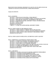
SKYLARK Tiny OSD QUICK USER MANUAL www.SkylarkFPV.com SATETY WARNING SKYLARK OSD is for entertainment purpose only, users should bear all the risks involved when using this electronics device. SUMMARY 1. Simple to use, equip with video input/output and power supply voltage only. 2. The functionalities provided including graphical, altitudinal, speed, return-arrow prompts, radar and low-voltage alert. PACKING LIST 1. 2. 3. 4. 5. 6. 7. Tiny OSD board 100A Current sensor 4 Hz GPS board GPS cable Current sensor cable User manual Reserve wire 1 pc 1 pc 1 pc 1 pc 1 pc 1 pc several pcs MAIN CONNECTION 1. Please follow the guide and install the system step-by-step, otherwise it may cause non-recoverable problems. 2. Main connection (the interfaces on PCB are labeled with corresponding port numbers.) Front side: GPS port: connect with GPS Steering gear port: connect with steering gear and supply the power to OSD main board. VO: the video transmitter signal connects with the camera VI: connect with the camera signal Rear side: connect with current sensor. 1 SKYLARK Tiny OSD QUICK USER MANUAL www.SkylarkFPV.com OPERATION PROCEDURES 1. Follow the descriptions on the interface, connect all the wires. To ensure users’ safety, please check the wires again after connection, then connect to the power. 2. After connecting to power, if “GPS is NOT Detected” is displayed and flashes, it means there is no GPS module or it is not well connected. Re-connect the GPS and connect to the power again. Note: if there is flashing massage, check the corresponding port is well connected and battery voltage is normal. Then connect to the power again. INDICATIONS OF THE LED LIGHT RED (Power) Indicates power supply, please check if the system is correctly connected when the light is off. DISPLAY EXPLANATION As shown in the following diagram. The rectangle in the center is the display range of the plane icon. As a warning, many of the displayed information would flash. When the GPS signal is not strong enough, latitude, longitude, numbers of GPS satellites, speed, altitude, the plane icon, returning angle & direction, horizontal distance corresponding to the point of departure would be flashing. When the signal becomes fine, flashing would stop automatically. When user enters this mode the first time after charging, if positioning of the GPS has not yet been completed, latitude and longitude would not be shown. The display area would appear the flashing words of “GPS Searching Data”, which means the GPS is still searching for the satellites. To guarantee the navigation information is accurate, please wait until the latitude and longitude data are displayed before takeoff. If the device is under interference, signal indication of remote control would flash for certain seconds, so as to warn the user that it is out of the control range. 2 SKYLARK Tiny OSD QUICK USER MANUAL www.SkylarkFPV.com DISPLAYED INFORMATION DESCRIPTION Description Display Range Latitude N is North Latitude, S is South Latitude, Unit is Degree 90.0N~0~90.0S Longitude E is East Longitude, W is West Longitude, Unit is Degree 180.0E~0~180.0W Numbers of GPS Numbers of GPS satellite that can be received signal 0~9; 9 would be satellites currently. displayed even more than 9 Speed Total speed, unit is Km/ hour 0~999km/h Current Operation current, unit is A 0.0~99.9A Voltage System voltage, unit is V. it would flash when under voltage. 0.0~99.9V Electricity The electricity consumed from system start-up till now, unit 0.0~9999mAH consumption is mAH Remaining electricity The battery symbol indicates the remaining electricity level, It takes a 2200mAH when it is nearly used up, the symbol would flash. battery as indication standard. Point of departure Indicate the point of departure Location & direction The plane icon indicates the existing location & direction corresponding to the point of departure. Up: North, Down: South, Left: West, Right: East. The flying direction is shown by the plane icon. Altitude Altitude that corresponding to the point of departure. The -9999~9999m corresponding to the figure can be negative, unit is meter. point of departure Returning angle & Indicate the required angle and direction for a returning direction journey, the unit for angle is degree. When angle is less than 5 degree, it would consider as accurate, so direction would not be displayed. Horizontal distance The horizontal distance corresponding to the point of 0~99.9km corresponding to the departure, the unit would be adjusted automatically. point of departure Signal indication of When the device is under interference and out of control remote control range, it would flash. Flying time The flying time is accumulated from the first take-off. When there are 4 or more GPS satellites and the speed exceeds 5m/s the first time, it starts counting. 3