1
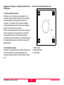
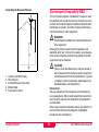
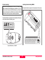
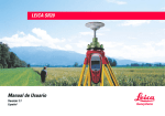
LEICA SR20 User Manual Version 2.0 English Introduction Leica SR20 Symbols Congratulations on your purchase of a new Leica SR20. The symbols used in this User Manual have the following meanings: DANGER: Indicates an imminently hazardous situation which, This manual contains important safety directions (refer to chapter "Safety directions") as well as instructions for setting up the product and operating it. Read carefully through the User Manual before you switch on the product. if not avoided, will result in death or serious injury. WARNING: Indicates a potentially hazardous situation or an unintended use which, if not avoided, could result in death or serious injury. CAUTION: Indicates a potentially hazardous situation or an Product identification The model and the serial number of your product are indicated on the typeplate. Enter the model and serial number in your manual and always refer to this information when you need to contact your agency or authorized service workshop. GPS Receiver Type: _______Serial No.: _______ External Antenna Type: _______Serial No.: _______ ) unintended use which, if not avoided, may result in minor or moderate injury and / or appreciable material, financial and environmental damage. Important paragraphs which must be adhered to in practice as they enable the product to be used in a technically correct and efficient manner. Trademarks • Windows (registered trademark of Microsoft Corporation) • Bluetooth (registered trademark of Bluetooth SIG, Inc.) All other trademarks are the property of their respective owners. Introduction 2 LEICA SR20 User Manual-2.0.0en View of chapters 1. General Information .................................................................... 5 2. Description of the System .......................................................... 7 3. Hardware and Software Setup ................................................. 11 4. Care and Transport ................................................................... 14 5. Safety Directions....................................................................... 16 6. Technical Data........................................................................... 28 LEICA SR20 User Manual-2.0.0en 3 View of chapters Table of Contents 1. General Information .................................5 5. The Leica SR20....................................................... 6 Overview of the User Manual .................................. 6 2. Description of the System.......................7 Unpacking the SR20 Standard Package ................. 7 GPS Receiver.......................................................... 8 Receiver Hardware.................................................. 8 Charge the Batteries ........................................ 9 Set Up the Equipment .................................... 10 Post-processing software ............................... 10 3. Hardware and Software Setup ..............11 6. Introduction............................................................ 11 Receiver Hardware................................................ 12 Leica SR20 Sensor ........................................ 12 Powering Up the Unit............................................. 13 4. Safety Directions ................................... 16 Intended use of product ........................................ 16 Permitted uses ............................................... 16 Adverse uses ................................................. 16 Limits of use .......................................................... 17 Responsibilities ..................................................... 17 International Warranty, Software License Agreement............................................................. 18 Hazards of use ...................................................... 19 Main hazards of use....................................... 19 Electromagnetic Compatability (EMC) .................. 24 FCC statement (applicable in U.S.)....................... 26 Technical Data ....................................... 28 Care and Transport ................................14 Transport ............................................................... 14 Storage .................................................................. 14 Cleaning and drying............................................... 15 Table of Contents 4 LEICA SR20 User Manual-2.0.0en 1. General Information Leica Geosystems offers an entire product basket of GPS receivers. This includes receivers designed for Land Surveying, GIS, Machine Control, Monitoring and various other applications. The SR20 GPS receiver allows the user the maximum in flexibility. The SR20 GPS receiver can be used as a high accuracy Land Surveying device, a powerful GIS data collector, or even a Reference Station. The SR20 is packaged with the Leica Geo Office software. This software is also extremely flexible with it’s ability to accept data from a variety of Leica receivers including: total stations, levels, and GPS. For decades, Leica Geosystems has enjoyed a worldwide technological lead in the manufacture of classical surveying instruments and systems. Starting in 1987, Leica Geosystems established a close business relationship with Magnavox's commercial GPS business unit for the design and construction of GPS surveying sensors. This culminated into Leica Geosystems acquisition of the Magnavox GPS business unit in 1994. With this purchase, the unbroken chain of impressive "firsts" now incorporated the field of satellite navigation and positioning technology. Magnavox was one of the first pioneers in this arena, playing a leading role in the development of GPS and its predecessors. Further acquisition of the Philips Ap Navigator business in 1997 widened Leica Geosystems product palette to an even greater extent. LEICA SR20 User Manual-2.0.0en 5 General Information The Leica SR20 Overview of the User Manual The Leica SR20 GPS receiver was designed to provide the Land Surveying community with a reliable, rugged and accurate GPS receiver that is also flexible enough to fit both sub-meter and centimeter accurate land surveying requirements. The Leica SR20 represents a true turnkey GPS solution by integrating the GPS receiver and antenna within the chassis of a handheld data collector. You will find the SR20 is extremely easy to use and yet has the all the power you would expect out of a Leica GPS receiver. The User Manual is intended to provide information concerning setup, safety, storage and technical data of the SR20 and accessories. For additional information on the use and operation of the SR20, please refer the SR20 "Getting Started Guide" (provided separately). For information concerning the use and interaction between Leica Geo Office and the SR20, please refer to the Leica Geo Office online help system. General Information 6 LEICA SR20 User Manual-2.0.0en 2. Description of the System Unpacking the SR20 Standard Package Take the product out of the transport case and check that it is complete: 1 2 3 4 5 6 7 8 9 LEICA SR20 User Manual-2.0.0en 7 SR20 Handheld GPS Receiver SR20 Soft Case GEB90 Battery, Li-Ion, 7.2V Data Transfer Cable, SR20 to RS232 SR20 Antenna Cable AT501 Antenna SR20 Getting Started Guide Leica SR20 User Manual Leica Geo Office Software CD Description of the System GPS Receiver Receiver Hardware The GPS Receiver receives the GPS signal from the NAVSTAR satellites and calculates a range to all visible satellites. The Leica SR20 is a 12-channel L1 code and phase handheld GPS receiver for professional data mapping. In most cases, a short introduction in the use of the Receiver will be provided by the local Leica Geosystems representative. Also refer to the SR20 "Getting Started Guide." See section "Technical Data". Description of the System 8 LEICA SR20 User Manual-2.0.0en • Charge the Batteries Your Leica SR20 is powered by a rechargeable 7.2 V, LiIon battery. The battery can be charged and discharged hundreds of times but it will eventually wear out. When the operation time is noticeably shorter than normal, it is time to buy a new Leica Geosystems GEB90 Li-Ion Battery. One battery, fully charged, will power the SR20 for about 7 hours continuously. Operating times will be shorter when working in cold weather. It is normal for the battery to become warm during charging. Using the chargers recommended by Leica Geosystems, it is not possible to charge the battery if the temperature is too high. Operation/Discharging • The batteries can be operated from -20°C to +55°C/ -4°F to +131°F. • Low operating temperatures reduce the capacity that can be drawn; very high operating temperatures reduce the service life of the battery. Primary use/charging • The battery must be charged prior to using it for the first time because it is delivered with an energy content as low as possible. • For new batteries or batteries that have been stored for a long time (> three months), you should take the battery through one complete charge/discharge cycle. • For Li-Ion batteries, a single discharging and charging cycle is sufficient. We recommend carrying out the process when the battery capacity indicated on the charger or on a Leica Geosystems product deviates significantly from the actual battery capacity available. • The permissible temperature range for charging is between 0°C to +40°C/ +32°F to +104°F. For optimal charging we recommend charging the batteries at a low ambient temperature of +10°C to +20°C/+50°F to +68°F if possible. LEICA SR20 User Manual-2.0.0en 9 Description of the System Set Up the Equipment Post-processing software For best performance, GPS data collection requires undisturbed satellite signal reception. This means GPS Receivers work best in locations which are free of obstructions. Press and release the Power Button located on lower left of the keyboard. The unit will reply with an audible tone, then proceed to a splash screen and then to the Main Menu. Your Leica SR20 is now fully ready for operation. The Post-processing software is used to process the observations taken by the Receiver in order to compute baselines and coordinates. Description of the System Leica Geo Office software is the standard post-processing software for the SR20 GPS receiver. Please refer to the "Getting Started Guide" and the Leica Geo Office onlinehelp system for further details. 10 LEICA SR20 User Manual-2.0.0en 3. Hardware and Software Setup Introduction “Hardware and Software Setup” is designed to help get the beginning user up and running with their new Leica SR20. For more information about setup, features and operations of the Leica SR20, please refer to the “SR20 Getting Started Guide". Hardware Leica SR20 Antenna Total Solution Software Leica Geo Office The Leica Geosystems GIS solution is composed of both hardware and software components. The hardware consists of the Leica SR20 sensor. This is used in the field to collect data. The software consists of Leica Geo Office. The Leica Geo Office software package provides powerful GPS post-processing tools. This software can be used for static or kinematic processing. The Leica Geo Office can also be used to process data from many other Leica Geosystems products. LEICA SR20 User Manual-2.0.0en 11 Hardware and Software Setup Leica Geo Office Post-processing software Leica Geo Office is used for data post processing. Please refer to the “Getting Started Guide” for more details. To install the Leica Geo Office software: 1 Insert the CD-ROM into the CD drive of your PC. 2 Execute the “Setup” command. 3 Follow the instructions that appear on the screen. A hardware user manual can be found on the CD in PDF format. Additionally, the software contains a comprehensive online Help System. After data is collected in the field, Leica Geo Office allows you to import, edit and export the data to your CAD system. The software can also be used to design codelists which allow you to customize the field data collection process to suit your needs. To learn more about Leica Geo Office, consult the “SR20 Getting Started Guide" and the online help. Receiver Hardware Leica SR20 Sensor The Leica SR20 is a GPS receiver designed for static data collection. The GPS receiver receives the GPS signal from the NAVSTAR satellites and calculates a range to all visible satellites. The Leica SR20 is a 12-channel L1 code and phase GPS receiver. Phase measurement recording can be used for post processing to achieve the highest accuracy possible. Phase measurements can also be used internally to smooth pseudorange measurements for increased accuracy code positioning. The standard external antenna for the SR20 is the AT501. The AT501 antenna tracks both the code and phase measurements on the L1 frequency. The SR20 also has an internal antenna that can be used in handheld operations. Please refer to the "Getting Started Guide" for the use of your Leica SR20 equipment. Hardware and Software Setup 12 LEICA SR20 User Manual-2.0.0en Powering Up the Unit The SR20 operates on a single battery. Once a battery is fully charged, you are ready to power up the SR20. 1. Open the SR20 Battery door by turning the door latch 90 degrees counterclockwise, and pull open the battery door. 2. Place the battery in the well with the gold contacts facing down and making contact. 3. Shut the battery door and return the latch to the locked position with the spin arrow facing upward toward the dot on the housing. 4. On the keypad, depress the Power Button in the Lower Left corner. Startup will be followed by an audible tone, then after a memory check (2 to 3 seconds) the SR20 Splash Screen will be followed by the Main Menu. 5. Once the Main Menu appears, the receiver will begin to search and acquire satellites. ) Initially the GPS unit will not have an Almanac (The almanac is a library of satellite orbits that helps the GPS locate the satellites more quickly). When using the unit for the first time, or after a long period without use, it may take several minutes to acquire a position; this is known as a “Cold Start”. ) LEICA SR20 User Manual-2.0.0en Make sure that the SR20 has a clear view of the sky! 13 Please refer to the SR20 Getting Started Guide for information on basic functions and data collection. Hardware and Software Setup 4. Care and Transport Transport Storage ) ) When dispatching the equipment, always use the complete original Leica Geosystems packaging (case and cardboard box). When transporting the equipment in the field, always make sure that you: • either carry the product in its original transport case • or carry the tripod with its legs splayed across your shoulder, keeping the attached product upright. ) • Never carry the product loose in a road vehicle. It can be affected by shock and vibration. Always carry it in its case and secure it. • When transporting the equipment by rail, air or ship, always use the complete original Leica Geosystems packaging (case and cardboard box), or its equivalent, to protect it against shock and vibration. When transporting or shipping batteries, the person in charge of the product must ensure that the applicable national and international rules and regulations are observed. Before transportation or shipping, contact your local passenger or freight transport company. Care and Transport • • • • 14 Temperature limits (-40°C to +70°C / -40°F to +158°F) Respect the temperature limits when storing the equipment, particularly in summer if the equipment is inside a vehicle. Li-Ion batteries Refer to "Environmental Specifications" for information about storage temperature range. A storage temperature range of -20 to +30°C/-4 to 68°F in a dry environment is recommended to minimize selfdischarging of the battery. At the recommended storage temperature range, batteries containing a 10% to 50% charge can be stored for up to one year. After this storage period, the batteries must be recharged. Remove batteries from the product and the charger before storing. After storage, recharge batteries before using. Protect batteries from damp and wetness. Wet or damp batteries must be dried before storing or use. LEICA SR20 User Manual-2.0.0en Cleaning and drying ) Use only a clean, soft, lint-free cloth for cleaning. If necessary, moisten the cloth with pure alcohol. Use no other liquids; these may attack the polymer components. ) ) Damp products must be unpacked. Dry the product, the case, the foam inserts and the accessories at not more than 40°C / 108°F and clean them. Do not repack until everything is completely dry. Cables and plugs Keep plugs clean and dry. Blow away any dirt lodged in the plugs of the connecting cables. Unplugging connecting cables or removing the memory card during the measurement may cause loss of data. Always switch off the product before removing the cables or the memory card. LEICA SR20 User Manual-2.0.0en 15 Care and Transport 5. Safety Directions The following directions should enable the person responsible for the product, and the person who actually uses the equipment, to anticipate and avoid operational hazards. The person responsible for the product must ensure that all users understand these directions and adhere to them. Intended use of product Permitted uses The product is intended for the following applications: • Measuring and computing coordinates using P-code and/or C/A-code signals from NAVSTAR GPS satellites • Carrying out measurement tasks using various GPS measuring techniques • Recording GPS and point related data • Computation and evaluation by means of software • Data transfer via internal radio (BLUETOOTH) for realtime surveys • Data transfer via internal radio (BLUETOOTH) for up and download of projects, coordinate systems, and configurations Safety Directions Adverse uses • • • • • • • • • • Use of the product without instruction Use outside of the intended limits Disabling safety systems Removal of hazard notices Opening the product using tools (screwdriver, etc.), unless this is specifically permitted for certain functions Modification or conversion of the product Use after misappropriation Use of products with obviously recognizable damages or defects. Use with accessories from other manufacturers without the prior express approval of Leica Geosystems Inadequate safeguards at the measuring station (e.g. when measuring on roads) WARNING: Adverse use can lead to injury, malfunction and 16 damage. It is the task of the person responsible for the equipment to inform the user about hazards and how to counteract them. The product is not to be operated until the user has been instructed how to work with it. LEICA SR20 User Manual-2.0.0en Limits of use Responsibilities See chapter "Technical Data". Area of responsibility for the manufacturer of the original equipment Leica Geosystems AG, CH-9435 Heerbrugg (hereinafter referred to as Leica Geosystems): Leica Geosystems is responsible for supplying the product, including the User Manual and original accessories, in a completely safe condition. Environment: Suitable for use in an atmosphere appropriate for permanent human habitation: not suitable for use in aggressive or explosive environments. External Antenna: Use in rain is permissible. After long term use in this environment the External Antenna must be checked by a Leica Geosystems service technician. DANGER: Local safety authorities and safety experts must be ) Responsibilities of the manufacturers of nonLeica Geosystems accessories: The manufacturers of non-Leica Geosystems accessories for the product are responsible for developing, implementing and communicating safety concepts for their products. They are also responsible for the effectiveness of those safety concepts in combination with the Leica Geosystems product. contacted before working in hazardous areas, near to electrical installations or in extreme environment conditions by the person in charge of the product. LEICA SR20 User Manual-2.0.0en 17 Safety Directions Responsibilities of the person in charge of the equipment: WARNING: The person responsible for the equipment must International Warranty, Software License Agreement ensure that it is used in accordance with the instructions. This person is also accountable for the training and deployment of personnel who use the equipment and for the safety of the equipment when in use. The person in charge of the product has the following duties: • To understand the safety instructions on the product and the instructions in the User Manual. • To be familiar with local regulations relating to accident prevention. • To inform Leica Geosystems immediately if the equipment becomes unsafe. • To ensure that the national laws, regulations and conditions for the operation of radio transmitters are respected. International Warranty The International Warranty can be downloaded from the Leica Geosystems AG home page at http://www.leica-geosystems.com/internationalwarranty or received from your Leica Geosystems dealer. Software License Agreement This product contains software that is preinstalled on the product, or is supplied to you on a data carrier medium, or can be downloaded by you online pursuant to prior authorization from Leica Geosystems. Such software is protected by copyright and other laws and its use is defined and regulated by the Leica Geosystems Software License Agreement, which covers aspects such as, but not limited to, Scope of the License, Warranty, Intellectual Property Rights, Limitation of Liability, Exclusion of other Assurances, Governing Law and Place of Jurisdiction. Please make sure, that at any time you fully comply with the terms and conditions of the Leica Geosystems Software License Agreement. Such agreement is provided together with all products and can also be found at the Leica Geosystems AG home page at http://www.leica-geosystems.com/swlicense or your Leica Geosystems dealer. Safety Directions 18 LEICA SR20 User Manual-2.0.0en You must not install or use the software unless you have read and accepted the terms and conditions of the Leica Geosystems Software License Agreement. Installation or use of the software or any part thereof, is deemed to be an acceptance of all the terms and conditions of such License agreement. If you do not agree to all or some of the terms of such License agreement, you may not download, install or use the software and you must return the unused software together with its accompanying documentation and the purchase receipt to the dealer from whom you purchased the product within ten (10) days of purchase to obtain a full refund of the purchase price. Hazards of use Main hazards of use WARNING: The absence of instruction, or the inadequate imparting of instruction, can lead to incorrect or adverse use, and can give rise to accidents with farreaching human, material, financial and environmental consequences. Precautions: All users must follow the safety directions given by the manufacturer and the directions of the person responsible for the product. CAUTION: Watch out for erroneous measurements if the product has been dropped or has been misused, modified, stored for long periods or transported. Precautions: Periodically carry out test measurements and perform the field adjustments, particularly after the product has been subjected to abnormal use and before and after important measurements. WARNING: If computers intended for use indoors are used in the field, there is a danger of electric shock. LEICA SR20 User Manual-2.0.0en 19 Safety Directions Precautions: Adhere to the instructions given by the computer manufacturer with regard to field use in conjunction with Leica Geosystems products. CAUTION: If the accessories used with the equipment are not properly secured and the equipment is subjected to mechanical shock (e.g. blows, falling), the equipment may be damaged or people may sustain injury. Precautions: When setting-up the equipment, make sure that the accessories (e.g. tripod, tribrach, connecting cables) are correctly adapted, fitted, secured, and locked in position. Avoid subjecting the equipment to mechanical shock. CAUTION: The product uses the GPS P-Code signal, which by U.S. policy, may be switched off without notice. CAUTION: During the transport, shipping or disposal of batteries it is possible for inappropriate mechanical influences to constitute a fire hazard. Precautions: Before shipping the product or disposing of it, discharge the batteries by running the product until they are flat. When transporting or shipping batteries, the person in charge of the product must ensure that the applicable national and international rules and regulations are Safety Directions observed. Before transportation or shipping contact your local passenger or freight transport company. WARNING: Using a battery charger not recommended by Leica Geosystems can destroy the batteries. This can cause fire or explosions. Precautions: Only use chargers recommended by Leica Geosystems to charge the batteries. WARNING: High mechanical stress, high ambient temperatures or immersion into fluids can cause leakage, fire or explosions of the batteries. Precautions: Protect the batteries from mechanical influences and high ambient temperatures. Do not drop or immerse batteries into fluids. WARNING: Short circuited battery terminals can overheat and cause injury or fire, for example by storing or transporting in pockets if battery terminals come in contact with jewellery, keys, metallized paper or other metals. Precautions: Make sure that the battery terminals do not come into contact with metallic objects. 20 LEICA SR20 User Manual-2.0.0en WARNING: WARNING: Inadequate securing of the survey site can lead to During dynamic applications, for example stakeout dangerous situations, for example in traffic, on building sites and at industrial installations. Precautions: Always ensure that the survey site is adequately secured. Adhere to the regulations governing accident prevention and road traffic. DANGER: Because of the risk of electrocution, it is very dangerous to use poles and extensions in the vicinity of electrical installations, such as power cables or electrical railways. Precautions: Keep at a safe distance from electrical installations. If it is essential to work in this environment, first contact the safety authorities responsible for the electrical installations and follow their instructions. WARNING: By surveying during a thunderstorm you are at risk from lightning. Precautions: Do not carry out field surveys during thunderstorms. WARNING: Only Leica Geosystems authorized service workshops are entitled to repair these products. LEICA SR20 User Manual-2.0.0en procedures there is a danger of accidents occurring if the user does not pay attention to the environmental conditions around, for example obstacles, excavations or traffic. Precautions: The person responsible for the product must make all users fully aware of the existing dangers. WARNING: If an External Antenna is not properly fitted to vehi- cles or any other means for transportation it can be torn off by mechanical shock, vibration or wind, possibly causing accident and injury. Precautions: Attach the External Antenna professionally. The External Antenna must be secured additionally, e.g. by use of a safety cord. Ensure that the mounting device is correctly mounted and able to safely carry the weight of the External Antenna (>1kg). WARNING: If the equipment is improperly disposed of, the • • 21 following can happen: If polymer parts are burnt, poisonous gases are produced which may impair health. If batteries are damaged or are heated strongly, they can explode and cause poisoning, burning, corrosion or environmental contamination. Safety Directions • • By disposing of the equipment irresponsibly you may enable unauthorized persons to use it in contravention of the regulations, exposing themselves and third parties to the risk of severe injury and rendering the environment liable to contamination. Precautions: Dispose of the equipment appropriately in accordance with the regulations in force in your country. Always prevent access to the equipment by unauthorized personnel. • DANGER: If the product is used in exposed locations (e.g. on • masts, mountains or buildings), it is at risk from lightning. Danger from high voltages also exists near power lines. Lightning, voltage peaks, or the touching of power lines can cause damage, injury and death. Precautions: • Do not use the product in a thunderstorm as you may increase the risk of being struck by lightning. • Be sure to remain at a safe distance from electrical installations. Do not use the product directly under or in close proximity to power lines. If it is essential to work in such an environment contact the local statutory regulatory bodies responsible for electrical installations and follow their instructions. • If the product has to be permanently mounted in an exposed location, it is advisable to provide a lightning conductor system. A suggestion on how to design a lightning conductor for the product is given hereinafter. Safety Directions 22 Always follow the regulations in force in your country with regard to grounding Antennas and masts. These installations must be carried out by an authorized specialist. To prevent damages due to indirect lightning strikes (voltage spikes), cables (antenna, power source, modem, ...) should be protected with appropriate protection elements (lightning arrestor). These installations must be carried out by an authorized, local specialist. Additional protection against lightning: If there is a risk of a thunderstorm, or if the equipment is to remain unused and unattended for a long period, protect your product additionally by unplugging all systems components and disconnecting all connecting cables and supply cables (e.g. Receiver - Antenna). LEICA SR20 User Manual-2.0.0en Suggestion for design of a Lightning Conductor for a GPS System Air Terminal arrangement (plan view) 1. On non-metallic structures Protection by Air Terminals is recommended. An Air Terminal is a pointed solid or tubular rod of conducting material with proper mounting and connection to a conductor. The position of 4 Air Terminals should be uniformly distributed around the Antenna at a distance equal to the height of the Air Terminal. The Air Terminal diameter should be 12mm for copper or 15mm for aluminium. The height of the Air Terminals should be 25 to 50cm. All Air Terminals should be connected to the down conductors. The diameter of the Air Terminal should be kept to a minimum to reduce GPS signal shading. 2. On metallic structures Protection is as described for non-metallic structures, but the Air Terminals can be connected directly to the conducting structure without the need for down conductors. LEICA SR20 User Manual-2.0.0en 1 GPS Antenna 2 Support-Structure 3 Air Terminal 23 Safety Directions Grounding the Receiver/Antenna Electromagnetic Compatability (EMC) The term "electromagnetic compatability" is taken to mean the capability of the product to function smoothly in an environment where electromagnetic radiation and electrostatic discharges are present, and without causing electromagnetic disturbances to other equipment. WARNING: Electromagnetic radiation can cause disturbances in other equipment. Although the product meets the strict regulations and standards which are in force in this respect, Leica Geosystems cannot completely exclude the possibility that other equipment may be disturbed. CAUTION: There is a risk that disturbances may be caused in 1 2 3 4 5 Lightning Conductor Array GPS Antenna Antenna/Receiver Connection Metallic Mast Connection to Earth Safety Directions other equipment if the product is used in conjunction with accessories from other manufacturers, e.g. field computers, personal computers, walkie-talkies, nonstandard cables, external batteries. Precautions: Only use equipment and accessories recommended by Leica Geosystems. When combined with the product, they meet the strict requirements stipulated by the guidelines and standards. When using computers and walkie-talkies, pay attention to the information about electromagnetic compatability provided by the manufacturer. 24 LEICA SR20 User Manual-2.0.0en CAUTION: Disturbances caused by electromagnetic radiation Use of the product with internal (BLUETOOTH) and external Radio devices: can result in the tolerance limits for measurements being exceeded. Although the product meets the strict regulations and standards which are in force in this connection, Leica Geosystems cannot completely exclude the possibility that the product may be disturbed by very intense electromagnetic radiation, e.g. near radio transmitters, walkie-talkies, diesel generators. Check the plausibility of results obtained under these conditions. WARNING: If the product is operated with connecting cables WARNING: Electromagnetic radiation can cause disturbances in attached at only one of their two ends (e.g. external supply cables, interface cables), the permitted level of electromagnetic radiation may be exceeded and the performance of other products may be impaired. Precautions: While the product is in use, connecting cables (e.g. product to external battery, product to computer) must be connected at both ends. other equipment, in installations (e.g. medical ones such as pacemakers or hearing aids) and in aircraft. It can also affect humans and animals. Precautions: Although the product complies with the strict regulations and standards applicable if used with internal and external radio devices, Leica Geosystems cannot completely exclude the possibility that interference with other equipment may occur, or that humans or animals may be affected. • • • • LEICA SR20 User Manual-2.0.0en 25 Do not operate the product with internal and external Radio devices in the vicinity of filling stations or chemical installations, or in other areas where an explosion hazard exists. Do not operate the product with internal and external Radio devices near to medical equipment. Do not operate the product with internal and external Radio devices in aircraft. Do not operate the product with internal and external Radio devices for long periods with it immediately next to your body. Safety Directions FCC statement (applicable in U.S.) • The grayed paragraph below is only applicable for products operated without internal Bluetooth. Connect the equipment into an outlet on a circuit different from that to which the receiver is connected. • Consult the dealer or an experienced radio/TV technician for help. WARNING: This equipment has been tested and found to comply with the limits for a Class B digital device, pursuant to part 15 of the FCC Rules. WARNING: Changes or modifications not expressly approved by Leica Geosystems for compliance could void the user's authority to operate the equipment. These limits are designed to provide reasonable protection against harmful interference in a residential installation. This equipment generates, uses and can radiate frequency energy and, if not installed and used in accordance with the instructions, may cause harmful interference to radio communications. However, there is no guarantee that interference will not occur in a particular installation. If this equipment does cause harmful interference to radio or television reception, which can be determined by turning the equipment off and on, the user is encouraged to try to correct the interference by one or more of the following measures: • Reorient or relocate the receiving antenna. • Increase the separation between the equipment and receiver. Safety Directions 26 LEICA SR20 User Manual-2.0.0en Product Labeling: This device complies with part 15 of the FCC Rules. Operation is subject to the following two conditions: (1) This device may not cause harmful interference, and (2) this device must accept any interference received, including interference that may cause undesired operation. Labelling internal battery GEB90: The label indicator is placed on the backside of the device. . .... ........ .... .... .... .... .. .... . .... ....... ... .... .... ........ .... ... . .... .... ........ .... ....... .... .... .... .... .. .... ........ .... .... ....... ........ .... ... ... .... .... ........ .... .... ....... .... .... .... .... .. .... ........ .... .... .... .... .... .. The label indicator is placed on the backside of the device in the center above the battery case. FCC ID: QOHSR20 This device complies with part 15 of the FCC Rules. Operation is subject to the following two conditions: (1) This device may not cause harmful interference, and (2) this device must accept any interference received, including interference that may cause undesired operation. This device complies with part 15 of the FCC Rules. Operation is subject to the following two conditions: (1) This device may not cause harmful interference, and (2) this device must accept any interference received, including 11WE MH29443 interference that may cause undesired operation. Leica SR20 Art.no. 742018 LEICA SR20 User Manual-2.0.0en 27 Safety Directions 6. Technical Data Tracking Characteristics • Satellite Reception Single frequency • Receiver channels 12 L1 continuous tracking • L1 channels Carrier phase, C/A narrow code • L1 Carrier Tracking Reconstructed carrier phase via C/A code • L1 Code Measurements Carrier phase smoothed C/A code measurements • Satellites Tracked Up to 12 simultaneously on L1 Time to first phase measurement typically 30 seconds. GPS Antennas • AT501 Microstrip L1 antenna with built in groundplane • RTB Combined GPS L1/ beacon antenna • RTS Combined GPS L1/ L-Band antenna Technical Data Interface • Port 1 Conformable with RS232 Lemo 7 Pin • BLUETOOTH Specification 1. Radio: BLUETOOTH QPL GS20/SR20 ....................... B02289 BLUETOOTH QPL WoRCS Module ................ B00874 Operating range .................................................... 10m 2. Other Characteristics Baudrate........................................................ 230.4 kps • Baudrate 300/1200/2400/4800/7200/9600/19200/38400/57600/ 115200 bps • Data Format Parity ....................................................none/odd/even Data Bit .................................................................. 7;8 Stop Bits.................................................................. 1;2 Flow Control .................................................. RTC/CTS ................................................................... XON/XOFF • WoRCS RTB Module RTB01 Beacon Module frequency range ...285.5 to 325.0 KHz Supply Voltage ..............................................+7.2VDC Nominal Power .................................................. 0.75 W 28 LEICA SR20 User Manual-2.0.0en Equipment weights • Receivers Leica SR20 ....................................................... 0.55 kg WoRCS RTB .................................................... 1.45 kg USB Bluetooth Module ....................................... 0.1 kg • Antennas AT501 ................................................................. 0.4 kg Power • Supply Voltage All equipment: ................................... Nominal 7.2V DC External: .......................................................... 12V DC Separation distances • Leica SR20 to AT501 RTB or RTS Antenna Supplied cables:................................................... 1.2m Longer cables available on request. Baseline precision The following specifications are based on measurements processed using Leica Geo Office software and are given as baseline rms (root mean square). • Differential Phase Operation Static Rapid Static Kinematic 10mm + 2ppm 10mm + 2ppm 20mm + 2ppm Environmental Specifications Product Leica SR20 and WoRCS AT501 Leica Geosystems PC-cards, all sizes Battery internal • • Operation -20°C to +55°C (-4°F to 131°F) -40°C to +75°C (-40°F to 167°F) -20°C to +75°C (-4°F to 167°F) -20°C to +55°C (-4°F to 131°F) Storage -40°C to +70°C (-40°F to 158°F) -40°C to + 75°C (-40°F to 167°F) -40°C to +75°C (-40°F to 167°F) -40°C to +70°C (-40°F to 158°F) • Operation Static Kinematic ) Humidity Up to 95%, non-condensing Protection against water, dust and sand IP54 in accordance with IEC/EN60529 LEICA SR20 User Manual-2.0.0en Differential Code 29 Post Processing 30 cm 30 cm Realtime DGPS 40 cm 40 cm Baseline precision is dependent upon various factors including the number of satellites tracked, constellation geometry, observation time, ephemeris accuracy, ionospheric disturbance, multipath and resolved ambiguities. Technical Data Conformity to national regulations • FCC part 15 (applicable in U.S.) • European directive 1999/5/EC on radio equipment and telecommunications terminal equipment (see CE Conformity Declaration). • The conformity for countries with other national regulations not covered by FCC part 15 or European directives 1999/5/EC has to be approved prior to use and operation. Frequency Range 2402 - 2480 MHz Transmission power limited to < 1.8 mW (e.i.r.p.) Antenna Type:Internal patch antenna Gain:2.7 dBi Technical Data 30 LEICA SR20 User Manual-2.0.0en LEICA SR20 User Manual-2.0.0en 31 Technical Data Leica Geosystems AG, Heerbrugg, Switzerland, has been certified as being equipped with a quality system which meets the International Standards of Quality Management and Quality Systems (ISO standard 9001) and Environmental Management Systems (ISO standard 14001). 742205-2.0.0en Printed in Switzerland - Copyright Leica Geosystems AG, Heerbrugg, Switzerland 2005 Original text Total Quality ManagementOur commitment to total customer satisfaction. Ask your local Leica Geosystems dealer for more information about our TQM program. Leica Geosystems AG CH-9435 Heerbrugg (Switzerland) Phone +41 71 727 31 31 Fax +41 71 727 46 73 www.leica-geosystems.com