1
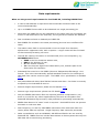
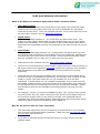
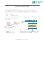
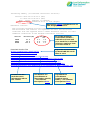
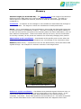
PositioNZ-PP GPS post-processing service Help information 1. PositioNZ-PP Quick Start – Step by Step Step 1 – Setup job Step 2 – Select GPS RINEX files Step 3 - Edit RINEX file metadata Step 4 - Confirm job details and submit for processing Job confirmation page Confirmation e-mail Results e-mail – coordinate solutions and downloading result files 2. Introduction to PositioNZ-PP What service is provided Benefits of using this service GPS processing software used Calculation of NZGD2000 coordinates 3. Data requirements General data input requirements RINEX file requirements Observation length needed Common errors encountered RINEX file fails to process 4. Orbit and Antenna information Ultra Rapid, Rapid and Final Orbits Antenna type information Antenna height information 5. Results Type of coordinates calculated Type of heights outputted Contents of csv result files Job summary page example Questions about the results 6. Glossary & contact details Glossary Contact LINZ PositioNZ-PP Step by Step Click ‘Cancel’ at any step to discard the current job and get a fresh PositioNZ-PP form to start again. Step 1 – Setup job Enter your e-mail address – processing results will be sent here. Enter the processing job title - will be used in any future correspondence with LINZ, if required. Step 2 – Select GPS RINEX files Click ‘Add Files’ at the bottom of the RINEX upload box. Select the RINEX files you want to upload for processing. Up to ten RINEX files can be submitted per processing job. If a RINEX file has been added in error, click the red circle button to remove it. Click the ‘Next’ button to start the file upload. The accepted RINEX file extensions for PositioNZ-PP are: Extension .yyO .yyO.Z .yyD .yyD.Z .gz .zip Description RINEX observation file. yy indicates the last two digits of the year when the data was observed. RINEX observation file - unix-compressed. RINEX observation file - compressed using Hatanaka compression. RINEX observation file - unix-compressed and Hatanaka compressed. gzip compressed file. zipped RINEX file. RINEX files located within a zipped folder also accepted (up to ten RINEX files per job once folder is unzipped). - An example of a RINEX file is available here. Step 3 - Edit RINEX file metadata Information extracted from the RINEX header will be shown on this page for each RINEX file, underneath each input field. Correct any fields that failed a validation check, or edit any that are incorrect and you have alternative values for (eg: if you know the RINEX header information is incorrect, and you have the correct values). Take note of any error messages, and see whether all the files you intended to upload were successfully attached. Generally RINEX files created by GNSS software will be successfully read by PositioNZ-PP, but you may need to refer to the common error section for help if your files are not accepted. Station name field: A simple uppercase four character code is required for internal processing in the GPS processing software used within PositioNZ-PP. Longer names will be truncated for this purpose. The station name should contain just alphanumeric characters with no spaces. Otherwise, spaces will be removed and alphanumeric characters will be taken from the RINEX filename to create the four character code. In the KML and csv result files, the full station name entered or extracted from the RINEX file will be shown, even if it has spaces. Antenna/radome type field: If you get a message “Antenna/radome type not recognised – select an alternative” then use the drop down list to choose an ‘officially recognised’ antenna type that can be processed by PositioNZ-PP. These have known antenna offsets and conform to International GNSS Service (IGS) naming conventions. Using the correct antenna type is important as the coordinate solution will be affected, especially in the vertical component. In the drop down list you will see the antenna types grouped into commonly used antennas, and antennas with and without radomes. PositioNZ-PP records antenna/radome types that you have used recently on your computer to make it easy to reuse the same settings. Antenna height field: Input values must be between 0 and 100 metres. The antenna height is the height of the Antenna Reference Point (ARP) above the vertical reference point of the mark. Please refer to the user manual of your GPS equipment for the location of the ARP, or the diagrams supplied by the IGS, available here. For further information on antenna heights and diagrams, click here. Remove RINEX files Tick the ‘Remove file from job’ boxes for each file and click ‘Next’. The file will be deleted from the job. You may also click ‘Back’ to go to Step 2 and add more files to the job. Step 4 – Confirm job details and submit for processing Confirm that the RINEX file details that you are about to submit are correct. In particular, please confirm that the e-mail address and job title you entered are correct, so that you can receive your results as expected. Items marked with a star differ from the value contained within the RINEX file – check that you intended to change these fields. If any details are incorrect, click the ‘Back’ button to make amendments. If your RINEX files are relatively new (less than about 12 days old), you may see a drop down box on the Step 4 page where you can make a selection for the minimum quality orbits that you would like to use for processing the job. PositioNZ-PP uses GNSS satellite orbit data from the International GNSS Service (IGS). They are available in three iterations of progressively greater accuracy: Ultra Rapid orbits – the earliest and least accurate. Available within 9 hours after the observation time. Rapid orbits – available within 41 hours after observation time. Final orbits – the most accurate – available within 18 days after observation time. For more information, click here. For most PositioNZ-PP jobs, Rapid orbits will provide good accuracy – there may be little benefit waiting for Final orbits. Processing with Rapid orbits should be enough for calculating coordinates at the survey quality level in NZ, but if you would like to use orbits that have been fully post-processed, use the Final orbits. If your orbit quality option is not yet available, the expected date of availability is shown. Your job can still be submitted and it will be on hold until the requested higher quality orbit products become available from IGS. Click the ‘Submit job for processing’ button to start PositioNZ-PP processing. Job confirmation page This page will confirm that your job was successfully submitted for PositioNZ-PP processing. A job number is assigned, and you should receive a confirmation e-mail shortly after submitting your job. A second e-mail with your results will arrive later, once all the required data becomes available and when the coordinate solutions have been processed with the orbit quality that was chosen. Confirmation e-mail This contains the URL link that you can click on to check the progress of your job. Normally job processing takes around ten minutes, but it could take longer if the PositioNZ-PP service is busy with several jobs. It will also depend on how many RINEX files you have submitted in a single processing job. Clicking on the URL link brings you to a page that shows one of these three different PositioNZ-PP states, depending on the processing status: your job has not yet been processed your job is on hold until the desired orbit quality data becomes available (note the expected availability time) your job has finished processing and you may download the result files from the job summary page. Results e-mail – coordinate solutions and downloading result files The second and final e-mail will be sent containing the job results summary once processing by PositioNZ-PP is complete. Click the URL link in the e-mail to go to the job summary page where you can download all of the result files. The result files come in a variety of formats, such as csv, txt, SINEX, and KML, that can be downloaded individually. There is also the option of downloading all of the job result files in a single zip folder if you would like to store all of the files together. A ‘readme’ file is also available to download containing extra information about the results. Introduction What service does PositioNZ-PP provide? The PositioNZ-PP automated GPS post-processing service, made available by Land Information New Zealand, provides users with accurate positioning solutions in official NZGD2000 coordinates and International Terrestrial Reference Frame (ITRF) coordinates. The service is free and simple to use – customers provide their e-mail address and upload their GPS RINEX files for observed marks for which they would like a coordinate solution. PositioNZ-PP then processes each input RINEX file individually using data from selected reference stations from the national network of PositioNZ continuously operating GNSS stations. The data is processed using the specialised Bernese v5.2 GNSS processing software. Results are sent by e-mail, which also contains a link to an online results page from which additional result files can be downloaded. Some of the benefits of using PositioNZ-PP include: Accurate, survey grade coordinate solutions are obtained without the need for users to have their own specialised GNSS processing software. The general accuracy is within a few centimetres. The service is free of charge, and straightforward to use. It is a 24 hour, 7 days a week automated online service (excluding planned and unexpected outages and staff assistance). If there are no control marks in the area of survey, you may use the PositioNZ-PP service to coordinate your own control. Enables the user to make high-precision connections into the geodetic network, as the PositioNZ-PP service utilises the PositioNZ network of continuously operating GNSS reference stations (Order 0). Saves time for the user, through reduced (or no) need for additional user-setup base stations. Coordinates are provided in the official geodetic datum NZGD2000, at nominal epoch 2000.0. Solutions are also available in the appropriate meridional circuit projection systems for each particular mark location. The latest NZ deformation model is automatically applied to calculate the coordinates at nominal epoch 2000.0, which is the official epoch for NZGD2000. This enables consistent dataset integration in Landonline and many other spatial databases. Coordinate solutions in the latest International Terrestrial Reference Frame (ITRF2008) at observation epoch are provided, as well as ITRF96, (with which NZGD2000 is aligned). Ellipsoidal heights are provided, as well as normal-orthometric heights in the official national vertical datum NZVD2009. Sophisticated Bernese v5.2 GNSS processing software is used within PositioNZPP. Processing takes advantage of the most precise orbit information available, and the GPS RINEX files are processed using ITRF2008 positions of the PositioNZ reference stations. Each RINEX file submitted per mark gives its own individual coordinate solution in the result files. Coordinate result files are able to be easily downloaded in multiple formats after clicking the URL link contained in the results e-mail that is automatically sent out when PositoNZ-PP finishes processing. If automatic PositioNZ-PP processing is not successful for your input RINEX files, LINZ staff aim to contact you within 5 working days about your job. After taking a closer look at the files, it may be possible to make some changes to them so that PositioNZ-PP can process them successfully. What software is used for GPS data post-processing in PositioNZ-PP? Bernese v5.2 GNSS post-processing software which is high-precision specialised positioning software. Software developed by Astronomical Institute, University of Bern (AIUB), Switzerland. Bernese software information can be found here. Other software used: Teqc from UNAVCO – which you can download here. See the RINEX file problems section for some information about Teqc for manipulating RINEX files so that the format is acceptable for PositioNZ-PP. How are NZGD2000 coordinates calculated by PositioNZ-PP? GPS post-processing is performed using the Bernese v5.2 GNSS processing software. The coordinates are first calculated in the IGb08 reference frame, which is a realisation of the International Terrestrial Reference Frame 2008 (ITRF 2008) calculated by the International GNSS Service. These coordinates are at the observation epoch of the RINEX file. The ITRF2008 observation epoch coordinates are then transformed into ITRF96 coordinates (the datum that NZGD2000 is aligned with), also at the observation epoch of the RINEX file. Using the latest NZ deformation model, these coordinates are propagated back to give NZGD2000 coordinates at nominal epoch 2000.0. This is the official reference epoch for NZGD2000 – for example, all coordinates in the Geodetic Database are published at nominal epoch 2000.0. Data requirements What are the general requirements for PositioNZ-PP, including RINEX files? A valid e-mail address is required so that coordinate results are able to be received automatically. Up to 10 RINEX files are able to be submitted in a single processing job. More than one RINEX file can be submitted for the same mark per processing job, even if it was observed on the same day, as long as the file names are different. One coordinate solution is obtained per RINEX file. Each RINEX file included in the same processing job must have a different file name. The station name field is recommended to have a simple four character, alphanumeric uppercase code, with no spaces. Longer names will be truncated so that internal processing can occur. The IGS file naming convention is recommended, but is not compulsory, eg: XXXXDDDS.YYO where XXXX is the four character station code, DDD is the GPS day of year, S is the session number, YY is the last two digits of the observation year, and O is part of the observation file extension. Submitted files must be in the RINEX (Receiver INdependent EXchange) v2.11 format. This is the internationally agreed standard format for the exchange of GPS data from various receiver types. The RINEX v2.11 specification is available here. Only data observed within New Zealand extents and after 1 Jan 2000 is currently accepted by the PositioNZ-PP service. Antenna height requirements: please see full details here. Antenna type requirements: please see full details here. Only the RINEX observation files are required (whether compressed or not) there is no need for any other supplementary files such as navigation files. PositioNZ-PP obtains high accuracy orbit products for processing automatically. RINEX data observed in ‘static’ mode is required. PositioNZ-PP does not process kinematic or real-time data. Dual-frequency (L1 and L2) GPS RINEX observation files with both code and carrier phase data are required. Single frequency data cannot be processed. Other constellations such as GLONASS, GALILEO and Beidou are not used by PositioNZ-PP. RINEX files can include observations to these systems but only the GPS data will be used during processing. How long must the observation session be in the RINEX file for PositioNZ-PP processing? What must the data sampling rate be? A data sampling rate of 30 seconds is used in PositioNZ-PP. Data sampled at higher rates (eg: 5 seconds) can be submitted, but the extra data will be discarded. If the data sampling rate (observation interval) is less than 30 seconds, and is a factor of 30, it will be converted into 30 second data for processing (eg: 1, 5, 10, 15 seconds). If the observation interval is greater than 30 seconds, it will not be able to be processed. The shortest observation session length accepted in an individual RINEX file is one hour of 30 second data, and the longest session length is 48 hours of 30 second data. Longer observation data spans are likely to provide more accurate solutions. If possible, it is recommended to have approximately 4 hours observation time. If you have observation lengths of 12 to 24 hours in the RINEX file, this could provide more accuracy. What are the oldest files that can be uploaded? RINEX data observed from 1 Jan 2000 or later are accepted for processing. Common errors encountered (PositioNZ-PP Step 3) Not a valid RINEX file (line XX) Your RINEX file failed validation checks – please make sure the RINEX version is 2.11 and check the contents of the file at the line number to see why it might have failed. More information on RINEX files is available here. Antenna/radome XXXXXXXX not recognized - select an alternative The antenna type in the RINEX file is not recognised by the International GNSS Service (IGS), or conform to the naming convention (click here for further information on antenna types). Usually the correct antenna type is available in this list, but the official name is different to what is in the RINEX file. Choose the appropriate antenna from the drop down list. Not observed in New Zealand (from the RINEX file headers). Currently only stations in New Zealand are accepted The coordinates in the RINEX file header indicate that the location of your mark is not in New Zealand. PositioNZ-PP only processes New Zealand data as it uses the PositioNZ network of continuously operating GNSS stations as reference stations. See the data file requirements here. Observation period is less than minimum 1 hour The RINEX file observation session is too short. The session length must be between 1 hour and 48 hours. Observation period is greater than maximum 2 days The RINEX file observation session is too long. The session length must be between 1 hour and 48 hours. XXXXDDDS.YYO is already loaded in the job Duplicate filenames are not accepted in the same processing job. Rename files so that they are unique or process the files in separate jobs. Too many files specified for job (Maximum is 10) The first ten files you uploaded were attached for processing, and the rest were discarded. Process the other files in a separate job. There are X items in the RINEX data that needs to be changed The items that failed the validation checks and need to be changed will be highlighted in red. See the relevant sections on the field contents at Step 3: station name, antenna type, and antenna height. Invalid observation frequency (XX). Must divide into 30 The data sampling rate in the RINEX file should be 30 seconds, or be a rate such as 5 or 10 seconds so that it can be converted into a 30 sampling interval. Data is not dual frequency RINEX data L1 & L2 data is needed (both code and phase). For more information, see the data requirements section. What should I do if the RINEX file fails to process in PositioNZ-PP? First check the common errors section to see if that helps to solve the issue. RINEX navigation files are not needed for PositioNZ-PP processing. If your file fails to process in PositioNZ-PP, you may try running the file through the Teqc software. This is command line based software, used for RINEX file manipulation. Teqc stands for Translation, Editing and Quality Check. This software is freely available for download from the UNAVCO website and a tutorial PDF is also available from this site. Teqc can identify problems with your RINEX file, such as RINEX header formatting, which can be altered before trying to process the file in PositioNZ-PP again. A useful Teqc command is: teqc +qcq FILENAME.yyO (the RINEX file must first be unzipped and uncompressed). First navigate to the directory where your RINEX file is located through the command line window and then run this Teqc quality control command. The output may include information about invalid lines in the RINEX file. More Teqc tutorial material is available here. An example of a RINEX observation file, GISB1440.13o, is shown below. The RINEX v2.11 specification is available here. The RINEX format is based on columns – data must be in exactly the right column to be interpreted properly. The order of header records after the first record is not important. Individual header records are identified by the text in columns 60 to 80 (number of characters along the row) which must be exactly as shown below. RINEX v2.11 Receiver type Mark name Data sampling interval length: 30 seconds Antenna height: height of antenna reference point (ARP) above vertical reference point of mark. Approx. XYZ coordinates, typical NZ values needed for processing by PositioNZ-PP Antenna type: recognised by IGS & conform to naming standard RINEX v2.11 specification: http://igscb.jpl.nasa.gov/igscb/data/format/r inex211.txt Stations located on the Chatham Islands have values missing (show zeros) for NZTM coordinates! The geodetic coordinates of these stations are outside of the valid range for calculating NZTM2000 coordinates. The coordinates could not be calculated in that projection system. Marks on the Chatham Islands will have results provided in the Chatham Islands Transverse Mercator projection in a future release of PositioNZ-PP. In the meantime, the LINZ coordinate conversion service can be used. Orbit and Antenna information What is the difference between Ultra Rapid, Rapid, and Final orbits? Ultra Rapid Orbits: These are computed partly from observations and partly from predicted orbits. These are the lowest quality orbits that are used by PositioNZ-PP (broadcast orbits will not be used). They are available between 3 to 9 hours after the end of an observation session, and are IGS orbit products. Rapid Orbits: These are available between 17 – 41 hours after the observation time. The quality of these orbits is better than the Ultra Rapid orbits, but not the highest quality that is available. It is recommended to use at least Rapid orbits (where Final orbits are unavailable) as they will generally be accurate enough for survey work. Final Orbits: These are available approximately 12 – 18 days after the observation day, and are carefully post-processed to ensure aspects such as problematic satellites are removed and other orbit issues are modeled. These are the best quality orbits that are available, but you may have to wait some time for them. Orbit latencies are available from the IGS orbit product website. There is not much difference in effect between Rapid and Final orbit processing in NZ as the continuously operating PositioNZ stations are relatively close together and the baseline error differences between the orbit qualities are not that significant. PositioNZ-PP will use the best available orbit information for each RINEX file at the time the job is submitted for processing, and will only offer a choice of orbit quality to users if the Final orbits are not yet available for all of the files submitted. If these orbits are not available immediately, then a drop down list will appear at Step 4 where users can choose which orbit quality they would like to use depending on the expected time that they will become available. Please see the above guide on the availability timeframes before choosing the orbit quality. For example, if there is a mixture of RINEX file ages, (eg: some are two months old, some three days old, some a few hours old) and you select Rapid orbits as the minimum quality orbit you are willing to accept, then PositioNZ-PP will calculate some files using Rapid quality orbits and some with Final quality orbits, depending which orbits are available for each RINEX file. Why do we have to wait for some orbit data? The orbit data required for precise positioning in PositioNZ-PP is only available from external international agency websites. LINZ uses the International GNSS Service (IGS) orbit products. To be able to calculate precise coordinate results, we must wait for accurate satellite orbits. What are the requirements for the antenna type field? The antenna type field can be updated by selecting a different antenna from the drop down list. If there is a message at Step 3 that the antenna type extracted from the RINEX header is not a recognised type, then the user must select an IGS recognised antenna type for use in PositioNZ-PP processing. For a list of accepted antennas, please click here. It may also be helpful to see the physical antenna dimensions, available here. The antenna information main page of the US National Geodetic Survey (NGS) is available here. To view antenna offsets information please see the NGS antenna calibration page. Only antennas calibrated for dual frequency data can be selected. The calculated station height may be incorrect if the wrong antenna type is used. Selecting the right antenna is important as corrections are applied depending on the antenna type. In particular, the offset between the Antenna Reference Point (ARP) and the electronic centre of the antenna varies. This mainly affects the vertical component, as using the wrong antenna type could change the calculated ellipsoidal height by several centimetres, but depending on the antenna could also affect the horizontal component too. In order for the software to apply this model or offset for each antenna type, it must be identified by a specific name or code known by the International GNSS Service (IGS). What are the requirements for the antenna height field? The antenna height is the height of the Antenna Reference Point (ARP) above the vertical reference point of the mark. The antenna height must be between 0 and 100 metres for PositioNZ-PP processing. The antenna height field is automatically populated and the value is extracted from the RINEX file header. You are able to update the antenna type and height fields with alternative values when submitting RINEX files to PositioNZ-PP. At Step 4, fields which do not match the RINEX file are starred so that users are warned that changes have been made to the input data before clicking the ‘Submit’ button. To obtain accurate height results for your mark from PositioNZ-PP, it is important to ensure that the antenna height is correctly measured between the defined reference point on the antenna and the vertical reference point of the ground mark. See below for diagrams showing examples of the antenna reference point on a Trimble Zephyr Geodetic antenna and the vertical reference point of a mark. Antenna Reference Point (ARP) Antenna height (for PositioNZ-PP) Top of user’s mark (vertical reference point) Example of an antenna height for PositioNZ-PP processing - distance between the vertical reference point of the user’s mark and the Antenna Reference Point (ARP). Antenna reference point (ARP) example on a Trimble Zephyr Geodetic antenna. Example of a vertical reference point on a mark from which antenna height is measured. Results What type of coordinates are calculated, and what are the job summary page contents? The results provided by PositioNZ-PP on the job summary page include two blocks of coordinates: Observation epoch coordinates and NZGD2000 coordinates at nominal epoch 2000.0. For example: EXTRACT FROM JOB SUMMARY PAGE: Epoch coordinates - defined at the observation epoch (decimal year 2011.34) ITRF2008 XYZ (m) ITRF96 XYZ (m) ITRF2008 lon/lat/hgt ITRF96 lon/lat/hgt : : : : -5011995.6446 149520.9862 -3929003.1605 -5011995.6407 149520.9671 -3929003.1839 178.291223308 -38.268212775 229.3264 178.291223525 -38.268212965 229.3374 NZGD2000 coordinates - defined at nominal epoch 2000.0 Deformation model version: 20140201 NZGD2000 lon/lat/hgt (DMS): 178 17 28.40220 E NZGD2000 lon/lat/hgt : 178.291222833 NZTM2000 east/north : 2063012.3832 POVETM2000 east/north : 435500.6618 NZVD2009 height : 38 16 05.57310 S -38.268214749 5751162.8874 839465.4184 229.3374 229.3374 206.8333 The observation epoch coordinates reflect the position of the mark at that point in time. These are expressed in terms of ITRF2008 and ITRF96 realisations of the International Terrestrial Reference System – ITRS). Note that technically ITRF2008 and ITRF96 do not define an ellipsoid – the GRS80 ellipsoid has been used to convert the X, Y, Z coordinates to latitude, longitude and ellipsoidal height. NZGD2000 is aligned with ITRF96. However, NZGD2000 coordinates are generally transformed back to nominal epoch 2000.0 by applying the National Deformation model. This removes the effect of tectonic deformation (including some earthquake events) since 2000.0 so that coordinates observed at different times remain in terms with each other. NZ is moving, on average, around 5 cm per year along the boundary between the Australian and Pacific plates. For example, the difference in coordinates between the years 2000 and 2014 may be as much as 70 cm. LINZ recommends that accurate coordinate calculations are performed in ITRF2008 or ITRF96, with coordinates being converted back to NZGD2000 for storage and mapping. This is the approach used by PositioNZ-PP (which uses ITRF2008). The NZGD2000 coordinates at nominal epoch 2000.0 can be used for local applications such as most cadastral surveying. The meridional circuit projection coordinates available for each mark are also in the results section and users may choose which ones to use. These coordinates are consistent with those published in Landonline and the Geodetic Database. Since the NZGD2000 coordinates (nominal epoch 2000.0) that you receive from PositioNZ-PP have already had the deformation model applied, be careful not to apply it again in other software which accounts for the New Zealand deformation model, such as the LINZ Survey Network Adjustment Package (SNAP). The meridional circuit projection abbreviations are available here. The following coordinates are provided by PositioNZ-PP at observation epoch – when the RINEX data was collected. ITRF2008 XYZ (m): These are geocentric, cartesian coordinates (X, Y, Z) in metres in the International Terrestrial Reference Frame 2008. ITRF96 XYZ (m): These are geocentric, cartesian coordinates (X, Y, Z) in metres in the International Terrestrial Reference Frame, 1996. This is the ITRF that NZGD2000 is aligned with as it was the latest available when NZGD2000 was implemented. (Please note: This is the NZGD2000 observation epoch coordinate, NOT reference epoch coordinate). ITRF2008 (lon, lat, hgt): These are geographic coordinates (geodetic coordinates) with longitude and latitude in decimal degrees and ellipsoidal height in metres. They are in the latest International Terrestrial Reference Frame, 2008. ITRF96 (lon, lat, hgt): These are geographic coordinates (geodetic coordinates) with longitude and latitude in decimal degrees and ellipsoidal height in metres. They are in the International Terrestrial Reference Frame, 1996. The deformation model has not been applied to observation epoch coordinates. The following NZGD2000 coordinates are provided by PositioNZ-PP at nominal epoch 2000.0 The latest national deformation model is used – this is used to propagate the coordinates from the observation epoch to nominal epoch 2000.0. This model contains relevant patches that needed to be taken into account after earthquake events. NZGD2000 lon/lat/hgt (DMS): These are geographic coordinates (geodetic coordinates), with longitude and latitude in degrees, minutes, seconds and ellipsoidal height in metres. Coordinates are at nominal epoch 2000.0, the reference epoch for NZGD2000. NZGD2000 lon/lat/hgt: Geographic coordinates (geodetic coordinates), latitudes and longitudes in decimal degrees and ellipsoidal heights in metres. Coordinates at nominal epoch 2000.0, the reference epoch for NZGD2000. NZTM2000 east/north: New Zealand Transverse Mercator Projection coordinates at nominal epoch 2000.0. Easting and Northing in metres. XXXXTM2000 east/north: Transverse Mercator Meridional Circuit projection, at nominal epoch 2000.0. Coordinates in more than one meridional circuit may be included, depending on the location of the mark. A full list of meridional circuit projection abbreviations are available here. NZVD2009 height: The normal-orthometric height in metres, in the official New Zealand Vertical Datum 2009. This height is relative to the NZGeoid2009 quasigeoid reference surface. For more information please see the NZVD2009 page. What heights are provided in the results? Two different heights are provided for users: the NZGD2000 ellipsoidal height and the NZVD2009 normal-orthometric height, both in metres. These are contained in the NZGD2000.csv file. The reference surface for NZGD2000 is the GRS80 ellipsoid. See the NZGD2000 page for further information. The reference surface for NZVD2009 is NZGeoid2009. See the NZVD2009 page for further information on the official vertical datum. Contents of csv result files Further information is also contained in the readme.txt file available for download from the job summary page. Column name mark datafile date itrf2008_X itrf2008_Y itrf2008_Z itrf96_X itrf96_Y itrf96_Z err_e err_n Result file: Coordinates.csv (At observation epoch) Description Full station name that user supplied, or extracted from RINEX file. RINEX file name. RINEX file - date of observation: UTC date & time of the beginning of the observation session. Cartesian coordinate X (metres) in the International Terrestrial Reference Frame 2008. Cartesian coordinate Y (metres) in the International Terrestrial Reference Frame 2008. Cartesian coordinate Z (metres) in the International Terrestrial Reference Frame 2008. Cartesian coordinate X (metres) in the International Terrestrial Reference Frame 1996, the realisation that NZGD2000 is aligned with. Cartesian coordinate Y (metres) in the International Terrestrial Reference Frame 1996, the realisation that NZGD2000 is aligned with. Cartesian coordinate Z (metres) in the International Terrestrial Reference Frame 1996, the realisation that NZGD2000 is aligned with. - Standard error (apriori – not scaled by SEUW) in the east direction (metres). - May be multiplied by, eg: 1.96 to obtain the error at the 95% confidence level. - May multiply by the SEUW value to obtain the aposteriori standard error. Standard error (apriori – not scaled by SEUW) in the north direction (metres). err_u corr_en corr_eu corr_nu seuw Column name mark datafile date coordsys east north ell_height nzvd09_height Standard error (apriori – not scaled by SEUW) in the up direction (metres). Correlation of the east and north errors. Correlation of the east and up errors. Correlation of the north and up errors. The standard error of unit weight from the final adjustment. The aposteriori SEUW is typically very optimistic. A more realistic measure of the accuracy can be taken from the residuals in the reference station coordinates in the minimum constraints solution in the job summary – though this still does not account for plumbing or heighting errors. Result file: NZGD2000.csv (At nominal epoch 2000.0) Description Full station name that user supplied, or extracted from RINEX file. RINEX file name. RINEX file - date of observation: UTC date and time of the beginning of the observation session. (Not the coordinate epoch date). Coordinate system column. Includes: - NZGD2000 (DMS – degrees, minutes, seconds) – New Zealand Geodetic Datum 2000. - NZGD2000 (decimal degrees) – New Zealand Geodetic Datum 2000. - NZTM2000 - New Zealand Transverse Mercator projection. - XXXXTM2000 – Individual Meridional Circuit projection coordinates. Coordinates may be available in more than one circuit projection, depending on mark location. Geographic coordinates: Longitude or Easting, depending on the coordinate system or projection. Negative for south, positive for north. Geographic coordinates Latitude or Northing, depending on the coordinate system or projection. Negative for west, positive for east. NZGD2000 ellipsoidal height (metres). Normal-orthometric height (metres). New Zealand Vertical Datum 2009. You may also convert the coordinate results to other coordinate systems by using the LINZ online coordinate conversion service. Job Summary Page Example LINZ PositioNZ-PP Job Summary Note: Land Information New Zealand (LINZ) does not provide a warranty of any kind with respect to the accuracy of these results. In no event shall LINZ be liable for loss of any kind whatsoever with respect to the use of these results. Job id : Title : Submitted: Status : XXXXXX Job summary page 2014-07-16 15:24:55 (local time) Completed successfully ============================= Input data Input RINEX file details File : Mark : Antenna : Receiver : Antenna height: cast1540.14o CAST TRM41249.00 TRIMBLE NETR9 0.002 m NONE ITRF2008 & ITRF96 coordinates – observation epoch. (NZGD2000 aligned with ITRF96) Orbit type: Final Final Coordinates Epoch coordinates - defined at the observation epoch (decimal year 2014.42) ITRF2008 XYZ (m) ITRF96 XYZ (m) ITRF2008 lon/lat/hgt ITRF96 lon/lat/hgt : : : : -4816682.6441 319792.7439 -4154972.9672 -4816682.6381 319792.7207 -4154972.9931 176.201551017 -40.909814192 173.5595 176.201551288 -40.909814413 173.5707 ---continued on next page--- NZGD2000 coordinates nominal epoch 2000.0. Geographic coordinates NZGD2000 coordinates - defined at nominal epoch 2000.0 Deformation model version: 20140201 NZGD2000 lon/lat/hgt (DMS): 176 12 05.60006 E NZGD2000 lon/lat/hgt : 176.201555573 NZTM2000 east/north : 1869642.6012 WAIRTM2000 east/north : 446702.5552 WANGTM2000 east/north : 460112.4273 NZVD2009 height : 40 54 35.34475 S 173.5705 -40.909817987 173.5705 5466317.67993 801568.89326 725590.38392 156.1677 XXXXTM2000 Meridional circuit projection coordinates NZVD2009 normalorthometric height Longitudes and latitudes in degrees minutes and seconds (DMS), or decimal degrees, eastings, northings, and heights are in metres. Heights are ellipsoidal except for the NZVD09 height. Covariance matrix. Diagonal values are variances (standard deviation squared). XYZ covariance matrix (m^2): 0.000000128 -0.000000007 0.000000100 -0.000000007 0.000000006 -0.000000006 0.000000100 -0.000000006 0.000000094 Covariance matrix contents X coordinate Y coordinate X coordinate Y coordinate Z coordinate σ2 XY (covariance between X & Y) σ2 XZ (covariance between X & Z) σ2 Y (variance of Y) σ2 YZ (covariance between Y & Z) σ2 YZ (covariance between Y & Z) σ2 Z (variance of Z) σ2 X (variance of X) σ2 XY (covariance between X & Y) σ2 XZ (covariance between X & Z) Multiply these ENU errors by SEUW to get aposteriori errors from Bernese ENU errors (mm): Z coordinate Apriori ENU errors (mm) from Bernese - topocentric 0.1 0.1 0.5 Note: covariances and standard errors are likely to be optimistic as GNSS processing does not account for all potential sources of error (for example plumbing errors). All errors are apriori values. Processing summary (for minimum constraints solution): Session: 2014-06-03 00:00:0 (UTC) to: 2014-06-03 23:59:3 (UTC) DOF: 59541 (Degrees of freedom) SEUW: 1.2543 (Standard error of unit weight) Aposteriori SEUW (standard error of unit weight) – around 1. Reference stations: The following reference stations have been selected to process this mark. The horizontal and vertical fit represent how well the calculated baselines from the supplied mark to these reference stations fit their ITRF2008 coordinates in the minimum constraints solution. Station DNVK MAST WGTN distance(km) 67.9 54.6 125.9 Hor 3.1 2.2 0.9 Fit(mm) Vrt 1.5 -2.6 1.1 Fit of the minimum constraints solution – indication of how well your mark fits in with the reference stations, how good the result is Download Results Files Zip folder to download All files compiled into a single zip file all PositioNZ-PP result Summary of RINEX file processing files at once Information about these results Summary of calculated coordinates (CSV format) NZGD2000 coordinates in different coordinate systems (CSV format) KML file for plotting the marks and baselines used in this job SINEX file of final coordinate calculation for CAST (cast1540.14o) SINEX file of minimum constraints calculation for CAST (cast1540.14o) Summary information from RINEX files in the calculation for CAST (cast1540.14o) Readme.txt file – includes more information about the results coordinates.csv (coordinates at observation epoch) – see content descriptions here. nzgd2000.csv (coordinates nominal epoch 2000) – see content descriptions here. How long can I expect to wait for the coordinate results? Provided the required orbit information is available, PositioNZ-PP will typically send results within 10 minutes. This may be longer if the service is busy with several jobs. You may have to wait longer if you have requested to use better quality orbits and they are not yet available (please note the expected availability time when making the selection). No confirmation or results e-mail has arrived? Resubmit your job, taking care to ensure you have entered the correct e-mail address at Step 1. When will LINZ get back to me if my job doesn’t process as expected? We aim to contact you about your PositioNZ-PP job within 5 working days. National Geodetic Office (NGO) staff are able to retrieve input RINEX files from jobs submitted for offline analysis of processing issues. This may include manual processing using the Bernese GNSS processing software. Why can’t I view the text result files properly? The text result files are best opened with a viewer that uses monospace font (eg: Courier). The alignment of the text and layout is better. Can you tell me some more information about the KML result file? The KML file can be used to view the user station and the PositioNZ-PP reference stations used in the processing. This file can be read by a wide range of GIS (Geographical Information System) software, as well as mapping software such as Google Earth. When opening a KML file in Google Earth, it should automatically zoom in to the area of NZ where your marks are, and you can also view the baselines from your processing job. Click on the mark node to see further information in the pop-up box, such as the RINEX file name. If it is a PositioNZ reference station, it is also possible to click ‘More Info’ and this will take you straight to the mark details page of the geodetic database. The KML file will contain the full station name that the user supplied, which may be different to the four character mark code used in the internal processing and given in some of the result files. Why are there values missing inside the KML and CSV files on the job summary page? If some files process and some are on hold, then values will be missing for the ‘on hold’ stations in every result file. Wait for all stations to process and then come back to the job summary page, all the result files will then be fully populated. Why are decimal years used for observation epoch results? For coordinate results at observation epoch in the ITRF and NZGD2000 datum, the epoch is given in decimal years. Decimal years are used because it is the easiest format for propagating coordinates between epochs when applying deformation models. Example: ITRF2008 coordinate at observation epoch 2011.38. This is epoch 2011 with Day of Year of 0.38 * 365 = DOY 139. Decimal years help to remove problems if a year is 366 days long, for example. Can you tell me more about the SEUW? The standard error of unit weight (SEUW) should be around 1 if the apriori estimated error is consistent with the actual error. Often the SEUW is greater than 1. This is not necessarily a problem, as the apriori estimated errors may have been unrealistic. A better measure of the quality of the results for most purposes is the fit with the reference station coordinates. Where do the RINEX files go after PositioNZ-PP finishes processing? The RINEX files used in processing jobs are kept by the system for 30 days in case a processing job fails and requires manual intervention and processing by LINZ staff. Most files are then automatically deleted after 30 days. Some RINEX files could be kept for future testing of the PositioNZ-PP service. Glossary Antenna height (for PositioNZ-PP) - The antenna height is the height of the Antenna Reference Point (ARP) above the vertical reference point of the mark. The ARP is a defined point on a particular antenna, and this is what the antenna height must be computed to. Covariance – a measure of how changes in one variable are associated with changes in a second variable. The degree to which two variables are linearly associated. Epoch – this is a timestamp on the coordinates to ensure that we distinguish what point in time the position (coordinates) relate to. Accurate recording of the epoch enables us to take into account the movement of the tectonic plates and other deformation, such as that related to earthquakes. These movements add up over time, and the coordinates do not stay constant, as the points we measure are continually changing their position. Observation epoch coordinates - Coordinates at the specific point in time when the RINEX data was observed. The coordinates have a timestamp of the observation date. Radome (Radar dome) – a protective cover for the GPS antenna, which still allows GPS signals through. An example of a radome is shown in the image below. GPS antenna with radome. Reference epoch coordinates – Coordinates at a particular agreed reference time, to propagate coordinates observed at various times back to the common epoch. In the case of New Zealand’s official geodetic datum NZGD2000, the reference epoch is nominally 1 Jan 2000. These mark positions are nominally as at 1 Jan 2000 except that they include deformation due to some earthquakes that have happened since then. Generally the NZGD2000 reference epoch coordinates of a mark do not change other than due to resurvey or local tectonic events such as earthquakes. RINEX – Receiver INdependent EXchange Format. Further information can be found here. SINEX - Solution INdependent EXchange Format. Results can be downloaded from the job summary page in this format. SINEX version 2.01 is used and the specification can be found here. UTC time – Coordinated Universal Time. UTC time is used in the GPS RINEX files. The day of UTC starts at midnight (00:00). It does not take into account daylight saving time and should not be confused with Greenwich Mean Time (GMT). Contact Details How can I contact LINZ about my processing job, or submit feedback? If you are experiencing problems and need some help or would like to submit feedback, please e-mail [email protected] with ‘PositioNZ-PP feedback’ or ‘PositioNZ-PP issue’ in the subject line. Alternatively, call LINZ customer support 0800 665 463.