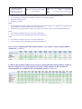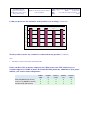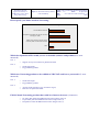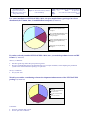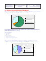
1
EUMETSAT Satellite Application Facility to NoWCasting & Very Short Range Forecasting Report on 2014 Users Survey & 2015 Users Workshop Code: NWC/CDOP2/SAF/AEMET/MGT/REP/03 Issue: 1.0 Date: 15 April 2015 File: NWC-CDOP2-SAF-AEMET-MGT-REP-03_v1.0 Page: 1/43 Report on 2014 Users Survey & 2015 Users Workshop NWC/CDOP2/SAF/AEMET/MGT/REP/01, Issue 1, Rev. 0 15 April 2015 Prepared by Project Team EUMETSAT Satellite Application Facility to NoWCasting & Very Short Range Forecasting Report on 2014 Users Survey & 2015 Users Workshop Code: NWC/CDOP2/SAF/AEMET/MGT/REP/03 Issue: 1.0 Date: 15 April 2015 File: NWC-CDOP2-SAF-AEMET-MGT-REP-03_v1.0 Page: 2/43 REPORT SIGNATURE TABLE Function Name Signature Date Prepared by Ana Sánchez, AEMET NWCSAF Operations Manager 10 March 2015 Reviewed by NWCSAF Project Team 31 March 2015 Authorised by Pilar Rípodas, AEMET SAFNWC Project Manager 15 April 2015 EUMETSAT Satellite Application Facility to NoWCasting & Very Short Range Forecasting Report on 2014 Users Survey & 2015 Users Workshop Code: NWC/CDOP2/SAF/AEMET/MGT/REP/03 Issue: 1.0 Date: 15 April 2015 File: NWC-CDOP2-SAF-AEMET-MGT-REP-03_v1.0 Page: 3/43 DOCUMENT CHANGE RECORD Version 1.0d Date 31 March 2015 Pages 41 First draft Changes 1.0 15 April 2015 43 First version EUMETSAT Satellite Application Facility to NoWCasting & Very Short Range Forecasting Report on 2014 Users Survey & 2015 Users Workshop Code: NWC/CDOP2/SAF/AEMET/MGT/REP/03 Issue: 1.0 Date: 15 April 2015 File: NWC-CDOP2-SAF-AEMET-MGT-REP-03_v1.0 Page: 4/43 Table of Contents 1 INTRODUCTION........................................................................................................................................................ 5 1.1 1.2 1.3 1.4 2 PURPOSE .................................................................................................................................................................... 5 SCOPE........................................................................................................................................................................ 5 DEFINITIONS AND ACRONYMS ...................................................................................................................................... 5 REFERENCES .............................................................................................................................................................. 5 1.4.1 Reference documents....................................................................................................................................... 5 OVERVIEW OF THE CDOP-3 USER REQUIREMENTS PROCESS..................................................................... 6 2.1 2.2 2.3 3 INTRODUCTION ........................................................................................................................................................... 6 2014 USERS’ SURVEY ................................................................................................................................................. 6 2015 USERS’ WORKSHOP ............................................................................................................................................ 6 SURVEY RESULTS .................................................................................................................................................... 8 3.1 3.2 3.3 3.4 3.5 4 GENERAL QUESTIONS.................................................................................................................................................. 8 MSG PART .............................................................................................................................................................. 11 PPS PART ................................................................................................................................................................ 17 GENERAL QUESTIONS (PRODUCTS DISTRIBUTION) ....................................................................................................... 21 REQUESTED IMPROVEMENTS (SURVEY SUMMARY) ...................................................................................................... 22 3.5.1 HELP DESK ................................................................................................................................................. 22 3.5.2 MSG PACKAGE ........................................................................................................................................... 23 3.5.2.1 CMA (PGE01) Cloud Mask................................................................................................................... 23 3.5.2.2 CT (PGE02) Cloud Type ....................................................................................................................... 23 3.5.2.3 CTTH (PGE03) Cloud Top Temperature and Height.............................................................................. 23 3.5.2.4 PC (PGE04) Precipitating Clouds .......................................................................................................... 23 3.5.2.5 CRR (PGE05) Convective Rainfall Rate ................................................................................................ 23 3.5.2.6 HRW (PGE09) High Resolution Winds ................................................................................................. 23 3.5.2.7 ASII (PGE10) Automatic Satellite Images Interpretation ........................................................................ 24 3.5.2.8 RDT (PGE11) Rapid Development Thunderstorms ................................................................................ 24 3.5.2.9 SPhR (PGE13) SEVIRI Physical Retrieval of Clear Air Parameters........................................................ 25 3.5.2.10 PCPh (PGE14) Precipitating Clouds based on Cloud Physical Properties ............................................... 25 3.5.2.11 CRPh (PGE14) Convective Rainfall Rate based on Cloud Physical Properties........................................ 25 3.5.3 PPS PACKAGE............................................................................................................................................. 25 3.5.3.1 CMA (PGE01) Cloud Mask................................................................................................................... 25 3.5.3.2 CT (PGE02) Cloud Type ....................................................................................................................... 25 3.5.3.3 CTTH (PGE03) Cloud Top Temperature and Height.............................................................................. 26 3.5.3.4 PC (PGE04) Precipitating Clouds .......................................................................................................... 26 3.5.3.5 CMIC (PGE05) Cloud Microphysics...................................................................................................... 26 3.5.3.6 Engineering........................................................................................................................................... 26 WORKSHOP OUTCOME ON USER REQUIREMENTS ...................................................................................... 27 4.1 MSG PACKAGE..................................................................................................................................................... 27 4.1.1 ENGINEERING AND HELPDESK ................................................................................................................ 27 4.1.2 Cloud Products ............................................................................................................................................. 31 4.1.3 Precipitation Products .................................................................................................................................. 33 4.1.4 Winds Product .............................................................................................................................................. 34 4.1.5 Automatic Satellite Images Interpretation ..................................................................................................... 35 4.1.6 Convection Products ..................................................................................................................................... 36 4.1.7 Physical Retrieval of Clear Air Parameters ................................................................................................... 37 4.1.8 EXIM (Extrapolated Imagery)....................................................................................................................... 39 4.1.9 MTG (in general) .......................................................................................................................................... 39 4.2 PPS PACKAGE ...................................................................................................................................................... 40 4.2.1 ENGINEERING ............................................................................................................................................ 40 4.2.2 Cloud Products ............................................................................................................................................. 42 4.2.3 Precipitation Product.................................................................................................................................... 42 4.2.4 Microphysics ................................................................................................................................................ 43 EUMETSAT Satellite Application Facility to NoWCasting & Very Short Range Forecasting Report on 2014 Users Survey & 2015 Users Workshop Code: NWC/CDOP2/SAF/AEMET/MGT/REP/03 Issue: 1.0 Date: 15 April 2015 File: NWC-CDOP2-SAF-AEMET-MGT-REP-03_v1.0 Page: 5/43 1 INTRODUCTION 1.1 PURPOSE The purpose of the document is to report on 2014 User Survey and 2015 Users’ Workshop for the CDOP-3 User Requirements Collection process. 1.2 SCOPE The document contains information compiled about the use of both packages: MSG and PPS, the environment where the users are running the software, the use and evaluation of every product and the users’ needs in Nowcasting for the future. 1.3 DEFINITIONS AND ACRONYMS See [RD.1.] for a complete list of acronyms for the SAFNWC project. 1.4 REFERENCES 1.4.1 Reference documents The reference documents contain useful information related to the subject of the project. These reference documents complement the applicable ones, and can be looked up to enhance the information included in this document if it is desired. They are referenced in this document in the form [RD.X] For dated references, subsequent amendments to, or revisions of, any of these publications do not apply. For undated references, the current edition of the document referred applies Current documentation can be found at SAFNWC Helpdesk web: http://www.nwcsaf.org Ref [RD.1.] Title The Nowcasting SAF Glossary Code NWC/CDOP2/SAF/AEMET/MGT/GLO Table 1: List of Referenced Documents Vers Date EUMETSAT Satellite Application Facility to NoWCasting & Very Short Range Forecasting Report on 2014 Users Survey & 2015 Users Workshop Code: NWC/CDOP2/SAF/AEMET/MGT/REP/03 Issue: 1.0 Date: 15 April 2015 File: NWC-CDOP2-SAF-AEMET-MGT-REP-03_v1.0 Page: 6/43 2 OVERVIEW OF THE CDOP-3 USER REQUIREMENTS PROCESS 2.1 INTRODUCTION A major control point within the NWC SAF CDOP-2 project is the 2015 Users’ Workshop supported by the 2014 Users’ Survey. The objective of this landmark is to assess the current status of the project from the users’ point of view and to collect user requirements for the next NWC SAF phase, CDOP-3. 2.2 2014 USERS’ SURVEY A Questionnaire Form based on the SurveyMonkey web tool, containing aspects related to MSG and PPS products and engineering, was prepared by the Project Team with the following objectives: • Assess the current status of products and engineering • Know the Nowcasting needs • Collect new user requirements for CDOP3. 2.3 2015 USERS’ WORKSHOP The first announcement of the Workshop was put in the NEWS page of the NWCSAF Help Desk on 18th September 2014 and the second on the 19th December 2014. There were also notifications sent to all the users by email. The workshop was held in Madrid on 24-26 February 2015 at AEMET HQ. The objectives of the Users’ Workshop have been: • To assess the applicability and usefulness of the NWC SAF products in the current phase CDOP-2. • To revise the proposals for further developments • To collect the user requirements for the next phase CDOP-3. The Workshop was specially focused on MTG, that will become operational during the CDOP-3, and on the EPS-SG new generation satellites. Users were requested to provide presentations and actively collaborate in the workshop activities along the following sessions: First day (morning and afternoon sessions) o Welcome, Plan for the WS and Current Status and Future Plans of the Nowcasting SAF o Eumetsat SAF Network and New Programmes presentations o NWC SAF Products presented by developers: Description CDOP2 future evolution CDOP3 perspective Second day (morning and afternoon sessions) o NWC SAF Products presented by developers (continuation) EUMETSAT Satellite Application Facility to NoWCasting & Very Short Range Forecasting Report on 2014 Users Survey & 2015 Users Workshop Code: NWC/CDOP2/SAF/AEMET/MGT/REP/03 Issue: 1.0 Date: 15 April 2015 File: NWC-CDOP2-SAF-AEMET-MGT-REP-03_v1.0 Page: 7/43 o Users’ Presentations (special interest in users’ feedback: usefulness, improvement suggestions, case studies, validation studies...) Third day (morning session) o 2015 Users' Survey results presentation; o New Users’ Requirements for CDOP-3; o Plenary session: conclusions In order to collect the User Requirements, 4 easels were disposed in the meeting room to allow users to write their interests on NWC SAF improvements for the next phase. These requirements were discussed during the last session. EUMETSAT Satellite Application Facility to NoWCasting & Very Short Range Forecasting Report on 2014 Users Survey & 2015 Users Workshop Code: NWC/CDOP2/SAF/AEMET/MGT/REP/03 Issue: 1.0 Date: 15 April 2015 File: NWC-CDOP2-SAF-AEMET-MGT-REP-03_v1.0 Page: 8/43 3 SURVEY RESULTS The Nowcasting SAF had 114 licensed users at the survey delivery time of which, 43 users answered the questionnaire. 41 of them answered the MSG part and 10 users, the PPS part. One user answered that they were not using any of the packages due to lack of resources. The survey was anonymous, although the users were given the chance to identify themselves and 23 of them did so. All the questions, except two, were optional. The 2014 Users Survey has proved the good shape of the NWC SAF products at the current phase and users have provided a lot of suggestions for the CDOP-3, as shown below. 3.1 GENERAL QUESTIONS Which of the following options suits best your type of user? (Compulsory) 0 5 10 15 20 25 National Meteorological Service 28 University/Research Center 6 Private Company 6 2 Private User Other 30 1 Other: Eumetsat How often do you access NWCSAF Help Desk (www.nwcsaf.org)? (43 answers) 4 3 Every day 21 Few times a week Few times a month Less than once a month 15 EUMETSAT Satellite Application Facility to NoWCasting & Very Short Range Forecasting Code: NWC/CDOP2/SAF/AEMET/MGT/REP/03 Issue: 1.0 Date: 15 April 2015 File: NWC-CDOP2-SAF-AEMET-MGT-REP-03_v1.0 Page: 9/43 Report on 2014 Users Survey & 2015 Users Workshop Could you please rate the usefulness of the NWCSAF Help Desk? (39 answers) 12 10 8 6 4 2 0 1 2 3 4 5 6 7 8 9 10 Average: 8.0 How do you think NWCSAF Help Desk could be improved? (8 answers) I am not a direct user of NWC SAF SW but of NWC SAF products and would like to have it extended to become a forum on use of products but agree it is difficult because not the initial purpose. It has always worked very well for me. The only remark is that sometimes users don´t report how a given problem ended, the mail is "closed" but I am not completely sure if there was just nothing else to report, because the suggested procedure solved the problem, or if the user solved the problem in any other way. When I log into the NWCSAF Help Desk, I always seem to get a "This Connection is Untrusted" security error message, and I have to add a security exception if I want to proceed. This is not particularly satisfactory. The web page is a bit messy, and it is not intuitive to find the information you need quickly. Too much clutter, obscures the view. Navigation panel to the left is not user friendly. Provide trajectory to geographical object for tracking over time. I'm thinking that the very definition of a 'helpdesk' system where every question pops up as a 'task' and by definition only wants to be cleared/finished by people in response seat really doesn't take into account the full knowledge of the community, if you were to set up, in parallel, maybe a forum where people can chip in and help/interact it might be beneficial for all, what weighs against this would be the secretiveness of the sector with private and state institutions and their considerations, but I think in the end it would turn out well and be cooperative. Structuring the messages in the mailbox according to topic (installation of software, product content, product quality ...) a bit more could be helpful. Access to document not easy: for example rank-key in search tools reinitialized at each request, no guidelines for the search. EUMETSAT Satellite Application Facility to NoWCasting & Very Short Range Forecasting Report on 2014 Users Survey & 2015 Users Workshop Code: NWC/CDOP2/SAF/AEMET/MGT/REP/03 Issue: 1.0 Date: 15 April 2015 File: NWC-CDOP2-SAF-AEMET-MGT-REP-03_v1.0 Page: 10/43 What is the main use you make of NWCSAF products? (43 answers) 2 7 20 Operation/Forecast Both Research Other 14 Do you use NWCSAF end-products for hazard warnings? (42 answers) No Yes 0,0% 10,0% 20,0% 30,0% 40,0% 50,0% 60,0% 70,0% Do you use NWCSAF end-products for a commercial activity? (43 answers) 37 No 6 Ye s 0 5 10 15 20 25 30 35 Which of the NWCSAF packages are you using? (Compulsory) 1 1 9 MSG package MSG & PPS PPS package None of them 32 40 EUMETSAT Satellite Application Facility to NoWCasting & Very Short Range Forecasting Report on 2014 Users Survey & 2015 Users Workshop Code: NWC/CDOP2/SAF/AEMET/MGT/REP/03 Issue: 1.0 Date: 15 April 2015 File: NWC-CDOP2-SAF-AEMET-MGT-REP-03_v1.0 Page: 11/43 3.2 MSG PART Which SAFNWC/MSG version is currently running in your site? (37 answers) 30 26 25 20 15 10 10 5 1 0 SAFNWC/MSG v2013 SAFNWC/MSG v2012 Other Other: SAFNWC/MSGv2011 Please specify your application environment. (28 answers) Almost every user who answered this question was using a Linux operating system with a different version one from each other. As a summary, they have been put together by “flavours”. Red Hat (8) SUSE (5) Fedora (4) CentOS (4) Debian (3) Ubuntu (2) Linux (without specification) (4) One user says to use AIX 6.1 operating system and another one uses Cray CLE 5.2. Please note that some of them may have more than one package installed (more than one operating system used). Please specify the characteristics of the Numerical Model you use. (23 answers) The NWP model that most users ingest in their installation is ECMWF, but there are other NWP models used. The temporal, spatial and vertical resolution varies almost with every user. ECMWF (16) UKMO Unified Model (2) HIRLAM (2) ALADIN (2) ARPEGE (1) COSMO (1) GME (1) Please note that one user can be using more than one NWP model. EUMETSAT Satellite Application Facility to NoWCasting & Very Short Range Forecasting Code: NWC/CDOP2/SAF/AEMET/MGT/REP/03 Issue: 1.0 Date: 15 April 2015 File: NWC-CDOP2-SAF-AEMET-MGT-REP-03_v1.0 Page: 12/43 Report on 2014 Users Survey & 2015 Users Workshop They were also asked about the use of NWP in Pressure or Hybrid levels: Pressure levels (13) Hybrid levels (1) Both (6) Do you receive NWP in Hybrid Levels in your system? (28 answers) 9 Ye s 13 No 6 D o n't Kno w 0 2 4 6 8 10 12 14 Which of the current SAFNWC/MSG Products are you using? (33 answers) 35 31 30 30 26 25 20 20 20 15 14 15 10 10 10 10 8 5 0 PGE01 PGE02 PGE03 PGE04 PGE05 PGE09 PGE10 PGE11 PGE13 PGE14 PGE14 Cma CT CTTH PC CRR HRW ASII RDT SPhR PCPh CRPh Could you please rate the usefulness of the products you are using? (27 answers) 10,00 8,3 9,00 8,00 8,1 7,5 7,5 7,4 6,4 7,00 6,7 7,0 7,3 7,5 6,00 4,3 5,00 4,00 3,00 2,00 1,00 0,00 PGE01 PGE02 PGE03 PGE04 PGE05 PGE09 PGE10 PGE11 PGE13 PGE14 PGE14 CMa CT CTTH PC CRR HRW ASII RDT SPhR PCPh CRPh EUMETSAT Satellite Application Facility to NoWCasting & Very Short Range Forecasting Report on 2014 Users Survey & 2015 Users Workshop Code: NWC/CDOP2/SAF/AEMET/MGT/REP/03 Issue: 1.0 Date: 15 April 2015 File: NWC-CDOP2-SAF-AEMET-MGT-REP-03_v1.0 Page: 13/43 Would you like to make any comment or remark about any product? (9 answers) CMA We use dust and snow flags. The CMa product is produced as a by-product of PGE09. We plan to carry out comparisons with our own cloud mask product. Land/Sea mask for this product is terrible, results in many false cloud detections. Feeds into PGE11. CT We want to use additional information in last versions e.g. water phase flag. We use the cloud type product as part of a product for estimating surface sunshine duration. As far as I am aware, there are no plans to try to discriminate between convective and non-convective clouds within PGE02? This would be very useful for us. Feeds into PGE11. CTTH In general good results, problems when inversions are present, or in case of cb clouds with overshooting tops. More information in case of broken and multilevel cloudiness would be useful. The CTTH product is produced as a by-product of PGE09. We plan to carry out comparisons with our own CTTH products. Poor accuracy for convective systems, usually underestimates height. Default resolution for NWP is too low (16x16 pixels I think). Feeds into PGE11. Default output is blocky, works much better set to 4 pixel resolution rather than 16. Very useful even at high latitudes. PC To be replaced in tools by PGE14 once some verification is done and positive. There is the possibility that we might start to use the precip products in the future. Nice, but needs more calibration. CRR Only instantaneous is used. To be replaced in tools by PGE14 after verification. There is the possibility that we might start to use the precip products in the future. Nice, but needs more calibration. We don't have 925 hPa in NWP, so Humidity correction does not get done. HRW Evolving rather in a portable AMV SW for NWP assimilation and general diagnosis, that looks reasonable. But there should still be place for nowcasting objectives, it is asked that low level high-resolution motion patterns is a parallel development line, with close contribution of users suggested. We assimilate the high resolution AMVs into our operational convective scale (UK) NWP model. Hard to implement in visualization. Used for reasearch and operational weather analyse. ASII There is no internal agreement on its use. It is proposed that a survey on operational use is conducted by the NWC SAF and information is reflected in the documentation. RDT Lack of continuity in convective cells lifecycle; too large, non representative extent. Earliest stages are important: Convective initiation subproduct is of course aimed, it is also proposed that BUFR product of convective cells also includes the very first detection before convective test. We are planning to implement this soon. EUMETSAT Satellite Application Facility to NoWCasting & Very Short Range Forecasting Code: NWC/CDOP2/SAF/AEMET/MGT/REP/03 Issue: 1.0 Date: 15 April 2015 File: NWC-CDOP2-SAF-AEMET-MGT-REP-03_v1.0 Page: 14/43 Report on 2014 Users Survey & 2015 Users Workshop Essential to have this product convected to HDF, the in-built converter does not function well. Very bad format, would be better in HDF (or at least with a working converter). Useful for warning service. Difficult to visualize. SPhR Use of all final subproducts with its guess differences is being developed for user applications. Operational use of (subsampled or selected) profiles is under consideration. Should be the same algorithm as in PPS, only indices for instability, please use standard WMO descriptors. PCPh See comment in PGE04. Plans for use of hourly subproduct. Nice, but misses the area sometimes and needs more calibration. CRPh See comment in PGE05. Plans for use of hourly subproduct. Nice, but misses the area sometimes and needs more calibration. In case you are adapting SAFNWC/MSG products to any satellite, could you please indicate which ones? (5 answers) PGE01 CMa 1 0 2 2 1 1 GOES-N (13-14-15) COMS MTSAT METEOSAT-7 FY-2 GOMS PGE02 CT 0 0 1 1 0 0 PGE03 CTTH 1 0 2 2 1 1 PGE04 PC 0 0 1 1 0 0 PGE05 CRR 0 0 1 1 0 0 PGE09 HRW 0 0 0 1 0 0 PGE10 ASII 0 0 0 1 0 0 PGE11 RDT 1 0 1 2 0 0 PGE13 SPhR 0 0 0 1 0 0 PGE14 PCPh 0 0 0 1 0 0 PGE14 CRPh 0 0 0 1 0 0 Could you please indicate which of the current & coming SAFNWC/MSG products would you like to be adapted to any of the following current & coming satellites (in the case that the needed channels are available in the corresponding sensor)? (26 answers) MTG GOES-N (13-14-15) GOES-R COMS GEO-KOMPSAT 2 MTSAT HIMAWARI-8/9 INSAT-3 ELECTRO-L FY-4 PGE01 CMa PGE02 CT PGE03 CTTH PGE04 PC PGE05 CRR PGE09 HRW PGE10 ASII PGE11 RDT PGE13 SPhR PGE14 PCPh PGE14 CRPh PGE15 CMIC PGE16 EXIM PGE17 ASII-NG PGE18 CI PGE19 CW 26 2 8 0 1 7 8 0 1 2 26 2 8 0 1 6 8 0 1 2 26 2 8 0 1 6 8 0 1 2 20 2 4 1 1 4 2 0 1 0 20 3 5 1 2 4 3 0 1 0 22 3 4 0 1 3 4 0 0 0 12 0 0 0 0 2 2 0 0 0 24 2 4 0 1 3 3 0 1 0 17 0 0 0 0 2 2 0 0 0 20 2 6 0 0 4 5 0 1 2 18 1 5 0 0 3 4 0 1 2 22 2 4 0 1 1 1 0 1 1 12 2 3 0 0 2 2 0 0 1 9 1 1 0 0 0 0 0 0 0 22 3 5 0 1 2 2 0 1 1 20 1 3 0 1 2 2 0 1 1 EUMETSAT Satellite Application Facility to NoWCasting & Very Short Range Forecasting Code: NWC/CDOP2/SAF/AEMET/MGT/REP/03 Issue: 1.0 Date: 15 April 2015 File: NWC-CDOP2-SAF-AEMET-MGT-REP-03_v1.0 Page: 15/43 Report on 2014 Users Survey & 2015 Users Workshop Could you please specify your future needs in Nowcasting? (27 answers) Users' future needs in Nowcasting 24 Cloud Pre-c o nv ec tiv e Env iro nment (Conv e c tion Initiatio n) Clear Air Pre-c o nv ec tiv e Env iro nment (Instability) 19 T hun derstorm W arning an d Trac k ing 19 15 Cloud T op Mic rop hysic s 17 Cumu lus/ Stratus distinc tio n 20 Pre c ip itation p robability an d ra te 12 Extrapo lated Ima gery 19 Atmospheric Motion Vec tors (AMVs) for a sp ec ific need 7 Detec tio n, trac k in g and forec ast of dry intrusio ns 3 Other 0 5 10 15 20 25 Which new Nowcasting products to be codified at NWCSAF could cover your needs? (4 users answered) User 1: o o Icing. Use of other MTG instruments e.g. Lightning sensor to improve RDT o o Discrimination between convective and non-convective cloud pixels would be useful for us. The quality of the high resolution AMV winds product will continue to be important to us, and consequently any pre-processing step that is required (i.e. to determine AMV height assignment) is also important. Therefore, we wonder whether it might be feasible for some of the more sophisticated schemes becoming available from EUMETSAT (e.g. the OCA scheme) might also become part of the SAFNWC system? o o PGE18 CI PGE17 ASII-NG o o o o o Convection Initiation RDT-Convection Warning Cloud Microphysics Extrapolated Imagery ASII-New Generation User 2: User 3: User 4: EUMETSAT Satellite Application Facility to NoWCasting & Very Short Range Forecasting Code: NWC/CDOP2/SAF/AEMET/MGT/REP/03 Issue: 1.0 Date: 15 April 2015 File: NWC-CDOP2-SAF-AEMET-MGT-REP-03_v1.0 Page: 16/43 Report on 2014 Users Survey & 2015 Users Workshop Which new MTG based Nowcasting products could be of interest for your service? (4 users answered) User 1: o o o o Cloud base level (if possible). Intra-cloud water information or profiling (as possible). Wind profiles. Any other parameter directly related to surface sensible weather that can reasonably be computed. o Better thin cirrus detection. o Lightning Imager for lightning over AfricaPGE17 ASII-NG o o o o o Convection Initiation RDT-Convection Warning Cloud Microphysics Extrapolated Imagery ASII-New Generation User 2: User 3: User 4: Are you using or have you used MSG Rapid Scan Service images to run NWCSAF software? (26 answers) 16 No 10 Yes 0 2 4 6 8 10 12 14 16 18 Comments: It is suggested that instead of a full independent rapid-scan procedure, a more adapted or "mixed" method could be developed by the NWC SAF, keeping the basic processing cycle of 15min as it is (but maybe delivery each 5min), while simplifying tracking, time-difference, overlapping processing and other implications considering the increased frequency. Answer by the Project Team: Not necessary since that up to now RSS offers same possibilities than FDSS. Only for case studies. Planned. RSS is essential for NWC. Have plans to do preoperational tests with RSS data. EUMETSAT Satellite Application Facility to NoWCasting & Very Short Range Forecasting Code: NWC/CDOP2/SAF/AEMET/MGT/REP/03 Issue: 1.0 Date: 15 April 2015 File: NWC-CDOP2-SAF-AEMET-MGT-REP-03_v1.0 Page: 17/43 Report on 2014 Users Survey & 2015 Users Workshop 3.3 PPS PART Which SAFNWC/PPS version is running or are you planning to run in your site? (6 answers) 4 3 2 1 0 SAFNWC/PPS v2014 SAFNWC/PPS v2012 SAFNWC/PPS v2010 Please specify your application environment. (5 answers) Red Hat (3, different versions) SUSE (1) CentOS (1) One of them also refers to be using Cray CLE 5.2. Please specify the characteristics of the Numerical Model you use. (5 answers) Three of them use ECMWF, but there are other NWP models used, like GME 20L60, HIRLAM, HRM and WRF. All of them receive NWP in Hybrid Levels in their system. Which of the current SAFNWC/PPS Products are you using? (5 answers) 5 4 3 2 1 0 PGE01 Cma PGE02 CT PGE03 CTTH PGE04 PC PGE05 CPP EUMETSAT Satellite Application Facility to NoWCasting & Very Short Range Forecasting Report on 2014 Users Survey & 2015 Users Workshop Code: NWC/CDOP2/SAF/AEMET/MGT/REP/03 Issue: 1.0 Date: 15 April 2015 File: NWC-CDOP2-SAF-AEMET-MGT-REP-03_v1.0 Page: 18/43 Could you please rate the usefulness of the products you are using? (5 answers) 10 9,2 9,0 9,2 8,8 8,0 8 6 4 2 0 PGE01 CMa PGE02 CT PGE03 CT TH PGE04 PC PGE05 CPP Would you like to make any comment or remark about any product? (1 answer) CPP Should be consistent with NWC SAF MSG CPP. Future satellites: PPS is already adapted to the VIIRS sensor on S-NPP. Plans foresee to continue support for VIIRS on future JPSS and NPOESS platforms. Additional to that, please indicate your need for future adaptations: EPS-SG (METimage sensor) FY3-D, E, F (MERSI-II sensor) Sentinel 3 (SLSTR sensor) PGE01 CMa PGE02 CT PGE03 CTTH PGE04 PC PGE05 CPP 4 3 4 4 3 4 4 3 4 3 1 2 3 2 3 EUMETSAT Satellite Application Facility to NoWCasting & Very Short Range Forecasting Report on 2014 Users Survey & 2015 Users Workshop Code: NWC/CDOP2/SAF/AEMET/MGT/REP/03 Issue: 1.0 Date: 15 April 2015 File: NWC-CDOP2-SAF-AEMET-MGT-REP-03_v1.0 Page: 19/43 Please specify your future needs in Nowcasting. Future needs in Nowcasting Cumulus/Stratus distinction Precipitation probability and rate from cloud top microphysics (CPP) S-NPP cloud products at highest posible resolution (375m at nadir instead of 750m) Other 0 1 2 3 4 5 Which developments in PPS would you see as desirable (software and products)? (2 users answered) User 1: o Support of Cray environment as platform for PPS. o o Cloud base height. Fog probability product. User 2: Which new Nowcasting products to be codified at NWCSAF could cover your needs? (2 users answered) User 1: o o Cloud base height. Fog probability product. o o Aerosol-cloud separation (esp. of volcanic origin). Detection of supercooled water. User 2: EPS-SG based Nowcasting products that could be of interest for users: (4 answers) o o o Ice water path (IWP) from MWI/ICI microwave imager suite (2) Liquid water path from MWI/ICI microwave imager suite (2) Precipitation rate from MWI/ICI microwave imager suite (4) EUMETSAT Satellite Application Facility to NoWCasting & Very Short Range Forecasting Report on 2014 Users Survey & 2015 Users Workshop Code: NWC/CDOP2/SAF/AEMET/MGT/REP/03 Issue: 1.0 Date: 15 April 2015 File: NWC-CDOP2-SAF-AEMET-MGT-REP-03_v1.0 Page: 20/43 For easier installation of NWCSAF/PPS v2014, also precompiled binary packages have been distributed (for Ubuntu, Suse, CentOS/Redhat enterprise) (6 answers) 1 I have installed NWCSAF/PPS v2014 with help of precompiled binary packages. 2 1 I have installed NWCSAF/PPS v2014, but I have not used precompiled binary packages. I plan to install NWCSAF/PPS v2014 with help of precompiled binary packages. I will not use precompiled binary packages. 2 If you have already installed NWCSAF/PPS v2014, have you used the products in new netCDF format? (5 answers) YES (3). Comments: Netcdf is good step, makes the post-processing easier. We have installed PPSv2014 in development/test since a couple of months, and is adapting the production system to the new format before putting it in operation. NO (2). Comments: Not yet, but soon. Would you consider contributing to future development/enhancements of the NWCSAF/PPS package? (6 answers) 2 2 Yes, with the current license agreement. Yes, if it was released under an open source license. Yes, it does not depend on the license. No, I am not interested. 2 Comments: Only for a climate PPS version. Not as open source software. EUMETSAT Satellite Application Facility to NoWCasting & Very Short Range Forecasting Report on 2014 Users Survey & 2015 Users Workshop Code: NWC/CDOP2/SAF/AEMET/MGT/REP/03 Issue: 1.0 Date: 15 April 2015 File: NWC-CDOP2-SAF-AEMET-MGT-REP-03_v1.0 Page: 21/43 3.4 GENERAL QUESTIONS (PRODUCTS DISTRIBUTION) Did you know that SAFNWC/MSG Cloud Mask, Cloud Type and CTTH products (Full Disk) are being distributed via the EUMETCAST Service? (30 answers) 9 Yes, I am aware of this service. Yes, I am using this service. Yes, I plan to use this service. No, I didn't know about this service. 19 2 Do you think it would be useful that other SAFNWC/MSG products would be distributed via the EUMETCAST service? (24 answers) YES (12). Comments: PC, CRR. (2) RDT. (3) NO (12). Comments: Prefer calculating locally. (2) Only to compare with own products. Did you know that NWCSAF/PPS Cloud Mask, Cloud Type and CTTH products from AVHRR are being distributed via the EUMETCAST NWC-EARS Service? (27 answers) Yes, I am aware of this service. 11 13 Yes, I am using this service. Yes, I plan to use this service. No, I didn't know about this service. 3 EUMETSAT Satellite Application Facility to NoWCasting & Very Short Range Forecasting Report on 2014 Users Survey & 2015 Users Workshop Code: NWC/CDOP2/SAF/AEMET/MGT/REP/03 Issue: 1.0 Date: 15 April 2015 File: NWC-CDOP2-SAF-AEMET-MGT-REP-03_v1.0 Page: 22/43 Via the EUMETCAST NWC-EARS service, would you be interested in ...? (11 answers) ... also receiving products for VIIRS (S_NPP)? (8) ... also receiving CPP products (cloud microphysical parameters)? (4) ... also receiving precipitation products? (6) 3.5 REQUESTED IMPROVEMENTS (SURVEY SUMMARY) Comments by the Project Team, if any, have been included in italics. 3.5.1 HELP DESK I would like to have it extended to become a forum on use of products but agree it is difficult because not the initial purpose. We don’t think it would be much more useful for the user than the current Mail Box. It has to be noticed that when a user writes a mail, it is also sent to all the users, so if someone feels that they can provide any advice on the topic, they can write their own contribution as well. In fact, this has happened some times. It has always worked very well for me. The only remark is that sometimes users don´t report how a given problem ended, the mail is "closed" but I am not completely sure if there was just nothing else to report, because the suggested procedure solved the problem, or if the user solved the problem in any other way. This change could be implemented, but we doubt about its usefulness. It would be on users’ side the task of marking the mail as “solved”, and most of the times for sure they will forget doing it, after having implemented the solution proposed by the Project Team. We can study the possibility of adding a kind of validation box, that the user would have to tick in order to rate the usefulness of the answer provided. When I log into the NWCSAF Help Desk, I always seem to get a "This Connection is Untrusted" security error message, and I have to add a security exception if I want to proceed. This is not particularly satisfactory. We are sorry for this inconvenience, but for the moment we don’t see the possibility to change the security certificate. The web page is a bit messy, and it is not intuitive to find the information you need quickly. Too much clutter, obscures the view. Navigation panel to the left is not user friendly. For the moment we have no plans of changing the website general design, we don’t find it that messy. Provide trajectory to geographical object for tracking over time. NWCSAF Project Team does not understand what the user means. I'm thinking that the very definition of a 'helpdesk' system where every question pops up as a 'task' and by definition only wants to be cleared/finished by people in response seat really doesn't take into account the full knowledge of the community, if you were to set up, in parallel, maybe a forum where people can chip in and help/interact it might be beneficial for all, what weighs against this would be the secretiveness of the sector with private and state institutions and their considerations, but I think in the end it would turn out well and be cooperative. See answer to the first request. Structuring the messages in the mailbox according to topic (installation of software, product content, product quality ...) a bit more could be helpful. We will study the possibility to add some more keys that could help the search. EUMETSAT Satellite Application Facility to NoWCasting & Very Short Range Forecasting Report on 2014 Users Survey & 2015 Users Workshop Code: NWC/CDOP2/SAF/AEMET/MGT/REP/03 Issue: 1.0 Date: 15 April 2015 File: NWC-CDOP2-SAF-AEMET-MGT-REP-03_v1.0 Page: 23/43 Access to document not easy: for example rank-key in search tools reinitialized at each request, no guidelines for the search. Same as previous one. 3.5.2 MSG PACKAGE 3.5.2.1 CMA (PGE01) Cloud Mask Improvement of Land/Sea mask. Icing. Intra-cloud water information or profiling. 3.5.2.2 CT (PGE02) Cloud Type We want to use additional information in last versions e.g. water phase flag. Discrimination between convective and non-convective clouds. Cumulus/Stratus distinction. Fog and Low cloud identification and tracking. Cloud base level. Better thin cirrus detection. 3.5.2.3 CTTH (PGE03) Cloud Top Temperature and Height In general good results, problems when inversions are present, or in case of cb clouds with overshooting tops. More information in case of broken and multilevel cloudiness would be useful. Poor accuracy for convective systems, usually underestimates height. Default resolution for NWP is too low (16x16 pixels I think). Default output is blocky, works much better set to 4 pixel resolution rather than 16. Cloud Top Microphysics Comments/answers on cloud products user requirements expressed in user survey (section 3.2 and 3.5.2) and workshop outcome (4.1.2) are summarized at the end of section 4.1.2 3.5.2.4 PC (PGE04) Precipitating Clouds To be replaced in tools by PGE14 once some verification is done and positive. Nice, but needs more calibration. No new efforts will be devoted to this product since new algorithms are being developed for the same purpose. 3.5.2.5 CRR (PGE05) Convective Rainfall Rate Nice, but needs more calibration. We don't have 925 hPa in NWP, so Humidity correction does not get done. No new efforts will be devoted to this product since new algorithms are being developed for the same purpose. 3.5.2.6 HRW (PGE09) High Resolution Winds Evolving rather in a portable AMV SW for NWP assimilation and general diagnosis, that looks reasonable. But there should still be place for nowcasting objectives, it is asked that low level high-resolution motion patterns is a parallel development line, with close contribution of users suggested. Hard to implement in visualization. Wind profiles. EUMETSAT Satellite Application Facility to NoWCasting & Very Short Range Forecasting Report on 2014 Users Survey & 2015 Users Workshop Code: NWC/CDOP2/SAF/AEMET/MGT/REP/03 Issue: 1.0 Date: 15 April 2015 File: NWC-CDOP2-SAF-AEMET-MGT-REP-03_v1.0 Page: 24/43 3.5.2.7 ASII (PGE10) Automatic Satellite Images Interpretation There is no internal agreement on its use. It is proposed that a survey on operational use is conducted by the NWC SAF and information is reflected in the documentation. Information on conceptionel model Shapiro-Keyser. ASII was declared “scientifically frozen during CDOP-2”. What is more (see e.g. preceding statement), the ASII general algorithmic concept is under scrutiny and not too likely to survive into the MTG era. Consequently, we take note of the request, but see no chance to address it in the short run. 3.5.2.8 RDT (PGE11) Rapid Development Thunderstorms Lack of continuity in convective cells lifecycle; too large, non representative extent. Earliest stages are important: Convective initiation subproduct is of course aimed, it is also proposed that BUFR product of convective cells also includes the very first detection before convective test. Lifecycle of the cells is assessed mixing statistical rules and empirical rules. Priority is given to the detection of phase of lifecycle at a given slot rather than the respect of classical lifecycle continuity. Nevertheless continuity can be improved. Up to now when the Yes convection diagnosis does not come statistical part of discrimination process but is driven by overshooting top or lightning presence, the Yes convection is not taken into account in heritage. Will be changed in v2016. RDT algorithm does not detect the core of convective cell but their general outline. Size of cells is defined by the detection part of the algorithm and is more representative of tower-base. An additional contour has been implemented in v2012, this contour is smaller and closer to top of clouds. Concerning the BUFR remark, the argument –bufr in configuration file can be chosen to satisfy yours needs. When the argument is set to 1 2 3 or 4, all cells are described (even non-convective cells). When the argument is set to –3 or –4, only convective cells are described but when they are convective for the first time all their history is provided. RDT has already an early diagnosis: 25% of convective systems are diagnosed before convection occurs. But that is not the main goal of RDT. And early diagnosis may be misunderstood with False Alarm. It would be difficult to increase early diagnosis feature of RDT. That’s the reason why a new product will be developed and delivered in v2016 : Convection Initiation Product. But RDT will keep the possibility to have an early diagnosis. Essential to have this product converted to HDF, the in-built converter does not function well. Up to now bufr2hdf tool is compliant only with first version of BUFR. v2016 new netcdf format will help the conversion. Very bad format, would be better in HDF (or at least with a working converter). See above. Difficult to visualize. See above. Cloud Pre-convective Environment (Convection Initiation) Foreseen for v2016. Thunderstorm Warning and Tracking. Done. EUMETSAT Satellite Application Facility to NoWCasting & Very Short Range Forecasting Report on 2014 Users Survey & 2015 Users Workshop Code: NWC/CDOP2/SAF/AEMET/MGT/REP/03 Issue: 1.0 Date: 15 April 2015 File: NWC-CDOP2-SAF-AEMET-MGT-REP-03_v1.0 Page: 25/43 Divergence product to identify strong vertical movements. To be analyzed. CDOP4. Convergence index inside RDT cell to be studied. Use of other MTG instruments e.g. Lightning sensor to improve RDT. v2022. Lightning Imager for lightning over Africa. v2022. 3.5.2.9 SPhR (PGE13) SEVIRI Physical Retrieval of Clear Air Parameters Should be the same algorithm as in PPS, only indices for instability, please use standard WMO descriptors. It seems to be a mistake, provided that there is no equivalent algorithm in PPS. Clear Air Pre-convective Environment (Instability) 3.5.2.10 PCPh (PGE14) Precipitating Clouds based on Cloud Physical Properties Nice, but misses the area sometimes and needs more calibration. This comment will be taken into account. A new calibration will be included for this product v2016. 3.5.2.11 CRPh (PGE14) Convective Rainfall Rate based on Cloud Physical Properties Nice, but misses the area sometimes and needs more calibration. This comment will be taken into account. A new calibration will be included for this product v2016. 3.5.3 PPS PACKAGE 3.5.3.1 CMA (PGE01) Cloud Mask S-NPP cloud products at highest possible resolution (375m at nadir instead of 750m). We will consider this requirement in prototyping for v2017. Implementation is either foreseen for highest possible resolution (TBD), or just incorporating information from high resolution channels. Aerosol-cloud separation (esp. of volcanic origin). Accepted. Aerosol flag planned for v2017. 3.5.3.2 CT (PGE02) Cloud Type Cumulus/Stratus distinction. This remains TBD. We would like to await GEO development results before deciding whether to implement anything in PPS. Possible implementation time TBD S-NPP cloud products at highest possible resolution (375m at nadir instead of 750m). We will consider this requirement in prototyping for v2017. Implementation is either foreseen for highest possible resolution (TBD), or just incorporating information from high resolution channels. Fog/low clouds distinction. Will be considered, needs further investigation and can not rely on satellite only. EUMETSAT Satellite Application Facility to NoWCasting & Very Short Range Forecasting Report on 2014 Users Survey & 2015 Users Workshop Code: NWC/CDOP2/SAF/AEMET/MGT/REP/03 Issue: 1.0 Date: 15 April 2015 File: NWC-CDOP2-SAF-AEMET-MGT-REP-03_v1.0 Page: 26/43 Cloud base height. Not prioritized, too many assumptions needed and quality doubtful. Fog probability product. Will be considered, needs further investigation and can not rely on satellite only. 3.5.3.3 CTTH (PGE03) Cloud Top Temperature and Height S-NPP cloud products at highest possible resolution (375m at nadir instead of 750m). TBD. Is this really useful for CTTH? Computationally expensive. 3.5.3.4 PC (PGE04) Precipitating Clouds 3.5.3.5 CMIC (PGE05) Cloud Microphysics Should be consistent with NWCSAF/MSG CPP. Will not be done during CDOP3. Precipitation probability and rate from cloud top microphysics (CPP). We propose not to do this development. See discussion under section 4.2.3 Detection of supercooled water. Will not be done. Only possible near cloud top. For that we do not really see usefulness in aviation applications. The user could combine phase information with CTTH information for an indication of supercooled water near cloud top. 3.5.3.6 Engineering Support of Cray environment as platform for PPS. Limited support can be provided, see answer to CMSAF request in sections 4.1.1 and 4.2.1 EUMETSAT Satellite Application Facility to NoWCasting & Very Short Range Forecasting Report on 2014 Users Survey & 2015 Users Workshop Code: NWC/CDOP2/SAF/AEMET/MGT/REP/03 Issue: 1.0 Date: 15 April 2015 File: NWC-CDOP2-SAF-AEMET-MGT-REP-03_v1.0 Page: 27/43 4 WORKSHOP OUTCOME ON USER REQUIREMENTS The outcome of the workshop is a summary of different sources of inputs: - Presentations made by users. - Notes on the easels by the users. - Emails received from users that were not able to attend the Workshop. - Emails from users that attended the workshop but realised afterwards they had missed to share something (e.g. AEMET-NWP). - Reports made by key-users, e.g. CMSAF, LSASAF, Romanian Met Service (NMA), Hungarian Met Service (OMSZ), etc… - Requirements from previous Workshops or Meetings. The answers or comments provided by the Project Team have been included in italics. 4.1 MSG PACKAGE 4.1.1 ENGINEERING AND HELPDESK Possibility to ingest hybrid levels in all MSG products. It will be studied for future versions, depending on the product. Provide the Reference System products using web services. The NWC SAF is not intended to provide products but software. The Reference System is only design as a help tool for the users to check that they are obtaining coherent products (especially when running the software for the first time). OSISAF, LSASAF and NWPSAF GEO software ready for cloud products (CMa, CT) at Day-1 of MTG-FCI satellite and at Day-1 of GOES-R or GOES-S (depending on which one will be in GOES-East position). Software has to be ready and made available sufficiently in advance (1 year minimum). NWCSAF can commit to deliver the GEO Cloud products SW some time in advance to the SAFs Project Teams that require it (OSI SAF, LSA SAF and NWP SAF). How much time in advance does not depend only on the NWCSAF, but also on the advance availability of the MTG test datasets that EUMETSAT will provide. OMSZ and South Africa Weather Service Support officially the use of other NWP models than ECMWF. For PGE13 it is used ECMWF to calculate the coefficients because is the most common NWP to users and all models are compared with ECMWF. In any case tools for calculate coefficients by users could be generated as best effort basis. OMSZ Possibility to use different NWP under the same user. It can be considered for next versions, not for GEO v2016, that is already being implemented. EUMETSAT Satellite Application Facility to NoWCasting & Very Short Range Forecasting Report on 2014 Users Survey & 2015 Users Workshop Code: NWC/CDOP2/SAF/AEMET/MGT/REP/03 Issue: 1.0 Date: 15 April 2015 File: NWC-CDOP2-SAF-AEMET-MGT-REP-03_v1.0 Page: 28/43 OMSZ User friendly description/tool to help to create NWP input file different from ECMWF would be welcome. All the necessary information is already included in the User Manual. We will consider the possibility of making a more comprehensive summary. DWD NWP import also GRIB 2. NWCSAF software already handles GRIB2. DWD (most) raster PGE also as polygons to use them as weather objects for (semi) automatic warning systems and other production systems. It is not considered at the moment. DWD Import of compressed HRIT Data (*HRIT*_C). We will consider the possibility of including the EUMETSAT tool for decompressing HRIT files. OMSZ It would be good if the user could indicate somehow after the mail closing, whether the answer helps to solve the problem or not. We can study the possibility of adding a kind of validation box, that the user would have to tick in order to rate the usefulness of the answer provided. OMSZ We suggest reorganizing the documentation to be more user friendly, more manageable. We will study the possibility to add some more keys that could help the search. OMSZ It would be nice if the spatial resolution of the NWP data could be different for different pressure levels. Increasing the spatial resolution in the lower levels is reasonable and beneficial. However, to use the same high spatial resolution for example at 50 hPa is unnecessary. We are working on this. We are studying the feasibility to implement it. OMSZ It would be beneficial to help the users who have no access to the ECMWF data (or who wish to use another model) by a user friendly description and/or tool how to calculate bias correction for other NWP models. Yes. We agree on that and although we have no commitment on this, we will do our best to perform this task, even inside CDOP-2 if enough resources are available. OMSZ Consider using more ECMWF pressure levels. Yes. We know that there are now 25 ECMWF pressure levels available in the ECMWF MARS. It will be considered. OMSZ Please, create module for parallax correcting the HRV image. It is not planned. We can consider it in the future if we have resources available. CMSAF The application of the NWC SAF packages for climate purposes requires a modular structure and object-oriented programming of the software. This includes, that patches are provided as separate modules to be implemented as additional software to the existing package (e.g. provision of interfaces for new satellites). The current experience (independent of MSG or PPS) is that a new full installation of the software is required to enable an executable version with stable functionality. NWCSAF/GEO SW patches for a given SW version do not require a new full installation of the SW package. For NWCSAF/PPS, the Project Team thinks that a closer cooperation could ease the process of patch installation. EUMETSAT Satellite Application Facility to NoWCasting & Very Short Range Forecasting Report on 2014 Users Survey & 2015 Users Workshop Code: NWC/CDOP2/SAF/AEMET/MGT/REP/03 Issue: 1.0 Date: 15 April 2015 File: NWC-CDOP2-SAF-AEMET-MGT-REP-03_v1.0 Page: 29/43 CMSAF Furthermore, CM SAF requires that it should be possible to run previous algorithms on data from new satellites (if they don’t change in terms of available spectral channels or other critical parts). A shift to a new satellite in the same satellite series should be realized so that it can still run with old algorithms. Thus, an update of the algorithms is not necessary in this case, which is a critical requirement for climate monitoring applications. NWCSAF Project Team can not commit to support more than two NWCSAF SW versions. Such a general requirement could become very demanding. The NWCSAF resources are dedicated to improve the products for Nowcasting purposes. The support for old versions has to be specified in more detail: which versions and what is needed. Then NWC SAF PT can decide on the feasibility to support or help CM SAF team. CMSAF For the climate data records a reliable and best possible calibration and inter-calibration of satellite data is very important. Therefore, for CM SAF it is required, that the processing of parts of the chain is possible, (e.g. start with L1c data as input without the need of L1b data being available). Again NWC SAF can not commit to a general requirement. The feasibility of the particular requirement of ingesting level 1c can be discussed together with CM SAF team. For PPS: in principle running from level 1c is not a problem for future versions and was asked for by several users. Details would need to be agreed and we would only support one well specified PPS internal level 1c format (Netcdf). CMSAF Furthermore, the compilation of individual software packages should be possible modular with clear log files to support the implementation work. NWCSAF PT would need a clarification on this requirement. CMSAF The concept of climate services is to provide long term data sets with latest observed data based on the same software version. Therefore, from the climate point of view, it is important, that interfaces for new satellites can also be implemented in older software versions of NWC-PPS and NWC-MSG to enable to have stable versions for the generation of long time series. Viceversa, CM SAF requires interfaces to older satellites (e.g. from NOAA or MSG) which should be supported in new upcoming NWC SAF software versions. In particular for PPS, input data in GAC and LAC resolution as well should be covered also in upcoming PPS versions. A SW version can support current and old satellites (if channels needed available) as a general rule (if needed, we can not commit to extra work). But NWCSAF can not commit to support future satellites for an old SW version. We do not have enough resources and we have other commitments. Such a requirement is not in the scope of NWC SAF. For PPS any new satellites need to be considered/agreed on a case by case basis. New satellites launched in the same family can likely be supported (given that the RTTOV version used in the old package will support this satellite) CMSAF In the next phase CM SAF plans to evaluate the benefit of an enhanced set of sensors/satellites with potential use for climate monitoring purposes in the future. These are for instance upcoming Chinese polar satellite sensors (in early morning orbit) or the SLSTR sensor on Sentinel-3. Data from these satellites should also be taken into account in considerations for future NWC SAF software versions. We welcome the requirement posed. Chinese polar orbiters are planned to be supported from FY-3D onward (MERSI-2 instrument), implementation planed in PPS v2019. We currently investigate whether adaptation to Sentinel3 SLSTR (not including forward view) can be prepared in CDOP2 to become operational in PPSv2017 (at least for PGE01-03). This depends on support by users for reprioritisations to be formulated before summer, and finally on SG approval. CMSAF CM SAF sees it as advantage that both SW package are able to be run with Reanalyses data as well as with forecast fields. This should be taken into account also in upcoming NWC SW packages. Functionality will be kept. EUMETSAT Satellite Application Facility to NoWCasting & Very Short Range Forecasting Report on 2014 Users Survey & 2015 Users Workshop Code: NWC/CDOP2/SAF/AEMET/MGT/REP/03 Issue: 1.0 Date: 15 April 2015 File: NWC-CDOP2-SAF-AEMET-MGT-REP-03_v1.0 Page: 30/43 CMSAF A clear and flexible module to ERA and ERA-interim data in grib2 and netcdf as input for the CM SAF CDR processing should be part of the software. For older versions of SAFNWC we can not do it. For GEO: Currently only grib-formats are supported. For PPS: It might be possible to ingest netcdf data as well from v2017 onward, if in a well specified agreed format. We would like to keep interface parts for the NWC reanalysis parts outside the PPS core package. CMSAF The CM SAF uses the supercomputing environment at ECMWF to generate EDR and CDR. The current facility at ECMWF is a Cray XC30 system with a Cray Linux Environment as operating system. The ECMWF plans to have this environment available until middle of 2018. In addition, DWD as the largest meteorological service in Europe is using a Cray XC30 system as well. It is therefore likely that CRAY is a key supercomputing environment for meteorological applications in Europe for the next years to decades. It is required, that the NWC MSG and PPS package are also supported on a CRAY platforms. NWC SAF can not commit to support on Cray in the same way as other support commitments. First of all, we do not have access to a Cray. We can offer CM SAF help with the installation and solving possible problems. CMSAF During the evaluation of CM SAF data sets it became evident, that the NWC SAF does not provide (publically) global (full disk, respectively) validation results. This led in the case of PPS to some delays and major development tasks. During the FA with the LSA and OSI SAF for the first time validation was performed for the full disk which was not available publically from NWC SAF. For that reason it is important for climate applications, that the quality of the generated cloud products is validated for the complete covered areas or for selected scenes covering a broader variability than the current. NWCSAF does validation to prove that NWCSAF follows the NWCSAF requirements. For cloud products GEO does validation on Europe, and since v2016 on the full disc. PPS does validation globally. CMSAF Comparison studies with different software versions for defined time periods and diverse regions. NWCSAF sees this as a very specific requirement that has to be done on CMSAF resources. A feedback loop with CMSAF can be useful; where NWCSAF PT learns from their results and can use them to improve the NWCSAF products. NWCSAF (GEO and PPS) can promise a comparison of the current version validation with the previous one. However the depth of validation performed regionally or over time periods will be determined by NWCSAF requirements only. IPMA Adaptation of GEO NWC SAF software for GOES-R and Himawari announced for v2016 will be useful at IPMA in the aim of its participation in satellite programs like Copernicus Global Land and MACC. It should be highlighted that it is not yet expected that this is only a technical adaptation; it is expected that products are calibrated for the new satellites and at some extent validated outside MSG-disk region. For v2016 only wind products will be adapted to GOES-N. Adaptation to other satellites is planned for v2017 (to be delivered in CDOP-3) and v2020 and the calibration commitment will depend on the product. IPMA Monitoring of processing progress of NWC SAF GEO and PPS packages is not user friendly. A graphical interface should be made available to the users. It is not considered a priority at the moment. EUMETSAT Satellite Application Facility to NoWCasting & Very Short Range Forecasting Report on 2014 Users Survey & 2015 Users Workshop Code: NWC/CDOP2/SAF/AEMET/MGT/REP/03 Issue: 1.0 Date: 15 April 2015 File: NWC-CDOP2-SAF-AEMET-MGT-REP-03_v1.0 Page: 31/43 MHS (Meteorological and Hydrological Service of Croatia) Provide a “quick and easy start documentation” for new users. NWCSAF will consider to provide a quick start documentation for new users, although there exists already the Section “Quick start” on the Software User Manual document. MHS Make it easier to reprocess several slots present in the import directory without modifying the configuration files We will consider the possibility to improve the NWCSAF software reprocessing capabilities. 4.1.2 Cloud Products High priority for Cumuliform/Stratiform separation (many applications depend on that, specially convection). Provision of Microphysics during night time. LSASAF Possibility to add smoke (fires) flag in CMA product. IPMA cloud screening improvement (in particular over very cold surfaces). IPMA Better identification of very low clouds/fogs. IPMA LSASAF developers of fire products find the cloud masking too conservative; better identification of thin clouds is required. IPMA The NWC SAF GEO developers should recommend to the users what size a region should be configured with to minimize bad detection of clouds in twilight conditions (e.g.: size of the region in configuration file should be equal to x times the region of interest). This information should be clear to users and included in the Software User Manual for the SAFNWC/MSG Application: Software Part. IPMA Homogeneity of the colorbars between GEO and PPS products for CPP products. DWD Reduce the size of rectangles in CTTH. OMSZ Looking forward the cloud top microphysics related products. Beside the cloud top phase, the effective radius of the cloud top particles also holds useful information for (interested) forecasters, researchers (for example on storm severity, or for verification of the numerical simulation results). The new channel NIR2.2 will help to retrieve even more accurate effective cloud top particle size values. OMSZ Requirements concerning the thin cirrus clouds: o Improve the detection of very thin cirrus clouds with MSG (if possible), with the MTG new NIR1.3 channel and better spatial resolution. o Improve the reliability of the ‘cirrus over lower clouds’ class - if possible. o Improve the separation between the very thin semitransparent clouds and fractional clouds (with MTG NIR1.3). OMSZ It would be useful to have separate classes for cumuliform and stratiform opaque clouds. This might be easier with the higher spatial resolution of MTG. The separation could be useful for example: o in case of dry convergence lines (with no radar signal, only satellite). The cumuliform pattern, its temporal evolution could refer to strong wind; o for aviation meteorologists. It is very important to separate the fog/low stratus from other clouds like stratocumulus. A cumuliform and stratiform separation could help in this. OMSZ Use the new NIR2.2 channel of MTG to improve the snow detection. OMSZ Improve the dust and volcanic ash flags by using the new visible and NIR channels on MTG. OMSZ Consider creating flag for smoke plume caused by fire as well, if it is possible, reasonable. OMSZ Some cloud top features (like cold ring, cold U/V features) can cause mistakes in CTTH. The cloud top of a storm penetrated in the tropopause, lower stratosphere often shows cold ring or cold U/V shape in the IR10.8 channel, having a warmer area in the middle. However, the cloud top height (pressure) of this warmer spot is higher (lower) than that of the anvil according the radar measurements. Presently the NWCSAF algorithm usually retrieves lower height (higher pressure) for these warm spots as it looks for a solution only until the tropopause. EUMETSAT Satellite Application Facility to NoWCasting & Very Short Range Forecasting Report on 2014 Users Survey & 2015 Users Workshop Code: NWC/CDOP2/SAF/AEMET/MGT/REP/03 Issue: 1.0 Date: 15 April 2015 File: NWC-CDOP2-SAF-AEMET-MGT-REP-03_v1.0 Page: 32/43 We suggest considering to solve this problem in the following way. The best solution would be to detect the ring U/V shapes with a pattern recognition algorithm, maybe by RDT. And then to retrieve the cloud top height and pressure supposing that the cloud top is above the tropopause level. Or at least fill the ring, U/V shapes in the cloud top height/pressure products, (but not in the cloud top temperature product). CMSAF For climate applications it is important to achieve consistency between the geostationary cloud property retrieval with that for the polar part. Both packages are essentially based on the same channels (which is different for cloud top and cloud mask). Thus, for CM SAF it is beneficial to apply the same algorithm to both satellite. AEMET (NWP) Distinction between fog and low clouds. NMA Looking forward for the new CMIC product. NMA Better stratiform/cumuliform clouds separation using MTG higher spatial resolution channels. NMA and NWPSAF Improve the detection of thin cirrus clouds using the MTG new channels (1.38 and 2.2). NMA Improve the separation between cirrus and fractional low clouds. NMA Better separation snow/clear land using combined reflectances from MTG channels 1.6 and 2.25. OSISAF and LSASAF GEO software ready for cloud products (CMa, CT) at Day-1 of MTG-FCI satellite and at Day-1 of GOES-R or GOES-S (depending on which one will be in GOES-East position). Software has to be ready and made available sufficiently in advance (1 year minimum). LSASAF GEO software ready for cloud products (CMa, CT) at Day-1 of MTG-FCI satellite. Software has to be ready and made available sufficiently in advance (1 year minimum). Below can be found the comments/answers on cloud products user requirement expressed in user survey (section 3.2 and 3.5.2) and workshop outcome (4.1.2): Proposed to be retained in CDOP3: Stratiform/cumuliform separation: proposed for MTG day 2 product (CDOP3) Cloud products from foreign satellites: GOES-R/S and Himawari proposed for v2017 (CDOP3). Improvement of thin cirrus and fractional clouds identification using 1.38micron channel: planned in v2017 (CDOP3). Use of 2.25 for snow identification: planned in v2017 (CDOP3) Improve CTTH for clouds near tropopause: an improvement is planned in v2017 (CDOP3) but will not solve cold ring or cold U/V situations. More information in case of broken and multilevel cloudiness: products at high spatial resolution are proposed for MTG day 2 product (CDOP3), which would lead to more information in case broken clouds. Implemented in CDOP2: Better cloud screening over cold surface: the use of RTTOV online (v2016, CDOP2) should slightly increase the quality of cloud detection. Cloud mask less conservative near fire: an slight improvement will be implemented in v2016 (CDOP2). Twilight conditions: information on minimum size of area will be given in SUM. GEO/CMIC color bars are harmonized with PPS/CPP. Size of rectangle in CTTH is configurable by the user (by default: 16). EUMETSAT Satellite Application Facility to NoWCasting & Very Short Range Forecasting Report on 2014 Users Survey & 2015 Users Workshop Code: NWC/CDOP2/SAF/AEMET/MGT/REP/03 Issue: 1.0 Date: 15 April 2015 File: NWC-CDOP2-SAF-AEMET-MGT-REP-03_v1.0 Page: 33/43 CMIC (Cloud microphysics) will be implemented in v2016 (CDOP2); it includes cloud phase, cloud optical thickness, effective particle size, liquid/ice water path. Postponed (not before CDOP4): Microphysics at night-time: cloud phase will be available at night-time in CMIC (v2016, CDOP2) but additional parameters are not planned before CDOP4 Inclusion of smoke flag: not before CDOP4. Improve the dust and volcanic ash flags by using the new visible and NIR channels on MTG: not before CDOP4 Miscellaneous: NWCSAF can commit to deliver the GEO CLoud products SW some time in advance to the SAFs Project Teams that require it (OSI SAF, LSA SAF and NWP SAF): the latest date among 6 months after availability of the MTG test datasets or 6 months before MTG launch Better identification of very stratiform/cumuliform separation. Distinction between fog and low clouds: fog cannot be identified only using satellite. But the stratiform/cumuliform separation (proposed in CDOP3) should help. CMSAF: NWCSAF only wants one cloud microphysical product in SAFNWC/GEO, keeping its own CMIC to which even AEMET precipitation products are tuned. CM SAF can develop the interface to plug a different algorithm to the NWCSAF SW, using the information in the NWCSAF ICD and other documents, if it is of its own interest. Icing clouds: the CMIC should be a help for users intending to identify icing clouds. No reliable icing products can be derived from VIS/IR satellite imagery. Cloud base: no reliable product can be derived from satellite VIS/IR imagery. Land/sea mask: Land/sea mask is at IR spatial resolution and may appear rough when reprojected against coastline at better spatial resolution -> products at high spatial resolution (MTG day 2, CDOP3) are proposed. Intra-cloud water information or profiling: Liquid Water Path (CMIC) will be available in v2016 (CDOP2) and correspond to integrated liquid water content. low clouds/fogs: no plan for improvement except 4.1.3 Precipitation Products OMSZ Improve the PC day algorithm at low solar elevation. No new efforts will be devoted to this product since new algorithms are being developed for the same purpose. OMSZ Improve the separation of convective precipitation from non-convective. This kind of work will be done inside the cloud products. As soon as the results are available they will be applied to precipitation products. OMSZ Include the NIR2.2 channel data of MTG. EUMETSAT Satellite Application Facility to NoWCasting & Very Short Range Forecasting Report on 2014 Users Survey & 2015 Users Workshop Code: NWC/CDOP2/SAF/AEMET/MGT/REP/03 Issue: 1.0 Date: 15 April 2015 File: NWC-CDOP2-SAF-AEMET-MGT-REP-03_v1.0 Page: 34/43 Day time precipitation products uses as inputs cloud top microphysical parameters computed inside cloud type product. Satellite radiances are not planned to be used as direct inputs. OMSZ and NMA Improve the precipitation algorithms in order to fully benefit of MTG. v2019: precipitation products will be adapted to MTG imager (better temporal and horizontal resolutions). v2022: CRPh product will be adapted and calibrated to MTG LI. OMSZ and NMA Use LI for MTG. v2022: CRPh product will be adapted and calibrated to MTG LI. 4.1.4 Winds Product Coordinated Group on Meteorological Satellites (CGMS - 2012 Meeting Report), the NWP SAF and KMA (the Korean Met. Administration) HRW should expand its algorithm to other satellites. Specific plans exist for (together with the rest of NWC SAF products) adaptation to Himawari 8/9 series (in v2017) and adaptation to GOES-R and MTG Imager series (in v2020). Extension to additional geostationary satellite series is not foreseen (there are already 5 series taken into account in the initial plan for CDOP-3!); maybe it could be done through NWC SAF User collaborations and VSAs. CGMS (2012 Meeting Report), and the 11th and 12th International Winds Workshop (IWW - 2012, 2014) HRW should integrate improvements suggested/developed by external users. “NWC SAF Visiting Scientist Activities” give the chance to finance and integrate AMV procedures in HRW algorithm in parallel to those developed by the NWC SAF team. Some specific man-months can be reserved in the VSAs for CDOP-3 for this task. 11th and 12th IWW Investigation of “Nested tracking” technique, “Mesoscale Quality indicators”, “Stereo height assignment” technique. “Nested tracking” technique and “Mesoscale Quality indicators” are going to be taken into account in v2022, for release in the first stages of CDOP-4. Considering the “Stereo height assignment techniques”, there is a need to be able to process more than one satellite at different geostationary locations, looking at the same Earth position at the same time. On one side, this task requires that the NWCSAF libraries are able to process two different satellites at the same time for the processing of one slot. On the other side, this procedure is much easier when the two geostationary satellites are of the same series. Considering that during CDOP-3 satellites of two different series (MSG and MTG) are going to be located over Europe and Africa and that MSG series is expected to die out in a near moment in the future, it is considered that it is better to postpone this task to a later phase (CDOP-4), in which more than one MTG imager will be available at the same time in space. 11th and 12th IWW, OMSZ, NWPSAF and AEMET Research on AMV retrieval and AMV wind profiles and AMV wind shear with hyperspectral data (like MTG Sounder Radiances or Temperature and Humidity profiles). Sounder will only be available in 2021 or later, at most only a few months before the end of CDOP-3. Additionally, there is a need to extract first the corresponding Radiances or T/q profiles from MTG Sounder satellite, and verify that they are resolutive enough to extract valid AMV data. All this suggests the corresponding AMVs and AMV profiles can only become operative during CDOP-4, with corresponding testing and validation studies to be taken during CDOP-3. EUMETSAT Satellite Application Facility to NoWCasting & Very Short Range Forecasting Report on 2014 Users Survey & 2015 Users Workshop Code: NWC/CDOP2/SAF/AEMET/MGT/REP/03 Issue: 1.0 Date: 15 April 2015 File: NWC-CDOP2-SAF-AEMET-MGT-REP-03_v1.0 Page: 35/43 11th and 12th IWW and NWPSAF Provision of additional “Speed and height error estimates”. Additional “Speed and height error estimates” are thought to be released in v2022, for release in the first stages of CDOP-4. AEMET (NWP) and NWPSAF It would be great if the HRW Software included a tool to produce statistics comparing AMVs with suitable model winds, e.g. winds from an ECMWF short range forecast (interpolated at the AMV horizontal and vertical location). “Best fit height respect to NWP model” and AMV statistics against NWP model data can easily be provided in v2017 of SAF/GEO package. OMSZ and NWPSAF Increase of temporal/spatial density of AMVs, specially at low levels (in line with the use of new satellites series like MTG Imager). The increase of temporal/spatial density of AMVs implies more evaluation of smaller tracer sizes/temporal gaps, and the use of a “Mixed method” between Nominal and Rapid scan, through which AMVs are calculated in Nominal scan cycles, with Tracking verification considering Rapid scan cycles. This can be provided in v2017 of SAF/GEO package. NWPSAF Option to process other Cloud products for AMV height assignment (like EUMETSAT/MPEF OCA product). EUMETSAT/MPEF OCA product is for the moment not operational. NWC SAF Project Team considers the processing of OCA for HRW Height assignment as a “feasibility study” to be done during CDOP-3. If it proves that the quality of NWC SAF/HRW AMVs improves with the use of OCA, the option to calculate HRW AMVs will be included in SAF/GEO package (in a moment still not specified). NWPSAF Maintain the easy usability of the code and good level of documentation. Each step of HRW software code has deeply been recommented throughout CDOP-2 up to v2016 up to the slightest detail. Together with the provided documentation, we consider now that HRW code and documentation is very easy to understand by anybody who wants to use it. NWC SAF Users’s Survey Hard to implement in visualization. It is expected that with the double option for HRW output in v2016 (BUFR or netCDF) the visualization of HRW output will be much easier. 4.1.5 Automatic Satellite Images Interpretation OMSZ Values of some key parameters in potential ‘pop-up windows’ would provide additional information to see the reason why the automatic algorithm chose this synoptic object. OMSZ Adapt the ASII-NG product to Meteosat Third Generation. Adaptation of ASII-NG is definitely our intention and will be included in the NWCSAF CDOP-3 proposal. Concerning the ASII ‘pop-up windows’ (which would rather be the output of parameter tables since NWCSAF doesn’t provide graphical interfaces; this is in fact already present in the software as an option for the developers when in debugging mode): we honestly don’t think that this will help; besides the basic parameters, there are spatial relationships involved, and ranking rules such as “if both conceptual model #1 and conceptual model #2 are possible, choose #1”. Looking at the complexity of Figures 22 and 23 in the ASII PUM, for example, one must conclude that it is hopeless to nail down the reasons for a certain choice at a specific grid point in any reasonable time. EUMETSAT Satellite Application Facility to NoWCasting & Very Short Range Forecasting Report on 2014 Users Survey & 2015 Users Workshop Code: NWC/CDOP2/SAF/AEMET/MGT/REP/03 Issue: 1.0 Date: 15 April 2015 File: NWC-CDOP2-SAF-AEMET-MGT-REP-03_v1.0 Page: 36/43 4.1.6 Convection Products IPMA Include information about cloud microphysics (v2016). First version in v2016. IPMA Information on convective patterns (U-shape, V-shape, cold ring) should be included in RDT product. Objective v2022, 6 VSA foreseen on this issue at the end of CDOP3. Up to now second level contour and overshooting top description is the first approach to describe convective patterns. IPMA Looking forward for the Convective Initiation product. v2016. DWD NWCSAF may have the newest BUFR tables and less local tables. BUFR-Table Version 6 vs Version 9, local BURF tables. DWD user has been contacted. For this technical problem, suggestion has been made to open a helpdesk ticket. Additionaly, an action CDOP2-OR2014-5 is assigned to MFT: “RDT developer to provide to LE the RDT BUFR tables (local B and D tables) in order to be put on the NWCSAF website (It does not need to be on the software)”. OMSZ Looking forward the Convective Initiation product of RDT. It is very important to detect the convective clouds as early as possible. The satellite information is the most useful in early stages of the convective cells, when no/no intense radar signal is available yet. Using RDT (without lightning input) - the developing convective cells are not detected early enough. CI could help in this case. v2016 We subscribe to this point of view on the importance of CI but note that RDT detect convective cells without lightning input in 70% of cases and CI will provide a convection probability with 30’ (v2016), 60’ (v2016) and 90’ range (v2018). OMSZ Detect cloud top features (like cold ring, cold U/V features). Long living (more than 45 minute) cold ring or cold U/V shapes are indicators of the possibly storm severity. Objective v2022, 6 VSA foreseen on this issue at the end of CDOP3. Up to now second level contour and overshooting top description is the first approach to describe convective patterns. OMSZ Improve the reliability of the separation between convective from non-convective cloud systems. It is a key point for RDT algorithm and has been highly improved in previous years : use of NWP data, new channels in discrimination process. We will still focus on these aspects in future releases: - v2018: new discrimination scheme and use of CI as additional predictor - v2019: use of MTG/FCI (better spectral resolution input data, increase of horizontal resolution) - v2022: use of MTG/LI in discrimination phase (to better distinguish convective cells from the others). OMSZ Find a solution for getting smoother trajectories. Convective cell trajectories are not smooth by nature. The tracking has been improved in v2013. The use of HRW in case of uncertainty on father cell and in case of incoherency in speed estimate in a given area will help the tracking and so the forecast part of RDT: v2016 and v2018. EUMETSAT Satellite Application Facility to NoWCasting & Very Short Range Forecasting Report on 2014 Users Survey & 2015 Users Workshop Code: NWC/CDOP2/SAF/AEMET/MGT/REP/03 Issue: 1.0 Date: 15 April 2015 File: NWC-CDOP2-SAF-AEMET-MGT-REP-03_v1.0 Page: 37/43 OMSZ It might be useful to have a ‘Lifting velocity’ (vertical speed of the cloud top height lifting in m/sec). It is important mainly in the developing phase. RDT provides cooling rate. The lifting speed could be given additionally. Some forecasters feel that the lifting speed is more expressive. v2018 (Additional attribute). OMSZ Adapt RDT and CI products to MTG. v2019 (version MTG ready) and v2022 (version that will take more benefit from MTG). OMSZ Use LI data of MTG. v2022. OMSZ To take into account the case of cirrus over low clouds as non-detection cause for CI. Using the cloud type product (that defines this type), a specific CI detection can be performed on these particular pixels. Foreseen for v2018. NMA Looking forward for the Convective Initiation product. v2016. NMA Include MTG-LI data. v2022. KMA unrealistic speed estimate in some cases v2012. Important correction in v2013. Work still ongoing. 4.1.7 Physical Retrieval of Clear Air Parameters IPMA Instability indices from MTG Sounder, Vertical Profiles in all sky conditions. OK. It would be studied the all sky conditions over clouds and at least partly cloudy conditions will be implemented. Profiles available as optional outputs. OK. It would be retained the possibility to write binary files with optional outputs. OMSZ As the satellite info in included in the fist guess, the algorithm is sensible to the undetected thin cirrus clouds/clouds. It would be less sensible if the first guess did not contain satellite measured information. OK. It will be included the possibility that users can configure the use as First-Guess directly the NWP profiles instead to calculate the First-Guess profiles with the non-linear regression from the NWP profiles and the bias corrected BTs. But in this case the algorithm will be considerably slower since the physical retrieval step must be applied to all pixels. To detect the presence of cirrus signal the residual (distance between bias corrected BTs and synthetic BTs on non window channels) could be monitored. In the case of MTG-FCI and Himawari or GOES-R versions the cloud mask will be better on day slots with the VIS1.3 channel. OMSZ Include the information of the new VIS0.9 channel of MTG to retrieve/improve low level humidity. OK. It would be possible but to manage the VIS channels and IR channels to retrieve/improve low level humidity only day time will complicate the algorithm now. To create just a product based on VIS chanel will distract man power resources and imply to expend time in development and validation. Any case this could be considered in CDOP-4 phase. EUMETSAT Satellite Application Facility to NoWCasting & Very Short Range Forecasting Report on 2014 Users Survey & 2015 Users Workshop Code: NWC/CDOP2/SAF/AEMET/MGT/REP/03 Issue: 1.0 Date: 15 April 2015 File: NWC-CDOP2-SAF-AEMET-MGT-REP-03_v1.0 Page: 38/43 OMSZ Use the data of IRS (infrared sounding mission) of MTG to retrieve 3D temperature and humidity profiles. OK. It will be included in CDOP-3 proposal. OMSZ Calculate total and layer precipitable water values and instability indices from IRS data OK. It will be included in CDOP-3 proposal. OMSZ Derive (low level) humidity advection from the 3D humidity and wind products retrieved from IRS data. OK. It will be considered to do in CDOP-4 as Day-2 products. AEMET It is desirable that some continuity with MSG (still to be used, developed, and even user developed, for some years!) is kept: clear-air retrieved profiles (certainly also, and even state-of the art extrapolations) should remain mandatory, given use of thermodynamic profiles (SPhR) is now assumed and to increase. Yes, it is in line with NWCSAF plans. EUMETSAT Satellite Application Facility to NoWCasting & Very Short Range Forecasting Report on 2014 Users Survey & 2015 Users Workshop Code: NWC/CDOP2/SAF/AEMET/MGT/REP/03 Issue: 1.0 Date: 15 April 2015 File: NWC-CDOP2-SAF-AEMET-MGT-REP-03_v1.0 Page: 39/43 4.1.8 EXIM (Extrapolated Imagery) Several users expressed their interest in having this product available as soon as possible. Yes, this is in line with our intentions – it shall be included in the next release of NWCSAF/GEO. 4.1.9 MTG (in general) DWD and IPMA NWCSAF products with 16 channel FCI. RDT: v2019 and v2022. DWD NWCSAF products from MTG RSS. Also all 2,5 min. RDT: Highly dependent of Eumetsat RSS strategy. DWD NWCSAF products from LI. Specially outside Europe. RDT: For convection product LI will helpful for all regions and will be very helpful in region where there is no lightning network. v2022. DWD NWCSAF products from MTG IRS very important for Nowcasting, specially Thunderstorms. RDT: Postponed, issue not clear at the moment and depending of Eumetsat Day1 and Day2 product. IPMA IPMA would benefit from the information of vertical profiles from the MTG - sounder data for all sky conditions. OK. It would be studied the all sky conditions over clouds and at least partly cloudy conditions will be implemented. NWPSAF Maintain and transfer software for FCI instrument. Yes, it is planned. Météo France (Herve Roquet) Remarks that forecasters at Météo France are used to NWCSAF products for the Rapid Scan Service and they will not understand if they can not be generated for the new EUMETSAT satellite MTG. Delia Gutiérrez (AEMET), that works in the "AFRIMET" cooperation program of AEMET and WMO with West African NMHSs, remarks the lack of observations in Africa and the benefit that the generation of vertical profiles and/or other products from the MTG-IRS could imply for Africa. She also recognises the difficulties these countries have to download and use operationally the SW. NWCSAF has plans for a SW package to generate vertical profiles from MTG-IRS data also outside of LAC-4, NWCSAF can not commit to deliver profiles. Other initiatives could benefit from the NWCSAF SW to generate the profiles for African Countries. EUMETSAT Satellite Application Facility to NoWCasting & Very Short Range Forecasting Report on 2014 Users Survey & 2015 Users Workshop Code: NWC/CDOP2/SAF/AEMET/MGT/REP/03 Issue: 1.0 Date: 15 April 2015 File: NWC-CDOP2-SAF-AEMET-MGT-REP-03_v1.0 Page: 40/43 4.2 PPS PACKAGE 4.2.1 ENGINEERING An API to call PPS on Level-1 files. E.g. run-pps noaa19.l1b, run-pps sdrfile1 sdrfile2…, or run-pps-cmask noaa19-l1b Requirement accepted, at least for the currently supported level 1 files. There will also be an interface to an internal level1 NetCDF file format, common to all supported satellites. OSISAF PPS software ready for cloud products (CMa, CT) at Day-1 of EPS-SG/Metimage satellite both for local (Arctic region) and global processing. Requirement accepted OSISAF Need for a stand-alone library for reading PPS HDF5 products files: C-functions for reading exist within the PPS package, but having them available in a separate library independent from the PPS package would avoid the need for installing the full PPS package on all platforms where we need to read the PPS output products. Requirement accepted. Will be provided outside PPS package and for NETCDF instead of HDF5 (format from v2014 onward). OSISAF Recommend for providing PPS output products in netCDF format compliant with the CF metadata convention. PPS v2014 already compliant with requirement. OMSZ Include module in PPS to create RGB images from the day&night band of the VIIRS instrument. Although it is an image and not a product but it is really beneficial providing ‘visible like’ visual information about the clouds at night. Not scope of NWCSAF. However SMHI might consider supplying this functionality in PyTroll. CMSAF The application of the NWC SAF packages for climate purposes requires a modular structure and object-oriented programming of the software. This includes, that patches are provided as separate modules to be implemented as additional software to the existing package (e.g. provision of interfaces for new satellites). The current experience (independent of MSG or PPS) is that a new full installation of the software is required to enable an executable version with stable functionality. See answer for GEO. We think that a closer cooperation could ease the process of patch installation. CMSAF Furthermore, CM SAF requires that it should be possible to run previous algorithms on data from new satellites (if they don’t change in terms of available spectral channels or other critical parts). A shift to a new satellite in the same satellite series should be realized so that it can still run with old algorithms. Thus, an update of the algorithms is not necessary in this case, which is a critical requirement for climate monitoring applications. See answer for GEO. CMSAF For the climate data records a reliable and best possible calibration and inter-calibration of satellite data is very important. Therefore, for CM SAF it is required, that the processing of parts of the chain is possible, (e.g. start with L1c data as input without the need of L1b data being available). In principle running from level 1c is not a problem for future versions and was asked for by several users. Details would need to be agreed and we would only support one well specified PPS internal level 1c format (Netcdf). EUMETSAT Satellite Application Facility to NoWCasting & Very Short Range Forecasting Report on 2014 Users Survey & 2015 Users Workshop Code: NWC/CDOP2/SAF/AEMET/MGT/REP/03 Issue: 1.0 Date: 15 April 2015 File: NWC-CDOP2-SAF-AEMET-MGT-REP-03_v1.0 Page: 41/43 CMSAF Furthermore, the compilation of individual software packages should be possible modular with clear log files to support the implementation work. See answer for GEO. CMSAF The concept of climate services is to provide long term data sets with latest observed data based on the same software version. Therefore, from the climate point of view, it is important, that interfaces for new satellites can also be implemented in older software versions of NWC-PPS and NWC-MSG to enable to have stable versions for the generation of long time series. Viceversa, CM SAF requires interfaces to older satellites (e.g. from NOAA or MSG) which should be supported in new upcoming NWC SAF software versions. In particular for PPS, input data in GAC and LAC resolution as well should be covered also in upcoming PPS versions. For PPS any new satellites need to be considered/agreed on a case by case basis. New satellites launched in the same family can likely be supported (given that the RTTOV version used in the old package will support this satellite). CMSAF In the next phase CM SAF plans to evaluate the benefit of an enhanced set of sensors/satellites with potential use for climate monitoring purposes in the future. These are for instance upcoming Chinese polar satellite sensors (in early morning orbit) or the SLSTR sensor on Sentinel-3. Data from these satellites should also be taken into account in considerations for future NWC SAF software versions. Accepted. Chinese polar orbiters are planned to be supported from FY-3D onward (MERSI-2 instrument), implementation planed in PPS v2019. We currently investigate whether adaptation to Sentinel3 SLSTR (not including forward view) can be prepared in CDOP2 to become operational in PPSv2017 (at least for PGE01-03). Nordic users granted support for reprioritisations which need to be formulated in a request to change project plan and finally on SG approval. CMSAF CM SAF sees it as advantage that both SW package are able to be run with Reanalyses data as well as with forecast fields. This should be taken into account also in upcoming NWC SW packages. Thereby, a clear and flexible module to ERA and ERA-interim data in grib2 and netcdf as input for the CM SAF CDR processing should be part of the software. Accepted, functionality will be kept. CMSAF The CM SAF uses the supercomputing environment at ECMWF to generate EDR and CDR. The current facility at ECMWF is a Cray XC30 system with a Cray Linux Environment as operating system. The ECMWF plans to have this environment available until middle of 2018. In addition, DWD as the largest meteorological service in Europe is using a Cray XC30 system as well. It is therefore likely that CRAY is a key supercomputing environment for meteorological applications in Europe for the next years to decades. It is required, that the NWC MSG and PPS package are also supported on a CRAY platforms. NWC SAF can not commit to support on Cray in the same way as other support commitments. We can offer CM SAF to help with the installation and solving possible problems. CMSAF During the evaluation of CM SAF data sets it became evident, that the NWC SAF does not provide (publically) global (full disk, respectively) validation results. This led in the case of PPS to some delays and major development tasks. During the FA with the LSA and OSI SAF for the first time validation was performed for the full disk which was not available publically from NWC SAF. For that reason it is important for climate applications, that the quality of the generated cloud products is validated for the complete covered areas or for selected scenes covering a broader variability than the current. Validation for PPS is done globally and compared to the previous version. Scope of the validation performed is to verify NWCSAF product requirements. See even answer for GEO. IPMA Monitoring of processing progress of NWC SAF GEO and PPS packages is not user friendly. A graphical interface should be made available to the users. Requirement not accepted for PPS, which does not support a task manager any longer. EUMETSAT Satellite Application Facility to NoWCasting & Very Short Range Forecasting Report on 2014 Users Survey & 2015 Users Workshop Code: NWC/CDOP2/SAF/AEMET/MGT/REP/03 Issue: 1.0 Date: 15 April 2015 File: NWC-CDOP2-SAF-AEMET-MGT-REP-03_v1.0 Page: 42/43 LSASAF LSA SAF will use Cloud Mask and Cloud type products from NWC SAF PPS package for operational Day-1 (products derived from Metop-SG (MetImage)), therefore software package with corresponding configuration files must be ready beforehand (minimum 1 month before). Moreover, if possible, the LSA SAF would be willing to use a beta version, as soon as it is ready. Requirement and offer of beta testing accepted. NMA We would like to have the software adapted to ingest EPS-SG data. Requirement accepted. OSISAF Requests adaptation of PPS version 2017 to be able to process SLSTR data (minimum Cloud mask) to be used in the OSISAF sea ice temperature product. Accepted but implementation needs to be prioritized against other work. We currently investigate whether adaptation to Sentinel3 SLSTR (not including forward view) can be prepared in CDOP2 to become operational in PPSv2017 (at least for PGE01-03). Nordic users granted support for reprioritisations which need to be formulated in a request to change project plan and finally on SG approval. 4.2.2 Cloud Products OSISAF Recommend for providing better error characteristics with the PPS cloud products. Accepted. Needs to be elaborated further between OSISAF and NWCSAF. OSISAF Interest in the current R&D work aiming at providing a cloud probability estimate as part of the PPS cloud mask: can it help the ice/cloud/open ocean discrimination in the polar regions in wintertime conditions? Interest welcome! Needs further collaborative work between OSISAF and NWCSAF. NMA Better cumulus/stratus separation. This remains TBD. We would like to await GEO development results before deciding whether to implement anything in PPS. Possible implementation time TBD. NMA Suomi NPP cloud products at highest possible resolution. We will consider this requirement in prototyping for v2017. Implementation is either foreseen for highest possible resolution (TBD), or just incorporating information from high resolution channels. 4.2.3 Precipitation Product No requirements raised Priority of precipitation product development in CDOP2 and CDOP3 against other user requests In the workshop presentation on PPS precipitation products and plans, users were asked about their actual Nowcasting needs from polar orbiters regarding VIS/IR retrieval of daytime rain rate (foreseen for version 2017 according to current project plan), the future of the current PC product (using MHS only) and whether there is a need for a day 1 software for a MWI/ICI precipitation retrieval or whether this development could be concluded as a day 2 product in CDOP4. There was no concrete response of users. Seeing a need to prioritise resources, we checked requirements with our key users on the Nordmet Satellite working group 5-7 March, which is attended by all Scandinavian and Baltic states. The presentation on PPS status and plans, given by Adam Dybbroe, presented plans to prioritise adaptation to Sentinel 3 above introduction of a cloud microphysics based rain rate in PPS and not to release any updates to precipitation products in CDOP3. In CDOP4 the release of NWCSAF software based on HSAF or CMSAF precipitation retrieval algorithm based on MWI/(ICI) is planned for either day-1 or day-2 availability (TBD). After a short discussion the need to prioritize was acknowledged and plans supported. EUMETSAT Satellite Application Facility to NoWCasting & Very Short Range Forecasting Report on 2014 Users Survey & 2015 Users Workshop Code: NWC/CDOP2/SAF/AEMET/MGT/REP/03 Issue: 1.0 Date: 15 April 2015 File: NWC-CDOP2-SAF-AEMET-MGT-REP-03_v1.0 Page: 43/43 We started to look at the planned implementation of the KNMI microphysics based precipitation product, and see problems at low to moderate sun elevations and over ice/snow covered surfaces. The product would primarily be used in northern latitudes in areas where no radar data is available, as over the north Atlantic. Use would thus be limited to the daytime conditions with sufficient sun elevation and thus in practise to only a part of the year. This limited availability of data makes its usefulness to Nowcasting questionable. It is thus better to reallocate development time to tasks which are requested by several users and we plan to write a proposal for change of project plan to the NWCSAF SG. Not having to support PPS precipitation products for CDOP3 releases will free development time for other tasks With MWI/ICI we have the possibility of high quality precipitation retrievals from direct broadcast data, which will be of interest for Nowcasting. It is important not to duplicate scientific development efforts here, and therefor adapt algorithms developed by HSAF/CMSAF for MWI. This precipitation product can be made available in CDOP4, most practically a short time after METOP-SG-B is declared operational, so that the main technical work can be performed in the beginning of CDOP4. 4.2.4 Microphysics IPMA More training material/case studies on CPP products. Will be done in CDOP2. IPMA Include better explanations of the colorbars (very important for new users). Will be done in CDOP2. IPMA Homogeneity of the colorbars between GEO and PPS products for CPP products. MF will consider same colorbars as PPS. CMSAF For climate applications it is important to achieve consistency between the geostationary cloud property retrieval with that for the polar part. Both packages are essentially based on the same channels (which is different for cloud top and cloud mask). Thus, for CM SAF it is beneficial to apply the same algorithm to both satellites. See answer given in GEO part.