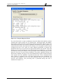
1
EX 5766
Aggregates Levy Sustainability Fund MEPF 04/03
MARA-GIS, Technical Report
Report EX 5766
Release 2.0
September 2008
Aggregates Levey Sustainability Fund – MEPF 04/03
MARA-GIS, Technical Report
Document Information
Project
Report title
Client
Client Representative
Project No.
Report No.
Project Manager
Project Director
Aggregates Levy Sustainability Fund - MEPF 04/03
MARA-GIS, Technical Report
Defra / CEFAS
Patricia Falconer
MCS0735
EX 5766
Michael Panzeri
Paul Sayers
Document History
Date
10/06/08
26/09/08
Release
1.0
2.0
Prepared
MCP
MCP
Approved
MPD
MPD
Authorised
PBS
PBS
Notes
The contents of this report do not necessarily reflect the views of the Funder
Prepared
Approved
Authorised
© HR Wallingford Limited
HR Wallingford accepts no liability for the use by third parties of results or methods presented in this report. The
Company also stresses that various sections of this report rely on data supplied by or drawn from third party
sources. HR Wallingford accepts no liability for loss or damage suffered by the client or third parties as a result of
errors or inaccuracies in such third party data.
EX 5766
ii
R. 2.0
Aggregates Levey Sustainability Fund – MEPF 04/03
MARA-GIS, Technical Report
Summary
MARA-GIS
Technical report
Report EX 5766
September 2008
Risk assessment involves an analysis of both the probability of potentially harmful events
occurring and the consequential impact of such events. The Marine Aggregate Risk Assessment
(MARA) Framework was developed to complement the existing Environmental Impact
Assessment (EIA) and Regional Environmental Assessment (REA) processes. Through the
provision of a structured risk assessment methodology and an associated supporting GIS based
software MARA seeks to formalise the characterisation of probability and consequences
together with the transparent representation of uncertainty within the underlying evidence. As
such MARA promotes clarity in the evidence gathered through EIAs and REAs and presented to
decision makers.
The conceptual bias and methods underpinning the MARA framework have been previously
described in an earlier ALSF supported project (HR Wallingford Report EX5453, 2007). The
subject of this report is the enactment of those methods within a GIS toolset. The MARA-GIS
is fully-functional and its utlility is demonstarted through application to a hypothetical case
study. The interface and scalability of the GIS supports its use by both consultants, for carrying
out an EIA or an REA, and Regulators for reviewing and checking assessments. A particular
strength of the GIS framework is that it provides an audit trail of the assumptions and enhances
transparency and consistency in the assessment of risks (at all scales).
The MARA Framework and associated MARA-GIS bring a consistency of approach to the
process of risk assessment in support of both Environmental Impact and Regional Environment
Assessments. MARA enables all environmental hazards, receptors and consequences of a
dredging operation to be considered within a coherent and transparent manner.
MARA involves a structured analysis of the complex interactions and issues that characterise
dredging activities. Therefore, although the MARA-GIS provides an easily operated computer
package it is not designed for use by inexperienced personnel and requires an experienced GIS
users who is both knowledgeable in risk assessment and the potential environmental impacts of
dredging activities.
The MARA-GIS application has been designed to operate on a typical PC with minimal
additional software requirements over those that would be normally used by consultants and
regulators (ArcGIS). With minimal training, the appropriate data and with expert judgement a
user can now perform a structured probabilistic Environmental Risk Assessment using the
MARA-GIS software.
EX 5766
iii
R. 2.0
Aggregates Levey Sustainability Fund – MEPF 04/03
MARA-GIS, Technical Report
The operation of the MARA-GIS is straightforward. It guides the user through the MARA
Framework clearly and in a step-by-step manner, feeding back information that has already been
entered, verifying that data are correct and highlighting when a step in the Framework is
complete or incomplete. At all times, supporting information can be logged to allow the user to
enter the source of data or the evidence that may be required to corroborate data. A number of
different data formats can be accommodated, from direct entry of values into the forms and
entry using slider bars through to loading of values from fields in tables and from CSV files.
The fuzzy logic methods developed in the earlier MARA project (to enable uncertainty within
qualitative expert judgement and quantitive process models to be combined) have been
embedded within the MARA-GIS to support an intuitive and complete representation of the
hazards and consequences within the context of a data sparse EIA and REA. The concept of
common data libraries (holding receptor’s sentisivity and exposure) included within the MARAGIS will, once widely used, actively support the principle of “collect once use many times”
ensuring all assessments use best avaiable data and can be subjected to transparent challenge.
The data that is considered within the assessment are stored by MARA-GIS within a single
database. It is therefore a straightforward task for a user to enter, review and revise their hazard
and receptor data for their EIA. The results of the analysis and information relating to the scope
of the licence applications are also stored in the database. The database provides a single source
of Environmental Risk Assessment data which can be provided to regulators or stakeholders,
allowing them to review all of the data considered during the risk assessment and the decisions
made by experts in the field in order to evaluate the risk. Since the MARA-GIS allows metadata
records to be entered whenever entering data, it allows the assessor to understand the
provenance of the data that has been considered making it easier to obtain and review particular
datasets in more detail should this be required.
EX 5766
iv
R. 2.0
Aggregates Levey Sustainability Fund – MEPF 04/03
MARA-GIS, Technical Report
It is however important to note that prior to widespread industry takeup the prototype MARAGIS toolset developed here will require piloting (on real sites) and non-functional refinement
prior to open release.
EX 5766
v
R. 2.0
Aggregates Levey Sustainability Fund – MEPF 04/03
MARA-GIS, Technical Report
EX 5766
vi
R. 2.0
Aggregates Levey Sustainability Fund – MEPF 04/03
MARA-GIS, Technical Report
Contents
Title page
Document Information
Summary
Contents
i
ii
iii
vii
1.
Introduction ...................................................................................................................... 1
1.1
Background.......................................................................................................... 1
1.2
Aims and Objectives of the project...................................................................... 2
1.2.1 Project phasing ....................................................................................... 2
1.2.2 Objectives............................................................................................... 2
1.2.3 Aims ....................................................................................................... 2
1.2.4 Deliverables............................................................................................ 3
1.2.5 Notes ...................................................................................................... 3
2.
Risk Assessment and the Marine Aggregate Extraction Risk Assessment (MARA)
Framework ....................................................................................................................... 3
2.1
Risk assessment - Underpinning principles ......................................................... 3
2.1.1 What is risk?........................................................................................... 3
2.1.2 Systems approach and risk models......................................................... 4
2.1.3 Units of risk............................................................................................ 5
2.1.4 Recognising Uncertainty ........................................................................ 5
2.1.5 How is the significance of risk perceived and measured?...................... 6
2.1.6 Risk assessment versus risk management .............................................. 6
2.2
The MARA Framework....................................................................................... 7
2.2.1 Overview ................................................................................................ 7
2.2.2 Task 1: Set scope.................................................................................... 7
2.2.3 Task 2: Spatial scale............................................................................... 8
2.2.4 Task 3: Definition of time scale ............................................................. 9
2.2.5 Task 4: Hazard probability..................................................................... 9
2.2.6 Task 5: Receptor presence ................................................................... 11
2.2.7 Task 6: Receptor sensitivity ................................................................. 12
2.2.8 Task 7: Receptor response (uncertainty quantification)....................... 12
2.2.9 Task 8: Risk quantification .................................................................. 13
2.2.10 Task 9: Cumulative and in-combination risks...................................... 15
2.2.11 10: Decision making ............................................................................ 15
3.
MARA-GIS .................................................................................................................... 15
3.1
Overview ........................................................................................................... 15
3.2
System and User Requirements ......................................................................... 17
3.3
MARA-GIS Software Design............................................................................ 17
3.4
Data Requirements............................................................................................. 21
3.5
Installation ......................................................................................................... 21
3.6
Operating MARA-GIS....................................................................................... 22
3.6.1 MARA-GIS Task Management Form.................................................. 22
3.6.2 Task 1: Open Database and Set Scope ................................................. 23
3.6.3 Task 2: Hazard State Probabilities ....................................................... 26
3.6.4 Task 3a: Receptor Presence ................................................................. 30
3.6.5 Task 3b: Receptor Sensitivity .............................................................. 32
3.6.6 Task 3c: Receptor Response ................................................................ 33
3.6.7 Task 4: Risk quantification .................................................................. 35
3.7
Audit and control ............................................................................................... 42
EX 5766
vii
R. 2.0
Aggregates Levey Sustainability Fund – MEPF 04/03
MARA-GIS, Technical Report
Contents continued
4.
Conclusions .................................................................................................................... 42
4.1
Overview............................................................................................................ 42
4.2
Benefits .............................................................................................................. 43
4.3
Recommendations for future research ............................................................... 43
4.4
Recommendations for wider application of MARA .......................................... 44
4.5
Final Conclusions .............................................................................................. 45
5.
References ...................................................................................................................... 45
Tables
Table 2.1
Table 2.2
Table 2.3
Table 3.1
Table 3.2
Table 3.3
Sources – Pathways – Receptors - Consequences ..................................................... 5
Example 3 x 3 hazard matrix with 5 hazard states................................................... 10
(a) hazard probabilities, (b) sensitivity and (c) response ......................................... 13
The stages of MARA-GIS ....................................................................................... 18
Example hazard state matrix.................................................................................... 28
Fields in the risk results layer created using the “Generate Map” button ................ 38
Figures
Figure 2.2 MARA Framework Overview ................................................................................... 7
Figure 2.3 (a) Hazard Zones, e.g. numerical model results at 2500 m2 resolution, (b)
Receptor Zones, e.g. zones of differing densities of Brittlestar (c) Impact zones,
delineated in red......................................................................................................... 9
Figure 2.4 Steps in the quantification of risk in MARA ........................................................... 13
Figure 3.1 Overview of Software Design.................................................................................. 19
Figure 3.2 Adding the “Start MARA-GIS” button to the ArcGIS toolbar ................................ 22
Figure 3.3 MARA GIS Task Management Form...................................................................... 23
Figure 3.4 Open Database and Set Scope Form ........................................................................ 24
Figure 3.5 Licence Locations Form. ......................................................................................... 25
Figure 3.6 Dredge Zones Locations Form................................................................................. 25
Figure 3.7 Dredge Zone Data Form .......................................................................................... 26
Figure 3.8 Hazard State Information Form ............................................................................... 27
Figure 3.9 Metadata form.......................................................................................................... 28
Figure 3.10 Hazard Data Entry Status list box and buttons to enter hazard state probabilities... 29
Figure 3.11 Hazard State Probabilities Form – manual option ................................................... 29
Figure 3.12 Hazard State Probabilities Form – shape attributes option ...................................... 30
Figure 3.13 Task 3a Receptor Presence Form............................................................................. 31
Figure 3.14 Receptor Presence Quantification Form .................................................................. 32
Figure 3.15 Receptor Sensitivity Form ....................................................................................... 33
Figure 3.16 Receptor Response Form ......................................................................................... 34
Figure 3.17 Summary of the processing tasks performed during Task 3c, the calculation of
the receptor response................................................................................................ 35
Figure 3.17 Summary of the processing tasks performed during Task 4, the calculation of
risk. .......................................................................................................................... 36
Figure 3.18 Risk Quantification .................................................................................................. 37
Figure 3.19 Risk Quantification – example results map: Loss of scallops due to noise ............. 39
Figure 3.20 Risk Quantification – example results map: Loss of scallops due to suspended
sediment ................................................................................................................... 40
Figure 3.21 Risk Quantification – example results map: Loss of scallops due to combined
suspended sediment and noise hazards .................................................................... 41
EX 5766
viii
R. 2.0
Aggregates Levey Sustainability Fund – MEPF 04/03
MARA-GIS, Technical Report
Contents continued
Appendixes
Appendix 1
Appendix 2
EX 5766
Data Required for EIA of Proposed Dredge Sites and Potential Sources
Schematisation of model data
ix
R. 2.0
Aggregates Levey Sustainability Fund – MEPF 04/03
MARA-GIS, Technical Report
EX 5766
x
R. 2.0
Aggregates Levey Sustainability Fund – MEPF 04/03
MARA-GIS, Technical Report
1.
Introduction
1.1
BACKGROUND
The UK marine aggregate industry supplies sand and gravel for use in the construction
industry, reclamation and beach recharge schemes. During 2006, over 24 million
tonnes of sand and gravel were dredged from marine sources in England and Wales
(The Crown Estate, 2006). The use of the marine aggregate resource is not without
environmental consequences, both positive and negative. Decision makers require
support to ensure the exploitation over time, of marine aggregate resources, are
optimised and managed to minimise the environmental consequences.
To help support this process the marine aggregate extraction industry is highly regulated
through a series of mechanisms (i.e. licensing procedures, Environmental Impact
Assessment, Electronic Monitoring Systems and monitoring procedures for
environmental characteristics). These complex controls seek to ensure that the future
development of an extraction site(s) does not have undue adverse impact on the
environment. In determining this view the concerns and interests of a wide range of
stakeholders are necessarily considered (including the public, local authorities,
conservation bodies, archaeological and heritage organisations and other industries that
use the marine environment).
The Aggregates Levy Sustainability Fund (ALSF) commissions a range of projects,
many of which aim to improve understanding of the environmental consequences of
dredging activity. This project follows an ALSF project which developed a framework
for assessing the risks from marine aggregate extraction. The Marine Aggregate
Extraction Risk Assessment (MARA) Framework was developed to explore the
potential of an approach for assessing hazard probability and consequences for receptors
and presenting these in an overall picture of the risk arising from the dredging activity.
The MARA Framework is fully described in Report EX5453 (HR Wallingford, 2007).
The reader should refer to this document for the detailed technical background to the
methodology.
The MARA Framework seeks to be a practical approach to assessing risk at a range of
spatial and temporal scales. It enables the assessment of risk at different levels of detail
and certainty, depending on the availability of data and knowledge about the physical
system and ecosystems. It was developed in the context of the Environmental Impact
Assessment (EIA) process and seeks to formalise the characterisation of probability and
consequences together with the transparent recognition of uncertainty. The real merit of
the MARA Frameworks is its ability to provide an audit trail and a basis for future reevaluation, if required. Importantly the MARA Framework can also provide a basis for
evaluating the results of compliance monitoring and optimising the future exploitation
of a resource.
The MARA Framework follows a systems based approach to risk and is closely linked
to the ‘Source-Pathway-Receptor-Consequence’ (‘S-P-R-C’) model as described in HR
Wallingford 2005. It also involves the use of statistical minimisation solving routines
and is heavily dependent upon the use of Geopgraphical Information Systems (GIS) to
perform the spatial calculations within the risk assessment. In order to follow the
MARA Framework a user would therefore need to have detailed working knowledge of
the ‘S-P-R-C’ approach to systems based risk assessment, statistical optimisation and
EX 5766
1
R. 2.0
Aggregates Levey Sustainability Fund – MEPF 04/03
MARA-GIS, Technical Report
GIS analaysis. With such a specialist user prerequisite, the uptake of the MARA
Framework in such a form is very limited.
The current project has been commissioned by the ALSF to develop the software tool
MARA-GIS to enable the MARA Framework to be implemented more readily. This
report provides both a summarised technical guide for the MARA-GIS software and a
detailed user manual. The reader is referred HR Wallingford, 2007 for further detail on
the theory of the MARA Framework.
1.2
AIMS AND OBJECTIVES OF THE PROJECT
1.2.1 Project phasing
The implementation of the MARA framework within the industry was originally
perceived to take four phases:
Phase 1 - Development of the methods - MARA Framework (completed and
reported within HR Wallingford, 2007)
Phase 2 - Enactment within prototype software – MARA-GIS (the subject of this
report)
Phase 3 - Proving and refinement of the MARA framework and MARA-GIS tools
through piloting (a potential future phase)
Phase 4 - Roll-out and beta testing by industry (a potential future phase)
1.2.2 Objectives
The objectives of Phase 2 were described in HR Wallingford 2007 as to:
1.
2.
3.
4.
5.
Develop a GIS-based tool that can be used to implement the MARA Framework.
Develop a data protocol that is used within MARA-GIS.
Explore the potential for live connections to underpinning datasets.
Document the development and use of the MARA-GIS tool.
Produce a user guide for how MARA-GIS should be operated.
1.2.3 Aims
Five specific aims were identified to address these objectives:
To develop a sound conceptual basis of the MARA-GIS
•
Develop ideas for delivering MARA-GIS, taking into consideration the future
evolution of the risk assessment process.
•
Determine the best approach for developing MARA-GIS.
To develop a MARA-GIS
•
Carry out the programming required to develop MARA-GIS.
•
The fundamental approach for developing the tool and explanations of how it can
be used will be reported in a final technical report. This report will explain the
functionality of the tool and could be used as a reference for people who wish to
use the tool.
EX 5766
2
R. 2.0
Aggregates Levey Sustainability Fund – MEPF 04/03
MARA-GIS, Technical Report
To develop an associated data protocol
•
Document the data formats required for input to MARA-GIS.
•
Document appropriate data management approach within MARA-GIS.
•
Explore the potential for live connections to underpinning datasets. This would
involve research into the potential for developing a web-based system that could
access datasets held by key stakeholders.
To test the GIS tools
•
Verification of tool with case study data from the hypothetical MEPF 04/03
ensuring that qualitative and quantitative data can be used within MARA-GIS and
will be capable of storing and analysing a mixture of expert judgement and process
model results.
To produce a user guide with instructions for using the tool
•
Produce a user guide with step-by-step type instructions for using the MARA-GIS
tool.
1.2.4 Deliverables
The deliverables of the project were identified as:
•
•
•
The MARA-GIS tool.
Final report detailing the development and use of the tool and the data protocol.
User guide with details for operating the MARA-GIS tool.
1.2.5 Notes
Through post proposal negotiation it was agreed to reduce the project scope by limiting
the effort on objective 2; exploration for live connections to underpinning datasets. This
may be explored during a later phase of the project.
2.
Risk Assessment and the Marine Aggregate
Extraction Risk Assessment (MARA) Framework
This section is drawn from HR Wallingford 2007 and provides a condensed background
to underlying theory of the MARA framework to assist the user of MARA-GIS and is
included for completeness.
2.1
RISK ASSESSMENT - UNDERPINNING PRINCIPLES
2.1.1 What is risk?
The science of risk assessment has been developed in recent decades to aid a
comprehensive understanding of the possibility of harmful consequences occurring as
the result from some human activity or natural hazard. The benefit of a risk-based
approach, and perhaps what above all distinguishes it from other approaches to design
or decision making, is that it deals with outcomes. A risk assessment, for example,
would give an expected amount of loss and damage to each receptor influenced by the
dredging activity that takes into account all possible levels of hazard and receptor
response. This is distinct from more traditional methods that consider only receptor
response to a peak level of hazard without necessarily linking the chance of particular
EX 5766
3
R. 2.0
Aggregates Levey Sustainability Fund – MEPF 04/03
MARA-GIS, Technical Report
hazards occurring with the damage that may be incurred. For example a traditional EIA
provides the potential significance of a possible hazard on a receptor, but often fails to
describe the chance of this occurring.
Risk can therefore be seen to be a combination of the chance of a particular event
occurring, and the impact that the event would cause if it occurred. Risk therefore has
two components – the chance (or probability) of an event and the impact (or
consequence) associated with it.
Within the context of MARA, probability and consequence are further described as
follows:
•
Probability – refers to the chance of the consequence occurring. This, in turn, is
given by the combined probability that a hazard will occur and that a consequence
will arise as a result of that hazard;
•
Consequence – refers to the undesirable outcome should a risk be realised. It
could refer to, for example, the loss of or damage to a habitat, archaeological
feature or benthic community. The geographical scale of the consequence may
extend beyond the local source of the hazard. It is also necessary to consider the
duration for which the hazard is present as well as the duration for which
consequences will be experienced and the length of time recovery takes.
2.1.2 Systems approach and risk models
Risk Assessment is achieved by understanding the occurrence of harmful events and
responses to those events within a system. An understanding of the way a system
behaves and in particular the mechanisms by which it may fail, is an essential aspect of
understanding risk (Sayers et. al., 2005). A systems-based approach to risk assessment
aims to describe each element within the system and represent the links between them
to provide a structured characterisation of the system behavior.
There are a number of models for characterising a system and system risk in order to
help the process of risk assessment. The MARA Framework is closely linked with the
‘Source-Pathway-Receptor-Consequence’ (‘S-P-R-C’) model. The ‘S-P-R-C’ model
assumes that for a risk to arise there must be a hazard that consists of a ‘source’ or
initiator event (e.g. suspended sediment); a receptor (e.g. benthic ecology); and a
pathway between the source and the receptor (e.g. advection of a dredge plume). The
consequence of the event for the receptor is determined by the way in which the
receptor responds to the hazard and the outcome may be expressed in social, economic
or environmental terms. Table 2.1 gives an indicative list of system elements for
MARA and their S-P-R-C classifications.
EX 5766
4
R. 2.0
Aggregates Levey Sustainability Fund – MEPF 04/03
MARA-GIS, Technical Report
Table 2.1 Sources – Pathways – Receptors - Consequences
PATHWAYS
SOURCES
•
•
•
•
•
•
•
•
Seabed sediment
Bedforms
Sediment transport
Bathymetry
Waves
Tidal regime
Suspended sediment
Dredger
•
•
•
•
•
•
•
•
RECEPTORS
Removal of seabed
Dredge plume
Dredge vessel
Sediment
Water
Marine systems
Coastal systems
Noise
• Geomorphology
• Marine ecology
• Archaeology and
heritage
• Human uses of the
marine environment
Receptors are also
termed receptors in
MARA – this part of
the model maps
directly to the
receptor presence
and sensitivity
assessments within
MARA.
Sources and Pathways relate to
hazards in MARA – what causes
hazards and how do they spread
through the study area.
CONSEQUENCES
• Social
• Economic
• Environmental
Consequences are
also termed
consequences in
MARA. The units of
risk communicate the
type of consequence
(expected £ revenue
lost, expected loss to
species population
etc.).
2.1.3 Units of risk
The units of risk depend on how the likelihood and consequence are defined.
Likelihood can be expressed as a frequency or probability; consequence is measured in
units that are appropriate for the receptors and the information that is required for
decision makers. Definitions are provided below:
•
Probability – may be defined as the chance of occurrence of one event compared
to the population of all events. Therefore, probability is dimensionless – it can be
expressed as a decimal or a percentage and must be referenced to a specific
timeframe, for example as an annual exceedence probability or lifetime
exceedence probability.
•
Consequence – represents an impact such as economic, social or environmental
damage or improvement. An example of a negative consequence would be the
destruction of sabellaria spinulosa reef environment.
•
Risk – is the combination of likelihood and consequence and the units of risk will
reflect this. The output of the risk assessment for dredging activity will list the
risks by receptor, with a unit of risk that is appropriate to that receptor. The risk,
for example, to commercial fisheries may be quantified as average annual loss of
income; for archaeological features risk may be quantified as number of features
or area of feature damaged or destroyed; and for juvenile scallops risk may be
expressed as numbers stressed or killed.
2.1.4 Recognising Uncertainty
In assessing the impact of marine aggregate extraction there is often considerable
difficulty in determining the likelihood of some hazards occurring, establishing the
EX 5766
5
R. 2.0
Aggregates Levey Sustainability Fund – MEPF 04/03
MARA-GIS, Technical Report
presence and distribution of receptors and understanding how they will respond to the
hazard. Models and expert judgment are used to inform the estimation of probability
and consequence but both are incomplete representations of reality and so are inherently
uncertain. Thus there is a difference between risk and uncertainty:
•
Risk – typical reflects the expected magnitude of harm - based on a simple product
of single estimate probability values and uniquely associated consequences.
•
Uncertainty – reflects our lack of sureness about something and in context this
translates through uncertain (fuzzy) descriptions of both probability and
consequence.
The MARA Framework (HR Wallingford 2007) has been established to enable this
uncertainty to be explicitly handled and propagated through the risk assessment and
decision process.
2.1.5 How is the significance of risk perceived and measured?
Intuitively it may be assumed that risks with the same numerical value have equal
‘significance’ but this is often not the case. To understand the significance of risk,
therefore, it is important to take into account its constituent parts; distinguishing
between rare, catastrophic events and more frequent less severe events. The notion of
‘significance’ is influenced by individual and societal perception of risk that can lend it
importance that has little relation to its actual level. For this reason, it is useful for the
risk results to be recorded as a distinct output, as well as within the overall
‘significance’ results. By separating individual value judgments on importance and
‘significance’, the regulator, stakeholders and the dredging applicant can see what the
actual risk is, compared to the perceived risk.
The MARA Framework does not support the assessor in their assessment of importance,
significance or acceptability, but simply provides a transparent assessment of the risk.
This is not to imply that the process of appropriately considering importance,
significance and acceptability should not be done; on the contrary, this is crucial to the
wider decision-making process. The suggestion is rather that these subjective
judgments be separated from the risk result so that the difference between the actual risk
and the significance that is attributed to it is transparent to all stakeholders. This will
allow an open discourse on the value given to particular consequences identified in the
risk assessment, reduce the gap between actual risk and perceived risk and encourage
transparent decision making regarding licence applications.
MARA-GIS supports this process by capturing and storing all of data used within the
risk assessment and making it possible to audit trail the process from beginning to end
rather than simply reviewing the outcomes. This should enable the assessor to make
more informed decisions regarding the significance of the risk.
2.1.6 Risk assessment versus risk management
A risk assessment attempts to provide a reasoned, objective quantification of the risk.
The information provided by the risk assessment can then be used by decision makers to
support management actions. However, the dredging industry and associated regulation
deals with complex decision-making processes, weighing up a set of often competing
factors. This process involves the views of decision makers and stakeholders on
whether the different risks are unacceptable, tolerable or broadly acceptable (see Section
EX 5766
6
R. 2.0
Aggregates Levey Sustainability Fund – MEPF 04/03
MARA-GIS, Technical Report
2.2.5). Understanding the wider social, economic and policy context of the industry is
therefore essential when interpreting the outcome of a risk assessment, thus the remit of
risk management presents challenges beyond the risk assessment process itself and is
outside the scope of MARA.
2.2
THE MARA FRAMEWORK
2.2.1 Overview
The MARA Framework was developed during the predecessor to this project by a
consortium lead by HR Wallingford. It was developed to allow implementation of the
principles of risk assessment described in Section 2.1 for marine aggregate extraction.
It is tiered to allow consistent multi-scale application at different levels of detail and
certainty. MARA can use any relevant type of qualitative and quantitative information,
including numerical model output and expert judgment. Figure 2.2 shows an overview
of the processes within the MARA Framework. This is described briefly in the
following sections and more fully in HR Wallingford 2007.
MARA Framework for Risk Assessment
1. Set scope
4. Hazard
probability
7. Receptor response
(uncertainty quantification)
2. Initial definition of
spatial scale
3. Definition
of time scale
5. Receptor
presence
6. Receptor
sensitivity
8. Risk
quantification
10. Decision
Making
Figure 2.2
9. Cumulative and incombination impacts
Risk Management
Issues
e.g. importance, policy,
acceptable risk
MARA Framework Overview
2.2.2 Task 1: Set scope
The first stage in the Framework is to capture the scope, such that the context of the risk
assessment is clear and documented. This effectively sets out the problem that has to be
analysed. To specify the scope of the work, it is necessary to describe the proposed
dredging activity, which may include details on:
•
•
•
•
•
•
EX 5766
the size and location of the area for which a licence is requested
the size and location of potential dredge zones within the licensed site
the type and amount of aggregate to be extracted
the frequency of dredging
any seasonality of dredging
the method of dredging including whether screening measures are to be used.
7
R. 2.0
Aggregates Levey Sustainability Fund – MEPF 04/03
MARA-GIS, Technical Report
The detail to which each of the above will be described will depend upon the nature of
the decision and the evidence required to support it; for example a regional assessment
will require a different level of detail compared to a single licence application. This is
recognised within MARA and the Framework is largely independent of the detail of the
analysis.
2.2.3 Task 2: Spatial scale
The Framework can be applied to assess risks arising from marine aggregate extraction
at any spatial scale including:
•
•
•
Dredge zone: assesses the risks arising from the extraction of aggregate within
one dredge zone that is within a licence site.
Licence area: assesses the risks arising from the extraction of aggregate within a
licence site.
Regional area: assesses the risks arising from the extraction of aggregate within a
region. This takes into account the cumulative effects of dredging activities in
different licence sites.
At the start of the risk assessment process, it is important that the spatial scale of the
assessment is defined.
Defining the risk system
The spatial extent of the risk system must encompass all the hazards arising from the
proposed dredging and the receptor locations. Its boundary therefore is to be defined by
the zone of influence of the hazards and location of receptors. The risk system should
also be adapted to allow consideration of cumulative and in-combination effects.
Defining impact zones
The MARA methodology calculates risk within a given area, the ‘Impact Zone’, for a
given period of time. Within an impact zone the characteristics of the hazard and
receptor response are assumed to be homogeneous. Each Impact Zone is also
considered to be autonomous; where the risk within each Impact Zone occurs
independently of its neighbours and so the method does not represent the migration of
receptors from one Impact Zone to another.
Within the risk system there may be few or many impact zones. The spatial definition
of Impact Zones, in line with the concept of the tiered risk assessment approach, will
vary according to the rate of change in hazards, the level of detail in the survey
information and the level of detail required by the assessment. Likewise, the impact
zones may be defined in two- or three-dimensions, evaluating risk over the seabed or a
volume of water. The boundaries and spatial extents of Impact Zones on the seabed and
through the water column need not be the same. Impact Zones may be irregularly
shaped and vary in size across area of the risk system; enabling smaller Impact Zones to
be used in areas of importance or where the hazard is rapidly changing (for example
close to the dredge activity).
The Impact Zones are defined by spatial intersection of the hazard zones and receptor
zones. Each layer of information is ‘cut’ into the other to produce the Impact Zones
such that Impact Zones are the smallest common denominator of all spatial input data.
Figure 2.3 shows an example of the spatial intersection of two input datasets, which is
described in further in Section 2.2.9.
EX 5766
8
R. 2.0
Aggregates Levey Sustainability Fund – MEPF 04/03
MARA-GIS, Technical Report
Figure 2.3
(a) Hazard Zones, e.g. numerical model results at 2500 m2 resolution, (b)
Receptor Zones, e.g. zones of differing densities of Brittlestar (c) Impact
zones, delineated in red
The bold red shows one of the impact zones where the boundary of a Receptor Zone intersects a Hazard
Zone.
2.2.4 Task 3: Definition of time scale
The time scale for the assessment must be set in relation to the dredging activity. The
risk assessment is carried out for a specified time duration, t, during which dredging
takes place. The duration of t will normally relate to the scale of the assessment. For
example, for assessments carried out at a single licence scale, t may be the duration of
the licence that is being applied for. However, if the dredging activity were seasonal
then it would be more appropriate to carry out an assessment for each period of activity
and aggregate the results to quantify overall risk. Risk assessments for multiple licence
areas within a region would require the duration of t to encompass all of the periods of
dredging throughout the region.
The time scale of the risk assessment considers only the physical changes and receptor
response to those changes occurring during the active period of dredging. It is
recognised that there may be a number of relevant processes occurring after the
dredging period that are necessary to take into account, namely;
•
•
•
The residence of hazards within the system beyond the period of dredging
The response of receptors to hazards remaining within the system
The recovery of the receptors.
2.2.5 Task 4: Hazard probability
A hazard is a physical change that has the potential to cause harm. Dredging activity
will result in a number of physical changes, such as removal of the seabed and creation
of a dredge plume. Each of these physical changes, or hazards, will vary in magnitude
over different spatial and temporal scales so the characteristics of the hazard (e.g.
magnitude and duration 1) for a particular location can be represented by a probabilistic
distribution. The risk assessment process uses information from the whole range of the
probability distribution, so that infrequent, high magnitude events are considered as well
as frequent, lower magnitude events.
Hazard assessment therefore requires the definition of the probability of occurrence for
the range of possible values, or states, of relevant hazard characteristics for each impact
zone.
1
Note that frequency is often noted in EIAs as a relevant hazard characteristic. In the MARA
Framework, the evaluation of frequency is implicit in the assessment of probability.
EX 5766
9
R. 2.0
Aggregates Levey Sustainability Fund – MEPF 04/03
MARA-GIS, Technical Report
Hazard characteristics are the aspects of the hazard such as magnitude, duration and rate
that describe the nature of the hazard at a particular location. The ‘hazard state’ is a
particular grouping of hazard characteristics. For example, if a hazard is described by
the characteristics of magnitude and duration and each of these characteristics were
defined as either zero, low or high, then there are 5 possible hazard states as depicted in
Table 2.2, where the greyed-out boxes are states that cannot occur.
Table 2.2 Example 3 x 3 hazard matrix with 5 hazard states
Duration
0
low
high
0
No hazard
Magnitude
low
high
low - low
low - high
high - low
high - high
The hazard characteristics should be most relevant to those which affect receptor
response and to the determination of consequences. This requires some understanding
of the particular Hazard States that the receptors are sensitive to. Consider, for example,
the hazard of the suspended sediment created by the dredge plume. An ecologist would
be able to advise that both magnitude and duration of the suspended sediment were
characteristics that could influence the response of the ecology that was exposed to the
hazard and may also be able to advise on thresholds for the hazard states. For the
magnitude of suspended sediment, if a particular species would die given short term
exposure to suspended sediment concentrations over 100 mg/l and another species
would die with short term exposure to concentrations over 50 mg/l, then it would be
useful to have information on three categories (< 50 mg/l, 50 – 100 mg/l and >100 mg/l)
in order to discern the various responses of the different species. It is also necessary to
take into account the range of values of the hazard state across the risk system in order
for the matrices to show the changes in hazard. The hazard category thresholds should
therefore be determined as appropriate for the receptor sensitivities.
Having determined which hazard characteristics are important and how they will be
categorised, it is necessary to assign probabilities to each possible hazard state. This is
completed for a specific spatially referenced hazard zone, so it is necessary to identify
and map hazard zones throughout the risk system, with each hazard zone representing a
change in the hazard levels. Quantified probabilities (i.e. from 0 to 1 inclusive) are
required for each hazard state. The best way of identifying these is likely to vary
between hazards and may include, for example, process modelling or expert judgement.
To determine the probability of occurrence for each hazard state, it is necessary to
understand what influences the probability for the particular hazard under consideration.
It is worth noting here that in MARA, the Hazard represents the Source and Pathway in
the ‘S-P-R-C’ risk model. For the example when considering suspended sediment, the
variables that influence the probability of the hazard state include:
•
•
EX 5766
Location – the exact location of the dredging activity within the licence area is not
necessarily pre-determined. Albeit the dredging activity will take place with due
recognition of any zoning that has been imposed within the site.
Source – the amount of fine sediment that is discharged from the dredger as
overspill and screening determines the source term for the dispersion of the plume
of sediment. This amount may vary with operating pattern and in different sea
states (with rougher conditions there may be more overspill).
10
R. 2.0
Aggregates Levey Sustainability Fund – MEPF 04/03
MARA-GIS, Technical Report
•
Hydrodynamic and meteorological conditions – the wind, waves and tidal currents
influence the dredge plume and are subject to natural variation.
It is necessary to consider the potential variation in each of these variables and
understand the probability of each different type of condition occurring in order to
determine the Hazard State probabilities for MARA.
Uncertainty in the probability of the hazard state is represented by estimating an upper
and lower bound for the probability specified for each hazard state. A ‘best estimate’
may also be specified if appropriate. These uncertainty estimates are used in the
calculation of risk and influence the upper and lower bounds of the results.
2.2.6 Task 5: Receptor presence
The term “receptor presence” is an expression of the number of receptors that are
present within the risk system. It is important to establish the spatial distribution of
receptors across the system. There may be a range of different types of receptor, for
example, marine archaeology, ecology, geomorphological features; and it is important
that these different types are all represented.
One very important question is how to quantify each receptor appropriately. This has a
bearing on the final communication of the risk assessment results because the units of
risk will be determined by the units of quantity selected to measure receptor presence.
Some common measures of receptor quantity include number counts, abundance,
biomass, area and volume.
Having determined the units that appropriately describe the receptor presence, it is
necessary to map and quantify receptors through the risk system. It should be possible
to determine receptor presence via a combination of survey data, information on general
distribution and abundance and informed judgment.
Of course, one of the difficulties in defining the quantity of receptors in the risk system
is that many receptors, particularly those within the ecological category, are mobile.
For mobile receptors, it is necessary to estimate the quantity that would be present
within the risk system at any one time (without the presence of the proposed dredging
activity). For receptors with a seasonal presence, this can be dealt with either by
splitting the timescale of the risk assessment into seasonal time periods, or by
incorporating a probability assigned to the receptor presence.
It is recognised that the quantification of receptor presence is not a simple task and
sometimes involves large uncertainties. However, quantification is crucial to establish
the risk to the system. The uncertainty in presence should be expressed as upper and
lower boundaries around a ‘best’ estimate. So, for example, for a risk system that is
populated by cod, a lower estimate, an upper estimate and a best guess may be given for
the abundance of cod over the area of the system. By taking into account the range of
potential presence values, the final result will communicate the range in numbers that
are potentially at risk. If the range is great, it may mean that if the upper estimate were
used, the risk would be deemed unacceptable and the licence would not be granted;
whereas if the lower estimate were used the licence would be granted. In this case, it
may be decided that it is necessary to collect more survey information to reduce the
uncertainty in the receptor presence term so that an appropriate decision can be made.
Alternatively, other risk management measures to mitigate the impacts may be
implemented.
EX 5766
11
R. 2.0
Aggregates Levey Sustainability Fund – MEPF 04/03
MARA-GIS, Technical Report
2.2.7 Task 6: Receptor sensitivity
Receptor sensitivity considers how the receptor will respond if exposed to a particular
hazard. There may be different levels of response including no response, stress,
damage, destruction, death, migration, beneficial response etc. MARA considers the
negative responses only and the sensitivity considered within MARA does not provide
any information on recoverability or importance of receptors; these are outside of the
scope of MARA and are dealt with elsewhere in the assessment.
The receptor sensitivity must be defined for each of the Hazard States. It is therefore
important to consider the receptor sensitivity when defining the hazards.
In determining the sensitivity relationships, it is necessary to establish a relationship
between the probability of loss and the hazard characteristics. Loss may be defined as
any particular response such as damage, death, stress etc., as long as this is explicitly
specified. When determining the relationship, the probability of loss must be
considered for one unit of the receptor only. So the question posed to an expert could
be, for example; “what is the chance that 1 m2 of receptor x will be destroyed as a result
of this particular combination of hazard magnitude and duration?” The answer can be
given as a quantitative probability or as a qualitative judgment using high, medium, low.
Any qualitative evaluation will be converted into a quantitative measure for use in the
rest of the assessment process.
The evaluation of receptor sensitivity to different hazards can be used in subsequent
assessments and so the outputs may be retained in a database. This is discussed further
in Section 4. Estimating receptor sensitivity is an uncertain process and this should be
recognised by the specification of optimistic and pessimistic estimates, and a best
estimate if appropriate. Through time such uncertainty bands may be expected to
gradually diminish as knowledge improves.
2.2.8 Task 7: Receptor response (uncertainty quantification)
Given that a probability has been defined for all Hazard States (described in Section
2.25) and a sensitivity has been defined for all Hazard States, it is possible to calculate
the receptor response (or loss) for each Hazard State as follows;
p(li ) = p( Hi) × p( Si )
(Equation 2.1)
where; p (li ) = probability of response for hazard state i
p(Hi) = probability of occurrence for hazard state i
and p (Si ) = probability of sensitivity to hazard state i.
It follows that the total probability of receptor response to a given hazard is determined
by summing the receptor response for all Hazard States. Equation 2.2 and Table 2.3.
n
p(l ) = ∑ [ p(Hi ) × p(Si )]
(Equation 2.2)
i =1
Where n = number of Hazard States
EX 5766
12
R. 2.0
Aggregates Levey Sustainability Fund – MEPF 04/03
MARA-GIS, Technical Report
Table 2.3 (a) hazard probabilities, (b) sensitivity and (c) response
Hazard
Sensitivity
p (H1)
p (H2)
p (H3)
p (S1)
p (S2)
p (S3)
p (H4)
p (H5)
p (H6)
p (S4)
p (S5)
p (S6)
p (H7)
p (H8)
p (H9)
p (S7)
p (S8)
p (S9)
Response
p (H1) x p (H2) x p (H3) x
p (S1)
p (S2)
p (S3)
p (H4) x p (H5) x p (H6) x
p (S4)
p (S5)
p (S6)
p (H7) x p (H8) x p (H9) x
p (S7)
p (S8)
p (S9)
Sum = probability of receptor
response (p(l))
Sum = 1
The approach for dealing with uncertainty within MARA framework is based on
interval probability theory. The Hazards State are mutually exclusive thus the sum of
the Hazard State probabilities must equal 1. Since MARA allows for the uncertainty in
Hazard State probabilities to be captured via upper bound and lower bound estimates, it
follows that the sum of lower bound probabilities will be less than 1 while the sum of
the upper bound probabilities will be more than one. This is resolved by using a
statistical optimisation routine to solve the Hazard State Probabilities which yield the
maximum total response (upper bound) and the minimum total response (lower bound)
by allowing the probability for each Hazard State to vary between the upper bound and
lower bound input values entered while constraining the sum of all hazard state
probabilities equal to 1.
2.2.9 Task 8: Risk quantification
Within MARA, risk is quantified by multiplying the probability of receptor response by
the receptor presence. This calculation is carried out for each impact zone (as described
in Section 2.2.3) so that the spatial correlation of the influence of each hazard on each
receptor can be taken into account. Figure 2.4, summarises the steps involved in the
quantification of risk.
8. Risk quantification
8a
Expected
impact
zone risk
8b
8c
Total expected
impact zone risk
1 receptor, 1 hazard
1 receptor, all hazards
For each receptor,
calculate the risk in
the impact zone as a
result of each
hazard. Do this for
all impact zones
within the risk
system.
For each receptor,
calculate the total risk for
each impact zone by
considering the
combined risk from all
the hazards present
within the impact zone.
System
risk
For each receptor,
calculate the total
risk by summing the
risk calculated for
each impact zone.
8d
Whole-life
system risk
Consider:
• Residence of
hazards within the
system.
• Continued
response of
receptors to those
hazards.
•Recoverability of
receptors.
Figure 2.4
EX 5766
Steps in the quantification of risk in MARA
13
R. 2.0
Aggregates Levey Sustainability Fund – MEPF 04/03
MARA-GIS, Technical Report
Expected Impact Zone Risk
In order to calculate the risk to a Receptor in an Impact Zone, it is necessary to quantify
the receptor presence within the Impact Zone. Since the Impact Zones are determined
by performing a spatial intersection of the Hazard Zones and Receptor Zones (see
Figure 2.3) it is necessary to calculate the presence data for each Impact Zone using an
area weighting or density based calculation from the original Receptor Zones boundary
data.
Once the receptor presence has been calculated for each Impact Zone, the expected
impact zone risk for one receptor (receptor x) as a result of one hazard (hazard y) is
thus:
r(receptor(x), hazard(y)) = m(p(l))
(Equation 2.3)
where r is impact zone risk (whether that be damage, death, stress etc.), m is the
receptor presence for the impact zone and p(l) is the probability of receptor response as
given in Equation 2.2. Upper bound and lower bound expected impact zone risk are
calculated by multiplying the lower value of p(l) from the optimisation process
described in Section 2.2.8 with the lower estimate of receptor presence to give the
optimistic result and the upper value of p(l) from the optimisation process with the
upper estimate of receptor presence to give the pessimistic result.
The outcome of this calculation will be a quantification of impact zone risk, in the same
units that describe receptor presence, for each receptor as a result of each hazard.
In order to carry out the calculation of p(l), any parameters that have been quantified in
previous stages with a continuous scale must be discretised. The coarseness of the
discretisation will influence the final risk result and sensitivity testing on the assessment
would ideally be carried out to find the most appropriate number of values to select. If
the previous stages of the assessment have characterised the hazard assessment and
receptor sensitivity in categories, for example, by giving relationships in matrices, this
is readily usable in the risk calculation.
Total expected impact zone risk
To find the total expected impact zone risk from all hazards, it is necessary to consider
the combined influence of all hazards occurring within the impact zone. This is
achieved via interval probability theory for each receptor by considering the likelihood
that the receptor is not lost due to each hazard, enabling the function to quantified
relating to the receptor not being lost due to all hazards. The inverse of this gives the
total expected Impact Zones Risk from all hazards as described below:
r(receptor(x)) =m(1 – [(1 – p(l)hazard 1) × (1 – p(l)hazard 2) × .... (1 – p(l)hazard n)])
(Equation 2.4)
This approach does, however, lack any representation of mutually inclusive or exclusive
hazard influences.
System risk
Up to this point in the assessment, risk has been considered at the scale of the impact
zone. In order to get an overall picture of risk, it is necessary to understand what is
happening at the level of the risk system for each receptor group. The total expected
system risk is therefore given for each receptor by finding the sum of the total expected
impact zone risk for each impact zone within the risk system, as given by Equation 3.4.
EX 5766
14
R. 2.0
Aggregates Levey Sustainability Fund – MEPF 04/03
MARA-GIS, Technical Report
The outcome is an aggregated risk measure for each receptor, applicable for the entire
risk system.
⎧n
⎫
R( receptor ( x )) = m⎨∑ (ri )⎬
⎩ i =1
⎭
(Equation 3.4)
Where ri is the risk for impact zone i. It may often be desirable to understand the risk
that is attributed to each hazard, so that a comparison can be made to see the most
detrimental physical effect of the dredging. In this case, it is necessary to sum the
results from computing Equation 3.2, which calculates impact zone risk for each
receptor to each hazard, for all impact zones over the risk system.
2.2.10 Task 9: Cumulative and in-combination risks
The existing framework for evaluating the environmental impact of marine aggregate
extraction activities requires the consideration of cumulative and in-combination
impacts. The terminology varies in different contexts, but the MARA framework
consistently applies the following definitions:
•
•
Cumulative effects – the risks arising from multiple dredging activities.
In-combination effects – the risks arising from the combined effect of dredging
with other activities such as fishing activity, navigation etc.
Cumulative and in-combination effects are dealt with in the framework by adjusting the
calculation of the hazard probability across the risk system; all procedures and data
flows within the framework remain the same as for assessing the risks resulting from
the dredging alone.
2.2.11 10: Decision making
A risk assessment attempts to provide a reasoned, objective quantification of the risk.
The information provided by the risk assessment can then be used by decision makers to
support management actions. However, the dredging industry and associated regulation
deals with complex decision-making processes, weighing up a set of often competing
factors. This process involves the views of decision makers and stakeholders on
whether the different risks are unacceptable, tolerable or broadly acceptable.
Understanding the wider social, economic and policy context of the industry is therefore
essential when interpreting the outcome of a risk assessment, thus the remit of risk
management presents challenges beyond the risk assessment process itself and is
outside the scope of MARA. MARA therefore helps decision making but does not
provide it and can most usefully be described as a Discussion Support System (DSS).
3.
MARA-GIS
3.1
OVERVIEW
Undertaking an EIA\REA in support of a dredging licence application can involve a
great deal of data analysis and sophisticated modelling. The approach to preparing an
EIA\REA can be highly variable from the levels of detail that go into the assessment to
the way in which it is presented. During the assessment, many different data sets are
likely to be consulted, including a number of maps and spatially varying data sets. It is a
EX 5766
15
R. 2.0
Aggregates Levey Sustainability Fund – MEPF 04/03
MARA-GIS, Technical Report
reasonable assumption that the analysis and integration of these datasets will be
performed using a Geographical Information System (GIS) since they allow such
datasets to be displayed in context with one another, facilitating the assessor to make
judgements about how they may impact the site when considered in combination.
The MARA Framework brings a consistency of approach to the process of producing an
EIA\REA for dredging applications. It provides a template that can be followed for
considering all of the environmental hazards, receptors and consequences of a dredging
operation. The Framework involves undertaking a rather complicated modelling
technique which can be difficult to perform and can be easily misunderstood; it requires
a user who is experienced at operating a GIS and in risk modelling using the SourcePathway-Receptor-Consequence approach. MARA-GIS brings the MARA Framework
into an easily operated computer package. It runs on a typical PC with minimal software
requirements enabling the Framework to be much more widely adopted by the industry.
With minimal training, the appropriate data and with expert judgement a user can now
perform a structured probabilistic Environmental Risk Assessment using the MARAGIS software.
The operation of MARA-GIS is straightforward. It guides the user through the MARA
Framework clearly and in a step-by-step manner, feeding back information that has
already been entered, verifying that data are correct and highlighting when a step in the
Framework is complete or incomplete. At all times, supporting information can be
logged to allow the user to enter the source of data or the evidence that may be required
to corroborate data. A number of different data formats can be accommodated, from
direct entry of values into the forms and entry using slider bars through to loading of
values from fields in tables and from CSV files.
The data that is considered within the assessment are stored by MARA-GIS within a
single database. It is therefore a straightforward task for a user to enter, review and
revise their hazard and receptor data for their EIA. The results of the analysis and
information relating to the scope of the licence applications are also stored in the
database. The database provides a single source of Environmental Risk Assessment data
which can be provided to regulators or stakeholders, allowing them to review all of the
data considered during the risk assessment and the decisions made by experts in the
field in order to evaluate the risk. Since the MARA-GIS allows metadata records to be
entered whenever entering data, it allows the assessor to understand the provenance of
the data that has been considered making it easier to obtain and review particular
datasets in more detail should this be required.
The MARA-GIS software performs the mathematical algorithms required to undertake
the complex the spatial and mathematical analyses of the MARA Framework, ensuring
that they are performed rapidly and consistently without the requirement for specialist
users or software. The results from the analyses can be summarised or presented as
layers in a map at the click of a button. A basic level of experience with ArcGIS is
necessary to complete a Risk Assessment using MARA-GIS since the user is required to
prepare the data using the GIS before it is loaded into MARA-GIS.
The process of running MARA-GIS for a given risk assessment is likely to take of the
order of few hours to a day depending on the level of detail and the number of hazards
and receptors that are to be considered. The process of considering which hazards and
receptors should be examined and acquiring or creating (using expert judgement where
necessary) those datasets may take considerably longer, as may the task of reporting the
results. It should be noted that the process of preparing an EIA already involves a
EX 5766
16
R. 2.0
Aggregates Levey Sustainability Fund – MEPF 04/03
MARA-GIS, Technical Report
thorough examination of the hazards, receptors and their likely impacts so this should
not add significantly to the existing process. The MARA-GIS adds a transparent and
consistent approach for examining all hazards individually and in combination to that
provides a clear audit trail. It can be used to review and target further work towards the
sources of greatest uncertainty. The risk assessment database can be very quickly copied
and modified to produce comparative results to show the increase in confidence that can
be achieved by focussing on the aspect which exhibit the greatest uncertainty.
3.2
SYSTEM AND USER REQUIREMENTS
MARA-GIS is an extension to ArcGIS (ArcView version 9.2) which adds additional
functionality to the standard desktop GIS software licence. ArcGIS was selected for the
base software since it is the industry leading GIS software package and therefore is
likely to be already used by many of the consultants undertaking EIAs in support of
dredging applications. MARA-GIS has been written within Microsoft Visual Studio in
C#.net using the ArcObjects class libraries to allow the tools to operate from within
ArcGIS and to perform spatial data processes and mapping. In order to operate MARAGIS, the PC must have access to version 9.2 of ArcGIS (ArcView or higher) and have
the dotNet2 Framework installed. The software creates and populates an ESRI
“Personal GeoDatabase” - a spatially enabled instance of a Microsoft Access database
for ArcGIS. It should be noted that it is not necessary for users to have Microsoft
Access in order to use MARA-GIS since the MARA tools control the creation,
population and management of the database. It may be beneficial however to have use
of Microsoft Access to explore or further analyse the contents of the database beyond
that provided by the MARA dialogs though it is not essential since ArcGIS and its
components will allow this to some degree.
With experience of desktop GIS software, MARA-GIS is relatively straightforward to
use. Advanced GIS skills may be required to perform more complex data preparation
tasks, for example model schematisation or simplification (see Appendix 2 for further
details).
3.3
MARA-GIS SOFTWARE DESIGN
The MARA-GIS software has been designed to closely follow the MARA Framework.
Therefore the MARA Framework report (HR Wallingford 2007) provides the detailed
theory that may be required for a user or regulator to fully understand the process that is
followed by MARA-GIS. All of the stages within the Framework are represented within
MARA-GIS. The numbering of the stages has been revised to follow the logical stages
of the software tool and processing stages.
The stages of MARA-GIS are described in Table 3.1 below:
EX 5766
17
R. 2.0
Aggregates Levey Sustainability Fund – MEPF 04/03
MARA-GIS, Technical Report
Table 3.1 The stages of MARA-GIS
Stage Title
1
Open Database and
Set Scope
2
Hazard Probability
3a
Receptor Presence
3b
Receptor Sensitivity
3c
Receptor Response
4
Risk Quantification
Description
The user creates a new database or opens and existing database.
They then enter the boundary datasets for the licence zone and
the dredge zone(s). The dredging information is entered
including the dredging methods and the loads, cycle times and
periods of operation.
For each hazard, The user defines the hazard and axes of the
hazard state. They enter the hazard zones dataset and then enter
the categories which define the particular hazard states.
The user enters the probabilities of occurrence for each hazard
state via manual input, slider bars or selection of fields in the
GIS hazard zone dataset.
For each receptor, the user defines the receptor and it’s units.
They enter the receptor zones dataset and enter the presence
data via manual input, slider bars or selection of fields in the
GIS receptor zones dataset. The user defines whether the
receptor is present throughout the analysis period or for a period
of time and whether it is during a key lifecycle stage.
The user identifies which hazard and receptor combinations are
to be analysed and which metrics (stress, loss etc) are to be
considered during the analysis.
For each hazard / receptor / metric combination the user enters
the receptor sensitivity data via manual input, slider bars or CSV
format text file.
The upper bound and lower bound responses associated with
each hazard / receptor / metric combination are calculated.
The risk associated with each hazard / receptor / metric
combination is calculated and the combined risk from all
hazards to each receptor is calculate.
Both of these results can be added to the ArcGIS map and the
total risk can be obtained.
The functional design of the software is presented in Figure 3.1.
EX 5766
18
R. 2.0
Aggregates Levey Sustainability Fund – MEPF 04/03
MARA-GIS, Technical Report
MARA-GIS
Management
MARA-GIS Data Inputs and Analysis Specification
2. Hazard Probability
1. Open
Database and
Set Scope
Upper and lower estimates
Upper, lower and best
estimates
Entry of context
information
about the scope
of the dredging
operation
Determine hazard
characteristics
Determine units
Entry of Licence
Zones and
Dredge Zones
3b. Receptor
Sensitivity
3a. Receptor Presence
Determine mutually
exclusive hazard state
categories
Optimistic and pessimistic
estimates
MARA-GIS Risk Quantification
3c. Receptor
Response
4. Risk
Quantification
Calculate receptor
response
Interval probability
techniques and
solver
Calculate expected
Impact Zone risk
1 receptor, 1 hazard
Determine responses
(stress, death etc)
Match sensitivity to hazard
states
Determine hazard zones /
load spatial data
Select receptor presence
spatial data
Create or load receptor
sensitivity tables
Determine hazard
probability
(upper and lower
estimates)
Determine receptor
density / numbers
(upper, lower and best
estimates)
Determine probability of
sensitivity
(optimistic and pessimistic
estimates) where hazard
state probability is >0
Calculate total
expected Impact Zone
risk
1 receptor, all hazards
Scope Licence
Licence ID
Licence Name
Licence Source
Licence Shape
Scope Dredge Zone
Dredge Zone ID
Licence ID
Dredge Zone Name
Dredge Zone Source
Dredge Zone Shape
Dredge Zone Info
Dredge Zone ID
Aggregate Type
Hopper Load
Aggregate Units
Loading Time
Loading Time Units
Cycle Time
Cycle Time Units
Operational Period
Operational Period Units
Extraction Method
Screening
Screening Method
Figure 3.1
EX 5766
Select shape
attributes to define
hazard state
probabilities
Populate hazard
state matrix
(Manual entry of
slider bars)
Populate sensitivity
matrix
(Manual entry of
slider bars)
MARA-GIS
database
Populate sensitivity
matrix via CSV file
Calculate system risk
for each receptor.
Sum of all Impact
Zone risks
MARA
Framework
Decision
Whole-life system risk
9. Cumulative & incombination
impacts
Outside
of
MARA-GIS
Scope
10 Decision
making
Overview of Software Design
19
R. 2.0
Aggregates Levey Sustainability Fund – MEPF 04/03
MARA-GIS, Technical Report
The MARA-GIS software can be used by consultants in the process of undertaking the
assessment of risk. It can also be used by those regulating licence applications and risk
assessments in order to review the detail of risk assessments that have been prepared
using the MARA-GIS.
3.4
DATA REQUIREMENTS
MARA-GIS requires spatial data in the form of ESRI shapefiles in order to perform the
risk assessments. These are used to capture the regions or zones that are associated with
the hazards and the receptors. The shapefiles can be used to enter the zones only or they
can be used to more rapidly load the data values relating to the different hazard states. If
the shapefiles are used to enter zonal information the user is required to enter the matrix
data manually, while loading this data from the shapefile is simply a case of selecting
the appropriate fields from the shapefile for each system state.
There is no limit to the complexity of the zones that are entered and any number of
different hazards and receptors can be considered. Appendix 1 provides a thorough list
of the potential data sets that may be considered for MARA and gives examples of the
likely formats and sources of the data. It should be noted that MARA-GIS is fully
compatible with data from MDIP centres which may either be suitable to use directly or
may require simplification of minimal reformatting. This is particularly of interest for
receptor sensitivity which is more regionally generic and for receptor presence which
may be obtained from regional surveys or models and used for risk assessments at a
number of licence areas.
The receptor presence data can be pre-loaded from a text file in the format of a 2D
matrix arranged comma separated variables (CSV) file.
Further detail about the specific data requirements are provided in the individual task
descriptions to be found in Section 3.6.
3.5
INSTALLATION
Before running the installation procedure the reader is referred to Section 3.2 to ensure
that they have the necessary software installed. In particular, the user should have the
dotNet2 Framework and ArcGIS version 9.2 (ArcView).
The MARA-GIS software is installed by running (double clicking) the MARA-GIS
setup.exe installation file. This will copy the MARA-GIS software to a folder under the
default windows Program Files area of the machine (“C:\Program Files\HR Wallingford
Ltd\MARA-GIS\”) and registers it with the dotNet2 Framework.
To activate the tool, the user should open ArgGIS and enter the customisation dialog
(Tools > Customize…) and under the commands tab the user will find the Category
“MARA-GIS” listed in the categories list box. On selecting the MARA-GIS Category, a
command will appear in the commands list box named “Start MARA-GIS”. The user
should drag and drop this command onto one of the active toolbars in their ArcGIS. This
button will now be available from the ArcGIS toolbar and is used to start the MARAGIS software. Figure 3.2 shows the standard ArcGIS “Customize” dialogue used to add
the MARA-GIS software to the ArcGIS session.
EX 5766
21
R. 2.0
Aggregates Levey Sustainability Fund – MEPF 04/03
MARA-GIS, Technical Report
Figure 3.2
Adding the “Start MARA-GIS” button to the ArcGIS toolbar
If the command is not listed in the ArcGIS customize dialogue, it may be necessary to
click on the “Add from file…” button and to navigate to the “MARAUI.dll” file in the
installation directory in order to load the software into ArcGIS.
3.6
OPERATING MARA-GIS
3.6.1 MARA-GIS Task Management Form
Clicking on
, the “Start MARA-GIS”, button in the ArcMap toolbar will open the
“MARA-GIS Task Management Form”. Figure 3.3 shows the Task Management form
from which all of the stages are accessed. Each of the stages is accessed sequentially
from the Task Management form. Once each stage has been completed, a green
‘complete’ marker will appear to the left of the corresponding Task button. Since the
Framework follows a logical series of stages, each Task becomes active upon
completion of the previous task. It is possible to go back to any of the tasks to
update/change values.
EX 5766
22
R. 2.0
Aggregates Levey Sustainability Fund – MEPF 04/03
MARA-GIS, Technical Report
Figure 3.3
MARA GIS Task Management Form
3.6.2 Task 1: Open Database and Set Scope
Task 1 opens a form which is used to connect to the database and to enter the project
scope, which is supplementary data that provides the contextual information about the
dredging activity that is being assessed. Figure 3.4 shows the Open Database and Set
Scope form.
The first frame in the Task 1 form allows the user to build an empty MARA-GIS
template database or to connect to an existing template database. When creating a new
database, the software builds a new MARA database, based on the ESRI Geodatabase
format and populates a number of the tables with lookup data for providing options in
drop-down menus in later stages. It then connects to the database activating the Project
Administration frame. When selecting an existing database, the tool connects to the
database and populates all of the controls in the MARA-GIS forms with the data from
the selected database. This allows the user to enter information to their risk assessment
during a number of GIS session and to close down and open the risk assessment as
required without losing any data. It also allows regulators to enter a database using the
MARA-GIS tools in order to review the data that were entered at every stage during the
analysis.
EX 5766
23
R. 2.0
Aggregates Levey Sustainability Fund – MEPF 04/03
MARA-GIS, Technical Report
Figure 3.4
Open Database and Set Scope Form
The Project Administration frame is used to capture information about the risk
assessment project title, the dredging applicant and the consultant undertaking the
analysis. A Metadata button allows further contextual information to be recorded as free
text to provide as much supporting evidence relating to the Risk Assessment as required.
The “Licence Locations” button opens a form to allow the user to select an ESRI
shapefile which contains the boundary of the licence area. The shapefile should contain
a numeric (integer) field which contains the licence number. If there is more than one
licence boundary in the shapefile then these need to have unique IDs. The form allows
the user to enter a licence name, to navigate to a folder that contains the boundary data
and to select the licence boundary shape file. The user must select the shapefile field
that contains the unique licence ID. The ID value box lists the IDs (from the ID Field)
for all areas in the shapefile so that the user can select one pertinent to the risk
assessment. Figure 3.5 shows the Licence Locations form.
EX 5766
24
R. 2.0
Aggregates Levey Sustainability Fund – MEPF 04/03
MARA-GIS, Technical Report
Figure 3.5
Licence Locations Form.
Once the Licence Zones have been entered, the user must enter the Dredge Zone
locations. This is achieved by clicking on the “Dredge Zones Locations” button to open
the Dredge Zones Locations form (shown in Figure 3.6). Using this form the user selects
the shapefile that contains the boundaries that are relevant to the current assessment.
The shapefile should contain a numeric (integer) field which contains unique dredge
zone IDs and it should contain a numeric (integer) field which contains the Licence Id.
The user selects these two fields from the shapefile in the corresponding boxes on the
form. The software will only load the boundaries which relate to the Licence ID that
was loaded for the licence locations. If the user enters a field which does not contain a
match for the Licence ID from the licence zones dataset then an error icon is displayed
and by hovering the mouse over the icon an error message can be displayed, as shown in
Figure 3.6.
Figure 3.6
Dredge Zones Locations Form
After adding the dredge zone boundaries, the user can provide information relating to
the dredging activity using the Dredge Zone Data form (Figure 3.7) by clicking on the
“Dredge Zone Data” button.
EX 5766
25
R. 2.0
Aggregates Levey Sustainability Fund – MEPF 04/03
MARA-GIS, Technical Report
In this form the user can enter a number of properties of the dredging activity which are
used to supply the supporting information to the risk assessors and regulators. The
information can be entered for each individual dredge zone or for all at once.
Figure 3.7
Dredge Zone Data Form
Once the Dredge zone information has been entered, Task 1 of MARA-GIS is complete
and the user can proceed to Task 2.
3.6.3 Task 2: Hazard State Probabilities
The Hazard State Information Form is opened by clicking on the “Task 2” button in the
MARA GIS Task Management Form. The form, shown in Figure 3.8, allows the user to
enter all of the data relating to hazards.
The first section of the form sets the hazard name and the descriptors or axes by which
the hazard will be categorised. For example for noise these may be duration and level
above background, while for currents they may be speed and direction.
Once the hazard name and descriptors are stored, the user enters the shapefile that
contains the Hazard Zones. Hazard Zones are regions which have the same probability
of occurrence for each hazard state. They are entered into the MARA-GIS tool as
polygons in a shapefile. The shapefile must have a numeric (integer) field that contains
a unique ID for each of the Hazard Zones. To add the Hazard Zones for a particular
hazard to the risk assessment, the selects the corresponding shapefile and selects the
appropriate Hazard Zone ID field.
The software has been restricted to allow a maximum of 100 Hazard Zones for any
particular hazard. This is believed to be a reasonably large cap on Hazard Zones given
EX 5766
26
R. 2.0
Aggregates Levey Sustainability Fund – MEPF 04/03
MARA-GIS, Technical Report
that the process is designed to aid the understanding of risk and uncertainty from
multiple sources of hazard and not for focussing at the detail of a single particularly
large and complex dataset that might represent a Hazard Zone. The subsequent stages of
the assessment use genetic algorithms for probabilistic minimisation and perform spatial
reassignment of the Hazard Zones to capture the combination of effects from multiple
sources. It is therefore necessary for the user to simplify or schematise any complex
numerical model datasets that should be considered within the MARA-GIS risk
assessment since these processes are not designed to work efficiently with what may be
many thousands of polygons. Appendix 2 describes how this can be undertaken with
standard tools in ArcGIS.
Figure 3.8
Hazard State Information Form
The Hazard Categories frame is used to enter the categories of class breaks that are
associated with the two descriptors. For instance, in the case of noise, it may be possible
to have hours, days and weeks on the duration axis and 0 to 150, 150 to 200 and >200 in
EX 5766
27
R. 2.0
Aggregates Levey Sustainability Fund – MEPF 04/03
MARA-GIS, Technical Report
the level (dB) above ground level category. When these two descriptor dimensions are
combined they produce 9 mutually exclusive hazard states which may be presented in a
2D matrix as shown in Table 3.2. For each hazard state there is a lower bound estimate
and an upper bound estimate of probability. These combine to reflect the confidence or
uncertainty that the user has in the probability data for that hazard state and zone.
Table 3.2 Example hazard state matrix
Duration
Level (dB) above background
0 to 150
Hours
LB/UB
Days
LB/UB
Weeks
LB/UB
150 to 200
LB/UB
LB/UB
LB/UB
> 200
LB/UB
LB/UB
LB/UB
The drop down list allows the user to pick from pre-assigned values or any of those used
previously. It also allows the user to enter their own values specific to the particular
dataset. The user enters the category into the box and clicks “add” to add the category to
the list box. Entries in the “Chosen Categories” list boxes may be deleted or reordered
by selecting the entry and using the appropriate buttons on the right side of the box. The
number of categories is limited to a maximum of 7 for each descriptor.
The Hazard characteristics should be carefully selected in conjunction with knowledge
of the receptor sensitivities. If, for example, a species that is being considered is
particularly sensitive to noise levels above a certain level but not those below the level
then this level should be one of the categories used in the description of the noise
hazard. The MARA Framework (HR Wallingford, 2007) Report describes this process
in more detail.
Once the hazard characteristics, the Hazard Zones and the hazard categories have been
entered, they can be saved to the database by pressing the “Save Hazard” button. The
hazard will be added to the “Hazard Data Entry Status” list box and the row will turn
red. This indicates that the data entry for this hazard is signalling to the user that the
hazard state probabilities need to be entered.
Figure 3.9
EX 5766
Metadata form
28
R. 2.0
Aggregates Levey Sustainability Fund – MEPF 04/03
MARA-GIS, Technical Report
On the right of the “Save Hazard” button is a “Metadata” button which enables the user
to enter supplementary information about the hazard data into a metadata form, shown
in Figure 3.9. The contents of the metadata form are added to the database by pressing
the “Save” button.
There is also a “Delete Hazard” button to provide the user with the facility to erase
hazard data that has been entered into the database should this be required.
While the hazard row remains red in the “Hazard Data Entry Status” list box (Figure
3.10), the user must enter hazard state probability data for each Hazard Zones to proceed
with the risk assessment.
Figure 3.10 Hazard Data Entry Status list box and buttons to enter hazard state
probabilities
The probabilities can be entered in one of two ways, either manually (Figure 3.11) using
text input or slider bars to enter the values for each hazard state or by selecting the fields
from the attribute table of the hazard zone shapefile that was loaded earlier (Figure
3.13).
Figure 3.11 Hazard State Probabilities Form – manual option
Using the manual input method, the user selects a hazard zone using the list box at the
top of the screen and enters the lower bound and upper bound hazard state probabilities
in the appropriate text boxes in the “Matrix Input” frame. Slider bars can be used to
enter the data by converting a qualitative estimate to values by clicking on the “Ex”
EX 5766
29
R. 2.0
Aggregates Levey Sustainability Fund – MEPF 04/03
MARA-GIS, Technical Report
button to the right of the hazard state grid cell. When the values are correct in all of the
active text input boxes, the data can be stored by pressing the “Save” button. The
software will verify the values in each of the cells such that each value is between 0 and
1 and the sum of the lower bounds is less than 1 while the sum of the upper bounds is
greater than 1. If the data are verified successfully, a tick will be registered against the
hazard zone. If the data verification is unsuccessful a message is displayed to tell the
user where the error lies.
The alternative method of entering hazard state probability values in the matrix grid is
entering the data from the shapefile. This opens a slightly different version of the
Hazard State Probabilities Form (shown in Figure 3.12) which has drop down boxes for
each hazard state to enable the user to select the field in the shapefile which contains the
values for the particular hazard state. When satisfied, the user clicks the “Save” button
to verify and store the data. The same verification procedure takes place and the data are
entered for all Hazard Zones.
Figure 3.12 Hazard State Probabilities Form – shape attributes option
Once all rows in the Hazard Data Entry Status list box are coloured green, if the Hazard
State Information Form is closed, the focus goes back to the MARA GIS Task
Management Form which shows that Task 2 is complete and the Task 3a button
becomes active.
3.6.4 Task 3a: Receptor Presence
The Receptor Presence form (Figure 3.13) is used to enter the receptor name, it’s units
and the Receptor Zones from a shapefile in a similar manner to that used for the Hazards
in the previous form.
There is an additional section to indicate whether the receptor is present throughout the
operational period or whether it is present for a percentage of the time. Also, it is
possible to indicate if the presence is during a critical life stage such as migration.
As with Task 2, once the receptor characteristics, presences and Receptor Zones are
stored in the database, an entry is made in the Receptor Data Entry Status list box.
EX 5766
30
R. 2.0
Aggregates Levey Sustainability Fund – MEPF 04/03
MARA-GIS, Technical Report
Again, further information about the source of data or its provenance can be captured by
entering the Metadata form. The receptor row remains red until the presence values have
been successfully stored. The receptor presence data are entered by pressing the “Enter
Upper and Lower Bounds” button. This opens the Receptor Presence Quantification
Form (Figure 3.14) which the user can use to enter the upper and lower bound
probabilities either manually, or by using two fields in the shapefile. Similar to before,
ticks are used to indicate that data has been stored successfully for any given Receptor
Zone.
Figure 3.13 Task 3a Receptor Presence Form
EX 5766
31
R. 2.0
Aggregates Levey Sustainability Fund – MEPF 04/03
MARA-GIS, Technical Report
Figure 3.14 Receptor Presence Quantification Form
Once the values have been successfully stored for all receptors, the row turns green to
indicate that the task is complete and upon closing the form the user is returned to the
MARA GIS Task Management Form which shows that Task 3a is complete and the
Task 3b button becomes active.
3.6.5 Task 3b: Receptor Sensitivity
The Receptor Sensitivity Form (Figure 3.15) is used to determine which of the hazards
and receptors are to be combined within the risk assessment and which metric is being
quantified (eg stress, loss etc). All possible hazard and receptor combinations are listed
in the “Select Relationship” list box. The user chooses a combination by selecting the
combination from the list, selecting a metric and pressing the “Add Sensitivity
Combination” button.
As in previous tasks, the saved response combination will appear red until the
probability values have been successfully entered. It is possible to enter the upper and
lower bound probabilities either manually, or by using values stored in a CSV file. It is
also possible to record further information about the source of the receptor sensitivity
information such as references to literature, sources of monitoring data or research
projects for example.
EX 5766
32
R. 2.0
Aggregates Levey Sustainability Fund – MEPF 04/03
MARA-GIS, Technical Report
Figure 3.15 Receptor Sensitivity Form
Once the values have been successfully stored for all receptors, the rows turn green to
indicate that the task is complete and upon closing the form the focus is returned to the
MARA GIS Task Management Form which shows that Task 3b is complete and
activates the button for Task 3c.
3.6.6 Task 3c: Receptor Response
The Receptor Response form is opened by clicking the “Task 3b” button on the Task
Management Form. The Receptor Response form (Figure 3.16) simply contains a button
which should be pressed to commence the calculation of the receptor responses.
EX 5766
33
R. 2.0
Aggregates Levey Sustainability Fund – MEPF 04/03
MARA-GIS, Technical Report
Figure 3.16 Receptor Response Form
For each of the hazard / receptor combinations selected in Phase 3b the MARA software
calculates the receptor response in every Hazard Zone. During this phase, the MARAGIS software extracts all of the relevant data relating to the hazard and the receptor for
each Hazard Zone and it runs a genetic algorithm to calculate the receptor response. It is
assumed that the hazard states represent an exhaustive set of mutually exclusive hazard
conditions that may occur. There are many different possibilities of hazard state
probabilities that may occur between the upper bound and the lower bound values that
would give rise to the condition, the sum of all hazard state probabilities = 1, that must
be enforced to satisfy this condition. The total response (sum of the probability of loss,
death etc) will vary for each of these possibilities. The genetic algorithm calculates the
hazard state conditions which give rise to the minimum total response and the maximum
total response from the multitude of possible hazard states. These calculated hazard
states, known as optimised lower and upper bound hazard state probabilities are
recorded in the database for use in the risk calculations and for review by the risk
assessors and regulators. The processing that is performed during this task is
summarised in Figure 3.17.
EX 5766
34
R. 2.0
Aggregates Levey Sustainability Fund – MEPF 04/03
MARA-GIS, Technical Report
Receptor response results
7. Receptor
Response
MARA-GIS
database
Next Impact Zone
For each response
of Receptor (r) to
Hazard (h)
Pessimistic
probability of
response to hazard
Upper bound
hazard probability
for IZ(i)
Lower bound
hazard probability
for IZ(i)
Use optimisation
method to solve upper
bound probability of
receptor response for
IZ(i)
Optimised
pessimistic
probability of
response to hazard
Optimistic
probability of
response to hazard
Use optimisation
method to solve lower
bound probability of
receptor response for
IZ(i)
Optimised upper
bound hazard
probability for IZ(i)
Optimised lower
bound hazard
probability for IZ(i)
Optimised
optimistic
probability of
response to hazard
For i = 0 to I
Impact Zones
Upper bound
Receptor (r)
response to
Hazard (h)
Lower bound
Receptor (r)
response to
Hazard (h)
Figure 3.17 Summary of the processing tasks performed during Task 3c, the calculation
of the receptor response.
Once the receptor response has completed, the Receptor Response form can be closed
returning the focus to the MARA GIS Task Management Form which shows that Task
3c is now complete and the final task, Risk Calculation is active.
3.6.7 Task 4: Risk quantification
The Risk Quantification form is opened by clicking the “Task 4” button on the Task
Management Form. The task performs the final risk calculations. Figure 3.17
summarises the analysis that is undertaken during this phase of the risk assessment. The
Risk Quantification form displays a log of the risk calculations while the task is
processing to indicate the successful run of each hazard / receptor / metric combination.
The “Calculate Risk” button is used to commence the calculation of the risk for each
response combination.
EX 5766
35
R. 2.0
Aggregates Levey Sustainability Fund – MEPF 04/03
MARA-GIS, Technical Report
Figure 3.17 Summary of the processing tasks performed during Task 4, the calculation of
risk.
During the risk calculation process, the hazard and receptor zones are spatially
integrated to produce the Impact Zones. The Impact Zones correspond to the
subdivision of the input datasets since they are cut by intersecting boundaries until they
represent the smallest common denominator as shown in Figure 2.3. Once the Risk
Calculation is complete, the results can be added to the ArcGIS session as a layer in the
map using the “Generate Map” button.
EX 5766
36
R. 2.0
Aggregates Levey Sustainability Fund – MEPF 04/03
MARA-GIS, Technical Report
The risk results show, in receptor units, the quantity of receptors impacted by the
hazard. The impact metric is as specified in Task 3b and is quoted in the layer title. For
example, if the risk result added to the map represents the quantity of scallops lost due
to noise, the label associated with the layer when it is loaded from the database would
read “REC: Scallops, HAZ: noise, MET: Loss”.
Figure 3.18 Risk Quantification
Some example maps are presented in Figures 3.19, 3.20 and 3.21 to give the reader a
better understanding of the principal map based outputs from the MARA-GIS risk
assessment process. Figure 3.19 shows the input combination of noise hazard and
scallops receptors with the metric being loss. The results show that although there are
fewer receptors near the dredge zone, the higher noise hazard contributes significant
risk. Figure 20 shows the input combination of depth averaged suspended sediment
hazard and scallops receptors with the metric again being loss. There is no probability of
the hazard reaching the higher density receptor zone therefore the modelled suspended
sediment output is a risk only in the lower density scallop zone. Figure 3.21 shows the
combined risk of loss to scallops from both the noise hazard and the suspended sediment
hazard. This map clearly shows that in this demonstration example, though there is a
risk of loss from the suspended sediment hazard, the noise is of greater significance.
EX 5766
37
R. 2.0
Aggregates Levey Sustainability Fund – MEPF 04/03
MARA-GIS, Technical Report
Exploring a similar sequence of maps for the lower bound risk can help the risk assessor
to understand the importance of uncertainty in the hazard, receptor and sensitivity data.
In addition to the upper and lower bound risk results, when the results layer is added to
the map it contains a number of the other calculated values. Any of these other values
can be used to produce additional thematic (categorised) maps for reporting and
exploring the results. By default, when the results are added to the map using the
“Generate Map” button, the categorisation field is the lower bound risk, however it is
possible to change the attribute used for thematic mapping of the results using the
standard ArcGIS layer symbology facilities and of course to change the colour schemes
used. The fields available for mapping the results are listed in Table 3.3.
Table 3.3 Fields in the risk results layer created using the “Generate Map”
button
Field
HazardZoneID (single hazard
results only)
ReceptorZoneID
SensitivityInfoID
ReceptorResponseLB
ReceptorPresenceLB
Calculated lower bound receptor response
from Task 3c
Calculated upper bound receptor response
from Task 3c
Lower bound receptor presence values
ReceptorPresenceUB
Upper bound receptor presence values
RiskLB
Lower bound risk to receptor (on
RiskUB
Upper bound risk to receptor
ReceptorResponseUB
EX 5766
Description
The Hazard Zone ID from the hazard
shapefile
The Receptor Zone ID from the receptor
shapefile
The ID of the sensitivity data
38
R. 2.0
Aggregates Levey Sustainability Fund – MEPF 04/03
MARA-GIS, Technical Report
Figure 3.19 Risk Quantification – example results map: Loss of scallops due to noise
EX 5766
39
R. 2.0
Aggregates Levey Sustainability Fund – MEPF 04/03
MARA-GIS, Technical Report
Figure 3.20 Risk Quantification – example results map: Loss of scallops due to suspended
sediment
EX 5766
40
R. 2.0
Aggregates Levey Sustainability Fund – MEPF 04/03
MARA-GIS, Technical Report
Figure 3.21 Risk Quantification – example results map: Loss of scallops due to combined
suspended sediment and noise hazards
EX 5766
41
R. 2.0
Aggregates Levey Sustainability Fund – MEPF 04/03
MARA-GIS, Technical Report
3.7
AUDIT AND CONTROL
One of the key benefits of the MARA Framework is the transparency and consistency
that it provides. This is captured within MARA-GIS which provides the capability a full
and detailed audit trail.
The MARA-GIS software records all of the data entered during the risk assessment
process into a single database. The database can be closed and re-opened as required to
review and modify the hazard and receptor data considered during the assessment
process. It is therefore possible for the database that supports a MARA risk assessment
to be provided to the regulators who may use the MARA-GIS software to review the
risk assessment evidence supporting the application.
In addition to the probability data, the database is used to store metadata with every
dataset. This can be used to provide detailed information about the sources of data, from
model parameters or references of academic papers to the basis for expert judgement
decisions. This provides further supporting information to the regulators to assist them
with review of the risk assessment.
An important feature of the MARA-GIS approach is that the database forms part of the
risk assessment. It should be encouraged that whenever MARA-GIS is used to
undertake risk assessment that the database and software are delivered in addition to any
EIA reports. This would ensure that the consistency and transparency that is key to the
MARA Framework philosophy is achieved in practice.
4.
Conclusions
4.1
OVERVIEW
The MARA Framework and MARA-GIS bring a consistency of approach to the process
of risk assessment in support of both Environmental Impact and Regional Environment
Assessments. MARA enables all environmental hazards, receptors and consequences of
a dredging operation to be considered within a coherent and transparent manner.
The Framework involves structured analysis of the complex interactions and issues that
characterise dredging activities. Therefore, although the MARA-GIS provides an easily
operated computer package it is not designed for use by inexperienced personnel and
requires an experienced GIS users who is both knowledgeable in risk assessment and
the potential environmental impacts of dredging activities.
MARA-GIS has been designed to run on a typical PC with minimal additional software
requirements over those that would be normally used by consultants and regulators
(ArcGIS). With minimal training, the appropriate data and with expert judgement a user
can now perform a structured probabilistic Environmental Risk Assessment using the
MARA-GIS software.
The operation of MARA-GIS is straightforward. It guides the user through the MARA
Framework clearly and in a step-by-step manner, feeding back information that has
already been entered, verifying that data are correct and highlighting when a step in the
Framework is complete or incomplete. At all times, supporting information can be
logged to allow the user to enter the source of data or the evidence that may be required
to corroborate data. A number of different data formats can be accommodated, from
EX 5766
42
R. 2.0
Aggregates Levey Sustainability Fund – MEPF 04/03
MARA-GIS, Technical Report
direct entry of values into the forms and entry using slider bars through to loading of
values from fields in tables and from CSV files.
The fuzzy logic methods developed in the earlier MARA project (to enable uncertianty
within qualitative expert judgement and quantitive process models to be combined) have
been embedded within the MARA-GIS to support an initutive and complete
representation of the hazards and consequences within the context of a data sparse EIA
or REA. The concept of common data libraries (holding receptors sentisivity and
exposure) included within the MARA-GIS will, once widely used, actively support the
principle of “collect once use many times” ensuring all assessment use best avaiable
data and can be subjected to transparent challenge.
The data that is considered within the assessment are stored by MARA-GIS within a
single database. It is therefore a straightforward task for a user to enter, review and
revise their hazard and receptor data for their EIA. The results of the analysis and
information relating to the scope of the licence applications are also stored in the
database. The database provides a single source of Environmental Risk Assessment data
which can be provided to regulators or stakeholders, allowing them to review all of the
data considered during the risk assessment and the decisions made by experts in the
field in order to evaluate the risk. Since the MARA-GIS allows metadata records to be
entered whenever entering data, it allows the assessor to understand the provenance of
the data that has been considered making it easier to obtain and review particular
datasets in more detail should this be required.
Take up however is likely to be limited until the utility of the methods and tools have
been demonstrated and the supporting data library infrastructures (including both
regulatory and hard processes) have been put in place.
4.2
BENEFITS
The MARA-GIS provides the potential to improve the consistency and transparency of
decision making within the dredging industry through the implementation of a
structured risk assessment in support of existing EIA and REA processes. In particular
the MARA-GIS provides:
•
•
•
•
4.3
A mechanism for combining expert judgement and process models.
A mechanism for combining data from different spatial scales.
A mechanism of reflecting uncertainty in datasets and process models through the
use of simple to use but robust methods – enabling key uncertainties to be
highlighted and if important addressed through further research or data collection.
Clarity is reporting key risks and an ability to disaggregate these risks into the most
important hazards and receptor groups – enabling a focused dialogue between
stakeholders regarding the most appropriate course of action (for example this
could include modification to the proposed dredge, acceptance of the risk or
perhaps permission refusal).
RECOMMENDATIONS FOR FUTURE RESEARCH
The implementation of the MARA framework within the industry was originally
perceived within four phases:
Phase 1 - Development of the methods - MARA Framework (completed and
reported within HR Wallingford, 2007)
EX 5766
43
R. 2.0
Aggregates Levey Sustainability Fund – MEPF 04/03
MARA-GIS, Technical Report
Phase 2 - Enactment within prototype software – MARA-GIS (the subject of this
report)
Phase 3 Proving and refinement of the MARA framework and MARA-GIS tools
through piloting on real studies (alpha testing)
Perhaps the most significant next step would be to pilot and prove the MARA methods
and associated tools within/or alongside real projects. This would prepare the tools for
industry wide roll out and take-up and would specifically include:
•
•
•
•
Demonstrating the utility of the MARA tool prior to full industry roll-out.
Provide a formal process of alpha testing and refinement of the software (to help
ensure user uptake).
Establishing protocols for populating and using the input data libraries (A key
component of MARA is that it relies upon structured data regarding the sensitivity
of different receptors to any change in the environmental hazards. This will ensure
the efficient use of the tool without the need for each user to re-enter relationships
for all hazards and associated receptor sensitivity).
Refinement of the MARA-GIS based on user feedback - Based on the findings of
the pilot application (alpha testing), the MARA GIS tool would then be revised and
updated based on comments to create a formal "release version".
Promotion and roll-out
The degree of update of MARA-GIS will be contingent on the degree to which risk
assessment and the MARA methods are embedded within the regulatory frameworks
and the resulting degree of uptake within the regulatory stakeholders. The implications
for policy and guidance will need to be considered.
Supporting infrastructure
The full utility of the MARA-GIS is unlikely to be realised without live and dynamic
links to updateable on-line hazard and receptor libraries – where information gathered
through either data collection campaigns or through EIA/REA studies – can be routinely
used in further assessments. In time this will enable consensus to be established
regarding receptor sensitivity as well as more easily described datasets relating to
receptor presence. This is unlikely to involve a single data repository but would involve
establishing linked datasets and download and update protocols. Further work on this
aspect should consider the roles of the MDIP data centres.
4.4
RECOMMENDATIONS FOR WIDER APPLICATION OF MARA
Environmental regulators across all sectors are increasingly seeking to provide
evidenced based decisions – where the evidence of potential harm is trade-off against
the potential benefits. As within the dredging industry evidence is often gathered
through a variety of sources – expert judgement and process models – while the data
and knowledge on receptors is typically sparse. The MARA framework therefore has
the potential for application outside the marine aggregates industry, including:
•
•
•
•
EX 5766
Renewable energy
Flood management
Offshore pipelines
Shoreline management.
44
R. 2.0
Aggregates Levey Sustainability Fund – MEPF 04/03
MARA-GIS, Technical Report
4.5
FINAL CONCLUSIONS
The challenge of enacting a robust and structured risk assessment process within the
complex setting of marine aggregates has been a challenging one. The MARA-GIS has
been developed as a fully-functional GIS system that is both intuitive and powerful.
Once implemented routinely within the industry the MARA-GIS will support a more
effective and efficient dialogue between stakeholders – enabling areas of agreement and
disagreement to be quickly identified, prioritised, resolved and recorded.
5.
References
Sayers, P., Gouldby, B., Simm, J., Meadowcroft, I., Hall, J. (2005) Risk, Performance
and Uncertainty in Flood and Coastal Defence. A Review. Report No FD2303/TR1.
HR Wallingford Report SR587.
HR Wallingford (2007) Aggregates Levy Sustainability Fund MEPF04/03. Development
of a risk assessment framework: MARA (Marine Aggregates Extraction Risk
Assessment) Framework – Final Technical Report. HR Wallingford Report EX 5453.
The Crown Estate (2006) Marine Aggregate Dredging. The Area Involved – 9th Annual
Report. http://www.thecrownestate.co.uk/area_involved_9th_update-2.pdf
EX 5766
45
R. 2.0
Aggregates Levey Sustainability Fund – MEPF 04/03
MARA-GIS, Technical Report
EX 5766
46
R. 2.0
Aggregates Levey Sustainability Fund – MEPF 04/03
MARA-GIS, Technical Report
Appendixes
EX 5766
R. 2.0
Aggregates Levey Sustainability Fund – MEPF 04/03
MARA-GIS, Technical Report
EX 5766
R. 2.0
Aggregates Levey Sustainability Fund – MEPF 04/03
MARA-GIS, Technical Report
Appendix 1 Data Required for EIA of Proposed
Dredge Sites and Potential Sources
The following table has been produced to assist the user of MARA-GIS to identify potential
hazard and receptor datasets that could be considered using MARA-GIS. The most likely
formats of the data are listed and links to potential sources are provided.
Likely Data Formats
Physical Processes
Data Theme
Bathymetry
Likely Format
Point soundings/Polyline
contours/Raster
Polygons
Seabed sediments, forms and
characteristics
Wave/tide/current regime
Suspended sediment
concentrations
Modelled plume concentrations
Tabular data relating to
single points
Raster
Point grid/raster
Possible Source
C-Map, BGS Digibath
BGS DigSBS250
WaveNet, C-Map, UK Tide
Gauge Network, BODC
MERIS satellite imagery
(from INSPECCT)
In-house
Marine Ecology
Data Theme
Animal sightings
Likely Format
Point
Flora and fauna diversity,
abundance, extent, species
richness, representativeness,
naturalness, rarity and fragility
Tabular data
Possible Source
Sea Mammal Research Unit,
JNCC, SeaWatch
Foundation, The Shark Trust
MarLIN
Distribution of key
biotopes/community types,
location and spatial extent of any
sensitive features, eg. Sabellaria
reefs
Polygons
JNCC
Seabird colonies/density
Point/point grid
DTI (7MB)
Nature Conservation
Data Theme
Designated land/sea, eg.
SSSI, Ramsar, SAC, cSAC,
SPA, BAP, SAP, HAP
Likely Format
Polygon
Possible Source
UK BAP,
www.ukmarinesac.org.uk, Natural
England
Fish and Shellfish Resources
Data Theme
Fauna diversity, abundance,
extent, species richness,
representativeness, naturalness,
rarity and fragility
EX 5766
Likely Format
Tabular data
Possible Source
MarLIN, CEFAS Fish
Mapping,
R. 2.0
Aggregates Levey Sustainability Fund – MEPF 04/03
MARA-GIS, Technical Report
Commercial Fisheries
Data Theme
Location, type and intensity
of fishing
Likely Format
Polygons/tabular data
Possible Source
MFA
Archaeology
Data Theme
Locations of wrecks, war
graves, and ordnance
Likely Format
Point
Possible Source
UKHO/SeaZone, English
Heritage
Navigation, Recreation and Other Uses
Data Theme
ports, shipping routes and
shipping intensities
Pipelines and cables
Military use
Recreational sailing routes
Blue Flag Beaches
Locations of offshore energy
installations and/or licensed
dredge sites
EX 5766
Likely Format
Point, Polyline
Possible Source
Polyline
Polygon
Polyline
Point
Polygon
UKDEAL
Metoc/SeaZone
Royal Yachting Association
Blue Flag
The Crown Estate
Anatec UK Ltd
R. 2.0
Aggregates Levey Sustainability Fund – MEPF 04/03
MARA-GIS, Technical Report
Appendix 2 Schematisation of model data
The MARA-GIS process is designed to evaluate the risk and uncertainty associated with
dredging activity in a probabilistic manner. It is therefore more appropriate to use data which
represent the level of confidence that exists in the various hazard and receptor data, rather than
to use deterministic data such as raw model output. The key is to understand and represent the
upper and lower confidence limits within the data.
The MARA-GIS software runs a matrix solving process to handle the combination of
uncertainty. The software uses a genetic algorithm to perform this process, which involves the
repeated variation of the hazard data input variables while searching for the optimum (either
upper or lower total receptor response. The matrix solving process must be undertaken for every
Hazard Zone in order to calculate the risk.
Although the matrix solving process is relatively fast (typically of the order one second), it is
repeated twice per Hazard Zone and receptor combination. To prevent run-time issues during
data verification and receptor response calculation phases, the number of Hazard Zones in a
single hazard has been restricted to a maximum of 100 zones MARA-GIS software, again the
user is reminded of the process being a probabilistic and not a deterministic approach.
In order to consider hazard datasets that have more than 100 zones, the data generalized to
represent the same data with fewer spatial areas. There are a number of straight forward
methods that can be used in the GIS to achieve this including;
•
•
•
Dissolving: data with the same values for certain fields the attribute table have their zones
merged – the resulting data have multiple regions (so-called multi-part polygons)
associated with a single record in the attribute table.
Rounding: data with highly precise values can be simplified by reducing the precision of
the values in certain fields of the attribute table. For example, numerical model data with 5
decimal places could be represented with 2, enabling the dissolve process to be more
successful.
Merging: neighbouring zones can be joined together where their matrix values are similar.
An example of such data simplification is shown below.
The data shown in Figure 1 is a polygon dataset produced from a numerical model of depth
averaged suspended sediment. It has attribute values quoted to 6 decimal places and it has each
regular model grid cell represented as a single square shaped polygon. The dataset has 5,590
zones.
Reducing the number of decimal places in the dataset to 2 resulted in a number of zones that had
the same values across all cells in the matrix. By performing a dissolve operation using all of the
attributes in the hazard state matrix (to preserve all hazard matrix probabilities) the dataset was
reduced to 108 zones.
Observation of the data revealed that there were numerous zones around the periphery which
had zero likelihood in all but one hazard state. Since these peripheral zones were of very low
hazard compared to the rest of the data, the zones were rounded to the nearest 0.05 and were
merged again to give 89 zones in the simplified modelled dataset for use in MARA-GIS. The
simplified model results data are displayed in Figure 2.
EX 5766
R. 2.0
Aggregates Levey Sustainability Fund – MEPF 04/03
MARA-GIS, Technical Report
Using the above techniques and other similar ones within the GIS it is possible to prepare the
data in a manner that makes it most efficient for processing using MARA-GIS.
Figure 1:
Numerical model data with 5,590 zones
Figure 2:
Simplified numerical model data with 89 zones
EX 5766
R. 2.0