1
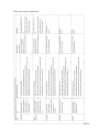
Acknowledgements
The authors would like to acknowledge the financial fund under Professional Service Development
Assistance Scheme (PSDAS) of Commerce and Economic Development Bureau, The Government
of the Hong Kong Special Administration Region as well as technical support of Hong Kong
Institute of Utility Specialists (香港管綫專業學會)and Hong Kong Utility Research Centre (香港
管線管理研究中心)as well as their company members. Additionally, the support of relavant
government departments should be acknowledged for their contribution to the information related
to operation, standards, and contract requirements.
List of Company Members of HKIUS (according to alphabet):
(1)
APC Surveying & Building Limited
(2)
BUDA Surveying Limited
(3)
B.P. (Building & Engineering) Co., Ltd
(4)
EGS (Asia) Limited
(5)
Freyssinet Hong Kong Ltd.
(6)
INNO Pipe Engineering Limited
(7)
Insituform Asia Limited
(8)
Jetrod Pipeline Consultant and Engineering Ltd
(9)
Patrick Yuen Underground Detection Company Limited
(10) Toptime Technologies Ltd.
(11) US & Associates Consulting Co.,Ltd
(12) UtilityINFO Limited
(13) U-Tech Engineering Company Ltd.
Editor in Chief
Editor
Consultant
Ir Dr. King Wong
L.M. Cheung, C.C. Chui, C.W. Hui, W.Y. So
Mr. Kai Yip Kwok, Mr. Chun Fai Wong
This guideline was done in May 2011 and this version is modified in May 2012.
.............................................................................................................................................. Page2
FOREWORD
After the disastrous landslip of 1994 occurred in Kwun Lung Lau on Hong Kong Island, the
Government has paid more attention on utility maintenance with particular emphasis on leakage
detection of buried water carrying services on both slopes and roads. The Government has increased
resources and imposed additional legislation on the detection of underground utilities. As a direct
result, the utility profession has been developing rapidly, and over the last decade, the number of
“Utility Specialists” ( 管 綫 專 業 監 理 師 ) has grown as the Government’s requirements for
Competent Persons to carry out the investigations has been implemented, in addition, Recognized
Professional Utility Specialist (RPUS) (管綫專業監察師) has been recognized in recent years.
However, lack of standard surveying methods, centralized monitoring systems and organized
management, have lead to unsatisfactory investigation results.
In order to address these issues, Hong Kong Institute of Utility Specialists (HKIUS) (香港管綫專
業學會), targeting the promotion of knowledge and good practice in the utility profession,
collaborated with Hong Kong Utility Research Centre (HKURC)(香港管線管理研究中心) and
supported by the funding from the Professional Services Development Assistance Scheme (PSDAS)
of HKSAR, published a series of guide books and pamphlets in 12 disciplines of the utility
profession in order to set standards for the practitioners to follow. As part of HKIUS continual
effort to enhance the professionalism of the utility profession, it is the intention of the series that the
quality of the survey can be raised and that utility related incidents can be avoided by performing
high quality utility practices. Hopefully, the resulting benefits can extend to the general public.
This issue provides good practice of using Pipe/Cable Locator (PCL) (管綫探測儀) in Utility
Survey. It states the whole process and specification of conducting Utility Survey (using PCL) from
planning to finishing stages and intended to be used by all personnel involved in the works.
_________________________
Mr. Zico Kai Yip KWOK
(郭啟業先生)
President, HKIUS (2010-13)
April, 2011
.............................................................................................................................................. Page3
TABLE OF CONTENT
1. INTRODUCTION ........................................................................................................................... 5
2. OBJECTIVE AND SCOPE ............................................................................................................. 6
3. PRE-SURVEY PREPARATION .................................................................................................... 7
3.1 Equipment .............................................................................................................................. 7
3.2 Planning ................................................................................................................................. 8
3.3 Statutory Requirement ........................................................................................................... 8
3.4 Personnel Requirement .......................................................................................................... 9
4. UTILITY SURVEY INSPECTION............................................................................................... 11
4.1 Calibration of PCL ............................................................................................................... 11
4.2 Detection Method ................................................................................................................. 11
4.3 Detection Techniques ........................................................................................................... 15
4.4 Depth measurement.............................................................................................................. 16
4.5 Current Measurement ........................................................................................................... 17
4.6 Marking ................................................................................................................................ 17
5. POST-SURVEY DATA PROCESSING ....................................................................................... 19
5.1 Inspection Report ................................................................................................................. 19
5.2 Accuracy and Quality Control ............................................................................................. 20
5.3 Record keeping .................................................................................................................... 21
6. LIMITATION OF PCL .................................................................................................................. 22
REFERENCES................................................................................................................................... 23
Appendix A: Abbreviations ............................................................................................................... 24
Appendix B: Related photographs ..................................................................................................... 28
Appendix C: Sample Materials .......................................................................................................... 29
B1 Utility Mapping Form (TOPO FORM ) ............................................................................... 29
B2 Utility Mapping Form (Form B) .......................................................................................... 30
B3 Utility Mapping Form (DETAIL SURVEY BOOKING FORM FORM) ........................... 31
B4 Survey Leveling Form .......................................................................................................... 32
B5 Survey Traverse Form .......................................................................................................... 33
B6 Survey Sketch Form ............................................................................................................. 34
.............................................................................................................................................. Page4
1. INTRODUCTION
The underground utility system of Hong Kong is extremely complicated. Electric cables, water,
sewage and gas pipes, telecommunication lines, etc. are buried underground in high density.
Construction, repair and maintenance works of the utilities often involve excavation. Careless
excavation works may cause damage to underground utilities and the cost of it can be high. It can
paralyze the power and water supply and cut communication channels. More importantly, accidents
related to buried pipes and cables can cause injuries and fatalities. Therefore, a responsible business
shall locate the buried lines and provide relevant information to minimize the possibility of any
accidents.
Non-destructive methods are introduced to estimate the location of the buried utilities.
Electromagnetic method using pipe/cable locator (PCL) and the use of ground penetrating radar
(GPR) are two common methods and the electromagnetic method will be discussed in this
document.
Pipe/cable locator has existed for more than 40 years ago and is widely used in the recent decade.
The phenomenon of electromagnetic induction was discovered by a British, Michael Faraday, in
1831. Portable locators were made later. There are numerous excavation works every year in Hong
Kong and as utility survey is required before digging; as a result, there is a huge number of survey
works. Due to the increasing number of utility specialist using the electromagnetic method, Hong
Kong Institute of Utility Specialists (HKIUS) (香港管綫專業學會), aiming at promotion of
knowledge and good practice in the utility profession, has prepared guideline to provide a
standardized method and process of conducting Utility Survey using PCL in order to promote a
good practice for the practitioners. Note that such standards are for reference only, any other
standards or requirements are acceptable as long as they are stated in the contract or mutual
agreement between the Contractor and the Engineer/ Client.
.............................................................................................................................................. Page5
2. OBJECTIVE AND SCOPE
Electromagnetic detection in utility survey is a non-destructive method for locating buried utilities.
The purpose of this guide is to provide recommendations on good practice of the methods and
specification of Utility Survey to enhance its quality. Since the result of the survey is a crucial
indicator to the road digging works, quality and accuracy are great concerns. Failure in meeting the
specified level of accuracy can be caused by non-compliance with standard requirements of
surveying process and equipment. This document aimed at providing guidelines for the practitioners
to follow to ensure a satisfactory quality of survey. This makes the inspection itself more time and
cost effective on the one hand, prevents cable related incidents on the other hand and in turn saves
social resources and more importantly, avoids casualties.
Up to standard components of a utility survey, including process, equipment and personnel,
constitute a high quality inspection. This guide provides information on the whole process and
specification of conducting Utility Survey from planning to finishing stages. Nevertheless, it shall
be noted that the functions and usage of each locator vary; detailed instructions shall refer to the
user manuals. And the “Specification for Utility Mapping By Non-Destructive Methods” (HKIUS,
2009) provides requirements on scope and accuracies of the Survey in details. Also, users of this
guide shall refer to relevant documents for further information on safety that are not covered in
details. It must be stressed that the guidelines given in this guide are in no way exhaustive, and
professional judgment must be employed in all cases.
This guide is intended to be used by all personnel who are involved in the planning, commencement
and supervision of Utility Survey, including contractors, utility companies, consultants, government
departments and other parties concerned.
.............................................................................................................................................. Page6
3. PRE-SURVEY PREPARATION
Before commencing the Utility Survey, preparation works including a comprehensive plan,
qualified equipment and personnel, shall be prepared to ensure a smooth and safe inspection process.
3.1 Equipment
The first step to utility location is to get familiar with the equipment. The PCL provides readings
and data for the operator’s interpretation. However, the usage and techniques for location can be
complicated. Therefore, knowing how to operate the PCL well is a basic requirement for a
successful location.
Equipment used in electromagnetic detection varies according to the capabilities of the locating set.
The two basic components the locating set are a transmitter and a receiver. Other accessories are
available to form a more sophisticated set with increased functions. Basic components can locate
buried pipes and cables while a sophisticated set can locate faults and solve problems.
Receiver
A receiver detects passive signals and signal that has been applied to a line by the transmitter. When
it detects the signals, it provides a visual and/or audio response. A receiver is used to sweep and
search an area for unknown lines or to trace, pinpoint and identify a target line.
Different modes can be chosen for different purposes in different situations. ‘Peak mode’ is the
most common mode being used. The signal response of the receiver rises to peak when it is exactly
over the target line. Some locators gave ‘Null mode’ that the signal response fall to null when it is
exactly over the target line. Null mode gives a sharper response while Peak mode gives a broader
one. Null mode sometimes is used to verify the result of Peak mode. However, it is recommended
to use Peak mode in utility congested area as Null mode may give a confusing result when two lines
are too close.
Transmitter
A transmitter discharges an identifiable signal and applies signal to the target line. The lines can
then be located and traced with a receiver by detecting the applied signal. It can also flood the area
with signal energizes all the lines in that area.
The use of accessories of the transmitter is optional. It depends on the method of detection used. A
pair of leads (in red and black) is used in direct connection while a signal clamp is used in signal
clamping.
Sonde
Sonde is a self-contained waterproof transmitter emits signal that can be located by the receiver.
Sondes are commonly used for locating non-metallic pipes.
iD Marker
An iD Marker can store pipe information and discharge signal to the receiver when being detected
so that the pipe can be located and traced. It is usually installed in non-metallic pipes and at critical
points (e.g. bends, road crossing) of metallic pipes and drains.
.............................................................................................................................................. Page7
3.2 Planning
Before detection, collect information of the existing utilities from different utility undertakers.
These record plans provide clues for the location of the underground utilities. Possible sources are
power companies, gas suppliers, telecommunication companies and government departments.
Reconnaissance survey shall be carried out to define the boundary and check for any missing or
incorrect surface installations. Note that the record plan shall be taken as reference only as the data
may contain incorrect information or outdated already. Try to collect comprehensive information
before investigation to obtain a more accurate result.
3.3 Statutory Requirement
Both employers and employees shall comply with relevant occupational health and safety
legislations and obligations to ensure a safe working environment and minimize disturbance to the
public caused by the work.
Laws and ordinance are set up to regulate the utility detection and excavation works in order to
protect the underground ground utilities and prevent related accidents. The Electricity Supply Lines
(Protect) Regulation (Cap. 406H) and Gas Safety (Gas Supply) Regulations (Cap. 51B) set rules for
works near the electricity and gas supply lines. Details of the regulations can be referred to the
Code of Practice on Working near Electricity Supply Lines and Code of Practice – Avoiding danger
from gas pipes issued by Electrical and Mechanical Services Department.
The Workplace Health and Safety Regulations specifies several requirements for personnel
involved in works, some of the requirements are stated in relevant ordinances or regulations such as
working in a confined space, road traffic control, excavation safety, dangerous substances, noise at
work, etc. The Occupational Safety and Health Ordinance (Cap.509) and the Factories and
Industrial Undertakings Ordinance (Cap. 59) are useful references. It is important to follow relevant
ordinances stated by the Occupational Safety and Health Council (http://www.oshc.org.hk) before
commencement of works.
Also, operators shall use Personal Protective Equipment (PPE) and shall have sufficient knowledge
in both usage and maintenance of the equipment. PPE shall include:
a.
b.
c.
d.
e.
f.
g.
Steel toe cap, rubber safety boots
Safety hamlet
Safety vest (reflective at night)
Safety goggles / Anti-glare glasses
Gloves
Ear muffs/ ear plugs
Handy gas detector
Appropriate steps shall be taken to minimize or even eliminate any potential risk of injuring the
public. In case excavations are required, the access around the work area has to be properly
supervised by a Competent Person (CP) (合資格人士), under Cap. 406H, the Electricity Supply
Lines (Protection) Regulation, at all times. Proper temporary traffic arrangement shall be made to
retain the access for “essential services” like police, fire service and ambulance.
If excavations are required, no dirt, excess spoil or any other materials shall be left in the water
channel to avoid polluting the drainage system. Sediment control procedures can be referred to the
Environmental Protection Department (http://www.epd.gov.hk).
.............................................................................................................................................. Page8
3.4 Personnel Requirement
In order to maintain the Utility Profession's requirements for the consistency, reliability and
accuracy of reports, CCTV inspection shall be performed by properly trained and accredited
personnel. Accredited personnel shall hold a certified qualification issued by a Registered
Training Organization (RTO), such as Utility Training Institute or The Hong Kong Polytechnic
University or equivalent.
In addition, a minimum of 3 years post training experience will be necessary for a person to become
competent. Besides, qualified personnel are required to attend refreshment course in every 3 years
to refresh and enhance their knowledge.
All works carried out within sewers, manholes or other confined spaces shall be performed in
accordance with the requirements for works in the vicinity of Confined Space and Occupational
Health & Safety Legislations, as well as any additional precautions that may be specified by the
asset owner.
.............................................................................................................................................. Page9
Table of personnel requirement
............................................................................................................................................ Page10
4. UTILITY SURVEY INSPECTION
Utility survey aims at locating the position of the pipes/ lines and finding the depth of the lines. For
locating the position of lines, passive detection can be carried out to search for cables and sweep the
area. Active detection can then be carried out to apply signal to the target line, so that its alignment
can be traced and the depth can be measured. In order to obtain an accurate result, proper usage of
the functions of the locators is important. Note that this document provides a general description on
the methods and techniques of location, functions and usage of locators of different brands and
models vary, detailed instructions shall refer to the user manuals issued by the manufacturers.
4.1 Calibration of PCL
Calibration of equipment ensures it works properly and thus raises the accuracy and reliability of
the result. Usually, the locator has calibrated when manufacture , an annual check, however, shall
be carried out to test if it can complied with the product specification. If it cannot, it shall be sent to
the manufacturer for re-calibration.
4.2 Detection Methods
The operating principle of PCL is electromagnetic method. The locator is not finding a pipe/cable, it
actually detects the magnetic field around the lines. There are two methods of detection for metallic
pipe/ cable, passive and active detection. For non-metallic pipes, accessories like sonde and iD
Marker can be used.
Passive Detection
Passive detection means detecting the passive signal naturally present on conductors. There are two
types of passive signals, power frequency and radio signal.
(1)
Power frequency:
A loaded cable produces a power frequency, for example, power cables carry 50 Hz current.
This low frequency signal can couple to other nearby lines. Detecting this signal can tell
where the conductor is but not what it is. Such signal can come from a power cable, a nearby
metal pipe or a concrete reinforced bar. Note that only cable with load carry current, if the
cable is not energized, it cannot be detected. Cables without load are dangerous during
excavation.
(2)
Radio Signal:
Radio signal is a very low frequency current that present in metallic pipes/lines resulting
from the broadcasted radio transmissions. These low frequency radio signals flow in buried
conductors are reradiated and can be detected by the receiver.
Passive detection is a fast and convenient method for location, no transmitter and connection is
required, only a receiver is needed to receive the passive signals on the conductor. Passive detection
can be used to locate buried conductor, however, it is unable to identify the conductor detected as
all conductors can carry the same signal. Passive detection can be used to sweep and search the area
to check for the existence of any cable. It can also be used to check for any nearby lines before
excavating the target line. The lines detected in passive detection can then be traced and identified
by active detection. It is not suitable to measure the depth during passive detection because the
location of the line is not confirmed.
............................................................................................................................................ Page11
To carry out passive detection, first select ‘Passive Mode’ or ‘Power Mode’ to detect the 50Hz
power frequency of the energized cable. Some locators have ‘Radio Mode’; select this mode to
search for any radio signal. The technique of ‘sweep and search’ is used in this method and will be
illustrated in Section 4.3.
Active Detection
Active detection is applying signal to a target line so that the line will carry a stronger signal that
can be identified by the receiver easily. A transmitter is used to transmit signal to the target line.
When using the transmitter, make sure that the frequency of the receiver is switched to the same
frequency of the transmitter. There are three common methods in active detection; they are direct
connection, signal clamping and induction.
(1)
Direct Connection:
The direct connection method applies signal to the target line by connecting the access point
of the line directly. A red lead, black lead and ground rod shall be used in this method. The
red lead is connected to the access point of the pipe/line at the near-end ground and the
signal current travels down the pipe. The return path of the current is through a far-end earth
ground by any metallic materials such as a screwdriver stuck into the ground. The circuit is
completed by connecting the black lead to a ground rod and the rod is placed as far away
from the alignment as possible and at right angle to the alignment. Then, check if the circuit
is completed.
Sometimes the access point may not be available to apply a far-end ground. The current can
still return to the transmitter and complete the current as the signal induces the ground. The
direction of signal can be controlled by ground rod placement. The signal flows to the
direction where the ground rod is placed.
To create a good circuit, a good ground is essential. Note that the ground rod shall be placed
far from the trace path to avoid interference from the alignment. However, in the real world,
the utilities are congested especially in the urban areas. The operator shall be very careful
when placing the ground rod to avoid it from crossing over other utilities. If another utility
becomes the return path of the circuit, the signal may be distorted and result in confusing
and less accurate detection. Besides the ground, metal road signs, telephone or street lamp
post can also be a good ground.
Red lead
Cable Cover
T1
T2
Current
Transmitter
Far-end Ground
Opened valve/ removed
near-end ground
Ground Rod
Soil
Black lead
Fig. 4.1 Direct connection method
............................................................................................................................................ Page12
(2)
Signal Clamping:
The signal clamping method applies a discriminating signal to the target line by clamping a
signal clamp on the line. Exposure of target line is necessary when using this method. When
the clamp is clamped on the line, the signal can be detected on either side of the line.
Grounding is not necessary in this method but a ground rod can be placed to control the
direction of signal. The ground rod can be placed in the direction where the signal is not
needed. The signal on the line will be induced to the ground. And the signal will only be
sent to the opposite direction of the placement of the ground rod.
To apply the signal effectively, the jaws shall be closed completely. There are clamps of different
size, choose suitable size so that the line can be fitted to the clamp.
In utility congested areas, signal clamping perhaps is a more suitable method. When signal is
applied by direct connection, the signal flows along the easiest path (the most conductive one)
instead of the one with signal applied. Signal clamping provides a more distinctive signal as the
clamped line must carry a stronger signal than the nearby lines. The target line can be distinguished
more easily.
T1
Opened valve/
removed nearend ground
T2
Cable Cover
Secondary Current
Signal
Clamp
Far-end
Ground
Soil
Primary
Current
Secondary Current
Fig. 4.2 Signal clamping
(3)
Induction:
The method of induction is making use of the transmitter to induce signal to a target line
directly under the transmitter. No access to the cable is necessary. The transmitter shall be
placed directly above and in line with the target line. The conductor shall be grounded at
both ends to produce a stronger signal for location. The operator shall walk from the
transmitter for at least around 10 paces away before location to avoid the receiver being
interfered by the transmitter. The line that carries the strongest signal is the target line.
Though this method is simple and quick, it is the least effective among the methods of active
detection. It is because the signal is not applied to a specific line directly. When the signal is
induced to the target line, the signal can induce other nearby lines easily at the same time.
This method performs poorly in locating deep targets.
............................................................................................................................................ Page13
Transmitter
Coil incorporated
Far-end Ground
Primary
Cable
current
Valve
Secondary Current
Fig. 4.3 Induction
Passive
Direct
connection
Signal
Clamp
Induction
Exposure
of lines
No
Yes
Yes
No
Signal
coupling
Higher
Lower
Lower
Higher
Congested
area
No
Yes
Yes
No
Time
Faster
Slower
Slower
Faster
Reliability
Lower
Higher
Higher
Lower
Table 4.1 Comparison of different detection methods
Other Applications
Passive and active detection can be used to locate metallic pipes and pipes with tracer wires. To
locate non-metallic pipes, iD Markers and sondes are two tools for tracing those pipes.
(1)
Electronic Marker System:
The Electronic Marker System or Intelligent Marker System can be used to identify the
location and depth of the lines. An iD Marker has a unique serial number and an electronic
chip inside to store relevant information like its owner, application, location and depth. The
marker is then installed on the pipes during construction or maintenance. Operator can use
the detector to detect the location of the markers and find out the pipe alignment as well as
the relevant information.
Markers of different colours represent different types of utilities. Different types of markers
are available for installation in pipes at different levels. There are five types of iD
............................................................................................................................................ Page14
markers available, they are Near Surface Marker, Ball Marker, Mini Marker and Full-range
Marker. Details of application shall be referred to the operation manual of the products.
Besides locating buried utilities, this system allows the data of the utilities to be managed
systematically. When the marker is installed on the pipe, the unique serial number can be
marked and entered into a database of easy management. Even if its location is not recorded,
each marker contains information for retrieval.
(2)
Sonde:
Sonde is a self-contained transmitter, it transmits signal that can be located by the receiver.It
is used in pipes, sewers and ducts. Alignment of the pipe can be traced by propelling a sonde
along the pipe. The field of the sonde is sausage-shaped instead of circular. The signal
response appears as ‘ghost peak – null – peak – null – ghost peak’.
First, propel the sonde for few paces and pinpoint the location of the sonde, mark the
location. Propel the sonde few paces further and pinpoint the location. Repeat the pinpoint
steps at similar intervals along the drains or ducts to trace the alignment.
Fig. 4.4 Pattern of the signal response when detecting a sonde
4.3 Detection Techniques
Different detection techniques can be used to find out unrecorded lines and trace target lines. There
are mainly three detection techniques; sweep and search, trace and pinpoint.
Sweep and Search
To search and locate unknown lines in the area, passive sweep and active search are two basic
techniques. This procedure is particularly important before excavation to prevent damage to the
buried utilities.
In passive sweep, the passive ‘power’ or ‘radio’ mode can be applied. Adjust the sensitivity of the
receiver to maximum and traverse the area in a grid search. The place where the response rises
indicates the presence of a line, stop and mark the location.
............................................................................................................................................ Page15
Fig. 4.5 Passive search traverse
Active search makes use of the method of induction. Active search involves both transmitter and
receiver, and two operators. One operator shall hold the transmitter while the other shall hold the
receiver. These two people shall have a distance of at least 20 paces to avoid interference of signal
from the transmitter. Switch on the transmitter and adjust the sensitivity of the receiver to maximum.
The two people walk in parallel slowly and if the transmitter crosses a line, the line is induced and
the receiver can detect a stronger signal simultaneously.
Trace
When the signal has been successfully applied to the target line, it can be traced by the receiver.
Hold a receiver over the target line, walk slowly and move the receiver to right and left at each pace.
Check if signal response is at peak when directly over the line and falls when moving to the two
sides. Trace the line continuously and stop every 10 to 20 paces to confirm the position of the line
carefully. Mark the position of the alignment periodically.
The signal from the transmitter becomes weaker as the receiver gets farther away. The operator can
adjust the sensitivity of the receiver to gain more signals.
Pinpoint
This technique is used to locate the exact position of the line. Hold the receiver over the target line,
make traverses across the line and define the point of maximum response. Rotate the receiver
without moving it as if it is a pivot. Stop at the point of maximum response. Hold the receiver in
this direction, move it side to side across the line and again, stop at the place that gives maximum
response. The target line is directly below and runs perpendicular to the receiver. Mark the position
and direction of the line.
4.4 Depth measurement
To measure the depth of the line accurately, a suitable point shall be selected before measuring. The
point shall be where the position of the line had confirmed with stable signal response. Note that
measuring depth at tees, bends, somewhere depth changes, near other lines and near the transmitter
can lead to distorted or inaccurate result.
............................................................................................................................................ Page16
To measure the depth, some locators nowadays are able to measure the depth automatically by
pressing a button. Some of them even have the depth shown on the screen automatically through out
the detection process. Depth can also be estimated manually. Hold the receiver above the line, move
the receiver left and right until the signal fall to 70% of the peak. The depth approximately equals to
the distance of the movement of the receiver.
Fig. 4.6 Measuring depth by 70% method
4.5 Current Measurement
Some locators have the function of ‘Current Measurement’ to measure current instead of signal
response. This function is useful in utility congested areas. After applying signal to the line, the
target line shall carry a stronger signal. However, when two lines are very close, and if the nearby
line lies shallower than the target line, the nearby line may give a stronger response than the deeper
target line. The nearby line may be wrongly recognized as the target line.
The use of current measurement avoids this problem. The strength of signal response varies
according to the gain setting and the depth of line but current does not. The line with signal applied
must carry the strongest current. Therefore, the line with the strongest current must be the target
line. Current measurement increases the accuracy in line identification.
4.6 Marking
On site marking
Mark the position of the lines with suitable symbols. The operator shall use oil-based paint instead
of water-based paint for enduring effect.
Marking on map
Accurate marking is important for accurate location. When marking a control point (location of the
utility), two points shall be taken as reference points, let’s say point A and point B. They shall be
fixed structures such as lamp pole, hydrant, manhole, etc. The distance between the control point
and the reference points and the depth of the utility at that point shall be marked and usually in a
separation of not less than 10m. The distance shall be converted to the distance on map according to
the mapping scale. Mark reference point A and B on the map. The reference point shall be taken as
the center of the circle and the distance as the diameter, draw an arc from each reference point. The
intersection point of the two arcs is the control point. Noted that the number of control points
depends on the mapping scale.
............................................................................................................................................ Page17
Fig. 4.7 Marking of control points
............................................................................................................................................ Page18
5. POST-SURVEY DATA PROCESSING
Data collected from the utility survey shall be presented clearly and accurately. The utilities
detected shall be presented in the form of drawing with legends. Computer software is available to
produce the drawing in digital format. Moreover, the resulting data contribute to the establishment
and renewal of the utility database. The database could provide up-to-date information for any
related works like construction, maintenance and replacement.
5.1 Inspection Report
The Utility Specialist shall examine, analyze, process and interpret the investigation results and
incorporate findings in a report. The report shall include the following essential information:
(1)
Introduction
a.
Project name
b.
Site Appreciation
(2)
Details of investigation
a.
Date of Investigation
b.
Detailed description of the investigation procedures adapted
c.
All equipment used for the investigation
d.
Identification of supervisor and equipment operators carrying out the investigation.
(3)
Investigation results
a.
Summary of buried utilities
b.
Report on examination, analysis and interpretation of the investigation results
c.
Identification of utilities, chambers, manholes and relevant surface installations
d.
Records of on-site verification of data handled by qualified person responsible for
the report
(4)
Appendix
a.
Drawings
b.
Site photographs
c.
Floppy diskettes/ CD ROMs for the digital data
The report shall include all results with a detailed discussion and accompany plans. Other
information shall be provided according to the contract and real situation.
Drawing
The investigation results shall be plotted in 1:100 scale A1 drawings on the specified grid and
datum approved by the Engineer. The layout, border, and title block shall be approved by the
Engineer. The drawing shall show building lines, roads with road names, traffic lanes, road
markings, pavement and kerbs, as well as other significant physical features within the investigated
area. At least two cross-sections shall be provided as instructed by the Engineer to scale and show
regular intervals, and more frequently at points of change and congestion. Cross-sections shall show
surface features, underground utilities (size, depth and type), sub-surface anomalies, pavement and
kerbs, and other significant physical features.
Computer software such as AutoCAD and Microstation are able to produce 2D drawings and 3D
models to illustrate the utility distribution in an area. They are capable of designing, visualizing and
............................................................................................................................................ Page19
documenting the drawings. The drawings can also be updated easily. Detailed usage of the software
can refer to user manuals of the software (AutoCAD by Autodesk and Microstation by Bentley).
5.2 Accuracy and Quality Control
The purpose of utility survey is locating the position of the underground utilities especially to
prevent damage to underground utilities. Accuracy is crucial or otherwise the survey becomes
meaningless. Therefore, quality control shall be carried out properly to ensure the survey has
reached the accuracy requirements.
A site check shall be conducted at the witness of the Engineer’s Representative. The Contractor is
required to re-survey a selected section of the works for a chosen site and demonstrate to the
satisfaction of the Engineer’s Representative that he can reproduce the result submitted at the
preliminary stage. If the contractor cannot reproduce the result, it shall be considered as failed.
Underground services which can be located without excavation, such as cables and connected metal
pipes which can be located by surface detection equipment, and drains, manholes, chambers and
drawpits shall be located and investigated to the accuracies given below.
Underground services shall be located and recorded continuously in three dimensions at intervals
not exceeding 5m at discrete areas or at intervals not exceeding 10m for survey along the road, and
at each surface feature, change of direction and bifurcation.
The position and level of locatable services, at the recorded points and intervals defined above, shall
be related to grid control points and bench marks to better than ±100 mm root mean square error on
the ground. 90% of a representative sample of points on locatable services shall be within ±165 mm
or 0.1d (depth) whichever is bigger.
Positions and levels shall be related to the specified grid and datum and shall normally be related to
the centre of metallic pipes or cables, crown of ducts and inverts of sewers and drains.
Any known underground services or information that cannot be investigated to the accuracies stated
above, other than by excavation, shall be entered in a unique layers defined as “unreliable”, as
approved by the Engineer. The utility specialist shall itemize in the reports the types of services that
have been classified as “unreliable” and other circumstances, such as local areas of interference,
where the specified accuracies cannot be achieved. The utility specialist shall make the best
judgment to provide details of these “unreliable” services or information as requested by the
Engineer. The utility specialist shall specify in the report the reasons why such services or
information cannot be investigated.
Wherever full details of underground services cannot be determined without excavation, these
details shall be deduced from the utility undertakers’ record drawings and entered into the drawing
in a unique layer defined as ‘records”.
Wherever access is available from the surface, the Contractor shall check the depth to underground
services. Positions of exact measurements shall be noted as attributes in the Drawings.
Wherever accuracies or tolerances are specified herein, they are defined as Maximum Errors or
statistically based root mean square errors (RMSE) as follows:
............................................................................................................................................ Page20
Maximum errors
Maximum errors are only used for fieldwork disclosures and plotting of map grids and control
points. All errors exceeding the maximum allowable tolerance including consequential errors shall
be corrected by the Utility Survey Specialist at his own expense.
Root mean square errors
(1)
The RMSE are related to checks on representative dimensions or levels.
(2)
The following conditions have to be satisfied:
a.
At least 67% of all readings must be correct to or better than RMSE;
b.
At least 90% of all readings must be correct to or better than 1.65 times the RMSE;
c.
All readings must be correct to or better than 3 times the RMSE.
d.
All readings not complying with the above three conditions, including consequential
errors, shall be corrected by the utility survey specialist at his own expense.
5.3 Record keeping
Data collected shall be kept well for future use. The survey result can be incorporated into the
existing plan and becomes the record plan as reference for excavation works. Updated information
minimizes the possibility of damaging underground utilities and accidents.
Copies of survey result shall be kept by the asset owner and the agent appointed. The asset owner
shall update the record plan according to the survey result. Besides paper copies, data stored in
digital form provides convenience to the management of the assets. Computer software like
AutoCAD and Microstation are available for creation and editing of 2D and 3D drawing. The
distribution of the underground utilities can be clearly shown in the drawings or 3D models. They
are also capable of slicing and filtering the drawings or models so that the data can be shown
selectively. The Integrated Data Management System (IDMS) (綜合資料管理系統) can be used to
store the data systematically for reporting and searching. This computer software enhances the
coordination of the project information. The Geographical Information System (GIS) is adapted to
store a large amount of information; all kinds of utilities in the area can be searched in the system.
This saves time as initially, each type of utility is recorded in relevant organization, for example, the
record from a power company only shows power cables in the area, and the operator has to combine
the record plans from all relevant utility undertakers to figure out different utilities in that area. GIS
saves times in collecting information as well as accessing information as they can be accessed via
the Internet using a portable device.
............................................................................................................................................ Page21
6. LIMITATION OF PCL
PCL can locate buried utilities without excavation. However, the location and depth of the utilities
can never be confirmed except exposing them.
PCL can only locate metallic pipes and pipes with tracer wires. The use of sonde and iD Marker is
necessary when locating non-metallic pipes. Sometimes these methods still may not be able to
locate all the utilities. In this case, Ground Penetrating Radar (GPR) that is theoretically capable of
detecting all kinds of objects underground can be used as an alternative.
The result of the detection using PCL highly depends on the interpretation of the operator. This is
one of the reasons why PCL was not widely accepted until some more systematic usages were
established. The PCL detects and shows the signal or current only, it does not guarantee the
indication of the target line. Signal distortion, sudden change of signal are common, lots of different
factors can affect the effectiveness of detection. Therefore, a well-trained and experienced operator
is important for a successful detection.
To conduct a successful detection, the operator shall not rely on the machine only, he shall use
different methods and techniques alternatively to get or verify the result. Besides using the PCL,
looking for surface installations also gives clues to the location of the buried utilities. The
cumulative information from site observation, record plans and maps provides useful information
on what you expect to see and where to start location.
............................................................................................................................................ Page22
REFERENCES
(1) 3M Cable Locator User Manual. 3M.
(2) abc & xyz of locating buried pipes and cables, Radiodetection. (2008). U.K.: Bristol.
(3) Advanced Training Course for Uderground Utility Survey (in complying with Cap.51B (Gas
Safety Regulation) and Cap.406H (Electricity Supply Lines (protection) Regulation). (2009).
Hong Kong: Utility Training Institute.
(4) Advanced Training Course for Underground Utility Survey. (2004). Hong Kong: UtilityINFO.
(5) American Standard of Testing Materials(ASTM) D6432-99, Standard Guide for Using the
Surface Ground Penetrating Rader Method for Subsurface Investigation. (1999).
(6) Cable and Pipe Locating Techniques. (1996). Taxas: 3M.
(7) Chapter398 Occupational Safety and Health Council Ordinance. Hong Kong: HKSARG.
(8) Code of Practice on Monitoring and Maintenance of Water-Carrying Services Affecting Slopes.
(2006). Hong Kong: Environment, Transport and Works Bureau.
(9) Code of Practice: Safety and Health at Work in Confined Spaces. (2000). Hong Kong: Labour
Department.
(10) Constitution. (2011). Hong Kong: Hong Kong Institute of Utility Specialists(HKIUS).
(11) DC/2002/11 Investigation of Sewers & Drains Affecting the Safetyof Slope Features in the
Catalogue of Slopes,Phase2. (2002). Hong Kong: Drainage Services Department.
(12) DC/98/01 Investigation of Sewers and Drains Behind and Adjacent to Cut Slope. (1999). Hong
Kong: Drainage Services Department.
(13) DC96/19, Investigation of Sewers and Drains Behind and Adjacent Fill Slopes and Retaining
Walls. (1996). Hong Kong: Drainage Services Department.
(14) Electricity Ordinance (Cap.406). Chapter406H"Electricity Supply Lines(Protection
Regulation"" . (2004). Hong Kong: HKSARG.
(15) Factories and Industrial Undertakings Ordinance (Cap.59). (1997). Hong Kong: HKSARG.
(16) General Specification for Civil Engineering Works, Vol. 1. (2006). Hong Kong: Civil
Engineering and Development Department.
(17) Guidelines for Excavation near Water Mains. (2000). Hong Kong: Water Supplies Department.
(18) HKHA161/95, Detection Of Leakage Form Buried Water Carrying Services In The Vicinity
Of Slopes' And Retaining Walls Within the Lands' Maintained By Housing Authority. (1995).
Hong Kong: Housing Authority.
(19) Inspection and Testing of BuriedWater Carrying Service Affecting Slopes, Slope Feature No.
11SW-B/R 409, Slope Surveying Report. (2003). Hong Kong : BUDA.
(20) Model Contract Document for Manhole Location Survey and the Production of record Map.
(1993). U.K.: Water Research Council.
(21) I.r Dr. King Wong & R.J Allen (2009). Hong Kong Conduit Condition Evaluation Codes
(HKCCEC): The Code of Practice on Conduit Condition Evaluation using CCTV in Hong
Kong (4nd ed). Utility Training Institute: Hong Kong
(22) RD400 Series User Manual. Radiodetection Inc.
(23) Training Session, www.ridgid.com. (2010). U.S.: Ridgid.
(24) W.Lai& K.WongS.Tsang. (2004). Applications of Ground Penetrating Rader in Civil
Engineering Works. Hong Kong.
(25) Method Statement for Utility Mapping By Non-Destructive Methods (2011). Hong Kong :
Hong Kong Institute of Utility Specialists (HKIUS) & UTI.
(26) Particular Specification for Utility Mapping By Non-Destructive Methods (2011). Hong Kong :
Hong Kong Institute of Utility Specialists (HKIUS) & UTI.
(27) Work Procedures for Utility Mapping By Non-Destructive Methods. Hong Kong (2011). Hong
Kong Institute of Utility Specialists (HKIUS) & UTI.
............................................................................................................................................ Page23
Appendix A: Abbreviations
Company/ Organization
Code
Description
BD
Buildings Department, HKSARG
CEDD
Civil Engineering and Development, HKSARG
DSD
Drainage Services Department, HKSARG
EMSD
Electrical and Mechanical Services Department, HKSARG
EPD
Environmental Protection Department, HKSARG
HA
Hong Kong Housing Authority, HKSARG
HKIUS
Hong Kong Institute of Utility Specialists
HKURC
Hong Kong Utility Research Centre
HyD
Highways Department, HKSARG
LandsD
Lands Department, HKSARG
LD
Labour Department, HKSARG
PolyU
The Hong Kong Polytechnic University
UTI
Utility Training Institute
WRc
Water Research Centre
WSAA
Water Services Association Australia
WSD
Water Supplies Department, HKSARG
WTI
Water Training Institute
Others
Code
Description
%
Percentage
BMP
Bitmap (Picture Format)
BWCS
Buried Water Carrying Service
CCE
Conduit Condition Evaluation
CCE(CCTV Conduit Condition Evaluation(Closed Circuit Television & Man- Entry)
& ME)
............................................................................................................................................ Page24
Company/ Organization
CCES
Conduit Condition Evaluation Specialists
CCTV
Closed Circuit Television
CD
Compact Disc
CL
Cover Level
COP
Code of practice
CP
Competent Person
DN
Nominal Diameter
DP
Design Pressure
DVD
Digital Versatile Disc
e.g.
Exempli Gratia
GIS
Geo-Information System
EPR
Environmental Protection Requirements
etc.
et cetera
GL
Ground Level
H
Height
HKCCEC
Hong Kong Conduit Condition Evaluation Codes
HPWJ
High Pressure Water Jetting
hr
Hour
Hz
Hertz
ICG
Internal Condition Grade
ID
Internal Diameter
IDMS
Integrated Data Management System
IL
Invert Level
ISO
International Standards Organization
JPEG
Joint Photographic Experts Group (Picture Format)
kHz
Kilo- Hertz
kPa
Kilopascal
............................................................................................................................................ Page25
Company/ Organization
m
Meter(s)
ME
Man Entry
MHICS
Manhole Internal Condition Survey
mm
Millimetre(s)
Mpa
Megapascal
MPEG
Motion Picture Experts Group (Video Format)
MS
Method Statement
MSCC
Manual of Sewer Condition Classification, UK
OHSAS
Occupational Health and Safety Assessment Series
PPE
Personal Protective Equipment
ppm
Parts per million
PS
Particular Specification
PSI
Pound Per Square Inch
QA/ QC
Quality Assurance/ Quality Control
Ref.
Reference
RMSE
Root Mean Square Error
RPUS
Recognized Professional Utility Specialist
RTO
Recognized Training Organization
SCG
Service Condition Grades
SOPs
Safe Operator Procedures
SPF
Sun Protection Factor
SPG
Structural Performance Grade
SRM
Sewer Rehabilitation Manual
STP
System Test Pressure
TTA
Temporary Traffic Arrangement
US
Utility Specialist
VHS
Video High Speed
............................................................................................................................................ Page26
Company/ Organization
W
Width
WLD
Water Leakage Detection
WO
Works Order
WP
Work Procedure
............................................................................................................................................ Page27
Appendix B: Related photographs
A: A locating set for direct connection
method
B: Tracing the alignment
C: The red lead is connected to the pipe
in direction connection
D: A signal clamp is used on an exposed
cable duct
E: Marking the location of the utility
detected
F: A Mini-Marker installed on a gas pipe
............................................................................................................................................ Page28
Appendix C: Sample Materials
B1 Utility Mapping Form (TOPO FORM)
............................................................................................................................................ Page29
B2 Utility Mapping Form (Form B)
............................................................................................................................................ Page30
B3 Utility Mapping Form (DETAIL SURVEY BOOKING FORM)
............................................................................................................................................ Page31
B4 Survey Leveling Form
............................................................................................................................................ Page32
B5 Survey Traverse Form
............................................................................................................................................ Page33
B6 Survey Sketch Form
............................................................................................................................................ Page34
............................................................................................................................................ Page35
Ref No.: Y12-IUS-Guide-120515 C.US