1
.--..-
E r-a
Navigation System
User Manual
4& Z*,
#s*x
?l.r;i7aat** *.5*?^e.a
?&*saaeal
g.A 8*",A
Navigsrion Sy$aem
@
User' s Manual
Chapter
1.
Welcome to use our GpS navigator
a
a
We reserve the final explanation right on this User, s Manual.
Specifications
are subject to change without notice. Sorry for
any
inconvenience caused!
a
Please make a copy of the important data. We assume no responsibility for
the data loss.
a
a
This manuar has been carefuily checked. prease contact our service center
when any typing mistake is found.
Please read the operating instruction carefully and use the accessories
only
provided by the original factory to avoid any unexpected damage. No
warranty will be executed if you are not following the instruction or
connecting with the incompatible accessories, we assume no responsibility
a
a
o
for any loss and damage caused hereby.
The electronic navigation data may be not in conformity with the actual
transporting marks due to the trafiic construction development. please be
sure to comply with the real road condition and follow the traffic rules.
Operating and viewing the GpS during driving may cause severe traffic
accident. Our company will not be responsible for any loss caused by the
unexpected accident.
Users can update and upgrade software from website at his/her option.
Any discrepancy between the pictures with real products hereinafter, the real
one prevails.
I
One
U*er Nlaaxual
Product introduction
Introduction
Welcome to use the GpS navigator, which is mainly used
for navigating and also
has the optional function of video playing, audio playing, Blueto;th
hinds free,
FM, Bluetooth, photo viewing, and E-Book etc.
iHigh performance, low-power consumption MediaTek MTS3S1 CpU;
OComfortable user interface: simple, easy to operate;
iPower management: keep the product trc work longer and more steadily;
aData transmitting: communicate with computer through USB cable;
lExcellent in receiving signar: accurate position fixingfprovides you the satisfied
navigating service;
acompatible with Bruetooth mobire: the navigator can arso be used for making
and answering call with hands-free (Optional);
lEntertainment: Mp3 and Mp4 function can relieve your fatigue;
Y-ou can use it when driving, walking, riding, or waiting for
a meeting; the perfect
"GPS + entertainment,, function can maie your life ind work more splendid.
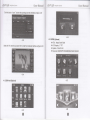
1.2 Package
The packing box contains the following accessories, please confirm:
1.GPS navigator
2.Travel Charger
3.Car charger
4.MlNl USB cabte
5.Earphone
6-User' s manual
T.Protecting cover
8.Car bracket
For the items listed above, please confirm the actual products.
lf any damage,
Please contact with the distributor or the agent as soon as possible.
lnstruction
Please read this
user' s manuar carefuily to be famiriar with ail the operation
details and to make the GpS navigator performs well:
(Remarkl The instruction relates to the themer
(Relative informationl The extending information
relates to the theme;
lNotel The notes and warnings rerite to the theme. prease varue and foilow
these notes, otherwise it will possibly bring damage to you and others.
This user manual only adapts to our GpS navigator products.
:
,
@
:
@
E
l-A
Chapter
User Manual
Navigation Syetem
Two
Features and specifications
E
,-..=
User Manual
Navigatiof, System
Status of the LCD light
When charging, the red light is on;
urhah
2.1 Main features
OOperating system: Microsoft Windows CE 5.0;
aHi-Fi stereo earphone and built-in Hi-Fi speaker, volume adjustable;
iButton and touch-screen operation;
lBuilt-in sensitive GPS antenna;
aThe navigating software could run the SD card directly;
lVideo format supported: ASF,AVI,WMV3GP,MP4,FLV;
aPhoto format supported: BMP, JPG, PNG;
aE-book format supported : TXT;
O Built-in rechargeable Li-battery which can be powered by travel and car
Ooeratino Svstem
Navioation Software
Video Plaver
6 fi^ieh6.l
SD or TF card
ASF.AVI.WMV3GP
M P4.
MediaTek MT3351
Flash memory
EMS memory
128 MBytes /2Gl4G
64 MBvtes/128MBvtes
LCD display
4.3" ot5" , 6" or7"
Resolution:480(H)-272(V)
Touch-screen
TFTLCDdisplay,
or 800(Hf480N)
USB Client 2.0. MlNl USB oort
SD/TF
SD / MMC
slot,
TXT
System setting
[FM Transmifter] [Screen adjustment] [Default set]
lvolumel [Powed [Backlight] [fime and Date]
fl enoraoel tsvs lnfol
Operating Temperature
30o/" to 90o/"RH
Atmospheric oressure
86KPa to 106KPa
GPS
B: High fidelity stereo earphone
Cold start' <42s
Hot
operation quickly.
start: <3s(in the open area)
start: <36s
Warm
Battery
Built-in rechargeable Li-battery
Battery Charging port
DC 5V oort
AC Charger
100/230V charger, 5Y
Car Charoer
DC9-24V 5V
/
@
/
:
0C to 60C
-20'C to 60C
This chapter will give an introduction of the apparent components and basic
function of the GPS Navigator and it will help you to be familiar with the basic
the maximum capacity of SD/TF
A: Built-in high fidelity speaker
r
45ol" to 8Oo/"RH
Storaoe humiditv ranoe
Card supported reaches to 8GB
Audio
FLV.
E-Album, JPG. GlF. BMP. PNG
Hioh-accuracv. endurable touch-screen
USB
li^hf ie
EBook Viewer
Workinq humiditv ranqe
CPU
'6
MP3 and WMA
StoraoeTemoerature
2.2 Specification
rh6 hl'
CE 5.0
Audio Plaver
Photo viewer
Temperature
charger.
^h.r
Microsoft Windows
1.54
1.5A
@
L.1A
,*.3
Chapter
User ivlanual
ilavigation Syetem
Three
Manual lnstruction
3.1 Power supply and charge
If this navigator is first used, please use AV adaptor to fully charge it.
3.1.1 Power supply
There are three types of supplying power: battery, adaptor, USB cable.
GPS navigator uses the Li-battery to supply power when it is not connected with
adaptor. The mark [ ffiffi
] on the up right of interface indicate the current
electric volume.
GPS navigator uses the external power when it is connected with the adaptor.
GPS navigator uses the USB cable to supply power when the GPS connects to
the PC.
I Remarkl This machine adopt buihin, unchangeable Lithium battery. At normal
condition (if the back light is not so bright), the actual supply hour can be different
because of the different way using the navigator. Some function (audio playing,
video playing, bright back light) will consume a large powel which will reduce the
using hour.
(NoteI This
3.3 Reset system
machine adopts built-in, unchangeable Lithium battery. ln order to
avoid fire and burning, please do not poke, bump or take it apart or throw it into
fire or water.
3.1.2 Use the travel charger to supply power
When the GPS navigator is first used, please use the AC adaptor to charge it.
1. Connect the DC part of the adaptor with the power interface at the left side of
the unit (The power interface is same as USB interface );
2. The other part connect to the power socket, it supplies power while charging.
( Remarkl Red LED indicates it' s being charged. Please wait until it is fully
charged and don' t pull out the adaptor while charging. When it is fully-charged,
the LED will turn to Blue. lf low battery or no battery please charge it immediately.
3.1.3 Use the car charger to supply power
l.Connect the DC part of the adaptor with
the power interface;
lf the system cannot work, you can reset the system by the following way:
Click the reset key on the right part of the machine to reset the system by using
the stylus.
(relative informationl
r
it can be no response in the following condition:
1.The shift between pictures is delayed or stopped.
2.The program select function cannot work normally, such as long time to carry
out or cannot be activated.
3.The power button can not work
( Note) The unsaved data will be lost as you reset the system when the system
has no response. Please copy the data every other time.
3.4 Use bracket to fix navigator
When use GPS in the car, you should fix the device to the part of window besides
the panel by using the bracket.
( Notel When use the bracket, please take care of the position. Please don' t
fix the navigator to the position where the driver' s sight is being influenced.
@
@
ffi
€3s*r ffiaca#xE
*a'li?&lirry *,tslrtY
A*ffi
Please do not lay it aside freely; do not fix it to the air bag, do not lay it on the
expand range of the air bag.
3.5 Stylus
A.* E*,,ffi
Us*r
,{a\igz}g, *Yslen
2.Connect the MlNl end
ffiwrzasal
tI]
of USB cable with the USB port on the teft part
1@
I with the Host port on computer.
3.After connecting, the screen will display the interface as below:
of GPS device and the normal eno
The stylus is the tool for you to use your navigator. Please keep it carefully.
1. Single click :
Singly click the screen with the stylus point.
2.
Double click,
Double click the screen with the stylus point.
3.
Drawing:
Click one point and hold to move on the screen.
( NoteI Any broken stylus, ball pen or any acute and harsh object will destroy
the LCD if you use it to operate the device.
3.6 SD/MMC card
The attached SD/MMC card contains the navigation software, map data and
media file. Please insert the card correctly when use it.
I Notel Please do not take out the SD/MMC card when the system is navigating
or playing.
( Note
1
.
any loss of data.
(RemarkI The GPS navigatorwill stop the operation when it is connected with
computer.
I
Don' t stress or curve the SD/MMC card, avoid loss and bulge.
don' t
to sun light, let the card far away from liquid and
2. Avoid high temperature or high humidity when use and store the card,
expose the card directly
4.Please pull out the MlNl USB cable after you flnished your operation, the GPS
navigatorwill return to the pre-operation interface.
( Notel Data security: Please copy the data to the outer storage device every
time before you update your system data. Our company takes no responsibility to
corrosive material.
3. Please pay attention to the heading when insert the SD/MMC card. lf you
INoteI lntheprbcessof communication,thefollowingoperationswill breakoff
the connection with computer, the unfinished data will be lost.
1).Pull out the MlNl USB cable;
2).Power off
3).Reset the system by using reset button or electric switch
insert the card improperly, you will damage the card.
3,7 Connecl with computer
The device can be connected with the computer through the MlNl USB on its left
part. You can copy the document between navigator and computer or copy the
data from GPS navigator to computer so as to recover the data in GPS when you
are in need of them.
l.Please confirm the GPS navigator is power on;
@
@
T___
1..=.'
='::
Chapter
EBs*r W*c?aaaE
::::::-a*.
Four Primary function
4# E*-ffi
Ws*r F#*masal
t'levigetid* A?*-*?n
4.1.2 Function introduction
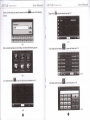
4.1 The main interface and the function
Navigation
4.1.1. Main menu
Bluetooth
Video player
Provide navigation service
This device can answer and make phone after connecting with
mobile phone via Bluetooth
Photo viewer
SupportASE AVl, WMV 3GP, MP4 and FLV format. Support
progress adiust, pause and full screen plav
Support JPG. BMP and PNG format. Support photo rotate,
E-book
Text format: txt.
Audio player
Audio playing format: WMA, MP3"
Game
Support random playing, sequential playing, repeat playing,
pause, previous/next, volume
Support game
enlarge/shrink pictures, automatic plav and so on
Support page selection
Setting
Brightness, Volume, Languages, Power, Time, System, Default,
GPS lnfo, Navipath.
This chapter will introduce the navigation function and notes.
4.2 Navigation functions and features
According to your choice of navigation system, the GPS navigator can make
position by GPS satellite signal receiver and display on the navigation map. The
system can calculate a best route after setting the destination, which can help
users to arrive the destination safely and rapidly.
The system can let you enjoy the individual charm and enjoy your trip by many
different ways such as vision map, vivid animation, voice indication, and words
indication.
The specific navigation functions are depended on your choice of navigating
software. Please refer to the Navigation Software lnstruction.
Notes
1.Map information
It is probably that the electronic navigation data is not consistent with the real
traffic instructions because of the traffic construction development. Please do
@
@
r"iz;et'
{**zzw*l
?,jsqz {**eeca*€
comply with the highway condition and the actual traffic rules.
4.3.2 Single click the button
2.Navigation
picture:
Dil
unO open Bluetooth setiing as the following
The navigator offers the route for the reference; determine the route by yourself,
the dnver may be more familiar with the route than GPS navigator.
3.Receiving signal
Many factors such as high, dense buildings (in the tunnel, between the high
building, underground parking, under the trestle), various weather condition, and
closure of the satellite will affect the ability to receive signal so as to result in
inaGcurate position, inefficiency of navigation operation and system function.
4.3.3 Single click botton
ffi
,o,
will get the following two pictures: the one is
in searching and the next one is the searching result.
$earchlllg f6r mobile phores,
4.3 Bluetooth setting and lnstructions:
mlt..,
This chapter introduces how to use this navigator's Bluetooth to connect with cell
phone for call making and answering.
Ooeration method
4.3.1 Single click the button
the following picture:
ff
ln main menu to open the Bluetooth interface as
4-7
@
@
Fh*
t--_ *
[
I
click the device you want to connect and cticr
@
to pair as the
",nn,"
oictures:
After successful pairing and connecting,
it
will show the following picture
following
'ffi
Singte
ctick
unoenter phone book as 4-.11
4.3.5 Single click the button
H
4.3.6 Single cticf the Outton
ffi
"
open call history as 4-12
4-9
4.3.4 Click the nutton
K
to open the phone book interface as 4-10
4-10
@
to open dial pad as 4-13
4-13
Lzt . *:3
E&:;;er Wrecpqsel
7a.r,?.,.:..t aa..i.ira:
4.3.7 Single click the button
,
ffi
Z
Z-*",
1jz:;*z 74r;c?aa7
1.|r,rira:,a,rri'*\!$i4*
and then it will be in dialing as 4-14
4.3.10 Single click the button
.4",,
*b
&,&
as 4-17
Name: Unknown
Itlumber: 10086
Calling...
4-17
4-14
4.3.8 If there is an incoming call, it will show the caller lD and its number as 4-15
4.3.11 Single message nrtton
-*,
!..
ffiand
itwill display connected. You can talk with each other
as 4-1 6
to download SMS of paired phone as 4-18
4-18
4_15
4.3.9 Single click
ffil
Sinqle click the
5r6on
flEI
to enter the following interface as 4-19
4-19
4-16
@
@
lia!igzlira *"!u1se
&#swr ffd?amea*l
t-Z
g
**ffi
5#s*r MasEa*al
Aa,rigatlq, *yi?sti1
4.'1 Audio player operation interface
This chapter introduces how to use the GPS video player to play your favorite
music, and let it be your personal MP3.
The audio player supports MP3 and WAV format, you could set the playing
sequen@ as you wish.
Before using the audio player, please copy the files to any folder.
4.5 Video operation lnterface
This chapter introduced how to use the GPS video player.
l.SupportASF, AVl, WMV 3GR MP4 and FLV
2.Support full-screen playing, progress choosing and file selection;
Before using the Video player, please copy your video file (ASF, AVI, WMV 3GP,
MP4 and FLV) to any folder.
4.9 Tool
singre dick
6
to choose different tools as4 -21
4.6 Photo viewer operation int+erface
This chapter introduces how to use the photo viewer to browse pictures.
1.
JPG. BMP and PNG
Support picture rotate, picture enlarge/shrink and automatic play.
Before using the photo viewer, please copy your photos to any folder.
Supports
2.
4-21
4.7 E-book reader interface and operation
This chapter introduces how to use GPS to read e-book.
l.Support TXT
2.Support turning over page, page browse, and file choosing.
Before using e-book function, please copy your TXT file and save it to any folder
4.10 System setting lnterface and operation
H to enter "Setting" menu, then you can set the relevant functions.
There are backlights, volume, languages, FM, time, calibration, system info and
Cficr<
default etc.
4.8 Game interface and operation
Single click
a
ffi
to choose different games as 4-20
@
@
L7, , -,.-
Ws*r
llg"ig4r.ia" 9y3Lfr3
3&asesEal
13
g
**ffi
!l4vi1&|.ia,1
W**r
tUrzel*
ffiaeacaal
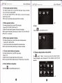
4.10.1 Backlight setting
Single click
Eil
to
"nt"r"
Uu"ktight setting interface as 4-23
4-25
FM Transmitter will send out the audio signal to the radio devices. Take 86.7MHZ
frequency for example, both the GPS transmitting frequency and the received
frequency of the radio should be 86.7MH2, then all the sounds of the GPS will be
input through the amplifier system of the radio.
4.10.2 Volume adjust
4.10.4 Navigation path
Set navigation path as 4-26
"Volume adjustment" includes:
1. Speaker volume adjustment
2.
"Screen clicktone" setting
4.10.5 Date and time setting:
Date and time include:
4-24
1. System time set;
2. System date set;
4.10.3 FM Transmitter
3. System time zone set.
Single clict<.3fl to enter the FM setting as 4-2S
4-27
@
7.
a,: a z1 1,
a
?
?ar,jz4
€$**r &&*esu*E
1.
[lorEl to set time and date.
2. Singie ( or I to choose trme area.
Click I to exit current interface after setting, and then it will show as4-28
1
. Single click button
Choose YES or
4.1 0.6
NO
re Z*.ffi
t{avigaliqri
U**r
*yst{,*
€#ac?Eeal
4.10.7 GPS lnformation
Single click the
urtton
Eil
and enter GPS information interface as 4-30
to exit current interface.
Screen Calibration
Click the
EI
to enter tne screen calibration as 4-28
4.11 ISDB-T (Optional)
4-30
Clickthe "TV" icon in Function Menu toenterfigure
1
4-28
cticr
ffi
it will move from in the sequence of the center, left up, left down,
right down and right up till the calibration succeed, then click any where on the
screen to save the calibration and exit to the main interface automaiically. lf not
save the information, please wait 30 seconds and it will exit from current interface
automatically.
4-31
p
k(6ta #tu
& @ddfu6
R@&tto@tnloB;nd&q@-
Es,
td@t,
Click "Continue" to enter the TV channels broadcast interface, then click
button to enter settings interface. The channel options interface is shown in
figure 4-32
+
4-29
Single click your favorite language and then exit.
@
4-32
@
a:, , -,,,,A
l-k"isati.n gve:effi
48s*r
Fffiasaeial
L* 8**ffi
?^2avi1elicr
*yn aftl
4.13 GPRS (Optional)
Select the TV channel you search for to enter the broadcast interface as figure 4-34
4.12 DUN web (Optional)
i
I
I
I
CPU: Media Tek MT3351
LCD display: 5" TFT
Systemr Wind CE 5.0
Dual-band GSM/GPRS EGSM900MHZGSM1800MHZ
Ws*r
fr&amasal
E t--
Us*r Wranual
Havigation System
Ghapter Five
Simple Problem shooting and maintenance
lF your GPS navigator cannot work normally, please check it as follows. lf you
cannot solve the problem, please contact our service center.
E
A*.ffi
Niavigatian
User htTaxual
*y,te*
Maintenance of GPS navigator
GPS navigator will be a reliable navigation and entertainment companion if
protected by right methods. Please follow the instructions below to ensure your
GPS run smoothly for a long time.
Protect screen: Don' t press the screen with strength or you will destroy it.
Please use the stylus to operate the navigator and spray a little glass cleaner on
don' t spray on the screen directly.
Be sure to turn off the GPS navigator before cleaning.
the soft cloth to clean the screen,
Reason
Reason
Solution
J
Can not turn on the navigatol Lack of power
Charge the battery
The device turn off suddenly Low battery
Charge the battery
The back light is not bright enough
Can not display clearly
The back light has been tumed ofi
No response when clicking the button
Without sound
TIe touch-screen is not calibrated
The
'/olume
is at
fte loweslmndilhn
The eaphone is not
Can not communicate with computer
mnnedd
well
The USB cable is not onnected well
Adjust the backlight
clicl( the LGD; the screen
will turn bright again.
Calibrate the touch-screer
lncrease the volume
Connect the earphone
Connect USB cable
The signal is weak, it need more thar
No signal
3 minutes lo receive the signal
The map data is lost
Contact your agent or distributor
@
(
Notel
Drop or strike will cause damage to high-precision components.
(NoteI Accidental damage is beyond our responsibilities.
J Don' t use it under such environment: Temperature change abruptly
(hightemperatureabove60',lowtemperatureunder-'10'),highvoltage,dusty,
electrostatic interference, avoid any corrosive liquid and dip into any liquid.
J Avoid radiated interference: The radiated interference from other
electronic products will affect the display and it will be normal afrer suppressing
the interference source.
(Notel lf you carry the unit by air, please put the GPS together with your
luggage to pass the X-ray detection system. Avoid scanning by the magnetic
head detector (at the passage used for passing) or the magnetic bar (held by the
security checker), or it will destroy the system date in the unit. We will take no
' responsibility for it.
J Avoid direct, intense light: Don' t use the GPS navigator in high light
and ultraviolet radiation in order to increase the using life.
@