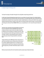
1
Caution Please respect and adhere to the copyrights of the image provider. While some image providers (most notably, governmental agencies such as USGS) provide image coverage free of charge and do not place restrictions on their use, most image providers have a copyright placed on the imagery they provide. That usually means that the imagery can be used for personal use only, limiting you from financially benefiting from your creations. If you’d like to create commercial photo-realistic sceneries with an intent of selling them, you must check if you are allowed to do so according to the terms and conditions of the image providers. Most image providers are in the business of selling the imagery if it is to be used for commercial purposes, so if you want to financially benefit from your work, you will have to obtain (purchase) a license to use the imagery in that manner. Also, please note that TerraBuilder, Inc. does NOT claim any copyright or implied ownership or license on the sceneries created using its software. Therefore, the designer is free to use scenery as they see fit, without any restrictions with respect to the TerraBuilder, Inc. and the design software we produce. TerraBuilder, Inc. shall not be held responsible in any way if the scenery/software designed using its application is used without permission, maliciously or in any other unlawful or otherwise inappropriate way. www.terrabuilder.com 1 Version Tracker Version Date Notes 1.00.00 Nov 17, 2012 Initial release. 1.01.00 March 5, 2013 Introduced Elevation Mesh support. 1.01.01 March 7, 2013 Maintenance release, minor UI fixes 1.01.02 March 9, 2013 Fixed multi source INF generation. 1.02.00 March 18, 2013 Added support for LOD in [Destination] block. Fixed grid toggle. www.terrabuilder.com 2 Contents 1. 2. 3. Introduction TerraBuilder FSX Requirements FSX Scenery Basics TerraBuilder FSX terminology What TerraBuilder FSX can’t do Comprehensive vs. Discrete tile design TerraBuilder FSX features 4. TerraBuilder FSX Application TerraBuilder FSX Application TerraBuilder FSX Application TerraBuilder FSX Application TerraBuilder FSX Application TerraBuilder FSX Application TerraBuilder FSX Application 5. elements – Overview elements – Project Properties Dialog elements – Image Element Properties Dialog elements – Elevation Element Properties Dialog elements – Image Element Options panel elements – Georeferencing Dialog FSX Scenery Design Concept Determining the scope and coverage of the scenery Acquiring the imagery from the imagery provider Optional: Creating alternate imagery (seasons/night time) Optional: Creating blending and water masks Creating custom elevated mesh scenery 6. Scenery Design Tutorial Tutorial 1: Photorealistic Scenery design Tutorial 2: Elevated Mesh Scenery design 7. Advanced Features 8. Design Tips and Tricks Combining the default FSX scenery elements with the PhotoRealistic scenery Working with water and blend masks 9. User Reference www.terrabuilder.com 3 1 Introduction The purpose of the TerraBuilder FSX application is to aid in creation of high-resolution photo-realistic and mesh terrain (elevation) scenery for Microsoft’s Flight Simulator X. This is achieved by importing pre-saved scenery images (tiles) and assembling them together into one large scenery with high resolution coverage. From our extensive experience in creating photo-realistic and mesh terrain scenery, we found this approach to be easier and less complicated than importing one extremely large image and creating a scenery out of it. The reason for this is that it is extremely cumbersome to deal with a single, huge image in image editing software (such as Adobe PhotoShop), which requires large memory swapping capabilities, long loading/saving times and choppy and cumbersome navigation to image sections (zooming and panning). Moreover, an image that is broken down to smaller components as a mosaic can be more easily fitted over the spherical surface, reducing or eliminating the need for WGS correction. The only drawback to such an approach is the tiresome and labor-intensive process of aligning a mosaic of images so that they seamlessly fit each other. Hence, the TerraBuilder FSX application was created to aid in this, and other, tasks. TerraBuilder FSX is essentially a tool that aids a scenery designer in assembling pre-saved image tiles (in BMP and RAW file format) into a single coherent scenery, enabling user/designer to match and assemble the imagery mosaic to a high degree of accuracy. The collection of images are saved in the Microsoft Flight Simulator’s SDK INF format, and can be later re-loaded for editing and scenery compilation. The use of INF file format eliminates the need for a proprietary “middle-man” file format and enables user familiar with the INF file format to quickly scan and edit the script in any text file editor. TerraBuilder FSX also acts as a front-end to the resample.exe application which comes as a part of the FSX SDK and is an essential tool in creating scenery files for MS FSX. Registered vs. Unregistered TerraBuilder FSX comes as a free download, but with limited functionality. You can purchase and register the software from within the application or from the TerraBuilder’s web site, both of which will direct you to a safe and secure PayPal payment processing. Once the payment is confirmed, TerraBuilder will send you a personal key code to activate the software. This will NOT happen instantaneously: The processing of the registration may take up to 24 hours. With a registered (paid) version, you can create a scenery project with unlimited imagery elements, up to 2880 x 2880 pixels in size (the application is able to handle as many imagery elements as it is practically allowable with respect to the graphics hardware and memory), and attach water and blend masks to them. You can save it to INF file, edit, compile to BGL (FSX scenery) and re-load this project for further editing. Some projects may balloon to a size that may become unmanageable due to its sheer expanse. Such projects are easily broken down to smaller collections of projects using “Save as” functionality. With an un-registered (free) version, you can do all of the above, however, if a project is saved to INF or compiled to BGL, only the FIRST image, along with its masks, if any, will be saved/compiled. www.terrabuilder.com 4 2 TerraBuilder FSX requirements TerraBuilder FSX will run on PCs using Windows XP, Windows Vista or Windows7 operating systems. TerraBuilder FSX does not require any special hardware to run, although a good video card and a lot of free memory will certainly help in the operation of the software, as with any other application. TerraBuilder FSX also needs rersample.exe application, which is available with the properly installed and activated FSX SDK. FSX SDK comes only with Deluxe version of FSX, although there may be a way to install it using the ordinary version of FSX. Also, while this is not critical to TerraBuilder FSX software, please note that there are several service packs and upgrades of FSX SDK that need to be installed. Please consult www.fsdeveloper.com site for all the latest info on installing the FSX SDK. A fair amount of image editing is required in order to create professional-looking PhotoRealistic sceneries, so a good knowledge and ownership of high-end image editing software, such as Adobe PhotoShop, is highly recommended. For elevated scenery creation, a high-end image editing software capable of creating 16-bit grayscale bitmaps and saving them in RAW file format (such as a recent version of Adobe PhotoShop) will be absolutely necessary. www.terrabuilder.com 5 3 FSX Scenery Basics Photo Realistic scenery creation: The default world of Flight Simulator X is largely made of a grid of generic landscape images, with many landscape types coming in many different variations. These landscape images are arranged like tiles and cover the entire surface of the virtual Earth. Different types of landscape seamlessly blend into each other, avoiding otherwise very prominent “sharp edge” effect. Flight Simulator X allows for layers of landscape image tiles to be placed on top of this default layer, allowing users to enhance the look of the localized scenery area with high altitude, high resolution aerial imagery. This is the preferred way of depicting the landscape, however, due to the sheer size required, it would be impossible to cover the entire globe with the high resolution imagery. It is, however, possible to create smaller, localized (depending on the resolution) coverage that is of particular interest to user/client/community. Such scenery can be created using the tiles captured from various sources and assembled together to form a single, cohesive landscape. In addition, the tiles can be associated with special textures that define where the landscape “fades out” (and where the underlying default scenery will show through). These special textures are called “Blend Masks” Also, the tiles can be associated with special textures that define where landscape contains water surface, which will then be rendered as water by the FSX rendering engine. These special textures are called “Water Masks” Finally, the seasonal version can be created, depending on the climate of the area, and have it associated to the month of the year when the seasonal variation is applicable www.terrabuilder.com 6 3 FSX Scenery Basics Mesh terrain (elevation) scenery creation: The default world of Flight Simulator X is covered with a fairly accurate, global topographic mesh terrain. This default topography, however, may contain omissions, errors, or is sometimes simply not accurate enough to depict local variations and details that may be important to a user with a specific area of interest. Flight Simulator X allows for addition and modification of the default topography by allowing user to create mesh terrain “add on” files which will then be incorporated together with the default topography. These add-on topography files override and take precedence over the default terrain. Several various formats are accepted as topography sources, and the processing is accomplished by using FS SDK’s resample.exe in a process similar to Photo Scenery design. The sources of topography data are usually governmental agencies that provide it for free, as GIS data sets. It is relatively easy to obtain and create INF file for well known elevation data formats and compile it as a FSX terrain scenery. However, editing such data sets to correct data gaps, errors and omissions can sometimes be cumbersome or impossible. TerraBuilder FSX goes a step further in allowing user to create their OWN terrain maps and easily compile it into mesh scenery. This is accomplished by creating grayscale bitmaps and saving them in RAW format – a task easily accomplished in PhotoShop image editing software. This approach can be used to create landscape details that were omitted in the original topography, or were added (or removed) www.terrabuilder.com 7 3 FSX Scenery Basics TerraBuilder FSX Terminology Term Description FSX Abbreviation, stands for “Flight simulator X”, the latest in the family of Microsoft’s flight simulator titles BGL A proprietary Microsoft file format used to store information about scenery used in Microsoft’s Flight Simulator series INF A text-based file format used to describe the components of the scenery and how and where to create it SDK Abbreviation which stands for “Software Development Kit”, refers to the FSX Software Development Kit available in the Deluxe edition of FSX resample.exe A console application provided by Microsoft that is used in compiling INF file script into BGL scenery file. You must install the Microsoft’s FSX SDK to obtain this application Scenery Image tile, Image Tile, Image A discrete image, in BMP file format, that represents an aerial picture of the scenery being created. In INF file, a discrete image is described as a [source] element. Water mask, WM A grayscale image in BMP format that describes the areas where the water will appear in the scenery. In INF file, a discrete image is described as a [source] element. Blend mask, BM A grayscale image in BMP format that describes the areas visible and invisible in the scenery. Used to seamlessly blend the photorealistic scenery with FSX’s. In INF file, a discrete image is described as a [source] element. Project A collection of Image tiles, blend masks and water masks that make up a scenery. Project is saved and loaded as an INF file. Georeference A process of defining the world location and size of the Image tile Default Scenery Scenery that comes with FSX Add on scenery Scenery that can be created and added to the default FSX scenery database Elevation map, terrain map A set of numbers, in digital format, that is arranged in a grid and depicts elevation points along regular intervals. Mesh Terrain Scenery A scenery that defines the topographical features of the landscape, in 3 dimensions. www.terrabuilder.com 8 3 FSX Scenery Basics What TerraBuilder FSX can’t do TerraBuilder FSX application will not automatically locate, download and slice the imagery - this task is left up to the user. Some scenery design applications in the past have provided user with a one-click photorealistic scenery design creation by automatically downloading coverage imagery from specified imagery servers. These applications proved to be short-lived, as the proper flight simulator scenery design involves many intricate steps and requires a high degree of image-editing skill. Scenery creation is more of an artistic than an analytic skill, and as such cannot be automated if the high quality product is desired in the end. A proper Flight Simulator scenery must include several layers of imagery so that all environmental aspects of the landscape can be properly depicted. The layers of the imagery include: Seasonal variations (usually 5 versions of the same image: spring, summer, fall, winter and hard winter) Night time illumination Water area definitions Blending area definitions Depending on the location of the scenery, some of those layers will not be necessary. For instance, a scenery area covering a desert landscape will not require seasonal variations, possibly no water mask and not even night time illumination. Care should be taken when choosing which area will be covered, so that the scope of the entire project can be determined in advance. Images in TerraBuilder FSX are always assumed to be oriented to true north, and CANNOT be rotated. TerraBuilder FSX has a limitation of being able to load imagery only in BMP file format (no GeoTIFF or TIFF files, which are supported by resample.exe). This limitation may be removed in the future versions, depending on the necessity of the feature. TerraBuilder FSX has another limitation of an image size of 2880x2880 pixels. This is due to the limitation of the internal architecture of the graphical layer used to build the application. This limitation, however, is an abstract one, as most screen captures of the imagery tend to be of the screen resolution, which does not usually go beyond 1920x1200 pixels. Also, there is no observable theoretical limitation to the number of tiles that can be used in a scenery project, so the per-image size limitation becomes a non issue in practice. The apparent size limitation also brings up another important aspect of scenery design: Difficulty of projecting large, flat image on the curved surface. The problem is that the large, flat imagery will inherently display errors in alignment when projected onto the curved surface of the Earth. In order to minimize these errors, it is advantageous to subdivide large image into smaller, discrete chunks which will fit onto the curved surface with smaller alignment errors – a concept explained in detail in the following section. www.terrabuilder.com 9 3 FSX Scenery Basics Comprehensive Vs. Discrete tile design These diagrams illustrate the difference between comprehensive and discrete design approaches. Ordinarily, in comprehensive design approach, user would either download or assemble a large (comprehensive) scale bitmap, and submit it to resample.exe utility for scenery creation. This approach is favored if the designer is manually editing the INF file, since only one source section needs to be created. However, this approach introduces large errors that show up when a flat image is fitted over a large curved area, such as the surface of Earth. With the discrete design approach, the imagery is saved in small, discrete images that are adjacent to each other, with small edge overlaps. This task is greatly facilitated by using TerraBuilder’s visual design approach, freeing the designer from tedious INF formatting while introducing a high level of precision and automatization. More importantly, the discrete approach subdivides the area covered into smaller tiles that more easily fit over curved area, and thus greatly diminish the overlap errors and gaps, compared to the comprehensive approach Comprehensive Discrete Large overlap Large gap With large, comprehensive approach to scenery design, large-scale imagery introduces overlap errors when fitted to the curved surface of the Earth www.terrabuilder.com The coverage error is greatly reduced when using smaller, discrete tile sizes. The larger tile granularity allows for more accurate fit over the curved surface. The overlap errors are on a smaller scale, and therefore less pronounced and easily blended by using overlapping tiles. 10 3 FSX Scenery Basics TerraBuilder FSX features If you are already familiar with FSX scenery design, you will find some of the highly advanced TerraBuilder FSX features very useful. While the knowledge of FSX scenery design and FSX Software Development Kit (SDK) terminology will be highly useful, it is not necessary to be familiar with all its nuances – TerraBuilder FSX has been developed with simplicity and the ease of use in mind from the beginning. However, some basic geography concepts are essential for proper understanding and the use of this application. These concepts will not be covered in this document, and it will be assumed that the user is familiar with them from the outset. So, let’s list some of the main features of TerraBuilder FSX: Complete freedom in inserting and adjustment of imagery tiles – you can easily select and move imagery tile to adjust for the position and fit. Easy to use, simple and intuitive interface: easily pan, zoom in and zoom out of the area worked on, select tiles and adjust parameters using clear and simple dialogs There are no proprietary project file formats: TB FSX directly reads and writes FSX SDK INF files, which are simple text files viewable in Notepad or similar applications Integrated resample.exe functionality: TB FSX will automatically prepare and execute a script that will create a BGL file directly from your project Support for elevated mesh scenery through RAW image format, editable in image editing software such as PhotoShop. Ability to create disjointed coverage Ability to mix high resolution and low resolution imagery for the same area Group selection and moving of imagery tiles Easy two-point calibration of the imagery – only the first image of the project needs to be calibrated, and all the rest of the images are then fitted by slight overlapping Complete set of editable image tile properties Complete control of the water/blend masks, with proper display of the visible and invisible areas. As you design your masks, you can check what parts will be visible and what parts will be masked Ability to assign temporal tags to the imagery (seasonal variations) Imagery filters – you can view your project by the type of imagery you are using (imagery, masks, seasons, etc.) Loading several INF projects into a single project, or separating a large INF project into several smaller ones One step scenery creation – compiling and creating the scenery file is as easy as clicking on a button. All the scripting and set up is taken care of automatically. Control over the User Interface look and feel (WARNING: TerraBuilder FSX does not have UNDO functionality so, as you are working on a project, SAVE your work often.) www.terrabuilder.com 11 4 TerraBuilder FSX Application Navigating in TerraBuilder FSX Operation Description Selecting Image tile(s) To select a single image tile, click on it. To select multiple image tiles, hold down SHIFT and click on the images. Every image tile that is selected has a white frame around it. Making a selected image active Hold down SHIFT and click on an already selected image (from a multiple selection) to make that image selected and active. A single selected image is active by default. Panning To pan around the project, hold down the SPACE bar on the keyboard and left-click and hold anywhere on the project area. Move the mouse while holding the mouse button and SPACE bar down to pan around the project . When panning is active, cursor will change into a “hand” symbol. Zooming In To zoom in on an image, hold down CTRL keyboard button and left-click on the specific point you’d like to zoom in on. Zooming in will be limited to about 3X the magnification. Zooming Out To zoom out, hold down CTRL and SHIFT keyboard buttons and left-click on the specific point you’d like to zoom out on. Zooming out is unlimited. If you “lose the sight” your imagery while zooming out, use View/Fit on screen menu option to re-center the imagery in the desktop area. Locking Locking is very useful when an image has been aligned (or georeferenced) in the proper position. In that case, it is a very good idea to lock the location of the image tile using the “lock” button Move selected image tile To move single image, click on the image tile and select it. If it is locked, unlock it. Left-click and hold, and move the mouse to move the image tile. Move multiple image tiles To move multiple images, select image tiles by holding down SHIFT and left-clicking on them. Unlock them all if locked. Hold down SHIFT while left-clicking on any one of the images and drag. All of the selected images will move. Move single or multiple image tiles by a small amount To fine-tune the position of the image tile(s), select image tile(s) by holding down SHIFT and left-clicking on them. Use keyboard directional arrow buttons to move the image tile(s) by one-pixel increments in up, down, left and right directions. Select a single image within a multiple selection Within the multiple selection of image tiles, hold down SHIFT and click on the image. This will make the selected image tile active, as well as selected. Viewing/Hiding tiles You can hide/unhide selected image tile(s) by using Main menu’s View options. See Reference (Section 9) for more info. Changing layering order of the image tiles To view or select image tile(s) that may be partially or completely overlaid by other image tiles, you can “push down” the image tile by using send to back button. www.terrabuilder.com 12 4 TerraBuilder FSX Application TerraBuilder FSX Application elements - Overview A. B. Main Menu toolbar Controls the general application operations (loading, saving, compiling, selecting, viewing) Application toolbar Contains options for interacting with the scenery project elements (grid, cursor shape, panning, moving, zooming) C. Image Element Options panel Lists the parameters and operation options for a single Image Element D. Coordinate Display bar Shows the real-time geographical coordinates of the cursor E. Zoom Factor readout Shows the level of the magnification, with 1:1 pixel being 1 F. Project Properties dialog Contains editable parameters pertaining to the overall scenery project G. Tile Properties dialog Contains editable parameters of the individual Image element H. Work area A desktop area where a scenery project mosaic is assembled I. Coordinate Display Format toggle Toggles between decimal degrees and Degree:Minute:Second coordinate display format J. Active Tile indicator Indicates which Image Tile, among the selected ones, is active. K. Grid Dynamic grid overlaid on top of the imagery, showing the latitudinal and longitudinal lines. L. Selector frame Denotes that the image tile is selected (but not necessarily active) B A J F L C G H K E www.terrabuilder.com D I 13 4 TerraBuilder FSX Application TerraBuilder FSX Application elements – Project Properties Dialog Project Info tab A. B. C. D. Current INF – shows the name of the current INF file, if saved. Project Directory - shows the location of the current INF file. Imagery element – shows the type and count of the imagery elements (images and masks). Project Scale – shows the projectwide scale, based on the first image added and inherited by all subsequent image elements. A B E F H Interface tab E. F. Colors – Enables selection of desktop background and grid colors. Click on the color box to change. Grid Transparency – slider specifies the transparency of the grid. Full left is completely transparent, full right is completely opaque. Other tab G. H. Resample.exe location – shows the location of the valid Resample.exe file. If this file is missing or the path is invalid, user is prompted to locate it. This is also valid for the first-time run of the application. BGL file compilation cannot proceed without this parameter. LOD Selector – Shows and sets the range of LOD in the [Destination] block. See SDK documentation for more info . G C D Apply – Applies the changes, if any, and keeps the dialog open. OK - Applies the changes, if any, and closes the dialog. Cancel - Discards any changed values and closes the dialog. www.terrabuilder.com 14 4 TerraBuilder FSX Application TerraBuilder FSX Application elements – Image Element Properties Dialog For detailed description of these parameters, please see The Resample Tool section of the Terrain and Scenery SDK Location & Sampling tab A. B. C. D. Image – shows the file name of the selected image tile. Image Location – shows and sets the latitude and longitude of the top left corner (anchor) of the selected image tile. Editable, single selection only. Null Value – shows, clears and sets the value of the RGB color Null Value parameter. Editable, single selection only. Parameters 4 and 5 are not supported (see SDK documentation for more info). Sampling Method – shows, clears and sets the preferred sampling method of the selected image tile. No selection indicates that no INF entry will be present, and the default (Gaussian) will be used. Works with multiple selections. A E G B C F Resolution & Variation tab E. F. Image Resolution – shows the Longitudinal and Latitudinal resolution of the image, equivalent to xDim and yDim parameters in SDK. Image Variation – shows and sets the temporal variation (seasonal and night/day textures) of the selected image tile. No selection indicates default “Day” setting. “All” indicates both day and night (not darkened at night). Works with multiple selections. Extents & Masks tab G. H. Image Extents – shows the latitudinal and longitudinal extents of the image. Non-editable. Image Masks – shows the indexes of the water and blend masks, if any. Non-editable. D H Apply – Applies the changes, if any, and keeps the dialog open. OK - Applies the changes, if any, and closes the dialog. Cancel - Discards any changed values and closes the dialog. www.terrabuilder.com 15 4 TerraBuilder FSX Application TerraBuilder FSX Application elements – Elevation Element Properties Dialog For detailed description of these parameters, please see The Resample Tool section of the Terrain and Scenery SDK Location & Sampling tab A. B. C. D. Image – shows the file name of the selected image tile. Image Location – shows and sets the latitude and longitude of the top left corner (anchor) of the selected image tile. Editable, single selection only. Null Value – shows, clears and sets the value of the RGB color Null Value parameter. Editable, single selection only. Parameters 4 and 5 are not supported (see SDK documentation for more info). Sampling Method – shows, clears and sets the preferred sampling method of the selected image tile. No selection indicates that no INF entry will be present, and the default (Gaussian) will be used. Works with multiple selections. A E G B C F Resolution & Variation tab E. F. Image Resolution – shows the Longitudinal and Latitudinal resolution of the image, equivalent to xDim and yDim parameters in SDK. Elevation Scaling – shows and sets the Scale and Bias parameters that control the elevation extents of the H D Extents & Masks tab G. H. Image Extents – shows the latitudinal and longitudinal extents of the image. Non-editable. Elevation Map display – switches elevation map between normal and shaded display style. This option is non-persistent (it will not be saved in INF file) Apply – Applies the changes, if any, and keeps the dialog open. OK - Applies the changes, if any, and closes the dialog. Cancel - Discards any changed values and closes the dialog. www.terrabuilder.com 16 4 TerraBuilder FSX Application TerraBuilder FSX Application elements – Image Element Options panel For detailed description of some of these parameters, please see The Resample Tool section of the Terrain and Scenery SDK A. Image Latitude and Longitude – shows the real world position of the upper left corner of the image (anchor). B. Image width and height – shows the physical pixel size of the image. C. Type, Layer, Channel– Lists the parameter of the image. Used to differentiate between image and mask types. For more information, refer to the Terrain and Scenery SDK documentation. D. Index – Lists the true index of the image, regardless of its display priority on the desktop. Index of the image is essentially the order in which the image was added to the project. Index number is used in attaching the masks, C E. Transparency pop out – Reveals a small menu where the values of the image transparency can be changed. This is used to aid in aligning the imagery. D F. Tile Properties – Invokes an Image Element properties dialog. G. Georeference - Invokes a georeferencing process on the Image Tile. E H. Add Water Mask – Opens a dialog to choose a water mask. F I. Add Blend Mask – Opens a dialog to choose a blend mask. G J. Delete selected – Deletes the selected image(s). Careful – there is no UNDO operation. H K. Lock – Locks the position of the image so that it cannot be geospatially moved. This is done when the image tile has been georeferenced or properly aligned, to prevent unintended dislocation of the image tile. I L. Visibility – Temporarily shows and hides the image. Useful when checking overlap alignment. NOT the same as “Hide Selected” option in M. Send to back - Sends the selected image(s) to the back, (changes the display order) revealing what was layered under them. Does not change the image order. Useful when working with masks, or in multi-resolution mosaics. A B J K www.terrabuilder.com L M 17 4 TerraBuilder FSX Application TerraBuilder FSX Application elements – Georeferencing dialog A. First point dialog – The first portion of the dialog displays when the first point is being specified. B. Second point dialog – The second portion is revealed when the second point is being specified. C. Selected pixel location – Latitudinal (vertical) pixel location and the Longitudinal (horizontal) pixel location (from the top left corner of the image) of the first point. D. Current pixel location – Latitudinal (vertical) pixel location and the Longitudinal (horizontal) pixel location (from the top left corner of the image) of the cursor location above the image. A E. First point Latitude and Longitude coordinates – Latitude and Longitude of the first point are entered in these boxes. B F. Second point Latitude and Longitude coordinates – Latitude and Longitude of the second point are entered in these boxes. G. Image being georeferenced – prominent features on the image, such as water towers, smoke stacks or road intersections, can be used as georeferencing points, by entering their real-world geographical coordinates obtained from the image provider. C G E D F Done – Applies the values, calculates the image location and closes the dialog. Cancel - Discards any values and keeps the image in the original location. www.terrabuilder.com 18 5 FSX Scenery Design Concept TerraBuilder FSX design concept is based on the following steps: 1. Determining the scope and coverage of the scenery The very first step is to determine what exactly will be represented in the scenery, and deciding on the best possible approach to accomplish this. 2. Acquiring the imagery from the imagery provider This process consists of going to an imagery provider site (such as USGS Server, TerraServer, WorldWind,…), finding the appropriate imagery and the desired level of zoom, and manually capturing and saving the image in the BMP image file format. This might be the most time-consuming process, and it needs a careful planning and approach (explained later). However, once mastered, it can go pretty quick – it is possible to design a decent-sized scenery in under an hour. 3. Optional: Creating alternate imagery (seasons/night time) This process usually consists of duplicating the main image and adjusting coloring in image editing software to reflect the desired season, or time of day (night time) 4. Optional: Creating blending and water masks This process usually consists of duplicating the main image and using it as a template to create areas in the image where there is water surface and painting it white, while leaving “dry land” black. With blending masks, the process is similar, where the areas that will be visible are painted white, while the invisible areas are left black. 5. Creating elevated mesh scenery This process is used to change topography of the default scenery. A custom elevation map can be created and used to add topography features or remove default topography features. TBFSX reads any RAW file, up to 2880x2880 pixels in size, so if the DEM or GEOTiff files can be exported to RAW format, the original topography can be edited. 6. Assembling the imagery mosaic in TerraBuilder FSX (Covered in Section 6: Tutorial) This is where the “fun” part begins – creating the scenery out of the imagery tiles you prepared. 7. Compiling imagery into a scenery file (BGL) (Covered in Section 6: Tutorial) This process is a simple click of a button – TerraBuilder FSX creates a script which invokes FSX’s resample.exe application which in turn creates the scenery file, ready for use in FSX www.terrabuilder.com 19 5 FSX Scenery Design Concept 1 - Determining the scope and coverage of the scenery The first and the most essential step in starting the process of photorealistic scenery design is determining exactly what will be the intent of the scenery, and deciding on the best possible approach to realize that intent. Here are a few simple questions that the designer needs to ask before embarking on the design: 1. Is there an imagery available for the desired scenery, and if so, what quality is it? Sometimes, the imagery available may be of low quality, with unfavorable lighting angles (long shadows and high contrast relief), missing coverage areas, differing coverage areas with visible transitions, and so on. In such cases, it may be possible to fix the bad areas using image editing software. In other cases, the imagery might have undesirable objects in it, such as aircraft parked on aprons and taxiing on runways. Likewise, in such cases, some image editing may be required to remove such undesirable artifacts. 2. Will the seasonal and night time imagery be required? This has to be carefully considered, as the amount of work to accomplish this can easily balloon to unmanageable proportions. If the seasonal imagery is required, the original images will need 4 or more versions with seasons and night time variations. Depending on the skill of the image editor, this task may be quite demanding, as the seasonal variations and snow coverage require subtle color changes that still have to look different from season to season. Modifying image to look snowed in may as well be a challenging task. 3. Are there a lot of intricate shorelines in the area covered? Intricate shorelines demand a very precise and careful creation of water masks, which can be quite time consuming. 4. Will the scenery be used for low-level bush flying, or will it be viewed from larger altitudes? If used for low-level scenic flights, the scenery is usually small in coverage but high in detail. Conversely, if used for high altitude flying, a higher coverage but low detail (lower resolution) imagery can be used. 5. Are there any airports and runways that will be visible in the scenery? If so, the position of the scenery might have to be adjusted to closely match the position of the default FSX airport. This might not match the real-life position, but it is far easier to match the scenery to the existing airport/runway than to remove the default runway and re-build it to match the scenery. The default runway angle sometimes does not match the angle in the imagery, so the imagery might have to be slightly rotated to get the exact match. See section 7 for more info. www.terrabuilder.com 20 5 FSX Scenery Design Concept 2 - Acquiring the imagery from the imagery provider The next step in the scenery design is the acquisition of the imagery itself. Let’s use Google Earth as an example of image provider in this case: First, with the area of interest selected (basically deciding what exactly will the scenery cover), we will decide on the resolution of the imagery. This is a simple task of deciding how much of the detail will be visible in the scenery: Will the user be able to spot their own house from the air, or just general landscape features? Usually, a good high resolution scenery is where individual vehicles can be spotted on the road, and to get to that level of resolution in Google Earth, simply zoom in on the area you’d like to create in the scenery. A good way of determining (and remembering) the resolution in Google Earth is the “altitude” readout: the lower the altitude, the higher the resolution of the imagery is. Let’s assume that an altitude at which the imagery looks nice and crisp is 520 meters. REMEMBER / NOTE this value, as you may inadvertently zoom in or out from it, and you’ll have to get back to that exact zoom level. The idea here is to take a screenshot (capture) of the area (Google Earth has an option for that) and then move on to an adjacent area. This can be accomplished fairly easily by (using a mouse) scrolling the area horizontally, from top right corner to top left corner, taking a screen capture and then repeating the process for the next adjacent area. The important thing to note is that, by doing it this way, a small overlap area is left on sides of both images, and this area will be used later to line up the images for a seamless fit. The same principle applies to top/down move-and-capture process, always leaving a small area of the imagery overlap that will be used for lining up the imagery. The images created this way are stored as BMP imagery and named in consecutive numbers. The pattern of capture is not important, as long as it is consecutive and orderly, so that the assembly of the mosaic within the TerraBuilder FSX application will be easier. The best patterns are usually horizontal rows started from the top left of the area of coverage, and moved down to bottom right, as depicted in the graphic below: (note the transition of direction between captures 6 and 7 and 12 and 13) 1 2 3 4 5 6 12 11 10 9 8 7 13 14 15 16 17 18 21 20 19 While this process may feel cumbersome at first, with a bit of practice it will be possible to quickly capture large areas of high-resolution landscape. www.terrabuilder.com 21 5 FSX Scenery Design Concept 2 – Continued: Acquiring the imagery from the imagery provider The resolution of the screen captures will be determined by the size of the screen display. The size of the capture can be anything up to 2880 x 2880 pixels (a limitation of the graphics library used in creating the TerraBuilder FSX application). Once created, it is a good idea to assemble them in the PhotoShop file, with each capture on a different layer. That way, it is easy to review them and sequentially save them in BMP format, numbered in the same sequence they were taken. More tips on imagery acquisition: If applicable, (as in Google Earth), make sure the terrain height (topography) rendering is turned off – all we want for this purpose is the flat image, without any distortions. If applicable, make sure that water effects and lighting effects are turned off as well Make sure that the view is straight top-down, not an oblique view (which will, obviously, introduce distortions). Finally, make absolutely sure that the straight top-down view is oriented with true North straight up – FSX assumes that the imagery is always “upright”, pointing to the true north**. **An exception to this is if the scenery is to be aligned to the already-existing airport. In that case, a slight deviation form the true north alignment is tolerable, for the sake of alignment with the default scenery. See section 7 for more info. www.terrabuilder.com 22 5 FSX Scenery Design Concept 3 - Creating alternate imagery (seasons/night time) The task of creating alternate seasonal/temporal imagery is an important step in production of high-quality photo-realistic scenery. It is important for the user to feel the suspension of disbelief while flying over the created scenery, and that feeling will certainly be augmented by the properly designed and implemented seasonal variations of your scenery. It would be highly distracting for the end user to use a photo realistic scenery which does NOT contain seasonal variations, while the default scenery around it has them: The photorealistic scenery would, in that case, look awfully out of place, with, for example, summer areas in the middle of snow covered default scenery. The best way to ascertain the extent of work needed on the seasonal imagery is to look at the same area of coverage within default textures, during all seasons. Some areas of the world change very little (if at all) during seasons, so the seasonal image variations may not be needed at all. The actual creation of seasonal variations and night time versions of the photorealistic imagery is usually done in a photo-editing software such as Adobe PhotoShop, and is beyond the scope of this user manual. It requires a bit of experience and skill in adjusting specific color bands to enhance or diminish colors that would be present/absent during the specific seasons. www.terrabuilder.com 23 5 FSX Scenery Design Concept 4 - Creating blending and water masks As with creating the seasonal variation textures, the task of creating blending and water masks is extremely important step in production of high-quality photo-realistic scenery. Blending and water masks are a simple grayscale images in BMP file format which define areas with different properties in the “parent” image file. Each image tile can have both water and blend masks, or only water or blend, or none, depending on its position and type of landscape it represents. Water and blend masks are of the same size as the “parent” image tile. Blend mask is a grayscale image in a BMP file format which defines what portion of the “parent” image will be hidden and what portion will be visible. This is extremely useful in fitting the photorealistic scenery over the default scenery, by blending the edges of the photorealistic scenery gradually for a smooth transition (otherwise, the sharp differences in the terrain type would be obvious). The blend mask is created in an image editing software by tracing the transition limits over the “parent” imagery, and filling the visible areas with white, and invisible with black, making sure in the process that the transition between the visible and invisible is gradual, with shades of grey. This is done with “feathering” option applied to the selection mask of the area, and is beyond the scope of this discussion. Water mask is a grayscale image in a BMP file format which defines what portion of the “parent” image will be shown as dry land and what part will be covered with water. This is extremely important segment of the scenery, because, if not included or designed improperly, a sharp transition between default water coverage and added scenery will be visible, and look extremely unnatural. The water mask is created in an image editing software by tracing the water areas (lakes and sea/ocean shorelines) over the “parent” imagery, and filling the water areas with black, and land with white, making sure in the process that the transition between the visible and invisible is sharp (as opposed to gradual with blend masks) because the shorelines usually have a sharp line where water and land meet. Likewise, the technical details of creation of water masks are beyond the scope of this discussion. www.terrabuilder.com 24 5 FSX Scenery Design Concept 5 - Creating elevated mesh scenery TerraBuilder FSX allows for the import and compiling of RAW files, which can be used to define an elevated mesh topography. RAW files are the simplest kinds of files, consisting of pure numbers, without any information (usually contained in file HEADERS) on how those numbers are arranged or how many of them there are. Those numbers can be of any bit depth or precision, but in our case, TBFSX will consider them to be in the UNSIGNED INTEGER format of 16 bits in length (UINT16 value for the SampleType parameter in the INF file). This format allows for a numerical range from 0 to 65535, which is plenty of precision for the purposes of designing Earth topography, which ranges from 0 to 8848m ASL. The RAW files can be created using a high-quality image editor application, such as PhotoShop. To create a custom elevated mesh topography map, simply create a new bitmap of any size up to 2880x2880 pixels, and specify color mode as grayscale and 16 bit (these settings can be found in the PhotoShop's New Image dialog, but can also be set after an image has been created or opened). After the image is created, any of the image editor’s drawing tools and filters can be used to create grayscale image that represents topography (which means, an image that consists of pure black, pure white, and all the shades of grey in between), with one simple rule: The brighter the image pixel is, the higher the elevation will be. The actual elevation extents will be defined in the TerraBuilder FSX application (for example, the same image can be used to define a hill 30 meters in height, or a mountain 3000 meters in height). Using the tools and techniques available in image editing software, it is possible to create a wide variety of topographical features, as in the examples below: A. B. C. D. E. F. A sample of a hilly, uneven terrain created with a cloud filter and faded on the edges An example of a geometric shape (pyramid) using nothing but gradient fills. A quick example of channels, causeways, holes and bumps, illustrating both holes and bumps in one map An example of a canyon or gorge, built as a "negative" elevation. A hand made volcano with eroded slope... made using a fading, transparent brush. An example of how a road overpass and underpass can be built: Overpass goes above underpass, which "digs in" slightly into the flat terrain. Obviously, a 3D bridge object would be inserted here. A B C A B C D E F D E F www.terrabuilder.com 25 5 FSX Scenery Design Concept 5 - Creating elevated mesh scenery (continued) FSX actually recognizes SIGNED elevation values ranging from -32767 to 32767 (again, more than enough to represent deepest gorges and tallest mountains). When using PhotoShop, however, RAW files are saved in UNSIGNED binary format, so FSX will interpret a value of 32768 as -32767 (or, it will roll over the value). Therefore, it is important to avoid elevations above the value of 32767 meters (and obviously, there is no need for such elevations on Earth). Using the Elevation Element Properties dialog, TerraBuilder FSX allows for precise specification of the minimum and maximum extents of the altitude range using the Bias and Scale parameters, and has an indicator of this rollover – the invalid value for the Maximum Altitude will turn red to warn of this somewhat “unexpected” behavior. Because of the above behavior, the default value of the SCALE parameter is set to 0.5. In other words, any RAW map (with a full range of grays from pure black to pure white ) inserted into TBFSX will have default Scale value of 0.5 and Bias of 0, which will translate into an altitude range of 0 meters minimum to 32767 meters maximum. These altitude ranges can then be adjusted either directly (which will recalculate Scale and Bias parameters) or by adjusting the Scale and Bias parameters (which will re-calculate minimum and maximum altitude values). When SAVING the RAW file format in PhotoShop (or other image editor), specify Header size as 0, and select Byte Order as IBM PC The dimensions of the bitmap will also have to be noted (or remembered) because the RAW format doesn’t contain any info on how wide and high the image was. Usually, the width or height dimension can be calculated by specifying other dimensions, and knowing how large the actual file is and how many numbers of certain size (16-bit, to be precise) are expected. Therefore, when importing a RAW file into TerraBuilder FSX, user will be prompted to enter the width of the RAW image. Another shortcoming of the resample.exe utility is that it does not allow for mixing of the imagery and elevation elements in the INF file (the INF file containing both types will fail to compile using resample.exe utility). Since TerraBuilder FSX allows for mixing of both types in a single project, it will prompt user to specify which type of element is to be saved to INF file and/or compiled to BGL file. This means that a project that contains both imagery and elevation elements will have to be saved into two different INF files, each containing exclusively imagery elements (with water and blend masks, if any) or elevation elements. www.terrabuilder.com 26 6 Scenery Design Tutorial 1 Assembling the imagery mosaic in TerraBuilder FSX If you haven’t done so, please download TBFSXTutorial01.zip file from here – it contains all the necessary files for this tutorial. While all the steps up to now were in preparation of the image tiles and water/blending masks, this part involves the actual use of TerraBuilder FSX application. The image tiles and their blending and water masks that have been prepared in the previous steps can now be loaded into the application and assembled into one coherent scenery area. The first step is to load the first image tile and “georeferencing” it. This means locating the image in the real world, and giving it real world dimensions. Georeferencing is a simple process of defining two points in the image and giving it geographical coordinates. Using this information, the application will calculate the size and position of the image tile. This process is needed only once, because subsequent imagery tiles will be fitted by using slight overlaps on their edges. The resulting scenery will be extremely accurately positioned, assuming the fitting of the overlaps was done as accurately as possible. If this was not the case, a cumulative imprecision will cause the scenery to drift with each progressive image tile, resulting in a progressively larger positional error. This imprecision will manifest through the misalignment with the default scenery. So – let’s start using the TerraBuilder FSX application by assembling a simple photorealistic scenery. Here’s the procedure, step by step: (WARNING: TerraBuilder FSX does not have UNDO functionality so, as you are working on a project, SAVE your work often.) Step Operation Result / Comments 1 Start the TerraBuilder FSX application. Application opens with the splash screen in the work area. 2 From the File menu located on the Main Toolbar, find and click on the Insert Map option. 3 Navigate to where you’ve unzipped the tutorial imagery, choose a HMB_01.bmp image and open it. The texture map will open and display in TerraBuilder FSX. Also, since this is a new project, a Georeference Dialog will be displayed automatically. This dialog will allow us to place and size this image in the real world space. The very first image loaded will, by default, be placed at the origin of the coordinate system (N0:00:00, E0:00:00) and will be used as a “keystone” (starting point) of the whole scenery. Georeferencing will allow us to place and size it in the real world, and all the rest of the images will use this first image to orient themselves. Our project now consists of a single image, placed in the workspace. We can’t really do anything with it now because the image has not been positioned and sized in the world coordinate system. If we were to choose cancel at this point and try to create scenery out of this image, resample.exe would report compilation errors because the image doesn’t have the proper parameters set yet. So, let’s continue with defining the parameters of this image by giving it its location and size. www.terrabuilder.com 27 6 Scenery Design Tutorial 1 Continued: Assembling the imagery mosaic in TerraBuilder FSX Next, we’ll define image’s geographical location and size (coverage) by georeferencing the image in a real world geographical coordinate system. This is done by specifying geographic locations of two points on the image. The points on the image are usually some easily recognizable geographical landmarks, such as landmark buildings, intersections, lighthouses, etc… as a matter of fact, they can be ANY feature in the image, as long as you can locate the same feature within image provider’s viewer (such as USGS Server) and read off he geographical location of that feature. For best georeferencing results, try to pick points on the image that are diametrically opposed and as far from each other as possible – that way the precision of the calculation is increased. Follow these simple steps to georeference our image: Step 4 Operation Result / Comments Move the cursor to a upper left area of the image and locate a small cape, as in the picture to the right. Click on it. In the edit boxes on the Georeference dialog, enter the following values using the keyboard: Landscape features, such as the small cape, are used to easily locate a specific feature in the image and its corresponding geographic location. The geographic coordinates were read off the imagery provider application, in this case, USGS Server, and are used here. 37.524220, -122.517874 5 On the Georeference dialog, click Next. Another part of the Georeference Dialog displays on the bottom. 6 Move the cursor to a bottom right area of the image and locate a small circle near the middle of the runway, as in the picture to the right. Click on it. In the edit boxes on the Georeference dialog, enter the following values using the keyboard: The best georeferencing results are achieved when the 2 georeferencing locations are diametrically opposed. 37.513918, -122.499973 7 On the Georeference dialog, click Done. The image is now properly located and sized in the real world coordinates. The image is now locked in place as well, unable to be moved inadvertently, until it is unlocked. SAVE the project (remember, there is no UNDO feature). Entering the positions of 2 points on the image and their corresponding Latitude/Longitude locations provides all the information needed for the scenery to be properly located and sized in the real world. Our project now consists of a single image, placed correctly in a real world geographical coordinate system. Technically, our project is now a true scenery and we could compile it and use it within FSX. However, it would look odd, because it’s edges would sharply stand out against FSX’s default scenery and it would look like an image laying flat on the ground. Also, water surfaces in the image would look flat, without any water effects, like the rest of the water in FSX. Let’s fix those problems by adding blend and water masks in the following section. www.terrabuilder.com 28 6 Scenery Design Tutorial 1 Continued: Assembling the imagery mosaic in TerraBuilder FSX Next, we’ll insert a blend mask so that the scenery blends better into the existing default scenery and the edges of the scenery we created aren’t as prominent. Step Operation Result / Comments 8 Click anywhere on the image in the TerraBuilder FSX workspace to select it. A panel full of options is displayed on the LEFT edge of the application. These options are related to the image tile that is currently selected (the only image tile we have loaded in our scenery). 9 On the left options panel, locate and click Add Blend Mask button. Open Image dialog opens. 10 Choose HMB_01_BM.BMP file and open it. The mask is now locked in place as well, unable to be moved inadvertently, until it is unlocked. SAVE the project (remember, there is no UNDO feature). The blend mask image is loaded and overlaid on top of our scenery image tile. Our scenery is starting to look a little nicer, no longer with the sharp edges, but with a gradual transition from the default to the PhotoRealistic scenery. However, it still lacks an effect of water over a small lake in the middle of the scenery we created. So, let’s follow these few easy steps and add a water mask to define the water area over the lake: Step Operation Result / Comments 11 Click anywhere on the blend mask in the TerraBuilder FSX workspace to select it. Since the blend mask is now overlaid on top of the image tile, it will be the one that gets selected. 12 Click on the “down” button to push the blend mask below the image tile. It is also possible to view Imagery only so that only the image tiles are selectable and the rest of the elements (blend and water masks) are hidden 13 Click on the image tile to select it. Image element is framed with the white border, denoting selected state. 14 On the left options panel, locate and click Add Water Mask button. Open Image dialog opens 15 Choose HMB_01_WM.BMP file and open it. The mask is now locked in place as well, unable to be moved inadvertently, until it is unlocked. SAVE the project (remember, there is no UNDO feature). The water mask image is loaded and overlaid on top of our scenery image tile. Our scenery project now consists of a single imagery tile, a blend mask (a file that will hide and gradually show the edges of the image so that it blends nicely with the default surroundings) and a water mask – a file that will fill the dark areas defined in the mask image with FSX default water. Next, we’ll expand the scenery by adding a few more image tiles and associated blend and water masks. www.terrabuilder.com 29 6 Scenery Design Tutorial 1 Continued: Assembling the imagery mosaic in TerraBuilder FSX Inserting additional imagery* While the scenery that was created in the preceding steps looks pretty in FSX, it is rather limited in coverage. This coverage can be expanded by inserting additional, adjacent tiles and placing them next to the preceding tile. The tiles are aligned with a slight overlay so that the alignment is more easily verified. Once the first tile has been inserted, there is no need to georeference subsequent tiles, since the starting point and scale of the scenery have been established**. The subsequent tiles that are inserted inherit the scale (size) of the first tile, and all they need is to be aligned to the rest of the mosaic. Step Operation Result / Comments 16 Use View | View Filter | Imagery Only option from the Main Toolbar This will hide the blend and water masks, so that they are not in the way while work is done on imagery tiles. 17 Click anywhere on the image in the TerraBuilder FSX workspace to select it. 18 From the File menu located on the Main Toolbar, find and click on the Insert Map option. 19 Choose a HMB_02.bmp and open it. The texture map will open and display in TerraBuilder FSX, OVERLAID over the first image. By default, this image is unlocked and free to move. Resolution of the image is identical to the selected image, or if none selected, the last one that was added. It is assumed that the map loaded comes in the sequence and is adjacent to the original loaded map. This image should share a portion of its edge with the original image so that it can be easily aligned with it. 20 Click on the image that you just inserted and, while holding the mouse button down, move it so that its LEFT edge and the first image’s RIGHT edge are overlapping and aligned. When you’re happy with the alignment, click the lock button to lock it in place. You can check the alignment by quickly hiding/displaying the image on top using the visibility button, or by specifying image’s transparency. When the images are properly aligned, the common features should be in the same positions in both images. Use keyboard directional buttons to nudge the image position. 21 Repeat the steps 8 to 15, using the files HMB_02_BM.bmp and HMB_02_WM.bmp to associate the blend and water masks with this second image tile. Note that an image tile DOES NOT need to have masks associated with it, if they are not needed. For instance, an image tile in the middle of the mosaic without any water surfaces will not need any masks. 22 Finally, repeat the steps 18 to 21 and insert the rest of the images HMB_03.bmp and HMB_04.bmp, and their associated blend and water masks. Image HMB_03.bmp should be to the bottom of the HMB_02.bmp, and image HMB_04.bmp should be to the left of HMB_03.bmp image. SAVE the project (remember, there is no UNDO feature). Before inserting a new image tile, always select an existing image tile that will be the closest to the image tile that you’re about to insert. The new image tile will be overlaid on top of the selected one, ready to be aligned. That’s it – that’s all it takes to assemble a simple scenery mosaic in TerraBuilder FSX. Next, we will compile this project into a BGL file, and view our creation in Microsoft Flight Simulator X. *While the full functionality is available to non-registered users, the scenery compiled with the unregistered version will contain only the first image tile and its masks. **Valid only if the images are all of the same scale… in other words, captured at the same zoom level… in other OTHER words, a width of 100 pixels in one image covers the same distance as a width of 100 pixels in the next image. www.terrabuilder.com 30 6 Scenery Design Tutorial 1 Continued: Assembling the imagery mosaic in TerraBuilder FSX The simple scenery we created is ready to be compiled into a scenery file, usable by FSX. Follow these few simple steps to invoke Microsoft’s Resample.exe tool that will automatically process the scenery mosaic you’ve just created – the compilation is completely automated, there is no interaction necessary. Step Operation Result / Comments 23 In File menu, locate and click Create BGL. If a dialog prompting Save as INF file appears, choose an INF file, or specify a file name. This will also specify the name of the BGL file. 24 Click on Save File (if prompted with a dialog) to initiate the compilation process. A small command window opens and displays the data on compilation of the BGL scenery file. Depending on the size of the scenery, this process may take a while. When the compilation of the scenery file is finished, press any key to close the window. 25 The BGL file is created in the same location where the image was located. You can move it to Addon Scenery folder in FSX to test it immediately in Flight Simulator X or TMFileViewer application (included with the FSX SDK). In order to properly see it, you will need to move your aircraft to the location of your new scenery. Also, make sure that the Addon Scenery is active in FSX’s Scenery Library (which it should be by default), otherwise, it will not show up. Congratulations! You are now ready to try your hand at creating PhotoRealistic sceneries of your favorite areas of the world. Check out the following sections for insight into more advanced features of the TerraBuilder FSX and scenery design tips and tricks. www.terrabuilder.com 31 6 Scenery Design Tutorial 2 Creating the elevation mesh scenery in TerraBuilder FSX If you haven’t done so, please download TBFSXTutorial02.zip file from here – it contains all the necessary files for this tutorial. The previous tutorial introduced the basics of photorealistic scenery creation. Using the same approach, we’ll now create a small elevated terrain mesh scenery. The source of this scenery is the RAW-type file contained in the tutorial package that can be downloaded from the above link. This file was created using Adobe PhotoShop CS3. The creation of such file is a simple process of creating a blank 16-bit grayscale image, and then drawing black and white altitude map into it using Photoshop's extensive set of drawing tools. The details of creating RAW-type imagery are beyond the scope of this tutorial and thus not covered. The RAW file represents a mesa-type rock structure found in the North America’s western desert areas. These mesas are small enough to be “missed” by the resolution of the default terrain, but large enough to be “worthy” of representation in the scenery, since they are quite spectacular features of the landscape. We’ll create one and place it in the general area just to illustrate the scenery creation process, rather than to accurately represent the local scenery. So – let’s design a simple mesh terrain scenery for FSX. Here’s the procedure, step by step: (WARNING: TerraBuilder FSX does not have UNDO functionality so, as you are working on a project, SAVE your work often.) Step Operation Result / Comments 1 Start the TerraBuilder FSX application. Application opens with the splash screen in the work area. 2 From the File menu located on the Main Toolbar, find and click on the Insert Elevation option. 3 Navigate to where you’ve unzipped the tutorial imagery, choose a MESA_01.raw image and open it. Before the RAW texture can be loaded, TerraBuilder FSX asks for its width. The image we’re using is 500x500 pixels in size. Enter 500 and click OK. The texture map will open and display in TerraBuilder FSX. Since RAW files are literally raw numbers, there is no information on dimensions or the types of the numbers contained in the file (usually specified in file headers) Height of the image will be calculated based on the value of the width and the size of the file. 4 Also, since this is a new project, a Georeference Dialog will be displayed automatically. This dialog will allow us to place and size this image in the real world space. The very first image loaded will, by default, be placed at the origin of the coordinate system (N0:00:00, E0:00:00) and will be used as a “keystone” (starting point) of the whole scenery. Georeferencing will allow us to place and size it in the real world, and all the rest of the images will use this first image to orient themselves. 5 Move the cursor to a lower left corner of the image and click on it. In the edit boxes on the Georeference dialog, enter the following values using the keyboard: 36.986, -110.154 and click Next. For the purpose of this tutorial and for the sake of illustration, we’ll insert this elevated mesh scenery in a general area, not really checking if this geological feature really exists. A proper approach would be to load an image scenery element of the area and use it only as a guide for alignment of the elevated mesh scenery. www.terrabuilder.com 32 6 Scenery Design Tutorial 2 Continued: Creating the elevation mesh scenery in TerraBuilder FSX Step Operation Result / Comments 6 Move the cursor to an upper right corner of the image and click on it. In the edit boxes on the Georeference dialog, enter the following values using the keyboard: 37.000, -110.14. The best georeferencing results are achieved when the 2 georeferencing locations are diametrically opposed. 7 On the Georeference dialog, click Done. The image is now properly located and sized in the real world coordinates. The image is now locked in place as well, unable to be moved inadvertently, until it is unlocked. SAVE the project (remember, there is no UNDO feature). Entering the positions of 2 points on the image and their corresponding Latitude/Longitude locations provides all the information needed for the scenery to be properly located and sized in the real world. 8 Next, elevation ranges need to be defined. Click on the elevation map to select it, and from the LEFT menu, click on Tile Properties button. Tile Properties dialog opens. Select middle tab, Resolution & Variation. In the Elevation Scaling section, enter a value of 1640 for Min Altitude and click Apply. By default, TerraBuilder FSX assigns elevations of this elevation map according to the grayscale levels in the image. Our test image has a full range (pure black to pure white) so the elevation range spans from 0 to 32767 meters. This obviously needs to be adjusted. 9 Enter a value of 2120 for Max Altitude and click Apply. There is no visible change in the elevation map, except that the Bias and Scale values have been automatically re-calculated. The minimum value of 1640 meters has been determined by checking the FSX’s MSL altitude of the relatively flat area where we’re inserting the scenery. Also, a height of around 480 meters was “eyeballed” to be about right (judging from the similar mesas in the vicinity) and added to Min Alt to become Max Alt. The simple elevated mesh scenery we created is ready to be compiled into a scenery file, usable by FSX. Follow these few simple steps to invoke Microsoft’s Resample.exe tool that will automatically process the scenery mosaic you’ve just created. Step Operation Result / Comments 10 In File menu, locate and click Create BGL. If a dialog prompting Save as INF file appears, choose an INF file, or specify a file name. This will also specify the name of the BGL file. 11 Click on Save File (if prompted with a dialog) to initiate the compilation process. A small command window opens and displays the data on compilation of the BGL scenery file. Depending on the size of the scenery, this process may take a while. When the compilation of the scenery file is finished, press any key to close the window. 12 The BGL file is created in the same location where the image was located. You can move it to Addon Scenery folder in FSX to test it immediately in Flight Simulator X or TMFileViewer application (included with the FSX SDK). In order to properly see it, you will need to move your aircraft to the location of your new scenery. Also, make sure that the Addon Scenery is active in FSX’s Scenery Library (which it should be by default), otherwise, it will not show up. www.terrabuilder.com 33 7 Advanced Features Feature Description Making operations on multiple imagery TerraBuilder FSX allows most of the properties of the image tile to be applied to a multiple selection of image tiles. Simply multiple-select image tiles you’d like to affect, make any one of the selected tiles active, and apply the setting. The setting will be applied to all of the selected tiles. Aligning Major part of the scenery creation in TerraBuilder FSX is the assembly of the scenery mosaic from the adjacent image tiles. Aligning the adjacent imagery tiles by precisely overlapping the edges will produce a seamless, coherent scenery. Move the scenery tiles by unlocking them and dragging them into position using the mouse, and then fine tune the position using the keyboard arrow keys to nudge them precisely so that they overlap without any offset. Use the Transparency and Quick Viewing/Hiding features (described below) to check if there is any offset. Transparency You can set image tile(s) transparency to a setting of 10%, 50% and 100% (default). This is very useful in aligning the edges of adjacent scenery for a completely seamless fit. This setting is temporary (not saved in INF file) and not reflected in the compiled scenery – it is used only as an aligning aid within TerraBuilder FSX application. This operation can be applied to a set of selected images. Quick Viewing/Hiding of the image tiles You can check the alignment by quickly hiding/displaying the image on top using the visibility button, or by specifying image’s transparency. When the images are properly aligned, the common features should be in the same positions in both images. If they are not aligned properly, there will be an offset between the features in two overlapping images. Use keyboard directional buttons to nudge the image position. Image layering You can layer the imagery according to its type. For example, you can select all water mask images by using View/View Filter option and use send to back (or hide selected) option. Then, use View/View Filter again to select imagery only, and use send to back. This will leave you with all the imagery displayed with all the blend masks on top of imagery. Combining multiple resolution imagery of the same area You can insert both low and high-resolution imagery of the same area in the same project and compile it within the single scenery package. LOD Auto directive, default in TerraBuilder FSX, will take care of the proper switching of the resolutions in the FSX. Inserting multiple INF projects TerraBuilder FSX allows for loading of multiple INF files into one project, and then compiling this project into a single scenery package. This is useful, for example, with sceneries with seasonal variations. You can create a summer INF file, then clone it as a winter INF file (by replacing the imagery while keeping the location), and repeat this for all seasons (and perhaps night time version). Then, you can load all the temporal variation INF files and compile them into a single scenery package. www.terrabuilder.com 34 8 Design tips and tricks Combining the default FSX scenery elements with the PhotoRealistic scenery Tips for designing the airport scenery while keeping the current FSX airport One of the best things about the FSX is that it is LAYERED, allowing end user to make improvements on certain scenery elements, while keeping others (that came with stock scenery) in place. The case in point is the addition of a high-resolution photorealistic coverage for an airport. The idea is to keep the default FSX airport elements (runway, lighting, aprons, buildings), but enhance it by replacing the default underlying generic landclass scenery with high-resolution localized photorealistic texture. The chances are, the FSX airport might be slightly misaligned from what aerial imagery shows. In this case, we will NOT move the airport (which is complicated and may even require a complete airport re-work) but make scenery perfectly fit to the existing airport, even though the aerial imagery may be more accurate than the FSX. Here are the steps that need to be taken: First, check that the ANGLE (heading) of the runway is identical in FSX and imagery: Making sure that your aircraft is pointing to true geographic north (or using a map/satellite view with North aligned to top of the screen), take a screenshot of the top-down view of the airport in the FSX. Then, if using Google Earth, make sure that the orientation (heading) in Google Earth is true North, and take a screen shot of roughly the same area. Compare the two images by inserting them as layers in PhotoShop, and making upper layer transparent. If the angles of the runways are identical, you are in luck. If, however, the angles are slightly off, you will need to take a measurement of this angle in Photoshop (there are tools for that in PhotoShop) and write it down. Even a small angle deviation will manifest itself as quite a noticeable misalignment, especially with aprons, lighting and other linear elements of airport. This angle will be used in Google Earth to slightly rotate the heading of the top-down view prior to start of the sequential image capturing. This will result in a slight misalignment of the photorealistic scenery as compared to the real life, but since we are blending the edges with the landclass textures, the misalignment hopefully won’t be noticeable. Next, we need to precisely position the existing FSX runway with its photorealistic representation that will come under it. To do this, we need to georeference the photo imagery with a high degree of precision: First, in FSX, using slew mode, determine geographic coordinates of the beginning and the end of the runway along its centerline. To make georeferencing easier, use an easilydistinguishable part of the runway that is shared with both FSX runway and imagery runway, such as the apron/runway border at the centerline. Note those values as latitude/longitude pairs P1 and P2. Next, start your mosaic assembly by taking sequential image screen captures of the runway. Start with one end of the runway, and insert this image into TerraBuilder FSX as a starting point of your project. www.terrabuilder.com 35 8 Design tips and tricks Continued: Combining the default FSX scenery elements with the PhotoRealistic scenery Georeference this first image by using the P1 value that you noted in the previous step. Use some other georeference marker from the imagery for the other point, as described in georeferencing section. This will ensure that the position of the beginning of the runway will precisely correspond to FSX location. It would be nice if both points P1 and P2 (beginning and the end of the runway) could be used for georeferencing, however, chances are that the whole runway won’t fit into a single image. Progressively insert the rest of the runway imagery (adjusting for a precise fit by using transparent overlapping) until you reach the other end. The other end of the runway must be precisely aligned as well. Use the georeferencing operation on the other end of the runway with the P2 point and some other georeference marker from the imagery for the other point, as described in georeferencing section. The georeferencing operation on this end image of the runway is likely to introduce a slight positional shift. Re-adjust the overlap of the rest of the imagery that is in between of the starting and ending images by moving them by slight amounts. If you take your time and spread this shift error over all of the in-between imagery, the per-image misalignment will be barely noticeable. For instance, if the whole runway was covered by 12 images from start to end, and if the end runway image shifted by 10 pixels after being georeferenced (so that it precisely fits the end of the runway in FSX), then adjusting 10 images in between by one pixel would perfectly adjust the alignment. An error of one pixel between image alignments would be barely noticeable. A compilation of runway-only segment is recommended (to be used as a fit-check against the default runway in FS), before proceeding with the insertion and alignment of the rest of the imagery that surrounds the runway. That way, any additional adjustments may be made on a minimal number of imagery tiles. The main idea here is to make sure the PhotoRealistic imagery fits perfectly to the scenery in FSX. That is, essentially, it! This technique can be applied to any existing FSX scenery object. For example, the similar technique could be used if a large default FSX bridge needed to be “fitted” into your scenery. With some care and due attention to detail, it is possible to achieve a high degree of accuracy in blending the existing FSX scenery objects and underlying PhotoRealistic scenery. www.terrabuilder.com 36 8 Design tips and tricks Working with water and blend masks Tips for working with water and blend masks When you use water masks, the parts of the imagery covered by the DARK areas of the mask will still be visible, but COVERED with water effects. This is useful when a shallow water needs to be shown, with features on the bottom (for example, coral reefs) In order to make default water show everywhere in your scenery, water maps and blend maps should be identical. If you want to show some underwater features of your scenery (for example, underwater coral in shallow waters), make the blending mask extents farther out from the shore, and line up water mask exactly to the water/land boundary. This works especially well in the tropical islands areas, where FSX water effects will be rendered over the imagery of shallow waters, blending with default water some distance away. www.terrabuilder.com 37 9 User Reference Main - File menu Keyboard shortcut Insert Map CTRL-M opens an “Open File” dialog to locate and load a scenery image of the BMP type opens an “Open File” dialog to locate and load a scenery image of the RAW type Insert Elevation Load INF CTRL-L opens an “Open File” dialog to locate and load an INF project file Save INF CTRL-S Saves the current project into the current active INF file (if present), or prompts for the name of the INF file. Save INF as… Create BGL Saves the current project into the NEW INF file. Note that the new INF becomes an active (current) INF project. CTRL-B Project Properties Uses the current INF to compile a BGL scenery file. If changes have been made to the project, it prompts for the INF file to save the changes. Invokes the Project Properties Dialog Reset Clears all the imagery and re-sets the project to a blank default. If changes have been made, prompts to save project to INF file. Exit Exits the application. If changes were made to a project (if any), prompts to save project to INF file. Main - View menu Fit on screen Zooms and centers the scenery so that all of it fits on the work desktop. Actual pixels Zoom the scenery to the 1:1 ratio (true size). Centers on the middle of the scenery. Hide All Hide all image tiles Hide Selected… Hide only the selected image tiles Unhide All Show all image tiles View Filter Invokes the view filter menu. The options on this menu allow filtering the display of the imagery according to its types (Imagery, Water Masks and Blend Masks). Reset Order Reset the order of image layering to the INF file order. This will display the layering of the imagery in the order they were added in. Main - Select menu Select All SHIFT-A Select all of the image tiles Select None SHIFT-X Select none of the image tiles Select Inverse SHIFT-I Select the unselected image tiles, de-select the selected ones www.terrabuilder.com 38 9 User Reference Main - Help menu User manual opens an “Open File” dialog to locate and load a scenery image Reference opens an “Open File” dialog to locate and load an INF project file TB web site Purchase Saves the current project into the current active INF file (if present), or prompts for the name of the INF file. Saves the current project into the NEW INF file. Note that the new INF becomes an active (current) INF project. Application toolbar Grid - Interactive Move/Pan - Non-interactive Hide/Unhide grid display. Hiding grid display may improve display performance. Move Image(s) mode indicator – moves location of the selected image(s). Image(s) must be unlocked before they are able to be moved. Hold down SHIFT to move multiple selected images together. SPACE BAR TOGGLE Pan around the project – pans around the scenery project without moving the location of image(s). This mode is active while a SPACE BAR is pressed and held. Zoom - Non-interactive Cursor style - Interactive Zoom activity indicator. Lights up when zooming up or down. CTRL+click to zoom in, CTRL+SHIFT+click to zoom out. Pointer styles – click-toggles between arrow and fine crosshair pointer styles Image Element option toolbar Transparency Pops up a selector between 3 levels of transparency: 10%, 50% and 100%. Useful when checking overlap alignment. Tile Properties Opens Tile Properties dialog and allows editing of various Image Tile parameters. Georeference Enables a geo-referencing operation on a single image. DOESN’T WORK PROPERLY CHECK BUG LOG. Add Water Mask opens an “Open File” dialog to locate and load a water mask BMP image. The added mask is locked in its position. Add Blend Mask opens an “Open File” dialog to locate and load a blend mask BMP image. The added mask is locked in its position. Delete selected Permanently deletes selected Image Tile(s). No UNDO ability, except for re-loading the INF file. Lock - Interactive Visibility - Interactive Send to back - Interactive Lock/Unlock toggle. Enables/Disables the moving (change of location) of Image Elements. Designed to prevent unintended or accidental movement of Image element. Visible/Invisible toggle – temporarily shows and hides the image. Useful when checking overlap alignment. NOT the same as “Hide Selected” option in View menu. Sends the selected image(s) to the back, (changes the display order) revealing what was layered under them. Does not change the image order. Useful when working with masks, or in multi-resolution mosaics. www.terrabuilder.com 39