1
Using WFS-T in combination with geolocation
for online transactional editing of geographic
features through mobile browsers
Yaowapa Pornsamutsin
Master’s Thesis
Master of Science in Media Technology
30 ECTS
Department of Computer Science and Media Technology
Gjøvik University College, 2010
Avdeling for
informatikk og medieteknikk
Høgskolen i Gjøvik
Postboks 191
2802 Gjøvik
Department of Computer Science
and Media Technology
Gjøvik University College
Box 191
N-2802 Gjøvik
Norway
Using WFS-T in combination with geolocation for
online transactional editing of geographic features
through mobile browsers
Yaowapa Pornsamutsin
2010/06/20
Using WFS-T in combination with geolocation for online transactional editing of geographic features through mobile browsers
Abstract
While online maps have been widely used in the society, the number of providers who develop
applications to serve those users needs have also been increasing. To make use of data or exchange data from each provider, some standards are involved. The OpenGIS Consortium (OGC)
is an association offering certain standards for geoprocessing which can be helped in developing
and implementing software.
The purpose of this project is to use WFS-T in combination with geolocation for online transactional editing of geographic features through mobile browsers on mobile phones based on
one of OGC standards called WFS (Web Feature Service), which WFS-T (Transactional Web Feature Service) is a part of WFS. With WFS-T, users can perform transactional operations such as
create, update and delete geographic features. Geographic features can be described as a set of
properties which may include a name, type and value. For example, one country can be defined as a geographic feature containing the following properties: {country name, country capital,
country lonlat, country population}; each property can have different type and value such as
country name has a type as string and has a value as Norway while country population has a
type as number and has a value as 4882600.
In this implementation, GeoServer is selected to be used as GIS server software, PostgreSQL
with PostGIS is used as datastore and OpenLayers is used in creating web-based geographic
application. Additionally, W3C Geolocation API is used to detect users’ locations from using their
devices, in this case, an Android phone is used as a test device during the implementation.
Once users launch their mobile browsers to connect to the Internet. The application will figure
the users’ locations and show the position as a point on a map through their mobile browsers.
Moreover, the amenity places around their area will be displayed. The prototype allows users to
make online transactions such as insert a new point as a new place. When users finish and save
their work, all data will be recorded in the database via WFS-T operations.
The project report will give readers some background information about geolocation, the
OpenGIS Standards including concepts and technologies of GIS and mobile browsers, how the
prototype is created, and also the results of the implementation to provide information for those
who are interested in using WFS-T to edit geographic features through web browsers on mobile
phones.
iii
Using WFS-T in combination with geolocation for online transactional editing of geographic features through mobile browsers
Acknowledgements
v
Using WFS-T in combination with geolocation for online transactional editing of geographic features through mobile browsers
Contents
Abstract . . . . . . . . . . . . . . . . . . . . . . . . . . . . . . . . . . . . .
Acknowledgements . . . . . . . . . . . . . . . . . . . . . . . . . . . . . .
Contents . . . . . . . . . . . . . . . . . . . . . . . . . . . . . . . . . . . .
1 Introduction . . . . . . . . . . . . . . . . . . . . . . . . . . . . . . . .
1.1 Topic covered by the Thesis . . . . . . . . . . . . . . . . . . . . .
1.2 Keywords . . . . . . . . . . . . . . . . . . . . . . . . . . . . . . .
1.3 Problem description . . . . . . . . . . . . . . . . . . . . . . . . .
1.4 Justification, Motivation and Benefits . . . . . . . . . . . . . . . .
1.5 Research Questions . . . . . . . . . . . . . . . . . . . . . . . . . .
1.6 Methodology . . . . . . . . . . . . . . . . . . . . . . . . . . . . .
2 Background . . . . . . . . . . . . . . . . . . . . . . . . . . . . . . . .
2.1 OGC Web Services . . . . . . . . . . . . . . . . . . . . . . . . . .
2.1.1 WMS . . . . . . . . . . . . . . . . . . . . . . . . . . . . .
2.1.2 WFS . . . . . . . . . . . . . . . . . . . . . . . . . . . . . .
2.1.3 GML . . . . . . . . . . . . . . . . . . . . . . . . . . . . . .
2.2 Mobile Browsers . . . . . . . . . . . . . . . . . . . . . . . . . . .
2.3 Geolocation . . . . . . . . . . . . . . . . . . . . . . . . . . . . . .
3 Related Work . . . . . . . . . . . . . . . . . . . . . . . . . . . . . . . .
4 Research and Implementation . . . . . . . . . . . . . . . . . . . . . .
4.1 Investigated platforms . . . . . . . . . . . . . . . . . . . . . . . .
4.1.1 Server-side . . . . . . . . . . . . . . . . . . . . . . . . . .
4.1.2 Client-side . . . . . . . . . . . . . . . . . . . . . . . . . . .
4.2 Implementation . . . . . . . . . . . . . . . . . . . . . . . . . . . .
4.2.1 Preparation . . . . . . . . . . . . . . . . . . . . . . . . . .
4.2.2 Testing . . . . . . . . . . . . . . . . . . . . . . . . . . . . .
5 Results and conclusion . . . . . . . . . . . . . . . . . . . . . . . . . .
5.1 Results . . . . . . . . . . . . . . . . . . . . . . . . . . . . . . . . .
5.2 Conclusion . . . . . . . . . . . . . . . . . . . . . . . . . . . . . .
6 Future Work . . . . . . . . . . . . . . . . . . . . . . . . . . . . . . . .
Bibliography . . . . . . . . . . . . . . . . . . . . . . . . . . . . . . . . . .
A GeoServer Issues . . . . . . . . . . . . . . . . . . . . . . . . . . . . .
B PostgreSQL with PostGIS Issues . . . . . . . . . . . . . . . . . . . . .
C Data preparation . . . . . . . . . . . . . . . . . . . . . . . . . . . . .
C.1 Export data from OpenStreetMap (OSM) . . . . . . . . . . . . . .
C.2 Convert and Import data using FME Universal Translator . . . . .
C.3 Manipulate and optimize data with PostgreSQL 8.4 / pgAdmin III
vii
.
.
.
.
.
.
.
.
.
.
.
.
.
.
.
.
.
.
.
.
.
.
.
.
.
.
.
.
.
.
.
.
.
.
.
.
.
.
.
.
.
.
.
.
.
.
.
.
.
.
.
.
.
.
.
.
.
.
.
.
.
.
.
.
.
.
.
.
.
.
.
.
.
.
.
.
.
.
.
.
.
.
.
.
.
.
.
.
.
.
.
.
.
.
.
.
.
.
.
.
.
.
.
.
.
.
.
.
.
.
.
.
.
.
.
.
.
.
.
.
.
.
.
.
.
.
.
.
.
.
.
.
.
.
.
.
.
.
.
.
.
.
.
.
.
.
.
.
.
.
.
.
.
.
.
.
.
.
.
.
.
.
.
.
.
.
.
.
.
.
.
.
.
.
.
.
.
.
.
.
.
.
.
.
.
.
.
.
.
.
.
.
.
.
.
.
.
.
.
.
.
.
.
.
.
.
.
.
.
.
.
.
.
.
.
.
.
.
.
.
.
.
.
.
.
.
.
.
.
.
.
.
.
.
.
.
.
.
.
.
.
.
.
.
.
.
.
.
.
.
.
.
.
.
.
.
.
.
.
.
.
.
.
.
.
.
.
.
.
.
.
.
.
.
.
.
.
.
.
.
.
.
.
.
.
.
.
.
.
.
.
.
.
.
.
.
.
.
.
.
.
.
.
.
.
.
.
.
.
.
.
.
.
.
.
.
.
.
.
.
.
.
.
.
iii
v
vii
1
3
4
4
4
5
5
7
7
9
9
9
9
12
13
19
19
19
24
27
27
32
37
37
39
41
43
47
49
51
51
53
54
Using WFS-T in combination with geolocation for online transactional editing of geographic features through mobile browsers
C.4 Create ’Workspace’ and ’Store’ in GeoServer
D OpenLayers Library . . . . . . . . . . . . . . . .
E W3C Geolocation API . . . . . . . . . . . . . . .
F A client application . . . . . . . . . . . . . . . .
viii
.
.
.
.
.
.
.
.
.
.
.
.
.
.
.
.
.
.
.
.
.
.
.
.
.
.
.
.
.
.
.
.
.
.
.
.
.
.
.
.
.
.
.
.
.
.
.
.
.
.
.
.
.
.
.
.
.
.
.
.
.
.
.
.
.
.
.
.
.
.
.
.
.
.
.
.
.
.
.
.
.
.
.
.
55
57
61
63
Using WFS-T in combination with geolocation for online transactional editing of geographic features through mobile browsers
1
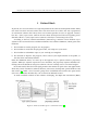
Introduction
If someone asks you what map is, how do you answer the question? You may think about an
image of the world including some regions, each region contains many countries. Or, you may
think of the shape of your country, pinning the city you live on that. Moreover, if you are a
traveler, you may think that map is something that can provide you information about sightseeings including how to be there. We can see that maps are a powerful way of thinking about
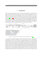
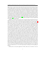
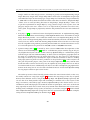
the earth [1]. Figure 1 is the map drawn on birch bark presenting the migration legend of the
native American called Ojibwe around 1820. It illustrates the lives of Ojibwe origins since they
were born until moved to the new places which the spiritual realities had taken part. Moreover,
it also flashes the essential of making maps related to their lives and thoughts as the symbols of
significant spiritual guides were used along the route (from the right to the left).
Figure 1: The Native map shows the migration legend of the Ojibwe ca. 1820 [1]
As time goes by, from drawing pictures on the rock in the past until now using maps on
digital devices, the changes of technology have been taking part of how we understand the
world including the ways to create maps. GIS (Geographic Information System or Geographical
Information System) is the combination of cartography (maps) and database technology which
we may be familiar with and use it in our daily lives but many of us do not realize about it. As the
Internet today has played an important role providing us huge information, we probably find all
information we want over the Web including spatial information. Spatial Information informs the
physical location of objects and the relationship between objects. For simple example, when we
are online and want to find directions from one place to the other places, we open Google Maps
and input texts to get the directions and map. Nowadays, there are lot of providers who have
developed and provided this kind of information in the market; how can we combine data from
1
Using WFS-T in combination with geolocation for online transactional editing of geographic features through mobile browsers
different sources? As same as in our society that we have some rules we need to follow to make us
can live happily together, in GIS world, to make one product/datum to be used with the others,
R
R
the implementation has been developed by following the OpenGISStandards
- OpenGISis
a
Registered Trademark of the Open Geospatial consortium, Inc (OGC). This organization is similar
to the World Wide Web Consortium (W3C) which has developed Web standards; both OGC
and W3C may be comprised of many organizations such as commercial, government, research,
university and so forth. The difference between the OGC and ISO (International Organization
for Standardization) is that ISO has provided of International Standards (supported by law) and
its organization is only at the National level without membership by any organizations. The OGC
can submit OGC standards for approval as ISO standards under the terms of the agreement with
TC211, Geographic information/Geomatics [2]. Recently, the OGC standards baseline comprises
30 standards [3] and for some standards such as WMS, SF and GML are already complied with
the requiredments of ISO standard.
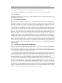
GIS allows us not only to create maps but also to manipulate important information on maps.
Information, in this case, can be any things in the real-world, for instance, parks, rivers, schools,
houses, and so far. Each category can be stored separately in different layers as shown in figure 2.
When we move to a new house, we may want to know the nearby places. We open a GIS application and send a request to a server asking for a map of our area. Then, the server finds geographic
data as we request, renders all together as one image and finally sends a respond back to us. This
is an example of using Web Map Service (WMS), one of the most famous OGC standards which
has been widely used for some years. Anyway, while all we get from using WMS is a picture,
using Web Feature Service (WFS) offers us a chance to do something more than just to look at the
map; all we get from using WFS is actual vector data (as XML). It can be seen that WFS provides
us greater control for the ways we are able to play with the raw geographic data including query
data and/or manipulate (insert, update and delete) data. From the previous example, when we
move to a new house, we may want to know nearby supermarkets. Then, we submit a query to
a server. Once the server finds related data to our request, it compiles the data and sends it back
to us as GML file (in this case, the GML file contains information about nearby shops). After that,
the application validates the file and draws vector for us. As a result, we can see the nearby shops
on a map. WFS basically supports read-only operations, WFS that allows us to insert, update and
delete geographic features called WFS-T (Transactional Web Feature Service). Once again, refer
to the example earlier, when we get the filtered data by location (shops around our house) from
the server, if our application supports WFS-T, we may be able to edit geographic features, such as
add a new shop, via the application interface without the infrastructure requirements. Furthermore, at the present of time, there is a technology available called geolocation API which makes
Web browsers can determine user’s location based on the used devices. It can be noticed that this
kind of technology is helpful in GIS application development since the browsers can detect user’s
location and then the GIS application can make use of the positioning of users. For example, in
this case, if we use the web-based GIS application to find the nearby shops, once we open the
program on Web browsers, we can see the requested places including our location pinning on
the map.
Currently, there are many GIS applications available; while some are commercial, some are
2
Using WFS-T in combination with geolocation for online transactional editing of geographic features through mobile browsers
Figure 2: GIS consists of map layers
provided for free. Moreover, not only we are able to use those tools on powerful computers, but
we are also able to use some tools on thin clients such as personal computers and mobile devices.
As mobile devices have been involved in human communication, we can see that many people
have their own mobile phones and use their devices not only to make or receive a phone call but
also do somethings else. The modern mobile phones support many services such as MMS, MP3,
camera, GPS, Internet, and so forth. At the present of time, many GIS applications developed
for mobile phones have used GPS receivers of mobile phones to locate locations of users and
displayed nearby attractions and facilities. Anyhow, not only GPS that can be used to provide
user’s position, but also location inferred from network signals such as IP address, MAC address,
WiFi connection, and so on. And, as mentioned above about using Google Maps, if our mobile
phones have GPS function and/or can be used to access to the Internet, no matter where we are,
we will probably never get lost, imagine how easy our lives will be from making use of this kind
of technology.
1.1
Topic covered by the Thesis
The purpose of the master’s thesis is to review and try out the capabilities and features of Transactional Web Feature Service (WFS-T) in combination with geolocation in editing geographic
features through mobile browsers based on one of those OGC standards called Web Feature Service (WFS). With WFS-T, users can do transactional operations such as create, update and delete
geographic features. As in the project, the following issues are performed:
•
Review of Web Feature Service Implementation Specification (OGC 04-094) version 1.1.0
mainly focusing on WFS-T section
•
Investigate previous work about how WFS and WFS-T are used, what are advantages and
disadvantages of implementing them
•
Develop a prototype using OpenLayers library in combination with geolocation API to build
a web-based geographic application which GeoServer is installed as a GIS server and Post3
Using WFS-T in combination with geolocation for online transactional editing of geographic features through mobile browsers
greSQL with PostGIS is used as a datastore connecting to GeoServer
•
Test editing of geographic features through mobile browsers and analyze the results
1.2
Keywords
Geographic Information Systems (GIS), GeoServer, OGC web services, WMS, WFS, WFS-T, Mobile browser, Geolocation
1.3
Problem description
Recently, there are numbers of open source GIS applications that offer for free. Comparing to
proprietary software, the most advantage of using free software may be that it can help organizations to save their cost such as in licensing fees and upgrading fees. However, it may also
provide some disadvantages if we choose the wrong one that is not fit to our projects.
And nowadays, Web Map Server (WMS) is one of the most important services that has been
widely used in GIS systems. It allows users to request for geographic data which will return results as map images. Many GIS tools support WMS, while many of them do not support WFS-T.
However, one good obvious issue of WFS-T is that it supports not only all operations of a basic
WFS which allows users to get raw geographic features over the Internet, but also a transaction
operation which allows users to modify geographic features. This benefit makes some providers
and developers concern to implement WFS-T in their systems. Recently, there are some applications that already support WFS-T, by the way, many of them are not be able to run on mobile
devices. So, in this project, we are going to research about how WFS-T in combination with
a new technology like geolocation can be used together to perform editing of geographic features via mobile browsers on mobile phones and investigate advantages and disadvantages from
implementing it.
1.4
Justification, Motivation and Benefits
From the introduction and problem description above, since there are various GIS applications
provided for free as Open Source software, it is more comfortable for us to think about how we
can develop the prototype because we do not need to concern much about the implementation
cost in case that we choose to use Open Source tools.
At the present of time, many research papers have involved in WMS area. While some of them
have been related to WFS, few of them have mentioned about WFS-T especially how WFS-T can
work on mobile phones. Additionally, geolocation is a new technology released for awhile and
becomes helpful in GIS this days including in developing applications for mobile devices.
We can see that mobile phones have played important roles in our society which most people
have their own mobile phones. Not only we can use our mobile phones to talk or to send text
messages to our friends, but many modern mobile phones provide a service to access to the
Internet. So, if we can make use of this kind of technology in combination with WFS-T, it will help
to provide some useful information for those who are interested in using and/or implementing
WFS-T in combination with geolocation on mobile devices and will probably be able to enhance
functions and value of developing the applications in the near future.
4
Using WFS-T in combination with geolocation for online transactional editing of geographic features through mobile browsers
1.5
Research Questions
Based upon the background and motivation and the problem definition, the following research
questions will be examined through the project:
«RQ-1» Is it be possible to implement WFS-T in combination with geolocation as a web application used on mobile browsers?
«RQ-2» What are the main challenges to make use of WFS-T in combination with geolocation
on mobile phones?
«RQ-3» To what extent are map and geographic features can be displayed on mobile browsers?
1.6
Methodology
The idea of WFS-T is not new but somehow it is still not widely used while geolocation API is
new and seems quite useful in the development of GIS applications especially for mobile phones.
In this project, we are interested to implement something related to WFS-T and can work on
mobile browsers. Not only the literature study is made, but also the prototype is developed. The
literature study provides us some useful information about WFS-T and relevant issues in which
we can adapt it with our system such as in planning and developing steps.
To make it more understandable, the methods we use to implement this project can be presented based on research questions as described below:
«RQ-1» Is it be possible to implement WFS-T in combination with geolocation as a web application used on mobile browsers?
To answer this question, both literature study and the prototype are made. Researching available technology and related papers give us the clear picture of how WFS-T and geolocation
works including the requirements we need and also the issues we should concern in implementing them. In this case, for example, Web Feature Service Implementation Specification is reviewed and as a result, we get some requirements and also supported operations of WFS (which
are discussed later in Related Work). This steps provide us significant background and lead to
develop an implementation plan. And then, we can create a prototype based on the plan and
once we perform a test, the answer to this question is revealed.
«RQ-2» What are the main challenges to make use of WFS-T in combination with geolocation on
mobile phones?
Creating and testing a prototype definitely help us to answer this question because we can
experience unexpected problems and difficulties during the implementation.
«RQ-3» To what extent are map and geographic features can be displayed on mobile browsers?
We are able to see how good geographic data can be shown on the screens when we perform
a test. So, to answer this question, implementing a prototype is a must.
After we set goal of the project, to build our own GIS system, we need to investigate the current
environment with available GIS tools in the market, for instance, we may want to have a GIS
server, a spatial database with geographic data, and some GIS tools (in this project, we mainly
5
Using WFS-T in combination with geolocation for online transactional editing of geographic features through mobile browsers
concentrate on using open source software). The investigations of platforms are made. After that,
the test environment is setup with the provided geographic data from different (free and wellknown) sources. The whole point of a mashup, a combination of features and/or data from more
than one source to develop a new useful service, is to make use of available GIS technology to
provide a web-based application allowing users to do online transactional editing of geographic
data through their mobile browsers. After the testing, the results are analyzed and the conclusion
is made.
6
Using WFS-T in combination with geolocation for online transactional editing of geographic features through mobile browsers
2
2.1
Background
OGC Web Services
In recent years, there has been an explosion of web mapping applications which allows users to
access to huge amounts of geographic data via their web browser. The operations to perform the
processes online are called Web Service. Since the area of this kind of implementation seems big
and there are many providers who have developed and provided web mapping applications in
the market, to make one product/datum to be used with the others, the implementation has been
R
R
developed by following the OpenGISStandards
- OpenGISis
a Registered Trademark of the
Open Geospatial consortium, Inc (OGC). OGC has defined interfaces and protocols for supporting
online interoperable solutions which its goal is to develop standards that enable interoperability
of spatial information and services. Recently, the OGC standards baseline comprises 30 standards
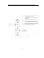
such as Web Map Service (WMS), Web Feature service (WFS), Geography Markup Language Language (GML), Keyhole Markup Language (KML) and so on. Figure 3, SEWilco describes how OGC
standards help GIS tools to communicate by using geoservices server with interfaces and applications sketch [4]; green represents read and write paths while dotted arrowed line indicates
mostly read-only data flow.
Currently, there are more than 250 organizations from all around the world including government, private sector, and academic organizations, that have joined the OGC; the followings are
some examples of the OGC’s members which are well-known: Google, ESRI, Microsoft, ORACLE,
NASA, IBM, MIT and so on. In the GIS world, especially in the area of interoperable web mapping,
OGC web services are very meaningful because they provide the standardization and opportunities for users to share geospatial information even though data is from different sources and/or
different applications. For instance, refer to the earlier scenario in the previous chapter, we move
to a new house and want to search for nearby shops, we are not required to understand the background processes of how we can get the returned data, anyway, what is going on can also be
described based on figure 3 as followings:
1. We launch a GIS application, which created by using OpenLayers, via a web browser
2. We submit a request asking for nearby shops
3. The request is sent to different servers
1) a server that is responsible for providing map images (as WMS), is asked for a map image
2) a server that is responsible for providing geographic features (as WFS), is asked for
information of nearby shops
4. Servers find relevant data and send responds back to the client application
1) a server that is responsible for providing map images (as WMS), sends a map layer
2) a server that is responsible for providing geographic features (as WFS), sends a GML file
5. The application processes the returned results
7
Using WFS-T in combination with geolocation for online transactional editing of geographic features through mobile browsers
Figure 3: An example of how OGC standards help GIS tools communicate by SEWilco. [4]
8
Using WFS-T in combination with geolocation for online transactional editing of geographic features through mobile browsers
1) displays a map image from WMS
2) validates GML and draws vectors, in this case, nearby shops are presented as points
6. The map and the nearby shops are displayed
We can see that the OGC web services, in this example: WMS and WFS, help to solve the problem of the lack of interoperability. With the use of open standards, we are able to manipulate
spatial information no matter how we get it or where it is from.
2.1.1
WMS
OpenGIS Web Map Service (WMS) Implementation Specification is one of the most well-known
Implementation Specifications by OGC. It offers a simple HTTP interface for map images from
distributed geospatial databases. Once a client send a request by specifying the area of interest
to the server, the service produces a content containing geographic information within the area
that the client requests, and then send the response back to the client as map images (in the
format of JPEG, GIF, PNG, or SVG). The client can easily view such images of the map through a
web browser without needing to have any knowledge about how the data is stored or produced.
2.1.2
WFS
OpenGIS Web Feature Service (WFS) Implementation Specification is the main geospatial web
service that provides an interface allowing requests for geographic features across the Internet
no matter which platforms the clients are. Similar to WMS, once a client send a request to a
web feature server asking for geographic data, the server will provide geospatial feature data
and send a response back in GML format. More details about WFS will be described in the next
chapter.
2.1.3
GML
Geography Markup Language (GML) is an XML grammar for describing geographic information.
It is well developed by the OpenGIS Consortium to express geometries and geographical relations
serving transaction operations over the Web. GML is also know as ISO19136 [5]. GML can be
divided into 2 parts including a GML document and a GML Schema. This results to users and
developers to be able to specific geographic features including points, lines and polygons.
2.2
Mobile Browsers
As same as web browsers on personal computers, web browsers designed to be used on mobile
devices called mobile browsers. Currently, mobile devices have been involved in our daily lives,
many applications have been developed to be supported on mobile phones. By the way, each
application has its own limitation about supported platforms. Figure 4 illustrates smartphone
operating systems and their market shares [6]. In 2006, users were mainly interested in using
5 operating systems including Symbian, Windows Mobile, RIM, Linux and Palm OS respectively.
Symbian accounted more than 50 percent of the market and has been acting as a leader of mobile
operating systems until the year of lately survey (2009). By the way, we can obviously see that its
market share has decreased while the market shares of RIM, iPhone and Android have increased
9
Using WFS-T in combination with geolocation for online transactional editing of geographic features through mobile browsers
significantly year by year.
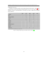
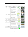
In addition, each mobile operating system supports different mobile browsers. Table 1 shows
default browsers used by major phone and PDA vendors. We can see that many of them are
proprietary software; only Android Browser and Firefox for mobile are FOSS (Free and Open
Source Software).
Figure 4: Smartphone Operating System Market Share Percentage [6]
10
11
Logicplant Co., Ltd.
uZard Web
MoRDAC (Mobile oriented
Remote Display and Control)
WebKit
Gecko
Fugu (Next version to
use Webkit)
NetFront
WebKit
Presto
WebKit
NetFront
WebKit
Webkit
Mango
Gecko
Lumi (Ver. 6.X)
WebKit (Ver. 7.X)
jB5 Browser Engine
Current layout engine
proprietary
proprietary
Proprietary
proprietary
proprietary
proprietary
proprietary
proprietary
proprietary
Proprietary
Apache 2.0 and GPL v2
proprietary
proprietary
MPL 1.1 or later, GNU GPL
2.0 or later, GNU LGPL 2.1
or later
proprietary
proprietary
proprietary
proprietary
Software license
Notes
100% owned by Teleca AB
Capable of reading HTML and reformat for
small screens, installed on many phones
on iPhone and iPod touch
Renders Flash 10, Ajax and Silverlight content.
Currently supports Windows Mobile 5/6.x,
Symbian S60 3rd & 5th Edition platforms
Convergence Web Browser for the expression
of Multi-media in Korea.
on Samsung, LG Electronics and other
Acquired by Research in Motion - No longer
supports Windows Mobile or Linux
Aquired from Openwave in 2008
Linux, Symbian, Windows Mobile, and Brew
platforms. jB5 Profiles addresses all segments of
phones - Feature phone and Smartphone.
Nokia, Samsung, LG Electronics, KYOCERA and
other Smartphone and cellular pone in USA,
China, Korea, etc
Currently released for Nokia Maemo and in
development for Android
Table 1: Default browsers used by major mobile phone and PDA vendors [7]
Fantalog Interactive
Apple Inc
Skyfire
NetSailor Browser
Safari
Skyfire Mobile Browser
ACCESS Co., Ltd.
Nokia
Obigo AB
Opera Software
Myriad Group
Microsoft
Torch Mobile Inc.
Internet Explorer Mobile
Iris Browser
Myriad Browser (Previously
Openwave Mobile Browser)
NetFront
Nokia Series 40 Browser
Obigo Browser
Opera Mobile
Amazon.com
Google
Palm
Research in Motion
Mozilla
Kindle Basic Web
Android Browser
WebOS Browser
BlackBerryBrowser
Firefox for mobile
Infraware Inc.
Comviva
jB5 Browser
Polaris Browser
Creator
Browser
Using WFS-T in combination with geolocation for online transactional editing of geographic features through mobile browsers
Using WFS-T in combination with geolocation for online transactional editing of geographic features through mobile browsers
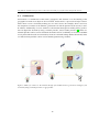
2.3
Geolocation
Geolocation is a combination of the words "geographic" and "location". It is the labeling of the
geographic location of an object in the real world. Geolocation is a process that helps to determines where a user is located by making use of a user’s device. For example, when a user uses
her computer to connect to the Internet, geolocation can tell the position of the user by a user’s
IP address. Additionally, if a user connects to the Internet through her mobile phone, geolocation can figure her location by using a network provider, and/or a GPS provider [8]. Name of a
network provider can be used to determine location based on availability of cell tower and WiFi
access points which results are retrieved by means of a network lookup. On the other hand, name
of a GPS location provider can be used to identify postion using satellites.
Figure 5: When you connect to the internet through your mobile browser, geolocation can figure your
location by using a network provider or a gps provider
12
Using WFS-T in combination with geolocation for online transactional editing of geographic features through mobile browsers
3
Related Work
At present, we can see that there is a high competition in the software development market. Many
new tools have been released, while some tools have been out of date. Not only a proprietary
or commercial software that always have new features/patches for users to upgrade versions,
but also a (free) open source software that has been developed and released regarding users’
demands. What is a (free) open source software? and why it is interesting to be used?
According to the Free software Foundation (www.fsf.org), software can be labelled as free
software if the associated license conditions fulfil the "free software definition", which grants four
freedoms:
1. The freedom to run the program, for any purpose
2. The freedom to study how the program works, and adapt it to your needs
3. The freedom to redistribute copies so you can help your neighbor
4. The freedom to improve the program, and to release your improvements to the public, so
that the whole community benefits
From the definitions above, we come up to the opposite of free software which is proprietary
software. While free software respects the users’ freedoms, the proprietary software identifies ownership. The main benefit of using free software is that it can help users to save their budgets.
In the GIS world, there has been rapid growth in the number of open source GIS applications
which they can be classified as software libraries, web servers, desktop GIS, spatial databases and
GIS viewer [9]. While a lot of research groups have established their stand in the open world,
users have to consider whether they can use data from different sources.
To make standard solution in GIS software developing, the Open GIS Consortium (OGC)
Figure 6: Terms used with respect to software licenses [9]
13
Using WFS-T in combination with geolocation for online transactional editing of geographic features through mobile browsers
provides two programs (OGC Specification Program and OGC Interoperability Program) [10] for
the planning, developing, reviewing, and last of all, officially adopting the specifications. In this
project, Web Feature Service Implementation Specification will be involved [11].
The Open Geospatial Consortium, Inc (OGC) is an international industry consortium
of 388 companies, government agencies and universities participating in a consensus
process to develop publicly available interface standards. – http://www.opengeospatial.
org/ogc
For the project implementation, we will mainly focus on performing transactional operations
since we are curious that why WFS is not used through a wide area as WMS. WFS-T is a part of
WFS, the full WFS operations support INSERT, UPDATE, DELETE, LOCK, QUERY and DISCOVERY
operations on geographic features using HTTP as the distributed computing platform [11] [12].
The protocol to be followed in order to process web feature service requests, the following steps
will proceed [11] [13]:
1. A client application would request a capabilities document from the WFS.
2. A client application (optionally) makes a request to a web feature service for the definition of
one or more of the feature or element types that the WFS can service.
3. The client application generates a request based on the definition of the feature types.
4. The request is posted to a web server.
5. The WFS is invoked to read and service the request.
6. When the WFS has completed processing the request, it will generate a status report and hand
it back to the client. In the event that an error has occurred, the status report will indicate
that fact.
Moreover, to support transaction and query processing, the following operations are defined:
1. GetCapibilities: When a WFS gets this request, it answers with a description of its capabilities.
2. DescribeFeatureType: A WFS can be asked to describe the structure of any of the feature
types it serves.
3. GetFeature: A WFS can be asked to deliver features, however, the client should be able to
constraint the query both spatially and non-spatially, and also specify what feature properties
he/she wants to receive from the WFS.
4. GetGmlObject: A WFS can be asked to retrieve element instances by traversing XLinks that
refer to their XML IDs. In this case, the client should be able to specify whether nested XLinks
embedded in returned element data should also be retrieved.
5. Transaction: This request is composed of operations that modify features including create,
update, and delete operations on geographic features.
6. LockFeature: This feature ensures that serializable transactions are supported by processing
a lock request on a feature while a transaction on that feature is being process.
14
Using WFS-T in combination with geolocation for online transactional editing of geographic features through mobile browsers
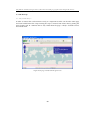
Figure 7 illustrates a communication between a WFS server and a client which HTTP is used
to handle requests (as already mentioned above in details).
Figure 7: Web Feature Server Communication Diagram [14]
As of May 2010, there are two version of Web Feature Service (WFS). The first version, 1.0.0,
was adopted as an implementation specification by OGC on May 17, 2002. And then the next
version is 1.1.0 which was published on May 3, 2005. As we already mentioned about the capabilities of WFS in the previous pages, table 2 shows the comparison of the operations between
WFS 1.0.0 and WFS 1.1.0. Operations are the functions that can be initiated through the WFS
15
Using WFS-T in combination with geolocation for online transactional editing of geographic features through mobile browsers
call and they all support the internal functions of transaction and query processing. We can see
that the only difference between two versions is that WFS 1.1.0 has the ability to perform an
operation called GetGMLObject. However, this function was implemented in WFS 1.1.0 which is
related to XLink and Transaction classes. Table 3 shows the comparison of WFS classes between
two version 1.0.0 and version 1.1.0. Each class can be described as below:
•
Basic WFS supports the read-only operations including GetCapabilities, DescribeFeatureType
and GetFeature.
•
Transaction WFS supports all operations of a basic WFS and in addition it includes a Transation
operation. Moreover, this class can also optionally implement GetGmlObject and LockFeature
operations.
•
XLink WFS, as same as a Transaction WFS class, supports all the read-only operations and
in addition it includes a GetGmlObject operation for local or remote XLinks, and provide the
option for this operation to be activated during GetFeature operations.
Operations
GetCapabilites
DescribeFeatureType
GetFeature
GetGmlObject
Transaction
LockFeature
WFS 1.0
Yes
Yes
Yes
No
Yes
Yes
WFS 1.1.0
Yes
Yes
Yes
Yes
Yes
Yes
Table 2: WFS Operations Comparison
Classes
Basic WFS
Transaction WFS
XLink WFS
WFS 1.0
Yes
Yes
No
WFS 1.1.0
Yes
Yes
Yes
Table 3: WFS Classes Comparison
Furthermore, between WFS 1.0.0 and WFS 1.1.0, there is also a difference in the base GML
schema used. The OGC WFS is one of the keys to GML deployment; GML is used in both the request and response messages of the WFS. The OGC interface offers standardized access to a feature
data store and allows users to perform operations such as create, update and retrieve GML feature data. When a client sends a message requesting for geographic feature data to a WFS server,
a response message will be sent back to client in GML format. However, WFS and GML have
been developed independently. GML, as a format file, can be understandable by GIS applications
and not completely served through OGC WFS. Therefore, the versions of GML identified in OGC
WFS specifications are not the most recent versions of GML available [3] [15]. WFS 1.0.0 shall
conform to GML version 2.1.1 as a minimum version for the identified WFS version [16] while
16
Using WFS-T in combination with geolocation for online transactional editing of geographic features through mobile browsers
WFS 1.1.0 shall conform to GML version 3.1.1 as a minimum version for the identified WFS
version [17].
Sandra Fällman mentioned in her master thesis, Using WFS to build GIS support [10], that during the period she implemented her project (in 2004), WFS was quite new and many negative
aspects due to the functionality of WFS were hidden, only general information about the specification and scenarios were presented. She also raised some important issues about how access
control handled in the OGC WFS Implementation Specification and how appropriate security
levels could be implemented which at that time they were not mentioned in the specification. As
the goal of her project is to investigate the technique of using WFS, she developed some demo
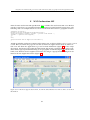
systems and ended up with a result from implementing demo system level 2, as shown below
in figure 8. The system comprises of a client application created by using Java, a WMS server
(MapServer), a WFS server (Deegree) and a spatial database (PostGIS). Users can use the client
application to request for geographic information which the tool is able to access to both the
WMS server and the WFS server.
Figure 8: Demo System level 2; Using WFS to build GIS support by Sandra Fällman [10]
Knut Sælid researched the techniques of using WFS-T on mobile phones in his master’s thesis,
WFS-T and mobile clients [18]. His work proves that WFS can be used in a system to generate map
images and geographic features, moreover, the results can be displayed successfully on mobile
phones. He developed a prototype system called SMILEX including server-side (SMILEX services)
and client-side (SMILEX client). For the SMILEX services, he implemented both WMS and WFS
17
Using WFS-T in combination with geolocation for online transactional editing of geographic features through mobile browsers
on the same platform using GeoServer while MySQL was used as a data storage. For the SMILEX
client, it was developed on Java 2 Micro Edition (J2ME). Moreover, the JSR 179 location API was
implemented to achieve a user position from making use of a GPS receiver on a mobile phone.
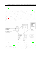
The figure 9 below presents an overview of a communication in the SMILEX system. It allows
users not only to ask for spatial information but also to perform transactions (insert, update,
delete) on geographic features through mobile phones.
Figure 9: Prototype Communication Overview [18]
18
Using WFS-T in combination with geolocation for online transactional editing of geographic features through mobile browsers
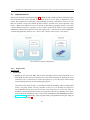
4
4.1
Research and Implementation
Investigated platforms
Since the main idea of this project is to find out whether WFS-T can be used in combination with
geolocation to edit geographic features online via mobile browsers. To setup a test environment,
we decided to create based on Sandra’s demo system level 2 as mentioned in chapter 2, Related
Work, since it was proved in her project, Using WFS to build GIS support, that the implemented
system worked fine and no problems occurred. Therefore, we need GIS servers serving as a map
server and a WFS server, a spatial database providing geographic features, a client application
and, in addition, mobile phones that can use to access to the Internet. However, we decided not
to use exactly the same platforms as the demo system of Sandra since the number of available
GIS products in the market has been increasing each day. Therefor, to make a decision which
services/platforms will be used, the investigations are made as discussed in greater details in the
following sections.
Figure 10: Requirements for a test system
4.1.1
Server-side
A MAP SERVER
Since in this project, we mainly focus on implementing WFS-T, so we consider to use available
map images which there are such a variety of them in the market today. And, candidates belong to
Google Maps, Bing Maps, and OpenStreetMap; all of them are well-known and providing interfaces
to extensive mapping.
•
Google Maps [19] is one of the most famous web mapping service applications owned by
19
Using WFS-T in combination with geolocation for online transactional editing of geographic features through mobile browsers
Google. Similar to other Google services, JavaScript is greatly used in implementing Google
Maps. Moreover, Google offers Google Maps APIs to allow users to manipulate Google maps
and embed the maps on their own pages. Google Maps was launched by Google on February
8, 2005 and has always been released new features since then, for instance, Google Bike Maps
- allows users to search for biking directions on Google Maps, Google My Maps - allows users
to put their information on Google Maps by using geometric shapes such as points, lines and
polygons, Google Street View - allows users to see maps based on panoramic street-level views,
and so forth. Google Maps is proprietary software and provided for free for non-commercial
use.
•
Bing Maps [20] is a web-based service developed by Microsoft. To implement Bing Maps,
Microsoft has used their own technology called MapPoint Web Service. And similar to Google
Maps, Microsoft provides a set of APIs that enable users to manipulate Bing Maps, for instance, users can integrate Bing Maps and location functionality into their own Web site. Moreover, users are able to work with the Bing Maps Platform for free but the use of the maps
must be on public-facing without password protected Web sites and the limitation to access
in a 12 month period is no greater than 125,000 sessions or 500,000 transactions.
•
OpenStreetMap(OSM) [21] is created by Steve Coast in 2004 under the inspiration of the
famous site named Wikipedia [22] which is a collaborative project with the slogan "The free
encyclopedia that anyone can edit". In the same way, OpenStreeMap is a collaborative project
with the slogan "The Free Wiki World Map". It allows users to manipulate geographic data on
the maps in a collaborative way no matter where they are. The project was started because
most maps we think of as free actually have legal or technical restrictions on their use, holding
back people from using them in creative, productive or unexpected ways[21]. Since everyone can
take part and join the project, some parts of the map in OpenStreetMap may contain more
detail than other services because they may be updated by local people who live in and/or
are familiar with the areas. Additionally, not only we are able to manipulate geographic information on the map, but we are also able to download and use all data from OpenStreetMap
for any purpose under an open source license.
The web map services above basically provide almost the same features which, in this case,
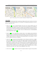
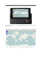
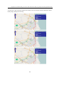
we mainly concern on a map layer. Figure 11 illustrates the map images of the city of Gjøvik,
Norway from different sources: Google Maps, Bing Maps and OpenStreetMap respectively. We
can see that all of them provide maps with something in common such as the layouts of the
maps, road names, and railway signs. However, OpenStreetMap is the chosen service as it is a
collaborative work which people all around the world can participate, some areas of the based
map (especially in small cities or rural areas) may contain more information such as bus routes,
walking tracks, and flights of steps (stairs) on footways; for instance, in figure11, the blue dotted
lines in OpenStreetMap represent cycling routes that are separate from the road. More examples
of map features in OpenStreetMap are shown in figure12.
20
Using WFS-T in combination with geolocation for online transactional editing of geographic features through mobile browsers
Figure 11: Map images from Google Maps, Bing Maps and OpenStreetMap
A WFS SERVER
There are many well-known platforms supporting the OGC Specifications available in the market
today. However, the following products are concerned to be implemented: MapServer, Deegree,
GeoServer and ArcGIS server.
•
MapServer [23] is one of well-known Open Source GIS server used for publishing data and
creating web mapping applications. It can be run on many major platforms such as Windows,
Linux and Mac OS X. However, MapServer supports only basic WFS (read-only) that means
we cannot use it to perform transation operation. From MapServer official website, WFS page,
it mentioned in To-do Items and Known Limitations that GeoServer is recommended for
those needing WFS-T support [24].
•
Deegree [25] is an Java API using for creating a GIS. It is also an Open Source provided for
free and conforms to many OGC Specifications including a transactional Web Feature Service
(WFS-T). For those new users who are interested in using Deegree, there is plenty of tutorial
available online. However, the limitation of performing WFS-T by using Deegree is that it
does not support transactions on shapefiles.
•
GeoServer [26] is designed for interoperability. As same as Deegree, GeoServer is an OpenSource server written in Java and also offers full support for OGC standards including WFS-T.
The main goal of GeoServer is to implement as a node within a free and open Spatial Data
Infrastructure. It intends to offer a free and open web server to publish geospatial data just
as the Apache HTTP Server has offered a free and open web server to publish HTML. With
GeoServer (WFS-T enabled), users can update, delete, and insert geographic data. In short,
GeoServer is one of those tools users need to display maps on web pages and it is used in
conjunction with clients such as uDig, GVSig, MapBuilder, and so forth.
•
ArcGIS Server [27] is commercial software developed by ESRI. It supports interoperability
21
Using WFS-T in combination with geolocation for online transactional editing of geographic features through mobile browsers
Figure 12: Example features in OpenStreetMap [21]
22
Using WFS-T in combination with geolocation for online transactional editing of geographic features through mobile browsers
standards such as OGC and W3C. Moreover, it also supports integrated development environments such as Microsoft Visual Studio, Eclipse and NetBeans. However, ArcGIS Server is
commonly used by organizations that want to distribute their own geographic data.
The comparison of each product is made as shown in table 4 , Comparison of WFS Servers.
We can see that MapServer, Deegree and GeoServer are Open Source software while only ArcGIS
Server is commercial software. Though ArcGIS Server is now using by the Geomatics group at
faculty of technology, economy and management at Gjøvik University College, where we study,
using it seems limit for those new users who interested in learning GIS due to it costs money to
use. So, we would prefer to use free software. By the way, even though MapServer is one of Open
Source applications which has been developed for quite some years, it does not support WFS-T.
So, now, the choice stands between Deegree and GeoServer. Both of them have transactional
capabilities and seems considerably widely used among GIS developers. However, we decided to
use GeoServer as a WFS server. The main reason is because the author has some experiences in
implementing it so under the time limit in developing the prototype, it would be better to use
something that we are familiar with. Moreover, GeoServer is a fully functional open source WFST server that follows the OGC standards for geographic information sharing with good tutorial
and demos available in its official website. So, as a result, GeoServer is selected to implement as
a WFS server in this project.
Software
MapServer
Deegree
Language
C
Java
Open Source
Yes
Yes
WFS
Yes
Yes
GeoServer
ArcGIS Server
Java
.Net/Java
Yes
No
Yes
Yes
WFS-T
No
Yes
(but transactions on
shapefiles do not work)
Yes
Yes
Table 4: Comparison of GIS products to be used as a WFS server
DATASTORES
GeoServer reads a variety of data formats such as PostGIS, MySQL, Oracle Spatial, ArcSDE,
Shapefiles and so forth. To make a decision about which datastore we should use in this project,
the choice stands between PostgreSQL with PostGIS, MySQL and Oracle Spatial.
•
PostgreSQL [28] with PostGIS [29]; PostgreSQL has been developed for more than 15
years as open source object-relational database system. It can be used on all major OS such as
UNIX, Mac OS X and Windows. Moreover, there are many interfaces supporting Java, ODBC,
Perl, Python, Ruby, C, C++, PHP, and so on. However, only PostgreSQL alone is unable to
work with spatial data, we need to install PostGIS which is an extension adding support for
geographic objects to the PostgreSQL object-relational database.
•
MySQL [30] has been released since 1995 as an open source relational database management
23
Using WFS-T in combination with geolocation for online transactional editing of geographic features through mobile browsers
system. Many well-known software projects such as WordPress, Wikipedia, Google, and so
forth, use MySQL regarding it offers nice features and is flexible to be used as it provides
source code available under the terms of the GNU General Public License. MySQL is written
in C, C++ and can be used on cross-platform.
•
Oracle Spatial [31] is commercial software offering data management for geographic
data. It is an option to Oracle Enterprise Edition serving as a foundation for spatial information systems. It allows users to be able to manage geographic data directly in their applications and services.
As same as the reasons we used in making decisions in the previous steps, due primarily to
time constraints, we would consider to use something that we know and it can work fine with
our project. In this case, the author has worked with Oracle and PostgreSQL with PostGIS before,
though MySQL database can be useful and worked well in the project, it is excluded as a candidate. And, between PostgreSQL with PostGIS and Oracle, the author would prefer ’PostgreSQL
with PostGIS’ due to it is Open Source software which means it is free of use.
4.1.2 Client-side
A CLIENT WEB APPLICATION
Since we want to see whether WFS-T can be used in combination with geolocation on mobile
browsers, we need to develop a web application that can be used through mobile browsers. Web
browser are responsible for reading HTML documents, then interpreting and showing them as
web pages. Therefore, we plan to use HTML (Hyper Text Markup Language), a language for
describing web pages, to create interactive interface. With HTML, we can embed many scripts
(such as JavaScript, JScript and ActionScript) to make our pages more dynamic and more interactive. By the way, how can we make geographic information available on the Web? or Which
GIS tools we can use to put a map including its detail on a web page? To answer the questions,
an investigation of the following products are made:
•
ArcGIS Web Mapping[32] by ESRI is a collection of APIs providing a solution for us to create
interactive web applications. The term Web APIs primarily refers to the JavaScript, Flex, or
Siliverlight APIs which all of them allow us to add content to the map via online services,
build stand-alone applications, connect to GIS servers, and so forth. For implementing cost,
development and deployment with the APIs are free but the latter can be done under certain
terms and conditions. By the way, to use ArcGIS Web Mapping, we need to have an ArcGIS
Server available whose maps and tools we can use in our application.
•
OpenLayers[33] is a free open source framework with the slogan - Free Maps for the Web.
It is a JavaScript library which not only allows us to display geographic information in web
browsers, but also provides an API for creating rich web-based geographic applications. In
24
Using WFS-T in combination with geolocation for online transactional editing of geographic features through mobile browsers
OpenLayers, map tools are separated from map data so we can use all the tools to implement
on all the data sources, this helps to fix the lack of interoperability. Moreover, it supports
open standards and protocols for geographic data access such as WMS and WFS. The initially
release of OpenLayers was launched in June 2006. After that, many new versions have been
released accordingly with useful documents and examples available on its website. Futhermore, OpenLayers has a powerful community behind it with users from many countries all
over the world and its functionalities have been keeping on developing and growing.
•
OpenScales[34] is a community-driven mapping project implemented by a diverse group of
people all around the world. It is a user-friendly interface designed for interoperability supporting a variety of OGC formats and protocols such as WMS and WFS. Moreover, it allows us
to build rich Internet mapping applications and manipulate geographic information. OpenScales was originally created from FlexLayers which was a Flex port of OpenLayers; users who
are familiar with OpenLayers can easily and quickly learn to use OpenScales because it offers
many similarities to OpenLayers. By the way, the main difference between OpenScales and
OpenLayers is that OpenScales uses ActionScript 3 and Flex while OpenLayers uses JavaScript.
The first framework, ArcGIS Web Mapping, is proprietary while the others, OpenLayers and
OpenScales, are open source; all of them are provided for free. Unfortunately, ArcGIS Web Mapping can be used only if we implement an ArcGIS Server in our system. So, it is excluded from
the list of candidates. Now, the choice stands between OpenLayers and OpenScales which both
of them should be able to work fine in the project since they support a WFS protocol and allow
us to develop web a mapping application. Anyway, OpenLayers is selected over OpenScales to be
used for the implementation of the web application since OpenLayers seems to be far developed
with good documentation and examples available on its website.
Since we want to test whether WFS-T can be used in combination with geolocation through
mobile browsers, to use OpenLayers alone seems not enough; in this case, we need a solution
that can help to provide a user location and show it on a browser. Actually, the concept of locating
users by making use of the geographical position of their mobile devices is not new as there are
many location-based mobile applications available in the market today such as Google Latitude a location-aware mobile application created by Google; Gowalla - a mobile web application created
by Alamofire allowing users to check-in to locations that they visit using their mobile devices; and
Foursquare - a web and mobile application offering users to connect with friends and update their
location. However, at the time of doing this project, there are still few solutions that can be used
to implement a mobile web application in order to detect users’ locations when they launch an
application through their mobile browsers; the following APIs are concerned as candidates to be
implemented in the project:
•
Google AJAX APIs[35] developed by Google includes a simple object property called
25
Using WFS-T in combination with geolocation for online transactional editing of geographic features through mobile browsers
google.loader.ClientLocation which allows our application to acquire a user’s location
based on a user’s IP address. In general, this method can expose an approximate location of
the user, but sometimes it is unable to locate users (especially for those who are behind an
anonymous proxy), or may return us inaccurate location (based on IP address geolocation
providers). Additionally, to use this solution, we need to sign up for an API key which is
provided for free.
•
Gears API[36] by Google provides a Geolocation API allowing our web application to gather
a user’s geographical position by using the getCurrentPosition method which it is able to
determine the user’s location by using a set of data such as the user’s IP address and WiFi
nodes. Moreover, the Gears Geolocation API is now capable to use WiFi antenna data to
provide more accurate position data. Google Gears is an open source project that enables
us to create powerful web application by providing many new features for us to add to web
browsers. However, to be able to use Gears API, an installation of Gears on a computer may
be required.
•
W3C Geolocation API[37] by W3C, the well-known organization for the World Wide Web,
offers a way to gather a user’s location by associating a geographic location with a hosting
device like Global Positioning System (GPS), IP address, RFID, WiFi and Bluetooth MAC
addresses, and so forth. W3C Geolocation API has been developed based on earlier work such
as Geolocation in Fireforx and Beyond, Gears Geolocation API, and LocationAware.org. To use
this API, neither an API key nor an installation are required. However, regarding security and
privacy considerations, users will be asked whether they want to share their locations when
they load the application via web browsers, this is to ensure that no location information is
done though the API before users allow it to do so.
All of the above APIs are provided for free and seem work fine in this project. However, we
decide to use W3C Geolocation API in this project since there is no work required before using
it compare to the first two APIs, Google AJAX and Gears, which we either need to register for an
API key or install a tool on our computer first.
Futhermore, for a client device, we plan to make a test on Motorola Milestone since it is
sponsored by our school. Its operating system is Android 2.0 with some nice features support
including web browser with location enabled, aGPS, 3G and so on.
26
Using WFS-T in combination with geolocation for online transactional editing of geographic features through mobile browsers
4.2
Implementation
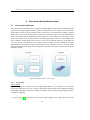
After the investigation of platforms, figure10 is filled up with selected products which the figure
below illustrates the results showing an overview of what we are going to implement in our
system. We categorize the system into 2 parts including 1)server-side and 2)client-side. The
first part contains a map server which OpenStreetMap is selected to be used to provide a map
image, a WFS server which GeoServer is chosen for providing geographic features, and lastly,
a spatial database which PostgreSQL with PostGIS is picked to be used to store geographic
information. On the other hand, for client-side, OpenLayers is selected to be used to implement
a web-based application and Motorola Milestone is chosen to be used as a test device.
An overview of system components
4.2.1
Preparation
SERVER - SIDE
1. Installation
•
GeoServer was started in 2001 and has been developed and released continually. As of
May 2010, the latest version of GeoServer is 2.0.2 released on May 25, 2010. By the way,
GeoServer 2.0.1 is selected to be used in this project as it was the latest stable version
released during the time we started doing the project.
GeoServer offers many choices as installation methods including using OS-independent
binary, using Web archive and using Installer. In this case, we develop our project based on Windows OS so the easiest way seems to be using Windows Installer. After we
download and run the installation file, the operations took only few minutes (more information about the installation steps can be found in GeoServer User Manual provided in
GeoServer.org). Additionally, some required settings and problems during the setup are
mentioned in appendix A
27
Using WFS-T in combination with geolocation for online transactional editing of geographic features through mobile browsers
•
PostgreSQL has the current stable version as 8.4.4 released on May 17, 2010 (for Windows OS). By the way, in this project, PostgreSQL 8.3.4 is installed on the same machine as
GIS server. The installation process took few minutes like when we installed GeoServer.
Nevertheless, only PostgreSQL alone cannot complete the requirement of being spatial
database so we need to install PostGIS to add support for geographic objects to the PostgreSQL and allows PostgreSQL to be used as a backend spatial database for geographic
information system. As a result, PostGIS 1.5 is installed.
2. Prepare data
After we have GeoServer and PostgreSQL with PostGIS installed on the machine, it is time
to fill up the database. In this project, we decided to use geographic data from OpenStreetMap(OSM) project. OSM allows us to feel free to download and use the full information for
any purpose we like under an open source license [21]. The following items are choices of
geographic data formats that we are able to export from OSM:
1. OpenStreetMap XML Data contains all the current raw geographic data in an XML format.
As a result, we will get a file called map.osm including Nodes, Ways, Relations, and Tags
in the file.
2. Mapnik Image offers map images in the default of OpenStreetMap style called Mapnik. A set
of image formats includes PNG, JPEG, SVG, PDF and PostScript.
3. Osmarender Image, similar to Mapnik Image, allows users to export a map image but in a
different style which is called Osmarender. We can decide to export map images in PNG or JPEG.
4. Embeddable HTML allows us not only to embed the map in our website, but also to mark
a specific location on the map. As a result, we will get an output text containing a link which
looks similar to the following: http://www.openstreetmap.org/?lat=60.79425&lon=10.686485
&zoom=14&layers=B000FTFT
In this case, we need a raw geodata, so we select to export OSM data as ’OpenStreetMap XML
data’. Once we export data from OSM, we will get an .osm file in XML format with related
geographic information, such as vector features, inside the area we specify in the map. The
output file contains similar syntax like the following:
28
Using WFS-T in combination with geolocation for online transactional editing of geographic features through mobile browsers
Then, we need to convert data into a format that can be loaded into PostGIS database. In
this step, FME Universal Translator[38] can do the trick. However, in the paper ’Interface
design for mobile devices’ [39], the author mentioned some concerned issues when designing
mobile devices user interface which one of them is the size of a mobile device is usually small
so the developers of mobile applications have to cope with limited screen size. Therefore, as we
plan to show geographic information on mobile devices which they may be not suitable for
displaying large amounts of data, we may also need to optimize our data too. Furthermore,
a data store in GeoServer must be created in order to use it to connect to geographic data in
PostGIS database. To sum it up, the processes of data preparation are illustrated as shown in
figure 13 including:
1) Exporting data from OpenStreetMap
2) Converting and Importing data using FME Universal Translator
3) Manipulating and Optimizing data with pgAdmin III
4) Creating a data store in GeoServer
For more details about the preparation steps, see appendix C - Data Preparation.
29
Using WFS-T in combination with geolocation for online transactional editing of geographic features through mobile browsers
Figure 13: Data preparation steps
30
Using WFS-T in combination with geolocation for online transactional editing of geographic features through mobile browsers
CLIENT- SIDE
Since the goal of this project is to try out the capability of WFS-T in combination with geolocation
in order to edit geographic features through mobile browsers. Therefore, we must create a webbased application that is able to (1) use to edit geographic features, and (2) determine a user’s
location. As mentioned in the investigation part, to reach item (1), we will use OpenLayers, while
for item (2), W3C Geolocation APIs can do the trick.
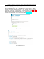
1. Using OpenLayers library to show geographic data and edit geographic features
OpenLayers is a pure JavaScript library providing for free as an open source. It helps us to
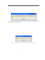
easily put a dynamic map in our web page with no server-side dependencies. To use OpenLayers Javascript API, we need to include "OpenLayers.js" in our page. The file can be stored
on our machine or if we wish to always use the latest release of the script, we should point
a location of the file to http://www.openlayers.org/api/OpenLayers.js, as shown below
in figure 14.
Figure 14: Include OpenLayers.js in a web page
Moreover, some essential codes of OpenLayers that we need to use in this project are mentioned below:
function
OpenLayers.Layer.WMS
OpenLayers.Layer.Vector
OpenLayers.Protocol.WFS
(to be used with OpenLayers.Layer.Vector)
description
Create a new WMS layer object
Create a new vector layer
Used to create a versioned WFS protocol
2. Using W3C GeoLocation API to gather a user’s location
We can locate a user’s position by creating a location-aware web page to make a user share her
location from using her mobile device, which in this case, we use Geolocation API. Generally,
the sources of location information can be Global Positioning System (GPS) and location
collected from network signals containing IP address, WiFi, MAC addresses, and so forth.
The following code is an example of how to get a basic location information [37]:
31
Using WFS-T in combination with geolocation for online transactional editing of geographic features through mobile browsers
//Example of a one-shot position request
navigator.geolocation.getCurrentPosition(showMap);
4.2.2
Testing
After a prototype is created, we have tested it both on mobile browsers and web browsers on
personal computers, which some screenshots of the application are captured and revealed. For
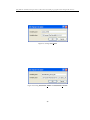
instance, figure 15 shows that when a user runs the application through a mobile browser, she
is asked whether she allows the application to gather her location information. While figure 16
and 17 happen when a user launches the application through Firefox, which similar to the previous case that the user runs the application on the mobile browser, she is asked whether she
wants to share her location information, the application will do so in case that she agrees. And
once she clicks a Share location button to allow the application to determine where she is, as
a result, her location including nearby places are displayed on a map as shown in figure 17; a
yellow smile icon represents her location while green circles are nearby shops. Addtionally, figure 18 describes a sequence of operations that the application provides for online transactional
editing of geographic features through mobile browsers, which the use case contains all possible
states since the application is launched until a user quits the application. Furthermore, refer to
the earlier example in the Introduction chapter, we move to a new house and want to search for
nearby shops, in this case, this application can be helpful, as we are going to discuss in greater
details in the next paragraph.
A scenario for the system
Jasmin is an international student from China coming to Norway to study a master’s degree
in Media Technology at Gjøvik University College (GUC) in Gjøvik. Today is the first day that she
reaches Gjøvik. She meets Li Xiatao, who is a second year student studying the same major as her;
he comes to pick her up at the train station and drives her to Kallerud where she is going to stay.
Kallerud is a student village located 500 meters from GUC and 2 km from Gjøvik city center with
laundry and internet access are provided.
Once Jasmin arrives at her room in Kallerud, she finds that she needs to buy many stuff including
food and some convenience products. She asks Xiatao whether there are any supermarkets around
the campus. Instead of answering her question, Xiatao uses his mobile phone launching a web application via his mobile browser, the application asks whether he allows it to gather his location
information, which he accept the request. and few minutes after that, he shows what are displayed
on his mobile screen to her. As a result, Jasmin sees a map with some symbols marking on, which she
can understand that a yellow icon represents her location while some green dots are nearby stores.
Xiatao tells her that he often uses the application to search for nearby stores and once he discovers
that the shop he visits is new and not on the map, he will add it through the application. On the
other hand, if he knows that a shop is no longer open or moved to a new place, he will either delete
or update its location on the map. Jasmin says thank you to Xiatao and plans to use her mobile
phone to connect to the application to discover Gjøvik. Additionally, she tries to use the application
on her personal computer and sees that it can work fine through Firefox.
32
Using WFS-T in combination with geolocation for online transactional editing of geographic features through mobile browsers
Figure 15: Xiatao is asked to share a location when running the application through a mobile browser on
his Android phone.
Figure 16: Jasmin is asked to share a location when running the application via Firefox on a PC.
33
Using WFS-T in combination with geolocation for online transactional editing of geographic features through mobile browsers
Figure 17: A yellow smiley icon locates Jasmin’s location, green points represent nearby shops.
34
Using WFS-T in combination with geolocation for online transactional editing of geographic features through mobile browsers
Figure 18: An application Use Case
35
Using WFS-T in combination with geolocation for online transactional editing of geographic features through mobile browsers
5
5.1
Results and conclusion
Results
In this project, we have developed a prototype to see whether we can make use of WFS-T in combination with geolocation to perform online transactional editing of geographic features through
mobile browsers. As a result, we can describe as answers to the research questions as followings:
«RQ-1» Is it possible to implement WFS-T in combination with geolocation as a web-based
application used on mobile browsers?
From developing and performing a test, we found that WFS-T and geolocation can work well
together through a mobile browser on Android phone. However, because W3C Geolocation API
that we selected to use instead of using other geolocation APIs such as Google Loader and Gears,
is still new, not all browsers support it. As a result, our applicant can work completely only on
those browsers that support W3C Geolocation API. We have tried on various browsers both on
PCs and mobile phones, results are listed below:
N ORMAL BROWSERS :
•
Mozilla Firefox (version 3.5 and later)
Once we open the application, we will be asked for permission to share our location (similar
to figure 16, as shown earlier in the previous chapter). In case that we agree, Firefox will
gather information about nearby wireless access points and our IP address. Then it will send
the information to the default geolocation service provider which is Google Location Services
to get an estimate of our location. Finally, the estimated location is shown on the application
as a yellow smile marker 17.
•
Google Chrome (version 5.0.371.0 dev and later)
Once we open the application, we will be asked whether we allow to be tracked our physical
location. If we consent, then, the next steps will be like what we already mentioned in Firefox.
•
Safari (version 5 and later)
The application works fine, which our location can be detected and shown on the map.
•
Internet Explorer
As of now, there is no support for geolocation in the current version (IE8). Therefore, once
we launch the application, our location will not be determined.
M OBILE BROWSERS :
•
Android Browser
Android browser supports the W3C Geolocation API. As a result, the application can work
37
Using WFS-T in combination with geolocation for online transactional editing of geographic features through mobile browsers
well on this platform. Similar to Mozilla Firefox, we will be asked whether we allow the
application to gather our location information (as shown earlier in figure 15), and once we
agree with it to do so, our location is presented on the map as a yellow smiley icon.
•
Safari on iPhone (OS 3.0 and later)
Similar to Android browser, the application can work well on Safari.
«RQ-2» What are the main challenges to make use of WFS-T in combination with geolocation
on mobile phones?
To develop a prototype, using OpenLayers library to deal with WFS-T is not that hard but
somehow some small problems could always happen. And once the problems happen, it takes
quite some times until we can find the solutions. In this project, when we have a problem, the
OpenLayers community including the mailing lists are very helpful especially for those new users
who want someone to help fixing their problems. However, Dean and Jim mentioned about the
AAA slogan in their book, Semantic Web for the Working Ontologist: Effective modeling in RDFS
and OWL, that on the World Wide Web, Anyone can say Anything about Any topic, which means
people are free to write a page saying whatever they want, and then publish it through the Internet. No one can guarantee that what we have seen on the public web board is completely
correct. Though the open source software like OpenLayers and GeoServer have been used by
many people, when we find an error and post the problem on the Internet forums, we are not
able to force anyone in the community to help answer your question. It is not like using commercial software in which when you have a problem, you can contact the technical support regarding
the software product and may get a response back in short period. Moreover, in some cases, we
can see that documentations of some open source products are unclear or not well structured
with grammar errors. This kind of problems can lead new users to feel that it is hard to learn to
use software. Additionally, since geolocation is a new technology, not many users realize about
it or understand how it works. Moreover, not all browsers support geolocation. So, to implement
the application (with geolocation-enabled) to work on every framework seems not possible at
this time.
«RQ-3» To what extent are map and geographic features can be displayed on mobile browsers?
Since mobile phones have small screens, the main challenge of the implementation based on
showing geographic information is belong to how to compose a suitable map image. From the
test, we found that either a base map layer (OpenStreetMap) or overlay layers (Shops and Current Positions) can be shown successfully on mobile browsers as in this case we mainly performed
a test on Motorola Milestone (Android), which its screen size (diagonal) is 3.7". Moreover, some
limitations while running the application on mobile phones have been revealed such as it is not
easy to select the geographic features (green dots) especially in case that two dots are close to
each other. Additionally, it is also not easy in order to zoom or pan the map due to the same
reason as earlier, buttons are close to each other.
38
Using WFS-T in combination with geolocation for online transactional editing of geographic features through mobile browsers
5.2
Conclusion
While using WMS returns geographic data as maps, WFS can return results in various formats
such as GML/KML and shape files. Therefore, we can say that WFS is more flexible due to it offers
users to play with the output and can write their own queries to get the geographic information
they need. WFS-T is an extension of WFS which one obvious feature of WFS-T is that it allows
users to insert, update and delete geographic data.
From the project implementation, we found that it is possible to implement WFS-T in combination with geolocation as a web-based application to be used on mobile browsers. However,
there are some difficulties and limitations in using the application including an access to the Internet is required during the usage of the application, an error from selecting wrong geographic features
can easily occur especially when the features are close to each other, and zooming and panning the
map are not easy to perform due to the similar reason as selecting geographic features which is
buttons are close to each other.
Futhermore, the application is unable to work on those browsers that do not support geolocation due to W3C Geolocation API is still new. Geolocation is a process of tracking and mapping
which can be performed by connecting a geographic location with IP address or device GPS coordinates. To bundle W3C Geolocation API in the application will make the web browser can
determine where we are located. In this case, we may curious about our privacy. For those web
browsers that support W3C Geolocation API such as Firefox and Google Chrome have a policy
not to share our location without our permission. We can see that when we visit a page that
geolocation code is bundled, we will be asked before any information is shared.
By the way, since Internet scams and frauds have been increasing each day, we may need to
concern about what information we are going to share and how much we can trust the websites
that ask for our information.
39
Using WFS-T in combination with geolocation for online transactional editing of geographic features through mobile browsers
6
Future Work
WFS-T is not new but it still not widely used. While geolocation is a new technology that becomes
well-known and useful this days. The implementation of WFS-T in combination with the geolocation technique for mobile browsers seems not much published. Therefore, to develop a prototype
in this project seems to be interesting considering that there are now no similar web applications
for mobile browsers available in the market. However, due primarily to time constraints, we
cannot include all features of WFS-T in our project. Currently, with a rapid growth of mobile
technology, new modern mobile phones have provided many functions, for example, we can use
our mobile phones to listen to MP3, record a voice, take a photo, buy a movie ticket, book a hotel, and so on. Moreover, many smartphones now include built-in GPS receivers that means we
are able to use map no matter where we are. And as a result, many applications can make use of
the new technology to estimate our location and provide some useful information that we may
be interested such as when we travel to one city and want to get some information about nearby
restaurants, we can just open a web browser (with geolocation-enabled) and then we can see
our location including the points of the nearby restaurants on the map. In the future, based on
the created prototype, some modules can be implemented to enhance the functionalities such as
to make users log on before using application, to make users upload their files (pictures, voices,
comments) related to the places, and so forth. Additionally, few solutions of determining location of users from using web browsers have been published at present. Each solution has its own
limitations, if we can find the way to make them work together especially to be able to perform
in every platform, that will be nice.
41
Using WFS-T in combination with geolocation for online transactional editing of geographic features through mobile browsers
Bibliography
[1] Krygier, J. & Wood, D. Making maps: a visual guide to map design for GIS, p. 3. The guilford
press, 2005.
[2] ISO.org.
ISO TC211.
http://www.iso.org/iso/iso_catalogue/catalogue_tc/
catalogue_tc_browse.htm?commid=54904. (Visited Jun 2010).
[3] Opengeospatial.org. OGC standards. http://www.opengeospatial.org/standards/. (visited May 2010).
[4] SEWilco. 2007. Ogc standards help gis tools communicate. http://commons.wikimedia.
org/wiki/File:Geoservices_server_with_apps.png. (Visited May 2010).
[5] Portele, Clemens (ed.). August 2007. OpenGIS Implementation Specification #07-036:
OpenGISGeography Markup Language (GML) Encoding Standard, version 3.2.1.
[6] Grigsby, J. 2010. Mobile operating systems and browsers are headed in opposite directions. http://radar.oreilly.com/2010/05/mobile-operating-systems-and-b.html.
(Visited Jun 2010).
[7] Wikipedia.org. Mobile Browser. http://en.wikipedia.org/wiki/Mobile_browser. (visited May 2010).
[8] Developer.Android.com.
Location Manager.
http://developer.android.com/
reference/android/location/LocationManager.html. (visited May 2010).
[9] Steiniger, S. & Bocher, E. 5 SEPTEMBER 2008. An overview on current free and open
source desktop GIS developments. Int. J. of Geographical Information Science.
[10] Fällman, S. Using WFS to build GIS support. Master’s thesis, Department of computing
science, Umeå University, Sweden, 2004.
[11] Vretanos, P. A. (ed). May 2005. OpenGIS Implementation Specification #04-094: Web
Feature Service Implementation Specification, version 1.1.0.
[12] Nanchang, P. R. 22-24 MAY 2009. A WebGIS framework for vector geospatial data sharing
based on open source projects. The 2009 International Symposium on Web Information
Systems and Applications, 124–127.
[13] Jun, J., Chong-jun, Y., Ying-chao, R., & Miao, J. 2008. The research and application of WFS
based GML. The International Archives of the Photogrammetry, Remote Sensing and Spatial
Information Sciences. vol. XXXVII Part B4.
43
Using WFS-T in combination with geolocation for online transactional editing of geographic features through mobile browsers
[14] Jody Garnett and Brent Owens. 2003. Validating Web Feature server Design Document.
[15] Chris deJager, AMEC Earth and Environmental Technology Business Unit. 24 May 2006.
Web Feature Services, Considerations for CGDI Government Partners. version 1.0.
[16] Cox, S., Cuthbert, A., Lake, R., and Matell, R. (eds.). April 2002. OpenGIS Implementation Specification #02-009: OpenGISGeography Markup Language (GML) Implementation
Specification, version 2.1.1.
[17] Cox, S., Daisey P., Lake, R., Portele C., Whiteside A. (eds.). January 2005. OpenGIS Implementation Specification #02-023r4: OpenGISGeography Markup Language (GML) Implementation Specification, version 3.1.1.
[18] Sælid, Knut. WFS-T and Mobile Clients. Master’s thesis, Department of informatics, University of Oslo, Norway, 2006.
[19] Google. Google Maps. http://maps.google.com/. (visited June 2010).
[20] Microsoft. Bing Maps. http://www.bing.com/maps. (visited June 2010).
[21] OpenStreetMap.org. OpenStreetMap (OSM). http://www.openstreetmap.org/. (visited
May 2010).
[22] Wikipedia.com. Wikipedia. http://en.wikipedia.org/wiki/Wikipedia. (visited June
2010).
[23] Mapserver.org. MapServer. http://www.mapserver.org/. (Visited May 2010).
[24] Mapserver.org. MapServer - WFS Server. http://www.mapserver.org/ogc/wfs_server.
html. (Visited May 2010).
[25] Deegree.org. Deegree. http://www.deegree.org/. (Visited May 2010).
[26] GeoServer.org. GeoServer. http://www.geoserver.org/. (Visited May 2010).
[27] ESRI.com. Arcgis Server. http://www.esri.com/software/arcgis/arcgisserver/
index.html. (Visited May 2010).
[28] Postgresql.org. PostgreSQL. http://www.postgresql.org/. (visited May 2010).
[29] refractions.net. PostGIS. http://postgis.refractions.net/. (visited May 2010).
[30] MySQL.com. MySQL. http://www.mysql.com/. (visited May 2010).
[31] Oracle.com. Oracle. http://www.oracle.com/. (visited May 2010).
[32] ESRI. ArcGIS Web Mapping. http://www.esri.com/software/arcgis/web-mapping/.
(visited June 2010).
[33] OpenLayers.org. OpenLayers. http://openlayers.org. (visited May 2010).
44
Using WFS-T in combination with geolocation for online transactional editing of geographic features through mobile browsers
[34] Openscales.org. OpenScales. http://openscales.org. (visited June 2010).
[35] Google. Google Loader - google.loader.ClientLocation. http://code.google.com/apis/
ajax/documentation/. (Visited June 2010).
[36] Google. Google Gears for Mobile - Geolocation API. http://code.google.com/apis/
gears/api_geolocation.html. (Visited June 2010).
[37] W3C. Geolocation API. http://dev.w3.org/geo/api/spec-source.html. (visited May
2010).
[38] FME Desktop ESRI Edition. FME Universal Translator. http://www.safe.com/. (visited
June 2010).
[39] Vávra, M. January 2009. Interface design for mobile devices. Cork Institute of technology.
[40] Cook, J. Web Mapping Course Notes. http://www.maths.lancs.ac.uk/~stantonm/Web_
Mapping_Course_Notes.pdf. (Visited June 2010).
45
Using WFS-T in combination with geolocation for online transactional editing of geographic features through mobile browsers
A
GeoServer Issues
After we install GeoServer, the below process may be required to implement:
- We will NEED to set the JAVA HOME environment 5 19 variable if it is not already set. This
is the path to your JDK/JRE such that %JAVA HOME% bin java.exe exists.
- We may also need to set the GEOSERVER HOME variable 20, which is the directory where
GeoServer is installed, and the GEOSERVER DATA DIR variable, which is the location of the
GeoServer data directory (usually %GEOSERVER HOME\data dir). The latter is mandatory if
you wish to use a data directory other than the one built in to GeoServer. The procedure for
setting these variables is identical as shown in table 5 and table 20.
1. Navigate to Control Panel > System > Advanced > Environment Variables.
2. Under System variables click New.
3. For Variable name enter JAVA HOME. For Variable value enter the path to your JDK/JRE.
4. Click OK three times.
Table 5: Setting environment variables
47
Using WFS-T in combination with geolocation for online transactional editing of geographic features through mobile browsers
Figure 19: Setting JAVA HOME
Figure 20: Setting GEOSERVER HOME and GEOSERVER DATADIR
48
Using WFS-T in combination with geolocation for online transactional editing of geographic features through mobile browsers
B
PostgreSQL with PostGIS Issues
PostgreSQL supports capital letters in table and column names, but it requires them to be quoted
in queries. Table 6 shows some examples of how the results return when the table names are
"norway" and "Norway".
Table Name
norway
Norway
SQL command
select * from norway;
select * from norway;
Norway
select * from Norway;
Norway
select * from "Norway";
Result
Success
ERROR: relation "norway" does not exist
SQL state: 42P01
ERROR: relation "norway" does not exist
SQL state: 42P01
Success
Table 6: Query problem in PostgreSQL
49
Using WFS-T in combination with geolocation for online transactional editing of geographic features through mobile browsers
C
C.1
Data preparation
Export data from OpenStreetMap (OSM)
To Export data from OpenStreetMap (as shown in figure 21), visit http://www.openstreetmap.
org/. Click ’Export’ tab, select ’area of interest’ and then ’Export’ it as ’OpenStreetMap
XML Data’. We will get one XML file with ’.osm’ extension. The structure of the file will probably
look like in figure 22.
Figure 21: Export data from OSM
51
Using WFS-T in combination with geolocation for online transactional editing of geographic features through mobile browsers
Figure 22: An example of XML data from OSM
52
Using WFS-T in combination with geolocation for online transactional editing of geographic features through mobile browsers
C.2
Convert and Import data using FME Universal Translator
Converting OSM XML data and importing the converted data into PostGIS database through
FME Universal Translator can easily be done by setting Translation parameters as shown in
figure 23.
Figure 23: Using FME to convert data and write data into PostGIS
53
Using WFS-T in combination with geolocation for online transactional editing of geographic features through mobile browsers
C.3
Manipulate and optimize data with PostgreSQL 8.4 / pgAdmin III
After importing data into PostGIS, we need to add a primary key into tables that we want to use
with GeoServer otherwise we will get an error when we try to insert a new point, as shown in
figure 24. GeoServer needs a primary key defined on each table in order to make transactions
work, if our tables in the database do not have any primary keys, we will probably need to add
one, for instance, we can add a serial (autoincrement) primary key to our tabl. After that, we
are required to reload the configuration, and then we are supposed to be able to modify our data.
For example, the auto-increment primary key can be added as using the script below:
» alter table tourism point add column id2 SERIAL;
» alter table tourism point add primary key (id2);
Figure 24: An error occurs when adding a new point in a table with no PK available in the table
54
Using WFS-T in combination with geolocation for online transactional editing of geographic features through mobile browsers
C.4
Create ’Workspace’ and ’Store’ in GeoServer
To use PostGIS with GeoServer, first, we will probably want to create ’Workspace’ which is a
container used to group similar layers together. And then, a new data source can bee added
by choosing ’PostGIS NG - PostGIS database’ as a Vector Data Source. Figure 25 and 27
shows screenshots of adding new workspace and data store. Additionally, the document of how
to create a new workspace and a store in details can be found in GeoServer.org.
Figure 25: Configure a workspace
Figure 26: Available Data Sources
55
Using WFS-T in combination with geolocation for online transactional editing of geographic features through mobile browsers
Figure 27: Data Info and Parameters of new vector data source
56
Using WFS-T in combination with geolocation for online transactional editing of geographic features through mobile browsers
D
OpenLayers Library
OpenLayers is a javascript-based web application which allows us to show geographic data on
our web pages. To use it, we are not required to have much knowledge in javascript, but we need
to respect the code and the order in which the components are declared and used.
The following code is an example of how to use OpenLayers to show map data and geographic
features in this project:
1: <html>
2:
<head>
3:
<title>OpenLayers</title>
4:
<script src="http://openlayers.org/api/OpenLayers.js"></script>
5:
<script type="text/javascript">
6:
var lon = 5;
7:
var lat = 40;
8:
var zoom = 5;
9:
var map, select;
10:
11:
function init(){
12:
var options = {
13:
projection: new OpenLayers.Projection("EPSG:900913"),
14:
displayProjection: new OpenLayers.Projection("EPSG:4326"),
15:
units: "m",
16:
maxResolution: 156543.0339,
17:
maxExtent: new OpenLayers.Bounds(-20037508.34, -20037508.34,
18:
20037508.34, 20037508.34)
19:
};
20:
21:
map = new OpenLayers.Map(’map’, options);
22:
var osm = new OpenLayers.Layer.TMS(
23:
"OpenStreetMap (Mapnik)",
24:
"http://tile.openstreetmap.org/", {
25:
type: ’png’, getURL: osm_getTileURL,
26:
displayOutsideMaxExtent: true,
27:
attribution: ’<a href="http://www.openstreetmap.org/">OpenStreetMap</a>’
28:
}
29:
);
30:
var saveStrategyPoint = new OpenLayers.Strategy.Save();
31:
var shops = new OpenLayers.Layer.Vector("Shops", {
32:
strategies: [new OpenLayers.Strategy.BBOX(), saveStrategyPoint],
33:
projection: new OpenLayers.Projection("EPSG:4326"),
34:
protocol: new OpenLayers.Protocol.WFS({
35:
version: "1.1.0",
36:
url: "/geoserver/wfs",
37:
featureType: "shop_point",
38:
srsName: "EPSG:4326",
39:
featureNS : "http://www.hig.no/imt4901/osm",
40:
geometryName: "geom"
41:
})
42:
});
43:
44:
map.addLayers([osm, shops]);
45:
map.addControl(new OpenLayers.Control.LayerSwitcher());
46:
map.zoomToExtent(
47:
new OpenLayers.Bounds(
48:
-12941319.173424, -4110122.686702, 18367287.606576, 11544180.703298
49:
).transform(map.displayProjection, map.projection)
50:
);
51:
52:
}
57
Using WFS-T in combination with geolocation for online transactional editing of geographic features through mobile browsers
53:
54:
function osm_getTileURL(bounds) {
55:
var res = this.map.getResolution();
56:
var x = Math.round((bounds.left - this.maxExtent.left) / (res * this.tileSize.w));
57:
var y = Math.round((this.maxExtent.top - bounds.top) / (res * this.tileSize.h));
58:
var z = this.map.getZoom();
59:
var limit = Math.pow(2, z);
60:
61:
if (y < 0 || y >= limit) {
62:
return OpenLayers.Util.getImagesLocation() + "404.png";
63:
} else {
64:
x = ((x % limit) + limit) % limit;
65:
return this.url + z + "/" + x + "/" + y + "." + this.type;
66:
}
67:
}
68:
</script>
69: </head>
70: <body onload="init()">
71:
<div id="map" ></div>
72: </body>
73: </html>
The steps of how the above code works can be explained as in the following terms [40]:
1. Load the OpenLayers library
4:
<script src="http://openlayers.org/api/OpenLayers.js"></script>
The http://openlayers.org/api/OpenLayers.js URL points to the location of a JavaScript
file that loads OpenLayers. This file helps us to put a dynamic map in our web page with no
server-side dependencies. The file, OpenLayers.js, can also be stored on our machine. Anyway,
to always use the latest of the script, we may want to point a location of the file to the link as
we mentioned in the example above. We can use debugging tools such as Firebug in Firefox to
explore the OpenLayers library from our browser.
2. Define a container for a map
71:
<div id="map" ></div>
This is a container for the map that we create in our page markup. Later, when we initialize
the "map" object, we will give the id of this div element to the map’s constructor.
3. Set a display projection and create a map
12:
13:
14:
15:
16:
17:
18:
19:
20:
21:
var options = {
projection: new OpenLayers.Projection("EPSG:900913"),
displayProjection: new OpenLayers.Projection("EPSG:4326"),
units: "m",
maxResolution: 156543.0339,
maxExtent: new OpenLayers.Bounds(-20037508.34, -20037508.34,
20037508.34, 20037508.34)
};
map = new OpenLayers.Map(’map’, options);
OpenLayers allows us to set a display projection to prevent us confusion regarding map coordinates. In this case, transformation is made from the map projection EPSG:900913 to the display
projection EPSG:4326. Moreover, the coordinates that we use in setCenter are not longitude and
latitude, but they are in projected units - meters. The maxResolution of the map defaults to fitting
this extent into 256 pixels, resulting in a maxResolution of 156543.0339. And, for the maxExtent
parameter, the coordinates strech from -20037508.34 to 20037508.34 in each direction.
At line 21, we can see that there are a lot of "maps" in the statement. The first declares the
variable, to give it a short name that can be used elsewhere in the Javascript code. Since the
variable is declared outside the function that initializes it, it can be used globally, which helps
58
Using WFS-T in combination with geolocation for online transactional editing of geographic features through mobile browsers
for debugging. The second- OpenLayers.Map called an object, tells the OpenLayers Javascript
that we are using the Map class, which means that all of the built-in parameters and options can
be accessed. The third is the name or identifier of the div that we are putting the map in, so
OpenLayers knows where to draw the map on the page. So this section basically creates a new
OpenLayers.Map object and gives it the variable name map.
4. Create Layers
22:
23:
24:
25:
26:
27:
28:
29:
30:
31:
32:
33:
34:
35:
36:
37:
38:
39:
40:
41:
42:
var osm = new OpenLayers.Layer.TMS(
"OpenStreetMap (Mapnik)",
"http://tile.openstreetmap.org/", {
type: ’png’, getURL: osm_getTileURL,
displayOutsideMaxExtent: true,
attribution: ’<a href="http://www.openstreetmap.org/">OpenStreetMap</a>’
}
);
var saveStrategyPoint = new OpenLayers.Strategy.Save();
var shops = new OpenLayers.Layer.Vector("Shops", {
strategies: [new OpenLayers.Strategy.BBOX(), saveStrategyPoint],
projection: new OpenLayers.Projection("EPSG:4326"),
protocol: new OpenLayers.Protocol.WFS({
version: "1.1.0",
url: "/geoserver/wfs",
featureType: "shop_point",
srsName: "EPSG:4326",
featureNS : "http://www.hig.no/imt4901/osm",
geometryName: "geom"
})
});
OpenLayers organizes a single map into several layers. This part of code tells OpenLayers that
we want to create two new layers, in this case, including a map layer (osm) and a geographic
feature layer (shops), which they can be referred to elsewhere as osm and shops.
5. Add layers to the map
44:
map.addLayers([osm, shops]);
This step is to add the created layers in no.4, osm and shops, to the map.
6. Create a layer switcher
45:
map.addControl(new OpenLayers.Control.LayerSwitcher());
This step is to create a layer switcher control to the map. Since earlier in the code, two layers
are added to the map, we will see that "OpenStreetMap (Mapnik)" and "Shops" are listed in the
control.
7. Position the map
46:
47:
48:
49:
50:
map.zoomToExtent(
new OpenLayers.Bounds(
-12941319.173424, -4110122.686702, 18367287.606576, 11544180.703298
).transform(map.displayProjection, map.projection)
);
This code tells the map to zoom out to its maximum extent, which by default is the entire world.
OpenLayers maps need to be told what part of the world they should display before anything
will appear on the page. Calling map.zoomToExtent() is one way to do this. Alternative ways
that offer more precision include using zoomToExtent() and setCenter().
59
Using WFS-T in combination with geolocation for online transactional editing of geographic features through mobile browsers
8. Load the map
70:
<body onload="init()">
In order to ensure that our document is ready, it is important to make sure that the entire page
has been loaded before the script creating the map is executed. We ensure this by putting the
map-creating code in a function that is only called when the page’s <body> element receives
the onload event.
Figure 28: A page created from the given code
60
Using WFS-T in combination with geolocation for online transactional editing of geographic features through mobile browsers
E
W3C Geolocation API
From the W3C Geolocation API Specification [37], it defines the Geolocation API as an API that
provides scripted access to geographical location information associated with the hosting device. The
following code is an example of how we can use Geolocation API to detect a geographic location.
if(navigator.geolocation) {
navigator.geolocation.getCurrentPosition(function(position) {
alert(’Your geographic coordinates: latitude= ’ + position.coords.latitude + ’,
longitude= ’ + position.coords.longitude);
});
}
else {
alert(’Your browser does not support Geolocation API!!!’);
}
To find out whether our browser support Geolocation or not, an object called navigator.geolocation
is used. Once we launch the page, in case that our browsers support Geolocation, we will be asked if we will allow the application to get our location information (figure 29). If we accept
the request, the browser will gather the information and provide a position object, in this code,
there will be a pop-up window informing us our geographic coordinates (figure 30). On the other
hand, if our browsers do not support Geolocation, we will get a pop-up window telling that our
browsers do not support this feature (figure 31).
Figure 29: If a browser supports Geolocation, we will be asked whether we want to share our location
information
61
Using WFS-T in combination with geolocation for online transactional editing of geographic features through mobile browsers
Figure 30: If a browser supports Geolocation and we allow it to gather our location information, we will
get a pop-up window showing our position
Figure 31: A pop-up window shows that our browser does not support geolocation
62
Using WFS-T in combination with geolocation for online transactional editing of geographic features through mobile browsers
F
A client application
Some screenshots of a client application are revealed as shown below:
(The application can be accessed at http://copernicus.hig.no:8080/geoserver/www/loc/imt4901.html)
1. When a user launches an application, if a browser supports Geolocation, she will be asked
whether she wants to share a location.
2. If the user accept the request, there will be a pop-up massage informing her position as
shown earlier in figure 30. After that, she will see a map with some symbols. A yellow smiley
icon represents her location while green dots represent nearby shops.
63
Using WFS-T in combination with geolocation for online transactional editing of geographic features through mobile browsers
3. The below code shows a background process for requesting geographic features from a WFS
server.
4. The below code shows a background response from requesting geographic features from a
WFS server.
64
Using WFS-T in combination with geolocation for online transactional editing of geographic features through mobile browsers
5. The user is able to add a new shop by selecting a pencil with a plus sign button, and then
locate the new shop on the map.
6. The user is able to delete green dots by selecting a pencil with a minus sign button, and then
select the point to delete.
65
Using WFS-T in combination with geolocation for online transactional editing of geographic features through mobile browsers
7. The user is able to move green dots by selecting a move button, and then select the point to
move.
8. The user can save the transaction by selecting a save button. The below code shows a
background response when the user adds a new point on the map and selects the save button.
66
Using WFS-T in combination with geolocation for online transactional editing of geographic features through mobile browsers
9. The user can save the transaction by selecting a save button. The below code shows a
background response when the user deletes a point on the map and selects the save button.
10. The user can save the transaction by selecting a save button. The below code shows a
background response when the user moves a point on the map and selects the save button.
67
Using WFS-T in combination with geolocation for online transactional editing of geographic features through mobile browsers
11. The user can save the transactions by selecting a save button. The below code shows a
background response when the user adds 3 new points, deletes 1 point, and moves 1 point on the
map, and then selects the save button.
68
Using WFS-T in combination with geolocation for online transactional editing of geographic features through mobile browsers
12. The user is able to choose whether she wants to see her location (Current Position) and/or
nearby shops (Shops) on the map.
69
Using WFS-T in combination with geolocation for online transactional editing of geographic features through mobile browsers
13. The user can select on any of geographic features (green dots) to see its description. Once
the user does so, a pop-up message will appear with the geographic description.
14. The user can pan and/or zoom the map by selecting the buttons on the top left. For the
below case, the user zooms in the map, as a result, she can see the map in more details.
70