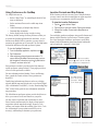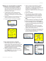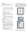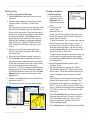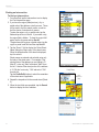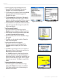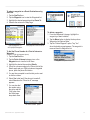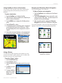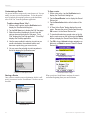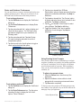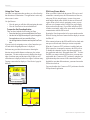
1
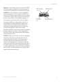
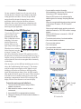
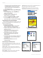
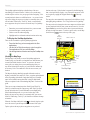
Garmin Que
®
GPS navigation software for
Palm OS® powered devices
applications guide
© Copyright 2005 Garmin Ltd. or its subsidiaries
Garmin International, Inc.
1200 East 151st Street,
Olathe, Kansas 66062, U.S.A.
Tel. 913/397.8200 or 800/800.1020
Fax 913/397.8282
Garmin (Europe) Ltd.
Unit 5, The Quadrangle,
Abbey Park Industrial Estate,
Romsey, SO51 9DL, U.K.
Tel. 44/0870.8501241
Fax 44/0870.8501251
Garmin Corporation
No. 68, Jangshu 2nd Road, Shijr,
Taipei County, Taiwan
Tel. 886/2.2642.9199
Fax 886/2.2642.9099
All rights reserved. Except as expressly provided herein, no part of this manual may be reproduced, copied, transmitted, disseminated,
downloaded or stored in any storage medium, for any purpose without the express prior written consent of Garmin. Garmin hereby
grants permission to download a single copy of this manual onto a hard drive or other electronic storage medium to be viewed and to
print one copy of this manual or of any revision hereto, provided that such electronic or printed copy of this manual must contain the
complete text of this copyright notice and provided further that any unauthorized commercial distribution of this manual or any revision
hereto is strictly prohibited.
Information in this document is subject to change without notice. Garmin reserves the right to change or improve its products and
to make changes in the content without obligation to notify any person or organization of such changes or improvements. Visit the
Garmin web site (www.garmin.com) for current updates and supplemental information concerning the use and operation of this and
other Garmin products.
Garmin® and MapSource® are registered trademarks and Que™ is a trademark of Garmin Ltd. or its subsidiaries and may not be used
without the express permission of Garmin.
The Palm OS, HotSync, Palm Powered
logo are registered trademarks and
Palm Powered is a trademark of Palm
Trademark Holding Company, LLC.
Other brands may be trademarks of their
respective owners.
October 2005
Part Number 190-00523-00 Rev. B
INTRODUCTION >
INTRODUCTION
About the Manuals
Garmin Que™ is designed to use Garmin GPS technology as
applications with a PDA to provide you with navigational
guidance. Garmin Que is provided with three instructional guides.
Setup Guide
The Setup Guide gives you software installation instructions, and
other important details. Before reading the other manuals, read
the Setup Guide which is included with the Installation Disk.
Quick Start Guide
The Quick Start Guide tells you how to get started navigating
with a convenient reference for basic features. You can carry
this with you as a quick reminder of how features operate and
how to access them. The Quick Start Guide is printed on the
reverse side of the Setup Guide.
Application Guide
This Application Guide describes, in detail, how to use the
Garmin Que™ application for navigation. Included on the
setup Disk, this document is in portable document file (pdf)
form, it can be printed from a PC as a paper copy which may
be of benefit when you take your device outside to navigate.
(Available only on the setup Disk and the Garmin website:
www.garmin.com.)
Editor’s Note:
The above manuals and guides were created using the Garmin
Que operating software installed on a PDA equipped with
popular features and operating with the various versions
of Palm OS® v 5. If your make and model PDA meets the
requirements stated on the product packaging, it should operate
in a manner similar to that described in these guides, but may
not include some features discussed in the applications guide.
Many PDA features described in this guide are not essential to
operation of Garmin Que and are used primarily as convenient
alternate methods of operation.
About Garmin Que Setup
Once installed on your PDA and in
communication with the remote GPS
receiver, QueSetup can be accessed
from the PDA applications launcher. The
QueSetup page provides you with the Que
Software version, the remote GPS receiver
i.d and version numbers, and Uninstall
and Reinstall buttons. Uninstall removes the Que applications
completely, while Reinstall prepares for the PDA for upgrades
or reinstallation without removing existing voice files or the
waypoints list.
IMPORTANT NOTE: The Garmin Que has been tested and
found to operate in a satisfactory manner when installed in Palm
OS powered PDAs and Mobile Phones that meet the minimum
operational requirements stated on the product package and on
page i of this guide. However, Garmin has no responsibility for
the quality or the reliability of performance of those products.
A significant issue is the variance in maximum speaker volume
for PDAs of different manufacturers. You may find the speaker
volume of your PDA to be compromised by road noise and
its location in your vehicle when receiving turn-by-turn
voice direction prompts while navigating with Garmin Que.
It is therefore recommended that you activate the “Attention
Tone” feature to prepare you to listen in advance for each
voice prompt. Instructions for activating the “Attention Tone”
are found on Page 17 of this Guide. Other remedies may be
third party devices that can amplify the speaker volume when
connected to the auxiliary speaker port of your PDA. Consult
your PDA retailer for information concerning these devices.
Touch-screen responsiveness for some Garmin Que operating
features may vary from PDA to PDA.
It is also important that you understand the operation of your
PDA prior to using Garmin Que. The operation of the Garmin
Que application requires understanding of standard procedures
used for the PDA that are not discussed in detail in the Garmin
Que Application Guide. If you purchased your PDA at the same
time as the Garmin GPS receiver and are not yet familiar with
its operation, it is recommended that you learn how to operate
the PDA first.
Que for Palm OS - Applications Guide
I
INTRODUCTION >
Warnings and Precautions
CAUTION: Use Garmin Que™ at your own risk. To reduce
the risk of unsafe operation, carefully review and understand
all aspects of this Application Guide—and thoroughly practice
operation using the simulator mode prior to actual use. When in
actual use, carefully compare indications from Garmin Que™
to all available navigation sources, including the information
from other NAVAIDs, visual sightings, charts, etc. For safety,
always resolve any discrepancies before continuing navigation.
CAUTION: It is the user’s responsibility to use this
product prudently. This product is intended to be used only
as a navigational aid and must not be used for any purpose
requiring precise measurement of direction, distance, location
or topography. This product should not be used as an aid to
determine ground proximity for aircraft navigation.
CAUTION: The electronic chart is an aid to navigation and is
designed to facilitate the use of authorized government charts,
not replace them. Only official government charts and notices
to mariners contain all information needed for safe navigation
– and, as always, the user is responsible for their prudent use.
MAP DATA INFORMATION: One of the goals of Garmin
is to provide customers with the most complete and accurate
cartography that is available to us at a reasonable cost. We use
a combination of governmental and private data sources, which
we identify as required in product literature and copyright
messages displayed to the consumer. Virtually all data sources
contain inaccurate or incomplete data to some degree. This
is particularly true outside the United States, where complete
and accurate digital data is either not available or prohibitively
expensive.
WARNING: The Global Positioning System (GPS) is operated
by the United States government, which is solely responsible
for its accuracy and maintenance. The system is subject to
changes which could affect the accuracy and performance of
all GPS equipment. Although Garmin Que™ is a precision
electronic NAVigation AID (NAVAID), any NAVAID can be
misused or misinterpreted and, therefore, become unsafe.
WARNING: This product, its packaging, and its components
contain chemicals known to the State of California to cause
cancer, birth defects, or reproductive harm. This Notice is
being provided in accordance with California’s Proposition 65.
If you have any questions or would like additional information,
please refer to our web site at http://www.garmin.com/prop65.
II
Que for Palm OS - Applications Guide
INTRODUCTION >
Important! Because Garmin Que can be used with a PDA for
vehicular navigation, important safety considerations must be
observed. Please read and observe the instructions on this page.
WARNING: For use in vehicles, it is the sole responsibility
of the owner/operator of a vehicle equipped with a PDA with
Garmin Que™ installed, to place and secure the device so that it
will not interfere with the vehicle operating controls and safety
devices, obstruct the driver’s view of driving conditions, or
cause damage or personal injury in the event of an accident.
Do not mount the PDA over airbag panels or in the field of
airbag deployment. Airbags expand with a rapid force that
can propel objects in their path towards the vehicle driver
or passengers causing possible injury. Refer to airbag safety
precautions contained in the vehicle owner’s manual.
Do Not Mount Where
Driver’s Field of Vision
is Blocked
Do Not Mount in
Front of Airbag
Panels
Do Not Place Unsecured
on the Vehicle Dash
Do Not Mount in Front of an
Airbag Field of Deployment
Do not mount the PDA in a place where the driver or passengers
are likely to impact it in a collision. The mounting hardware
provided by Garmin is not warranted against collision damage
or the consequences thereof.
WARNING: When used in vehicles, it is the sole responsibility
of the driver of the vehicle to operate the vehicle in a safe
manner, maintain full surveillance of all driving conditions
at all times, and not become distracted by the PDA to the
exclusion of safe driving practices. It is unsafe to operate the
controls of the PDA while you are driving. Failure by the driver
of a vehicle equipped with a PDA with Garmin Que installed to
pay full attention to operation of the vehicle and road conditions
while the vehicle is in motion could result in an accident with
property damage and personal injury.
Que for Palm OS - Applications Guide
III
INTRODUCTION >
Table of Contents
Introduction..................................................... I
About the Manuals ............................................ I
Setup Guide ................................................................... I
Quick Start Guide .......................................................... I
Application Guide ......................................................... I
About Garmin Que Setup.................................. I
Warnings and Precautions .............................. II
Overview ........................................................ 1
Connecting to the GPS Receiver .................... 1
Customizing the Que Units Settings .............. 2
Using the Hard Buttons to access Garmin Que
applications ................................................... 3
Using the Arrow Button to access Garmin Que
features .......................................................... 3
Using the QueMap Application Selector Icons5
Using the QueMap Que Menu.......................... 5
Using Preferences for QueMap ....................... 6
Location Formats and Map Datums................ 6
Marking your current location as a waypoint 7
Using QueFind .................................................. 8
Finding a City ............................................................... 9
Finding an Address ....................................................... 9
Finding an Intersection ............................................... 10
Finding Points of Interest ........................................... 11
Using Waypoints......................................................... 11
QueRoutes ...................................................... 14
Creating Routes .......................................................... 14
Using QueMap to Select a Destination ...................... 15
Using a Detour ............................................................ 15
Stopping and Resuming Route Navigation ................ 15
Customizing a Route .................................................. 16
Saving a Route ............................................................ 16
Route and Guidance Preferences ................................ 17
Using Routing Voice Prompts .................................... 17
Using QueTurns .......................................................... 18
PDA Low-Power Mode ................................... 18
Map Data Installation................................... 19
Using Map Install to Download Map Data .... 19
Using MapSource® to Download Map Data .. 19
Additional Information ................................ 20
Specifications ................................................. 20
Troubleshooting Guide .................................. 21
MapSource® Cartography........................ 22
What is WAAS? ........................................ 22
Software License Agreement .................. 22
IV
Que for Palm OS - Applications Guide
OVERVIEW >
OVERVIEW
You may customize Garmin Que to fit your needs, such as
selecting the units of measure, map orientation, map detail,
routing preferences and others. For now, the Que default
settings should be adequate for learning how to use the
applications with the exception of the units preferences
explained in this section. Information on customizing each
of the various Que applications is explained in the sections
describing each Que application.
Connecting to the GPS Receiver
The wireless GPS receiver
must be turned On and
communicating with the
PDA via Bluetooth wireless
technology. It also must
initialize (determine its
location) before you can
begin using it for navigation.
When the receiver initializes
Tap to open the Application
for the first time it may take
as long as 15 minutes. This
time can be shortened by using the GPS application to select
the general area in which you are currently located (see page 2).
Anytime you have traveled more than 600 miles with the GPS
receiver turned off, the receiver must again find its location by
re-initializing.
If for any reason, you have difficulty initializing your receiver,
refer to the Troubleshooting Guide on page 21. The solution
could be as simple as moving the receiver slightly to avoid
buildings or objects that are blocking or deflecting satellite
signals. When operating on battery power, the PDA normally
turns off after the last key press to save power. When connected
to the GPS receiver it actually switches to low-power mode
maintaining communication with the GPS but turning off the
display. Press the Power button to re-activate the display.
• Current satellite reception informationWhile establishing a link with the GPS receiver a “
Connecting to GPS” message displays.
When the GPS receiver is on and searching for
satellite signals. the message “Acquiring Satellites”
appears.
When only enough satellite signals are being received
to determine a 2D location, “2D GPS Location”
displays.
When enough satellite signals are being received to
establish a location fix, a “3D GPS Location” message
displays.
When the GPS Receiver is turned off, a “GPS Off”
message displays.
• The location and numbers of overhead satellites.
• Your current location coordinates.
• The current date and time.
• Your current speed.
• Your approximate elevation.
• The accuracy at which your location has been fixed.
Acquiring Satellites
To turn the receiver on and initialize it:
1. Turn On both the GPS receiver and your PDA to
establish a connection.
2. Make certain the receiver’s view of the sky is
unobstructed.
3. Access QueGPS from the Applications Launcher.
4. Observe the following GPS receiver status indicators on
the GPS page:
Que for Palm OS - Applications Guide
Signal Strength
Bars
Position and numbers
of overhead satellites
3D Location Fix
1
OVERVIEW >
• The signal strength of each satellite being received.
• The battery capacity, indicates power reserve
when the GPS receiver is not connected to an
external power source.
To set your location in order to speed GPS satellite
acquisition:
1. Press the Menu Key or tap the QueGPS tab to
display the Options Menu.
2. Tap ‘New Location’ to display options for
determining your current location.
3. Choose from Automatic, Use Map, or Cancel.
4. If you choose Map, use the stylus to tap your
approximate location on the map and then tap Done.
Customizing the Que Units Settings
Before using the Que applications to navigate, you may want
to set the units to an appropriate type of measurement for your
location or navigation activity.
To change the units settings:
1. From the Applications Launcher screen, tap the
Prefs icon to display the Preferences Menu.
2. Under the ‘Other’ category tap Que to display the
preferences for Que.
3. Tap the under the Preferences tab to
display the list of Que Preferences.
4. Select Units to display the Units settings for
Distance and Speed, Elevation, Depth, and
Direction values.
5. Tap the beneath each unit category to display the
list of measurement options for each and select
your desired unit.
6. When finished, tap Done to return to the
Preferences Menu.
Auto Power On - allows the GPS 10 to automatically power on
when power from an external source is applied.
Auto Power Off - allows the GPS 10 to power off when
communication with the PDA has been lost for 15 minutes.
Set New Location Option
Set New Location by tapping your approximate location on the map
System Applications Launcher
Customizing the GPS functions
Before using the Que applications to navigate, you may want
to set the remote GPS Receiver settings for features that can be
controlled from the PDA.
Connect to GPS - placing a check in this box connects the
PDA via Bluetooth wireless technology to the GPS 10 receiver
when the PDA is powered On.
WAAS Enabled - placing a check in this box enables Wide
Area Augmentation System for increased accuracy.
2
Units Setup Page
GPS Preferences Page
Que for Palm OS - Applications Guide
OVERVIEW >
Using the Hard Buttons to access Garmin
Que applications
Before using the Que applications to navigate, you may want
to assign one or more of the Que applications to launch from a
hard button.
To assign a Que application to a hard button:
1. From the Applications Launcher screen, tap the Prefs
icon to display the Preferences Menu.
2. Select Buttons to display the Buttons Options Menu.
3. Select a button position with a and tap to display the
pick list of assignment options.
4. Tap the desired function from the pick list to assign it to
the button selected in step 3.
Preferences - Button Options
Using the Arrow Button to access Garmin
Que features
Many PDAs have a four or five position button used for
scrolling lists, etc. For our purposes we will refer to this button
as the Arrow button. You can use this button to operate many
of the Garmin Que navigation features with a Que application
active.
To change the Map Scale on the Map Page:
With the Map Page displayed, press the Top or Bottom
of the Arrow Button to increase or decrease the map
scale. Hold the button down to quickly change the scale.
Observe the map scale in the lower right
corner of the map to determine the desired scale.
To scroll any list:
With an entry on the list highlighted, press the Top or
Bottom of the Arrow Button.
To cycle through the Que Applications:
Press the Left or Right Arrow Button.
To listen to spoken navigation instructions or
status messages:
Press and hold the Left or Right Arrow Button.
Button Assignments
The Arrow Button
Up
Left
Right
Down
(Graphic representation, may not exactly
resemble the button on your device.)
Buttons Pick List
Note that the button descriptions and options available may
vary from PDA to PDA. Mobile phones with Palm OS offer a
different array of buttons than most PDAs and those that can be
reassigned are different as well.
Que for Palm OS - Applications Guide
3
OVERVIEW >
The QueMap application displays a detailed map of the area
surrounding your current location. It allows you to pan the map
with the stylus as well as view your progress when navigating. Your
current location is shown as a solid black arrow. As you travel to the
edge of the display, the map moves (redraws) to constantly show your
current location. When in the “Track Up” mode, a north reference
arrow appears at the top left corner to orient the map. Use QueMap
to:
•
•
•
•
Determine your current location and view your movement
Locate and navigate to nearby map items
Follow a route line when navigating
Highlight and view information about locations on the map
To Display the QueMap Application:
location on the map. If that location is supported by detailed mapping
data, a description briefly displays. Any point on the map can be saved
as a waypoint by tapping the Waypoint marker flag in the map
toolbar.
The map color can automatically compensate for the difference in day
and night lighting conditions. See “Using Preferences for QueMap”.
The map scale can be changed to show more map area with less detail
or more map detail with less area (zoom out and zoom in). Press the
Up and Down keys on the front of the unit to increase and decrease
the scale in single increments. To select a specific scale, use the Map
Scale Selector
shown at the top of this page.
Map
Orientation
(North Up)
Current location icon
There are three methods to open the QueMap Application.
•
•
•
Press the Hard key you have assigned to the Que
applications.
Use the Left or Right Arrow keys to cycle through the
Que applications until you reach QueMap.
Use the Applications Launcher and tap the QueMap icon
.
Viewing the Map Page
The Map Page is the primary screen of the QueMap application.
From this page you can observe a triangular arrow that indicates your
current location and direction of travel. As you move, the arrow
moves with you, turning when you turn and stopping when you
stop. When zoomed in the accuracy of your location is indicated by
an Accuracy Circle. The smaller the circle the more accurate your
location.
The Map also displays detailed geographic information such as
highways and roads, lakes and rivers, cities, waypoints and residential
streets, depending on the detail of map data being used. Detailed
maps can be loaded from map data Disk’s using the Map Install
feature as explained in the “Downloading Map Data” section of this
guide.
There are two map orientation options: North Up and Track Up.
North Up orients the map like a paper map, while Track Up orients
the map in the direction of travel and can be set to display only
below a desired map scale. As you travel to the edge of the
display, the map moves (redraws) to constantly show your current
location. When using “Track Up”, the North arrow indicates the map
orientation.
When the ‘Pan Map with Stylus’ mode
is selected, drag the stylus
across the screen to pan the map with the movement of the stylus.
Tap the stylus on the map to place a map pointer on any selected
4
Map Scale
Waypoint Flag
(Zoom
(Mark Location
Scale)
icon)
View Area
Display Information
Pan Map Selector
Format
icon
with Stylus
icon
Position Arrow icon
The Map Page
Accuracy Circle
New Waypoint Page
Position Arrow
on Map
Map Point
Information
Que for Palm OS - Applications Guide
OVERVIEW >
Using the QueMap Application Selector Icons
With QueMap displayed, tap the desired selector to activate the
feature as described below:
Tap the Display Format icon on the map toolbar toggle
between the three options of displaying and hiding the
navigation data fields.
Tap the Waypoint Flag on the map toolbar to display
the ‘Mark Waypoint’ entry window for your current
location (Position Arrow) or a ‘New Waypoint’ entry
window for the Map Pointer. The window displays with
a name describing the location if identified as an item in
the map data or as Waypoint 1, 2, 3, etc.
Full Map only
Map with Navigation and Data Fields
showing
Tap the Information icon to display information about
a location identified by the Map Pointer on the Map
Page. When tapped, an information window displays
describing the location if identified as an item in the
map data or position coordinates (i.e. lat/lon).
Tap the Position Arrow icon (vehicle pointer) to center
the map on your current location when in North Up
mode. When in Track Up mode, the map is centered
horizontally on your location.
Tap the Pan Map icon to allow the stylus to drag
the map and to mark map items with the map pointer
(Panning Arrow).
Place the stylus anywhere on the map and then move the
stylus. The map moves with the stylus and exposes the
part of the map previously out of view. Lift the stylus to
stop panning. To recenter your location on the map, tap
the Position Arrow icon.
Tap the View Area icon to allow you to define an area
on the map with the stylus that will be enlarged when
you lift the stylus from the screen.
Select a point adjacent to the area you want to enlarge
and then drag the stylus to create a box around the area.
Lift the stylus to complete, allowing the map to redraw.
When the View Area Selector is active the Pan Map
feature is not usable.
Tap the Map Scale icon to display the list of map scales.
Drag the arrow to scroll through the entire list of scales.
Tap the scale you want and the map will display at that
scale.
Map with Data Fields showing only
QueMap Menu
Using the QueMap Que Menu
With QueMap active, tap the Menu icon to display the Que
Menu.
To create a route to a map point:
Use the stylus to identify a point on the map, then tap
Route To.
To measure the distance between two points on the
map:
1. Open the Que Menu and tap Measure Distance
to view the Measure Distance Page.
2. To measure from your current location to a point on
the map, use the stylus to tap that point. A dotted
line connects the two
points and the distance
displays below.
3. Tap the Map Pin icon to
connect two points other
than your location.
Measure Distance Option
Que for Palm OS - Applications Guide
5
OVERVIEW >
Using Preferences for QueMap
Use Maps Preferences to:
• Reduce “Map Clutter” by controlling the detail of how
items are displayed.
• Set the maximum Zoom scale at which map items
display.
• Control the display of multiple map features.
• Determine Map orientation.
• Set the display mode for day or night viewing.
The factory (default) settings for these preferences allow you
to operate the QueMap application with confidence. As you
become more familiar with its operation, you may desire to
customize the application to fit your needs. Tap the Help button
for detailed definitions of the map preference options.
Location Formats and Map Datums
While Location preferences are not a part of Map Preferences,
you may want to reset them to match those on paper maps that
you plan to use in conjunction with GPS navigation.
To view the Location Preferences:
1. Tap the symbol before “Maps”.
2. Tap Location to open the Location Preferences window.
3. Change the Location Format and/or Map Datum as
necessary.
You can display position coordinates using specific formats and
datums selected from the Que Preferences, Location options.
For a brief description about these preferences, tap the Help
button. Detailed information about using formats and datums
can be found in the “Appendix” of this guide.
To view the QueMap Preferences:
.
1. From the QueMap application, tap Menu icon
2. Tap Preferences.
3. View and change the preferences as needed. To
open a different QueMap Preferences page, such as
the Navigation Preferences, tap the symbol before
“General,” as shown to the left.
Map Preferences Pages are accessed by
tapping the symbol to the left of the Maps
option to display the list of map preferences.
Each preference window is provided with a Help button to
explain preference settings in detail. These pages provide an
overview of the preferences available.
For more information about Heading, Course, and Bearing
lines, consult the Garmin website at www.garmin.com/
aboutGPS/.
Most Map Preferences
offer a “Text Size” option
selector and a “Maximum
Zoom” Selector option.
Detailed map information preferences can be set to display
selected detailed maps stored in the unit or on a Secure Digital
(SD) or Multimedia Card (MMC). See the “Downloading Map
Data” section in this guide for more information on detailed
map procedures.
The Miscellaneous preference options provide check boxes to
allow you to turn on or off some features as you prefer.
Location Preferences
You may want to experiment with such features as AutoZoom (sets the maximum scale for display of map items in
conjunction with the map detail setting), Accuracy Circle
(defines your location within the confines of the circle. Circle
size is determined by map resolution and GPS receiver
accuracy), and Basemap to determine your preferences.
Location Formats
6
Map Datums
Que for Palm OS - Applications Guide
OVERVIEW >
Marking your current location as a waypoint
To mark your current location as a waypoint:
1. Use the stylus to tap the Waypoints icon (flag) at the
base of the map. Be certain the pointer arrow is not
displayed or the location on the map marked by the
arrow is saved as the waypoint.
2. The Mark Waypoint window is displayed with the
waypoint automatically named as “Waypoint”. (Each
subsequently marked waypoint will be named “Waypoint
1, 2, 3”, etc.)
3. Rename the waypoint to one more descriptive of your
location as explained at the bottom of this page.
4. To save the waypoint to the Waypoint List, tap OK.
Mark Waypoint Dialog
Used for saving a location as a
waypoint
Waypoint Marked on the Map Page
3. Observe that the ‘New Waypoint’ window
has named the location as an address,
intersection, or named map item if supported
by data in the map database. If not
supported, it names the location as Waypoint
1, 2, 3, etc.
4. Rename the waypoint.
5. If the point on the map is an address, checking
the “Include Address Data” option copies the
address information to the new waypoint.
6. To relocate the waypoint on the map, tap
Edit.
7. To save the waypoint to the Waypoints List, tap OK.
To rename the waypoint and view details about it:
1. From the New Waypoint window, tap the Edit button
to display the Waypoint Map page which shows the
waypoint on the map.
2. Tap the second icon at the bottom of the page to
display the Details page. Enter a new name for the
waypoint, add a phone number, etc.
3. Tap the third icon to display the Location page. Here
you can change its map symbol, move its location
and enter an altitude value if known.
New Waypoint Window
To save a point on the map as a waypoint:
1. With the Map displayed, use the stylus to tap a
desired location on the map which causes the map
pointer to display. If the point on the map where
you tapped has descriptive information in the map
database, it displays for six seconds.
2. Once the map pointer is at the desired location,
tap the Waypoint Flag at the bottom of the map to
display the ‘New Waypoint’ window.
Waypoint Map Page
Waypoint Details Page
Que for Palm OS - Applications Guide
Waypoint Location Page
7
OVERVIEW >
Using QueFind
The QueFind Application displays lists of geographic points in
the map database and downloaded detailed maps.
Use the QueFind application to achieve one of the tasks listed
below:
• Use existing lists of map data items such as Waypoints,
Cities, and Points of Interest to find desired destinations
and navigate to them using the QueRoutes application.
• Find items contained in the map data and in the Address
Book.
• View details about items, such as addresses and
telephone numbers.
• Find an item to use as a destination for a route.
To open the QueFind Application:
There are three methods to open the QueFind Application.
• Press the Hard key you have assigned to the Que
applications.
• Use the Left or Right Arrow keys to cycle through
the Que applications until you reach QueFind.
• Use the Applications Launcher and tap the QueFind
icon .
Once the QueFind application is displayed, tap the icon of the
category in which you want to find items.
To select and view an item from a QueFind
Category:
1. Once you have selected a category from the display
of Find icons, the Find Items List is displayed.
2. You may choose a search method for an item. If
the map pointer is present on the map page, Near
Map Pointer is available to allow you to search for
items near the map pointer. If on an active route,
Near Route Destination and Near Current Route are
available.
3. You can shorten your search list by entering the
name of the item at the top of the page in the
“Name” or “Containing” field.
4. When the list is displayed, highlight a single item.
8
5. Then tap Details to display an information page
that provides a map showing the item location, the
distance from your current location, the item name
along with item type, address and phone number (if
available). Tap Done to return to the list or the Save
Waypoint button to save it on the Waypoints list.
Palm OS® Find is a Palm OS® application for
finding items within the Palm OS® (Operating
System). Tap this to find an Address Book
item, etc.
Search Methods when navigating a route
Enter a distance range to search around the
current route
6. Tap Route To to generate a route to this item.
7. Tap Done to return to the previous QueFind page.
Que for Palm OS - Applications Guide
OVERVIEW >
Finding a City
To select a city from the Cities List:
1. Tap the QueFind icon then tap Cities to view the
Cities List.
2. Choose a search method by selecting from ‘Near
Current Location,’ ‘By Name,’ or ‘Near Other’
options.
If the map pointer is present on the map page, ‘Near
Map Pointer’ is available to allow you to search for
cities near the map pointer. The Near Other option
allows you to designate a map item and then search
for cities near that item. Tap the Menu button to
display the drop down options list where can use
either the Que basemap or downloaded detailed
maps to find a city. Tapping ‘Find Near Selected
Item’ displays only cites near a map item of your
choice.
3. Shorten your search list by entering the name
of the city at the top of the page in the ‘Name’ or
‘Containing’ field.
4. When the list is displayed, highlight a single city.
5. Tap the Details button to display an information
page that provides a map showing the city location
on the map, the distance from your current location,
and city name along with state and country
information. The title of the page identifies the size
category of the city (if that information is available).
Tap the Done button to return to the list or the Save
Waypoint button to save it as a waypoint on the
Waypoints list.
6. With the city highlighted on the list, tap Route To to
generate a route to it.
7. Tap Done to return to the previous QueFind page.
City Details
Cities List with search methods Map Page
menu
Que for Palm OS - Applications Guide
Finding an Address
To find an address:
1. From the QueFind
application, tap the
Addresses icon to
display the Addresses
page.
2. If you know the
QueFind Address Entry Fields
region (state,
province), city, or
postal code of the address, enter them now
to limit the search results and the choice of
street and city names.
To enter the regions, city or postal code, tap the
selector trigger, then tap an item in the list. If
you select a city, the region field is hidden; to
show the region field again, tap the city name
and tap the Use All button at the bottom of the
‘Select City Name’ dialog box.
To again search all regions or postal codes, tap
on the region or postal code selector trigger
and then tap the Use All button at the bottom
of the dialog box.
3. Enter the desired street number in the
“Number” field.
4. Tap the street field to display the ‘Select
Street Name’ dialog box. Begin entry of the
street name. When the desired name of the
street is displayed, tap it to place it on the
page.
Street names are entered and selected using only
the body of the street name, For example, if the
street portion of the address you are finding is “E.
Main St”, enter only “Main” and select “Main” from
the list. Likewise if the street portion of the address
City Details
is “N 13th Ave” enter only “13th” and select “13th”
Info Page
from the list.
Tap the Prefix/Suffix button to display options for
the street prefix and suffix. If there is no prefix or
suffix to be added, select None. After you have
made your selections, tap OK to return to the
QueFind Addresses page.
5. Tap the Search button to display the list of matches.
9
OVERVIEW >
Finding an Intersection
To find an intersection:
1. From QueFind, tap the Intersections icon to display
the Find Intersections page.
2. If you know the region (state/province), city, or
postal code of the address, enter them now. These
will be used to limit the search results, as well as
limit the choice of street and city names.
To enter the regions, city, or postal code, tap the
field and tap an item in the list. If you select a city,
the region field is hidden. To show the region field
again; tap the city name and tap Use All.
To again search all regions or postal codes, tap the
region or postal code field and then tap Use All.
3. Tap the ‘Street 1’ field to display the ‘Select Street
Name’ dialog box. Begin entry of the street name.
When the desired name of the street is displayed,
tap it to select it.
Street names are entered and selected using only
the body of the street name. For example, if the
street portion of the address you are finding is “E.
Main St”, enter only “Main” and select “Main” from
the list. Likewise if the street portion of the address
is “N 13th Ave” enter only “13th” and select “13th”
from the list.
Tap the Prefix/Suffix button to select the remainder
of the street name if applicable.
4. Repeat the step above for the second street (Street
2).
5. When the two fields are completed, tap the Search
button to display the list of matches.
List of matches for an Address
Find Intersection
Entry Dialog
List of
Matches for
Entry
Intersection
Detail
Information
Page
10
Que for Palm OS - Applications Guide
OVERVIEW >
Finding Points of Interest
The amount of information available in the All Points of Interest
category is so extensive it is divided into smaller categories to refine
your search.
Using Waypoints
A waypoint is a location that has been saved, such as your home
or school. Any QueFind location can be saved as a waypoint.
To learn specific information about saving a location as a
waypoint, refer to the instructions on the following page.
To find a waypoint using QueFind:
1. Tap the QueFind icon, then tap the Waypoint icon
to view the Waypoints List. To narrow the list, tap
the icon under the QueFind tab to display those
waypoints nearest your location.
2. To view information for a highlighted waypoint, tap
Details. To create a route to a waypoint, tap Route
To.
3. Tap Done to close.
To use QueFind Points of Interest:
1. Tap the QueFind icon to display the QueFind
application.
NOTE: The categories “Manmade Places” through “Tides”
are specific to only certain types of detailed maps (other than
City Select). These types of maps must be purchased separately. Consult your Dealer or the Garmin web site (www.garmin.
com) for information about map options.
2. Tap the desired category to display the list of items
in that category or the entry dialog for Addresses or
Intersections.
3. If you selected a category with a list, you are given
a choice of displaying items by name or only those
near your current location. You can further refine
your search by selecting a sub-category from the
“All-Types” list.
4. Tap the desired subject to display the refined list.
5. With the list displayed, highlight a single Point of
Interest item.
6. Tap Details to display an information page showing
a location map and detailed information about the
item.
7. After you have viewed details about a Find item,
that item is added to the Recently Found Places list
to simplify the process for reviewing. To review an
item, tap Recent Finds to display the list.
Que for Palm OS - Applications Guide
Waypoint List
Waypoint displayed on the Map Page
11
OVERVIEW >
To edit a waypoint using the Waypoints List:
1. Launch the QueFind Application then tap the
Waypoint icon to view the Waypoints List.
2. Tap the waypoint to highlight it and then tap Details
to display the first of three details pages, the
Waypoint Map page.
3. Tap the second icon at the bottom of the page to
display the Waypoint Information page. The text
entries on this page can be edited, such as entering
a phone number or changing the waypoint name.
4. Tap the third icon to display the location information
page where you can edit the waypoint symbol, the
location and altitude.
To edit a waypoint Symbol:
1. From the Location Information Page tap the
Symbol selector to display the ‘Select Symbol’ list.
2. Scroll through the list until you find the symbol that
you want to associate with the waypoint.
3. Tap the desired symbol and then tap OK to assign
the symbol.
4. Tap OK to use the selected symbol or Cancel to
keep the current symbol.
To change the location of a waypoint:
1. From the Location Information Page tap the
Location selector to display the ‘Edit Location’
window.
2. Tap Find to use QueFind to find a new location for
the waypoint. Select a Find map item and then tap
OK to assign it as the new location.
or...Tap Map to display the Map Page that allows
you to tap anywhere on the map and designate it
as the new location. A dotted line connects the new
location with the old and the word “MOVE” appears
below the map pointer. Tap Done to complete the
move.
To change the altitude of a waypoint:
1. From the waypoint Location Information Page,
highlight the Altitude entry. Enter a new altitude
if you have a reliable source for determining the
altitude for that location.
12
Waypoint Information Page
Location Information Page
Waypoint Symbol List
Edit Location Options
Moving a waypoint on the Map
Que for Palm OS - Applications Guide
OVERVIEW >
To select a waypoint as a Route Destination using
QueFind:
1. Tap the QueFind icon.
2. Tap the Waypoint icon to view the Waypoints list.
3. Highlight the desired waypoint and tap Route To.
4. Observe the route on the Map Page.
Dial Phone Number query
“Phone is Off” message
QueFind Waypoints List
with highlighted waypoint
Detail page for a Point of Interest
To delete a waypoint:
1. From the Waypoints List page, highlight the
waypoint you want to delete.
2. Tap the Menu button to display the drop-down
Waypoints List Options Menu.
3. Tap the “Delete Waypoint” option. Tap “Yes”
when the delete prompt appears. The waypoint is
removed from the Waypoints List.
To dial the Phone Number of a Point of Interest or
Waypoint:
(Requires a PDA with integrated phone)
1. Tap the QueFind icon.
2. Tap the Point of Interest category icon or the
Waypoint icon to view the list of items.
3. Highlight the desired item and tap Details.
4. If there is a phone number in the Phone field of the
Details page and your PDA includes an integrated
phone, press the phone Dial button.
5. You are then prompted to confirm that you do want
to dial the number.
6. Select Yes to dial and if the phone is turned off,
select Yes when the “Phone is off” message
appears.
7. You can also dial
the number using
the stylus and the
‘Dial’ option from
the Detail page
drop-down menu.
Waypoint List Options Menu
“Dial Phone Number” option
Que for Palm OS - Applications Guide
13
OVERVIEW >
Using QueRoutes
QueRoutes is an application that provides you with a graphic
route line, plus graphic and voice turn-by-turn directions to a
chosen destination. You can select a destination from any of the
QueFind application categories and the QueMap application.
QueRoutes functions primarily as a route management tool
once you have selected a destination.
Use the QueRoutes application to:
•
•
•
•
•
3. The QueMap application is displayed and a
“Calculating Route” animated graphic is displayed
in the bottom left-hand corner of the map. When
the map displays the route in magenta, the route is
“active”.
4. Follow the voice prompts and turn preview pages to
navigate to your destination.
Recalculate the route to your current destination.
Add stops or new waypoints (vias) to customize your route.
Save specific routes for use at a later date.
Set the preferences for routing.
Stop and resume navigation of an active route.
To access the QueRoutes Application:
There are three methods to access QueRoutes.
Press the hard key you assigned to the Que
Application to access the QueRoute Applications.
• Press the assigned hard key repeatedly to cycle
through the Que Applications until the QueRoutes
application displays.
• Use the Applications launcher to access the Que
Apps page and then select QueRoutes.
•
Creating a Route to a QueFind item
Calculating Route
QueRoutes with Active Route
Active Route shown on the Map
Creating Routes
To begin a route all you really need is a destination. A route can be
activated from QueFind or QueMap.
To use QueFind to select a destination:
1. Select an item from any of the QueFind application
search categories. Refer to the “QueFind” section
of this manual for detailed instructions on searching
for items.
2. Tap the Route To button at the bottom of the page.
14
Que for Palm OS - Applications Guide
OVERVIEW >
Using QueMap to Select a Destination
You can create a route to any place on the map by using the stylus
to place the map pointer on a location that you want to use as a
destination.
To select a destination:
1. Tap the QueMap icon to display the Map.
2. With the stylus, tap the location on the map that you
want to use as a destination.
3. Tap the MENU icon to display the QueMap options
menu.
4. Tap the Route To... option.
5. A “Calculating Route” animated graphic is displayed
in the bottom left-hand corner of the map. When
the map displays the route in magenta, the route is
“active”.
6. Follow the on-screen directions, voice prompts and
turn preview pages to navigate to your destination.
Stopping and Resuming Route Navigation
You can stop navigating a route at any time.
To Stop or Resume route navigation:
1. Tap the QueRoute icon to display the ‘QueRoutes’
dialog box.
2. Tap the Stop Navigation icon to remove the route
overlay from the ‘Map’ page. This also stops voice
prompts and turn preview pages.
3. Start navigating again by tapping the Resume
Navigation icon from the ‘QueRoutes’ dialog box.
You can also ‘Recalculate’ a route at any time during navigation by
tapping the ‘Recalculate’ icon from the QueRoutes Application.
QueRoutes when a Route is active
Route To Option from Menu
Selecting a Map Item to Route To
Using a Detour
To avoid an area of traffic congestion or other obstacles on a route,
you can use the “Detour” option to alter the route to avoid the roads
used in the current route for a specific distance.
QueRoutes when a Route has been
stopped before completion
To use the “Detour” option:
1. Tap the QueRoutes icon.
2. Tap the Detour option.
3. Tap the distance to avoid roads used in the current
route.
4. Tap OK to activate
the detour.
5. To cancel a detour,
select the “Cancel
Detour” icon from
Detour Distance Options
QueRoutes.
Que for Palm OS - Applications Guide
15
OVERVIEW >
Customizing a Route
You are not limited to using a newly created route as is: You can
modify it to meet your own requirements. To alter the path of
travel to include various points on the way to the destination,
select “Edit Vias” from the QueRoutes application.
To add or change Route “Vias”:
1. While a route is active, tap the QueRoute icon to
display the ‘QueRoutes’ dialog box.
2. Tap the Edit Vias icon to display the Edit Vias page.
3. Select the method of adding a via point from the
options shown at the bottom of the page. “From
Find” displays the QueFind application. “From Map”
displays the QueMap application.
4. Use the same method to select a via point as you
would a destination, the selected location now
becomes a point along your current route.
5. You can move the selected via point anywhere in
the list by tapping the Up/Down arrows.
To Save a route:
1. With a route active, tap the QueRoute icon to
display the ‘QueRoutes’ dialog box.
2. Tap the Saved Routes icon to display the Saved
Routes List.
2. Tap the Save Active button at the bottom of the
page.
3. A “Save Active Route” dialog displays the route
name. Rename the route if desired and then tap
OK to save it to the Saved Routes List.
4. To view details about any saved route on the list,
tap the route name on the list then tap the Details
button to display the ‘Saved Route Details’ dialog.
5. Tap OK to close, Activate to begin navigation on
that route, or Delete to remove it from the Saved
Routes List.
Save Active Route Dialog
Via Points List and Options Menu
Saving a Route
Once you have created a route to a destination, while it is still
active, you can save it to the “Saved Routes” list for re-use at a
later date.
Saved Route Details Dialog
When you select a Saved Route to navigate, the route is
recalculated beginning from your current location.
Saved Routes List
16
Que for Palm OS - Applications Guide
OVERVIEW >
Route and Guidance Preferences
You can control the way routes are calculated and how the route
guidance prompts are given. When you set preferences for an
individual route, all other routes reflect those preferences.
To set routing preferences:
1. Tap the QueRoute icon to display the ‘QueRoutes’
dialog box.
2. Tap the Route Preferences icon to display Route
Preferences.
3. Tap the icon beneath the ‘’ option to display and
select from three options. The ‘Off Road’ option
generates a straight line to your destination, not
following roads.
4. Tap the icon beneath the ‘Calculate Routes
For’ option to display and select from a list of
transportation options.
5. Tap the box next to the ‘Avoid’ options to toggle a
check mark and activate that option.
3. Tap the icon beneath the ‘Off-Route
Recalculation’ option to display and select from four
options for recalculation notification. Tap Help for
definitions.
4. Tap the icon beneath the ‘Turn Preview‘ option
to display and select from a list of methods for turn
notification. Tap Help for definitions.
5. Tap the icon beneath ‘Voice Prompt’ to select
voice guidance. Tap Help for definitions.
6. Toggle the ‘Attention Tone’ box for audible
notification of route changes. Tap Help for
definitions.
Guidance Preferences
Routing Preferences
To set guidance preferences:
1. Tap the QueRoute icon to display the ‘QueRoutes’
dialog box.
2. Tap the Route Preferences icon. Tap the icon
preceding ‘Routing’ to display the list of other
options. Select ‘Guidance’.
Que for Palm OS - Applications Guide
Using Routing Voice Prompts
Once you have created a route to a destination you can begin
navigation. In addition to a graphic in the QueMap application
and “pop-up” turn displays you will be given voice prompts
prior to turns and points on your route. While navigating a
route, you may need to adjust the volume to compensate for
road noise, etc.
To adjust voice prompt volume:
1. Select the Volume menu item from any Que
application.
2. Adjust the Guidance volume slider to a level
appropriate for overcoming environmental noise.
3. Tap Done when completed.
To listen to a turn voice prompt or GPS status message at any
time, hold the left or right Arrow key on the PDA when on the
main page of any Que application.
Volume Adjustment Page
17
OVERVIEW >
Using Que Turns
QueTurns is an application that can show you a list of turn-byturn directions to a destination. The application is active only
when a route is active.
Use QueTurns to:
• View the turns you will take while navigating the route.
• View the Turn Preview for an individual turn.
To open the QueTurns Application:
There are three methods for accessing QueTurns.
•
•
•
Press the Hard key you have assigned to QueTurns.
Use the Left or Right Arrow keys to cycle through the
Que applications until you reach QueTurns
Use the Applications Launcher and tap the QueTurns
icon.
If you are actively navigating a route, a list of turns that you
will take while navigating that route is displayed.
Each turn entry provides a direction arrow showing the
direction to turn and the distance to that turn, plus written
instructions. The time to the next turn is displayed at the top
right of each turn entry and the time of day which you will
reach that turn is displayed at the lower right of each turn entry.
Tapping a turn on the list displays a ‘Turn Preview’ page for
that turn.
PDA Low-Power Mode
When your PDA is linked with the remote GPS receiver and
connected to external power, the PDA remains on. However,
when your PDA is using its battery, it enters a low-power
mode and the display turns off after the time set for auto-off
expires. When you are actively navigating a route, you can
still hear voice prompts and see Turn Preview pages display
before each turn in the route. If your PDA includes an LED,
it flashes occasionally, while in low-power mode, to indicate
communication with the GPS receiver.
Pressing the Power button when in low-power mode turns the
PDA on. Pressing the Power button when the display is on turns
the PDA off.
If the connection between the GPS and PDA is lost, both units
auto-power off at the end of their pre-set time out periods.
When the “Connect to GPS” preference is enabled and your
PDA is turned on, it attempts to connect to the GPS receiver.
To disable the connection, use the drop-down menu for any
Que application and select “Disconnect from GPS.” To cause
the PDA to re-connect with the GPS receiver, you must once
again enable the “Connect to GPS” preference, using the Que
applications drop-down menus. If the connection has been
disabled for more than fifteen minutes, you must also turn the
GPS receiver back on.
You can also adjust the “Connect to GPS” preferrence from the
GPS preferences application.
Turn Preview Page
Turns List
18
Que for Palm OS - Applications Guide
MAP DATA INSTALLATION >
MAP DATA INSTALLATION
Using Map Install to Download Map Data
Map Install allows you to download detailed mapping data
to the Palm OS handheld or a Secure Digital Card. When
detailed maps are installed, Que applications, like QueFind, can
provide a broader range of information about the geographic
area in which you are navigating. If you do not install detailed
mapping data, you will only have access to the information
contained in your Que Application’s basemap.
To download maps:
1. You must have first installed the Detailed Map Data
Disks on your PC. Refer to the Que for Palm OS
Setup Guide.
2. From your PC Desktop click the Map Install icon to
open the Map Install application.
3. Read the information on the ‘Welcome’ window. It
will help to determine your next step. For certain
maps (like those provided with your new unit) you
must use an Unlock Code to open the map data.
You may have already entered the Unlock Code
during the setup process and you can move to the
next InstallWizard page.
If not, use the sheet of paper packaged with
your GPS unit that contains the code. Click the
appropriate Unlock Code button to open the dialog
box and follow instructions on each page that
follows.
4. When finished with the UnlockWizard a “Select
Device” window appears. Select the desired device
for receiving downloaded map data (Que with your
Palm OS device “username” attached) and the map
data storage location from the drop down list, then
press ‘Next’ to move to the map selection window.
5. In the map selection window, select a map region
to download to your unit. Use the map selection
tool to click on the map areas that you want.
6. Click Next to move to the ‘Finish’ window.
A “Sending to iQue” window displays and
automatically closes when the map data has been
sent.
The next time you perform a HotSync® operation, the map data
will be moved to the Mobile Device Storage or Secure Digital
Card.
19
Unlock Code Dialog
Install Maps on Device
Sendiing Maps
Using MapSource® to Download Map Data
If you own or intend to purchase additional Garmin MapSource
products (other than those provided with your Palm OS
handheld), you may need an unlock code to install some
of these additional MapSource products. Follow unlock
instructions provided in the Garmin Que for Palm OS Setup
Guide.
The MapSource operating software (version 5.4 and above)
can be used to download maps to the PDA internal storage or a
Secure Digital Card. When using the “Save To Device” feature
on MapSource download maps, select the ‘Que’ option to
display the ‘Save To Que’ dialog window. In the ‘Que Settings’
portion of this window, select a Location of either ‘Internal
Storage’ or ‘Secure Digital (SD) Card’ and then click Send.
Note: The next time you perform a HotSync® operation the
map data from either type of download is transferred to the
Palm OS handheld.
When downloading maps, be certain to check the amount of
free space available on the card to be certain there is sufficient
space for the new maps. Open the Card Info application to view
the available space information.
MapSource map selection window
‘Save from and to
Device’ buttons
‘Send to Que’ dialog box
Que for Palm OS - Applications Guide
ADDITIONAL INFORMATION >
ADDITIONAL INFORMATION
Specifications
Internal System
Operating System:
Palm OS v 5
Application Software
Garmin “Que”:
GPS Info, Electronic Mapping, Automatic Route Generation, and Turn-By-Turn Voice Guidance
Moving Map Features
Basemap:
Routable basemap contains state and country boundaries,
lakes, rivers, streams, airports, cities, towns, coastlines,
state and interstate highways, local thoroughfares and
secondary roads within metro areas
Map Data Disks:
Accepts downloadable map detail from Garmin PC-based
MapSource City Select™and City Navigator™ Data Disks
which provide street-level detail, addresses, listings of
nearest restaurant, hotels, ATMs and more. Accepts most
other MapSource map data as well as U.S. Topos and
Marine charts
Navigation features
Routes:
Automatically calculated with turn-by-turn instructions; using
built-in basemap, routes include interstates, highways and
major thoroughfares; with detailed data from Map Data
Disks, routes include residential street-level detail
Specifications are subject to change without notice.
20
Que for Palm OS - Applications Guide
ADDITIONAL INFORMATION >
Troubleshooting Guide
Symptom
GPS Signal Related Problems
“No GPS Connected” message.
Probable Cause
Remedy
Connection to GPS receiver or PDA not active.
Use Que Prefs or the Que menu to connect
to the GPS receiver.
“Connecting to GPS” message stays on.
GPS receiver is not turned on.
GPS receiver is not powered.
GPS receiver (if wireless) is out of range.
Turn On receiver.
Connect power source or charge battery.
Relocate closer to the PDA.
“Acquiring Satellites” message stays on.
GPS receiver is collecting satellite data.
Wait for data to be collected.
“Lost Satellite Reception” message appears
repeatedly.
GPS receiver cannot maintain a constant signal
Antenna is incorrectly positioned.
Move to location with less interference
Relocate antenna for best reception.
Cannot achieve reliable satellite signals when Some auto windshields are tinted using a thin
the GPS receiver is mounted on my auto dash. metallic coating to reflect ultraviolet sun rays.
Most vehicles with this type windshield
block satellite signals as well. GPS
receivers will not operate inside the vehicle.
With the receiver on my auto dash, the satellite Car radios and Disk players can generate electrical Relocate the GPS receiver away from the
signal reception is weak.
fields that can interfere with satellite signals.
radio or turn off the radio when using the
Garmin Que to navigate.
Map Messages at Startup or Card Insertion
“Can’t Unlock Maps”
You must enter the unlock code during MapSource Follow installation instructions on the setup
installation.
disk.
“Detailed Maps Don’t Support Routing”
These maps are not the type used for auto-routing. Select maps designed for auto-routing.
“Too Many Maps on Data Card”
The map sets you are trying to load are too
Check the space available in the chosen
large for the space available in the storage location. location and choose another location with
enough space or reduce the map set size.
Map Data Related Problems
No Find Feature items listed for “By Name”
options.
Que.
Maps that support that option are not installed
from MapSource.
Open MapSource and select maps from
City Select version 6.5, save to Garmin
“None Found” message when accessing the These options only display data from topographic Load maps of this type using MapSource
Man made Places, Water Features, and Land maps and marine charts.
topographic and marine chart map data.
Features Find Options.
Find Feature Search Messages
“Select Street Before Searching”
You have tapped the “Search” button before
entering the name of the street for an address.
Enter a street name before beginning your
search for an address.
“Select Two Streets Before Searching”
You have entered none or only one street before Enter both street names to complete the
searching for an intersection.
intersection description.
“None Found”
This message appears when there is no data
in the loaded maps matching the entry.
Try a variation of the item description.
If you encounter problems that you cannot solve, first determine that they are not related to operation of your PDA, then: Contact Garmin Product Support at 913/397.8200 or 800/800.1020
Que for Palm OS - Applications Guide
21
ADDITIONAL INFORMATION >
MapSource® Cartography
You may want to purchase additional MapSource® map
data disks with maps for another country, topographic maps
or marine charts. Consult your Garmin Dealer or the Garmin
website (www.garmin.com) for pricing and availability.
Additional MapSource map data sets can be purchased from
your Garmin Dealer or on-line from Garmin. Consult your
Garmin Dealer for MapSource maps compatible for use with
the Garmin Que or visit the Garmin website at (www.garmin.
com).
What is WAAS?
The Wide Area Augmentation System (WAAS) is an FAA
funded service to improve the overall integrity of the GPS
signal for users in North America. WAAS is just one service
provider that adheres to the MOPS (Minimum Operational
Performance Standard) for global Satellite Based Augmentation
Systems (SBAS). Eventually there will be several services
of worldwide geostationary communication satellites that
broadcast integrity information and differential correction data
as transmitted by ground reference stations.
At this time WAAS is still in the developmental stage with a
goal of providing reliable signals with an accuracy of 7 meters
(21-22 feet) both horizontally and vertically 95% of the time.
Current tests have shown the actual accuracy to be on the
order of 2-3 meters (7-10 feet). This accuracy is comparable to
DGPS (as explained below), but without the need for a separate
beacon receiver. Since all SBAS systems use the same receiver
frequency, any SBAS system should be capable of providing
your GPS unit with increased accuracy at any location in the
world when others under development reach operational status.
In addition to satellites in orbit over the Earth, ground based
reference stations must also be in place near the region you are
located. Enabling WAAS in regions that are not supported by
ground stations, which correct position data, typically, does not
improve accuracy even when receiving signals from an SBAS
satellite. In fact it can degrade the accuracy to less than that
provided by GPS satellites alone. For this reason, your Garmin
GPS receiver, when in the “WAAS Enabled” mode, uses the
method that achieves the best accuracy. To enable/disable
WAAS, refer to the General Settings tab of the System Setup
Page of Garmin Que. For more information, go to http://gps.faa.
gov/Programs/WAAS/waas.htm.
22
Software License Agreement
THIS SOFTWARE IS OWNED BY GARMIN
CORPORATION (“GARMIN”) AND IS PROTECTED
UNDER COPYRIGHT LAWS AND INTERNATIONAL
COPYRIGHT TREATIES. THIS SOFTWARE IS LICENSED,
NOT SOLD. THIS SOFTWARE IS PROVIDED UNDER
THE FOLLOWING LICENSE WHICH DEFINES WHAT
YOU MAY DO WITH THE PRODUCT AND CONTAINS
LIMITATIONS ON WARRANTIES AND/OR REMEDIES.
IMPORTANT: CAREFULLY READ THIS LICENSE BEFORE
USING THIS PRODUCT. INSTALLING, COPYING, OR
OTHERWISE USING THIS PRODUCT INDICATES YOUR
ACKNOWLEDGMENT THAT YOU HAVE READ THIS
LICENSE AND AGREE TO ITS TERMS. IF YOU DO
NOT AGREE, RETURN THE COMPLETE PRODUCT TO
GARMIN INTERNATIONAL. INC. CUSTOMER SERVICE,
1200 EAST 151st STREET, OLATHE, KS 66062 WITHIN 10
DAYS OF THE DATE YOU ACQUIRED IT FOR A FULL
REFUND.
1. LICENSE: GARMIN (“we” or “us”) provides you with
storage media containing computer software (the “Program”)
which may also include digital cartographic data and “online”
or electronic documentation, and printed materials (together
called the “Product”) and grants you a limited non-exclusive
license to use the Product in accordance with the terms of this
License Agreement. The copyright and all other rights to the
Product shall remain with us. You must reproduce any copyright
or other notice marked on the Product on all copies you make.
2. YOU MAY:
a) install and use one copy of the Product on a single computer
or network. This copy is to be used by only a single user at a
time. If you wish to use the Product for more users, you will
need an additional license for each user.
b) make one copy of the Product for archive or backup
purposes.
c) use a copy of the Product on a home or portable computer if
that copy is never loaded at the same time it is loaded on your
primary computer.
d) transfer the Product to someone else only if you assign all
of your rights under this License, cease all use of the Product,
erase or destroy any copy (including the hard disk copy) made
in support of your use of the Product, and ensure that the other
person agrees to the terms of this License.
Que for Palm OS - Applications Guide
ADDITIONAL INFORMATION >
3. YOU MUST NOT:
a) make copies of the Product except as expressly permitted in
Section 2 of this License.
b) translate, reverse engineer, decompile, or disassemble
the Product except to the extent the foregoing restriction is
expressly prohibited by applicable law.
c) rent, lease, loan, sub-license, distribute, assign, or transfer the
Product except as set out in Section 2 (d) above.
d) modify the Product or merge all or any part of the Product
with another program.
4. TERM: This License shall continue for as long as you use
the Product. However, this License will terminate automatically
without notice from GARMIN if you fail to comply with any
of its terms or conditions. You must agree, upon termination, to
destroy all copies of the Product. The Limitations of Warranties
and Liability set out below shall continue in force even after
any termination.
5. LIMITATION OF WARRANTIES AND LIABILITY:
THE PRODUCT IS PROVIDED ON AN “AS IS” BASIS,
WITHOUT ANY WARRANTIES OR CONDITIONS,
EXPRESS OR IMPLIED, INCLUDING, BUT NOT LIMITED
TO, WARRANTIES OF MERCHANTABLE QUALITY,
MERCHANTABILITY OR FITNESS FOR A PARTICULAR
PURPOSE, OR THOSE ARISING BY LAW, STATUTE,
USAGE OF TRADE, OR COURSE OF DEALING. THE
ENTIRE RISK AS TO THE RESULTS AND PERFORMANCE
OF THE PRODUCT IS ASSUMED BY YOU. NEITHER
WE NOR OUR DEALERS OR SUPPLIERS SHALL HAVE
ANY LIABILITY TO YOU OR ANY OTHER PERSON OR
ENTITY FOR ANY INDIRECT, INCIDENTAL, SPECIAL,
OR CONSEQUENTIAL DAMAGES WHATSOEVER,
INCLUDING, BUT NOT LIMITED TO, LOSS OF REVENUE
OR PROFIT, LOST OR DAMAGED DATA OR OTHER
COMMERCIAL OR ECONOMIC LOSS, EVEN IF WE
HAVE BEEN ADVISED OF THE POSSIBILITY OF SUCH
DAMAGES, OR THEY ARE FORESEEABLE. WE ARE
ALSO NOT RESPONSIBLE FOR CLAIMS BY A THIRD
Que for Palm OS - Applications Guide
PARTY. OUR MAXIMUM AGGREGATE LIABILITY
TO YOU SHALL NOT EXCEED THE AMOUNT PAID
BY YOU FOR THE PRODUCT. THE LIMITATIONS IN
THIS SECTION SHALL APPLY WHETHER OR NOT
THE ALLEGED BREACH OR DEFAULT IS A BREACH
OF A FUNDAMENTAL CONDITION OR TERM OR A
FUNDAMENTAL BREACH. SOME STATES/COUNTRIES
DO NOT ALLOW THE EXCLUSION OR LIMITATION OF
LIABILITY FOR CONSEQUENTIAL OR INCIDENTAL
DAMAGES, SO THE ABOVE LIMITATION MAY NOT
APPLY TO YOU.
6. RESTRICTED RIGHTS: If this Product is acquired by or
for the U.S. Government, then it is provided with Restricted
Rights. Use, duplication, or disclosure by the U.S. Government
is subject to restrictions as set forth in subparagraph (c)(1)(ii)
of The Rights in Technical Data and Computer Software
clause at DFARS 252.227-7013, or subparagraphs (c)(1) and
(2) of the Commercial Computer Software - Restricted Rights
at 48 GarminR 52.227-19, or clause 18-52.227-86(d) of the
NASA Supplement to the FAR, as applicable. The contractor/
manufacturer is GARMIN International, Inc., 1200 E. 151st
Street, Olathe, KS 66062, USA.
7. EXPORT CONTROLS: You agree not to export or re-export
the Product to any country in violation of the export control
laws of the United States of America.
8. GENERAL: This License is the entire agreement between
us, superseding any other agreement or discussions, oral or
written, and may not be changed except by a signed agreement.
This License shall be governed by and construed in accordance
with the laws of the State of Kansas, United States of America.
If any provision of this License is declared by a court of
competent jurisdiction to be invalid, illegal, or unenforceable,
such a provision shall be severed from the License and the other
provisions shall remain in full force and effect.Index
23
INDEX
INDEX
A
Accuracy Circle 4, 6
Acquiring Satellites 1
Active Route 14
Addresses 7
All Points of Interest 11, 17
Altitutude (Elevation) 2, 12
Audio (Voice Prompts) 17
Auto-Zoom 6
Automatic Route Calculation 17
Avoidance 15, 17
B
Buttons 3, 6
By Name, Search 8
C
Calculating a Route 14
Cities
Finding By Name 9
Information Page 9
Near Current Location 9
View on Map 9
Color Mode, Map 6
Containing, Search for 8
Current location (Position Arrow) 4, 5
D
Deleting
A Route 16
A Waypoint 13
Detailed Maps 6, 19
Details Page (Find) 9
Detours (Using) 15
E
Editing
A Waypoint 12
Via Points on a Route 16
Elevation (Altitude) 12
Ending a Route (Stop Navigation) 15
F
Faster Time (Route) 17
Find Applications Menus
Addresses 9
24
All Points of Interest 11
Anchorage 11
Attractions 11
Cities 9
Emergency and Gov. 11
Entertainment 11
Facilities 11
Fishing Sites 11
Food and Drink 11
Intersections 10
Land Features 11
Lodging 11
Man Made Places 11
Marine Services 11
Navaids 11
Recent Finds 8, 11
Restricted Areas 11
Services 11
Shopping 11
Tides 11
Transportation 11
Water Features 11
Waypoints 11
Wrecks and Obstructions 11
G
GPS
Location 1
Receiver 1
Guidance Preferences 17
H
HotSync 19
I
Initializing the GPS Receiver 1
Intersections, Finding 10
L
Location Information 4
M
Map
Data Downloading 19
Orientation 4
Page 4
Panning 5
Pointer 5
Que for Palm OS - Applications Guide
INDEX
Preferences 6
Scale 5
Marking your Location 7
Measuring Distance 5
N
Navigating Routes 14
Near Current Location 8
New Location 2
Next Turn 18
Night Mode 6
North Up, Track Up 6
O
Off Road Route Navigation 17
Off Route Recalculation 17
Orientation, Map 4, 6
P
Panning Arrow (Map Panning) 5
Panning the Map 5
PDA Low Power 1, 18
Points of Interest 11
Position Coordinates 1, 6
R
Recalculate Route 17
Receiver Status 1
Recent Finds 8
Renaming Waypoints 12
Resuming Route Navigation 15
Routes Page 14
Route Preferences 17
Turn Preview 18
U
Units of Measure 2
V
Vehicular Safety II
Vias 14, 16
Via Points 16
Voice Prompts 17
W
Warnings and Precautions II
Waypoints 13
As Destinations 13
Creating 7
Dailing Phone Numbers
13
Editing 12
Moving 12
Searching for 11
Symbols 12
Z
Zooming the Map Scale 4
Zoom Scale 4
S
Satellite Information (GPS) Page 1
Saving Routes 16
Signal Strength 1
Software License Agreement 22
Specifications 20
Status Messages 1
T
Table of Contents III
Text Size (Preferences) 6
Track Up 4, 6
Troubleshooting 21
Turns Page 18
Que for Palm OS - Applications Guide
25
© Copyright 2005 Garmin Ltd. or its subsidiaries
Garmin International, Inc.
1200 E 151st Street, Olathe, Kansas 66062 U.S.A.
Tel. 913/397.8200
Fax. 913/397.8282
Garmin (Europe) Ltd.
Unit 5, The Quadrangle, Abbey Park Industrial Estate, Romsey, SO51 9AQ U.K.
Tel. 44/0870.8501241
Fax. 44/0870.8501251
Garmin Corporation
No. 68, Jangshu 2nd Road, Shijr, Taipei County, Taiwan
Tel. 886/2.2642.9199
Fax. 886/2.2642.9099
Part Number 190-00523-00 Rev. B