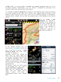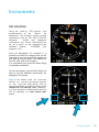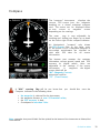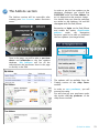
1
Air Navigation Pro 5.3
User
Manual
Av a i l a bl e on t h e
The information in this document is subject to
change without notice and does not represent
a commitment on the part of Xample Ltd.
The software described by this document is
subject to a License Agreement and may not
be copied to other media. All product and
company names are TM or ® trademarks of
their respective owners.
Special thanks to our Beta testers, partners
and users who where invaluable in making
this a better product.
Air Navigation Pro is developed by:
Johann Huguenin
Flavien Volken
http://www.xample.aero
http://www.facebook.com/AirNavNews
http://www.youtube.com/XampleAirNav
PRODUCT VERSION: 5.3 (01/2013)
DOCUMENT VERSION: 5.3 (01/2013)
About the company
Xample LLC
Coteau des Ifs 41
1400 Cheseaux-Noréaz
Switzerland
2
Contents
(click to jump to page)
New/updated content
Introduction
4.
5.
6.
About Air Navigation app
Minimum requirement
Disclaimer
User Interface
7.
8.
9.
Interface on iPad
Interface on iPhone
Buttons in the toolbar
Installation
14.
15.
17.
17.
Getting started with Air Nav Pro
Installing maps/charts - Updates
Restore purchased maps/charts
Waypoints/Airspaces package
Moving map
18.
20.
21.
23.
24.
26.
Introduction
Select a waypoint from the database
Route planning
Adding an Aircraft profile
Map Options menu + Overlaying
The Terrain Elevation view
Instruments
27.
28.
30.
31.
32.
33.
34.
35.
36.
Introduction
HSI
VOR/CDI
ADF
Compass
Altimeter
Groundspeed
Variometer
Flight information
Tools/Features
37.
38.
39.
40.
41.
43.
44.
45.
46.
Flight Time
Record a Flight
Logbook
Weather
Document browser
Sensors
Screen lock and notebook
Approach charts
Weight and Balance
EFIS module
49.
50.
51.
Introduction
Pressure and View Mode
Terrain awareness 3D/2D
Xample services
52.
53.
54.
55.
The User Account
Addons section
Flight Tracking system
Route synch
Third-party services
56.
GoVFR
Simulators
57.
59.
Connecting to X-Plane
Connecting to FSX
Import/export data
(Backup/sharing)
60.
61.
64.
68.
69.
69.
Introduction
Embedded Webserver
WebDAV server
Email feature
Open in Air Nav feature
Backup waypoints option
Advanced features
70.
71.
72.
73.
76.
Pair 2 devices
Attach a PDF document
Sound alerts
Waypoints file format
Airspaces file format
External devices
77.
77.
External GPS
AHRS g mini
Getting Support
78.
79.
Troubleshooting
Contact us
3
Introduction
Thank you for your interest in Air
Navigation. Air Navigation was developed
with General Aviation in mind, however it
was quickly adopted by pilots of various
flying vehicles including for example
paragliders, gliders, ultra light, single or
multiengine airplanes, helicopters and even
hot air balloons.
Air Navigation
is an
affordable, yet
powerful flight planning and real-time
navigation application. With version 4, the
application user interface was overhauled
to make it easier to use and
add
various new features. We hope you’ll
enjoy
the
product as much
as we
enjoyed working on it.
About this document
This document is intended to be a
complete user manual, however, as new
updates are released often, brand new
features may be missing until they are
added in a further version. You will find
references
to
3
versions
of
Air
Navigation
(Free, Standard
and
Pro),
however, this document will focus on Air
Navigation Pro.
About Air Navigation
Air Navigation is a real time navigation
and
flight planning application. It is
distributed in 3 versions:
Air Navigation Free
• Internal database with
more
than
100. 000 waypoints,
airports
and
related information;
• Navigation instruments (HSI, CDI, ADF).
Air Navigation Standard
• Moving map with direct to waypoint
capability;
• Access to free of charge, open
source maps, downloadable from
within the application;
• Internal database with more than
100. 000 waypoints,
airports
and
related information;
• Internal
database
with
airspaces
information
(not
all
countries
available);
• Logbook (manual);
• Navigation instruments (HSI, VOR,
ADF).
Air Navigation Pro
• Moving map with multi leg flight
planning or direct
to waypoint
capability;
• Access to commercial aviation charts
(as in-app purchases) for Europe,
USA, Australia, New-Zealand (check
our website for available countries);
• Supportfor geo
r e f e r e n c e d
approach charts (not
a
l
l
countries available, check our website
for more information);
• Access to free of charge, open
source maps, downloadable from
within the application;
• Internal database with more than
100 000 waypoints, airports and
related information;
• Internal
database
with
airspaces
information
(not
all
countries
available);
• Logbook (automatic);
• Support
for elevation data, see
terrain in front of airplane or while
planning legs;
• Support for 3D data of Synthetic Vision;
• Navigation instruments (HSI, CDI, ADF);
• Online flight tracking service.
• Support for the use of external gadgets
(AHRS g mini, other manufacturers)
Go back to index
4
Minimum requirements
Air Navigation Pro 5 will run on:
‣
An iPhone, iPod Touch or iPad;
‣
iOS operating system version 5.1 or
higher;
‣
200 MB of available space for
application and database;
‣
approximately 350 MB of available space
for each chart of the size of a country
like France or Germany;
‣
A GPS module is mandatory for real
time navigation. The following devices
have an integrated GPS module:
- iPhone 3GS/4/5;
- iPad 1 or 2 with 3G capabilities;
- New iPad (known as iPad 3);
- iPad mini + Cellular (with 4G capabilities).
iPod Touch and iPads Wifi only require
an external GPS module. Example of
external GPS modules are:
• TOM TOM car kit for iPhone;
• GNS 5870 MFi Bluetooth;
• Bad Elf 66 channels;
• DUAL XGPS 150 series;
• Garmin GLO Bluetooth.
the
For more information on how to connect Air
Nav Pro with an external GPS device, please
refer the «External devices» chapter.
Note: versions of Air Navigation Pro 5.2 or
higher will NOT work on an iPhone 3G due to the
changes on Apple’s testing code for developers.
However, the app will perform normally on an
iPhone 3GS or latest versions.
Go back to index
5
Disclaimer
Before using this software, you must read
the following terms and conditions.
and
agree with
This software is not intended to replace
a certified
navigation device! We do not guarantee the accuracy and
comprehensiveness of the information provided.
The
embedded navigation
database
is
provided
for
informational purpose only. It may not be complete and may
contain erroneous data.
You should always use official aeronautical documentation
(AIP) when preparing and performing a flight. You should
always use certified navigation devices when performing
a flight. This software is provided ‘as-is’, without any
express or implied warranty. In no event will the authors or
third party data providers be held liable for any damages
arising from the use of this software.
YOUR USE OF THIS REAL TIME ROUTE GUIDANCE
APPLICATION IS AT YOUR SOLE RISK. LOCATION DATA
MAY NOT BE ACCURATE.
Go back to index
6
User Interface
Air Navigation Pro 5 on
iPad
On iPad the screen is divided to display
the selected route and an instrument
of your choice on the left side. The
moving map is on the right side
together with the data bar at the
bottom.
An optional terrain profile view can
be displayed at the bottom.
The moving map can be set to full
screen and it this case, the route and
the instrument are hidden but still
accessible from the instrument button
in the top toolbar.
Other
modules, functionalities
and
settings can be accessed from the top
toolbar.
Toolbar
Current
Route
Moving
Map
Instrument
Data bar
Terrain Profile
Go back to index
7
Air Navigation Pro 5 on
iPhone
On iPhone the toolbar is hidden by
default
and
you
must
press
the
«screwdriver» button on the left side to
display it.
On iPhone
one
module
can
be
displayed at a time. By default, the
moving map is displayed at launch
time.
Other
modules can
be
displayed
by
pressing
the
corresponding tab buttons at the bottom
of the screen.
Other modules and settings can
be
accessed in the «Configuration» tab in
the bottom right corner.
Toolbar
(normally
hidden)
Moving Map
Data bar
Terrain Profile
Bottom bar
Go back to index
8
Buttons in the Toolbar
On iPhone, this button toggles the moving map data bar visibility on/off. On
iPad, this button toggles between «Split-screen» and «Full-screen» mode.
The split screen shows two of the selected instruments together with the
moving map. This instruments/route can be selected from the “Instruments
Layout” menu in «Configuration» button at the top-right corner of the toolbar. For
more information please refer to «Configuration» icon on next page.
This button will run the «EFIS module». You will first need to download
the 3D data from the «Map Store» menu.
On the iPhone, you will find this instrument on the «Configuration» tab at
the bottom right corner.
«Map Options» displays the map settings module. In the map settings you
can configure what will be displayed on the map and how. Please refer to the
«Map Options» chapter for details. The following are the available options on
this menu:
• Control the screen brightness;
• Show/hide the map
background (the
installed charts/maps);
• Show/hide the terrain elevation graph;
• Enable the Terrain awareness 3D/2D;
• Show/hide symbols of weather conditions
(VMC, IMC);
• Setup the airspaces filter and
display
modes;
• Setup the waypoints filter;
• Enable the extended track line, bearing
line and runway limits extensions;
• Enable Maps/Charts and choose which
map will be displayed on top o f t h e
others;
• Choose background color (for where there
is no map).
Toggles between «Flight mode» and «Edit mode». When edit mode is turned
on, a yellow-black bar at the top of the screen indicates it is active.
On the edit mode it is possible to tap waypoints on the map to add/remove
them to/from a current route.
Additionally, you can freely navigate the EFIS module.
Go back to index
9
Displays the waypoint database where
it is possible to
«Search» for a particular waypoint or list nearby waypoints, sorted by
distance.
Displays the list of saved «Routes». Tapping on a route from the list will set
this route as current, display the legs in the «Route» module and display
the route in the moving map as a magenta-color vector.
Selects the «nearest airfield»
to waypoint.
from
your current
location as a direct
This button is used to «Erase» the current selected route or “ direct to”
feature from the moving map. Press this button when you want to set the
map to «free flight» mode and/or when you want to start a new blank
route. Additionally, you can hide a georeferenced approach chart from the
moving map.
Displays the «current Flight logbook» entry. On iPhone, this module
is reachable from the tabs at the bottom and has a slightly different icon.
Displays the «instruments» list. On iPhone/iPod Touch, the instruments list is
reachable from the «Configuration» tab at the bottom right corner.
Displays a list of «weather stations» and latest METAR/TAF information in a
decoded format. You can add stations of your choice by entering an
identifier in the search field on top and press return. On iPhone/iPod
Touch, this module is reachable from the «Configuration» tab at the
bottom right corner.
Displays a list of «PDF documents» associated to an airfield. Pressing a
document will display its content in fullscreen mode.
You will also use this tool to create an «Aircraft profile».
On iPhone/iPod Touch,
this
module
is
reachable
from
the
«Configuration» tab at the bottom right corner.
Go back to index
10
Displays the «Tools» list where you can find additional utilities. On iPhone/
iPod Touch, the tools are reachable from the «Configuration» tab at the
bottom right corner.
The following are the available options on this menu:
• Air Nav Services. Please refer to «Xample
Services» chapter on this manual;
• GoVFR tool. Please refer to the «Third
Party Services» chapter on this manual;
• Custom Waypoint Editor. You will be
able to create user waypoints of different
types (Airfield, Heliport, IFR, Navaids, etc);
• Logbook. Please refer to the «Logbook»
chapter on this manual;
• Recorded Flights. You can reproduce
your flights live on this option. Refer to
«Record a Flight» chapter on this manual;
• Sensors. Please refer to the «Sensors»
chapter on this manual.
• W&B Calc. Weight and Balance calculator
after entering the required data in the
Aircraft profile.
Displays the «Settings» module where you can fine tune the application
behavior and customize units and other settings.
We can also find the «Map Store» module within this button, from where you can
download both free and commercial maps/charts/data.
When using the Waypoints database search engine, you can enable/disable the
countries displayed to make the search easier.
This button also displays the «Instrument
Layout» menu, where the instruments are
reordered on top of the list in order to appear
in the «split» screen when using an iPad. In
this case, only the first two will show together
with the moving map.
On a n iPhone/iPod Touch, the «Instruments
Layout» menu will reorder the first 4
instruments to show them in the Bottom bar.
All the mentioned modules and settings are
reachable from the «Configuration» tab at
the bottom right corner on an iPhone/iPod
Touch.
Go back to index
11
The following are the available «Settings»:
• Units. Gives the possibility to change the units of
the displayed values:
- Distance & speed: NM&KTS, M&Mph, km&km/h;
- Runway lengths: meters, feet;
- Altitude: meters, feet;
- Pressure (AHRS g mini): hPa, inHg;
- Coordinates: DD:MM:SS, decimal, DD:MM.mm;
- Logbook time: HH:MM, decimal.
Should you wish to change Fuel/Length units, you
can do it in the Aircraft profile panel.
• Map. Blocks/allows map rotation.
When «Auto approach charts» option is ON, the
approach plate will show up on the moving map
when the desired Airport is the next waypoint.
Note that in order to use this option, you will first
need to purchase the “VFR/IFR” approach charts
from the Map Store (not all countries available).
Please refer to the next chapter for more info.
«TRK/Bearing» option will allow you choose from
showing True North or Magnetic North when
creating a Route/displaying next waypoint. When
«Hidden points selectable» option is ON, the user can still select a waypoint if it`s
hidden.
• Instruments. You can choose from displaying
the True/Magnetic North when using the
Compass. When «Adjust Nav 1 to map leg» is
ON, the instrument will automatically be
configured to the NEXT waypoint on the map.
Remember that as it`s “Nav 1” it will only affect to
the FIRST instrument of the list showing under
«Instrument Layout» menu.
You can also choose to «Auto Adjust the OBS»
when using the ADF, VOR and HSI. This will
automatically align the arrow/CDI of the
instrument in direction of the configured
waypoint.
Sound alerts can be activated from «Audio effects».
• Network. This will show, when enabled, the IP
addresses to connect the Mac/PC with the
«E mbedded WebServer» or the «W ebDAV server».
You also have the option for enabling
«GSM download», when using 3G/4G network to
download charts/data.
Go back to index
12
• Misc. The user can «RAW the METAR/TAF»
information, enable the option that will turn
the «flight recorder» ON, and have the
possibility to «run the app in the background»
on the iPad, if having to temporarily use another
app or change settings outside Air Navigation
Pro. If Air Nav remains in the background for
more than 10 minutes, it will automatically close
so as to save energy.
«Alternate speed/course» option forces Air Nav
compute the data in “time deltas” and not
continuously. This will help when the GPS signal
is weak and breaks off intermittently.
The «Automatic logbook» option will complete
the
Block-OFF/Block-ON times
and
the
Take-OFF/Landing times automatically. Please
refer to the «Logbook» chapter in this manual for
more details.
«Share GPS via Bluetooth» will let PAIR the
device with another one of the same nature (for
example an iPad with an iPod Touch) and share
the GPS signal.
• Disclaimer. Disables the “Disclaimer” message
at the start of the app.
• Default. Reverts to factory settings, WITHOUT deleting or modifying existing waypoints,
routes, flights or logbook.
This last option might help in case Air Navigation Pro is not working properly.
• Spinball. This option will only appear in the «Settings» section of the iPhone/iPod Touch.
There is not such a feature on an iPad.
To calibrate the spinball, you have to position your iPhone/iPod Touch on a flat surface.
Note that only when flying aerobatics the spinball is spinning.
Go back to index
13
Installation
Getting started with Air Nav Pro
After installation of the application, at first launch, the
system will ask for authorization to access location
data (GPS). You should allow GPS access to Air
Navigation otherwise realtime navigation functionalities
will not work properly. If your device do not have an
integrated GPS device, you should get some of the ones
advised on page 5.
After launching Air Navigation for the first time, the
map should be centered to your current location. The
application has an internal waypoints database and
you should see waypoints in the vicinity on the map.
Please note that NO map in the background is
installed with the application. You can install a map
from
various
free-of-charge
or
commercial
sources in the «Map Store» module within the app or
from the «Addons» section of the User Account Website.
You can find more information on how to install
maps/charts in the next page.
Should you wish to change length, speed or altitude
units, you can do so from the «Settings» panel.
Go back to index
14
Installing maps and charts
Commercial charts screenshots:
http://www.facebook.com/AirNavShots
Different type of products can be installed to be used
as the background image of the moving map module
or to use with the 3D module and the Elevation Graph:
‣
‣
‣
‣
‣
‣
Free-of-charge maps;
Charts from the public domain;
Paid charts;
Geo-referenced approach charts;
3D data;
Free Elevation data.
These products are stored in the iPhone/iPad’s memory
and do not require an internet connection while
flying.
There are two ways of getting the charts/data:
➡ «Map Store» module.
➡ «Addons» section from the User Account.
In this chapter, we will focus on the «Map Store».
There is a dedicated part in the «Xample Services»
chapter for the «Addons» section.
Before you attempt to download a product
should check that:
you
‣ Your
iPhone/iPod/iPad is connected to a
functional Wifi network;
‣ Bluetooth is turned OFF on your device, as it
can disturb the Wifi network, sometimes leading
to download failure.
Note: if you wish to uninstall any chart, map or 3D data, you
should do it from the panel «Installed products» of the Map Store
module. For more details, continue to read on next page.
Go back to index
15
The «Map Store» module has been modified
totally on version 5.3 to make it more easy to
use. It looks like the screenshot beside shows
and it’s reachable from the «Configuration»
button/tab. It has 4 sections:
• Installed products
It shows the charts, maps and data that is
currently installed in the app.
• All my products (former Restore purchases)
It shows all the charts, maps and data that
has been downloaded and purchased since
first use of Air Nav Pro (not necessarily
installed in the app). This is where you can
re-download a previously purchased product
• Catalog
It is divided into two parts; on the first part
you can choose the country you are
interested in and you will show all the
charts/maps and data available for that
country. On the second part, you will show the products by their category.
• Downloads
It lists current and pending downloads. This module is typically used to monitor
download progression of a product. It is possible to reorder/delete the downloads
or cancel all by pressing on the «Edit» button located at the upper left corner.
Updates
Install Updates
Every time there is an update for a map, chart or
3D data, you will be notified by a red symbol as
the screenshot shows beside.
The red symbol will appear on both the bottom
bar of the Map Store module and next to the
product.
The reason for an update may be:
• A chart update that is part of your
subscription is available;
• We found an issue with the chart/data
and we released a fixed version.
Go back to index
16
Re-installing purchased
maps, charts and 3D data
On version 5.3 of Air Navigation Pro the
Map Store module has been re-designed
to be more clear for users.
The button labeled «All my products»
reachable from the bottom bar of the
module will display all the maps, charts
and 3D data acquired by the user iTunes
account from the very first time, no matter
they were installed or not.
In order to re-install previously acquired
maps, charts or 3D data, you can look into
this module and press on the desired one
to install it.
You can also choose to install them all by
pressing on the upper left corner button
(see screenshot on the right).
You should Always use the
same iTunes account.
The option Input code is still present for a
product that was sold with a license code,
such as the German VFR approach charts.
Waypoints and Airspaces
Thanks to the User Account introduced
with the version 5.3 of Air Nav Pro our
databases
can
be
updated
more
frequently without having to wait until the
following app release.
The databases come in packages that are
available in the Catalog section of the
«Map Store» module and updates will
show up like it was described on previous
page with a red mark.
Make sure to first SUBSCRIBE within your
User Account. More details on page 52.
In order to get the updates and be able to
download the packages to your device,
you
should
enable
the
option
«Synchronize
addons»
under
«Air
Navigation Services» panel in Air Nav Pro.
Go back to index
17
Moving Map
Introduction
The moving map is the main instrument of Air Navigation. It is used for real
time navigation as well as route planning or creation of user waypoints.
In Air Navigation 5, you can create a route/waypoint d i r e c t l y from the moving
map. It is possible to add intermediate waypoints to your current route during
a flight (to avoid bad weather conditions for example)
By default, the moving map is centered on your current location, north oriented. By
pressing to the symbol in the top left corner, you can toggle between:
North oriented, current location
in the center of the s creen,
moving;
Track oriented, current location
at 1/3 the bottom of the
screen,
rotating
to
match
current track, moving;
Panned mode;
Touching and moving the map will
switch to panned
mode. In this
case the map will be moved to the
location
of
your
choice,
north
oriented. It will not move to follow
your current
location, instead, the
aircraft symbol will move on the
map, possibly leave the screen area.
You can center the map again and
restore map movements by pressing
once on the symbol in the top left
corner.
Go back to index
18
Touching an area of interest on the map will reveal a
popup with useful information. Touchable items are:
• Waypoints: elevation,
type,
full name
for
Navaids and their frequency, Airports runway and
frequency information. On version 5.3 we also
included: Sunrise/Sunset time and Bearing/Distance
from current position.
• Airspace: lower and upper limits, name, class and
additional information.
• METAR/TAF stations: Weather information of an
Airport. You enable them in the «Map Otions»
menu.
VMC - Visual Meteorologiacal Conditions
(VFR allowed)
Marginal VMC
(VFR only controlled)
IMC - Instrumental Meteorological Conditions
(Only IFR flights)
You can simplify the information of METAR/TAF by
enabling the option “Raw METAR/TAF” under
«Settings».
On iPad, pressing outside the popup will hide
it, on iPhone you have to press the close
button in the top right corner of the popup.
When in «Flight mode» (default), pressing on the name of the waypoint will ask you
if you want to select this waypoint and affect it to an instrument or direct to t he point
in the moving map.
Go back to index
19
Selecting a waypoint from the database
By pressing on this button at the top toolbar on an iPad or within the toolbar in an
iPhone/iPod Touch (accessible from the «screwdriver» button), you can have access
to the waypoints database.
You can search by country or use
the «search» field to go directly to
the waypoint you are looking for. It is
possible to search by “name”, “ID”,
“place”.
Once
you
found
the
desired
waypoint, you can directly press on it
to select it as a “direct to” or adjust it
to one of the instruments (HSI, VOR,
ADF); or you can press on the blue
disclosure button on the right side
and check the information about it
such as name, city, frequency (for
Navaids),
runway
and
contact
frequency info (for Airfields) and you
can “jump” on the map where that
waypoint is located by selecting
«Show on map» button.
Go back to index
20
The data bar at the bottom of the moving map will display real time information such
as next waypoint information (identifier, name, bearing, distance and
estimated
time), current
speed as reported by the GPS (ground speed), track, altitude as
reported by the GPS, height over ground (if the elevation data for your area is
installed), quality of the GPS signal.
For real time navigation, the quality of the GPS signal is required to be a green
or yellow symbol. A red or orange symbol will only show an approximate location and
will not report speed nor track information.
For better results, you should place your device near a window, with a direct view of
the sky, Do not hold the iPad with the hand covering the GPS antenna (black area on
the top of the iPad). If you are flying with a full metal airplane or your airplane
is equipped with anti ice windshield, the internal iPhone/iPad GPS may be a bit weak
and you may need an external GPS module.
Route planning
By default, the moving map is in «flight mode». You can toggle the moving
map from «flight mode» to «planning mode» at any time to create or
amend a route by pressing the «EDIT» button in the Toolbar.
To start creating a route:
‣ toggle to «Edit mode», a yellow and black
striped bar should appear at the top of the
moving map. A search field will also appear on
top of the «Route» module.
‣ To add waypoints, press on waypoints of
your choice on the moving map. In the
waypoint popup, press the «add
to route»
option. A yellow star should now appear on the
moving map and your waypoint should be in
the «Route» list.
‣ Alternatively, you can input one or more
waypoint identifiers in the search field on top
of the «Route» module and press return.
Multiple identifiers must be separated by a
space.
Note: to find a waypoint near an airfield, typically
VFR report points, you can use the following syntax:
W@LSZG (waypoint id@airfield id) then return. This
will force Air Navigation to find the closest waypoint
from LSZG with the identifier W.
Go back to index
21
In Edit mode it is also possible to reorder and remove waypoints from the list in
the «Route module». Alternatively, you can remove a waypoint by pressing on the
map and choose the «remove from route» option.
It is possible to insert a waypoint by pressing on the magenta vector (leg) and moving
to a new location on the map. As a result a new waypoint will be inserted in the
«Route». If the location on the map is not over an existing waypoint, a «temporary»
waypoint will be created. You can add this waypoint later to the database if you wish to
do so.
You can
create a new
waypoint by pressing 2
seconds at its location on
the map. A popup will ask
if you want to add this
point to the database or
simply
use
it as
a
“temporary” waypoint for
the route or direct to.
In the «Route» module, you can
press on the «Summary» line at the
top of the list to set the
route
name and wind. The route name
is used to identify a
particular route in the «Route» list
when they are saved. Wind and
cruise speed information will be used
to display estimated time
and
heading in «edit mode». In «flight
mode» current speed as reported by
the GPS will be used to compute
estimated time.
The button at the top right corner
of the window can
be
used to
reverse the route or duplicate it.
When you are satisfied with your
route, you can
toggle back to
«flight
mode»,
the route
is
automatically stored in the «Routes
list».
Go back to index
22
Add an Aircraft profile
(Get ETA and total Fuel consumption)
Air Nav Por 5 offers the possibility to calculate the total
fuel consumption for the whole flight and the estimated
arrival time when you plan a route.
First of all, you will have to create an Aircraft profile. In
order to do that, you will press on «Aircraft» under
«Document Browser» menu and proceed to add a
New aircraft. You will be able to set the Aircraft`s
identification and choose an image (optional).
After completing with the ID, you will be taken back to
the window where your new Aircraft ID is created.
In order to enter more information about your
Aircraft, you should press on the BLUE-circled button
on the right side. Under “Cruise information”, you will
be able to enter the Cruise Speed and the Fuel flow
of your Aircraft. This information is very important for
Air Nav to calculate the ETA and Fuel consumption.
Under “Make, model, appearance” you will be able to
enter the aircraft’s info and choose color.
From Air Nav Pro 5.2 onwards, a feature for
Weight and Balance has been added (refer to
«Weight and Balance» chapter for more details).
Should you wish to change speed or altitude
units, you can do it from the «Settings» panel.
Don`t forget to select your Aircraft. Once
selected, you should see a green mark on the
left side of the ID, as it is shown on the image
above.
If you wish to send the Aircraft profile by e-mail,
should you do it through the button on the upperright corner.
Note: After creating a route, when
pressing on «Summary» within the
Route module, you will then be able to
see the ETA and the estimated Fuel
consumption for the whole flight.
Go back to index
23
«Map
Options» menu
From the «Toolbar»
the moving map.
press the «Map Options» button to access various options for
• Brightness. Controls the brightness of the screen.
s c r e e n
• Show maps. Enables or disables the background.
• Elevation graph. Enables or disables the terrain
elevation view. Refer to next chapter.
• Terrain awareness 2D/3D. Enables or disables the
terrain awareness for both moving map and 3D EFIS
module.
• Show METAR on map. Displays icons over the Airports
according to the weather conditions (VMC/IMC) on the
map. Internet connection is needed to use this feature.
The «Maps settings» module
• Airspaces. Displays a list where you can
show/hide the airspaces according to their type on the
moving map. Use it as a filter of which type of airspaces
you’d like to always see on the map and which ones
not. There`s also an Altitude filter, so you might choose
from seeing all the existing airspaces in the zone you are flying or just the ones at your
current altitude. Besides, you can fully-shade the airspaces and even display their names
and show them in the Elevation Graph as shown on the screenshots, below.
• Waypoints. You can filter the waypoints according to their type (Airfield, Heliport, IFR,
VRP, Navaid, etc). There`s also the chance to filter by runway length and surface type.
• Widgets. You can choose to show or
hide the extended the track line of the
plane (shown as a dotted orange line)
and the bearing line to a next waypoint
(shown as a dotted gray line. See
screenshot on following page. You can
also show labels on each leg vector that
will show distance and course to next
waypoint. As another feature, Runway
identifiers will extend the runway limits
on the moving map to make the approach easier.
Go back to index
24
The «Extended track line» (orange) shows the ETA in minutes from your current position.
The «Bearing line» (grey) points to the next waypoint selected.
• Background color. You can choose the color of the background for the zones where no
maps are shown. This is a very useful tool for when you find “gaps” or “white” zones in the
sea/ocean part of some downloaded charts. You can then choose the “sea” color to fill
those gaps.
• Maps. You can show/hide/overlay previously downloaded maps.
Air Nav Pro 5’ s map engine is capable of displaying multiple maps at the same time
and specify which map should be displayed on top where they overlap. It means that
you can MIX maps from different providers and use them all at the same time.
Overlaying (“Missing part” on a chart)
In the screenshot on the right, we show both the
chart “Brazil WAC 2011” and the chart “Uruguay - Free”
one on top of the other. The problem looks like if the
Brazilian chart is missing a part, but actually, it is not.
This is a clear example of OVERLAYING.
You can solve this
problem by simply
moving the charts
up or down in the
«Maps» panel or
switching them ON
or OFF.
Move from here
On the picture on
the right, we show
the chart from Uruguay on top of the one from Brazil.
So, if we move it below, the latter will show on top of the
former. This is shown on the picture on the left. We
move the charts by pressing and holding from the right
edge (where the three-line mark is).
Go back to index
25
The terrain elevation view
if elevation data is installed for your
region, the elevation graph will display
terrain information. Note that you will
show data information ONLY after
downloading «F r e e Elevation data» files
or «3D data» files from the «Map Store».
The difference between each is that the
former may have inaccuracies and the
latter is more precise and complete.
In «Edit mode», it will display the
terrain
between the two
waypoints
of the selected leg. This is very useful
when planning your route, to get an
estimate of the minimum safe altitude.
Please note that even with a good GPS
signal, the altitude as reported by the
GPS may have an accuracy of +/- 200 ft.
Elevation database may also contains some
inaccuracies. You should always plan your
flight with a reasonable margin over the
obstacles.
In «Flight mode», it will display the
terrain
in front
of
the
aircraft,
updating the view every 5 seconds, the
terrain view can be zoomed to display
10 NM to 50 NM of terrain elevation. The
maximum reported
altitude
will be
displayed in the top left corner of the
elevation view. A symbol representing
your aircraft will be displayed in the
view with a red dashed line, representing
your current altitude, as reported by the
GPS.
Note 1: The «3D data» includes all the terrain information with better accuracy than the one from the
«Free Elevation data». It`s more complete and it works for both the terrain profile graph and the «3D
EFIS» module (for more info refer to the «3D EFIS module» chapter).
Note 2: remember that you can activate the Airspace view in the Elevation Graph from the menu
«Map options», then looking for the option under «Airspaces» section.
The Elevation Graph should look like the following screenshot shows.
Go back to index
26
Instruments
Introduction
Using the built-in GPS receiver and
accelerometers of the
iPhone
Air
Navigation can simulate various aircraft
instruments such as HSI, ADF, CDI/VOR,
Altimeter.
Unlike
real
navigation
instruments, the virtual instruments can
be set to point to any waypoint in the
database (airport,
VOR/DME, user
waypoint, etc).
From Air Navigation 5.1 onwards it is
possible to make fine changes and set the
instrument more accurately by tapping on
one side of it or the other. This applies for
the HSI, VOR, ADF and Compass.
It is considered very useful for when flying
in turbulent conditions.
On the next pages, you will find details on
how to use the different instruments Air
Navigation Pro brings.
Note: In the default mode the instrument
displays the course of the selected waypoint
on the map/route automatically. You can
cancel this behavior by switching off the option
«Adjust Nav 1 to map leg» under «Settings».
It is also possible to automatically align the
CDI by switching on «Auto adjust OBS»
option.
Go back to index
27
HSI
The HSI is the
most practical of all
traditional nav
instruments but
it also
requires some training before it can be
used efficiently.
If the GPS reception is bad the warning
flag will
show
that
the
instrument
does not display correct data.
The top
part
of the screen is an
emulated HSI (Horizontal
situation
indicator) . The yellow
needle
is the
Course select pointer, the moving part in
the middle is the Course deviation indicator
(CDI) which displays the deviation (+/- 12
degrees) from the selected radial or course
to or from the selected waypoint. Unlike on
a real HSI where the orange Heading bug
is used to set a course for the autopilot,
the heading bug displays the bearing to
the selected waypoint. Also the HSI does
not display magnetic heading but the
track of the aircraft.
The advantage of the HSI is that
it
displays the position of the aircraft symbol
in the middle
relative
to the selected
course. The compass card will rotate automatically to match the current flying track.
Radial or course selection is done by touch and swipe gesture up or down on the left
or right of the compass ring.
A “NAV” warning flag (as shown in the image above) will let you know that you
should Not trust the HSI indicator in the following cases:
‣
‣
‣
‣
No waypoint is selected for the instrument;
the waypoint distance is over 250 nautical miles;
the GPS accuracy is bad;
Groudspeed is less than 5 Kts.
Note: Please note that you may still get correct deviation information when GPS accuracy is
less than 2.5 nautical miles. In this case the compass card will be oriented to the north.
Go back to index
28
Below the main indicator, the selected waypoint is displayed as well as the distance
from the waypoint (great circle distance) and GPS accuracy. You can use any kind of
waypoint (Airports, VOR, NDB, etc) to be used with the HSI instrument. (A real HSI
indicator requires radio signals from VOR, VOR/DME or VORTAC transmitters).
You can
select a new
waypoint from the
database with the the blue disclosure button on
the bottom part of the instrument (see screenshot).
Please read «Selecting waypoints from the database»
to get
information about waypoint search and
selection.
Note: remember that you will ONLY find the spinball at the
bottom of the instrument on iPhone/iPod Touch devices.
Go back to index
29
VOR/CDI
The VOR instrument uses GPS
display the bearing to a waypoint
data
to
The top
part
is an emulated VOR
indicator. The white
needle (CDI, Course
deviation indicator)
will
display
the
current
deviation up to +/- 12 degrees
relative to the selected radial to or from
the course to the selected waypoint.
Course and radial selection is done by
touching and
swiping gesture up or
down on the left or right of the compass
ring.
Below the main indicator the name of the
currently selected waypoint is displayed as
well as distance from the waypoint (great
circle) and GPS accuracy. You can use any
kind of waypoint (Airports, VOR, NDB, etc)
with the VOR instrument (whereas a reallife VOR indicator requires radio signals from
VOR, VOR/DME or VORTAC transmitters).
You can select a new waypoint from
the
database
with
the
the
blue
disclosure button on the bottom part of
the
instrument. Please read
«Selecting
waypoints from the database» to get information about waypoint search and selection.
A “NAV” warning flag will let you know that you should Not trust the VOR
indicator in the following cases:
‣ No waypoint is selected for the instrument;
‣ the waypoint distance is over 250 nautical miles;
‣ the GPS accuracy is less than 2.5 nautical miles;
Note 1: you don’t need Groundspeed to get accurate information on this instrument.
Note 2: remember that you will ONLY find the spinball at the bottom of the instrument on iPhone/
iPod Touch devices.
Go back to index
30
ADF
The ADF instrument in Air Navigation uses
GPS track information and does of course
not receive any radio waves. It can still be
of value for practicing ADF navigation.
The top part is the ADF indicator. The yellow
needle is pointing towards the
selected
waypoint relative to the longitudinal axis of
the aircraft.
The compass card can be manually rotated
using touch and swipe up/down gesture on
the left or the right of the indicator. This
way you can set the ADF to the magnetic
heading.
Below the main indicator the name of the
active waypoint is displayed as well as the
distance from the waypoint (great
circle
distance) and GPS accuracy. It is possible to
select any kind of waypoint (Airports, VOR,
NDB, etc) as an ADF target waypoint unlike
with a real ADF which requires NDB or AM
transmitters as waypoints.
You can select a new waypoint from the
database with
the the blue
disclosure
button
on the
bottom part
of the
instrument. Please read «Selecting waypoints from the database» to get information
about waypoint search and selection.
A “NAV” warning flag (as shown in the image above) will let you know that you
should Not trust the ADF indicator in the following cases:
‣
‣
‣
‣
No waypoint is selected for the instrument;
the waypoint distance is over 250 nautical miles;
the GPS accuracy is bad;
Groudspeed is less than 3 Kts.
Note: remember that you will ONLY find the spinball at the bottom of the instrument on iPhone/iPod
Touch devices.
Go back to index
31
Compass
The “compass” instrument
displays the
current GPS course (not the magnetic
heading) on a virtual animated compass
card. The course can be displayed either
as true
course
or
magnetic
course
depending on the settings.
The outer
ring is user adjustable by
touching and sliding your finger up or down
on the left or right of the compass indicator.
Air Navigation’s "compass" only shows
the GPS course. Due to the large error
of the iPhone 3GS/4′s integrated compass in
the cockpit environment we
decided to
stick with
GPS data for
all course
information.
The bottom part contains the compass
information, current ground speed and GPS
accuracy as digital values. Units are
adjustable in the settings. If the course
information
is
magnetic
the digital
course label will be
“MC” (Magnetic Course)
otherwise it will be
“TC” (True Course).
A “NAV” warning flag will let you know that
Compass indicator in the following cases:
‣
‣
‣
‣
you
should Not
trust the
No waypoint is selected for the instrument;
the waypoint distance is over 250 nautical miles;
the GPS accuracy is bad;
Groudspeed is less than 3 Kts.
Note: remember that you will ONLY find the spinball at the bottom of the instrument on iPhone/iPod
Touch devices.
Go back to index
32
Altimeter
The Altimeter of Air Navigation is GPS based
like all nav instruments. Usually, the GPS has
an acceptable precision.
Nevertheless
it
should never be used as a replacement for
the barometric altimeter.
The altimeter instrument of Air Navigation
displays altitudes above Mean sea level (MSL)
as reported from the GPS unit. Usually the
altitude has an accuracy of 70 ft or less. The
accuracy is usually even better with external
GPS modules.
The top part is the anal o g al ti mete
r indicator. On the bottom part you will
find the digital altimeter value as well as
the current GPS status symbol.
The altimeter unit can be set as feet
meters in the application settings.
or
A Question mark will show instead of a digital altimeter value when:
‣ GPS accuracy is more than 230 ft;
Note: remember that you will ONLY find the spinball at the bottom of the instrument on iPhone/iPod
Touch devices.
Go back to index
33
Groundspeed
The top part is the analog ground speed
indicator. On the bottom part you will find
the digital speed value as well as the
current GPS status symbol.
The speed unit can be set as knots, miles per
h o u r o r k ilometers p er h o u r i n t he
application settings.
A Question mark will show instead of a digital altitude value when:
‣ GPS accuracy is bad;
Note: remember that you will ONLY find the spinball at the bottom of the instrument on iPhone/iPod
Touch devices.
Go back to index
34
Variometer
The variometer was designed to work with
external devices such us the AHRS g mini.
Other external devices are thought to be
compatible with this instrument in future
updates of Air Navigation Pro app.
For the time being, the variometer will receive
the AHRS g mini data and display it at the
bottom bar of the instrument.
If no signal is received, then a question mark will
show as vertical speed (see screenshot).
Sound alerts are supported for the variometer.
Shall you wish to enable them, you should do it
from the «Settings» panel:
Go back to index
35
Flight information
The flight information module displays
of real time navigation values in digital
It will also compute the distance flown
the application startup or the current
was reset in the «Flight time» module.
a list
form.
since
flight
At the bottom part, you will find the GPS
horizontal and vertical accuracy as well as
the coordinates of the current
location, as
reported by the GPS subsystem.
Go back to index
36
Tools/Features
Besides
the
moving
map
and
navigation instruments, various tools
are available to help with flight planning
and other tasks.
Flight Time
Take-off time will be set when
the
speed pass 30 kts. Landing time is se t
when
the speed decrease to 25 kts.
Block-on will be set when the aircraft
stops.
After 90 seconds
with no
movement, the flight will be stored in the
logbook. This is to ensure that the
block-on time will be registered in case
you have
to stop on the taxiway for
example.
Air Navigation will try to find
the
airport
at the block-off and
landing
location,
setting the
values
in the
logbook accordingly. Multiple take-offlandings will be added to the landings
count.
Our filters are designed to not
record events in case the GPS signal is
poor or invalid. Therefore you should
check that the GPS signal is good (yellow
or green
symbol) before
using the
automatic logbook.
The logbook values can be edited at any
time
either
from
the
«Flight time»
module, by pressing on the corresponding
line, or, if the
flight
was
already
committed to
the logbook, from the
logbook module itself.
By pressing the «Edit» button in the top
right corner, you can force commit the
flight to the logbook or reset the «flight
time» module to start a new flight.
The flight time module is used to store
the current
flight log entry. The
time and d e p a rt u r e / a r r i v a l p l a c e s
ca n
be
s et manually o r a utomat
ically . To let
Air Navigation fill the
time,
departure and
arrival places
automatically , the «Automatic logbook»
option must be turned on in «Settings».
Block-off
time
is
set when
Air
Navigation detects the movement of the
aircraft.
If for any reason Air Nav collapses
and the application is closed during
the flight, you can recover the
session.
Note: on iPhone, if the «flight time» module is
placed in the bottom tab bar (default), a red
badge will start blinking with the time value as
soon as the block-off time is set, until the flight
is committed to the logbook (see image).
Go back to index
37
Record a Flight
The flight can be reproduced from within
the application by pressing on the desired
recorded flight in the «Tools» menu, where
the flights are stored.
In order to record a flight, you have to
enable the option «Flight recorder» in
t h e «Settings» menu. This should be
done before starting the flight.
Air Nav will start recording as soon as
the Block-Off time is set. You can find
this value, as it was explained on the
previous chapter, under the «Flight Time»
module.
When the Block-On time is finally set,
Air Nav will stop recording the flight and
it will be automatically stored in «Tools»
menu.
A KML file will be stored as well in one of
the Air Nav`s folders. This file can be
downloaded
from
the
embedded
WebServer server and then opened on
Google Earth/Maps and see the flight`s
track (refer to «Advanced features» for more
info on how to connect to the Webserver)
Remember that you can set the values
manually or it can be set automatically
if the option «Automatic logbook» is
enabled in «Settings» as well.
Note: Besides having the chance to reproduce a
flight in Air Nav Pro, you can also send it by
email by selecting the option after pressing on a
desired one.
Go back to index
38
Logbook
Then, flights from the current year
are grouped by months, and then by
year.
It is
always
possible
to
display
individual flights in months or year
groups
by
pressing
on
the
corresponding line.
Individual flights can
deleted.
be
edited or
By pressing on the «Edit» button
top right corner, it is possible to:
in the
• toggle edit mode to delete entries from
the list;
• create a new log entry;
• send the entire logbook or selected
flights by Email as a text and html file;
• set the initial time and landing count
from a previous logbook.
The logbook is basically a database
of stored flights time and details. It
contains all your
manually added
flights or, if the «Automatic logbook» is
turned
on
in
the settings, the
detected flights time
and departure/
arrival.
The flights are displayed
most recent flights first.
with
the
Flights from the current month are
displayed as individual entries in the
main list.
Go back to index
39
Weather
To add a station to the list, type the
ICAO identifier of the airport where the
station is located in the search field at
the top of the list. Then press return.
The station
will be added to the list
immediately. However, gathering
weather
data may
take
some ti m e . Pl e a s e
note that downloading w eather
d ata
requires
an
i ntern et connection
and
may
not
work during flight as
GSM coverage is poor.
To remove a station, swiping on the line
from right to left, will reveal a “ delete”
symbol.
Pressing on a station’s line will reveal the
detailed
weather
message
(METAR)
decoded.
Additionally a forecast weather message
(TAF) will be displayed (when available).
The weather module will list your favorite
weather stations, usually located at
airfields. The weather module will try to
download the latest available weather
data for each station every 30 minutes.
Weather
data
will be
decoded and
stored in the cache, together with a
timestamp. Weather station cached data
will be invalidated if older than 36
hours.
Nota: weather info can be activated
directly on the map for some airports.
Check on page 19.
Go back to index
40
Document browser
«Users documents» appear on top
of
the
list and
are
useful to
store
i mpor t a n t d o cuments such
as A
F Ms , Checklists, Notams, etc. Below the
«User documents», you can find all the PDF
documents attached to specific waypoints
(ICAO or not, IFR waypoint, User waypoint,
etc).
When
installing an
approach charts
package,
PDF documents
will
b e
stored and displayed on a per-airfield
basis and appear in the indexed list
with their identifier, name and country.
There’s a search field on top of the list that
you can use to look for a specific PDF
document.
It is possible to install user documents and
attach them to airfields. To do so, the
name of the PDF file must be prefixed
with the 4 letters ICAO identifier of the
corresponding airfield and the file must
be uploaded in the «Appcharts» section
of the embedded web server (see the
«Embedded Webserver» chapter, later in
this guide, for more details).
The «Document browser» module lets you
access and
display PDF documents
while planning or during a flight.
D ocuments c an be a dded in t he
«Docu ment browser» either by:
‣ Installing an approach charts package;
‣ Uploading
a
PDF file
embedded Webserver;
from
‣ Sending a PDF document by
the
Email
and using
the
«Open
in Air
Navigation» function in the mail client;
‣ Using the
WebDAV server to copy
files from a computer.
Go back to index
41
Alternatively, the document
can be sent by email to
your iPhone/iPad.
Then you can use
the
«Open in Air Navigation»
function,
available
when
pressing on the attachment
in the mail application.
After purchasing app charts,
attaching PDF documents to
any waypoint or adding «User
documents» to the Document
Browser menu, you can use the
button at the top-right corner
of the window to re-index and
show the new documents on
the list.
Note: To copy PDF documents to «Users
documents» or to attach PDF documents
to airfields with non-ICAO identifier,
you must use the WebDAV server (see
the «WebDAV server» chapter later in this
guide).
Go back to index
42
Sensors
They work as follows:
Internal Sensors bridge
‣ to pair with another device (an iPad with an
iPhone for example). Typically it is possible to
connect a Wifi only iPad to an iPhone with an
internat GPS module and let the iPhone share
the location data with the iPad.
X-Plane Flight simulator
‣ to connect with the X-Plane plugin.
(refer to the X-Plane-related chapter)
MS Flight Simulator X
‣ to connect with the FSX plugin.
(refer to the FSX-related chapter)
iOS Location Services
‣ to be able to receive GPS signal (either internal
or external).
Levil AHRS G Mini
‣ to connect with the AHRS G mini device. This is a
special device that makes the EFIS module work
by showing accurate bank angle, direction and
attitude of the aircraft (refer to the «3D EFIS
module» chapter below in this manual).
Internal IMU
‣ to connect with the internal gyroscopes of the iPad/iPhone.
Go back to index
43
Screen Lock
It is possible to lock the screen in order not to
accidentally change the route or press on nondesirable buttons while in flight.
You will lock the screen by swiping three fingers
from right to left over the moving map. You will
unlock the screen by swiping them from left to right.
Two symbols on the left side will confirm that the
screen has been locked, one at the bottom and one
at the top.
Notepad
When the screen is locked, you can use it as a
notepad to note down relevant information such as
frequencies, transponder code, pressure data, etc.
You will write on the screen by using your fingers.
You have 6 pages which are accessible by scrolling up
or down with three fingers.
All pages are saved and stored while not erased. In
order to blank a page, you will tap on the screen
three consecutive times with three fingers.
You can also erase the notes by pressing on the
“delete” button at the top-left corner of the locked
screen.
Go back to index
44
Approach charts (Georeferenced)
Air Navigation Pro supports georeferenced approach charts for
certain countries. The charts can be downloaded from the module
«Map Store». They come in packages, but still the user can choose
which ones download into Air Nav to use on top of the moving map.
After downloading the approach charts into Air Nav, they will show
on a list in the «Document Browser» (you might have to press on the
upper-right button to “re-index” the list).
Most of approach
charts files come
with more than 1
PDF document, some
of
them
have
a d d i t i o n a l
information such us
parking
sheet,
aerodrome
chart,
several VAC’s, and
even a description on
how to approach or
relevant data coming
with the charts.
An approach chart can be opened manually by
pressing on the Airport waypoint and selecting
the the file which shows a “plane” symbol on the
left side.
It can also be automatically configured to pop-up
on top of the moving map by enabling the option
«Auto approach chart» from the Settings. The
approach chart will then pop up as soon as the
Airport waypoint is the next one in the route list
or if we select the waypoint as “Direct to”.
In order to hide the approach chart you
should use the RED icon from the toolbar.
Go back to index
45
Weight and Balance
(W&B)
The Aircraft profile has been updated
with definition of Weight and Balance
envelope
values
and
weights/arm
locations. When a profile is selected you
can easily compute weight and balance
with the W&B Calc tool under «Tools»
menu.
Once everything is set and all the values
are entered, you will be able to see the
calculation reflected on a graph, under
«Tools» menu.
Envelope Graphic,
made of 5 points:
As mentioned before, the W&B tool is
located in the Aircraft profile under
«Document Browser».
On the screenshot at the upper-right
corner of this page, you will see the
available fields to be completed.
The weights for seats, baggage and misc
will be entered from the «Tools» menu
AFTER the rest of the data has been
already completed. The same happens to
the amount of fuel.
On next page there’s a full example.
31,5
31,5
33,0
38,0
38,0
cm
cm
cm
cm
cm
/
/
/
/
/
1300
1150
1670
1670
1150
lb
lb
lb
lb
lb
Note: you need to enter at least 4 points for
envelope data.
Go back to index
46
Example on W&B tool
In order to complete data related to the
aircraft’s nature, you MUST use a
certified manual of the aircraft’s model.
This is NOT a certified calculator.
Let’s first complete the data concerning
the aircrafts specifications. We’ll take a
C150 as an example.
In order to complete the «Envelope» data,
the values are taken from the CG Envelope
Graph.
3
4
1
2
2
3
1
5
4
5
Go back to index
47
We proceed with the Seats, Fuel and
Baggage, as shown in the screenshot.
1
2
Note:
The Miscellaneous part is optional.
3
4
5
After the module is completed, we then
make sure to have the Aircraft profile
selected from the Aircraft list (see the
green mark on the left side of the profile).
Finally, we go to the «Tools» menu and
we select the «W&B Calc» panel, from
where we will complete with the weights
and fuel information:
2
1
Note: once we have the
module
completed,
we
proceed to press on the
button «Calculate».
Go back to index
48
EFIS Module (3D Synthetic Vision)
Introduction
The EFIS module is a graphic interface which displays
real 3D terrain while flying. In order to use it, you will
first need to download the 3D data from the Map
Store. This is a complex piece of data and it works for
both the EFIS module and the Elevation Graph. So this
means that once you have installed it in Air Nav Pro,
you won’t need to install the Free Elevation data.
You will show an Elevation
indicator on your right and a
Groundspeed indicator on your
left.
At the top of the screen, you will
show the Compass.
In the middle of the screen the
Artificial Horizon. EFIS code
engine has been programmed to
work close to a real one.
At the bottom, there`s a green
button that shows a different
label depending on how and
where you are flying.
You might show the following:
You can freely navigate throughout the terrain in this mode.
Press it for 2 seconds to calibrate it according to your device`s position.
This will show it when using an AHRS G mini gadget.
You will show it when using Air Nav Pro with X-Plane.
You will show it when using Air Nav Pro with FSX.
Go back to index
49
If you want to get the aircraft`s attitude and banking in a real flight, Air Navigation must be
installed on an iOS device with internal gyroscopes (iPad 3, Pad 2, iPone 4/4S).
If it is not the case, Air Nav is prepared
to work together with an external
device known as AHRS G mini from
Levil technology.
The AHRS G mini can also share
pressure, altitude and Airspeed with
Air Navigation if the sensors are active
under “Tools” menu.
Pressure and View mode
Air Navigation 5 comes with the possibility of setting the QNH at the top of the Altitude
indicator within the EFIS module. You can change it when in “Flight Mode”.
Also, by pressing on the top bar (Compass
indicator, as shown below on the image), you can
toggle the screen view to Course/Heading
mode. This will only work when using the AHRS g
mini gadget.
Note: If you split the screen on the iPad while using
the EFIS module, you will always show the Route
module and the Moving Map as the ONLY
instruments.
You can also turn the Elevation graph ON and you
will see the Elevation data up to 10 NM ahead.
(you can see it on a screenshot on next page)
Go back to index
50
Manual navigation in 3D EFIS module
In «Edit» mode, you can manually move
along the 3D terrain by controlling pitch,
heading, altitude and moving back and
forth.
When you have a route created and still in
«Edit» mode, if you press over a waypoint
from the «Route» module, you will be
positioned 2 NM from the selected
waypoint in direction of the leg.
Use the following controls to move along
the terrain:
➡ use the Altitude indicator to move
up/down.
➡ use the arrows on the left to move forth and back.
➡ use the artificial horizon in the middle of the screen to control pitch and direction.
Terrain awareness 2D / 3D
When the option is enabled under «Map
Options», you will show terrain zones
above current altitude in RED. Terrain
below us up to 50 meters will show in
YELLOW.
This feature works for both the EFIS module
and the 2D moving map.
You must acquire the 3D data
from the Map Store if you wish to
use this feature.
Note 2: if you have the option “Terrain
awareness 2D/3D” enabled, but you don`t
use it, you might experience a yellow color
on the map, so it is better that you disable
the option.
Go back to index
51
Xample services
The User Account
Version 5.3 introduces access to new online
services. Users can create a Free account
on our server http://services.xample.ch giving
access to various services:
‣ Check your products
(Maps, charts, waypoints and airspaces)
‣ Flights: Live Tracking System
(Sync/Visualize, share your flights in real-time)
‣
‣
‣
‣
‣
Routes: Sync/Visualize your routes
Share flights with friends and family
Share flights on Facebook
Easy-to-use interface
Several base layers
(Google, Bing and OpenStreetMap maps)
Each User Account can be configured by
“clicking” on the user’s nickname at the
upper-right corner of the top bar.
After creating the free account on the
mentioned page, you can proceed to sync your
routes and purchases on the iPad.
Under «Tools» menu there is a panel named
«Air Navigation Services» in which you will find
the option to Login.
Make sure you are logged in
Note: internet connection is needed on the iPad/
iPhone to use this feature.
Go back to index
52
The Addons section
The Addons section will be accessible after
creating your User Account, under «Services»
menu.
In order to get the free updates to the
databases packages you should first
SUBSCRIBE under the Free Addons list
as it is depicted on the previous image.
You should then see how the packages
are added to «My Addons» list and will
then sync with the iPad/iPhone.
Remember to login on the iPad/iPhone
and enable the option «Synchronize
addons»
under
«Air
Navigation
Services» panel to be able to download
the free updates (see image below).
Once in the page, you will be able to purchase
charts and subscribe to the free updates
database. «My Addons» will list all the
subscriptions and purchases done in the page
or directly in the iPad.
Login
The updates will be available from the
Catalog section of the «Map Store»
module.
In order to sync purchases, you will
proceed the same.
You will show all your purchases under
the section «All my products» of the
«Map Store» module.
Go back to index
53
Flight tracking system
(3G capabilities needed)
The application will send points through the
server in real time as the flight performs and
at the same time a person connected with your
User Account will be able to check those
points that build the track and has relevant info
such as current altitude, heading and time.
(see screenshot below)
Login
The process will start when the Block-off time
has been set in the «Flight Time» module
Remember it can be automatically configured
in the settings. Click here for more details.
Once Block-off time is set, Air Nav Pro will
record the flight live to your User Account.
The recording will finish as soon as the Block-on
time is established.
To avoid issues, make sure to:
• enable «Live tracking service» under
«Tools» menu;
• be logged in with your User Account.
Note: Flight tracking system will work live as long
as GSM network is available.
Go back to index
54
Each recorded flight will be stored on the left bar in the «AIRNAVIGATION» section of the
User Account website. It can be downloaded as a KML file or as a GPX file from the right
side of the bottom data bar. You can also delete a flight.
It is possible to keep the flight private or share it with
family or friends with a password or set it as “public”.
This can be configured from the «Options» tab on the
left bar (see image on the left).
Routes sync
Routes will be imported to the User Account through Air
Navigation Pro by using the «Routes manager» under «Tools»
menu.
The routes will be stored in the «Routes» tab of the left bar
and they can be viewed displayed on the map and can also be
downloaded as GPX files or KML files following the same
procedure as with the flights.
If using a second device, with the same User Account, routes
from on the server can be downloaded directly into that device
through the «Routes manager» panel in Air Nav Pro.
Go back to index
55
Third party services
GoVFR
www.govfr.com is a third party website where you can create a free account and create
and exchange flight plans.
The «GoVFR» module in Air Navigation was
designed to communicate with the website and
exchange Routes (flightplans) between Air
Navigation and your account on the website.
In order to use the «GoVFR» module you
have to:
‣ Create
an
account
www.govfr.com website;
on
the
‣ Create
a
flightplan
on
the
www.govfr.com website (for testing
purpose);
‣ In the «GoVFR» module, press the
«Account information» line and enter your
credentials;
‣ Go
back to the «GoVFR» module,
you should see the test flight plan in the
list.
Pressing on a flightplan in the list will
download and install it as a Route in Air
Navigation.
Pressing on «Upload a flightplan» will display a
list of routes stored in Air Navigation. You can
then press on a route to upload it to your GoVFR
account.
Go back to index
56
Simulators
Connecting the X-Plane plugin
In order to connect Air Navigation Pro to the X-PLANE Flight Simulator a special plugin
must be installed in the «plugin» folder of X-Plane.
The Plug-in for Mac or Windows can be downloaded from the Addons section of our site:
http://www.dixdouze.com/xample/index.php/airnavigation/support
The plugin «Air Navigation_mac.xpl» or «Air Navigation_win.xpl» must be copied to the
«Resources/Plugins» folder inside the X-Plane folder. If the plugin is correctly
installed, you should see «Air Navigation» in the «Plugins» menu of X-Plane, located at the
top bar when starting a flight.
Go back to index
57
Once you have identified the plugin on X-Plane, then click on «Start Air Navigation
bridge», located within «Plugins» top menu as mentioned before.
On Mac computers we use the "Bonjour" feature to discover X-Plane on the network,
this is much easier than typing network addresses.
On Windows computers the “Bonjour” service is required for the automatic detection of
X-Plane network address by the iPhone or iPad. If you have already installed iTunes
you don’t have to do anything, since Bonjour comes with iTunes automatically.
To
download and install the Bonjour service for Windows manually
following address:
g o
to the
http://apple.com/support/downloads/bonjourforwindows.html
download the installer and follow on screen instructions.
Once you have started the Air Navigation bridge on the X-Plane:
‣ make sure you have your iPad/iPhone and your PC connected to the same wifi
network;
‣ make sure to switch the X-Plane Sensors ON in the «Tools» menu.
Go back to index
58
Connecting the “Flight Simulator X” (FSX) plugin
Air Navigation Pro 5 gives the
possibility of using all its features with
MS Flight Simulator X (FSX).
In order to do so, you should follow this steps:
‣ Make sure to have the “Acceleration” pack installed with FSX (or instead the SP1 and
SP2, that you can get from the internet).
‣ Download and install the plugin from our website: http://www.dixdouze.com/
xample/index.php/airnavigation/support
If having issues while installing it, run the icon as “Administrator” (right-click on it)
‣ Download and install “Bonjour” application:
http://support.apple.com/kb/DL999
‣ Make sure to have both PC and iPad/iPhone connected to the SAME wifi network.
‣ Run FSX and accept on the messages that you will show related to the plugin.
‣ Run Air Navigation Pro on your iPad/iPhone and make sure to ONLY have the “Flight
Simulator X” sensor in «Tools» menu (disable all the others, including “iOS Location
Services”.
‣ Start a flight in FSX and press “ALT” key , then look for the “Add-ons” menu on the top
bar and Start Air Nav bridge.
Note: make sure to have no Firewalls blocking the connection.
Go back to index
59
Import/export data
(backup and sharing)
Introduction
Air Navigation Pro was designed to allow
endusers to import
data in the
application database and
export
data
created on Air Navigation P r o such as
Waypoints, Recorded tracks, Routes, etc.
These tools play an important role when it comes to sharing information with a friend, or
copying the data to a second device or for doing a backup before reinstalling the app.
The following are tools to import/export data:
(click on the option to jump to page)
➡
➡
➡
➡
➡
➡
Embedded Webserver (page 59 - import/export)
WebDAV server (page 62 - import/export)
Email feature (page 66 - export only)
Open in Air Nav feature (page 67 import only)
Backup option for user waypoints (page 67 - import/export)
Xample Services (page 52 - import/export)
Currently it is possible to import/export the following data:
Import
Export
• Waypoints, Frequencies and
Runways
as TXT-format files;
TXT-format files;
• Waypoints, Frequencies and Runways by
editing
the
«UserDatabase.sql»
• Waypoints, Frequencies and Runways as
file
(SQLite 3 file);
• Waypoints as GPX files;
• Waypoints, Frequencies and Runways
created within Air Navigation Pro that
are stored in a «UserDatabase.sql» file
(SQLite 3 file);
• Routes as GPX files;
• Routes as GPX files;
• Airspaces files as OpenAir text files;
• Logbook entries as TXT-format files;
• Airspaces files as Tim Newport Peace
• Recorded tracks as KML files (they can
text files;
• PDF documents;
• Logbook entries as TXT-format files.
be viewed with Google Earth);
• Email (Routes, PDFs, logbook, aircraft
profile).
• Aircraft profile in ANP format.
Go back to index
60
Embedded Webserver
The iPhone/iPod must be connected on a wifi network. Additionally the wifi network
must be the same network as your desktop computer.
The web server must be turned on in
the «Settings». If the web server is on, its
network address will appear just below
the web
server switch (see screenshot
beside). Example: http://192.168.46:8080
To access the embedded web server,
type this address in the URL bar in a
reasonably up to date Internet Browser
(Firefox 3, Safari 4, Explorer 8) on your
computer and
press return.
Air
Navigation web site should appear in your
navigator.
If you fail to connect, try several times
and on different browsers.
Note: if you have
the Bonjour application installed on your computer, the web server will
appear automatically as part of the detected websites, in this case you don’t have to type the
IP address manually. Bonjour is installed automatically on Mac computers, on Windows it comes
together with iTunes.
Should you wish to install the plugin manually, please download the latest installer at this
address:
http://apple.com/support/downloads/bonjourforwindows.html
Go back to index
61
On the browser, available data is grouped by type: Navigation
Airspaces, Recorded flights, Logbook (see screenshot below).
plans,
Waypoints,
Press on a group bar to disclose its content. Some data types can only be uploaded or
deleted (Airspaces or maps), some can only be downloaded and deleted (Recorded
flights) and some others can be uploaded, downloaded or deleted (Waypoints, Navigation
plans, logbook).
To download a file, press the green arrow on the right side of the file. The red circle
is used to delete a file.
To import a file in a particular group, press the file icon with the blue arrow on the
right s i d e of the group name. A selection popup will appear on top of the page.
On most modern browser, after a file is selected, it will start uploading immediately.
On older browser, you may need to press the «Upload» button to start uploading.
Go back to index
62
To upload a PDF document and associate it to a specific airfield, you must add the
ICAO code of the airport where you want the PDF to appear at the beginning of the
pdf name ( Example: LSGG _Geneva_approach.pdf ). You can
then upload the
document in the «Appcharts» section. If Air Navigation cannot find an airfield
matching the 4 letter prefix of the file, an error message will appear and the PDF will
not be installed.ç
You can also send PDF documents by
Email to your iPhone/iPad. If you add
the 4 letter ICAO code as a prefix to
the PDF name,
you can
use the
«Open in Air Navigation» feature of the
mail client.
The pdf file will be
automatically
installed in Air
Navigation.
Note:
You can
also send routes i n G P X
f o r m a t by email to your iPhone/iPad. Then, you
can use the «Open in Air Navigation» feature of
the mail client. The route file will be installed in
Air Navigation.
Go back to «Import/Export data» chapter
Go back to index
63
WebDAV server
WebDAV is a file server protocol based
on the http
protocol. It is natively
supported by most modern operating
systems (Windows, MacOS X, Linux).
Since version 4.0.1, it is possible to
share and
«mount» the «documents»
folder of Air Navigation as a network
share (server) on your computer by using
the WebDAV protocol.
The WebDAV network
share is much
more
practical as it is possible to
manipulate files as if they were on a
USB key. It is possible to copy several
files at the same time
and even
complete folder
structures to Air
Navigation.
The WebDAV address will appear in the
settings, under the Webserver address.
Mounting
the «Documents» folder
using WebDAV
on Windows 7, VISTA, XP
‣ Open “My Computer” from the Start Menu;
‣ From the Menu select “Map Network Drive”
Or
Right-click on “My Computer” and select
“Map Network Drive”;
‣ Use the link on the bottom of the next
box: “Sign up for online storage or
connect to a network server”;
As we do it with the Webserver, by
activating the option «Enable web
server» (see screenshot above), we
can get the IP address below that
option. Example:
http://192.168.1.46:9090
Go back to index
64
‣ Follow the network assistant’s procedure and use the network address from Air
Navigation settings page. The default address can be for example:
http://iPode-bdu:9090 or
http://192.168.1.101:9090
‣ Chose a name for your iPhone which will appear in the
“My Network Places” window later;
‣ Open the drive like an external hard disk and use it the
same way.
Go back to index
65
Mounting the «Documents» folder
using WebDAV on MacOS X
‣ Select the «Go» menu;
‣ Select “Connect to Server”;
‣ Enter the network IP address according to Air Nav Pro:
the default address can be for example http://192.168.1.101:9090;
‣ The iPhone will appear on the desktop as a hard drive symbol.
Content of the «Documents» folder
Once mounted as a network drive, you can access and manage files used by Air
Navigation.
deleting, renaming or installing unsupported files may cause the application to
malfunction.
The
«Documents»
folder
contains installed maps and
charts. They are stored in
the «MapPackages» subfolder.
The maps can be backed up
to a computer and copied
to another device. However,
commercial
maps
are
protected with a certificate
that will only work on the
device
where
it was
created. If you try to install
maps on a second device,
you will have
to use a
«Restore purchase» b l u e
button
located
at
the top-right corner
of the «Map Store» module to
create
the
necessary
certificates.
Go back to index
66
If you want to backup the maps on your computer, you should also backup the certificates.
The certificates are located in the folder named with the hexadecimal string (first folder in the
screenshot on previous page). You should NOT change the name of the folder or the files
inside.
The «databases» folder currently contains only the user database. In the future,
Air Navigation may support more than one user database. The user database file is
a SQLite file and can be edited by any SQLite 3 editor. This database contains user
waypoints, frequencies and runways. They are linked by the waypoint identifier. It
means that if you want to input an airport with a runway and some frequencies.
The relevant records must have the same value in the «waypoint_id» field.
The «Documents» subfolder is where user approach
charts and user PDF documents are stored. You can
create
subfolders inside the «Document» folder.
They will appear at the top of the «Documents
Browser» module in Air Navigation. The «Airport
charts» folder name is reserved for documents
linked to an airfield. You can copy documents
inside the «Airport charts» folder but they must be
grouped in a folder named with the identifier of
an airfield, otherwise Air Navigation will ignore
them.
created
folders
The «Elevation» folder is where the free elevation databases are stored. You can
backup the elevation files on your computer. You can also copy those files to other
devices.
The «Logbook.sql» is a SQLite3 database file where the content of Air Navigation
logbook is stored. It can be edited by any SQLite 3 editor.
The «Navplans» folder is where saved routes are stored. You can backup and/or copy
the files to other devices.
Go back to «Import/Export data» chapter
Go back to index
67
Email feature
Users can send their data through Email
as long as they have their account
configured within the iPad/iPhone:
Routes (in GPX format)
In the «Route module» you will find a
button at the upper right corner.
Recorded flights (in KML format)
Under «Tools» menu, you will get in the
«Recorded Flights» panel and press on the
desired flight.
Logbook (in TXT format)
Under «Tools» menu, you will get in the
«Logbook» panel and press on the button
at the upper right corner.
Aircraft profile (in ANP format)
Under «Document browser» menu, you will
get in the «Aircraft» profile panel and find
the button at the upper right corner.
Go back to «Import/Export data» chapter
Go back to index
68
«Open in Air Nav Pro» feature
If you have your Email account
configured on the iPad/iPhone, you will
then be able to send a file compatible
with Air Nav Pro to your mail box and use
the feature «Open in Air Nav Pro» as the
screenshot shows below.
Backup option for
User Waypoints
Users can use the «backup waypoints»
option to keep their created user
waypoints in a file that will then be
copied from iTunes at the moment of
synchronizing. That file can be copied to
another device then and the option
«restore waypoints» will bring them back.
This option is executed directly from the
mail box on the iPad/iPhone.
As you can see, there are three types of
files that Air Nav Pro can import through
this method:
‣ PDF documents
‣ GPX Route files (not waypoints yet)
‣ ANP Aircraft profile files
Go back to «Import/Export data» chapter
Go back to index
69
Advanced features
Pair 2 devices
‣ Enable the «Internal Sensors bridge»
in the«Toos» menu o n the slave
device (usually a device without GPS).
‣ Connection should occur automatically
when a suitable master device is
detected. You can monitor connection
state in the sensor bridge. Green
means that you are connected and
receiving GPS data.
Communication between 2 iOS devices
is established by connecting the 2
devices via BLUETOOTH. The procedure
to start the connection is as follow:
‣ Enable bluetooth at system level
on
the
iPhone,
iPod
or
iPad
settings on both devices.
‣ Enable the
«Share
GPS
via
bluetooth» option in Air Navigation
settings
on
the master device
(usually the device with an internal
GPS).
Note: in order to maintain the connection Air
Navigation Pro must be running on both
devices at the same time during the whole
flight.
Go back to index
70
Attach a PDF document (WebDAV server)
Existing/created ICAO Airport waypoint
From the «Documents» folder on the WebDAV server, OPEN the «Airport charts» folder.
Remember to create a new folder with the ICAO code name of the Airport and copy the
PDF document inside it.
Example: I want to add an Aerodrome chart to the Airport of ICAO: LFAO. I will then create a
folder named “LFAO” inside “Airports charts” and then copy the PDF document
“LFAO aerodrome chart.PDF”.
Any non-ICAO waypoint
Air Nav Pro allows you to attach a PDF document to ANY type of waypoint (Airfield,
Heliport, IFR waypoint, User Waypoint, etc).
The procedure is the same as for the ICAO-code waypoints.
You should create a new folder inside «Airport charts» folder with the EXACT name of the
waypoint and then copy the PDF document into it.
Example: I want to add a PDF document to an Airfield named “Marco Aurelio 2”.
I will then create a new folder named “Marco Aurelio 2” and i will copy the PDF file into it.
See that I’m respecting the “spaces” that the waypoint’s name has.
The user can open the PFD documents from within Air Navigation Pro from the «Document
Browser» menu or directly by pressing on the waypoint and selecting the Document from the
pop-up window, as the screenshot shows below.
LFAO aerodrome chart
Go back to index
71
Sound alerts
On version 5.3 of Air Nav Pro, support for
sound alerts was implemented. They can
be enabled from the «Settings» module:
• Navaids will reproduce the morse-code
sound when pressing on them in the
map;
• Waypoint approach/departure to/from
a selected waypoint. This option will
play a 2-note sound going up in tone when approaching
to the waypoint and the same sound going down in tone
when flying away from the waypoint.
• An alert sound for the Variometer has been included.
User can also attach custom sound alerts in Air Nav Pro for when approaching to a
selected waypoint. The idea is to play a sound alert at a determined distance to the
selected waypoint from current location. More than one sound file can be attached and they
will be assigned to only 1 distance each.
The sound file has to be copied into the root folder of Air Nav Pro through the WebDAV
server. Click here for details about how to use the WebDAV server.
It must be copied under the following conditions:
‣ sound file in WAV format
‣ sound file name starts by OVH_
‣ sound file name continues with a number in meters.
This number will reflect distance to the selected waypoint you wish to hear the sound.
You will find examples below:
File names:
OVH_500.wav
OVH_1000.wav
The files above represent a sound alert
as soon as you enter the circle of
1000 meters and 500 meters radius
centered on next waypoint selected on
the map.
The screenshot beside shows clearly
where the files should be copied.
Go back to index
72
Waypoints file format
To import a list of waypoints with the embedded Webserver, the data must be
formatted as a tab separated text file, encoded as UTF8 to support special
characters.
You can use your favorite spreadsheet application or convert waypoints from another
database to match the structure described below.
We strongly recommend that you create a custom waypoint on the iPhone/iPod first
and download it from the website to get the correct file structure, then you don’t
have to type the columns names manually (which could result in typos and/or bad
structure that would not be recognized as a valid file on importation).
File structure for waypoints
To be valid, a waypoint file must start with a row listing the columns names separated
by a tab character (TAB key). The other lines are the actual waypoints values (one
line per waypoint). Values can be empty but they must be separated by a tab
character.
The best would be to work on MS EXCEL and when having finished, then copy the columns
and paste them into a TXT file with a program like «Notepad»:
TXT file
Copy/Paste
EXCEL file
Go back to index
73
Columns names and definition are:
‣ waypoint_id (text, usually less than 6 characters, required value)
‣ waypoint_name (text, longer description of the waypoint)
‣ waypoint_type (number: 1=Airport, 2=fix, 3=waypoint,4=Helipad, 5=seaplane base,
‣
‣
‣
‣
‣
‣
‣
‣
8=IFR waypoint, 10=DME, 11=NDB, 12=VOR, 13=NDB/DME, 14=VOR/DME, 15=TACAN,
16=VORTAC)
waypoint_longitude (number with decimal)
waypoint_latitude (number with decimal)
waypoint_elevation (number, elevation in feet)
waypoint_country (text)
waypoint_state (text, example California)
waypoint_channel (text)
waypoint_frequency (number, for navaids only)
main_runway_orientation (number 1 to 360)
File structure for frequencies
To be valid, a frequencies file must start with a row listing the columns
names separated by a tab character. The other lines are the actual frequencies
values (1 line per frequency). Values can be empty but they must be separated
by a tab character.
TXT file
EXCEL file
Copy/Paste
Go back to index
74
Columns names and definition are:
‣
‣
‣
‣
waypoint_id (text, must match a waypoint waypoint_id to be associated with it)
type (text, short name of the frequency)
description (text, long name of the frequency)
frequency_mhz (number with decimal, the actual frequency)
File structure for runways
To be valid, a runways file must start with a row listing the columns names separated
by a tab character. The other lines are the actual runways values (1 line per runway).
Values can be empty but they must be separated by a tab character.
TXT file
Copy/Paste
Columns names and definition are:
‣ waypoint_id (text, must match a waypoint
‣
‣
‣
‣
‣
EXCEL file
waypoint_id to be associated with it)
rw_id (text, name of the runway)
rw_orientation (number 1-360)
wid_ft (number, width in feet)
len_ft (number, length in feet)
sfc_ty (number, unknown=0, Asphalt=1, Concrete=2, Grass=3, Gravel=4, Dirt=5,
Sand=6, Snow=7, Ice=8, Water=9)
Note: remember that all the files described in this chapter will be imported into Air Nav Pro through
the embedded WebServer.
Go back to index
75
Airspaces file format
Air Navigation is compatible with two well known Airspace file formats:
➡ OpenAir
➡ Tim Newport-Peace
Both formats are easy to understand text files format describing Airspace attributes
and geographic boundaries as well as lower and upper limits.
You can import airspaces files from the embedded Webserver, in the «Airspace» tab.
Important: OpenAir files must have a “.txt” file extension, Tim Newport-Peace must
have an “.air” file extension.
You can find a description of the
http://soaringweb.org/TP/sua.html
Tim New Port Peace format h ere:
You can find a description of the OpenAir format here:
http://www.winpilot.com/UsersGuide/UserAirspace.asp
Once uploaded, the airspaces should appear on the m o ving map.
Note: OpenAir pen styles “SB” and “SP” commands are not supported.
Go back to index
76
External devices
‣ Make sure to have the sensor «iOS
Location Services» activated in the
«Sensors» panel under «Tools» menu.
External GPS devices
Air Navigation Pro functionality depends
on receiving a GPS signal internally
(coming from an internal device) or
externally, which means that the signal is
provided by an external GPS device.
No matter if it is wired or Bluetooth, the
procedure to make sure the device is
working is the following:
‣ Create a connection between the iPad/
iPhone and the external GPS device.
‣ Make sure to have Air Navigation Pro
activated under Location Services in the
Settings of the iPad/iPhone.
AHRS g mini
Air Navigation Pro
is compatible with
the gadget AHRS
g mini from Levil
technology. This
is mainly used in
the «EFIS module»
to work as an
artificial horizon.
However as newer
versions
are
developed, more
uses
become
possible with this device:
• Altitude data
• Pressure data
• Airspeed data
For more information, you can refer
to the «EFIS module» chapter.
To check the specs of the AHRS g
mini, your can visit the Levil website:
http://www.aviation.levil.com/
Go back to index
77
Getting support
Troubleshooting
The following is a list of common issues experienced by the users of Air Navigation Pro.
We propose some of the possible quick solutions as follows:
Before proceeding, verify that you have the latest version of Air Nav Pro installed.
Check directly in your iPad/iPhone by accessing to the App Store - Updates.
• Cannot upgrade to the latest version of Air Nav Pro
➡ Please check minimum requirements on page 5.
• Loaded Air Nav Pro for the first time and no maps/current location are showing
➡ Please refer to page 14.
• Slow functionality, crashes, weird behaviour
➡ Reboot device. Close apps you don’t use while running Air Nav Pro. Check for latest iOS
upgrades. Check GPS signal reception. Disable waypoints/airspaces you don’t need on
the map. See how to hide them on page 24.
Problems still continue: reinstall app completely: first backup stored data: check page 60.
• Intermittent GPS signal loss
➡ Reboot device. Use the option «Alternate speed/course» from the Settings of Air Nav Pro.
• Total GPS signal loss
➡ Reboot device. Check under «Privacy» - «Location Services» in the Settings of the iPad/
iPhone. The switch of Air Nav Pro must be enabled. Make also sure to have the sensor
“iOS Location Services” enabled as well within Air Nav Pro. Screenshots on previous page.
• External GPS device does not work with Air Nav Pro
➡ Reboot device. Proceed as described on previous page.
• Maps will not download to device
➡ Reboot wifi network and check it is working properly. Disable bluetooth.
Try a different wifi network if possible.
• Purchased maps are lost after reinstalling Air Nav Pro
➡ Please refer to page 17.
• Restoring purchased maps will not work
➡ Make sure to use the same iTunes Email account as on first time of purchase.
Go back to index
78
Contact us
The current user manual is a work in
progress, since it will be updated and
completed as new features and tools are
released.
In the mean time, if you don’t find
specific
information
about
Air
Navigation Pro, you can send us a
support request from the «support»
section of our website:
http://xample.desk.com/
We usually answer support
within a few business days.
requests
Go back to index
79