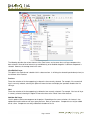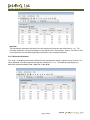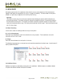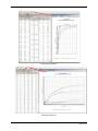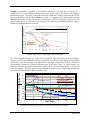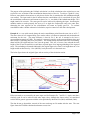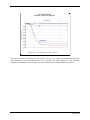
1
UniSettle4 User Manual
and
Analysis Examples
Pierre A. Goudreault and Bengt H. Fellenius
November 2011
UniSoft Geotechnical Solutions Ltd.
528 River Road
Ottawa, Ontario, Canada
K1V 1E9
www.UnisoftLtd.com
UniSettle 4.0 for Windows
User Manual
528 River Road
Ottawa, Ontario
Canada
K1V 1E9
www.unisoftltd.com
© 2011-2012 UniSoft Geotechnical Solutions Ltd. All rights reserved.
Version 4.02: 10/4/2011 4:22:55 PM
TABLE OF CONTENTS
PART I
1.0 INTRODUCTION
1.1 Welcome
1.2 Technical Support
1.3 Recommended System Requirements
....................................5
....................................5
....................................5
....................................5
2.0 WHAT'S NEW
....................................7
3.0 GETTING STARTED
3.1 Installation
3.2 Server Installation
3.3 Example Files
3.4 Removal
3.5 Activation
3.5.1 Manual Activation
3.5.2 Online Activation
3.5.3 Request Activation Code
3.5.4 Server vs. Desktop Activation
3.6 Upgrading
....................................8
....................................8
....................................9
....................................9
....................................9
....................................10
....................................11
....................................12
....................................12
....................................13
....................................13
4.0 USING UNISETTLE
4.1 Definitions
4.2 Navigating UniSettle 4.0
4.3 Data Menu
4.4 Entering Data
....................................15
....................................15
....................................18
....................................18
....................................20
5.0 YOUR FIRST ANALYSIS
5.1 New Project
5.2 Using the Demo Examples
5.3 Open Project
5.4 Recent Projects
5.5 Selecting Units
5.6 Introducing Time
5.7 Introducing Mesh Points
5.8 Viewing Design Data
5.9 View Site Plan
5.10 Perform an Analysis
5.11 Review Results
5.11.1 Effective Stresses
5.11.2 Total Stresses
5.11.3 Effective Stresses Comparison
....................................24
....................................24
....................................24
....................................25
....................................26
....................................27
....................................27
....................................28
....................................29
....................................30
....................................33
....................................33
....................................35
....................................35
....................................35
Page 2 of 64
5.11.4 Total Settlement
5.11.5 Differential Settlement
5.11.6 Settlement Comparison
5.11.7 Layer Compression
5.11.8 Time Related Settlement
5.12 Chart Results
5.13 Save Data
5.14 Print Data and Results
....................................36
....................................36
....................................37
....................................37
....................................37
....................................38
....................................40
....................................40
6.0 IMPORTING AND EXPORTING
6.1 Importing UniSettle XMLU Files
6.2 Importing UniSettle 3.0 Files
6.3 Export to XMLU File
6.4 Export Site Plan to Bitmap
6.5 Export Results to Excel
6.6 Export Results to Text File
6.7 Export Chart to Bitmap
....................................42
....................................42
....................................43
....................................43
....................................44
....................................44
....................................44
....................................44
7.0 ADMINISTRATION
7.1 User Preferences
7.2 Check for New Update
7.3 Activate
....................................45
....................................45
....................................45
....................................45
PART II
8.0 PROJECT INFORMATION
8.1 Project
8.2 Client
8.3 Engineer
8.4 Custom
....................................46
....................................46
....................................46
....................................47
....................................47
9.0 SETTINGS
9.1 General Settings
9.2 Vertical Drains
9.3 Analysis
....................................48
....................................48
....................................48
....................................49
10.0 SOIL LAYERS
10.1 General
10.2 Compressibility
10.3 Secondary Compression
10.4 Drainage
....................................50
....................................50
....................................51
....................................53
....................................54
Page 3 of 64
11.0 PORE PRESSURE
11.1 General
11.2 Hydrostatic Profile
11.3 Non-Hydrostatic Profile
....................................56
....................................56
....................................56
....................................57
12.0 LOADS AND EXCAVATIONS
12.1 General
12.2 Integration Steps
12.3 Geometry
....................................58
....................................58
....................................59
....................................59
13.0 MESH POINTS
13.1 Mesh Point Array
13.2 Additional Points
....................................61
....................................61
....................................61
14.0 DEPTH POINTS
14.1 Additional Depths
....................................63
....................................63
15.0 USER PREFERENCES
15.1 Engineer
15.2 Environment
15.3 Other Input
....................................64
....................................64
....................................64
....................................64
Page 4 of 64
PART I
1.0 INTRODUCTION
1.1 Welcome
Welcome to UniSettle 4.0 for Windows 7, a software application for the calculation of stress distribution and soil
settlement involving complex load combinations and soil conditions.
The documentation for this product is divided into two separate documents. This user manual was developed to
help you navigate the many features of the software and an examples manual describing the various example files
provides the software. The Redbook by Dr. B.H. Fellenius can also be downloaded from our website. It includes
an overview of the engineering concepts and equations used in UniSettle 4.0.
This user manual assumes that you are already familiar with the Microsoft Windows environment and the various
geotechnical concepts used throughout the application.
UniSettle 4.0 is currently available in 4 modes: Demo, Basic, Standard, and Professional. Depending on the type
of version you are running, some of the features described in this manual may be disabled. From time to time, we
also issue updates to correct minor issues or add new features. Slight differences may exist between the images
shown in this document and the version that is running on your computer.
UniSettle 4.0 has many features and hoping to learn them all in a single reading is not realistic. Part I of this user
manual refers to the use of the software in general terms. Part II describes the input variables used throughout the
application.
If your copy of the software is already installed, activated, and ready to go, we suggest that you jump straight to
Section 4.0 - Using UniSettle. If you are anxious to perform an analysis immediately, jump to Section 5.0 Your
First Analysis. If you have questions related to the engineering concepts behind UniSettle 4.0, please refer to our
Example Manual distributed with the software and Dr. B.H. Fellenius Redbook available on our website.
1.2 Technical Support
Free limited technical support regarding the use of all our products may be obtained by contacting us at
[email protected]. We also suggest that you regularly consult our website at www.unisoftltd.com. It
provides many technical papers and FAQs that may already have the answer to your question.
Before contacting us, please make sure that you are using the latest release of the product as we correct and
release updates as issues are reported. Also, please have your serial number available. It is shown in the "About"
window located under the main "Help" menu.
1.3 Recommended System Requirements
UniSettle 4.0 was developed specifically for the Microsoft Windows 7 environment. In that regard, it requires
Microsoft.Net Framework Version 3.5 SP1 or above. Microsoft.Net Framework comes pre-installed with Microsoft
Windows 7.
Page 5 of 64
Our setup application will attempt to locate Microsoft.Net Framework in your system. For earlier versions of
Microsoft Windows such as Windows Vista, Windows XP (SP3), and Windows 2000, you may need to visit the
Microsoft website, download and install Microsoft.Net Framework prior to resuming the installation of UniSettle 4.0.
Microsoft.Net Framework is a component developed and maintained by Microsoft Corp. It is free for all registered
users of Microsoft Windows.
Page 6 of 64
2.0 WHAT'S NEW
Now 32-bit
UniSettle 4.0 is now a 32-bit compiled application. It is fully compatible with Microsoft Windows XP, Windows
2000, and Windows 7 (both 32-bit and 64-bit versions).
New input and results windows
We have developed a new look for all input and results windows. These were designed to simplify data entry and
facilitate navigation between various components and results.
Janbu and conventional method
Compression of individual soil layers can now be calculated based on either Janbu or conventional parameters.
Input conversion to Janbu parameters is no longer required.
Time period
In previous releases of UniSettle, loads, excavations, and pore pressure profiles could only be specified as initial or
final condition. A specific time period for individual load, excavation, and pore pressure profile can now be
specified. This allows for the modeling of real site conditions over time.
Load Types
Two new load types have been introduced: full and half embankments.
Immediate and secondary settlement
In addition to consolidation settlement, UniSettle 4.0 now calculates immediate and secondary settlements.
Time dependent settlement
UniSettle 4.0 now calculates the time related settlements according to the Terzaghi one-dimensional consolidation
equation or according to vertical drains theory.
Multiple analysis points and methods
Calculation of stresses and settlements can now be performed at multiple mesh points simultaneously using
Boussinesq, Westergaard, or 2:1 distribution.
Page 7 of 64
3.0 GETTING STARTED
3.1 Installation
If a previous release of UniSettle 4.0 is already installed on your computer, you may skip this section and go
directly to the section pertaining to activation. However, we strongly recommend that you visit our website and
make sure that you are using the latest version of the software. Upgrading to the latest release of UniSettle 4.0 is
discussed in Section 3.6 - Upgrading.
If you have obtained the setup file from an Internet link, you may begin installation by executing the file. In
general, our setup file should read something similar to UniSettle4_Latest_Setup.exe. If you received the software
on a medium such as a CD or a USB drive, our setup software should start automatically when you insert the
medium. Otherwise, this may indicate that your computer Autoplay feature is disabled and you will be required to
browse the root folder of the medium and execute the setup file manually.
UniSettle 4.0 has been developed for Microsoft Windows 7 (32 and 64-bit), and therefore requires Microsoft.Net
Framework 3.5 Sp1 or higher. Microsoft Framework is integral to Windows 7 and should already be in your system
if you have kept up with your regular Microsoft updates.
Our setup application will attempt to locate Microsoft.Net Framework in your system. For earlier versions of
Microsoft Windows such as Windows Vista, Windows XP SP3, and Windows 2000, you may be required to visit the
Microsoft website, download and install Microsoft.Net Framework prior to resuming the installation of UniSettle 4.0.
Important
To successfully install our product, you must have all administrative privileges. Our setup application creates
new folders and copies the required files. As a result, you may be required to temporarily disable portions of your
firewall. Depending on your system settings, you may be asked to confirm that you trusting the application.
The setup application is straightforward. You will be asked to provide a destination directory and details regarding
the creation of shortcuts on your start menu and desktop. Our setup application will then proceed to automatically
install and register all the necessary components. It will also create a series of related links. These include
shortcuts to the main application, documentation, and our removal software.
Page 8 of 64
Once installation is complete, you may revert back to a standard account with limited privileges. However, due to
Microsoft Windows limitations, you will not be able to use UniSettle 4.0 in the "Guest" account mode.
Unless the application was previously installed and permanently activated, UniSettle 4.0 will install as a demo
version. Please refer to Section 3.5 - Activation for procedures to unlock your product.
UniSoft Ltd believes that software should not be intrusive. In that regard, our setup application does not create
unnecessary registry entries, shortcut links, or tray icons. UniSettle 4.0 loads when you instruct it to and terminates
when you exit.
3.2 Server Installation
A single copy of UniSettle 4.0 can be installed on a server and accessed by multiple users at the same time. The
number of users that can have simultaneous access to the application depends on the number of licences you
have purchased. As such, our setup application must create and copy files into a local access folder such as:
c:\Users\{Username}\AppData\Local\UniSoft GS\UniSettle4
and a public access folder such as:
c:\Users\Public\UniSoft GS\UniSettle4
The exact location of these folders may be altered by the network administrator by modifying the contents of the
UniSettle4.exe.config file located in the root folder of the application. Both the local and public access folders
require full Read/Write permission.
Warning
Modifying the content of the configuration file should be conducted by an experienced network administrator with
good knowledge of the target system. It may also require the re-activation of your licence. Updating the software
may also revert this file back to the application defaults.
3.3 Example Files
As part of the setup process, you will have the option of installing a series of example files than may be used for
educational purposes. If you select this option, the example files will be installed in the "UniSettle 4.0 Example
Files" folder created under the current user documents folder. If the application was installed on a server, the
network administrator will be required to move these files manually to provide access to all users.
To make sure no important data is lost in the event that you remove the software, the example files will not be
removed by the uninstall application. You will need to do this manually.
3.4 Removal
UniSettle 4.0 is removed from your system by accessing the Uninstall command located under the main Microsoft
Windows Start menu.
Page 9 of 64
Our removal application will remove all the files copied at the time of the original setup, various components,
registration information from your registry, and all the shortcut links created at the time of installation. However, it
will not remove data files or shortcut links created by users. Any traces to UniSettle can be manually deleted from
your computer with a simple search of your system.
If you prefer, you can delete UniSettle 4.0 by accessing the "Add or Remove Programs" feature usually located
under Microsoft Windows Control Panel.
Important
If you elected to install the many example files at setup, these will not be deleted. This is to ensure that you do
not delete important information.
3.5 Activation
All UniSoft products are copy-protected using activation code technology. When you purchased UniSettle 4.0, you
were provided with a unique serial number and activation code that will unlock your copy of the software for 30
days. Within that period of time, you are responsible to forward your unique registration number created at setup.
Upon receiving this number, we will issue a new unique activation code that will permanently activate your copy of
the product.
Protection of our product may seem a nuisance at times, but we strongly believe that it can protect your investment
as well. If you have acquired our product through legitimate channels, this probably means that you are
professional and serious about your work. By protecting our product, we hope to maximize your competitive
advantage by making sure that others are competing on a same playing field. We also hope that limiting pirating
will provide us with the necessary revenues required to continuously maintain and improve our products.
To activate your licence, access the "Activate..." feature located under the main "Administration" menu. At this
time, you are provided with three options: Manual Activation, Online Activation, or Request Activation Code.
Page 10 of 64
Warning
Changing your system date and time in an attempt to bypass the expiration will completely disable the
application. It may also affect other products using similar protection methods.
3.5.1 Manual Activation
Select manual activation if you were provided with a serial number and activation code. You will be asked to enter
your serial number, activation code, and company name. Click on "Accept..." to complete the process. If
accepted, your copy of the software will be activated accordingly.
Page 11 of 64
If your copy is temporarily activated, you will be required to contact us with your unique registration number so we
may issue a permanent activation code. As an alternative, you can activate your licence using the "Online
Activation" option.
3.5.2 Online Activation
Use online activation if the activation code provided to you has expired or is no longer valid. If online activation is
successful, your copy of the software will be temporarily activated until we receive your request electronically. You
will be asked to provide some information to allow us to verify the legitimacy of the request. More importantly, you
will be asked to specify a valid e-mail address where we will send your permanent activation code.
Once you receive your permanent activation code, you will be required to activate your copy using the manual
activation procedure.
Important
For this service to function properly, a live Internet connection with unhindered access to our web server is
required. Please consult with your network administrator as your Internet connections may be set to block 2-way
communications for some ports. Communication to our web server is performed via port 8889.
3.5.3 Request Activation Code
Use this option to request an activation code if both manual and online activation code attempts have failed. You
will be asked to provide information to allow us to verify the legitimacy of the request. More importantly, you will
be asked to specify a valid e-mail address where we will send your permanent activation code.
Page 12 of 64
Your activation code request will be saved as a text file on your computer desktop. You are responsible to forward
this file and its contents to us by e-mail. Unless we receive the file, we cannot issue an activation code. Please
allow at least 72 hours for us to receive and process your request.
3.5.4 Server vs. Desktop Activation
If you require multiple licences, you will be asked to specify the type of licences at the time of purchase. If the
software is installed on a public server, a single serial number and activation code will be issued. If your licences
are meant to be distributed over multiple computers, then multiple serial numbers and activation codes will be
issued. Please do not hesitate to contact us to discuss your specific needs. Our licensing is designed to be
flexible and to respond to our users' changing needs.
3.6 Upgrading
From time to time we issue new releases to correct reported problems or simply to add new features. When a new
release is made available, our registered users will be informed by e-mail. We also suggest that you visit our
website at www.unisoftltd.com frequently, where we will be posting the latest news regarding our products.
In the event that a new release is available, you can upgrade your copy using one of three methods:
1. By accessing the "Check for New Update" located under the Start menu of your Microsoft Windows interface.
Page 13 of 64
2. By accessing the "Check for New Update..." located under the main "Administration" menu of the application.
3. Download and manually install the latest setup file from our website at www.unisoftltd.com.
Updating your copy of UniSettle 4.0 requires full administrative privileges. Please refer to Section 3.0 - Getting
Started for more information. If you have not modified the UniSettle4.exe.config file, you will not be required to reactivate your copy of the software.
Upgrading via our website or via the "Check for New Update" feature requires a live internet connection. You may
also be required to disable some of your firewall settings. Please contact your network administrator for details.
Page 14 of 64
4.0 USING UNISETTLE
We hope that UniSettle 4.0 is an application that is intuitive for most engineers. This section provides a quick
overview of what you need to know before beginning.
4.1 Definitions
Computer and software terms are no different than geotechnical terms. Learning and using the correct ones on a
consistent basis should help you learn to use our products faster. The following definitions are used throughout this
manual.
Interface
The interface is the means of communication between the user and the software. It is the sum of all the visible
parts of the software. The image below represents UniSettle 4.0’s interface. It includes the main menu, buttons,
and windows.
Toolbar
A toolbar is a graphic user interface component upon which menus, buttons, icons or other input or output
elements are placed.
Page 15 of 64
Menu and sub-menu
A menu is a list of commands usually presented at the top of the interface or at the top of individual windows.
Menus are often hierarchically organized, allowing navigation through different levels of the menu structure.
Selecting a menu entry should result in an action or provide another list of options. The latter is referred to as a
sub-menu.
Popular menu items are often presented as buttons on toolbars. This saves the user time by allowing quick access
to frequently-used actions.
Button
In computing terms, a button is a user interface element that provides the user with a simple way to trigger an
event. Selecting a button should result in an action or, in the case of a drop-down button, provide a list of available
options. Buttons are often an iconic representation of the most popular menu options. They can also contain short
text commands such as "OK", "Cancel", or "Proceed".
Buttons located on toolbars are usually a repeat of the most frequently used menu items.
Drop-down box
A drop-down box is a commonly-used graphical user interface component. It may be a combination of a dropdown list or list box and a single-line textbox, allowing the user to either type a value directly into the control or
choose from the list of items. In UniSettle 4.0, design units are selected from a drop-down box displayed on the
main toolbar.
Page 16 of 64
Data tree
A data tree is a widely-used method to display inter-related data. It emulates a hierarchical tree structure with a set
of linked nodes. In UniSettle 4.0, a data tree is used to access every data form available. The main advantage of
a data tree is that it makes information visible and readily available rather than having to navigate complicated
menu structures. If you have used Microsoft Windows Explorer or Microsoft Windows Outlook in the past, you are
likely very familiar with data trees.
One of the most powerful features of the data tree is that long lists of components may be individually collapsed or
expanded by clicking on the + or - sign located on the left side of a heading.
The various features of the data tree used in UniSettle are discussed in Section 4.2 - Navigating UniSettle 4.0.
Windows
In a Microsoft Windows compatible application, windows are used to display textual and graphical information. In
UniSettle 4.0, windows (or forms) are used to enter general data, soil properties, loads and excavations, display
results, display messages, etc. This document assumes that you have prior experience with other Microsoft
Windows products and that you are already familiar with the many features attached to windows such as opening,
moving, resizing, and closing.
Component
This manual uses the term component to describe groups of data of the same type. For example, all soil layers
are individual components of the same type. Loads and excavations are also components but of different types.
Page 17 of 64
4.2 Navigating UniSettle 4.0
In an effort to make the software more powerful and versatile, the navigation between various input windows is
now performed via the main data tree. The data tree is a powerful tool as it allows the user to display and access a
large number of items. The data tree is also context sensitive, a term meaning that the various menu options
available at any given time might vary depending on the item currently selected.
The following image shows the data tree for a project having three soil layers, two loads, and a single excavation.
Selecting the second soil layers from the list (i.e. Clay) will display the input data specific to this clay layer.
Similarly, selecting other items from the list will display the input data specific to each item.
4.3 Data Menu
The main "Data" menu is used to add, delete, copy, paste, move, expand, and collapse the various components of
the data tree. It is directly related to the context sensitive feature of the data tree. In other words, the options
presented under the main "Data" menu are dynamic and will change according to the data tree item selected. This
also means that the "Data" menu may be accessed directly by clicking the right mouse button on a selected data
tree item.
The following sample image shows the list of options under the main "Data" menu when the "Clay" soil layer is
selected. Many of the options presented under the main "Data" menu are also available as buttons on the
secondary toolbar. The role of each feature is explained below.
Page 18 of 64
The following describes the various features of the "Data" menu, and assumes that a soil layer component has
been selected. Some of these features may read differently or be disabled altogether if a different component is
selected. However, the concept remains the same.
View/Edit Soil Layer
This option is the equivalent of a double click in a data tree item. It will bring the selected input window (or form) to
the forefront of the interface.
Previous
Forces the selection of the item appearing just above the item currently selected. For example, if the second soil
layer is currently selected, selecting this option will move the focus and display the input data related to the first
soil layer.
Next
Forces the selection of the item appearing just below the item currently selected. For example, if the last soil layer
is currently selected, selecting this option will move the focus to the "Loads" item of the data tree.
Add New Soil Layer
Use this option to add a new component to the project. Depending on the current selection, this feature is also
updated and used to add new soil layers, pore pressures, loads, or excavations. Components can only be added
one at a time. Components are always added to the bottom of the list.
Page 19 of 64
Tip
To insert a new soil layer between two existing layers, use the "Add New Soil Layer" option in conjunction with
the "Move Up" command discussed below.
Delete Soil Layer
Use this option to delete an existing component of the project. Depending on the current selection, this feature
may be used to delete an existing soil layer, pore pressure profile, load, or excavation. Multiple components of the
same group may be deleted at once. To select a series of components, click on the items while holding your
keyboard Shift key. Use caution when deleting components. Once deleted, components cannot be retrieved.
Tip
To de-select a group of items, simply release the Shift key and select any single item again.
Copy Soil Layer
Use this option to copy individual component data into the application memory. The data in memory may be
pasted into another component of the same kind later. Depending on the current selection, this feature can only
apply to soil layers, pore pressure profiles, loads, or excavations. “Copy” is used in conjunction with the "Paste"
command and has no use outside the application.
Paste Soil Layer
Use this option to apply the contents of the memory to a specific component of the same kind. Pasting data
amounts to replacing the currently selected group of data with the data in memory. “Paste” is used in conjunction
with the "Copy" command and is most useful to repeat the input of similar components.
Move Up / Move Down
Use these two commands to revise the order of the selected item inside the data tree. Moving soil layers up or
down the list will affect the results as soil layers are assumed to be in the order in which they appear.
Tip
Use the "Move Up" command in conjunction with the "Add New Soil Layer" option to insert a new soil layer
between two existing soil layers.
Expand All
One of the best features of the data tree is that long lists of components may be individually collapsed or expanded
by clicking on the + or - sign located on the left side of a heading. In addition, the complete tree may be expanded
by selecting the "Expand All" command. Individual items can then be collapsed by clicking the - sign located on
the left side of the heading.
Collapse All
This command acts opposite to the "Expand All" command. It collapses the entire tree to a minimum number of
items. Individual items can then be expanded by clicking the + sign located on the left side of the heading.
4.4 Entering Data
In an effort to provide consistency and to facilitate the use of the software, all input windows use an Excel-type grid
and cell system. The following image uses the "User Preferences" window to describe some of the features
Page 20 of 64
applicable to most input windows. User preferences may be accessed from the main "Administration" menu, and
are discussed in greater detail in Section 7.1 - User Preferences.
Group heading
The group heading is used to describe a related set of input data. This heading is fixed and cannot be edited or
changed. As with the data tree, group headings may be collapsed or expanded using the + or - signs located on
the left.
Variable name
The variable name is a short reference to the specific variable under consideration. When selecting a row, the
specific variable and a short definition will appear at the bottom of the window. The variable name is fixed and
cannot be edited or changed.
Description
The bottom of the window provides a short definition and relevant information regarding the variable under
consideration. This description is fixed and cannot be edited or changed.
Input cells
Input cells are on the right side of each variable name. There are 3 types of input cells: regular, drop-down, and
button. Once selected, input cells behave differently depending on their type. Navigation between input cells is
performed using the mouse cursor or the keyboard’s Up or Down arrow keys.
Regular input cell
This is the most common type of input cell used throughout the application. It was designed to behave as a
Microsoft Excel spreadsheet cell. Once it has been selected, the cell may be edited by typing, pressing the
keyboard’s F2 key, or double-clicking the left mouse button. Editing is cancelled using the keyboard’s Esc key or
recorded by pressing the keyboard’s Enter key or moving to another cell.
Page 21 of 64
Drop-down input cell
When it has the focus, a drop-down input cell is recognized by the downward arrow located on the right side of the
cell. It usually provides the user with a list of items to choose from. This type of cell is edited by pressing the
keyboard’s F2 key or by clicking the left mouse button on the downward arrow. Editing is cancelled using the
keyboard’s Esc key or recorded by pressing the keyboard’s Enter key. Some drop-down input cells will only allow
selection from a pre-determined list. Others will allow you to enter and select your own content.
An example of a drop-down input cell can be found in the "Display Units" input located in the "User Preferences"
window.
The "Type" entry located under the "General" heading of the soil layer window is also a drop-down input cell. It
permits you to enter your own content.
Button input cell
When it has the focus, a button input cell is recognized by the ellipsis button (...) located on the right side of the
cell. When activated, this feature will provide a new input window, allowing you to complete the editing. This type
of cell may be edited by pressing the keyboard’s F2 key or by clicking the left mouse button on the ellipsies button.
Page 22 of 64
The "Project Folder" input located in the "User Preferences" window is an example of a button input cell. When
selected, it will display a browser window which allows the user to select the folder of his/her choice.
Page 23 of 64
5.0 YOUR FIRST ANALYSIS
If you have read the previous sections of this document, you should be up and running and have a better
understanding of the interface. However, you still have not used the software for its intended purposes. This
section will guide you through the steps necessary to perform your first analysis.
5.1 New Project
When starting a new project, we recommend that you access the "New Project" command located under the main
"File" menu. Doing so will reset your entire application to the original defaults. The main advantage of using this
feature is that it will inform you if some data were previously modified and not yet saved. In this event, you will be
provided with the option to save, skip or cancel.
When beginning a new project, your interface will revert back to the original defaults and preferences. Some of
these preferences may be customized to your specific needs. In order to do this, access the "User Preferences"
command located under the main "Administration" menu. Refer to Part II of this document for more information
pertaining to user preferences.
5.2 Using the Demo Examples
As part of the setup process, you had the option of installing a series of example files that may be used for
educational purposes. If you elected to do this, these example files were installed in the "UniSettle 4.0 Example
Files" folder created under the current user document folder. If the application was installed on a server, the
network administrator may need to move these files manually to provide you with access.
The examples provided with the application were designed to cover a large range of conditions. Note that if you
are using a Demo version, you will not be able to save and will be limited with what you can change. Nonetheless,
the example files are a great tool which will assist you in learning the various features of the software as well as
many geotechnical concepts. If the example files were not installed as part of the original setup, you can obtain
them by visiting the download section of our website at www.unisoftltd.com.
Page 24 of 64
5.3 Open Project
To open a new project residing on your computer or server, access the "Open Project" command located under the
main "File" menu.
A browser window showing the contents of your computer and other connected drives should appear. UniSettle 4.0
project files have by default the .Unisettle4 file extension. Once you find the project you are looking for, simply
bring it in by clicking the "Open" button.
Page 25 of 64
If the process was successful, the interface and the data tree will automatically be updated to display the latest set
of data.
Important
In many versions of Windows, file extensions are hidden by default. If this occurs, you may not be able to
correctly identify UniSettle 4.0 project files. If this is the case, we recommend that you contact your network
administrator.
Important
Only project files previously created with UniSettle 4.0 may be opened in this fashion. If you are a registered user
of UniSettle 3.0, you can import UniSettle 3.0 project files (.stl) using the "Import" feature. Importing other file
formats is discussed in Section 6.0 - Importing and Exporting.
5.4 Recent Projects
Project files can also be accessed via the "Recent Projects" feature located under the main "File" menu.
UniSettle 4.0 records and keeps a list of the projects previously worked on (up to 25). One of the advantages of
this feature is that it provides you with more information than simply a file name. For a selected project file, it will
Page 26 of 64
display project and client information such as name, number, description, contact, address, and the full path of the
project file in your system. The bulk of the information displayed in this window is obtained from the "Project
Information" window which is discussed in Section 8.0 of this document.
The "Remove Item" and "Remove All" options allow you to delete and maintain the project list. Selecting "Open"
will open the selected project in UniSettle.
The list of projects is unique to each user account. Opening a project on an instance of the application on your
laptop would not affect the list of projects on an other instance of the application.
Important
Although a project may appear on the list, it may not be available for you to open. Such would be the case if the
file was previously deleted and no longer existed or if the file was located on a separate server that is currently
unavailable.
5.5 Selecting Units
The first action one typically completes before entering data is selecting the system of units. With UniSettle 4.0,
this feature consists of a drop-down box conveniently placed in the main tool bar.
Two systems of units are available: The International System of Units (SI) and the US Customary units. One of the
best features of UniSettle 4.0 is that the system of units may be switched on the fly at any time. This applies to the
data and the results. This means that some soil parameters may be entered in SI while others may be entered in
US Customary. Once the analysis is concluded, the results and charts may be converted with a single click.
Important
To avoid leakage errors due to multiple conversions effected on the same data, UniSettle performs what is known
as hard conversion. This means that data are converted, kept in memory, saved, and calculated with a high level
of precision. However, when displayed on screen, they may be subjected to rounding to a lower level of
precision. For example, entering a 10-foot thick soil layer would be internally converted to 3.048 metres;
however, it would be rounded to 3.05 metres when displayed.
5.6 Introducing Time
In very general terms, consolidation is caused by the change in effective stress over a specific period of time. In
previous versions of UniSettle, the change in effective stress was calculated as the difference between the
conditions before construction (i.e. initial condition) and the conditions at the end of construction (i.e. final
condition).
In real cases, it is expected that large construction projects are spread over many months and often consist of
various stages of loading and unloading. In an effort to address real situations, UniSettle 4.0 is now incorporating
Page 27 of 64
time as a variable. This means that whenever modeling a pore pressure profile, a load, or an excavation, a time
period at which the change is taking place must be specified. As a result, the software considers the start of
construction as the initial condition (time=0). However, the definition of the term "final condition" is reserved to
identify a time in the future well beyond the end of construction.
Example
Assuming that an old building is removed over a 3-month period and replaced by a new building a year later.
This example could be modeled by entering the following components in UniSettle:
- Soil layers and properties at the start of construction
- Footprint of the existing building with a positive stress effect at a Time, t = 0 month (initial)
- Footprint of the existing building with a negative stress effect at a Time, t = 3 months
- Footprint of the new building with a positive stress effect at a Time, t = 15 months
In UniSettle 4.0, the unloading caused by the removal of the existing building will be taken into account when
calculating the total compression of the soil after the completion of the new building. One could also go a step
further by modeling the construction of the new building over multiple stages (i.e. time periods).
5.7 Introducing Mesh Points
In previous versions of UniSettle, stresses and settlements could only be calculated at two points (i.e. X-Y
Coordinates) along the depth of the soil profile (i.e. Z depth). The stresses and settlements at other points were
obtained by performing the same analysis after entering the new set of points. In UniSettle 4.0, multiple points can
now be specified as a mesh or individually by accessing the "Mesh Points" window located under "Analysis" data.
Page 28 of 64
Adding X-Y Mesh points is simple, but exponentially increases the time required to perform an analysis. Mesh
points are discussed in Section 13.0.
5.8 Viewing Design Data
Also new to UniSettle 4.0 is the way in which design data are accessed and presented. No longer are they hidden
under a series of menus. All input windows relating to your current project are listed in the data tree located on the
left side of the interface. For example, to view the input window for the Initial Pore Pressure, simply click the
related entry from the data tree.
Page 29 of 64
The data tree combined with the "Data" menu provide an efficient way to navigate, edit, add, and delete input data.
Refer to Section 4.0 - Using UniSettle for more information regarding various features of the data tree.
5.9 View Site Plan
When dealing with multiple coordinates, even small mistakes can result in the most severe consequences. In
order to assist the engineer, a bird’s eye view of the site under consideration is produced by accessing the main
"Site Plan" menu. In addition, the site plan may be printed or exported to a bitmap file. Additional information can
be found in Section 5.14 - Print Data and Results and Section 6.4 Export Site Plan to Bitmap.
Page 30 of 64
The site plan window has its own toolbar displaying a series of options used to customize the viewport. Some of
these options are used to modify the behavior of the cursor, or to change the scale and the extent of the drawing,
while others are used to customize the contents of the drawing. These options are described and discussed below.
Default cursor
Many of the options associated with the site plan will change the way the cursor reacts when moved over the
image. Use this button to return the cursor back to its default state and reset other features.
Pan image
Panning (in computer terms) enables you to move the image both horizontally and vertically by holding down the
left mouse button. Panning is equivalent to moving the image using the vertical and horizontal scroll bars located
at the right and bottom of the viewport. Select the default cursor button to return it to its default behavior.
Important
Panning can only work when the image has previously been zoomed and the extent of the image is beyond the
edge of the viewport.
Mouse button zoom
When enabled, it allows the user to zoom in or out of the image by clicking on the left or right mouse buttons,
respectively. Select the default cursor button to return it to its default behavior.
Area zoom
When selected, this option allows you to zoom the image in a specific rectanglular area. To do this, move the
cursor to one corner of the area you want to enlarge. While holding down the left mouse button, move the cursor
to create a rectangle around the area you wish to enlarge. Release the mouse button. Select the default cursor
button to return it to its default behavior.
View full image
Resets the image zoom so the full image (the width and the height) fits inside the current view port.
View full width
Resets the image zoom so the width fits inside the current view port.
Page 31 of 64
View full height
Resets the image zoom so the height fits inside the current view port.
Site plan options
This is a drop-down button which allows you to dictate the contents of the site plan. Specific items may be
selected (checked) or de-selected (unchecked).
Use these options to hide or display the loads, excavations, mesh points, their coordinates, the (0,0) origin, or the
construction history via the "Show History" option.
Time period
This feature allows you to show the various site conditions at a specific time period. Assuming that various loads
and excavations were set to apply at various time periods, you can use this option to display only the components
applicable up to that time period.
Important
This feature works in conjunction with the "Show History" option located under the "Site plan options". When
"Show History" is selected, the loads and excavations displayed will be those applicable up to the selected period
(i.e. inclusive). When de-selected, the loads and excavations displayed will only be those applicable to the
selected period (i.e. exclusive).
Redraw
Use this feature to redraw the site plan. This is a rapid way to reset the drawing to its full view port.
Tip
By default, loads appear in light blue while excavations appear in light red with a certain level of transparency.
This feature results in overlapping loads and excavations of a darker tone.
Page 32 of 64
5.10 Perform an Analysis
Technically, if you have just created a new project and have not yet entered any data or information, you should
still be able to perform an analysis. If this is the case, you will be presented with a complete set of results
indicating 0. For the purposes of learning UniSettle however, it is recommended that you open one of the example
projects installed at setup.
Your first analysis is initiated by accessing the "Analyze" command located under the main "Analysis" menu.
The time required to complete the analysis depends on multiple factors, including the speed of your processor, the
depth of the soil profile, the number and size of the loads and excavations, the integration steps, the number of
time periods, the number of analysis points, and the methods selected.
For example, the approximate number of iterations required to calculate the compression of a 100-foot deep soil
layer with 5 loads, 4 time periods, 3 analysis points, and using only Boussinesq would be 100 x 5 x 4 x 3 x 3 x 1 =
18,000. Adding 2 new loads, 1 new time period, 5 new analysis points, and Westergaard to the equation would
mean 100 x 7 x 5 x 8 x 8 x 2 = 448,000 iterations. Approximately 25 times more demanding on your processor.
After a few projects, you will learn to negotiate and compromise between pushing the application to its limits versus
using the time necessary to perform complicated analyses.
5.11 Review Results
If your analysis was successfully completed, you will be presented with a results table displaying the total
compression of each soil layer. Other results may be displayed by accessing the main "Results" menu.
Page 33 of 64
Additionally, the secondary toolbar is updated with a series of drop-down boxes meant to display other sets of
results applying to the same topic. The image presented above displays the options available when the effective
stresses are called to the top. It shows the effective stresses calculated according to Boussinesq, at point (0.00,
0.00) at initial condition and at 6 months. Use the drop-down boxes to change the set of results on the fly.
Important
The concept of changing the specific dataset using the drop-down boxes located on the secondary toolbar is
typical for all result windows.
The Professional version of UniSettle produces eight different results topics. These are discussed below. Most
results can also be displayed in chart format. The features affecting the charts are discussed in Section 5.12 Chart Results.
Page 34 of 64
5.11.1 Effective Stresses
Effective stresses are a compilation of the total stress, pore pressure, and effective stresses at a specific point for
two specific time periods and a specific method (i.e. Boussinesq, Westergaard, 2:1 Distribution).
5.11.2 Total Stresses
Total stresses are a compilation of the total stresses for all 3 methods at a specific point. The dataset may be
modified to display the total stresses caused by a specific soil layer, load, or excavation. The following image
shows the total stresses calculated for "Building #1" at point (5.00, 10.00).
5.11.3 Effective Stresses Comparison
The effective stresses comparison is a compilation of the total effective stresses at a specific point for two time
periods. If specified as part of the analysis, the stresses will be calculated as per Boussinesq, Westergaard, and
2:1 distribution.
5.11.4 Total Settlement
The total settlement results are a compilation of the immediate, consolidation, and secondary settlement at a
specific point and for a specific analysis method. The following image displays the total settlement calculated as
per Boussinesq at point (5.00, 10.00).
Page 35 of 64
Important
The consolidation settlements displayed in this table represent the long-term total settlement (i.e. t100). The
secondary settlements are those calculated at a time specified in the soil properties. Refer to "Soil Data" in Part
II of this document for more detail regarding the calculation of the secondary settlement.
5.11.5 Differential Settlement
This result is a compilation of the total settlement for two selected points and for a specific analysis method. The
values displayed in the table represent the long-term settlement (i.e. t100). The following image displays the
differential settlement between (5.00, 10.00) and (15.00, 20.00).
Page 36 of 64
5.11.6 Settlement Comparison
The settlement comparison is a compilation of the long-term settlement at a specific point. If specified as part of
the analysis, the settlement will be calculated as per Boussinesq, Westergaard, and 2:1 distribution.
5.11.7 Layer Compression
Displays the immediate, consolidation, and secondary compression on a layer per layer basis at a specific point
and for a specific method. The values displayed in the table represent the long-term settlement (i.e. t100).
5.11.8 Time Related Settlement
Displays the immediate, consolidation, and secondary compression as a function of time at a specific point. The
time related settlement uses a combination of both cv and ch (coefficients of vertical and horizontal consolidation)
to calculate an average degree of consolidation. The following image shows the time related settlement at (5.00,
10.00) for all soil layers combined. The results are adapted to show the time related settlement of an individual
layer by accessing the specific drop-down box located on the secondary toolbar.
Important
The Basic and Standard versions of UniSettle 4.0 do not calculate time related settlements.
Page 37 of 64
5.12 Chart Results
Most results may be presented in chart format. This provides a good way to quickly demonstrate the behavior and
tendency of the results. Charting of the results currently on top are displayed by accessing the "Chart Results"
option located under the main "Results" menu. In addition, charts may be printed or exported to a bitmap file.
The image below shows a graphic representation of the calculated total settlement at (5.00, 10.00).
Note
Charting has been included in UniSettle as a matter of convenience. Charting data may be exported to a
separate text file to allow for more advanced charting and result manipulation.
The chart window has its own toolbar displaying a series of options used to customize the view port. Some of
these options are used to modify the contents of the display, others to change the scaling of the axes. Changing
the options for one chart will not affect the charts for other topics. Options are described below.
Page 38 of 64
Quadrant
Select this option to change the quadrant.
Series
Use this option to add or remove a specific series from the chart. The series in this list vary depending on the type
of results displayed on the screen.
Show points
Select this option to toggle chart points ON/OFF.
Axes scaling
Use this option to customize the scale used for each axis. When accessing this feature, a scroll bar will be
displayed, allowing you to move the visible extent of the data.
Reset Axes Scale
Use this option to quickly reset the axes scale to 1:1.
Important
Although multiple results windows may be displayed onscreen simultaneously, only the top results window (with
the focus) can be charted.
Page 39 of 64
5.13 Save Data
The input data are saved by accessing the "Save" or "Save As" command located under the main "File" menu.
When selecting "Save As", you will always be presented with an environment window giving you the option to
browse and save your data using the filename and folder of your choice. If your data were previously saved (or
opened) under a given name, the "Save" option will skip the environment window and save the file in the
background.
Important
The "Save" and "Open" options can only be used to open and save project files (i.e. files with the ".Unisettle4"
extension). Other types of data may be imported or exported using the import and export features discussed in
Section 6.0 Importing and Exporting.
5.14 Print Data and Results
All data, results, and charts produced by UniSettle may be sent to a Microsoft Windows 7 compatible printer.
Printing in UniSettle is context sensitive, meaning that only the data or results currently on top (with the focus) can
be printed. The image below shows the input data for a Clay soil layer. The "Print" option is updated to show the
specific topic available for printing at this time.
Page 40 of 64
Basic page setup, including paper size, source, orientation, and margins is available via the "Page Setup" option.
UniSettle also provides the ability to print to a pdf file directly. This may also be achieved by downloading and
installing one of the many pdf printers available on the Internet.
Page 41 of 64
6.0 IMPORTING AND EXPORTING
Importing and exporting features extend the usefulness of UniSettle to other popular software. The exporting and
importing options are located under the main "File" menu, and are described below.
6.1 Importing UniSettle XMLU Files
The UniSettle 4.0 user has the ability to import XMLU files. Although very specific to UniSettle 4.0 and other
UniSoft applications, the XMLU file format is based on the popular extensible markup language (XML). In short,
XML is a set of rules for encoding documents in machine-readable form.
When used in conjunction with the exporting features of UniSettle, soil layers, pore pressure profiles, loads, and
excavation data may be imported into an existing project. This powerful feature of the software allows you to
quickly combine data from one project with another. It can also be used to build a library of soil profiles, loads, or
excavations.
Importing XMLU files is very similar to opening a project file. When selected, a window allowing you to browse the
contents of your computer and other connected drives will appear. Once you find the XMLU file you are seeking,
simply bring it in by clicking the "Open" button. If the process was successful, you will be prompted with the option
to overwrite or append the contents of the file to the data currently in memory. The data tree will automatically be
updated to display the latest set of data.
Page 42 of 64
6.2 Importing UniSettle 3.0 Files
Project files (.stl), soil files (.sol), and load files (.lod) created with UniSettle 3.0 may be imported directly into
UniSettle 4.0. Importing these types of files is very similar to opening a project file. When selected, a window
allowing you to browse the contents of your computer and other connected drives will appear. Once you find the
file you are looking for, simply bring it in by clicking the "Open" button. If the process was successful, you may be
prompted with the option to overwrite or append the contents of the file to the data currently in memory. The data
tree will automatically be updated to display the latest set of data.
UniSettle 4.0 introduces new concepts that were not part of older versions of UniSettle. As such, the importing
feature must make many decisions and revert back to internal defaults when dealing with data unique to
UniSettle 4.0. We strongly suggest that you review each input data before proceeding with your analysis. The
following is a list of issues you should consider when importing data files created by UniSettle 3.0.
Time period
In previous releases of UniSettle, loads, excavations, and pore pressure profiles could only be specified as initial or
final condition. A specific time period for individual load, excavation, and pore pressure profile can now be
specified. This allows for the modeling of real site conditions over time. When imported into UniSettle 4.0, pore
pressures, loads, and excavations previously specified as "Final" are now imported with a time value of 1.0 month.
Loads and excavations
In UniSettle 3.0, one could specify a load (or excavation) to act only at "Initial" condition. In UniSettle 4.0, this
condition may now be modeled by introducing a negative copy of the same load applicable at a later time period.
When imported into UniSettle 4.0, similar conditions require the manual addition of counteracting loads (or
excavations).
Immediate and secondary settlements
In addition to primary consolidation, UniSettle 4.0 now calculates immediate and secondary settlements. When
importing old data into UniSettle 4.0, the soil properties affecting immediate and secondary settlements are set
to 0.
Multiple mesh points and methods
Calculation of stresses and settlements can now be performed at multiple mesh points simultaneously using
Boussinesq, Westergaard, or 2:1 distribution. You must manual set these variables before proceeding to your
analysis.
6.3 Export to XMLU File
UniSettle 4.0 has exporting capabilities for XMLU files. Although very specific to UniSettle 4.0 and other UniSoft
applications, the XMLU file format is based on the popular extensible markup language (XML). In short, XML is a
set of rules for encoding documents into machine-readable form.
When used in conjunction with the importing features of UniSettle, exporting of soil layers, pore pressure profiles,
loads, and excavations allows you to quickly combine data from one project with another. It can also be used to
build a library of soil profiles, loads, or excavations.
Page 43 of 64
Exporting XMLU files is very similar to saving a project file. When selected, you will always be presented with an
environment window giving you the option to browse and save your data using the filename and folder of your
choice.
6.4 Export Site Plan to Bitmap
The site plan may be exported to a high resolution color bitmap image by accessing the "Export Site Plan" option
located under the main "File" menu. Exporting the site plan is similar to saving a project file. When selected, you
will be presented with an environment window giving you the option of browsing and saving your data using the
filename and folder of your choice.
6.5 Export Results to Excel
The complete set of results currently in memory may be exported to an Excel (.xls) file. Exporting the results is
similar to saving a project file. When selected, you will be presented with an environment window giving you the
option to browse and save the results using the filename and folder of your choice. The specific set of data
exported is dictated by the conditions specified in the many result drop-down boxes located in the secondary
toolbar.
Tip
Because the exported data is a combination of text and numbers, Excel converts each cell using its "General"
format. If you plan to perform formatting or mathematical operations on some of the data, you will have to
manually convert the format from "General" to "Number". Depending on your version of Excel, there are many
ways to do this; one of the simplest is to use the "Paste Special" feature of Excel as follows:
1. In an empty cell, enter the number 1.
2. Select the cell. From the main "Edit" menu, select "Copy".
3. Select the range of cells to be converted.
4. From the main "Edit" menu, select "Paste Special ".
5. Under "Operation", select "Multiply".
6. Click OK.
6.6 Export Results to Text File
As an alternative to exporting to Excel, results may be exported to a Tab delimited text file. Contrary to exporting
to Excel, exporting to a text file is context sensitive, meaning that only the results currently on top (with the focus)
can be exported.
6.7 Export Chart to Bitmap
The chart currently on screen may be exported to a color bitmap image for further manipulation or insertion into a
report. Exporting a results chart is similar to exporting the site plan. When selected, you will be presented with an
environment window which gives you the option to browse and save your data using the filename and folder of
your choice.
Page 44 of 64
7.0 ADMINISTRATION
The features located under the main "Administration" menu are related to the general management of the
application itself. Access it to set personal preferences, to upgrade to a new release, or to activate the application
after purchase.
7.1 User Preferences
Preferences are settings that control a user's account and various aspects of the user's viewing and editing
environment. Preferences include the default project folder, system units, numerical format, and many more.
User preferences are discussed in detail in Part II of this document.
7.2 Check for New Update
Use this option to automatically contact our Internet server and verify if a new release of UniSettle is available.
Upgrading is discussed in Section 3.6 - Upgrading.
7.3 Activate
Use this option to activate your copy of UniSettle after purchase or after re-installation. Activation is discussed in
Section 3.5 - Activation.
Page 45 of 64
PART II
This section of the manual provides a detailed description of the input variables used throughout the software.
Some of the entries may not be available or visible to your specific interface as many are dependent on the
version you are running.
8.0 PROJECT INFORMATION
The project information input window lists the general entries relating to the project under consideration. The
information entered on this form generally has no effect on the results of an analysis.
8.1 Project
Use this section of the form to specify general information relating to the project under consideration. The entries
listed under this subject are also displayed in the "Recent Projects..." window located under the main "File" menu.
Furthermore, the "Name" input is also displayed on the interface status bar and all printouts.
8.2 Client
Refers to the general client information. The information specified under this subject will also be used in the
"Recent Projects..." window located under the main "File" menu.
Page 46 of 64
8.3 Engineer
Use this section to specify general information regarding the engineer working on the analysis. The defaults used
under this heading can be personalized by accessing the "User Preferences..." option located under the main
"Administration" menu.
8.4 Custom
This section of the form provides 3 additional lines of input to record the information of your choice.
Page 47 of 64
9.0 SETTINGS
Use this input window to specify the various settings and constants used throughout the analysis.
9.1 General Settings
Water Density
The water density used in the calculation of static pore pressure. It is used internally to convert pore pressure
measurements from height to pressure.
Gravity
Gravity is a constant (local gravitational field) for converting mass to weight (force). It is used throughout the
application to convert kg (kilograms) to kPa (kilopascals) and pounds to pound-force. By default, the gravity
constant on earth is set to 9.81 m/s2 (32.81 ft/s2). It can be personalized by accessing the "User Preferences..."
option located under the main "Administration" menu.
The option of changing the gravity constant is for compatibility with previous versions of UniSettle, to facilitate the
validation of calculations performed in the metric system, or for projects situated outside the gravitational field of
the earth.
Important
When converting from SI to Customary US units, the software ignores the gravity constant and uses commonly
used conversion factors (i.e. 1 kg=2.20 lbs, 1 lb/ft3 = 16.02 kg/m3).
9.2 Vertical Drains
Use this section to specify the constants applicable to vertical drains. The influence of vertical drains and the
depth at which they apply is discussed in Section 10.4 - Drainage.
Drain Equivalent Diameter, d
Represents the equivalent diameter of a single drain.
Drain Influence Zone, D
Represents the zone of influence of a single drain. This value is usually obtained based on the layout of the drains
on the field.
Page 48 of 64
Time, t
Time at which vertical drains are installed. Time, t=0, refers to initial condition.
9.3 Analysis
Stress Distribution
UniSettle 4.0 can perform stress distribution using Boussinesq, Westergaard, and 2:1 Distribution. Use this entry
to select the method(s) used during the analysis. Selecting more than one method will proportionally increase the
time necessary to perform the calculations. The default for this input is "All Methods". It can be modified via the
"User Preferences..." option located under the main "Administration" menu.
Limit Secondary Settlement
Dictates if the calculations of the cumulative secondary compression will be limited to the consolidation values. In
theory, the secondary compression is infinite and does not relate to the change of effective stress. This option
allows you to turn this feature On/Off.
Page 49 of 64
10. SOIL LAYERS
Use this input form to specify the various soil properties and parameters used throughout the analysis. . The
values specified in this window apply to the soil layer under consideration at the time (i.e. selected from the data
tree).
10.1 General
Name
Use to specify a name for the soil layer under consideration. We suggest keeping this name short as it is used in
the data tree and the many results windows and combo boxes.
Type
Defines the type of soil. You can select from a pre-determined list or enter your own type. This entry has no effect
on the rest of the results and is provided for information only.
Description
Use this to enter the description of your choice. This entry has no effect on the rest of the results and is provided
for information only.
Label
Use this entry to override the label that will be presented at the top of each layer in the results table. If left blank,
the layer number within the profile and the name previously assigned will be used.
Thickness
Defines the thickness of the layer under consideration. Setting this value to 0 will disable the layer and disregard it
during calculations. Changing the thickness of a layer will automatically revise the depth of the layer under
consideration and other layers located below.
Depth
Use this entry to specify the depth at the bottom of the soil layer under consideration (as an alternative to the
thickness). Changing the depth will revise the thickness of the layer under consideration and the depths of the soil
layers below.
Page 50 of 64
Z Steps
Use this value to define the integration steps along the thickness of the soil layer under consideration. When set to
0, the integration steps will be set internally. Using a small value will proportionally increase the time necessary to
perform the calculations. As such, integration steps smaller than 0.3 m (1 ft) will not be accepted.
Important
To improve the performance and precision of the results, it is important to use engineering judgment when
selecting integration steps. For obvious reasons, smaller integration steps just below an applied load will be more
beneficial than smaller integration steps deep below the load.
Layer Interpolation
By default, the soil properties and parameters are usually considered to be an average over the entire thickness of
the layer. When selecting "Interpolate between top and bottom", the user will be required to specify the properties
at the top and the bottom of the layer under consideration. When performing the calculations, the properties
specific to a particular depth will be interpolated accordingly.
Density
Defines the soil density for the layer under consideration. The soil density is used in the calculation of the total
stresses.
Initial Void Ratio, e0
Use this entry to specify the initial void ratio of the layer under consideration. The initial void ratio is used in many
aspects of the consolidation.
10.2 Compressibility
The entries located under this heading refer to the layer compressibility properties and parameters. Some of the
entries described in this section may or may not be visible depending on the options selected.
Method
Use this entry to select the preferred settlement calculation method. The available options are the Janbu modulus
method or the conventional E, e0, Cc, and Cr method. The default for this entry can be changed by accessing the
"User Preferences..." option located under the main "Administration" menu.
Stress Exponent, j
The Janbu stress exponent applicable to the soil layer under consideration. This input is available only when the
Janbu modulus method was selected previously.
Page 51 of 64
Soil Response
Select the type of soil response (linear or non-linear). Only available when the conventional method was selected
previously.
Preconsolidation Parameter
Select how preconsolidation will be specified. Preconsolidation can be defined using the overconsolidation ratio,
OCR, or the preconsolidation margin, ∆σ'.
Overconsolidation Ratio, OCR
Use this entry to specify preconsolidation using an overconsolidation ratio. Setting this value to 1.0 is equivalent to
disabling preconsolidation. This input is only available when the preconsolidation using the overconsolidation ratio,
OCR, is selected.
Preconsolidation Margin, ∆σ'
Use this entry to specify preconsolidation using a preconsolidation margin. Setting this value to 0 is equivalent to
disabling preconsolidation. This input is only available when the preconsolidation using the preconsolidation
margin, ∆σ', is selected.
Immediate Comp. Modulus Number, mi
Use this entry to specify the immediate compression modulus number for the layer under consideration. Setting
this value to 0 will disregard immediate compression. This input is only available when the Janbu modulus method
was selected previously.
Immediate Recomp. Modulus Number, mir
Use this entry to specify the immediate recompression modulus number for the layer under consideration. This
input is only available when the Janbu modulus method was selected previously.
Virgin Modulus Number, m
Defines the Janbu virgin modulus number for the layer under consideration. Setting this value to 0 will disregard
primary consolidation. This input is only available when the Janbu modulus method was selected previously.
Recompression Modulus Number, mr
Defines the Janbu recompression virgin modulus number for the layer under consideration. This input is only
available when the Janbu modulus method was selected previously.
Immediate Comp. Modulus, Ei
Defines the immediate compression elastic modulus for the layer under consideration. Setting this value to 0 will
disregard immediate compression. This input is only available when the conventional method was selected
previously.
Immediate Recomp. Modulus, Eir
Defines the immediate recompression elastic modulus for the layer under consideration. This input is only
available when the conventional method was selected previously.
Page 52 of 64
Compression Index, Cc
Defines the compression index for the layer under consideration. Setting this value to 0 will disregard
consolidation. This input is only available when the conventional method with a non-linear soil response was
selected previously.
Recompression Index, Cr
Defines the recompression index for the layer under consideration. This input is only available only when the
conventional method with a non-linear soil response was selected previously.
Compression Modulus, Ec
Defines the compression elastic modulus for the layer under consideration. Setting this value to 0 will disregard
consolidation. This input is only available when the conventional method with a linear soil response was selected
previously.
Recompression Modulus, Er
Defines the recompression elastic modulus for the layer under consideration. This input is only available when the
conventional method with a linear soil response was selected previously.
10.3 Secondary Compression
The entries located under this heading refer to the soil layer secondary compression properties and parameters.
Secondary Compression Index, Cα
Defines the secondary compression index for the soil layer under consideration. Setting this value to 0 will
disregard secondary consolidation.
Start of Consolidation, t1
Use this entry to define the expected start of consolidation used in the calculation of secondary compression.
Duration of Consolidation, t90
Duration of consolidation used in the calculation of secondary compression.
Report Period, tr
Defines the time at which secondary compression is reported in the Total Settlement table. In theory, secondary
compression continues indefinitely and would otherwise skew the reported total settlement.
Page 53 of 64
10.4 Drainage
The entries located under this heading refer to the soil layer drainage properties and parameters. These properties
are used in the calculation of settlement vs time. Calculation of settlement vs time is only available in the
Professional version of UniSettle 4.0.
Drainage Type
Use this option to select the type of drainage applicable to the soil layer under consideration. Available options
are: Vertical, Horizontal, Combined, and Immediate. Horizontal drainage is calculated using the vertical drain
properties specified in the Settings input window. When selecting "Combined", both the effects of vertical and
horizontal drainage will be used in the computations.
Important
The drainage properties are context sensitive and their availability varies depending on the type of drainage
selected.
Drainage Path, Hdr
Use this entry to specify the vertical drainage path. Options are Single or Double.
Coefficient of Consolidation, cv
Defines the vertical coefficient of consolidation for the soil layer under consideration. This value is directly related
to the time required to achieve 90% of the primary consolidation (tv90) from vertical drainage alone. Changing one
will update the other accordingly.
Time to 90% Consolidation, tv90
Time required to achieve 90% of primary consolidation from vertical drainage only (using Tv=0.848). This value is
directly related to the vertical coefficient of consolidation (cv). Changing one will update the other accordingly.
Unloading Consolidation Factor, cvr
Multiplication factor applicable to vertical coefficient of consolidation during unloading.
Coefficient of Consolidation, ch
Horizontal coefficient of consolidation for the soil layer under consideration. This value is directly related to the
time required to achieve 90% (th90) of the primary consolidation from horizontal drainage alone. Changing one will
update the other accordingly. Horizontal drainage is calculated using the vertical drain properties specified in the
Settings input window.
Page 54 of 64
Time to 90% Consolidation, th90
Time required to achieve 90% of primary consolidation from horizontal drainage. This value is directly related to
the horizontal coefficient of consolidation (ch). Changing one will update the other accordingly.
Unloading Consolidation Factor, chr
Multiplication factor applicable to horizontal coefficient of consolidation during unloading.
Page 55 of 64
11. PORE PRESSURE
Use this input window to specify the various pore pressure profiles used during the analysis. The values specified
in this window apply to the pore pressure profile under consideration at the time (i.e. selected from the data tree).
11.1 General
The entries located under this heading refer to the pore pressure profile in general.
Name
Use this entry to specify a name for the pore pressure profile under consideration. We suggest keeping this name
short as it is used in the data tree and the various results windows and combo boxes.
Description
Use this entry to enter the description of your choice. This entry has no effect on the remainder of the results and
is provided for information only.
Time, t
Defines the time at which the pore pressure profile under consideration applies. By default, at least one pore
pressure profile must exist at initial condition (t=0). This entry can be modified only for additional pore pressure
profiles.
Profile Type
Use this entry to specify the type of pore profile. Options are Hydrostatic and Non-Hydrostatic. The type of pore
profile selected dictates the availability of other entries.
11.2 Hydrostatic Profile
The entry located under this heading apply only when hydrostatic conditions are specified.
Page 56 of 64
G.W.T. Depth
Depth of ground water table under hydrostatic conditions. This depth is measured from the ground surface at initial
condition (i.e. top of the first specified soil layer). A negative value would represent a lake-type condition with the
top of the first soil layer representing the bottom of the lake.
11.3 Non-Hydrostatic Profile
The entries located under this heading are only applicable when non-hydrostatic conditions are specified.
Non-hydrostatic pore pressures are defined by a series of depths and equivalent heights of water (or pressure).
Series can be added or deleted using the action buttons located at the top of the pore pressure window.
Important
Action buttons are only enabled when the focus is on a specific series.
Depth
Depth at which the specific pore pressure applies. To model a lake effect, specify a negative height of water (or
pressure) at a depth of 0.
Height
The applicable pore pressure at the specified depth expressed in height of water. The pressure is directly related
to the height of water via the water density specified in the Settings window. Changing one will update the other.
Changing the water density will update the pressure while respecting the height of water.
Pressure
Pore pressure expressed in pressure units. The height of water is directly related to the pressure via the water
density specified in the Settings window. Changing one will update the other. Changing the water density from the
general settings will update the pressure accordingly.
Page 57 of 64
12. LOADS AND EXCAVATIONS
A user can add multiple loads and excavations applicable at different times during the project. Although loads and
excavations are listed separately inside the data tree, the method used to specify loads and excavations is similar.
12.1 General
The entries located under this heading refer to the load and excavation under consideration.
Name
Use this entry to specify a name for the load (or excavation) under consideration. We suggest keeping this name
short as it is used in the data tree and the various results windows and combo boxes.
Description
Use this to enter the description of your choice. This entry has no effect on the remainder of the results and is
provided for information only.
Time, t
Defines the time at which this load (or excavation) applies.
Status
Use this entry to temporarily disable a load (or excavation) from your analysis. Disabled loads and excavations will
appear on the site plan as a grey color, rather than blue (load) or red (excavations).
Shape
Use this entry to select the geometric shape of the load or excavation under consideration. Available loads are
Point, Line, Rectangle, Triangle, Circle, Polygon, Embankment (symmetrical or half), and Entire site. Available
excavations are Rectangle, Triangle, Circle, Polygon, and Entire site.
Tip
- Point loads are the fastest way to model small footings.
- Line loads are the fastest way to model long and narrow footings and/or roads.
- Rectangular shapes are the most efficient way to model large loads or excavations.
Add (X,Y) to Mesh
UniSettle calculates the effective stresses and settlement at (X,Y) coordinates, referred to as "Mesh Points". When
"Yes" is selected, the coordinates required to describe the geometry of the shape under consideration will be
Page 58 of 64
automatically added to the array of mesh points and will be incorporated into the analysis. Mesh points are
discussed in Section 13.0 - Mesh Points.
12.2 Integration Steps
The stress distribution equations from Boussinesq or Westergaard are straightforward for simple shapes such as a
single point or a rectangular load. For more complicated shapes, UniSettle applies the same principles by
integrating the shapes into a series of smaller rectangular areas.
This section of the input window is used to dictate the size of the integration rectangles used for each shape.
Selecting the correct integration steps is a compromise between speed and precision.
Along X Axis, n∆X
Defines the number of integration steps along (i.e. parallel to) to the X-Axis.
Along Y Axis, n∆Y
Defines the number of integration steps along (i.e. parallel to) the Y-Axis.
Along Length Axis, n∆L
For line loads only. Defines the number of integration steps along (i.e. parallel to) the length of a line load.
12.3 Geometry
The entries available under this subject depend on the shape of the load (or excavation) under consideration. The
following image shows the available entries for a polygon shape load.
Depth, Z
Defines the depth of the load or excavation under consideration. A load with a negative depth indicates a distance
above ground (i.e. above the first soil layer). This feature may be used to define a new footing placed on a new fill
which in turn could be placed on top of the first soil layer.
Page 59 of 64
Area, A
Defines the contact area when a point load is specified. This area is used to limit the amount of total stress caused
by the point load at the point of contact.
Breadth, B
Defines the breadth (or width) of a rectangular load or excavation. For a line load, breadth refers to the width of
the line and is used to limit the amount of total stress at the point of contact. For rectangular shape loads or
excavations, breadth refers to the dimension measured along the East-West direction (X-Axis).
Length, L
Defines the length of a rectangular load or excavation. It refers to the dimension measured along the North-South
direction (Y-Axis).
Radius, R
Defines the radius of a circular shape load or excavation.
Breadth, Bt
Defines the breadth (or width) measured at the top of an embankment shape load.
Breadth, Bb
Defines the breadth (or width) measured at the base of an embankment shape load.
Height, H
Defines the total height of an embankment shape load.
Density
Defines the density of the material used in the construction of an embankment. The total contact stress is
calculated by multiplying the volume of the embankment by its density.
Load Q
The total load caused by a point load.
Load, q
The total contact stress applied by a load. For linear loads, q is expressed as load per length. For surface (area)
loads, q is expressed as load per area.
X and Y Coordinates
These define the exact location and shape of the load or excavation. The exact representation of X and Y vary
depending on the shape under consideration. Refer to the image associated with each type of load (or excavation)
for details.
Important
When more than two coordinates are required to define the shape (i.e. Triangle and Polygon), the coordinates
must be entered in a clockwise fashion.
Page 60 of 64
13. MESH POINTS
Mesh points represent the (X,Y) coordinates where effective stresses and settlements will be calculated and
reported. Mesh points can be defined as an array (i.e. group) or individually. The total number of mesh points
allowed in a single analysis depends on the version you are running.
Important
The number of mesh points is by far the most important factor affecting the speed at which calculations are
performed and reported. The number of iterations required to complete the analysis is exponentially related to
the total number of mesh points. For example, the number of iterations required to perform an analysis with 2
mesh points would take twice as long. Four mesh points would take 16 times longer. Twelve mesh points would
take 144 times longer.
13.1 Mesh Point Array
Use the entries under this heading to define an array of mesh points.
X1, Y1, X2, Y2 Coordinates
Define the X and Y boundaries used in the calculation of an array of points. These coordinates are used in
conjunction with the X and Y steps.
X, Y Steps
Define the distance between the mesh points in the array.
The following image represents a mesh point array that would be created from the above input. It would create 15
equally spaced mesh points.
13.2 Additional Points
Additional mesh points are defined by entering their (X,Y) coordinates. Additional points are added or deleted
using the action buttons located at the top of the window.
Page 61 of 64
Important
Action buttons are only enabled when the focus is on a specific point.
X, Y
Define the X and Y coordinates of a specific mesh point.
Status
Defines the status of the mesh points during the analysis. Set to "Disable" to ignore specific points during analysis.
Name
Defines a custom name for the mesh point under consideration. We suggest keeping this name short as it is used
in the various results windows and combo boxes.
Page 62 of 64
14. DEPTH POINTS
Use this window to specify additional depths that will be used during the analysis.
14.1 Additional Depths
Additional depths are defined by entering a depth value. Depth points are added or deleted using the action
buttons located at the top of the window.
Important
Action buttons are only enabled when the focus is on a specific depth.
Page 63 of 64
15. USER PREFERENCES
User preferences are located under the main "Administration" menu and are used to personalize some aspects of
the UniSettle interface and defaults. They are used every time a new project is created.
15.1 Engineer
The entries located under this heading refer to those located under the Project Information input window. You can
personalize your name, firm and department.
15.2 Environment
The entries located under this heading refer to the general behavior of the UniSettle environment.
Project Folder
Use this option to personalize the folder that will be used when first opening or saving a new project.
Display Units
Use this option to set the default design units. Design units can also be switched at anytime by accessing the
"Units" drop down box located on the main toolbar.
Numerical Format
Use this option to select the preferred numerical format of the numbers when presented in tables.
15.3 Other Input
Use the input under this heading to change the default values of commonly used constants and variables. They
include gravity, z-steps, and various analysis methods.
Page 64 of 64
UniSettle 4.0 for Windows
Background and Examples
528 River Road
Ottawa, Ontario
Canada
K1V 1E9
Internet: www.unisoftltd.com
© 2011 UniSoft Geotechnical Solutions Ltd. All rights reserved.
December 2013
BACKGROUND AND EXAMPLES
UniSettle is a software for calculation of settlement —consolidation as well as immediate and secondary
compression. It applies basic soil mechanics principles as described in the "Red Book" (Fellenius 2009),
notably Chapters 1 and 3, appended to the end of this tutorial (somewhat upgraded).
UniSettle can handle problems of settlement common in geotechnical engineering practice. It can be
used with customary US units, as well as SI-units. A click on a button will shift back-and-forth between
the systems with conversion of all input and output. The calculation results are provided in tables and
graphics that can be exported to common file formats, notably Excel.
UniSettle accepts a large number of load areas in different shapes and with uniform or non-uniform
distribution of stress. Soil density, compressibility, and void ratio can vary within a soil layer. Pore
pressures can be hydrostatic or non-hydrostatic with a number of changes throughout the soil profile.
Stress distribution can be by Boussinesq, Westergaard, or 2:1 method.
Page 2/20
UniSettle Version 3 comes with several prepared examples aiming to show how the software can assist a
User in performing settlement analysis. On first opening the program, the tree or "ladder" of options
shown to the left in the below screen shot may appear daunting and could lead a first-time-user to believe
that the program would require a multitude of inputs to operate. But that's not the case. Just input a
single soil layer (click at "New Layer") with soil density and compressibility (Cc/e0 or modulus number)
and a single load (click at "New Load") to enter load area and stress. Then, click at the "go" symbol, the
green circle with the ">" in the center and UniSettle will deliver values of settlement and stress.
Click here to have UniSettle
calculate all values
Look at the above figure and the additional screen captures following below to familiarize yourself with
the software. Then, study the examples presented in the following in parallel to opening the respective
case files. You will be up and running UniSettle in no time for any case, however elaborate. Should you
still have a question, UniSoft will be glad to respond.
UniSettle will let you input a multitude of soil layers of uniform thickness, move them around in the
profile, let you use E-modulus, Cc-e0 for compressibility, or use Janbu modulus number, as per your
Page 3/20
preference. You can input immediate compression modulus as well as coefficient for secondary
compression and consolidation coefficient. Note, if you do not input a value but leave it as a "0",
UniSettle will disregard the particular computation for that layer. That is, you can have a soil profile of
several soil layers and you only need to input the parameters appropriate for the analysis of a specific
layer. You can input a multitude of load types and excavations, and you can indicate that they are placed
at different times and determine settlement versus time.
For example, you can input a pore water pressure distribution that is changed at certain times (say, water
table lowered in steps at different times, then raised) and determine the effect of this on effective
stresses, and settlements with time. You can calculate the effect of preloading a site with a surcharge that
is kept at a site for a limited time and then simulate the construction of a building or embankment on the
preloaded area.
Going beyond the input is just as easy. You can display the calculation results in tables and/or graphics,
export the results to Excel or to text file and graphics to bitmap format. And, of course import case files
from the previous program version, UniSettle v.3.
The following screen capture shows the results of calculated stress distribution underneath a specific
point (center of a building and coordinates for that point). Click first on the σ'c button and then on the
button to display the graph of the stress distribution. You can increase or decrease the number of lines in
the table and points shown by indicating the "Z steps" in the soil layer input or hide them (click on the
"tool box in the upper left corner of the graph).
The default table appearing after a calculation is completed shows the settlement components
(immediate, consolidation, and secondary compression) for each soil layer. Click on the graph button
to display a block diagram of the settlements for each layer.
Page 4/20
UniSettle has several options which are selected by the button on the menu bar as indicated below.
Show Site Calculate
Plan
Display Stresses
Total stress
Effective stress
Stress comparison
Display Settlements
Total with depth
Differential
Comparison
Display Settlements
Per layer
With time
Show Graph
of active
table
In an actual design calculation, the most frequently activated buttons are probably the button for display
of "total settlement distribution with depth", St , and the button for display of "settlement with time" .
The following two screen captures demonstrate how these options appear. Note that both options include
all settlement types, i.e., immediate, consolidation, and secondary compression. If you desire only one of
these, place a "0" at the other respective parameters controling the calculation. Or, export the results to
Excel where each results column can be worked on as you may see fit. And, where results from two
different analyses can be combined and compared. The possibilities are limitless.
After perusing the below two results — table and graphs — you are ready to use UniSettle for your own
work. However, take a look at the below examples and study the associated case files. You will find
them quite interesting and a source of ideas for your own forthcoming work. The program will be
installed with these cases accessible as files with extension "*.UniSettle4". For a Background document,
see the appended "Red Book" Chapters 1 and 3 (Fellenius 2009).
Page 5/20
Settlement Distribution
Settlement with time
Page 6/20
Example 1. In illustrating Boussinesq stress distribution, Holtz and Kovacs (1981) borrowed (and
converted to SI-units) an example by Newmark (1942): An L-shaped area is loaded by a uniform stress
of 250 KPa. (The area is shown below with the dimensions indicated by x and y coordinates). The text
book assignment (Holtz and Kovacs Example 8.22) is to calculate the stress induced at a point located
80 metre below Point O (coordinates x = 2 m; y = 12 m), a point well outside the loaded area. Back then,
the effort necessitated using Newmark's influence chart, and only one point could be calculated at a time.
The plan view below shows the loaded area placed on the Newmark's chart with Point O at the center of
the circles. A hand calculation documented by Holtz and Kovacs (1981), gives the results that the stress
at Point O is 40 KPa.
Area 2
Point O
Area 1
Original plan view and plan produced by UniSettle with Point O at coordinates x = 2 m; y = 12 m
In entering the building geometry to UniSettle, the L-shaped footprint of the building is divided into two
rectangles, Area 1 and Area 2, each with its geometry defined by the breadth and with and either location
of the center or of each corner, plus the applied stress, 250 KPa. Choosing the output "Results/Effective
Stresses", or clicking on the button σ', a table appears showing the vertical stresses calculated for Point O
coordinates. The column "Final, Effective Stress" shows the value at 80 m depth to be 40.6 KPa, which
is also the value given in Holtz and Kovacs (1981). If the soil profile has been entered with soil density
input, the table includes the effect of the soil stress. Then, to see only the value of the applied stress, the
display option is to select "Total Stresses", instead and indicate the load area desired in the menu bar .
One load area at a time is displayed. The picture below shows the combination of two such displays.
Note that not only do the tables show the values at the 80 m depth, it includes the values of the entire
profile. Moreover, it displays the parallel calculation made for the Westergaard solution.
A diagram (see below) is also available to show graphically the distribution of stress at Point O.
Of course, any other point could be chosen for the calculation. And, should the soil data,(density, ground
water table or pore pressure distribution, soil compressibility, UniSettle will calculate the settlement at
any point indicated.
Page 7/20
Results table with Depth 80 ft and Boussinesq values marked out
STRESS (kPa) AT POINT "O" (x = 2.0 m; y = 12.0 m)
80 m depth
Boussinesq stress distribution at Point O
Page 8/20
Example 2 is taken from a classic geotechnical text: Norwegian Geotechnical Institute, Publication
No. 16, Example 7, (Janbu et al., 1956): The example shows the results of calculations (pre-computer
era, so by hand) of settlement for a structure with a footprint of 10 m by 10 m founded at a depth of 2.0 m
on 22 m of normally consolidated clay deposited on bedrock, as shown below (copy of the original
NGI 16 figure). Boussinesq stress distribution is assigned and the settlement is to be determined below
the center of the structure. The initial groundwater table lies at a depth of 1.5 m and the distribution of
pore water pressure is hydrostatic. The clay is built up of four layers with the parameters indicated in the
below figure. The upper and the lower pair of layers are identical. The split into two pairs is made in
NGI 16 to indicate that of the two main layers are split in two for the calculation process.
3
Soil profile, loading case, and results table
As a somewhat cheeky comment, a calculation by means of the phase system equations in Chapter 1 of
the Red Book shows that the void ratio values of about 1.22 indicated in the figure are not compatible
with the 1,900 kg/m3 value indicated for the total saturated density unless the solid density of the clay
particles is about 3,000 kg/m3, about ten percent higher than the probable value. The void ratio values
combined with the more realistic value of solid density of 2,670 kg/m3 require a saturated density of
about 1,750 kg/m3. The 1,900 kg/m3 value indicated in the figure has been retained in the following,
however. (The Reader will have to excuse that also the Norwegian language has been retained; one does
not tinker with the classics)!
Page 9/20
The original units in "old metric" shown in the figure have been converted to “new metric”, i.e. SI units,
and the net input of 17 KPa for the stress imposed by the structure (final conditions) has been replaced by
an input stress of 50 KPa plus input of final excavation to the 2.0 m depth (i.e., a reduction by 33 KPa).
(N.B., because the excavation has the same footprint as the structure, no difference is caused by
separating input of load from input of excavation, as opposed to first reducing the imposed stress by the
excavation equivalent). The soil layers in the figure are indicated as normally consolidated with
compressibility parameters in the format of conventional Cc-e0 parameters. The NGI 16 publication was
published in 1956, seven years before the advent of the Janbu tangent modulus approach. The modulus
numbers for layers A1, A2, B1, and B2 are 19.4, 20.9, 26.1, and 25.5 (by soft conversion from the Cc-e0
parameters; usually, modulus numbers are only used as whole numbers).
As given in the figure from NGI 16, settlement calculations result in 89 mm of consolidation settlement
below the center of the foundation. The calculation using UniSettle results in 91 mm, which is
practically the same. Assigning, say, 0.5 m thick sub layers and calculating using UniSettle reveals that
no appreciable gain is achieved from using many sub layers: the settlement value is essentially the
same, 93 mm.
The foundation for the structure is probably quite rigid. Therefore, the settlement calculated below the
characteristic point (x = 3.7 m; y = 3.7 m) is more representative than below the center: In no time at all,
UniSettle can calculate the consolidation settlement for the characteristic point, obtaining a value
of 69 mm, about 25 % smaller than the value calculated for a point under the center of the structure (if
assumed to be flexible).
Or, suppose that the structure would not be a rigid monolith, but a building with a basement. It is then
very unlikely that the groundwater table stays at a depth of 1.5 m also inside the structure; most probably,
the groundwater table is lowered at least to a depth of 2.0 m. After changing to a final groundwater table
at 2.0 m and assuming hydrostatic distribution below this level, a re-calculation with UniSettle returns a
settlement of 106 mm at the center and 91 mm at the characteristic point.
Well, perhaps the effect of lowering the groundwater table is not constant but changes linearly to the
original value at bottom of the clay layer (22 m depth). UniSettle now calculates a settlement of 92 mm
below the center of the structure and 77 mm at the characteristic point.
The NGI 16 text includes a separate calculation of the immediate settlement, a value of 22 mm is
indicated to be added to the consolidation settlement of 89 mm for the example. Whether or not to
include a calculation of immediate settlement in a case similar to the subject one can be argued. As can
the method to use for its calculation: applying an elastic modulus, or adjusting the compressibility
parameters; NGI 16 uses the elastic modulus approach with an E-value of 7,000 KPa for the two upper
soil layers and 9,000 KPa for the two lower layers. UniSettle's calculation shows 20 mm for the original
input values. (One might also question the magnitude of the immediate E-moduli, but is irrelevant to the
example).
The NGI 16 figure also provides values of consolidation coefficient. With these values as input and
indicating double-draining layers, then, about 90 % of the consolidation is completed after a year.
However, a one-year duration of achieving a 90 % degree of consolidation is optimistic. Applying
double drainage condition would mean that full drainage would occur at each clay layer boundary of
the 4 to 7 m thick layers. That is, the layers would be assumed to drain into each other with no effect on
the consolidation development! At best, the total 22-m soil thickness could be assumed double draining.
Page 10/20
This would mean that the consolidation time is not one year, but about (22/4)2 longer, i.e., 30 years. To
calculate the development over time of the consolidation, because the upper and lower clay layer pairs
are essentially equal, each pair should be turned into a single layer, which now would be single-drained.
The assigned coefficients of consolidation now show that 90-% degree of consolidation would require 12
and 15 years, respectively, for the two soil layers. UniSettle calculates the settlement development over
time over a hundred year duration. The maximum consolidation settlement is in most cases reached long
before hundred years.
UniSettle calculates also the development over time of the secondary compression. The input required is
the start of the consolidation, which is the time for when the first change (increase) occurred in the
effective stress distribution, and the length of time for 90 % consolidation to develop. In contrast to the
consolidation development, secondary compression continues indefinitely, albeit at a reducing rate.
Therefore, UniSettle includes the option of eliminating the report period for the value of secondary
compression to show in the results table. The user inputs the duration considered relevant, say 30 years.
The original example does not include values of secondary compression. The question is what
coefficient of secondary compression, Cα, to use as input. Some suggest that the coefficient should be in
the range of 0.02 t like Cc, which gives a value of 0.005. Moreover, in an inorganic clay, which is
probably is the case for the NGI 16 example, a secondary compression that is larger than the immediate
compression to occur within the first 30 years after the end of the consolidation is not probable. The
0.005 values meets this empirical condition.
The largest point of contention is when the secondary compression should be assumed to start. Does it
start at the start of the consolidation or at the end of the consolidation? The modern consensus is that it
starts when the consolidation is initiated. However, calculation practice is to let it start at the end of the
consolidation.
The below figure shows the calculated immediate compression, consolidation settlement, secondary
compression, and total settlement versus time for the original NGI 16 input calculated for the center of
the excavation. The diagram is plotted after exporting the results to Excel and then plotting the data.
140
Settlement at Center of Foundation
TOTAL
SETTLEMENT (mm)
120
100
Consolidation
80
60
40
Secondary
Immediate
20
0
0
5
10
15
20
25
30
35
40
45
50
TIME (years)
First 50 years of settlements for Example 2 at the center of the foundation
Page 11/20
The above time-settlement diagram indicates the start of the secondary compression to be at the point
of 90-consolidation. Because secondary compression is only of interest at a time long after the end of the
consolidation, its initial portion is normally of little concern. However, a purist might find the initial
horizontal portion of the secondary compression curve disturbing. UniSettle provides two ways of
making the secondary compression start at the initiation of the consolidation. One "quick and dirty"
approach is to input a very short time for the duration of the consolidation and adjust the coefficient so
that, say, the 30-year compression is the same as the that for the actual duration. This approach,
however, distorts initial portion of the curve. The second approach is to export the results to Excel and
shift the secondary compression column to start at the start of the consolidation as opposed to at the end
and plot the curves accordingly.
Example 3. is taken from the another classic textbook, Terzaghi and Peck (1948), Examples in
Chapter V, Articles 35 and 36 (Problems 3 and 1, respectively). The following is the verbatim quote
from the book: A building of very great length has a width of 120 ft. Its weight constitutes a practically
uniform surcharge of 5.0 ksf on the ground surface. Between the depths of 70 and 90 ft, there is a layer
of soft clay. The rest of the subsoil is dense sand. The soft clay has a natural water content of 45 %.
The unit weight of the solids is 168.5 pcf and the total unit weight of the dense sand is 130 pcf. The free
water level (groundwater table) is at the ground surface. From the results of consolidation tests, it has
been ascertained that the compression index, Cc, is equal to 0.50.
Art. 35, Problem 3: Compute the intensity of vertical stress (using Newmark influence chart) due to the
weight of the building at the following points located in a horizontal plane at mid-height of the
compressible layer: directly below the edge of the building, 20 ft from the edge toward the center line,
40 ft from the edge toward the center line, and directly below the center line.
Answer: 2.30, 2.96, 3.43, 3.57 ksf.
Art. 36, Problem 1: Compute settlements at the edge and center of the building.
Answer: 8.5 and 12.3 in.
Using the information given in the problem texts, the equations in Chapter 1 (UniPhase) provides the
void ratio, e0, and saturated total density of the clay is determined to 1.21 and 110 pcf, respectively. The
void ratio and compression index combine to a Janbu modulus number of 10.
Calculations of the stress using UniSettle returns the following values at the four locations: 2.28, 2.95,
3.40, and 3.56 ksf, respectively, i.e., the same answers as given in Art. 35, Problem 3.
Calculations of settlement using UniSettle returns settlements values of 8.59 and 12.32 in., again a full
agreement with the text book for the problem (Art. 36, Problem 1).
The UniSettle calculated development of settlement for the case is shown below. Such compilations
were rarely done in the 1940s, because the calculations would then have taken a disproportionate amount
of time. Now, with UniSettle, all calculations results are available after a mere minute or two of input.
Page 12/20
Compilation of settlement development over time
In a real case, it would be of interest to input also the compressibility of the dense sand, say, assuming
elastic response and a modulus number of 300 (30 MPa or 4,350 ksf), which enables UniSettle to also
calculate the settlement in the sand. With that input, UniSettle indicates that the sand contributes about
an additional 6 inches of settlement. However, the settlement in the sand would develop during the
construction and rather soon after its completion, i.e., be "immediate". It is easy to input suitable
consolidation coefficients and divide the stress imposed by the building into components constructed at
different times to model development of settlement with time. For example, one can model the sand
settlement as immediate settlement with an immediate compression modulus, Ei, of 3,000 ksf, which
incorporates also the 'consolidation' settlement of the sand. For completeness, an Ei of for the clay of
500 ksf is also input to the case file along with a consolidation coefficient, c v, is input as 6 x 10⁻⁸ m2/s for
the clay to model the consolidation development of the clay. The building stress is modeled as four steps
dividing the 5.0 ksf applied stress into four 1.25 ksf steps applied one month apart. The results of these
calculations are included in the above diagram.
Page 13/20
Example 4 is Example 4.4 in Chapter 4 of Perloff and Baron (1976) and presents a 40 feet wide circular
water tank on a ring foundation, with fill placed outside the tank and with the tank bottom flexible and
resting on the ground, as illustrated below. The assignment is to calculate Boussinesq stress at tank
center (Point A) and at the ring at radius 20 ft (Point B) at a depth of 20 feet for both points. The input
file shows the input of the stress from the surcharge and the tank as three overlapping areas. Area 1 has a
surcharge of 0.3 ksf all over site, Area 2 is the 4 ft wide ring foundation for the tank structure with inside
and outside radii of 18 ft and 22 ft with a uniform stress of 1.0 ksf. Area 3 is stress from the water inside
the tank which has a radius of 18 ft and a uniform stress of 2.0 ksf.
The stresses at the 20 ft depth calculated for A and B are 1.37 ksf and 0.84 ksf, respectively.
The example is interesting because pertains to a realistic case and tempts to several what-if studies, and it
indicates a simple approach to calculate stress distributions and settlements for ring foundations.
So, what if the base of the tank would not flexible, but stiff so that all the tank loads go to the ring
foundation (no surcharge is placed under the tank)? What then about the stresses at A and B? Well, the
weight of water in the tank will cause a uniform stress of 4 ksf on the 4 ft wide tank ring footing in
addition to the stress from the weight of the tank and surcharge The surcharge is also under the tank
bottom. The calculated stresses at 20 ft depth below the center and the ring are now 0.63 ksf and 0.85
ksf. Obviously not much of a change under the ring, it would seem. An input of reasonable soil density,
groundwater table, and compressibility, indicates that the difference in calculated settlement is mostly
found in the upper 10 t0 12 ft. At 20 ft depth and below, the settlement below the ring as well as below
the tank center are almost the same.
Page 14/20
Example 5 is an example is taken from the real world: A sewage treatment plant (or part of one)
will be built in a low-lying area, where the depth to bedrock is 170 feet. As indicated in the soil
profile below, the soils consist of 3 ft of clay crust on a 22 ft of soft clay and 27 ft of silty clay.
Hereunder, the soils consist of 18 ft of compact sand on 30 ft of soft silt. Below the silt, at a
depth of 100 ft, the soils consist of 70 ft of sandy silt on 30 ft of silty sand on bedrock. A slight
preconsolidation condition is present for all soil layers. The UniSettle file stl-Ex5.Unisettle4
contains the details of the soil.
The initial groundwater table is hydrostatic from the ground surface. It will be lowered by three
feet, which lowering will affect the soft clay layer within the first six months and take 3 years to
work itself though the entire soil profile with the final distribution again hydrostatic.
An old existing old road across the site will be removed and replaced with a new road during the
first month after start. The entire area will be raised about 3 to 4 ft. The structures to build are
an administration building and an office tower constructed over 6 months after start. Twentyfour months after start, two clarifiers will be constructed. For details see the example file.
#1 Clarifier
#2 Clarifier
Tower
Building
Old Road
New Road
Soil Profile
Site plan: Old and New Roads, tower, building, and clarifiers
Of course, one task for the foundation design is determine if the building and the tower will
require pile foundations. It is not for theist tutorial to make suggestions for design, only to show
what and how key settlement values can be developed to assist the design process. However,
already before performing any calculations, it would appear necessary to place the building and
tower on piled foundations. A question is how deep must the piles be installed to ensure that
settlements will be no more than, say, an inch? UniSettle can provide an immediate answer if the
foundation depth of the building (and the tower, in turn) is changed from the 4 feet assigned in
the file to the depth of the equivalent footing. When details of the pile groups and loads have
been decided (the UniPile program will be indispensable for this purpose), UniSettle can perform
the necessary settlement calculations with full control of the contributory effects of the adjacent
fill and structures.
Page 15/20
An additional task for the foundation design is determine if the clarifiers can be placed on grade
or not. The UniSettle calculation returns all necessary values of total and differential settlements
for the center and edge of the clarifiers that the design engineer needs to consider together with
the structural conditions and pipeline connections, etc.
Further calculation results of this case are not presented here. The file Ex08.stl contains all the
input and the User can phrase the relevant settlement questions and practice computing the
answers.
Example 6 is intended for a comparison between stresses calculated using all three methods —
Boussinesq, Westergaard, and 2:1 — for determining the stress distribution as applied to the
center, the corner, and the characteristic point below a square 3.0 m footing loaded by a uniform
stress of 100 KPa and placed on the surface of a soil of zero density. File stl-Ex06.stl contains
the input data of the example. The three diagrams below shows the stresses below the center of
the footing, the characteristic point, and the corner of the square footing. The stress scale is in
percent of the applied stress and the depth scale is depth in footing diameter. It is interesting to
see that the distributions according to the Boussinesq and 2:1-methods agree quite well below the
characteristic point.
STRESS (% )
0
20
40
60
STRESS (% )
80
100
0
0
20
40
0
Westergaard
Westergaard
Boussinesq
0
0
2:1
4
2
1
2:1
3
4
CENTER
5
CHARACTERISTIC POINT
20
40
60
80
100
Boussinesq
Westergaard
DEPTH (diameters)
DEPTH (diameters)
DEPTH (diameters)
100
1
2
5
STRESS (% )
80
Boussinesq
1
3
60
2:1
2
3
4
CORNER
5
The figure below shows settlement with depth calculated for Boussinesq distribution for the
footing center, characteristic point, and corner assuming a uniform soil and with the settlement
scale as a ratio to the settlement calculated at the center of the footing. Of interest here is that the
settlement at the characteristic point, considered representative for a semi-rigid foundation, is
about 80 % of the calculated at the footing center. Note also that most of the settlement develops
within a depth of one footing diameter. Of course, this is only true for the special case analyzed.
Where a footing is wide and the soil is non-uniform, results could be quite different. However,
with UniSettle also very variable and complicated conditions can be analyzed with equal ease.
Page 16/20
SETTLEMENT (% )
0
0
20
40
60
CORNER
80
100
CENTER
CHARACTERISTIC
POINT
DEPTH (diameters)
1
2
3
4
5
The diagrams of this example (stl-Ex06) are not obtained directly from UniSettle, but by
exporting the results to Excel and then plotting the selected data directly in the spreadsheet. File
stl-06 All results.xls contains the exported tables and the plots.
Exporting the results to Excel allows incorporating results from in-situ tests, such as CPTU and
SPT, and adding a soil profile etc. to the diagrams of stress and settlements, as well as combining
UniSettle results obtained from analyses of different soil profiles.
Page 17/20
Example 7 demonstrates calculation of consolidation settlement. The input data are taken from a
published case of a test embankment constructed for the studies made for the design of the Bangkok
International Airport. The paper reporting the case history (Moh and Lin 2006) presents the soil profile,
pore pressure distribution, and the embankment details. A companion paper (Sheah 2006) provides
additional information, notably values of soil compressibility. The following figure is Fig. 6 in the first
paper (slightly spriced up with colors) and shows the total settlement measured during about 120 days
after the full embankment had been placed.
3
2
1
0
CONSOLIDATION
SETTLEMENT
20 m
IMMEDIATE
SETTLEMENT
20 m
TOTAL
TOTAL
SETTLEMENT
SETTLEMENT
DESIGN CURVE
0
20
40
60
80
MEASURED TOTAL
SETTLEMENT
100
120
TIME (days)
140
150
160
200
220
240
Original figure ("Fig. 6") showing the test embankment
HEIGHT (m)
File "EX07 Bangkok Example Fig. 6.Unisettle4" includes the input information on the soil and pore
pressure as well as the embankment loading in the form of 10 load areas placed during the first 60 days
of the study. Only minor changes to the information in the papers was needed to achieve a fit between
the settlement calculated by UniSettle and that shown in the above figure. A major variable, and
unknown, is the time for primary consolidation (actually, 90 % of primary consolidation). A value of 20
years was assumed. The below figure has the same data as the above, but is redrawn and with the new
curves calculated by UniSettle added in light blue color.
-400
Construction Period
3.0
-300
40 m
2.0
-200
10 m
Full Height = 3.0 m
1.0
-100
SETTLEMENT (mm)
00
Immediate Settlement
100
200
Consolidation Settlement
Total Settlement
300
("Design Curve")
400
500
Measured Total Settlement
600
0
40
80
120
160
200
240
TIME (Days)
Immediate settlement and primary consolidation calculated by UniSettle
Page 18/20
The purpose of the performing the UniSettle calculation is to fit the calculation to the original curves, not
to provide a new evaluation of the consolidation characteristics of the site. To achieve a good fit is easy.
However, note that the observations are only shown for the first six months after full embankment height
was reached. The input used for the fit indicate that the consolidation (90 %) would take 20 years and
the consolidation settlement would amount to about 2 m, i.e., two-thirds of the embankment height. This
might sound a bit excessive. The same good fit can be achieved by adjusting the input. Increasing the
modulus number to make primarily the layer to 12 m depth less compressible and, at the same time,
shortening the time required for the consolidation will return an equally good fit. To evaluate
consolidation and to validate a theoretical calculation, requires control over the entire development.
Example 8 is a case with records during the entire consolidation period from the same site as in Ex. 7.
The same values of soil compressibility were used to achieve a fit between measured and calculated total
settlement for the case. The main difference is that for Ex. 8, the soil is assumed to be have a
preconsolidation margin of 8 KPa. The analysis is extremely sensitive to the preconsolidation values and
other means of achieving that fit are not realistic. The measurements show that at the time of unloading,
about half the fill height had been "lost" into the ground. This will, of course, have reduced the total
height of the fill and to model this would have required input of an ongoing unloading of the imposed
stress. The unloading at 24 months indicated in the original figure to be from 3.8 m height down to 2.8 m
height would not have been by 1.8 m (40 KPa), but by about 0.6 m in the actual case.
The below figure shows the original figure with an overlay of the calculation results.
FILL HEIGHT (m)
Wick Drains Installed
≈200 days
Calculated
Total
Settlements
Effort was made to use essentially the same input used for Examples Ex. 7 and Ex. 8. Again, note that a
similarly good fit can be achieved with other input values, although the chosen values are considered
realistic and in general agreement with the values published by Moh and Lin (2006) and Sheah (2006).
The data do not go beyond the removal of the extra surcharge on 24 months after the start. The next
figure shows the UniSettle calculated settlements versus time.
Page 19/20
Unloading
Note that the purpose of including the case records is not to try to compare agreement between theory
and observations, but to demonstrate the use of UniSettle for such comparison. An ambitious
comparison would require more complete site and soil data than the available information allows.
Page 20/20