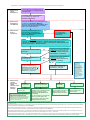
1
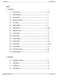
User guide Contents 1.0 Introduction ............................................................................................................ 1 2.0 Planning scheme structure................................................................................... 1 3.0 Types of development and levels of assessment .............................................. 2 4.0 Determining the level of assessment and assessment criteria for development........................................................................................................... 3 5.0 Using and applying codes .................................................................................... 4 6.0 Assessment rules for development ..................................................................... 7 7.0 Navigating the Sunshine Coast Planning Scheme 2014 .................................... 9 Attachments Attachment 1 Attachment 2 Summarised contents of the Sunshine Coast Planning Scheme 2014 How to determine the level of assessment and the assessment criteria for development Disclaimer This document deals with technical matters in a summary way only and has been prepared to assist users and the broader community to understand the operation of the Sunshine Coast Planning Scheme 2014. It is not a legal interpretation on the use of the planning scheme. Some variation to the general guidance provided in this document may occur in some specific situations. 0 Sunshine Coast Planning Scheme 2014 User guide 1.0 Introduction This User Guide provides information on: The structure and operation of the Sunshine Coast Planning Scheme 2014; The different types of development regulated under the planning scheme; The levels of assessment applying to development; Using and applying the planning scheme codes; Applying the assessment rules for development; and Navigating the Sunshine Coast Planning Scheme 2014. 1.1 Overview The Sunshine Coast Planning Scheme 2014 has been prepared under the Sustainable Planning Act 2009 (the SPA) and in accordance with the Queensland Planning Provisions version 3.0 (25 October 2013) to guide land use and development within the Sunshine Coast region. The Queensland Planning Provisions (the QPP) are the standard planning scheme provisions made under the SPA that provide a consistent format and structure for local government planning schemes across the State. The QPP also includes a standard suite of zones, standard definitions and development assessment rules which have been reflected in the Sunshine Coast Planning Scheme 2014. The Sunshine Coast Planning Scheme 2014 has also been prepared to reflect the South East Queensland Regional Plan 2009-2031 and all aspects of the single State Planning Policy (December 2013) that are relevant to the Sunshine Coast region. 1.2 Planning scheme area The Sunshine Coast Planning Scheme 2014 applies to the planning scheme area of the Sunshine Coast Council including all premises, roads, internal waterways and local government tidal areas. However, the Sunshine Coast Planning Scheme 2014 does not regulate land use and development in the following priority development areas (PDAs): Maroochydore City Centre PDA; and Caloundra South PDA. The Maroochydore City Centre PDA and Caloundra South PDA are under the control of Economic Development Queensland and subject to the Economic Development Act 2012. As such, development in these areas is assessed against the applicable development scheme administered by the Department of State Development, Infrastructure and Planning. In addition, for that part of the planning scheme area identified as subject of the Kawana Waters Development Agreement, the Sunshine Coast Planning Scheme 2014 incorporates Development Control Plan 1 – Kawana Waters (DCP 1). In effect, development in this part of the planning scheme area will continue to be regulated by the provisions of DCP 1 and the 1996 transitional planning scheme and planning scheme policies for the former Caloundra City local government area. Map SCC1 (Local government planning scheme area and context) of the Sunshine Coast Planning Scheme 2014 shows the general location and extent of the PDA’s and the land within DCP 1 which is subject of the Kawana Waters Development Agreement. 2.0 Planning scheme structure In accordance with the QPP, the Sunshine Coast Planning Scheme 2014 is structured into 10 parts, 6 schedules and 2 appendices, as outlined in the figure below. PLANNING SCHEME PARTS SCHEDULES APPENDICES Part 1 About the planning scheme Schedule 1 Definitions Appendix 1 Index and glossary of abbreviations and acronyms Part 2 State planning provisions Schedule 2 Mapping Appendix 2 Table of amendments Part 3 Strategic framework Schedule 3 Priority infrastructure plan mapping and supporting material Part 4 Priority infrastructure plan Schedule 4 Notations required under the Sustainable Planning Act 2009 Part 5 Tables of assessment Schedule 5 Land designated for community infrastructure Part 6 Zones Schedule 6 Planning scheme policies Part 7 Local plans Part 8 Overlays Part 9 Development codes Part 10 Other plans For further detail about the contents of each part, schedule and appendix of the Sunshine Coast Planning Scheme 2014, please refer to Attachment 1 of this User Guide. 3.0 Types of development and levels of assessment The Sunshine Coast Planning Scheme 2014 regulates the following types of development, as defined under the SPA: making a material change of use of premises (e.g. starting a new use or increasing the scale or intensity of an existing use); reconfiguring a lot (e.g. subdivision of land or rearranging lot boundaries); carrying out building work (e.g. building, repairing, altering, moving or demolishing a building); and carrying out operational work (e.g. filling or excavation, civil and landscaping works, vegetation clearing and placing an advertising device on premises). A proposed development may involve one or more of the above types of development. For the types of development described above, the Sunshine Coast Planning Scheme 2014 may identify the following categories of development (or levels of assessment), as defined under the SPA: 2 Exempt development is not regulated by the Sunshine Coast Planning Scheme 2014 and no development approval is required. However, approvals or licenses may be still required under other state legislation (e.g. Building Regulation 2006) or Council local laws (e.g. Local Law No. 2 (Animal Management). Sunshine Coast Planning Scheme 2014 User guide Self-assessable development does not require a development approval from Council under the Sunshine Coast Planning Scheme 2014. However, the proposed development must comply with the self-assessable acceptable outcomes of the applicable code(s) in the planning scheme. In some cases this compliance check may be done by a private certifier (e.g. for dwelling houses). A development application and approval from Council under the planning scheme is required only where the proposed development cannot meet one or more of the self-assessable acceptable outcomes of the applicable code(s). Development requiring compliance assessment requires a compliance permit from the Council. Under the Sunshine Coast Planning Scheme 2014, compliance assessment is only applicable in limited circumstances as provided for under section 5.4 (Prescribed levels of assessment), being subdivision of one lot into two lots (and associated operational work) if compliance assessment is required under Schedule 18 of the Sustainable Planning Regulation 2009. Code assessable development requires a development approval from Council under the Sunshine Coast Planning Scheme 2014 and is to be assessed against the codes identified as being applicable to the development. A code assessable development application does not require public notification. Where code assessable development does not comply with the purpose and overall outcomes of any applicable code, it must be assessed having regard to Part 3 (Strategic framework) of the Sunshine Coast Planning Scheme 2014. Impact assessable development requires a development approval from Council under the Sunshine Coast Planning Scheme 2014 and is to be assessed against the planning scheme as a whole (to the extent relevant). An impact assessable development application requires public notification and provides third party appeal rights to any submitters. In addition to the above categories of development, Schedule 1 of the SPA outlines the limited circumstances under which development is prohibited development. A development application or a request for compliance assessment cannot be made for prohibited development. The state also prescribes levels of assessment for certain types of development as reflected in section 5.4 (Prescribed levels of assessment) of the planning scheme. 4.0 Determining the level of assessment and assessment criteria for development For the different types of development, the tables of assessment in Part 5 of the Sunshine Coast Planning Scheme 2014 identify: the level of assessment; and the assessment criteria (i.e. the relevant sections of the planning scheme) that apply to the assessment of development. 4.1 Level of assessment The process for determining the level of assessment for development is detailed in section 5.3.1 of the Sunshine Coast Planning Scheme 2014. To help illustrate this process, a flow chart has been prepared to provide a step-by-step guide for determining the level of assessment (refer to Attachment 2 of this User Guide). It is important to note that the tables of assessment for local plans and overlays may change the provisional level of assessment in certain circumstances, so it is always necessary to check all the relevant tables of assessment in Part 5 of the planning scheme to confirm the level of assessment. In this regard, where development is identified in the tables of assessment in Part 5 as having a different level of assessment under a zone than under a local plan or overlay, the highest level of assessment will prevail as follows: self-assessable prevails over exempt; compliance assessment prevails over self-assessable; code assessable prevails over self-assessable and exempt; and impact assessable prevails over code assessable, self-assessable and exempt. For development in the Maroochydore Principal Regional Activity Centre and Palmview declared master planned areas, levels of assessment are determined by referring to the tables of assessment in Part 10 (Other plans) of the planning scheme. 4.2 Assessment criteria The provisions of the planning scheme that apply to self-assessable development, development requiring compliance assessment and code assessable development are identified in the “assessment criteria” column of the relevant tables of assessment in Part 5 of the Sunshine Coast Planning Scheme 2014. For impact assessable development, the planning scheme as whole applies, to the extent relevant. Refer to Step 4 in the flow chart included as Attachment 2 of this User Guide for further details on how to determine the assessment criteria for development. In accordance with section 1.5 (Hierarchy of assessment criteria) of the planning scheme, where there is inconsistency between the provisions (including the assessment criteria) within the planning scheme, the following rules apply: the strategic framework prevails over all other elements to the extent of the inconsistency; statewide codes prevail over all other elements (other than the strategic framework) to the extent of the inconsistency; overlays prevail over all other elements (other than the strategic framework and statewide codes) to the extent of the inconsistency; local plan codes prevail over zone codes, use codes and other development codes to the extent of the inconsistency; zone codes prevail over use codes and other development codes to the extent of the inconsistency; and provisions of Part 10 (Other plans) may override any of the above. 5.0 Using and applying codes Codes contained in Sunshine Coast Planning Scheme 2014 set out most of the criteria for the assessment of proposed development (i.e. requirements to be met by development). 5.1 Format and structure codes In accordance with the QPP, the codes in the Sunshine Coast Planning Scheme 2014 have a generally consistent format and structure as follows: a statement about the application of the code (i.e. what type of development the code applies to); a statement about the purpose of the code; overall outcomes about how the stated purpose of the code will be achieved; and assessment criteria for self-assessable development and assessable development presented in a two column table, with performance outcomes included in the left hand column and, where specified, acceptable outcomes identified in the right hand column. The purpose, overall outcomes and assessment criteria are used to determine whether development complies with the code, in accordance with section 5.3.3 (Determining the assessment criteria) of the planning scheme. Refer to Part 6.0 of this User Guide for further information. The Sunshine Coast Planning Scheme 2014 includes seven types of codes included in Parts 6 to 10 of the planning scheme document. An overview of each type of planning scheme code is outlined below. 4 Sunshine Coast Planning Scheme 2014 User guide 5.2 Zone codes Zone codes are contained in Part 6 of the Sunshine Coast Planning Scheme 2014 and provide assessment criteria for development in each of the 22 zones identified in the planning scheme. Zone codes only apply to assessable development (i.e. code or impact assessable development). Where applicable, a zone code may also contain provisions for a precinct in a zone. The respective zones and zone precincts are mapped in Schedule 2 (Mapping) of the planning scheme. If effect, each zone code outlines the broad intent for the zone, via the purpose of the zone code and the overall outcomes, with a focus on the type and form of development that is considered appropriate in that zone. To assist in this regard, most zone codes contain a table of consistent and potentially consistent uses for the zone. Unlike most other codes contained in the Sunshine Coast Planning Scheme 2014, zone codes do not include more detailed assessment criteria in the form of performance outcomes and acceptable outcomes. Where included in a zone code, the table of consistent and potentially consistent uses for the zone identifies uses that are intended to occur in the zone (“consistent uses”) and uses that are only intended to occur in the zone where further assessment has determined that the use is appropriate in the zone having regard to such matters as its location, nature, scale and intensity (“potentially consistent uses”). A use that is not identified in the zone code as a consistent use or a potentially consistent use is an inconsistent use and is not intended to occur in the zone. 5.3 Local plan codes Local plan codes are contained in Part 7 (Local plans) of the Sunshine Coast Planning Scheme 2014 and provide assessment criteria for development in each of the 27 local plan areas identified in the planning scheme. Local plan codes only apply to assessable development (i.e. code or impact assessable development). Where applicable, a local plan code may also contain provisions for a local plan precinct and sub-precinct. Where a local plan area includes local plan precincts and subprecincts, these are mapped in Schedule 2 (Mapping) of the planning scheme. Local plan codes help to organise the planning scheme area at the local level and provide more detailed planning guidance for the zone and identify the preferred character and intent for each local plan area. In effect, local plan codes provide variations to the other planning scheme codes (e.g. zone codes and development codes) by including additional and/or overriding assessment criteria that apply to development in a particular local plan area. It should also be noted that some local plans contain variations to the consistent and potentially consistent uses identified in the zone codes for specific local plan precincts. Each local plan code is supported by a local plan elements figure that helps to illustrate various features and elements within the local plan area that are referred to in the assessment criteria of the code. 5.4 Overlay codes Overlays are mapped in Schedule 2 (Mapping) of the planning scheme and identify areas that reflect state and local interests and have one or more of the following: there is a particular sensitivity to the effects of development; there is a constraint on land use or development outcomes; there is the presence of valuable resources; or there are particular opportunities for development. Overlay codes are contained in Part 8 (Overlays) of the Sunshine Coast Planning Scheme 2014 and provide assessment criteria for the various overlay elements identified on the overlay maps in Schedule 2. In effect, the Height of buildings and structures overlay maps also provide assessment criteria by prescribing maximum heights for development. While mostly applying to assessable development, the following overlay codes also contain assessment criteria for self-assessable development: Biodiversity, waterways and wetlands overlay (dwelling house and rural uses); Bushfire hazard overlay (dual occupancy and dwelling house); Coastal protection overlay (dual occupancy and dwelling house); Flood hazard overlay (dual occupancy and dwelling house); and Landslide hazard and steep land overlay (dwelling house and other self-assessable development). 5.5 Statewide codes In accordance with the QPP, the following Statewide codes are included in section 9.2 (Statewide codes) of the Sunshine Coast Planning Scheme 2014: Community residence code – providing assessment criteria for a self-assessable material change of use for a community residence; Forestry for wood production code – providing self-assessable and assessable criteria applicable to a material change of use involving cropping where forestry for wood production in the Rural zone; and Reconfiguring a lot (subdividing one lot into two lots) and associated operational work code) – providing assessment criteria (compliance outcomes) for development requiring compliance assessment as prescribed under Table 5.4.2 (Prescribed levels of assessment: reconfiguring a lot). 5.6 Use codes Use codes are contained in section 9.3 of the Sunshine Coast Planning Scheme 2014 and provide the assessment criteria for a number of defined uses (e.g. Dwelling house code) by specifying performance outcomes and acceptable outcomes for development. As such, the assessment criteria for use codes primarily apply to development for material change of use and are focused on regulating building siting, built form and design and managing the general effects of development. While the majority of use codes only apply to assessable development, the following use codes contain assessment criteria for self-assessable development: Caretaker’s accommodation code; Dual occupancy code; Dwelling house code; Home based business code; Industry uses code; Market code; Rural industries code; Rural uses code; and Sales office code. 5.7 Other development codes Other development codes are contained in section 9.3 of the Sunshine Coast Planning Scheme 2014 and provide the assessment criteria for development of a stated type (e.g. reconfiguring a lot), operational work (e.g. landscaping) and other non-use specific aspects of development (e.g. access and parking). 5.8 Structure plan codes Part 10 (Other plans) of the Sunshine Coast Planning Scheme 2014 contains the structure plans for the declared master planned areas of the Maroochydore Principal Regional Activity Centre (PRAC) and Palmview. Structure plans, for the most part, operate as separate planning frameworks with only limited references to, and interactions with, the balance of the planning scheme. 6 Sunshine Coast Planning Scheme 2014 User guide Similar to most of the other planning scheme codes, the structure plan area codes provide overall outcomes, performance outcomes and acceptable outcomes for the assessment of development that apply to the whole of the master planned area, particular precincts and sub-precincts and to infrastructure and services. 6.0 Assessment rules for development The QPP provides a number of “rules” that need to be considered when assessing development and determining compliance with the codes and other provisions of the planning scheme. The subsections below describe these rules for the different categories of development. 6.1 Self assessable development As stated in section 5.3.3(a) of the Sunshine Coast Planning Scheme 2014, and in accordance with the QPP, self-assessable development: (a) must be assessed against all of the identified self-assessable acceptable outcomes of the applicable code(s) identified in the assessment criteria column of the tables(s) of assessment in Part 5; (b) that complies with the self-assessable acceptable outcomes of the applicable code(s) complies with the code(s); and (c) that does not comply with one or more of the identified self-assessable acceptable outcomes of the applicable code(s) generally becomes code assessable development1. If self-assessable development becomes code assessable due to the proposal not complying with one or more of the self-assessable acceptable outcomes of an applicable code, the assessment criteria for the development application are limited to the performance outcomes that correspond to the selfassessable acceptable outcome/s that were not complied with or not capable of being complied with. The development must still comply with the remainder of the self-assessable outcomes of an applicable code. 6.2 Development requiring compliance assessment As stated in section 5.3.3(b) of the Sunshine Coast Planning Scheme 2014, and in accordance with the QPP version 3, development requiring compliance assessment:(a) must be assessed against all the identified compliance outcomes of the applicable code(s) identified in the assessment criteria column of the relevant table(s) of assessment in Part 5; and (b) that complies with, or is conditioned to comply with, the compliance outcome(s) complies with the code(s). Development requiring compliance assessment which does not comply with one or more of the relevant compliance outcomes will be issued with an action notice requiring compliance. If the development is not capable of achieving compliance then it is not compliance assessable development and may be made assessable development by the planning scheme. 6.3 Code assessable development Code assessable development must be assessed against all of the applicable code(s) identified in the assessment criteria column of the relevant table(s) of assessment in Part 5 (refer to section 5.3.3(c) of the Sunshine Coast Planning Scheme 2014). Under the SPA, code assessable development must also have regard to the purpose of any instrument containing an applicable code. The QPP further provides that the Strategic Framework is considered to be the purpose of the instrument containing an applicable code. (refer to section 5.3.3(c) of the Sunshine Coast Planning Scheme 2014 and the QPP version 3). 1 Due to the operation and effect of Schedule 4 of the Sustainable Planning Regulation 2009, in certain circumstances, a material change of use involving a dwelling house and associated outbuildings cannot be made assessable development under a planning scheme. For further information, please refer to the Dwelling House Guide. This means that code assessable development must be assessed with regard to the strategic framework. Because the planning scheme codes are intended to implement the strategic framework at a more detailed level, in practice, code assessable development will generally only be required to specifically address the strategic framework where it does not comply with the purpose and overall outcomes of an applicable code(s). Under the SPA, code assessable development is also assessed against a range of other material. Determining code compliance for code assessable development In accordance with the QPP, section 5.3.3(c)(iii) of the Sunshine Coast Planning Scheme 2014 provides that code assessable development that complies with: (a) the purpose and overall outcomes of the code complies with the code; and (b) the performance outcomes or acceptable outcomes of the code complies with the purpose and overall outcomes of the code. In practice this means that a proposal which complies with the acceptable outcomes of the applicable code is automatically taken to comply with the corresponding performance outcomes and all higher order outcomes of the code (overall outcomes and purpose of the code). Similarly, a proposal which complies with the performance outcomes of the applicable code is automatically taken to comply with the higher order outcomes of the code. Where a proposal does not comply with the acceptable outcomes or performance outcomes of an applicable code, development complies with the code where it complies with the purpose and overall outcomes of the code. Code assessable development that does not comply with the purpose and overall outcomes of the applicable codes is assessed having regard to Part 3 (Strategic Framework) of the planning scheme. Refer to section 6.5 below in relation to what happens if code or impact assessable development does not comply with the Strategic Framework. 6.4 Impact assessable development Impact assessable development is assessed against all elements of the planning scheme which are relevant to the proposed development, including the Strategic Framework. This may include the relevant zone code, local plan code, use code and any relevant overlay codes and other development codes. Impact assessable development is also assessed against other material as provided for in the SPA. 6.5 Assessable development that does not comply with the Strategic Framework Assessable development (i.e. code or impact assessable development) that does not comply with the Strategic Framework will be refused in the vast majority of cases, unless a condition can be imposed that would achieve compliance. Under section 326 of the SPA, the assessment manager’s decision must not conflict with the planning scheme (or another ‘relevant instrument’) unless: the conflict is necessary to ensure the decision complies with a State Planning Regulatory Provision; or there are “sufficient grounds” to justify the decision; or conflict arises because of a conflict between: two or more relevant instruments of the same type and the decision best achieves the purposes of the instruments; or two or more aspects of any one relevant instrument and the decision best achieves the purposes of that instrument (such as a conflict between two codes in a planning scheme). “Grounds” is defined in the SPA to mean matters of public interest and does not include the personal circumstances of an applicant, owner or interested party. Statutory Guideline 05/09 provides guidance 8 Sunshine Coast Planning Scheme 2014 User guide in relation to what types of circumstances may constitute “sufficient grounds” including circumstances where the relevant instrument is out of date or incorrect or there is an urgent need for the proposal. Assessable development that does not comply with the applicable codes may therefore be approved despite an inconsistency with the strategic framework, provided that there are “sufficient grounds” to justify the decision despite the conflict with the planning scheme. 7.0 Navigating the Sunshine Coast Planning Scheme 2014 In making a development application under the planning scheme, it is first necessary to determine the type of development involved (i.e. material change of use, reconfiguring a lot, building work and/or operational work). These terms are defined in section 10 of the SPA. A proposed development may involve one or more of these types of development. This part of the User Guide identifies how to navigate your way through the Sunshine Coast Planning Scheme 2014 when making or assessing a development application involving one or more of the four types of development described above. For a more general guide, please refer to the flow chart included as Attachment 2 of this User Guide. The step-by-step guide for each type of development commences on a new page for ease of identification and separate use. 7.1 1. A step-by-step guide for a material change of use Identify the use definition for the proposed material change of use. Refer to Table SC1.1.2 (Use definitions) in Schedule 1 (Definitions) of the planning scheme. Note—a use not listed in Table SC1.1.2 (Use definitions) is an undefined use. 2. 3. Determine the attributes of the development site by referring to the relevant maps in Schedule 2 (Mapping) to confirm:(a) the zone allocated to the site by referring to the relevant zone map; (b) where applicable, the zone precinct allocated to the site by referring to the relevant zone map; (c) where applicable, the local plan area that applies to the site by referring to the relevant zone map; (d) where applicable, the local plan precinct and local plan sub-precinct that applies to the site by referring to the relevant local plan precinct map; and (e) where applicable, the overlay(s) that apply to the site by referring to the relevant overlay maps. Determine if the material change of use has a prescribed level of assessment by referring to Table 5.4.1 (Prescribed levels of assessment: material change of use) in Part 5 (Tables of assessment). Note—for a material change of use, prescribed levels of assessment only apply to a community residence, cropping (where forestry for wood production) or dwelling house where meeting the circumstances identified in Table 5.4.1. If the material change of use has a prescribed level of assessment, Table 5.4.1 identifies the level of assessment that will apply and, where applicable, the assessment criteria (Statewide codes) that applies. 4. If determined at Step 3 that the material change of use does not have a prescribed level of assessment, determine the provisional level of assessment by referring to the relevant table of assessment in section 5.5 (Levels of assessment – material change of use) for the relevant zone that applies to the development site (as determined at Step 2(a)). Make note of any applicable codes that apply to the proposed use by referring to the “assessment criteria” column of the relevant table of assessment in section 5.5. 5. If the development site is located in a local plan area (as determined at Step 2(c)), determine if the provisional level of assessment (as determined at Step 4) is changed by a local plan area by referring to the relevant table of assessment for a material change of use in section 5.9 (Levels of assessment – local plans). Make note of any applicable codes that apply to the proposed use by referring to the “assessment criteria” column of the relevant table of assessment in section 5.9. 6. If an overlay(s) applies to the development site (as determined at Step 2(e)), determine if the level of assessment is changed by an applicable overlay by referring to Table 5.10.1 (Overlays) in Part 5. Also, make note of the overlay code(s) that apply to the proposed use by referring to the “assessment criteria” column of Table 5.10.1. Note—in accordance with section 5.3.2(5) of the planning scheme, where development is proposed on a site partly affected by an overlay, the level of assessment for the overlay only relates to that part of the site affected by the overlay. 7. If the level of assessment is changed by an applicable overlay (as determined in Step 6), the level of assessment for the material change of use is as per the level of assessment identified in Table 5.10.1 (Overlays). If the level of assessment is not changed by an applicable overlay (as determined in Step 6), or there is no applicable overlay, the level of assessment for the material change of use is: 8. 9. (a) as per the applicable table of assessment in section 5.5 (Levels of assessment – material change of use); OR (b) where applicable, the supplementary table of assessment for the local plan in section 5.9 (Levels of assessment – local plans). If the level of assessment is identified as: Self-assessable, go to Step 9; OR Code assessable, go to Step 10; OR Impact assessable, go to Step 11. Where the material change of use is identified as self-assessable development, assess the proposed development against the criteria for self-assessable development (i.e. acceptable outcomes) in the applicable codes, being the codes identified as applying to the proposed use as determined in Steps 4, 5 and 6. If the proposed material change of use complies with all of the acceptable outcomes for selfassessable development of the applicable codes, then no further reference to the Sunshine Coast Planning Scheme 2014 is required and the proposal is deemed to comply with the provisions of the planning scheme. If the proposed material change of use does not comply with one or more of the self-assessable acceptable outcomes, the proposal is code assessable development (go to Step 10), subject to the assessment limitations stated in section 5.3.3(c)(ii) of the planning scheme. 10. Where the material change of use is identified as code assessable development, a development application must be made to the Council for assessment. The development application will be assessed against all of the applicable codes(s) identified as applying to the proposed use as determined in Steps 4, 5 and 6. Note—section 313 of the SPA identifies other matters that code assessable development must be assessed against. Determine the proposal’s compliance with the planning scheme, having regard to the assessment rules in section 5.3.3(c). 11. Where the material change of use is identified as impact assessable development, a development application must be made to the Council for impact assessment (including public notification). The development application will be assessed against the entire Sunshine Coast Planning Scheme 2014, to the extent relevant. Note—section 314 of the SPA identifies other matters that impact assessable development must be assessed against. 7.2 1. 10 A step-by-step guide for reconfiguring a lot Determine the attributes of the development site by referring to the relevant maps in Schedule 2 (Mapping) to confirm:(a) the zone allocated to the site by referring to the relevant zone map; (b) where applicable, the zone precinct allocated to the site by referring to the relevant zone map; (c) where applicable, the local plan area that applies to the site by referring to the relevant zone map; Sunshine Coast Planning Scheme 2014 User guide 2. (d) where applicable, the local plan precinct and local plan sub-precinct that applies to the site by referring to the relevant local plan precinct map; and (e) where applicable, the overlay(s) that apply to the site by referring to the relevant overlay maps. Determine if the proposed reconfiguring a lot has a prescribed level of assessment by referring to Table 5.4.2 (Prescribed levels of assessment: reconfiguring a lot) in Part 5 (Tables of assessment). Note—for reconfiguring a lot, a prescribed level of assessment only applies to subdivision of one lot into two lots where meeting the circumstances identified in Table 5.4.2. If it is determined that the proposed reconfiguring a lot has a prescribed level of assessment, Table 5.4.2 identifies that compliance assessment will apply and section 9.2.3 (Reconfiguring a lot code (subdividing one lot into two lots) and associated operational work code) provides the relevant assessment criteria. 3. If determined at Step 2 that the reconfiguring a lot does not have a prescribed level of assessment, determine the provisional level of assessment by referring to Table 5.6.1 (Reconfiguring a lot) for the relevant zone that applies to the development site (as determined at Step 1(a)). Make note of any applicable codes that apply to the proposed reconfiguring a lot by referring to the “assessment criteria” column of Table 5.6.1. 4. If the development site is located in a local plan area (as determined at Step 2(c)), determine if the provisional level of assessment (as determined at Step 3) is changed by a local plan area by referring to the relevant table of assessment for reconfiguring a lot in section 5.9 (Levels of assessment – local plans). Make note of any applicable codes that apply to the reconfiguring a lot by referring to the “assessment criteria” column of the relevant table of assessment in section 5.9. Note—the only table of assessment in section 5.9 of the planning scheme that currently applies to reconfiguring a lot is Table 5.9.4.2 (Golden Beach/Pelican Waters local plan: reconfiguring a lot) where located in the Emerging community zone (Pelican Waters Golf Course). 5. If an overlay(s) applies to the development site (as determined at Step 1(e)), determine if the level of assessment is changed by an applicable overlay by referring to Table 5.10.1 (Overlays) in Part 5. Also, make note of the overlay code(s) that apply to the proposed reconfiguring a lot by referring to the “assessment criteria” column of Table 5.10.1. Note—in accordance with section 5.3.2(5) of the planning scheme, where development is proposed on a site partly affected by an overlay, the level of assessment for the overlay only relates to that part of the site affected by the overlay. 6. If the level of assessment is changed by an applicable overlay (as determined in Step 5), the level of assessment for the reconfiguring a lot is as per the level of assessment identified in Table 5.10.1 (Overlays). If the level of assessment is not changed by an applicable overlay (as determined in Step 5), or there is no applicable overlay, the level of assessment for the reconfiguring a lot is: 7. (a) as per Table 5.6.1 (Reconfiguring a lot); OR (b) where applicable, the supplementary table of assessment for the local plan in section 5.9 (Levels of assessment – local plans). If the level of assessment for the proposed reconfiguring a lot is identified as: Code assessable, go to Step 8; OR Impact assessable, go to Step 9. Note—there are currently no circumstances where reconfiguring a lot is self-assessable development under the planning scheme. 8. Where the reconfiguring a lot is identified as code assessable development, a development application must be made to the Council for assessment. The proposed reconfiguring a lot will be assessed against all of the applicable codes(s) identified as applying to the proposed development as determined in Steps 3, 4 and 5. Note—section 313 of the SPA identifies other matters that code assessable development must be assessed against. Determine the proposal’s compliance with the planning scheme, having regard to section 5.3.3(c). 9. Where the reconfiguring a lot is identified as impact assessable development, a development application must be made to the Council for impact assessment (including public notification). The development application will be assessed against the entire Sunshine Coast Planning Scheme 2014, to the extent relevant. Note—section 314 of the SPA identifies other matters that impact assessable development must be assessed against. 7.3 A step-by-step guide for building work Note—this step-by-step guide for building work only applies to building work not associated with a material change of use. For building work associated with a material change of use, refer to section 7.1 of this User Guide for a step-by-step guide as to how to navigate the Sunshine Coast Planning Scheme 2014 for a material change of use. 1. Determine if the proposed building work is associated with a material change of use. If the building work is associated with a material change of use, the building work is not separately regulated by the Sunshine Coast Planning Scheme 2014 and will be assessed as part of any assessment required for the material change of use (refer to section 7.1 of this User Guide). Note—assessment of the building work may still be required under the Building Regulation 2006 or other state legislation). If the proposed building work is not associated with a material change of use, go to Step 2. 2. Determine if the Sunshine Coast Planning Scheme 2014 definition of “minor building work” applies to the proposed building work by referring to Table SC1.2.2 (Administrative definitions) in Schedule 1 (Definitions) of the planning scheme. 3. Determine the attributes of the development site relevant to building work by referring to the relevant maps in Schedule 2 (Mapping) to confirm:(a) where applicable, the local plan area that applies to the site by referring to the relevant zone map; and (b) where applicable, the overlay(s) that apply to the site by referring to the relevant overlay maps. 4. Determine the provisional level of assessment for the proposed building work by referring to Table 5.7.1 (Building work) in Part 5 (Tables of assessment). Make note of any applicable code(s) that apply to the proposed building work by referring to the “assessment criteria” column of Table 5.7.1. 5. If an overlay(s) applies to the development site (as determined at Step 3(b)), determine if the provisional level of assessment is changed by an applicable overlay by referring to Table 5.10.1 (Overlays) in Part 5. Also, make note of the overlay code(s) that apply to the proposed building work by referring to the “assessment criteria” column of Table 5.10.1. Note—in accordance with section 5.3.2(5) of the planning scheme, where development is proposed on a site partly affected by an overlay, the level of assessment for the overlay only relates to that part of the site affected by the overlay. 6. If the provisional level of assessment is changed by an applicable overlay (as determined in Step 5), the level of assessment for the building work is as per the level of assessment identified in Table 5.10.1 (Overlays). Note—in accordance with Table 5.10.1 (Overlays),the following overlays may have the effect of changing the level of assessment for building work not associated with a material change of use: Acid sulfate soils – if located in an acid sulfate soils area as identified on an Acid Sulfate Soils Overlay Map and the proposed work will involve excavating or filling exceeding the thresholds stated in Table 5.10.1; Height of buildings and structures overlay – if exceeding the maximum height specified for the site on the applicable Height of Buildings and Structures Overlay Map; or Heritage and character areas overlay – if involving a local heritage place or within a neighbourhood character area as identified on a Heritage and Character Areas Overlay Map. If the level of assessment is not changed by an applicable overlay (as determined in Step 5), or there is no applicable overlay, the level of assessment for the building work is as per Table 5.7.1 (Building work). 7. 12 If the level of assessment for the proposed building work is identified as: Self-assessable, go to Step 8; OR Code assessable, go to Step 9; OR Sunshine Coast Planning Scheme 2014 User guide Impact assessable, go to Step 10. Note—building work not associated with a material change of use will only be impact assessable under the planning scheme if the following circumstances apply: 8. the proposed building work will involve the demolition, relocation or removal of a heritage place; or the proposed building work will exceed the maximum height specified for the site on the applicable Height of Buildings and Structures Overlay Map. Where the building work is identified as self-assessable development, assess the proposed building work against the criteria for self-assessable development (i.e. acceptable outcomes) in the applicable codes, being the codes identified as applying to the proposed use as determined in Steps 4 and 5. If the proposed building work complies with all of the applicable acceptable outcomes for selfassessable development of the applicable codes, then no further reference to the Sunshine Coast Planning Scheme 2014 is required and the proposal is deemed to comply with the provisions of the planning scheme. If the proposed building work does not comply with one or more of the selfassessable acceptable outcomes, the proposal is code assessable development (go to Step 9), subject to the assessment limitations stated in section 5.3.3(c)(ii) of the planning scheme. 9. Where the building work is identified as code assessable development, a development application must be made to the Council for assessment. The proposed building work will be assessed against all of the applicable codes(s) identified as applying to the proposed development as determined in Steps 4 and 5. Note—section 313 of the SPA identifies other matters that code assessable development must be assessed against. Determine compliance with the planning scheme, having regard to the assessment rules in section 5.3.3(c). 10. Where the building work is identified as impact assessable development, a development application must be made to the Council for impact assessment (including public notification). The development application will be assessed against the entire Sunshine Coast Planning Scheme 2014, to the extent relevant. Note—section 314 of the SPA identifies other matters that impact assessable development must be assessed against. 7.4 A step-by-step guide for operational work 1. Determine what type of operational work is involved by referring to the definition of operational work in section 10 of the SPA (e.g. filling or excavation, vegetation clearing, placing an advertising device on premises). 2. Determine the attributes of the development site by referring to the relevant maps in Schedule 2 (Mapping) to confirm:- 3. (a) the zone allocated to the site by referring to the relevant zone map; (b) where applicable, the zone precinct allocated to the site by referring to the relevant zone map; (c) where applicable, the local plan area that applies to the site by referring to the relevant zone map; (d) where applicable, the local plan precinct and local plan sub-precinct that applies to the site by referring to the relevant local plan precinct map; and (e) where applicable, the overlay(s) that apply to the site by referring to the relevant overlay maps. Determine if the proposed operational work has a prescribed level of assessment by referring to Table 5.4.4 (Prescribed levels of assessment: operational work) in Part 5 (Tables of assessment). Note—for operational work, a prescribed level of assessment only applies to operational work associated with subdivision of one lot into two lots where meeting the circumstances identified in Table 5.4.3. If it is determined that the operational work has a prescribed level of assessment, Table 5.4.3 identifies that compliance assessment will apply and section 9.2.3 (Reconfiguring a lot code (subdividing one lot into two lots) and associated operational work code) provides the relevant assessment criteria. 4. If determined at Step 3 that the operational work does not have a prescribed level of assessment, determine the provisional level of assessment for the particular aspect of operational work (e.g. engineering work and/or landscape work, filling or excavation) by referring to Table 5.8.1 (Operational work). Make note of any applicable codes that apply to the proposed operational work by referring to the “assessment criteria” column of Table 5.8.1. 5. If the development site is located in a local plan area (as determined at Step 2(c)), determine if the provisional level of assessment (as determined at Step 4) is changed by a local plan area by referring to the relevant table of assessment for operational work in section 5.9 (Levels of assessment – local plans). Make note of any applicable codes that apply to the proposed operational work by referring to the “assessment criteria” column of the relevant table of assessment in section 5.9. Note—the only table of assessment in section 5.9 of the planning scheme that currently applies to operational work is Table 5.9.3 (Caloundra West local plan: operational work) where located in the Sport and recreation zone (specifically, Corbould Park Racecourse, and involving placing an advertising device on premises). 6. If an overlay(s) applies to the development site (as determined at Step 2(e)), determine if the level of assessment is changed by an applicable overlay by referring to Table 5.10.1 (Overlays) in Part 5. Also, make note of the overlay code(s) that apply to the proposed operational work by referring to the “assessment criteria” column of Table 5.10.1. Note—in accordance with section 5.3.2(5) of the planning scheme, where development is proposed on a site partly affected by an overlay, the level of assessment for the overlay only relates to that part of the site affected by the overlay. 7. If the level of assessment is changed by an applicable overlay (as determined in Step 5), the level of assessment for the operational work is as per the level of assessment identified in Table 5.10.1 (Overlays). If the level of assessment is not changed by an applicable overlay (as determined in Step 5), or there is no applicable overlay, the level of assessment for the operational work is: 8. (a) as per Table 5.8.1 (Operational work); OR (b) where applicable, the supplementary table of assessment for the local plan in section 5.9 (Levels of assessment – local plans). If the level of assessment for the proposed operational work is identified as: Self-assessable, go to Step 9; OR Code assessable, go to Step 10; OR Impact assessable, go to Step 11. Note—operational work will only be impact assessable under the planning scheme if placing a third party advertising device on land (other than land owned or controlled by the Council and used for sport and recreation purposes). A third party advertising device means an advertising device placed on premises for the purpose of advertising a matter not associated with the primary purpose for which the premises is used or developed. 9. Where the operational work is identified as self-assessable development, assess the proposed operational work against the criteria for self-assessable development (i.e. acceptable outcomes) in the applicable codes, being the codes identified as applying to the proposed use as determined in Steps 4, 5 and 6. If the proposed operational work complies with all of the applicable acceptable outcomes for selfassessable development of the applicable codes, then no further reference to the Sunshine Coast Planning Scheme 2014 is required and the proposal is deemed to comply with the provisions of the planning scheme. If the proposed operational work does not comply with one or more of the self-assessable acceptable outcomes, the proposal is code assessable development (go to Step 10), subject to the assessment limitations stated in section 5.3.3(c)(ii) of the planning scheme. 10. Where the operational work is identified as code assessable development, a development application must be made to the Council for assessment. The proposed operational work will be assessed against all of the applicable codes(s) identified as applying to the proposed development as determined in Steps 4, 5 and 6. Note—section 313 of the SPA identifies other matters that code assessable development must be assessed against. Determine compliance of the code assessable operational work with the planning scheme by referring to section 5.3.3(c). 14 Sunshine Coast Planning Scheme 2014 User guide 11. Where the operational work is identified as impact assessable development, a development application must be made to the Council for impact assessment (including public notification). The development application will be assessed against the entire Sunshine Coast Planning Scheme 2014, to the extent relevant. Note—section 314 of the SPA identifies other matters that impact assessable development must be assessed against. Attachment 1 – Summarised contents of the Sunshine Coast Planning Scheme 2014 PLANNING SCHEME PARTS Planning scheme part Part 1 About the planning scheme Summarised contents of each part Introduces the planning scheme and identifies and describes the planning scheme area. Provides an overview of the component parts of the planning scheme. Provides guidance on the interpretation of the planning scheme. Identifies and describes the categories of development under the Sustainable Planning Act 2009. Provides a hierarchy of assessment criteria in the event that there is an inconsistency between provisions in different parts of the planning scheme. Confirms what aspects of building work are regulated under the planning scheme. Part 2 State planning provisions Part 3 Strategic framework Part 4 Priority infrastructure plan 16 Identifies the aspects of the State Planning Policy that have been reflected in the planning scheme. Confirms that the planning scheme appropriately advances the South East Queensland Regional Plan 2009-2031. Confirms that the planning scheme appropriately reflects version 3.0 of the QPP dated 25 October 2013. Sets the overall policy direction for development in the Sunshine Coast region to 2031. Provides a strategic intent (vision) that applies to the whole of the Sunshine Coast region. Provides strategic outcomes, specific outcomes and supporting strategic framework maps to achieve the strategic intent, organised into the following themes: Settlement pattern Economic development Transport Infrastructure and services Natural environment Community identify, character and social inclusion Natural resources Natural hazards Identifies and describes the planning assumptions which have informed preparation of the priority infrastructure plan (PIP), including the projections for future urban growth and the assumptions of demand for each trunk infrastructure network. States the priority infrastructure area (PIA) which is the Council’s prioritised area to accommodate future growth. States the desired standard of service for each trunk infrastructure network. States the existing and planned trunk infrastructure for the following trunk infrastructure networks: Water supply trunk network Sewerage trunk network Stormwater quality trunk network Transport (roads) trunk network Transport (active transport) trunk network Public parks and land for community facilities trunk network Identifies the PIP maps and provides a schedule of works for trunk infrastructure for each trunk infrastructure network. Sunshine Coast Planning Scheme 2014 User Guide Attachment 1 – Summarised contents of the Sunshine Coast Planning Scheme 2014 Planning scheme part Part 5 Tables of assessment Part 6 Summarised contents of each part Provides direction on how to read and interpret the tables of assessment contained in this part. Provides direction on how to determine the level of assessment and assessment criteria that apply. Provides the following tables of assessment that identify levels of assessment and the assessment criteria that apply: Zones Part 7 Local plans Prescribed development Material change of use Reconfiguring a lot Building work Operational work Local plans Overlays Provides the assessment criteria for each of the 22 planning scheme zones (and zone precincts where applicable) via the following zone codes: Low density residential zone code Medium density residential zone code High density residential zone code Tourist accommodation zone code Principal centre zone code Major centre zone code District centre zone code Local centre zone code Low impact industry zone code Medium impact industry zone code High impact industry zone code Waterfront and marine industry zone code Sport and recreation zone code Open space zone code Environmental management and conservation zone code Community facilities zone code Emerging community zone code Limited development (landscape residential) zone code Rural zone code Rural residential zone code Specialised centre zone code Tourism zone code Provides the assessment criteria for the 27 identified local plan areas (and local plan precincts where applicable) via the following local plan codes: Beerburrum local plan code Beerwah local plan code Blackall Range local plan code Bli Bli local plan code Buderim local plan code Caloundra local plan, code Caloundra West local plan code Coolum local plan code Eudlo local plan code Attachment 1 – Summarised contents of the Sunshine Coast Planning Scheme 2014 Planning scheme part Summarised contents of each part Eumundi local plan code Part 8 Overlays Part 9 Development codes Forest Glen / Kunda Park / Tanawha local plan code Glass House Mountains local plan code Golden Beach / Pelican Waters local plan code Kawana Waters local plan code Kenilworth local plan code Landsborough local plan code Maleny local plan code Maroochy North Shore local plan code Maroochydore / Kuluin local plan code Mooloolaba / Alexandra Headland local plan code Mooloolah local plan code Nambour local plan code Palmwoods local plan code Peregian South local plan code Sippy Downs local plan code Woombye local plan code Yandina local plan code Provides the assessment criteria for the 13 planning scheme overlays via the following overlay codes: Acid sulfate soils overlay code Airport environs overlay code Biodiversity, waterways and wetlands overlay code Bushfire hazard overlay code Coastal protection overlay code Extractive resources overlay code Flood hazard overlay code Height of buildings and structures overlay code Heritage and character areas overlay code Landslide hazard and steep land overlay code Regional infrastructure overlay code Scenic amenity overlay code Water resource catchments overlay code Provides the general assessment criteria for development, arranged into the following code categories: Statewide codes (x 3) Community residence code Forestry for wood production code Reconfiguring a lot (subdividing one lot into two lots) and associated operational work code Use codes (x 21) 18 Business uses and centre design code Caretaker’s accommodation code Child care centre code Community activities code Dual occupancy code Dwelling house code Extractive industry code Home based business code Sunshine Coast Planning Scheme 2014 User Guide Attachment 1 – Summarised contents of the Sunshine Coast Planning Scheme 2014 Planning scheme part Summarised contents of each part Industry uses code Market code Multi-unit residential uses code Nature and rural based tourism code Relocatable home park and tourist park code Residential care facility and retirement facility code Rural industries code Rural uses code Sales office code Service station code Sport and recreation uses code Telecommunications facility code Utility code Other development codes (x 11) Part 10 Other plans Advertising devices code Landscape code Nuisance code Reconfiguring a lot code Safety and security code Stormwater management code Sustainable design code Transport and parking code Vegetation management code Waste management code Works, services and infrastructure code Provides the planning framework for the following declared master planned areas for which a structure plan has been prepared: Maroochydore Principal Regional Activity Centre (PRAC) Palmview The structure plans include: Details of the planning scheme provisions that apply to the declared master planned areas. Strategic framework for the master planned area Tables of assessment for the master planned area Structure plan area code PLANNING SCHEME SCHEDULES Planning scheme schedule Summarised contents of each schedule Schedule 1 Definitions Schedule 2 Mapping Provides the use definitions, as prescribed by the QPP, that are used in the planning scheme. Provides the administrative definitions for the terms used in the planning scheme (some prescribed by the QPP and other terms identified by the Council). Lists and includes all of the planning scheme mapping, including: Strategic framework maps Zone maps Local plan maps Other plan maps (for Maroochydore PRAC and Palmview Attachment 1 – Summarised contents of the Sunshine Coast Planning Scheme 2014 Planning scheme schedule Summarised contents of each schedule declared master planned areas) Overlay maps Identifies the community facilities zone annotations used on the zone maps. Schedule 3 Priority infrastructure plan mapping and supporting material Schedule 4 Lists and includes the priority infrastructure area (PIA) maps and the trunk infrastructure network maps supporting the priority infrastructure plan (PIP). Includes various notations that are required to be noted in the planning scheme in accordance with the Sustainable Planning Act 2009 (the SPA), including: Notations required under the Sustainable Planning Act 2009 Notation of decisions affecting the planning scheme under section 391 of the SPA which includes approvals in conflict with the planning scheme, preliminary approvals overriding the planning scheme and decisions to accept a request for application of a superseded planning scheme. Notation of resolution(s) under section 684D of the SPA, being any resolutions about infrastructure charges under the relevant state planning regulatory provision. Notation of registration for urban encroachment provisions under section 680ZE of the SPA, providing relevant details of any notice about the registration of premises related to the urban encroachment provisions of Chapter 8A of the SPA. Schedule 5 Land designated for community infrastructure Schedule 6 Planning scheme policies Includes the details of land in the planning scheme area that has been designated under a community infrastructure designation in accordance with section 206 and 211 of the SPA. Contains the planning scheme policies that support the implementation of the planning scheme, including specifying information that the Council may require for a development application, specifying the standards called up in a code and providing guidance or advice about satisfying assessment criteria in the planning scheme. The planning scheme polices that support the planning scheme are the following: PSPs relating to Part 7 (Local plans) Planning scheme policy for Landsborough (urban design guidelines) Planning scheme policy for Sippy Downs Town Centre PSPs relating to Part 8 (Overlays) Planning scheme policy for the acid sulfate soils overlay code Planning scheme policy for the airport environs overlay code Planning scheme policy for the biodiversity, waterways and wetlands overlay code Planning scheme policy for the bushfire hazard overlay code Planning scheme policy for the extractive resources overlay code Planning scheme policy for the flood hazard overlay code Planning scheme policy for the heritage and character areas overlay code Planning scheme policy for the landslide hazard and steep land overlay code Planning scheme policy for the scenic amenity overlay code PSPs relating to Part 9 (Development codes) 20 Planning scheme policy for the utility code Sunshine Coast Planning Scheme 2014 User Guide Attachment 1 – Summarised contents of the Sunshine Coast Planning Scheme 2014 Planning scheme schedule Summarised contents of each schedule Planning scheme policy for development works Planning scheme policy for the nuisance code Planning scheme policy for the reconfiguring a lot code Planning scheme policy for the transport and parking code Planning scheme policy for the waste management code PSPs relating to Part 10 (Other plans) Planning scheme policy for Maroochydore Principal Regional Activity Centre Structure Plan Planning scheme policy for Palmview Structure Plan Other planning scheme policies Planning scheme policy for biodiversity offsets Planning scheme policy for information that local government may require Planning scheme policy for performance bonds PLANNING SCHEME APPENDICES Planning scheme appendix Summarised contents of each appendix Appendix 1 Index and glossary of abbreviations and acronyms Appendix 2 Provides a list of abbreviations and acronyms used in the planning scheme and the relevant details or descriptions of the abbreviations and acronyms. Provides a list of all post-commencement amendments made to the planning scheme, including planning scheme policies. Table of amendments Attachment 2 – How to determine the level of assessment and the assessment criteria for development 1. Determine the type of development Is the development a material change of use, reconfiguring a lot, operational work or building work? If a material change of use, determine the use definition by reference to Schedule 1 (Definitions) 2. Determine the development site attributes Determine the attributes of the development site by reference to Schedule 2 (Mapping) – determine applicable zone, zone precinct, local plan area, local plan precinct and overlays. Make a note of these attributes. 3. Determine the level of assessment Determine if the development has a prescribed level of assessment by reference to Section 5.4 (Prescribed levels of assessment) Yes The level of assessment is as per Section 5.4 (Prescribed levels of assessment) No Determine the provisional level of assessment by reference to the tables of assessment in Section 5.5 (Levels of assessment – material change of use), 5.6 (Levels of assessment – reconfiguring a lot), 5.7 (Levels of assessment – building work) or 5.8 (Levels of assessment – operational work) Is the development site in a local plan area? Yes Determine if the level of assessment is changed by a supplementary table of assessment for a local plan area by reference to Section 5.9 (Levels of assessment – local plans) No Are overlays identified on the development site? Yes No No Yes The level of assessment is as per the table of assessment in Section 5.5, 5.6, 5.7 or 5.8 OR the supplementary table of assessment for the local plan in Section 5.9 (if applicable) 4. Determine the relevant assessment If Exempt criteria Development (sections of the planning scheme) The Planning Scheme does not apply. Note: A material change of use for a dwelling house is exempt if Schedule 4, Table 2, Item 2 of the Sustainable Planning Regulation 2009 applies. However the building work for the dwelling house is assessed against provisions of the planning scheme by the local government as concurrence agency for the building application (Schedule 7, Table 1 Item 26). 1 Determine if the level of assessment is changed by an overlay by reference to Table 5.10 (Levels of assessment – overlays) If Self Assessable or Compliance Assessable For prescribed development, the applicable codes or provisions listed in the tables of assessment within Section 5.4 (Prescribed levels of assessment). The level of assessment is as per Section 5.10 (Levels of assessment – overlays) If Code Assessable The applicable codes or provisions listed in the relevant tables of assessment within Sections 5.5 to 5.10 inclusive. Note: Where development is comprised of a number of defined uses or is proposed on premises included in more than one zone, local plan or overlay, the level of assessment is the highest level for each aspect of the development under each of the applicable zones, local plans or overlays. If Impact Assessable The whole Planning Scheme applies, to the extent relevant. For other development, the applicable codes or provisions listed in the relevant tables of assessment within Sections 5.5 to 5.10 inclusive. Kawana Waters DCP 1 Area – As per Section 1.2 (Planning Scheme Components), land within Development Control Plan 1 - Kawana Waters is subject of the Kawana Waters Development Agreement and DCP 1. Palmview Declared Master Planned Area – For development in the Palmview Declared Master Planned Area, refer to the Palmview Structure Plan in Part 10 – Other Plans for the level of assessment and relevant assessment criteria. Mapping is located in Schedule 2. Maroochydore Declared Master Planned Area – For development in the Maroochydore Declared Master Planned Area, refer to the Maroochydore Principal Activity Centre (PRAC) Structure Plan in Part 10 – Other Plans for the level of assessment and relevant assessment criteria. Mapping is located in Schedule 2. Maroochydore Priority Development Area – The Sunshine Coast Planning Scheme does not apply to development in the Maroochydore Priority Development Area. The Maroochydore City Centre Priority Development Area Proposed Development Scheme (January 2014) was on public display from 31 January – 17 March 2014. Caloundra South Priority Development Area – The Sunshine Coast Planning Scheme does not apply to development in the Caloundra South Priority Development Area. Development applications are assessed against the Caloundra South UDA Development Scheme (October 2011) by the Queensland Government Department of State Development, Infrastructure and Planning (DSDIP).