1
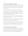
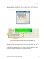
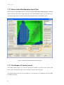
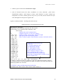
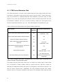
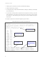
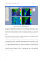
The Centre for Australian Weather and Climate Research
A partnership between CSIRO and the Bureau of Meteorology
Chemical Transport Model – User Manual
Martin Cope and Sunhee Lee
CAWCR Technical Report No. 016
October 2009
Chemical Transport Model – User Manual
Martin Cope and Sunhee Lee
CAWCR Technical Report No. 016
October 2009
ISSN: 1836-019X
ISBN: 9780643098237 (pdf.)
Series: Technical report (Centre for Australian Weather and Climate Research.) ; no.16
Enquiries should be addressed to:
Martin Cope
Centre for Australian Weather and Climate Research:
A Partnership between the Bureau of Meteorology and CSIRO
[email protected]
Copyright and Disclaimer
© 2009 CSIRO and the Bureau of Meteorology. To the extent permitted by law, all rights are
reserved and no part of this publication covered by copyright may be reproduced or copied in any
form or by any means except with the written permission of CSIRO and the Bureau of
Meteorology.
CSIRO and the Bureau of Meteorology advise that the information contained in this publication
comprises general statements based on scientific research. The reader is advised and needs to be
aware that such information may be incomplete or unable to be used in any specific situation. No
reliance or actions must therefore be made on that information without seeking prior expert
professional, scientific and technical advice. To the extent permitted by law, CSIRO and the Bureau
of Meteorology (including each of its employees and consultants) excludes all liability to any
person for any consequences, including but not limited to all losses, damages, costs, expenses and
any other compensation, arising directly or indirectly from using this publication (in part or in
whole) and any information or material contained in it.
Contents
1.
INTRODUCTION................................................................................................. 4
2.
CTM STRUCTURE ............................................................................................. 5
3.
TAPM_GUI.......................................................................................................... 8
3.1
Enable CTM option ................................................................................................... 8
3.2
Pre-processor Input Directory................................................................................. 10
3.3
Scenario Name ....................................................................................................... 10
3.4
Select the CTM chemistry....................................................................................... 11
3.5
Skip the TAPM spin-up days................................................................................... 13
3.6
Run the CTM for a subset of TAPM met grids........................................................ 13
3.7
Selecting the CTM Master Grid Domains ............................................................... 14
3.8
Selecting the CTM Inline grid domains ................................................................... 14
3.9
Emission File Format .............................................................................................. 16
3.10 CIT Emission Files.................................................................................................. 17
3.11 CTM Emission Files................................................................................................ 18
3.12 Select Inline Grid Emission Input Files ................................................................... 20
3.13 The Number of Vertical Levels ............................................................................... 20
3.14 Select CTM run–time options ................................................................................. 21
4.
USER INPUT FILES ......................................................................................... 26
4.1
The initial and boundary concentration file ............................................................. 26
4.2
CIT Format Emission files ...................................................................................... 27
4.3
CTM Format Emission files .................................................................................... 32
5.
DISPLAY FILES ............................................................................................... 36
6.
TEXT FILES GENERATED BY THE CTM ........................................................ 37
7.
DISPLAY OF DATA IN NETCDF FILES ........................................................... 37
8.
REFERENCES.................................................................................................. 41
i
List of Figures
Figure 1 The CTM file structure as used in TAPM–CTM for a two–grid system ........................... 7
Figure 2 Location of the CTM Pollution option in the TAPM GUI .................................................. 9
Figure 3 The CTM graphical user interface. .................................................................................. 9
Figure 4 Enabling of the CTM simulation option in TAPM........................................................... 10
Figure 5 Select scenario name (i.e. base or test)........................................................................ 10
Figure 6 Selection of the CTM chemical transformation mechanism .......................................... 11
Figure 7 Select the number of meteorological spin-up days before the CTM integration
commences .......................................................................................................................... 13
Figure 8 Selector to indicate which TAPM grid nest contains the outermost CTM grid is located.
.............................................................................................................................................. 13
Figure 9 Selection of Master grids (left). Selection of corresponding inline grids (right). ............ 15
Figure 10 Selection of Inline grids ............................................................................................... 16
Figure 11 Emission file formats ................................................................................................... 16
Figure 12 CIT Area Emission Files.............................................................................................. 17
Figure 13 Option for selecting emission files for the Master grids............................................... 18
Figure 14 CTM Area Emission Files............................................................................................ 19
Figure 15 Option for selecting CTM formatted emission files for the CTM Master grids............. 19
Figure 16 Selection of emission files for the Inline grids. ............................................................ 20
Figure 17 Number and spacing of the vertical CTM levels. The number of vertical levels output
to the NetCDF data packets. ................................................................................................ 21
Figure 18 The CTM run–time options.......................................................................................... 21
Figure 19 Example of the CTM data display system. .................................................................. 38
ii
List of Tables
Table 1 Summary of the chemical mechanisms available for use with the CTM........................ 12
Table 2 Listing of the TAPM–CTM run–time options. ................................................................. 22
Table 3 Structure of the initial concentration/boundary concentration file................................... 26
Table 4 Structure of a cit_grid_dx.dat file.................................................................................... 28
Table 5 File structure for a CIT area source emissions file......................................................... 30
Table 6 Structure of a CIT elevated point source file .................................................................. 31
Table 7 Summary of the TAPM emission source groups treated by TAPM–CTM ...................... 32
Table 8 File structure for a CTM area source emissions file....................................................... 34
Table 9 File structure for a CTM point source emissions file ...................................................... 35
Table 10 Example of line-segment display file ............................................................................ 36
Table 11 Example of locality display file...................................................................................... 36
Table 12 Structure of the ctm archive.cobs file ........................................................................... 39
Table 13 Structure of the .csv observational data file. ................................................................ 40
INTRODUCTION
1.
INTRODUCTION
This document provides an overview of the steps required to set up a chemical transport
simulation using the TAPM–CTM modelling system. The modelling system consists of the
TAPM prognostic meteorological model and a chemical transport model (CTM) which CSIRO
originally developed for use with the Australian Air Quality Forecasting System. The technical
background to the CTM is summarised in Cope et al. (2009) The CTM is run online within the
TAPM time marching loop, and thus has the capability of handling frequent updates (i.e. 300 s
intervals) to the meteorological fields. This capability provides the potential for more accurate
simulation of chemical transport and transformation under rapidly changing meteorological
conditions such as sea breeze flows.
By electing to use TAPM–CTM, it is assumed that the user wishes to undertake simulations
which require complex chemical transformation and, optionally, an aerosol modelling
capability. Such situations may include the modelling of photochemical transformation for
scenarios where subtle changes in the speciation of volatile organic compounds are entailed,
where secondary aerosol transformation needs to be considered, or where other chemical
transformation systems may be important (i.e. the chemistry of background air or the chemical
cycle of a persistent pollutant such as mercury). In these situations it is appropriate to use
TAPM–CTM; otherwise it is recommended to TAPM be used. Note that running TAPM–CTM
with a complex chemical transformation scheme will cause typical TAPM run times to increase
by a factor of 2–5. This is a consequence of transporting many more chemical species and the
need to solve a ‘stiff’ system of differential equations describing the chemical transformation
rates.
TAPM–CTM is configured for both episodic and longer term modelling (which could involve
simulating a period of weeks to years). Note that TAPM–CTM was originally configured to
provide an alternative to the TAPM and CIT (Carnegie-Mellon, California Institute of
Technology airshed model; Harley et al., 1993) modelling system which was used by some of
the Australian environmental protection authorities. As such, the system was designed to use
the CIT format concentration boundary conditions and emission inventory files, with only a
minimal amount of modification (see Section 4). However, the model has since been modified
to input a superset of the TAPM-type emission formats (i.e. see Hurley 2008a) and thus
provides additional flexibility in the treatment of the emissions. Replacement of CIT by
TAPM–CTM provides the ability to model multi-scale problems (using nested grids), and to
4
CTM STRUCTURE
easily inter-change the chemical mechanism. The online configuration of the CTM provides the
advantage of more frequent updates of the meteorological data and improved transport
modelling.
This manual assumes that the user is already familiar with the technical background and
operation of TAPM, and has thoroughly reviewed the steps required to set up a TAPM
simulation using the TAPM graphical user interface. The following sections describe the CTM
file structure, and the process for setting up the CTM component of a TAPM run.
2.
CTM STRUCTURE
The file structure of the CTM component of TAPM–CTM is shown in Figure 1. In this
example, a two–level nested grid system is considered. Each of the CTM grids must have a
corresponding TAPM grid of the same resolution. For example, if the CTM grids are to have a
horizontal spacing of 3 km and 1 km respectively, TAPM must be configured to run two grids
of the same spacing (plus additional grids of lower resolution if required for modelling larger
scale meteorological processes).
For the 2–grid system shown in Figure 1, boundary conditions for the outer CTM grid are
prescribed from a user–generated input file. Boundary conditions for the inner CTM grid are
interpolated from the outer CTM grid during run time. When used in this configuration, the
CTM grids are defined as Master grids. A Master grid has the same grid spacing as the
corresponding TAPM grid. As will be shown below, the GUI allows one Master grid to be
defined per TAPM grid.
The TAPM–CTM system also allows the use of Inline grids. One or more Inline grids may
exist within a given Master grid. An Inline grid will usually be of higher resolution (usually
1/2 to 1/3 the grid spacing of the Master grid), and will use interpolated TAPM meteorology.
An Inline grid is integrated at the same time as the Master grid and receives boundary
concentrations from the Master grid every time step.
An Inline grid is used when the chemical transport calculations need to be undertaken on a
smaller grid spacing than is available from the TAPM meteorological simulation. For example,
TAPM may be used to generate meteorological fields on grids with horizontal spacing of 9 km
and 3 km respectively. The CTM is also integrated on 9 and 3 km spaced Master grids. Let’s
assume that it is also necessary to compute chemical-transport on a grid of 1 km spacing. In this
CSIRO. TAPM–CTM user manual (8/10/2009)
5
CTM STRUCTURE
case, the 1 km spaced grid would be defined as an Inline grid to the 3 km CTM Master grid
and would use interpolated meteorological data from the 3 km TAPM grid.
Central to the CTM operation is the concept of a data packet. This is a NetCDF1 file which
contains all of the input and output fields of the CTM for a 24 h period for a single grid. A
separate NetCDF file is generated for each grid and for each 24 h period of the simulation. The
NetCDF file system is used because its format is independent of the underlying operating
system.
In the example shown in Figure 1, the two CTM grids are set up using the TAPM GUI as
discussed in the next section. The GUI is also used to identify the names of CIT–formatted
emissions files, and initial and boundary concentration files. Text–based locality and line
segment display files are also used for plotting simple maps over the concentration predictions
after the simulation has been completed.
Following the process of grid configuration and file selection, the GUI triggers a CTM preprocessor which creates the NetCDF data packets, interpolates and loads in the emission data,
generates a text-based configuration file (one per grid), and generates a generic photolysis
reaction file for use by the chemical transformation mechanism. The TAPM–CTM system is
then executed, with the TAPM predicted meteorological fields being passed to TAPM–CTM
every 300 s, where they are interpolated onto the CTM grid and used to drive the transport–
chemical–transformation processes.
Once a simulation has been completed, CTM results may be viewed using a GUI-driven display
system (CTM-DDS). The operation of this system is discussed in the CTM-DDS online user
manual and is also summarised in Section 7.
1
NetCDF is a network independent common data format which is widely used for storing a
wide range of scientific data (http://www.unidata.ucar.edu/software/netcdf/).
6
CTM STRUCTURE
System Input Files
ctm_config_1.txt
yymmdd_photolysis.dat
(infile/photolysis_species.txt)
User Input files
Emissions- CIT
cit_grid_dx.dat
aems_*.in
mvems_*.in
pems_*.in
domain1;dx1(m)
TAPM
METEOROLOGICAL
DATA
Data Packet
(domain1)
Emissions-TAPM
.vpx; .vpv; .vdx; gse; .whe; .pse
Initial/boundary concentrations
tcbc_chemistry.in
Output Text Files
ctm_chem_scenario.lis1
ctm_debug.txt1
ctm_timing.txt1
Display files
linesegments.csv[.txt]
locations.csv[txt]
domain2; dx2(m)
boundary
concentrations
Data Packet
(domain2)
Figure 1 The CTM file structure as used in TAPM–CTM for a two–grid system
CSIRO. TAPM–CTM user manual (8/10/2009)
7
TAPM_GUI
3.
TAPM_GUI
The process of setting up a TAPM–CTM simulation is similar to that used to set up a
conventional TAPM pollution simulation.
Set up a TAPM meteorological simulation using the TAPM GUI to prescribe the
meteorological grids, the integration period and the surface and meteorological boundary
conditions. When doing this, care must be taken to prescribe a grid system which will
encompass the CTM grids. Similarly, the vertical extent of the TAPM domain must encompass
the vertical extent of the CTM domain. It is also necessary to ensure that the TAPM
meteorological simulation encompasses the length of the CTM simulation. Note that one or
more spin-up days of meteorological–only modelling may be prescribed if necessary. Similarly
it is possible to skip one or more outer grids of a nested TAPM grid system before the outermost CTM grid is defined, thus reserving one or more of the lower resolution grids for
meteorological modelling. The procedure for setting up a TAPM simulation is described in the
TAPM user manual (Hurley, 2008a).
If the CTM software has been installed (check for the presence of a CTM directory under the
TAPM root directory to confirm this), then the Optional Input menu will include the CTM
Pollution option (Figure 2). Selection of this option will bring up the CTM pollution menu (see
Figure 3). This menu provides an interface for selecting the chemical mechanism, the number
and dimensions of a nested grid system, the vertical model domain, CIT-formatted emission
inventory files and some output options.
3.1 Enable CTM option
In order to run the CTM chemistry in the place of the TAPM pollution module, ensure that the
CTM pollution from Optional Input Box is selected as shown in Figure 4 (left).
8
TAPM_GUI
Figure 2 Location of the CTM Pollution option in the TAPM GUI
Figure 3 The CTM graphical user interface.
CSIRO. TAPM–CTM user manual (8/10/2009)
9
TAPM_GUI
Figure 4 Enabling of the CTM simulation option in TAPM
3.2 Pre-processor Input Directory
The CTM pre-processor generates CTM control files and NetCDF data packets. The Preprocessor Input Directory (Figure 4- right) contains domain independent files (i.e. such as the
data base files from which photolysis rates are calculated) which are accessed by the CTM preprocessor. An infile directory will be set up at installation time.
3.3 Scenario Name
Fill in the scenario name box with a unique name up to 10 characters to identify a particular
run.
Figure 5 Select scenario name (i.e. base or test)
10
TAPM_GUI
3.4 Select the CTM chemistry
The CTM chemistry is linked to the TAPM–CTM system at run time via a dynamic link library
file. This approach allows chemical mechanisms to be interchanged without having to
recompile the TAPM–CTM system.
Figure 6 Selection of the CTM chemical transformation mechanism
Click on the Select the CTM chemistry box to view and select the appropriate chemistry. This
is illustrated in Figure 6 where it can be seen that eight different mechanisms are available for
use ranging from a simple NOx tracer scheme to a Carbon Bond scheme with extensions for
aerosol chemistry. Table 1 provides a summary of the mechanisms available with the current
version of TAPM–CTM.
CSIRO. TAPM–CTM user manual (8/10/2009)
11
TAPM_GUI
Table 1 Summary of the chemical mechanisms available for use with the CTM
Name
Mechanism
NOX
NO, NO2
Simple two species tracer mechanism used for
testing and training. Links to an urban
photochemical precursor inventory.
OX
NO, NO2, O3
Models the photochemical steady-state system.
Used for testing and training. Links to an urban
photochemical precursor inventory
HG3t
Three species mercury
tracer mechanism
Generic Reaction Set
GRS
(Azzi et al. 1992)
LCC
Lurmann, Carter, Coyner
mechanism
(Lurmann et al. 1987)
Carbon Bond 2005
CB05
(Yarwood et al. 2005)
CB05_AER
Carbon Bond 2005 + aerosol
species
Description
Models the transport and deposition of elemental,
bi-valent and particulate mercury. No chemical
reactions
Highly condensed photochemical transformation
mechanism. Using for training and screening-level
urban ozone modelling. Links to an urban
photochemical precursor inventory however
requires a correctly defined reactivity-weighted
volatile organic compound (VOC) species.
Lumped species photochemical smog mechanism
which has seen wide use in Australia and the U.S.
Links to an urban and regional photochemical
precursor inventory however requires correctly
speciated VOC emissions.
Lumped and structure photochemical smog
mechanism which as recently been implemented
into U.S models and the CTM. Links to urban and
regional photochemical precursor inventories
however requires correctly speciated VOC
emissions.
The version of the mechanism contains addition
species and reactions for modelling the primary
and secondary production of PM2.5
Note that a chemical mechanism must be selected with care, as the species in the selected
chemical mechanism; in the initial/boundary concentration file; and in the emissions inventory
files must match a name and case in order for the CTM to process the data. In this regard, the
chemical mechanism species list is defined as the Master Species List and thus one or more of
the species in the initial condition and emissions files much match a species in this list.
Appendix A of Cope et al. (2009) provides the Master Species List for the mechanisms shown
Table 1.
12
TAPM_GUI
3.5 Skip the TAPM spin-up days
This selector is used to indicate how many days of the meteorological simulation are skipped
before the CTM begins its integration cycle (Figure 7). For example, if TAPM is integrated for
3 days and the CTM is to be run for the second and third days, the selector should be set to
indicate that one day is skipped. No days are skipped in the example given in Figure 7.
Figure 7 Select the number of meteorological spin-up days before the CTM integration commences
3.6 Run the CTM for a subset of TAPM met grids
This selector (Figure 8) is used to identify the TAPM grids on which CTM grids are located.
For example, assume that TAPM is configured with three grids with horizontal spacing of 9
km, 3 km and 1 km. These grids are sequentially numbered from 1 to 3 (with 1 corresponding to
the outermost TAPM grid). If the CTM is to be run for all three resolutions, this selector will be
set to run the CTM from the TAPM grid 1 to grid 3. If however, it is not considered necessary
to run the CTM on the 9 km grid (i.e. this grid is used to simulate the larger-scale
meteorological flows only) the selector would be set to run the CTM for TAPM grid 2 to 3.
Note that the inner-most CTM grid is always run on the inner most TAPM domain. Thus the
selector can only be used to define the TAPM grid which contains the first grid of the CTM
domain.
Figure 8 Selector to indicate which TAPM grid nest contains the outermost CTM grid is located.
CSIRO. TAPM–CTM user manual (8/10/2009)
13
TAPM_GUI
3.7 Selecting the CTM Master Grid Domains
As discussed previously, the CTM grids are divided into Master and Inline grids. A Master
grid is driven by the meteorological output from a TAPM grid of the same horizontal grid
spacing. A Master grid receives its boundary concentrations from a lower resolution run (i.e. an
outer nest) or from a user defined, time invariant boundary concentration file (if the Master is
the outer–most grid nest).
One Master grid is defined for each TAPM meteorological grid as described in Section 3.6.
One or more Inline grids may exist within a given Master grid domain. An Inline grid will
usually be of higher resolution (usually 1/2 to 1/3 the grid spacing of the master grid), and will
use interpolated TAPM meteorology. An Inline grid is integrated at the same time as the
Master grid and receives boundary concentrations from the Master grid every time step. Use of
the GUI to define an Inline grid is discussed shortly.
The menu selection circled in Figure 9 is used to define the Master grids. The Master grids are
numbered sequentially, starting at 1 for the outer most CTM grid. The Master Grid Domain #
selector is used to select each CTM grid.
Each Master grid has a unique name as prescribed in the Master Grid Name box. The location
of a CTM Master grid relative to the associated TAPM grid is defined next, using selectors
which define where the CTM grid starts and ends in TAPM grid units.
Guidance as to the location of the CTM grid relative to the TAPM grid can be found by
viewing the TAPM and CTM grids in the centre graphic of the CTM Pollution menu (the CTM
grid can be overlayed by checking the Show Master Grid Lines box underneath the graphic).
Note that a Master grid is not required to be centred within the corresponding TAPM grid.
3.8 Selecting the CTM Inline grid domains
The boxed area on the right hand side of contains a slide button which can be used to prescribe
the number of Inline grids. For the example shown in Figure 9, the number of inline grids has
been set to zero. However, if the number of Inline grids is set to one or more then the Inline
grid menu system is displayed (see Figure 10). The Inline Grid Domain is initially set to off,
however, the slider button can be used to select up to five Inline grids per Master grid.
14
TAPM_GUI
The Inline Grid Name box is used to define a unique name for each Inline grid. The Inline
Grid (nx,ny) slider buttons are used to define the number of east-west and north-south grid
points. The (dx, dy) slider button is used to define the horizontal grid spacing, while the (x0,
y0) define the position of the first (1, 1) grid point which is located at the south-west corner of
the grid.
Figure 9 Selection of Master grids (left). Selection of corresponding inline grids (right).
CSIRO. TAPM–CTM user manual (8/10/2009)
15
TAPM_GUI
Figure 10 Selection of Inline grids
3.9 Emission File Format
The CTM pre-processor requires information about the format and number of emission files
which will be loaded into the NetCDF data packets. The files formats are selected using the
radio buttons outlined in Figure 11 and consist of a modified version of the CIT model area
source file format (McRae et al. 1992) or a modified version of the TAPM emission file
formats (Hurley 2008a). A detailed description of these formats is given in section 4.2.
Figure 11 Emission file formats
Once the file format has been selected, the Emission Source Files button is clicked to select the
number and type of CIT or CTM emissions files which will be processed.
16
TAPM_GUI
3.10 CIT Emission Files
Figure 12 shows the menu which pops up when the CIT emission file format is selected. This
menu is used to indicate whether the CIT area source emissions file (see Section 4 for further
discussion of this file) contains data for commercial/domestic emissions only, for
commercial/domestic and motor vehicle emissions, or for commercial/domestic, motor vehicle
and biogenic emissions (the CIT default).
Figure 12 CIT Area Emission Files
If the radio button for Area is selected, then the user will be required to input separate files for
commercial/domestic emissions (an aems file) and for motor vehicle emissions (mvems file). If
the option for Area+Vehicle is selected then it is assumed that both of these source groups are
included in the CIT aems file. As a consequence, a separate motor vehicle emissions file will
not be required. Selection of either of these options indicates that biogenic emissions will
calculated online in the CTM. However selection of the Area+Vehicle+Biogenic option
indicates that biogenic emissions are also included in the CIT aems file and thus biogenic
emissions will not be calculated online.
Note that it is important to ensure that the Area Emission File Contain option is selected
before the emissions are entered (Select Master Grid Emission Input Files).
Note too that the user will also be requested to input the name of a CIT pems (elevated
industrial point source) file as described shortly. The provision of at least one CIT emission file
is mandatory as the TAPM–CTM pre-processor requires an emission species list in order to set
up data file structures in the NetCDF data packets.
CSIRO. TAPM–CTM user manual (8/10/2009)
17
TAPM_GUI
The emission files for each Master grid are selected by clicking on the Select Master Grid
Emission Input File button (Figure 13). When selected, a series of file selection windows are
displayed, which are then used to select the CIT format emission files.
Note that these files are used only for the current Master Grid domain. The cycle of emission
file selection must be completed for each Master Grid domain defined for the current CTM grid
configuration. This is done because the user may want to select different emission file
resolutions and spatial extents for each Master Grid domain.
The user is first asked to input a CIT format geographical definition file (cit_grid_#km.dat),
and CIT format point source emission files (see Section 4). Following this, and depending upon
the contents of the CIT aems file as discussed above, file selection windows will be opened for
entering the names of the commercial/domestic and motor vehicle emission files.
Figure 13 Option for selecting emission files for the Master grids
The region covered by a particular CIT emission file can be overlayed on the model grid by
checking the Show Master Emission Grid Lines check box. The names of the selected files are
listed below the Select Master Grid command button.
3.11 CTM Emission Files
Figure 14 shows the menu which pops up when the CTM emission file format is selected and
the Emission Source Files button is clicked. It can be seen that there are seven individual source
types which can be selected as described in Section 4.3. Note that TAPM–CTM requires the
selection of a least one source group.
18
TAPM_GUI
The emission files for each Master grid are selected by clicking on the Select Master Grid
Emission Input Files command button (Figure 15). When clicked, a series of file selection
windows are displayed, which are used to select the CTM format emission files.
Figure 14 CTM Area Emission Files
Figure 15 Option for selecting CTM formatted emission files for the CTM Master grids.
Note that these files will be used only for the current Master Grid domain. The cycle of
emission file selection must be completed for each Master Grid domain defined for the current
CTM nested grid configuration. This is done because the user may want to select different
emission file resolutions and spatial extents for each Master Grid domain.
CSIRO. TAPM–CTM user manual (8/10/2009)
19
TAPM_GUI
3.12 Select Inline Grid Emission Input Files
Emission files for the Inline grids are selected using the Select Inline Grid Emission command
button located on the bottom right hand side of the CTM Pollution menu (e.g. see Figure 16).
The selection procedure is identical to that discussed previously for the Master grids.
Figure 16 Selection of emission files for the Inline grids.
3.13 The Number of Vertical Levels
This slider button (Figure 17) is used to specify the number of vertical levels in the CTM
master grids. Note that the same vertical structure is used in all of the grids.
The default number of levels are 10 (0-2000 m), 12 (0-3000 m), 15 (0-4000 m) and 20 (0-4000
m; higher resolution).
20
TAPM_GUI
Also contained within this section of the CTM Pollution menu is a slider switch (Vertical
Levels Output) which specifies the number of vertical levels which are written out to the CTM
data packets. The number of output levels can vary between 1 and the number of vertical levels
as prescribed by the Number of Vertical Levels slider button.
Figure 17 Number and spacing of the vertical CTM levels. The number of vertical levels output to the
NetCDF data packets.
3.14 Select CTM run–time options
Listed at the bottom of the CTM GUI (see Figure 18) are subsets of the options which are
processed by the CTM at run time. These options are used to enable/disable various processes
in the model including advection, chemical transformation, dry deposition and the use of
various aerosol simulation modules.
A complete list of the available options is given in Table 2. Note that it is possible to add
additional options outside of the GUI by modifying the ctm_config_#.txt configuration files.
Figure 18 The CTM run–time options.
CSIRO. TAPM–CTM user manual (8/10/2009)
21
TAPM_GUI
Table 2 Listing of the TAPM–CTM run–time options.
Option
1
Definition
GUI
Advection/noAdvection
Enable (default)/disable the calculation of 3d pollutant transport
y
Hdiffusion/noHdiffusion
Enable (default)/disable the calculation of
horizontal diffusion
y
Vdiffusion/noVdiffusion
Enable (default)/disable the calculation of
vertical diffusion calculations
y
Transport Calculations
Maximum time step for chemical
transformation and diffusion is limited by the
minimum advection time step (default)
Lockstep/noLockstep
Enable(default)/disable the use of TAPM
diffusivity fields for sub-grid-scale turbulent
transport calculations
2
NWPdiffusivity/noNWPdiffusivity
n
n
Chemical Transformation And Aerosol
Processes
Enable(default)/disable the coupled
calculation of chemical transformation and
vertical diffusion
Chemistry/noChemistry
Enable/disable(default) the calculation of
gas-phase ammonium nitrate production.
2
Nitrate/noNitrate
Mars/noMars
Enable/disable(default) the calculation of
gas-phase ammonium nitrate and sulfate
production.
2
y
y
CloudChemistry/noCloudChemistry
Enable/disable(default) the calculation of
sulfate production in cloud water
n
DryDeposition/noDryDeposition
Enable(default)/disable the dry deposition
calculations
y
2
22
y
TAPM_GUI
Biogenic And Natural Emissions
Biogenic/noBiogenic
Enable (default)/disable the calculation of
natural and biogenic emission rates using
online emissions module
Enable(default)/disable the calculation of
emissions from trees when calculating total
biogenic emissions
Trees/noTrees
Enable(default)/disable the calculation of
emissions from grass when calculating
biogenic emissions
Grass/noGrass
userBiogenic
[UserBiogenic_def.txt]
Provide user defined biogenic emission
rates and land–use mappings in the file
UserBiogenic_def.txt
y
n
n
n
Provide user defined leaf area index for
trees and grasses in the user-provided files.
n
Enable/disable(default) the calculate of sea
salt aerosol emissions
n
Enable/disable(default) emissions from fire
sources
n
Enable/disable(default) emissions from
wind–blown dust sources
n
Anthropogenic/noAnthropogenic
Enable(default)/disable emissions from
anthropogenic sources
y
Motor_vehicle/noMotor_vehicle
Enable(default)/disable emissions from
motor vehicle sources
n
Com_dom/noCom_dom
Enable(default)/disable emissions from
commercial/domestic sources
n
Industrial/noIndustrial
Enable(default)/disable emissions from
elevated point sources
n
biogenicLAI
[canopyLAI_x.txt, grassLAI_x.txt]
2
SeaSalt/noSeaSalt
2
Fire/noFire
2
Dust/noDust
Anthropogenic Emissions
StacktipDownWash/noStacktipDownWash
PlumeSmear/noPlumeSmear
BriggsPlumeRise/noBriggsPlumeRise
CSIRO. TAPM–CTM user manual (8/10/2009)
Enable(default)/disable the calculation of
reduced effective stack height due to plume
downwash in the lee of stacks
Enable(default)/disable the calculation of
vertical plume spread due to internal
turbulence in point source plumes
Enable/disable(default) the use of Briggs
analytic plume rise equations instead of
calculations based on the numerical
integration of the governing differential
equations
n
n
n
23
TAPM_GUI
Emission Scaling
Scale_motor_vehicles
[NOx_fac, ROC_fac, PM_fac]
Scale_commercial_domestic
[NOx_fac, ROC_fac, PM_fac]
Scale_fire
[NOx_fac, ROC_fac, PM_fac]
Scale_natural_biogenic
[NOx_fac, ROC_fac, PM_fac]
Scale motor vehicle emissions of NOx
(NOx_fac), ROCs and CO (ROC_fac), and
aerosols (PM_fac) by the user defined
fractional scale factors (default- all scale
factors = 1.0)
Scale commercial/domestic emissions of
NOx (NOx_fac), ROCs and CO (ROC_fac),
and aerosols (PM_fac) by the user defined
fractional scale factors (default- all scale
factors = 1.0)
Scale fire emissions of NOx (NOx_fac),
ROCs and CO (ROC_fac), and aerosols
(PM_fac) by the user defined fractional
scale factors (default- all scale factors =
1.0)
Scale biogenic emissions of NOx
(NOx_fac), ROCs (ROC_fac), and aerosols
(PM_fac) by the user defined fractional
scale factors (default- all scale factors =
1.0)
n
n
n
n
Legacy Cit Options
Restrict the maximum mixing depth within a
sea breeze (defined as existing between
hours start_hr, end_hr, and having a wind
direction between start_wd, end_wd; having
a minium mixing ratio (ppTH) of min_mr.
The maximum mixing depth is given by
max_pbl
SeaBreezeCap
[start_hr, end_hr
start_wd, end_wd
min_mr, max_pbl]
Enable/disable(default) the use of the CIT
vertical diffusion algorithm (for backwards
compatibility)
VdiffCIT/noVdiffCIT
Enable/disable(default) the use of the CIT
diagnostic mixing depth scheme for
calculating the PBL
pblCIT/nopblCIT
SurfaceMet/noSurfaceMet
Enable/disable(default) the use of layer-1
temperature and humidity to calculate
chemical transformation rate coefficients in
all model levels (CIT default)
n
n
n
n
Miscellaneous Options
Warm_start/noWarm_start
Enable/disable(default) warm start using
previous model run for initial concentrations
n
Nest/noNest
Enable(default)/disable the use of one-way
nesting
n
Write_warm_start/noWrite_warm_start
Enable/disable(default) the writing of warm
start data
n
2
24
TAPM_GUI
Met_interpolate/noMet_interpolate
Vector/noVector
1
Enable/disable(default) the temporal
interpolation of meteorological data
n
Enable/disable(default) the use of code
optimised for vector computers
n
y=available from the GUI; n=available through modification to the ctm_config.txt files
2
These are currently research options only and thus may not be available with the release
version of TAPM–CTM. Please contact [email protected] or [email protected] for
further information regarding these options.
CSIRO. TAPM–CTM user manual (8/10/2009)
25
USER INPUT FILES
4.
USER INPUT FILES
The user will need to provide three sets of input files: (a) an initial and boundary concentration
file, (b) emission files, and (c) plot display files.
4.1 The initial and boundary concentration file
This file contains initial concentrations and 2-dimensional boundary time invariant
concentrations for chemical species used in a particular run. The generic file name is
‘tcbc_chemistry.in’. The example shown below is a file called ‘tcbc_grs.in’ which is used for a
Victoria grid domain and a GRS chemistry scheme. The vertical initial concentration records
are used to initialise all CTM grids, and the boundary data provide boundary concentrations for
the outer-most Master grid. The format should be as shown in Table 3. Explanatory notes are
given in brackets (and should not be included in the actual file).
Table 3 Structure of the initial concentration/boundary concentration file
Header record
VERTICAL INITIAL CONDITIONS (This line must start with VERT)
CO 65.00 65.00 65.00 65.00 65.00
(CO in ppb for 5 vertical levels. Concentrations above level 5 use the last defined level)
SO2 1.00 1.00 1.00 1.00 0.10
(SO2 in ppb)
………
………
PM8 1.00 1.00 1.00 1.00 0.10
(PM8 in ug/m3)
* (This line must be included to indicate the end of the vertical concentration records)
BOUNDARY CONDITIONS (This line must start with BOUN)
CO NORT 65.00 65.00 65.00 65.00 65.00 ………
(CO in ppb for all vertical levels on the Northern boundary)
CO EAST 65.00 65.00 65.00 65.00 65.00 ……
CO SOUT 65.00 65.00 65.00 65.00 65.00 ……
CO WEST 65.00 65.00 65.00 65.00 65.00 ……
………..
………..
PM8 NORT 1.00 1.00 1.00 1.00 1.00 …….
PM8 EAST 1.00 1.00 1.00 1.00 1.00 …….
PM8 SOUT 1.00 1.00 1.00 1.00 1.00 …….
PM8 WEST 1.00 1.00 1.00 1.00 1.00 …….
26
USER INPUT FILES
The number of species defined in the tcbc_chemistry.in file is arbitrary. Each species name is
four characters long and must match a species name as defined in the selected chemical
mechanism (the Master Species List). Species names are case sensitive. Species whose names
don’t match will be ignored. The concentrations of undefined species will be set to a small but
non-zero value. The number of species defined in the vertical initial conditions records does not
have to match the number of species defined in the boundary conditions records.
The number of levels defined in the tcbc_chemistry.in file is arbitrary but must be the same for
all initial and boundary concentration records. If the number of levels defined in the
tcbc_chemistry.in file is less than the number of TAPM–CTM levels, the last level defined in
the tcbc_chemistry.in file will be applied to the remainder of the TAPM–CTM levels.
The vertical initial concentrations are written with one line for each chemical species. The
boundary concentrations are written on one line for each direction for each species. Each
direction code has 4 characters, is case sensitive and is defined as one of ‘NORT’, ‘SOUT’,
‘EAST’ or ‘WEST’. If a direction is not prescribed for a particular species or the direction code
is not recognised, then the boundary concentration for that direction and species will be set to a
small but non-zero value. Concentrations can be written in integer or real formats (including the
use of exponents i.e. 1.0E-05).
4.2 CIT Format Emission files
This set of user data consists of the following- a file for specifying emission grid information,
and files which contain hourly gridded emissions for commercial/domestic sources, motor
vehicle sources and industrial point sources. Note that it is necessary to provide at least one
CIT emission file as the TAPM-CTM pre-processor requires information regarding emission
species for setting up storage structures in the NetCDF data packets. The emissions are defined
in local standard time.
The grid information generic file name is cit_grid_dx.dat. dx stands for resolution of the
emission files in km, for example, cit_grid_3km.dat. The format is as shown in Table 4.
Here nx and ny are used to define the horizontal dimensions of the emission grid system; x0 and
y0 define the SW corner of the SW cell (cell 1,1) of the grid (m); dx and dy define the
horizontal grid spacing (m). Note that each emission grid (area source, motor vehicle and
industrial) must use the grid system as defined by the parameters given above.
CSIRO. TAPM–CTM user manual (8/10/2009)
27
USER INPUT FILES
Note that only the grid definition data on line 5 are used by the CTM pre-processor.
Table 4 Structure of a cit_grid_dx.dat file
CIT header file for time date and grid data – comment line
Time [yy mm dd hh] –comment line
2004 07 01 00
nx ny x0(m) y0(m) dx(m) dy(m) top(m) lat0, long0, AMG zone – comment line
60 70 243000 6195000 3000 3000 2000 -35.0 150.75 56
Latitude (deg) longitude (deg) time zone –comment line
-35.0 150.75 10
Number of vertical layers –comment line
10
CIT fractional vertical spacing – comment line:
0.0125 0.025 0.0375 0.05 0.05 0.05 0.075 0.10 0.20 0.40
Area source, industrial source and motor vehicle source emission files are typically named
according to the following convention.
•
pems_chemistry_dx_scenario.in,
•
aems_chemistry_dx_scenario.in,
•
mvems_chemistry_dx_scenario.in.
For an example, aems_lcc_3km_basecase.in is an area source emission file with 3 km grid
spacing, speciated according to the LCC chemistry scheme, and with emissions representative
of a business-as-usual scenario. The format of these files is similar to the standard CIT model
convention (McRae et al. 1992), and is discussed below.
Emissions can be provided for one or more days. If a TAPM–CTM integration period is for
longer than the number of days present in a given emission file then the file is rewound and
emissions are re-read from the top of the file. Such an approach provides the potential for
modelling daily-varying emissions. Note too that it is not necessary for all of the emission files
to have the same number of days of data. For example, the pems file could contain a single day
of emissions while the aems file could contain 7 days and thus include a weekday-weekend
cycle.
For area source emission files (i.e. aems and mvems files) the file structure is as shown in Table
5. Explanatory notes are given in brackets. This structure includes the following records.
•
28
A descriptive text header (ends with a line containing * in the 1st column).
USER INPUT FILES
•
The number of emission species.
•
Ranking, species code name and molecular weight.
•
For each hour of the day and for each grid cell containing non-zero emissions, a code letter
for ground level sources (G), hour, coordinates in grid units in the x and y direction and
species emission rates of each species in units of parts-per-million per minute (ppmV min-1)
for a grid cell of 1 m depth.
A coordinate of 999, 999 is used to flag the end of an hour.
Note that the molecular weight field is not a standard CIT field. Molecular weight been added
in order to allow the emissions files to be used with alternative chemical mechanisms. Note too
that the same number and ordering of species and species names must reside in each emissions
file.
Additionally, note that species names are case sensitive and are only processed by TAPM–
CTM if a match is found with a species name from the Master Species List for the selected
chemical transformation mechanism (see Appendix A of Cope 2009).
The emissions structure presented in Table 5 can be created using the following code construct.
Loop days = 1, ndays
Loop hour = 1, 24
Loop row = 1 to ny
Loop col = 1 to nx
IF(any species (col,row,hour,day)
row, all species (col, row)
>
0)WRITE
hour,
col,
End Loop !nx
End Loop !ny
WRITE hour,999
End Loop !hour
End Loop !days
CSIRO. TAPM–CTM user manual (8/10/2009)
29
USER INPUT FILES
Table 5 File structure for a CIT area source emissions file
DESCRIPTIVE HEADER
MAQS surface-level emissions inventory.
This version of the inventory is for 20070206
BASECASE 3km version
*
(Indicates the end of comment lines)
19
(Number of species- here it is defined for the LCC scheme)
1 NO 30.0 (Number of entry, species name, molecular weight)
2 NO2 46.0 (The species may be given in any order)
3 CO 28.0 (This is read by a generic Fortran format, but name is defined as 4 char)
4 SO2 64.1
5 PART 1.0
6 ETHE 28.0
7 ALKE 47.6
8 ALKA 84.9
9 TOLU 92.0
10 AROM 111.6
11 HCHO 30.0
12 ALD2 46.0
13 MEK 72.0
14 MEOH 32.0
15 ETOH 46.0
16 ISOP 68.1
17 CIN 154.26
18 PINE 136.24
19 ROC 13.7
G 0 9 1 (G: ground level , 0 for hour, grid point in x and y direction, a1,i2,i3,i3/)
0.368E-03 0.343E-04 0.325E-02 0.125E-03 0.913E-02 0.445E-04 0.755E-04 0.465E-03
0.428E-04 0.391E-04 0.738E-05 0.128E-05 0.463E-05 0.000E+00 0.416E-04 0.000E+00
0.000E+00 0.000E+00 0.250E-04 (19 continuous entries by 8e10.3)
G 0 10 1
0.101E-05 0.112E-06 0.855E-05 0.392E-07 0.188E-05 0.694E-07 0.903E-07 0.775E-06
0.786E-07 0.338E-07 0.691E-08 0.159E-08 0.769E-09 0.000E+00 0.000E+00 0.000E+00
0.000E+00 0.000E+00 0.393E-07
…….
…….
G23999999 (G:ground level , 23 for hour, x and y grid 999 mean the end of the file)
0.000E+00 0.000E+00 0.000E+00 0.000E+00 0.000E+00 0.000E+00 0.000E+00
0.000E+000.000E+00 0.000E+00 0.000E+00 0.000E+00 0.000E+00 0.000E+00 0.000E+00
0.000E+00 0.000E+00 0.000E+00 0.000E+00
The elevated point source emission file (pems) has the following structure (Table 6).
•
descriptive text (ends when a line containing * in the 1st column is read),
•
number of species (depends on chemistry scheme selected),
30
USER INPUT FILES
•
number, species code name and molecular weight,
•
code of elevated sources (E), hour, coordinates in x and y direction , point source
identification number, stack height in meter, stack diameter in meter, exhaust gas
temperature in Celsius, exhaust gas flow rate in m3 per second, and an emission flux per
unit cell height for each species in ppmV min-1.
Again a coordinate number = 999 flags the end of an hour.
Table 6 Structure of a CIT elevated point source file
DESCRIPTIVE HEADER
MAQS Point source industrial emissions file. This version
of the inventory is for a Sydney high oxidant day, 2007.
3km version]
*
(Indicates the end of comment lines)
19
(Number of species- it is for LCC scheme)
1 NO 30.0
(Number of entry, species name, molecular weight)
2 NO2 46.0
(The species may be listed in any order)
3 CO 28.0
(This is read by a generic Fortran format, but name is defined as 4char)
4 SO2 64.1
5 PART 1.0
6 ETHE 28.0
7 ALKE 47.6
E: code for elevated sources (a1)
8 ALKA 84.9
0: hour (i2)
9 TOLU 92.0
31, 14: grid coordinates (2i3)
10 AROM 111.6
772: identification number
11 HCHO 30.0
66.3: stack hight in m (f8.1)
12 ALD2 46.0
4.2: stack diameter in m (f8.1)
13 MEK 72.0
180.0: exhaust gas temp (oC) (f8.1)
14 MEOH 32.0
140.7: gas flow rate (m3 s-1) (f8.1/)
15 ETOH 46.0
335.0 6234 (source location [optional]
16 ISOP 68.1
On next line 19 entries (8e10.3) of flux of each
17 CIN 154.26
species in ppmV min-1
18 PINE 136.24
19 ROC 13.7
E 0 31 14 772 66.3 4.2 180.0 140.7 335.0 6234.1
0.224E-01 0.118E-02 0.125E-01 0.244E-03 0.132E+00 0.148E-04 0.547E-04 0.165E-03
0.123E-04 0.941E-05 0.635E-04 0.000E+00 0.000E+00 0.000E+00 0.000E+00 0.000E+00
0.000E+00 0.000E+00 0.952E-05
………...........
(23 for hour, x and y grid 999 mean the end of the file)
E23999999 999 999.0 999.0 999.0 999.0 999.0 999.0 etc.
CSIRO. TAPM–CTM user manual (8/10/2009)
31
USER INPUT FILES
4.3 CTM Format Emission files
The CTM emission files are based on the TAPM format area source and elevated point source
file formats. A description of the various source types are given in Table 7. Some of the source
types are prescribed at a standard temperature and temperature correction factors are then
applied at every time step and grid point within the CTM to estimate emissions for the local
environmental conditions. The user is referred to Hurley (2008a) for a description of the
emission–temperature functions (.vpx; .vpv; .whe) and the plume rise algorithms (for .pse).
Table 7 Summary of the TAPM emission source groups treated by TAPM–CTM
Source group
Filename
extension
Temperature dependency?
1
Motor vehicle petrol-fuelled exhaust emissions
.vpx
Yes. NOx, VOC and CO .
T(standard) = 25°C
Motor vehicle diesel-fuelled exhaust emissions
.vdx
No
Motor LPG-fuelled exhaust emissions
.vlx
No
Motor vehicle petrol-fuelled evaporative
emissions
.vpv
Yes. VOC.
T(standard) = 27°C
Commercial-domestic emissions; generic area
source emissions
.gse
No
Wood heater emissions
.whe
Yes. PM .
T(standard; daily) = 10°C
Industrial elevated point source emissions
.pse
Yes. Momentum and
buoyancy forced plume rise.
All species.
2
1
NOx- oxides of nitrogen (nitric oxide + nitrogen dioxide); VOC (volatile organic compounds); CO
2
(carbon monoxide). PM (particulate matter).
The format of the area source files (all but .pse) is as follows are similar to those of the TAPM
files as described in Hurley (2008a) with the exception that the CTM files contains an
additional text information header and species list description (as described in Section 4.2 for
the CIT format emission files). Additionally, the CTM formatted emission files include
emission rates for all species included in the species list description rather than the fixed
32
USER INPUT FILES
numbers of species contained in the TAPM emission files. The CTM area source files have the
following format.
1. A descriptive text header (ends with a line containing * in the 1st column).
2. The number of emission species (ns).
3. Number, species code name (case sensitive) and molecular weight (g).
4. Grid description, number of east-west points (nx); number of north-south points (ny), dxeast-west grid spacing (m), dy- north source grid spacing (m), cx, cy- centre of the grid
[easting (m), northing (m)].
5. For each hour of the day and for each grid cell the species emission rates of each species in
units of grams per second (g s-1) with emissions given for each species in the order provided
in the species list.
The emissions structure can be described by the following pseudo code. Note that ndays can lie
between 1 and the number of days of simulation. If ndays is less than the number of simulation
days then the emission file is rewound and reading commences again from the top of the file.
Loop days = 1, ndays
Loop hour = 1, 24
Loop row = 1 to ny
Loop col = 1 to nx
Read (in,*) (emissions(s), s=1, ns)
End Loop
!nx
End Loop
!ny
End Loop
!hour
End Loop
!days
An area source emission file fragment is given in Table 8. Note that each CTM emissions file
has to have the same number of species in identical order. However it is possible for each file to
cover a different region, have different spatial resolution and cover a different time period.
The format of a .pse file is as follows.
1. A descriptive text header (ends with a line containing * in the 1st column).
2. The number of emission species (ns).
CSIRO. TAPM–CTM user manual (8/10/2009)
33
USER INPUT FILES
3. Number, species code name (case sensitive) and molecular weight (g).
4. Number of point sources (nsource)
5. For each point source- unique identification number, easting (m), northing (m), stack height
(m), stack radius (m)
6. For each hour of the day and for each point source, the plume exit velocity vs (m/s), the
plume temperature ts (K) and the species emission rates of each species in units of grams
per second (g s-1) with emissions given for each species in order as defined in the species
name record.
An example of a point source emission file fragment is given in Table 9.
Table 8 File structure for a CTM area source emissions file
DESCRIPTIVE HEADER
Version_02
Tapm surface emissions file. Generated by AAQFSt2apmMvems v1.0
File was created (yyyymmdd): 20080305 at time (hhmmss.sss):
163441.273
GramPerSec :TAPM emission units of g/s
Mvems are in a uniform grid
*
Descriptive header
20
1 NO
30.0
2 NO2
46.0
3 CO
28.0
4 SO2
64.1
List of species names
5 PM10
1.0
and molecular weights
6 ETHE 28.0
7 ALKE 47.6
8 ALKA 84.9
9 TOLU 92.0
10 AROM 111.6
11 HCHO 30.0
12 ALD2 46.0
13 MEK
72.0
14 MEOH 32.0
Grid description
Emissions (g/s) for 20
15 ETOH 46.0
(nx,
ny,
dx,
dy,
cx,
cy)
species for point (1,1)16 ISOP 68.1
[SW corner]; of hour 1
17 CIN 154.3
of day 1
18 PINE 136.2
19 ROC
1.0
20 CO_E 28.0
210 273 1000.000 1000.000 314500.000 6295000.000
.000E+00 0.000E+00 0.000E+00 0.000E+00 0.000E+00 .000E+00
0.000E+00 0.000E+00 0.000E+00 0.000E+00 .000E+00 0.000E+00
0.000E+00 0.000E+00 0.000E+00 .000E+00 0.000E+00 0.000E+00
0.000E+00 0.000E+00
34
USER INPUT FILES
Table 9 File structure for a CTM point source emissions file
DESCRIPTIVE HEADER
Version_02
Tapm surface emissions file. Generated by AAQFSt2apmMvems v1.0
File was created (yyyymmdd): 20080305 at time (hhmmss.sss):
163441.273
GramPerSec :TAPM emission units of g/s
Mvems are in a uniform grid
*
Descriptive header
20
1 NO
30.0
2 NO2
46.0
3 CO
28.0
4 SO2
64.1
List of species names,
5 PM10
1.0
molecular weights (g)
6 ETHE 28.0
7 ALKE 47.6
8 ALKA 84.9
9 TOLU 92.0
10 AROM 111.6
11 HCHO 30.0
12 ALD2 46.0
13 MEK
72.0
14 MEOH 32.0
Time invariant source data.
15 ETOH 46.0
Number of point
ident, x (m), y (m), hs (m),
16 ISOP 68.1
sources; number of
ds (m), d1,d2,d3
17 CIN 154.3
hours of emissions
18 PINE 136.2
(d1-d3 are dummy data)
19 ROC
1.0
20 CO_E 28.0
118 24
772 335000.00 6234100.00 66.30 2.10 1.00 0.00 0.00
773 335100.00 6234100.00 67.00
1.10 source
1.00 data
0.00 0.00
Time varying
774 335100.00 6234000.00 67.10
1.65
1.00
0.00(g/s)
0.00
vs (m/s), ts (K), emissions
775 335200.00 6233900.00 58.20 1.05 1.00 0.00 0.00
776 335000.00 6233900.00 53.60 0.95 1.00 0.00 0.00
777 335000.00 6234200.00 60.30 0.40 1.00 0.00 0.00
…………………………………………………………………………………………………………………….
…………………………………………………………………………………………………………………….
…………………………………………………………………………………………………………………….
0.102E+02 0.453E+03 0.413E+01 0.333E+00 0.216E+01 0.962E-01
0.805E+00 0.254E-02 0.160E-01 0.863E-01 0.696E-02 0.645E-02
0.117E-01 0.000E+00 0.000E+00 0.000E+00 0.000E+00 0.000E+00
0.000E+00 0.000E+00 0.584E-04 0.216E+01
0.230E+02 0.469E+03 0.413E+01 0.333E+00 0.216E+01 0.962E-01
0.805E+00 0.254E-02 0.160E-01 0.863E-01 0.696E-02 0.645E-02
0.117E-01 0.000E+00 0.000E+00 0.000E+00 0.000E+00 0.000E+00
0.000E+00 0.000E+00 0.584E-04 0.216E+01
0.136E+02 0.700E+03 0.468E+01 0.380E+00 0.244E+01 0.109E+00
0.914E+00 0.290E-02 0.180E-01 0.978E-01 0.791E-02 0.731E-02
0.133E-01 0.000E+00 0.000E+00 0.000E+00 0.000E+00 0.000E+00
0.000E+00 0.000E+00 0.662E-04 0.244E+01
CSIRO. TAPM–CTM user manual (8/10/2009)
35
DISPLAY FILES
5.
DISPLAY FILES
Graphical display of the meteorological and concentrations fields in the NetCDF data packets
using the data display system (Section 7) optionally requires that the user input a line-segment
file for identifying relevant boundaries (i.e. land/sea interfaces), and a localities file for
identifying the names and locations of important sites. The line-segment file has the generic
name lineSegments.[csv;txt]. The line segment file consists of line segment objects (see Table
10). Each object consists of a series of connected straight-line segments. The start of a new line
segment object is flagged with ‘999 999’ and red, blue, green (RGB) components which are
used to colour each line segment object. In the example given in Table 10, the first line segment
object is coloured white and the second object is coloured red. Coordinates should be listed in
metres.
Table 10 Example of line-segment display file
Header record
999. 999. 1.0 1.0 1.0
132000. 155000. (listing Easting position first [m])
132000. 157400.
132000. 159500.
…
999. 999. 1.0 0.0 0.0
234500 644000.
234500 655500.
….
The localities file has the generic name locations.[csv;txt]. Each locality is identified by an
easting and northing (m), and name (see Table 11). A maximum length of a locality name is 12
characters.
Table 11 Example of locality display file
Header record
323800 5801500 Brighton
326500 5816800 Alphington
36
TEXT FILES GENERATED BY THE CTM
6.
TEXT FILES GENERATED BY THE CTM
In addition to the NetCDF files, TAPM–CTM also generates output files which document the
simulation, including the runtime parameters of the simulation, debug information and CPU
timing information. The files are named ‘CTM_chemistry_scenario.lis#’ for the runtime
information, where chemistry and scenario are those selected using the GUI. For example, if
the CB05 mechanism was selected for the simulation and a base case emissions inventory was
used,
TAPM–CTM
would
generate
the
files
CTM_cb05_basecase.lis1
and
CTM_cb05_basecase.lis2, for a two grid simulation. The debug file has the generic name
CTM_debug.txt#, and the CPU timing file has the generic name CTM_timing.txt#.
7.
DISPLAY OF DATA IN NETCDF FILES
Air quality, emissions and meteorological data from TAPM–CTM can be displayed using a
GUI-driven display system (CTM-DDS- Figure 19; also see CTM-DDS online help file). The
display system may be accessed from the
Analyse Output menu of the TAPM GUI.
Alternative CTM-DDS may be started by
double-clicking on the relevant NetCDF data
packet using the mouse. CTM-DDS generates 2-dimensional animations of pollutant, emissions
and meteorological fields. In addition, CTM-DDS can also be used to generate time series plots
of observed and modelled meteorological and air pollutant parameters. Such data can then be
used to verify the performance of TAPM–CTM.
In order to undertake this validation, observed air quality and meteorological data sets need to
be converted into a NetCDF file format which can be read by CTM-DDS. This is done using a
file conversion program which is run by double-clicking on a configuration file with the generic
name ctmArchive.cobs. The configuration file lists the observation day; the name of the air
quality and meteorological observation file (usually an Excel .csv file); the number of
observing stations and air quality species; and the location for the yyyymmdd00_obs.nc file.
The format of the configuration file is given in Table 12.
CSIRO. TAPM–CTM user manual (8/10/2009)
37
DISPLAY OF DATA IN NETCDF FILES
Figure 19 Example of the CTM data display system.
Note that it is important that the configuration file have the extension .cobs in order to ensure
that Windows can identify the correct program to run. Also note that it is important to ensure
that the names and order of the species listed in the configuration file (Table 12), exactly match
those given in the observation data file. The order and number of meteorological parameters is
fixed.
In the example given in Table 12, the air quality and meteorological observations are contained
in qldaq.csv. The format of this file is given in Table 13.
The data entry should be in an order as given in the header line; year, month, day, monitoring
station identification number, station name, station location in easting then northing (m), hour,
wind speed (m s-1), wind direction, ambient air temperature (°C), water vapour mixing ratio (kg
kg-1), planetary boundary-layer height (m) , then species concentration in the same order as in
the configuration file. Year, month, day, station id and hour are defined as integer. Hour should
start from 0 not 1 and is start-of-hour in local standard time. Station name can have up to 20
characters. The rest are free format. If there are no observed values, enter -99. The values listed
below are dummy values.
38
DISPLAY OF DATA IN NETCDF FILES
Table 12 Structure of the ctm archive.cobs file
Enter yy mm dd ndays
(comment line)
2002 2 25 10
Enter the number of AQ stations (comment line)
12
Enter number of species (it should match the list of species names)
9
Enter name of species (observed air quality data should be in the same order as given here)
NO
NO2
NOY
O3
CO
SO2
NEPH
PM25
PM10
Enter output path
(path where NetCDF observation file will reside- should reside)
c:\postp-tapm-ctm\ (with the TAPM-CTM .nc files)
AQ input filename (name of observed air quality text-based data file)
c:\postp-tapm-ctm\qldaq.dat
Scale factors (optional). For each pollutant factor to go to ppb (gas) and ug/m3 (aerosol)
1.0 1.0 1.0 1.0 1.0 1.0 1.0 1.0 1.0
CSIRO. TAPM–CTM user manual (8/10/2009)
39
DISPLAY OF DATA IN NETCDF FILES
Table 13 Structure of the .csv observational data file.
year, month,
NOY, O3, CO,
2002 2 25 33
2002 2 25 33
2002 2 25 33
line)
…..
…..
…..
2002 2 25 33
-….
40
day, stn_id,stn_name, easting, northing, hour, ws (m/s), wd (deg), Tdry (degC), mr (kg/kg), pbl (m), NO, NO2,
SO2, PM10, PM2.5 (on one line)
Brisbane 337500 6244200 0 2.92 114.60 21.1 0.010 81 0.00 0.00 0.00 2.77 -99 5.0 0.17 21.9 -99
Brisbane 337500 6244200 1 2.35 109.00 20.9 0.012 90 0.00 0.00 0.00 2.75 -99 5.0 0.17 21.8 -99
(on one
Brisbane 337500 6244200 2 1.87 99.82 19.2 0.015 120.0 00.0.00 0.00 2.64 -99 5.0 0.17 22.9 -99.
Griffith 397500 6284200 1 2.35 109.00 20.9 0.012
90 0.00 0.00 0.00 2.83 -999. 5.0 0.17 21.83 -99
REFERENCES
8.
REFERENCES
Cope M. Lee, S., Noonan J., Lilley B., Hess, D., Azzi M., 2009. Chemical Transport Model
Technical Description. CSIRO Marine and Atmospheric Research Internal Report.
Harley R.A., Russell A.G., McRae G.J., Cass G.R. & Seinfeld J.H., 1993. Photochemical modelling of the
southern California air quality study. Environ. Sci. Technol., 27:378-388.
Hurley, P. J., TAPM V4. User Manual, 2008a, CSIRO Marine and Atmospheric Research Internal Report
No. 5. ISBN: 978-1-921424-73-1
Hurley P., 2008b. TAPM v4. Part 1: Technical Description. CSIRO Marine and Atmospheric Research.
ISBN: 978-1-921424-71-7. ISSN: 1835-1476.
Lurmann F.W., Carter W.P. and Coyner L.A., 1987. A surrogate species chemical reaction mechanism for
urban scale air quality simulation models. Final report to U.S. Environment Protection Agency under
Contract Number 68-02-4104.
McRae, G.J., Russell, A. M., Harley, R. A., CIT Photochemical Airshed Model-Systems Manual, 1992,
California Institute of Technology.
Yarwood G., Rao S., Yocke M., Whitten G., 2005. Updates to the Carbon Bond chemical mechanism.:
CB05. Final report RT-04-00675 to U.S. Environmental Protection Agency, Research Triangle Park,
NC 27703.
CSIRO. TAPM–CTM user manual (8/10/2009)
41