1
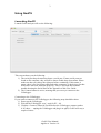
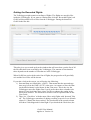
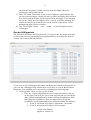
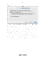
GeoPS User Guide
The Volkslogger reader for Mac
Applies to GeoPS 1.0
GeoPS is in no way affiliated with Garrecht Avionik GmbH; creator of Volkslogger.
1
Contents
Contents .................................................................................................................... 1
Purpose of GeoPS...................................................................................................... 2
Before you start using GeoPS .................................................................................... 2
Requirements......................................................................................................... 2
A note about serial ports ........................................................................................ 2
Using GeoPS ............................................................................................................. 3
Launching GeoPS .................................................................................................. 3
Getting the Recorded Flights.................................................................................. 5
Routes & Waypoints.............................................................................................. 6
Declaration ............................................................................................................ 8
Preferences ............................................................................................................ 9
Units.................................................................................................................. 9
Task................................................................................................................. 10
Keyspan Acceleration ...................................................................................... 11
Appendices.............................................................................................................. 12
Serial Ports .......................................................................................................... 12
Introduction ..................................................................................................... 12
Trouble ............................................................................................................ 12
GeoPS User Manual
Applies to Version 1.0
2
Purpose of GeoPS
GeoPS is developed to provide a basic functionality of communicating with the
Volkslogger GPS logger. This means that (at this stage) it does not feature all sorts of
luxurious functionality like:
- (Offline) Waypoints and Route Management
- Track visualization
- Support for other GPS’s and Loggers.
These things may in the future be implemented, but there are other means of doing
that on Mac already.
After saying what GeoPS can’t do; here is what it can do:
- Show logger serial number, and hard- and software versions.
- Get the list of recorded flights from the Volkslogger.
- Get one or more completed Flights from the logger.
- Erase the Flights in the Volkslogger
- Download all Routes and Waypoints that are stored in the Volkslogger.
- Import Waypoints from .dbt files as found on the Internet.
- Create and modify routes by dragging waypoints into the Routes.
- Edit the Declaration, easily choose a pre defined Route or add your own
Waypoints.
- Upload Routes, Waypoints and the Declaration to the Volkslogger.
Before you start using GeoPS
Requirements
-
Mac OS X 10.2 or later.
A serial port.
A note about serial ports
Macintoshes do not have Serial Ports: they have USB.
There are many brands of USB - Serial adapters on the market. GeoPS has been tested
with 3 brands: Keyspan, USB_G4 (by MCT) and Sweex. Other adapters will probably
also work, but then again … they may not.
There is more info about Serial Ports in the Appendix of this User Guide.
GeoPS User Manual
Applies to Version 1.0
3
Using GeoPS
Launching GeoPS
Launch GeoPS and you will see the following:
This screen shows you the following:
1) The serial port drop down menu shows a serial port. If more serial ports are
found on the computer, they will all be shown in this drop down menu. Please
make sure that you choose the right port before continuing. If this menu is
empty, there is no Serial Port connected to the computer, or the drivers for that
device have not been installed (properly). There is a section that contains
trouble shooting the Serial Ports in the Appendix of this User Guide.
2) The Connect button is active, meaning that you can try to connect to the
Volkslogger.
Connecting to the Volkslogger.
If you want to connect to the Volkslogger, the following steps should be taken:
1) Power up the Volkslogger
2) Wait till the Volkslogger ‘says’: wait for PC…09.
3) Click the ‘Connect’ button in GeoPS before the Volkslogger counter reaches
0. If it does … unplug the Volkslogger and plug it in again, GeoPS will retry a
couple of times.
GeoPS User Manual
Applies to Version 1.0
4
If all goes well, GeoPS will have established a connection with the Volkslogger in a
couple of seconds. The Volkslogger will show the following text in its window:
data-transfer
ready !
The GeoPS window will now look something like this:
As you can see the following happened:
1) The serial ports menu dimmed, because it is now impossible to change the
serial port that the Volkslogger is connected to.
2) The ‘Connect’ button has become the ‘Disconnect’ button.
3) The serial number and version info is filled in into the window.
GeoPS User Manual
Applies to Version 1.0
5
Getting the Recorded Flights
The Volkslogger might contain recordings of flights. The flights are stored in files
inside the Volkslogger. If you want to examine that, click the ‘Recorded Flights’ tab.
GeoPS will download a list of files from the Volkslogger. During the download
GeoPS looks like this:
This also gives you a sneak peek at the window that will soon show you the list of all
the files that have been recorded by the Volkslogger. The amount of time that this
takes depends on the number of files that are in the Volkslogger.
When GeoPS has retrieved the entire list of flights, the progress bar will gracefully
exit and the list of files will be shown.
If you take a look at the screen, you will notice the following:
1) Start and Stop are followed by ‘(GMT)’. That means that the start and stop
time are given in the GMT (or UTC) time zone. As a matter of fact, the Date
(in the third column) is also shown in that Time zone. This is the way the
Volkslogger stores the flights. But if you’d prefer those three columns to be
shown in your local time zone, please feel free to change the setting in the
Preferences window. The Preferences window will be explained later in this
User Guide.
2) There is a ‘Check box’ with the name: Show only flights with ‘detected Take
off’. The Volkslogger remembers if during recording a speed of over 40 km/h
(about 21.5 Knots) has been reached. The check mark in the second column
will show if this happened for that flight. If you checked the Check box (the
GeoPS User Manual
Applies to Version 1.0
6
one with the long name) GeoPS will only show the flights where the
Volkslogger detected the take off.
3) There is a button ‘Download’. If one or more flights are selected in the list,
you can press this button. GeoPS will ask you where the Flights files will have
to be stored, and the Flights will be retrieved from the logger. If you checked
the ‘Secure’ check box, the flights will be ‘secured’ so that the resulting IGC
contain Security Keys so that the files can be used in competitions, record
attempts and other official occasions.
4) The ‘Clear Flights’ button … well … uuuhh … clears the flights from the
Volkslogger.
Routes & Waypoints
The next tab is the Routes and Waypoints tab. If you press this, the progress bar that
we met in the previous paragraph pops out again and keeps us waiting for about 45
seconds. The result could look like this:
As can be seen, the Volkslogger did contain one Route and a bunch of Waypoints. In
your case the Volkslogger may contain more or less info, or even no Routes and no
Waypoints. This problem can be resolved by performing the following steps:
1) Get Waypoints. There are two ways to do that:
a. Press the + button underneath the list of waypoints (which is the one
on the right). That will give you a fresh waypoint and you can edit the
name, latitude and longitude by double clicking the appropriate field
and typing the coordinates. It does not matter how you type the
coordinates. GeoPS understands many different formats. For instance:
i. 50 40 30 will result in 50 degrees, 40 minutes, 30 seconds.
ii. 50 40.30 will result in 50 degrees, 40.30 minutes
GeoPS User Manual
Applies to Version 1.0
7
iii. 50.4030 will result in 50.4030 degrees
b. Go to the Worldwide Soaring Turnpoint Exchange website:
http://soaring.aerobatics.ws/TP/ and download a set of waypoints.
Please take good care in selecting the proper file. There are many
Waypoint file formats. There is only one format that is specific to the
Volkslogger. That is the file with the extension .dbt.
2) Make Route(s). Luckily there is only one way to do that: Drag waypoints from
the Waypoints list to the Routes list. Please experiment a bit with this, it
actually works very easy. Hint: It does make a difference where you drop the
waypoint:
a. On top of a Route: Waypoint added as last waypoint in Route.
b. On top of a Waypoint: Waypoint is replaced by new Waypoint.
c. Between Waypoints: Waypoint is inserted where it is dropped.
Please note that the Waypoint I actually copied and placed in the Route. So
changing the Waypoint in the Waypoints list does NOT change all occurrences of
that Waypoint in Routes and Task.
GeoPS User Manual
Applies to Version 1.0
8
Declaration
The last tab on this window is the Declaration Tab.
First … what is a Declaration?
Remember the good old days? Navigation was done using maps … you know, those
large paper sheets, which never seemed to have the proper side up? The things that
you always flew off of? Well, in that era we had to write down some sort of Flight
Plan on a declaration form and take a photograph of that piece of paper to be able to
use that flight for an official document like a Silver, Gold or Diamond Badge:
I am: Somebody
I fly in: This glider
I want to go:
From: Here
Via: There
And: There
Back to: Here
Well, just like trying to find a cell phone after you landed out: That declaration is
history! In this day and age, we fill in this Declaration page in GeoPS and save that in
the Volkslogger.
Here is what a Declaration might looks like:
And here is how it works.
The easiest way is this:
- Make at least one Route in the ‘Routes & Waypoints’ tab.
- Click on the ‘Declarations’ tab.
GeoPS User Manual
Applies to Version 1.0
9
-
GeoPS will now look something like the window shown above.
At the bottom of the screen there is a drop down menu called ‘Use Route’.
Click that and select the Route that you want to fly.
Now fill in the top half of the screen, where you fill in your names, glider info
and Home field … This Home field is the Take Off field, because that could
be different from the start point in, say a competition.
When you are done: Press ‘Save to Logger’ and you are ready to go!
Preferences
So you do not like the way GeoPS works? Here is how to change that!
In the GeoPS menu, next to the
menu is the option ‘Preferences’.
The following things can be modified:
Units
Coordinates can be shown in 3 different formats:
- Degrees
- Degrees and Minutes
- Degrees, Minutes and Seconds
Distances can be measured in km, Statute Miles or Nautical Miles.
This applies only to the distances calculated in the Routes and Task; not the Line
Width and Sector sizes, because the Volkslogger expects the Start Line Width, Sector
Cylinder Radius and Sector Radius in meters and kilometers.
GeoPS User Manual
Applies to Version 1.0
10
Date and Time fields in the Recorded Flights list can be represented in GMT or
Local time. The fields that this affects are:
- Flight Date
- Start (time of first coordinate in file)
- Stop (time of last coordinate in file)
Task
When you use the ‘Use Route’ option in the Declaration tab, GeoPS has to guess a
couple of things:
- Start Line Width
- Sector Cylinder Radius
- Sector Radius
The GeoPS preferences allow you to choose what GeoPS fills in for these values.
Please note that GeoPS will initially use a Line for the Start and Finish point, and it
will use a Sector for all Turn points, but you can always change the values that GeoPS
chooses if you want different values for a specific task.
GeoPS User Manual
Applies to Version 1.0
11
Keyspan Acceleration
This is a tough one …
Not all USB – Serial adapters are the same or behave the same. I have tried to find a
way that treats all USB – Serial converters the same, but have not found one yet. The
‘Generic’ way that I use to write data back to the Volkslogger works differently on
Keyspan adapters when compared to most other adapters.
The result is that the Keyspan takes over 60 seconds to write the data to the
Volkslogger, while the other adapters take 20 to 25 seconds.
To fix this, the code had to be changed to allow the Keyspan to do the write in the
same time. The problem is … when this setting is used on an adapter that does not
need the acceleration, the Serial port will hang (and so will GeoPS) and you will end
up with an empty Declaration, no Waypoints and no Routes in your Volkslogger.
So … please, please use this setting only when you use a Keyspan adapter. And
switch it off when you use another brand of adapter. The default value is ‘Off’, so if
you never touched this setting, that is what it should be.
GeoPS User Manual
Applies to Version 1.0
12
Appendices
Serial Ports
Introduction
The modern Mac (every Mac produced after the introduction of the iMac in 1997)
does not have serial ports. As the Volkslogger is not equipped with an USB port (and
as far as I know no other logger is either), we will have to use a USB - Serial adapter.
Although the manufacturers are doing their best to deliver a good product, these USB
- Serial adapters do not behave exactly like real serial ports do. This also implies that
one adapter may behave differently that another.
Luckily there are not too many variations: There are some chip sets that many adapter
manufacturers use:
Prolific is one example of this. Their chipset can be found in the Sweex and IOGear
adapters, and probably others too.
Another example is MCT. This is a company that makes adapters for other
companies. Those other companies sell them under their own names. So for all those
companies, MCT provides the drivers … but more about this shortly.
Trouble
But that is not why you are reading this … You probably want to know why GeoPS
does not ‘recognize’ your USB – Serial adapter.
Let us start at the beginning: You have a Mac and an USB – Serial adapter, but the
two have never met.
Please read the manual that comes with the adapter, but in general it comes down to
inserting a CD or downloading a driver and installing it.
Reboot and you should be ready to go.
But still … GeoPS, or any other application for that matter, does not see the adapter.
Please check the obvious first:
- Is the cable plugged in well? Please check, check, and double check.
- Is the cable inserted in a USB hub?
o Is that hub connected well?
o Is the Hub powered? Are you sure it is?
o Try inserting it in the computer or keyboard, instead of in the hub.
- Try another USB socket … maybe the one you try now is broken?
If you tried all that … and still GeoPS does not recognize the adapter, please read on.
I have some experience with these adapters, so let me write some of that down.
GeoPS User Manual
Applies to Version 1.0
13
USB_G4.
This adapter is very nice, very small, and has 3 LEDs on it that flash beautifully when
in use. It has one problem … the installer for the driver has a ‘permissions problem’.
The drivers can be downloaded from http://www.pfranc.com/usb/usb.mhtml#drivers
This site links you through to the MCT website.
Version 1.5.8 of the installer does not set the permissions for the files properly. But
do not despair: there is a fix. Watch out, this fix requires:
- Typing in the Unix terminal.
- The administrator password for your computer
This is what we will do:
1) Launch the Terminal. You can find this application in the
‘Applications/Utilities’ folder of your computer.
2) Type the following: sudo su
3) The terminal will ask for a password; type the administrator password for this
computer. This is the password that the ‘owner’ of the computer uses to log in
into the computer.
4) Type: chmod -R og-w /System/Library/Extensions/USBSerialDriver.kext
5) And press the enter or return key.
6) Type: chown -R root:wheel/System/Library/Extensions/USBSerialDriver.kext
7) And press the Enter or Return key again.
8) Quit the Terminal application
9) Reboot your computer
10) Launch GeoPS and you will see: GeoPS recognizes the serial port … I hope.
Belkin F5U109 or F5U409
This is a funny one … I did not try it myself, but some info can be found on the
Internet.
Belkin says they do support Mac up to (and including) Mac OS 9.2.2.
As GeoPS requires Max OS 10.2, we are not amused. Rumor has it that there are Beta
versions of the drivers around, but Belkin denies that. From what I read on the
internet, the Beta drivers have the same problem as the USB_G4, so it ‘should’ be
solved the same way … the commands on the Terminal should be exactly the same,
except for the driver name, which is: BelkinSerialDriver.kext
But if you are not as adventurous, I would suggest you donate your Belkin to charity
and invest in a proper USB – Serial adapter; one that has Mac OS X support.
Word has it that the Belkin uses MCT drivers … so you might want to try the drivers
from http://www.mct.com.tw/driver.html but please be aware that USB_G4 uses those
drivers too, and those drivers have the permissions problem that you’d have to solve.
But … I did not try this … if you do, please tell me what you experienced, and I can
add it to this User Guide.
Keyspan
GeoPS uses a method to talk to the Volkslogger that ‘every’ USB - Serial adapter
understands. And all adapters do work exactly the same way … until we write our
Declaration back to the Volkslogger.
The Keyspan uses over 1 minute to do this.
GeoPS User Manual
Applies to Version 1.0
14
‘Other adapters’ use 20 to 25 seconds.
Please note that Keyspan is absolutely not to blame for this! As far as I am concerned
Keyspan makes the finest USB - Serial on the market today.
So, to make sure that the Keyspan users can also write their data to the Volkslogger in
20 – 25 seconds, I put the ‘Keyspan Acceleration’ setting in the preferences. This way
nobody needs to feel left behind …
Please check out the chapter on Preferences if you want to know how to use the
Keyspan Acceleration.
Other brands
There are many other brands. If I find one I will try to see if it works with GeoPS.
If you have any experience with USB - Serial adapters that might help other GeoPS
users, please mail that to me, and I will add your findings to this User Guide.
GeoPS User Manual
Applies to Version 1.0