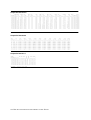
1
User’s Guide of SWAP version 2.0 Simulation of water flow, solute transport and plant growth in the SoilWater-Atmosphere-Plant environment J.G. Kroes, J.C. van Dam, J. Huygen, R.W. Vervoort Report 81 Dept. Water Resources, Wageningen Agricultural University Technical Document 53 DLO Winand Staring Centre, Wageningen, 1999 ABSTRACT Kroes, J.G., J.C. van Dam, J. Huygen and R.W. Vervoort, 1999. User’s Guide of SWAP version 2.0; Simulation of water flow, solute transport and plant growth in the SoilWater-Atmosphere-Plant environment. Wageningen Agricultural University. Report 81, DLO Winand Staring Centre. Technical Document 53.128 pp. 6 fig.;3 tab.;20 ref. This manual describes how the numerical model SWAP version 2.0 can be used to simulate vertical transport of weater, solutes and heat in variably saturated, cultivated soils. A brief theoretical description is followed by a technical description of model structure and general data flow. An extensive explanation is given of program inputs and outputs based on ASCII text files. The manual ends with examples using important features of the model. Keywords: agrohydrology, drainage, evapotranspiration, irrigation, salinization, simulation model, SWAP, soil water, soil heat, soil heterogeneity, surface water management ISSN 0927-4499 © 1999 DLO Winand Staring Centre for Integrated Land, Soil and Water Research (SC-DLO), P.O. Box 125, NL-6700 AC Wageningen (The Netherlands). Phone: +31 317 474200; fax: +31 317 424812; e-mail: [email protected] Wageningen Agricultural University P.O. Box 9101, NL-6700 HB Wageningen (The Netherlands) Phone: +31 317489111; fax: +31 317484449; e-mail: [email protected] No part of this publication may be reproduced or published in any form or by any means, or stored in a data base or retrieval system, without the written permission of the DLO Winand Staring Centre. The DLO Winand Staring Centre assumes no liability for any losses resulting from the use of this document. Projectnumber 81094 4 p SC-DLO TECHNICAL DOCUMENT 53.DOC p 1999 [Technical Document 53/IS/03-99] Contents Summary 9 1 Introduction 11 2 Brief theoretical description 2.1 System definition 2.2 Soil water flow 2.3 Soil heat flow 2.4 Solute transport 2.5 Crop growth 2.6 Soil heterogeneity 2.7 Irrigation and drainage 2.8 Surface water system 2.9 Sensitivity and limitations 13 13 13 14 15 15 16 16 16 16 3 Technical model description 3.1 Model structure 3.2 General data flow 3.3 Model extensions 19 19 21 21 4 Program inputs 4.1 Introduction 4.2 General information (Swap.key) 4.2.1 Section 1: Environment 4.2.2 Section 2: Time variables 4.2.3 Section 3: Meteorological data 4.2.4 Section 4: In- and output files for the simulation runs 4.2.5 Section 5: Processes which should be considered 4.2.6 Section 6: Optional output files 4.2.7 Section 7: Optional output files for water quality models 4.3 Daily meteo data (station.yyy) 4.4 Detailed rainfall (stationR.yyy) 4.5 Irrigation fixed (*.irg) 4.6 Irrigation calculated (*.cap) 4.6.1 Section 1: General 4.6.2 Section 2: Irrigation time criteria 4.6.3 Section 3: Irrigation depth criteria 4.7 Crop rotation (*.cal) 4.8 Detailed crop growth (*.crp) 4.8.1 Section 1: Crop factor or crop height 4.8.2 Section 2: Crop development 4.8.3 Section 3: Initial values 4.8.4 Section 4: Green surface area 23 23 24 24 25 25 25 26 26 26 28 28 30 31 31 31 32 34 35 35 35 36 36 4.9 4.10 4.11 4.12 4.13 4.8.5 Section 5: Assimilation 36 4.8.6 Section 6: Conversion of assimilates into biomass 37 4.8.7 Section 7: Maintenance respiration 37 4.8.8 Section 8: Partitioning 37 4.8.9 Section 9: Death rates 37 4.8.10 Section 10: Crop water use 37 4.8.11 Section 11: Salt stress 38 4.8.12 Section 12: Interception 38 4.8.13 Section 13: Root density distribution and root growth 38 Detailed grass growth (*.crp) 42 4.9.1 Section 1: Initial values 42 4.9.2 Section 2: Green surface area 42 4.9.3 Section 3: Assimilation 43 4.9.4 Section 4: Conversion of assimilates into biomass 43 4.9.5 Section 5: Maintenance respiration 43 4.9.6 Section 6: Partitioning 43 4.9.7 Section 7: Death rates 44 4.9.8 Section 8: Crop water use 44 4.9.9 Section 9: Salt stress 44 4.9.10 Section 10: Interception 44 4.9.11 Section 11: Root density distribution and root growth 44 Simple crop growth (*.crp) 47 4.10.1 Section 1: Crop development 48 4.10.2 Section 2: Light extinction 48 4.10.3 Sections 3: LAI or soil cover 49 4.10.4 Section 4: Crop factor or crop height 49 4.10.5 Section 5: Rooting depth 49 4.10.6 Section 6: Yield response 49 4.10.7 Section 7: Crop water use 49 4.10.8 Section 8: Salt stress 50 4.10.9 Section 9: Interception 50 4.10.10 Section 10: Root density distribution and root growth 50 Soil water and profile (*.swa) 53 4.11.1 Section 1: Ponding 53 4.11.2 Section 2: Soil evaporation 53 4.11.3 Section 3: Time discretization of Richards' equation 53 4.11.4 Section 4: Spatial discretization 55 4.11.5 Section 5: Soil hydraulic functions and maximum rooting depth 55 4.11.6 Section 6: Hysteresis of soil water retention function 55 4.11.7 Section 7: Similar media scaling of soil hydraulic functions 55 4.11.8 Section 8: Preferential flow due to immobile water 57 4.11.9 Section 9: Preferential flow due to soil cracks 57 4.11.10 Section 10: Vertical distribution of drainage flux 58 4.11.11 Section 11: Initial moisture condition 58 Soil hydraulic functions (*.sol) 59 Basic drainage (*.drb) 61 6 p SC-DLO TECHNICAL DOCUMENT 53.DOC p 1999 4.14 4.15 4.16 4.17 4.13.1 Section 1: Method 61 4.13.2 Section 2: Table of drainage flux - groundwater relation 61 4.13.3 Section 3: Drainage formula of Hooghoudt or Ernst 61 4.13.4 Section 4: Drainage and infiltration resistance 63 Extended Drainage (*.dre) 67 4.14.1 General 67 4.14.2 Section 1: drainage characteristics 67 4.14.3 Section 2: surface water system 69 Bottom boundary conditions (*.bbc) 75 Heat flow (*.hea) 78 4.16.1 Section 2: Analytical method 78 4.16.2 Section 3: Numerical method 78 Solute transport (*.slt) 80 4.17.1 Section 1: Top boundary and initial condition 80 4.17.2 Section 2: Diffusion, dispersion, and solute uptake by roots 80 4.17.3 Section 3: Adsorption 80 4.17.4 Section 4: Decomposition 80 4.17.5 Section 5: Transfer between mobile and immobile water volumes 81 4.17.6 Section 6: Solute residence in the saturated zone 81 5 Program execution and output 5.1 Program execution 5.2 Program output 85 85 85 6 Examples 6.1 The reference situation 6.1.1 Introduction 6.1.2 Solute 6.1.3 Heat 6.1.4 Output of reference situation 6.2 Exercises 6.2.1 Meteorological year 6.2.2 Irrigation 6.2.2.1 An imaginary year without rainfall 6.2.2.2 Several years without rainfall 6.2.2.3 Surface irrigation 6.2.3 Crop type 6.2.4 Evapotranspiration of partly covered soil 6.2.5 Soil texture 6.2.6 Hysteresis of retention function 6.2.7 Scaling of soil hydraulic functions 6.2.8 Root density distribution 6.2.9 Bromide breakthrough to surface water 6.2.9.1 Breakthrough during a 2-year period 6.2.9.2 Influence of an impervious soil layer 87 87 87 89 89 89 89 90 91 91 92 93 93 94 95 96 96 97 98 98 99 6.2.10 6.2.11 6.2.11.1 6.2.11.2 Preferential flow Drainage design Reduction for wet conditions Increasing drain depth References 100 100 101 101 103 Annexes A. Output files of the Hupsel reference case B. List of routines of Swap version 2.0 C. SWAP list with main variables D. Description of the output files *.afo and *.aun E. Summary of input data F. Summary of output data 8 p SC-DLO TECHNICAL DOCUMENT 53.DOC p 1999 105 109 113 123 125 127 Summary In an earlier report (Van Dam et al., 1997) the applied flow and transport concepts of SWAP and their background have been described. This report describes the structure of the model and how the model can be used. After the introduction, chapter 2 starts with a brief summary of the system modelled by SWAP and the flow and transport processes considered. Chapter 3 presents the model structure. SWAP includes 7 submodels: Meteo, Crop (detailed general, detailed grass and simple), Soil, Irrigation and Timer. One simulation may consist of 70 sequential or parallel sub-runs. SWAP calculates first the potential crop growth for the entire sub-run period and next the actual crop growth in interaction with water flow, solute transport and heat flow. As the Soil sub-model forms the heart of SWAP, the order in which the boundary conditions and relevant processes are calculated in Soil, is shown in detail. The data flow to and from the sub-models is discussed. In order to adapt to a data base structure, the input of different kind of data (meteorology, crop, irrigation, soil, drainage, surface water) is divided over different input files. In chapter 4 all the input files are described. First an overview of required and optional input files is given, including their general format rules. Next the input files are discussed one by one, while of each file an example is shown. Chapter 5 explains the program execution and lists the output files that can be generated by the sub-models Crop, Soil and Irrigation. Chapter 6 describes an application and contains exercises to explain program use. The application refers to water and solute transport on a maize field in the Hupsel catchment. Exercises indicate the effect of different meteorological years, irrigation, different crops, soil texture, hysteresis of the retention function, scaling of the soil hydraulic functions, and different root density distributions. Also the effect of errors in soil profile description and of preferential flow on bromide leaching to surface water is shown. The final exercise applies to drainage design. In the annexes the SWAP subroutines and the main program variables are listed. SC-DLO TECHNICAL DOCUMENT 53.DOC p 1999 p 9 10 p SC-DLO TECHNICAL DOCUMENT 53.DOC p 1999 1 Introduction Knowledge of water flow and solute transport processes in the vadose zone is essential to derive proper management conditions for plant growth and environmental protection in agricultural and environmental systems. Numerical models are widely used as helpful tools to gain insight in the processes occurring in these complex systems and to analyse optional management scenarios. One of these numerical models is SWAP (Soil-Water-Atmosphere-Plant), the successor of the agrohydrological model SWATR (Feddes et al., 1978) and some of its numerous derivatives. The experiences gained with the existing SWATR versions were combined into SWAP, which integrates water flow, solute transport and crop growth according to current modelling concepts and simulation techniques. Main improvements are accurate numerical solution of the Richards’ flow equation and incorporation of solute transport, heat flow, soil heterogeneity, detailed crop growth, regional drainage at various levels and surface water management. The model offers a wide range of possibilities to address both research and practical questions in the field of agriculture, water management and environmental protection. DLO Winand Staring Centre and Wageningen Agricultural University have developed the computer model SWAP 2.0 in close co-operation. SC-DLO TECHNICAL DOCUMENT 53.DOC p 1999 p 11 12 p SC-DLO TECHNICAL DOCUMENT 53.DOC p 1999 2 Brief theoretical description The theory of the processes simulated by SWAP 2.0 is extensively described by Van Dam et al. (1997). This chapter summarises the most important theoretical concepts, which should be known for proper use of the program. 2.1 System definition SWAP is a computer model that simulates transport of water, solutes and heat in variably saturated top soils. The program is designed for integrated modelling of the Soil-AtmospherePlant System (figure 1). Transport processes at field scale level and during whole growing seasons are considered. System boundaries at the top are defined by the soil surface with or without a crop and the atmospheric conditions. The lateral boundary simulates the interaction with surface water systems. The bottom boundary is located in the unsaturated zone or in the upper part of the groundwater and describes the interaction with regional groundwater. Fig 1. A schematised overview of the modelled system 2.2 Soil water flow Spatial differences of the soil water potential cause flow of soil water. Darcy's equation is used to quantify these soil water fluxes. For one-dimensional vertical flow, Darcy's equation can be written as: SC-DLO TECHNICAL DOCUMENT 53.DOC p 1999 p 13 q = - K(h) ∂ (h + z) ∂z (1) where q is soil water flux density (positive upward) (cm d-1), K is hydraulic conductivity (cm d1 ), h is soil water pressure head (cm) and z is the vertical co-ordinate (cm), taken positively upward. Water balance considerations of an infinitely small soil volume result in the continuity equation for soil water: ∂θ ∂q - S(h) =∂t ∂z (2) where θ is volumetric water content (cm3 cm-3), t is time (d) and S is soil water extraction rate by plant roots (cm3 cm-3 d-1). Combination of Eq. 1 and 2 results in the well-known Richards' equation: ∂h ∂ K(h) + 1 ∂ ∂h ∂z = C(h) = - S(h) ∂t ∂t ∂z (3) where C is the water capacity (dθ/dh) (cm-1). Richards' equation has a clear physical basis at a scale where the soil can be considered as a continuum of soil, air and water. SWAP solves Eq. 3 numerically, subject to specified initial and boundary conditions and with known relations between θ, h and K. These relationships, which are generally called the soil hydraulic functions, can be measured directly in the soil, or might be obtained from basic soil data. The Richards’ equation is solved using an implicit finite difference scheme as described by Belmans et al. (1983). This scheme has been adapted such that the solution applies both to the unsaturated and saturated zone, that water balance errors due to non-linearity of the differential water capacity are minimised and that calculated soil water fluxes at the soil surface are more accurate. Phreatic or perched groundwater levels are found at the transition from negative to positive soil water pressure heads. Important features of the Richards’ equation are that it allows the use of soil hydraulic data bases and simulation of all kinds of management scenarios. The soil hydraulic functions are described by analytical expressions of Van Genuchten (1980) and Mualem (1976) or by tabular values. Hysteresis of the water retention function can be taken into account with the scaling model of Scott et al. (1983). Root water extraction at various depths in the root zone is calculated from potential transpiration, root length density and possible reductions due to wet, dry or saline conditions. 2.3 Soil heat flow Soil temperature may affect the surface energy balance, soil hydraulic properties, decomposition rate of solutes and growth rate of roots. SWAP version 2.0 uses the soil temperatures only to adjust the solute decomposition rate. Combination of the general soil 14 p SC-DLO TECHNICAL DOCUMENT 53.DOC p 1999 heat flux equation and the equation for conservation of energy yields the differential equation for transient soil heat flow: C heat ∂T ∂ = ∂t ∂z heat ∂T ∂z (4) where Cheat is the soil heat capacity (J cm-3 oC -1) and T is the soil temperature (oC). This equation is solved either analytically or numerically. In the analytical solution a uniform thermal conductivity and soil heat capacity are assumed, and at the soil surface a sinusoidal temperature wave is adopted. In the numerical solution the thermal conductivity and the soil heat capacity are calculated from the soil composition and the volume fractions of water and air as described by De Vries (1975). At the soil surface the daily average temperature is used as boundary condition. 2.4 Solute transport SWAP simulates convection, diffusion and dispersion, non-linear adsorption, first order decomposition and root uptake of solutes. This permits the simulation of ordinary pesticide and salt transport, including the effect of salinity on crop growth. In case of detailed pesticide or nutrient transport, daily water fluxes can be generated as input for other groundwater-quality models, such as PESTLA (Boesten and van der Linden, 1991; Berg and Boesten, 1998) and ANIMO (Groenendijk and Kroes, 1997; Kroes and Roelsma, 1998). The model SWAP simulates the residence time of solutes in the saturated zone analogous to mixed reservoirs. In this way solute transport from soil surface to surface water can be derived. 2.5 Crop growth Crop growth can be simulated by the code WOFOST 6.0 (Hijmans et al., 1994). The cropping pattern may consist of maximal three crops per agricultural year. WOFOST calculates the radiation energy absorbed by the canopy as function of incoming radiation and crop leaf area. Using the absorbed radiation and taking into account photosynthetic leaf characteristics, the potential gross photosynthesis is calculated. The latter is reduced due to water and/or salinity stress, as quantified by the relative transpiration, and yields the actual gross photosynthesis. Part of the carbohydrates (CH2O) produced are used to provide energy for the maintenance of the existing live biomass (maintenance respiration). The remaining carbohydrates are converted into structural matter. In this conversion, some of the weight is lost as growth respiration. The dry matter produced is partitioned among roots, leaves, stems and storage organs, using partitioning factors that are a function of the crop phenological development stage. The fraction partitioned to the leaves, determines leaf area development and hence the dynamics of light interception. The dry weights of the plant organs are obtained by integrating their growth rates over time. During the development of the crop, part of living biomass dies due to senescence. If simulation of crop growth is not needed, the user might just prescribe leaf area index, crop height, rooting depth, and root density distribution as a function of development stage. SC-DLO TECHNICAL DOCUMENT 53.DOC p 1999 p 15 2.6 Soil heterogeneity Spatial variability of the soil hydraulic functions is described with the scaling concept of Miller and Miller (1956). The user may provide the reference curve and a number of scaling factors, and SWAP will generate for each scaling factor the soil hydraulic functions and the corresponding water and solute balance and relative crop yield. In cracked clay soils the shrinkage characteristic is used to determine crack volume, area and depth. Water and solutes collected in the cracks will infiltrate at the crack bottom into the soil matrix or flow rapidly to the surface water. In the clay matrix, the Richard equation is applied for water flow and the convection-dispersion equation for solute transport. Flow and transport in water-repellent soil is based on the concept of a mobile and an immobile soil volume. The actual mobile volume at a certain depth depends on the soil water pressure head. In the mobile volume the Richards' equation and the solute transport equation apply. In the immobile volume, the water flux is assumed to be zero. Solutes diffuse between mobile and immobile volume. 2.7 Irrigation and drainage Irrigation may be prescribed at fixed times or scheduled according to a number of criteria. The scheduling option allows the evaluation of alternative application strategies. The timing criteria include allowable daily stress, allowable depletion of readily available water in the root zone, allowable depletion of totally available water in the root zone, and critical pressure head or water content at a certain depth. Field drainage can be calculated with a linear flux-groundwater level relationship, with a tabular flux-groundwater relationship, or with drainage equations of Hooghoudt and Ernst. The use of drainage equations allows the design or evaluation of drainage systems. 2.8 Surface water system At sub-regional level the interaction between soil water balance, crop growth and surface water management can be simulated. The surface water system can be partitioned in up to five channel orders, each defined by its bed level, bed width, side-slope and spacing. In each channel, except from the primary channel, the surface water has the same level, which is either input or calculated from the sub-region water balance. The water level of the primary channel is input. Drainage to each channel order is calculated with the corresponding drainage resistances. Also infiltration from the channels, using the corresponding infiltration resistances, is calculated when the surface water level is higher than the groundwater level. In case of surface water level as output, for each water management period, a fixed or automatic weir can be simulated. The user should provide a water management scheme that specifies the target level for surface water, the maximum mean groundwater level, the maximum soil water pressure head and the minimum air volume in the soil. SWAP will select the highest surface water level for which all criteria are met. 2.9 Sensitivity and limitations To gain insight in the sensitivity of the results of the model SWAP to changes on some of its input parameters, a global sensitivity analysis was performed with this model by Wesseling and Kroes (1998). Generation of parameter values and the analysis were carried out with the statistical package Usage (Jansen and Withagen, 1997) for different 16 p SC-DLO TECHNICAL DOCUMENT 53.DOC p 1999 crop-soil combinations. The analysis was carried out with a range of meteorological years, which included average and extreme meteorological data. Input parameters were selected that are associated with a number of processes in the SWAP-model: soil physics, evapotranspiration, drainage, regional hydrology. For each input-parameter a distribution type, its average, variance, minimum and maximum value were selected using existing databases and expert-judgement. The analysis focussed on results as cumulative terms of the water balance and groundwater level. Some conclusions drawn from this analysis are: • Boundary conditions (both upper and lower) are of crucial importance when applying the model SWAP; • For all soil-crop combinations the soil and crop evaporation were strongly depending on the function describing the Leaf Area Index (LAI); • Drainage, simulated as lateral discharge, is very sensitive to the surface water levels; • High groundwater levels are strongly related to surface water levels; low groundwater levels depend on a combination of LAI, soil physical parameters and surface water levels; the average groundwater level is mainly determined by the level in the primary drainage system; • At low values for the saturated hydraulic conductivity the model SWAP did not succeed in finishing the simulations within one hour cpu-time; this occurred for peat at values below 0.1 cm d-1. and for clay at values below 0.06 cm d-1. At these low values the Richards equation could not be solved within the specified cpu-time. SWAP 2.0 is developed for calculations with daily meteorological input data. Exceptions are e.g. studies with surface water runoff, for which the user may provide actual, short time rainfall intensities. In general, model results should be analysed on a daily base. For many cases this will be sufficient; for analyses using more detailed and complete meteorological data other models such as SWAPS (Ashby et al., 1996) are recommended. Other limitations of this version of SWAP are: • no simulation of regional groundwater hydrology; • no interaction between crop growth and nutrient availability; • no non-equilibrium sorption of pesticides and no simulation of metabolites SC-DLO TECHNICAL DOCUMENT 53.DOC p 1999 p 17 18 p SC-DLO TECHNICAL DOCUMENT 53.DOC p 1999 3 Technical model description 3.1 Model structure A flow chart representing the main structure of the model Swap is given in figure 2. The structure of the program is such that one simulation run may consist of: • A simulation period of 70 years (sequential sub-runs); • Up to 70 scenarios of a growing period with a maximum length of one year (parallel sub-runs); • Up to 70 sub-runs of a growing period with a maximum length of one year, with each sub-run its own soil hydraulic functions according to similar media scaling (parallel subruns). Simulation and sub-run control parameters are initialised at the start of the simulation (figure 2, top left). The simulation starts for each sub-run with the potential crop production of the first day. Potential crop production is defined as the total dry matter production of a green crop surface that, during its entire growth period, is optimally supplied with water and nutrients, and grows without interference from weeds, pests and diseases. The production level is essentially determined by the prevailing weather conditions. To get an estimate of the potential production, the complete period of the sub-run is calculated (figure 2, block A). Once potential crop production is determined, the simulation of water-limited crop growth starts with an initialisation of sub-models for Timing and Soil. Optionally the Irrigation submodel is initialised. Next the simulation starts the day at 00.00 hour with the intake of meteorological data after which the sub-model Soil solves the discretized equations for water flow, solute transport and heat flow (figure 2, block B). These calculations are performed with a reduced timestep, which will be decreased, maintained or increased according to numerical conditions for the solution of water flow and solute transport equations (see Van Dam et al., 1997, par. 2.4 and par. 3.3). Within the sub-model Soil the top, lateral and bottom boundary conditions are determined first, after which the sink term of root water extraction is calculated. With boundary conditions and sink terms known, the Richards equation is solved, resulting in values for pressure heads and moisture contents for the next timestep. Soil temperatures are then determined by solving the heat flow equation. Parameters for hysteresis are updated and the daily water fluxes are integrated. If interaction with the surface water system is required (extended drainage), the various surface water flows are calculated. Also during each time step the solute transport equation is solved using the actual soil water fluxes. The submodel Soil is called for each timestep until the end of the day. Once the end of a day is reached and the calculations with the sub-model Soil are finished, the actual crop growth rates are determined and its corresponding state variables are integrated. After updates of some parameters the next day of simulations starts. Once the last day of a simulation sub-run is reached the sub-model Soil is terminated and once the end of the last sub-run is reached the complete simulation ends. SC-DLO TECHNICAL DOCUMENT 53.DOC p 1999 p 19 Read simulation control and soil profile characteristics Start simulation-sub-run A (1 sub-run simulates maximum period of 1 year Initialize timer Start sub-run Start of day: 00.00 h Initialize crop-growth Read meteorological data Crop-growth rates and integration of state variables End of day: 24:00 h Last day of sub-run Simulation of potential cropgrowth Start simulation of water-limited cropgrowth; Initialize timer Initialize soil and irrigation (part1) submodels B Start of day: 00.00 h Bottom boundary conditions Initialize crop and irrigation (part2) submodels Lateral boundary conditions: drainage Determine irrigation (part3) parameters Crack flow Read meteorological data Top boundary conditions Soil sub-model for one timestep dt N N Root extraction rate Calculate dt en t N Pressure heads and moisture contents End of day: 24.00 h ? Soil temperatures Y Hysteresis Crop growth rates and integration of state variables Integrate state variables Terminate irrigation submodel Update flags, switches and counters Surface water system End of Last day: day 24.00 h of sub-run ? ? Solute concentrations and mass balance Y Terminate soil sub-model Last sub-run of simulation ? Y Fig 2. Main structure of Swap 2.0 20 p SC-DLO TECHNICAL DOCUMENT 53.DOC p 1999 End of simulation 3.2 General data flow The main module of the model Swap consists of 7 submodels (figure 3): Meteo, Crop (detailed non-grass, detailed grass and simple), Soil, Irrigation and Timer. Sub-models are divided into parts for initialisation, rate calculation, integration and termination. The submodels perform calls to subroutines, of which an overview is given in Annex B. In order to facilitate tailored use of SWAP by researchers, Annex C contains the main variables of the program. Each submodel requires specific input. In detail this will be explained in the next chapter. An overview of the general data flow is given in figure 3. A summary of required input and output data is given in respectively annex E and F. Apart from one general input file, all files have variable file names and fixed file extensions. In figure 3 the file extensions are given between brackets. The general input file (Swap.key) contains the switches that arrange the various simulation options. Meteorological data can be supplied as daily data or, in a separate file, as short-term rainfall data to allow the calculation of surface runoff. Values of crop parameters enter the corresponding sub-model for Crop growth, which can either be a detailed mechanistic model (Wofost) for annual crops or grassland, or a simple empirical crop model. Up to three crops per year are supported in any combination of the mechanistic and the empirical model. In case of grass production however, only one crop per year is allowed as the grassland is supposed to be permanent. The crop rotation scheme is given in a separate input-file. The sub-model Soil reads spatial discretisation (geometry) and important soil characteristics. Separate input is given for soil physical data, bottom boundary conditions, surface water system, heat flow and solute transport. The sub-model Irrigation reads from separate input-files: prescribed irrigation gifts or criteria to simulate irrigation gifts. The sub-model Timer extracts information from the general input file Swap.key and the sub-model Soil. 3.3 Model extensions For some applications the usual array lengths may be insufficient, or the user might wish to decrease some array lengths to use less memory. This is possible by changing parameter values that specify certain array lengths in the file PARAM.FI, and subsequent recompiling the program. The array lengths that might be changed are: – maximum number of years in the simulation period, (standard 70) – maximum number of compartments, (standard 40) – maximum number of horizons, (standard 5) – maximum number of applied irrigations, (standard 366) – maximum number of open water levels (basic drainage) , (standard 366) – maximum number of water levels primary system (ext. drainage) , (standard 366) – maximum number of water levels secondary system (ext. drainage) , (standard 366) – maximum oscillation of groundwater level (ext. drainage) , (standard 1000.0 cm) – maximum number of management periods (ext. drainage) , (standard 52) SC-DLO TECHNICAL DOCUMENT 53.DOC p 1999 p 21 Fig 3 Main data flow of Swap 2.0 22 p SC-DLO TECHNICAL DOCUMENT 53.DOC p 1999 4 Program inputs 4.1 Introduction A summary of all input files the model can handle is given in table 1. Some files are required, other files are optional. The general input file named Swap.key refers to the input files of the actual simulation. Apart from the name of the file Swap.key, all file names can be freely chosen. The file extensions are fixed however and indicated in bold in table 1. Other restrictions that apply to the file names are: • The name of the meteo file with daily data consists of the name of the meteo station and an extension equal to last 3 digits of the year considered. The optional file with detailed rainfall has an equal name, with addition of an ‘r’ before the extension (see table 1); • A generic name is used for the input files *.swa (soil profile description), *.slt (solute transport data) and *.hea (heat flow data). In the example of table 1, the generic name is ‘Hupsel’. Table 1 Summary of input file requirements Kind of data General Meteo Irrigation Crop Soil related Heat Solute Description of file-content (kind of parameters) Simulation and I/O-options Daily data Detailed rainfall Irrigation fixed Irrigation calculated Rotation Detailed non-grass Detailed grass Simple crop model Soil water Soil hydraulic functions Drainage lateral: basic Drainage extended: surface water Bottom boundary conditions Heat flow Solute transport and transformation Filename Required Swap.key Hupsel.yyy Hupselir.yyy Hupsel.irg Irrig.cap Year80.cal Maize.crp Grass.crp MaizeS.crp Hupsel.swa Sandt.sol Hupsel.drb Hupsel.dre Hupsel.bbc Hupsel.hea Hupsel.slt + + Optional + + + + + + + + + + + + + + In the input files of each parameter the symbolic name, a description and an identification is given. The identification between square brackets uses the following convention: 1) range (recommended minimum and maximum) 2) unit 3) data type (I = Integer, R = Real*4, Ax = character string of x positions) For example: [-5000 ..100 cm, R] means: value between –5000 and +100 with a unit in cm, given as a Real*4 data type (which means that a dot must be added). Swap uses the units day for time, cm for length and mg for mass. Exceptions are the input of meteorological data (see par. 4.3), crop data (see par. 4.8 - 4.10), drain spacings and weir discharge coefficients in case of surface water management (see par. 4.14). General rules for the formats of input files are: • order of variables is fixed • free format with structure ‘VariableName’ = ‘value’ • comment in lines is allowed starting with ‘*’ or ‘!’ SC-DLO TECHNICAL DOCUMENT 53.DOC p 1999 p 23 • blank lines are allowed In the following paragraphs each of the input files will be briefly discussed. 4.2 General information (Swap.key) 4.2.1 Section 1: Environment The project name (maximum of 8 characters) will be used as a generic file name for several input files, notably the .SWA file (soil water flow data), the .SLT file (solute transport data) and the .HEA file (heat flow data). The variable Path indicates the directory where the user wants to store the input and output files. An example is: 'c:\Swap\example\' or '..\example\'. If no characters (Path = ‘’) are given then the program will assume that all input files are located at the current directory (the directory from which the model is executed). Output files will also be written to the directory specified with the variable Path. ********************************************************************************** * Filename: SWAP.KEY * Contents: SWAP 2.0 - General input data ********************************************************************************** * Comment area: * *C Case: Water and solute transport in the Hupsel area, *C a catchment in the eastern part of the Netherlands *C *C Example of the User's Guide: reference situation *C *C A set of input data to explore SWAP ********************************************************************************** ********************************************************************************** * Section 1: Environment * Project = 'Hupsel' ! Generic name for .SWA, .SLT and .HEA files, [A8] Path = '' ! Path to data directory, [A50] CType = 1 ! Switch, computer type, [PC=1, VAX & Workstation =2] SWSCRE = 1 ! Switch, display progression of simulation run, [Y=1, N=0] ********************************************************************************** ********************************************************************************** * Section 2: Time variables * SSRUN = 01 01 1980 ! Start date of simulation run, give day month year, [3I] ESRUN = 31 12 1980 ! End date of simulation run, give day month year, [3I] FMAY = 1 ! First month of the agricultural year, January = 1, [1..12, I] PERIOD = 0 ! Output interval, ignore = 0, [0..366, I] SWRES = 1 ! Switch, reset output interval counter each year, [Y=1, N=0] SWODAT = 1 ! Switch, extra output dates are given in table, [Y=1, N=0] * If SWODAT = 1, table with additional output dates * Date records of type dd mm yyyy (max. 366), [1..31 1..12 1..3000, 3I] 31 01 1980 29 02 1980 31 03 1980 30 04 1980 31 05 1980 30 06 1980 31 07 1980 31 08 1980 30 09 1980 31 10 1980 30 11 1980 31 12 1980 * End of table ********************************************************************************** File swap.key with general information: section 1 and 2 24 p SC-DLO TECHNICAL DOCUMENT 53.DOC p 1999 4.2.2 Section 2: Time variables Start and end of the simulation period must be specified. The maximum length of the simulation period amounts 70 years. A year in SWAP does not necessarily start on January 1st, but rather on the first day of the month named `first month of the agricultural year’. Note that input files with time dependent data (except the meteo data files) relate to an agricultural year. Swap output can be generated at regular intervals and additionally at irregular output dates, which must be specified explicitly. The day counter signalling the end of an output interval may be reset each sequential sub-run or just proceed. 4.2.3 Section 3: Meteorological data The variable METFIL is the name of file with values of daily meteorological data and reference evapotranspiration data. The content of the file is discussed in paragraph 4.3. The name of the file should maximally be 7 characters long as it functions as the first part of the name of related meteo data files. The file extensions are derived from the three last digits of a year number. An example is: a file with the name 'Hupsel.998' contains meteo data from station Hupsel and year 1998. Note that internally SWAP calculates with actual year numbers (4 digits), so that no millennium problem will occur. Latitude and altitude of the meteo station are used in the Penman Monteith equation. If reference evapotranspiration values are used instead of meteorological data (variable SWETR) then dummy values for latitude and altitude should be given. The variable SWETR indicates whether SWAP should calculate potential evapotranspiration rates from daily meteorological data (using the Penman Monteith equation) or from daily reference evapotranspiration values. In addition to daily rainfall data in the meteo files, detailed short timestep rainfall data may be specified in a separate data file. The variable SWRAI indicates if such a file will be used. A file with detailed rainfall related to the meteo data file given above should have the name 'HupselR.998'. 4.2.4 Section 4: In- and output files for the simulation runs A simulation run may comprise a period of 70 years (sequential run). Alternatively, up to 70 simulations for the same year (or part of the year) with changing input conditions for this year can be carried out (parallel run). A sequential run for more than one year or a parallel run for more than one case contains a number of sub-runs. Each sub-run may have its own specific input data with respect to soil water boundary conditions and crop rotation scheme, whereas each crop (maximum = 3) in the scheme is related to a specific model type (detailed, detailed grass only or simple), cropping period and irrigation water application rules. For each sub-run the next filenames (no extensions !) might be specified (optional can be skipped): SC-DLO TECHNICAL DOCUMENT 53.DOC p 1999 p 25 • • • • • IRGFIL - (optional) input file with fixed irrigation data (*.IRG). Fixed irrigations are an alternative to calculated irrigations and can be applied both within and outside a cropping period. CALFIL - (optional) input file with the crop rotation scheme (*.CAL). In case this file is not specified, bare soil is assumed throughout the simulation period. DRFIL - (optional) input file for the basic drainage routine (*.DRB) or the drainage routine extended to surface water (*.DRE). Which type to be specified (if any) is one of the run options in section 5. BBCFIL - input file with the bottom boundary condition (*.BBC). OUTFIL - generic name of output files for this year. 4.2.5 Section 5: Processes which should be considered For the simulation of lateral drainage three options are available: • no simulation of lateral drainage; • simulation with the basic drainage routine (lateral drainage to maximally 5 drainage levels, no simulation of the surface water balance); • simulation with the extended drainage routine (lateral drainage to maximally 5 drainage levels, taking into account simulation of the surface water balance). The possibility to simulate solute and heat transport can be switched on or off. 4.2.6 Section 6: Optional output files Under output options the user can specify whether additional output files of the extended drainage routine and the profile file (for each output day: vertical profiles of soil water content, solute concentration, soil temperature, soil water flux and solute flux) must be produced. 4.2.7 Section 7: Optional output files for water quality models This section contains switches that arrange output to files which are commonly used by water quality models like PESTLA (Berg and Boesten, 1998) and ANIMO (Kroes and Roelsma, 1998). Options can be switched on and off and names for the related output files can be specified. 26 p SC-DLO TECHNICAL DOCUMENT 53.DOC p 1999 ********************************************************************************** * Section 3: Meteorological data * METFIL = 'Wageni' ! File name without extension of meteorological data, [A7] LAT = 52.0 ! Latitude of meteo station, [-60..60 degrees, R, North = +] ALT = 10.0 ! Altitude of meteo station, [-400..3000 m, R] SWETR = 0 ! Switch, use ETref values of meteo file [Y=1, N=0] SWRAI = 0 ! Switch, use detailed rainfall data [Y=1, N=0] ********************************************************************************** ********************************************************************************** * Section 4: In- and output files for the sub-runs * * Specify for each simulation sub-run (max. 70) the following 5 file names * without extension (absence of file as '') [A8]: * 1 - the (optional) input file with fixed irrigation data [.IRG] * 2 - the (optional) input file with the crop rotation scheme [.CAL] * 3 - the (optional) input file for the basic drainage routine [.DRB] * or the (optional) input file for the extended drainage routine [.DRE] * 4 - the input file with the bottom boundary condition [.BBC] * 5 - generic name of output files * * IRGFIL CALFIL DRFIL BBCFIL OUTFIL 'Hupsel' 'Year80' 'Hupsel' 'Hupsel' 'Result' * End of table ********************************************************************************** ********************************************************************************** * Section 5: Processes which should be considered SWDRA = 1 * * * ! Switch, simulation of lateral drainage: 0 = No simulation of drainage 1 = Simulation with basic drainage routine 2 = Simulation with extended drainage routine SWSOLU = 1 ! Switch, simulation of solute transport [Y=1, N=0] SWHEA = 1 ! Switch, simulation of heat transport [Y=1, N=0] ********************************************************************************** ********************************************************************************** * Section 6: Optional output files, each run generates a separate file * SWVAP = 1 ! Switch, output profiles of moisture, solute and temperature [Y=1, N=0] SWDRF = 0 ! Switch, output drainage fluxes, only for extended drainage [Y=1, N=0] SWSWB = 0 ! Switch, output surface water reservoir, only for ext. dr. [Y=1, N=0] ********************************************************************************** ********************************************************************************** * Section 7: Optional output files for water quality models or specific use, * one file covers the total simulation period * SWAFO = 0 ! Switch, output file with formatted hydrological data, [Y=1, N=0] AFONAM = 'Result' ! File name without .AFO extension, [A8] SWAUN = 0 ! Switch, output file with unformatted hydrological data, [Y=1, N=0] AUNNAM = 'Result' ! File name without .AUN extension, [A8] SWATE = 0 ! Switch, output file with soil temperature profiles, [Y=1, N=0] ATENAM = 'Result' ! File name without .ATE extension, [A8] SWAIR = 0 ! Switch, output file with irrigation data [Y=1, N=0] AIRNAM = 'Result' ! File name without .AIR extension, [A8] * End of file ******************************************************************** File swap.key with general information: section 3, 4 , 5, 6 and 7 SC-DLO TECHNICAL DOCUMENT 53.DOC p 1999 p 27 4.3 Daily meteo data (station.yyy) SWAP uses daily evapotranspiration data. Also the rainfall data should be specified for each day, but in addition the actual rainfall intensities may be specified in the file stationnr.yyy. The ranges, units and datatype of the meteo data are: Day ...........................................................................[0..31 d, I] Month.......................................................................[1..12 m, I] Year ......................................................................[1..3000 y, I] Daily global Radiation (RAD) ......................[0..5.E6 kJ/m2, R] Minimum temperature (Tmin)............................. [-50..35 C, R] Maximum temperature (Tmax)........................... [-30..60 C, R] Average vapour pressure (HUM).......................[0..10 kPa, R] Average windspeed (WIND) .......................... [0..50 m/sec, R] Total rainfall (RAIN)........................................[0..1000 mm, R] Reference evapotranspiration(ETref) ...............[0..100 mm,R] Missing values in the input file should be indicated with -99.0 or lower. The following rules apply to missing meteo data: • missing values of rainfall are never allowed; • if potential evapotranspiration must be calculated, no missing values are allowed of the data RAD,Tmin, Tmax, HUM and WIND; potential evapotranspiration will be calculated in case ETref values are not used (specified in SWAP.KEY, section 3), or when ETref values are missing; • no missing values for Tmin and Tmax are allowed if a crop is present or soil temperature must be simulated; • no missing value for RAD is allowed in case the detailed crop model or the detailed grass model is active. Violation of these rules cause program termination, after first writing the date and the cause of the fatal error to the log file. 4.4 Detailed rainfall (stationR.yyy) Detailed rainfall data are necessary if runoff needs to be simulated accurately. Each data record represents a reading from a raingauge, which is empty at 00.00 hours and will be emptied again at the end of the day (24.00 hours). This means that data entered should be cumulative over 24 hours. Day, month, year, hour and minute should be entered as integers. Rain should be entered at least in tenth of a millimetre. Note that in addition to the detailed rainfall, also the daily rainfall amounts should be specified in file station.yyy. 28 p SC-DLO TECHNICAL DOCUMENT 53.DOC p 1999 ************************************************************************ * Filename: Wageni.980 * Contents: SWAP 2.0 – Meteo data of Wageningen weather station ************************************************************************ * Comment area: * * *************************************************************************** * Station DD MM YYYY RAD Tmin Tmax HUM WIND RAIN ETref * nr nr nr kJ/m2 C C kPa m/s mm mm *************************************************************************** 'Wageningen' 1 1 1980 2540. -1.2 1.4 .62 3.5 6.2 -99.9 'Wageningen' 2 1 1980 3520. -6.5 1.4 .53 1.7 .0 -99.9 'Wageningen' 3 1 1980 1510. -8.2 .1 .49 2.2 .2 -99.9 'Wageningen' 4 1 1980 740. -.3 3.5 .66 4.5 7.0 -99.9 'Wageningen' 5 1 1980 990. 2.8 5.1 .78 3.0 2.2 -99.9 'Wageningen' 6 1 1980 1090. 3.8 6.0 .82 2.7 8.7 -99.9 … … 'Wageningen' 21 12 1980 650. .1 4.0 .69 2.6 2.5 -99.9 'Wageningen' 22 12 1980 1060. .3 8.0 .80 2.9 .0 -99.9 'Wageningen' 23 12 1980 480. 7.7 11.1 1.10 5.1 2.4 -99.9 'Wageningen' 24 12 1980 1120. 8.4 12.0 1.02 5.1 .0 -99.9 'Wageningen' 25 12 1980 1420. 2.8 9.8 .86 4.6 3.9 -99.9 'Wageningen' 26 12 1980 2530. .8 5.7 .64 3.8 .0 -99.9 'Wageningen' 27 12 1980 3220. -3.3 4.3 .60 1.1 .7 -99.9 'Wageningen' 28 12 1980 870. -2.7 3.4 .62 2.8 .0 -99.9 'Wageningen' 29 12 1980 350. 3.3 7.2 .87 3.5 .0 -99.9 'Wageningen' 30 12 1980 320. 6.4 8.2 .92 4.3 .0 -99.9 'Wageningen' 31 12 1980 570. 5.7 8.6 .82 7.2 2.0 -99.9 File Wageni.980: daily meteorological data ******************************************************************************** * Filename: Wagenir.980 * Contents: SWAP 2.0 - detailed rainfall data of weather station ******************************************************************************** ******************************************************************************** * Station DD MM YYYY HR MN Rain * Units: nr nr nr nr nr mm ******************************************************************************** 'Wageningen' 01 01 1980 14 00 3.0 'Wageningen' 01 01 1980 15 00 4.5 'Wageningen' 01 01 1980 17 00 6.2 'Wageningen' 01 01 1980 24 00 6.2 'Wageningen' 04 01 1980 06 00 1.5 'Wageningen' 04 01 1980 09 00 3.0 'Wageningen' 04 01 1980 10 00 6.9 'Wageningen' 04 01 1980 24 00 7.0 File wageniR.980: detailed rainfall data SC-DLO TECHNICAL DOCUMENT 53.DOC p 1999 p 29 4.5 Irrigation fixed (*.irg) Two different types of irrigation can be specified in SWAP. The choice between the types depends on the economical and physical constraints of the irrigation area (see Van Dam et al, 1997, chapter 8). Either a fixed irrigation schedule can be specified, or irrigation application can be calculated according to a number of criteria. A combination of fixed and calculated irrigation is also possible. An example of this would be a pre-irrigation (flooding the field) before planting and later on irrigation based on crop development. Fixed irrigation can be specified the whole year round; irrigation scheduling can only be active during a cropping period. Both types of irrigation may overlap, but fixed irrigation has priority: if irrigation is prescribed on a certain day, no irrigation will be calculated for the same day. This paragraph described the input data for a fixed irrigation schedule. These input must be specified in a file with extension *.IRG and must be given for each year with fixed irrigations, as indicated in SWAP.KEY, section 4. The type of irrigation can be specified as being: a sprinkling (0) or a surface (1) irrigation. In case of sprinkling irrigation, interception will be calculated. ********************************************************************************** * Filename: Hupsel.IRG * Contents: SWAP 2.0 - Fixed irrigations ********************************************************************************** * Comment area: * * Case: Water and solute transport in the Hupsel area, * a catchment in the eastern part of the Netherlands * * Example of the User's Guide: reference situation * * A set of input data to explore SWAP ********************************************************************************** * List for each irrigation application (max 50 records): * day month depth concentration sprinkling (=0) or surface (= 1) application * mm mg/cm3 5 1 5.0 1000.0 1 * End of file ******************************************************************** File hupsel.irg: fixed irrigation 30 p SC-DLO TECHNICAL DOCUMENT 53.DOC p 1999 4.6 Irrigation calculated (*.cap) In the previous paragraph (par. 4.5) a general description was given of the two options for irrigation. This paragraph described the input data required for irrigation applications according to a number of criteria. Scheduling irrigation can be a more optimal strategy if certain objectives need to be reached in crop production, like economic returns or efficiency. In order for the irrigation scheduling to be active, the *.CAP file needs to be specified in the crop calendar file *.CAL. 4.6.1 Section 1: General The water quality of the irrigation water and type of irrigation (sprinkling or surface) should be defined. 4.6.2 Section 2: Irrigation time criteria Five different timing criteria can be chosen: 1) 2) 3) 4) 5) Allowable daily stress. This parameter determines the fraction [0..1, R] of the potential transpiration rate below which the actual transpiration rate should fall before initiating an irrigation. Allowable depletion of readily available water. This parameter determines the depletable fraction [0..1, R] of the amount of water in the soil profile between h=100 cm (field capacity) and the point at which water uptake is reduced (h3, Fig 2.2 of Van Dam et al, 1997), before irrigation should be started. The point of reduced water uptake depends on the atmospheric demand. These parameters are crop specific and should be specified for each crop model in the crop file *.CRP. section Crop water use. Allowable depletion of totally available water. This parameter determines the depletable fraction [0..1, R] of the amount of water in the soil profile between h=100 cm (field capacity) and the wilting point (h4, Fig 2.2 of Van Dam et al, 1997), before irrigation should be started. The wilting point is crop specific and should be specified for each crop model in the crop file *.CRP. section Crop water use. Allowable depletion amount. This value determines a predetermined amount of water [0..500 mm, R] which can be extracted below h=-100 cm (field capacity), before irrigation should be started. Critical pressure head or moisture content exceeded. In this case irrigation is initiated as soon as a hypothetical sensor in the soil indicates that the pressure head or moisture content drops below a specified value. This would be typical in many automated systems. The user should specify the depth of the sensor. Each of the options gives the opportunity to define the timing criteria as function of crop development stages, giving the possibility of dynamic irrigation scheduling. It is conceivable that a crop can be allowed different levels of water and/or salinity stress depending on its development stage. SC-DLO TECHNICAL DOCUMENT 53.DOC p 1999 p 31 4.6.3 Section 3: Irrigation depth criteria The back to field capacity option is useful in the case of sprinkler or micro irrigation. SWAP calculates the amount of irrigation water needed to bring the pressure heads in the root zone until h = -100 cm. An over (positive) or under (negative) irrigation amount [0..100 mm, R] can be specified depending on the development stage of the crop. This can be useful if salts need to be leached or regular rainfall is expected. The fixed depth irrigation [0..200 mm, R] is generally used when gravity irrigation systems are simulated, which generally allow little variation in application depth. Again it is possible to specify the irrigation amount depending on the crop development stage. ********************************************************************************** * Filename: IRRIG.CAP * Contents: SWAP 2.0 - Irrigation scheduling criteria and parameters ********************************************************************************** * Comment area: * * ********************************************************************************** ********************************************************************************** * Section 1: General * ISUAS = 1 ! Switch, type of irrigation method during scheduling phase: * 0 = sprinkling irrigation * 1 = surface irrigation CIRRS = 0.0 ! solute concentration of scheduled irrig. water, [0..100 mg/cm3, R] ********************************************************************************** File Irrig.cap: simulated irrigation, section 1: general info 32 p SC-DLO TECHNICAL DOCUMENT 53.DOC p 1999 ********************************************************************************** * Section 2: Irrigation time criteria * * Choose one of the 5 options: TCS1 = 1 ! Switch, criterion Daily Stress, [Y=1, N=0] * * If TCS1 = 1, specify mimimum of ratio actual/potential transpiration [0..1, R], * as function of development stage [0..2, R], maximum 7 records: * DVS Ta/Tp 0.0 0.95 2.0 0.95 * End of table TCS2 = 0 ! Switch, criterion Depletion of Readily Available Water, [Y=1, N=0] * * If TCS2 = 1, specify minimal fraction of readily available water [0..1, R], * as function of development stage [0..2, R], maximum 7 records: * DVS RAW 0.0 0.95 2.0 0.95 * End of table TCS3 = 0 ! Switch, criterion Depletion of Totally Available Water, [Y=1, N=0] * * If TCS3 = 1, specify minimal fraction of totally available water [0..1, R], * as function of development stage [0..2, R], maximum 7 records: * DVS TAW 0.0 0.50 2.0 0.50 * End of table TCS4 = 0 ! Switch, criterion Depletion Water Amount, [Y=1, N=0] * * If TCS4 = 1, specify maximum amount of water depleted below field cap. [0..500 mm, R], * as function of development stage [0..2, R], maximum 7 records: * DVS DWA 0.0 40.0 2.0 40.0 * End of table TCS5 = 0 ! Switch, criterion pressure head or moisture content, [Y=1, N=0] * * If TCS5 = 1, specify: * PHORMC = 0 ! Switch, use pressure head (PHORMC=0) or water content (PHORMC=1) DCRIT = -30.0 ! Depth of the sensor [-100..0 cm, R] * Also specify critical pressure head [-1.0E6..-100.0 cm, R] or moisture * content [0.0..1.0 cm3/cm3, R], as function of development stage DVS [0.0..2.0, R]: * DVS VALUE 0.0 1000.0 2.0 1000.0 * End of table ********************************************************************************** ********************************************************************************** * Section 3: Irrigation depth criteria * * Choose one of the 2 options: DCS1 = 1 ! Switch, criterion Back to Field Capacity, [Y=1, N=0] * * If DCS1 = 1, specify amount of under (-) or over (+) irrigation [0..100 mm, R], * as function of development stage [0..2, R], maximum 7 records: * DVS dI 0.0 0.0 2.0 0.0 * End of table DCS2 = 1 ! Switch, criterion Fixed Irrigation Depth, [Y=1, N=0] * * If DCS2 = 1, specify fixed irrigation depth [0..200 mm, R], * as function of development stage [0..2, R], maximum 7 records: * DVS FID 0.0 0.0 2.0 0.0 * End of table * End of file ******************************************************************** File Irrig.cap: simulated irrigation, sections 2 and 3: timing and depth of irrigation SC-DLO TECHNICAL DOCUMENT 53.DOC p 1999 p 33 4.7 Crop rotation (*.cal) Up to three crops can be simulated in each agricultural year using SWAP. For each crop, in a separate record, crop type, parameters, emergence and harvest and irrigation scheduling should be specified. Only one crop can grow in the field at one time, so emergence and harvest dates should be sequentially and cannot overlap. The file containing the crop parameters, without the extension *.CRP, needs to be indicated here. The type of crop model should be indicated. SWAP uses the crop model WOFOST 6.0 (see Chapter 7 of Van Dam et al, 1997), but the user can also choose to use a simple crop model, which does not calculate crop development, or can use WOFOST attuned to permanent grass. During an agricultural year combinations of these three crop model types can be used. The user's choice of detail in the crop model will depend on the user's interest in detailed output or the availability of input data. Note that radiation and temperature data are necessary if the user specifies any of the options that use WOFOST. Indicate the month and day of crop emergence, this will be the day the model uses to start calculation of crop development stage and plant transpiration. The emergence date should not be prior to an earlier crop's harvest date. Indicate the harvest date, which will also be the day yield will be calculated in the detailed crop model and transpiration calculation will be terminated. The harvest date should not be later than a following crop's emergence date. Indicate the day the scheduled irrigation should start. In most cases this is the same as the date of crop emergence. However a different date can be indicated, according to the users preferences. ********************************************************************************** * Filename: Year80.cal * Contents: SWAP 2.0 - Crop calendar ********************************************************************************** *c Comment area: *c *c Rotation scheme Hupsel 1980 ********************************************************************************** * Specify for each crop (maximum 3): * * * * * * CRPFIL Type CAPFIL EMERGENCE END_crop START_sch = = = = = = Crop data input file without .CRP extension, [A8] Type of crop model: simple = 1, detailed = 2, grass = 3 Irrigation calculation input file with without .CAP extension, [A8] Emergence date of the crop Forced end of crop growth Start of irrigation scheduling period * CRPFIL Type * 'MaizeS' 1 * End_of_table CAPFIL '' EMERGENCE d1 m1 01 05 END_crop d2 m2 15 10 START_sch d3 m3 01 05 File year80.cal: crop rotation scheme 34 p SC-DLO TECHNICAL DOCUMENT 53.DOC p 1999 4.8 Detailed crop growth (*.crp) Depending on the availability of input date the user can choose between several crop models. If the user has chosen the detailed crop model option in the crop calendar *.CAL, then, for each crop chosen by the user, detailed crop growth data need to be specified for the WOFOST 6.0 model. Note that although the user can choose to use ETRef, the user will need daily radiation and temperature data in order to use the detailed crop model. 4.8.1 Section 1: Crop factor or crop height Crop height or crop factor may used to determine the potential crop evapotranspiration. If daily meteorological data are used as input (paragraph 4.3) then both options are possible. If reference evapotranspiration is used as input then only crop factors can be used. ********************************************************************************************** * Filename: WwheatD.CRP * Contents: SWAP 2.0 - Crop data of detailed crop model ********************************************************************************************** *c Comment area: *c *c Winter wheat - Tritium aestivum L. ********************************************************************************************** * Section 1: Crop factor or crop height * SWCF = 1 ! choice between crop factor [=1] or crop height [=2] * * If SWCF = 1, list crop factor [0.5..1.5, R], as function of dev. stage [0..2 -,R]: * If SWCF = 2, list crop height [0..1000 cm, R], as function of dev. stage [0..2 -,R]: * * DVS CF or CH (maximum 15 records) CFTB = 1.00 1.00 2.00 1.00 * End of Table ********************************************************************************************** File wheatd.crop: detailed crop growth, section 1 4.8.2 Section 2: Crop development Growth simulation is started at the emergence date, specified by the user in the crop calendar file. A crop passes through the successive phenological stages from 0 to 2, depending on the development rate. The development rate can depend either on temperature or daylength or both. In modern cultivars, the day length can generally be ignored if an appropriate temperature sum is chosen. For more information the user should check Van Dam et al (1997) par. 7.2. If temperature is chosen, appropriate temperature sums should be defined, which will determine the development stage of the crop. If daylength is chosen, appropriate optimum and threshold daylengths should be defined to determine the reduction factor for the development rate of the crop. If the combination option is chosen, the user should specify SC-DLO TECHNICAL DOCUMENT 53.DOC p 1999 p 35 both the temperature and the daylength parameters. The daily increase in temperature sum does not need to be linear. It is conceivable that the increase is lower at higher average temperatures. The relationship can be defined in a maximum of 15 data pairs. Finally the development stage at harvest should be defined. 4.8.3 Section 3: Initial values The initial growth parameters needed are the initial crop weight, the leaf area index and the maximum relative increase of LAI. 4.8.4 Section 4: Green surface area In the second (assimilates limited) growth stage the maximum increase in leaf area index is determined by the specific leaf area. The specific leaf area of a crop can differ depending on the development stage. SWAP allows introduction of a curve describing the specific leaf area in up to 15 data points as a function of the development stage. To calculate total assimilation it is necessary to know the green area of the stems and storage organs since these can absorb radiation. Under optimal conditions (constant 35 °C) leaves have a certain life span. Lower temperatures limit the life span of the leaves. Next to the optimal temperature of 35 °C, a lower threshold temperature, which is crop specific, should be specified. 4.8.5 Section 5: Assimilation This section contains the parameters needed to calculate the assimilation rate from the solar radiation data. Detailed information about the assimilation calculations can be found in par. 7.3 through 7.5 of Van Dam et al (1997). The extinction coefficients and light use efficiency are needed to calculate a potential gross assimilation for the crop. These determine how much radiation can be used for assimilation. The assimilation rate is than reduced by either the phenological stage of the crop, the average daytime temperature or a low minimum temperature at night, when the assimilates are transformed. The maximum CO2 assimilation rate (AMAX) is a function of the crop development stage. The user can enter a specific relationship (up to 15 data pairs) to characterise this relationship. The reduction factor (TMPF) based on average daily temperature accounts for suboptimum temperatures. The input allows for a relationship defined by up to 15 data pairs The influence of a low minimum night temperature on the reduction factor of AMAX also can be defined by a relationship of up to 15 data pairs. 36 p SC-DLO TECHNICAL DOCUMENT 53.DOC p 1999 4.8.6 Section 6: Conversion of assimilates into biomass The assimilates are transformed into structural biomass after subtraction of respiration for maintenance. Depending on the product formed, the efficiency of the conversion of primary photosynthates to structural plant material varies. Efficiencies are crop specific and should be specified in this section 4.8.7 Section 7: Maintenance respiration An increase in temperature causes an increase in maintenance respiration. Generally a 10 °C temperature increase causes maintenance respiration to increase by a factor 2. Respiration is dependent on relative maintenance coefficients of the specific crop organs. These coefficients are proportional to the dry weights of the plant organs. Senescence will decrease respiration. The reduction factor (RFSE) is crop specific and may depend on crop development stage. The user can enter up to 15 data pairs to define this relationship. 4.8.8 Section 8: Partitioning The partitioning of the produced structural plant material to the different plant organs is defined by partitioning factors (FR, FL, FS, FO), which each depend on crop development stage. Note that the sum of the partitioning factors for leaves, stems and storage organs should equal 1.0 at any development stage (see Par. 7.8 of Van Dam et al,1997)! 4.8.9 Section 9: Death rates The user needs to define the death rate due to water and/or salinity stress. The death rate of the storage organs is considered to be zero. The user can specify a death rate of the roots (RDRR) and stems (RDRS) as a function of crop development stage. The death rate of the leaves is somewhat more complicated (see Par. 7.9 of Van Dam et al,1997), and was already defined in section 4. 4.8.10 Section 10: Crop water use Both the water and the salinity stress will limit the potential transpiration of the crop. SWAP assumes that the reduction factors due to water and salinity stress are multiplicative. The user should enter the pressure heads defining the root water extraction function. The soil water potential stress relationship (as depicted in fig 2.2 of Van Dam et al,1997) is used to calculate the water stress of the crop. For this relationship the user should specify the upper and lower limits of the root water extraction function. If the Penman-Monteith equation is used, the user needs to supply the minimum canopy resistance RSC. SC-DLO TECHNICAL DOCUMENT 53.DOC p 1999 p 37 Under high atmospheric demand transpiration might decrease earlier than under low atmospheric demand. SWAP assumes a linear relationship between the potential transpiration rate and the threshold pressure head HLIM3. 4.8.11 Section 11: Salt stress Reduction of water uptake due to salt stress needs input of a maximum salt tolerance value (EC value below which no salt stress occurs) and the slope of the EC and root water uptake reduction curve (see Par. 2.3 of Van Dam et al, 1997). 4.8.12 Section 12: Interception The precipitation interception coefficient is used to calculate the amount of interception with the Braden (1985) concept. At increasing precipitation amounts, the interception asymptotically reaches the value COFAB*LAI cm, where LAI is the leaf area index. 4.8.13 Section 13: Root density distribution and root growth The user may enter up to 15 data pairs to define the relative root density distribution as a function of the relative rooting depth. Any unit for the root density can be used; SWAP will normalise the root density distribution. Root growth is calculated rather straightforward. The user needs to define the initial rooting depth, the maximum daily increase and the maximum rooting depth. The daily increase is equal to the maximum daily increase unless too few assimilates are available or the maximum rooting depth is reached. 38 p SC-DLO TECHNICAL DOCUMENT 53.DOC p 1999 ********************************************************************************************** * Section 2 : Crop development * IDSL = 0 ! Switch: * 0 = Crop development before anthesis depends on temperature only * 1 = Crop development before anthesis depends on daylength only * 2 = Crop development before anthesis depends on both * If IDSL = 1 or 2, specify: DLO = ! Optimum daylength for crop development, [0..24 h, R] DLC = ! Minimum daylength, [0..24 h, R] * If IDSL = 0 or 2, specify: TSUMEA = 1255.0 ! Temperature sum from emergence to anthesis, [0..10000 C, R] TSUMAM = 909.0 ! Temperature sum from anthesis to maturity, [0..10000 C, R] * List daily increase of temperature sum [C, R] as function of av. day temp. [0..100 C, R] * ADT DTSM (maximum 15 records) DTSMTB = 0.00 0.00 30.00 30.00 45.00 30.00 * End of table DVSEND = 2.00 ! development stage at harvest [0..3.0 -, R] ********************************************************************************************** ********************************************************************************************** * Section 3: Initial values * TDWI = 210.0 ! Initial total crop dry weight, [0..10000 kg/ha, R] LAIEM = 0.1370 ! Leaf area index at emergence, [0..10 m2/m2, R] RGRLAI = 0.0070 ! Maximum relative increase of LAI per day, [0..1 m2/m2/d, R] ********************************************************************************************** ********************************************************************************************** * Section 4: Green surface area * * List specific leaf area [ha/kg, R] as function of development stage [0..2, R]: * DVS SLA (maximum 15 records) SLATB = 0.00 0.0020 2.00 0.0020 * End of table SPA = 0.0 ! Specific pod area, [0..1 ha/kg, R] SSA = 0.0 ! Specific stem area, [0..1 ha/kg, R] SPAN = 35.0 ! Life span of leaves at optimum conditions, [0..366 d, R] TBASE = 0.0 ! Lower threshold temperature for ageing of leaves, [-10..30 C, R] ********************************************************************************************** ********************************************************************************************** * Section 5: Assimilation * KDIF = 0.60 ! Extinction coefficient for diffuse visible light, [0..2 -, R] KDIR = 0.75 ! Extinction coefficient for direct visible light, [0..2 -, R] EFF = 0.45 ! Light use efficiency of single leaf, [0..10 kg/ha/hr/(Jm2s), R] * List max. CO2 assimilation rate [kg/ha/hr, R] as function of dev. stage [0..2 -, R]: * DVS AMAX (maximum 15 records) AMAXTB = 0.00 40.0 1.00 40.0 2.00 20.0 * End of table * List reduction factor of AMAX [-, R] as function of average day temp. [-10..50 C, R]: * ADT TMPF (maximum 15 records) TMPFTB = 0.00 0.01 10.00 0.60 15.00 1.00 25.00 1.00 35.00 0.00 * End of table * List reduction factor of AMAX [-, R] as function of minimum day temp. [-10..50 C, R]: * MDT TMNF (maximum 15 records) TMNFTB = 0.00 0.00 3.00 1.00 * End of table ********************************************************************************************** ********************************************************************************************** * Section 6: Conversion of assimilates into biomass * CVL = 0.685 ! Efficiency of conversion into leaves, [0..1 kg/kg, R] CVO = 0.709 ! Efficiency of conversion into storage organs, [0..1 kg/kg, R] CVR = 0.694 ! Efficiency of conversion into roots, [0..1 kg/kg, R] CVS = 0.662 ! Efficiency of conversion into stems, [0..1 kg/kg, R] ********************************************************************************************** File wheatd.crop: detailed crop growth, sections 2-6 SC-DLO TECHNICAL DOCUMENT 53.DOC p 1999 p 39 ********************************************************************************************** * Section 7: Maintenance respiration * Q10 = 2.0 ! Rel. increase of respiration rate with temperature, [0..5 /10 C, R] RML = 0.030 ! Rel. maintenance respiration rate of leaves, [0..1 kgCH2O/kg/d, R] RMO = 0.010 ! Rel. maintenance respiration rate of st.org., [0..1 kgCH2O/kg/d, R] RMR = 0.015 ! Rel. maintenance respiration rate of roots, [0..1 kgCH2O/kg/d, R] RMS = 0.015 ! Rel. maintenance respiration rate of stems, [0..1 kgCH2O/kg/d, R] * List reduction factor of senescence [-, R] as function of dev. stage [0..2 -, R]: * DVS RFSE (maximum 15 records) RFSETB = 0.0 1.00 2.0 1.00 * End of table ********************************************************************************************** ********************************************************************************************** * Section 8: Partitioning * * List fraction of total dry matter increase partitioned to the roots [kg/kg, R] * as function of development stage [0..2 -, R]: * DVS FR (maximum 15 records) FRTB = 0.00 0.50 0.10 0.50 0.20 0.40 0.35 0.22 0.40 0.17 0.50 0.13 0.70 0.07 0.90 0.03 1.20 0.00 2.00 0.00 * End of table * List fraction of total above ground dry matter incr. part. to the leaves [kg/kg, R] * as function of development stage [0..2 -, R]: * DVS FL (maximum 15 records) FLTB = 0.00 0.65 0.10 0.65 0.25 0.70 0.50 0.50 0.70 0.15 0.95 0.00 2.00 0.00 * End of table * List fraction of total above ground dry matter incr. part. to the stems [kg/kg, R] * as function of development stage [0..2 -, R]: * DVS FS (maximum 15 records) FSTB = 0.00 0.35 0.10 0.35 0.25 0.30 0.50 0.50 0.70 0.85 0.95 1.00 1.05 0.00 2.00 0.00 * End of table * List fraction of total above ground dry matter incr. part. to the st. organs [kg/kg, R] * as function of development stage [0..2 -, R]: * DVS FO (maximum 15 records) FOTB = 0.00 0.00 0.95 0.00 1.05 1.00 2.00 1.00 * End of table ********************************************************************************************** File wheatd.crop: detailed crop growth, section 7 and 8 40 p SC-DLO TECHNICAL DOCUMENT 53.DOC p 1999 ********************************************************************************************** * Section 9: Death rates * PERDL = 0.030 ! Maximum rel. death rate of leaves due to water stress, [0..3 /d, R] * List relative death rates of roots [kg/kg/d] as function of dev. stage [0..2 -, R]: * DVS RDRR (maximum 15 records) RDRRTB = 0.00 0.00 1.50 0.00 1.5001 0.02 2.00 0.02 * End of table * List relative death rates of stems [kg/kg/d] as function of dev. stage [0..2 -, R]: * DVS RDRS (maximum 15 records) RDRSTB = 0.00 0.00 1.50 0.00 1.5001 0.02 2.00 0.02 * End of table ********************************************************************************************** ********************************************************************************************** * Section 10: Crop water use * HLIM1 = -10.0 ! No water extraction at higher pressure heads, [-100..100 cm, R] HLIM2U = -25.0 ! h below which optimum water extr. starts for top layer, [-1000..100 cm, R] HLIM2L = -25.0 ! h below which optimum water extr. starts for sub layer, [-1000..100 cm, R] HLIM3H = -320.0 ! h below which water uptake red. starts at high Tpot, [-10000..100 cm, R] HLIM3L = -600.0 ! h below which water uptake red. starts at low Tpot, [-10000..100 cm, R] HLIM4 = -8000.0 ! No water extraction at lower pressure heads, [-16000..100 cm, R] RSC = 70.0 ! Minimum canopy resistance, [0..1000 s/m, R] ADCRH = 0.5 ! Level of high atmospheric demand, [0..5 cm/d, R] ADCRL = 0.1 ! Level of low atmospheric demand, [0..5 cm/d, R] ********************************************************************************************** ********************************************************************************************** * Section 11: Salt stress * ECMAX = 2.0 ! ECsat level at which salt stress starts, [0..20 dS/m, R] ECSLOP = 0.0 ! Decline of rootwater uptake above ECMAX, [0..40 %/dS/m, R] ********************************************************************************************** ********************************************************************************************** * Section 12: Interception * COFAB = 0.25 ! Interception coefficient Von Hoyningen-Hune and Braden, [0..1 cm, R] ********************************************************************************************** ********************************************************************************************** * Section 13: Root density distribution and root growth * * List relative root density [0..1 -, R], as function of rel. rooting depth [0..1 -, R]: * Rdepth Rdensity (maximum 11 records) RDCTB = 0.0 1.0 1.0 1.0 * End of table RDI RRI RDC = = = 10.0 1.2 125.0 ! Initial rooting depth, [0..1000 cm, R] ! Maximum daily increase in rooting depth, [0..100 cm/d, R] ! Maximum rooting depth crop/cultivar, [0..1000 cm, R] * End of File ******************************************************************************** File wheatd.crop: detailed crop growth, section 9 - 13 SC-DLO TECHNICAL DOCUMENT 53.DOC p 1999 p 41 4.9 Detailed grass growth (*.crp) This grass crop model is a specialised form of the WOFOST crop model, ignoring some of the parameters of the detailed crop model. The following assumptions where made with respect to the grass cover: – the grass consists of the species perennial ryegrass; – the sward is regularly mowed and remains vegetative; – no grazing by cattle takes place; – the grassland is permanent. As the grass grows continuously, the crop development stage can not be used as time variable. Instead, the daynumber is used to define the change of variables over time. It also means that the rate of development can be ignored and subsequently the parameters defining this development. The grass model uses only the second growth stage, which is the source (assimilates) limited growth stage. 4.9.1 Section 1: Initial values The growth parameters needed are the initial crop weight, the leaf area index and the maximum relative increase in LAI. ********************************************************************************** * Filename: grass.CRP * Contents: SWAP 2.0 - Crop data of detailed grass model ********************************************************************************** *c Comment area: *c *c ********************************************************************************** ********************************************************************************** * Section 1: Initial values * TDWI = 1000.0 ! Initial total crop dry weight, [0..10000 kg/ha, R] LAIEM = 0.63 ! Leaf area index at emergence, [0..10 m2/m2, R] RGRLAI = 0.0070 ! Maximum relative increase of LAI per day, [0..1 m2/m2/d, R] ********************************************************************************** File grass.crp: detailed crop growth, section 1 4.9.2 Section 2: Green surface area In the second (assimilates limited) growth stage the maximum increase in leaf area index is determined by the specific leaf area. The specific leaf area of a grass crop can differ depending on the season. SWAP allows for introduction of a curve describing the specific leaf area in up to 15 data points as a function of the daynumber. To determine total assimilation it is necessary to know the green area of the stems since these can also absorb radiation. 42 p SC-DLO TECHNICAL DOCUMENT 53.DOC p 1999 Under optimal conditions (constant 35 °C) leaves have a certain life span. Lower temperatures limit the life span of the leaves. Next to the optimal temperature of 35 °C, a lower threshold temperature, which is crop specific, should be entered. 4.9.3 Section 3: Assimilation This section contains the parameters needed to calculate the assimilation rate from the solar radiation data. Detailed information about the assimilation calculations can be found in Par. 7.3 through 7.5 of Van Dam et al (1997). The extinction coefficients and light use efficiency are needed to calculate a potential gross assimilation rate for the crop. The assimilation rate is than reduced by either the phenological stage of the crop, the average daytime temperature or a low minimum temperature at night when the assimilates are transformed. In case of a grass crop, the maximum CO2 assimilation rate (AMAX) is a function of the daynumber. The user can enter data (up to 15 data pairs) to characterise this relationship. The reduction factor (TMPF) based on average daily temperature accounts for suboptimum temperatures. The input allows for a relationship, between TMPF and daynumber, defined in up to 15 data pairs. The influence of a low minimum night temperature on the reduction factor of AMAX (TMNF) also can be defined by a relationship of up to 15 data pairs. 4.9.4 Section 4: Conversion of assimilates into biomass Conversion into dry matter in case of a grass ignores storage organs. The assimilates are transformed into structural biomass after subtraction of respiration for maintenance. Depending on the product formed, the efficiency of the conversion of primary photosynthates to structural plant material varies. Efficiencies are crop specific and should be specified in this section. 4.9.5 Section 5: Maintenance respiration An increase in temperature causes an increase in maintenance respiration. Generally a 10 °C temperature increase causes maintenance respiration to increase by a factor 2. Respiration depends on relative maintenance coefficients of the specific crop organs. These coefficients are proportional to the dry weights of the plant organs. Senescence will decrease respiration. In case of a grass crop, the reduction factor (RFSE) can be dependent on the season. The user can enter up to 15 data pairs to define the relationship between RFSE and daynumber. 4.9.6 Section 6: Partitioning The partitioning of the produced structural plant material to the different plant organs is defined by partitioning factors (FR, FL, FS), which each depend on the season (i.e. daynumber). Note that the sum of the partitioning factors of leaves and stems should equal 1.0 at any development stage (see Par. 7.8 of Van Dam et al, 1997) ! SC-DLO TECHNICAL DOCUMENT 53.DOC p 1999 p 43 4.9.7 Section 7: Death rates Here the user needs to define the death rate due to water and/or salinity stress. The user can specify a death rate of the roots (RDRR) and stems (RDRS) as a function of the daynumber (up to 15 data pairs). The death rate of the leaves is somewhat more complicated (see paragraph 7.9 of Van Dam et al, 1997), and has already partly been in section 2. 4.9.8 Section 8: Crop water use Both the water and the salinity stress will limit the potential transpiration of the crop. SWAP assumes that the reduction factors due to water and salinity stress are multiplicative. The user should enter the pressure heads defining the root water extraction function. The soil water potential stress relationship (as depicted in fig 2.2 of Van Dam et al, 1997) is used to calculate the water stress of the crop. For this relationship the user should specify the upper and lower limits of the root water extraction function. If the Penman-Monteith equation is used, the user needs to supply the minimum canopy resistance RSC. Under high atmospheric demand transpiration might decrease earlier than under low atmospheric demand. SWAP assumes a linear relationship between the potential transpiration rate and the threshold pressure head HLIM3. 4.9.9 Section 9: Salt stress Reduction of water uptake due to salt stress needs input of a maximum salt tolerance value (EC value below which no salt stress occurs) and the slope of the EC and root water uptake reduction curve (see Par. 2.3 of Van Dam et al, 1997). 4.9.10 Section 10: Interception The precipitation interception coefficient is used to calculate the amount of interception with the Braden (1985) concept. At increasing precipitation amounts, the interception asymptotically reaches the value COFAB*LAI cm, where LAI is the leaf area index. 4.9.11 Section 11: Root density distribution and root growth The user may enter up to 15 data pairs to define the relative root density distribution as a function of the relative rooting depth. Any unit for the root density can be used; SWAP will normalise the root density distribution. Root growth is calculated rather straightforward. The user needs to define the initial rooting depth, the maximum daily increase and the maximum rooting depth. The daily increase is equal to the maximum daily increase unless too few assimilates are available or the maximum rooting depth is reached. 44 p SC-DLO TECHNICAL DOCUMENT 53.DOC p 1999 ********************************************************************************** * Section 2: Green surface area * * List specific leaf area [ha/kg, R] as function of time [0..366 d, R] : * TIME SLA (maximum 15 records) SLATB = 1.0 0.0015 80.0 0.0015 300.0 0.0020 366.0 0.0020 * End of table SSA = 0.0 ! Specific stem area, [0..1 ha/kg, R] SPAN = 30.0 ! Life span of leaves at optimum conditions, [0..366 d, R] TBASE = 0.0 ! Lower threshold temperature for ageing of leaves, [-10..30 C, R] ********************************************************************************** ********************************************************************************** * Section 3: Assimilation * KDIF = 1.00 ! Extinction coefficient for diffuse visible light, [0..2 -, R] KDIR = 0.75 ! Extinction coefficient for direct visible light, [0..2 -, R] EFF = 0.50 ! Light use efficiency of single leaf, [0..10 kg/ha/hr/(Jm2s), R] * List max. CO2 assimilation rate [kg/ha/hr, R] as function of time [0..366 d, R]: * TIME AMAX (maximum 15 records) AMAXTB = 1.0 40.0 95.0 40.0 200.0 35.0 275.0 25.0 366.0 25.0 * End of table * List reduction factor of AMAX [-, R] as function of average day temp. [-10..50 C, R]: * ADT TMPF (maximum 15 records) TMPFTB = 0.00 0.00 5.00 0.70 15.00 1.00 25.00 1.00 40.00 0.00 * End of table * List reduction factor of AMAX [-, R] as function of minimum day temp. [-10..50 C, R]: * MDT TMNF (maximum 15 records) TMNFTB = 0.00 0.00 4.00 1.00 * End of table ********************************************************************************** ********************************************************************************** * Section 4: Conversion of assimilates into biomass * CVL = 0.685 ! Efficiency of conversion into leaves, [0..1 kg/kg, R] CVR = 0.694 ! Efficiency of conversion into roots, [0..1 kg/kg, R] CVS = 0.662 ! Efficiency of conversion into stems, [0..1 kg/kg, R] ********************************************************************************** ********************************************************************************** * Section 5: Maintenance respiration * Q10 = 2.0 ! Rel. increase of respiration rate with temperature, [0..5 /10 C, R] RML = 0.030 ! Rel. maintenance respiration rate of leaves, [0..1 kgCH2O/kg/d, R] RMR = 0.015 ! Rel. maintenance respiration rate of roots, [0..1 kgCH2O/kg/d, R] RMS = 0.015 ! Rel. maintenance respiration rate of stems, [0..1 kgCH2O/kg/d, R] * List reduction factor of senescence [-, R] as function of time [0..366 d, R]: * TIME RFSE (maximum 15 records) RFSETB = 1.0 1.00 366.0 1.00 * End of table ********************************************************************************** File grass.crp: sections 2-5 SC-DLO TECHNICAL DOCUMENT 53.DOC p 1999 p 45 ********************************************************************************** * Section 6: Partitioning * * List fraction of total dry matter increase partitioned to the roots [kg/kg, R] * as function of time [0..366 d, R]: * TIME FR (maximum 15 records) FRTB = 1.0 0.30 366.0 0.30 * End of table * List fraction of total above ground dry matter incr. part. to the leaves [kg/kg, R] * as function of time [0..366 d, R]: * TIME FL (maximum 15 records) FLTB = 1.0 0.60 366.0 0.60 * End of table * List fraction of total above ground dry matter incr. part. to the stems [kg/kg, R] * as function of time [0..366 d, R]: * TIME FS (maximum 15 records) FSTB = 1.0 0.40 366.0 0.40 * End of table ********************************************************************************** ********************************************************************************** * Section 7: Death rates * PERDL = 0.050 ! Maximum rel. death rate of leaves due to water stress, [0..3 /d, R] * List relative death rates of roots [kg/kg/d] as function of time [0..366 d, R]: * TIME RDRR (maximum 15 records) RDRRTB = 1.0 0.00 366.0 0.00 * End of table * List relative death rates of stems [kg/kg/d] as function of time [0..366 d, R]: * TIME RDRS (maximum 15 records) RDRSTB = 1.0 0.00 366.0 0.00 * End of table ********************************************************************************** ********************************************************************************** * Section 8: Crop water use * HLIM1 = -10.0 ! No water extraction at higher pressure heads, [-100..100 cm, R] HLIM2U = -25.0 ! h below which optimum water extr. starts for top layer, [-1000..100 cm, R] HLIM2L = -25.0 ! h below which optimum water extr. starts for sub layer, [-1000..100 cm, R] HLIM3H = -200.0 ! h below which water uptake red. starts at high Tpot, [-10000..100 cm, R] HLIM3L = -800.0 ! h below which water uptake red. starts at low Tpot, [-10000..100 cm, R] HLIM4 = -8000.0 ! No water extraction at lower pressure heads, [-16000..100 cm, R] RSC = 70.0 ! Minimum canopy resistance, [0..1000 s/m, R] ADCRH = 0.5 ! Level of high atmospheric demand, [0..5 cm/d, R] ADCRL = 0.1 ! Level of low atmospheric demand, [0..5 cm/d, R] ********************************************************************************** ********************************************************************************** * Section 9: Salt stress * ECMAX = 2.0 ! ECsat level at which salt stress starts, [0..20 dS/m, R] ECSLOP = 0.0 ! Decline of rootwater uptake above ECMAX, [0..40 %/dS/m, R] ********************************************************************************** ********************************************************************************** * Section 10: Interception * COFAB = 0.25 ! Interception coefficient Von Hoyningen-Hune and Braden, [0..1 cm, R] ********************************************************************************** ********************************************************************************** * Section 11: Root density distribution and root growth * * List relative root density [0..1 -, R], as function of rel. rooting depth [0..1 -, R]: * Rdepth Rdensity (maximum 11 records) RDCTB = 0.0 1.0 1.0 1.0 * End of table RDI RRI RDC = = = 50.0 0.0 50.0 ! Initial rooting depth, [0..1000 cm, R] ! Maximum daily increase in rooting depth, [0..100 cm/d, R] ! Maximum rooting depth crop/cultivar, [0..1000 cm, R] * End of file ******************************************************************** File grass.crp: detailed grass growth section 6-11 46 p SC-DLO TECHNICAL DOCUMENT 53.DOC p 1999 4.10 Simple crop growth (*.crp) The simple crop model is useful when crop growth does not need to be simulated or when crop growth input data are insufficient. The simple crop growth model represents a green canopy that intercepts precipitation, transpires and shades the ground. To facilitate the user in making choices when applying simple crop growth a flowchart is given in figure 4. The development stage of the crop can be either controlled by the temperature sum, or can be linear in time (section 1). Instead of leaf area index, soil cover fraction may be used to divide potential evapotranspiration into potential transpiration and potential evaporation (section 3). Aerodynamic properties (section 4) are used to calculate potential transpiration. If the reference evapotranspiration is input (see also par. 4.2.3 and 4.3) then crop factors may be used. If daily meteorological data are used as input then either crop factors of crop height may be used to determine potential transpiration. Fig. 4. Flow chart for input data on simple crop growth SC-DLO TECHNICAL DOCUMENT 53.DOC p 1999 p 47 4.10.1 Section 1: Crop development Crop development can be either modelled linearly (fixed length of the crop cycle) or can be controlled by the temperature sum (variable length of the crop cycle). In the case of a fixed crop cycle, only the toal length of the crop cycle needs to be entered. In the case of a variable length of the crop cycle, different temperature sums need to be entered. 4.10.2 Section 2: Light extinction The extinction coefficients are needed to calculate the amount of light, which reaches the leaves, and the soil surface, which in turn determines the rate of assimilation and soil evaporation (see also Van Dam et al (1997), page 74). These coefficients are not needed if the soil cover fraction is used to partition potential transpiration and potential evaporation. ********************************************************************************** * Filename: MaizeS.CRP * Contents: SWAP 2.0 - Crop data of simple model ********************************************************************************** *c Comment area: *c *c Case: Water and solute transport in the Hupsel area, *c a catchment in the eastern part of the Netherlands *c *c Example of the User's Guide: reference situation *c *c A set of input data to explore SWAP ********************************************************************************** ********************************************************************************** * Section 1: Crop development * IDEV = 1 ! Length of crop cycle: 1 = fixed, 2 = variable * If IDEV = 1, specify: LCC = 168 ! Length of crop cycle [1..366 days, I] * If IDEV = 2, specify: TSUMEA = 1050.0 ! Temperature sum from emergence to anthesis, [0..10000 C, R] TSUMAM = 1000.0 ! Temperature sum from anthesis to maturity, [0..10000 C, R] TBASE = 0.0 ! Start value of temperature sum, [-10..20 C, R] ********************************************************************************** ********************************************************************************** * Section 2: Light extinction * KDIF = 0.6 ! Extinction coefficient for diffuse visible light, [0..2 -, R] KDIR = 0.75 ! Extinction coefficient for direct visible light, [0..2 -, R] ********************************************************************************** File maizeS.crp: simple crop growth, sections 1 – 2 48 p SC-DLO TECHNICAL DOCUMENT 53.DOC p 1999 4.10.3 Sections 3: LAI or soil cover To divide potential evapotranspiration over the potential (crop) transpiration and potential (soil) evaporation the user should specify either the leaf area index (LAI) or the soil cover fraction (SC) as a function of development stage (DVS). 4.10.4 Section 4: Crop factor or crop height If the reference evapotranspiration is input (see also par. 4.2.3 and 4.3) then crop factors may be used. If daily meteorological data are used as input then either crop factors of crop height may be used to determine potential transpiration. 4.10.5 Section 5: Rooting depth Rooting depth (RD) is given as a function of DVS for a maximum of 36 data pairs. 4.10.6 Section 6: Yield response The yield response factor (KY) determines at each growing stage the relationship between the relative yield and the relative transpiration (defined as the ratio of the actual over the potential transpiration). In case of a linear relation between the relative crop yield and the relative transpiration, or when no information is available for the yield response factor as a function of DVS, specify KY = 1 for 0 ≤ DVS ≤ 2. 4.10.7 Section 7: Crop water use Both the water and the salinity stress will limit the potential transpiration of the crop. SWAP assumes that the reduction factors due to water and salinity stress are multiplicative. The user should enter the pressure heads defining the root water extraction function. The soil water potential stress relationship (as depicted in fig 2.2 of Van Dam et al, 1997) is used to calculate the water stress of the crop. For this relationship the user should specify the upper and lower limits of the root water extraction function. The ratio of potential crop evapotranspiration rate to reference evapotranspiration rate under full soil cover conditions needs to be entered if the user wants to use ETref values instead of the Penman-Monteith equation. This value is equal to the crop factor for full soil cover. If the Penman-Monteith equation is used, the user needs to supply the minimum canopy resistance RSC. Under high atmospheric demand transpiration might decrease earlier than under low atmospheric demand. SWAP assumes a linear relationship between the potential transpiration rate and the threshold pressure head HLIM3. SC-DLO TECHNICAL DOCUMENT 53.DOC p 1999 p 49 4.10.8 Section 8: Salt stress Reduction of water uptake due to salt stress needs input of a maximum salt tolerance value (EC value below which no salt stress occurs) and the slope of the EC and root water uptake reduction curve (see Par. 2.3 Van Dam et al, 1997). 4.10.9 Section 9: Interception The precipitation interception coefficient is used to calculate the amount of interception with the Braden (1985) concept. At increasing precipitation amounts, the interception asymptotically reaches the value COFAB*LAI cm, where LAI is the leaf area index. Note: If the soil cover fraction(SC) is used as input (par. 4.10.3), then LAI for the interception-calculations will be derived from SC, according to Van Dam et al (1997) page 75, as: LAI = SC/3. 4.10.10 Section 10: Root density distribution and root growth The user may enter up to 11 data pairs to define the relative root density distribution as a function of the relative rooting depth. Any unit for the root density can be used, SWAP will normalise the root density distribution, such that the integral of root density times depth over the rootzone equals one. Root growth is calculated rather straightforward. The user needs to define the initial rooting depth, the maximum daily increase and the maximum rooting depth. The daily increase is equal to the maximum daily increase, unless too few assimilates are available or the maximum rooting depth is reached. 50 p SC-DLO TECHNICAL DOCUMENT 53.DOC p 1999 *********************************************************************************************** * Section 3: Leaf area index or soil cover fraction * SWGC = 1 ! choice between LAI [=1] or soil cover fraction [=2] * * If SWGC = 1, list leaf area index [0..12 ha/ha, R], as function of dev. stage [0..2 -,R]: * If SWGC = 2, list soil cover fraction [0..1 m2/m2, R], as function of dev. stage [0..2 -,R]: * DVS LAI or SCF ( maximum 36 records) GCTB = 0.00 0.05 0.30 0.14 0.50 0.61 0.70 4.10 1.00 5.00 1.40 5.80 2.00 5.20 * End of table *********************************************************************************************** *********************************************************************************************** * Section 4: crop factor or crop height * SWCF = 2 ! choice between crop factor [=1] or crop height [=2] * * If SWCF = 1, list crop factor [0.5..1.5, R], as function of dev. stage [0..2 -,R]: * If SWCF = 2, list crop height [0..1000 cm, R], as function of dev. stage [0..2 -,R]: * * DVS CF or CH (maximum 36 records) CFTB = 0.0 1.0 0.3 15.0 0.5 40.0 0.7 140.0 1.0 170.0 1.4 180.0 2.0 175.0 * End of table *********************************************************************************************** *********************************************************************************************** * Section 5: rooting depth * * List rooting depth [0..1000 cm, R], as a function of development stage [0..2 -,R]: * DVS RD (maximum 36 records) RDTB = 0.00 5.00 0.30 20.00 0.50 50.00 0.70 80.00 1.00 90.00 2.00 100.00 * End of table *********************************************************************************************** *********************************************************************************************** * Section 6: yield response * * List yield response factor [0..5 -,R], as function of development stage [0..2 -,R]: * DVS KY (maximum 36 records) KYTB = 0.00 1.00 2.00 1.00 * End of table *********************************************************************************************** File maizeS.crp: simple crop growth: sections 3 - 6 SC-DLO TECHNICAL DOCUMENT 53.DOC p 1999 p 51 *********************************************************************************************** * Section 7: crop water use * HLIM1 = -15.0 ! No water extraction at higher pressure heads, [-100..100 cm, R] HLIM2U = -30.0 ! h below which optimum water extr. starts for top layer, [-1000..100 cm, R] HLIM2L = -30.0 ! h below which optimum water extr. starts for sub layer, [-1000..100 cm, R] HLIM3H = -325.0 ! h below which water uptake red. starts at high Tpot, [-10000..100 cm, R] HLIM3L = -600.0 ! h below which water uptake red. starts at low Tpot, [-10000..100 cm, R] HLIM4 = -8000.0 ! No water extraction at lower pressure heads, [-16000..100 cm, R] RSC = 70.0 ! Minimum canopy resistance [0..1000 s/m, R] ADCRH = 0.5 ! Level of high atmospheric demand, [0..5 cm/d, R] ADCRL = 0.1 ! Level of low atmospheric demand, [0..5 cm/d, R] *********************************************************************************************** *********************************************************************************************** * Section 8: salt stress * ECMAX = 2.0 ! ECsat level at which salt stress starts, [0..20 dS/m, R] ECSLOP = 0.0 ! Decline of rootwater uptake above ECMAX [0..40 %/dS/m, R] *********************************************************************************************** *********************************************************************************************** * Section 9: interception * COFAB = 0.25 ! Interception coefficient Von Hoyningen-Hune and Braden, [0..1 cm, R] *********************************************************************************************** *********************************************************************************************** * Section 10: Root density distribution and root growth * * List relative root density [0..1 -, R], as function of rel. rooting depth [0..1 -, R]: * Rdepth Rdensity (maximum 11 records) RDCTB = 0.00 1.00 1.00 0.00 * End of table * End of file ********************************************************************************* File maizeS.crp: simple crop growth: sections 7 - 10 52 p SC-DLO TECHNICAL DOCUMENT 53.DOC p 1999 4.11 Soil water and profile (*.swa) 4.11.1 Section 1: Ponding The maximum ponding layer thickness [cm] determines which water layer can be present on top of the soil surface before runoff starts. 4.11.2 Section 2: Soil evaporation The conversion of potential soil evaporation from potential evaporation can be multiplied with a coefficient for soil evaporation. This may be appropriate for instance if one applies the simple crop growht model (par. 4.10) with reference evapotranspiration as input (par. 4.3). For such a case the given reference evapotranspiration may be corrected for periods where the crop is absent or small. One value can be given within the ranges 0.5 and 1.5. SWAP calculates actual soil evaporation using the soil hydraulic functions in case of a dry soil. In case of a wet soil, actual evaporation equals potential evaporation. To calculate the actual evaporation accurately the thickness of the top compartment should not be too large (see for detailed information Van Dam et al., 1997, par. 2.2 and 6.8). The manual suggests a thickness of 1 cm near the soil surface. Since the soil evaporation could be overestimated using ordinary soil hydraulic functions, SWAP allows the use of two alternative empirical functions. Since these functions are empirical, the parameters are soil and location specific and will need to be determined by the user. SWAP will determine the actual evaporation rate by taking the minimum value of Emax (from soil hydraulic functions), Ep (potential from meteo data) and the evaporation rates according to the empirical functions (if selected by the user). 4.11.3 Section 3: Time discretization of Richards' equation To solve the numerical scheme accurately and efficiently, the user should define minimum and maximum time steps. The time steps are defined as fractions of a day. The program will look for the optimal time step between the defined limits, taking the number of iterations to reach convergence as a criterium. Making the time step range too large could lead to instability, while making it too small will increase the calculation time substantially. The stop criterium for the iteration procedure is defined between 1E-05 and 0.1 (cm3 cm-3) and basically defines convergence. Choosing it too large could introduce errors, while choosing it too small will increase the calculation time substantially. The user should check the mass balance error in the soil water output file (*.WBA) to determine if the error is acceptable. The user can choose two types of implicit schemes: 1. Richards equation is solved twice per time step. For very simple problems, under steady state or slowly changing conditions, this might be appropriate. 2. Richards equation is solved until convergence. This is the recommended procedure for most transient unsaturated flow problems. SC-DLO TECHNICAL DOCUMENT 53.DOC p 1999 p 53 ********************************************************************************** * Filename: Hupsel.SWA * Contents: SWAP 2.0 - Soil water and profile data ********************************************************************************** *c Comment area: *c *c Case: Water and solute transport in the Hupsel area, *c a catchment in the eastern part of the Netherlands *c *c Example of the User's Guide: reference situation *c *c A set of input data to explore SWAP ********************************************************************************** ********************************************************************************** * Section 1: Ponding * PONDMX = 0.2 ! Maximum thickness of ponding water layer, [0..1000 cm, R] ********************************************************************************** ********************************************************************************** * Section 2: Soil evaporation * SWCFBS = 0 ! Switch for use of coefficient (CFBS) for soil evaporation [Y=1, N=0] * 0 = CFBS is not used * 1 = CFBS used to calculate ES0 from ET0, ETR or ESO * * If SWCFBS = 1 then specify CFBS, else a dummy value may entered for CFBS: CFBS = 1.0 ! Coefficient for soil evaporation [0.5..1.5 -, R] * SWREDU = 1 ! Switch, method for reduction of soil evaporation: * 0 = reduction to maximum Darcy flux * 1 = reduction to maximum Darcy flux and to maximum Black (1969) * 2 = reduction to maximum Darcy flux and to maximum Bo/Str. (1986) COFRED = 0.35 ! Soil evaporation coefficient of Black, [0..1 cm/d1/2, R], * or Boesten/Stroosnijder, [0..1 cm1/2, R] RSIGNI = 0.5 ! Minimum rainfall to reset models Black and Bo/Str., [0..1 cm/d, R] ********************************************************************************** ********************************************************************************** * Section 3: Time discretization of Richards' equation * DTMIN = 1.0E-5 ! Minimum timestep, [1.E-8..0.1 d, R] DTMAX = 0.2 ! Maximum timestep, [ 0.01..0.5 d, R] SWNUMS = 2 ! Type of implicit scheme: * 1 = Richards equation is solved twice per time step * 2 = Richards equation is solved until convergence (use in general) THETOL = 0.001 ! Maximum dif. water content between iterations, [1.E-5..0.01 cm3/cm3] ********************************************************************************** File: hupsel.swa, example of a file with soil water and profile data, section 1 - 3 54 p SC-DLO TECHNICAL DOCUMENT 53.DOC p 1999 4.11.4 Section 4: Spatial discretization SWAP allows for the definition of up to 5 soil layers. Additionally, the soil is subdivided in a maximum of 40 compartments, which are used in the finite difference scheme. Minimising the number of compartments will decrease calculation time, but might increase the mass balance error. For each soil layer, the bottom compartment number should be defined. The soil layers are numbered from top to bottom. For each compartment the thickness (in cm) should be defined. Note that for accurate calculation of top boundary fluxes, the compartment thickness should be small (~ 1 cm) near the soil surface. 4.11.5 Section 5: Soil hydraulic functions and maximum rooting depth Specify for each soil layer a file with soil hydraulic functions, which are described in Par. 4.12. Note that no file extension should be entered. The depth at which rooting is limited by the soil profile should be entered here. The program will also check the maximum rooting depth of the crop and will use the minimum of the two maximum depths as boundary when simulating root growth. 4.11.6 Section 6: Hysteresis of soil water retention function In SWAP hysteresis only affects the water retention function. The hydraulic conductivity as function of soil water content is considered uniquely defined. SWAP uses the method of Scott et al. (1983) to simulate hysteresis. If hysteresis is simulated, the user should define either initial condition wetting, or initial condition drying. If the soil is initially dry and is getting wet during the simulation, the simulation should start from the initial condition wetting. Alternatively, if the initial condition is wet (for instance in winter, or after a rainstorm) the initial condition for hysteresis should be drying. A minimum head difference to change from wetting to drying [cm] at a soil node should be specified. This parameter is introduced to prevent the program from quickly swapping from a wetting to a drying curve if small changes in the pressure head, in a direction opposite to the previous direction, occur. If hysteresis is chosen by the user, the hydraulic functions should be defined with Mualemvan Genuchten parameters in the soil hydraulic function file, *.SOL. If hysteresis applies, similar media scaling (section 7) or preferential flow due to immobile water (section 8) can not be applied. 4.11.7 Section 7: Similar media scaling of soil hydraulic functions This option allows the scaling of the Mualem-van Genuchten parameters of the soil hydraulic function to simulate spatial variability following Miller and Miller (1956). For each defined scaling factor SWAP will run another simulation, using the scaled soil hydraulic functions. These runs are thus examples of parallel runs. If this option is chosen, a maximum period of one year can be simulated with SWAP. SWAP allows for the definition of 30 different scaling factors, implying 30 different sub-runs. SC-DLO TECHNICAL DOCUMENT 53.DOC p 1999 p 55 The user should define the number of repetitions (or scaling factors) and soil layers which should be scaled. The soil layers are counted from the soil surface downwards. For each repetition the user should specify a scaling factor, of which 1.0 means: 'not scaled'. If scaling is chosen by the user, the soil hydraulic functions should be defined with the Mualem-van Genuchten parameters in the soil hydraulic function files, *.SOL. If scaling applies, hysteresis of the retention function (section 6) or preferential flow due to immobile water (section 8) can not be applied. ********************************************************************************** * Section 4: Spatial discretization * NUMLAY = 2 ! Number of soil layers, [1..5, I] NUMNOD = 34 ! number of soil compartments, [1..40, I] * List compartment number at bottom of each soil layer (max 5), [1..40, I]: BOTCOM = 14 34 * List thickness of each soil compartment (max 40), [0..500 cm, R]: DZ = 1.0 1.0 1.0 1.0 1.0 1.0 1.0 1.0 1.0 1.0 5.0 5.0 5.0 5.0 5.0 5.0 5.0 5.0 5.0 5.0 10.0 10.0 10.0 10.0 10.0 10.0 10.0 10.0 10.0 10.0 10.0 10.0 10.0 10.0 ********************************************************************************** ********************************************************************************** * Section 5: Soil hydraulic functions and maximum rooting depth * * Specify for each soil layer (max 5) the hydr. function file without .SOL ext., [A8] SOLFIL = 'Sandt' 'Sands' * * Specify for each soil layer (max. 5) the soil texture (g/g mineral parts) and * the organic matter content (g/g dry soil) * PSAND PSILT PCLAY ORGMAT 0.80 0.15 0.05 0.100 0.78 0.14 0.08 0.012 * End of table * RDS = 200.0 ! Maximum rooting depth allowed by the soil profile, [1..1000 cm, R] ********************************************************************************** ********************************************************************************** * Section 6: Hysteresis of soil water retention function * SWHYST = 0 ! Switch, hysteresis: * 0 = no hysteresis * 1 = hysteresis, initial condition wetting * 2 = hysteresis, initial condition drying * If SWHYST=1 or 2, specify: TAU = 0.2 ! Minimum pressure head difference to change wetting-drying, [0..1 cm, R] ********************************************************************************** ********************************************************************************** * Section 7: Similar media scaling of soil hydraulic functions * SWSCAL = 0 ! Switch, similar media scaling [Y=1, N=0] * If SWSCAL = 1, specify: NSCALE = 3 ! Number of runs, [1..30, I] ISCLAY = 2 ! Number of soil layer to which scaling is applied, [1..5, I] * List scaling factor of each run (max. 30), [0..100, R] FSCALE = 0.45 1.00 2.50 0.00 0.00 0.00 0.00 0.00 0.00 0.00 0.00 0.00 0.00 0.00 0.00 0.00 0.00 0.00 0.00 0.00 0.00 0.00 0.00 0.00 0.00 0.00 0.00 0.00 0.00 0.00 ********************************************************************************** File: hupsel.swa, example of a file with soil water and profile data, section 4 – 7 56 p SC-DLO TECHNICAL DOCUMENT 53.DOC p 1999 4.11.8 Section 8: Preferential flow due to immobile water SWAP allows for simulation of preferential flow due to unstable wetting fronts, e.g. in case of water repellent soils. The soil is divided in a mobile (or transport) domain and an immobile (or resident) domain. Exchange of solutes between the two domains is governed by the exchange of water and diffusion of solutes. The solute exchange coefficient for the preferential flow (if applicable) should be defined in file *.SLT, section 5. The mobile fraction of the soil is defined in this section. In water repellent soils the mobile soil fraction may depend on the water content of the soil. SWAP assumes a linear relationship between log(-h) and the mobile soil fraction. The user should specify the log(-h) and the mobile soil fraction (FM) for two data points to define this linear relationship. If the user wants to simulate a situation in which the mobile soil fraction is not dependent on the soil water content, of course a constant relationship can be defined. Additionally, the constant volumetric water content in the immobile fraction should be specified, since this value can be substantially different from the water content in the mobile soil fraction. If preferential flow is selected by the user, the soil hydraulic functions should be defined with the Mualem-van Genuchten parameters in the soil hydraulic function files, *.SOL. If preferential flow applies, hysteresis of the retention function (section 6) or scaling of the soil hydraulic functions (section 7) can not be applied. 4.11.9 Section 9: Preferential flow due to soil cracks SWAP employs the clay shrinkage characteristic for the simulation of soil crack formation and water and solute transport in cracks. The residual shrinkage stage of the shrinkage characteristic is described by an exponential relationship. The user needs to supply three points of the relationship between moisture ratio (v) and the void ratio (e) and SWAP will determine the necessary parameters describing the entire shrinkage characteristic. The points which need to be supplied are the void ratio (e) at ν=0 (zero water content), the moisture ratio at the transition of residual to normal shrinkage (ν1) and the structural shrinkage νs. See for more detail Fig. 5.2 of Van Dam et al (1997). If the crack area at the soil surface is calculated, the crack area for infiltration might be underestimated due to the sharp water content increase close to the soil surface. This would underestimate the amount of infiltration into the cracks. To prevent this, SWAP allows calculation of the horizontal crack area for infiltration at a certain soil depth. Applications show that a depth of 5 cm below soil surface performs well. Shrinkage might not occur in an isotropic way, meaning that all three dimensions shrink at the same rate. This is defined by the geometry factor Rs , which equals 3 in case of isotropic shrinkage. If only subsidence occurs, Rs = 1, in case subsidence dominates cracking 1 < Rs < 3, in case cracking dominates subsidence Rs > 3. The diameter of the soil matrix polygon determines the area of the crack walls relative to the surface area. The bypass flow rate of the crack storage water, which bypasses the soil matrix and directly flows to the drains, is calculated similar to linear reservoirs, using the exponential rate coefficient defined here. The effective lateral diffusion coefficient determines the rate of solute diffusion from the soil matrix to the bypassing water and has to be derived in the laboratory or from field measurements. SC-DLO TECHNICAL DOCUMENT 53.DOC p 1999 p 57 Cracks are formed if the soil water content becomes smaller than a critical value. The critical water content depends on the amount of clay and the clay mineralogy. In case of moderately to heavy clay soils, the critical water content is close to the saturated water content. 4.11.10 Section 10: Vertical distribution of drainage flux If solute transport with lateral drainage is to be simulated the drainage flux may be partitioned over the saturated layers. If this option is not chosen, SWAP assumes that the drainage flux leaves the model at the bottom compartment. If only water flow is simulated or a relatively small section of a deep saturated profile is simulated, this assumption is realistic. However in case of solute transport and deep, non-uniform soils (see also chapter 10 in Van Dam et al, 1997) the vertical distribution of drainage fluxes in the saturated zone becomes important and should be taken into account. If this option is chosen, anisotropy factors need to be defined for each soil layer. The anisotropy factor is the ratio of the vertical over the horizontal saturated hydraulic conductivity. The user should also specify the drain spacing in the drainage file (see Par. 4.13 or 4.14). 4.11.11 Section 11: Initial moisture condition The user can define two types of initial moisture conditions: 1. The first possibility is to define nodal pressure heads for each compartment. This option is useful if the simulated situation starts from non-equilibrium or if no groundwater table is simulated. Note that initial pressure heads should be entered in cm, where negative numbers indicate unsaturated conditions. Unlike water contents, soil water pressure heads are continuous with depth. 2. The second possibility is to define the initial moisture conditions as an equilibrium profile with the groundwater table. In this case the nodal pressure at the groundwater table equals zero and the nodal pressure decreases linearly with height towards the soil surface. In this case the initial groundwater level needs to be specified. Note that the value specified should be negative, if the groundwater level is below the soil surface. 58 p SC-DLO TECHNICAL DOCUMENT 53.DOC p 1999 ********************************************************************************** * Section 8: Preferential flow due to soil volumes with immobile water * SWMOBI = 0 ! Switch, preferential flow due to immobile water, [Y=1, N=0] * * * * * * * If SWMOBI = 1, specify mobile fraction as function of log -h for each soil layer: PF1 first datapoint, log -h (cm), [0..5, R] FM1 first datapoint, mobile fraction (1.0 = totally mobile), [0..1, R] PF2 second datapoint, log -h (cm), [0..5, R] FM2 second datapoint, mobile fraction (1.0 = totally mobile), [0..1, R] Also specify volumetric water content in immobile soil volume (THETIM), [0..0.3, R] PF1 FM1 PF2 FM2 THETIM 0.0 0.4 3.0 0.4 0.02 0.0 1.0 3.0 1.0 0.02 * End of table ********************************************************************************** ********************************************************************************** * Section 9: Preferential flow due to soil cracks * SWCRACK = 0 ! Switch, soil cracks, [Y=1, N=0] * If SWCRACK = 1, SHRINA = 0.53 MOISR1 = 1.0 MOISRD = 0.05 ZNCRACK = -5.0 GEOMF = 3.0 DIAMPOL = 40.0 RAPCOEF = 0.0 DIFDES = 0.2 specify: ! Void ratio at zero water content, [0..2 cm3/cm3, R] ! Moisture ratio at trans. residual --> normal shrinkage [0..5 cm3/cm3, R] ! Structural shrinkage, [0..1 cm3/cm3, R] ! Depth at which crack area of soil surface is calculated [-100..0 cm, R] ! Geometry factor (3 = isotropic shrinkage), [0..100, R] ! Diameter soil matrix polygon, [0..100 cm, R] ! Rate coef. bypass flow from cracks to surface water [0..10000 /d, R] ! Effective lateral solute diffusion coefficient, [0..10000 /d, R] * If SWCRACK = 1, specify also crit. water content of each soil layer (max. 5), [0..1, R]; * if actual water becomes smaller than critical water content, cracks are formed THETCR = 0.35 0.40 ********************************************************************************** ********************************************************************************** * Section 10: Vertical distribution drainage flux in saturated part soil column * SWDIVD = 1 ! Switch, apply vertical distribution [Y=1, N=0] * If SWDIVD = 1, specify anisotropy factor (vertical/horizontal saturated hydraulic * conductivity) for each soil layer (max. 5), [0..1000 -, R] : COFANI = 1.0 1.0 1.0 1.0 1.0 ********************************************************************************** ********************************************************************************** * Section 11: Initial moisture condition * SWINCO = 2 ! Switch, type of initial moisture condition: * 1 = pressure head of each compartment is input * 2 = pressure head of each compartment is in hydrostatic equilibrium with * initial groundwater table * If SWINCO = 1, specify initial h (max 40), [-1.E10..1.E4 cm, R]: HI = 0.0 0.0 0.0 0.0 0.0 0.0 0.0 0.0 0.0 0.0 0.0 0.0 0.0 0.0 0.0 0.0 0.0 0.0 0.0 0.0 0.0 0.0 0.0 0.0 0.0 0.0 0.0 0.0 0.0 0.0 0.0 0.0 0.0 0.0 0.0 0.0 0.0 0.0 0.0 0.0 * If SWINCO = 2, specify: GWLI = -75.0 ! Initial groundwater level, [-5000..100 cm, R] * End of file ******************************************************************** File Hupsel.swa, example of a file with soil water and profile data, sections 8 – 11 4.12 Soil hydraulic functions (*.sol) For each soil layer defined in the soil profile, the relations between the soil water pressure head, the soil moisture content and the unsaturated hydraulic conductivity should be specified. SWAP allows either definition of this relationship with a table, or with the Mualem-van Genuchten analytical function. If the simulation includes hysteresis of the retention function, scaling of the soil hydraulic functions or preferential flow due to immobile water, the analytical function should be used! SC-DLO TECHNICAL DOCUMENT 53.DOC p 1999 p 59 If the tabular form is chosen, for each moisture content [0..1 cm3/cm3, R]) the corresponding soil water pressure head [-1.E10..0 cm, R] and unsaturated hydraulic conductivity [1.E-15..1000 cm/d, R] needs to be defined. The user should start with the lowest water content, of which the corresponding pressure head should be lower than 1.0E6 cm. Next water content increments of 0.01 should be used until the saturated water content. If the analytical function option is chosen, the parameters of the Mualem-van Genuchten equation should be entered. The parameter COFGEN8, describing the α parameter of the main wetting curve of the soil water retention function, is only needed in case hysteresis should be simulated. The option for hysteresis is chosen in file *.SWA, section 6. ********************************************************************************** * Filename: Sandt.sol * Contents: SWAP 2.0 - Soil hydraulic functions ********************************************************************************** *c Comment area: *c *c Parameters based on Staring series (Wosten et al., 1994) ********************************************************************************** ********************************************************************************** * Section 1: Method * SWPHYS = 1 ! Switch, method to describe soil hydraulic functions: * 0 = Table * 1 = Analytical function of Mualem - Van Genuchten (1980) ********************************************************************************** ********************************************************************************** * Section 2: Table * * Specify pressure head [cm, negative] and hydraulic conductivity [cm/d] as function of * water content [cm3/cm3]; * start with the lowest water content (corresponding pressure head should be smaller than * -1.0E6) and use increments of 0.01 until the saturated water content: * theta H_theta K_theta 0.020 -5.658312E+06 5.678438E-10 0.030 -3.863693E+04 3.599819E-08 \ \ \ / / / \ \ \ 0.430 0.000000E+00 9.650000E+00 * End of table ********************************************************************************** ********************************************************************************** * Section 3: Analytical function of Mualem - Van Genuchten (1980) * COFGEN1 = 0.01 ! Residual moisture content, [0..0.4 cm3/cm3, R] COFGEN2 = 0.43 ! Saturated moisture content, [0..0.95 cm3/cm3, R] COFGEN3 = 9.65 ! Saturated hydraulic conductivity, [0.01..1000 cm/d, R] COFGEN4 = 0.0227 ! Alpha main drying curve drying, [0.0001..1 /cm, R] COFGEN5 = -0.983 ! Exponent in hydraulic conductivity function, [-25..25 -, R] COFGEN6 = 1.548 ! Parameter n, [1..5 -, R] COFGEN8 = 0.0454 ! Alpha main wetting curve, [0.0001..1 /cm, R] * End of file ******************************************************************** File Sandt.sol, example of a file with soil hydraulic functions, sections 1 - 3 60 p SC-DLO TECHNICAL DOCUMENT 53.DOC p 1999 4.13 Basic drainage (*.drb) SWAP allows for two different drainage routines. The basic drainage routine, meant for most field-scale situations and the extended drainage routine, meant for simulation of drainage at a regional level and surface water management. If the user does not want to simulate surface water, the basic drainage routine should suffice. The basic drainage routine does allow for simulation of drainage through several drainage levels, including channels, when drainage and infiltration resistances are selected. Note that in file SWAP.KEY, section 4 and 5, in case of drainage the user should already have chosen either the basic or the extended drainage routine. 4.13.1 Section 1: Method Three methods are available to establish the drainage flux: 1. Tabular qdrain(gwl) relationship using a table with flux-groundwater level data pairs 2. Calculated drainage using the formulas of Hooghoudt and Ernst 3. Linear qdrain(gwl) relationship, which is calculated using given drainage/infiltration resistance for one or more different levels SWAP allows for both drainage and sub-irrigation through the same system. Prior to calculating the drainage or sub-irrigation rate, it is determined whether the flow situation involves drainage, sub-irrigation or neither. No drainage or sub-irrigation will occur if both the groundwater level and the surface water level are below the drainage base. Drainage will occur if the following two conditions are met: • the groundwater level is higher than the channel bed level; • the groundwater level is higher than the surface water level. Sub-irrigation can only occur if the following two conditions are met: • the surface water level is higher than the channel bed level; • the surface water level is higher than the groundwater level. The maximum of the surface water level and the channel bed level will be used to calculate the drainage base. 4.13.2 Section 2: Table of drainage flux - groundwater relation This option should be used if the relationship between qdrain and the groundwater level is non-linear. SWAP will linearly interpolate between the specified values. The drain spacing should be entered in [m]. The drain spacing does not need to be specified if the user did not partition the drainage flux vertically (file *.SWA, section 10). 4.13.3 Section 3: Drainage formula of Hooghoudt or Ernst Another option to calculate drainage is to use the formulas of Hooghoudt (1940) and Ernst (1956), which calculate stationary groundwater flow from/to surface water. Five typical drainage situation can be chosen (figure 5): 1. On top of an impervious layer in a homogeneous profile 2. Above an impervious layer in a homogeneous profile 3. At the interface of a fine upper and a coarse lower soil layer 4. In the lower, more coarse soil layer 5. In the upper, more fine soil layer SC-DLO TECHNICAL DOCUMENT 53.DOC p 1999 p 61 A more complex drainage situation will demand an increasing number of input parameters. Most of these parameters are self-explanatory. The geometry factor of Ernst (Gdr [0..100 -, R]) can be determined from van Dam et al (1997, table 8.1) and is listed below. The geometry factor depends on the ratio of the hydraulic conductivity of the bottom (Khbot) and the top layer (Khtop). Using the relaxation method Ernst (1962) distinguished the following situations: - Khbot/Khtop < 0.1 ===> Gdr = 1; - 0.1 < Khbot/Khtop < 50 ===> Gdr follows from Table 2; - 50 < Khbot/Khtop ===> Gdr = 4. Fig. 5 Five field drainage situations considered in SWAP (after Ritzema, 1994). The hydraulic head φ is defined positive upward with φ = 0 at the soil surface. Table 2: Gdr as obtained by the relaxation method (Ernst 1962). Khbot/Khtop 1 2 3 5 10 20 50 1 2.0 2.4 2.6 2.8 3.2 3.6 3.8 2 3.0 3.2 3.3 3.5 3.6 3.7 4.0 4 5.0 4.6 4.5 4.4 4.2 4.0 4.0 Dbot/Dtop 8 9.0 6.2 5.5 4.8 4.5 4.2 4.0 16 15.0 8.0 6.8 5.6 4.8 4.4 4.2 32 30.0 10.0 8.0 6.2 5.0 4.6 4.6 Dbot is thickness of bottom layer; Dtop is thickness of top layer. For more information see paragraph 8.4 in Van Dam et al (1997). The drain characteristics, which need to be specified, are the same for all 5 different drainage situations and are rather self-explanatory. The value for the entry resistance [0..1000 d, R] can be obtained, analogous to the resistance value of an aquitard, by dividing the wet perimeter of the channel walls by the hydraulic conductivity. If the hydraulic conductivity does not differ substantially from the conductivity of the surrounding subsoil, the numerical value of the entry resistance will become relatively small. 62 p SC-DLO TECHNICAL DOCUMENT 53.DOC p 1999 4.13.4 Section 4: Drainage and infiltration resistance A linear relationship between the average groundwater level and the drainage or infiltration flux is considered in this option. Up to five different drainage levels can be specified. For each level the user can specify whether drainage or infiltration or both are allowed. Both the drainage and infiltration resistance needs to be specified by the user. SWAP provides this option because it is conceivable that the infiltration and drainage resistance differ because of differences in groundwater table, local permeability, or preferential flow to the drain. The drain spacing does not need to be specified if the user has not chosen to distribute the drainage flux vertically (file *.SWA, section 10). Specify the level of the drainage medium bottom. SWAP will determine the drainage base by taking the maximum of the drainage medium bottom and the surface water level. If a channel is considered, the water level in the channel as a function of time needs to be specified additionally. ********************************************************************************** * Filename: Hupsel.DRB * Contents: SWAP 2.0 - Basic lateral drainage ********************************************************************************** *c Comment area: *c *c Case: Water and solute transport in the Hupsel area, *c a catchment in the eastern part of the Netherlands *c *c Example of the User's Guide: reference situation *c *c A set of input data to explore SWAP ********************************************************************************** ********************************************************************************** * Section 1: Method * DRAMET = 2 ! Switch, method of lateral drainage calculation: * 1 = Use table of drainage flux - groundwater level relation * 2 = Use drainage formula of Hooghoudt or Ernst * 3 = Use drainage/infiltration resistance, multi-level if needed ********************************************************************************** ********************************************************************************** * Section 2: Table of drainage flux - groundwater level relation * * In case drainage fluxes should be distributed vertically in the saturated * zone (SWDIVD = 1 in *.SWA), specify the distance L between drainage canals: LM1 = 30. ! Drain spacing, [1..1000 m, R] * Specify drainage flux [cm/d, R] as function of groundwater level [cm, R, * negative below soil surface]; start with highest groundwater level: * GWL Q (maximum 25 records) -20.0 0.5 -100. 0.1 * End of table ********************************************************************************** File Hupsel.drb, example of a input file with data on basic drainage, section 1 - 2 SC-DLO TECHNICAL DOCUMENT 53.DOC p 1999 p 63 ********************************************************************************** * Section 3: Drainage formula of Hooghoudt or Ernst * IPOS = 2 ! Position of drain: * 1 = On top of an impervious layer in a homogeneous profile * 2 = Above an impervious layer in a homogeneous profile * 3 = At the interface of a fine upper and a coarse lower soil layer * 4 = In the lower, more coarse soil layer * 5 = In the upper, more fine soil layer * Of the * * * BASEGW KHTOP KHBOT KVTOP KVBOT GEOFAC ZINTF next parameters, always specify BASEGW and KHTOP, KHBOT and ZINTF in case IPOS = 3,4 or 5, KVTOP and KVBOT in case IPOS = 4 or 5, GEOFAC in case IPOS = 5 = -200. ! Level of impervious layer, [-1E4..0 cm, R, neg. below soil surf.] = 25.0 ! Horizontal hydraulic conductivity top layer, [0..1000 cm/d, R] = 10.0 ! horizontal hydraulic conductivity bottom layer, [0..1000 cm/d, R] = 5.0 ! Vertical hydraulic conductivity top layer, [0..1000 cm/d, R] = 10.0 ! Vertical hydraulic conductivity bottom layer, [0..1000 cm/d, R] = 4.8 ! Geometry factor of Ernst, [0..100 -, R] = -150. ! Level of interface of fine and coarse soil layer, [-1E4..0 cm, R] * Always specify: LM2 = 11. ! Drain spacing, [1..1000 m, R] WETPER = 30.0 ! Wet perimeter of the drain, [0..1000 cm, R] ZBOTDR = -80.0 ! Level of drain bottom, [-1000..0 cm, R, neg. below soil surface] ENTRES = 20.0 ! Drain entry resistance, [0..1000 d, R] ********************************************************************************** ********************************************************************************** * Section 4: Drainage and infiltration resistance * NRLEVS = 2 ! Number of drainage levels, [1..5, I] ********************************************************************************** ********************************************************************************** * Section 4a: Drainage to level 1 * DRARES1 = 100 ! Drainage resistance, [10..1E5 d, R] INFRES1 = 100 ! Infiltration resistance, [0..1E5 d, R] SWALLO1 = 1 ! Switch, for allowance drainage/infiltration: * 1 = Drainage and infiltration are both allowed * 2 = Drainage is not allowed * 3 = Infiltration is not allowed * In case drainage fluxes should be distributed vertically in the saturated * zone (SWDIVD = 1 in *.SWA), specify the distance L1 between drainage canals L1 = 20. ! Drain spacing, [1..1000 m, R] ZBOTDR1 = -90.0 ! Level of drainage medium bottom, [-1000..0 cm, R] SWDTYP1 = 2 ! Type of drainage medium: * 1 = Drain tube * 2 = Open channel * In case SWDTYP1 = 2, specify date [day month] and channel water level [cm, negative * if below field surface], maximum 366 records: * dd mm LEVEL1 01 01 -90.0 31 12 -90.0 * End of table ********************************************************************************** File Hupsel.drb, example of a input file with data on basic drainage, section 3 – 4a 64 p SC-DLO TECHNICAL DOCUMENT 53.DOC p 1999 ********************************************************************************** * Section 4b: Drainage to level 2 * DRARES2 = 100 ! Drainage resistance, [10..1E5 d, R] INFRES2 = 100 ! Infiltration resistance, [0..1E5 d, R] SWALLO2 = 1 ! Switch, for allowance drainage/infiltration: * 1 = Drainage and infiltration are both allowed * 2 = Drainage is not allowed * 3 = Infiltration is not allowed * In case drainage fluxes should be distributed vertically in the saturated * zone (SWDIVD = 1 in *.SWA), specify the distance L2 between drainage canals L2 = 20. ! Drain spacing, [1..1000 m, R] ZBOTDR2 = -90.0 ! Level of drainage medium bottom, [-1000..0 cm, R] SWDTYP2 = 2 ! Type of drainage medium: * 1 = Drain tube * 2 = Open channel * In case SWDTYP2 = 2, specify date [day month] and channel water level [cm, negative * if below field surface], maximum 366 records: * dd mm LEVEL2 01 01 -90.0 31 12 -90.0 * End of table ********************************************************************************** ********************************************************************************** * Section 4c: Drainage to level 3 * DRARES3 = 100 ! Drainage resistance, [10..1E5 d, R] INFRES3 = 100 ! Infiltration resistance, [0..1E5 d, R] SWALLO3 = 1 ! Switch, for allowance drainage/infiltration: * 1 = Drainage and infiltration are both allowed * 2 = Drainage is not allowed * 3 = Infiltration is not allowed * In case drainage fluxes should be distributed vertically in the saturated * zone (SWDIVD = 1 in *.SWA), specify the distance L3 between drainage canals L3 = 20. ! Drain spacing, [1..1000 m, R] ZBOTDR3 = -90.0 ! Level of drainage medium bottom, [-1000..0 cm, R] SWDTYP3 = 2 ! Type of drainage medium: * 1 = Drain tube * 2 = Open channel * In case SWDTYP3 = 2, specify date [day month] and channel water level [cm, negative * if below field surface], maximum 366 records: * dd mm LEVEL3 01 01 -90.0 31 12 -90.0 * End of table ********************************************************************************** File Hupsel.drb, example of a input file with data on basic drainage, section 4b – 4c SC-DLO TECHNICAL DOCUMENT 53.DOC p 1999 p 65 ********************************************************************************** * Section 4d: Drainage to level 4 * DRARES4 = 100 ! Drainage resistance, [10..1E5 d, R] INFRES4 = 100 ! Infiltration resistance, [0..1E5 d, R] SWALLO4 = 1 ! Switch, for allowance drainage/infiltration: * 1 = Drainage and infiltration are both allowed * 2 = Drainage is not allowed * 3 = Infiltration is not allowed * In case drainage fluxes should be distributed vertically in the saturated * zone (SWDIVD = 1 in *.SWA), specify the distance L4 between drainage canals L4 = 20. ! Drain spacing, [1..1000 m, R] ZBOTDR4 = -90.0 ! Level of drainage medium bottom, [-1000..0 cm, R] SWDTYP4 = 2 ! Type of drainage medium: * 1 = Drain tube * 2 = Open channel * In case SWDTYP4 = 2, specify date [day month] and channel water level [cm, negative * if below field surface], maximum 366 records: * dd mm LEVEL4 01 01 -90.0 31 12 -90.0 * End of table ********************************************************************************** ********************************************************************************** * Section 4e: Drainage to level 5 * DRARES5 = 100 ! Drainage resistance, [10..1E5 d, R] INFRES5 = 100 ! Infiltration resistance, [0..1E5 d, R] SWALLO5 = 1 ! Switch, for allowance drainage/infiltration: * 1 = Drainage and infiltration are both allowed * 2 = Drainage is not allowed * 3 = Infiltration is not allowed * In case drainage fluxes should be distributed vertically in the saturated * zone (SWDIVD = 1 in *.SWA), specify the distance L5 between drainage canals L5 = 20. ! Drain spacing, [1..1000 m, R] ZBOTDR5 = -90.0 ! Level of drainage medium bottom, [-1000..0 cm, R] SWDTYP5 = 2 ! Type of drainage medium: * 1 = Drain tube * 2 = Open channel * In case SWDTYP5 = 2, specify date [day month] and channel water level [cm, negative * if below field surface], maximum 366 records: * dd mm LEVEL5 01 01 -90.0 31 12 -90.0 * End of table * End of file ******************************************************************** File Hupsel.drb, example of a input file with data on basic drainage, section 4d – 4e 66 p SC-DLO TECHNICAL DOCUMENT 53.DOC p 1999 4.14 Extended Drainage (*.dre) 4.14.1 General This paragraph describes data requirements for applying the model to situations with extended drainage. The term `extended’ means that the surface water levels are not prescribed independently, but are simulated as a result of the soil water balance and surface water management. The groundwater-surface water system is schematised at the scale of a horizontal subregion. Only a single representative groundwater level is simulated, which is 'stretched' over a scale that in reality involves a variety of groundwater levels. Most of the theory has been described by Van Dam et al (1997, chapter 9), some additional remarks are given in this paragraph. The input data for extended drainage are given in the input file with the extension *.DRE. This file is divided into 2 sections: • section 1: drainage characteristics • section 2: surface water system Ahead of these sections, the user should specify the altitude of the control unit (= soil surface), with respect to a certain reference level (ALTCU). Water management levels are given with respect to the same reference. Of course the user may choose to define the soil as surface reference level by specifying zero for the altitude. 4.14.2 Section 1: drainage characteristics Section 1 starts with the specification of the 'drainage resistance' for surface runoff, γsill. A value of 0.1 d will be appropriate (in most cases). The maximum ponding depth (zsill) is defined in the input file with soil water and profile data (file-extension *.SWA). The process of surface runoff is complicated and the user should be aware of the simplifications of reality applied to simulate surface runoff (Van Dam et al, 1997, chapter 9). Next follows the specification of the number of drainage levels, n. This excludes the surface runoff. Section 1 continues with the specification of the 'orders' of drainage channels, in the input denoted as 'levels': at maximum 5 levels can be handled. In the module for extended drainage, level 1 involves the deepest channels in the considered subregion. This does not have to be the 'primary system'; it can also be the 'secondary' system (in that case the primary system is absent). Per level the user can specify whether it concerns 'channels' or 'drains'. So the user may specify that all of the levels are pipe drains. Apart from specifying its type, per drainage level the user must specify the following parameters: – representative spacing between channels, Ldrain (m!); – bottom width of channel bed (only for channels), wdrain (cm!); – groundwater level for maximum sub-irrigation rate, Νavg min (cm). – drainage resistance for situations with drainage, γdrain (d); – drainage resistance for situations with infiltration , γinf (d); – entrance resistance for situations with drainage (only for channels), γentr (d); – entrance resistance for situations with infiltration (only for channels), γexit (d); – depth of channel bed /depth of drains, zbed,i (cm, negative!); – side-slope of channels (only for channels, dz / dwdrain), sdrain (-) (-); In addition to the explanation given in chapter 9 of Van Dam et al (1997) it should be noted that for this 'quasi-subregional' approach the entrance resistance is included in the SC-DLO TECHNICAL DOCUMENT 53.DOC p 1999 p 67 expression for the total drainage resistance γtot in the following manner: γ tot = γ drain + Ldrain γ entr u drain (5) where udrain is the wetted perimeter (cm), and γentr is the entrance resistance (d) as given by Ernst (1956). In the case of channels, the wetted perimeter is computed, for each time step, from the surface water level Νsur, the channel bed level zbed, the channel bed width wdrain and the channel side-slope sdrain. In the case of pipe drains however entrance/exit resistance is not calculated from the wetted perimeter and therefore should be included in the drainage/sub-irrigation resistance. If a parameter is not relevant (e.g. width of channel bed for drains), a dummy like "0." should be entered. The content of Section 1 is given below for a situation with 2 levels of drainage. ******************************************************************************** * Filename: Hupsel.DRE * Contents: SWAP 2.0 - extended drainage routine; * example for interaction with surface water system ******************************************************************************* *c Comment area: *c *c OMV calibration runs *c ******************************************************************************** * * ALTCU = 1200.0 ! ALTitude of the Control Unit relative to reference level AltCu = 0.0 means reference level coincides with surface level [-300000..300000 cm, R] ******************************************************************************** * Section 1: drainage characteristics * RSRO = 0.5 ! drainage Resistance of Surface RunOff [0.001..1.0 d, R] * NRSRF = 2 ! number of subsurface drainage levels [1..5, I] * *** Table with physical characteristics of each subsurface drainage level: * * LEVEL ! drainage level number [1..NRSRF, I] * SWDTYP ! type of drainage medium [open=0, closed=1] * L ! spacing between channels/drains [1..1000 m, R] * ZBOTDR ! altitude of bottom of channel or drain [ALTCU-1000..ALTCU-0.01 cm,R] * GWLINF ! groundw. level for max. infiltr. [-1000..0 cm rel. to soil surf., R] * RDRAIN ! drainage resistance [1..100000 d, R] * RINFI ! infiltration resistance [1..100000 d, R] * Variables RENTRY, REXIT, WIDTHR and TALUDR must have realistic values when the * type of drainage medium is open (second column of this table:SWDTYP=0) * For closed pipe drains (SWDTYP=1) dummy values may be entered * RENTRY ! entry resistance [0..10 d, R] * REXIT ! exit resistance [0..10 d, R] * WIDTHR ! bottom width of channel [0..100 cm, R] * TALUDR ! side-slope (dh/dw) of channel [0.01..5, R] * *LEV SWDTYP L ZBOTDR GWLINF RDRAIN RINFI RENTRY REXIT WIDTHR TALUDR 1 0 250.0 1093.0 -350.0 150.0 4000.0 0.8 0.8 100.0 1.5 2 0 200.0 1150.0 -300.0 150.0 1500.0 0.8 0.8 100.0 1.5 * End_of_table ******************************************************************************** File hupsel.dre, extended drainage, section1: characteristics of subsurface drainage systems 68 p SC-DLO TECHNICAL DOCUMENT 53.DOC p 1999 4.14.3 Section 2: surface water system This part of the module (section 2) describes management and level of the surface water system. The various options may have a strong impact on the way the interactions are simulated. Any changes in the used option should therefore be followed by a complete 'gothrough' of the input data file, in order to check the consistency. In order to help the user to do this, the sections of the input file have been indexed and a flow chart is given in figure 6. Start section 2 1 3 Section 2a Select system (SW S R F ) Section 2b 2 Surface water levels in prim a r y w a t e r c o u r s e ( W L P ) Section 2c Select control (SW S E C ) 2 Section 3 1 Surface water levels in secondary water course (W L S ) Section 4 M iscellaneous parameters, Type of water management, Parameters for fixed or automatic weir End Fig 6 low chart for input data of surface water system in input file *.dre Section 2 contains the specification of the surface water system. This section starts with a switch (section 2a, variable SWSRF) for three modes to simulate the surface water system: 1. no surface water system is simulated; 2. surface water system is simulated with no separate primary water course; 3. surface water system is simulated with a primary water course (level 1) separate from the control unit If the first option (SWSRF=1) has been chosen, the user may skip the rest of this input file. For the second or third option (SWSRF=2 or 3) the user has also to specify (section 2c, variable SWSEC) how the surface water level in the control unit is determined: 1. the surface water level is simulated; 2. the surface water level is obtained from input data. If the third option (SWSRF=3) has been chosen, the user should also specify (section 2b) the time variation of the surface water level in the primary water course. The specification is done in terms of data pairs (time, water level). For obtaining levels at intermediate dates, the program performs a linear interpolation. If the option is chosen to obtain surface water levels from input data (SWSEC=2), the surface water level of the secondary watercourse has to be specified in the form of data pairs (section 3). SC-DLO TECHNICAL DOCUMENT 53.DOC p 1999 p 69 If the option is chosen to simulate surface water levels (SWSEC=1), the user has to specify how the surface water system in the control unit functions and how it is managed (section 4). Section 4 starts with some miscellaneous parameters (section 4a): • the initial surface water level in the control unit; • the criterium for detecting oscillation of the surface water level; • the number of water management periods. Section 4b: for each management period the user should specify • the index of the period • the date that it ends • the type of watermanagent (1- fixed weir crest; 2- automatic weir) • the water supply capacity • the allowed dip of the surface water level, before initiating the supply Dependent on the discharge relationship for the weir, the user has to specify: • either Section 4c (SWQHR=1, exponential relation) • or Section 4d (SWQHR=2, relation given as table) Section 4c: for each water management period with a fixed weir crest using weir characteristics, the user should specify: • Size of the control unit (catchment) (ha); • A table with weir characteristics for each management period: • Index for management period (-); • Elevation (H) of the weir crest (cm); • Weir coefficient αinput (m3-β s-1); • Weir coefficient β (-) In Van Dam et al (1997) it was indicated that the head-discharge relationship is described with a simple equation (eq. 9.10). In that equation units conform to the rest of the model code, i.e. unit of length in cm and unit of time in d and the discharge is computed per unit of area (cm3 cm-2 d-1 or cm d-1). However, in hydraulic literature (e.g. Working Group on Hydraulic Structures, 1976) head-discharge relationships are given in SI-units, i.e. m for length and s for time and the discharge is computed as a volume rate (m3 s-1). To facilitate the input for the user we conformed to hydraulic literature. This implies that the user has to specify the weir characteristics that define a relationship of the following form: Q = α input H β (6) where Q is the discharge (m3 s-1), H is the head above the crest (m) and αinput is a weir coefficient (m3-β s-1), β is a weir exponent (-). The only preparatory work that the user has to do is to compute the value of αinput from the various coefficients preceding the upstream head above the crest. For instance, for a broad-crested rectangular weir, αinput is (approximately) given by: α input = 1.7b (7) where 1,7 is the discharge coefficient of the weir (based on SI-units), b is the width of the weir (m). 70 p SC-DLO TECHNICAL DOCUMENT 53.DOC p 1999 To correct for units, the model carries out the following conversion: 1− β 8.64 ∗ 100 α weir = Acu αinput (8) where Acu is the size of the control unit (ha) The model requires input of the size of the control unit (Acu), which in simple cases will be identical to the size of the simulation unit. Section 4d: For each water management period with a fixed weir crest using weir data the user should specify a table. Section 4e: For each water management period with an automatic weir the user should specify: • index of the management period • the maximum allowed drop rate of the water level setting • the depth (HDEPTH) in the soil profile for the pressure head criterium (HCRIT) Within each management period, the water level of a secondary watercourse is defined by certain criteria that are defined in a table. This table should be given for each management period: • the index of the management period; • the phase i of the scheme • the water level setting of the automatic weir in phase i, ϕsur,tar • the groundwater level criterium for allowing a weir setting, ϕm,max • the pressure head criterium for allowing a weir setting, hp,max • the unsaturated volume criterium for allowing a weir setting, Vuns,min. ******************************************************************************** * Section 2a: Specification and control of surface water system * SWSRF = 2 ! option for interaction with surface water system [1..3, I] * 1 = no interaction with surface water system * 2 = surf. water system is simulated with no separate primary system * 3 = surf. water system is simulated with separate primary system ******************************************************************************** * ******************************************************************************** * Section 2b: Surface water level of primary system * * Only if SWSRF = 3 then the following table must be entered * Table with Water Levels in the Primary system [max. = 52]: * no levels above soil surface for primary system * * DATE : dd = daynumber [1..31, I] * mm = monthnumber [1..12, I] * WLP : water level in primary water course [ALTCU-1000..ALTCU-0.01 cm,R] * *DATE WLP *dd mm cm *End_of_table ******************************************************************************** * ******************************************************************************** * Section 2c: Surface water level of secondary system * * If SWSRF = 2 or 3 then the variable SWSEC must be entered * SWSEC = 2 ! option for surface water level of secondary system [1..2, I] * 1 = surface water level is input * 2 = surface water level is simulated ******************************************************************************** SC-DLO TECHNICAL DOCUMENT 53.DOC p 1999 p 71 File hupsel.dre, extended drainage, section 2a,2b,2c: surface water system, levels of primary and secondary water course ******************************************************************************** * Section 3: surface water level in secondary water course is input * * Table with Water Levels in the Secondary system [max. = 52]: * * DATE : dd = daynumber [1..31, I] * mm = monthnumber [1..12, I] * WLS : water level in secondary water course [ALTCU-1000..ALTCU+100 cm,R] * *DATE WLS *dd mm cm *End_of_table ******************************************************************************** File hupsel.dre, extended drainage, section 3: surface water level in secondary water course ******************************************************************************** * Section 4: surface water level is simulated * ******************************************************************************** * Section 4a: Miscellaneous parameters * WLACT = 1123.0 ! initial surface water level [ALTCU-1000..ALTCU cm,R] OSSWLM = 2.5 ! criterium for warning about oscillation [0..10 cm, R] ******************************************************************************** * ******************************************************************************** * Section 4b: management of surface water levels * NMPER = 4 ! number of management periods [1..10, I] * * For each management period specify: * IMPER index of management period [1..NMPER, I] * IMPEND date that period ends: * dd = daynumber [1..31, I] * mm = monthnumber [1..12,I] * SWMAN type of water management [1..2, I] * 1 = fixed weir crest * 2 = automatic weir * WSCAP surface water supply capacity [0..100 cm/d, R] * WLDIP allowed dip of surf. water level, before starting supply [0..100 cm, R] * INTWL length of water-level adjustment period (SWMAN=2 only) [1..31 d, R] * *IMPER IMPEND SWMAN WSCAP WLDIP INTWL * dd mm 1 31 01 1 0.00 0.0 1 2 01 04 2 0.00 5.0 1 3 01 11 2 0.00 5.0 1 4 31 12 1 0.00 0.0 1 *End_of_table * SWQHR = 1 ! option for type of discharge relationship [1..2, I] * 1 = exponential relationship * 2 = table ******************************************************************************** File hupsel.dre, extended drainage, section 4 (surface water level is simulated): miscellaneous and management parameters 72 p SC-DLO TECHNICAL DOCUMENT 53.DOC p 1999 ******************************************************************************** * Section 4c: exponential discharge relation (weir characteristics) * * If SWQHR=1 and for ALL periods specify: * SOFCU = 100.0 ! Size of the control unit [0.1..100000.0 ha, R] * * IMPER index of management period [1..NMPER, I] * HBWEIR weir crest; levels above soil surface are allowed, but simulated * surface water levels should remain below 100 cm above soil surface; * the crest must be higher than the deepest channel bottom of the * secondary system (ZBOTDR(1 or 2), [ALTCU-ZBOTDR..ALTCU+100 cm,R]. * If SWMAN = 2: HBWEIR represents the lowest possible weir position. * ALPHAW alpha-coefficient of discharge formula [0.1..50.0, R] * BETAW beta-coefficient of discharge formula [0.5..3.0, R] * *IMPER HBWEIR ALPHAW BETAW 1 1114.0 3.0 1.4765 2 1110.0 3.0 1.4765 3 1110.0 3.0 1.4765 4 1114.0 3.0 1.4765 *End_of_table ******************************************************************************** * ******************************************************************************** * Section 4d: table discharge relation * LABEL4d = 1 ! Do not modify * * If SWQHR=2 and for ALL periods specify: * * IMPER index of management period [1..NMPER, I] * ITAB index per management period [1..10, I] * HTAB surface water level [ALTCU-1000..ALTCU+100 cm, R] * (first value for each period = ALTCU + 100 cm) * QTAB discharge [0..500 cm/d, R] * (should go down to a value of zero at a level that is higher than * the deepest channel bottom of secondary surface water system) * *IMPER ITAB HTAB QTAB *End_of_table ******************************************************************************** File hupsel.dre, extended drainage, section 4c and section 4d (surface water level is simulated): weir characteristics as exponential function (4c) or as table (4d) SC-DLO TECHNICAL DOCUMENT 53.DOC p 1999 p 73 ******************************************************************************** * Section 4e: automatic weir control * LABEL4e = 1 ! Do not modify * * For the periods when SWMAN=2 specify next two tables: * *** Table #1 * * * IMPER index of management period [1..NMPER, I] * DROPR maximum drop rate of surface water level [0..100 cm/d, positive, R] * if the value is set to zero, the parameter does not play * any role at all * HDEPTH depth in soil profile for comparing with HCRIT * [-100..0 cm below soil surface, R] * *IMPER DROPR HDEPTH 2 0.0 -15.0 3 0.0 -15.0 *End_of_table * *** Table #2 * * IMPER index of management period [1..NMPER, I] * IPHASE index per management period [1..10, I] * WLSMAN surface water level of phase IPHASE [ALTCU-500.0..ALTCU cm,R] * GWLCRIT groundwater level of phase IPHASE, max. value * [-500..0 cm below soil surface, R] * HCRIT critical pressure head, max. value, (at HDEPTH, see above) * for allowing surface water level [-1000..0 cm, neg., R] * VCRIT critical unsaturated volume (min. value) for all * surface water level [0..20 cm, R] * * Notes: 1) The zero's for the criteria on the first record are in fact * dummy's, because under all circumstances the scheme will set * the surface water level at least to wlsman(imper,1) * 2) The lowest level of the scheme must still be above the * deepest channel bottom of the secondary surface water system * *IMPER IPHASE WLSMAN GWLCRIT HCRIT VCRIT 2 1 1114.0 0.0 0.0 0.0 2 2 1124.0 -80.0 0.0 0.0 2 3 1124.0 -90.0 0.0 0.0 2 4 1154.0 -100.0 0.0 0.0 3 1 1114.0 0.0 0.0 0.0 3 2 1124.0 -80.0 0.0 0.0 3 3 1124.0 -90.0 0.0 0.0 3 4 1154.0 -100.0 0.0 0.0 *End_of_table ******************************************************************************** File hupsel.dre: extended drainage, section4e: surface water level is simulated with automatic weir control 74 p SC-DLO TECHNICAL DOCUMENT 53.DOC p 1999 4.15 Bottom boundary conditions (*.bbc) The bottom boundary condition in SWAP is considered separate of the drainage or infiltration flux, which is specified in the file *.DRB (Par. 4.13) for basic drainage or *.DRE (Par. 4.14) for drainage extended to surface water. The drainage or infiltration flux applies to local groundwater flow, which is directly affected by local surface water management. The drainage/infiltration flux is considered to leave/enter the soil profile horizontally. The bottom boundary conditions, which always should be specified, should include the influence of groundwater flow on larger scale, which is not affected by local surface water management. Instead of defining the local drainage fluxes separately, the user may choose to include the local drainage fluxes in the bottom boundary condition. In that case the effect of changes in local surface water management on the field scale water balance cannot be simulated. SWAP allows eight different bottom boundary conditions: 1) Groundwater level is given 2) Regional bottom flux is given 3) Flux from deep aquifer is calculated 4) Upward flux calculated as a function of groundwater 5) Pressure head of bottom compartment is given 6) Zero flux at the bottom of the profile 7) Free drainage at the bottom of the profile 8) Lysimeter with free drainage Ad 1) Groundwater level is given Up to 366 records can be entered to describe the ground water level as a function of time. Similar to other data that are given as function of time, SWAP will interpolate between data pairs. Note that if in file *.SWA, section 11, an initial soil water profile in equilibrium with the groundwater level has been specified, the defined ground water level in this section determines the initial soil water profile. Ad 2) Regional bottom flux is given The user can either use a table to specify the regional bottom flux, or use a sine function to generate a regional bottom flux. If a sinusoidal bottom flux is defined, the user should provide mean [-10..10 cm/d, R], amplitude [-10..10 cm/d, R] and the day number [1..366, I] at which the maximum of the sine wave occurs. Positive values for the function are an upward flux, while negative values are a downward flux. Ad 3) Flux from a deep aquifer is calculated. In this case qbot is calculated from an aquifer below an aquitard. Since the shape of the groundwater above the aquitard is important in calculating the average groundwater level, the user should specify a shape factor of the phreatic surface and the mean drainage base (depth) (see Fig. 2.6 and Par. 2.4.3 in Van Dam et al., 1997). Possible values for the shape factor are 0.66 (parabolic), 0.64 (sinusoidal), 0.79 (elliptic) and 1.00 (no drains, flat). The bottom flux is calculated using the hydraulic head difference between the phreatic groundwater and the groundwater in the semi-confined aquifer and the resistance of the semi-confining layer. The user should also specify the parameters defining the sine wave in the aquifer (similar to condition 2). The user should enter subsequently: - the amplitude or maximum deviation of the sine wave; - the daynumber at which the maximum occurs; SC-DLO TECHNICAL DOCUMENT 53.DOC p 1999 p 75 - the period of the sine wave. Ad 4) Upward flux calculated as a function of groundwater The exponential relationship was developed for deep sandy areas in the Netherlands, so care should be taken when this condition is used in other areas. The user should specify the coefficients in the exponential relationship. Van Dam et al (1997) refer to Massop and De Wit (1994) and Ernst and Feddes (1979) for examples of these relationships. Ad 5) Pressure head of the bottom compartment is given In general this is called a Dirichlet condition. The user can specify up to 366 pressure heads [-1.E10..1.E5 cm, R] in the table. Ad 6) Zero flux at the bottom of the profile This condition can be used if an impermeable layer exists at the bottom of the profile. Ad 7) Free drainage at the bottom of the soil profile This condition applies to soil profiles with deep groundwater levels, for which unit gradient of hydraulic head can be assumed at the bottom boundary. Mind that the accuracy of the simulated water contents depends to a large extent on the accuracy of the specified unsaturated hydraulic conductivity function. Ad 8) Lysimeter with free drainage This option can be used if free outflow at a soil-air interface is to be simulated. Drainage will only occur if the pressure head in the bottom compartment increases until above zero. If the pressure head is negative, a no flux boundary applies. 76 p SC-DLO TECHNICAL DOCUMENT 53.DOC p 1999 ********************************************************************************** * Filename: Hupsel.BBC * Contents: SWAP 2.0 - Bottom Boundary Condition ********************************************************************************** *c Comment area: *c *c ********************************************************************************** * Choose one of 8 options: SWOPT1 = 0 ! Switch, use groundwater level, [Y=1, N=0] * * If SWOPT1 = 1, specify date [day month] and groundwater level [cm, neg. below * soil surface], maximum 366 records: * d1 m1 GWlevel 1 1 -95.0 31 12 -110.0 * End of table ********************************************************************************** SWOPT2 = 0 ! Switch, use regional bottom flux [Y=1, N=0] * * If SWOPT2 = 1, specify whether a sine or a table are used to prescribe the flux: SWC2 = 2 ! Sine function = 1, table = 2 * In case of sine function, specify: C2AVE = 0.1 ! Average value of bottom flux, [-10..10 cm/d, R, + = upwards] C2AMP = 0.05 ! Amplitude of bottom flux sine function, [-10..10 cm/d, R] C2MAX = 91 ! Daynumber with maximum bottom flux, [1..366 d, I] * In case of table, specify date (day month) and bottom flux [cm/d, + = upwards]: * d2 m2 Qbot (maximum 366 records) 1 1 0.10 5 6 0.20 31 12 0.10 * End of table ********************************************************************************** SWOPT3 = 0 ! Switch, calculate bottom flux from deep aquifer, [Y=1, N=0] * * If SWOPT3 = 1, specify: SHAPE = 0.79 ! Shape factor to derive average groundwater level, [0..1 -, R] HDRAIN = -110.0 ! mean drainage base used to correct groundw. level [-1.e4..0 cm, R] RIMLAY = 500 ! Vertical resistance of aquitard, [0..10000 d, R] AQAVE = -140.0 ! Average hydraulic head in aquifer [-1000..1000 cm, R] AQAMP = 20.0 ! Amplitude hydraulic head sinus wave, [0..1000 cm, R] AQTAMX = 120 ! First daynumber (Jan 1 = 1) with top hydraulic head, [1..366 d, I] AQPER = 365 ! Period hydraulic head sinus wave, [1..366 d, I] ********************************************************************************** SWOPT4 = 0 ! Switch, calc. bottom flux as function of groundw. level, [Y=1, N=0] * * If SWOPT4 = 1, specify of q = A exp (Bh) relation: COFQHA = ! Coefficient A, [-100..100 cm/d, R] COFQHB = ! Coefficient B [-1..1 /cm, R] ********************************************************************************** SWOPT5 = 0 ! Switch, use pressure head of bottom compartment, [Y=1, N=0] * * If SWOPT5 = 1, specify date [day month] and bottom compartment pressure * head [cm, negative if unsaturated], maximum 366 records: * d5 m5 GWlevel 1 1 50.0 31 12 20.0 * End of table ********************************************************************************** SWOPT6 = 1 SWOPT7 = 0 SWOPT8 = 0 ! Switch, bottom flux equals zero, [Y=1, N=0] ! Switch, free drainage of soil profile, [Y=1, N=0] ! Switch, free outflow at soil-air interface, [Y=1, N=0] * End of file ******************************************************************** File hupsel.bbc: bottom boundary conditions SC-DLO TECHNICAL DOCUMENT 53.DOC p 1999 p 77 4.16 Heat flow (*.hea) This file needs to be provided if the user has indicated simulation of heat transport in the SWAP.KEY file, section 5. Heat transport in SWAP can be simulated either analytically or numerically. 4.16.1 Section 2: Analytical method The analytical method assumes soil thermal diffusivity and soil heat capacity to be constant. In this case the heat flow equation can easily be solved assuming a sinusoidal variation of the temperature through the year. The user should specify the mean, amplitude and the daynumber with the maximum air temperature. Additionally the user should specify the damping depth, which is a function of the heat diffusivity (see equation 4.8 in Par. 4.2 of Van Dam et al, 1997). No soil thermal properties need to be specified under this option. 4.16.2 Section 3: Numerical method The initial soil temperatures should be entered. SWAP uses the average daily temperature calculated form the meteo file `station.yyy’ as a top boundary condition and assumes a zero flux boundary at the bottom compartment. In addition, the soil thermal properties should be entered. SWAP uses the fraction of clay, sand, and organic matter to calculate the soil thermal properties. SWAP assumes that the solid fraction (fraction of the soil that is not water or air) is build up out of clay, sand and organic matter. By supplying the fractions clay and sand, the organic matter fraction is known. The soil thermal properties are strongly affected by the actual water content. 78 p SC-DLO TECHNICAL DOCUMENT 53.DOC p 1999 ********************************************************************************** * Filename: Hupsel.HEA * Contents: SWAP 2.0 - Heat flow data ********************************************************************************** *c Comment area: *c *c Case: Water and solute transport in the Hupsel area, *c a catchment in the eastern part of the Netherlands *c *c Example of the User's Guide: reference situation *c *c A set of input data to explore SWAP ********************************************************************************** ********************************************************************************** * Section 1: Method * SWSHF = 2 ! Switch, method: * 1 = Use analytical method * 2 = Use numerical method ********************************************************************************** ********************************************************************************** * Section 2: Analytical method * TAMPLI = 10.0 ! Amplitude of annual temperature wave at soil surface, [0..50 C, R] TMEAN = 15.0 ! Mean annual temperature at soil surface, [5..30 C, R] DDAMP = 50.0 ! Damping depth of temperature wave in soil, [0..200 cm, R] TIMREF = 90.0 ! Day number (Jan 1 = 1) at top sine temperature wave [1..366 d, I] ********************************************************************************** ********************************************************************************** * Section 3: Numerical method * * List initial temperature of each compartment (max 40), [-10..40 C, R] TEMPI = 6.0 6.0 6.0 6.0 6.0 6.0 6.0 6.0 6.0 6.0 6.0 6.0 6.0 6.0 6.0 6.0 6.0 6.0 6.0 6.0 6.0 6.0 6.0 6.0 6.0 6.0 6.0 6.0 6.0 6.0 6.0 6.0 6.0 6.0 6.0 6.0 * End of file ******************************************************************** File hupsel.hea: heat flow data SC-DLO TECHNICAL DOCUMENT 53.DOC p 1999 p 79 4.17 Solute transport (*.slt) Input data for this option only need to be specified if the user has indicated simulation of solute transport in SWAP.KEY, section 5. Solute transport is simulated deterministically in SWAP by describing the physical processes. The basic solute transport, as used for salt transport, employs the convection-dispersion equation. Options are provided for the user to include adsorption and decomposition of reactive solutes. SWAP is focussed on the transport of salts, pesticides and other solutes that can be described with relatively simple kinetics. If detailed pesticide transport should be simulated, SWAP can be used in combination with PESTLA (Berg and Boesten, 1998). If detailed nitrate transport should be simulated, SWAP can be used in combination with ANIMO (Groenendijk and Kroes, 1998). 4.17.1 Section 1: Top boundary and initial condition This section starts with the solute concentration in the precipitation. In order to establish the initial conditions for the solute transport, the user should specify the solute concentrations in mg/cm3 of each compartment. 4.17.2 Section 2: Diffusion, dispersion, and solute uptake by roots The user should specify: • the dispersion length (D/v), for which Jury et al. (1991) indicated a value between 0.5 and 2 cm in case of packed laboratory columns and a value between 5 and 20 cm for field conditions; • the molecular diffusion coefficient, in the order of 0.012 cm2/day, which is generally much smaller than the dispersion coefficient and in most field conditions can be neglected. • the solute uptake factor Kr for the roots; if Kr > 1, solutes are taken up at a higher rate than would follow from soil water uptake rate by roots times the solute concentration. 4.17.3 Section 3: Adsorption If the user wants to consider solute adsorption, implying delay of solute breakthrough because part of the solute is adsorbed to the soil particles, the user should supply the following parameters: • Freundlich coefficient; in case of linear adsorption this parameter is equal to the slope of the adsorption-desorption curve; • Freundlich exponent; this parameter determines whether the adsorption is non-linear. In case of linear adsorption the user should specify a value of 1; • reference value of the solute concentration, which is used to make the Freundlich exponent dimensionless. 4.17.4 Section 4: Decomposition Solute decomposition is calculated from a potential solute decomposition rate, which applies to soil from the plow layer at 20 °C and at a suction h = -100 cm. The potential decomposition rate is reduced under the influence of temperature, soil water content and depth in the soil profile. Details are provided in paragraph 3.3 of Van Dam et al (1997). 80 p SC-DLO TECHNICAL DOCUMENT 53.DOC p 1999 The user should specify: • potential decomposition rate [/d]; • temperature parameter γT , used to calculate the reduction factor due to temperature (Van Dam et al., 1997, page 43); • minimum water content for potential decomposition [-]; • exponent of the relation proposed by Walker (1974) to describe reduction of decomposition due to dryness [-]; • of each layer a decomposition reduction factor due to depth [-], which can only be derived from field experiments. 4.17.5 Section 5: Transfer between mobile and immobile water volumes If preferential flow due to unstable wetting fronts is modelled, SWAP uses the two domain mobile-immobile model. Since the fraction of mobile water has already been specified in file *.SWA, section 8, only the solute exchange rate between the mobile and immobile parts should be specified here [/d]. 4.17.6 Section 6: Solute residence in the saturated zone In this section the user may specify parameters to calculate the solute breakthrough to surface water. In the saturated zone only linear adsorption and first order decomposition can be considered. In case no breakthrough curve should be simulated, the user only needs to enter the solute concentration in the aquifer, which will be used as a lower boundary condition. In case a breakthrough to surface water should be modelled, the following parameters should be specified: • thickness of the aquifer for solute breakthrough [cm]; • porosity of the aquifer [-]; • linear adsorption coefficient for the aquifer [cm3/mg]; specify 0 if no adsorption takes place; • decomposition rate in the aquifer [/d]; • initial solute concentration in the aquifer [mg/cm3]. SC-DLO TECHNICAL DOCUMENT 53.DOC p 1999 p 81 ********************************************************************************** * Filename: Hupsel.SLT * Contents: SWAP 2.0 - Solute data ********************************************************************************** *c Comment area: *c *c Case: Water and solute transport in the Hupsel area, *c a catchment in the eastern part of the Netherlands *c *c Example of the User's Guide: reference situation *c *c A set of input data to explore SWAP ********************************************************************************** ********************************************************************************** * Section 1: Top boundary and initial condition * CPRE = 0.0 ! Solute concentration in precipitation, [0..100 mg/cm3, R] * List initial solute concentration of each comp. (max 40), [0..1000 mg/cm3, R]: CMLI = 0.0 0.0 0.0 0.0 0.0 0.0 0.0 0.0 0.0 0.0 0.0 0.0 0.0 0.0 0.0 0.0 0.0 0.0 0.0 0.0 0.0 0.0 0.0 0.0 0.0 0.0 0.0 0.0 0.0 0.0 0.0 0.0 0.0 0.0 0.0 0.0 ********************************************************************************** ********************************************************************************** * Section 2: Diffusion, dispersion, and solute uptake by roots * DDIF = 0.0 ! Molecular diffusion coefficient, [0..10 cm2/day, R] LDIS = 5.0 ! Dispersion length, [0..100 cm, R] TSCF = 0.0 ! Relative uptake of solutes by roots, [0..10 -, R] ********************************************************************************** File hupsel.slt: solute data, section 1 – 2 82 p SC-DLO TECHNICAL DOCUMENT 53.DOC p 1999 ********************************************************************************** * Section 3: Adsorption * SWSP = 0 ! Switch, consider solute adsorption [Y=1, N=0] * If SWSP = 1, specify: KF = 1.0 ! Freundlich coefficient, [0..100 cm3/mg, R] FREXP = 0.9 ! Freundlich exponent, [0..10 -, R] CREF = 1.0 ! Reference solute concentration for adsorption, [0..1000 mg/cm3, R] ********************************************************************************** ********************************************************************************** * Section 4: Decomposition * SWDC = 0 ! Switch, consider solute decomposition [Y=1, N=0] * If SWDC = 1, DECPOT = 0.0 GAMPAR = 0.0 RTHETA = 0.3 BEXP = 0.7 specify: ! Potential decomposition rate, [0..10 /d, R] ! Factor reduction decomposition due to temperature, [0..0.5 /C, R] ! Minimum water content for pot. decomposition, [0..0.4 cm3/cm3, R] ! Exponent in reduction decomposition due to dryness, [0..2 -, R] * List the reduction of pot. decomposition for each soil layer (max 5), [0..1 -, R]: FDEPTH = 1.0 0.5 ********************************************************************************** ********************************************************************************** * Section 5: Transfer between mobile and immobile water volumes (if present) * SWPREF = 0 ! Switch, consider mobile-immobile water volumes [Y=1, N=0] * If SWPREF = 1, specify: KMOBIL = 0.0 ! Solute transfer coef. between mobile-immobile parts, [0..100 /d, R] ********************************************************************************** ********************************************************************************** * Section 6: Solute residence in the saturated zone * SWBR = 0 ! Switch, consider mixed reservoir of saturated zone [Y=1, N=0] * If SWBR = 0, specify: CDRAIN = 0.0 ! solute concentration in groundwater, [0..100 mg/cm3, R] * If SWBR = 1, HAQUIF = 110.0 POROS = 0.4 KFSAT = 0.0 DECSAT = 0.0 CDRANI = 0.0 specify: ! Thickness saturated part of aquifer, [0..10000 cm, R] ! Porosity of aquifer, [0..0.6, R] ! Linear adsorption coefficient in aquifer, [0..100 cm3/mg, R] ! Decomposition rate in aquifer, [0..10 /d, R] ! Initial solute concentration in groundwater, [0..100 mg/cm3, R] * End of file ******************************************************************** File hupsel.slt: solute data, section 3 – 6 SC-DLO TECHNICAL DOCUMENT 53.DOC p 1999 p 83 84 p SC-DLO TECHNICAL DOCUMENT 53.DOC p 1999 5 Program execution and output 5.1 Program execution The general input file Swap.key must be present at the same directory as the executable SWAP. All other input files should exist on the directory, which has been specified in the file Swap.key (par. 4.2.1). The output files will be written to this directory. A simulation is executed by entering the name of the executable SWAP (e.g. sw207_32.exe) directly from the command line. Indirectly a simulation can be executed by entering the name of a batch-file. Along with the program a simple batch-file is supplied in the directory of the examples. The program is protected against extreme incorrect values of input parameters. A range check is performed on the upper and lower boundary values of most input parameters. Error messages will be written to the screen or to a file called Swap.log, which will be generated at the same directory from where the program is executed. A consistency check of all options and corresponding parameter values however is impossible. It is therefore required that users have basic knowledge of the modelled processes. 5.2 Program output The program may generate various ASCII output files (see figure 3) which can be switch on/of by means of variables given at the end of the general input file Swap.key. The sub-model for Soil may produce the following output files: – Water balance with cumulative data (*.wba) – Water balance with data for time increments (*.inc) – Water balance with data cumulative over time and vertical space (*.bal) – Solute balance (*.sba) – Soil temperature (*.tep) – Soil moisture-, solute- and temperature- profiles (*.vap) – Interaction with surface water (Extended Drainage) (*.drf, *.swb, *.man) The sub-model for irrigation may generate simulated irrigation gifts (*.sc1, *.sc2, *.sc3). The sub-model for Crop will generate files with crop growth status (*.cr1, *.cr2, *.cr3). Formatted and unformatted (binary) export files for can be generated with data that cover the entire simulation period (*.afo, *.aun, *.ate, *.air). These output files can be directly used as input for pesticide and nutrient models like PESTLA (Berg and Boesten, 1998) and ANIMO (Kroes and Roelsma, 1998). A description of the files *.afo and *.aun is given in annex D. Three additional files will be generated automatically: – a file with error messages (swap207.log) – a file with final pressure heads of all compartments (Hfinal.dat) an empty file which is only relevant when the Graphical User Interface is applied (Suc.cex) SC-DLO TECHNICAL DOCUMENT 53.DOC p 1999 p 85 86 p SC-DLO TECHNICAL DOCUMENT 53.DOC p 1999 6 Examples The examples in this chapter serve as exercises and intend to make you familiar with basic features of the agrohydrological model SWAP and the way input and output are arranged. You will simulate a field case for water flow, solute transport and crop growth in the Hupsel catchment. Subsequently the following items are considered by changing the input for a reference situation and analysing the simulation results: – meteorological year – irrigation – crop type – evapotranspiration of partly covered soil – soil texture – hysteresis of retention function – scaling of soil hydraulic functions – root density distribution – bromide breakthrough to surface water – drainage design After carrying out the exercises the reader should be able to use SWAP for his/her own agrohydrologic research. In paragraph 6.1 the reference situation is described and in paragraph 6.2 exercises are discussed. Additional input files are supplied in the directory \DATA\ : • Daily weather data of Wageningen meteo station for a period of 40 years (1954-1993); • Data files for detailed crop growth at West-European conditions of winter wheat, grain maize, spring barley, rice, sugar beet, potato, field bean, soy bean, winter oil seed, rape and sunflower, as adapted from Prins et al., (1993); • Soil hydraulic functions of the Staring Series (Wösten et al., 1994). 6.1 The reference situation The input files that are required to carry out the exercises are supplied with the program. The input data files for the reference situation are located in the directory \REFERENC\. These data should not be changed and serve as initial condition for the exercises discussed in par. 6.2. 6.1.1 Introduction In the reference run a simulation is carried out for water and solute transport in the variably saturated zone at an experimental field in the Hupsel catchment in the East of the Netherlands. Measured meteorological data of the Wageningen weather station are used to calculate evapotranspiration according to the Penman-Monteith equation (Van Dam et al, 1997, par. 6.2). The weather data belong to the year 1980, which is more or less an average meteorological year for the considered region. Daily rainfall data are used as surface runoff is not expected. The climatic conditions are such that no irrigation is needed. The field is cultivated with maize, which emerges 1 May, and is harvested 15 October. Maize growth is not simulated, but instead the simple crop routine is selected to prescribe SC-DLO TECHNICAL DOCUMENT 53.DOC p 1999 p 87 leaf area index, soil cover, crop height and rooting depth as function of development stage (see Table 3). A triangular root density distribution is assumed. The soil profile contains loamy sand, both in the top and in the subsoil. The soil hydraulic data of the two soil layers are derived from Wösten et al. (1994) (Van Dam et al, 1997, Annex A). In the reference case no hysteresis or scaling of the soil hydraulic functions is considered. Also preferential flow due to immobile soil volumes or shrinkage cracks is not taken into account. Drains are located at 0.80 m depth and are spaced 11 m apart. An impermeable boulder clay layer occurs at 2.0 m depth. For calculation of solute breakthrough curve to the surface water, the mean thickness of the phreatic aquifer is estimated at 1.10 m. Figure 7 gives an overview of the considered case. Fig. 7 The schematisation of the Hupsel reference case Table 3. Maize crop data for the reference situation in the Hupsel catchment. Leaf Area Index (-) Soil Cover (-) Crop Height (cm) Rooting depth (cm) 0.0 0.05 0.05 1 5 Development Stage (-) 0.3 0.5 0.7 0.14 0.61 4.1 0.2 0.5 1.0 15 40 140 20 50 80 88 p SC-DLO TECHNICAL DOCUMENT 53.DOC p 1999 1.0 5.0 1.4 5.8 170 90 180 2.0 5.2 1.0 175 100 6.1.2 Solute On 5 January, 5 mm KBr is applied with a concentration of 1000 mg/cm3. The dispersion length equals 5 cm. Molecular diffusion is neglected, as it is much smaller than mechanical dispersion at the prevailing soil water fluxes. In case of bromide adsorption and decomposition are zero, which makes bromide very suitable for tracer studies. 6.1.3 Heat Heat transport is numerically simulated, using the measured daily air temperature as top boundary condition and zero flux as bottom boundary condition. 6.1.4 Output of reference situation The simulation period lasts from 1 January to 31 December 1980. The simulated water and solute balance are printed at the end of each month. The monthly output includes the simulated soil profile data on water content, pressure head, solute concentration and soil temperatures. The following output files are generated and listed in annex A: – Result.wba: Water balance with cumulative data – Result.inc: Water balance with data for time increments – Result.bal: Water balance with data cumulative over time and vertical space – Result.sba: Solute balance – Result.tep: Soil temperature – Result.vap: Soil moisture-, solute- and temperature- profiles – Result.cr1: crop growth status Furthermore 3 additional files are generated: – Swap207.log: a file with error messages – Hfinal.dat: a file with final pressure heads of all compartments – Suc.cex: an empty file which is only used by the Graphical User Interface The SWAP output (annex A, file Result.wba) shows that the maize potential transpiration during 1980 equals 29.63 cm, while the maize actual transpiration of this year equals 26.60 cm. The drainage in 1980 amounts 21.39 cm. The groundwater level reaches its maximum at 31 March (-70.0 cm) and its minimum at 30 September (-131.5 cm). The water balance increments (output file Result.inc) show a small amount of irrigation water which is caused by the application of bromide. Of the 500 mg/cm2 bromide applied, 39.5 mg/cm2 has reached the surface water at 31 December. The main amount of bromide is still in the soil profile. The maize relative yield (annex A, file Result.cr1) amounts 0.90, which is equal to the ratio of actual transpiration and potential transpiration (26.60/29.63). 6.2 Exercises The exercises are carried out on directory \EXAMPLES\EXERCISE. Each exercise uses the reference situation of the previous paragraph as starting point. Therefore we start with an inialisation by running the batch-file INITIAL.BAT. This batch-file copies the input files of SC-DLO TECHNICAL DOCUMENT 53.DOC p 1999 p 89 the reference-situation from directory \EXAMPLES\EXERCISE\INITIAL to the directory \EXAMPLES\EXERCISE. Each exercise consists of four steps: a) Initialise with reference situation described in par. 6.1 (execute INITIAL.BAT); b) Change input data in input files and save changed input files c) Execute a simulation with SWAP (execute SWAP.BAT) d) Verify results The input can be changed in two ways: 1. using a text editor, directly editing the input files; 2. using the graphical user interface. Additional input files required for some of the exercises are located on the directory \EXAMPLES\EXERCISE. 6.2.1 Meteorological year In the first exercise we evaluate the effect of a different meteorological year. a) Initialise with the reference situation described in par. 6.1 (execute INITIAL.BAT); b) Change input: 1. Select the relatively wet year 1981 by the following changes in the file 'Swap.key' (section 2): – the simulation period must be changed to the period 1 January 1981 until 31 December 1981; – the output dates must be changed accordingly (note that February has 28 days in 1981). 2. Goto Key. Load 'SwapGui.key' on directory c:\swap\examples\exercise. The following changes in section Timing have to be carried out: – the simulation period must be changed to the period 1 January 1981 until 31 December 1981; – the output dates must be changed accordingly (note that February has 28 days in 1981). c) Execute a simulation with SWAP d) Verify results. In the file 'Result.wba' compare rainfall, transpiration, evaporation, drainage and groundwater levels for 31 March, 31 July and 30 November between 1980 (reference situation from par. 6.1) and 1981. Also check bromide amounts leached to surface water in file 'Result.sba'. Answer Fluxes 1980 1981 Unit Rainfall Potential transpiration Actual transpiration Potential evaporation Actual evaporation Drainage 66.0 29.6 26.6 35.0 14.4 21.4 79.9 27.7 26.9 29.9 14.9 33.0 cm/year cm/year cm/year cm/year cm/year cm/year 90 p SC-DLO TECHNICAL DOCUMENT 53.DOC p 1999 Groundwaterlevels 1980 1981 31 March 31 July 30 November -70.0 -78.5. -107.5 -67.4 -91.9 -65.6 Leaching bromide to drain 1980 1981 31 July 31 December 39.3 39.5 60.0 107.8 cm cm cm mg/cm2 mg/cm2 6.2.2 Irrigation This exercise shows how SWAP can be used to optimize irrigation. The exercise consists of three parts: 6.2.2.1: an imaginary year without rainfall; 6.2.2.2: several years without rainfall 6.2.2.3: surface irrigation Only the first of these 3 exercises must be initialised; the other 2 exercises continue with the results of the previous exercise. 6.2.2.1 An imaginary year without rainfall An imaginary year 2000 without rainfall will be simulated first. a) Initialise with reference situation described in par. 6.1 (execute INITIAL.BAT); b) Change input. 1. In the file ‘Swap.key’ (section 2) the simulation period must be changed to 1 January 2000 - 31 December 2000 and the output dates must be changed accordingly (be aware that the year 2000 is a leap year). 2. Load 'SwapGui.key' on directory c:\swap\examples\exercise. In section Timing the simulation period must be changed to 1 January 2000 - 31 December 2000 and the output dates must be changed accordingly (be aware that the year 2000 is a leap year). c) Execute a simulation d) Verify results. In the output file 'Result.wba' compare transpiration, evaporation, drainage and groundwater levels for 31 March, 31 July and 30 September between 1980 and 2000. Also check bromide amounts leached to surface water in the output file 'Result.sba'. Answer Fluxes 1980 2000 Unit Potential transpiration Actual transpiration Potential evaporation Actual evaporation Drainage 29.6 26.6 35.0 14.4 21.4 30.7 27.1 35.0 4.4 0.9 cm/year cm/year cm/year cm/year cm/year SC-DLO TECHNICAL DOCUMENT 53.DOC p 1999 p 91 Groundwaterlevels 1980 2000 Unit 31 March 31 July 30 September -70.0 -78.5 -131.5 -87.9 -136.1 -174.2 cm cm cm Leaching bromide to drain 1980 2000 Unit 31 July 31 December 39.3 39.3 0.00 0.00 mg/cm2 mg/cm2 Although no rainfall occurred in this year, the maize crop is able to transpire 27.1 cm water out of a demand of 30.7 cm. The crop survives because of the large initial water content. This shows the importance of correct initial moisture conditions for water balance analysis. 6.2.2.2 Several years without rainfall We will see what happens if the period without precipitation continues for a second year. a) Change input. 1. In the file ‘swap.key’ changes must be made in 2 sections: – Section 2 (Time variables): The simulation period must be changed. Extend the simulation period until 31 December 2001 and set output dates at the end of each month in each year. – Section 4 (Input and output files): Specify the input files for the second year for fixed irrigation (''), crop rotation ('Year80'), drainage ('Hupsel') and bottom boundary condition ('Hupsel'). In this way the boundary conditions are the same as the first year, except that the bromide tracer is only applied the first year. Specify the generic name for the output files for year 2001 as 'Result2'. 2. Goto Key. Load 'SwapGui.key' on directory c:\swap\examples\exercise. Change the following: – At section Timing: Extend the simulation period to 1 January 2000 - 31 December 2001 and set output dates at the end of each month in each year. – At section Sub-runs: Specify the input files for the second year for fixed irrigation (''), crop rotation ('Year80'), drainage ('Hupsel') and bottom boundary condition ('Hupsel'). In this way the boundary conditions are the same as the first year, except that the bromide tracer is only applied the first year. Specify the generic name for the output files for year 2001 as 'Result2'. b) Execute a simulation c) Verify results. Compare transpiration and evaporation for 2000 and 2001 (files 'Result.wba' and 'Result2.wba'). Also compare relative crop yield for both years (files 'Result.cr1' and 'Result2.cr1') Answer Fluxes 2000 2001 Unit Potential transpiration Actual transpiration Potential evaporation Actual evaporation 30.7 27.1 35.0 4.4 30.8 12.2 34.9 1.7 cm/year cm/year cm/year cm/year Crop growth Relative yield 2000 0.88 2001 0.40 Unit - 92 p SC-DLO TECHNICAL DOCUMENT 53.DOC p 1999 The crop in the second year can only transpire 40% of the potential transpiration, which will severely hamper crop development. 6.2.2.3 Surface irrigation This exercise shows what will happen if the previous simulation is continued automatic irrigation scheduling for both years. a) Change input. 1. Specify in the crop calendar file 'Year80.cal' (variabel CAPFIL) the input file for irrigation scheduling ('Irrig.cap') and set emergence data at 1st of May. Verify (no changes required !) in the input file 'Irrig.cap' (Section 2) the Ratio for allowable Daily Stress (Ta/Tp), which should be equal to 0.95 during the entire growing period. Also verify in the same file ‘Irrig.cap’ (Section 3) the irrigation depth criterium which should be Back to Field Capacity without under- or over-irrigation. 2. Goto Crop/calendar. Load file 'Year80.cal'. Specify the input file for irrigation scheduling ('Irrig.cap') and set start date of irrigation at 1st of May. Goto Irrigations/scheduled irrigations. Load file 'Irrig.cap'. Verify (no changes required !) at section Timing Criteria, the Ratio for allowable Daily Stress: Ta/Tp = 0.95 during the entire growing period. Also verify at section Depth Criteria, the irrigation depth criterium which must be Back to Field Capacity without under- or over-irrigation. b) Execute a simulation c) Verify results. Analyse irrigation, transpiration, evaporation, drainage, and crop yield for the years 2000 and 2001. Answer Fluxes 2000 2001 Unit Irrigation Potential transpiration Actual transpiration Potential evaporation Actual evaporation Drainage 14.0 30.7 30.5 35.0 6.5 0.9 27.8 30.8 30.3 34.9 5.9 0.0 cm/year cm/year cm/year cm/year cm/year cm/year Crop growth Relative yield 2000 0.99 2001 0.99 Unit - In the second year almost double the amount of irrigation water is needed, due to the decrease of water storage in the soil profile. The used irrigation criterium increases the relative crop yield to 0.99 in both years. If water has to be saved, a more stringent irrigation criterium can be considered. 6.2.3 Crop type In this exercise the water balance for grassland instead of the maize crop will be simulated using the simple crop growth model. a) Initialise with reference situation described in par. 6.1 (execute INITIAL.BAT); b) Change input. 1. In the crop calendar file 'Year80.cal' change the name of the crop data file CRPFIL, to 'GrassS'. In the same file choose the simple crop type model (Type =1) and set the SC-DLO TECHNICAL DOCUMENT 53.DOC p 1999 p 93 emergence date at 1 January and the end date at 31 December. Verify the crop data in the file 'GrassS.crp': the leaf area index LAI = 2.5, soil cover SC = 1.0, crop height CH = 15 cm, and rooting depth RD = 40 cm, during the whole year 1980. You might check the pressure heads of the reduction function for root water extraction with Annex C (Van Dam, 1997). 2. Goto Crop/calendar. Load file 'Year80.cal'. Change file with crop parameters to GrassS. In this case we will also use the simple crop model. Set the emergence date at 1 January and the harvest date at 31 December. Goto Crop/data/simple model. Load file 'grass.crp'. Verify (don't change !) the crop data: the leaf area index LAI = 2.5, soil cover SC = 1.0, crop height CH = 15 cm, and rooting depth RD = 40 cm, during the whole year 1980. c) Execute a simulation d) Verify results. Compare interception, transpiration, evaporation, and drainage between the maize and grass cro p for the year 1980. Answer Fluxes Maize Grass Unit Interception Potential transpiration Actual transpiration Potential evaporation Actual evaporation Drainage 4.5 29.6 26.6 35.0 14.4 21.4 7.4 54.9 54.9 0.0 0.0 9.6 cm/year cm/year cm/year cm/year cm/year cm/year Grass covers the soil the year round, which cause, compared to maize, a larger interception and actual transpiration, and a smaller actual evaporation and drainage. 6.2.4 Evapotranspiration of partly covered soil The potential evapotranspiration demand as exerted by the atmosphere has to be divided into potential transpiration and potential evaporation (see Par. 6.6, Van Dam, 1997). This division can be based on the leaf area index or the soil cover. As the reduction of potential transpiration is generally much less than the reduction of potential evaporation, the water balance is quite sensitive to the method used to divide potential transpiration and potential evaporation. In this exercise we change the method of division and evaluate the effect on the simulated water balance. a) Initialise with reference situation described in par. 6.1 (execute INITIAL.BAT); b) Change input: 1. Use soil cover data to divide potential evapotranspiration into potential transpiration and potential evaporation. Therefore you must change in the crop data file 'MaizeS.crp', section 4, the variable SWSC to a value of 1. Verify whether the soil cover data (variable SC) correspond to data given in par. 6.1, table 3. 2. Goto Crop/data/simple model. Load file 'MaizeS.crp'. At page 2, select to use soil cover data to divide potential evapotranspiration into potential transpiration and potential evaporation. Supply the soil cover data as specified in par. 6.1, table 3. c) Execute a simulation d) Verify results. Compare transpiration, evaporation, and drainage for the simulation that uses the leaf area index (reference) and the simulation that uses the soil cover to divide the potential evapotranspiration. 94 p SC-DLO TECHNICAL DOCUMENT 53.DOC p 1999 Answer Fluxes LAI SC Unit Potential transpiration Actual transpiration Potential evaporation Actual evaporation Drainage 29.6 26.6 35.0 14.4 21.4 35.5 33.0 29.6 11.4 18.1 cm/year cm/year cm/year cm/year cm/year The simulated water balance for both cases is clearly different. A proper division of potential evapotranspiration in potential transpiration and potential evaporation is needed to achieve an accurate water balance. 6.2.5 Soil texture During this exercise you will investigate the effect of changes in soil texture. a) Initialise with reference situation described in par. 6.1 (execute INITIAL.BAT); b) Change input: 1. Two changes are needed: – Change in the soil water file 'Hupsel.swa', section 5, the names of hydraulic function files to 'Clayt' (clay - top soil) and 'Clays' (clay - sub soil). – Change in the input file ‘Hupsel.drb’, section 3, variable KHTOP, the saturated conductivity for a calculation of the drainage flux from 25 to 2.5 cm/d. 2. Two changes are needed: – Goto Soil/Profile description. Load file 'Hupsel.swa'. At page 2, change the names of the files with the soil hydraulic functions. The first layer should be 'Clayt' (clay - top soil) and the second layer 'Clays' (clay - sub soil). – Goto Drainage/basic. Load file 'Hupsel.drb'. Change the horizontal hydraulic conductivity of the top layer from 25 to 2.5 cm/d. c) Execute a simulation d) Verify results. Verify runoff, transpiration, drainage and groundwater levels at 31 March, 31 July and 30 September for the simulations with the sand and the clay soil. Answer Fluxes Sand Clay Unit Runoff Potential transpiration Actual transpiration Drainage 0.0 29.6 26.6 21.4 12.6 29.6 22.5 11.9 cm/year cm/year cm/year cm/year Groundwaterlevels Sand Clay Unit 31 March 31 July 30 September -70.0 -78.5 -131.5 -29.2 -65.6 -162.1 cm cm cm Although daily values for precipitation are used, runoff occurs at the clay soil. The higher groundwater levels in the clay soil during the growing season, cause less root water uptake at the deeper soil layers, and thus less actual transpiration. In the second half of the year, the groundwater levels decline, because less water percolates to the groundwater. SC-DLO TECHNICAL DOCUMENT 53.DOC p 1999 p 95 6.2.6 Hysteresis of retention function During this exercise you will include hysteresis of the retention function and check its effect on the soil water balance. a) b) Initialise with reference situation described in par. 6.1 (execute INITIAL.BAT); Change input: 1. Choose the hysteresis option by changing in the soil water file 'Hupsel.swa', section 6, the variable SWHYST. As we start the simulation in a wet period during winter, we should start from the main drying curve; therefore the variable SWHYST must be 2. Next we need to specify the αw parameter of the Mualem - Van Genuchten function to calculate the main wetting curve (see Par. 2.2.3, Van Dam, 1997). This parameter should be specified in both soil files ('Sandt.sol' and 'Sands.sol'). As a rule of the thumb, take αw = 2 αd. You may verify the values of these parameters (file *.sol, section 3, COFGEN4 and COFGEN8), but you don’t need to change these values as they have defined already. 2. Goto Soil/Profile description. Load file 'Hupsel.swa'. At page 3, select hysteresis with initial condition drying. As we start the simulation in a wet period in winter, we should start from the main drying curve. Next we need to specify the αw parameter of the Mualem - Van Genuchten function to calculate the main wetting curve (see Par. 2.2.3, Van Dam, 1997). Goto Soil/layer: hydraulic properties. Load file 'Sandt.sol'. As a rule of the thumb, take the parameter 'alpha main wetting' equal to twice the value of 'alpha main drying'. Do the same for the second soil layer ('Sands.sol'). c) Execute a simulation d) Verify results Analyse the effect of hysteresis on transpiration, evaporation, drainage and groundwater levels at 31 March and 30 September. Answer Fluxes No Hyst. With Hyst. Unit Potential transpiration Actual transpiration Potential evaporation Actual evaporation Drainage 29.6 26.6 35.0 14.4 21.4 29.6 26.6 35.0 14.4 22.7 cm/year cm/year cm/year cm/year cm/year Groundwaterlevels No Hyst. With Hyst. Unit 31 March 30 September -70.0 -131.5 -70.5 -129.7 cm cm At the present hydrological conditions, hysteresis hardly affects the water balance and groundwater levels. 6.2.7 Scaling of soil hydraulic functions Horizontal variability of the soil hydraulic functions can be taken into account by scaling according to Miller and Miller (see Par. 5.1.2, Van Dam, 1997). In SWAP you may supply up to 30 scaling factors. The program will generate the actual soil hydraulic functions out of the reference soil hydraulic functions and perform a simulation for each plot. Just to 96 p SC-DLO TECHNICAL DOCUMENT 53.DOC p 1999 practise how this works, we will use three scaling factors: 0.45, 1.00 and 2.50. The second simulation with scaling factor 1.00 corresponds to the reference simulation. a) Initialise with reference situation described in par. 6.1 (execute INITIAL.BAT); b) Change input: 1. In file 'Hupsel.swa', section 7, choose the option scaling for 3 repetitions and apply the scaling to the top layer. Supply the three scaling factors: 0.45, 1.00 and 2.50. 2. Goto Soil/Profile description. Load file ‘Hupsel.swa’. At page 3, select scaling. Set number of repetitions to 3, number of soil layers involved to 1, and supply the three scaling factors: 0.45, 1.00 and 2.50. c) Execute a simulation d) Verify results. Check that the second simulation indeed corresponds to the reference simulation. Evaluate transpiration, evaporation, drainage and groundwater levels for the three simulations. Answer Scaling factor 0.45 1.00 2.50 Unit Runoff Potential transpiration Actual transpiration Potential evaporation Actual evaporation Drainage 0.6 29.6 26.9 35.0 14.4 21.5 0.0 29.6 26.6 35.0 14.4 21.4 0.0 29.6 26.6 35.0 14.4 21.1 cm/year cm/year cm/year cm/year cm/year cm/year Groundwaterlevels 31 March 30 September -69.8 -137.0 -70.0 -131.5 -69.9 cm -131.9 cm The results with the three scaling factors show, that the water balance is not sensitive to the soil texture. The water balance is mainly governed by the boundary conditions. 6.2.8 Root density distribution In the reference simulation (par. 6.1), a triangular root density distribution was assumed. In general the root density will decrease with depth, especially in case of irrigation, shallow groundwater tables, decreasing organic matter content and increasing mechanical resistance. This exercise will show the effect of changes in the root density distribution. a) Initialise with reference situation described in par. 6.1 (execute INITIAL.BAT); b) Change input: 1. In the file 'MaizeS.crp', section 11, variable Rdensity, change the root density distribution from triangular to uniform (set all values for Rdensity to 1.0). 2. Goto Crop/data/simple model. Load file 'MaizeS.crp'. At page 1, section Root distribution, set Rdens = 1.0 for 0.0 ≤ Rdepth ≤ 1.0. In this way a uniform root distribution is defined. c) Execute a simulation d) Verify results. Analyse transpiration, evaporation, drainage and groundwater levels for the triangular and uniform root density distribution. SC-DLO TECHNICAL DOCUMENT 53.DOC p 1999 p 97 Answer Fluxes Triangular Uniform Unit Potential transpiration Actual transpiration Potential evaporation Actual evaporation Drainage 29.6 26.6 35.0 14.4 21.4 29.6 21.6 35.0 14.4 25.1 cm/year cm/year cm/year cm/year cm/year Groundwaterlevels Triangular Uniform Unit 31 March 30 November -70.0 -107.5 -70.0 -87.5 cm cm In case of the uniform root distribution, the actual transpiration sharply reduces to 21.6 cm. A large reduction occurs in the lower, wet part of the root zone. In the current model concept, water stress at a certain soil depth is not compensated for by higher root water uptake at another soil depth. Therefore, in case of shallow groundwater levels, be sure that the appropriate rooting depth and -distribution are used! 6.2.9 Bromide breakthrough to surface water Tracer studies in the field that include both the unsaturated and saturated zone may require a duration of several years. In the reference situation (par. 6.1), after one year, only 39.5 mg/cm2 out of 500 mg/cm2 is leached to the drains. After one year, only a small amount of bromide has reached the groundwater level, which you may verify from the solute profiles in output file 'Result.vap'. In this exercise we will simulate bromide leaching in the second experimental year. Also we will analyse the influence of the depth of the impervious layer. 6.2.9.1 Breakthrough during a 2-year period During this first part of the exercise you will calculate the breakthrough of the bromide during a two-year period. a) Initialise with reference situation described in par. 6.1 (execute INITIAL.BAT); b) Change input. 1. In the file ‘Swap.key’ changes must be made in 2 sections: – Section 2 (Time variables): extend the simulation period to 31 December 1981 and specify monthly output dates for the years 1980 and 1981 (1981 is no leap year). – Section 4 (Input and output files): Specify the input files for the second year for fixed irrigation (''), crop rotation ('Year80'), drainage ('Hupsel') and bottom boundary condition ('Hupsel'). In this way the boundary conditions are the same as the first year, except that the bromide tracer is only applied the first year. Specify the generic name for the output files for the year 1981 as 'Result2'. 2. Goto Key and load file 'SwapGui.key'. Changes must be made in 2 sections: – In section Timing, set the end of the simulation period to 31 December 1981 and specify output dates at the end of each month for 1981 (no leap year); 98 p SC-DLO TECHNICAL DOCUMENT 53.DOC p 1999 – In section Subruns, specify the input files for the second year for fixed irrigation (''), crop rotation ('Year80'), drainage ('Hupsel') and bottom boundary condition ('Hupsel'). In this way the boundary conditions are the same as the first year, except that the bromide tracer is only applied the first year. Specify the generic name for the output files for the year 1981 as 'Result2'. c) Execute a simulation d) Verify results. Verify leaching of bromide for 1980 and 1981 (files 'Result.bal' and 'Result2.bal'). How much bromide leached to the drains on 31 December 1981 ? Answer Year Bromide leached Unit 1980 1981 39.5 197.1 mg/cm2 mg/cm2 The bromide leaches very slowly to the ditches. Although at the start of the first year 500 mg/cm2 bromide has been applied to the field, after two year only 39.5 + 197.1 = 236.6 mg/cm2 bromide has leached to the ditches. 6.2.9.2 Influence of an impervious soil layer The residence time of pesticides and nutrients in the vadose zone is very important for decomposition and uptake by roots. In the saturated zone mainly dilution of solutes occurs. The residence time of solutes in the saturated zone, however, can be considerable. In the reference case (par. 6.1), an impermeable layer occurs at 2 m depth, which results in a relatively small residence time. During this second part the sensitivity of the bromide breakthrough to the impermeable layer depth will be analysed. You will be using the results of the previous paragraph as reference. a) 1. Change input: Two files need changes: – File ‘Hupsel.drb’, section 3, variable BASEGW: change the depth of the impermeable layer (BASEGW) from -200 to -180 cm; – File ‘Hupsel.swa’, section 4, variables NUMNOD and BOTCOM(2): change the number of compartments NUMNOD from 34 to 32, and the bottom compartment of the secondlayer BOTCOM(2) from 34 to 32. 2. Two files need changes: – Goto Drainage/basic, and load file' Hupsel.drb'. Change the depth of the impermeable layer from -200 to -180 cm; – Goto Soil/profile description, and load file 'Hupsel.swa'. At page 2, change the number of soil compartments to 32. Also change the compartment at the bottom of the second layer from 34 to 32. b) Execute a simulation c) Verify results. Verify leaching of bromide for 1980 and 1981 (files 'Result.bal' and 'Result2.bal'). How much bromide is leached to the drains on 31 December 1980 and 1981 ? SC-DLO TECHNICAL DOCUMENT 53.DOC p 1999 p 99 Answer Depth impermeable layer (m) -2.00 -1.80 Year During 1980 During 1981 39.5 197.1 46.3 216.1 Unit mg/cm2 mg/cm2 In the first year, an increase of the impermeable layer with 0.20 m increases the bromide leaching from 39.5 to 46.3 mg/cm2 (+17%). This may be important in case of pesticides. In the second year the effect of the height of the impermeable layer is less (+10%). 6.2.10 Preferential flow Field tracer studies may be affected by preferential flow due to water repellency or clay cracks. In this exercise we will consider preferential flow due to water repellency in the top soil layer, which may have a large impact on bromide leaching to the surface water. We will assume that in the water repellent top layer the flow paths occupy only 40 percent of the soil volume. a) Initialise with reference situation described in par. 6.1 (execute INITIAL.BAT); b) Change input. 1. Change in the file ‘Hupsel.swa’, section 8, variable SWMOBI; enable preferential flow by setting the variable SWMOBI to 1. Verify that the mobile fraction 0.4 in the first soil layer and 1.0 in the second soil layer, and the volumetric water content in the immobile soil volume fraction = 0.02 (THETIM). The corresponding input table in section 8, is then looking as listed under 2. 2. Goto Soil/profile description. At page 3, section preferential flow, include immobile water. In the Table, specify the following values for the 2 soil layers: PF1 0.0 0.0 FM1 0.4 1.0 PF2 3.0 3.0 FM2 0.4 1.0 THETIM 0.02 0.02 c) Execute a simulation d) Verify results. Compare the amount of bromide leached in 1980 for the case with uniform flow and the case with preferential flow. Answer Bromide leached Uniform flow Preferential flow Unit During 1980 39.5 68.2 mg/cm2 The results show that preferential flow due to water repellency has a large impact on the leaching of bromide. 6.2.11 Drainage design Drainage design, taking into account transient flow conditions, is an important feature of SWAP. For instance, SWAP allows a design that accounts for capillary rise, which decreases the required irrigation demands. The program also allows optimization of 100 p SC-DLO TECHNICAL DOCUMENT 53.DOC p 1999 irrigation time and application of irrigation amounts that take into account a certain amount of leaching. In this exercise we will just explore whether the drainage depth in the Hupsel reference situation (par.6.1) is optimal for the weather conditions in 1980. First we need to determine whether the reduction of maize growth is determined by either too wet or too dry conditions. 6.2.11.1 Reduction for wet conditions a) Initialise with reference situation described in par. 6.1 (execute INITIAL.BAT); b) Change input. 1. Change in the crop file ‘MaizeS.crp’, section 8, the variables HLIM1, HLIM2U, HLIM2L (these parameters determine the wet branch of the root water uptake reduction fucntion) to +100 cm. By specifying this positive value, the simulated maize crop will never suffer from too wet conditions. 2. Goto Crop/data/simple model, and load file 'MaizeS.crp'. At page 3, change the pressure head values to + 100 cm for 'start to extract water from the soil', 'start to extract water optimally from the upper soil layer', and 'start to extract water optimally from the lower soil layers'. In this way the wet branch of the root water uptake reduction function is eliminated, and the simulated maize crop will never suffer from too wet conditions. c) Execute a simulation d) Verify results. Compare the transpiration for the cases with and without reduction at too wet conditions. Answer Reduction at too wet conditions Yes No Unit Potential transpiration Actual transpiration 29.6 26.6 29.6 29.6 cm/year cm/year By excluding the stress due to wet conditions, the actual transpiration becomes equal to the potential transpiration. Probably stress due to wetness occurs and the drains are too high or the spacing is too wide for this particular year. 6.2.11.2 Increasing drain depth a) Initialise with reference situation described in par. 6.1 (execute INITIAL.BAT); b) Change input: 1. Change in the crop file ‘Hupsel.drb’, section 3, the variable ZBOTDR; decrease the drain level (ZBOTDR) from -80.0 cm to -100.0 cm. Change in the file 'Hupsel.swa', section 11, the initial groundwater level (GWLI) from -75 to -95 cm. 2. Goto Drainage/basic, and load file 'Hupsel.swa'. Decrease the drain level from -80.0 cm to -100.0 cm. Goto Soil/profile description, and load file 'Hupsel.swa'. Decrease the initial groundwater level from -75 to -95 cm. c) Execute a simulation d) Verify results. Compare the transpiration, evaporation, drainage and groundwater levels for the simulations with both drain depths. SC-DLO TECHNICAL DOCUMENT 53.DOC p 1999 p 101 Answer Drain depth (cm) -80.0 -100.0 Unit Potential transpiration Actual transpiration Potential evaporation Actual evaporation Drainage Groundwaterlevels 31 March 30 September 29.6 26.6 35.0 14.4 21.4 29.6 28.7 35.0 14.4 19.4 cm/year cm/year cm/year cm/year cm/year -70.0 -131.5 -90.3 -144.4 cm cm Crop yield 0.90 0.97 - For the year 1980 a change of the drain depth from -80 to -100 cm, would increase to actual transpiration from 26.6 to 28.7 cm, and increase the relative crop yield from 0.90 to 0.97. Simulations for a range of years are needed to determine the optimal drainage depth for this field. 102 p SC-DLO TECHNICAL DOCUMENT 53.DOC p 1999 References Ashby, M, A.J. Dolman, P. Kabat, E.J. Moors, and M.J. Ogink-Hendriks, 1996. SWAPS version 1.0. Technical reference manual. Technical Document 42, DLO Winand Staring Centre, Wageningen. Belmans, C., J.G. Wesseling and R.A. Feddes, 1983. Simulation of the water balance of a cropped soil: SWATRE. J. Hydrol., 63, 271-286. Berg, F. van den and J.J.T.I. Boesten, 1998. Pestla 3.2. Description, User’s Guide and Installation, Technical Document 43, DLO Winand Staring Centre, Wageningen. In prep. Boesten, J.J.T.I., and A.M.A. van der Linden, 1991. Modeling the influence of sorption and transformation on pesticide leaching and persistence. J. Environ. Qual., 20, 425-435. De Vries, D.A., 1975. Heat transfer in soils. In 'Heat and mass transfer in the biosphere. I. Transfer processes in plant environment', De Vries, D.A., and N.H. Afgan (eds.), Scripts Book Company, Washington D.C., p. 5-28. Feddes, R.A., P.J. Kowalik and H. Zaradny, 1978. Simulation of field water use and crop yield. Simulation Monographs. Pudoc. Wageningen. pp 189. Groenendijk, P., and J.G. Kroes, 1998. Modelling the nitrogen and phosphorus leaching to groundwater and surface water; ANIMO 3.5. Report 144, DLO Winand Staring Centre, Wageningen. In prep. Hijmans, R.J., I.M. Guiking-Lens, and C.A. van Diepen, 1994. User's guide for the WOFOST 6.0 crop growth simulation model. Technical Document 12, Winand Staring Centre, Wageningen, The Netherlands, 144 p. Jansen, M.J.W. and J.C.M. Withagen. In press. USAGE: Uncertainty and sensitivity analysis in a Genstat environment. Centre for Biometry Wageningen. Kroes, J.G. and J. Roelsma, 1998. ANIMO 3.5, User’s Guide for the ANIMO version 3.5 nutrient leaching model. Technical Document 46, Winand Staring Centre, Wageningen, The Netherlands, 98 p. Mualem, Y., 1976. A new model for predicting the hydraulic conductivity of unsaturated porous media. Water Resour. Res., 12: 513-522. Raes, D., H. Lemmens, P. van Aelst, M. vanden Bulcke and M. Smith, 1988. IRSIS Reference Manual. Laboratory of land management, faculty of agricultural sciences, Katholieke Universiteit Leuven, Belgium. Ritzema, H.P., 1994. Subsurface flow to drains. In `Drainage principles and applicatoins’, H.P. Ritzema (Ed. in chief), ILRI publication 16, second editions, Wageningen, p.263-304. SC-DLO TECHNICAL DOCUMENT 53.DOC p 1999 p 103 Scott, P.S., G.J. Farquhar, and N. Kouwen, 1983. Hysteretic effects on net infiltration. In 'Advances in infiltration', American Society of Agricultural Engineers, St. Joseph, Mich, p. 163-170. Smith, M., 1992. CROPWAT, A computer program for irrigation planning and management. FAO Irrigation and Drainage paper 46. Supit, I., A.A. Hooijer and C.A. van Diepen (Eds.), 1994. System description of the WOFOST 6.0 simulation model. DLO Winand Staring Centre, Wageningen, the Netherlands. Van Dam, J.C., J. Huygen, J.G. Wesseling, R.A. Feddes, P. Kabat, P.E.V. van Walsum, P. Groenendijk, C.A. van Diepen, 1997. SWAP version 2.0, Theory. Simulation of water flow, solute transport and plant growth in the Soil-Water-Atmosphere-Plant environment. Technical Document 45, DLO Winand Staring Centre, Report 71, Department Water Resources, Agricultural University, Wageningen Van Genuchten, M.Th., 1980. A closed form equation for predicting the hydraulic conductivity of unsaturated soils. Soil Sci. Soc. Am. J., 44, 892-898. Wesseling J.G. and J.G. Kroes. 1998. A global sensitivity analysis of the model SWAP. Report 160. DLO Winand Staring Centre. Wageningen, The Netherlands. Working Group on hydraulic Structures, 1976. Discharge measurement structures. Publication no. 20, Institute for Land Reclamation and Improvement (ILRI), Wageningen, The Netherlands. 104 p SC-DLO TECHNICAL DOCUMENT 53.DOC p 1999 Annex A. Output files of the Hupsel reference case Output file Result.bal Period : Depth soil profile : Final : Initial : Change 1/01/1980 until 200.00 cm Water storage 71.63 cm 72.07 cm ============= -0.44 cm 31/12/1980 Solute storage 0.4605E+03 mg/cm2 0.0000E+00 mg/cm2 ================= 0.4605E+03 mg/cm2 Water balance components (cm) In ========================= Rain : 66.01 Irrigation : 0.50 Bottom flux : 0.00 ========================= Sum : 66.51 Out ============================ Interception : 4.52 Runoff : 0.00 Transpiration : 26.60 Soil evaporation : 14.43 Crack flux : 0.00 Drainage level 1 : 21.39 ============================ Sum : 66.95 Solute balance components (mg/cm2) In ========================= Rain : 0.0000E+00 Irrigation : 0.5000E+03 Bottom flux : 0.0000E+00 ========================= Sum : 0.5000E+03 Out ============================ Decomposition : 0.0000E+00 Root uptake : 0.0000E+00 Cracks : 0.0000E+00 Drainage : 0.3950E+02 ============================ Sum : 0.3950E+02 Output file Result.inc Water balance increments (cm/period) * Date Day Rain Irrig Interc Runoff Transpiration Evaporation Drainage QBottom *dd/mm/yyyy nr pot act pot act <=========><==><======><======><======><======><======><======><======><======><=======><======> 31/01/1980 31 4.690 0.500 0.000 0.000 0.000 0.000 0.564 0.546 3.316 0.000 29/02/1980 60 4.650 0.000 0.000 0.000 0.000 0.000 1.645 1.151 5.133 0.000 31/03/1980 91 5.490 0.000 0.000 0.000 0.000 0.000 3.319 1.843 2.371 0.000 30/04/1980 121 4.060 0.000 0.000 0.000 0.000 0.000 6.376 2.273 3.049 0.000 31/05/1980 152 0.930 0.000 0.013 0.000 0.068 0.068 11.985 1.107 0.220 0.000 30/06/1980 182 6.620 0.000 0.796 0.000 3.633 3.535 5.682 2.193 0.359 0.000 31/07/1980 213 14.570 0.000 1.424 0.000 7.370 4.905 1.056 1.056 6.884 0.000 31/08/1980 244 4.640 0.000 1.076 0.000 9.516 9.062 0.757 0.757 0.006 0.000 30/09/1980 274 2.740 0.000 0.829 0.000 7.063 7.053 0.484 0.484 0.000 0.000 31/10/1980 305 6.740 0.000 0.383 0.000 1.981 1.981 1.180 1.152 0.000 0.000 30/11/1980 335 5.260 0.000 0.000 0.000 0.000 0.000 1.274 1.192 0.000 0.000 31/12/1980 366 5.620 0.000 0.000 0.000 0.000 0.000 0.720 0.678 0.055 0.000 SC-DLO TECHNICAL DOCUMENT 53.DOC p 1999 p 105 Output file Result.wba * DATE DAY RAIN [cm] IRR [cm] RUO TRA [cm] EVS [cm] FLUX [cm] DSTOR GWL QDIF Date* *dd/mm/yyyy nr gro....net gro...net cm pot....act pot....act lat.....bot cm cm cm dd/mm/yyyy *<========><==><=====><=====><====><====><======><=====><=====><=====><=====><======><======><======><======><====><=========> 31/01/1980 31 4.69 4.69 0.5 0.5 0.00 0.00 0.00 0.56 0.55 3.32 0.00 1.33 -73.1 0.00 31/01/1980 29/02/1980 60 9.34 9.34 0.5 0.5 0.00 0.00 0.00 2.21 1.70 8.45 0.00 -0.31 -76.8 0.00 29/02/1980 31/03/1980 91 14.83 14.83 0.5 0.5 0.00 0.00 0.00 5.53 3.54 10.82 0.00 0.97 -70.0 0.00 31/03/1980 30/04/1980 121 18.89 18.89 0.5 0.5 0.00 0.00 0.00 11.90 5.81 13.87 0.00 -0.29 -77.0 0.00 30/04/1980 31/05/1980 152 19.82 19.81 0.5 0.5 0.00 0.07 0.07 23.89 6.92 14.09 0.00 -0.77 -81.2 0.00 31/05/1980 30/06/1980 182 26.44 25.63 0.5 0.5 0.00 3.70 3.60 29.57 9.11 14.45 0.00 -1.03 -82.3 0.00 30/06/1980 31/07/1980 213 41.01 38.78 0.5 0.5 0.00 11.07 8.51 30.63 10.17 21.33 0.00 -0.73 -78.5 0.00 31/07/1980 31/08/1980 244 45.65 42.34 0.5 0.5 0.00 20.59 17.57 31.38 10.93 21.34 0.00 -7.00 -116.4 0.00 31/08/1980 30/09/1980 274 48.39 44.25 0.5 0.5 0.00 27.65 24.62 31.87 11.41 21.34 0.00 -12.62 -131.5 0.00 30/09/1980 31/10/1980 305 55.13 50.61 0.5 0.5 0.00 29.63 26.60 33.05 12.56 21.34 0.00 -9.40 -128.0 0.00 31/10/1980 30/11/1980 335 60.39 55.87 0.5 0.5 0.00 29.63 26.60 34.32 13.76 21.34 0.00 -5.33 -107.5 0.00 30/11/1980 31/12/1980 366 66.01 61.49 0.5 0.5 0.00 29.63 26.60 35.04 14.43 21.39 0.00 -0.44 -78.8 0.00 31/12/1980 Output file Result.sba *DATE DAY SQTOP DECTOT ROTTOT SAMPRO SAMCRA SQBOT SQDRA SQRAP SAMAQ SQSUR SOLBAL* *dd/mm/yyyy nr mg/cm2 mg/cm2 mg/cm2 mg/cm2 mg/cm2 mg/cm2 mg/cm2 mg/cm2 mg/cm2 mg/cm2 mg/cm2* *<========><==><==========><==========><==========><==========><==========><==========><==========><==========><==========><==========><=========> 31/ 1/1980 31 0.5000E+03 0.0000E+00 0.0000E+00 0.5000E+03 0.0000E+00 0.0000E+00 0.7371E-06 0.0000E+00 0.0000E+00 0.0000E+00 -0.73E-03 29/ 2/1980 60 0.5000E+03 0.0000E+00 0.0000E+00 0.4996E+03 0.0000E+00 0.0000E+00 0.3522E+00 0.0000E+00 0.0000E+00 0.0000E+00 -0.18E-02 31/ 3/1980 91 0.5000E+03 0.0000E+00 0.0000E+00 0.4992E+03 0.0000E+00 0.0000E+00 0.7961E+00 0.0000E+00 0.0000E+00 0.0000E+00 -0.20E-02 30/ 4/1980 121 0.5000E+03 0.0000E+00 0.0000E+00 0.4970E+03 0.0000E+00 0.0000E+00 0.2961E+01 0.0000E+00 0.0000E+00 0.0000E+00 -0.29E-02 31/ 5/1980 152 0.5000E+03 0.0000E+00 0.0000E+00 0.4969E+03 0.0000E+00 0.0000E+00 0.3075E+01 0.0000E+00 0.0000E+00 0.0000E+00 -0.32E-02 30/ 6/1980 182 0.5000E+03 0.0000E+00 0.0000E+00 0.4966E+03 0.0000E+00 0.0000E+00 0.3356E+01 0.0000E+00 0.0000E+00 0.0000E+00 -0.35E-02 31/ 7/1980 213 0.5000E+03 0.0000E+00 0.0000E+00 0.4607E+03 0.0000E+00 0.0000E+00 0.3929E+02 0.0000E+00 0.0000E+00 0.0000E+00 -0.50E-02 31/ 8/1980 244 0.5000E+03 0.0000E+00 0.0000E+00 0.4607E+03 0.0000E+00 0.0000E+00 0.3931E+02 0.0000E+00 0.0000E+00 0.0000E+00 -0.50E-02 30/ 9/1980 274 0.5000E+03 0.0000E+00 0.0000E+00 0.4607E+03 0.0000E+00 0.0000E+00 0.3931E+02 0.0000E+00 0.0000E+00 0.0000E+00 -0.50E-02 31/10/1980 305 0.5000E+03 0.0000E+00 0.0000E+00 0.4607E+03 0.0000E+00 0.0000E+00 0.3931E+02 0.0000E+00 0.0000E+00 0.0000E+00 -0.49E-02 30/11/1980 335 0.5000E+03 0.0000E+00 0.0000E+00 0.4607E+03 0.0000E+00 0.0000E+00 0.3931E+02 0.0000E+00 0.0000E+00 0.0000E+00 -0.49E-02 31/12/1980 366 0.5000E+03 0.0000E+00 0.0000E+00 0.4605E+03 0.0000E+00 0.0000E+00 0.3950E+02 0.0000E+00 0.0000E+00 0.0000E+00 -0.48E-02 Output file Result.cr1 *DATE ID DVS LAI CH RD CRT RELY* *dd/mm/yyyy nr cm cm * *<============><==><===><===><==><==><===><===> 31/05/1980 152 31 0.37 0.30 24 30 0.99 0.99 30/06/1980 182 61 0.73 4.18 143 81 0.97 0.97 31/07/1980 213 92 1.10 5.19 172 91 0.77 0.77 31/08/1980 244 123 1.46 5.74 179 95 0.85 0.85 30/09/1980 274 153 1.82 5.38 176 98 0.89 0.89 15/10/1980 289 168 2.00 5.20 175 100 0.90 0.90 with RELY = relative crop yield 106 p SC-DLO TECHNICAL DOCUMENT 53.DOC p 1999 Output file Result.vap * * date 31/01/1980 31/01/1980 31/01/1980 31/01/1980 31/01/1980 31/01/1980 31/01/1980 31/01/1980 31/01/1980 31/01/1980 31/01/1980 31/01/1980 31/01/1980 31/01/1980 31/01/1980 31/01/1980 31/01/1980 31/01/1980 31/01/1980 31/01/1980 31/01/1980 31/01/1980 31/01/1980 31/01/1980 31/01/1980 31/01/1980 31/01/1980 31/01/1980 31/01/1980 31/01/1980 31/01/1980 31/01/1980 31/01/1980 31/01/1980 31 31 31 31 31 31 31 31 31 31 31 31 31 31 31 31 31 31 31 31 31 31 31 31 31 31 31 31 31 31 31 31 31 31 depth cm -0.5 -1.5 -2.5 -3.5 -4.5 -5.5 -6.5 -7.5 -8.5 -9.5 -12.5 -17.5 -22.5 -27.5 -32.5 -37.5 -42.5 -47.5 -52.5 -57.5 -65.0 -75.0 -85.0 -95.0 -105.0 -115.0 -125.0 -135.0 -145.0 -155.0 -165.0 -175.0 -185.0 -195.0 water (-) 0.354 0.353 0.352 0.352 0.351 0.350 0.349 0.348 0.347 0.346 0.344 0.342 0.341 0.343 0.296 0.309 0.323 0.337 0.351 0.363 0.375 0.380 0.380 0.380 0.380 0.380 0.380 0.380 0.380 0.380 0.380 0.380 0.380 0.380 head cm -36.684 -37.105 -37.527 -37.948 -38.367 -38.780 -39.185 -39.580 -39.962 -40.328 -41.433 -42.513 -42.696 -41.962 -38.592 -34.353 -29.838 -25.139 -20.322 -15.431 -8.023 1.918 11.870 21.826 31.785 41.749 51.717 61.689 71.665 81.645 91.629 101.617 111.608 121.604 solute mg/cm3 0.304E+02 0.363E+02 0.424E+02 0.485E+02 0.546E+02 0.603E+02 0.655E+02 0.699E+02 0.732E+02 0.753E+02 0.776E+02 0.541E+02 0.281E+02 0.119E+02 0.485E+01 0.175E+01 0.574E+00 0.174E+00 0.495E-01 0.134E-01 0.181E-02 0.103E-03 0.000E+00 0.000E+00 0.000E+00 0.000E+00 0.000E+00 0.000E+00 0.000E+00 0.000E+00 0.000E+00 0.000E+00 0.000E+00 0.000E+00 temp C 7.4 7.3 7.1 7.0 6.9 6.8 6.6 6.5 6.4 6.2 5.9 5.3 4.7 4.2 3.8 3.4 3.2 2.9 2.7 2.5 2.3 2.0 1.9 1.8 1.7 1.7 1.6 1.6 1.6 1.6 1.6 1.6 1.7 1.7 Wflux cm/d -0.111E+01 -0.109E+01 -0.107E+01 -0.105E+01 -0.103E+01 -0.101E+01 -0.987E+00 -0.963E+00 -0.938E+00 -0.913E+00 -0.833E+00 -0.701E+00 -0.583E+00 -0.494E+00 -0.417E+00 -0.341E+00 -0.277E+00 -0.221E+00 -0.173E+00 -0.134E+00 -0.981E-01 -0.772E-01 -0.719E-01 -0.657E-01 -0.594E-01 -0.532E-01 -0.469E-01 -0.406E-01 -0.344E-01 -0.281E-01 -0.219E-01 -0.156E-01 -0.938E-02 -0.313E-02 Sflux mg/cm2/d -0.338E+02 -0.396E+02 -0.455E+02 -0.511E+02 -0.563E+02 -0.609E+02 -0.646E+02 -0.673E+02 -0.687E+02 -0.687E+02 -0.647E+02 -0.380E+02 -0.164E+02 -0.587E+01 -0.202E+01 -0.597E+00 -0.159E+00 -0.385E-01 -0.858E-02 -0.179E-02 -0.178E-03 -0.798E-05 0.000E+00 0.000E+00 0.000E+00 0.000E+00 0.000E+00 0.000E+00 0.000E+00 0.000E+00 0.000E+00 0.000E+00 0.000E+00 0.000E+00 213 213 213 213 213 213 -0.5 -1.5 -2.5 -3.5 -4.5 -5.5 0.273 0.275 0.276 0.278 0.280 0.281 -84.571 -83.318 -82.068 -80.822 -79.580 -78.343 0.643E+00 0.629E+00 0.666E+00 0.718E+00 0.782E+00 0.866E+00 18.2 18.1 18.1 18.1 18.0 18.0 0.429E-01 0.438E-01 0.446E-01 0.453E-01 0.459E-01 0.465E-01 0.276E-01 0.276E-01 0.297E-01 0.325E-01 0.359E-01 0.403E-01 366 366 366 366 366 366 366 366 366 366 366 366 366 366 366 366 366 366 366 366 366 366 366 366 366 366 366 366 366 366 366 366 366 366 -0.5 -1.5 -2.5 -3.5 -4.5 -5.5 -6.5 -7.5 -8.5 -9.5 -12.5 -17.5 -22.5 -27.5 -32.5 -37.5 -42.5 -47.5 -52.5 -57.5 -65.0 -75.0 -85.0 -95.0 -105.0 -115.0 -125.0 -135.0 -145.0 -155.0 -165.0 -175.0 -185.0 -195.0 0.293 0.294 0.295 0.295 0.296 0.297 0.298 0.298 0.299 0.300 0.304 0.310 0.317 0.325 0.274 0.288 0.303 0.319 0.334 0.348 0.366 0.379 0.380 0.380 0.380 0.380 0.380 0.380 0.380 0.380 0.380 0.380 0.380 0.380 -69.869 -69.465 -69.033 -68.573 -68.084 -67.567 -67.022 -66.449 -65.849 -65.223 -63.248 -59.438 -55.234 -50.774 -45.977 -41.073 -36.135 -31.176 -26.203 -21.222 -13.739 -3.752 6.239 16.231 26.224 36.217 46.211 56.206 66.201 76.198 86.195 96.193 106.191 116.190 0.816E-01 0.974E-01 0.114E+00 0.133E+00 0.154E+00 0.178E+00 0.205E+00 0.236E+00 0.270E+00 0.309E+00 0.436E+00 0.793E+00 0.136E+01 0.218E+01 0.325E+01 0.484E+01 0.715E+01 0.104E+02 0.145E+02 0.195E+02 0.273E+02 0.291E+02 0.208E+02 0.108E+02 0.453E+01 0.152E+01 0.411E+00 0.943E-01 0.179E-01 0.251E-02 0.192E-03 0.000E+00 0.000E+00 0.000E+00 7.1 7.1 7.0 7.0 6.9 6.8 6.8 6.7 6.7 6.6 6.4 6.2 5.9 5.7 5.5 5.4 5.2 5.1 5.0 4.9 4.8 4.7 4.6 4.5 4.5 4.5 4.5 4.5 4.5 4.5 4.6 4.6 4.6 4.6 -0.150E+00 -0.145E+00 -0.139E+00 -0.134E+00 -0.128E+00 -0.123E+00 -0.118E+00 -0.112E+00 -0.107E+00 -0.102E+00 -0.875E-01 -0.667E-01 -0.516E-01 -0.421E-01 -0.354E-01 -0.298E-01 -0.256E-01 -0.224E-01 -0.199E-01 -0.178E-01 -0.157E-01 -0.141E-01 -0.132E-01 -0.120E-01 -0.109E-01 -0.974E-02 -0.860E-02 -0.745E-02 -0.630E-02 -0.516E-02 -0.401E-02 -0.287E-02 -0.172E-02 -0.573E-03 -0.122E-01 -0.141E-01 -0.159E-01 -0.178E-01 -0.198E-01 -0.219E-01 -0.241E-01 -0.265E-01 -0.289E-01 -0.314E-01 -0.382E-01 -0.529E-01 -0.699E-01 -0.916E-01 -0.115E+00 -0.144E+00 -0.183E+00 -0.232E+00 -0.289E+00 -0.348E+00 -0.429E+00 -0.412E+00 -0.274E+00 -0.130E+00 -0.494E-01 -0.148E-01 -0.353E-02 -0.703E-03 -0.113E-03 -0.129E-04 -0.772E-06 0.000E+00 0.000E+00 0.000E+00 … 31/07/1980 31/07/1980 31/07/1980 31/07/1980 31/07/1980 31/07/1980 … 31/12/1980 31/12/1980 31/12/1980 31/12/1980 31/12/1980 31/12/1980 31/12/1980 31/12/1980 31/12/1980 31/12/1980 31/12/1980 31/12/1980 31/12/1980 31/12/1980 31/12/1980 31/12/1980 31/12/1980 31/12/1980 31/12/1980 31/12/1980 31/12/1980 31/12/1980 31/12/1980 31/12/1980 31/12/1980 31/12/1980 31/12/1980 31/12/1980 31/12/1980 31/12/1980 31/12/1980 31/12/1980 31/12/1980 31/12/1980 SC-DLO TECHNICAL DOCUMENT 53.DOC p 1999 p 107 108 p SC-DLO TECHNICAL DOCUMENT 53.DOC p 1999 Annex B. List of routines of Swap version 2.0 Routine Purpose AFGEN ANALIN ASSIM ASTRO BOCOBOT BOCODRB BOCODRE BOCOTOP CALCGWL CRACK CROPD CROPS DATONR DEVRIES DIVDRA DMCNODE ERRHANDL FINDUNIT FLUXES FROMTO GRASS HCONODE HEADCALC INITSOL INTEGRAL IRRIG JMPLBL LIMIT METEO NOCROP NRTODA OUTAFO OUTAIR OUTATE OUTAUN OUTBAL OUTDRF OUTINC OUTSBA OUTSWB OUTTEP OUTVAP OUTWBA interpolate linearly in table check if line is blank or comment gross CO2 assimilation rate of the crop daylength (astronomical and photoperiod) calculate lower boundary conditions calculate basic, lateral drainage calculate extended, lateral drainage calculate top boundary conditions search for groundwater levels calculate crack shrinkage and swelling, including fluxes WOFOST crop growth routine for SWAP simple crop growth routine for SWAP convert date into daynumber calculate soil thermal properties divide drainage flux to compartments calculate moisture capacity from pressure head handle errors find first free even unit number calculate bottom and compartment fluxes number of days between two given dates grass growth routine for SWAP calculate hydraulic conductivity from water content calculate pressure heads at next time initialize soil profile data integrate intermediate and cumulative water fluxes initialize and calculate irrigation jump to label NAME limit variable between given boundaries return meteorological data of actual day specify crop characteristics for bare soil convert daynumber into date formatted hydrological output for ANIMO/PESTLA (*.AFO) write irrigations (*.AIR) write soil temperatures (*.ATE) unformatted hydrological output for ANIMO/PESTLA (*.AUN) write cumulative overview water and solute balance (*.BAL) write drainage fluxes, runoff, etc. (*.DRF) write water balance increments (*.INC) write solute balance (*.SBA) write surface water balance (*.SWB) write soil temperatures (*.TEP) write water and solute profile data (*.VAP) write water balance (*.WBA) SC-DLO TECHNICAL DOCUMENT 53.DOC p 1999 p 109 PENMON PRHNODE QHTAB RACHAR RADATA RADIAT RADOUR RAINTR RAREAR RDBBC RDCRPD RDCRPS RDDRB RDDRE RDGRASS RDHEA RDKEY RDSLT RDSOL RDSWA REDUCEVA RFCHAR RFDOUR RFINTR RFREAR ROOTEX RSCHAR RSDATA RSDOUR RSINTR RSREAR SHIFTL SHIFTR SKPLBL SOIL SLTBAL SOILTMP SOLUTE STEPNR THENODE TIMER TOTASS TRIDAG UPDATE WATCON WBALLEV WLEVBAL calculate potential evaporation and transpiration rates calculate pressure head from water content calculate discharge from water level with table read character array format free read array format free calculate fluxes of diffuse and PAR radiation read double precision array format free read integer array format free read real array format free read bottom boundary condition read crop data (detailed model) read crop data (simple model) read basic drainage read extended drainage and surface water read grass data (detailed model) read soil heat transport data read general input file SWAP read solute transport data read soil hydraulic functions read soil water and profile data calculate actual soil evaporation read fixed number character array read fixed number, double precision array read fixed number integer array read fixed number, real array calculate actual water extraction by roots read single character value read single data read single, double precision value read singel integer value read single real value shift character string to the left shift character string to the right verify label and return position of '=' general soil routine calculate of solute balance calculate of soil temperatures calculate solute concentrations find step number calculate water content from pressure head SWAP time keeper calculate daily total gross assimilation solve a tridiagonal matrix check hysteretic reversal and update scanning curve calculate water storage in soil profile and cracks surface water balance surface water balance 110 p SC-DLO TECHNICAL DOCUMENT 53.DOC p 1999 WLEVST WSTLEV ZEROCUMU ZEROINTR surface water level from surface water storage surface water storage from surface water level reset cumulative water fluxes reset intermediate water fluxes SC-DLO TECHNICAL DOCUMENT 53.DOC p 1999 p 111 112 p SC-DLO TECHNICAL DOCUMENT 53.DOC p 1999 Annex C. SWAP list with main variables A A ACRACK ADCRH ADCRL ADSFLU ALFAMG ALPHAW ALT AMAX AMAXTB AQAMP AQAVE AQOMEG AQTAMX ARFLUX ATMDEM AVRAD := first Angstrom coefficient [-] := fraction of surface area occupied by cracks [-] := threshold level high atmospheric demand [cm] := threshold level low atmospheric demand [cm] := array with adsorption flux crack ⇒ matrix [cm d-1] := array with alpha parameter in M-VG functions [cm-1/2] := array with alpha coefficient of weir discharge formula [cm1-β d-1] := altitude above mean sea level [m] := instantaneous gross assimilation rate at light saturation [kg ha-1 h-1] := AFGEN table: development stage [-] => max. CO2 assimilation rate [kg ha-1 h-1] := maximum deviation from AQAVE [cm] := average distance between water level in piezometer (located in deep aquifer) and ground surface [cm, negative when water level is below surface level] := angular speed water level fluctuations [radians d-1] := first time the water level reaches its highest position [daynumber] := nett rain flux at short time interval [cm d-1] := atmospheric evaporative demand [cm d-1] := total daily shortwave radiation [J m-2 d-1] B B BASEGW BAYRD BAYRY BDENS BETAW BEXP BOTCOM BRUND BRUNY C CDRAIN CEVAP CGIRD CGRAI CH CHTAB CIL CIRR CISY CKWM1 CL CML CMLI CMSY CNIRD CNRAI := second Angstrom coefficient [-] := base of phreatic aquifer [cm] := beginning of agricultural year, daynumber since January 1st := beginning of agricultural year, yearnumber := dry soil bulk density [g cm-3] := array with beta coefficient of weir discharge formula [-] := exponent in reduction transformation due to dryness [-] := array with compartment # at the bottom of each soil layer := begin of simulation - daynumber (calendar year) := begin of simulation – year number := initial solute concentration in aquifer [mg cm-3] := cumulative actual soil evaporation [cm] := cumulative gross irrigation depth [cm] := cumulative gross rainfall [cm] := crop height [m] := AFGEN table: development stage [-] => crop height [cm] := array with solute concentration in immobile soil water [mg cm-3] := solute concentration of irrigation water [mg cm-3] := array with total concentration (solved+absorbed) in mobile volume [mg cm-3] := water storage in cracks during previous time step [cm] := array with average solute concentration in soil water [mg cm-3] := array with solute concentration in mobile soil water [mg cm-3] := array with initial solute concentration per compartment [mg cm3] := array with total concentration (solved+absorbed) in mobile volume [mg cm-3] := cumulative net irrigation depth [cm] := cumulative net rainfall [cm] SC-DLO TECHNICAL DOCUMENT 53.DOC p 1999 p 113 COFAB COFANI COFGEN COFQHA COFQHB COFRED COSLD CPEVA CPOND CPRE CPTRA CQBOT CQCRACK CQDRA CQDRAIN CQDRAR CQDRD CQROT CQTOP CRACKC CRACKW CRALEV CREF CREF CRUNO CVL CVO CVR CVS CWOUT CWSUPP := precipitation interception coefficient [-] := array with anisotropy factor of each layer [-] := array with Van Genuchten parameters := coefficient A in flux-groundwater level relationship [cm d-1] := coefficient B in flux-groundwater level relationship [cm d-1] := soil evaporation coefficient [cm d-0.5] or [cm-0.5] := amplitude of sine of solar height [-] := cumulative potential soil evaporation [cm] := solute concentration in ponding water [mg cm-3] := solute concentration in rain water [mg cm-3] := cumulative potential transpiration [cm] := cumulative flow depth through bottom of profile [cm] := cumulative flow from cracks into matrix [cm] := cumulative total drainage flow depth [cm] := array with cumulative drainage flow depth per drainage level [cm] := cumulative rapid drainage flow depth [cm] := cumulative total drainage flow into surface water reservoir [cm] := cumulative root water uptake [cm] := cumulative flow depth through top of profile [cm] := solute concentration in cracks [mg cm-3] := water storage in cracks [cm] := level of the crack bottom [cm] := reference solute concentration for adsorption [mg cm-3] := reference solute concentration for adsorption [mg cm-3] := cumulative surface runoff [cm] := efficiency of conversion into leaves [kg kg-1] := efficiency of conversion into storage organs [kg kg-1] := efficiency of conversion into roots [kg kg-1] := efficiency of conversion into stems [kg kg-1] := cumulative surface water discharge [cm] := cumulative surface water supply [cm] D DAY DAY1 DAY2 DAYL DAYLP DAYNR DAYSTA DDAMP DDIF DECPOT DECSAT DECTOT DIAMPOL DIFDES DIMOCA DISNOD DistDrain DLC DLO := day number since beginning of the month := daynumber since start of calendar year of first date := daynumber since start of calendar year of second date := astronomical daylength [h] := photoperiodic daylength [h] := day number since beginning of the calendar year := daynumber (calendar year) at start of simulation run := damping depth [cm] := molecular diffusion coefficient [cm2 day-1] := potential transformation rate [d-1] := transformation rate in aquifer [d-1] := cumulative solute amount transformed [mg cm-2] := diameter soil matrix polygon [cm] := effective lateral diffusion coefficient [d-1] := array with differential moisture capacity at each node [cm-1] := array with distance between a node and the one above [cm] := array with spacing between channels/drains [m] := lower threshold daylength pre-anthesis development [h] := optimum daylength pre-anthesis development [h] 114 p SC-DLO TECHNICAL DOCUMENT 53.DOC p 1999 DMCH DNOCON DPTRA DQROT DRAINL DRAMET DRARES DROPR DRZ DT DTGA DTM1 DTMAX DTMIN DTSMTB DTSOLU DVSEND DZ E ECMAX ECSLOP EFF ENTRES ENVSTR ERUND ERUNY ES0 ET0 EW0 := array with H-values of C(h) table [cm] := daynumber of day with no conversion := potential transpiration [cm] := actual transpiration [cm] := array with depth of drainage base per level [cm] := method to calculate drainage flux := array with drainage resistances [d] := array with maximum drop rate of surface water level [cm d-1] := depth of the root zone [cm, negative] := current timestep [d] := daily total gross assimilation [kg ha-1 d-1] := previous time step [d] := maximum value of timestep allowed [d] := minimum value of timestep allowed [d] := AFGEN table: average temp. [C]=> daily increase temperature sum [C] := time step modification due to solute transport [d] := development stage at harvest [-] := array with thickness of compartments [cm] := Ecsat level below which no salt stress occurs [dS m-1] := decline root water uptake above ECMAX [% dS-1 m-1] := light use efficiency single leaf [(kg ha-1 h-1)/(J m-2 s-1)] := entrance resistance of the drain tube [d] := path to project data directory := end of simulation run – daynumber (calendar year) := end of simulation run – yearnumber := potential evaporation rate from a bare soil [mm/d] := potential transpiration rate from a dry crop [mm/d] := potential transpiration rate from a wet crop [mm/d] F FCRACK FDEPTH FGROS FLCROP FLGENU := switch indicating if flow through cracks has to be considered := array with reduction factor of potential transformation rate for each layer := total instantaneous gross assimilation rate [kg ha-1 h-1] := switch indicating presence of a crop := array describing how hydraulic properties of each soil layer are specified (VanGenuchten parameters or with a table) FLLAST := flag indicating last timestep of a day FLRAIC := flag indicating timestep correction due to detailed rainfall data FLREVA := flag indicating how actual soil evaporation is obtained FLTB := AFGEN table: development stage [-] => fraction of total above ground dry matter increase partitioned to the leaves [-] FLTSAT := flag indicating profile is totally saturated FluxDr := array with drainage/infiltration flux per drainage level [cm d-1] FluxDrComp := array with flux per node to/from each drainage level [cm d1] FM1 := array with corresponding mobile fractions [-] FM2 := array with corresponding mobile fractions [-] FMOBIL := array with volume fraction of mobile region in a compartment [-] FOTB := AFGEN table: development stage [-] => fraction of total above ground dry matter increase partitioned to the storage organs [-] SC-DLO TECHNICAL DOCUMENT 53.DOC p 1999 p 115 FREXP FRTB FSTB FTOPH G GAMPAR GEOFAC GEOMF GIRD GRAI GWL GWLBAK GWLCRIT GWLEV GWLI GWLINF GWLTAB := Freundlich (adsorption) exponent [-] := AFGEN table: development stage [-] => fraction of total dry matter increase partitioned to the roots [-] := AFGEN table: development stage [-] => fraction of total above ground dry matter increase partitioned to the stems [-] := flag indicating head- (T) or flux (F) controlled top boundary condition := transformation reduction factor due to temperature [°C-1] := geometry factor Ernst [-] := geometry factor [-], (3 = isotropic shrink) := gross irrigation rate [cm d-1] := gross daily rainfall rate [cm d-1] := groundwater level [cm, negative = below surface level] := array with last four groundwater levels [cm] := array with maximum value for GWL of phase IPHASE [cm] := groundwater level [cm, below surface is negative] := initial groundwater level [cm, - = below surface level] := array with groundwater level for maximum infiltration [cm, neg.] := AFGEN table with combinations of daynumber (T) and groundwater level [cm] H H HAQUIF HBWEIR HCRIT HDEPTH HeaCap HeaCon HEAD HGITAB HI HLIM1 HLIM2L HLIM2U HLIM3H HLIM3L HLIM4 HM1 HOUR HQHTAB HSURF HTABLE HUM HWLMAN I IDAY IDSL IEVAP IINTC := array with pressure head at each node [cm] := thickness aquifer for solute breakthrough [cm] := array with height of weir crest [cm] := array with critical pressure head at HDEPTH [cm] := array depth in soil profile for comparing with HCRIT [cm, neg.] := array with heat capacity of each compartment [J cm-3 K-1] := array with thermal conductivity at each node [J cm-1 K-1 d-1] := pressure head at current node [cm] := AFGEN table with combinations of daynumber and pressure head of lowest compartment [cm, negative= unsaturated] := array with initial pressure head of each node [cm] := start of root water extraction := start of optimal extraction for all lower layers := start of optimal extraction from upper soil layer := end of optimal water uptake – high atmospheric demand := end of optimal water uptake – low atmospheric demand := end of water uptake (wilting point) := H during previous timestep := hour of the day (solar time) [h] := array with hydraulic head above weir crest [cm] := head top boundary condition [cm] := array with pressure head [cm] as a function of moist. content := vapour pressure [kPa] := pressure head used for target level [cm] := daynumber since January 1st [-] := switch for pre-anthesis development := cumulative actual soil evaporation [cm] := cumulative interception [cm] 116 p SC-DLO TECHNICAL DOCUMENT 53.DOC p 1999 ILTAB IMPEND IMPER INDEX INFRES INPOLA INPOLB INQ INQDRA INQROT INTWL IPEVA IPOS IPREC IPTRA IQBOT IQCRACK IQDRA IQDRAR IQROT IRUNNR IRUNO ISCLAY ISEQ := length of the table; := array with time (T) that management period ends [d] := index for current management period := array with wetting curve [=1] or drying curve [=-1] indicators := array with infiltration resistance per level [d] := array with relative location of upper boundary of compartment := array with relative location of lower boundary of compartment := array with cumulative flow depth through top of compartment [cm] := array with cumulative drainage flow depth per level per node [cm] := array with cumulative root extraction volume per node [cm] := length of water level adjustment period [d] := cumulative intermediate potential soil evaporation [cm] := position of the drain tubes [-] := cumulative intermediate precipitation [cm] := cumulative intermediate potential transpiration [cm] := cumulative intermediate flow depth through bottom of profile [cm] := cumulative intermediate flow from cracks into matrix [cm] := cumulative intermediate total drainage flux [cm] := cumulative intermediate rapid drainage flow depth [cm] := cumulative intermediate whole root zone root water extraction [cm] := number of the current single simulation run := cumulative surface runoff [cm] := number of the soil layer involved in scaling := sequential [=1] or parallel run [=0] J K K KCTAB KDIF KDIR KF KFSAT KHBOT KHTOP KMEAN KMOBIL KSAT KSE99 KTABLE KVBOT KVTOP KYTAB := array with hydraulic conductivity at each node + lower boundary [cm d-1] := AFGEN table: development stage [-] => crop factor [-] := extinction coefficient for diffuse light [-] := extinction coefficient direct light [-] := Freundlich (adsorption) coefficient [cm3 mg-1] := linear adsorption coefficient aquifer [cm3 mg-1] := horizontal hydraulic conductivity bottom layer [cm d-1] := horizontal hydraulic conductivity top layer [cm d-1] := array with arithmetic mean hydraulic conductivity between a node and the one above [cm d-1] := exchange rate between mobile-immobile parts [d-1] := array with saturated hydraulic conductivity of each layer [cm d-1] := array with hydraulic conductivity at relative saturation of 0.99 [cm d-1] := array with hydraulic conductivity [cm d-1] as a function of moisture content := vertical hydraulic conductivity bottom layer [cm d-1] := vertical hydraulic conductivity top layer [cm d-1] := table: development stage[-] => yield response factor [-] L L LAI LAIEM LAITB LAT := array with spacing between channels/drains [cm] := leaf area index [ha/ha] = leaf area index at emergence [ha ha-1] := AFGEN table: development stage [-] => leaf area index [ha ha-1] := geographical latitude [degrees] SC-DLO TECHNICAL DOCUMENT 53.DOC p 1999 p 117 LAY LAYER LCC LDIS LENGTH := number of the soil layer involved := array describing in which soil layer a node is situated := length of the crop cycle [d] := dispersion length [cm] := length of the table M METFIL MOISR1 MOISRD MONTH := name of the meteo station [-] := moisture ratio at residual ⇒ normal shrink [-] := structural shrinkage [-] := month number N NIRD := net irrigation flux [cm d-1] NMPER := number of management periods NNCRACK := node number for evaluating shrinkage characteristic NODE := number of the current node [-] NODGWL := first unsaturated node (counted from below) NODHD := array with compartment number related to HDEPTH NOFRNS := number of runs NPHASE := array with number of phases per management period NQH := array with number of data pairs in QHTAB NRAI := nett daily rainfall rate [cm d-1] NRLEVS := number of drainage levels NRPRI := number of drainage levels in primary system NRSEC` := number of drainage levels in secondary system NRSRF := number of drainage levels NUMADJ := counter for number of target level adjustments NUMBIT := number of iterations NUMCOMP := number of soil compartments NUMDRAIN := number of drainage levels NUMLAY := number of soil layers NUMNOD := number of soil compartments O OSGWLM OUTPER OVERFL OWLTAB := criterium for warning about groundwater oscillation [cm] := counter := flag for overflow of automatic weir := array with time ówater level in ditch [cm] relation P P1 P2 PARDIF PARDIR PercentClay PercentSand PERDL PERIOD PEVA PF1 PF2 := lower limit of the range := upper limit of the range := diffuse irradiance on a horizontal plane [J m-2 s-1] := direct irradiance on a horizontal plane [J m-2 s-1] := percentage of clay in dry soil := percentage of sand in dry soil := maximum relative death rate of leaves due to water stress [d-1] := output interval (days) := potential soil evaporation rate [cm d-1] := array with pF values first data point (one for each layer) [-] := array with pF values second data point (one for each layer) [-] 118 p SC-DLO TECHNICAL DOCUMENT 53.DOC p 1999 POND PONDM1 PONDMX POROS PTRA := thickness of ponding water layer [cm] := ponding layer during previous timestep [cm] := maximum thickness of ponding layer [cm] := porosity of aquifer [-] := potential transpiration rate [cm d-1] Q Q Q10 QBOT QBOTAB QCRACK QDRA QDRAIN QDRD QDRTAB QDRTOT QIMMOB QQHTAB QROSUM QROT QTOP R RAD RAPCOEFF RAPDRA RCC RCS RDC RDCTAB RDI RDM RDRAIN RDRRTB RDS RDTAB RENTRY RER REVA REXIT RFSETB RGRLAI RIMLAY RINFI RML RMO RMR RMS ROTTOT RRI := array with flow depth through top of compartment [cm] := relative increase in respiration rate per 10 °C temperature increase [-] := flux through bottom boundary of the profile [cm d-1,+=upward] := AFGEN table with combinations of daynumber (T) and lower boundary flux [cm d-1] := infiltration rate from cracks into soil matrix [cm d-1] := array with flux per node to/from each drainage level [cm d-1] := array with drainage/infiltration flux per dr. level [cm d-1] := drainage flux into surface reservoir [cm d-1] := array with drainage flux ó groundwater level relationship := total drainage flux [cm d-1] := array with flow depth per node to/from immobile phase [cm] := array with related (see HQHTAB) discharge [cm d-1] := total rootwater extraction flux [cm d-1] := array with root extraction flux per node [cm d-1] := top boundary flux [cm d-1] := incoming short wave radiation [J/m2/d] := rate coefficient bypass flow from cracks to drains [d-1] := bypass flow rate to drains/ditches [cm d-1] := reflection coefficient crop [-] := reflection coefficient soil [-] := maximum rooting depth crop [cm] := table: datapairs of root distribution coefficient [-] as a function of fraction of maximum rooting depth [-] := initial rooting depth [cm] := maximum rooting depth [cm,+] := array with drainage resistance [d] := AFGEN table: development stage [-] => rel. death rates of roots [kg kg-1 d-1] := maximum rooting depth allowed by the soil [cm] := AFGEN table: development stage [-] => rooting depth [cm] := array with entry resistance [d] := relative error in stop criterium for calculation of non-linear ads [-] := actual soil evaporation rate [cm d-1] := array with exit resistance [d] := AFGEN table: development stage [-] => reduction factor for senescence [-] := maximum relative increase in leaf area index [ha ha-1 d-1] := vertical resistance of semi-permeable layer [d] := array with infiltration resistance [d] := relative maintenance respiration rate leaves [kg CH2O kg-1 d-1] := relative maintenance resp. rate storage organs [kg CH2O kg-1 d-1] := relative maintenance resp. rate roots [kg CH2O kg-1 d-1] := relative maintenance resp. rate stems [kg CH2O kg-1 d-1] := cumulative solute amount taken up by the crop [mg cm-2] := maximum daily increase in rooting depth [cm d –1] SC-DLO TECHNICAL DOCUMENT 53.DOC p 1999 p 119 RSIGNI RSRO RTHETA RUNNR RUNOTS S SAMAQ SAMCRA SAMINI SAMPRO SHAPE SHRINA SHRINB SHRINC SINB SINLD SLATB SLOPFM SLOPFM SPA SPAN SQBOT SQDRA SQRAP SQSUR SQTOP SSA STRING STTAB SWAFO SWAIR SWALLO SWANAF SWATE SWAUN SWBOTB SWDRA SWDRF SWDTYP SWETR SWHYST SWINCO SWMAN SWMOBI SWNUMS SWQHR SWREDU SWSCAL SWSEC SWSOLU SWSRF := sgnificance threshold daily rainfall [cm] := drainage resistance of surface runoff [d] := minimum water content for potential transformation rate [-] := number of current single run := runoff flux during current timestep [cm d-1] := solute storage in saturated groundwater [mg cm-2] := solute storage in partly filled cracks [mg cm-2] := initial solute storage in soil profile [mg cm-2] := solute storage in soil profile [mg cm-2] := shape factor of groundwater [-] := limit of void ratio at zero water content [-] := fitting parameter shrinkage characteristic [-] := fitting parameter shrinkage characteristic [-] := sine of solar elevation [degrees] := seasonal offset of sine of solar height [-] := AFGEN table: development stage [-] => specific leaf area [ha kg-1] := array with slope of the pF-FM relation := slope of the pF-FM relation := specific pod area [ha kg-1] := life span of leaves [d] under optimum temp. & light conditions := cumulative solute amount through bottom soil profile [mg cm-2] := cumulative solute amount profile => drain/ditch [mg cm-2] := cumulative solute amount crack => drain/ditch [mg cm-2] := cumulative solute amount saturated zone => drain/ditch [mg cm-2] := cumulative solute amount through top soil profile [mg cm-2] := specific stem area [ha kg-1] := character string to be left or right aligned; := array with surface water storage as a function of surface water level [cm] := switch for output of formatted hydrological data := switch for output of irrigation data := array with switches for allowance drainage/infiltration [-] := switch for output of soil profile data := switch for output of soil temperature profiles := switch for output of unformatted hydrological data := active option for bottom boundary condition [-] := switch for simulation of drainage := switch for output of drainage fluxes (extended drainage option) := array with type of drainage media [-] := switch for use of ETref column in meteo files := switch for hysteresis options := switch for initial moisture condition options := array with type of water management [1=fixed weir, 2=automatic weir] := switch indicating if soil contains immobile water := type of implicit scheme used [-] := switch indicating type of weir discharge relationship [-] := options for reduction of soil evaporation := switch for similar media scaling := switch indicating surface water is simulated or input := switch for simulation of solute transport := switch for specification of the surface water system 120 p SC-DLO TECHNICAL DOCUMENT 53.DOC p 1999 SWSRFO SWTEMP := switch for output of water balance surface water reservoir := switch indicating presence of temperature data T T TABLE TALUDR TAMPLI TAU TAV TBASE TCUM TDWI TEMP TEMPI THETA THETAI THETAR THETAS THETCR THETHI THETIM THETLO THETM1 THETOL THETSL ThickComp TIMREF TMEAN TMNFTB TMPFTB TSCF TSUMAM TSUMEA := time since start of the agricultural year [d] := name of the table := array with side slope of channel [dh/dw] := amplitude of annual temperature wave at soil surface [°C] := minimum head difference for change scanning curve [cm] := average day temperature [°C] := lower threshold temperature for ageing of leaves [°C] := time since begin of simulation run [d] := initial total crop dry weight [kg ha-1] := array with temperature at surface and nodal points [°C] := array with initial values for TEMP [°C] := array with volumetric moisture content of a node [cm3 cm-3] := array with initial moist. content of each compartment [cm3 cm-3] := array with nodal residual water content [cm3 cm-3] := array with nodal saturated water content [cm3 cm-3] := critical theta for depth of cracks [-] := array with pointer to highest theta values in HTABLE := array with volumetric water content in immobile soil parts [cm3 cm-3] := array with pointer to lowest theta values in HTABLE := array with nodal moisture content at previous time step [cm3 cm-3] := stop criterium iteration procedure := array with saturated volumetric water content of each layer [cm3 cm-3] := array with thickness of the compartments [cm] := time at start of sine temperature wave [day#] := mean annual temperature at soil surface [°C] := AFGEN table: low minimum temperature [C] => reduction factor of AMAX [-] := AFGEN table: average temperature[C] => reduction factor of AMAX [-] := solute (root)uptake factor [-] := temperature sum from anthesis to maturity [°C] := temperature sum from emergence to anthesis [°C] U V VCRIT VOLACT VOLINI VOLM1 VOLSAT VTAIR := array with critical unsaturated volume [cm] := water storage in the soil profile [cm] := initial total volume of water in the soil profile [cm] := VOLACT during previous time step [cm] := volume of water in the saturated soil profile [cm] := total air volume in soil profile [cm] W WCON WETPER WIDTHR WIN WLDIP := moisture content at current node [-] := array with wet perimeter of the drains [cm] := array with bottom width of channel [cm] := windspeed at 2 meter height [m/s] := array with allowed dip of surface water level, before starting supply [cm] SC-DLO TECHNICAL DOCUMENT 53.DOC p 1999 p 121 WLEV WLP WLPTAB := surface water level [cm] := surface water level primary system [cm] := AFGEN table with combinations specifying water level in the primary system [cm, neg.] as a function of time WLS := surface water level secondary system [cm] WLSBAK := arraywith water levels secondary system at past four timesteps [cm] WLSMAN := array with surface water level of phase IPHASE [cm] WLSTAB := AFGEN table with combinations specifying water level in the secondary system [cm, neg.] as a function of time WLSTAR := target level of surface water [cm] WSCAP := array with surface water supply capacity [cm d-1] WST := current surface water storage [cm] WSTINI := initial surface water storage [cm] WSTOR := surface water storage [cm] WTOPLAT := lateral surface flow into cracks [cm] X X X := value of the independent variable (AFGEN, STEPNR) := parameter to restrict (LIMIT) Y YEAR YEAR1 YEAR2 := year number := year number of first date := year number of second date Z Z ZBOTDR ZINTF ZNCRACK := array with position of nodal points [cm, negative] := array with bottom of drainage medium [cm, neg.] := depth of the interface between the two layers [cm] := depth where crack area soil surface is calculated [cm] 122 p SC-DLO TECHNICAL DOCUMENT 53.DOC p 1999 Annex D. Description of the output files *.afo and *.aun This annex describes the content of the output files with extension *.afo and *.aun. The content of both files is identic; they only differ in format: one file is binary and unformatted (*.aun) and the other file is formatted (*.afo). The description given in this annex uses the following symbols: – Unit = units as theyu are applied in these files; units may differ from those applied in Swap ! – R = data are written to a new record; – DT = data type; R means Real*4, I means Integer*2; – Mnemonic= the name of the variable as applied in the source code of Swap Description of variable Unit Range R DT Mnemonic Year when hydrological simulation started - [1. .4> * I bruny Year when hydrological simulation ended - [bruny..4> - I eruny Time (Julian daynumber) when hydrological simulation started (Minimum); will be 0.0 when simulation started at 1st of January, 00.00 hour. - [0.0..4> - R brund-1 Time (Julian daynumber) when hydrological simulation ended (Maximum) - [0.0..4> - R erund Stepsize of time-interval for dynamic hydrological data d [1.0..30.0] - R period Number of model compartments - [1 ..numnod] * I numnod Number of horizons - [1 ..numlay - I numlay Number of drainage systems (value must be 0, 1, 2, 3 or 4) - [0,1,2,3,4] - I nrlevs [1 ..numnod] * I botcom(numlay) Time domain Geometry of model system The following 4 variables (botcom – thetawp) are given for the horizons 1 – numlay: Compartment number of the deepest compartment (bottom) of each horizon/layer - Volume fraction moisture at Saturation m m 3 -3 [0.0 .. 1.0] * R thetas (numlay) Volume fraction moisture at Field Capacity m m 3 -3 [0.0 .. 1.0] * R thetafc(numlay) 3 -3 [0.0 .. 1.0] * R thetawp(numlay) [0.001..10 0] * R dz(numnod) Volume fraction moisture at Wilting point m m The following variable dz is given for the compartments 1 – numnod Thickness of compartments m SC-DLO TECHNICAL DOCUMENT 53.DOC p 1999 p 123 Description of variable Unit Range R DT Mnemonic Initial conditions The following variable theta is given for the compartments 1 – numnod 3 -3 Volume fraction moisture inItially present in compartments 1 – NUMNOD m m [0.0 .. 1.0] * R theta(numnod) InItial groundWAterlevel msurface [0.0..4> * R gwl Storage by inItial ponding (m+surface) m+ surface [0.0..4> - R pond - [0.0..4> * R tcum [0.0..4> - R iprec [0.0..4> - R iintc -1 [0.0..4> - R ievap -1 [0.0] - R 0.0 -1 [0.0..4> - R ipeva -1 [0.0..4> - R iptra Dynamic part Time (Julian daynumber) in hydrological model -1 Precipitation (incl. irrigation) water flux md Evaporation flux by interception md Actual evaporation flux by bare soil md -1 Evaporation flux by ponding md Potential evaporation flux by soil md Potential transpiration flux md -1 Flux of surface RUnoff md [0.0..4> - R iruno GroundwAter level at end of time-interval msurface [0.0..4> - R gwl Storage by ponding at soil surface at end of time-interval m+ surface [0.0..4> - R pond The variables h - inqdra are given for the compartments 1 - numnod, with one exception for inq, which is given for the compartments 1 – numnod+1 Suction (pressure head) of soil moisture (negative when unsaturated) cm Volume fraction of moisture at end of time-interval m m 3 -3 <-4..+4> * R h(numnod) [0.0 .. 1.0] * R theta(numnod) -1 [0.0..4> * R inqrot(numnod) -1 [0.0..4> * R inq(numnod+1) Actual transpiration flux md Flux incoming from above (compartments 1 – numnod+1, downward=positive) md The presence of values for variables inqdra1-inqdra4 is determined by the variable nrlevs. The value of nrlevs determines the number of drainage systems for which flux densities must be given. -1 Flux of drainage system of 1st order (canal) md Flux of drainage system of 2nd order (ditch) md -1 -1 Flux of drainage system of 3rd order (trench) md Flux of drainage system of 4th order (tube drain) md -1 124 p SC-DLO TECHNICAL DOCUMENT 53.DOC p 1999 [0.0..4> * R inqdra(1,numnod) [0.0..4> * R inqdra(2,numnod) [0.0..4> * R inqdra(3,numnod) [0.0..4> * R inqdra(4,numnod) Annex E. Summary of input data General information (Swap.key) Environment Time variables Meteorological data In- and output files for the sub-runs Processes which should be simulated Optional output files Daily meteorological data (*.yyy) Radiation, temperature, vapour pressure, wind speed, rainfall and/or reference evapotranspiration Detailed rainfall (*r.yyy) Actual rainfall intensities Fixed irrigation (*.irg) Amount and quality of prescribed irrigation applications Calculated irrigation (*.cap) Type of irrigation Irrigation timing criteria Irrigation depth criteria Crop calendar (*.cal) Crop data input file Calculated irrigation input file Crop emergence and harvest Start irrigation scheduling Detailed crop growth (*.crp) Crop height Crop development Initial values Green surface area Assimilation Assimilates conversion into biomass Maintenance respiration Dry matter partitioning Death rates Crop water use Salt stress Interception Root growth and density distribution Simple crop growth (*.crp) Crop development Light extinction Leaf area index Soil cover fraction Crop height Salt stress Interception Root density distribution Water in soil profile (*.swa) Ponding Reduction soil evaporation Time discretization flow equation Spatial discretization Files with soil hydraulic functions Maximum rooting depth Hysteresis of soil water retention function Similar media scaling Preferential flow due to soil volumes with immobile water Preferential flow due to cracks Vertical distribution drainage flux Initial moisture condition Soil hydraulic functions (*.sol) Soil water retention function Unsaturated hydraulic conductivity function Basic drainage (*.drb) Table of drainage flux - groundwater level Drainage formula of Hooghoudt or Ernst Drainage and infiltration resistances Extended drainage (*.dre) Drainage characteristics Surface water level of primary and/or secondary system Simulation of surface water level Weir characteristics Bottom boundary conditions (*.bbc) Heat flow (*.hea) Analytical or numerical method Solute transport (*.slt) Top boundary and initial condition Diffusion and dispersion Solute uptake by roots Adsorption Decomposition Transfer between mobile and immobile water volumes Residence in saturated zone Rooting depth Yield response Crop water use SC-DLO TECHNICAL DOCUMENT 53.DOC p 1999 p 125 126 p SC-DLO TECHNICAL DOCUMENT 53.DOC p 1999 Annex F. Summary of output data Total water and solute balance (*.bal) Final and initial water and solute storage Water balance components Solute balance components Incremental water balance components (*.inc) Gross rainfall Gross irrigation Interception Runoff Potential and actual transpiration Potential and actual evaporation Net drainage Net bottom flux Cumulative water balance components (*.wba) Gross and net rainfall Gross and net irrigation Runoff Potential and actual transpiration Potential and actual evaporation Net lateral flux (drainage) Net bottom flux Change water storage in profile Groundwater level Water balance error Cumulative solute balance components (*.sba) Flux at soil surface Amount decomposed Amount taken up by plant roots Amount in soil profile Amount in cracks Flux at soil profile bottom Drainage flux Bypass flux from cracks Amount in defined saturated aquifer Flux from defined saturated aquifer Soil temperatures (*.tep) Soil temperature of nodes 1,6,11, etc. Soil profiles (*.vap) Profiles of water content, pressure head, solute concentration, temperature, water flux and root water uptake Irrigation (*.sc*) Calculated irrigation applications Detailed crop growth (*.cr*) Development stage Leaf area index Crop height Rooting depth Cumulative relative transpiration during 0-2 DVS Cumulative relative transpiration during 1-2 DVS Cumulative potential and actual weight of dry matter Cumulative potential and actual weight of storage organ Simple crop growth (*.cr*) Development stage Leaf area index Crop height Rooting depth Cumulative relative transpiration Cumulative relative crop yield Extended drainage components (*.drf) Drainage fluxes of each level Total drainage flux Net runoff Rapid drainage Surface water management 1 (*.swb) Groundwater level Weir target level Surface water level Storage in surface water reservoir Sum of drainage, runoff and rapid drainage External supply to surface water reservoir Outflow from surface water reservoir Surface water management 2 (*.man) Weir type Groundwater level Pressure head for target level Total air volume in soil profile Weir target level Surface water level Surface water outflow Number of target level adjustments Indicator weir overflow Weir crest level Final pressure heads (Hfinal.dat) Final pressure heads Log file (SWAP207.log) Error mess SC-DLO TECHNICAL DOCUMENT 53.DOC p 1998 p 127 128 p SC-DLO TECHNICAL DOCUMENT 53.DOC p 1999