1
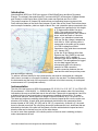
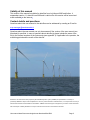
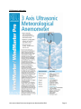
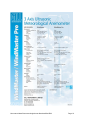
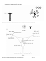
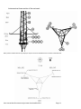
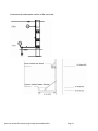
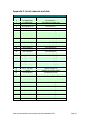
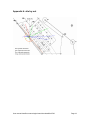
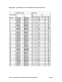
User manual data files meteorological mast NoordzeeWind
Document code: NZW-16-S-4-R03
Version: 2.0
Date: 1 October 2007
Author: ing. HJ Kouwenhoven
User manual data files meteorological mast NoordzeeWind R03
Page 1
Contents:
Introduction .....................................................................................................................................3
Instrumentation ..............................................................................................................................3
Process of data handling..............................................................................................................4
Description of the data files..........................................................................................................4
Quality of data ................................................................................................................................4
Validity of this manual ...................................................................................................................5
Contact details and questions .....................................................................................................5
Appendix 1: list of instruments.....................................................................................................6
Appendix 2: instrumentation drawing .......................................................................................11
Appendix 3: list of channels and data ......................................................................................16
Appendix 4: site lay out ..............................................................................................................18
Appendix 5: positions of met mast and wind turbines ...........................................................18
Appendix 5: positions of met mast and wind turbines ...........................................................19
Appendix 6: distances between met mast and wind turbines suitable for wake
measurements .............................................................................................................................20
User manual data files meteorological mast NoordzeeWind R03
Page 2
Introduction
NoordzeeWind (NZW) is a 50/50 joint venture of Shell Wind Energy and Nuon Duurzame
Energie. The company has entered an EPC contract with BCE (a consortium of Ballast Nedam
and Vestas) to install a wind farm off the Dutch coast near Egmond aan Zee in 2006.
The project comprises 36 Vestas V90 wind turbines and associated support systems in the
Dutch territorial waters of the North Sea, between 10 and 18km off the coast. Each turbine has a
steel monopile foundation, piled to a depth of about 30m, and a transition piece connected to the
monopile via a grouted joint. Hub height
is 70 meters above Mean Sea level
(MSL). The produced power will be
transmitted through three 34kV cables to
shore, which land north of IJmuiden
harbour. In a substation located near
Wijk aan Zee the voltage is stepped up
from 34kV to 150kV and the power is
transported to the public grid by means
of a 150kV underground cable.
Operations of the wind farm commenced
on 1 January 2007.
At the site of the Offshore Wind farm
Egmond aan Zee (OWEZ) a met mast
was erected in 2003, capable of
measuring the actual weather and wave
conditions. The data gathered is logged
into two data loggers and are
subsequently sent to the shore by
means of a GSM connection.
A cable connection between the met
mast and the wind farm provides power
and data transport capacity.
To achieve sufficient stability for the instruments the met mast is constructed as a triangular
lattice tower, mounted on a monopile foundation, driven in the sea bed. The distance between
the instruments and the body of the met mast is sufficient to limit the inaccuracy of wind speed
measurements to 5% (except wake effects).
Instrumentation
The site of the met mast is in WGS 84 coordinates 52º 36‘ 22.9“ N, 4º 23‘ 22.7“ E, (in UTM31 ED
50 coordinates X = 594194.830, Y = 5829600.084) at the south western side of the wind farm,
indicated on the map as a little black star in the red circle. Please refer to appendices 4 and 5 for
a detailed site lay out and coordinates. Instruments are installed at three levels: 70 meters
above mean sea level, which equals hub height of the wind turbines, at 21,6 m and at 116 m.
The latter two heights are enabling determination of the wind speed profile over the entire rotor
diameter of 90 meters. At each level wind speed and wind direction are measured at three
booms situated at 300º (NW), 60º (NE) and at 180º (S), respectively. As North is 0º, the south
boom is directed pure south. By using three booms per measurement level, wind flows that are
disturbed by the wake of the mast can be filtered out while undisturbed wind speed and wind
direction data can be derived from (one of) the other booms.
As can be seen from appendix 4, the chosen position of the met mast is enabling (multiple)
wake measurements as well.
User manual data files meteorological mast NoordzeeWind R03
Page 3
At each level the wind speed is measured by cup anemometers and by an acoustic (3D sonic,
brand “Gill”) instrument. The acoustic instrument is capable of measuring detailed horizontal and
vertical wind speed and direction variations.
Additional instruments like rain sensors, temperature sensors, air pressure and an Acoustic
Doppler Current Profiler (ADCP) are installed as well. The complete list of instruments and
specifications of the most important instruments is added as appendix 1. A drawing showing
where the instruments are placed on the met mast is attached as appendix 2.
Process of data handling
The instruments in the met mast are delivering their signals to a data acquisition system in the
met mast, comprising of two data loggers working in parallel to create redundancy. Each
instrument is delivering its output signal to both loggers. Before storage the data are converted
to 10 minute average values. On a daily basis, the supplier of the system reads the data by use
of the glass fibre network in the wind farm. After a quality check by the supplier the data are sent
on a monthly basis to the data acquisition system of ECN in Petten.
Description of the data files
Each sensor signal has a unique channel number in the database, see appendix 3. This channel
number, combined with the systematic lay out of the database will enable easy data selection.
The first six columns of each data file are used for the time stamp based on UTC. These
columns are followed by the section that is containing the actual data. Each measured
parameter is using five columns in the data files and the lay out of the data is identical for each
parameter: channel number, maximum value, minimum value, average value, and standard
deviation:
Year
Month
Day
Hour
Min
Second
Channel
Max
Min
Mean
STD
Channel
Max
2005
1
1
0
0
0
0
166
150
157.94
2.770
1
15
…..And so on...
All data are receiving a time stamp, comprising of year, month, day, hour, 10-minute block. The
seconds value is present in the data files as well but for obvious reasons this value has no
meaning.
The files are labeled systematic: OWEZ_M_181_YYYYMMDD-YYYYMMDD.xls
In general each data file is containing data of one calendar month, the actual period is specified
in the name of the file.
Quality of data
All sensors are calibrated according to MEASNET. General accuracy of wind data that is not
influenced by the wake of the mast itself is better than 95%. For scientific users of the data only,
the actual calibration certificates are available at NoordzeeWind upon request.
Before the data is made available on the internet, quality checks have been carried out.
Calibration factors of the instruments are applied on the data. Wind direction data are corrected
where appropriate to secure values between 0 and 360 degrees. Corrupt and/or missing data
fields are marked by replacing those invalid data by error values (-999999).
User manual data files meteorological mast NoordzeeWind R03
Page 4
Validity of this manual
This version of the manual is suitable for data files from July/August 2005 and further. It
supersedes version 1.1 dated 8 June 2006 and is valid until a new version will be issued and
made available on the internet.
Contact details and questions
Questions about this user manual or the data files can be addressed by sending an E mail to:
[email protected]
Questions about the user manual can only be answered if the version of the user manual (see
title sheet) is specified. In case of questions about data file(s) please include the name of the
file(s), the channel numbers of the instruments (see appendix 3) if applicable to the question, the
measuring period and the month of the data file.
Disclaimer: This manual has been prepared by NoordzeeWind [Investor I] B.V. (NZWBV) No representation or warranty is
provided by NZWBV in respect of the completeness or accuracy of the information contained herein, or in respect of the accuracy of
the wind met mast data made available on this website. NZWBV reserves the right to change the lay out and/or content of the data
files and accepts no liability whatsoever in respect of the use of this manual or the wind met mast data.
User manual data files meteorological mast NoordzeeWind R03
Page 5
Appendix 1: list of instruments
Position
Location /
at
Height (meters
drawing: above MSL):
Instrument:
1
2
3
4
5
6
7
8
9
10
11
S/21
S/21
S/21
NE/21
NE/21
NW/21
NW/21
NW/21
S/70
S/70
S/70
Wind direction vane
Cup anemometer
Temperature/humidity
Wind direction vane
Cup anemometer
Wind direction vane
Cup anemometer
Sonic windmeter
Wind direction vane
Cup anemometer
Temperature/humidity
12
13
14
15
16
17
18
19
20
21
22
23
24
25
26
27
32
NE/70
NE/70
NE/70
NW/70
NW/70
NW/70
NW/70
S/116
S/116
S/116
NE/116
NE/116
NW/116
NW/116
NW/116
116
20
42
-3.8
43
-17
Wind direction vane
Cup anemometer
Precipitation sensor
Wind direction vane
Cup anemometer
Sonic windmeter
Precipitation sensor
Wind direction vane
Cup anemometer
Temperature/humidity
Wind direction vane
Cup anemometer
Wind direction vane
Cup anemometer
Sonic windmeter
Acceleration sensor
Air pressure
SeaWater Temperature
Sensor
Acoustic Doppler Current
Profiler
Instrument make and
type:
Instrument
code:
Mierij Meteo 524
Mierij Meteo 018
Vaisala Oyj HMP 233
Mierij Meteo 524
Mierij Meteo 018
Mierij Meteo 524
Mierij Meteo 018
Gill 1086M
Mierij Meteo 524
Mierij Meteo 018
Vaisala Oyj HMP 233
Mierij Meteo 524
Mierij Meteo 018
Mierij Meteo PD 205
Mierij Meteo 524
Mierij Meteo 018
Gill 1086M
Mierij Meteo PD 205
Mierij Meteo 524
Mierij Meteo 018
Vaisala Oyj HMP 233
Mierij Meteo 524
Mierij Meteo 018
Mierij Meteo 524
Mierij Meteo 018
Gill 1086M
Seika XB2i
Druck RPT 410V
WD 524/S/21
WS 018/S/21
RHTT 261/S/21
WD 524/NE/21
WS 018/NE/21
WD 524/NW/21
WS 018/NW/21
3DWM4/NW/21
WD 524/S/70
WS 018/S/70
RHTT 261/S/70
WD 524/NE/70
WS 018/NE/70
PD 205/NE/70
WD 524/NW/70
WS 018/NW/70
3DWM4/NW/70
PD 205/NW/70
WD 524/S/116
WS 018/S/116
RHTT 261/S/116
WD 524/NE/116
WS 018/NE/116
WD 524/NW/116
WS 018/NW/116
3DWM4/NW/116
AC SB2i/T/116
DP910
Mierij Meteo Pt100
ST 808/NW/-3.8
Nortek-as AWAC
ADCP
Note: position numbers 28 until 42 (except pos. 32) are for auxiliaries and not used for
instruments. Refer to appendix 2 for a drawing of the positions of the instruments on the meteo
mast.
User manual data files meteorological mast NoordzeeWind R03
Page 6
Wind direction vane
User manual data files meteorological mast NoordzeeWind R03
Page 7
Cup Anemometer
User manual data files meteorological mast NoordzeeWind R03
Page 8
Gill Ultrasonic wind meter
User manual data files meteorological mast NoordzeeWind R03
Page 9
User manual data files meteorological mast NoordzeeWind R03
Page 10
Appendix 2: instrumentation drawings
Overview:
Note: position numbers 28 until 42 (except pos. 32) and 44 are for auxiliaries and not used for measurements.
User manual data files meteorological mast NoordzeeWind R03
Page 11
Instruments at top section of the met mast:
Note: position numbers 28 until 42 (except pos. 32) and 44 are for auxiliaries and not used for measurements.
User manual data files meteorological mast NoordzeeWind R03
Page 12
Instruments at middle section of the met mast:
Note: position numbers 28 until 42 (except pos. 32) and 44 are for auxiliaries and not used for measurements.
User manual data files meteorological mast NoordzeeWind R03
Page 13
Instruments at lower section of the met mast:
Note: position numbers 28 until 42 (except pos. 32) and 44 are for auxiliaries and not used for measurements.
User manual data files meteorological mast NoordzeeWind R03
Page 14
Instruments at under water section of the met mast:
User manual data files meteorological mast NoordzeeWind R03
Page 15
Appendix 3: list of channels and data
Channel
0
1
2
3
4
5
6
7
8
9
10
11
12
13
14
15
16
17
18
19
20
21
22
23
24
25
26
27
28
29
30
31
32
33
34
35
36
37
38
Overview of data base channels and instruments
Instrument code
Parameter and Unit
3D WM4/NW/21
wind direction [°]
3D WM4/NW/21
horizontal wind speed [m/s]
3D WM4/NW/21
vertical wind speed [m/s]
3D WM4/NW/116
wind direction [°]
3D WM4/NW/116
horizontal wind speed [m/s]
3D WM4/NW/116
vertical wind speed [m/s]
3D WM4/NW/70
wind direction [°]
3D WM4/NW/70
horizontal wind speed [m/s]
3D WM4/NW/70
vertical wind speed [m/s]
WS 018/NW/116
wind speed [m/s]
WS 018/NE/116
wind speed [m/s]
WS 018/S/116
wind speed [m/s]
WS 018/NW/70
wind speed [m/s]
WS 018/NE/70
wind speed [m/s]
WS 018/S/70
wind speed [m/s]
WS 018/NW/21
wind speed [m/s]
WS 018/NE/21
wind speed [m/s]
WS 018/S/21
wind speed [m/s]
RHTT 261/S/116
ambient temp. [°C]
RHTT 261/S/70
ambient temp. [°C]
RHTT 261/S/21
ambient temp. [°C]
RHTT 261/S/116
relative humidity [%]
RHTT 261/S/70
relative humidity [%]
RHTT 261/S/21
relative humidity [%]
DP910
ambient air pressure [mbar]
PD 205/NW/70
precipitation [yes/no]
PD 205/NE/70
precipitation [yes/no]
ST 808/NW/-3.8
sea water temperature [°C]
AC SB2i/T/116
X ( north – south ) acceleration [m/s2]
AC SB2i/T/116
Y ( west – east ) acceleration [m/s2]
WD 524/NW/116
wind direction [°]
WD 524/NE/116
wind direction [°]
WD 524/S/116
wind direction [°]
WD 524/NW/70
wind direction [°]
WD 524/NE/70
wind direction [°]
WD 524/S/70
wind direction [°]
WD 524/NW/21
wind direction [°]
WD 524/NE/21
wind direction [°]
WD 524/S/21
wind direction [°]
User manual data files meteorological mast NoordzeeWind R03
Page 16
Channel
50
51
52
53
54
55
56
57
58
Overview of data base channels and instruments
Instrument code
Parameter and Unit
ADCP
Water level [m]
ADCP
Water temperature [°C]
ADCP
Wave height [m]
ADCP
Wave period [s]
ADCP
Wave direction [°]
ADCP
Current velocity 7 m [m/s]
ADCP
Current velocity 11 m [m/s]
ADCP
Current direction 7 m [°]
ADCP
Current direction 11 m [°]
Note: Channel numbers are referring to the data files.
User manual data files meteorological mast NoordzeeWind R03
Page 17
Appendix 4: site lay out
User manual data files meteorological mast NoordzeeWind R03
Page 18
Appendix 5: positions of met mast and wind turbines
User manual data files meteorological mast NoordzeeWind R03
Page 19
Appendix 6: distances between met mast and wind turbines
suitable for wake measurements
User manual data files meteorological mast NoordzeeWind R03
Page 20