1
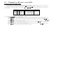
SURFEX OFF-LINE
User’s Guide
surfex version : v4
P. Le Moigne
28 juillet 2008
Table des mati`
eres
I
How to install the software
7
1 Export off-line version of SURFEX
9
II
Off-line guide
13
2 Using the externalized surface in off-line mode
15
2.1
The input files . . . . . . . . . . . . . . . . . . . . . . . . . . . . . . . . . . . . . .
15
2.2
namelist NAM IO OFFLINE . . . . . . . . . . . . . . . . . . . . . . . . . . . . . .
15
2.3
forcing files . . . . . . . . . . . . . . . . . . . . . . . . . . . . . . . . . . . . . . . .
16
2.3.1
creation of forcing files . . . . . . . . . . . . . . . . . . . . . . . . . . . . . .
16
2.3.2
installation of an experiment . . . . . . . . . . . . . . . . . . . . . . . . . .
17
3 One example of off-line surfex application
3.1
3.2
19
netcdf format files . . . . . . . . . . . . . . . . . . . . . . . . . . . . . . . . . . . .
19
3.1.1
FORCING.nc . . . . . . . . . . . . . . . . . . . . . . . . . . . . . . . . . . .
19
3.1.2
PARAMS.nc . . . . . . . . . . . . . . . . . . . . . . . . . . . . . . . . . . .
20
ascii format files . . . . . . . . . . . . . . . . . . . . . . . . . . . . . . . . . . . . .
20
3.2.1
PGD.txt . . . . . . . . . . . . . . . . . . . . . . . . . . . . . . . . . . . . . .
20
3.2.2
PREP.txt . . . . . . . . . . . . . . . . . . . . . . . . . . . . . . . . . . . . .
23
3.2.3
Extracting 2d fields . . . . . . . . . . . . . . . . . . . . . . . . . . . . . . .
23
3.2.4
I/O diagram . . . . . . . . . . . . . . . . . . . . . . . . . . . . . . . . . . .
25
4 Some output of off-line simulation
27
4.1
Examples of prognostic variables output . . . . . . . . . . . . . . . . . . . . . . . .
27
4.2
list of available variables . . . . . . . . . . . . . . . . . . . . . . . . . . . . . . . . .
28
III
Users guide
31
5 Overview of the externalized surface sequence
3
33
5.1
The sequence . . . . . . . . . . . . . . . . . . . . . . . . . . . . . . . . . . . . . . .
33
5.2
The atmospheric models using the externalized surface . . . . . . . . . . . . . . . .
33
5.2.1
in offline mode . . . . . . . . . . . . . . . . . . . . . . . . . . . . . . . . . .
33
5.2.2
in MESONH . . . . . . . . . . . . . . . . . . . . . . . . . . . . . . . . . . .
33
5.2.3
in AROME . . . . . . . . . . . . . . . . . . . . . . . . . . . . . . . . . . . .
34
6 The physiographic fields
6.1
35
Overview of physiographic fields computation : PGD . . . . . . . . . . . . . . . .
35
6.1.1
Choice of the grid . . . . . . . . . . . . . . . . . . . . . . . . . . . . . . . .
35
6.1.2
Choice of the physiographic fields . . . . . . . . . . . . . . . . . . . . . . . .
35
6.2
Choice of the surface schemes . . . . . . . . . . . . . . . . . . . . . . . . . . . . . .
44
6.3
Definition of the grid . . . . . . . . . . . . . . . . . . . . . . . . . . . . . . . . . . .
45
6.3.1
Choice of the grid type
. . . . . . . . . . . . . . . . . . . . . . . . . . . . .
45
6.3.2
Conformal projection grids (Mercator, Lambert, Polar stereographic) . . . .
46
6.3.3
Cartesian grids . . . . . . . . . . . . . . . . . . . . . . . . . . . . . . . . . .
47
6.3.4
Regular longitude-latitude grids . . . . . . . . . . . . . . . . . . . . . . . . .
48
6.3.5
Regular Lambert grids . . . . . . . . . . . . . . . . . . . . . . . . . . . . . .
49
6.3.6
Gaussian grids . . . . . . . . . . . . . . . . . . . . . . . . . . . . . . . . . .
50
6.4
Land cover fractions . . . . . . . . . . . . . . . . . . . . . . . . . . . . . . . . . . .
51
6.5
Orography, subgrid orography and bathymetry . . . . . . . . . . . . . . . . . . . .
52
6.6
Namelist for ISBA scheme
. . . . . . . . . . . . . . . . . . . . . . . . . . . . . . .
53
6.7
Namelist to add user’s own fields . . . . . . . . . . . . . . . . . . . . . . . . . . . .
54
6.8
Namelist for chemistry anthropogenic emissions
55
. . . . . . . . . . . . . . . . . . .
7 Initialization of the prognostic fields
57
7.1
Overview of fields computation : PREP . . . . . . . . . . . . . . . . . . . . . . . .
57
7.2
Date initialization and default input data file for all schemes . . . . . . . . . . . . .
58
7.3
Sea scheme ”SEAFLX” . . . . . . . . . . . . . . . . . . . . . . . . . . . . . . . . .
59
7.4
Lake scheme ”WATFLX” . . . . . . . . . . . . . . . . . . . . . . . . . . . . . . . .
60
7.5
Lake scheme ”FLAKE” . . . . . . . . . . . . . . . . . . . . . . . . . . . . . . . . .
61
7.6
Vegetation scheme ”ISBA ” . . . . . . . . . . . . . . . . . . . . . . . . . . . . . . .
62
7.7
Town scheme ”TEB ” . . . . . . . . . . . . . . . . . . . . . . . . . . . . . . . . . .
63
8 How to run the externalized surface physical schemes
65
8.1
”SURF ATM” general options available over all tiles . . . . . . . . . . . . . . . . .
65
8.2
”SEAFLX” sea scheme options . . . . . . . . . . . . . . . . . . . . . . . . . . . . .
66
8.3
”FLAKE” lake scheme options . . . . . . . . . . . . . . . . . . . . . . . . . . . . .
67
8.4
”ISBA ” vegetation scheme options . . . . . . . . . . . . . . . . . . . . . . . . . . .
68
9 How to run the externalized surface chemical schemes
69
9.1
Chemical settings control . . . . . . . . . . . . . . . . . . . . . . . . . . . . . . . .
69
9.2
Chemical anthropogenic emissions . . . . . . . . . . . . . . . . . . . . . . . . . . .
69
9.3
Chemical deposition over ocean . . . . . . . . . . . . . . . . . . . . . . . . . . . . .
69
9.4
Chemical deposition over lakes . . . . . . . . . . . . . . . . . . . . . . . . . . . . .
69
9.5
Chemical deposition over towns . . . . . . . . . . . . . . . . . . . . . . . . . . . . .
70
9.6
Chemical deposition and biogenic emissions over vegetation . . . . . . . . . . . . .
70
10 Externalized surface diagnostics
71
10.1 Diagnostics relative to the general surface monitor . . . . . . . . . . . . . . . . . .
71
10.2 Diagnostics relative to the general surface monitor and to each surface scheme . . .
72
10.3 Diagnostics relative to the ISBA vegetation scheme . . . . . . . . . . . . . . . . . .
73
10.4 Diagnostics relative to the TEB town scheme . . . . . . . . . . . . . . . . . . . . .
73
10.5 Diagnostics relative to the FLAKE scheme . . . . . . . . . . . . . . . . . . . . . . .
73
10.6 Diagnostics relative to the 1D oceanic scheme . . . . . . . . . . . . . . . . . . . . .
73
11 Externalized surface model output fields
75
11.1 Prognostic model output fields . . . . . . . . . . . . . . . . . . . . . . . . . . . . .
75
11.1.1 ISBA . . . . . . . . . . . . . . . . . . . . . . . . . . . . . . . . . . . . . . .
75
11.1.2 SEAFLUX . . . . . . . . . . . . . . . . . . . . . . . . . . . . . . . . . . . .
77
11.1.3 TEB . . . . . . . . . . . . . . . . . . . . . . . . . . . . . . . . . . . . . . . .
78
11.1.4 WATFLUX . . . . . . . . . . . . . . . . . . . . . . . . . . . . . . . . . . . .
78
11.1.5 FLAKE . . . . . . . . . . . . . . . . . . . . . . . . . . . . . . . . . . . . . .
78
A Example of namelist features
79
A.1 How to define a target grid . . . . . . . . . . . . . . . . . . . . . . . . . . . . . . .
79
A.2 How to use ECOCLIMAP I . . . . . . . . . . . . . . . . . . . . . . . . . . . . . . .
79
A.3 How to use ECOCLIMAP II
. . . . . . . . . . . . . . . . . . . . . . . . . . . . . .
79
. . . . . . . . . . . . . . . . . . . . . . . . . . . . .
80
A.5 How to initialize variables from grib file . . . . . . . . . . . . . . . . . . . . . . . .
80
A.6 How to initialize main ISBA scheme options . . . . . . . . . . . . . . . . . . . . . .
80
A.7 user defined surface parameters . . . . . . . . . . . . . . . . . . . . . . . . . . . . .
80
A.7.1 Uniform values prescribed : 1d example without patches . . . . . . . . . . .
81
A.7.2 Uniform values prescribed : 1d example with patches . . . . . . . . . . . . .
84
A.7.3 Surface parameters read from external files . . . . . . . . . . . . . . . . . .
92
A.4 How to use 1D Oceanic Model
Premi`
ere partie
How to install the software
7
Chapitre 1
Export off-line version of SURFEX
Instructions to install surfex on a linux-PC and to run a 1d example.
0. select a directory where installation has to be done: for example $HOME or $HOME/MYDIR,
where MYDIR is an existing directory (if not, it has to be created by the user).
From now on, it is supposed that the user has defined a MYDIR directory.
1. download EXPORT_v4.0.tgz from surfex web site and move it into ${HOME}/MYDIR/EXPORT_v4.0.tgz
2. extract files from archive: tar zxvf EXPORT_v4.0.tgz
(or gunzip EXPORT_v4.0.tgz and then tar xvf EXPORT_v4.0.tar)
at this stage directory EXPORT_v4.0 is created in MYDIR and contains all software
peaces.
3. initialize environment variables needed for surfex:
3.1 set main environment variable:
export SURFEX_EXPORT="$HOME/MYDIR/EXPORT_v4.0"
3.2 then run a configuration script included in the archive:
. $SURFEX_EXPORT/conf/profile_surfex
4. run install_surfex:
install_surfex : (i)
realizes the compilation of surfex sources
(ii) prepares executable files for pgd, prep, offline and sxpost applications stored
in ${SURFEX_EXPORT}/src/exe directory
If everything goes well until this step, then surfex has been successfully installed on you computer.
5. How to install a pre-defined experiment:
(i)
(ii)
go to ${SURFEX_EXPERIMENT}/forcing directory
run 1_compile_and_link.bash script in order to prepare executable that will then be used
to install an experiment.
(iii) run 2_prepare_files.bash to know the available experiments
(iv) run 2_prepare_files.bash with a name of experiment as argument:
for example "2_prepare_files.bash hapex"
9
a namelist MY_PARAM.nam will open (vi editor), simply quit (use command :q)
Some information will then be written on the screen and should look like:
$SURFEX_EXPORT="/home/lemoigne/surfex/EXPORT_v4.0/"
-- namelist NAM_MY_PARAM read
> ===================================================================
> PREP_INPUT_EXPERIMENT: YEXPER
= HAPEX
> PREP_INPUT_EXPERIMENT: INI
= 1
> PREP_INPUT_EXPERIMENT: INPTS
= 17521
> PREP_INPUT_EXPERIMENT: JNPTS
= 17521
> PREP_INPUT_EXPERIMENT: ZTSTEPFRC
= 1800.
> PREP_INPUT_EXPERIMENT: YFORCING_FILETYPE = NETCDF
> ===================================================================
YFILE_FORCIN=../Data/hapex/HAPEX.DAT.30
-rw-r--r-- 1 lemoigne mc2 1543644 jui 22 16:51 /home/lemoigne/surfex/EXPORT_v4.0//EXP/forcing/FORCING.nc
-rw-r--r-- 1 lemoigne mc2
644 jui 22 16:51 /home/lemoigne/surfex/EXPORT_v4.0//EXP/forcing/PARAMS.nc
=====================================================================================
> input files moved to /home/lemoigne/surfex/EXPORT_v4.0//EXP/rundir/hapex
=====================================================================================
6. once the installation is done, go to $SURFEX_EXPERIMENT/rundir/hapex directory and launch successively:
(i)
pgd.exe
(ii) prep.exe
(iii) offline.exe
7. to view output 1d, you can use vespa tool. Type vespa to get available fields and then
vespa FIELDNAME to plot FIELDNAME
8. How to rerun a pre-defined experiment with new inputs:
8.1
you can define new surface characteristics by modifying file $SURFEX_EXPERIMENT/rundir/hapex/OPTIONS.nam
and then run pgd.exe, prep.exe and offline.exe
8.2
you can define new initial values for state variables by modifying file
$SURFEX_EXPERIMENT/rundir/hapex/OPTIONS.nam and then run prep.exe and offline.exe
8.3
you can modify the forcing characteristics:
(i) you can rerun $SURFEX_EXPERIMENT/forcing/2_prepapre_files.bash and modify namelist MY_PARAM to
select the number of time steps you want to treat (parameter NUMBER_OF_TIME_STEPS_FINAL)
the format of the input forcing files (parameter YFORCING_FILETYPE)
(ii) then go to $SURFEX_EXPERIMENT/rundir/hapex and rerun pgd.exe, prep.exe and offline.exe
9. How to create a new experiment:
9.1
you need to modify $SURFEX_EXPERIMENT/forcing/src/my_forcing.f90 to introduce the call to the new program
that is going to read your dataset
9.2
you need to create a new subroutine named $SURFEX_EXPERIMENT/forcing/src/my_forc_xxxx.f90
that corresponds to experiment xxxx
9.3
go then to $SURFEX_EXPERIMENT/forcing and run successively:
(i) 1_compare_and_link.bash (to account for your new subroutine)
(ii) 2_prepare_files.bash (to create input files related to your experiment)
(ii) then go to $SURFEX_EXPERIMENT/rundir/xxxx and run pgd.exe, prep.exe and offline.exe
10. How to compile your own source for surfex
10.1
10.2
cp the sources (from OFF_LINE or SURFEX directories) that you want to modify
onto $SURFEX_EXPORT/src/MYSRC
go to $SURFEX_EXPORT/src/MYSRC and make your modifications
10.3
go to $SURFEX_EXPORT/src and simply launch command "make"
new executable files will be created in exe directory and will replace the old ones.
11. How to include the BUGFIX (when exists)
11.1
download BUGFIX_EXPORT_v4.0.tgz
11.2
extract files from archive BUGFIX_EXPORT_v4.0.tgz, a directory named MYSRC and
containing bug fixes will be created
11.3
place extracted MYSRC in $SURFEX_EXPORT/src/ as replacement of the old one
11.4
go to $SURFEX_EXPORT/src and simply launch command "make"
new executable files will be created in exe directory and will replace the old ones.
Deuxi`
eme partie
Off-line guide
13
Chapitre 2
Using the externalized surface in
off-line mode
2.1
The input files
The use of the externalized surface software in off-line mode requires the preparation of several types
of file, especially the input data necessary for the run and the definition of the options specified in the
namelist .
– OPTIONS.nam is the namelist name used in the off-line model. The same namelist is used for the
PGD, PREP and RUN facilities. The description of the different namelist blocks for PGD (”The
physiographic fields”) and PREP (”Initialization of the prognostic fields”) tools are described
in the next chapter. The namelist block where functionnalities of the off-line run in terms of
Input/Output is named NAM IO OFFLINE
– the princip of an off-line simulation is that the atmospheric variables are known in advance. Thus,
time series of air temperature, humidity, wind speed, precipitation, pressure and radiation terms
are known. These data are pre-treated in order to be written in specific files (see below) called
forcing files.
– like for any model, some parameters related to the scheme have to be set and state variable have
to be initialized. These two tasks are performed by mean of tools PGD and PREP which lead to
create the initial file used in the simulation
2.2
namelist NAM IO OFFLINE
This namelist is the only one that is specific for the off-line mode.
Fortran name
CSURF FILETYPE
Fortran type
string of 6 characters
CTIMESERIES FILETYPE
string of 6 characters
CFORCING FILETYPE
CPGDFILE
CPREPFILE
CSURFFILE
XTSTEP SURF
XTSTEP OUTPUT
LPRINT
LRESTART
LINQUIRE
LSET FORC ZS
LWRITE COORD
string of
string of
string of
string of
real
real
logical
logical
logical
logical
logical
6 characters
28 characters
28 characters
28 characters
15
values
”NETCDF”, ”FA ”
”ASCII ”, ”LFI ”
”NETCDF”, ”OFFLIN”, ”NONE ”
”ASCII ”, ”TEXTE ”, ”BINARY”
”FA ”, ”LFI ”
”NETCDF”, ”BINARY”, ”ASCII”
default value
”ASCII ”
”NONE ”
”NETCDF”
”PGD”
”PREP”
”SURFOUT”
300.
1800.
.FALSE.
.FALSE.
.FALSE.
.FALSE.
.FALSE.
–
–
–
–
–
–
–
–
–
–
–
–
–
2.3
CSURF FILETYPE : type of Surfex surface files created during PGD or PREP steps .
CTIMESERIES FILETYPE : type of the files containing the output diagnostic time series .
CFORCING FILETYPE : type of atmospheric forcing files .
CPGDFILE : name of the PGD file .
CPREPFILE : name of the PREP file .
CSURFFILE : name of the final output surfex file (restart file) .
XTSTEP SURF : surface time step .
XTSTEP OUTPUT : time step of the output time series .
LPRINT : write information on screen during run .
LRESTART : write restart file .
LINQUIRE : enable test of inquiry mode .
LSET FORC ZS : if T, the orography of the forcing file is set to the same value as in surface file .
LWRITE COORD : enable write of fields XLAT and XLON in output file .
forcing files
2.3.1
creation of forcing files
For the preparation of forcing files, specific programs are used and are located in $SURFEX EXPERIMENT/forcing/src.
The structure of $SURFEX EXPERIMENT directory looks like :
EXP
|-|
|
|
|
|
|
|
|-|
|
|-|
|
|
|
|
|
|
‘--
Data
|-- Alp_for_0203
|-- Alqueva0206
|-- cdp9697
|-- hapex
|-- ma01
|-- me93
‘-- vl92
forcing
|-- Comp
‘-- src
namelist
|-- Alp_for_0203
|-- Alqueva0206
|-- cdp9697
|-- hapex
|-- ma01
|-- me93
‘-- vl92
rundir
‘-- hapex
– Data directory contains subdirectories (one per experiment) in which atmospheric time-series ascii
files are stored
– namelist directory contains subdirectories (one per experiment) in which at least 2 namelists are
stored : the first one named MY PARAM.nam contains information related to the forcing. For
example for the ”hapex” experiment, MY PARAM.nam looks like :
&NAM_MY_PARAM
/
YEXPERIMENT_NAME
= ’HAPEX
’
NUMBER_GRID_CELLS = 1
NUMBER_OF_TIME_STEPS_INPUT = 17521
NUMBER_OF_TIME_STEPS_FINAL = 17521
ZATM_FORC_STEP
= 1800.
YFORCING_FILETYPE = ’NETCDF’
,
,
,
,
,
– YEXPERIMENT NAME
is the name associated to the experiment (12 characters)
– NUMBER GRID CELLS
is the grid cell number
– NUMBER OF TIME STEPS INPUT
number of time steps of forcing serie
– NUMBER OF TIME STEPS FINAL
number of time steps used for the simulation (should be lower or equal to NUMBER OF TIME STEPS INPUT)
– ZATM FORC STEP
frequency of atmospheric forcing
– YFORCING FILETYPE
is the type of the forcing files asked by the user :
– NETCDF :
2 files will be created : FORCING.nc and PARAMS.nc
– ASCII :
12 files will be created : Params config.txt file will contain informations related to the simulation and 11 files, one per parameter, named Forc CO2.txt, Forc DIR.txt, Forc PS.txt,
Forc RAIN.txt, Forc SNOW.txt, Forc WIND.txt,Forc DIR SW.txt, Forc LW.txt, Forc QA.txt,
Forc SCA SW.txt, Forc TA.txt will be created
– BINARY :
12 files will be created : Params config.txt file will contain informations related to the simulation and 11 files, one per parameter, named Forc CO2.bin, Forc DIR.bin, Forc PS.bin,
Forc RAIN.bin, Forc SNOW.bin, Forc WIND.bin,Forc DIR SW.bin, Forc LW.bin, Forc QA.bin,
Forc SCA SW.bin, Forc TA.bin will be created
All forcing files will be placed in $SURFEX EXPERIMENT/rundir/hapex/ and a consistency
test between MY PARAM.nam and OPTIONS.nam will be done in case the forcing filetype
would be different.
2.3.2
installation of an experiment
Go to $SURFEX EXPERIMENT/forcing directory and launch 1 compile and link.bash to create
executable file that will then be used to prepare the files when you’ll launch 2 prepare files.bash giving
the experimant name as argument. If you want to create a nex experiment named for example ’MYTEST
’, you’ll have to modify $SURFEX EXPERIMENT/forcing/src/my forcing.f90 program in order to refer
to the new subroutine that you’ll have created and that must be named my forc mytest.f90 and stored in
$SURFEX EXPERIMENT/forcing/src. You simply have to add few lines in my forcing.f90 program :
CASE (’MYTEST
’)
CALL MY_FORC_MYTEST(HEXPER,KNI,KNPTS,PTSTEP_FORC,
KYEAR,KMONTH,KDAY,PTIME,
PLON, PLAT, PZS, PZREF, PUREF,
PTA, PQA, PPS, PWINDSPEED, PWINDDIR,
PDIR_SW, PSCA_SW, PLW, PRAIN, PSNOW, PCO2
&
&
&
&
)
Then copy my forc hapex.f90 into my forc mytest.f90, replace HAPEX by MYTEST, refer to the
correct input file and adapt the reading sequence.
Create $SURFEX EXPERIMENT/namelist/mytest and namelist MY PARAM.nam and OPTIONS.nam
inside this directory
When this is done, go to $SURFEX EXPERIMENT/forcing and run 1 compile and link.bash
and 2 prepare files.bash mytest
Chapitre 3
One example of off-line surfex
application
This example is based on the situation of the 25th of October 2004 at 06UTC and covers a temporal
period of 24 hours. During this day an unstable weather was observed in France, especially in the Southern
part.
Here, two different file formats are used as input for the externalized surface off-line software. Both
are portable : the first format is netcdf and the second is the ascii one. Netcdf format has been chosen
because of several participations of PILPS intercomparison projects that requires such format, due to its
portability. It follows the Alma concept (proposed by Polcher in 1998).
3.1
3.1.1
netcdf format files
FORCING.nc
For this experiment, atmospheric forcing is extracted from French database named BDAP (Base de
Donn´ees Analys´ees et Pr´evues). Data come from the analysis of surface parameters performed by Safran
analysis system devoted to hydrological applications. A constant value in space is applied for each gridbox.
list of parameters
Variable name
NB TIMESTP
FORC TIME STEP
TSUN
ZS
LON
LAT
TA
QA
WIND
DIR SW
SCA SW
LW
PS
RAIN
SNOW
CO2
DIR
Dimensions
DIM FULL
DIM FULL
DIM FULL
DIM FULL
DIM FULL
DIM FULL
DIM FULL
DIM FULL
DIM FULL
DIM FULL
DIM FULL
DIM FULL
DIM FULL
DIM FULL
DIM FULL
,
,
,
,
,
,
,
,
,
,
,
NB TIMESTP
NB TIMESTP
NB TIMESTP
NB TIMESTP
NB TIMESTP
NB TIMESTP
NB TIMESTP
NB TIMESTP
NB TIMESTP
Unit
s
s
s
m
deg
deg
K
Kg/Kg
m/s
W/m2
W/m2
W/m2
Pa
Kg/m2/s
Kg/m2/s
NB TIMESTP
NB TIMESTP
deg
Description
number of time steps
forcing time step
current sun time
surface orography
longitudes
latitudes
air temperature
air specific humidity
wind speed
downward direct shortwave radiation
downward diffuse shortwave radiation
downward longwave radiation
surface pressure
rainfall rate
snowfall rate
CO2 concentration
wind direction
Dimensions DIM FULL and NB TIMESTP represent respectively the total number of gridboxes
in the area of interest and the number of atmospheric time steps.
19
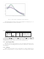
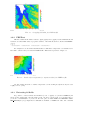
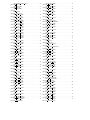
Fig. 3.1 – Time evolution of temperature over the working area
The following pictures show the time evolution of forcing quantities for the integration period, over
the region of interest. Each curve correspond to a grid point.
3.1.2
PARAMS.nc
Variable name
DIM FULL
DTCUR-TDATE
DTCUR-TIME
ZREF
UREF
Dimensions
DIM FULL
DIM FULL
Value
1280
2004, 10, 25
21600
2
10
Unit
s
m
m
Description
number of grid boxes
starting date of the run
starting time of the run
reference height for T and q
reference height for wind
The two netcdf files are prepared independantly from PGD and PREP applications, with external
programs named prep input parameters.f90 and my forcing.f90. Parameters DIM FULL, PATCH NUMBER,
DTCUR-TDATE, DTCUR-TIME have to be set up carefully according to the one defined during PGD
and PREP applications, anyhow consistency tests are performed during surfex setup.
3.2
ascii format files
This format is used in the off-line applications because it’s the simpliest format that may replace
more complex (in terms of file handling) like lfi format used in the meso-NH framework or FA used in the
Arome framework.
3.2.1
PGD.txt
This file contains the information related to physiography and orography essentially. The file is
splitted into several parts. The first one corresponds to the gridbox as seen as a single pixel where quantities
Fig. 3.2 – Time evolution of specific humidity over the working area
Fig. 3.3 – Time evolution of longwave incoming radiation over the working area
Fig. 3.4 – Time evolution of shortwave incoming radiation over the working area
are aggregated. The corresponding field names are prefixed with FULL. This gridbox may be separated
into four tiles respectively associated to nature, town, sea/ocean and lake). The corresponding field names
are respectively prefixed with NATURE, TOWN, SEA and WATER.
The physiographic parameters written out into PGD.txt file are mainly the fraction of land covers contained
in each gridbox. These fractions are computed from ECOCLIMAP database.
&FULL
DIM_FULL
(-)
1280
&FULL
DIM_SEA
(-)
0
&FULL
DIM_NATURE
(-)
1279
&FULL
DIM_WATER
(-)
1
&FULL
DIM_TOWN
(-)
240
&FULL
ECOCLIMAP
(-)
T
&NATURE ISBA
ISBA
3-L
&NATURE PHOTO
PHOTO
NON
&NATURE GROUND_LAYER
GROUND_LAYER
3
&NATURE PATCH_NUMBER
PATCH_NUMBER
1
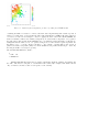
Value of DIM FULL indicates that this is a 2D exercise, and the gridbox contains a non-zero
fraction of nature, of water (lake) and of town, but there’s no fraction of sea because the number of points
with a non-zero fraction of sea DIM SEA is zero. 1279 gridboxes contain vegetation and 240 gridboxes
contain a fraction of town, onmly one gridbow contains a fraction ok inland water(lake). Surface scheme
to treat vegetation is Isba 3-L which means that soil is represented with 3 layers. The number of patches
is 1, it indicates that the vegetation is not splitted into patches like it could (this should be the case for
the A-gs option of Isba that treats explicitly photosynthesis).
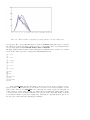
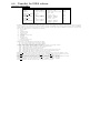
Fig. 3.5 – Orography field taken from PGD.txt file
3.2.2
PREP.txt
This file contains the information related to physiography and orography read from PGD.txt file and
rewritten, as well as initial values of prognostic variables of the different schemes contained in SURFEX.
&NATURE TG1
X_Y_TG1 (K)
2.8576409563069382E+02
2.8548082006251650E+02
2.8540527530138650E+02
2.8546873415878122E+02 ...
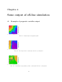
For example here are shown the first initial values of skin surface temperature over natural area for
Isba surface scheme as they are written in PREP.txt file. This field is represented on figure 3.6.
Fig. 3.6 – Initial surface temperature for vegetation taken from PREP.txt file
An other example shows the roof surface temperature over the working area (Toulouse city is located
roughly at x=15, y=22)
3.2.3
Extracting 2d fields
It’s possible to extract 2d fields from PGD.txt (covers, orography, etc.) and from PREP.txt (initial prognostic variables like soil temperature profile, soil water content profile, etc.). For that purpose
you need to run SXPOST tool (located at the same place as PGD, PREP and OFFLINE : $SURFEX EXPORT/src/exe/). Input files for SXPOST are PGD.txt or PREP.txt if exists, and a namelist
Fig. 3.7 – Initial surface temperature for the roofs taken from PREP.txt file
containing the number of fields to be extracted, the name and a flag indicating if the variable depends on
patches or not. The name of a given field is the name written in PGD.txt or PREP.txt file where characters
” &” have been removed. For example, to extract orography, the name of the field is ZS in SURFEX, the
mask over which it’s defined can be FULL (total gridbox). To extract surface temperature over vegetation,
the name will be TG1 and the mask NATURE. (grep ”&” PGD.txt returns all variables of this file). To
distinguish variables defined or not over patches, a flag is used : if the variable is patch dependant, the
flag must be set to ’+’, in the contrary, it should be ’-’. For example orography (ZS) doesn’t depend on
patches, but surface temperature (TG1) does. If the simulation uses patches and the flag is ’-’ then only
the first patch will be treated (bare ground).
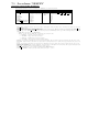
The namelist SXPOST.nam looks like :
2
- FULL
ZS
+ NATURE TG1
Running SXPOST will return a file per variable, which will contain the longitude, the latitude and
the value of the field for each gridbox over which the field is defined (For example, TG1 which is known
only over nature won’t have a value for each gridbox of the domain).
3.2.4
I/O diagram
Fig. 3.8 – Surfex diagram showing the input/output files produced by the different tools (the list of
produced variables in case YWRPRGM=’TEXTE ’ is obviously not exhaustive)
Chapitre 4
Some output of off-line simulation
4.1
Examples of prognostic variables output
Fig. 4.1 – Initial surface temperature field
Fig. 4.2 – Root layer water content after 12 hours of integration
Fig. 4.3 – Interception (by vegetation) water content after 12 hours of integration
27
4.2
list of available variables
This list has been made by using vespa which is a tool that has been used to realize the plots of this
document. This is not the complete possible list since only the fileds that are present in netcdf ouput files
are listed.
*********************************
*********** V E S P A ***********
*********************************
***
***
***
V-aluable
***
***
E-xternalized
***
***
S-urface
***
***
P-lot
***
***
A-pplication
***
***
***
*********************************
*********************************
ISBA PROGNOSTIC VARIABLES
=========================
TG1: "Soil_temp_layer_1" ;
WG1: "Soil_liquid_layer_1" ;
WGI1: "Soil_ice1" ;
TG2: "Soil_temp_layer_2" ;
WG2: "Soil_liquid_layer_2" ;
WGI2: "Soil_ice2" ;
TG3: "Soil_temp_layer_3" ;
WG3: "Soil_liquid_layer_3" ;
WGI3: "Soil_ice3" ;
WR: "Interception_reservoir" ;
RESA: "Aerodynamic_resistance" ;
WSNOW_VEG1: "Snow_Water_Equivelent_layer_1" ;
RSNOW_VEG1: "Snow_density_layer_1" ;
TSNOW_VEG1: "Snow_temperature_layer1" ;
HSNOW_VEG1: "Snow_heat_layer1" ;
WSNOW_VEG2: "Snow_Water_Equivelent_layer_2" ;
RSNOW_VEG2: "Snow_density_layer_2" ;
TSNOW_VEG2: "Snow_temperature_layer2" ;
HSNOW_VEG2: "Snow_heat_layer2" ;
WSNOW_VEG3: "Snow_Water_Equivelent_layer_3" ;
RSNOW_VEG3: "Snow_density_layer_3" ;
TSNOW_VEG3: "Snow_temperature_layer3" ;
HSNOW_VEG3: "Snow_heat_layer3" ;
ASNOW_VEG: "Snow_albedo" ;
ISBA DIAGNOSTIC VARIABLES
=========================
RI_ISBA: "Averaged_Richardson_Number" ;
RN_ISBA: "Averaged_Net_Radiation" ;
H_ISBA: "Averaged_Sensible_Heat_Flux" ;
LE_ISBA: "Averaged_Latent_Heat_Flux" ;
GFLUX_ISBA: "Averaged_Ground_Heat_Flux" ;
LEG: "Ground_Evaporation_Heat_Flux" ;
LEGI: "Soil_Ice_Sublimation" ;
LEV: "Vegetation_Evaporation_Heat_Flux" ;
LES: "Snow_Evaporation_Heat_Flux" ;
LER: "Canopy_Water_Interception_Evaporation" ;
LETR: "Vegetation_Evapotranspiration" ;
EVAP: "Evapotranspiration" ;
DRAIN: "Soil_Drainage_Flux" ;
RUNOFF: "Supersaturation_Runoff" ;
LEG_ISBA: "Averaged_Ground_Evaporation_Heat_Flux" ;
LEGI_ISBA: "Averaged_Soil_Ice_Sublimation" ;
LEV_ISBA: "Averaged_Vegetation_Evaporation_Heat_Flux" ;
LES_ISBA: "Averaged_Snow_Evaporation_Heat_Flux" ;
LER_ISBA: "Averaged_Canopy_Water_Interception_Evaporation" ;
LETR_ISBA: "Averaged_Vegetation_Evapotranspiration" ;
EVAP_ISBA: "Averaged_Evapotranspiration" ;
DRAIN_ISBA: "Averaged_Soil_Drainage_Flux" ;
RUNOFF_ISBA: "Averaged_Supersaturation_Runoff" ;
CH_ISBA: "Averaged_thermal_diffusion_coefficient" ;
HV_ISBA: "Halstead_coefficient" ;
Z0REL: "Output_Z0REL" ;
VEGTYPE_PATCH_1: "fraction_of_vegetation_type_1" ;
VEGTYPE_PATCH_2: "fraction_of_vegetation_type_2" ;
VEGTYPE_PATCH_3: "fraction_of_vegetation_type_3" ;
VEGTYPE_PATCH_4: "fraction_of_vegetation_type_4" ;
VEGTYPE_PATCH_5: "fraction_of_vegetation_type_5" ;
VEGTYPE_PATCH_6: "fraction_of_vegetation_type_6" ;
VEGTYPE_PATCH_7: "fraction_of_vegetation_type_7" ;
VEGTYPE_PATCH_8: "fraction_of_vegetation_type_8" ;
VEGTYPE_PATCH_9: "fraction_of_vegetation_type_9" ;
VEGTYPE_PATCH_10: "fraction_of_vegetation_type_10" ;
VEGTYPE_PATCH_11: "fraction_of_vegetation_type_11" ;
VEGTYPE_PATCH_12: "fraction_of_vegetation_type_12" ;
ISBA PHYSIOGRAPHIC VARIABLES
============================
VEG: "Output_vegetation_fraction" ;
Z0_ISBA: "Output_Z0_ISBA" ;
LAI: "Output_LAI_ISBA" ;
ALBNIR_SOIL: "Output_ALBNIR_SOIL" ;
ALBVIS_SOIL: "Output_ALBVIS_SOIL" ;
TEB PROGNOSTIC VARIABLES
========================
T_ROOF1: "Roof_Temperature_Layer_1" ;
T_ROOF2: "Roof_Temperature_Layer_2" ;
T_ROOF3: "Roof_Temperature_Layer_3" ;
T_ROAD1: "Road_Temperature_Layer_1" ;
T_ROAD2: "Road_Temperature_Layer_2" ;
T_ROAD3: "Road_Temperature_Layer_3" ;
T_WALL1: "Wall_Temperature_Layer_1" ;
T_WALL2: "Wall_Temperature_Layer_2" ;
T_WALL3: "Wall_Temperature_Layer_3" ;
TI_BLD: "Internal_Building_Temperature" ;
TI_ROAD: "Deep_Road_Temperature" ;
WS_ROOF1: "Roof_Water_Content_Layer_1" ;
WS_ROOF2: "Roof_Water_Content_Layer_2" ;
WS_ROOF3: "Roof_Water_Content_Layer_3" ;
WS_ROAD1: "Road_Water_Content_Layer_1" ;
WS_ROAD2: "Road_Water_Content_Layer_2" ;
WS_ROAD3: "Road_Water_Content_Layer_3" ;
T_CANYON: "Canyon_Air_Temperature" ;
Q_CANYON: "Canyon_Air_Humidity" ;
TEB DIAGNOSTIC VARIABLES
========================
RI_TEB: "Averaged_Richardson_Number" ;
CD_TEB: "Averaged_Drag_Momentum_Coef" ;
CDN_TEB: "Averaged_Neutral_Drag_Coef" ;
CH_TEB: "Averaged_Drag_Thermal_Coef" ;
RESA_TEB: "Averaged_Aerodyn_Resistance" ;
RN_TEB: "Averaged_Net_Radiation" ;
H_TEB: "Averaged_Sensible_Heat_Flux" ;
LE_TEB: "Averaged_Latent_Heat_Flux" ;
GFLUX_TEB: "Averaged_Ground_Heat_Flux" ;
WATER PROGNOSTIC VARIABLES
==========================
TS_WATER: "Averaged_Water_Temperature" ;
Z0_WATER: "Roughness length" ;
WATER DIAGNOSTIC VARIABLES
==========================
RI_WAT: "Averaged_Richardson_Number" ;
CD_WAT: "Averaged_Drag_Momentum_Coef" ;
CDN_WAT: "Averaged_Neutral_Drag_Coef" ;
CH_WAT: "Averaged_Drag_Thermal_Coef" ;
RESA_WAT: "Averaged_Aerodyn_Resistance" ;
RN_WAT: "Averaged_Net_Radiation" ;
H_WAT: "Averaged_Sensible_Heat_Flux" ;
LE_WAT: "Averaged_Latent_Heat_Flux" ;
GFLUX_WAT: "Averaged_Ground_Heat_Flux" ;
SURF_ATM DIAGNOSTICS VARIABLES
==============================
RI: "Averaged_Richardson_Number" ;
RN: "Averaged_Net_Radiation" ;
H: "Averaged_Sensible_Heat_Flux" ;
LE: "Averaged_Latent_Heat_Flux" ;
GFLUX: "Averaged_Ground_Heat_Flux" ;
SURF_ATM FRACTIONS
==================
FRAC_SEA: "Fraction_of_sea" ;
FRAC_WATER: "Fraction_of_water" ;
FRAC_TOWN: "Fraction_of_town" ;
FRAC_NATURE: "Fraction_of_nature" ;
FORCING FIELDS
==============
TA: "air temperature" ;
QA: "air specific humidity" ;
WIND: "wind speed" ;
DIR_SW: "downward direct shortwave radiation" ;
SCA_SW: "downward diffuse shortwave radiation" ;
LW: "downward longwave radiation" ;
PS: "surface pressure" ;
RAIN: "rainfall rate" ;
SNOW: "snowfall rate" ;
CO2: "CO2 concentration" ;
DIR_SW: "downward direct shortwave radiation" ;
DIR: "wind direction" ;
Troisi`
eme partie
Users guide
31
Chapitre 5
Overview of the externalized
surface sequence
The externalized surface facilities do not contain only the program to run the physical surface schemes, but also those producing the
initial surface fields (before the run) and the diagnostics (during or after the run). All these facilities are listed, below, and they separate in 4
main parts :
5.1
1.
The sequence
PGD (routine pgd surf atm.f90) : this program computes the physiographic data file (called PGD file below). At this step, you perform
3 main tasks :
(a)
You choose the surface schemes you will use.
(b) You choose and define the grid for the surface
(c)
The physiographic fields are defined on this grid.
Therefore, the PGD file contains the spatial characteristics of the surface and all the physiographic data necessary to run the interactive
surface schemes for vegetation and town.
2.
PREP (routine prep surf atm n.f90) : this program performs the initialization of the surface scheme prognostic variables, as temperatures profiles, water and ice soil contents, interception reservoirs, snow reservoirs.
3.
run of the schemes (routine coupling surf atm n.f90) : this performs the physical evolution of the surface schemes. It is necessary
that this part, contrary to the 2 previous ones, is to be coupled within an atmospheric forcing (provided either in off-line mode or via
a coupling with an atmospheric model).
4.
DIAG (routine diag surf atm n.f90) : this computes diagnostics linked to the surface (e.g. surface energy balance terms, variables at
2m of height, etc...). It can be used either during the run (adding these diagnostics in the output file(s) of the run), or independantly
from the run, for a given surface state (still, an instantaneous atmospheric forcing is necessary for this evaluation).
In addition, in order to read or write the prognostic variables or the diagnostics variables, respectively, in the surface files, the following
subroutines are used : init surf atm n.f90, write surf atm n.f90 and write diag surf atm n.f90.
5.2
The atmospheric models using the externalized surface
The externalized surface can presently be used in :
1.
in offline mode
2.
MESONH
3.
AROME
For each model, additionnal possibilities of the surface, especially the ability to read and write in files with particular formats, are
added :
5.2.1
in offline mode
In this case, several types of files can be used :
– ASCII files, not efficient in term of storage, but completely portable.
– netcdf files, that can be used by the program code ”OFFLIN”.
– BINARY files, increases the efficiency of the system.
– LFI files, increases the efficiency of the system. This special format is used in meso-NH and Arome models for surface fields.
– FA files, This special format is used for Arpege and Aladin models.
currently, PGD and PREP steps may be done using any of the format listed above, and also the run produces time series of each
variable (prognostic or diagnostic) in ASCII, NETCDF, LFI or FA files and the output instant of the run in an ASCII, LFI or FA file.
The namelists are all included in the namelist file named OPTIONS.nam
5.2.2
in MESONH
In this case, MESONH FM files are used. The parallelization of the surface fields is done during the reading or writing of the fields by
the FMREAD and FMWRIT routines.
Initialization of surface fields integrated in MESONH programs
In MESONH, there are usually 2 ways to produce initial files, depending if you want to use real or ideal atmospheric conditions.
However, from the surface point of view, there is no difference between these 2 main possibilities of fields (real -e.g. from operationnal surface
scheme in an operationnal model- or ideal -e.g. uniform-), whatever the treatment done for the atmospheric fields. This is allowed because the
same externalized routines corresponding to PGD and PREP are used :
In the case of realistic atmospheric fields, the MESONH programs calling the surface are :
1.
PREP PGD : it uses the PGD facility of the surface
2.
PREP NEST PGD : surface fields are only read and rewritten, except the orography that is modified (the modification of the orography
itself is considered as an atmospheric model routine, as orography is also a field of the atmospheric model).
33
3. PREP REAL CASE : it uses the PREP facility of the surface, that can produce either ideal or realistic surface fields.
4. SPAWNING : it does not produce surface fields any more. The surface fields will be recreated during the PREP REAL CASE step
following the SPAWNING.
In the case of ideal atmospheric fields, the MESONH program calling the surface is :
1. PREP IDEAL CASE : it uses both the PGD and PREP facilities of the surface. Ideal or realistic (the latter only in conformal
projection) physiographic fields can be either produced or read from a file. Then the prognostic surface variables, either ideal or
realistic, can be computed by PREP.
If you use MESONH atmospheric model, the input and output surface files are the same as the atmospheric ones, so there is no need
to specify via surface namelists any information about the input or output file names.
Namelist NAM PGDFILE
Note however that, in PREP PGD (just before the call to the surface physiographic computation in PGD, for which the namelists are
described in the next chapter), there is a namelist to define the output physiographic file :
Fortran name
Fortran type
CPGDFILE
string of 28 characters
MESONH run and diagnostics
Then, the MESONH run can be done. During this one, the diagnostics can be, or not, be computed.
In DIAG, the surface diagnostics can also be recomputed.
5.2.3
in AROME
In this case, MESONH FM files are also used, for the surface only. The parallelization of the surface fields is done during the reading
or writing of the fields by parallelization routines of ALADIN atmospheric model.
Chapitre 6
The physiographic fields
6.1
Overview of physiographic fields computation : PGD
The physiographic fields are averaged or interpolated on the specified grid by the program PGD. They are stored in a file, called PGD
file, but only with the physiographic 2D fields, the geographic and grid data written in it.
During the PGD facility :
1.
You choose the surface schemes you will use.
2.
You choose and define the grid for the surface.
3.
The physiographic fields are defined on this grid.
6.1.1
Choice of the grid
There are 3 possibilities. 2 are always possible, one is available only if the PGD routine is integrated into an atmospheric model
initialization facility.
1.
The grid is chosen via namelists options (see below)
2.
The grid is defined as a part of the grid of an already existing surface file, indicated via namelists (see below)
3.
The grid is defined as being identical to the one of an atmospheric model, which is given as fortran argument in the coupling of the
PGD surface facilities (routine PGD SURF ATM) into an atmospheric model initialization procedures. In this case, all namelists
that are usually used to define the surface grid are ignored. Note that, in addition to the grid, the orography can also be given
from the atmospheric file.
6.1.2
Choice of the physiographic fields
There are 3 main possibilities depending on LECOCLIMAP flag.
Namelist NAM FRAC
This namelist defines if ECOCLIMAP mechanism based on fractions of covers will be used or not.
Fortran name
Fortran type
LECOCLIMAP
XUNIF SEA
CFNAM SEA
CFTYP SEA
Logical
real
character (LEN=28)
character (LEN=6)
values
XUNIF WATER
CFNAM WATER
CFTYP WATER
real
character (LEN=28)
character (LEN=6)
XUNIF NATURE
CFNAM NATURE
CFTYP NATURE
real
character (LEN=28)
character (LEN=6)
XUNIF TOWN
CFNAM TOWN
CFTYP TOWN
real
character (LEN=28)
character (LEN=6)
between 0 and 1
’DIRECT’, ’BINLLF’
’BINLLV’, ’ASCLLV’
between 0 and 1
’DIRECT’, ’BINLLF’
’BINLLV’, ’ASCLLV’
between 0 and 1
’DIRECT’, ’BINLLF’
’BINLLV’, ’ASCLLV’
between 0 and 1
’DIRECT’, ’BINLLF’
’BINLLV’, ’ASCLLV’
default value
.TRUE.
none
’ ’
none
none
’ ’
none
none
’ ’
none
none
’ ’
none
– XUNIF SEA : uniform prescribed value of sea fraction. If XUNIF SEA is set, file CFNAM SEA is not used.
– CFNAM SEA : sea fraction data file name. If XUNIF SEA is set, file CFNAM SEA is not used.
– CFTYP SEA : type of sea data file (’DIRECT’, ’BINLLF’, ’BINLLV’, ’ASCLLV’)
– XUNIF WATER : uniform prescribed value of water fraction. If XUNIF WATER is set, file CFNAM WATER is not used.
– CFNAM WATER : water fraction data file name. If XUNIF WATER is set, file CFNAM WATER is not used.
– CFTYP WATER : type of water data file (’DIRECT’, ’BINLLF’, ’BINLLV’, ’ASCLLV’)
– XUNIF NATURE : uniform prescribed value of nature fraction. If XUNIF NATURE is set, file CFNAM NATURE is not used.
– CFNAM NATURE : nature fraction data file name. If XUNIF NATURE is set, file CFNAM NATURE is not used.
– CFTYP NATURE : type of nature data file (’DIRECT’, ’BINLLF’, ’BINLLV’, ’ASCLLV’)
– XUNIF TOWN : uniform prescribed value of town fraction. If XUNIF TOWN is set, file CFNAM TOWN is not used.
– CFNAM TOWN : town fraction data file name. If XUNIF TOWN is set, file CFNAM TOWN is not used.
– CFTYP TOWN : type of town data file (’DIRECT’, ’BINLLF’, ’BINLLV’, ’ASCLLV’)
If flag LECOCLIMAP is set to .TRUE., there are 2 possibilities :
ideal physiographic fields :
These fields are either uniform (fraction of each 215 ecoclimap ecosystem, orography, or any field needed by the surface schemes). As
mentionned above, orography can be, in the case of the coupling with an atmospheric model, imposed as the atmospheric model (non-uniform)
field.
35
realistic physiographic fields :
PGD can use files to build accurate physiographic fields from geographical information. This is possible only if the grid chosen can
be linked to geographical coordinates (latitude and longitude), i.e. if the grid type is ”LATLONREG ” or ”CONF PROJ ”.
The files that can be used are :
– A file describing the type of cover of the surface. This describes where are located the different cover types (forests, towns, seas,
etc...). At the time being, the file provided contains the ecoclimap data (215 land covers) on the world, with a resolution of 30”.
PGD computes the fraction of surface coverage occupied by each type in the grid mesh.
From this information, the surface parameter convenient for the surface schemes (such as building fraction, leaf area index, etc..)
are deduced, using correspondance arrays : a parameter has always the same value for a given cover type, anywhere in the
world.
– A file containing the orography : GTOPO30. The resolution of the file is 30” on the world. This allows to compute the model
orography, and the following subgrid-scale orographic characteristics :
–
P
the surface of frontal obstacle (A) over the surface of the grid mesh (S) in each direction (
P
A + /S,
i
P
A − /S,
i
P
A + /S,
j
A − /S, used to compute the directional z0ef f ),
j
+
−
+
−
– the half height of these obstacles (h /2, h /2, h /2, h /2, used to compute the directional z0 ef f ),
i
i
j
j
,
– These 8 parameters are used to compute the total roughness length in the four directions given by the model axis (z0ef f
i+
z0 ef f
, z0 ef f
, z0 ef f
),
−
+
−
i
j
j
– the Subgrid-Scale Orography (SSO) parameters (standard deviation µzs , anisotropy γzs , direction of the small main axis θzs
and slope σzs ).
– For ISBA scheme, a file with the clay fraction of the (near-surface) soil. The resolution of the file provided is 5’ on the world.
– For ISBA scheme, a file with the sand fraction of the (near-surface) soil. The resolution of the file provided is 5’ on the world.
If LECOCLIMAP flag is set to .FALSE. :
user defined physiographic fields :
ISBA scheme
Over natural areas, all surface parameters for each patch, at a given frequency have to be specified by the user in namelist NAM DATA ISBA.
parameters depending on the number of vegetation types :
Fortran name
XUNIF VEGTYPE
CFNAM VEGTYPE
CFTYP VEGTYPE
Fortran type
real
character (LEN=28)
character (LEN=6)
values
between 0 and 1
’DIRECT’, ’BINLLF’
’BINLLV’, ’ASCLLV’
default value
none
’’
none
description
vegetation type
file name
file type
unit
parameters depending on the number of patches and time :
Fortran name
NTIME
XUNIF VEG
CFNAM VEG
CFTYP VEG
Fortran type
integer
real
character (LEN=28)
character (LEN=6)
XUNIF LAI
CFNAM LAI
CFTYP LAI
real
character (LEN=28)
character (LEN=6)
XUNIF Z0
CFNAM Z0
CFTYP Z0
real
character (LEN=28)
character (LEN=6)
XUNIF EMIS
CFNAM EMIS
CFTYP EMIS
real
character (LEN=28)
character (LEN=6)
values
12 or 36
between 0 and 1
’DIRECT’, ’BINLLF’
’BINLLV’, ’ASCLLV’
’DIRECT’, ’BINLLF’
’BINLLV’, ’ASCLLV’
’DIRECT’, ’BINLLF’
’BINLLV’, ’ASCLLV’
’DIRECT’, ’BINLLF’
’BINLLV’, ’ASCLLV’
default value
36
none
’’
none
description
time dimension
vegetation fraction
file name
file type
unit
none
’’
none
leaf area index
file name
file type
(m2 /m2 )
none
’’
none
roughness length
file name
file type
(m)
none
’’
none
emissivity
file name
file type
(-)
(-)
parameters depending on the number of patches and soil levels :
Fortran name
XUNIF DG
CFNAM DG
CFTYP DG
Fortran type
real
character (LEN=28)
character (LEN=6)
XUNIF ROOTFRAC
CFNAM ROOTFRAC
CFTYP ROOTFRAC
real
character (LEN=28)
character (LEN=6)
values
’DIRECT’, ’BINLLF’
’BINLLV’, ’ASCLLV’
’DIRECT’, ’BINLLF’
’BINLLV’, ’ASCLLV’
default value
none
’’
none
description
soil layer thickness
unit
(m)
none
’’
none
root fraction
(-)
parameters depending on number of patches only :
Fortran name
XUNIF RSMIN
CFNAM RSMIN
CFTYP RSMIN
Fortran type
real
character (LEN=28)
character (LEN=6)
XUNIF GAMMA
real
CFNAM GAMMA
CFTYP GAMMA
character (LEN=28)
character (LEN=6)
XUNIF WRMAX CF
real
CFNAM WRMAX CF
CFTYP WRMAX CF
character (LEN=28)
character (LEN=6)
XUNIF RGL
real
CFNAM RGL
CFTYP RGL
character (LEN=28)
character (LEN=6)
XUNIF CV
real
CFNAM CV
CFTYP CV
character (LEN=28)
character (LEN=6)
XUNIF Z0 O Z0H
real
CFNAM Z0 O Z0H
CFTYP Z0 O Z0H
character (LEN=28)
character (LEN=6)
XUNIF ALBNIR VEG
real
CFNAM ALBNIR VEG
CFTYP ALBNIR VEG
character (LEN=28)
character (LEN=6)
XUNIF ALBVIS VEG
CFNAM ALBVIS VEG
CFTYP ALBVIS VEG
real
character (LEN=28)
character (LEN=6)
XUNIF ALBUV VEG
CFNAM ALBUV VEG
CFTYP ALBUV VEG
real
character (LEN=28)
character (LEN=6)
XUNIF ALBNIR SOIL
CFNAM ALBNIR SOIL
CFTYP ALBNIR SOIL
real
character (LEN=28)
character (LEN=6)
XUNIF ALBVIS SOIL
CFNAM ALBVIS SOIL
CFTYP ALBVIS SOIL
real
character (LEN=28)
character (LEN=6)
XUNIF ALBUV SOIL
CFNAM ALBUV SOIL
CFTYP ALBUV SOIL
real
character (LEN=28)
character (LEN=6)
values
’DIRECT’, ’BINLLF’
’BINLLV’, ’ASCLLV’
’DIRECT’, ’BINLLF’
’BINLLV’, ’ASCLLV’
default value
none
’’
none
description
minimal stomatal resistance
unit
(s/m)
none
coefficient used in the
computation of RSMIN
(-)
coefficient for maximum
interception water storage
capacity
(-)
maximum solar radiation
available for
photosynthesis
(W/m2 )
vegetation thermal
inertia coefficient
(Km2 /J)
ratio of surface
roughness lengths
(−)
vegetation near-infra-red
albedo
(−)
none
’’
none
vegetation visible albedo
(−)
none
’’
none
vegetation UV albedo
(−)
none
’’
none
soil near-infra-red albedo
(−)
none
’’
none
soil visible albedo
(−)
none
’’
none
soil UV albedo
(−)
’’
none
none
’DIRECT’, ’BINLLF’
’BINLLV’, ’ASCLLV’
’’
none
none
’DIRECT’, ’BINLLF’
’BINLLV’, ’ASCLLV’
’’
none
none
’DIRECT’, ’BINLLF’
’BINLLV’, ’ASCLLV’
’’
none
none
’DIRECT’, ’BINLLF’
’BINLLV’, ’ASCLLV’
’’
none
none
’DIRECT’, ’BINLLF’
’BINLLV’, ’ASCLLV’
’DIRECT’, ’BINLLF’
’BINLLV’, ’ASCLLV’
’DIRECT’, ’BINLLF’
’BINLLV’, ’ASCLLV’
’DIRECT’, ’BINLLF’
’BINLLV’, ’ASCLLV’
’DIRECT’, ’BINLLF’
’BINLLV’, ’ASCLLV’
’DIRECT’, ’BINLLF’
’BINLLV’, ’ASCLLV’
’’
none
Isba-A-gs parameters depending on number of patches only :
Fortran name
XUNIF GMES
CFNAM GMES
CFTYP GMES
Fortran type
real
character (LEN=28)
character (LEN=6)
values
XUNIF BSLAI
CFNAM BSLAI
CFTYP BSLAI
real
character (LEN=28)
character (LEN=6)
XUNIF LAIMIN
CFNAM LAIMIN
CFTYP LAIMIN
real
character (LEN=28)
character (LEN=6)
XUNIF SEFOLD
real
CFNAM SEFOLD
CFTYP SEFOLD
character (LEN=28)
character (LEN=6)
XUNIF GC
CFNAM GC
CFTYP GC
real
character (LEN=28)
character (LEN=6)
XUNIF DMAX
real
CFNAM DMAX
CFTYP DMAX
character (LEN=28)
character (LEN=6)
XUNIF F2I
real
none
XUNIF F2I
CFNAM F2I
CFTYP F2I
real
character (LEN=28)
character (LEN=6)
none
’’
none
XUNIF H TREE
CFNAM H TREE
CFTYP H TREE
real
character (LEN=28)
character (LEN=6)
XUNIF RE25
real
CFNAM RE25
CFTYP RE25
character (LEN=28)
character (LEN=6)
XUNIF CE NITRO
real
CFNAM CE NITRO
CFTYP CE NITRO
character (LEN=28)
character (LEN=6)
XUNIF CF NITRO
real
CFNAM CF NITRO
CFTYP CF NITRO
character (LEN=28)
character (LEN=6)
XUNIF CNA NITRO
real
CFNAM CNA NITRO
CFTYP CNA NITRO
character (LEN=28)
character (LEN=6)
’DIRECT’, ’BINLLF’
’BINLLV’, ’ASCLLV’
’DIRECT’, ’BINLLF’
’BINLLV’, ’ASCLLV’
’DIRECT’, ’BINLLF’
’BINLLV’, ’ASCLLV’
’DIRECT’, ’BINLLF’
’BINLLV’, ’ASCLLV’
’DIRECT’, ’BINLLF’
’BINLLV’, ’ASCLLV’
’DIRECT’, ’BINLLF’
’BINLLV’, ’ASCLLV’
’DIRECT’, ’BINLLF’
’BINLLV’, ’ASCLLV’
’DIRECT’, ’BINLLF’
’BINLLV’, ’ASCLLV’
’DIRECT’, ’BINLLF’
’BINLLV’, ’ASCLLV’
default
none
’’
none
description
mesophyll conductance
unit
(m/s−1
none
’’
none
ratio d(biomass)/d(lai)
(kg/m2 )
none
’’
none
minimum LAI
(m2 /m2 )
none
e-folding time
for senescence
(s)
none
’’
none
cuticular conductance
(m/s)
none
maximum air saturation
deficit
(kg/kg)
critical normilized soil
water content for stress
parameterization
(−)
none
’’
none
height of trees
(m)
none
Ecosystem respiration
parameter
(kg/kgms−1 )
leaf aera ratio sensivity
to [nitrogen]
(m2 /kg)
lethal minimum value
of leaf area ratio
(m2 /kg)
nitrogen concentration
of active biomass
(kg/kg)
’’
none
’’
none
’’
none
none
’DIRECT’, ’BINLLF’
’BINLLV’, ’ASCLLV’
’’
none
none
’DIRECT’, ’BINLLF’
’BINLLV’, ’ASCLLV’
’’
none
none
’DIRECT’, ’BINLLF’
’BINLLV’, ’ASCLLV’
’’
none
TEB scheme
Over urban areas, all surface parameters have to be specified by the user in namelist NAM DATA TEB.
Fortran name
XUNIF BLD
CFNAM BLD
CFTYP BLD
Fortran type
real
character (LEN=28)
character (LEN=6)
XUNIF BLD HEIGHT
CFNAM BLD HEIGHT
CFTYP BLD HEIGHT
real
character (LEN=28)
character (LEN=6)
XUNIF WALL O HOR
CFNAM WALL O HOR
CFTYP WALL O HOR
real
character (LEN=28)
character (LEN=6)
XUNIF Z0 TOWN
real
CFNAM Z0 TOWN
CFTYP Z0 TOWN
character (LEN=28)
character (LEN=6)
XUNIF ALB ROOF
CFNAM ALB ROOF
CFTYP ALB ROOF
real
character (LEN=28)
character (LEN=6)
XUNIF EMIS ROOF
CFNAM EMIS ROOF
CFTYP EMIS ROOF
real
character (LEN=28)
character (LEN=6)
XUNIF HC ROOF
real
CFNAM HC ROOF
CFTYP HC ROOF
character (LEN=28)
character (LEN=6)
XUNIF TC ROOF
real
CFNAM TC ROOF
CFTYP TC ROOF
character (LEN=28)
character (LEN=6)
XUNIF D ROOF
CFNAM D ROOF
CFTYP D ROOF
real
character (LEN=28)
character (LEN=6)
XUNIF ALB ROAD
CFNAM ALB ROAD
CFTYP ALB ROAD
real
character (LEN=28)
character (LEN=6)
XUNIF EMIS ROAD
CFNAM EMIS ROAD
CFTYP EMIS ROAD
real
character (LEN=28)
character (LEN=6)
XUNIF HC ROAD
real
CFNAM HC ROAD
CFTYP HC ROAD
character (LEN=28)
character (LEN=6)
XUNIF TC ROAD
real
CFNAM TC ROAD
CFTYP TC ROAD
character (LEN=28)
character (LEN=6)
XUNIF D ROAD
CFNAM D ROAD
CFTYP D ROAD
real
character (LEN=28)
character (LEN=6)
values
’DIRECT’, ’BINLLF’
’BINLLV’, ’ASCLLV’
’DIRECT’, ’BINLLF’
’BINLLV’, ’ASCLLV’
’DIRECT’, ’BINLLF’
’BINLLV’, ’ASCLLV’
’DIRECT’, ’BINLLF’
’BINLLV’, ’ASCLLV’
’DIRECT’, ’BINLLF’
’BINLLV’, ’ASCLLV’
’DIRECT’, ’BINLLF’
’BINLLV’, ’ASCLLV’
’DIRECT’, ’BINLLF’
’BINLLV’, ’ASCLLV’
default
none
’’
none
description
fraction of buildings
unit
(−)
none
’’
none
buildings height
(m)
none
’’
none
wall surf. / hor. surf.
(−)
none
roughness length
for momentum
(m)
none
’’
none
roof albedo
(−)
none
’’
none
roof emissivity
(−)
none
roof layers heat
capacity
(J/K/m3 )
roof layers thermal
conductivity
(W/K/m)
none
’’
none
roof layers depth
(m)
none
’’
none
road albedo
(−)
none
’’
none
road emissivity
(−)
none
road layers heat
capacity
(J/K/m3 )
road layers thermal
conductivity
(W/K/m)
road layers depth
(m)
’’
none
’’
none
none
’DIRECT’, ’BINLLF’
’BINLLV’, ’ASCLLV’
’DIRECT’, ’BINLLF’
’BINLLV’, ’ASCLLV’
’DIRECT’, ’BINLLF’
’BINLLV’, ’ASCLLV’
’DIRECT’, ’BINLLF’
’BINLLV’, ’ASCLLV’
’DIRECT’, ’BINLLF’
’BINLLV’, ’ASCLLV’
’’
none
’’
none
none
’DIRECT’, ’BINLLF’
’BINLLV’, ’ASCLLV’
’DIRECT’, ’BINLLF’
’BINLLV’, ’ASCLLV’
’’
none
none
’’
none
Fortran name
XUNIF ALB WALL
CFNAM ALB WALL
CFTYP ALB WALL
Fortran type
real
character (LEN=28)
character (LEN=6)
XUNIF EMIS WALL
CFNAM EMIS WALL
CFTYP EMIS WALL
real
character (LEN=28)
character (LEN=6)
XUNIF HC WALL
real
CFNAM HC WALL
CFTYP HC WALL
character (LEN=28)
character (LEN=6)
XUNIF TC WALL
real
CFNAM TC WALL
CFTYP TC WALL
character (LEN=28)
character (LEN=6)
XUNIF D WALL
CFNAM D WALL
CFTYP D WALL
real
character (LEN=28)
character (LEN=6)
XUNIF H TRAFFIC
real
CFNAM H TRAFFIC
CFTYP H TRAFFIC
character (LEN=28)
character (LEN=6)
XUNIF LE TRAFFIC
real
CFNAM LE TRAFFIC
CFTYP LE TRAFFIC
character (LEN=28)
character (LEN=6)
XUNIF H INDUSTRIES
real
CFNAM H INDUSTRIES
CFTYP H INDUSTRIES
character (LEN=28)
character (LEN=6)
XUNIF LE INDUSTRIES
real
CFNAM LE INDUSTRIES
CFTYP LE INDUSTRIES
character (LEN=28)
character (LEN=6)
values
’DIRECT’, ’BINLLF’
’BINLLV’, ’ASCLLV’
’DIRECT’, ’BINLLF’
’BINLLV’, ’ASCLLV’
’DIRECT’, ’BINLLF’
’BINLLV’, ’ASCLLV’
default
none
’’
none
description
wall albedo
unit
(−)
none
’’
none
wall emissivity
(−)
none
wall layers heat
capacity
(J/K/m3 )
wall layers thermal
conductivity
(W/K/m)
none
’’
none
wall layers depth
(m)
none
anthropogenic sensible
heat fluxes due to
traffic
(W/m2 )
anthropogenic latent
heat fluxes due to
traffic
(W/m2 )
anthropogenic sensible
heat fluxes due to
factories
(W/m2 )
anthropogenic latent
heat fluxes due to
factories
(W/m2 )
’’
none
none
’DIRECT’, ’BINLLF’
’BINLLV’, ’ASCLLV’
’DIRECT’, ’BINLLF’
’BINLLV’, ’ASCLLV’
’DIRECT’, ’BINLLF’
’BINLLV’, ’ASCLLV’
’’
none
’’
none
none
’DIRECT’, ’BINLLF’
’BINLLV’, ’ASCLLV’
’’
none
none
’DIRECT’, ’BINLLF’
’BINLLV’, ’ASCLLV’
’’
none
none
’DIRECT’, ’BINLLF’
’BINLLV’, ’ASCLLV’
’’
none
SEAFLUX scheme
Treat SST as a forcing variable. For that purpose, several SST files at a given time are required and namelist NAM DATA SEAFLUX should
be filled.
Fortran name
LSST DATA
NTIME
CFNAM SST
CFTYP SST
Fortran type
logical
integer
character (LEN=28)
character (LEN=6)
NYEAR SST
NMONTH SST
NDAY SST
XTIME SST
integer
integer
integer
real
–
–
–
–
–
–
–
–
values
12
’DIRECT’, ’BINLLF’
’BINLLV’, ’ASCLLV’
default
none
12
’’
none
description
flag to activate this option
number of SST data
unit
(−)
(−)
LSST DATA : flag to initialize SST from a climatology
NTIME : number of SST input files
CFNAM SST : SST data file name
CFTYP SST : type of SST data file (’DIRECT’, ’BINLLF’, ’BINLLV’, ’ASCLLV’)
NYEAR SST : year of SST data file
NMONTH SST : month of SST data file
NDAY SST : day of SST data file
XTIME SST : time in seconds of SST data file
How to initialise SST from external files : an example with 3 SST input files (lat, lon, value type).
&NAM_DATA_SEAFLUX
/
NTIME = 3 , LSST_DATA = T ,
CFNAM_SST (1)
= ’sst_1.dat
CFNAM_SST (2)
= ’sst_2.dat
CFNAM_SST (3)
= ’sst_3.dat
NYEAR_SST(1)=1985, NMONTH_SST(1)=12,
NYEAR_SST(2)=1986, NMONTH_SST(2)=1 ,
NYEAR_SST(3)=1986, NMONTH_SST(3)=1 ,
’, CFTYP_SST (1)
= ’ASCLLV’,
’, CFTYP_SST (2)
= ’ASCLLV’,
’, CFTYP_SST (3)
= ’ASCLLV’,
NDAY_SST(1)=31 , XTIME_SST(1)=64800.,
NDAY_SST(2)=1 , XTIME_SST(2)=43200.,
NDAY_SST(3)=2 , XTIME_SST(3)=0.
FLAKE scheme
Over lakes, if one wants to use Flake scheme, some parameters have to be specified by the user in the namelist NAM DATA FLAKE.
Fortran name
XUNIF WATER DEPTH
YWATER DEPTH
YWATER DEPTHFILETYPE
Fortran type
real
character (LEN=28)
character (LEN=6)
values
XUNIF WATER FETCH
YWATER FETCH
YWATER FETCHFILETYPE
real
character (LEN=28)
character (LEN=6)
XUNIF T BS
real
286.
YT BS
YT BSFILETYPE
character (LEN=28)
character (LEN=6)
’’
none
XUNIF DEPTH BS
YDEPTH BS
YDEPTH BSFILETYPE
real
character (LEN=28)
character (LEN=6)
XUNIF EXTCOEF WATER
YEXTCOEF WATER
YEXTCOEF WATERFILETYPE
’DIRECT’, ’BINLLF’
’BINLLV’, ’ASCLLV’
’DIRECT’, ’BINLLF’
’BINLLV’, ’ASCLLV’
’DIRECT’, ’BINLLF’
’BINLLV’, ’ASCLLV’
default
20.
’’
none
description
Lake depth
filename
unit
(m)
1000.
’’
none
wind fetch
filename
(m)
temperature at the outer edge
of the thermally active layer
of the bottom sediments
filename
1.
’’
none
depth of the sediments layer
filename
real
3.
character (LEN=28)
character (LEN=6)
’’
none
extinction coefficient of solar
radiation in water
filename
’DIRECT’, ’BINLLF’
’BINLLV’, ’ASCLLV’
’DIRECT’, ’BINLLF’
’BINLLV’, ’ASCLLV’
– XUNIF xxx : uniform prescribed value of parameter xxx. If XUNIF xxx is set, file CFNAM xxx is not used.
– CFNAM xxx : data file name associated to parameter xxx. If XUNIF xxx is set, file CFNAM xxx is not used.
– CFTYP xxx : type of sea data file (’DIRECT’, ’BINLLF’, ’BINLLV’, ’ASCLLV’)
(K)
(m)
(m−1 )
6.2
Choice of the surface schemes
You must first choose the surface schemes you will use. It is not possible, once chosen, to modify the surface schemes in the later steps
(PREP, running of the schemes, DIAG).
Depending on the schemes you use, some additional physiographic fields will be computed if they are needed for the surface scheme
chosen. For example, the ISBA scheme (used for vegetation and soil) needs the fractions of clay and sand.
Namelist NAM PGD SCHEMES
This namelist defines the four schemes that will be used, one for each type of surface (sea, inland water, town, vegetation).
–
–
values
string
string
string
string
”NONE
”NONE
”NONE
”NONE
of
of
of
of
6
6
6
6
characters
characters
characters
characters
default value
”,
”,
”,
”,
”FLUX
”FLUX
”FLUX
”FLUX
”,
”,
”,
”,
”TSZ0 ”, ”ISBA ”
”SEAFLX”
”WATFLX”, ”FLAKE ”
”TEB ”
”ISBA ”
”SEAFLX”
”WATFLX”
”TEB ”
”NONE ” : no scheme used. No fluxes will be cmputed at the surface.
2.
”FLUX ” : ideal fluxes are prescribed. The have to be set in the fortran routine init ideal flux.f90.
3.
”TSZ0 ” : In this cheme, the fluxes are computed according to the ISBA physics, but the surface characteristics (temperature,
humidity, etc...) remain constant with time.
4.
”ISBA ” : this is the full ISBA scheme (Noilhan and Planton 1989), with all options developped since this initial paper.
CSEA : scheme used for sea and ocean . The different possibilities are :
1.
–
Fortran type
CNATURE
CSEA
CWATER
CTOWN
CNATURE : scheme used for vegegation and natural soil covers . The different possibilities are :
1.
–
Fortran name
”NONE ” : no scheme used. No fluxes will be cmputed at the surface.
2.
”FLUX ” : ideal fluxes are prescribed. The have to be set in the fortran routine init ideal flux.f90.
3.
”SEAFLX” : this is a relatively simple scheme, using the Charnock formula.
CWATER : scheme used for inland water . The different possibilities are :
1.
”NONE ” : no scheme used. No fluxes will be cmputed at the surface.
2.
”FLUX ” : ideal fluxes are prescribed. The have to be set in the fortran routine init ideal flux.f90.
3.
”WATFLX” : this is a relatively simple scheme, using the Charnock formula.
4.
”FLAKE ” : this is lake scheme from Mironov, 2005.
CTOWN : scheme used for towns . The different possibilities are :
1.
”NONE ” : no scheme used. No fluxes will be cmputed at the surface.
2.
”FLUX ” : ideal fluxes are prescribed. The have to be set in the fortran routine init ideal flux.f90.
3.
”TEB ” : this is the Town Energy Balance scheme (Masson 2000), with all the susequent ameliorations of the scheme.
6.3
Definition of the grid
Note that all the namelists presented in this section are ignored if the grid is imposed, in the fortran code, from an atmospheric model.
This is the case when one already have defined the atmospheric grid and one want to be sure that the surface has the same grid. For example,
this is what happens in the MESONH program PREP IDEAL CASE (when no physiographic surface file is used).
If you are in this case, ignore all the namelists presented in this section, and only the namelists for cover and the following ones, have
to be used.
6.3.1
Choice of the grid type
Namelist NAM PGD GRID
This namelist defines the grid type, either specified or from an existing surface file
Fortran name
Fortran type
default value
CGRID
YINIFILE
YFILETYPE
string of 10 characters
string of 28 characters
string of 6 characters
”CONF PROJ ”
none
none
– CGRID : type of grid and projection . It is used only if a file is not prescribed (see below). The different grid possibilities are :
1.
”GAUSS ” : this grid is a gaussian grid (global grid, that may be stretched, rotated, ...)
2.
”CONF PROJ ” : this grid is a regular grid (in meters in x and y perpendicular directions) on conformal projection plan
(Mercator, Lambert or polar stereographic).
3.
”CARTESIAN ” : this grid is a regular grid (in meters in x and y perpendicular directions), with no reference to real
geographical coordinates.
4.
”LONLAT REG” : this grid is defined as a regular latitude - longitude grid.
5.
”IGN ” : this grid type contains all IGN (French National Geographical Institute) possible Lambert projections
6.
”NONE ” : this grid is not regular. Only the number of points and the size of each grid mesh is prescribed. There is no
positioning of each point compared to any other.
– YINIFILE : name of the file used to define the grid. It is possible to define the grid as a subgrid of a previously created file.
This is currently possible only for files that have a ”CONF PROJ ” or ”CARTESIAN ” grid type. The exact definition of the
subgrid grid chosen is prescribed in a namelist (described below), depending on the type of grid available in the file chosen.
The use of a file has priority on the CGRID type.
– YFILETYPE : type of the YINIFILE file, if the latter is provided. YFILETYPE must be given. The following values are currently
usable :
– ”MESONH” : the file type is a MESONH file.
6.3.2
Conformal projection grids (Mercator, Lambert, Polar stereographic)
Namelist NAM CONF PROJ
This namelist defines the projection in case CGRID=”CONF PROJ ”
–
–
–
–
Fortran name
Fortran type
default value
XLAT0
XLON0
XRPK
XBETA
real
real
real
real
none
none
none
none
XLAT0 : reference latitude for conformal projection (real, decimal degrees)
XLON0 : reference longitude for conformal projection (real, decimal degrees)
XRPK : cone factor for the projection (real) :
– XRPK=1 : polar stereographic projection from south pole
– 1>XRPK>0 : Lambert projection from south pole
– XRPK=0 : Mercator projection from earth center
– -1<XRPK<0 : Lambert projection from north pole
– XRPK=-1 : polar stereographic projection from north pole
XBETA : rotation angle of the simulation domain around the reference longitude (real)
Namelist NAM CONF PROJ GRID
This namelists defines the horizontal domain in case CGRID=”CONF PROJ ”.
–
–
–
–
–
–
Fortran name
Fortran type
XLATCEN
XLONCEN
NIMAX
NJMAX
XDX
XDY
real
real
integer
integer
real
real
XLATCEN : latitude of the point of the center of the domain (real, decimal degrees)
XLONCEN : longitude of the point of the center of the domain (real, decimal degrees)
NIMAX : number of surface points of the grid in direction x.
NJMAX : number of surface points of the grid in direction y.
XDX : grid mesh size on the conformal plane in x direction (real, meters).
XDY : grid mesh size on the conformal plane in y direction (real, meters).
Namelist NAM INIFILE CONF PROJ
This namelists defines the horizontal domain from an existing surface file in which grid type is ”CONF PROJ ”. If nothing is set in
the namelist, a grid identical as the one in the file is chosen.
–
–
–
–
–
–
Fortran name
Fortran type
default value
IXOR
IYOR
IXSIZE
IYSIZE
IDXRATIO
IDYRATIO
integer
integer
integer
integer
integer
integer
1
1
YINIFILE size
YINIFILE size
1
1
IXOR : first point I index, according to the YINIFILE grid, left to and out of the new physical domain.
IYOR : first point J index, according to the YINIFILE grid, under and out of the new physical domain.
IXSIZE : number of grid points in I direction, according to YINIFILE grid, recovered by the new domain.
it must only be factor of 2,3 or 5.
IYSIZE : number of grid points in J direction, according to YINIFILE grid, recovered by the new domain.
it must only be factor of 2,3 or 5.
IDXRATIO : resolution factor in I direction between the YINIFILE grid and the new grid. If to be used
be factor of 2,3 or 5.
IDYRATIO : resolution factor in J direction between the YINIFILE grid and the new grid. If to be used
be factor of 2,3 or 5.
If to be used in MESONH,
If to be used in MESONH,
in MESONH, it must only
in MESONH, it must only
6.3.3
Cartesian grids
Namelist NAM CARTESIAN
This namelist defines the projection in case CGRID=”CARTESIAN ”
–
–
–
–
–
–
Fortran name
Fortran type
default value
XLAT0
XLON0
NIMAX
NJMAX
XDX
XDY
real
real
integer
integer
real
real
none
none
none
none
none
none
XLAT0 : reference latitude (real, decimal degrees)
XLON0 : reference longitude (real, decimal degrees)
NIMAX : number of surface points of the grid in direction x.
NJMAX : number of surface points of the grid in direction y.
XDX : grid mesh size on the conformal plane in x direction (real, meters).
XDY : grid mesh size on the conformal plane in y direction (real, meters).
Namelist NAM INIFILE CARTESIAN
This namelists defines the horizontal domain from an existing surface file in which grid type is ”CARTESIAN ”. If nothing is set in
the namelist, a grid identical as the one in the file is chosen.
Fortran name
Fortran type
default value
IXOR
IYOR
IXSIZE
IYSIZE
IDXRATIO
IDYRATIO
integer
integer
integer
integer
integer
integer
1
1
YINIFILE size
YINIFILE size
1
1
– IXOR : first point I index, according to the YINIFILE grid, left to and out of the new physical domain.
– IYOR : first point J index, according to the YINIFILE grid, under and out of the new physical domain.
– IXSIZE : number of grid points in I direction, according to YINIFILE grid, recovered by the new domain.
it must only be factor of 2,3 or 5.
– IYSIZE : number of grid points in J direction, according to YINIFILE grid, recovered by the new domain.
it must only be factor of 2,3 or 5.
– IDXRATIO : resolution factor in I direction between the YINIFILE grid and the new grid. If to be used
be factor of 2,3 or 5.
– IDYRATIO : resolution factor in J direction between the YINIFILE grid and the new grid. If to be used
be factor of 2,3 or 5.
If to be used in MESONH,
If to be used in MESONH,
in MESONH, it must only
in MESONH, it must only
6.3.4
Regular longitude-latitude grids
Namelist NAM LONLAT REG
This namelist defines the projection in case CGRID=”LONLAT REG”
–
–
–
–
–
–
Fortran name
Fortran type
default value
XLONMIN
XLONMAX
XLATMIN
XLATMAX
NLON
NLAT
real
real
real
real
integer
integer
none
none
none
none
none
none
XLONMIN : minimum longitude covered by the grid, i.e. corresponding to the west border of the domain (real,
XLONMIN must be smaller than XLONMAX, but no more than 360 smaller.
XLONMAX : maximum longitude covered by the grid, i.e. corresponding to the east border of the domain (real,
XLONMAX must be larger than XLONMIN, but no more than 360 larger.
XLATMIN : minimum latitude covered by the grid, i.e. corresponding to the south border of the domain (real,
XLATMIN must be between -90 and +90, and smaller than XLATMAX.
XLATMAX : maximum longitude covered by the grid, i.e. corresponding to the ’right’ border of the domain (real,
XLATMAX must be between -90 and +90, and larger than XLATMIN.
NLON : number of surface points in the longitude direction.
NLAT : number of surface points in the latitude direction.
decimal degrees).
decimal degrees).
decimal degrees).
decimal degrees).
6.3.5
Regular Lambert grids
Namelist NAM IGN
This namelist defines the projection in case CGRID=”IGN ”
Fortran name
Fortran type
values
default value
CLAMBERT
NPOINTS
XX
XY
XDX
XDY
character (len=3)
integer
real
real
real
real
’L1 ’, ’L2 ’, ’L3 ’, ’L4 ’, ’L2E’, ’L93’
none
none
none
none
none
none
– CLAMBERT : type of Lambert prjection
– ”L1 ” : Lambert I
– ”L2 ” : Lambert II
– ”L3 ” : Lambert III
– ”L4 ” : Lambert IV
– ”L2E” : Extended Lambert II
– ”L93” : Lambert 93
– NPOINTS : number of grid points defining the grid
– XX : X coordinate of grid mesh center
– YY : Y coordinate of grid mesh center
– XDX : grid mesh size on the conformal plane in x direction (real, meters).
– XDY : grid mesh size on the conformal plane in y direction (real, meters).
6.3.6
Gaussian grids
These namelists define the projection in case CGRID=”GAUSS ”
Namelist NAMDIM
Fortran name
Fortran type
default value
NDGLG
integer
none
Fortran name
Fortran type
default value
NRGRI
integer
none
Fortran name
Fortran type
default value
RMUCEN
RLOCEN
RSTRET
real
real
real
none
none
none
Namelist NAMRGRI
Namelist NAMGEM
–
–
–
–
–
NDGLG : number of pseudo-latitudes
NRGRI : number of pseudo-longitudes on each pseudo-latitude circle starting from the rotated pole
RMUCEN : sine of the latitude of the rotated pole
RLOCEN : longitude of the rotated pole (radian)
RSTRET : stretching factor (must be greater than or equal to 1)
6.4
Land cover fractions
Namelist NAM COVER
This namelist gives the information to compute the surface cover fractions.
Fortran name
Fortran type
values
XUNIF COVER
array of 573 reals
≥ 0
YCOVER
YFILETYPE
character (LEN=28)
character (LEN=6)
XRM COVER
XRM COAST
LRM TOWN
LEUNEW
NYEAR CHOICE
YCOVER2
YCOVER3
YPATCHS
YDG
YLAIPATCHS
real
real
logical
logical
integer
character
character
character
character
character
(LEN=28)
(LEN=28)
(LEN=28)
(LEN=28)
(LEN=28)
default value
and
P573
i=1
’DIRECT’, ’BINLLF’,
’BINLLV’, ’ASCLLV’
≥ 0
≥ 0
XUNIF COVER(i) = 1
none
’ ’
none
10−6
1.
.FALSE.
.FALSE.
9999
’ ’
’ ’
’ ’
’ ’
’ ’
– XUNIF COVER : specified values for uniform cover fractions. For each index i between 1 and 573, XUNIF COVER(i) is the fraction
of the ith ecosystem of ecoclimap. The same fraction of each ecosystem is set to all points of the grid. The sum of all ecosystem
573
fractions must be equal to one :
XUNIF COVER(i) = 1.
i=1
If XUNIF COVER is set, it has priority on the use of an ecosystem file (see next item : YCOVER). In the case of grid without any
reference to geographical coordinates (”CARTESIAN ” or ”NONE ”), XUNIF COVER must be set.
– YCOVER : ecoclimap data file name. It is used only if XUNIF COVER is not set.
– YFILETYPE : type of YCOVER file (’DIRECT’, ’BINLLV’, ’BINLLF’, ’ASCLLV’).
– XRM COVER : for each point, all fractions of ecosystems that are below XRM COVER are removed (i.e. set to zero), and the
corresponding area fractions are distributed among the remaining ecosystem fractions. Whatever the value of XRM COVER, at
least one ecosystem remains for each grid point.
– XRM COAST : limit of coast coverage under which the coast is replaced by sea or inland water.
– LRM TOWN : if .TRUE., all ecosystems containing town fractions are removed and replaced by the ecosystem corresponding to
rocks.
– LEUNEW : if .TRUE., ecosystems are defined from ECOCLIMAP II, if .FALSE., they’re defined from ECOCLIMAP I
– NYEAR CHOICE : reference year to compute parameters : 9999 means average between 2002 and 2006
– YCOVER2 : ecoclimap II data file name for town fraction. It is used only if XUNIF COVER is not set.
– YCOVER3 : ecoclimap II data file name for lake fraction. It is used only if XUNIF COVER is not set.
– YPATCHS : data file name for fraction of patchs.
– YDG : data file name for depths.
– YLAIPATCHS : data file name for lai profiles description
P
6.5
Orography, subgrid orography and bathymetry
Namelist NAM ZS
This namelist defines the orography file and orographic treatment to be done.
–
–
–
–
–
–
Fortran name
Fortran type
XUNIF ZS
YZS
YFILETYPE
real
character (LEN=28)
character (LEN=6)
COROGTYPE
XENV
NZSFILTER
character (LEN=3)
real
integer
values
default value
none
’ ’ (default orography is 0.)
none
’DIRECT’, ’BINLLF’
’BINLLV’, ’ASCLLV’
’AVG’, ’ENV’, ’SIL ’
’ENV’
0.
1
XUNIF ZS : uniform value of orography imposed on all points (real,meters). If XUNIF ZS is set, file YZS is not used.
YZS : data file name. If XUNIF ZS is set, file YZS is not used. If neither XUNIF ZS and YZS is set, then orography is set to zero.
YFILETYPE : type of data file (’DIRECT’, ’BINLLF’, ’BINLLV’, ’ASCLLV’)
COROGTYPE : type of orography (string of 3 characters) :
– ’AVG’ : mean orography zs .
– ’ENV’ : envelope relief, defined from mean orography and the subgrid orography standard deviation as zs + XEN V ∗ σzs .
– ’SIL’ : silhouette relief, defined as the mean of the two subgrid silhouettes in directions x and y (if two main directions can be
defined for the grid chosen).
XENV : enhance factor in envelope orography definition (real).
NZSFILTER : number of iterations of the spatial filter applied to smooth the orography (integer, 1 iteration removes the 2∆x signal,
50% of the 4∆x signal, 25% of the 6∆x signal, etc1 ...).
Namelist NAM SEABATHY
This namelist defines the bathymetry file
–
–
–
–
1 The
Fortran name
Fortran type
XUNIF SEABATHY
YSEABATHY
YSEABATHYFILETYPE
real
character (LEN=28)
character (LEN=6)
YNCVARNAME
character (LEN=28)
values
default value
’DIRECT’, ’BINLLF’
’BINLLV’, ’ASCLLV’
none
’ ’
none
XUNIF SEABATHY : uniform value of bathymetry imposed on all points (real,meters). If XUNIF SEABATHY is set, file YSEABATHY is not used.
YSEABATHY : data file name. If XUNIF SEABATHY is set, file YSEABATHY is not used. If neither XUNIF SEABATHY and
YSEABATHY is set, then bathymetry is set to zero.
YSEABATHYFILETYPE : type of data file (’NETCDF’)
YNCVARNAME : name of variable to be read in NETCDF file
amplitude of the filtered signal for each wavelength λ∆x is
1
2
(cos(2π/λ) + 1).
6.6
Namelist for ISBA scheme
Namelist NAM ISBA
Fortran name
Fortran type
values
default value
NPATCH
CISBA
CPHOTO
integer
character (LEN=3)
string of 3 characters
1
’3-L’
’NON’
NGROUND LAYER
XUNIF CLAY
YCLAY
YCLAYFILETYPE
integer
real
character (LEN=28)
character (LEN=6)
between 1 and 12
’2-L’, ’3-L’, ’DIF’
’NON’, ’AGS’, ’LAI’, ’AST’,
’LST’, ’NIT’
> 0
between 0 and 1
XUNIF SAND
YSAND
YSANDFILETYPE
real
character (LEN=28)
character (LEN=6)
XUNIF RUNOFFB
real
’DIRECT’, ’BINLLF’
’BINLLV’, ’ASCLLV’
between 0 and 1
’DIRECT’, ’BINLLF’
’BINLLV’, ’ASCLLV’
between 0 and 1
3
none
’ ’
none
none
’ ’
none
0.5
– NPATCH : number of patches used in ISBA. One patch corresponds to aggregated parameters. 12 patches correspond to separate
energy budgets for all vegetation types present in ISBA. 3 patches correspond to bare soil types, low vegetation, trees. If CPHOTO
equals ’NON’ any number of patches between 1 and 12 is possible, for the other values of CPHOTO, 12 patches are required. The
order and the signification of each patch is the following :
– 1 : bare ground
– 2 : rocks
– 3 : permanent snow
– 4 : deciduous forest
– 5 : conifer forest
– 6 : evergreen broadleaf trees
– 7 : C3 crops
– 8 : C4 crops
– 9 : irrigated crops
– 10 : grassland (C3)
– 11 : tropical grassland (C4)
– 12 : garden and parks
– CISBA : type of soil discretization and physics in ISBA :
– ’2-L’ : force-restore method with 2 layers for hydrology
– ’3-L’ : force-restore method with 3 layers for hydrology
– ’DIF’ : diffusion layer, with any number of layers
– CPHOTO : type of photosynthesis physics. The following options are currently available :
– ”NON” : none is used. Jarvis formula is used for plant transpiration.
– ”AGS” : ISBA-AGS, without evolving Leaf Area Index
– ”LAI” : ISBA-AGS, with evolving Leaf Area Index
– ”AST” : ISBA-AGS with offensive/defensive stress, without evolving Leaf Area Index
– ”LST” : ISBA-AGS with offensive/defensive stress, with evolving Leaf Area Index
– ”NIT” : ISBA-AGS with nitrogen, with evolving Leaf Area Index
– NGROUND LAYER : number of soil layer used in case of diffusion physics in the soil (CISBA = ’DIF’).
– XUNIF CLAY : uniform prescribed value of clay fraction. If XUNIF CLAY is set, file YCLAY is not used.
– YCLAY : clay fraction data file name. If XUNIF CLAY is set, file YCLAY is not used.
– YCLAYFILETYPE : type of clay data file (’DIRECT’, ’BINLLF’, ’BINLLV’, ’ASCLLV’)
– XUNIF SAND : uniform prescribed value of sand fraction. If XUNIF SAND is set, file YSAND is not used.
– YSAND : sand fraction data file name. If XUNIF SAND is set, file YSAND is not used.
– YSANDFILETYPE : type of sand data file (’DIRECT’, ’BINLLF’, ’BINLLV’, ’ASCLLV’)
– XUNIF RUNOFFB : uniform prescribed value of subgrid runoff coefficient.
6.7
Namelist to add user’s own fields
Namelist NAM DUMMY PGD
This namelist allows to incorporate into the physiographic file any surface field.
You can treat up to 999 such fields. These fields will be written on all the files you will use later(after prognostic fields initialization,
or during and after run, etc...). Their name in the files are ’DUMMY GRnnn’, where nnn goes from 001 to 999.
During the execution of the programs, these fields are stored in the XDUMMY FIELDS( :, :) (first dimension : spatial dimension,
second dimension : total number of fields), in the module MODD DUMMY SURF FIELD$n. You must modify the fortran source, where you
want to use them.
Fortran name
NDUMMY
CDUMMY
CDUMMY
CDUMMY
CDUMMY
CDUMMY
CDUMMY
PGD
PGD
PGD
PGD
PGD
PGD
PGD
NBR
NAME( :)
FILE( :)
COMMENT( :)
FILETYPE( :)
AREA( :)
ATYPE( :)
Fortran type
default value
integer
1000 * character
1000 * character
1000 * character
1000 * character
1000 * character
1000 * character
0
1000
1000
1000
1000
1000
1000
(LEN=20)
(LEN=28)
(LEN=40)
(LEN=6)
(LEN=3)
(LEN=3)
* ’ ’
* ’ ’
* ’ ’
*’ ’
*’ALL’
*’ARI’
Only the first NDUMMY PGD NBR values in these arrays are meaningfull.
– NDUMMY PGD NBR : number of dummy fields.
– CDUMMY PGD NAME( :) : list of the dummy fields you want to initialize with your own data. You can give any name you want.
This is a way to describe what is the field. This information is not used by the program. It is just written in the FM files.
– CDUMMY PGD FILE( :) : list of the names of the files containing the data for the fields you have specified in CDUMMY PGD NAME( :).
–
–
–
CDUMMY PGD FILETYPE( :) : list of the types of the files containing the data for the fields you have specified in CDUMMY PGD NAME( :)
(’DIRECT’, ’LATLON’, ’BINLLF’, ’BINLLV’, ’ASCLLV’).
CDUMMY PGD AREA( :) : area of meaningfullness of the fields you have specified in CDUMMY PGD NAME( :) (’ALL’, ’NAT’,
’TWN’, ’SEA’, ’WAT’, ’LAN’, respectively for everywhere, natural areas, town areas, sea, inland waters, land = natural cover +
town). For example, oceanic emission of DNS is relevant on ’SEA’.
CDUMMY PGD ATYPE( :) : type of averaging (during PGD for the fields you have specified in CDUMMY PGD NAME( :) (’ARI’,
’INV’, ’LOG’, respectively for arithmetic, inverse and logarithmic averaging).
6.8
Namelist for chemistry anthropogenic emissions
Namelist NAM CH EMIS PGD
This namelist is used to initialize chemistry components emissions.
You can treat up to 999 such fields. These fields will be written on all the files you will use later (after prognostic fields initialization,
or during and after run, etc...). Their name in the files are ’EMIS GRnnn’, where nnn goes from 001 to 999.
During the execution of the programs, these fields are stored in the XEMIS GR FIELDS( :, :) (first dimension : spatial dimension,
second dimension : total number of fields), in the module MODD EMIS GR FIELD$n. The temporal evolution, the aggregation of prescribed
emissions and the link with the corresponding chemical prognostic variables are handled by the subroutine CH EMISSION FLUXn.f90
Fortran name
NEMIS
CEMIS
CEMIS
CEMIS
NEMIS
CEMIS
CEMIS
CEMIS
PGD
PGD
PGD
PGD
PGD
PGD
PGD
PGD
Fortran type
NBR
NAME( :)
FILE( :)
COMMENT( :)
TIME
FILETYPE( :)
AREA( :)
ATYPE( :)
integer
1000 * character
1000 * character
1000 * character
integer
1000 * character
1000 * character
1000 * character
default value
(LEN=20)
(LEN=28)
(LEN=40)
(LEN=6)
(LEN=3)
(LEN=3)
0
1000
1000
1000
0
1000
1000
1000
* ’ ’
* ’ ’
* ’ ’
*’DIRECT’
*’ALL’
*’ARI’
Only the first NEMIS PGD NBR values in these arrays are meaningfull.
– NEMIS PGD NBR : number of dummy fields.
– CEMIS PGD NAME( :) : list of the dummy fields you want to initialize with your own data. You can give any name you want. This
is a way to describe what is the field. This information is not used by the program. It is just written in the FM files.
– CEMIS PGD FILE( :) : list of the names of the files containing the data for the fields you have specified in CEMIS PGD NAME( :).
– CEMIS PGD COMMENT( :) : list of the comments associated to each emission field.
– NEMIS PGD TIME( :) : list of the time of the files containing the data for the fields you have specified in CEMIS PGD NAME( :).
– CEMIS PGD FILETYPE( :) : list of the types of the files containing the data for the fields you have specified in CEMIS PGD NAME( :)
(’DIRECT’, ’BINLLF’, ’BINLLV’, ’ASCLLV’).
– CEMIS PGD AREA( :) : area of meaningfullness of the fields you have specified in CEMIS PGD NAME( :) (’ALL’, ’NAT’, ’TWN’,
’SEA’, ’WAT’, ’LAN’, respectively for everywhere, natural areas, town areas, sea, inland waters, land = natural cover + town). For
example, oceanic emission of DNS is relevant on ’SEA’.
– CEMIS PGD ATYPE( :) : type of averaging (during PGD for the fields you have specified in CEMIS PGD NAME( :) (’ARI’, ’INV’,
’LOG’, respectively for arithmetic, inverse and logarithmic averaging).
Example :
&NAM_CH_EMIS_PGD NEMIS_PGD_NBR = 2,
CEMIS_PGD_NAME(1)=’COE’,
NEMIS_PGD_TIME(1)=0,
CEMIS_PGD_COMMENT(1)=’CO_00h00’,
CEMIS_PGD_AREA(1)=’LAN’,
CEMIS_PGD_ATYPE(1)=’ARI’,
CEMIS_PGD_FILE(1)=’co_00.asc’,
CEMIS_PGD_FILETYPE(1)=’ASCLLV’,
CEMIS_PGD_NAME(2)=’COE’,
NEMIS_PGD_TIME(2)=43200,
CEMIS_PGD_COMMENT(2)=’CO_12h00’,
CEMIS_PGD_AREA(2)=’LAN’,
CEMIS_PGD_ATYPE(2)=’ARI’,
CEMIS_PGD_FILE(2)=’co_12.asc’,
CEMIS_PGD_FILETYPE(2)=’ASCLLV’,
CEMIS_PGD_NAME(3)=’DMSE’,
NEMIS_PGD_TIME(3)=0,
CEMIS_PGD_COMMENT(3)=’dms_cte’,
CEMIS_PGD_AREA(3)=’SEA’,
CEMIS_PGD_ATYPE(3)=’ARI’,
CEMIS_PGD_FILE(3)=’dms.asc’,
CEMIS_PGD_FILETYPE(3)=’ASCLLV’ /
Chapitre 7
Initialization of the prognostic
fields
7.1
Overview of fields computation : PREP
The prognostic fields (temperature, humidity, ice, snow, etc...) are averaged or interpolated on the specified grid by the program
PREP. They are stored in the surface file. The computation is done separately for each surface scheme.
During the PREP facility :
1.
You initializes the date of the surface
2.
You initializes the prognostic variables of the chosen sea scheme
3.
You initializes the prognostic variables of the chosen lake scheme
4.
You initializes the prognostic variables of the chosen vegetation scheme
5.
You initializes the prognostic variables of the chosen town scheme
Here are presented the initialization procedures for the schemes that need such information (for example, scheme ”IDEAL ” does not
need any information here, but modificaton of the code source init ideal flux.f90).
Note that for each scheme, and for some for each variable of the scheme, it is possible to initialize the prognostic fields either form an
operationnal or research model, or using prescribed (usually uniform) fields.
57
7.2
Date initialization and default input data file for all
schemes
Namelist NAM PREP SURF ATM
This namelist information is used to (possibly) :
– initialize the date of all surface schemes. The namelist information is used only if no input data file is used, either from namelist or
by fortran code (as in MESONH programs). If a file is used, the date is read in it.
– define the default file in which each scheme can read the needed data (e.g. temperature).
Note that, all the information given in this namelist can be erased for each scheme by the namelist corresponding to this scheme, as
the information in the shceme namelists have priority on namelist NAM PREP SURF ATM.
–
–
Fortran name
Fortran type
CFILE
string of 28 characters
CFILETYPE
string of 6 characters
NYEAR
NMONTH
NDAY
XTIME
integer
integer
integer
real
values
’MESONH’,
’GRIB ’
default value
- atmospheric file used in the program
calling the surface facilities, if any
- none otherwise
- type of the atmospheric file, if any
- none otherwise
none
none
none
none
CFILE : name of the file used to define
1.
the date.
2.
the file in which to read the needed data (e.g. temperature).
The use of a file or prescribed value in each scheme namelist has priority on the data in CFILE file of namelist
NAM PREP SURF ATM.
CFILETYPE : type of the CFILE file, if the latter is provided. CTYPE must then be given. The following values are currently
usable :
– ”MESONH” : the file type is a MESONH file.
– ”GRIB ” : the file type is a GRIB file, coming from any of these models :
1. ”ECMWF ” : european center forecast model
2. ”ARPEGE” : Arpege french forecast model
3. ”ALADIN” : Aladin french forecast local model
4. ”MOCAGE” : Mocage french research chemistry model
–
–
–
–
NYEAR : year of surface UTC time. It is used only if no atmospheric file or no surface file is given (in those the date can be read).
NMONTH : month of surface UTC time. It is used only if no atmospheric file or no surface file is given (in those the date can be
read).
NDAY : day of surface UTC time. It is used only if no atmospheric file or no surface file is given (in those the date can be read).
XTIME : time from midnight of surface UTC time. It is used only if no atmospheric file or no surface file is given (in those the date
can be read). (seconds).
7.3
Sea scheme ”SEAFLX”
Namelist NAM PREP SEAFLUX
This namelist information is used to initialize the ”SEAFLX” sea scheme temperature.
Fortran name
Fortran type
XSST UNIF
CFILE SEAFLX
CTYPE
real
string of 28 characters
string of 6 characters
NYEAR
NMONTH
NDAY
XTIME
LSEA SBL
LOCEAN MERCATOR
LOCEAN CURRENT
integer
integer
integer
real
logical
logical
logical
values
’MESONH’,
’GRIB ’
default value
none
CFILE in NAM PREP SURF ATM
CFILETYPE in NAM PREP SURF ATM
none
none
none
none
F
F
F
– XSST UNIF : uniform prescribed value of Sea Surface Temperature. This prescribed value, if defined, has priority on the use of
CFILE SEAFLX data.
– CFILE SEAFLX : name of the file used to define the Sea surface Temperature. The use of a file or prescribed value XSST UNIF
has priority on the data in CFILE SEAFLX file.
– CTYPE : type of the CFILE SEAFLX file, if the latter is provided. CTYPE must then be given. The following values are currently
usable :
– ”MESONH” : the file type is a MESONH file.
– ”GRIB ” : the file type is a GRIB file, coming from any of these models :
1. ”ECMWF ” : european center forecast model
2. ”ARPEGE” : Arpege french forecast model
3. ”ALADIN” : Aladin french forecast local model
4. ”MOCAGE” : Mocage french research chemistry model
– NYEAR : year of surface UTC time. It is used only if no atmospheric file or no surface file is given (in those the date can be read).
– NMONTH : month of surface UTC time. It is used only if no atmospheric file or no surface file is given (in those the date can be
read).
– NDAY : day of surface UTC time. It is used only if no atmospheric file or no surface file is given (in those the date can be read).
– XTIME : time from midnight of surface UTC time. It is used only if no atmospheric file or no surface file is given (in those the date
can be read). (seconds).
– LSEA SBL : activates surface boundary multi layer scheme over sea.
– LOCEAN MERCATOR : oceanic variables initialized from MERCATOR if T
– LOCEAN CURRENT : initial ocean state with current (if F ucur=0, vcur=0)
7.4
Lake scheme ”WATFLX”
Namelist NAM PREP WATFLUX
This namelist information is used to initialize the ”WATFLX” sea scheme temperature.
Fortran name
Fortran type
XTS WATER UNIF
CFILE WATFLX
CTYPE
real
string of 28 characters
string of 6 characters
NYEAR
NMONTH
NDAY
XTIME
LWAT SBL
integer
integer
integer
real
logical
values
’MESONH’,
’GRIB ’
default value
none
CFILE in NAM PREP SURF ATM
CFILETYPE in NAM PREP SURF ATM
none
none
none
none
F
–
XTS WATER UNIF : uniform prescribed value of water surface temperature supposed at an altitude of 0m (mean sea level altitude). The temperature is then modified for each point depending on its altitude, following a uniform vertical gradient of -6.5
Kkm−1 . This prescribed value, if defined, has priority on the use of CFILE WATFLX data.
–
CFILE WATFLX : name of the file used to define the Sea surface Temperature. The use of a file or prescribed value XTS WATER UNIF
has priority on the data in CFILE WATFLX file.
CTYPE : type of the CFILE WATFLX file, if the latter is provided. CTYPE must then be given. The following values are currently
usable :
– ”MESONH” : the file type is a MESONH file.
– ”GRIB ” : the file type is a GRIB file, coming from any of these models :
–
1. ”ECMWF ” : european center forecast model
2. ”ARPEGE” : Arpege french forecast model
3. ”ALADIN” : Aladin french forecast local model
4. ”MOCAGE” : Mocage french research chemistry model
–
–
–
–
–
NYEAR : year of surface UTC time. It is used only if no atmospheric file or no surface file is given (in those the date can be read).
NMONTH : month of surface UTC time. It is used only if no atmospheric file or no surface file is given (in those the date can be
read).
NDAY : day of surface UTC time. It is used only if no atmospheric file or no surface file is given (in those the date can be read).
XTIME : time from midnight of surface UTC time. It is used only if no atmospheric file or no surface file is given (in those the date
can be read). (seconds).
LWAT SBL : activates surface boundary multi layer scheme over inland water.
7.5
Lake scheme ”FLAKE”
Namelist NAM PREP FLAKE
This namelist information is used to initialize the ”FLAKE” sea scheme temperature.
Fortran name
Fortran type
XTS WATER UNIF
XUNIF T SNOW
XUNIF T ICE
XUNIF T MNW
XUNIF T BOT
XUNIF T B1
XUNIF H SNOW
XUNIF H ICE
XUNIF H ML
XUNIF H B1
CFILE FLAKE
CTYPE
real
real
real
real
real
real
real
real
real
real
string of 28 characters
string of 6 characters
NYEAR
NMONTH
NDAY
XTIME
LFLK SBL
integer
integer
integer
real
logical
values
’MESONH’,
’GRIB ’
default value
none
273.15
min(273.15,XTS WATER)
depends on XTS WATER
depends on XTS WATER
depends on XTS WATER
0.
0. or 0.01 if XTS WATER < 273.15
3.
1.
CFILE in NAM PREP SURF ATM
CFILETYPE in NAM PREP SURF ATM
none
none
none
none
F
– XTS WATER UNIF : uniform prescribed value of water surface temperature supposed at an altitude of 0m (mean sea level altitude). The temperature is then modified for each point depending on its altitude, following a uniform vertical gradient of -6.5
Kkm−1 . This prescribed value, if defined, has priority on the use of CFILE FLAKE data.
XUNIF T SNOW : surface temperature of snow (K)
XUNIF T ICE : surface temperature at the ice-atmosphere or at the ice-snow interface (K)
XUNIF T MNW : mean water column temperature (K)
XUNIF T BOT : water temperature at the bottom of the lake (K)
XUNIF T B1 : temperature at the bottom of the upper layer of sediments (K)
XUNIF H SNOW : snow layer thickness (m)
XUNIF H ICE : ice layer thickness (m)
XUNIF H B1 : thickness of the upper level of the active sediments (m)
CFILE FLAKE : name of the file used to define the surface temperature. The use of a file or prescribed value XTS WATER UNIF
has priority on the data in CFILE FLAKE file.
– CTYPE : type of the CFILE FLAKE file, if the latter is provided. CTYPE must then be given. The following values are currently
usable :
– ”MESONH” : the file type is a MESONH file.
– ”GRIB ” : the file type is a GRIB file, coming from any of these models :
–
–
–
–
–
–
–
–
–
1. ”ECMWF ” : european center forecast model
2. ”ARPEGE” : Arpege french forecast model
3. ”ALADIN” : Aladin french forecast local model
4. ”MOCAGE” : Mocage french research chemistry model
– NYEAR : year of surface UTC time. It is used only if no atmospheric file or no surface file is given (in those the date can be read).
– NMONTH : month of surface UTC time. It is used only if no atmospheric file or no surface file is given (in those the date can be
read).
– NDAY : day of surface UTC time. It is used only if no atmospheric file or no surface file is given (in those the date can be read).
– XTIME : time from midnight of surface UTC time. It is used only if no atmospheric file or no surface file is given (in those the date
can be read). (seconds).
– LFLK SBL : activates surface boundary multi layer scheme over inland water.
7.6
Vegetation scheme ”ISBA ”
Namelist NAM PREP ISBA
This namelist information is used to initialize the ”ISBA ” vegetation scheme variables : soil temperature profile, soil water and ice
profiles, water intercepted by leaves, snow.
–
–
–
–
–
Fortran name
Fortran type
XHUG SURF
XHUG ROOT
XHUG DEEP
CFILE WG
CTYPE WG
real
real
real
string of 28 characters
string of 6 characters
XTG SURF
XTG ROOT
XTG DEEP
CFILE TG
CTYPE TG
real
real
real
string of 28 characters
string of 6 characters
CFILE ISBA
CTYPE
string of 28 characters
string of 6 characters
NYEAR
NMONTH
NDAY
XTIME
LISBA CANOPY
integer
integer
integer
real
logical
values
default value
’MESONH’,
’GRIB ’
’MESONH’,
’GRIB ’
’MESONH’,
’GRIB ’
none
none
none
CFILE ISBA in this namelist
CTYPE in this namelist
none
none
none
CFILE ISBA in this namelist
CTYPE in this namelist
CFILE in NAM PREP SURF ATM
CFILETYPE in NAM PREP SURF ATM
none
none
none
none
F
XHUG SURF : uniform prescribed value of soil water index (SWI) for the surface soil layer. This prescribed value, if defined, has
priority on the use of CFILE WG and CFILE ISBA data.
XHUG ROOT : uniform prescribed value of soil water index (SWI) for the root zone soil layer(s). This prescribed value, if defined,
has priority on the use of CFILE WG and CFILE ISBA data.
XHUG DEEP : uniform prescribed value of soil water index (SWI) for the deep soil layer(s). This prescribed value, if defined, has
priority on the use of CFILE WG and CFILE ISBA data.
CFILE WG : name of the file used to define the soil water profiles. The use of a file or prescribed value of XHUG SURF,
XHUG ROOT and XHUG DEEP has priority on the data in CFILE WG file.
CTYPE WG : type of the CFILE WG file, if the latter is provided. CTYPE WG must then be given. The following values are
currently usable :
– ”MESONH” : the file type is a MESONH file.
– ”GRIB ” : the file type is a GRIB file, coming from any of these models :
1. ”ECMWF ” : european center forecast model
2. ”ARPEGE” : Arpege french forecast model
3. ”ALADIN” : Aladin french forecast local model
4. ”MOCAGE” : Mocage french research chemistry model
–
–
–
–
–
XTG SURF : uniform prescribed value of temperature for the surface soil layer, supposed at an altitude of 0m (mean sea level
altitude). The temperature is then modified for each point depending on its altitude, following a uniform vertical gradient of -6.5
Kkm−1 . This prescribed value, if defined, has priority on the use of CFILE TG and CFILE ISBA data.
XTG ROOT : uniform prescribed value of temperature for the root zone soil layer(s), supposed at an altitude of 0m (mean sea
level altitude). The temperature is then modified for each point depending on its altitude, following a uniform vertical gradient of
-6.5 Kkm−1 . This prescribed value, if defined, has priority on the use of CFILE TG and CFILE ISBA data.
XTG DEEP : uniform prescribed value of temperature for the deep soil layer(s), supposed at an altitude of 0m (mean sea level
altitude). The temperature is then modified for each point depending on its altitude, following a uniform vertical gradient of -6.5
Kkm−1 . This prescribed value, if defined, has priority on the use of CFILE TG and CFILE ISBA data.
CFILE TG : name of the file used to define the soil temperature profile. The use of a file or prescribed value of XTG SURF,
XTG ROOT and XTG DEEP has priority on the data in CFILE TG file.
CTYPE TG : type of the CFILE TG file, if the latter is provided. CTYPE TG must then be given. The following values are currently
usable :
– ”MESONH” : the file type is a MESONH file.
– ”GRIB ” : the file type is a GRIB file, coming from any of these models :
1. ”ECMWF ” : european center forecast model
2. ”ARPEGE” : Arpege french forecast model
3. ”ALADIN” : Aladin french forecast local model
4. ”MOCAGE” : Mocage french research chemistry model
–
–
CFILE ISBA : name of the file used to define any ISBA variable. The use of a file or prescribed value XHUG SURF,
XHUG ROOT, XHUG DEEP, XTG SURF, XTG ROOT, XTG DEEP, CFILE WG and CFILE TG has priority on the
data in CFILE ISBA file.
CTYPE : type of the CFILE ISBA file, if the latter is provided. CTYPE must then be given. The following values are currently
usable :
– ”MESONH” : the file type is a MESONH file.
– ”GRIB ” : the file type is a GRIB file, coming from any of these models :
1. ”ECMWF ” : european center forecast model
2. ”ARPEGE” : Arpege french forecast model
3. ”ALADIN” : Aladin french forecast local model
4. ”MOCAGE” : Mocage french research chemistry model
–
–
–
–
–
NYEAR : year of surface UTC time. It is used only if no atmospheric file or no surface file is given (in those the date can be read).
NMONTH : month of surface UTC time. It is used only if no atmospheric file or no surface file is given (in those the date can be
read).
NDAY : day of surface UTC time. It is used only if no atmospheric file or no surface file is given (in those the date can be read).
XTIME : time from midnight of surface UTC time. It is used only if no atmospheric file or no surface file is given (in those the date
can be read). (seconds).
LISBA CANOPY : activates surface boundary multi layer scheme over vegetation.
Namelist NAM PREP ISBA SNOW
This namelist defines the type of snow scheme used in ISBA scheme.
–
Fortran name
Fortran type
values
default value
CSNOW
string of 3 characters
’D95’, ’3-L’, ’EBA’
’D95’
CSNOW : type of snow scheme. Possible snow schemes are :
1.
’D95’ : Douville et al (1995) snow scheme.
2.
’3-L’ : Boone and Etchevers (2000) three layers snow scheme.
3.
’EBA’ : Bogatchev and Bazile (2005), Arpege operational snow scheme.
7.7
Town scheme ”TEB ”
Namelist NAM PREP TEB
This namelist information is used to initialize the ”TEB ” urban scheme variables : road, roof and wall temperature profiles, water
intercepted by roofs and roads, snow, building internal temperature.
Fortran name
Fortran type
XWS ROAD
XWS ROOF
CFILE WS
CTYPE WS
real
real
string of 28 characters
string of 6 characters
XTS ROAD
XTS ROOF
XTS WALL
XTI BLD
XTI ROAD
CFILE TS
CTYPE TS
real
real
real
real
real
string of 28 characters
string of 6 characters
CFILE TEB
CTYPE
string of 28 characters
string of 6 characters
NYEAR
NMONTH
NDAY
XTIME
LTEB CANOPY
integer
integer
integer
real
logical
values
’MESONH’,
’GRIB ’
’MESONH’,
’GRIB ’
’MESONH’,
’GRIB ’
default value
none
none
CFILE TEB in this namelist
CTYPE in this namelist
none
none
none
none
none
CFILE TEB in this namelist
CTYPE in this namelist
CFILE in NAM PREP SURF ATM
CFILETYPE in NAM PREP SURF ATM
none
none
none
none
F
– XWS ROAD : uniform prescribed value of soil water interception for the road reservoir. This prescribed value, if defined, has priority
on the use of CFILE WS and CFILE TEB data.
– XWS ROOF : uniform prescribed value of soil water interception for the roof reservoir. This prescribed value, if defined, has priority
on the use of CFILE WS and CFILE TEB data.
– CFILE WS : name of the file used to define the soil water reservoirs. The use of a file or prescribed value of XWS ROAD and
XWS ROOF has priority on the data in CFILE WS file.
– CTYPE WS : type of the CFILE WS file, if the latter is provided. CTYPE WS must then be given. The following values are currently
usable :
– ”MESONH” : the file type is a MESONH file.
– ”GRIB ” : the file type is a GRIB file, coming from any of these models :
1. ”ECMWF ” : european center forecast model
2. ”ARPEGE” : Arpege french forecast model
3. ”ALADIN” : Aladin french forecast local model
4. ”MOCAGE” : Mocage french research chemistry model
– XTS ROAD : uniform prescribed value of surface temperature for road, supposed at an altitude of 0m (mean sea level altitude).
The temperature is then modified for each point depending on its altitude, following a uniform vertical gradient of -6.5 Kkm−1 .
This prescribed value, if defined, has priority on the use of CFILE TS and CFILE TEB data.
– XTS ROOF : uniform prescribed value of surface temperature for roof, supposed at an altitude of 0m (mean sea level altitude).
The temperature is then modified for each point depending on its altitude, following a uniform vertical gradient of -6.5 Kkm−1 .
This prescribed value, if defined, has priority on the use of CFILE TS and CFILE TEB data.
– XTS WALL : uniform prescribed value of surface temperature for wall, supposed at an altitude of 0m (mean sea level altitude).
The temperature is then modified for each point depending on its altitude, following a uniform vertical gradient of -6.5 Kkm−1 .
This prescribed value, if defined, has priority on the use of CFILE TS and CFILE TEB data.
– XTI BLD : uniform prescribed value of internal building temperature. This temperature is not dependent on altitude. This prescribed
value, if defined, has priority on the use of CFILE TS and CFILE TEB data.
– XTI ROAD : uniform prescribed value of deep road temperature, supposed at an altitude of 0m (mean sea level altitude). The
temperature is then modified for each point depending on its altitude, following a uniform vertical gradient of -6.5 Kkm−1 . This
prescribed value, if defined, has priority on the use of CFILE TS and CFILE TEB data.
– CFILE TS : name of the file used to define the soil temperature profile. The use of a file or prescribed value of XTS ROAD,
XTS ROOF, XTS WALL, XTI BLD or XTI ROAD has priority on the data in CFILE TS file.
– CTYPE TS : type of the CFILE TS file, if the latter is provided. CTYPE TS must then be given. The following values are currently
usable :
– ”MESONH” : the file type is a MESONH file.
– ”GRIB ” : the file type is a GRIB file, coming from any of these models :
1. ”ECMWF ” : european center forecast model
2. ”ARPEGE” : Arpege french forecast model
3. ”ALADIN” : Aladin french forecast local model
4. ”MOCAGE” : Mocage french research chemistry model
– CFILE TEB : name of the file used to define any TEB variable. The use of a file or prescribed value XWS ROAD, XWS ROOF,
XTS ROAD, XTS ROOF, XTS WALL, XTI BLD, XTI ROAD, CFILE WS or CFILE TS has priority on the data in
CFILE TEB file.
– CTYPE : type of the CFILE TEB file, if the latter is provided. CTYPE must then be given. The following values are currently
usable :
– ”MESONH” : the file type is a MESONH file.
– ”GRIB ” : the file type is a GRIB file, coming from any of these models :
1. ”ECMWF ” : european center forecast model
2. ”ARPEGE” : Arpege french forecast model
3. ”ALADIN” : Aladin french forecast local model
4. ”MOCAGE” : Mocage french research chemistry model
– NYEAR : year of surface UTC time. It is used only if no atmospheric file or no surface file is given (in those the date can be read).
– NMONTH : month of surface UTC time. It is used only if no atmospheric file or no surface file is given (in those the date can be
read).
– NDAY : day of surface UTC time. It is used only if no atmospheric file or no surface file is given (in those the date can be read).
– XTIME : time from midnight of surface UTC time. It is used only if no atmospheric file or no surface file is given (in those the date
can be read). (seconds).
– LTEB CANOPY : activates surface boundary multi layer scheme over town.
Chapitre 8
How to run the externalized
surface physical schemes
Here are described the options available during the run of the several surface schemes.
8.1
”SURF ATM” general options available over all tiles
Namelist NAM SURF ATM
Fortran name
Fortran type
XCISMIN
XVMODMIN
LALDTHRES
LALDZ0H
LDRAG COEF ARP
LNOSOF
XEDB
XEDC
XEDD
XEDK
XUSURIC
XUSURID
XUSURICL
XVCHRNK
XVZ0CM
XRIMAX
XDELTA MAX
real
real
logical
logical
logical
logical
real
real
real
real
real
real
real
real
real
real
real
values
default value
6.7E-5
0.
F
F
F
F
5.
5.
5.
1.
1.
0.035
4.
0.015
0.0
0.0
1.0
–
–
–
–
–
–
–
–
–
LALDTHRES : flag to set a minimum wind and shear like done in Aladin model.
XCISMIN : minimum wind shear to compute turbulent exchange coefficient (used only if LALDTHRES)
XVMODMIN : minimum wind speed to compute turbulent exchange coefficient (used only if LALDTHRES)
LALDZ0H : to take into account orography in heat roughness length
LDRAG COEF ARP : to use drag coefficient computed like in Arpege/Aladin models
LNOSOF : no parameterization of subgrid orography effects on atmospheric forcing
XEDB, XEDC, XEDD, XEDK : coefficients used in Richardson critical numbers computation
XUSURIC, XUSURID, XUSURICL : Richardson critical numbers
XVCHRNK, XVZ0CM : Charnock’s constant and minimal neutral roughness length over sea (formulation of roughness length over
sea)
– XRIMAX : limitation of Richardson number in drag computation
– XDELTA MAX : maximum fraction of the foliage covered by intercepted water for high vegetation
Namelist NAM WRITE SURF ATM
Fortran name
Fortran type
LNOWRITE COVERS
LNOWRITE CANOPY
LNOWRITE TEXFILE
logical
logical
logical
values
default value
F
F
F
– LNOWRITE COVERS : if T, do not write covers in initial/restart or LBC files
– LNOWRITE CANOPY : if T, do not write canopy prognostic variables in initial/restart or LBC files
– LNOWRITE TEXFILE : if T, do not fill class cover data.tex file during the model setup
65
8.2
”SEAFLX” sea scheme options
Namelist NAM SEAFLUXn
–
–
Fortran name
Fortran type
values
default value
CSEA FLUX
CSEA ALB
LPWG
LPRECIP
LPWEBB
LPROGSST
NTIME COUPLING
string of 6 characters
string of 4 characters
logical
logical
logical
logical
integer
’DIRECT’, ’ITERAT’, ’COARE3’, ’ECUME ’
’UNIF’, ’TA96’
’ECUME ’
’TA96’
F
F
F
F
CSEA FLUX : type of flux computation physics. The following option is currently available :
– ”DIRECT” : direct Charnock computation. No effect of convection in the the boundary layer on the fluxes formulae.
– ”ITERAT” : iterative method proposed by Fairall et al (1996) from TOGA-COARE experiment, amended by Mondon and Redelsperger (1998) to take into account effect of atmospheric convection on fluxes.
– ”COARE3” : iterative method proposed by Fairall et al (1996) from TOGA-COARE experiment, amended by cnrm/memo to take
into account effect of atmospheric convection, precipitation and gustiness on fluxes.
– ”ECUME ” : iterative method proposed by Fairall et al (1996) from TOGA-COARE experiment, amended by cnrm/memo to take
into account effect of atmospheric convection, precipitation and gustiness on fluxes : improvement of surface exchange coefficients
representation.
– LPWG : correction of fluxes due to gustiness
– LPRECIP : correction of fluxes due to precipitation
– LPWEBB : correction of fluxes due to convection (Webb effect)
CSEA ALB : type of albedo formula. The following options are currently available :
– ”UNIF” : a uniform value of 0.135 is used for water albedo
– ”TA96” : Taylor et al (1996) formula for water direct albedo, depending on solar zenith angle θ :
αdir = 0.037/ 1.1cos(θ)1.4 + 0.15
LPROGSST : set it to .TRUE. to make SST evolve with tendency when using the 1d oceanic model
NTIME COUPLING : coupling time frequency between surface and the 1d oceanic model
–
–
8.3
”FLAKE” lake scheme options
Namelist NAM FLAKEn
Fortran name
Fortran type
values
default value
LSEDIMENTS
CFLAKE SNOW
CFLAKE FLUX
logical
string of 6 characters
string of 6 characters
’NON ’, ’FLAKE ’, ’ISBAES’
’FLAKE ’, ’ISBA ’
T
’NON ’
’FLAKE ’
– CFLAKE SNOW : snow scheme to be used. For the time being only option ’FLAKE ’ is active
– CFLAKE FLUX : scheme to be used to compute surface fluxes of moment, energy and water vapor. For the time being only option
’FLAKE ’ is active
– LSEDIMENTS : to use the bottom sediments scheme of Flake (default)
8.4
”ISBA ” vegetation scheme options
Namelist NAM SGH ISBAn
–
–
–
–
–
–
–
Fortran name
Fortran type
values
default value
CRUNOFF
CTOPREG
CKSAT
CRAIN
CHORT
LTRIP
LFLOOD
string of
string of
string of
string of
string of
logical
logical
’WSAT’, ’DT92’ , ’SGH’
’DEF ’, ’NON’
’DEF’, ’SGH’
’DEF’, ’SGH’
’DEF ’, ’SGH’
’WSAT’
’DEF ’
’DEF’
’DEF’
’DEF ’
F
F
4
4
4
3
4
characters
characters
characters
characters
characters
CRUNOFF : type of subgrid runoff. The following options are currently available :
– ”WSAT” : runoff occurs only when saturation is reached
– ”DT92” : Dumenill and Todini (1992) subgrid runoff formula
– ”SGH” : Decharme et al. (2006) Topmodel like subgrid runoff
CTOPREG : kind of regression. Option activated only if CRUNOFF = ’SGH’. The following options are currently available :
– ”DEF” : Wolock and MacCabe regression between topographic indices computed at 1km and 100m resolution (recommended)
– ”NON” : no regression
CKSAT : Activates the exponential profile for Ksat. The following options are currently available :
– ”DEF” : homogeneous profile
– ”SGH” : exponential decreasing profile with depth (due to compaction of soil)
CRAIN : Activates the spatial distribution of rainfall intensity. The following options are currently available :
– ”DEF” : homogeneous distribution
– ”SGH” : exponential distribution which depends on the fraction of the mesh where it rains. This fraction depends on the mesh
resolution and the intensity of hourly precipitation. (If the horizontal mesh is lower than 10km then the fraction equals 1).
CHORT : Activates the Horton runoff due to water infiltration excess. The following options are currently available :
– ”DEF” : no Horton runoff
– ”SGH” : Horton runoff computed
LTRIP : Activates TRIP river routing model (RRM) scheme
LFLOOD : Activates the flooding scheme
Namelist NAM ISBAn
–
–
–
–
–
–
–
–
–
–
Fortran name
Fortran type
values
default value
CC1DRY
CSCOND
CSOILFRZ
CDIFSFCOND
CSNOWRES
CALBEDO
CROUGH
CCPSURF
XTSTEP
XCGMAX
string
string
string
string
string
string
string
string
real
real
’DEF ’, ’GB93’
’NP89’, ’PL98’
’DEF’, ’LWT’
’DEF ’, ’MLCH’
’DEF’, ’RIL’
’MEAN’, ’DRY ’, ’WET ’, ’EVOL’
’Z01D’, ’Z04D’
’DRY ’, ’HUM’
’DEF ’
’NP89’
’DEF’
’DEF ’
’DEF’
’DRY ’
’Z04D’
’DRY ’
none
2.E-5
of
of
of
of
of
of
of
of
4
4
3
4
3
4
4
3
characters
characters
characters
characters
characters
characters
characters
characters
CC1DRY : type of C1 formulation for dry soils. The following options are currently available :
– ”DEF ” : Giard-Bazile formulation
– ”GB93” : Giordani 1993, Braud 1993
CSCOND : type of thermal conductivity. The following options are currently available :
– ”NP89” : Noilhan and Planton (1989) formula
– ”PL98” : Peters-Lidard et al. (1998) formula
CSOILFRZ : type of soil freezing-physics option. The following options are currently available :
– ”DEF” : Boone et al. 2000 ; Giard and Bazile 2000
– ”LWT” : Phase changes as above, but relation between unfrozen water and temperature considered
CDIFSFCOND : type of Mulch effects. The following options are currently available :
– ”DEF ” : no mulch effect
– ”MLCH” : include the insulating effect of leaf litter/mulch on the surf. thermal cond.
CSNOWRES : type of turbulent exchanges over snow. The following options are currently available :
– ”DEF” : Louis
– ”RIL” : Maximum Richardson number limit for stable conditions ISBA-SNOW3L turbulent exchange option
CALBEDO : type of bare soil albedo. The following options are currently available :
– ”DRY ” : dry bare soil albedo
– ”WET ” : wet bare soil albedo
– ”MEAN” : albedo for bare soil half wet, half dry
– ”EVOL” : albedo of bare soil evolving with soil humidity
CROUGH : type of orographic roughness length. The following options are currently available :
– ”Z01D” : orographic roughness length does not depend on wind direction
– ”Z04D” : orographic roughness length depends on wind direction
CCPSURF : type of specific heat at surface. The following options are currently available :
– ”DRY” : specific heat does not depend on humidity at surface
– ”HUM” : specific heat depends on humidity at surface.
XTSTEP : time step for ISBA. Default is to use the time-step given by the atmospheric coupling (seconds).
XCGMAX : maximum value for soil heat capacity.
Namelist NAM SURF DST
–
Fortran name
Fortran type
values
default value
CEMISPARAM
CVERMOD
string of 5 characters
string of 6 characters
’Dal87’
’CMDVER’
’Dal87’
’CMDVER’
”CEMISPARAM” : parameterization type
Chapitre 9
How to run the externalized
surface chemical schemes
Here are described the options available during the run of the several schemes for emission and deposition of chemical species. Note
that all the schemes for deposition and emission of chemical species do activate only if chemical species are present (i.e. if the coupling between
atmosphere and surface include the chemical species concentrations and fluxes).
9.1
Chemical settings control
Namelist NAM CH CONTROLn
Fortran name
Fortran type
CCHEM SURF FILE
string of 28 characters
values
default value
’ ’
– CCHEM SURF FILE : name of general (chemical) purpose ASCII input file.
9.2
Chemical anthropogenic emissions
Namelist NAM CH SURFn
Fortran name
Fortran type
LCH SURF EMIS
logical
values
default value
.FALSE.
– LCH SURF EMIS : flag to use anthropogenic emissions or not.
9.3
Chemical deposition over ocean
Namelist NAM CH SEAFLUXn
Fortran name
Fortran type
values
default value
CCH DRY DEP
string of 6 characters
’NONE ’, ’WES89 ’
’WES89 ’
– CCH DRY DEP : type of deposition scheme.
– ”NONE ” : no chemical deposition scheme.
– ”WES89 ” : Wesley (1989) deposition scheme.
9.4
Chemical deposition over lakes
Namelist NAM CH WATFLUXn
Fortran name
Fortran type
values
default value
CCH DRY DEP
string of 6 characters
’NONE ’, ’WES89 ’
’WES89 ’
– CCH DRY DEP : type of deposition scheme.
– ”NONE ” : no chemical deposition scheme.
– ”WES89 ” : Wesley (1989) deposition scheme.
69
9.5
Chemical deposition over towns
Namelist NAM CH TEBn
–
9.6
Fortran name
Fortran type
values
default value
CCH DRY DEP
string of 6 characters
’NONE ’, ’WES89 ’
’WES89 ’
CCH DRY DEP : type of deposition scheme.
– ”NONE ” : no chemical deposition scheme.
– ”WES89 ” : Wesley (1989) deposition scheme.
Chemical deposition and biogenic emissions over vegetation
Namelist NAM CH ISBAn
–
–
Fortran name
Fortran type
values
default value
CCH DRY DEP
LCH BIO FLUX
string of 6 characters
logical
’NONE ’, ’WES89 ’
’WES89 ’
.FALSE.
CCH DRY DEP : type of deposition scheme.
– ”NONE ” : no chemical deposition scheme.
– ”WES89 ” : Wesley (1989) deposition scheme.
LCH BIO FLUX : flag to activate the biogenic emissions.
Chapitre 10
Externalized surface diagnostics
The diagnostics for the surface require the call to the complete physics of the surface. Therefore, they can be computed either during
the run of the schemes (in order to have for example continuous time series of these diagnostics), or can be computed at a given instant only,
if atmospheric forcing is given at this instant for the surface scheme to do one time step. The cumulated diagnostics are of course significant
only when computed during a run.
10.1
Diagnostics relative to the general surface monitor
Namelist NAM DIAG SURF ATMn
Fortran name
Fortran type
default value
LFRAC
LDIAG GRID
logical
logical
.FALSE.
.FALSE.
– LFRAC : flag to save in the output file the sea, inland water, natural covers and town fractions.
– LDIAG GRID : flag for mean grid diagnostics
71
10.2
Diagnostics relative to the general surface monitor and
to each surface scheme
Namelist NAM DIAG SURFn
–
–
–
–
–
Fortran name
Fortran type
values
default value
N2M
LSURF BUDGET
LRAD BUDGET
LCOEF
LSURF VARS
integer
logical
logical
logical
logical
0, 1, 2
0
.FALSE.
.FALSE.
.FALSE.
.FALSE.
N2M : flag to compute surface boundary layer characteristics :
– N2M=1 : computes temperature at 2 m, specific humidity at 2 m, relative humidity, zonal and meridian wind at 10 m, and
Richardson number. 2m and 10m quantities are calculated extrapolating atmospheric forcing variables with Paulson laws using
surface heat, water and momentum fluxes.
– N2M=2 : computes temperature at 2 m, specific humidity at 2 m, relative humidity, zonal and meridian wind at 10 m, and
Richardson number. 2m and 10m quantities are calculated interpolating between atmospheric forcing variables and surface temperature and humidity.
LSURF BUDGET : flag to save in the output file the terms of the surface energy balance (net radiation, sensible heat flux, latent heat
flux, ground flux), for each scheme (on the four separate tiles), on each patch of the vegetation scheme if existing, and aggregated
for the whole surface. The diagnosed fields are (∗ stands for the scheme considered (∗=nothing : field aggregated on the whole
surface ; ∗=name of a scheme : field for this scheme) :
– RN ∗ : net radiation
– H ∗ : turbulent sensible heat flux
– LE ∗ : turbulent latent heat flux
– GFLUX ∗ : ground or storage heat flux
– SWD ∗ : downward short wave radiation
– SWU ∗ : upward short wave radiation
– SWBD ∗ : downward short wave radiation for each spectral band
– SWBU ∗ : upward short wave radiation for each spectral band
– LWD ∗ : downward long wave radiation
– LWU ∗ : upward long wave radiation
– FMU ∗ : zonal wind stress
– FMV ∗ : meridian wind stress
– Z0EFF : effective roughness length (vegetation and orography)
LRAD BUDGET : flag used to write downward and upward shortwave radiation per spectral band into output file (they’re computed
even if LRAD BUDGET is false)
LCOEF : flag to save in the output file the transfer coefficients used in the computation of the surface energy fluxes, for each scheme
(on the four separate tiles) and aggregated for the whole surface. The diagnosed fields are (∗ stands for the scheme considered
(∗=nothing : field aggregated on the whole surface ; ∗=name of a scheme : field for this scheme) :
– CD ∗ : drag coefficient for momentum
– CH ∗ : drag coefficient for heat
– CE ∗ : drag coefficient for evaporation (differs from CH only over sea)
– Z0 ∗ : roughness length
– Z0H ∗ : thermal roughness length
LSURF VARS : flag to save in the output file the surface specific humidity for each scheme (on the four separate tiles), on each patch
of the vegetation scheme if existing. The diagnosed fields are (∗ stands for the scheme considered (∗=nothing : field aggregated on
the whole surface ; ∗=name of a scheme : field for this scheme) :
– QS ∗ : specific huidity
10.3
Diagnostics relative to the ISBA vegetation scheme
Namelist NAM DIAG ISBAn
Fortran name
Fortran type
default value
LPGD
LPGD FIX
LSURF EVAP BUDGET
LSURF MISC BUDGET
LSURF BUDGETC
LRESET BUDGETC
logical
logical
logical
logical
logical
logical
.FALSE.
.FALSE.
.FALSE.
.FALSE.
.FALSE.
.FALSE.
– LPGD : flag to save in the output file the physiographic fields of ISBA scheme that are computed from ecoclimap data from the
ecosystem fractions.
– LPGD FIX : flag to save in the output file the physiographic fields of ISBA scheme that are computed from ecoclimap data from
the ecosystem fractions and that does not vary in time.
– LSURF EVAP BUDGET : flag to save in the output file the detailed terms of the water vapor fluxes, on each patch of the vegetation
scheme if existing, and aggregated for the natural surface. The diagnosed fields are :
– LSURF MISC BUDGET : flag to save in the output file miscelleaneous fields. The diagnosed fields are :
– HV : Halstead coefficient
– SNG : snow fraction over bare ground
– SNV : snow fraction over vegetation
– SN : total snow fraction
– SWI : soil wetness index for each ground layer (wg − wwilt )/(wf c − wwilt ) where wg is the volumic water content, wf c is the
porosity and wwilt corresponds to the plant wilting point.
– GPP : Gross primary production
– RDK : Dark respiration
– LSURF BUDGETC : flag to save in the output file the time integrated values of all budget terms that have been activated (either
with :LSURF BUDGET flag in NAM DIAG SURFn or LSURF EVAP BUDGET in the present namelist).
– LRESET BUDGETC : flag to reset cumulatives variables at the beginning of a run
10.4
Diagnostics relative to the TEB town scheme
Namelist NAM DIAG TEBn
Fortran name
Fortran type
default value
LSURF MISC BUDGET
logical
.FALSE.
– LSURF MISC BUDGET : flag to save in the output file miscelleaneous fields. The diagnosed fields are :
– Z0 TOWN : roughness length for town
– QF BLD : domestic heating
– QF BLDWFR : domestic heating
– FLX BLD : heat flux from bld
– TI BLD EQ : internal temperature without heating
– TI BLDWFR : internal temperature without heating
– QF TOWN : total anthropogenic heat
– DQS TOWN : storage inside building
– H WALL : wall sensible heat flux
– H ROOF : roof sensible heat flux
– H ROAD : road sensible heat flux
– RN WALL : net radiation at wall
– RN ROOF : net radiation at roof
– RN ROAD : net radiation at road
– GFLUX WALL : net wall conduction flux
– GFLUX ROOF : net roof conduction flux
– GFLUX ROAD : net road conduction flux
– LE ROOF : roof latent heat flux
– LE ROAD : road latent heat flux
10.5
Diagnostics relative to the FLAKE scheme
Namelist NAM DIAG FLAKEn
Fortran name
Fortran type
default value
LWATER PROFILE
XZWAT PROFILE
logical
real
.FALSE.
– LWATER PROFILE : flag to save in the output file miscelleaneous fields. The diagnosed fields are :
– XZWAT PROFILE : depth of output levels (m) in namelist
10.6
Diagnostics relative to the 1D oceanic scheme
Namelist NAM DIAG OCEANn
Fortran name
Fortran type
default value
LDIAG OCEAN
logical
.FALSE.
– LDIAG OCEAN : flag for ocean variables
Chapitre 11
Externalized surface model output
fields
Model output fields depend on the tile and on the configuration of run.
11.1
Prognostic model output fields
11.1.1
ISBA
The definition of the representation of soil, vegetation, snow and surface boundary layer components is done during PGD and PREP.
The description of soil is done with parameter CISBA (2 layers, 3 layers or more if diffusion treatment selected) from NAM ISBA. The
representation of vegetation is done with parameters NPATCH (number of patches over vegetation) and CPHOTO (type of photosynthesis).
During PREP, the snow scheme is chosen by parameter CSNOW in NAM PREP ISBA and if the surface boundary layer (SBL) scheme is
activated then LISBA CANOPY key has to be set to T.
75
name
TG
WG
WGI
WR
RESA
LAI
AN
ANDAY
ANFM
LE AGS
RESPBSTR
RESPBSTR2
BIOMASSTR2
BIOMASSTR2 LAST
BIOMASSTR LAST
WSNOW VEG
RSNOW VEG
HSNOW VEG
TSNOW VEG
ASNOW VEG
ISBA CAN U
ISBA CAN T
ISBA CAN Q
ISBA CAN E
ISBA CAN P
layer
1
2
n≥3
1
2
3
n≥4
1
2
n≥3
soil (CISBA)
2-L 3-L
•
•
•
•
•
•
•
•
•
•
•
•
•
•
•
•
•
DIF
•
•
•
•
•
•
•
•
•
•
•
•
vegetation (CPHOTO)
AST/AGS
LAI/LST
NIT
•
•
•
•
•
•
•
•
•
•
snow (CSNOW)
layer D95/EBA
DIF
SBL
layer 1 to 6
•
•
•
•
•
•
•
•
•
•
1
2
3
1
2
3
1
2
3
1
•
•
•
•
•
•
•
•
•
•
•
•
•
•
•
•
•
•
•
variable
TG1
TG2
TG3
WG1
WG2
WG3
WGI1
WGI2
WGI3
WR
RESA
LAI
AN
ANDAY
ANFM
LE AGS
RESPBSTR
RESPBSTR2
BIOMASSTR2
BIOMASSTR2 LAST
BIOMASSTR LAST
TSNOW VEG1
WSNOW VEG1
RSNOW VEG1
HSNOW VEG1
ASNOW VEG
WSNOW VEG2
RSNOW VEG2
HSNOW VEG2
WSNOW VEG3
RSNOW VEG3
HSNOW VEG3
ISBA CAN Un
ISBA CAN Tn
ISBA CAN Qn
ISBA CAN En
ISBA CAN Pn
11.1.2
dimension
[2D]
[2D]
[2D]
[2D]
[2D]
[2D]
[2D]
[2D]
[2D]
[2D]
[2D]
[2D]
[2D]
[2D]
[2D]
[2D]
[2D]
[2D]
[2D]
[2D]
[2D]
[2D]
[2D]
[2D]
[2D]
[2D]
[2D]
[2D]
[2D]
[2D]
[2D]
[2D]
[1D]
[1D]
[1D]
[1D]
[1D]
unit
[K]
[K]
[K]
[m3/m3]
[m3/m3]
[m3/m3]
[m3/m3]
[m3/m3]
[m3/m3]
[Kg/m2]
[s/m]
[m2/m2]
[kgCO2/m2/s]
[kgCO2/m2]
[mg/m2/s]
[W/m2]
[W/m2]
[W/m2]
[Kg/m2]
[Kg/m2]
[Kg/m2]
[K]
[Kg/m2]
[Kg/m3]
[W/m2]
[-]
[Kg/m2]
[Kg/m3]
[W/m2]
[Kg/m2]
[Kg/m3]
[W/m2]
[m/s]
[m/s]
[m/s]
[m/s]
[m/s]
description
surface temperature
deep soil temperature
third layer temperature
surface liquid volumetric water content
root liquid volumetric water content
deep liquid volumetric water content
surface frozen volumetric water content
root frozen volumetric water content
third layer frozen volumetric water content
liquid water retained by the foliage
aerodynamical resistance
leaf area index
CO2 net assimilation
daily CO2 net assimilation
maximum leaf assimilation
latent heat flux
respiration of above-ground structural biomass
respiration of deep structural biomass
total dry above-ground structural biomass
total dry below-ground structural biomass of day-1
total dry above-ground structural biomass of day-1
1st layer snow temperature
1st layer snow water equivalent
1st layer snow density
1st layer snow heat content
snow albedo
2nd layer snow water equivalent
2nd layer snow density
2nd layer snow heat content
3rd layer snow water equivalent
3rd layer snow density
3rd layer snow heat content
wind in canopy at layer n (n=1 to 6)
temperature in canopy at layer n (n=1 to 6)
humidity in canopy at layer n (n=1 to 6)
TKE in canopy at layer n (n=1 to 6)
pressure in canopy at layer n (n=1 to 6)
SEAFLUX
SST
Z0SEA
SEA SBL
SEA SBL
SEA SBL
SEA SBL
SEA SBL
SEAFLUX
•
•
U
T
Q
E
P
SBL
•
•
•
•
•
11.1.3
TEB
name
T ROOF
WS ROOF
T ROAD
WS ROAD
T WALL
TI BLD
TI ROAD
WSNOW ROOF
RSNOW ROOF
TSNOW ROOF
ASNOW ROOF
WSNOW ROAD
RSNOW ROAD
TSNOW ROAD
ASNOW ROAD
T CANYON
Q CANYON
TEB CAN U
TEB CAN T
TEB CAN Q
TEB CAN E
TEB CAN P
11.1.4
Standard TEB
layer
1
•
2
•
3
•
•
1
•
2
•
3
•
•
1
•
2
•
3
•
•
•
1
•
1
•
1
•
•
1
•
1
•
1
•
•
•
•
•
•
•
•
•
WATFLUX
TS WATER
Z0WATER
WAT SBL U
WAT SBL T
WAT SBL Q
WAT SBL E
WAT SBL P
11.1.5
CANOPY
WATERFLUX
•
•
SBL
•
•
•
•
•
FLAKE
TS WATER
T SNOW
T ICE
T MNW
T WML
T BOT
T B1
CT
H SNOW
H ICE
H ML
H B1
WAT SBL U
WAT SBL T
WAT SBL Q
WAT SBL E
WAT SBL P
FLAKE
•
•
•
•
•
•
•
•
•
•
•
•
SBL
•
•
•
•
•
Annexe A
Example of namelist features
A.1
How to define a target grid
&NAM_PGDFILE
/
&NAM_PGD_GRID
/
&NAM_CONF_PROJ
/
&NAM_CONF_PROJ_GRID
CPGDFILE=’PGDFILE.2.5km_AROME_FRANCE’
CGRID = ’CONF PROJ ’
XLAT0=46.401460686331625,
XLON0=2.2000000000000273,
XRPK=0.7241894422,
XBETA=0.00
XLATCEN=46.401460686331625,
XLONCEN=2.2000000000000273,
NIMAX=588, NJMAX=500,
XDX=2499.7648911167489,
XDY=2499.7648911167489
/
A.2
How to use ECOCLIMAP I
This is the classical way how to use ecoclimap and other databases (orography, sand and clay). In previous
version, the name of ecoclimap database was ecoclimats v2, it has been replaced by ECOCLIMAP I GLOBAL.
&NAM_FRAC
/
&NAM_COVER
/
&NAM_ZS
/
&NAM_ISBA
LECOCLIMAP = T
YCOVER
= ’ECOCLIMAP_I_GLOBAL’
YFILETYPE = ’DIRECT’
YZS
= ’gtopo30’
YFILETYPE = ’DIRECT’
,
YCLAY
YCLAYFILETYPE
YSAND
YSANDFILETYPE
CISBA
CPHOTO
NPATCH
NGROUND_LAYER
,
,
,
,
,
,
,
=
=
=
=
=
=
=
=
’clay_fao’
’DIRECT’
’sand_fao’
’DIRECT’
’3-L’
’NON’
1
3
,
/
A.3
How to use ECOCLIMAP II
&NAM_FRAC
/
&NAM_COVER
LECOCLIMAP = T
LEUNEW
YFILETYPE
YCOVER
= T
= ’DIRECT’
= ’ECOCLIMAP_II_EUROP’
79
,
,
,
YCOVER2
YCOVER3
YPATCHS
YDG
YLAIPATCHS
=
=
=
=
=
’ECOCLIMAP_II_EUROP_URBAN’
’ECOCLIMAP_II_EUROP_WATER’
’ECOCLIMAP_II_EUROP_PATCH.prn’
’ECOCLIMAP_II_EUROP_DEPTH.prn’
’ECOCLIMAP_II_EUROP_LAI.prn ’
,
,
,
,
/
A.4
How to use 1D Oceanic Model
&NAM_SEABATHY
/
&NAM_PREP_SEAFLUX
/
&NAM_SEAFLUXn
YSEABATHY
= ’etopo2.nc’,
YSEABATHYFILETYPE = ’NETCDF’,
YNCVARNAME
= ’topo’
CFILE_SEAFLX
CTYPE
LOCEAN_MERCATOR
LOCEAN_CURRENT
=
=
=
=
’mercator_20031203.nc’,
’NETCDF’,
T,
F
CSEA_ALB = "TA96" ,
LPROGSST = T
/
A.5
How to initialize variables from grib file
&NAM_PREP_SURF_ATM
/
&NAM_PREP_TEB
/
&NAM_PREP_SEAFLUX
/
&NAM_PREP_WATFLUX
/
&NAM_PREP_ISBA
/
&NAM_PREP_ISBA_SNOW
/
A.6
= ’arpifs.AN.20030101.00’ ,
= ’GRIB ’
CFILE_TEB
CTYPE
= ’arpifs.AN.20030101.00’ ,
= ’GRIB ’
CFILE_SEAFLX = ’arpifs.AN.20030101.00’ ,
CTYPE
= ’GRIB ’
CFILE_WATFLX = ’arpifs.AN.20030101.00’ ,
CTYPE
= ’GRIB ’
CFILE_ISBA
CTYPE
= ’arpifs.AN.20030101.00’ ,
= ’GRIB ’
CSNOW = ’3-L’
How to initialize main ISBA scheme options
&NAM_SGH_ISBAn
/
&NAM_ISBAn
/
&NAM_CH_ISBAn
/
A.7
CFILE
CFILETYPE
CRUNOFF
= "WSAT"
CROUGH
CSCOND
CALBEDO
CC1DRY
CSOILFRZ
CDIFSFCOND
CCPSURF
CSNOWRES
=
=
=
=
=
=
=
=
"Z04D"
"NP89"
"DRY"
’DEF ’
’DEF’
’DEF ’
’DRY’
’DEF’
,
,
,
,
,
,
,
CCH_DRY_DEP = "WES89 "
user defined surface parameters
Ecoclimap is not used (LECOCLIMAP = F). Information is not read from databases but the usern defines
his own surface parameters. Uniform field is used in this 1D case.
A.7.1
Uniform values prescribed : 1d example without patches
&NAM_DATA_ISBA
NTIME = 12 ,
XUNIF_VEGTYPE(1)
XUNIF_VEGTYPE(2)
XUNIF_VEGTYPE(3)
XUNIF_VEGTYPE(4)
XUNIF_VEGTYPE(5)
XUNIF_VEGTYPE(6)
XUNIF_VEGTYPE(7)
XUNIF_VEGTYPE(8)
XUNIF_VEGTYPE(9)
XUNIF_VEGTYPE(10)
XUNIF_VEGTYPE(11)
XUNIF_VEGTYPE(12)
XUNIF_VEG(1,1)
XUNIF_VEG(1,2)
XUNIF_VEG(1,3)
XUNIF_VEG(1,4)
XUNIF_VEG(1,5)
XUNIF_VEG(1,6)
XUNIF_VEG(1,7)
XUNIF_VEG(1,8)
XUNIF_VEG(1,9)
XUNIF_VEG(1,10)
XUNIF_VEG(1,11)
XUNIF_VEG(1,12)
XUNIF_LAI(1,1)
XUNIF_LAI(1,2)
XUNIF_LAI(1,3)
XUNIF_LAI(1,4)
XUNIF_LAI(1,5)
XUNIF_LAI(1,6)
XUNIF_LAI(1,7)
XUNIF_LAI(1,8)
XUNIF_LAI(1,9)
XUNIF_LAI(1,10)
XUNIF_LAI(1,11)
XUNIF_LAI(1,12)
XUNIF_Z0(1,1)
XUNIF_Z0(1,2)
XUNIF_Z0(1,3)
XUNIF_Z0(1,4)
XUNIF_Z0(1,5)
XUNIF_Z0(1,6)
XUNIF_Z0(1,7)
XUNIF_Z0(1,8)
XUNIF_Z0(1,9)
XUNIF_Z0(1,10)
XUNIF_Z0(1,11)
XUNIF_Z0(1,12)
XUNIF_EMIS(1,1)
XUNIF_EMIS(1,2)
XUNIF_EMIS(1,3)
XUNIF_EMIS(1,4)
XUNIF_EMIS(1,5)
XUNIF_EMIS(1,6)
XUNIF_EMIS(1,7)
XUNIF_EMIS(1,8)
XUNIF_EMIS(1,9)
XUNIF_EMIS(1,10)
XUNIF_EMIS(1,11)
XUNIF_EMIS(1,12)
XUNIF_DG(1,1)
XUNIF_DG(1,2)
XUNIF_DG(1,3)
XUNIF_ROOTFRAC(1,1)
XUNIF_ROOTFRAC(1,2)
XUNIF_ROOTFRAC(1,3)
=
=
=
=
=
=
=
=
=
=
=
=
=
=
=
=
=
=
=
=
=
=
=
=
=
=
=
=
=
=
=
=
=
=
=
=
=
=
=
=
=
=
=
=
=
=
=
=
=
=
=
=
=
=
=
=
=
=
=
=
=
=
=
=
=
=
0.,
0.,
0.,
0.,
1.,
0.,
0.,
0.,
0.,
0.,
0.,
0.,
1.,
1.,
1.,
1.,
1.,
1.,
1.,
1.,
1.,
1.,
1.,
1.,
0.789,
0.213,
0.345,
0.467,
0.888,
0.621,
0.743,
0.855,
0.976,
0.123,
0.134,
0.155,
2.5,
2.5,
2.5,
2.5,
2.5,
2.5,
2.5,
2.5,
2.5,
2.5,
2.5,
2.5,
0.97,
0.97,
0.97,
0.97,
0.97,
0.97,
0.97,
0.97,
0.97,
0.97,
0.97,
0.97,
0.01,
0.70,
1.30,
-999.,
-999.,
-999.,
XUNIF_RSMIN(1)
XUNIF_GAMMA(1)
XUNIF_WRMAX_CF(1)
XUNIF_RGL(1)
XUNIF_CV(1)
XUNIF_Z0_O_Z0H(1)
XUNIF_ALBNIR_VEG(1)
XUNIF_ALBVIS_VEG(1)
XUNIF_ALBUV_VEG(1)
XUNIF_ALBNIR_SOIL(1)
XUNIF_ALBVIS_SOIL(1)
XUNIF_ALBUV_SOIL(1)
XUNIF_GMES(1)
XUNIF_RE25(1)
XUNIF_BSLAI(1)
XUNIF_LAIMIN(1)
XUNIF_SEFOLD(1)
XUNIF_GC(1)
XUNIF_DMAX(1)
XUNIF_F2I(1)
XUNIF_H_TREE(1)
XUNIF_CE_NITRO(1)
XUNIF_CF_NITRO(1)
XUNIF_CNA_NITRO(1)
/
&NAM_DATA_TEB
NROOF_LAYER
XUNIF_ALB_ROOF
XUNIF_EMIS_ROOF
XUNIF_HC_ROOF(1)
XUNIF_HC_ROOF(2)
XUNIF_HC_ROOF(3)
XUNIF_TC_ROOF(1)
XUNIF_TC_ROOF(2)
XUNIF_TC_ROOF(3)
XUNIF_D_ROOF(1)
XUNIF_D_ROOF(2)
XUNIF_D_ROOF(3)
NROAD_LAYER
XUNIF_ALB_ROAD
XUNIF_EMIS_ROAD
XUNIF_HC_ROAD(1)
XUNIF_HC_ROAD(2)
XUNIF_HC_ROAD(3)
XUNIF_TC_ROAD(1)
XUNIF_TC_ROAD(2)
XUNIF_TC_ROAD(3)
XUNIF_D_ROAD(1)
XUNIF_D_ROAD(2)
XUNIF_D_ROAD(3)
NWALL_LAYER
XUNIF_ALB_WALL
XUNIF_EMIS_WALL
XUNIF_HC_WALL(1)
XUNIF_HC_WALL(2)
XUNIF_HC_WALL(3)
XUNIF_TC_WALL(1)
XUNIF_TC_WALL(2)
XUNIF_TC_WALL(3)
XUNIF_D_WALL(1)
XUNIF_D_WALL(2)
XUNIF_D_WALL(3)
XUNIF_Z0_TOWN
XUNIF_BLD
XUNIF_BLD_HEIGHT
XUNIF_WALL_O_HOR
XUNIF_H_TRAFFIC
XUNIF_LE_TRAFFIC
XUNIF_H_INDUSTRY
=
=
=
=
=
=
=
=
=
=
=
=
=
=
=
=
=
=
=
=
=
=
=
=
=
=
=
=
=
=
=
=
=
=
=
=
=
=
=
=
=
=
=
=
=
=
=
=
=
=
=
=
=
=
=
=
=
=
=
=
=
=
=
=
=
=
=
150.,
0.04,
0.1,
30.,
0.00001,
10.,
0.15,
0.05,
0.0425,
0.15,
0.05,
0.0425,
0.001,
0.00000015,
0.25,
1.0,
31536000.,
0.,
0.1,
0.3,
20.,
4.85,
-0.24,
2.8,
3,
0.2,
0.97,
2110000.,
2800000.,
2900000.,
1.51,
0.08,
0.05,
0.05,
0.4,
0.1,
3,
0.2,
0.97,
2110000.,
2800000.,
2900000.,
1.51,
0.08,
0.05,
0.05,
0.4,
0.1,
3,
0.2,
0.97,
2110000.,
2800000.,
2900000.,
1.51,
0.08,
0.05,
0.05,
0.4,
0.1,
1.,
0.5,
10.,
0.5,
10.,
0.,
5.,
XUNIF_LE_INDUSTRY= 0.
/
&NAM_FRAC
/
&NAM_PGD_GRID
/
&NAM_LONLAT_REG
/
&NAM_PGD_SCHEMES
/
&NAM_ZS
/
&NAM_ISBA
LECOCLIMAP =
XUNIF_SEA
XUNIF_WATER
XUNIF_TOWN
XUNIF_NATURE
F,
= 0.,
= 0.5,
= 0.,
= 0.5
CGRID = ’LONLAT REG’
XLONMIN
XLONMAX
XLATMIN
XLATMAX
NLON
NLAT
=
=
=
=
=
=
0.
0.
0.
0.
1
1
,
,
,
,
,
CNATURE
CSEA
CTOWN
CWATER
=
=
=
=
’ISBA ’
’SEAFLX’
’TEB
’
’WATFLX’
,
,
,
XUNIF_ZS
= 0.
XUNIF_CLAY
XUNIF_SAND
XUNIF_RUNOFFB
CISBA
CPHOTO
NPATCH
NGROUND_LAYER
=
=
=
=
=
=
=
0.4
0.2
0.5
’3-L’
’NON’
1
3
/
&NAM_PREPFILE
CPREPFILE = ’PREP’
/
&NAM_PREP_SURF_ATM NYEAR = 2004,
NMONTH = 10,
NDAY
= 25,
XTIME = 21600.
/
&NAM_PREP_SEAFLUX XSST_UNIF = 285.,
NYEAR = 2004,
NMONTH = 10,
NDAY
= 25,
XTIME = 21600.
/
&NAM_PREP_WATFLUX XTS_WATER_UNIF = 285.,
NYEAR = 2004,
NMONTH = 10,
NDAY
= 25,
XTIME = 21600.
/
&NAM_PREP_TEB
XTI_ROAD= 285.,
XTI_BLD = 285.
XTS_ROAD= 285.
XTS_ROOF= 285.,
XTS_WALL= 285.,
XWS_ROAD= 0.,
XWS_ROOF= 0.,
NYEAR = 2004,
NMONTH = 10,
NDAY
= 25,
XTIME = 21600.
/
&NAM_PREP_ISBA
XHUG_SURF = 0.2,
XHUG_ROOT = 0.2,
XHUG_DEEP = 0.2,
XTG_SURF = 285.,
,
,
,
,
,
,
XTG_ROOT
XTG_DEEP
NYEAR =
NMONTH =
NDAY
=
XTIME =
/
&NAM_PREP_ISBA_SNOW
/
&NAM_IO_OFFLINE
/
&NAM_DIAG_SURFn
/
&NAM_DIAG_SURF_ATMn
/
&NAM_DIAG_ISBAn
/
&NAM_DIAG_TEBn
/
&NAM_SGH_ISBAn
/
&NAM_ISBAn
/
&NAM_CH_ISBAn
/
&NAM_SEAFLUXn
/
&NAM_CH_SEAFLUXn
/
&NAM_CH_WATFLUXn
/
&NAM_CH_TEBn
/
A.7.2
= 288.,
= 292.
2004,
10,
25,
21600.
CSNOW = ’3-L’
YPROGRAM = ’ASCII ’
YCOUPLING = ’E’
,
LSURF_BUDGET = T
N2M
= 1
LFRAC
,
= T
LPGD
LSURF_EVAP_BUDGET
LSURF_MISC_BUDGET
LSURF_BUDGETC
=
=
=
=
T ,
T ,
T ,
F
LSURF_MISC_BUDGET = T
CRUNOFF
= "WSAT"
CROUGH
CSCOND
CALBEDO
CC1DRY
CSOILFRZ
CDIFSFCOND
CSNOWRES
CCPSURF
=
=
=
=
=
=
=
=
"Z04D"
"NP89"
"DRY"
’DEF ’
’DEF’
’DEF ’
’DEF’
’DRY’
,
,
,
,
,
,
,
CCH_DRY_DEP = "WES89 "
CSEA_ALB = "TA96"
CCH_DRY_DEP = "WES89 "
CCH_DRY_DEP = "WES89 "
CCH_DRY_DEP = "WES89 "
Uniform values prescribed : 1d example with patches
&NAM_DATA_ISBA
NTIME = 12 ,
XUNIF_VEGTYPE(1)
XUNIF_VEGTYPE(2)
XUNIF_VEGTYPE(3)
XUNIF_VEGTYPE(4)
XUNIF_VEGTYPE(5)
XUNIF_VEGTYPE(6)
XUNIF_VEGTYPE(7)
XUNIF_VEGTYPE(8)
XUNIF_VEGTYPE(9)
XUNIF_VEGTYPE(10)
XUNIF_VEGTYPE(11)
XUNIF_VEGTYPE(12)
XUNIF_VEG (1,1)
=
=
=
=
=
=
=
=
=
=
=
=
=
0.,
0.,
0.,
0.,
0.,
0.,
1.,
0.,
0.,
0.,
0.,
0.,
0.,
XUNIF_VEG (5,1)
= 0.,
XUNIF_VEG (9,1)
= 0.,
XUNIF_VEG (1,2)
XUNIF_VEG (1,3)
XUNIF_VEG (1,4)
XUNIF_VEG (1,5)
XUNIF_VEG (1,6)
XUNIF_VEG (1,7)
XUNIF_VEG (1,8)
XUNIF_VEG (1,9)
XUNIF_VEG (1,10)
XUNIF_VEG (1,11)
XUNIF_VEG (1,12)
XUNIF_LAI (1,1)
XUNIF_LAI (1,2)
XUNIF_LAI (1,3)
XUNIF_LAI (1,4)
XUNIF_LAI (1,5)
XUNIF_LAI (1,6)
XUNIF_LAI (1,7)
XUNIF_LAI (1,8)
XUNIF_LAI (1,9)
XUNIF_LAI (1,10)
XUNIF_LAI (1,11)
XUNIF_LAI (1,12)
XUNIF_Z0 (1,1)
XUNIF_Z0 (1,2)
XUNIF_Z0 (1,3)
XUNIF_Z0 (1,4)
XUNIF_Z0 (1,5)
XUNIF_Z0 (1,6)
XUNIF_Z0 (1,7)
XUNIF_Z0 (1,8)
XUNIF_Z0 (1,9)
XUNIF_Z0 (1,10)
XUNIF_Z0 (1,11)
XUNIF_Z0 (1,12)
XUNIF_EMIS(1,1)
XUNIF_EMIS(1,2)
XUNIF_EMIS(1,3)
XUNIF_EMIS(1,4)
XUNIF_EMIS(1,5)
XUNIF_EMIS(1,6)
XUNIF_EMIS(1,7)
XUNIF_EMIS(1,8)
XUNIF_EMIS(1,9)
XUNIF_EMIS(1,10)
XUNIF_EMIS(1,11)
XUNIF_EMIS(1,12)
XUNIF_VEG (2,1)
XUNIF_VEG (2,2)
XUNIF_VEG (2,3)
XUNIF_VEG (2,4)
XUNIF_VEG (2,5)
XUNIF_VEG (2,6)
XUNIF_VEG (2,7)
XUNIF_VEG (2,8)
XUNIF_VEG (2,9)
XUNIF_VEG (2,10)
XUNIF_VEG (2,11)
XUNIF_VEG (2,12)
XUNIF_LAI (2,1)
XUNIF_LAI (2,2)
XUNIF_LAI (2,3)
XUNIF_LAI (2,4)
XUNIF_LAI (2,5)
XUNIF_LAI (2,6)
XUNIF_LAI (2,7)
XUNIF_LAI (2,8)
XUNIF_LAI (2,9)
=
=
=
=
=
=
=
=
=
=
=
=
=
=
=
=
=
=
=
=
=
=
=
=
=
=
=
=
=
=
=
=
=
=
=
=
=
=
=
=
=
=
=
=
=
=
=
=
=
=
=
=
=
=
=
=
=
=
=
=
=
=
=
=
=
=
=
=
0.,
0.,
0.,
0.5,
0.9,
0.9,
0.9,
0.9,
0.,
0.,
0.,
0.,
0.,
0.,
0.,
1.,
3.,
3.,
3.,
3.,
0.,
0.,
0.,
0.01,
0.01,
0.01,
0.01,
0.05,
0.15,
0.15,
0.15,
0.15,
0.01,
0.01,
0.01,
0.98,
0.98,
0.98,
0.98,
0.98,
0.98,
0.98,
0.98,
0.98,
0.98,
0.98,
0.98,
0.,
0.,
0.,
0.,
0.5,
0.9,
0.9,
0.9,
0.9,
0.,
0.,
0.,
0.,
0.,
0.,
0.,
1.,
3.,
3.,
3.,
3.,
XUNIF_VEG (5,2)
XUNIF_VEG (5,3)
XUNIF_VEG (5,4)
XUNIF_VEG (5,5)
XUNIF_VEG (5,6)
XUNIF_VEG (5,7)
XUNIF_VEG (5,8)
XUNIF_VEG (5,9)
XUNIF_VEG (5,10)
XUNIF_VEG (5,11)
XUNIF_VEG (5,12)
XUNIF_LAI (5,1)
XUNIF_LAI (5,2)
XUNIF_LAI (5,3)
XUNIF_LAI (5,4)
XUNIF_LAI (5,5)
XUNIF_LAI (5,6)
XUNIF_LAI (5,7)
XUNIF_LAI (5,8)
XUNIF_LAI (5,9)
XUNIF_LAI (5,10)
XUNIF_LAI (5,11)
XUNIF_LAI (5,12)
XUNIF_Z0 (5,1)
XUNIF_Z0 (5,2)
XUNIF_Z0 (5,3)
XUNIF_Z0 (5,4)
XUNIF_Z0 (5,5)
XUNIF_Z0 (5,6)
XUNIF_Z0 (5,7)
XUNIF_Z0 (5,8)
XUNIF_Z0 (5,9)
XUNIF_Z0 (5,10)
XUNIF_Z0 (5,11)
XUNIF_Z0 (5,12)
XUNIF_EMIS(5,1)
XUNIF_EMIS(5,2)
XUNIF_EMIS(5,3)
XUNIF_EMIS(5,4)
XUNIF_EMIS(5,5)
XUNIF_EMIS(5,6)
XUNIF_EMIS(5,7)
XUNIF_EMIS(5,8)
XUNIF_EMIS(5,9)
XUNIF_EMIS(5,10)
XUNIF_EMIS(5,11)
XUNIF_EMIS(5,12)
XUNIF_VEG (6,1)
XUNIF_VEG (6,2)
XUNIF_VEG (6,3)
XUNIF_VEG (6,4)
XUNIF_VEG (6,5)
XUNIF_VEG (6,6)
XUNIF_VEG (6,7)
XUNIF_VEG (6,8)
XUNIF_VEG (6,9)
XUNIF_VEG (6,10)
XUNIF_VEG (6,11)
XUNIF_VEG (6,12)
XUNIF_LAI (6,1)
XUNIF_LAI (6,2)
XUNIF_LAI (6,3)
XUNIF_LAI (6,4)
XUNIF_LAI (6,5)
XUNIF_LAI (6,6)
XUNIF_LAI (6,7)
XUNIF_LAI (6,8)
XUNIF_LAI (6,9)
=
=
=
=
=
=
=
=
=
=
=
=
=
=
=
=
=
=
=
=
=
=
=
=
=
=
=
=
=
=
=
=
=
=
=
=
=
=
=
=
=
=
=
=
=
=
=
=
=
=
=
=
=
=
=
=
=
=
=
=
=
=
=
=
=
=
=
=
0.,
0.,
0.,
0.5,
0.9,
0.9,
0.9,
0.9,
0.,
0.,
0.,
0.,
0.,
0.,
0.,
1.,
3.,
3.,
3.,
3.,
0.,
0.,
0.,
0.01,
0.01,
0.01,
0.01,
0.05,
0.15,
0.15,
0.15,
0.15,
0.01,
0.01,
0.01,
0.98,
0.98,
0.98,
0.98,
0.98,
0.98,
0.98,
0.98,
0.98,
0.98,
0.98,
0.98,
0.,
0.,
0.,
0.,
0.5,
0.9,
0.9,
0.9,
0.9,
0.,
0.,
0.,
0.,
0.,
0.,
0.,
1.,
3.,
3.,
3.,
3.,
XUNIF_VEG (9,2)
XUNIF_VEG (9,3)
XUNIF_VEG (9,4)
XUNIF_VEG (9,5)
XUNIF_VEG (9,6)
XUNIF_VEG (9,7)
XUNIF_VEG (9,8)
XUNIF_VEG (9,9)
XUNIF_VEG (9,10)
XUNIF_VEG (9,11)
XUNIF_VEG (9,12)
XUNIF_LAI (9,1)
XUNIF_LAI (9,2)
XUNIF_LAI (9,3)
XUNIF_LAI (9,4)
XUNIF_LAI (9,5)
XUNIF_LAI (9,6)
XUNIF_LAI (9,7)
XUNIF_LAI (9,8)
XUNIF_LAI (9,9)
XUNIF_LAI (9,10)
XUNIF_LAI (9,11)
XUNIF_LAI (9,12)
XUNIF_Z0 (9,1)
XUNIF_Z0 (9,2)
XUNIF_Z0 (9,3)
XUNIF_Z0 (9,4)
XUNIF_Z0 (9,5)
XUNIF_Z0 (9,6)
XUNIF_Z0 (9,7)
XUNIF_Z0 (9,8)
XUNIF_Z0 (9,9)
XUNIF_Z0 (9,10)
XUNIF_Z0 (9,11)
XUNIF_Z0 (9,12)
XUNIF_EMIS(9,1)
XUNIF_EMIS(9,2)
XUNIF_EMIS(9,3)
XUNIF_EMIS(9,4)
XUNIF_EMIS(9,5)
XUNIF_EMIS(9,6)
XUNIF_EMIS(9,7)
XUNIF_EMIS(9,8)
XUNIF_EMIS(9,9)
XUNIF_EMIS(9,10)
XUNIF_EMIS(9,11)
XUNIF_EMIS(9,12)
XUNIF_VEG (10,1)
XUNIF_VEG (10,2)
XUNIF_VEG (10,3)
XUNIF_VEG (10,4)
XUNIF_VEG (10,5)
XUNIF_VEG (10,6)
XUNIF_VEG (10,7)
XUNIF_VEG (10,8)
XUNIF_VEG (10,9)
XUNIF_VEG (10,10)
XUNIF_VEG (10,11)
XUNIF_VEG (10,12)
XUNIF_LAI (10,1)
XUNIF_LAI (10,2)
XUNIF_LAI (10,3)
XUNIF_LAI (10,4)
XUNIF_LAI (10,5)
XUNIF_LAI (10,6)
XUNIF_LAI (10,7)
XUNIF_LAI (10,8)
XUNIF_LAI (10,9)
= 0.,
= 0.,
= 0.,
= 0.5,
= 0.9,
= 0.9,
= 0.9,
= 0.9,
= 0.,
= 0.,
= 0.,
= 0.,
= 0.,
= 0.,
= 0.,
= 1.,
= 3.,
= 3.,
= 3.,
= 3.,
= 0.,
= 0.,
= 0.,
= 0.01,
= 0.01,
= 0.01,
= 0.01,
= 0.05,
= 0.15,
= 0.15,
= 0.15,
= 0.15,
= 0.01,
= 0.01,
= 0.01,
= 0.98,
= 0.98,
= 0.98,
= 0.98,
= 0.98,
= 0.98,
= 0.98,
= 0.98,
= 0.98,
= 0.98,
= 0.98,
= 0.98,
= 0.,
= 0.,
= 0.,
= 0.,
= 0.5,
= 0.9,
= 0.9,
= 0.9,
= 0.9,
= 0.,
= 0.,
= 0.,
= 0.,
= 0.,
= 0.,
= 0.,
= 1.,
= 3.,
= 3.,
= 3.,
= 3.,
XUNIF_LAI (2,10)
XUNIF_LAI (2,11)
XUNIF_LAI (2,12)
XUNIF_Z0 (2,1)
XUNIF_Z0 (2,2)
XUNIF_Z0 (2,3)
XUNIF_Z0 (2,4)
XUNIF_Z0 (2,5)
XUNIF_Z0 (2,6)
XUNIF_Z0 (2,7)
XUNIF_Z0 (2,8)
XUNIF_Z0 (2,9)
XUNIF_Z0 (2,10)
XUNIF_Z0 (2,11)
XUNIF_Z0 (2,12)
XUNIF_EMIS(2,1)
XUNIF_EMIS(2,2)
XUNIF_EMIS(2,3)
XUNIF_EMIS(2,4)
XUNIF_EMIS(2,5)
XUNIF_EMIS(2,6)
XUNIF_EMIS(2,7)
XUNIF_EMIS(2,8)
XUNIF_EMIS(2,9)
XUNIF_EMIS(2,10)
XUNIF_EMIS(2,11)
XUNIF_EMIS(2,12)
XUNIF_VEG (3,1)
XUNIF_VEG (3,2)
XUNIF_VEG (3,3)
XUNIF_VEG (3,4)
XUNIF_VEG (3,5)
XUNIF_VEG (3,6)
XUNIF_VEG (3,7)
XUNIF_VEG (3,8)
XUNIF_VEG (3,9)
XUNIF_VEG (3,10)
XUNIF_VEG (3,11)
XUNIF_VEG (3,12)
XUNIF_LAI (3,1)
XUNIF_LAI (3,2)
XUNIF_LAI (3,3)
XUNIF_LAI (3,4)
XUNIF_LAI (3,5)
XUNIF_LAI (3,6)
XUNIF_LAI (3,7)
XUNIF_LAI (3,8)
XUNIF_LAI (3,9)
XUNIF_LAI (3,10)
XUNIF_LAI (3,11)
XUNIF_LAI (3,12)
XUNIF_Z0 (3,1)
XUNIF_Z0 (3,2)
XUNIF_Z0 (3,3)
XUNIF_Z0 (3,4)
XUNIF_Z0 (3,5)
XUNIF_Z0 (3,6)
XUNIF_Z0 (3,7)
XUNIF_Z0 (3,8)
XUNIF_Z0 (3,9)
XUNIF_Z0 (3,10)
XUNIF_Z0 (3,11)
XUNIF_Z0 (3,12)
XUNIF_EMIS(3,1)
XUNIF_EMIS(3,2)
XUNIF_EMIS(3,3)
XUNIF_EMIS(3,4)
XUNIF_EMIS(3,5)
=
=
=
=
=
=
=
=
=
=
=
=
=
=
=
=
=
=
=
=
=
=
=
=
=
=
=
=
=
=
=
=
=
=
=
=
=
=
=
=
=
=
=
=
=
=
=
=
=
=
=
=
=
=
=
=
=
=
=
=
=
=
=
=
=
=
=
=
0.,
0.,
0.,
0.01,
0.01,
0.01,
0.01,
0.05,
0.15,
0.15,
0.15,
0.15,
0.01,
0.01,
0.01,
0.98,
0.98,
0.98,
0.98,
0.98,
0.98,
0.98,
0.98,
0.98,
0.98,
0.98,
0.98,
0.,
0.,
0.,
0.,
0.5,
0.9,
0.9,
0.9,
0.9,
0.,
0.,
0.,
0.,
0.,
0.,
0.,
1.,
3.,
3.,
3.,
3.,
0.,
0.,
0.,
0.01,
0.01,
0.01,
0.01,
0.05,
0.15,
0.15,
0.15,
0.15,
0.01,
0.01,
0.01,
0.98,
0.98,
0.98,
0.98,
0.98,
XUNIF_LAI (6,10)
XUNIF_LAI (6,11)
XUNIF_LAI (6,12)
XUNIF_Z0 (6,1)
XUNIF_Z0 (6,2)
XUNIF_Z0 (6,3)
XUNIF_Z0 (6,4)
XUNIF_Z0 (6,5)
XUNIF_Z0 (6,6)
XUNIF_Z0 (6,7)
XUNIF_Z0 (6,8)
XUNIF_Z0 (6,9)
XUNIF_Z0 (6,10)
XUNIF_Z0 (6,11)
XUNIF_Z0 (6,12)
XUNIF_EMIS(6,1)
XUNIF_EMIS(6,2)
XUNIF_EMIS(6,3)
XUNIF_EMIS(6,4)
XUNIF_EMIS(6,5)
XUNIF_EMIS(6,6)
XUNIF_EMIS(6,7)
XUNIF_EMIS(6,8)
XUNIF_EMIS(6,9)
XUNIF_EMIS(6,10)
XUNIF_EMIS(6,11)
XUNIF_EMIS(6,12)
XUNIF_VEG (7,1)
XUNIF_VEG (7,2)
XUNIF_VEG (7,3)
XUNIF_VEG (7,4)
XUNIF_VEG (7,5)
XUNIF_VEG (7,6)
XUNIF_VEG (7,7)
XUNIF_VEG (7,8)
XUNIF_VEG (7,9)
XUNIF_VEG (7,10)
XUNIF_VEG (7,11)
XUNIF_VEG (7,12)
XUNIF_LAI (7,1)
XUNIF_LAI (7,2)
XUNIF_LAI (7,3)
XUNIF_LAI (7,4)
XUNIF_LAI (7,5)
XUNIF_LAI (7,6)
XUNIF_LAI (7,7)
XUNIF_LAI (7,8)
XUNIF_LAI (7,9)
XUNIF_LAI (7,10)
XUNIF_LAI (7,11)
XUNIF_LAI (7,12)
XUNIF_Z0 (7,1)
XUNIF_Z0 (7,2)
XUNIF_Z0 (7,3)
XUNIF_Z0 (7,4)
XUNIF_Z0 (7,5)
XUNIF_Z0 (7,6)
XUNIF_Z0 (7,7)
XUNIF_Z0 (7,8)
XUNIF_Z0 (7,9)
XUNIF_Z0 (7,10)
XUNIF_Z0 (7,11)
XUNIF_Z0 (7,12)
XUNIF_EMIS(7,1)
XUNIF_EMIS(7,2)
XUNIF_EMIS(7,3)
XUNIF_EMIS(7,4)
XUNIF_EMIS(7,5)
=
=
=
=
=
=
=
=
=
=
=
=
=
=
=
=
=
=
=
=
=
=
=
=
=
=
=
=
=
=
=
=
=
=
=
=
=
=
=
=
=
=
=
=
=
=
=
=
=
=
=
=
=
=
=
=
=
=
=
=
=
=
=
=
=
=
=
=
0.,
0.,
0.,
0.01,
0.01,
0.01,
0.01,
0.05,
0.15,
0.15,
0.15,
0.15,
0.01,
0.01,
0.01,
0.98,
0.98,
0.98,
0.98,
0.98,
0.98,
0.98,
0.98,
0.98,
0.98,
0.98,
0.98,
0.,
0.,
0.,
0.,
0.5,
0.9,
0.9,
0.9,
0.9,
0.,
0.,
0.,
0.,
0.,
0.,
0.,
1.,
3.,
3.,
3.,
3.,
0.,
0.,
0.,
0.01,
0.01,
0.01,
0.01,
0.05,
0.15,
0.15,
0.15,
0.15,
0.01,
0.01,
0.01,
0.98,
0.98,
0.98,
0.98,
0.98,
XUNIF_LAI (10,10)
XUNIF_LAI (10,11)
XUNIF_LAI (10,12)
XUNIF_Z0 (10,1)
XUNIF_Z0 (10,2)
XUNIF_Z0 (10,3)
XUNIF_Z0 (10,4)
XUNIF_Z0 (10,5)
XUNIF_Z0 (10,6)
XUNIF_Z0 (10,7)
XUNIF_Z0 (10,8)
XUNIF_Z0 (10,9)
XUNIF_Z0 (10,10)
XUNIF_Z0 (10,11)
XUNIF_Z0 (10,12)
XUNIF_EMIS(10,1)
XUNIF_EMIS(10,2)
XUNIF_EMIS(10,3)
XUNIF_EMIS(10,4)
XUNIF_EMIS(10,5)
XUNIF_EMIS(10,6)
XUNIF_EMIS(10,7)
XUNIF_EMIS(10,8)
XUNIF_EMIS(10,9)
XUNIF_EMIS(10,10)
XUNIF_EMIS(10,11)
XUNIF_EMIS(10,12)
XUNIF_VEG (11,1)
XUNIF_VEG (11,2)
XUNIF_VEG (11,3)
XUNIF_VEG (11,4)
XUNIF_VEG (11,5)
XUNIF_VEG (11,6)
XUNIF_VEG (11,7)
XUNIF_VEG (11,8)
XUNIF_VEG (11,9)
XUNIF_VEG (11,10)
XUNIF_VEG (11,11)
XUNIF_VEG (11,12)
XUNIF_LAI (11,1)
XUNIF_LAI (11,2)
XUNIF_LAI (11,3)
XUNIF_LAI (11,4)
XUNIF_LAI (11,5)
XUNIF_LAI (11,6)
XUNIF_LAI (11,7)
XUNIF_LAI (11,8)
XUNIF_LAI (11,9)
XUNIF_LAI (11,10)
XUNIF_LAI (11,11)
XUNIF_LAI (11,12)
XUNIF_Z0 (11,1)
XUNIF_Z0 (11,2)
XUNIF_Z0 (11,3)
XUNIF_Z0 (11,4)
XUNIF_Z0 (11,5)
XUNIF_Z0 (11,6)
XUNIF_Z0 (11,7)
XUNIF_Z0 (11,8)
XUNIF_Z0 (11,9)
XUNIF_Z0 (11,10)
XUNIF_Z0 (11,11)
XUNIF_Z0 (11,12)
XUNIF_EMIS(11,1)
XUNIF_EMIS(11,2)
XUNIF_EMIS(11,3)
XUNIF_EMIS(11,4)
XUNIF_EMIS(11,5)
=
=
=
=
=
=
=
=
=
=
=
=
=
=
=
=
=
=
=
=
=
=
=
=
=
=
=
=
=
=
=
=
=
=
=
=
=
=
=
=
=
=
=
=
=
=
=
=
=
=
=
=
=
=
=
=
=
=
=
=
=
=
=
=
=
=
=
=
0.,
0.,
0.,
0.01,
0.01,
0.01,
0.01,
0.05,
0.15,
0.15,
0.15,
0.15,
0.01,
0.01,
0.01,
0.98,
0.98,
0.98,
0.98,
0.98,
0.98,
0.98,
0.98,
0.98,
0.98,
0.98,
0.98,
0.,
0.,
0.,
0.,
0.5,
0.9,
0.9,
0.9,
0.9,
0.,
0.,
0.,
0.,
0.,
0.,
0.,
1.,
3.,
3.,
3.,
3.,
0.,
0.,
0.,
0.01,
0.01,
0.01,
0.01,
0.05,
0.15,
0.15,
0.15,
0.15,
0.01,
0.01,
0.01,
0.98,
0.98,
0.98,
0.98,
0.98,
XUNIF_EMIS(3,6)
XUNIF_EMIS(3,7)
XUNIF_EMIS(3,8)
XUNIF_EMIS(3,9)
XUNIF_EMIS(3,10)
XUNIF_EMIS(3,11)
XUNIF_EMIS(3,12)
XUNIF_VEG (4,1)
XUNIF_VEG (4,2)
XUNIF_VEG (4,3)
XUNIF_VEG (4,4)
XUNIF_VEG (4,5)
XUNIF_VEG (4,6)
XUNIF_VEG (4,7)
XUNIF_VEG (4,8)
XUNIF_VEG (4,9)
XUNIF_VEG (4,10)
XUNIF_VEG (4,11)
XUNIF_VEG (4,12)
XUNIF_LAI (4,1)
XUNIF_LAI (4,2)
XUNIF_LAI (4,3)
XUNIF_LAI (4,4)
XUNIF_LAI (4,5)
XUNIF_LAI (4,6)
XUNIF_LAI (4,7)
XUNIF_LAI (4,8)
XUNIF_LAI (4,9)
XUNIF_LAI (4,10)
XUNIF_LAI (4,11)
XUNIF_LAI (4,12)
XUNIF_Z0 (4,1)
XUNIF_Z0 (4,2)
XUNIF_Z0 (4,3)
XUNIF_Z0 (4,4)
XUNIF_Z0 (4,5)
XUNIF_Z0 (4,6)
XUNIF_Z0 (4,7)
XUNIF_Z0 (4,8)
XUNIF_Z0 (4,9)
XUNIF_Z0 (4,10)
XUNIF_Z0 (4,11)
XUNIF_Z0 (4,12)
XUNIF_EMIS(4,1)
XUNIF_EMIS(4,2)
XUNIF_EMIS(4,3)
XUNIF_EMIS(4,4)
XUNIF_EMIS(4,5)
XUNIF_EMIS(4,6)
XUNIF_EMIS(4,7)
XUNIF_EMIS(4,8)
XUNIF_EMIS(4,9)
XUNIF_EMIS(4,10)
XUNIF_EMIS(4,11)
XUNIF_EMIS(4,12)
XUNIF_DG(1,1)
XUNIF_DG(1,2)
XUNIF_DG(1,3)
XUNIF_DG(2,1)
XUNIF_DG(2,2)
XUNIF_DG(2,3)
XUNIF_DG(3,1)
XUNIF_DG(3,2)
XUNIF_DG(3,3)
XUNIF_DG(4,1)
XUNIF_DG(4,2)
XUNIF_DG(4,3)
XUNIF_ROOTFRAC(1,1)
=
=
=
=
=
=
=
=
=
=
=
=
=
=
=
=
=
=
=
=
=
=
=
=
=
=
=
=
=
=
=
=
=
=
=
=
=
=
=
=
=
=
=
=
=
=
=
=
=
=
=
=
=
=
=
=
=
=
=
=
=
=
=
=
=
=
=
=
0.98,
0.98,
0.98,
0.98,
0.98,
0.98,
0.98,
0.,
0.,
0.,
0.,
0.5,
0.9,
0.9,
0.9,
0.9,
0.,
0.,
0.,
0.,
0.,
0.,
0.,
1.,
3.,
3.,
3.,
3.,
0.,
0.,
0.,
0.01,
0.01,
0.01,
0.01,
0.05,
0.15,
0.15,
0.15,
0.15,
0.01,
0.01,
0.01,
0.98,
0.98,
0.98,
0.98,
0.98,
0.98,
0.98,
0.98,
0.98,
0.98,
0.98,
0.98,
0.01,
1.60,
1.60,
0.01,
1.60,
1.60,
0.01,
1.60,
1.60,
0.01,
1.60,
1.60,
-999.,
XUNIF_EMIS(7,6)
XUNIF_EMIS(7,7)
XUNIF_EMIS(7,8)
XUNIF_EMIS(7,9)
XUNIF_EMIS(7,10)
XUNIF_EMIS(7,11)
XUNIF_EMIS(7,12)
XUNIF_VEG (8,1)
XUNIF_VEG (8,2)
XUNIF_VEG (8,3)
XUNIF_VEG (8,4)
XUNIF_VEG (8,5)
XUNIF_VEG (8,6)
XUNIF_VEG (8,7)
XUNIF_VEG (8,8)
XUNIF_VEG (8,9)
XUNIF_VEG (8,10)
XUNIF_VEG (8,11)
XUNIF_VEG (8,12)
XUNIF_LAI (8,1)
XUNIF_LAI (8,2)
XUNIF_LAI (8,3)
XUNIF_LAI (8,4)
XUNIF_LAI (8,5)
XUNIF_LAI (8,6)
XUNIF_LAI (8,7)
XUNIF_LAI (8,8)
XUNIF_LAI (8,9)
XUNIF_LAI (8,10)
XUNIF_LAI (8,11)
XUNIF_LAI (8,12)
XUNIF_Z0 (8,1)
XUNIF_Z0 (8,2)
XUNIF_Z0 (8,3)
XUNIF_Z0 (8,4)
XUNIF_Z0 (8,5)
XUNIF_Z0 (8,6)
XUNIF_Z0 (8,7)
XUNIF_Z0 (8,8)
XUNIF_Z0 (8,9)
XUNIF_Z0 (8,10)
XUNIF_Z0 (8,11)
XUNIF_Z0 (8,12)
XUNIF_EMIS(8,1)
XUNIF_EMIS(8,2)
XUNIF_EMIS(8,3)
XUNIF_EMIS(8,4)
XUNIF_EMIS(8,5)
XUNIF_EMIS(8,6)
XUNIF_EMIS(8,7)
XUNIF_EMIS(8,8)
XUNIF_EMIS(8,9)
XUNIF_EMIS(8,10)
XUNIF_EMIS(8,11)
XUNIF_EMIS(8,12)
XUNIF_DG(5,1)
XUNIF_DG(5,2)
XUNIF_DG(5,3)
XUNIF_DG(6,1)
XUNIF_DG(6,2)
XUNIF_DG(6,3)
XUNIF_DG(7,1)
XUNIF_DG(7,2)
XUNIF_DG(7,3)
XUNIF_DG(8,1)
XUNIF_DG(8,2)
XUNIF_DG(8,3)
XUNIF_ROOTFRAC(5,1)
=
=
=
=
=
=
=
=
=
=
=
=
=
=
=
=
=
=
=
=
=
=
=
=
=
=
=
=
=
=
=
=
=
=
=
=
=
=
=
=
=
=
=
=
=
=
=
=
=
=
=
=
=
=
=
=
=
=
=
=
=
=
=
=
=
=
=
=
0.98,
0.98,
0.98,
0.98,
0.98,
0.98,
0.98,
0.,
0.,
0.,
0.,
0.5,
0.9,
0.9,
0.9,
0.9,
0.,
0.,
0.,
0.,
0.,
0.,
0.,
1.,
3.,
3.,
3.,
3.,
0.,
0.,
0.,
0.01,
0.01,
0.01,
0.01,
0.05,
0.15,
0.15,
0.15,
0.15,
0.01,
0.01,
0.01,
0.98,
0.98,
0.98,
0.98,
0.98,
0.98,
0.98,
0.98,
0.98,
0.98,
0.98,
0.98,
0.01,
1.60,
1.60,
0.01,
1.60,
1.60,
0.01,
1.60,
1.60,
0.01,
1.60,
1.60,
-999.,
XUNIF_EMIS(11,6)
XUNIF_EMIS(11,7)
XUNIF_EMIS(11,8)
XUNIF_EMIS(11,9)
XUNIF_EMIS(11,10)
XUNIF_EMIS(11,11)
XUNIF_EMIS(11,12)
XUNIF_VEG (12,1)
XUNIF_VEG (12,2)
XUNIF_VEG (12,3)
XUNIF_VEG (12,4)
XUNIF_VEG (12,5)
XUNIF_VEG (12,6)
XUNIF_VEG (12,7)
XUNIF_VEG (12,8)
XUNIF_VEG (12,9)
XUNIF_VEG (12,10)
XUNIF_VEG (12,11)
XUNIF_VEG (12,12)
XUNIF_LAI (12,1)
XUNIF_LAI (12,2)
XUNIF_LAI (12,3)
XUNIF_LAI (12,4)
XUNIF_LAI (12,5)
XUNIF_LAI (12,6)
XUNIF_LAI (12,7)
XUNIF_LAI (12,8)
XUNIF_LAI (12,9)
XUNIF_LAI (12,10)
XUNIF_LAI (12,11)
XUNIF_LAI (12,12)
XUNIF_Z0 (12,1)
XUNIF_Z0 (12,2)
XUNIF_Z0 (12,3)
XUNIF_Z0 (12,4)
XUNIF_Z0 (12,5)
XUNIF_Z0 (12,6)
XUNIF_Z0 (12,7)
XUNIF_Z0 (12,8)
XUNIF_Z0 (12,9)
XUNIF_Z0 (12,10)
XUNIF_Z0 (12,11)
XUNIF_Z0 (12,12)
XUNIF_EMIS(12,1)
XUNIF_EMIS(12,2)
XUNIF_EMIS(12,3)
XUNIF_EMIS(12,4)
XUNIF_EMIS(12,5)
XUNIF_EMIS(12,6)
XUNIF_EMIS(12,7)
XUNIF_EMIS(12,8)
XUNIF_EMIS(12,9)
XUNIF_EMIS(12,10)
XUNIF_EMIS(12,11)
XUNIF_EMIS(12,12)
XUNIF_DG(9,1)
XUNIF_DG(9,2)
XUNIF_DG(9,3)
XUNIF_DG(10,1)
XUNIF_DG(10,2)
XUNIF_DG(10,3)
XUNIF_DG(11,1)
XUNIF_DG(11,2)
XUNIF_DG(11,3)
XUNIF_DG(12,1)
XUNIF_DG(12,2)
XUNIF_DG(12,3)
XUNIF_ROOTFRAC(9,1)
=
=
=
=
=
=
=
=
=
=
=
=
=
=
=
=
=
=
=
=
=
=
=
=
=
=
=
=
=
=
=
=
=
=
=
=
=
=
=
=
=
=
=
=
=
=
=
=
=
=
=
=
=
=
=
=
=
=
=
=
=
=
=
=
=
=
=
=
0.98,
0.98,
0.98,
0.98,
0.98,
0.98,
0.98,
0.,
0.,
0.,
0.,
0.5,
0.9,
0.9,
0.9,
0.9,
0.,
0.,
0.,
0.,
0.,
0.,
0.,
1.,
3.,
3.,
3.,
3.,
0.,
0.,
0.,
0.01,
0.01,
0.01,
0.01,
0.05,
0.15,
0.15,
0.15,
0.15,
0.01,
0.01,
0.01,
0.98,
0.98,
0.98,
0.98,
0.98,
0.98,
0.98,
0.98,
0.98,
0.98,
0.98,
0.98,
0.01,
1.60,
1.60,
0.01,
1.60,
1.60,
0.01,
1.60,
1.60,
0.01,
1.60,
1.60,
-999.,
XUNIF_ROOTFRAC(1,2) =
XUNIF_ROOTFRAC(1,3) =
XUNIF_ROOTFRAC(2,1) =
XUNIF_ROOTFRAC(2,2) =
XUNIF_ROOTFRAC(2,3) =
XUNIF_ROOTFRAC(3,1) =
XUNIF_ROOTFRAC(3,2) =
XUNIF_ROOTFRAC(3,3) =
XUNIF_ROOTFRAC(4,1) =
XUNIF_ROOTFRAC(4,2) =
XUNIF_ROOTFRAC(4,3) =
XUNIF_RSMIN
(1)=
XUNIF_GAMMA
(1)=
XUNIF_WRMAX_CF
(1)=
XUNIF_RGL
(1)=
XUNIF_CV
(1)=
XUNIF_Z0_O_Z0H
(1)=
XUNIF_ALBNIR_VEG (1)=
XUNIF_ALBVIS_VEG (1)=
XUNIF_ALBUV_VEG
(1)=
XUNIF_ALBNIR_SOIL (1)=
XUNIF_ALBVIS_SOIL (1)=
XUNIF_ALBUV_SOIL (1)=
XUNIF_GMES
(1)=
XUNIF_RE25
(1)=
XUNIF_BSLAI
(1)=
XUNIF_LAIMIN
(1)=
XUNIF_SEFOLD
(1)=
XUNIF_GC
(1)=
XUNIF_DMAX
(1)=
XUNIF_F2I
(1)=
XUNIF_H_TREE
(1)=
XUNIF_CE_NITRO
(1)=
XUNIF_CF_NITRO
(1)=
XUNIF_CNA_NITRO
(1)=
XUNIF_RSMIN
(4)=
XUNIF_GAMMA
(4)=
XUNIF_WRMAX_CF
(4)=
XUNIF_RGL
(4)=
XUNIF_CV
(4)=
XUNIF_Z0_O_Z0H
(4)=
XUNIF_ALBNIR_VEG (4)=
XUNIF_ALBVIS_VEG (4)=
XUNIF_ALBUV_VEG
(4)=
XUNIF_ALBNIR_SOIL (4)=
XUNIF_ALBVIS_SOIL (4)=
XUNIF_ALBUV_SOIL (4)=
XUNIF_GMES
(4)=
XUNIF_RE25
(4)=
XUNIF_BSLAI
(4)=
XUNIF_LAIMIN
(4)=
XUNIF_SEFOLD
(4)=
XUNIF_GC
(4)=
XUNIF_DMAX
(4)=
XUNIF_F2I
(4)=
XUNIF_H_TREE
(4)=
XUNIF_CE_NITRO
(4)=
XUNIF_CF_NITRO
(4)=
XUNIF_CNA_NITRO
(4)=
XUNIF_RSMIN
(7)=
XUNIF_GAMMA
(7)=
XUNIF_WRMAX_CF
(7)=
XUNIF_RGL
(7)=
XUNIF_CV
(7)=
XUNIF_Z0_O_Z0H
(7)=
XUNIF_ALBNIR_VEG (7)=
XUNIF_ALBVIS_VEG (7)=
XUNIF_ALBUV_VEG
(7)=
-999.,
XUNIF_ROOTFRAC(5,2) =
-999.,
XUNIF_ROOTFRAC(5,3) =
-999.,
XUNIF_ROOTFRAC(6,1) =
-999.,
XUNIF_ROOTFRAC(6,2) =
-999.,
XUNIF_ROOTFRAC(6,3) =
-999.,
XUNIF_ROOTFRAC(7,1) =
-999.,
XUNIF_ROOTFRAC(7,2) =
-999.,
XUNIF_ROOTFRAC(7,3) =
-999.,
XUNIF_ROOTFRAC(8,1) =
-999.,
XUNIF_ROOTFRAC(8,2) =
-999.,
XUNIF_ROOTFRAC(8,3) =
40.,
XUNIF_RSMIN
(2)=
0.,
XUNIF_GAMMA
(2)=
0.2,
XUNIF_WRMAX_CF
(2)=
100.,
XUNIF_RGL
(2)=
0.00002, XUNIF_CV
(2)=
10.,
XUNIF_Z0_O_Z0H
(2)=
0.3,
XUNIF_ALBNIR_VEG (2)=
0.1,
XUNIF_ALBVIS_VEG (2)=
0.0425,
XUNIF_ALBUV_VEG
(2)=
0.3,
XUNIF_ALBNIR_SOIL (2)=
0.1,
XUNIF_ALBVIS_SOIL (2)=
0.06,
XUNIF_ALBUV_SOIL (2)=
0.003,
XUNIF_GMES
(2)=
0.0000003,XUNIF_RE25
(2)=
0.06,
XUNIF_BSLAI
(2)=
0.3,
XUNIF_LAIMIN
(2)=
5184000., XUNIF_SEFOLD
(2)=
0.00025, XUNIF_GC
(2)=
0.1,
XUNIF_DMAX
(2)=
0.3,
XUNIF_F2I
(2)=
20.,
XUNIF_H_TREE
(2)=
3.79,
XUNIF_CE_NITRO
(2)=
9.84,
XUNIF_CF_NITRO
(2)=
1.3,
XUNIF_CNA_NITRO
(2)=
40.,
XUNIF_RSMIN
(5)=
0.,
XUNIF_GAMMA
(5)=
0.2,
XUNIF_WRMAX_CF
(5)=
100.,
XUNIF_RGL
(5)=
0.00002, XUNIF_CV
(5)=
10.,
XUNIF_Z0_O_Z0H
(5)=
0.3,
XUNIF_ALBNIR_VEG (5)=
0.1,
XUNIF_ALBVIS_VEG (5)=
0.0425,
XUNIF_ALBUV_VEG
(5)=
0.3,
XUNIF_ALBNIR_SOIL (5)=
0.1,
XUNIF_ALBVIS_SOIL (5)=
0.06,
XUNIF_ALBUV_SOIL (5)=
0.003,
XUNIF_GMES
(5)=
0.0000003,XUNIF_RE25
(5)=
0.06,
XUNIF_BSLAI
(5)=
0.3,
XUNIF_LAIMIN
(5)=
5184000., XUNIF_SEFOLD
(5)=
0.00025, XUNIF_GC
(5)=
0.1,
XUNIF_DMAX
(5)=
0.3,
XUNIF_F2I
(5)=
20.,
XUNIF_H_TREE
(5)=
3.79,
XUNIF_CE_NITRO
(5)=
9.84,
XUNIF_CF_NITRO
(5)=
1.3,
XUNIF_CNA_NITRO
(5)=
40.,
XUNIF_RSMIN
(8)=
0.,
XUNIF_GAMMA
(8)=
0.2,
XUNIF_WRMAX_CF
(8)=
100.,
XUNIF_RGL
(8)=
0.00002, XUNIF_CV
(8)=
10.,
XUNIF_Z0_O_Z0H
(8)=
0.3,
XUNIF_ALBNIR_VEG (8)=
0.1,
XUNIF_ALBVIS_VEG (8)=
0.0425,
XUNIF_ALBUV_VEG
(8)=
-999.,
XUNIF_ROOTFRAC(9,2)
-999.,
XUNIF_ROOTFRAC(9,3)
-999.,
XUNIF_ROOTFRAC(10,1)
-999.,
XUNIF_ROOTFRAC(10,2)
-999.,
XUNIF_ROOTFRAC(10,3)
-999.,
XUNIF_ROOTFRAC(11,1)
-999.,
XUNIF_ROOTFRAC(11,2)
-999.,
XUNIF_ROOTFRAC(11,3)
-999.,
XUNIF_ROOTFRAC(12,1)
-999.,
XUNIF_ROOTFRAC(12,2)
-999.,
XUNIF_ROOTFRAC(12,3)
40.,
XUNIF_RSMIN
0.,
XUNIF_GAMMA
0.2,
XUNIF_WRMAX_CF
100.,
XUNIF_RGL
0.00002,
XUNIF_CV
10.,
XUNIF_Z0_O_Z0H
0.3,
XUNIF_ALBNIR_VEG
0.1,
XUNIF_ALBVIS_VEG
0.0425,
XUNIF_ALBUV_VEG
0.3,
XUNIF_ALBNIR_SOIL
0.1,
XUNIF_ALBVIS_SOIL
0.06,
XUNIF_ALBUV_SOIL
0.003,
XUNIF_GMES
0.0000003, XUNIF_RE25
0.06,
XUNIF_BSLAI
0.3,
XUNIF_LAIMIN
5184000.,
XUNIF_SEFOLD
0.00025,
XUNIF_GC
0.1,
XUNIF_DMAX
0.3,
XUNIF_F2I
20.,
XUNIF_H_TREE
3.79,
XUNIF_CE_NITRO
9.84,
XUNIF_CF_NITRO
1.3,
XUNIF_CNA_NITRO
40.,
XUNIF_RSMIN
0.,
XUNIF_GAMMA
0.2,
XUNIF_WRMAX_CF
100.,
XUNIF_RGL
0.00002,
XUNIF_CV
10.,
XUNIF_Z0_O_Z0H
0.3,
XUNIF_ALBNIR_VEG
0.1,
XUNIF_ALBVIS_VEG
0.0425,
XUNIF_ALBUV_VEG
= -999.,
= -999.,
= -999.,
= -999.,
= -999.,
= -999.,
= -999.,
= -999.,
= -999.,
= -999.,
= -999.,
(3)= 40.,
(3)= 0.,
(3)= 0.2,
(3)= 100.,
(3)= 0.00002,
(3)= 10.,
(3)= 0.3,
(3)= 0.1,
(3)= 0.0425,
(3)= 0.3,
(3)= 0.1,
(3)= 0.06,
(3)= 0.003,
(3)= 0.0000003,
(3)= 0.06,
(3)= 0.3,
(3)= 5184000.,
(3)= 0.00025,
(3)= 0.1,
(3)= 0.3,
(3)= 20.,
(3)= 3.79,
(3)= 9.84,
(3)= 1.3,
(6)= 40.,
(6)= 0.,
(6)= 0.2,
(6)= 100.,
(6)= 0.00002,
(6)= 10.,
(6)= 0.3,
(6)= 0.1,
(6)= 0.0425,
(6)= 0.3,
(6)= 0.1,
(6)= 0.06,
(6)= 0.003,
(6)= 0.0000003,
(6)= 0.06,
(6)= 0.3,
(6)= 5184000.,
(6)= 0.00025,
(6)= 0.1,
(6)= 0.3,
(6)= 20.,
(6)= 3.79,
(6)= 9.84,
(6)= 1.3,
(9)= 40.,
(9)= 0.,
(9)= 0.2,
(9)= 100.,
(9)= 0.00002,
(9)= 10.,
(9)= 0.3,
(9)= 0.1,
(9)= 0.0425,
XUNIF_ALBNIR_SOIL
XUNIF_ALBVIS_SOIL
XUNIF_ALBUV_SOIL
XUNIF_GMES
XUNIF_RE25
XUNIF_BSLAI
XUNIF_LAIMIN
XUNIF_SEFOLD
XUNIF_GC
XUNIF_DMAX
XUNIF_F2I
XUNIF_H_TREE
XUNIF_CE_NITRO
XUNIF_CF_NITRO
XUNIF_CNA_NITRO
XUNIF_RSMIN
XUNIF_GAMMA
XUNIF_WRMAX_CF
XUNIF_RGL
XUNIF_CV
XUNIF_Z0_O_Z0H
XUNIF_ALBNIR_VEG
XUNIF_ALBVIS_VEG
XUNIF_ALBUV_VEG
XUNIF_ALBNIR_SOIL
XUNIF_ALBVIS_SOIL
XUNIF_ALBUV_SOIL
XUNIF_GMES
XUNIF_RE25
XUNIF_BSLAI
XUNIF_LAIMIN
XUNIF_SEFOLD
XUNIF_GC
XUNIF_DMAX
XUNIF_F2I
XUNIF_H_TREE
XUNIF_CE_NITRO
XUNIF_CF_NITRO
XUNIF_CNA_NITRO
/
&NAM_DATA_TEB
NROOF_LAYER
XUNIF_ALB_ROOF
XUNIF_EMIS_ROOF
XUNIF_HC_ROOF(1)
XUNIF_HC_ROOF(2)
XUNIF_HC_ROOF(3)
XUNIF_TC_ROOF(1)
XUNIF_TC_ROOF(2)
XUNIF_TC_ROOF(3)
XUNIF_D_ROOF(1)
XUNIF_D_ROOF(2)
XUNIF_D_ROOF(3)
NROAD_LAYER
XUNIF_ALB_ROAD
XUNIF_EMIS_ROAD
XUNIF_HC_ROAD(1)
XUNIF_HC_ROAD(2)
XUNIF_HC_ROAD(3)
XUNIF_TC_ROAD(1)
XUNIF_TC_ROAD(2)
XUNIF_TC_ROAD(3)
XUNIF_D_ROAD(1)
XUNIF_D_ROAD(2)
XUNIF_D_ROAD(3)
NWALL_LAYER
XUNIF_ALB_WALL
XUNIF_EMIS_WALL
XUNIF_HC_WALL(1)
(7)= 0.3,
XUNIF_ALBNIR_SOIL (8)= 0.3,
XUNIF_ALBNIR_SOIL (9)= 0.3,
(7)= 0.1,
XUNIF_ALBVIS_SOIL (8)= 0.1,
XUNIF_ALBVIS_SOIL (9)= 0.1,
(7)= 0.06,
XUNIF_ALBUV_SOIL (8)= 0.06,
XUNIF_ALBUV_SOIL (9)= 0.06,
(7)= 0.003,
XUNIF_GMES
(8)= 0.003,
XUNIF_GMES
(9)= 0.003,
(7)= 0.0000003,XUNIF_RE25
(8)= 0.0000003, XUNIF_RE25
(9)= 0.0000003,
(7)= 0.06,
XUNIF_BSLAI
(8)= 0.06,
XUNIF_BSLAI
(9)= 0.06,
(7)= 0.3,
XUNIF_LAIMIN
(8)= 0.3,
XUNIF_LAIMIN
(9)= 0.3,
(7)= 5184000., XUNIF_SEFOLD
(8)= 5184000.,
XUNIF_SEFOLD
(9)= 5184000.,
(7)= 0.00025, XUNIF_GC
(8)= 0.00025,
XUNIF_GC
(9)= 0.00025,
(7)= 0.1,
XUNIF_DMAX
(8)= 0.1,
XUNIF_DMAX
(9)= 0.1,
(7)= 0.3,
XUNIF_F2I
(8)= 0.3,
XUNIF_F2I
(9)= 0.3,
(7)= 20.,
XUNIF_H_TREE
(8)= 20.,
XUNIF_H_TREE
(9)= 20.,
(7)= 3.79,
XUNIF_CE_NITRO
(8)= 3.79,
XUNIF_CE_NITRO
(9)= 3.79,
(7)= 9.84,
XUNIF_CF_NITRO
(8)= 9.84,
XUNIF_CF_NITRO
(9)= 9.84,
(7)= 1.3,
XUNIF_CNA_NITRO
(8)= 1.3,
XUNIF_CNA_NITRO
(9)= 1.3,
(10)= 40.,
XUNIF_RSMIN
(11)= 40.,
XUNIF_RSMIN
(12)= 40.,
(10)= 0.,
XUNIF_GAMMA
(11)= 0.,
XUNIF_GAMMA
(12)= 0.,
(10)= 0.2,
XUNIF_WRMAX_CF
(11)= 0.2,
XUNIF_WRMAX_CF
(12)= 0.2,
(10)= 100.,
XUNIF_RGL
(11)= 100.,
XUNIF_RGL
(12)= 100.,
(10)= 0.00002, XUNIF_CV
(11)= 0.00002,
XUNIF_CV
(12)= 0.00002,
(10)= 10.,
XUNIF_Z0_O_Z0H
(11)= 10.,
XUNIF_Z0_O_Z0H
(12)= 10.,
(10)= 0.3,
XUNIF_ALBNIR_VEG (11)= 0.3,
XUNIF_ALBNIR_VEG (12)= 0.3,
(10)= 0.1,
XUNIF_ALBVIS_VEG (11)= 0.1,
XUNIF_ALBVIS_VEG (12)= 0.1,
(10)= 0.0425,
XUNIF_ALBUV_VEG
(11)= 0.0425,
XUNIF_ALBUV_VEG
(12)= 0.0425,
(10)= 0.3,
XUNIF_ALBNIR_SOIL (11)= 0.3,
XUNIF_ALBNIR_SOIL (12)= 0.3,
(10)= 0.1,
XUNIF_ALBVIS_SOIL (11)= 0.1,
XUNIF_ALBVIS_SOIL (12)= 0.1,
(10)= 0.06,
XUNIF_ALBUV_SOIL (11)= 0.06,
XUNIF_ALBUV_SOIL (12)= 0.06,
(10)= 0.003,
XUNIF_GMES
(11)= 0.003,
XUNIF_GMES
(12)= 0.003,
(10)= 0.0000003,XUNIF_RE25
(11)= 0.0000003, XUNIF_RE25
(12)= 0.0000003,
(10)= 0.06,
XUNIF_BSLAI
(11)= 0.06,
XUNIF_BSLAI
(12)= 0.06,
(10)= 0.3,
XUNIF_LAIMIN
(11)= 0.3,
XUNIF_LAIMIN
(12)= 0.3,
(10)= 5184000., XUNIF_SEFOLD
(11)= 5184000.,
XUNIF_SEFOLD
(12)= 5184000.,
(10)= 0.00025, XUNIF_GC
(11)= 0.00025,
XUNIF_GC
(12)= 0.00025,
(10)= 0.1,
XUNIF_DMAX
(11)= 0.1,
XUNIF_DMAX
(12)= 0.1,
(10)= 0.3,
XUNIF_F2I
(11)= 0.3,
XUNIF_F2I
(12)= 0.3,
(10)= 20.,
XUNIF_H_TREE
(11)= 20.,
XUNIF_H_TREE
(12)= 20.,
(10)= 3.79,
XUNIF_CE_NITRO
(11)= 3.79,
XUNIF_CE_NITRO
(12)= 3.79,
(10)= 9.84,
XUNIF_CF_NITRO
(11)= 9.84,
XUNIF_CF_NITRO
(12)= 9.84,
(10)= 1.3,
XUNIF_CNA_NITRO
(11)= 1.3,
XUNIF_CNA_NITRO
(12)= 1.3,
=
=
=
=
=
=
=
=
=
=
=
=
=
=
=
=
=
=
=
=
=
=
=
=
=
=
=
=
3,
0.2,
0.97,
2110000.,
2800000.,
2900000.,
1.51,
0.08,
0.05,
0.05,
0.4,
0.1,
3,
0.2,
0.97,
2110000.,
2800000.,
2900000.,
1.51,
0.08,
0.05,
0.05,
0.4,
0.1,
3,
0.2,
0.97,
2110000.,
XUNIF_HC_WALL(2) =
XUNIF_HC_WALL(3) =
XUNIF_TC_WALL(1) =
XUNIF_TC_WALL(2) =
XUNIF_TC_WALL(3) =
XUNIF_D_WALL(1) =
XUNIF_D_WALL(2) =
XUNIF_D_WALL(3) =
XUNIF_Z0_TOWN
=
XUNIF_BLD
=
XUNIF_BLD_HEIGHT =
XUNIF_WALL_O_HOR =
XUNIF_H_TRAFFIC =
XUNIF_LE_TRAFFIC =
XUNIF_H_INDUSTRY =
XUNIF_LE_INDUSTRY=
/
&NAM_FRAC
LECOCLIMAP =
XUNIF_SEA
XUNIF_WATER
XUNIF_TOWN
XUNIF_NATURE
/
&NAM_PGD_GRID
/
&NAM_LONLAT_REG
F,
= 0.,
= 0.,
= 0.,
= 1.
CGRID = ’LONLAT REG’
/
&NAM_PGD_SCHEMES
/
&NAM_ZS
/
&NAM_ISBA
2800000.,
2900000.,
1.51,
0.08,
0.05,
0.05,
0.4,
0.1,
1.,
0.5,
10.,
0.5,
10.,
0.,
5.,
0.
XLONMIN
XLONMAX
XLATMIN
XLATMAX
NLON
NLAT
=
=
=
=
=
=
0.
0.
0.
0.
1
1
,
,
,
,
,
CNATURE
CSEA
CTOWN
CWATER
=
=
=
=
’ISBA ’
’SEAFLX’
’TEB
’
’WATFLX’
,
,
,
XUNIF_ZS
= 113.
XUNIF_CLAY
XUNIF_SAND
XUNIF_RUNOFFB = 0.5
CISBA
CPHOTO
NPATCH
NGROUND_LAYER
= 0.37
= 0.37
,
,
,
=
=
=
=
’2-L’
’NIT’
12
2
/
&NAM_PREPFILE
CPREPFILE = ’PREP’
/
&NAM_PREP_SURF_ATM NYEAR = 1986,
NMONTH = 1,
NDAY
= 1,
XTIME = 0.
/
&NAM_PREP_SEAFLUX XSST_UNIF = 285.,
NYEAR = 1986,
NMONTH = 1,
NDAY
= 1,
XTIME = 0.
/
&NAM_PREP_WATFLUX XTS_WATER_UNIF = 285.,
NYEAR = 1986,
NMONTH = 1,
NDAY
= 1,
XTIME = 0.
/
&NAM_PREP_TEB
XTI_ROAD= 285.,
,
,
,
XTI_BLD = 285.
XTS_ROAD= 285.
XTS_ROOF= 285.,
XTS_WALL= 285.,
XWS_ROAD= 0.,
XWS_ROOF= 0.,
NYEAR = 1986,
NMONTH = 1,
NDAY
= 1,
XTIME = 0.
/
&NAM_PREP_ISBA
XHUG_SURF = 1.,
XHUG_ROOT = 1.,
XHUG_DEEP = 1.,
XTG_SURF = 276.16,
XTG_ROOT = 276.16,
XTG_DEEP = 276.16,
NYEAR = 1986,
NMONTH = 1,
NDAY
= 1,
XTIME = 0.
/
&NAM_PREP_ISBA_SNOW
/
&NAM_IO_OFFLINE
/
&NAM_DIAG_SURFn
/
&NAM_DIAG_SURF_ATMn
/
&NAM_DIAG_ISBAn
LSURF_BUDGETC
/
&NAM_DIAG_TEBn
/
&NAM_SGH_ISBAn
/
&NAM_ISBAn
/
&NAM_CH_ISBAn
/
&NAM_SEAFLUXn
/
&NAM_CH_SEAFLUXn
/
&NAM_CH_WATFLUXn
/
&NAM_CH_TEBn
/
CSNOW = ’3-L’
YPROGRAM = ’ASCII ’
YCOUPLING = ’E’
LSURF_BUDGET
N2M
LCOEF
LSURF_VARS
=
=
=
=
F
0
F
F
LFRAC
= F
,
,
,
,
LPGD
= F ,
LSURF_EVAP_BUDGET = F ,
LSURF_MISC_BUDGET = F ,
= F
LSURF_MISC_BUDGET = F
CRUNOFF
= "WSAT"
CROUGH
CSCOND
CALBEDO
CC1DRY
CSOILFRZ
CDIFSFCOND
CSNOWRES
CCPSURF
=
=
=
=
=
=
=
=
"Z04D"
"NP89"
"DRY"
’DEF ’
’DEF’
’DEF ’
’DEF’
’DRY’
CCH_DRY_DEP = "WES89 "
CSEA_ALB = "TA96"
CCH_DRY_DEP = "WES89 "
CCH_DRY_DEP = "WES89 "
CCH_DRY_DEP = "WES89 "
,
,
,
,
,
,
,
A.7.3
Surface parameters read from external files
The following namelist is valid only for simulation without patches. In case of use of patches (like for A-gs
options), it should be updated.
&NAM_DATA_ISBA
NTIME = 12 ,
CFNAM_VEGTYPE(1)
CFNAM_VEGTYPE(2)
CFNAM_VEGTYPE(3)
CFNAM_VEGTYPE(4)
CFNAM_VEGTYPE(5)
CFNAM_VEGTYPE(6)
CFNAM_VEGTYPE(7)
CFNAM_VEGTYPE(8)
CFNAM_VEGTYPE(9)
CFNAM_VEGTYPE(10)
CFNAM_VEGTYPE(11)
CFNAM_VEGTYPE(12)
CFNAM_VEG(1,1)
CFNAM_VEG(1,2)
CFNAM_VEG(1,3)
CFNAM_VEG(1,4)
CFNAM_VEG(1,5)
CFNAM_VEG(1,6)
CFNAM_VEG(1,7)
CFNAM_VEG(1,8)
CFNAM_VEG(1,9)
CFNAM_VEG(1,10)
CFNAM_VEG(1,11)
CFNAM_VEG(1,12)
CFNAM_LAI(1,1)
CFNAM_LAI(1,2)
CFNAM_LAI(1,3)
CFNAM_LAI(1,4)
CFNAM_LAI(1,5)
CFNAM_LAI(1,6)
CFNAM_LAI(1,7)
CFNAM_LAI(1,8)
CFNAM_LAI(1,9)
CFNAM_LAI(1,10)
CFNAM_LAI(1,11)
CFNAM_LAI(1,12)
CFNAM_Z0(1,1)
CFNAM_Z0(1,2)
CFNAM_Z0(1,3)
CFNAM_Z0(1,4)
CFNAM_Z0(1,5)
CFNAM_Z0(1,6)
CFNAM_Z0(1,7)
CFNAM_Z0(1,8)
CFNAM_Z0(1,9)
CFNAM_Z0(1,10)
CFNAM_Z0(1,11)
CFNAM_Z0(1,12)
CFNAM_EMIS(1,1)
CFNAM_EMIS(1,2)
CFNAM_EMIS(1,3)
CFNAM_EMIS(1,4)
CFNAM_EMIS(1,5)
CFNAM_EMIS(1,6)
CFNAM_EMIS(1,7)
CFNAM_EMIS(1,8)
CFNAM_EMIS(1,9)
CFNAM_EMIS(1,10)
CFNAM_EMIS(1,11)
CFNAM_EMIS(1,12)
CFNAM_DG(1,1)
CFNAM_DG(1,2)
CFNAM_DG(1,3)
=
=
=
=
=
=
=
=
=
=
=
=
=
=
=
=
=
=
=
=
=
=
=
=
=
=
=
=
=
=
=
=
=
=
=
=
=
=
=
=
=
=
=
=
=
=
=
=
=
=
=
=
=
=
=
=
=
=
=
=
=
=
=
’VEGTYPE_01.DAT
’VEGTYPE_02.DAT
’VEGTYPE_03.DAT
’VEGTYPE_04.DAT
’VEGTYPE_05.DAT
’VEGTYPE_06.DAT
’VEGTYPE_07.DAT
’VEGTYPE_08.DAT
’VEGTYPE_09.DAT
’VEGTYPE_10.DAT
’VEGTYPE_11.DAT
’VEGTYPE_12.DAT
’VEG_01.DAT
’VEG_02.DAT
’VEG_03.DAT
’VEG_04.DAT
’VEG_05.DAT
’VEG_06.DAT
’VEG_07.DAT
’VEG_08.DAT
’VEG_09.DAT
’VEG_10.DAT
’VEG_11.DAT
’VEG_12.DAT
’LAI_01.DAT
’LAI_02.DAT
’LAI_03.DAT
’LAI_04.DAT
’LAI_05.DAT
’LAI_06.DAT
’LAI_07.DAT
’LAI_08.DAT
’LAI_09.DAT
’LAI_10.DAT
’LAI_11.DAT
’LAI_12.DAT
’Z0_01.DAT
’Z0_02.DAT
’Z0_03.DAT
’Z0_04.DAT
’Z0_05.DAT
’Z0_06.DAT
’Z0_07.DAT
’Z0_08.DAT
’Z0_09.DAT
’Z0_10.DAT
’Z0_11.DAT
’Z0_12.DAT
’EMIS_01.DAT
’EMIS_02.DAT
’EMIS_03.DAT
’EMIS_04.DAT
’EMIS_05.DAT
’EMIS_06.DAT
’EMIS_07.DAT
’EMIS_08.DAT
’EMIS_09.DAT
’EMIS_10.DAT
’EMIS_11.DAT
’EMIS_12.DAT
’DG_1.DAT
’DG_2.DAT
’DG_3.DAT
’,
’,
’,
’,
’,
’,
’,
’,
’,
’,
’,
’,
’,
’,
’,
’,
’,
’,
’,
’,
’,
’,
’,
’,
’,
’,
’,
’,
’,
’,
’,
’,
’,
’,
’,
’,
’,
’,
’,
’,
’,
’,
’,
’,
’,
’,
’,
’,
’,
’,
’,
’,
’,
’,
’,
’,
’,
’,
’,
’,
’,
’,
’,
CFTYP_VEGTYPE(1)
CFTYP_VEGTYPE(2)
CFTYP_VEGTYPE(3)
CFTYP_VEGTYPE(4)
CFTYP_VEGTYPE(5)
CFTYP_VEGTYPE(6)
CFTYP_VEGTYPE(7)
CFTYP_VEGTYPE(8)
CFTYP_VEGTYPE(9)
CFTYP_VEGTYPE(10)
CFTYP_VEGTYPE(11)
CFTYP_VEGTYPE(12)
CFTYP_VEG(1,1)
CFTYP_VEG(1,2)
CFTYP_VEG(1,3)
CFTYP_VEG(1,4)
CFTYP_VEG(1,5)
CFTYP_VEG(1,6)
CFTYP_VEG(1,7)
CFTYP_VEG(1,8)
CFTYP_VEG(1,9)
CFTYP_VEG(1,10)
CFTYP_VEG(1,11)
CFTYP_VEG(1,12)
CFTYP_LAI(1,1)
CFTYP_LAI(1,2)
CFTYP_LAI(1,3)
CFTYP_LAI(1,4)
CFTYP_LAI(1,5)
CFTYP_LAI(1,6)
CFTYP_LAI(1,7)
CFTYP_LAI(1,8)
CFTYP_LAI(1,9)
CFTYP_LAI(1,10)
CFTYP_LAI(1,11)
CFTYP_LAI(1,12)
CFTYP_Z0(1,1)
CFTYP_Z0(1,2)
CFTYP_Z0(1,3)
CFTYP_Z0(1,4)
CFTYP_Z0(1,5)
CFTYP_Z0(1,6)
CFTYP_Z0(1,7)
CFTYP_Z0(1,8)
CFTYP_Z0(1,9)
CFTYP_Z0(1,10)
CFTYP_Z0(1,11)
CFTYP_Z0(1,12)
CFTYP_EMIS(1,1)
CFTYP_EMIS(1,2)
CFTYP_EMIS(1,3)
CFTYP_EMIS(1,4)
CFTYP_EMIS(1,5)
CFTYP_EMIS(1,6)
CFTYP_EMIS(1,7)
CFTYP_EMIS(1,8)
CFTYP_EMIS(1,9)
CFTYP_EMIS(1,10)
CFTYP_EMIS(1,11)
CFTYP_EMIS(1,12)
CFTYP_DG(1,1)
CFTYP_DG(1,2)
CFTYP_DG(1,3)
=
=
=
=
=
=
=
=
=
=
=
=
=
=
=
=
=
=
=
=
=
=
=
=
=
=
=
=
=
=
=
=
=
=
=
=
=
=
=
=
=
=
=
=
=
=
=
=
=
=
=
=
=
=
=
=
=
=
=
=
=
=
=
’ASCLLV’,
’ASCLLV’,
’ASCLLV’,
’ASCLLV’,
’ASCLLV’,
’ASCLLV’,
’ASCLLV’,
’ASCLLV’,
’ASCLLV’,
’ASCLLV’,
’ASCLLV’,
’ASCLLV’,
’ASCLLV’,
’ASCLLV’,
’ASCLLV’,
’ASCLLV’,
’ASCLLV’,
’ASCLLV’,
’ASCLLV’,
’ASCLLV’,
’ASCLLV’,
’ASCLLV’,
’ASCLLV’,
’ASCLLV’,
’ASCLLV’,
’ASCLLV’,
’ASCLLV’,
’ASCLLV’,
’ASCLLV’,
’ASCLLV’,
’ASCLLV’,
’ASCLLV’,
’ASCLLV’,
’ASCLLV’,
’ASCLLV’,
’ASCLLV’,
’ASCLLV’,
’ASCLLV’,
’ASCLLV’,
’ASCLLV’,
’ASCLLV’,
’ASCLLV’,
’ASCLLV’,
’ASCLLV’,
’ASCLLV’,
’ASCLLV’,
’ASCLLV’,
’ASCLLV’,
’ASCLLV’,
’ASCLLV’,
’ASCLLV’,
’ASCLLV’,
’ASCLLV’,
’ASCLLV’,
’ASCLLV’,
’ASCLLV’,
’ASCLLV’,
’ASCLLV’,
’ASCLLV’,
’ASCLLV’,
’ASCLLV’,
’ASCLLV’,
’ASCLLV’,
CFNAM_ROOTFRAC(1,1)
CFNAM_ROOTFRAC(1,2)
CFNAM_ROOTFRAC(1,3)
CFNAM_RSMIN(1)
CFNAM_Z0_O_Z0H(1)
CFNAM_GAMMA(1)
CFNAM_WRMAX_CF(1)
CFNAM_RGL(1)
CFNAM_CV(1)
CFNAM_ALBNIR_VEG(1)
CFNAM_ALBVIS_VEG(1)
CFNAM_ALBUV_VEG(1)
CFNAM_ALBNIR_SOIL(1)
CFNAM_ALBVIS_SOIL(1)
CFNAM_ALBUV_SOIL(1)
CFNAM_GMES(1)
CFNAM_RE25(1)
CFNAM_BSLAI(1)
CFNAM_LAIMIN(1)
CFNAM_SEFOLD(1)
CFNAM_GC(1)
CFNAM_DMAX(1)
CFNAM_F2I(1)
CFNAM_H_TREE(1)
CFNAM_CE_NITRO(1)
CFNAM_CF_NITRO(1)
CFNAM_CNA_NITRO(1)
/
&NAM_DATA_TEB
NROOF_LAYER = 3 ,
CFNAM_ALB_ROOF
CFNAM_EMIS_ROOF
CFNAM_HC_ROOF(1)
CFNAM_HC_ROOF(2)
CFNAM_HC_ROOF(3)
CFNAM_TC_ROOF(1)
CFNAM_TC_ROOF(2)
CFNAM_TC_ROOF(3)
CFNAM_D_ROOF(1)
CFNAM_D_ROOF(2)
CFNAM_D_ROOF(3)
NROAD_LAYER = 3 ,
CFNAM_ALB_ROAD
CFNAM_EMIS_ROAD
CFNAM_HC_ROAD(1)
CFNAM_HC_ROAD(2)
CFNAM_HC_ROAD(3)
CFNAM_TC_ROAD(1)
CFNAM_TC_ROAD(2)
CFNAM_TC_ROAD(3)
CFNAM_D_ROAD(1)
CFNAM_D_ROAD(2)
CFNAM_D_ROAD(3)
NWALL_LAYER = 3 ,
CFNAM_ALB_WALL
CFNAM_EMIS_WALL
CFNAM_HC_WALL(1)
CFNAM_HC_WALL(2)
CFNAM_HC_WALL(3)
CFNAM_TC_WALL(1)
CFNAM_TC_WALL(2)
CFNAM_TC_WALL(3)
CFNAM_D_WALL(1)
CFNAM_D_WALL(2)
CFNAM_D_WALL(3)
CFNAM_Z0_TOWN
CFNAM_BLD
CFNAM_BLD_HEIGHT
CFNAM_WALL_O_HOR
=
=
=
=
=
=
=
=
=
=
=
=
=
=
=
=
=
=
=
=
=
=
=
=
=
=
=
’ROOTFRAC_1.DAT
’ROOTFRAC_2.DAT
’ROOTFRAC_3.DAT
’RSMIN.DAT
’Z0_O_Z0H.DAT
’GAMMA.DAT
’WRMAX_CF.DAT
’RGL.DAT
’CV.DAT
’ALBNIR_VEG.DAT
’ALBVIS_VEG.DAT
’ALBUV_VEG.DAT
’ALBNIR_SOIL.DAT
’ALBVIS_SOIL.DAT
’ALBUV_SOIL.DAT
’GMES.DAT
’RE25.DAT
’BSLAI.DAT
’LAIMIN.DAT
’SEFOLD.DAT
’GC.DAT
’DMAX.DAT
’F2I.DAT
’H_TREE.DAT
’CE_NITRO.DAT
’CF_NITRO.DAT
’CNA_NITRO.DAT
’,
’,
’,
’,
’,
’,
’,
’,
’,
’,
’,
’,
’,
’,
’,
’,
’,
’,
’,
’,
’,
’,
’,
’,
’,
’,
’,
CFTYP_ROOTFRAC(1,1)
CFTYP_ROOTFRAC(1,2)
CFTYP_ROOTFRAC(1,3)
CFTYP_RSMIN(1)
CFTYP_Z0_O_Z0H(1)
CFTYP_GAMMA(1)
CFTYP_WRMAX_CF(1)
CFTYP_RGL(1)
CFTYP_CV(1)
CFTYP_ALBNIR_VEG(1)
CFTYP_ALBVIS_VEG(1)
CFTYP_ALBUV_VEG(1)
CFTYP_ALBNIR_SOIL(1)
CFTYP_ALBVIS_SOIL(1)
CFTYP_ALBUV_SOIL(1)
CFTYP_GMES(1)
CFTYP_RE25(1)
CFTYP_BSLAI(1)
CFTYP_LAIMIN(1)
CFTYP_SEFOLD(1)
CFTYP_GC(1)
CFTYP_DMAX(1)
CFTYP_F2I(1)
CFTYP_H_TREE(1)
CFTYP_CE_NITRO(1)
CFTYP_CF_NITRO(1)
CFTYP_CNA_NITRO(1)
=
=
=
=
=
=
=
=
=
=
=
=
=
=
=
=
=
=
=
=
=
=
=
=
=
=
=
’ASCLLV’,
’ASCLLV’,
’ASCLLV’,
’ASCLLV’,
’ASCLLV’,
’ASCLLV’,
’ASCLLV’,
’ASCLLV’,
’ASCLLV’,
’ASCLLV’,
’ASCLLV’,
’ASCLLV’,
’ASCLLV’,
’ASCLLV’,
’ASCLLV’,
’ASCLLV’,
’ASCLLV’,
’ASCLLV’,
’ASCLLV’,
’ASCLLV’,
’ASCLLV’,
’ASCLLV’,
’ASCLLV’,
’ASCLLV’,
’ASCLLV’,
’ASCLLV’,
’ASCLLV’,
=
=
=
=
=
=
=
=
=
=
=
’ALB_ROOF.DAT
’EMIS_ROOF.DAT
’HC_ROOF.DAT
’HC_ROOF.DAT
’HC_ROOF.DAT
’TC_ROOF.DAT
’TC_ROOF.DAT
’TC_ROOF.DAT
’D_ROOF.DAT
’D_ROOF.DAT
’D_ROOF.DAT
’,
’,
’,
’,
’,
’,
’,
’,
’,
’,
’,
CFTYP_ALB_ROOF
CFTYP_EMIS_ROOF
CFTYP_HC_ROOF(1)
CFTYP_HC_ROOF(2)
CFTYP_HC_ROOF(3)
CFTYP_TC_ROOF(1)
CFTYP_TC_ROOF(2)
CFTYP_TC_ROOF(3)
CFTYP_D_ROOF(1)
CFTYP_D_ROOF(2)
CFTYP_D_ROOF(3)
=
=
=
=
=
=
=
=
=
=
=
’ASCLLV’,
’ASCLLV’,
’ASCLLV’,
’ASCLLV’,
’ASCLLV’,
’ASCLLV’,
’ASCLLV’,
’ASCLLV’,
’ASCLLV’,
’ASCLLV’,
’ASCLLV’,
=
=
=
=
=
=
=
=
=
=
=
’ALB_ROAD.DAT
’EMIS_ROAD.DAT
’HC_ROAD.DAT
’HC_ROAD.DAT
’HC_ROAD.DAT
’TC_ROAD.DAT
’TC_ROAD.DAT
’TC_ROAD.DAT
’D_ROAD.DAT
’D_ROAD.DAT
’D_ROAD.DAT
’,
’,
’,
’,
’,
’,
’,
’,
’,
’,
’,
CFTYP_ALB_ROAD
CFTYP_EMIS_ROAD
CFTYP_HC_ROAD(1)
CFTYP_HC_ROAD(2)
CFTYP_HC_ROAD(3)
CFTYP_TC_ROAD(1)
CFTYP_TC_ROAD(2)
CFTYP_TC_ROAD(3)
CFTYP_D_ROAD(1)
CFTYP_D_ROAD(2)
CFTYP_D_ROAD(3)
=
=
=
=
=
=
=
=
=
=
=
’ASCLLV’,
’ASCLLV’,
’ASCLLV’,
’ASCLLV’,
’ASCLLV’,
’ASCLLV’,
’ASCLLV’,
’ASCLLV’,
’ASCLLV’,
’ASCLLV’,
’ASCLLV’,
=
=
=
=
=
=
=
=
=
=
=
=
=
=
=
’ALB_WALL.DAT
’EMIS_WALL.DAT
’HC_WALL.DAT
’HC_WALL.DAT
’HC_WALL.DAT
’TC_WALL.DAT
’TC_WALL.DAT
’TC_WALL.DAT
’D_WALL.DAT
’D_WALL.DAT
’D_WALL.DAT
’Z0_TOWN.DAT
’BLD.DAT
’BLD_HEIGHT.DAT
’WALL_O_HOR.DAT
’,
’,
’,
’,
’,
’,
’,
’,
’,
’,
’,
’,
’,
’,
’,
CFTYP_ALB_WALL
CFTYP_EMIS_WALL
CFTYP_HC_WALL(1)
CFTYP_HC_WALL(2)
CFTYP_HC_WALL(3)
CFTYP_TC_WALL(1)
CFTYP_TC_WALL(2)
CFTYP_TC_WALL(3)
CFTYP_D_WALL(1)
CFTYP_D_WALL(2)
CFTYP_D_WALL(3)
CFTYP_Z0_TOWN
CFTYP_BLD
CFTYP_BLD_HEIGHT
CFTYP_WALL_O_HOR
=
=
=
=
=
=
=
=
=
=
=
=
=
=
=
’ASCLLV’,
’ASCLLV’,
’ASCLLV’,
’ASCLLV’,
’ASCLLV’,
’ASCLLV’,
’ASCLLV’,
’ASCLLV’,
’ASCLLV’,
’ASCLLV’,
’ASCLLV’,
’ASCLLV’,
’ASCLLV’,
’ASCLLV’,
’ASCLLV’,
/
&NAM_FRAC
/
&NAM_PGD_GRID
/
&NAM_LONLAT_REG
/
&NAM_PGD_SCHEMES
/
&NAM_ZS
/
&NAM_ISBA
CFNAM_H_TRAFFIC
CFNAM_LE_TRAFFIC
CFNAM_H_INDUSTRY
CFNAM_LE_INDUSTRY
=
=
=
=
’H_TRAFFIC.DAT
’LE_TRAFFIC.DAT
’H_INDUSTRY.DAT
’LE_INDUSTRY.DAT
’,
’,
’,
’,
CFTYP_H_TRAFFIC
CFTYP_LE_TRAFFIC
CFTYP_H_INDUSTRY
CFTYP_LE_INDUSTRY
=
=
=
=
’ASCLLV’,
’ASCLLV’,
’ASCLLV’,
’ASCLLV’,
LECOCLIMAP = F,
CFNAM_SEA
CFNAM_WATER
CFNAM_NATURE
CFNAM_TOWN
=
=
=
=
’SEA.DAT
’WATER.DAT
’NATURE.DAT
’TOWN.DAT
’,
’,
’,
’,
CFTYP_SEA
CFTYP_WATER
CFTYP_NATURE
CFTYP_TOWN
=
=
=
=
’ASCLLV’,
’ASCLLV’,
’ASCLLV’,
’ASCLLV’
CGRID = ’LONLAT REG’
XLONMIN
XLONMAX
XLATMIN
XLATMAX
NLON
NLAT
=
=
=
=
=
=
0.
0.5
0.
0.5
1
1
,
,
,
,
,
CNATURE
CSEA
CTOWN
CWATER
=
=
=
=
’ISBA ’
’SEAFLX’
’TEB
’
’WATFLX’
,
,
,
XUNIF_ZS
= 0.
XUNIF_CLAY
XUNIF_SAND
XUNIF_RUNOFFB
CISBA
CPHOTO
NPATCH
NGROUND_LAYER
=
=
=
=
=
=
=
0.4
0.2
0.5
’3-L’
’NON’
1
3
/
&NAM_PREPFILE
CPREPFILE = ’PREP’
/
&NAM_PREP_SURF_ATM NYEAR = 2004,
NMONTH = 10,
NDAY
= 25,
XTIME = 21600.
/
&NAM_PREP_SEAFLUX XSST_UNIF = 285.,
NYEAR = 2004,
NMONTH = 10,
NDAY
= 25,
XTIME = 21600.
/
&NAM_PREP_WATFLUX XTS_WATER_UNIF = 285.,
NYEAR = 2004,
NMONTH = 10,
NDAY
= 25,
XTIME = 21600.
/
&NAM_PREP_TEB
XTI_ROAD= 285.,
XTI_BLD = 285.
XTS_ROAD= 285.
XTS_ROOF= 285.,
XTS_WALL= 285.,
XWS_ROAD= 0.,
XWS_ROOF= 0.,
NYEAR = 2004,
NMONTH = 10,
NDAY
= 25,
XTIME = 21600.
/
,
,
,
,
,
,
&NAM_PREP_ISBA
/
&NAM_PREP_ISBA_SNOW
/
&NAM_IO_OFFLINE
/
&NAM_DIAG_SURFn
/
&NAM_DIAG_SURF_ATMn
/
&NAM_DIAG_ISBAn
/
&NAM_DIAG_TEBn
/
&NAM_SGH_ISBAn
/
&NAM_ISBAn
/
&NAM_CH_ISBAn
/
&NAM_SEAFLUXn
/
&NAM_CH_SEAFLUXn
/
&NAM_CH_WATFLUXn
/
&NAM_CH_TEBn
/
XHUG_SURF = 0.2,
XHUG_ROOT = 0.2,
XHUG_DEEP = 0.2,
XTG_SURF = 285.,
XTG_ROOT = 288.,
XTG_DEEP = 292.
NYEAR = 2004,
NMONTH = 10,
NDAY
= 25,
XTIME = 21600.
CSNOW = ’3-L’
YPROGRAM = ’ASCII ’
YCOUPLING = ’E’
LSURF_BUDGET = T
N2M
= 1
LFRAC
,
,
= T
LPGD
LSURF_EVAP_BUDGET
LSURF_MISC_BUDGET
LSURF_BUDGETC
=
=
=
=
T ,
T ,
T ,
F
LSURF_MISC_BUDGET = T
CRUNOFF
= "WSAT"
CROUGH
CSCOND
CALBEDO
CC1DRY
CSOILFRZ
CDIFSFCOND
CSNOWRES
CCPSURF
=
=
=
=
=
=
=
=
"Z04D"
"NP89"
"DRY"
’DEF ’
’DEF’
’DEF ’
’DEF’
’DRY’
CCH_DRY_DEP = "WES89 "
CSEA_ALB = "TA96"
CCH_DRY_DEP = "WES89 "
CCH_DRY_DEP = "WES89 "
CCH_DRY_DEP = "WES89 "
,
,
,
,
,
,
,
Index
- namelist description
NAM CARTESIAN . . . . . . . . . . . . . . . . . . . . . . . . . . . . 47
NAM CH CONTROLn . . . . . . . . . . . . . . . . . . . . . . . . 69
NAM CH EMIS PGD . . . . . . . . . . . . . . . . . . . . . . . . . .55
NAM CH ISBAn . . . . . . . . . . . . . . . . . . . . . . . . . . . . . . 70
NAM CH SEAFLUXn . . . . . . . . . . . . . . . . . . . . . . . . . 69
NAM CH SURFn . . . . . . . . . . . . . . . . . . . . . . . . . . . . . . 69
NAM CH TEBn . . . . . . . . . . . . . . . . . . . . . . . . . . . . . . . 70
NAM CH WATFLUXn . . . . . . . . . . . . . . . . . . . . . . . . 69
NAM CONF PROJ . . . . . . . . . . . . . . . . . . . . . . . . . . . . 46
NAM CONF PROJ GRID . . . . . . . . . . . . . . . . . . . . . 46
NAM COVER . . . . . . . . . . . . . . . . . . . . . . . . . . . . . . . . . 51
NAM DATA FLAKE . . . . . . . . . . . . . . . . . . . . . . . . . . 43
NAM DATA ISBA . . . . . . . . . . . . . . . . . . . . . . . . . . . . . 36
NAM DATA SEAFLUX . . . . . . . . . . . . . . . . . . . . . . . 42
NAM DATA TEB . . . . . . . . . . . . . . . . . . . . . . . . . . . . . 40
NAM DIAG FLAKEn . . . . . . . . . . . . . . . . . . . . . . . . . 73
NAM DIAG ISBAn . . . . . . . . . . . . . . . . . . . . . . . . . . . . 73
NAM DIAG OCEANn . . . . . . . . . . . . . . . . . . . . . . . . . 73
NAM DIAG SURF ATMn . . . . . . . . . . . . . . . . . . . . . 71
NAM DIAG SURFn . . . . . . . . . . . . . . . . . . . . . . . . . . . 72
NAM DIAG TEBn . . . . . . . . . . . . . . . . . . . . . . . . . . . . 73
NAM DUMMY PGD . . . . . . . . . . . . . . . . . . . . . . . . . . 54
NAM FLAKEn . . . . . . . . . . . . . . . . . . . . . . . . . . . . . . . . 67
NAM FRAC . . . . . . . . . . . . . . . . . . . . . . . . . . . . . . . . . . . 35
NAM IGN . . . . . . . . . . . . . . . . . . . . . . . . . . . . . . . . . . . . . 49
NAM INIFILE CARTESIAN . . . . . . . . . . . . . . . . . . 47
NAM INIFILE CONF PROJ . . . . . . . . . . . . . . . . . . 46
NAM ISBA . . . . . . . . . . . . . . . . . . . . . . . . . . . . . . . . . . . . 53
NAM ISBAn . . . . . . . . . . . . . . . . . . . . . . . . . . . . . . . . . . . 68
NAM LONLAT REG . . . . . . . . . . . . . . . . . . . . . . . . . . 48
NAM PGD GRID . . . . . . . . . . . . . . . . . . . . . . . . . . . . . 45
NAM PGD SCHEMES . . . . . . . . . . . . . . . . . . . . . . . . 44
NAM PGDFILE . . . . . . . . . . . . . . . . . . . . . . . . . . . . . . . 34
NAM PREP FLAKE . . . . . . . . . . . . . . . . . . . . . . . . . . 61
NAM PREP ISBA . . . . . . . . . . . . . . . . . . . . . . . . . . . . . 62
NAM PREP ISBA SNOW . . . . . . . . . . . . . . . . . . . . . 62
NAM PREP SEAFLUX . . . . . . . . . . . . . . . . . . . . . . . 59
NAM PREP SURF ATM . . . . . . . . . . . . . . . . . . . . . . 58
NAM PREP TEB . . . . . . . . . . . . . . . . . . . . . . . . . . . . . 63
NAM PREP WATFLUX . . . . . . . . . . . . . . . . . . . . . . . 60
NAM SEABATHY . . . . . . . . . . . . . . . . . . . . . . . . . . . . . 52
NAM SEAFLUXn . . . . . . . . . . . . . . . . . . . . . . . . . . . . . 66
NAM SGH ISBAn . . . . . . . . . . . . . . . . . . . . . . . . . . . . . 68
NAM SURF ATM . . . . . . . . . . . . . . . . . . . . . . . . . . . . . 65
NAM SURF DST . . . . . . . . . . . . . . . . . . . . . . . . . . . . . . 68
NAM WRITE SURF ATM . . . . . . . . . . . . . . . . . . . . 65
NAM ZS . . . . . . . . . . . . . . . . . . . . . . . . . . . . . . . . . . . . . . . 52
NAMDIM . . . . . . . . . . . . . . . . . . . . . . . . . . . . . . . . . . . . . 50
NAMGEM . . . . . . . . . . . . . . . . . . . . . . . . . . . . . . . . . . . . . 50
NAMRGRI . . . . . . . . . . . . . . . . . . . . . . . . . . . . . . . . . . . . 50
C
CALBEDO
NAM ISBAn . . . . . . . . . . . . . . . . . . . . . . . . . . . . . . . . . . . 68
CC1DRY
NAM ISBAn . . . . . . . . . . . . . . . . . . . . . . . . . . . . . . . . . . . 68
CCH DRY DEP
NAM CH ISBAn . . . . . . . . . . . . . . . . . . . . . . . . . . . . . . 70
NAM CH SEAFLUXn . . . . . . . . . . . . . . . . . . . . . . . . . 69
NAM CH TEBn . . . . . . . . . . . . . . . . . . . . . . . . . . . . . . . 70
NAM CH WATFLUXn . . . . . . . . . . . . . . . . . . . . . . . . 69
CCHEM SURF FILE
NAM CH SURFn . . . . . . . . . . . . . . . . . . . . . . . . . . . . . . 69
CCPSURF
NAM ISBAn . . . . . . . . . . . . . . . . . . . . . . . . . . . . . . . . . . . 68
CDIFSFCOND
NAM ISBAn . . . . . . . . . . . . . . . . . . . . . . . . . . . . . . . . . . . 68
CDUMMY PGD AREA
NAM DUMMY PGD . . . . . . . . . . . . . . . . . . . . . . . . . . 54
CDUMMY PGD ATYPE
NAM DUMMY PGD . . . . . . . . . . . . . . . . . . . . . . . . . . 54
CDUMMY PGD FILE
NAM DUMMY PGD . . . . . . . . . . . . . . . . . . . . . . . . . . 54
CDUMMY PGD FILETYPE
NAM DUMMY PGD . . . . . . . . . . . . . . . . . . . . . . . . . . 54
CDUMMY PGD NAME
NAM DUMMY PGD . . . . . . . . . . . . . . . . . . . . . . . . . . 54
CEMIS PGD AREA
NAM CH EMIS PGD . . . . . . . . . . . . . . . . . . . . . . . . . .55
CEMIS PGD ATYPE
NAM CH EMIS PGD . . . . . . . . . . . . . . . . . . . . . . . . . .55
CEMIS PGD COMMENT
NAM CH EMIS PGD . . . . . . . . . . . . . . . . . . . . . . . . . .55
CEMIS PGD FILE
NAM CH EMIS PGD . . . . . . . . . . . . . . . . . . . . . . . . . .55
CEMIS PGD FILETYPE
NAM CH EMIS PGD . . . . . . . . . . . . . . . . . . . . . . . . . .55
CEMIS PGD NAME
NAM CH EMIS PGD . . . . . . . . . . . . . . . . . . . . . . . . . .55
CEMISPARAM
NAM SURF DST . . . . . . . . . . . . . . . . . . . . . . . . . . . . . . 68
CFILE
NAM PREP SURF ATM . . . . . . . . . . . . . . . . . . . . . . 58
CFILE FLAKE
NAM PREP FLAKE . . . . . . . . . . . . . . . . . . . . . . . . . . 61
CFILE ISBA
NAM PREP ISBA . . . . . . . . . . . . . . . . . . . . . . . . . . . . . 62
CFILE SEAFLX
NAM PREP SEAFLX . . . . . . . . . . . . . . . . . . . . . . . . . 59
CFILE TEB
NAM PREP TEB . . . . . . . . . . . . . . . . . . . . . . . . . . . . . 63
CFILE TG
NAM PREP ISBA . . . . . . . . . . . . . . . . . . . . . . . . . . . . . 62
CFILE TS
NAM PREP TEB . . . . . . . . . . . . . . . . . . . . . . . . . . . . . 63
CFILE WATFLX
NAM PREP WATFLX . . . . . . . . . . . . . . . . . . . . . . . . 60
CFILE WG
NAM PREP ISBA . . . . . . . . . . . . . . . . . . . . . . . . . . . . . 62
CFILE WS
NAM PREP TEB . . . . . . . . . . . . . . . . . . . . . . . . . . . . . 63
CFILETYPE
96
NAM PREP SURF ATM . . . . . . . . . . . . . . . . . . . . . . 58
CFLAKE FLUX
NAM FLAKEn . . . . . . . . . . . . . . . . . . . . . . . . . . . . . . . . 67
CFLAKE SNOW
NAM FLAKEn . . . . . . . . . . . . . . . . . . . . . . . . . . . . . . . . 67
CFNAM
NAM FRAC . . . . . . . . . . . . . . . . . . . . . . . . . . . . . . . . . . . 35
CFNAM ALB ROAD
NAM DATA TEB . . . . . . . . . . . . . . . . . . . . . . . . . . . . . 40
CFNAM ALB ROOF
NAM DATA TEB . . . . . . . . . . . . . . . . . . . . . . . . . . . . . 40
CFNAM ALB WALL
NAM DATA TEB . . . . . . . . . . . . . . . . . . . . . . . . . . . . . 41
CFNAM ALBNIR SOIL
NAM DATA ISBA . . . . . . . . . . . . . . . . . . . . . . . . . . . . . 38
CFNAM ALBNIR VEG
NAM DATA ISBA . . . . . . . . . . . . . . . . . . . . . . . . . . . . . 38
CFNAM ALBUV SOIL
NAM DATA ISBA . . . . . . . . . . . . . . . . . . . . . . . . . . . . . 38
CFNAM ALBUV VEG
NAM DATA ISBA . . . . . . . . . . . . . . . . . . . . . . . . . . . . . 38
CFNAM ALBVIS SOIL
NAM DATA ISBA . . . . . . . . . . . . . . . . . . . . . . . . . . . . . 38
CFNAM ALBVIS VEG
NAM DATA ISBA . . . . . . . . . . . . . . . . . . . . . . . . . . . . . 38
CFNAM BLD
NAM DATA TEB . . . . . . . . . . . . . . . . . . . . . . . . . . . . . 40
CFNAM BLD HEIGHT
NAM DATA TEB . . . . . . . . . . . . . . . . . . . . . . . . . . . . . 40
CFNAM BSLAI
NAM DATA ISBA . . . . . . . . . . . . . . . . . . . . . . . . . . . . . 39
CFNAM CE NITRO
NAM DATA ISBA . . . . . . . . . . . . . . . . . . . . . . . . . . . . . 39
CFNAM CF NITRO
NAM DATA ISBA . . . . . . . . . . . . . . . . . . . . . . . . . . . . . 39
CFNAM CNA NITRO
NAM DATA ISBA . . . . . . . . . . . . . . . . . . . . . . . . . . . . . 39
CFNAM CV
NAM DATA ISBA . . . . . . . . . . . . . . . . . . . . . . . . . . . . . 38
CFNAM D ROAD
NAM DATA TEB . . . . . . . . . . . . . . . . . . . . . . . . . . . . . 40
CFNAM D ROOF
NAM DATA TEB . . . . . . . . . . . . . . . . . . . . . . . . . . . . . 40
CFNAM D WALL
NAM DATA TEB . . . . . . . . . . . . . . . . . . . . . . . . . . . . . 41
CFNAM DG
NAM DATA ISBA . . . . . . . . . . . . . . . . . . . . . . . . . . . . . 37
CFNAM DMAX
NAM DATA ISBA . . . . . . . . . . . . . . . . . . . . . . . . . . . . . 39
CFNAM EMIS
NAM DATA ISBA . . . . . . . . . . . . . . . . . . . . . . . . . . . . . 37
CFNAM EMIS ROAD
NAM DATA TEB . . . . . . . . . . . . . . . . . . . . . . . . . . . . . 40
CFNAM EMIS ROOF
NAM DATA TEB . . . . . . . . . . . . . . . . . . . . . . . . . . . . . 40
CFNAM EMIS WALL
NAM DATA TEB . . . . . . . . . . . . . . . . . . . . . . . . . . . . . 41
CFNAM F2I
NAM DATA ISBA . . . . . . . . . . . . . . . . . . . . . . . . . . . . . 39
CFNAM GAMMA
NAM DATA ISBA . . . . . . . . . . . . . . . . . . . . . . . . . . . . . 38
CFNAM GC
NAM DATA ISBA . . . . . . . . . . . . . . . . . . . . . . . . . . . . . 39
CFNAM GMES
NAM DATA ISBA . . . . . . . . . . . . . . . . . . . . . . . . . . . . . 39
CFNAM H INDUSTRIES
NAM DATA TEB . . . . . . . . . . . . . . . . . . . . . . . . . . . . . 41
CFNAM H TRAFFIC
NAM DATA TEB . . . . . . . . . . . . . . . . . . . . . . . . . . . . . 41
CFNAM H TREE
NAM DATA ISBA . . . . . . . . . . . . . . . . . . . . . . . . . . . . . 39
CFNAM HC ROAD
NAM DATA TEB . . . . . . . . . . . . . . . . . . . . . . . . . . . . . 40
CFNAM HC ROOF
NAM DATA TEB . . . . . . . . . . . . . . . . . . . . . . . . . . . . . 40
CFNAM HC WALL
NAM DATA TEB . . . . . . . . . . . . . . . . . . . . . . . . . . . . . 41
CFNAM LAI
NAM DATA ISBA . . . . . . . . . . . . . . . . . . . . . . . . . . . . . 37
CFNAM LAIMIN
NAM DATA ISBA . . . . . . . . . . . . . . . . . . . . . . . . . . . . . 39
CFNAM LE INDUSTRIES
NAM DATA TEB . . . . . . . . . . . . . . . . . . . . . . . . . . . . . 41
CFNAM LE TRAFFIC
NAM DATA TEB . . . . . . . . . . . . . . . . . . . . . . . . . . . . . 41
CFNAM RE25
NAM DATA ISBA . . . . . . . . . . . . . . . . . . . . . . . . . . . . . 39
CFNAM RGL
NAM DATA ISBA . . . . . . . . . . . . . . . . . . . . . . . . . . . . . 38
CFNAM ROOTFRAC
NAM DATA ISBA . . . . . . . . . . . . . . . . . . . . . . . . . . . . . 37
CFNAM RSMIN
NAM DATA ISBA . . . . . . . . . . . . . . . . . . . . . . . . . . . . . 38
CFNAM SEA
NAM FRAC . . . . . . . . . . . . . . . . . . . . . . . . . . . . . . . . . . . 35
CFNAM SEFOLD
NAM DATA ISBA . . . . . . . . . . . . . . . . . . . . . . . . . . . . . 39
CFNAM SST
NAM DATA SEAFLUX . . . . . . . . . . . . . . . . . . . . . . . 42
CFNAM TC ROAD
NAM DATA TEB . . . . . . . . . . . . . . . . . . . . . . . . . . . . . 40
CFNAM TC ROOF
NAM DATA TEB . . . . . . . . . . . . . . . . . . . . . . . . . . . . . 40
CFNAM TC WALL
NAM DATA TEB . . . . . . . . . . . . . . . . . . . . . . . . . . . . . 41
CFNAM VEG
NAM DATA ISBA . . . . . . . . . . . . . . . . . . . . . . . . . . . . . 37
CFNAM VEGTYPE
NAM DATA ISBA . . . . . . . . . . . . . . . . . . . . . . . . . . . . . 36
CFNAM WALL O HOR
NAM DATA TEB . . . . . . . . . . . . . . . . . . . . . . . . . . . . . 40
CFNAM WRMAX CF
NAM DATA ISBA . . . . . . . . . . . . . . . . . . . . . . . . . . . . . 38
CFNAM Z0
NAM DATA ISBA . . . . . . . . . . . . . . . . . . . . . . . . . . . . . 37
CFNAM Z0 O Z0H
NAM DATA ISBA . . . . . . . . . . . . . . . . . . . . . . . . . . . . . 38
CFNAM Z0 TOWN
NAM DATA TEB . . . . . . . . . . . . . . . . . . . . . . . . . . . . . 40
CFORCING FILETYPE
NAM IO OFFLINE . . . . . . . . . . . . . . . . . . . . . . . . . . . . 16
CFTYP ALB ROAD
NAM DATA TEB . . . . . . . . . . . . . . . . . . . . . . . . . . . . . 40
CFTYP ALB ROOF
NAM DATA TEB . . . . . . . . . . . . . . . . . . . . . . . . . . . . . 40
CFTYP ALB WALL
NAM DATA TEB . . . . . . . . . . . . . . . . . . . . . . . . . . . . . 41
CFTYP ALBNIR SOIL
NAM DATA ISBA . . . . . . . . . . . . . . . . . . . . . . . . . . . . . 38
CFTYP ALBNIR VEG
NAM DATA ISBA . . . . . . . . . . . . . . . . . . . . . . . . . . . . . 38
CFTYP ALBUV SOIL
NAM DATA ISBA . . . . . . . . . . . . . . . . . . . . . . . . . . . . . 38
CFTYP ALBUV VEG
NAM DATA ISBA . . . . . . . . . . . . . . . . . . . . . . . . . . . . . 38
CFTYP ALBVIS SOIL
NAM DATA ISBA . . . . . . . . . . . . . . . . . . . . . . . . . . . . . 38
CFTYP ALBVIS VEG
NAM DATA ISBA . . . . . . . . . . . . . . . . . . . . . . . . . . . . . 38
CFTYP BLD
NAM DATA TEB . . . . . . . . . . . . . . . . . . . . . . . . . . . . . 40
CFTYP BLD HEIGHT
NAM DATA TEB . . . . . . . . . . . . . . . . . . . . . . . . . . . . . 40
CFTYP BSLAI
NAM DATA ISBA . . . . . . . . . . . . . . . . . . . . . . . . . . . . . 39
CFTYP CE NITRO
NAM DATA ISBA . . . . . . . . . . . . . . . . . . . . . . . . . . . . . 39
CFTYP CF NITRO
NAM DATA ISBA . . . . . . . . . . . . . . . . . . . . . . . . . . . . . 39
CFTYP CNA NITRO
NAM DATA ISBA . . . . . . . . . . . . . . . . . . . . . . . . . . . . . 39
CFTYP CV
NAM DATA ISBA . . . . . . . . . . . . . . . . . . . . . . . . . . . . . 38
CFTYP D ROAD
NAM DATA TEB . . . . . . . . . . . . . . . . . . . . . . . . . . . . . 40
CFTYP D ROOF
NAM DATA TEB . . . . . . . . . . . . . . . . . . . . . . . . . . . . . 40
CFTYP D WALL
NAM DATA TEB . . . . . . . . . . . . . . . . . . . . . . . . . . . . . 41
CFTYP DG
NAM DATA ISBA . . . . . . . . . . . . . . . . . . . . . . . . . . . . . 37
CFTYP DMAX
NAM DATA ISBA . . . . . . . . . . . . . . . . . . . . . . . . . . . . . 39
CFTYP EMIS
NAM DATA ISBA . . . . . . . . . . . . . . . . . . . . . . . . . . . . . 37
CFTYP EMIS ROAD
NAM DATA TEB . . . . . . . . . . . . . . . . . . . . . . . . . . . . . 40
CFTYP EMIS ROOF
NAM DATA TEB . . . . . . . . . . . . . . . . . . . . . . . . . . . . . 40
CFTYP EMIS WALL
NAM DATA TEB . . . . . . . . . . . . . . . . . . . . . . . . . . . . . 41
CFTYP F2I
NAM DATA ISBA . . . . . . . . . . . . . . . . . . . . . . . . . . . . . 39
CFTYP GAMMA
NAM DATA ISBA . . . . . . . . . . . . . . . . . . . . . . . . . . . . . 38
CFTYP GC
NAM DATA ISBA . . . . . . . . . . . . . . . . . . . . . . . . . . . . . 39
CFTYP GMES
NAM DATA ISBA . . . . . . . . . . . . . . . . . . . . . . . . . . . . . 39
CFTYP H INDUSTRIES
NAM DATA TEB . . . . . . . . . . . . . . . . . . . . . . . . . . . . . 41
CFTYP H TRAFFIC
NAM DATA TEB . . . . . . . . . . . . . . . . . . . . . . . . . . . . . 41
CFTYP H TREE
NAM DATA ISBA . . . . . . . . . . . . . . . . . . . . . . . . . . . . . 39
CFTYP HC ROAD
NAM DATA TEB . . . . . . . . . . . . . . . . . . . . . . . . . . . . . 40
CFTYP HC ROOF
NAM DATA TEB . . . . . . . . . . . . . . . . . . . . . . . . . . . . . 40
CFTYP HC WALL
NAM DATA TEB . . . . . . . . . . . . . . . . . . . . . . . . . . . . . 41
CFTYP LAI
NAM DATA ISBA . . . . . . . . . . . . . . . . . . . . . . . . . . . . . 37
CFTYP LAIMIN
NAM DATA ISBA . . . . . . . . . . . . . . . . . . . . . . . . . . . . . 39
CFTYP LE INDUSTRIES
NAM DATA TEB . . . . . . . . . . . . . . . . . . . . . . . . . . . . . 41
CFTYP LE TRAFFIC
NAM DATA TEB . . . . . . . . . . . . . . . . . . . . . . . . . . . . . 41
CFTYP NATURE
NAM FRAC . . . . . . . . . . . . . . . . . . . . . . . . . . . . . . . . . . . 35
CFTYP RE25
NAM DATA ISBA . . . . . . . . . . . . . . . . . . . . . . . . . . . . . 39
CFTYP RGL
NAM DATA ISBA . . . . . . . . . . . . . . . . . . . . . . . . . . . . . 38
CFTYP ROOTFRAC
NAM DATA ISBA . . . . . . . . . . . . . . . . . . . . . . . . . . . . . 37
CFTYP RSMIN
NAM DATA ISBA . . . . . . . . . . . . . . . . . . . . . . . . . . . . . 38
CFTYP SEA
NAM FRAC . . . . . . . . . . . . . . . . . . . . . . . . . . . . . . . . . . . 35
CFTYP SEFOLD
NAM DATA ISBA . . . . . . . . . . . . . . . . . . . . . . . . . . . . . 39
CFTYP SST
NAM DATA SEAFLUX . . . . . . . . . . . . . . . . . . . . . . . 42
CFTYP TC ROAD
NAM DATA TEB . . . . . . . . . . . . . . . . . . . . . . . . . . . . . 40
CFTYP TC ROOF
NAM DATA TEB . . . . . . . . . . . . . . . . . . . . . . . . . . . . . 40
CFTYP TC WALL
NAM DATA TEB . . . . . . . . . . . . . . . . . . . . . . . . . . . . . 41
CFTYP TOWN
NAM FRAC . . . . . . . . . . . . . . . . . . . . . . . . . . . . . . . . . . . 35
CFTYP VEG
NAM DATA ISBA . . . . . . . . . . . . . . . . . . . . . . . . . . . . . 37
CFTYP VEGTYPE
NAM DATA ISBA . . . . . . . . . . . . . . . . . . . . . . . . . . . . . 36
CFTYP WALL O HOR
NAM DATA TEB . . . . . . . . . . . . . . . . . . . . . . . . . . . . . 40
CFTYP WATER
NAM FRAC . . . . . . . . . . . . . . . . . . . . . . . . . . . . . . . . . . . 35
CFTYP WRMAX CF
NAM DATA ISBA . . . . . . . . . . . . . . . . . . . . . . . . . . . . . 38
CFTYP Z0
NAM DATA ISBA . . . . . . . . . . . . . . . . . . . . . . . . . . . . . 37
CFTYP Z0 O Z0H
NAM DATA ISBA . . . . . . . . . . . . . . . . . . . . . . . . . . . . . 38
CFTYP Z0 TOWN
NAM DATA TEB . . . . . . . . . . . . . . . . . . . . . . . . . . . . . 40
CGRID
NAM PGD GRID . . . . . . . . . . . . . . . . . . . . . . . . . . . . . 45
CHORT
NAM SGH ISBAn . . . . . . . . . . . . . . . . . . . . . . . . . . . . . 68
CISBA
NAM ISBA . . . . . . . . . . . . . . . . . . . . . . . . . . . . . . . . . . . . 53
CKSAT
NAM SGH ISBAn . . . . . . . . . . . . . . . . . . . . . . . . . . . . . 68
CLAMBERT
NAM IGN . . . . . . . . . . . . . . . . . . . . . . . . . . . . . . . . . . . . . 49
CNATURE
NAM PGD SCHEMES . . . . . . . . . . . . . . . . . . . . . . . . 44
COROGTYPE
NAM ZS . . . . . . . . . . . . . . . . . . . . . . . . . . . . . . . . . . . . . . . 52
CPGDFILE
NAM IO OFFLINE . . . . . . . . . . . . . . . . . . . . . . . . . . . . 16
CPHOTO
NAM ISBA . . . . . . . . . . . . . . . . . . . . . . . . . . . . . . . . . . . . 53
CPREPFILE
NAM IO OFFLINE . . . . . . . . . . . . . . . . . . . . . . . . . . . . 16
CRAIN
NAM SGH ISBAn . . . . . . . . . . . . . . . . . . . . . . . . . . . . . 68
CROUGH
NAM ISBAn . . . . . . . . . . . . . . . . . . . . . . . . . . . . . . . . . . . 68
CRUNOFF
NAM SGH ISBAn . . . . . . . . . . . . . . . . . . . . . . . . . . . . . 68
CSCOND
NAM ISBAn . . . . . . . . . . . . . . . . . . . . . . . . . . . . . . . . . . . 68
CSEA
NAM PGD SCHEMES . . . . . . . . . . . . . . . . . . . . . . . . 44
CSEA ALB
NAM SEAFLUXn . . . . . . . . . . . . . . . . . . . . . . . . . . . . . 66
CSEA FLUX
NAM SEAFLUXn . . . . . . . . . . . . . . . . . . . . . . . . . . . . . 66
CSNOW
NAM PREP ISBA SNOW . . . . . . . . . . . . . . . . . . . . . 62
CSNOWRES
NAM ISBAn . . . . . . . . . . . . . . . . . . . . . . . . . . . . . . . . . . . 68
CSOILFRZ
NAM ISBAn . . . . . . . . . . . . . . . . . . . . . . . . . . . . . . . . . . . 68
CSURF FILETYPE
NAM IO OFFLINE . . . . . . . . . . . . . . . . . . . . . . . . . . . . 16
CSURFFILE
NAM IO OFFLINE . . . . . . . . . . . . . . . . . . . . . . . . . . . . 16
CTIMESERIES FILETYPE
NAM IO OFFLINE . . . . . . . . . . . . . . . . . . . . . . . . . . . . 16
CTOPREG
NAM SGH ISBAn . . . . . . . . . . . . . . . . . . . . . . . . . . . . . 68
CTOWN
NAM PGD SCHEMES . . . . . . . . . . . . . . . . . . . . . . . . 44
CTYPE
NAM PREP FLAKE . . . . . . . . . . . . . . . . . . . . . . . . . . 61
NAM PREP ISBA . . . . . . . . . . . . . . . . . . . . . . . . . . . . . 62
NAM PREP SEAFLX . . . . . . . . . . . . . . . . . . . . . . . . . 59
NAM PREP TEB . . . . . . . . . . . . . . . . . . . . . . . . . . . . . 63
NAM PREP WATFLX . . . . . . . . . . . . . . . . . . . . . . . . 60
CTYPE TG
NAM PREP ISBA . . . . . . . . . . . . . . . . . . . . . . . . . . . . . 62
CTYPE TS
NAM PREP TEB . . . . . . . . . . . . . . . . . . . . . . . . . . . . . 63
CTYPE WG
NAM PREP ISBA . . . . . . . . . . . . . . . . . . . . . . . . . . . . . 62
CTYPE WS
NAM PREP TEB . . . . . . . . . . . . . . . . . . . . . . . . . . . . . 63
CWATER
NAM PGD SCHEMES . . . . . . . . . . . . . . . . . . . . . . . . 44
I
IDXRATIO
NAM INIFILE
NAM INIFILE
IDYRATIO
NAM INIFILE
NAM INIFILE
IXOR
NAM INIFILE
NAM INIFILE
IXSIZE
NAM INIFILE
NAM INIFILE
IYOR
NAM INIFILE
NAM INIFILE
IYSIZE
NAM INIFILE
NAM INIFILE
CARTESIAN . . . . . . . . . . . . . . . . . . 47
CONF PROJ . . . . . . . . . . . . . . . . . . 46
CARTESIAN . . . . . . . . . . . . . . . . . . 47
CONF PROJ . . . . . . . . . . . . . . . . . . 46
CARTESIAN . . . . . . . . . . . . . . . . . . 47
CONF PROJ . . . . . . . . . . . . . . . . . . 46
CARTESIAN . . . . . . . . . . . . . . . . . . 47
CONF PROJ . . . . . . . . . . . . . . . . . . 46
CARTESIAN . . . . . . . . . . . . . . . . . . 47
CONF PROJ . . . . . . . . . . . . . . . . . . 46
CARTESIAN . . . . . . . . . . . . . . . . . . 47
CONF PROJ . . . . . . . . . . . . . . . . . . 46
L
LALDTHRES
NAM SURF ATM . . . . . . . . . . . . . . . . . . . . . . . . . . . . . 65
LALDZ0H
NAM SURF ATM . . . . . . . . . . . . . . . . . . . . . . . . . . . . . 65
LCH BIO FLUX
NAM CH ISBAn . . . . . . . . . . . . . . . . . . . . . . . . . . . . . . 70
LCH SURF EMIS
NAM CH SURFn . . . . . . . . . . . . . . . . . . . . . . . . . . . . . . 69
LCOEF
NAM DIAG SURFn . . . . . . . . . . . . . . . . . . . . . . . . . . . 72
LDIAG GRID
NAM DIAG SURF ATMn . . . . . . . . . . . . . . . . . . . . . 71
LDIAG OCEAN
NAM DIAG OCEANn . . . . . . . . . . . . . . . . . . . . . . . . . 73
LDRAG COEF ARP
NAM SURF ATM . . . . . . . . . . . . . . . . . . . . . . . . . . . . . 65
LEUNEW
NAM COVER . . . . . . . . . . . . . . . . . . . . . . . . . . . . . . . . . 51
LFLK SBL
NAM PREP SEAFLUX . . . . . . . . . . . . . . . . . . . . . . . 61
LFLOOD
NAM SGH ISBAn . . . . . . . . . . . . . . . . . . . . . . . . . . . . . 68
LFRAC
NAM DIAG SURF ATMn . . . . . . . . . . . . . . . . . . . . . 71
LINQUIRE
NAM IO OFFLINE . . . . . . . . . . . . . . . . . . . . . . . . . . . . 16
LISBA CANOPY
NAM PREP ISBA . . . . . . . . . . . . . . . . . . . . . . . . . . . . . 62
LNOSOF
NAM SURF ATM . . . . . . . . . . . . . . . . . . . . . . . . . . . . . 65
LNOWRITE CANOPY
NAM WRITE SURF ATM . . . . . . . . . . . . . . . . . . . . 65
LNOWRITE COVERS
NAM WRITE SURF ATM . . . . . . . . . . . . . . . . . . . . 65
LNOWRITE TEXFILE
NAM WRITE SURF ATM . . . . . . . . . . . . . . . . . . . . 65
LOCEAN CURRENT
NAM PREP SEAFLUX . . . . . . . . . . . . . . . . . . . . . . . 59
LOCEAN MERCATOR
NAM PREP SEAFLUX . . . . . . . . . . . . . . . . . . . . . . . 59
LPGD
NAM DIAG ISBAn . . . . . . . . . . . . . . . . . . . . . . . . . . . . 73
LPGD FIX
NAM DIAG ISBAn . . . . . . . . . . . . . . . . . . . . . . . . . . . . 73
LPRECIP
NAM SEAFLUXn . . . . . . . . . . . . . . . . . . . . . . . . . . . . . 66
LPRINT
NAM IO OFFLINE . . . . . . . . . . . . . . . . . . . . . . . . . . . . 16
LPROGSST
NAM SEAFLUXn . . . . . . . . . . . . . . . . . . . . . . . . . . . . . 66
LPWEBB
NAM SEAFLUXn . . . . . . . . . . . . . . . . . . . . . . . . . . . . . 66
LPWG
NAM SEAFLUXn . . . . . . . . . . . . . . . . . . . . . . . . . . . . . 66
LRAD BUDGET
NAM DIAG SURFn . . . . . . . . . . . . . . . . . . . . . . . . . . . 72
LRESET BUDGETC
NAM DIAG ISBAn . . . . . . . . . . . . . . . . . . . . . . . . . . . . 73
LRESTART
NAM IO OFFLINE . . . . . . . . . . . . . . . . . . . . . . . . . . . . 16
LRM TOWN
NAM COVER . . . . . . . . . . . . . . . . . . . . . . . . . . . . . . . . . 51
LSEA SBL
NAM PREP SEAFLUX . . . . . . . . . . . . . . . . . . . . . . . 59
LSEDIMENTS
NAM FLAKEn . . . . . . . . . . . . . . . . . . . . . . . . . . . . . . . . 67
LSET FORC ZS
NAM IO OFFLINE . . . . . . . . . . . . . . . . . . . . . . . . . . . . 16
LSST DATA
NAM DATA SEAFLUX . . . . . . . . . . . . . . . . . . . . . . . 42
LSURF BUDGET
NAM DIAG SURFn . . . . . . . . . . . . . . . . . . . . . . . . . . . 72
LSURF BUDGETC
NAM DIAG ISBAn . . . . . . . . . . . . . . . . . . . . . . . . . . . . 73
LSURF MISC BUDGET
NAM DIAG FLAKEn . . . . . . . . . . . . . . . . . . . . . . . . . 73
NAM DIAG ISBAn . . . . . . . . . . . . . . . . . . . . . . . . . . . . 73
NAM DIAG TEBn . . . . . . . . . . . . . . . . . . . . . . . . . . . . 73
LSURF VARS
NAM DIAG SURFn . . . . . . . . . . . . . . . . . . . . . . . . . . . 72
LTEB CANOPY
NAM PREP TEB . . . . . . . . . . . . . . . . . . . . . . . . . . . . . 63
LTRIP
NAM SGH ISBAn . . . . . . . . . . . . . . . . . . . . . . . . . . . . . 68
LWAT SBL
NAM PREP SEAFLUX . . . . . . . . . . . . . . . . . . . . . . . 60
LWRITE COORD
NAM IO OFFLINE . . . . . . . . . . . . . . . . . . . . . . . . . . . . 16
N
N2M
NAM DIAG SURFn . . . . . . . . . . . . . . . . . . . . . . . . . . . 72
NDAY
NAM PREP FLAKE . . . . . . . . . . . . . . . . . . . . . . . . . . 61
NAM PREP ISBA . . . . . . . . . . . . . . . . . . . . . . . . . . . . . 62
NAM PREP SEAFLX . . . . . . . . . . . . . . . . . . . . . . . . . 59
NAM PREP SURF ATM . . . . . . . . . . . . . . . . . . . . . . 58
NAM PREP TEB . . . . . . . . . . . . . . . . . . . . . . . . . . . . . 63
NAM PREP WATFLX . . . . . . . . . . . . . . . . . . . . . . . . 60
NDAY SST
NAM DATA SEAFLUX . . . . . . . . . . . . . . . . . . . . . . . 42
NDGLG
NAMDIM . . . . . . . . . . . . . . . . . . . . . . . . . . . . . . . . . . . . . 50
NDUMMY PGD NBR
NAM DUMMY PGD . . . . . . . . . . . . . . . . . . . . . . . . . . 54
NEMIS PGD NBR
NAM CH EMIS PGD . . . . . . . . . . . . . . . . . . . . . . . . . .55
NEMIS PGD TIME
NAM CH EMIS PGD . . . . . . . . . . . . . . . . . . . . . . . . . .55
NGROUND LAYER
NAM ISBA . . . . . . . . . . . . . . . . . . . . . . . . . . . . . . . . . . . . 53
NIMAX
NAM CARTESIAN . . . . . . . . . . . . . . . . . . . . . . . . . . . . 47
NAM CONF PROJ GRID . . . . . . . . . . . . . . . . . . . . . 46
NJMAX
NAM CARTESIAN . . . . . . . . . . . . . . . . . . . . . . . . . . . . 47
NAM CONF PROJ GRID . . . . . . . . . . . . . . . . . . . . . 46
NLAT
NAM CARTESIAN . . . . . . . . . . . . . . . . . . . . . . . . . . . . 48
NLON
NAM CARTESIAN . . . . . . . . . . . . . . . . . . . . . . . . . . . . 48
NMONTH
NAM PREP FLAKE . . . . . . . . . . . . . . . . . . . . . . . . . . 61
NAM PREP ISBA . . . . . . . . . . . . . . . . . . . . . . . . . . . . . 62
NAM PREP SEAFLX . . . . . . . . . . . . . . . . . . . . . . . . . 59
NAM PREP SURF ATM . . . . . . . . . . . . . . . . . . . . . . 58
NAM PREP TEB . . . . . . . . . . . . . . . . . . . . . . . . . . . . . 63
NAM PREP WATFLX . . . . . . . . . . . . . . . . . . . . . . . . 60
NMONTH SST
NAM DATA SEAFLUX . . . . . . . . . . . . . . . . . . . . . . . 42
NPATCH
NAM ISBA . . . . . . . . . . . . . . . . . . . . . . . . . . . . . . . . . . . . 53
NPOINTS
NAM IGN . . . . . . . . . . . . . . . . . . . . . . . . . . . . . . . . . . . . . 49
NRGRI
NAMRGRI . . . . . . . . . . . . . . . . . . . . . . . . . . . . . . . . . . . . 50
NTIME
NAM DATA ISBA . . . . . . . . . . . . . . . . . . . . . . . . . . . . . 37
NAM DATA SEAFLUX . . . . . . . . . . . . . . . . . . . . . . . 42
NTIME COUPLING
NAM SEAFLUXn . . . . . . . . . . . . . . . . . . . . . . . . . . . . . 66
NYEAR
NAM PREP FLAKE . . . . . . . . . . . . . . . . . . . . . . . . . . 61
NAM PREP ISBA . . . . . . . . . . . . . . . . . . . . . . . . . . . . . 62
NAM PREP SEAFLX . . . . . . . . . . . . . . . . . . . . . . . . . 59
NAM PREP SURF ATM . . . . . . . . . . . . . . . . . . . . . . 58
NAM PREP TEB . . . . . . . . . . . . . . . . . . . . . . . . . . . . . 63
NAM PREP WATFLX . . . . . . . . . . . . . . . . . . . . . . . . 60
NYEAR CHOICE
NAM COVER . . . . . . . . . . . . . . . . . . . . . . . . . . . . . . . . . 51
NYEAR SST
NAM DATA SEAFLUX . . . . . . . . . . . . . . . . . . . . . . . 42
NZSFILTER
NAM ZS . . . . . . . . . . . . . . . . . . . . . . . . . . . . . . . . . . . . . . . 52
R
RLOCEN
NAMGEM . . . . . . . . . . . . . . . . . . . . . . . . . . . . . . . . . . . . . 50
RMUCEN
NAMGEM . . . . . . . . . . . . . . . . . . . . . . . . . . . . . . . . . . . . . 50
RSTRET
NAMGEM . . . . . . . . . . . . . . . . . . . . . . . . . . . . . . . . . . . . . 50
X
XBETA
NAM CONF PROJ . . . . . . . . . . . . . . . . . . . . . . . . . . . . 46
XCGMAX
NAM ISBAn . . . . . . . . . . . . . . . . . . . . . . . . . . . . . . . . . . . 68
XCISMIN
NAM SURF ATM . . . . . . . . . . . . . . . . . . . . . . . . . . . . . 65
XDELTA MAX
NAM SURF ATM . . . . . . . . . . . . . . . . . . . . . . . . . . . . . 65
XDX
NAM CARTESIAN . . . . . . . . . . . . . . . . . . . . . . . . . . . . 47
NAM CONF PROJ GRID . . . . . . . . . . . . . . . . . . . . . 46
NAM IGN . . . . . . . . . . . . . . . . . . . . . . . . . . . . . . . . . . . . . 49
XDY
NAM CARTESIAN . . . . . . . . . . . . . . . . . . . . . . . . . . . . 47
NAM CONF PROJ GRID . . . . . . . . . . . . . . . . . . . . . 46
NAM IGN . . . . . . . . . . . . . . . . . . . . . . . . . . . . . . . . . . . . . 49
XEDB
NAM SURF ATM . . . . . . . . . . . . . . . . . . . . . . . . . . . . . 65
XEDC
NAM SURF ATM . . . . . . . . . . . . . . . . . . . . . . . . . . . . . 65
XEDD
NAM SURF ATM . . . . . . . . . . . . . . . . . . . . . . . . . . . . . 65
XEDK
NAM SURF ATM . . . . . . . . . . . . . . . . . . . . . . . . . . . . . 65
XENV
NAM ZS . . . . . . . . . . . . . . . . . . . . . . . . . . . . . . . . . . . . . . . 52
XHUG DEEP
NAM PREP ISBA . . . . . . . . . . . . . . . . . . . . . . . . . . . . . 62
XHUG ROOT
NAM PREP ISBA . . . . . . . . . . . . . . . . . . . . . . . . . . . . . 62
XHUG SURF
NAM PREP ISBA . . . . . . . . . . . . . . . . . . . . . . . . . . . . . 62
XLAT0
NAM CARTESIAN . . . . . . . . . . . . . . . . . . . . . . . . . . . . 47
NAM CONF PROJ . . . . . . . . . . . . . . . . . . . . . . . . . . . . 46
XLATCEN
NAM CONF PROJ GRID . . . . . . . . . . . . . . . . . . . . . 46
XLATMAX
NAM LONLMAT REG . . . . . . . . . . . . . . . . . . . . . . . . 48
XLATMIN
NAM LONLMAT REG . . . . . . . . . . . . . . . . . . . . . . . . 48
XLON0
NAM CARTESIAN . . . . . . . . . . . . . . . . . . . . . . . . . . . . 47
NAM CONF PROJ . . . . . . . . . . . . . . . . . . . . . . . . . . . . 46
XLONCEN
NAM CONF PROJ GRID . . . . . . . . . . . . . . . . . . . . . 46
XLONMAX
NAM LONLMAT REG . . . . . . . . . . . . . . . . . . . . . . . . 48
XLONMIN
NAM LONLMAT REG . . . . . . . . . . . . . . . . . . . . . . . . 48
XRIMAX
NAM SURF ATM . . . . . . . . . . . . . . . . . . . . . . . . . . . . . 65
XRM COAST
NAM COVER . . . . . . . . . . . . . . . . . . . . . . . . . . . . . . . . . 51
XRM COVER
NAM COVER . . . . . . . . . . . . . . . . . . . . . . . . . . . . . . . . . 51
XRPK
NAM CONF PROJ . . . . . . . . . . . . . . . . . . . . . . . . . . . . 46
XSST UNIF
NAM PREP SEAFLX . . . . . . . . . . . . . . . . . . . . . . . . . 59
XTG DEEP
NAM PREP ISBA . . . . . . . . . . . . . . . . . . . . . . . . . . . . . 62
XTG ROOT
NAM PREP ISBA . . . . . . . . . . . . . . . . . . . . . . . . . . . . . 62
XTG SURF
NAM PREP ISBA . . . . . . . . . . . . . . . . . . . . . . . . . . . . . 62
XTI BLD
NAM PREP TEB . . . . . . . . . . . . . . . . . . . . . . . . . . . . . 63
XTI ROAD
NAM PREP TEB . . . . . . . . . . . . . . . . . . . . . . . . . . . . . 63
XTIME
NAM PREP FLAKE . . . . . . . . . . . . . . . . . . . . . . . . . . 61
NAM PREP ISBA . . . . . . . . . . . . . . . . . . . . . . . . . . . . . 62
NAM PREP SEAFLX . . . . . . . . . . . . . . . . . . . . . . . . . 59
NAM PREP SURF ATM . . . . . . . . . . . . . . . . . . . . . . 58
NAM PREP TEB . . . . . . . . . . . . . . . . . . . . . . . . . . . . . 63
NAM PREP WATFLX . . . . . . . . . . . . . . . . . . . . . . . . 60
XTIME SST
NAM DATA SEAFLUX . . . . . . . . . . . . . . . . . . . . . . . 42
XTS ROAD
NAM PREP TEB . . . . . . . . . . . . . . . . . . . . . . . . . . . . . 63
XTS ROOF
NAM PREP TEB . . . . . . . . . . . . . . . . . . . . . . . . . . . . . 63
XTS WALL
NAM PREP TEB . . . . . . . . . . . . . . . . . . . . . . . . . . . . . 63
XTS WATER UNIF
NAM PREP FLAKE . . . . . . . . . . . . . . . . . . . . . . . . . . 61
NAM PREP WATFLX . . . . . . . . . . . . . . . . . . . . . . . . 60
XTSTEP
NAM ISBAn . . . . . . . . . . . . . . . . . . . . . . . . . . . . . . . . . . . 68
XTSTEP OUTPUT
NAM IO OFFLINE . . . . . . . . . . . . . . . . . . . . . . . . . . . . 16
XTSTEP SURF
NAM IO OFFLINE . . . . . . . . . . . . . . . . . . . . . . . . . . . . 16
XUNIF ALB ROAD
NAM DATA TEB . . . . . . . . . . . . . . . . . . . . . . . . . . . . . 40
XUNIF ALB ROOF
NAM DATA TEB . . . . . . . . . . . . . . . . . . . . . . . . . . . . . 40
XUNIF ALB WALL
NAM DATA TEB . . . . . . . . . . . . . . . . . . . . . . . . . . . . . 41
XUNIF ALBNIR SOIL
NAM DATA ISBA . . . . . . . . . . . . . . . . . . . . . . . . . . . . . 38
XUNIF ALBNIR VEG
NAM DATA ISBA . . . . . . . . . . . . . . . . . . . . . . . . . . . . . 38
XUNIF ALBUV SOIL
NAM DATA ISBA . . . . . . . . . . . . . . . . . . . . . . . . . . . . . 38
XUNIF ALBUV VEG
NAM DATA ISBA . . . . . . . . . . . . . . . . . . . . . . . . . . . . . 38
XUNIF ALBVIS SOIL
NAM DATA ISBA . . . . . . . . . . . . . . . . . . . . . . . . . . . . . 38
XUNIF ALBVIS VEG
NAM DATA ISBA . . . . . . . . . . . . . . . . . . . . . . . . . . . . . 38
XUNIF BLD
NAM DATA TEB . . . . . . . . . . . . . . . . . . . . . . . . . . . . . 40
XUNIF BLD HEIGHT
NAM DATA TEB . . . . . . . . . . . . . . . . . . . . . . . . . . . . . 40
XUNIF BSLAI
NAM DATA ISBA . . . . . . . . . . . . . . . . . . . . . . . . . . . . . 39
XUNIF CE NITRO
NAM DATA ISBA . . . . . . . . . . . . . . . . . . . . . . . . . . . . . 39
XUNIF CF NITRO
NAM DATA ISBA . . . . . . . . . . . . . . . . . . . . . . . . . . . . . 39
XUNIF CLAY
NAM ISBA . . . . . . . . . . . . . . . . . . . . . . . . . . . . . . . . . . . . 53
XUNIF CNA NITRO
NAM DATA ISBA . . . . . . . . . . . . . . . . . . . . . . . . . . . . . 39
XUNIF COVER
NAM COVER . . . . . . . . . . . . . . . . . . . . . . . . . . . . . . . . . 51
XUNIF CV
NAM DATA ISBA . . . . . . . . . . . . . . . . . . . . . . . . . . . . . 38
XUNIF D ROAD
NAM DATA TEB . . . . . . . . . . . . . . . . . . . . . . . . . . . . . 40
XUNIF D ROOF
NAM DATA TEB . . . . . . . . . . . . . . . . . . . . . . . . . . . . . 40
XUNIF D WALL
NAM DATA TEB . . . . . . . . . . . . . . . . . . . . . . . . . . . . . 41
XUNIF DEPTH BS
NAM DATA FLAKE . . . . . . . . . . . . . . . . . . . . . . . . . . 43
XUNIF DG
NAM DATA ISBA . . . . . . . . . . . . . . . . . . . . . . . . . . . . . 37
XUNIF DMAX
NAM DATA ISBA . . . . . . . . . . . . . . . . . . . . . . . . . . . . . 39
XUNIF EMIS
NAM DATA ISBA . . . . . . . . . . . . . . . . . . . . . . . . . . . . . 37
XUNIF EMIS ROAD
NAM DATA TEB . . . . . . . . . . . . . . . . . . . . . . . . . . . . . 40
XUNIF EMIS ROOF
NAM DATA TEB . . . . . . . . . . . . . . . . . . . . . . . . . . . . . 40
XUNIF EMIS WALL
NAM DATA TEB . . . . . . . . . . . . . . . . . . . . . . . . . . . . . 41
XUNIF EXTCOEF WATER
NAM DATA FLAKE . . . . . . . . . . . . . . . . . . . . . . . . . . 43
XUNIF F2I
NAM DATA ISBA . . . . . . . . . . . . . . . . . . . . . . . . . . . . . 39
XUNIF GAMMA
NAM DATA ISBA . . . . . . . . . . . . . . . . . . . . . . . . . . . . . 38
XUNIF GC
NAM DATA ISBA . . . . . . . . . . . . . . . . . . . . . . . . . . . . . 39
XUNIF GMES
NAM DATA ISBA . . . . . . . . . . . . . . . . . . . . . . . . . . . . . 39
XUNIF H B1
NAM PREP FLAKE . . . . . . . . . . . . . . . . . . . . . . . . . . 61
XUNIF H ICE
NAM PREP FLAKE . . . . . . . . . . . . . . . . . . . . . . . . . . 61
XUNIF H INDUSTRIES
NAM DATA TEB . . . . . . . . . . . . . . . . . . . . . . . . . . . . . 41
XUNIF H SNOW
NAM PREP FLAKE . . . . . . . . . . . . . . . . . . . . . . . . . . 61
XUNIF H TRAFFIC
NAM DATA TEB . . . . . . . . . . . . . . . . . . . . . . . . . . . . . 41
XUNIF H TREE
NAM DATA ISBA . . . . . . . . . . . . . . . . . . . . . . . . . . . . . 39
XUNIF HC ROAD
NAM DATA TEB . . . . . . . . . . . . . . . . . . . . . . . . . . . . . 40
XUNIF HC ROOF
NAM DATA TEB . . . . . . . . . . . . . . . . . . . . . . . . . . . . . 40
XUNIF HC WALL
NAM DATA TEB . . . . . . . . . . . . . . . . . . . . . . . . . . . . . 41
XUNIF LAI
NAM DATA ISBA . . . . . . . . . . . . . . . . . . . . . . . . . . . . . 37
XUNIF LAIMIN
NAM DATA ISBA . . . . . . . . . . . . . . . . . . . . . . . . . . . . . 39
XUNIF LE INDUSTRIES
NAM DATA TEB . . . . . . . . . . . . . . . . . . . . . . . . . . . . . 41
XUNIF LE TRAFFIC
NAM DATA TEB . . . . . . . . . . . . . . . . . . . . . . . . . . . . . 41
XUNIF NATURE
NAM FRAC . . . . . . . . . . . . . . . . . . . . . . . . . . . . . . . . . . . 35
XUNIF RE25
NAM DATA ISBA . . . . . . . . . . . . . . . . . . . . . . . . . . . . . 39
XUNIF RGL
NAM DATA ISBA . . . . . . . . . . . . . . . . . . . . . . . . . . . . . 38
XUNIF ROOTFRAC
NAM DATA ISBA . . . . . . . . . . . . . . . . . . . . . . . . . . . . . 37
XUNIF RSMIN
NAM DATA ISBA . . . . . . . . . . . . . . . . . . . . . . . . . . . . . 38
XUNIF RUNOFFB
NAM ISBA . . . . . . . . . . . . . . . . . . . . . . . . . . . . . . . . . . . . 53
XUNIF SAND
NAM ISBA . . . . . . . . . . . . . . . . . . . . . . . . . . . . . . . . . . . . 53
XUNIF SEA
NAM FRAC . . . . . . . . . . . . . . . . . . . . . . . . . . . . . . . . . . . 35
XUNIF SEABATHY
NAM SEABATHY . . . . . . . . . . . . . . . . . . . . . . . . . . . . . 52
XUNIF SEFOLD
NAM DATA ISBA . . . . . . . . . . . . . . . . . . . . . . . . . . . . . 39
XUNIF T B1
NAM PREP FLAKE . . . . . . . . . . . . . . . . . . . . . . . . . . 61
XUNIF T BOT
NAM PREP FLAKE . . . . . . . . . . . . . . . . . . . . . . . . . . 61
XUNIF T BS
NAM DATA FLAKE . . . . . . . . . . . . . . . . . . . . . . . . . . 43
XUNIF T ICE
NAM PREP FLAKE . . . . . . . . . . . . . . . . . . . . . . . . . . 61
XUNIF T MNW
NAM PREP FLAKE . . . . . . . . . . . . . . . . . . . . . . . . . . 61
XUNIF T SNOW
NAM PREP FLAKE . . . . . . . . . . . . . . . . . . . . . . . . . . 61
XUNIF TC ROAD
NAM DATA TEB . . . . . . . . . . . . . . . . . . . . . . . . . . . . . 40
XUNIF TC ROOF
NAM DATA TEB . . . . . . . . . . . . . . . . . . . . . . . . . . . . . 40
XUNIF TC WALL
NAM DATA TEB . . . . . . . . . . . . . . . . . . . . . . . . . . . . . 41
XUNIF TOWN
NAM FRAC . . . . . . . . . . . . . . . . . . . . . . . . . . . . . . . . . . . 35
XUNIF VEG
NAM DATA ISBA . . . . . . . . . . . . . . . . . . . . . . . . . . . . . 37
XUNIF VEGTYPE
NAM DATA ISBA . . . . . . . . . . . . . . . . . . . . . . . . . . . . . 36
XUNIF WALL O HOR
NAM DATA TEB . . . . . . . . . . . . . . . . . . . . . . . . . . . . . 40
XUNIF WATER
NAM FRAC . . . . . . . . . . . . . . . . . . . . . . . . . . . . . . . . . . . 35
XUNIF WATER DEPTH
NAM DATA FLAKE . . . . . . . . . . . . . . . . . . . . . . . . . . 43
XUNIF WATER FETCH
NAM DATA FLAKE . . . . . . . . . . . . . . . . . . . . . . . . . . 43
XUNIF WRMAX CF
NAM DATA ISBA . . . . . . . . . . . . . . . . . . . . . . . . . . . . . 38
XUNIF Z0
NAM DATA ISBA . . . . . . . . . . . . . . . . . . . . . . . . . . . . . 37
XUNIF Z0 O Z0H
NAM DATA ISBA . . . . . . . . . . . . . . . . . . . . . . . . . . . . . 38
XUNIF Z0 TOWN
NAM DATA TEB . . . . . . . . . . . . . . . . . . . . . . . . . . . . . 40
XUNIF ZS
NAM ZS . . . . . . . . . . . . . . . . . . . . . . . . . . . . . . . . . . . . . . . 52
XUSURIC
NAM SURF ATM . . . . . . . . . . . . . . . . . . . . . . . . . . . . . 65
XUSURICL
NAM SURF ATM . . . . . . . . . . . . . . . . . . . . . . . . . . . . . 65
XUSURID
NAM SURF ATM . . . . . . . . . . . . . . . . . . . . . . . . . . . . . 65
XVCHRNK
NAM SURF ATM . . . . . . . . . . . . . . . . . . . . . . . . . . . . . 65
XVMODMIN
NAM SURF ATM . . . . . . . . . . . . . . . . . . . . . . . . . . . . . 65
XVZ0CM
NAM SURF ATM . . . . . . . . . . . . . . . . . . . . . . . . . . . . . 65
XWS ROAD
NAM PREP TEB . . . . . . . . . . . . . . . . . . . . . . . . . . . . . 63
XWS ROOF
NAM PREP TEB . . . . . . . . . . . . . . . . . . . . . . . . . . . . . 63
XX
NAM IGN . . . . . . . . . . . . . . . . . . . . . . . . . . . . . . . . . . . . . 49
XZWAT PROFILE
NAM DIAG FLAKEn . . . . . . . . . . . . . . . . . . . . . . . . . 73
Y
YCLAY
NAM ISBA . . . . . . . . . . . . . . . . . . . . . . . . . . . . . . . . . . . . 53
YCLAYFILETYPE
NAM ISBA . . . . . . . . . . . . . . . . . . . . . . . . . . . . . . . . . . . . 53
YCOVER
NAM COVER . . . . . . . . . . . . . . . . . . . . . . . . . . . . . . . . . 51
YCOVER2
NAM COVER . . . . . . . . . . . . . . . . . . . . . . . . . . . . . . . . . 51
YCOVER3
NAM COVER . . . . . . . . . . . . . . . . . . . . . . . . . . . . . . . . . 51
YDEPTH BS
NAM DATA FLAKE . . . . . . . . . . . . . . . . . . . . . . . . . . 43
YDEPTH BSFILETYPE
NAM DATA FLAKE . . . . . . . . . . . . . . . . . . . . . . . . . . 43
YDG
NAM COVER . . . . . . . . . . . . . . . . . . . . . . . . . . . . . . . . . 51
YEXTCOEF WATER
NAM DATA FLAKE . . . . . . . . . . . . . . . . . . . . . . . . . . 43
YEXTCOEF WATERFILETYPE
NAM DATA FLAKE . . . . . . . . . . . . . . . . . . . . . . . . . . 43
YFILETYPE
NAM COVER . . . . . . . . . . . . . . . . . . . . . . . . . . . . . . . . . 51
NAM PGD GRID . . . . . . . . . . . . . . . . . . . . . . . . . . . . . 45
NAM SEABATHY . . . . . . . . . . . . . . . . . . . . . . . . . . . . . 52
NAM ZS . . . . . . . . . . . . . . . . . . . . . . . . . . . . . . . . . . . . . . . 52
YINIFILE
NAM PGD GRID . . . . . . . . . . . . . . . . . . . . . . . . . . . . . 45
YLAIPATCHS
NAM COVER . . . . . . . . . . . . . . . . . . . . . . . . . . . . . . . . . 51
YNCVARNAME
NAM SEABATHY . . . . . . . . . . . . . . . . . . . . . . . . . . . . . 52
YPATCHS
NAM COVER . . . . . . . . . . . . . . . . . . . . . . . . . . . . . . . . . 51
YSAND
NAM ISBA . . . . . . . . . . . . . . . . . . . . . . . . . . . . . . . . . . . . 53
YSANDFILETYPE
NAM ISBA . . . . . . . . . . . . . . . . . . . . . . . . . . . . . . . . . . . . 53
YSEABATHY
NAM SEABATHY . . . . . . . . . . . . . . . . . . . . . . . . . . . . . 52
YT BS
NAM DATA FLAKE . . . . . . . . . . . . . . . . . . . . . . . . . . 43
YT BSFILETYPE
NAM DATA FLAKE . . . . . . . . . . . . . . . . . . . . . . . . . . 43
YWATER DEPTH
NAM DATA FLAKE . . . . . . . . . . . . . . . . . . . . . . . . . . 43
YWATER DEPTHFILETYPE
NAM DATA FLAKE . . . . . . . . . . . . . . . . . . . . . . . . . . 43
YWATER FETCH
NAM DATA FLAKE . . . . . . . . . . . . . . . . . . . . . . . . . . 43
YWATER FETCHFILETYPE
NAM DATA FLAKE . . . . . . . . . . . . . . . . . . . . . . . . . . 43
YY
NAM IGN . . . . . . . . . . . . . . . . . . . . . . . . . . . . . . . . . . . . . 49
YZS
NAM ZS . . . . . . . . . . . . . . . . . . . . . . . . . . . . . . . . . . . . . . . 52