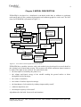
1
i The European Soil Erosion Model (EUROSEM): documentation and user guide Morgan, R.P.C., Quinton, J.N., Smith, R.E., Govers, G., Poesen, J.W.A., Auerswald, K., Chisci, G., Torri, D., Styczen, M.E., Folly, A.J.V. Silsoe College Cranfield University Silsoe, Bedford MK45 4DT United Kingdom Version 3.6 July 1998 MORGAN, R.P.C, QUINTON, J.N., SMITH, R.E., GOVERS, G., POESEN, J.W.A., AUERSWALD, K., CHISCI, G., TORRI, D., STYCZEN, M.E., FOLLY, A.J.V. 1998. The European soil erosion model (EUROSEM): documentation and user guide. Silsoe College, Cranfield University. ii Table of contents CHAPTER 1 INTRODUCTION 1 1.1 GENERAL INTRODUCTION 1.2 CONCEPT OF A EUROPEAN SOIL EROSION MODEL 1.2.1 OBJECTIVES 1.2.2 STRATEGIES FOR MODELLING OVER TIME 1.2.3 STRATEGIES FOR MODELLING OVER SPACE 1 2 2 2 3 CHAPTER 2 MODEL DESCRIPTION 4 2.1 GUIDE TO SYMBOLS 2.2 BASIC CONCEPTS OF DYNAMIC SIMULATION MODELS 2.3 RAINFALL INTERCEPTION 2.4 INFILTRATION 2.5 SOIL SURFACE CONDITION 2.6 SURFACE RUNOFF PROCESSES 2.6.1 FLOW ROUTING Interrill Flow Rill Flow Rill geometry 2.7 EROSION PROCESSES 2.7.1 SOIL DETACHMENT BY RAINDROP IMPACT 2.7.2 SOIL DETACHMENT BY RUNOFF 2.7.3 TRANSPORT CAPACITY OF THE FLOW Rill Transport Capacity Interrill Transport Capacity 2.8 CALCULATION OF HILLSLOPE SOIL EROSION 2.8.1 TREATMENT OF RILL FLOW 2.8.2 CHANNEL EROSION 5 6 8 10 13 13 14 15 15 15 17 17 18 19 19 20 20 21 22 CHAPTER 3 DESCRIPTION OF VARIABLES 23 3.1 RAINFALL DATA FILE 3.2 CATCHMENT CHARACTERISTICS FILE 3.2.1 SYSTEM 3.2.2 OPTIONS 3.2.3 COMPUTATION ORDER 3.2.4 ELEMENT-WISE INFO 23 24 24 25 25 25 CHAPTER 4 USING EUROSEM 35 4.1 GETTING STARTED 4.2 SYSTEM REQUIREMENTS 4.3 INSTALLATION 4.4 FILE CHARACTERISTICS 4.4.1 RAINFALL DATA FILE 35 35 35 40 40 MORGAN, R.P.C, QUINTON, J.N., SMITH, R.E., GOVERS, G.,ii POESEN, J.W.A., AUERSWALD, K., CHISCI, G., TORRI, D., STYCZEN, M.E., FOLLY, A.J.V. 1998. The European soil erosion model (EUROSEM): documentation and user guide. Silsoe College, Cranfield University. iii 4.4.2 CATCHMENT CHARACTERISTICS FILE 4.4.3 OUTPUT FILES 4.5 RUNNING EUROSEM 43 58 65 CHAPTER 5 SIMULATION TECHNIQUES 70 5.1 HOW TO SIMULATE…. 5.1.1 HOW TO SIMULATE DIFFERENT SOIL TYPES 5.1.2 HOW TO SIMULATE THE EFFECT OF PLANTS 5.2 MODEL CALIBRATION 5.2.1 FIELD DATA QUALITY ANALYSIS 5.2.2 ORDER OF CALIBRATION 5.2.3 INFILTRATION PARAMETERS 5.2.4 HYDRAULIC ROUGHNESS 5.2.5 EFFECT OF PARAMETERS RECS 5.2.6 COMPARATIVE SENSITIVITY 70 70 72 73 74 76 76 77 78 81 CHAPTER 6 REFERENCES 82 CHAPTER 7 RELEVANT LITERATURE 88 APPENDIX 1 - DETERMINATION OF TIME-DEPTH PAIRS 1 APPENDIX 2 - DETERMINATION OF SLOPE 3 APPENDIX 3 - ESTIMATION OF MANNING'S 'N' 5 APPENDIX 4 - HYDROLOGICAL PROPERTIES OF SOILS 8 APPENDIX 5 - ROCK FRAGMENTS 12 APPENDIX 6 - SURFACE ROUGHNESS 15 APPENDIX 7 - VEGETATION PROPERTIES 17 APPENDIX 8 - RILL (CONCENTRATED FLOW PATH) MEASUREMENTS 23 MORGAN, R.P.C, QUINTON, J.N., SMITH, R.E., GOVERS, G., iii POESEN, J.W.A., AUERSWALD, K., CHISCI, G., TORRI, D., STYCZEN, M.E., FOLLY, A.J.V. 1998. The European soil erosion model (EUROSEM): documentation and user guide. Silsoe College, Cranfield University. iv APPENDIX 9 - SOIL ERODIBILITY 26 APPENDIX 10 - CHANNEL DIMENSIONS 30 MORGAN, R.P.C, QUINTON, J.N., SMITH, R.E., GOVERS, G., iv POESEN, J.W.A., AUERSWALD, K., CHISCI, G., TORRI, D., STYCZEN, M.E., FOLLY, A.J.V. 1998. The European soil erosion model (EUROSEM): documentation and user guide. Silsoe College, Cranfield University. v Forward to the 1998 EUROSEM user guide This EUROSEM user guide replaces the guide produced in 1994 and represents the 3rd edition. The guide is, however rather different in that we have incorporated model documentation and examples of how to set the model up for different land use practices. Since the 1994 user guide was produced EUROSEM’s use has become more widespread. It is certainly no longer just a European model! We know of scientists using the model in many parts of the world, including Australia, Malaysia, Kenya, and Bolivia. The model is also being increasingly applied to catchment scale studies, with studies completed in the Netherlands and Austria, and ongoing projects in Costa Rica, Mexico, Nicaragua and South Africa. We would encourage those of you who are working with the model to let us know of your results. Give us the address of your web site so we can link it to ours or send it some text to include on ours. The version of the model described in this user guide will be the last to run under DOS. We are currently working on a graphical interface for EUROSEM that will enable it to be run from Windows 95 or NT. This will also make the model more user-friendly. Other developments being carried out at present include adding particle size selectivity and a more flexible watershed representation and linkages with GIS software. The European Soil Erosion Model (EUROSEM) is a joint effort of many European scientists. Those who have worked on or assisted with the development of EURSOSEM are: J. Albaladejo Montoro, V. Andreu, K. Auerswald, W. Blum, Boiffin, H.R. Bork, P. J. Botterweg, V. Castillo, J.A. Catt, G. Chisci, B. Diekkrüger, W. Everaert, A.Folly, S. Giakoumakis, G. Govers, B. Hasholt, A.J. Johnston, E. Klaghofer, Y. Le Bissonnais, G. Monnier, R.P.C. Morgan, T. Panini, J.W.A. Poesen, J.N. Quinton, R.J. Rickson, J.L. Rubio, V. Sardo, , R.E. Smith P. Strauss, M.E. Styczen, D. Torri, G. Tsakiris, R. Webster, M. Vauclin and H. Vereeken,. Financial support has been from Directorate General XII of the Commission of the European Communities under the Third Environment Programme (Research Grant EV41*1591) and the STEP Programme (Research Grant PL 900247). Continued support for work on EUROSEM comes from the Commission of the European Communities INCO programme (ERBIC18CT960096) and the Environment and Climate Research Programme (ENV 4-CT97-0697). MORGAN, R.P.C, QUINTON, J.N., SMITH, R.E., GOVERS, G.,v POESEN, J.W.A., AUERSWALD, K., CHISCI, G., TORRI, D., STYCZEN, M.E., FOLLY, A.J.V. 1998. The European soil erosion model (EUROSEM): documentation and user guide. Silsoe College, Cranfield University. 1 Chapter 1 INTRODUCTION 1.1 GENERAL INTRODUCTION The last decade has seen an increasing awareness by scientists, governments and the general public of the problem of soil erosion within the countries of the European Community. Five workshops on the topic have been organised and funded by the Commission of European Communities: at Firenze, 19-21 October 1982 (Prendergast, 1983); Cesena, 9-11 October 1985 (Chisci and Morgan, 1986); Brussels, 2-3 December 1986 (Morgan and Rickson, 1988); Valencia, 7-9 July 1987 (Rubio and Rickson, 1990); and Freising-Weihenstephan, 24-26 May 1988 (Schwertmann, Rickson and Auerswald, 1989). From the information presented at these workshops, it is clear that erosion rates on agricultural land in the hilly areas of the Mediterranean and on sandy, loamy and chalky soils in northern Europe can reach 10-100 t/ha annually. Such rates often cause pollution and sedimentation downstream as well as reducing the depth of soil available for future agricultural production. These rates should be compared with a value of 1 t/ha which is generally considered the maximum allowable for control of pollution and preservation of the soil resource (Evans, 1981). Some form of soil conservation or soil protection policy is clearly needed within Europe (Morgan and Rickson, 1990) in which management decisions are based on physical principles and sound scientific concepts. The development of policies to control erosion is, at present, hindered because there is no satisfactory system in Europe for assessing the risk of erosion, predicting erosion rates under existing conditions or designing and evaluating different soil protection strategies. Methods of erosion assessment based on scoring systems for rainfall erosivity, soil erodibility, slope and land use (Auerswald and Schmidt, 1986; Rubio, 1988; Briggs and Giordano, 1992; Jäger, 1994) provide good information on the spatial distribution of erosion risk but only limited data on erosion rates which cannot be easily validated. Also, they do not produce the information necessary to design soil conservation measures or evaluate their effect. These deficiencies can only be overcome by combining erosion risk assessments with predictions from erosion models. American scientists developed the Universal Soil Loss Equation (USLE) (Wischmeier and Smith, 1978) as a technique for assessing erosion and evaluating the likely effects of different soil conservation practices. Several studies have been carried out to test the applicability of the USLE to European conditions. They show that great care is required in the selection of input values for the rainfall (R) (Chisci and Zanchi, 1981; Richter, 1983) and soil erodibilty (K) (Richter, 1980; De Ploey, 1986; Schwertmann, 1986) factors. Even if the equation could be transferred successfully to Europe, there is considerable doubt as to whether it would provide the information that policy makers need. The design of strategies to control pollution associated with runoff and erosion on agricultural land requires knowledge of what happens in individual rain storms, often on a minute-by-minute basis, in order to predict the size and timing of peak discharges of water and sediment from hillslopes to rivers. The USLE cannot provide this because it predicts only mean annual soil loss. Another weakness of the USLE is that it predicts erosion by multiplying together values of factors expressing rainfall, soil, slope, land cover and conservation practice, whereas, in reality, erosion cannot be represented in this simplistic way (Kirkby, 1980). In order to provide a better representation of erosion processes, American scientists have concentrated in recent years on developing more physically-based erosion models such as those used in MORGAN, R.P.C, QUINTON, J.N., SMITH, R.E., GOVERS, G., POESEN, J.W.A., AUERSWALD, K., CHISCI, G., TORRI, D., STYCZEN, M.E., FOLLY, A.J.V. 1998. The European soil erosion model (EUROSEM): documentation and user guide. Silsoe College, Cranfield University. 2 CREAMS (Knisel, 1980; Foster et al, 1981); ANSWERS (Beasley, Huggins and Monke, 1980) and WEPP (Nearing et al, 1989). Similar models are also being developed in Australia (Rose et al, 1983; Misra and Rose, 1992). Soil erosion modelling was discussed at the European Community Workshop held in Brussels, 1986, when Chisci and Morgan (1988) proposed a framework for a European model to be based on the best European research into erosion processes and their control. One of the recommendations of the Workshop was that European scientists should "try to develop a new general erosion model for use in the EC countries for erosion risk evaluation and the design of erosion control measures" (Chisci, 1988). At the end of the meeting, twelve of the attending scientists came together for an informal discussion and agreed to form a group dedicated to the development of such a model. The group obtained funding for the work from Directorate General XII of the Commission of European Communities, first, under the Fourth Environmental Programme (1986-1990) and, subsequently, under the STEP Programme (1989-1992). To date, the work has involved more than 40 scientists from ten European Community countries, two other European countries and collaboration with the USDA Agricultural Engineering Research Service, Fort Collins, Colorado, USA. This document describes the resulting model, known as the European Soil Erosion Model or EUROSEM and provides a guide to using the model. 1.2 CONCEPT OF A EUROPEAN SOIL EROSION MODEL 1.2.1 Objectives Given the above background, the following objectives were set for a European soil erosion model (Chisci and Morgan, 1988). It should (1) enable the risk of erosion to be assessed; (2) be applicable to fields and small catchments; (3) operate on an event basis; and (4) be useful as a tool for selecting soil protection measures. In order to meet these requirements, a strategy was needed for modelling erosion in time and space. 1.2.2 Strategies for modelling over time Since soil erosion by water is closely related to rainfall and runoff, erosion modelling cannot be separated from the procedures used to model the generation of runoff and its routing down a hillside and through the river channel network. American models such as CREAMS and WEPP are based on a continuous simulation approach in which changing soil moisture conditions are modelled from daily calculations of the soil water balance. In this way, the conditions at the start of each rainstorm are predicted. The problems with continuous simulation models are that they require a large amount of input data on changing climatic and land use conditions over a year, they are highly sensitive to the modelling of evapotranspiration and dynamic properties of the soils and they yield predictions for a large number of events that produce only small amounts of runoff and soil loss. Since measurements of soil erosion on hillside plots and in small watersheds in Europe show that most erosion takes place in two or three storms each year (Sfalanga and Franchi, 1978; MORGAN, R.P.C, QUINTON, J.N., SMITH, R.E., GOVERS, G.,2 POESEN, J.W.A., AUERSWALD, K., CHISCI, G., TORRI, D., STYCZEN, M.E., FOLLY, A.J.V. 1998. The European soil erosion model (EUROSEM): documentation and user guide. Silsoe College, Cranfield University. 3 Boschi and Chisci, 1978; Richter, 1979; Raglione, Sfalanga and Torri, 1980; Boschi, Chisci and Ghelfi, 1984; Tropeano, 1984; Chisci, Boschi and Ghelfi, 1985), it was considered more important to develop a model which could be applied to these events. This approach requires the starting conditions for each storm to be specified as data inputs. Although both CREAMS and WEPP can be run for individual storms, they simulate only total storm soil loss, and assume a steady flow profile along the surface. They do not model peak sediment discharge or treat the pattern of events within a storm, or provide a sediment graph showing the pattern of sediment discharge over time, information which is useful for looking at potential pollution loadings from sediment fluxes into water courses. Especially for catchments where one or two events define most of the annual soil loss, steady flow is rarely achieved, and the WEPP methodology will be inappropriate. Given the significance of the offsite effects of erosion within Europe, it was decided that within-storm modelling of erosion for selected storms was a more important objective than the between-storm modelling required for continuous simulation. Within-storm modelling is also more compatible with the equations used in process-based models to describe the mechanics of erosion. These equations are strictly applicable to instantaneous conditions and they cannot be applied to average conditions without loss of accuracy. Applying them to conditions averaged over one minute is thus more acceptable than using them for conditions averaged over one hour or more. 1.2.3 Strategies for modelling over space Many of the factors that influence erosion, particularly soil, slope and land use, have considerable spatial variability and cannot be described by a single average value, even over areas as small as one field. Lumped models, which treat an area as a single unit of uniform characteristics, are not appropriate. If this spatial variability is to be taken into account, a distributed model must be used. In such a model, an area is divided into sub-units, each having uniform characteristics of slope, soil and land cover. These sub-units are then arranged in sequence to form a cascade through which water and sediment movement can be routed from top to bottom of the hillsides and from upstream to downstream along the river channels. Such a distributed approach is adopted for EUROSEM, based on the KINEROS model structure (Woolhiser, et al., 1990). MORGAN, R.P.C, QUINTON, J.N., SMITH, R.E., GOVERS, G.,3 POESEN, J.W.A., AUERSWALD, K., CHISCI, G., TORRI, D., STYCZEN, M.E., FOLLY, A.J.V. 1998. The European soil erosion model (EUROSEM): documentation and user guide. Silsoe College, Cranfield University. 4 Chapter 2 MODEL DESCRIPTION EUROSEM is developed as a distributed event-based model that, in addition to predicting total runoff and soil loss, produces hydrographs and sediment graphs for each event. The flow chart for EUROSEM is presented in Figure 2.1. Soil surface conditions Rainfall Interception Vegetation Storage Surface depression storage Throughfall Leaf Drainage Detachment by raindrop impact Stemflow Net Rainfall Surface water depth Infiltration Hortonian overland flow Flow transport capacity Detachment by flow Sediment transport/ deposition Total detachment Figure 2.1. Flow chart of the European Soil Erosion Model EUROSEM has a modular structure with each module being developed in as much detail as the existing level of knowledge permits. This structure will enable continuous improvements to be made in the light of new research. The model deals with: • the interception of rainfall by the plant cover; • the volume and kinetic energy of the rainfall reaching the ground surface as direct throughfall and leaf drainage; • the volume of stemflow; • the volume of surface depression storage; • the detachment of soil particles by raindrop impact and by runoff; • sediment deposition; and • the transport capacity of the runoff. Algorithms also deal with frozen soils and stoniness. MORGAN, R.P.C, QUINTON, J.N., SMITH, R.E., GOVERS, G.,4 POESEN, J.W.A., AUERSWALD, K., CHISCI, G., TORRI, D., STYCZEN, M.E., FOLLY, A.J.V. 1998. The European soil erosion model (EUROSEM): documentation and user guide. Silsoe College, Cranfield University. 5 2.1 GUIDE TO SYMBOLS A a B b cross-sectional area of flow coefficient in flow rating equation saturation deficit of the soil exponent in relationship between soil detachment rate and depth of surface water layer BW bottom width of channel C sediment concentration c coefficient in relationship between transport capacity of flow and unit stream power COH cohesion of the soil at saturation as measured with a torvane COV percentage vegetation cover D depth between average height of an interrill surface and the base of an adjacent rill D50 median particle diameter of the soil DEPNO number of depressions along transect of roughness measurement DET rate of soil particle detachment by raindrop impact DETpave rate of soil particle detachment by raindrop impact allowing for nonerodible (paved) surfaces DF net rate of soil particle detachment by flow DS depth of surface depression storage DT direct throughfall depth Eq erosive ability of flow e net rate of erosion of the soil bed per unit length F rainfall depth infiltrated by the soil f infiltration rate fc maximum rate of infiltration G effective net capillary drive h depth of surface water IC depth of rainfall intercepted by the vegetation ICmax maximum depth of interception storage ICstore depth of interception storage j exponent in equation describing the profile of a rill side wall and adjacent interrill area k soil detachability per unit of rainfall energy Ks saturated hydraulic conductivity Ksroc saturated hydraulic conductivity allowing for rock fragments in the soil Ksveg saturated hydraulic conductivity allowing for effects of vegetation cover KE kinetic energy of rainfall LD depth of leaf drainage m exponent in flow rating equation n Manning‘s roughness coefficient NR net rainfall depth at the ground surface P wetted perimeter PA average acute angle of plant stems to ground surface PAVE proportion of the surface area occupied by non-erodible (paved) surfaces PBASE proportion of the surface area occupied by basal area of the plant stems MORGAN, R.P.C, QUINTON, J.N., SMITH, R.E., GOVERS, G.,5 POESEN, J.W.A., AUERSWALD, K., CHISCI, G., TORRI, D., STYCZEN, M.E., FOLLY, A.J.V. 1998. The European soil erosion model (EUROSEM): documentation and user guide. Silsoe College, Cranfield University. 6 PH Q q qc qs R Rcum Ri r RD RECS ROC RR S Si Smax SF Su Sucrit TC t tp TIF u ugcrit ugmin vs w wir x z β η φ ψ effective height of the plant canopy discharge rate of lateral inflow of discharge per unit length rate of lateral inflow of discharge per unit length of channel rate of lateral sediment inflow per unit length rainfall depth cumulative rainfall depth during the storm rainfall rate or rainfall intensity hydraulic radius rill depth infiltration recession factor proportion of the soil by volume occupied by rock fragments roughness ratio slope initial value of relative saturation of the soil maximum relative saturation of the soil depth of stemflow unit stream power critical value of unit stream power sediment concentration of flow at transport capacity time time to ponding depth of temporarily intercepted throughfall flow velocity value of critical grain shear velocity of flow for rill initiation minimum value of critical grain shear velocity necessary to detach soil particle by flow settling velocity of soil particles in the flow flow width width between centre line of a rill and centre line of the interrill area distance value of z when the side slope of a rill is expressed as a gradient, i.e. 1:z efficiency coefficient for detachment of soil particles by flow exponent in relationship between transport capacity of flow and unit stream power soil porosity soil matric potential 2.2 BASIC CONCEPTS OF DYNAMIC SIMULATION MODELS The model computes soil loss as a sediment discharge, defined as the product of the rate of runoff (m3 s-1) and the sediment concentration in the flow (m3 m-3), to give a volume (or mass) of sediment passing a given point in a given time. The computation is based on the dynamic mass balance equation (Bennett, 1974; Kirkby, 1980; Woolhiser, Smith and Goodrich, 1990): MORGAN, R.P.C, QUINTON, J.N., SMITH, R.E., GOVERS, G.,6 POESEN, J.W.A., AUERSWALD, K., CHISCI, G., TORRI, D., STYCZEN, M.E., FOLLY, A.J.V. 1998. The European soil erosion model (EUROSEM): documentation and user guide. Silsoe College, Cranfield University. 7 ∂ ( AC) ∂ (QC ) ∂t + ∂x − e ( x, t ) = q s ( x, t ) (1) in which C = sediment concentration (m3 m-3), A = cross sectional area of the flow (m2), Q = discharge (m3 s-1), qs = external input or extraction of sediment per unit length of flow (m3 s-1 cm-1), e = net detachment rate or rate of erosion of the bed per unit length of flow (m3 s-1 cm-1), x = horizontal distance, and t = time. This equation is illustrated in Figure 2.2 with respect to channel flow where qs represents lateral inflows of sediment from the base of adjacent hillsides. When applied to overland flow over hillslopes, qs becomes zero. q qs water surface A +δ A A Q e Q +δ Q flow depth soil surface δx Figure 2.2. Representation of the mass balance equation for erosion (equation 1) The term, e, in equation (1) is defined by two major components: e = DET + DF where (2) DET = the rate of soil particle detachment by raindrop impact, and DF = the balance between the rate of soil particle detachment by the flow and the particle deposition rate. Since EUROSEM is an erosion model, it must be attached to a hydrological model from which values of surface runoff Q(x,t) and A(x,t) can be generated. These are obtained by numerical solution of the dynamic mass balance equation for water, analogous to Eq. (1): MORGAN, R.P.C, QUINTON, J.N., SMITH, R.E., GOVERS, G.,7 POESEN, J.W.A., AUERSWALD, K., CHISCI, G., TORRI, D., STYCZEN, M.E., FOLLY, A.J.V. 1998. The European soil erosion model (EUROSEM): documentation and user guide. Silsoe College, Cranfield University. 8 ∂A ∂ Q + = r( t ) − f ( t ) ∂t ∂ x (3) where r(t) is the rainfall rate less the interception f(t) is the local infiltration rate. EUROSEM is linked to the KINEROS model (Woolhiser, Smith and Goodrich, 1990) which is an event-oriented, physically-based distributed model that numerically solves Eq. (3) using a kinematic wave assumption for a fixed relation Q(A) (Woolhiser and Liggett, 1967; Woolhiser, 1969). It has also been linked with the MIKE SHE model (Danish Hydraulic Institute, 1993) which is a continuous simulation model and an extension of the original Systéme Hydrologigue Européen (SHE) model (Danish Hydraulic Institute, 1985; Abbott et al., 1986). KINEROS generates runoff as infiltration-excess using the infiltration model of Smith and Parlange (1978) . The combined EUROSEM-KINEROS model simulates soil erosion by raindrop impact and infiltration-excess overland flow at a field and small catchment scale on a minute-by-minute basis. It does not simulate saturation excess runoff from perched aquifers, which is inherently a longer term process. The catchment modelling approach, based on KINEROS, is to take a small watershed and, using information on slope, soils and land cover, divide it into a series of units or elements which are, more or less, homogeneous. These units can be planes, representing sub-divisions of the hillslopes, or channels, representing separate channel segments. The units are then linked as a series of cascading planes and channels. For numerical solution, each unit is also divided into a series of computational nodes. The model then calculates the amount of runoff and sediment produced at each node in each time step and routes them over the land surface of each unit and then from one unit to another over the cascade and through the channel network to the catchment outlet. An example of how to represent a catchment in this way is contained in chapter 4. The various components of the model are now described in turn, beginning with the rainfall input. 2.3 RAINFALL INTERCEPTION Rainfall input to the model is in the form of a depth R(mm) for each time step during a storm. From this input, rainfall intensity Ri (mm hr-1) and rainfall volume (m3) (i.e. depth x area) are calculated. Account is also kept of the cumulative rainfall (m) received during the storm. On reaching the canopy of the vegetation, the rainfall is divided into two parts. These are that reaching the soil surface as direct throughfall (DT), falling either on open ground or passing through gaps in the canopy, and that which strikes the vegetation cover. The division is based on the simple relationship: IC = R * COV where IC (4) = the depth of rainfall intercepted by the vegetation, and COV = the percentage cover of the vegetation. An initial proportion of the intercepted rainfall is stored on the leaves and branches of the vegetation. This is termed the interception store. The rainfall held in this store does not reach the soil surface and therefore is unavailable for infiltration or runoff. In many erosion models, MORGAN, R.P.C, QUINTON, J.N., SMITH, R.E., GOVERS, G.,8 POESEN, J.W.A., AUERSWALD, K., CHISCI, G., TORRI, D., STYCZEN, M.E., FOLLY, A.J.V. 1998. The European soil erosion model (EUROSEM): documentation and user guide. Silsoe College, Cranfield University. 9 this interception store is either ignored, as in CREAMS, or is considered as a depth which has to be filled before rain is allowed to pass from the vegetation canopy to the ground, as in KINEROS. This last approach means that no rain reaches the soil surface from the canopy until the interception store is full. EUROSEM adopts a more dynamic approach which allows rainfall to pass from the canopy to the ground at the same time as the interception store is being filled. This means that some transfer of water from the canopy will take place right from the start of the storm. The volume of the interception store (ICstore) for a time step (t) is modelled as a function of the cumulative rainfall (Rcum) from the start of the storm, using the exponential relationship proposed by Merriam (1973): ICstore = ICmax [1 − exp( Rcum / ICmax )] (5) where ICmax = the maximum volume of the interception store for the given crop or vegetation cover. This approach is shown diagrammatically in Figure 2.3. Figure 2.3. Representation of rainfall interception pattern by plant canopy. (a) interception store must be filled before rain is allowed to reach ground surface; (b) in EUROSEM, rainfall reaches the ground while the interception store fills exponentially. Values of ICmax depend upon the plant species, which affects the size, shape and roughness of the leaves, as well as on the plant density, the growth stage of the vegetation and the wind velocity. The rainfall which is intercepted by the canopy and not held in the interception store becomes temporarily intercepted throughfall (TIF) and reaches the ground surface as either stemflow (SF) or leaf drainage (LD). The volume of stemflow (m3) is modelled as a function of the average acute angle (PA; degrees) of the plant stems to the ground surface, using equations developed in laboratory experiments by van Elewijck (1989a; 1989b). These equations have been modified by assuming that a maximum of half the volume of temporarily intercepted throughfall is available for stemflow, to give: SF = 0.5 TIF (cos PA . sin2 PA) (6) for grasses, and SF = 0.5 TIF .cos (PA) (7) MORGAN, R.P.C, QUINTON, J.N., SMITH, R.E., GOVERS, G.,9 POESEN, J.W.A., AUERSWALD, K., CHISCI, G., TORRI, D., STYCZEN, M.E., FOLLY, A.J.V. 1998. The European soil erosion model (EUROSEM): documentation and user guide. Silsoe College, Cranfield University. 10 for other plant species. Conceptually, equations (6) and (7) describe the relationship between the diameter of the catching surface (stems and leaves) and the median volume drop diameter of the raindrops. Where, as with grasses, the mean diameter of the catching surface is less than the drop diameter, gravity, expressed by sin PA, plays an important role in determining the volume of stemflow. With thicker catching surfaces, stemflow volume depends only on the projected length of the stems or leaves, as expressed by cos (PA). The difference between the volume of the temporarily intercepted throughfall and the volume of stemflow comprises leaf drainage, i.e. that component of the rainfall which reaches the soil surface as individual drips from the leaves. The net rainfall at the ground surface (NR), which is therefore available for infiltration, is the summation of the direct throughfall, stemflow and leaf drainage. These relationships are summarised as follows: LD = TIF - SF (8) NR = DT + LD + SF = R - Icstor (9) 2.4 INFILTRATION Infiltration is accounted for in the KINEROS part of the model. A detailed description can be found in Woolhiser, Smith and Goodrich (1990), so only a brief account of the procedure is given here. The infiltration equation used (Smith and Parlange, 1978) is: fc = Ks exp( F / B ) exp( F / B ) − 1 (10) where fc = the maximum rate at which water can enter the soil, which is known as the infiltration capacity (cm min-1), Ks = the saturated hydraulic conductivity of the soil (cm min-1), F = the amount of rain already absorbed by the soil (cm), and B = an integral capillary and water deficit parameter of the soil. The term B is obtained from: B = G (θs - θi) where G (11) = the effective net capillary drive, θs = the maximum value of water content of the soil, and θi = the initial value of soil water content (cm3 cm-3). The term G is a conductivity-weighted integral of the capillary head of the soil, defined as: 1 G= Ks in which ψ 0 ∫ K (ψ )dψ (12) −∞ = the soil matric potential (-), and K(ψ) = a hydraulic conductivity function. MORGAN, R.P.C, QUINTON, J.N., SMITH, R.E., GOVERS, G., 10POESEN, J.W.A., AUERSWALD, K., CHISCI, G., TORRI, D., STYCZEN, M.E., FOLLY, A.J.V. 1998. The European soil erosion model (EUROSEM): documentation and user guide. Silsoe College, Cranfield University. 11 G is essentially a property of the soil with units of length and is conceptually equivalent to a value of effective capillary head. Typical values for G, Ks and θs are given in appendix 4 for a range of soil types. KINEROS models infiltration through a single soil layer. The process comprises three stages. Initially, infiltration is limited by the rainfall intensity and F is accumulated at the rainfall rate; in this stage, the infiltration rate (f) at time t equals the rainfall rate (r), i.e. f(t) = ri(t) (13) From the time that infiltration capacity is reached which is equivalent to the time of ponding, equation (10) determines the infiltration rate, so that: f(t) = fc (14) The relationships for the first two stages are illustrated in Figure 2.4. The third stage begins when the rain ceases or the rainfall intensity falls below the infiltration capacity. Infiltration is then modelled as fc times the proportion of the soil surface covered by (flowing) water. This is achieved through the use of the parameter, RECS, which describes the roughness of the soil surface and represents, conceptually, the local maximum average depth of flow (h) when the surface is just completely covered by water. A high value of RECS represents a rough surface, such as one recently ploughed with a mouldboard, and a low value represents a smooth surface, such as a recently-prepared seed bed. The procedure assumes that the proportion of the soil surface covered by flowing water decreases in direct proportion to the decline in mean flow depth below RECS: f ( t ) = f ( t −1 ) h RECS (15) in which h is the mean flow depth (cm). Where Ks is based on measurements made in the field with an infiltrometer, its value will take account of the effects of rock fragments or stones within the soil profile and the effect of any crop or vegetation cover on the surface. Where this is not the case, the values for bare soil Ks are modified within the model. Rock fragments effect infiltration in two ways. The first is that they reduces the effective overall storage in porosity (θs - θi). The KINEROS model modifies the parameter B in equation (10) to account for the presence of rock fragments (ROC) using the relationship (Woolhiser, Smith and Goodrich, 1990): Broc = B (1.-ROC) where Broc = the parameter B modified for rock fragments, and (16) ROC = the fraction of the soil composed of rock fragments, expressed as a volume between 0 and 1. The second way in which rock fragments effect infiltration into soils is through their position on the surface of the soil (Poesen and Ingelmo-Sanchez, 1992; Poesen et al., 1994). Those rocks which are embedded into a surface seal (i.e. a top layer with pore spaces due to the packing of primary particles) will reduce infiltration. Those which sit on the surface will protect surface structure, and promote infiltration. EUROSEM models the first case using the equation: Ksroc = Ks (1-PAVE) (17) and the second using the equation: MORGAN, R.P.C, QUINTON, J.N., SMITH, R.E., GOVERS, G., 11POESEN, J.W.A., AUERSWALD, K., CHISCI, G., TORRI, D., STYCZEN, M.E., FOLLY, A.J.V. 1998. The European soil erosion model (EUROSEM): documentation and user guide. Silsoe College, Cranfield University. 12 Ksroc = Ks (1+PAVE) (18) where Ksroc = a modified value of saturated hydraulic conductivity (cm/min), and PAVE = aerial rock fragment cover. Figure 2.4. Representation of the infiltration model (equation 9) used in KINEROS and EUROSEM. The infiltration rate (f) equals the rainfall rate (r) until ponding occurs (Fp). After ponding, the infiltration rate is controlled by the infiltration curve and is asymptotic to a final rate which is equal to the effective saturated hydraulic conductivity. The infiltration capacity of a given soil is affected by the type and density of the vegetation cover, as demonstrated by the numerous studies reviewed by Dunne (1978) and Faulkner (1990). The effect is not dealt with explicitly within KINEROS and the research base for modelling it is rather sparse. Thornes (1990) proposes that infiltration capacity increases exponentially with increasing percentage vegetation cover as a function of increases in organic matter and decreases in the bulk density of the soil. Such a relationship is similar to that developed by Holtan (1961) to express the saturated hydraulic conductivity of the soil as a function of the percentage basal area of the vegetation. Based on his work, the following equation is used in EUROSEM to modify the saturated hydraulic conductivity value of the soil: Ksveg = K s 1 1 − PBASE (19) where Ksveg is the saturated hydraulic conductivity of the soil with the vegetation, Ks is the saturated hydraulic conductivity of the bare soil, and PBASE is the total area of the base of the plant stems expressed as a proportion (between 0 and 1) of the total area of the plane. MORGAN, R.P.C, QUINTON, J.N., SMITH, R.E., GOVERS, G., 12POESEN, J.W.A., AUERSWALD, K., CHISCI, G., TORRI, D., STYCZEN, M.E., FOLLY, A.J.V. 1998. The European soil erosion model (EUROSEM): documentation and user guide. Silsoe College, Cranfield University. 13 2.5 SOIL SURFACE CONDITION The roughness of the soil surface, including roughness brought about by tillage, affects runoff and erosion, and determines the volume of water that can be held on the surface as depression storage. The basis for modelling depression storage is extremely limited with only a few studies available to quantify the depths of water likely to be involved (e.g. Reid, 1979; Evans, 1980). Depression storage is not modelled in KINEROS and is ignored in most hydrological models. However, it is included in EUROSEM where it can be used to describe one of the effects of tillage. Boiffin (1984) categorises four grades of surface roughness (0 - 1.2 cm; 1.2 - 2.0 cm; 2.0 - 3.0 cm; and > 3 cm micro-relief) in relation to tillage practices on loamy soils. This is part of a classification of the state of the soil surface for predicting the likelihood of erosion (Boiffin, Papy and Monnier, 1988; Auzet et al., 1990). These values cannot be used directly as indicators of depression storage, however, because the shallower depressions on any surface will fill, overflow and produce interconnecting runoff paths whilst the deeper depressions are still filling. Thus only a proportion of the depression depth constitutes effective depression storage. Few studies exist as a basis for estimating what that proportion might be. The roughness of the soil surface is expressed in EUROSEM by a roughness measure (RFR) defined with respect to the ratio of the straight line distance between two points on the ground (X) to the actual distance measured over all the microtopographic irregularities (Y): RFR = Y−X * 100. Y (20) This is illustrated in figure 2.5 and the procedure for measurement is described in Appendix 6. This mean height is converted into a surface storage depth, D, using a regression equation from Auerswald (1992): D = exp( − 6.66 + 0.27 * RFR) (21) X Y Figure 2.5. Illustration of the parameterisation of surface roughness in EUROSEM. 2.6 SURFACE RUNOFF PROCESSES The basis for describing flow velocity within an erosion model is rather limited. Savat (1980) proposes algorithms for obtaining best estimates of mean velocity for four different flow conditions: smooth laminar, rough laminar, smooth turbulent and rough turbulent. The KINEROS model also allows transition between early laminar flow and turbulent flow at larger discharges. However, because of the disturbance by raindrops and the difficulty in experimentally detecting the early laminar flow regime, EUROSEM uses equations for turbulent flow only. This is the type of flow most likely to occur in the storms for which EUROSEM is designed. The mean velocity of this type of flow without sediment is described by the Manning equation as indicated below. Several studies (Emmett, 1970; Pearce, 1976; Morgan, 1980) indicate that values of Manning‘s n for overland flow are about an order of MORGAN, R.P.C, QUINTON, J.N., SMITH, R.E., GOVERS, G., 13POESEN, J.W.A., AUERSWALD, K., CHISCI, G., TORRI, D., STYCZEN, M.E., FOLLY, A.J.V. 1998. The European soil erosion model (EUROSEM): documentation and user guide. Silsoe College, Cranfield University. 14 magnitude higher than those pertaining to channel flows because most of the vegetation and rock fragments project rigidly above the flow. Although the boundary resistance is similar to that observed in open channel flow, the form resistance is much higher (Thornes, 1980). This should result in increasing flow depth and decreasing velocity. Sometimes this can be offset, however, by surges in velocity between the roughness elements and vortex erosion upslope and downslope of the elements (Babaji, 1987) which may, in turn, increase erosion (De Ploey, Savat and Moeyersons, 1976). If sediment in the flow also increases the velocity (Govers, 1989; 1990), actual flow velocity will be determined by the relative balance between this velocity increase and the retarding effects of roughness. It is not possible from present knowledge to model this balance. Considering all the above points, it would seem that the best estimate of flow velocity is obtained using normally accepted values of Manning‘s n, i.e. without any increase in value for shallow overland flow. If this leads to an overestimation of velocity for clear flow, it may, at the same time, allow for likely increases in velocity due to surges and the presence of sediment in the flow. The Manning equation is therefore used in EUROSEM to calculate flow velocity for shallow overland flow. Tables for estimating Manning n values are found in appendix 3. Use of Manning's equation for channel flow is perhaps less controversial because of its wide use by engineers. Also, the sediment concentrations are much lower than in overland flow so their effect on velocity will be much less. Alternatives would be to use equations involving the Chezy or Darcy-Weisbach friction coefficients but values of these for a range of soil, microtopographic and vegetation conditions are not so readily available as values of Manning‘s n. A model based on these alternatives would therefore suffer from a lack of suitable input data. 2.6.1 Flow Routing When the net rainfall intensity at the ground surface exceeds the infiltration rate and surface depression storage is satisfied, the excess comprises surface runoff. In the KINEROS model, runoff along a slope for a plane element, a rill, or a channel is viewed as a one-dimensional surface flux in which discharge (Q) is related to the hydraulic radius (r). Hydraulic radius is defined as the area A divided by the wetted perimeter, p. The rating equation is based on the normal flow equation, which in general may be written: u = α r m−1 (22) where, based on the Manning equation for flow velocity, r = hydraulic radius, α = (s)0.5/n, n = Manning roughness value, and m = 5/3. In terms of discharge Q, with Q = uA, the general rating equation can be written Q = uA = α pr m (23) This equation is combined with the continuity equation (3) to give: p∂ r α p m−1 ∂ r + ρ = q ( x ,t ) ∂t m ∂x (24) MORGAN, R.P.C, QUINTON, J.N., SMITH, R.E., GOVERS, G., 14POESEN, J.W.A., AUERSWALD, K., CHISCI, G., TORRI, D., STYCZEN, M.E., FOLLY, A.J.V. 1998. The European soil erosion model (EUROSEM): documentation and user guide. Silsoe College, Cranfield University. 15 Interrill Flow For shallow flow surface flow, a unit width is used for computations, so p = 1 and r = depth h, so that the discharge rating Eq. (23) becomes Q = α hm (25) In this case Eq. (24) becomes, for a unit width (p = 1): ∂ h α m−1 ∂ h + h = q( x , t ) ∂t m ∂x (26) where for interrill areas, q = Ri - f is the lateral inflow rate, or "rainfall excess." In KINEROS, the kinematic wave equations (23) or (26) are solved numerically for a finite difference grid by a four-point implicit method using the Newton-Raphson technique (Pearson, 1983; Woolhiser, Smith and Goodrich, 1990). The upslope boundary condition for the depth of flow (h) at x = 0 and t = 0 is either 0 or is equal to the depth of runoff from an upslope contributing plane. Rill Flow A similar procedure is adopted for routing flow in rills or channels, where the relevant rating equation is Eq. (24). The term q(x,t) in Eq. (24) becomes the unit discharge into the rills from interrill contributions. There are 3 cases for the surface topography of a surface element: a. The surface may contain no rills, but have some surface irregularities. b. The surface may be rilled, with interrill flows routed toward the rills as described by Eq. (26) c. The surface may be furrowed, or have very dense rills, such that interrill routing is illogical due to the short distance traversed by interrill flows. For case (a), interrill flow is assumed over the entire element, and the flow direction is directly down the plane. Interrill splash and transport relations are used. Figure 2.6 illustrates the abstracted geometry used to describe a rilled surface [option (b), above]. Flow must slope toward the rills, and for any element their spacing is assumed to be uniform. Interrill slope is taken as the vector sum of the slope along the rills and the slope of the surface in a direction normal to the rills. When distance of interrill flow is less than 1 m, interrill routing is abandoned, and rain flow transport concentrations are used for interrill sediment concentrations. Runoff is not routed, but rill input rate q is taken as the rainfall excess rate times the interrill flow distance. The reader is referred to the KINEROS manual (Woolhiser, Smith and Goodrich, 1990) for further details of the surface flow equations. Rill geometry Figure 2.7 is a general definition equation for the geometry of a rill. The rill is essentially a trapezoid, with side walls having slopes of 0 (vertical) or greater. The interrill area must have a slope toward the rill. For the furrow case, the rill spacing is equal to furrow spacing, and the general furrow depth and sideslope may be specified. MORGAN, R.P.C, QUINTON, J.N., SMITH, R.E., GOVERS, G., 15POESEN, J.W.A., AUERSWALD, K., CHISCI, G., TORRI, D., STYCZEN, M.E., FOLLY, A.J.V. 1998. The European soil erosion model (EUROSEM): documentation and user guide. Silsoe College, Cranfield University. 16 Figure 2.6. Geometric abstraction for flow on a rilled surface element. W L w r W d When furrows are overtopped, the flow in the rill area and the overflow area are treated as having equal water elevation, but different velocities owing to the different hydraulic radii of the rill and the overbank areas. Figure 2.7. Representation of the hydraulic geometry in the rill profile : wir = the width between the centre line of the rill and the centre line of the interrill area, d = the depth between the base of the rill and the average height of the interrill surface, z = the side slope of the rill, expressed as the ratio of horizontal to vertical component MORGAN, R.P.C, QUINTON, J.N., SMITH, R.E., GOVERS, G., 16POESEN, J.W.A., AUERSWALD, K., CHISCI, G., TORRI, D., STYCZEN, M.E., FOLLY, A.J.V. 1998. The European soil erosion model (EUROSEM): documentation and user guide. Silsoe College, Cranfield University. 17 2.7 EROSION PROCESSES 2.7.1 Soil detachment by raindrop impact Soil detachment by raindrop impact is considered for both direct throughfall and leaf drainage. In the present version of EUROSEM, soil detachment is related to the kinetic energy of the rain. If this proves unsatisfactory, trials will be conducted to see whether relating detachment to the sum of the squared momentum of each raindrop, as proposed by Styczen and HøghSchmidt (1988), gives better results. The rainfall energy reaching the ground surface as direct throughfall (KE(DT); J m-2 mm-1) is assumed to be the same as that of the natural rainfall. It is estimated as a function of rainfall intensity (Ri , mm hr-1) from the equation derived by Brandt (1989), assuming that the raindrop size distribution follows that described by Marshall and Palmer (1948): KE(DT) = 8.95 + (8.44 log r) (27) The energy of the leaf drainage (KE(LD); J m-2 mm-1) is estimated from the following relationship developed experimentally by Brandt (1990): KE(LD) = (15.8 . PH0.5) - 5.87 (28) where PH = the effective height of the plant canopy (m). This relationship is considered valid because the drop-size distribution of leaf drainage has been shown to have a consistent median drop diameter of about 4.8 mm, regardless of the type of plant (Brandt, 1989), which means that the mass of a unit of leaf drainage can be taken as constant. Variations in the energy of leaf drainage are therefore a function of the impact velocity of the raindrops which depends on the height of fall. The model sets the kinetic energy of leaf drainage to zero when the canopy height is less than 14 cm to avoid the negative values predicted by equation (28). The total kinetic energy of the rainfall can be calculated by multiplying the energies obtained from equations (27) and (28) by the respective depths of direct throughfall and leaf drainage received and summing the two values. This calculation is made in EUROSEM for every increment of the rainstorm. Soil detachment by raindrop impact (DET; g m-2) is calculated from the equation: DET = k (KE) e-bh where (29) an index of the detachability of the soil (g J-1), KE = total kinetic energy of the rain (J m-2), b = an exponent, and h = the depth of the surface water layer (mm). k = the Soil detachability depends on soil texture. Values for the detachability index, k, are given in appendix 9. They are taken from graphs and tables presented by Poesen (1985), Govers (1991) and Everaert (1992), and corrected according to the procedure proposed by Poesen and Torri (1988) to allow for differences in the size of the measuring plots used by the various researchers. Although Torri, Sfalanga and Del Sette (1987) show that the value of the exponent, b, depends on soil texture, insufficient experimental work is available to define the relationship over a wide range of soils. A working value of 2.0 is therefore proposed as representative of a range of values between 0.9 and 3.1. The relationship assumes that soil detachment by MORGAN, R.P.C, QUINTON, J.N., SMITH, R.E., GOVERS, G., 17POESEN, J.W.A., AUERSWALD, K., CHISCI, G., TORRI, D., STYCZEN, M.E., FOLLY, A.J.V. 1998. The European soil erosion model (EUROSEM): documentation and user guide. Silsoe College, Cranfield University. 18 raindrop impact decreases exponentially as the water depth increases. This occurs because the raindrop energy is absorbed by the water surface instead of the soil and because the water layer resists the development of lateral water jets set up within the splash crater. Where non-erodible surfaces, such as rock outcrops, desert pavements, concrete and tarmac, occur within the element, the detachment rate is modified by: DETpav = DET (1 - PAVE) where (30) DETpav = the detachment rate allowing for the non-erodible surfaces, and PAVE = the proportion (between 0 and 1) of the element covered by non-erodible surfaces Initial Condition for Sediment Concentration Even before runoff commences, surface soil is being disturbed by the energy of raindrops, so that there are soil particles in the very first runoff water. Moreover, even if the flow is below the threshold of transporting capacity, rainsplash can cause a concentration to remain in the flowing water, as discussed below. Since during a rainstorm, splash erosion will already be taking place when runoff begins, the initial sediment concentration in the runoff cannot be taken as zero. Based on an analysis of Eq (1) at the time of ponding (tp) or x=0 and A=0, the sediment concentration (C) at tp is calculated from: C( t p ) = DET q + vs (31) where vs is the particle settling velocity (m s-1). This equation is also used to determine the boundary condition at the upper end of a slope plane when there is no input of runoff or sediment from above. The influence of slope on soil particle detachment is neglected in EUROSEM because of the difficulty in characterising the ‘effective slope’ which needs to be measured over distances of several drop diameters from the point of raindrop impact. It is not the same as the general surface slope, which is generally smaller. Further work is required on how to determine the ‘effective slope’ parameter, which will need to take account of surface roughness and the angle of internal friction of the soil (Torri and Poesen, 1992). 2.7.2 Soil Detachment by Runoff Soil detachment by runoff is modelled in terms of a generalised erosion-deposition theory proposed by Smith et al (1994). This assumes that the transport capacity concentration of the runoff (TC) reflects a balance between the two continuous counteracting processes of erosion and deposition. It implies that the ability of flowing water to erode its bed is independent of the amount of material it carries and is only a function of the energy expended by the flow, particularly the shear between the water and the bed, and the turbulent energy in the water. The implication seems entirely reasonable in the light of work by Rauws and Govers (1988) which shows that sediment detachment by overland flow is related to the grain shear velocity of the flow, and studies by Govers (1987) which indicate that the initiation of soil particle movement is associated with turbulent perturbations within the flow. The erosion rate of the flow (Eq) is continually accompanied by deposition at a rate equal to wCvs, where w is the MORGAN, R.P.C, QUINTON, J.N., SMITH, R.E., GOVERS, G., 18POESEN, J.W.A., AUERSWALD, K., CHISCI, G., TORRI, D., STYCZEN, M.E., FOLLY, A.J.V. 1998. The European soil erosion model (EUROSEM): documentation and user guide. Silsoe College, Cranfield University. 19 width of flow, C is the sediment concentration in the flow and vs is the settling velocity of the particles. This condition can be expressed as: DF = Eq - w C (32) where DF = the net detachment rate of soil particles by the flow (equation 2). According to the generalised theory, the transport capacity concentration (TC) represents the sediment concentration at which the rate of erosion by the flow and accompanying rate of deposition are in balance. In this condition, DF, is zero and Eq equates to the deposition rate (w.TC.vs). A general equation for soil detachment by flow and deposition during flow, expressed in terms of settling velocity and transport capacity, then becomes: DF = w vs (TC - C) (33) This equation, however, assumes that the soil particles are loose so that processes are reversible, whereas, in reality, detachment will be limited by the cohesion of the soil material. The pick-up rate for cohesive soil therefore needs to be reduced by a coefficient whenever C is less than TC. This coefficient is equivalent to the efficiency functions proposed by Rose et al (1983) and Styczen and Nielsen (1989) in their modelling of soil detachment by flow. Equation (33) becomes: DF = β w vs (TC - C) (34) where β = a flow detachment efficiency coefficient. By definition, β is 1 when DF is negative (deposition is occurring), and β is less than one for cohesive soils when DF is positive (TC greater than C). To calculate β for cohesive soils, the concentration capacity deficit is first expressed in relative terms: C* = (Cmx - C)/Cmx. Cohesion as measured by a Torvane in kPa under saturated conditions may be represented by J. For J less than 1, β is assumed = 0.335. For larger values of J, β is reduced exponentially: β = 0.79e −0.85 J (35) When TC is zero and DET has a value due to rainfall energy, there will be a value of C obtained such that, using Eq (2) with e = 0, DET = wvsC. The concentration in flow will be C = DET/wvs . This has been termed "rain flow transportation" (Moss et al. 1979). 2.7.3 Transport Capacity of the Flow The capacity of runoff to transport detached soil particles is expressed in terms of a concentration, TC. For flow in rills, it is modelled as a function of unit stream power, using a relationship based on the work of Govers (1990) which showed that the transporting capacity of overland flow could be predicted from simple hydraulic parameters. For interrill flow, TC is modelled as a function of modified stream power, based on the experimental work of Everaert (1991). Rill Transport Capacity Simple stream power is the hydraulic variable on which rill TC is based, and is defined as: ω= u S (36) Based on this variable, Govers(1990) found that TC could be expressed for any particle size (ranging from 50 to 150 µm) as follows: TC = c (ω - ωcr)η (37) MORGAN, R.P.C, QUINTON, J.N., SMITH, R.E., GOVERS, G., 19POESEN, J.W.A., AUERSWALD, K., CHISCI, G., TORRI, D., STYCZEN, M.E., FOLLY, A.J.V. 1998. The European soil erosion model (EUROSEM): documentation and user guide. Silsoe College, Cranfield University. 20 where S = slope, u = mean flow velocity (cm/s), ωcr = critical value of unit stream power (= 0.4 cm/s), and c,η = experimentally-derived coefficients depending on particle size. Further analysis has shown that one can estimate c and η as follows: c = [(d50 + 5)/0.32]-0.6 (38) η = [(d50 + 5)/300] 0.25 These relationships were derived from experiments carried out on a range of materials with a median grain size (d50) from silt to coarse sand, slopes from 1 to 12 per cent and discharges from 2 to 100 cm3 cm-1 s-1. They are valid for sediment concentrations up to 0.32 which seemed to be an upper limit obtained in the experiments beyond which further increases in stream power caused no further increase in sediment concentration. The need to insert a critical value for unit stream power of 0.4 cm/s means that the equations cannot be used at very low unit stream powers and they are probably not valid when the unit stream power falls below 0.7 cm/s. Interrill Transport Capacity Experimental work was also done on shallow interrill flow by Everaert (1991), who used a modified stream power based on work of Bagnold (1966): Ω = ω1.5/h2/3 (39) Everaert also used a range of particle sizes, from 33 to 390 µ. Fitted to this data, EUROSEM uses the following interrill flow equations: TC = ( ) b 0.7 / n Ω − Ωc ) −1 ( ρs q n (40) where n is 5 and b is a function of particle size: b = (19 - d50/30.)/104 (41) Ω c is a critical Bagnold stream power, defined as Ωc (0.5u u ) = 2 3/ 2 *c 2/3 h (42) using critical stream power, u*c = yc (ρ s − 1)gd50 (43) in which yc is the modified Shields' critical shear velocity (White, 1970) based on particle Reynolds number. 2.8 CALCULATION OF HILLSLOPE SOIL EROSION The numerical solution of Eq. (24) or (26) provides an array of values of Q, A, u, at each finite difference node point, and these values, along with the array of values of C at each node [Ci ; i=1, N] plus the upstream condition Ci=0, allows explicit solution of a finite difference formulation of Eq. (1). MORGAN, R.P.C, QUINTON, J.N., SMITH, R.E., GOVERS, G., 20POESEN, J.W.A., AUERSWALD, K., CHISCI, G., TORRI, D., STYCZEN, M.E., FOLLY, A.J.V. 1998. The European soil erosion model (EUROSEM): documentation and user guide. Silsoe College, Cranfield University. 21 For each time step and each node along the slope plane, the net rate of erosion (e) and the sediment discharge (product QC) are calculated. Combining equations (2) and (34), e is obtained as: e = DET + y w vs (TC - C) (44) When rates of soil detachment by raindrop impact are sufficiently small and the sediment concentration in the flow exceeds the transport capacity, e becomes negative and represents a net deposition rate. This situation will arise when DET is very low or when runoff and sediment are routed from one slope plane to another of lower gradient. Since, effectively, excess sediment concentration will be deposited at a rate dependent upon the settling velocity of the particles, there may be short time periods and short distances along the slope plane over which sediment will continue to be transported in excess of transport capacity until the pick-up rate and transport capacity come into equilibrium. Although, as pointed out by Kirkby (1980), this approach to modelling the interaction between erosion and deposition has not been exhaustively tested, it has the advantage of smoothing out the processes over time and space. An alternative approach, allowing all the excess material to be dumped immediately (Meyer and Wischmeier, 1969) causes large discontinuities in erosion and deposition rates to occur along a slope plane. 2.8.1 Treatment of Rill Flow When equation (1) and (44) are applied to a relatively smooth slope plane, i.e. one without any rills or plough furrows, the model simulates interrill erosion with a high proportion of the soil surface covered by shallow overland flow. When rills or other defined channels exist on the slope plane, the model can simulate both shallow flow between rills dominated by rainsplash erosion, and downslope flow with much larger carrying capacities. When flow depth is sufficient to overtop the rills, the "overbank" flow is assigned a velocity determined by the hydraulic geometry of that portion of the flow, independent of the velocity of the portion in and above the rill. The two areas are linked by having equal surface elevations, as is done for routing in overtopped river reaches. The unified rill profile model can also be used to describe the profiles of furrows produced by agricultural implements. Since a furrowed surface will generally have a larger depth and smaller width than a rill, the solution of equation (1) is more stable because overtopping of the furrows by flow is less common than that of shallow rills. By using the unified rill model with furrows, EUROSEM can simulate plough-rill erosion. An option available within EUROSEM is to specify whether the rills are of uniform depth over the whole length of a plane or whether the depth increases downslope. If the second option is chosen, the model estimates rill depth (d) at a given node (k) on the plane from (Smith, personal communication): x + dx d k = D j k −1 L j + dx where D(j) 0.5 (45) = the depth of the rill at the bottom of the element, j, x(k-1) = the horizontal distance from top of element, j, to previous node, dx = the horizontal distance between node, k, and previous node, and x(j) = the horizontal distance of element, j. MORGAN, R.P.C, QUINTON, J.N., SMITH, R.E., GOVERS, G., 21POESEN, J.W.A., AUERSWALD, K., CHISCI, G., TORRI, D., STYCZEN, M.E., FOLLY, A.J.V. 1998. The European soil erosion model (EUROSEM): documentation and user guide. Silsoe College, Cranfield University. 22 2.8.2 Channel Erosion As in the KINEROS model, channel erosion is simulated in EUROSEM using the same general approach as adopted for hillslope erosion. The main differences are that soil detachment by raindrop impact within the channel is neglected and that lateral inflows of sediment from the hillsides (qs in equation 1) become important. Equation (1) is solved for sediment concentration (C) at distance (x) and time (t) beginning at the first node below the upstream boundary. If there is no input of runoff at the upper end of the channel, the transport capacity at the first node is zero and the boundary condition is set as: C ( o, t ) = qs Q + v s BW (46) where BW = the bottom width of the channel. Otherwise, procedures are precisely the same as for calculation of rill sediment transport. Bank collapse is not simulated. MORGAN, R.P.C, QUINTON, J.N., SMITH, R.E., GOVERS, G., 22POESEN, J.W.A., AUERSWALD, K., CHISCI, G., TORRI, D., STYCZEN, M.E., FOLLY, A.J.V. 1998. The European soil erosion model (EUROSEM): documentation and user guide. Silsoe College, Cranfield University. 23 Chapter 3 DESCRIPTION OF VARIABLES Table 3.1 lists the input variables and parameters in alphabetical order and gives brief definitions. A more detailed description is presented below with the listings in the order in which the user will come across them in the input files. The two input files are considered separately. When entering into data files, care should be taken to follow the style of the template files provided. It is important to distinguish between values which are integers and those which are real numbers; the latter must be entered with a decimal point. 3.1 RAINFALL DATA FILE NGAGES The number of rain gauges for which data are presented in the file. A number between 1 and 20 is accepted. MAXND The maximum number of time-depth pairs used to describe the pattern of accumulated rainfall during the storm. Where different time-depth pairs are used for each gauge, the number refers to gauge with the highest number of such pairs. The procedure for determining the number of time-depth pairs using data from a recording rain gauge is described in Appendix 1. The number of time-depth pairs must be sufficient to take the cumulative rainfall record beyond the total computational time (TFIN) for which it is proposed to operate the model. ELE.NUM.(J) Each catchment is represented by a number of elements (slope planes or channels) which are identified and numbered separately. RAINGAUGE The number of the rain gauge to which the element number is matched. WEIGHT A proportional weighting factor for the rain gauge used where an element is matched to two or more rain gauges. The weighting factor describes the relative importance attached to each gauge in describing the rainfall characteristics on that element. ALPHA-NUMERIC GAGE IDENTIFICATION This is the name you assign to each rain gauge to aid its identification. The name must be kept short and must not extend on to an extra line of text. GAGE NUM. The identification number of the rain gauge. NUM. OF DATA PAIRS (ND) MORGAN, R.P.C, QUINTON, J.N., SMITH, R.E., GOVERS, G., 23POESEN, J.W.A., AUERSWALD, K., CHISCI, G., TORRI, D., STYCZEN, M.E., FOLLY, A.J.V. 1998. The European soil erosion model (EUROSEM): documentation and user guide. Silsoe College, Cranfield University. 24 The number of time-depth pairs for which data are entered for the identified rain gauge. TIME The starting time from the beginning of the storm of each time-depth pair. Units: min ACCUM.DEPTH The accumulated depth of rain at the beginning of each time-depth pair. Units: mm 3.2 CATCHMENT CHARACTERISTICS FILE The input data are organised in four sections headed: SYSTEM,OPTIONS, COMPUTATION ORDER and ELEMENT WISE.INFO. 3.2.1 System NELE The total number of elements in the catchment. The value must be the same as the number of elements entered under ELE.NUM.(J) in the Rainfall Data File. NPART This relates to a component within KINEROS which describes the settling of sediment in ponds. It is not used in the present version of EUROSEM. A value of 0 should always be used. CLEN The characteristic length of overland flow. It represents the longest possible length of flow in the catchment through a series of cascading planes and channel elements. Use maximum lengths of cascading planes or longest channel. Units: m TFIN The total computation time for which the simulation is to be run. Its value must be less than the end-time of the last time-depth pair in the Rainfall Data File. The value of TFIN will depend upon the duration of the storm and the response time of the catchment. It should be sufficient to contain the hydrograph of surface runoff and should therefore extend from the start of the rainfall to the time that surface runoff on the hillslopes ceases. Units: min DELT The time increment used in the simulations. Ideally this should be as short as possible. However, the total number of time steps, defined as TFIN/DELT should not exceed 1000. A warning message will appear if the model is run with a time step which is too large. Generally, values between 0.5 and 1.0 minutes are appropriate. Units: min MORGAN, R.P.C, QUINTON, J.N., SMITH, R.E., GOVERS, G., 24POESEN, J.W.A., AUERSWALD, K., CHISCI, G., TORRI, D., STYCZEN, M.E., FOLLY, A.J.V. 1998. The European soil erosion model (EUROSEM): documentation and user guide. Silsoe College, Cranfield University. 25 THETA The weighting factor used in the finite difference equations in KINEROS for routing overland flow and channel flow. A value between 0.5 and 1.0 should be used. TEMP The air temperature at the start of the storm. It is used in the model to compute the kinematic viscosity of water. Units: º C 3.2.2 Options The values of the entries under this heading must always have values of 2, otherwise EUROSEM will not operate. NTIME The code for the time units used in KINEROS. NTIME = 1 for seconds and NTIME = 2 for minutes. A value of 2 should always be used with the present version of EUROSEM. NEROS This allows the user to call or reject the erosion option within KINEROS. With values of 0 and 1, the option is not called. A value of 2 calls the erosion option which, in this case is EUROSEM. 3.2.3 Computation Order This heading describes the order in which the plane and channel elements comprising the catchment must be organised to provide the correct cascading sequence for the movement of runoff and sediment over the land surface. NLOG This denotes the order of calculation. numerical sequence. Each entry must therefore be in NUM.(J) This defines the corresponding element number for each entry in the sequence. The element numbers need not be in numerical order. The total number of elements listed here must be the same as the total number entered under ELE.NUM.(J) in the Rainfall Data File and the same as that entered under NELE above. 3.2.4 Element-Wise Info This heading gives the data on the catchment characteristics of each element. The number by which each element is known must be the same as that listed above under NUM.(J), where the computational order is defined, and also that listed under ELE.NUM.(J) in the Rainfall Data File. J The identification number of the element. MORGAN, R.P.C, QUINTON, J.N., SMITH, R.E., GOVERS, G., 25POESEN, J.W.A., AUERSWALD, K., CHISCI, G., TORRI, D., STYCZEN, M.E., FOLLY, A.J.V. 1998. The European soil erosion model (EUROSEM): documentation and user guide. Silsoe College, Cranfield University. 26 NU The number of the element which contributes runoff and sediment to the upslope boundary. NR This entry applies only to channel elements. It identifies the number of the plane (hillslope) element contributing runoff to the channel from the right-hand side when viewed in the direction of the flow (i.e. downstream). For plane elements, a value of 0 should be entered. NL This entry applies only to channel elements. It identifies the number of the plane element (hillslope) contributing runoff to the channel from the left-hand side when viewed in the direction of the flow (i.e. downstream). For plane elements, a value of 0 should be entered. NC1 This entry applies only to channel elements. It identifies the number of the first channel element contributing flow from upstream. For plane (hillslope) elements, a value of 0 should be entered. NC2 This entry applies only to channel elements. It identifies the number of the second channel element contributing flow from upstream. It is relevant for channels downstream of a confluence so that there are two contributing channel elements at the upstream end. For plane (hillslope) elements, a value of 0 should be entered. NPRINT This controls the amount of information provided in the auxiliary output file. The value should normally be set to 1. XL The length of the element. Units: m W The width of the element. The entry applies to plane (hillslope) elements only. A value of 0.0 should be used for channel elements. Units: m S The average slope of any rills on the element, measured in the direction of maximum slope, i.e. at right angles to the contour. For unrilled plane elements, enter a value of 0.0 and for channel elements, enter a value of 0.01. Further information on slope measurement is contained in Appendix 2. Units: m/m ZR The side slope of the right-hand side of the channel, assuming a trapezoidal cross-section and expressing slope as 1:ZR. For plane (hillslope) elements, enter a value of 0.0. ZL The side slope of the left-hand side of the channel, assuming a trapezoidal cross-section and expressing slope as 1:ZL. For plane (hillslope) elements, enter a value of 0.0. MORGAN, R.P.C, QUINTON, J.N., SMITH, R.E., GOVERS, G., 26POESEN, J.W.A., AUERSWALD, K., CHISCI, G., TORRI, D., STYCZEN, M.E., FOLLY, A.J.V. 1998. The European soil erosion model (EUROSEM): documentation and user guide. Silsoe College, Cranfield University. 27 BW The bottom width of the channel, assuming a trapezoidal cross-section. For plane (hillslope) elements, enter a value of 0.0. Units: m MANN(RL) The value of surface roughness, expressed by Manning's n, for the rill channels on a plane (hillslope) element. The value should take account of the effects of soil particle roughness, surface microtopography and land cover. They should also be modified to take account of rock fragments on the surface of the soil. The procedure for estimating the value is described in Appendix 3 where Tables of guide values are also found. A value of 0.0 can be set when no rills are simulated. Units: m1/6 MANN(IR) The value of surface roughness, expressed by Manning's n, for a plane(hillslope) element without rills, for the interrill area of an element with rills or for a channel element. The value should take account of the effects of soil particle roughness, surface microtopography and land cover. They should also be modified to take account of rock fragments on the surface of the soil. The procedure for estimating the value is described in Appendix 3 where Tables of guide values are also found. Units: m1/6 FMIN The saturated hydraulic conductivity of the soil. The value entered should be that for the soil itself and need not be adjusted for plant cover or rock fragments. These adjustments are made within EUROSEM, as functions of PBASE, ROC and PAVE. However, if the values of FMIN have been obtained for soils with a vegetation or rock fragment cover, the measured values should be used; the input values of PBASE, ROC and PAVE should then be set to 0.0 so that no automatic adjustment is made to the FMIN value within the model. For further information and guide values for soils of different textures, see Appendix 4. Units: mm/h G Effective net capillary drive of the soil (see equation 12, Section 2.3). For guide values for soils of different textures, see Appendix 4. Units: mm POR The porosity of the soil. areprovided in Appendix 4. Guide values for soils of different textures Units: % v/v THI The initial volumetric moisture content of the soil, i.e. at the start of the storm. Where this is estimated, rather than measured, the value must lie between THMAX and the residual moisture content (THR) at permanent wilting point. MORGAN, R.P.C, QUINTON, J.N., SMITH, R.E., GOVERS, G., 27POESEN, J.W.A., AUERSWALD, K., CHISCI, G., TORRI, D., STYCZEN, M.E., FOLLY, A.J.V. 1998. The European soil erosion model (EUROSEM): documentation and user guide. Silsoe College, Cranfield University. 28 For further information and guide values of THMAX and THR for soils of different textures, see Appendix 4. Units: % v/v THMAX The maximum moisture content of the soil. For further information and guide values for soils of different textures, see Appendix 4. Units: % v/v ROC The fraction of the soil, expressed between 0 and 1 occupied by rock fragments. Conceptually, ROC represents the relative volume of the soil which does not act as a porous medium. Its effect is to reduce the value of FMIN (see equation 17, Section 2.3). A value of 0.0 should be used if the FMIN value is a measured one which already takes account of the rock fragments. The procedure for obtaining values of ROC from field samples is described in Appendix 5. RECS The infiltration recession factor, defined as the average maximum local difference in microrelief of the soil surface. RECS is used to drive the infiltration process after rain ceases and infiltration is controlled by the depth of water lying on the surface. Conceptually, RECS represents the local average surface depth of water when the surface is completely covered by water. The procedure for measuring RECS in the field is described in Appendix 6. Units: mm DINT The maximum interception storage of the plant cover. Guide values are presented in Appendix 7 for a range of cover types. Units: mm DEPNO The average number of rills (concentrated flow paths) across the width of the plane (hillslope) element. The procedure for determining DEPNO in the field is described in Appendix 8. Flow paths may range in size from small continuous depressions of millimetre-sized depths and widths to clearly-defined rills and plough furrows, provided they are aligned downslope. For an unrilled plane, a value of 0.0 should be entered. For a channel element, a value of 0.0 should be used. RILLW The average bottom width of the concentrated flow paths or rills (see Appendix 8). An option exists within EUROSEM to specify whether the rills are of uniform width over the length of the plane element or whether the width increases downslope (see RS below). If the second option is chosen, the width MORGAN, R.P.C, QUINTON, J.N., SMITH, R.E., GOVERS, G., 28POESEN, J.W.A., AUERSWALD, K., CHISCI, G., TORRI, D., STYCZEN, M.E., FOLLY, A.J.V. 1998. The European soil erosion model (EUROSEM): documentation and user guide. Silsoe College, Cranfield University. 29 should be specified as at the bottom of the plane and scaling is automatically applied within the model. For a channel element, a value of 0.0 should be used. Units: m RILLD The average depth of the concentrated flow paths or rills (see Appendix 8). An option exists within EUROSEM to specify whether the rills are of uniform depth over the length of the plane element or whether the depth increases downslope (see RS below). If the second option is chosen, the depth should be specified as at the bottom of the plane and scaling is automatically applied within the model. For a channel element, a value of 0.0 should be used. Units: m ZLR The average side slope of the concentrated flow paths or rills expressed as1:ZLR (see Appendix 8). For a channel element, a value of 0.0 should be used. RS This sets the option for specifying whether the width and depth of the concentrated flow paths or rills is uniform or increases downslope. If RS = 1, the model assumes that the values of RILLW and RILLD apply to the whole length of the element. If RS = 0, the model assumes that the values of RILLW and RILLD apply to the bottom end of the element and scales the values to smaller dimensions with distance upslope. RFR The roughness of the surface determined downslope, i.e. in the direction of flow, and expressed as a ratio, defined in Appendix 6. The ratio is used in EUROSEM to express the effects of tillage as well as naturally-occurring variations in microtopography. Appendix 6 describes the methods recommended for obtaining the ratio from field measurement. It also contains a Table of guide values related to different tillage practices and procedures for modifying the values according to soil type and to change over time as roughness levels decline through raindrop impact. SIR The interrill slope. For unrilled plane elements, this is the average slope of the plane. For channel elements, this is the average slope of the channel. For a plane element with rills, SIR is defined as the average ground slope followed by overland flow as it passes over the interrill area into the rills (see Appendix 2). The average slope of the rills should be entered under S. Units: m/m COVER The effective percentage canopy cover of the vegetation. Strictly it refers to the proportion (between 0 and 1) of the ground surface obscured by the vegetation when viewed vertically from above. The value should take account of ground vegetation, mulches and any litter layer as well as trees and bushes (see Appendix 7). SHAPE An indicator of the shape of the leaves of the vegetation cover. A value of 1.0 is used to denote bladed leaves (e.g. those found on grasses and cereal crops) and needle leaves. A value of 2.0 is used to denote broad leaves. Conceptually QUINTON, J.N., SMITH, R.E., GOVERS, G., 29POESEN, J.W.A., AUERSWALD, K., CHISCI, G., TORRI, D., MORGAN, R.P.C, STYCZEN, M.E., FOLLY, A.J.V. 1998. The European soil erosion model (EUROSEM): documentation and user guide. Silsoe College, Cranfield University. 30 the SHAPE factor describes, in a simplified way, the relationship between the size of the leaves and the median volume drop diameter of the rainfall. A value of 0.0, to be entered when there is no vegetation cover, will cause stemflow to be set zero. PLANGLE The average acute angle between the plant stems and the ground surface. Guide values for mature plants are given in Appendix 7. Units: degrees PBASE The percentage basal area of the vegetation cover expressed as a fraction between 0 and 1. Details of field measurement and a table of guide values are found in Appendix 7. PLANTH The average height of the plant canopy above the ground surface. Since the purpose is to describe the fall height of intercepted raindrops, any ground vegetation, mulches and litter layer should be considered. Guide values for mature plants are given in Appendix 7 where further information of methods of field assessment is provided, Units: cm DERO The depth of any resistant or non-erodible layer (e.g. plough pan or concretionary horizon) below the soil surface. Once erosion reaches this depth, the model prevents further downcutting by rills; from then on the rills are only able to erode by widening their channels. Units: m ISTONE D50 An indicator of the effect of rock fragments on the surface of the soil on the saturated hydraulic conductivity (see Appendix 5). A value of +1 should be used where the rock fragments sit on the surface and protect the soil from structural breakdown due to raindrop impact; or where the rocks either sit on or are fully embedded in a soil with high macroporosity, e.g. due to recent tillage. In this instance, the rock fragments will enhance infiltration. A value of -1 should be used where the rocks are partially embedded within or sit on top of a sealed surface which will reduce infiltration. The median particle size of the soil as obtained from standard particle-size analysis using the USDA system to define textural classes (i.e. clay: < 0.002 mm; silt: 0.002 - 0.05 mm; sand 0.05 - 2.00 mm). Units: µm EROD The detachability of the soil particles by raindrop impact. Appendix 9 describes a method for determining detachability using field measurement and also gives a table of guide values for use where measured data are not available. Units: g/J SPLTEX The value of the exponent relating detachment of soil particles by raindrop impact to the depth of water on the soil surface. The current version of EUROSEM uses a constant value of 2.0 for this exponent. As further QUINTON, J.N., SMITH, R.E., GOVERS, G., 30POESEN, J.W.A., AUERSWALD, K., CHISCI, G., TORRI, D., MORGAN, R.P.C, STYCZEN, M.E., FOLLY, A.J.V. 1998. The European soil erosion model (EUROSEM): documentation and user guide. Silsoe College, Cranfield University. 31 information becomes available, future versions of EUROSEM may allow the value to be varied according to soil texture. COH The cohesion of the soil as measured in the field with a torvane (Soil Test CL600) after the soil has been saturated (see Appendix 9). Guide values for soils of different textures are given in Appendix 9 for use when measured data are not available. These values should be adjusted where a vegetation cover is present to allow for additions to cohesion brought about by root reinforcement. Units: kPa RHOS The specific gravity of the sediment particles. This is normally set at 2.65 Mg/m3. Units: Mg/m3 PAVE The fraction of the surface occupied by non-erodible material, e.g. rock fragments, concrete, tarmac. It is used in EUROSEM to reduce the rate of soil detachment by raindrop impact in direct proportion to the area occupied by non-erodible surfaces and also to influence the way rock fragments affect the saturated hydraulic conductivity of the soil (see ISTONE above). SIGMAS The standard deviation of the mean sediment particle diameter (µm) for any element upslope of a pond. It is used within KINEROS for modelling sedimentation within ponds or reservoirs. It is not required in the present version of EUROSEM which does not deal with ponds. A value of 0.0 can therefore be entered. MCODE The value chosen for MCODE allows the user to choose the equations used in EUROSEM to simulate sediment transport by interrill flow. MCODE = 1 selects the equations proposed by Everaert (1992) which relate specifically to interrill flow. MCODE = 0 selects the equations proposed by Govers (1990) for rill flow and applies them to both interrill and rill flow. In the first version of EUROSEM, Govers's equations were used for all flows. Later, Everaert's equations were included in the model but, in certain situations, their use gave very high values of transport capacity so that, where the interrill flow contributed to rills, the transport capacity of the rill flow was often filled by sediment from the interrill areas. The detachment of soil particles by flow in the rills was then reduced to zero and the rills did not enlarge during the storm. The result was an overall high rate of predicted erosion but with no rill erosion. The ability to use Govers's equations was therefore maintained as an option where such results were considered by the user to be unrealistic. Although, in the current version of EUROSEM, this problem of overprediction has been overcome, the two options are retained to allow the user to choose. MORGAN, R.P.C, QUINTON, J.N., SMITH, R.E., GOVERS, G., 31POESEN, J.W.A., AUERSWALD, K., CHISCI, G., TORRI, D., STYCZEN, M.E., FOLLY, A.J.V. 1998. The European soil erosion model (EUROSEM): documentation and user guide. Silsoe College, Cranfield University. 32 Table 3.1 Definitions of input variables and parameters used in EUROSEM identified by the labels in the computer code. Variable Symbol Definition Units ACCUM.DEPTH Accumulated depth of rain mm BW Width of channel bottom m CLEN Characteristic length of catchment. Use maximum lengths of cascading planes or longest channel m COH J Cohesion of the soil or soil-root matrix as measured at saturation using a torvane kPa COVER COV Percentage canopy cover % D50 d50 Median particle diameter of the soil µm DELT Time increment number used in calculations, usually 1 minute min DEPNO Average number of concentrated flow paths (rills) across the width of the plane DERO Maximum depth to which erosion can occur because of a non-erodible layer in the soil m Maximum interception storage of the vegetation cover mm DINT ICmax ELE.NUM.(J) Element number EROD Detachability of the soil particles by raindrop impact g/J FMIN ksat Saturated hydraulic conductivity of the soil mm/h G G Effective net capillary drive of the soil mm GAGE.NUM Rain gauge number ISTONE Governs effect of rock fragments on saturated hydraulic conductivity (+1 = increase in hydraulic conductivity; -1 = decrease in hydraulic conductivity) J Element number MANN(IR) n MANN(RL) MAXND MCODE Value of Manning’s n for the interrill area, allowing for roughness effects of soil particles, rock fragments, surface microtopography and vegetation cover (also used for non-rilled elements and channel elements) m1/6 m1/6 Value of Manning’s n for the rills, allowing for roughness effects of soil particles, rock fragments, surface microtopography and vegetation cover Maximum number of time-depth pairs for all rain gauges Governs selection of sediment transport equations for interrill flow (0 = Govers; 1 = Everaert) MORGAN, R.P.C, QUINTON, J.N., SMITH, R.E., GOVERS, G., 32POESEN, J.W.A., AUERSWALD, K., CHISCI, G., TORRI, D., STYCZEN, M.E., FOLLY, A.J.V. 1998. The European soil erosion model (EUROSEM): documentation and user guide. Silsoe College, Cranfield University. 33 Table 3 (continued) Variable Symbol Definition NC1 Element number of first channel contributing at upstream boundary of a channel element NC2 Element number of second channel contributing at upstream boundary of a channel element NELE Total number of plane and channel elements NEROS Allows user to call or reject erosion option within KINEROS. Set = 2 for EUROSEM NGAGES Number of rain gauges (1-20) NL Element number contributing flow to left-hand side of channel (when facing downstream) NLOG Governs computation order NPRINT Controls amount of information provided in the auxiliary output file. Normally set at 1 (other options are 2 and 7). NR Element number contributing flow to right-hand side of channel (when facing downstream) NU Element number of plane contributing to upslope boundary NUM.OF DATA PAIRS (ND) Number of time-depth pairs for rainfall data NUM.(J) Number of element corresponding to NLOG. Governs order in which elements are treated in computation. PAVE PBASE PLANGLE PAVE PBASE PA RECS RFR Identification number assigned to the rain gauge m % v/v Specific gravity of the sediment particles RILLD Average depth of concentrated flow paths (rills) RILLW ROC mm Infiltration recession factor Downslope roughness RHOS ROC degrees Soil porosity RAINGAGE RFR Percentage of basal area of vegetation expressed as a proportion between 0 and 1 Effective canopy height POR RECS Fraction of surface covered by non-erodible material, e.g. rock fragments, concrete, tarmac Average acute angle of the plant stems to the soil surface PLANTH Units mg/m3 m m Average width of concentrated flow paths (rills) Proportion of rock fragments in the soil by volume MORGAN, R.P.C, QUINTON, J.N., SMITH, R.E., GOVERS, G., 33POESEN, J.W.A., AUERSWALD, K., CHISCI, G., TORRI, D., STYCZEN, M.E., FOLLY, A.J.V. 1998. The European soil erosion model (EUROSEM): documentation and user guide. Silsoe College, Cranfield University. 34 Table 3 (continued) Variable Symbol RS S Definition Units Governs the option of whether the width and depth of rills are uniform over the length of the element or whether they increase downslope s Average slope of the rills or concentrated flow paths on a plane element SHAPE Plant leaf shape factor, 1 = bladed leaves; 2 = broad leaves. A value of 0 = no vegetation and sets stemflow to zero SIGMAS Standard deviation of sediment diameter (not used in present version of EUROSEM) SIR s Interrill slope (also used for slope of plane elements without rills and for channel elements) SPLTEX b Water depth exponent affecting soil detachment by raindrop impact (set to 2.0 in present version of EUROSEM) m/m m/m TEMP Air temperature at time of rainfall °C TFIN Duration of model simulation. Value must be less than the end-time of the last time-depth pair of the rainfall data min THETA Weighting factor in finite difference equations, usually set between 0.5 and 1.0 THI θI Initial volumetric moisture content of the soil % v/v THMAX θs Maximum volumetric moisture content of the soil % v/v TIME Accumulated time from start of storm min W Width of plane element (set to 0.0 for channels) m WEIGHT Multiplication factor for weighting of RAINGAGE XL Length of plane or channel element m ZL Side slope of left side of trapezoidal channel 1:x ZLR Side slope of concentrated flow paths (rills) 1:x ZR Side slope of right side of trapezoidal channel 1:x MORGAN, R.P.C, QUINTON, J.N., SMITH, R.E., GOVERS, G., 34POESEN, J.W.A., AUERSWALD, K., CHISCI, G., TORRI, D., STYCZEN, M.E., FOLLY, A.J.V. 1998. The European soil erosion model (EUROSEM): documentation and user guide. Silsoe College, Cranfield University. 35 Chapter 4 USING EUROSEM 4.1 GETTING STARTED The following instructions are intended to be foolproof but if you have problems, e.g. error messages, please write or fax the authors, stating exactly what happens. Use of the computer’s ‘print-screen’ facility is often helpful in these situations. 4.2 SYSTEM REQUIREMENTS To run EUROSEM you will need the following: • An IBM compatible PC with at least 2MB of free hard disk space • MS DOS 3 or higher • 8086 or higher processor • A VGA monitor to run the graphics option. 4.3 INSTALLATION To install EUROSEM on to your computers hard disk 1. go to the C:\ prompt; 2. insert the floppy disk into drive A; 3. type install. EUROSEM will be copied onto your hard drive and installed in the directory C:\EUROSEM. Any additional information on EUROSEM which has arisen after the production of this manual will be displayed on the screen. Alternatively you can copy the files yourself into a directory of you choosing and display the latest information on EUROSEM by typing the file READ.ME. 4.4 Describing A Catchment For Eurosem EUROSEM describes catchments by decomposition into elements which are either planes or channels. The method is taken from the KINEROS, and more details and examples can be found in the KINEROS manual (Woolhiser et al, 1990). Figure 4.1 illustrates several aspects of the topographic decomposition of a catchment into elements. The plan of a simple catchment is shown in Fig. 4.1a, with the elevation countours and channel locations. Flow moves always normal to the contour lines, and the catchment can be divided into flow elements along flow lines as indicated in Figure 4.1b. Channel segments are lettered A through D, and there are 11 numbered surface elements. The catchment could be divided into fewer or into many more elements. MORGAN, R.P.C, QUINTON, J.N., SMITH, R.E., GOVERS, G., 35POESEN, J.W.A., AUERSWALD, K., CHISCI, G., TORRI, D., STYCZEN, M.E., FOLLY, A.J.V. 1998. The European soil erosion model (EUROSEM): documentation and user guide. Silsoe College, Cranfield University. 36 Each surface element is represented by a rectangle whose length should be equal to the average flow path length through that element, and whose area matches the area of the element as measured from the plan, Figure 4.1b. Each catchment should be sub-divided into elements based on the vegetation and the topography. The slope of each element is the mean slope of the area it represents and elements which have significant breaks in b a 6 8 3 7 C 4 9 2 D 1 5 B 11 10 A 12 c 6 7 8 3 9 C 4 11 D B 2 1 A 10 12 5 Figure 4.1 Illustration of the decomposition of natural topography into elements for modelling a catchment. slope should be represented by several cascading elements, each element representing a locally dominant slope. Likewise, as shown in this figure by MORGAN, R.P.C, QUINTON, J.N., SMITH, R.E., GOVERS, G., 36POESEN, J.W.A., AUERSWALD, K., CHISCI, G., TORRI, D., STYCZEN, M.E., FOLLY, A.J.V. 1998. The European soil erosion model (EUROSEM): documentation and user guide. Silsoe College, Cranfield University. 37 elements 1-2 and 3-4, surfaces with significant convergence or divergence can be represented by a succession of elements with increasing or decreasing width. Care should be taken in agricultural catchments that the specified slope (and other geometry) refers to the actual slope of the flowing water: furrows may direct the flow in contradiction to the overall land surface slope. Figure 4.2 illustrates a case where a paddock surface flow is directed by furrows in a direction (indicated by dotted lines) which is not the same as the flow direction when that paddock is unfurrowed (white arrow). In the latter case, the same area might better be represented by a cascade of successively narrower surfaces in order to represent the flow convergence toward the near corner. When an area contributing to the side of a channel has significantly nonuniform length, the channel can be divided into segments and each segment assigned a contributing surface of different length, as shown by elements 9-11 or 10-12 contributing to sequential channel segments B and A in Figure 4.1. The width of an element is found by dividing the area by the length. For the case of an element which is actually a parallelogram, as for element 5 in Figure 4.1, the length of the channel into which the element flows will be significantly longer than the surface width. Such a parallelogram is correctly modeled in EUROSEM, with the surface outflow distributed uniformly along the receiving channel length. A surface element may receive input at its upper boundary from another surface element, and may flow into a downslope surface element or into the head end or the side of a channel. A channel may receive input either from its upper end, and from a surface element on either one or both sides, or only one of those options. A channel cannot flow onto a surface. At the upper end of a channel, there may be either a plane (in figure 4.1c, element 2 flows into channel D) or one or two channels providing input. Several kinds of variability or topographic complexity can be represented in this scheme, many of which have been referred to above: Variations in Slope. A runoff surface with significant changes in slope along the flow path can be represented by a sequence of planes which flow onto one another. Convergent and Divergent Flow. When a hillslope which feeds runoff into a channel exhibits significant widening or narrowing along the direction of flow, several elements of increasing or decreasing width may be cascaded to represent MORGAN, R.P.C, QUINTON, J.N., SMITH, R.E., GOVERS, G., 37POESEN, J.W.A., AUERSWALD, K., CHISCI, G., TORRI, D., STYCZEN, M.E., FOLLY, A.J.V. 1998. The European soil erosion model (EUROSEM): documentation and user guide. Silsoe College, Cranfield University. 38 the hillslope. The joining of cascading elements of different widths is accomplished by matching total discharge and sediment concentrations at the shared boundary. Changes in Rill Density. Like the other geometric changes, if it is desired to model a hillslope with downslope changes in rill density, a cascading set of surfaces can be used. At each boundary, total discharge will be matched, while upstream flows and sediment concentrations will be redistributed into the assigned rill geometry. Note that parameter RS will have to be 0 for all but the uppermost surface. Other Variations Likewise, any other parameter variations can be simulated along a hillslope by use of cascading planes, including changes in hydraulic roughness, infiltration parameters, plant type or cover conditions, initial wetness, or soil rockiness. The soil particle size, D50, however, needs realistically to be kept constant, since there is no facility in EUROSEM to treat the implications of a changing D50. That requires a model with the ability to transport some particle sizes at the same time that others are being deposited, and other differentiating processes which arise when there are a variety of soil particle sizes. Parameterisation. The parameter input file is organised into elements, which need not be numbered in input order. They should, however, be input in a computational order, so that for any element, those providing input values will have been simulated before the element is simulated. The numbers in Figure 4.1b and c are in such a computational order, for example, except that in this example, for illustrative purposes, channels were given letters rather than numbers. In the model, all elements must have a unique number. The element number is an identifier which is used by other elements to indicate where outflow is directed, or from which elements inflow is received. Channels are not assigned any significant surface area, and the sum of all surface elements should match the surface area of the catchment. The model admits a total of 60 elements of all kinds. The code parameters NU, NL, NR, NC1, and NC2 are used to indicate the flow connections of an element. NU is the element number, if any, whose flows provide the upper boundary condition of an element. NU=0 designates an upstream element. NL and NR are the elements flowing into the left and right sides of a channel, and only apply to channel elements. NC1 and NC2 indicate, if positive, the element numbers for channels which flow into the upstream end of a channel. If the element is a channel, NU is the surface element which flows directly into its upper end. For the example in Figure 4.4.1b and c, channels D and C would have NU=2 and 6, MORGAN, R.P.C, QUINTON, J.N., SMITH, R.E., GOVERS, G., 38POESEN, J.W.A., AUERSWALD, K., CHISCI, G., TORRI, D., STYCZEN, M.E., FOLLY, A.J.V. 1998. The European soil erosion model (EUROSEM): documentation and user guide. Silsoe College, Cranfield University. 39 respectively. Figure 4.2 Flow and appropriate slope may follow topography, or may be directed by mechanically formed furrows. 4.5 Creating And Editing Input Files The two data files supplied can be used as templates for creating input files for the area to which the model is being applied. Appropriate names should be chosen for the input files. It is recommended that the files are known by the name or location of the area. For example, the files on the templates have been created to simulate erosion for the storm on 26 January 1990 on erosion plot number 6 of the experimental plots operated by Silsoe College and Rothamsted Experimental Station at Woburn, Bedfordshire, UK. They have therefore been titled WOBR1.DAT for the rainfall data file and WOBC1.DAT for the catchment characteristics file. When creating new data input files, the new files should be created by copying and renaming the template files. This is done by typing: COPY WOBR1.DAT [ new file name ] to create a new rainfall data file, and COPY WOBC1.DAT [ new file name ] to create a new catchment data file. MORGAN, R.P.C, QUINTON, J.N., SMITH, R.E., GOVERS, G., 39POESEN, J.W.A., AUERSWALD, K., CHISCI, G., TORRI, D., STYCZEN, M.E., FOLLY, A.J.V. 1998. The European soil erosion model (EUROSEM): documentation and user guide. Silsoe College, Cranfield University. 40 Before the new files can be used, they must be edited so that they contain the data specific to the study area. This can be done using the MS-DOS editor, 'EDIT' or another full screen editor. You should enter the editing system and practise editing and saving your new files. If you are using the full-screen type you will see the files displayed as in Figures 4.3 and 4.4. You should only edit the data input values. Any other changes will alter the way in which EUROSEM reads the input files and will cause the programme to abort. You should make sure that you do not delete any of the marker signs, # and *, or add extra lines of text to the file. The name labels for each item of data are only for guidance but they should not be changed or deleted. 4.4 FILE CHARACTERISTICS 4.4.1 Rainfall data file To illustrate how a rainfall data file is produced, we will describe the procedure we followed to create the rainfall data file (WOBR1.DAT) provided as the template. You should follow a similar procedure when creating your own file. It is recommended that you print out your copy of the template file WOBR1.DAT and refer to it alongside the description which follows. NGAGES NGAGES refers to the number of rain gauges in the study area. Since, in this example, rainfall data were available from only one gauge, the value of NGAGES was set to 1. MAXND This refers to the maximum number of time-depth pairs used to describe the pattern of accumulated rainfall during the storm. It can be determined by the procedure described in appendix 1. Figure A1.1 shows the trace for storm rainfall obtained from a recording rain gauge. Based on changes in the slope of the line on this plot, the storm can be divided into discrete time periods within which the rainfall is of more or less uniform intensity. MORGAN, R.P.C, QUINTON, J.N., SMITH, R.E., GOVERS, G., 40POESEN, J.W.A., AUERSWALD, K., CHISCI, G., TORRI, D., STYCZEN, M.E., FOLLY, A.J.V. 1998. The European soil erosion model (EUROSEM): documentation and user guide. Silsoe College, Cranfield University. 41 This information is then used to describe the storm by defining the time (T; mins) of the start of each period of the storm and the cumulative rainfall (D; mm) received in the storm up to that time, as shown in Table A1.1. Each entry in Table A1.1 is termed a time-depth pair. The number of timedepth pairs must be sufficient to take the cumulative rainfall record past the total computational time (TFIN) for which it is proposed to operate the model. The value for TFIN will depend upon the duration of the rainfall and the response time of the catchment. It should be sufficient to contain the hydrograph of surface runoff and should therefore extend from the start of the rainfall to the time that surface runoff on the hillslope ceases. For the one storm and one gauge being considered, the number of timedepth pairs was 9 (Table A1.1). Therefore, we entered MAXND = 9. ELE.NUM.(J) Each catchment is represented by a number of elements which need to be identified here and numbered. Since we were considering one erosion plot and this is represented by a single plane, the number of elements = 1. Therefore, we entered ELE.NUM.(J) = 1. RAINGAUGE Each element in the catchment must be assigned to a rain gauge. In this instance, since there was only one gauge, element 1 was assigned to RAINGAUGE 1. MORGAN, R.P.C, QUINTON, J.N., SMITH, R.E., GOVERS, G., 41POESEN, J.W.A., AUERSWALD, K., CHISCI, G., TORRI, D., STYCZEN, M.E., FOLLY, A.J.V. 1998. The European soil erosion model (EUROSEM): documentation and user guide. Silsoe College, Cranfield University. 42 EUROSEM Rainfall Input Data # *************************** Gage Network Data **************************** # NUM. OF RAINGAGES MAX. NUM. OF TIME-DEPTH DATA PAIRS FOR ALL GAGES (NGAGES) (MAXND) -------------1 9 # There must be NELE pairs of (GAGE WEIGHT) data * ELE. NUM. (J) RAINGAGE WEIGHT ------------------------1 1 1.0 # ***************************** Rainfall Data ***************************** There must be NGAGES sets of rainfall data. Repeat lines from * to * for each gage inserting a variable number of TIME-DEPTH data pairs (see example in User Manual). # * ALPHA-NUMERIC GAGE ID: WOBURN EROSION PLOTS - FARM GAUGE # GAGE NUM. NUM. OF DATA PAIRS (ND) ------------------------------1 9 # There must be ND pairs of time-depth (TD) data: NOTE: The last time must be greater than TFIN (the total computational time). # TIME(min) ACCUM. DEPTH(mm) ----------------0.0 0.0 45.0 0.2 60.0 0.4 70.0 1.0 85.0 1.5 89.0 2.9 90.0 2.2 125.0 3.0 160.0 3.0 * Figure 4.3. Example of EUROSEM Rainfall Data File (WOBR1.DAT) MORGAN, R.P.C, QUINTON, J.N., SMITH, R.E., GOVERS, G., 42POESEN, J.W.A., AUERSWALD, K., CHISCI, G., TORRI, D., STYCZEN, M.E., FOLLY, A.J.V. 1998. The European soil erosion model (EUROSEM): documentation and user guide. Silsoe College, Cranfield University. 43 WEIGHT This allows the opportunity of weighting the rainfall recorded at a given gauge by a multiplier to provide a better estimate of the rainfall on a given element. For example, if the element was located one quarter of the way between gauge A, which received a storm rainfall of 36 mm, and gauge B, which received 20 mm, we could estimate that the rainfall on the element would be 32 mm. We could then assign the element to gauge A but weight rainfall received at gauge A by 32/36 or 0.88. In this instance, since there was only one element and one gauge, we entered WEIGHT = 1 ALPHA-NUMERIC IDENTIFICATION This is the name that you wish to assign to the raingauge. For the alphanumeric identification for Woburn we chose ”Woburn erosion plots - farm gauge•. You should keep this identification tag quite short and make certain that it does not extend on to an extra line of text. TIME-ACCUM.DEPTH PAIRS For GAGE 1, the number of time-depth pairs (ND) was 9 in this example. The data for each time-depth pair were entered, starting at time 0 and the accumulated rainfall (ACCUM.DEPTH) for the first time period. We checked that the starting time of the last time-depth period was equal to or greater than the intended total computational time (TFIN). The rainfall data file was then complete. When you have completed your new rainfall data file, we recommend that it should be saved immediately to avoid any chance of losing the data. The file should be saved under its new name, using the appropriate command under the computer editing system for saving the current edited file. 4.4.2 Catchment characteristics file The template file WOBC1.DAT was created using the following procedure. We recommend that you print out your copy of the template file and refer to it alongside the description given below. MORGAN, R.P.C, QUINTON, J.N., SMITH, R.E., GOVERS, G., 43POESEN, J.W.A., AUERSWALD, K., CHISCI, G., TORRI, D., STYCZEN, M.E., FOLLY, A.J.V. 1998. The European soil erosion model (EUROSEM): documentation and user guide. Silsoe College, Cranfield University. 44 The file arranges the input data in four sections. These are headed SYSTEMS, OPTIONS, COMPUTATION ORDER and ELEMENT WISE INFO. MORGAN, R.P.C, QUINTON, J.N., SMITH, R.E., GOVERS, G., 44POESEN, J.W.A., AUERSWALD, K., CHISCI, G., TORRI, D., STYCZEN, M.E., FOLLY, A.J.V. 1998. The European soil erosion model (EUROSEM): documentation and user guide. Silsoe College, Cranfield University. 45 EUROSEM V. 3/93 Parameter Input File Woburn plots # ********************************** *********** S Y S T E M ******** ********************************** * NELE NPART CLEN(M) TFIN(min)DELT(min) THETA TEMP 1 0 100. 150. 0.5 0.7 10.0 # *********************************** ********* O P T I O N S *********** *********************************** NTIME NEROS 2 2 # *********************************************** **** C O M P U T A T I O N O R D E R **** *********************************************** There must be NELE elements in the list. NLOG must be sequential. ELEMENT NUM. need not be. # COMP. ORDER ELEMENT (NLOG) NUM. (J) ------------1 1 # *********************************************** ****** E L E M E N T - W I S E I N F O *** *********************************************** There must be NELE sets of the ELEMENT-WISE prompts and data records; duplicate records from * to * for each element. The elements may be entered in any order. * J NU NR NL NC1 NC2 NPRINT 1 0 0 0 0 0 1 XL(M) W(M) S ZR ZL BW( RLMAN M) N 35.0 25.0 0.11 0.0 0.0 0.0 0.04 FMIN(mm G(mm) POR THI THMX ROC RECS(m /h) m) 2.6 240 0.453 0.4 0.42 0.00 10.0 DEPNO RILLW( RILLD( ZLR RS RFR m) m) 10.0 0.08 0.05 1.0 0. 1.0 COVER SHAPE PLANG PLANTBA PLANTH( DERO LE SE cm) 0.1 1 55.0 0.03 15.0 3.0 D50(µ) EROD SPLTEX COH RHOS PAV SIGMAS E 250. 1.6 2. 2.65 2.65 0.0 1.00 * IRMAN N 0.04 DINT(m m) 3.0 SIR 0.07 ISTONE(+/) -1 MCODE 0 Figure 4.4. Example of EUROSEM Catchment Characteristics File (WOBC1.DAT) (1) SYSTEMS The following entries are made under this heading: MORGAN, R.P.C, QUINTON, J.N., SMITH, R.E., GOVERS, G., 45POESEN, J.W.A., AUERSWALD, K., CHISCI, G., TORRI, D., STYCZEN, M.E., FOLLY, A.J.V. 1998. The European soil erosion model (EUROSEM): documentation and user guide. Silsoe College, Cranfield University. 46 NELE This defines the total number of elements in the catchment. Its value should agree with the number of elements entered under ELEMENT NUM. (J) in the Rainfall Data File. Since, in this example, only one slope plane was being considered, we entered NELE = 1. NPAR This relates to a component of the KINEROS model which describes the settling of sediment in ponds. At present, it is not used in EUROSEM. A value of 0 should always be set here. CLEN This is the characteristic length of overland flow and represents the longest length in a series of cascading planes or channels. Since the erosion plot was being treated as one slope element, CLEN was set here as equal to the downslope length of the plot, i.e. 35 m. TFIN This is the total computational time (min) for which the model is to be run. Its value must be less than the end-time of the last time-depth pair in the Rainfall Data File. For the storm considered here, the last time-depth pair ends at 160 minutes, so we set TFIN = 150 min. DELT This defines the time increment used in the calculations. Ideally, this should be as short as possible. However, the total number of time steps, defined as TFIN/DELT should not exceed 1000 in which case the model will pause and a warning message will appear. We chose a value of DELT = 0.5. THETA This is a weighting factor used in the finite difference equations in KINEROS for routing overland flow and channel flow. It should have a value between 0.5 and 1.0. A value of 0.7 is recommended and this was the value we chose. MORGAN, R.P.C, QUINTON, J.N., SMITH, R.E., GOVERS, G., 46POESEN, J.W.A., AUERSWALD, K., CHISCI, G., TORRI, D., STYCZEN, M.E., FOLLY, A.J.V. 1998. The European soil erosion model (EUROSEM): documentation and user guide. Silsoe College, Cranfield University. 47 TEMP The air temperature (° Celsius) at the start of the storm should be set here. (2) OPTIONS No changes should be made to the entries under this heading. EUROSEM is designed to operate with values of 2 under both entries. NTIME This is the code for the time units used in the model. NTIME = 1 for seconds and NTIME = 2 for minutes. NEROS This allows the user to call or reject the erosion option in the model. With values set at 0 or 1, the erosion option is not called and only the hydrological calculations are made. A value of 2 calls the erosion option. (3) COMPUTATION ORDER This heading describes the order in which the elements must be organised to provide the correct cascading sequence for the movement of runoff and sediment downslope and downstream. NLOG This denotes the order of calculation. Each entry must therefore be in numerical sequence. ELEMENT NUM.(J) This defines the corresponding element number for each entry in the sequence. The element numbers need not be in numerical order. The total number of elements listed here should be the same as the total number entered under ELE. NUM. (J) in the Rainfall Data File and correspond to the number entered under NELE above. MORGAN, R.P.C, QUINTON, J.N., SMITH, R.E., GOVERS, G., 47POESEN, J.W.A., AUERSWALD, K., CHISCI, G., TORRI, D., STYCZEN, M.E., FOLLY, A.J.V. 1998. The European soil erosion model (EUROSEM): documentation and user guide. Silsoe College, Cranfield University. 48 Since only one slope plane was being considered at Woburn, NLOG was set to 1 and ELEMENT NUM. was therefore also equal to 1. (4) ELEMENT WISE INFO This heading gives the data on the catchment characteristics of each element. The number by which each element is known must be the same as that listed above under ELEMENT NUM, where the computational order is defined, and also under ELE. NUM. (J) in the Rainfall Data File. J This represents the number of the element. J = 1 for the first element, J = 2 for the second element, and so on. In the example being used here, there was only one element, so J = 1. NU This denotes the number of the element which contributes runoff and sediment to the upslope boundary. Since there was only one element, there were no upslope contributing elements, so NU = 0. NR This entry applies to elements which are channels and denotes the number of the hillslope elements contributing flow to the channel from the righthand side when viewed in the direction of flow, i.e. facing downstream. For hillslope elements, as here, NR = 0. NL This entry similarly applies to channels and denotes the number of the hillslope element contributing flow to the channel from the left-hand side. For hillslope elements, as here, NL = 0. NC1 This entry also applies to channels and denotes the number of the first channel element contributing flow to the channel from upstream. For hillslope elements, NC1 = 0. MORGAN, R.P.C, QUINTON, J.N., SMITH, R.E., GOVERS, G., 48POESEN, J.W.A., AUERSWALD, K., CHISCI, G., TORRI, D., STYCZEN, M.E., FOLLY, A.J.V. 1998. The European soil erosion model (EUROSEM): documentation and user guide. Silsoe College, Cranfield University. 49 NC2 This entry denotes the number of the second channel element contributing flow to the channel from upstream. It is relevant for channels downstream of a confluence so that there are two contributing channel elements at the upstream end. For hillslope elements, NC2 = 0. NPRINT This controls the amount of information provided in the auxilary output file. In our case it is set to 1. XL This is the length of the element (meters). Since the erosion plot was 35 m long, XL = 35.0. W This is the width of the element (m). Since the erosion plot was 25 m wide, W = 25.0. It should be noted that W = 0.0 if the element being described is a channel. S This is the average slope of any rills on the element (m/m), measured in the direction of maximum slope, i.e. at right angles to the contour. Since the average slope of the rills was measured in the field at 11 per cent, we entered S = 0.11. ZR This is the side slope of the right-hand side of the channel, assuming a trapezoidal shape and expressing the slope as 1:ZR. Since we were dealing with a plane element, there were no channels, so ZR = 0. ZL This is the side slope of the left-hand side of the channel, assuming a trapezoidal shape and expressing the slope as 1:ZL. Since we were dealing with a plane element, there were no channels, so ZL = 0. MORGAN, R.P.C, QUINTON, J.N., SMITH, R.E., GOVERS, G., 49POESEN, J.W.A., AUERSWALD, K., CHISCI, G., TORRI, D., STYCZEN, M.E., FOLLY, A.J.V. 1998. The European soil erosion model (EUROSEM): documentation and user guide. Silsoe College, Cranfield University. 50 BW This is the bottom width (m) of the channel, assuming a trapezoidal shape. Since we were dealing with a plane element, there were no channels, so BW = 0.0. RLMANN This is the value of Manning‘s n for the rill channels (concentrated flow paths) on the element, taking account of the combined effects of soil particle roughness, surface microtopography and plant cover on the element. For the sandy loam soil in a smooth seed-bed, a typical value would be n = 0.015. For wheat, n ranges from 0.01 to 0.30, depending on the percentage cover and planting density. For the smooth seedbed and 10 per cent cover prevailing at the time of the storm, we estimated a value at the lower end of the range, e.g. 0.04. The value for Manning's n should be further adjusted to take account of rock fragments or stones in the surface soil, using equation A3.2 in appendix 3. Since the soil at Woburn is not stony, no adjustment was necessary here. IRMANN This is the value of Manning's n for the interrill area of the element, again taking into account soil particle roughness, surface microtopography and plant cover. For the smooth surface and cover of the element in question, the same value was chosen as for Manning's n in the rills. We therefore entered IRMANN = 0.04. As with the case above, the Manning's n value should be adjusted, if necessary, for rock fragments or stones in the surface soil, using equation A3.2 in appendix 3. No such adjustment was needed for Woburn. You should note that the model will further adjust the value of IRMANN to take account of the level of roughness on the interrill area, as expressed by the downslope roughness ratio, RFR (Appendix 6). FMIN This is the saturated hydraulic conductivity of the soil (mm/h). This should be the value for the soil itself and should not be adjusted for plant cover or stoniness. These adjustments are made within the model itself, as functions MORGAN, R.P.C, QUINTON, J.N., SMITH, R.E., GOVERS, G., 50POESEN, J.W.A., AUERSWALD, K., CHISCI, G., TORRI, D., STYCZEN, M.E., FOLLY, A.J.V. 1998. The European soil erosion model (EUROSEM): documentation and user guide. Silsoe College, Cranfield University. 51 of input data on PBASE and ROC respectively. From Table A4.2, we could have selected a value of 26 mm/h but this would be for an uncompacted soil. Allowing for the fact that the soil had been exposed to raindrop impact for four months and compacted by farm machinery during drilling before the storm took place, it was decided to reduce the value by an order of magnitude, giving a value similar to that of a clay loam. The value of FMIN = 2.6 was therefore entered. If FMIN has been measured for soils with a vegetation or stone cover, the measured value should be used. The input values for PBASE and ROC should then be set to zero so that no further adjustment is made to the FMIN value within the model. G This is the effective net capillary drive of the soil (mm), as described in Section 3.3.1. From Table A4.1, a value of 240 was chosen for a sandy loam soil, so here G = 240. POR This is the porosity of the soil (% v/v). From Table A4.1, a value of 0.453 was chosen for a sandy loam soil and we entered POR = 0.453. THI This is the volumetric moisture content of the soil at the start of the storm. This has to be estimated in relation to the time since it last rained and the speed with which the soil dries out. As explained in Appendix 4, THI will take a value between the maximum moisture content of the soil (THMX) and the moisture content at wilting point. Since the storm occurred in the middle of a wet spell of weather, the soil had had little opportunity to dry out between storms. A rather high value of THI = 0.4 was therefore chosen. THMX This is the maximum moisture content of the soil. From Table A4.1, we chose a value of THMX = 0.42. MORGAN, R.P.C, QUINTON, J.N., SMITH, R.E., GOVERS, G., 51POESEN, J.W.A., AUERSWALD, K., CHISCI, G., TORRI, D., STYCZEN, M.E., FOLLY, A.J.V. 1998. The European soil erosion model (EUROSEM): documentation and user guide. Silsoe College, Cranfield University. 52 ROC This is the proportion (% v/v) of the soil occupied by stones and rocks. Since the sandy loam soil at Woburn is not stony, we entered ROC = 0.0. A value of ROC = 0.0 should also be used if the input value for FMIN is a measured one which already takes account of the presence of rock fragments or stones. RECS This is the infiltration recession factor and is defined as the average maximum local difference in microrelief (mm). Based on field measurements of surface roughness (Appendix 6), a value of RECS = 10.0 was selected. It should be noted that a value of RECS > 0 must always be entered. DINTR This is the maximum interception storage of the plant cover (mm). From Table A7.1, for winter-sown wheat, a value of DINTR = 3.0 was chosen. DEPNO This denotes the average number of rills (concentrated flow paths) across the width of the slope plane. Since the erosion plot is ploughed up-anddown slope, the plough furrows act as concentrated flow paths. Based on field observations, an average of ten paths was recorded, using the procedure shown in Appendix 8. A value of DEPNO = 10.0 was therefore entered. RILLW This is the average bottom width (m) of a concentrated flow path or rill. Based on field measurement, the average furrow width was 8 cm, so a value of RILLW = 0.08 was entered. A flat surface would be assigned a value of RILLW = 0.0. MORGAN, R.P.C, QUINTON, J.N., SMITH, R.E., GOVERS, G., 52POESEN, J.W.A., AUERSWALD, K., CHISCI, G., TORRI, D., STYCZEN, M.E., FOLLY, A.J.V. 1998. The European soil erosion model (EUROSEM): documentation and user guide. Silsoe College, Cranfield University. 53 RILLD This is the average depth (m) of a concentrated flow path or rill. Based on field measurement, the average furrow depth was 5 cm, so a value of RILLD = 0.05 was entered. ZLR This denotes the average side slope of a concentrated flow path (rill), expressed as 1:ZLR. Based on field measurement, a typical side slope was 1:1. Therefore a value of ZLR = 1.0 was entered. RS If RS = 0, the model assumes that the values of RILLW and RILLD entered above apply for the whole length of the element. If RS = 1, the model assumes the values apply to the rill at the lower end of the element and scales the values to smaller dimensions with distance upslope. In this case, the scaling option was not selected, so we entered RS = 0. RFR This is the downslope roughness ratio. Based on field measurements, using the procedure described in Appendix 6 and illustrated in Figure A6.1, a value of RFR = 1.0 was obtained and entered. Although this value is much lower than those listed in Table A6.1, it is a typical value for a relatively smooth surface. As stated earlier when choosing a value for Manning’s n, the condition of the ground at the time of the storm was a smooth seed-bed flattened by several months of raindrop impact. SIR This is the interrill slope, defined as the average ground slope followed by overland flow as it passes from the interrill area into the rills. Field measurements along the overland flow paths observed during storms, gave a slope of 7 per cent. A value of SIR = 0.7 was therefore entered. MORGAN, R.P.C, QUINTON, J.N., SMITH, R.E., GOVERS, G., 53POESEN, J.W.A., AUERSWALD, K., CHISCI, G., TORRI, D., STYCZEN, M.E., FOLLY, A.J.V. 1998. The European soil erosion model (EUROSEM): documentation and user guide. Silsoe College, Cranfield University. 54 COVER This is the effective percentage canopy cover of the vegetation. Since, at the time of the storm, this was estimated at 10 per cent, a value of COVER = 0.1 was entered. SHAPE This refers to the shape of the leaves. SHAPE = 1 for bladed leaves and needle leaves. SHAPE = 2 for broad leaves. Since the crop was wheat, we entered SHAPE = 1. PLANGLE This is the average acute angle (degrees) between the plant stems and the ground surface. Based on field measurement, a value of PLANGLE = 55° was entered. PBASE This is the percentage basal area of the vegetation cover. From Table A7.3, we can see that the value for small grains (wheat, barley, rice) ranges from 0.2 to 0.3, depending on the planting density. As this may be assumed to be high, a value of 0.3 is chosen. Since the percentage plant cover was only 10 per cent, the value was reduced accordingly and we entered PBASE = 0.03. It should be noted that if the value entered for FMIN has been determined in the field for vegetated conditions, PBASE should be set to 0.0. This avoids further adjustment of the FMIN value within the model to allow for the effect of the vegetation cover. PLANTH This is the average height of the plant canopy (cm). From field measurements, a value of PLANTH = 15.0 cm was entered. DERO This is the maximum depth (m) to which erosion can proceed before a resistant or non-erodible layer (e.g. hard pan) in the soil is reached. Since MORGAN, R.P.C, QUINTON, J.N., SMITH, R.E., GOVERS, G., 54POESEN, J.W.A., AUERSWALD, K., CHISCI, G., TORRI, D., STYCZEN, M.E., FOLLY, A.J.V. 1998. The European soil erosion model (EUROSEM): documentation and user guide. Silsoe College, Cranfield University. 55 there are no inhibiting layers in the soil at Woburn, a relatively high value was chosen. We entered DERO = 3.0. ISTONE An indicator of the effect of rock fragments on the surface of the soil on the saturated hydraulic conductivity. Since there are no rock fragments on the soil surface, the model will not be using this parameter and either + or - can be entered. D50 This is the median particle size of the soil (µm). From textural determinations of the sandy loam soil on the plot, a value of D50 = 250 µm was entered. EROD This is the detachability of the soil particles by raindrop impact (g/J). From Table A9.1, for a sandy loam soil, a value of EROD = 1.6 was selected. SPLTEX This is the value of the exponent relating detachment of soil particles by raindrop impact to the depth of water on the soil surface. A value of 2.0 is used in EUROSEM. COH This is the cohesion of the soil (kPa). The value should take account of the effects of the root system of the vegetation. From field measurements with a torvane on the bare saturated soil, cohesion is very low at about 2.0 kPa. From Table A9.2, assuming that wheat has a similar effect to barley, an increase in cohesion of between 0.6 and 2.6 kPa may be expected as a result of root reinforcement. For a crop at the stage of 10 per cent cover, we might estimate an increase at the lower end of the range, say 0.65 kPa. If this is added to the cohesion value for the bare soil, we get a total cohesion of 2.0 + 0.65 kPa = 2.65 kPa. A value of COH = 2.65 was therefore entered. RHOS MORGAN, R.P.C, QUINTON, J.N., SMITH, R.E., GOVERS, G., 55POESEN, J.W.A., AUERSWALD, K., CHISCI, G., TORRI, D., STYCZEN, M.E., FOLLY, A.J.V. 1998. The European soil erosion model (EUROSEM): documentation and user guide. Silsoe College, Cranfield University. 56 This is the specific gravity of the sediment particles. This is normally set at 2.65 Mg/m3. PAVE This is the proportion of the surface occupied by non-erodible material, e.g. concrete, tarmac, desert pavement. For the erosion plot at Woburn, we entered PAVE = 0.0. SIGMAS This is the standard deviation of the sediment particle diameter (µm) for any element immediately upslope of a pond. It is used within KINEROS for modelling the process of sedimentation in a pond or reservoir. Since EUROSEM does not deal with ponds, SIGMAS was set = 0.0. MCODE This allows the user to choose the sediment transport capacity equations for the interrill flow. MCODE = 0 selects the equations proposed by Govers (1990). MCODE = 1 selects the equations proposed by Everaert (1992). Interrill sediment transport capacity controls the rate at which sediment from the interrill areas is delivered to the concentrated flow paths or rills. Everaert's (1992) equations give much higher values of interrill sediment transport capacity with the result that the transport capacity in the rills can often be filled by material from the interrill areas. The detachment of soil particles by flow in the rills is then reduced to zero and the rate of erosion becomes controlled by the detachability of the soil and the effects of vegetation on the interrill areas and not by the cohesion of the soil and the roughness imparted by vegetation in the rills. We chose to use the equations of Govers (1990) and therefore entered MCODE = 0. The Catchment Characteristics File was then complete. To avoid losing any data, it is recommended that, when complete, the catchment characteristics file is immediately saved. Observed data file MORGAN, R.P.C, QUINTON, J.N., SMITH, R.E., GOVERS, G., 56POESEN, J.W.A., AUERSWALD, K., CHISCI, G., TORRI, D., STYCZEN, M.E., FOLLY, A.J.V. 1998. The European soil erosion model (EUROSEM): documentation and user guide. Silsoe College, Cranfield University. 57 EUROSEM 3.0 allows the possibility of displaying the simulated hydrographs and sediment graphs graphically. The graphs can also be compared with observed data. In order to use this facility, which is particularly useful for calibration and validation work, an observed data file must be created. Figure 4.5 shows the observed data file for the event at Woburn. The data file must be given a name; we chose to call ours OBSERVE.DAT. The file consists of three columns, showing time, runoff (mm/h) and sediment discharge as a volumetric concentration. The relevant data should be entered under these headings. EUROSEM does not require information for each time step used in the model simulation. Only the time steps on which the observations were made are required. It is not necessary to have both runoff and sediment concentration values for each time step but, if a value is missing, you should enter a negative number. Checking the data files A large amount of data has now been placed in the two input files and it would be surprising if there were not some errors. The two input data files and the observed data file (if used) should now be checked. Although checking can be done on the monitor screen, it is better to check the data on print-outs of the files. After correction, the files must be saved. Checking and correcting the data files in this systematic way generally produces fewer errors than working directly on the file as displayed on the monitor screen. MORGAN, R.P.C, QUINTON, J.N., SMITH, R.E., GOVERS, G., 57POESEN, J.W.A., AUERSWALD, K., CHISCI, G., TORRI, D., STYCZEN, M.E., FOLLY, A.J.V. 1998. The European soil erosion model (EUROSEM): documentation and user guide. Silsoe College, Cranfield University. 58 ********EUROSEM V3 OBSERVED DATA FILE********** TIME(MIN) Q(MM/H) .00 .0 21.00 .0 21.50 .0 22.00 .0081 22.50 .0636 23.00 .2619 23.50 .7521 24.00 1.6945 24.50 3.1316 25.00 4.9729 25.50 7.0957 26.00 9.3023 26.50 11.3030 27.00 12.8613 27.50 13.9506 28.00 14.9752 28.50 15.5398 29.00 15.9054 29.50 16.1392 30.00 16.3341 30.50 16.2235 31.00 15.5284 31.50 14.1153 32.00 12.1616 32.50 10.1129 33.00 8.2561 33.50 6.6692 34.00 5.3545 34.50 4.2887 35.00 3.4391 35.50 2.7694 36.00 2.2439 36.50 1.8312 37.00 1.5056 37.50 1.2469 38.00 1.0395 38.50 .8720 39.00 .7360 39.50 .6246 40.00 .5325 40.50 .4559 60.00 .00000000 QS(KG/MIN) .0000 .0000 .2588E-0 .1855E-07 .3332E-06 .3200 -10. 7.525 18.34 35.10 57.13 82.18 106.0 124.4 136.3 149.0 154.9 158.0 159.8 161.0 160.7 155.6 140.9 117.5 92.26 70.23 52.45 38.72 28.37 20.75 15.20 11.18 8.10 6.156 4.608 3.465 2.615 1.980 1.502 1.140 .8629 .0000 Figure 4.5. Example of a EUROSEM observed data file (OBSERVE.DAT) 4.4.3 Output Files Version 3.0 and higher allow the option of three output files. These are: Dynamic output file Static output file MORGAN, R.P.C, QUINTON, J.N., SMITH, R.E., GOVERS, G., 58POESEN, J.W.A., AUERSWALD, K., CHISCI, G., TORRI, D., STYCZEN, M.E., FOLLY, A.J.V. 1998. The European soil erosion model (EUROSEM): documentation and user guide. Silsoe College, Cranfield University. 59 Auxiliary output file All output files are provided automatically. However, they must be given file names. We chose to call them respectively: WOBC1.DYN WOBC1.STA WOBC1.AUX DYNAMIC OUTPUT FILE Figure 4.6 shows the dynamic output file for the sample storm on the erosion plot at Woburn. The file contains the information that was entered for identifying the study area, the names of the input files used, the total sediment removed from the element, the area of the element, data on runoff volume, runoff depth, sediment concentration and total sediment removed from the element for each time step in the simulation, the time to peak flow rate and the rate of flow at the peak, and a water balance calculation for the storm. We see that the total erosion simulated from the plane was 163.8 kg and that the simulated peak runoff of 60 mm/h and peak sediment discharge of 139.8 kg/min occurred 90 minutes after the start of the storm. The total runoff was 1.198 mm which, for a storm of 5.7 mm, represents a runoff coefficient of 21 per cent. The volume balance error was very small at less than 1 per cent. STATIC OUTPUT FILE Figure 4.7 shows the static output file. The file gives information identifying the study area and a list of the input data used in the simulation. The derived parameter is the modified value of Manning's n for the interrill area calculated within the model, taking account of the input value for IRMANN and the value of RFR. The file follows with a summary of the total erosion or deposition simulated for the storm with separate accounting for the rill and interrill areas, hydrological and sediment discharge characteristics of the simulated storm, changes in the dimensions of the rills arising from erosion or deposition, and a water balance calculation. We can see that the total erosion amounts to 1.87 t/ha and that whilst rill depth increased downslope, rill width attained a maximum at 17.5 m down the slope. MORGAN, R.P.C, QUINTON, J.N., SMITH, R.E., GOVERS, G., 59POESEN, J.W.A., AUERSWALD, K., CHISCI, G., TORRI, D., STYCZEN, M.E., FOLLY, A.J.V. 1998. The European soil erosion model (EUROSEM): documentation and user guide. Silsoe College, Cranfield University. 60 INPUT PARAMETER FILE: INPUT RAINFALL FILE: ELE # ----1 wobc1.dat wobr1.dat === DESCRIPTIVE RUN TITLE === VOL. BAL. TYPE ERROR % ------------PLANE .453E-01 SED. TOTAL (KGS.) ---------163.774 .0017 mm Inactive Storage Capacity on plane HYDROGRAPH FOR ELEMENT 1 CONTRIBUTING AREA= 875.00 SQ. METER OR HECTARES TIME(MIN) Q(M3/Min) Q(MM/H) CONC. .00 .50 1.00 1.50 89.00 89.50 90.00 90.50 91.00 91.50 92.00 92.50 93.00 93.50 94.00 94.50 95.00 95.50 96.00 96.50 149.00 149.50 150.00 .000000 .000000 .000000 .000000 .000000 .370911 .874920 .490726 .216932 .086407 .029550 .013895 .007116 .003629 .001955 .000626 .000170 .000002 .000000 .000000 .000000 .000000 .000000 .0000 .0000 .0000 .0000 .0000 25.4339 59.9945 33.6498 14.8753 5.9251 2.0263 .9528 .4880 .2488 .1341 .0429 .0116 .0002 .0000 .0000 .0000 .0000 .0000 .00000000 .00000000 .00000000 .00000000 .00000000 .04710156 .06029553 .07414180 .05721624 .04008070 .02542549 .01754890 .01221337 .00791453 .00478878 .00049014 .00000763 .00000924 .00000000 .00000000 .00000000 .00000000 .00000000 TIME TO PEAK FLOW RATE = 90.000 .0088 QS(KG/MI N) .0000 .0000 .0000 .0000 .0000 46.30 139.8 96.42 32.89 9.178 1.991 .6462 .2303 .7611E-01 .2481E-01 .8127E-03 .3437E-05 .5990E-07 .0000 .0000 .0000 .0000 .0000 (MIN) MORGAN, R.P.C, QUINTON, J.N., SMITH, R.E., GOVERS, G., 60POESEN, J.W.A., AUERSWALD, K., CHISCI, G., TORRI, D., STYCZEN, M.E., FOLLY, A.J.V. 1998. The European soil erosion model (EUROSEM): documentation and user guide. Silsoe College, Cranfield University. 61 PEAK FLOW RATE = 59.995 (MM/H) ------------------------------------------------------------------------TOTAL RAINFALL DEPTH = 5.701 (MM) **** EVENT SUMMARY **** ----- ------GLOBAL VOLUME BALANCE VALUES ARE IN UNITS OF LENGTH (VOL./BASIN AREA) BASIN AREA = 875.00000 (M**2) STORAGE REMAINING ON ALL PLANES = .00000 (MM) STORAGE REMAINING IN CHANNELS+CONDUITS = .00000 (MM) STORAGE REMAINING IN PONDS = .00000 (MM) TOTAL INFILTRATION FROM ALL PLANES = 4.45074 (MM) TOTAL INFILTRATION FROM ALL CHANNELS = .00000 (MM) TOTAL BASIN RUNOFF = 1.19819 (MM) 1.0484 CU.M. --------TOTAL OF STOR., INFIL. AND RUNOFF TERMS = 5.64893 (MM) *** GLOBAL VOL. ERROR = .9088 PERCENT *** Figure 4.6. Example of EUROSEM Dynamic Output File (WOBC1.DYN) (To save space some timesteps in the hydrograph output have been omitted) AUXILARY OUTPUT FILE Figure 4.8 shows the auxiliary output file. The file gives information on the depths of total rain (RAIN), direct throughfall (TFALL), leaf drainage (DRIP), stemflow (STEM) and interception storage (VEGSTORE), rainfall intensity, and the kinetic energy of both the direct throughfall and the leaf drainage, for each time-depth pair of the storm; the amount of rainfall intercepted by the plant cover and the capacity interception storage (stocap). Details are provided of the rill spacing and dimensions of the rill at the top and bottom of the element at the start of the storm. A sediment budget is given comprising the volume of material eroded on the element (eros), the input of sediment from the element above, if any (susp), the volume of sediment removed from the element (sedout) and the overall sediment balance. This information is provided separately for the interrill and rill areas. MORGAN, R.P.C, QUINTON, J.N., SMITH, R.E., GOVERS, G., 61POESEN, J.W.A., AUERSWALD, K., CHISCI, G., TORRI, D., STYCZEN, M.E., FOLLY, A.J.V. 1998. The European soil erosion model (EUROSEM): documentation and user guide. Silsoe College, Cranfield University. 62 Also given are the final spacings and dimensions of the rills or concentrated flow paths; the values of selected hydrological and erosion input data; the total surface erosion or deposition within the storm for each node on the element for which simulations were made; and a water balance at the end of the element. Additional information, provided when relevant, includes a recalculation of the volumetric moisture content of the soil after periods in the storm when rainfall ceases and the surface is free of water; and the relationships between flow depth, crosssectional area of the flow and wetted perimeter used in routing flow across the interrill area and along the rills. Interrill flow is only routed explicitly by the model when the interrill flow paths are extremely long. MORGAN, R.P.C, QUINTON, J.N., SMITH, R.E., GOVERS, G., 62POESEN, J.W.A., AUERSWALD, K., CHISCI, G., TORRI, D., STYCZEN, M.E., FOLLY, A.J.V. 1998. The European soil erosion model (EUROSEM): documentation and user guide. Silsoe College, Cranfield University. 63 -----------------------------------------------------------------| | * EUROSEM 3 STATIC SUMMARY FILE * | | -----------------------------------------------------------------RUN TITLE: INPUT DATA FOR ELEMENT 1 ========================= NU: 0 W: 25.00 M XL: MANN: .04 FMIN: POR: .45 THI: ROC: .01 RECS: DEPNO: 10.00 RS: ZLR: 1.00 RILLW: COVER: .10 SHAPE: PBASE:.03 PHEIG: .15 M EROD: 1.60 G/J SPLTX: RHOS: 2.65kgm3 PAVE: SIR: .154 DERO: Derived parameter: MN(IR): .039 EROSION SUMMARY --------------TOTAL RILL EROSION TOTAL INTERRILL EROSION TOTAL EROSION/DEPOSITION (a minus denotes deposition) 35.00 M 2.60 MM/HR .40 5.00 MM .0 .08 M 1 D50: 2.00 .00 3.00 m 159.322 kg 1.122 kg 1.821 t/ha .013 t/ha 163.774 kg 1.872 t/ha HYDROLOGY SUMMARY, ELEMENT 1 ============================== NET RAINFALL PEAK RAINFALL RATE TIME TO RUNOFF DURATION OF RUNOFF TIME TO PEAK FLOW RATE PEAK FLOW RATE = TIME TO PEAK SEDIMENT DISCHARGE= PEAK SEDIMENT DISCHARGE = = = = = = 59.995 90.000 139.80 5.7007 119.14 89.500 6.5000 90.000 (MM/H) (MIN) (kg/MIN) RILL DIMENSION SPATIAL SUMMARY, ELEMENT 1 ------------------------------------------DISTANCE RILL DEPTH RILL WIDTH DOWNSLOPE M mm mm .00 22.36 80.00 8.75 32.64 84.99 17.50 40.46 85.41 26.25 46.84 84.72 35.00 52.16 84.35 GLOBAL VOLUME BALANCE ===================== TOTAL RAINFALL DEPTH = STORAGE REMAINING ON ALL PLANES = STORAGE REMAINING IN CHANNELS+CONDUITS = STORAGE REMAINING IN PONDS = TOTAL INFILTRATION FROM ALL PLANES = TOTAL INFILTRATION FROM ALL CHANNELS = TOTAL BASIN RUNOFF = 1.19819 (MM) --------TOTAL OF STOR., INFIL. AND RUNOFF TERMS = *** GLOBAL VOL. ERROR = S: G: THMX: DINTR: RFR: RILLD: PANG: 250.00 um COH: SIGMA: .11 240.00 M .4 3.00 MM 1.000 .05 M 55.01 o 2.65 KPA 1.00 (MM) (MM/H) (MIN) (MIN) (MIN) DEPTH INCREASE mm .00 1.02 1.73 2.12 2.16 WIDTH INCREASE mm .00 4.99 5.41 4.72 4.35 5.701 (MM) .00000 (MM) .00000 (MM) .00000 (MM) 4.45074 (MM) .00000 (MM) 1.0484 CU.M 5.64893 (MM) .9088 PERCENT *** Figure 4.7. Example of EUROSEM Static Output File (WOBC1.STA) MORGAN, R.P.C, QUINTON, J.N., SMITH, R.E., GOVERS, G., 63POESEN, J.W.A., AUERSWALD, K., CHISCI, G., TORRI, D., STYCZEN, M.E., FOLLY, A.J.V. 1998. The European soil erosion model (EUROSEM): documentation and user guide. Silsoe College, Cranfield University. 64 INPUT PARAMETER FILE: wobc1.dat INPUT RAINFALL FILE: wobr1.dat === DESCRIPTIVE RUN TITLE === INTERCEPTION DATA FOR ELEMENT 1 ALL DATA EXPRESSED AS MM PER TIME DEPTH PAIR TIME RAIN TFALL DRIP MIN MM MM MM 45. .200 .180 -.021 60. .200 .180 -.015 70. .600 .540 -.019 85. .500 .450 .004 89. 1.400 1.260 .055 90. 2.000 1.800 .114 125. 1.100 .990 .067 160. .000 .000 .000 0. .000 .000 .000 *** PLANE NO. 1 DIAGNOSTIC INFORMATION *** stocap(m): .000002 STEM MM -.013 -.009 -.012 .003 .034 .071 .042 .000 .000 RAINFALL HYETOGRAPH FOR PLANE NO. 1 (AFTER INTERCEPTION REMOVED) TIME (MIN) INTENSITY(MM/HR) .0 .19 45.0 .62 60.0 3.06 70.0 1.83 85.0 20.24 89.0 119.14 90.0 1.88 125.0 .00 160.0 .00 VEGSTORE MM .05438 .04452 .09073 .04342 .05043 .01427 .00149 .00000 .00000 ERROR % .00000 .00000 .00000 .00000 .00000 .00000 .00000 .00000 .00000 Kinetic Energy (J/m2) Rain .000 6.360 17.785 13.320 31.181 44.421 12.873 .000 .000.000 Leaf Drip .000 .000 .000 .002 .010 .014 .015 .000 THE RAIN GAGE FOR PLANE 1 IS GAGE NO. 1 PPCT. WEIGHT IS 1.00 INTERCEPTION IS .30 (MM) Short Interrill flow length: not explicitly routed Every 2.50 m there is a rill with sideslope Width(m) and Depth(m) at Top of slope: .08000 Width and Depth at Bottom: 1.00 .02236 .08000 .05000 INITIAL SATS. AFTER HIATUS: .31230480 .31230480 .31230480 .31230480 .31230480 Large NC -.00001 At I= 2, depth -.00001 Large NC -.00010 At I= 3, depth -.00010 Large NC -.00005 At I= 4, depth -.00005 Large NC -.00004 At I= 5, depth -.00004 INtRill eros, susp, sedout, and Bal. (m*3): -.00042 .00000 .00042 .00000 Rill eros, susp, sedout, and Bal. (m*3): -.06012 .00000 .06180 .00168 GEOM. PARAMETERS ARE L= 35.0 W= 25.0 S= .1100 Every 2.50 m there is a rill with sideslope 1.00 Width(m) and Depth(m) at Top of slope: .08000 .02236 Width and Depth at Bottom: .08435 .05216 ROUGHNESS COEF. IS MANNINGS N= .040 INFILT. PARAMETERS ARE FMIN= 2.68041 mm/h; G= 240.000 mm POR= .4000 SMAX= .4530 SI= .4200 ROC= .010 RECS= .00 mm EROSION PARAMETERS ARE --D50= 250. RHOS= 2.65 POR= .45 PAVE.FAC.= .000 ACCUMUL. SURFACE DEPOSIT. OR EROSION (NEG.) AT EACH NODE (m.) .00000 -.19038E-03 -.30781E-03 -.36887E-03 -.38907E-03 **** WATER BALANCE AT END OF PLANE **** <INFLOW BASED ON (PPT*GAGE WT) - INTER. + RUNON> INFLOW= .499E+01 OUTFLOW= .494E+01 STOR.=.000E+00 ERROR=.453E-01 % ------------------------------------------------------------------------- Figure 4.8. Example of a EUROSEM Auxiliary Output File (WOBC1.AUX) MORGAN, R.P.C, QUINTON, J.N., SMITH, R.E., GOVERS, G., 64POESEN, J.W.A., AUERSWALD, K., CHISCI, G., TORRI, D., STYCZEN, M.E., FOLLY, A.J.V. 1998. The European soil erosion model (EUROSEM): documentation and user guide. Silsoe College, Cranfield University. 65 The message, Large NC, followed by calculations of negative depths at various nodes on the element indicates instability in the numerical solutions of the infiltration sub-routine. These arise when there is insufficient surface water to satisfy the infiltration requirement. They are not important in terms of the overall simulation of erosion by EUROSEM, however, and can be ignored. We can see that the peak rainfall intensity of 119 mm/h occurred 89 minutes after the start of the storm. The timing of the peak flow and sediment discharge thus represent an almost immediate response to this. By comparing the dynamic and auxiliary output files, we can also see that runoff ceased only five minutes after the end of the storm. By summing the data in the interception table, we find that direct throughfall accounted for 4.86 mm of the 5.7 mm of rain. This is not surprising. With a crop cover of only 10 per cent, the effect of vegetation in intercepting the rain and reducing its energy would be expected to be small. If we multiply the value for rill sediment leaving the plane (sedout = 0.00168 m3) by the specific gravity of the sediment particles, we get the value for total erosion as given in the static output file. If we examine the value for erosion at each node we can see how erosion has increased from zero at the top of the slope plane to a maximum at the bottom. 4.5 RUNNING EUROSEM Now that the two input data files have been prepared and a decision made on the names of the output, EUROSEM is ready for use. Assuming you are operating from the hard disk, you should now change to the directory which contains the EUROSEM program by typing: C:\ CD EUROSEM The screen will then display C:\EUROSEM\ You should then type: EURO MORGAN, R.P.C, QUINTON, J.N., SMITH, R.E., GOVERS, G., 65POESEN, J.W.A., AUERSWALD, K., CHISCI, G., TORRI, D., STYCZEN, M.E., FOLLY, A.J.V. 1998. The European soil erosion model (EUROSEM): documentation and user guide. Silsoe College, Cranfield University. 66 and hit the carriage return. The following will appear on the screen: EUROSEM RUNNING WITH PROGRAM KINEROS/ Metric LAHEY VERSION OF 11/97 VERSION 3.2L 11-97 FOR LAHEY LISK GRAPH LIBRARY. THIS VERSION REPLACES ALL PREVIOUS VERSIONS. USE WITH CARE!!! Hit Carriage Return to Continue: On hitting the return key, the following will appear: PLEASE REPORT ALL BUGS/PROBLEMS TO: DR J.N.QUINTON SILSOE COLLEGE SILSOE BEDFORD MK45 4DT UNITED KINGDOM TEL + 44 - (0)1525 - 863294 FAX + 44 - (0)1525 -863300 EMAIL [email protected] Enter a 1 to 80 char. title for the output file: This entry is merely for purposes of description. For the example being used here, we entered the place and date of the storm: woburn jan 26 1990 After this entry has been made, a series of questions appears on the screen. Do you want screen graph of output hydrograph? If your computer can display the graphic outputs contained within EUROSEM and you wish to view them, type Y. Otherwise type N. After this entry, the following dialogue will appear: MORGAN, R.P.C, QUINTON, J.N., SMITH, R.E., GOVERS, G., 66POESEN, J.W.A., AUERSWALD, K., CHISCI, G., TORRI, D., STYCZEN, M.E., FOLLY, A.J.V. 1998. The European soil erosion model (EUROSEM): documentation and user guide. Silsoe College, Cranfield University. 67 File name Assignments in Memory: INPUT PARAMETER FILE: WOBC1.DAT INPUT RAINFALL FILE: WOBR1.DAT Recorded Data File: OBSERV.DAT Static Output File: WOBC1.STA Dynamic Output File: WOBC1.DYN Output Auxiliary File: WOBC1.AUX Use These I/O FILES? (Y or N) This provides the option of using input data files and output files whose names have been stored by the program from a previous application of the model. It is useful when you have completed one simulation with EUROSEM and want to make some changes to the input data before running another simulation. Answering Y (YES) to this question saves you having to specify the names of the input and output files over again. If you answer Y, you skip the next seven questions. If you answer N, you pass to the following questions: NAME OF INPUT PARAMETER FILE (UP TO 12 CHAR): You should now enter the name you wish to use for the catchment characteristics file. This can be up to twelve characters in length. The name should be split between part of the label which relates to the site and part which relates to the data contained in the file. The section of the label relating to the data should be three characters in length and separated from the first part of the label by a fullstop. NAME OF INPUT RAINFALL FILE (UP TO 12 CHAR): You should now enter the name of the rainfall file. NAME OF STATIC OUTPUT FILE (UP TO 12 CHAR): You should now enter the name of the static output file. NAME OF DYNAMIC OUTPUT FILE (UP TO 12 CHAR): You should now enter the name of the dynamic output file. MORGAN, R.P.C, QUINTON, J.N., SMITH, R.E., GOVERS, G., 67POESEN, J.W.A., AUERSWALD, K., CHISCI, G., TORRI, D., STYCZEN, M.E., FOLLY, A.J.V. 1998. The European soil erosion model (EUROSEM): documentation and user guide. Silsoe College, Cranfield University. 68 NAME OF AUXILIARY OUTPUT FILE (UP TO 12 CHAR): You should now enter the name of the auxiliary output file. ARE ANY ELEMENTS PONDS? (Y OR NO) This question is not relevant to EUROSEM Version 3.0, so type N. Name of Recorded Data File: (if any) You should now either enter the name of the observed data file. If you do not have an observed data file, you should leave the entry blank (i.e. not type anything at all) and press the carriage return The model will then run. Whilst the model is running, the word Working will appear on the screen. Completion may take from a few seconds to several minutes depending upon the computer being used, the length of the storm and the amounts of runoff and erosion being predicted. If a graphical output has been requested, this will appear on the screen on successful completion of the simulation. At present it is not possible to save the graph to a file and it cannot, therefore, be printed. The graph is, however, useful for immediate visual comparison of the shapes of the hydrographs and sediment graphs with observed data and with the output of previous simulations. When you have viewed the graph, hit the carriage return to return the screen to the DOS prompt. If a graphical output was not selected, the words NORMAL COMPLETION will appear on the screen, if the programme has run successfully, and you will be returned to the DOS prompt. Any other message indicates an error has occurred within the program. If this is the case, you should first check the input files closely for any faults. If this does not solve the problem, it should be reported to the authors. MORGAN, R.P.C, QUINTON, J.N., SMITH, R.E., GOVERS, G., 68POESEN, J.W.A., AUERSWALD, K., CHISCI, G., TORRI, D., STYCZEN, M.E., FOLLY, A.J.V. 1998. The European soil erosion model (EUROSEM): documentation and user guide. Silsoe College, Cranfield University. 69 After a run has been completed successfully, the individual output files can be called by name in turn and displayed on the screen. They can also be printed out if required. It should be stressed that this version of EUROSEM is intended for users to try out and comment on. It is not intended for practical applications, although later versions will be. NO LIABILITY MAY BE CLAIMED FOR DIRECT OR CONSEQUENTIAL DAMAGE ARISING FROM USE OF THE PROGRAM. MORGAN, R.P.C, QUINTON, J.N., SMITH, R.E., GOVERS, G., 69POESEN, J.W.A., AUERSWALD, K., CHISCI, G., TORRI, D., STYCZEN, M.E., FOLLY, A.J.V. 1998. The European soil erosion model (EUROSEM): documentation and user guide. Silsoe College, Cranfield University. 70 Chapter 5 SIMULATION TECHNIQUES 5.1 HOW TO SIMULATE…. This section describes in detail how to simulate different soil types and the effect of plant parameters on model output. 5.1.1 How To Simulate Different Soil Types Soil properties have a significant effect on both runoff and erosion. When simulating the effect of different soil types and soil conditions, the User needs to set appropriate input values for the following parameters which influence (a) the hydrological behaviour of the soil and (b) the resistance of the soil to erosion. Hydrological behaviour is influenced by FMIN, G, POR, THI, THMAX, IRMANN and RLMANN; the resistance of the soil is influenced by EROD and COH. The User should always remember that erosion cannot be properly or even accurately simulated for a catchment unless the runoff is first well simulated. Predictions of erosion are moderately sensitive to FMIN, G, IRMANN and RLMANN and highly sensitive to THMAX and THI (Quinton, 1994). The User therefore needs to pay particular attention to those parameters which relate to infiltration and runoff generation. This is especially true if the parameter values have to be selected without the benefit of a measurement on which calibration may be performed, or if the measurement does not allow a distinction to be drawn between interactive parameters. The use of hydrologically-sensitive parameters for calibration is described in Section 5.2. The two most important infiltration parameters are FMIN and G to which predictions of the volume of storm runoff and the peak flow are moderately sensitive (Quinton, 1994). Values for each can be chosen in a general way in relation to soil type, but there is no consistent trend and the presence of organic matter and the condition of the soil can modify any general relation. Tables A.4.1 and A.4.2 (Appendix 4) give an indication of how the parameter values can change with soil texture. The values are based on a compilation of data on soil hydraulic properties from Rawls et al (1982) and include ranges based on the standard deviation of the data on which they are based. The overall trend is that FMIN declines and G increases in value as the soil becomes finer. Further, the sensitivity of each parameter is increased as values of the other parameter also increase. In detail, the values of both parameters depend much more on the particle-size distribution than on the median particle size of the soil. The general inverse relationship of FMIN decreasing as G increases also holds when the parameter values are adjusted for changes in soil condition due to compaction, loosening by tillage, or surface seal formation. Measurements indicate that the range in values of FMIN is significantly larger than that in G. Next to FMIN and G in importance is the maximum water content THMAX to which predictions of runoff volume and peak are highly sensitive (Quinton, 1994). This value can change easily with soil condition and management. Whilst tillage will consistently tend to increase THMAX, the compaction of the soil by tractor wheels and the sealing of the surface due to rainfall will create a shallow surface layer with significantly reduced FMIN, reduced THMAX and a somewhat increased G. Usually, changes in FMIN are more dramatic than MORGAN, R.P.C, QUINTON, J.N., SMITH, R.E., GOVERS, G., 70POESEN, J.W.A., AUERSWALD, K., CHISCI, G., TORRI, D., STYCZEN, M.E., FOLLY, A.J.V. 1998. The European soil erosion model (EUROSEM): documentation and user guide. Silsoe College, Cranfield University. 71 changes in G. It should be noted that the values of THMAX and THI should represent net conditions for the overall wetted soil depth during infiltration and not just the surface layer. For these reasons, a shallow surface seal should not have undue influence over parameter values, except for the value of FMIN. Catchment behaviour will be far more sensitive to conditions in the immediate soil surface in storms of very high intensity, as compared with lower intensity storms which wet the soil to a greater depth prior to the start of runoff. Not surprisingly, predictions of runoff volumes and peaks are highly sensitive to THI (Quinton, 1994) and, in the absence of measured data, the value of this parameter needs to be set very carefully. The value of residual water content (THR; Table A.4.1) may be used as a guide in determining a realistic lower limit for the value of THI. This limiting value should be approached, however, only for very dry conditions. Furthermore, soil profile drying is initially rapid following wetting, and much slower later on, so that estimates of very high THI (close to THMAX) should also be avoided, except immediately after rainfall. The User can set values of IRMANN and RLMANN in relation to the median particle size of the soil (equation A.3.1; Appendix 3). Since the values, however, represent only a smooth bare surface, they have to be increased to take account of microtopographic roughness and the presence of a vegetation or crop cover. Generally, these latter factors will outweigh the effects of soil texture choosing an appropriate value. Nevertheless, where a range of values is available from which to choose (Table A.3.1), a value at the upper end of the range should be selected for coarse-textured soils and a value at the lower end for fine-textured soils. Although predictions of runoff volumes and peaks have a low sensitivity to the Manning's n (Quinton, 1994), its value should still be chosen with some care since it will have an effect on the shape of the rising limb of the hydrograph and, in short-duration storms, the peak flow rate. The effect is sufficiently important for Manning's n to be useful for calibration purposes (see Section 5.2). As would be expected, the predictions of erosion are moderately sensitive to changes in the values of both EROD and COH (Quinton, 1994). The User can select a value of EROD from Table A.9.1 according to the texture of the soil. The values are highest for soils with a high silt and very fine sand content, which are the most detachable (Poesen, 1985) and decrease with both increasing clay and increasing sand contents. A range of values is given. Generally, the mean values should be used for a sealed or compacted soil, the high values for loose and moist soils, and the low values for loose and dry soils. However, account should also be taken of the aggregate stability of the soil. This particularly applies to clay soils. Low values should be used for soils with high aggregate stability and, therefore, for soils with high organic contents and low plastic limits (Chisci et al, 1989) and high values for soils with less stable aggregates. EROD can also be used as a calibration factor (Section 5.2).Wherever possible, measured values should be used for COH. The User can, however, select a guide value, depending on soil texture, from Table A.9.2. Here two sets of values are given, one for compacted soils and one for uncompacted. Particular care is needed in choosing a value if rill slopes are high or the interrill Manning's n value is low since the sensitivity of model outputs to COH is increased under these conditions (Quinton, 1994). The aggregate stability of the soil should again be considered, with higher values being used for soils with strongly stable aggregates, high organic content and low plastic limits. Account should also be taken of the initial soil moisture condition; dry loamy soils (Govers, 1991) and soils with high contents of illite and MORGAN, R.P.C, QUINTON, J.N., SMITH, R.E., GOVERS, G., 71POESEN, J.W.A., AUERSWALD, K., CHISCI, G., TORRI, D., STYCZEN, M.E., FOLLY, A.J.V. 1998. The European soil erosion model (EUROSEM): documentation and user guide. Silsoe College, Cranfield University. 72 smectite (Grissinger, 1966) are often highly erodible. The importance of initial soil moisture content will be greater for short-duration storms than for long-duration storms during which soils will be saturated for a considerable period of time. Low values of cohesion should therefore be used if the initial moisture content is close to saturation or if the surface soil layer is extremely dry (say THI < 0.1), but somewhat higher values if the initial soil condition could be described as moist. Given the above, it is not surprising that the range of values from which the User can choose is much greater for clay soils. The User should select a value only after having taken a detailed account of the soil conditions. 5.1.2 How To Simulate The Effect Of Plants Generally, a plant cover will reduce erosion by protecting the soil against raindrop impact, decreasing the volume of runoff (through increasing interception storage and infiltration of rain water into the soil), imparting roughness to flow (lowering flow velocity) and increasing the cohesion of the soil. In addition, the plant cover will influence the volume and energy of the rainfall at the ground surface. Where a plant cover is present, the User should take account of these effects by choosing appropriate input values for COVER, PLANTH, DINTR, SHAPE, PLANGLE, PBASE, MANN and COH. Particular attention should be given to PBASE to which all model outputs are highly sensitive because of its effect on FMIN (Quinton, 1994). Ideally, the User should obtain values of COVER, PLANTH and PLANGLE by measurement (see Appendix 7 for techniques). The measurement of COVER must be based on any vegetative material which will intercept the rainfall before it reaches the soil surface. Account should be taken of litter layers, mulches, surface-laid geotextiles and ground vegetation, as well as the canopies of bush, shrub and tree layers. In contrast, PLANTH must reflect the height of the lowest vegetation layer. For instance, in forest with a good litter layer and ground vegetation, effective PLANTH may be zero or a few centimetres; where such surface protection does not exist beneath the trees, PLANTH will be the height of the canopy (or the lowest canopy level in multi-storey vegetation) which may be tens of metres. On arable land, PLANTH may be zero in minimum tillage systems where a residue cover or mulch is retained but will be the height of the crop canopy where such cover is absent. PLANTH does not need to be determined very accurately for contact covers and low-growing vegetation because the model is insensitive to changes in PLANTH when it is below 14 cm. Greatest accuracy is required for PLANTH between 14 and 50 cm because the erosion predictions are most sensitive to values in this range. When PLANTH exceeds 50 cm, its value also needs to be determined accurately when COV > 70 per cent (Quinton, 1994). Although it is sometimes possible to obtain measured data for DINTR, PLANGLE and PBASE, it is tedious to do so. The User should make use of the Guide values (Tables A7.1, A7.2 and A7.3) contained for these parameters and also for PLANTH in Appendix 7. Since these values are for mature plants, the User should adjust the values to take account of the age of the plants or crop growth stage. PLANTH will also vary if the plant growth is retarded for any reason, e.g. a period of drought, infertile soil, high groundwater table. For DINTR, the effective value for a given stage of growth will reflect the percentage cover; the Guide value should therefore be weighted by the ratio of actual percentage cover to percentage cover at MORGAN, R.P.C, QUINTON, J.N., SMITH, R.E., GOVERS, G., 72POESEN, J.W.A., AUERSWALD, K., CHISCI, G., TORRI, D., STYCZEN, M.E., FOLLY, A.J.V. 1998. The European soil erosion model (EUROSEM): documentation and user guide. Silsoe College, Cranfield University. 73 maturity. Generally, greater accuracy is required in determining DINTR when COV and PBASE are high. A similar weighting procedure could be adopted for determining PBASE values at different stages of plant growth, although care should be taken to stay within the recommended range of values. It should be stressed that the Guide values given for poor and good covers, both represent conditions at maturity. The value for poor cover should not therefore be used to represent a crop or vegetation with potentially good cover but in an early stage of growth. Where Guide values are adopted for PLANGLE, the User should use general and local knowledge of the appearance of the vegetation or crop at the appropriate stage of growth. Depending on the type of vegetation, both measured and Guide values of PLANGLE can show a high level of variability. The User should follow the protocol described in Appendix 7 to deal with this. It should be kept in mind, however, that model outputs are rather insensitive to changes in PLANGLE so it may not be worthwhile spending a lot of time in determining its value very accurately. SHAPE is relatively easy to categorise and can be done by observation of the plant or by choosing from the Guide values listed in Appendix 7. The User must modify the values used for RLMANN and IRMANN to allow for the effects of vegetation. The procedure described in Appendix 3 should be followed in interpreting the Guide values contained in Table A3.1. Model outputs on erosion are more sensitive to the chosen value when it is < 0.25. Since this will generally be the case, some care is required in selecting an appropriate value. When the model is calibrated on Manning's n (see Section 5.2), the calibrated value should be checked to see that it falls within a realistic range. When rills are present in the landscape, they are more likely to be cut in bare soil, so that different values will generally be required for RLMANN and IRMANN. Although it is generally recognised that plant roots contribute to the overall cohesion of the soil, it is difficult to obtain adequate measurements of the cohesion of the soil-root matrix in the field. If the cohesion is measured with a torvane, as required by EUROSEM for measurements on bare soil, roots become entrapped within the vane and it is their resistance that determines the measured value. Although the cohesion of the soil-root matrix depends upon the tensile strength of the roots, it is the tensile resistance of the root system which is important rather than the strength of an individual segment of root (Wu, 1995). Thus, the values obtained from torvane measurements cannot be directly applied. The User should therefore take the cohesion values for bare soil and modify them according to the Guide Values found in Appendix 9 (Table A9.3). Generally, a 10-20 per cent increase in the value of cohesion can be expected depending on the plant density and the vegetation type. The dynamic nature of vegetation must be recognised. Thus, where a User is simulating erosion over a succession of storms during the growing period, the vegetation parameters in the Catchment Characteristics File must be regularly updated. 5.2 MODEL CALIBRATION Model parameters for any system may be determined from measured input and output data by running a model and changing parameter values until the model and the measurements agree. MORGAN, R.P.C, QUINTON, J.N., SMITH, R.E., GOVERS, G., 73POESEN, J.W.A., AUERSWALD, K., CHISCI, G., TORRI, D., STYCZEN, M.E., FOLLY, A.J.V. 1998. The European soil erosion model (EUROSEM): documentation and user guide. Silsoe College, Cranfield University. 74 This is called parameter calibration. It is especially useful when parameters are not physically measurable, or when the parameter represents the effective mean of a spatially variable value. Calibration may be used to estimate several EUROSEM parameter values when an experimental plot or well defined small catchment provides reliable rainfall and runoff data to which results from EUROSEM may be compared. Good calibration requires good data, not only having accurate rates of rainfall and runoff, but also having coincidence of timing of both records. It is also desirable to have a calibration event covering a relatively long period of runoff. Calibration with a variety of types of storms is often desirable, because it is often impossible to fit all results equally well with the same parameters. In practical terms, storms used for model calibration would have to be subdivided based upon their storm pattern which in some cases vary according to the season. For the purpose of model evaluation, rainstorms for the calibration and validation should exhibit similar characteristics. 5.2.1 Field data quality analysis There are several important points to consider in judging whether experimental data is likely to lead to a good calibration. Large catchments inherently will contain much water in storage during runoff, and using such data to calibrate for infiltration parameters is very difficult. Even using small plot data for infiltration calibration requires understanding that there may be on the order of a minute delay between the actual onset of runoff and the appearance of water in a measuring flume record. A minute may be significant if the time to ponding is only a few minutes from the start of rainfall. This could lead to parameter errors of 20% or more. If runoff is measured by a flume or weir, there may also be a significant backwater storage involved. For each discharge rate through the measuring device, there is an associated depth of water which is measured, called a control depth, and for each control depth, there is a volume of storage behind the device. This storage may be referred to as backwater storage. During any time interval when flow is increasing, some of the water that flows to the device, such as a weir, will be used to increase the storage, and some will flow through the device. Accounting for that storage increase during hydrograph rise, and storage loss during recession, is called derouting. Derouting must be undertaken if the rate of inflow to the weir is to be estimated. Derouting can be accomplished if necessary by solution through time of a linear differential equation which can relate inflow rate, storage change and measured outflow, and thus derive the time of pattern of inflow. The actual method of performing derouting will not be discussed here. The importance of timing coincidence of rainfall and runoff records cannot be overemphasized. Figure 5.1 illustrates a clear case of this problem. The sharp peak in runoff physically must be associated with a significant drop in the rate of rainfall excess, yet it comes about one minute before this could have occurred for the rainfall hyetograph shown. Many other such errors in hydrograph-runoff data would not be so obvious. Fitting infiltration and soil roughness parameters to this data without recognizing the inherent error in timing would inevitably result in extremely biased calibrated parameters. Many of the parameters required by EUROSEM are measurable, and some can be estimated by sampling, but a few are not physically measurable, and must be estimated from tabulations MORGAN, R.P.C, QUINTON, J.N., SMITH, R.E., GOVERS, G., 74POESEN, J.W.A., AUERSWALD, K., CHISCI, G., TORRI, D., STYCZEN, M.E., FOLLY, A.J.V. 1998. The European soil erosion model (EUROSEM): documentation and user guide. Silsoe College, Cranfield University. 75 Figure 5.1 Example of a data timing error. based on experimental experience or by fitting to plot rainfall/runoff data. Table 5.1 illustrates in general how the basic hydrologic and erosion parameters of EUROSEM may be classed according to measurability for storms/events. Table 5.1 Parameter measurability Parameter source Parameter type Hydrology Measurable overall XL W S, SIR RILLW, RILLD, ZRL PAVE Measurable by sample ROC FMIN G THI THMX RECS RFR Erosion D50 COVER SHAPE COH PLANTH, PLANGLE PBASE Practically unmeasurable RLMANN, IRMANN EROD SPLTX The following discussion will assume that a user of EUROSEM has rainfall and runoff data for a particular experimental catchment for which best fit parameters listed above are to be found for storms or events. Emphasis will be placed on calibrating to obtain best estimates of plot or experimental parameters by comparing a measured and simulated runoff hydrograph or hydrographs. MORGAN, R.P.C, QUINTON, J.N., SMITH, R.E., GOVERS, G., 75POESEN, J.W.A., AUERSWALD, K., CHISCI, G., TORRI, D., STYCZEN, M.E., FOLLY, A.J.V. 1998. The European soil erosion model (EUROSEM): documentation and user guide. Silsoe College, Cranfield University. 76 The first items listed as measurable are unmistakably parameters that can be found from a field investigation or a detailed map, in some cases. Most of the other parameters, while physically related and physically measurable, may have significant temporal and spatial variation, and values can be obtained only in a statistical sense by measurements. Even rill dimensions should be considered only measurable by sampling, except for the common case of regular ‘rills’ which are furrows formed by farm implements. It might also be more correct to list the mean particle size, D50, and plant cover ,COVER, as sampled parameters as well. Although FMIN and G can be estimated by performing infiltrometer tests at a sample point, they cannot be found for a catchment as a whole, and usually need to be found by calibration. Infiltrometer tests to find values for these parameters are tedious at best. Measurement of Manning n is possible in special cases with special plot design, but is usually very difficult, and it should be considered normally unmeasurable. These 3 parameters will be the focus of much of the discussion in this section. Not only are they the most difficult to measure or estimate, but the results of EUROSEM are sensitive to their values. 5.2.2 Order of Calibration It is quite important to calibrate the runoff hydrology before attempting to calibrate the sediment transport parameters. The sediment transport simulation of EUROSEM cannot logically be better than the quality of the hydrologic simulation. 5.2.3 Infiltration parameters It is best to obtain a good estimate of the plot mean infiltration parameters G and FMIN, and then to fit a value for Manning’s n, but depending on the length and size of the storm, there are some inherent parameter interactions to be dealt with in finding these parameters. Parameter interaction is used here to describe the condition where two different parameters can be used interchangeably to effect a similar change in the shape of a hydrograph. Very short storms lend themselves to the greatest problems of parameter interactions. The general definition diagram for infiltration shows that, for the early part of the infiltration capacity curve, the relation is linear in log-log space. During this early period, in fact, the infiltration relation is effectively independent of gravity, and the asymptote of the ƒc curve at small I can be simply described (Smith, 1990), using the parameters defined in chapter 2: ƒc = BK s I (5.1) Thus for short storms during which this relation holds, the time to start of runoff can as easily be fitted by an adjustment of B (containing G) as by adjustment of Ks. For a longer storm which carries the infiltration capacity relation as far into the asymptotic region (the start of the curve) as possible it is necessary to fit both G and Ks. For such an event, Ks, will have the most significant effect on runoff amount and rate later in the storm, and G (B) may be independently adjusted to match the time of inception of runoff. These parameter characteristics are illustrated in Figures 5.2 and 5.3. Parameters G and FMIN have very similar effects even for these long steady rains. Care must be taken to look independently at both timing and volume MORGAN, R.P.C, QUINTON, J.N., SMITH, R.E., GOVERS, G., 76POESEN, J.W.A., AUERSWALD, K., CHISCI, G., TORRI, D., STYCZEN, M.E., FOLLY, A.J.V. 1998. The European soil erosion model (EUROSEM): documentation and user guide. Silsoe College, Cranfield University. 77 of runoff, because there are more than one combination of these two parameters which will match a given amount of runoff. This can be easily seen by reference Figure 5.2 Effect of FMIN on longer hydrograph. Figure 5.3 Effect of Parameter G on longer hydrograph. to figure 5.4; the volume of runoff for this storm, shown as the unshaded area below the dotted line, could be conserved by increasing the level of Ks and reducing G appropriately. Figure 5.4 illustrates the parameter interaction indicated by equation 5.1, for the short storm. 5.2.4 Hydraulic roughness Figure 5.5 illustrates the basic effect that changing values of n will have on a simple plot outflow with constant rainfall rate. The dotted line shows rainfall excess, the rate at which MORGAN, R.P.C, QUINTON, J.N., SMITH, R.E., GOVERS, G., 77POESEN, J.W.A., AUERSWALD, K., CHISCI, G., TORRI, D., STYCZEN, M.E., FOLLY, A.J.V. 1998. The European soil erosion model (EUROSEM): documentation and user guide. Silsoe College, Cranfield University. 78 runoff is produced in place. The difference between this curve and the runoff rate measured at the bottom of this hypothetical plot, is the rate at which water is going into storage. In fact Figure 5.4 Interaction of parameters G and FMIN in short storms. the area between the two curves up to any time T is the volume of storage V(T) on the plot surface (assuming rainfall excess, r(t)-f(t), is uniform): T V(T) = ∫ [r (t ) − q (t )] dt (5.2) 0 This volume must be equal to the volume of water on the surface at the end of the rainfall. If infiltration rate could be assumed nearly constant, then it is not difficult to calculate this volume, and it could be used to estimate the appropriate hydraulic roughness. In contrast to the situation in figure 5.5, figure 5.6 shows that the hydraulic roughness is important for estimating the peak runoff of short storms. Changing the amount of runoff which must go into storage can have a significant effect on the peak for such short events. It can also be seen from these figures that for short storms there is a subtle interaction between the infiltration curve, which was assumed known in figure 5.2, and the roughness, since each can affect the shape of the rising hydrograph and the peak runoff for a short storm. This is another reason why a longer storm is far superior to a short one for purposes of calibration. While changes in (Ks, G) or n both have an effect on the shape of the rising portion of the hydrograph, later in the storm the effects of infiltration are significantly different from the effects of roughness. Complexity of a long storm is not a problem, since the Ks (FMIN) can be adjusted to match the volume, and roughness used to calibrate the peaks produced by any later bursts of intense rain. 5.2.5 Effect of parameters RECS The recession parameter RECS represents the effect of an idealised concept of microtopography, which confines flow to an ever decreasing portion of the area as recession MORGAN, R.P.C, QUINTON, J.N., SMITH, R.E., GOVERS, G., 78POESEN, J.W.A., AUERSWALD, K., CHISCI, G., TORRI, D., STYCZEN, M.E., FOLLY, A.J.V. 1998. The European soil erosion model (EUROSEM): documentation and user guide. Silsoe College, Cranfield University. 79 proceeds. This causes a reduction in gross infiltration, and lengthens the recession, as illustrated in figure 5.7. While it is not as important as the infiltration parameters, RECS can Figure 5.5 Effect of roughness in relation to surface storage. MORGAN, R.P.C, QUINTON, J.N., SMITH, R.E., GOVERS, G., 79POESEN, J.W.A., AUERSWALD, K., CHISCI, G., TORRI, D., STYCZEN, M.E., FOLLY, A.J.V. 1998. The European soil erosion model (EUROSEM): documentation and user guide. Silsoe College, Cranfield University. 80 Figure 5. 6 Effect of roughness for short storm. be used to achieve improved fits of recession, especially in runoff from quite rough or undulating surfaces. Figure 5.7 Calibration potential of the RECS parameter for recessions. 5.2.6 Calibrating erosion parameters MORGAN, R.P.C, QUINTON, J.N., SMITH, R.E., GOVERS, G., 80POESEN, J.W.A., AUERSWALD, K., CHISCI, G., TORRI, D., STYCZEN, M.E., FOLLY, A.J.V. 1998. The European soil erosion model (EUROSEM): documentation and user guide. Silsoe College, Cranfield University. 81 EUROSEM provides the user with the ability to specify values for SPLTEX and EROD. The former controls the effect that surface water depth has on damping the splash erosion of raindrops, and should not require significant calibration. The latter, EROD, may be useful to calibrate, since this parameter represents the relative rate of splash erosion for a particular soil. Splash erosion is most significant in the early parts of a storm, when transport capacity is relatively low, and depths of water are also relatively low. Thus, in calibrating EROD based on measured sediment concentrations for a plot experiment, attention should be focused on the concentrations during the rising portion of the runoff hydrograph. Figure 5.8 illustrates the effect of EROD on runoff concentration early in a storm. 5.2.6 Comparative sensitivity The results above indicate the interaction of parameters G and FMIN, and that runoff and hydrograph shape is considerably more sensitive to the infiltration parameters than to hydraulic roughness. Whatever combinations of G and FMIN are used, they should not be such that the guidelines in Appendix 4 for these parameters are severely violated. A general guide should be to calibrate parameters in the following order: FMIN, G, n, RECS for the hydrograph, and then EROD to help match sediment concentration measurements. MORGAN, R.P.C, QUINTON, J.N., SMITH, R.E., GOVERS, G., 81POESEN, J.W.A., AUERSWALD, K., CHISCI, G., TORRI, D., STYCZEN, M.E., FOLLY, A.J.V. 1998. The European soil erosion model (EUROSEM): documentation and user guide. Silsoe College, Cranfield University. 82 Chapter 6 REFERENCES Abbott, M.B., Bathurst, J.C., Cunge, J.A., O'Connel, P.E. & Rasmussen, J. 1986. An introduction to the European Hydrological System -Systeme Hydrological European, "SHE", 1. History and philosophy of a physically-based distributed modelling system. Journal of Hydrology, 87, 45-59. Auerswald, K. and Schmidt, F. 1986. Atlas der Erosionsgefährdung in Bayern. Karten zum flächenhaften Bodenabtrag durch Regen. GLA-Fachberichte 1, Bayerisches Geologisches Landesamt, München. Auerswald, K. 1992. Changes in surface roughness during erosive rains. Lehrstuhl für Bodenkunde, TU München, D-8050 Freising. Auzet, A.V. Boiffin, J. Papy, F. Mancorps, J. and Ouvrry, J.F. 1990. An approach to the assessment of erosion forms and erosion risk on agricultural land in the northern Paris Basin, France. In Boardman, J. Foster, D.L. & Dearing, J.A. (eds), Soil erosion on agricultural land. Wiley, Chichester, UK. 383-400. Babaji, G.A. 1987. Some plant stem properties and overland flow hydraulics: a laboratory simulation. PhD Thesis, Cranfield Institute of Technology. Bagnold, R.A. 1966. An approach to the sediment transport problem from general physics. Geological Survey Professional Paper 422-1, 137pp Beasley, D.B., Huggins, L.F. and Monke, E.J. 1980. ANSWERS: A model for watershed planning. Transactions of the American Society of Agricultural Engineers 23, 938-944. Bennett, J.P. 1974. Concepts of mathematical modelling of sediment yield. Water Resources Research 10, 485-492. Boiffin, J. 1984. La dégradation structurale des couches superficielles du sol sous l‘action des pluies. Thèse D.Ing. INAPG. Boiffin, J., Papy, F. and Monnier, G. 1988. Some reflections on the prospect of modelling the influence of cropping systems on soil erosion. In Morgan, R.P.C. and Rickson, R.J. (eds), Erosion assessment and modelling, pp. 215-234, Commission of the European Communities Report No. EUR 10860 EN. Boschi, V. and Chisci, G. 1978. Influenza delle colture e delle sistemazioni superficiali sui deflussi e l‘erosione in terreni argillosi di collina. Genio Rurale 41(4), 7-16. Boschi, V., Chisci, G. and Ghelfi, R. 1984. Effeto regimante del medicaio sul ruscellamento delle acque e l‘erosione del suolo negli avvicendamenti collinari. Agronomia 18(3/4), 199-215. Brandt, C.J. 1989. The size distribution of throughfall drops under vegetation canopies. Catena 16, 507-524. Brandt, C.J. 1990. Simulation of the size distribution and erosivity of raindrops and throughfall drops. Earth Surface Processes and Landforms 15, 687-698. Briggs, D. & Giodano, A. 1992.CORINE: soil erosion risk and important land resources. Commision of the European Communities, Brussels, Punblication No. EUR 13233 EN. MORGAN, R.P.C, QUINTON, J.N., SMITH, R.E., GOVERS, G., 82POESEN, J.W.A., AUERSWALD, K., CHISCI, G., TORRI, D., STYCZEN, M.E., FOLLY, A.J.V. 1998. The European soil erosion model (EUROSEM): documentation and user guide. Silsoe College, Cranfield University. 83 Chisci, G. 1988. Conclusions and recommendations. In Morgan, R.P.C. and Rickson, R.J. (eds), Erosion assessment and modelling, pp 341-348, Commission of the European Communities Report No. EUR 10860 EN. Chisci, G., Boschi, V. and Ghelfi, R. 1985. Ruscellamento superficiale ed erosione nei terreni declivi. Genio Rurale 48(10), 21-31. Chisci, G. and Morgan, R.P.C. (eds), 1986. Soil erosion in the European Community: impact of changing agriculture. Balkema, Rotterdam. Chisci, G. and Morgan, R.P.C. 1988. Modelling soil erosion by water: why and how. In Morgan, R.P.C. and Rickson, R.J. (eds), Erosion assessment and modelling, pp. 121-146, Commission of the European Communities Report No. EUR 10860 EN. Chisci, G. and Zanchi, C. 1981. The influence of different tillage systems and different crops on soil losses on hilly silty-clayey soil. In Morgan, R.P.C. (ed), Soil conservation: problems and prospects, pp. 211-217, Wiley, Chichester. Danish Hydraulic Institute, 1985. Introduction to the SHE. Hørsholm. De Ploey, J. 1986. Soil erosion and possible conservation measures in loess loamy areas. In Chisci, G. and Morgan, R.P.C. (eds), Soil erosion in the European Community: impact of changing agriculture, pp. 157-163, Balkema, Rotterdam. De Ploey, J., Savat, J. and Moeyersons, J. 1976. The differential impact of some soil factors on flow, runoff creep and rainwash. Earth Surface Processes 1, 151-161. DHI. 1993. Mike-SHE. Short description. Hørsholm, Denmark. Dunne, T. 1978. Field studies of hillslope flow processes. In Kirkby, M.J. (ed), Hillslope Hydrology, pp. 227-293, Wiley, Chichester. Emmett, W.W. 1970. The hydraulics of overland flow on hillslopes. USGS Professional Paper 662-A. Evans, R. 1980. Mechanics of water erosion and their spatial and temporal controls: an empirical viewpoint. In Kirkby, M.J. and Morgan, R.P.C. (eds), Soil erosion, pp. 109-128, Wiley, Chichester. Evans, R. 1981. Potential soil and crop losses by erosion. Proceedings, SAWMA Conference on Soil and Crop Loss: Developments in erosion control. National Agricultural Centre, Stoneleigh. Everaert, W. 1991. Empirical relations for the sediment transport capacity of interrill flows. Earth Surface Processes and Landforms 16, 513-532. Everaert, W. 1992. Mechanismen van intergeulerosie: laboratorium experimenten. thesis, Katholieke Universitet Leuven. PhD Faulkner, H. 1990. Vegetation cover density variations and infiltration patterns on piped alkali sodic soils: implications for the modelling of overland flow in semi-arid areas. In Thornes, J.B. (ed), Vegetation and erosion, pp. 317-346, Wiley, Chichester. Foster, G.R., Lane, L.J., Nowlin, J.D., Laflen, J.M. and Young, R.A. 1981. Estimating erosion and sediment yield on field-sized areas. Transactions of the American Society of Agricultural Engineers 24, 1253-1263. Govers, G. 1987. Initiation of motion in overland flow. Sedimentology 34, 1157-1164. MORGAN, R.P.C, QUINTON, J.N., SMITH, R.E., GOVERS, G., 83POESEN, J.W.A., AUERSWALD, K., CHISCI, G., TORRI, D., STYCZEN, M.E., FOLLY, A.J.V. 1998. The European soil erosion model (EUROSEM): documentation and user guide. Silsoe College, Cranfield University. 84 Govers, G. 1989. Grain velocities in overland flow: a laboratory study. Earth Surface Processes and Landforms 14, 481-498. Govers, G. 1990. Empirical relationships on the transporting capacity of overland flow. International Association of Hydrological Sciences Publication 189, 45-63. Govers, G. 1991. Spatial and temporal variations in splash detachment: a field study. Catena Supplement 20, 15-24. Holtan, H.N. 1961. A concept for infiltration estimates in watershed engineering. USDA Agricultural Research Service ARS-41-51. Jäger, S. 1994. Modelling regional soil erosion susceptibility using the universal soil loss equation and GIS. In Rickson, R.J. (ed). Conserving soil resources: European perspectives. CAB International, Wallingford, UK. Kirkby, M.J. 1980. Modelling water erosion processes. In Kirkby, M.J. and Morgan, R.P.C. (eds), Soil erosion, pp. 183-216, Wiley, Chichester. Knisel, W.G. (ed), 1980. CREAMS: a field scale model for chemicals, runoff and erosion from agricultural management systems. USDA Conservation Research Report No. 26. Marshall, I.S. and Palmer, W.M. 1948. The distribution of raindrops with size. Journal of Meteorology 5, 165-166. Merriam, R.A. 1973. Fog drip from artificial leaves in a fog wind tunnel. Water Resources Research 9, 1591-1598. Meyer, L.D. and Wischmeier, W.H. 1969. Mathematical simulation of the process of soil erosion by water. Transactions, American Society of Agricultural Engineers 12, 754-758, 762. Misra, R.K. & Rose, C.W. 1992. A guide for the use of erosion-deposition programs. Department of Earth Sciences, Griffith University, Australia. Morgan, R.P.C. 1980. Field studies of sediment transport by overland flow. Earth Surface Processes 5, 307-316. Morgan, R.P.C., Quinton, J.N. and Rickson, R.J. 1991. EUROSEM: A user guide. Silsoe College, Silsoe. Morgan, R.P.C. and Rickson, R.J. (eds), 1988. Erosion assessment and modelling. Commission of the European Communities Report No. EUR 10860 EN. Morgan, R.P.C. and Rickson, R.J. 1990. Issues on soil erosion in Europe: the need for a soil conservation policy. In Boardman, J. Foster, D.L. & Dearing, J.A. (eds), Soil erosion on agricultural land. Wiley, Chichester, UK. 591-603. Moss, A.J., Walker, P.H. and Hutka, J.. 1979. Raindrop stimulated transportation in shallow water flows: an experimental study. Sedimentary Geology 22, 165-184 Nearing, M.A., Foster, G.R., Lane, L.J. and Finckner, S.C. 1989. A process-based soil erosion model for USDA-Water Erosion Prediction Project technology. Transactions of the American Society of Agricultural Engineers 32, 1587-1593. Pearce, A.J. 1976. Magnitude and frequency of erosion by Hortonian overland flow. Journal of Geology 84, 65-80. Pearson, C.E. 1983. Handbook of applied mathematics. Van Nostrand Reinhold, New York. MORGAN, R.P.C, QUINTON, J.N., SMITH, R.E., GOVERS, G., 84POESEN, J.W.A., AUERSWALD, K., CHISCI, G., TORRI, D., STYCZEN, M.E., FOLLY, A.J.V. 1998. The European soil erosion model (EUROSEM): documentation and user guide. Silsoe College, Cranfield University. 85 Poesen, J. 1985. An improved splash transport model. Zeitschrift für Geomorphologie 29, 193-211. Poesen, J.W. and Ingelmo-Sanchez, F. 1992. Runoff and sediment yield from topsoils with different porosity as affected by rock fragment cover and position. Catena 19, 451-474 Poesen, J.W., Torri, D., and Bunte, K. 1994. Effects of rock fragments on soil erosion by water at different spatial scales: a review. Catena 23, 141-166 Poesen, J. and Torri, D. 1988. The effect of cup size on splash detachment and transport measurements. Part I: Field measurements. Catena Supplement 12, 113-126. Prendergast, A.G. (ed), 1983. Soil erosion. Commission of the European Communities Report No. EUR 8427 EN. Raglione, M., Sfalanga, M. and Torri, D. 1980. Misura dell‘erosione in un ambiente argilloso della Calabria. Annali dell‘ Istituto Sperimentale per lo Studio e la Difesa del Suolo 11, 159181. Rauws, G. and Govers, G. 1988. Hydraulic and soil mechanical aspects of rill generation on agricultural soils. Journal of Soil Science 39, 111-124. Reid, I. 1979. Seasonal changes in microtopography and surface depression storage of arable soils. In Hollis, G.E. (ed), Man‘s impact on the hydrological cycle in the United Kingdom, pp. 19-30, Geo Books, Norwich. Richter, G. 1979. Bodenerosion in Reblagen des Moselgebeietes Ergebnisse quantitätiver Untersuchungen 1974-1977. Universität Trier Forschungsstelle Bodenerosion, Mertesdorf, Heft 3. Richter, G. 1980. On the soil erosion problem in temperate humid area of Central Europe. Geo Journal 4, 279-287. Richter, G. 1983. Aspects and problems of soil erosion hazard in the EEC countries. In Prendergast, A.G. (ed), Soil erosion, pp. 9-17, Commission of the European Communities Report No. EUR 8427 EN. Rose, C.W., Williams, J.R., Sander G.C. and Barry, D.A. 1983. A mathematical model of soil erosion and deposition processes. I. Theory for a plane element. Soil Science Society of America Journal 47, 991-995. Rubio, J.L. 1988. Erosion risk mapping in areas of the Valencia Province (Spain). In Morgan, R.P.C. and Rickson, R.J. (eds), Erosion assessment and modelling, pp. 25-39, Commission of the European Communities Report No. EUR 10860 EN. Rubio, J.L. and Rickson, R.J. (eds), 1990. Strategies to combat desertification in Mediterranean Europe. Commission of the European Communities Report No. EUR 11175 EN/ES. Savat, J. 1979. Laboratory experiments on erosion and deposition of loess by laminar sheet flow and turbulent rill flow. In Vogt, H. and Vogt, Th. (eds), Colloque sur l‘érosion agricole des sols en milieu tempéré non Méditerranéen, pp. 139-143, Université Louis Pasteur, Strasbourg. Schwertmann, U. 1986. Soil erosion: extent, prediction and protection in Bavaria. In Chisci, G. and Morgan, R.P.C. (eds), Soil erosion in the European Community: impact of changing agriculture, pp. 185-200, Balkema, Rotterdam. MORGAN, R.P.C, QUINTON, J.N., SMITH, R.E., GOVERS, G., 85POESEN, J.W.A., AUERSWALD, K., CHISCI, G., TORRI, D., STYCZEN, M.E., FOLLY, A.J.V. 1998. The European soil erosion model (EUROSEM): documentation and user guide. Silsoe College, Cranfield University. 86 Schwertmann, U., Rickson, R.J. and Auerswald, K. (eds), 1989. Soil erosion protection measures in Europe. Soil Technology Series No. 1, Catena Verlag, Cremlingen-Destedt. Sfalanga, M. and Franchi, R. 1978. Relazioni tra carica solida in sospensione, caratteristiche fisiografiche e sollecitazioni energetiche in due piccoli bacini idrografici (Botro dell‘Alpino Valdera). Annali dell‘ Istituto Sperimentale per lo Studio e la Difesa del Suolo 9, 183-201. Smith, R.E. and Parlange, J.. 1978. A parameter-efficient hydrologic infiltration model. Water Resources Research 14, 533-538. Smith, R.E., Goodrich, D., & Quinton, J.N. 1995. Dynamic, distributed simulation of watershed erosion: The KINEROS2 and EUROSEM models. Journal of Soil and Water Conservation. Styczen, M. and Høgh-Schmidt, K. 1988. A new description of splash erosion in relation to raindrop size and vegetation. In Morgan, R.P.C. and Rickson, R.J. (eds), Erosion assessment and modelling, pp. 147-198, Commission of the European Communities Report No. EUR 10860 EN. Styczen, M. and Nielsen, S.A. 1989. A view of soil erosion theory, process-research and model building: possible interactions and future developments. Quaderni di Scienza del Suolo 2, 27-45. Thornes, J.B. 1980. Erosional processes of running water and their spatial and temporal controls: a theoretical viewpoint. In Kirkby, M.J. and Morgan, R.P.C. (eds), Soil erosion, pp. 129-182, Wiley, Chichester. Thornes, J.B. 1990. The interaction of erosional and vegetational dynamics in land degradation: spatial outcomes. In Thornes, J.B. (ed), Vegetation and erosion, pp. 41-53, Wiley, Chichester. Torri, D., Sfalanga, M. and Del Sette, M. 1987. Splash detachment: runoff depth and soil cohesion. Catena 14, 149-155. Torri, D., Poesen. J., Monaci, F. and Busoni, E. 1994. Rock fragment content and fine soil bulk density. Catena 23, 65-71. Tropeano, D. 1984. Rate of soil erosion processes in vineyards in Central Piedmont (NW Italy). Earth Surface Processes and Landforms 9, 253-266. van Elewijck, L. 1989a. Influence of leaf and branch slope on stemflow amount. Paper presented to British Geomorphological Research Group Symposium on Vegetation and Geomorphology, Bristol, UK van Elewijck, L. 1989b. Stemflow on maize: a stemflow equation and the influence of rainfall intensity on stemflow amount. Soil Technology 2, 41-48. Wischmeier, W.H. and Smith, D.D. 1978. Predicting rainfall erosion losses. USDA Agricultural Handbook No. 537. White, S.J. 1970. Plane bed thresholds of fine grained sediments. Nature 14, Oct. 10, 152153. Woolhiser, D.A. 1969. Overland flow on a converging surface. Transactions, American Society of Agricultural Engineers 12, 460-462. Woolhiser, D.A. and Liggett, J.A. 1967. Unsteady one-dimensional flow over a plane - the rising hydrograph. Water Resources Research 3, 753-771. MORGAN, R.P.C, QUINTON, J.N., SMITH, R.E., GOVERS, G., 86POESEN, J.W.A., AUERSWALD, K., CHISCI, G., TORRI, D., STYCZEN, M.E., FOLLY, A.J.V. 1998. The European soil erosion model (EUROSEM): documentation and user guide. Silsoe College, Cranfield University. 87 Woolhiser, D.A., Smith, R.E. and Goodrich, D.C. 1990. KINEROS: A kinematic runoff and erosion model: documentation and user manual. USDA Agricultural Research Service ARS77. MORGAN, R.P.C, QUINTON, J.N., SMITH, R.E., GOVERS, G., 87POESEN, J.W.A., AUERSWALD, K., CHISCI, G., TORRI, D., STYCZEN, M.E., FOLLY, A.J.V. 1998. The European soil erosion model (EUROSEM): documentation and user guide. Silsoe College, Cranfield University. 88 Chapter 7 RELEVANT LITERATURE Since the initial version of EUROSEM was developed, the model has been tested for a range of conditions and extensive work on model uncertainty has been carried out. This chapter lists some of the publications which have resulted from this work. 1. FAVIS-MORTLOCK, D., QUINTON, J.N., & DICKINSON, T. 1996. The GTCE validation of soil erosion models for global change studies. Journal of Soil and Water Conservation 51 (5), 397-403. 2. FOLLY, A.J.V., QUINTON, J.N. & SMITH, R.E. Evaluation of the EUROSEM model for the Catsop Catchment. Accepted for publication in Catena. 3. MORGAN, R.P.C, QUINTON, J.N., SMITH, R.E., GOVERS, G., POESEN, J.W.A., AUERSWALD, K., CHISCI, G., TORRI, D., & STYCZEN, M.E. 1998. The European soil erosion model (EUROSEM) : a process-based approach for predicting sediment transport from fields and small catchments. Earth Surface Processes and Landforms 23, 527-544. 4. MORGAN, R.P.C, QUINTON, J.N., SMITH, R.E., GOVERS, G., POESEN, J.W.A., AUERSWALD, K., CHISCI, G., & TORRI, D. 1998. The EUROSEM model. In Global Change: Modelling soil erosion by water (eds. J. Bordman & D. Favis-Mortlock), NATO ASI series, Series 1: Global environmental change. Springer-Verlag, London. 373-382. 5. MORGAN, R.P.C, QUINTON, J.N., SMITH, R.E., GOVERS, G., POESEN, J.W.A., AUERSWALD, K., CHISCI, G., TORRI, D., STYCZEN, M.E., FOLLY, A.J.V. 1998. The European soil erosion model (EUROSEM): documentation and user guide. Silsoe College, Cranfield University. 6. MORGAN, R.P.C., QUINTON, J.N. & RICKSON, R.J. 1990. Structure of the Soil erosion prediction model for the European Community. In Proceedings of the International Symposium on Water Erosion, Sedimentation and Resource Conservation. pp.49-59. Central Soil and Water Conservation Research and Training Institute. Dehradun, India 7. MORGAN, R.P.C., QUINTON, J.N. & RICKSON, R.J. 1991. EUROSEM a user guide. Silsoe College, Silsoe, Bedford, UK., pp.56. 8. MORGAN, R.P.C., QUINTON, J.N. & RICKSON, R.J. 1992. documentation manual. Silsoe College, Silsoe, Bedford, UK, pp. 34. EUROSEM 9. MORGAN, R.P.C., QUINTON, J.N. & RICKSON, R.J. 1992. Soil erosion prediction model for the European Community. In Erosion, Conservation and small scale farming.(eds. Hurni, H. and Tato, K.). pp.151-162. GB-ISCO-WASWC. 10. MORGAN, R.P.C., QUINTON, J.N. & RICKSON, R.J. 1993. EUROSEM version 3.1 a user guide. Silsoe College, Cranfield University, Silsoe, Bedford, UK., pp.83. 11. MORGAN, R.P.C., QUINTON, J.N. & RICKSON, R.J. 1994. Modelling methodology for soil erosion assessment and soil conservation design: the EUROSEM approach. Outlook on Agriculture 23, 5-9. 12. QUINTON, J.N. & MORGAN, R.P.C. 1996. Description of the European soil erosion model (EUROSEM) and an example of its validation. In Soil erosion processes on steep MORGAN, R.P.C, QUINTON, J.N., SMITH, R.E., GOVERS, G., 88POESEN, J.W.A., AUERSWALD, K., CHISCI, G., TORRI, D., STYCZEN, M.E., FOLLY, A.J.V. 1998. The European soil erosion model (EUROSEM): documentation and user guide. Silsoe College, Cranfield University. 89 lands - evaluation and modelling, Proceedings of the international workshop on soil erosion processes on steep lands - evaluation and modelling, Merida, Venezuela, 1993, (eds. I. Pla Sentis, R. Lopez Falcon & D. Lobo Lujan), CIDIAT, Merida, Venezuela. 13. QUINTON, J.N. & MORGAN, R.P.C. 1998. EUROSEM: an evaluation with single event data from the C5 Watershed, Oklahoma, USA. In Global Change: Modelling soil erosion by water (eds. J. Bordman & D. Favis-Mortlock), NATO ASI series, Series 1: Global environmental change. Springer-Verlag, London. 14. QUINTON, J.N. 1994. The validation of physically-based erosion models - with particular reference to EUROSEM. In Conserving Soil Resources: European Perspectives (ed. R.J. Rickson), CAB International, Wallingford. 15. QUINTON, J.N. 1994. The validation of physically-based erosion models - with particular reference to EUROSEM. PhD thesis, Cranfield University. 16. QUINTON, J.N. 1996. Modelando el impacto de barreras vivas sobre la conservación de Suelo y sgua: propósito y beneficios. p75 - 78. In Estrategias para prácticas mejoradas de conservación se suelo y agua en los systemas de producción de ladera en los valles andinos de Bolivia. Projecto Laderas and Silsoe Research Institute. 17. QUINTON, J.N. 1997. A physically-based approach to optimising barrier strip spacing in the Andean Valleys of Bolivia. Annales Geophysicae. Part II, hydrology, Oceans, Atmosphere and non-linear Geophysics C329:15(2). (Abstract only) 18. QUINTON, J.N. 1997. Efecto del modelando de barreras vivas en pastos sobbre escurrimiento y la pérdida de suelo en laderas empinadas en Bolivia: Simulaciones preliminares. In proceedings of workshop. Cochabamba, October 1997. 19. QUINTON, J.N. 1997. Reducing predictive uncertainty in model simulations: a comparison of two methods using the European Soil Erosion Model. Catena 30, 101-117. 20. SMITH, R.E., GOODRICH, D.A. & J.N. QUINTON. 1995. Dynamic distributed simulation of watershed erosion: KINEROS II and EUROSEM. Journal of Soil and Water Conservation 50, 517-520. MORGAN, R.P.C, QUINTON, J.N., SMITH, R.E., GOVERS, G., 89POESEN, J.W.A., AUERSWALD, K., CHISCI, G., TORRI, D., STYCZEN, M.E., FOLLY, A.J.V. 1998. The European soil erosion model (EUROSEM): documentation and user guide. Silsoe College, Cranfield University. 1 APPENDIX 1 - DETERMINATION OF TIME-DEPTH PAIRS Figure A1.1 shows a typical rainfall trace for a storm as obtained from a recording rain gauge. Based on changes in the slope of the line defining the trace, the storm should be divided into discrete time periods within which the rainfall is of more or less uniform intensity. The storm is then described by defining the time (T; min) of the start of each discrete period and the cumulative rainfall (D; mm) received up to that time, as shown in Table A1.1. Each entry in Table A1.1 is termed a time-depth pair. The number of time-depth pairs used to describe the storm must be sufficient to take the cumulative rainfall record past the total computational time (TFIN) for which it is proposed to run the model. The value for TFIN will depend upon the duration of the rainfall and the response time of the catchment. It should be sufficient to contain the hydrograph of surface runoff and should therefore extend from the start of the rainfall to the time that the contribution of surface runoff from the hillslopes to the stream channel ceases. For the storm shown here, the number of time-depth pairs (ND) is 9. Cumulative rainfall depth (mm) 3 2.5 2 1.5 1 0.5 0 0 20 40 60 80 100 120 140 160 Time (min) Figure A1.1. Trace for storm rainfall MORGAN, R.P.C, QUINTON, J.N., SMITH, R.E., GOVERS, G., POESEN, J.W.A., AUERSWALD, K., CHISCI, G., TORRI, D., STYCZEN, M.E., FOLLY, A.J.V. 1998. The European soil erosion model (EUROSEM): documentation and user guide. Silsoe College, Cranfield University. 2 Table A1.1. Time-depth pairs for the rainfall trace shown in Figure A1.1, based on periods of equal rainfall intensity Time (min) Cumulative rainfall (mm) 0 0.0 45 0.2 60 0.4 70 1.0 85 1.5 89 1.9 90 2.2 125 3.0 160 3.0 MORGAN, R.P.C, QUINTON, J.N., SMITH, R.E., GOVERS, G.,2 POESEN, J.W.A., AUERSWALD, K., CHISCI, G., TORRI, D., STYCZEN, M.E., FOLLY, A.J.V. 1998. The European soil erosion model (EUROSEM): documentation and user guide. Silsoe College, Cranfield University. 3 APPENDIX 2 - DETERMINATION OF SLOPE EUROSEM uses two descriptors of slope steepness, SIR and S. Definitions SIR is the basic input parameter. On a simple uniform plane (hillslope) element without rills or clearly-defined concentrated flow paths, SIR represents the average slope of the plane (m/m), measured along the direction of maximum slope, i.e. at right angles to the contour. For a channel element, SIR represents the average slope of the channel (m/m). In these two situations, S is not used and a value of 0.0 may be entered for the plane and a value of 0.01 for the channel parameter. Where a hillslope plane contains rills or concentrated flow-paths, measurements of both SIR and S are required. S represents the average slope along the rill channels. SIR represents the interrill slope, i.e. the slope followed by the interrill flow as it moves from the interrill areas into the rills. This will normally be at an angle to the rills. Field evidence of micro-rills, sediment fans and vegetation streamlined by the flow should be used to determine the flow direction. EUROSEM assumes that the interrill slope must be considerably steeper than the rill slope, otherwise the flow would not concentrate into rills. At present the model defaults to an interrill slope of 1.4 S, if a value of SIR E 1.4 is used as input.It should be noted that if interrill flow is assumed to be nearly at right-angles to the rills, the interrill flow path will be much shorted than if the flow is assumed almost parallel to the rills (Figure A2.1). The interrill flow distance will affect the delivery of sediment from the interrill areas to the rills. Up until such time as the sediment transport capacity of interrill flow is reached, a longer flow path will increase the quantity of sediment delivered to the rills; if this is very high, the amount delivered may even fill the transport capacity of the rills. However, once the interrill sediment transport capacity is attained, a longer flow path will provide more opportunity for sedimentation to occur and the proportion of sediment eroded on the interrill areas which is delivered to the rills will fall. With interrill flow paths greater than 1 m, EUROSEM routes the movement of runoff and sediment over the interrill areas. When interrill flow length is less than 1 m, explicit interrill routing is abandoned (Section 2.5.1.2). Measurement The slopes of plane elements (rills and interrill) and channel elements should be measured in the field with an Abney Level of clinometer. To check that the slope is reasonably uniform over the length of the plane or channel, measurements should be made at 5 m intervals along the profile. Judgement should be used in deciding whether an element can be reasonably described by a single slope or whether it should be split into two or more elements. MORGAN, R.P.C, QUINTON, J.N., SMITH, R.E., GOVERS, G.,3 POESEN, J.W.A., AUERSWALD, K., CHISCI, G., TORRI, D., STYCZEN, M.E., FOLLY, A.J.V. 1998. The European soil erosion model (EUROSEM): documentation and user guide. Silsoe College, Cranfield University. 4 Rill (S) Steeply sloping interrill (SIR) Gently sloping interrill (SIR) Figure A2.1. Rill (S) and interrill (SIR) slope paths on a plane (hillslope) element MORGAN, R.P.C, QUINTON, J.N., SMITH, R.E., GOVERS, G.,4 POESEN, J.W.A., AUERSWALD, K., CHISCI, G., TORRI, D., STYCZEN, M.E., FOLLY, A.J.V. 1998. The European soil erosion model (EUROSEM): documentation and user guide. Silsoe College, Cranfield University. 5 APPENDIX 3 - ESTIMATION OF MANNING'S 'N' Manning's n is used in EUROSEM to describe the roughness imparted to flow. Strictly, the value chosen should represent the summation of roughness (friction) effects as follows: n = ng + nv + nm where ng = grain roughness due to the soil particles, nv = roughness imparted by vegetation, and nm = microtopographic roughness of the surface, particularly that associated with tillage practices and stoniness. Since Manning's n cannot be measured directly, its value needs to be estimated. Alternatively, Manning's n can be considered a calibration parameter (Section 5.2) but the calibrated value should then be compared with commonly accepted values to see that it is physically realistic. It is possible to estimated the grain roughness (ng) component of Manning's n, using the Strickler formula: ng = 0.041 D50 0.167 (A3.1) where D50 is the median particle size of the soil (m). The estimated value could be used to represent the total Manning's n value for smooth bare surfaces, i.e. conditions where no vegetation or crop cover exists and where microtopographic relief is minimal. Since procedures for estimating the nv and nm components have not been developed, there is no way of modifying the ng value for a wider range of conditions. In most circumstances, therefore, it is necessary to refer to published tables of experimentally determined values. Table A3.1 gives Guide Values for Manning's n. Table A3.1 shows a range of values for each condition. For example, for bare soil, four lines of values are presented, each line representing a different level of microtopographic roughness. Within each line, a value close to the upper end of the range should be chosen if the soil particle (grain) roughness is high, and a value near the lower end of the range if the soil particle roughness is low. Similarly, within the range of values presented for different crop and mulch covers, a high value should be chosen for conditions of high grain roughness and high microtopographic roughness, and a low value for conditions of low grain and microtopographic roughness. Generally, the Manning's n value for bare soil is within the range of 0.01 to 0.03. Where a vegetation or crop cover is present, the value of Manning's n should never be less than that for bare soil. The values given in Table A3.1 are derived from a range of experiments which include flows in channels and shallow overland flow. It has been shown (Emmett, 1970; Pearce, 1976; Morgan, 1980) that values of Manning's n for shallow flows on hillslopes are about an order of magnitude higher than those relating to flow in channels because most of the vegetation and rock fragments project rigidly above the flow. However, as seen in Section 2.5, other factors may offset this effect. On balance, therefore, the tabulated values should be used for flows both in channels and on hillslopes. Some distinction between the two types of flow can still be MORGAN, R.P.C, QUINTON, J.N., SMITH, R.E., GOVERS, G.,5 POESEN, J.W.A., AUERSWALD, K., CHISCI, G., TORRI, D., STYCZEN, M.E., FOLLY, A.J.V. 1998. The European soil erosion model (EUROSEM): documentation and user guide. Silsoe College, Cranfield University. 6 made, however, by chossing a value at the upper end of the listed range for interrill flow and a value at the lower end for channel flow. The values listed in Table A3.1 do not take account of the effects of rock fragments on the surface. Where the soil surface has 10 per cent or more cover of rock fragments, the value chosen for Manning's n should be modified as follows (Poesen, 1992): nroc = n . e 0.018 ROC (A3.2) where nroc = the value of Manning's n with a rock fragment cover, n = the value of Manning's n without a rock fragment cover, and ROC = the fraction of the surface covered with rock fragments. MORGAN, R.P.C, QUINTON, J.N., SMITH, R.E., GOVERS, G.,6 POESEN, J.W.A., AUERSWALD, K., CHISCI, G., TORRI, D., STYCZEN, M.E., FOLLY, A.J.V. 1998. The European soil erosion model (EUROSEM): documentation and user guide. Silsoe College, Cranfield University. 7 Table A3.1. Guide values for Manning's n Land use or cover Bare soil: roughness depth Bermuda grass: sparse to good cover very short grass short grass medium grass long grass very long grass Bermuda grass: dense cover Other dense sod forming grasses Dense bunch grasses Annual grasses (e.g. Sudan grass) Kudzu Lespedeza (legumes) Natural rangeland Clipped range Wheat straw mulch Chopped maize stalks Cotton Wheat Sorghum Mouldboard plough Chisel plough; residue rate Disc/harrow residue rate No tillage: residue rate Coulter < 25 mm 25-50 mm 50-100 mm > 100 mm > 50 mm 50-100 mm 150-200 mm 250-600 mm > 600 mm low 0.010 0.014 0.023 0.045 mean 0.020 0.025 0.030 0.047 high 0.030 0.033 0.038 0.049 0.015 0.030 0.030 0.040 0.060 0.300 0.390 0.023 0.046 0.074 0.100 0.150 0.410 0.450 0.150 0.200 0.150 0.100 0.130 0.150 0.055 0.100 0.150 0.180 0.020 0.040 0.070 0.080 0.125 0.090 0.060 0.070 0.180 0.300 0.400 0.080 0.160 0.250 0.300 0.040 0.070 0.300 0.100 0.040 0.060 0.085 0.150 0.200 0.480 0.630 0.070 2.5 t/ha 5.0 t/ha 7.5 t/ha 10.0 t/ha 2.5 t/ha 5.0 t/ha 10.0 t/ha < 0.6 t/ha 0.6-2.5 t/ha 2.5-7.5 t/ha > 7.5 t/ha < 0.6 t/ha 0.6-2.5 t/ha 2.5-7.5 t/ha > 7.5 t/ha < 0.6 t/ha 0.6-2.5 t/ha 2.5-7.5 t/ha 0.100 0.020 0.050 0.075 0.100 0.130 0.012 0.020 0.023 0.070 0.100 0.040 0.020 0.010 0.070 0.190 0.340 0.010 0.100 0.140 0.030 0.010 0.160 0.050 0.230 0.320 0.240 0.080 0.150 0.200 0.250 0.050 0.075 0.130 0.090 0.300 0.110 0.100 0.170 0.340 0.470 0.460 0.410 0.250 0.530 0.070 0.130 0.470 0.130 After Petryk and Bosmajian (1975), Temple (1982) and Engman (1986) MORGAN, R.P.C, QUINTON, J.N., SMITH, R.E., GOVERS, G.,7 POESEN, J.W.A., AUERSWALD, K., CHISCI, G., TORRI, D., STYCZEN, M.E., FOLLY, A.J.V. 1998. The European soil erosion model (EUROSEM): documentation and user guide. Silsoe College, Cranfield University. 8 APPENDIX 4 - HYDROLOGICAL PROPERTIES OF SOILS Input data are required on those soil properties which influence the generation of runoff. The properties concerned are those used in the KINEROS model (Woolhiser et al, 1990) to describe the infiltration of water into the soil. The maximum rate at which water can enter the soil is known as the infiltration capacity. This rate depends upon the initial saturation deficit (θmax-θ), the capillary drive and the saturated hydraulic conductivity of the soil (Section 3.3). Information is required on the following parameters: saturation moisture content of the soil (THMAX), initial moisture content of the soil (THI), soil porosity (POR), the effective net capillary drive (G), and the effective saturated hydraulic conductivity of the soil (FMIN). Saturation moisture content (THMAX) The saturation moisture content of the soil (THMAX) is obtained by determining the volumetric moisture content of the soil at zero tension, using a sand table. Guide values for soils of different textures are given in Table A4.1. Initial moisture content (THI) The initial moisture content of the soil is obtained by determining the volumetric moisture content of the soil in the field at the start of the storm. If the moisture content is determined gravimetrically, the value can be converted by applying the equation: θv = θm ρb / ρw (A4.1) where θv = the volumetric moisture content, θm = the gravimetric moisture content, ρb = the dry bulk density of the soil (Mg/m3), and ρw = the density of water (= 1.0 Mg/m3). Often it will be necessary to estimate the value of THI. The estimated value must lie between THMAX and the residual saturation (THR), i.e. the relative saturation at permanent wilting point. As a guide, it is helpful to determine the relative saturation values at both permanent wilting point and field capacity, as defined by the measured volumetric moisture contents of the soil at matric potentials of -150 m and -1 m respectively. With information on the relative saturation values at permanent wilting point, field capacity and saturation, and local knowledge of how quickly the soil drains after rainfall, a suitable estimate of THI can usually be obtained. Guide values for residual saturation (THR) are given in Table A4.1. Soil porosity (POR) MORGAN, R.P.C, QUINTON, J.N., SMITH, R.E., GOVERS, G.,8 POESEN, J.W.A., AUERSWALD, K., CHISCI, G., TORRI, D., STYCZEN, M.E., FOLLY, A.J.V. 1998. The European soil erosion model (EUROSEM): documentation and user guide. Silsoe College, Cranfield University. 9 Porosity (v/v) of the soil is calculated from: POR = 1 - ρb / ρs (A4.2) where ρb = the bulk density of the soil (Mg/m3), and ρs = the particle density of the soil (usually assumed = 2.65 Mg/m3). Bulk density should be determined from soil cores taken in the field using density rings. A minimum of three replications should be taken on each element. Guide values of porosity for soils of different textures are listed in Table A4.1. Effective net capillary drive (G) Effective net capillary drive can be derived from the following equation relating unsaturated hydraulic conductivity to the matric potential of the soil: G = 1 k (ψ ) d (ψ ) ksat ∫ (A4.3) where G = effective net capillary drive, ksat = the saturated hydraulic conductivity, and k = the unsaturated hydraulic conductivity at matric potential (ψ). Since unsaturated hydraulic conductivity is rather difficult to measure, guide values for G, in relation to soil texture, are given in Table A4.1. Saturated hydraulic conductivity (FMIN) EUROSEM requires an input value for the saturated hydraulic conductivity (ksat) of the bare soil (fine earth component, i.e. < 2 mm). This should be determined either in the laboratory from undisturbed soil core samples taken in the field or approximated by the terminal infiltration rate, as measured in the field with a double-ring infiltrometer. Alternatively, tension infiltrometers (disc permeameters) may be used. Since the spatial variability of terminal infiltration rate is usually very high, ideally between 5 and 20 replications should be taken on each element. The mean value of these may then be used or, alternatively, several simulations with the model may be undertaken, choosing values randomly from within the measured range. For most bare soil conditions, FMIN = ksat. Guide values are given in Table A4.2. The input values for bare soil are adjusted within EUROSEM for the presence of rock fragments and a plant cover, according to the input values of PAVE and PBASE respectively. Where FMIN values have been measured in the field for samples containing both fine earth and rock fragments and these values are used as input to EUROSEM, the value of PAVE should be set to zero. It should be noted, however, that it will not then be possible to take MORGAN, R.P.C, QUINTON, J.N., SMITH, R.E., GOVERS, G.,9 POESEN, J.W.A., AUERSWALD, K., CHISCI, G., TORRI, D., STYCZEN, M.E., FOLLY, A.J.V. 1998. The European soil erosion model (EUROSEM): documentation and user guide. Silsoe College, Cranfield University. 10 account of the reduction in soil detachment by raindrop impact resulting from the rock fragment cover, since this depends upon the value of PAVE (see Appendix 5). An alternative procedure, which allows this problem to be overcome, is to set PAVE to its proper value. The value of FMIN will then be modified within EUROSEM and its value will appear on the screen as part of the interactive dialogue. At this point, the modified value can be rejected and the model will operate with the input value of FMIN. Where FMIN has been measured in the presence of a plant or crop cover, the values can be used as inputs to EUROSEM but the value of PBASE should be set to zero. Since PBASE does not influence any other part of EUROSEM, the rest of the simulation is unaffected by this procedure and the other parameters describing the vegetation cover should be given their appropriate values. Table A4.1. Guide values for soil hydraulic characteristics Texture (*) Porosity (POR) (v/v) Residual saturatio n (THR) (v/v) mean mean low high Maximu m saturatio n (THR) (v/v) mean Sand 0.37 0.44 0.50 0.020 0.42 Loamy sand 0.37 0.44 0.51 0.035 0.41 Sandy loam 0.35 0.45 0.56 0.040 Loam 0.38 0.46 0.55 Silt loam 0.42 0.50 Sandy clay loam 0.33 Clay loam Net capillary drive (G) (mm) low high 22 mean 101 207 41 147 323 0.41 98 248 526 0.030 0.43 185 375 937 0.58 0.015 0.47 220 485 1043 0.40 0.46 0.070 0.33 220 617 1070 0.41 0.46 0.52 0.070 0.39 250 533 1174 Silty clay loam 0.42 0.47 0.52 0.380 0.43 370 720 1470 Sandy clay 0.37 0.43 0.49 0.110 0.32 373 768 1730 Silty clay 0.43 0.48 0.53 0.060 0.42 430 812 1700 Clay 0.43 0.48 0.53 0.090 0.39 460 890 1830 (*) Texture classes according to USDA classification Values are those recommended by Woolhiser et al (1990) for use as inputs to KINEROS. Data for THR and THMAX are taken from the SR and SMAX values respectively in Woolhiser et al (1990) after dividing by soil porosity. MORGAN, R.P.C, QUINTON, J.N., SMITH, R.E., GOVERS, G., 10POESEN, J.W.A., AUERSWALD, K., CHISCI, G., TORRI, D., STYCZEN, M.E., FOLLY, A.J.V. 1998. The European soil erosion model (EUROSEM): documentation and user guide. Silsoe College, Cranfield University. 11 Table A4.2. Guide values for saturated hydraulic conductivity Texture (*) Sand Saturated hydraulic conductivity (mm/h) low mean high 170 210 600 Loamy sand 18 61 800 Sandy loam 7 26 190 Loam 2 13 65 Silt loam 3 7 25 Sandy clay loam 1 4 50 Clay loam 0.4 2 38 Silty clay loam 0.6 1.5 12 Sandy clay 0.6 1.2 25 Silty clay 0.5 0.9 5 Clay 0.1 0.6 12 (*) Texture classes according to USDA classification After Rijtema (1969), Li et al (1976), Brakensiek (1979), Brakensiek et al (1981), McCuen et al (1981), Cosby et al (1984), Woolhiser et al (1990). MORGAN, R.P.C, QUINTON, J.N., SMITH, R.E., GOVERS, G., 11POESEN, J.W.A., AUERSWALD, K., CHISCI, G., TORRI, D., STYCZEN, M.E., FOLLY, A.J.V. 1998. The European soil erosion model (EUROSEM): documentation and user guide. Silsoe College, Cranfield University. 12 APPENDIX 5 - ROCK FRAGMENTS EUROSEM simulates the following effects of rock fragments: (1) a reduction in the relative volume of the soil not acting as a porous medium; (2) a reduction in the area of fine earth exposed to raindrop impact; and (3) a change in the effective saturated hydraulic conductivity of the soil. These effects are expressed through the parameters ROC, PAVE and ISTONE respectively. ROC The parameter, ROC, represents the fraction of the soil composed of rock fragments, expressed by volume. Its effect is to reduce the effective overall storage of water in the soil (Section 2.3). The volume of rock fragments should be determined from field samples of known volumes of the soil material (fine earth + rocks). The samples should be large enough to include all stone sizes found in the area. A minimum of three samples should be taken on each element. The stones should be separated by washing the soil from them and their volume measured by displacement. Where determinations of rock fragment content have been made on the basis of mass, the nomograph shown in Figure A5.1 (Torri et al, 1994) can be used to convert to a volumetric equivalent, provided that the bulk density of the rock fragment-free fine earth (ρb) and the bulk density of the rock fragments (ρroc) are known. PAVE The parameter, PAVE, describes the fraction of the soil surface covered by non-erodible material. For rock fragment covers, the simplest method of determination is to lay a commercially available wire-mesh grid, 1 m2 in size with grid wires at 10 cm intervals, over the surface. A photograph of the gridded area is then taken vertically from above. The number of grid intersection points coinciding with rock fragments, expressed as a fraction (between 0 and 1) of the total number of grid intersections, provides an estimate of the rock fragment cover. Depending on the size of the element, between two and five replicate samples should be used. ISTONE The parameter, ISTONE, determines whether the effect of PAVE is to decrease or increase the saturated hydraulic conductivity of the soil (Section 2.3). The nature of the effect is dependent upon the size of the element and the position of the rock fragments on the surface of the soil (Poesen and Ingelmo-Sanchez, 1992; Poesen et al, 1994). For elements which are smaller than 1 m2 or larger than 100 m2, the effect of rock fragments is to reduce erosion. The value of ISTONE should therefore be set to +1. For elements which are between 1 m2 and 100 m2 in size, rock fragments may act to either decrease or increase erosion, depending on their effect on saturated hydraulic conductivity (FMIN) and, therefore, runoff production. The effects may be simulated by setting ISTONE MORGAN, R.P.C, QUINTON, J.N., SMITH, R.E., GOVERS, G., 12POESEN, J.W.A., AUERSWALD, K., CHISCI, G., TORRI, D., STYCZEN, M.E., FOLLY, A.J.V. 1998. The European soil erosion model (EUROSEM): documentation and user guide. Silsoe College, Cranfield University. 13 to -1 (decreases FMIN, will increase erosion) or +1 (increases FMIN, will decrease erosion). The following conditions, illustrated in Figure A5.2, may be used as a guide: rock fragments embedded in a surface soil layer which shows structural porosity (i.e. inter-aggregate pores, biopores and cracks) (Figure A5.2a) or a porosity due to tillage - set ISTONE to +1; rock fragments resting on the surface soil, which may be characterised by either structural (Figure A5.2b) or textural porosity (Figure A5.2c) (i.e. pore spaces due only to the packing of primary particles) - set ISTONE to +1. rock fragments which are partially embedded in a soil layer with a surface seal which has developed in a soil with essentially only textural porosity (Figure A5.2d) set ISTONE to -1; rock fragments embedded in a surface soil layer with structural porosity (Figure A5.2e) - set ISTONE to -1. Where porosity due to tillage outweighs either of the effects (3) and (4), ISTONE should be set to +1. Figure A5.1. Nomogram for converting rock fragment content measured by mass (Mr) to a by-volume (Vr) basis (Torri et al, 1994). MORGAN, R.P.C, QUINTON, J.N., SMITH, R.E., GOVERS, G., 13POESEN, J.W.A., AUERSWALD, K., CHISCI, G., TORRI, D., STYCZEN, M.E., FOLLY, A.J.V. 1998. The European soil erosion model (EUROSEM): documentation and user guide. Silsoe College, Cranfield University. 14 ISTONE = +1 ISTONE = -1 LEGEND (a) (d) TEXTURAL POROSITY (b) STRUCTURAL POROSITY (e) SURFACE SEAL (c) R RUNOFF Figure A5.2. Guides for setting value of ISTONE (after Poesen et al, 1994). MORGAN, R.P.C, QUINTON, J.N., SMITH, R.E., GOVERS, G., 14POESEN, J.W.A., AUERSWALD, K., CHISCI, G., TORRI, D., STYCZEN, M.E., FOLLY, A.J.V. 1998. The European soil erosion model (EUROSEM): documentation and user guide. Silsoe College, Cranfield University. 15 APPENDIX 6 - SURFACE ROUGHNESS EUROSEM uses two measures of the roughness or microtopographic relief of the soil surface. These are RFR and RECS. RFR The parameter, RFR, expresses the roughness of the soil surface as measured in the downslope direction (i.e. the direction of surface water flow). It is used in EUROSEM to estimate the surface depression storage (Section 4.3). The parameter is related to the ratio of the straight-line distance between two points on the ground (X) to the actual distance measured over all the microtopographic irregularities (Y). The ratio can be obtained from field measurements using a 1-m long chain with 3-mm links, as illustrated in Figure A6.1. Over smooth surfaces where the variation in roughness is less than 5 per cent, three downslope transects on each element should be sufficient but where the variation in roughness exceeds 5 per cent, the number of transects should be increased to ten. X Y soil surface Y = true surface length X = straight-line surface length Figure A6.1. Measurements required for calculating surface roughness ratio (RFR) Guide values for RFR for a range of tillage practices are given in Table A6.1. These can be used where measured data are unavailable but details of the tillage practice, soil texture and rainfall are known. The values listed in the Table apply to the condition of the soil surface immediately after tillage. They should be modified, using the following equations in turn, for (1) the effect of soil type and (2) the decline in roughness over time as a result of raindrop impact on the soil. RFRsoil = RFRguideval . (0.4 + 0.025 CLAY) RFR = RFR soil .e -0.7 CUMKE (A6.1) (A6.2) MORGAN, R.P.C, QUINTON, J.N., SMITH, R.E., GOVERS, G., 15POESEN, J.W.A., AUERSWALD, K., CHISCI, G., TORRI, D., STYCZEN, M.E., FOLLY, A.J.V. 1998. The European soil erosion model (EUROSEM): documentation and user guide. Silsoe College, Cranfield University. 16 where RFR = the roughness ratio, RFRguideval = the guide value for the roughness ratio as given in Table A6.1, the modified RFR value taking account of soil type, CLAY = the percentage clay content of the soil, and CUMKE = the accumulated kinetic energy of the rainfall (kJ/m2) since the time RFRsoil = of tillage. RECS The term, RECS, defines the average value of the maximum local difference in microrelief. It is used to drive the infiltration process within the KINEROS model when, after the cessation of rainfall, infiltration is controlled by the depth of water lying on the surface (Section 5.3). The value of RECS can be obtained by measuring the absolute difference in height between the highest and lowest point on each of the transects used to determine RFR, and taking the average of the measurements. Table A6.1. Guide values of the roughness ratio (RFR) for different tillage practices Tillage implement Roughness ratio (RFR; cm/m) Mouldboard plough 30-33 Chisel plough 24-27 Cultivator 15-23 Tandem disc 25-28 Offset disc 32-35 Paraplow 32-35 Spike-tooth harrow 17-23 Spring-tooth harrow 25 Rotary hoe 21-22 Rototiller 23 Drill 20-21 Row planter 13-22 Data assembled by K.Auerswald from studies by Alberts et al (1989), Williams et al (1990) and Yoder et al (1991). MORGAN, R.P.C, QUINTON, J.N., SMITH, R.E., GOVERS, G., 16POESEN, J.W.A., AUERSWALD, K., CHISCI, G., TORRI, D., STYCZEN, M.E., FOLLY, A.J.V. 1998. The European soil erosion model (EUROSEM): documentation and user guide. Silsoe College, Cranfield University. 17 APPENDIX 7 - VEGETATION PROPERTIES EUROSEM requires data on six properties of the vegetation, namely COVER, DINTR, PLANGLE, PLANTH, SHAPE and PBASE. In addition, the values of Manning's n and soil cohesion should be adjusted to take account of plant cover effects (see Appendix 9). COVER The percentage canopy cover (COVER) refers to the proportion (between 0 and 1) of the ground surface obscured by vegetation when viewed vertically from above. It varies with the stage of growth of the plant or crop cover and therefore changes seasonally. For most crops, bushes, shrubs and ground vegetation, COVER can be estimated in the field by placing a 1 m2 quadrat, with a wire or string mesh grid at 10 cm intervals, over the top of the canopy. A photograph of the gridded area is then taken vertically from above. The number of grid intersection points coinciding with vegetation, expressed as a fraction of the total number of grid intersections, gives an estimate of the canopy cover. Depending upon the size of the element and the spatial variability in vegetation cover, between three and five replicate samples should be used. For taller vegetation, for example trees, it may be difficult to get above the canopy but estimates can be made from photographs taken looking up through the canopy. Estimating canopy cover is most difficult for vegetation between 1 and 3 m tall; here the only way is to estimate by eye. Since the purpose of measuring the percentage canopy cover is to determine the proportion of the ground surface exposed to raindrop impact, the cover should include that of ground vegetation, mulches and any litter layer, as well as that of trees and bushes. DINTR The maximum interception storage (DINTR; mm) of a vegetation cover depends upon its canopy cover and the size, shape and roughness of its leaves. Since it is extremely difficult to measure, guide values are presented in Table A7.1 for a range of vegetation types. PLANGLE The average angle of the stems (PLANGLE; degrees) of the vegetation cover is best determined from photographs taken side on to the vegetation. The angle measured is the acute angle between the ground surface and the stems or shoots. For some vegetation types, there may be no dominant angle and the variation around the mean may be rather high. In such cases, the user should carry out a sensitivity analysis for the application in question to assess the impact of choosing different values on the model output. If the sensitivity is low, the user should use the mean of the measured values. If the sensitivity is high, several simulations should be made with different values chosen randomly from within the measured MORGAN, R.P.C, QUINTON, J.N., SMITH, R.E., GOVERS, G., 17POESEN, J.W.A., AUERSWALD, K., CHISCI, G., TORRI, D., STYCZEN, M.E., FOLLY, A.J.V. 1998. The European soil erosion model (EUROSEM): documentation and user guide. Silsoe College, Cranfield University. 18 range (see Section 9). Guide values for mature plants are given in Table A7.2. PLANTH The average height of the canopy (PLANTH; cm) should be measured in the field or calculated from photographs taken from side on to the vegetation. Since the purpose of this term is to describe the fall height of the intercepted raindrops, any ground vegetation, mulches or litter layer should be considered. Thus, for a forested element, the effective plant height could be zero if the soil is covered by dense ground flora or a continuous litter layer but it would be the average height of the tree canopy if the soil is bare. Guide values for mature plants are given in Table A7.2. Judgment should be used on varying these values to take account of the stage of growth (age) of the vegetation, and the effects of local soil and climatic conditions on plant growth. SHAPE EUROSEM uses a simple distinction for the plant shape factor (SHAPE) between thin bladed vegetation such as grasses, cereals and needle-leaved trees (SHAPE =1) and broad-leaved vegetation (SHAPE = 2). Guide values for mature plants are given in Table A7.2. PBASE Percentage basal area of the vegetation (PBASE) can be determined in the field by counting the number of plant stems in a square metre, measuring the diameters of their stems and, assuming the stems to be circular, calculating their cross-sectional areas. PBASE is the total area of the plant stems expressed as a proportion (between 0 and 1) of the square metre. The number of replicates required for a single element depends upon the complexity of the vegetation. One sample may be sufficient for mono-cultures but four or five samples will be needed where the vegetation cover is of mixed species. Some typical values of PBASE are given in Table A7.3. MORGAN, R.P.C, QUINTON, J.N., SMITH, R.E., GOVERS, G., 18POESEN, J.W.A., AUERSWALD, K., CHISCI, G., TORRI, D., STYCZEN, M.E., FOLLY, A.J.V. 1998. The European soil erosion model (EUROSEM): documentation and user guide. Silsoe College, Cranfield University. 19 Table A7.1. Guide values of maximum interception storage for mature plants Vegetation/Crop type DINTR (mm) Fescue grass 1.2 Molinia 0.2 Rye grass 2.5 Meadow grass, clover 2.3 Blue stem grass 2.3 Heather 1.5 Bracken 1.3 Tropical rain forest 2.5 Temperate deciduous woodland: winter Temperate deciduous woodland: summer 1 2.5 Needleleaf forest: pines 1 Needleleaf forest: spruce, firs 1.5 Evergreen hardwood forest 0.8 Apple 0.5 Soya beans 0.7 Potatoes 0.9 Cabbage 0.5 Brussels sprouts 1 Sugar beet 0.6 Millet 0.3 Spring wheat 1.8 Winter wheat 3 Barley, rye, oats 1.2 Maize 0.8 Tobacco 1.8 Alfalfa 2.8 After Horton (1919), Zinke (1967), Rutter and Morton (1977) and Herwitz (1985) MORGAN, R.P.C, QUINTON, J.N., SMITH, R.E., GOVERS, G., 19POESEN, J.W.A., AUERSWALD, K., CHISCI, G., TORRI, D., STYCZEN, M.E., FOLLY, A.J.V. 1998. The European soil erosion model (EUROSEM): documentation and user guide. Silsoe College, Cranfield University. 20 Table A7.2. Guide values for canopy height, plant stem angle and plant shape factor for mature plants Plant type Height (m) Stem angle (°) Shape factor Temperate deciduous forest 20-40 10-80 2 Coniferous forest: pine 30-40 10-80 1 Coniferous forest: spruce, fir 50-60 10-80 1 Apple 10-15 10-20 2 Peach, nectarine 6-7 40-60 2 Citrus 6-12 10-80 2 Olive 12-15 30-40 2 Banana 2-5 20-80 2 Grape 0.8-1 40-80 2 Fescue grass 0.05-0.06 60-90 1 Molinia 0.02-1.2 75-80 1 Rye grass 0.1-0.9 45-60 1 0.5-1 70-75 1 Oat grass 0.5-1.5 20-90 1 Bermuda grass 0.3-0.6 50-60 1 Kikuyu grass 0.2 40-70 1 Guinea grass 2-3 20-60 1 Napier grass 2-6 70-90 2 Rhodes grass 0.5-2 50-80 1 Vetiver grass 1-3 60-80 2 Prairie grass 0.8-1 40-80 1 Buffel grass 0.1-1 50-80 1 Elymus 0.3-0.5 50-90 1 Bent grass 0.4-0.5 60-80 1 Clover 0.3-0.6 10-60 2 Alfalfa, lucerne 0.3-0.9 50-70 2 Heather 0.5-0.6 0-90 2 Beans (Phaseolus, Vicia) 1-3 60-80 2 Mung bean, Black gram 0.3-1 60-80 2 0.1-0.2 20-40 2 3-4 20-40 2 Chick pea 0.4-0.5 60-70 2 Cotton 0.8-1.2 0-20 2 Groundnut 0.2-0.6 40-80 2 Hops 5-6 15-70 2 Maize 2-3 50-80 2 Timothy grass Soya bean Pigeon pea, Red gram MORGAN, R.P.C, QUINTON, J.N., SMITH, R.E., GOVERS, G., 20POESEN, J.W.A., AUERSWALD, K., CHISCI, G., TORRI, D., STYCZEN, M.E., FOLLY, A.J.V. 1998. The European soil erosion model (EUROSEM): documentation and user guide. Silsoe College, Cranfield University. 21 Millet, sorghum 1-2 50-80 2 1-1.4 25-60 2 0.8-1.6 60-90 2 Pineapple 0.5-1 70-90 2 Potato 0.6-1 30-50 2 Cassava 2.5-3 70-90 2 Rice 0.5-1 70-80 1 Sugar beet 0.8-1 70-80 2 Sugar cane 3-6 70-90 2 1.5-2 10-60 2 0.5-1.5 80-90 1 1-2 80-90 1 Rubber 18-30 20-80 2 Oil palm 9-10 0-90 2 Coffee 4-4.5 40-80 2 Tea 1-1.5 60-80 2 Cocoa 4.5-7 60-80 2 Coconut 18-30 0-90 2 Oilseed rape Linseed Tobacco Wheat, barley, oats Rye After Cobley (1956), Bogdan (1977), Tindall (1983), Doorenbos and Kassam (1986), De Rougemont (1989) and Langer and Hill (1991). These references should also be consulted for crops not listed. MORGAN, R.P.C, QUINTON, J.N., SMITH, R.E., GOVERS, G., 21POESEN, J.W.A., AUERSWALD, K., CHISCI, G., TORRI, D., STYCZEN, M.E., FOLLY, A.J.V. 1998. The European soil erosion model (EUROSEM): documentation and user guide. Silsoe College, Cranfield University. 22 Table A7.3. Basal area (PBASE) for different vegetation types Land use or cover Cover condition Proportional basal area (PBASE) Fallow: after row crops 0.1 Fallow: after sod 0.3 Row crops Small grain Hay - legume Hay - sod Pasture or range (bunch grass) Temporary pasture - sod Permanent pasture or meadow Woods and forest poor 0.1 good 0.2 poor 0.2 good 0.3 poor 0.2 good 0.4 poor 0.4 good 0.6 excellent 0.8 poor 0.2 fair 0.3 good 0.4 poor 0.4 fair 0.5 good 0.6 poor 0.8 good 1.0 1.0 After Holtan (1961) MORGAN, R.P.C, QUINTON, J.N., SMITH, R.E., GOVERS, G., 22POESEN, J.W.A., AUERSWALD, K., CHISCI, G., TORRI, D., STYCZEN, M.E., FOLLY, A.J.V. 1998. The European soil erosion model (EUROSEM): documentation and user guide. Silsoe College, Cranfield University. 23 APPENDIX 8 - RILL (CONCENTRATED FLOW PATH) MEASUREMENTS For simplicity, EUROSEM treats all types of concentrated flow paths, e.g. rills, tractor wheelings, plough furrows or other depressions which channel flow downslope on plane elements, as rills. Their effect is expressed by four variables: width (RILLW), depth (RILLD), side slope (ZLR) and frequency (DEPNO - defined as the average number of concentrated flow paths across the width of the element). The User should also decide whether to model the rills as uniform in their width and depth along the element or to scale them so that their width and depth increase with distance downslope (parameter RS). Where the flow paths are treated as uniform in their depth and width along the element, their geometry and frequency should be measured on about ten cross-slope transects at regular intervals downslope (Figure A8.1). Averages of the measured values should be used as input data. Where a decision is taken to scale the rills, values should be based on measurements made at the bottom of the element. Figure A8.2 shows the measurements of the geometry at a rill cross-section. Samplin g transe cts Downs lope di stance Where major changes occur along a slope in either the number or the size of the flow paths (rills), new elements should be defined, even though the slope steepness and soil type may remain the same over the whole length of the slope (Figure A8.3). MORGAN, R.P.C, QUINTON, J.N., SMITH, R.E., GOVERS, G., 23POESEN, J.W.A., AUERSWALD, K., CHISCI, G., TORRI, D., STYCZEN, M.E., FOLLY, A.J.V. 1998. The European soil erosion model (EUROSEM): documentation and user guide. Silsoe College, Cranfield University. 24 Figure A8.1. Measurement of the frequency of concentrated flow paths (rills). Rill centre line x Rill depth (h) Side slope (ZLR) = x/h Rill width Downs lope di stance Figure A8.2. EUROSEM rill geometry Element 1 Element 2 Element 3 MORGAN, R.P.C, QUINTON, J.N., SMITH, R.E., GOVERS, G., 24POESEN, J.W.A., AUERSWALD, K., CHISCI, G., TORRI, D., STYCZEN, M.E., FOLLY, A.J.V. 1998. The European soil erosion model (EUROSEM): documentation and user guide. Silsoe College, Cranfield University. 25 Figure A8.3. Division of slope into elements based on frequency of concentrated flow paths or rills. MORGAN, R.P.C, QUINTON, J.N., SMITH, R.E., GOVERS, G., 25POESEN, J.W.A., AUERSWALD, K., CHISCI, G., TORRI, D., STYCZEN, M.E., FOLLY, A.J.V. 1998. The European soil erosion model (EUROSEM): documentation and user guide. Silsoe College, Cranfield University. 26 APPENDIX 9 - SOIL ERODIBILITY Soil erodibility is described in EUROSEM using two parameters: one is a measure of the detachability of the soil by raindrop impact (EROD) and the other, used to express the detachability of the soil by flow, is soil cohesion (COH). EROD The detachability of the soil by raindrop impact (EROD; g/J) is expressed as the weight of soil particles detached per unit of rainfall energy. It can be measured in the field with splash cups (Bollinne, 1980; Morgan, 1981), provided a correction factor is applied to allow for the effect of cup size (Poesen and Torri, 1988): MSR = MS e 0.054D (A9.1) where MSR = the real mass of splashed soil material per unit area (g cm-2), MS = the measured splash per unit area (g cm-2), and D = the diameter of the splash cup (cm). Six replications are considered a suitable number for a single element with dimensions of tens of metres. The number should be adjusted, however, according to the area of the element. Determination of EROD also requires estimates of the kinetic energy of the rainfall which caused the splash. The energy calculations can be made if the rainfall is recorded on an automatic gauge since it is then possible to divide the rainfall rainfall into intensity classes, estimate the energy of one millimetre of rain in that class using a suitable equation, determine the total energy of the rain falling in that class by multiplying estimated energy for one millimetre by the number of millimetres, and then summing the total energies for all the intensity classes. The procedure is described more fully in Hudson (1995) and Morgan (1995) where different energy-intensity equations are also presented. EROD can now be calculated simply by dividing the total detachment (g/cm2) by the energy of the rainfall (J/cm2). Since it takes some time to obtain good replicated data on detachability, guide values for EROD are given in Table A9.1 for different soil textures. COH Soil cohesion (COH; kPa) should be measured with a torvane (Soil Test CL-600) in the field after the surface has been saturated. At least six replications should be made on a single element; if the variability is greater than 15 per cent, the number of replicates should be increased to 10. MORGAN, R.P.C, QUINTON, J.N., SMITH, R.E., GOVERS, G., 26POESEN, J.W.A., AUERSWALD, K., CHISCI, G., TORRI, D., STYCZEN, M.E., FOLLY, A.J.V. 1998. The European soil erosion model (EUROSEM): documentation and user guide. Silsoe College, Cranfield University. 27 Some typical values of cohesion for bare saturated soils of different textures are given as a guide in Table A9.2. These should also be used to adjust measured values for changes in the condition of the soil, e.g. if the measured values are for uncompacted soil and EUROSEM is to be run to simulate a compacted soil. Where a vegetation or crop cover is present, soil cohesion will normally be higher than on a bare soil because of the reinforcement of the soil by plant roots. Ideally, the measurements of cohesion should then be made in the rooted soil but sometimes this is difficult because the torvane becomes entangled with the roots. Also, the cohesion values tend to reflect those obtained when the roots break rather than those of the soil matrix. Arguably, however, these measured values are the realistic ones since the increase in cohesion resulting from the roots is a function of the tensile strength of the root material (Wu, 1995). Where measurements are not possible in rooted soils, cohesion should be measured on bare soils and the value obtained increased by a value selected from Table A9.3. Similarly, where guide values from Table A9.2 are used for soil cohesion, they should be increased by a value selected from Table A9.3 if a vegetation cover is present. Table A9.1. Guide values for soil detachability (EROD) Texture (*) low Detachability (EROD; g/J) mean high 2.0 2.4 clay 1.7 clay loam 1.4 1.7 1.9 silt 0.8 1.2 1.6 silt loam 0.8 1.5 2.3 loam 1.0 2.0 2.7 sandy loam 1.7 2.6 3.1 loamy sand 1.9 3.0 4.0 fine sand 2.0 3.5 6.0 sand 1.0 1.9 3.0 (*) Soil texture classes according to the USDA system. Minimum values should be used when the soil is in a loose and dry initial state. Maximum values should be used when the soil is loose and moist. Mean values are for sealed or compacted top soil. After Poesen (1985), Poesen and Torri (1988), Govers (1991) and Everaert (1992). MORGAN, R.P.C, QUINTON, J.N., SMITH, R.E., GOVERS, G., 27POESEN, J.W.A., AUERSWALD, K., CHISCI, G., TORRI, D., STYCZEN, M.E., FOLLY, A.J.V. 1998. The European soil erosion model (EUROSEM): documentation and user guide. Silsoe College, Cranfield University. 28 Table A9.2. Guide values of soil cohesion (COH; kPa) at saturation for compacted and soils Texture (*) uncompacted low clay mean uncompacted compacted high low 10 12 14 clay loam 9 10 14 silty clay 9 15 11 10 9 26 sandy clay loam 8 3 10 silt loam 2 3 loam 2 fine sandy loam mean high 29 33 44 5 6 9 17 3 4 7 7 8 2 3 3 5 6 8 sandy loam 2 2 4 4 7 10 loamy sand 2 2 3 6 8 9 sand 2 2 3 8 8 9 silty clay loam (*) Soil texture classes according to the USDA system After Vickers (1993) MORGAN, R.P.C, QUINTON, J.N., SMITH, R.E., GOVERS, G., 28POESEN, J.W.A., AUERSWALD, K., CHISCI, G., TORRI, D., STYCZEN, M.E., FOLLY, A.J.V. 1998. The European soil erosion model (EUROSEM): documentation and user guide. Silsoe College, Cranfield University. 29 Table A9.3. Guide values for increases in soil cohesion (COH) brought about by root reinforcement Vegetation type barley Increase in soil cohesion (COH; kPa) 0.2-0.6 grass 1-8 marram grass 1.5-15 chaparral, matorral 0.3-3 alfalfa 10 Alder 2-12 Sitka spruce 4-12 Hemlock 1-8 Willow 6 Poplar 2 Maple 4-6 Pines 4-10 Coniferous forest 1-17.5 Candlenut 15-35 Acacia 1-5 After Gray and Leiser (1982), Greenway (1987) and Wu (1995) The values listed are for mature vegetation. Somewhat lower values should be used for plants in earlier stages of growth. MORGAN, R.P.C, QUINTON, J.N., SMITH, R.E., GOVERS, G., 29POESEN, J.W.A., AUERSWALD, K., CHISCI, G., TORRI, D., STYCZEN, M.E., FOLLY, A.J.V. 1998. The European soil erosion model (EUROSEM): documentation and user guide. Silsoe College, Cranfield University. 30 APPENDIX 10 - CHANNEL DIMENSIONS For channel elements, EUROSEM assumes a trapezoidal channel cross-section which is described by three simple measurements: bottom width (BW), side slope of the left-hand side (ZL) and side slope of the right-hand side (ZR). These are shown in Figure A10.1. Measurements should be made at a number of cross-sections (transects) along the channel element. Depending on the length of the element, between three and five transects should suffice to obtain representative values. Where channel cross-sections are parabolic in shape, an attempt should be made to fit a trapezoidal section based on the location of the breaks of slope between the floor and the sides of the channel. The bottom width should be defined as the distance between these two points. The side slope measurement should be based on a line coincident with the greatest length of the bank slope. Figure A10.1. EUROSEM/KINEROS channel geometry MORGAN, R.P.C, QUINTON, J.N., SMITH, R.E., GOVERS, G., 30POESEN, J.W.A., AUERSWALD, K., CHISCI, G., TORRI, D., STYCZEN, M.E., FOLLY, A.J.V. 1998. The European soil erosion model (EUROSEM): documentation and user guide. Silsoe College, Cranfield University.