1
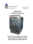
USER GUIDE FOR THE INTERACTIVE ADOPTED RUDP FOR
THE BRADFORD DISTRICT IN LOCAL VIEW FUSION
The Interactive Adopted RUDP, originally made available in MapGuide in
2005, has been rebuilt in Local View Fusion (LVF) from ESRI. The same
information is displayed but accessed in a different way, and can now be
viewed using a wider range of operating platforms and browsers.
The purpose of this LVF application, remains, to enable users to look at the
adopted proposals maps, read the adopted documents and move seamlessly
between them.
The RUDP documents and maps displayed are still those that were adopted
in October 2005. They do not reflect those policies that were not saved
following the Direction from the Secretary of State in September 2008, or the
lapsing of policies H1 and H2 noted by the Council’s Executive in November
2011.
The Interactive Adopted RUDP can be accessed initially from one of the
adopted documents or from one of the three mapping applications.
INTERACTIVE ADOPTED RUDP DOCUMENTS.
The documents are;
• Policy Framework,
• Proposals for the Bradford North Constituency,
• Proposals for the Bradford South Constituency,
• Proposals for the Bradford West Constituency,
• Proposals for the Keighley Constituency,
• Proposals for the Shipley Constituency.
All documents are broken down into their constituent chapters.
Starting from a Proposals Report is useful if you are searching for a particular
allocation and have its reference, e.g. BN/H1.1.
Searching in a document.
To search in any of the documents;
• Press Ctrl f and enter the relevant text.
• The use of wildcards (*) is recommended as it will help improve the search,
particularly if the search data is only partial or incomplete.
Linking to an allocation in a mapping application
Clicking on the site reference for an allocation in the Proposals Reports,
highlighted in either purple or royal blue, will open another window which will
show the extent of the allocation in the relevant mapping application.
INTERACTIVE ADOPTED RUDP MAPS.
The mapping applications are;
• A composite of all the Adopted RUDP Proposals Maps for the
Parliamentary Constituencies and the City and Town Centre Insets.
• Adopted RUDP Proposals Map Supplementary
• Adopted RUDP Location Strategy Map.
Starting in the Composite Proposals Map is useful if you want to find
information on a specific area, and do not have a site allocation reference.
The legend to the composite application can be opened in a separate window
using the link in the bottom right corner of the map view.
Moving to a location of interest in a mapping application.
There are numerous ways to navigate in LVF and to open multiple windows
showing policy, plan and site information, some of the most useful being;
Search facility.
This allows site specific information, on address; street name; policy
reference; and Ordnance Survey grid reference to be used to zoom straight to
an area of interest.
• The Address and Street searches are not case sensitive although
accurate spellings are important as the search does not have fuzzy
capabilities.
• Please enter as full address or street as possible, abbreviations are
recognised, e.g. rd.
• Wildcards(*) are recommended as it will help improve the search, particularly
if the search data is only partial or incomplete.
• When using the Ordnance Survey reference, use the full 6 figure X and
Y co-ordinates, comma separated, e.g. 123456,456789. An OS map
sheet reference can also be used, e.g. SE1132NW.
Map control icon.
This is an easy way to move around the map by clicking the pan arrows or the
zoom signs. The centre button will reset the map to the original location.
Drop a pin.
After dropping the pin into the area of interest the map view will automatically
refresh to a more detailed scale at the chosen location.
Mouse and keystrokes.
To zoom in or out;
• Use the central mouse wheel.
• Using shift, left mouse click, hold and move, will zoom into the map
area selected.
• Using shift, control, left mouse click, hold and move, will zoom out of
the view.
• Hover over the map and double left click to zoom in.
To navigate around the map
• Left mouse click, hold and move.
Linking to documents from an area of interest.
When at the chosen location, the site specific policies can be identified from
the map view and clarified through the legend, which can be opened in a
separate window using the link in the bottom right corner of the map view.
If further clarity is required on specific policies and proposals, and/or
reference to the documents containing them, drop the pin in the relevant
location, as accurately as possible, and click on the link. Please note that
information displayed is within a specific distance from the pin location.
In the composite application this distance is 20m, and the actual distance
is displayed.
For those using this information to conduct a personal search, please note
that because the information displayed is within a specific distance from
the pin location, not all the specific polices identified may be relevant.
District wide policies will always apply to all locations, and particular reference
should be made to Policy UR4.
Dependant upon the specific location, the information and documents
available could include;
•
•
•
•
Site Description, for the specific site policy proposal from the Proposals
Report for that Parliamentary Constituency.
Policy Detail, for the text of the relevant policy within the Policy
Framework
Policy Framework, for the start of the relevant chapter where all the
policies relating to the theme can be looked at.
Summary, for a list of all policies in the Policy Framework.
Other functionality.
Local links
From here the two other mapping applications can be launched. These will
open at the same location as that in the initial map view.
Map features
Clicking here will enable the road names to toggle on or off.
Refresh map view
Clicking this icon resets the map to the default view of the whole of the
District.
Version 1: November 2013.