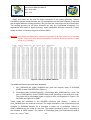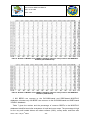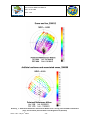
1
POLDER-3 / PARASOL BRDF Databases
User Manual
Issue 1.20
Prepared by Roselyne Lacaze (POSTEL Service Centre / MEDIAS-France)
in collaboration with Emilie Fédèle and François-Marie Bréon (LSCE)
st
Issue 1.20 – July 31 2009
Ref: POS-P3-BRDFUserManual
Date: 31.07.2009
Issue: 1.20
Change Record
Issue/Rev
Date
Pages
I1.00
12.12.2007
All
I1.10
16.06.2008
All
Description of Change
Update
after
the
inclusion
of
Release
polarized
reflectance in the files
I1.20
31.07.2009
22-85
Update
after
the
regeneration
of
the
databases in February 2009
st
Issue 1.20 – July 31 2009
-1-
Ref: POS-P3-BRDFUserManual
Date: 31.07.2009
Issue: 1.20
Table of Content
1.
INTRODUCTION ..........................................................................................................................................5
2.
THE INPUT DATA........................................................................................................................................7
3.
2.1.
THE POLDER-3/PARASOL DATA ......................................................................................................7
2.2.
THE IGBP LAND COVER MAP ..............................................................................................................7
2.3.
THE GLC2000 LAND COVER ...............................................................................................................8
METHODOLOGY FOR BUILDING THE DATABASES.......................................................................10
3.1.
SELECTION OF THEMATICALLY-HOMOGENEOUS PIXELS .............................................................10
3.2.
THE PRE-SELECTION OF A FIXED NUMBER OF PIXELS.................................................................14
3.3.
THE FINAL SELECTION OF THE BEST BRDFS ................................................................................14
3.4.
COMPARISON WITH THE POLDER- 2 METHODOLOGY .................................................................15
4.
THE BIDIRECTIONAL POLARIZED REFLECTANCE DISTRIBUTION FUNCTION (BPDF).......17
5.
FILES DESCRIPTION ...............................................................................................................................18
6.
ANALYSIS OF THE DATABASES..........................................................................................................21
6.1.
NUMBER OF SELECTED BRDFS .......................................................................................................21
6.2.
SPATIAL DISTRIBUTION OF SELECTED PIXELS ..............................................................................23
6.3.
TEMPORAL DISTRIBUTION OF SELECTED PIXELS .........................................................................31
6.4.
THEMATIC CONTENT OF THE SELECTED PIXELS...........................................................................33
6.5.
ANALYSIS OF THE BPDF ...................................................................................................................34
6.6.
SOME POTENTIAL USES OF THE DATABASES ................................................................................34
7.
CONCLUSION............................................................................................................................................39
8.
REFERENCES ...........................................................................................................................................40
9.
ACKNOWLEDGMENT AND CONTACT ................................................................................................44
ANNEX1 : POLDER FULL RESOLUTION REFERENCE GRID................................................................45
ANNEX2 : MULTI-TEMPORAL BRDFS OF THE YEARLY DATABASES...............................................48
ANNEX3 : BRDFS OF MISCLASSIFIED OR MIXED PIXELS ...................................................................58
ANNEX4 : EXAMPLES OF BPDF MEASURED AT 865NM .......................................................................63
ANNEX5 : EXAMPLES OF MEASURED AND SIMULATED BRDF .........................................................71
st
Issue 1.20 – July 31 2009
-2-
Ref: POS-P3-BRDFUserManual
Date: 31.07.2009
Issue: 1.20
List of Figures
Figure 1 : Majority GLC2000 vegetation class for POLDER pixels .............................................................11
Figure 2 : Percentage of homogeneity of POLDER land pixels in terms of GLC2000 classes...............11
Figure 3 : Majority IGBP classes for POLDER pixels....................................................................................12
Figure 4 : Percentage of homogeneity of POLDER land pixels in terms of IGBP classes. .....................12
Figure 5 : Extract of a BRDF ASCII file ...........................................................................................................19
Figure 6 : Location of the 22 012 pixels of the GLC2000-based MONTHLY database. ..........................27
Figure 7 : Location of the 2 016 different pixels of the GLC2000-based YEARLY database ..................28
Figure 8 : Location of the 14 649 pixels of the IGBP-based MONTHLY database...................................29
Figure 9 : Location of the 1 299 different pixels of the IGBP-based YEARLY database..........................30
Figure 10 : Directional signatures measured by POLDER-3 in the principal plane over an Evergreen
Broadleaf forest (up-left), an Evergreen Needleleaf forest (up-right), a mixed forest (bottom-left),
and a Deciduous Broadleaf forest (bottom-right). These pixels are selected in both MONTHLY
databases. ...................................................................................................................................................37
Figure 11 : Directional signatures measured by POLDER-3 in the principal plane over shrubland (topleft), herbaceous area (top-right), a Cultivated and Managed region (bottom-left), and Snow and
Ice (bottom-right). These pixels are selected in both MONTHLY databases. ...................................38
st
Issue 1.20 – July 31 2009
-3-
Ref: POS-P3-BRDFUserManual
Date: 31.07.2009
Issue: 1.20
List of Tables
Table 1 : The vegetation classes of the IGBP land cover map......................................................................8
Table 2 : The vegetation classes of the global GLC2000 land cover map...................................................9
Table 3 : Percentage of land cover classes (GLC2000 at left, IGBP at right) among the thematicallyhomogeneous pixels of the POLDER grid. .............................................................................................13
Table 4 : Comparison of methodologies for BRDFs selection.....................................................................16
Table 5 : Number of BRDFs of the YEARLY database which are also present in the MONTHLY
database (GLC2000-based). ....................................................................................................................22
Table 6 : Number of BRDFs of the YEARLY database which are also present in the MONTHLY
database (IGBP-based).............................................................................................................................22
Table 7 : Common BRDFs to both MONTHLY databases for some vegetation types. The last column
gives the percentage of BRDFs of the GLC2000 class which belong to the corresponding IGBP
class. ............................................................................................................................................................23
Table 8 : Distribution of BRDFs of the MONTHLY database per GLC2000 class and per month..........24
Table 9 : Distribution of BRDFs of the YEARLY database per GCL2000 class and per month .............24
Table 10 : Distribution of BRDFs of the MONTHLY database per IGBP class and per month...............25
Table 11 : Distribution of BRDFs of the YEARLY database per IGBP class and per month...................26
Table 12 : Distribution over the year of BRDFs in the GLC2000-based YEARLY database. ..................32
Table 13 : Distribution over the year of BRDFs in the IGBP-based YEARLY database. .........................33
Table 14 : Summary of comparison for similar GLC and IGBP vegetation classes .................................33
st
Issue 1.20 – July 31 2009
-4-
Ref: POS-P3-BRDFUserManual
Date: 31.07.2009
Issue: 1.20
1.
Introduction
The Bi-directional Reflectance Distribution Function (BRDF) describes how the terrestrial
surfaces reflect the sun radiation. Its potential has been demonstrated for several
applications in land surface studies. These includes the correction of bi-directional effects in
time series of vegetation indices and reflectances (Leroy and Roujean, 1994; Wu et al.,
1995), the direct use of angular measurements for estimation of leaf area index and other
biophysical parameters by inversion of radiative transfer models (Knyazikhin et al., 1998;
Bicheron and Leroy, 1999), albedo retrieval (Wanner et al., 1997; Cabot and Dedieu, 1997;
Capderou, 1998), land cover classifications (Abuelgassim et al., 1996; Bicheron et al., 1997;
Hyman and Barnsley, 1997), and radiance to flux conversion factors for Earth radiation
budget studies (Manalo-Smith et al., 1998). Then, many users need spatial and temporal
variations of the BRDF, for different types of biomes and at different seasons.
The BRDF has been measured in the field (e.g. Kimes, 1983; Deering et al., 1992) or
from airborne instruments (Irons et al., 1991; Leroy and Bréon, 1996), with most often an
adequate sampling of directional space but with a poor spatial coverage. Directional effects
on land surfaces have been seen from space with AVHRR (e.g. Gutman, 1987) or with
ATSR (Godsalve, 1995). Then, the spatial coverage is potentially adequate, but the
sampling of the BRDF is limited in the angular plane of acquisition. The space-borne
POLDER instrument has provided the first opportunity to sample the BRDF of every point on
Earth for viewing angles up to 60°-70°, and for the full azimuth range, at a spatial resolution
of about 6km, when the atmospheric conditions are favourable (Hautecoeur et Leroy, 1998).
POLDER1 and POLDER-2 have delivered 8 months (November 1996 – June 1997) and 7
months (April – October 2003) of global data onboard the Japanese ADEOS-1 and ADEOS2 platforms, respectively. Since the beginning of 2005, the POLDER-3 sensor onboard the
PARASOL micro-satellite has been flying in the A-Train.
The Service Centre of the POSTEL Thematic Centre on the Land Surface built two global
databases of 24,857 BRDFs from POLDER-1 data, and 24,090 BRDFs from POLDER-2
data collected at 443, 565, 670, 765 and 865nm on the basis of the 22 land cover classes of
the GLC2000 land cover classification (GLC, 2003). These databases are available for
downloading on the POSTEL web site (www1). User manuals presenting the methodology of
pixels selection and analysis of the databases are also available.
The Laboratoire des Sciences du Climat et de l’Environnement (LSCE), one of the
Expertise Centres of POSTEL, defined a new method to select the BRDFs from the
POLDER-3/PARASOL data acquired between November 2005 and October 2006 in order to
build 4 new databases:
1. 2 MONTHLY databases gathering the best quality BRDFs for each month,
independently: one based upon the IGBP land cover map, the second based upon
the GLC2000 land cover map.
st
Issue 1.20 – July 31 2009
-5-
Ref: POS-P3-BRDFUserManual
Date: 31.07.2009
Issue: 1.20
2. 2 YEARLY databases designed to follow the annual cycle of surface reflectance
and its directional signature. The selection of high quality pixel is based on the full
year. The first one is based upon the IGBP land cover map, the second one is
based upon the GLC2000 land cover map.
The objective is to collect directional information on homogeneous pixels representing the
main continental ecosystems to serve for the development and prototyping of science
applications of the BRDF measurements.
This document presents the methodology applied to build the POLDER-3 BRDF data
sets, describes the file content, and analyses the databases.
st
Issue 1.20 – July 31 2009
-6-
Ref: POS-P3-BRDFUserManual
Date: 31.07.2009
Issue: 1.20
2.
The input data
2.1. The POLDER-3/PARASOL data
The POLDER-3 instrument is a radiometer designed to measure the directionality and
polarization of the sunlight scattered by the ground atmosphere system. The instrument is
made of a bi-dimensional CCD matrix, a rotating wheel that carries filters and polarizers, and
a wide field of view lens (114°). The field of view seen by the CCD matrix is ± 51° along
track and ± 43° across track. The view zenith angle s seen at surface level are larger due to
Earth curvature, ± 61 ° along track and ± 50 ° acro ss track (± 70° in the matrix diagonal).
This orientation of the telecentric optics array favours multidirectional viewing over daily
global coverage, compared to POLDER-1 & 2. The pixel size on the ground is about 6 km
for a PARASOL altitude of 705 km. The rotating wheel carries filters that allow spectral
measurements at 9 wavelengths (443, 490, 565, 670, 763, 765, 865, 910, and 1020nm).
The 1020nm waveband has been added, compared to POLDER1&2, to conduct
observations for comparison with data acquired by the lidar on CALIPSO, one of the
PARASOL companion satellites in the A-Train. Three of the channels (490, 670 and 865nm)
measure the polarization of the incident light. Images of the same band are acquired every
19.6 s, which permits a large overlap between successive images. During the PARASOL
overpass, a surface target is viewed up to 16 times with a different viewing angle. The
directional configuration changes each day due to orbital shift between successive days.
Therefore, after a few days, assuming favourable atmospheric conditions, the slices of
measurements provide a sampling of the BRDF in the limits of the instrument field of view.
The POLDER-3 data are processed to obtain the geocoded, calibrated, cloud screened
and atmospherically-corrected land surface reflectances for each orbit. These algorithms
consist of a cloud detection, a correction from the effects of absorbing gazes, stratospheric
and tropospheric aerosols. Then, a semi-empirical BRDF model (Maignan et al., 2004) is
inverted on the directional land surface reflectances acquired during 30-days to assess the
spectral and broadband directional-hemispherical reflectances (DHR), and bi-hemispheric
reflectances (BHR), and the anisotropy-corrected NDVI derived from the DHR at 670 and
865 nm. The final biogeophysical products are available on 5th, 15th and 25th of each month.
Details on the Level 2 and Level 3 “Land Surface” algorithms can be found in Lacaze and
Maignan (2007). The POLDER-3/PARASOL Land Surface products can be downloaded on
the POSTEL web site (www1).
2.2. The IGBP land cover map
The International Geosphere Biosphere Programme (IGBP) 1-km AVHRR 10-day
composites for April 1992 through March 1993 map (Eidenshink and Faundeen, 1994) are
the base data used to elaborate the land cover. Multi-temporal AVHRR NDVI data are used
to divide the landscape into land cover regions, based on seasonality. While the primary
AVHRR data used in the classification is NDVI, the individual channel data sets are used for
st
Issue 1.20 – July 31 2009
-7-
Ref: POS-P3-BRDFUserManual
Date: 31.07.2009
Issue: 1.20
post classification characterization of certain landscape properties. A data quality evaluation
was conducted and is reported by Zhu and Yang (1996).
The IGBP land cover map contains 17 classes (Table 1) and can be downloaded at
www2 . Class n°17, labelled "Water Bodies", is not considered for the BRDF selection.
N°
1
2
3
4
5
6
7
8
9
10
11
12
13
14
15
16
17
IGBP Land Cover Class
Evergreen Needleleaf Forest
Evergreen Broadleaf Forest
Deciduous Needleleaf Forest
Deciduous Broadleaf Forest
Mixed Forest
Closed Shrublands
Open Shrublands
Woody savannas
Savannas
Grasslands
Permanent Wetlands
Croplands
Urban and Built-up
Cropland/Natural Vegetation Mosaic
Snow and Ice
Barren or Sparsely Vegetated
Water Bodies
Table 1 : The vegetation classes of the IGBP land cover map.
2.3. The GLC2000 land cover
The co-ordination of the Global Land Cover 2000 project has been carried out under the
5 Framework Program 1999-2002 for Research of the European Commission. It is part of
the project of the European Commission called Global Environment Information System
(GEIS).
th
In contrast to former global mapping initiatives the GLC2000 project is a bottom up
approach to global mapping. In this project more than 30 research teams have been
involved, contributing to 19 regional windows. There were two conditions to be fulfilled by the
regional experts to guarantee a certain degree of consistency. The data had to be based on
SPOT-4 VEGETATION VEGA2000 dataset, which was made freely available by Cnes.
Secondly, the partners agreed to use the Land Cover Classification System (LCCS)
provided by FAO (Di Gregorio and Jansen, 2000). The regional legends are compatible with
the LCCS, which describes land cover according to a hierarchical series of classifiers and
attributes. These separate vegetated or non-vegetated surfaces; terrestrial or
st
Issue 1.20 – July 31 2009
-8-
Ref: POS-P3-BRDFUserManual
Date: 31.07.2009
Issue: 1.20
aquatic/flooded; cultivated and managed; natural and semi-natural; life-form; cover; height;
spatial distribution; leaf type and phenology. Coding each class with LCCS allows a map
legend to be progressively more detailed for regional, and in some cases, national level
users. Due to its hierarchical structure it is possible to translate the regional classification
into a more general one – the global legend (Table 2). More information on the GLC2000
products is available on the project web site (www3).
The GLC2000 land cover map is truncated at 56°S. Th e missing data between 56°S and
90°S have been filled using a land/sea mask. The la nd pixels were labelled as “Snow & Ice”
(Class n°21) and the water pixels were labelled as “Water Bodies” (Class n°20).
N°
1
2
3
4
5
6
7
8
9
10
11
12
13
14
15
16
17
18
19
20
21
22
GLC2000 Land Cover Class
Tree Cover, broadleaved, evergreen
Tree Cover, broadleaved, deciduous, closed
Tree Cover, broadleaved, deciduous, open
Tree Cover, needle-leaved, evergreen
Tree Cover, needle-leaved, deciduous
Tree Cover, mixed leaf type
Tree Cover, regularly flooded, fresh
Tree Cover, regularly flooded, saline, (daily variation)
Mosaic: Tree cover / Other natural vegetation
Tree Cover, burnt
Shrub Cover, closed-open, evergreen (with or without sparse tree layer)
Shrub Cover, closed-open, deciduous (with or without sparse tree layer)
Herbaceous Cover, closed-open
Sparse Herbaceous or sparse shrub cover
Regularly flooded shrub and/or herbaceous cover
Cultivated and managed areas
Mosaic: Cropland / Tree Cover / Other Natural Vegetation
Mosaic: Cropland / Shrub and/or Herbaceous cover
Bare Areas
Water Bodies (natural & artificial)
Snow and Ice (natural & artificial)
Artificial surfaces and associated areas
Table 2 : The vegetation classes of the global GLC2000 land cover map.
st
Issue 1.20 – July 31 2009
-9-
Ref: POS-P3-BRDFUserManual
Date: 31.07.2009
Issue: 1.20
3.
Methodology for building the databases
We elaborated the BRDF databases using the measurements acquired from November
2005 to October 2006. This year was chosen as it is well suited to follow a full vegetation
cycle in the Northern hemisphere, and also because the instrument suffered few
interruptions during this period.
For both databases, the methodology relies on 3 main steps:
1. the selection of thematically-homogeneous pixels, according to the land cover
map (IGBP or GLC2000).
2. a pre-selection of a fixed number of pixels according to the quality of the inversion
of the reflectance model against one month of data. This criterium allows
removing the noisiest BRDFs and those with few observations.
3. the final selection of the best BRDFs. In this last step, the selection accounts for
the quality of the reflectance model inversion over one single orbit, which allows
removing the noisy orbits that could disturb the overall quality of the BRDF.
After several tests, we choose to apply the steps 2 and 3 on the reflectances measured
at 670nm, because it allows selecting BRDFs which are generally clean at all wavebands.
3.1. Selection of thematically-homogeneous pixels
On the one hand, the GLC2000 land cover map is available in a regular latitude/longitude
grid at 1/112° space resolution, and the IGBP is av ailable in a regular latitude/longitude grid
at 1/120° space resolution. On the other hand, the POLDER-3/PARASOL surface
reflectances are located in a reference grid based on the sinusoidal equal area projection
with a constant step along a meridian with a resolution of 1/18° (Annex1 ).
Because the space resolution of a POLDER pixel is larger than the space resolution of a
GLC2000 pixel or an IGBP pixel, a POLDER pixel can contain different vegetation classes.
For each POLDER pixel, the vegetation classes located on its area are identified, and the
majority class is allocated to the pixel. Figure 1 and Figure 3 show the resulting maps for
GLC2000 and IGBP, respectively. A pixel is considered as “homogeneous” if the majority
class represents at least 80% of the number of 1-km pixels contained in its area. According
to this definition, 57% of the land pixels of the POLDER grid are homogeneous in terms of
GLC2000 class (Figure 2), whereas 52,7% of the land pixels of the POLDER grid are
homogeneous in terms of IGBP class (Figure 4). This result indicates that the spatial
variability of the GLC2000 land cover map is smoother, even with more classes than the
IGBP land cover, and that the ecosystems are more homogeneous and better delimited.
st
Issue 1.20 – July 31 2009
- 10 -
Ref: POS-P3-BRDFUserManual
Date: 31.07.2009
Issue: 1.20
Figure 1 : Majority GLC2000 vegetation class for POLDER pixels
Figure 2 : Percentage of homogeneity of POLDER land pixels in terms of GLC2000 classes.
st
Issue 1.20 – July 31 2009
- 11 -
Ref: POS-P3-BRDFUserManual
Date: 31.07.2009
Issue: 1.20
Figure 3 : Majority IGBP classes for POLDER pixels
Figure 4 : Percentage of homogeneity of POLDER land pixels in terms of IGBP classes.
st
Issue 1.20 – July 31 2009
- 12 -
Ref: POS-P3-BRDFUserManual
Date: 31.07.2009
Issue: 1.20
In both cases, the most populated classes of thematically-homogeneous pixels are "Bare
Areas" (~21% for GLC2000 and IGBP) or “Snow and Ice” (~18% for GLC2000, ~19% for
IGBP) (Table 3). For the GLC2000 land cover map, the “Cultivated and Managed areas” and
the “Evergreen Broadleaf Forest” gather more than 10% of these homogeneous pixels. At
the opposite, the regularly flooded forests and the burnt areas concern some ten thousand
of pixels, only. For the IGBP land cover map, the "Open Shrubland", and the "Evergreen
Broadleaf Forest" represent more than 18% and 14% of the homogeneous pixels,
respectively. At the opposite, the "Permanent Wetlands" and the "Closed Shrubland" gather
some ten thousand of pixels, only.
GLC2000 Class
GLC_01
GLC_02
GLC_03
GLC_04
GLC_05
GLC_06
GLC_07
GLC_08
GLC_09
GLC_10
GLC_11
GLC_12
GLC_13
GLC_14
GLC_15
GLC_16
GLC_17
GLC_18
GLC_19
GLC_20
GLC_21
GLC_22
%
10.95
3.02
2.20
4.89
2.15
0.77
0.26
0.03
0.65
0.06
0.25
5.35
7.25
8.68
0.28
11.05
1.02
0.96
21.07
1.09
17.92
0.09
IGBP Class
IGBP_01
IGBP_02
IGBP_03
IGBP_04
IGBP_05
IGBP_06
IGBP_07
IGBP_08
IGBP_09
IGBP_10
IGBP_11
IGBP_12
IGBP_13
IGBP_14
IGBP_15
IGBP_16
%
2.45
14.52
0.31
0.35
2.09
0.05
18.97
1.62
2.65
6.77
<0.01
9.67
0.24
0.18
18.94
21.17
Table 3 : Percentage of land cover classes (GLC2000 at left, IGBP at right) among the
thematically-homogeneous pixels of the POLDER grid.
Table 3 shows that the 2 maps give quite similar percentages of surface covered by
grass (GLC_13 and IGBP_10) and crops (GLC_16 and IGBP_12), even if the figures of
GLC2000 are slightly higher. The differences appear on the forest classes: IGBP displays
more evergreen broadleaf forests (IGBP_02 and GLC_01) and mixed forests (IGBP_05 and
GLC_06) than GLC2000, but it is the opposite for the other forest types. If we consider all
the main forest classes (GLC_01 to GLC_06, and IGBP_01 to IGBP_05), the number of
homogeneous pixels reach almost 24% for GLC2000, and 20% only for IGBP. The largest
st
Issue 1.20 – July 31 2009
- 13 -
Ref: POS-P3-BRDFUserManual
Date: 31.07.2009
Issue: 1.20
difference concerns the areas covered by shrubs: the shrubland classes of IGBP (IGBP_6
and IGBP_7) represent 19% of homogenous pixels, whereas the shrubland classes of
GLC2000 (GLC_11 and GLC_12) gather less than 6% of homogenous pixels.
In the next steps, we consider only the 2 159 417 homogeneous pixels of the POLDER
grid for GLC2000, and the 1 988 845 homogeneous pixels of the POLDER grid for IGBP.
3.2. The pre-selection of a fixed number of pixels
Only the homogeneous pixels viewed by at least 5 orbits during the month, after the cloud
detection and the atmospheric correction, are concerned by the pre-selection. A notation,
equal to 1/RMS670 or equal to 0 is less than 5 orbits, is allocated to each pixel. RMS670 is the
Root Mean Square error between the measurements at 670nm and the reflectance model
(Maignan et al., 2004) inverted against all data acquired during a period of 30 days centred
on the 15th of each month. This RMS670 is given in the quality index of the Level3 products.
The RMS at 670nm has been chosen because it allows selecting BRDFs which are clean at
all wavebands (490, 565, 670 and 865nm) comparing to the RMS at 865nm which extracts
BRDFs which are clean only in the near –infrared.
In the case of the MONTHLY database, the 500 pixels with the best notations (the
highest) are selected for each of the 4 bands of latitude (0°-20°, 20°-40°, 40°-60°, 60°-90°:
North and South are gathered), and for each class of the land cover map (22 classes for
GLC2000, 16 classes for IGBP). If a class contains less than 500 pixels, they are all kept.
This is done for each month. After this step, 291 556 pixels are pre-selected for GLC2000,
and 191 685 pixels are pre-selected for IGBP.
In the case of the YEARLY database, a yearly notation is calculated as the mean of the
monthly notations (including notations equal to 0). Only pixels with at least 5 valid monthly
notations are considered. The 1000 pixels with the best notations are selected for each band
of latitude and each vegetation class. If the class contains less than 1000 pixels, they are all
kept. After this step, 49 395 pixels are pre-selected for GLC2000, and 31 529 pixels are preselected for IGBP.
3.3. The final selection of the best BRDFs
First, the procedure consists in calculating the RMS, between the observations and the
reflectance model, in two ways:
1. the model is inverted per orbit: RMSorbit
2. the model is inverted against all observations acquired during the month:
RMSmonth
st
Issue 1.20 – July 31 2009
- 14 -
Ref: POS-P3-BRDFUserManual
Date: 31.07.2009
Issue: 1.20
In both cases, the observations acquired in the angular range of 5° around the hot spot or
around the glitter directions are not accounted for the model inversion.
If RMSorbit ≥ 2 * RMSmonth , the orbit is considered not valid.
Then, the reflectance model is inverted over all remaining valid orbits of the month, and
RMSmonth is calculated again. A notation, equal to 1/RMSmonth, is allocated to each pixel with
at least 5 remaining valid orbits during the month. The notation of other pixels is 0. If
RMSmonth is lower than 0.5, then the notation is equal to 2. If a pixel is viewed under one, or
more, hot spot configuration during the month, then its notation is raised of 20%. For each
additional orbit, comparing to 5, the notation is raised of 4%. A yearly notation is calculated
as the mean of the monthly notations (including notations equal to 0).
The notations, monthly and yearly, are sorted out in decreasing order, excluding the
pixels located at a distance less than 35km from a pixel with a better notation. The 30 pixels
with the best notations are selected for each band of latitude, and each vegetation class. If a
class contains less than 30 pixels, they are all kept. For the MONTHLY database, this is
done for each month.
At final, the GLC2000-based MONTHLY database gathers 22 012 pixels, and the IGBPbased MONTHLY database gathers 14 649 pixels.
For the YEARLY database, 2 016 pixels are identified for GLC2000, and 1 299 pixels are
identified for IGBP. For each of them, a BRDF file is built for each month with a valid
monthly notation. Then, at final, the GLC2000-based YEARLY database contains 21 262
BRDFs, and the IGBP-based YEARLY database contains 13 887 BRDFs.
The NDVI of the selected pixels is calculated following the approach described in Lacaze
and Maignan (2007).
3.4. Comparison with the POLDER- 2 methodology
The differences between the methodology described above and the approach used to
elaborate the POLDER-2 BRDFs database (Lacaze, 2006b) are summarized in Table 4.
Previously, the selection was based upon angular criteria exclusively. In the present
approach, the angular criterium is considered with the number of orbit per BRDF only. Now,
the selection considers the radiometric quality of measurements mainly, through the quality
of the inversion of the reflectance model against the observations. This leads to select the
smoothest BRDFs. These changes were done with the aim to improve the usefulness of the
selected BRDFs for modelling activities.
The new criterium of the thematic homogeneity, which reduces a lot the number of
relevant pixels, has been introduced to consider the "purest" pixels only. The objective was
to get typical BRDFs of the main vegetation types.
st
Issue 1.20 – July 31 2009
- 15 -
Ref: POS-P3-BRDFUserManual
Date: 31.07.2009
Issue: 1.20
The criterium of vicinity has been added to avoid the retrieval of clumps of 3, 4 or more
neighbouring pixels. Indeed, when one pixel matches the criteria of selection, it is highly
likely that its neighbours do also. This clustering of BRDFs was strong in the POLDER-1 and
POLDER-2 BRDF databases (Lacaze, 2006a; Lacaze, 2006b), for all vegetation types. This
new criterium aims at improving the sampling of ecosystems.
POLDER-2
POLDER-3
Number of sequence/orbit
10 ≤
NA
Number of orbit/BRDF
8≤
5≤
Number of angular regions sampled
5≤
NA
Thematic homogeneity of the pixel
NA
RMS of model/observations
Neighbourhood
NA
NA
80% ≤
1 / RMS
Out of about 35km
Selection per:
GLC_2000 class
Month
Bands of latitude
Class of NDVI
22
7
5
12
22
12
4
NA
Number of best pixels
10
30
Criteria of selection:
Table 4 : Comparison of methodologies for BRDFs selection.
st
Issue 1.20 – July 31 2009
- 16 -
Ref: POS-P3-BRDFUserManual
Date: 31.07.2009
Issue: 1.20
4.
The Bidirectional Polarized reflectance Distribution Function (BPDF)
POLDER was the first satellite sensor to measure continuously the linearly polarized
Earth-reflected radiance. For 3 spectral bands (490, 670, and 865nm), a polarizer is added
to the filters in order to assess the degree of linear polarization and the polarization
direction. These parameters are derived by combining measurements in 3 channels with the
same spectral filters but with the polarizer axes turned by steps of 60°. The three
polarization measurements in a spectral band are successive and have a total time lag of
0.6s between the first and the third (last) measurement. In order to compensate for
spacecraft motion during the lag and to register the three measurements, a small-angle,
wedge prism is used in each polarizing assembly. As a consequence, the matrix image is
translated in the focal plane to offset the satellite motion, and the three polarization
measurements are quasi collocated.
Natural light from the sun is not polarized, or rather it is randomly polarized. However,
certain physical processes in the atmosphere (molecular scattering, scattering by
stratospheric and tropospheric aerosols, scattering by clouds), and some natural surfaces
(vegetation, bare soil, snow, ice, water) orient electric vibrations, thus generating polarized
light.
Measurements indicate that the surface polarized reflectance is almost constant in the
visible and near-IR spectrum, while the polarization degree varies inversely with the
reflectance. Therefore, a single channel contains the information on the polarized
reflectance. However, as original data are TOA measurements, the contribution of the
atmosphere has to be removed to derive the polarized component of the surface. Then, it is
more efficient to use the measurements acquired at 865nm since the atmospheric
contribution of the atmosphere is smaller at this wavelength than in the visible channels.
The polarized reflectance measured at 865nm is provided for each pixel contained in the
4 databases.
st
Issue 1.20 – July 31 2009
- 17 -
Ref: POS-P3-BRDFUserManual
Date: 31.07.2009
Issue: 1.20
5.
Files description
The directories tree is the following:
The folders are GLC_XX (IGBP_XX) where XX is the class number in the
GLC2000 (IGBP) land cover map
The sub-folders are YYYYMM corresponding to the year (YYYY=2005 or 2006)
and the month (MM = 01 to 12) of acquisition.
They contain BRDF files named as brdf_ndviNN.LLLL_CCCC.dat where :
NN indicates the NDVI range: NN=00 corresponds to NDVI < -0.2 and NN=12 to
0.9 < NDVI < 1.
LLLL and CCC are the line and the column of the POLDER reference grid where
the pixel is located (see Annex1 ).
The BRDF files are ASCII files starting with three header lines (example on Figure 5).
The header provides the pixel location in latitude and longitude, the GLC2000 (or the IGBP)
class number, the NDVI, the number of valid orbits, and the number of valid observations
(each pass provides up to 16 different directional measurements), and the fraction of the
dominant surface type within the POLDER pixel.
The header is followed by the measurements. Each line is one directional observation.
The “no data” value is -9.990. The different fields displayed in a columnar format (I6, 3F8.2,
6F7.3, F8.2, 2F8.3, 6X, I6, F8.4) are:
yymmdd
: date of the observation
thetaS
: sun zenith angle (°)
thetaV
: view zenith angle (°)
RelAzi
: relative azimuth angle (°)
R490
: surface reflectance measured at 490nm
R565
: surface reflectance measured at 565nm
R670
: surface reflectance measured at 670nm
R765
: surface reflectance measured at 765nm
R865
: surface reflectance measured at 865nm
R1020
: surface reflectance measured at 1020nm
phiS
: sun azimuth angle (°)
DVzC
: thetaS * COS (RelAzi)
DVzS
: thetaS * SIN (RelAzi)
Orbit_numb
: cccooo where ccc is the PARASOL cycle number
(1<ccc<999) and ooo is the orbit number (1<ooo<233)
RP865
: polarized reflectance at 865nm
st
Issue 1.20 – July 31 2009
- 18 -
Ref: POS-P3-BRDFUserManual
Date: 31.07.2009
Issue: 1.20
DVzC and DVzS can be used for slight corrections of the viewing geometry. Indeed,
POLDER-3 spectral measurements are not simultaneous so that each channel is acquired
with a slightly different viewing geometry. We give here the view angles for the 670nm band.
The viewing geometry for the other channels can vary by a few tenths of degrees. For
applications that require a higher accuracy, these parameters allow the correction. Further
details on these corrections are given in Bréon (2005).
Warning: One month corresponds to a period of synthesis of 30 days, and not to a calendar
month. Then, some side effects can appear for months where the number of days
is low (e.g. February).
Figure 5 : Extract of a BRDF ASCII file
Two additional files are provided with databases:
1. GLC_PARASOL.bin (IGBP_PARASOL.bin) gives the majority class of GLC2000
(IGBP) for each POLDER pixel (Figure 1)
2. Percentage_Max_GLC2000Class.bin (Percentage_Max_IGBPClass.bin) gives the
level of homogeneity of the POLDER land pixels according to the land cover map.
The pixels with a percentage higher or equal to 80% are displayed in Figure 2 for
GLC2000 and Figure 4 for IGBP.
These maps are presented in the POLDER reference grid (Annex1 ). Values of
GLC_PARASOL.bin are coded on one byte. The range is between 1 and 22 according to the
numbers of GLC2000 classes; 23 is allocated to pixels out of projection. Values of
IGBP_PARASOL.bin are coded on one byte. The range is between 0 and 17 according to
the numbers of IGBP classes. The values of Percentage_Max_GLC2000Class.bin and of
st
Issue 1.20 – July 31 2009
- 19 -
Ref: POS-P3-BRDFUserManual
Date: 31.07.2009
Issue: 1.20
Percentage_Max_IGBPClass.bin are coded in floating points on 4 bytes with a maximum
equal to 100.
st
Issue 1.20 – July 31 2009
- 20 -
Ref: POS-P3-BRDFUserManual
Date: 31.07.2009
Issue: 1.20
6.
Analysis of the databases
6.1. Number of selected BRDFs
The GLC2000-based MONTHLY and YEARLY POLDER-3 databases contain 22 012,
and 21 262 BRDFs, respectively, selected among one year of observations.
The methodology of selection of the MONTHLY database consists in keeping the 30 best
BRDFs among the 1 056 (22 GLC_CLASS * 12 months * 4 bands of latitude) classes, what
corresponds to 31 680 pixels. At final, the MONTHLY POLDER-3 database contains 22 012
BRDFs, i.e. 69% of the theoretic maximal number of pixels. This is a good rate of filling
considering that some vegetation types are little or not present (as a thematically
homogeneous pixel) in some latitudes. For the YEARLY database, the filling rate is better
since it reaches 76% (2 016 different pixels in the database comparing to the theoretic
maximum of 2 640 = 22 * 4 * 30).
The IGBP-based MONTHLY and YEARLY POLDER-3 databases contain 14 649, and 13
887 BRDFs, respectively. This is lower than the GLC2000-based databases since the IGBP
land cover map contains 16 classes only, against 22 for the GLC2000 land cover.
The methodology of selection of the MONTHLY database consists in keeping the 30 best
BRDFs among the 768 (16 GLC_CLASS * 12 months * 4 bands of latitude) classes, what
corresponds to 23 040 pixels. At final, the MONTHLY POLDER-3 database contains 14 649
BRDFs, i.e. around 64% of the theoretic maximal number of pixels. For the YEARLY
database, the filling rate is a little bit better since it reaches 68% (1 299 different pixels in the
database comparing to the theoretic maximum of 1 920 = 16 * 4 * 30). These percentages
are lower than for the GLC2000-based databases, which is a consequence of the lower rate
of homogeneity of POLDER pixels in terms of IGBP land cover classes.
Some BRDFs are common to MONTHLY and YEARLY databases. Table 5 and Table 6
give the number of BRDFs of the YEARLY database which are also present in the
MONTHLY database, for the GLC2000-based database and for the IGBP-based database,
respectively.
In a general way, the highest (lowest) percentages are for the classes which represent
the less (most) important part of the thematically-homogeneous pixels (Table 3). For other
classes, the figures of Table 5 and Table 6 result of the combination of:
The representativeness of a biome in each band of latitude: least numerous are
the pixels, more important is the probability that the same ones are selected in
MONTHLY and YEARLY databases.
The variability of the BRDFs quality during the year: if a pixel has good BRDFs
all along the year, it has strong probability to be selected in both databases.
The quality of the BRDF depends on many factors and can not be generalized.
st
Issue 1.20 – July 31 2009
- 21 -
Ref: POS-P3-BRDFUserManual
Date: 31.07.2009
Issue: 1.20
Table 5 : Number of BRDFs of the YEARLY database which are also present in the MONTHLY
database (GLC2000-based).
Table 6 : Number of BRDFs of the YEARLY database which are also present in the MONTHLY
database (IGBP-based).
3 006 BRDFs are common to the GLC2000-based and IGBP-based MONTHLY
databases, whereas only 243 BRDFs are common to the GLC2000-based and IGBP-based
YEARLY databases.
Table 7 gives the number and the percentage of common BRDFs in the MONTHLY
databases identified as similar ecosystems in both land cover maps. The percentage is high
for the very well located biomes as urban surfaces (100%), snowy areas, and bare soils
st
Issue 1.20 – July 31 2009
- 22 -
Ref: POS-P3-BRDFUserManual
Date: 31.07.2009
Issue: 1.20
(>94%). The agreement between the 2 land cover maps is good for the broadleaf evergreen
forests (>96%), needleleaf evergreen forest (89%), and crop and cultivated regions (>76%).
At the opposite, only 21% of BRDFs identified as herbaceous areas in the GLC2000 land
cover map (GLC_13) selected in the IGBP-based database, belongs to the corresponding
IGBP class (IGBP_10). None BRDF of GLC_03 (Open Broadleaf Deciduous Forest)
selected in the IGBP-based database is classified in IGBP_04. Most of them (82%) are
identified as Woody Savanna (IGBP_08).
Among the 243 pixels common to GLC_based and IGBP_based YEARLY database, 3
belongs to GLC_02 (Closed Broadleaf Deciduous Forest), and only 1 is identified as
IGBP_04 (Broadleaf Deciduous Forest). Only 9 pixels are classified as Open Broadleaf
Deciduous Forest (GLC_03), but they are identified as Woody savannas (IGBP_08) or
Savannas (IGBP_09) on the IGBP land cover map. Likewise, only 1 of the 9 pixels classified
as GLC_13 (Herbaceous cover) selected also in the IGBP_based YEARLY database are
identified as grassland (IGBP_10), others are identified as Open shrubland (IGBP_07).
Table 7 : Common BRDFs to both MONTHLY databases for some vegetation types. The last
column gives the percentage of BRDFs of the GLC2000 class which belong to the
corresponding IGBP class.
6.2. Spatial distribution of selected pixels
The 22 012 BRDFs of the GLC2000-based MONTHLY database and the 21 262 BRDFs
of the GLC2000-based YEARLY database are shared between the 22 GLC2000 classes
and the 12 months as presented in Table 8 and Table 9, respectively. 120 (30 * 4 bands of
latitude) is the maximum of BRDFs that can be selected per month and per vegetation class.
This happens at least one month for almost half of the GLC_2000 classes, especially during
the spring and the summer of the Northern hemisphere. 90 BRDFs in a month means that
this vegetation class is probably not present (as thematically homogeneous pixel) in one
band of latitude. At the opposite, there are few cases with less than 30 pixels per month: it
st
Issue 1.20 – July 31 2009
- 23 -
Ref: POS-P3-BRDFUserManual
Date: 31.07.2009
Issue: 1.20
happens for GLC_07, all the year, GLC_08 (regularly flooded forests) and GLC_10 (Burnt
areas). This is reliable since these vegetation types are minority biomes at global scale
(Table 3).
Table 8 : Distribution of BRDFs of the MONTHLY database per GLC2000 class and per month
Table 9 : Distribution of BRDFs of the YEARLY database per GCL2000 class and per month
st
Issue 1.20 – July 31 2009
- 24 -
Ref: POS-P3-BRDFUserManual
Date: 31.07.2009
Issue: 1.20
The 14 649 BRDFs of the IGBP-based MONTHLY database and the 13 887 BRDFs of
the IGBP-based YEARLY database are shared between the 16 IGBP classes and the 12
months as presented in Table 10 and Table 11. Only a quarter of the classes display a
maximum of BRDFs (120) at least one month in both databases. That never happens for
forest classes (IGBP_01 to IGBP_05). Then, there is almost 49% more BRDFs of forests in
the GLC-based MONTHLY database than in the IGBP-based MONTHLY database. This is
larger than the difference noted on the thematically-homogeneous pixels (§3.1). Likewise,
although IGBP displays much more homogeneous shrubland pixels than GLC2000 (Table
3), the number of BRDFs for classes IGBP_06 and IGBP_07 is lesser than the number of
BRDFs for corresponding GLC2000 classes (GLC_11 and GLC12). IGBP_07 is a majority
class, and IGBP_06 a minority class not present in the Northern latitudes. At the opposite,
GLC_11 and GLC_12 are medium classes (in terms of spatial coverage) and are present in
all bands of latitude. The methodology of selection, with a number maximum of pixels preselected by class and by band of latitude (§3.2), favours the second case.
Table 10 : Distribution of BRDFs of the MONTHLY database per IGBP class and per month
st
Issue 1.20 – July 31 2009
- 25 -
Ref: POS-P3-BRDFUserManual
Date: 31.07.2009
Issue: 1.20
Table 11 : Distribution of BRDFs of the YEARLY database per IGBP class and per month
st
Issue 1.20 – July 31 2009
- 26 -
Ref: POS-P3-BRDFUserManual
Date: 31.07.2009
Issue: 1.20
Figure 6 : Location of the 22 012 pixels of the GLC2000-based MONTHLY database.
st
Issue 1.20 – July 31 2009
- 27 -
Ref: POS-P3-BRDFUserManual
Date: 31.07.2009
Issue: 1.20
Figure 7 : Location of the 2 016 different pixels of the GLC2000-based YEARLY database
st
Issue 1.20 – July 31 2009
- 28 -
Ref: POS-P3-BRDFUserManual
Date: 31.07.2009
Issue: 1.20
Figure 8 : Location of the 14 649 pixels of the IGBP-based MONTHLY database.
st
Issue 1.20 – July 31 2009
- 29 -
Ref: POS-P3-BRDFUserManual
Date: 31.07.2009
Issue: 1.20
Figure 9 : Location of the 1 299 different pixels of the IGBP-based YEARLY database.
st
Issue 1.20 – July 31 2009
- 30 -
Ref: POS-P3-BRDFUserManual
Date: 31.07.2009
Issue: 1.20
Figure 6 displays the spatial distribution of the 22 012 selected pixels of the GLC2000based MONTHLY database. Very few of them are located in the equatorial region because
of the cloudiness and of the PARASOL field of view. The band of latitude between the
Cancer Tropic and 40°N in Africa and Asia is also u nder-sampled. At the opposite, the
medium and high latitudes are well-sampled, especially in America. In Europe, the undersampling is related to the non homogeneity of pixels (Figure 2). The discontinuity of the
sampling appears at the limits of bands of latitudes like at 60° North in Eurasia, at 40° North
in USA and 20° South in Australia. The same comment s are generally valid for the spatial
distribution of the 14 649 BRDFs of the IGBP-based MONTHLY database (Figure 8), the 2
016 different pixels of the GLC2000-based YEARLY database (Figure 7), and the 1 299
different pixels of the IGBP-based YEARLY database (Figure 9).
6.3. Temporal distribution of selected pixels
Some pixels of the GLC2000-based and IGBP-based MONTHLY databases are selected at
several months. For all the vegetation classes, the percentage of pixels having at least 2
BRDFs reaches 10% in the both MONTHLY databases. It is not appropriate to perform
relevant analysis to monitor the temporal evolution of the surface. That’s why the YEARLY
databases have been elaborated. They contain all the available (according to the criteria
described in Section 3) monthly BRDFs of 2 016 different pixels (GLC2000-based database)
and 1 299 different pixels (IGBP-based database) acquired during one year.
Table 12 and Table 13 analyse the temporal distribution of the BRDFs of the GLC2000based and IGBP-based YEARLY databases, respectively. Only IGBP_03 (Deciduous
Needleleaf forest) have no pixels with 12 BRDFs, i.e. one per month, describing a complete
vegetative cycle. Only GLC_07 (forest regularly flooded by fresh water), GLC_09 (Mosaic:
tree/other natural vegetation), IGBP_02 (Evergreen Broadleaf Forest), and IGBP_15 (Snow
and Ice) contain pixels having only 5 BRDFs which is the minimum required by the method
of selection. At the opposite, the GLC_18 (Mosaic: crop/shrub/grass), GLC_03 (Broadleaf
Deciduous Open Forest), and IGBP_06 (Closed Shrubland) are the vegetation types with
the best temporal sampling. IGBP_15 (Snow and Ice), GLC_07 (forest regularly flooded by
fresh water), IGBP_02 (Evergreen Broadleaf Forest) contain numerous pixels (~20%, ~17%,
and ~16%, respectively) with no BRDF during a long period (more than 5 months).
We can also note that 1 IGBP class (IGBP_06: Closed Shrubland), and 2 GLC classes
(GLC_03: Broadleaf Deciduous Open Forest and GLC_18: Mosaic crop/shrub and/or grass)
contains no pixels without BRDF during more than 2 successive months. 3 IGBP classes
(IGBP_06, IGBP_09: savannas, IGBP_11: permanent wetland), and only 2 GLC classes
(GLC_18, GLC_03: Broadleaf Deciduous Open forest) contain pixels having N BRDFs with 9
≤ N < 12. Finally, 9 IGBP classes (IGBP_03, IGBP_04: Deciduous Braodleaf Forest,
IGBP_06, IGBP_07: Open shrubland, IGBP_09, IGBP_10: grassland, IGBP_11, IGBP_12:
cropland, IGBP_16: Barren and sparsely vegetated), and 10 GLC classes (GLC_03,
GLC_05: Needleleaf deciduous forest, GLC_10: Burnt tree cover; GLC_12: Deciduous
shrubland; GLC_13: Herbaceous cover; GLC_14: Sparse herbaceous or sparse shrubland,
st
Issue 1.20 – July 31 2009
- 31 -
Ref: POS-P3-BRDFUserManual
Date: 31.07.2009
Issue: 1.20
GLC_15: regularly flooded shrub and/or grass, GLC_16: cultivated and managed areas,
GLC_18,GLC_19: bare areas) contain no pixels without BRDF during more than 5 months.
This general result has to be detailed with a comparison per thematic class. Table 14 gives
the best database considering each criterium for similar vegetation types. For the majority of
comparisons, the GLC2000-based YEARLY database presents the best temporal sampling,
especially for the forest classes.
Table 12 : Distribution over the year of BRDFs in the GLC2000-based YEARLY database.
Annex2 displays examples of multi-temporal BRDFs of pixels selected in both YEARLY
databases. They allows following the evolution of the BRDF shape according to the
vegetation cycle and the changes of the surface properties. The hot spot effect is well
marked by a strong increase of the spectral reflectances (Annex2_1, Annex2_2, Annex2_4),
whereas the minimum of reflectance in the forward directions is also clearly displayed on
vegetated areas. The BRDFs of snowy areas present very high reflectances, with maximum
values in the forward directions (Annex2_ 8). The pixels located in highest latitudes,
Northern or Southern, do not have BRDFs during the winter time due to permanent cloud
coverage (Annex2_1, Annex2_3, Annex2_ 8). We can also see the presence of snow mixed
with vegetation on the multi-temporal BRDF of needleleaf forests located over 50°N
(Annex2_1, Annex2_3).
st
Issue 1.20 – July 31 2009
- 32 -
Ref: POS-P3-BRDFUserManual
Date: 31.07.2009
Issue: 1.20
Table 13 : Distribution over the year of BRDFs in the IGBP-based YEARLY database.
% of pixels with
N BRDFs
% of pixels with no BRDF
during N successive months
GLC_01 vs IGBP_02
GLC
GLC
GLC_02+GLC_03 vs IGBP_04
GLC
GLC
GLC_04 vs IGBP_01
GLC
GLC
GLC_05 vs IGBP_03
GLC
IGBP
GLC_06 vs IGBP_05
IGBP
IGBP
GLC_13 vs IGBP_10
IGBP
IGBP
GLC_16 vs IGBP_12
GLC
GLC
GLC_19 vs IGBP_16
GLC
GLC
GLC_21 vs IGBP_15
GLC
GLC
GLC_22 vs IGBP_13
IGBP
IGBP
Thematic Classes
Table 14 : Summary of comparison for similar GLC and IGBP vegetation classes
6.4. Thematic content of the selected pixels
In the POLDER-2 database, we noted that some pixels are clearly misclassified: the
BRDF features and the NDVI values did not agree with the vegetation class (Lacaze, 2006).
Here, in the POLDER-3 databases, these cases are reduced because of the criterium on the
pixel homogeneity (§ 3.1). For example, 7% (8,3%) of the pixels identified as bare soils in
the GLC2000-based MONTHLY database (IGBP-based MONTHLY database) display NDVI
values larger than 0.2. Likewise, only 5.3% (0.1%) of pixels identified as broadleaf
evergreen forest in the GLC2000-based MONTHLY database (IGBP-based MONTHLY
st
Issue 1.20 – July 31 2009
- 33 -
Ref: POS-P3-BRDFUserManual
Date: 31.07.2009
Issue: 1.20
database) give an NDVI lesser than 0.5. Although that improvement, some
misclassifications still exist. The easiest ones to detect concern the “Snow and Ice” areas,
and the “Water Bodies”. Some typical examples are presented in Annex3.
Annex3_ 1 and Annex3_ 2 show the multi-temporal BRDF of 2 pixels identified as “Snow
and Ice” by IGBP and GLC2000, respectively, which are obviously not permanent snowy
areas. The BRDFs give the seasonal variations of the surface. For the first one, the snow
which fully covers the surface in winter, melts slowly in May and June to make way to tundra
vegetation, likely. For the second one, located in the Rockies, the BRDFs, which do not
indicate the presence of snow for the full year, is typical of a vegetation with a well-marked
vegetative cycle (the NDVI is larger than 0.7 in May and June).
Annex3_ 3 shows the multi-temporal BRDF of a pixel identified as “Water Bodies” by
GLC2000 and located in Australia. The reflectance values are high, the BRDF displays a
strong hot spot peak but no glitter effect which is the typical feature translating the water
presence on the surface. The pixel could be an area of bright soil covered by sparse
vegetation (the NDVI varies from 0.1 to 0.4). On Annex3_ 4, we can see the multi-temporal
BRDFs of a mixed (water + vegetation) pixel, which displays both a strong hot spot
phenomenon and a glitter effect in the forward direction. Even if there is a water pond on the
pixel surface, the directional signature and the magnitude of reflectance are clearly driven by
the vegetation contribution.
6.5. Analysis of the BPDF
The shape of BPDF is similar for all types of surfaces: at a given sun angle, the polarized
reflectance increases from the backscattering directions to the forward scattering directions.
The minimum around the backscattering direction is due to the fact that polarization is
mostly generated by specular reflection, whose degree of polarization is null for a nadir
incidence. Note however that negative polarization (i.e. polarization parallel to the scattering
plane) is observed, which can not be explained by single reflectance or scattering process.
The polarized reflectance is low, even negative in the back-scattering direction (Annex4_
1, Annex4_ 2, Annex4_ 7). Its magnitude, for the given angular conditions, is larger for bare
soil (Annex4_ 6) than for vegetated areas (Annex4_ 1, Annex4_ 4,
Annex4_ 5). When polarizing surfaces as water ponds or lakes are present in the pixel,
the BPDF display a “glitter” effect in the specular direction (Annex4_ 1 bottom, Annex4_ 3
top, Annex4_ 6 bottom). We can note that the maximum of polarized reflectance is obtained
in the specular direction over a snowy pixel (Annex4_ 7).
6.6. Some potential uses of the databases
The BRDFs of the databases provide detailed information about the angular properties of
the land surface ecosystems. Measurements acquired in the principal plane, where the
st
Issue 1.20 – July 31 2009
- 34 -
Ref: POS-P3-BRDFUserManual
Date: 31.07.2009
Issue: 1.20
BRDFs display its sharpest features, show the great potential of these data. As examples,
Figure 10, and Figure 11 present spectral directional signatures of 8 various ecosystems at
different time periods. The graphs show that reflectances at 565nm are higher than
reflectances at 670nm for well vegetated areas (forests, cropland) where NDVI is high.
When the influence of soil background increases, the reflectance at 670nm is close
(cropland) or higher (shrubland, grassland) than the reflectance at 565nm. The principal
plane displays the main patterns of the BRDF: the peak of reflectance in the hot spot
direction, and the glitter effect, when water is located in the pixel, with a magnitude almost
equal to the hot spot intensity. The BRDF of “Snow and Ice” pixels exhibits well distinct
spectral profiles with maximum of reflectances at 490nm and minimum at 1020nm. The
specific bowl shape shows an increase of reflectance in the forward direction, which
translates the presence of a thin layer of water at the surface. As we have already noted on
the BRDF showed in Annexes, the signatures in the principal plane are very smooth. This is
due to the removal of disturbed orbit during the procedure of selection.
Such directional measurements can be very useful for many applications. They have
already used to investigate the retrieval of structural parameters of the vegetation or to
quantify the spatial distribution of major elements of landscape (Lacaze et al., 2002; Chen et
al., 2003) in order to improve the assessment of the leaf area index (Chen et al., 2005),
which is a biophysical parameter of major interest for many environmental applications.
These databases are also unique and essential tools for testing the abilities of radiative
transfer models to simulate the directional effects.
The POLDER-3 BRDF databases are essential tools for testing the abilities of radiative
transfer models to simulate the directional properties of the surface with the aim, for
instance, to correct the bi-directional effects. Such application can be achieved with the
linear reflectance model of Maignan et al. (2004), used for selecting these BRDFS, and also
used in the POLDER-3/PARASOL Land Surface operational processing line to normalise the
directional measurements. Annex5 presents examples of the measured BRDF, the
simulated one after inversion of the Maignan model, and a scatter-plot comparing the both
for 3 wavebands. The quality of the inversion depends on the ecosystem and its
specificities. The model reproduces very well the sharp peak of reflectance of the hot spot
phenomenon (e.g.Annex5_ 1, Annex5_ 3, Annex5_ 5, Annex5_ 8, Annex5_ 9, Annex5_ 10,
Annex5_ 11, Annex5_ 12) because of the hotspot module (Bréon et al., 2002) merged with
the Ross_thick kernel. The model cannot simulate the glitter effect when some water is on
the surface (Annex5_ 13). The model is well adapted to reproduce the directional signature
of discontinuous landscapes (Annex5_ 8, Annex5_ 9, Annex5_ 10). The best results of the
inversion are obtained in the near infrared channel where the multiple scattering smoothes
the directional features of the BRDF.
Thanks to the instrumental concept of the POLDER sensor, the view zenith angles at
surface level are ± 61° along track and ± 50° acros s track (± 70° in the matrix diagonal). The
POLDER-3 BRDFs databases are irreplaceable tools to test the ability of reflectance models
to reproduce the BRDF shape at large viewing angles, and to determine which model could
st
Issue 1.20 – July 31 2009
- 35 -
Ref: POS-P3-BRDFUserManual
Date: 31.07.2009
Issue: 1.20
be the best to improve the assessment of surface albedo, considering that the contribution
of radiation at large angles is not negligible.
The YEARLY databases provide a unique opportunity to analyse the temporal variability
of directional signatures as a function of vegetation cover type. The availability of a full
vegetative cycle improves the usefulness of these databases comparing to the 8 months of
the POLDER-1 measurements used by Bacour and Bréon (2005) to elaborate standard
BRDFs used to perform the correction of directional effects in AVHRR reflectance time
series (Bacour et al., 2006). However, the information about the vegetation type has to be
used carefully. As shown in Table 7, the agreement between the land cover maps depends
on the ecosystem: it can be very good for urban areas, and quite bad for the open
deciduous broadleaf forests of GLC2000 which are identified at 82% as woody savannas by
IGBP. Then, it would be more recommended to use only pixels common to both databases,
and identified as similar vegetation types.
Nadal and Bréon (1999) have used the polarized reflectances measured by POLDER-1 to
generate empirical surface BPDFs of eleven surface types defined by the IGBP
classification and the NDVI. For each surface type, an empirical function with two
parameters has been fitted to the observations. The primary use of these functions is the
correction of TOA polarized reflectance measurements for an estimate of aerosol
characteristics over land surfaces. They are currently use in the operational Land Surface
processing line to carry out the tropospheric aerosol correction (Lacaze and Maignan, 2007).
st
Issue 1.20 – July 31 2009
- 36 -
Ref: POS-P3-BRDFUserManual
Date: 31.07.2009
Issue: 1.20
Evergreen Broadleaf Forest,
(1880 - 2155) 14.4167°S - 62.27°E
0.8
0.4
1020nm
865nm
765nm
670nm
565nm
490nm
0.4
0.2
0.0
-60
-40
-20
0
20
View zenith angle
40
60
-60
Mixed Forest,
(838 - 4981) 43.4722°N – 133.260°E
0.3
-20
0
20
View zenith angle
40
0.4
60
1020nm
865nm
765nm
670nm
565nm
490nm
0.3
Reflectance
0.4
-40
Deciduous Broadleaf Forest,
(877 - 2182) 41.3056°N – 78.28°W
1020nm
865nm
765nm
670nm
565nm
490nm
0.5
Reflectance
0.2
0.1
0.0
0.6
1020nm
865nm
765nm
670nm
565nm
490nm
0.3
Reflectance
0.6
Reflectance
Evergreen Needleleaf Forest,
(534 - 2083) 60.3611°N – 130.060°W
0.2
0.2
0.1
0.1
0.0
0.0
-60
-40
-20
0
20
View zenith angle
40
60
-60
-40
-20
0
20
View zenith angle
40
60
Figure 10 : Directional signatures measured by POLDER-3 in the principal plane over an
Evergreen Broadleaf forest (up-left), an Evergreen Needleleaf forest (up-right), a mixed forest
(bottom-left), and a Deciduous Broadleaf forest (bottom-right). These pixels are selected in
both MONTHLY databases.
st
Issue 1.20 – July 31 2009
- 37 -
Ref: POS-P3-BRDFUserManual
Date: 31.07.2009
Issue: 1.20
Open Deciduous Shrubland,
(2159 - 5159) 29.9167°S – 122.98°E )
0.4
0.7
1020nm
865nm
765nm
670nm
565nm
490nm
0.2
1020nm
865nm
765nm
670nm
565nm
490nm
0.6
0.5
Reflectance
0.3
Reflectance
Grassland/Herbaceous areas,
(1355 - 3632) 14.75°N – 22.49°E
0.4
0.3
0.2
0.1
0.1
0.0
0.0
-60
-40
-20
0
20
View zenith angle
40
-60
60
Cropland/Cultivated areas,
(870 - 1737) 41.6944°N – 111.880°W
0.5
-20
0
20
View zenith angle
40
60
Snow and Ice,
(2847 - 3666) 68.1389°S – 63.51°E
1.2
1020nm
865nm
765nm
670nm
565nm
490nm
0.4
-40
1.0
0.3
Reflectance
Reflectance
0.8
0.2
0.6
0.4
0.1
1020nm
865nm
765nm
670nm
565nm
490nm
0.2
0.0
0.0
-60
-40
-20
0
20
View zenith angle
40
60
-60
-40
-20
0
20
View zenith angle
40
60
Figure 11 : Directional signatures measured by POLDER-3 in the principal plane over
shrubland (top-left), herbaceous area (top-right), a Cultivated and Managed region (bottomleft), and Snow and Ice (bottom-right). These pixels are selected in both MONTHLY databases.
st
Issue 1.20 – July 31 2009
- 38 -
Ref: POS-P3-BRDFUserManual
Date: 31.07.2009
Issue: 1.20
7.
Conclusion
The POSTEL Service Centre provides 4 BRDF databases gathering POLDER-3/PARASOL
measurements selected using a new methodology developed by the LSCE. They also
contains the polarized reflectance measured at 865nm.
The criteria of selection, which rely on the RMS resulting of a reflectance model inversion
against observations, favour the smoothest BRDFs. The selection is done per month
(MONTHLY databases) and on the whole year (YEARLY databases) for each class of the
GLC2000 land cover map (GLC2000-based databases), and of the IGBP land cover map
(IGBP-based databases). These databases are dedicated to modelling activities with a
specific focus on the impact of surface seasonal variations on the BRDF features.
Comparing to the existing POLDER-1 and POLDER-2 BRDF databases, the POLDER3/PARASOL databases present many improvements. One year of acquisitions allow to
monitor the variations of BRDF over a full vegetative cycle. The orbital cycle of PARASOL,
longer than the ADEOS-2 one, provides a better angular sampling of the BRDF.
Observations under larger viewing angles (up to 70°) give the opportunity to investigate the
ability of models to simulate the BRDF sides, with the aim to improve the albedo
assessment.
Used carefully regarding to the information on the vegetation type (due to the disagreement
between the both land cover maps), these databases are an exceptional collection of bidirectional reflectances measured from space, providing exclusive information about the
anisotropy of the continental ecosystems.
st
Issue 1.20 – July 31 2009
- 39 -
Ref: POS-P3-BRDFUserManual
Date: 31.07.2009
Issue: 1.20
8.
References
Global Land Cover 2000 database. European Commission, Joint Research Centre, 2003,
www3.
Abuelgasin, A., S. Gopal, J. R. Irons, and A. H. Strahler, Classification of ASAS multiangle
and multispectral measurements using artificial neural networks, Remote Sensing of
Environment, 57, 79-87, 1996.
Bacour, C. and F.M. Bréon, Variability of biome reflectance directional signature as seen by
POLDER, Remote Sensing of Environment, 98, 80-95, 2005.
Bacour, C., F.M. Bréon, and F. Maignan, Normalisation of the directional effect on NOAAAVHRR reflectances measurements for an improved monitoring of vegetation cycles,
Remote Sensing of Environment, 102, 402-413, 2006.
Bicheron, P., M. Leroy, O. Hautecoeur, and F. M. Bréon, Enhanced discrimination of boreal
forest covers with directional reflectances from the airborne polarization and
directionality of Earth Reflectances (POLDER) instrument, Journal of Geophysical
Research, 102, 29,517-29,528, 1997.
Bicheron, P. and M. Leroy, A method of biophysical parameter retrieval at global scale by
inversion of a vegetation reflectance model, Remote Sensing of Environment, 67, 251266, 1999.
Bicheron, P. and M. Leroy, Bidirectional reflectance distribution function signatures of major
biomes obser