1
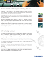
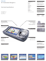
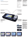
Europe
Navman Europe Ltd
4G Gatwick House
Peeks Brook Lane
Horley, Surrey
RH6 9ST
United Kingdom
Tel +44(0)1293 780500
Fax +44(0)1293 782065
www.navman-europe.com
[email protected]
Headquarters
Navman NZ Ltd
13 -17 Kawana Street
PO Box 68, 155 Newton
Auckland
New Zealand
www.navman.com
[email protected]
Copyright© Navman NZ Limited
NAVMAN, SmartS™, Back-on-Trak™
are registered trademarks of Navman
NZ Limited.
All rights reserved.
Data source © 2003 Tele Atlas N.V.
Windows® is a registered trademark
of Microsoft Corporation.
All other trademarks and registrations
are the property of their respective
owners.
iCN Series
Transferable Navigation
www.navman-europe.com
Navman : a leader in GPS navigation technology. And more.
Established in New Zealand in 1998, Navman researches, designs and builds
critical navigation technology, including GPS navigation devices, commercial fleet
tracking systems and marine electronics instruments.
Employing over 500 staff and using its own manufacturing facilities, Navman
products are researched and developed in-house, resulting in high quality systems
that are easy to use.
With offices all over the world, Navman is a global GPS company. In Europe,
teams of dedicated individuals provide localised high quality sales and technical
support to its ever growing user base.
Navman has the backing of the Brunswick corporation, one of the world’s longest
established corporations, and will continue to grow and provide world leading
critical navigation systems.
GPS technology explained.
The Global Positioning System (GPS) is a satellite-based navigation system made
up of a network of satellites placed into orbit. GPS works in any weather
conditions, anywhere in the world, 24 hours a day. There are no subscription fees
or setup charges to use GPS.
GPS satellites circle the earth in a very precise orbit and transmit signal information
to earth. GPS receivers take this information to calculate the user's exact location.
This location is then passed on to the software, which displays in real time the
maps relevant to the location.
Once the user's position has been determined, the GPS unit can calculate other
information, such as speed, bearing, track, trip distance, distance to destination
and more.
Today's GPS receivers with parallel multi-channel design are extremely accurate.
A GPS with a 12 parallel channel receiver is quick to lock onto satellites when first
turned on and maintains a strong signal whilst driving.
iCN 630
3D Transferable Navigation
The Navman iCN 630 provides the ultimate in-car navigation experience.
“
Simply load your maps, plug-it in, enter your destination and drive.
difference to our
Throughout your journey, the iCN 630’s unique SmartS™ Version 2 Software
will provide turn-by-turn voice instructions until you reach your final
destination, guiding you Back-on-Track™ should you leave the suggested
route. Along the way, points-of-interest such as petrol stations, restaurants,
hotels and airports will appear on-screen, on a map scale that varies with
your travelling speed.
operation’s effeciency,
…obviously,
the Navman has
The iCN 630’s ultra-sharp automotive rated colour screen is in a league of its
own, displaying with unprecedented clarity 3D views of street level maps of
just about anywhere in the 16 European countries included.
But this is the best part : the iCN 630 is totally transferable in seconds. Which
means you benefit from an automotive class navigation system, in any vehicle.
made a huge
particularly in out of
town areas, where
addresses are not as
straightforward as in
the city…
…every driver has his
own Navman and is
responsible for it, so
we really needed a
mobile solution that
was easy to use.
key features & benefits
Transferable
Use your iCN 630 from vehicle to
vehicle.
Quality
High definition automotive LCD
screen housed in magnesium alloy
casing.
Voice Guidance
Male and female, turn-by-turn voice
instructions.
Navigate and Arrive
To a house number, a street name,
an intersection or to a point-ofinterest selected from the map
database included.
Routing
Automatic calculation of any route to
bring you Back-On-Track™ fast if
you take the wrong turn.
Visual Guidance
Automatic zooming, up to 200 miles,
when driving with overlay arrows
showing the exact turn to take when
you approach a junction or a
roundabout.
Favourites
Use favourites to navigate to your
Home, Office, Hotel, Restaurant
etc… without having to enter the
same details over again.
Display
Variable map and navigation screens
allowing you to choose your
preferred navigation screen. Night
and day map display.
3D Maps
Vivid colour 3D map display, showing
street level road details, parks, lakes
and rivers.
Avoid Area
Route calculation can be made to
avoid user selected areas, so as to
exclude areas which are prone to
traffic difficulties.
Postcode Search
Enter destination directly by selecting
5 character postcode search.
”
Tim Ward
South-East Couriers
iCN 630
3D Transferable Navigation
Countries covered
United Kingdom
Ireland (major cities)
France
Germany
Italy
Belgium
Netherlands
Luxembourg
Austria
Switzerland
Portugal
Spain
Norway
Denmark
Sweden
Finland (south)
Technical Specifications
Optional :
USA, Canada, Australia
View
GPS Antenna
Multi-directional – lncreased
capability to receive GPS
signal from any direction
External antenna connection
via MCX connector (external
antenna not included)
GPS Receiver Type
12 channel parallel, automatic
selection.
Update Rate
Typically every second
once fix established.
Accuracy of Position Fix
The accuracy of the GPS
position is typically better than
5m (16ft) for 95% of the time
under optimum conditions.
Time to First Fix
Hot start
8s typical
Warm start
38s typical
Cold start
45s typical
Bright, colour 3D maps
3.8" TFT QVGA (320x240)
automotive rated landscape
screen displaying up to 65536
colours.
Fast, dedicated processor
Intel ® PXA255 Applications
Processor with Intel ®
XScale ™ Technology
64MB RAM
64MB Onboard Flash Memory
for map and data storage.
Power
External Power
12 V DC cigarette lighter
vehicle power cable.
Solid construction
Unit completely housed in
magnesium alloy casing.
Expansion
Built-in Secure Digital
(SD) and Multimedia
Card (MMC)
Expansion slot.
Ideal for maps
and data storage.
Easy to use controls
Ergonomic keys and
touchpad for intuitive
navigation of menu-driven
graphical user interface.
To install maps
You will need a computer with
the following requirements :
IBM® Compatible 486 PC
or higher, Dual Speed
CD-ROM or higher, Microsoft ®
Windows ® 98 SE, ME, 2000 or
XP.
Memory
128 MB MMC card included
Important note
Vehicles that have heated or
heat reflective windshields may
require a re-radiating or
external antenna (not included).
3D View
Avoid Area
Data Input
Route Summary
Instruction list
iCN 620
Transferable Navigation
The Navman iCN 620 is our entry-level transferable navigation solution.
It retains many of the great features and design style of the iCN 630, but
comes with a slightly smaller 3.5” screen and 2D regional mapping, rather
than Pan-European, which makes it even more affordable.
But in true Navman style, the iCN 620 remains a high-quality transferable
navigation solution. Not only does the iCN 620 combine “plug-and-drive”
ease of use with the outstanding features of our SmartS™ navigation software
Version 1.0, it is also highly expandable, making the iCN 620 a truly versatile
navigation system.
Yet, with so many benefits, this high-quality transferable GPS unit remains
surprisingly affordable.
“
Since I started
using a Navman, I
have found it to be a
really useful tool. All I
do is enter the
postcode and street
of my next patient,
listen and follow the
spoken
instructions…It’s really
easy to use…I would
recommend it to
anyone who spends
time on the road
going to unfamiliar
locations…
”
Dr. Paul Wright
Abbey Surgery
London
key features & benefits
Transferable
Use your iCN 620 from vehicle to
vehicle.
Quality
High definition colour LCD screen
housed in magnesium alloy casing.
Voice Guidance
Male and female, turn-by-turn voice
instructions.
Navigate and Arrive
To a house number, a street name,
an intersection or to a point-ofinterest selected from the map
database included.
Routing
Automatic calculation of any route
to bring you Back-On-Track™ fast if
you take the wrong turn.
Visual Guidance
Automatic zooming when driving
with overlay arrows showing the
exact turn to take when you
approach a junction or a
roundabout.
Favourites
Use favourites to navigate to your
Home, Office, Hotel, Restaurant
etc… without having to enter the
same details over and over again.
Display
Variable map and navigation screens
allowing you to choose your
preferred navigation screen. Night
and day map display.
2D colour maps
Full colour 2D maps display showing
street level road details, parks, lakes
and rivers.
iCN 620
Transferable Navigation
Countries covered
The country maps provided
vary according to the product
language :
United Kingdom , Ireland
France, Switzerland
Italy
Spain, Portugal, Andora
To install maps
you will need a computer with
the following requirements :
IBM® Compatible 486 PC
or higher, Dual Speed
CD-ROM or higher, Microsoft ®
Windows ® 98 SE, ME, 2000 or
XP, internet connection (when
installing), Internet Explorer 5.5
or higher.
Germany, Austria, Switzerland
Technical Specifications
Belgium, Netherlands,
Luxembourg
Norway, Sweden, Finland,
Denmark
Optional :
Maps from other European
countries, as well as the USA,
Canada and Australia, are
available as an option.
Bright, colour maps
3.5" Transreflective QVGA
(320 x 240) landscape screen,
displaying up to 65536 colours.
Important note
Vehicles that have heated or
heat reflective windshields may
require a re-radiating or
external antenna (not included).
Fast, dedicated processor
Intel ® PXA250 Applications
Processor with Intel ®
XScale ™ Technology
64MB RAM
64MB Onboard Flash Memory
for map and data storage.
Power
External Power
12 V DC cigarette lighter
vehicle power cable.
Solid construction
Unit completely housed in
magnesium alloy casing.
Expansion
Built-in Secure Digital
(SD) and Multimedia
Card (MMC)
Expansion slot.
Ideal for maps
and data storage.
Easy to use controls
Ergonomic keys and
touchpad for intuitive
navigation of menu-driven
graphical user interface.
GPS Antenna
Multi-directional – lncreased
capability to receive GPS
signal from any direction
External antenna connection
via MCX connector (external
antenna not included)
GPS Receiver Type
12 channel parallel, automatic
selection.
Update Rate
Typically every second
once fix established.
Accuracy of Position Fix
The accuracy of the GPS
position is typically better than
5m (16ft) for 95% of the time
under optimum conditions.
Time to First Fix
Hot start
8s typical
Warm start
38s typical
Cold start
45s typical
Points of interest display
Motorway junction
Navigation screen
Instruction list
iCN 630 & iCN 620
Maps and accessories
Below are some of the additional software products, maps and
accessories to enhance your navigation experience.
Map data for your iCN
Should you need to use your navigation
system in regions not covered by the maps
included with your iCN.
Versions available include :
Western Europe
USA
Australasia
External antenna
For vehicles that have heated or heat
reflective windshields.
This external antenna is supplied with a 5m
cable and connects to your iCN via its MCX
connector.
European coverage
The iCN 630 comes with 16 country maps
covering most of Western Europe.
The iCN 620 comes with regional maps
(See Technical Specifications page for
details).
iCN 630 & iCN 620
SmartS™ example journey voice instructions
Below are some of the voice instructions your iCN unit would “speak” on a simple journey, going from A to B.
4
Back-on-Track™
automatically
recalculates new
journey.
7
"in 300 meters at
the roundabout
take the third exit"
5
"In 50 meters,
turn left.
2
"In 300 meters at
the roundabout
take the fourth
exit"
A
1
Journey starts.
"In 100 meters,
Turn left"
B
3
Service Station
Point-of-Interest
appears on screen
6
"in 1100 meters
exit left"
8
"Destination".
You have arrived.
iCN 630 & iCN 620
Comparison chart
Transferable
TFT QVGA LCD screen
Screen size
Screen resolution (pixels)
External power
SD and MMC expansion slot
iCN 620
•
•
•
•
3.8”
3.5”
320x240
320x240
•
•
•
•
16 (Continental Europe)
1 (UK and Ireland)
3D Maps
•
-
Back-on-Track™
•
•
Turn-by-turn voice instructions
•
•
Day and night screen display
•
•
Variable map and navigation screens
•
•
Automatic zooming
•
•
Post Code Searching
•
-
Avoid Areas
•
-
User Selectable language on iCN
•
-
Route to a town only
•
-
Zoom out to 200 mile scale
•
-
Complete Route Summary
•
-
Country maps supplied
iCN 630 & iCN 620
Box Contents
iCN 630
Box contents iCN 630
iCN 630 unit with integral GPS
Receiver
SmartST V 2.0 navigation
software and 3 map CD’s
128 MB MMC memory card
Vehicle windshield and dash
mounting bracket
Vehicle power cable
Mains Power Pack for indoor
installation and planning
USB Cable for installation of
maps
Quickstart guide
CD-ROM includes:
User manual
Adobe Acrobat Reader
Box contents iCN 620
iCN 620 unit with integral GPS
Receiver
SmartST V 1.0 navigation
software and 2 map CD’s
Vehicle windshield mounting
bracket
Vehicle power cable
Mains Power Pack for indoor
installation and planning
USB Cable for installation of
maps
Quickstart guide
CD-ROM includes:
User manual
Adobe Acrobat Reader