1
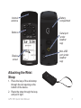
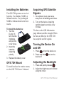
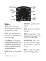
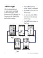
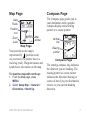
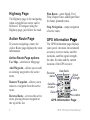
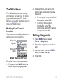
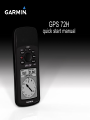
GPS 72H
quick start manual
See the Important Safety and
Product Information guide in
the product box for product
warnings and other important
information.
Manual Conventions
When you are instructed to “press”
something, press the buttons on
the device. Use the rocker to select
something in a list, and then press
ENTER.
The small arrows (>) used in the
text indicate that you should select a
series of items in order, for example,
“Press PAGE > ENTER > select
TRACKS.”
Contact Garmin
Contact Garmin Product Support if
you have any questions while using
your GPS 72H. In the USA, go to
www.garmin.com/support, or contact
Garmin USA by phone at (913)
397.8200 or (800) 800.1020.
In the UK, contact Garmin (Europe)
Ltd. by phone at 0808 2380000.
In Europe, go to www.garmin.com
/support and click Contact Support
for in-country support information,
or contact Garmin (Europe) Ltd. by
phone at +44 (0) 870.8501241.
If needed, the serial number of your
GPS 72H is located on the back of
the device in the lower right corner.
Optional Accessories
For a list of available accessories for
use with the GPS 72H, go to
http://buy.garmin.com.
GPS 72H Quick Start Manual
Internal
antenna
Battery
compartment
Buttons
Serial port
(under
weather
cap)
Display
screen
Mini-USB
port (under
weather
cap)
Attaching the Wrist
Strap
1. Place the loop of the wrist strap
through the slot opening at the
bottom of the device.
2. Route the strap through the loop,
and pull it tight.
GPS 72H Quick Start Manual
Installing the Batteries
The GPS 72H operates on two AA
batteries. Use alkaline, NiMH, or
lithium batteries. Use precharged
NiMH or lithium batteries for best
results.
To install the batteries:
1. Turn the
D-ring 1/4
turn counterclockwise,
and pull the
cover loose.
2. Insert the
batteries,
observing
polarity.
3. Replace the battery cover.
GPS 72H Mount
To install and use the marine mount,
see the GPS 72H Owner’s Manual.
Acquiring GPS Satellite
Signals
1. Go outdoors to an open area,
away from tall buildings and trees.
2. Turn on the device. Acquiring
satellite signals can take a few
minutes.
The bars on the GPS Information
page indicate satellite strength. When
the bars are filled in, the GPS 72H
has acquired satellite signals.
Turning the Device On
and Off
1. Press
to turn the device on.
2. Press and hold
to turn the
device off.
Adjusting the Backlight
1. Press and quickly release
.
2. Adjust the brightness and contrast
using the rocker.
GPS 72H Quick Start Manual
ZOOM IN
ZOOM
OUT
GO TO/
MOB
PAGE
MENU
Power
QUIT
Buttons
Rocker
QUIT—press to return to the
previous page and cycle through the
main pages in reverse order.
ENTER/
MARK
ZOOM OUT—press to zoom the
map out.
PAGE—press to cycle through the
main pages.
Power—press and hold to turn the
device on or off. Press and release to
adjust the backlight.
MENU—press and release to view
the Menu for the current page. Press
twice to view the Main Menu.
GO TO/MOB—press to begin or
stop navigation to a waypoint. Press
and hold (man overboard function)
to store current location and begin
navigation to that point.
ENTER/MARK—press to select
an menu item, data field, or option.
Press and hold to save your current
location.
ZOOM IN—press to zoom the map
in.
GPS 72H Quick Start Manual
Rocker—rock up, down, right, and
left to move through page items.
The Main Pages
All of the information needed
to operate your device is found
on the five main pages: the GPS
Information page, the Map page, the
Compass page, the Highway page,
and the Active route page.
GPS Information
Page
Map Page
Active Route
Page
• Press the PAGE button to
navigate through the main pages.
• Press MENU to access the menu
for these pages.
• Use the rocker and the ENTER
button to select the option you
want to change.
• Press MENU twice to access the
Main Menu.
Compass Page
Highway Page
GPS 72H Quick Start Manual
Map Page
Compass Page
The Compass page guides you to
your destination with a graphic
compass display and a bearing
pointer or a course pointer.
Data
Fields
Position
icon
Map
pointer
Zoom
scale
Map Page
Your position on the map is
represented by (position icon).
As you travel, the pointer leaves a
track log (trail). Waypoint names and
symbols are also shown on the map.
To view the map with north up:
1. From the Map page, press
MENU.
2. Select Setup Map > General >
Orientation > North Up.
GPS 72H Quick Start Manual
Vertical
line
Bearing
pointer
Compass Page
The rotating compass ring indicates
the direction you are heading. The
bearing pointer or course pointer
indicates the direction (bearing or
course of travel) to your destination,
relative to your current heading
direction.
Highway Page
The Highway page is for navigating
when a straight line course can be
followed. To navigate using the
Highway page, just follow the road.
Active Route Page
If you are navigating a route, the
Active Route page displays the route
information.
Active Route Page options
Use Map—switches to Map page.
Add Waypoint—allows you to add
an existing waypoint to the active
route.
Remove Waypoint—allows you to
remove a waypoint from the active
route.
Reverse Route—reverses the active
route, placing the last waypoint at
the top of the list.
Plan Route—enter Speed, Fuel
Flow, Depart Time, and Depart Date
for future planned routes.
Stop Navigation—stops navigation
of active route.
GPS Information �����
Page
The GPS Information page displays
your speed, elevation, the estimated
accuracy, receiver status, satellite
locations, satellite signal strength,
the date, the time and the current
location of the GPS receiver.
Receiver
status
Satellite
location
Date
Data fields
Signal
strength
Time
Location
GPS Information Page
GPS 72H Quick Start Manual
The Main Menu
The Main Menu contains settings
and features not found on the main
pages and submenus. The Main
Menu is accessible from any page by
pressing MENU twice.
Marking Your Current
Location
You must have a valid position fix to
mark your current location.
Waypoint
symbol
Waypoint
name
Mark Waypoint Page
2. A default three-digit name and
symbol are assigned to the new
waypoint.
• To accept the waypoint default
information, select OK.
• To change the waypoint
information, select the
appropriate field. After making
changes, select OK.
Editing Waypoints
1. Press MENU twice > select
Points > Waypoints.
2. Select the waypoint you want to
edit.
3. Use the rocker and the ENTER
button to make changes.
4. Select OK.
To mark your current location:
1. Press and hold MARK until the
Mark Waypoint page appears.
GPS 72H Quick Start Manual
Recording your Tracks
The track log starts recording as soon
as the device gets a location fix.
To save the entire track log:
1. Press MENU twice > select
Tracks.
2 Select Save > Entire Log.
To save a portion of the track
log:
1. Press MENU twice > select
Tracks.
2. Select Save.
3. Select the portion of the track log
to save from the list
4. Select OK.
To view a track on the map:
1. Press MENU twice > select
Tracks.
2. Select a track to view.
3. Select Map.
10
Creating and Navigating
Routes
A route is a sequence of waypoints
that lead you to your destination.
A route must have at least two
waypoints.
1. Press MENU twice > select
Routes > New.
2. Press MENU to add a waypoint
using the Map page or from
existing waypoints.
3. Select OK to ����������������������
add it to the route.
4. Repeat steps 2 through 4 to add
additional waypoints to the route.
5. Press MENU > select Start
Navigation.
Navigating a Route
1. Press MENU twice > select
Routes.
2. Select a saved route > Navigate.
NOTE: To stop navigating, press
MENU > select Stop Navigation.
GPS 72H Quick Start Manual
Editing a Route
Use the Route page to edit, change
the route name, and review route
points.
To change the name of the route:
1. Press MENU twice > Routes.
2. Select a saved route, and then
select the route name field at the
top of the Route page.
3. Use the rocker and the ENTER
button to change the text in the
field.
Connecting Your Device
to a Computer
1. Plug the small end of the USB
cable into the mini-USB port on
the back of the device (under the
weather cap).
2. Connect the larger end of the
USB cable to an available USB
port on your computer.
GPS 72H Quick Start Manual
NOTE: To check your connection,
press MENU twice > select Setup >
Interface > Connected.
Transferring Tracks, Routes,
or Waypoints
Tracks, routes, and waypoints can be
transferred between your device and
a computer using MapSource®.
NOTE: For information about
MapSource, go to www.garmin.com.
To transfer tracks, routes,
or waypoints to and from
MapSource:
1. Connect your device to the
computer with a USB cable.
2. Open MapSource on your
computer.
3. Select tracks, routes, or
waypoints to transfer.
4. Click Receive From Device
or Send To Device on the
MapSource Transfer menu.
11
Garmin® , the Garmin logo, and MapSource® are trademarks of Garmin Ltd. or its subsidiaries, registered
in the USA and other countries. These trademarks may not be used without the express permission of
Garmin.
© 2009 Garmin Ltd. or its subsidiaries
Garmin International, Inc.
1200 East 151st Street, Olathe, Kansas 66062, USA
Garmin (Europe) Ltd.
Liberty House, Hounsdown Business Park, Southampton, Hampshire, SO40 9LR UK
Garmin Corporation
No. 68, Jangshu 2nd Road, Shijr, Taipei County, Taiwan
www.garmin.com
September 2009
Part Number 190-01119-01 Rev. B
Printed in Taiwan