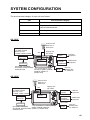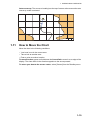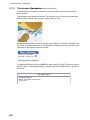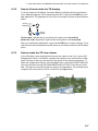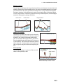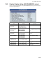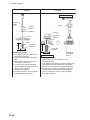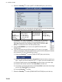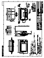
1
Model
GP-1670F/GP-1870F
www.furuno.com
OPERATOR'S MANUAL
GPS PLOTTER/SOUNDER
The paper used in this manual
is elemental chlorine free.
・FURUNO Authorized Distributor/Dealer
9-52 Ashihara-cho,
Nishinomiya, 662-8580, JAPAN
All rights reserved.
Printed in Japan
A : JUN . 2012
C : FEB . 15, 2013
Pub. No. OME-44770-C
(TAHA )
GP-1670F/GP-1870F
*00017659312*
*00017659312*
* 0 0 0 1 7 6 5 9 3 1 2 *
IMPORTANT NOTICES
General
• This manual has been authored with simplified grammar, to meet the needs of international users.
• The operator of this equipment must read and follow the descriptions in this manual. Wrong operation or maintenance can cancel the warranty or cause injury.
• Do not copy any part of this manual without written permission from FURUNO.
• If this manual is lost or worn, contact your dealer about replacement.
• The contents of this manual and equipment specifications can change without notice.
• The example screens (or illustrations) shown in this manual can be different from the screens
you see on your display. The screens you see depend on your system configuration and equipment settings.
• Save this manual for future reference.
• Any modification of the equipment (including software) by persons not authorized by FURUNO
will cancel the warranty.
• SDHC is a registered trademark of SD-3C, LLC.
• All brand and product names are trademarks, registered trademarks or service marks of their
respective holders.
How to discard this product
Discard this product according to local regulations for the disposal of industrial waste. For disposal
in the USA, see the homepage of the Electronics Industries Alliance (http://www.eiae.org/) for the correct method of disposal.
How to discard a used battery
Some FURUNO products have a battery(ies). To see if your product has a battery, see the chapter
on Maintenance. Follow the instructions below if a battery is used. Tape the + and - terminals
of battery before disposal to prevent fire, heat generation caused by short circuit.
In the European Union
The crossed-out trash can symbol indicates that all types of batteries
must not be discarded in standard trash, or at a trash site. Take the
used batteries to a battery collection site according to your national
legislation and the Batteries Directive 2006/66/EU.
Cd
In the USA
The Mobius loop symbol (three chasing arrows) indicates that Ni-Cd
and lead-acid rechargeable batteries must be recycled. Take the used
batteries to a battery collection site according to local laws.
Ni-Cd
Pb
In the other countries
There are no international standards for the battery recycle symbol. The number of symbols can
increase when the other countries make their own recycle symbols in the future.
i
SAFETY INSTRUCTIONS
The operator must read the safety instructions before attempting to operate the equipment.
WARNING
Indicates a potentially hazardous situation which, if not avoided,
could result in death or serious injury.
CAUTION
Indicates a potentially hazardous situation which, if not avoided,
could result in minor or moderate injury.
Warning, Caution
Prohibitive Action
WARNING
Do not open the equipment.
The equipment uses high voltage that
can cause electrical shock. Refer any
repair work to a qualified technician.
If water leaks into the equipment or
something is dropped into the equipment, immediately turn off the power
at the switchboard.
Mandatory Action
WARNING
Do not disassemble or modify the
equipment.
Fire, electrical shock or serious injury
can result.
Make sure no rain or water splash
leaks into the equipment.
Fire or electrical shock can result if
water leaks into the equipment.
Fire or electrical shock can result.
If the equipment is giving off smoke
or fire, immediately turn off the power
at the switchboard.
WARNING
Fire or electrical shock can result.
If you feel the equipment is acting
abnormally or giving off strange
noises, immediately turn off the
power at the switchboard and contact
a FURUNO service technician.
Electrical current flows to the pins of
the transducer connector when the
power is on, regardless of whether
the transducer cable is connected or
not.
If the transducer cable is not connected,
cover the transducer connector with the
supplied cap to prevent electrical shock.
ii
Do not place liquid-filled containers
on or near the equipment.
Fire or electrical shock can result if a
liquid spills into the equipment.
WARNING
Do not operate the equipment with
wet hands.
Electrical shock can result.
Use the proper fuse.
Use of the wrong fuse can cause fire or
electrical shock.
SAFETY INSTRUCTIONS
CAUTION
Do no turn on the equipment with the
transducer out of water.
The transducer can be damaged.
The picture is not refreshed when
picture advancement is stopped.
Maneuvering the vessel in this condition
can result in a dangerous situation.
Adjust the gain correctly.
Incorrect gain may give a wrong depth
indication, which could result in a
dangerous situation.
The data presented by this equipment
is intended as a source of navigation
information.
The prudent navigator never relies
exclusively on any one source of
navigation information, for safety of
vessel and crew.
The LCD panel is made of glass.
Handle it with care.
Injury can result if the glass breaks.
Follow the compass safe distances
shown below to prevent interference
to a magnetic compass.
Standard
compass
Steering
compass
GP-1670F
0.30 m
0.30 m
GP-1870F
0.30 m
0.30 m
Warning Label
Do not remove the label.
To avoid electrical shock,do not remove
cover. No user-serviceable parts inside.
Warning Label
iii
TABLE OF CONTENTS
FOREWORD ...................................................................................................................ix
SYSTEM CONFIGURATION ..........................................................................................xi
EQUIPMENT LISTS .......................................................................................................xii
1.
OPERATIONAL OVERVIEW .................................................................................1-1
1.1 Controls...................................................................................................................... 1-1
1.1.1 Control description ......................................................................................... 1-1
1.2 RotoKeyTM and Soft Controls .................................................................................... 1-5
1.3 How to Turn the Power On or Off............................................................................... 1-6
1.4 How to Adjust the Display Brilliance........................................................................... 1-6
1.5 2D Plotter Displays..................................................................................................... 1-6
1.6 The Cursor ................................................................................................................. 1-9
1.7 Navigation Data Boxes............................................................................................. 1-10
1.7.1 How to select the data to display in a box.................................................... 1-10
1.8 Home Screen (Display Selection) ............................................................................ 1-11
1.8.1 How to select a display ................................................................................ 1-11
1.8.2 How to switch the active screen................................................................... 1-11
1.8.3 How to customize the home screen ............................................................. 1-12
1.8.4 Description of home screen displays ........................................................... 1-14
1.9 Display Range.......................................................................................................... 1-18
1.10 Orientation Mode...................................................................................................... 1-18
1.11 How to Move the Chart ............................................................................................ 1-19
1.12 Menu Operation ....................................................................................................... 1-20
1.13 Object Information.................................................................................................... 1-21
1.13.1 Simple information ....................................................................................... 1-21
1.13.2 Detailed information ..................................................................................... 1-21
1.14 Context-Sensitive Menus ......................................................................................... 1-22
1.15 Man Overboard (MOB)............................................................................................. 1-24
1.15.1 How to mark MOB position .......................................................................... 1-24
1.15.2 How to stop navigating to a MOB mark........................................................ 1-24
1.15.3 How to erase an MOB mark......................................................................... 1-24
1.16 How to Take a Screenshot....................................................................................... 1-24
1.17 Tide Information ....................................................................................................... 1-25
1.17.1 Tide height information................................................................................. 1-25
1.17.2 Tide stream information ............................................................................... 1-26
2.
TRACK ...................................................................................................................2-1
2.1
2.2
2.3
2.4
2.5
2.6
2.7
2.8
3.
How to Show, Hide all Track ...................................................................................... 2-1
How to Stop Recording Track .................................................................................... 2-1
How to Select Recording Method, Recording In-terval .............................................. 2-1
How to Change the Color of Your Boat’s Track ......................................................... 2-2
How to Change the Color of Your Boat’s Track with Sea Surface Temperature ....... 2-2
How to Hide, Show Track by Color ............................................................................ 2-2
How to Delete Track by Color .................................................................................... 2-3
How to Find Track Information ................................................................................... 2-3
POINTS ..................................................................................................................3-1
3.1 What is a Point? ......................................................................................................... 3-1
3.2 How to Enter a Point .................................................................................................. 3-1
3.2.1 How to enter a point at the current position ................................................... 3-1
3.2.2 How to enter a point at the cursor position..................................................... 3-2
iv
TABLE OF CONTENTS
3.3
3.4
3.5
3.6
3.7
3.8
4.
3.2.3 How to enter a position manually on the plotter screen .................................3-3
3.2.4 How to enter a point from the Points List .......................................................3-3
How to Find Detailed Point Information ......................................................................3-4
How to Move a Point ..................................................................................................3-4
3.4.1 How to move a point on the screen ................................................................3-4
3.4.2 How to move a point from the Points List.......................................................3-4
How to Select Visibility for Points ...............................................................................3-5
How to Search, Sort Points on the Points List............................................................3-5
3.6.1 How to search points ......................................................................................3-5
3.6.2 How to sort points...........................................................................................3-5
How to Filter Points by Shape on the Points List........................................................3-6
How to Delete Points ..................................................................................................3-6
3.8.1 How to delete a point from the screen............................................................3-6
3.8.2 How to delete points from the Points List .......................................................3-6
ROUTES ................................................................................................................4-1
4.1 What is a Route? ........................................................................................................4-1
4.2 How to Create a Route ...............................................................................................4-1
4.2.1 How to create a route from the RotoKey menu ..............................................4-1
4.2.2 How to create a route from the Routes List ....................................................4-2
4.2.3 How to create a route with the Easy Routing feature .....................................4-3
4.3 How to Extend a Route on the Screen .......................................................................4-6
4.4 How to Insert a Point on a Route on the Screen ........................................................4-7
4.5 How to Move a Point in a Route on the Screen..........................................................4-7
4.6 How to Delete a Point From a Route on the Screen ..................................................4-7
4.7 Routes List..................................................................................................................4-8
4.7.1 How to display the Routes List .......................................................................4-8
4.7.2 Functions available in the Routes List ............................................................4-9
4.8 Route Report, Route Calculator ...............................................................................4-10
4.9 How to Display a Route on the Screen.....................................................................4-11
4.10 How to Connect Two Routes....................................................................................4-11
4.11 Simple Route Information .........................................................................................4-11
4.12 How to Rename a Route on the Screen...................................................................4-12
4.13 How to Delete Routes...............................................................................................4-12
4.13.1 How to delete a route on the screen ............................................................4-12
4.13.2 How to delete routes from the Routes List ...................................................4-12
5.
NAVIGATION.........................................................................................................5-1
5.1 How to Navigate to a Quick Point...............................................................................5-1
5.2 How to Navigate to a Saved Point..............................................................................5-2
5.2.1 How to navigate to a saved point selected on the screen ..............................5-2
5.2.2 How to navigate to a point selected from the Points List................................5-2
5.3 How to Select a Route for Navigation.........................................................................5-2
5.3.1 On-screen route .............................................................................................5-2
5.3.2 Route selected from the Routes List ..............................................................5-3
5.3.3 How to start navigation from a point on a route..............................................5-3
5.4 Functions Available When You Follow a Route..........................................................5-4
5.4.1 Restart navigation ..........................................................................................5-4
5.4.2 Follow a route in reverse order.......................................................................5-4
5.4.3 Stop following a route.....................................................................................5-4
5.4.4 Skip a leg in a route........................................................................................5-4
6.
MAP SETTINGS, 2D PERSPECTIVE/3D DISPLAYS AND
SATELLITE OVERLAY .........................................................................................6-1
6.1 Map Setup ..................................................................................................................6-1
6.2 2D Perspective Dispay ...............................................................................................6-5
v
TABLE OF CONTENTS
6.3 3D Display.................................................................................................................. 6-6
6.3.1 3D display description .................................................................................... 6-6
6.3.2 How to tilt and rotate the 3D display .............................................................. 6-7
6.3.3 How to make the 3D view clearer .................................................................. 6-7
6.4 Satellite Photo Overlay............................................................................................... 6-8
7.
FISH FINDER OPERATIONS ................................................................................7-1
7.1
7.2
7.3
7.4
7.5
7.6
7.7
7.8
7.9
7.10
7.11
7.12
7.13
7.14
7.15
7.16
7.17
7.18
8.
ALARMS ................................................................................................................8-1
8.1
8.2
8.3
8.4
8.5
8.6
8.7
8.8
8.9
8.10
8.11
8.12
8.13
vi
How the Fish Finder Works........................................................................................ 7-1
Fish Finder Display .................................................................................................... 7-2
How to Activate the Fish Finder ................................................................................. 7-3
How to Select a Display ............................................................................................. 7-3
7.4.1 How to select a single frequency or dual frequency....................................... 7-3
7.4.2 How to select a zoom display......................................................................... 7-4
7.4.3 A-scope display.............................................................................................. 7-5
7.4.4 Bottom discrimination display......................................................................... 7-6
Automatic Fish Finder ................................................................................................ 7-8
7.5.1 How the automatic fish finder works .............................................................. 7-8
7.5.2 How to select an automatic fish finder mode ................................................. 7-8
7.5.3 How to adjust the gain in the auto mode........................................................ 7-8
Manual Fish Finder Operation.................................................................................... 7-9
7.6.1 How to select a display range ........................................................................ 7-9
7.6.2 How to shift the range .................................................................................... 7-9
7.6.3 How to adjust the gain.................................................................................. 7-10
7.6.4 How to reduce clutter ................................................................................... 7-10
Picture Advance Speed............................................................................................ 7-11
How to Reduce Interference .................................................................................... 7-12
How to Erase Weak Echoes .................................................................................... 7-12
How to Measure Depth, Time Between Locations ................................................... 7-13
How to Balance Echo Strength ................................................................................ 7-13
White Marker............................................................................................................ 7-14
White Line ................................................................................................................ 7-14
Alarms ...................................................................................................................... 7-14
7.14.1 How to set an alarm ..................................................................................... 7-15
7.14.2 How to select the echo signal level that triggers the fish alarm ................... 7-15
ACCU-FISHTM ......................................................................................................... 7-16
7.15.1 Considerations for ACCU-FISHTM ............................................................... 7-16
7.15.2 How to activate ACCU-FISHTM, select display information ......................... 7-17
7.15.3 Fish size correction ...................................................................................... 7-17
Water Temperature Graph ....................................................................................... 7-18
FISH FINDER Menu................................................................................................. 7-19
Interpreting the Display ............................................................................................ 7-22
ALARMS Menu .......................................................................................................... 8-1
Audio Alarm Conditions.............................................................................................. 8-2
Arrival Alarm............................................................................................................... 8-2
XTE Alarm.................................................................................................................. 8-3
Temperature Alarm .................................................................................................... 8-3
Shear Alarm ............................................................................................................... 8-4
Depth Alarm ............................................................................................................... 8-4
Anchor Alarm ............................................................................................................. 8-5
Trip Alarm................................................................................................................... 8-5
Speed Alarm .............................................................................................................. 8-5
Fuel Tank Alarm......................................................................................................... 8-6
Water Tank Alarm ...................................................................................................... 8-6
Black Water Tank Alarm ............................................................................................ 8-6
TABLE OF CONTENTS
9.
MEMORY CARD OPERATIONS ...........................................................................9-1
9.1
9.2
9.3
9.4
9.5
9.6
The Memory Card Screen ..........................................................................................9-1
How to Initialize SD Cards..........................................................................................9-1
How to Eject an SD Card............................................................................................9-2
How to Save Data to an SD Card...............................................................................9-2
How to Rename Files on an SD Card ........................................................................9-2
How to Delete Files from an SD Card ........................................................................9-3
9.6.1 How to delete individual files from an SD card...............................................9-3
9.6.2 How to delete all files from an SD card ..........................................................9-3
9.7 How to Import Data from an SD Card.........................................................................9-3
9.8 How to Process Screenshots .....................................................................................9-4
9.8.1 How to select source of screenshots (internal memory or SD card) ..............9-4
9.8.2 How to save screenshots in the internal memory to an SD card....................9-4
9.8.3 How to delete screenshots .............................................................................9-5
10. OTHER FUNCTIONS ..........................................................................................10-1
10.1 AIS Operations .........................................................................................................10-1
10.1.1 AIS target symbols .......................................................................................10-1
10.1.2 How to find AIS target information................................................................10-2
10.1.3 AIS activation range .....................................................................................10-2
10.1.4 CPA and TCPA alarms.................................................................................10-2
10.2 DSC Message Information .......................................................................................10-3
10.2.1 How to select a device for DSC message information .................................10-3
10.2.2 DSC message information ...........................................................................10-3
10.3 Stopwatch, Timer......................................................................................................10-4
10.4 How to Select Input, Output Data .............................................................................10-5
10.4.1 Input data .....................................................................................................10-5
10.4.2 Output data...................................................................................................10-6
10.5 Engine Display Setup (INSTRUMENTS menu)........................................................10-7
11. CUSTOMIZING YOUR UNIT ...............................................................................11-1
11.1 GENERAL Menu ......................................................................................................11-1
11.2 PLOTTER Menu .......................................................................................................11-2
11.3 SYSTEM Menu.........................................................................................................11-3
12. MAINTENANCE, TROUBLESHOOTING ............................................................12-1
12.1
12.2
12.3
12.4
12.5
12.6
Maintenance .............................................................................................................12-1
How to Replace the Fuse .........................................................................................12-2
Troubleshooting........................................................................................................12-2
GPS Status Display ..................................................................................................12-4
How to Restore Defaults, Clear Memory ..................................................................12-5
System Information...................................................................................................12-6
13. INSTALLATION ...................................................................................................13-1
13.1 Installation of Display Unit ........................................................................................13-1
13.2 Installation of Antenna Unit.......................................................................................13-2
13.3 Installation or Transducers .......................................................................................13-2
13.3.1 How to mount a transducer through the hull ................................................13-2
13.3.2 Transom mount transducer ..........................................................................13-5
13.3.3 How to mount a transducer inside the hull ...................................................13-6
13.3.4 Triducer ........................................................................................................13-7
13.4 Installation of Sensors (option) ...............................................................................13-12
13.4.1 Speed/temperature sensors ST-02MSB, ST-02PSB .................................13-12
13.4.2 Temperature sensors .................................................................................13-13
13.5 Wiring .....................................................................................................................13-15
13.6 Initial Settings .........................................................................................................13-19
vii
TABLE OF CONTENTS
13.6.1 INSTALLATION SETTINGS menu............................................................. 13-19
13.6.2 CAN bus input/output ................................................................................. 13-21
APPENDIX 1 MENU TREE .......................................................................................AP-1
APPENDIX 2 ABBREVIATIONS, SYMBOLS ...........................................................AP-6
APPENDIX 3 JIS CABLE GUIDE ...........................................................................AP-11
SPECIFICATIONS .....................................................................................................SP-1
PACKING LISTS.......................................................................................................... A-1
OUTLINE DRAWINGS................................................................................................. D-1
INTERCONNECTION DIAGRAM ................................................................................ S-1
INDEX.......................................................................................................................... IN-1
viii
FOREWORD
A Word to GP-1670F, GP-1870F Owners
Congratulations on your choice of the FURUNO GP-1670F, GP-1870F GPS Plotter/Sounder. We
are confident you will see why the FURUNO name has become synonymous with quality and reliability.
Since 1948, FURUNO Electric Company has enjoyed an enviable reputation for innovative and
dependable marine electronics equipment. This dedication to excellence is furthered by our extensive global network of agents and dealers.
This equipment is designed and constructed to meet the rigorous demands of the marine environment. However, no machine can perform its intended function unless operated and maintained
properly. Please carefully read and follow the recommended procedures for operation and maintenance.
We would appreciate hearing from you, the end user, about whether we are achieving our purposes.
Thank you for considering and purchasing FURUNO equipment.
Features
The GP-1670F and GP-1870F provide a totally integrated GPS receiver, color video plotter and
color fish finder. The built-in GPS receiver provides highly accurate position, course and speed
information. The fish finder presents vivid underwater images on a high quality LCD. The compact
display unit and antenna unit permit installation where space is limited.
The main features are
General
• Bright 5.7-inch (GP-1670F) or 7-inch (GP-1870F) color LCD with brilliance control.
• Excellent viewing angles, even when wearing sunglasses.
• Internal GPS receiver provides highly accurate position information (GPS, within 2.5 m, SBAS,
within 2 m).
• Customizable analog and digital displays show wind angle and speed, engine condition (speed,
temperature, oil pressure, etc.), etc.
• Large internal memory stores 30,000 track points, 30,000 points, 1,000 routes (500 waypoints/
route).
• SD card slot accepts SD and SDHC cards for external storage of data and settings.
• Full range of alarms: Arrival, Anchor Watch, Cross-track Error, Speed, Depth, Temperature,
Fish Alarm, Bottom Alarm, etc.
• Man overboard (MOB) feature records latitude and longitude coordinates at the time of MOB.
• CAN bus interface for the connection of GPS Receiver, Weather Station, FI-50 (instrument series), Satellite Compass, etc.
• Accepts NMEA0183 input with optional NMEA data converter.
• Internal GPS antenna available.
• C-Map 4D charts available.
ix
FOREWORD
Fish finder
• Fish finder measures the depth to the bottom and displays underwater conditions in multi-colors* according to echo strength. A monochrome presentation shows the echoes in shades of
gray. (*Number of colors depends on network sounder, color sounder.).
• Automatic and manual fish finder operation. Auto mode automatically adjusts range, gain and
clutter ac-cording to purpose - fishing or cruising.
• Wide variety of zoom modes for detailed observation of fish and bottom.
• ACCU-FISHTM provides length and depth of individual fish. Appropriate transducer required.
Other
• AIS function (requires connection to an AIS transponder) provides navigational information from
AIS transponder equipped vessels within 50 nm.
• Instrument displays (steering, engine, weather, and wind) with connection of relevant sensors.
• DSC (Digital Selective Calling) function alerts to DSC messages received and position requests. (Requires DSC capable radiotelephone.)
Open Source Acknowledgement
This product makes use of the following open source software:
FreeType (www.freetype.org)
Portions of this software are copyright ©2009 The FreeType Project
(www.freetype.org). All rights reserved.
libpng (http://www.libpng.org/)
This software is based in part on the work of the Independent JPEG Group.
libjpeg (http://www.ijg.org/)
We would like to thank each developer of the above-mentioned open
source software for their great contribution to the open source community.
x
SYSTEM CONFIGURATION
The environmental category of each unit is as follows:
Unit
Environmental category
Display unit
Protected from the weather
GPS antenna unit
Exposed to the weather, or protected from the weather in
case of internal antenna
Transducer, sensor
Submerged in water
Other units
Protected from the weather
GP-1670F
Water temp./speed sensor
ST-02MSB, ST-02PSB
Water temp. sensor
T-02MSB, T-02MTB, T-03MSB
Matching Box
MB-1100*
Antenna Unit
GPA-017 or
GPA-017S
OR
Display Unit
GP-1670F
Internal GPS
antenna
Transducer
520-5PSD, 520-5MSD,
525-5PWD, 525STID-MSD, * For connection to 1 kW
525STID-PWD
transducer (50B-6, 50B-6B,
200B-5S, 50/200-1T,
50/200-12M)
Junction Box
FI-5002
CAN bus
equipment
NMEA Data
Converter
IF-NMEA2K2
NMEA 0183
equipment
12-24 VDC
Rectifier
PR-62
100/110/
220/230 VAC,
1ø, 50/60 Hz
GP-1870F
Antenna Unit
GPA-017 or
GPA-017S
OR
Water temp./speed sensor
ST-02MSB, ST-02PSB
Water temp. sensor
T-02MSB, T-02MTB, T-03MSB
Display Unit
GP-1870F
Internal GPS
antenna
Matching Box
MB-1100*
Junction Box
FI-5002
CAN bus
equipment
NMEA Data
Converter
IF-NMEA2K2
NMEA 0183
equipment
12-24 VDC
Transducer
* For connection to 1 kW transducer
520-5PSD, 520-5MSD,
(50B-6, 50B-6B, 200B-5S,
525-5PWD, 525STID-MSD, 50/200-1T, 50/200-12M)
525STID-PWD
Rectifier
PR-62
100/110/
220/230 VAC,
1ø, 50/60 Hz
xi
EQUIPMENT LISTS
Standard supply
Name
Type
Code no.
Qty
Select
one
Remarks
Display Unit
GP-1670F
-
Display Unit
GP-1870F
-
Installation
Materials
CP14-07100
000-021-070
1 set
Spare Parts
SP14-03501
001-184-710
1 set
Accessories
FP14-03001
001-184-730
1 set
For GP-1670F
FP14-03201
001-183-120
1 set
For GP-1870F
w/CP14-07101, MJ-A3SPF0013A035C (power cable)
Optional equipment
Name
Type
Code no.
Remarks
Replacement Kit
OP14-72
001-184-750
Waterproofing Cap
LTWCAP-WBDMMSA1
000-167-169-11
Antenna Unit
GPA-017
Antenna Unit
GPA-017S
Mast Mtg. Kit
CP20-01111
004-365-780
Antenna Cable Set
CP20-01700 *30M*
004-372-110
Antenna Cable Set
CP20-01710 *50M*
004-372-120
Transducer
520-5PSD
000-015-204
Thru-hull mount, plastic
520-5MSD
000-015-212
Thru-hull mount, metal
525-5PWD
000-146-966-01
Transom mount, plastic
Triducer (transducer
with speed/ temperature sensor)
525STID-MSD
000-011-783
Thru-hull mount, metal
525STID-PWD
000-011-784
Transom mount, plastic
Transducer (1 Kw)
50B-6
000-015-042
10 m, 1 kW
50B-6B
000-015-043
15 m, 1 kW
200B-5S
000-015-029
10 m, 1 kW
50/200-1T
000-015-170
10 m, 1 kW
50/200-12M
000-015-171
10 m, 1 kW
ST-02MSB
000-137-986-01
Thru-hull type, metal
ST-02PSB
000-137-987-01
Thru-hull type, plastic
Speed/ Temperature Sensor
xii
EQUIPMENT LISTS
Name
Temperature Sensor
Type
Code no.
Remarks
T-02MTB
000-040-026
Transom mount, 8 m cable
T-02MSB
000-040-040
Thru-hull type
T-03MSB
000-040-027
Thru-hull type, 8 m cable
Matching Box
MB-1100
000-041-353
For connection to 1 kW transducer
Rectifier
PR-62
000-013-484
100 VAC
Rectifier
PR-62
000-013-485
110 VAC
Rectifier
PR-62
000-013-486
220 VAC
Rectifier
PR-62
000-013-487
230 VAC
Junction Box
FI-5002
Right Angle Mounting Base
No.13QA330
001-111-910-10
L-angle Mounting
Base
No.13-QA310
001-111-900-10
Handrail Mounting
Base
No.13-RC5160
001-111-920-10
Cable Assy.
TNC-PS-/PS-3D-L15M-R
001-173-110-10
Cable Assy.
M12-05BM+05BF-010
001-105-750-10
w/connectors (light), 1 m
Cable Assy.
M12-05BM+05BF-020
001-105-760-10
w/connectors (light), 2 m
Cable Assy.
M12-05BM+05BF-060
001-105-770-10
w/connectors (light), 6 m
Cable Assy.
M12-05BFFM-010
001-105-780-10
w/connectors (light), 1 m
Cable Assy.
M12-05BFFM-020
001-105-790-10
w/connectors (light), 2 m
Cable Assy.
M12-05BFFM-060
001-105-800-10
w/connectors (light), 6 m
Cable Assy.
CB-05PM+05BF-010
000-167-968-10
w/connectors (heavy), 1 m
Cable Assy.
CB-05PM+05BF-020
000-167-969-10
w/connectors (heavy), 2 m
Cable Assy.
CB-05PM+05BF-060
000-167-970-10
w/connectors (heavy), 6 m
Cable Assy.
CB-05BFFM-010
000-167-971-10
w/connectors (heavy), 1 m
Cable Assy.
CB-05BFFM-020
000-167-972-10
w/connectors (heavy), 2 m
Cable Assy.
CB-05BFFM-060
000-167-973-10
w/connectors (heavy), 6 m
Micro T-connector
SS-050505-FMF-TS001
000-168-603-10
Micro style: 3
Mini/Micro T-connector
NC-050505-FMF-TS001
000-160-507-10
Mini style: 2, micro style: 1
Termination Resistorr (Mini)
LTWMN-05AMMTSL8001
000-160-508-10
Mini style, male, termination
resistor
Termination Resistor (Micro)
LTWMC-05BMMTSL8001
000-168-604-10
Micro style, male, termination
resistor
xiii
EQUIPMENT LISTS
Name
Type
Code no.
Remarks
Termination Resistor (Mini)
LTWMN-05AFFTSL8001
000-160-509-10
Mini style, female, termination resistor
Termination Resistor (Micro)
LTWMC-05BFFTSL8001
000-168-605-10
Micro style, female, termination resistor
Inline Terminator
FRU-0505-FF-IS
001-077-830-10
Cable Assy.
02S4147-1
000-141-082
For speed/temp. sensor
Inner Hull Kit
22S0191
000-082-598
w/installation instructions,
not usable with the bottom
discrimination display
NMEA Data Converter
IF-NMEA2K2
xiv
1.
OPERATIONAL OVERVIEW
1.1
Controls
1.1.1
Control description
The controller for this system is either the GP-1670F or the GP-1870F. A key that has
two text labels has two functions. The top label is the main function and the bottom
label is the secondary function. Short-push to access the main function and long-push
(approximately three seconds) to access the secondary function.
You operate the chart plotter with
• Keys
• CursorPad
• RotoKeyTM
• Menus, where you select options
• Context-sensitive menus, where you select options
• Lists, where you can edit items
When you operate a key, a single beep sounds to tell you correct operation. If you do
not need the key beep, you can deactivate it from the menu.
How to remove the hard cover
Put fingers under notch at bottom
of cover and pull toward you.
POINTS/GO TO key
CursorPad
HOME/CTRL key
ESC/MENU key
ENT key
EVENT/MOB key
RotoKeyTM
POWER/BRILL key
Behind cover:
- SD card slot
- USB micro connector
- RESET button
Pictured: GP-1870F
Control
POWER/
BRILL key
Description
Short press: Adjust LCD brilliance.
Long press: Turn the power on or off.
1-1
1. OPERATIONAL OVERVIEW
Control
Description
Short push: Display the base RotoKey soft controls for the current
RotoKey
mode.
Long push: Display the full RotoKey soft controls for the current mode.
Rotate: Zoom in or out the display range for the chart. Select a menu
item. Select the display range for the fish finder.
POINTS/GO Short press: Put a point at the cursor position.
TO key
Long press: Set cursor position as destination.
EVENT/
Short press: Put a point at the current position.
MOB key
Long press: Put an MOB (ManOverBoard) mark at current position.
ENT key
Confirm current operation.
ESC/MENU Short press: Escape from current operation. Silence an audio alarm.
key
Long press: Open the menu.
HOME/
Short press: DIsplay the home screen, to select a display.
CTRL key
Long press: Switch the active display in combination modes.
CursorPad
Moves the cursor and scrolls the screen, in the direction of the arrow
pressed.
SD card slot: Card drive for SD card (chart card and memory card).
Micro USB connector: Connects to a PC for maintenance. (Mouse or USB flash memory cannot be connected.)
RESET button: Resets the program. Should the screen freeze press this button to restart.
TM
SD cards
The SD cards store ship’s tracks, routes, points, settings, etc. The unit
accepts SD and SDHC (Secure Digital High Capacity) type cards and
the maximum capacity is 32 GB.
To set a card in the slot, insert the card label side up. If the card does not go in easily,
do not use force. Push the card until the card is in position.
To remove a card, Select [Eject SD card] from the full RotoKey menu.
Remove the card (with your fingers) after the message "You can eject SD card safely."
appears.
Care and handling of SD cards
• Handle the cards carefully; rough handling can damage the card and destroy its
contents.
• Make sure the cover is closed at all times. Insert the card fully or remove the
card; the cover cannot be closed if the card is inserted partially.
• Remove a card with only your fingers. Do not use metal instruments (like tweezers)
to remove the card.
• Do not remove a card during the reading of the card or writing to the card, to prevent
damage to the card and loss of the data stored on the card.
• If water is at the bottom of the cover, DO NOT open the cover. Remove the water
with a dry cloth completely and then open the cover.
1-2
1. OPERATIONAL OVERVIEW
Tested SD cards
The SD cards tested for use in this equipment are listed in the table below.
Maker, Type
Size
2 GB 4 GB 8 GB 16 GB 32 GB
ADTEC
AD-SDH (SD) [AD-SDH2G]
Y
BUFFALO
RSDC-S (SD) [RSDC-S2G]
Y
RSDC-G Hi-Performance (SD) [RSDC-G2G]
Y
Hagiwara System
T series (SD) [PSDB0487A]
Y
M series Super High Speed (SD) [PSDB0486A]
Y
I-O DATA
I-O DATA (SD) [SD-2G]
Y
I-O DATA Super High Speed (SD) [SDP-2G]
Y
Kingston
Kingston (SD) [SD/2GBFE]
Y
Kingston (SDHC) CLASS 4 [SD4/16GB]
Y
Kingston (SDHC) CLASS 4 [SD4/32GB]
Y
Panasonic
Panasonic PRO HIGH SPEED (SD) [RP-SDK02GJ1A]
Y
Panasonic HIGH SPEED (SD) CLASS 2
[[RP-SDR02GJ1A]
Y
Panasonic HIGH SPEED (SDHC) CLASS 4
[RP-SDM04GK1K]
Y
Panasonic HIGH SPEED (SDHC) CLASS 4
[RP-SDM08GK1K]
Y
Panasonic HIGH SPEED (SDHC) CLASS 4
[RP-SDM16GK1K]
Y
Panasonic (SDHC) CLASS 4 [RP-SDP16GJ1K]
Y
Panasonic (SDHC) CLASS 10 [RP-SDW16GJ1K]
Y
Panasonic PRO HIGH SPEED (SDHC) CLASS 6
[RP-SDV04GK1K]
Y
Panasonic PRO HIGH SPEED (SDHC) CLASS 6
[RP-SDV08GK1K]
Y
pqi
pqi (SD) [QSDS-2G]
Y
1-3
1. OPERATIONAL OVERVIEW
Maker, Type
Size
2 GB 4 GB 8GB
16 GB 32GB
San Disk
SanDisk (SD) [SDSDB-2048-J60]
Y
SanDisk (SDHC) [SDSDBR-4096-J85]
Y
SanDisk Ultra II (SDHC) CLASS 4 [SDSDRH-8192-903]
SanDisk Ultra II (SD) [SDSDH-2048-903]
Y
Y
SanDisk Ultra II (SDHC) [SDSDRH-4096-903]
Y
SanDisk Extreme III (SDHC) [SDSDRX3-4096-903]
Y
SanDisk Extreme (SDHC) [SDSDX3-016G-J31A]
Y
SanDisk Extreme (SDHC) [SDSDX3-032G-J31A]
Y
SILICON POWER
(SDHC) [SP016GBSDH006V10]
Y
(SDHC) [SP032GBSDH006V10]
Y
TOSHIBA
(SD) CLASS 4 [SD-B002GT4]
1-4
Y
1. OPERATIONAL OVERVIEW
1.2
RotoKeyTM and Soft Controls
The main function of the RotoKeyTM is to display the RotoKey menu, a set of revolving
soft controls that change with the operating mode. There are two sets of RotoKey
menus: base and full. A short push of the key shows the base set for the current mode,
and a long push displays the full compliment of soft controls for the current mode.
When the full set is active, a scroll bar appears to show your location in the menu.
Scroll bar
Full soft controls
Base soft controls
There are two categories of soft controls, toggle and drop-down list. Category is distinguished by an icon at the left edge of the soft controls.
Soft control
category
Toggle
Example
Description
A soft control with a lamp is a toggle control. The lamp is green when the function
is ON; gray when OFF.
Function ON (green)
Function OFF (gray)
Drop-down list
A soft control with a left arrow has a dropdown list that has a set of functions to
choose from.
To operate the soft controls, push the RotoKeyTM to show the RotoKey menu. Rotate
the key to select a soft control then push the key to do the function labeled on the soft
control. When you search through the RotoKey menu, the selected soft control is longer than other soft controls, its color is light blue and the soft control name is in white
characters. The soft controls automatically disappear from the screen if not operated
within approx. six seconds. To erase the soft controls manually, press the ESC/MENU
key.
Note 1: Hereafter, this manual only implies the use of the RotoKeyTM in soft control
operations. We write “Open the RotoKey menu then select [soft control name]” where
you would rotate and push the key to select and do a function.
Note 2: Where “key” is not preceded by a key name, this means the RotoKeyTM.
1-5
1. OPERATIONAL OVERVIEW
1.3
How to Turn the Power On or Off
To turn the power ON, press
approx two seconds. Release when the FURUNO
logo appears. It takes approx. 25-30 seconds to start the system, in the sequence
shown below.
1) If some data is missing or is out of date, a message states the missing component.
Contact your dealer for details.
2) If a C-MAP chart card is inserted, chart information is checked to see if it is up to
date. If the chart is not up to date, the message "The chart data is out of data, and
may be unsafe for navigation, which could place you and others at risk..." If this
message appears contact your dealer to get up-to-date charts.
3) The unit beeps and shows the “Warnings - Limitations on Use” screen. Read the
information then push the RotoKeyTM to start operation.
To turn the power OFF, press
appears.
1.4
until the message “Shutting down, please wait...”
How to Adjust the Display Brilliance
You can adjust the display brilliance as follows:
1. Press the
key to show the [Backlight Brill]
adjustment window.
2. Press the same key again to adjust the brilliance
cyclically. The window shows the current level
with analog and digital displays. The brilliance
can also be adjusted with the RotoKeyTM. Rotate the key clockwise to increase the brilliance, or counterclockwise to decrease
the brilliance.
3. Press the ESC/MENU key to close the window.
1.5
2D Plotter Displays
The plotter provides a small world map. More detailed charts for your area are optionally available. The plotter section has functions to enter waypoints, and create and
plan routes.
The plotter receives position information from the internal GPS receiver. Your position
is marked on the screen with the own ship icon. You can change the shape of the icon
from the menu. Waypoints and routes you have entered are shown on the display. You
can move, delete and edit the waypoints and routes from a context-sensitive menu or
through the menu.
The plotter display also
• Plots the track of your boat.
• Measures distances and bearings.
• Marks man overboard (MOB) position.
1-6
• Controls alarm functions.
• Follows routes.
1. OPERATIONAL OVERVIEW
2D plotter display, vector chart
A vector chart is a series of points and lines that make up the features on a chart. Vector charts look computer generated. Details on the chart can be turned on and off. Objects on the chart can be clicked on to learn more details. Depths can be monitored to
warn before grounding. When zooming in and out of a vector chart only the geographical features grow larger or smaller where text keeps it's same size and orientation.
Vector charts lack most topographical features.
Position fix state*
Alarm icon
Orientation mode (North Up, Course Up,
Auto Course Up, Heading Up)
GPS 3D
Heading line
(red dashed line)
Compass
COG line
(black)
Own ship
marker (black)
Track
(default color
is red)
MOB
mark
L/L grid
Cursor
(inactive, red)
MOB
180°T
14.2 NM
MOB box
(Bearing and range to MOB position)
20 NM
Range scale
*Position fix state indications
GPS 2D: 2D position fix
GPS 3D: 3D position fix
GPSW2D: WAAS 2D position fix
GPSW3D: WAAS 3D position fix
NO FIX: No position data
SIM: Simulator mode
1-7
1. OPERATIONAL OVERVIEW
2D plotter display, vector/satellite
The vector chart plus a satellite photo. See chapter 6 for how to adjust the satellite display.
2D plotter display, raster
A raster chart is a direct copy or scan of an existing paper chart. Raster charts look
identical to paper charts. All information contained within the chart is printed directly
on it. What you see is what you get. When zooming in and out of a raster chart everything on the chart grows larger or smaller. When rotating a raster chart every thing on
the chart rotates.
1-8
1. OPERATIONAL OVERVIEW
1.6
The Cursor
The cursor has the functions shown below.
• Find, when put on respective item:
• Position, range and bearing to cursor location
• Point information
• Route information
• Track information
• AIS target information
• DSC information
• Tide information
• Object information
• Select a position for a waypoint on the plotter display.
• Select an item. For example, a waypoint on the plotter display.
The appearance of the cursor depends on its state - active or inactive.
To move the cursor, press any of the four arrows on the CursorPad. The cursor
moves in the direction indicated on the pressed arrow.
: Active
: Inactive (red)
How to find cursor position, range and bearing to cursor position
Press any of the four arrows on the CursorPad to move the cursor in the direction indicated on the pressed arrow. The cursor position and the distance and bearing from
your boat to the cursor position are displayed.
Position
Cursor position in
latitude and longitude
43°59.2157'N
135°16.6498'E
DST NM
Distance to
cursor position
BRG T
10.5 185°
Bearing to
cursor position
How to find current position, SOG and COG
Put the cursor on the own ship icon to find current position, SOG and COG.
Position
Cursor position in
latitude and longitude
43°22.1834'N
134°26.3465'E
SOG kn
Speed over
the ground
COG T
12.2 155°
Course over
the ground
1-9
1. OPERATIONAL OVERVIEW
1.7
Navigation Data Boxes
The navigation data boxes, displayed at the bottom of the screen, show various navigation data fed from the sensors connected to the display unit. Two or four boxes can
be displayed and you can freely change the data shown in each box. The data that
you can show depends on your system configuration. The boxes can be shown or hidden with the [Nav Data] soft control.
kn
Note: Waypoint name, distance to WPT, bearing to WPT, XTE, TTG and ETA are not
available unless you are navigating to a point or route. Bars (--) are shown in the respective box when the data is not available.
1.7.1
How to select the data to display in a box
1. Open the full RotoKey menu then choose [Select Data]. The background color of
all but one of the boxes is grey.
Box not greyed out is
currently selected box.
kn
2. Rotate the RotoKeyTM to select the data box to change then push the key to show
the [Select Data] (data category) window.
3. Select a data box category, and a window with choices relevant to your selection
appears.
DST
BRG
Navigation
Speed/
Bearing
4. Select the data desired.
1-10
Depth
Environment
Wind
1. OPERATIONAL OVERVIEW
1.8
Home Screen (Display Selection)
1.8.1
How to select a display
The home screen has eight displays from which to choose. Press the HOME/CTRL
key to show the home screen. Operate the CursorPad or rotate the RotoKeyTM to
select a display. The current selection is circumscribed with a red rectangle. Press the
RotoKeyTM or ENT key to confirm your selection.
1.8.2
How to switch the active screen
In multi-split screens, you can switch the active screen with the HOME/CTRL key.
Long-press the key to select the screen to make active. The active screen is circumscribed with a red rectangle.
ACTIVE
ACTIVE
M
CTRL CTRL
Long
press
Long
press
ACTIVE
AC IVE ACTIVE
1-11
1. OPERATIONAL OVERVIEW
1.8.3
How to customize the home screen
The home screen has seven screens that you can customize. (The full-screen plotter
display cannot be customized. If you try to customize this display, the message “Can’t
customize this display.” appears.) You can split the screen in up to four separate segments. In each segment you can select the following displays:
Screen
Displays available
Single screen
Plotter, fish finder, tide and celestial, GPS status
Half screen
Plotter, fish finder, highway, wind angle meter, meter (speed, water
temperature/temperature, engine), graph, tank
Quarter screen
Navigation data, steering, wind angle meter, meter (same choices as
for half screen), graph, tank
Follow the procedure below to customize a home screen. As an example, the procedure shows how to put the plotter display and fish finder display on the halves screen.
1. Press the HOME/CTRL key to show the home screen.
2. Use the RotoKeyTM to select the screen to customize.
3. Long-push the RotoKeyTM to show the [PAGE CUSTOMIZATION] screen.
4. Select the division desired then push the RotoKeyTM. For example, select the
halves screen. The [DISPLAY CUSTOMIZATION] screen appears.
The rectangle cursor (red) in the screen selection area circumscribes the screen
division currently selected. If necessary, use the RotoKeyTM to select a screen
division.
1-12
1. OPERATIONAL OVERVIEW
5. Select a display then push the RotoKeyTM. For example, select the plotter display. The chosen display appears at the location selected and the rectangle cursor moves to the adjacent screen.
6. Select a display for the right half then push the RotoKeyTM. For example, select
the fish finder display. Control is returned to the home screen, where you can see
the result of your selection.
Plotter, fish finder display
1-13
1. OPERATIONAL OVERVIEW
1.8.4
Description of home screen displays
Full screen displays
Plotter: See page 1-7.
Fish finder: See chapter 7.
Tide & Celestial: Your plotter provides for calculation of the tide heights for any date.
Additionally this display shows the time of sunrise, sunset, moonrise and moonset.
See section 1.17.
GPS status display: The GPS status display shows the location and RX signal
strength of each satellite being received. See section 12.4.
Half screen displays
The half screen displays provide the plotter display, highway display, navigation data,
and navigation data plus a graphic display (graph or meter). In most displays the data
can be changed. See the end of this section for how to change data.
Plotter: See page 1-7.
Highway: The highway display provides a graphic presentation of your boat’s track
along intended course, and is useful for monitoring ship's progress toward a waypoint.
You can zoom in and zoom out the display by rotating the RotoKeyTM. The vertical
line at the center of the screen is your intended course and the name of the waypoint
you are steering to is at top of the line. Steer your boat so that the own ship marker in
the XTE scale stays near zero. If you go off course, the direction to steer to return to
your course is indicated with the color-coded steer direction arrow. The arrow is red
when you should steer to port; green when you should steer to starboard. The width
of the navigation lane (black area in the figure below) and the XTE (cross-track error)
range scale are equal to the XTE alarm setting. In the example illustration, the boat is
off course to the starboard side by approx 0.3 nm. Rotate the RotoKeyTM to change
the display range.
Navigation data
(selectable)
WPT name
Waypoint (red)
Steer direction arrow (green)
(Steer right to keep course.)
Display range
Steer direction arrow (red)
(Steer left to keep course.)
Note: Both steer direction
arrows are not displayed at the
same time in actual operation.
They are displayed here for
demonstration purpose.
1-14
Own ship marker (red)
XTE range scale
(equal to XTE alarm range)
1. OPERATIONAL OVERVIEW
Wind meter+navigation data x2: The wind meter provides
analog and digital indications of wind angle. The wind meter
is fixed; however, the two boxes of navigation data can be
changed.
kn
Meter+navigation data x2: This display provides a meter
plus two navigation data boxes. The meter and boxes can be
changed. The example at right shows the appearance of the
SOG meter.
kn
kn
Graph+navigation data x2: The graph (depth, water temperature, air temperature, atmospheric pressure, SOG, wind
speed) plots selected data in a five-minute period. The navigation data indications can be changed freely.
Tank level: The tank level of fuel, water and black water are
shown in both analog and digital formats. The analog indication is colored according to tank level as follows:
Color
Tank level
Fuel, water
Black water
Green
Equal to or greater
than 40%
Equal to or less
than 60%
Yellow
Between 20% and
39%
Between 61% and
80%
Red
Less than 20%
Greater than 80%
1-15
1. OPERATIONAL OVERVIEW
Quarter screens
The figure below shows the available quarter screens. Like with the half screens you
can select the navigation data to display in a quarter screen.
㫂㫅
㫂㫅
Navigation data x1
Navigation data x2
㫂㫅
㫄
Navigation data x3
㫂㫅
㫄
㫂㫅
Navigation data x4
㪫
Steering
Wind angle
㫂㫅
Meter x1 (ex. SOG)
㪚
Graph
Meter x4
㪚
㪚
Graph, navigation data x2
1-16
Navigation data x2, graph
Tank
1. OPERATIONAL OVERVIEW
How to select the data to display in a quarter screen, half screen navigation data
1. Display a home screen that has a quarter screen or a half
screen with navigation data.
2. Long press the HOME/CTRL key to select the data display to
change. The selected indication is circumscribed with a red
rectangle.
3. Choose [Select Data] from the RotoKey menu.
4. Rotate the RotoKeyTM to select the indication to change then
push the RotoKeyTM. The [Select Data] window shows the
data categories available.
5. Rotate the RotoKeyTM to select a category then push the key.
The right figure shows the choices available with [Navigation].
6. Select desired data.
DST
DST-E
BRG
Engine indications
The following engine indications are available, in the quarter screen.
•
•
•
•
•
•
•
Engine boost pressure
Engine coolant pressure
Engine load
Engine oil pressure
Engine oil temperature
Engine speed
Engine temperature
•
•
•
•
•
•
Engine trim
Fuel pressure
Fuel rate
Total engine hours
Transmission oil pressure
Transmission temperature
Engine instance number
The engine instance number appears on all engine-related indications.
E-SPD 2
RPM
Engine Instance No.
0: Single engine, or PORT engine with 2 or 3 engines
1: STARBOARD engine with 2 engines,
or CENTER engine with 3 engines
2: STARBOARD engine with 3 engines
Note: This is the standard numbering method,
Different methods can be applied.
1-17
1. OPERATIONAL OVERVIEW
1.9
Display Range
You can change the chart scale to change the amount of information shown, or zoom in or out at the location you select,
in the plotter and steering displays. The selected chart scale
appears at the bottom right-hand position on the screen. The
available ranges depends on latitude and chart area.
20 NM
To select a display range, rotate the RotoKeyTM. Clockwise
to increase the range; counterclockwise to decrease the
range.
1.10
Range scale
Orientation Mode
The chart can be shown in head-up, north-up, courseup and auto course-up. Select an orientation mode
from the RotoKey menu: Select [Mode] followed by
[Head Up], [North Up], [Course Up] or [Auto Course
Up]. The selected mode appears at the top right-hand
position.
Orientation mode
GPS 3D
Description of orientation modes
Head-up: Displays the chart with the current compass heading of your boat at the top
of the screen. The heading data from a compass is required. When the heading
changes, the ship icon remains fixed, and the chart picture rotates according to heading.
North-up: North is at the top of the screen. When your heading changes, the ship icon
moves according to heading. This mode is for long-range navigation.
Course-up: The chart picture is stabilized, and shown with your current course (over
ground) at the top of the screen. The ship icon moves with the heading. If you select
a new course, the picture resets to display the new course at the top of the screen. If
no destination is set, the course is upward on the screen at the moment course-up is
selected.
PT00001
5 NM
1-18
1. OPERATIONAL OVERVIEW
Auto course-up: The course or heading is at the top of screen at the moment the auto
course-up mode is selected.
PT00001
5 NM
1.11
How to Move the Chart
Move the chart in the following conditions.
• Your boat is not in the current area.
• Take a look at another area.
• Enter a point at another location.
To move the chart, press and hold down the CursorPad to move it to an edge of the
display. The chart shifts in the direction opposite to the arrow pressed.
To return your boat to the screen center, select [Center] from the RotoKey menu.
1-19
1. OPERATIONAL OVERVIEW
1.12
Menu Operation
This section shows you how to operate the menu. There are eight menus, [General],
[Map], [Plotter], [Alarms], [System], [Fish Finder], [Instruments] and [Interface].
1. Long-push the ESC/MENU key to show the main menu.
2. Rotate the RotoKeyTM to select a menu then push the key or the ENT key to display that menu. (A menu can also be selected with the CursorPad.) For example,
select the [General] menu.
3. Rotate the RotoKeyTM to select a menu item then push the key to show
the corresponding options window. For example, select [Font Size] and
the options window shown right appears.
Large
Small
4. Rotate the RotoKeyTM to select an option then push the key to confirm setting.
Some menu items require entry of alphanumeric data. See the procedure below.
How to enter alphanumeric data
1) Use the right and left arrows on the CursorPad to select the digit or character
to change.
2) Use the up and down arrows on the CursorPad to select a numeric value.
3) Repeat steps 1) and 2) to enter remaining numeric data.
1-20
1. OPERATIONAL OVERVIEW
4) Press the ENT key to save the data.
5. Press the ESC/MENU key to close the menu. (Several presses may be required
depending on your location in the menu.)
Note: Hereafter, this manual only implies the use of the RotoKeyTM in menu operations. We write “Select [menu name, menu item or menu option]” where you would rotate and push the key to select and set a menu item.
1.13
Object Information
1.13.1
Simple information
Simple information is available for points, track, routes, objects, AIS targets, DSC
marker and tide. Simply put the cursor on the item for which you want to find information. The figure below shows simple information for a point, track, route and chart object.
Track Information
PT00011
43°59.2157'N
135°16.6498'E
DST NM
BRG T
10.5 185°
Time
Temp
Depth
Fish size
Bottom type
02-24-12 12:46PM
11.3ºF
85.7 m
21, 18, 15, 07 cm
Mud 60%
Track information
Tower White 85 Feet
Flashing(1) White. 15 Seconds
85 Feet 24 Miles
Object information
(chart object)
Point information
Name
RT0001
Comment 12:20PM 03-16-12
Route information
1.13.2
Detailed information
Detailed information is available for points, routes and chart objects. Put the cursor on
the item for which you want to find detailed information then press the ENT key to
show the context-sensitive menu. Select one of the following depending on your selection:
• Point: [DETAILED]
• Route: [INFO]
• Chart object: [FULL INFO]
The right figure shows detailed information for a
point.
Name
Position
PT0001
34º41.006N
135º41.629E
Time
02-24-12 12:46PM
Temp
11.3º
Depth
85.7 m
Fish size
21, 18, 15, 07 cm
Bottom type Mud 60%
Comment FURUNO
Detailed point information
1-21
1. OPERATIONAL OVERVIEW
1.14
Context-Sensitive Menus
The context-sensitive menus let you quickly access the functions related to the cursorselected item. Select an applicable item then press the ENT key to show the related
context-sensitive menu. Use the RotoKeyTM to select a function. The table below
shows the context-sensitive menus available in each category.
Item
Context-sensitive menu
Point
[MOVE]: Move the point selected.
[DELETE]: Delete the point selected.
[EDIT]: Edit the point selected.
[GOTO]: Go to the point selected.
[DETAILED]: Find detailed information about the
point selected.
[EASY ROUTING]: Get easy routing calculations
to the point selected.
MOVE
DELETE
EDIT
GOTO
DETAILED
EASY ROUTING
Point (set as
destination)
Point in
Route (active route)
Point in
Route (inactive route
[STOP]: Stop navigating to the point selected.
[RESTART]: Restart navigation to the point selected.
[DETAILED]: Get detailed information about the
point selected.
STOP
RESTART
DETAILED
[MOVE]: Move the point selected.
[SKIP]: Skip the point selected.
[ACTIVATE FROM]: Start navigating from the
point selected.
MOVE
SKIP
ACTIVATE FROM
[MOVE]: Move the point selected.
[DELETE]: Delete the point selected.
[GOTO]: Start navigating from the point selected.
[EASY ROUTING]: Get easy routing calculations
for the route selected.
MOVE
DELETE
GOTO
EASY ROUTING
Chart Object
[FULL INFO]: Get full information about the chart
object selected.
[LAT/LON]: Save the position selected as a point.
[EASY ROUTING]: Get easy routing calculations
to the chart object selected.
FULL INFO
LAT/LON
EASY ROUTING
Own Boat
COG LINE
HEADING LINE
RECORD TRACK
SHIP ICON
EASY ROUTING
1-22
Description
Infinite
Off
On
Icon 1
[COG LINE]: Show or hide the COG vector.
[HEADING LINE]: Show or hide the heading line.
[RECORD TRACK]: Stop or start recording your
boat’s track.
[SHIP ICON]: Change the ship icon.
[EASY ROUTING]: Get easy routing calculations.
1. OPERATIONAL OVERVIEW
Item
Route (active)
Route (inactive)
Context-sensitive menu
STOP
RESTART
REVERSE
INSERT
EXTEND
INFO
GOTO
REVERSE
INSERT
EXTEND
RENAME
DELETE
INFO
EASY ROUTING
Track
HIDE
DELETE
EASY ROUTING
Points List
MOB mark
(on Points
List)
[STOP]: Stop navigating the active route.
[RESTART]: Restart navigating the active route.
[REVERSE]: Follow the points in the active route
in reverse order.
[INSERT]: Add a new point to the cursor position
of the active route.
[EXTEND]: Add a new point to the end of the active route.
[INFO]. Get information about the active route.
[GOTO]: Activate the route selected.
[REVERSE]: Follow the points in the route in reverse order.
[INSERT]: Add a new point to the cursor position
of the route selected.
[EXTEND]: Add a new point to the end of the route
selected.
[RENAME]: Rename the route selected.
[DELETE]: Delete the route selected.
[INFO]: Get information about the route selected.
[EASY ROUTING]: Get easy routing calculations
for the route selected.
[HIDE]: Hide the track in the selected color.
[DELETE]: Delete the track in the selected color.
[EASY ROUTING]: Get easy routing calculations
for the track.
EDIT
DELETE
PLOT
MODE
GOTO
[EDIT]: Edit the point selected.
[DELETE]: Delete the point selected.
[PLOT]: Show the point selected on the plotter
display.
[MODE]: Select the visibility for the point selected.
[GOTO]: Go to the point selected.
EDIT
DELETE
PLOT
REVERSE
REPORT
GOTO
[EDIT]: Edit the route selected.
[DELETE]: Delete the route selected.
[PLOT]: Show the route selected on the plotter
display.
[REVERSE]: Follow the points of the route selected in reverse order.
[REPORT]: Display the route report for the route
selected.
[GOTO]: Go to the route selected.
Routes List
MOB mark
(on screen)
Description
START
DELETE
PLOT
DELETE
GOTO
[START]: Go to the MOB mark selected.
[DELETE]: Delete the MOB mark selected.
[PLOT]: Show the MOB mark selected on the plotter display.
[DELETE]: Delete the MOB mark selected.
[GOTO]: Go to the MOB mark selected.
1-23
1. OPERATIONAL OVERVIEW
Item
Screenshots (INTERNAL)
Screenshots (SD
CARD)
1.15
Context-sensitive menu
Description
SAVE
DELETE
RENAME
PREVIEW
[SAVE]: Copy the screenshots in the internal
memory to the SD card.
[DELETE]: Delete the screenshots.
[RENAME]: Give the file a new name.
[PREVIEW]: Show the screenshots selected on
the screen.
LOAD
DELETE
RENAME
PREVIEW
[LOAD]: Copy the screenshots in the SD card to
the internal memory.
[DELETE]: Delete the screenshots.
[RENAME]: Give the file a new name.
[PREVIEW]: Show the screenshots selected on
the screen.
Man Overboard (MOB)
The MOB mark denotes man overboard position. Enter the mark when someone falls
overboard, to automatically create a route to the man overboard position. Only one
mark can be displayed.
1.15.1
How to mark MOB position
Long-push the EVENT/MOB key on any screen. The plotter display appears if you are
using a different screen. The MOB mark is put at the latitude and longitude position of
your boat at the moment the key is pressed. The [MOB] box at the bottom left of the
screen shows the bearing and range to the MOB mark.
MOB
180°T
14.2 NM
MOB mark
1.15.2
Bearing to MOB position
Range to MOB position
MOB box
How to stop navigating to a MOB mark
Put the cursor on the MOB mark then press the ENT key. “STOP” appears at the bottom left corner. Press the ENT key to stop navigation. The message "Stop navigating
to MOB. Are you sure?" appears. [YES] is selected; press the ENT key.
1.15.3
How to erase an MOB mark
Put the cursor on the mark then press the ENT key to show the context-sensitive
menu. Select [DELETE] then press the ENT key. The message "Delete MOB. Are you
sure?" appears. [YES] is selected; press the ENT key. (The MOB mark set as destination cannot be erased. You must cancel navigation to the mark before you can
erase it.)
1.16
How to Take a Screenshot
You can take a screenshot at any time and save it to the internal memory, in PNG format. Open the full RotoKey menu then select [Screenshot]. For how to process
screenshots, see section 9.8.
1-24
1. OPERATIONAL OVERVIEW
1.17
Tide Information
Your chart contains worldwide tide height and tidal current information.
1.17.1
Tide height information
The tide station symbol appears at the locations of tide height recording stations.
To get tide information from a tide station, put the cursor on the tide station symbol,
press the ENT key then select [FULL INFO] from the context-sensitive menu to show
the [OBJECTS] menu. The cursor is selecting [Tide height station]; push the ENT key
to get tide height information.
TOMOGA SHIMA
03-23-12
12:06 PM
06:30AM
4.981 ft
12:45PM
0.134 ft
5.0
12:04PM
0.404 ft
4.0
3.0
2.0
1.0
If several tide stations overlap one another on the screen, information for each station
is presented when [FULL INFO] is selected from the context-sensitive menu. Select
desired station to find tide information.
• The information is mostly accurate under moderate weather conditions. However,
storms and weather fronts can influence forecasted tide times and heights.
• To change the [Date], push the RotoKeyTM then use the CursorPad to set.
• To change the [Tide Prediction] time, rotate the RotoKeyTM or operate the right and
left arrows on the CursorPad. The vertical red line moves with knob rotation/arrow
operation.
• To quit the display and return to the plotter display, press the ESC/MENU key.
1-25
1. OPERATIONAL OVERVIEW
1.17.2
This page is intentionally left blank.
Tide stream information
The tidal stream information is made from the tide stream data received from tide
stream station.
Tidal streams are marked with arrows. The size and color of the arrow indicate tide
stream speed, Yellow, slow; orange, medium, and red, fast.
Simple and detailed tide stream information are available. For simple information, put
the cursor on a tide stream marker. The [Object Information] box shows the date, time
and direction and speed of the tide stream.
23-03-12 12:03:50 PM
DIR=302°T SPD=3.7 kn
Simple tide stream information
For detailed information, press the ENT key then select [FULL INFO] from the context
sensitive menu. [Tide stream station] is selected; see the information at the bottom of
the screen.
Tide stream station
3d Height meters: 0
Name: 34°37.40’N, 135°01.73’ E
Time zone: 9
1-26
2.
TRACK
Your boat’s track is plotted on the display with position information fed from the internal GPS navigator. This section shows you how to process track, from how to show
or hide the track to how to change its color.
2.1
How to Show, Hide all Track
By soft control: Open the RotoKey menu then select [Track] to toggle the track display ON and OFF.
By context-sensitive menu: Put the cursor on any part of the track then press the
ENT key to show the context-sensitive menu. Select [HIDE] to hide the track.
2.2
How to Stop Recording Track
1. Open the [PLOTTER] menu then select [TRACK] and [RECORD TRACK].
2. Select [Off] then press the ENT key.
3. Press the ESC/MENU key to close the menu.
To resume recording, select [On] at step 2.
2.3
How to Select Recording Method, Recording Interval
To trace your boat’s track, your boat’s position is stored into the memory at an interval
of time or distance. For distance, a shorter interval provides better reconstruction of
the track, but the storage time of the track is shorten. When the track memory becomes full, the oldest track is erased to make room for the latest.
1. Open the [PLOTTER] menu then select [TRACK] and
[TRACK RECORDING METHOD].
2. Select [Time] or [Distance] as appropriate.
3. Select the menu item [Time] or [Distance] according to the
item selected at step 2. The options for those menu items
are shown in the right figure.
4. Select desired recording interval then press the ESC/
MENU key to close the menu.
0.01 NM
0.05 NM
0.1 NM
0.5 NM
1.0 NM
2.0 NM
5.0 NM
10.0 NM
Distance
Time
2-1
2. TRACK
2.4
How to Change the Color of Your Boat’s Track
You can select the color for your boat’s track among red, green, light green, yellow,
purple, orange, brown, and black. It is useful to change the color at regular intervals
to distinguish tracks at different times of a day, for example.
1. Open the [PLOTTER] menu then select [TRACK] and [ACTIVE TRACK] to show
the track color options.
2. Select a color then press the ESC/MENU key to close the menu.
2.5
How to Change the Color of Your Boat’s Track
with Sea Surface Temperature
You can have the track painted in a different color when the sea surface temperature
changes by the amount set.
1. Open the [PLOTTER] menu then select [TRACK] and [TRACK COLOR BY TEMPERATURE].
2. Select [0.2] or [2.0] as appropriate.
0.2
Red: -1.0°F to 0.8°F 0 to 0.2°F, 1.0°F to
1.2°F
Orange: -0.8°F to -0.6°F, 0.2°F to 0.4°F,
1.2°F to 1.4°F
Yellow: -0.6°F to -0.4°F, 0.4°F to 0.6°F,
1.4°C to 1.6°F
Green: -0.4°F to -0.2°F, 0.6°F to 0.8°F,
1.6°F to 1.8°F
Blue: -0.2°F to 0°F, 0.8°F to 1.0°F, 1.8°F
to 2.0°F
2.0
Red: -10°F to -8.0°F, 0°C to 2.0°F, 10°F to
12°F
Orange: -8.0°F to -6.0°F, 2.0°F to 4.0°F,
12°F to 14°F
Yellow: -6.0°F to -4.0°F, 4.0°F to 6.0°F,
14°F to 16°F
Green: -4.0°F to -2.0°F, 6.0°F to 8.0°F,
16°F to 18°F
Blue: -2.0°F to 0°F, 8.0°F to 10°F, 18°F to
20°F
3. Press the ESC/MENU key to close the menu.
2.6
How to Hide, Show Track by Color
When the screen becomes cluttered with many different colors of track you may want
to show only a certain color to clear up the screen.
How to show, hide track from the menu
1. Open the [PLOTTER] menu then select [TRACK] and [SHOW TRACK BY COLOR].
2. Select the color to display then press the ENT key.
3. Select [On]. Select [On] in [All] to display all colors.
4. Press the ESC/MENU key to close the menu.
How to hide track with the context-sensitive menu
Put the cursor on the track color to hide then press the ENT key to show the contextsensitive menu. Select [HIDE] to hide the track color selected.
2-2
2. TRACK
2.7
How to Delete Track by Color
When the screen becomes cluttered with track, you may want to delete some track to
clear up the display. You can delete track from the context-sensitive menu or the
menu.
How to delete track color from the menu
1. Open the [PLOTTER] menu then select [TRACK] and [DELETE TRACK BY COLOR].
2. Select the color to delete then press the ENT key. The message "Delete track. Are
you sure?" appears.
3. Select [YES] then press the ENT key.
4. Press the ESC/MENU key to close the menu.
How to delete track color with the context-sensitive menu
Put the cursor on the track color that you want to delete then press the ENT key to
show the context-sensitive menu. Select [DELETE] then press the ENT key. The message "Delete track. Are you sure?" appears. Select [YES] then press the ENT key.
2.8
How to Find Track Information
Put the cursor on the track to find track information.
Track Information
Time
Temp
Depth
Fish size
Bottom type
02-24-12 12:46PM
11.3ºF
85.7 m
21, 18, 15, 07 cm
Mud 60%
2-3
2. TRACK
This page is intentionally left blank.
2-4
3.
POINTS
3.1
What is a Point?
In navigation terminology, a point is any location you mark on the plotter display. A
point can be a fishing spot, reference point and other important locations. You can use
a point you have entered to set a destination and create a route.
This unit has 30,000 points into which you can enter position information. There are
four methods that you can use to mark a point:
• At your current position
• At cursor position
• Enter position from the [Points List]
• Enter position manually on the screen
When you enter a point, the point is put on the screen with the point symbol selected
as the default point symbol, with the youngest empty point number. The position of the
point, symbol and navigation information (range, bearing, etc.) are saved to the [Points
List]. You can show or hide the points, and the default setting shows all points.
Default point symbol
(default configuration
is a yellow circle)
PT00001
Point name
(default color: yellow)
You can edit a point on the screen or on the [Points List].
3.2
How to Enter a Point
3.2.1
How to enter a point at the current position
A point may be entered at current position even when the menu is open. Press the
EVENT/MOB key. The symbol of the point is marked at the position at the time the
EVENT/MOB key was pressed. The point is automatically named.
3-1
3. POINTS
3.2.2
How to enter a point at the cursor position
1. Operate the CursorPad to put the cursor where desired then press the POINTS/
GOTO key.
The “point” pop-up appears and shows point name, latitude and longitude position
of the point, and distance and bearing to the point. No further operation is necessary to save the point under the assigned point name and the default symbol and
color. To save the point under different conditions, go to step 2.
Symbol
PT00011
Cursor position in
latitude and longitude
DST NM
Distance to point
Point name
43°59.2157'N
135°16.6498'E
BRG T
10.5 185°
Bearing to point
2. Press the POINTS/GOTO key again, and a window that looks something like the
one shown below appears.
3. By default, the [Name] field shows the youngest empty point number. You can
change the name, using the CursorPad.
4. The [Position] field shows the position at the time the point was entered. If necessary, you can change the position, using the CursorPad.
5. Select [Shape] to change the icon, from among the choices shown below.
6. Select [Color] to change the color of the icon, from among the choices shown below.
7. [Show] selects the visibility level for the point (icon).
[Show]: Show the icon and the point name.
3-2
3. POINTS
[Hide]: Hide the icon and its name.
[Icon]: Show only the icon.
8. Use [Comment] to enter a comment about the point, with the CursorPad. The default comment is the time and date of entry of the point. A comment may have a
maximum of 64 alphanumeric characters.
9. To save the point, select the [Save] button then push the RotoKeyTM key.
3.2.3
How to enter a position manually on the plotter screen
Press the ENT key to show the context-sensitive menu. Select [LAT/LON] then press
the ENT key to show the position input box. The position shown in the box is the cursor
position. Enter position using the CursorPad. After you have entered the position, the
[Save] button is automatically selected. Press the ENT key to save the point, under
the youngest empty point number.
3.2.4
How to enter a point from the Points List
Do the following to enter a point on the [Points List].
1. Open the [PLOTTER] menu and select [POINTS] to show the [Points List].
2. The [New] button (at the bottom of the screen) is selected; push the RotoKeyTM
to show the point entry window.
3. Follow steps 3 to 8 in section 3.2.2.
4. To save the point, select the [Save] button then push the RotoKeyTM key.
3-3
3. POINTS
3.3
How to Find Detailed Point Information
You can find detailed point information with the point information pop-up. Put the cursor on the point then press the ENT key. (A point is correctly selected if the “point” box
appears. See the figure in section 3.2.1.) Select [DETAILED] then press the ENT key.
Name
Position
PT0001
34º41.006N
135º41.629E
Time
02-24-12 12:46PM
Temp
11.3º
Depth
85.7 m
Fish size
21, 18, 15, 07 cm
Bottom type Mud 60%
Comment FURUNO
3.4
How to Move a Point
You can move a point two ways: on the screen and from the [Points List].
3.4.1
How to move a point on the screen
Method 1: Drag the point to a new location
1. Select the point with the cursor then push the ENT key to show the context-sensitive menu. (The point is correctly selected if the "point" box appears.)
2. Select [MOVE] from the context-sensitive menu then press the ENT key.
3. Drag the cursor to the new location then press the ENT key. The icon moves to
the selected position.
Method 2: Manual input of latitude and longitude from the Points List
1. Select the point with the cursor then push the ENT key to show the context-sensitive menu. (The point is correctly selected if the “point” box appears.)
2. Select [EDIT] from the context-sensitive menu then press the ENT key to show
the point edit screen.
3. Edit the position.
4. Select the [Save] button to finish.
3.4.2
How to move a point from the Points List
1. Open the [PLOTTER] menu and select [POINTS] to show the [Points List].
2. Select the point to edit.
3. Select [EDIT] from the context-sensitive menu.
4. Select the [Position] field to edit the position.
5. Select the [Save] button then press the ENT key.
3-4
3. POINTS
3.5
How to Select Visibility for Points
Points can be shown or hidden individually or collectively.
1. Open the [PLOTTER] menu and select [POINTS] to show the [Points List].
2. Select the point to edit then press the ENT key.
Note: If you want to assign visibility globally, select any point.
3. Select [MODE] from the context-sensitive menu.
4. Select the visibility desired.
[SHOW]: Show the selected point’s icon and point name.
[ICON]: Show the icon of the selected point.
[HIDE]: Hide the selected point.
[SHOW ALL]: Show all points’ icon and point names.
[ICON ALL]: Show the icon of all points.
[HIDE ALL]: Hide all points.
The entry(ies) in the [Mode] column change according to your selection.
3.6
How to Search, Sort Points on the Points List
3.6.1
How to search points
1. Open the [PLOTTER] menu and select [POINTS] to show the [Points List].
2. Select [Search] (at the bottom of the screen).
3. Enter the point name in the text box. The cursor jumps to the applicable position
in the [Points List].
3.6.2
How to sort points
1. Open the [PLOTTER] menu and select [POINTS] to show the [Points List].
2. Select [Sort] (at the bottom of the screen).
3. Select the sort method.
[A-Z ASCENDING]: A-to-Z order
[Z-A DESCENDING]: Z-to-A order
[DISTANCE ASCENDING]: Distance in ascending order
[DISTANCE DESCENDING]: Distance in descending order
3-5
3. POINTS
3.7
How to Filter Points by Shape on the Points List
You may filter points on the [Points List] by icon shape. This is useful when you are
looking for points of a specific shape.
1. Open the [PLOTTER] menu and select [POINTS] to show the [Points List].
2. Select [Icon] (at the bottom of the screen).
3. Select [ICON] to show the icon selection window.
4. Select the icon desired.
3.8
How to Delete Points
You can delete individual points directly on the screen and on the [Points List]. All
points can be deleted from the [Points List].
3.8.1
How to delete a point from the screen
1. Select the point with the cursor then push the ENT key to show the context-sensitive menu. (The point is correctly selected if the “point” box appears.)
2. Select [DELETE] then press the ENT key. The message "Delete this point. Are
you sure?" appears.
3. [YES] is selected; push the RotoKeyTM to delete the point.
3.8.2
How to delete points from the Points List
How to delete a point
1. Open the [PLOTTER] menu and select [POINTS] to show the [Points List].
2. Select the point to delete then press the ENT key to show the context-sensitive
menu.
3. Select [DELETE] then press the ENT key. The message "Delete this point. Are
you sure?" appears.
4. [YES] is selected; push the RotoKeyTM to delete the point.
How to delete all points
1. Open the [PLOTTER] menu and select [POINTS] to show the [Points List].
2. Rotate the RotoKeyTM to select the [Delete all] button (at the bottom of the
screen) then push the key. The message "Delete all points. Are you sure?" appears.
3. [YES] is selected; push the RotoKeyTM to delete all points.
3-6
4.
ROUTES
4.1
What is a Route?
Often a trip from one place to another involves several course changes, requiring a
series of route points (waypoints) which you navigate to, one after another. The sequence of waypoints leading to the ultimate destination is called a route. The equipment can store 1,000 routes, with a maximum of 50 points per route.
You create a route by pointing and clicking geographical positions on the screen.
These positions are marked with yellow circles.
You can follow a route that you have created, with the GOTO feature. When you follow
a route, the points on the route are yellow circles and a red line with arrows connects
between the points. The arrows show the direction in which to follow the route.
Routes can be edited directly on the screen or through the menu and the editing feature available depends on route status (active or inactive) and method.
•
•
•
•
•
•
•
•
4.2
Select a route to follow.
Select a route to follow and follow it in reverse order.
Insert a point(s) in a route.
Add point(s) to the end of a route.
Rename a route.
Delete a route.
Find information about a route.
Connect two routes.
How to Create a Route
There are two ways to create a route: soft control ([Routes]→[New]) and menu
([Routes List]).
4.2.1
How to create a route from the RotoKey menu
1. Open the RotoKey menu then select [Route] and [New].
2. Put the cursor on the first point for the route then press the ENT key.
A yellow circle marks the position selected and the point number (QPxxxxx,
xxxxx=point number) appears below the point.
3. Put the cursor on the next point then press the ENT key.
A yellow circle marks the position and a blue line with arrow runs between the 1st
point and this point. The arrow indicates the direction of the route.
Note: You can also add a saved point to the route. Select the point then press the
ENT key.
4. Repeat step 3 to complete the route.
5. The [Save] soft control is selected; push the RotoKeyTM to save the route.
The route is saved under the next sequential empty route number. The name for the
route is initially assigned as “RTxxxx” (xxxx=route number). The name can be
changed as desired.
4-1
4. ROUTES
4.2.2
How to create a route from the Routes List
A route can also be created from the [Routes List], with the points you have entered.
1. Open the [PLOTTER] menu and select [ROUTES] to show the [Routes List].
2. The [New] button is selected; push the RotoKeyTM.
3. The input box (at the bottom of the screen) is showing the route name, the youngest empty route number. Change the route name if necessary. Finally, press the
ENT key. The screen something like the one shown below appears.
LEG
Route
points
Saved
points
4. Press the ENT key to show the context-sensitive menu then do the following to
enter a route point.
1) [INSERT] is selected; press the ENT key. The cursor moves to the saved
points column.
2) Use the CursorPad to select a point then press the ENT key. The cursor returns to the route points column.
3) Use the CursorPad to put the cursor on the next route point number then
press the ENT key.
4) Repeat 1) - 3) to continue entering points.
4-2
4. ROUTES
5) After you have entered all the points you require, press the ESC/MENU key.
The [Routes List] reappears, showing the newly entered route.
4.2.3
How to create a route with the Easy Routing feature
The Easy Routing feature automatically constructs a route between two points, taking
into consideration the preset values for safe depths, safe heights and boat’s width, to
provide you with an estimate of a safe route to your destination. Easy Routing can be
initiated on points, on quick points, on track points, on route legs, on a position fix, on
MOB position, on DSC points, on a cartographic object, and chart.
You simply set a start position and a destination. This can be newly entered points or
any of the points mentioned above that are currently on the screen. (The total distance
can not be longer than 100 NM.) Easy Routing then analyzes the path between the
two points and creates a route, inserting legs in the route when necessary to get you
away from areas which exceed the safety values set on the menu. Easy Routing analyzes each leg for safety in three levels: safe leg, potentially dangerous leg, and unsafe leg, and color codes them accordingly, green for safe, yellow for potentially dangerous and red for unsafe.
Note: A chart card must be inserted to use Easy Routing. Not all chart cards carry
Easy Routing. The message "No charts with Easy Routing data found." appears if a
chart card does not have Easy Routing.
EASY ROUTING DISCLAIMER: The accuracy of Easy Routing is limited by the availability of electronic charts loaded on your navigation system and the accuracy of original source material used in producing such charts. Always remember that you should
navigate with the most detailed and up-to-date chart available from FURUNO, and
new information from National Hydrographic Offices may render your charts obsolete
at any time. Easy Routing is only an aid to navigation and must be used in conjunction
with conventional navigation practices. As the navigator of your boat, you are responsible for reviewing the suggested route against the official nautical publications and situational awareness. You must edit and/or approve the suggested route before using
it for navigation purposes.
4-3
4. ROUTES
How to set the safe values for Easy Routing
Follow the procedure below to set the safe values to use in Easy Routing.
1. Open the [PLOTTER] menu and select [EASY ROUTING].
6.6 ft
39.4 ft
0.0022 NM
5.0 min
2. [SAFE DEPTH] is the minimum safe depth, namely, your boat’s draft.
3. [SAFE HEIGHT] is the minimum safe height, namely, the height of your boat.
4. [SAFE CORRIDOR] is the minimum width of the path.
5. [TIMEOUT] is the amount of time to wait before exiting the Easy Routing function,
when it cannot create a route.
6. [SAFE MARGIN] is the minimum distance (300 m) between a dangerous/not navigable area and your boat. This area could be land or a body of water. Turn it on
to honor this distance.
7. Turn off [RESPECT DRAUGHT] if you want to disregard the depths that are shallower than the [SAFE DEPTH] setting.
How to create a route with Easy Routing
1. Put the cursor on the starting point then press the ENT key.
2. Select [EASY ROUTING] followed by [START].
START
DESTINATION
CALCULATE
The starting point is marked with a green flag, labeled [ER START].
ER START
3. Put the cursor on the destination then press the ENT key.
4-4
4. ROUTES
4. Select [EASY ROUTING] followed by [DESTINATION].
The destination point is marked with a green flag,
labeled [ER DEST].
ER CALCULATING
Calculating route
Please wait
5. Press the ENT key then select [EASY ROUTING]
followed by [CALCULATE].
A warning about the use of easy routing appears.
Read the warning then press the ENT key. Calculation begins and the right figure appears. Calculation progress is indicated with the progress bar.
EXIT
6. When the calculation is completed, the [EASY ROUTING REPORT] appears.
EASY ROUTING REPORT
EASY ROUTING REPORT
Route has been calculated.
Route length:
Total number of legs: 5
0 Unsafe (red)
0 Potentially dangerous (yellow)
0 Safe (green)
Moved 0
OK
DETAILS
“Click” to show
detailed report
Unsafe legs (red) - This leg crosses dangerous
areas or objects. A specific and accurate
visual check of the leg (and route) is mandatory
and manual correction is absolutely necesary.
Potentionally dangerous legs (yellow) - This leg
crosses some potentionally dangerous areas
or objects. A specific visual check and potential
manual correction of the left has to be performed.
Safe legs (green) - No hazards have been detected
for this route leg. Prudent navigation is
in any case recommended.
7. Click the [OK] button. (To get detailed information about the route, “click” the [DETAILS] button. Press the ESC/MENU key to close the detailed report.)
8. The Easy Routing created route appears.
Leg
ER DEST
ER DEST
ER START
ER START
In the above example, five legs were created. Legs are color coded according to
safety levels, red for unsafe, yellow for potentially dangerous, and green for safe.
In the example, all legs were judged to be safe therefore the line between the start
and destination is completely green. If the route has an unsafe or potentially dangerous leg, retry the calculation, with different locations.
9. Press the ENT key to save the route, or press the ESC/MENU key to escape without saving the route.
The Easy Routing created graphic is removed. If you saved the route, the Start and
Destination flags and the route remain on the screen. If you exited without saving the
route, only the Start and Destination flags remain on the screen. The flags can be removed by selecting [DELETE] at [START POINT] and [DESTINATION POINT] on the
[EASY ROUTING] menu. The flags are also removed when the power is turned off.
4-5
4. ROUTES
Error messages in Easy Routing
Error message
Meaning
Latitude of the defined points is
greater than 80°. Route has not
been calculated.
The latitude of the points is over
80°N/S.
Reselect the points.
No charts with Easy Routing
data found. Calculation cannot
be started.
You tried to use Easy Routing
with no chart data.
Insert appropriate chart card.
Route calculation has been
halted.
You canceled route calculation. –
Route has not been calculated.
Route cannot be calculated in a
situation other than those mentioned above.
Route is too complex, calculation could not complete.
The route is too complex to cal- Try to select a slightly different
culate.
set of points.
Start and destination points are
too far away. Calculation cannot be stored.
The start and destination points
are more than 100 NM apart.
Reduce the distance between
points to 100 NM or less.
Start and destination points
placed in the same position.
Route has not been calculated.
Start and destination positions
are the same.
Select different positions.
Start or destination point of
route cannot be moved to a
navigable position on water.
Route has not been calculated.
One or both points of the route Reselect the points.
are on land or on a forbidden area.
Timeout has been exceed.
Route has not been calculated.
The route could not be generat- Retry the calculation.
ed within the time specified with
[TIMEOUT] in the [EASY
ROUTING] menu.
4.3
Remedy
Reselect points and try the calculation again.
How to Extend a Route on the Screen
You can extend a route from the last point on the route. This is useful when you want
to travel beyond the last point in a route.
1. Put the cursor on any leg of the route then press the ENT key.
2. Select [EXTEND] from the context-sensitive menu then press the ENT key.
3. Drag the cursor to where you want to extend the route. A dashed line runs between the last point and the cursor.
4. Press the ENT key. The dashed line is replaced with a solid line and the point is
numbered with the next sequential point number of the route.
4-6
4. ROUTES
4.4
How to Insert a Point on a Route on the Screen
You can put a point between route legs when you need an additional point along a
route.
1. Put the cursor on a leg of the route.
2. Press the ENT key, select [INSERT] then press the ENT key. A dashed line is
overlaid on the selected leg.
3. Drag the cursor to the location where to put the point then press the ENT key. The
dashed line disappears and the leg is redrawn with a solid line.
4.5
How to Move a Point in a Route on the Screen
You can move a point in a route as follows:
1. Put the cursor on the point to move then press the ENT key.
2. Select [MOVE] then press the ENT key.
3. Drag the cursor to the new location for the point. The color of the point icon and
the point name turn gray.
4. Press the ENT key to anchor the point. The color of the point and point name returns to yellow.
4.6
How to Delete a Point From a Route on the
Screen
Unnecessary points in a route can be deleted as shown below. You can also delete a
route point from the [Routes List]. See section 4.7.2.
1. Put the cursor on the point to delete then press the ENT key.
2. Select [DELETE] then press the ENT key. You are asked if you are sure to delete
the point.
3. [YES] is selected; press the ENT key to delete the point.
The route is redrawn omitting the deleted point.
4-7
4. ROUTES
4.7
Routes List
4.7.1
How to display the Routes List
The [Routes List] shows all the routes saved to the internal memory. To show the
[Routes List], open the [PLOTTER] menu and select [ROUTES].
Use the up and down arrows on the CursorPad to scroll the list. For multiple pages,
switch between pages with the right and left arrows on the CursorPad.
Function buttons
The three function buttons at the bottom of the [Routes List] do the functions shown
below. Use the RotoKeyTM to access the buttons.
[New]: Create a route. See section 4.2 for the procedure.
[Delete all]: Delete all routes. See section 4.13.
[Search]: Search your routes. A text input box appears. Enter the search string then
press the ENT key. The cursor selects the route whose name matches the search
string.
4-8
4. ROUTES
4.7.2
Functions available in the Routes List
Context-sensitive menu
Select a route from the list then press the ENT key menu to show the context-sensitive
menu.
EDIT
DELETE
PLOT
REVERSE
REPORT
GOTO
[DELETE]: Delete the selected route.
[PLOT]: Display the selected route on the plotter display.
[REVERSE]: Follow the selected route in reverse order. See the
next chapter.
[REPORT]: Show the route report for the selected route.
[GOTO]: Navigate the route selected. See the next chapter.
Route editing function buttons
The route editing function buttons appear at the bottom of the screen when a route is
selected for editing. Select the route from the [Routes List] then press the ENT key to
show the context-sensitive menu. Select [EDIT] from the context-sensitive menu then
press the ENT key.
[Rename]: Rename the route. A text input box appears with the current route name
in the box. Edit the name as appropriate.
[Comment]: Enter a comment for the route, using the CursorPad. A maximum of 64
alphanumeric characters may be used. The comment is the time and date the route
was created.
[Sort]: Sort the list according to the sort options:
[A-Z ASCENDING]: Alphabetical order
[Z-A DESCEDTING]: Reverse alphabetical order
[DISTANCE ASCENDING]: Distance in ascending order
[DISTANCE DESCENDING]: Distance in descending order
[Search]: Enter a search waypoint name then press the ENT key. The cursor selects
the waypoint that matches the name entered.
[Connect]: Connect the selected route to the last point of the route edited. See
section 4.10.
4-9
4. ROUTES
[Coord Type]: Select the position display format for points globally, among
ddd’mm’ss, ddd°mm.mmm, ddd°mm.mmmm, ddd.dddddd.
4.8
Route Report, Route Calculator
A route report provides detailed information about a route plus a route navigation calculator. The route navigation calculator lets you see the time necessary to travel to
each leg and the amount of fuel required for each leg with various speeds and fuel
consumption figures.
Route report
To show the route report, select a route on the [Routes List] then press the ENT key.
Select [REPORT] from the context-sensitive menu then press the ENT key. The report
provides the following information:
• The name of each point
• The position of each point
• The bearing to each point
• The distance to each point
• The total distance between points and total distance of the route
• The time required to get to a point using the speed selected
• The amount of fuel required to get to a point and the total amount of fuel required to
run the route.
2.64 gal/h
T
Note: A route report can also be shown by selecting the route on the screen. Select
the route then press the ENT key. Select [INFO] from the context-sensitive menu.
Route calculator
Use the [Speed] and [Fuel] buttons at the bottom of the [Route Report] to enter speed
and fuel consumption/hour. See how those values affect the [Time] and [Fuel] indications.
4-10
4. ROUTES
4.9
How to Display a Route on the Screen
Open the [PLOTTER] menu and select [ROUTES] to show the [Routes List]. Select a
route then press the ENT key. Select [PLOT] from the context-sensitive menu then
press the ENT key.
4.10
How to Connect Two Routes
You can connect two routes from the [Routes List]. In the example below route 1 is
connected to route 2.
1. Open the [PLOTTER] menu and select [ROUTES] to show the [Routes List].
2. Select the starting route then press the ENT key.
3. Select [EDIT] from the context-sensitive menu then press the ENT key.
4. Use the RotoKeyTM to select the [Connect] button (at the bottom of the screen)
then press the RotoKeyTM to display the routes list (at right half of the screen).
5. Select route 2 then press the ENT key.
The joined route is saved under the name of route 1. If the total number of points exceeds 50, the excess is removed from the end of the route.
4.11
Simple Route Information
You can find simple route information for a route by putting the cursor on a leg of the
route. The name of the route and the date of its creation are shown.
Name
RT0001
Comment 12:20PM 03-16-12
4-11
4. ROUTES
4.12
How to Rename a Route on the Screen
The default name for a route is RTXXXX (XXXX=route number). If desired, you can
rename the route with one more descriptive.
1. Put the cursor on the route to rename then press the ENT key.
2. Select [Rename] then press the ENT key. An input box showing current route
name appears.
3. Edit the name as appropriate then press the ENT key.
4.13
How to Delete Routes
Routes can be deleted individually or collectively. A route currently used for navigation
cannot be deleted.
4.13.1
How to delete a route on the screen
1. Put the cursor on a leg of the route to delete then press the ENT key.
2. Select [DELETE] then press the ENT key. You are asked if you are sure to delete
the route.
3. [YES] is selected; press the ENT key to delete the route.
The route is deleted from the screen and the [Routes List].
4.13.2
How to delete routes from the Routes List
Individual route
1. Open the [PLOTTER] menu and select [ROUTES].
2. Select a route then press the ENT key.
3. Select [DELETE] from the menu then press the ENT key.
All routes
You can delete all routes from the list as follows:
1. Open the [PLOTTER] menu and select [ROUTES].
2. Use the RotoKeyTM to select [Delete all] (at the bottom of the screen) then push
the key. You are asked if you are sure to delete all routes.
3. [YES] is selected; press the ENT key to delete all routes.
4-12
5.
NAVIGATION
This chapter shows you how to get to a desired destination by using “quick points,”
saved points, and routes.
Before you go to a point or follow a route, make sure the path to the points is clear.
Zoom your chart to check for hazards which appear on a smaller scale.
5.1
How to Navigate to a Quick Point
The advantage of navigating to a quick point, the cursor position, is that you do not
need to save the point to the memory. However, the point is erased when a new quick
point is entered.
Put the cursor on the position to mark as a quick point then long-push the POINTS/
GO TO key. Then,
• A yellow circle appears at the location, with the youngest empty quick point number
below it. The navigation line (red) connects between own ship and the quick point,
your destination. The line shows the shortest path to the destination and the direction to go.
• The arrival area, the radius of which is set with the arrival alarm, is shown with a red dashed circle. When
your boat comes within the circle or your boat moves
through an imaginary perpendicular line that crosses
through the center of the destination point, the audio
alarm sounds and the arrival alarm icon appears at the
top of the screen to alert you. The arrival area and
XTE alarm lines are shown when the related alarms
are active.
• The XTE alarm lines (red dashed lines), show the XTE
alarm range, set with the XTE alarm. When your boat
crosses an XTE line, audible and visual alarms are re-leased to alert you.
5-1
5. NAVIGATION
5.2
How to Navigate to a Saved Point
There are two methods by which to navigate to a saved point: select the point on the
screen and select the point from the [Points List].
5.2.1
How to navigate to a saved point selected on the screen
Put the cursor on the saved point then press the ENT key. Select [GOTO] then press
the ENT key. See the description on page 5-1 for the meaning of the symbols and
lines and the sequence of events in navigation to a point.
Arrival area (red)
Point
(yellow by
default)
XTE alarm line
(red)
FURUNO
Point
name
5.2.2
Ship icon
Navigation line
(red)
How to navigate to a point selected from the Points List
1. Open the [PLOTTER] menu and select [POINTS] to show the [Points List].
2. Select a point then press the ENT key to show the context-sensitive menu.
3. Select [GOTO] then press the ENT key.
5.3
How to Select a Route for Navigation
There are two methods to select a route for navigation: select the route on the screen
and select the route from the [Routes List].
5.3.1
On-screen route
Put the cursor on any route leg of the route then press the ENT key to show the context-sensitive menu. Select [GOTO] then press the ENT key.
Note: If you are currently navigating a route, the message "Destination is already
present. Stop the navigation." appears. Select [YES] to stop navigation on the current
route and switch to the newly selected route, or select [NO] to continue navigation with
the current route.
After you select a route the following occurs:
5-2
5. NAVIGATION
• A red line runs between the points on the route. The line shows the shortest path
to the destination and the direction to go.
Route point
(yellow by
default)
PT00003
Arrival area (red)
PT00002
XTE alarm line
(red)
PT00001
Navigation line
• The arrival area, the radius of which is set with the arrival alarm, is shown with a red
dashed circle. When your boat comes within the circle or your boat moves through
an imaginary perpendicular line that crosses through the center of the destination
point, the audio alarm sounds and the arrival alarm icon appears at the top of the
screen to alert you. See the description on page 5-1.
• After you arrive to a point, the arrival area marker and the dashed line are switched
to the next waypoint.
5.3.2
Route selected from the Routes List
Open the [PLOTTER] menu and select [ROUTES] to show the [Routes List]. Select a
route and then press the ENT key to show the context-sensitive menu. Select [NAVIGATE] from the menu. See the description and figure in section 5.3.1 for the sequence
of events in route navigation. Note that the route points of a route created from the
[Routes List] are marked as “PTxxxxx”.
5.3.3
How to start navigation from a point on a route
Depending on your position, objective, etc., you may want to skip some route points
on a route and start navigating directly to a specific point. Put the cursor on a route
point then press the ENT key to show the context-sensitive menu. Select [ACTIVATE
FROM] then press the ENT key.
5-3
5. NAVIGATION
5.4
Functions Available When You Follow a Route
5.4.1
Restart navigation
When you follow a route, you can restart
the navigation to the next point on the
route from current location.
When you steer to keep away from an obstruction or your boat drifts, you go off
course, like shown with Line 1 in the figure. If you do not need to return to the
original course, you can go to the desired
point from the current position as shown
in Line 2 in the figure.
Line 2
Obstacle
Line 1
Original course
Put the cursor on a leg in the route then press the ENT key to show the context-sensitive menu. Select [RESTART] then press the ENT key. The route start position
moves to the current position and the XTE is reset to zero.
5.4.2
Follow a route in reverse order
You can follow the route points of a route in reverse order. This feature is useful when
you want to retrace a route from the end to the beginning.
Put the cursor on a leg in the route then press the ENT key to show the context-sensitive menu. Select [REVERSE] then press the ENT key. The arrows on the route now
point in the opposite direction.
5.4.3
Stop following a route
Put the cursor on a leg in a route then press the ENT key to show the context-sensitive
menu. Select [STOP] then press the ENT key. The arrival area, XTE alarm lines are
erased and the color of the legs connecting the route points of the route changes to
blue.
5.4.4
Skip a leg in a route
When you don’t need to follow all route legs in a route you can skip an unnecessary
leg. (Multiple legs can be skipped) After you select the leg to skip, the route is redrawn, with the skipped leg removed. Put the cursor on the route point to skip then
press the ENT key to show the context-sensitive menu. Select [SKIP] then press the
ENT key.
5-4
6.
MAP SETTINGS, 2D PERSPECTIVE/3D DISPLAYS AND
SATELLITE OVERLAY
This chapter shows you how to set up the map display and how to select the 2D perspective and 3D displays.
6.1
Map Setup
All map settings are in the [MAP] menu. On this menu you can
• Change icon size
• Change the size of the place names
• Select nav aids presentation format
• Select chart language
• Predict tide movement
• Configure the information to show
Open the [MAP] menu and set items according to your operating needs.
[ICON SIZE]: Select the size for the icons (buoy, lighthouse, etc.). The choices are
[Standard] or [Large].
[PLACE NAMES SIZE]: Select the size for the place name indications, among [Standard], [Medium] or [Large].
[NAV AIDS PRESENTATION]: Select nav aids presentation format, [US] or [International].
6-1
6. MAP SETTINGS, 2D PERSPECTIVE/3D DISPLAYS AND SATELLITE OVERLAY
[CHART LANGUAGE]: Use [Language] to select the chart language to use to show
chart information (place names, etc.), among English and major European and Asian
languages. Use [Mode] to select what language to display chart information in.
[Off]: Chart information is shown in English when it is not available in the chart language selected.
[English]: Chart information is shown in the chart language selected when English is
not available.
[Local]: Chart information is shown in the local language when it is not available in the
chart language selected.
[CURRENTS PREDICTION]: Predict current (tide) movement in the specified time interval.
03-16-12
01:25:32:PM
SPD 1.9 kn
DIR 302°T
Rotate the RotoKeyTM to set the time for which to show predicted current movement.
Push the RotoKeyTM for three seconds to enable entry of date. Use the CursorPad
to enter the date for which to show predicted current movement.
[CHART DISPLAY]: Setup the overlay displays.
[PLOTTER WINDOW]: Select which display to apply the settings of [CHART DISPLAY] in the 2-way split screen for the plotter display. The default setting puts the display on the left half.
[DISPLAY MODE]: Select the chart display mode, among [2D], [2D Perspective] and
[3D].
[OVERLAY]: Select the type of overlay to use, among [Vector], [Satellite], [Raster] and
[Chart Shading] (not available in the 3D display).
[OVERLAY MODE]: Select where to display the overlay, [On Land], [On Sea] or [On
All]. (Available in 2D and 2D perspective modes when [Satellite] or [Chart Shading] is
selected at [Overlay].)
[TRANSPARENCY]: You can set the level of transparency for the satellite photo on
the water. The higher the figure the greater the level of transparency.
[3D EXAGGERATION FACTOR]: Set the level of the 3D exaggeration factor, Level 1
to Level 5, to view topographical features more easily. The higher the number the
greater the exaggeration.
[MAP CONFIGURATION]: Show or hide various objects to set the level of detail for
your maps. [Display Mode] offers four preset levels (full, medium, low and tides) plus
a custom level which you can set according to your needs. The table on the next page
shows the settings for each of the four preset levels. You can zoom in the chart range
over the range which is limited by the chart when setting [Off] in [CHART LOCK]. However, if done the chart can not be displayed correctly.
6-2
6. MAP SETTINGS, 2D PERSPECTIVE/3D DISPLAYS AND SATELLITE OVERLAY
Item
Full
DIsplay Level
Medium
Low
MARINE SETTINGS
NAMES
On
On
HAZARD AREAS LAOn
Off
BELS
NAV-AID NAMES
On
Off
PORT NAMES
On
Off
On
No sector
NAV AIDS &LIGHT SECTORS
ATTENTION AREAS
On
On
TIDES & CCURRENTS
On
Off
SEABED TYPE
On
Off
PORTS & SERVICES
On
On
TRACKS & ROUTES
On
Off
UNDERWATER OBJECTS SETTINGS
UNDERWATER OB32.8
32.8
JECTS LIMIT
ROCKS
Icon+
Icon
Depth
OBSTRUCTIONS
Icon+
Icon
Depth
DIFFUSERS
Icon+
Icon
Depth
WRECKS
Icon+
Icon
Depth
DEPTH SETTINGS
DEPTH SHADING
Dynamic
Dynamic
MODE
SAFE DEPTH
15.0
15.0
DEPTH RANGE MIN
0.0
0.0
DEPTH RANGE MAX
32804.0
32804.0
CHART SETTINGS
LAT/LON GRID
On
Off
BOUNDARIES MODE
AUTO
AUTO
CHART BOUNDARIES
On
Off
VAD BOUNDARIES
On
Off
CHART LOCK
On
On
Tides
Available Settings
Off
Off
On
Off
On, Off
On, Off
Off
Off
No sector
Off
Off
Off
On, Off
On, Off
On, Off, No sector
Off
Off
Off
Off
Off
Off
On
Off
Off
Off
On, Off
On, Off
On, Off
On, Off
On, Off
32.8
32.8
0.0 to 1000.0 ft
Icon
Icon
Icon, Icon+Depth
Icon
Icon
Icon, Icon+Depth
Icon
Icon
Icon, Icon+Depth
Icon
Icon
Icon, Icon+Depth
Dynamic
Dynamic
15.0
0.0
32804.0
15.0
0.0
32804.0
Safe, Dynamic,
Dynamic Inverted
0.0 to 1000.0 ft
0.0 to 32804.0 ft
0.0 to 32804.0 ft
Off
AUTO
Off
Off
On
Off
AUTO
Off
Off
On
On, Off
AUTO, Manual
On, Off
On, Off
On, Off
[VAD]: Value Added Data. Show or hide land VAD.
[Standard land VAD]: Select [On], [Off] or [Custom] at [DISPLAY] to show or hide standard land VAD. For [Custom], select which items to show or hide at [CUSTOMIZE].
The choices are [Road] and [Land Elevation].
[Standard marine VAD]: Select [On], [Off] or [Custom] at [DISPLAY] to show or hide
standard marine VAD. For [Custom], select which items to show or hide at [CUSTOMIZE]. The choices are [Tide height station], [Port/Marina] and [Tide stream station].
Note: You can display [VAD] with the RotoKeyTM. Long-press the RotoKeyTM to
open the full RotoKey menu then select [VAD].
6-3
6. MAP SETTINGS, 2D PERSPECTIVE/3D DISPLAYS AND SATELLITE OVERLAY
[FIND]: The find feature helps you locate ports, tide stations, wrecks, obstructions,
and points of interests (attractions, medical service, entertainment, shopping, etc.).
[COORDINATES] puts the cursor on the position you enter.
For example, select [PORT BY DISTANCE] to find the ports closest to your current
position.
PORT BY DISTANCE
NM
TADOTSU - TADOTSU
242
0.096
MARUGAME - MARUGAME
47
2.075
SAKAIDO KO - SAKAIDE
58
6.275
MIZUSHIMA - MIZUSHIMA
1
12.19
HIBI - HIBI
41
14.00
UNO KO - UNO KO
39
16.46
TAKAMATSU - TAKAMATSU
72
16.48
OKAYAMA - OKAYAMA
31
22.71
KOMATSUSHIMA - KOMATSUSHIMA
110
45.25
AIOI - AIOI
50
46.59
The list shows the name, bearing and distance to each port, in ascending distance. To
find the location of a port on the chart, select the port then press the ENT key. The
screen closes and the chart appears, with the port put at the center of the screen.
How to hide the place names
Do the following to hide the place names on the chart.
1. Select [MAP CONFIGURATION] from the [MAP] menu.
2. Open [DISPLAY MODE] then select [Custom].
3. Open [NAMES] then select [Off].
4. Press the ESC/MENU key to close the menu. To display the place names, select
[On].
6-4
6. MAP SETTINGS, 2D PERSPECTIVE/3D DISPLAYS AND SATELLITE OVERLAY
6.2
2D Perspective Dispay
The 2D perspective display provides an aerial perspective display. Select [2D/3D]
Mode and [2D Perspective] from the RotoKey menu to show this display.
2D display
2D perspective display
6-5
6. MAP SETTINGS, 2D PERSPECTIVE/3D DISPLAYS AND SATELLITE OVERLAY
6.3
3D Display
6.3.1
3D display description
The 3D display has native 3D chart design that allows full time 3D presentation. This
true 3D environment gives you all of the information you require with no restrictions on
the information you can see. You can plan your routes, enter points, etc. like on the
2D chart. To show the 3D display, select [2D/3D Mode] and [3D] from the RotoKey
menu. The 3D icon, whose appearance changes according to display adjustment
state, appears to the right of the orientation mode box.
The 3D display provides a 3D view of land and sea around your boat. Land is shown
in different shades of green according to height above the sea level. Water is shown
in different shades of blue according to depth. The 3D display has most of the same
information as the 2D display. With both presentations available you can see the conditions around your boat from different angles. The 3D display helps you navigate
when you are in waters that you do not know. Also, most functions of the 2D display,
for example, destination setting, are available in the 3D display.
For best results make sure you have accurate position and heading data.
GPS 3D
Course Up
20 NM
6-6
6. MAP SETTINGS, 2D PERSPECTIVE/3D DISPLAYS AND SATELLITE OVERLAY
6.3.2
How to tilt and rotate the 3D display
To tilt and rotate the 3D display, first select [Mode] and [Manual] from the RotoKey
menu. [Manual] appears in the orientation mode box. Long-push the ENT key to enable adjustment. The appearance of the 3D icon changes as shown in the illustration
below.
3D adj.
disabled
ENT
ENT
3D adj.
enabled
Tilt the chart: Operate the up and down arrow pads on the CursorPad.
Rotate the chart: Operate the right and left arrow pads on the CursorPad.
After you complete the adjustment, long-push the ENT key to confirm settings. To escape from the manual adjustment mode, select an orientation mode from the RotoKey
menu.
6.3.3
How to make the 3D view clearer
In the 3D display, some topographical features are easier to see if you use the [3D
Exaggeration Factor]. This feature expands both objects on the chart and the underwater vertically so that you can easily see the shape of the objects and position. To
adjust the exaggeration feature, open the [MAP] menu, select the [CHART DISPLAY]
menu and set the level with [3D EXAGGERATION FACTOR]. Five levels are available. The higher the level the greater the degree of exaggeration. The example below
compares the same picture in Level 1 and Level 5 exaggerations.
Land
Level 1 exaggeration
Level 5 exaggeration
6-7
6. MAP SETTINGS, 2D PERSPECTIVE/3D DISPLAYS AND SATELLITE OVERLAY
6.4
Satellite Photo Overlay
You can overlay the satellite photo for your area on the 2D and 3D displays. Open the
RotoKey menu then select [2D/3D Mode], [2D] or [3D] and [Vector/Satellite] to show
the satellite photo.
The illustration below shows the vector chart with the satellite photo overlay.
How to set the level of transparency
You can select the level of transparency for the parts of the satellite photo that are on
water. Open the [MAP] menu and select [CHART DISPLAY] and [TRANSPARENCY].
Set the level in three digits, from 0 to 100. The higher the number the greater the degree of transparency.
6-8
7.
FISH FINDER OPERATIONS
7.1
How the Fish Finder Works
The fish finder calculates the distance between its transducer and underwater objects
like fish, lake bottom or seabed. The results are shown in different colors or shades of
gray according to echo strength.
The ultrasonic waves transmitted through water move at a constant speed of approximately 4800 feet (1500 meters) per second. When a sound wave “hits” an underwater
object like fish or sea bottom, part of the sound wave is reflected toward the source.
To find the depth to an object, the fish finder calculates the time difference between
the transmission of a sound wave and the time the reflected sound wave is received.
The picture displayed by the fish finder contains a series of vertical scan lines. Each
line is a "picture" of the objects under your boat. The series of pictures are put sideby-side across the screen to show the contours of the bottom and echoes from fish.
The amount of history of objects that have moved under your boat can be less than a
minute to more than one minute depending on the picture advance speed.
7-1
7. FISH FINDER OPERATIONS
7.2
Fish Finder Display
The fish finder screen provides a “picture” of the echoes found by the fish finder. Echoes are scrolled across the screen from the right position to the left position. The number of minutes an echo is displayed on the screen is controlled by the picture advance
speed.
The echoes at the right position are the current echoes. These echoes can be from
individual fish, a school of fish, or the bottom. Depth to the bottom is indicated always,
provided the gain is set correctly.
Both low and high TX frequencies are provided. (Frequencies depend on the transducer connected.) The low frequency has a wide detection area, which is useful for
general detection and understanding bottom conditions. The high frequency has a
narrow beam width that helps you inspect fish.
The range, gain, clutter and TVG can be adjusted automatically according to your purpose (cruising or fishing) to let you do other tasks.
The color bar at the left edge of the display shows the range of colors used to display
different echo strengths. Weaker echoes appear in colors near the bottom of the bar,
and stronger echoes appear in colors near the top.
Mode (Fishing,
Cruising or Manual)
Minute marker
(each bar is equal
to 30 seconds)
Auto Range
(No indication for
manual range)
Zero
line
Frequency
(LF or HF)
Color
bar
VRM
Elapsed time,
VRM depth
Bottom echo
School of
fish
Range
scale
Depth
indication
Appears when simulation
mode is active.
Note: The depth indication on the fish finder display is the sounding value from the
internal fish finder. The DEPTH indication in the data box is the sounding value from
the equipment selected in the [INTERFACE] - [SELECT INPUT DEVICE] menu. Then,
the depth value in the data box can be different if the data is fed from an external device.
7-2
7. FISH FINDER OPERATIONS
7.3
How to Activate the Fish Finder
Select a fish finder display at the home screen. See section 1.8.
7.4
How to Select a Display
Your fish finder has these display modes: single frequency (50 kHz or 200 kHz), dual
frequency (50 kHz + 200 kHz), bottom lock, bottom zoom, marker zoom, A-scope, and
bottom discrimination.
7.4.1
How to select a single frequency or dual frequency
Single frequency
The single frequency display shows either
the low-frequency or high-frequency picture
on the full screen. Select a frequency according to your purpose.
• A low frequency gives a wide detection area. Use the low frequency for general
search and to find bottom conditions.
High
frequency
Low
frequency
• A high frequency gives better resolution.
Use the high frequency to inspect a school
of fish.
To select a single frequency display, open
the RotoKey menu, select [Frequency] then [200 kHz] or [50 kHz].
Dual frequency
The dual frequency display provides both low- and high-frequency pictures. Use the
dual frequency display to compare the same picture with two different soundingfrequencies. The low-frequency picture is on the left, and the high-frequency is on the
right.
Low
frequency
High
frequency
Freq.
Detection Bottom
Beamwidth Resolution
(kHz)
range
tail
Low
Wide
Low
Deep
Long
High
Narrow
High
Shallow
Short
To select a dual frequency display, open the RotoKey menu then select [Frequency] and [Dual].
7-3
7. FISH FINDER OPERATIONS
7.4.2
How to select a zoom display
The zoom displays appear on the left-half of the screen and the high or low frequency
display on the right half. Three zoom displays are available: bottom lock, bottom zoom
and marker zoom.
How to activate a zoom display
Open the full RotoKey menu, select [Zoom] then [Btm Lock], [Btm Zoom] or [Mkr
Zoom]. To deactivate the zoom display, select [Off] after selecting [Zoom].
Bottom lock display
The bottom lock display provides a compressed normal picture on the right half and a
7 to 400 feet (3 to 120 meter) wide layer in contact with the bottom is expanded on the
left half. This display helps you distinguish the fish near the bottom from the bottom
echo. You can select the bottom lock range with [BOTTOM LOCK RANGE] in the
[RANGES] menu in the [FISH FINDER] menu.
Bottom lock display
Single freq. display
School of fish
Zoomed
school of fish
Zoom marker
This area zoomed
and displayed on
left 1/2 of screen.
Bottom shown as a straight line
Bottom zoom display
The bottom zoom display expands the bottom and the fish near the bottom according
to the zoom range selected with [ZOOM RANGE] in the [RANGES] menu in the [FISH
FINDER] menu. This display helps you find the density of the bottom. A bottom displayed with a short echo tail normally indicates a soft bottom (sand bottom, etc.). A
long echo tail indicates a hard bottom.
Bottom zoom display
Single freq. display
Bottom
Zoom marker
Zoom marker
automatically
follows change in
depth.
7-4
7. FISH FINDER OPERATIONS
Marker zoom display
The marker zoom display expands a selected area of the normal fish finder picture to
full vertical size of the screen on the left-half window. You can select the part to expand with the VRM (Variable Range Marker). Move the zoom marker with the CursorPad. The area between the VRM and zoom marker is expanded. The marker can be
shown or hidden with [ZOOM MARKER] in the [FISH FINDER] menu.
Marker zoom display
Single freq. display
School of fish
VRM
This area zoomed on
left half of screen
Zoomed
fish echo
Zoom marker
7.4.3
A-scope display
The A-scope display appears at the right 1/16 of the screen and is available in any fish
finder mode. This display shows the echoes at each transmission with the amplitudes
and tone in balance with their intensities. This display helps you identify possible fish
species and bottom structure. To show or hide the A-scope display, open the full RotoKey menu then select [A-scope] to activate or deactivate the display.
Weak reflection
(small fish or noise)
Fish echo
"Peak"
shows past
amplitude
with dots.
Strong
reflection
(bottom)
Single frequency display
A-scope display
A-scope peak hold
You can show the "normal" A-scope display plus the peak-hold amplitude picture for
the last five seconds in dots. To show the peak hold display, turn on [A-SCOPE PEAK
HOLD] in the [FISH FINDER] menu.
7-5
7. FISH FINDER OPERATIONS
7.4.4
Bottom discrimination display
The bottom discrimination display analyzes the bottom echo to categorize bottom
hardness in one of four types (rocks, gravel, sand, mud) and shows the results in a
colorful graphic display. A transducer or triducer that supports the bottom discrimination display is required.
There are two bottom discrimination displays: graphic and probability.
Graphic display: The most probable material on the bottom (mud, sand, gravel, rock)
is indicated graphically.
Probability
bar
Bottom
discrimination
display column
Hardness legend
Rock
Gravel
Sand
Mud
Probability bar:
Degree of trust for bottom discrimination display
(Green, Normal; Yellow, Caution;
Background color, Abnormal)
Probability display: The most probable bottom material is indicated in proportion.
Probability
bar
Hardness
legend
Mud
Sand
Gravel
Rock
Bottom
discrimination
display column
Graph example
example
Mud probability
(Approx. 25%)
Sand probability
(Approx. 25%)
Rock probability
(Approx. 50%)
Characteristics of the bottom discrimination display
• The bottom discrimination display provides an estimate of bottom composition. Actual composition may be different.
7-6
7. FISH FINDER OPERATIONS
• The 600 W transducers and triducers that support the bottom discrimination feature
are 520-5PSD, 520-5MSD, 525-5PWD, 525STID-MSD, 525STID-PWD.
• The 1 kW transducers that support the bottom discrimination feature are 50/200-1T
and 50/200-12M.
• The high and low frequencies are alternately transmitted, regardless of current display selection. The TX interval is slower when this feature is active.
• Operating environment:
- Depth: 16 to 328 ft
- Speed: 10 knots or less
• The bottom discrimination feature uses the distance from your boat’s draft. Be sure
to enter your boat’s draft.
How to set the bottom discrimination display
1. Open the [FISH FINDER] menu and select [BOTTOM].
2. Select [BOTTOM DISCRIMINATION].
3. Select [Graphic], [Probability] or [Off].
[Graphic]: Show the most probable bottom composition in four colors or graph
form.
[Probability]: Show the most probable bottom composition in graph form.
[Off]: Turn off the bottom discrimination display.
4. Select [LEGEND].
5. Select [On] or [Off] to show or hide the hardness legend (at the bottom of the bottom discrimination display).
Graphic legend
Probability legend
6. Press the ESC/MENU key to close the menu.
7-7
7. FISH FINDER OPERATIONS
7.5
Automatic Fish Finder
Your fish finder can be adjusted automatically, allowing you to do other tasks.
7.5.1
How the automatic fish finder works
The automatic fish finder function automatically adjusts the gain, clutter, TVG and
echo offset. The main features of the automatic mode are as shown below.
• Gain adjusts the sensitivity of the receiver to show the bottom echo in reddishbrown, the strongest echo (default color arrangement).
• Clutter automatically reduces low-level noise like plankton.
• The TVG function is automatically adjusted.
• The echo offset balances the gain on high and low frequencies.
• Range is adjusted automatically to always show the bottom echo.
7.5.2
How to select an automatic fish finder mode
There are two types of automatic fish finder modes: Cruising and Fishing. Cruising
tracks the bottom, and Fishing searches for schools of fish. Cruising uses a higher
clutter removal setting than Fishing. Do not use Cruising when your purpose is to find
fish, because the clutter removal circuit can erase weak fish echoes.
To select an automatic mode, open the RotoKey menu then select [Auto Mode] followed by [Fishing] or [Cruising].
7.5.3
How to adjust the gain in the auto mode
The gain controls how echoes of different strengths are displayed. Gain is automatically adjusted; however, you can fine tune the gain according to meet local characteristics, etc. Set the gain to show a slight amount of noise on the screen. Increase the
gain for greater depths and lower the gain for shallow waters.
To adjust the gain, open the RotoKey menu then select [Gain 50k] or [Gain 200k] followed by the soft control labeled with the frequency you want to adjust. The corresponding adjustment windows appears. Rotate the key clockwise to increase the gain,
counterclockwise to decrease it.
7-8
7. FISH FINDER OPERATIONS
7.6
Manual Fish Finder Operation
Use the manual operation to see schools of fish and the bottom echo with a fixed gain
setting.
The gain, range and range shift functions let you select the depth you can see on the
screen. The basic range provides a "window" into the water column and range shift
moves the" window" to the depth that you select.
To select the manual mode, open the RotoKey menu then select [Auto Mode] and
[Manual].
7.6.1
How to select a display range
Range can be selected automatically or manually. Open the RotoKey menu then select [Auto Range] and [Auto] or [Manual].
[Auto]: The range is automatically adjusted to always display the bottom echo at the
lower of the screen. When rotate the RotoKeyTM in the auto mode, the message “Auto
Range mode. Can’t change Rage.” appears.
[Manual]: Change the range with the RotoKeyTM. Turn the key clockwise to increase
the range and counterclockwise to decrease the range.
Unit
1 2 3
m 5 10 20
ft 15 30 60
fm 3 5 10
HR 3 8 15
pb 3 5 10
7.6.2
Basic Range
4
5
6
40 80 150
120 200 400
20 40 80
30 50 100
30 50 100
7
300
1000
150
200
200
8
500
1500
300
300 HR=Hiro (Japanese unit of depth)
300 pb=passi/braza
How to shift the range
The basic range and range shift functions let you select the depth you can see on the
screen. This function is not available when the auto range mode is on or the bottom
discrimination feature is active.
Window can be
shifted up and
down to select
starting depth.
Display
7-9
7. FISH FINDER OPERATIONS
To adjust the shift, open the full RotoKey menu then select
[Shift] to show the [Shift] window. Turn the key clockwise to increase the shift, counterclockwise to decrease the shift.
7.6.3
How to adjust the gain
The gain controls how echoes of different strengths are displayed. Set the gain to show a slight amount of noise on the screen. Increase the gain
for greater depths and lower the gain for shallow waters.
CAUTION
Adjust the gain correctly.
Incorrect adjustment can lead to a
dangerous situation if the boat is steered
according to the depth indication.
Gain too high
Gain proper
Gain too low
To set the gain, open the RotoKey menu then select [Gain 50 kHz] or [Gain 200 kHz]
to show the [Gain] window. Turn the key clockwise to increase the gain, counterclockwise to decrease the gain. 100 is the maximum gain.
7.6.4
How to reduce clutter
Low intensity “spots” of noise appear over most of screen like in the illustration shown
below. These spots of noise are caused by sediment in the water or noise.
To reduce clutter, open the full RotoKey menu then select [Sensitivity] and [Clutter] to
show the [Clutter] window. Turn the key clockwise adjust the clutter. Clockwise rotation increases the clutter reduction.
7-10
7. FISH FINDER OPERATIONS
Clutter
7.7
Picture Advance Speed
The picture advance speed controls how quickly the vertical scan lines move across
the screen. A fast advance speed expands the size of a school of fish horizontally on
the screen. A slow advance speed shortens the school of fish. Use a fast advance
speed to see the hard bottom. Use a slow advance speed to see the smooth bottom.
Fast
Slow
1. Open the [FISH FINDER] menu and select [PICTURE ADVANCE].
2. Select a picture advance speed. The options in the window indicate the
number of scan lines made per transmission. For example, [1/2]
creates one scan line per two transmissions. [1/16] is the slowest advance speed and [2/1] is the fastest speed. [STOP] stops picture advance, and is useful for taking a screenshot or photo.
CAUTION
The picture is not refreshed when the picture advancement is stopped.
Maneuvering the vessel in this condition can
cause grounding.
7-11
7. FISH FINDER OPERATIONS
7.8
How to Reduce Interference
Interference from other fish finders and electrical equipment appears on the screen as
shown in the illustration. When these types of interference appear on the screen, use
the interference rejector to reduce the interference. Three levels are available. Turn
off the interference rejector when there is no interference, so that you do not erase
weak echoes.
Interference from
other fish finder
Interference from
electrical equipment
on your boat
To reduce interference, open the full RotoKey menu then select [Sensitivity] and [Interference] to show the [Interference] window. Select the level of interference reduction to use. [High] provides the greatest degree of interference reduction.
7.9
How to Erase Weak Echoes
Sediment in the water and reflections from plankton
appear on the display in low-intensity colors.
To erase weak echoes, open the full RotoKey menu
then select [Sensitivity] and [Color Erase] to show
the [Color Erase] window. Select a low percentage
to erase weak echoes. Increase the percentage to
erase strong echoes.
7-12
Weak
echoes
7. FISH FINDER OPERATIONS
7.10
How to Measure Depth, Time Between Locations
You can measure the depth to an object with the VRM. Also, you can measure the time
from the right edge to a location. For example, you can measure how many minutes
ago the echo appeared.
To measure the depth, press the up and down arrow pads on the CursorPad to put
the VRM on the object to measure the depth. To measure time, press the right and left
arrow pads on the CursorPad.
The VRM cannot be operated when the Gain adjustment window is active.
0
Time elapsed
0’07”
10
14.2
VRM depth
20
30
7.11
How to Balance Echo Strength
A school of fish at a depth deeper than a school of equal strength in shallow waterappears in weaker colors. This condition is caused by the attenuation of the ultrasonic
wave. To display the schools of fish in the same colors, use the TVG. The TVG automatically adjusts the gain with depth so that echoes of the same strength and different
depths are shown in the same colors.
Unwanted echoes
from surface
Unwanted echoes
are erased.
0 ft
0 ft
300 ft
300 ft
Echoes of the same size
are displayed in different
sizes and colors
depending on depth.
Echoes of the same size
are displayed in same
sizes and colors.
Do the following to balance echo strength:
1. Open the [FISH FINDER] menu then select [FISH FINDER SETUP].
2. Select [50 kHz TVG] or [200 kHz TVG].
3. Enter TVG value. Lower the TVG setting to decrease the gain for near distance.
7-13
7. FISH FINDER OPERATIONS
4. Press the ESC/MENU key to close the menu.
7.12
White Marker
The white marker displays the selected echo strength in white.
Use this feature to distinguish fish near the bottom from the
bottom echo.
Open the full RotoKey menu then select [Sensitivity] and
[White Marker] to show the [White Marker] window. Select
Off
00
[On]. Select the current the value, push the RotoKeyTM, rotate the key to set the echo strength number to display in white then push the key. The
higher the number, the stronger echo is displayed in white. The selected color is
marked in white on the color bar.
7.13
White Line
The white line feature displays the leading edge of the bottom
echo in white to help you distinguish bottom fish from the bottom echo.
Open the full RotoKey menu then select [Sensitivity] and
[White Line] to show the [White Line] window. Select the val-
White Edge Off
0%
ue, push the RotoKeyTM, rotate the key to set the width then
push the key. The larger the number the greater the width of the line. Select [White
Edge On] to show the contour of the bottom in white.
7.14
Alarms
There are four types of alarms that produce audio and visual alerts to alert you fish
within an area, fish length, and bottom type.
The fish alarm alerts you to a school of fish in the alarm zone.
The fish alarm (B/L) alerts you when a fish is within the specified distance from the
bottom. Available when the bottom lock display is active.
The fish size alarm alerts you when a fish of the specified length is in the alarm zone.
Available when the ACCU-FISHTM feature is active.
The bottom type alarm alerts you when the bottom type (rock, sand, mud, gravel)
matches both the bottom type and probability percentage selected. Available when
the bottom discrimination display is active.
When the conditions of an alarm are met, the buzzer sounds and the applicable alarm
icon appears at the top of the screen. Silence the buzzer by pressing the ESC/MENU
key. The icon remains on the screen until the offending alarm is disabled or the condition that caused the alarm has ended.
7-14
7. FISH FINDER OPERATIONS
7.14.1
How to set an alarm
1. Open the [ALARMS] menu and select [FISH ALARM], [FISH ALARM (B/L)], [FISH
SIZE ALARM] or [BOTTOM TYPE ALARM]. An alarm setting window appears.
Off
Off
Depth 0.0 ft
Range 5 ft
Min: 5 inch
Max: 199 inch
Fish Alarm,
Fish Alarm (B/L)
Probability 70
Bottom Type Alarm
Fish Size Alarm
2. For the alarms other than [BOTTOM TYPE ALARM], select [On] on the first line
of the alarm setting window.
3. Do one of the following depending on the alarm selected at step 1.
[FISH ALARM], [FISH ALARM (B/L)]: Set the start depth with [Depth]. Set the
alarm range with [Range]. See the figure below for details.
Surface
Alarm Range
R
[Depth]
(from sea surface)
[Range]
Fish
h Alarm
Alarm
Range
[Range]
[Depth]
(from bottom)
Bottom
Fish Alarm for Bottom Lock
[FISH SIZE ALARM]: Set the minimum and maximum lengths at [Min] and [Max].
[BOTTOM TYPE ALARM]: Set the alarm referring to the illustration shown below.
Select the type of bottom for
which you want to be alerted.
Set the percentage of
probability (50-90%)
that triggers the alarm.
7.14.2
How to select the echo signal level that triggers the fish alarm
You can specify the echo signal level that triggers the fish alarm. Open the [ALARMS]
and [FISH ALARM LEVEL] menus. Select [High], [Medium] or [Low] as appropriate.
7-15
7. FISH FINDER OPERATIONS
7.15
ACCU-FISHTM
The ACCU-FISHTM feature measures the length of individual fish and tags the fish
with a fish symbol whose size is scaled to the length of the fish. The length or depth
of the fish can be indicated digitally. Connection to a transducer that supports ACCUFISHTM is required.
7.15.1
Considerations for ACCU-FISHTM
• The fish length calculated by this fish finder is intended for reference purposes; it is
not a completely accurate measurement of fish length.
• The 600 W transducers which support ACCU-FISHTM are 520-5PSD, 520-5MSD,
525-5PWD, 525STID-MSD and 525STID-PWD.
• To display fish marks and fish size using a 1 kW transducer, the integrated transducer 50/200-1T or 50/200-12M is recommended.
• Echo intensity depends on fish species. When the fish length differs between the
indicated length and the actual length, you can compensate the difference on the
[FISH FINDER] menu.
• ACCU-FISHTM is inoperative when the zero line rejector is active.
• High and low frequencies are alternately transmitted when ACCU-FISHTM is active,
regardless of mode selection.
• A fish whose depth is shallower than 2 m or greater than 100 m cannot be measured.
• In a school of fish, echoes overlap one another, so the margin of error will be greater.
• The bottom echo must be present to show the fish symbols.
• The TX pulse length changes according to ACCU-FISHTM On/Off state. This causes a difference in both sensitivity and the echoes viewed.
7-16
7. FISH FINDER OPERATIONS
7.15.2
How to activate ACCU-FISHTM, select display information
1. Open the [FISH FINDER] and [ACCU-FISH] menus.
2. Select [FISH INFO] to activate or deactivate ACCU-FISHTM and select the information to display.
[Off]: Deactivate ACCU-FISHTM.
[Fish Size]: Show fish size.
[Depth]: Show depth to the fish.
Fish length or depth
is shown in red.
Note: You can show the fish info figure alone (without fish symbol) by turning off
[FISH SYMBOLS].
3. Select [INFO SIZE] to choose the size of the fish info indication, [Small] or [Large].
4. Select [FISH SYMBOLS] to choose the style for the fish symbol, [Off], [Solid] or
[Striped]. The size of the symbol is scaled according to fish length.
Striped Solid
Large fish symbol
(more than 50 cm, or
more than 20 inches)
Small fish symbol
(10 to 49 cm, or 4 to
19 inches)
7.15.3
Fish size correction
The fish size shown on the display can be different from the true size. If the size indicated is wrong, add an offset to the measured value to get an accurate indication on
the screen. Open the [FISH FINDER] and [ACCU-FISH] menus and select [FISH SIZE
CORRECTION]. Use the RotoKeyTM to set a correction percentage. The setting
range is -80% to +100%, in intervals of 10%.
Setting
Revised fish length
+100
Two times
+50
1.5 times
-50
1/2
-65
1/3
-75
1/4
-80
1/5
7-17
7. FISH FINDER OPERATIONS
7.16
Water Temperature Graph
The water temperature graph, which requires a temperature sensor, shows the surface water temperature.
The water temperature indication (line) moves across the screen from right to left. The
water temperature scale is available in degrees Celsius or Fahrenheit, one of which
you can select with [TEMPERATURE] in the [UNITS OF MEASURE] menu in the
[SYSTEM] menu.
You can activate or deactivate the graph with [TEMPERATURE GRAPH] in the [FISH
FINDER] menu.
Temperature
scale
Temperature
graph
7-18
7. FISH FINDER OPERATIONS
7.17
FISH FINDER Menu
This section provides the descriptions for the items in the [FISH FINDER] menu that
have not been mentioned previously.
Scroll
[BACKGROUND COLOR]: Select the background color, among black, dark blue,
light blue, white and monochrome (echoes appear in tones of gray.)
[COLOR BAR]: Turn the color bar on or off.
[BOTTOM RANGE SHIFT AREA]: Select the area where to show the bottom echo,
when Auto Range is active. For example, setting 75% would place the bottom echo at
a position equivalent to 75% from the top of the display.
[ZERO LINE REJECTION]: Turn the zero line (transmission line) on or off. When
turned on, the transmission line disappears, which allows you to see fish echoes near
the surface clearly. The length of the transmission line changes with transducer used
and installation characteristics. If the width of the transmission line is 4.5 ft (default value) or more, set the transmission line width with [ZERO LINE RANGE].
[ZERO LINE RANGE]: This feature adjusts the transmission line so that the line disappears when the menu item [ZERO LINE REJECTION] is turned on. For a long tail,
increase the value. If the transmission line does not disappear, lower the TX power.
[FULL SCREEN GAIN CONTROL]: The gain setting can be applied to only new echoes or new and existing echoes. Turn this feature on to get the gain setting applied to
both new and existing echoes. The advantage of the full screen gain control is that you
can quickly and easily find the right gain setting for your conditions.
7-19
7. FISH FINDER OPERATIONS
[FISH FINDER SETUP]: The [FISH FINDER SETUP] sub menu provides the following
features.
Scroll
Item
7-20
Function
[TRANSMISSION]
Turn transmission on or off.
[TRANSMISSION POWER]
Set the transmission power, [High] or [Low]. Interference may appear on the screen when an echo sounder
having the same frequency as your own is being operated in the vicinity of your boat. In this case, select low
power and contact the other vessel to request them to reduce their TX power.
[TRANSDUCER]
Select the transducer used. If you use the optional triducer 525STID-MSD or 525STID-PWD, you do not need to
select the transducer.
[TRANSMIT RATE]
Change pulse repetition rate. Normally, the highest rate
(20) is used. When in shallow waters second re-flection
echoes may appear between the surface and actual bottom echo. In this case, lower the TX transmit. The [[Auto]] setting automatically adjusts the frequency and pulse
length with depth.
[50 kHz ECHO OFFSET],
[200 kHz ECHO OFFSET]
The echo offset feature compensates for too weak or too
strong echo level. If the on-screen echo level appears to
be too weak or too strong and the level cannot be adjusted satisfactorily with the gain controls, apply an offset to
correct the level.
7. FISH FINDER OPERATIONS
Item
Function
[50 kHz BOTTOM LEVEL],
[200 kHz BOTTOM LEVEL]
In the default bottom level setting (0), the equipment
judges consecutive strong echoes to be bottom echoes.
If, in that setting, the depth indication is unstable, adjust
the bottom level. If strong vertical lines extend upward
from the bottom echo in the bottom lock display, lower
the bottom level to weaken the vertical lines. If the level
is too low, however, it may be difficult to distinguish bottom fish from the bottom echo.
[SMOOTHING]
If echoes appear “spotty” adjust smoothing to smooth
echoes. The higher the setting the greater the smoothing.
[DEPTH INFORMATION]
Hide or show the depth indication and select its size,
[Large] or [Small].
[SENSOR SETUP]: The [SENSOR SETUP] sub menu provides the following features.
+0.0 ft
+0%
+0.00°F
+0 m/s
Item
Function
[DRAFT]
The default depth measurement method is the distance
between the transducer and the bottom. To get the depth
from the sea surface to the bottom, enter the ship’s draft.
Entry of the ship’s draft is required if the bottom discrimination display is used.
[SPEED CALIBRATION]
If the speed sensor generated speed is not correct, you
can add an offset to correct the on-screen speed indication. (NMEA format speed cannot be corrected.) For
example, if the indication is +5% faster than the actual
value, enter -5.
[TEMPERATURE
CALIBRATION]
If the temperature sensor generated speed is not correct, you can add an offset to correct the on-screen temperature indication. (NMEA format temperature cannot
be corrected.) For example, if the temperature indication
is 2° lower than the actual value, enter +2.
[ACOUSTIC SPEED
CALIBRATION]
The velocity of the acoustical pulse through water can
vary depending on water conditions, which can affect the
depth indication. Normally, adjustment of this setting is
not necessary. If you feel the depth indication is continuously wrong, contact a FURUNO agent or dealer for advice.
7-21
7. FISH FINDER OPERATIONS
[RANGES]: The default range settings are suitable for most applications. However,
you can customize the ranges to suit your needs, with [RANGE 1] - [RANGE 8]. Set
the ranges in descending order. Be sure that each range is higher than its preceding
range.
15 ft
30 ft
60 ft
120 ft
200 ft
400 ft
1000 ft
1500 ft
30 ft
30 ft
7.18
Interpreting the Display
Zero line
Zero
line
The zero line (transmission line) shows
the position of the transducer. The line
disappears from the screen when the
range is shifted.
Range shifted
Bottom echoes
The strongest echoes are from the bottom, and are normally shown in reddish-brown
or red. The colors and the width change with bottom material, depth, sea condition,
installation, frequency, pulse length and sensitivity.
Difference in depth
Second
bottom echo
7-22
Difference in sensitivity
7. FISH FINDER OPERATIONS
Bottom contour
The tail from a hard bottom is longer than the tail from a soft bottom, because the hard
bottom reflects more of the ultrasonic pulse. An echo from shallow water gives a stronger reflection than the echo received from deep water. A longer bottom tail appears
on slopes, because of the difference in travel time at both edges of the beam angle.
For the rough bottom, echoes are reflected on many different planes, which displays
echoes in many layers, giving a 3D effect.
Soft bottom
Hard bottom
Rough bottom
Nature of a bottom
The nature of a bottom is known from the intensity
and length of the bottom tail. To find the nature of
a bottom, use a long pulse length and normal
gain. For the hard and rough bottom, the bottom
echo is reddish-brown with a long tail. For the mud
or sand bottom, the bottom echo has less red and
with a short tail. A bottom with a lot of small particles can give a long tail on the low frequency picture.
Mud & sand
Rock base
Fish quantity
The size and density of a school of fish are indicators of the quantity of fish.
Large school
Small school
Size and density of school of fish
7-23
7. FISH FINDER OPERATIONS
Size of a school of fish
Usually the size of fish echoes on the screen is proportional to the actual size of the
school of fish. However, if two fish echoes appear at different depths with the same
size, the school of fish at the shallower depth is displayed smaller because the ultrasonic beam widens as it propagates and a school of fish in deep water is displayed
larger.
School depth and sounding time
Sounding time for a shallow school of fish
S
Sounding
g time
e for a deep
p school of
o fish
Density of a school of fish
If two schools appear with the same color at different depths, the one in deeper water
is denser because the ultrasonic wave attenuates as it propagates and the school of
fish in deep water tends to be displayed in a weaker color.
Difference in signal strength
Less reddish
(Sparse echo)
Reddish
(Dense echo)
Strong echo
Weak
ak echo
o
Fish echoes at
the same depth
Bottom fish
The echoes from the bottom are stronger than
the bottom fish echoes so that you can distinguish between them by colors. The bottom echoes are normally shown in reddish-brown or red,
the bottom fish echoes in weaker color.
7-24
Bottom fish echo
7. FISH FINDER OPERATIONS
Plankton
A plankton layer appears as a large amount of
green or blue dots, and is a possible location for
fish. A plankton layer moves down in the day and
up at night.
School of fish
Plankton
Current rip
When two ocean currents of different speeds directions and water temperatures meet, a current
rip occurs. A current rip appears on the screen as
shown in the right illustration.
Current rip
Surface noise
When the sea is rough or the ship moves over a
wake, surface noise can appear at the top of the
screen.
Surface noise
Air bubbles in the water
When the sea is rough or the ship makes a quick
turn, there can be blank spots in the bottom echo
(see the right illustration). These blank spots are
caused by air bubbles which stop the movement
of the sound wave. These air bubbles can occur
with the low frequency ultrasonic waves.
Ultrasonic wave
blocked by air bubbles
Unstable bottom echo
The bottom echoes can have a saw-tooth appearance. This occurs in heavy weather because
pitching and rolling changes the direction of the
ultrasonic pulses and the vertical motion of the
ship causes the distance to the bottom to change.
Unstable bottom echo
7-25
7. FISH FINDER OPERATIONS
False echo
When an ultrasonic pulse is transmitted, some energy leaves from each side of the
beam. This energy has the name "sidelobe". Echoes from sidelobes show on the
screen as false images like in the illustration shown below.
Mainlobe
Sidelobe
7-26
False image
8.
ALARMS
The plotter section has 11 alarms that release audiovisual alarms when the specified
conditions are met. These are
•
•
•
•
•
•
•
•
•
•
•
Anchor alarm
Arrival alarm
Black water tank alarm
Depth alarm
Fuel tank alarm
Shear alarm
Speed alarm
Temperature alarm
Trip alarm
Water tank alarm
XTE alarm
When an alarm condition is met, the audio alarm sounds, a relevant alarm pop-up appears and the applicable alarm icon appears and flashes at the upper left-hand position. (See the Appendix for a list of the alarm icons.) You may silence the audio alarm
by pressing the ESC/MENU key. An alarm icon remains on the screen until the corresponding alarm is deactivated or the reason for the alarm is gone.
8.1
ALARMS Menu
The [ALARMS] menu is where you set the conditions for the alarms.
Off
Off
Off
Off
Off
Off
Off
Off
Scroll
Off
Off
Off
Off
Off
Off
Off
8-1
8. ALARMS
8.2
Audio Alarm Conditions
The audio alarm can be enabled or disabled and the alarm interval selected.
1. Open the [ALARMS] menu then select [AUDIBLE ALARM].
2. Select [Off] or [On] as appropriate.
3. Select [INTERVAL].
4. Select the alarm interval desired, among [Short] or [Long].
5. Press the ESC/MENU key to close the menu.
8.3
Arrival Alarm
The arrival alarm informs you that your boat is approaching a destination waypoint.
The area that defines an arrival zone is that of an imaginary circle which you approach
from outside the circle. The alarms will be released if your boat enters the imaginary
circle. You must set a destination to use this alarm.
Alarm range
Own ship
: Alarm area
Destination waypoint
To set the arrival alarm:
1. Open the [ALARMS] menu then select [ARRIVAL ALARM].
2. Confirm that the cursor is selecting the top line then push the RotoKeyTM.
3. Select [On].
4. Set the alarm value at [Distance].
5. Press the ESC/MENU key to close the menu.
8-2
8. ALARMS
8.4
XTE Alarm
The XTE (cross-track error) alarm warns you when your boat is off its intended course.
You must set a destination to use this alarm.
Own ship
position
Alarm
setting
Destination
waypoint
Intended
course
: Alarm area
To set the XTE alarm:
1. Open the [ALARMS] menu then select [XTE ALARM].
2. Confirm that the cursor is selecting the top line then push the RotoKeyTM.
3. Select [On].
4. Set the alarm value at [Distance].
5. Press the ESC/MENU key to close the menu.
8.5
Temperature Alarm
The temperature alarm, which requires water temperature data, alerts you to changes
in water temperature. There are two types of alarms: [Within] and [Outside]. The [Within] alarm sounds when the water temperature is within the range set, and the [Outside]
alarm sounds when the water temperature is higher or lower than the range set.
To set the temperature alarm:
1. Open the [ALARMS] menu then select [TEMPERATURE ALARM].
2. Confirm that the cursor is selecting the top line then push the
RotoKeyTM.
3. Select [Within] or [Outside] as appropriate.
4. Select [Min].
5. Set the minimum temperature.
6. Select [Max].
7. Set the maximum temperature.
Note: You can switch between plus and minus with the RotoKeyTM.
8. Press the ESC/MENU key to close the menu.
8-3
8. ALARMS
8.6
Shear Alarm
The shear alarm, which requires water temperature data, sounds when the temperature exceeds the value set.
To set the shear alarm:
1. Open the [ALARMS] menu then select [SHEAR ALARM].
2. Confirm that the cursor is selecting the top line then push the RotoKeyTM.
3. Select [On].
4. Set the alarm value at [Range].
5. Press the ESC/MENU key to close the menu.
8.7
Depth Alarm
The depth alarm, which requires depth data, sounds when the depth is within the
alarm range set.
To set the depth alarm:
1. Open the [ALARMS] menu then select [DEPTH ALARM].
2. Confirm that the cursor is selecting the top line then push the RotoKeyTM.
3. Select [On].
4. Select [Depth].
5. Enter the starting depth.
6. Select [Range].
7. Set the alarm range.
8. Press the ESC/MENU key to close the menu.
Note: When [DEPTH] in [SELECT INPUT DEVICE] in the [INTERFACE] menu is set
to other than [Fish Finder], the depth alarm works according to the depth data from
external equipment. The depth may not be the same as the depth indication in the fish
finder display.
8-4
8. ALARMS
8.8
Anchor Alarm
The anchor alarm informs you that your boat is moving when it should be at rest.
Alarm range
Own ship position
: Alarm area
To set the anchor alarm:
1. Open the [ALARMS] menu then select [ANCHOR ALARM].
2. Confirm that the cursor is selecting the top line then push the RotoKeyTM.
3. Select [On].
4. Set the alarm value at [Distance].
5. Press the ESC/MENU key to close the menu.
8.9
Trip Alarm
The trip alarm alerts you when you have travelled the distance set.
To set the trip alarm:
1. Open the [ALARMS] menu then select [TRIP ALARM].
2. Confirm that the cursor is selecting the top line then push the RotoKeyTM.
3. Select [On].
4. Set the alarm value at [Distance].
5. Press the ESC/MENU key to close the menu.
8.10
Speed Alarm
The speed alarm tells you when the speed of your boat is within or outside the speed
set.
To set the speed alarm:
1. Open the [ALARMS] menu then select [SPEED ALARM].
2. Confirm that the cursor is selecting the top line then push the RotoKeyTM.
3. Select [Within] or [Outside] as appropriate.
4. Select [Max].
5. Set the maximum speed.
6. Select [Min].
7. Set the minimum speed.
8. Press the ESC/MENU key to close the menu.
8-5
8. ALARMS
8.11
Fuel Tank Alarm
The fuel tank alarm warns you when the fuel level goes below the specified percentage.
To set the fuel tank alarm:
1. Open the [ALARMS] menu then select [FUEL TANK].
2. Confirm that the cursor is selecting the top line then push the RotoKeyTM.
3. Select [On].
4. Set the alarm value (5 to 50%, 5% steps).
5. Press the ESC/MENU key to close the menu.
8.12
Water Tank Alarm
The water tank alarm warns you when the water tank level goes below the specified
percentage.
To set the water tank alarm:
1. Open the [ALARMS] menu then select [WATER TANK].
2. Confirm that the cursor is selecting the top line then push the RotoKeyTM.
3. Select [On].
4. Set the alarm value (5 to 50%, 5% steps).
5. Press the ESC/MENU key to close the menu.
8.13
Black Water Tank Alarm
The black water tank alarm warns you when the black water tank level goes higher
than the specified percentage.
To set the black water tank alarm:
1. Open the [ALARMS] menu then select [BLACK WATER TANK].
2. Confirm that the cursor is selecting the top line then push the RotoKeyTM.
3. Select [On].
4. Set the alarm value (5 to 50%, 5% steps).
5. Press the ESC/MENU key to close the menu.
8-6
9.
MEMORY CARD OPERATIONS
This system uses SD and SDHC cards to store points, routes, tracks, settings, and
screenshots. The system accepts cards of up to 32GB in size.
9.1
The Memory Card Screen
Open the [GENERAL] menu and select [MEMORY CARD] to show the [MEMORY
CARD] screen. This is where all phases of memory card operations start.
Tracks
Points&Routes
9.2
Screenshots
Defaults
Name
Points
Routes
Date
Time
FILE0001
7
2
04-02-12
01:20PM
How to Initialize SD Cards
Before you can use an SD card, the card must be initialized for use with the system.
You can initialize cards that contain data, in which case all information on the card is
erased.
1. Open the SD card cover and insert a blank SD card in the SD card slot. Close the
cover.
2. Open the [GENERAL] menu and select [MEMORY CARD].
3. Push the ENT key to give control to the RotoKey functions (at the bottom of the
screen). Rotate the RotoKeyTM to select [Initialize] then push the key. (If the card
is not a storage card, the message "It is not a user card." appears.) The message
"Delete all files from SD card. Are you sure?" appears.
4. Select [YES] then push the ENT key. When the initialization is completed, the
message "SD Card was successfully initialized." appears. Do not remove the card
until the initialization is completed.
5. Press the ESC/MENU key to erase the message.
9-1
9. MEMORY CARD OPERATIONS
9.3
How to Eject an SD Card
To prevent loss of data on an SD card, eject the SD card from the RotoKey menu.
Open the Full RotoKey menu then select [Eject SD]. After ejecting the SD card, close
the cover.
9.4
How to Save Data to an SD Card
1. Open the [GENERAL] menu and select [MEMORY CARD].
2. Select the tab ([Point], [Route], [Track], [Screen], [Default]) corresponding to the
item that you want to save.
3. Use the RotoKeyTM to select [Save] then push the key. Wait for the message
"Saving completed". to appear. Do not remove the card until the message appears. Press the ESC/MENU key to erase the message. In the example, below
the ship’s tracks were saved.
The default file name is FILExxxx (xxxx=next sequential file number). If desired,
you can change the name. A file name may have a maximum of 13 alphanumeric
characters. See section 1.13 for how to enter alphanumeric data.
1
9.5
FILE0001
1
03-25-12
12:39PM
How to Rename Files on an SD Card
1. Open the [GENERAL] menu and select [MEMORY CARD].
2. Select the appropriate tab at the top of the screen.
3. Select the file to rename then press the ENT key to show the context-sensitive
menu.
4. Select [RENAME].
5. Edit the file name as appropriate, with the CursorPad.
9-2
9. MEMORY CARD OPERATIONS
9.6
How to Delete Files from an SD Card
9.6.1
How to delete individual files from an SD card
1. Open the [GENERAL] menu and select [MEMORY CARD].
2. Select the appropriate tab at the top of the screen then press the ENT key.
3. Select the file to delete then press the ENT key to show the context-sensitive
menu.
4. Select [DELETE].
5. You are asked "Delete the file. Are you sure?" The [YES] button is selected; press
the ENT key to delete the file. When the deleting is completed, the message "Deleting completed." appears. Do not remove the card until the deleting is completed. Press the ESC/MENU key to erase the message.
9.6.2
How to delete all files from an SD card
1. Open the [GENERAL] menu and select [MEMORY CARD].
2. Press the ENT key to give control to the RotoKeyTM.
3. Use the RotoKeyTM to select [DELETE ALL] then push the key
4. You are asked "Delete all files from SD card. Are you sure?" The [YES] button is
selected; press the ENT key to delete all files. When the deleting is completed, the
message "Deleting completed." appears. Do not remove the card until the deleting
is completed. Press the ESC/MENU key to erase the message.
9.7
How to Import Data from an SD Card
You can import points, routes, track, streenshots and default settings from an SD card
to the internal memory. This can be useful when you want to replace lost data or import
new data from a like unit.
1. Open the [GENERAL] menu and select [MEMORY CARD].
2. Select the appropriate tab at the top of the screen then press the ENT key.
3. Select a file then press the ENT key.
4. Select [LOAD] then press the ENT key.
5. You are asked "Load the file. Are you sure?" The [YES] button is selected; press
the ENT key to load the file selected.
When the loading is completed, the message "Loading completed." appears. Do
not remove the card until the loading is completed. Press the ESC/MENU key to
erase the message.
9-3
9. MEMORY CARD OPERATIONS
9.8
How to Process Screenshots
The [Screenshots] tab process the screenshots saved to the memory and SD cards.
You can save screenshots saved in the internal memory to the SD card and delete
screenshots from both the internal memory and an SD card.
9.8.1
How to select source of screenshots (internal memory or SD
card)
On the [Screenshots] tab, the left button at the bottom of the screen, operated with the
RotoKeyTM, toggles the source of screenshots between the internal memory and SD
card. The selected source is indicated at the top left corner, as [[INTERNAL] or [SD
CARD].
Currently displayed memory
Thumbnail of
screenshot
FILE0001
FILE0002
"Click" to toggle memory of screenshots between SD card and internal memory.
9.8.2
How to save screenshots in the internal memory to an SD card
1. Open the [GENERAL] menu and select [MEMORY CARD].
2. Select the [Screenshots] tab at the top of the screen then press the ENT key.
3. If the indication at the top left corner is [SD CARD], push the RotoKeyTM with [INTERNAL] selected at the bottom of the screen.
4. Select a screenshot then press the ENT key.
5. Select [SAVE] then press the ENT key.
6. When the saving is completed, the message "Saving completed." appears. Do not
remove the card until the saving is completed. Press the ESC/MENU key to erase
the message.
9-4
9. MEMORY CARD OPERATIONS
9.8.3
How to delete screenshots
How to delete individual screenshots
1. Open the [GENERAL] menu and select [MEMORY CARD].
2. Select the [Screenshots] tab at the top of the screen then press the ENT key.
3. Select the SD card or internal memory as applicable. See section 9.8.1.
4. Select the screenshot to delete then push the ENT key to show the context-sensitive menu.
5. Select [DELETE].
6. You are asked "Delete the file. Are you sure?" The [YES] button is selected; push
the ENT key to delete the file selected. When the deleting is completed, the message "Deleting completed." appears. Do not remove the card until the deleting is
completed. Press the ESC/MENU key to erase the message.
How to delete all screenshots
1. Open the [GENERAL] menu and select [MEMORY CARD].
2. Select the [Screenshots] tab at the top of the screen then press the ENT key.
3. Select the SD card or internal memory as applicable. See section 9.8.1.
4. Use the RotoKeyTM to select the [DELETE ALL] button (at the bottom of the
screen) then push the key
5. You are asked "Delete all files from Internal Memory. Are you sure?" or "Delete all
files from SD card. Are you sure?" The [YES] button is selected; push the ENT key
to delete all files from the source selected. When the deleting is completed, the
message "Deleting completed." appears. Do not remove the card until the deleting
is completed. Press the ESC/MENU key to erase the message.
9-5
9. MEMORY CARD OPERATIONS
This page is intentionally left blank.
9-6
10. OTHER FUNCTIONS
10.1
AIS Operations
AIS (Automatic Identification System) is a system that continuously transmits the identification and position of your boat to AIS transponder equipped vessels within communicating range. All such vessels also receive data from other AIS transponder
equipped vessels and display their positions and other relevant information. The AIS
broadcasts this information over a VHF transceiver. Data include:
•
•
•
•
•
•
Position
Call sign
Name of vessel
Speed over the ground
Course over the ground
CPA
• Heading
• MMSI no.
• TCPA
A maximum of 200 targets can be displayed, in the order in which they are received.
Connection to a Class A or B AIS transponder is required.
10.1.1
AIS target symbols
Symbol
Target category
Color
Description
AIS target
White
COG is indicated with a solid line.
Dangerous AIS
target
White
(flashing)
An AIS target is declared a
dangerous target when its
CPA and TCPA put the target on a collision course
with your boat.
Lost AIS target
White
An AIS target becomes a
lost target if a signal is not
received from the AIS target for x* minutes. The lost
target symbol is erased if a
signal is not received for an
additional x* minutes. *The
time depends on the AIS
transponder. Check your
AIS owner’s manual for details.
COG
The symbols of AIS targets out of the display range are displayed smaller.
10-1
10. OTHER FUNCTIONS
10.1.2
How to find AIS target information
Put the cursor on an AIS target symbol to show AIS target information.
Name
Latitude
Longitude
MMSI
Call Sign
SOG
COG
HDG
CPA
TCPA
10.1.3
FURUNO
34°39.0413N
135°21.8571E
456342110
1AB23
15.3 kn
234°T
235°T
3.28 NM
00:11:40
AIS activation range
The default AIS activation range is 5.0 nm. Any AIS target that is within 5.0 nm of your
boat is automatically activated. If you require a shorter or longer activation range, you
can change the range from the menu. Open the [SYSTEM] menu and select [AIS SETUP]. Select [ACTIVATION RANGE] and enter the range desired. (Note that tracking
continues internally on a maximum of 200 targets within 50 nm.)
10.1.4
CPA and TCPA alarms
The CPA alarm sounds when an AIS transponder equipped vessel comes within the
CPA alarm range set. The TCPA alarm alerts you when an AIS transponder equipped
vessel is within the time you specify.
Do the following to set the CPA and TCPA alarms:
1. Open the menu then open the [SYSTEM] and [AIS SETUP] menus.
2. Select [CPA ALARM] or [TCPA ALARM] as appropriate.
CPA alarm setting window
TCPA alarm setting window
3. Line 1 in the window is selected; push the RotoKeyTM then select [On].
4. Set the range (CPA alarm) or time of closest approach (TCPA alarm) on line 2.
5. Press the ESC/MENU key to close the menu
10-2
10. OTHER FUNCTIONS
10.2
DSC Message Information
The DSC (Digital Selective Calling) message information feature alerts you when you
have received a DSC position request or a DSC distress call, via an SSB radiotelephone. The D icon marks the position of the vessel that sent the request or call on
the plotter display, at the time the message was sent. The cursor is put on that position.
If you are not on the plotter display, the message shown below appears. Select [YES]
if you want to go to the plotter display.
WARNING
Receive DSC
Switch the Plotter display?
YES
NO
This feature requires connection of a DSC capable radiotelephone that outputs the
PGN format DSC sentence (129808).
10.2.1
How to select a device for DSC message information
Open the [INTERFACE] menu and select [SELECT INPUT DEVICE]. Select a model
name in [DSC].
10.2.2
DSC message information
When a DSC message is received, the DSC icon appears on the display, at the position when the message was transmitted. The max. 20 DSC icons are saved. When the
capacity for icons is reached, the oldest icon is automatically erased to make room for
the latest mark. To see information about the message, put the cursor on the icon. The
example below shows the information shown for a distress call.
Name of vessel and
date and time of
transmission
Position of vessel at
time of transmission
DISTRESS CALL
VOYAGER
02/13/12 08:10PM
43°59.2157'N
135°16.6498'E
DST NM
BRG T
10.5
185°
Distance and bearing
to position at time of
transmission
10-3
10. OTHER FUNCTIONS
10.3
Stopwatch, Timer
A stopwatch or timer is available on a navigation data display. (The stopwatch and timer cannot be used simultaneously.) The stopwatch counts elapsed time and the timer
counts down the time from a specified time interval. To enable the stopwatch or timer,
do the following.
How to show the timer or stopwatch display
1. Display a home screen that has a quarter screen or a half screen with navigation
data. If you do not currently have one, make one referring to section 1.8.
2. Long press the HOME/CTRL key to select a data display where
to show the timer or stopwatch display. The selected indication
is circumscribed with a red rectangle.
3. Open the RotoKey menu then choose [Select Data].
4. Rotate the RotoKeyTM to select the location where to put the
timer or stopwatch then push the RotoKeyTM. The [Select Data]
window, shown in the right figure, appears.
5. Select [Stopwatch] followed by [TIMER] or [WATCH].
Timer operation
Select the screen that has the timer then set the timer by operating the down arrow on
the CursorPad. The setting range is 00:15 to 15:00. Press the ENT key to start or stop
the timer. The beep(s) sound(s) at the following times:
•
•
•
•
When the remaining time is 10, 5, 4, 3, 2, or 1 minute(s), two beeps sound.
When the remaining time is 30 seconds, three beeps sound.
When the remaining time is 10 seconds, one beep sounds every second.
When the count is 0, one long beep sounds for a second.
To restart the timer from the time set, open the RotoKey menu then select [Reset].
Stopwatch operation
To start or stop the stopwatch, select the screen that has the stopwatch then press the
ENT key. To reset the stopwatch to zero, open the RotoKey menu then select [Reset].
10-4
10. OTHER FUNCTIONS
10.4
How to Select Input, Output Data
Select the data to receive and output. Before selecting data to output, confirm what
data the external equipment requires. Output necessary data only. Outputting unnecessary data can cause receiving problems at the external equipment.
10.4.1
Input data
Open the [[INTERFACE] menu and select [SELECT INPUT DEVICE].
Internal GPS
Fish Finder
Fish Finder
Fish Finder
Scroll
Select the item to process then push the RotoKeyTM. Do one of the following depending on your selection.
Item
Options
[POSITION & SOG/COG]
[Internal GPS]: Use the internal GPS navigator.
[Auto]: Select if you have multiple navigators connected
and you want to use them instead of the internal GPS
navigator. If the external source is a FURUNO make, its
name appears below [Auto]. Select it to have that device
feed respective data.
[DEPTH], [WATER TEMPERATURE] and [SPEED
THROUGH WATER]
[Fish Finder]: Select to have the internal fish finder feed
respective data.
[Auto]: Select when multiple external sources are available and you want to use them instead of the internal fish
finder. In this case, the device with the lowest IP address
has priority. If the external source is a FURUNO make, its
name appears below [Auto]. Select it to have that device
feed respective data.
Other items
Select [Auto] in case of multiple sources, or the FURUNO
device name that appears below [Auto], if a FURUNO device is connected.
10-5
10. OTHER FUNCTIONS
10.4.2
Output data
Open the [INTERFACE] menu and select [SELECT OUTPUT PGN]. Select the item
to process. Select [On] or [Off] as appropriate.
Scroll
)
(ENVT. PARAMETERS)
10-6
10. OTHER FUNCTIONS
10.5
Engine Display Setup (INSTRUMENTS menu)
Set your engine’s specifications on the [INSTRUMENTS] menu to get correct information on the engine displays.
80° to 320°F
80° to 320°F
80° to 320°F
Item
Options
Remarks
ENGINE RPM
4000, 6000, 8000 rpm
Set max. rpm.
MAX OIL
PRESSURE
600kPa/6Bar/80Psi
800kPa/8Bar/120Psi
1000kPa/12Bar/160Psi
Set max. oil pressure
ENGINE BOOST
PRESSURE
160kPa/1Bar/24Psi
200kPa/2Bar/32Psi
320kPa/4Bar/40Psi
Set engine boost pressure rating.
ENGINE COOLANT
PRESSURE
320kPa/2Bar/48Psi
520kPa/4Bar/64Psi
600kPa/6Bar/96Psi
Set engine coolant pressure
rating.
FUEL PRESSURE
320kPa/2Bar/48Psi
520kPa/4Bar/64Psi
600kPa/6Bar/96Psi
Set fuel pressure rating.
ENGINE
TEMPERATURE
30 to 150°C/80 to 320°F
50 to 210°C/120 to 400°F
Set engine temperature
range.
ENGINE OIL
TEMPERATURE
30 to 150°C/80 to 320°F
50 to 210°C/120 to 400°F
Set engine oil temperature
range.
TRANSMISSION
TEMPERATURE
0 to 150°C/80 to 320°F
50 to 210°C/120 to 400°F
Set transmission temperature range.
10-7
10. OTHER FUNCTIONS
This page is intentionally left blank.
10-8
11. CUSTOMIZING YOUR UNIT
The default settings are suitable for a wide variety of applications. However, you may
wish to customize settings to meet your environment, operational needs, local characteristics, etc. This chapter provides descriptions of the menu items not previously
described, to help you determine the settings right for you.
11.1
GENERAL Menu
[KEYPAD BEEP]: Activate or deactivate the key beep which sounds when a key (incl.
RotoKeyTM) is operated.
[PALETTE]: Select the color scheme to use, [SunLight], [Night] or [Normal].
[FONT SIZE]: Set the font size, large or small, for the main menu, context-sensitive
menu and information windows. The font in the data boxes, RotoKey menu and indications on the map is not adjustable.
[TIME OFFSET]: The time fed from the GPS satellites is UTC. To use local time, enter
the time difference between UTC and local time.
[DAYLIGHT SAVINGS TIME]: Turn on when your area uses daylight saving time.
[TIME FORMAT]: Select the time display format, 12 hour or 24 hour.
[DATE FORMAT]: Select the date display format, MM-DD-YY or DD-MM-YY.
11-1
11. CUSTOMIZING YOUR UNIT
11.2
PLOTTER Menu
[COG LINE]: The tip of the COG line is your estimated position at the end of the time
interval selected here. The COG line can be a valuable tool for evaluating the risk of
collision with another vessel if AIS targets are displayed. A target whose vector passes
through your ship's position is on a collision course. The [Infinite] option extends the
line to the edge of the screen.
[HEADING LINE]: Show or hide the heading line.
[SHIP ICON]: You can display the ship icon in one of three configurations.
Icon 1 Icon 2 Icon 3
[SHIP OFFSET]: Activate or deactivate the ship offset feature. The ship icon is automatically moved to the opposite position on screen based on your boat’s course when
the icon nears the edge of the screen while you scroll the chart. In the illustration below, for example, the ship icon is placed at the bottom 1/4 of the screen because the
ship icon is nearing the upper right edge of the screen.
[QUICK INFO]: Select what objects to show quick information for.
[On Points]: Show quick information for points (chart objects, points, routes, track).
[On All]: Show quick information for anything selected with the cursor
[Off]: Turn off the quick information feature.
11-2
11. CUSTOMIZING YOUR UNIT
11.3
SYSTEM Menu
SYSTEM INFORMATION
[LANGUAGE]: Select the language among English and major European and Asian
languages.
[UNITS OF MEASURE]: The default units of measure are based on the language selected. However, you can freely set the units of measure for distance, speed, wind
speed, depth, fish size, temperature, air pressure, oil pressure, and fuel.
Item
Distance
Speed
Wind Speed
Depth
Fish Size
Temperature
Air Pressure
Oil Pressure
Fuel
Available units
NM, SM, KM, NM+ft, NM+m, SM+ft
kn, mph, km/h
kn, m/s, mph, Bft
m, ft, fm, pb, HR
inch, cm
°C, °F
Bar, hPa
Bar, PSI, kPa
l, UK gal, US gal
[FIX]: Provides for adjustment of the GPS position.
FIX DATUM
WGS 1984
[POSITION FILTER]: When the DOP or receiving condition is unfavorable, the GPS
fix may change, even if the vessel is dead in water. This change can be reduced by
smoothing the raw GPS fixes. You can choose the setting from among [Off], [Low],
[Medium] and [High]. The higher the setting, the more smoothed the raw data, however too high a setting slows response time to change in latitude and longitude. This is
especially noticeable at high ship's speeds. [Off] is the “normal” setting; increase the
11-3
11. CUSTOMIZING YOUR UNIT
setting if the GPS fix changes greatly.
[SPEED FILTER]: During position fixing, ship's velocity (speed) is directly measured
from the GPS satellite. The raw velocity data may change randomly depending on receiving conditions and other factors. You can reduce this random variation by increasing the filter setting. Like with the latitude and longitude filter, the higher the speed filter
setting the more smoothed the raw data. If the setting is too high, however, the response to speed and course change slows. For no smoothing, choose Off.
[FIX DATUM]: Select the datum used to prepare your chart.
[NAVIGATION SETUP]: Navigate provides for customizing of the map display.
[COORDINATE SYSTEM]: Select the coordinate display method, among
ddd mm.mmm, ddd mm.mmmm, or ddd mm ss.
[MAP DATUM]: Select the datum.
[ROTATION OF THRESHOLD]: Sets the amount of course (in degrees) that initiates
redrawing of the course in the Auto course-up mode.
[COMPASS SETUP]: Select the type of compass used and set magnetic variation.
[BEARINGS]: Select True for gyrocompass, Magnetic for magnetic compass.
[VARIATION]: The location of the magnetic north pole is different from the geographical north pole. This causes a difference between the true and magnetic north location.
This difference is called magnetic variation, and varies with respect to the observation
point on earth. Your unit is preprogrammed with all the earth's magnetic variations.
However, you may wish to enter variation manually, referring to a nautical chart, to refine accuracy. Set to [AUTO] to get correct variation when there is no position data.
[INTERNAL GPS SETUP]: Set up the internal GPS receiver.
11-4
11. CUSTOMIZING YOUR UNIT
[RESTART GPS]: Restart reception of GPS satellites.
[NAVIGATION SPEED]: Set different dynamic platform models to adjust the navigation engine to the expected application environment. [Low] corresponds to pedestrian
dynamic platform model. For applications with low acceleration and speed. [High] corresponds to at sea dynamic platform model. Recommended for applications at sea.
[DIFFERENTIAL CORRECTION]: Turn GPS differential correction on or off. The correction is made with SBAS (WAAS, EGNOS, MSAS).
[GPS SIMULATION]: Set up the GPS simulator.
0°
1.0 kn
[SIMULATION MODE] activates or deactivates the GPS simulation mode. Set the
course, speed, date and time. [CURSOR CONTROL] allows control of the simulation
speed and course with the arrow keys. Use the up and down arrows to control speed;
the right and left arrows to control course.
[FISH FINDER SIMULATION]: Activate or deactivate the fish find simulator. [Demo1]
is a shallow water simulator and [Demo2] is a deep water simulator.
11-5
11. CUSTOMIZING YOUR UNIT
This page is intentionally left blank.
11-6
12. MAINTENANCE,
TROUBLESHOOTING
This section provides maintenance and troubleshooting procedures that the user can
follow to get optimum performance from the equipment. Before attempting any maintenance or troubleshooting procedure please review the safety information below. If
you cannot restore normal operation after following the troubleshooting procedures do
not attempt to check inside the equipment; have a qualified technician check the set.
IMPORTANT
WARNING
12.1
ELECTRICAL SHOCK HAZARD
Do not open the equipment.
Do not apply paint, anti-corrosive sealant
or contact spray to coating or plastic parts.
Only qualified personnel can work
inside the equipment.
Those items contain organic solvents that can
damage coating and plastic parts, especially
plastic connectors.
Maintenance
Check the items shown in the table below regularly to prevent unnecessary trouble.
Check item
Check point
Remedy
Antenna unit
Check for loosened and
corroded bolts.
Tighten loosened bolts. Replace heavily
corroded bolts.
Cable
Check that cables are tight- Connect cable if it has loosened. Replace
ly fastened, free of corrodamaged cables.
sion and not damaged.
DIsplay unit
connector
Check if tightly fastened.
Fasten if loosened.
Ground
Check for tight connection
and rust.
Fasten if loosened. Remove rust if
present.
Display unit
Dust on the cabinet, LCD
Remove dust from the cabinet with a dry
clean cloth.Wipe the LCD carefully to prevent scratching, using tissue paper and
an LCD cleaner. To remove dirt or salt
deposits, use an LCD cleaner, wiping
slowly with tissue paper so as to dissolve
the dirt or salt. Change paper frequently
so the salt or dirt will not scratch the LCD.
Do not use commercial cleaners to clean
the equipment. Those cleaners can remove paint and markings.
Transducer
Face of transducer
Marine life and growth on the transducer
can lower sensitivity. Remove any foreign
material from the face of the transducer
with a wooden stick or fine sandpaper.
12-1
12. MAINTENANCE, TROUBLESHOOTING
12.2
How to Replace the Fuse
The fuse (3A) in the fuse holder on the power cable protects the display unit from high
electric current and equipment fault. If you cannot turn on the power, check the fuse
to see if it has blown. If the fuse has blown, find the reason before you replace the fuse.
If the fuse blows again after the replacement, contact your dealer for advice.
WARNING
Use the proper fuse.
Use of a wrong fuse can result in fire and damage the equipment.
12.3
Troubleshooting
This section provides simple troubleshooting procedures which the user can follow to
restore normal operation. If you cannot restore normal operation, do not check inside
the unit. Have a qualified technician check the equipment.
Problem
Remedy
General Troubleshooting
You cannot turn on
the power.
•
•
•
•
•
Check for blown fuse.
Check that the power connector is tightly fastened.
Check for corrosion on the power cable connector.
Check for damaged power cable.
Check the battery voltage is 10.8 to 31.2 V.
No picture appears
even though the
power is on.
Press the POWER/BRILL key and rotate the RotoKeyTM clockwise to raise the brilliance.
There is no response
when a key is
pressed.
Turn off and on the power. If you do not get a response, the key
is damaged. Contact your dealer for instructions.
Plotter Troubleshooting
12-2
Position is not fixed
within 90 seconds.
• Check that the antenna connector is tightly fastened.
• Check the number of satellites received, on the GPS Status
Display.
• Check if [POSITION&SOG/COG] in the [SELECT INPUT
DEVICE] menu in the [INTERFACE] menu is set to [Internal
GPS]. Execute [RESTART GPS] in the [INTERNAL GPS
SETUP] menu in the [SYSTEM] menu.
Bearing is wrong.
Check the magnetic variation setting at [COMPASS SETUP] in
the [SYSTEM] menu.
The track of your
boat is not plotted.
Check that the track is turned on. Operate the [Track] soft control to turn track on.
12. MAINTENANCE, TROUBLESHOOTING
Problem
The speed indication
is not zero after the
ship is stopped.
Remedy
Set [NAVIGATION SPEED] to [Low] in the [INTERNAL GPS
SETUP] in the [SYSTEM] menu.
Fish Finder Troubleshooting
You selected a fish
finder display, but no
picture appears.
• Check that the transducer cable is fastened.
• Check if the fish finder source is correctly selected.
Marks and characters appear, but no
picture appears.
Check that the transducer cable is connected.
Picture appears but
zero line does not
appear.
• The picture is shifted. Check the shift setting.
• Check if [ZERO LINE REJECTION] in the [FISH FINDER]
menu is off.
The picture sensitivity is too low.
• Check the gain setting in manual operation.
• Check if marine life or air bubbles are on the transducer.
• Bottom is too soft to return an acceptable echo.
The depth indication
does not appear.
• For manual operation, adjust gain and range to display the bottom echo (in reddish-brown).
• Adjust the bottom level.
• Check if [DEPTH] in the [SELECT INPUT DEVICE] menu in
the [INTERFACE] menu is set to [Fish Finder].
Noise or interference
shows on the display.
• Make sure the transducer cable is not near the engine.
• Check the ground connection.
• Check if another fish finder in the vicinity of your boat has the
same operating frequency as your fish finder.
• Try to adjust the interference rejector.
12-3
12. MAINTENANCE, TROUBLESHOOTING
12.4
GPS Status Display
The GPS status display shows the RX signal strength and the location of each GPS
satellite received. By default, the GPS status display is provided on a home screen.
GPS 3D
Description of GPS status display
• The graphic at the right side of the display shows the position of each GPS satellite
in the sky. The circles are colored according to a satellite’s SNR. Green if the SNR
of the satellite is high enough to be used to fix position, or red if the SNR is too low
to be used to fix position
• The bars in the graph at the left show the strength of the RX signal from each satellite. Satellites that have a signal level of 40 or higher are used to fix position. The
bars are colored in the same manner as the circles.
• HDOP (Horizontal Dilution of Precision) is an indication of the precision of the position fix from the GPS based on the satellites. The lower the number the more accurate the position fix. An HDOP of 2.0 or less is considered good, and 20.0 or above
will result in a loss of fix.
• PDOP (Position Dilution of Precision) is the accuracy of a 3D GPS position based
on the number of satellites and the geometry of satellite positions. PDOP ranges
from 0-99. The lower the number, the more accurate the data.
12-4
12. MAINTENANCE, TROUBLESHOOTING
12.5
How to Restore Defaults, Clear Memory
You may wish to restore default or user settings.
1. Open the [SYSTEM] menu then select [DEFAULT SETTINGS].
2. Select one of the following according to your objective.
[FACTORY DEFAULT]: Restore all default factory settings. User-saved items
(waypoint, routes, etc.) are not erased.
[USER DEFAULT]: Restore the user settings saved with [SAVE USER DEFAULT]. User-saved items and user settings are not erased.
[SAVE USER DEFAULT]: Save all current user settings as default user settings.
Waypoints, routes, etc. stored in the memory are not erased.
[CLEAR MEMORY]: All default factory and default user settings are erased. Usersaved items (waypoints, routes, etc.) are erased.
3. A message asks if you are sure to complete the action selected. The [YES] button
is selected; press the ENT key to complete the action. Then, one of the following
occurs:
[FACTORY DEFAULT]: The power is reset.
[USER DEFAULT]: The power is reset.
[SAVE USER DEFAULT]: User defaults are saved.
[CLEAR MEMORY]: The power is reset.
12-5
12. MAINTENANCE, TROUBLESHOOTING
12.6
System Information
The system information display, for use by the service technician, shows chart operating system information, license information and the data access manager report.
Open the [SYSTEM] menu and select [SYSTEM INFORMATION] to show the charting
operating system display. Select [License] or [DAM Report] to show the respective display. The information shown in the figure below may be different from what you see
on your display.
License
DAM report
12-6
13. INSTALLATION
13.1
Installation of Display Unit
Mounting considerations
The display unit can be installed on a tabletop or flush mounted in a console.
Select a suitable mounting location considering the following:
• Keep the display unit out of direct sunlight.
• The temperature and humidity should be moderate and stable.
• Locate the unit away from exhaust pipes and vents.
• The mounting location should be well ventilated.
• Mount the unit where shock and vibration are minimal.
• Keep the unit away electromagnetic field generating equipment such as motor, generator.
• For maintenance and checking purposes, leave sufficient space at the sides and
rear of the unit and leave slack in cables.
• A magnetic compass will be affected if placed too close to the display unit. Observe
the compass safe distances shown in the Safety Information to prevent disturbance
to a magnetic compass.
Mounting procedure
Follow the procedure below to mount the display unit on a tabletop or in a console.
Refer to the outline drawings at the back of this manual.
Tabletop mounting
1. Fix the hanger by four self-tapping screws (φ4.8×22, supplied).
2. Screw knob bolts in display unit, set it to hanger, and tighten knob bolts.
3. Attach hard cover to protect LCD.
Flush mounting
Follow the procedure below to mount the display unit in a console. Refer to the outline drawing at the back of this manual.
1. The thickness of the cutout should be 5 to 18 mm.
2. Prepare a cutout in the mounting location whose dimensions are shown in the outline drawings at the back of this manual.
3. Screw in four threaded rods (supplied) into the display unit.
4. Set the display unit to the cutout and fasten it with the washers and nuts.
13-1
13. INSTALLATION
13.2
Installation of Antenna Unit
Mounting considerations
The antenna unit GPA-017/017S (option) is available for receiving GPS signal with farther sensitivity.
Select a suitable mounting location considering the following:
• Select a location out of the radar beam. The radar beam will obstruct or prevent reception of the GPS satellite signal.
• The location should be well away from a VHF antenna. A GPS receiver is interfered
by a harmonic wave of a VHF antenna.
• There should be no interfering object within the line-of-sight to the satellites. Objects
within line-of-sight to a satellite, for example, a mast, may block reception or prolong
acquisition time.
• Mount the antenna unit as high as possible. Mounting the antenna unit as high as
possible keeps it free of interfering objects and water spray, which can interrupt reception of GPS satellite signal if the water freezes.
• If the antenna cable is to be passed through a hole which is not large enough to
pass the connector, you may unfasten the connector with a needle nose pliers and
3/8-inch open-end wrench. Refasten it as shown below after running the cable
through the hole.
Gasket (reddish brown)
Washer
Clamp nut
Shield
Center pin (soldered)
Connector shell
• If the internal GPS antenna is used, be sure there are no obstructions above or
around the display unit.
13.3
Installation or Transducers
13.3.1
How to mount a transducer through the hull
Transducer mounting location
The thru-hull mount transducer provides the best performance of all, since the transducer protrudes from the hull and the effect of air bubbles and turbulence near the hull
skin is reduced. If your boat has a keel, the transducer should be at least 30 cm away
from it.
The performance of this fish finder is directly related to the mounting location of the
transducer, especially for high-speed cruising. The installation should be planned in
advance, keeping the length of the transducer cable and the following factors in mind:
• Air bubbles and turbulence caused by movement of the boat seriously degrade the
sounding capability of the transducer. The transducer should, therefore, be located
13-2
13. INSTALLATION
in a position where water flow is the smoothest. Noise from the propellers also adversely affects performance and the transducer should not be mounted nearby. The
lifting strakes are notorious for creating acoustic noise, and these must be avoided
by keeping the transducer inboard of them.
• The transducer must always remain submerged, even when the boat is rolling,
pitching or up on a plane at high speed.
• A practical choice would be somewhere between 1/3 and 1/2 of your boat's length
from the stern. For planing hulls, a practical location is generally rather far astern,
so that the transducer is always in water regardless of the planing attitude.
22
24
120
120
28
30
Unit: mm
68
BOW
68
520-5PSD
87
520-5MSD
Transducer mounting locations
DEEP V
HULL
●
●
Position 1/2 to 1/3 of the hull from stern.
15 to 30 cm off center line (inside first lifting
strakes.)
HIGH SPEED
V HULL
●
●
Within the wetted bottom area
Deadrise angle within 15°
Installation procedure
1. With the boat hauled out of the water, mark the location chosen for mounting the
transducer on the bottom of the hull.
2. If the hull is not level within 15° in any direction, fairing blocks made out of teak
should be used between the transducer and hull, both inside and outside, to keep
the transducer face parallel with the water line. Fabricate the fairing block as
shown below and make the entire surface as smooth as possible to provide an un-
13-3
13. INSTALLATION
disturbed flow of water around the transducer. The fairing block should be smaller
than the transducer itself to provide a channel to divert turbulent water around the
sides of the transducer rather than over its face.
Hole for
stuffing tube
BOW
Upper Half
Lower Half
Saw along
slope of hull.
3. Drill a hole just large enough to pass the threaded stuffing tube of the transducer
through the hull, making sure it is drilled vertically.
4. Apply a sufficient amount of high quality caulking compound to the top surface of
the transducer, around the threads of the stuffing tube and inside the mounting
hole (and fairing blocks if used) to ensure watertight mounting.
5. Mount the transducer and fairing blocks and tighten the locknut. Be sure that the
transducer is properly oriented and its working face is parallel to the waterline.
Flat Washer
Rubber Washer
Fairing
Block
Hull
Deep-V Hull
Flat Washer
Hull
Rubber
Washer
Cork
Washer
Flat Hull
Note: Do not over-stress the stuffing tube and locknut through excessive tightening,
since the wood block will swell when the boat is placed in the water. It is suggested
that the nut be tightened lightly at installation and retightened several days after the
boat has been launched.
Transducer preparation
Before putting your boat in water, wipe the face of the transducer thoroughly with a
detergent liquid soap. This will lessen the time necessary for the transducer to have
good contact with the water. Otherwise the time required for complete "saturation" will
be lengthened and performance will be reduced.
DO NOT paint the transducer. Performance will be affected.
13-4
13. INSTALLATION
13.3.2
Transom mount transducer
The optional transom mount transducer is very commonly employed, usually on relatively small I/O or outboard boats. Do not use this method on an inboard motor boat
because turbulence is created by the propeller ahead of the transducer.
DO NOT overtighten screws, to prevent damage to the transducer.
Parallel with hull
Transom
Less than 10°
Mount at the stripe.
Transom
Stripe
Over 10°
Installation procedure
A suitable mounting location is at least 50 cm away from the engine and where the
water flow is smooth.
1. Drill four pilot holes for self-tapping screw (5×20) in the mounting location.
2. Coat the threads of the self-tapping screws (5x14) for the transducer with silicone
sealant for waterproofing. Attach the transducer to the mounting location with the
self-tapping screws.
3. Adjust the transducer position so the transducer faces right to the bottom. If necessary, to improve water flow and minimize air bubbles staying on the transducer
face, incline the transducer about 5° at the rear. This may require a certain amount
of experimentation for fine tuning at high cruising speeds.
4. Tape the location shown in the figure below.
5x20
5°
Taping
M5x14
5. Fill the gap between the wedge front of
the transducer and transom with epoxy
material to eliminate any air spaces.
6. After the epoxy hardens, remove the
tape.
Bracket
Transducer
Hull
2 to 5°
Epoxy material
13-5
13. INSTALLATION
13.3.3
How to mount a transducer inside the hull
The transducer may also be installed inside the hull on FRP boats. However, this installation method affects the ability to detect the bottom, fish and other objects because the ultrasound pulse is weakened when it passes through the hull.
Note: This mounting method should not be used to mount the transducer that supports the ACCU-FISHTM and/or bottom discrimination display feature, since performance is greatly degraded.
Necessary tools
The following tools are required:
• Sandpaper (#100)
• Silicone sealant
Remarks on installation
• Do the installation with the ship moored at a dock, etc. The water depth should be 6.532 feet (2-10 meters).
• Turn off the engine.
• Do not power the unit with the transducer in the air, to prevent damage to the transducer.
• Do not use this method on a double layer hull.
• Before attaching the transducer to the hull, check that the site is suitable. Put the
transducer in a water-filled plastic bag. Connect the transducer to the display unit and
put the transducer on the installation site. Turn on the display unit and check that the
depth indication appears.
Installation procedure
The attenuation of the ultrasound pulse varies with the thickness of the hull. Select a
location where attenuation is the lowest.
1. Select 2-3 locations considering the four points mentioned below. (You will finalize
the mounting location through some trial and error later.)
• Mount the transducer at a location 1/2 to 1/3 of the length of your boat from the
stern.
• The mounting location is between 15 to 50 cm from the centerline of the hull.
• Do not place the transducer over hull struts or ribs which run under the hull.
• Avoid a location where the rising angle of the hull exceeds 15°, to minimize the
effect of the boat's rolling.
Centerline
1/2
1/3
50 cm
50 cm
15 cm
15 cm
Transducer
mounting
location
2. Clean the face of the transducer to remove any foreign material. Lightly roughen
the face with #100 sandpaper. Also, use the sandpaper to roughen the inside of
the hull where the transducer is to be mounted.
13-6
13. INSTALLATION
3. Wipe off any sandpaper dust from the face of the transducer.
4. Dry the face of the transducer and the hull. Coat the transducer face and mounting
location with silicone sealant. Hardening begins in approx. 15-20 minutes so do
this step without delay.
Transducer
Silicone
Sealant
5. Attach the transducer to the hull.
Press the transducer firmly down on the hull
and gently twist it back and forth to remove
any air which may be trapped in the silicone
sealant.
6. Support the transducer with a piece of wood
to keep it in place while the sealant is drying.
It takes 24-72 hours to harden completely.
13.3.4
Hull
Silicone
Sealant
Triducer
DO NOT overtighten screws, to prevent damage to the transducer.
525STID-MSD
The optional triducer 525STID-MSD is designed for thru-hull mounting.
ø79
BOW
133 2.00"-12 UN
threads
7
ø51
27
140
Unit: mm
525STID-PWD
The optional transom mount triducer 525STID-PWD can be installed by the thru-hull
method or the inside-hull method.
13-7
13. INSTALLATION
Pre-test for speed and temperature
Connect the sensor to the instrument and spin the paddlewheel. Check for a speed
reading and the approximate air temperature. If there is no reading, return the sensor
to your place of purchase.
Tools and materials required
• Scissors
• Masking tape
• Safety goggles
• Dust mask
• Electric drill
• Screwdrivers
• Drill bit:
For bracket holes: 4 mm, #23, or 9/64”
For fiberglass hull: chamfer bit (preferred),
6 mm, or 1/4”
For transom hole: 9 mm or 3/4” (optional)
For cable clamp holes: 3 mm or 1/8”
• Straight edge
• Silicone sealant
• Pencil
• Cable ties
• Water-based anti-fouling paint (mandatory in salt water)
Mounting location
To ensure the best performance, the sensor must be submerged in aeration-free and
turbulence-free water. Mount the sensor close to the centerline of your boat. On slower heavier displacement hulls, positioning it farther from the centerline is acceptable.
Allow adequate space above the bracket for it to release and rotate the sensor upward.
Height without
speed sensor
191 mm (7-1/2")
Height with
speed sensor
213 mm (8-1/2")
Height
Note 1: Do not mount the sensor in an area of turbulence or bubbles: near water intake or discharge openings; behind strakes, struts, fittings, or hull irregularities; behind
eroding paint (an indication of turbulence).
Note 2: Avoid mounting the sensor where the boat
may be supported during trailering, launching, hauling, and storage.
Note 3: For single drive boat, mount on the starboard side at least 75 mm (3") beyond the swing radius of the propeller, as shown in the right figure.
Note 4: For twin drive boat, mount between the
drives.
13-8
75 mm (3")
minimum beyond
swing radius
13. INSTALLATION
How to install the bracket
1. .Cut out the installation template (enclosed with transducer) along the dotted line.
2. At the selected location, position the template, so the arrow at the bottom is
aligned with the bottom edge of the transom. Being sure the template is parallel
to the waterline, tape it in place.
Align template vertically.
Deadrise angle
Slope of hull
Parallel to
waterline
Align template arrow with
bottom edge of transom.
Warning: Always wear safety goggles and a dust mask.
3. Using a 4 mm, #23, or 9/64” bit, drill three holes 22 mm (7/8”) deep at the locations
indicated. To prevent drilling too deeply, wrap masking tape around the bit 22 mm
(7/8”) from the point.
Fiberglass hull: Minimize surface cracking by chamfering the gelcoat. If a chamfer bit or countersink bit is not available, start drilling with a 6mm or 1/4” bit to a
depth of 1 mm (1/16”).
4. If you know your transom angle, the bracket is designed for a standard 13° transom angle.
11°-18° angle: No shim is required. Skip to step 3 in "Adjustments".
Other angles: The shim is required. Skip to step 2 of "Adjustments".
If you do not know the transom angle, temporarily attach the bracket and sensor
to the transom to determine if the plastic shim is needed.
5. Using the three #10 x 1-1/4” self-tapping screws, temporarily screw the bracket to
the hull. DO NOT tighten the screws completely at this time. Follow the step 1-4
in "How to attach the sensor to the bracket", before proceeding with "Adjustments".
Adjustments
1. Using a straight edge, sight the underside of the sensor relative to the underside
of the hull. The stern of the sensor should be 1-3 mm (1/16-1/8”) below the bow
of the sensor or parallel to the bottom of the hull.
Note: Do not position the bow of the sensor lower than the stern because aeration
will occur.
2. To adjust the sensor's angle relative to the hull, use the tapered plastic shim provided. If the bracket has been temporarily fastened to the transom, remove it. Key
the shim in place on the back of the bracket.
2°-10° transom angle (stepped transom and jet boats): Position the shim with
the tapered end down.
13-9
13. INSTALLATION
19°-22° transom angle (small aluminum and fiberglass boats): Position the
shim with the tapered end up.
2º-10º 11º transom angle 19º-22º
NO SHIM
transom
transom
angle
angle
shim with
taper down
shim with
taper up
YES
YES
YES
parallel
parallel
parallel
12º-18º transom angle
NO SHIM
NO
angle
reversed
YES
NO
slight
angle
angle too
steep
3. If the bracket has been temporarily fastened to the transom, remove it. Apply a
marine sealant to the threads of the three #10 x 1-1/4” self-tapping screws to prevent water seeping into the transom. Screw the bracket to the hull. Do not tighten
the screws completely at this time.
4. Repeat step 1 to ensure that the angle of the sensor is correct.
Note: Do not position the sensor farther into the water than necessary to avoid
increasing drag, spray, and water noise and reducing boat speed.
5. Using the vertical adjustment space on the bracket slots, slide the sensor up or
down to provide a projection of 3 mm (1/8”). Tighten the screws.
Cable cover
Cable
clamp
50 mm (2")
Hull projection 3 mm (1/8")
13-10
13. INSTALLATION
How to attach the sensor to the bracket
1. If the retaining cover near the top of the bracket is closed, open it by depressing
the latch and rotating the cover downward.
Step 1
Step 2
Latch
Pivot
arm
Retaining
cover
Step 3
Slot
Step 4
2. Insert the sensor's pivot arms into the slots near the top of the bracket.
3. Maintain pressure until the pivot arms click into place.
4. Rotate the sensor downward until the bottom snaps into the bracket.
5. Close the retaining cover to prevent the accidental release of the sensor when
your boat is underway.
How to route the cable
Route the sensor cable over the transom, through a drain hole, or through a new hole
drilled in the transom above the waterline.
Never cut the cable or remote the connector; this will void the warranty. Always wear
safety goggles and a dust mask.
1. If a hole must be drilled, choose a location well above the waterline. Check for obstructions such as trim tabs, pumps, or wiring inside the hull. Mark the location
with a pencil. Drill a hole through the transom using a 19 mm or 3/4” bit (to accommodate the connector).
2. Route the cable over or through the transom.
3. On the outside of the hull secure the cable against the transom using the cable
clamps. Position a cable clamp 50 mm (2") above the bracket and mark the
mounting hole with a pencil.
4. Position the second cable clamp halfway between the first clamp and the cable
hole. Mark this mounting hole.
5. If a hole has been drilled in the transom, open the appropriate slot in the transom
cable cover. Position the cover over the cable where it enters the hull. Mark the
two mounting holes.
6. At each of the marked locations, use a 3 mm or 1/8” bit to drill a hole 10 mm (3/
8”) deep. The prevent drilling too deeply, wrap masking tape around the bit 10 mm
(3/8”) from the point.
13-11
13. INSTALLATION
7. Apply marine sealant to the threads of the #6 x 1/2” self-tapping screw to prevent
water from seeping into the transom. If you have drilled a hole through the transom, apply marine sealant to the space around the cable where it passes through
the transom.
8. Position the two cable clamps and fasten them in place. If used, push the cable
cover over the cable and screw it in place.
9. Route the cable to the display unit being careful not to tear the cable jacket when
passing it though the bulkhead(s) and other parts of the boat. To reduce electrical
interference, separate the sensor cable from other electrical wiring and "noise"
sources. Coil any excess cable and secure it in place with zip-ties to prevent damage.
13.4
Installation of Sensors (option)
13.4.1
Speed/temperature sensors ST-02MSB, ST-02PSB
The speed/temperature sensors (ST-02MSB, ST-02PSB) are designed for thru-hull
mounting. Install them as shown in this section.
Mounting considerations
Select a suitable mounting location, considering the following:
• Select a location where the transducer will not be damaged in trailering, launching,
hauling, and storage.
• Select a mid-boat flat position. The sensor does not have to be installed perfectly perpendicular.
• Select a location in the forward direction viewing from the drain hole, to allow for circulation of cooling water.
• Select a location away from water flow from keel, water discharge pipe, etc.
• Vibration at the location shall be minimal.
• Do not install fore of the transducer of a fish finder, to prevent disturbance (and loss of
performance) to the fish finder.
Mounting procedure
1. Dry-dock the boat.
2. Make a hole of approx. 51 mm diameter in the mounting location.
3. Unfasten the locknut and remove the sensor section.
4. Apply silicone sealant to the flange of the sensor. The height of the coat should be
approx. 6 mm.
5. Pass the sensor casing through the hole.
6. Face the notch on the sensor toward boat's bow and tighten the flange.
7. Set the sensor section to the sensor casing and tighten the locknut.
13-12
13. INSTALLATION
8. Launch your boat and check for water leakage around the sensor.
Locknut
Face "notch"
toward bow.
51
Flange nut
123
Coat with
silicone sealant. Brim
ø77
13.4.2
Unit: mm
Temperature sensors
Transom mount temperature sensor T-02MTB
• Fix the cable at a convenient location on the transom with the cable clamp.
• When the cable is led through the transom board, make a hole of approx. 17 mm in
diameter to pass the connector. After passing the cable, seal the hole with a sealing
compound.
>50 cm
D=
D
5x20
Flush with hull bottom.
Thru-hull mount temperature sensor T-02MSB, T-03MSB
Select a suitable mounting location considering the following points:
• Select a mid boat flat position.
• Select a location where the transducer will not be damaged in trailering, launching,
hauling, and storage.
• Locate away from equipment which gives off heat.
• Locate away from drain pipes.
• Select a location where vibration is minimal.
Install the sensor as shown on the next page.
13-13
13. INSTALLATION
T-02MSB
T-03MSB
Sensor Holder
Cable
8m
Sensor
cable
8m
Locknut
Locknut
Washer
Gasket
Locknut
Washer
ø21 mm
Gasket
ø25 mm
70
M20
Coat with
sealant.
ø42
Mounting procedure
1. Drill a hole of 21 mm in diameter in
the mounting location.
2. Pass the sensor cable through the
hole.
3. Pass gasket, washer and locknut
onto cable in that order.
4. Coat the sensor flange with high
quality sealant and then fasten the
sensor with the locknut.
(Torque: max. 59N·m)
5. Launch the boat to check for water
leakage around the sensor.
13-14
M24
70
ø50
Holder Guide
Coat with
sealant.
Plate thickness within
25 mm
Mounting procedure
1. Drill a hole of 25 mm in diameter in the
mounting location.
2. Coat holder guide with high quality sealant, and
pass gasket, washer and locknut onto holder
guide in that order and then tighten the locknut.
3. Set the sensor holder to the holder guide from
inside the boat and then tighten the locknut.
4. Launch the boat to check for water leakage
around the sensor.
13. INSTALLATION
13.5
Wiring
All wiring are terminated at the rear of the display unit. Refer to the interconnection
diagram on page S-1.
Display unit (back)
No use
WARNING ELECTRICAL SHOCK
CAN bus
equipment
Black
DO NOT touch the pins inside the
connector. Put the cap (supplied) on
the connector when power is off or
the transducer is disconnected.
White
Shield
Transducer
GPS antenna unit
GPA-017/017S
Power cable
Connect the power cable to the power connector. Connect the leads to the battery (12
or 24 VDC); white to plus(+) terminal and black to minus(-) terminal. Ground the shield
to ship’s ground.
Cable connector
Power cable
w/fuse (3A)
Lead wire
Black
White
Shield
BATTERY
Ground
Note: The fuse is not waterproof. Wrap the fuse holder with vinyl tape to keep water
out of the fuse holder.
13-15
13. INSTALLATION
GPS antenna unit (option)
Connect the antenna cable to the GPS connector.
How to attach the M-P-8DFB connector
Dimensions in millimeters.
Outer sheath
Armor Inner sheath Shield
50
Remove outer sheath and armor by the dimensions shown left.
Expose inner sheath and shield by the dimensions shown left.
30
Cover with heat-shrink tubing and heat.
Cut off insulator and conductor by 10mm.
10
30
Twist shield end.
Ship on clamp nut, gasket and clamp as shown left.
Clamp nut
Gasket Clamp
(reddish
brown)
Aluminum foil
Fold back shield over clamp and trim.
Trim shield here.
Cut aluminum foil at four places, 90º from one another.
Insulator
Fold back aluminum foil onto shield and trim.
Trim aluminum tape foil here.
1
Expose the insulator by 1 mm.
Expose the core by 5 mm.
5
Clamp nut
Pin
Shell
Solder through the hole.
Slip the pin onto the conductor. Solder them together through
the hole on the pin.
Insert the pin into the shell. Screw the clamp nut into the shell.
(Tighten by turning the clamp nut. Do not tighten by turning
the shell.)
How to waterproof the connector
Wrap the connector with vulcanizing tape and then vinyl tape.
Bind the tape ends with cableties.
13-16
13. INSTALLATION
How to extend cable length (GPA-017S)
The standard cable is 10 m long. For extension, in case of the GPA-017S, an antenna
cable set of 30 m or 50 m is available. Extension cable cannot be used with the GPA017.
Fabricate the end of the antenna cable and attach the coaxial connector. See the preceding page.
ANTENNA UNIT GPA-017S
: Connector
Conversion cable assy.
Antenna cable
1m
To display unit
1m
30 m or 50 m
Fabricate locally.
Transducer
Connect the transducer cable to the XDR port.
Transducer and sensor
Use the optional conversion cable (02S4147) to connect the optional speed/temperature sensor and the transducer to the XDR port.
Connect to XDR port
at rear of display unit
MJ-A10SPF
MJ-A6SRMD
From
sensor
Tape connectors with
vulcanizing tape and
then vinyl tape to
waterproof them.
Bind tape ends with
cable ties to prevent
tape from unraveling.
MJ-A10SRMD
From
transducer
13-17
13. INSTALLATION
Matching box (option, required for 1kW transducer)
The optional matching box (Type: MB-1100, Code No.: 000-041-353) is required toconnect the optional transducers 50B-6, 50B-6B, 200B-5S, 50/200-1T and 50/20012M.
Part
Type
Code no.
Qty
Matching Box*
MB-1100
000-041-353
1
Crimp-on Lug
FV1.25-3 (LF)
000-116-756-10
6
Cord Lock**
NC-1
000-168-230-10
1
*: With 10P connector cable
**: For connecting two transducers
Transducer
50B-6/6B
Jumper block setting
J2: No output reduction (default)
J1: Output reduction
J2
SHIELD
RED
RED
200kHz
Vinyl Sheath
02P6348
50kHz
BLK
BLK
1
TB1
2
3
3
2
4
1
5
Transducer
200B-5S
Green
(shield)
J1
TB2
Crimp-on Lug
FV1.25-3 (LF)
WHT
BLK
Detach grommet;
attach cord lock.
Connect 10P
connector to
XDR port on
rear of
display unit.
Shield
Taping
Shrink Tubing
About CAN bus connections
CAN bus is a communication protocol that shares multiple data and signals through a
single backbone cable. You can simply connect any CAN bus devices onto the backbone cable to expand your network onboard. With CAN bus, IDs are assigned to all
the devices in the network, and the status of each sensor in the network can be detected. All the CAN bus devices can be incorporated into the NMEA2000 network. For
detailed information about CAN bus wiring, see “Furuno CAN bus Network Design
Guide” (Type: TIE-00170) on Tech-Net), or contact your dealer.
13-18
13. INSTALLATION
13.6
Initial Settings
13.6.1
INSTALLATION SETTINGS menu
The first time the system is powered, the [INSTALLATION SETTINGS] menu appears.
Enter basic settings, following the procedure below.
1. If your language is English USA, the default language, go to step 4.
2. [LANGUAGE] is selected; push the RotoKeyTM to show the language selection
window.
3. Rotate the RotoKeyTM to select a language then push the key.
13-19
13. INSTALLATION
4. Rotate the RotoKeyTM to select [UNITS OF MEASURE] then push the key.
°F
The units of measure are automatically changed according to the language selected. The available units are as shown in the table below.
Item
DISTANCE
SPEED
WIND SPEED
DEPTH
FISH SIZE
Available units
NM, SM, KM, NM+ft,
NM+m, SM+ft
kn, mph, km/h
kn, m/s, mph, Bft
m, ft, fm, pb, HR
inch, cm
Item
TEMPERATURE
AIR PRESSURE
OIL PRESSURE
FUEL
Available units
°C, °F
Bar, hPa
Bar, PSI, kPa
l, UK gal, US gal
To change a unit, rotate the RotoKeyTM to select the unit name then
push the key. An options window for the unit selected appears. The
right figure shows the units available for [DISTANCE]. Rotate the RotoKeyTM to select the unit to use then push the key.
5. Press the ESC/MENU key to return to the I[NSTALLATION SETTINGS] menu.
6. Time fed from the internal GPS navigator is UTC time. If you would
rather use local time, follow the steps below to enter the time difference between
your time and UTC time. Otherwise go to step 7.
1) Rotate the RotoKeyTM to select [TIME OFFSET] then push the key.
2) Press the up or down arrow on the CursorPad to show a minus (-) sign or (+)
sign. + sign if your time is ahead of UTC, or - sign if your time is behind UTC.
3) Press the right arrow on the CursorPad to put the cursor on the hour digit.
4) Press the up or down arrow on the CursorPad to set the hour.
5) If necessary, press the right arrow on the CursorPad to select the minute digit
and use the CursorPad to set minutes.
6) Push the RotoKeyTM to finish.
7. Rotate the RotoKeyTM to select [FINISH INSTALLATION] then push the key.
13-20
13. INSTALLATION
13.6.2
CAN bus input/output
How to select CAN bus input and output data
1. Long-press the ESC/MENU key to open the menu.
2. Rotate the RotoKeyTM to select [INTERFACE] then push the key.
3. Use the RotoKeyTM to select [SELECT INPUT DEVICE] then push the key.
Internal GPS
Fish Finder
Fish Finder
Fish Finder
4. Select the data to input as follows:
1) Use the RotoKeyTM to select a data then push the key. For [POSITION &
SOG/COG], [DEPTH], [WATER TEMPERATURE] and [SPEED THROUGH
WATER], the following options windows appear.
Name of connected
equipment appears here
POSITION &
SOG/COG
DEPTH, WATER TEMPERATURE,
SPEED THROUGH WATER
2) For [POSITION & SOG/COG]:
[Internal GPS]: Position fix is obtained via the internal GPS antenna (including
optional GPS antenna).
[AUto]: Select if you have multiple external navigators connected and want to
use them instead of the internal GPS. In this case, the navigator with the lowest IP address has priority.
If you have a FURUNO external navigator speed/course source connected, its
name appears below [Auto]. Select the model name to have that device feed
corresponding data.
3) For [DEPTH], [WATER TEMPERATURE] and[[SPEED THROUGH WATER],
Select [Fish Finder] to have the internal fish finder feed respective data. Select
[Auto] when external sources are available and you want to use them instead
of the internal fish finder. In this case, the device with the lowest IP address
has priority.
13-21
13. INSTALLATION
If the external source is a FURUNO make, its name appears below [Auto]. Select the device name to have the device feed respective data.
4) Other items are selected to [Auto]. Respective data are input if associated device is connected to the system.
5. Press the ESC/MENU key to return to the [INTERFACE] menu.
6. Use the RotoKeyTM to select [SELECT OUTPUT PGN] then push the key.
7. Use the RotoKeyTM to select an item then push the key.
8. Select [On] or [Off] as appropriate then push the RotoKeyTM.
9. Repeat steps 7 and 8 for remaining items.
10. Press the ESC/MENU key several times to close the menu.
CAN bus (NMEA 2000) input/output
Input PGN
PGN
Description
059392
ISO Acknowledgement
059904
ISO Request
060928
ISO Address Claim
061184
Self Test Group Function
126208
NMEA-Request Group Function
NMEA-Command Group Function
NMEA-Acknowledge Group Function
13-22
126992
System Time
126996
Product Information
127245
Rudder
127250
Vessel Heading
127251
Rate of Turn
13. INSTALLATION
PGN
Description
127488
Engine Parameters, Rapid Update
127489
Engine Parameters, Dynamic
127493
Transmission Parameters
127496
Trip Parameter, Vessel
127505
Fluid Level
128259
Speed
128267
Water Depth
129025
Position, Rapid Update
129026
COG & SOG, Rapid Update
129029
GNSS Position Data
129033
Time & Date
129038
AIS Class A Position Report
129039
AIS Class B Position Report
129040
AIS Class B Extended Position Report
129291
Set & Drift, Rapid Update
129538
GNSS Control Status
129540
GNSS Sats in View
129793
AIS UTC and Date Report
129794
AIS Class A Static and Voyage Related Data
129798
AIS SAR Aircraft Position Report
129808
DSC Call Information
129809
AIS Class B “CS” Static Data Report, Part A
129810
AIS Class B “CS” Static Data Report, Part BA
130306
Wind Data
130310
Environmental Parameters
130311
Environmental Parameters
130312
Temperature
130313
Humidity
130314
Actual Pressure
130577
Direction Data
13-23
13. INSTALLATION
Output PGN
PGN
Description
059392
ISO Acknowledgement
059904
ISO Request
060928
ISO Address Claim
126208
NMEA-Request Group Function
Output cycle (msec)
NMEA-Command Group Function
NMEA-Acknowledge Group Function
126464
Transmit PGN’s Group Function
126992*1
System Time
126996
Production Information
127258*1
Magnetic Variation
1000
128259
Speed (Requires speed sensor)
1000
128267
Water Depth
1000
128275*1
Distance Log
1000
129025*1
Position, Rapid Update
100
129026*1
COG & SOG, Rapid Update
250
129029*1
GNSS Position Data
1000
129033*1
Time & Date
1000
129283*2
Cross Track Error
1000
129284*2
Navigation Data
1000
129285*2
Navigation - Route/WP
1000
130310
Environmental Parameters (Requires temperature sensor)
1000
130312
Temperature (Requires temperature sensor)
2000
130830
Target Information
130831
Bottom Classification
130832
Fish Length
1000
*1 Output when [POSITION & SOG/COG] in [SELECT INPUT DEVICE] of the [INTER-
FACE] menu is selected to [Internal GPS] and the position-fixing mode indication is
other than "NO FIX".
*2 Must be set to output waypoint information (L/L position, etc.)
13-24
APPENDIX 1 MENU TREE
ESC/MENU
(long press)
GENERAL
KEYPAD BEEP (On, Off)
PALETTE (Sunlight, Night, Normal)
FONT SIZE (Large, Small)
TIME OFFSET (UTC)
DAYLIGHT SAVING TIME (On, Off)
TIME FORMAT (12 Hours, 24 Hours)
DATE FORMAT (MM-DD-YY, DD-MM-YY)
MEMORY CARD (SD card operations)
MAP
ICON SIZE (Standard, Large)
PLACE NAMES SIZE (Standard, Medium, Large)
NAV AIDS PRESENTATION (US, International)
CHART LANGUAGE
LANGUAGE (English, other)
MODE (Off, English, Local)
CURRENTS PREDICTION
CHART DISPLAY
PLOTTER WINDOW (Left, Right)
DISPLAY MODE (2D, 2D Perspective, 3D)
1
* OVERLAY set to
OVERLAY (Vector, Satellite, Raster,
Satellite or Chart
Chart Shading)
Shading
OVERLAY MODE*1 (On Land, On Sea,
2
* DISPLAY MODE set
On All)
to 3D
3
TRANSPARENCY*
(0 - 100, 0)
*3 OVERLAY set to
3D EXAGGERATION FACTOR*2 (Level 1,
Satellite
Level 2, Level 3, Level 4, Level 5)
MAP
CONFIGURATION
1
2
(Con’t on next page)
DISPLAY MODE (Full, Medium, Low,
Tides, Custom)
MARINE SETTINGS
NAMES (On, Off)
HAZARD AREAS LABELS (On, Off)
NAV-AID NAMES (On, Off)
PORT NAMES (On, Off)
NAV AIDS & LIGHT SECTORS (On, Off,
No Sector)
ATTENTION AREAS (On, Off)
TIDES & CURRENTS (On, Off)
SEABED TYPE (On, Off)
PORTS & SERVICES (On, Off)
TRACKS & ROUTES (On, Off)
UNDERWATER OBJECTS SETTINGS
UNDERWATER OBJECTS LIMIT
(32.8 ft)
ROCKS (Icon, Icon+Depth)
OBSTRUCTIONS (Icon, Icon+Depth)
DIFFUSERS (Icon, Icon+Depth)
WRECKS (Icon, Icon+Depth)
DEPTH SETTINGS
DEPTH SHADING MODE (Safe,
Dynamic, Dynamic Invert)
SAFE DEPTH (15.0 ft)
DEPTH RANGE MIN (0.0 ft)
DEPTH RANGE MAX (32804.0 ft)
CHART SETTINGS
LAT/LON GRID (On, Off)
BOUNDARIES MODE (Auto, Manual)
CHART BOUNDARIES (On, Off)
VAD BOUNDARIES (On, Off)
CHART LOCK (On, Off)
AP-1
APPENDIX 1 MENU TREE
2 (Con’t from previous page)
1
VAD
Standard land VAD - [Free Value Added Data]
DISPLAY (On, Off, Custom)
CUSTOMIZE
Road (On, Off)
Land Elevation (On, Off)
Standard Marine VAD - [Free Value Added Data]
DISPLAY (On, Off, Custom)
CUSTOMIZE
Tide height station (On, Off)
Port/Marina (On, Off)
Tide stream station (On, Off)
FIND (PORT SERVICES, PORT BY DISTANCE, PORT BY NAME, TIDE STATIONS,
WRECKS, OBSTRUCTIONS, POINTS OF INTEREST, COORDINATES)
PLOTTER
POINTS (Display the Points List.)
ROUTES (Display the Routes List.)
TRACK
RECORD TRACK (On, Off)
SHOW TRACK BY COLOR (All, Red, Green, Light Green,
Yellow, Purple, Orange, Brown, Black)
ACTIVE TRACK (Red, Green, Light Green, Yellow, Purple,
Orange, Brown, Black)
TRACK COLOR BY TEMP (Off, 0.2°F, 2.0°F)
DELETE TRACK BY COLOR (Red, Green, Light Green,
Yellow, Purple, Orange, Brown, Black)
TRACK RECORDING METHOD (Time, Distance)
DISTANCE (0.01 NM, 0.05 NM, 0.1 NM, 0.5 NM, 1.0 NM,
2.0 NM, 5.0 NM, 10.0 NM)
TIME (1 sec, 5 sec, 10 sec, 30 sec, 1 min, 5 min, 10 min,
30 min, 1 hour)
START POINT (POSITION, DELETE) EASY ROUTING
DESTINATION POINT (POSITION, DELETE)
START CALCULATIONS
SAFE DEPTH (3.3 to 65.6; 6.6 ft)
SAFE HEIGHT (6.6 to 164.0; 39.4 ft)
SAFE CORRIDOR (0.0011 to 0.0270, 0.0022 NM)
TIMEOUT (1.0 to 20.0, 5.0 min)
SAFE MARGIN (On, Off)
RESPECT DRAFT (On, Off)
COG LINE (Infinite, Off, 2 min, 10 min, 30 min, 1 hour, 2 hours)
HEADING LINE (On, Off)
SHIP ICON (Icon 1, Icon 2, Icon 3)
SHIP OFFSET (On, Off)
QUICK INFO (On Points, On All, Off)
ALARMS
AUDIBLE ALARM (On, Off)
INTERVAL (Short, Long)
ARRIVAL ALARM (Off, On, Distance: 0.01 to 5.39; 0.10 NM)
XTE ALARM (Off, On, Distance: 0.00 to 5.39; 0.10NM)
TEMPERATURE ALARM (Off, Within, Outside, Min: -004.00 (0.00°F) to +103.98,
Max: -004.00 to +103.98 (10.00°F))
SHEAR ALARM (Off, On, Range: 00.01 to 19.99; 0.10°F)
DEPTH ALARM (Off, On, Depth: 0.0 to 9999.9; 0.0 ft, Range: 0.0 to 9999.9; 10.0 ft)
ANCHOR ALARM (Off, On, Distance: 0.00 to 5.39; 0.10 NM)
TRIP ALARM (Off, On, 0001 to 9999; 9000 NM)
SPEED ALARM (Off, Within, Outside, Min/Max: 000.0 to 539.9; 0.0 kn)
FUEL TANK (Off, On, 5 - 50; 30%)
WATER TANK (Off, On, 5 - 50; 30%)
BLACK WATER TANK (Off, On, 50 - 95; 70%)
FISH ALARM LEVEL (High, Medium, Low)
FISH ALARM (Off, On, Depth: 0.0 to 4000.0; 0.0 ft, Range: 0.0 to 4000.0; 5.0 ft)
FISH ALARM B/L (Off, On, Depth: 0.0 to 400.0; 0.0 ft, Range: 0.0 to 30.0; 5.0 ft)
FISH SIZE ALARM (Off, On, Min: 1 to 198; 5 inch, Max: 2 to 199; 199 inch)
BOTTOM TYPE ALARM (Off, Rock, Gravel, Sand, Mud, Probability: 50 to 90; 70)
1 (Con’t on next page)
AP-2
APPENDIX 1 MENU TREE
1 (Con’t from previous page)
SYSTEM
LANGUAGE (English, others)
UNITS OF
DISTANCE (NM, SM, km, NM+ft, NM+m, SM+ft)
MEASURE
SPEED (kn, mph, km/h)
WIND SPEED (kn, m/s, mph, Bft)
DEPTH (m, ft, fm, pb, HR)
FISH SIZE (cm, inch)
TEMPERATURE (°F, °C)
AIR PRESSURE (Bar, hPa)
OIL PRESSURE (Bar, PSI, kPa)
FUEL (l, UK gal, US gal)
FIX
POSITION FILTER (Off, Low, Medium, High)
SPEED FILTER (Off, Low, Medium, High)
FIX DATUM (WGS 1984)
COORDINATE SYSTEM (ddd mm.mmm, ddd mm.mmmm,
NAVIGATION
ddd mm ss)
SETUP
MAP DATUM (WGS 1984 and others, WGS 1984)
ROTATION THRESHOLD (05 to 60; 30)
COMPASS SETUP
BEARINGS (True, Magnetic)
VARIATION (Auto, Manual)
INTERNAL GPS
RESTART GPS
SETUP
NAVIGATION SPEED (Low, High)
DIFFERENTIAL CORRECTION (On, Off)
GPS SIMULATION
SIMULATION MODE (On, Off)
COURSE (0 to 359; 0°)
SPEED (0.0 to 500.0; 1.0kn)
DATE (current date if fix available)
TIME (current time)
CURSOR CONTROL (On, Off)
FISH FINDER SIMULATION (Off, Demo1, Demo 2)
AIS SETUP
DISPLAY (On, Off)
ACTIVATION RANGE (0.1 to 50.0; 5.0 NM)
CPA ALARM (Off, On, 0.5 to 50.0; 0.5 NM)
TCPA ALARM (Off, On, 1 to 30; 10 min)
DEFAULT
SETTINGS
FACTORY DEFAULT
USER DEFAULT
SAVE USER DEFAULT
CLEAR MEMORY
SYSTEM INFORMATION (Show operating system information.)
1 (Con’t on next page)
AP-3
APPENDIX 1 MENU TREE
1 (Con’t from previous page)
FISH
FINDER
BACKGROUND COLOR (Black, Dark blue, Light blue, White, Monochrome)
PICTURE ADVANCE (STOP, 1/16, 1/8, 1/4, 1/2, 1/1, 2/1)
TEMPERATURE GRAPH (On, Off)
ZOOM MARKER (On, Off)
A-SCOPE (On, Off)
A-SCOPE PEAK HOLD (On, Off)
COLOR BAR (On, Off)
BOTTOM RANGE SHIFT AREA (Upper Limit: 15 to 85; 70, Width: 5 to 40; 10)
ZERO LINE REJECTION (On, Off)
ZERO LINE RANGE (1.4 to 2.5; 2.0 m)
FULL SCREEN GAIN CONTROL (On, Off)
ACCU-FISH
FISH INFO (Off, Fish size, Depth)
INFO SIZE (Small, Large)
FISH SYMBOLS (Off, Striped, Solid)
FISH SIZE CORRECTION (-80 to 100; 0%)
BOTTOM
BOTTOM DISCRIMINATION (Off, Graphic, Probability)
LEGEND (On, Off)
FISH FINDER
TRANSMISSION (On, Off)
SETUP
TRANSMISSION POWER (High, Low)
TRANSDUCER (600W, 1kW, 520-5PSD, 520-5MSD,
525-5PWD, 525STID-MSD, 525STID-PWD,
50B-6/200B-5S, 50B-6B/200B-5S, 50/200-1T, 50/200-12M)
TRANSMIT RATE (Auto, Manual, 0-20; 20)
50 kHz TVG (0 to 9; 3)
200 kHz TVG (0 to 9; 3)
50 kHz ECHO OFFSET (-50 to +50; +0)
200 kHz ECHO OFFSET (-50 to +50; +0)
50 kHz BOTTOM LEVEL (-100 to +100; +0)
200 kHz BOTTOM LEVEL (-100 to +100; +0)
SMOOTHING (Off, SM1, SM2, SM3, SM4)
DEPTH INFORMATION (Large, Small, Off)
SENSOR SETUP
DRAFT (-20.0 to +39.9; +0.0 ft)
SPEED CALIBRATION (-50 to +50; +0 %)
TEMPERATURE CALIBRATION (-9.90 to +9.90; +0.00°F)
ACOUSTIC SPEED CALIB. (-50 to +50; +0 m/s)
RANGES
RANGE 1 (15 to 4000; 15 ft)
RANGE 2 (15 to 4000; 30 ft)
RANGE 3 (15 to 4000; 60 ft)
RANGE 4 (15 to 4000; 120 ft)
RANGE 5 (15 to 4000; 200 ft)
RANGE 6 (15 to 4000; 400 ft)
RANGE 7 (15 to 4000; 1000 ft)
RANGE 8 (15 to 4000; 1500 ft)
ZOOM RANGE (15 to 400; 30 ft)
BOTTOM LOCK RANGE (15 to 30; 30 ft)
INSTRUMENTS
ENGINE RPM (4000RPM, 6000RPM, 8000RPM)
MAX OIL PRESSURE (600kPa, 800kPa, 1000kPa)
ENGINE BOOST PRESSURE (160kPa, 200kPa, 320kPa)
ENGINE COOLANT PRESSURE (320kPa, 520kPa, 600kPa)
FUEL PRESSURE (320kPa, 520kPa, 600kPa)
ENGINE TEMPERATURE (80º to 320ºF, 120º to 400ºF)
ENGINE OIL TEMPERATURE (80º to 320ºF, 120º to 400ºF)
TRANSMISSION TEMPERATURE (80º to 320ºF, 120º to 400ºF)
1 (Con’t on next page)
AP-4
APPENDIX 1 MENU TREE
1 (Con’t from previous page)
INTERFACE
CAN BUS MONITOR (Devices, General, TX PGN List, RX PGN List, Transmitted PGNs)
SELECT INPUT
POSITION & SOG/COG (Internal GPS, Auto)
DEVICE
DEPTH (Fish Finder, Auto)
WATER TEMPERATURE (Fish Finder, Auto)
SPEED THROUGH WATER (Fish Finder, Auto)
HEADING (Auto)
AIR TEMPERATURE (Auto)
HUMIDITY (Auto)
WIND CHILL TEMPERATURE (Auto)
DEW-POINT TEMPERATURE (Auto)
AIR PRESSURE (Auto)
WIND (Auto)
AIS (Auto)
DSC (Auto)
RUDDER (Auto)
RATE OF TURN (Auto)
ENGINE 0 (Auto)
ENGINE 1 (Auto)
ENGINE 2 (Auto)
TANK (Auto)
TARGET INFORMATION (Auto)
126992 (SYSTEM TIME) (On, Off)
SELECT OUTPUT
127258 (MAG. VARIATIONS) (On, Off)
PGN
127259 (SPEED) (On, Off)
128267 (WATER DEPTH) (On, Off)
128275 (DISTANCE LOG) (On, Off)
129025 (POSN RAP. UP) (On, Off)
129026 (COG/SOG RAP. UP) (On, Off)
129029 (GNSS POSITION DATA) (On, Off)
129033 (TIME AND DATE) (On, Off)
129283 (CROSS TRACK ERROR) (On, Off)
129284 (NAVIGATION DATA) (On, Off)
129285 (NAVIGN - RTE/WP) (On, Off)
130310 (ENVT. PARAMETERS) (On, Off)
130312 (TEMPERATURE) (On, Off)
130830 (TARGET INFO) (On, Off)
130831 (BOTTOM CLASSN) (On, Off)
130832 (FISH LENGTH) (On, Off)
AP-5
APPENDIX 2 ABBREVIATIONS,
SYMBOLS
Abbreviations
Abbreviation
2D
3D
A-PRS
A-TMP
AIS
AM
AOR
AUTO
B-type
Bar
Bft
BIOS
BOOST
BRG
C
C-TMP
C-MAP
CAN BUS
cm
COG
COOL-P
CPA
CTRL
DATE
DD
Demo
DEPTH
DEW-P
DIR
DOP
DSC
DST
DST-E
E
E-SPD
E-TMP
ELV
ESC
ETA
F
AP-6
Meaning
Two Dimensional
Three Dimensional
Air Pressure
Air Temperature
Automatic Identification System
Ante Meridiem
Atlantic Ocean Region
Automatic
Bottom type
Barometric
Beaufort
Basic Input/Output System
Engine Boost Pressure
Bearing
Celsius
Wind-Chill Temperature
Registered trademark of the Jeppesen Corporation
Controller Area Network Bus
centimeter
Course Over the Ground
Engine Coolant Pressure
Closest Point of Approach
Control
Date
Day
Demonstration
Depth
Dew-Point Temperature
Direction
Dilution of Precision
Digital Selective Call
Distance
Distance to Empty
East
Engine Speed
Engine Temperature
Elevation
Escape
Estimated Time of Arrival
Fahrenheit
APPENDIX 2 ABBREVIATIONS, SYMBOLS
Abbreviation
FF
fm
ft
FUEL
FUEL-P
FUEL-R
GAIN H
GAIN L
gal
GNSS
GPS
HDG
HDOP
h
HOUR
hPa
HR
HUMID
IOR
JP
kHz
KM
km/h
KNT
kPa
LAT
Lib
LOAD
LON
m
m/s
M
Max
Min
min
MM
MOB
mph
N
NAD
NAV
NGA
NM
O-PRS
O-TMP
ODO
OS
pb
PGN
Meaning
Fast File
fathoms
feet
Fuel Rate
Fuel Pressure
Fuel Rate
Gain High (frequency)
Gain Low (frequency)
gallon
Global Navigation Satellite System
Global Positioning System
Heading
Horizontal Dilution of Precision
hour
Total Engine Hours
Hectopascal
Hiro
Humidity
Indian Ocean Region
Japan
kilohertz
kilometer
kilometer/hour
knot
Kilo Pascal
Latitude
Library
Engine Load
Longitude
meter
meters/second
Magnetic
Maximum
Minimum
minute
Month
ManOverBoard
mile per hour
North
North American Datum
Navigation
National Despoliation Intelligence Agency
Nautical Mile
Engine Oil Pressure
Engine Oil Temperature
Odometer
Operating System
Passi Braza
Parameter Group Number
AP-7
APPENDIX 2 ABBREVIATIONS, SYMBOLS
Abbreviation
PM
POR
POS
PSI
PT
QP
RES
ROT
RT
RUDDR
S
SD
SDHC
SDK
sec
SIM
SL
SM
SOG
STW
SYM
T
T-PRS
T-TMP
TCPA
TEMP
TIME
TRIM
TRIP
TTG
UK
US
UTC
V
VAD
VDOP
W
WAAS
WDA
WDT
WGS
WPT
WSA
WST
XTE
YY
AP-8
Meaning
Post Meridiem
Pacific Ocean Region
Position
Per Square Inch
Point
Quick Point
Resolution
Rate Of Turn
Route
Rudder
South
Secure Digital
Secure Digital High capacity
Software Development Kit
second(s)
Simulation
Satellite
statute mile
Speed Over the Ground
Speed Through Water
Symbol
True
Transmission Oil Pressure
Transmission Temperature
Time to Closest Point of Approach
Temperature
Time
Engine Trim
Trip
Time To Go
United Kingdom
United States
Universal Time Coordination
Version
Value Added Data
Vertical Dilution of Precision
Watt, West
Wide Area Augmentation System
Wind Direction Apparent
Wind Direction True
World Geodetic System
Waypoint
Wind Speed Apparent
Wind Speed True
Cross Track Error
Year
APPENDIX 2 ABBREVIATIONS, SYMBOLS
Symbols
Plotter display symbols
Item
Symbol
Cursor (two types)
: Active
: Inactive (red)
MOB (ManOverBoard) mark
(red)
Ship icon (three types)
Icon 1 Icon 2 Icon 3
Ship icon+COG line
Ship icon+Heading line
(red)
Ship icon+track
Point (single point and route point)
(default: yellow)
AP-9
APPENDIX 2 ABBREVIATIONS, SYMBOLS
Alarm symbols
ALARM
ALARM
ARRIVAL ALARM
FISH ALARM (B/L)
ANCHOR ALARM
FISH SIZE
CROSS TRACK ERROR
BOTTOM TYPE
SPEED ALARM
FUEL TANK
TRIP ALARM
WATER TANK
TEMPERATURE ALARM
BLACK-WATER TANK
SHEAR ALARM
CPA ALARM
DEPTH ALARM
TCPA ALARM
FISH ALARM
AP-10
SYMBOL
SYMBOL
APPENDIX 3 JIS CABLE GUIDE
Cables listed in the manual are usually shown as Japanese Industrial Standard (JIS). Use the following guide to locate an
equivalent cable locally.
JIS cable names may have up to 6 alphabetical characters, followed by a dash and a numerical value (example: DPYC-2.5).
For core types D and T, the numerical designation indicates the cross-sectional Area (mm2) of the core wire(s) in the cable.
For core types M and TT, the numerical designation indicates the number of core wires in the cable.
1. Core Type
2. Insulation Type
Double
core
power
line
P Ethylene Propylene Rubber
D
T Triple core power line
M Multi core
TT Twisted pair communications (1Q=quad cable)
3. Sheath Type
Y PVC (Vinyl)
4. Armor Type
C Steel
6. Shielding Type
SLA All cores in one shield,
DPYCY
5. Sheath Type
Y Anticorrosive vinyl sheath
TPYCY
plastic tape w/aluminum tape
-SLA
Individually shielded cores,
plastic tape w/aluminum tape
MPYC-4
1
2
3
4
5
6
1
EX: DPYCYSLA - 1.5
Core Area (mm2)
Designation type
2
3
4
MPYC - 4
Designation type
TTYCSLA-4
# of cores
The following reference table lists gives the measurements of JIS cables commonly used with Furuno products:
Core
Cable
Core
Cable
Area
Diameter
Diameter
DPYC-1.5
1.5mm2
1.56mm
11.7mm
TPYCY-1.5
1.5mm2
1.56mm
14.5mm
DPYC-2.5
2.5mm2
2.01mm
12.8mm
TPYCY-2.5
2.5mm2
2.01mm
15.5mm
DPYC-4
4.0mm2
2.55mm
13.9mm
TPYCY-4
4.0mm2
2.55mm
16.9mm
DPYC-6
6.0mm2
3.12mm
15.2mm
TPYCYSLA-1.5
1.5mm2
1.56mm
13.9mm
DPYC-10
10.0mm2
4.05mm
17.1mm
TTYC-7SLA
0.75mm2
1.11mm
20.8mm
DPYC-16
16.0mm2
5.10mm
19.4mm
TTYCSLA-1
0.75mm2
1.11mm
9.4mm
2
1.11mm
10.8mm
0.75mm
2
1.11mm
15.7mm
0.75mm
2
1.11mm
19.5mm
0.75mm
2
1.11mm
11.2mm
0.75mm
2
1.11mm
17.9mm
Type
1.5mm
2
2.5mm
2
4.0mm
2
1.5mm
2
DPYCYSLA-2.5
2.5mm
2
2.01mm
13.0mm
MPYC-2
1.0mm2
1.29mm
10.0mm
MPYC-4
1.0mm2
1.29mm
11.2mm
MPYC-7
1.0mm2
1.29mm
13.2mm
MPYCY-12
1.0mm2
1.29mm
19.0mm
MPYCY-19
1.0mm2
1.29mm
22.0mm
DPYCY-1.5
DPYCY-2.5
DPYCY-4
DPYCYSLA-1.5
1.56mm
2.01mm
2.55mm
1.56mm
13.7mm
14.8mm
15.9mm
11.9mm
Type
Area
TTYCSLA-1Q
TTYCSLA-4
TTYCY-4SLA
TTYCYSLA-1
TTYCYSLA-4
Diameter
0.75mm
Diameter
AP-11
APPENDIX 3 JIS CABLE GUIDE
This page is intentionally left blank.
AP-12
FURUNO
GP-1670F/1870F
SPECIFICATIONS OF GPS PLOTTER/SOUNDER
GP-1670F/1870F
1
1.1
1.2
1.3
1.4
1.5
1.6
GENERAL
Display
GP-1670F
GP-1870F
Display mode
Projection
Useable area
Language
5.7-inch TFT color LCD, 640 x 480 dots
7.0-inch TFT color LCD, 800 x 480 dots
Plotter, Plotter/Sounder, Sounder, Highway, Waypoint display
Mercator
80° latitude or below
Bahasa Indonesia, Bahasa Malaysia, Chinese, Danish, English
(UK/USA), Finnish, French, German, Greek, Italian, Japanese,
Norwegian, Polish,Portuguese, Russian, Spanish, Swedish, Thai,
Vietnamese
Brilliance
GP-1670F
GP-1870F
800 cd/m2 typical
900 cd/m2 typical
2
2.1
2.2
2.3
2.4
2.5
2.6
2.7
2.8
2.9
GPS RECEIVER
Receiving channels
Rx frequency
Rx code
Position fixing system
Accuracy
Cold start
Update interval
Receiving sensitivity
SBAS
GPS: 50 channels, SBAS: 1 channel
1575.42 MHz
C/A code, WAAS
All in view
GPS 10 m, SBAS 7.5 m
90 s approx.
1s
-150 dBm
WAAS, EGNOS and MSAS
3
3.1
3.2
3.3
3.4
3.5
3.6
3.7
PLOTTER FUNCTION
Effective projection area
SD card
Track display
Memory capacity
AIS information
Weather information
Equipments monitor
0.125 NM to 2,048 NM (at equatorial area)
32 GB max., C-MAP 4D chart
Plot interval: by time or distance
Track: 30,000 points, Waypoint: 30,000 points, Course: 1,000 route
200 points
Wind, Wave, Weather type, Humidity and Temperature
Engine monitor, Instruments information
4
4.1
4.2
4.3
4.4
4.5
4.6
SOUNDER
Transmit frequency
Transmit method
Transmission power
Transmission interval
Pulselength
Receiving sensitivity
50/200 kHz
Single or alternative transmission
600 W/ 1kW rms selectable
2000 times/min.
0.04 to 3.0 ms
10 dBμV
SP - 1
E4477S01C-M
FURUNO
4.7
4.8
4.9
Range
Picture advance speed
Other functions
5
5.1
5.2
5.3
INTERFACE
I/O port
Data format
Data sentences
Input
5.4
6
6.1
GP-1670F/1870F
Basic range: 5 to 1200 m, Shift: 0 to 1200 m
7 steps
ACCU-FISHTM, A-scope, bottom discrimination,
Automatic mode (cruising/fishing)
CAN bus, USB for maintenance
IEC61162-1/NMEA Ver1.5/2.0/3.0 (data converter required)
GGA, GLL, HDG, HDT, MDA, MTW, MWV, RMA, RMB, RMC,
VHW, VTG, ZDA
Output
DBT,DPT,MTW*,TLL*,VHW* (*: external data required)
CAN bus PGN (NMEA2000)
Input
059392/904, 060928, 061184, 126208/992/996,
127245/250/251/488/489/493/496/505, 128259/267,
129025/026/029/033/038/039/040/538/540/793/794/798,
129808/809/810, 130306/310/311/312/313/314/577
Output
059392/904, 060928, 126208/464/992/996, 127258,
128259/267/275, 129025/026/029/033/283/284/285,
130310/312/830/831/832
6.2
POWER SUPPLY
Display unit
GP-1670F
12-24 VDC: 0.9-0.5 A
GP-1870F
12-24 VDC: 1.0-0.5 A
Rectifier (PR-62, option) 100/110/115/220/230 VAC, 1 phase, 50/60Hz
7
7.1
7.2
7.3
ENVIRONMENTAL CONDITIONS
Ambient temperature
-15°C to +55°C
Relative humidity
93% or less at +40°C
Degree of protection
IP56
SP - 2
E4477S01C-M
NAME
UNIT
999-999-181-00
HGB10AX
999-999-180-00
K10LC3005A
999-999-183-00
MINU CLOTH FRN
999-999-184-00
HBS47A
999-999-197-00
VTSPKNOB-M6 FRN
999-999-186-00
0312 003.MXP
999-999-194-00
GP-1670F
DESCRIPTION/CODE №
GP-1670F-E
(略図の寸法は、参考値です。 DIMENSIONS IN DRAWING FOR REFERENCE ONLY.)
(*)は、ダミーコードに付き、注文できません。
(*) THIS CODE CANNOT BE ORDERED.
FLUSH MOUNT GASKET
Fマウントパッキン
OUTLINE
INSTALLATION MATERIALS
ACCESSORIES
SPARE PARTS
FLUSH MOUNT SCREWS KIT
Fマウントネジキット
工事材料
CLEANING CLOTH
フィルタークリーナー
EXTERNAL BRACKET
ハンガー
KNOB
ノブ
付属品
GLASS TUBE FUSE
ヒューズ
予備品
GPS PLOTTER/SOUNDER
GPSプロッタ/魚探
ユニット
PACKING LIST
(*)
1
(*)
4
(*)
1
(*)
1
(*)
2
(*)
1
(*)
1
Q'TY
NAME
DOCUMENT
OUTLINE
999-999-192-00
IMC-44770-*
999-999-189-00
OS*-44770-*
999-999-190-00
GP-1X70 O/M *CD-ROM*
999-999-187-00
C42-01201-*
999-999-179-00
VTATM4.8X22 TCC INX
000-176-666-10
MJ-A3SPF0013A-035C
DESCRIPTION/CODE №
1/1
(*)
1
(*)
1
(*)
1
(*)
1
(*)
4
1
C4477-Z01-B
TWO TYPES AND CODES MAY BE LISTED FOR AN ITEM. THE LOWER PRODUCT MAY BE SHIPPED IN PLACE OF
THE UPPER PRODUCT. QUALITY IS THE SAME.
☆
Q'TY
型式/コード番号が2段の場合、下段より上段に代わる過渡期品であり、どちらかが入っています。 なお、品質は変わりません。
INSTALLATION MANUAL
装備要領書
OPERATOR'S GUIDE(E/J)
操作要領書(英/和)
OPERATOR'S MANUAL CD
取扱説明CD
FLUSH MOUNTING TEMPLATE
フラッシュマウント型紙
図書
EXTERNAL BRACKET
FIXING SCREWS
タッピンネジ
CABLE ASSEMBLY
ケーブル(クミヒン)MJ
14CW-X-9852 -1
A-1
NAME
UNIT
999-999-182-00
HGB11AX
999-999-180-00
K10LC3005A
999-999-183-00
MINU CLOTH FRN
999-999-185-00
HBS48AX
999-999-197-00
VTSPKNOB-M6 FRN
999-999-186-00
0312 003.MXP
999-999-196-00
GP-1870F
DESCRIPTION/CODE №
GP-1870F-E
(略図の寸法は、参考値です。 DIMENSIONS IN DRAWING FOR REFERENCE ONLY.)
(*)は、ダミーコードに付き、注文できません。
(*) THIS CODE CANNOT BE ORDERED.
FLUSH MOUNT GASKET
Fマウントパッキン
OUTLINE
INSTALLATION MATERIALS
ACCESSORIES
SPARE PARTS
FLUSH MOUNT SCREWS KIT
Fマウントネジキット
工事材料
CLEANING CLOTH
フィルタークリーナー
EXTERNAL BRACKET
ハンガー
KNOB
ノブ
付属品
GLASS TUBE FUSE
ヒューズ
予備品
GPS PLOTTER/SOUNDER
GPSプロッタ/魚探
ユニット
PACKING LIST
(*)
1
(*)
4
(*)
1
(*)
1
(*)
2
(*)
1
(*)
1
Q'TY
NAME
DOCUMENT
OUTLINE
999-999-192-00
IMC-44770-*
999-999-189-00
OS*-44770-*
999-999-190-00
GP-1X70 O/M *CD-ROM*
999-999-187-00
C42-01201-*
999-999-179-00
VTATM4.8X22 TCC INX
000-176-666-10
MJ-A3SPF0013A-035C
DESCRIPTION/CODE №
1/1
(*)
1
(*)
1
(*)
1
(*)
1
(*)
4
1
C4479-Z01-B
TWO TYPES AND CODES MAY BE LISTED FOR AN ITEM. THE LOWER PRODUCT MAY BE SHIPPED IN PLACE OF
THE UPPER PRODUCT. QUALITY IS THE SAME.
☆
Q'TY
型式/コード番号が2段の場合、下段より上段に代わる過渡期品であり、どちらかが入っています。 なお、品質は変わりません。
INSTALLATION MANUAL
装備要領書
OPERATOR'S GUIDE(E/J)
操作要領書(英/和)
OPERATOR'S MANUAL CD
取扱説明CD
FLUSH MOUNTING TEMPLATE
フラッシュマウント型紙
図書
EXTERNAL BRACKET
FIXING SCREWS
タッピンネジ
CABLE ASSEMBLY
ケーブル(クミヒン)MJ
14CX-X-9852 -1
A-2
6/Apr/2012
H.Maki
D-1
6/Apr/2012
H.Maki
D-2
6/Apr/2012
H.Maki
D-3
6/Apr/2012
H.Maki
D-4
D-5
C
B
A
TNC-J-3
0.2m
ジャンクションボックス
JUNCTION BOX
FI-5002 *2
または OR
データ変換器
DATA CONVERTER
IF-NMEA2K2 *2
NJTP-3DXV
1m
N-P-8DFB
NOTE
*1: SHIPYARD SUPPLY.
*2: OPTION.
注記
*1)造船所手配。
*2)オプション。
N-J-3
10m
*1
IV-2sq.
整流器 (+) 1
RECTIFIER(-) 2
PR-62 *2
*2
*2
DWG.No.
SCALE
C4477-C01- A
kg
Y.NISHIYAMA
H.MAKI
REF.No.
ST-02MSB *2
ST-02PSB
水温・船速センサー
TEMP/SPEED SENSOR
または
OR
T-02MSB *2
T-02MTB
T-03MSB
水温センサー
TEMP SENSOR
T.YAMASAKI
MASS
22/Mar/2012
21/Mar/2012
CHECKED
21/Mar/2012
APPROVED
DRAWN
525STID-MSD または 525-5PWD
520-5PSD
525STID-PWD OR
520-5MSD
水温・船速センサー付
送受波器
送受波器
TRANSDUCER
TRANSDUCER
W/ TEMP/SPEED SENSOR
PWR
(+)
(-)
SHIELD
MJ-A3SPF
1
シロ WHT
2
クロ BLK
3
MJ-A3SPF0013-035, 3A
3.5m
5
6
CAN bus
SHIELD
NET-S
NET-C
NET-H
NET-L
USB
USB2.0
M12-05PMMP 1
2
アカ RED
3
クロ BLK
4
シロ WHT
5
アオ BLU
NJTP-3DXV
1m
A TYPE
4
USB CABLE
TNC-P-3
*2
M12-05BFFM,1/2/6m
*1
100/110/
220/230VAC DPYC-1.5
1φ,50/60Hz
12-24VDC
N-P-8DFB
パソコン(保守用)
PC (FOR MAINTENANCE)
*2
8D-FB-CV,
30/50m
指示部
DISPLAY UNIT
GP-1670F/1870F
XDR
MJ-A10SPF
10m,φ5.4
GPS
J1
8m,φ5.4
GPA-017
SPD
12V-P1
SPD0V/TDID0V/SHIELD
TEMP
TD_ID
NC
TEMP0V
XDR-P
XDR-SHIELD
XDR-M
1
2
3
4
5
6
7
8
9
10
GPA-017S
MJ-A10SRMD
空中線部
ANTENNA UNIT
XDR
1
2
3
4
5
6
MJ-A6SRMD
*2
02S4147,0.2m
1
2
3
4
5
6
4
SPD
12V-P1
SPD0V/TDID0V/SHIELD
TEMP
TD_ID
NC
TEMP0V
XDR-P
XDR-SHIELD
XDR-M
1
空中線部
ANTENNA UNIT
3
NAME
名 称
TITLE
(1kW)
50/200-1T
50/200-12M
(1kW)
50B-6/6B 200B-5S
INTERCONNECTION DIAGRAM
GPS PLOTTER/SOUNDER
相互結線図
GP-1670F/1870F
カラーGPSプロッタ魚探
*2
525-5PWD
520-5PSD
520-5MSD
送受波器
TRANSDUCER
MB-1100
5 2 1 4 3
MB-1100
1 2 3 4 5
10m
BLK
BLU
GRN
RED
2
クロ BLK
アカ RED
MJ-A10SPF
1
2
3
4
5
6
7
8
9
10
8
9
10
XDR
クロ
アオ
ミドリ
アカ
MJ-A10SPF
10
1m
クロ BLK
アカ RED
1
S-1
INDEX
Numerics
2D perspective dispay............................... 6-5
3D display
description ............................................... 6-6
exaggeration ........................................... 6-7
tilt............................................................. 6-7
A
ACCU-FISHTM
activating, deactivating .......................... 7-17
considerations ....................................... 7-16
fish size correction ................................ 7-17
Acoustic speed calibration ...................... 7-21
AIS
activation range ..................................... 10-2
CPA and TCPA alarms ......................... 10-2
symbols ................................................. 10-1
target information .................................. 10-2
Alarms
anchor ..................................................... 8-5
arrival ...................................................... 8-2
audio alarm ............................................. 8-2
black water tank ...................................... 8-6
depth ....................................................... 8-4
fuel tank................................................... 8-6
menu ....................................................... 8-1
shear ....................................................... 8-4
speed ...................................................... 8-5
temperature ............................................. 8-3
trip ........................................................... 8-5
water tank................................................ 8-6
XTE ......................................................... 8-3
Alarms menu ............................................. 8-1
Anchor alarm............................................. 8-5
Arrival alarm .............................................. 8-2
A-scope display......................................... 7-5
Audio alarm ............................................... 8-2
Auto course-up........................................ 1-19
B
Background color (fish finder) ................. 7-19
Black water tank alarm.............................. 8-6
Bottom discrimination display.................... 7-6
Bottom level ............................................ 7-21
Bottom lock display ................................... 7-4
Bottom type alarm ................................... 7-14
Bottom zoom display................................. 7-4
Brilliance.................................................... 1-6
C
Chart scrolling ......................................... 1-19
Clutter...................................................... 7-10
Color bar ................................................. 7-19
Color erase.............................................. 7-12
Context-sensitive menus......................... 1-22
Controls..................................................... 1-1
Course-up ............................................... 1-18
CPA alarm............................................... 10-2
Cursor ....................................................... 1-9
D
DAM report.............................................. 12-6
Defaults restore....................................... 12-5
Depth alarm............................................... 8-4
Depth indication ...................................... 7-21
Display range .......................................... 1-18
Display range (fish finder) ......................... 7-9
Draft ........................................................ 7-21
DSC message ......................................... 10-3
Dual frequency display .............................. 7-3
E
Easy routing
description ............................................... 4-3
error messages ....................................... 4-6
safe values for ......................................... 4-4
Echo offset .............................................. 7-20
Engine display ......................................... 10-7
F
Fish alarm ............................................... 7-14
Fish alarm (b/l) ........................................ 7-14
Fish size alarm ........................................ 7-14
Fuel tank alarm ......................................... 8-6
Fuse replacement ................................... 12-2
G
Gain adjustment
automatic................................................. 7-8
manual .................................................. 7-10
General menu ......................................... 11-1
GPS status display.................................. 12-4
H
Head-up .................................................. 1-18
Highway display ...................................... 1-14
Home screen
active screen ......................................... 1-11
customizing ........................................... 1-12
description of displays ........................... 1-14
display selection .................................... 1-11
HOME/CTRL key .................................... 1-11
I
Input data ................................................ 10-5
Interference ............................................. 7-12
L
License information ................................. 12-6
M
Maintenance............................................ 12-1
Maps
IN-1
INDEX
chart display .............................................6-2
chart language .........................................6-2
icon size ...................................................6-1
map configuration.....................................6-2
nav aids presentation ...............................6-1
place name size .......................................6-1
Marker zoom display ..................................7-5
Memory cards
care ..........................................................1-2
deleting files from .....................................9-3
ejecting............................................. 1-2, 9-2
importing data from ..................................9-3
initializing..................................................9-1
rename files on.........................................9-2
saving data to...........................................9-2
screen ......................................................9-1
tested .......................................................1-3
Memory clear ...........................................12-5
Menu overview .........................................1-20
Menu tree ................................................AP-1
MOB (Man Overboard) ............................1-24
creating, from RotoKey menu ..................4-1
creating, from routes list...........................4-2
creating, with easy routing .......................4-3
deleting...................................................4-12
deleting points from..................................4-7
displaying ...............................................4-11
editing.......................................................4-9
extending..................................................4-6
information .............................................4-11
inserting points .........................................4-7
moving points ...........................................4-7
renaming ................................................4-12
report......................................................4-10
restarting navigation.................................5-4
reverse order navigation ..........................5-4
selecting for navigation ............................5-2
skipping a leg ...........................................5-4
stopping following of.................................5-4
Routes list
displaying .................................................4-8
functions available with ............................4-9
N
Navigation
quick point ................................................5-1
route .........................................................5-2
saved point...............................................5-2
Navigation data boxes .............................1-10
North-up ...................................................1-18
S
Satellite photo overlay................................6-8
Screenshots
copying from internal memory to
a memory card .....................................9-4
deleting.....................................................9-5
selecting source of ...................................9-4
taking......................................................1-24
Shear alarm ...............................................8-4
Shift ............................................................7-9
Single frequency display ............................7-3
Smoothing ................................................7-21
Soft controls ...............................................1-5
Speed alarm...............................................8-5
Speed calibration .....................................7-21
Stopwatch ................................................10-4
System configuration.................................... xi
System information ..................................12-6
System menu ...........................................11-3
O
Object information ....................................1-21
Orientation mode .....................................1-18
Output data ..............................................10-6
P
Picture advance speed ............................7-11
Plotter menu.............................................11-2
Points
deleting.....................................................3-6
entering, at current position......................3-1
entering, at cursor position.......................3-2
entering, from points list ...........................3-3
entering, manually....................................3-3
filtering......................................................3-6
information ...............................................3-4
moving......................................................3-4
searching on points list.............................3-5
sorting on points list .................................3-5
visibility.....................................................3-5
Power on/off ...............................................1-6
POWER/BRILL key ....................................1-6
Q
Quick point .................................................5-1
R
RotoKeyTM .................................................1-5
Routes
calculator................................................4-10
connect two routes .................................4-11
IN-2
T
Tank level display.....................................1-15
TCPA alarm..............................................10-2
Temperature alarm.....................................8-3
Temperature calibration ...........................7-21
Temperature graph display ......................1-15
Tide & celestial display.............................1-14
Tide height information.............................1-25
Tide stream information ...........................1-26
Timer ........................................................10-4
Track
color .........................................................2-2
color by water temperature ......................2-2
deleting by color .......................................2-3
hiding, showing all trasck .........................2-1
hiding, showing by color...........................2-2
information ...............................................2-3
INDEX
recording interval..................................... 2-1
recording method .................................... 2-1
stopping recording of............................... 2-1
Transmission power ................................ 7-20
Trip alarm .................................................. 8-5
Troubleshooting ...................................... 12-2
TVG......................................................... 7-13
V
VRM ........................................................ 7-13
W
Water tank alarm....................................... 8-6
Water temperature graph ........................ 7-18
White line ................................................ 7-14
White marker........................................... 7-14
Wind meter display.................................. 1-15
X
XTE alarm ................................................. 8-3
Z
Zero line .................................................. 7-22
range ..................................................... 7-19
rejection................................................. 7-19
IN-3
FURUNO Worldwide Warranty for Pleasure Boats (Except North America)
This warranty is valid for products manufactured by Furuno
Electric Co. (hereafter FURUNO) and installed on a pleasure
boat. Any web based purchases that are imported into other
countries by anyone other than a FURUNO certified dealer may
not comply with local standards. FURUNO strongly recommends
against importing these products from international websites as
the imported product may not work correctly and may interfere
with other electronic devices. The imported product may also be
in breach of the local laws and mandated technical requirements.
Products imported into other countries as described previously
shall not be eligible for local warranty service.
For products purchased outside of your country please contact
the national distributor of Furuno products in the country where
purchased.
This warranty is in addition to the customer´s statutory legal
rights.
Warranty repairs carried out by companies/persons other than a
FURUNO national distributor or a certified dealer is not covered
by this warranty.
6. Warranty Limitations
When a claim is made, FURUNO has a right to choose whether
to repair the product or replace it.
The FURUNO warranty is only valid if the product was correctly
installed and used. Therefore, it is necessary for the customer to
comply with the instructions in the handbook. Problems which
result from not complying with the instruction manual are not
covered by the warranty.
FURUNO is not liable for any damage caused to the vessel by
using a FURUNO product.
The following are excluded from this warranty:
1. Terms and Conditions of Warranty
FURUNO guarantees that each new FURUNO product is the
result of quality materials and workmanship. The warranty is
valid for a period of 2 years (24 months) from the date of the
invoice, or the date of commissioning of the product by the
installing certified dealer.
a.
Second-hand product
b.
Underwater unit such as transducer and hull unit
c.
Routine maintenance, alignment and calibration
services.
d.
Replacement of consumable parts such as fuses,
lamps, recording papers, drive belts, cables, protective
covers and batteries.
e.
Magnetron and MIC with more than 1000 transmitting
hours or older than 12 months, whichever comes first.
f.
Costs associated with the replacement of a transducer
(e.g. Crane, docking or diver etc.).
g.
Sea trial, test and evaluation or other demonstrations.
h.
Products repaired or altered by anyone other than the
FURUNO national distributor or an authorized dealer.
i.
Products on which the serial number is altered,
defaced or removed.
j.
Problems resulting from an accident, negligence,
misuse, improper installation, vandalism or water
penetration.
k.
Damage resulting from a force majeure or other natural
catastrophe or calamity.
l.
Damage from shipping or transit.
m.
Software updates, except when deemed necessary
and warrantable by FURUNO.
n.
Overtime, extra labour outside of normal hours such as
weekend/holiday, and travel costs above the 160 KM
allowance
o.
Operator familiarization and orientation.
2. FURUNO Standard Warranty
The FURUNO standard warranty covers spare parts and labour
costs associated with a warranty claim, provided that the product
is returned to a FURUNO national distributor by prepaid carrier.
The FURUNO standard warranty includes:
Repair at a FURUNO national distributor
All spare parts for the repair
Cost for economical shipment to customer
3. FURUNO Onboard Warranty
If the product was installed/commissioned and registered by a
certified FURUNO dealer, the customer has the right to the
onboard warranty.
The FURUNO onboard warranty includes
•
•
•
•
Free shipping of the necessary parts
Labour: Normal working hours only
Travel time: Up to a maximum of two (2) hours
Travel distance: Up to a maximum of one hundred
and sixty (160) KM by car for the complete journey
4. Warranty Registration
For the Standard Warranty - presentation of product with serial
number (8 digits serial number, 1234-5678) is sufficient.
Otherwise, the invoice with serial number, name and stamp of
the dealer and date of purchase is shown.
For the Onboard Warranty your FURUNO certified dealer will
take care of all registrations.
5. Warranty Claims
For the Standard Warranty - simply send the defective product
together with the invoice to a FURUNO national distributor.
For the Onboard Warranty – contact a FURUNO national
distributor or a certified dealer. Give the product´s serial number
and describe the problem as accurately as possible.
FURUNO Electric Company, March 1, 2011
FURUNO Warranty for North America
FURUNO U.S.A., Limited Warranty provides a twenty-four (24) months LABOR and twenty-four (24) months PARTS
warranty on products from the date of installation or purchase by the original owner. Products or components that are
represented as being waterproof are guaranteed to be waterproof only for, and within the limits, of the warranty
period stated above. The warranty start date may not exceed eighteen (18) months from the original date of purchase
by dealer from Furuno USA and applies to new equipment installed and operated in accordance with Furuno USA’s
published instructions.
Magnetrons and Microwave devices will be warranted for a period of 12 months from date of original equipment
installation.
Furuno U.S.A., Inc. warrants each new product to be of sound material and workmanship and through its authorized
dealer will exchange any parts proven to be defective in material or workmanship under normal use at no charge for a
period of 24 months from the date of installation or purchase.
Furuno U.S.A., Inc., through an authorized Furuno dealer will provide labor at no cost to replace defective parts,
exclusive of routine maintenance or normal adjustments, for a period of 24 months from installation date provided the
work is done by Furuno U.S.A., Inc. or an AUTHORIZED Furuno dealer during normal shop hours and within a radius
of 50 miles of the shop location.
A suitable proof of purchase showing date of purchase, or installation certification must be available to Furuno U.S.A.,
Inc., or its authorized dealer at the time of request for warranty service.
This warranty is valid for installation of products manufactured by Furuno Electric Co. (hereafter FURUNO). Any
purchases from brick and mortar or web-based resellers that are imported into other countries by anyone other than a
FURUNO certified dealer, agent or subsidiary may not comply with local standards. FURUNO strongly recommends
against importing these products from international websites or other resellers, as the imported product may not work
correctly and may interfere with other electronic devices. The imported product may also be in breach of the local
laws and mandated technical requirements. Products imported into other countries, as described previously, shall not
be eligible for local warranty service.
For products purchased outside of your country please contact the national distributor of Furuno products in the
country where purchased.
WARRANTY REGISTRATION AND INFORMATION
To register your product for warranty, as well as see the complete warranty guidelines and limitations, please visit
www.furunousa.com and click on “Support”. In order to expedite repairs, warranty service on Furuno equipment is
provided through its authorized dealer network. If this is not possible or practical, please contact Furuno U.S.A., Inc.
to arrange warranty service.
FURUNO U.S.A., INC.
Attention: Service Coordinator
4400 N.W. Pacific Rim Boulevard
Camas, WA 98607-9408
Telephone: (360) 834-9300
FAX: (360) 834-9400
Furuno U.S.A., Inc. is proud to supply you with the highest quality in Marine Electronics. We know you had several
choices when making your selection of equipment, and from everyone at Furuno we thank you. Furuno takes great
pride in customer service.