1
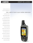
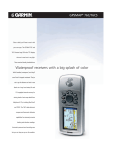
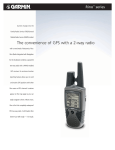
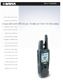
Rino® 520/530
No matter what you run into out there,
help is always close at hand with these
2-way radio with GPS lets you “buddy up” from 14 miles away.
new 500-series Rino® radios. Combining
powerful two-way transceivers with GPS
navigation and color mapping, these
feature-packed Rino (Radio Integrated
with Navigation for the Outdoors) units
keep you on track and in touch with
your fellow adventurers. With Garmin’s
patented position-reporting capability,
the Rino 520 packs 5 watts of transmit
power for a range of up to 14 miles.
For hikers and climbers, the equally
powerful Rino 530 adds an electronic
compass and barometric altimeter plus
a NOAA weather receiver to the mix.
Rino® 520/530
Radio features
Channels:
TX Power:
Squelch codes:
Range:
Modes:
Call tones:
VOX:
Other features:
15 GMRS channels*, 7 FRS channels,
8 GMRS repeater (USA only)
FRS = 0.5w
GMRS = 0.5w, 2w, 5w (USA)
0.5w, 2w (CAN)
38
Up to 2 miles on FRS channels;
Up to 14 miles on GMRS
Channel scan with programmable scan list;
channel monitor
10 call and ring tones, 4 roger tones
External Voice Activation with
sensitivity selection
Alarm, calculator, calendar, clock,
lap timer, stopwatch, games
Location reporting features
User ID:
10-character name with graphic symbol
Location sending:
One button press with Call or
Talk button**
Location receiving:
Automatic; keep track of up to
50 Rino contacts; allows user to poll
other user's position
Contact GoTo:
Navigation data automatically updated
to contact’s latest location
®
Lets you retrace the path of up to
Contact TracBack :
20 contacts
Contact Quick View: Lets you quickly center all contact
locations on map
Contact Assembly:
Lets you and your contacts send and
navigate to a common destination
Proximity alarm:
Alerts you if contact moves out of a
specified distance radius or if you are
within a specified distance of a waypoint
Navigation features
Waypoints/icons:
500 autoroute waypoints
500 with name, graphic symbol and notes
Routes:
50 reversible
Tracks:
10,000 track points. Automatic track log;
20 saved tracks let you retrace your path
in both directions
Trip computer:
Current speed, average speed, time of
sunrise/sunset, resettable maximum
speed, trip timer, trip distance, electronic
compass (530 only) and barometric
altimeter (530 only)
Tables:
Built-in celestial tables for best times
to fish and hunt, sun and moon rise/set
based on date and location
Map datums:
More than 100
Position format:
Lat/Lon, UTM/UPS, Maidenhead, MGRS,
Loran TDs and other grids, Light
Autorouting Basemap included
GPS performance
Receiver:
Acquisition times:
Warm:
Cold:
AutoLocate™:
WAAS-enabled, 12 parallel channel GPS
receiver continuously tracks and uses up
to 12 satellites to compute and update
your position
Update rate:
1/second, continuous
GPS accuracy:
Position:
< 15 meters, 95% typical***
Velocity:
0.05 meter/sec steady state
DGPS (USCG) accuracy:
Position:
3-5 meters, 95% typical
Velocity:
0.05 meter/sec steady state
DGPS (WAAS) accuracy:
Position:
< 3 meters, 95% typical***
Velocity:
0.05 meter/sec steady state
Dynamics:
6g’s
Interfaces:
USB RS232 serial interface requires
optional accessory cable 010-10572-00
Antenna:
Quad-helix
Power
Source:
Battery life:
Physical
Size:
Weight:
Display:
Case:
Temperature range:
User data storage:
Rev 0805
yes
yes
detailed basemap
accepts 56 MB data
from a variety of
MapSource CDs
5.1"H x 2.3"W x 1.8"D; 7.5"H with antenna
(13 x 5.8 x 4.6 cm; 19 cm with antenna)
10.3 ounces (294 g) with Li-Ion battery
pack; 6.2 ounces (175g) without battery
1.7"H x 1.3"W
176 x 220 pixels, 256-color
transflective TFT
Waterproof to IEC 60529 IPX7 standards
-4º to 140º F (-20º to 60º C)
Indefinite, no memory battery required
Barometric altimeter feature
Accuracy:
10 feet with proper calibration
(user and/or automatic calibration)
Resolution:
1 foot
Range:
–2,000 to 30,000 feet
Elevation computer: Current elevation, resettable minimum
and maximum elevation, ascent/descent
rate, total ascent/descent, average and
maximum ascent/descent rate
Pressure:
Local pressure (mbar/inches HG), 48-hour
automatic pressure trend recording
Accessories
Standard:
Optional:
Here’s how the units are different
voice scrambler
vibration alert
database or map
MapSource®
High capacity 8.4v 2400 mAh Li-Ion
Battery Pack
18 hours typical with Alkaline battery
pack, 16 hours typical with Li-Ion pack
Select a destination on the
map page, and Rino will
automatically draw a straight
line from your position.
Electronic compass feature
Accuracy:
±5º (average)
Resolution:
1 degree
Approximately 15 seconds
Approximately 45 seconds
Approximately 5 minutes
Rino 520
Rino’s selectable channel and
squelch codes let you talk to
your buddies without interference from other radio users.
Rino 530
yes
yes
detailed basemap
accepts 56 MB of downloaded
map detail from a variety of
MapSource CDs, electronic
compass, barometric altimeter,
weather receiver
PC/USB interface cable
User’s guide
Quick start guide
Lithium-Ion battery pack
Lithium-Ion charger
AC adapter
Belt clip
Wrist strap
Automotive mount
Handlebar mount
Carrying case
2.5 to 3.5 mm jack adapter
Earbud with push-to-talk microphone
Flexible ear receiver
Headset with boom mic
Alkaline battery pack
Replacement Lithium-Ion battery pack
PC interface cable (serial)
Vehicle power cable
Neck lanyard
MapSource® CD-ROMs
M01-10200-00
Tell Rino to “GoTo” a waypoint
or location, and the navigation
page will point you there with a
graphic compass display.
©2005 Garmin Ltd. or its subsidiaries
Garmin International, Inc.
1200 East 151st Street
Olathe, Kansas 66062, U.S.A.
913/397.8200 fax 913/397.8282
Garmin (Europe) Ltd.
Unit 5, The Quadrangle
Abbey Park Industrial Estate
Romsey, SO51 9DL, U.K.
44/1794.519944 fax 44/1794.519222
Garmin Corporation
No. 68, Jangshu 2nd Rd.
Shijr, Taipei County, Taiwan
886/2.2642.9199 fax 886/2.2642.9099
www.garmin.com
Specifications are preliminary and subject to
change without notice.
*Using GMRS requires FCC license in the United States.
No license is required in Canada.
**Location sending/receiving is available on both FRS and
GMRS channels in the US and Canada. The minimum time
between updates is 30 seconds (as specified by FCC), except
when responding to a polling request
*** Subject to accuracy degradation to 100m 2DRMS under
the U.S. Department of Defense Selective Availability Program.