Transcript
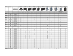
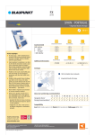
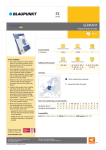
2009
Western Europe
for S series
DVD
Product Highlights
By choosing navigation products based
upon Tele Atlas maps, you receive
guaranteed freshness, accuracy and
quality:
■■ Travel to thousands of destinations
throughout Western Europe, see the
local sites and travel effortlessly
with a choice of 2D/3D viewing on
your device.
■■ The new map data includes full
street level mapping for Western
Europe.
■■ These maps will bring your Navman
right up to date with the latest
mapping data available.
Country details
A Austria
B Belgium
CH Switzerland
D Germany
DK Denmark
E Spain
F France
FIN Finland
GBGreat Britain & Northern Ireland
I Italy
IRE Ireland
L Luxembourg
N Norway
NL The Netherlands
P Portugal
S Sweden
Detailed street network
House numbers
Postal code
~100 %
~100 %
~100 %
~100 %
~100 %
~100 %
~100 %
~100 %
~100 %
~100 %
~100 %
~100 %
~100 %
~100 %
~93 %
~92 % (+17 %)
~99 %
~100% (only GB &
Belfast)
~88 % (+18 %)
~100 % (+30 %)
~100 %
~100 %
~100 %
~70 %
~97 %
✓
✓
✓
✓
✓
✓
✓
✓
7-digit
~100 %
~100 %
~100 %
~100 %
~100 %
~100 %
~100 %
+ AND Andorra, FL Liechtenstein, MC Monaco, RSM San Marino, V Vatican City.
Map Data 2009.02
Compatibility*
S30, S50, S70, S90i
Tele Atlas is unique in being
certified to the ISO/TS 16949
standard for its map quality.
ISO/TS 16949
BUREAU VERITAS
Certification
www.teleatlas.com
*Please note - this software is not compatible with any Navman 3D Device or S80.
©2009 Tele Atlas B.V. All rights reserved.
SAP 102 8813
For price: Please refer to the General order form
✓
✓
✓
✓
✓